The Gulf of Kutch Marine National Park and Sanctuary: A Case Study By Nilanjana Biswas International Collective in Support of Fishworkers Chennai

Welcome message from author
This document is posted to help you gain knowledge. Please leave a comment to let me know what you think about it! Share it to your friends and learn new things together.
Transcript
The Gulf of Kutch Marine National Park and Sanctuary: A Case Study
By Nilanjana Biswas
International Collective in Support of Fishworkers Chennai
International Collective in Support of Fishworkers (ICSF)
List of Acronyms and Abbreviations BOD biological oxygen demand
bn billion CF Conservator of Forests
CRZ Coastal Regulation Zone CZM Coastal Zone Management
DCC Digvijay Cement Company
EEZ exclusive economic zone
EMCB Environment Management Capacity Building
GEER Gujarat Environment and Education Research Foundation GMB Gujarat Maritime Board
GSFC Gujarat State Fertilizer Company
ha hectare
HMKP Hind Mazdoor Kisan Panchayat
ICMAM integrated coastal and marine area management plan
ICZM integrated coastal zone management
IOC Indian Oil Company ISI Indian Standards Institution
MARPOL International Convention for the Prevention of Pollution from Ships
MASS Machchimaar Adhikar Sangharsh Samiti
MCPA marine and coastal protected areas
MLD million litres per day
mn million
MNPS Marine National Park and Sanctuary MoEF Ministry of Environment and Forests MoU memorandum of understanding MPA marine protected area
NBWL National Board for Wild Life
NFF National Fishworkers' Forum
NGO non-governmental organization NIO National Institute of Oceanography
NRC National Research Council
PA protected area RPL Reliance Petroleum Limited
RTI Right to Information (Act)
International Collective in Support of Fishworkers (ICSF)
SBM single buoy mooring
SEAP State Environmental Action Programme
SEZ special economic zone
sq km square kilometre
TCL Tata Chemicals Limited
tpa tonnes per annum
WII Wildlife Institute of India
WLPA Wild Life (Protection) Act, 1972

International Collective in Support of Fishworkers (ICSF)
Contents
Summary 1 1. Introduction 2 2. Gulf of Kutch Marine National Park and Sanctuary (MNPS) 3
2.1. Coral reefs 5 2.2. Mangroves 6 2.3. Fisheries in Jamnagar District 6 2.4. Issues in the management of the MNPS 8
2.4.1.Demarcation of boundaries 9 2.4.2. Multiple ‘stakeholders’ and legal regimes 9 2.4.3. Tourism 11 2.4.4. Developmental activities in the region 12
Petroleum and petrochemicals 12 Chemicals 17 Cement 19 Fertilizers 20 Salt works 20 Thermal power stations 21 Ports and jetties 22 Shipbreaking units 22
2.5. Livelihood Issues of Traditional Fishing Communities 22
2.5.1.1.1. Impact of chemicals 25 2.5.1.1.2. Impact of oil pollution 25
2.6. Attempts to Address Coastal Zone Issues in the Gulf of Kutch 26
2.6.1. Mangrove reforestation 26 2.6.2. Coral translocation 27 2.6.3. Integrated coastal zone management 27 2.6.4. People’s organization in the region 28
2.7. Recommendations and Conclusions 29
International Collective in Support of Fishworkers (ICSF)
Appendix
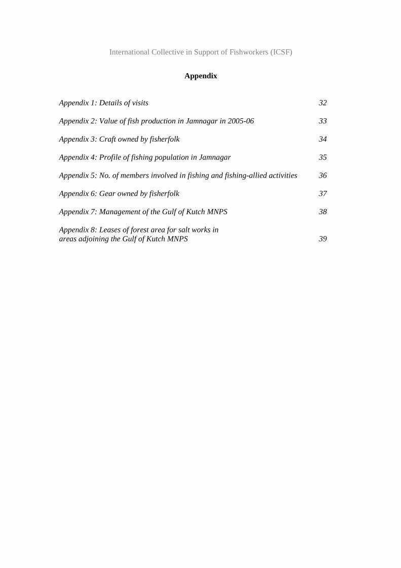
Appendix 1: Details of visits 32 Appendix 2: Value of fish production in Jamnagar in 2005-06 33 Appendix 3: Craft owned by fisherfolk 34 Appendix 4: Profile of fishing population in Jamnagar 35 Appendix 5: No. of members involved in fishing and fishing-allied activities 36 Appendix 6: Gear owned by fisherfolk 37 Appendix 7: Management of the Gulf of Kutch MNPS 38 Appendix 8: Leases of forest area for salt works in areas adjoining the Gulf of Kutch MNPS 39

International Collective in Support of Fishworkers (ICSF)

International Collective in Support of Fishworkers (ICSF)
1
The Gulf of Kutch Marine National Park and Sanctuary:
A Case Study 1
Summary The Gulf of Kutch is situated in Saurashtra in the western State of Gujarat in India. The region is an arid peninsula. Economic development was historically centered around the port facilities offered by the Gulf. Sea trade and fishing were important traditional occupations. The Gulf is rich in marine wealth and biodiversity. The region was notified as a Marine National Park and Sanctuary (MNPS) in 1982. Since 1991, coral reefs and mangroves in the region have additionally been accorded the highest degree of protection under the 1991 Coastal Regulation Zone (CRZ) Notification. Today the region is the centre of the industrial growth and economic boom in Gujarat. The rampant and unchecked industrialization threatens both the traditional economy of the region, and its sensitive marine ecology. The biggest threat is from the giant petroleum and petrochemicals-based industry on the coastline of the Gulf. Seventy per cent of India’s total crude import is expected to take place through the Gulf of Kutch. In addition, chemicals like soda ash, cement, fertilizer, salt works, thermal power stations and shipbreaking units are contributing to what adds up to an environmental disaster. The Gulf of Kutch MNPS, unlike most of Gujarat’s 26 other protected areas (PAs) , has a management plan, though dated. However, the plan has done little to protect the region from the depredations of industrialization. The reasons include overlapping jurisdiction of various government regulatory bodies, and the absence of clear physical and legal boundaries. The lack of a political opposition strong enough to take on the single-minded drive towards industrialization in Gujarat is another reason.. The biggest victims of this unchecked industrialization and the resultant pollution and habitat degradation are the local communities. Fishing, in particular, traditional fishing, has been very negatively affected by environmental pollution, and competition from large fishing vessels. Agriculture, which flourished in small pockets, has been destroyed by the degradation of soil and groundwater. Women already appear to be bearing the brunt of the unfolding crisis. The sphere of women’s domestic responsibilities has greatly increased with the compounding crises in groundwater availability, lack of basic healthcare, and increased livelihood insecurity. There is evidence of women from fishing families moving from traditional occupation to wage employment, as headload workers in salt pans, and in other forms of manual labour. The effect on women’s health is particularly pernicious, with high rates of maternal mortality being reported by fishing communities.
1 This study, commissioned by ICSF, was undertaken by Nilanjana Biswas, an independent researcher.

International Collective in Support of Fishworkers (ICSF)
2
There is a small but growing opposition to industrialization from some unions and non-governmental organizations (NGOs).
1 Introduction The western State of Gujarat in India faces the Arabian Sea. What appears to be its open mouth holds the waters of the Gulf of Kutch (sometimes spelled Kacchh), and at its neck is the State’s other Gulf—the Gulf of Khambhat. The waters of the Arabian Sea wash 1,650 km of Gujarat—giving it the longest coastline among all Indian maritime States. About 60 per cent of the coastline comprises the indentations of the two Gulfs2. The Gulf of Kutch separates the landmass of Saurashtra from the northern landmass of Kutch. The entire region is held to be very young, geologically, and hence highly prone to earthquakes. Deep seismic fault lines run through the Gulf, affecting the coast on both sides, the January 2001 earthquake being the most recent tectonic upheaval that devastated not only Kutch but also parts of Saurashtra. Saurashtra is an arid peninsula. On an average, it receives 500 mm rainfall annually. The land is dry and stony, covered with patchy scrub vegetation, notably, the ubiquitous prosopsis, cacti and twisted fig trees. Porous beige-coloured limestone covers the ground and it is not uncommon to come across vast excavation sites from where stone has been hewn or blasted to provide the booming construction industry its standard building material. Rains quickly drain off the rocky hinterland through narrow rivulets and channels that trickle into the sea. Historically, the impenetrability of the landmass and poor road conditions hindered land-based trade routes, and the development of the Saurashtra region was driven solely by the trading possibilities offered by its long coastline and ports. Port-led development continues to be the major driving force of industrialization in Saurashtra, particularly in the Gulf of Kutch. The calm and deep waters of its southern shores, together with the relative protection it enjoys from monsoon waves, make the Gulf of Kutch an ideal commercial cargo transit channel. However, the Gulf is also rich in marine wealth and biodiversity due to the mangroves and coral habitats found in its sheltered waters. On the Saurashtra side, the mouth of the Gulf of Kutch adjoins Jamnagar’s Okhamandal taluka. At the head, its waters meet the Little Rann of Kutch, where numerous creeks run through an expanse of marshy land. River runoff into the Gulf through this marshy area has steadily diminished over the years due to the damming of rivers upstream—a change that is correlated with the growing salinity of the Gulf’s waters. Perhaps the most striking feature of the coast along the Gulf of Kutch would be its inter-tidal mudflats—vast stretches of coastal land covered with salt-encrusted, soft, sticky 2 Singh, H.S., Yennawar, P., Asari, R.J., Tatu, K., Raval, B.R. (2006): An Ecological and Socio-Economic Study in Marine National Park and Sanctuary in the Gulf of Kutch (A Comprehensive Study on Biodiversity and Management Issues); GEER Foundation; Gandhinagar

International Collective in Support of Fishworkers (ICSF)
3
clay. Concealed by the Gulf’s waters during the high tide, these mudflats are exposed when the high tide ebbs. This clayey layer is between 12 m to 15 m deep, covering a substratum of calcareous sand and rock. A chain of 42 islands, many rich with coral reefs and mangroves, are clustered in the southern Gulf near the Saurashtra coast. These reefs and mangroves provide a uniquely productive habitat for a diverse and colourful variety of life forms. The Gulf of Kutch is a shallow water basin about 60 m deep at the mouth, sloping up to a depth of less than 20 m at the head, visited by 'mixed semidiurnal' tides, that is, it experiences two high tides and two low tides of variable ranges every day3. The Gulf of Kutch is also an area of negative water balance; more water evaporates from this water body than is recharged through rainfall and river runoff4. Together with the pattern of currents that lead to unflushed sediment deposition, this significantly affects the 'carrying' or 'assimilation' capacity of the Gulf5.
2 The Gulf of Kutch Marine National Park and Sanctuary
The Gulf of Kutch Marine National Park and Sanctuary (MNPS) was established by a set of State Notifications during the period 1980 to 1982 in an area of 457.92 sq km along the coast of Saurashtra in the southern Gulf of Kutch (22015’ to 23040’N and 68020’ to 70040’E). Designated first as a Sanctuary in 1980, certain areas covering the islands and inter-tidal zones were declared as National Park areas during the same year. A final Notification of the PAs was issued in 19826. The Gulf of Kutch MNPS has been classified as part of the West coast (8A) Biotic Province by the Wildlife Institute of India (WII) 7.
The notified area includes 148.92 sq km of 42 islands in the Gulf and 309 sq km of inter-tidal zone along its coast. Out of the notified areas, an area of 162.89 sq km is designated
3 The information about tides in the Gulf of Kutch is based on the following sources: Deshmukh, B., Nayak,S., Bahuguna,A. and Dev,P. (2005): Study of Suspended Sediment Dispersal Patterns in the Gulf of Kutch with Reference to Coral Reefs; Map India 2005; Nair, V. (2002): Status of The Flora and Fauna of Gulf of Kutch, India; National Institute of Oceanography; Goa; and Sengupta, R and Deshmukhe, G (2000): Coastal and Maritime Environments of Gujarat: Ecology and Economics; Gujarat Ecology Commission; Vadodara 4 Sengupta, R and Deshmukhe, G (2000): Coastal and Maritime Environments of Gujarat: Ecology and Economics; Gujarat Ecology Commission; Vadodara 5 The Indus River is estimated to discharge 200 cu km of water and 450 mn tonnes of suspended sediments annually into the Arabian Sea. See Deshmukh, B. et al (2005). 6 The Marine National Park was constituted in an area of 162.89 sq km vide Notification No. AKH-138-2-82-WLP-1081-126827-V2, dated 20. 7. 1982. The Marine Sanctuary was constituted in an area of 220.71 km2 and 237.21 sq.km vide Notification No. AKH –140-80-WLP-1079-109483-P2, dated 12-08-1980 and Notification No. AKH-138-3-82-WLP-1081-126827-V2, dated 20. 7. 1982, respectively. 7 Panwar, H.S. and Mathur,V.B. (2002): Wildlife Protected Area Network in India: A Review. Executive Summary. Dehradun: Wildlife Institute of India.

International Collective in Support of Fishworkers (ICSF)
4
as National Park area while the remaining is sanctuary land8. The National Park area covers 37 islands while the sanctuary area covers five islands as well as the inter-tidal zone from Navlakhi to Okha. According to the Notification, the revenue borders of Dwarka (Okha), Kalyanpur, Khambalia, Lalpur, Jamnagar, Dhrol and Jodiya talukas of Jamnagar District mark the southern boundary of the marine protected area (MPA).
Three categories of areas are included within the MNPS: 11.82 sq km of reserve forests, 347.90 sq km of unclassified forests and 98.20 sq km of Indian territorial waters. Since the PAs were constituted under the Wild Life Protection Act (1972), the management of the area is under the jurisdiction of the State’s Forest Department.
Figure 1: The Gulf of Kutch Marine National Park and Sanctuary
(Source: Adapted from DOD-ICMAM Report, 2002) The MNPS supports considerable species diversity. One study reported a total of 1,127 species of flora and fauna in the MPA9. These include 200 species of molluscs, including oysters, three species of turtles and three species of marine mammals: dolphins, whales, and the rare and endangered sea cow, dugong dugon. A recent study recorded 144 different fish varieties in the MNPS areas and also 27 species of commercially important prawn10.
8 Under the Wild Life (Protection) Act (1972), extractive use is banned in both National Parks and Sanctuaries. The difference between the two PAs is that a National Park receives a much higher degree of protection where no human interference is permitted, except those beneficial to conservation. In case of Sanctuaries, certain rights (for example, traditional rights such as grazing or fishing) may be permitted. 9 Singh, H.S. (2002): Protected Areas in India: Status of Coastal Wetlands and their Conservation in India; GEER Foundation; Gandhinagar 10 Singh, H.S., Yennawar, P., Asari, R.J., Tatu, K., Raval, B.R. (2006): An Ecological and Socioeconomic Study in Marine National Park and Sanctuary in the Gulf of Kutch (A Comprehensive Study on Biodiversity and Management Issues); GEER Foundation; Gandhinagar

International Collective in Support of Fishworkers (ICSF)
5
The MNPS was initially established for the conservation and protection of a rich and diverse ecosystem, particularly the inter-tidal and sub-tidal coral reefs and mangrove habitats of the Gulf. Since 1991, coral reefs and mangroves have additionally been accorded the highest degree of protection under the 1991 Coastal Zone Regulation (CRZ) Notification11. Coral reefs and mangroves have great ecological significance; both increase shore stability, offer protection against tidal surges, and are the breeding grounds of a host of fishes, crustaceans, algae and other forms of marine life. Indeed, the decline in corals and mangroves is correlated with a general decline in the diversity and quantum of marine life.
2.1 Coral Reefs Several types of coral formations are found in the Gulf of Kutch: fringing reefs, platform reefs, patch reefs and coral pinnacles. There is dispute, however, about the numbers. Pillai and Patel (1988) recorded 37 species of hard corals12; the Gujarat Environment and Education Research Foundation (GEER Foundation) reports 42 hard and 10 soft corals13; and the Gujarat’s State of Environment Report mentions 44 species of hard corals and 12 species of soft corals14. The age of the reefs varies from 5,240 years at Salaya to about 45,000 years at Okha. Coral colonies grow extremely slowly, at a rate of less than 1 cm to 10 cm every year, growing upwards at a rate varying from a few millimeters to about 3 cm, under amenable conditions15.
One study reports that according to satellite data, the total reef area in the Gulf decreased from 217 sq km in 1975 to 123 sq km in 1986; a net loss of 43 per cent. During this period, coral reef cover within the Core Areas of the MNPS declined by 54 per cent. The study also states that, in fact, reefs presumed to have died, actually lie buried under mud, thus indicating that heavy silt load is the reason for coral damage16. Coral dredging by a cement company (discussed later) is held to be largely responsible for the heavy siltation.
Between 1985 and 1991, as a result of a ban on coral mining and the protective efforts of Park authorities, coral cover was reported to have increased in the Core Areas of the
11 According to the 1991 CRZ Notification, CRZ-I includes areas that are ecologically sensitive, such as National Parks, Sanctuaries, mangroves, coral reefs, areas close to aquatic breeding grounds; areas of outstanding natural beauty or heritage areas; and areas likely to be inundated due to rise in sea level. It also includes areas lying between the low tide line and the high tide line. 12 Pillai, C.S.G. and Patel, M.I (1988): Scleractinian Corals from the Gulf of Kutch, J. Mar. Biol. Assoc. India, 30 (1-2), 54-74. 13 Singh, H.S., Yennawar, P., Asari, R.J., Tatu, K., Raval, B.R. (2006): An Ecological and Socioeconomic Study in Marine National Park and Sanctuary in the Gulf of Kutch (A Comprehensive Study on Biodiversity and Management Issues); GEER Foundation; Gandhinagar. 14 State of Environment Report; Gujarat; 2005; Gujarat Ecology Commission; Vadodara. 15 State of Environment Report; Gujarat; 2005; Gujarat Ecology Commission; Vadodara. 16 Nair, V. (2002): Status of the Flora and Fauna of Gulf of Kutch, India; National Institute of Oceanography; Goa.

International Collective in Support of Fishworkers (ICSF)
6
MNPS17. Recently, however, satellite data has revealed a reversal of the gains, with coral ecosystems once more under stress due to industrialization and port-building18.
2.2 Mangroves Apart from corals, the mangroves of the Gulf of Kutch are of unique ecological and economic importance. Jamnagar District has an area of 665.9 sq km mangrove cover, predominantly of scrubby and sparse type19. Although this area is managed and developed by the MNPS authorities, in terms of jurisdiction, only 140 sq km out of the total mangrove area is part of the MNPS20.
Gujarat witnessed severe depletion of its mangrove cover between the 1960s and 1980s21. Even in the MNPS areas the decline was dramatic, from 138.5 sq km in 1975 to just 33.4 sq km in 198522. Mangrove degradation has been attributed to the diversion of mangrove lands for industry-building, decreased freshwater discharge into mangrove areas due to the damming of rivers, port-related activities, aquaculture, mining, expansion of salt industries, marine oil pollution, gathering of fodder and fuelwood, and reduced natural regeneration23.Mangrove species such as Rhizophora, Ceriops and Aegiceros, which are reported to have once existed in the region, are now rare, while the species Bruguiera is extinct.24
Since the early 1990s, mangrove cover has been increasing in Gujarat, from 397 sq km in 1991 to 960 sq km in 200325. An analysis of the data, however, reveals that only two districts - Jamnagar and Kutch - contributed to more than 90 per cent of the overall increase in mangrove cover.
The Director of the GEER Foundation attributed the increase in mangrove cover in Kutch to the fact that during the last decade, coastal security has been massively stepped up in Kori Creek, located close to the country’s border with Pakistan. This has stopped all forms of anthropogenic activity at Kori Creek, where most of the mangroves of Kutch are located. The Director attributed Jamnagar’s increase in mangrove cover to the reforestation work being carried out in the district26.
17 Singh, H.S., Yennawar, P., Asari, R.J., Tatu, K., Raval, B.R. (2006): An Ecological and Socioeconomic Study in Marine National Park and Sanctuary in the Gulf of Kutch (A Comprehensive Study on Biodiversity and Management Issues); GEER Foundation; Gandhinagar. 18 Nayak, S (undated): Role Of Remote Sensing to Integrated Coastal Zone Management; Space Applications Centre (ISRO), Ahmedabad; (http://www.isprs.org/istanbul2004/comm7/papers/235.pdf) 19 Singh, H.S. (2002): Protected Areas in India: Status of Coastal Wetlands and their Conservation in India; GEER Foundation; Gandhinagar 20 Singh, H.S. (2006): Mangroves and their Environment (with Emphasis on Mangroves in Gujarat); Forest Department; Gujarat State. 21 Hirway, I and Goswami, S (2004): Valuation of Mangroves in Gujarat; Gujarat Ecology Commission; Vadodara. 22 Nayak, S. and Pandeya, A. (undated): Study of Ecological Changes in the Marine National Park Using Satellite Data; SAC, Ahmedabad and GEER Foundation, Gandhinagar. 23 See Singh, H.S. (2006) and Hirway, I and Goswami, S (2004). 24 Stanley, O.D.(2002): Proceedings of the National Seminar on Creeks, Estuaries and Mangroves - Pollution and Conservation, 28th to 30th November, 2002, Thane. Quadros, G. ed. 2002; 78-83. 25 Singh, H.S. (2006): Mangroves and their Environment (With Emphasis on Mangroves in Gujarat); Forest Department; Gujarat State. 26 Personal interview with C. N. Pandey, Director, GEER Foundation on 9 January 2008.
International Collective in Support of Fishworkers (ICSF)
7
2.3 Fisheries in Jamnagar District Perhaps the single most prominent aspect about fisheries in Gujarat’s Jamnagar District is the high commercial value of its yield. In 2005-06, the average value of the marine fish landed in Jamnagar was over 70 per cent higher than the average value of catch for Gujarat. The average value of marine fish per kg was Rs.52.33 for Jamnagar, as against Rs.30.36 per kg for Gujarat (see Appendix 2). During 2005-06, at 66,489 tonnes, Jamnagar contributed 10.01 per cent of the total marine fish production in the State.
The physical features of the southern Gulf of Kutch favour fishing. A cluster of mangrove-forested islands near the southern coast of the Gulf generates nutritive detritus, which nurtures prawns and fish in large numbers. The rich algal vegetation associated with the reef islands contributes to raising the level of dissolved oxygen in the waters. Its vast inter-tidal mudflats are conducive to traditional fishing with indigenous craft and gear; a relatively even sea floor supports trawling operations for demersal species.
A range of mechanized and non-mechanized fishing practices is found in the region. Non-mechanized fishing includes pagadia fishing, which, according to the fishers in the region, is becoming more and more impracticable as a single source of livelihood. Pagadias wade into the waters at low tide, driving stakes used to string low stake nets into the seabed. They also practice hook-and-line fishing and often catch crabs and other crustaceans in mangrove swamps areas. The hodi (plank-built boat) is used to transport the catch. Non-mechanized fishing craft include the machuwa or the sailboat where gillnets and bag-nets are used as gear. Mechanized fishing craft include the motorized sailboat and the motorized tony (fibreglass boats), which may be fitted with an outboard or inboard engine. These use gillnets, bag-nets and seine-nets as gear. The trawlers use trawl nets for demersal fishing operations.
The fishing grounds for fishing by both mechanized and non-mechanized craft often coincide—off the ports of Okha, Bet, Sikka, Salaya, Bedi and Jodiya—but are at different depths. The pagadias venture up to 2 m or so, while the motorized machuwa, hodi or tony may comb waters at depths between 10 m to 15 m. Jamnagar’s trawlers, concentrated at Okha, have, over the years, moved their trawling operations to the northern waters off Jakhau, Mandvi and Bhadreshwar.
The population of traditional artisanal fisherfolk such as pagadias and owners of the non-motorized hodi in Jamnagar and its adjoining district, Rajkot, is high -- 16.52 per cent of Gujarat’s fishers who operate non-motorized boats can be found in Jamnagar. In contrast, the district has only 4.46 per cent of Gujarat’s trawlers; 7.23 per cent of its mechanized boats and 5.02 per cent of its motorized boats (see Appendix 3).
Fishing in Jamnagar has been part of a well-developed, traditional coastal economy. The district has 17 fish landing centres. About 10.8 per cent of Gujarat’s fishing families reside in 23 fishing villages along Jamnagar’s coasts. The fisher population is 31,910— nearly 10 per cent of Gujarat’s total fisher population, with 6,459 fishing families. Ninety-seven per cent of the population comprises the Muslim machhiyara and wagher communities; Hindus constitute the remaining 3 per cent, of which 2.6 per cent belong to the Scheduled Caste/Scheduled Tribe category (see

International Collective in Support of Fishworkers (ICSF)
8
Source: Gujarat Fisheries Statistics, 2005-06 Appendix 4). In many communities, the main languages used are Kutchi and Gujarati.
About 42 per cent of the adult fishing population in Jamnagar is involved in active fishing. Activities classified in the census as ‘allied fishing activities’, such as fish vending, drying, net repair and daily wage labour, engage a significant proportion -- 42.1 per cent -- of women (see Appendix 5). Gender-disaggregated data for active fishing is not captured in the official statistics. However, in fishing villages along the Gulf of

International Collective in Support of Fishworkers (ICSF)
9
Kutch, among pagadia fisher families, women too contribute to active fishing. According to local perception, fisherwomen’s roles are undergoing changes as more and more women become headload workers and take up other casual wage labour. The reason for this shift is the increasing non-viability of traditional fishing, and the decline in catches.
At 4.9 members to a family, the average household size in Jamnagar is smaller than Gujarat’s average fishing family size of 5.4. Jamnagar has a sex ratio (females per 1,000 males) of 930, marginally higher than the national average of 92727.
Jamnagar’s fishing villages are comparatively better developed than those in the rest of Gujarat. According to the official marine statistics, all of Jamnagar’s fishing villages have pukka houses, electricity and road connections, as against 83 per cent pukka housing, 93 per cent electrification and 92 per cent road connections in other fishing districts in Gujarat28. Educational opportunities are also better developed in Jamnagar, with an average of 2.1 secondary schools per fishing village as against 0.9 in other fishing villages in Gujarat. Despite this, Jamnagar’s fishing population is largely uneducated, with illiteracy at 91.8 per cent, as against 59 per cent in other fishing areas in the State.
Asset ownership, an indicator of economic viability, is fairly high among fishing families in Jamnagar. Thirty-four per cent of fishing families in the district own their own craft as against the State’s average of 28 per cent, while 86 per cent of fishing families own their own gear, as against an average of 55 per cent reported among fishing families in the rest of the State. Gillnets and longlines are, by far, the most common fishing gear used in the district. Even among non-fishing families, asset ownership is high, probably indicating that the leasing out of assets is profitable business. Among Jamnagar’s non-fishing families, 6 per cent possess fishing craft, and 5 per cent possess fishing gear, while for the rest of Gujarat, the corresponding figures are 1 per cent and 2 per cent, respectively. The sharing of craft is unknown in the district, while there is occasional sharing of trawl nets and other gear (see Appendix 6).
An important aspect of the economy is the extent of membership of co-operatives. Nearly 8 per cent of the fishing families in Jamnagar are members in fishing or other co-operatives, as compared to 7.6 per cent for other fishing villages (see
27 It may be noted, however, that the sex ratio in Gujarat’s fishing communities has been steadily declining from 959 in 1992 to 921 in recent times. 28 Gujarat Fisheries Statistics, 2005-06; (Although this report uses the official statistics released by the State government, the data gathered in field trips during the study sometimes contradicted the official data. For example, contradicting the 100 per cent electrification claim made for Jamnagar’s fishing villages is one large fishing village, Rupen ‘bandar’ in the western-most taluka of Dwarka, which, as late as January 2008, was still awaiting electricity.)

International Collective in Support of Fishworkers (ICSF)
10
Source: Gujarat Fisheries Statistics, 2005-06 Appendix 4), indicating a reasonably high membership in co-operatives.
2.4 Issues in the Management of the MNPS The Gulf of Kutch MNPS, unlike most of Gujarat’s 26 other PAs, boasts of a management plan29. The plan was created in 1994 and lapsed in 1999. An updated plan is not available. The 1994 plan, however, describes the key threats facing the MNPS and lists the various factors that make the management of the MNPS complex and contentious. Some of these issues are taken up in the following sub-sections.
29 Management Plan: Marine National Park and Sanctuary, Jamnagar, May 1994.
International Collective in Support of Fishworkers (ICSF)
11
2.4.1 Demarcation of boundaries Although the MNPS was established for the conservation of marine resources, we have no information on the rationale used to demarcate the MNPS areas. The 1994 MNPS management plan too does not explain this.
When the MNPS was declared, the area covered by the 42 islands in the Gulf was assessed to be 148.92 sq km. This figure was subsequently used to mark the MNPS boundaries. However, a study by the National Institute of Oceanography (NIO) points out that according to satellite-based wetland maps, the total area covered by the 42 islands during low tides is actually 410.6 sq km; therefore, a major part of the islands (261.7 sq km), containing healthy coral reefs, are outside the legal boundaries of the MNPS, pointing to the need to redraw the MNPS boundaries30.
Boundary settlement continues to be a contentious issue. According to the WLPA, once an area is declared as protected, the legal settlement of boundaries and the rights of local communities must be completed within a two-year time frame. However, as late as 1994, when the management plan for the MNPS was written, 12 years after the PAs were notified, 60 km of the territorial boundary line and 499 km of the boundaries of islands in the Gulf (the permanent water line) remained non-demarcated and under dispute. Field visits undertaken for the present study revealed that the situation remains unchanged even today; a fact corroborated by a recent study31. The Conservator of Forests, in charge of the MNPS areas, revealed that the problem emanated from the fact that when the MNPS areas were declared, the formal settlement of rights was never officially carried out, leading to a grave problem of overlapping jurisdiction that persists to date.32
2.4.2 Multiple ‘stakeholders’ and legal regimes In the Gulf of Kutch MNPS, 87 per cent of the area falling under protection overlaps with the jurisdiction of the Gujarat Maritime Board, which is in charge of port development throughout the area. Port-building activities are often directly in conflict with conservation efforts, and the 1994 MNPS plan has attracted the frequent complaint that port-related activities are carried out without consulting park authorities. Apart from this, there are other overlapping activities, which include those of the Fisheries Department, the Department of Customs, the Light House Department and the Indian Navy33 as well as those of a growing number of hazardous and polluting industries. The island reef areas and creeks, which now fall within the MNPS, are also fishing grounds for a large number of fishers. Two islands within the MNPS area are inhabited: Bet Dwarka, which is an important temple and pilgrim site, and Ajad, which supports a small farming community. Many of the islands, such as Chusna, Pirotan, Ajad and Bet, are pir and dargah sites (traditional religious sites) hosting annual pilgrimages and fairs. The PA is thus a highly
30 Nair, V. (2002): Status of The Flora and Fauna of Gulf of Kutch, India; National Institute of Oceanography; Goa. 31 Singh, H.S., Yennawar, P., Asari, R.J., Tatu, K., Raval, B.R. (2006): An Ecological and Socioeconomic Study in Marine National Park and Sanctuary in the Gulf of Kutch (A Comprehensive Study on Biodiversity and Management Issues); GEER Foundation; Gandhinagar 32 Personal interview with D.S. Narve, CF, Gulf of Kutch Marine National Park and Sanctuary on 9 January 2008. 33 Management Plan: Marine National Park and Sanctuary, Jamnagar; May 1994.

International Collective in Support of Fishworkers (ICSF)
12
contested zone, with several ‘stakeholders’ claiming dominion over it. As a result, there are multiple legal instruments and policies that simultaneously govern the MNPS areas.
The overarching framework for environmental protection is provided by the Indian Constitution, which contains two Articles of significance: Article 48A, which states that “The State shall endeavour to protect and improve the environment and safeguard the forests and wildlife of the country”; and Article 51 A (g), which states that “It shall be the duty of every citizen of India to protect and improve the natural environment and to have compassion for all living creatures.” The Constitution provides for sovereignty over the resources of the exclusive economic zone (EEZ) and grants both the State and the Central governments power to legislate on the subject of forests and wildlife protection.
The Gulf of Kutch MNPS was designated, and is managed, under the WLPA, 1972 (as amended in 2002 and 2006). The WLPA provides the highest protection to wild animals, birds and plants and their habitats, with a view to ensuring the ecological and environmental security of the country. In the 2002 Amendment to the Act the definition of the term ‘animal’ was expanded to include fish.
Although territorial waters may be included in the establishment of PAs, the WLPA provides no specific definition of either MPAs or marine and coastal protected areas (MCPAs). Where territorial waters are to be included within a sanctuary, the WLPA specifically mentions that this may be done (a) after taking adequate measures to protect the occupational interests of the local fishermen; and (b) while duly protecting the right of 'innocent passage' of any vessel or boat through the territorial waters. In the latter case, the WLPA specifies that should a fisherman, residing within 10 km of a Sanctuary or National Park, inadvertently enter such territorial waters on a boat not used for commercial fishing, the boat shall not be seized.
In 2002, the WLPA was amended to empower State governments to create Conservation and Ccommunity Reserves with the participation of local communities. While this could be a potential tool in the hands of communities for gaining legal recognition of their traditional conservation efforts, the restriction that only community and private land may be thus reserved severely curtails the potential power of the provision34. Since the WLPA empowers State governments to notify changes in the boundaries of PAs, the threat of de-notification is also ever-present.
The diversion of MNPS land for commercial use is also common practice. Approval was recently granted, for example, to the Indian Navy for the diversion of 0.41 ha of MNPS land for the construction of a Waterman Ship Training Centre35; to the Indian Oil Corporation for use of 24 ha of land of the Marine Sanctuary and 22.5 ha of the Marine National Park; and to the Gujarat State Fertilizer Company for the use of 12.47 ha of Marine Sanctuary land36.
34 http://www.panchayats.org/downloads/Comments%20on%20WP%20Bill.PDF 35 http://www.envfor.nic.in/divisions/wildlife/12th_Minutes_Standing_Committee.pdf 36 Minutes of the 10th Meeting of the Standing Committee of National Board for Wild Life (NBWL) convened on 19 February, 2008 at 10.30 a.m. in Room No. 403, Paryavaran Bhavan, New Delhi, under the Chairmanship of the Hon’ble Minister of State for Forests and Wildlife.
International Collective in Support of Fishworkers (ICSF)
13
Destructive commercial activities in the vicinity of PAs can lead to severe habitat loss and add to the environmental burden in the PA. This, as will be seen later, is one of the most critical problems facing the rapidly developing region of the Gulf of Kutch.
Apart from the WLPA, other prevailing legal instruments include the Environment (Protection) Act, 1986, and within this Act, the Coastal Regulation Zone (CRZ) Notification, 1991; the Biological Diversity Act, 2002, and Rules, 2004; the Indian Forest Act, 1927; the Forest (Conservation) Act, 1980, as amended in 1988; the Scheduled Tribes and the Other Traditional Forest Dwellers (Recognition of Forest Rights) Act, 2006, and Rules, 2008.
Regulating human activities, such as fisheries, ports, shipping and cargo transport in the Gulf of Kutch are various legal instruments, which include the Indian Fisheries Act, 1897; the Gujarat Fisheries Act, 2003; the Territorial Waters, Continental Shelf, Exclusive Economic Zone and other Maritime Zones Act, 1976; and the Maritime Zone of India (Regulation of Fishing by Foreign Vessels) Act, 1981, and Rules, 1982; the Indian Ports Act, 1908; the Customs Act, 1962; as well as the Merchant Shipping Act, 1958, and its Amendments.
Regulating marine pollution is the Water (Prevention and Control of Pollution) Act, 1974 (amended up to 1988), which is operative up to 5 km from the shoreline in all coastal States and Union Territories. The enforcement of this Act rests with Central and State Pollution Control Boards. In the case of marine areas, sea water is categorized into five zones, with minimum standards evolved by the Indian Standards Institution (ISI) for the permissible quantities and concentrations of pollutants in each zone.
The prevention and control of marine pollution is one of the responsibilities of the Coast Guard, under the Coast Guard Act, 1978. The prevention and control of marine pollution by oil from ships and liabilities for oil pollution damage are addressed in amendments to the Merchant Shipping Act, 1958, which address provisions of the International Convention for the Prevention of Pollution from Ships (MARPOL) in accordance with the amendments to the 1954 Oil Pollution Convention.
Implementation and enforcement of pollution-related legislation rests with the Central and State Pollution Control Boards and the State Departments of Environment.
2.4.3 Tourism The species diversity in the MNPS areas is being leveraged to promote tourism. In 2006-07, about 7,000 tourists visited the Pirotan island, which is rich with fringing coral reefs and mangroves, and is part of the National Park's Core Area37. The 1994 MNPS management plan had proposed that Pirotan be designated a Zone 1A Area, that is, an area under the highest protection within the MNPS, closed to all activity except scientific research, visits of pirs (sacred places) by fishers, and afforestation. However, zoning was never implemented, and, instead, the island was opened to tourism. MNPS authorities believe that only the serious and environmentally sensitive tourist would take the trouble of visiting the remote island of Pirotan. Environmentalists in Jamnagar, however, claim
37 Data from the Office of the Conservator of Forests, Marine National Park and Sanctuary, Jamnagar; January 2008.
International Collective in Support of Fishworkers (ICSF)
14
that Pirotan’s corals are already facing heavy damage as they often get crushed under the feet of visitors38.
Nature education and tourism are facilitated by the GEER Foundation, a Gandhinagar-based organization established by the State Department of Forests and Environment in 1982, which implements a number of projects related to the MNPS, primarily concerned with nature education and research.
2.4.4 Developmental Activities in the Region India’s economic liberalization programme, which gathered steam since 1991, has transformed Gujarat, the State with the longest coastline, well-developed ports and related infrastructure) into the country’s top investment destination.
In 2006-07, Gujarat cornered about one-fourth of India’s total industrial investment, with investments of Rs 73,170 crore from 86 projects. The State set itself an industrial output target of Rs.3680 billion by the year 2020, nearly seven times the existing level39. Most of the investments were mopped up in the Gulf of Kutch, bestowing the region with a new nickname, ‘The Gulf of Riches’. If a new generation of billionaires was being spawned40, it was, as a national daily declared, “all thanks to [the] Gulf of Kutch” 41.
As the areas within and around it become prime investment targets, the Gulf of Kutch MNPS today faces unprecedented challenges, including the threat of de-notification42. The investments that are pouring into the Gulf of Kutch region will essentially mean a much larger scale of the same kind of industrial development that the region has already experienced. The following sections, therefore, cover the impact of existing industries. The petroleum and petrochemicals industry receives a more detailed consideration for two reasons: (a) over 50 per cent of new investments are in this sector; and (b) it is considered the biggest threat to the PAs in the region.
Petroleum and Petrochemicals The Gulf of Kutch, due to its proximity to oil-exporting Middle East countries, and the natural advantages of its calm ports, is emerging as a major oil-importing base and refinery site. Seventy per cent of India’s total crude import is expected to take place through the Gulf of Kutch; its oil traffic in 2007 was estimated to be about 84 million tonnes43.
38 As one environmentalist put it, “The tourist may be sensitive but his boots are not!” 39 “Gujarat bags a fourth of corporate investments”; The Indian Express; Aug 16, 2007 40 As of November 2007, the Gulf had attracted investments worth Rs 1.40 lakh crores from four of India's billionaires - Mukesh Ambani, Shashi Ruia, Ratan Tata and Gautam Adani. 41 “Gulf of Kutch: India's real Gateway”; http://timesofindia.indiatimes.com/Cities/Gulf_of_Kutch_The_real_Gateway_Of_India/rssarticleshow/2549331.cms 42 Protected Area Update 22 (http://144.16.65.194/hpg/envis/doc1999ahtml/biodpa991010.html) 43 Vethamony, P.; Babu, M.T.; Reddy, G.S.; Sudheesh, K.; Desa, E.; Zingde, M.D (2007): Estimation of carrying capacity of the Gulf of Kutch, west coast of India in relation to petroleum hydrocarbon through oil spill modeling; Proceedings of the International Maritime-Port Technology and Development Conference. MTEC 2007. Research Publishing Services; Singapore; 2007; 505-511.

International Collective in Support of Fishworkers (ICSF)
15
Until the 1990s, the Gulf of Kutch had an annual refining capacity of less than 1 mn tonnes, all in the public sector. In the last decade, the area has seen a fifty-fold increase in refining capacity, to around 45 mn tonnes per annum.
Recent verdicts of the Supreme Court of India allowing oil companies like Reliance and Essar to lay oil pipelines right through the Gulf of Kutch MNPS have been viewed as a severe setback to the conservation agenda44. The court judgements have ruled that pipelines through Core Areas would not cause more than minimum or transient damage and, in fact, “ultimately would improve the habitat of both the Sanctuary as well as the National Park”45. Other court judgements have ruled that refinery companies need not divulge company information on the ground that confidential information received by invoking the Right to Information (RTI) Act, might be misused by a third party46.
In this context, what are the implications of the petroleum and petrochemicals boom in the Gulf of Kutch for human beings and the marine environment? Studies highlight several major threats that occur during the construction and operational phases of refinery projects.
During the construction phase, offshore infrastructural activities such as the laying of pipelines, setting up a single buoy mooring (SBM), and constructing the product terminal can result in habitat destruction, increase the turbidity and the biological oxygen demand (BOD) of the waters, with a consequent decrease in the level of dissolved oxygen available for living organisms.
During a refinery’s operational phase, there are several sources of oil contamination: operational spillage, pinhole leakage, accidental spillages and effluent release.
Operational spillages may take place due to weak or improperly maintained links in the floating superstructure. Indeed, a certain degree of operational spillage is considered routine for an SBM, although it is virtually impossible to gauge how much of such spillage actually takes place. With plans of scaling up the number of SBMs from the existing four to nine in the coming years, routine operational oil spillage will be more than doubled, inside or near PAs.
Pinhole leakages are unnoticed leakages from pinholes in the pipelines that carry crude from the SBM to shore-based tanks or in product pipelines that transport petroleum products across the Gulf. We have no data by which to ascertain how much marine oil pollution takes place due to pinhole leakages in the Gulf. One study, for the purpose of modelling, assumes that a pipeline in the Gulf of Kutch would have three leaking pinholes, from each of which oil would flow out at the rate of half a litre per second47.
Accidental spillages are unforeseen spillages that occur, for example, during the transportation of petroleum, pipeline or tanker spills, coastal facility spills, tanker
44 Gatecrashing ploy; Down to Earth; Vol 12 ,No 3; June 22, 2003 45 Gujarat Navodaya Mandal Vs. State of Gujarat and Ors; Spl. Civil Appln. No. 403 of 1998; AIR1998Guj141, (1999)1GLR700 46 PIO should not share confidential information of company, says HC; UNI; 31 August 2007. 47 Vethamony, P.; Babu, M.T.; Reddy, G.S.; Sudheesh, K.; Desa, E.; Zingde, M.D (2007): Estimation of carrying capacity of the Gulf of Kutch, west coast of India in relation to petroleum hydrocarbon through oil spill modeling; Proceedings of the International Maritime-Port Technology and Development Conference. MTEC 2007. Research Publishing Services; Singapore; 2007; 505-511.

International Collective in Support of Fishworkers (ICSF)
16
accidents and collisions, and so on. During the early 1990s, several fuel oil leaks in Gujarat’s waters were recorded by the Coast Guard48. In the last decade or so, as investments in the petroleum and petrochemicals sectors have soared, crude oil spillage accidents are increasingly being reported (see Box 1: Oil Spills in the Gulf of Kutch). However, only a fraction of actual spillage incidents received media coverage.
The release of industrial and domestic wastewater from refinery complexes and townships into the Gulf is another major source of oil pollution. The routine operations of refinery units, operational discharges when the emergency shutdown or startup of a unit is ordered, domestic wastewater from burgeoning refinery townships all contribute significantly to polluting the waters of the Gulf. A report by the National Research Council (NRC) states that such land-based pollutants could be, by a wide margin, the largest source of petroleum hydrocarbon loadings to the sea 49. While there are environmental guidelines specifying the maximum amount of liquid effluent waste refineries can dump into the sea, the actual quantities discharged and their content remain unknown. Therefore, what is also unknown is the impact on aquatic life. Studies have only pointed to the possibility that fish and shellfish “may get tainted” and that since the Gulf is a major breeding ground for marine organisms, their eggs and juveniles may suffer “considerable damage” when exposed continuously to hydrocarbons over long periods due to wastewater impact50.
48 http://www.coastalhazards.info/files/Pollution_Incidents_in_Indian_Waters_since_1982_updated.pdf 49 NRC (2003): Oil in the Sea III: Inputs, Fates, and Effects. National Research Council; National Academies Press; Washington DC. 50 Zingde, M.D. and M.N. Anand (1994): Implication of coastal refineries to the ecology of the Gulf of Kutch; Proceedings of seminar on ocean and industry realities and expectations held on October 25 and 26, 1994 at the National Institute of Oceanography, Dona Paula, Goa. Srivastava, P.S. ed. ,New Delhi, India, 67-76
International Collective in Support of Fishworkers (ICSF)
17
Box 1: Oil Spills in the Gulf of Kutch
Wildlife populations have been found to be most at risk from oil51. The 1994 Gulf of Kutch MNPS management plan identifies oil pollution as the “greatest potential threat to marine life and their habitat”.
Oil has a particularly pernicious effect on mangroves. In an early study, the effects of petroleum products were studied on the seedlings of two mangrove species52. Exposure to petrol and diesel in concentrations of 5 to 10 per cent caused the burning, yellowing and
51 Boesch, D.F. and Rabalais, N.N (1987). Long-term environmental effects of offshore oil and gas development. Elsevier Applied Science, New York. 52 Jagtap, T.G. and Untawale, A.G (1980): Effect of petroleum products on mangrove seedlings; Mahasagar: 13; 1980; 165-172.
In the third week of November, 1999, a large oil slick was detected near Narara Island off the Vadinar coast in Jamnagar. The spillage was traced to the Vadinar-Kandla pipeline of the Indian Oil Company (IOC) and is believed to have occurred when oil was being pumped from a tanker to the IOC's single buoy mooring (SBM). Walking around Narara, a press team reported seeing dead dolphins and sea turtles, besides long stretches of blackened mangrove. The IOC officials, fearing arrest, immediately moved the Sessions Court for anticipatory bail and denied having had anything to do with the slick. There was confusion among government officials. While the Forest Department registered offences against IOC staff for allegedly violating the WLPA, a senior district official was unsure: "We cannot say it is IOC [just] because the slick is close to Vadinar. A tide could have pulled the slick in one direction…1” Hardly had the controversy died down when, seven days later, another spillage occurred in the same place: the Gulf of Kutch near Vadinar port. Luckily, this time the 500 m-long and 300 m-wide oil slick spreading from the direction of Sikka, was spotted by workers on the crude tanker Maharaja Agrasen, which was waiting to berth at the IOC SBM. Had the spill gone undetected, it would have probably been carried ashore to the Vadinar coast by the evening high tide. The Marine National Park Director and Conservator, R. C. Pal, among the last to get the news, could only point out that the oil patch was spreading from the Sikka side where Reliance also had its SBM2. Who was responsible for the spillage? The question remains unanswered. In March 2004, heavy fog at night led to the collision between two vessels in the Gulf of Kutch - MV APL Puscan, a container carrier on passage to Mundra, and MT Delta-1, on passage from Kandla to the United Arab Emirates. The impact caused the Delta-1, which luckily had just offloaded its potentially deadly cargo of naphtha, to break into two pieces. Approximately 678 tonnes of diesel, 4,530 litres of lube oil, 790 litres of gear oil and 1,022 litres of heavy oil were released into the waters of the Gulf. Even as the Chairman of the Gujarat Pollution Control Board told the press that "no doubt, there has been some oil spill, and it might affect fish”, newspapers reported that the Gujarat government had, quite inexplicably, ruled out any environmental damage because of the collision3. Sources:
1. Was it IOC leak or did a ship dump oil? Indian Express, 27 November 1999 2. Another oil slick near Vadinar port. Express News Service, 1 December 1999 3. Environment damage due to shipwreck ruled out. Times News Network. 19 March 2004

International Collective in Support of Fishworkers (ICSF)
18
wilting of leaves, and finally, seedling death in a matter of weeks. A GEER Foundation study, published in 2006, recounted that as far back as in 1992-93, mangrove areas of Pirotan Island (a part of the National Park area, supposedly under the highest degree of environmental protection) were found to be caked with spilled oil and 3 ha of mangroves were found dead. The study also found layers of oil caking the surface of other “bets” (islands) in the National Park, and concluded: “In [the] absence of surveillance and monitoring, these minor spills were not recorded but...occurred undoubtedly in the past.”53
The NRC report also discusses the effects of oil spills on coral reef ecosystems, citing multiple field studies that document coral tissue death and coral bleaching due to oiling. The report compares two spills in terms of their impact on corals: the 1986 Galeta spill in Panama and the 1991 Persian Gulf War spill. Although the latter spill was 120 times greater in volume, the long-term (over five years) effects of oil in Panama were “more pronounced and detrimental due likely to repeat inoculation of oil from the surrounding mangroves into the coral ecosystem”54. That is to say, oil residues harbored in mangrove ecosystems can be a source of repeated, lethal oiling for corals, much after the spill. This finding has important implications for the Gulf of Kutch, where coral reefs and mangrove ecosystems occur in close proximity.
Some time after a spill occurs, a water-in-oil mousse is formed, which, in contact with suspended solids, forms tar balls that sink to the seabed or get washed ashore. If the sinking tar balls fall on coral polyps, the polyps are likely to be damaged or killed55. Further, studies show that mixtures of dispersants and oil are more toxic to corals than just the oil56. In the Gulf of Kutch, however, chemical dispersants are often used to tackle oil spills, without any assessment of the consequent damage to inter-tidal and sub-tidal coral reefs.
Apart from oil spillages, the presence of giant refineries adjacent to both PAs and populated townships poses a constant threat, calling for strict monitoring and surveillance. Whether safety standards are strictly followed in Jamnagar’s refineries is a moot question.
In 2001, a toxic gas leak of hydrocarbon from a petroleum refinery in Jamnagar is estimated to have caused about one million people in the city to experience headaches, breathlessness and a burning sensation in the eyes.57 In 2006, a fire in the Reliance refinery seriously injured a worker and caused a partial shutdown58. A year later, in 2007,
53 Singh, H.S., Yennawar, P., Asari, R.J., Tatu, K., Raval, B.R. (2006): An Ecological and Socio-Economic Study in Marine National Park and Sanctuary in the Gulf of Kutch (A Comprehensive Study on Biodiversity and Management Issues). GEER Foundation, Gandhinagar. 54 NRC (2003): Oil in the Sea III: Inputs, Fates, and Effects. National Research Council. National Academies Press, Washington DC. 55 Singh, H.S., Yennawar, P., Asari, R.J., Tatu, K., Raval, B.R. (2006): An Ecological and Socioeconomic Study in Marine National Park and Sanctuary in the Gulf of Kutch (A Comprehensive Study on Biodiversity and Management Issues). GEER Foundation; Gandhinagar. 56 Peters et al, 1997 cited in NRC (2003). 57 Mysterious threat; Down To Earth; 15 October 2001. 58 Fire at Reliance refinery complex at Jamnagar; The Hindu Business Line, 26 October 2006.

International Collective in Support of Fishworkers (ICSF)
19
four people were killed and 16 others injured in a fire that broke out when pipes were being welded in the Essar refinery complex59.
The State policy on disaster management mentions that the Government of Gujarat has envisaged the development of a holistic approach that addresses “the entire gamut of disasters arising from natural (droughts, floods, earthquakes, cyclones, etc.) and man-made (oil spills, forest fires, chemical catastrophes, etc.) causes”60. However, while the job of cleaning up after oil spills are detected has been outsourced to a private company, the Gulf of Kutch still lacks a comprehensive oil spill contingency plan61.
Chemicals The abundant availability of limestone and common salt, materials required for the production of soda ash, has led to the establishment of giant soda ash plants along the coast at Mithapur, Sutrapada and Porbandar.
Mithapur is located on the west coast in Gujarat’s Dwarka sub-division. Its revenue areas mark the eastern boundaries of the Gulf of Kutch MNPS62. The Tata Chemicals Limited (TCL) plant at Mithapur, spread over about 15,000 acres of land, is among the world’s largest integrated salt works and inorganic chemicals complex. The main product groups are soda ash, chloro-caustic products, marine chemicals, salt and cement.
According to the Department of Scientific and Industrial Research, about 10 cu m per tonne of effluent is generated during soda ash manufacturing63. Going by these figures, the effluents discharged by TCL can be expected to have shot up nearly 30 times, from 330,000 cu m per year in the 1930s to 8,750,000 cu m per year at present. What does the effluent contain and where is it dumped?
A June 2008 investigation that examined files pertaining to TCL’s consent application at th eGujarat Pollution Control Board's head office in Gandhinagar found that the effluents were being discharged right into the MNPS. According to the investigators, TCL managed to secure a permit citing a 1987 stay order from the Gujarat High Court on grounds that the unit had come up before the Park was notified.64
A. study carried out in 1993 stated that the Mithapur plant produces around 18 mn litres per day (mld) of highly alkaline process waste. The wastewater contains about 150 gm/l of suspended solids and 25 mg/l of ammoniacal nitrogen. This is released through marshy lands above the high tide line in the marine sanctuary area. Due to its high density, the milky white effluent does not mix well with sea water but instead spreads along inter-tidal areas or settles in heaps along the shore. The white colour of the effluent is due to high levels of suspended solids: calcium carbonate, calcium sulphate, magnesium
59 http://www.ibnlive.com/news/fire-erupts-at-jamnagar-oil-pipeline-4-dead/32525-3.html 60 http://www.gujaratindia.com/Policies/Policy2.pdf 61 Telephonic conversation with Mr Rajiv Ranjan, M/s Clean Sea Enterprise, Mumbai, on 2 February 2008. 62 vide Notification No. AKH-138(1)/82-WLP-1081-126827-V-2, dated 20 July 1982. 63 http://dsir.nic.in/reports/techreps/tsr148.pdf 64 Scorching Salt; Down to Earth; 15 June 2008.

International Collective in Support of Fishworkers (ICSF)
20
hydroxide and silica. The study found that the raw effluent was toxic. Even at 20 per cent concentration, fish did not survive in it for more than 15 minutes65.
Another study, sponsored by TCL, which examined samples of the waters adjoining the Mithapur plant during two seasons (pre-monsoon and post-monsoon) conceded that the effluent discharge was indeed toxic but claimed that “the wastewater released from the factory does not reach the Gulf of Kutch in the quantities released.” 66 .
The effluent-carrying pipelines from the Mithapur plants were laid years before the declaration of the MNPS. In the present decade, two devastating accidents have taken place within a three-year period.
On 2 June 2001, a salt brine pipeline running through the marine national park, from a TCL factory at Samlasar to its Padli and Mithapur salt works, burst open, spilling thousands of tonnes of effluent into the PAs. A case was registered against the company under the WLPA and two engineers of the company placed temporarily under arrest67.
Within three years of the salt brine spill, in October 2003, there was yet another accident. This time, a TCL slurry pond burst, releasing 300,000 tonnes of calcium chloride into the PAs. Over 1,500 mangrove plants were killed. Four employees of the plant were arrested and later released on bail on charges of alleged negligence, and the Gujarat State Pollution Control Board ordered the closure of the company’s soda ash manufacturing plant68. However, less than a week later, the company that for 15 years had dodged responsibility for clean production, was allowed to reopen its plant on the mere promise that it would clean up the slurry waste and comply with safety measures in future.
Significant tracts of agricultural land near the coasts, covering an estimated 243 ha, are today the company’s waste disposal sites69 (see Box 2: Toxic Dumping). TCL produces 8,760,000 tonnes of soda ash annually. Going by estimates, it can be calculated that every year the company generates approximately 4,37,500 cu m of solid waste, which ends up in surrounding landfills. To understand the implications better, consider this. Every year, the amount of solid waste generated by TCL’s soda ash production process can fill 30 international-sized football fields up to about the height of a single-storey house.
65 Zingde, M. D. (1993): Studies on impact of release of liquid industrial waste from soda ash industry in the nearshore water of North Gujarat; NIO; Environmental Impact on Aquatic and Terrestrial Habitats; 9-30; 1993 66 http://www.nio.res.in/annual_reports/1987-88.pdf 67 “Toxic destruction”; Down to Earth, 15 July 2001. 68 “Four held in Tata Chemicals leakage case”; Times News Network; 25 Oct 2003. 69 Scorching Salt; Down to Earth, 15 June 2008.

International Collective in Support of Fishworkers (ICSF)
21
Box 2: Toxic Dumping
Cement Although several cement companies operate in Jamnagar’s Khambaliya taluka, in the immediate vicinity of PAs is the Digvijay Cement Co. (DCC), which belongs to the Aditya Birla Group. The cement plant at Sikka has a production capacity of 1.30 mn b). To cater to the international market, the company operates a captive all-weather working port at Sikka, 1.7 km from the plant.
A December 2007 visit to Mithapur revealed the effluent dumping practices involved in TCL’s soda ash manufacturing. Traveling from Dwarka to Mithapur by car, our first stop was the discharge point where liquid effluents from the soda ash plant flow into the sea. It was difficult to believe that this was MNPS land. No matter where you looked, the coast was utterly barren and uniformly grey, ending abruptly in the blue waters of the Gulf of Kutch. Not a blade of grass grew here and not a living creature was visible. These were the areas declared “biologically dead” following two devastating toxic spillages from the Mithapur plant in 2001 and 2003 . Amidst the silence was a single sound – that of liquid effluent gushing in a milky white stream into the sea. From the discharge point, we travelled inland, to look at how the solid wastes from soda ash manufacturing were being disposed. Our journey took us through several villages, including Surajkaradi, Padli and Samlasar, and finally ended at Lalpur. Two workers from the Mithapur plant took the risk of being our guides. We were travelling through lands owned by TCL but the journey was as if through moonscape. For miles, on either side of the road, rose tall grey slopes - mountains of hardened solid waste. A fine dust hung in the air. Near Lalpur, the car climbed up one of the slopes. The top of the dump provided a better perspective of what was happening. The dumping had started from Surajkaradi in the north and followed a simple strategy. Once a plot of land, about half a kilometre wide and equally long, brimmed up with waste, the adjoining plot was dug up and filled. Over time, the waste matter hardened. Villagers in surrounding areas confirmed, as did the Official Gazette, that this apparent moonscape once consisted of fertile agricultural fields. However, toxic dumping in one spot rapidly caused adjoining plots to become infertile. Farmers in adjoining areas therefore had no option but to sell their now-useless lands at whatever price the company was willing to give. And so the process of land acquisition and destruction continued. This impressionistic account is corroborated by a recent investigative report, which states: “At the Tata plant in Mithapur, effluent is taken to huge mud trenches, effluent-settlement ponds, which cover about 243 ha. The liquid is supposed to go to the sea from here after suspended solids in it settle down. According to the Consent to Operate given to the company in 2004, ponds marked S,T,U, V,W,X were in use, implying 18 ponds—A to R—have already been filled up with solids.”1
1. “Scorching Salt”, Down to Earth, 15 June 2008
International Collective in Support of Fishworkers (ICSF)
22
Until 1982, DCC was dredging materials from an area of 648 ha in the Gulf of Kutch for its cement production. The area was leased out by the State government and included six coral reef islands, namely, Pirotan, Kalvan, Jindra, Dhani, Dera and Goose. These islands now fall under the National Park area. Sustained coral mining, at the rate of about 0.5 mn tpa by the company, caused major destruction of reefs70. Satellite data showed a dramatic decline in coral reef cover in the region. Forest Department officials filed a case against the company, but it was only after the declaration of the PAs in 1982 that coral mining was banned and the leases granted to DCC revoked.
The effects of calcareous sand and coral mining have proven to be rather more long-term. The 1994 MNPS management plan points out that due to the extensive dredging, mud and suspended particles continue to settle on coral reefs. Such deposits are lethal for corals. Today, although the company cannot dredge within the PAs , it continues to extract raw materials from areas in the immediate vicinity, thus increasing the overall environmental burden in the Gulf of Kutch. In the last 10 years, the loss of about 64 sq km of reef area has been reported within the National Park due to heavy sediment loads71.
Fertilizers The Gujarat State Fertilizer Company (GSFC), located at Motikhavdi near Sikka in the vicinity of the protected zone, is the region’s largest fertilizer company. It operates its own jetty at Sikka in the Gulf of Kutch where phosphoric acid and liquid ammonia are offloaded from ships and pumped through pipelines over a 10 km distance to two plants, operated by contractors, for the production of the fertilizer diammonium phosphate. The 1994 MNPS management plan mentions that the transport of liquid ammonia and phosphoric acid through PAs is potentially a great hazard to marine life should pipeline leakages or bursts occur. In fact, the plan states that in July 1993, when the sudden mass death of fish and marine life was reported in the region, local fishermen attributed the deaths to the leakage of gas from a ship offloading toxic liquids at the GSFC jetty; however, the plan states that “nothing could be done about it due to lack of evidence”.
It is interesting that in a recent Supreme Court judgment that approved a refinery project in the region, the judges defended their decision by citing GSFC’s example. They contended that subsequent to the laying of the GSFC pipelines, areas devoid of marine life had shown an improvement of marine biota, including the regeneration of corals72.
Salt works Gujarat produces 70 per cent of the country’s salt. For the last 60 years, salt works in Jamnagar have greatly contributed to the State’s annual salt production. A massive salt works factory operated by TCL uses salt pans in the Okha Rann region and other areas of
70 Singh, R.B (2006): “Critical Problems of Coastal Ecosystem in India”. Indian Cartographer. 2006. 71 Singh, R.B (2006): “Critical Problems of Coastal Ecosystem in India”. Indian Cartographer. 2006. 72 Essar Oil Ltd. vs Halar Utkarsh Samiti and others; Reported in 2004 AIRSCW 573.

International Collective in Support of Fishworkers (ICSF)
23
north Okhamandal, while smaller salt works are dispersed throughout Jamnagar’s coasts, inside or close to the PAs. In the vicinity of the MNPS, an area of 103.25 sq km of mangrove forests is leased out to 21 salt industries.
A study by the DOD- ICMAM Project Directorate in 2002 estimated that salt pans discharge about 2.95 mn kilolitres of bittern annually. Bittern is a highly concentrated form of sea water obtained in the final stage of salt production, when salt is crystallized. The bittern discharged and the negative water balance of the Gulf result in increased salinity of sea water and soil73 Corals too are highly susceptible to change in sea water quality, especially salinity.
Bittern is toxic for mangroves. Between 1975 and 1982, the mangrove cover in the State decreased from 733.53 sq km to 177.31 sq km, a 76 per cent decline, while the area occupied by salt pans grew from 4.81 sq km to 49.13 sq km, a 921 per cent increase.
From the available data, it appears that 20 out of the 21 leases granted to salt manufacturers in mangrove areas adjoining the MNPS expired by the year 2005 (see Appendix 8). Since the leases are granted or extended by the Forest Department, clarification on the current status of these leases was sought from the Principal Secretary of the Forest Department in Gujarat. He said he was unaware of the current situation and would look into the matter74.
Thermal power stations A 240-mw capacity, coal-based power station run by the Gujarat State Electricity Board operates in the vicinity of the PAs. The plant has two units and will soon be augmented by two more units of 250 mw capacity each, at an estimated cost of Rs.2,500 crores. The power station uses massive fly ash ponds extending over thousands of acres for fly ash disposal. A report by the GEER Foundation points out that these fly ash ponds are associated with frequent overflows during the rainy season, which contributes to the degradation of marine life. At the Sikka port, the bulk transport of coal for the thermal power plant also poses a threat to marine life75.
Significantly, several new thermal power stations are coming up in the region. Essar Power Holdings Limited plans to set up a 1,200-mw power plant in Jamnagar, based on coal imported from Indonesia and South Africa76. The Reliance Group will develop a 500-mw coke-based power plant in addition to its existing captive power generation units at Jamnagar. Also coming up in the northern shores of the Gulf is Tata Power Company’s 4000-mw ultra mega power project at Mundra.
73 Geographical Information System for Gulf of Kutch; Government of India, Department of Ocean Development; Integrated Coastal Marine Area Management (ICMAM) Project Directorate; Chennai; 2002 74 Personal interview with Pradeep Khanna, Principal Secretary, Forest Department, on Jan 10, 2008 in Gandhinagar, Gujarat 75 Geographical Information System for Gulf of Kutch; Government of India, Department of Ocean Development; Integrated Coastal Marine Area Management (ICMAM) Project Directorate; Chennai; 2002 76 http://www.financialexpress.com/news/Essar-to-build-1-200mw-plant-in-Jamnagar/213132/
International Collective in Support of Fishworkers (ICSF)
24
Ports and jetties As the first Indian State to privatize its port sector, Gujarat revamped its port policy, allowing for massive private sector participation in port building and container handling capabilities. With the announcement of 10 greenfield sites for port development in 2007, the port sector attracted 19 memorandums of understanding (MoUs) with investments worth Rs.104.74 bn77.
Currently, Gujarat has the highest number of ports in the country—41—and these handle 20 per cent of India’s cargo78. It is estimated that by the year 2015, cargo volumes at Gujarat’s ports will grow to about 400 mn tpa - 39 per cent of the total national cargo volume79.
There are many environmental problems associated with increased port development and maritime activity, including tanker spills and accidents, as well as sediment deposition on corals due to deep-sea dredging activities.
The accelerated development of ports and harbours will also greatly increase the problems that fishing communities face, further restricting their fishing grounds and depleting the availability of fish.
Ship-breaking units The second-largest shipbreaking unit in Gujarat is located at Sachana, under the ambit of the Bedi port. A GEER Foundation study provides the details of the various problems associated with Sachana’s shipbreaking unit. One is the problem of dual control since the area comes under the jurisdiction of both the Gujarat Maritime Board (GMB) and the MNPS authorities.80.
Fifteen plots in the industrial yard at Sachana were granted by the GMB for shipbreaking in areas adjoining protected waters; of these, three are operational. During the period 1992 to 2001, 71 ships were broken there. The study states that any scrap from shipbreaking activity that does not have sale value is simply dumped in the protected zone. Engine oil and other non-degradable toxic compounds flow into the protected waters of the Gulf of Kachch from where tides wash them into neighbouring creeks and mangrove swamps. Consequently, mangroves in the region are so degraded that they cannot be regenerated.
2.5 Livelihood Issues of Traditional Fishing Communities As discussed earlier, the settlement of the rights of stakeholders in the MNPS areas, including those of communities, has yet to be completed. However, nomadic maldhari – the camel grazier communities -- were banned from entering the MNPS areas immediately after the notification of the PAs. A recent study states that their entry was
77 “Modi well-placed to realize dreams of Golden Gujarat”. http://www.indiaenews.com/politics/20071224/87871.htm 78 “State of resilience”. Frontline, Vol 22, Issue 7,12-25 March 2005. 79 http://www.indiainbusiness.nic.in/know-india/states/gujarat.htm 80 Management Plan; Marine National Park and Sanctuary; Jamnagar; 1994.

International Collective in Support of Fishworkers (ICSF)
25
curtailed on the belief that grazing by camels was responsible for mangrove depletion, although there was no validating evidence; on the contrary, all available evidence pointed to polluting industries like salt works as the primary cause for mangrove loss81.
As far as the fishery is concerned, the situation is more ambiguous. Amendments to the WLPA have extended protection to all fish species in areas declared as National Parks and Sanctuaries. Section 26A of the Act, in recognition of the occupational interests of fishermen, allows the right of 'innocent passage' of any vessel or boat through the territorial waters even in PAs. As a result of the Gujarat Fisheries Act and Rules, several other regulatory provisions apply to the fisheries sector. These include a ban on explosives, noxious materials and the monoculture of certain fish species; the prohibition of gillnets with mesh size less than 150 mm; bag-nets with mesh size smaller than 40 mm at the tail end; and any form of drag-net; the protection of certain species; the requirement of fishing licenses and identity cards, and so on. There is also a closed fishing season, which prohibits fishing from 10 June to 15 August.
There are 30 fishing centres in the MNPS areas: four in Rajkot and the rest in Jamnagar District. Traditional fishing is carried out both at night and during the day in shallow waters up to a depth of about 2 m, using bag-nets, stake-nets and cast-nets. Except during the monsoon period, the nearshore areas of the southern coast are the main fishing grounds for traditional pagadia fishers. During this period, when the waters are calm, mechanized boats are used for deep-sea fishing. During the monsoon season, fishers migrate to the fishing grounds near reef areas and set up temporary shacks.
The local perception among traditional fishers is that a plethora of legal regimes, without clear enforcement boundaries, compounds the existing problems of livelihood sustenance. The overlapping jurisdiction of powers means multiple sources of harassment for fishers82.
In 2006, the Customs Department made it compulsory for active fishers to carry a creek pass and laminated photo-identity card. Furthermore, the Gujarat Fisheries Act of 2003 introduced licence requirements to regulate all kinds of fishing, from pagadia fishing to trawling. Should boatowners not be able to furnish identification and licensing documents on demand, they would be “liable to suitable action”. This might mean the cancellation of the identity card or pass, the confiscation of craft and gear, and also physical violence at the hands of the authorities. One fisherman is reported to have died in the custody of the Customs guards83.
Fishermen reported that they are liable to be picked up, and their boats and gear confiscated, at any time, should they stray into MNPS areas. A common grievance held by fishers relate to the ambiguous and unmarked nature of the in-water boundaries of the MNPS. The 1994 MNPS management plan had stated that orange buoy markers with
81 Bharwada, C. and Mahajan, V. (2007): Mangroves and Maldharis of Gujarat: Understanding Coastal Pastoralists’ Dependence on Mangrove; Gujarat Ecology Commission; Vadodara. 82 Ahmed, a fisherman from Bet Dwarka said, “We never know when we’ll be picked up and by whom when we go out fishing. Guards from the Customs Department, the Forest Department, or the port authorities arrest us, saying that we are encroaching. They demand to see our licence. They seize our boats. They pick us up and thrash us. It’s always harassment, and usually only a bribe works.” 83 Personal conversation with fishers at Sikka on 18 December 2007.
International Collective in Support of Fishworkers (ICSF)
26
light reflectors would be fixed in the plan period and boat lines demarcated for ports. That has, however, not happened yet.
According to local perception, the enforcement of rules is fairly arbitrary. Traditional fishers point out that trawler owners are often able to use political and money power to escape penalties. In most places, traditional fishers identified trawling as one of the key reasons for the depletion of fish stocks and destruction of their gear. In the industrialized coastal belt, oil and chemical contamination, salt works and increasing port activity were stated as the reasons for declining catches. According to the local traditional fishers, these destructive activities continue unchecked, even as they themselves are harassed for minor offences.
The Conservator of Forests (CF) at Jamnagar denied that the MNPS Forest Guards ever used physical violence against fishermen and that gear was rarely confiscated. Forest Guards, however, stated that without intimidation and physical violence, protection cannot be enforced84. In such a rough-and-ready system, fishers find themselves increasingly vulnerable.
The rapid degradation of coastal wetlands, such as mangroves and swamps, has affected fishermen’s populations. A recent unpublished report states that coastal wetland degradation has led to the loss of fish species diversity in the Gulf of Kutch. The draft report uses the example of the saline coastal wetlands in the Little Rann of Kutch to illustrate the growing vulnerability of traditional fishers. This region, which adjoins the MNPS at the head or closed end of the Gulf of Kutch, has an estimated 9,000 active fishermen who use traditional fishing practices. According to the report, the destruction of natural hydrological patterns, the depletion of mangroves and other coastal vegetation, and continued apathy towards marginal fishermen have seriously jeopardized the livelihoods of traditional fishers85.
The 1994 MNPS management plan stated that fishermen in the coastal villages in the region would be involved in the conservation and protection of the MNPS. However, not a single meeting towards this purpose has ever taken place86.
In Gujarat, subsidies and benefits have tended to favour a capitalist mode of fisheries production. With the quality of life in traditional fishing communities rapidly deteriorating, women appear to be bearing the brunt of the crisis. Domestic responsibilities are ever increasing, along with the problems of drinking water availability and a decline in health and food security. Wage employment among women is rising rapidly. Girls are pulled out of school within a few years of enrollment and made to help with domestic work. The health of women in the community has been particularly affected, and the rates of maternal mortality are high, going by conversations with fishers.
2.5.1.1.1 Impact of chemicals
84 One forest guard said: “Earlier we would thrash the fishermen who encroached into our territories but now we no longer need to do so, because they keep out on their own.” 85 State Environment Action Programme (2003): Environmental Action Plan for Gujarat – Problems, Causes and Solutions; Gujarat Ecology Commission,Vadodara. Unpublished. 86 Personal interview with D.S. Narve, CF, Gulf of Kutch Marine National Park and Sanctuary on 9 January 2008.

International Collective in Support of Fishworkers (ICSF)
27
Villagers in the areas of TCL’s dumping sites claim that salinity ingress has created an acute water crisis and rendered agricultural lands barren. In 2000, TCL’s Mithapur plant was reportedly extracting 14 mn litres of water every day from the ground and two sweet water lakes – Bhimgaja and Mithikhari - in the area87. In all the coastal villages, the crises in drinking water supply and agriculture are forcing coastal communities to either migrate to other areas or look for contract work with TCL, the same company that they hold responsible for their current plight. Women of the village of Lalpur complained that noxious gases from the TCL-owned settling ponds, which were now reaching their village precincts, forced them to keep their doors and windows shut all the time. Many reported health problems like skin disorders and ailments of the respiratory and digestive tracts. According to the women, crops that successfully grew five years ago, even during water-scarce periods, were now failing. Groundwater, once sweet, was now frequently undrinkable and had to be either bought or fetched from a distance, adding to their domestic burden.
2.5.1.1.2 Impact of oil pollution Fishing communities in Sachana constantly complain about oil spillage in the region due to shipbreaking. The hardest hit are the pagadia fishers who wade into the nearby waters to catch fish. Families who can no longer engage in fishing watch helplessly as thousands of dead, oil-coated fish are washed ashore.
Men and women in the fishing villages at Sikka and Bedi complain that the fish they catch smell of petrol, and there are few takers for the catch. The reduction in catch is the other problem in the industrialized coastal zone. In Sikka, near Jamnagar, along the southern Gulf of Kutch, fishers say that oil and other chemical pollutants have depleted fish stocks.
Oil spills often cause the death of fish in large numbers, which, in turn, compromises the livelihood security of fishing communities. Correlating spills with fish mortality is, however, fraught with operational issues. Often there is no correlation between the size of a release and its impact; it is all about ‘location’88.
On 22 September 2007, newspapers reported that thousands of fish had drifted on to the Dumas beach near Surat. The dead fish were sticky, which suggested they had been covered by oil and chemicals. While initial investigations suggested an oil spill as the possible cause, the fish were sent to a forensic lab for testing89. The next day, thousands of dead fish shored up on two other beaches - Ubhrat and Datti90. And less than a month later, on 5 October 2007, thousands of dead fish once again flooded the shores of Dumas. Were oil spills indeed responsible for these incidents or some other chemical contaminant? Forest officer R J Asari complained: “We are still waiting for the earlier report from the Forensic Science Laboratory.91”
87 “The Myth of Drought”, Down to Earth, 15 May 2000. 88 NRC (2003): Oil in the Sea III: Inputs, Fates, and Effects. National Research Council; National Academies Press; Washington DC. 89 http://www.topnews.in/thousands-fish-found-dead-along-gujarat-coast-22286 90 http://www.expressindia.com/latest-news/After-Dumas-fish-found-dead-at-Ubhrat-and-Dati/219770/ 91 http://www.expressindia.com/latest-news/Fishes-wash-up-shores-of-Dumas-again/225332/

International Collective in Support of Fishworkers (ICSF)
28
Oil spillages have threatened not only the waters of the Gulf but also its coast, polluting farmlands. In February 2000, farmers of Jamnagar’s Mota Thavaria village filed a case against the IOC seeking Rs 7.25 crore as compensation for damages caused by a leak in IOC’s Salaya-Mathura pipeline, which had contaminated 135 ha of their farmland and created health problems for 35 families in the vicinity92.
Translating oil spill damage into monetary terms is a highly complex task. In the United States, the average cost of damages caused by oil spillage works out to about US $28,000 (at 1990 rates) per tonne of spilled oil.93 A significant exception was the Exxon Valdez case (when the tanker Exxon Valdez ran aground in Alaska in 1989, spilling 10.9 mn gallons of crude oil), where the liabilities claim ran to US $900 mn: US $90,000 per tonne of oil. However, it is significant to note that a decade after the spill, Exxon was reported as having still not paid out a penny of the US $5 bn in damages originally awarded to fishing communities whose livelihoods were devastated by the accident94.
If fishing communities are given the short shrift in North America, where massive liability suits deter, to some extent, corporate recklessness, the chances of fishing communities in India being compensated appear somewhat dim. Prevention is perhaps the only solution.
2.6 Attempts to Address Coastal Zone Issues in the Gulf of Kutch
The State and industry have attempted to address the growing ecological problems in the Gulf of Kutch in several ways. This section attempts to highlight a few significant interventions.
2.6.1 Mangrove reforestation Over the last 17 years, reforestation activities have been carried out by the Forest Department in an area of 149.83 sq km in Jamnagar’s inter-tidal mudflats; mostly (100.87 sq km) in the MNPS areas95. This works out to 8.8 sq km of plantation per year of different species of Avicennia. Due to its tolerance of hyper-saline conditions, Avicennia now constitutes over 99 per cent of the total mangrove cover in the State, while many of the other mangrove species that once grew there can now be categorized as 'threatened'96. The MNPS authorities today see reforestation as perhaps their sole work97, and spend 41.4 per cent of the total annual budget on this activity (see Appendix 7). While reforestation activities are heavily documented in Forest Department publications, the impact of monoculture that reforestation is bringing into mangroves in the region is poorly understood.
92 “Compensation demand”, Down to Earth, 15 February 2000. 93 NRC (2003): Oil in the Sea III: Inputs, Fates and Effects. National Research Council; National Academies Press; Washington DC. 94 “Betrayed By An Oil Giant”, The Independent, 25 March 2004. 95 Hirway, I and Goswami, S (2004): Valuation of Mangroves in Gujarat. Gujarat Ecology Commission, Vadodara. 96 Singh, H.S. (2006): Mangroves and their Environment (with Emphasis on Mangroves in Gujarat). Forest Department, Gujarat. 97 Personal interview with D.S. Narve, CF, Gulf of Kutch MNPS on 9 January 2008.
International Collective in Support of Fishworkers (ICSF)
29
Sometimes attempts at afforestation collide with deforestation moves. An example of this is the mangrove restoration initiative, 'REMAG'. The REMAG project was designed to reforest seven villages between 2001 and 2006, covering a total of 5000 ha of land at a cost of Rs 10.13 crores. Halfway through the afforestation initiative, near the end of 2003, the Gujarat government announced the building of the Kalpsar dam. It became clear that 80 per cent of the areas to be dammed would overlap with areas where mangrove reforestation under the REMAG project was already halfway implemented. As a result, the project had to be stopped. The REMAG project has since been scaled down to cover 3,891 ha of new areas, mainly in a different district, at a cost of Rs 6.53 crore98.
2.6.2 Coral translocation In 2005, a project for the translocation of corals in the Gulf of Kutch was started, as a remedy from the risk posed by the oil pipelines being laid by Essar Oil. The Essar-funded project involved moving about 20 species of corals from project-affected areas to areas inside the MNPS. Environmentalists expressed deep concern over the project, and a nationwide campaign to stop the translocation was started. Conservationists believed that the move would adversely affect marine ecology on the whole, displacing all the species directly and indirectly dependent on the corals, and also affect the livelihoods of the fishing communities. Since corals are protected under the WLPA, their translocation constitutes a cognizable offence99.
2.6.3 Integrated coastal zone management In recent times, the Gujarat government has availed of World Bank loans for projects on integrated coastal zone management (ICZM).
In 1996, the World Bank announced a US$ 50 mn loan for environment management capacity building (EMCB) in India. This project was completed in 2004. As part of the project, an integrated coastal and marine area management plan (ICMAM) for the Gulf of Kutch was prepared. Also, US$ 1.05 mn was made available for the creation of a State Environmental Action Programme (SEAP) for Gujarat.
The unpublished draft copy of the SEAP report reveals a strong pro-market bias in its ‘Summary Action Matrices’ section: the modernization of harbours; the introduction of a system of tradable quotas for marine fish; the commercialization of urban water supply and sewerage on a full-cost recovery basis; voluntary retirement schemes for municipal cleaners (safai karmacharis); the privatization of solid waste management, and so on.
More recently, in 2007, Gujarat, together with Orissa and West Bengal, was the recipient of a US$ 70 mn ICZM project, designed to “test the practical application of the coastal zone management approach.”
Coastal zone management, if legally adopted, would replace existing coastal regulations, a move that has been unanimously rejected by fishworkers' unions and coastal NGOs throughout the country100. The fear is that replacing a regulatory framework with a
98 REMAG: Restoration of Mangroves in Gujarat – A Community-based Approach. Gujarat Ecology Commission, 2006. 99 http://www.sanctuaryasia.com/takeaction/detailcampaign.php?cid=137 100 National Consultation on Impending Threat to the Coastal Zone, Chennai, 11 June 2007.
International Collective in Support of Fishworkers (ICSF)
30
management framework would pave the way for the full-blown commercialization of coastal areas, which, in turn, would lead to the further marginalization of coastal communities.
A new law, however, appears to be on the anvil. On 1 May 2008, the Ministry of Environment and Forests (MoEF) invited objections to the draft of a new Coastal Zone Management (CZM) Notification. A widely endorsed petition by civil society organizations views the proposed new law to be no more than a “discriminatory document that allows a number of new stakeholders to enter the coast, while ignoring the claims of those who have been traditionally linked to the sea and have been the real owners and protectors of the coast. It affords no realization of the lofty objectives of conservation of the sensitive marine and coastal ecological spaces, of protecting livelihoods and of mitigating human vulnerability to natural and man-made disasters.”101
2.6.4 People’s organizations in the region Early opposition to the growth of the petrochemicals sector in the Gulf of Kutch came from the trade union sector. In 1994, the Hind Mazdoor Kisan Panchayat (HMKP) petitioned the High Court for a stay on the proposed Reliance Petroleum Limited (RPL) refinery on the environmental ground that the refinery would seriously jeopardize mangrove and coral reef ecosystems in the MNPS areas. Another concern highlighted in the trade union’s petition was the potentially-devastating impact of the refinery on local groundwater availability. Trade unions today support farmers in the Jamnagar belt in their fight against acquisition of farmlands for the establishment of refineries and special economic zones (SEZs), and on the issue of job security and economic justice for workers in Jamnagar’s rapidly industrializing coastal belt.
In 2006, the multiple social and ecological crises gripping the coastal regions of Gujarat were brought out by the work of Janpath, an Ahmedabad-based network of NGOs. That year, Janpath had undertaken a journey, under the banner “Dariya Kinara Samvad Yatra”, to investigate the key issues facing communities residing along Gujarat’s coastline. The journey covered more than 450 coastal villages of 34 blocks of 13 districts, meeting with over 50,000 people. The outcome of the journey has been documented in the form of a booklet containing narratives and testimonials from the affected coastal communities. Janpath is now planning focused interventions on some of the specific issues that the journey highlighted that concern saltpan workers and fishing communities, among others.
Another significant attempt to address the specific issues of traditional fishers is the recent formation of the Machchimaar Adhikar Sangharsh Samiti (MASS). Conceived as a trade union, MASS' initial focus was on Jamnagar’s artisanal fishing communities. Activists of MASS are currently undertaking a household survey of all fishing communities in the Jamnagar area. Identifying CRZ violations in the area and forming viable community-based associations are part of the initial work.
In May 2008, massive mobilization of fishing communities along Gujarat’s coasts took place as part of a nationwide campaign by the National Fishworkers' Forum (NFF). The two-month-long campaign was launched in Gujarat. The campaign focused on the need
101 Letter to Meena Gupta, Secretary, MoEF, dated 16 May 2008, from a large number of civil society groups.

International Collective in Support of Fishworkers (ICSF)
31
to recognize the inalienable traditional and customary rights of fisher people over coastal lands and waters; reject the CZM Notification\\, oppose destructive development activities in coastal areas, and recognize women’s contribution to the fisheries102.
2.7 Recommendations and Conclusions Saurashtra’s inland areas and coasts present a study in contrasts. While the coasts are blessed with an abundance of marine resources and calm, navigable waters, the inshore peninsula is arid, harsh and dry. Increasing soil salinity, water shortage and decreasing economic viability in the hinterland are, therefore, compelling people to migrate to coastal areas in search of better employment options and infrastructure facilities. The pressures on the coast are immense. Over the years, coastal urban agglomerations have emerged in industrial hotspots along the Gulf of Kutch, often in the immediate vicinity of areas declared protected.
However, the region’s PAs are already under severe stress. Studies have repeatedly advocated caution with respect to the carrying and assimilation capacity of the Gulf of Kutch, in keeping with its tidal peculiarities. From all available indicators, it is clear that the unchecked industrialization in the Gulf of Kutch is depleting corals, reducing the natural regenerative capacity of mangroves, wiping out fish species, and increasing the load of land-based pollutants.
The burden of the unfolding ecological crisis falls directly upon coastal communities, particularly on the poor, traditional communities who depend on natural resources for a living, and who are faced with an increasing loss of economic options. The ecological crisis also increases their vulnerability to natural disasters like cyclones.
The impacts of the changing economy of the region are particularly felt by the most vulnerable sections, the artisanal fishers and women within artisanal fishing communities. While those with access to capital are able to resort to multi-day, deep-sea fishing and other capital-intensive investments, the worst-hit appear to be the traditional artisanal fishers, since their nearshore fishing grounds have to cope with the greatest impact of coastal pollution and degradation.
Women in Saurashtra appear to be bearing the brunt of the unfolding crisis. Their domestic responsibilities have increased greatly due to the compounding crises in groundwater availability, lack of basic healthcare, and increased livelihood insecurity. There is evidence of women from fishing families moving from traditional occupations to wage employment, as headload workers in salt pans, and in other forms of manual labour.
In a situation of unprecedented economic boom in the region, the least that would be expected of good governance is that those displaced by the boom are somehow accommodated in the new economy. However, the reality is that these communities are totally marginalized. We see from the literacy figures discussed earlier that illiteracy in the fishing villages in the district is nearly 92 per cent, as compared to 59 per cent for fishing areas in the State as a whole. This is despite the fact that the region has above-average access to infrastructure, including educational infrastructure. There is evidently a
102 http://www.coastalcampaign.page.tl/Media-Report.htm?PHPSESSID=43802d810a9bad0305cccfdd4f5b7a43 (accessed on 16 August 2008).
International Collective in Support of Fishworkers (ICSF)
32
deep disconnect between the economic development, and the human development of the people of the region.
Indeed, a new economy, driven by global capital, is rapidly engulfing the traditional economies of fishers, nomadic pastoralists and dry-land farmers. In such a context, the question needs to be posed: In places like Jamnagar, where fishing has traditionally yielded high returns, with the value of the catch being more than 70 per cent above the average value for the rest of Gujarat, why should the fishing sector be systematically run down through aggressive industrialization?
In the Gulf of Kutch MNPS, the problems with management issues relate to contentious boundary demarcation; the presence of multiple ‘stakeholders’ and legal regimes; and a convergence of developmental activities in and around PAs.
One of the glaring shortcomings in the management of the MNPS is the absence of a management plan, with the original plan having lapsed in 1999. A linked, but deeper, complication arises from the inadequacies in existing laws to address marine protection as well as the shoddy enforcement of what regulation does exist.
The WLPA, which governs the MNPS areas, appears to be ineffectual in addressing the specific needs of marine protection. This Act was designed for the conservation and protection of terrestrial areas and has a dominantly ‘forest’ focus. The WLPA is based on the principle of physical exclusion of human beings from PAs, and, as a corollary, of penalizing intrusion. This exclusionary framework creates specific problems in marine areas declared protected, as it ignores the mainstay of fisher people’s livelihood: the daily dependence on the sea. Similarly, it fails to address the specific problems of a dynamic marine environment involving the fluid movement of water and water-borne pollutants, nutrients and marine life.
However, while there is an urgent need for protective legislation specifically suited to address marine conservation, several legal provisions from different government agencies already exist, which, if properly implemented, would jointly provide for a fairly high degree of environmental protection.
In view of the large number of sponsored studies that give a clean chit to polluting industries, independent assessment of some of the most polluting industries is strongly recommended. In each case, industry-specific impacts need to be probed. Anecdotal evidence provided by the local people should be verified though a process of independent inquiry. In coastal Gujarat, it would appear that today the problems consequent to the high degree of industrialization are being addressed with even more industrialization, while the problems related to low regulation are sought to be addressed by abandoning all regulation. In view of the current moves to dispense with coastal regulation, there is a great need for independent research to critically examine the impact of the World Bank loan for ‘testing the CZM approach’ in Gujarat. A comprehensive critique of the interventions made by the State and industry towards addressing coastal zone issues is urgently necessary in order to put in place meaningful alternatives.
International Collective in Support of Fishworkers (ICSF)
33
The effort by the Machchimaar Adhikar Sangharsh Samiti to systematically document the existing violations of the CRZ along the Saurashtra coast is an important step towards negotiating the community’s democratic rights over their traditional areas of life and livelihood along the coasts. Those found violating existing CRZ regulations must be booked and penalized without further delay; failure to do so would serve only to condone such violations.
Finally, while there is urgent need for reforms in different aspects of planning, regulation and government intervention, all these must be undertaken with the active involvement of local communities, keeping in mind two basic principles: the democratic rights of communities to a dignified existence and livelihood; and an acknowledgement of the knowledge and long-term commitment of the communities to safeguarding coastal ecology.
In conclusion, great clarity is needed to understand the ground-level realities and implications in a context where the government of Gujarat has positioned itself as most supportive of the State's industrialization. The various shortcomings in regulating the use of the environment and preventing its degradation, and safeguarding the livelihood rights of the people in the Kutch region arise directly from a neglect of this ground reality. There has to be a wider recognition of the social, economic and environmental perils of the present model of industrial growth in the Gulf of Kutch region. Numerous studies have separately looked at different aspects of the unfolding developmental disaster. However, the urgent task is to bring together these studies within a coherent perspective of the issues faced by the region and its people. At the ground level, the studies have to reach out to the widest possible audience of local people. For this, they have to be translated into a language and medium that the common people can readily relate to. Research in the region should also reach a larger audience of the people of Saurashtra, the rest of Gujarat and the country as a whole through the popular media. Independent studies must also be used to counter the body of 'embedded' research that exists in support of predetermined agendas. To this end, they have to take on board professional expertise that has credibility to counter corporate-friendly studies. This is important if the development paradigm has to be challenged legally, and if State regulatory agencies have to be forced to act against violations of the law. However, any significant impact can only come from ground-level organizations. Small steps in organization have come through various NGO and trade union initiatives. These can be strengthened through providing access to information and means of communication. They can also be helped to forge alliances, which are broadly inclusive in nature, across the different agendas and priorities of varying social movements.

International Collective in Support of Fishworkers (ICSF)
Appendix 1
Details of Visits Visit Dates 13 to 18 June 2007 16 to 22 December 2007 6 to 11 January 2008 Places Visited
1. JAMNAGAR � DWARKA taluka
Arambhada Bhimgaja Bet Dwarka Bhimgaja Gadechi Mithakhari Mithapur Okha Okha Rann Rupen bandar
� JAM KHAMBHALIYA taluka Salaya
� JAMNAGAR taluka Bediport Jamnagar Sikka
� JODIYA taluka Jodiya
� KALAWAD taluka Sachana
2. AHMEDABAD 3. GANDINAGAR

International Collective in Support of Fishworkers (ICSF)
Appendix 2
Value of Fish Production in Jamnagar in 2005-06
Average fish price Tonnes Rs./Kg Total - Rupees W. Pomfret 3,898 161 628,123,720 B. Pomfret 805 70 56,374,150
Bom. Duck 517 18 9,083,690
Thread fin 1,752 127 221,715,600
Jew fish 5,708 149 849,350,400
Hilsa 34 55 1,881,220
Clupeids 4,003 21 83,542,610
Coilia - 8 -
Shark 1,959 17 33,714,390
Mullet 905 35 31,484,950
Catfish 5,969 18 108,814,870
Eel 227 45 10,128,740 Leath. Jacket 2,528 32 79,935,360
Seer fish 3,122 57 176,705,200 Indian Salmon 193 48 9,325,760 Ribbon fish 4,319 21 89,273,730
Silver bar 897 16 14,737,710
Perch 2,791 46 128,804,650
Sm. Scianieds 9,764 18 175,654,360
Shrimp 3,477 26 90,193,380 Prawn [M] 1,948 85 165,813,760
Prawn [J] 574 236 135,360,680
Lobster 211 337 71,005,720
Crab 329 23 7,619,640
Levta 2 30 59,800
Cuttla/Sq 4,049 54 218,969,920
Misc 6,508 13 81,740,480 Total 66,489 3,479,414,490 Source: Gujarat Fisheries Statistics, 2005-06 Average price for Jamnagar: Rs 52.33 per kg Average price for Gujarat: Rs 30.36 per kg
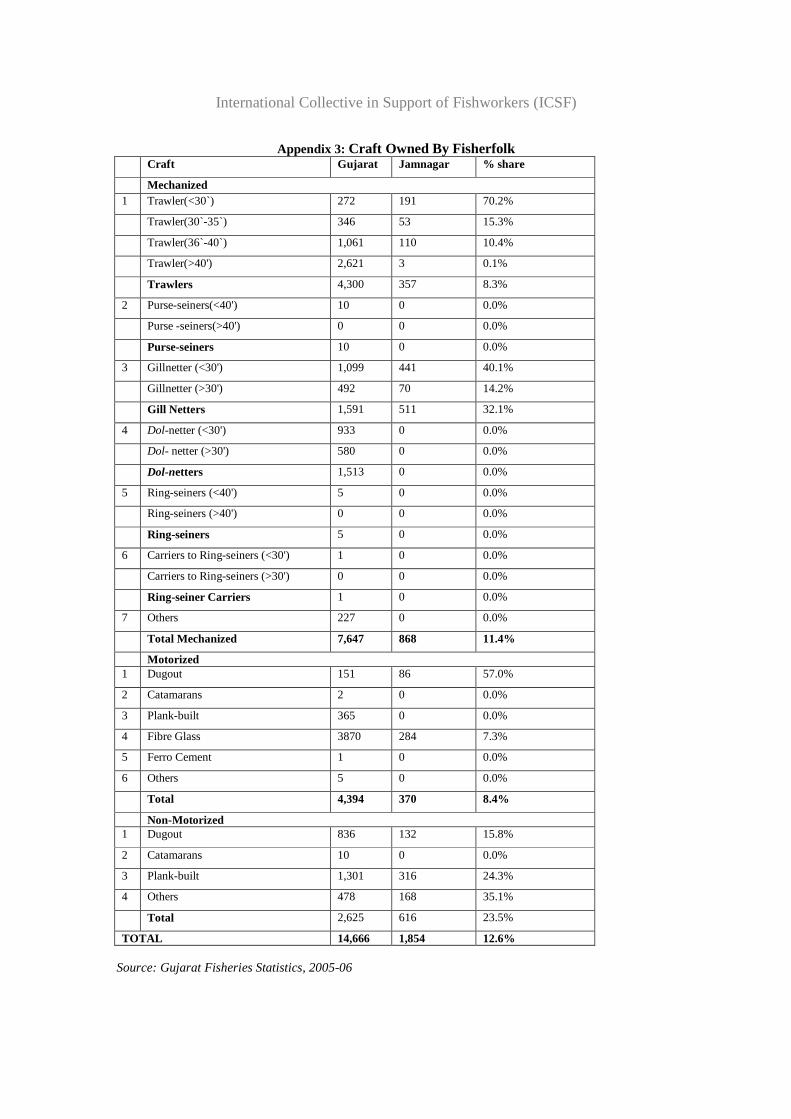
International Collective in Support of Fishworkers (ICSF)
Appendix 3: Craft Owned By Fisherfolk
Source: Gujarat Fisheries Statistics, 2005-06
Craft Gujarat Jamnagar % share
Mechanized 1 Trawler(<30`) 272 191 70.2%
Trawler(30`-35`) 346 53 15.3%
Trawler(36`-40`) 1,061 110 10.4%
Trawler(>40') 2,621 3 0.1%
Trawlers 4,300 357 8.3%
2 Purse-seiners(<40') 10 0 0.0%
Purse -seiners(>40') 0 0 0.0%
Purse-seiners 10 0 0.0%
3 Gillnetter (<30') 1,099 441 40.1%
Gillnetter (>30') 492 70 14.2%
Gill Netters 1,591 511 32.1%
4 Dol-netter (<30') 933 0 0.0%
Dol- netter (>30') 580 0 0.0%
Dol-netters 1,513 0 0.0%
5 Ring-seiners (<40') 5 0 0.0%
Ring-seiners (>40') 0 0 0.0%
Ring-seiners 5 0 0.0%
6 Carriers to Ring-seiners (<30') 1 0 0.0%
Carriers to Ring-seiners (>30') 0 0 0.0%
Ring-seiner Carriers 1 0 0.0%
7 Others 227 0 0.0%
Total Mechanized 7,647 868 11.4%
Motorized 1 Dugout 151 86 57.0%
2 Catamarans 2 0 0.0%
3 Plank-built 365 0 0.0%
4 Fibre Glass 3870 284 7.3%
5 Ferro Cement 1 0 0.0%
6 Others 5 0 0.0%
Total 4,394 370 8.4%
Non-Motorized 1 Dugout 836 132 15.8%
2 Catamarans 10 0 0.0%
3 Plank-built 1,301 316 24.3%
4 Others 478 168 35.1%
Total 2,625 616 23.5%
TOTAL 14,666 1,854 12.6%
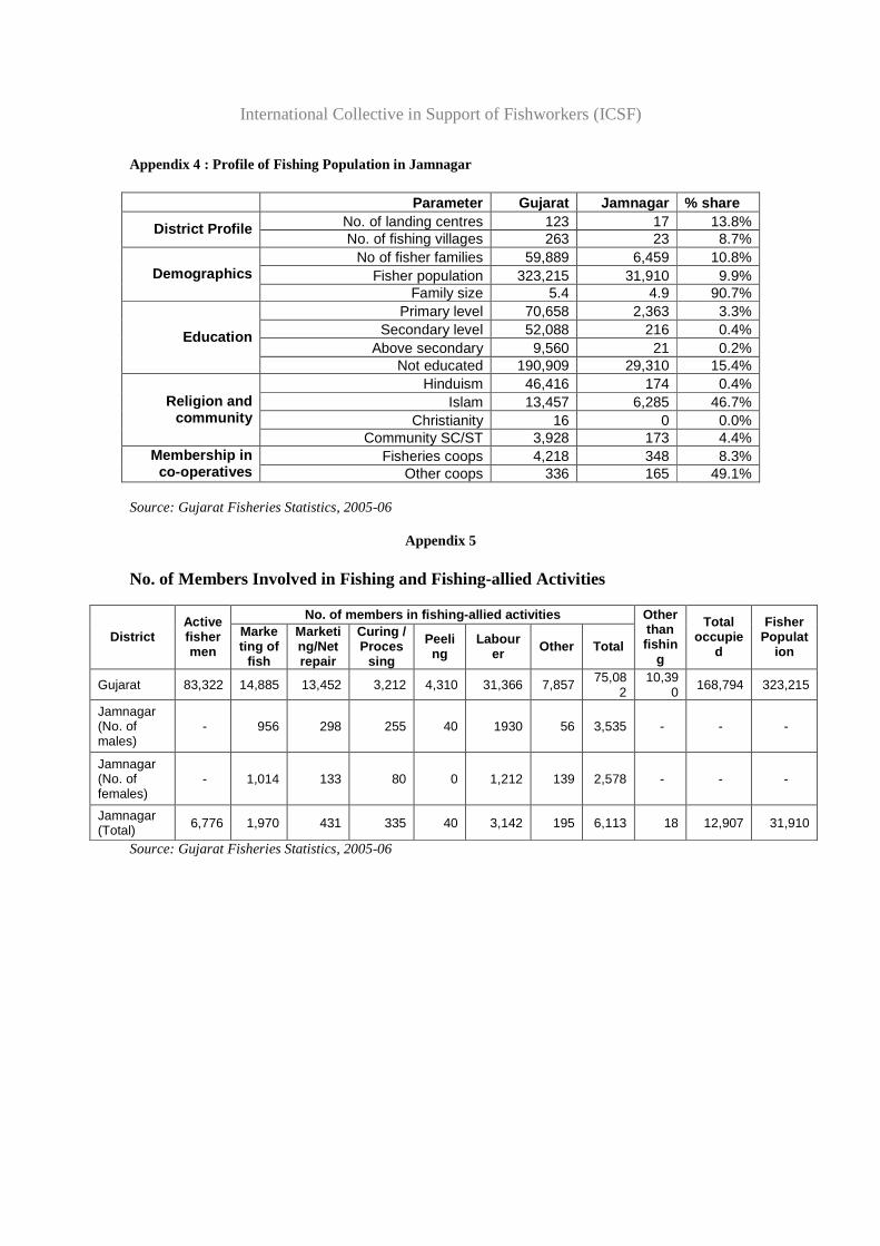
International Collective in Support of Fishworkers (ICSF)
Appendix 4 : Profile of Fishing Population in Jamnagar
Parameter Gujarat Jamnagar % share No. of landing centres 123 17 13.8% District Profile No. of fishing villages 263 23 8.7%
No of fisher families 59,889 6,459 10.8% Fisher population 323,215 31,910 9.9% Demographics
Family size 5.4 4.9 90.7% Primary level 70,658 2,363 3.3%
Secondary level 52,088 216 0.4% Above secondary 9,560 21 0.2%
Education
Not educated 190,909 29,310 15.4% Hinduism 46,416 174 0.4%
Islam 13,457 6,285 46.7% Christianity 16 0 0.0%
Religion and community
Community SC/ST 3,928 173 4.4% Fisheries coops 4,218 348 8.3% Membership in
co-operatives Other coops 336 165 49.1%
Source: Gujarat Fisheries Statistics, 2005-06
Appendix 5
No. of Members Involved in Fishing and Fishing-allied Activities
No. of members in fishing-allied activities
District Active fishermen
Marketing of
fish
Marketing/Net repair
Curing / Proces
sing
Peeling
Labourer Other Total
Other than fishin
g
Total occupie
d
Fisher Populat
ion
Gujarat 83,322 14,885 13,452 3,212 4,310 31,366 7,857 75,082
10,390 168,794 323,215
Jamnagar (No. of males)
- 956 298 255 40 1930 56 3,535 - - -
Jamnagar (No. of females)
- 1,014 133 80 0 1,212 139 2,578 - - -
Jamnagar (Total) 6,776 1,970 431 335 40 3,142 195 6,113 18 12,907 31,910
Source: Gujarat Fisheries Statistics, 2005-06
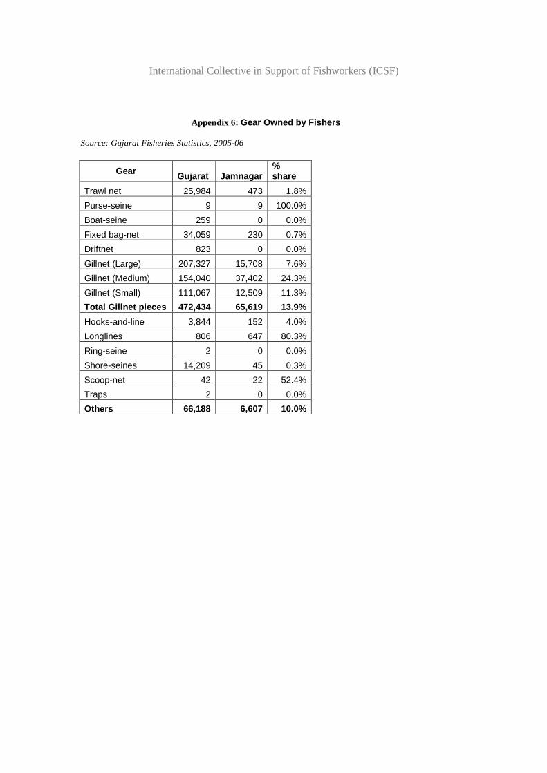
International Collective in Support of Fishworkers (ICSF)
Appendix 6: Gear Owned by Fishers Source: Gujarat Fisheries Statistics, 2005-06
Gear Gujarat Jamnagar % share
Trawl net 25,984 473 1.8%
Purse-seine 9 9 100.0%
Boat-seine 259 0 0.0%
Fixed bag-net 34,059 230 0.7%
Driftnet 823 0 0.0%
Gillnet (Large) 207,327 15,708 7.6%
Gillnet (Medium) 154,040 37,402 24.3%
Gillnet (Small) 111,067 12,509 11.3%
Total Gillnet pieces 472,434 65,619 13.9%
Hooks-and-line 3,844 152 4.0%
Longlines 806 647 80.3%
Ring-seine 2 0 0.0%
Shore-seines 14,209 45 0.3%
Scoop-net 42 22 52.4%
Traps 2 0 0.0%
Others 66,188 6,607 10.0%
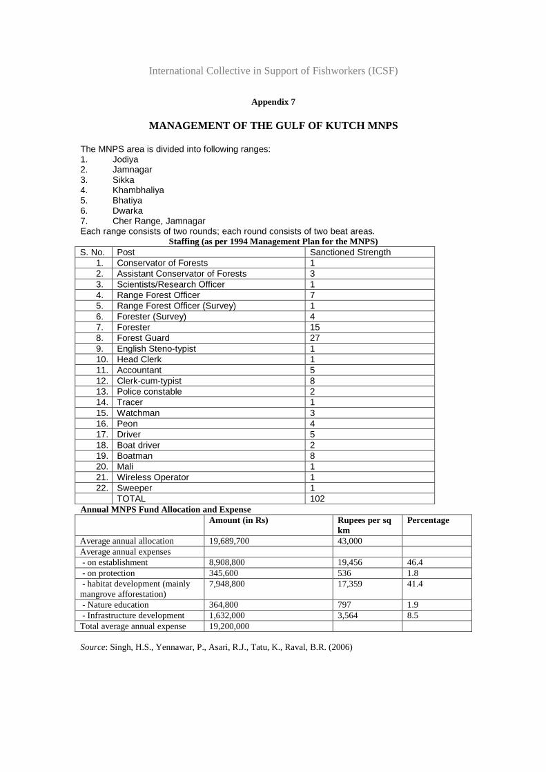
International Collective in Support of Fishworkers (ICSF)
Appendix 7
MANAGEMENT OF THE GULF OF KUTCH MNPS The MNPS area is divided into following ranges: 1. Jodiya 2. Jamnagar 3. Sikka 4. Khambhaliya 5. Bhatiya 6. Dwarka 7. Cher Range, Jamnagar Each range consists of two rounds; each round consists of two beat areas.
Staffing (as per 1994 Management Plan for the MNPS) S. No. Post Sanctioned Strength
1. Conservator of Forests 1 2. Assistant Conservator of Forests 3 3. Scientists/Research Officer 1 4. Range Forest Officer 7 5. Range Forest Officer (Survey) 1 6. Forester (Survey) 4 7. Forester 15 8. Forest Guard 27 9. English Steno-typist 1 10. Head Clerk 1 11. Accountant 5 12. Clerk-cum-typist 8 13. Police constable 2 14. Tracer 1 15. Watchman 3 16. Peon 4 17. Driver 5 18. Boat driver 2 19. Boatman 8 20. Mali 1 21. Wireless Operator 1 22. Sweeper 1
TOTAL 102 Annual MNPS Fund Allocation and Expense Amount (in Rs) Rupees per sq
km Percentage
Average annual allocation 19,689,700 43,000 Average annual expenses - on establishment 8,908,800 19,456 46.4 - on protection 345,600 536 1.8 - habitat development (mainly mangrove afforestation)
7,948,800 17,359 41.4
- Nature education 364,800 797 1.9 - Infrastructure development 1,632,000 3,564 8.5 Total average annual expense 19,200,000 Source: Singh, H.S., Yennawar, P., Asari, R.J., Tatu, K., Raval, B.R. (2006)
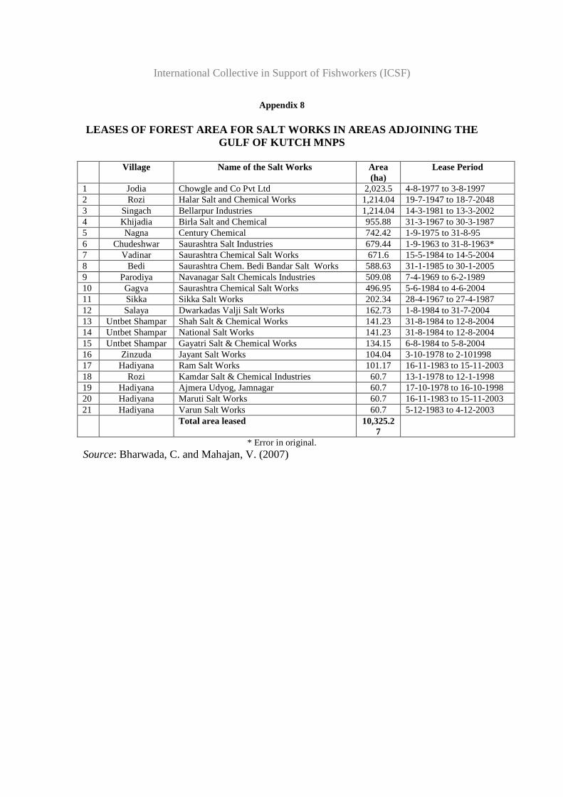
International Collective in Support of Fishworkers (ICSF)
Appendix 8 LEASES OF FOREST AREA FOR SALT WORKS IN AREAS ADJOI NING THE
GULF OF KUTCH MNPS
Village Name of the Salt Works Area (ha)
Lease Period
1 Jodia Chowgle and Co Pvt Ltd 2,023.5 4-8-1977 to 3-8-1997 2 Rozi Halar Salt and Chemical Works 1,214.04 19-7-1947 to 18-7-2048 3 Singach Bellarpur Industries 1,214.04 14-3-1981 to 13-3-2002 4 Khijadia Birla Salt and Chemical 955.88 31-3-1967 to 30-3-1987 5 Nagna Century Chemical 742.42 1-9-1975 to 31-8-95 6 Chudeshwar Saurashtra Salt Industries 679.44 1-9-1963 to 31-8-1963* 7 Vadinar Saurashtra Chemical Salt Works 671.6 15-5-1984 to 14-5-2004 8 Bedi Saurashtra Chem. Bedi Bandar Salt Works 588.63 31-1-1985 to 30-1-2005 9 Parodiya Navanagar Salt Chemicals Industries 509.08 7-4-1969 to 6-2-1989 10 Gagva Saurashtra Chemical Salt Works 496.95 5-6-1984 to 4-6-2004 11 Sikka Sikka Salt Works 202.34 28-4-1967 to 27-4-1987 12 Salaya Dwarkadas Valji Salt Works 162.73 1-8-1984 to 31-7-2004 13 Untbet Shampar Shah Salt & Chemical Works 141.23 31-8-1984 to 12-8-2004 14 Untbet Shampar National Salt Works 141.23 31-8-1984 to 12-8-2004 15 Untbet Shampar Gayatri Salt & Chemical Works 134.15 6-8-1984 to 5-8-2004 16 Zinzuda Jayant Salt Works 104.04 3-10-1978 to 2-101998 17 Hadiyana Ram Salt Works 101.17 16-11-1983 to 15-11-2003 18 Rozi Kamdar Salt & Chemical Industries 60.7 13-1-1978 to 12-1-1998 19 Hadiyana Ajmera Udyog, Jamnagar 60.7 17-10-1978 to 16-10-1998 20 Hadiyana Maruti Salt Works 60.7 16-11-1983 to 15-11-2003 21 Hadiyana Varun Salt Works 60.7 5-12-1983 to 4-12-2003 Total area leased 10,325.2
7
* Error in original. Source: Bharwada, C. and Mahajan, V. (2007)
Related Documents