GEOLOGY, LANDSCAPE AND ARCHAEOLOGY IN THE GAYWOOD VALLEY AREA Technical terms, which have been italicised, are defined in the Glossary which follows this text, except for those only used once, which are defined at the point of use. INTRODUCTION East Anglia as a whole is made up entirely of sedimentary rocks, the bulk of which are tilted gently to the east [Fig. 1]. They form one side of a broad gentle anticline, or upfold, which was formed by the earth movements that created the Alps between 10 and 20 million years ago. Fig. 1. A geological cross-section from Marshland, through to Massingham (not to scale). The Gaywood Valley is only about 19 kilometres long but despite that includes a variety of sedimentary rocks which range in age from Upper Jurassic through to the recently deposited muds on the banks of the Great Ouse. This account, however, will include areas both to the north and south since rocks occurring in these areas have influenced human activity within the Gaywood valley itself. Geologists traditionally divide any account of sedimentary rocks into two. The Solid Geology deals with the older, usually hardened or lithified, rocks. On top of these may lie younger Superficial Deposits which usually consist of loose uncemented sediments. They overlie and mask the underlying solid rocks and the processes responsible for their formation have helped to erode and sculpt the bedrock, to give us the present day landscape. THE SOLID GEOLOGY Table 1. A list of the solid strata exposed in the Gaywood Valley. Fossils are used to recognise different rock types that were all laid down within the same broad time period, e.g. the Jurassic. Finer subdivisions of geological time (zones) are also based on fossil evidence; however, it is usually more convenient to divide rocks up into units based on rock type. Large units, called Formations, may be subdivided into smaller units (or members) which are often named after a place where they can be seen easily. Members are usually made up of a series of individual beds of rock.. In the past different names were applied to some units - these have been included to allow comparisons with older accounts of the geology.

Welcome message from author
This document is posted to help you gain knowledge. Please leave a comment to let me know what you think about it! Share it to your friends and learn new things together.
Transcript

GEOLOGY, LANDSCAPE AND ARCHAEOLOGY IN THE GAYWOOD VALLEY AREA
Technical terms, which have been italicised, are defined in the Glossary which follows this text, except for those only used once, which are defined at the point of use.
INTRODUCTION
East Anglia as a whole is made up entirely of sedimentary rocks, the bulk of which are tilted gently to the east [Fig. 1]. They form one side of a broad gentle anticline, or upfold, which was formed by the earth movements that created the Alps between 10 and 20 million years ago.
Fig. 1. A geological cross-section from Marshland, through to Massingham (not to scale).
The Gaywood Valley is only about 19 kilometres long but despite that includes a variety of sedimentary rocks which range in age from Upper Jurassic through to the recently deposited muds on the banks of the Great Ouse. This account, however, will include areas both to the north and south since rocks occurring in these areas have influenced human activity within the Gaywood valley itself.
Geologists traditionally divide any account of sedimentary rocks into two. The Solid Geology deals with the older, usually hardened or lithified, rocks. On top of these may lie younger Superficial Deposits which usually consist of loose uncemented sediments. They overlie and mask the underlying solid rocks and the processes responsible for their formation have helped to erode and sculpt the bedrock, to give us the present day landscape.
THE SOLID GEOLOGY
Table 1. A list of the solid strata exposed in the Gaywood Valley. Fossils are used to recognise different rock types that were all laid down within the same broad time period, e.g. the Jurassic. Finer subdivisions of geological time (zones) are also based on fossil evidence; however, it is usually more convenient to divide rocks up into units based on rock type. Large units, called Formations, may be subdivided into smaller units (or members) which are often named after a place where they can be seen easily. Members are usually made up of a series of individual beds of rock.. In the past different names were applied to some units - these have been included to allow comparisons with older accounts of the geology.

AGE UNIT(Formations)
SUB-UNITS (Members)
OLD UNITS
CRETACEOUS60 – 145 MA
White Chalk Upper Chalk
Grey Chalk Lower Chalk
Carstone Upper Greensand
Unconformity i.e. a long break in deposition
Dersingham Beds
Sandringham SandsFormation
Leziate Sands Mintlyn Beds
LowerGreensands
JURASSIC142 - 200 MA
Runcton BedsRoxham Beds
Unconformity i.e. a long break in deposition
Kimmeridge Clay Kimmeridge Clay
JURASSIC DEPOSITS
The Kimmeridge Clay Formation. These quiet water, fossil rich marine deposits are the oldest rocks to be found in the valley. They occur beneath
King’s Lynn itself, buried beneath younger sediments, but are occasionally brought to the surface during deep excavations. They are also rich in oil, and an attempt to extract this was made at the turn of the last century, at Setch, which is south of King’s Lynn.
The two topmost beds of the Jurassic, the Roxham and Runcton beds, are thin and poorly exposed, so they have had little effect on the landscape. As they are both sandy units they are included in the Sandringham Sands Formation, the bulk of which is Cretaceous in age. At the base of the Roxham Beds is a very distinctive hard, grey shelly sandstone with shiny black phosphatic pebbles in it; this is overlain by fine grained mottled sands. The Runcton Beds are, apparently, green clayey sands also containing phosphatic nodules. Both of these units can be dated by the Jurassic ammonites that may be found in them.
(The element phosphorus, which occurs in Phosphatic nodules, occurs in fossil faeces. These may accumulate on the sea floor when deposition by other sediments is particularly slow).
CRETACEOUS DEPOSITS
The bulk of the rocks in the Gaywood Valley are Cretaceous in age. They gradually become younger and younger as one proceeds eastwards up the valley (Fig.1 & Table 1).
The Sandringham Sands Formation. This rock unit spans the upper Jurassic and parts of the lower Cretaceous.
Like the Jurassic Roxham and Runcton beds the lowest unit of the Cretaceous, the Mintlyn Beds, are poorly exposed. They consist of about 13 metres of grey-green clayey sand and clay ironstones which contains fossil bivalves and ammonites.
The Leziate Sands member, which is about 30 metres thick - and therefore has the greatest visible effect on the landscape - consists dominantly of very
fine-grained pure sands, laid down under marine conditions. They contain some clayey horizons and also may contain nodules of iron pyrite (FeS2). They contain very few fossils.
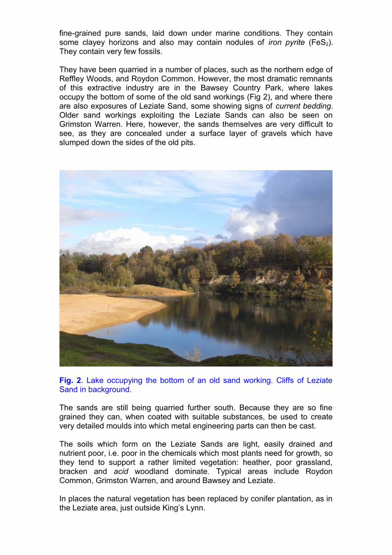
They have been quarried in a number of places, such as the northern edge of Reffley Woods, and Roydon Common. However, the most dramatic remnants of this extractive industry are in the Bawsey Country Park, where lakes occupy the bottom of some of the old sand workings (Fig 2), and where there are also exposures of Leziate Sand, some showing signs of current bedding. Older sand workings exploiting the Leziate Sands can also be seen on Grimston Warren. Here, however, the sands themselves are very difficult to see, as they are concealed under a surface layer of gravels which have slumped down the sides of the old pits.
Fig. 2. Lake occupying the bottom of an old sand working. Cliffs of Leziate Sand in background.
The sands are still being quarried further south. Because they are so fine grained they can, when coated with suitable substances, be used to create very detailed moulds into which metal engineering parts can then be cast.
The soils which form on the Leziate Sands are light, easily drained and nutrient poor, i.e. poor in the chemicals which most plants need for growth, so they tend to support a rather limited vegetation: heather, poor grassland, bracken and acid woodland dominate. Typical areas include Roydon Common, Grimston Warren, and around Bawsey and Leziate.
In places the natural vegetation has been replaced by conifer plantation, as in the Leziate area, just outside King’s Lynn.
The Dersingham Beds, which reach a maximum thickness of about 24 metres, are poorly exposed in the Gaywood valley, although they do cap some low hills; however, they have had a marked influence since they are the source of ‘Small Carr’ which is used extensively locally as a building stone. Small Carr, which is a thin bedded, fine grained foxy-brown sandstone, is mainly found towards the base of the sequence. The main source locally was probably from the Blakely Cross quarry on Roydon Common (TF673.223).
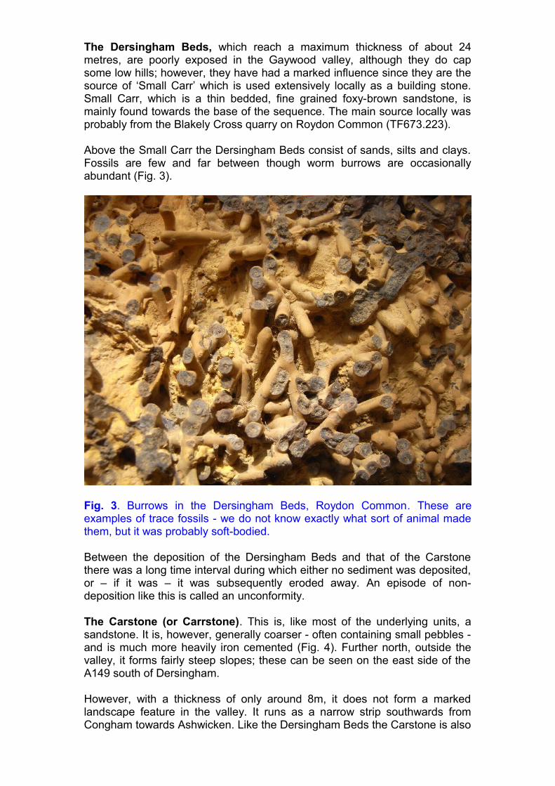
Above the Small Carr the Dersingham Beds consist of sands, silts and clays. Fossils are few and far between though worm burrows are occasionally abundant (Fig. 3).
Fig. 3. Burrows in the Dersingham Beds, Roydon Common. These are examples of trace fossils - we do not know exactly what sort of animal made them, but it was probably soft-bodied.
Between the deposition of the Dersingham Beds and that of the Carstone there was a long time interval during which either no sediment was deposited, or – if it was – it was subsequently eroded away. An episode of non-deposition like this is called an unconformity.
The Carstone (or Carrstone). This is, like most of the underlying units, a sandstone. It is, however, generally coarser - often containing small pebbles - and is much more heavily iron cemented (Fig. 4). Further north, outside the valley, it forms fairly steep slopes; these can be seen on the east side of the A149 south of Dersingham.
However, with a thickness of only around 8m, it does not form a marked landscape feature in the valley. It runs as a narrow strip southwards from Congham towards Ashwicken. Like the Dersingham Beds the Carstone is also

used locally as a building stone, supplying what is called ‘Big Carr’ because larger lumps are used (Allen 2004). It is not, however, quarried in the valley itself.
Fig. 4. A close up of Carrstone ('Big Carr'). The sand grains are easily visible and are quite angular. Small Carr is much finer grained.
The Chalk. Eastwards from Congham and Grimston the valley is underlain by Chalk. Chalk is a remarkably pure form of fine grained limestone. Limestone consists dominantly of calcium carbonate (CaCO3), laid down in tropical waters. It is often fossiliferous, but the most remarkable constituent of the Chalk is Flint.
Flint is a non-crystalline form of the mineral silica (silicon dioxide SiO2) which normally occurs as quartz – the commonest mineral to form sand grains. However, it can also dissolve in seawater, and certain types of sponges and other marine organisms are able to extract this dissolved silica from the water and incorporate it into their skeletons. When they die these remains are deposited on the sea floor, where they may accumulate in huge numbers.
These deposits of silica exist as gels. Chemical changes occurring in the sediment after deposition, often triggered by the release of chemicals from the rotting remains of animals, may cause these silica gels to migrate through the sediment and then solidify – to form layers or nodules of flint. Some flints contain fossils, but most do not. However, it should be remembered that many creatures, such as worms, have no hard parts to become fossilised.
Flint is only found in the White (Upper) Chalk, which is not seen in our area, but which occurs further north and further east. However, huge amounts of flint were eroded from it during the Ice Ages and transported into our area and deposited as field stones. These stones were cleared from the fields, to make cultivation easier, and then incorporated into all sorts of buildings. Flint can also, of course, be 'worked' to produce tools, such as hand axes, so it was a valuable resource for early humans too.

The presence of Chalk helps explain why the upper part of the Gaywood ‘Valley’ is free of water: such surface water as does fall sinks into the soft limestone of the Chalk and disappears underground. However, there are no accessible present day exposures of Chalk in the Valley. This is because the Chalk lies buried beneath varying thickness’s of glaciofluvial sands and gravels. Where these superficial deposits are thinner, lime-loving plants such as Rockrose Heliathemum nummularium and Dropwort Filipendula vulgaris may occur, but otherwise there is little sign of it, unless it is turned up by the plough.
Chalk has been quarried commercially, for lime, at Gayton and at Hillington. The sites are all, however, on private land and not readily accessible, though they can be seen from public footpaths.
THE SUPERFICIAL DEPOSITS.
The Superficial deposits all belong to the Quaternary Period of geological time, which extends back to about 2.8 million years before the present. During the Quaternary there were a series of major climatic changes with episodes of very cold climate (Ice Ages or Glaciations), alternating with warmer (Interglacial) episodes. The detailed geology of the Quaternary is very complex and the experts are not fully agreed on the details of what occurred, particularly during the Wolstonian stage. One reason for this is that erosion by ice often destroyed the sediments laid down during interglacial stages, or – unless revealed in quarries – they may be completely concealed beneath younger deposits. Table 2 presents a rough summary of what we know.
As a result we are not entirely sure of events in the Gaywood Valley itself but can guess what was happening from evidence present in the Babingley valley to the north, and Nar valley to the south.
We can be sure, however, that the present form of the Gaywood Valley has been caused by the interplay between glacial and periglacial activities, as well as the action of rivers, wind, and gravity.
During an Ice Age the weight of ice lying on it will push the land downwards. Sea levels may also drop because rainwater, instead of flowing back into the sea, is trapped on land as ice. However, at the end of an ice age sea levels will initially rise as all the melting ice pours back into the sea. Some time later, free of the weight of the ice, the land will begin to rise again and sea levels will drop. These relative changes in land and sea level add to the complexity of the geology, particularly in areas near the coast. During some of the times when sea levels were lower Britain was joined to Europe and it would have been possible to simply walk across what is now the North Sea – which is how our ancestors reached Britain. When sea levels rose again, however, Britain became an island.
THE SEQUENCE OF EVENTS IN THE GAYWOOD VALLEY
Glacial deposits. Probably the most extensive superficial deposits in Norfolk are those associated with the Lowestoft Formation. These are
sediments laid down by the Anglian glaciation, which occurred between 474 and 427 thousand years ago (Table 2). They are very varied.
Ice moves very slowly by what is called laminar flow. Rock fragments of different sizes are picked up and carried along together, regardless of size, so that clay and sand particles can be carried at the same speed and same direction as large boulders. (This is very different from what happens in flowing water when smaller, lighter, particles are swept along faster than heavier ones, resulting in sorting taking place.) Glacial deposits, or tills, are typically unsorted. (Till used to be known as Boulder Clay, however that term is inappropriate because not all tills contain boulders.)
As the ice sheets moved over the underlying Chalk and older sediments they picked up fragments and ground the material down – as well as mixing it with material from other sources, such as the bed of the North Sea. Local Anglian tills are often referred to as Chalky Till or Chalky Boulder Clay because they often contain appreciable amounts of Chalk. Where present the clays form an impermeable soil which may result in poor drainage and surface water; the ground up Chalk component of the material gives a soil rich in calcium carbonate (CaCO3) which may support a distinctive vegetation.
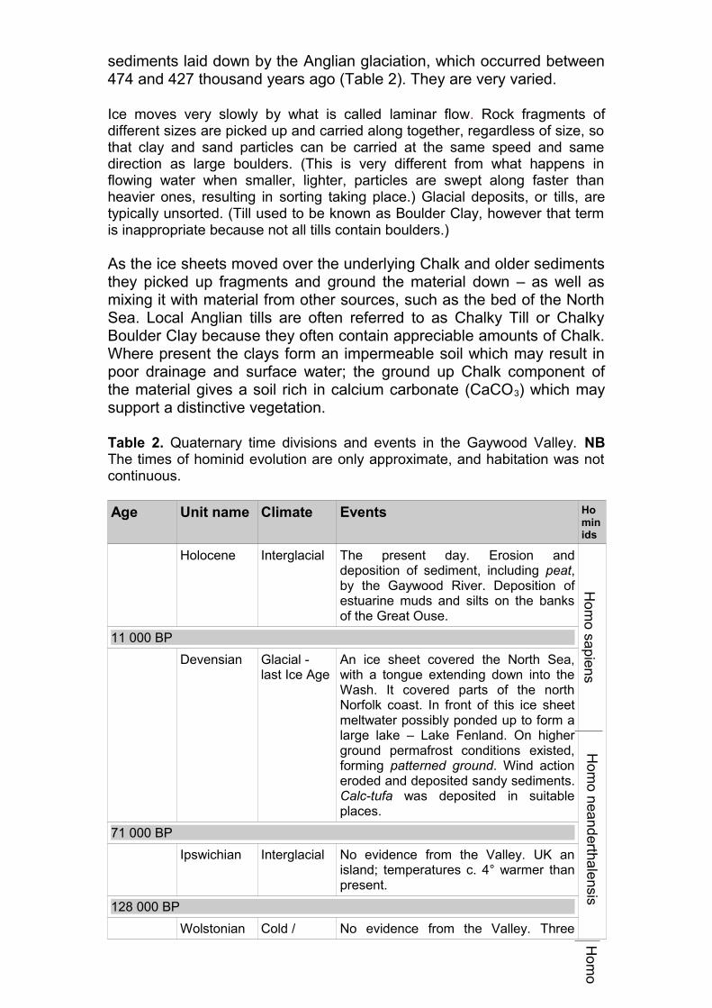
Table 2. Quaternary time divisions and events in the Gaywood Valley. NB The times of hominid evolution are only approximate, and habitation was not continuous.
Age Unit name Climate Events Hominids
Holocene Interglacial The present day. Erosion and deposition of sediment, including peat, by the Gaywood River. Deposition of estuarine muds and silts on the banks of the Great Ouse.
11 000 BP
Devensian Glacial - last Ice Age
An ice sheet covered the North Sea, with a tongue extending down into the Wash. It covered parts of the north Norfolk coast. In front of this ice sheet meltwater possibly ponded up to form a large lake – Lake Fenland. On higher ground permafrost conditions existed, forming patterned ground. Wind action eroded and deposited sandy sediments. Calc-tufa was deposited in suitable places.
71 000 BP
Ipswichian Interglacial No evidence from the Valley. UK an island; temperatures c. 4° warmer than present.
128 000 BP
Wolstonian Cold / No evidence from the Valley. Three
Ho
mo
sap
ien
sH
om
o nea
nd
erthale
nsisH
om
o
variable separate cold episodes within the Wolstonian.
364 000 BP
Hoxnian Interglacial No evidence from the Valley.
427 000 BP
Anglian Ice Age A major ice sheet covered the whole of Britain (including East Anglia) as far south as a line extending from the Bristol Channel to the Thames. The ice, and subglacial melt waters, shaped the underlying land surface both by eroding it and depositing materials on it. The ice was both preceded and followed by very cold periglacial conditions which also affected the landscape.
474 000 BP
Cromerian Warm Deposits of this age only found in north-eastern Norfolk.
712 000 BP
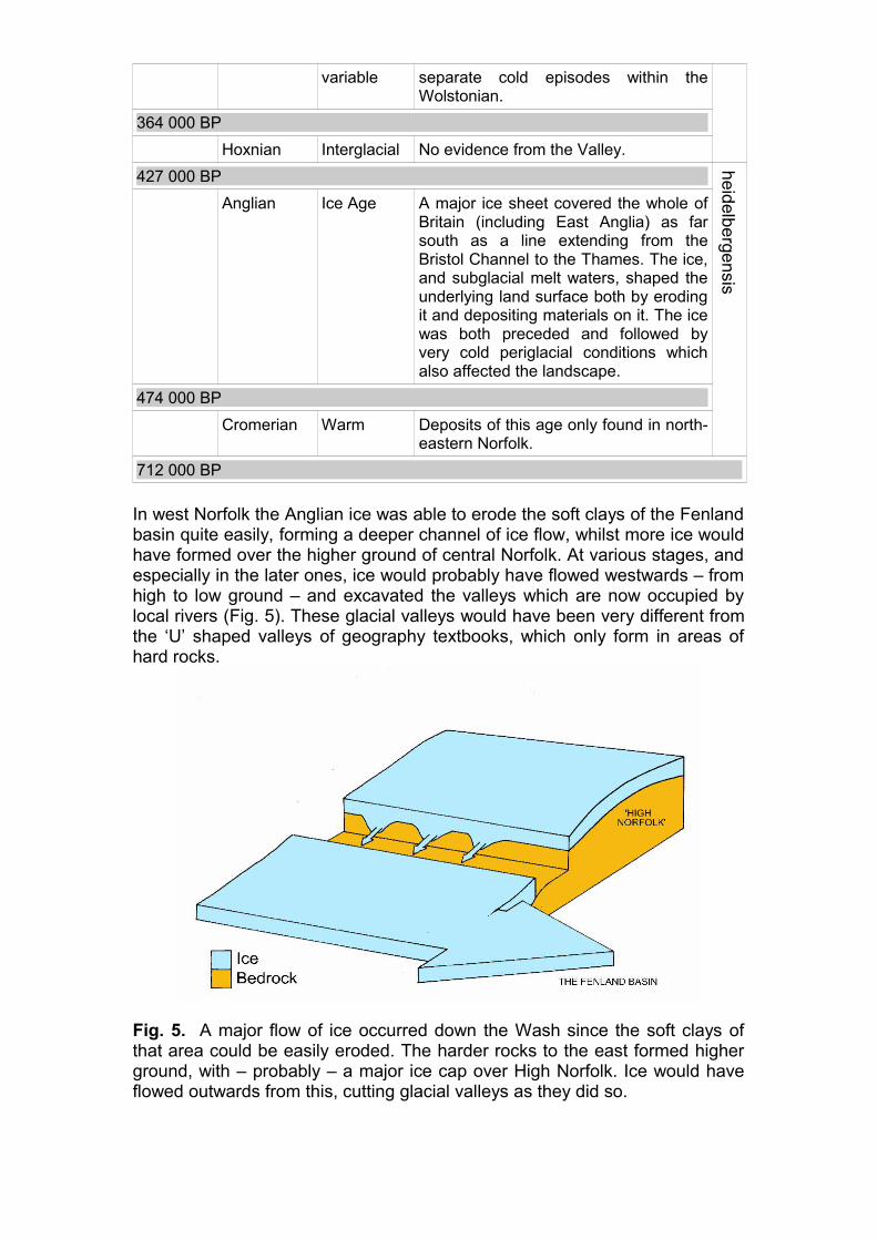
In west Norfolk the Anglian ice was able to erode the soft clays of the Fenland basin quite easily, forming a deeper channel of ice flow, whilst more ice would have formed over the higher ground of central Norfolk. At various stages, and especially in the later ones, ice would probably have flowed westwards – from high to low ground – and excavated the valleys which are now occupied by local rivers (Fig. 5). These glacial valleys would have been very different from the ‘U’ shaped valleys of geography textbooks, which only form in areas of hard rocks.
Fig. 5. A major flow of ice occurred down the Wash since the soft clays of that area could be easily eroded. The harder rocks to the east formed higher ground, with – probably – a major ice cap over High Norfolk. Ice would have flowed outwards from this, cutting glacial valleys as they did so.
heid
elbe
rgen
sis
(Whilst there is clear evidence in places for cold episodes during the Wolstonian stage, the evidence for actual glaciation in East Anglia is unclear and the subject of debate between experts).
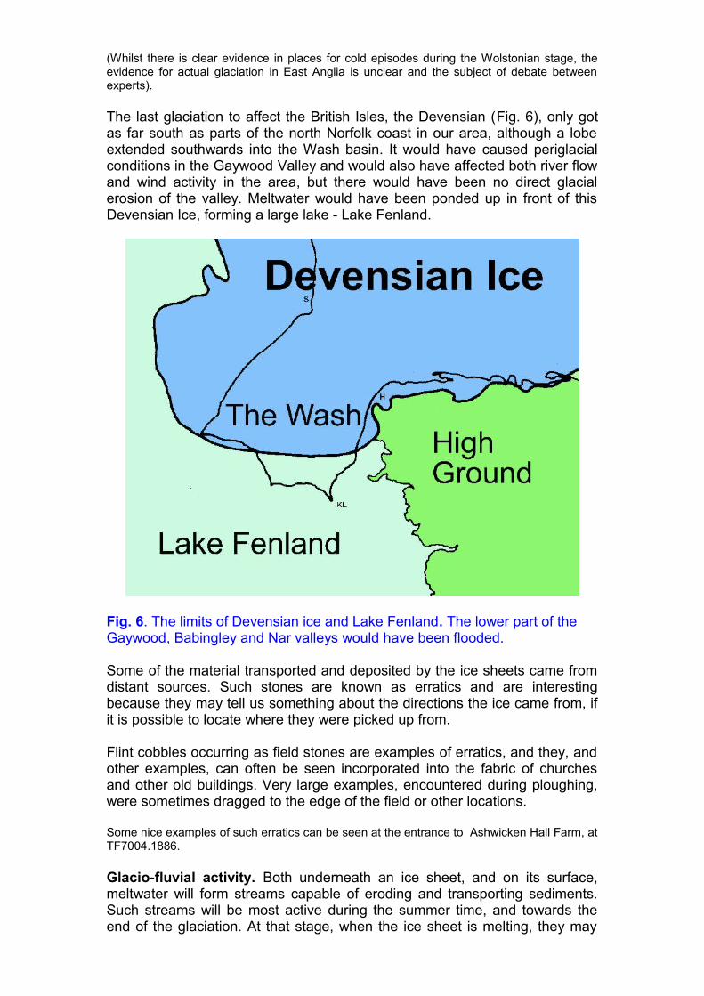
The last glaciation to affect the British Isles, the Devensian (Fig. 6), only got as far south as parts of the north Norfolk coast in our area, although a lobe extended southwards into the Wash basin. It would have caused periglacial conditions in the Gaywood Valley and would also have affected both river flow and wind activity in the area, but there would have been no direct glacial erosion of the valley. Meltwater would have been ponded up in front of this Devensian Ice, forming a large lake - Lake Fenland.
Fig. 6. The limits of Devensian ice and Lake Fenland. The lower part of the Gaywood, Babingley and Nar valleys would have been flooded.
Some of the material transported and deposited by the ice sheets came from distant sources. Such stones are known as erratics and are interesting because they may tell us something about the directions the ice came from, if it is possible to locate where they were picked up from.
Flint cobbles occurring as field stones are examples of erratics, and they, and other examples, can often be seen incorporated into the fabric of churches and other old buildings. Very large examples, encountered during ploughing, were sometimes dragged to the edge of the field or other locations.
Some nice examples of such erratics can be seen at the entrance to Ashwicken Hall Farm, at TF7004.1886.
Glacio-fluvial activity. Both underneath an ice sheet, and on its surface, meltwater will form streams capable of eroding and transporting sediments. Such streams will be most active during the summer time, and towards the end of the glaciation. At that stage, when the ice sheet is melting, they may
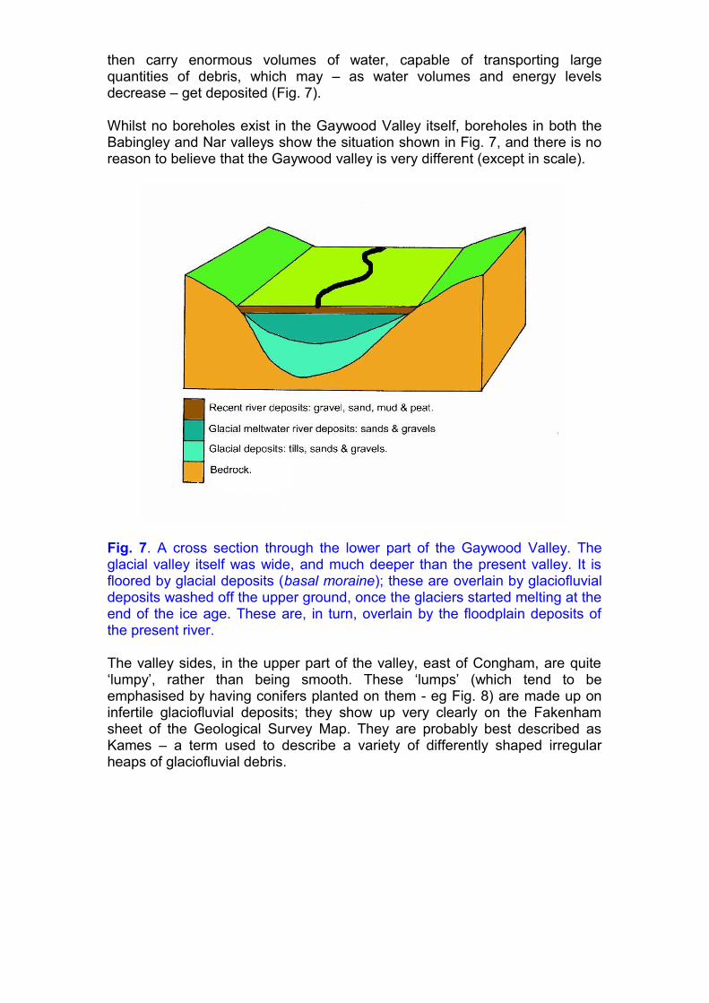
then carry enormous volumes of water, capable of transporting large quantities of debris, which may – as water volumes and energy levels decrease – get deposited (Fig. 7).
Whilst no boreholes exist in the Gaywood Valley itself, boreholes in both the Babingley and Nar valleys show the situation shown in Fig. 7, and there is no reason to believe that the Gaywood valley is very different (except in scale).
Fig. 7. A cross section through the lower part of the Gaywood Valley. The glacial valley itself was wide, and much deeper than the present valley. It is floored by glacial deposits (basal moraine); these are overlain by glaciofluvial deposits washed off the upper ground, once the glaciers started melting at the end of the ice age. These are, in turn, overlain by the floodplain deposits of the present river.
The valley sides, in the upper part of the valley, east of Congham, are quite ‘lumpy’, rather than being smooth. These ‘lumps’ (which tend to be emphasised by having conifers planted on them - eg Fig. 8) are made up on infertile glaciofluvial deposits; they show up very clearly on the Fakenham sheet of the Geological Survey Map. They are probably best described as Kames – a term used to describe a variety of differently shaped irregular heaps of glaciofluvial debris.
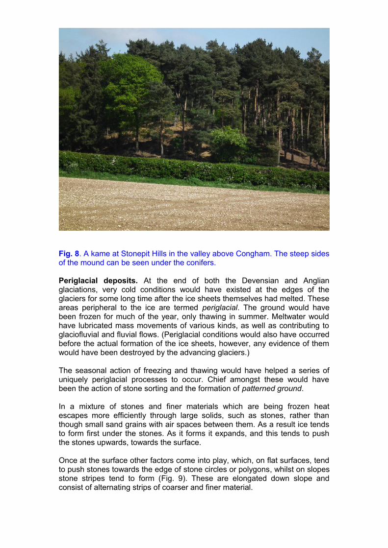
Fig. 8. A kame at Stonepit Hills in the valley above Congham. The steep sides of the mound can be seen under the conifers.
Periglacial deposits. At the end of both the Devensian and Anglian glaciations, very cold conditions would have existed at the edges of the glaciers for some long time after the ice sheets themselves had melted. These areas peripheral to the ice are termed periglacial. The ground would have been frozen for much of the year, only thawing in summer. Meltwater would have lubricated mass movements of various kinds, as well as contributing to glaciofluvial and fluvial flows. (Periglacial conditions would also have occurred before the actual formation of the ice sheets, however, any evidence of them would have been destroyed by the advancing glaciers.)
The seasonal action of freezing and thawing would have helped a series of uniquely periglacial processes to occur. Chief amongst these would have been the action of stone sorting and the formation of patterned ground.
In a mixture of stones and finer materials which are being frozen heat escapes more efficiently through large solids, such as stones, rather than though small sand grains with air spaces between them. As a result ice tends to form first under the stones. As it forms it expands, and this tends to push the stones upwards, towards the surface.
Once at the surface other factors come into play, which, on flat surfaces, tend to push stones towards the edge of stone circles or polygons, whilst on slopes stone stripes tend to form (Fig. 9). These are elongated down slope and consist of alternating strips of coarser and finer material.

Fig. 9. On the photo, which was taken in Iceland, there are small stone circles (or polygons) in the foreground and some small stripes on the slope in the middle of the photo.
The finer material is more moisture retentive, so crops grow better in it, whilst in the coarser drier material crops grow less well. This can sometimes be seen on the ground (Fig. 10) though it often shows up much better on aerial photographs. A visit to Google Earth will show some very distinct patterned ground on the south side of the upper Gaywood valley, on Grimston Heath.
Fig. 10. Crop marks (possible stone stripes) in fields; interpreting such marks is difficult since they could have other causes, perhaps related to agricultural practises.
Lake (Lacustrine) Deposits. During the Devensian glaciation (Fig. 6) the ice formed a lobe which extended across the mouth of the Wash. To the south (and west) of this meltwater was hemmed in by higher ground and probably accumulated to form a large lake – Lake Fenland. (The full extent of Lake Fenland can be seen on the Britice website). This water would have flooded

the lower parts of valleys such as those of the Babingley, Gaywood and Nar. Fresh water lake deposits have been found in the Nar valley and they may also exist in parts of the Gaywood valley although it would need evidence from boreholes to prove this.
Lakes tend to be quiet water environments so the main material deposited tends to be clay, which requires little energy to transport it. Freshwater clays can be distinguished from marine clays – like those of the Kimmeridge Clay – by the fossils they contain.
River (Fluvial) deposits. The drainage pattern of the Babingley, Gaywood and Middleton is fairly straightforward: they are fed by springs coming from the Chalk, although both the Babingley and Gaywood have dry valleys which extend much further east. (Although the two rivers are about the same size, the Babingley valley is much narrower, indicating, perhaps, that it was not as deeply eroded by ice as the Gaywood valley). The Middleton Stop Drain, which is a tributary of the Nar, does not have an eastward extending dry valley though like the Gaywood it has a disproportionately wide valley.
The springs which feed these rivers are dominantly located on private land and are therefore inaccessible. Even when they can be accessed they are remarkably dull, with the exception of that located just south-west of Grimston church which emerges strong and clear from below a garden wall.
Water percolating down through the lower Cretaceous sands often pick up considerable quantities of iron oxides. These may stain the water in dykes and ditches bright orange; they may also be deposited to form a ferruginous cement, forming Iron Pan. Suitable iron oxides may also form deposits of Bog Iron ore.
One of the more obvious features of the valley is that the upper reaches are dry – there is no surface flowing water. These upper reaches would have been carved by flowing waters coming from the melting Anglian Ice. As the underlying Chalk would still have been frozen the water was confined to the surface; its main sediment load would have consisted of sands and gravels derived from pre-existing glaciofluvial deposits.
Once the temperature rose enough for the Chalk to unfreeze then, increasingly, water would have been able to escape underground. Even by Faden’s time these upper sections were probably dry winterbournes. (A winterbourne is an ephemeral stream which occasionally runs over the ground surface after periods of very heavy rain, when the water table rises above the surface. This happens most frequently in winter).
The present river is obviously too small to have carved the comparatively wide valley it occupies: it is a misfit river. The usual assumption is that the valley was carved in immediately post-glacial times when large volumes of meltwater were available to erode the landscape.
Water flows in a different way to ice, by turbulent flow, as a result of which rock particles of different sizes get sorted, i.e. the smaller, lighter, ones – such as sand or mud particles – tend to become physically separated from heavier, coarser, pebbles and boulders, which require more energy to transport them.
Natural rivers tend to meander, ie to show a series of more-or-less regular sinuous bends. In the case of the Gaywood most of these natural meanders have been eliminated, in the interests of agricultural drainage. However, they have been re-instated in the section flowing through Derby Fen (TF70.20) in an attempt to improve the habitat for nature.
In the actual river valley itself the Gaywood is, at present, mainly transporting fine-grained muds and silts, most of which have been washed into the river by rainwater. In summer, when water levels are lower, there may not even be enough energy to transport this sort of material and the water will be clear. In those sections of the river where there is a coarse gravelly bottom it is likely that the gravel only moves occasionally, when floodwaters are strong enough to move such heavy material.
On the floodplain of the lower reaches of the river waterlogged conditions may prevent bacteria from breaking down plant material, which may then accumulate to form deposits of peat. Peat deposits occur in several places, and may occasionally be seen on the sides of freshly cleaned dykes.
In the upper, dry, sections of the valley the river deposits are sandy and gravelly, and probably represent reworked glaciofluvial material.
Aeolian deposits. At the end of the last glaciation the local landscape would have been tundra-like in nature. It is likely that there was little vegetation, and therefore there was nothing to stop the wind from picking up fine sand particles and blowing them about. This aeolian (or wind) action would have been particularly active over areas where the Leziate Sands were exposed since they are very fine and therefore easily lifted.
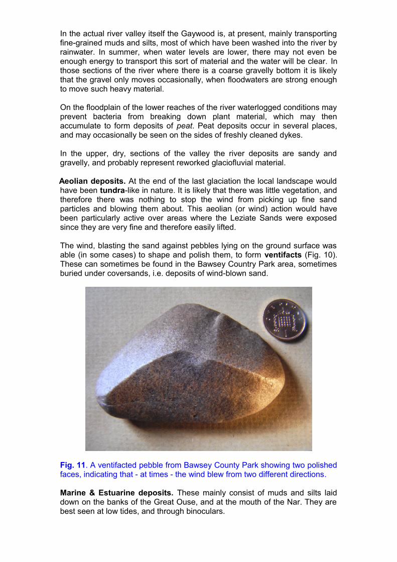
The wind, blasting the sand against pebbles lying on the ground surface was able (in some cases) to shape and polish them, to form ventifacts (Fig. 10). These can sometimes be found in the Bawsey Country Park area, sometimes buried under coversands, i.e. deposits of wind-blown sand.
Fig. 11. A ventifacted pebble from Bawsey County Park showing two polished faces, indicating that - at times - the wind blew from two different directions.
Marine & Estuarine deposits. These mainly consist of muds and silts laid down on the banks of the Great Ouse, and at the mouth of the Nar. They are best seen at low tides, and through binoculars.
Mass wasting deposits. Mass movements occur on slopes, when material is moved slowly downhill under the influence of gravity. Although such deposits can form distinctive landforms they do not do so in the Gaywood valley.
Most of these mass movements deposits, which are labelled as Head on the geological maps of the area, have been considerably modified by agriculture, making it very difficult to make out their origin, except by detailed examination by experts. They incorporate materials from the rocks occurring higher upslope.
GEOLOGY AND HUMAN ACTIVITIES
The historical use of geological raw materials in the Gaywood Valley has not been researched in depth. It would require a major co-operative effort between geologists and archaeologists. Much of the evidence for former activity, in the form of pits, has vanished, either through infilling, or simply by being overgrown by vegetation. Gallois (1994) lists many of the disused pits in the Valley.
AGRICULTURAL (AND OTHER) USES
The underlying geology is a major constraint on the types of soil which form, the natural vegetation which develops upon them, and the agricultural uses to which they can subsequently be put.
At a very simple level the soils in the valley can be divided into two types: nutrient poor infertile ('acid') soils, and relatively nutrient rich fertile soils. The former are mainly associated with the Cretaceous sands and some of the Quaternary glaciofluvial deposits whilst the latter are more closely associated with Quaternary tills and lacustrine and fluvial deposits.
Curiously, the light, relatively infertile soils may have been amongst the earliest to be cultivated simply because early ploughs could deal with them more easily than with the more fertile clay soils. Some of the clay soils also occurred in valley bottoms liable to flooding, which could therefore only be cultivated once they had been drained. The wooded infertile soils would have supplied fuel to our ancestors, as would the peat deposits found on some of the low lying wet areas.
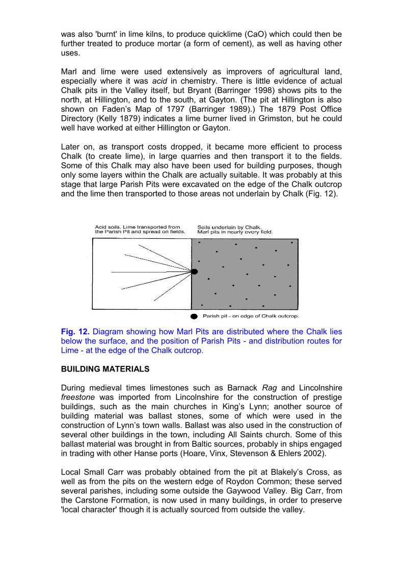
The Agricultural Revolution and the use of Lime. One of the key features of the eighteenth century ‘Agricultural Revolution’ was the invention of the Norfolk Four Crop Rotation system by local landowner ‘Turnip’ Townsend. As well as crop rotation the system also involved the marling of fields, to increase crop yields. Marling involved digging down through the (relatively thin) layer of glacial sands to reach the underlying Chalk (or other calcium carbonate rich layers (marls)) which are a good source for some of the nutrients missing from the sands. The cheapest and most effective method of distributing this chalky material was to have a pit in the middle of each field, so as to reduce transport costs and time. These marl pits have since been abandoned, and usually show up as clumps of bushes or trees, both on aerial photographs and on the ground.
Later on Chalk was ground up commercially, usually in larger quarries, to be spread - as lime fertiliser, often with the addition of other nutrient chemicals. It
was also 'burnt' in lime kilns, to produce quicklime (CaO) which could then be further treated to produce mortar (a form of cement), as well as having other uses.
Marl and lime were used extensively as improvers of agricultural land, especially where it was acid in chemistry. There is little evidence of actual Chalk pits in the Valley itself, but Bryant (Barringer 1998) shows pits to the north, at Hillington, and to the south, at Gayton. (The pit at Hillington is also shown on Faden’s Map of 1797 (Barringer 1989).) The 1879 Post Office Directory (Kelly 1879) indicates a lime burner lived in Grimston, but he could well have worked at either Hillington or Gayton.
Later on, as transport costs dropped, it became more efficient to process Chalk (to create lime), in large quarries and then transport it to the fields. Some of this Chalk may also have been used for building purposes, though only some layers within the Chalk are actually suitable. It was probably at this stage that large Parish Pits were excavated on the edge of the Chalk outcrop and the lime then transported to those areas not underlain by Chalk (Fig. 12).
Fig. 12. Diagram showing how Marl Pits are distributed where the Chalk lies below the surface, and the position of Parish Pits - and distribution routes for Lime - at the edge of the Chalk outcrop.
BUILDING MATERIALS
During medieval times limestones such as Barnack Rag and Lincolnshire freestone was imported from Lincolnshire for the construction of prestige buildings, such as the main churches in King’s Lynn; another source of building material was ballast stones, some of which were used in the construction of Lynn’s town walls. Ballast was also used in the construction of several other buildings in the town, including All Saints church. Some of this ballast material was brought in from Baltic sources, probably in ships engaged in trading with other Hanse ports (Hoare, Vinx, Stevenson & Ehlers 2002).
Local Small Carr was probably obtained from the pit at Blakely’s Cross, as well as from the pits on the western edge of Roydon Common; these served several parishes, including some outside the Gaywood Valley. Big Carr, from the Carstone Formation, is now used in many buildings, in order to preserve 'local character' though it is actually sourced from outside the valley.

Silver Carr, which is also used locally, is a hard well cemented variant of the Leziate Sand which occurred in the Castle Rising area but fragments of which have been dispersed further south by glacial activity, where it may occur as field stones. (It was also used by the Romans, who transported it further east along the coast).
Bricks. Whilst there is little physical evidence left it is clear that these were being made locally; several brick kilns are shown round Lynn on Bryant’s map of Norfolk (Barringer 1998). An entry in the Post Office Directory for 1879 (Kelly 1879) also shows a potter operating in Gaywood, presumably using the same sorts of clay as were exploited by the brick makers (Fig 13).
Fig. 13. The brick kilns are all situated on estuarine or fluvial clays and all are near the main point of use. There was, at that time, no money to be made transporting such low value items long distances. NB the very different shape of the coastline.
Chalk has been used as a building material in several places in the valley, as, for instance, in Congham (Fig. 14). Cottages in the same group also employ fragments of Silver Carr, as well as bricks and Flint fieldstones. The latter are also widely used in other local buildings, as well as in the smaller parish churches where the use of imported limestone, other than for details requiring carving (such as windows), would have been too expensive.

Fig. 12. End wall of a cottage in Congham. The lower part is made up of Silver Carr and flint fieldstones, whilst the upper part if made up of blocks of dressed Chalk.
Sand & gravel extraction probably occurred whenever a local need arose. Bryant’s Map shows such a pit near the position of the Queen Elizabeth Hospital; it also indicates sand extraction was occurring in the Leziate area (‘Sand Pit Hill’), where it has continued to the present day.
Iron Pan (Fig 15) is another material used locally. Like the Carrstone this material is normally a dark brown iron-stained material. However, it is geologically much younger than the Carrstone and can usually be distinguished from it by the fact that it contains pebbles of flint.

Fig. 15. Iron pan used in the construction of Bawsey Church. It is an extremely variable material whose variations and probable mode of formation are discussed in detail in Allen (2004). Note the flint pebbles.
Erratics & Fieldstones of many types have been incorporated into many local buildings, most notably some of the churches. Recognition of some of the more obscure rock types is a matter for the specialist.
Places to visit
A variety of sites have been mentioned in the account given above. It should be borne in mind that some of these are on private land, and that permission should be sought from the landowner before entering the site. Those listed below are all open to the public, but activities such as fossil or mineral collection would require the landowners permission.
Bawsey Country Park [TF675.197]. There are several places where exposures of the Leziate Sands can be seen, including some which show current bedding. There are also exposures of till, though for safety reasons they are inaccessible. Also: pyrite nodules & occasional ventifacts can be found.
Reffley Woods [TF654.221]. The Pits on the northern edge are cut into the Leziate Sands, but they are poorly exposed.
Derby Fen [TF705.206]. Re-instated meanders on the Gaywood river. The banks of the Great Ouse [TF615.194]. When the tide goes out extensive
stretches of mud and silt are exposed, on both banks of the river. The best (and safest) place to visit them however, is between the Free Bridge and the West Lynn ferry. A dry day in summer is best because then the sediments will be drier to walk on and a variety of sedimentary structures such as bird’s footprints and sun cracks can usually be seen.
Hunstanton Cliffs [TF769.422]. Hunstanton cliffs, though well outside the Gaywood Valley, are probably the best place to see good exposures of both the Carstone and the Chalk. One bed – the Red Chalk – is present at Hunstanton but thins out southwards, so is not present in the Gaywood Valley.
Blakely Cross Pit, Roydon Common [TF672.222]. This site is managed by the Norfolk Wildlife Trust from whom permission to visit should be obtained. It shows good sections through the iron stained fine sandstones of the Dersingham Beds, as well as patches of younger superficial deposits.
Grimston Warren [TF679.215]. There are large pits on Grimston Warren which were worked for both glacial sands and gravels, and Leziate Sand, however, the bedrock material is poorly exposed, being mantled with material which has slipped down the slope of the pits.
Leziate Fen [TF706.201]. The eastern part of Leziate Fen consists of a series of alternating mounds and depressions that are arranged roughly north-south. In places where rabbits have burrowed into these, lumps of calc-tufa can be found.
Calc-tufa is a deposit of calcium carbonate (CaCO3) that forms when underground waters rich in dissolved calcium carbonate are able to escape to the surface. The lowering of pressure that occurs allows the carbonate to be deposited, often over moss and other organisms (such as snails) living in the area. It can be seen forming at the present day in areas such as the Yorkshire Dales, but here in Norfolk it almost certainly formed at the end of the last Ice Age when carbonate rich springs, escaping from the Chalk, would have been more frequent.
BIBLIOGRAPHY & REFERENCES
This account of the geology and geomorphology of the Gaywood Valley is aimed at the general public, rather than the academic reader. Accordingly, technical terms have been avoided as much as possible, and the text has not been fully referenced; however, all the sources used have been listed below, along with some more general texts. The academic reader should be able to work out the probable source of any particular item they may wish to pursue further, even if it is not directly referred to in the text. Sources printed in blue are especially useful general sources of information.
Allen JRL. 2004. Carrstone in Norfolk Buildings (BAR British Series 371). Oxford: Archaeopress [Covers all the locally used building stones, not just Carstone].
Ballantyne CK & Harris C. 1994. The Periglaciation of Great Britain. Cambridge: Cambridge University Press.
Barringer JC. 1998. Bryant’s Map of Norfolk in 1826. Dereham: The Larks Press.
Barringer, JC. 1989. Faden’s Map of Norfolk (1797). Dereham: The Larks Press.
Britice: www.sheffield.ac.uk/geography/staff/clark_chris/britice
British Geological Survey. 1978. King’s Lynn and The Wash Sheet 145 and apart of 129. Solid and drift geology. 1: 50 000 Provisional Series. Keyworth, Nottingham: British Geological Survey.
British Geological Survey. 1999. Fakenham. England and Wales Sheet 146. Solid and drift geology. 1: 50 000 Provisional Series. Keyworth, Nottingham: British Geological Survey.
Buteux S, Chambers J & Silva B. 2009. Digging Up the Ice Age. Oxford: Archaeopress.
Chatwin CP. 1961. East Anglia and adjoining areas 4th edn. London: HMSO.
French HM. 2007. The Periglacial Environment (3rd edn.).Chichester: John Wiley.
Friend P. 2008. Southern England (New Naturalist Library). London: HarperCollins
Gallois RW. 1994. Geology of the country around King’s Lynn and The Wash. London: HMSO.
Hoare PG, Vinx R, Stevenson CR & Ehlers J. 2002. Re-used bedrock ballast in King’s Lynn’s ‘Town Wall’ and the Norfolk port’s medieval trading links. Medieval Archaeology XLVI: 91 – 105.
Holt-Wilson, T. 2010. Norfolk’s Earth Heritage – valuing our Geodiversity. Norwich: Norfolk Geodiversity Partnership.
Jones RL & Keen DH. 1993. Pleistocene Environments in the British Isles. London: Chapman & Hall.
Kelly ER (ed.). 1879. The Post Office Directory for the counties of Cambridge, Norfolk and Suffolk. London: Kelly & Co.
Landscape East: www.landscape-east.org.uk
Larwood GP & Funnell BM (eds). 1970. The Geology of Norfolk. Geological Society of Norfolk.
Prince HC. 1960. Pits and ponds in Norfolk. Erdkunde, Band XVI, 10 – 34.
Straw A. & Clayton KC. 1979. The geomorphology of the British Isles: Eastern and Central England. London: Methuen.
Woodcock N. & Strachan R. (eds). 2000. Geological History of Britain and Ireland. Oxford: Blackwell
Woodforde J. 1976. Bricks to build a house. London: Routledge & Kegan Paul.
GLOSSARY
acid: acid soils have a pH of <7 and are deficient in elements such as calcium (Ca) and magnesium (Mg).
basic: basic soils have a pH of >7 and are rich in plant nutrients such as calcium (Ca) and magnesium (Mg).
bed: a sedimentary rock unit consisting of a single rock type, having a clear top and bottom. Also (Latin) stratum, plural strata.
bedrock: the underlying solid rocks in an area; they may be concealed beneath soil and / or superficial deposits.
bog iron ore: iron oxides deposited in bogs; easily converted to iron using early technologies.
calc-tufa: a spongy deposit of calcium carbonate (CaCO3), usually formed around vegetation emerging from lime rich spring waters.
current bedding: a type of sedimentary structure produced by flowing water. It results in inclined bedding surfaces within the bed, which may resemble the effects of folding.

dip: the angle to which a bed has been tilted by earth movements. Dip possesses both angle and direction, e.g. 23° NE
exposure: a place where rock is actually visible at the surface. A given bed may have an extensive outcrop but very few actual exposures.
folding: bending and contortion of rocks, resulting from earth movements.
freestone: a building material which can be cut equally easily in any direction. They are especially useful for carving.
gel: a semi-solid substance which may be more-or-less rigid. The constituent atoms do not have a fixed rigid structure.
glaciofluvial: rivers flowing from melting ice. Such rivers have special features such as highly erratic flows at different times of year, which influences the way in which they transport sediments.
head: a term used to describe superficial deposits of obscure origin.
iron pan: an iron cemented sand or gravel superficial deposit, blocks of which can be used as a building material.
iron pyrite: 'Fool's Gold' or iron sulphide (FeS2) occur as nodules in the Leziate Sands. On exposure at the surface it oxidises ('rusts') and stains drainage water.
lime: calcium carbonate (CaCO3).
moraine: unsorted and unstratified glacial deposits which often form in particular locations and give rise to distinctive landforms.
nodule: a 'lump' of lithified material occurring within an otherwise poorly cemented sediment. Often associated with fossils, or local cementation events.
outcrop: a place where rock can actually be seen at the surface, i.e. it is not covered by superficial deposits or soil.
patterned ground: ground where freeze-thaw processes, working within periglacial sediments, sort different sized particles into stripes or polygons.
peat: a deposit of semi-decayed plant material which has accumulated, usually under water-logged conditions where bacteria have been unable to break it down. Formerly used as a fuel material.
periglacial: an area peripheral to a glacier of ice sheet in which the subsoil is usually more-or-less permanently frozen.
pH: a scale measuring the acidity / alkalinity of a solution.
rag: a type of building stone characterised by reasonably conspicuous bedding, which limits the directions in which it can be cut and shaped.

sedimentary rocks: rocks made up of individual grains of material which have been transported in some way before deposition.
tundra: a climate and vegetation type found in polar regions. Usually periglacial in character.
water table: a level within rocks or soil below which all the pore spaces are filled with water. The level moves up and down seasonally.
Text, photographs & diagrams produced by Ljuba Giles & Robin Stevenson, from whom further details about local geology can be obtained, via West Norfolk & King's Lynn Archaeological Society.
Related Documents