UNIVERSITY OF CALIFORNIA PUBLICATIONS IN AMERICAN ARCHAEOLOGY AND ETHNOLOGY Vol . 6 Nos . 2 and 3 THE GEOGRAPHY AND DIALECTS OF THE MIWOK INDIANS BY S . A . BARRETT ON THE EVIDENCES OF THE OCCUPA- TION OF CERTAIN REGIONS BY THE MIWOK INDIANS BY A . L . KROEBER BERKELEY THE UNIVERSITY PRESS FEBRUARY, 1908

Welcome message from author
This document is posted to help you gain knowledge. Please leave a comment to let me know what you think about it! Share it to your friends and learn new things together.
Transcript
UNIVERSITY OF CALIFORNIA PUBLICATIONSIN
AMERICAN ARCHAEOLOGY AND ETHNOLOGY
Vol . 6
Nos . 2 and 3
THE GEOGRAPHY AND DIALECTS OF THE
MIWOK INDIANS
BY
S . A . BARRETT
ON THE EVIDENCES OF THE OCCUPA-
TION OF CERTAIN REGIONS BY
THE MIWOK INDIANS
BY
A. L. KROEBER
BERKELEY
THE UNIVERSITY PRESS
FEBRUARY, 1908
UNIVERSITY OF CALIFORNIA PUBLICATIONS
IN
AMERICAN ARCHAEOLOGY AND ETHNOLOGYVOL . 6
NO . 2
THE GEOGRAPHY AND DIALECTS OF THE
MIWOK INDIANS.
BY
S. A. BARRETT.
CONTENTS .PAGE
Introduction . . . . . . . . .- . . 333Territorial Boundaries 344Dialects . . 352Dialectic Relations 356
Lexical 356Phonetic 358
Alphabet . .. . . . 359Vocabularies .. . . . . 362
Footnotes to Vocabularies 368
INTRODUCTION.
Of the many linguistic families in California most are con-
fined to single areas, but the large Moquelumnan or Miwok family
is one of the few exceptions, in that the people speaking its various
dialects occupy three distinct areas . These three areas, while
actually quite near together, are at considerable distances from
one another as compared with the areas occupied by any of the
other linguistic families that are separated.
The northern of the three Miwok areas, which may for con-
venience be called the Northern Coast or Lake area, is situated
in the southern extremity of Lake county and just touches, at its
northern boundary, the southernmost end of Clear lake . This
334
University of California Publications in Am . Arch. and Ethn . [Vol. 6
area has been described and bounded in detail in " The Ethno-
geography of the Porno and Neighboring Indians" which consti-
tutes a part of the present volume.
The second of the three areas lies on the northern shore of
San Francisco bay, and comprises Marin county together with a
small portion of the southern part of Sonoma and a very small
part of Napa counties . Within this area are two dialectic divi-
sions. The smaller, which may be conveniently termed the
Western Coast or Bodega dialectic area, comprises a very small
territory immediately about the shores of Bodega bay . The
larger division may be termed the Southern Coast or Marin
dialectic area, and occupies the remainder of the area . These
two dialectic areas have also been described and bounded in the
paper referred to above.
The third or main area occupied by people belonging to the
Moquelumnan or Miwok stock comprises, generally speaking, that
portion of the western slope of the Sierra Nevada mountains
which extends from Cosumnes river on the north to Fresno river
on the south.
Information concerning the two smaller Moquelumnan or
Miwok areas in the Coast region was obtained, together with the
other information embodied in "The Ethno-geography of the
Porno and Neighboring Indians," during the years 1903-6 . The
information here given, concerning the main or Sierra area, that
inhabited by the people usually specifically known as the Miwok,
was obtained during the summer of 1906, both investigations
being made as part of the Ethnological and Archaeological Survey
of California conducted by the University of California through
the generous support of Mrs . Phoebe A. Hearst. The more
recent investigation of the Miwok proper was combined with
other work to which it was to a certain extent subsidiary . With
a large area to be covered and limited time available, it was
impossible to go into great detail in the determination of boun-
daries and sub-dialectic differences . Sufficient information was
however obtained to make possible a classification of the Miwok
language into dialects, and a reasonably thorough determination
of the boundaries of the family and of these dialectic divisions.
As is almost always the case in working over the ethno-geography
1908] Barrett .—The Geography and Dialects of the Miwok Indians .
335
of a large area at the present time when certain regions have
been for many years uninhabited by the Indians themselves, there
are portions of the boundaries which it is possible to determine
only approximately . The doubt in respect to these lines has
been noted both in the text and on the map.
As before stated, the main Miwok area, the one here con-
sidered, lies chiefly on the western slope of the Sierra Nevada
mountains, the only exception being at its northwestern ex-
tremity, where it extends out into the broad plain of the San
Joaquin valley . Generally speaking, the Miwok territory extends
on the north to Cosumnes river, on the south to Fresno river, on
the east to the crest of the Sierra Nevada mountains, at least for
the greater part, and on the west to the eastern edge of the broad
plain which forms San Joaquin valley, except in that portion of
the territory lying north of Calaveras river, where it extends out
into the plain itself . This large area comprises, in whole or in
part, Sacramento, Amador, Calaveras, San Joaquin, Stanislaus,
Tuolumne, Mariposa, Merced, and Madera counties, and covers
the greater part of the drainages of seven large rivers : the Co-
sumnes, Mokelumne, Calaveras, Stanislaus, Tuolumne, Merced,
and Fresno . Thus this main Miwok area, extending from the
crest of the Sierras westward into San Joaquin valley itself,
reaches over three physiographic divisions : the high ranges of the
Sierra, the foot-hills, and at least a section of the plain of the
San Joaquin valley itself.
The climate and environment of this area are very varied.
In the high mountain region along the headwaters of the rivers,
most of which head above the snow line, the severity of the
winters prevents a perennial occupation. This whole high Sierra
region is covered with several feet of snow through a considerable
part of the year, and almost all the higher peaks and ranges have
perpetual snow . This snow covering renders even the lower alti-
tudes of the high Sierras uninhabitable in the winter . Yosemite
valley and other valleys of even lower altitudes were in former
times abandoned by the Indians with the approach of winter.
The high mountain region was, however, rich in certain vegetable
foods . The vast ranges of this region were covered with conifers
of many species, many of which, such as the sugar pine, furnished
336
University of California Publications in Am. Arch . and Ethn . [Vol . 6
a very important part of the native vegetable food . In addition
to the many food-bearing conifers, there were a number of species
of oak, which here as almost everywhere else in the northern and
central parts of California furnished the chief food supply, the
acorns of almost every species of oak being put to use . In addi-
tion to these large trees, there were many smaller nut and berry
bearing trees and shrubs, and many species of small plants bear-
ing bulbs and tubers, as well as a great quantity of seed-bearing
grasses and other plants . All of these were turned to good ac-
count in furnishing the aboriginal food supply of the region.
This almost limitless and varied supply of vegetable foods nat-
urally attracted the Indians from the lower altitudes to the higher
mountains during the summer months . Game was also abundant.
Many species of animals and birds, such as deer, elk, and quail,
wintered in the plains and foot-hills but moved to the higher
mountains during the heat of summer . Fish were also abundant
in the streams at this season. All these circumstances, combined
with the excessive summer heat of the lower foot-hill region,
tended to induce the Indians to move to the higher altitudes
wherever possible.
The foot-hill region, however, was not at all lacking in its
food supply, particularly in the higher foot-hills . Here conifers
were chiefly lacking, but there were various species of oak. There
were also many smaller berry and nut bearing trees and shrubs,
which, when combined with acorns, always the chief resource,
and the bulbs, tubers, and grass seeds of the open meadows and
hillsides, provided an abundance of vegetable foods. In the lower
foot-hills trees of any size are few in number, being replaced by
great areas of brush and open grassy meadows . As before men
tioned, many of the animals and birds are driven from the high
Sierras by the winter snows to the foot-hills and to the plains of
San Joaquin valley, where they furnished a good supply of game
during that season . Fish were, of course, abundant in the many
rivers and creeks which water this portion of the area.
In the southern part of the main Miwok area, the foot-hills
rise quite abruptly from the San Joaquin plains . This abrupt-
ness grows less and less toward the north, until, in the vicinity
of Calaveras river and northward, there is a long, very gentle
1908] Barrett .—The Geography and Dialects of the Miwok Indians .
337
rise from the plains through the foot-hills to the higher Sierra.
In fact it is difficult in certain northern parts to say definitely
where the plains end and the foot-hills begin, so gentle and undu-
lating are the first rises . It is here that the Miwok extended out
into the San Joaquin and Sacramento plains, reaching to the
edge of the tule marshes that border the delta of the San Joaquin,
and to the easternmost of the several mouths of the Sacramento.
This plains region is almost without trees of any kind, except a
very few immediately along certain water courses . Otherwise,
its vegetation is almost entirely confined to seed-bearing grasses
and flowering plants . In temperature, the foot-hill and plains
regions differ very little, the temperature in the summer often
reaching one hundred and ten degrees Fahrenheit and sometimes
even going higher . Of course, as the higher Sierra ranges are
approached through the foot-hills, this extreme summer temper-
ature decreases, until in the mountain valleys such as Yosemite
the summer temperature never rises to an uncomfortable point.
Snow almost never falls in the plains and but rarely in the lower
foot-hills . There is however a moderate rainfall during the
winter in both regions.
With its abundant food supply, this large territory should
have been able in aboriginal times to support an extensive popu-
lation, and from all the information that can be gathered from
the Indians, and from the evidences of old village sites, there is
every reason to believe such to have been the case . At present,
of course, comparatively few Indians remain . These live on
small homesteads owned by themselves, or on ranches by per-
mission of the white land owners . There is but one small govern-
ment reservation for any of these people, about four miles east
of Jackson in Amador county ; but there are not on the average
over a dozen or so of Indians on this reservation at any one time.
Those who do occupy the reservation receive almost no aid or
rations from the government . It may therefore be said almost
without qualification that all of the surviving Miwok are self-
supporting. In some cases, families seem to be quite comfort-
ably situated on quarter-sections of land belonging to themselves,
though the majority are by no means so fortunate . That but
few of the Miwok survive, and that these now find themselves
338
University of California Publications in din . Arch. and Ethn . [Vol . 6
more or less dependent upon white land owners, may be the more
easily understood if it be recalled that immediately north of this
area, on American river, gold was first discovered in 1848 . With
the gold excitement, and the rush of 1849 and following years,
there was hardly a foot of gravel along the many streams in the
whole Miwok area that was not panned or sluiced . With this
sudden rush of many thousands of gold seekers, many of them
with but very little respect for the rights of their fellow white
men, and most of them with no respect for the rights of the
Indians, it is little wonder that the latter soon found themselves
dispossessed and that they rapidly decreased in numbers.
Culturally, the Miwok, of course, are in a broad sense a unit
with the Indians of the remainder of northern and central Cali-
fornia. Among the Miwok there are certain cultural differences
which, while of comparatively little importance in themselves,
serve to separate the people into two divisions . These may be
called the northern and the southern, with the region between
Stanislaus and Tuolumne rivers as a sort of neutral ground
where the special features of both north and south are found.
In the northern of these cultural divisions, that portion of the
Miwok territory north of Stanislaus river, the predominant form
of cradle is made of small wooden cross rods lashed to two ver-
tical sticks, the upper ends of which are bent over into bows
in such a manner that they will support a flexible protection,
such as a dressed skin, over the child's head . The cradle of the
southern region is woven of many small vertical rods and has a
regular hood of bent rods woven together in the same manner as
the body of the cradle itself and lashed to it at the top and at the
sides . The utensil used for stirring mush in the northern divi-
sion is a paddle, whittled from a solid piece of wood, usually
oak. That in the southern region is a loop of bent wood, usually
an oak branch. Throughout the whole Miwok area, almost the
only twined baskets made are the conical burden basket, the ellip-
tical seed beater with a handle, and the triangular scoop-shaped
basket used for winnowing and as a general receptacle. These bas-
kets differ very little in the northern and southern areas, but in
coiled basketry there is a marked difference between the two
regions . In the north the foundation is usually of either one or
1908] Barrett .—The Geography and Dialects of the Miwok Indians .
339
three rods of willow, hazel, or other slender wood . In the extreme
south, these wooden rods are almost entirely supplanted by a
multiple grass foundation.
The woven hooded cradle, the looped stick mush-stirrer, and
the grass-foundation coiled basketry of the southern Miwok, they
share with their neighbors of different family, the Yokuts and
Shoshonean Mono . The peculiar cradle, wooden mush-paddle,
and rod-foundation basketry of the northern Miwok, are found
among the Maidu adjacent to them . It is therefore evident that
the difference in regard to these implements can not be ascribed
to independent cultural differentiations among the Miwok, but
must be regarded as part of larger developments of culture af-
fecting a region of which the Miwok held only part.
These three examples are among the most striking differences
between the two divisions of the Miwok, and grow to be par-
ticularly noticeable in traveling through this region . A fuller
investigation of Miwok implements, customs, and beliefs would
very probably show other differences between these northern and
southern regions . In the neutral region between Stanislaus and
Tuolumne rivers both types of each of the above-mentioned uten-
sils are found. While the grass-foundation basket is typical of
the southern area, it should not be understood that the willow or
rod-foundation basket is not made . In fact it really predom-
inates, the grass-foundation basket being the most common in
point of numbers only in the extreme southern part of the Miwok
area, in and about Mariposa . Likewise, the wooden cradle with
cross rods is more particularly characteristic of the extreme
northern region.
It has been impossible to investigate very fully such matters
as ceremonial practices and mythology ; but from information
obtained on these points it seems probable that on fuller investi-
gation along these lines considerable differences will be found to
exist between the northern and southern Miwok in these respects
also, no doubt with influence from the peoples to the north and
to the south . As to the influence of the stocks to the east, the
Washo and Shoshonean, and the northern branch of the Yokuts
to the west, too little information is now available to make com-
parisons possible ; in the case of the Washo and Shoshonean
340
University of California Publications in Am . Arch . and Ethn . [Vol. 6
Indians because very little systematic work has yet been done
among them, and in the case of the northern Yokuts because
they are at present almost entirely extinct.
Professor A. L. Kroeber 2 has shown that the Yokuts who
formerly occupied the greater part of the San Joaquin valley
proper and a portion of the adjacent foothills toward its southern
end, have a social organization which is most unusual among the
people comprising the various stocks confined entirely within the
limits of California. These immediate neighbors of the Miwok
had a true tribal organization, the whole stock being divided
into at least forty small tribes . This, however, is the only case
thus far reported among California peoples of such tribal organ-
ization . The Miwok, like the remainder of the Californian
stocks, lack any true tribal organization, as that term is generally
understood with its political signification, though there are certain
endings to place names : -umni, -amni, -emni, and -imni, which are
identical with those found on some Yokuts tribal names, such as
" Telamni, " "Choinimni," "Wiikchamni." This fact was
noted by Professor Kroeber in discussing "The Dialectic Di-
visions of the Moquelumnan Family in Relation to the Internal
Differentiation of the Other Linguistic Families of California . " 3
Therefore, with this fact in mind, and at the same time knowing
that these particular endings were found also among the Maidu
as parts of certain place names, such as Sekumne and Yalisumni, 4
an especial effort was made during the progress of the present
investigation to discover the exact use of these endings among
the Miwok and to determine whether they had any real connec-
tion with a true tribal organization as among the Yokuts, or
whether they were endings of mere place names as among the
Maidu. The latter was found to be the case, the signification of
the ending apparently being in all cases, " people of." This end-
ing is always found upon such terms as o'tcex or o'tce, the name
of a village site a few miles west of Galt, and mo'kel, the name
of a site near Lockford ; the addition of the ending resulting
2 The Yokuts Language of South Central California, Univ . Calif . Publ.Am. Arch . Ethn., II, 169, 1907.
' Amer . Anthr., n. s ., VIII, 652-663, 1906.'See the map accompanying Professor R . B. Dixon's "The Northern
Maidu," Bull . Amer . Mus. Nat . Hist ., XVII, 125, 1905 .
1908] Barrett .—The Geography and Dialects of the Miwok Indians .
341
in the names applied to the people of the villages, respectively
Otceha'mni and moke'lumni, signifying in full, people of O'tce or
O'tcex and people of mO'kel . Notwithstanding the obvious similar-
ity between these and the Yokuts tribal names, there is an essen-
tial difference between the two . Whereas the Yokuts tribal name
with its -umni ending appears to be very strictly applied to the
people themselves of a certain community, it was quite indepen-
dent of the name of the village in which they lived . For instance,
the Choinimni now live at tice'ten in the edge of the foot-hills on
King's river. Further, these tribal names are a part of the in-
heritance of the individual, and attach to the person belonging
to the tribe no matter where he may be or how far he may move
from the home of the remainder of his tribe . On the other
hand, the Miwok employed such names as moke'lumni entirely
with the signification of "people of" the village of mo'kel ; and
should an individual permanently change his residence to O'tcex,
he would then be referred to as an Otceha'mni, the idea being that
when he changes his place of actual residence he loses all con-
nection with the name by which he has formerly been known.
In this respect the Miwok resemble most if not all of the peoples
of central and northern California, except the Yokuts.
The only general names applied to people by the Miwok were
terms formed upon the names of the cardinal points . Examples
of such names are : ta'mnlekO, northerners, from ta'man or tama'-
lin, north ; hi sotoko, easterners, from hi sum, east ; tcu'metoko,
southerners, from tcn'metc, south ; and olowitoko, westerners,
from olo'win, west . This ending, which is equivalent to "people
of," takes the following forms : oko, ok, k. That these names
have no tribal signification is clearly shown by the fact that each
is applied not to any particular people but to all people, no matter
how near or remote, living in the given direction to which the
name refers. These names, as also the terms applied to the car-
dinal points, vary according to the laws of phonetic change in
passing from one dialect to another . There are also certain dif-
ferent endings used by different individuals speaking the same
dialect . For example : the people living to the south are called
tcn'metoko, tcu'mmetok, and tcumte'ya, those to the east are
called hi sotoko and hisu wit . In the last term the ending -wit is
really a directive with the signification of towards .
342
University of California Publications in Am . Arch . and Ethn . [Vol. 6
These different renderings of the same name have been taken
by some early writers as the names of distinct, so-called, tribes.
Powers in his "Tribes of California. notes that the greater
number of the terms used by the Miwok to designate peoples are
formed from the names of the cardinal points, but at the same
time states that they also have certain names which they apply
without reference to the cardinal points . Among these he men-
tions "Chum-te-ya" as a people living on the middle Merced
river, and the "Heth-to-ya" as a people living on the upper
Chowchilla river . The former of these two names is tcumte'ya,
above mentioned, and the latter is simply a different form for
hi sotoko or easterners . This term is still used by the Miwok,
having been obtained recently by Professor Kroeber among the
Indians in the extreme southern end of the area.
In the same connection Powers mentions certain other names
of peoples which appear to be simply place names, in some cases
with endings added . Such is "A-wa-ni," which is simply the
name for Yosemite valley . Powers' term "Wal-li," which he
gives as the name of a people on Stanislaus and Tuolumne rivers,
and which he explains as derived from wallim, meaning down
low, is really only the Miwok term signifying earth or ground,
though wallim, really " toward the earth," is used with the sig-
nification of low or down.
There is still another set of names applied to various peo-
ples, those names derived from other than Miwok sources.
These are very few, but there is one which is commonly used by
the Miwok in the vicinity of Ione and Jackson in Amador
county as a name for themselves . This term, koni, has been
mentioned by Powers' and by Professor Kroeber . 7 It is the
name originally applied to these people by the Maidu to the north,
and for some reason has come to be used by themselves . Also
"Po-ho-no-chi," which Powers gives as the name of the Miwok
in the extreme south and which is at present quite commonly
applied to them, particularly by the Yokuts to the south, may be
a name not referable to Miwok origin . The term is apparently
'Contributions to North American Ethnology, III, 349, 1877.e Op. cit ., p . 349.7 The Dialectic Divisions of the Moquelumnan Family, etc ., op. cit ., p . 660 .
1908] Barrett .—The Geography and Dialects of the Miwok Indians .
343
not used by any of the Miwok as a name for themselves, and the
only derivation which could be obtained for it from them was that
it comes from poho'no, the name of Bridal Veil Falls in Yosemite
valley, and tci, an ending signifying location or origin . That this
derivation is probably correct seems likely from the fact that the
ending -tci occurs quite frequently, used in the same manner with
place names, in the southern part of the Miwok territory, though
it was not met with in the northern and central parts of the
region . An ending -tci is also frequently found on true tribal
names among the Yokuts immediately to the south.
The importance of the name Yosemite makes it worthy of
mention in this same connection . This great valley with its
wonderful scenery is known the world over under the name of
Yosemite, but to the few survivors of the Indians who once in-
habited it and the surrounding territory, it is known by its orig-
inal name, awa'ni . This name itself still survives in Ahwahnee,
a settlement down on Fresno river some forty miles southwest
of the valley to which the name rightfully belongs . The original
name of Ahwahnee was wasa'ma . That the name Yosemite is
incorrectly applied to this valley has been pointed out by Powers 8
and others, and various explanations and derivations have been
offered for it . So far as could be learned from the Indians who
formerly lived in the vicinity of this valley, Yosemite is a cor-
ruption of usu'mati or uhumati, the term applied to any species
of bear and particularly to the grizzly . The derivation of the
name of the valley from that of a former captain or chief named
yosemite or nsu 'mati, who was noted for killing bears, seems,
however, to be doubtful.
While the Yokuts to the south were divided into forty or
more small tribes, each occupying one or more villages and inde-
pendent of all the remaining tribes,—this independence even
extending to the matter of language, so that each village-tribe
had its own dialect inquiry failed to disclose any such condi-
tion among the Miwok. Here, notwithstanding the fact that the
territory occupied by the stock is a very large one, there are but
four dialects, many separate villages speaking the same dialect.
There appear to be certain slight sub-dialectic differences, but
B Op. cit ., p . 361 .
344
University of California Publications in Am . Arch. and Ethn. [Vol . 6
these are not at all marked, and no clear differentiations of speech
are recognized and no definite territorial limits are stated for such
sub-dialects by the people themselves . There seems to be a total
lack of anything resembling true tribal organization . Even a
federation of villages does not appear to have existed. Each vil-
lage appears to have had its captain or head man who exercised
very limited powers of government over his people . The people of
the particular villages kept for the most part to themselves except
upon the occasion of the celebration of some ceremony or in case
of war . In the case of the celebration of a ceremony, a difference
of language in this region, as elsewhere in California, proved no
barrier to association, since people not only of different dialects
but also of entirely different linguistic families associated quite
freely with one another upon such occasions . In the event of
war among the Miwok, two or more villages might temporarily
join in a common cause, in which case the captain or chief of the
village which was instrumental in bringing about the federation
took the lead and acted as the head of the united forces . In
property rights also these Miwok villages were entirely indepen-
dent, each having its own special territory with its hunting
grounds, fishing streams, and food-gathering ranges, of which the
last seem to have been divided, to a certain extent at least, into
individual or family sections . The territory thus controlled by
such a village was separated by certain well understood natural
boundaries from the territories of adjacent villages . In these
respects also, the Miwok resemble quite closely the Maidu and
other north-central California stocks . Thus, on the whole, in
matters of political organization and dialectic subdivision, the
Miwok show practical identity with the great bulk of the central
California stocks and are quite different in these respects from
the Yokuts to the south.
TERRITORIAL BOUNDARIES.
The Moquelumnan or Miwok and Costanoan families were
first classed as the same, being called the Mutsun, 9 named after
a village at or near the mission of San Juan Bautista. The
large Mutsun territory was made to comprise two areas, the
'See map accompanying Powers' "Tribes of California."
1908] Barrett .—The Geography and Dialects of the Miwok Indians .
345
larger reaching from the crest of the Sierras to the sea coast
and extending from Cosumnes river and San Francisco bay on
the north to Fresno river and the region between Monterey and
Point Sur on the south . The smaller, equivalent to that now
recognized as occupied by the Marin and Bodega dialectic divi-
sions, lay along the northern shore of San Francisco bay and
was separated from the larger only by this body of water . Sub-sequently, however, it was found that the Mutsun was not a
single stock but comprised two, which were given, according to
Powell's system of priority, the names Costanoan and Moquelum-
nan . 10 As then determined, the Moquelumnan territory com-
prised two detached areas, the larger lying on the western slope
of the Sierra Nevada mountains and in the eastern part of the
lower San Joaquin valley ; the smaller lying immediately north
of San Francisco bay and comprising a territory slightly larger
than Marin county . Recent investigations, however, have dis-
covered a third and still smaller detached area, occupied by the
dialect which has for convenience been designated as the North-
ern Coast or Lake dialect, situated in southern Lake county .n
The geographical relations of these three detached Moquelumnan
or Miwok areas, as at present determined, may be seen upon the
small sketch map of California which has been placed in a cor-
ner of the map of the main Miwok area accompanying this paper.
The larger of the two areas north of San Francisco bay is occu-
pied by peoples speaking two slightly different dialects which
for convenience have been designated, as before stated, the West-
ern Coast or Bodega dialect and the Southern Coast or Marin
dialect . Concerning the resources, topography, boundaries, and
village sites of these three dialectic areas in the Coast region,
nothing need here be said, as the subject has been fully
treated in "The Ethno-geography of the Porno and Neighboring
Indians."
The remaining area, the one which may be called that of the
Miwok proper, or the main Moquelumnan area, lies, as before
stated, almost wholly on the western slope of the Sierra Nevada
io See J . W. Powell's map of the "Linguistic Stocks of American IndiansNorth of Mexico," 7th Ann . Rep . Bur. Amer . Ethn.
""A New Moquelumnan Territory in California ." Amer . Anthr ., n. s.,V, 730, 1903 .
346
University of California Publications in Am. Arch . and Ethn . [Vol . 6
mountains and reaches from Cosumnes river on the north to
Fresno river on the south . The only exception to this mountain
habitat of the Miwok is the northwestern extremity of their ter-
ritory, which extends down into the broad plain of the San
Joaquin valley and reaches almost to San Joaquin and Sacra-
mento rivers themselves near their junction . In fact it does
actually extend to the easternmost of the several mouths of the
Sacramento . A comparison of these limits of the Miwok area
with those they present on older maps shows considerable differ-
ences, particularly in the eastern and western boundaries. The
northern and southern boundaries remain very nearly as when
first mapped. The details of these differences will be discussed
after the exact boundaries as determined during the present in-
vestigation have been outlined.
Beginning at the confluence of Cosumnes river with Sacra-
mento river, the northern boundary of the main Miwok area very
probably follows the course of the former up to the junction of
the middle fork with the main stream, where it probably takes the
course of the middle fork up to its head, and thence on up through
the higher mountains to a point a short distance west of Silver
lake. This northern boundary of the Miwok is probably the cor-
rect one, though it should be noted that Miwok informants differ
concerning certain parts of it, and that as no opportunity was
found to question any of the Maidu living north of this line, no
first hand evidence from that source can here be given . One in-
formant maintained that the Miwok held the territory for a short
distance north of the mouth of Cosumnes river, placing their
northern limit a few miles north of the town of Elk Grove . Other
informants, however, maintained that the Miwok held no territory
whatever north of Cosumnes river, which information seems to
agree with that given by the Maidu to Professor R . B. Dixon
though, as stated in his paper on ' ` The Northern Maidu, " 13 his
informants left some doubt as to the boundaries in this vicinity.
Again, certain Miwok informants claimed that the territory in the
immediate vicinity of Plymouth, nearly south of the confluence
of the forks of Cosumnes river, was part of the territory of the
Maidu. Others, however, claimed that it belonged to the Miwok,
13 Op . cit ., p . 125 .
1908] Barrett .—The Geography and Dialects of the Miwok Indians .
347
but differed in opinion as to whether it belonged to the Plains or
the Amador dialect. That this vicinity was held by the Miwok
there seems little doubt, though it can not be definitely stated to
which of the two dialectic areas it belonged. In respect to the
eastern part of this northern boundary, the bulk of Miwok infor-
mation gave the south fork of the Cosumnes as the northern limitof Miwok territory . This information, however, does not agree
with that obtained from the Maidu by Professor Dixon, who
places this portion of the Maidu-Miwok boundary definitely at
the middle fork instead of the south fork . Therefore, since Pro-
fessor Dixon's information on this point appears to be quite
positive, and since a considerable amount of similar information
was obtained from the Miwok in the course of the present inves-
tigation, it seems highly probable that the middle fork does mark
the boundary in this region.
From the point just west of Silver lake the boundary runs in
a southerly direction through the mountains and across the head
of Mokelumne river, where it takes a more westerly course and
runs to the vicinity of Big Trees, otherwise known as the Cala-
veras big tree grove . Here it turns quite sharply to the south
for a few miles and then to the east, going across the northern
headwaters of Stanislaus river, and thence up the range separat-
ing Aspen Creek from the middle fork of Stanislaus river, to the
crest of the high Sierras, which it then follows, with its general
southeasterly trend, to a point at or near Mt . Lyell . Both Miwok
and Washo informants were questioned concerning the boundary
between their territories and all agreed that the Washo owned
the region for some distance down on the western slope of the
Sierras, and that they held a narrow strip of territory down to
the vicinity of Big Trees . The Washo placed the line definitely
about three miles west of Big Trees, while some of the Miwok
placed it between Big Trees and Gardner's about three or four
miles to the east . Neither Miwok nor Washo inhabited the very
high mountains during the colder season, but during the summer
both camped there and seem to have been on very friendly terms.
It also appears that although the ownership of the respective ter-
ritory of each was fully recognized by the other, there were no
exacting restrictions placed by either upon the other in their
348
University of California Publications in Am. Arch. and Ethn. [Vol . 6
territory. The same conditions apparently did not obtain im-
mediately to the south of this region. There was hostility be-
tween the Miwok and the Shoshonean "Paiutes " along the por-
tion of their boundary line at the southern head of Stanislaus
river, although still farther to the south, in the vicinity of
Yosemite valley and southward, the people of the two stocks were
on very friendly terms, making amicable trading trips both ways
across the summit of the Sierras.
At Mt . Lyell the boundary turns in a southwesterly direction
and follows the divide between the headwaters of San Joaquin
and Merced rivers to the head of Fresno river . It then follows,
in a general way, the course of this stream with its northeasterly
and southwesterly trend down, at least, to a point a few miles
west of Fresno Flat. Here it probably makes a slight swing to
the south to include the vicinity of what was formerly known as
Fresno Crossing, then returns to the river itself and continues
down it to a point about due south of Raymond . The north-
eastern part of this portion of the boundary separates Miwok
from Shoshonean territory, while the southwestern part separates
it from Yokuts territory. There is a possible deviation from the
southern boundary as here given, in the vicinity of Ahwahnee.
According to certain informants the boundary left the river here
and ran for a short distance to the north, including Ahwahnee
and vicinity in Yokuts territory . However, the bulk of the in-
formation obtained places Ahwahnee in Miwok territory and
runs the boundary between the Miwok and Yokuts directly on
Fresno river itself, except, as above mentioned, where it swings to
the south to include the vicinity of Fresno Crossing, at which
point it was asserted by both Miwok and Yokuts informants that
the Miwok occupied both banks of the river for a few miles.
The western boundary of the Miwok territory is not as yet
absolutely settled, but according to the best information obtain-
able it follows the western edge of the foot-hill region—the actual
meeting place of the broad plain of the San Joaquin valley with
the foot-hills themselves—from the point above mentioned on
Fresno river south of Raymond, to Calaveras river, down which
stream it runs to a point a few miles northeast of Stockton.
Here it turns in a general northwesterly direction and follows the
1908] Barrett .—The Geography and Dialects of the Miwok Indians .
349
edge of the tule marsh east of San Joaquin river to the eastern-
most of the several mouths of Sacramento river, up which it runs
to the point of origin, the confluence of Cosumnes river with
Sacramento river . As above mentioned, this western boundary is
not yet definitely settled, but it is very probable that the limit
here outlined is the correct one, as will be shown later.
There are certain points wherein the boundaries here given
for the Miwok differ from the limits formerly assigned to them.
Formerly, the Miwok were supposed to have inhabited an area
extending to the summit of the high Sierras throughout the whole
north and south range of the stock, but it appears from informa-
tion obtained from both Miwok and Washo informants that the
Washo owned a considerable area about Silver lake and the head-
waters of Mokelumne and Stanislaus rivers, their territory ex-
tending in a sort of narrow tongue even as far west as the vicinity
of the Calaveras grove of big trees.
Concerning the western boundary of the Miwok area only
Miwok information is available . All Miwok informants do not
agree as to the language spoken by the people occupying the
plains of the valley along San Joaquin river. The best informa-
tion at hand, however, places the boundary at the eastern edge
of the plains as far north as Calaveras river, thus bringing it
thirty miles or more farther toward the east than has formerly
been reported . In view of the fact that Miwok informants are
not fully agreed upon this subject and also in view of the fact
that it has formerly been supposed that the western boundary
of the Miwok territory, throughout the greater part of its extent,
was San Joaquin river itself, diligent search was made for some
individuals who formerly inhabited this portion of the San
Joaquin plains and from whom information concerning this
subject might still be obtained today. However, owing to the
early settlement of this region, most of which is rich agricultural
land, and the consequent diminution and dispersion of its
aboriginal population, no such individual was found, and it
seems very unlikely that it will be possible in future to ,collect
evidence from this source . In addition to the statements madeby certain Miwok informants to the effect that the edge of the
San Joaquin plains was the western limit of Miwok territory,
350
University of California Publications in Am. Arch . and Ethn . [Vol . 6
they were able to specifically name certain village sites ; as, for
instance, in the vicinity of Snelling on Merced river and in the
vicinity of Oakdale on Stanislaus river, each lying but a few
miles from the foot-hills. These village sites the informants
definitely knew to have been formerly inhabited by people speak-
ing the Yokuts language. In particular, two informants, now
old people, one whose home before the coming of the whites was
in the vicinity of Merced Falls on Merced river, and the other
whose old home was near Knight's Ferry, on Stanislaus river,
both of whom therefore should be most likely to know definitely
concerning the peoples formerly living in the plains but a few
miles distant, stated very positively that the plains in these two
regions were held by people speaking the Yokuts language ; and
they were able to give short vocabularies of the language used
by their plains neighbors . In addition to these Yokuts villages
in the plains of the immediate vicinity, these informants were
also able to locate many of the Miwok villages among the foot-
hills along the lower courses of these rivers. These and other
informants maintained that the entire plains region east of San
Joaquin river was occupied by the Yokuts, but that in the plains
to the west of the San Joaquin a language entirely different from
either Yokuts or Miwok was spoken . This would be Costanoan.
In respect to this last statement, it would be of course quite
unsafe with but this as evidence to assume that the Costanoan
stock reached to the west bank of the San Joaquin. But this
statement, meager as it is, adds a certain weight to those already
published and placing the eastern Costanoan boundary on the
San Joaquin . On the other hand, it must be remembered that
the Yokuts were primarily a valley or plains people, that they
held the plains on both banks of the San Joaquin, in the lower or
northern end of the valley, and practically all of the plains on
both sides of the river and about Tulare lake in the upper or
southern end of the valley. In view of these facts it would be
an unusual distribution to have Costanoan territory reaching to
the river bank along this central part of the San Joaquin while
practically all of the remainder of this great valley was, so far as
is now known, in possession of the Yokuts . Therefore, although
the evidence so far published points to the occupation of this
1908] Barrett .—The Geography and Dialects of the Miwok Indians .
351
central portion of the San Joaquin plains lying west of the river
by Costanoan people, the possibility of a Yokuts occupation of
the whole plains region extending along both banks of the San
Joaquin river should not be overlooked.
In corroboration of the newly found continuous northern
extension of the Yokuts territory east of San Joaquin river, it
should also be noted that, as has been shown by Professor
Kroeber,'' the dialect spoken by the Yokuts formerly living in
the vicinity of Stockton was very closely related to the Chauchila
dialect spoken in the vicinity of the river of the same name, which
is a number of miles north of Fresno river. Further, recent in-
formation kindly furnished by Professor Kroeber is to the effect
that his Yokuts informant living farthest north in San Joaquin
valley, namely, near Raymond in Madera county, stated that the
territory of the Yokuts extended, in the plains, beyond Chowchilla
river, which stream lies itself north of the limits formerly assigned
to that stock . No definite statement could be obtained from this
informant as to the northernmost limits of the Yokuts territory,
but she was certain that the Yokuts held both sides of Chowchilla
river in the plains . Thus it would appear that while it is now
impossible, on account of their probable total extinction, to obtain
vocabularies and further direct evidence from the people who
actually inhabited this section of the San Joaquin plains, there
is little room for doubt that they were Yokuts, and that the
Yokuts occupied a continuous area stretching from near Tehach-
api on the south to the vicinity of the confluence of San Joaquin
and Sacramento rivers on the north, thus making the territory
of this stock one of the most extensive in California.
This change of the western boundary of the Miwok from the
San Joaquin river itself to the eastern edge of the plains of the
San Joaquin valley, very greatly reduces the total area formerly
accredited to the Miwok . In addition to this reduction of the
Miwok area on the west, it is still further diminished in the north-
ern part of its eastern border, where a considerable area on the
headwaters of Mokelumne and Stanislaus rivers which was for-
merly accredited to the Miwok has been found to belong to the
' The Yokuts Language of South Central California, Univ. Calif . Publ .,Am. Arch . Ethn., II, 311 .
352
University of California Publications in Am . Arch. and Ethn . [Vol . 6
Washo, the greater part of whose territory lies about Lake Tahoe
and on the eastern side of the Sierra Nevada mountains.
On the other hand, there are almost no parts of the Miwok
boundary which have been extended so as to include more terri-
tory than formerly. The recent map of the Bureau of American
Ethnology, showing the "Linguistic Families of American In-
dians North of Mexico, "18 gives a detached northern Yokuts or
"Mariposas" area which is made to include practically all of
the plains of the San Joaquin valley lying between Cosumnes
and Calaveras rivers, although the Bureau's earlier map of the
same title17 shows this territory as Moquelumnan . Information
obtained in connection with the present investigation shows the
earlier map to be more nearly correct and that the greater portion
of this territory between Cosumnes and Calaveras rivers was
part of the Miwok area . Further, there is now added to the
Miwok territory a very small area in the vicinity of what was
formerly known as Fresno Crossing on Fresno river, just west
of Fresno Flat. Of these two areas the latter only, which is in-
significantly small, may be considered as an actually newly deter-
mined addition to the Miwok territory, since the earlier map of
the Bureau of Ethnology has the Calaveras-Cosumnes plains
region properly included in Miwok territory . Thus it appears
from the present investigation that the territory of the Miwok
proper is smaller by a very considerable amount than was for--
merly supposed, and that, while it has lost considerable areas on
the west, and northeast, it has gained practically nothing along
any of its boundaries .
DIALECTS.
Within the main Miwok area, there are four markedly distinct
dialects spoken, none of which have names given to them by the
Indians. It has already been pointed out that the designating
of people by the Miwok is done in two ways : either by a general
name compounded from the term used for a given cardinal di-
rection, this name referring to all people living in that direction,
regardless of linguistic or other affinities ; or by a local name,,
1e Accompanying Bulletin 30.
" Accompanying the Seventh Annual Report.
1908] Barrett .—The Geography and Dialects of the Miwok Indians .
353
formed upon the name of the particular village in which the
people spoken of reside . The same terms are used by them in
reference to language, it being said of an individual that he
speaks the language of the easterners or that he speaks the
language of the certain village in which he lives . They do, of
course, recognize a difference between dialects of their own
language and also a still greater difference between the speech
of themselves and their neighbors of different linguistic stock.
But in neither case do they have any name specifically applied
to a language or dialect as such. For convenience in referring
to the dialects of the Miwok, it will thus be necessary to arbitrar-
ily select names for them. The dialect spoken in the northwest-
ern part of this area and lying chiefly in the plains of the San
Joaquin valley may be designated as the Plains or Northwestern
Sierra dialect . That spoken in the area immediately east of the
last may be designated as the Amador or Northeastern Sierra
dialect, and the dialects spoken in the remaining two areas may
be designated as the Tuolumne or Central Sierra dialect and the
Mariposa or Southern Sierra dialect. The word Sierra is here
introduced into the names of these dialects in order to make
more clear the distinction between the dialects of the main Miwok
area situated in the region of the Sierra Nevada mountains, and
the remaining three dialects which are spoken on or comparative-
ly near the shore of the ocean and which have, therefore, been
designated as the Northern, Western and Southern Coast dialects.
Professor Kroeber in his paper on the " Dialectic Divisions of
the Moquelumnan Family' makes a tentative separation of the
language spoken in the main Miwok area into three dialects,
which he does not definitely name or bound, employing so far
as possible names already in use in reference to the language
spoken in the various parts of the Miwok area. The vocabulary
given by him under the name Mokelumni is of the same dialect
as that here designated as the Plains dialect . The Amador dialect
is called Koni, with which he classes an Angels Camp vocabulary.
In the south he places his Yosemite and Pohonichi vocabularies
as practically identical . These two correspond to what is here
designated as the Mariposa dialect . Professor Kroeber notes
' B Op . cit., pp. 659, 660 .
354
University of California Publications in Am. Arch. and Ethn. [Vol . 6
that there are certain slight differences between the Koni and the
Angels Camp vocabularies, and again between those from Yo-
semite and the Pohonichi, but with the limited lexical material
then available does not feel warranted in making definite separa-
tions of dialects in these cases . With the present vocabularies
at hand it appears that the Koni or Amador and the Angels Camp
or Tuolumne are separate though closely related dialects . On
the other hand it was observed in the course of the present inves-
tigation that the language spoken in Yosemite valley and that
spoken in the lower foothills about Mariposa were slightly differ-
ent. This difference however does not appear to amount to more
than a sub-dialectic one, and these two regions have therefore
been classed together as possessing essentially the same speech,
the Mariposa dialect.
Owing to the different orthographies used in recording the
vocabularies accompanying Powers' Tribes of California" it is
difficult to determine precisely to what one of the Miwok dialects
each belongs. Of the twelve vocabularies given under the title
of "Mutsun" eight are Miwok. Of these, five are from the
dialects of the Sierra group and three are from those of the
Coast group . Following Powers' numbering of these vocabul-
aries, they belong to dialects as follows : number one, Amador;
numbers two and nine, probably Tuolumne ; number eight, Mari-
posa ; and number eleven, Plains . Those belonging to the Coast
group of dialects are numbers four, ten, and twelve . The first
two seem to resemble the Marin dialect slightly more than the
Bodega, while the last seems to be nearer the Bodega . The dif-
ferences between the Marin and Bodega dialects are, however,
so slight that it is impossible to determine definitely to which
any one of these three vocabularies belongs . Among these
vocabularies there is none from the Northern Coast or Lake
dialect.
The Plains dialect is separated from the Amador dialect by a
line probably running, in a general southwesterly direction, from
the point at which the north, middle, and south forks of Cosum-
nes river meet to form the main stream, to the vicinity of the
junction of Sutter and Jackson creeks at a point a few miles
's Cont . N. A . Ethn., III, 535 seq.
1908] Barrett.—The Geography and Dialects of the Miwok Indians .
355
west of Ione, where it turns in a southerly direction and runs to
Calaveras river which it strikes at a point at or near where the
boundary between Calaveras and San Joaquin counties crosses
it, three miles or so down stream from the town of Comanche.
From this point, it follows Calaveras river down to the point
where the western interstock boundary comes to that stream.
There is some doubt as to the location of the northern portion
of this dialectic boundary, as the Indians differ in their opin-
ions as to the dialect spoken at the town of Plymouth and in that
vicinity, even as far south as Drytown. Some claim that theAmador dialect extended some miles west of Plymouth, while
others claim that the Plains dialect extended a short distance
east of that place . Still others maintain that the language
spoken in the vicinity of Plymouth was not Miwok at all, but
Maidu. This, however, seems quite doubtful, as the majority
of the Miwok claimed the territory in this section as far north
as Cosumnes river and the Maidu, according to Professor Dixon,
claimed only as far south as the middle fork of Cosumnes river.
The Plains dialectic area is practically surrounded on three sides
by the territories of Indians belonging to entirely different
linguistic stocks . On the northwest are the Maidu, on the west
the Yokuts and possibly a small body of the Wintun or Maidu,
and along a portion of the southern boundary the Yokuts also.
Along the eastern part of its southern boundary, and along the
entire length of the eastern boundary, the territory of the Plains
dialect is contiguous to that of the people speaking the Amador
dialect.
The boundary between the Amador and the Tuolumne dial-
ectic areas extends from the eastern Miwok inter-stock boundary,
at a point in the mountains just north of the Calaveras grove of
big trees, along the mountains to the north of the southern head
waters of Calaveras river, passing about half way between El
Dorado and Sheep Ranch, and thence on toward the southwest
until it intersects the western inter-stock boundary probably at a
point about southwest of Harmon peak. That this boundary
passes over or near Harmon peak was definitely stated by in-
formants, but it was impossible to obtain definite information
concerning the extreme western end of the line. This dialectic
356
University of California Publications in Am. Arch. and Ethn. [Vol 6
area is adjoined on the north by the territory of the Maidu, on
the east by that of the Washo, on the south by the Tuolumne
dialectic area, on the southwest by the territory of the Yokuts,
and on the west by the Plains dialectic area.
The Tuolumne dialectic area is separated from that of the
Mariposa dialect by a boundary line beginning at or near Mt.
Lyeli, and following quite strictly, as nearly as could be ascer-
tained, the water shed between Tuolumne and Merced rivers, thus
passing north of Yosemite valley and including this in the Mari-
posa area . The western extremity of this inter-dialectic bound-
ary could not be definitely determined, but all indications point
to the range separating the drainages of Tuolumne and Merced
rivers in this western extremity as well as throughout the re-
mainder of the line . The Tuolumne dialectic area is adjoined
on the northwest by the Amador dialectic area, on the east by
Washo and Shoshonean territory, on the south by the Mariposa
dialectic area, and on the west by the territory of the Yokuts.
The Mariposa dialectic area in turn is adjoined on the north
by the Tuolumne dialectic area, on the southeast partly by Sho-
shonean and partly by Yokuts territory, and on the west also by
Yokuts territory.
DIALECTIC RELATIONS.
LEXICAL.
The vocabularies here given consist of lists of words obtained
in each case from several informants speaking the same dialect
and residing in different parts of their particular dialectic area.
The only exception is that of the Plains dialect where it was
possible to find but a single informant . He spoke what he called
the Mokelumne dialect . His vocabulary is, however, corroborated
by a short list of otceha'mni terms obtained in 1904 by Professor
Kroeber from several informants.
Lexically the four dialects spoken in the Sierra Miwok area
form a unit as compared with those spoken in the Coast Range
region north of San Francisco bay. There are, however, very
considerable differences in the roots found in the various dialects,
the percentage of roots common to the four Sierra dialects in the
accompanying vocabularies being as low as 35 .
1908] Barrett .—The Geography and Dialects of the Miwok Indians .
357
The limited number of words in these vocabularies makes it
impractical to attempt to determine the exact mathematical re-
lations existing in respect to the number of stems held in common
among all the dialects or between any two of them. Certain
general relations are, however, evident.
From an inspection of the list it appears that the four Sierra
dialects fall into three groups : Plains, Amador-Tuolumne, and
Mariposa . Of these the Plains dialect is the most distinct from
the others, having fully 40 per cent of stems entirely peculiar to
itself . The Amador and Tuolumne dialects are quite closely
united, having about 80 per cent of their roots in common . The
Mariposa dialect is removed by a considerable degree from the
Amador-Tuolumne group, having only about 60 per cent of
stems in common with it . It is, however, much more closely re-
lated to the Amador-Tuolumne group than is the Plains dialect.
Among the three Miwok dialects spoken in the Coast range
mountains, the adjacent Marin and Bodega dialects are very
closely related to each other . The connection between these two
is on the whole even closer than that between the two members
of the Amador-Tuolumne group.
The northern Coast or Lake dialect is, however, different from
the other two Coast dialects, and probably stands farthest re-
moved of any from the typical Miwok stem.
The dialects of the Coast group are apparently slightly more
related to the Plains dialect than to the others of the Sierra
region . The territory of the Coast dialects is geographically
nearer to the area in which the Plains dialect was spoken, which
fact, together with the somewhat closer lexical relationship,
might be taken to indicate a former actual connection between
the people of the two regions, with a subsequent intrusion of
Wintun, or with a Miwok migration, as the cause of separation.
However, the coast dialects contain so many totally different root
forms from those found in the dialects of the Sierra group, that
whatever the cause of separation may have been, it seems prob-
able that the separation itself has been of long standing.
In both the Coast and the Sierra groups there are a few
terms borrowed from surrounding languages, but their number
358
University of California Publications in Am. Arch. and Ethn . [Vol. 6
is so small as to be negligible in a consideration of the causes of
divergence between the two groups.
PHONETIC.
The vocabularies here given contain too small a number of
terms to make it possible to determine at all accurately the
phonetic changes which occur in passing from one to another of
the Miwok dialects. The following may, however, be taken as
indicative of what will probably be found when fuller lists of
words are available and longer study has been made.
On account of the small proportion of terms which the Plains
dialect has in common with the others, it is specially difficult to
gain any idea of the phonetic relation of this dialect to the others.
It appears, however, that the dialect is phonetically as well as
lexically more different from the remaining three Sierra dialects
than these are from one another.
The sound u or u is of frequent occurrence as a final sound
after certain sounds, particularly s and t, in the Amador, Tuol-
umne, and Mariposa dialects, but is almost never so used in the
Plains dialect . So marked is this difference, that as one travels
through the Miwok territory it is one of the most noticeable
changes in passing from the region of the Plains dialect to any
of the others.
The only phonetic changes which appear at all constantly in
the short list of words here given are two, the change of t in the
Amador, Tuolumne, and Mariposa dialects to s, c, or k in the
Plains dialect, and the change of s in the Plains, Amador, and
Tuolumne dialects to h in the Mariposa dialect. The latter
equivalence is a very frequent one . There are no conspicuous
changes occurring between the Amador and Tuolumne dialects.
These three examples, the only ones which have appeared
with any constancy, indicate that with fuller material several
regular changes would become sufficiently evident to clearly dis-
tinguish the four dialects phonetically . Here, as well as in the
lexical consideration, the Amador and Tuolumne dialects seem
to group themselves together, the Mariposa dialect to be some-
what removed, and the Plains dialect still more distinct .
1908] Barrett .—The Geography and Dialects of the Miwok Indians .
359
ALPHABET.
The characters used to represent the various sounds found in
the Miwok dialects are as follows :
Vowels.
a
as in father.
ai
as in aisle.
e
as in obey.
e as in net.
1
as in machine.
i
as in pin.
o
as in note.
o English aw.
n as in rule.
u as in put.
n
as in but.
u
is made with the lips considerably rounded.
There is no exactly equivalent sound in
English.
u
Similar to u but with lips more rounded . This
sound approaches the French u, but is of less
definite quality.
u An obscure sound.
The apostrophe (') following a vowel or consonant indicates
a pronounced aspiration.
Consonants.
p,b,w,m,n,y,h
as in English.
k is a symbol which has been used to represent
two different sounds : the post-palatal and the
medio-palatal voiceless stops, the value given
it in any case being governed by the tongue
position of the vowel with which it is as-
sociated.
g
is the sonant of k and its positions are varied by
the vowel with which it is associated in the
same manner as in the case of k .
360
University of California Publications in Am. Arch . and Ethn . [Vol. 6
t, d alveolar stops, voiceless and voiced respectively.
The latter occurs rarely in the Sierra group
of dialects.
t voiceless dental stop. In making this sound the
tongue tip rests against the backs of the up-
per teeth.
T
voiceless interdental stop.
n
nasalized post-palatal sonant ; like English ng.
x has a sound usually approaching Spanish jota,
but is sometimes distinguishable from h only
with difficulty.
g `the sonant of x.
c, j
open prepalatal consonants, voiceless and voiced
respectively.s, z
open alveolar consonants, voiceless and voiced
respectively.
s This peculiar voiceless continuant is made by
protruding the lower jaw to a considerable
extent and retracting the edges of the tongue
to an almost prepalatal position.
1
as in English let.
L This is a voiceless stop made with the tip of the
tongue on the alveolar arch . The closureis followed by only a slight explosion, the
air being allowed to escape laterally . This
sound has not so far been met with among
the Sierra dialects and only occasionally
among the Coast dialects.1
the sonant of L.
L resembles L except that the tongue is somewhat
more retracted, and more relaxed so that
there is almost no explosion as the air escapes
over the sides of the tongue. The sound re-
sembles that of hl. This also has not so far
been found among the Sierra dialects and is
found among the Coast dialects more rarely
than is L .
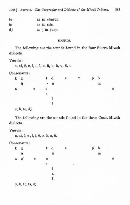
1908] Barrett .—The Geography and Dialects of the Miwok Indians . 361
tc
ts
dj
as in church.
as in sits.
as j in jury .
SOUNDS.
The following are the sounds found in the four Sierra Miwok
dialects.
Vowels :
a, ai, 0, e, I, i, O, o, II, u, ii, u, ii, U.
Consonants:
kg
t d
t
T
p b
n
• n
m
x
c
s
w
s
1
l
y, h, tc, dj.
The following are the sounds found in the three Coast Miwok
dialects.
Vowels :a, ai, 6, e , I, i, 6,
Consonants:
kg
t d
t
p h
n
n
m
x g'
c
s
w
s
y, h, tc, ts, dj .
1
L
VOCABULARIES.
Plains Amador Tuolumne Mariposa Bodega 98 Maria Lake(N.W. Sierra) (N.E. Sierra) (Cent. Sierra) (S . Sierra) (W. Coast) (S . Coast) (N. Coast)
1 person min-ko miwil-k miwu miwu nla-mitca mitca-kO xotsaxO
2 man sawe naiad nana nana tai taiyis tai
3 woman ilailil osa osa oha kaleyi knleyis potsi
4 boy salinai20 nana-ti nana-ti nana-tcu hena hands hena-pasta
5 girl amdnai 21 osa-ti osa-ti oha-tcu koya koya kola-pntn
6 child ehelu esellu esellu
7 infant Oki, panne hiki-me 22 hiki-me esellut-ki ati nti pntn
8 old man iltdm-tci Aya-ti O a -na humelet-ki Oyis nawa
9 old woman iltil-ya ona-ti on-oso onoteot-ki kiiyeyi poteis hdknyn
10 father appa upu upu-ti upu api api api
11 mother iika uta uta-ti uta unil unil dud
12 white man udten-ko alleni-k uyeayd oyeai total potola-ko dtel-kO
13 head tolo liana hana hake mold mole Lnbnddak
14 hair tolo hana yase hisok mold-nkatcen kola-mold sapa
15 eye welai EUTU sdnTu huntu silt sat sat
16 ear coloto, alok tokosu tokosn tolko alOk alok alOk
17 nose hdak hOku auto nito bilk hdk hnk18 mouth liipe awo awo awo laknm lakfim Rippe
19 tongue nepit nepitil nepiTu nepiT lemtep lemtip letip
20 teeth kilt kiltu k'Tu keuu gut kilt, gilt gilt
21 neck topa topa" setce, lola heleke heleke heleki
22 arm tawa, tumal tumalu wonotn patcan, Tawa talik taiili taalik
23 hand eku ukusu, tissu tissu tissu, akus ilkn fails ail24 fingers kitcayi tcigola24 tissu tissn dka nkns kapdm
Plains Amador Tuolumne Mariposa Bodega Marin Lake
(N.W. Sierra) (N .E . Sierra) (Cent. Sierra) (S. Sierra) (W. Coast) (S . Coast) (N. Coast)
25 nails ti tissii sala tissu pitci pitci ti
26 breasts (female) mn' musu musu musu mu mu mu
27 milk mu' mnsd mush ewe ewe
28 knee honoi honoyii honoyii honoi mowi mowi tokollo
29 leg tuna tuiiu, kawali tunu, hotcanu tuiiu ho] etca, hol ]olo
30 foot kolo hate, kolo hate hate ko ko, koyo ko]1O
31 bone wirski kutcutcu ku'tcutcu kutcutc mutci kulum knlum
32 rib woto wima alaka wipik wipik hatsi
33 blood kitcau kitcanu kitcawu kitcau kitcau kitcau kitsau
34 excrement kiina kunatu kunatOs kunat
35 chief tceka haiapu haiapo haiapo hoipn hoipus hoipn
36 doctor remise alini 2' alini' Tnynk temnepa wenen-api yomta
37 friend otta sake-t moe, aiyu-t otci-nti, aiyu-ntioiya oiam-go oiya
38 house kodja kotca kotca, ntcn iitcu kb- tea kutca weyi
39 door uknya olata uknya uknya ka ka ka
40 dance-house hanepn haui haui hafii lemma lamma lamma
41 bow tanuka kutca kutca, sollokS yawe kono kono kono
42 arrow ha-Edo yatci paipu muteku lanta lanta kinwa
43 knife satakni kitce kaiaiyi sope hulaia hulaia tsitsa
44 boat saga saku woTe saka saka nu
45 string lukabunu nmasi hilo kattcen kattcen entsa
46 pipe2 ' topokela paumma paumma2'° paumma sugulupu sumki cumkit-tnmai
47 tobacco kasii kasu kasu kahu kaiyau kaiyau kaiyau
48 awl luya tcilla tcuila tculla husaya mooi, sutaya hntik
49 burden basket tcikele tcikele tika tika tika
50 cradle hiki hiki saka saka tnnuk
Plains Amador Tuolumne Mariposa Bodega Marin Lake(N.W. Sierra) (N .E . Sierra) (Cent. Sierra) (S. Sierra) (W. Coast) (S. Coast) (N. Coast)
51 pestle hopa kawatci kawatci kawatci pa paiya, pa towai52 comb sakani sakani yatcek sonek lawine
53 mush paddle salakka talowa [not used] [not used] wiwil olak
54 mush stirrer [not used] sawaiya sawaiya sawaiya [not used] [not used] [not used]
55 sun hi hiema hiema watu hi hi hi, hintaka
56 moon kome kome kome kome pilSlsk pulnlnk ksmenawa
57 star holokai hosokOna hosokona tealaTS hiti hitis tole
58 day hiama hiema hiema hiema hi hiana hi
59 night kawdl kawulu kawulu kawulu-To kawul kawul kawul
60 wind wulsli hena hena kanuma kiwel hena, kiwel hena
61 thunder lilik timele timeleli timeleli talawa talawa talawa
62 rain homa nuka nuka nuka, Smstca Spa Spa Spa
63 snow kela kela kela kela yawem yawem tana
64 fire wiike wuke wuke wuke, hilyie wski wski wiki
65 smoke kali hakisu hakisu hakisa kal kal kal
66 ashes sike yoli yomi, sike sike yemi yemi wilok
67 water kik kiku kiku kiku liwa kik, liwa kik
68 earth, dirt yotok walli walli walli you you yowa
69 earth, world walk walli walli walli weft wea walk
70 stream wakatce wakalu wakale wakal-mumo2B tcok tcok wfiwe
71 valley wiskapa pulaiu pulaiu aiyi loklo lokla loklo72 mountain wepa hiss-wit leme, hissm leme paiyi paiyis pawl
73 rock sawa sawa sawa hawa luppS Iupn lips74 tree alawa leka'° lama lama aiwa alwas alwa
75 wood tfimai suss susu huhu tumai tOmai tsmai
76 white oak siwek molla leka leka Sliki mule
Plains Amador Tuolumne Mariposa Bodcga Martin Lake
(N.W. Sierra) (N .E . Sierra) (Cent. Sierra) (S. Sierra) (W. Coast) (S. Coast) (N . Coast)
77 black oak sasa sasa tel6li te101i kotin kOtis ute
78 manzanita"s eye eye eye eye oyi tsilaka eyi
79 medicine wene wene h0siku loha wene wene
80 poison tupelo tipaila yonuwa yenpa patca patca haiwi
81 acorn otcapa wilisa muyi, teleli muyu, teleli iimpa ampa waiya
82 mush pitca nupa nupa nupa-ti ulki iliki iilki
83 pinole, meal tiiyii tiyi tiyi tiyi iskin iskii askan
84 bread isle, yoko ule ule
85 whiskey [Spanish] [Spanish] umi-liwa omi-liwa xaixaig` ik
86 meat iirnena halo pitcema pitcema tcoyeke kesnm silo87 dogH2 teitci tcuki tcuki tcukii haiyisa haiynsa
88 grizzly bear usumati usumati usumati uhumati kale kale kale
89 coyote oleti oletci aseli" aheli oye oye Ole
90 deer uwiiya uwuya uwiya uwaya, hika tcoyeke kesnm-ala- sakikesnm
91 jack rabbit epali eplali eplali eplali tsami axle tsami
92 rabbit skin robe idjile yiipte yupti yupti, moll
93 bird tcitcipuk mitcematil tcitcka tcitcka meye meye mete
94 buzzard tcuhu tcihi hiusi hihi oyekeya ekeya his
95 quail (valley) nukute hekeke hekeke hekeke sokotok kekekai tsokeko
96 bluejay (valley) saiisi taiti taisma taitci saiyite saiyite caiyits
97 humming bird kululu litcitci litcitci litcitci kilup'pi
98 yellow hammer tiiwai tiwaiu tiwaiu tiwai oyewololok wololak tsiyak
99 red-head w 'pecker paltina palatata palatata palatata panak palatcak panak
100 turtle awannai awannata awannata awanta meleya meleya meleya
Plains Amador Tuolumne Mariposa Bodega Marin Lake(N.W. Sierra) (N.B . Sierra) (Cent . Sierra) (S . Sierra) (W. Coast) (S . Coast) (N. Coast)
101 frog wataksaiyi wataksaiyi watakuna" a kotola kotola kalala
102 rattlesnake tcatakaxa wakali 1awaTi lawaTi kutakwakaklai fiknlis holamai
103 fish p p lapisaiyn lapisaiyu lapisai elewi iota kats
104 salmon tuknn kfiknnfi kosdmn kosum kasi kasi kassi
105 louse ken ketu keTu, tcupsi keTil, lupsi ket tcupsi ket
106 flea kuku kukusu kukusu kuku kuku kiikfis kuku
107 mosquito uyugugu uyukusu uyukusu tculu soiyo soiyo soiyo
1.08 grasshopper kodjo kotco kotco aiint kotok koto kat6
109 yellow jacket siisu melnaiu meliiaiu meliiai menani menani menani
110 white pututu keleli keleli pasassi potota potola tsetan
111 black knlulu kulnli kaluli TnxUxi lakota mnlnta mnlumulu
112 red wilt ete weteti weteti34 yotcotci kitcfiln nliita awaawa
113 large tame utu ututi oyani 6motak unfini Pdi
114 small ititi itcibiti Timitci tcinimitcu umntce uti kficci
115 good welwel kudji kutci tcUTU tawi tewls emene
116 bad saiye saiye usutu uswi, uxutuma amu limn obn
117 sweet tcPtcini tcudjiiyu tcnya3° tcuyeiia koiynp kawatcn koikoi
118 north" talc-wit tam an tamalin tamalin kani kan-win kanin
119 east" hake-wit hisu-wit hisum hihum ala hinhine ala
120 south" yaku-wit tcnmutc tcumetc tcumetc g lom, olom olop 616m-wall
121 west 36 et ea-wit olo-wit olo-win olo-win helwa helwaia glom Q
122 up 30 newit
hign) lile lile lile lile lile lile
123 down wanit walim, tamma wallim wallim, hfiye hoime hoime wen,
124 no hela ewutu ewuT4t ken Mum h Tama hella
125 yes huu hu hu huu u u u126 one kenatu luti kene keiie kenne kenne kenne
Plains Amador Tuolumne Mariposa Bodega Maria Lake
(N.W. Sierra) (N.E. Sierra) (Cent. Sierra) (S. Sierra) (]V . Coast) (S . Coast) (N . Coast)
127 two oyoko otiko otiko otiko osa ossa otta
128 three teloko tolokou tolokosu Tolokot tolcga teleka, tel0ka
129 four oyiseko oyisa oyisa uyisa huya ]Liiya ot5ta
130 five kasoko masoka masoka mahoka kenneku kenekus kedokk5
131 six temepu temoka temoka TemOka patcitak patcitak patsadat
132 seven kenekak kenekagu kenekagu titawa selawi semlawi cemlawi
133 eight kawenta kawenta kawinta kawinta ossnwa osnya ottaia
134 nine woe woe woe e]iwa kennekoto unUtas kenenhelak
135 ten ekuye naatca naatea naatca kitci,
gitci kitsis iikukUlsi
136 eleven liisa-kena ken-heteagu naatca-keiie- kenne-wallik kenne-lilek kenne-wallik
hateeni3'
137 twenty naa naa 5tiak-naatca98 osa-gitci osa-gitcis otta-tumai
138 eat teama-k uwu uwu uwu yolum y OlUm
139 drink use uhU usu uhU Ussii ussu
140 run taiga huwate kuwaTu huwaTe hiewate hitsu
141 dance lemma-k kalte kalanu kalaue kawnl laki
142 sing hutki-k muli-ni muli-ni nmaTe, mulina koya koya
143 shoot oku-ne auke tumku take tnwe tnwen
144 kill heta-k yena-ni yuna-ni38 yehe like katten
145 shout kawi kawuue-ni kaUiie-ni kawa-k lute haiyap
368
University of California Publications in Am . Arch. and Ethn . [Vol. 6
FOOTNOTES TO VOCABULARIES.
20 The same informant gave sawe-hasi upon another occasion.21 The same informant gave ocoo-hasi upon another occasion.22 hiki is cradle in the Amador and Tuolumne dialects.23 tokolola is also used.
R4 ukusn is also used.25 koyapenuk is also used.20 koiyapi and ummisi are also used.
27 panmma is very similar to the Shoshonean term, pamo, pamu, found inthe Shoshoni-Comanche and Mono-Paviotso dialectic groups (present series,IV, 94).
270 kawatcu is also used.23 wakalmu and wakalmnmo are also used.20 wakal, wakalu and wakalmu are also used.20 leka probably here refers to the white oak rather than to trees in
general.31 The Miwok recognize three different species of Manzanita . In the
Tuolumne dialect these are called respectively eye, mokosn, and mokolkine.32 tcukn and several variants are met with very frequently throughout
California, though by no means universally.33 oleten and katuwa were also given as names for coyote in this dialect.330 wataksaiyi is also used.34 yololli is also used.36 tciitcnyn is also used.30 The directive ending -wit or -win signifying toward is frequently added
to the roots of the terms of direction.37 One informant gave naatca-kene-iini.3s One informant gave otiak-mahu.3s kalkini is also used.
Berkeley, California,April 15, 1907 .
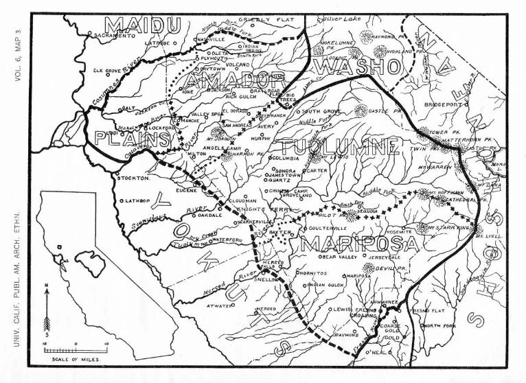
1Si1Ver Lake
ACRA ENTONA . VILLE MO/(EL UMNE
} PK.
8Ri•GEPOR
ANOREASidle For
0MURPHY :MAT TERM
Monet
• LOCKFOR
A )l
COLUMBIA
41
05 ' UTH GROG
:j~=?CAST
STOCKTON .
EL) ENE
0 LATRROP\ 0
LOUDMAN
0 OAKDALE
$ous O't
& Ar
O
GHT
R'
st
9,SE000Ut 't
+.
•
;' ;?175rTARRp.:y
ING.iT♦E RO
COULTE ILLEYOSEMITE
AT WATEROHNEE
ES • FLAT
ORTN FOR

Digitized byYosemite Online Library
http ://www.yosemite .ca .us/library
Dan Anderson
Related Documents