The Journal of Academic Social Science Studies International Journal of Social Science Doi number:http://dx.doi.org/10.9761/JASSS2828 Number: 34 , p. 331-342, Spring II 2015 THE GEOGRAPHICAL ANALYSIS OF THE CHANGES OCCURRING IN TERKOS LAKE (ISTANBUL) AND ITS SURROUNDINGS TERKOS GÖLÜ (İSTANBUL) VE ÇEVRESİNDE MEYDANA GELEN DEĞİŞİMİN COĞRAFİ ANALİZİ Dr. Sümeyra KURT Istanbul University Department of Geography Abstract This study analysis the changes occurring in Terkos Laguna Lake and its surroundings, located in northwest coasts of Turkey, by using Geographic Information Systems and Remote Sensing techniques. The land use and its changes, as well as the changes that occur in lake areas and coastline were identified in the study by conducting land classifications. It was observed in the analysis that the residential areas advance towards areas where the lake is located. A decrease in the ratio of 9.79 km 2 (23.78 %) took place in the area of Terkos Lake in a period of 27 years from 1987 to 2014. The coastline fell to 85.62 km 2 by decreasing 116.45 km (57.74 %) in this period of 27 years. The residential areas around the lake, agricultural activities, the excessive of the resources that nourish the lake, drought and vaporization proved to be effective on these changes. This situation necessitates taking measures and creating a sustainable management plan in order to prevent the occurrence of unavoidable problems in the area which meets 30 % of Istanbul’s fresh water needs. Key Words Geographic Information Systems (GIS), Remote Sensing (RS), Terkos Lake, Analysis of Change Özet Bu çalışmada, Coğrafi Bilgi Sistemleri ve Uzaktan Algılama teknikleri kullanılarak Türkiye’nin kuzeybatı kıyısında yer alan Terkos Lagün Gölü ve çevresinde meydana gelen değişim analiz edilmiştir. Çalışmada arazi sınıflandırmaları yapılarak arazi kullanım ve değişimleri ile göl alanı ve kıyı çizgisinde meydana gelen değişimler belirlenmiştir. Yapılan incelemede özellikle yerleşim alanlarının gölün bulunduğu alana doğru ilerlediği belirlenmiştir. Terkos Gölü alanında 1987 yılından 2014 yılına kadar geçen 27 yıllık sürede 9,79 km² (% 23,78)’luk bir oranda azalma olmuştur. Kıyı çizgisi ise 27 yıllık sürede 116,45 km azalarak (% 57,74) 85,62 km’ye düşmüştür. Bu değişimler üzerinde göl çevresindeki yerleşmeler, tarımsal faaliyetler, gölü besleyen kaynakların aşırı derecede kullanımı, kuraklık ve buharlaşma faktörleri etkili olmuştur. Bu durumun İstanbul’un % 30’luk tatlı su ihtiyacını karşılayan sahada dönüşü olmayan problemler meydana gelmemesi için, tedbir alınmasını ve sürdürülebilir bir yönetim planının oluşturulmasını gerekli kılmaktadır. Anahtar Kelimeler: Coğrafi Bilgi Sistemleri (CBS), Uzaktan Algılama (UA), Terkos Gölü, Değişim Analizi

Welcome message from author
This document is posted to help you gain knowledge. Please leave a comment to let me know what you think about it! Share it to your friends and learn new things together.
Transcript
The Journal of Academic Social Science Studies
International Journal of Social Science
Doi number:http://dx.doi.org/10.9761/JASSS2828
Number: 34 , p. 331-342, Spring II 2015
THE GEOGRAPHICAL ANALYSIS OF THE CHANGES
OCCURRING IN TERKOS LAKE (ISTANBUL) AND ITS
SURROUNDINGS TERKOS GÖLÜ (İSTANBUL) VE ÇEVRESİNDE MEYDANA GELEN
DEĞİŞİMİN COĞRAFİ ANALİZİ Dr. Sümeyra KURT
Istanbul University Department of Geography Abstract
This study analysis the changes occurring in Terkos Laguna Lake and its
surroundings, located in northwest coasts of Turkey, by using Geographic Information
Systems and Remote Sensing techniques. The land use and its changes, as well as the
changes that occur in lake areas and coastline were identified in the study by conducting
land classifications. It was observed in the analysis that the residential areas advance
towards areas where the lake is located. A decrease in the ratio of 9.79 km2 (23.78 %) took
place in the area of Terkos Lake in a period of 27 years from 1987 to 2014. The coastline
fell to 85.62 km2 by decreasing 116.45 km (57.74 %) in this period of 27 years. The
residential areas around the lake, agricultural activities, the excessive of the resources
that nourish the lake, drought and vaporization proved to be effective on these changes.
This situation necessitates taking measures and creating a sustainable management plan
in order to prevent the occurrence of unavoidable problems in the area which meets 30
% of Istanbul’s fresh water needs.
Key Words Geographic Information Systems (GIS), Remote Sensing (RS),
Terkos Lake, Analysis of Change
Özet
Bu çalışmada, Coğrafi Bilgi Sistemleri ve Uzaktan Algılama teknikleri
kullanılarak Türkiye’nin kuzeybatı kıyısında yer alan Terkos Lagün Gölü ve çevresinde
meydana gelen değişim analiz edilmiştir. Çalışmada arazi sınıflandırmaları yapılarak
arazi kullanım ve değişimleri ile göl alanı ve kıyı çizgisinde meydana gelen değişimler
belirlenmiştir. Yapılan incelemede özellikle yerleşim alanlarının gölün bulunduğu alana
doğru ilerlediği belirlenmiştir. Terkos Gölü alanında 1987 yılından 2014 yılına kadar
geçen 27 yıllık sürede 9,79 km² (% 23,78)’luk bir oranda azalma olmuştur. Kıyı çizgisi ise
27 yıllık sürede 116,45 km azalarak (% 57,74) 85,62 km’ye düşmüştür. Bu değişimler
üzerinde göl çevresindeki yerleşmeler, tarımsal faaliyetler, gölü besleyen kaynakların
aşırı derecede kullanımı, kuraklık ve buharlaşma faktörleri etkili olmuştur. Bu durumun
İstanbul’un % 30’luk tatlı su ihtiyacını karşılayan sahada dönüşü olmayan problemler
meydana gelmemesi için, tedbir alınmasını ve sürdürülebilir bir yönetim planının
oluşturulmasını gerekli kılmaktadır.
Anahtar Kelimeler: Coğrafi Bilgi Sistemleri (CBS), Uzaktan Algılama (UA),
Terkos Gölü, Değişim Analizi
332
Sümeyra KURT
INTRODUCTION
Water is one of the most important elements necessary for the existence and continuity
of human beings and ecological systems. The rate of fresh water is 2.5 % even though 1.4 km3 of
the world is covered with water (Dirican and MusuL, 2008). However, today, the rapidly
increasing population and environmental problems lead to the increase in demand for water
supplies and threatened the existence of water which is one of the most important elements for
the ecological quality of life. Negative problems, such as population growth and unplanned and
improper land use, continue to change water sources, agricultural lands, forested areas and
natural environment very quickly (Erlich, 1988, Biswas, 1997, Loucks, 2000, Taş, 2006, Özşahin,
2011). The statements, made by FAO (1994), clearly show these changes by asserting that there
was no increase in forest lands in Turkey between 1983 and 1993, but there was an increase of
3.44 % in agricultural lands in the same period (Tunay and Ateşoğlu, 2004, Özdemir and
Bahadır, 2010).
One of the areas, where the changes in the natural environment are most clearly seen, is
the areas of Lagoon Lake. Being shallow lakes that are connected with larger body of water like
the sea, lagoons are wetlands and special ecosystems that also carry great ecological significance
(Kırdağlı, 1999). Coastal lagoons are transitional zones between sea-water and freshwater
environments that are under the influence of both terrestrial and marine factors (Acarlı et al.,
2009). However, even though there are 72 lagoons in Turkey, many of these have lost their
lagoon characteristics and productivity due to reasons like draining and discharging wastes
(Gözgözoğlu, 2002, Sümer and Tekşam, 2013).
Terkos Lagoon Lake and its surroundings, one of the most important water resources of
Istanbul, are located in such an area that is also affected by natural environmental problems.
Terkos Lake, which has a total drainage area of 776 km², precipitation area of 744 km² and a
surface area of 32 km², is approximately 12 km in length and 5 km in width (Davaşlıgil, 1998).
However, inability literally to bring solution to the problems experienced in the lake area and
the lack of appropriate plans for land use require analyzing the changes and development in
this area.
Today, techniques of Remote Sensing and Geographic Information Systems are widely
used in the determination of land use and the changes in the area. These methods do not only
provide convenience in the determination of change, but also in the process of monitoring
(Özdemir and Akar, 2009, Kurt et al., 2011). Developments in satellite technologies with each
passing day and the increase in resolutions have rendered analysis easier and more precise.
Therefore, the areal change in Terkos Lake, one of the most important freshwater and wetland
ecosystems of Istanbul, and the factors that influence this change were attempted to be
determined in this study by using techniques of Geographic Information Systems and Remote
Sensing.
STUDY AREA
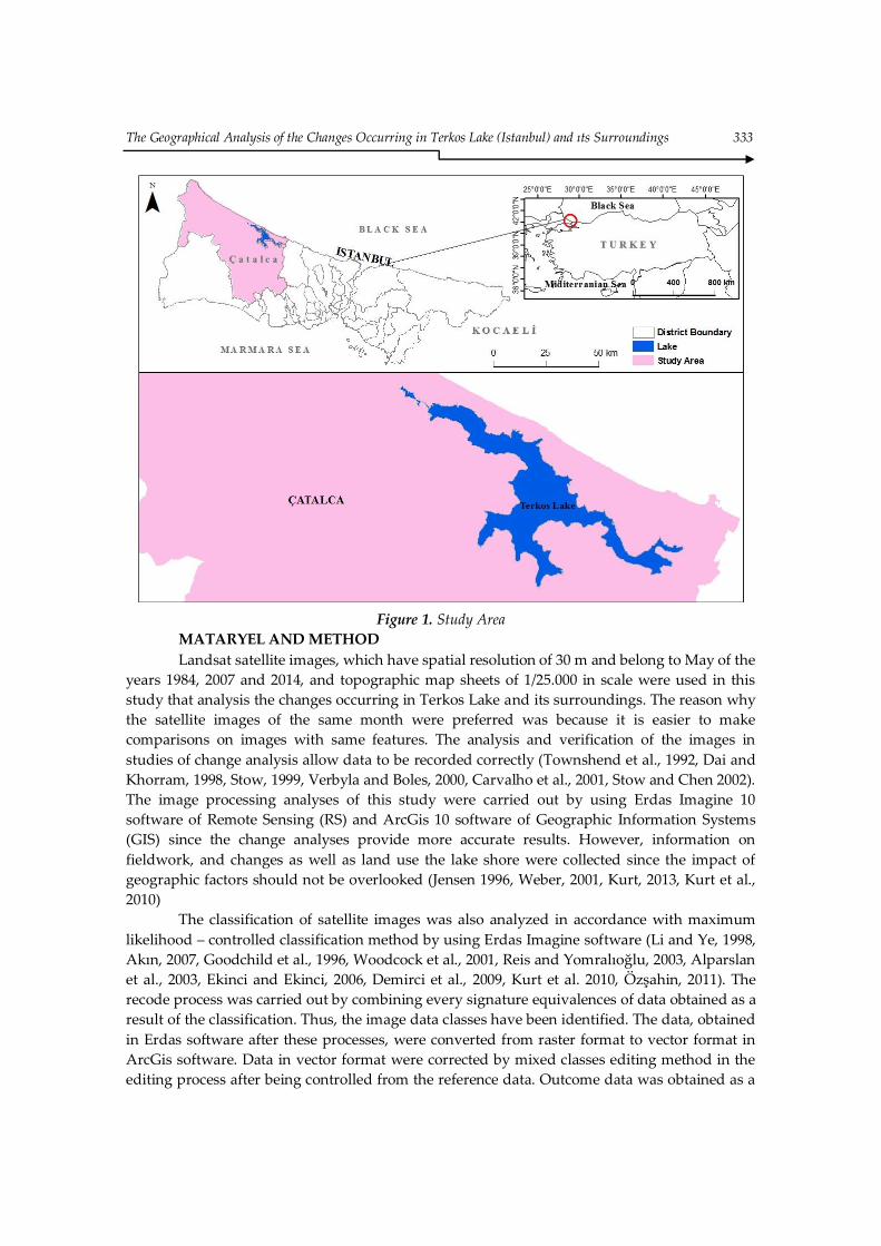
Catalca district and Terkos Lake are located between 27°58 – 29°56 eastern longitude
and 40°48 – 41°36 ´ northern latitudes. Terkos Lake is situated within the boundaries of Catalca
district of Istanbul province and in Terkos Basin. It is surrounded by Black Sea in the north,
Arnavutkoy in the east, Buyukcekmece and Silivri districts in the south and water parting line
of Ergene Basin in the west (Figure 1). The lake, formed between Karaburun in the coast of
Black Sea and Ormanli villages, is one of the most significant freshwater areas of Istanbul.
The Geographical Analysis of the Changes Occurring in Terkos Lake (Istanbul) and ıts Surroundings 333
Figure 1. Study Area MATARYEL AND METHOD
Landsat satellite images, which have spatial resolution of 30 m and belong to May of the
years 1984, 2007 and 2014, and topographic map sheets of 1/25.000 in scale were used in this
study that analysis the changes occurring in Terkos Lake and its surroundings. The reason why
the satellite images of the same month were preferred was because it is easier to make
comparisons on images with same features. The analysis and verification of the images in
studies of change analysis allow data to be recorded correctly (Townshend et al., 1992, Dai and
Khorram, 1998, Stow, 1999, Verbyla and Boles, 2000, Carvalho et al., 2001, Stow and Chen 2002).
The image processing analyses of this study were carried out by using Erdas Imagine 10
software of Remote Sensing (RS) and ArcGis 10 software of Geographic Information Systems
(GIS) since the change analyses provide more accurate results. However, information on
fieldwork, and changes as well as land use the lake shore were collected since the impact of
geographic factors should not be overlooked (Jensen 1996, Weber, 2001, Kurt, 2013, Kurt et al.,
2010)
The classification of satellite images was also analyzed in accordance with maximum
likelihood – controlled classification method by using Erdas Imagine software (Li and Ye, 1998,
Akın, 2007, Goodchild et al., 1996, Woodcock et al., 2001, Reis and Yomralıoğlu, 2003, Alparslan
et al., 2003, Ekinci and Ekinci, 2006, Demirci et al., 2009, Kurt et al. 2010, Özşahin, 2011). The
recode process was carried out by combining every signature equivalences of data obtained as a
result of the classification. Thus, the image data classes have been identified. The data, obtained
in Erdas software after these processes, were converted from raster format to vector format in
ArcGis software. Data in vector format were corrected by mixed classes editing method in the
editing process after being controlled from the reference data. Outcome data was obtained as a
334
Sümeyra KURT
result of these processes. The general classes used in classification are: residential area,
agricultural fields, vacant areas, bush/grass, lake/water, forest and clouds.
Principal Component Analysis (PCA) technique was used in the determination of
coastal line of the selected years since it helps to distinguish the difference between water and
land. PCA is the technique of creating a new image after removing the relationship between
multispectral images and reducing the image in numerous bands to the desired number of
bands (Munyati, 2004, Mausel, 2004, Almutairi and Warner, 2010). This is a useful method
because it collects a significant amount of information in multispectral data and reducing the
correlation between imaging bands. Principal Component Analysis (PCA) is a method
preferred in image compression, image enhancement, change detection and in reducing the
number of bands before classification (Loughlin, 1991, Akça and Doğan, 2002, Alparslan et al.,
2004, Munyati, 2004). Thematic maps (TM), created as a result, were again transferred to
Geographical Information Systems environment by converting raster data into vector data.
Coastal lines and maps were created as a result of the analysis conducted on the obtained new
images.
General Geographical Features of Terkos Lake and Its Surroundings
Terkos Lake is a coastal set lagoon separated from the Black Sea by sand dunes whose
width ranges from 250 m to 5 km and whose average width is 2 km. It was formed by the
creation of a bay as a result of the advancement of the waters of Black Sea, which rose due to
Flandrian transgression, towards the land and the conversion of this bay into a lake following
its disconnection from the sea in time through a coastal levee. Another factor that contributes to
the formation of this lake is the enclosure of the mouth of Istranca Creek, which extends parallel
to the coast of the Black Sea, by an alluvial set. Terkos sand dunes were formed in this section
between Terkos Lake and the Black Sea. Sand dune fields start 25 km from the west of
Bosphorus and span in an area of 30 km along the coast of Black (Köken, 1991, Aygün, 1994,
Baylan and Karadeniz, 2006). Terkos sand dunes, which represent the biggest and most
important sand systems located nearby Istanbul, has an international significance due to its
inclusion of endemic plan species for the region (Byfield and Özhatay, 1993). The surroundings
of Terkos Lake were identified in 1999 as one of the 100 “hot spots” in Europe that is most
valuable in terms of biodiversity and that needs to be urgently protected within “Gift for the
World” Project carried out by the co-operation between World Wildlife Foundation (WWF) and
the Ministry of Environment and Forestry (Anonymous, 2002). Therefore, the lake and its
surroundings have the quality to serve the environment and plant analysis type of ecological
tourism (TMMOB, 2014).
There are undulating plains and high steep hills in the surroundings of Terkos Lake
whose heights increase westward. The surroundings of the lake, which was formed 100-150 m
in height and on the edge of this hilly area in the Black Sea coast line, have less rugged
morphological structure (Akşiay et al., 1990, Bargu vd., 1995). A part of the coastal line between
the Lake and Black Sea is steep-cliffed and a part of it is covered with beaches. The lands
formed in the surroundings of the lake have erosion-slanted structural features (Eruz et al.,
1995). Terkos Lake, being rich in terms of feeding rivers, has fresh-water characteristics despite
its proximity to the Black Sea. Istranca Creek is the stream that carries the maximum amount of
water to the lake (Aygün, 1994, Baki, 1997).
The geological foundation of the lake’s surroundings is composed of metamorphic
rocks of the Paleozoic and Mesozoic era. The cover rocks, young sediments and Ergene group in
the upper part can be found on metamorphic rocks. The limited areas on the bottom of rivers
that pour into the lake are covered with the current Quaternary alluvium (Akşiay et al., 1990,
The Geographical Analysis of the Changes Occurring in Terkos Lake (Istanbul) and ıts Surroundings 335
Bargu et al., 1995). Geological units in the lake’s surroundings are Eocene-aged Kirklareli,
Miocene-aged Ergene Formation, Pliocene-aged Belgrade Formation, alluviums and sand dunes
(Baki, 1997). These are also the units that mainly carry the groundwater. The rocks located in
the water section that limits the Terkos Basin are generally impermeable or less permeable. This
prevents the water exchange with neighboring basins. The conclusion that no water leakage
from the lake into the Black Sea would be possible can be reached due to width and geological
structure of sand dunes in some regions between the Black Sea and the lake (Bargu et al. 1995).
However, it was discovered that the coastal strip, which separates the lake from the Black Sea,
is dangerously narrowed because of unauthorized sand removal from the area and erosion
(Özdemir, E., 2004, Maktav et al., 2002).
RESULTS
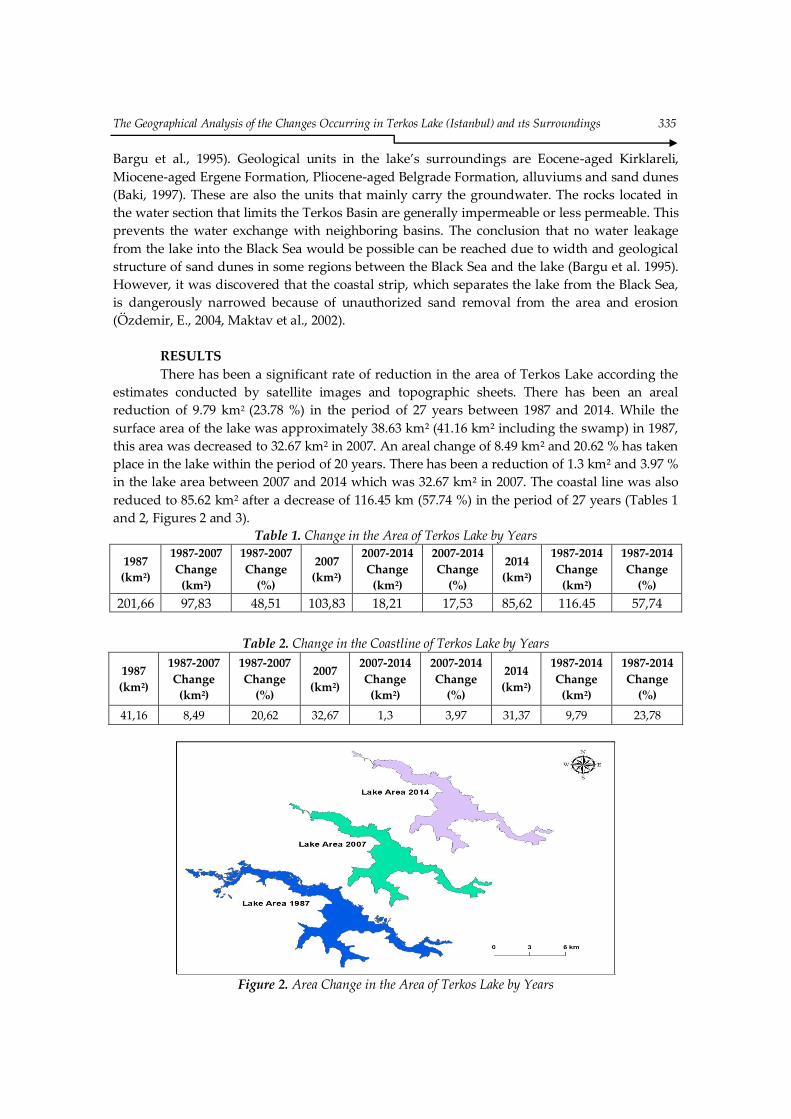
There has been a significant rate of reduction in the area of Terkos Lake according the
estimates conducted by satellite images and topographic sheets. There has been an areal
reduction of 9.79 km2 (23.78 %) in the period of 27 years between 1987 and 2014. While the
surface area of the lake was approximately 38.63 km² (41.16 km² including the swamp) in 1987,
this area was decreased to 32.67 km² in 2007. An areal change of 8.49 km² and 20.62 % has taken
place in the lake within the period of 20 years. There has been a reduction of 1.3 km² and 3.97 %
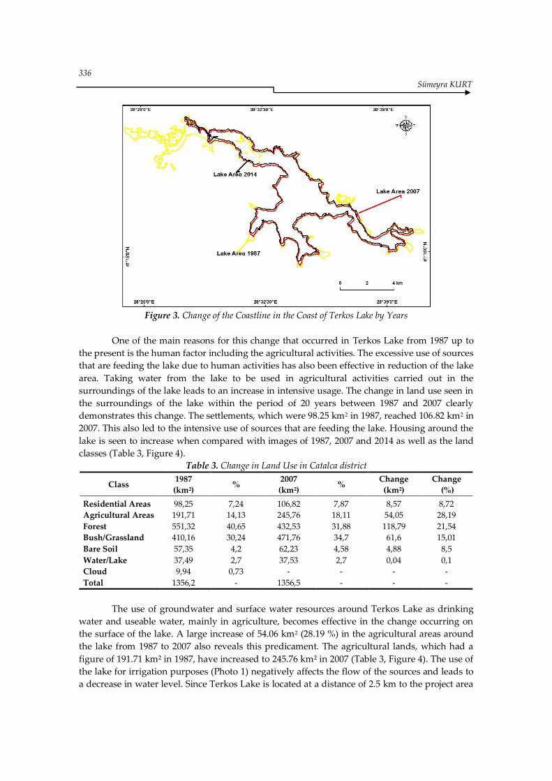
in the lake area between 2007 and 2014 which was 32.67 km² in 2007. The coastal line was also
reduced to 85.62 km² after a decrease of 116.45 km (57.74 %) in the period of 27 years (Tables 1
and 2, Figures 2 and 3).
Table 1. Change in the Area of Terkos Lake by Years
1987
(km²)
1987-2007
Change
(km²)
1987-2007
Change
(%)
2007
(km²)
2007-2014
Change
(km²)
2007-2014
Change
(%)
2014
(km²)
1987-2014
Change
(km²)
1987-2014
Change
(%)
201,66 97,83 48,51 103,83 18,21 17,53 85,62 116.45 57,74
Table 2. Change in the Coastline of Terkos Lake by Years
1987
(km²)
1987-2007
Change
(km²)
1987-2007
Change
(%)
2007
(km²)
2007-2014
Change
(km²)
2007-2014
Change
(%)
2014
(km²)
1987-2014
Change
(km²)
1987-2014
Change
(%)
41,16 8,49 20,62 32,67 1,3 3,97 31,37 9,79 23,78
Figure 2. Area Change in the Area of Terkos Lake by Years
336
Sümeyra KURT
Figure 3. Change of the Coastline in the Coast of Terkos Lake by Years
One of the main reasons for this change that occurred in Terkos Lake from 1987 up to
the present is the human factor including the agricultural activities. The excessive use of sources
that are feeding the lake due to human activities has also been effective in reduction of the lake
area. Taking water from the lake to be used in agricultural activities carried out in the
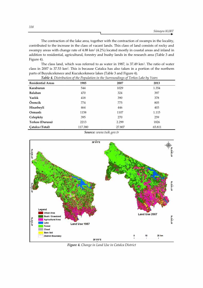
surroundings of the lake leads to an increase in intensive usage. The change in land use seen in
the surroundings of the lake within the period of 20 years between 1987 and 2007 clearly
demonstrates this change. The settlements, which were 98.25 km2 in 1987, reached 106.82 km2 in
2007. This also led to the intensive use of sources that are feeding the lake. Housing around the
lake is seen to increase when compared with images of 1987, 2007 and 2014 as well as the land
classes (Table 3, Figure 4).
Table 3. Change in Land Use in Catalca district
Class 1987
(km²) %
2007
(km²) %
Change
(km²)
Change
(%)
Residential Areas 98,25 7,24 106,82 7,87 8,57 8,72
Agricultural Areas 191,71 14,13 245,76 18,11 54,05 28,19
Forest 551,32 40,65 432,53 31,88 118,79 21,54
Bush/Grassland 410,16 30,24 471,76 34,7 61,6 15,01
Bare Soil 57,35 4,2 62,23 4,58 4,88 8,5
Water/Lake 37,49 2,7 37,53 2,7 0,04 0,1
Cloud 9,94 0,73 - - - -
Total 1356,2 - 1356,5 - - -
The use of groundwater and surface water resources around Terkos Lake as drinking
water and useable water, mainly in agriculture, becomes effective in the change occurring on
the surface of the lake. A large increase of 54.06 km2 (28.19 %) in the agricultural areas around
the lake from 1987 to 2007 also reveals this predicament. The agricultural lands, which had a
figure of 191.71 km² in 1987, have increased to 245.76 km² in 2007 (Table 3, Figure 4). The use of
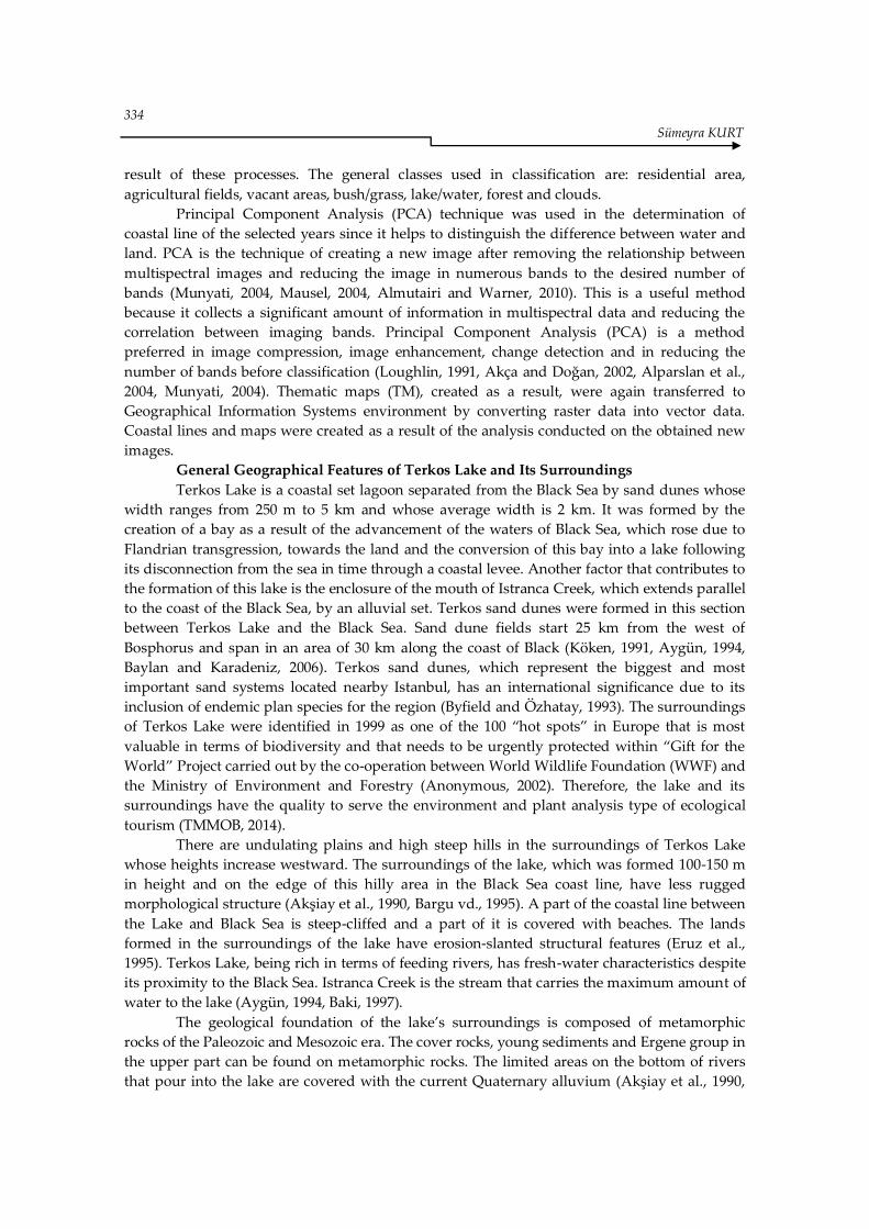
the lake for irrigation purposes (Photo 1) negatively affects the flow of the sources and leads to
a decrease in water level. Since Terkos Lake is located at a distance of 2.5 km to the project area
The Geographical Analysis of the Changes Occurring in Terkos Lake (Istanbul) and ıts Surroundings 337
of the 3rd Airport, a greater rate of decrease in water level is expected to be seen as a result of
construction works which will cause some streams that feed Terkos Lake basin, with a total
water collection area of 736.km2 and water area of 39 km2, to get disconnected with the lake
(TMMOB, 2014, Photo 1).
Catalca district of Istanbul is one of the land classes with high rates of forestry and
scrublands. Especially in 1987, the mountainous areas in the north and south of the basin were
covered with forests and, in some places, forests went down up to the eastern shore of the
basin. Nowadays, forest areas are widely seen in mountainous areas in the western and
southern parts of the lake. The hills, which are on the landward side of the lake and rise up to
approximately 100 meters, are generally covered with meadows and a community of forest
plants (Byfield and Özhatay, 1993). However, there was a decrease in forests and bushy areas in
recent years due to the increase in settlements in these regions (Table 3, Figure 4). While 40.65 %
(551,32 km2) of 1356. km2 land were covered with forests in 1987, this rate came down to 31.88
km2 in 2007. In 1987, the bushy lands, with the area of 410.16 km2, covered 30.24 % of the total
area of 1356.2 km2 (Table 3). In 2007, this land class has decreased by 34.7 %. Increase in
settlement and construction especially in Terkos Lake and its surroundings as well as on the
Black Sea coast of Catalca district has been effective in this decline.
Terkos Lake is the second largest area that meets with about 30 % (142.000.000 m3) of
Istanbul’s water needs. Therefore, the Terkos Lake Dam, built in this area in 1983 and being
developed, continues to provide service today (Bayram et al,. 2013, Baki, 1997). However, this
area is under the pressure of approximately 30.000 people who live in 18 residential areas of
Catalca district (Table 4). There is an increase in seasonal population of the Lake and its
surroundings both because they are located on the sea coast and forestry fields in the area offer
recreation facilities (Baylan and Karadeniz, 2006).
The lake pollution continues to increase with each passing day due to increase in
population and construction around the lake in recent years. Therefore, lake water is reported
to have dropped from the second class quality drinking water to the third class quality (Baylan
and Karadeniz 2006). The pollution, caused by the residential areas around Terkos Lake, causes
serious damage in ecological system of the lake as seen in some wetlands in Turkey (Altınsaçlı
and Griffiths, 2001, Arı 2002, Tağıl, 2007). TMMOB Istanbul Branch of Environmental Engineers
Association has also identified that the waters of Terkos Lake significantly reduced and the
pressures of pollution increasingly continue as a result of the activities carried out in the basin
(TMMOB, 2014, Photo 1).
Photo 1. Polution in Terkos Lake
338
Sümeyra KURT
The contraction of the lake area, together with the contraction of swamps in the locality,
contributed to the increase in the class of vacant lands. This class of land consists of rocky and
swampy areas with change rate of 4.88 km2 (4.2%) located mostly in coastal areas and inland in
addition to residential, agricultural, forestry and bushy lands in the research area (Table 3 and
Figure 4).
The class land, which was referred to as water in 1987, is 37.49 km2. The ratio of water
class in 2007 is 37.53 km2. This is because Catalca has also taken in a portion of the northern
parts of Buyukcekmece and Kucukcekmece lakes (Table 3 and Figure 4).
Table 4. Distribution of the Population in the Surroundings of Terkos Lake by Years
Residential Areas 1985 2007 2013
Karaburun 544 1029 1.354
Balaban 470 324 397
Yazlık 418 390 378
Örencik 774 775 805
Hisarbeyli 464 446 403
Ormanlı 1158 1107 1.115
Celepköy 395 270 259
Terkos (Durusu) 2213 2.299 1826
Çatalca (Total) 117.380 27.807 65.811
Source: www.tuik.gov.tr
Figure 4. Change in Land Use in Catalca District
The Geographical Analysis of the Changes Occurring in Terkos Lake (Istanbul) and ıts Surroundings 339
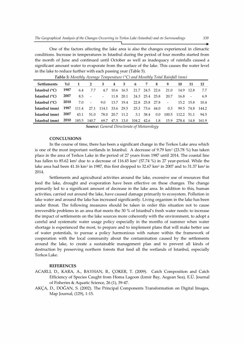
One of the factors affecting the lake area is also the changes experienced in climactic
conditions. Increase in temperatures in Istanbul during the period of four months started from
the month of June and continued until October as well as inadequacy of rainfalls caused a
significant amount water to evaporate from the surface of the lake. This causes the water level
in the lake to reduce further with each passing year (Table 5).
Tablo 5: Monthly Average Temperature (°C) and Monthly Total Rainfall (mm)
Settlements Yıl 1 2 3 4 5 6 7 8 9 10 11 12
İstanbul (°C) 1987 6.4 7.7 4.7 10.6 16.5 21.7 24.5 22.6 21.0 14.9 12.8 7.7
İstanbul (°C) 2007 8.5 - - 11.8 20.1 24.3 25.4 25.8 20.7 16.8 - 6.9
İstanbul (°C) 2010 7.0 - 9.0 13.7 19.4 22.8 25.8 27.8 - 15.2 15.8 10.4
İstanbul (mm) 1987 111.4 27.1 114.1 33.6 29.5 25.3 73.6 44.0 0.3 99.5 74.8 144.2
İstanbul (mm) 2007 43.1 51.0 78.0 20.7 11.2 3.1 38.4 0.0 100.5 112.2 51.1 94.5
İstanbul (mm) 2010 185.5 140.7 69.7 47.5 13.0 104.2 42.6 1.8 15.9 278.4 14.8 161.9
Source: General Directorate of Meteorology
CONCLUSIONS
In the course of time, there has been a significant change in the Terkos Lake area which
is one of the most important wetlands in Istanbul. A decrease of 9.79 km2 (23.78 %) has taken
place in the area of Terkos Lake in the period of 27 years from 1987 until 2014. The coastal line
has fallen to 85.62 km2 due to a decrease of 116.45 km2 (57.74 %) in 27 year-period. While the
lake area had been 41.16 km2 in 1987, this first dropped to 32.67 km2 in 2007 and to 31.37 km2 in
2014.
Settlements and agricultural activities around the lake, excessive use of resources that
feed the lake, drought and evaporation have been effective on these changes. The change
primarily led to a significant amount of decrease in the lake area. In addition to this, human
activities, carried out around the lake, have caused damage primarily to ecosystem. Pollution in
lake water and around the lake has increased significantly. Living organism in the lake has been
under threat. The following measures should be taken in order this situation not to cause
irreversible problems in an area that meets the 30 % of Istanbul’s fresh water needs: to increase
the impact of settlements on the lake sources more coherently with the environment, to adopt a
careful and systematic water usage policy especially in the months of summer when water
shortage is experienced the most, to prepare and to implement plans that will make better use
of water potentials, to pursue a policy harmonious with nature within the framework of
cooperation with the local community about the contamination caused by the settlements
around the lake, to create a sustainable management plan and to prevent all kinds of
destruction by preserving northern forests that feed all the wetlands of Istanbul, especially
Terkos Lake.
REFERENCES
ACARLI, D., KARA, A., BAYHAN, B., ÇOKER, T. (2009). Catch Composition and Catch
Efficiency of Species Caught from Homa Lagoon (Izmir Bay, Aegean Sea), E.Ü. Journal
of Fisheries & Aquatic Science, 26 (1), 39-47.
AKÇA, D., DOĞAN, S. (2002). The Principal Components Transformation on Digital Images,
Map Journal, (129), 1-15.
340
Sümeyra KURT
AKIN, A. (2007). Assesing Different Remote Sensing Techniques to Detect Land Use/Cover
Changes in Coastal Zone of Çukurova Deltas, Çukurova University, Institute of Science
and Technology, Master Thesıs, Adana.
AKŞİAY, F., BEKBÖLET, M., EROSKAY, O. (1990). Investigation of Chemical Physical and
Ecological Balance of the Terkos Lake and Environmental, Bosphorus University,
Institute of Environmental Sciences, 88.
ALMUTAIRI, A., WARNER, T. A. (2010). Change Detection Accuracy and Image Properties: A
Study Using Simulated Data, Remote Sensing, (2), 1508-1529.
ALPARSLAN, E., DÖNERTAŞ, E. A., YÜCE, H. (2004). Change Analysıs on The Yalova
Provınce’s Coastal Settlement from Satellite Images, Fatih Üniversitesi, 3rd
Geographical Information Systems Information Days, 6-9 October 2004, Istanbul,
ALPARSLAN, E., YÜCE, H. (2003). Monitoring Urban Growth Around Küçükçekmece Lake
Through Remote Sensing Technology, Küçükçekmece Around Technical Congress,
Earthquake and Planninga, Proceedings Book, (1), 62–72.
ANONİM, (2002). Turkey's Gift to the World, Turkey Wildlife Conservation Society (TWCS)
and World Wide Fund for Nature (WWF) Publication, İstanbul.
AYGÜN, N. (1994). Effects on Drinking Water of Lake Terkos and Surrounding Residential
Areas, Istanbul University, Institute of Social Sciences, Master Thesıs, Istanbul.
BAKİ, T. (1997). Terkos Lake Water Quality Assessment, Yıldız Technical University, Institute
of Science and Technology, Master Tesıs, Istanbul.
BARGU, S., DOĞAN, E., EROSKAY, O. (1995). Terkos Basin Final Report, Volume I, Istanbul
Technical University, Environmental Engineering Department, Ministry of
Environment and Forestry, General Directorate of Environmental Protection, Istanbul.
BAYLAN, E., KARADENİZ, N. A. (2006). Research on Conservation and Development of
Natural and Cultural Environment, Case Study Terkos Lake, Istanbul, Journal of
Agricultural Sciences, 12 (2), 151-161.
BAYRAM, B., ŞEKER, Z.D., ACAR, U., YUKSEL, Y., GÜNER, ARI, A. H., ÇETİN, İ. (2013). An
Integrated Approach to Temporal Monitoring of the Shorline and Basin of Terkos Lake,
Journal of Coastal Research, 29 (6), 1427-1435.
BİSWAS, A. K. (1997). Water Resources, McGraw- Hill, USA.
BYFIELD, A., ÖZHATAY, N. (1993). Turkey's Report on the Protection of the North Dunes,
Wildlife Conservation Society (WCS) and Fauna and Flora International (FFI), p.5,
Istanbul.
CARVALHO, L. M. T., FONSECA, L. M. G., MURTAGH, F., CLEVES, J. G. P. W. (2001). Digital
Change Detection with the Aid of Multiresolution Wavelet Analysis, International
Journal of Remote Sensing, (22), 3871-3876.
DAI, X. L., KHORRAM, S. (1998). The effects of Image Misregistration on the Accuracy of
Remotely Sensed Change Detection, IEEE Transactions on Geoscience and Remote
Sensing 36, 1566–1577
DAVAŞLIGİL, Ö. (1998). Preliminary Approach to Evaluation of Terkos Lake Water Quality.
İstanbul Institute of Science and Technology, Istanbul.
DEMİRCİ, A., KARABURUN, A., KURT, S. (2009). Assessment of Urban Growth in a Natural
Protected Area Using Multi-Temporal Satellite Data: A Case Study of the Strait of
Istanbul (Bosphorus), Fresenius Environmental Bulletin, 18 (9a), 1701-1708.
DİRİCAN, S., MUSUL, H. A. (2008). Preliminary Study on Some Physico-Chemical Properties
and Cladocera Species of Çamlıgöze Dam lake (Sivas), Jornal Agricultural Factor HR.U.
12 (4), 19-24.
The Geographical Analysis of the Changes Occurring in Terkos Lake (Istanbul) and ıts Surroundings 341
DURAN, C., GÜNEK, H. (2007). Determination Land Use Changing in Basin of Lake of Hazar,
Fırat University Journal of Social Science, 17 (2), 31-52.
EKİNCİ, D., EKİNCİ, B. (2006). The Potential of Remote Sensing for Monitoring Kayışdağı and
Its Surroundings (Istanbul) Land Cover Changes and Their Effects on Physical
Geography Conditions, Proc. 18th International Soil Meeting (ISM) on Soil Sustaining
Life on Earth, Managing Soil and Technology Conference Papers, May 22-26, Şanlıurfa,
Proceedings Book, (1), 327-336.
ERLICH, P. R. (1988). The Loss of Diversity: Causes and Consequences (E. O. Wilson, F. M.
Peter), Biodiversity, National Academic Press, Washington.
ERUZ, E., ŞENGÖNÜL, K., KARAGÖZ, Ö. (1995). Terkos Basin Final Report Volume 1, Istanbul
Institute of Science and Technology, Ministry of Environment and Forestry, General
Directorate of Environmental Protection, Istanbul.
GOODCHİLD, M. F., STAYEERT, L. T., PARKS, B. O., JOHNSTON, C. J., MAİDMENT, D.,
CRANE, M., GLENDİNNİNG, S. (1996). GIS and Environmental Modeling: Progress
and Recent Research, GIS World, USA.
GÖZGÖZOĞLU, E. (2002). Trade Transport Customs Directorate Fisheries Office of the
Ongoing Activities, SÜMAE Dolphin Research Bulletin, (2), 2-5.
JENSEN, R. J. (1999). Introductory Digital Image Processing A Remote Sensing Perspective,
ISBN 0–13–205840–5, New Jersey.
KIRDAĞLI, M. (1999). Investigation of the Lagoon-Sea Interaction, Shipbuilding and Marine
Technology Congress, Proceedings Book, 367-377.
KÖKEN, A. (1991). Lithological and Geomorphology Characteristics Environment of the Terkos
and Buyukcemece Lake, İstanbul University Institute of Social Sciences, Master Thesıs,
Istanbul.
KURT, S. (2013). Land Use Changes in Istanbul’s Black Sea Coastal Regions between 1987 and
2007, Journal of Geographical Sciences, 23 (2), 271-279.
KURT, S., DEMİRCİ, A., KARABURUN, A. (2011). Coastal Land Use Changes in Istanbul
between 1987 and 2007, Eastern Geographical Review, (26), 115-128.
KURT, S., KARABURUN, A., DEMİRCİ, A. (2010). Coastline Changes in Istanbul between 1987
and 2007, Scientific Research and Essays, 5(19), 3009-3017.
LI, X., YEH, A. G. O. (1998). Principal Component Analysis of Stacked Multitemporal Images
for the Monitoring of Rapid Urban Expansion in the Pearl River Delta, International
Journal of Remote Sensing, (19), 1501–1518.
LOUCKS, D. P. (2000). Sustainable Water Resources Management, Water International, 25(1), 3-
10.
LOUGHLIN, W. P. (1991). Principal Component Analysis for Alteration Mapping,
Photogrammetric Engineering & Remote Sensing, 57 (9), 1163-1169.
MAKTAV, D., ERBEK, S. F., KABDAŞLI, S. (2002). Monitoring Coastal Erosion at the Black Sea
Coasts in Turkey Using Satellite Data: A Case Study at the Lake Terkos, North-West
Istanbul, International Journal Remote Sensing, 23 (19), 4115–4124.
MAUSEL, D., BRONDIZOO, P., MORAN, E. (2004). Change Detection Techniques,
International Journal of Remote Sensing, 25 (12), 2365 - 2401.
MUNYATI, C. (2004). Use of Principal Component Analysis (PCA) of Remote Sensing Images in
Wetland Change Detection on the Kafue Flats, Zambia, Geocarto International, 19
(3),11-22.
342
Sümeyra KURT
ÖZDEMİR, A. M., BAHADIR, M. (2010). Temporal Change Analysis of Land Use in The Acıgöl
Watershed Through Remote Sensing (1975-2005), The Journal of International Social
Research, 3 (12), 335-351.
ÖZDEMİR, E. (2004). Evaluation Planning Use of the Ractionary Fill Coastal Areas of the
Istanbul, Istanbul Avcılar Case, Istanbul University, Faculty of Forestry, Landscape
Architecture Department, PhD Thesıs, İstanbul.
ÖZDEMİR, Y., AKAR, İ. (2009). Determination of Land-Use Features in Alibeyköy Dam and
Vicinity by Using Multi Temporal Satellite Imagery and GIS, TMMOB Geographical
Information Systems Conference, 02-06 November 2009, İzmir,
ÖZŞAHİN, E. (2011). Gölbaşı (Fish) Geographical Analysis of The Change in Lake Gölbası
(Hatay), Turkish Studies-International Periodical For the Languages, Literature and
History of Turkishor Turkic, Volume 6 (1),1604-1621.
REİS, S., YOMRALIOĞLU, T. (2003). Determination of the Landsat ETM + satellite image of
Trabzon Land Cover, Transportation in Rural Areas in the Eastern Black Sea Region,
Symposium Settlement Problems and Solutions, Black Sea Technical University,
Proceedings, 306-315, Trabzon,
STOW, D.A. (1999). Reducing the Effects of Misregistration on Pixel-level Change Detection,
International Journal of Remote Sensing, (20), 2477-2483.
STOW, D. A., CHEN, D.M. (2002). Sensitivity of Multitemporal NOAA AVHRR Data of an
Urbanizing Region to Land-use/Land-cover Change and Misregistration, Remote
Sensing of Environment, (80), 297-307
SÜMER, Ç., TEKŞAM, İ. (2013). Catch Effıciency and Composition of Beymelek Lagoon,
Anadolu Journal of Agricultural Sciences, 28 (1), 47-51.
TAŞ, B. (2006). Land use effects of the geomorphological units in the Tosya district. Journal of
Geographical Sciences, 4 (1), 43–66.
TMMOB (2014). Technical Assessment Report for Water Basins of Istanbul’s European Side.
TOWNSHEND, J.R.G., JUSTICE, C.O., GURNEY, C., MCMANUS, J. (1992). The impact of
misregistration on change detection, IEEE Transactions on Geoscience and Remote
Sensing, 30 (5), 1054–1060.
TUNAY, M., ATEŞOĞLU, A. (2008). Analysıs of Changes in Vegetation Bıomass About Amasra
and Nearby Places Using Multitemporal and Multisensor Satellite Data, Bartın Journal
of Faculty of Forestry, 10 (13), 71-79.
VERBYLA, D. L., BOLES, S. H. (2000). Bias in Land Cover Change Estimates due to
Misregistration, International Journal of Remote Sensing, (21), 3553–3560.
WOODCOCK, C. E., MACOMBER, S. A., PAX-LENNEY, M., COHEN, W. B. (2001). Monitoring
large areas for forest change using Landsat: generalization across space, time and
Landsat sensor, Remote Sensing of Environment, 78,194–203.
Related Documents