The following update provides the status of NOAA’s fleet of ships and aircraft, which play a critical role in the collection of oceanographic, atmospheric, hydrographic, and fisheries data. NOAA’s current fleet of 16 ships – the largest civilian research and survey fleet in the world – and nine aircraft, are operated, managed, and maintained by NOAA’s Office of Marine and Aviation Operations (OMAO). OMAO includes civilians, mariners, and officers of the United States NOAA Commissioned Officer Corps (NOAA Corps), one of the nation’s seven Uniformed Services. Find us on Facebook for the latest news and activities. http://www.facebook.com/NOAAOMAO

Welcome message from author
This document is posted to help you gain knowledge. Please leave a comment to let me know what you think about it! Share it to your friends and learn new things together.
Transcript
The following update provides the status of NOAA’s fleet of ships and aircraft, which play a critical role in
the collection of oceanographic, atmospheric, hydrographic, and fisheries data. NOAA’s current fleet of 16
ships – the largest civilian research and survey fleet in the world – and nine aircraft, are operated,
managed, and maintained by NOAA’s Office of Marine and Aviation Operations (OMAO). OMAO includes
civilians, mariners, and officers of the United States NOAA Commissioned Officer Corps (NOAA Corps),
one of the nation’s seven Uniformed Services.
Find us on Facebook for the latest news and activities.
http://www.facebook.com/NOAAOMAO
Page | 2
Table of Contents Please click on the Table of Contents entry below to be taken directly to a specific ship, center, aircraft,
asset, program, or information. The fleet is listed based on the geographical location of their
homeport/base starting in the Northeast and ending in the Pacific.
Office of Marine and Aviation Operations (OMAO) and the NOAA Commissioned Officer Corps
– In the News - ............................................................................................................................................. 4
Sunken WWII-era fighter plane found in Northwestern Hawaiian Islands .................................................... 4
NOAA Uses Drones to Improve Hurricane Forecast Models ........................................................................ 4
Wrecks of German U-boat, Nicaraguan freighter from World War II convoy battle found ............................ 4
A homecoming of sorts for ship's captain ..................................................................................................... 5
NOAA removes 57 tons of marine debris from Northwestern Hawaiian Islands .......................................... 5
NOAA vessel here to update navigation charts ............................................................................................ 5
OMAO’s Ships and Centers ....................................................................................................................... 6
New Castle, NH ............................................................................................................................................ 6
NOAA Ship Ferdinand R. Hassler ................................................................................................................. 6
Woods Hole, MA (currently docks in Newport, RI) .................................................................................. 7
NOAA Ship Henry B. Bigelow ....................................................................................................................... 7
Davisville, RI ................................................................................................................................................ 8
NOAA Ship Okeanos Explorer ...................................................................................................................... 8
Norfolk, VA ................................................................................................................................................... 8
NOAA Ship Thomas Jefferson ...................................................................................................................... 8
OMAO’S MARINE OPERATIONS CENTER – ATLANTIC (MOC-A) ........................................................... 8
Charleston, SC ............................................................................................................................................ 8
NOAA Ship Nancy Foster ............................................................................................................................. 8
NOAA Ship Ronald H. Brown ....................................................................................................................... 9
Pascagoula, MS ........................................................................................................................................... 9
NOAA Ship Oregon II .................................................................................................................................... 9
NOAA Ship Gordon Gunter ......................................................................................................................... 10
NOAA Ship Pisces ...................................................................................................................................... 10
San Diego, CA ........................................................................................................................................... 11
NOAA Ship Reuben Lasker ........................................................................................................................ 11
Newport, OR .............................................................................................................................................. 11
NOAA Ship Rainier ..................................................................................................................................... 11
NOAA Ship Bell M. Shimada....................................................................................................................... 12
OMAO’S MARINE OPERATIONS .............................................................................................................. 12
OMAO’S MARINE OPERATIONS CENTER – PACIFIC (MOC-P)............................................................. 12
Page | 3
Ketchikan, AK (currently docks in Newport, OR) .................................................................................. 12
NOAA Ship Fairweather .............................................................................................................................. 12
Kodiak, AK ................................................................................................................................................. 12
NOAA Ship Oscar Dyson ............................................................................................................................ 12
Honolulu, HI ............................................................................................................................................... 13
NOAA Ship Hi’ialakai .................................................................................................................................. 13
NOAA Ship Oscar Elton Sette .................................................................................................................... 13
OMAO’S MARINE OPERATIONS CENTER – PACIFIC ISLANDS (MOC-PI) ........................................... 13
OMAO’s Aircraft ........................................................................................................................................ 14
Tampa, Florida ........................................................................................................................................... 14
OMAO’S AIRCRAFT OPERATIONS CENTER (AOC) ............................................................................... 14
WP-3D (N43RF) – “Hurricane Hunter” ........................................................................................................ 14
WP-3D (N42RF) .......................................................................................................................................... 14
Twin Otter (N46RF) ..................................................................................................................................... 14
Twin Otter (N48RF) ..................................................................................................................................... 15
Twin Otter (N57RF) ..................................................................................................................................... 15
Twin Otter (N56RF) ..................................................................................................................................... 16
Gulfstream IV (N49RF) ............................................................................................................................... 16
Jet Prop Commander (N45RF) ................................................................................................................... 16
King Air (N68RF) ......................................................................................................................................... 17
Unmanned Systems Support ................................................................................................................... 18
NASA Global Hawk ..................................................................................................................................... 18
Coyote® ...................................................................................................................................................... 18
OMAO Partnerships .................................................................................................................................. 19
United States Senate Committee on Commerce, Science, and Transportation – Office of Ranking
Member, Senator John Thune (R-SD) ........................................................................................................ 19
National Science Foundation ...................................................................................................................... 19
Department of Defense - U.S. Pacific Command (USPACOM) .................................................................. 19
Department of Defense - U.S. Northern Command (USNORTHCOM) ...................................................... 19
Department of Defense - U.S. Navy ........................................................................................................... 20
Department of Defense and NOAA’s Office of Coast Survey ..................................................................... 20
Department of Homeland Security - U.S. Coast Guard .............................................................................. 20
Department of State - North Atlantic Treaty Organization – Science and Technology Organization, Centre
for Maritime Research and Experimentation ............................................................................................... 20
Teacher At Sea Program .......................................................................................................................... 21
OMAO - NOAA Dive Program ................................................................................................................... 22
OMAO - NOAA Small Boat Program ........................................................................................................ 23
Office of Marine and Aviation Operations .............................................................................................. 24
NOAA Commissioned Officer Corps ....................................................................................................... 25
Page | 4
Office of Marine and Aviation Operations
(OMAO) and the
NOAA Commissioned Officer Corps
– In the News -
Below is a sampling of clips and web links to recent news items related to OMAO and the NOAA Corps.
Sunken WWII-era fighter plane found in Northwestern Hawaiian Islands -KHON2 (Honolulu)
Maritime archaeologists working with NOAA’s Office of National Marine Sanctuaries and the U.S. Fish &
Wildlife Service revealed Thursday the remains of a sunken World War II era P-40K Warhawk fighter
aircraft. The aircraft was discovered in August while the team conducted research in
Papahānaumokuākea Marine National Monument aboard NOAA Ship Hi‘ialakai. The wreckage was
found in about 25 feet of water off the southeast side of the barrier reef within the Midway Atoll National
Wildlife Refuge and Battle of Midway National Memorial. During drift dive and towboard surveys at an
area off Eastern Island, the site of Midway’s historic runways, the team found various artifacts: an engine,
landing gear, numerous .50-caliber shells with the markings “1941” and several other objects. A few
hundred feet away, the team found three propeller blades (one with a hub still attached), a strut, three
.50-caliber machine guns, a machine gun muzzle, dozens of .50-caliber shells and other aircraft parts...
NOAA Uses Drones to Improve Hurricane Forecast Models
-WGCU (NPR South Florida)
As Hurricane Gonzalo bears down on Bermuda, National Oceanic and Atmospheric Administration
hurricane scientists are analyzing data from a recent experiment involving drones to improve hurricane
forecast models in the future. Adapting military technology for civilian use, NOAA scientists dropped
specially outfitted drones into Hurricane Edouard in September. Edouard was a strong storm with a well-
defined eye and posed no threat to land making it ideal for the experiment. It marked the first successful
test of how drones can provide improved data on hurricane intensity and how storms build energy. The
drones, called coyotes, are thin missile-shaped aircraft with retractable wings and covered with sensors...
Wrecks of German U-boat, Nicaraguan freighter from World War II convoy battle found
off coast of North Carolina -Masslive.com and many other publications, including CNN, Washington Post, Associated Press, etc.
A German submarine and a Nicaraguan tanker, involved with the Battle of the Atlantic in World War II,
were found off the coast of North Carolina this summer. The National Oceanic and Atmospheric
Administration announced Tuesday that the two vessels were the German U-boat 576 and Nicaraguan
freighter Bluefields...The discovery of U-576 and Bluefields is a result of a 2008 partnership between
NOAA and the Bureau of Ocean Energy Management to survey and document vessels lost during WWII
off the North Carolina coast, NOAA stated. Earlier this year, in coordination with Monitor National Marine
Sanctuary, NOAA Ship Okeanos Explorer conducted an initial survey based on archival research. In
Page | 5
August, archaeologists aboard NOAA research vessel SRVX Sand Tiger located and confirmed the ships’
identities...
A homecoming of sorts for ship's captain -Peninsula Daily News
A National Oceanic and Atmospheric Administration research vessel based in Alaska made a brief stop in
Port Angeles earlier this month. It was a homecoming of sorts for her skipper. The Oscar Dyson moored
to Port of Port Angeles' Terminal 1 for a brief layover Oct 14. Later in the day, I went aboard the ship and
joined Capt. Jesse Stark and his crew for the midday meal. That vessel travels very well on its stomach.
Commissioned in 2005, the Oscar Dyson is based in Kodiak, Alaska, and was on her way to her winter
home in Newport, Ore., NOAA's Marine Operation Center for its ships that operate in the Pacific. The
vessel primarily is a fisheries research platform for scientists from various NOAA laboratories as well as
the academic community that focus on the population dynamics of the pollock and salmon fisheries in
Alaska. One reason the ship stopped in Port Angeles was to give the Seattle-bound scientists onboard an
opportunity to disembark...
NOAA removes 57 tons of marine debris from Northwestern Hawaiian Islands -NOAA News Release
A team of 17 NOAA divers sailing aboard NOAA Ship Oscar Elton Sette has returned from a 33-day
mission to remove marine debris from Papahānaumokuākea Marine National Monument in Hawaii, a
World Heritage Site and one of the largest marine conservation areas in the world. In total, they removed
approximately 57 tons of derelict fishing nets and plastic litter from the monument’s tiny islands and atolls,
sensitive coral reefs and shallow waters...
NOAA vessel here to update navigation charts -Port Townsend Leader
A research vessel is here to conduct modern hydrographic surveys and update the nautical charts of the
waters from Port Angeles to Port Townsend and north to Bellingham, including the San Juan Islands. The
National Oceanic and Atmospheric Administration (NOAA) ship Rainier departed Kodiak, Alaska on Oct.
20 and arrived in Jefferson County waters early last week. The 232-foot Rainier is used to measure
ocean depths over an area covering about 22 square nautical miles, mostly near Protection Island and
Lopez Island, for updating nautical charts. The NOAA ship Fairweather was in the area earlier this year
doing similar work on what is a multi-year research project...
Page | 6
OMAO’s Ships and Centers
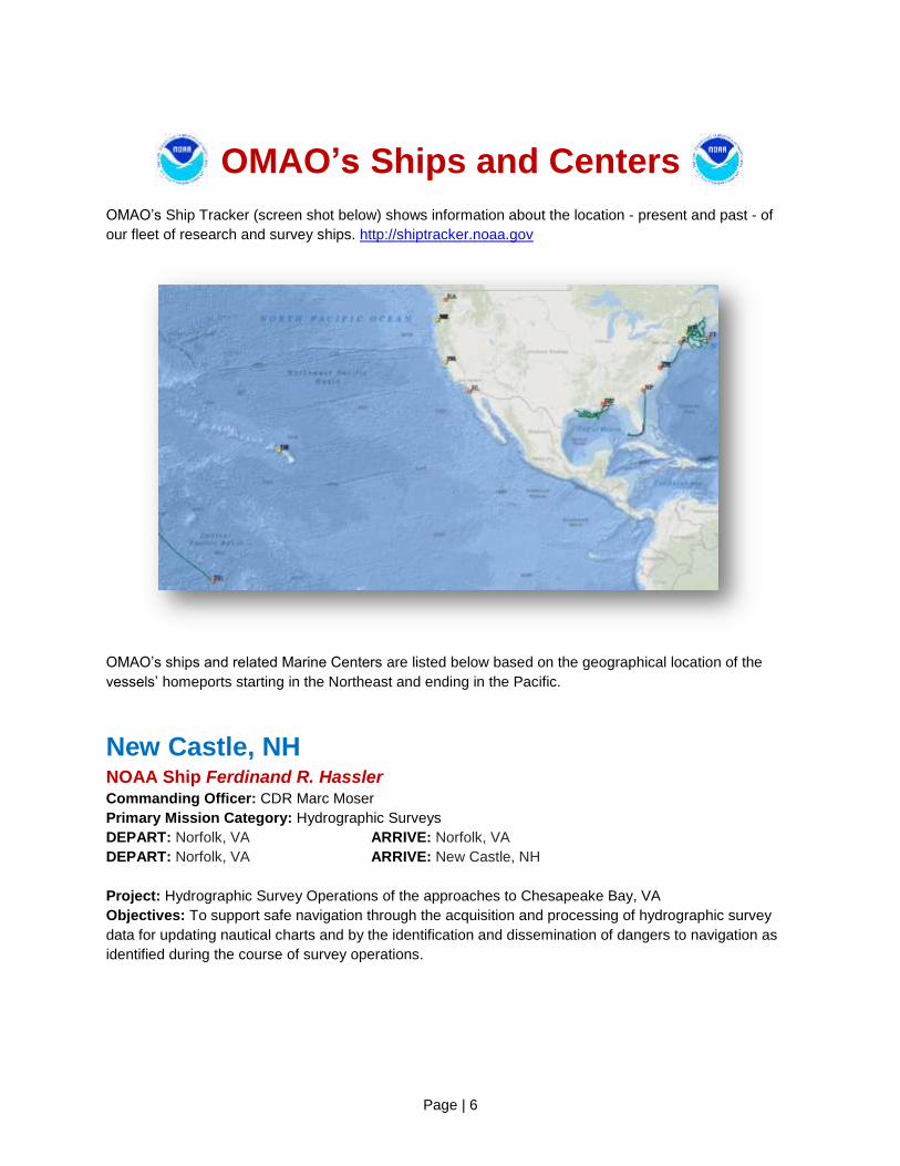
OMAO’s Ship Tracker (screen shot below) shows information about the location - present and past - of
our fleet of research and survey ships. http://shiptracker.noaa.gov
OMAO’s ships and related Marine Centers are listed below based on the geographical location of the
vessels’ homeports starting in the Northeast and ending in the Pacific.
New Castle, NH NOAA Ship Ferdinand R. Hassler Commanding Officer: CDR Marc Moser
Primary Mission Category: Hydrographic Surveys
DEPART: Norfolk, VA ARRIVE: Norfolk, VA
DEPART: Norfolk, VA ARRIVE: New Castle, NH
Project: Hydrographic Survey Operations of the approaches to Chesapeake Bay, VA
Objectives: To support safe navigation through the acquisition and processing of hydrographic survey
data for updating nautical charts and by the identification and dissemination of dangers to navigation as
identified during the course of survey operations.

Page | 7
Woods Hole, MA (currently docks in Newport, RI) NOAA Ship Henry B. Bigelow Commanding Officer: CDR G. Mark Miller
Primary Mission Category: Fisheries Research
DEPART: Boston, MA ARRIVE: Newport, RI
DEPART: Newport, RI ARRIVE: Newport, RI
Project: Autumn Bottom Trawl Survey and Fleet Inspection Period
Objectives:
1. Determine the autumn distribution and relative abundance of fish and invertebrate species found on
the continental shelf, including variable amounts of additional biological information obtained through
intensive sampling effort.
2. Opportunistically test trawl gear, methods, or survey related equipment that may benefit the trawl
survey in the future.
3. Collect oceanographic data including Conductivity, Temperature, and Depth (CTD) casts and bongo
tows at selected stations.
4. Collect acoustic data along cruise tracks, as well as test and conduct preliminary survey operations
with acoustic systems including the EK-60 and ME-70.
Ever wonder what we bring aboard during an ocean trawl? Check out this shot from NOAA Ship Henry B. Bigelow! This picture shows a deck tow of skates and dog fish.
[Photo: Dave Chevrier, NOAA]

Page | 8
Davisville, RI NOAA Ship Okeanos Explorer Commanding Officer: CDR Ricardo Ramos / Incoming Commanding Officer: CDR Mark Wetzler
Primary Mission Category: Oceanographic Exploration and Research
Ship Status: Alongside Marine Operations Center – Atlantic, Norfolk, VA, until January, for scheduled
maintenance, routine repairs, crew rest, and training.
Norfolk, VA NOAA Ship Thomas Jefferson Commanding Officer: CAPT James Crocker
Primary Mission Category: Hydrographic Surveys
DEPART: Boston, MA ARRIVE: Norfolk, VA
Project: Hydrographic Survey Operations in eastern Long Island Sound
Objectives: To support safe navigation through the acquisition and processing of hydrographic survey
data for updating nautical charts and by the identification and dissemination of dangers to navigation as
identified during the course of survey operations.
OMAO’S MARINE OPERATIONS CENTER – ATLANTIC (MOC-A) CAPT Anne Lynch, Commanding Officer MOC-A
MOC-A serves as a homeport for one NOAA ship, and manages the day-to-day operations and provides
administrative, engineering, maintenance, and logistical support for the research and survey ships in
NOAA's Atlantic fleet. Each year these ships conduct dozens of missions to assess fish and marine
mammal stocks, conduct coral reef research, collect seafloor data to update nautical charts, and explore
the ocean.
Charleston, SC NOAA Ship Nancy Foster Commanding Officer: LCDR Jeffrey Shoup
Primary Mission Category: Oceanographic Research, Environmental Assessment
DEPART: Charleston, SC ARRIVE: Charleston, SC
Project: Validation of Visible Infrared Imaging Radiometer Suite (VIIRS) Satellite Radiometer
Objectives: Observe and measure inherent and apparent optical properties of water masses for three
primary objectives:
1. Joint Polar Satellite System (JPSS) VIIRS ocean color satellite validation
2. Inter-calibration and inter-comparison of validation techniques and measurements
3. Optical characterization of ocean variability (i.e. coastal, near-shore, cross-shelf, eddies, fronts,
filaments, and blue water).
Page | 9
NOAA Ship Ronald H. Brown Commanding Officer: CAPT Joseph Pica
Primary Mission Category: Oceanographic Research, Environmental Assessment
DEPART: Kwajalein, Republic of Marshall Islands (RMI) ARRIVE: Honolulu, HI
Project: Tropical Oceans Atmosphere (TAO) 155W
Objectives: Conduct maintenance of the TAO Array along the 155°W line. En route to the first station,
the ship will recover a decommissioned mooring and retrieve a mooring that has gone adrift. Continue to
conduct underway operations between stations, including mooring recoveries, deployments, and repairs.
Pascagoula, MS NOAA Ship Oregon II Commanding Officer: Master Dave Nelson
Primary Mission Category: Fisheries Research
DEPART: Galveston, TX ARRIVE: Pascagoula, MS
DEPART: Pascagoula, MS ARRIVE: Pascagoula, MS
Project: Southeast Area Monitoring and Assessment Program (SEAMAP) Fall Groundfish
Objectives: 1. Sample the northern Gulf of Mexico (GOM) with SEAMAP standard trawl sampling gear to determine
the abundance and distribution of benthic fauna.
2. Collect size measurements to determine population size structures.
3. Record profiles through the water column of temperature, salinity, fluorescence, dissolved oxygen,
and turbidity using a Conductivity/Temperature/Depth (CTD) unit at SEAMAP stations.
4. Collect water samples weekly and perform bench top dissolved oxygen tests.
5. Assess the occurrence, abundance, and geographical distribution of the early life stages of
ichthyoplankton in the sampling using a bongo frame and neuston frame.
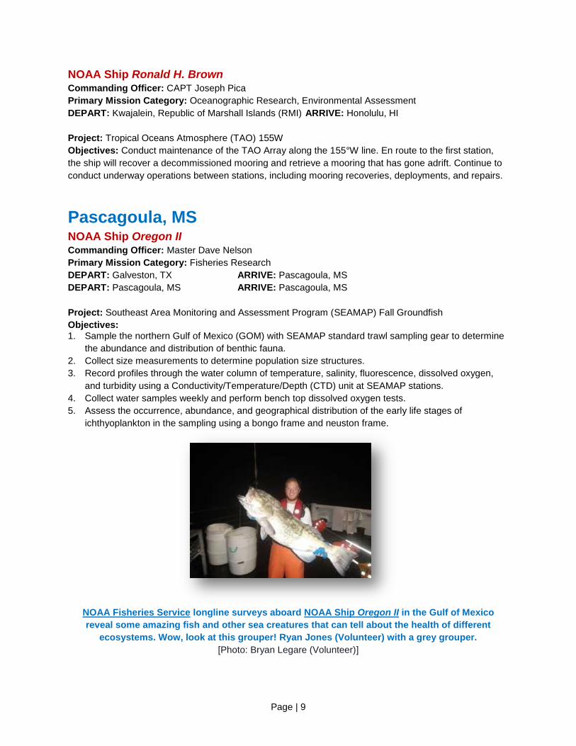
NOAA Fisheries Service longline surveys aboard NOAA Ship Oregon II in the Gulf of Mexico
reveal some amazing fish and other sea creatures that can tell about the health of different
ecosystems. Wow, look at this grouper! Ryan Jones (Volunteer) with a grey grouper.
[Photo: Bryan Legare (Volunteer)]
Page | 10
NOAA Ship Gordon Gunter Commanding Officer: Master Don Pratt
Primary Mission Category: Fisheries Research
DEPART: Pascagoula, MS ARRIVE: Pascagoula, MS
Project: Southeast Area Monitoring and Assessment Program (SEAMAP) Fall Ichthyoplankton Plankton
Survey / Pelagic Survey
Objectives:
1. Assess the occurrence, abundance, and geographical distribution of the early life stages of fall
spawning fishes, especially king and Spanish mackerel, red drum, and snappers.
2. Describe the pelagic habitat of fish larvae through physical and biological measurements.
3. Map the distribution of fish eggs and invertebrate zooplankton.
4. Study extrusion of smaller fish larvae through the standard SEAMAP bongo nets.
5. Examine the spatial resolution of red and vermillion snapper distribution.
6. Collect detailed observations of net-caught jellyfish and ctenophores.
NOAA Ship Pisces Commanding Officer: CDR Peter Fischel
Primary Mission Category: Fisheries Research
DEPART: Newport, RI ARRIVE: Norfolk, VA
DEPART: Norfolk, VA ARRIVE: Pascagoula, MS
Project: Northeast Integrated Pelagic Survey
Objectives:
1. Collect underway data using Thermosalinograph (TSG), SCS, and ADCP
2. Complete CTD and bongo operations at stations throughout area
3. Calibrate the EK60 Scientific Sounder
4. Conduct acoustic surveys using the EK60 and ME70
5. Collect biological data to verify species-specific acoustic measurements using midwater trawls
6. Collect marine mammal and seabird observations
7. Collect butterfish and conduct in situ respirometer experiments while at sea.

Page | 11
NOAA Ship Pisces – The mesh at the apex of the trawl is known as the “kite”. Skilled fisherman
Victor Coleman attaches a device called a TDR to the kite that will record the temperature and
depth that the trawl is fishing.
[Photo: ENS Jacob Barbaro, NOAA]
San Diego, CA NOAA Ship Reuben Lasker Commanding Officer: CDR Keith Roberts
Primary Mission Category: Fisheries Research
Ship Status: The ship is alongside in San Diego, CA, due to voltage and harmonic issues within the
propulsion motors and will remain alongside as solutions are developed.
Newport, OR NOAA Ship Rainier Commanding Officer: CDR E.J. Van Den Ameele
Primary Mission Category: Hydrographic Surveys
DEPART: Kodiak, AK ARRIVE: Seattle, WA
DEPART: Seattle, WA ARRIVE: Newport, OR
Project: Hydrographic Survey Operations in the vicinity of the San Juan Islands.
Objectives: To support safe navigation through the acquisition and processing of hydrographic survey
data for updating nautical charts and by the identification and dissemination of dangers to navigation as
identified during the course of survey operations.
Page | 12
NOAA Ship Bell M. Shimada Commanding Officer: CDR Brian Parker
Primary Mission Category: Fisheries Research
Ship Status: In drydock at Bay Ship & Yacht Shipyard in Alameda, CA, for a scheduled repair period.
OMAO’S MARINE OPERATIONS CAPT Eric Berkowitz, Director of Marine Operations
OMAO’s Marine Operations oversees operations of the three regional Centers, including the Marine
Operations Center-Pacific, Marine Operations Center-Atlantic, and Marine Operations Center-Pacific
Islands.
OMAO’S MARINE OPERATIONS CENTER – PACIFIC (MOC-P) CAPT Douglas Baird, Commanding Officer MOC-P
MOC-P serves as a homeport for two NOAA ships, and manages the day-to-day operations and provides
administrative, engineering, maintenance, and logistical support for the research and survey ships in
NOAA's Pacific fleet. Each year these ships conduct dozens of missions to assess fish and marine
mammal stocks, conduct coral reef research, collect seafloor data to update nautical charts, and explore
the ocean.
Ketchikan, AK (currently docks in Newport, OR) NOAA Ship Fairweather Commanding Officer: CDR David Zezula
Primary Mission Category: Hydrographic Surveys
Ship Status: In drydock at Bay Ship & Yacht Shipyard in Alameda, CA, for a scheduled repair period.
Expected departure mid-January.
Kodiak, AK NOAA Ship Oscar Dyson Commanding Officer: CDR Arthur “Jesse” Stark
Primary Mission Category: Fisheries Research
Ship Status: Alongside Marine Operations Center – Pacific, in Newport, OR, for scheduled maintenance
and dockside repairs. Expected departure mid-January.
Page | 13
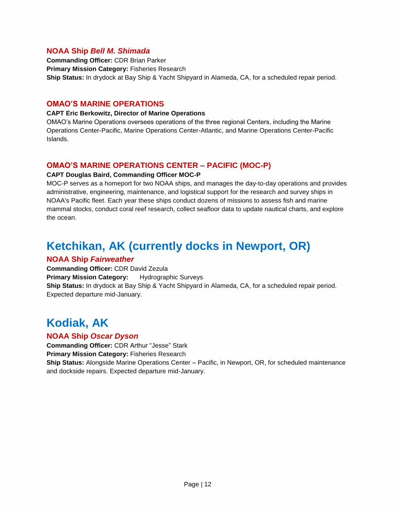
Good news for Alaska pollock in the Bering Sea! NOAA Alaska Fisheries Science Center has just reported big increases in pollock abundance estimates from this year’s surveys. Much of
the research leading to this report comes from acoustic-trawl surveys conducted aboard NOAA Ship Oscar Dyson. Read more of the report athttp://1.usa.gov/1u2AMAx
[Photo: NOAA]
Honolulu, HI NOAA Ship Hi’ialakai Commanding Officer: CDR Daniel Simon
Primary Mission Category: Oceanographic Research, Environmental Assessment
Ship Status: Alongside Marine Operations Center – Pacific Islands, Pearl Harbor, HI, after successful
completion of all projects for the year. The ship will remain alongside until January for scheduled
maintenance, routine repairs, crew rest, and training.
NOAA Ship Oscar Elton Sette Commanding Officer: CDR Stephanie Koes
Primary Mission Category: Fisheries Research
Ship Status: Alongside Marine Operations Center – Pacific Islands, Pearl Harbor, HI, after successful
completion of all projects for the year. The ship will remain alongside until February for scheduled
maintenance, fleet inspection, routine repairs, crew rest, and training.
OMAO’S MARINE OPERATIONS CENTER – PACIFIC ISLANDS (MOC-PI) CAPT Robert Kamphaus, Commanding Officer MOC-PI
MOC-PI serves as a homeport for two NOAA ships, and manages the day-to-day operations and provides
administrative, engineering, maintenance, and logistical support for the ships in NOAA's Pacific Islands’
fleet.
Page | 14
OMAO’s Aircraft
Tampa, Florida OMAO’S AIRCRAFT OPERATIONS CENTER (AOC) CAPT Harris Halverson, Commanding Officer AOC
The AOC, located at MacDill Air Force Base, serves as the main base for OMAO’s fleet of nine aircraft
and provides capable, mission-ready aircraft and professional crews to the scientific community. Whether
studying global climate change or acid rain, assessing marine mammal populations, surveying coastal
erosion, investigating oil spills, flight checking aeronautical charts, or improving hurricane prediction
models, the AOC flight crews continue to operate in some of the world's most demanding flight regimes.
WP-3D (N43RF) – “Hurricane Hunter” Current Mission: Scheduled maintenance and upgrades
The aircraft will be undergoing scheduled maintenance and systems upgrades until January.
WP-3D (N42RF) Aircraft Commander: TBD
Temporary Base: Fairbanks, AK
Current Mission: 2014 Hurricane Reconnaissance and Research. Western
Atlantic and Gulf of Mexico.
The NOAA Hurricane Hunter WP-3D will continue to be ready to respond for the remainder of the 2014
Hurricane season. Radar reconnaissance missions on both NOAA WP-3D aircraft will be conducted to
support tropical cyclone forecasting and the Hurricane Forecast Improvement Project. These flights will
use the WP-3D's tail Doppler radar system to obtain high-density, three-dimensional measurements of
the inner core wind structure of each tropical cyclone, potentially throughout its full life cycle. The
hurricane research missions will also use the WP-3D to support the calibration/validation of satellite
measurements and instrumentation development for the tropical cyclone environment and sampling of
other aspects of the tropical cyclone inner core. These measurements will be used to enhance the
accuracy of track and intensity guidance generated by NOAA's numerical weather prediction
models. They will also be used directly by NWS hurricane specialists with the ultimate outcome being
improved accuracy of intensity and track forecasts, extended forecast/warning lead-times and improved
confidence levels by decision makers.
Twin Otter (N46RF) Aircraft Commander: LT Michael Marino
Current Mission: Various locations for Snow Survey/ Soil Moisture Surveys
The aircraft is in scheduled maintenance at the beginning of November and will then resume conducting Snow Survey operations for the National Operational Hydrologic Remote Sensing Center (NOHRSC). Operations in November will primarily be focused on establishing new flight lines and for soil moisture surveys in the upper Midwest.

Page | 15
Twin Otter (N48RF) Aircraft Commander: LT Francisco Fuenmayor
Temporary Base: West Palm Beach, FL
Current Mission: Various locations for LiDAR Evaluation
The aircraft is conducting an evaluation of a topometric-bathymetric Light Detecting and Ranging (LiDAR)
system for the Remote Sensing Division of the National Geodetic Survey. The system can scan
coastlines and simultaneously measure ground heights above the surface as well as the depths below,
near the shoreline. The data could potentially be used to update nautical charts.
Twin Otter aircraft (N48RF) has been conducting high-resolution aerial coastal mapping surveys
of St. Croix and Buck Island reef.
More info: http://oceanservice.noaa.gov/geodesy/aerialphotos/
[Photo: ENS Jacob Blaauboer, NOAA]
Twin Otter (N57RF) Aircraft Commander: LT John Rossi and LCDR Phillip Eastman
Temporary Base: Hyannis, MA
Current Mission: Northeast Right Whale Survey – Atlantic waters off of Maine and
Massachusetts.
The aircraft will be conducting a survey of the North Atlantic Right Whale, off the New England coast. This
survey will serve multiple objectives with respect to marine mammal conservation: 1) provide locations of
North Atlantic Right whales to mariners, 2) provide description of Right whale distribution to support the
implementation of seasonal and dynamic area management, 3) provide annual photo-identification
records on Right whales, as well as detailed vertical photogrammetry in selected periods, 4) provide
information on the distribution and abundance of marine mammals and marine turtles in the winter,
spring, summer and fall seasons, 5) provide sightings of dead whales, 6) provide information on the
distribution of shipping and fishing gear, and 7) census seal populations along the New England coast
Page | 16
Twin Otter (N56RF) Temporary Base: Calgary, AB
Current Mission: Scheduled Maintenance Period
Aircraft is in an extended scheduled maintenance period for the next two months.
Gulfstream IV (N49RF) Aircraft Commander: TBD
Current Mission: Hurricane Surveillance and Research. Western Atlantic and Gulf
of Mexico
NOAA's Gulfstream IV aircraft will support operational tropical cyclone forecasting and the Hurricane
Forecast Improvement Project. The G-IV will be the primary aircraft for surveillance missions with the Air
Force's WC-130J and NOAA's WP-3D aircraft serving as backup platforms. The radar reconnaissance
missions will use the G-IV's Tail Doppler Radar (TDR) system to obtain high-density, three-dimensional
measurements of the inner core wind structure of tropical cyclones, potentially throughout its full life
cycle. The National Weather Service is seeking to gather data on the performance of the TDR
observation system and will work with the Hurricane Research Division to develop observing strategies
for maximizing the utility of the TDR with the goal of improving hurricane track and intensity
forecasts. Near the end of the month, the aircraft will begin undergoing scheduled maintenance.
Jet Prop Commander (N45RF) Aircraft Commander: LCDR Patrick Didier and LTJG Kyle Salling
Current Mission: Various locations for Snow Survey / Soil Moisture Surveys
The aircraft will be in scheduled maintenance at the beginning of November but will then resume Snow
Survey operations for the National Operational Hydrologic Remote Sensing Center (NOHRSC). The
project utilizes an Airborne Gamma Radiation detector to make airborne Snow Water Equivalent (SWE)
and soil moisture measurements. Airborne SWE measurements are used by NWS Weather Forecast
Offices (WFO) and NWS River Forecast Centers (RFC) when issuing river and flood forecasts, water
supply forecasts, and spring flood outlooks. Survey locations will be determined based on NOHRSC
tasking. Operations in November will primarily be focused on establishing new flight lines and for soil
moisture surveys in Michigan. At the end of the month, the aircraft will conduct training flights out of
MacDill Air Force Base in Florida.

Page | 17
King Air (N68RF) Aircraft Commander: LCDR Rebecca Waddington and LT Tanner Sims
Current Mission: Various locations for coastal mapping
Dates of Operation: Continuous operations
The King Air will be undergoing scheduled maintenance at the beginning of the month and
then conducting Coastal Mapping mission flights in various locations during November. The Coastal
Mapping work is an on-going mission, run by the Remote Sensing Division of the National Geodetic
Survey (NGS), with the goal of providing a regularly-updated national shoreline for supporting marine
navigation, defining territorial limits, and managing coastal resources. Stereo photogrammetry and LiDAR
are used to produce a digital database for a national shoreline. At the end of the month, the aircraft will
be prepared for repainting.
Hawker Beechcraft King Air (N68RF) is equipped with two downward-facing sensor ports that can
support a wide variety of remote sensing systems, including digital cameras, multispectral and
hyperspectral sensors, and topographic and bathymetric LIDAR systems.
[Photo: NOAA]
Page | 18
Unmanned Systems Support
NASA Global Hawk Location: NASA Wallops Flight Facility, VA
One of NASA’s Global Hawks is currently being instrumented for a multinational science
campaign. The Coordinated Airborne Studies in the Tropics project, or CAST, will carry 8 payloads (2
from NOAA) operating out of Edwards Air Force Base to the equatorial region for atmospheric
profiling. Science flights are expected to begin in late February and conclude in March of 2015. A NOAA
Corps officer, LCDR Jonathan Neuhaus, will be participating as a pilot and project manager.
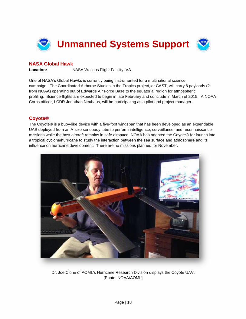
Coyote® The Coyote® is a buoy-like device with a five-foot wingspan that has been developed as an expendable
UAS deployed from an A-size sonobuoy tube to perform intelligence, surveillance, and reconnaissance
missions while the host aircraft remains in safe airspace. NOAA has adapted the Coyote® for launch into
a tropical cyclone/hurricane to study the interaction between the sea surface and atmosphere and its
influence on hurricane development. There are no missions planned for November.
Dr. Joe Cione of AOML's Hurricane Research Division displays the Coyote UAV.
[Photo: NOAA/AOML]

Page | 19
OMAO Partnerships
United States Senate Committee on Commerce, Science, and Transportation –
Office of Ranking Member, Senator John Thune (R-SD) Location: Washington, DC
Detail: LCDR Wendy Lewis, NOAA Commissioned Officer Corps
LCDR Lewis is currently on detail to the Committee and the office of Ranking Member Thune where she
will be assisting on activities pertaining to oceans, atmosphere, and fisheries policy, as well as other
matters within the Committee's jurisdiction
National Science Foundation Location: Antarctica
Mission: LTJG Joe Phillips, NOAA Commissioned Officer Corps
Members of the NOAA Commissioned Officer Corps carry out NOAA's mission in remote locations across
the globe. LTJG Phillips is assigned to Antarctica where he serves as the Station Chief for NOAA’s
Atmospheric Research Observatory (ARO) at the Amundsen-Scott South Pole Station. The ARO at the
Amundsen-Scott South Pole Station is a National Science Foundation facility used in support of scientific
research related to atmospheric phenomena.
Department of Defense - U.S. Pacific Command (USPACOM) Location: Honolulu, HI
Embedded Liaison: CAPT Barry Choy, NOAA Commissioned Officer Corps
The U.S. Pacific Command (USPACOM) area of responsibility encompasses approximately half the
earth's surface and more than half of its population. The 36 nations that comprise the Asia-Pacific include:
two of the three largest economies and nine of the ten smallest; the most populous nation; the largest
democracy; the largest Muslim-majority nation; and the smallest republic in the world. The region is a vital
driver of the global economy and includes the world's busiest international sea lanes and nine of the ten
largest ports. By any meaningful measure, the Asia-Pacific is also the most militarized region in the world,
with seven of the world's ten largest standing militaries and five of the world's declared nuclear nations.
Under these circumstances, the strategic complexity facing the region is unique. CAPT Choy is linked
closely with the activities within the region allowing for identification of opportunities and cooperation
between USPACOM and NOAA, and better overall government function situational awareness in the
region.
Department of Defense - U.S. Northern Command (USNORTHCOM) Location: Boulder, CO
Embedded Liaison: CAPT Mark Moran, NOAA Commissioned Officer Corps
U.S. Northern Command (USNORTHCOM) partners to conduct homeland defense, civil support, and
security cooperation to defend and secure the United States and its interests. NORTHCOM’s area of
responsibility includes air, land, and sea approaches and encompasses the continental United States,
Alaska, Canada, Mexico, and the surrounding water out to approximately 500 nautical miles. It also
includes the Gulf of Mexico, the Straits of Florida, and portions of the Caribbean region that include The
Bahamas, Puerto Rico, and the U.S. Virgin Islands. CAPT Moran serves as the liaison for the NOAA
Corps, helping to plan, organize, and execute homeland defense and civil support missions.

Page | 20
Department of Defense - U.S. Navy Location: Washington, DC
Embedded Liaison: CDR Christiaan Van Westendorp, NOAA Commissioned Officer Corps
The NOAA liaison to the Oceanographer of the Navy serves as the Head of the Interagency Policy
Branch of the International and Interagency Policy Division, Office of the Oceanographer of the Navy,
located at the U.S. Naval Observatory. The mission of this Division is to coordinate and execute the
Oceanographer of the Navy functions related to policy and programs involving international and/or
interagency oceanography. Oceanography includes meteorology, oceanography, mapping, charting and
geodesy, astronomy, and precise time and time interval. Starting in July, CDR Van Westendorp will serve
as the interface for the Oceanographer of the Navy between Navy and U.S. Federal Agencies including
NOAA.
Department of Defense and NOAA’s Office of Coast Survey Location: Silver Spring, MD
Embedded Liaison: CDR Matthew Wingate, NOAA Commissioned Officer Corps
NOAA’s National Ocean Service Office of Coast Survey (OCS) is the lead federal provider of nautical
charts and hydrographic survey data of the U.S. Exclusive Economic Zone. Meeting this responsibility
requires active cooperation and coordination with federal partners in the Departments of Defense and
Homeland Security with which NOAA shares responsibility for U.S. navigational products and services.
CDR Wingate tracks, coordinates, and adds value to existing activities involving OCS subject matter
experts and partners, seeks and develops additional opportunities for collaboration, and increases
visibility and access to these activities and partnerships for OCS leadership.
Department of Homeland Security - U.S. Coast Guard Location: Washington, DC
Embedded Liaison: CAPT Jeremy Adams, NOAA Commissioned Officer Corps
As the NOAA liaison to the United States Coast Guard (USCG), CAPT Adams maintains a current and
comprehensive knowledge of interagency activities and policies related to the USCG and NOAA. He
identifies potential conflict or benefit issues for analysis and evaluation, conducts appropriate
assessments and studies, and serves as the interface between NOAA and the USCG. CAPT Adams
initiates, designs, and implements strategies through federal agency liaison and coordination that results
in cooperative arrangements for maritime security, oceanographic research, hazardous materials spill
response, and many other activities.
Department of State - North Atlantic Treaty Organization – Science and
Technology Organization, Centre for Maritime Research and Experimentation Location: Le Spezia, Italy
Embedded Liaison: LTJG Kevin Michael, NOAA Commissioned Officer Corps
As the NOAA liaison to the North Atlantic Treaty Organization (NATO), Centre for Maritime Research and
Experimentation (CMRE), LTJG Michael will be part of their unmanned systems engineering team. CMRE
is a world-class scientific research and experimentation facility that organizes and conducts scientific
research and technology development, centered on the maritime domain, delivering innovative and field
tested science and technology solutions to address defense and security needs of the Alliance. LTJG
Michael will assist with the development of unmanned systems that have the ability to sense,
comprehend, predict, communicate, plan, make decisions, and take appropriate action to achieve mission
goals.

Page | 21
Teacher At Sea Program The mission of the Teacher at Sea (TAS) program is to give teachers a clearer insight into our ocean
planet, a greater understanding of maritime work and studies, and to increase their level of environmental
literacy by fostering an interdisciplinary research experience. The program provides a unique environment
for learning and teaching by sending kindergarten through college-level teachers to sea aboard NOAA
research and survey ships to work under the tutelage of scientists and crew. Then, armed with new
understanding and experience, teachers bring this knowledge back to their classrooms. Since its
inception in 1990, the program has enabled more than 600 teachers to gain first-hand experience of
science and life at sea. By participating in this program, teachers enrich their classroom curricula with
knowledge that can only be gained by living and working side-by-side, day and night, with those who
contribute to the world's body of oceanic and atmospheric scientific knowledge. Below is a list of the
NOAA Teachers at Sea for the current monthly update for the 2014 Field Season. Once they have
embarked on their cruise, you can gain access to their blogs which document their missions at sea and
offer a wealth of information about the research being conducted as well as personal stories. More info:
http://teacheratsea.noaa.gov
2014 Current TAS Placements Blogs – http://teacheratsea.noaa.gov/2014/index.html
November - LTJG Theresa Smith will visit Chris Henricksen’s (TAS, 2014, NOAA Ship Henry B. Bigelow)
classroom in Westerville, OH. LTJG Smith attended school in Westerville and was trained by
Commanding Officer, G. Mark Miller, of NOAA Ship Henry B. Bigelow. She will spend time at Mark Twain
Elementary sharing her knowledge of NOAA science and careers with the students.
Janelle Harrier-Wilson teaches Earth Science at Lanier High School in Sugar Hill, GA. Janelle was
aboard NOAA Ship Henry B. Bigelow while scientists conducted an Autumn Bottom Trawl Survey. You
can learn more about this important scientific work by clicking here.
School Town: Sugar Hill, GA
School: Lanier High School
Grades Taught: 6th
Ship: NOAA Ship Henry B. Bigelow
Mission: Autumn Bottom Trawl Survey
Blog: Janelle Harrier-Wilson's Blog Posts
Page | 22
OMAO - NOAA Dive Program
OMAO manages and implements NOAA’s Dive Program (NDP), which trains and certifies scientists,
engineers, and technicians from federal, state, tribal governments, and the private sector to perform the
variety of tasks carried out underwater to support NOAA’s mission. NDP also has cooperative diving
agreements with over 100 government agencies and academic institutions. NOAA has more than 400
divers who perform over 14,000 dives per year. The NDP is headquartered at the NOAA Diving Center at
the NOAA Western Regional Center in Seattle, Washington. http://www.ndc.noaa.gov/gi_program.html
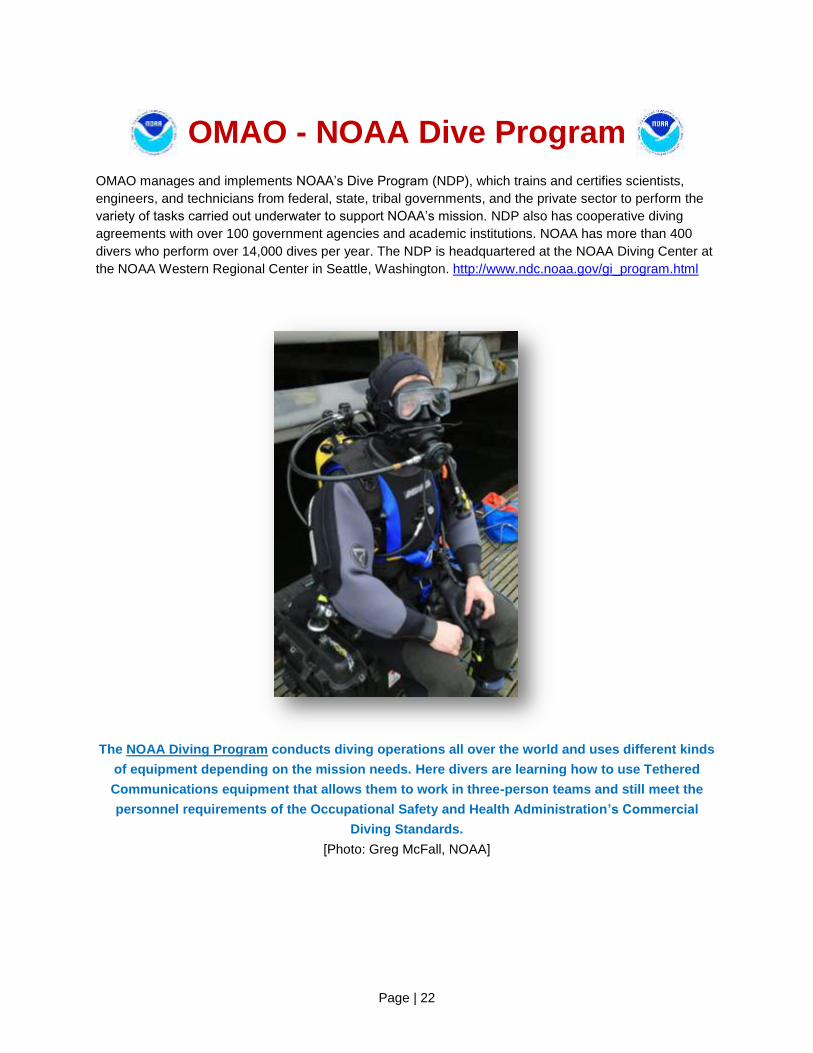
The NOAA Diving Program conducts diving operations all over the world and uses different kinds
of equipment depending on the mission needs. Here divers are learning how to use Tethered
Communications equipment that allows them to work in three-person teams and still meet the
personnel requirements of the Occupational Safety and Health Administration’s Commercial
Diving Standards.
[Photo: Greg McFall, NOAA]
Page | 23
OMAO - NOAA Small Boat Program
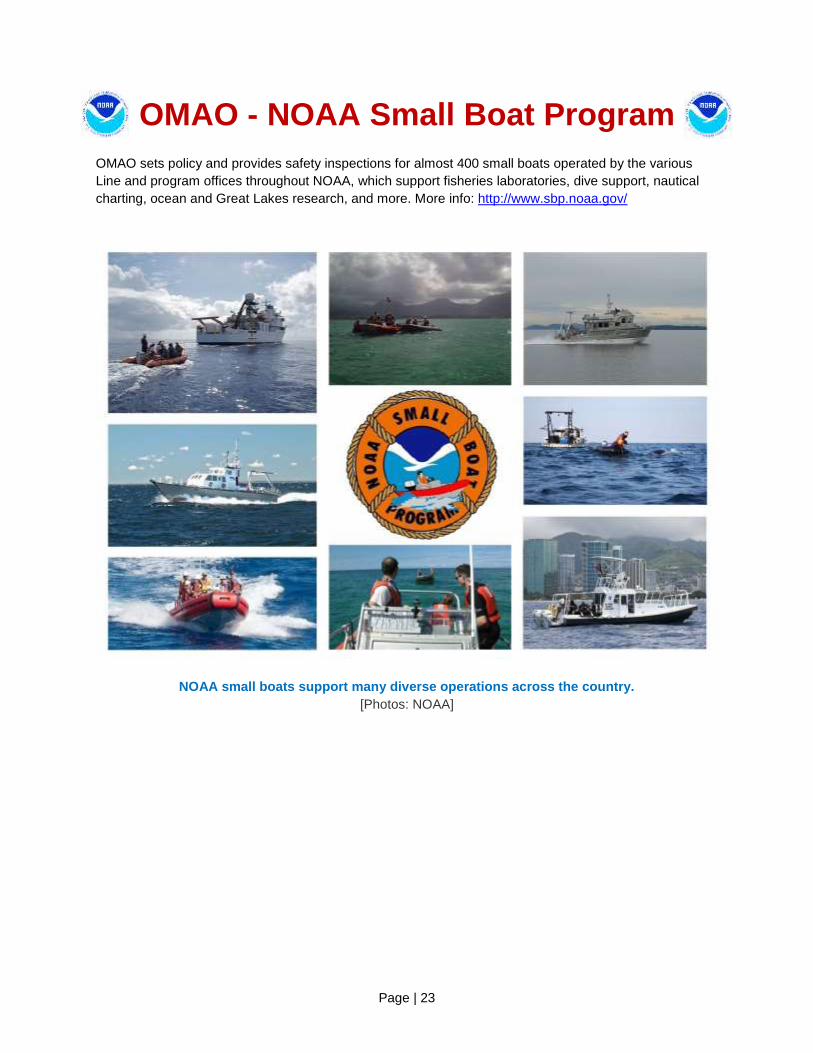
OMAO sets policy and provides safety inspections for almost 400 small boats operated by the various
Line and program offices throughout NOAA, which support fisheries laboratories, dive support, nautical
charting, ocean and Great Lakes research, and more. More info: http://www.sbp.noaa.gov/
NOAA small boats support many diverse operations across the country.
[Photos: NOAA]
Page | 24
Office of Marine and Aviation Operations Providing environmental intelligence for a dynamic world.
The personnel, ships, and aircraft of NOAA play a critical role in gathering environmental data vital to the nation's economic security, the safety of its citizens, and the understanding, protection, and management of our natural resources. The NOAA fleet is managed and operated by the Office of Marine and Aviation Operations (OMAO), an office comprising civilians, mariners, and officers of the NOAA Commissioned Officer Corps, one of the seven uniformed services of the United States. NOAA's roots trace back to 1807, when President Thomas Jefferson ordered the first comprehensive coastal surveys. Those early surveys ensured safe passage of ship-borne cargo for a young nation. As the needs of the nation have grown, so too have OMAO's responsibilities. Today, OMAO civilians and NOAA Corps officers operate, manage, and maintain NOAA's active fleet of 16 research and survey ships and 9 specialized aircraft. Together, OMAO and the NOAA Corps support nearly all of NOAA's missions. NOAA has the largest fleet of civilian research and survey ships in the nation. The fleet ranges from large oceanographic ships capable of exploring and charting the world's deepest ocean, to smaller vessels responsible for surveying the shallow bays and inlets of the United States. The fleet supports a wide range of marine activities including fisheries surveys, nautical charting, and ocean and climate studies. Based throughout the continental United States, Alaska, and Hawaii, the ships operate in all regions of the nation and around the world. NOAA's aircraft provide a wide range of airborne capabilities. Our highly specialized Lockheed WP-3D turboprop "hurricane hunter" aircraft are equipped with an unprecedented variety of scientific instrumentation, radars, and recording systems for both in situ and remote sensing measurements of the atmosphere, the Earth, and its environment. Together with NOAA's Gulfstream IV-SP hurricane surveillance jet, these aircraft greatly improve our physical understanding of hurricanes and enhance the accuracy of tropical cyclone forecasts. NOAA's light aircraft also play a vital role in monitoring our environment. Our King Air, Commander and Twin Otter aircraft support marine mammal population studies, shoreline change assessments, oil spill investigations, and snowpack surveys for spring flood forecasts.
The NOAA fleet provides immediate response capabilities for unpredictable events. For example, after Hurricane Sandy, NOAA ships Thomas Jefferson and the newly commissioned Ferdinand R. Hassler conducted emergency bathometric surveys to locate possible submerged navigational hazards in the ports of New York and Virginia. These surveys enabled the ports to reopen quickly. Aerial images of storm-stricken regions, taken by NOAA aircraft, helped residents and emergency workers to quickly assess the condition of houses, bridges, and vital infrastructure.
In 2011, OMAO’s Aero Commander and Jetprop Commander aircraft conducted snow surveys, which increased the accuracy of National Weather Service's flood forecasting during a record year of snow and floods. In 2010, the NOAA fleet and the NOAA Corps played a major role in the response to the BP Deepwater Horizon oil spill, conducting extensive studies in the Gulf of Mexico to monitor the health of the ecosystem. NOAA's entire Atlantic fleet and over a quarter of the total strength of the NOAA Corps were deployed to the Gulf following the spill, developing mission plans and assisting response efforts. While manned aircraft and sea-going vessels have been, and will continue to be, a primary source of environmental data, new technology will have a significant role to play in the future NOAA fleet. OMAO, in coordination with other NOAA offices and federal agencies, is evaluating and deploying remotely piloted underwater and aircraft systems that could significantly contribute to environmental observations. OMAO's ongoing challenge is to meet the growing demand for in situ scientific data while providing the highest level of service. As NOAA's fleet continues to age, maintenance costs steadily increase. Operational costs have increased as well, driven largely by rising fuel costs. To better serve the needs of the nation, NOAA is examining the composition of the fleet through an exhaustive and critical review of at-sea science and observation requirements. Our objective is to develop a clear, cost-efficient path forward to ensure that the NOAA fleet can continue to conduct at-sea surveys and research vital to fisheries management, updating nautical charts, responding to natural and manmade disasters, and understanding coastal and marine systems more fully. Meeting these requirements is essential to developing sustainable, science-based management and conservation plans that protect the health and resiliency of these resources over the long-term. We are also continuing our effort to build a civilian and NOAA Corps officer work force that is uniquely qualified to gather critical environmental intelligence and be adaptive and responsive to a changing world. We transitioned our basic NOAA Corps officer training class to the U.S. Coast Guard Academy, where newly commissioned officers train alongside Coast Guard officer candidates, developing skills and professional relationships that will benefit both services, especially during challenging times. Finally, we continue to expand our partnerships with other federal agencies. We are proud of our longstanding and fruitful working relationships with the U.S. Air Force, U.S. Coast Guard, U.S. Navy, and U.S. Public Health Service and through the Interagency Working Group on Facilities and Infrastructure, continue facilitating cross-agency cooperation for the federal fleet of research and survey ships. Active collaboration among the Federal family is critical to ensuring the long-term capability and success of the federal ocean infrastructure. Our partners' success is our success.
Page | 25
NOAA Commissioned
Officer Corps – Supporting NOAA’s Science, Service, and Stewardship –
The NOAA Commissioned Officer Corps (NOAA Corps) is one of the nation’s seven uniformed services
and serve with the ‘special trust and confidence’ of the President. NOAA Corps officers are an integral
part of the National Oceanic and Atmospheric Administration (NOAA), an agency of the U.S. Department
of Commerce. With 321 officers, the NOAA Corps serves throughout the agency’s line and staff offices to
support nearly all of NOAA’s programs and missions. The combination of commissioned service and
scientific expertise makes these officers uniquely capable of leading some of NOAA’s most important
initiatives.
The NOAA Corps is part of NOAA’s Office of Marine and Aviation Operations (OMAO) and traces its roots
back to the former U.S. Coast and Geodetic Survey, which dates back to 1807 and President Thomas
Jefferson. In 1970, NOAA was created to develop a coordinated approach to oceanographic and
atmospheric research and subsequent legislation converted the commissioned officer corps to the NOAA
Corps.
The NOAA Corps today provides a cadre of professionals trained in engineering, earth sciences,
oceanography, meteorology, fisheries science, and other related disciplines. Corps officers operate
NOAA’s ships, fly aircraft, manage research projects, conduct diving operations, and serve in staff
positions throughout NOAA.
Benefits of the NOAA Corps to the Nation
The combination of commissioned service with scientific and operational expertise, allows the NOAA
Corps to provide a unique and indispensable service to the nation. NOAA Corps officers enable NOAA to
fulfill mission requirements, meet changing environmental concerns, take advantage of emerging
technologies, and serve as environmental first responders. For example:
In 2012 after Hurricane Sandy, seafloor sonar surveys completed by NOAA ships and small boats
helped reopen Baltimore and Virginia ports, quickly restarting commerce and allowing Navy ships to
return to port. New York and New Jersey ports were reopened, enabling emergency supplies to reach
some of the hardest-hit areas. Maritime traffic resumed more quickly because NOAA embedded
regional navigation managers within command centers.
Hours after Sandy, NOAA planes and scientists conducted aerial surveys of the affected coastlines
and immediately published the photos online, allowing emergency managers and residents to
examine the damage even before ground inspections were permitted. These surveys are also vital to
FEMA assessment teams and other on-the-ground responders and those managing oil spill clean-up
and damage assessment. Over 3,000 miles of coastline have been surveyed, and over 10,000
images processed to document coastal damage and impacts to navigation.
In 2011, OMAO’s Aero Commander and Jetprop Commander aircraft conducted snow surveys, which
increased the accuracy of National Weather Service's River Forecast Centers flood forecasting during
a record year of snow and floods.

Page | 26
After Hurricane Irene in 2011, the NOAA Ship Ferdinand Hassler and team completed 300 lineal
nautical miles of survey work in less than 48 hours providing a Damage Assessment that enabled the
U.S. Coast Guard to re-open ports and restore more than $5M per hour in maritime commerce less
than 3 days after the storm.
More than 80 officers, or a quarter of the NOAA Corps’ total strength, were re-assigned and/or
deployed to support the Deepwater Horizon disaster response in the Gulf in 2010.
o Eight NOAA-owned vessels, or the entire Atlantic fleet, were also deployed to the Gulf of
Mexico for spill response, as well as several aircraft.
NOAA Corps officers who run NOAA’s Ships support fish stock and marine mammal assessments,
marine ecosystem studies, ocean exploration, coral reef preservation and protection, and mapping
and charting around the United States and the Arctic, and more.
NOAA Corps officers who run NOAA’s Aircraft collect environmental and geographic data essential to
studying climate change, assess marine mammal populations, survey coastal erosion, investigate oil
spills, and improve hurricane and winter storm forecasts as they pilot the WP-3D Orion hurricane
hunters and other aircraft that fly through, and above the storms to obtain critical forecasting data.
Find out more about the NOAA Corps, its mission and history at http://www.noaacorps.noaa.gov/.
The Executive Officers (XO) stand beside the dedicated “XO” chair on the bridge of the United
States Coast Guard Cutter (USCGC) Dauntless.
LCDR Eric T. Johnson, NOAA, on left and LCDR Brandon Fisher, USCG, on right.
[Photo: ENS Rachel Pryor, NOAA]
Related Documents