MINISTRY OF AGRICULTURE PALESTINIAN WATER AUTHORITY PALESTINIAN NATIONAL AUTHORITY THE FEASIBILITY STUDY ON WATER RESOURCES DEVELOPMENT AND MANAGEMENT IN THE JORDAN RIVER RIFT VALLEY FINAL REPORT VOLUME-I MAIN REPORT DECEMBER 2008 JAPAN INTERNATIONAL COOPERATION AGENCY NIPPON KOEI CO., LTD.

Welcome message from author
This document is posted to help you gain knowledge. Please leave a comment to let me know what you think about it! Share it to your friends and learn new things together.
Transcript
MINISTRY OF AGRICULTURE PALESTINIAN WATER AUTHORITY PALESTINIAN NATIONAL AUTHORITY
THE FEASIBILITY STUDY ON
WATER RESOURCES DEVELOPMENT AND MANAGEMENT IN
THE JORDAN RIVER RIFT VALLEY
FINAL REPORT
VOLUME-I MAIN REPORT
DECEMBER 2008
JAPAN INTERNATIONAL COOPERATION AGENCY
NIPPON KOEI CO., LTD.
MINISTRY OF AGRICULTURE PALESTINIAN WATER AUTHORITY PALESTINIAN NATIONAL AUTHORITY
THE FEASIBILITY STUDY ON
WATER RESOURCES DEVELOPMENT AND MANAGEMENT IN
THE JORDAN RIVER RIFT VALLEY
FINAL REPORT
VOLUME-I MAIN REPORT
DECEMBER 2008
JAPAN INTERNATIONAL COOPERATION AGENCY
NIPPON KOEI CO., LTD.

THE FEASIBILITY STUDY ON
WATER RESOURCES DEVELOPMENT AND MANAGEMENT IN
THE JORDAN RIVER RIFT VALLEY
FINAL REPORT
LIST OF VOLUMES
VOLUME-I MAIN REPORT
VOLUME-II ANNEXES-A
ANNEX 1 HYDROLOGY ANNEX 2 HYDROGEOLOGY ANNEX 3 STORM WATER HARVESTING
VOLUME-III ANNEXES-B
ANNEX 4 SPRINGS ANNEX 5 AGRICULTURAL WELLS
VOLUME-IV ANNEXES-C
ANNEX 6 PILOT PROJECTS ANNEX 7 SOCIO-ECONOMY ANNEX 8 ON-FARM WATER MANAGEMENT ANNEX 9 ENVIRONMENTAL ASSESSMENT ANNEX 10 GIS DATABASE ANNEX 11 PROJECT EVALUATION

PREFACE
In response to the request from the Palestinian National Authority (PNA), the
Government of Japan decided to conduct the Feasibility Study on Water Resources
Development and Management in the Jordan River Rift Valley and entrusted the study
to the Japan International Cooperation Agency (JICA).
JICA selected and dispatched a study team headed by Mr. Kunio GOTO of
Nippon Koei Co., Ltd. during the period from March 2007 to December 2008.
The team conducted the study with the counterpart agencies and held a series of
discussions with the officials concerned of PNA. Upon returning to Japan, the team
conducted further studies and prepared this final report.
I hope that this report will contribute to the promotion of the project for water
resources development project and to the realization of the concept of “Corridor for
Peace and Prosperity”.
Finally, I wish to express my sincere appreciation to the officials concerned of
PNA for their close cooperation extended to the study.
December 2008
Ariyuki MATSUMOTO
Vice President
Japan International Cooperation Agency
December 2008 Mr. Ariyuki MATSUMOTO Vice President Japan International Cooperation Agency Tokyo, JAPAN
LETTER OF TRANSMITTAL Dear Sir,
We are pleased to submit herewith the Final Report of the Feasibility Study on Water Resources Development and Management in the Jordan River Rift Valley. The Final Report was prepared based on the results of the Study conducted during the period from March 2007 to December 2008.
The objectives of the Study are to: i) formulate a basic plan for efficient utilization of water for agriculture in the Jordan River Rift Valley; ii) formulate a basic plan for water resources development in the Jordan River Rift Valley; and iii) carry out technology transfer to Palestinian counterpart personnel through on-the-job training during the course the Study.
In the Phase 1 from March 2007 to December 2007, the basic plans for improvement of spring water conveyance system and rehabilitation and integrated management of agricultural wells were formulated for efficient utilization of water for agriculture in the Study Area. And the prospective plan for storm water harvesting was proposed for water resources development.
Two types of pilot projects, namely the rehabilitation and integrated management of agricultural wells and the improvement of spring water conveyance system, were implemented during the Phase 2 from January 2008 to December 2008 to verify efficiency and effectiveness of the basic plans. Major lessons learned from the pilot projects were reflected upon the basic plans. The Feasibility Study was conducted for the priority schemes selected in the basic plans.
The Study was performed based on continual partnership of the Ministry of Agriculture and the Palestinian Water Authority as well as the Ministry of Planning, the Environment Quality Authority, farmers and other stakeholders. Their opinions and intensions were, therefore, incorporated in the plans.
We hope that the report would contribute to efficient utilization of water for agriculture and the water resources development and management in the Study Area.
We would like to express our deep appreciation a sincere gratitude to all the officials who extended their extensive assistance and cooperation to the JICA Study Team, in particular the Ministry of Agriculture and the Palestinian Water Authority. We also acknowledge the officials of your agency and Embassy of Japan in Israel for their support and valuable advices in the course of the Study.
Very truly yours,
Kunio GOTO Team Leader of the JICA Study Team for the Feasibility Study on Water Resources Development and Management in the Jordan River Rift Valley
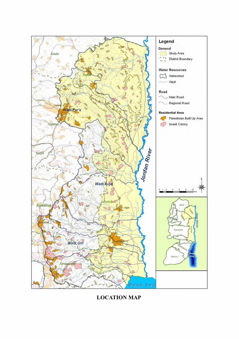
LOCATION MAP
Residential Area
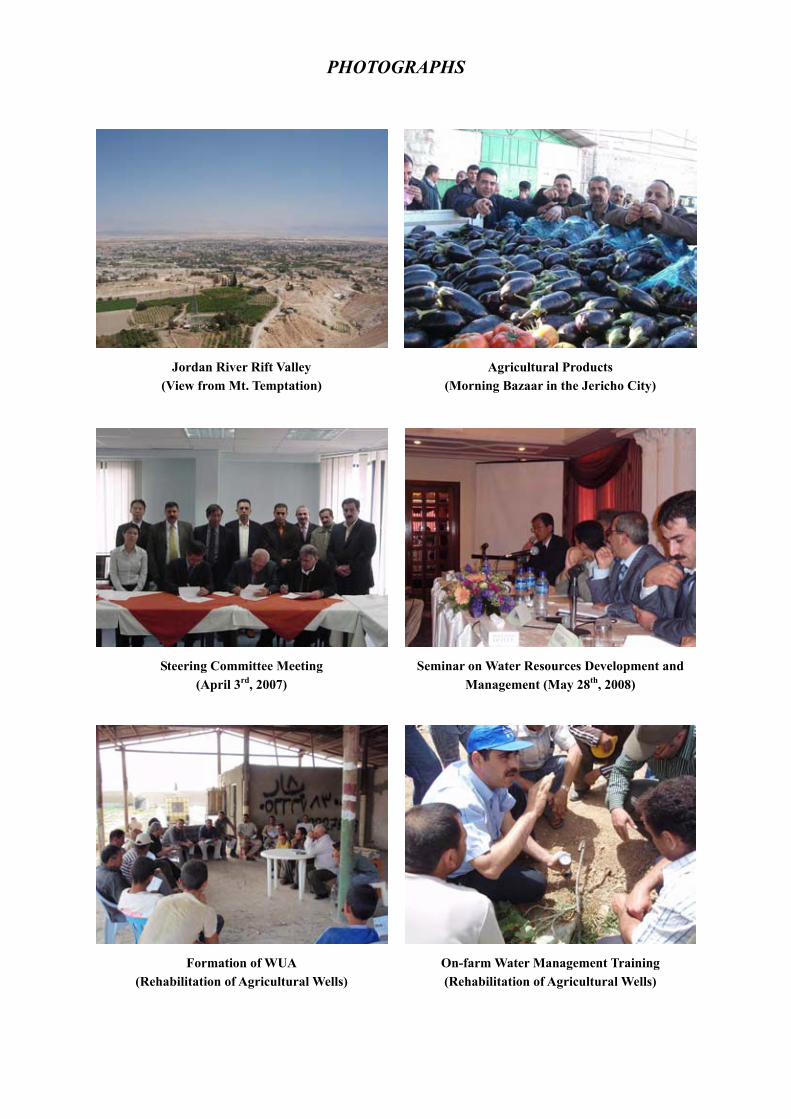
PHOTOGRAPHS
Jordan River Rift Valley (View from Mt. Temptation)
Agricultural Products (Morning Bazaar in the Jericho City)
Steering Committee Meeting (April 3rd, 2007)
Seminar on Water Resources Development and Management (May 28th, 2008)
Formation of WUA (Rehabilitation of Agricultural Wells)
On-farm Water Management Training (Rehabilitation of Agricultural Wells)
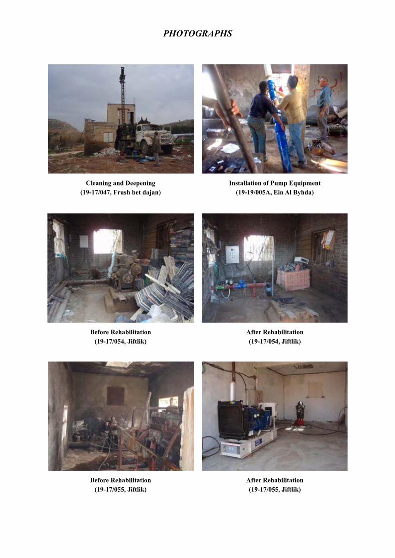
PHOTOGRAPHS
Cleaning and Deepening (19-17/047, Frush bet dajan)
Installation of Pump Equipment (19-19/005A, Ein Al Byhda)
Before Rehabilitation (19-17/054, Jiftlik)
After Rehabilitation (19-17/054, Jiftlik)
Before Rehabilitation (19-17/055, Jiftlik)
After Rehabilitation (19-17/055, Jiftlik)
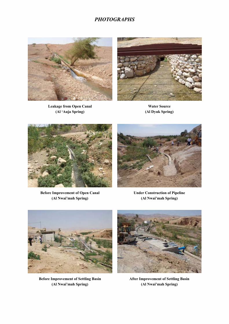
PHOTOGRAPHS
Leakage from Open Canal (Al ‘Auja Spring)
Water Source (Al Dyuk Spring)
Before Improvement of Open Canal (Al Nwai’mah Spring)
Under Construction of Pipeline (Al Nwai’mah Spring)
Before Improvement of Settling Basin (Al Nwai’mah Spring)
After Improvement of Settling Basin (Al Nwai’mah Spring)
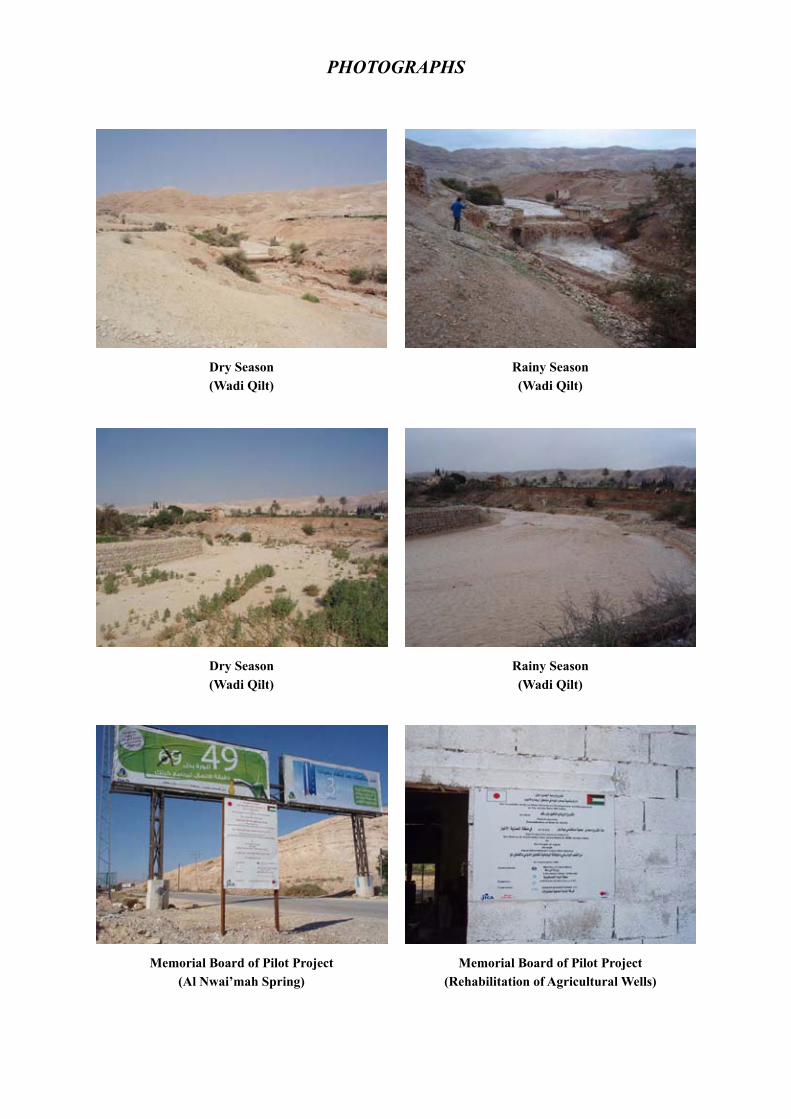
PHOTOGRAPHS
Dry Season (Wadi Qilt)
Rainy Season (Wadi Qilt)
Dry Season (Wadi Qilt)
Rainy Season (Wadi Qilt)
Memorial Board of Pilot Project (Al Nwai’mah Spring)
Memorial Board of Pilot Project (Rehabilitation of Agricultural Wells)
S - 1
FINAL REPORT
EXECUTIVE SUMMARY
1. Introduction
1.1 Authority
This Final Report has been prepared in accordance with the Scope of Work (S/W) for the Feasibility Study on Water Resources Development and Management in the Jordan River Rift Valley, agreed upon between the concerned authorities of Palestinian National Authority (PNA) and the Japan International Cooperation Agency (JICA) on February 27, 2007. The report presents all the results of the Study throughout the defined period.
1.2 Background
Inefficient use of water resources is a vital issue to Palestine. The problem is mainly caused by i) an excessive water consumption due to the time-based distribution, ii) water conveyance losses in open canal irrigation network, iii) damaged agricultural wells, and iv) limited use of surface water. Since water demand is expected to increase in the future, efficient use of the existing water resources as well as development of new water resources is essential.
A study on Jericho Regional Development was conducted by JICA during the period of October 2005 to September 2006 to formulate a Regional Development Plan for the Jericho and the Jordan River Rift Valley area, and also to enhance the capacity for formulation and implementation of a regional development program. Said program was comprised of a Social and Community Development Program, Agriculture and Agribusiness Development Program and Tourism and Urban Environment Program.
The Feasibility Study on Water Resources Development and Management in the Jordan River Rift Valley is conducted as a sub-program of the Agriculture and Agribusiness Development Program under the concept of “Corridor for Peace and Prosperity”.
1.3 Objectives of the Study
The objectives of the Study are as follows:
(1) To formulate a basic plan for efficient utilization of water for agriculture in the Jordan River Rift Valley;
(2) To formulate a basic plan for water resources development in the Jordan River Rift Valley; and
(3) To carry out technology transfer to Palestinian counterpart personnel through on-the-job training during the course of the Study.
1.4 The Study Area
The Study Area, as presented in the location map, is located in the West Bank of the Jordan River Rift Valley, which includes the watershed areas of Wadi Qilt, Wadi Auja and Wadi Far’a.

S - 2
1.5 Work Schedule
The Study was carried out over a period of 22 months, from March 2007 to December 2008, consisting of the following two phases:
Phase 1: March 2007 ~ December 2007 (Formulating basic plans on efficient utilization of water for agriculture and water resources development)
Phase 2: January 2008 ~ December 2008 (Conducting feasibility studies on selected water resources management schemes for water resources development and for efficient utilization of water agriculture, including implementation of small scale pilot projects)
M A M J J A S O N D J F M A M J J A S O N D1 2 3 4 5 6 7 8 9 10 11 12 13 14 15 16 17 18 19 20 21 22
Work in Palestine
Work in Japan
Report
Activity FY2007 FY2008
Phase-1 Phase-21st Year 2nd Year 3rd Year
IC/R PR1 It/R DF/R F/R
Source: JICA Study Team
Figure 1 Work Schedule of the Study
2. Activities
The Study Team conducted the following works throughout the study period:
(1) Home Office Preparatory Work (March 2007)
(2) First Field Work (March 2007 to August 2007)
(3) Second Field Work (1) (October 2007 to March 2008)
(4) First Home Office Work (March 2008 to April 2008)
(5) Second Field Work (2) (May 2008 to August 2008)
(6) Second Home Office Work (September 2008)
(7) Third Field Work (November 2008)
(8) Third Home Office Work (December 2008)
3. The Study Area
3.1 General Conditions
(1) Topography and Landscapes
1) Mountainous area is located in the upstream of Wadi Far’a. The elevation reaches up to 600 m above sea level.
2) Most of all Study Areas are covered by foothills with steep slopes. The elevation of the foothills range from 0 to 200 m above sea level.

S - 3
3) Flat area, which is lower than the sea level and has relatively high agricultural resources, lies along the Jordan River. The length and width of the area is about 10 km and 1 to 2 km, respectively.
(2) Climate
1) Rainfall
Rainfall ranges from 80 - 200 mm/year along the flat area, to 200 - 350 mm/year in the mountainous area.
2) Temperature
Mean monthly temperature in Jericho and Wadi Far’a ranges between a minimum of 13.1oC in December to a maximum of 32.4 oC in August.
3) Evaporation
Evaporation rate is high due to high temperature, intensive sunshine and low humidity, particularly during the period of May through September. Annual average evaporation in Jericho reaches around 2,100 mm.
Genial climate enables cultivation of the vegetable crops throughout the year. It is expected to secure the sufficient water for the advantages of agriculture in the Study Area.
(3) Geology and Hydrogeology
Generally, the Jordan Valley area is part of the Eastern Basin in the West Bank. The existing aquifer systems within the Study Area consist of the following main aquifers: (i) The Holocene Aquifer; (ii) The Pleistocene Gravel Aquifer (Samra Formation); (iii) The Neogene (Miocene – Pliocene) Aquifer (Beida Formation); (iv) The Eocene Aquifer (Jenin sub series); (v) The Upper Cretaceous Aquifer (Jerusalem, Bethlehem, and Hebron Formations); and (vi) The Lower Cretaceous Aquifer (Yatta, Upper Beit Kahil and Lower Beit Kahil
Formations).
3.2 Present Land Use of the Study Area
The land use distribution is summarized as follows:
Table 1 Present Land Use of the Study Area Unit: km2
Land Cover Area A Area B Area C Total Agricultural Areas 86 36 219 342 Palestinian Communities 16 2 47 65 Israeli Settlement 0 0 17 17 Military Base 13 3 67 84 Others 32 16 537 586
Total 148(13.5%)
58(5.3%)
887 (81.2%)
1,093(100.0%)
Area A: under control of PNA both for administration and security Area B: under control of PNA for administration, and Israeli Government for security Area C: under control of Israeli Government both for administration and security Source: MoP(2005)

S - 4
3.3 Socio-Economic Condition
(1) Administration
The Study Area covers three administrative districts; these are Jericho governorate, Tubas governorate and a part of Nablus governorate. Under these governorates, there are 29 Local Government Units (LGUs) consisting of two municipalities and 27 village councils. Although the municipalities have comparatively well-organized administrative structure and sufficient number of staff, the administrative capacity and financial management of the village councils remain very weak.
(2) Demography
Total population of Palestinian was 3,762,005 in 2005. Among these, 2,372,216 reside in the West Bank, while 97,373 live within the Study Areas, Jericho and Tubas. The annual population growth rate of Palestinian from 1997 to 2005 was 3.3%, while that of Jericho and Tubas were 3.8% and 3.6% respectively. Accordingly, the population growth rate in the Study Area is rather higher than the regional average of Palestine.
(3) Employment
Labor force in the Jordan River Rift Valley area, consisting of Jericho and Tubas, is 24,100 persons. Unemployment rates of Jericho and Tubas are 14.0% and 23.2%, respectively.
(4) Economic Trends
Gross Domestic Product (GDP) in Palestinian Territory had steadily increased during 1994 -1999. For three years between 2000 and 2002, GDP has dropped 21% since 1999. GDP recovered gradually afterwards.
(5) Local Financial System
Access to credit is quite limited to farmers, particularly to small scale farmers, in the Study Area. Lack of collateral and high market risks for the agricultural sector unable farmers to access commercial and financial institutions. Agricultural and rural credits are currently provided for informal channels, such as family, relative, middleman, wholesaler, etc.
(6) Education
The current education system is relatively improved, and works effectively. According to the socioeconomic survey, only about 43.5% of the heads of surveyed households have either no education or are drop-outs from primary education.
(7) Health
Public health conditions of Palestine are similar to those of lower, middle-income countries. Infant mortality rate of Jericho Governorate was lower than the average as per WB, during 2000-2004. Life expectancy of Jericho Governorate has also improved. The latest figure indicates a higher life expectancy of 72.4 years in 2000-2005, as compared to 56.6 years in 1970-1975. The Ministry of Health, the United Nations
S - 5
Relief and Works Agency (UNRWA) and NGOs are the main service providers in the Study Area.
(8) Poverty
A high incident of poverty is observed in the agricultural sector of the Study Area. The deep poverty rate and the poverty rate of the agricultural sector are 29.7 % and 50.4 %, respectively.
(9) Gender Issue
Socio-economic survey results conducted by the Study Team indicated that job opportunities for females, as compared to males, are relatively limited, except in the agricultural industry in the Study Area.
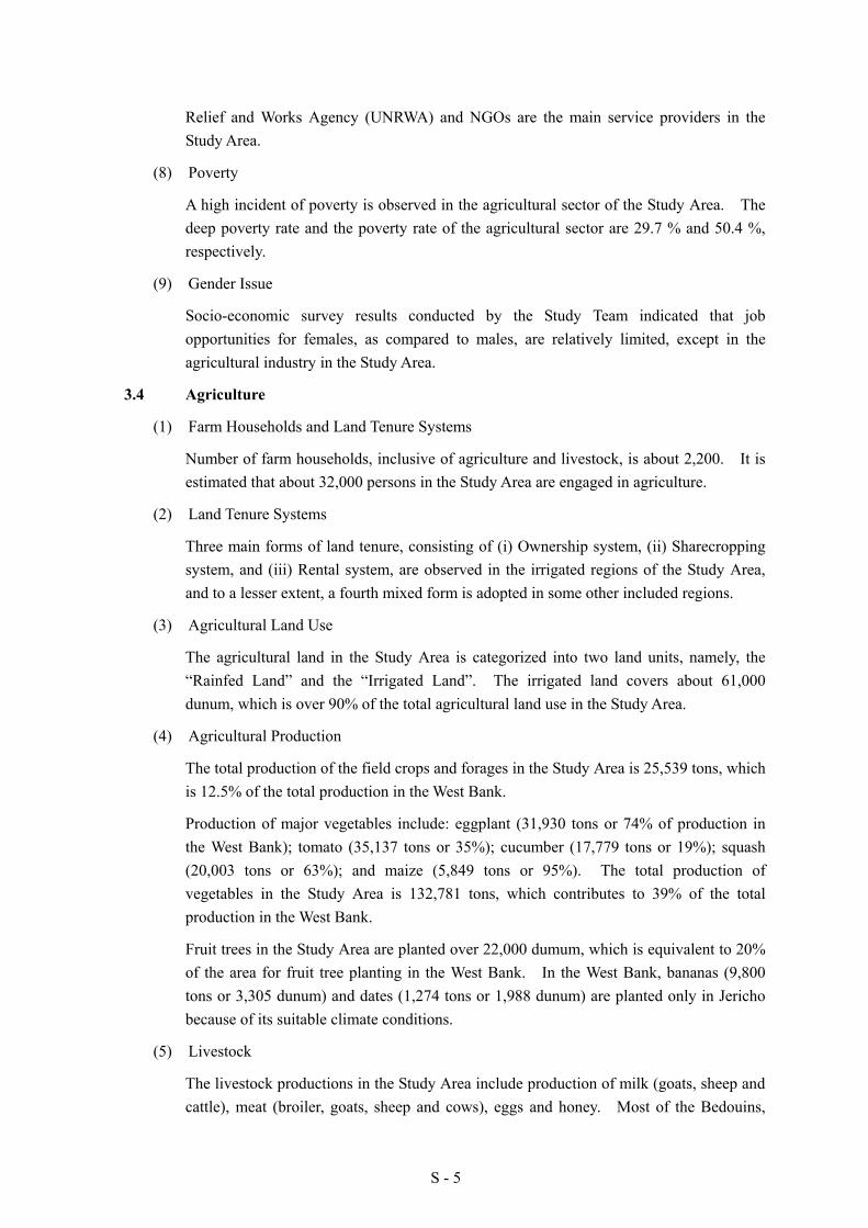
3.4 Agriculture
(1) Farm Households and Land Tenure Systems
Number of farm households, inclusive of agriculture and livestock, is about 2,200. It is estimated that about 32,000 persons in the Study Area are engaged in agriculture.
(2) Land Tenure Systems
Three main forms of land tenure, consisting of (i) Ownership system, (ii) Sharecropping system, and (iii) Rental system, are observed in the irrigated regions of the Study Area, and to a lesser extent, a fourth mixed form is adopted in some other included regions.
(3) Agricultural Land Use
The agricultural land in the Study Area is categorized into two land units, namely, the “Rainfed Land” and the “Irrigated Land”. The irrigated land covers about 61,000 dunum, which is over 90% of the total agricultural land use in the Study Area.
(4) Agricultural Production
The total production of the field crops and forages in the Study Area is 25,539 tons, which is 12.5% of the total production in the West Bank.
Production of major vegetables include: eggplant (31,930 tons or 74% of production in the West Bank); tomato (35,137 tons or 35%); cucumber (17,779 tons or 19%); squash (20,003 tons or 63%); and maize (5,849 tons or 95%). The total production of vegetables in the Study Area is 132,781 tons, which contributes to 39% of the total production in the West Bank.
Fruit trees in the Study Area are planted over 22,000 dumum, which is equivalent to 20% of the area for fruit tree planting in the West Bank. In the West Bank, bananas (9,800 tons or 3,305 dunum) and dates (1,274 tons or 1,988 dunum) are planted only in Jericho because of its suitable climate conditions.
(5) Livestock
The livestock productions in the Study Area include production of milk (goats, sheep and cattle), meat (broiler, goats, sheep and cows), eggs and honey. Most of the Bedouins,
S - 6
who live within the Study Area, engage in the livestock sector. The livestock production rate in the Study Area is relatively low in comparison with the other areas.
(6) Marketing
Most of the agricultural products produced in the Study Area are cash crops. Main destinations of the products are other areas in the West Bank and Israel.
3.5 Water Resources Management
(1) Wadi Watershed
In the Study Area, there are a number of wadis, which are broadly demarcated into nine major wadi basins as shown in the table below. Flood water is currently not utilized, since there is no intake facility installed in the wadis.
Table 2 Major Wadi Basins in the Study Area No. Name of Wadi Catchment Area (km2)
1. Wadi Hahal Milah 276.1 2. Wadi Abu Sidra 120.8 3. Wadi Far’a 336.9 4. Wadi Al 'Ahmer 180.1 5. Wadi Auja 291.4 6. Wadi Nueima 152.5 7. Wadi Qilt 172.4 8. Wadi Marar 102.4 9. Wadi Mukallak 140.5
Source: PWA Database
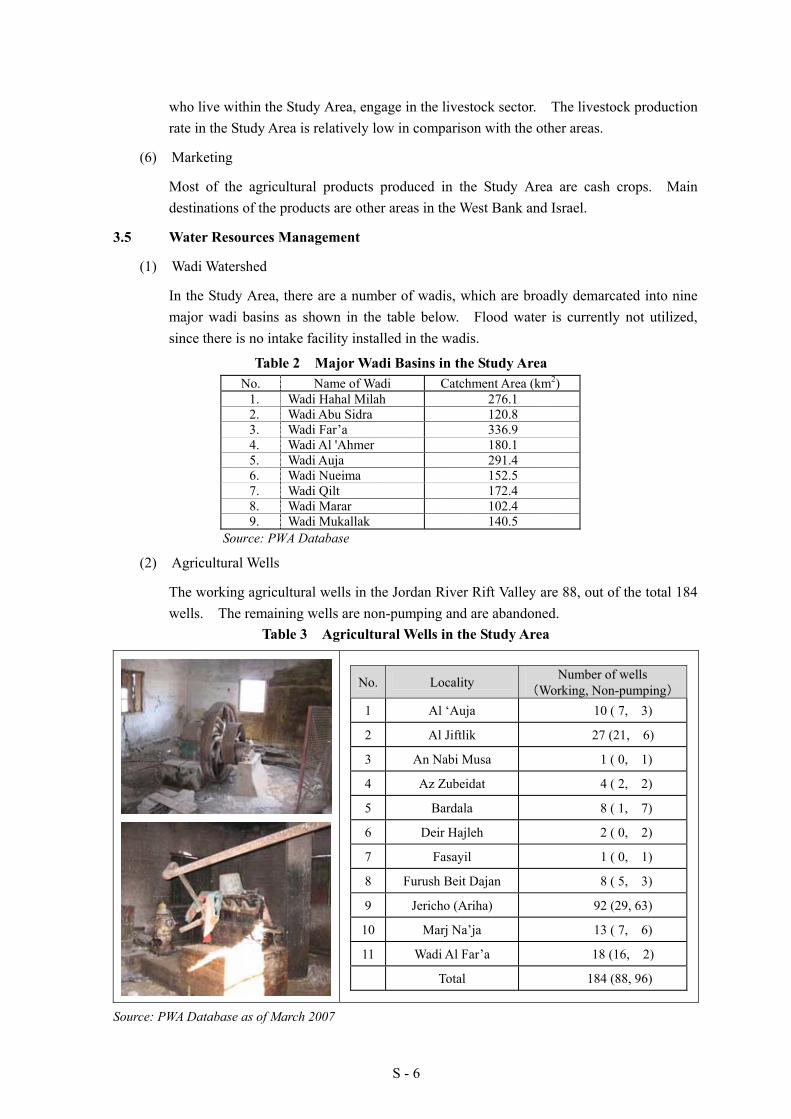
(2) Agricultural Wells
The working agricultural wells in the Jordan River Rift Valley are 88, out of the total 184 wells. The remaining wells are non-pumping and are abandoned.
Table 3 Agricultural Wells in the Study Area
No. Locality Number of wells (Working, Non-pumping)
1 Al ‘Auja 10 ( 7, 3)
2 Al Jiftlik 27 (21, 6)
3 An Nabi Musa 1 ( 0, 1)
4 Az Zubeidat 4 ( 2, 2)
5 Bardala 8 ( 1, 7)
6 Deir Hajleh 2 ( 0, 2)
7 Fasayil 1 ( 0, 1)
8 Furush Beit Dajan 8 ( 5, 3)
9 Jericho (Ariha) 92 (29, 63)
10 Marj Na’ja 13 ( 7, 6)
11 Wadi Al Far’a 18 (16, 2)
Total 184 (88, 96)
Source: PWA Database as of March 2007

S - 7
(3) Spring Water
A group of 24 springs is located in the Study Area as listed below, together with the average discharge data for each. Most of the springs function less due to the damage of the conveyance system and improper management of water distribution.
Table 4 Spring in the Study Area
No. Name Code Average
Discharge (MCM/yr)
1 Fasayil AC/054 0.66
2 Al Dyuk AC/060 4.86
3 Al Nwai'mah AC/060A 2.60
4 Al Shusah AC/060B 0.61
5 Al Sultan AC/061 5.54
6 Shibli AQ/022 0.85
7 Abu Saleh AQ/024 0.19
8 Meskah AQ/025 1.29
9 Al Far'ah AQ/030 5.31
10 Al Dlaib AQ/032 1.20
11 Sedrah AQ/036 1.46
12 Hamad & Baidah AQ/037A 0.88
13 Qdairah AQ/037B 1.19
14 Jeser AQ/038 0.14
15 Tabban AQ/039 1.29
16 Al Subyan AQ/040 0.19
17 Balata AQ/043 0.18
18 Dafna AQ/044 0.13
19 Al 'Auja AR/020 9.55
20 Al Qilt & Al Fawwar AS/020 6.55
21 Al Fawwar AS/021 4.48
22 Far’a AS/022 0.70
23 Al Jummaizah AS/022A 0.30
24 Al Ru'yan AS/022B 0.36
Source: PWA Database Note: The average discharge volumes of each spring are calculated from the raw data with the unit of
L/s measured in 1960-2006.
(4) On-Farm Facilities and Management
Various methods of water application are used in irrigation systems. The three basic methods prevailing in Palestine are surface irrigation, sprinkler irrigation, and drip irrigation.
3.6 Constraints on Water Resources Development and Management
(1) Socio-Economic Conditions
Political issues such as Israeli control between Palestine and her neighboring countries sometimes interrupt the economic development. Restriction on the movement of goods and people within Palestine aggravated the quality of public services and deprived the
1
23
4
5
68
7
910
1112
1314
1516
17
18
19
20
21
23
24
22

S - 8
economic activities. Consequently, human resource development as well as institutional strengthening is essential to achieve a sustainable socio-economic development in the region.
(2) Existing Water Resources
The constraints on agricultural wells and spring water uses are pointed out below:
Agricultural Well
1) Most of the wells were drilled from 1950 to 1966, and then its capacity decreased; 2) Limitation of well extraction; 3) Drop of groundwater level; 4) Electricity deficit in many areas; 5) Escalating costs of equipment, spare parts and maintenance works; 6) Lack of local cooperative organization for maintenance of wells; 7) Lack of efficient and qualified local drilling companies; and 8) Political Issues such as Israeli control to be settled between Palestine and Israel on
the water resources development and management including agricultural development
Spring Water
1) Inefficient use of water due mainly to seepage, leakage in the main conveyance canals or natural conveyance systems and insufficient capacities of those conveyance facilities;
2) Excessive water consumption caused by time-based water distribution; 3) Lack of water users association; 4) Lack of capacity on operation and maintenance (O&M) of water conveyance
facilities; 5) Contamination by untreated wastewater inflow in the wadis; 6) Unstable water supply due to the seasonal fluctuation; and 7) Political Issues such as Israeli control to be settled between Palestine and Israel on
the water resources development and management including agricultural development
4. Hydrology and Hydro-geology
4.1 Hydrological Analysis
Hydrological analysis was conducted on major wadis in the Study Area, namely, Wadi Qilt and Wadi Far’a.
(1) Available Data
1) Temperature, Rainfall, Evaporation (1953/1954 – 2005/2006) provided by PWA, MoT, PHG;
2) Hourly rainfall on Wadi Far’a Basin (2003/2004 – 2004/2005) and runoff on Wadi Far’a (2003/2004 – 2004/2005) provided by Najah University;
3) Runoff on Wadi Qilt (1967 – 1983) provided by Israel Water Committee; and 4) Runoff on Wadi Qilt and Wadi Far’a (spot data in 1971 – 2005) provided by PWA.
S - 9
(2) Hydrological Analysis
The hydrological analysis on Wadi Qilt was performed by applying the daily rainfall data to the simulation model called the “Tank Model,” under a very limited flood runoff data. The mean annual runoff volume in the Wadi Qilt between 1953/1954 and 2005/2006 was derived as1.67 MCM.
Meanwhile, the hydrological analysis on Wadi Far’a is being carried out by the EU Engineer and Najah University. The annual runoff volumes of Wadi Far’a sub-catchment was derived as 1.76 MCM, based on the observed data of 2003 to 2005.
(3) Sedimentation
Although no sediment data on wadis of Palestine is available, the study team has estimated the sedimentation of Wadi Far’a at 0.75 mm/year, and that of Wadi Qilt at 0.625 mm/year, based on the study result of the Kafrein Dam in Jordan.
(4) Assessment of Availability of Hydrological Data for Feasibility Study of Storm water Harvesting Project
The available hydrological data on Wadi Qilt is still insufficient to carry out a feasibility study on storm water harvesting project in the Wadi Qilt basin. It is recommended that the feasibility study and subsequent detailed design be performed when the hydrological data, including the sediment data (preferably the 5-years’ data) are adequately available.
4.2 Hydro-Geological Environment of Study Area
(1) Hydrogeology and Aquifer System
The geological stratigraphy of the Study Area is as follows:
1) Quaternary Aquifer 2) Neogene Aquifer 3) Eocene Aquifer 4) Upper Cretaceous Aquifer 5) Lower Cretaceous Aquifer
Groundwater basin in the Study Area is divided into Eastern Basin and North Eastern Basin with anticline syncline structure. This means that the basin of surface water and that of groundwater are different.
(2) Groundwater Environment of the Study Area
The results of existing data analysis and field survey are summarized below:
1) In the Eastern Basin, the secular decreasing tendency of groundwater level of Quaternary, Eocene and Upper Cretaceous Aquifer is remarkable;
2) The chloride ion concentration of Quaternary Aquifer is very high, and its tendency to increase is observed;
3) As for the spring water originated in Cenomanian Aquifer of the Eastern Basin, the tendency to decrease is not observed. However, the tendency of chloride and nitrate ion to increase is possible to a part of the spring water due to its contamination with waste water;

S - 10
4) A remarkable change is not seen in the groundwater level of the North Eastern Basin. In recent years, the groundwater use of Cretaceous Aquifer has progressed. Thus, the monitoring of the groundwater level and pumping rate are necessary; and
5) The chloride ion concentration of the wells in the North Eastern Basin is not significant. The increase tendency of chloride and nitrate ion is observed due to mixing of waste water.
5. Comprehensive Water Resources Management and Development
5.1 Water Resources in the Study Area
(1) Present Water Resources
The present water resources in the four sub-regions are estimated on the basis of available data in 2005, as summarized in the following table:
Table 5 Present Water Resources in 2005
Area Spring (MCM/yr)
Well (MCM/yr)
Mekorot * (MCM/yr)
Total (MCM/yr)
Jericho/Al ‘Auja 22.22 3.83 1.09 27.14 Lower Al Far’a 1.50 4.20 0.17 5.87West Tubas 8.38 2.88 0.02 11.28North Tubas 0.00 0.38 4.10 4.48Total 32.10 11.29 5.38 48.77
Note: Excluding assumed losses. *: purchase from Mekorot (Israel water company) Source: PWA database (2005)
(2) Present Water Demand
Water resources in the Study Area are mainly allocated for agricultural, domestic and industrial uses. Those demands are shown in the following tables:
Table 6 Present Agricultural Water Demand in 2004/2005 Agricultural Water Demand (MCM/yr)
Area Irrigated
Area (Dunum)
Field Crop
Protected Plants
Open Field
Vegetable Fruit Total
Jericho/Al ‘Auja 26,079 0.88 0.60 12.66 15.03 29.17Lower Al Far'a 20,289 2.05 0.61 9.76 2.84 15.26West Tubas 5,837 0.53 0.66 0.82 2.13 4.14North Tubas 8,772 0.17 2.93 2.72 0.23 6.05Total 60,977 3.63 4.80 25.96 20.23 54.62
Source: Agricultural Statistics, PCBS, 2004/05, Water resources and Irrigated Agriculture, Applied Research Institute, March 1998, and JICA Study Team estimate
S - 11
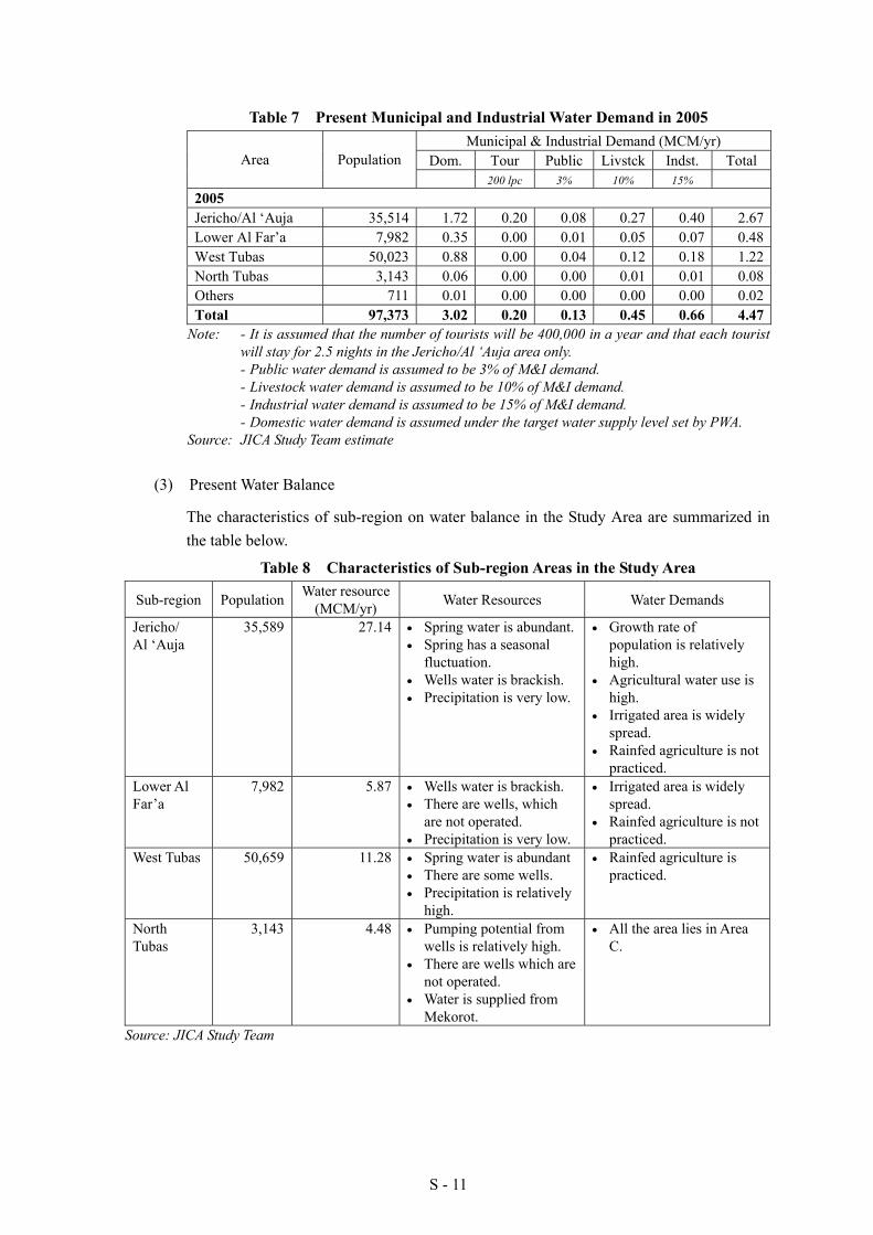
Table 7 Present Municipal and Industrial Water Demand in 2005 Municipal & Industrial Demand (MCM/yr)
Dom. Tour Public Livstck Indst. Total Area Population 200 lpc 3% 10% 15%
2005
Jericho/Al ‘Auja 35,514 1.72 0.20 0.08 0.27 0.40 2.67Lower Al Far’a 7,982 0.35 0.00 0.01 0.05 0.07 0.48West Tubas 50,023 0.88 0.00 0.04 0.12 0.18 1.22North Tubas 3,143 0.06 0.00 0.00 0.01 0.01 0.08Others 711 0.01 0.00 0.00 0.00 0.00 0.02Total 97,373 3.02 0.20 0.13 0.45 0.66 4.47
Note: - It is assumed that the number of tourists will be 400,000 in a year and that each tourist will stay for 2.5 nights in the Jericho/Al ‘Auja area only.
- Public water demand is assumed to be 3% of M&I demand. - Livestock water demand is assumed to be 10% of M&I demand. - Industrial water demand is assumed to be 15% of M&I demand. - Domestic water demand is assumed under the target water supply level set by PWA. Source: JICA Study Team estimate
(3) Present Water Balance
The characteristics of sub-region on water balance in the Study Area are summarized in the table below.
Table 8 Characteristics of Sub-region Areas in the Study Area
Sub-region Population Water resource (MCM/yr) Water Resources Water Demands
Jericho/ Al ‘Auja
35,589 27.14 • Spring water is abundant.• Spring has a seasonal
fluctuation. • Wells water is brackish. • Precipitation is very low.
• Growth rate of population is relatively high.
• Agricultural water use is high.
• Irrigated area is widely spread.
• Rainfed agriculture is not practiced.
Lower Al Far’a
7,982 5.87 • Wells water is brackish. • There are wells, which
are not operated. • Precipitation is very low.
• Irrigated area is widely spread.
• Rainfed agriculture is not practiced.
West Tubas 50,659 11.28 • Spring water is abundant • There are some wells. • Precipitation is relatively
high.
• Rainfed agriculture is practiced.
North Tubas
3,143 4.48 • Pumping potential from wells is relatively high.
• There are wells which are not operated.
• Water is supplied from Mekorot.
• All the area lies in Area C.
Source: JICA Study Team

S - 12
(4) New Water Resources in the Study Area
In the Study Area, following new water resources could be made available. These are:
1) Floodwater in wadi basins; and 2) Recycled water from wastewater treatments plants in major cities/towns.
(5) Constraint on Water Resources Development and Management
The following constraints on the water resources development and management in the Study Area are pointed out:
1) Limited Water Resource; 2) Inefficient Water Utilization due to Deteriorated Conveyance System; 3) Existence of Non-functioning Wells; 4) Ineffective Use of Storm Water Resource; and 5) Political Issues to be settled for the water resources development and management
(e.g. delay issue of permits from Israeli side).
5.2 Strategy for Water Resources Development and Management
Saving water is the most essential issue in the Study Area. Based on the above situations, the following measures are proposed for the water resources development and management in the Study Area.
1) Improvement of Spring Water Conveyance System 2) Rehabilitation and Integrated Management of Agricultural Wells 3) Development of Storm Water Harvesting 4) Formulation of Management System
5.3 Potential Water Resources
The future water potential after accomplishing the above strategies is estimated as follows:
Table 9 Future Potential Water Volume in the Study Area Available Water Volume
Existing (2005)
Pilot Term2007-2009(3 years)
Short Term2010-2012(3 years)
Mid Term 2013-2015 (3 years)
Long Term(After 2016)Water Resource
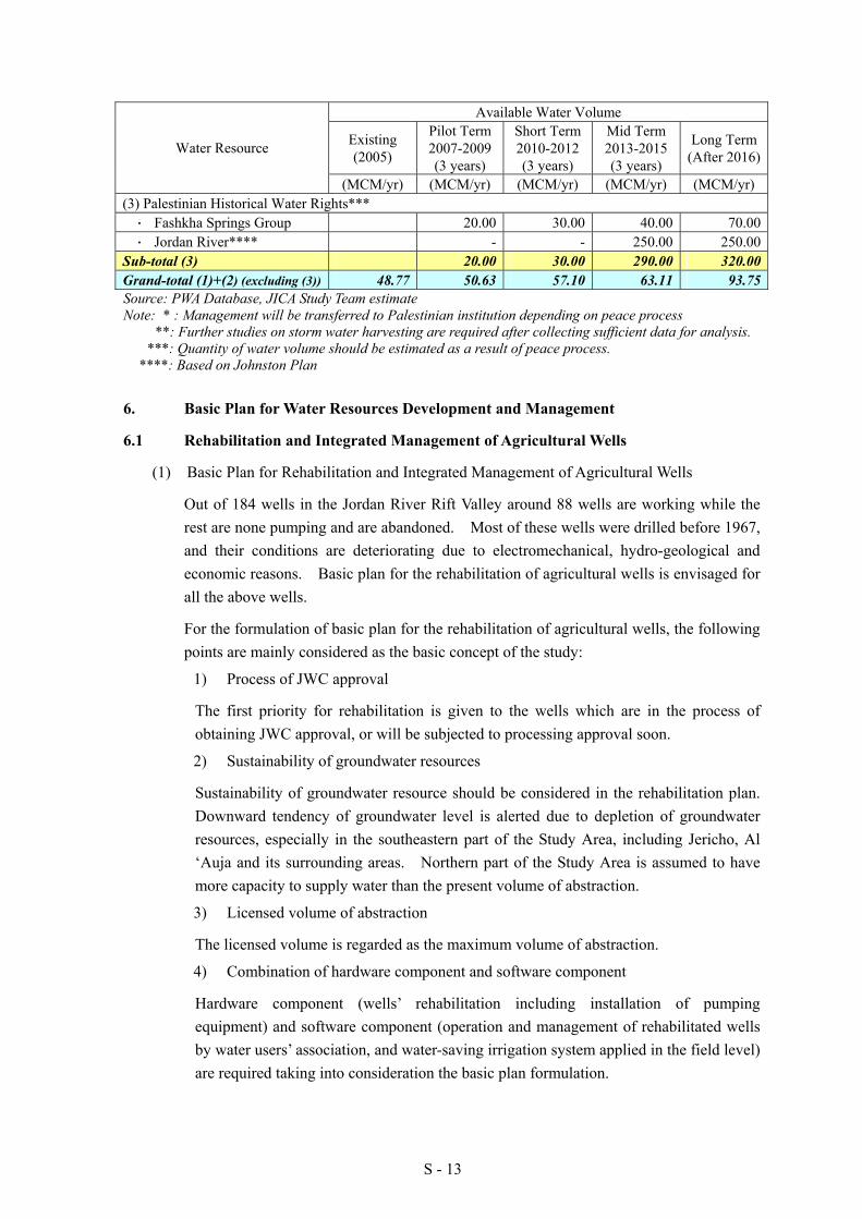
(MCM/yr) (MCM/yr) (MCM/yr) (MCM/yr) (MCM/yr)(1) Existing Water Resources ・ Existing Springs 32.10 32.10 32.10 32.10 32.10・ Existing Wells 11.29 11.29 11.29 11.29 11.29・ Mekorot* 5.38 5.38 5.38 5.38 5.38
Sub-total (1) 48.77 48.77 48.77 48.77 48.77(2) Future Potential Water Resources ・ Spring Canal Improvement 2.39 4.26 11.47・ Well Rehabilitation 0.47 3.35 6.69 10.25・ New Well Development 0.76 0.76 0.76 0.76・ Storm Water Harvesting** 0.50 0.50 10.00・ Wastewater Reuse 0.63 1.33 2.13 12.50
Sub-total (2) 1.86(+1.86)
8.33(+6.47)
14.34 (+6.00)
44.98(+30.64)
S - 13
Available Water Volume
Existing (2005)
Pilot Term2007-2009(3 years)
Short Term2010-2012(3 years)
Mid Term 2013-2015 (3 years)
Long Term(After 2016)Water Resource
(MCM/yr) (MCM/yr) (MCM/yr) (MCM/yr) (MCM/yr)(3) Palestinian Historical Water Rights*** ・ Fashkha Springs Group 20.00 30.00 40.00 70.00・ Jordan River**** - - 250.00 250.00
Sub-total (3) 20.00 30.00 290.00 320.00Grand-total (1)+(2) (excluding (3)) 48.77 50.63 57.10 63.11 93.75Source: PWA Database, JICA Study Team estimate Note: * : Management will be transferred to Palestinian institution depending on peace process **: Further studies on storm water harvesting are required after collecting sufficient data for analysis. ***: Quantity of water volume should be estimated as a result of peace process. ****: Based on Johnston Plan
6. Basic Plan for Water Resources Development and Management
6.1 Rehabilitation and Integrated Management of Agricultural Wells
(1) Basic Plan for Rehabilitation and Integrated Management of Agricultural Wells
Out of 184 wells in the Jordan River Rift Valley around 88 wells are working while the rest are none pumping and are abandoned. Most of these wells were drilled before 1967, and their conditions are deteriorating due to electromechanical, hydro-geological and economic reasons. Basic plan for the rehabilitation of agricultural wells is envisaged for all the above wells.
For the formulation of basic plan for the rehabilitation of agricultural wells, the following points are mainly considered as the basic concept of the study:
1) Process of JWC approval
The first priority for rehabilitation is given to the wells which are in the process of obtaining JWC approval, or will be subjected to processing approval soon.
2) Sustainability of groundwater resources
Sustainability of groundwater resource should be considered in the rehabilitation plan. Downward tendency of groundwater level is alerted due to depletion of groundwater resources, especially in the southeastern part of the Study Area, including Jericho, Al ‘Auja and its surrounding areas. Northern part of the Study Area is assumed to have more capacity to supply water than the present volume of abstraction.
3) Licensed volume of abstraction
The licensed volume is regarded as the maximum volume of abstraction.
4) Combination of hardware component and software component
Hardware component (wells’ rehabilitation including installation of pumping equipment) and software component (operation and management of rehabilitated wells by water users’ association, and water-saving irrigation system applied in the field level) are required taking into consideration the basic plan formulation.
S - 14
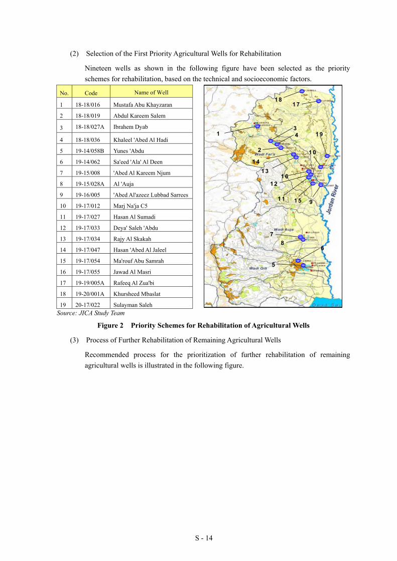
(2) Selection of the First Priority Agricultural Wells for Rehabilitation
Nineteen wells as shown in the following figure have been selected as the priority schemes for rehabilitation, based on the technical and socioeconomic factors.
No. Code Name of Well
1 18-18/016 Mustafa Abu Khayzaran
2 18-18/019 Abdul Kareem Salem
3 18-18/027A Ibrahem Dyab
4 18-18/036 Khaleel 'Abed Al Hadi
5 19-14/058B Yunes 'Abdu
6 19-14/062 Sa'eed 'Ala' Al Deen
7 19-15/008 'Abed Al Kareem Njum
8 19-15/028A Al 'Auja
9 19-16/005 'Abed Al'azeez Lubbad Sarrees
10 19-17/012 Marj Na'ja C5
11 19-17/027 Hasan Al Sumadi
12 19-17/033 Deya' Saleh 'Abdu
13 19-17/034 Rajy Al Skakah
14 19-17/047 Hasan 'Abed Al Jaleel
15 19-17/054 Ma'rouf Abu Samrah
16 19-17/055 Jawad Al Masri
17 19-19/005A Rafeeq Al Zua'bi
18 19-20/001A Khursheed Mbaslat
19 20-17/022 Sulayman Saleh Source: JICA Study Team
Figure 2 Priority Schemes for Rehabilitation of Agricultural Wells
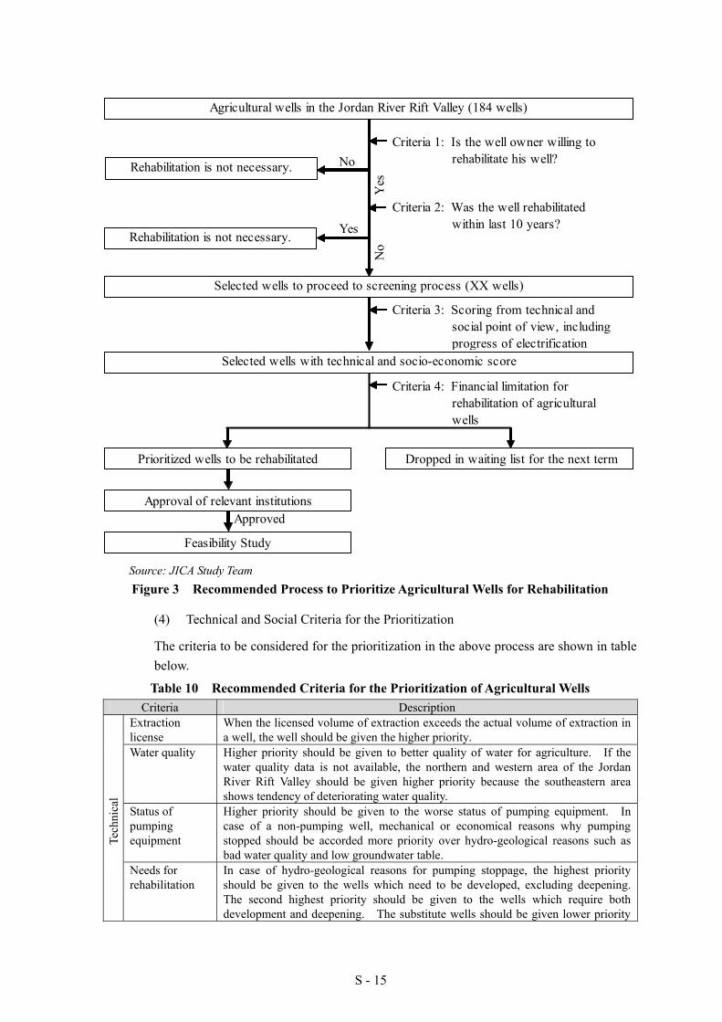
(3) Process of Further Rehabilitation of Remaining Agricultural Wells
Recommended process for the prioritization of further rehabilitation of remaining agricultural wells is illustrated in the following figure.
1 31 6
1 2
1 4
1 5
1 7
3
1 1
7
41
1 8
1 9
9
86
5
1 02
1 31 6
1 2
1 4
1 5
1 7
3
1 1
7
41
1 8
1 9
9
86
5
1 02
S - 15
Source: JICA Study Team Figure 3 Recommended Process to Prioritize Agricultural Wells for Rehabilitation
(4) Technical and Social Criteria for the Prioritization
The criteria to be considered for the prioritization in the above process are shown in table below.
Table 10 Recommended Criteria for the Prioritization of Agricultural Wells Criteria Description
Extraction license
When the licensed volume of extraction exceeds the actual volume of extraction in a well, the well should be given the higher priority.
Water quality Higher priority should be given to better quality of water for agriculture. If the water quality data is not available, the northern and western area of the Jordan River Rift Valley should be given higher priority because the southeastern area shows tendency of deteriorating water quality.
Status of pumping equipment
Higher priority should be given to the worse status of pumping equipment. In case of a non-pumping well, mechanical or economical reasons why pumping stopped should be accorded more priority over hydro-geological reasons such as bad water quality and low groundwater table.
Tech
nica
l
Needs for rehabilitation
In case of hydro-geological reasons for pumping stoppage, the highest priority should be given to the wells which need to be developed, excluding deepening. The second highest priority should be given to the wells which require both development and deepening. The substitute wells should be given lower priority
Agricultural wells in the Jordan River Rift Valley (184 wells)
Criteria 1: Is the well owner willing to rehabilitate his well?Rehabilitation is not necessary.
Criteria 2: Was the well rehabilitated within last 10 years?
Criteria 3: Scoring from technical and social point of view, including progress of electrification
Rehabilitation is not necessary.
Dropped in waiting list for the next termPrioritized wells to be rehabilitated
No
Yes
Yes
No
Selected wells to proceed to screening process (XX wells)
Selected wells with technical and socio-economic score
Criteria 4: Financial limitation for rehabilitation of agricultural wells
Approval of relevant institutions
Feasibility Study
Approved

S - 16
Criteria Description since necessity of rehabilitation is lesser.
In case of electromechanical reason, installation of motors and pumps should be given higher priority than the maintenance of existing pumping equipment in terms of the necessity for governmental support. Electrification of power source has advantage in the rehabilitation. The lowest priority should be given to the economical reason in terms of the necessity of governmental support as well.
Availability of alternative water source
Some of the wells have alternative water source, such as spring water channel near the cultivated area. Priority of these wells should be lower than the others.
Irrigated area The technical criteria are limited to a bore hole and pumping equipment. Therefore, the water distribution system is not included. Even though the well would be rehabilitated, sometimes expansion of cultivation area can not be expected due to the farmers’ difficult economic condition. Since a wider cultivation area is assumed to show more cost-benefit performance, a well, which serves a wider irrigated area, should be given higher priority.
Irrigable area A well, which serves more irrigable land as compared to the actual irrigated area, is expected to possibly expand its irrigation network in future. Such wells should be given higher priority than others.
Soci
o-ec
onom
ic
Water users The criterion on the water user has two levels. One is the combination of water users, such as an absent landowner, owner farmer and tenant farmer. Another level is the number of total water users. To avoid limiting the benefits of rehabilitation to the land and well owners and their families only, a well, of which the water users are just the owner and his family, should be given the lowest priority. In terms of O&M, the owners obviously have an important role, and they should be actively involved in this aspect. Consequently, a well, which is utilized by both owner farmers and tenant farmers, should be given the highest priority. Meanwhile, a well, which is used only by tenant farmers, should be the second priority. Furthermore, the number of total water users should be taken into consideration for the prioritization. A larger number of total water users (beneficiaries) should be given higher priority.
Source: JICA Study Team
(5) Tentative Implementation Schedule for Rehabilitation of Agricultural Wells
Tentative Implementation schedule for rehabilitation of agricultural wells is as shown below.
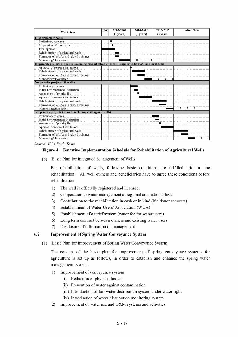
S - 17
2006
Preliminary researchPreparation of priority listJWC approvalRehabilitation of agricultural wellsFormation of WUAs and related trainingsMonitoring&Evaluation
Approval of relevant institutionsRehabilitation of agricultural wellsFormation of WUAs and related trainingsMonitoring&Evaluation
Preliminary researchInitial Environmental EvaluationAssessment of priority listApproval of relevant institutionsRehabilitation of agricultural wellsFormation of WUAs and related trainingsMonitoring&Evaluation
Preliminary researchInitial Environmental EvaluationAssessment of priority listApproval of relevant institutionsRehabilitation of agricultural wellsFormation of WUAs and related trainingsMonitoring&Evaluation
2010-20122007-2009
2nd priority projects (30 wells)
3rd priority projects (30 wells including drilling new wells)
Work item
Pilot projects (8 wells)
1st priority projects (13 wells) excluding rehabilitation of 20 wells supported by FAO and Arabfund
(3 years) (3 years) (3 years)After 20162013-2015
Source: JICA Study Team
Figure 4 Tentative Implementation Schedule for Rehabilitation of Agricultural Wells
(6) Basic Plan for Integrated Management of Wells
For rehabilitation of wells, following basic conditions are fulfilled prior to the rehabilitation. All well owners and beneficiaries have to agree these conditions before rehabilitation.
1) The well is officially registered and licensed. 2) Cooperation to water management at regional and national level 3) Contribution to the rehabilitation in cash or in kind (if a donor requests) 4) Establishment of Water Users’ Association (WUA) 5) Establishment of a tariff system (water fee for water users) 6) Long term contract between owners and existing water users 7) Disclosure of information on management
6.2 Improvement of Spring Water Conveyance System
(1) Basic Plan for Improvement of Spring Water Conveyance System
The concept of the basic plan for improvement of spring conveyance systems for agriculture is set up as follows, in order to establish and enhance the spring water management system.
1) Improvement of conveyance system (i) Reduction of physical losses (ii) Prevention of water against contamination (iii) Introduction of fair water distribution system under water right (iv) Introduction of water distribution monitoring system
2) Improvement of water use and O&M systems and activities
S - 18
(i) Establishment and strengthening of O&M organization (ii) Training on on-farm water management
Upon the above concept, basic plan for improvement of spring water conveyance system is prepared under the following regional wise development:
1) Wadi Far’a Area (Badhan, Al Far’a and Ain Shibli Spring Groups) (i) Rehabilitation of the intake facilities of Al Dlaib, Hammad & Beidha,
Qudairah, Sedrah, Jeser, Subyn and Meskeh springs (ii) Development of pipeline system for main and sub-main conveyance lines of
Al Fa’ra, Al Dlaib, Hammad & Baidah, Qudairah, Tabban, Sedrah, Jeser, Subyan and Meskeh springs
(iii) Development of trunk pipelines to convey water from Al Badhan and Al Far’a Spring Groups to the down stream villages, connecting to the Al Far’a Irrigation Project
(iv) Development of sub-main pipelines to convey water to the downstream areas such as An Nassariya, Al' Aqrabaniya, Frush Beit Dajan and Al Jiftlik.
(v) Establishment of O&M bodies including a coordination committee (vi) Strengthening of O&M bodies and a coordination committee (vii) Awareness promotion for effective water use for irrigation
2) Al ‘Auja Spring (i) Rehabilitation of existing intake weir (ii) Development of pipeline system for main and sub-main conveyance lines (iii) Establishment and enhancement of O&M body (iv) Awareness promotion for effective water use for irrigation
3) Jericho and Dyuk Spring Group (i) Development of pipeline system for main and sub-main conveyance lines (ii) Rehabilitation of existing open canals for main, secondary and tertiary
conveyance lines (iii) Establishment and enhancement of O&M body (iv) Awareness promotion for effective water use for irrigation
(2) Priority Scheme for Improvement of Spring Water Conveyance System
Based on the concept of basic plan, the criteria for selection of priority schemes was set as shown in the following, from the viewpoint of the characteristics of water sources and water use situation and its improvement needs:
1) The spring should have continuous discharge through the years. This means that any dried-up springs or seasonal springs should be removed from the shortlist;
2) The spring water should be used for agricultural purposes; 3) The spring should be used for to benefit the public. This means that the spring
water and facilities should not be owned and used by only a particular family; 4) The utilization of spring should be limited to a particular locality. This means that
the spring with users and stakeholders from plural localities should be excluded from the shortlist to avoid any friction or conflict as a result of the improvement in the pilot project; and
S - 19
5) The improvement requirements identified for the spring should include rehabilitation of its mainline, to meet the concept of the basic plan.
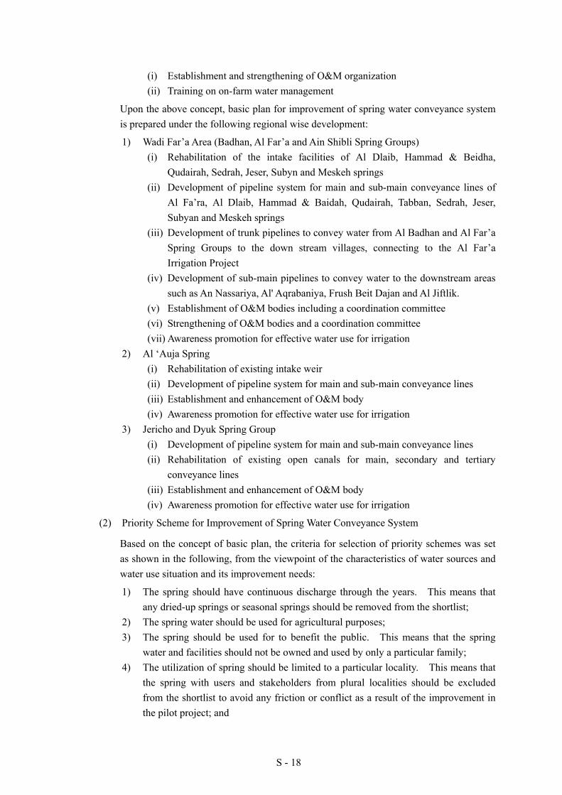
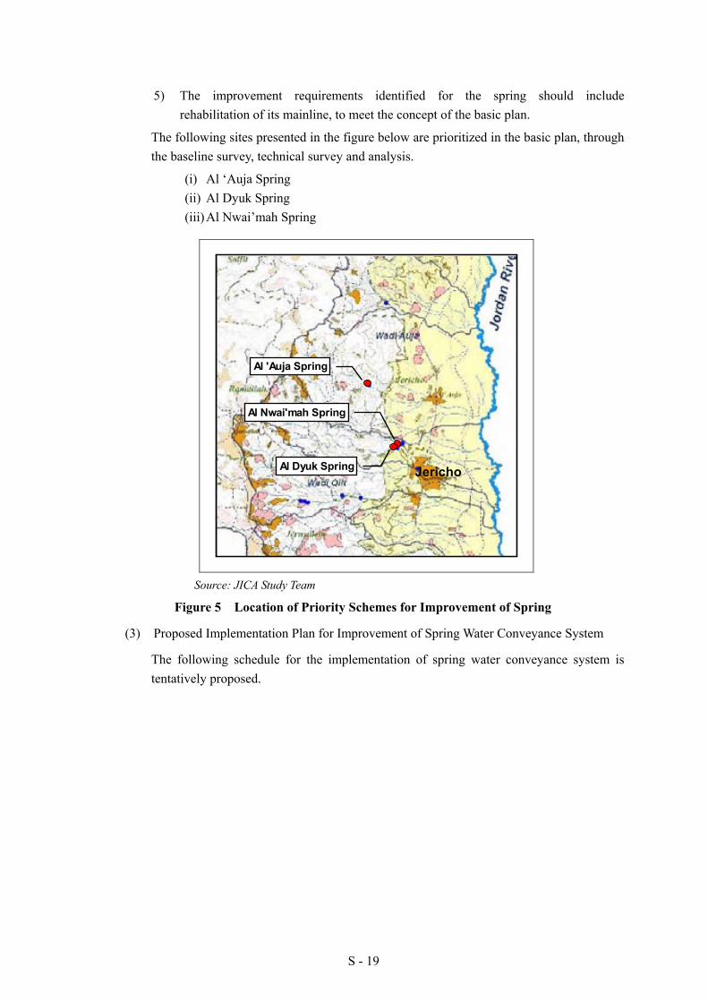
The following sites presented in the figure below are prioritized in the basic plan, through the baseline survey, technical survey and analysis.
(i) Al ‘Auja Spring (ii) Al Dyuk Spring (iii) Al Nwai’mah Spring
Al 'Auja Spring
Al Nwai'mah Spring
Al Dyuk Spring
Source: JICA Study Team
Figure 5 Location of Priority Schemes for Improvement of Spring
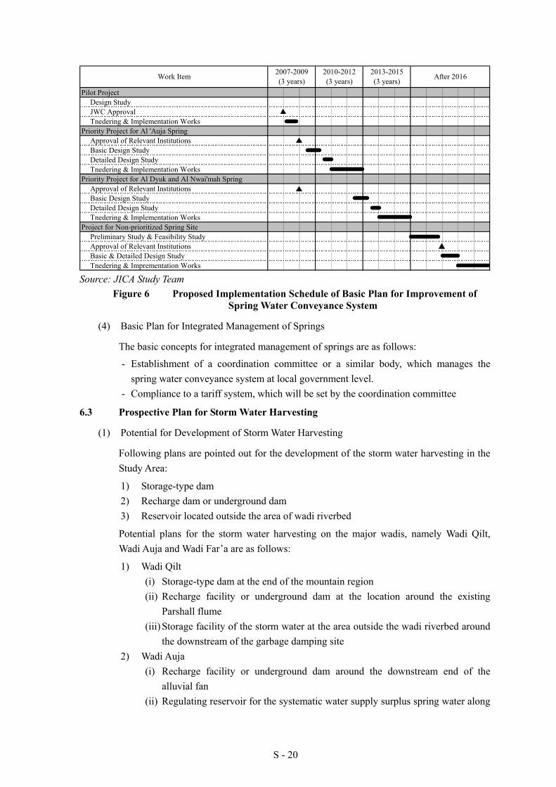
(3) Proposed Implementation Plan for Improvement of Spring Water Conveyance System
The following schedule for the implementation of spring water conveyance system is tentatively proposed.
Jericho
S - 20
Pilot ProjectDesign StudyJWC ApprovalTnedering & Implementation Works
Priority Project for Al 'Auja SpringApproval of Relevant InstitutionsBasic Design StudyDetailed Design StudyTnedering & Implementation Works
Priority Project for Al Dyuk and Al Nwai'mah SpringApproval of Relevant InstitutionsBasic Design StudyDetailed Design StudyTnedering & Implementation Works
Project for Non-prioritized Spring SitePreliminary Study & Feasibility StudyApproval of Relevant InstitutionsBasic & Detailed Design StudyTnedering & Imprementation Works
After 2016Work Item 2007-2009(3 years)
2010-2012(3 years)
2013-2015(3 years)
Source: JICA Study Team
Figure 6 Proposed Implementation Schedule of Basic Plan for Improvement of Spring Water Conveyance System
(4) Basic Plan for Integrated Management of Springs
The basic concepts for integrated management of springs are as follows:
- Establishment of a coordination committee or a similar body, which manages the spring water conveyance system at local government level.
- Compliance to a tariff system, which will be set by the coordination committee
6.3 Prospective Plan for Storm Water Harvesting
(1) Potential for Development of Storm Water Harvesting
Following plans are pointed out for the development of the storm water harvesting in the Study Area:
1) Storage-type dam 2) Recharge dam or underground dam 3) Reservoir located outside the area of wadi riverbed
Potential plans for the storm water harvesting on the major wadis, namely Wadi Qilt, Wadi Auja and Wadi Far’a are as follows:
1) Wadi Qilt (i) Storage-type dam at the end of the mountain region (ii) Recharge facility or underground dam at the location around the existing
Parshall flume (iii) Storage facility of the storm water at the area outside the wadi riverbed around
the downstream of the garbage damping site 2) Wadi Auja
(i) Recharge facility or underground dam around the downstream end of the alluvial fan
(ii) Regulating reservoir for the systematic water supply surplus spring water along
S - 21
the headrace located in the wide flat plain area 3) Wadi Far’a
(i) Storage type dam around the confluence between Nablus Basin and Tubas Basin
The location of potential sites and plans are presented in Chapter 6.
(2) Prospective Plan for Storm Water Harvesting
Hydrological and geological data was insufficient to conduct the feasibility study for the storm water harvesting plan. Moreover, installation of hydrological station and geological investigation could not be executed due to the delay issue of permits from Israel. However, three prospective plans among the above potentials were prepared with conditions on geological and hydrological aspects. The rest of the potential plans were not considered for further studies, judging from the available data as well as the result of the field investigations.
Prospective plans of storm water harvesting are:
1) Recharge facility or underground dam at the location around the existing Parshall flume on Wadi Qilt;
2) Storage facility of the storm water at the area outside the wadi riverbed around downstream area of the garbage damping site on Wadi Qilt; and
3) Regulating reservoir for the systematic water supply surplus spring water along the headrace located in the wide flat plain area.
(3) Measures Taken prior to the Execution of the Feasibility Study
In order to proceed to the next step which is the execution of feasibility study for storm water harvesting, the following measures were considered in this study.
1) Preparation of Installation Plan for Hydrological Stations 2) Preparation of Pilot Project Plan for Storm Water Harvesting
6.4 On-farm Water Management
As well as rehabilitation and improvement of main irrigation facilities, enhancement of on-farm application efficiency is essential to realize the efficient water use in the field of irrigation. Following measures are proposed:
1) Improvement of techniques and O&M for water saving irrigation; 2) Replacement of old facilities for water saving irrigation; and 3) Awareness promotion on efficient water use.
To accomplish the proposed water saving irrigation, the following activities were implemented during the course of the study:
1) Initiate pilot project on improvement of spring water conveyance system and rehabilitation of agricultural well (to enhance water conveyance efficiency)
2) Conduct training courses for on-farm water management (to enhance on-farm application efficiency)
S - 22
6.5 Implementation Program for Water Resources Development
The water resources development in the Study Area mentioned in the previous sections will be implemented under short, medium, and long term plans. Urgency, scale, political risks for executing the construction works, and other factors are also taken into consideration in the plans.
Table 11 Implementation Program for Water Resources Development
Plan Short Term (2010-2012)
Medium Term (2013-2015)
Long Term (After 2016)
Improvement of Spring Water Conveyance System
Al ‘Auja Spring Al Nwai’mah and Al Dyuk Spring
16 springs
Rehabilitation of Agricultural Wells
11 wells (excluding 8 wells from 19 priority wells which was executed as the pilot project)
30 wells 30 wells
Collection and analysis of relevant data and information for the preparation of storm water harvesting plan
Development of Storm Water Harvesting
Implementation of Pilot Projects
Major wadis such as Wadi Qilt, Wadi Auja and Wadi Far’a
Source: JICA Study Team
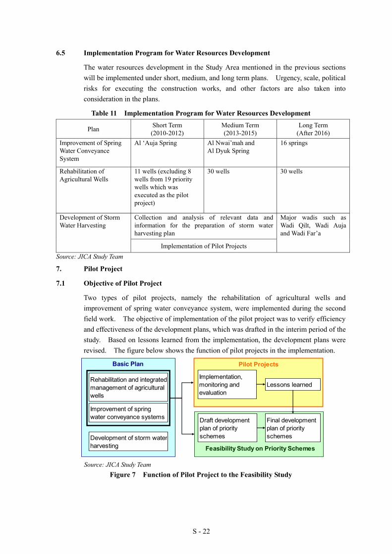
7. Pilot Project
7.1 Objective of Pilot Project
Two types of pilot projects, namely the rehabilitation of agricultural wells and improvement of spring water conveyance system, were implemented during the second field work. The objective of implementation of the pilot project was to verify efficiency and effectiveness of the development plans, which was drafted in the interim period of the study. Based on lessons learned from the implementation, the development plans were revised. The figure below shows the function of pilot projects in the implementation.
Source: JICA Study Team Figure 7 Function of Pilot Project to the Feasibility Study
Basic Plan
Improvement of springwater conveyance systems
Rehabilitation and integratedmanagement of agriculturalwells
Feasibility Study on Priority SchemesDevelopment of storm waterharvesting
Draft developmentplan of priorityschemes
Pilot Projects
Implementation,monitoring andevaluation
Lessons learned
Final developmentplan of priorityschemes

S - 23
7.2 Selection of Pilot Project
The following sites have been selected as the pilot projects during the first field work period (from March 2007 to August 2007), considering the selection criteria. These have been approved by the Steering Committee.
(1) Rehabilitation and Integrated Management of Agricultural Wells: 8 wells with the high order of priority among 19 wells as mentioned in 6.1 (2)
(2) Improvement of Spring Water Conveyance System: Upper parts of Nwai’mah Spring Conveyance System
Work items and cost for the pilot project are as follows:
Table 12 Work Item and Cost for Well Rehabilitation of Pilot Projects Area Condition Needs
Code Name Location A B C B
ad
Not
pu
mpi
ng
Cle
anin
g
Dee
peni
ng Remarks
1 19-15/008
'Abed Al Kareem Njum
Auja * * *
Cleaning up to 58 m, Installation was cancelled due to water quality through pump test.
2 19-17/047
Hasan 'Abed Al Jaleel
Frush bet dajan * * *
Deepening more than 20 m, Vertical pump (80 m3/hr, Head 200m), motor(125 HP)
3 19-17/034
Rajy Al Skakah
Frush bet dajan
* * * Vertical pump (50 m3/hr, Head 180m), motor(75 HP)
4 19-17/027
Hasan Al Sumadi
Jiftlik * *
Vertical pump (65 m3/hr, Head 80m), motor(75 HP)
5 19-17/054
Ma'rouf Abu Samrah
Jiftlik * *
Submergible pump (30 m3/hr, Head 70m)
6 19-17/055
Jawad Al Masri
Jiftlik * *
Vertical pump (90m3/hr, Head 120m), motor(75 HP)
7 19-19/005A
Rafeeq Al Zua'bi
Ein Al Byhda
* * Vertical pump (110m3/hr, Head 50m), motor(50 HP)
8 18-18/036
Khaleel 'Abed Al Hadi
Far’a * *
Vertical pump (90m3/hr, Head 60m), motor(50 HP)
Total direct cost : USD500,000 (including the software component)
Source: JICA Study Team
Table 13 Work Item and Cost of Nwai’mah Spring Pilot Project
Work Item
(1) Rehabilitation of the first part of main open canal (approx. 30m)
(2) Construction of a settling basin (16m3, concrete structure) with bypass pipes (Approx. 40, HDPE pipe)
(3) Installation of closed pipeline (underground) replacing the second part of main open canal (approx. 1.0km, HDPE pipe with dia.14 inch)
Total cost : USD320,000 (including the software component)
Source: JICA Study Team

S - 24
7.3 Supporting System for Water Resources Management
Apart from the improvement and rehabilitation works, supporting system for the water resources management, such as formation and training of water users association and capacity building for related organization, is carried out at the pilot project sites, in order to accomplish the project target and to build integrated management for the wells.
The supporting activities to be taken throughout the pilot projects are as follows:
Source: JICA Study Team
Figure 8 Flow of Supporting System
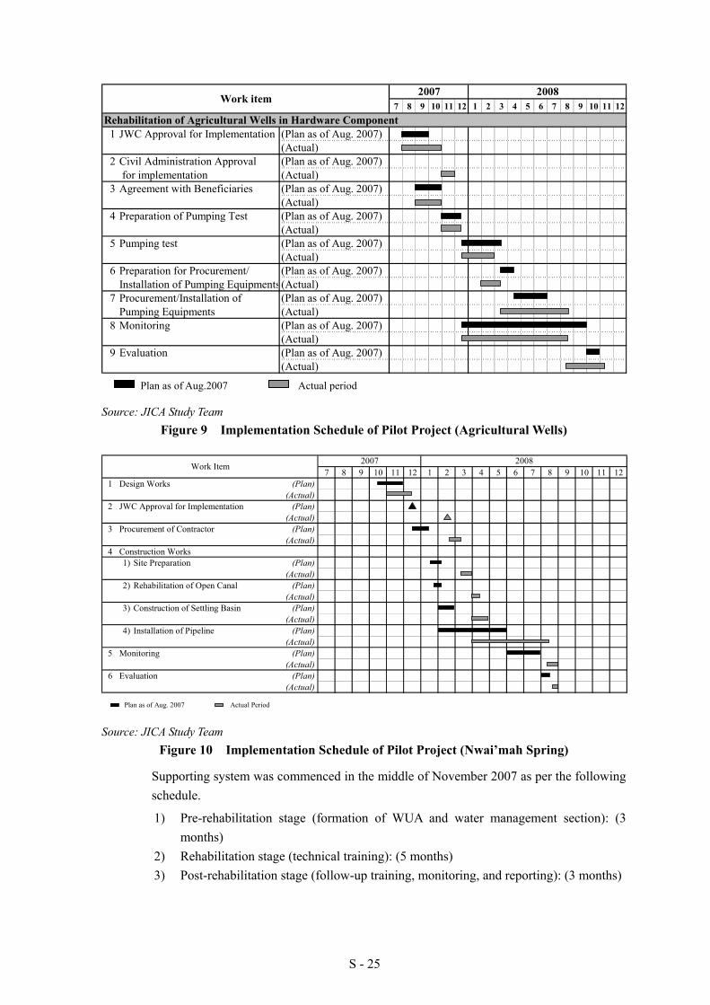
7.3 Implementation Schedule of Pilot Projects
Implementation schedule and actual progress of the pilot projects for rehabilitation of agricultural wells and improvement of spring water conveyance system are shown in the following figure.
Post rehabilitationstage
Follow up activities for operation and maintenance
Follow up activity for on-farm water management
Rehabilitationstage
Training for operation and maintenance
Training for on-farm water management
All stages: Awareness promotion on water management system
Spring Conveyance System
Agricultural Wells
Supplementary survey
Capacity building of related organization
Establishment of WUA
Pre rehabilitationstage
S - 25
Source: JICA Study Team Figure 9 Implementation Schedule of Pilot Project (Agricultural Wells)
7 8 9 10 11 12 1 2 3 4 5 6 7 8 9 10 11 121 Design Works (Plan)
(Actual)2 JWC Approval for Implementation (Plan)
(Actual)3 Procurement of Contractor (Plan)
(Actual)4 Construction Works
1) Site Preparation (Plan)(Actual)
2) Rehabilitation of Open Canal (Plan)(Actual)
3) Construction of Settling Basin (Plan)(Actual)
4) Installation of Pipeline (Plan)(Actual)
5 Monitoring (Plan)(Actual)
6 Evaluation (Plan)(Actual)
2007 2008Work Item
Plan as of Aug. 2007 Actual Period Source: JICA Study Team
Figure 10 Implementation Schedule of Pilot Project (Nwai’mah Spring)
Supporting system was commenced in the middle of November 2007 as per the following schedule.
1) Pre-rehabilitation stage (formation of WUA and water management section): (3 months)
2) Rehabilitation stage (technical training): (5 months) 3) Post-rehabilitation stage (follow-up training, monitoring, and reporting): (3 months)
7 8 9 10 11 12 1 2 3 4 5 6 7 8 9 10 11 12
1 JWC Approval for Implementation (Plan as of Aug. 2007) (Actual)
2 Civil Administration Approval (Plan as of Aug. 2007) for implementation (Actual)
3 Agreement with Beneficiaries (Plan as of Aug. 2007)(Actual)
4 Preparation of Pumping Test (Plan as of Aug. 2007)(Actual)
5 Pumping test (Plan as of Aug. 2007)(Actual)
6 Preparation for Procurement/ (Plan as of Aug. 2007)Installation of Pumping Equipments(Actual)
7 Procurement/Installation of (Plan as of Aug. 2007)Pumping Equipments (Actual)
8 Monitoring (Plan as of Aug. 2007)(Actual)
9 Evaluation (Plan as of Aug. 2007)(Actual)
2008
Rehabilitation of Agricultural Wells in Hardware Component
2007Work item
Plan as of Aug.2007 Actual period
S - 26
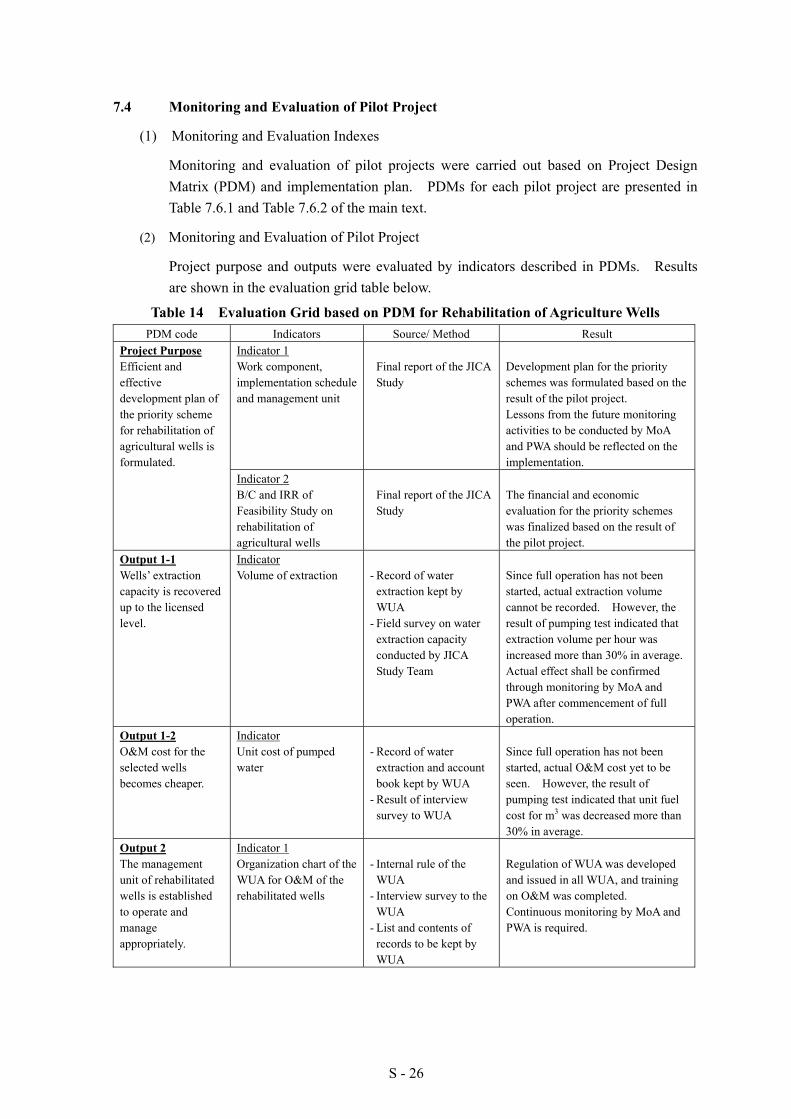
7.4 Monitoring and Evaluation of Pilot Project
(1) Monitoring and Evaluation Indexes
Monitoring and evaluation of pilot projects were carried out based on Project Design Matrix (PDM) and implementation plan. PDMs for each pilot project are presented in Table 7.6.1 and Table 7.6.2 of the main text.
(2) Monitoring and Evaluation of Pilot Project
Project purpose and outputs were evaluated by indicators described in PDMs. Results are shown in the evaluation grid table below.
Table 14 Evaluation Grid based on PDM for Rehabilitation of Agriculture Wells PDM code Indicators Source/ Method Result
Indicator 1 Work component, implementation schedule and management unit
Final report of the JICA
Study
Development plan for the priority schemes was formulated based on the result of the pilot project. Lessons from the future monitoring activities to be conducted by MoA and PWA should be reflected on the implementation.
Project Purpose Efficient and effective development plan of the priority scheme for rehabilitation of agricultural wells is formulated.
Indicator 2 B/C and IRR of Feasibility Study on rehabilitation of agricultural wells
Final report of the JICA
Study
The financial and economic evaluation for the priority schemes was finalized based on the result of the pilot project.
Output 1-1 Wells’ extraction capacity is recovered up to the licensed level.
Indicator Volume of extraction
- Record of water
extraction kept by WUA
- Field survey on water extraction capacity conducted by JICA Study Team
Since full operation has not been started, actual extraction volume cannot be recorded. However, the result of pumping test indicated that extraction volume per hour was increased more than 30% in average. Actual effect shall be confirmed through monitoring by MoA and PWA after commencement of full operation.
Output 1-2 O&M cost for the selected wells becomes cheaper.
Indicator Unit cost of pumped water
- Record of water
extraction and account book kept by WUA
- Result of interview survey to WUA
Since full operation has not been started, actual O&M cost yet to be seen. However, the result of pumping test indicated that unit fuel cost for m3 was decreased more than 30% in average.
Output 2 The management unit of rehabilitated wells is established to operate and manage appropriately.
Indicator 1 Organization chart of the WUA for O&M of the rehabilitated wells
- Internal rule of the
WUA - Interview survey to the
WUA - List and contents of
records to be kept by WUA
Regulation of WUA was developed and issued in all WUA, and training on O&M was completed. Continuous monitoring by MoA and PWA is required.

S - 27
PDM code Indicators Source/ Method Result Indicator 2 Records kept by the WUA
- Internal rule of the
WUA - Training report - Interview survey to the
WUA - List and contents of
records to be kept by WUA
Training of O&M and record keeping was completed in participation of well owners, operators and record keepers. Continuous awareness raising activities and timely/appropriate guidance by MoA and PWA are required.
Indicator 3 Expected financial balance of WUA
- Interview survey to
WUA - List and contents of
records to be kept by WUA
The tariff system was proposed to make the financial balance sound, but it was not applied because full operation of pumping equipment is not started yet. Continuous awareness raising activities and timely/appropriate guidance by MoA and PWA are required.
Output 3 Farmers’ understanding on efficient use of agricultural water is deepened.
Indicator No. of farmers participating the training and their understandings on water saving agriculture
- Interview survey to the
participants - Record of water
extraction kept by WUA
- Field survey on water extraction capacity conducted by JICA Study Team
124 trainees, who include 80% of the farmers, participated in the training course. 96.3% of trainees intend to change their irrigation practice based on the training course they received. Continuous awareness raising activities and timely/appropriate guidance by MoA and PWA are required.
Output 4 Procedure, implementation schedule, cost and desired management system are clarified through all activities.
Indicator Lessons learned from the pilot project
- Interview survey to the
well owners, WUA and farmers
- Study report of the JICA Study
Many practical lessons learned were obtained through the process of the pilot project activities. Regarding the post project period, continuous monitoring is needed for evaluation.
Source: JICA Study Team
Table 15 Evaluation Grid based on PDM for Improvement of Spring Water Conveyance System
PDM code Indicators Source/ Method Result Indicator 1 Work component , implementation schedule and management unit
- Final report of the JICA
Study
Development plan for the priority schemes was formulated based on the result of the pilot project. Lessons from the future monitoring activities to be conducted by MoA and PWA should be reflected on the implementation.
Project Purpose Efficient and effective development plan of the priority scheme for improvement of spring water conveyance system is formulated. Indicator 2
B/C and IRR of Feasibility Study on improvement of spring water conveyance system
- Final report of the JICA
Study
The financial and economic evaluation for the priority schemes was finalized based on the result of the pilot project.

S - 28
PDM code Indicators Source/ Method Result Output 1 Conveyance loss of spring water is decreased.
Indicator Volume of conveyed water and leakage
- Discharge record - Field survey on water
leakage
The water loss in the target conveyance line was 38.5% before the project. The result of water flow monitoring shows that it was improved to be 9.9% after the project.
Output 2-1 Spring water is allocated effectively and efficiently.
Indicator Expected condition of water allocation
- Discharge record - Field survey on water
leakage
It can be conceivable that the water volume conveyed to the users is increased to be another 0.7 million m3/year from the result of water flow monitoring mentioned above.
Indicator 1 Organization chart of the management unit for O&M of the improved conveyance system
- Water allocation plan - Interview survey to the
village council
Stakeholders decided that two existing water management bodies be merged to promote efficient management. An organization structure of merged management committee was proposed, but not yet started. In order to get ready for the improvement works for the entire conveyance system, awareness raising activities by MoA and PWA are required continuously.
Indicator 2 Records kept by the management unit
- Scope of work of the
management unit - Training report - Interview survey to the
village council and farmers
- List and contents of records to be kept by the management unit
No. of training participants was 7, who were nominated as candidates for the committee members. They were explained on the proposed scope of works for O&M. Continuous awareness raising activities and timely/appropriate guidance by MoA and PWA are required.
Output 2-2 A management unit of spring water conveyance system is established to operate and manage appropriately.
Indicator 3 Expected financial balance of the village council on water
- Interview survey to the
village council - List and contents of
records to be kept by the village council
The tariff system was proposed to make the financial balance sound, but it will not be applied until the entire conveyance system is improved. Continuous awareness activities by MoA and PWA are required.
Output 3 Procedure, implementation schedule, cost and desired management system are clarified through all activities.
Indicator Lessons learned from the pilot project
- Interview survey to the
village council - Study report of the
JICA Study
Many practical lessons learned were obtained through the process of the pilot project activities. Regarding the post project period, continuous monitoring is needed for evaluation.
Source: JICA Study Team
S - 29
(4) Lessons Learned from the Activities of the Pilot Project
Through the activities of the pilot projects, the following lessons were realized, and reflected in the preparation of the plan for the priority schemes.
1) General
- Close communication and confirmation among all water users is essential to prepare the proper planning, and to avoid design modifications during the construction period.
- Any field investigation especially in the natural reserve area should be reported to the Civil Administration, prior to the execution of the works.
- Regarding implementation, apart from obtaining JWC approval, Civil Administration permission is also required for any field activities including movement of contractor’s staff, equipment, materials etc.
- The applications for the activities mentioned in the above are required not only for Area C but also for Areas A and B.
2) Rehabilitation of Agricultural Wells
- Among selected eight agricultural wells, installation of pump equipment for well No. 19-15/008 in Al ‘Auja was abandoned because that water quality of the well with a high electric conductivity of about 4,000 to 6,000 µs/cm was observed through 1st stage works. It causes restriction of the cropping in the area.
- For the prioritization of the proposed wells, score setting on each criterion should be considered, so that difference among wells can be clearly appeared.
- Any activities requiring farmers’ participation should not be planned from June to August (agricultural off-season), since they are not available on site during this period.
- Orientation or introduction of the project activity requires longer time and patience. In particular, owners of absentee-owned wells tend to misunderstand about ownership of their well and water rights.
- For the facilitation of WUA establishment, a period for rapport building among stakeholders and facilitators varies depending on the condition of the well. Experiences in the pilot project indicate that at least six months need to be allotted.
- For smooth movement of the staff tasked to perform field works, identification card should be issued by the project or Palestinian Authority.
- If a target well is absentee-owned or owner managed, its proposed rehabilitation should be approved first by the well owners, as well as establishment of WUA. This obtained approval shall be confirmed in a written document in order to avoid any problems during the implementation works.
- Renewal of extraction license should be monitored by PWA as part of the routine works in order to avoid any delay of implementation.
- Establishment of WUA has to be scheduled before the procurement of equipment. This

S - 30
is intended to more possibly execute the collective works for the formation of WUA.
- Approval of well rehabilitation by JWC requires many procedures and takes time. Approval of JWC on wells that need rehabilitation, should be obtained prior to submission of the rehabilitation proposal to the donors.
- Most of the target wells in pilot project are located in Area C, thus requires approvals from concerned Israeli authorities, who are in charge of security in the project site. These authorities have to be properly informed about the project in order to avoid any obstacles concerning the movement of staff and equipment.
- Most of well equipment has to be imported from outside of Palestine through the Israeli port. Delivery schedule may be delayed due to official procedures in the port. Hence, three months should be allotted for the procurement of equipment
- An electric motor as power source is preferable in terms of lowering the operation cost. This is consistent with the policy of PWA. Possibility of considering the electric motor in the detailed design should to be carefully examined in any area.
- If a target well produces saline water, well owners have to be adequately informed about the quality of water, options for water use in agriculture and other purposes.
3) Improvement of Spring Water Conveyance System
- During the design stage, it is necessary to initiate a workshop to discuss the outline of proposed facilities and O&M methods with the O&M bodies and water rights holder, and consequently obtain a consensus.
- It is preferable to maintain the traditional distribution methods and structures of the distribution line. This is ideal to obtain project consensus with the users, taking into consideration the current or traditional operating methods even in cases where the conveyance system is replaced with closed pipelines.
- The user connection component should be user-friendly
- The construction plan should be designed considering user’s water demand period.
- In case a conveyance system is rehabilitated partially, the O&M plan for the proposed projects should include a work item for the O&M of the whole system.
- If there are existing groups, which are involved in any O&M activity in the system, utilization of these groups for O&M of improved system should be considered rather than new one to establish.
8. Feasibility Study on Priority Schemes
8.1 Development Plan for Rehabilitation of Agricultural Wells
(1) Site Location of Priority Schemes
The first priority agricultural wells for rehabilitation were selected in the basic plan, as presented in Chapter 6 of the main text. . Among these 19 wells, eight were selected as the pilot project while the remaining 11 were included in the priority schemes for the
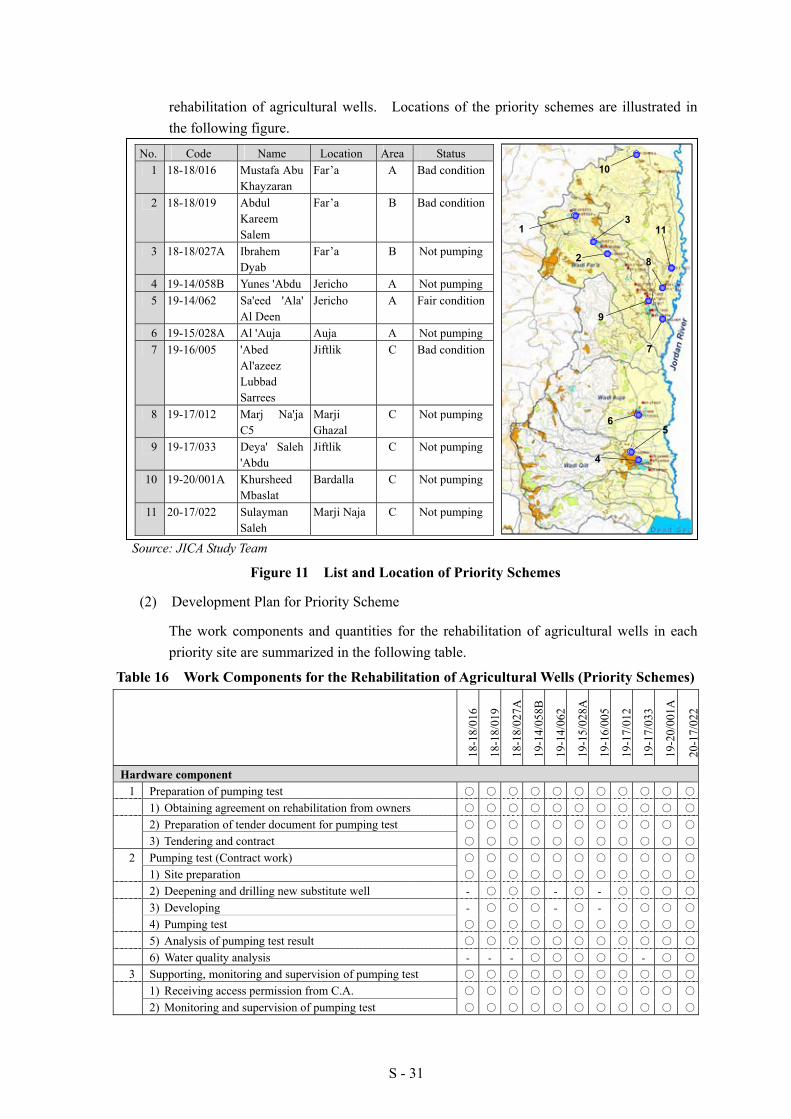
S - 31
rehabilitation of agricultural wells. Locations of the priority schemes are illustrated in the following figure.
No. Code Name Location Area Status 1 18-18/016 Mustafa Abu
Khayzaran Far’a A Bad condition
2 18-18/019 Abdul Kareem Salem
Far’a B Bad condition
3 18-18/027A Ibrahem Dyab
Far’a B Not pumping
4 19-14/058B Yunes 'Abdu Jericho A Not pumping5 19-14/062 Sa'eed 'Ala'
Al Deen Jericho A Fair condition
6 19-15/028A Al 'Auja Auja A Not pumping7 19-16/005 'Abed
Al'azeez Lubbad Sarrees
Jiftlik C Bad condition
8 19-17/012 Marj Na'ja C5
Marji Ghazal
C Not pumping
9 19-17/033 Deya' Saleh 'Abdu
Jiftlik C Not pumping
10 19-20/001A Khursheed Mbaslat
Bardalla C Not pumping
11 20-17/022 Sulayman Saleh
Marji Naja C Not pumping
Source: JICA Study Team
Figure 11 List and Location of Priority Schemes
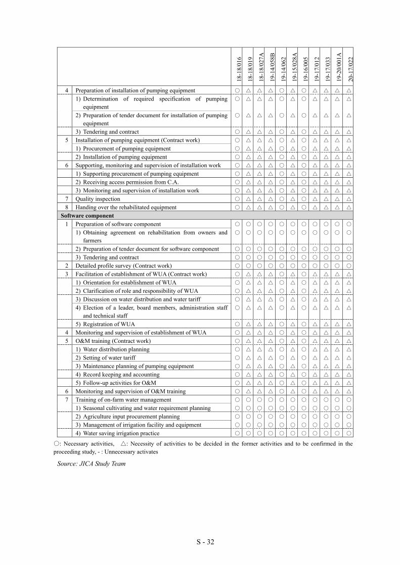
(2) Development Plan for Priority Scheme
The work components and quantities for the rehabilitation of agricultural wells in each priority site are summarized in the following table.
Table 16 Work Components for the Rehabilitation of Agricultural Wells (Priority Schemes)
18-1
8/01
6
18-1
8/01
9
18-1
8/02
7A
19-1
4/05
8B
19-1
4/06
2
19-1
5/02
8A
19-1
6/00
5
19-1
7/01
2
19-1
7/03
3
19-2
0/00
1A
20-1
7/02
2
Hardware component 1 Preparation of pumping test ○ ○ ○ ○ ○ ○ ○ ○ ○ ○ ○
1) Obtaining agreement on rehabilitation from owners ○ ○ ○ ○ ○ ○ ○ ○ ○ ○ ○
2) Preparation of tender document for pumping test ○ ○ ○ ○ ○ ○ ○ ○ ○ ○ ○
3) Tendering and contract ○ ○ ○ ○ ○ ○ ○ ○ ○ ○ ○
2 Pumping test (Contract work) ○ ○ ○ ○ ○ ○ ○ ○ ○ ○ ○
1) Site preparation ○ ○ ○ ○ ○ ○ ○ ○ ○ ○ ○
2) Deepening and drilling new substitute well - ○ ○ ○ - ○ - ○ ○ ○ ○
3) Developing - ○ ○ ○ - ○ - ○ ○ ○ ○
4) Pumping test ○ ○ ○ ○ ○ ○ ○ ○ ○ ○ ○
5) Analysis of pumping test result ○ ○ ○ ○ ○ ○ ○ ○ ○ ○ ○
6) Water quality analysis - - - ○ ○ ○ ○ ○ - ○ ○
3 Supporting, monitoring and supervision of pumping test ○ ○ ○ ○ ○ ○ ○ ○ ○ ○ ○
1) Receiving access permission from C.A. ○ ○ ○ ○ ○ ○ ○ ○ ○ ○ ○
2) Monitoring and supervision of pumping test ○ ○ ○ ○ ○ ○ ○ ○ ○ ○ ○
9
31
10
11
7
65
4
82
S - 32
18-1
8/01
6
18-1
8/01
9
18-1
8/02
7A
19-1
4/05
8B
19-1
4/06
2
19-1
5/02
8A
19-1
6/00
5
19-1
7/01
2
19-1
7/03
3
19-2
0/00
1A
20-1
7/02
2
4 Preparation of installation of pumping equipment ○ △ △ △ ○ △ ○ △ △ △ △
1) Determination of required specification of pumping equipment
○ △ △ △ ○ △ ○ △ △ △ △
2) Preparation of tender document for installation of pumping equipment
○ △ △ △ ○ △ ○ △ △ △ △
3) Tendering and contract ○ △ △ △ ○ △ ○ △ △ △ △
5 Installation of pumping equipment (Contract work) ○ △ △ △ ○ △ ○ △ △ △ △
1) Procurement of pumping equipment ○ △ △ △ ○ △ ○ △ △ △ △
2) Installation of pumping equipment ○ △ △ △ ○ △ ○ △ △ △ △
6 Supporting, monitoring and supervision of installation work ○ △ △ △ ○ △ ○ △ △ △ △
1) Supporting procurement of pumping equipment ○ △ △ △ ○ △ ○ △ △ △ △
2) Receiving access permission from C.A. ○ △ △ △ ○ △ ○ △ △ △ △
3) Monitoring and supervision of installation work ○ △ △ △ ○ △ ○ △ △ △ △
7 Quality inspection ○ △ △ △ ○ △ ○ △ △ △ △
8 Handing over the rehabilitated equipment ○ △ △ △ ○ △ ○ △ △ △ △
Software component 1 Preparation of software component ○ ○ ○ ○ ○ ○ ○ ○ ○ ○ ○
1) Obtaining agreement on rehabilitation from owners and farmers
○ ○ ○ ○ ○ ○ ○ ○ ○ ○ ○
2) Preparation of tender document for software component ○ ○ ○ ○ ○ ○ ○ ○ ○ ○ ○
3) Tendering and contract ○ ○ ○ ○ ○ ○ ○ ○ ○ ○ ○
2 Detailed profile survey (Contract work) ○ ○ ○ ○ ○ ○ ○ ○ ○ ○ ○
3 Facilitation of establishment of WUA (Contract work) ○ △ △ △ ○ △ ○ △ △ △ △
1) Orientation for establishment of WUA ○ △ △ △ ○ △ ○ △ △ △ △
2) Clarification of role and responsibility of WUA ○ △ △ △ ○ △ ○ △ △ △ △
3) Discussion on water distribution and water tariff ○ △ △ △ ○ △ ○ △ △ △ △
4) Election of a leader, board members, administration staff and technical staff
○ △ △ △ ○ △ ○ △ △ △ △
5) Registration of WUA ○ △ △ △ ○ △ ○ △ △ △ △
4 Monitoring and supervision of establishment of WUA ○ △ △ △ ○ △ ○ △ △ △ △
5 O&M training (Contract work) ○ △ △ △ ○ △ ○ △ △ △ △
1) Water distribution planning ○ △ △ △ ○ △ ○ △ △ △ △
2) Setting of water tariff ○ △ △ △ ○ △ ○ △ △ △ △
3) Maintenance planning of pumping equipment ○ △ △ △ ○ △ ○ △ △ △ △
4) Record keeping and accounting ○ △ △ △ ○ △ ○ △ △ △ △
5) Follow-up activities for O&M ○ △ △ △ ○ △ ○ △ △ △ △
6 Monitoring and supervision of O&M training ○ △ △ △ ○ △ ○ △ △ △ △
7 Training of on-farm water management ○ ○ ○ ○ ○ ○ ○ ○ ○ ○ ○
1) Seasonal cultivating and water requirement planning ○ ○ ○ ○ ○ ○ ○ ○ ○ ○ ○
2) Agriculture input procurement planning ○ ○ ○ ○ ○ ○ ○ ○ ○ ○ ○
3) Management of irrigation facility and equipment ○ ○ ○ ○ ○ ○ ○ ○ ○ ○ ○
4) Water saving irrigation practice ○ ○ ○ ○ ○ ○ ○ ○ ○ ○ ○
○: Necessary activities, △: Necessity of activities to be decided in the former activities and to be confirmed in the proceeding study, - : Unnecessary activates
Source: JICA Study Team
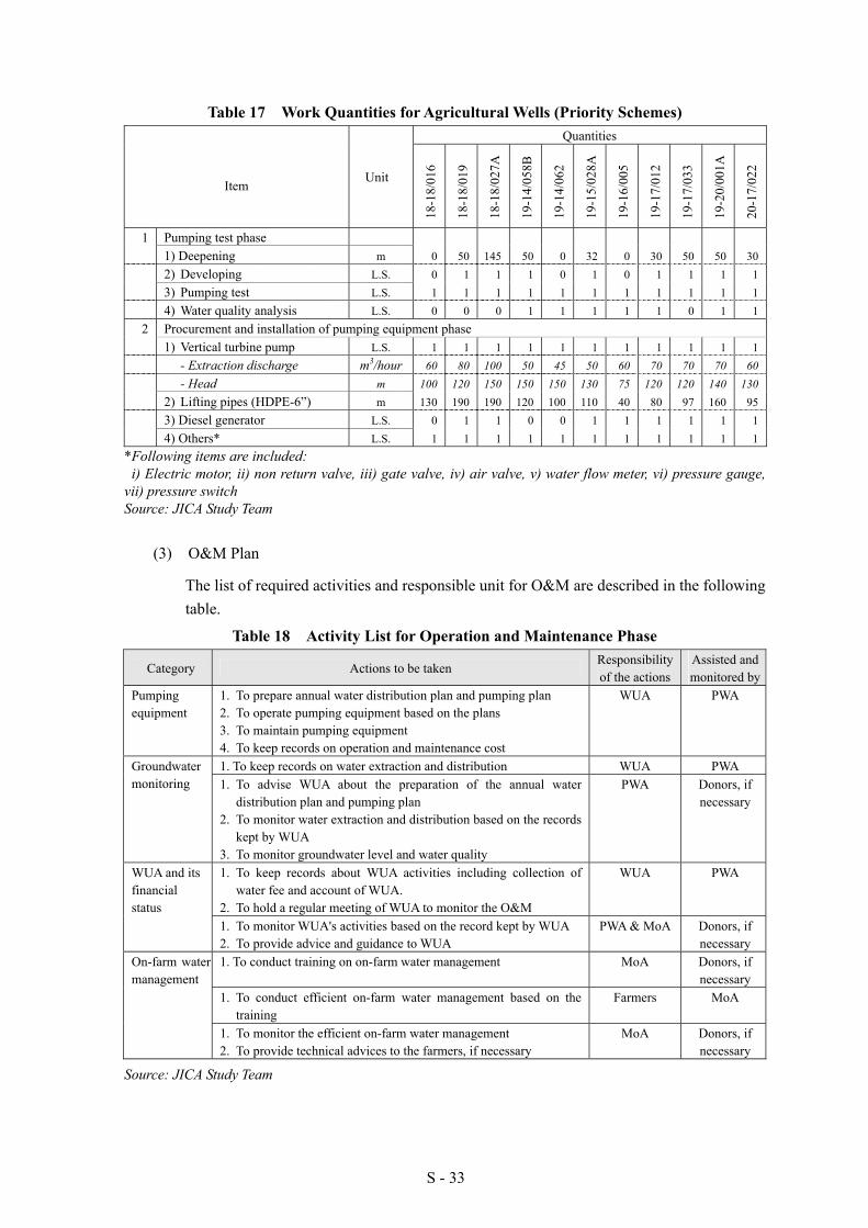
S - 33
Table 17 Work Quantities for Agricultural Wells (Priority Schemes) Quantities
Item Unit
18-1
8/01
6
18-1
8/01
9
18-1
8/02
7A
19-1
4/05
8B
19-1
4/06
2
19-1
5/02
8A
19-1
6/00
5
19-1
7/01
2
19-1
7/03
3
19-2
0/00
1A
20-1
7/02
2
1 Pumping test phase 1) Deepening m 0 50 145 50 0 32 0 30 50 50 30 2) Developing L.S. 0 1 1 1 0 1 0 1 1 1 1 3) Pumping test L.S. 1 1 1 1 1 1 1 1 1 1 1 4) Water quality analysis L.S. 0 0 0 1 1 1 1 1 0 1 1
2 Procurement and installation of pumping equipment phase 1) Vertical turbine pump L.S. 1 1 1 1 1 1 1 1 1 1 1 - Extraction discharge m3/hour 60 80 100 50 45 50 60 70 70 70 60 - Head m 100 120 150 150 150 130 75 120 120 140 130 2) Lifting pipes (HDPE-6”) m 130 190 190 120 100 110 40 80 97 160 95 3) Diesel generator L.S. 0 1 1 0 0 1 1 1 1 1 1 4) Others* L.S. 1 1 1 1 1 1 1 1 1 1 1
*Following items are included: i) Electric motor, ii) non return valve, iii) gate valve, iv) air valve, v) water flow meter, vi) pressure gauge,
vii) pressure switch Source: JICA Study Team
(3) O&M Plan
The list of required activities and responsible unit for O&M are described in the following table.
Table 18 Activity List for Operation and Maintenance Phase
Category Actions to be taken Responsibility of the actions
Assisted and monitored by
Pumping equipment
1. To prepare annual water distribution plan and pumping plan 2. To operate pumping equipment based on the plans 3. To maintain pumping equipment 4. To keep records on operation and maintenance cost
WUA PWA
1. To keep records on water extraction and distribution WUA PWA Groundwater monitoring 1. To advise WUA about the preparation of the annual water
distribution plan and pumping plan 2. To monitor water extraction and distribution based on the records
kept by WUA 3. To monitor groundwater level and water quality
PWA Donors, if necessary
1. To keep records about WUA activities including collection of water fee and account of WUA.
2. To hold a regular meeting of WUA to monitor the O&M
WUA PWA WUA and its financial status
1. To monitor WUA's activities based on the record kept by WUA 2. To provide advice and guidance to WUA
PWA & MoA Donors, if necessary
1. To conduct training on on-farm water management MoA Donors, if necessary
1. To conduct efficient on-farm water management based on the training
Farmers MoA
On-farm water management
1. To monitor the efficient on-farm water management 2. To provide technical advices to the farmers, if necessary
MoA Donors, if necessary
Source: JICA Study Team

S - 34
8.2 Development Plan for Spring Water Conveyance System
(1) Site Location of Priority Schemes
The site locations of the priority schemes are shown in the following figure. The Al ‘Auja spring source is situated in Area C while the natural reserve area is adjacent to the upper Wadi Al ‘Auja. The Al Nwai’mah and Al Dyuk spring sources are at the same location, as well as the Shusah Spring which is one of the private springs.
Al 'Auja Spring
Al Nwai'mah Spring
Al Dyuk Spring
Source: JICA Study Team
Figure 12 Location of Priority Schemes for Spring Improvement
(2) Development Plan for Priority Scheme
The work components and quantities for the improvement of spring water conveyance system in each priority site are summarized in the following table.
Table 19 Work Components for Spring Improvement (Priority Schemes) Al ‘Auja Al Dyuk Al Nwai'mah
1) Installation of conveyance pipelines
2) Construction of settling basin
3) Construction of Distribution Box
4) Rehabilitation of intake weir
5) Rehabilitation of existing concrete canals
1) Installation of conveyance pipelines
2) Construction of settling basin
3) Construction of Distribution Box
4) Rehabilitation of existing concrete canals
1) Installation of conveyance pipelines
2) Construction of Distribution Box
3) Rehabilitation of existing concrete canals
Source: JICA Study Team

S - 35
Table 20 Work Quantity for Spring Improvement (Priority Schemes)
Unit Quantity Unit Quantity Unit QuantityPipe Installation m 4,680 Pipe Installation m 6,930 Pipe Installation m 15,010
HDPE-355mm m 1,720 SP-22" m 480 SP-26" m 1,590HDPE-280mm m 1,620 SP-18" m 1,230 SP-22" m 200HDPE-225mm m 1,340 SP-16" m 760 SP-20" m 3,720
SP-12" m 760 SP-18" m 4,160HDPE-450mm m 1,080 HDPE-450mm m 4,280HDPE-400mm m 250 HDPE-400mm m 1,060HDPE-355mm m 1,420HDPE-280mm m 950
Construction Construction ConstructionSettling Basin pcs 0 Settling Basin pcs 1 Settling Basin pcs 1Distribution Box pcs 8 Distribution Box pcs 24 Distribution Box pcs 16
Rehabilitation Rehabilitation RehabilitationIntake Rehabilitation L.S. 0 Intake Rehabilitation L.S. 0 Intake Rehabilitation L.S. 1Canal Rehabilitation m 2,000 Canal Rehabilitation m 2,900 Canal Rehabilitation m 3,750
Item Item ItemNWAI'MAH DYUK AUJA
Source: JICA Study Team
(3) O&M Plan
Roles and responsibility for O&M are illustrated below.
- Monitoring of Water Resources- Controlling of Water Rights- Planning of Water Resources Allocation
- O&M of Conveyance System- Monitoring of Water Resources- Monitoring of Water Distribution
- Operation for Water Distribution- O & M for On-farm Activities
Supervisor(Government)
Provider(Village Council)
User(Water Right Holders)
Instruction Reporting
Direction
CoordinationCommittee
ReportingDirection Reporting
Monitoring
Source: JICA Study Team
Figure 13 Roles and Responsibility for O&M
The activities to be handled for O&M of the spring water conveyance system are shown in the following table:
Table21 Activity List for O&M Acting Body Category Actions to be taken
1. Preparation of annual O&M plan 2. Preparation of financial plan 3. Accounting 4. Maintenance of water right 5. Tariff collection 6. Holding board meetings
Administration
7. Monthly and annually reporting on activities 1. Monitoring of water flow from spring sources by current meter
Village Council
Monitoring of Water Resources 2. Monitoring of water quality of spring sources by observation
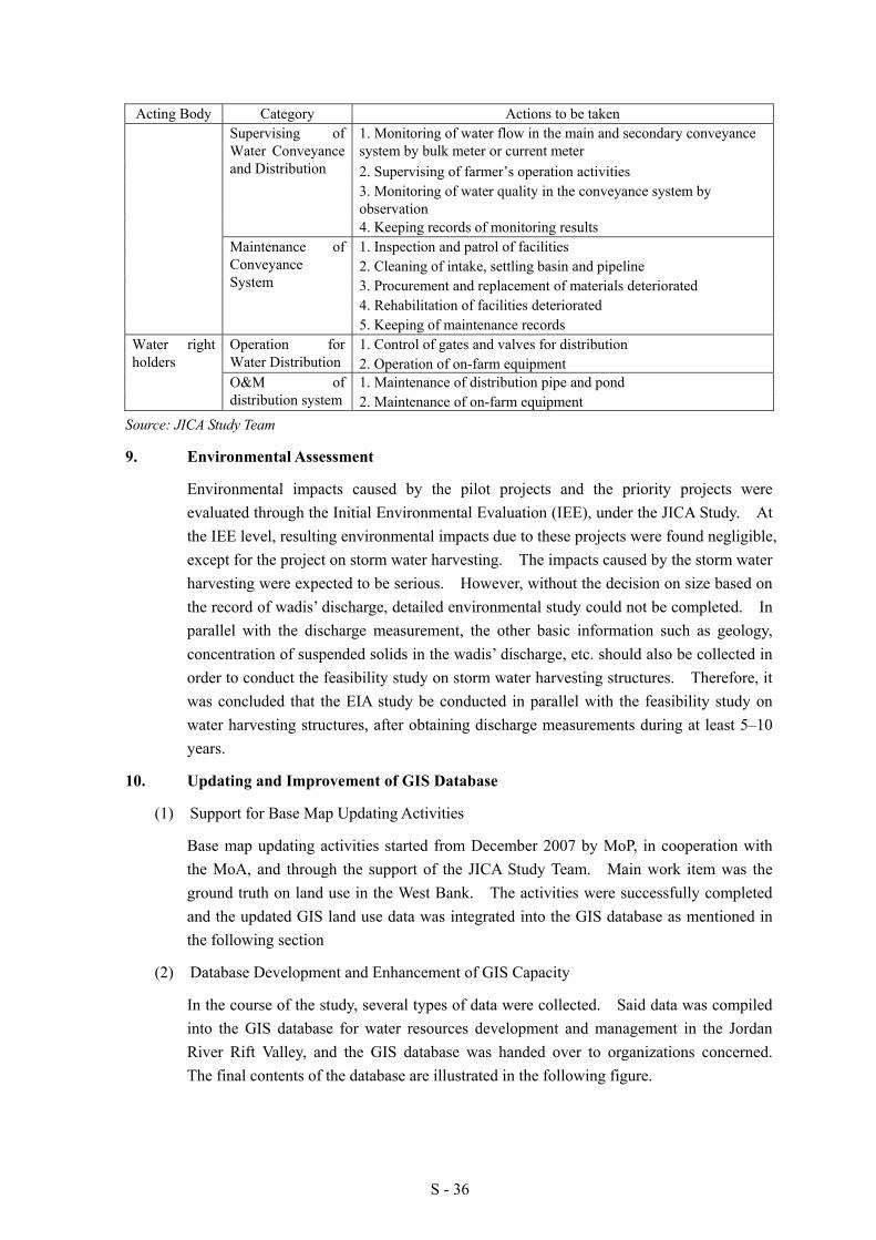
S - 36
Acting Body Category Actions to be taken 1. Monitoring of water flow in the main and secondary conveyance system by bulk meter or current meter 2. Supervising of farmer’s operation activities 3. Monitoring of water quality in the conveyance system by observation
Supervising of Water Conveyance and Distribution
4. Keeping records of monitoring results 1. Inspection and patrol of facilities 2. Cleaning of intake, settling basin and pipeline 3. Procurement and replacement of materials deteriorated 4. Rehabilitation of facilities deteriorated
Maintenance of Conveyance System
5. Keeping of maintenance records 1. Control of gates and valves for distribution Operation for
Water Distribution 2. Operation of on-farm equipment 1. Maintenance of distribution pipe and pond
Water right holders
O&M of distribution system 2. Maintenance of on-farm equipment
Source: JICA Study Team
9. Environmental Assessment
Environmental impacts caused by the pilot projects and the priority projects were evaluated through the Initial Environmental Evaluation (IEE), under the JICA Study. At the IEE level, resulting environmental impacts due to these projects were found negligible, except for the project on storm water harvesting. The impacts caused by the storm water harvesting were expected to be serious. However, without the decision on size based on the record of wadis’ discharge, detailed environmental study could not be completed. In parallel with the discharge measurement, the other basic information such as geology, concentration of suspended solids in the wadis’ discharge, etc. should also be collected in order to conduct the feasibility study on storm water harvesting structures. Therefore, it was concluded that the EIA study be conducted in parallel with the feasibility study on water harvesting structures, after obtaining discharge measurements during at least 5–10 years.
10. Updating and Improvement of GIS Database
(1) Support for Base Map Updating Activities
Base map updating activities started from December 2007 by MoP, in cooperation with the MoA, and through the support of the JICA Study Team. Main work item was the ground truth on land use in the West Bank. The activities were successfully completed and the updated GIS land use data was integrated into the GIS database as mentioned in the following section
(2) Database Development and Enhancement of GIS Capacity
In the course of the study, several types of data were collected. Said data was compiled into the GIS database for water resources development and management in the Jordan River Rift Valley, and the GIS database was handed over to organizations concerned. The final contents of the database are illustrated in the following figure.

S - 37
Source: JICA Study Team Figure 14 GIS Database Structure
(3) Support for Consensus Building on Better Data Management
To secure consistency of GIS data in the said GIS database after handing over to the organizations concerned, a meeting on GIS data management was held among responsible personnel of the organizations in August 2008. Finally, tentative GIS committee was established and a consensus on better GIS data management for the future was built.
11. Implementation Plan and Cost Estimates for the Priority Schemes
11.1 Rehabilitation of Agricultural Wells
(1) Implementation Plan for the Rehabilitation of Agricultural Wells
Implementation schedule for the priority schemes for rehabilitation of agricultural wells is as shown in the following figure.
Source: JICA Study Team
Figure 15 Implementation Schedule for Rehabilitation of Agricultural Wells
GIS Database for JICA Water Resources FS
1 General 2 Water supply 3 Feasibility study1-1 Administration 2-1 Surface water 3-1 Spring
Area classification Catchment Aerial photographGovernorate Wadis Auja springResindential area 2-2 Groundwater Contour line
Israeli Spring Dyuk&Nwai'mah springPalestinian built up area Spring Auja irrigation scheme
1-2 Topography Well Dyuk&Nwaimah irrigation schemeContour line Well 3-2 Storm water harvesting
1-3 Soil and geology Aquifer Pilot project (Wadi Qilt)Geology 2-3 Rainfall Wadi AujaSoil Isohyet map Wadi Fara
1-4 Road Rainfall gauging Wadi QiltRoad Study area
1-5 Land useLand useNatural reserve
1-6 Study areaStudy area
1-7 Satellite imageNorthern JRRVSouther JRRV
Legend
Database Vector data Raster dataArcMap Point Line Polygon Raster
1- Preparation for pumping test2- Pumping test3- Supporting, monitoring and supervision of pumping test4- Preparation for installation of pumping eqipment5- Installation of pumping equipment6- Supporting, monitoting and supervision of installation work7- Quality inspection8- Handing over the rehabilitated equipments
1- Preparation of software component2- Detailed profile survey3- Supporting, monitoring and supervision of detailed profile survey4- Facilitation of establishment of WUA5- O&M training6- Traininng of on-farm water management7- Followup activities for O&M
20122010Work item 2011Hardware component
Software component
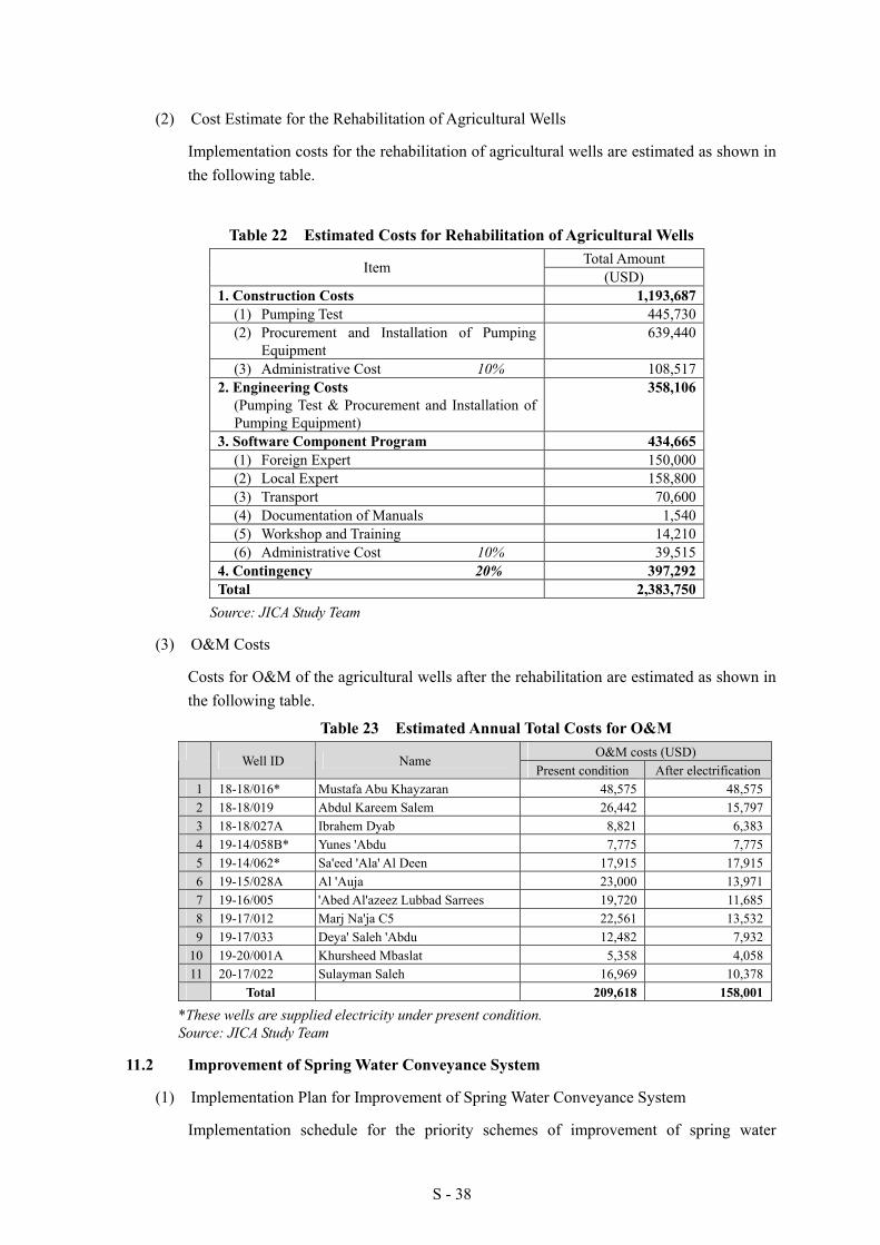
S - 38
(2) Cost Estimate for the Rehabilitation of Agricultural Wells
Implementation costs for the rehabilitation of agricultural wells are estimated as shown in the following table.
Table 22 Estimated Costs for Rehabilitation of Agricultural Wells Total Amount Item (USD)
1. Construction Costs 1,193,687 (1) Pumping Test 445,730 (2) Procurement and Installation of Pumping
Equipment 639,440
(3) Administrative Cost 10% 108,517 2. Engineering Costs
(Pumping Test & Procurement and Installation of Pumping Equipment)
358,106
3. Software Component Program 434,665 (1) Foreign Expert 150,000 (2) Local Expert 158,800 (3) Transport 70,600 (4) Documentation of Manuals 1,540 (5) Workshop and Training 14,210 (6) Administrative Cost 10% 39,515
4. Contingency 20% 397,292 Total 2,383,750
Source: JICA Study Team
(3) O&M Costs
Costs for O&M of the agricultural wells after the rehabilitation are estimated as shown in the following table.
Table 23 Estimated Annual Total Costs for O&M O&M costs (USD)
Well ID Name Present condition After electrification
1 18-18/016* Mustafa Abu Khayzaran 48,575 48,5752 18-18/019 Abdul Kareem Salem 26,442 15,7973 18-18/027A Ibrahem Dyab 8,821 6,3834 19-14/058B* Yunes 'Abdu 7,775 7,7755 19-14/062* Sa'eed 'Ala' Al Deen 17,915 17,9156 19-15/028A Al 'Auja 23,000 13,9717 19-16/005 'Abed Al'azeez Lubbad Sarrees 19,720 11,6858 19-17/012 Marj Na'ja C5 22,561 13,5329 19-17/033 Deya' Saleh 'Abdu 12,482 7,932
10 19-20/001A Khursheed Mbaslat 5,358 4,05811 20-17/022 Sulayman Saleh 16,969 10,378
Total 209,618 158,001
*These wells are supplied electricity under present condition. Source: JICA Study Team
11.2 Improvement of Spring Water Conveyance System
(1) Implementation Plan for Improvement of Spring Water Conveyance System
Implementation schedule for the priority schemes of improvement of spring water
S - 39
conveyance system is as shown in the following figure.
Approval of Relevant InstitutionsBasic Design StudyDetailed Design Study & TenderingImplementation Works
Construction WorksSoftware Component
Approval of Relevant InstitutionsBasic Design StudyDetailed Design Study & TenderingImplementation Works
Construction WorksSoftware Component
Al 'Auja Spring
Al Dyuk and Nwai'mah Spring
2012 2013 2014 2015Work item 2009 2010 2011
Source: JICA Study Team
Figure 16 Implementation Schedule of Priority Scheme
(2) Cost Estimate for the Improvement of Spring Water Conveyance System
Implementation costs for the improvement of spring water conveyance system are estimated as shown in the following table.
Table 24 Estimated Costs for Al ‘Auja Improvement Scheme Total Amount Item
(USD) [Al 'Auja Spring] 1. Construction Costs 5,734,900 (1) Direct Construction Costs 5,213,500 - Temporary Works 5% 248,300 - Pipe Installation and Related Works 3,764,200 - Intake Rehabilitation Works 2,100 - Canal Rehabilitation Works 1,198,900 (2) Administrative Cost 10% 521,400 2. Engineering Costs 15% 860,200 (Detailed Design & Construction Supervision) 3. Software Component Program 533,500 SubTotal 7,128,600 Contingency 20% 1,425,700 Total 8,554,300
Source: JICA Study Team

S - 40
Table 25 Estimated Costs for Al Nwai’mah and Al Dyuk Improvement Scheme Total Amount Item
(USD) [Al Dyuk & Al Nwai'mah Springs] 1. Construction Costs 4,343,200 (1) Direct Construction Costs 3,948,400 Al Nwai'mah 1,246,100 - Temporary Works 5% 59,300 - Pipe Installation and Related Works 636,900 - Intake Rehabilitation Works 0 - Canal Rehabilitation Works 549,900 Al Dyuk 2,702,300 - Temporary Works 5% 128,700 - Pipe Installation and Related Works 1,764,000 - Intake Rehabilitation Works 0 - Canal Rehabilitation Works 809,600 (2) Administrative Cost 10% 394,800 2. Engineering Costs 15% 592,300 (Detailed Design & Construction Supervision) 3. Software Component Program 541,100 SubTotal 5,476,600 Contingency 20% 1,095,300 Total 6,571,900
Source: JICA Study Team
(3) O&M Costs
The O&M costs for each spring facility are estimated as shown in the following table.
Table 26 Estimated Annual Total Costs for O&M
(Unit: USD) Item Al Nwai'mah Al Dyuk Al ‘Auja
Depreciation Cost (USD) 49,800 108,100 208,500Personnel Cost (USD) 30,800 30,800 38,500Administrative Cost 20% 16,100 27,800 49,400Total O&M Costs (USD) 96,700 166,700 296,400Average Discharge for Agr. (Mm3/yr) 2.53 4.73 9.55O&M Costs per m3 (USD/m3) 0.038 0.035 0.031
Source: JICA Study Team
12. Project Evaluation
(1) Economic Analysis
Economic internal rate of return (EIRR), net present value (NPV), and benefit – cost ratio (B/C) of each priority scheme are summarized in the following table. The quantitative evaluation results reveal high economic viability.
S - 41
Table 27 Evaluation Results of the Economic Analysis EIRR NPV@12%
(‘000USD) B/C@12%
Improvement of Spring Conveyance Systems
Al ‘Auja Spring 23.2% 5,663 1.72
Al Dyuk & Al Nwai’mah Springs 13.5% 472 1.08
Rehabilitation & Management of 11 Agricultural Wells 14.9% 493 1.14
Source: JICA Study Team
(2) Farm Income Analysis
Implementation of the overall priority projects also benefits the farmer’s household income. The farm income analysis has indicated that a typical vegetable-producing farmer’s household would obtain an additional irrigated land of 5.5 dunum, and thereby raising their household income by 35% (equivalent to USD2,700 per annum).
13. Technology Transfer
The technology transfer to the counterpart personnel, conducted mainly while on the job, was carried out by the study team throughout the study period, in accordance with the Technology Transfer Program.
A training course program to Jordan was carried out from June 29 to July 2, 2008, aiming to develop the skills of the Palestinian counterpart personnel on surface water monitoring, which is intended for the development of storm water harvesting. It also aimed to develop skills on ground water monitoring for better ground water resources management.
As a part of technology transfer as well as information disclosure, seminars on water resources development and management in the Jordan River Rift Valley were held twice which were fitst seminar on May 28, 2008 and second seminar on November 19, 2008. Counterpart agencies for the Study, other relevant agencies in Palestine including local government, donors, NGOs and village council were participated in the seminars.
14. Conclusion and Recommendations
(1) Conclusions
As a result of the feasibility study, it was realized that the implementation of the proposed priority schemes is technically sound and economically viable. From the institutional and organizational, social and natural environmental aspects, it was also found that the schemes are generally sound. Execution of the schemes could accomplish the principal objective of efficient utilization of water, and increase the agricultural production through harmonized implementation of hardware and software components. Thus, it is concluded that the schemes should be implemented in the manner planned in this Study.
(2) Recommendations
1) In order to achieve the effective utilization of water resources, water resources development and management plans in the study should be implemented with close
S - 42
coordination between hardware component (consisting of rehabilitation of agricultural wells and improvement of spring conveyance system as well as development of new water resources) and software components (comprising of establishment of water users association for integrated management of agricultural wells, capacity building of O & M organizations and training of farmers for farming practice on water saving irrigation).
2) Water resources development plan has been formulated considering short, medium and long term plans as mentioned in Chapter 6 of the main text. The execution of this study, in fact, experienced shortage of data and information especially required for the preparation of new water resources development in the Study Area. Moreover, required investigations to support the existing data were also difficult to execute due to the issuance of security situation permits. Accordingly, it is recommended that execution of rehabilitation and improvement of the existing irrigation system should proceed ahead since a more accurate data and information will be required for the preparation of new water resources development plan.
3) In connection with recommendation 2) above, storm water harvesting plan in this study has been prepared with several limited conditions due to insufficient data available for the preparation of the plan. It is recommended that data such as meteorological and hydrological data be obtained during the short and medium terms of the water resources development. After these data were sufficiently obtained and collected, the storm water harvesting plan (preliminary plan prepared in this study) will be reviewed and revised to confirm its feasibility.
4) Any water resources development including rehabilitation and improvement of existing facilities in the Study Area require JWC approval as well as permission from the civil administration of Israel, prior to implementation. It often takes time to obtain such approval and permission. It is expected that this process will be relieved within a few year. However, it is recommended that PWA shall apply to JWC as well as the civil administration at an early stage in accordance with the implementation plan before settlement on this matter.
5) After the Study Period, it is recommended that monitoring and evaluation of the pilot project should be continued periodically. In particular, sustainability of WUA activity is the most important element for O&M of water supply facility. Lessons learned from WUA activity would be helpful for formation process in the priority schemes.
6) For the rehabilitation of agricultural wells, joint management through WUA by well owners and water users is important for the sustainable water management. In particular, introduction of water tariff system is vital for the future renewal of facility and equipment by the WUA. Clarification of water fee by tariff could help farmers to have motivation to examine and lower the production cost of agriculture produces.
7) Since electrification in the Study Area is under development, it is recommended that power sources for future plan such rehabilitation of wells should be examined

S - 43
depending on progress of the electrification, in order to save O&M cost.
8) There is a water resource registration system for wells in the central government, but it is not functioning well. Modification of the system is recommended in order to control and restrict well abstraction according to the license volumes in parallel with establishment of monitoring system of water utilization.
9) The central government does not have any registration system for springs although wells registration system exists. It is recommended to establish the registration, monitoring and restriction system of spring water right and its actual utilization as a bylaw.
10) It is necessary to hold workshops for explanation of proposed new conveyance and distribution system and its operation and maintenance method and to conduct site investigations with water right holders to determine the new conveyance alignment, distribution boxes and outlets for farmers in the designing stages for the priority schemes.
11) In parallel with the implementation of the priority schemes, proper on-farm water management should be extended. In particular, capacity development of extension agents is encouraged.
12) Based on the IEE study for the storm water harvesting, it is concluded that the environmental assessment study should be conducted prior to implementation of pilot project for the storm water harvesting.
13) Recycled water from wastewater and desalted water are other new water resource for irrigation purposes. The availability of recycled water depends on the progress of development of sewerage network and treatment systems in major cities. Introduction of water recycling from wastewater as well as desalination, in taking into consideration the shortage of absolute water volume in the study area, is recommended, although related details are excluded from this study.
14) Other than the water resources development in the basic plan of this study, many micro irrigation facilities in the field exist, such as micro spring, pond and others. It should be realized that these facilities need to be maintained in order to utilize the limited available water effectively.
15) All the findings and lessons learned through the implementation of the pilot projects are quite important and precious for the every stakeholder concerned to the water resources development and management in the Jordan River Rift Valley. Those findings and lessons learned are outcomes from what JICA Study Team and Palestinian counterparts have acquired through the implementation of the pilot projects of this study. It is recommended that those precious findings and lessons learned are reviewed either for the implementation of the priority schemes or preparation of other new water resources development and management plans by the related Palestinian authorities.

i
THE FEASIBILITY STUDY ON
WATER RESOURCES DEVELOPMENT AND MANAGEMENT IN
THE JORDAN RIVER RIFT VALLEY
FINAL REPORT
VOLUME-I
MAIN REPORT
TABLE OF CONTENTS PREFACE LETTER OF TRANSMITTAL LOCATION MAP PHOTOGRAPHS EXECUTIVE SUMMARY
Page CHAPTER 1 INTRODUCTION................................................................................... 1-1
1.1 Authority ................................................................................................. 1-1 1.2 Background ............................................................................................. 1-1 1.3 Objectives of the Study ........................................................................... 1-2 1.4 Study Area ............................................................................................... 1-2 1.5 Work Schedule ........................................................................................ 1-2 1.6 Counterpart and Steering Committee ...................................................... 1-3
CHAPTER 2 OUTLINE AND ACTIVITIES OF THE STUDY .................................. 2-1
2.1 General .................................................................................................... 2-1 2.2 Outline of the Study ................................................................................ 2-1
2.2.1 Home Office Preparatory Work (March 2007) .......................... 2-1 2.2.2 First Field Work (March 2007 to August 2007) ......................... 2-1 2.2.3 Second Field Work (1) (October 2007 to March 2008) ............. 2-5 2.2.4 First Home Office Work (March 2008 to April 2008) ............... 2-6 2.2.5 Second Field Work (2) (May 2008 to August 2008) .................. 2-6 2.2.6 Second Home Office Work (September 2008)........................... 2-9 2.2.7 Third Field Work (November 2008) .......................................... 2-9 2.2.8 Third Home Office Work (December 2008) .............................. 2-9
ii
CHAPTER 3 THE STUDY AREA ............................................................................... 3-1 3.1 General Conditions of the Study Area..................................................... 3-1
3.1.1 Topography and Landscapes ...................................................... 3-1 3.1.2 Climate ....................................................................................... 3-1 3.1.3 Geology and Hydrogeology ....................................................... 3-4
3.2 Present Land Use in the Study Area........................................................ 3-8 3.3 Socio-Economic Conditions.................................................................... 3-9
3.3.1 Demography ............................................................................... 3-9 3.3.2 Administration............................................................................ 3-10 3.3.3 Employment ............................................................................... 3-10 3.3.4 Economic Trends........................................................................ 3-12 3.3.5 Local Financial System .............................................................. 3-15 3.3.6 Education.................................................................................... 3-16 3.3.7 Health ......................................................................................... 3-16 3.3.8 Poverty ....................................................................................... 3-16 3.3.9 Gender Issue............................................................................... 3-17
3.4 Agriculture .............................................................................................. 3-18 3.4.1 Farm Households and Land Tenure Systems ............................. 3-18 3.4.2 Agricultural Land Use................................................................ 3-19 3.4.3 Agricultural Production.............................................................. 3-20 3.4.4 Livestock .................................................................................... 3-24 3.4.5 Marketing ................................................................................... 3-24 3.4.6 Agriculture Extension Service ................................................... 3-25 3.4.7 Constraints on Agricultural Development.................................. 3-26
3.5 Water Resources Management ................................................................ 3-28 3.5.1 Watersheds.................................................................................. 3-28 3.5.2 Agricultural Wells ...................................................................... 3-29 3.5.3 Spring Water............................................................................... 3-32 3.5.4 On-Farm Facilities and Management......................................... 3-41
3.6 Constraints on Water Resources Development and Management........... 3-44 3.6.1 Socio-Economic Conditions....................................................... 3-44 3.6.2 Existing Water Resources........................................................... 3-44
CHAPTER 4 HYDROLOGY AND HYDROGEOLOGY............................................ 4-1
4.1 General .................................................................................................... 4-1 4.2 Hydrological Analysis ............................................................................. 4-5
4.2.1 General Climate.......................................................................... 4-5 4.2.2 Rainfall Analysis ........................................................................ 4-8
iii
4.2.3 Discharge Measurements Conducted by PWA on Wadi Qilt and Wadi Far’a ........................................................................... 4-12
4.2.4 Flood Runoff Data on Wadi Qilt, Provided by Israel ................. 4-14 4.2.5 Preliminary Runoff Analysis on Wadi Qilt ................................ 4-16 4.2.6 Preliminary Runoff Analysis on Wadi Far’a .............................. 4-17 4.2.7 Flood Analysis............................................................................ 4-18 4.2.8 Sedimentation............................................................................. 4-19 4.2.9 Assessment of Availability of Hydrological Data for
Feasibility Study of Storm Water Harvesting Project ................ 4-19 4.3 Hydro-Geological Environment of Study Area....................................... 4-22
4.3.1 Hydrogeology and Aquifer System............................................ 4-22 4.3.2 Hydraulic Parameter of Aquifer ................................................. 4-27 4.3.3 Groundwater Flow...................................................................... 4-29 4.3.4 Groundwater Use........................................................................ 4-33 4.3.5 Spring Water............................................................................... 4-40 4.3.6 Groundwater Quality.................................................................. 4-44 4.3.7 Evaluation of Groundwater Resources....................................... 4-54 4.3.8 Analysis of Effective Use of Seasonal Variation of Spring by
Groundwater Simulation ............................................................ 4-57 4.4 Potential Water Resources....................................................................... 4-60
4.4.1 General ....................................................................................... 4-60 4.4.2 Effective Rainfall and Effective Catchment in Each Catchment 4-62 4.4.3 Water Resources Amount by Water Source................................ 4-66 4.4.4 Overall Assessment of Results of Estimated Water Resources
Amount in the Study Area .......................................................... 4-66 CHAPTER 5 COMPREHENSIVE WATER RESOURCES MANAGEMENT AND
DEVELOPMENT ................................................................................... 5-1 5.1 Development Plan in Palestine................................................................ 5-1
5.1.1 Medium Term Development Plan .............................................. 5-1 5.1.2 National Water Policy and Strategy ........................................... 5-2 5.1.3 Agricultural Medium Term Development Plan 2006-2008 ....... 5-3 5.1.4 Oslo II Accords........................................................................... 5-4 5.1.5 Organization of Water Resources Development in Palestine..... 5-4
5.2 Water Resources in the Study Area ......................................................... 5-6 5.2.1 Present Water Resources ............................................................ 5-6 5.2.2 Present Water Demand ............................................................... 5-8 5.2.3 Present Water Balance................................................................ 5-8 5.2.4 New Water Resources in the Study Area.................................... 5-11
iv
5.2.5 Constraints on Water Resources Development and Management ............................................................................... 5-11
5.2.6 Strategies for Water Resources Development and Management 5-11 5.3 Future Potential of Water Resources in the Study Area .......................... 5-12
5.3.1 Future Potential of Water Resources .......................................... 5-12 5.3.2 Future Water Balance ................................................................. 5-15
CHAPTER 6 BASIC PLAN FOR WATER RESOURCES DEVELOPMENT AND
MANAGEMENT.................................................................................... 6-1 6.1 Baseline Survey and Inventory Survey ................................................... 6-1
6.1.1 Baseline Survey.......................................................................... 6-1 6.1.2 Inventory Survey on Agricultural Wells and Springs................. 6-13
6.2 Basic Plan for Rehabilitation and Integrated Management of Agricultural Wells ........................................................................................................ 6-17
6.2.1 Basic Consideration for the Rehabilitation of Private Well as a Public Project ............................................................................. 6-17
6.2.2 Concept of the Basic Plan for the Rehabilitation of Agricultural Wells ...................................................................... 6-17
6.2.3 Selection of the First Priority Agricultural Wells for Rehabilitation ............................................................................. 6-18
6.2.4 Recommendation for Further Rehabilitation of Remaining Agricultural Wells ...................................................................... 6-22
6.2.5 Basic Plan for Integrated Management of Wells........................ 6-25 6.3 Basic Plan for Improvement of Spring Water Conveyance System........ 6-30
6.3.1 Basic Consideration for Improvement of Spring Water Conveyance System ................................................................... 6-30
6.3.2 Concept of Basic Plan for Improvement of Spring Water Conveyance System ................................................................... 6-31
6.3.3 Prioritization of Improvement of Spring Water Conveyance System ........................................................................................ 6-33
6.3.4 Implementation Plan for Improvement of Spring Conveyance System ........................................................................................ 6-37
6.3.5 Basic Plan for Integrated Management of Spring Water Conveyance System ................................................................... 6-40
6.4 Basic Plan for Storm Water Harvesting................................................... 6-43 6.4.1 Basic Concept for Formulation of Basic Plan for Storm Water
Harvesting .................................................................................. 6-43 6.4.2 Selection of Prospective Storm Water Harvesting Plans............ 6-44

v
6.4.3 Consideration of Measures against Evaporation and Suspended Load ......................................................................... 6-52
6.4.4 Pre-feasibility Study for Storm Water Harvesting...................... 6-54 6.4.5 Further Investigation Schedule with List of Information
Required ..................................................................................... 6-71 6.4.6 Installation Plan of Hydrological Station ................................... 6-73 6.4.7 Pilot Project for Storm Water Harvesting................................... 6-80 6.4.8 Draft TOR for Future Feasibility Study for Storm Water
Harvesting .................................................................................. 6-87 6.5 On-farm Water Management................................................................... 6-90
6.5.1 Present Status of Irrigation System ............................................ 6-90 6.5.2 Efficient Water Use for Irrigation............................................... 6-90 6.5.3 Constraints of On-farm Application Efficiency ......................... 6-92 6.5.4 Activity to Cope with Constraints on Water Saving Irrigation .. 6-94 6.5.5 Concept on Water Saving Irrigation........................................... 6-95 6.5.6 Training Course for On-farm Water Management ..................... 6-95 6.5.7 Water Economical Efficiency and Value-added ......................... 6-106 6.5.8 Value-added in Cultivation Phase .............................................. 6-107 6.5.9 Value-added in Processing Phase ............................................... 6-113 6.5.10 Concept of Value-added Process ................................................ 6-113
6.6 Implementation Program for Water Resource Development .................. 6-114 CHAPTER 7 PILOT PROJECT.................................................................................... 7-1
7.1 Objective of Pilot Project ........................................................................ 7-1 7.2 Selection of Pilot Project for Rehabilitation of Agricultural Wells......... 7-2
7.2.1 Selection Criteria........................................................................ 7-2 7.2.2 Pilot Project for Rehabilitation and Integrated Management
for Agricultural Wells ................................................................. 7-4 7.3 Selection of Pilot Project for Improvement of Spring Water Conveyance
System ..................................................................................................... 7-6 7.3.1 Selection Criteria........................................................................ 7-6 7.3.2 Pilot Project for Improvement of Spring Water Conveyance
System ........................................................................................ 7-8 7.4 Supporting System for Water Resources Management ........................... 7-9
7.4.1 Assistance for Establishment and Capacity Building of WUA for Agricultural Wells ................................................................. 7-9
7.4.2 Assistance for Establishment of Coordination Committee and Capacity Building of Village Council for Spring....................... 7-12
vi
7.5 Implementation Schedule of Pilot Project............................................... 7-14 7.5.1 Pilot Project for Rehabilitation of Agricultural Wells ................ 7-14 7.5.2 Pilot Project for Improvement of Spring Water Conveyance
System ........................................................................................ 7-15 7.5.3 Supporting System for Water Resources Management .............. 7-15
7.6 Monitoring and Evaluation of Pilot Project ............................................ 7-16 7.6.1 Project Design Matrix (PDM) of Pilot Project........................... 7-16 7.6.2 Monitoring Method .................................................................... 7-19 7.6.3 Evaluation Method ..................................................................... 7-19 7.6.4 Monitoring and Evaluation of Pilot Project ............................... 7-19 7.6.5 Monitoring and Evaluation of the Pilot Project in Post Study
Period ......................................................................................... 7-28
CHAPTER 8 FEASIBILITY STUDY ON PRIORITY SCHEMES ............................. 8-1 8.1 Development Plan for the Rehabilitation of Agricultural Wells ............. 8-1
8.1.1 Preparation of Development Plan for the Rehabilitation of Agricultural Wells ...................................................................... 8-1
8.1.2 Development Plan for Rehabilitation of Agricultural Wells ...... 8-10 8.1.3 Operation and Maintenance (O&M) Plan .................................. 8-10
8.2 Development Plan for Improvement of Spring Water Conveyance System ..................................................................................................... 8-11
8.2.1 Site Location of Priority Schemes.............................................. 8-11 8.2.2 Development Plan for Priority Schemes .................................... 8-12 8.2.3 Operation and Maintenance (O&M) Plan .................................. 8-27
CHAPTER 9 ENVIRONMENTAL ASSESSMENT .................................................... 9-1
9.1 General .................................................................................................... 9-1 9.2 Legal Basis on Environmental Assessment............................................. 9-1
9.2.1 Palestinian Environmental Assessment Policy........................... 9-1 9.2.2 Water-related Laws..................................................................... 9-3 9.2.3 Land-related Laws...................................................................... 9-8 9.2.4 Organizations Concerned with Agricultural Water Use ............. 9-8
9.3 Initial Environmental Evaluation ............................................................ 9-8 9.3.1 Purpose of Initial Environmental Evaluation ............................. 9-9 9.3.2 Methodology of IEE................................................................... 9-9 9.3.3 Identification of Conceivable Impacts of Priority Projects for
Feasibility Study......................................................................... 9-9 9.3.4 Mitigation Measures for Major Environmental and Social
Impacts ....................................................................................... 9-16
vii
9.3.5 Identification of Conceivable Impacts of Pilot Projects............. 9-19 9.3.6 Conclusion of IEE ...................................................................... 9-20
9.4 Tentative Environmental Assessment on Storm Water Harvesting ......... 9-21 9.5 Environmental Monitoring and Management Plan ................................. 9-25 9.6 Information Disclosure............................................................................ 9-30
CHAPTER 10 UPDATING AND IMPROVEMENT OF GIS DATABASE .................. 10-1
10.1 Objectives and Approaches to Update and Improve GIS Database ........ 10-1 10.2 Review of Present Data Management Structure...................................... 10-1
10.2.1 Data Management in Ministry of Agriculture (MoA)................ 10-1 10.2.2 Data Management in Palestinian Water Authority (PWA)......... 10-2 10.2.3 GIS Data Management in Ministry of Planning (MoP) ............. 10-2 10.2.4 GIS Data Management in Environment Quality Authority
(EQA) ......................................................................................... 10-3 10.3 Problem Identification on GIS Activities ................................................ 10-3
10.3.1 Review of Collected GIS Data from Technical Aspect .............. 10-3 10.3.2 Review of Data Management System from Institutional
Aspect......................................................................................... 10-4 10.3.3 1st Joint Meeting on GIS Data Management ............................. 10-5
10.4 Activities for Updating and Improvement of GIS................................... 10-7 10.4.1 Support for Base Map Updating Activities ................................ 10-7 10.4.2 Database Development and Enhancement of GIS Capacity ...... 10-8 10.4.3 Support for Consensus Building on Better Data Management .. 10-9
10.5 Recommendations for Further Improvement of Data Management ....... 10-11 10.5.1 Issues for Data Management ...................................................... 10-11 10.5.2 Recommended Actions for Improvement of Data Management 10-12
CHAPTER 11 IMPLEMENTATION PLAN AND COST ESTIMATES OF PRIORITY
SCHEMES .............................................................................................. 11-1 11.1 Rehabilitation of Agricultural Wells........................................................ 11-1
11.1.1 Proposed Works for the Rehabilitation of Agricultural Wells .... 11-1 11.1.2 Implementation Plan for the Rehabilitation of Agricultural
Wells........................................................................................... 11-2 11.1.3 Cost Estimates for the Rehabilitation of Agricultural Wells ...... 11-3 11.1.4 Costs for Operation and Maintenance (O&M)........................... 11-4
11.2 Improvement of Spring Water Conveyance System ............................... 11-4 11.2.1 Proposed Works for the Improvement of Spring Water
Conveyance System ................................................................... 11-4

viii
11.2.2 Implementation Plan for the Improvement of Spring Water Conveyance System ................................................................... 11-5
11.2.3 Cost Estimates for the Improvement of Spring Water Conveyance System ................................................................... 11-9
11.2.4 Costs for Operation and Maintenance (O&M)........................... 11-11 CHAPTER 12 PROJECT EVALUATION ...................................................................... 12-1
12.1 Approach and Methodology of Evaluation ............................................. 12-1 12.2 Economic Analysis.................................................................................. 12-1
12.2.1 Assumptions ............................................................................... 12-1 12.2.2 Economic Costs.......................................................................... 12-2 12.2.3 Economic Benefits ..................................................................... 12-4 12.2.4 Evaluation Results of the Economic Analysis............................ 12-8
12.3 Financial Analysis ................................................................................... 12-10
CHAPTER 13 TECHNOLOGY TRANSFER ................................................................ 13-1 13.1 General .................................................................................................... 13-1 13.2 Execution of Technology Transfer .......................................................... 13-1
13.2.1 On the Job Training .................................................................... 13-1 13.2.2 Training Course in Jordan .......................................................... 13-2 13.2.3 Seminar on Water Resources Development and Management... 13-4
CHAPTER 14 CONCLUSION AND RECOMMENDATIONS .................................... 14-1 14.1 Conclusion............................................................................................... 14-1 14.2 Recommendations ................................................................................... 14-1

ix
LIST OF ATTACHMENTS Page
Attachment-1 Scope of Work (S/W) ........................................................................................ AT1-1 Attachment-2 Minutes of Meeting on Inception Report .......................................................... AT2-1 Attachment-3 Minutes of Meeting on 2nd Steering Meeting .................................................. AT3-1 Attachment-4 Minutes of Meeting on 3rd Steering Meeting ................................................... AT4-1 Attachment-5 Minutes of Meeting on 4th Steering Meeting ................................................... AT5-1
LIST OF TABLES Page
Table 3.2.1 Land Use Distribution of the Study Area .......................................................... 3-8 Table 3.3.1 Population Change between 1997 and 2005 ..................................................... 3-9 Table 3.3.2 Area of Governorate, Population and Population Density of the Palestinian
Territory by Governorate/ District, 2005........................................................... 3-9 Table 3.3.3 Population Projection of the Study Area ........................................................... 3-10 Table 3.3.4 Labor Force Indicators in the Palestinian Territory by Governorate/District,
January- March, 2007........................................................................................ 3-11 Table 3.3.5 Consumer Price Index and Rate of Change by Major Expenditure Groups,
2003-2005 ......................................................................................................... 3-14 Table 3.3.6 Average Daily Wage for Wage Employees by Economic Activity and Place ... 3-14 Table 3.3.7 Palestinian Imports Indicators, 2000-2004........................................................ 3-15 Table 3.3.8 Poverty Rates According to Actual Monthly Consumption Patterns of
Households 1998- 2005 .................................................................................... 3-17 Table 3.3.9 Full or Partial Participation in Activities by Sex............................................... 3-17 Table 3.4.1 Population and Farm Household Type .............................................................. 3-18 Table 3.4.2 Agricultural Land Use in the Study Area .......................................................... 3-20 Table 3.4.3 Characteristics of Farming by Locality............................................................. 3-20 Table 3.4.4 Field Cropped Area, Yield and Production of Field Crops and Forages in
Jericho and Tubas (2004/05) ............................................................................. 3-21 Table 3.4.5 Field Cropped Area, Yield and Production of Vegetables in Jericho and
Tubas (2004/05) ................................................................................................ 3-22 Table 3.4.6 Field Cropped Area, Yield and Production of Fruits in Jericho and Tubas
(2004/05)........................................................................................................... 3-23 Table 3.4.7 Livestock Production in Jericho and Tubas (2004/05)...................................... 3-24 Table 3.5.1 Major Wadi Basins in the Study Area ............................................................... 3-28 Table 3.5.2 Summary of Agricultural Wells......................................................................... 3-29 Table 3.5.3 Spring Discharge in West Bank in 2003............................................................ 3-32 Table 3.5.4 Spring Discharge in West Bank in 2003............................................................ 3-33 Table 3.5.5 List of Spring Group in the Study Area............................................................. 3-34
x
Table 3.5.6 Estimated Spring Water Allocation to Agricultural and Domestic Uses ........... 3-37 Table 3.5.7 Current Situation of Spring Water Use for Agriculture..................................... 3-37 Table 3.5.8 O&M and Water Users Organization ................................................................ 3-39 Table 3.5.9 Water Tariff ....................................................................................................... 3-40 Table 3.5.10 Comparison of Irrigation System in Relation to Site and Situational Factors .. 3-44 Table 4.1.1 List of Rainfall Stations in the West Bank (Functional Stations Only)............. 4-2 Table 4.2.1 Annual Mean Monthly Air Temperature and Relative Humidity, Monthly
Rainfall and Mean Monthly Evaporation at Jericho ......................................... 4-6 Table 4.2.2 Annual Mean Monthly Air Temperature and Relative Humidity, Monthly
Rainfall and Mean Monthly Evaporation at Nablus.......................................... 4-6 Table 4.2.3 List of Rainfall Stations in Drainage Areas of Wadis Covered by this Study ... 4-8 Table 4.2.4 Annual Rainfall Records in and around the Study Area ................................... 4-9 Table 4.2.5 Results of Current Metering Carried out by PWA on the Wadi Qilt
(Extracted from the 1998 FORMARD Report)................................................. 4-13 Table 4.2.6 Results of Current Metering Carried out by PWA on the Wadi Qilt and
Wadi Far’a (Obtained from PWA in This Study) .............................................. 4-13 Table 4.2.7 Observed Flood Runoff at Station No. 46150 on Wadi Qilt, Provided by
Israel.................................................................................................................. 4-15 Table 4.2.8 Mean Monthly Discharges of Observed Flow at Al-Badan Stream Gauge....... 4-17 Table 4.2.9 Mean Monthly Discharge of Observed Flow at Al-Far’a Stream Gauge.......... 4-17 Table 4.2.10 Probable Floods Estimated for Catchment of the Kafrein Dam in Jordan
(CA=161 km2) and Their Creager’s C Values................................................... 4-18 Table 4.2.11 Estimated Probable Floods for Catchment of Wadi Qilt and Al Badan ............ 4-18 Table 4.3.1 Geological Stratigraphy .................................................................................... 4-22 Table 4.3.2 Hydraulic Parameters of Eastern Aquifer.......................................................... 4-27 Table 4.3.3 (1) Pumping Test Data and the Result of Analysis – (19-14/081) .......................... 4-28 Table 4.3.3 (2) Pumping Test Data and the Result of Analysis – (19-14/052) .......................... 4-28 Table 4.3.3 (3) Pumping Test Data and the Result of Analysis – (19-13/015) .......................... 4-29 Table 4.3.4 Springs in the Study Area.................................................................................. 4-41 Table 4.3.5 Summary of Change of Annual Groundwater Balance by Artificial
Recharge (1976 – 1999) .................................................................................... 4-58 Table 4.4.1 Surface Water (SW) and Groundwater (GW) Areas of 9 Wadi Basins ............. 4-61 Table 4.4.2 Marginal Ground Elevation and Annual Rainfall ............................................. 4-63 Table 4.4.3 Catchment Area at 50 m Intervals of Contour Lines in Each Wadi Basin ........ 4-64 Table 4.4.4 Catchment Area at 50 mm Interval of Annual Rainfall in Each Wadi Basin .... 4-65 Table 4.4.5 Estimated Potential Water Resources in the Study Area ................................... 4-67 Table 5.1.1 Water Allocation Recognized under Oslo II Accords ....................................... 5-4 Table 5.1.2 Existing and Future Institutional Framework of the Water Sector.................... 5-5 Table 5.2.1 Present Water Resources in 2005 ...................................................................... 5-6 Table 5.2.2 Present Agricultural Water Demand in 2004/2005............................................ 5-8 Table 5.2.3 Present Municipal and Industrial Water Demand in 2005................................. 5-8 Table 5.2.4 Characteristics of Sub-regions in the Study Area.............................................. 5-10
xi
Table 5.2.5 Strategies for Water Resources Development and Management of Sub-regions in the Study Area........................................................................... 5-12
Table 5.3.1 Future Increased Volume through Improvement of the Spring Water Conveyance System .......................................................................................... 5-13
Table 5.3.2 Future Increased Volume through Rehabilitation of Existing Wells ................. 5-13 Table 5.3.3 Future Volume to be Increased by Water Recycling System............................. 5-14 Table 5.3.4 Future Potential Water Volume in the Study Area............................................. 5-14 Table 5.3.5 Future Municipal and Industrial Water Demand ............................................... 5-15 Table 5.3.6 Future M&I Water Demands and Water Available for Agriculture ................... 5-16 Table 6.1.1 Sample Distribution .......................................................................................... 6-1 Table 6.1.2 Basic Information of Surveyed Households...................................................... 6-2 Table 6.1.3 Average Agricultural Land Area Used and Owned by the Family.................... 6-2 Table 6.1.4 Average Cultivated Area per Family (Field Crops)........................................... 6-5 Table 6.1.5 Average Cultivated Area per Family (Fruits) .................................................... 6-5 Table 6.1.6 Average Cultivated Area per Family (Vegetables) ............................................ 6-5 Table 6.1.7 Livestock Owned by Family ............................................................................. 6-6 Table 6.1.8 Percentage of Respondents Owning Agricultural Equipment and Facilities .... 6-6 Table 6.1.9 Income Source and Dependence ....................................................................... 6-6 Table 6.1.10 Evaluation of Monthly Income in Last 5 years ................................................. 6-8 Table 6.1.11 Self Evaluation of Living Standard................................................................... 6-8 Table 6.1.12 Ranking of Problems and Respondents............................................................. 6-13 Table 6.1.13 Summary of Inventory for Agricultural Wells .................................................. 6-15 Table 6.1.14 Summary of Inventory for Springs ................................................................... 6-16 Table 6.2.1 List of High Priority Wells Selected by PWA and MoA ................................... 6-20 Table 6.2.2 Recommended Criteria for the Prioritization of Agricultural Wells ................. 6-23 Table 6.2.3 Next Priority Wells Recommended by PWA and MoA..................................... 6-24 Table 6.3.1 Result of Spring Inventory Survey.................................................................... 6-33 Table 6.3.2 First Evaluation for Shortlist of Priority Scheme.............................................. 6-35 Table 6.3.3 Water Resources Availability for Shortlisted Site ............................................. 6-35 Table 6.3.4 Estimated Water Loss in Conveyance System .................................................. 6-36 Table 6.3.5 Proposed Long-term Project ............................................................................. 6-38 Table 6.3.6 Proposed Work Item for the Future Project....................................................... 6-38 Table 6.3.7 Provisional Cost Estimate for Priority Scheme................................................. 6-39 Table 6.3.8 Provisional Cost Estimate for Future Project.................................................... 6-39 Table 6.4.1 Basic Concept for Storm Water Harvesting ...................................................... 6-43 Table 6.4.2 Conceivable Types of Storm Water Harvesting Facilities................................. 6-45 Table 6.4.3 Identified Storm Water Harvesting Plans in Three Major Wadi Basins ............ 6-47 Table 6.4.4 Summary of Quantity Calculation .................................................................... 6-56 Table 6.4.5 Summary of Quantity Calculation for Storm Water Harvesting Facility at
Wadi Auja.......................................................................................................... 6-65 Table 6.4.6 Summary of Tentative Evaluation Result of the Prospective Plans .................. 6-70 Table 6.4.7 Main Field Survey and Investigation Works for the Storm Water
Harvesting ......................................................................................................... 6-71
xii
Table 6.4.8 Proposed New Stream Gauges on Wadi Qilt and Wadi Auja ............................ 6-77 Table 6.4.9 Water Storage Capacity of Candidate Sites....................................................... 6-82 Table 6.4.10 Sample of a Record Note .................................................................................. 6-87 Table 6.5.1 Use of Irrigation Practices in the Jordan River Rift Valley............................... 6-90 Table 6.5.2 Agricultural Water Demand .............................................................................. 6-92 Table 6.5.3 Constraints and Countermeasures on Irrigation Efficiency .............................. 6-94 Table 6.5.4 Outline of Training Components....................................................................... 6-96 Table 6.5.5 List of Pilot Project Sites for Well Rehabilitation ............................................. 6-96 Table 6.5.6 Training Program .............................................................................................. 6-97 Table 6.5.7 Training Participants ......................................................................................... 6-97 Table 6.5.8 Answerer to the Pre-training Questionnaire...................................................... 6-98 Table 6.5.9 Answerer to the Post-training Questionnaire .................................................... 6-99 Table 6.5.10 Impact of Training............................................................................................. 6-105 Table 6.5.11 Palestinian Export of Fresh Fruits and Vegetables by Destination
Country/Area, 1999-2005 ................................................................................. 6-107 Table 6.5.12 Comparison Table of Gross Margin and Profit of Major Crops in the Study
Area (2006/2007) .............................................................................................. 6-107 Table 6.5.13 Comparison Table of Water Efficiency of Major Crops in the Study Area
(2006/2007)....................................................................................................... 6-109 Table 6.5.14 Comparison Table of Labor Efficiency of Major Crops in the Study Area
(2006/2007)....................................................................................................... 6-111 Table 6.6.1 Implementation Program for Water Resources Development........................... 6-114 Table 7.2.1 Evaluation Marks in the Criteria for Wells from Technical View ..................... 7-2 Table 7.2.2 Evaluation Marks in the Criteria of Wells from Socio-economic View............ 7-2 Table 7.2.3 Result of Final Evaluation to Select Pilot Project Sites for Rehabilitation of
Agricultural Wells ............................................................................................. 7-3 Table 7.2.4 Sites and Needs for Well Rehabilitation of Pilot Projects................................. 7-4 Table 7.3.1 Evaluation Marks in the Criteria ....................................................................... 7-7 Table 7.3.2 Result of Final Evaluation for Spring Improvement Pilot Project .................... 7-8 Table 7.3.3 Work Item and Cost of Nwai’mah Pilot Project................................................ 7-9 Table 7.4.1 Activity of Assistance at Each Stage (Agricultural Wells)................................ 7-10 Table 7.4.2 Activity of Assistance at Each Stage (Spring Water Conveyance System)....... 7-12 Table 7.6.1 PDM: Pilot Project for Well Rehabilitation ...................................................... 7-17 Table 7.6.2 PDM: Pilot Project for Improvement of Spring Water Conveyance System .... 7-18 Table 7.6.3 Progress of Activities in the Pilot Project for Rehabilitation of Agriculture
Wells.................................................................................................................. 7-19 Table 7.6.4 Evaluation Grid based on PDM for Rehabilitation of Agriculture Wells.......... 7-20 Table 7.6.5 The Results of Pumping Test ............................................................................ 7-22 Table 7.6.6 Progress of Activities in the Pilot Project for Improvement of Spring Water
Conveyance system........................................................................................... 7-24 Table 7.6.7 Evaluation Grid based on PDM for Improvement of Spring Water
Conveyance System .......................................................................................... 7-25
xiii
Table 8.1.1 Mechanical Condition of the Priority Wells...................................................... 8-2 Table 8.1.2 Hydrogeological Condition of the Priority Wells.............................................. 8-2 Table 8.1.3 Socio-economic Condition around the Priority Wells....................................... 8-3 Table 8.1.4 Summary of Detailed Survey and Assessment of the Priority Schemes ........... 8-3 Table 8.1.5 Expected Condition of the Priority Wells after Rehabilitation.......................... 8-8 Table 8.1.6 Work Components and Quantities for Priority Scheme .................................... 8-9 Table 8.1.7 Activity List for Operation and Maintenance Phase ......................................... 8-11 Table 8.2.1 Outline of Priority Site for Spring Improvement .............................................. 8-12 Table 8.2.2 Average Discharge of Priority Spring ............................................................... 8-13 Table 8.2.3 Outline of Spring Conveyance Facility............................................................. 8-13 Table 8.2.4 Spring Water Users Category ............................................................................ 8-15 Table 8.2.5 Spring Water Right Allocation by Conveyance Blocks .................................... 8-16 Table 8.2.6 Design Flow for Al Nwai’mah and Al Dyuk Springs ....................................... 8-20 Table 8.2.7 Coefficient for Hydraulic Calculation............................................................... 8-21 Table 8.2.8 Design Flow for Al Nwai’mah and Al Dyuk Springs ....................................... 8-21 Table 8.2.9 Pipe Materials to be Adopted ............................................................................ 8-21 Table 8.2.10 Advantage/Disadvantage of Alternatives .......................................................... 8-23 Table 8.2.11 Work Components and Quantities for Priority Scheme .................................... 8-26 Table 8.2.12 Proposed Form for List of Water Right Holders ............................................... 8-29 Table 8.2.13 Number of Water Flow Monitoring Points........................................................ 8-29 Table 8.2.14 Activity List for O&M ...................................................................................... 8-30 Table 8.2.15 Necessary Staff and Tasks of O&M Team in Village Council .......................... 8-31 Table 8.2.16 Work Item of Software Component Program.................................................... 8-31 Table 9.2.1 Valued Environmental Components.................................................................. 9-2 Table 9.2.2 Environmental Laws and Regulations .............................................................. 9-3 Table 9.2.3 Water-related Laws Introduced to Palestine...................................................... 9-4 Table 9.2.4 Water-related Laws and Regulations................................................................. 9-4 Table 9.2.5 Palestinian Guideline for Drinking Water ......................................................... 9-5 Table 9.2.6 Treated Wastewater Quality by Basic Indicators .............................................. 9-5 Table 9.2.7 Number of Barriers Required for Different Crops and the Types of Treated
Wastewater ........................................................................................................ 9-7 Table 9.2.8 Land-related Laws and Regulations.................................................................. 9-8 Table 9.2.9 Organizations Concerned with Agricultural Water Use .................................... 9-8 Table 9.3.1 Scoping Matrix for Rehabilitation of Agricultural Wells .................................. 9-10 Table 9.3.2 Scoping Matrix for Improvement of Spring Water Conveyance System.......... 9-12 Table 9.3.3 Scoping Matrix for Potential Storm Water Harvesting ..................................... 9-14 Table 9.3.4 Mitigation Measures Taken for Major Environmental and Social Impacts in
the Implementation of the Pilot Projects ........................................................... 9-19 Table 9.4.1 Scoping Matrix for Pilot Project of Storm Water Harvesting (As of July
2008) ................................................................................................................. 9-23 Table 9.5.1 Environmental Monitoring and Management Plan
(Rehabilitation of Agricultural Wells) ............................................................... 9-26
xiv
Table 9.5.2 Environmental Monitoring and Management Plan (Improvement of Spring Water Conveyance System)....................................... 9-28
Table 10.2.1 Roles and Responsibilities on Data Management in MoA ............................... 10-1 Table 10.2.2 Roles and Responsibilities on Data Management in PWA ............................... 10-2 Table 10.3.1 List of Differences Observed in the Collected GIS Data .................................. 10-3 Table 10.4.1 Activities for Updating and Improvement of GIS............................................. 10-7 Table 10.4.2 Summary of 2nd Joint Meeting on GIS Data Management .............................. 10-9 Table 11.1.1 Work Items for the Rehabilitation of Agricultural Wells .................................. 11-1 Table 11.1.2 Costs for the Rehabilitation of Agricultural Wells ............................................ 11-4 Table 11.1.3 Estimated Annual Total Costs for O&M ........................................................... 11-4 Table 11.2.1 Work Components of Priority Scheme.............................................................. 11-5 Table 11.2.2 Quantities of Construction Material for Priority Scheme ................................. 11-5 Table 11.2.3 Estimated Costs for Al ‘Auja Improvement Scheme ........................................ 11-10 Table 11.2.4 Estimated Costs for Al Nwai’mah and Al Dyuk Improvement Scheme ........... 11-10 Table 11.2.5 Estimated Costs for Software Component Program ......................................... 11-11 Table 11.2.6 Estimated Costs for Basic Design Study for Each Project ................................ 11-11 Table 11.2.7 Estimated Annual Depreciation Costs............................................................... 11-12 Table 11.2.8 Estimated Personnel Costs for Operation and Maintenance ............................. 11-12 Table 11.2.9 Estimated Annual Total Costs for Operation and Maintenance ........................ 11-12 Table 12.2.1 Economic Costs of the Improvement of the Priority Springs Conveyance
Systems ............................................................................................................. 12-3 Table 12.2.2 Economic Costs of Rehabilitation and Integrated Management of 11
Agricultural Wells ............................................................................................. 12-4 Table 12.2.3 Expected Water Volume Secured by the Project Implementation ..................... 12-5 Table 12.2.4 Domestic Water Demand and Economic Benefits ............................................ 12-6 Table 12.2.5 Incremental Agricultural Water Supply and Economic Benefits by the
Improvement of the Spring Conveyance Systems ............................................ 12-7 Table 12.2.6 Incremental Agricultural Water Supply and Economic Benefits by the
Rehabilitation and Integrated Management of Agricultural Wells.................... 12-7 Table 12.2.7 Economic Evaluation Results of the Improvement of Spring Conveyance
Systems ............................................................................................................. 12-8 Table 12.2.8 Economic Evaluation Results of the Rehabilitation of Agricultural Well
Projects.............................................................................................................. 12-9 Table 12.2.9 Sensitivity Analysis........................................................................................... 12-9 Table 12.3.1 Crop Budget (Vegetables) ................................................................................. 12-11 Table 12.3.2 EIRR, NPV and B/C for the Improvement of 3 Spring Conveyance
Systems ............................................................................................................. 12-12 Table 12.3.3 EIRR, NPV, and B/C of the Rehabilitation of 11 Agricultural Wells................ 12-13
xv
Table 13.2.1 Training Course in Jordan ................................................................................. 13-3 Table 13.2.2 Summary of First Seminar ................................................................................ 13-4 Table 13.2.3 Summary of Second Seminar............................................................................ 13-5
LIST OF FIGURES Page
Figure 3.1.1 Topographic Map of the Study Area ................................................................. 3-1 Figure 3.1.2 Annual Average Rainfall from Jericho and Tubas Meteorological Stations ..... 3-2 Figure 3.1.3 Long-term Annual Average Rainfall of the Jordan Valley ................................ 3-2 Figure 3.1.4 Monthly rainfall from Jericho and Nablus Meteorological Stations in 2004.... 3-2 Figure 3.1.5 Mean Temperature in WB ................................................................................. 3-3 Figure 3.1.6 Mean Monthly Temperature.............................................................................. 3-3 Figure 3.1.7 Mean Monthly Evaporation .............................................................................. 3-3 Figure 3.1.8 Hydrogeological Map ....................................................................................... 3-7 Figure 3.2.1 Present Land Use in the Study Area.................................................................. 3-8 Figure 3.3.1 Changes of Unemployment Rate in Palestine during 1995 - 2006 ................... 3-11 Figure 3.3.2 Percentage Distribution of Employed Persons Aged +15 in WB by
Economic Activity and Sex............................................................................... 3-12 Figure 3.3.3 Gross Domestic Product in Palestine, 1994-2005 (at Constant Price, Base
Year 1997) ......................................................................................................... 3-12 Figure 3.3.4 Contribution of Economic Activity to GDP in Palestine in 1997 and 2005...... 3-13 Figure 3.3.5 Changes of Employment Ratio in Israel and Settlement to Total
Employment during 1995 - 2007 ...................................................................... 3-14 Figure 3.3.6 Credit Source by Monthly Expenditure ............................................................ 3-15 Figure 3.5.1 Major Wadi Basins in the Study Area ............................................................... 3-28 Figure 3.5.2 Location of Spring Group in the Study Area..................................................... 3-34 Figure 3.5.3 Monthly Average Discharge of Jericho & Dyuk Spring Group ........................ 3-35 Figure 3.5.4 Monthly Average Discharge of Al ‘Auja and Al Qilt Spring Group ................. 3-35 Figure 3.5.5 Monthly Average Discharge of Al Far’a Spring Group .................................... 3-35 Figure 3.5.6 Monthly Average Discharge of Badhan and Shibli Spring Group .................... 3-36 Figure 3.5.7 Historical Discharge of Ain Shibli Spring......................................................... 3-36 Figure 4.1.1 Location of Functional Rainfall Station in Palestine......................................... 4-3 Figure 4.2.1 Isohyetal Map of the Study Area....................................................................... 4-7 Figure 4.2.2 Double Mass Curves between Annual Rainfalls ............................................... 4-10 Figure 4.2.3 Concept of Extractable Discharge from Wadi Considering Hydrological
Data ................................................................................................................... 4-20 Figure 4.3.1 Geological Map of the Study Area.................................................................... 4-23 Figure 4.3.2 Hydrogeological Map and Cross Section of the Study Area............................. 4-24 Figure 4.3.3 Watershed Division of Surface Water and Groundwater................................... 4-26
xvi
Figure 4.3.4 Groundwater Level Cotour Map around Jericho City....................................... 4-30 Figure 4.3.5 Annual and Seasonal Change of Groundwater Level ....................................... 4-32 Figure 4.3.6 Annual and Seasonal Changes of Groundwater Use(Eastern Basin)........... 4-33 Figure 4.3.7 Annual and Seasonal Change of Groundwater Use(Eastern Basin) ............ 4-34 Figure 4.3.8 Annual and Seasonal Changes of Groundwater Use
(North Eastern Basin) .................................................................................. 4-34 Figure 4.3.9 Annual Changes of Groundwater Use(North Eastern Basin) ...................... 4-35 Figure 4.3.10 Annual and Seasonal Change of Groundwater Use (Mesh Data) ..................... 4-36 Figure 4.3.11(1) Operation of the Agriculture Wells – Jericho Area ........................................... 4-37 Figure 4.3.11(2) Operation of the Agriculture Wells – Jiftlik Area.............................................. 4-38 Figure 4.3.11(3) Operation of the Agriculture Wells – Far’a Area .............................................. 4-39 Figure 4.3.12 Location Map of Springs in the Study Area...................................................... 4-40 Figure 4.3.13 Annual and Seasonal Change of Spring Discharge........................................... 4-43 Figure 4.3.14(1) Secular Change of Chloride (Cl) Ion -Wells ..................................................... 4-46 Figure 4.3.14(2) Secular Change of Nitrate (NO3) Ion -Wells .................................................... 4-47 Figure 4.3.14(3) Secular Change of Chloride (Cl) and Nitrate (NO3) Ion -Springs.................... 4-48 Figure 4.3.15(1) Tri-linear Diagram and Hexa Diagram -Wells .................................................. 4-50 Figure 4.3.15(2) Tri-linear Diagram and Hexa Diagram -Springs............................................... 4-51 Figure 4.3.16 Diagram for Classification of Irrigation Water ................................................. 4-52 Figure 4.3.17 Suitability for Irrigation Water .......................................................................... 4-53 Figure 4.3.18 Annual and Seasonal Change of Groundwater Use(Eastern Basin) ............ 4-54 Figure 4.3.19 Annual Change of Groundwater Level (Eastern Basin).................................... 4-54 Figure 4.3.20 Annual Change of Chloride Ion (Eastern Basin - Wells) .................................. 4-54 Figure 4.3.21 Operation of the Agricultural Wells .................................................................. 4-55 Figure 4.3.22 Annual Change of Spring Discharge – Shbli Spring (Eocene Aquifer) ............ 4-56 Figure 4.3.23 Annual Change of Groundwater Use (North Eastern Basin) ............................ 4-56 Figure 4.3.24 Annual Change of Groundwater Level (North Eastern Basin) ......................... 4-56 Figure 4.3.25 Annual Change of Chloride and Nitrate Ion (North Eastern Basin - Wells) ..... 4-57 Figure 4.3.26 Analytical Area of Groundwater Simulation..................................................... 4-58 Figure 4.4.1 Boundaries of Surface Water and Groundwater of 9 Wadi Basins.................... 4-61 Figure 4.4.2 Relation between Ground Elevation and Annual Evaporation Depth............... 4-62 Figure 4.4.3 Relation between Annual Rainfall and Ground Elevation ................................ 4-63 Figure 5.1.1 Organizational Structure of the PWA................................................................ 5-5 Figure 5.1.2 Organizational Structure of the MoA................................................................ 5-6 Figure 5.2.1 Present Water Resources in each Sub-region .................................................... 5-7 Figure 5.2.2 Present Water Balance in each Sub-region........................................................ 5-9 Figure 6.1.1 Cultivated Area and Own Land......................................................................... 6-3 Figure 6.1.2 Land Owned by Family..................................................................................... 6-3 Figure 6.1 3 Irrigation Practices ............................................................................................ 6-4 Figure 6.1.4 Cultivated Area by Crop.................................................................................... 6-4
xvii
Figure 6.1.5 Average Monthly Income and Expenditure (2006)........................................... 6-7 Figure 6.1.6 Degree of Income Dependence on Agriculture by Income Level ..................... 6-7 Figure 6.1.7 Distribution of Income and Expenditure of Household with Irrigated Area ..... 6-8 Figure 6.1.8 Main Water Sources for Agriculture ................................................................. 6-9 Figure 6.1.9 Usage of Own Well for Agriculture by Income Level ...................................... 6-10 Figure 6.1.10 Agriculture Water from Mekorot by Village ..................................................... 6-11 Figure 6.1.11 Quantity and Quality of Water Sources for Agriculture.................................... 6-11 Figure 6.1.12 Dissatisfaction on Quantity and Quality by Water Source................................ 6-12 Figure 6.2.1 First Priority Agricultural Wells for Rehabilitation........................................... 6-21 Figure 6.2.2 Recommended Process to Prioritize Agricultural Wells for Rehabilitation ...... 6-22 Figure 6.2.3 Tentative Implementation Schedule for Rehabilitation of Agricultural Wells .. 6-25 Figure 6.3.1 Location Map of Priority Schemes (Spring) ..................................................... 6-36 Figure 6.3.2 Proposed Implementation Schedule of Basic Plan for Improvement of
Spring Water Conveyance System .................................................................... 6-40 Figure 6.4.1 Potential Storm Water Harvesting Plan on Wadi Qilt ....................................... 6-49 Figure 6.4.2 Potential Storm Water Harvesting Plan on Wadi Auja ...................................... 6-50 Figure 6.4.3 Potential Storm Water Harvesting Plan on Wadi Far’a ..................................... 6-50 Figure 6.4.4 Proposed Site for Storage Facility at Downstream Area of Wadi QIlt .............. 6-57 Figure 6.4.5 Layout Plan of Reservoir, Intake Facilities and Concrete Weir with Gate........ 6-58 Figure 6.4.6 Basic Concept of Concrete Weir with Gate....................................................... 6-59 Figure 6.4.7 Proposed Site for Recharge Facility at Upstream Area of Wadi Qilt ................ 6-63 Figure 6.4.8 Geology of Proposed Site for Underground Dam at Wadi Auja ....................... 6-66 Figure 6.4.9 Geological Sections of Proposed Site for Underground Dam at Wadi Auja ..... 6-67 Figure 6.4.10 Proposed Site for Regulating Reservoir at Wadi Auja ...................................... 6-69 Figure 6.4.11 Investigation Schedule for Construction of Storm Water Harvesting
Facilities ............................................................................................................ 6-72 Figure 6.4.12 Location of New Stream Gauges on Wadi Qilt and Wadi Auja ........................ 6-75 Figure 6.4.13 Location Map of Candidate Sites ...................................................................... 6-83 Figure 6.4.14 Plan of Pilot Project at PP2 ............................................................................... 6-84 Figure 6.4.15 Standard Cross-section and Profile for Pilot Project at PP2 ............................. 6-85 Figure 6.4.16 Implementation Schedule of Pilot Project......................................................... 6-87 Figure 6.4.17 Expected Schedule for the Future Feasibility Study ......................................... 6-89 Figure 6.5.1 Concept on Water Saving Irrigation.................................................................. 6-95 Figure 6.5.2 Determination of Irrigation Timing................................................................... 6-98 Figure 6.5.3 Need of Training in Irrigation Field .................................................................. 6-98 Figure 6.5.4 Receiving Training on Irrigation Techniques.................................................... 6-99 Figure 6.5.5 Training Subjects Needed by Farmers .............................................................. 6-99 Figure 6.5.6 Place of Training ............................................................................................... 6-100 Figure 6.5.7 Sufficiency of Training Duration ...................................................................... 6-100 Figure 6.5.8 Suitability of Training Time.............................................................................. 6-100 Figure 6.5.9 Timing of Training ............................................................................................ 6-101 Figure 6.5.10 Nature of Training............................................................................................. 6-101 Figure 6.5.11 Qualification of Trainers ................................................................................... 6-101 Figure 6.5.12 Qualification of Trainers ................................................................................... 6-102 Figure 6.5.13 Use of Training Means...................................................................................... 6-103
xviii
Figure 6.5.14 Responses from the Trainee .............................................................................. 6-104 Figure 6.5.15 Gross Margin and Profit of Vegetables in the Study Area................................. 6-108 Figure 6.5.16 Gross Margin and Profit of Fruits in the Study Area ........................................ 6-108 Figure 6.5.17 Gross Margin and Profit per Water Unit Required by Vegetables in the
Study Area (NIS/m3) ......................................................................................... 6-110 Figure 6.5.18 Gross Margin and Profit per Water Unit Required by Fruits in the Study
Area (NIS/m3) ................................................................................................... 6-111 Figure 6.5.19 Gross Margin and Profit per Labor Unit Required by Vegetables in the
Study Area (NIS/hour) ...................................................................................... 6-112 Figure 6.5.20 Gross Margin and Profit per Labor Unit Required by Fruits in the Study
Area (NIS/hour) ................................................................................................ 6-112 Figure 6.5.21 Concept of Value-added Process ....................................................................... 6-113 Figure 7.1.1 Function of Pilot Project to the Feasibility Study ............................................. 7-1 Figure 7.2.1 Location Map of Pilot Project (Agricultural Wells) .......................................... 7-5 Figure 7.2.2 Work Item and Conceptual Image of Well Rehabilitation Pilot Project............ 7-6 Figure 7.3.1 Conceptual Image of Nwai’mah Pilot Project................................................... 7-9 Figure 7.4.1 Flow Chart of the Supporting System............................................................... 7-14 Figure 7.5.1 Implementation Schedule of Pilot Project (Agricultural Wells)........................ 7-15 Figure 7.5.2 Implementation Schedule of the Pilot Project (Nwai’mah Spring)................... 7-15 Figure 8.1.1 List and Location of Priority Schemes.............................................................. 8-1 Figure 8.1.2 Typical Layout of Pumping Equipment ............................................................ 8-8 Figure 8.2.1 Location of Priority Schemes for Spring Improvement .................................... 8-12 Figure 8.2.2 Existing Spring Conveyance System (Al Nwai’mah)....................................... 8-14 Figure 8.2.3 Existing Spring Conveyance System (Al Dyuk)............................................... 8-14 Figure 8.2.4 Existing Spring Conveyance System (Al ‘Auja)............................................... 8-15 Figure 8.2.5 Irrigation Water Balance of Al ‘Auja Spring..................................................... 8-17 Figure 8.2.6 Outline of Existing Spring Water Conveyance System..................................... 8-18 Figure 8.2.7 Monthly Spring Discharge and Design Flow of Al ‘Auja Spring ..................... 8-20 Figure 8.2.8 Alternatives of Spring Water Conveyance/Distribution System....................... 8-23 Figure 8.2.9 Image of Changing Spring Conveyance System............................................... 8-24 Figure 8.2.10 Proposed Distribution Box Alternatives............................................................ 8-25 Figure 8.2.11 Proposed Canal Construction and Rehabilitation.............................................. 8-25 Figure 8.2.12 Proposed Conveyance System (Al Nwai’mah)................................................. 8-26 Figure 8.2.13 Proposed Conveyance System (Al Dyuk)......................................................... 8-26 Figure 8.2.14 Proposed Conveyance System (Al ‘Auja)......................................................... 8-27 Figure 8.2.15 Roles and Responsibility for O&M................................................................... 8-28 Figure 8.2.16 Image of Proposed Distribution Blocks ............................................................ 8-28 Figure 8.2.17 Water Flow Monitoring Point ........................................................................... 8-29 Figure 9.2.1 Flowchart of Environmental Assessment Procedures ....................................... 9-2

xix
Figure 9.2.2 Typical Procedure of Land Expropriation......................................................... 9-8 Figure 10.3.1 Problem Trees on GIS Activities....................................................................... 10-6 Figure 10.4.1 Schedule of Ground Truth for Base Map Updating .......................................... 10-8 Figure 10.4.2 GIS Database Structure ..................................................................................... 10-8 Figure 10.5.1 Sample of Recommended Questionnaire Sheet for Monitoring of
Agricultural Wells ............................................................................................. 10-14 Figure 11.1.1 Implementation Schedule for the Rehabilitation of Agricultural Well.............. 11-3 Figure 11.2.1 Implementation Schedule of Priority Scheme................................................... 11-6 Figure 11.2.2 Typical Works Schedule for Software Component Program............................. 11-8 Figure 11.2.3 Proposed Implementing Organization Structure ............................................... 11-9
xx
ABBREVIATIONS
ACDI/VOCA Agricultural Cooperative Development International / Volunteers in Overseas Cooperative Assistance
ANERA American Near East Refugee Aid ASAP The Project for Strengthening Support System Focusing on
Sustainable Agriculture in the Jordan River Rift Valley CAGR Compound Annual Growth Rate CEP Center for Engineering and Planning COGAT Coordinate of Government Activities in the Territories DCL District Coordination Liaison DF/R Draft Final Report EIA Environmental Impact Assessment EIS Environmental Impact Systems EQA Environment Quality Authority EIRR Economic Internal Rate of Return EP Evaporation ESC Eastern Surface Catchment EU European Union FAO Food and Agriculture Organization FFWSs Flood Forecasting and Warning Systems F/S Feasibility Study GDP Gross Domestic Product GIS Geographic Information System GTZ German Agency for Technical Cooperation HWE House of Water and Environment IC/R Inception Report ICRC International Committee of the Red Cross IDF Israeli Defense Force IEC Information Education Communication IEE Initial Environmental Evaluation IFAD International Fund for Agricultural Development IMR Infant Mortality Rate JCspd Joint Council for services, planning and development JDECO Jerusalem District Electric Company JICA Japan International Cooperation Agency JRRV Jordan River Rift Valley JVA Jordan Valley Authority JWC Joint Water Committee
xxi
LGUs Local Government Units MAP Mapping Agency Palestine MD Palestine Meteorological Department MEnA Ministry of Environmental Affairs Mekorot Israel Water Company MoA Ministry of Agriculture MoEHE Ministry of Education and Higher Education MoH Ministry of Health MoI Ministry of Interior MoLG Ministry of Local Government MoP Ministry of Planning MoPIC Ministry of Planning and International Cooperation MoT Ministry of Transportation MTDP Medium Term Development Plan NARC National Agriculture Research Center NEAP National Environmental Action Plan NER Net Enrolment Rate NGO Non-Governmental Organization NPV Net Present Value O&M Operation and Maintenance ODA Official Development Assistance PARC Palestinian Agricultural Relief Committees PCBS Palestinian Central Bureau of Statistics PES Preparation of an Environmental Strategy PHG Palestinian Hydrology Group PIEFZA Palestinian Industrial Estates & Free Zones Authority PMD Palestinian Meteorological Department PNA Palestinian National Authority PWA Palestinian Water Authority S/W Scope of Work SAR Sodium Absorption Ratio SCF Standard Conversion Factor SCUs School, College and Universities SODEPAZ SOLIDARIDAD, DESARROLLO Y PAZ SS Suspended Solids TCTP Third Country Training Program TOR Terms of Reference UAE United Arab Emirates

xxii
UN United Nations UNDP United Nations Development Programme UNIDO United Nations Industrial Development Organization Unesco-IHE United Nations Educational, Scientific and Cultural Organization -
Institute for Water Education UNRWA United Nations Relief and Works Agency for Palestine Refugees
in the Near East USAID United States Agency for International Development VAT Value Added Tax WB West Bank WBGS West Bank and Gaza Strip WBWD West Bank Water Department WHO World Health Organization WRDM Water Resources Development and Management WUA Water Users’ Association
xxiii
MEASUREMENT UNITS
Extent Volume
cm2 = Square-centimeters (1.0 cm x 1.0 cm)
m2 = Square-meters (1.0 m x 1.0 m)
cm3 = Cubic-centimeters
(1.0 cm x 1.0 cm x 1.0 cm
or 1.0 m-lit.)
km2 = Square-kilometers (1.0 km x 1.0 km)
m3 CM = Cubic-meters
(1.0 m x 1.0 m x 1.0 m
or 1.0 k-lit.)
dunum = Dunum (0.1 ha)
ha = Hectares (10,000 m2)
ac = Acres (4,046.8 m2 or 0.40468 ha.)
lit l = Liter (1,000 cm3)
Length Weight
mm = Millimeters gr = Grams
cm = Centimeters (cm = 10 mm) µg = Micrograms (0.000001 gr.)
m = Meters (m = 100 cm) mg = Miligrams (0.001 gr.)
km = Kilometers (km = 1,000 m) kg = Kilograms (1,000 gr.)
ton = Metric ton (1,000 kg)
Time Others
sec. = Second ℃ = degree Celsius
min. = Minutes (60 sec.) R = Right angle
hr. = Hours (60 min.) kPa = Kilopascal (1,000 Pa)
yr. = Year
Currency
USD = United States Dollar NIS = New Israeli Shekel
JPY = Japanese Yen JD = Jordanian Dinar
Exchange Rate
USD1.00 = NIS3.5= JPY107
as of August 2008
(unless otherwise specified)
1 - 1
CHAPTER 1 INTRODUCTION
1.1 Authority
This Final Report has been prepared in accordance with the Scope of Work (S/W) for the Feasibility Study on Water Resources Development and Management in the Jordan River Rift Valley, agreed upon between the concerned authorities of Palestinian National Authority (PNA) and the Japan International Cooperation Agency (JICA) on February 27, 2007. The report presents all the results of the Study throughout the defined period.
1.2 Background
The Study Area is located in the eastern part of the West Bank of the Jordan River Rift Valley, and has a population of about 100,000 at present. The climate in the Study Area is categorized as arid to semi-arid zone, with annual average rainfall ranging from less than 100 mm to 400 mm. Required water in the area is presently sourced from spring water and groundwater.
Although water is mainly utilized for irrigation and livestock in the Study Area, water resources are currently being utilized inefficiently. The problem is due mainly to: i) improper water distribution based on time; ii) water conveyance losses from insufficient irrigation facilities; iii) damaged agricultural wells; and iv) lack of development of surface water. Since water demand is expected to increase in the future, efficient utilization of the existing water resources, as well as development of new water resources is essential in the Study Area.
A study on Jericho Regional Development was conducted by JICA during the period of October 2005 to September 2006, to formulate a Regional Development Plan for the Jericho and the Jordan River Rift Valley area, and to enhance the capacity for formulation and implementation of a regional development program. The program is comprised of a Social and Community Development Program, Agriculture and Agribusiness Development Program and Tourism and Urban Environment Program. Agriculture and Agribusiness Program (Agricultural Sector) is further divided into Water Resources Management, Industry & Trade Promotion and Agriculture Development.
In July 2006, the Government of Japan held discussions with Palestine, Israel and Jordan and recommended the concept of “Corridor for Peace and Prosperity,” aiming the realization of a permanent peace process in the region. For this concept, a Four-Party Consultative Unit was established, with Japan expressing its intentions to grant an Official Development Assistance (ODA) in order to accelerate the confidence building among the concerned countries, through the regional development.
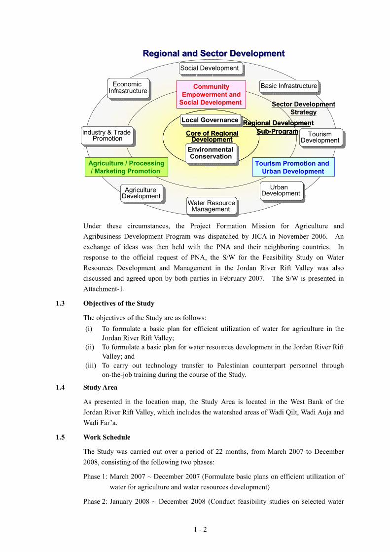
1 - 2
Under these circumstances, the Project Formation Mission for Agriculture and Agribusiness Development Program was dispatched by JICA in November 2006. An exchange of ideas was then held with the PNA and their neighboring countries. In response to the official request of PNA, the S/W for the Feasibility Study on Water Resources Development and Management in the Jordan River Rift Valley was also discussed and agreed upon by both parties in February 2007. The S/W is presented in Attachment-1.
1.3 Objectives of the Study
The objectives of the Study are as follows: (i) To formulate a basic plan for efficient utilization of water for agriculture in the
Jordan River Rift Valley; (ii) To formulate a basic plan for water resources development in the Jordan River Rift
Valley; and (iii) To carry out technology transfer to Palestinian counterpart personnel through
on-the-job training during the course of the Study.
1.4 Study Area
As presented in the location map, the Study Area is located in the West Bank of the Jordan River Rift Valley, which includes the watershed areas of Wadi Qilt, Wadi Auja and Wadi Far’a.
1.5 Work Schedule
The Study was carried out over a period of 22 months, from March 2007 to December 2008, consisting of the following two phases:
Phase 1: March 2007 ~ December 2007 (Formulate basic plans on efficient utilization of water for agriculture and water resources development)
Phase 2: January 2008 ~ December 2008 (Conduct feasibility studies on selected water
Regional DevelopmentSub-Program
Regional DevelopmentSub-ProgramCore of Regional
DevelopmentCore of Regional
Development
Sector DevelopmentStrategy
Regional and Sector DevelopmentRegional and Sector DevelopmentRegional and Sector DevelopmentRegional and Sector Development
Agriculture / Processing/ Marketing Promotion
CommunityEmpowerment and
Social Development
Tourism Promotion and Urban Development
Agriculture / Processing/ Marketing Promotion
Agriculture / Processing/ Marketing Promotion
CommunityEmpowerment and
Social Development
CommunityEmpowerment and
Social Development
Tourism Promotion and Urban Development
Tourism Promotion and Urban Development
Water ResourceManagement
Water ResourceManagement
AgricultureDevelopmentAgriculture
Development
Industry & TradePromotion
Industry & TradePromotion
Social DevelopmentSocial Development
Basic InfrastructureBasic Infrastructure
Tourism Development
Tourism Development
UrbanDevelopment
UrbanDevelopment
EconomicInfrastructure
EconomicInfrastructure
Local GovernanceLocal Governance
Environmental Conservation
Water ResourceManagement
Water ResourceManagement
1 - 3
resources management schemes for water resources development and for efficient utilization of water agriculture including implementation of small scale pilot projects)
M A M J J A S O N D J F M A M J J A S O N D1 2 3 4 5 6 7 8 9 10 11 12 13 14 15 16 17 18 19 20 21 22
Work in Palestine
Work in Japan
Report
Activity FY2007 FY2008
Phase-1 Phase-21st Year 2nd Year 3rd Year
IC/R PR1 It/R DF/R F/R
1.6 Counterpart and Steering Committee
The counterpart personnel assigned for the Study are as follows:
Counterpart Personnel Assigned
JICA Study Team Palestinian Counterpart
Name Position Name Organization
Kunio GOTO Team Leader/ Water Resource Management
Issam Nofal 1/
Deeb Abdel Ghafoor 1/
MoA
PWA
Toshio KATAYAMA Hydrological Analysis/ Water Harvesting
Mohannad Hej Hussein
Almotaz A. Abadi
MoA
PWA Toshiyuki WADA Groundwater Analysis /
Hydrogeology & Water Quality
Imad Ghanma
Deeb Abdel Ghafoor
Majida Almaneh
MoA
PWA
PWA Masahiko TANIGUCHI
Satellite Image/GIS Database
Yagoub Zaid
Waleed Abu Muhsin
Khaled Salem
MoA
PWA
EQA Jun HORIMOTO Plan & Design for Spring
Water Conveyance System
Mohanad Hej Hussein
Omar Zayed
MoA
PWA Abbas Zuhair KALBOUNEH
Plan & Design for Agricultural Well
Farah Sawuftah
Khairi
MoA
PWA Yuji MURASE Plan & Design for Storm
Water Harvesting Issam Nofal
Omar Zayed
MoA
PWA Akio YAMASHITA Water Management Ibtisam Abu Haija
Hanai Qasem
MoA
PWA Yasunobu KUDO Organization of Water
Management/Social Environment
Issam Nofal
Ayman Jarrar
Abdel Aziz Rayyan
MoA
PWA
EQA

1 - 4
JICA Study Team Palestinian Counterpart
Name Position Name Organization Abbas Zuhair KALBOUNEH
Supervision of Pilot Project
Mohannad Hej Hussein
Khairi
Omar Zayed
MoA
PWA
PWA Honorato G. PALIS Environmental Impact
Assessment Thaer Al-Rabi
Sbuhi Samhan
Mahmoud Abushanab
MoA
PWA
EQA Koji OTSUKA Financial Analysis/Project
Evaluation Raed Al-Aghber
Kamal Issa
Ibrahim Abdelrahim
MoA
PWA
MoP 1/ : Chief Counterpart Personnel MoA: Ministry of Agriculture PWA: Palestinian Water Authority EQA: Environment Quality Authority MoP: Ministry of Planning
For the smooth execution of the Study, a Steering Committee composed of the following major members was organized: (i) Palestinian Water Authority (PWA); (ii) Ministry of Agriculture (MoA); (iii) Ministry of Planning (MoP); (iv) Environment Quality Authority (EQA); (v) Resident Representative of JICA Palestine Office; (vi) Leader of the Study Team; and (vii) Others appointed by the Chairperson.

2 - 1
CHAPTER 2 OUTLINE AND ACTIVITIES OF THE STUDY
2.1 General
As explained in Section 1.5, the Study has been conducted from March 2007 to December 2008 in a series of works divided into two phases.
Phase-1 consists of: (i) Home Office Preparatory Work; (ii) First Field Work; and (iii) Second Field Work (1), while Phase-2 comprises: (iv) First Home Office Work; (v) Second Field Work (2); (vi) Second Home Office Work; (vii) Third Field Work; and (viii) Third Home Office Work.
The proceeding sections explain the outline of activities throughout the study period.
2.2 Outline of the Study
2.2.1 Home Office Preparatory Work (March 2007)
(1) Collection and Analysis of Relevant Data and Information
The existing relevant data, which includes agricultural development, agricultural product processing and marketing programs proposed in the Jericho Regional Development Study Project in Palestine, were reviewed and analyzed in order to identify major items and constraints for smooth execution of the First Field Work as an initial stage.
(2) Examination of Study Methodology and Preparation of Implementation Programs
The study plan and methodology, capacity development plan for the counterpart personnel etc., were examined. Subsequently, the implementation program for the Study was prepared.
(3) Preparation of the Inception Report
On the basis of the preliminary examination mentioned above, the Inception Report was prepared, containing: (i) Background of the Study; (ii) Objectives of the Study; (iii) Basic Approach to the Study; (iv) Contents and Methodology of the Study; (v) Work plan (flowchart of the work schedule, itineraries, sub-contracted works); (vi) Organization of the Study Team (assignment schedule and work period); (vii) Organization of Implementation of the Study (organization of counterpart and backup support of the home office; (viii) Reports to be submitted; (ix) Required Data for the Study; (x) Undertakings of PNA; and (xi) Policy and Plan for Capacity Development of the Palestinian Officials.
2.2.2 First Field Work (March 2007 to August 2007)
(1) First Steering Committee Meeting
The First Steering Committee Meeting was held in April 3, 2007 to discuss the Inception Report. The staff of JICA Headquarters also joined the meeting. After the explanation of report contents by the Study Team, related discussions were held among attendees, in order to obtain the committee’s joint acceptance of the report. The minutes of said meeting are included in this report as Attachment-2.

2 - 2
(2) Collection and Analysis of Relevant Data and Information
Existing relevant data, which includes agricultural development, agricultural product processing and marketing programs proposed in the Jericho Regional Development Study Project in Palestine, were collected, reviewed and analyzed in order to define the present situation and clarify the issues related to water utilization.
(3) Survey for Rural Society, Irrigated Agriculture and Water Resources
The following items were surveyed to determine the potentials and constraints of the water resources development in the Jordan River Rift Valley:
(i) Rural Society: (a) Natural condition, (b) Socio-economy, (c) Administrative institutions, and (d) Gender in rural society;
(ii) Irrigated Agriculture: (a) Farming, (b) Farmers’ organization, and (c) Irrigation methods and water management; and
(iii) Water Resources Development: (a) Water utilization, (b) Water volume and quality, (c) Irrigation facilities, and (d) Laws, regulations and customs for water utilization.
(4) Preparation of Inventory for Water Resources
Based on the results of data and information collected in 2.2.2-(2) above and the results of survey conducted in 2.2.2-(3) above, an inventory was prepared concerning the water resources in the Study Area.
(5) Improvement and Updating of Existing GIS Database
Improvement and updating of the existing GIS database were conducted based on the results of the survey and inventory discussed above. Capacity development of counterpart personnel and enhancement of organizations for the proper utilization of the GIS database were carried out, in order to produce unified information and to train the Palestinian personnel in periodically updating the data after the study period.
(6) Discussions with Other Donor Agencies
The Study Team discussed the contents of the Study with the other donors in-charge of the water resources development, as well as with the concerned agencies of neighboring countries. Information related to similar projects was also collected from these agencies.
(7) Preparation of Technology Transfer Program
The Technology Transfer Program in the study period was prepared for the respective counterpart personnel based on the responsibilities of each technical field. The program carried out throughout the study includes on-the-job trainings, meetings and seminars.
(8) Preparation of Basic Plan for Improvement of Spring Water Conveyance Systems
Basic plan for improvement of spring water conveyance systems was prepared through the detailed investigation and analysis of data.

2 - 3
1) Detailed Investigations
Spring water was investigated by means of field observations and interview surveys, which cover the following subjects:
(i) Laws and regulations concerning utilization of spring water; and (ii) Condition of spring water conveyance systems (Discharge, facilities, water
leakage, water quality etc.).
2) Analysis and Evaluation of Present Condition and Potential for Improvement
The existing springs were classified based on the investigation results and possibility of improvement was examined, e.g. improvement of conveyance facilities. Prioritization for the spring water conveyance systems was performed based on the examination results, with due consideration of the technical, economic, social and legal aspects.
3) Preparation of Basic Plan for Improvement of Spring Water Conveyance System
Basic plan for improvement of spring water conveyance systems was prepared based on the analysis and evaluation of their present conditions.
4) Selection of Priority Schemes for the Feasibility Study
The priority schemes for improvement of spring water conveyance system were selected from the above Basic Plan, considering viability, as well as the economic, social and legal aspects.
(9) Preparation of Basic Plan for Rehabilitation and Integrated Management of Agricultural Wells
Basic plan for rehabilitation and integrated management of agricultural wells was also prepared through the detailed investigation and analysis of data.
1) Detailed Investigation
Agricultural wells were investigated through field observations and surveys interviews, which cover the following topics:
(i) Laws and regulations related to the utilization of agricultural wells; (ii) Condition of wells (depth, water level, water volume, water quality,
hydro-geology, and ownership); and (iii) Operation and maintenance (O&M) of wells.
2) Analysis and Evaluation of Present Condition and Potential for Rehabilitation
The existing wells were classified based on their operations, management system, etc, and the possibility of their rehabilitation was examined considering technical and economic aspects.
3) Examination of Social Assessment
A social assessment was carried out to determine if a certain well could be utilized as community well.

2 - 4
4) Preparation of Basic Plan for Rehabilitation and Integrated Management of Agricultural Wells
Basic Plan for rehabilitation of agricultural wells was prepared based on the analysis and evaluation of their present conditions. Moreover, a plan for the institutional arrangements of water users associations for the integrated management of the wells was evaluated.
5) Selection of Priority Schemes for the Feasibility Study
The priority schemes for rehabilitation and integrated management of agricultural wells were selected from the above Basic Plan, considering the viability of the Plan as well as the economic, social and legal aspects.
(10) Execution of Initial Environmental Evaluations (IEE)
IEE of the scheme plans, such as the improvement of spring water conveyance systems and the rehabilitation and integrated management of agricultural wells were carried out. The results were also used as basis for the selection of the priority schemes for the Feasibility Study.
(11) Selection of Pilot Project
Pilot projects were selected in order to verify the suitability and effectiveness of the plans for the improvement of spring water conveyance systems and the rehabilitation and integrated management of agricultural wells as mentioned in the above (8) and (9).
(12) Preparation of Pamphlet
A pamphlet presenting the objectives and contents of the study was prepared in order to introduce the Study to the concerned Palestinian agencies, other donors agencies etc.
(13) Preparation of Progress Report (1)
Progress Report (1) was prepared based on the study results of the First Field Work, which includes following contents:
(i) Present conditions and issues of the Study Area; (ii) Results of rural society, irrigated agriculture and water resources studies; (iii) Basic Plan for improvement of spring water conveyance systems; (iv) Basic Plan for rehabilitation and integrated management of agricultural wells; (v) Basic approach to preparation of storm water harvesting for Wadi watersheds; (vi) Selection of pilot projects; (vii) Progress of technology transfer program; and (viii) Results of IEE.
(14) Second Steering Committee Meeting
A Second Steering Committee Meeting was held in July 23, 2007 to discuss the Basic Plan, Selection of Pilot Project and Schedule of Second Field Work. The resident representative of JICA Palestine joined the meeting. After the Study Team explained the above enumerated contents, related discussions among attendees took place in order to obtain committee’s joint acceptance of the proposed Basic Plan, the selected pilot projects
2 - 5
and the schedule of Second Field Work. The minutes of this meeting is included in this report as Attachment-3
2.2.3 Second Field Work (1) (October 2007 to March 2008)
(1) Detailed Survey for Agricultural Water Use
Conditions and information regarding spring water conveyance systems and agricultural wells during the winter season were collected and investigated. Results obtained were reflected on the Basic Plan prepared in (8) and (9) of Section 2.2.2.
(2) Preparation of Basic Plan for Storm Water Harvesting for Wadi Watersheds
1) Examination of Storm Water Harvesting
Hydrological analysis for watersheds was made focusing on surface water. Moreover, groundwater was analyzed by reviewing the water levels in the existing wells. The influences on the surrounding water resources by the development of storm water harvesting were assessed through the analysis.
2) Evaluation of Present Condition and Potential
Possibilities of storm water harvesting in the respective watersheds were examined through the evaluation of the present condition and its potential.
3) Preparation of Basic Plan for Storm Water Harvesting
Basic Plan for storm water harvesting for Wadi Qilt, Wadi Auja and Wadi Far’a watersheds was studied through the above examination.
(3) Supplemental Investigation for Selected Pilot Projects
Supplemental investigations in the selected pilot projects were executed to confirm the condition of the irrigation facilities and farming practices.
(4) Preparation of Implementation Schedule for the Pilot Projects
Implementation plans for the pilot projects were prepared, taking into consideration the farmers’ participation in water management, including the following contents:
(i) Work schedule; (ii) Target, outcome, activities, avoidance of expected risk etc.; (iii) Monitoring index; (iv) Methods and executing organization for monitoring and evaluation; and (v) Methods of extension of project outcomes.
(5) Implementation of Pilot Project
Upon approval of the Joint Water Committee (JWC) for the implementation of the pilot projects, rehabilitation of eight agricultural wells and improvement of a spring water conveyance system were commenced from December 2007 and February 2008, respectively, under the supervision of the Study Team.
2 - 6
(6) Feasibility Study for Priority Schemes
The feasibility study for the priority schemes, which have been selected during the First Field Work stage, was conducted based on detailed investigation.
(7) Preparation of Interim Report
An Interim Report was prepared mainly covering the activities and progress up to the interim stage of the study, with the following contents:
(i) Progress and issues of Pilot Projects; (ii) Plan for the improvement of spring water conveyance systems (1st revision); (iii) Plan for the rehabilitation and integrated management of agricultural wells
(1st revision); (iv) Basic Plan for storm water harvesting; and (v) Progress of the technology transfer program.
(8) Third Steering Committee Meeting
The Third Steering Committee Meeting was held in February 13, 2008 to discuss the contents of the Interim Report. The Basic Plan for water resources development and management, the activities and progress of the pilot projects, plan of the selected priority schemes as well as the schedule of the subsequent field work were accepted by the committee. The minutes of said meeting is presented in Attachment-4.
2.2.4 First Home Office Work (March 2008 to April 2008)
The Study Team explained the contents of the Interim Report to JICA Headquarters and the Advisory Committee in Japan. Their comments were reflected in the report.
2.2.5 Second Field Work (2) (May 2008 to August 2008)
The pilot projects were executed to confirm the validity and effectiveness of the improvement of spring water conveyance systems and the rehabilitation and integrated management of agricultural wells. The projects include not only the rehabilitation and improvement of facilities, but also the improvement of water management on farm level, and the establishment of an integrated management system for the wells.
Based on the lessons learned from the pilot projects, the Basic Plan for the improvement of spring water conveyance systems and the rehabilitation and integrated management of agricultural wells, formulated in the First Field Work, were revised. Then, the feasibility study for the improvement of spring water conveyance systems and the rehabilitation and integrated management of agricultural wells as well as preparation of preliminary plan for the storm water harvesting were carried out in the Second Field Work (2).
(1) Implementation and Monitoring of Pilot Project
Following the Second Field Work (1), implementation of the pilot projects were continued on a sub-contract basis, in accordance with the schedule approved by the agencies concerned. Monitoring of the pilot projects was conducted parallel with the implementation works.
2 - 7
Among the selected eight wells for the pilot projects, one well was abandoned due to high electric conductivity of its contained water, observed during 1st stage of the works.
(2) Execution of First Seminar
First Seminar was held in May 28 2008 at Ramallah to introduce the outcomes of the study and to promote its understanding. Palestinian agencies concerned, NGOs, donor agencies and other JICA study teams joined the seminar.
(3) Evaluation of Pilot Projects
Based on the monitoring index mentioned in (4) of Section 2.2.3, evaluation of the pilot projects was made and the corresponding lessons learned were reflected in the Basic Plan for the improvement of spring water conveyance systems and the Basic Plan for the rehabilitation and integrated management of agricultural wells.
(4) Feasibility Study for Selected Schemes
The feasibility study for the priority schemes, which have been selected during the First Field Work, was continued including collection of data and information required for the study as well as field investigations.
(5) Preparation of Development Plans (Draft) for Selected Schemes
1) Preparation of Development Plan (Draft)
Development plans (draft) for the selected schemes were prepared, which comprise the improvement of spring water conveyance systems, the rehabilitation and integrated management of agricultural wells and the storm water harvesting. The plans include not only the rehabilitation and improvement of facilities, but also the improvement of water management on farm level and the establishment of an integrated management system for the wells. Moreover, the urgency, development level, and possible financing sources for implementation, including Palestinian own budget and financing by other donors agencies were examined.
2) Economic and Financial Analysis
Economic and financial analysis was conducted based on valid input for cost estimates and benefits.
It is noted that available hydrological data are insufficient for the preparation of the feasibility study on storm harvesting plan. Continuous long-term data is required to prepare an accurate plan. Accordingly, the storm water harvesting plan in this report shall be reviewed and re-examined after accumulation of hydrological data.
(6) Preparation of Plan for Installation of Hydrological Station
It was observed that some of the existing hydrological stations in the study area are not functioning. In connection with (5) above, the plan for the rehabilitation and installation of hydrological observation system was formulated in order to observe continuous hydrological data in the study area.
(7) Preparation of Pilot Project Plan for Storm Water Harvesting
Plan of small scale pilot project was prepared to confirm the validity and effectiveness of

2 - 8
storm water harvesting, which could be implemented in parallel with the observation of long term hydrological data as mentioned in (6) above.
(8) Environmental Evaluation
Environmental impact in the proposed development plan (draft) mentioned in (5) as well as alterative plans to minimize the impact was examined.
(9) Preparation of Implementation Programs for the Selected Schemes
Implementation programs for the selected schemes were prepared, which included the executing body, implementation schedule and financial sources. The program is laid out on a yearly basis.
(10) Recommendations for Efficient Utilization of Water
Recommendations cover efficient utilization of water resources, including waste water and brackish water treatment means, draft rules for water distribution, draft organization of a water management system and methods for maintenance of facilities. Executing bodies, targets, indexes for attainment, implementation schedule, priority of the plan and management were also examined.
(11) Preparation of Draft Final Report
A Draft Final Report was prepared describing the study results throughout the study period including the feasibility study for the selected schemes. Contents of the report are as follows.
1) Basic Plan and Its Processes and Analysis:
(i) Plan for improvement of spring water conveyance system; (ii) Plan for rehabilitation and integrated management of agricultural wells; and (iii) Plan for storm water harvesting.
2) Contents of Pilot Projects and their Evaluation Results
3) Results of Feasibility Study:
(i) Background for selection of priority schemes; (ii) Development plan for selected schemes; (iii) Operational plan; (iv) Maintenance plan; (v) Implementation program; (vi) Evaluation and conclusions; and (vii) Recommendations.
4) Recommendations for Efficient Utilization of Water
(12) Fourth Steering Committee Meeting
The Fourth Steering Committee Meeting was held in August 19, 2008 to discuss about the final outcomes of the Study. The Basic Plan for water resources development and
2 - 9
management, results of the pilot projects, plan of the selected priority schemes including their implementation plan and recommendations to efficient utilization of water were accepted by the Committee. The minutes of said meeting is presented in Attachment-5.
2.2.6 Second Home Office Work (September 2008)
(1) Discussion of Draft Final Report
The Study Team explained the contents of the Draft Final Report to JICA Head Quarter and the Advisory Committee in Japan. Their comments were consequently reflected in the report.
(2) Preparation of Final Report
The Draft Final Report was modified and finalized according to the comments received from PNA, as well as the comments from JICA and the Advisory Committee in Japan.
2.2.7 Third Field Work (November 2008)
(1) Explanation of Final Report to PNA
The Final Report was explained to the Palestinian agencies concerned to obtain consensus for the contents of the report.
(2) Execution of Second Seminar
Second Seminar was held in November 19, 2008 to explain and to obtain the understanding on the outcomes of the Study. Palestinian agencies concerned, NGOs, donor agencies and other JICA study teams joined this seminar.
2.2.8 Third Home Office Work (December 2008)
(1) Submission of Final Report
The Final Report was submitted after obtaining final approval by JICA.
Related Documents