Anda Ruskule W 2/2 Applying ecosystem approach Senior MSP Practitioner at Baltic Environmental Forum (BEF) (HELCOM-VASAB) #BalticMSP The Ecosystem Approach in Latvian MSP

The Ecosystem Approach in Latvian MSP at the 2nd Baltic Maritime Spatial Planning Forum
Feb 08, 2017
Welcome message from author
This document is posted to help you gain knowledge. Please leave a comment to let me know what you think about it! Share it to your friends and learn new things together.
Transcript

Anda Ruskule
W 2/2 Applying ecosystem approach
Senior MSP Practitioner at Baltic Environmental Forum (BEF)
(HELCOM-VASAB)
#BalticMSP
The Ecosystem Approach in Latvian
MSP

Stocktaking phaseTrade-off analysis of four maritime use scenarios
Development of optimum maritime use solution and
conditions for sea uses
Strategic environmental assessment of the MSP
Implementation of the ecosystem approach in Latvian MSP
January, 2015 April, 2016Long term vision and goals
• Characteristics of marine environment: geology, salinity, water temperature, nutrients etc.
• Available data on species, coastal habitats, landscape, cultural heritage
• Mapping of benthic habitats• Mapping of ecosystem services
Assessing impacts on marine ecosystem status against selected criteria – MSFD descriptors and indicators applied:
• Biodiversity (D1)• Population of commercial fish and
shellfish (D3)• Spawning stock biomass • Elements of marine food webs (D4)• Eutrophication (D5)• Sea floor integrity (D6)
Assessing sensitivity of habitats and species to different human impacts - Impact matrix :
• Shipping• Offshore constructions• Fishery• Aquaculture• Tourism• Military operations
Best knowledge and practice Precaution & mitigation
Alternative developments
Identification of ecosystem services Relational understanding
Participation and communication
Subsidiarity & coherence
Adaptation

Mapping of marine ecosystem and services

Regulating services
Ecosystem service assessment approaches
Cultural services
Provisioning services
• Characterization of the ecosystem structures and functions and relation to ES provisioning
• Applies quantitative biophysical measurements, based on spatial data or modelling, expert judgement
Biophysical assessment
• Involves stakeholders, assess importance of particular ES for particular stakeholders groups
• Applies sociological surveys, interviews , focus group discussions
Social assessment
• Assess particular ES of their total value in monetary terms
• Applies economic valuation methods, e.g. market value analysis, avoided damage costs, contingent valuation –WTP, etc.
Economic assessment

Development benthic habitat map Habitat classification using HELCOM HUB, 2013, including levels 3 - defined according to substrate; level 4 -
community structure; level 5 - typical communities
Spatial and biophysical data applied:
Sea bottom sediment map Secchi depth and bathymetry data Benthic biology data (field observations)

Provisioning services
Wild plants, algae and their outputsArea covered by red algae Furcellaria
lumbricalis
Wild animals and their outputsTotal catch of commercially important fish
species
Regulating services
Bio-remediation
Filtration/sequestration/storage/accumulation
Maintaining nursery populations and habitats
Global climate regulation
Cultural servicesPhysical and experiential
interactions Marine tourism and leisure possibilities at
the coastal areas
Eutrophication control through denitrification, storage of nutrients and
pollutants
Benthic habitats for carbon storage
Benthic habitats as nursery sites for fish species
Filtration of nutrients by mussels
Identification of ecosystem services (CICES v4.3)

Mapping of provisioning services
Wild animals and their outputs - fish for food: the total catch of commercially important fish species in the open sea within 10 years period
mapping based on statistical data from fishery logbooks
values presented in scale 1-5

Mapping of provisioning services
Wild plans, algae and their outputs - red algae Furcellaria lumbricalis beds, potentially to be used in food industry, pharmacy, etc.
Mapping based on expert knowledge on benthic habitats suitable for growth of red algae + field survey data (coverage of species - % of area unit)
values presented in scale 1-3 (1 - habitat suitable for species, but no occurrence detected; 2- low occurrence detected; 3-high occurrence detected)

Mapping of regulating services
6 regulation and maintenance service maps
- Bio-remediation:
- Filtration of nutrients by animals (mussels)
- Maintaining nursery populations and habitats - nursery sites for fish species
- Global climate regulation - carbon storage
- eutrophication control through denitrification- eutrophication control through storage of nutrients- storage of pollutants
Mapped based benthic habitat map - using the habitats types as proxy for distribution of the ecosystem service:
Potential supply of ES within each habitat type assessed based on expert knowledge
Binary assessment: does the particular habitat type provide the particular service or not – 0/1
Summaru map: number of ES provides by bethichhabitat type/grid cell

Mapping of cultural services
Physical and experiential interactions - Marine tourism and leisure possibilities at the coastal areas
Based on expert knowledge and field observations
suitability of each grid for cell marine tourism and leisure activities at the coast assessed based on combination of several criteria:
number of visitors (survey data);
suitability of the area (or best place) for particular tourism or leisure activity/life style (e.g. angling, bird watching, kiteboard, etc.);
accessibility – presence of parking lots and public access roads near the coast
Assessment results presented in scale 1-5 (from 1-very low suitability to 5 – very high suitability)
Assessing impacts of alternative scenarios and proposed sea use solutions
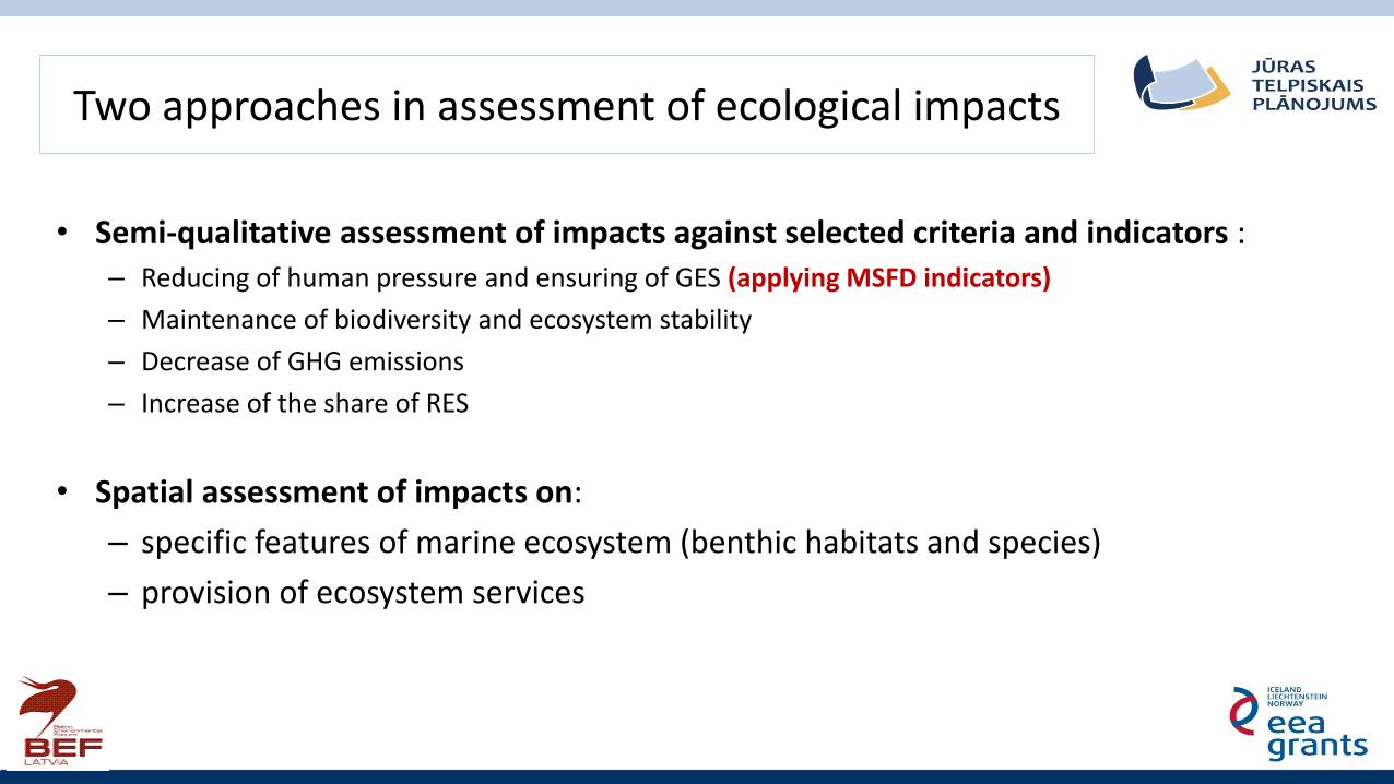
Two approaches in assessment of ecological impacts
• Semi-qualitative assessment of impacts against selected criteria and indicators :– Reducing of human pressure and ensuring of GES (applying MSFD indicators)
– Maintenance of biodiversity and ecosystem stability
– Decrease of GHG emissions
– Increase of the share of RES
• Spatial assessment of impacts on:
– specific features of marine ecosystem (benthic habitats and species)
– provision of ecosystem services

- Reducing of human pressure and ensuring of GES
- Maintenance of biodiversity and ecosystem stability
- Decrease of GHG emissions- Increase of the share of RES
Trade-off assessment of scenarios against selected criteria and indicators
A B C D
Economic impact 1,2 1,0 0,8 1,0
Social impact 0,8 1,5 0,3 0,8
Impact on environment and climate change -0,5 -0,8 0,8 0,5
Transboundary impact 0,6 -0,2 1,0 1,0
Average value 0,5 0,4 0,7 0,8
-2 Significant negative impact
-1 Slightly negative impact
0 No impact
1 Slightly positive impact
2 Significant positive impact

Applied MSFD descriptors and indicators in assessing scenarios and proposed sea use solutions
Descriptors Indicators Expected impact of proposed sea use solutions
Biodiversity (D1) Share of marine protected areas from all marine waters (%)
Expected increase
Conservation status of protected habitat types Change of the status from “ bad” to “good’
Benthic Quality Index BQI Potential reduction of nutrient loads by introducing algae and mussels aquaculture
Population of commercial fish and shellfish (D3)
Spawning stock biomass Nutria impact
Elements of marine food webs (D4)
Zooplankton mean size vs. total stock Potential reduction of nutrient loads by introducing algae and mussels aquaculture
Eutrophication(D5)
Nutrient (N, P) loads in surface waters from point sources
Potential reduction of nutrient loads by introducing algae and mussels aquaculture
Summer chlorophyll a concentration
Depth distribution of Fucus vesiculosus and Furcellarialumbricalis
Sea floor integrity (D6) Population structure of Macoma balthica Possible negative impact dues to continuation of demersal trawling

Sea use impact matrix applied for spatial assessment of impacts
Sea uses that are planned by MSP
Benthic habitats
Ship
pin
g
Enco
ura
ge a
reas
Dre
dgi
ng
Du
mp
ing
site
s
Off
-sh
ore
win
d e
ne
rgy
Wav
e e
ne
rgy
Cab
les
Oil
extr
acti
on
Aq
uac
ult
ure
-fis
h
Aq
uac
ult
ure
-al
gae
Aq
uac
ult
ure
-m
uss
els
Bat
hin
g si
tes
Kit
e-b
oar
d
An
glin
g
Div
ing
Mo
torb
oat
s
Co
asta
l fis
her
y
Op
en s
ea f
ish
ery
wit
h
pel
agic
tra
wl
Op
en s
ea f
ish
ery
wit
h
ben
thic
tra
wl
Op
en s
ea f
ish
ery
wit
h
pas
sive
gea
rs
Mili
tary
tra
inin
g ar
eas
Co
astl
ine
pro
tect
ion
-b
each
no
uri
shm
ent
AA.A: Baltijas jūras fotiskās zonas klintājs un laukakmeņi 1 1 1 2 2 1 1 1 2 2 1 0 0 0 1 1 1 2 2 2 1 2
AA.A1: Baltijas jūras fotiskās zonas klintājs un laukakmeņi ar makroskopisko epibentosu 1 1 1 2 2 1 1 1 2 2 1 0 0 0 1 1 1 2 2 2 1 2
AA.A2: Baltijas jūras fotiskās zonas klintājs un laukakmeņi ar retu makroskopisko epibentosu 1 1 1 2 2 1 1 1 2 2 1 0 0 0 1 1 1 2 2 2 1 2
AA.H3N: Baltijas jūras fotiskās zonas dūņu nogulumi ar vēžveidīgo infaunu 1 1 1 1 1 0 1 1 2 2 1 0 0 0 0 1 1 1 2 1 1 1
AA.I: Baltijas jūras fotiskās zonas rupjgraudainie nogulumi 1 1 1 1 1 0 1 1 2 2 1 0 0 0 0 1 1 1 2 1 1 1
AA.J: Baltijas jūras fotiskās zonas smilts 1 1 1 1 1 0 1 1 2 2 1 0 0 0 0 1 1 1 2 1 1 1
AA.J1: Baltijas jūras fotiskās zonas smilts ar makroskopisko epibentosu 1 1 1 2 1 0 1 1 2 2 1 0 0 0 1 1 1 1 2 1 1 1
AA.J3: Baltijas jūras fotiskās zonas smilts ar makroskopisko infaunu 1 1 1 1 1 0 1 1 2 2 1 0 0 0 0 1 1 1 2 1 1 1
AA.J3L: Baltijas jūras fotiskās zonas smilts ar gliemeņu infaunu 1 1 1 1 1 0 1 1 2 2 1 0 0 0 0 1 1 1 2 1 1 1
AA.M1: Baltijas jūras fotiskās zonas jaukts substrāts ar makroskopisko epibentosu 1 1 1 2 2 1 1 1 2 2 1 0 0 0 1 1 1 2 2 2 1 2
AA.M2: Baltijas jūras fotiskās zonas jaukts substrāts ar retu makroskopisko epibentosu 1 1 1 2 2 1 1 1 2 2 1 0 0 0 1 1 1 2 2 2 1 2
AA.M4: Baltijas jūras fotiskās zonas jaukts substrāts bez makrobentosa 1 1 1 1 2 1 1 1 2 2 1 0 0 0 0 1 1 2 2 2 1 2
AB.A: Baltijas jūras afotiskās zonas klintājs un laukakmeņi 0 1 1 2 2 1 1 1 2 2 1 0 0 0 1 0 0 2 2 2 1 2
AB.A1: Baltijas jūras afotiskās zonas klintājs un laukakmeņi ar makroskopisko epibentosu 0 1 1 2 2 1 1 1 2 2 1 0 0 0 1 0 0 2 2 2 1 2
AB.B: Baltijas jūras afotiskās zonas morēna 0 1 1 1 2 1 1 1 2 2 1 0 0 0 0 0 0 2 2 2 1 2
AB.H: Baltijas jūras afotiskās zonas dūņu nogulumi 0 0 1 1 1 0 1 1 2 2 1 0 0 0 0 0 0 1 2 1 1 1
AB.H3: Baltijas jūras afotiskās zonas dūņu nogulumi ar makroskopisko infaunu 0 0 1 1 1 0 1 1 2 2 1 0 0 0 0 0 0 1 2 1 1 1
AB.H3N: Baltijas jūras afotiskās zonas dūņu nogulumi ar vēžveidīgo infaunu 0 0 1 1 1 0 1 1 2 2 1 0 0 0 0 0 0 1 2 1 1 1
AB.I: Baltijas jūras afotiskās zonas rupjgraudainie nogulumi 0 0 1 1 1 0 1 1 2 2 1 0 0 0 0 0 0 1 2 1 1 1
AB.J: Baltijas jūras afotiskās zonas smilts 0 0 1 1 1 0 1 1 2 2 1 0 0 0 0 0 0 1 2 1 1 1
AB.J3: Baltijas jūras afotiskās zonas smilts ar makroskopisko infaunu 0 0 1 1 1 0 1 1 2 2 1 0 0 0 0 0 0 1 2 1 1 1
AB.J3L: Baltijas jūras afotiskās zonas smilts ar gliemeņu infaunu 0 0 1 1 1 0 1 1 2 2 1 0 0 0 0 0 0 1 2 1 1 1
AB.M: Baltijas jūras afotiskās zonas jaukts substrāts 0 0 1 2 1 0 1 1 2 2 1 0 0 0 0 0 0 1 2 1 1 1
AB.M1: Baltijas jūras afotiskās zonas jaukts substrāts ar makroskopisko epibentosu 0 0 1 2 1 0 1 1 2 2 1 0 0 0 1 0 0 1 2 1 1 1
AB.M2: Baltijas jūras afotiskās zonas jaukts substrāts ar retu makroskopisko epibentosu 0 0 1 2 1 0 1 1 2 2 1 0 0 0 1 0 0 1 2 1 1 1
AB.M4: Baltijas jūras afotiskās zonas jaukts substrāts bez makrobentosa 0 0 1 2 1 0 1 1 2 2 1 0 0 0 0 0 0 1 2 1 1 1
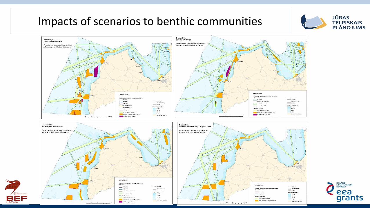
Impacts of scenarios to benthic communities
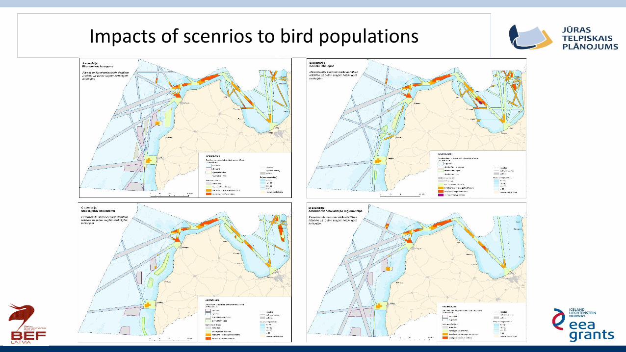
Impacts of scenrios to bird populations

Impacts to ecosystem services provided by benthic habitats

Impacts of proposed sea use solution to benthic habitats

Impacts of proposed sea use solution to areas important for bird species

Impacts of proposed sea use solution to areas important for fish species

Impacts of proposed sea use solution to areas important for regulating services

Related Documents


![WELCOME! [oportunidadesinternacionais.ufsc.br]oportunidadesinternacionais.ufsc.br/files/2017/04/Baltic-Summer... · and Latvian are Indo-European languages, ... Latvia have already](https://static.cupdf.com/doc/110x72/5b1c89c27f8b9af2348bc004/welcome-oportun-oportun-and-latvian-are-indo-european-languages-latvia.jpg)