Biological Report 85(7.9) February 1987 THE ECOLOGY OF THE COASTAL MARSHES OF WESTERN LAKE ERIE: A COMMUNITY PROFILE Fish and Wildlife Service U.S. Department of the Interior Corps of Engineers U.S. Department of the Army

Welcome message from author
This document is posted to help you gain knowledge. Please leave a comment to let me know what you think about it! Share it to your friends and learn new things together.
Transcript
Biological Report 85(7.9) February 1987
THE ECOLOGY OF THE COASTAL MARSHES OF
WESTERN LAKE ERIE:
A COMMUNITY PROFILE
Fish and Wildlife Service
U.S. Department of the Interior Corps of Engineers
U.S. Department of the Army

Cover. Aerial view of Old Woman Creek National Estuarine Sanctuary. Note the decrease in wave height within the estuary (August 1983).

Biological Report 85(7.9) February 1987
THE ECOLOGY OF THE COASTAL MARSHES OF WESTERN LAKE ERIE: A COMMUNITY PROFILE
by
Charles E. Herdendorf Center for Lake Erie Area Research
Department of Zoology The Ohio State University
Columbus, OH 43210
Project Officer
Walter G. Duffy National Wetlands Research Center U.S. F1sh and Wildlife Service
1010 Gause Boulevard SUdell, LA 70458
19970318 082 Prepared for
National Wetlands Research Center F1sh and Wildlife Service
U.S. Department of the Interior Washington, DC 20240
DTIC QUALITY XUHfECTED 1

Library of Congress Cataloging-in-Publication Data
Herdendorf, Charles E. The ecology of the coastal marshes of western Lake
Erie.
(Biological report ; 85 (7.9)) Bibliography: p. Supt. of Docs, no.: I 49.89/2:85(7.9) 1. Marsh ecology—Erie, Lake. I. Duffy, Walter G.
II. National Wetlands Research Center (U.S.) III. Title. IV. Series: Biological report (Washington, D.C.) ; 85-7.9. QH104.5.E73H47 1987 574.5'26325;097712 86-607954
This report should be cited as follows:
Herdendorf, C.E. 1987. The ecology of the coastal marshes of western Lake Erie: a community profile. U.S. Fish Wildl. Serv. Biol. Rep. 85(7.9). 171 pp. + micro- fiche appendices.

PREFACE
This profile on the coastal wetlands of western Lake Erie 1s one of a series of community profiles that deal with marine and freshwater habitats of ecological Importance. The estuaries, lagoons, and coastal marshes which fringe the Ohio, Michigan, and Ontario shores of western Lake Erie are among the most productive areas in the Great Lakes. Because they occur within a densely populated, heavily industrialized, and intensely agricultur- al 1zed region, the marshes have suffered losses in both area and quality. However, the remaining marshes are vital habitats for migratory waterfowl, furbearers, and fish, and perform many Important hydro- logical and ecological functions.
The Glossary of Geology (Bates and Jackson 1980) defines "freshwater estu- aries" for the Great Lakes as "the lower reach of a tributary to the lake that has a drowned river mouth, shows a zone of transition from stream water to lake water, and is influenced by changes in lake level as a result of seiches or wind tides." Brant and Herdendorf (1972) were among the first investigators to describe the characteristics of Great Lakes estuaries. Such estuaries are Important wetland habitats 1n western Lake Erie. The definition given above provides an adequate physical description for the purposes of this report.
Lake Erie 1s noted for its severe storms, intense wave attack, and rapid water level changes. The high energy produced by these storms limits the existence of coastal wetlands to places where some type of natural or artificial
protection is available. Correspondingly, the coastal marshes of western Lake Erie fall Into three categories depending on the type of protection for the aquatic vegetation: 1) coastal lagoons behind barrier beaches, 2) estuarine tributary mouths, and 3) managed marshes protected by earthen and rip-rap dikes. According to Cowardin et al. (1979), these wetlands would Include elements of riverine, lacustrine, and palustrine systems.
The information in this report is intended to provide a basic understanding of the ecological relationships in the western Lake Erie coastal marshes and the impact of natural and human-induced disturbances on the marsh community. References are provided for those seeking more detailed treatment of specific aspects of the coastal marsh ecology. Appendices are included and list the dimensions and ownership of the major marshes and the Important biological species of algae, macrophytes, invertebrates, fish, amphibians, rep- tiles, birds, and mammals occurring 1n the coastal marshes.
Any questions or comments about or requests for thi|s publication should be addressed to:
Information Transfer Specialist National Wetlands Research Center U. S. Fish and Wildlife Service NASA-SIidell Computer Complex 1010 Gause Boulevard SIIdell, LA 70458 (504)646-7310, FTS 680-7310.

CONVERSION FACTORS
FOR METRIC (SI) UNITS TO U.S. CUSTOMARY UNITS OF MEASUREMENT
Metric (SI) units of measurement used in this report can be converted to U.S. customary units as follows:
Multiply
Linear measurements:
millimetres (mm) centimetres (cm) metres (m) kilometres (km)
Area measurements:
square metres (m2) hectares (ha) square kilometres (km2)
Volume measurements:
cubic metres (m3) cubic metres (m3) cubic kilometres (km3)
Mass measurements:
grams (g) kilograms (kg) metric tons (m ton)
hx. To obtain
0.039 0.394 3.281 0.621
inches (in) inches (in) feet (ft) miles (mi)
10.764 2.471 0.386
square feet (ft2) acres square miles (mi2)
35.318 1.308 0.240
cubic feet (ft3) cubic yards (yd3) cubic miles (ml3)
0.035 2.205 1.102
ounces (oz) pounds (lb) U.S. tons (ton)
Rate measurements:
centimetres per second (cm/sec) metres per second (m/sec) metres per second (m/sec) cubic metres per second (m3/sec) metres per hour (m/hr) kilometres per hour (km/hr)
0.394 inches per second (in/sec) 3.281 feet per second (ft/sec) 1.943 nautical miles per hour (knot)
35.318 cubic feet per second (cfs) 3.281 feet per second (ft/sec) 0.621 miles per hour (mph)
Temperature measurements:
degrees Celsius (°c) 9/5°C + 32 degrees Farenhelt (°F)
CONTENTS
Page
PREFACE 117
CONVERSION FACTORS iv
FIGURES v11 TABLES x ACKNOWLEDGMENTS xi
Chapter 1. INTRODUCTION 1
1.1 Coastal Wetlands of the Great Lakes 1 1.2 Comparison of Coastal and Inland Wetlands 2 1.3 Function and Value of Coastal Wetlands 4 1.4 Distribution of Western Lake Erie Coastal Marshes 4
Chapter 2. PHYSICAL ENVIRONMENT 22
2.1 Geology 22
2.2 Climate and Weather 39 2.3 Hydrology 43 2.4 Water Quality 51
Chapter 3. BIOTIC ENVIRONMENT 57
3.1 Phytoplankton, Periphyton, and Zooplankton 57 3.2 Wetland Vegetation 64 3.3 Invertebrates 83 3.4 Fish 93 3.5 Amphibians and Reptiles 99 3.6 Bi rds 104 3.7 Mammals 113
Chapter 4. ECOLOGICAL PROCESSES 120
4.1 Origin and Existence of Coastal Marshes 120 4.2 Biological Productivity 123 4.3 Community Processes 132 4.4 Coastal Marshes as F1sh and Wildlife Habitat 138
Chapter 5. WETLAND DISTURBANCE AND MARSH MANAGEMENT 139
5.1 Wetland Disturbance 140 5.2 Wetland Ownership and Management ..., 153 5.3 Prospects for the Future 157
REFERENCES 159
Page
APPENDICES (MICROFICHE) 173
A Dimensions of Western Lake Erie Coastal Wetlands by United States and Canada Quadrangle Maps 173
B Ownership of Major Coastal Marshes 1n Western Lake Erie 175 C Common Algae Occurring 1n the Coastal Marshes and Nearshore Waters
of Western Lake Erie 177 D Common Protozoans and Zooplankton Occurring 1n the Coastal Marshes
and Nearshore Waters of Western Lake Erie 194 E Habitat Preference of Aquatic Plants 1n Western Lake Erie 204 F Aquatic Vascular Plants of Sandusky Bay and the Sandusky River
Estuary ,. 213 G Common BenthicjMacroinvertebrates of Sandusky Bay 217 H Taxonomic Listing of Freshwater Mollusca of Western Lake Erie
Coastal Marshes^ Nearshore Waters, and Tributary Mouths 219 I Habitat Preference of Freshwater Mollusca of Western Lake Erie
Coastal Marshes and Nearshore Waters 223 J Fish Species of Lake Erie Wetlands 226 K Amphibians and Reptiles Occurring in the Vicinity of Western Lake
Erie Coastal Wetlands 232 L Birds Occurring in the Vicinity of Western Lake Erie Coastal
Marshes 234 M Mammals of the Western Lake Erie Coastal Marshes 240
VI

FIGURES
Number EäflS
1 Map of the Great Lakes drainage basin 2 2 Study area 1n Ohio, Michigan, and Ontario 5 3 Western Lake Erie coastal marshes 1n Michigan, Ohio, and Ontario ... 6 4 Barrier beach at Sterling State Park, Monroe, Michigan 8 5 Coastal landforms of Woodtlck Peninsula Marsh, Michigan 9 6 Cross section of Woodtlck Peninsula Marsh, Michigan 10 7 Grassy Island, a diked containment structure for harbor dredglngs
1n Toledo Harbor, Ohio 10 8 Location map of Federal- and State-owned coastal marshes 1n the
vicinity of Locust Point, Ohio .. „, 11 9 R1p-rap dike separating Lake Erie from Darby Marsh 12 10 Rocky shoreline of South Bas"3 Island 13 11 Heron and egret nests 1n flooded margins of Lake Henry,
Pelee Island 13 12 Aquatic vegetation 1n a portion of Middle Harbor, Ohio 14 13 East end of Sandusky Bay and Cedar Point sand spit, showing
marsh development 1n a sheltered lagoon IS 14 Aerial view of Cedar Point sand spit, showing breach 1n the
barrier 16 15 B1g Island, an experimental marsh 1n Sandusky at the mouth
of Pipe Creek 17 16 Aerial view of Bay Point sand spit and marshes at the entrance
to Sandusky Bay , • • • • 17 17 Willow Point Marsh, an example of a diked wetland on the south
shore of Sandusky Bay 18 18 Emergent stands of river bulrush and floating leaves of white
water lily at Old Woman Creek Estuary 20 19 Aerial photograph of Point Pelee National Park, Ontario 21 20 Depth contours of western and central Lake Erie ... 22 21 Physiographic map of the Lake Erie basin ..........a..*.*...,.«.«..... 22 22 Geologic map of western Lake Erie 25 23 Bedrock geology of Ottawa County, Ohio 26 24 Geologic cross section of the bedrock underlying South Bass aid
Kelleys Islands • 27 25 Location map of Islands, reefs, and shoals in western Lake Erie .... 28 26 Explanation of cave and sinkhole formation 1n the islands region
of Lake Erie 30 27 Pregladal drainage 1n western Lake Erie as Inferred from bedrock
surface 32 28 Map of prominent beach ridges abandoned by post-glacial lakes
1n northern Ohio 32 29 Distribution of bottom deposits In the Islands area of western
Lake Erie 35 30 Marsh deposits at Magee Marsh 37 31 Cross section of barrier beach and lagoon at Magee Marsh, Ohio 37 32 Cross section through Point Pelee 38 33 Annual air temperature curves for Toledo, Put-in-Bay, and Buffalo .. 39

Number Page
34 Average monthly precipitation at four locations on Lake Erie 40 35 Annual precipitation over Lake Erie drainage basin 40 36 Average annual winds at Sandusky, Ohio 41 37 Monthly percent of possible sunshine at Toledo, Ohio 42 38 Map of major watersheds 1n the western and central Lake Erie
drainage basins 44 39 Annual frequency of occurrence of seiche periods at Put-In-Bay,
Oh 10 46 40 Dominant surface and bottom current patterns 1n western Lake Erie .. 48 41 Yearly water and air temperature curves for western Lake Erie 54 42 Nearshore concentrations of total phosphorus in western Lake Erie .. 55 43 Seasonal trends in phytoplankton populations in Fishery Bay,
South Bass Island, Ohio 60 44 Map of the northern side of South Bass Island showing the location
of Terwilliger's Pond and Fishery Bay 63 45 Seasonal trends 1n Zooplankton populations 1n Fishery Bay, South
Bass Island, Ohio 64 46 Distribution maps of 24 aquatic macrophytes in western Lake Erie
wetl ands 66 47 Emergent beds of American water-lotus 1n Fish Point Marsh on
Pelee Island, Ontario 70 48 Emergent colony of arrow arum and several clumps of buttonbush
at 01 d Woman Creek Estuary 71 49 Gravel beach on the south shore of West Sister Island 72 50 Coastal landforms at Toussalnt Marsh complex 76 51 Floating beds of American water-lotus in open water habitat at
Old Woman Creek Estuary 73 52 Mouth of Old Woman Creek completely barred across by a barrier 79 53 Aerial photograph of Old Woman Creek Estuary during low water
conditions 3g 54 Aerial photograph of Old Woman Creek Estuary during high water
conditions 3^ 55 Aquatic macrophytes In cove at Old Woman Creek Estuary 32 56 Benthlc Invertebrate communities of the Islands area of western
Lake Erie 34 57 Distribution of aquatic invertebrate communities 1n the lower
Detroit River 35 58 Submersed aquatic plants from Fishery Bay, South Bass Island 39 59 Spawning and nursery grounds of lake sturgeon, northern pike,
carp, emerald shiner, white bass, and walleye 1n the lower Detroit River . 94
60 Spawning and nursery grounds for Important western Lake Erie fish species 95
61 Fish collected 1n a trapnet set at the estuarine mouth of Pickerel Creek In Sandusky Bay .....; 99
62 Water level control structure between Sandusky Bay and Wlnous Point Marsh 100
63 Length frequency of gizzard shad entering and exiting a control led marsh 101
64 Great blue heron 105 65 Black-crowned night-heron nest at Fox's Pond, North Bass
Island, Ohio 105 66 Group of juvenile double-crested cormorants near Pelee
Island , Ontario 106 67 Fall migration corridors for dabbling ducks across western
Lake Erie 109
viii

UüSML Page
68 Fall migration corridors for diving ducks across western Lake Erie . 110
69 Fall migration corridors for Canada geese across western Lake Erie Ill
70 Young American bitterns 1n the nest at Magee Marsh Ill 71 Muskrat house 1n process of construction at Magee Marsh 114 72 Raccoon, a common predator of duck nests 1n Winous Point Marsh 117 73 Energy pyramid 1n Lake Erie coastal marshes 124 74 Seasonal growth of submersed macrophyte taxa In the Detroit River... 128 75 Diagram of the detritus food chain 1n Sandusky Bay Estuary 131 76 Wetland succession 1n a Lake Erie beach pond at Presque Isle,
Pennsylvania 134 77 Succession of dragonfly species as marshes on the Bass Islands
develop and age from open water to closed ponds 135 78 Seasonal variation in Zooplankton productivity, relative
contribution of zooplanktonlc taxa to that productivity, and distribution of major Ichthyoplankton taxa 1n western Lake Erie .... 137
79 Invertebrate diet for yellow perch larvae and juveniles 138 80 Extent of wetlands bordering western Lake Erie 1n 1800 compared
to 1984 distribution of coastal marshes 139 81 Extent of the Black Swamp 1n northwestern Ohio 140 82 Map of streams tributary to western Lake Erie 141 83 Comparison of the coastal marshes at the mouth of the River
Raisin between 1915 and 1974 143 84 Barrier beach at Magee Marsh being breached by waves during a
northeast storm ».. 144 85 Comparison of Woodtlck Peninsula Marsh between 1937 and 1975 145 86 Distribution of wetland vegetation 1n 1950 and 1977 at Toussaint
Marsh, Ohio 146 87 Aquatic macrophyte displacement model for western Lake Erie 147 88 Pollution 1n Maumee Bay as Indicated by concentration of
tubifidds 1n the bottom sediments * 150 89 Ice cover 1n western Lake Erie under various conditions 151 90 Winous Point Marsh during drawdown stage 155 91 Interior region of Winous Point Marsh ,.. 156 92 Water level control structure between Sandusky Bay and Winous
Point Marsh I57
TABLES
Number Eäflfi
1 Comparison of coastal wetlands for the Laurentlan Great Lakes within the United States 3
2 Morphometry of Lake Erie 24 3 Glacial lake stages of the Lake Erie basin 33 4 Average monthly duration of daylight for western Lake Erie 42 5 Western Lake Erie tributaries .. 45 6 Chemical and physical characteristics of Detroit River and
western Lake Erie waters 51 7 Water quality measurements 1n three western Lake Erie marshes
during the growing season 52 8 Water quality measurements 1n Navarre Marsh, Ohio 53 9 Mean dally solar radiation received at the surface of Lake Erie .... 54
10 Annual deposition of airborne substances 1n Lake Erie 56 11 Abundance of phytoplankton 1n the vicinity of four-coastal
wetlands 1n western Lake Erie 58 12 Relative abundance of species of algae by marsh locality 1n
western Lake Erie 59 13 Dominant diatom perlphyton on macrophytes 1n western Lake Erie
marshes 61 14 Comparison of phytoplankton and Zooplankton populations for
nearshore localities 1n western Lake Erie «,. 62 15 Benthlc macrolnvertebrates of the lower Detroit River wetlands
and their relative tolerance to pollution 86 16 Benthlc macrolnvertebrate population of the lower Detroit River .... 87 17 Invertebrates collected 1n Navarre Marsh, Ohio 88 18 Invertebrate animals found on plants 1n western Lake Erie
wetlands 89 19 Western Lake Erie unlonld bivalves and their glochldlal host fish .. 92 20 Food items of muskrats 1n Lake Erie coastal wetlands 115 21 Habitat and den characteristics of raccoons 1n Wlnous Point Marsh .. 118 22 Blomass and productivity of emergent wetland plants of the Great
Lakes region 126 23 Estimated standing crop blomass for submersed vegetation 1n
Anchor Bay, Lake St. Clalr 127 24 Seasonal estimates of standing crop blomass for submersed
macrophytes 1n the Lake St. Cla1r-Detro1t River system 127 25 Dominant submersed aquatic macrophyte taxa of the Lake St.
Cla1r-Detro1t River system 129 26 Carbon assimilation by phytoplankton productivity 1n Lake Erie 129 27 Concentrations of nutrients and metals 1n wetland plants at the
stage of maximum development, B1g Creek Marsh, Ontario 131 28 Heterotrophlc bacterial populations 1n western Lake Erie ........... 132 29 Coastal wetland losses and gains on the Michigan shore of western
Lake Erie and the lower Detroit River 142 30 Historical changes 1n wetland vegetation at Woodtlck Peninsula 144 31 Historical changes 1n wetland vegetation at Toussalnt Marsh ........ 144

ACKNOWLEDGMENTS
In preparing a comprehensive report such as this profile, 1t 1s not possible to mention all the Individuals who provided Information» guidance» and stimulus. Much of the credit goes to my colleagues at The Ohio State University and the Ohio Sea Grant Program, Including Ronald Stuckey, Milton Trautman, Wilson Brltt, Clarence Taft» Jeffrey Reutter» David Stansbery» Mark Barnes» David Culver» David Johnson» Larry Cooper» and Loren Putnam. Students of the Franz Theodore Stone Laboratory at Put-1n-Bay, Ohio» helpful 1n researching various aspects of the marsh ecology» were Alan Riemer, Gary Kirkpatrlck, and Suzanne Hartley.
Eugene Jaworskl and Nlckolas Raphael of Eastern Michigan University, Kenneth Krieger of Heidelberg College, Karl Bednarik and Carl Baker of the Ohio Division of Wildlife, Gene Wright, David Klarer» and Linda Fe1x of Old Woman Creek
National Estuarine Research Reserve» Thomas H1nch of Point Pelee National Park» Joseph Leach of the Ontario Ministry of Natural Resources» and Bernard Griswold» Will Hartman» Thomas Edsall and Don Schloesser of the Great Lakes Fishery Laboratory, U.S. F1sh and Wildlife Service, all provided useful Information, field assistance, or encouragement.
Special thanks are given to Roy Kroll» Wlnous Point Shooting Club, and Lynwood MacLean, U.S. F1sh and Wildlife Service, for sharing their knowledge of Lake Erie marshes. Wiley Kitchens and Walter Duffy, National Wetlands Research Center» provided guidance and advice throughout the project. Funding for this project was provided by the Office of the Chief and the Detroit District» U.S. Army Corps of Engineers. And I especially want to thank Sandra Herdendorf for typing and editing the manuscript. To all those who helped, I gratefully acknowledge their assistance.
XI

CHAPTER 1.
INTRODUCTION
1.1 COASTAL WETLANDS OF THE GREAT LAKES
In recent years there has been an increasing awareness of the resource value of our coastal wetlands and the urgent need to protect and conserve these ecosystems. The wetlands of the North American Great Lakes have been greatly altered by natural processes and cultural practices. The impacts to coastal wetlands 1n the Great Lakes region have become a subject of particular concern for the emerging coastal management programs in the eight States and the one Canadian province bordering the lakes.
Traditionally, wetland conservation efforts along the Great Lakes have been aimed at protecting waterfowl habitat or, to a lesser degree, fish spawning and nursery grounds. More recent efforts toward preservation are based on the knowledge that wetlands provide additional benefits, including flood control, shore erosion protection, water management, nutrient-cycle control, accumulation of sediment, and supply of detritus for the aquatic food web.
Although the intrinsic value of Great Lakes wetland areas are being more fully recognized, no comprehensive studies have been undertaken to map these wetlands or to characterize the ecological relation- ships within them. The U. S. F1sh and Wildlife Service (Herdendorf et al. 1981a,b,c) Inventoried the existing knowledge of physical, biological, and cultural aspects of the coastal wetlands associated with each of the Great Lakes. Their study pointed out many gaps in our
knowledge of the resources found 1n Great Lakes wetlands, particularly site-specific information and a comprehensive under- standing of the community ecology of these coastal marshes. This report Is intended as a contribution toward filling these voids by presenting a profile of the wetland community 1n a portion of the Great Lakes—the western Lake Erie-Detroit River system.
For the purposes of this report, wetlands are defined as areas which are periodically or permanently inundated with water and which are typically charac- terized by vegetation that requires saturated soil for growth and repro- duction. This definition Includes areas that are commonly referred to as bogs, fens, marshes, sloughs, swamps, and wet meadows. The coastal wetlands of the Great Lakes are further defined as all wetlands located within 1 km of the lake shore or, 1f farther from the shore, those directly influenced by water level change of the lakes or their connecting waterways.
The Laurentlan Great Lakes system within the United States (Figure 1) extends from Duluth, Minnesota, at the western end of Lake Superior, to Massena, New York, on the St. Lawrence River. It possesses a shoreline length of over 6,000 km and a water surface area of 158,000 km2. Herdendorf et al. (1981a) enumerated a total of 1,370 coastal wetlands for the Great Lakes and their connecting channels, for a combined wetland area of 1,209 km2
(Table 1). The greatest number and area of coastal wetlands ring Lake Michigan, the only Great Lake entirely within the
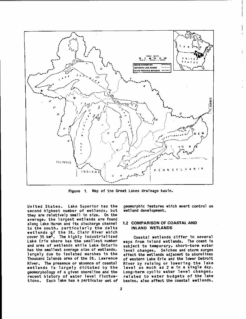
Figure 1. Map of the Great Lakes drainage basin.
United States. Lake Superior has the second highest number of wetlands, but they are relatively small 1n size. On the average, the largest wetlands are found along Lake Huron and Its discharge channel to the south, particularly the delta wetlands of the St. Clalr River which cover 35 km2. The highly Industrialized Lake Erie shore has the smallest number and area of wetlands while Lake Ontario has the smallest average size of wetlands, largely due to Isolated marshes 1n the Thousand Islands area of the St. Lawrence River. The presence or absence of coastal wetlands 1s largely dictated by the geomorphology of a given shoreline and the recent history of water level fluctua- tions. Each lake has a particular set of
geomorphlc features which exert control on wetland development.
1.2 COMPARISON OF COASTAL AND INLAND WETLANDS
Coastal wetlands differ in several ways from Inland wetlands. The coast Is subject to temporary, short-term water level changes. Seiches and storm surges affect the wetlands adjacent to shorelines of western Lake Erie and the lower Detroit River by raising or lowering the lake level as much as 2 n In a single day. Long-term cyclic water level changes, related to water budgets of the lake basins, also affect the coastal wetlands.
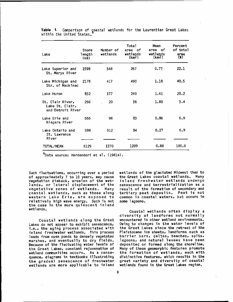
Table 1. Comparison of coastal wetlands for the Laurentian Great Lakes within the United States.
Lake Shore
1ength (km)
Number of wetlands
Total area of wetlands
(km2)
Mean Percent area of of total wetlands
(km2) area
Lake Superior and 1598 348 St. Marys River
Lake Michigan and 2179 417 Str. of Mackinac
267
490
0.77
1.18
22.1
40.5
Lake Huron 832 177 249 1.41 20.2
St. Clair River, 256 20 36 1.80 3.4 Lake St. Clair, and Detroit River
Lake Erie and 666 96 83 0.86 6.9 Niagara River
Lake Ontario and 598 312 84 0.27 6.9 St. Lawrence River
TOTAL/MEAN 6129 1370 1209 0.88 100.0
Data source: Herdendorf et al. (1981a).
Such fluctuations, occurring over a period of approximately 7 to 10 years, may cause vegetation dleback, erosion of the wet- lands, or lateral displacement of the vegetative zones of wetlands. Many coastal wetlands, such as those along western Lake Erie, are exposed to relatively high wave energy. Such 1s not the case 1n the more quiescent inland wetlands.
Coastal wetlands along the Great Lakes do not appear to exhibit senescence, I.e., the aging process associated with inland freshwater wetlands. This process leads from open ponds to densely vegetated marshes, and eventually to dry fields. Because of the fluctuating water levels of the Great Lakes, constant rejuvenation of wetland communities occurs. As a conse- quence, diagrams 1n textbooks illustrating the gradual senescence of freshwater wetlands are more applicable to inland
wetlands of the glaciated Midwest than to the Great Lakes coastal wetlands. Many Inland freshwater wetlands undergo senescence and terrestrial1zat1on as a result of the formation of secondary and tertiary peat deposits. Peat 1s not common 1n coastal waters, but occurs 1n some lagoons.
Coastal wetlands often display a diversity of landforms not normally encountered 1n other wetland environments. Owing to changes 1n the water levels of the Great Lakes since the retreat of the Pleistocene 1ce sheets, landforms such as barrier bars, deltas, beaches, spits, lagoons, and natural levees have been deposited or formed along the shoreline. Many of these geomorphic features promote the formation of wetlands, each with distinctive features, which results 1n the great variety and diversity of coastal wetlands found in the Great Lakes region.
1.3 FUNCTION AND VALUE OF COASTAL WETLANDS
Great Lakes coastal wetlands are highly productive, diverse communities which interface between terrestrial and aquatic environments. The most obvious and unique feature of these wetlands is their characteristic vegetation, which provides a diverse community structure offering cover and food for the animal components of the system. Because of the ability of this vegetation to slow the flow rate of water passing through, wetlands are valuable for erosion control, trapping sediments before they reach the open lake, and attenuating the force of moderate waves to lessen their destructive power. However, Intense lake storms can uproot macrophytes and eventually destroy wetlands. The same vegetation provides a natural pollution abatement mechanism by serving as a filter for coastal tributaries by reducing the quantity of nutrients and toxic pollutants being washed into the Great Lakes. Coastal wetlands are highly valued as recreational sites for activities such as hunting, trapping, fishing, boating access to larger bodies of water, birdwatching, and general aesthetic enjoyment. The combina- tion of recreational desirability, agricultural and residential potential, and the proximity of coastal wetlands to larger bodies of water have contributed to their status as endangered environments. Their unique properties are susceptible to numerous natural and human-caused environmental disruptions that are now causing coastal wetlands to disappear at an alarming rate.
Coastal wetlands 1n the Great Lakes are multi-functional 1n nature because these environments are part of both the uplands and the open-water ecosystems. It 1s the Interface with the lakes that multiplies the wetland functions and contributes to their dynamics. In general, a multi-functioning wetland tends to have a higher value than those with narrower functions. However, coastal wetlands which are Isolated by barriers or degraded by factors such as land drainage or high water may exhibit fewer functions and therefore have lower values. Coastal streams and waterways enhance the Interactions, whereas obstacles such as
dikes result in coastal wetland fragmen- tation and loss of function. The effect of long-term lake level changes on the function of the coastal wetlands can also be significant. Function loss, then, can result from both upland-derived and lake- derived forces.
1.4 DISTRIBUTION OF WESTERN LAKE ERIE COASTAL MARSHES
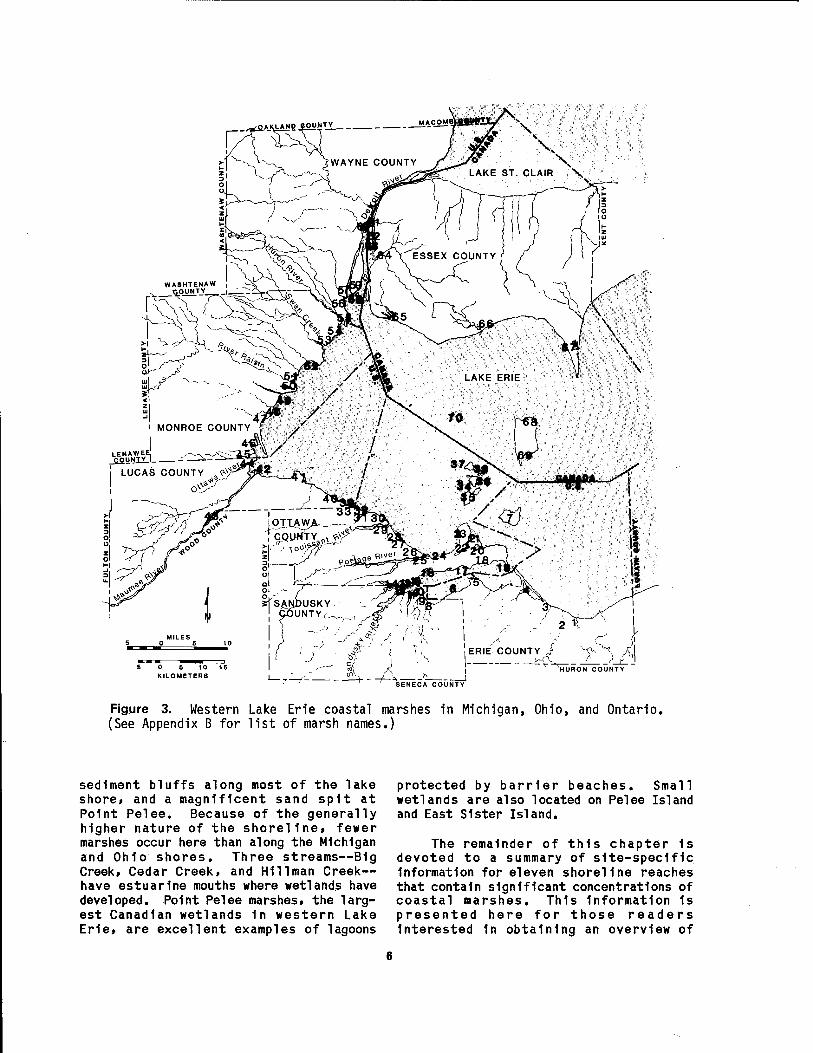
The coastal marshes of western Lake Erie fringe the shorelines and estuaries of Michigan, Ohio, and Ontario (Figure 2). They occur along 189 km of the shore (about 32%) and encompass an area of 268 km2. Appendix A lists the coastal length and area of wetlands within the eight counties in the study area. The names and ownership of 70 of the major marshes are given in Appendix B. The location of the individual marshes (designated by a number in Appendix B) are shown on Figure 3.
The Michigan shoreline of western Lake Erie (Figure 3) consists of low-lying marshes and sand beaches. Submergent and emergent wetlands surround the Islands at the mouth of the Detroit River. The marshy shore 1s interrupted by Stony Point, a rocky headland formed by a brecciated dolomite which crops out at the north end of Brest Bay. A 6-km-long sand spit, known as Woodtick Peninsula, forms the northern edge of Maumee Bay and provides protection for the wetlands which have developed in that portion of the bay.
The Ohio shoreline of western Lake Erie (Figure 3) in its natural state is generally a marsh area fronted by low barrier beaches. Between Maumee Bay (Toledo Harbor) and!Port Clinton, earthen and rock dikes now protect most of the shore except for the rock-bound Erie Islands. Four of the islands contain small wetlands formed within narrow embayments or behind barrier bars. East of Port Clinton the ground elevation rises, and at the headland known as Catawba Island a rock ledge stands over 10 m above lake level. Further to the east is another headland known as Marblehead. The crescent-shaped low ground between these headlands contains three open-water marshes called West, Middle, and East Harbors. Each 1s fronted by a sandy
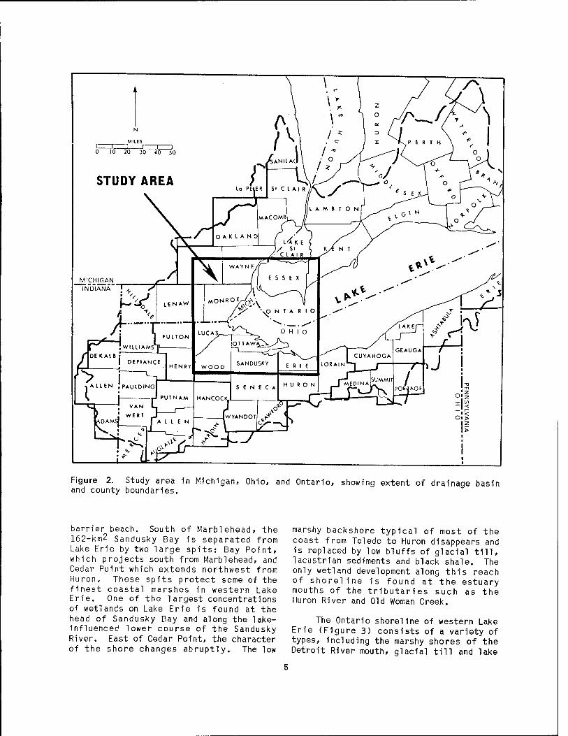
Figure 2. Study area in Michigan, Ohio, and Ontario, showing extent of drainage basin and county boundaries.
barrier beach. South of Marblehead, the 162-km2 Sandusky Bay is separated from Lake Erie by two large spits: Bay Point, which projects south from Marblehead, and Cedar Point which extends northwest from Huron, These spits protect some of the finest coastal marshes in western Lake Erie. One of the largest concentrations of wetlands on Lake Erie is found at the head of Sandusky Bay and along the lake- influenced lower course of the Sandusky River. East of Cedar Point, the character of the shore changes abruptly. The low
marshy backshore typical of most of the coast from Toledo to Huron disappears and is replaced by low bluffs of glacial till, lacustrian sediments and black shale. The only wetland development along this reach of shoreline is found at the estuary mouths of the tributaries such as the Huron River and Old Woman Creek.
The Ontario shoreline of western Lake Erie (Figure 3) consists of a variety of types, including the marshy shores of the Detroit River mouth, glacial till and lake
5 0 5 10 16 KILOMETERS A
, ERIE COUNTY i
'HURON COUNTY
SENECA COUNTY
Figure 3. Western Lake Erie coastal marshes in Michigan, Ohio, and Ontario. (See Appendix B for list of marsh names.)
sediment bluffs along most of the lake shore, and a magnificent sand spit at Point Pelee. Because of the generally higher nature of the shoreline, fewer marshes occur here than along the Michigan and Ohio shores. Three streams—B1g Creek, Cedar Creek, and Hlllman Creek— have estuarlne mouths where wetlands have developed. Point Pelee marshes, the larg- est Canadian wetlands 1n western Lake Erie, are excellent examples of lagoons
protected by barrier beaches. Small wetlands are also located on Pelee Island and East Sister Island.
The remainder of this chapter 1s devoted to a summary of s1te-spedf 1c Information for eleven shoreline reaches that contain significant concentrations of coastal marshes. This Information 1s presented here for those readers Interested 1n obtaining an overview of

major wetland localities. Readers Interested 1n a general understanding of the biota and ecological processes operating 1n Lake Erie marshes may wish to bypass these descriptions and proceed to the next chapter which deals with the physical environment.
The Detroit River 1s actually a strait, 50 km long, connecting two larger bodies of water, Lake St. Clalr and Lake Erie. The terrain through which the river flows 1s relatively flat and broken only by the River Rouge on the Michigan side and the Canard River (Riviere aux Canards) and Turkey Creek on the Ontario side, and by low glacial moraines and beach ridges of former lakes. The upper half of the Detroit River has steep banks, a width of less than 1 km, depths to 15 m, and two sizable islands at Its head, Belle Isle and Peach Island. Wetland development is sparse 1n this reach of the river except in the embayments and shoals associated with the island, and most of the vegetation 1s of the submergent type. The lower half of the river has gently sloping banks, a width of 6 km at Its mouth, and depths generally less than 10 m (about 3 m at the mouth).
The mouth of the Detroit River contains several small islands and one major island, Grosse lie. Most of these islands are fringed by coastal wetlands where construction has not destroyed them. These wetlands are generally non-wooded marshes dominated by lush stands of emergent aquatic plants, particularly cattails (Tvpha spp.). The most note- worthy marshes can be found on Gibraltar Island, Cherry Island, Celeron Island, Stony Island, Grassy Island, and Grosse He in Michigan; and Fighting Island, Turkey Island, and near the mouth of the Canard River on the Ontario side. Submergent forms are abundant on the shoals surrounding the island and in protected embayments.
Lake sturgeon (Acipenser fulvescens). northern pike (Esox lucius). muskellunge (E. masauinonav). carp (Cvprinus carpio). channel catfish (Ictalurus punctatus). largemouth bass (Micropterus salmoides). smallmouth bass (M. dolomieui). bluegill (Lepomis macrochirus). yellow perch (Perca flavescens). and walleye (Stizosteriinn y.
v.itreum) are among the fish species which spawn in coastal wetlands of the lower Detroit River. The dominant water birds using these wetlands are mallard (Anas piatvrhvnchos). blue-winged teal (A. discors). wood duck (Mx. sponsa.). ruddy duck (Oxvura .i a m a i c e n s i s ) . belted kingfisher (Cervle alcvon). great blue heron (Ardea herodias). green-backed heron (Butorides striatus). common moorhen (Gallinula chloropus). herring gull (Larus aroentatns) . ring-billed gull (J.. delawarensis). Caspian tern (Sterna caspia.). and lesser yellowlegs (Trinoa flavipes).
Pointe Mouillee
Located along the shore of western Lake Erie, 8 km south of the Detroit River mouth, this marsh is one of the largest wetlands along the Michigan shoreline of the lake. Most of this wetland is within the Pointe Mouillee State Game Area. The estuarine mouths of the Huron River and Mouillee Creek are located near the center of the marsh. A sandy barrier beach, known as Pointe Mouillee,.originally separated the marsh from Lake Erie.
These wetlands suffered extensive damage during the high water storms of the early 1950s and early 1970s. Onshore and offshore dikes now protect portions of the marshes which are largely managed for waterfowl. The marshes are also popular fishing locations and they provide habitat for heron and egret rookeries. For the past decade, the U.S. Army Corps of Engineers has been constructing an immense banana-shaped dike offshore of the Pointe Mouillee Marsh. This is a multi-purpose structure. First, it will provide a containment area for material dredged from the Detroit River navigation channel. Secondly, it serves as a buffer between the coastal marshes and the open lake. And thirdly, it will provide access to the central lagoon and marsh area. When completed, the project will leave behind an island for a future refuge area.
Cattails are the natural dominant species in Mouillee Marsh. However, portions of the marsh are managed for waterfowl and such food plants as smartweeds (Polvqonum spp.), pigweed

(Ama rant hu s spp.), and bur reeds (Sp arg am" urn spp.) are propagated in diked management areas to the exclusion of cattails. Approximately 20 species of fish are common in Mouillee Marsh. Carp is the most abundant. Forage species such as gizzard shad (Dorosoma cepedianum), alewife (Alosa pseudoharengus), emerald shiner (Notrop i s atherinoides)» and spottail shiner (Notropis hudsonius) also utilize the marsh. Common amphibians and reptiles include the bullfrog (Rana catesbei ana), green frog (R. clamitans)i leopard frog (ß. pipiens)> American toad (Buifo americanus), fox snake (Elaphe vulpina), brown snake (Storeria dekavi), snapping turtle (Chelvdra serpentina), and midland painted turtle (Chrvsemvs picta). Canada goose (Branta canadensis). black duck (Anas rubripes), mallard, gadwall (A. strepera), blue-winged teal, and wood duck are common nesting species in Mouillee Marsh. Muskrat (Ondatra zibethicus), are dependent on the marsh for food, shelter, and breeding areas, whereas opossum (Pidel phis vi rginiana), red fox (Vulpes vulpes), raccoon (Procvon lotor), mink ( M u s t e1 a vison ), and striped skunk (Mephitis mephitis) utilize the marsh as a foraging area.
River Raisin-Swan Creek
The estuaries of the River Raisin, Swan Creek, and several smaller streams in the same vicinity provide the proper habitat for the development of coastal wetlands. The port of Monroe, Michigan, at the mouth of the River Raisin, is highly disturbed by industrial and power plant operations, but some emergent stands still persist, particularly in La Plaisance Bay. Sterling State Park, north of the river mouth, contains coastal marshes behind a barrier beach (Figure 4). Recent construction of a containment structure for harbor dredgings adjacent to the park has modified some wetland and beach habitat. Swan Creek and Otter Creek estuaries are given some protection by the bedrock outcrop at Stony Point, and support diverse coastal marshes. Construction of the Enrico Fermi Power Plant has caused disturbance at the southern edge of Swan Creek Marsh.
Figure 4. Barrier beach at Sterling State Park, Monroe, Michigan (September 1982). Note undercutting of large cottonwood trees indicating a shoreward migration of the barrier.
Maumee Bay
This bay lies at the mouth of the Maumee River and is formed by Cedar Point (locally known as Little Cedar Point to avoid confusion with the point of the same name on the east side of Sandusky Bay) on the east and Woodtick Peninsula on the west. These two sand spits provide the shelter necessary for wetland development on their landward side. The former lies within the Cedar Point National Wildlife Refuge (administered as part of the Ottawa National Wildlife Refuge) and the latter lies partially within the Erie State Game Area (administered by the Michigan Department of Natural Resources). The
8

Cedar Point marshes extend westward along the south shore of the bay to Maumee Bay State Park. Estuarine wetlands also occur along the Maumee River valley, between Rossford and the first bedrock riffles at Perrysburg, and in the lower reaches of the Ottawa River.
Although metropolitan Toledo coin- cides with this area, emergent wetlands still exist at the base of Little Cedar Point, in the Maumee River Estuary above Rossford, along much of the Ottawa River Estuary, behind Woodtick Peninsula (Figures 5 and 6), and inside the massive rip-rap dikes constructed to contain harbor dredgings (Figure 7) and power plant flyash. The marshes in the bay are protected by dikes and are managed for
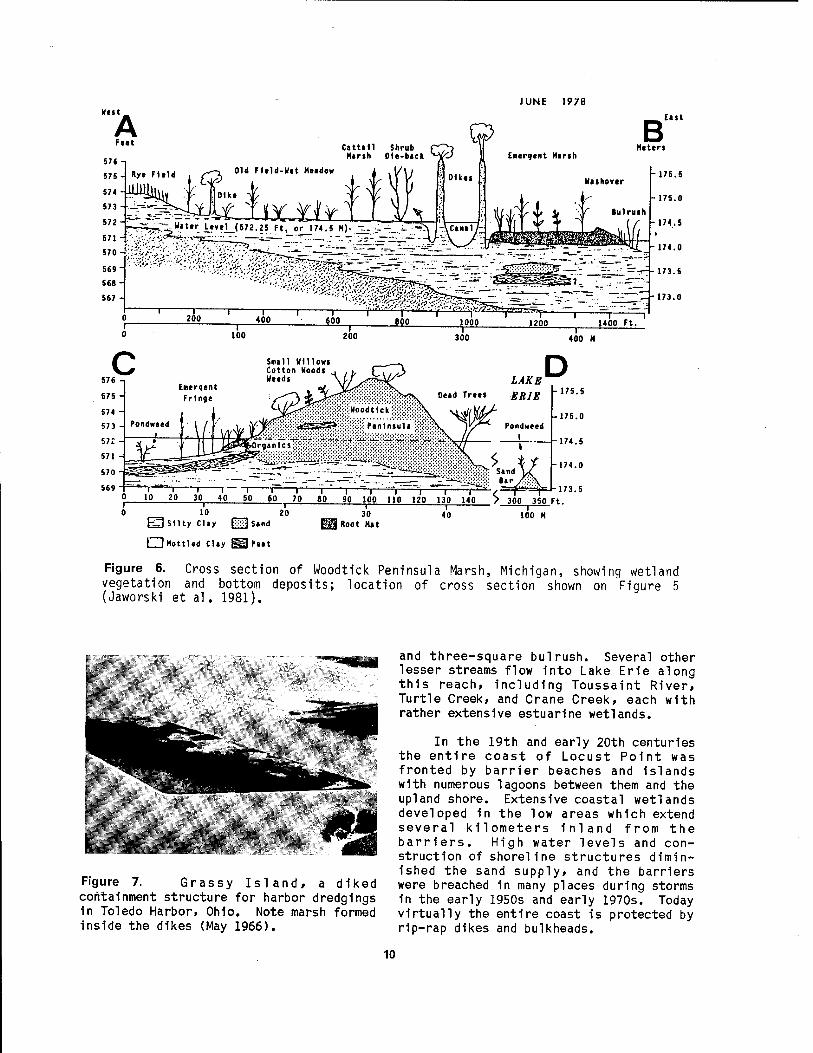
Figure 5. Coastal landforms of Woodtick Peninsula Marsh, Michigan, showing location of cross section illustrated in Figure 6 (Jaworski et al. 1981).
waterfowl. The estuarine wetlands are more undisturbed and often associated with the large islands in those slack water reaches.
The major plant species thriving in the Maumee Bay marshes include narrow- leaved cattail (Tvpha angustifolia), broad-leaved cattail (I. 1ati folia), jewel weeds (Impatiens spp.), swamp rose- mallow (Hibiscus palustris), bluejoint grass (Cal amagrostis canadensis), and swamp milkweed (Asclepias incarnata). In the transition zone between open water and the cattail stands, soft-stem bulrush (Sci rpus va 1idus), and three-square bulrush (.§_• americanus) are the dominant species. Fish found in the Maumee Bay wetlands include bowfin (Amia calva), carp, yellow perch, largemouth bass, white bass (Morone chrvsops), green sunfish (Lepomi s cvanel1 us) , yellow bullhead (Ictalurus natal is), gizzard shad, and walleye.
The historical occurrence of the rare Förster's tern (Sterna forsten') has been reported for these wetlands (Campbell and Trautman 1936). A bald eagle (Haliaeetus leucocephalus) nest is active on Cedar Point. The most common waterfowl are mallard, black duck, green-winged teal (Anas crecca), blue-winged teal, northern shoveler (A. clvpeata), and American coot (Fulica americana)■ Tundra swans (Olor columb i anus) and snow geese (Chen caerulescens) also utilize the area for resting during spring migration.
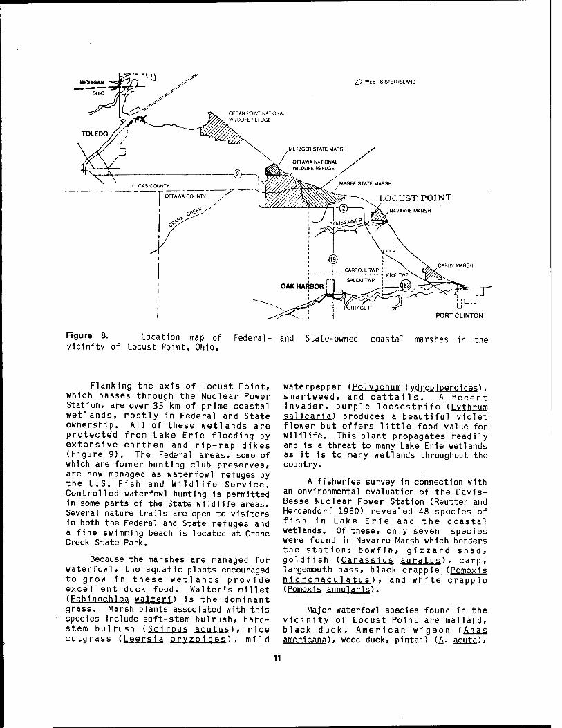
Locust Point is a broadly rounded feature on the Ohio shore of western Lake Erie that extends from Maumee Bay eastward to Port Clinton (Figure 8). This reach of shoreline contains nearly continuous coastal marshes, most of them in public ownership. Fronting the community of Port Clinton, east of the harbor jetties, are cattail marshes behind barrier beaches. This is an area of converging littoral drift which provides the natural sand bars that protect the wetland. The Portage River Estuary which forms the Port Clinton harbor is highly disturbed but contains some fringing emergent plants, such as reed-canary grass (Phalaris amridlnacsfl)
JUNE 197B Mest East
Cattail Shrub Marsh Die-back
^Adm£Jbx^ü±2 570
569 568-
567
Old Ffeld-Wet Meadow
Dike -¥■ £1: v >c >v
200 , -T- , , '"-^ffo^f ^y-^o^a^^^. ;"- - ^ - —, 1£2 600 BOO 1000 1200 1400 ft.
100 200 300 400 M
570
569 I I I I ~l I r"* I "T 1 1 T 1 {-*■ 0 10 20 30 40 50 60 70 80 90 100 110 120 130 140 1 I 1 1 1 0 10 20 30 40
ESsntyClay EH Sand Effi Root Mat
173.5 300 350 Ft. 1
100 H
□ Mottled Clay H Peat
Figure 6. Cross section of Woodtick Peninsula Marsh, Michigan, showing wetland vegetation and bottom deposits; location of cross section shown on Figure 5 (Jaworski et al. 1981).
i &■■!
Figure 7. Grassy Island, a diked containment structure for harbor dredglngs in Toledo Harbor, Ohio. Note marsh formed Inside the dikes (May 1966).
and three-square bulrush. Several other lesser streams flow Into Lake Erie along this reach, including Toussaint River, Turtle Creek, and Crane Creek, each with rather extensive estuarlne wetlands.
In the 19th and early 20th centuries the entire coast of Locust Point was fronted by barrier beaches and islands with numerous lagoons between them and the upland shore. Extensive coastal wetlands developed in the low areas which extend several kilometers inland from the barriers. High water levels and con- struction of shoreline structures dimin- ished the sand supply, and the barriers were breached in many places during storms in the early 1950s and early 1970s. Today virtually the entire coast is protected by rip-rap dikes and bulkheads.
10
MICHIGAN
OHIO
Q WEST SISTER ISLAND
CEDAR POINT NATIONAL WILDLIFE REFUGE
METZGER STATE MARSH
MAGEE STATE MARSH
LOCUST POINT NAVARRE MARSH
PORT CLINTON
Figure 8. Location map of Federal- and State-owned coastal marshes in the vicinity of Locust Point, Ohio.
Flanking the axis of Locust Point, which passes through the Nuclear Power Station, are over 35 km of prime coastal wetlands, mostly in Federal and State ownership. All of these wetlands are protected from Lake Erie flooding by extensive earthen and rip-rap dikes (Figure 9). The Federal areas, some of which are former hunting club preserves, are now managed as waterfowl refuges by the U.S. Fish and Wildlife Service. Controlled waterfowl hunting 1s permitted in some parts of the State wildlife areas. Several nature trails are open to visitors in both the Federal and State refuges and a fine swimming beach is located at Crane Creek State Park.
Because the marshes are managed for waterfowl, the aquatic plants encouraged to grow in these wetlands provide excellent duck food. Walter's millet (EqhinochlQa waiters is the dominant grass. Marsh plants associated with this species include soft-stem bulrush, hard- stem bulrush (Scirpus acutus), rice cutgrass (Leersia orvzoltje?) . mild
waterpepper (Polvaonum hvdropiperoides). smartweed, and cattails. A recent invader, purple loosestrife (Lvthrum salicaria) produces a beautiful violet flower but offers little food value for wildlife. This plant propagates readily and is a threat to many Lake Erie wetlands as It is to many wetlands throughout the country.
A fisheries survey in connection with an environmental evaluation of the Davis- Besse Nuclear Power Station (Reutter and Herdendorf 1980) revealed 48 species of fish in Lake Erie and the coastal wetlands. Of these, only seven species were found in Navarre Marsh which borders the station: bowfln, gizzard shad, goldfish (.Cargssjus ajirfllg?) > carp, largemouth bass, black crappie (Pomoxis HlqrP'Mgti'UtM?) » and white crappie (Pomoxis annularis).
Major waterfowl species found in the vicinity of Locust Point are mallard, black duck, American wigeon (Anas americana), wood duck, pintail (A., acuta),
11

Figure 9. Rip-rap dike separating Lake Erie (right) from Darby Marsh (left); this wetland is part of the Ottawa National Wildlife Refuge (August 1982).
blue-winged teal, and Canada goose. The wetlands in this complex also provide important nesting and feeding habitat for bald eagles. Three pairs of bald eagles have been observed nesting here in recent years. Ospreys (Pandion haliaetus) use the area for feeding and resting during migration.
As with most of the Lake Erie marshes, the muskrat is the most important furbearer. Other mammals common in the marshes and earthen dikes are woodchuck (Marmota monax), eastern cottontail (Svlvilagus floridanus), striped skunk, and white-tailed deer (Qdocoileus virginianus).
Lake Erie Islands
With exception of Pelee Island, none of the Lake Erie Islands have extensive marshlands. All of the islands are rockbound (Figure 10). The only oppor- tunity for marshes to develop exists in protected embayments, coastal ponds, and where converging sand bars form a lagoon at the base of a spit. Noteworthy
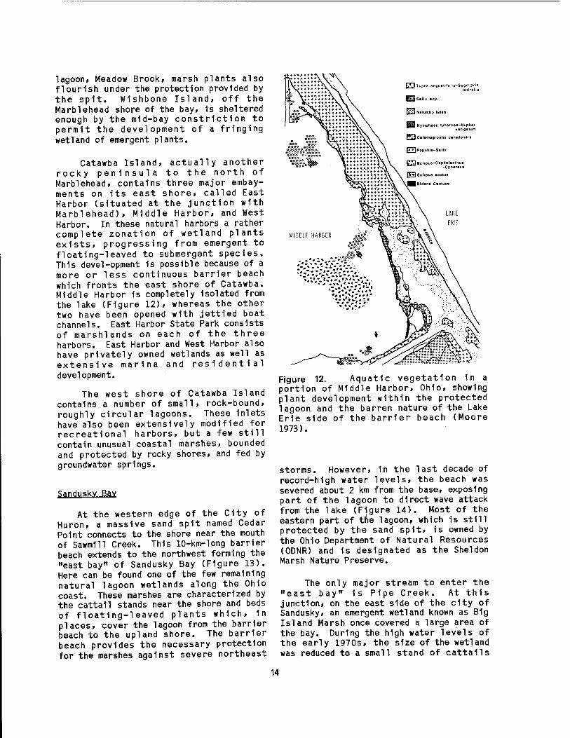
examples of these wetlands include the Put-in-Bay embayment on South Bass Island where extensive beds of submerged macrophytes occur in Fishery Bay, and on North Bass Island, Manila Bay, where emergent forms are more common. Coastal ponds and lagoons occur on Kelleys Island (Carp Pond), Middle Bass Island (Haunck's Pond), South Bass Island (Terwi11iger's Pond), North Bass Island (Manila Bay, Fox's Pond and Smith's Pond) East Sister Island (East Sister Swamp), and Pelee Island (Lake Henry and Fish Point Swamp). Each has its own distinct flora, but in general, floating-leaved plants are best developed in these1 isolated habitats. The largest island marshes are found on Pelee Island where sand spits at both its north and south tips have formed lagoons similar to the formation of Point Pelee on the Ontario shore. Lake Henry, on the north, has been breached by high water storms and is now in danger of being engulfed by Lake Erie (Figure 11).
Typically, the small wetlands on these islands occupy depressions behind sand spits or barrier bars that have been
12
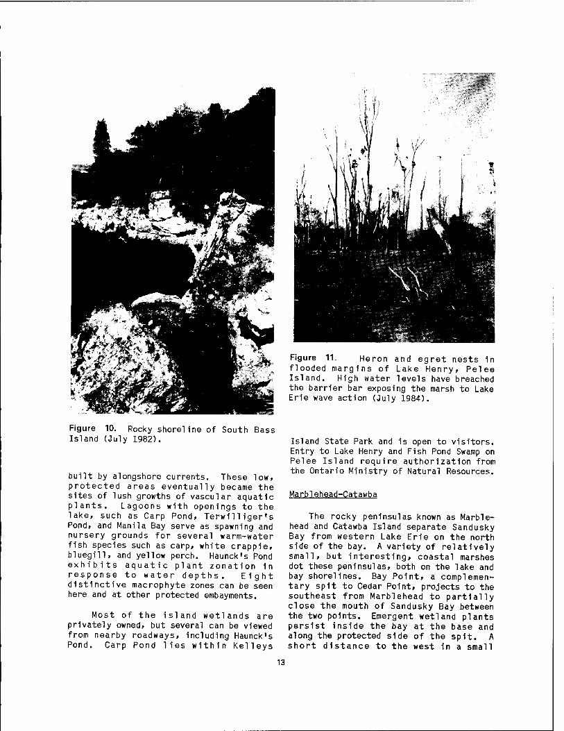
Figure 10. Rocky shoreline of South Bass Island (July 1982).
built by alongshore currents. These low, protected areas eventually became the sites of lush growths of vascular aquatic plants. Lagoons with openings to the lake, such as Carp Pond, Terwilliger's Pond, and Manila Bay serve as spawning and nursery grounds for several warm-water fish species such as carp, white crappie, bluegill, and yellow perch. Haunck's Pond exhibits aquatic plant zonation in response to water depths. Eight distinctive macrophyte zones can be seen here and at other protected embayments.
Most of the island wetlands are privately owned, but several can be viewed from nearby roadways, including Haunck's Pond. Carp Pond lies within Kelleys
Figure 11. Heron and egret nests in flooded margins of Lake Henry, Pelee Island. High water levels have breached the barrier bar exposing the marsh to Lake Erie wave action (July 1984).
Island State Park and is open to visitors. Entry to Lake Henry and Fish Pond Swamp on Pelee Island require authorization from the Ontario Ministry of Natural Resources.
Marblehead-Catawba
The rocky peninsulas known as Marble- head and Catawba Island separate Sandusky Bay from western Lake Erie on the north side of the bay. A variety of relatively small, but interesting, coastal marshes dot these peninsulas, both on the lake and bay shorelines. Bay Point, a complemen- tary spit to Cedar Point, projects to the southeast from Marblehead to partially close the mouth of Sandusky Bay between the two points. Emergent wetland plants persist inside the bay at the base and along the protected side of the spit. A short distance to the west in a small
13
lagoon, Meadow Brook, marsh plants also flourish under the protection provided by the spit. Wishbone Island, off the Marblehead shore of the bay, 1s sheltered enough by the mid-bay constriction to permit the development of a fringing wetland of emergent plants.
Catawba Island, actually another rocky peninsula to the north of Marblehead, contains three major embay- ments on its east shore, called East Harbor (situated at the junction with Marblehead), Middle Harbor, and West Harbor. In these natural harbors a rather complete zonation of wetland plants exists, progressing from emergent to floating-leaved to submergent species. This devel-opment 1s possible because of a more or less continuous barrier beach which fronts the east shore of Catawba. Middle Harbor 1s completely Isolated from the lake (Figure 12), whereas the other two have been opened with jettled boat channels. East Harbor State Park consists of marshlands on each of the three harbors. East Harbor and West Harbor also have privately owned wetlands as well as extensive marina and residential development.
The west shore of Catawba Island contains a number of small» rock-bound, roughly circular lagoons. These Inlets have also been extensively modified for recreational harbors, but a few still contain unusual coastal marshes, bounded and protected by rocky shores, and fed by groundwater springs.
Sandusky Bav
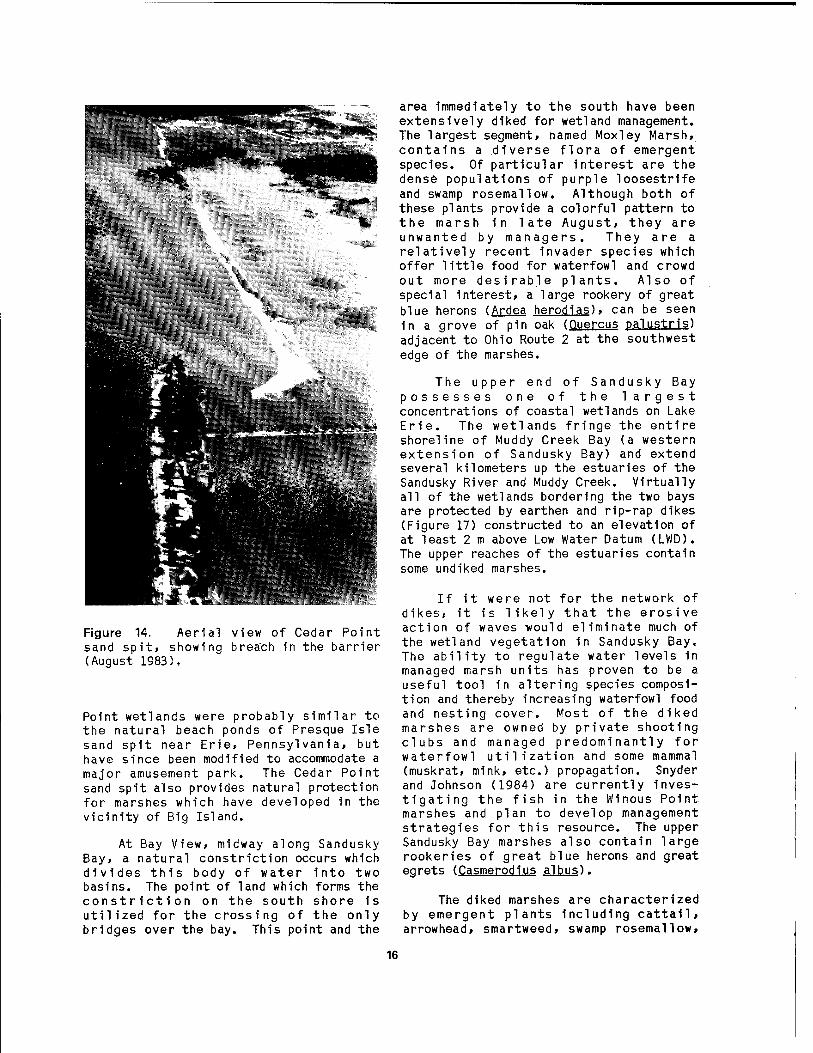
At the western edge of the City of Huron, a massive sand spit named Cedar Point connects to the shore near the mouth of Sawmill Creek. This 10-km-long barrier beach extends to the northwest forming the "east bay" of Sandusky Bay (Figure 13). Here can be found one of the few remaining natural lagoon wetlands along the Ohio coast. These marshes are characterized by the cattail stands near the shore and beds of floating-leaved plants which, 1n places, cover the lagoon from the barrier beach to the upland shore. The barrier beach provides the necessary protection for the marshes against severe northeast
CDT*Pha anoustifolta-SacUlai
Salix app.
Nelumbo lutea
Prl CalamaaroBlis canad.nali
I* »IPopulua-Salln
L'.M Scirpue-Caphalanthua -Cyp.rtuB
I'HSclrpua acutua
Bidana c.rnuua
LAKE
ERIE
Figure 12. Aquatic vegetation 1n a portion of Middle Harbor, Ohio, showing plant development within the protected lagoon and the barren nature of the Lake Erie side of the barrier beach (Moore 1973).
storms. However, in the last decade of record-high water levels, the beach was severed about 2 km from the base, exposing part of the lagoon to direct wave attack from the lake (Figure 14). Most of the eastern part of the lagoon, which is still protected by the sand spit, is owned by the Ohio Department of Natural Resources (ODNR) and 1s designated as the Sheldon Marsh Nature Preserve.
The only major stream to enter the "east bay" is Pipe Creek. At this junction, on the east side of the city of Sandusky, an emergent wetland known as B1g Island Marsh once covered a large area of the bay. During the high water levels of the early 1970s, the size of the wetland was reduced to a small stand of cattails
14
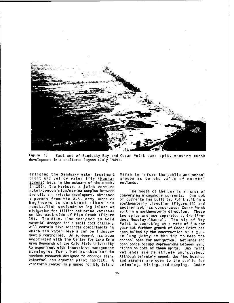
Figure 13. East end of Sandusky Bay and Cedar Point sand spit, showing marsh development 1n a sheltered lagoon (July 1949).
fringing the Sandusky water treatment plant and yellow water lily (Nuphar fldvena) beds 1n the estuary of the creek. In 1984» The Harbour, a joint venture hotel/condom1n1um/mar1na complex between the city and private developers, obtained a permit from the U.S. Army Corps of Engineers to construct dikes and reestablish wetlands at B1g Island as mitigation for filling estuarlne wetlands on the east side of Pipe Creek (Figure 15). The dike, also designed to hold material dredged for a small boat channel, will contain five separate compartments 1n which the water levels can be Indepen- dently controlled. An agreement has been negotiated with the Center for Lake Erie Area Research of the Ohio State University to experiment with innovative management strategies for diked marshes and to conduct research designed to enhance fish, waterfowl and aquatic plant habitat. A visitor's center 1s planned for B1g Island
Marsh to inform the public and school groups as to the value of coastal wetlands.
The mouth of the bay 1s an area of converging alongshore currents. One set of currents has built Bay Point spit 1n a southeasterly direction (Figure 16) and another set has Constructed Cedar Point spit 1n a northwesterly direction. These two spits are now separated by the 13-m- deep Moseley Channel. The tip of Bay Point 1s accreting at a rate of 3 m per year but further growth of Cedar Point has been halted by the construction of a 2.6- km-long jetty at the tip to keep the channel open for navigation. Wetlands and open ponds occupy depressions between sand ridges on both of these spits. Bay Point wetlands are relatively undisturbed. Although privately owned, the fine beaches and marshes are open to the public for swimming, hiking, and camping. Cedar
15
r3|wzä^'>-i;<?iM^-r^" ■■■■
Figure 14. Aerial view of Cedar Point sand spit» showing breach in the barrier (August 1983).
Point wetlands were probably similar to the natural beach ponds of Presque Isle sand spit near Erie, Pennsylvania, but have since been modified to accommodate a major amusement park. The Cedar Point sand spit also provides natural protection for marshes which have developed in the vicinity of Big Island.
At Bay View, midway along Sandusky Bay, a natural constriction occurs which divides this body of water into two basins. The point of land which forms the constriction on the south shore is utilized for the crossing of the only bridges over the bay. This point and the
area immediately to the south have been extensively diked for wetland management. The largest segment, named Moxley Marsh, contains a diverse flora of emergent species. Of particular interest are the dense populations of purple loosestrife and swamp rosemallow. Although both of these plants provide a colorful pattern to the marsh in late August, they are unwanted by managers. They are a relatively recent invader species which offer little food for waterfowl and crowd out more desirable plants. Also of special interest, a large rookery of great blue herons (Ardea herodias), can be seen in a grove of pin oak (Quercus palustris) adjacent to Ohio Route 2 at the southwest edge of the marshes.
The upper end of Sandusky Bay possesses one of the largest concentrations of coastal wetlands on Lake Erie. The wetlands fringe the entire shoreline of Muddy Creek Bay (a western extension of Sandusky Bay) and extend several kilometers up the estuaries of the Sandusky River and Muddy Creek. Virtually all of the wetlands bordering the two bays are protected by earthen and rip-rap dikes (Figure 17) constructed to an elevation of at least 2 m above Low Water Datum (LWD). The upper reaches of the estuaries contain some und iked marshes.
If it were not for the network of dikes, it is likely that the erosive action of waves -would eliminate much of the wetland vegetation in Sandusky Bay. The ability to regulate water levels in managed marsh units has proven to be a useful tool in altering species composi- tion and thereby increasing waterfowl food and nesting cover. Most of the diked marshes are owned by private shooting clubs and managed predominantly for waterfowl utilization and some mammal (muskrat, mink, etc.) propagation. Snyder and Johnson (1984) are currently inves- tigating the fish in the Winous Point marshes and plan to develop management strategies for this resource. The upper Sandusky Bay marshes also contain large rookeries of great blue herons and great egrets (Casmerodius albus).
The diked marshes are characterized by emergent plants including cattail, arrowhead, smartweed, swamp rosemallow,
16

Figure 15. Big Island, an experimental marsh in Sandusky at the mouth of Pipe Creek (August 1984).
ft.*1!.. ■ ■
B^lMii,'Tlvil"fjOTffM
■HMC-.V. g£~-rr _*!•■ ^^^ ^?^^
■ . '■ ■'■•'■'■'. ■'■;';'' ■I"- 'r - '-.
i-'i*. ,»/'•' ■ ■ Vf' jfcfr, r.H.tfn
||jg|j
IllIBi ürtSässs
Ifiilil 111 ■III
llllHHi '*'}• H
1 k'Xn,'
P^äaS ■BllülLUili ' ■ VtrjjjBzi
jaj Wt^ätBe ■11™!™!!!! ^^WraiiBl|ji^^H^^H
Figure 16. Aerial view of Bay Point sand spit and marshes at the entrance to Sandusky Bay. Marblehead Peninsula in background (August 1983).
17
Billi
p m m
Figure 17. Willow Point Marsh, an example of a diked wetland on the south shore of Sandusky Bay (April 1968).
and purple loosestrife. The latter of purple loosestrife to a negligible species is becoming a nuisance; however, size. The undiked estuarlne marshes are careful management has kept the population typified by greater development of massive
18

beds of floating-leaved species. In the open water of the marshes the dominant plant species vary from year to year, but the most common ones are coontail (Ceratophvllum demersum). water-milfoil (MvriQDhvllum exalbescftnO . duckweeds (Lemna spp.), water smartweed (Polvgonum amphibium emersum), American water-lotus (Nel umbo 1 utea). white water lily (Nvmphaea tuberosa), spatterdock (Nuphar advena), pondweeds (Potamogeton spp.), and water stargrass (Heteranthera dubia).
The dominant nesting waterfowl of Sandusky Bay marshes are mallard (72%), black duck (16%), and blue-winged teal (9%). The adlilt great blue heron population of these wetlands is estimated at over 3,000 birds; one rookery alone at Winous Point had 1,200 breeding pairs in 1976 (Edford 1976). Nesting bald eagles have been observed 1n this area as recently as 1984.
The muskrat is the most important furbearer in upper Sandusky Bay marshes and receives the greatest trapping pressure in these wetlands. During the November-to-March trapping season, over 5,000 muskrats are taken each year from the Winous Point Marsh. Other marsh mammals trapped for their pelts include raccoon, opossum, mink, and red fox.
Old Woman Creek-Huron River
The eastern limit of the area under consideration contains the estuarine mouths of Old Woman. Creek and the Huron River. The marsh developed in these es- tuaries lies not only at the southerly- most point of Lake Erie, but also of the entire Great Lakes.
Old Woman Creek wetland occupies the lower estuarine portion of the stream. It is separated from Lake Erie by a narrow barrier beach at the stream mouth. The wetland is mostly non-wooded, with emer- gent and floating-leaf plants bordered by a mixed hardwood forest on the steep banks. The American water-lotus is excep- tionally well developed 1n this broad embayment on the north side of Star Island. The drowned mouth of the creek has been set aside since 1977 as a re- search and education preserve known as the Old Woman Creek National Estuarine
Research Reserve. The Reserve jointly managed by the National Oceanic and Atmospheric Administration (NOAA) and the Ohio Department of Natural Resources, features a public education center, research laboratories, housing for inves- tigators, nature trails, and interpretive canoe trips. Old Woman Creek is the first reserve of this type on the Great Lakes.
Within Old Woman Creek wetland four aquatic habitats can be found: 1) open water, 2) shoreline, 3) embayment marshes, and 4) mud flats. Common vascular aquatic plants occurring in the open water include American lotus, spatterdock, arrow arum (Peltandra viroinica). coontail, pond- weeds, and duckweed. The shoreline habitat features buttonbush (Cephalanthus occidental is), rough leaf dogwood (Cornus dririnmondii), blueflag (Iris versicolor)> and arrowhead (Sagittaria 1 atifolia). Embayment marshes (Figure 18), which have been reduced in size due to high lake levels since 1972, are characterized by river bulrush (Scirpus fluviatilis), giant bur reed (Sparganium eurvcarpum), cattail, and lizard's tail (Saururus cernuus). In mid-summer the mud flats are marked by swamp rosemallow and water smartweed.
West of Old Woman Creek, the next major wetlands occur in the estuarine mouth of the Huron River. From approximately 2 km to 5 km upstream from the lake, extensive marshes persist on both sides of the valley. American lotus beds are also common here, along the lower reaches of the small tributary called Mud Brook, but emergent forms such as cattail, bulrush, and bur reed dominate. A part of the Huron River wetlands, known as the DuPont Marsh, is owned by ODNR and managed as a nature preserve.
Big Creek
The wetlands at the estuarine mouth of Big Creek are located 20 km southeast of Amherstburg, Ontario, and extend westward along the lakeshore to Bar Point at the mouth of the Detroit River. These marshes are partly within Holiday Beach Provincial Park, administered by the Ontario Ministry of Natural Resources. In fall and spring the marshland is a rewarding place for birdwatching and
19
**g&&-"xt§
Figure 18. Emergent stands of river bulrush (Scirpus fluviatilis) in fore- ground and floating leaves of white water lily (Nymphaea tuberosa) in the background at Old Woman Creek Estuary (Marshall 1977).
waterfowl hunting. The marsh within the park is designated as a waterfowl sanctuary while hunting is permitted in the adjacent wildlife management area. This is one of the best Canada goose hunting areas in southern Ontario. Small mammals common to the area include musk rat, raccoon, rabbit, and red fox. A boat launching ramp is located on Lake Erie at the west end of the bathing beach. Common fish species caught in the lake include walleye, freshwater drum (Aplodinotus grunniens), and yellow perch.
Point Pelee
Point Pelee the north shore the division of central basins.
is a massive sand spit on of Lake Erie that marks the lake's western and
The 8-km-long spit is triangular in shape with an exceptionally sharp, narrow point projecting out into the lake. The spit has been formed by a
convergence of alongshore currents, resulting in the deposition of sand eroded from the bluffs far to the east and west of the point. The sand bars deposited by these currents enclose a cattail marsh of high quality. The entire spit and the 10- km2 marsh lie within the boundaries of Point Pelee National Park, administered by Parks Canada. The park is surrounded by 22.5 km of sand and pebblje beaches (Figure 19).
The terrain of Point Pelee is mostly marsh or woodland. The marsh contains six major open-water ponds. The largest (Big Pond) has a boardwalk nature trail constructed for the enjoyment of park visitors. Here, aquatic plants and sedges wage a constant battle with the open ponds, encroaching on them and filling the margins with a lush carpet of vegetation, including cattails, spatterdock, pickerel weed (Pontederia cordata), and swamp rose- mallow. An unusual feature of this
20

Boardwalk Nature Trail
Entrance to Marsh
NATURE CENTRE & MUSEUM'
NATURE PRESERVE EAST BEACH
NATURE TRAIL
A
-e POINT PELEE NATIONAL PARK
BOAT RAMP ,
Dangerous \' Currents
LAKE ERIE
Figure 19. Aerial photograph of Point Pelee National Park, Ontario, showing location of coastal marshes and other park features (Allen 1970).
wetland is the massive floating mats of cattail formed by a network of intertwined rhizomes. This feature appears to be an adaptation to frequent changes in water level. Wetlands also exist in the sloughs between the successive beach ridges/sand dunes which run the length of the spit. The Interior marshes are naturally protected by the barrier beaches of the spit but occasionally the east beach is breached by the lake. Of the 600 plant species found on Point Pelee, the greatest variety can be seen along the woodland nature trail towards the southern end of the spit. Two major bird migration flyways overlap at Point Pelee. Each spring and autumn thousands of birds and birdwatchers Invade the park. It 1s not uncommon for a single observer to tally more than 100 species during the height of the migration season. Of the 332 species recorded for the area, 90 stay to nest. Waterfowl and shorebirds are abundant 1n the marshes. Fishing 1s permitted within the marsh. The most common species are sunfish, yellow perch, northern pike, largemouth bass, carp, and dogfish (or bowfln).
Animals found nowhere else in Canada enjoy the mild climate of Point Pelee. The eastern mole (Scalopus aquaticus) bur- rows in sand dunes adjacent to the marsh ponds and the fox-squ1rrel (Sdurus niger) shares the shelter of the deciduous forest with the grey squirrel (jj>. carolinensls). Raccoon and mink can be found near the marshes where they feed on abundant creatures that thrive there. Muskrats build their community dwellings near the pond shores. At the edge of the forest other mammals can be found Including the eastern cottontail, white-tailed deer, the white-footed mousej (Peromvscus leucopus). and the Insectivorous little brown bat (Mvotis lucifugus).
21

CHAPTER 2.
PHYSICAL ENVIRONMENT
Lake Erie is one of the largest lakes in the world, ranking 11th by area and 17th by volume (Herdendorf 1984). It is the southernmost of the Laurentian Great Lakes, lying between 41°21'N and 42°50'N latitude and 7 8 ° 5 0 ' W and 8 3 ° 3 0 ' W longitude. The lake is narrow and rel- atively shallow for a lake of its size (Figure 20) with its longitudinal axis oriented east-northeast. Lake Erie is approximately 388 km long and 92 km wide, with a mean depth of 19 m and a maximum sounding of 64 m. The lake has a surface area of 25,657 km2, a volume of 484 krn^, a shoreline length of 1,380 km, and a surface elevation of 173.9 m above mean sea level.
2.1 GEOLOGY
Physiography and Morphometrv
The Lake Erie basin lies in the Central Lowland physiographic province near where this province wedges out between the Appalachian Plateau and the Canadian Shield. The boundary between the Central Lowland and the Appalachian Plateau in the Erie basin is a sharp rise of 60 to 90 m in elevation called the Portage Escarpment (Figure 21). From Cleveland eastward the escarpment parallels the lake shore and lies generally less than 8 km from it. At Cleveland the escarpment turns southward across Ohio.
APPALACHIAN PLATEAU
Figure 20. Depth contours (1n meters) of Figure 21. Physiographic map of the Lake western and central Lake Erie. Erie basin.
22

The portion of the Central Lowland bordering Lake Erie 1s known as the Lake Plain and 1s» for the most part, the very flat former lake bottom. East of Cleveland it is narrow and lies between the Portage Escarpment and the present lake shore. West of Cleveland 1t widens quickly, and 1n western Ohio 1t 1s more than 80 km wide. It narrows again 1n Michigan to about 30 km wide. In Canada, 1t is 30 to 50 km wide but is not so well defined because of the complexity of glacial features. The Lake Plain is characteristically low and comprises poorly drained silt and clay with occasional sandy ridges formed as beaches and bars in older lakes.
The streams (except the Detroit River) entering Lake Erie originate either within or just outside the boundaries of the Lake Plain. The valleys are generally narrow and winding with steep to vertical walls. The shapes Indicate that most of the valleys are in a youthful stage of development, having been cut rapidly since the Ice Age into a relatively flat surface that is elevated above the present level of the lake.
The landscape of the Lake Erie basin is characterized by thousands of square kilometers of flat'terrain, broken only by occasional ancient beach ridges and the relatively steep valley walls in many of the major tributaries. Even these fea- tures are subdued in the western part of the basin. The terrain is less monotonous from Cleveland eastward, along the south shore, where the basin reaches into the rolling hills of the northwestern perimeter of the Appalachian uplands. However, the basin there is relatively narrow between the lake and the drainage divide.
Soils in the extensive flatlands of the Lake Erie basin are characteristically dominated by poorly drained and relatively impervious clays, derived from old lake and glacial drift. These soils are fertile and, because of this, have been artificially drained to a great extent. The uplands along the southeast edge of the basin are well-drained, rock-derived, and less fertile. Old beach ridges throughout the basin are extensively used for highways and farming.
Streams entering Lake Erie are generally low-gradient and winding but have steep-walled valleys. They carry large silt loads where they traverse easily eroded clay flatlands and smaller loads in the rocky, hilly areas. Excluding the Detroit River input, only three streams, the Maumee and Sandusky Rivers 1n Ohio, and the Grand River in Ontario, supply significant quantities of water directly to the lake.
The morphometry of a lake refers to its shape or form and is usually expressed as a series of dimensions. Such Information 1s useful in understanding how a lake was formed and how It will respond to environmental stresses. Lake Erie can be naturally divided, on the basis of bathymetry, Into three basins: western, central, and eastern. The major mor- phometric dimensions of each basin and the entire lake are given 1n Table 2. This section deals with the physical environment of the western basin and the western portion of the central basin known as the Sandusky sub-bas1n.
The western basin, lying west of a line from the tip of Point Pelee, Ontario, to Cedar Point, Ohio, is the smallest and the shallowest of the three basins, with most of the bottom at depths between 7 and 10 m. In contrast with the other two basins, a number of bedrock islands, reefs, and shoals are situated 1n the western basin and form a partial divide between it and the central basin. Topographically, the bottom is monot- onously flat, except for the sharply rising Islands and shoals. The maximum depths 1n the basin are found in the 1nter-1sland channels. The deepest sound- ing, 19 m, was made 1n a small depression north of Starve Island Reef; south of Gull Island Shoal, in another depression, a depth of 16 m has been recorded. Elsewhere in the basin these depths are not approached.
The waters of the western basin are more turbid than the other basins because of: 1) large sediment loads from the Detroit, Maumee, Portage and Sandusky rivers, 2) wave resuspenslon of silts and clay from the bottom, and 3) high algal productivity. The Detroit River accounts for over 90* of the flow of water into
23

Tablea 2. Erie.
Morphometry of the western, central, and eastern basins of Lake
Dimension Western Central Eastern Entlr Basin Basin Basin Lake
80 212 137 388 64 92 76 92
18.9 25.6 64.0 64.0 7.4 18.5 24.4 18.5
3,284 16,138 6,235 25,657 25 305 154 484
438 512 430 1,380 12.8 62.9 24.3 100 5.1 63.0 31.9 100
31.7 37.1 31.2 100 1.2 2.2 1.1 0.9 2.3 1.3 1.7 2.1 51 635 322 1,008
37,000 15,000 7,000 59,000 173.86 173.86 173.86 173.86 174.58 174.58 174.58 174.58 172.97 172.97 172.97 172.97 5,300 200 200 5,700 5,300 5,500 5,700 5,700 6,600 6,900 7,200 7,200 3,100 3,200 3,300 3,300
Maxinun length (km) Max1Bum breadth (km) Max1nun depth (m) Mean depth (■) Area (km2) Volume (km3) Shoreline length (km) Percent of area (%) Percent of volume (X) Percent of shoreline {%) Development of volume (ratio) Development of shoreline (ratio) Water storage capacity (days) Drainage basin land area (km2) Mean elevation (m) Highest monthly mean elevation (m) Lowest monthly mean elevation (m) Mean tributary Inflow (m3/sec) Mean outflow (m3/sec) Highest mean monthly outflow (m3/sec) Lowest mean monthly outflow (m3/sec)
Data source: Herdendorf (1983).
Lake Erie and therefore controls the circulation patterns 1n the western part of the basin. Its Inflow penetrates far southward into the basin, retarding the dispersion of the sediment-laden Maumee River and the Michigan shore streams which results 1n high concentrations of contaminants along the western shore.
The water of the western basin 1s normally isothermal from top to bottom. Its shallowness precludes the formation of a permanent thermocHne except in the deep holes. Occasionally during calm periods 1n the summer, the water stratifies thermally, leading to rapid oxygen deple- tion near the lake bottom.
The central basin is divided from the western basin by the island chain and from the eastern basin by a relatively shallow sand and gravel bar between Erie,
Pennsylvania, and Long Point, Ontario. The central basin has an average depth of 19 m and a maximum depth of 26 m. Except for the rising slopes of a morainlc bar extending south-southeastward from Point Pelee, Ontario, the bottom of the central basin is extremely flat. The depression between this bar and the islands is known as the Sandusky sub-bas1n. This sub-bas1n has an area of approximately 1,350 km2 and a maximum depth of 16 m.
Although the central basin receives over 95% of its inflow from the western basin, the water is considerably less turbid and less biologically productive. Drainage from the western basin and Inflow from the Sandusky River and other Ohio tributaries are concentrated 1n the Sandusky sub-basin and along the south shore where biological productivity and contaminants are the highest.
24

Water temperatures in the central basin are isothermal from fall to late spring; thermal stratification normally occurs below 15 m from June until September. During the latter part of the stratified period the thin hypolimnion may lose all of its dissolved oxygen. The western basin typically freezes over each winter and the central basin occasionally freezes from shore to shore.
Bedrock Geology
The varying depths of the Lake Erie basins are attributed to differential erosion by preglacial streams, glaciers, and postglacial lake processes (Carman 1946). The rock strata of the central and eastern portions of Lake Erie dip slightly
to the southeast. Lake Ontario is sep- arated from Lake Erie by resistant Silurian limestones and dolomites of the Niagara Escarpment. The central and eastern basins of Lake Erie are underlain by nonresistant shale, shaly limestone, and shaly sandstone of Upper Devonian Age. Inland along the south shore, eastward from Cleveland, the Portage Escarpment, composed largely of Mississippian sand- stone, rises over 100 m above the level of the lake and forms the northwest front of the Appalachian Plateau (Figure 21).
The outcrop belt of Devonian shales swings inland between Cleveland and Sandusky and continues southward through central Ohio. The shallow western basin is underlain by Silurian and Devonian limestones and dolomites (Figure 22) on
LEGEND FOR GEOLOGIC MAP OF WESTERN LAKE ERIE
System Formation Symbol Lit hoi ogy Thickness
in feet Hamilton Dha Shale 250
Devonian Delaware Dd Limestone 100 Columbus Dc Limestone 40 Detroit River Ddr Dolomite 250
Silurian River Raisin Srr Dolomite 40
MICHIGAN
Mississippian Coldwater Mc Shale 500 Berea Mbe Sandstone 0-120 Antrim Dat Shale 100-450 Ten Mile Creek
Dt Dolomite 40
Silica Shale 45
Devonian Dundee Ddd Limestone 50-350 Anderdon
Ddr Limestone 25
Lucas Dolomite 200 AmherstburR Dolomite 20-50 Sylvania Ds Sandstone 90-250 River Raisin Srr Dolomite 200
Silurian Put-in-Bay Sp Dolomite 50-100 Tymochtee St Dolomite 90 Greenfield Sg Dolomite 125
Mississippian Berea Mbe Sandstone 10-50 Bedford Mbd Shale 0-150 Cleveland Del Shale 30-70 Huron Dh Shale 600 Prout Dp Limestone 15
Devonian Plum Brook Dpb Shale 35 Delaware Dd Lime stone 70 Columbus Dc Lime stone 60 Lucas Dl Dolomite 30-75 Amherstburi; Dah Dolomite 60-80 River Raisin Srr Dolomite 40-60 Put-in-Bav Sp Dolomite 35-60
Silurian Tymochtee St Dolomite 150 Greenfield Sg Dolomite 500 Lockport SI Dolomite 50-80
Figure 22. Geologic map of western Lake Erie (Herdendorf and Braidech 1972).
25
the northward plunging end of the Findlay Arch (Cincinnati Anticline), or Algonquin Arch as it is known in Ontario. Glacial erosion had relatively slight effects on these resistant rocks other than to form impressive grooves such as those found on Kelleys Island and the Bass Islands. The glacial scour was probably controlled by the preglacial stream valleys, resulting in the shallow basin and the island chains.
The bedrock in the Island region of western Lake Erie (Figure 2 3) is sedimentary in origin and was deposited as lime muds in shallow, warm Silurian and Devonian seas, which covered the region from 410 to 375 million years (m.y.) ago. The warm, clear conditions of those seas can be inferred from the abundant fossil corals and other invertebrates found in the rocks on Kelleys and Johnson islands. While a shallow sea occupied the present islands region, the Appalachian Mountains were built to the east, resulting in the deposition of deltas which now form the sandstones and shales of the Niagara Escarpment at the east end of the Lake.
The shores of all of the major islands are rockbound, chiefly rugged in
character, with bluffs along the major portions of their perimeters. The highest elevations are normally adjacent to the west.shores, except West Sister Island where the bluffs are highest along the east shore. The upland area adjacent to the west shore of South Bass Island (Victory Woods) reaches a height of 21 m above lake level, the highest elevation in the islands. Small sand, cobble, or boulder beaches are situated at indentations in the shoreline. The most extensive sand beach of this type is found in the north bay of Kelleys Island.
The dominant structural feature of the bedrock underlying western Lake Erie is the Findlay Arch. The nearly north- south axis of this arch passes through the island region and then plunges gently to the north. A study of the structure of Precambrian, or basement, rock of Ohio indicates that the crest of the arch lies a few miles east of West Sister Island. As a consequence of the alignment of the arch, the overlying Paleozoic bedrock dips to the east at approximately 4 to 7 m per km in the Bass-Kelleys Island area (Figure 24). For this reason, the oldest rocks are exposed on West Sister Island and
GENERALIZED STRATIGRAPHIC SECTION
County borders Township borders *-■■ Formation borders MM Active quarries
Si *
FORMATION ! MEMIER [SYMBOL
COLUMBUS LIMESTONE
LUCAS DOLOMITE
AMHERSTBURG
DOLOMITE
BASS
ISLANDS FORMATION
Raism Rlyr Sir Put'in-Bay Sip Tymachlii _ S6t_
LOCKPORT
DOLOMITE
TZ.
Sbp
Sbt
JSbr
V Sbt \ LITMOUOatC SYMBOLS ^P~~K. "*^
\ [' !' ' ] i ■-..«- | ) -..J \S<**tr » \ \ il! l*—"— |~r~Tl ™»**'w ■ „ X > •
i V
-.
>Y \< I J> Sbpry
Sbg wy^y !z\ sbt j /• C~esLr &$p<tl
OTTAW/ j B ^T^XA
..^_ J oe , >-'
i ±_ f
Figure 23. Bedrock geology of Ottawa County, Ohio (adapted from Forsyth 1971).
26
SOUTH BASS ISLAND
Figure 24. Geologic cross section of the bedrock underlying South Bass and Kelleys Islands (Carman 1946). The structure of the bedrock has resulted in the cuesta shape of the islands with cliffs on the west sides and gentle slopes on the east sides.
successively younger formations crop out to the east along the flank of the arch.
The islands and reefs are arranged in three roughly north-south belts or chains (Figure 25). The most westerly belt lies north of Locust Point and Includes approximately 12 reefs and West Sister Island. The middle belt extends from Catawba Island through the Bass and Sister Islands and includes at least 14 reefs and 10 islands. The easterly belt en- compasses Johnson Island, Marblehead Peninsula, Kelleys Island, Middle Island and Pelee Island, and about seven reefs and shoals. This arrangement and the cuesta shape of the islands are controlled by the structure and relative resistance of the underlying bedrock (Figure 24).
The bedrock exposed on West Sister Island and on reefs in the vicinity of Locust Point as far east as Niagara Reef is the lower portion of the Tymochtee Dolomite. This formation 1s highly var- iable in its resistance to weathering, a factor that may explain the lack of bedrock reefs between Niagara Reef and the Bass Islands.
The reefs consist of submarine bed- rock exposures and associated rock rubble and gravel. The topography of the reef tops varies from rugged surfaces caused by bedrock pinnacles and large boulders to smooth slabs of nearly horizontally bedded rock. In places, the exposed bedrock has the appearance of low stairs with the "steps" dipping slightly to the east from the fringe of the reefs to Its crest. All of the bedrock formations that form the reefs are carbonate rocks which contain
abundant solution avltles. Most of the reefs are conical In shape and elongated, as are many of the Islands, in a northeast-southwest direction. Two fac- tors appear to have influenced this elongation: 1) vertical joint systems in the bedrock which are oriented parallel to the elongation and 2) elongation of which 1s in general agreement with the major trends of glacial ice movements as deduced from grooves found on the Islands.
The middle and eastern belts of bedrock Islands (Catawba-Bass and Johnson- Kelleys) are characterized by high ele- vations and cliffs at their western shorelines; elevations generally decrease eastward resulting 1n shelving rock along the eastern shorelines. The resulting topographic form 1s that of a cuesta (or asymmetrical ridge) where the gentle slope agrees with the dips of resistant beds and
the steeper slope 1s an eroding cliff maintained partly by undercutting of less resistant rocks. Because West Sister Island lies on the west flank of the Cincinnati Arch, the dip of the strata is also to the west. This has resulted 1n the development of a cuesta with Its steep cliff on the east side of the island, the opposite of those formed on the more easterly Islands.
Catawba and the Bass Islands are underlain by a band of resistant dolomites of the Bass Island Group (Figure 23). The Put-1n-Bay Dolomite of this group 1s responsible for most of the rugged features of the shoreline. The Tymochtee Formation, which underlies the Put-1n-Bay Dolomite at the base of the cliffs, 1s ■ore readily eroded by waves and results
27
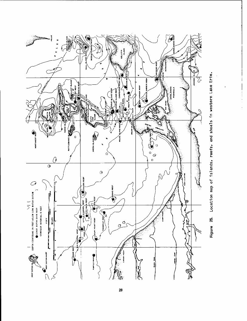
(0
c
+>
*
o
T3 c 10
0) <D
in
c (0
Q. <0 E
+> 10 o o
in CM
3
28
in the undermining of the rock above, which falls away in large blocks, forming nearly vertical walls. The shoreline of Catawba Island from Rock Ledge to West Harbor is 10 km long and consists of an alternation of rocky headlands and glacial bluffs. The dolomite headlands rise to 21 m above lake level, whereas the glacial till is much less resistant to erosion and has been cut back into coves with indentations along the coast. Pebble and cobble beaches have formed locally in the coves. The 6 km of shore from West Harbor to Lakeside is low and bordered by sand beaches. The beaches lie on marsh deposits which formed in the shallow bay between Catawba Island and Marblehead Peninsula. The underlying materials are glacial till and lacustrine clay. An extensive sand deposit has accumulated in the East Harbor area and low sand dunes have formed behind the beach.
The resistant lower beds of the Columbus Limestone are responsible for the easterly chain of bedrock highs, including Johnson and Kelleys islands. Between South Bass Island and Kelleys Island three formations are less resistant than the Put-in-Bay Dolomite and the Columbus Limestone, a fact which explains the depression between the islands.
The Marblehead Peninsula shore arcs for 6 km from Lakeside to the base of Bay Point and is lined with limestone and dolomite bluffs, generally less than 6 m above lake level. Sections of the shore are composed of thin-bedded rock which yields to wave attack; elsewhere the rock is massively bedded and more resistant to erosion. Glacial till commonly caps the bluffs. The narrow pebble beaches which line the shore at the base of the bluffs have been largely derived from the bedrock. Bay Point extends southward from Marblehead Peninsula for 3 km into Sandusky Bay. This point is a compound spit that is growing from sand contributed by littoral currents moving along Cedar Point and around the end of the Sandusky Harbor jetty. Johnson Island, lying in Sandusky Bay adjacent to Bay Point, is composed of low limestone and glacial till shores. The shore of this island is bordered by discontinuous cobble beaches.
The Detroit-St. Clair River system is underlain by middle and upper Devonian and by lower Mississippian rocks. The oldest rocks are the dolomites of the Detroit River formations and the limestone of the Dundee Formation, found at the mouth of the Detroit River. Prom here the rocKs are successively younger in a northwest direction through Lake St. Clair. In Lake St. Clair and the upper Detroit River valley the bedrock is buried by up to 30 m of glacial till and recent lake sediment. Near the mouth of the Detroit River the bedrock surface rises to an elevation of 168 m and is covered by only a thin veneer of more recent deposits.
Caves and Sinkholes
The Lake Erie Islands, including Catawba and Marblehead peninsulas, exhibit a rather unusual cave and sinkhole topography. The carbonate bedrock of these islands is soluble in weak, naturally-occurring acids, such as car- bonic and various organic acids. These acids have slowly dissolved portions of the rock, producing caves, sinkholes, and other solution features. This process has taken place for millions of years, probably starting soon after the lime muds which had accumulated in the Silurian ocean were drained of sea water. The solution process initially resulted in sinkholes which became filled with dolomite fragments that had broken off the rim, producing a breccia in the lime mud. Exposures of these ancient breccia-filled sinkholes are common on the west shore of South Bass Island.
Solution has also occurred more recently, producing many small caves in the bedrock,, Thirty-seven such caves have been reported for the islands. Most of the caves are the result of solution and subsequent collapse of the surrounding and overlying rock into the void. The exact origin of the caves and sinkhole features has been a matter of speculation. The most widely accepted theory (Verber and Stansbery 1953) states that the structure of the rock materials combined with their mineral composition and contact with water has resulted in cave and sinkhole formation (Figure 26). Specifically, the Put-in-Bay Dolomite is underlaid by the
2S

^T=-~~i TYMOCHTEE SHALY DOL. ANHYDRITE
TILL
PUT-IN-BAY DOLOMITE
GYPSUM
PRESENT CAVES
UNDERGROUND LAKE
Figure 26. Explanation of cave and sinkhole formation in the islands region of Lake Erie: A) cross section showing original anhydrite bed, B) uplifting of overlying strata by hydration into gypsum, C) cavern left by gypsum solutioning, and D) collapse of overlying strata and formation of sinkholes and new peripheral caves (Verber and Stansbery 1953).
Tymochtee Formatton which contains lenses» or pockets, of anhydrite gypsum. Anhydrite has the property of swelling 1n contact with moisture; hydration Increases the volume from 33% to 63%, exerting approximately 6.5 tons of pressure per cm2 on the surrounding materials. The Tymochtee Formation caused a doming of the overlying Put-1n-Bay rock structure. Later» the gypsum was dissolved, leaving a
large, unsupported subterranean cavern. Eventually, the roof of the cavern collapsed, forming crescent-shaped caves and caverns around the perimeter. The collapse generally formed large shallow circular depressions on the land surface and created small caves around the margins of these collapse features. In areas of Catawba and Marblehead, the lenses of anhydrite may have been thinner and less
30
extensive, producing only a slight doming, and eventually resulting 1n the formation of a sinkhole rather than a cave. The lower levels of many of the caves, formed either by solution or collapse, are now flooded by water coming 1n from the lake along cracks and solution openings. Perry's Cave on South Bass Island and Crystal Rock Cave on the south shore of Sandusky Bay near Castalla are the only caves of this type open to the public.
The shoreline of Catawba and the Bass Islands contain many indentations and headlands which owe their origin to such solution processes. Roughly circular lagoons 1n the bedrock are particularly common along the west shore of Catawba Island. These lagoons are thought to be sinkholes as evidenced by springs Issuing from their bottoms. Formerly lagoons such as these provided excellent protection for coastal wetlands, but in recent years most of them have been developed as small boat harbors. A few natural lagoons still exist along the rocky shores (such as Terwllllger's Pond on South Bass Island), but even these are threatened by the rapid increase 1n recreational use of the reg i on.
Glacial Geology
Geologically, the last glacier retreated from the Lake Erie basin very recently, less than 12,000 years ago (Hough 1958). Glacial events started much earlier, about a million years ago, when the first Ice sheets Invaded the Lake Erie region from the northeast. Geologists refer to this segment of the earth's history as the Pleistocene Epoch or Ice Age. As the ice overrode the resistant limestone, which now forms the brink of Niagara Falls, It dug deeply into the softer Devonian shales of western New York. The ice front was obstructed by the steeply rising Portage Escarpment which lies a few kilometers inland of the present south shore of the lake between Cleveland and Buffalo (Figure 21). Thus, the glacier was deflected to the west along the outcrop of the soft shale. The shale was scoured to form the deep bottom of the narrow eastern basin. Farther west where the width of the shale belt is greater, glacial erosion resulted in the broader, but shallower central basin. The
western basin owes its islands, reefs and shallowness to the tough Devonian and Silurian limestones and dolomites which resisted glacial scour.
The preglacial topography of the Lake Erie basin can be inferred from test borings and seismic measurements of the sediments overlying the bedrock surface (Figure 27). During the long period between the deposition of Paleozoic sediments 1n the region and the first glacier advance, approximately 300 million years, an extensive river drainage system was cut Into the rocks. A trellis-shaped stream pattern formed 1n the Islands area while the main-trunk stream entered the present lake basin from the northwest and exited 1n the vicinity of the Niagara River. The Pleistocene glaciers followed these preglacial valleys, scouring them deeper and smoothing their meander as they moved southwest. The islands and reefs were probably high ground or hills between the trellis streams. The end result was greatly broader and deeper stream valleys. Since the retreat of the last glacier, over 30 m of sediment has been deposited in many of the glaciated valleys to give the present Lake Erie a much smoother and flatter bottom than 1t had when water first filled the basin.
Glacial lake stages. As the ice sheets paused in their advance or retreat, ridges known as moraines were built up of rock debris at the 1ce margins. The debris, often called glacial till, 1s composed of a heterogeneous mixture of rock fragments ranging in size from clay to boulders. In places, end moraines were deposited in such a way as to dam the natural drainage, thereby forming large lakes in the scoured depressions. Lake Erie is a remnant of such a lake. At its highest stage this lake, known as Lake Maumee, was over 244 m above sea level, (70 m above the present level of Lake Erie). Lake Maumee extended as far southwest as the present city of Fort Wayne, Indiana (Figure 28). At that time, drainage from the lake was toward the southwest via the Wabash and Mississippi Rivers to the Gulf of Mexico. As the 1ce retreated, other outlets were uncovered and several lake stages (Figure 28) were formed at successively lower levels, except for minor readvances of the ice
31

Figure 27. Preglacial drainage in western Lake Erie as inferred from bedrock surface (Hobson et al. 1969).
yvx""^"
VS J^D U S K>^f--R LA-r l„^x1-;/ \ 1—
I -• ■••'*« I i r - 1 I ( i R ° N rMED?HA .SUMMIT
0^;C 'cO-VA S H T A B U L A
^ j i 6EAU6A j
Vl P A.U.L D I N 6 |
K--
!T RUMBULL
PORTAGE
VAN-WERT L. ^-^ivf"1 III" P
e
AN C OC K
r1
»J-.. , J—J fn A p
| ! A L L E N
j T- -, J H A R D I N
WYANDOT jcRAWFORD j *-* WsKI ANOi W A Y N Ej I RICHLAND^. " I
h-
I MERC ER I A U G L A I Z E MARION
-T" .j
IRICHLAND'*
S j
,JM0RR0WI
Figure 28. Map of prominent beach ridges abandoned by post glacial lakes in northern Ohio (Stout et al. 1943
32

which blocked outlets and caused (Table 3). When the last glacier temporarily higher lake levels. retreated from the vicinity of Buffalo,
New York, a new drainage outlet became The foregoing sequence of events available through the Niagara River.
occurred in a 2,000-year span of time from However, the new outlet was as much as approximately 14,000 to 12,000 years ago 30 m lower than at present because the
Table 3. Glacial lake stages of the Lake Erie basin.3
Lake stage Age (years ago)
Elevation (m above sea level)
Reason for change in level
Outlet
Erie 4,300 174 Isostatic uplift (modern) to the north
Niagara River
Erie 12,200 150-143 Continued ice (early) retreat
Lundy 195-190 Erosion of outlet and continued ice retreat
Niagara River
Mohawk River or west to Lake Calumet or Lake Glenwood
Warren 207-203 Continued ice advance (Valders Drift)
Grand River, Mich.
Wayne
Low water stage
Whittlesey 13,000
200 Advance of ice
? Extensive retreat of ice
224 Readvance of ice Port Huron Moraine
Mohawk River, N. Y.
Niagara River (?)
Grand River, Mich.
Low water stage
Arkona
Maumee III
Maurnee II
? Extensive retreat of ice
217-212 Retreat of ice and erosion of outlet
238 Readvance of ice Lake Border moraine
232 Continued ice retreat
Niagara River (?)
£rand River, Mich,
Wabash River, Ind.
Grand River, Mich«
Maumee I 14,000 244 Formation of first major lake stage in depression between 1ce and Defiance Moraine
Wabash River, Ind«
a, Data source: Herdendorf and Braidech (1972).
33

land surface had been depressed by the weight of glacial ice which was approximately 1.6 km thick.
This new and very low outlet caused a massive flood of water to exit the lake basin toward the east, resulting in the drainage of the western end of the lake and the formation of separate, shallow lakes in the central and eastern portions of the lake basin. During this low lake stage (12,000 to 4,000 years ago) much of the western basin was dry and exposed to erosion, which greatly altered and reshaped the bottom surface. The Niagara outlet gradually rebounded to its present elevation, and Lake Erie correspondingly rose from this low elevation of 140 m to its present level. As the lake rose, waves and currents cut into the lake bottom, locally excavating the glacial deposits and exposing some of the shallowly burled bedrock. The exposed bedrock now forms the islands, reefs, and rocky shorelines of the lake.
Ancient beach ridges. Low, contin- uous sandy ridges are common in northern Ohio, often within a few miles of Lake Erie. Numerous east-west roads follow these ridges and many early homes were built on them. Each ridge represents an ancient beach, formed along the shore of former lakes which once occupied the Lake Erie basin at elevations much higher than the present lake. These former lakes are known as Maumee, Arkona, Whittlesey, Warren, Wayne, Grassmere, and Lundy. Because these lakes each had a different outline and each stood at a different elevation, each stage is marked by a separate set of beaches at a charac- teristic elevation. The three most prominent ridges are Warren, Whittlesey, and Maumee (Figure 28). In some places, such as Amherst, Berlin Heights, and Castalia, where the former lake shore was a rocky, spectacular cliff, features resembling sea caves and sea stacks can be seen.
Lake Sediments
The bottom deposits of Lake Erie consist of silt and clay muds, sand and gravel, peat, compact glacio-lacustrine clays, glacial till, shoals of limestone and dolomite bedrock and rubble, shale
bedrock shelves, and erratic cobbles and boulders composed chiefly of Igneous and metamorphic rocks (Herdendorf 1968). The distribution of bottom sediments 1s closely related to the bottom topography. The broad, flat areas of the western and central basins, and the deep areas of the eastern basin have mud bottoms. Mldlake bars and nearshore slopes are comprised mostly of sand and gravel or glacial till. Rock 1s exposed 1n the shoals of western Lake Erie and along the south shore of the central basin at Huron and Vermilion, Ohio. In general, sand is limited along the shoreline, but extensive dunes have been formed at several places, most notably at the base and southwestern side of Point Pelee and Long Point, Ontario. These dunes were formed presumably under the influence of the prevailing southwest winds. Littoral currents have con- centrated sand spits, baymouth bars, and harbor breakwalls at such places as Point Pelee and Long Point, Ontario; Woodtick Peninsula, Michigan; East Harbor, Cedar Point, and Vermilion, Ohio; and Presque Isle, Pennsylvania.
The bottom deposits of the Ohio portion of western Lake Erie (Figure 29) are composed mainly of mud (semifluid clay- and silt-sized particles) (58%). Sand (17%), mixed mud and sand (12%), mixed sand, gravel, and coarser material (7%), glacio-lacustrine clay (3%), and bedrock (3%) account for the remaining bottom material. Peat and plant detritus occur in isolated areas along marshy shores. Sand deposits in Maumee Bay and at the entrance to Sandusky Bay are sites of commercial dredging (Verber 1957).
Test borings into the subsurface bot- tom deposits in the vicinity of the Lake Erie Islands show a predominance of lake- deposited material with only thin glacial till overlying bedrock (Hartley 1961). Preglacial buried valleys are indicated by bedrock topography, which in places has 61 m of relief. Some boring also indicates the possibility of interglacial or postglacial buried valleys and lower lake stages. Beach deposits and peat have been found 11 to 24 m below the present lake level, buried under more recent deep-water sediments. A radiocarbon date of 6,550 years ago was obtained for a sample of oak wood buried 7 m below the lake bottom
34

MILES
Figure 29. Distribution of bottota deposits 1n the Islands area of western Erle (Herdendorf and Braldech 1972).
Lake
35

(Herdendorf and Braldech 1972). This date permits the calculation of a sedimentation rate of 0.1 m/century. A deep boring In the central basin 48 km north of Cleveland (water depth of 26 m) yielded bottom surface sediment of gray-brown mud. Successively lower sampling yielded soft gray-brown clay that became stlffer downward. At 34 m of bottom penetration* rock or hard glacial till that could not be penetrated was reached. Seismic reflection surveys have revealed a maximum unconsol Idated sediment thickness of 84 m 1n the central basin and 40 m 1n the western basin.
Recent sedimentation 1n Lake Erie can be attributed to two primary sources: suspended sol ids from Inflowing streams and bluff material contributed by shore erosion. Over 6 million metric tons of clay, silt, and sand are transported annually to Lake Erie from Its trib- utaries. Shore erosion of glacial till and lacustrine clay bluffs 1s an acute problem at many locations along the shoreline. Maximum shore erosion, based on volume of material removed, occurs along the north shore of the central basin between Port Stanley and the base of Long Point, although the low-lying south shore of Maumee Bay has experienced the maximum rate of shore recession, which has been as high as 6 m per year. Estimates of erosion rates for the Ohio shoreline indicate that about 6,000 mVkm of bluff material erode each year. If these estimates are extrapolated for the entire shore of the lake, 8,500,000 m^ of this material are contributed to the lake each year, which would equal a thickness of 0.25 mm 1f spread uniformly over the lake bottom (Herdendorf 1975).
Marl and tufa, a carbonate of lime deposited on growing plants, occur in the low bluffs and marshes along the south shore of Sandusky Bay, particularly in the vicinity of Little Pickerel Creek. Both of these deposits are up to 0.3 m thick and lie above or below lake clays near the present bay water level. These deposits are associated with mineralized ground- water which is under artesian pressure In this area. As the groundwater issued from the underlying bedrock, carbonate deposits such as these formed locally in the coastal wetlands. Both tufa and marl
offer less resistance to wave attack than the overlying and underlying clay. Consequently, these deposits are removed rapidly, causing undercutting of overlying clay and erosion of the shoreline (Bowman 1951).
Marsh Deposits and Wetland Soils
Prolific growth 1n the Locust Point marshes has resulted 1n a deposit of marsh "muck" overlying the ancient lake clays (Savoy 1956). The marsh deposits consist of decayed organic matter mixed with varying amounts of clay, silt, and sand (Figure 30). Sand 1s only abundant 1n areas near the barrier beaches where storms have carried sand wedges Into the marshes. These deposits vary from a grayish brown to a rich, brownish black. In thickness, the deposits range from a thin veneer to nearly 1 m. On the floor of the marshes, these deposits are quite soft and porous with abundant, loosely coherent plant remains. In places, these deposits occur beneath the barrier beach deposits, and locally they are exposed where wave action has cut into the beach (Figure 31). The recent geologic history of the Locust Point shore Indicates that the barrier beaches have migrated shoreward over the marshes, and thus have preserved marsh deposits beneath the beach sands. Savoy (1956) found that the barrier bar at Magee Marsh has steadily advanced landward over the marshlands as a result of the overwashlng of beach sand Into the marsh during northeast storms and the sweeping of sand in through breaches. During this advance, the compacted marsh deposits which have been overridden by the bar are eventually exposed to current and wave attack at the beach front. When the marsh deposits themselves are eroded, they contribute a black, peaty material to the beach face which discolors the nearshore waters of the lake.
Coakley (1972), working 1n the vicinity of Point Pelee, showed that the point 1s composed of two sand and gravel spits resting on a glacial moraine (Figure 32). The spits enclose a marshland which has formed relatively thin peat deposits (1 m). The sand bodies reach a thickness of 8 m on the west side of the spit. Coakley attributes the source of this deposit to discharges of sandy materials
36

mi nwiniii ■
Figure 30. Marsh deposits at Magee Marsh, showing tension cracks that develop when dewatered (Savoy 1956).
LAKE ERIE
Lake Surf Zone Foreshore Barrier Bar
berms
lower upper
Lagoon
marsh edge marsh/ i
1 ■ 'I I II I I I I I I I I I I I I I I I, ■.dröck i I I I I I ±dl Li i i i i' i' i' i ' i' i' i' i' iL i' i' i' i h ' i' i ' i' i'Tiii i' i' i' ' ' ' '
Figure 31. Cross section of barrier beach and lagoon at Maqee Marsh, Ohio (Savoy 1956).
37
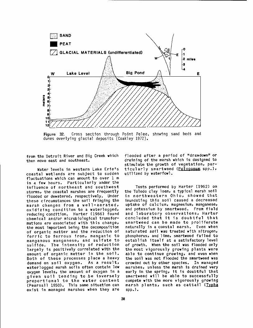
SAND
PEAT
rZ\ GLACIAL MATERIALS (undifferentiated)
Figure 32. Cross section through Point Pelee, showing sand beds and dunes overlying glacial deposits (Coakley 1972).
from the Detroit River and Big Creek which then move east and southeast.
Water levels in western Lake Erie's coastal wetlands are subject to sudden fluctuations which can amount to over 1 m in a few hours. Particularly under the influence of northeast and southwest storms, the coastal marshes are frequently flooded or dewatered, respectively. Under these circumstances the soil fringing the marsh changes from a wel1-aerated, oxidizing condition to a waterlogged, reducing condition. Harter (1966) found chemical and/or microbiological transfor- mations are associated with this change, the most important being the decomposition of organic matter and the reduction of ferric to ferrous iron, manganic to manganous manganese, and sulfate to sulfide. The intensity of reduction largely is positively correlated with the amount of organic matter in the soil. Both of these processes place a heavy demand on soil oxygen. As a result, waterlogged marsh soils often contain low oxygen levels, the amount of oxygen 1n a given soil tending to be Inversely proportional to the water content (Pearsall 1950). This same situation can exist in managed marshes when they are
flooded after a period of "drawdown" or draining of the marsh which is designed to stimulate the growth of vegetation, par- ticularly smartweed (Polvoonum SDD.).
utilized by waterfowl.
Tests performed by Harter (1962) on the Toledo clay loam, a typical marsh soil in northwestern Ohio, showed that Inundating this soil caused a decreased uptake of calcium, magnesium, manganese, and potassium by smartweed. From field and laboratory observations, Harter concluded that it 1s doubtful that smartweed can be made to proliferate naturally in a coastal marsh. Even when saturated soil was treated with nitrogen, phosphorus, and lime, smartweed failed to establish Itself at a satisfactory level of growth. When the soil was flooded only the most vigorously growing plants were able to continue growing, and even when the soil was not flooded the smartweed was crowded out by other species. In managed marshes, unless the marsh 1s drained very early in the spring, 1t is doubtful that smartweed will be able to successfully compete with the more vigorously growing marsh plants, such as cattail (Tvpha spp.).
38

Redmond et al . (1971) mapped the marsh soils of Erie County, Ohio. The highest concentrations were found along the south shore of Sandusky Bay between Sandusky and Whites Landing and near the mouths of the Huron River and Old Woman Creek. They observed that these areas are submerged part of the year» but are dry long enough to permit the growth of cattails, sedges, and other water-tolerant plants. The soil material underlying the marsh varies considerably. In the areas west of Sandusky, it is similar to the material in the lower part of the profile of Toledo soils, but in the areas east of Sandusky, it is similar to the material in the lower part of the profile of Lenawee and Col wood soils. Toledo soils are dark- colored, very poorly drained soils that formed in clayey lake bed deposits. Lenawee soils are similar but slightly coarser in texture. Colwood soils are also dark-colored and poorly drained, but they formed in lake-deposited silt and fine sand. Redmond et al . (1971) concluded that these areas provide good habitat for duck, muskrat, and other kinds of wildlife, if they are protected from land-filling operations and from pollution.
2.2 CLIMATE AND WEATHER
The climate of western Lake Erie is temperate and humid-continental and is characterized by rapidly changing weather. The location of the Great Lakes between the source regions of contrasting polar and tropical air masses fosters these complex weather patterns.
Temperature
The annual average temperatures for mainland stations 1n the Lake Erie basin range between 8.4°C to 10.0°C. Tem- peratures generally decrease north- eastward from the southwestern end of the basin (Figure 33). The highest average temperatures occur at Put-in-Bay on South Bass Island with an annual average of 11.1°C.
The highest average monthly tem- peratures occur in July, ranging from 21.1°C to 23.4°C at mainland stations.
80
60
50
S 40
30
20
„-.
1 I PUT-IN-BAY
^~~~ 'N-^' — TOLEDO
/'/, -^\ \
/'/BUFFALO / \ \
// \ \
Vv // \\\
/ Y< // ^ \
// \ // \\
/ \ ' h \ ^ // x
'// \
;^£ -jy V v
JAN. FEB. MAR. APR. MAY JUN. JUL. AUG. SEP. OCT. NOV. DEC.
Figure 33. Annual air temperature curves for Toledo, Put-in-Bay, and Buffalo (FWPCA 1968).
These also generally decrease north- eastward across the basin from Toledo to Buffalo. Put-in-Bay again is the highest at 24.0°C. The lowest average monthly temperatures occur in January at the western end of the lake and February at the eastern end, and range from -4.4°C to -2.2°C. The extremes of air temperature in the Lake Erie basin are about -28.8°C and 37.8°C.
Precipitation
Average monthly precipitation at mainland stations in the Lake Erie basin is well-distributed throughout the year (Figure 34) and ranges from about 77 cm (30 in) to more than 102 cm (40 in) with an overall basin average of about 86.4 cm (34 in). Yearly precipitation has varied between the extremes of 71.0 (28 in) and 109.2 cm (43 1n). Precipitation shows a striking correlation to land elevation and topography (Figure 35). Low-lying flat areas of the western basin, including the coastal marshes, have the lowest pre- cipitation.
Most of the precipitation in the Lake Erie basin 1s derived from the north- eastward flow of warm, moisture-laden air
39
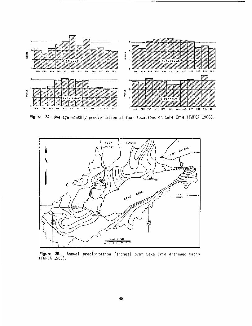
JAN. FEB MAR APR. MAY JUN JUL. AUG SEP OCT NOV. DEC
JAN FEB MAR APR MAY JUN JUL AUG JEP OCT NOV OEO JAN FEB MAR APR MAY JUN JUL AUG SEP OCT NOV DEC
Figure 34. Average monthly precipitation at four locations on Lake Erie (FWPCA 1968).
Figure 35. Annual precipitation (inches) over Lake Erie drainage basin (FWPCA 1968).
40

of low pressure systems from the Gulf of Mexico. Precipitation results when this clashes with colder, northern air of high pressure systems, moving in from the west and northwest. This kind of weather is typical of spring, summer, and early fall, and usually occurs in cycles of a few days. Humidity is high along with high temperatures, and south to southwest winds persist for long periods.
In winter, however, the colder Ca- nadian air masses push southeastward and dominate the weather, resulting in less precipitation and less humidity. The heavier precipitation (usually snow) is experienced in the eastern part of the basin, particularly inland from the American shore. This largely local phenomenon, known as "lake effect," is caused by air moving across Lake Erie, picking up moisture en route, and precipitating it when the air mass rises along the front of the hills on the southeastern shore. Snowfall is greater in the eastern part of the basin: e.g.»Buffalo has an annual average snowfall of 182.9 cm as compared to less than 91.4 cm for Toledo (Federal Water Pollution Control Administration 1968).
Thunderstorms occur on about 35 days each year and are most frequent from April through August. Heavy rains of 5.0, 7.6, 9.4, 11.4, 13.2, and 14.7 cm in 24-hour periods can be expected to occur at least once every 2, 5, 10, 25, 50, and 100 years respectively. The heaviest rain of record in Ohio fell between 0200 and 2200 hours on 12 July 1966 at Sandusky. Total rainfall during this period was 26.7 cm.
Figure 36. Average annual winds at Sandusky, Ohio, for 1948-1957 (Herdendorf and Braidech 1972).
Sunshine
Western Lake Erie experiences a maximum of about 15 hours of daylight in the summer and 9 hours in the winter (Table 4). Therefore, the percent of possible sunshine is greatest in midsummer and least in winter (Figure 37), although precipitation might indicate otherwise. Less sunshine in winter is due to the cloud-producing effects of the lake. December and January ordinarily have less than 40% of possible sunshine, while June and July average more than 70% at most stations. The percentage over the lake in summer is even greater.
Wind
Southwesterly winds prevail over Lake Erie in all months of the year (Figure 36), a characteristic common to the northern hemisphere temperate region. However, in fall and winter, northwesterly winds occur frequently, reaching high velocities (65 to 80 km/hr) during storms. In spring, the same is true of northeasterly winds except that velocities (50-65 km/hr) are usually lower. Storms of this intensity from the northeast can be particularly devastating to coastal wetlands 1n Ohio and Michigan.
Growing Season
Lake Erie has a marked moderating effect on the climate of the basin, especially for a few kilometers inland from the shore. This is demonstrated by the length of the frost-free season; near shore it is greater than 200 days, while only a few kilometers inland it 1s as much as 30 days less (Verber 1955). This longer frost-free season is due to a warming effect from the lake water. During the late fall and early winter, the lake is still relatively warm and delays the first killing frost.
41

Table 4. Average monthly duration of daylight for western Lake Er1e.a
Month Sunrl se Sunset PaYllght
(hr:m1n) period (total sec)
Jan. 15 0759 EST 1723 9:24 33,840
Feb. 15 0728 EST 1805 10:28 37,680
Mar. 15 0645 EST 1838 11:53 42,780
Apr. 15 0535 EST 1911 13:16 47,760
May 15 0612 EDST 2043 14:35 52,500
June 15 0555 EDST 2109 15:14 54,840
July 15 0610 EDST 2106 14:56 53,760
Aug. 15 0641 EDST 2034 13:53 49,980
Sep. 15 0710 EDST 1945 12:35 45,300
Oct. 15 0742 EDST 1853 11:11 40,260
Nov. 15 0722 EST 1711 9:49 35,340
Dec. 15 0754 EST 1701 9:07 32,820
Data source: U.S. Weather Service.
Although located 1n nearly the most northern portion of the State, South Bass and the other Islands have the longest frost-free period of any area 1n Ohio. South Bass Island has an average frost- free period of 205 days, while Bucyrus, 80
JAN FEB MAR APR. MAY JUN JUL AUG. SEP OCT. NOV DEC.
Figure 37. Monthly percent of possible sunshine at Toledo, Ohio, for 1965 (FWPCA 1968).
km to the south, has an average of 154 days. North Bass Island has a frost-free period of 206 days. The high heat capacity of the lake prolongs the summer temperature far Into fall, but the small range of temperature between the maximum and the minimum dally temperature permits a long spring, j The long frost-free period, however, does not Indicate a long growing season. The spring temperatures are retarded» and the threshold temperature, or temperature denoting the beginning of the blooming period of the flora, occurs much later on the Island than on the mainland. This retardation 1s reflected by the average date of the last killing frost, which 1s around April 15 for the Islands, contrasted with May 20 for the Interior of Ashtabula County, nearly 1n the same latitude, and with April 30 as far south as Columbus. Similarly, the average date for the first
42
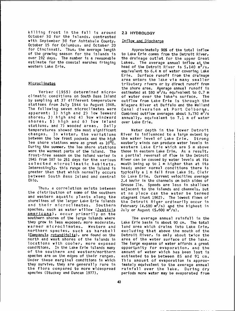
killing frost in the fall is around October 30 for the islands, contrasted with September 30 for Ashtabula County, October 15 for Columbus, and October 20 for Cincinnati. Thus, the average length of the growing season for the Islands is over 192 days. The number is a reasonable estimate for the coastal marshes fringing western Lake Erie.
Verber (1955) determined micro- climatic conditions on South Bass Island by sampling at 37 different temperature stations from July 1944 to August 1948. The following seven microclimates were apparent: 1) high and 2) low leeward shores, 3) high and 4) How windward shores, 5) high and 6) low inland stations, and 7) wooded areas. Daily temperatures showed the most significant changes. In winter, the variations between the low frost pockets and the high lee shore stations were as great as 10°C. During the summer, the lee shore stations were the warmest parts of the island. The frost-free season on the island varied in 1945 from 187 to 251 days for the various selected microclimatic habitats. Interestingly, this range on the island is greater than that which normally occurs between South Bass Island and central Ohio.
Thus, a correlation exists between the distribution of some of the southern and western aquatic plants along the shorelines of the larger Lake Erie islands and their microclimates. Southern species, such as water willow (Justicia ameri cana) . occur primarily on the southern shores of the large islands where they grow in less exposed, more moderate, warmer microclimates. Western and northern species, such as harebell (Campanula rotundifolia), are found on the north and west shores of the islands in locations with cooler, more exposed conditions. In the Lake Erie islands many of the southern and western/northern species are on the edges of their ranges. Under these marginal conditions in which they survive, they are generally rare 1n the flora compared to more widespread species (Stuckey and Duncan 1977).
2.3 HYDROLOGY
Inflow and Discharge
Approximately 90% of the total inflow to Lake Erie comes from the Detroit River, the drainage outlet for the upper Great Lakes. The average annual inflow at the head of the Detroit River is 5,140 m3/s, equivalent to 6.4 m of water covering Lake Erie. Surface runoff from the drainage area enters the lake via many smaller tributary rivers or by direct runoff from the shore area. Average annual runoff 1s estimated at 580 rrr/s, equivalent to 0.7 m of water over the lake's surface. The outflow from Lake Erie is through the Niagara River at Buffalo and the Weiland Canal diversion at Port Colbortie. Combined outflow averages about 5,730 nr/s annually, equivalent to 7.1 m of water over Lake Erie.
Water depth in the lower Detroit River is influenced to a large extent by the water level of Lake Erie. Strong easterly winds can produce water levels in western Lake Erie which are 5 m above those in eastern Lake Erie. As a result, a partial reversal of flow in the Detroit River can be caused by water levels at its mouth being up to 1 m higher than at its head; under normal conditions there is typically aim fall from Lake St. Clair to Lake Erie. Current velocities average 2.4 km/hr in the channels on both sides of Grosse lie. Speeds are less in shallows adjacent to the islands and channels, but at no place can the water be termed stagnant (Hunt 1962). The lowest flows of the Detroit River ordinarily occur in February (4,500 nrr/s) and the highest in July or August (5,600 m/s).
The average annual rainfall in the Lake Erie basin 1s about 90 cm. The total land area which drains into Lake Erie, excluding that above the mouth of the Detroit River, is only about twice the area of the water surface of the lake. The large expanse of water affords a great opportunity for evaporation, and the amount of water which has been lost is estimated to be between 85 and 91 cm. This amount of evaporation is approx- imately equivalent to the average annual rainfall over the lake. During dry periods more water may be evaporated from
43

the lake than flows Into it from its drainage basin. Under these conditions Lake Erie delivers into the Niagara River a smaller quantity of water than it receives from the Detroit River.
Four natural hydrologic factors ac- count for the net supply of water to coastal wetlands: 1) precipitation, 2) runoff, 3) ground water, and 4) evaporation. While the major source of water to Lake Erie is the upper Great Lakes via the Detroit River, several watersheds (Figure 38) drained by 10 major streams and numerous small ones discharge into the western basin of Lake Erie (Table 5). Each of these tributaries has a drowned mouth, creating estuarine conditions which have fostered the formation of coastal marshes.
Water Levels
The record high water levels in Lake Erie during 1972 and 1973 contributed greatly to increased erosion of the shores. Because the narrow beaches fronting the coastal wetlands and shore bluffs were submerged, they were exposed to direct wave attack and erosion by alongshore currents. Severe storms have resulted in profound changes in shoreline configuration and disruption of the marshes.
Water level changes on Lake Erie are of two principal types: 1) long-period fluctuations and 2) short-period fluctuations. Long-period fluctuations are related to volumetric changes of the lake, caused principally by variations in
Figure 38. Map of major watersheds in the western and central Lake Erie drainage basins (FWPCA 1968).
44

Table 5. Estimated characteristics of western Lake Erie tributaries.a
Stream Drainage Average Suspended Dissolved area discharge sol Ids solids (km2) (m3/sec) (tons/yr) (tons/yr)
MICHIGAN Detroit River — 5,140 1,570,000 33,580,000 Huron River River Raisin Others
2,300 2,640 3,110
16 19 20
1,800 4,700 4,000
73,000 91,200 25,000
OHIO Ottawa River 470 3 1,000 5,000 Maumee River Toussaint River Portage River
17,050 280
1,520
137 2
11
2,270,000 700
120,000
1,370,000 4,000
91,200 Sandusky River 3,680 30 270,000 446,400 Huron River Others
1,040 900
9 8
12,000 60,000
50,000 100,000
ONTARIO B1g Creek Others
110 500
1 4
300 1,500
1,200 5,000
TOTAL 33,600
a^ .
5,400 4,316,000 35,842,00
Data source: Herdendorf 1975.
precipitation, evaporation, and runoff. These changes include both seasonal fluctuations and those occurring over a period of several years. Short-period fluctuations are due to a tilting of the lake surface by wind or by atmospheric pressure differentials. Wind tides, seiches, and harbor surges, which have periods from a few seconds to several days, are examples of short term fluctuations. Verber (1960) found sun and lunar tides are negligible, resulting in maximum fluctuations of 3.3 cm.
Long-period fluctuation«;, jhe high- est and lowest average monthly levels on Lake Erie generally occur in June and February, respectively. This seasonal variation typically ranges from 0.3 to 0.6 ir. The plane of reference for charts and navigational works on Lake Erie 1s known as Low Water Datum (LWD), and stands at an elevation of 173.3 m above the mean at Father Point, Quebec. The
water level at Father Point, known as the International Great Lakes Datum or IGLD, 1955, approximates sea level at the place where the flow from the Great Lakes enters the ocean based on water level records for the year 1955. The mean level of Lake Erie for the period of record (1900-83) is 173.9 m as measured by the U. S. Army Corps of Engineers. The highest average monthly level recorded was 174.8 m reached in June 1973 and the lowest average monthly level recorded was 173.0 m in February 1936. This represents a change in the lakes volume of approximately 10%.
Long-term variations are the result of persistent high or low precipitation. In the mid-1960s on Lake Erie and the upper Great Lakes, there were low precipitation and near-record low water levels in the lakes. In 1972-73, there were higher precipitation and extreme high water levels on Lake Erie. Records at Cleveland going back more than 100 years
45
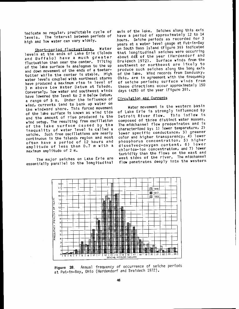
indicate no regular, predictable cycle of levels. The interval between periods of high and low water can vary widely.
sh»rt-periM f1ll^t'lations- Water levels at the ends of Lake Erie (Toledo and Buffalo) have a much greater fluctuation than near the center. Tilting of the lake surface 1s analogous to the up and down movement of the ends of a teeter- totter while the center is stable. High water levels coupled with northeast storms have produced a maximum rise 1n level of 3 m above Low Water Datum at Toledo. Conversely, low water and southwest winds have lowered the level to 2 m below Datum, a range of 5 m. Under the Influence of wind, currents tend to bank up water on the windward shore. This forced movement of the lake surface is known as wind tide and the amount of rise produced is the wind setup. The resulting free oscillation of the lake surface caused by the inequality of water level is called a seiche. Such free oscillations are nearly continuous in the islands region and most often have a period of 12 hours and amplitude of less than 0.7 m with a maximum amplitude of 2 m.
The major seiches on Lake Erie are essentially parallel to the longitudinal
axis of the lake. Seiches along this axis have a period of approximately 12 to 14 hours. Seiche periods as recorded for 3 years at a water level gauge at Put-in-Bay on South Bass Island (Figure 39) indicated that longitudinal seiches were occurring about 44% of the year (Herdendorf and Braidech 1972). Surface winds from the southwest or northeast are likely to produce such seiches along the long axis of the lake. Wind records from Sandusky, Ohio, are in agreement with the frequency of seiche periods; surface winds from these directions occur approximately 150 days (42%) of the year (Figure 39).
^Ir-'.llatl"" qPd Currents
Water movement in the western basin of Lake Erie is strongly influenced by Detroit River flow. This inflow is composed of three distinct water masses. The mldchannel flow predominates and is characterized by: 1) lower temperature, 2) lower specific conductance, 3) greener color and higher transparency, 4) lower phosphorus concentration, 5) higher dissolved-oxygen content, 6) lower chloride-ion concentration, and 7) lower turbidity than the flows on the east and west sides of the river. The midchannel flow penetrates deeply into the western
18- 1 17- 1 Ü 1944 16- I«; ^ 1947
15- ,iJi l ^ 1952
o: 14- < a 3 3 £ 13- i||i|li|| U- 12- O J i is H 11- Z |l|:;i: IIP Li ,u- i 1 % ! 1 * 1 § ^i: S
tr 9- LU
" I Pl|ijh ^ ■! ^
a e- ii ^ ^ N y ^ BL
U 7- Z 1 111 It p ^ :; S r, | S c
W 6- M I'-'BIII^ 1? Is :|if Id b" 8= 4-
3-
2-
1-
0
|if|iip|* ^:;: 8?i^!j |\
P Ütj!-t? |l ll |1 JÄ
$ f^S $ I l'-'-lllBä If |l 11 ':':« ^ i§- ! ii||Ä|l "* "'{"%
& # - H *; Piilllli Xi |l 11 *
VT 8 9 ol 11 SEICHE P
15 16 17 ERIOD (HOURS)
18 19 20 21 22 23 I 24
Figure 39. Annual frequency of occurrence of seiche periods at Put-in-Bay, Ohio (Herdendorf and Braidech 1972).
46

basin where 1t mixes with other masses and eventually flows into the central basin through Pelee Passage and to a lesser extent through South Passage. The side flows generally cling to the shoreline and recycle 1n large eddy currents.
In the central basin, the prevailing southwest winds are parallel to the longitudinal axis of the lake. Because of the earth's rotation these winds generate currents which cause a geostrophlc trans- port of water toward the U.S. shore. This convergence of water on the south shore results 1n a rise 1n lake level along the coast which 1s offset by sinking water masses that carry water away from the south shore. At the same time the lake level is lowered along the Canadian shore as surface currents move the water offshore. The sinking along the south shore 1s compensated by a subsurface movement of water toward the north and an upwelUng along the Ontario shore.
The central basin thermocllne 1s approximately 10 m shallower adjacent to the north shore than on the south side of the lake; this can be Interpreted as an upwelUng Influenced by the prevailing southwest winds (Herdendorf 1970). The resultant surface currents Indicate a net eastward movement, while subsurface readings show a slight net westward movement. This can be explained by the cycle of 1) surface transport of water toward the southeast, 2) sinking of water off the south shore, 3) subsurface transport toward the north-northwest, and 4) upwelUng adjacent to the north shore. The pattern of this type of circulation would be analogous to colls of a spring that taper toward the eastern end of the lake. The formation of a deep thermocllne 1n the southern half of the central basin results In a relatively thin hypollmnlon which 1s highly susceptible to oxygen depletion by sediments with high oxygen demands. These circumstances result 1n the presence of anoxlc bottom water, particularly 1n the southwestern part of the basin (Sandusky sub-bas1n).
The surface currents In the western half of the western basin are dominated by the Detroit River inflow (Figure 40). However, in the eastern half of the basin the surface flow becomes more Influenced
by the prevailing southwesterly winds, and this effect produces a clockwise flow around the Islands. Eddy effects along the sides of the Detroit River Inflow lead to sluggish movement of surface water west of Colchester, Ontario, and between Stony Point, Michigan, and Toledo. These eddies tend to retain waters contained within them, leading to the higher concentrations of pollutants found 1n these areas.
The surface flow of water 1n the western basin 1s often affected by changes 1n wind direction and Intensity. Strong winds drive surface circulation 1n the direction that the wind 1s blowing. Thus with a sufficiently strong wind most of the surface water, except masses along the windward shore, moves in the same direc- tion as the wind.
In summer, bottom currents 1n much of the western basin of Lake Erie are similar to surface currents, being dominated by the Detroit River Inflow (Figure 40). However, 1n the Island area the bottom currents are often the reverse of the surface currents resulting 1n a counter- clockwise flow around the Islands. Like the surface movement, bottom currents can also be changed by the wind, although stronger winds are required to create a major change of pattern. With strong winds, which cause major changes 1n water level, the bottom currents are essentially the reverse of surface currents.
Herdendorf and Braldech (1972) measured lake currents at 68 stations 1n the Island region under various wind conditions during a 10-year period. When data from these measurements were plotted to create current maps, one of the most striking features noted was that winds from any direction will normally drive surface currents downwind, while subsurface currents are often opposed to the wind. To compensate for the loss of surface water blown downwind, a returning flow of water 1s created along the bottom. Wind direction, bottom topography, and shoreline configuration appear to be the major factors controlling shallow-water current patterns. The average recorded velocity for surface and bottom currents was 14.4 cm/s and 7.7 cm/s, respectively. The highest velocities were found In restricted areas such as 1nter-1sland
47

DOMINANT SUMMER SURFACE FLOW LAKE ERIE - WESTERN BASIN
>\^v
DOMINANT SUMMER BOTTOM FLOW IN LAKE ERIE - WESTERN BASIN
r^7 - . . . Figure 40. Dominant surface and bottom current patterns in western Lake Erie (FWPCA 1968).
48
Channels and in the vicinity of reefs. Currents in excess of 25 cm/s were found at 35% of. the stations, while currents above 50 cm/s were measured at only one station.
All of the submerged rock exposures within the region project above the surrounding bottom, and are generally swept clean of sediments by the currents. The relatively clean surface Indicates that no permanent sedimentation 1s taking place on the reefs. However, sediment collectors that have been mounted on the reefs indicate that a considerable amount of sediment is being transported over the reefs to be deposited in deeper water. Because the reefs project above the bottom, they are generally areas of higher energy due to the forces of waves and currents. The habitat created closely simulates the environment found in the riffles and streams. Several fish species, particularly the walleye which commonly spawns in streams, appear to have enjoyed success in Lake Erie because of the availability of this type of habitat.
The wind is the over-riding force affecting water circulation of the central basin of Lake Erie. Wind-driven currents are, as the term implies, the movements of water directly caused by wind stress at the water surface. These currents are the fastest and most variable 1n direction of large-scale water movements. Large vol- umes of water can be moved in a very short time, as in wind set-up. The orientation of the central basin, with its long axis essentially parallel to the prevailing southwesterly winds, makes this effect especially important and can cause dewatering of coastal marshes 1n the western basin. Also, during northeast storms, large volumes of water can be transferred to the western basin, flooding coastal wetlands.
Coastal Processes
Most of Lake Erie's shores are characterized by easily eroded banks of glacial till and lacustrian sediments, whil^ lesser reaches are composed of resistant bedrock bluffs. The shore of western Lake Erie consists of low banks of lake clay and narrow barrier beaches; the bluffs of the central basin are more
typically till capped by lake clay and sand which rise to 23 m above lake level on the south shore and over 46 m on the north shore. Resistant limestone and dolomite crops out only in 9-m high cliffs along the Ohio shore between Port Clinton and Sandusky and on all of the western Lake Erie islands. Shale bedrock forms erosion-resistant, nearly vertical bluffs, 6 to 15 m high, between Vermilion and Cleveland.
Wave action follows wind action very closely on Lake Erie because of the shallowness of the lake. Swells, however, often continue into the next day after a storm subsides. The depth of the water and the direction, velocity, duration, and open water fetch of the wind collectively determine the characteristics of waves at a given location. The U. S. Army Corps of Engineers (Resio and Vincent 1976) estimates that off Marblehead Peninsula, with a fetch of 240 km and a wind velocity of 48 km/hr, the maximum wave for Lake Erie is developed in 20 hours. Given these conditions, a wave 3.7 m high with a 6.5-sec period can develop. Waves of this height break offshore, but reformed waves as high as 1.1 m can reach the shoreline of the coastal wetlands.
As waves approach the shoreline the water level rises at the shore and the excess water escapes as alongshore (littoral) currents. These currents can be rapid (up to 1.2 m/s) when waves approach the shore at angles other than perpendicular and can result in the transport of beach materials as large as cobbles (64 to 256 mm in diameter) and boulders (>256 mm). Such currents are important agents of erosion, transpor- tation, and deposition of sediments along the barrier beaches which front many of the coastal marshes.
The rockbound shoreline of western Lake Erie 1s undergoing very slow erosion by scour from waves and currents. However, during the recent period of high water many large blocks of dolomite fell from the high cliffs of several Islands. This problem has become particularly acute at the south point of South Bass Island, where in 1976, 1t necessitated the relocation of the U. S Coast Guard navigation light tower which was in danger
49

of falling Into the lake. The highest Incidence of erosion appears to take place in the spring and fall. Ground water seeping into cracks and joints in the rock freezes, expands, and tends to split the rock from the cliffs, a process known as frost wedging. This process, coupled with frequent and severe storms 1n the spring and fall, has resulted in many offshore blocks of dolomite which ring the west shores of several of the islands.
Alongshore currents also produce excellent beaches. One of the best examples in western Lake Erie is Fish Point, a spit at the southern tip of Pelee Island. The sand has come from glacial deposits lying east and west of the island. Converging southerly currents along the east and west sides of the island have built a 3-km-long spit which encloses a lagoon and coastal marsh.
Dissipation of Currents and Waves
Tilton et al. (1978) documented how currents are dissipated by the frictional resistance of emergent and submergent aquatic vegetation. In slowing the velocity of water movement, aquatic vegetation provides a quiescent environment where drift of egg masses and sessile organisms is minimized. Furthermore, an excellent rearing habitat is provided for free swimming organisms in which predatlon may be reduced and a minimum of energy is required to resist water movement. The value of wetlands as nursery habitats is separate from their value as spawning grounds in that fish species which do not spawn in wetlands may still benefit from the lack of current by using the marsh community as a rearing habitat.
The value of wetland vegetation in reducing velocity of water movement is most important in rivers and estuaries but should not be minimized in the coastal wetlands. Seiche activity on Lake Erie produces large movements of water which can move organisms from relatively sheltered nearshore areas into the open water (Tilton et al. 1978). Submergent and emergent aquatic vegetation reduces the velocity of the water movement from coastal wetlands and thus reduces the transport of organisms to the open lake.
Krecker (1931) studied seiche activity in coastal marshes and lagoons along western Lake Erie and emphasized the importance of lagoon wetlands as shelter for fishes and invertebrates. He also pointed out the importance of seiche currents in maintaining channels which connect the lagoons, such as East Harbor» with the lake. The connecting channels serve to make the lagoons available to fish as feeding and spawning grounds. They also permit the introduction of externally derived detritus, including particulate organic matter, along with algae and duckweeds which provide food for herbivorous fish and other forage species. In turn, the abundance of these forage fish, as well as large numbers of juvenile fish resulting from spawning activities, attract predator fish to wetlands for feeding. Predator fish, such as northern pike, may feed at dusk and at dawn in shallow waters, but usually return to somewhat cooler or deeper waters for resting during the day. Thus, links between open waters and the shallow wetlands are essential. In more isolated marshes, only spring floods and other high-water periods provide access to the wetlands for feeding and spawning fish. During periods of low or obstructed flow, links to adjacent wetlands are broken and the isolated wetland populations may suffer from higher water temperatures, reduced dissolved oxygen, and concen- tration of chemical effluents.
Hall and Ludwig (1975) observed that bulrush (Sclrpus acutus) and spike-rush (Eleocharis palustris) were very effective 1n wave dampening in Cecil Bay on Lake Michigan. Studies for outside the Great Lakes suggest that the vegetation of coastal wetlands provides an effective barrier to low amounts of turbulence. Emergent vegetation is more effective in absorbing wave energy and wave heights than submergent vegetation and also acts as a buffer against winds, further reducing surface turbulence. The benefits to aquatic organisms as a result of wave energy dissipation are similar to those from reduction of currents. An additional benefit of the dissipation of wave and wind energy by emergent macrophytes is the creation of a habitat in which waterfowl and other birds are likely to take shelter during storms with strong winds.
50

While aquatic vegetation 1n wetland areas acts to reduce current and wave energy, these macrophytes are also susceptible to the physical stress of such water movements. Streams with swift currents are frequently devoid of macrophytes as are exposed shores of large lakes. Coastal wetland communities develop along the Lake Erie shoreline where shelter is provided by a barrier beach» Island, or embayment. In western Lake Erie, protection 1s provided to many coastal wetlands by barrier beaches. Wherever beaches have been eroded so as to expose wetlands to wave action, such as at Pointe Mouillee, damage and erosion of the vegetation has occurred (Jaworskl and Raphael 1976). The susceptibility of aquatic macrophytes to physical stress by wave action varies with species and plant
morphology. Emergent macrophytes tend to resist the action of waves more than submersed macrophytes, with reeds and bulrushes being more resistant than cattails (Hutchinson 1975).
2.4 WATER QUALITY
Numerous water quality Investigations have been conducted on the Detroit River and western Lake Erie, however, measurements 1n the coastal wetlands are rare. The U. S. Environmental Protection Agency operates a national water quality data storage and retrieval system (STÖRET); published and unpublished Lake Erie data from several Federal, State, provincial, and local agencies have been entered into STÖRET since 1967. Table 6
Table 6. Chemical and physical characteristics of Detroit River and western Lake Erie waters.
Parameter Units
Mean values for 1967 to 1982 Detroit Western River Lake Erie
Temperature Dissolved oxygen D.O. saturation Conductivity (25oc) Dissolved solids Suspended sol Ids Seech1 depth Alkalinity pH Calcium, total Magnesium, total Potassium, total Sodium, total Chloride, total Sulfate, total Fluoride, total Silica, dissolved Ammonia, dissolved Nitrate + Nitrite, dlss, Phosphorus, total Phosphorus, dissolved Chlorophyll a
°c 14.6 17.3 mg/1 9.3 9.8
% 92.0 98.0 jumohs/cm 256.0 282.0
mg/1 140.0 194.0 mg/1 15.4 19.9 m 1.0 0.8 mg/1 83.4 82.3 units 8.0 8.4 mg/1 29.8 34.4 mg/1 7.5 7.6 mg/1 1.0 1.2 mg/1 6.1 8.9 mg/1 17.2 20.8 mg/1 16.1 32.7 mg/1 0.11 0.24 jug/1 0.83 0.94 ug/1 47.0 61.0 jug/1 300.0 325.0 jug/1 70.1 78.7 iig/1 33.8 29.3 jug/1 3.4 13.5
*Data source: U.S. Environmental Protection Agency, STÖRET Data System.
51

represents a retrieved STÖRET summary (mean values) for 22 parameters measured 1n the Detroit River and western Lake Erie from 1967 to 1982.
In conjunction with a study of epiphytic diatoms, MUHe (1979) measured the water quality 1n three western Lake Erie coastal marshes (Table 7). Comparing these determinations with the STÖRET summaries It 1s evident that marsh water
1s considerably more mineralized, higher 1n nutrients, and more turbid than lake water. The marshes do show a wide degree of variability, particularly 1n nutrient content, alkalinity and suspended sol Ids. The maximum temperature 1n Wlnous Point Marsh, 32°C 1n early September, Illustrates the high temperatures that can be expected 1n coastal wetlands, particularly those enclosed within a dike system. More recent studies at Wlnous
Table 7. Water quality measurements in three western Lake Erie marshes during the 1977 growing season.
Parameter Navarre Marsh Wlnous Point Marsh Moxley Marsh
Jul 2 Aug 13 Sep 6 Jul 2 Aug 13 Sep 6 Jul 2 Aug 13 Sep 6
Depth (cm) 37 59 55
Temp (oc) 20.5 22.5 23.0
PH 7.3 6.7 7.3
Alkalinity (ppm CaC0_) 160 150 175
Chloride (ppm C1-) 30.0 27.5 27.5
Hardness-Ca++ (ppm CaC0_) 140 110 130
Hardness-Total (ppm CaC0_j 180 160 160
Turbidity (JTU) 50 25 45
Silica (ppm) 8.4 7.0 7.0
Phosphate (-ug/1 P) 114 35 1059
Nitrite (jug/1 N) 1.5 3.0 1.5
Nitrate (ug/1 N) 38 2486 54
35 44 77 44 49 38
27.0 28.5 32.0 23.0 25.0 23.0
7.4 7.5 7.5 7.7 7.2 7.2
110 115 175
180 195 220
285 290 240
450 670 270
897 270 101
36.5 0.0 0.0
599 2938 108
200 155 225
29.0 27.5 37.5 37.5 45.0 40.0
225 240
340 300
20 25 23
13.0 4.8 9.8 11.0 6.5 14.5
130 16 212
1.5 3.0 3.0
95 2825 25
Data source: Millie (1979).
52

Point Marsh (Snyder and Johnson 1984) indicate that within the controlled marshes turbidity was generally low and floral richness high. Diurnal fluctuation of dissolved oxygen and carbon dioxide was marked, although in deeper water (>0.5 m) dissolved oxygen was seldom limiting to fish and was often near saturation at mid- day. Oxygen measurements by Lehman (1973) in Navarre Marsh (Table 8) also revealed adequate dissolved oxygen concentrations for fish life.
Thermal Structure
As a consequence of the wide range in the seasonal climatic (thermal) conditions 1-n the Great lakes region, Lake Erie undergoes a cycle of heat storage and heat loss which involves exchanges of vast amounts of thermal energy. The resultant seasonal cycles of lake temperatures are of great importance to many physical, chemical, and biological processes in the coastal wetlands. A principal component of the heat budget of western Lake Erie is
incoming solar radiation. Table 9 contains average daily values of solar radiation received at the surface of the lake for each month.
Lake Erie water temperatures in the western basin normally fall to 0.5°C about the middle of December, and remain at that level until the middle of March. Most winters, the western basin freezes over completely. Ice usually disappears from the western end of the lake by late April. Shortly after ice breakup in the spring, the ice drifts eastward and accumulates in the eastern basin.
Western Lake Erie warms up more quickly in the spring heating season and cools more rapidly in fall than does the rest of the lake. The lake normally attains its highest temperature in late July or early August (Figure 41). Nearshore temperatures generally average a few degrees warmer than the open lake, but the entire basin is essentially isothermal in structure throughout the year except
Table 8. Water quality measurements 1n Navarre Marsh, Ohio.3
Parameter Measurements for 197?
Jul 10 Aug 9 Aug 22 Sep 19 Oct 17 Nov 19
AlkalInity (ppm CaCO)
120 - - - 150 135
Carbon Dioxide (ppm C02)
12 - - 20 16 8
Oxygen (ppm 02j
6 6 5 10 5 8
pH (units) 6.7 6.6 6.5 7.5 8.4 8.3
Turbidity (JTU) 18 11 26 6 - 19
Sulfate (ppm S04)
15 18 8 7 9 90
Hardness-Total (ppm CaCO)
225 215 218 200 200 200
Data source: Lehman (1973).
53

Table 9. Mean dally solar radiation received at the surface of Lake Erie.a
Solar radiation Radiant fl ux Irradlance
per davb enerav per secb (joules/m2)
per secb Month (langleys) (kcal/m2) (juE/m2) (quanta/cm2)
Jan 110 1,100 136 576 3.5 x 10²⁰
Feb 190 1,900 211 894 5.4 x 10²⁰
Mar 290 2,900 284 1,202 7.2 x 10²⁰
Apr 390 3,900 342 1,448 8.8 x 10²⁰ May 450 4,500 359 1,519 9.1 x 10²⁰
Jun 550 5,500 420 1,778 10.7 x 10²⁰
Jul 550 5,500 429 1,813 10.9 x 10²⁰ Aug 470 4,700 394 1,667 10.0 x 10²⁰
Sep 370 3,700 342 1,448 8.7 x 10²⁰
Oct 240 2,400 250 1,057 6.4 x 10²⁰ Nov 130 1,300 154 652 3.9 x 10²⁰
Dec 90 900 115 486 2.9 x 10²⁰
bData source: Mateer (1955). Conversion Factors:
1 langley = 1 cal/cm2 1 cal = 4.19 joules 1 joule/m2/sec = 1 watt/m2 1 joule = 4.23 Aie1nste1ns (mean for visible light) 1 iielnsteln = 6.02 x 10¹⁷ quanta.
when rapid heating causes a temporary thermocline to form. The thermal gradient across these thermoclines 1s generally less than 3 °C. Prolonged periods of calm weather (longer than a week) have produced anoxlc or near-anoxlc conditions 1n the
ephemeral hypolimnlons (Carr et al. 1965). The Detroit River also Influences the thermal structure for 10 to 15 km south of Its mouth by discharging water several degrees cooler than the water mass found along the south shore (Herdendorf 1969).
Nutrients
i JAN | FEB i MAR , APR | MAY , JUN i JUL i ADC , SEP i OCT i NOV | DEC |
PUT-IN-BAY. OHIO Walar Twno. Ran«*;
1*16-IMS
TOLEDO, OHIO A». Ak ~
Figure 41. Yearly water and air temperature curves for western Lake Erie (FWPCA 1968).
Phosphorus has been identified as a limiting nutrient for algal productivity in Lake Erie (Hartley and Potos 1971), whereas nitrogen is 1n sufficiently large supply 1n the lake waters that it is not considered limiting to plant growth. The distribution of most nutrients throughout the lake shows similar patterns. Total phosphorus, for example, 1s characteris- tically high 1n concentration near the mouth of major tributaries, particularly the Maumee River (Figure 42). The Detroit River 1s an exception 1n that a large volume of upper Great Lakes water tends to dilute the nutrient load contributed by the urban and industrial complex adjacent to the river.
54
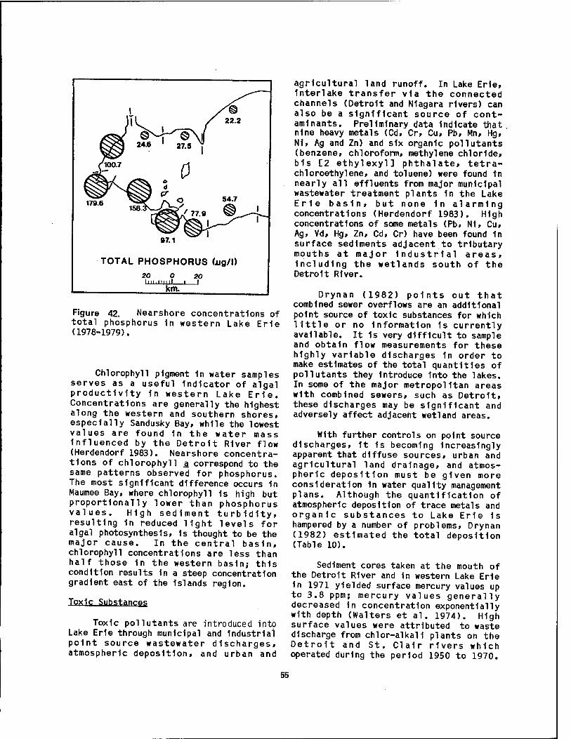
Figure 42. Nearshore concentrations of total phosphorus 1n western Lake Erie (1978-1979).
Chlorophyll pigment 1n water samples serves as a useful Indicator of algal productivity 1n western Lake Erie. Concentrations are generally the highest along the western and southern shores, especially Sandusky Bay, while the lowest values are found 1n the water mass Influenced by the Detroit River flow (Herdendorf 1983). Nearshore concentra- tions of chlorophyll a correspond to the same patterns observed for phosphorus. The most significant difference occurs 1n Maumee Bay, where chlorophyll Is high but proportionally lower than phosphorus values. High sediment turbidity, resulting 1n reduced light levels for algal photosynthesis, 1s thought to be the major cause. In the central basin, chlorophyll concentrations are less than half those 1n the western basin; this condition results In a steep concentration gradient east of the Islands region.
Toxic Substance
Toxic pollutants are introduced into Lake Erie through municipal and Industrial point source wastewater discharges, atmospheric deposition, and urban and
agricultural land runoff. In Lake Erie, Interlake transfer via the connected channels (Detroit and Niagara rivers) can also be a significant source of cont- aminants. Preliminary data Indicate that nine heavy metals (Cd, Cr, Cu, Pb, Mn, Hg, N1, Ag and Zn) and six organic pollutants (benzene, chloroform, methylene chloride, bis [2 ethylexyl] phthalate, tetra- chloroethylene, and toluene) were found in nearly all effluents from major municipal wastewater treatment plants 1n the Lake Erie basin, but none 1n alarming concentrations (Herdendorf 1983). High concentrations of some metals (Pb, N1, Cu, Ag, Vd, Hg, Zn, Cd, Cr) have been found 1n surface sediments adjacent to tributary mouths at major Industrial areas, including the wetlands south of the Detroit River.
Drynan (1982) points out that combined sewer overflows are an additional point source of toxic substances for which little or no information 1s currently available. It 1s very difficult to sample and obtain flow measurements for these highly variable discharges 1n order to make estimates of the total quantities of pollutants they introduce into the lakes. In some of the major metropolitan areas with combined sewers, such as Detroit, these discharges may be significant and adversely affect adjacent wetland areas.
With further controls on point source discharges, it 1s becoming increasingly apparent that diffuse sources, urban and agricultural land drainage, and atmos- pheric deposition must be given more consideration 1n water quality management plans. Although the quantification of atmospheric deposition of trace metals and organic substances to Lake Erie is hampered by a number of problems, Drynan (1982) estimated the total deposition (Table 10).
Sediment cores taken at the mouth of the Detroit River and 1n western Lake Erie 1n 1971 yielded surface mercury values up to 3.8 ppm; mercury values generally decreased in concentration exponentially with depth (Walters et al. 1974). High surface values were attributed to waste discharge from chlor-alkall plants on the Detroit and St. Clalr rivers which operated during the period 1950 to 1970.
55
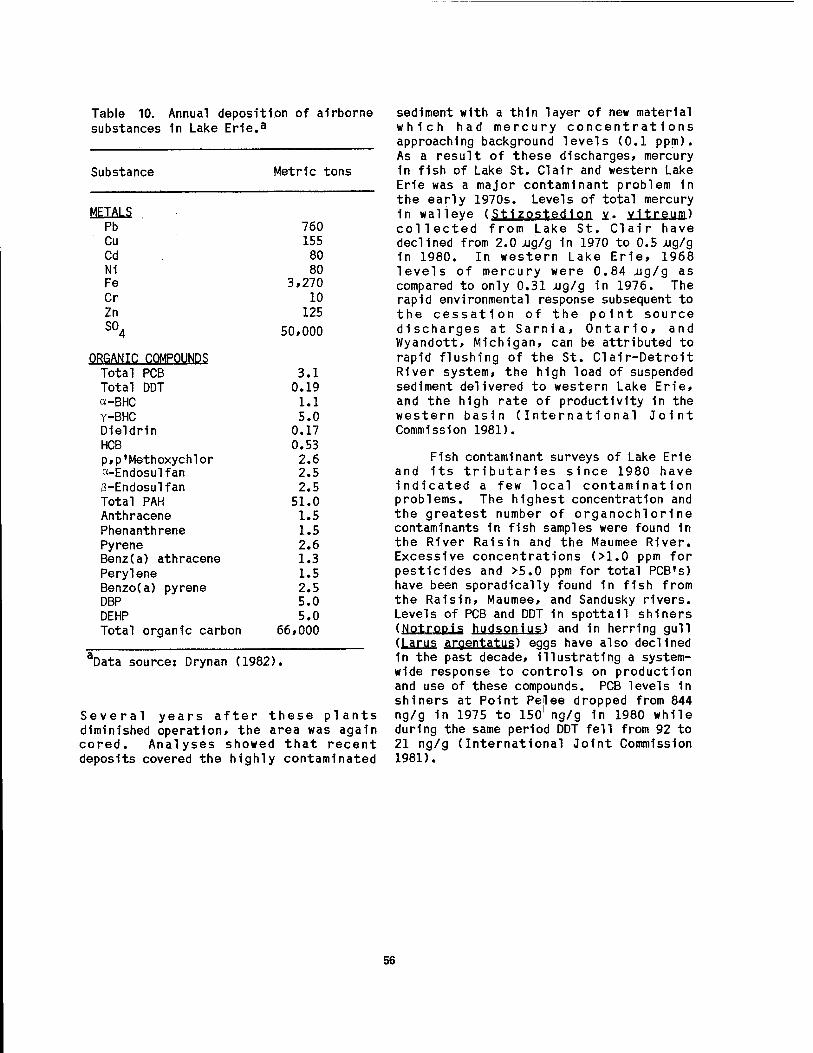
Table 10. Annual deposition of airborne substances 1n Lake Er1e.a
Substance Metric tons
METALS Pb 760 Cu 155 Cd 80 Ni 80 Fe 3,270 Cr 10 Zn 125 SO,
4 50,000
ORGANIC COMPOUNDS Total PCB 3.1 Total DDT 0.19 a-BHC 1.1 Y-BHC 5.0 Dieldrln 0.17 HCB 0.53 p,p'Methoxychlor 2.6 a-Endosulfan 2.5 ß-Endosulfan 2.5 Total PAH 51.0 Anthracene 1.5 Phenanthrene 1.5 Pyrene 2.6 Benz(a) athracene 1.3 Perylene 1.5 Benzo(a) pyrene 2.5 DBP 5.0 DEHP 5.0 Total organic carbon 66,000
Data source: Drynan (1982).
Several years after these plants diminished operation, the area was again cored. Analyses showed that recent deposits covered the highly contaminated
sediment with a thin layer of new material which had mercury concentrations approaching background levels (0.1 ppm). As a result of these discharges, mercury 1n fish of Lake St. Clalr and western Lake Erie was a major contaminant problem 1n the early 1970s. Levels of total mercury 1n walleye (Stlzostedlon y.. vitreum) collected from Lake St. Clair have declined from 2.0 xig/g 1n 1970 to 0.5 ng/g 1n 1980. In western Lake Erie, 1968 levels of mercury were 0.84 -ug/g as compared to only 0.31 Aig/g in 1976. The rapid environmental response subsequent to the cessation of the point source discharges at Sarnia, Ontario, and Wyandott, Michigan, can be attributed to rapid flushing of the St. Clair-Detrolt River system, the high load of suspended sediment delivered to western Lake Erie, and the high rate of productivity 1n the western basin (International Joint Commission 1981).
Fish contaminant surveys of Lake Erie and Its tributaries since 1980 have indicated a few local contamination problems. The highest concentration and the greatest number of organochlorine contaminants in fish samples were found in the River Raisin and the Maumee River. Excessive concentrations (>1.0 ppm for pesticides and >5.0 ppm for total PCB's) have been sporadically found 1n fish from the Raisin, Maumee, and Sandusky rivers. Levels of PCB and DDT in spottall shiners (UalimiS hll«JsQn1u?) and in herring gull (Larus argentatus) eggs have also declined 1n the past decade, illustrating a system- wide response to controls on production and use of these compounds. PCB levels 1n shiners at Point Pelee dropped from 844 ng/g 1n 1975 to 1501 ng/g 1n 1980 while during the same period DDT fell from 92 to 21 ng/g (International Joint Commission 1981).
56
CHAPTER 3.
BIOTIC ENVIRONMENT
3.1 PHYTOPLANKTON, ZOOPLANKTON
PERIPHYTON, AND
Planktonic algae, although not as important as macrophytes, are significant primary producers of organic matter in Lake Erie marshes, converting the sun's energy into chemical compounds that 1n turn are used as food by animals and nonphotosynthetic micro-organisms. By contrast, in the nearshöre waters and open lake, algae are the dominant primary producers, greatly overshadowing the biomass produced by higher plants 1n the wetlands. Phytoplankton production and distribution are Influenced by sunlight, temperature, marsh morphometry, water movements, grazing by Zooplankton, nutrients, and other factors.
Many Inorganic elements are required for algal cell growth, including nitrogen, phosphorus, potassium, calcium, and Iron. Algae reproduce rapidly when phosphorus is added to the water, and continue to reproduce as more phosphorus 1s added. Recycling of nutrients within a marsh may be sufficient to promote algal blooms for several years after the initial loading. However, nitrogen and other nutrients must also be present If algal production is to continue. Sawyer (1954) concluded that when inorganic nitrogen concentrations of 0.30 mg/1 (sum of NHg-N, N02~N, and N03-N) and orthophosphate-pTiosphorus concentra- tions of 0.01 mg/1 (PO.-p) were present in bodies of water at the start of the active growing season, nuisance algal blooms could be anticipated. Measurements 1n
western Lake Erie marshes Indicate concentration well in excess of these limits.
A list of the common algae, including planktonic and perlphytlc forms, occurring in the coastal marshes and nearshore waters of western Lake Erie is contained in Appendix C. The first comprehensive investigation of phytopl ankton in the vicinity of western Lake Erie coastal marshes was Initiated in 1929 by Wright et al. (1955), who collected samples from the estuaries of the Detroit, Raisin, Maumee, and Portage rivers (Table 11). Distinct differences were observed between phytoplankton communities of the Detroit River and the smaller tributaries. The sheltered Maumee Bay maintained a greater standing crop than the other locations. The algal abundance decreased markedly with increased distance from the mouth of the Maumee River. Herdendorf et al. (1977) observed a similar pattern 1n spring phytoplankton populations 1n Maumee Bay, except locations nearest the river mouth showed some reduction in numbers due to the high turbidity caused by spring runoff. Chandler (1942) also found tur- bidity to have a negative effect on plankton and submersed macrophyte photosynthesis near South Bass Island.
Taft and Taft (1971) published an exhaustive study of the algae 1n western Lake Erie, exclusive of diatoms. Their collections Included sites within emergent plant marshes on the Lake Erie Islands and Catawba Peninsula (East, Middle, and West harbors). The richness of the algal flora of these localities 1s indicated by the more than 300 species found in South Bass
57

Table 11. Abundance of phvtopi ankton in the vicinity of four coastal wetlands in western Lake Erie.
Location Phvtoplankton (cells/ml) and Blue-green Green Diatoms Other Total month (1930) algae algae algae
Detroit River Mouth
June 2 9 14 1 26 July 5 20 13 1 39 Aug 5 19 5 2 31 Sept 42 34 4 15 95 Oct 25 12 34 0
mean
71
52 River Raisin Estuarv
May 32 112 431 3 578 June 27 79 47 1 154 July 292 139 21 1 453 Aug 591 195 48 1 835 Sept 925 347 75 1 1348 Oct 1100 255 145 0
mean
1500
811 Maymee Bay
June 64 566 22 0 652 July 718 765 87 3 1573 Aug 2417 2480 203 20 5120 Sept 1665 1958 418 0 4041 Oct 2002 850 406 0
mean
3258
2929 Portage River Estuarv
May 8 56 159 0 223 June 2 1 16 0 19 July 67 84 53 2 206 Aug 311 261 128 1 701 Sept 550 210 175 0
mean
935
417
Data source: Wright et al. (1955),
coastal marshes (Table 12). Hohn (1969) studied the diatoms in Fishery Bay» a shallow embayment of South Bass Island containing dense beds of wild celery (Vallisneria americana). Asterlonella formosa populations were relatively consistent throughout the year at approximately 1,000 cells/ml. Dlatoma tenue exhibited the highest population in the spring at slightly more than 5,000
cells/ml. Britt et al. (1973) observed that phytoplankton investigations from the late 1920s through the 1960s all indicated that diatoms were the dominant group 1n the nearshore waters of western Lake Erie, except in early summer.
Reutter and Reutter (1977) studied the phytoplankton community associated with submerged aquatic plants in Fishery
58
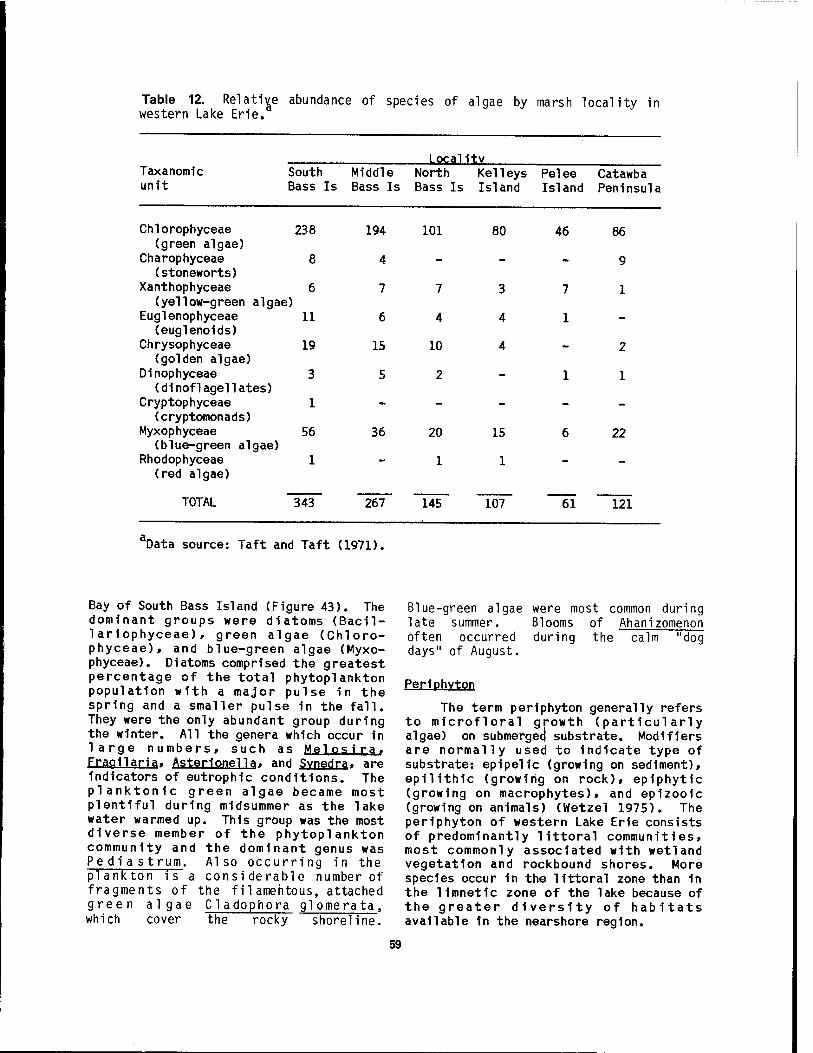
Table 12. Relative abundance of species of algae by marsh locality in western Lake Erie.
Taxanomic unit
Locality South Middle North Kelleys Pelee Catawba Bass Is Bass Is Bass Is Island Island Peninsula
11
19
Chlorophyceae 238 (green algae)
Charophyceae 8 (stoneworts)
Xanthophyceae 6 (yellow-green algae)
Euglenophyceae (euglenoids)
Chrysophyceae (golden algae)
Dinophyceae 3 (dinoflagellates)
Cryptophyceae 1 (cryptomonads)
Myxophyceae 56 (blue-green algae)
Rhodophyceae 1 (red algae)
194 101
4 -
7 7
6 4
15 10
5 2
TOTAL 343
36
267
20
1
80
3
4
4
15
1
46
7
1
145 107 61
86
9
1
2
1
22
~121
Data source: Taft and Taft (1971).
Bay of South Bass Island (Figure 43). The dominant groups were diatoms (Bacil- lariophyceae), green algae (Chloro- phyceae), and blue-green algae (Myxo- phyceae). Diatoms comprised the greatest percentage of the total phytoplankton population with a major pulse in the spring and a smaller pulse 1n the fall. They were the only abundant group during the winter. All the genera which occur in large numbers, such as Melosi ra. Fragilarja, Asterionella, and Svnedra, are indicators of eutrophlc conditions. The planktonic green algae became most plentiful during midsummer as the lake water warmed up. This group was the most diverse member of the phytoplankton community and the dominant genus was Pe d i a s trum. Also occurring in the plankton is a considerable number of fragments of the filamentous, attached green algae Cl adophora glomerata, which cover the rocky shoreline.
Blue-green algae were most common during late summer. Blooms of Ahanizomenon often occurred during the calm "dog days" of August.
periphYton
The term periphyton generally refers to microfloral growth (particularly algae) on submerged substrate. Modifiers are normally used to indicate type of substrate: ep1pel1c (growing on sediment), epilithlc (growing on rock), epiphytic (growing on macrophytes), and epizooic (growing on animals) (Wetze! 1975). The periphyton of western Lake Erie consists of predominantly littoral communities, most commonly associated with wetland vegetation and rockbound shores. More species occur in the littoral zone than in the limnetic zone of the lake because of the greater diversity of habitats available in the nearshore region.
59
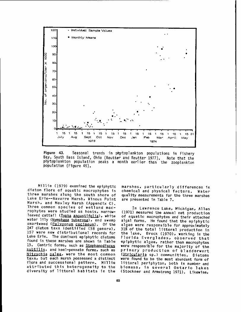
120- • Individual Sample Values
110 • Monthly Means
10O •
8 9°- o
•
X 80- L 41
■- 70-
II)
1 6°" c
L 0
ti_ 0 40-
. •
0 z 3a
20- # • *
ia ... * * •
1 15 1 15 1 15 1 15 1 15 1 15 1 15 1 15 1 15 1 15 1 15 31 July Aug Sept Oct Nov Dec Jan Feb Mar April May
1973 1974 1
M4
Figure 43. Seasonal trends in pr\ytoplankton populations in Fishery Bay, South Bass Island, Ohio (Reutter and Reutter 1977). Note that the phytoplankton population peaks a month earlier than the Zooplankton population (Figure 45).
IT,-« / 1 m<-i\ j i j-u s L.J, . ......
diatom flora of aquatic macrophytes in three marshes along the south shore of Lake Erie—Navarre Marsh, Winous Point Marsh, and Moxley Marsh (Appendix C). Three common species of wetland mac- rophytes were studied as hosts, narrow- leaved cattail (Tvpha anaustifol1aK white water lily (Nvmphaea tubero^ . and swamp smartweed (Eolvgonum cocineum). Of the 247 diatom taxa identified (38 genera), 157 were new distributional records for Lake Erie. The dominant epiphytic diatoms found in these marshes are shown in Table 13. Centric forms, such as Stephanodlscus subtil 1s. and keel-pennate forms, such as Nitzschia palea, were the most common taxa, but each marsh possessed a distinct flora and successlonal pattern. Millie attributed this heterogeneity to the diversity of littoral habitats In the
marshes, particularly differences 1n chemical and physical factors. Water quality measurements for the three marshes are presented 1n Table 7.
In Lawrence Lake, Michigan, Allen (1971) measured the annual net production of aquatic macrophytes and their attached algal forms. He found that the epiphytic algae were responsible for approximately 31% of the total littoral production 1n the lake. Brock (1970), working in the Florida Everglades, observed that epiphytic algae, rather than macrophytes were responsible for the majority of the primary production of bladderwort (Utr1cular1a sp.) communities. Diatoms were found to be the most abundant form of littoral peMphyton, both 1n number and blomass, 1n several Ontario lakes (Stockner and Armstrong 1971). Likewise,
60

Table 13. Dominant diatom periphyton on macrophytes in western Lake Erie marshes.
Macrophyte genera Periphyton species
Am Ca Cm Gg Gp Md Ncr Nl Na Nca Nfi Nfo Np Ss
Navarre Marsh TYPha X X X X X Nvmphaea X X X X X Polvgonum X X X X XX X X X X
Winous Point Marsh Typhg X X X X X X X Nymphaea X X X X X Polvqonum X X X X X X
Moxley Marsh Tvpha X X X X X X X Nvmphaea X X X X X X X Polvaonum X X X X X X X X
bData source: Millie > (1971). Species Key:
Am = Achnanthes minutiss 1ma Nl = Navicula lanceolata Ca = Cvclotella a.t.omus Na = N1tzsch1a amphibia Cm = Cvclotella menephiniana Nca = Nitzschia capltellata Ga = Gomphonema qracile Nfi = Nitzschia flUformls GD = Gomphonema Darvulum Nfo = Nitzschia fonticola Md = Melosira distans ND = Nitzschia Dalea Ncr = Navicula c "VDtocephala Ss = Stephanodlscus subtil 1s
s anticipated that e plphytic diatoms ZooplanKton are an important component of the energy base 1n western Lake Erie marshes.
Stoneworts (Characeae) are large algae with whorled branches that attain heights of over 0.3 m 1n western Lake Erie coastal marshes. Chara, grows 1n water rich 1n calcium carbonate which 1s Incorporated into their hard, brittle branches. This feature spares them from grazing by invertebrates, except for certain water beetles (Halipus and Peltodvtes). Stonewort supports a diverse epiphytic flora and serves as food for waterfowl. These plants grow on firm marsh sediment and some rocky bottoms. NUqlla, and Tolvpella are less calcareous stoneworts that have been reported 1n East Harbor Marsh and Haunck's Pond (Taft and Taft 1971).
By definition, plankton are floating organisms whose movements are more or less dependent on currents. However, some zooplankters exhibit active swimming movements that aid 1n maintaining vertical position. Zooplankters are diverse 1n their feeding habits. Herbivores graze on phytoplankton, periphyton and macrophytes within the coastal marshes. Carnivores prey on attached protozoans and other zooplankters, while omnlvores feed at all trophic levels. In turn, Zooplankton are Important fish and waterfowl food. Every fish species and many duck species utilizing the wetlands in this region eat zooplankters during some portion of their life cycle.
The animal components of the marsh plankton are protozoans, rotifers, and
61
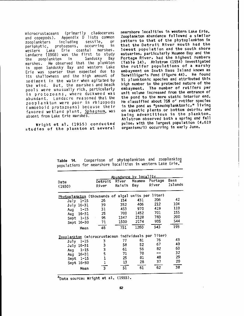
microcrustaceans (primarily cladocerans and copepods). Appendix D lists common zooplankters including sessile, or periphytic, protozoans, occurring in western Lake Erie coastal marshes. Landacre Ü908) was the first to study the Zooplankton in Sandusky Bay marshes. He observed that the plankton in open Sandusky Bay and western Lake Erie was sparser than expected due to its shallowness and the high amount of sediment in the water when agitated by the wind. But, the marshes and beach pools were unusually rich, particularly in protozoans, where duckweed was abundant. Landacre reasoned that the Zooplankton were poor in rhizopods (amoeboid protozoans) because their favored wetland plant, Sphagnum, was absent from Lake Erie marshes.
Wright et al. (1955) conducted studies of the plankton at several
nearshore localities 1n western Lake Erie. Zooplankton abundance followed a similar pattern to that of the phytoplankton 1n that the Detroit River mouth had the lowest population and the south shore estuaries, particularly Maumee Bay and the Portage River, had the highest numbers (Table 14). Ahlstrom (1934) Investigated the rotifer populations of a marshy embayment on South Bass Island known as TerwIlUger's Pond (Figure 44). He found 91 planktonlc species and attributed this high number to the protected nature of the embayment. The number of rotifers per unit volume Increased from the entrance of the pond to the more static Interior end. He classified about 75% ox rotifer species in the pond as "pseudoplanktonlc," living on aquatic plants or bottom debris, and being adventitious 1n the plankton. Ahlstrom observed both a spring and fall pulse, with the largest population (4,619 organisms/1) occurring in early June.
Table 14. Comparison of phytoplankton and Zooplankton populations for nearshore localities in western Lake Erie.
AhnnHanre hv locality
Date Detroit . River Maumee Portage Bass
(1930) River Raisin Bay River Islands
PhvtoDlank-ton (thousands of algal units per liter)
July 1-15 26 154 431 206 42 July 16-31 39 352 406 212 104 Aug 1-15 31 453 970 419 110 Aug 16-31 25 700 1452 701 155 Sept 1-15 95 1347 2128 783 200 Sept 16-30 71 1500 2174 935 544
Mean 48 751 1260 543 193
Zooplankton (mic rocrustacean individuals per liter)
July 1-15 3 77 81 76 43
July 16-31 3 58 52 67 40
Aug 1-15 3 61 56 82 63
Aug 16-31 5 71 70 — 32
Sept 1-15 1 25 81 48 29
Sept 16-30 1 13 28 37 20
Mean 3 51 61 62 38
äData source: Wright et al. (1955).
62
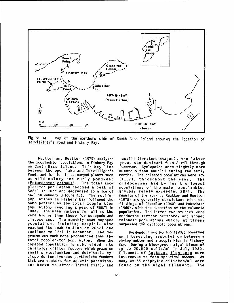
PUT-IN-BAY (Main Harbor)
FEfT 0 500 1000 1500
Figure 44. Map of the northern side of South Bass Island showing the location of Terwilliger's Pond and Fishery Bay.
Reutter and Reutter (1975) analyzed the Zooplankton populations in Fishery Bay on South Bass Island. This bay lies between the open lake and Terwilliger's Pond, and is rich in submerged plants such as wild celery and curly pondweed (Potamogeton crispus). The total zoo- plankton population reached a peak of 588/1 in June and decreased to a low of 54/1 in January (Figure 45). The rotifer populations in Fishery Bay followed the same pattern as the total Zooplankton population, reaching a peak of 300/1 1n June. The mean numbers for all months were higher than those for copepods and cladocerans. The monthly mean copepod population, including naupl11, also reached its peak in June at 266/1 and declined to 12/1 in December. The de- crease was much more pronounced than the total Zooplankton population. When the copepod population 1s subdivided Into calanoids (filter feeders which graze on small phytoplankton and detritus), cy- clopolds (omnivorous partlculate feeders that are vectors for aquatic parasites, and known to attack larval fish), and
nauplil (Immature stages), the latter group was dominant from April through December. Cyclopolds were slightly more numerous than nauplH during the early months. The calanold populations were low (<10/1) throughout the year. The cladocerans had by far the lowest populations of the major Zooplankton groups, rarely exceeding 30/1. The results of the work by Reutter and Reutter (1975) are generally consistent with the findings of Chandler (1940) and Hubschman (1960), with the exception of the calanold population. The latter two studies were conducted farther offshore, and showed calanold populations which, at times, surpassed the cyclopold populations.
Herdendorf and Monaco (1983) observed an Interesting association between a phytoplankter and a zooplankter 1n Fishery Bay. During a blue-green algal bloom of up to 20,000 cells/ml 1n July 1980, filaments of Ajiahea.n,a flos-agua were Interwoven to form spherical masses. As many as 66 epiphytic c1l1ates/ml were found on the algal filament. The
63

1000- . • Individual Sample values
900. • * Monthly Means
800-
2 700- •
•
w £ 600
c &500-
0
0 400 -
•
•
•'
•
Z 300 - • • • •
• • •'
200 t. • • . •
100 % • • •
•
1 15 i I
1 15 1 15 1 15 1 15 1 15 1 15 1 15 1 15 1 15 1 15 1 15 31
April 1973
May June July Aug Sept Oct Nov Dec Jan Feb March 1974
Figure 45. Seasonal trends in Zooplankton populations in Fishery Bay, South Bass Island, Ohio (Reutter and Reutter 1975). Compare with phytoplankton trends in Figure 43.
contractile stalks of Vorticella campanula were attached to the outer filament segments forming a pulsating corona around the entire algal mass. The pulsating feeding behavior of Vorticella produced a distinct gliding motion of the algal colony. Pratt and Rosen (1983) speculated that the "swimming" motion created by sessile protozoans on algae may be advantageous in maintaining nutrient flow past the algal cells.
3.2 WETLAND VEGETATION
Many of the vascular aquatic plants in the western Lake Erie coastal marshes exposed to natural water level fluc- tuations are "pioneer species." They are the type that first colonize a low, wet, denuded area. If the habitat becomes too stable (i.e., constant water levels within a controlled marsh) they soon become crowded by other species and eventually disappear. However, the seeds of these species have considerable longevity and
are able to again germinate when the environment is disturbed.
At the time of Wisconsin glacial retreat, streams were either enlarged or formed anew as meltwater became abundant. The bare soil of moraines and alluvial deposits characterized the landscape. Stranded bodies of water between the receding ice front and terminal moraines formed lakes such as the former stages of Lake Erie in northwestern Ohio and southeastern Michigan. Stuckey (1972) describes this "glacial sidewalk" as a perfect avenue for migration and col- onization by pioneer plants. A good example is marsh cress (Rorippa P.a1u,strjs var. hispida) which survived glaciation 1n refugia in the Rocky Mountains. A short- lived pioneer plant, 1t doubtlessly spread rapidly as the ice receded, carried by wind and water to the fresh barren soils where 1t germinated and grew 1n abundance. This plant 1s not found south of the southern limit of Wisconsin glaciation 1n the central United States, presumably
64

(PptarnQgetpn (E- crispus), S P 1 C a t U IP ) (Heteranthera few others
because environments were more stable to the south and already vegetated. This species, as do many other pioneer plants, continues to persist 1n Lake Erie coastal marshes because of the frequent storms and constantly changing water level regime (Vesper and Stuckey 1977).
In the aquatic and wetlands habitats of western Lake Erie over 300 species of vascular plants have been identified (Stuckey and Duncan 1977). The more important of these species are listed 1n Appendix E. Figure 46 depicts the distribution of 24 of the prominent species in western Lake Erie wetlands.
In the open water of the lake and larger bays, aquatic vascular plants are few and limited mostly to the rooted submersed ones, such as wild celery (Vail isner1a americana), sago pondweed
pectlnatus). curly pondweed water-milfoil (MyrlQphyllum
and water star-grass dilbjj). These species and a
among them coontall (Ceratophvllum demersum), waterweed (Elodea canadensis), Richardson's pondweed (Potamogeton richardsonli). and the sub- mersed form of the flowering-rush are the major submersed species 1n the bays and shallow water near the shoreline (Stuckey 1968).
The flora of the ponds shows considerable diversity. In addition to having most of the species already mentioned, the ponds also have small floating plants such as the duckweeds (Lemnaceae) which form dense mats in stagnant water. In some places the floating water fern, (Azol1 a caroliniana) also forms dense reddish mats. Species with large floating leaves, white water lilies (Nvmphaea tuberosa). and the American water-lotus (Nelumbp lutea) are not common, but where they do grow they may form extensive colonies (Figure 47), as does the large emersed leaved spatterdock or yellow water lily (Nuphar advena). Emersed species with showy flowers or large distinctively shaped leaves, such as cattails (Tvpha spp.)> bur reed (Sparganium eurvcarpum), flowering rush (Blitpmus umbellatus) . arrowhead (Saaittaria latifolia), swamp rosemallow (Hibiscus inosheutQS)> water smartweed
(Polvgpnum punctatum), and pickerel weed (Pontederia cordata) line the edges of the coastal lagoons, often in segregated zones. Along the dryer margins of the marshes, three-square bulrush (Sei rpys PUPg.gQSr) » b 1 u e j o i n t ( Cal amagrostjs canadensis), prairie grass (Phragmites austral is), reed-canary grass (Phalaris arundinacea). and rush (Juncus effusus) are common.
Drastic changes have occurred in the aquatic flora in the past 85 years. For example, in Put-1n-Bay harbor, 50% (20 out of 40) of the species of aquatic vascular plants have disappeared (Stuckey 1971). As a whole, the flora of the bays, and in particular Put-in-Bay, have been disturbed severely because of increased turbidity of the water, building of retaining walls and docks, use of herbicides, dredging operations, and human multiuses of these aquatic habitats ranging from recreation to dumping grounds for wastes. Many of the lagoons and embayments have been destroyed to build marinas and housing developments, particularly in the islands region. In those coastal lagoons that remain, most of the submersed aquatic species ever known to be present still survive and represent one of the few refuges for this segment of the flora. Local changes in the aquatic flora have been very evident during the past decade, a period of record high water levels for Lake Erie. This temporary environmental condition has affected the aquatic flora by reducing the populations of most of the emersed shoreline species and increasing the populations of some submersed and floating-leaved species.
Before the coming of the European settlers, the marshes behind the sand and gravel beaches were more extensive than they are today. Originally, vast stands of tall grasses, such as wild rice (Zizania aquatic), prairie grass, blue- joint grass, and cord grass (Spartina pectinata) dominated in wet places and in shallow clear water. Sedges were also plentiful, including spike-rushes (Eleo- charis spp.), hard-stem bulrush (Scirpus acutus), soft-stem bulrush (S_. val idu,s), river bulrush (S_. fluviatilisT, and three- square bulrush. Broad-leaved cattail (Tvpha latifolia) was much more extensive than the then rare narrow-leaved cattail
65
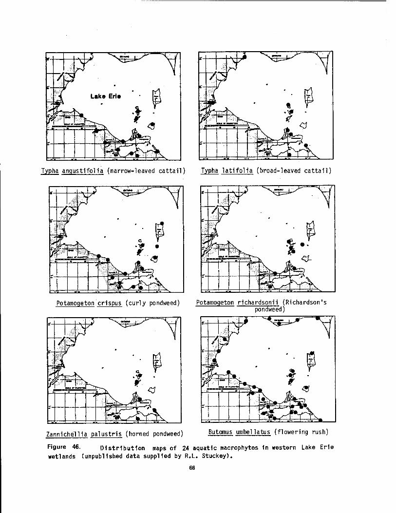
Typha angustifolia (narrow-leaved cattail) Typha latifolia (broad-leaved cattail)
Potamogeton crispus (curly pondweed) Potamogeton richardsonii (Richardson's pondweed]
Zannichellia palustris (horned pondweed) Butomus umbellatus (flowering rush)
Figure 46. Distribution maps of 24 aquatic macrophytes 1n western Lake Erie wetlands (unpublished data supplied by R.L. Stuckey).
66
Vail isneria americana (wild celery)
Carex frankii (Frank's sedge)
Heteranthera dubia (water stargrass)
Calamagrostis canadensis (bluejoint grass)
3"
Scirpus acutus (hard-stem bulrush)
Pontederia cordata (pickerel weed]
Figure 46. (continued)
67
Polygonum coccineum (swamp smartweed) Rumex verticil latus (swamp dock)
^
Amaranthus tuberculatus (water-hemp) Nelumbo lutea (American water-lotus)
Nuphar advena (yellow waterlily) Nymphaea tuberosa (white waterlily)
Figure 46. (continued)
68
Rorippa palustris (marsh cress) Hibiscus palustris (swamp rosemallow)
Decodon verticillatus (swamp loosestrife) Myriophyllum spicatum (water-milfoil)
Justicia americana (water-willow) Juncus x stuckeyi (Stuckey's rush)
Figure 46. (concluded)
69

Figure 47. Emergent beds of American water-lotus (Nelumbo lutea) 1n Fish Point Marsh on Pelee Island, Ontario (L1gas 1952).
(T. anaustifolia). Plants with large showy flowers, such as the American lotus, white water lily, spatterdock, swamp rosemallow, pickerel weed, and arrowhead grew in large colonies and gave color to the marsh. Scattered throughout the marshes, among the cattails and sedges, were monkeyflower (Mimulus ringens), swamp milkweed (Asclepias incarnata), hedge- nettle, (Stachys tenuifolia), common skullcap (Scutellaria epilobiifolia), and marsh cress. On the exposed mudflats were annuals — false pimpernel (L i ndern ia dubia), beggar-ticks (Bidens spp.), water- plantain (Alisma piantaao-aquatica), blunt spike-rush (Eleochari s obtusa), and several species of umbrella sedges (Cvperus spp.). In the clear open water were submersed species, wild celery, waterweed, water-milfoil (Mvriophvl1 urn exal bescens ) , stiff water crowfoot (Ranunculus 1ongirostris), flexed naiad (Na.ias f 1 exil is), and many species of pondweeds (Potamogeton spp.).
The waters of the marshes and most of the bays have become quite muddy and turbid within the past century. These conditions have come about by: 1) the extensive erosion of the soil in the once- forested uplands of the watershed, 2) dredging, diking, and drainage of large portions of the marshes for private, industrial, agricultural, and wildlife areas, 3) construction of docks and bulkheads that, in combination with dredging channels, have altered many of
the bays for commercial or recreational purposes, and 4) introduction of carp (Cvprinus carpio), a species of fish that uproots and destroys aquatic plants and contributes to the overall turbidity by stirring up the bottom silt and keeping it in suspension. These physical changes, silted conditions, and continued high turbidity levels bring about a situation in which sensitive submersed species of open clear water are eliminated or are drastically reduced in numbers, thereby resulting in a decline in species diversity. These submersed species are the more sensitive, mostly northern species of clear, cool, well-oxygenated waters.
The swamps, dominated by woody vegetation, occur in small units in the low wet areas along the lake shore (Figure 48). Probably because of continued fluctuating water levels, this vegetation type was never as extensive as the marshes. Willows (Salix spp.), cottonwood (Populus deltoides), sycamore (Platanus occidental is), and ashes (Fraxinus spp.) are the dominant trees. Formerly, American elm (Ulmus amerlcana) was more prevalent, but most of these trees have since been destroyed by the Dutch elm disease. Shrubs are mostly dogwoods (Corngs spp.), elderberry (Sambucus canadensis), willows, buttonbush (Ceph- alanthus Qcddsntal i?) > and roses (Rasa spp.). Diversity of herbaceous species 1n the swamps is low. Among the more commonly occurring ones during the summer season are shade-tolerant plants such as nettles ( U rticaceae), false-nettle (Boehmeria cvlindrica), and spotted touch- me-not (Impatiens capensis).
Sand beaches are scattered and not extensive along the western Lake Erie shoreline. The sand deposits are low and do not form dunes (Figure 4). Consequently, they are particularly vulnerable to fluctuating water levels, continuous wave action, and erosive action by ice in winter. Most of the sand beaches are now used for recreation as swimming and camping areas. Because of these natural and artificial disturbances, most of the species unique to this type of habitat have disappeared (Core 1948; Stuckey and Duncan 1977). Distinctive herbaceous species now rare or extirpated
70

Figure 48. Emergent colony of arrow arum (Peltandra virginica) and several clumps of buttonbush (Cephalanthus occidental is) at Old Woman Creek Estuarv (Marshall 1977). J
are sea rocket (Cakile edentula), seaside spurge (Euphorbia polvoonifolia). beach pea (Lathyrus Japonicus) . sand grass (Trip!as is purpurea). sand dropseed (Sporobolus crvptandrus) . beach grass (Ammophila breviligulata). wormwood (ftrtemjsiq caudata), prickly pear (Opuntia humifusa). and Schweinitz»s and Houghton's cyperus (C_y_p_er_u_S schweinitzii and £,. houqhtonii). Distinctive shrubs that are today also rare or eliminated are sand- dune willow, sand cherry (Prunus pumila), buffalo berry (Shepherdia, canadensto. ground juniper (Juniperus communis). k1nn1kinick (Arctostaphvlos uva-ursi). and Canadian milk-vetch (Astragalus can- adensis). Common trees present are cottonwoods, willows, dogwoods, and ashes, and among these are often thick growths of Hanas including wild grape (Vi11 s spp.), Virginia creeper (Parthenocissus vlt^- £eae), poison ivy (Rhus radleans) . bittersweet (Celastrus scandens). and trumpet-creeper (Campsjs radicans). In
the open areas on the sand beaches, herbaceous species such as Russian thistle (§3lsQla, kali), winged pigweed (Cvcoloma atrip!icifolium). umbrella-wort (Mirabilis nvctaginea). and sandbur grass (Cenchrus cauciflorus) formerly not present, now form a new distinctive beach flora. Ubiquitous European "weeds" have also invaded, including!crab grass (Diaitaria sanquinalis). pigwedd (Amaranthus spp.), white sweet clover (Mel i lotus alba,), catnip (Nepeta catarja). and mullein (Verb^scum thapsus).
Gravel beaches and bars are a common habitat on the Lake Erie Islands (Figure 49). Because these beaches are subjected to severe 1ce scouring and wave wash, no permanent vegetation becomes established on this continuously agitated shore. Mats of the alga Cladophora often wash ashore, die, and decay on the gravel beaches. Farther up on the beach where waves reach only during storms and periods of high
71
• "-■*•• '■;
7-z~*- -~ '■ *" ,.'; ■ '•• ~- ■'■
Figure 49. Gravel beach on the south shore of West Sister Island, showing storm-created terraces (July 1979).
*i*fSSJÄi|i'
water, willows, cottonwood, dogwood, and ashes are dominant woody members. Lianas, such as wild grape, poison ivy, and Virginia creeper become entangled on the beach. Herbaceous species are few, but usually germander (Teucrium canadense) and smartweeds are present.
Perhaps the most dramatic of the shoreline habitats are the high, rugged limestone and dolomite cliffs (Figure 10). These are mostly confined to the north and west shores of most of the islands. These cliffs have two vegetation zones — one along the wave-splashed lower portion of the cliffs and the other on the drier upper portion. Plants inhabiting the lower portion, which are also characteristic"of the low shelving rocky shores, are filamentous algae, mainly the green alga Cl adophora and an invading marine, red alga Bangi a. Distinctive herbaceous vascular plants are Dudley's rush (Juncus dudlevi), «aim's lobelia ( L o b e1i a k a 1m i i). St. John's wort (Hvpericum kalmianum), prairie and winged loosestrife (Lvsimachia quadriflora and
Lvthrum alatu m), mountain mint (Pvcanthemum virginianum), heath aster
(Aster pilosus). grass-leaved goldenroo ( Solidao graminifolia), golden ragwort (Senecio pauperculus), and beardtongue (Penstemon h i rsutus). On the upper portion are such distinctive herbaceous species as ivory sedge (Carex eburnea), nodding onion (All ium cernuum), purple and hairy rockcress (Arabis drummondi i and A. pvcnocarpa), harebell (Campanula rotun- difolio), and smooth cliff brake fern (Pel 1aea glabella). Bluegrass (Poe compressa) is abundant above the splash zone. Xeric mosses and foliose lichens are pioneers in this habitat. Shrubs and small trees line most of the tops of the cliffs. Among the more common ones are ninebark (Phvsocarpus opulifolius), choke cherry (Prunus virginiana), staghorn sumac (Rhus tvph i na) , hackberry (Cel11 s occidental is), dogwoods (Cornus sp.), hop hornbeam (Ostrva virgi niana), and red cedar (Juniperus virginiana). Dense growths or lianas, such as poison ivy, Virginia creeper, and wild grapes, cover large portions of the cliffs.
72

SqncJusKv Rtyer Estuary
The wetland plants of the Sandusky River Basin, including Sandusky Bay, have been studied by Moseley (1899, 1905), Burr (1901), Pieters (1901), Meeks (1963, 1969), Lowden (1969), and Stuckey (1975). Representative aquatic plants of Sandusky Bay and their present abundance status are listed in Appendix F. The wetlands of the basin may be grouped into four categories: 1) the remnants of original wet prairie, marshes, swamps, peat lands, and cranberry bogs in the upper portion of the basin; 2) the once vast, but not contained diked marshes at the upper end of Sandusky Bay; 3) the Sandusky River and its tributaries; and 4) the constructed drainage ditches, diked reservoirs, and ponds. The second category is the one most germane to a discussion of coastal wetlands, but elements of the other three categories are evident within the zone Influenced by Lake Erie water levels.
In the upper portion of the Sandusky River Basin, extensive wetlands developed in shallow lakes in many of the low areas between moraines left by the retreating Wisconsinian glacier approximately 13,500 years ago. All of these wetlands lay to the south of the oldest of the ancient Lake Erie beach ridges (Lake Maumee) which forms a line from Fostoria, east to Tiffin, and north to Clyde, Ohio. These early wetlands may have served as the source area for the aquatic plants which eventually colonized the embayments of western Lake Erie.
Before settlement by Europeans, the vast marshes of Sandusky Bay extended upstream as far as Fort Stephenson, now Fremont, Ohio. Early accounts speak of lush growths of a wide variety of aquatic plants including wild rice, reeds, rushes, cattails, swamp rosemallow, pond lilies, and waterweeds. Moseley (1899) recalled the memory of individuals who said that rushes grew over much of Sandusky Bay where now there is open water. Aquatic plants were also said to frequently impede the paddle wheels of steamers that ventured through the upper bay into the Sandusky River. By the turn of the century, Pieters (1901) noted that muddy water in the deeper portions of the bay only supported moderate growths of
Ya,nisper1a and Potamoqeton. but near the clear water by the shore, plants were more abundant.
From these early descriptive accounts of the plants, Lowden (1969) and Stuckey (1975) have inferred the original aquatic vascular flora at the mouth of the Sandusky River. Before settlement of the basin, large stands of grasses—such as wild rice, reed grass, bluejoint grass, and cord grass—and large sedges—such as creeping spike-rush, hard-stem bulrush, soft-stem bulrush, river bulrush, and three-square were dominant in shallow wet areas. American water-lotus, white water lily, yellow water Uly, swamp rosemallow, pickerel weed, and arrowhead also grew in large colonies. Wild celery, large-leaved pondweed (Potamoaeton amp!ifolius). grass- like pondweed (E. gramineus). Robin's pondweed (E- robinnsi i, flat-stemmed pondweed (EA zosteriformis). stiff water crowfoot, waterweed, flexed naiad, Guadalupe naiad, (Na.ias quadalupensis). and water-milfoil grew as submersed plants in open clear waters.
The waters of Sandusky Bay are now extremely turbid due to modifications following settlement of the catchment basin (Stuckey 1975). The silted conditions and high turbidity levels bring about a situation, as pointed out by Langlois (1954), Lowden (1969), and Stuckey (1971), where sufficient light does not reach the submersed plants and, consequently, sensitive species typical of open, clear waters are eliminated or drastically reduced in numbers. Examples of such extirpated plants include large- stemmed pondweed, flat-stemmed pondweed, flexed naiad, wedge-shaped arrowhead (Saqittaria cuneata), waterweed, wild celery, stiff water crowfoot, and humped bladderwort (Utricularia glbba). Sur- viving are only a few submersed, tolerant species, such as coontail, curly pondweed, minor naiad (Na.ias minor), and water- milfoil .
Mainly because of the physical changes in the marshes, the grasses and sedges previously mentioned are becoming quite rare, and even the wild rice may now be extirpated. The species with large showy flowers, doubtlessly reduced in numbers from 100 years ago, undergo
73

considerable fluctuation in size of individual populations today because of the changing water level conditions. In years of lower water» when dikes artificially maintain marshes and mudflats, swamp rosemallow flourishes, along with several emersed species that once were rare or infrequent, such as narrow-leaved cattail, reed-canary grass, barnyard grass (Echinochloa pungens), old- witch grass (Panicum capillare), and panic grass (P. dichotomiflorum). On newly created dikes, nodding smartweed (Polvgonum lapathifolium) and Pennsylvania smartweed (P. pensylvanicum) dominate (Bartolotta 1978). In the marshes, Walter's millet (Echinochloa walteri), has been planted for wildlife food. Several European invaders, now becoming common, are flowering rush, purple loosestrife (Lvthrum sal icaria), barnyard grass (Ej. crusgalli), bittersweet nightshade (Solanum dulcamara), great hairy willow- herb (Epilobium hi rsutum), and European water horehound (Lvcopus europeaus). In some places purple loosestrife now dominates to the exclusion of most other species (Stuckey 1980).
The Sandusky River and some of its tributaries also contain many of the aquatic species that occur in the remnant original wetlands. However, aquatic species that occur in the remnant original wetlands. However, submersed species are generally absent because of the turbidity of the water and the silted bottom conditions. A few southern, mudflat or shallow-water species, usually not found elsewhere in the basin, add distinction to the river flora. Among these, accord- ing to Stuckey (1975), are water-hemp (AmaEi*Qibms tMbercuUtMS)» many-fruited seedbox (Ludwiai a polvcarpa), three- square, lizard's tail (Saururus cernuus), bur cucumber (Sicvos angulatus), water pimpernel (Samolus parviflorus), riverbank cyperus (Cvperus rivularis)> swamp dock (Rumex verticil!atus), false dragonhead (Phvstostegia virginiana), loosestrife (Lvthrum dacotanum), sneezeweed (Helenium autumnale), fog fruit (Phvla lanceolata), and prickly cucumber (E^chinocvstis lobata). Most of these species occur in the lower portion of the river between Tiffin and Fremont, particularly in the shallow water areas where dolomite bedrock is exposed. This reach of the river is
immediately above the portion effected by the fluctuation in the water level of Lake Erie.
Woodtick Peninsula
Located in southeastern Monroe County, Michigan, along the western coast of Lake Erie, the Woodtick Peninsula wetlands complex consists of a barrier island (Woodtick Peninsula), a backbarrier embayment (North Maumee Bay), and a coastal marsh situated at the margin of the lake plain. The wetland is bounded by Lake Erie on the east, Maumee Bay on the south, Highway 1-75 on the west, and the Whiting Power Plant on the north. The Erie Shooting and Fishing Club, a private club founded in 1857, encompasses 400 ha of diked marshland. Although Bay Creek and a few other small tributaries and artificial canals input into North Maumee Bay, the hydrology of this backbarrier wetland complex is controlled by long-term lake level fluctuations as well as by short-term wind-generated circulation and seiches. The common wetland plants found by Jaworski et al. (1981) follow:
Barrier beach (Woodtick Peninsula) cottonwood (Populus del toides) wild grape (Vitis spp.) crack willow (Salix fragil is) jewel weed (Impatiens capensis) box-elder (Acer negundo) smartweed (Polvgonum spp.)
Backshore of barrier beach (overwash) burdock (Arctium minus) sweet clover (Melilotus spp.) reed-canary grass (Phalaris
arundinaceae) willows (Salix spp.) bluejoint grass (Calamagrostis
canadensis)
Open water (North Maumee Bay) sago pondweed (Potamogeton
pectlnatus)
Emergent marsh (landward side) arrowhead (Sagittaria latifolia) soft-stem bulrush (Scirpus validus) three-square (5- pungens) hybrid cattail (Tvpha x glauca) narrow-leaved cattail (I.
angustifolia)
74

Emergent marsh (Erie Marsh) soft-stem bulrush (Scirpus valldus) arrowhead (Saaittaria latifolia) spike-rush (Eleocharis sp.) purple loosestrife (Lvthrum
salicaria) narrow-leaved cattail (Tvpha
angustifolia) smartweed (Polvaonum spp.) hybrid cattail (Tvpha x glauca) jewelweed (Impatiens capensis) reed-canary grass (Phalaris
arundinacea)
Emergent marsh (Bay Creek Marsh) narrow-leaved cattail (Tvpha
anaustifolia) cottonwood (Populus deltoides) hybrid cattail (Tvpha x glauca) willows (Salix spp.) purple loosestrife (Lvthrum
salicaria) jewelweed (Impatiens capensis) arrowhead (Sagittaria latifolia)
Old field (abandoned farmland) reed-canary grass (Phalaris
arundinacea) wooly sedge (Carex lanuginosa) jewelweed (Impatiens capensis) fox sedge (£. vulpinoidea) awl-fruited sedge (Q. stipata).
These plants were identified in June 1978 along the transects shown in Figures 5 and 6. During the survey the Lake Erie water level averaged 174.42 m, which is 0.40 m above the long-term average for that month. The transect consists of two segments with an unsurveyed section in the center. The central section was not surveyed because it contains diked wetlands managed by the private clubs and the water intake canal for the power plant.
Toussaint Marsh
This wetland complex, located in Ottawa County, Ohio, is basically an estuary of the Toussaint River and Rusha Creek. However, many of the shallow lagoons landward of the barrier beach ridges, which flank the river mouth, have been diked and modified by human activities. Because of the flat, relatively fertile Lake Plain soils (Fulton and Lucas soils), agriculture has
encroached upon these coastal wetlands. As a result of agricultural encroachment turbidity levels are high, especially in the lower Toussaint River. This backbarrier marsh extends from the Toussaint River southeast to Camp Perry, Ohio. Agricultural fields and Ohio Route 2 form the landward boundary. Local residents refer to the Green Bay and the Huntington Marsh in the northern and southern portions, respectively. Tous- saint Marsh is a private shooting club marsh which has been diked since the late 1800s. Because pumping and water level management have been practiced si-nce at least the 1940s, the wetland cannot be regarded as a natural system. The plants in the following list were obtained by Jaworski et al. (1981) along a transect through the Green Bay and the Huntington Marsh (Figure 50) in June 1978:
Eroding barrier beach (Lake Erie) cottonwood (Populous deltoides) willows (Salix spp.) gray dogwood (Cornus racemosa) wild grapes (Vitis spp.) Virginia creeper (Parthenocissus sp.) jewelweed (Impatiens capensis) hedge bindweed (Convolvulus
sepium)
Backbarrier flats and marshes willows (Salix spp.) thistle (Cirsium spp.) reed-canary grass (Phalaris
arundinacea) sedges (Carex spp.) jewelweed (Impatiens capensis) sweet flag (Acorus calamus) pickerel weed (Pontederia
c.orjia±ä) water smartweed (Polvaonum
amphibium)
Emergent marsh (Green Bav/Huntinoton) hybrid cattail (Typha x glauca) narrow-leaved cattail (I.
angustifolia) bluejoint grass (Calamagrostis
canadensis) marsh fern (Thelvpteris palustris) swamp loosestrife (Decodon
verticil!atus) swamp rosemallow (Hibiscus palustris) swamp dock (Rumex verticil!atus)
75
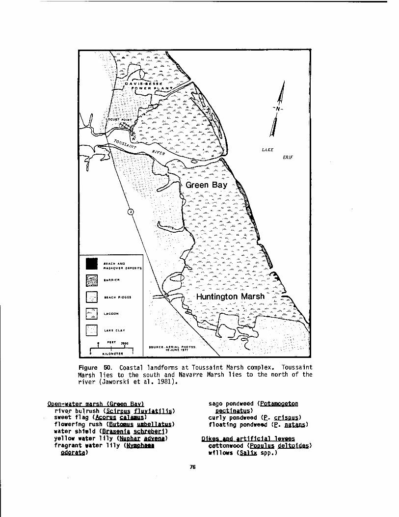
|gpk f c~~~\ty^ "■"'" ''''■ "' *• iv^'*v ~/v-
\ /i / /'VT •':„."'"•■•'"'"''• "•"- "AV^WV / \ /) ./■■■■■■ t*1 • , ..,.. ,, .1/. ..it. u.. •>\~^\ 1
\yi j -SÖStj» '"" •""" , ■ • •"• ■"■ J\A_I\ II ^ 1 s7=*£S& ""• "•.."•"" .".;■■"-■ .••«.. ..I/TYMX /I
K ^// \fk " ■" ■" „„; •'"'• ■"'•• '"•„, •"••■ V R\ It
\ - v* " >'•■■ ' ••"■■ ■"■ "• ■"• ■"• "\v I L'Oft, v—ä—«±^-~,.. ,i. ■•"•-. -i.. ■•"■. .>>"• V I
^^S^^L=^*^><^ - ■ > ■ **2J "*£
7 \ /X^^^ir^sk n \ I ^i '"' ■••*!■—Ar"""""' .*. "'' "^ä
\ d^i ^reen Bav %, \ \JL .^. i, „ .•ii,. I,E\
\ /.II, J/. ,,, '""■ ""j^l
\ » I"' ""' •"• '"' •"•■ "'".* "''' '••'• vk
\ ^3k... .... " -'• ■>•■ J.. ■•■• tt
\ A "'' "''' ,/ ', ** -' •"" ..!'.. ^^i
^_ \ ^/ •' ' '""" ' ''"■ "' •'"' " ''" '"/'" ' W
Efl BEACH AND Efll HASHOVER DEPOSITS \ ^^^ ''''■ '' *'* '"' V..l/ V
==^P; Huntington Marsh { r^\
N. — *^5 ' SOURCE AERIAL PHOTOS. X X^
10 JUNE 1977 X ^
ßfe ■ ARRIER
■ EACH ftfOGES
..Ui, LAGOON
LAKE CLAV
0 '*ET 2000 1 . 1
_ r ' i 0 KILOMETER '
Figure 50. Coastal landforms at Toussaint Marsh complex. Toussaint Marsh lies to the south and Navarre Marsh lies to the north of the river (Jaworski et al. 1981).
Open-water marsh (Green Bav) river bulrush ($Cl£ßUS flyYlatlUg) sweet flag (Acorns calamus) flowering rush (fiuJaBUS UBbellfltUS) water shfeld (Brasenla schreberD yellow water lily (üußJiax adkfinj) fragrant w«ter Uly (NYBpflMH
fl£LfiIi±ä)
sago pondweed (Potamoqeton pecttnatus)
curly pondweed (E- crlspus) floating pondweed (£. jiajtaag)
Dikes and artificial levees COttonwood (Populus delto1des) willows (Sallx spp.)
76
burdock (Arctium minus) thistles (Cirsium spp.) reed-canary grass (Phalaris
arundinacea)
Swamp margin (Toussaint Marsh) cottonwood (Populus cj elJoid. e s.) green ash (Fraxinus pennsvlvanica) red-osier dogwood (Cornus
stolonifera) gray dogwood (£(. racemosa) elderberry (Sambucus canadensis) reed-canary grass (£halaj:i§
panic grasses (Panicum spp.) swamp dock (Rumex verticillatus) water smartweed (Polvgonum amphibium) jewel weed (Impatiens capensis) river bulrush (Scirpus fluviatilis).
Relatively high lake levels resulted in a predominance of species tolerant to inundation. Because this wetland, like so many other extant wetlands along Lake Erie, is diked and managed, lake level fluctuations do not directly influence succession.
Middle Harbor Marsh
Middle Harbor is located on Catawba Island peninsula and contains an exceptionally rich lagoonal marsh behind a natural barrier beach (Figure 12). This marsh is within East Harbor State Park. The relatively undisturbed interior shores of Middle Harbor provide sites for many emergent and submersed species. In low- water years such as 1964 and 1966, Moore (1973) found mud flats are prominent and provide sites for the following aquatic plants:
Low water mud flats water plantain (Alisma plantaoo-
gquatisj) swamp beggar ticks (Bidens connata) low cyperus (Cvperus diandrus) rusty cyperus (£. ferruainescens) riverbank cyperus (Q. rivularis) Walter's millet (Echinochloa walteri) yerbe-de-tago (Eclipta alba) nodding smartweed (Polvgonum
laoathifolium) pickerel weed (Pontederia cordata) crowfoot (Ranunculus spp.) arrowhead (Saalttariq latifolia) bur reed (Sparaanium eurvcarpum)
Borders pf pigd, flats swamp milkweed (Asclepias incarnata) beggar ticks (Bidens frondosa) swamp rosemallow (Hibiscus palustris) rushes (Juncus spp.) rushes (Juncus spp.) reed-canary grass (Phalaris
arundinacea) cottonwood (Populus del toides) bittersweet nightshade (Solanum
dulcamara) narrow-leaved cattail (Tvpha
During the high-water years, such as 1972- 74, the mud flats are inundated. The most significant result 1s diminished Tvpha- Sparganium stands. The shallow water over the former mud flats provides favorable sites for the following aquatic plants:
Shallow water over mud flats nodding beggar ticks (Bidens cernua) small duckweed (Lemna minor) minor naiad (Majas minor) barnyard grass (Echinochloa
crusaalli) water-milfoil (Mvriophvllum
exalbescens) reed-canary grass (Phalaris
arundinacea) water smartweed (Polvgonum
arundinacea) nodding smartweed (£.
lapathifoliurn) mad-dog skullcap (Scute!1 aria
lateriflora) water-parsnip (Siurn suave) watermeal (Wolffia columbiana).
Along the shoreline dense stands of red- osier dogwood (Cornus stolonifera) occur.
The primary hydrophytes within the open, generally turbid, water areas of Middle Harbor are water-milfoil, curly pondweed, and sago pondweed with locally dense populations of American bulrush, hard-stem bulrush, American water-lotus, spatterdock, and swamp smartweed (Rplygonum coccineum). The hard-stem bulrush grows in water as deep as 1.5 m and extends 1 m above the water!s surface. The higher water seems to favor vegetative multiplication of the American water-lotus and to a lesser extent, spatterdock and white water lily,
77

especially over the shallower areas of previously exposed mud flats (Moore 1973). Middle Harbor is less than 2 m deep.
Old Woman Creek, a drowned stream mouth on the south shore of Lake Erie, near Huron in Erie County, Ohio, 1s considered a freshwater estuary as defined by Brant and Herdendorf (1972). This estuary has.been designated as a national estuarine research reserve by the National Oceanic and Atmospheric Administration. The aquatic plants of this area were studied by Marshall and Stuckey (1974) and Marshall (1977).
Within the estuary, four aquatic and wetland habitat types were identified. These include open water, shoreline, remnant embayment marshes, and mudflats. Owing to high water levels in Lake Erie, the open water habitat (Figure 51) presently includes the stream and its
entire floodplain. Aquatic vascular plants in this habitat are American water- lotus, yellow water lily, white water lily, arrow arum, coontail, knotty pondweed (PgtamogetQD nodosus), sago pondweed, small duckweed, and large duckweed (Spirodela polvrhiza).
Shoreline habitat exists at the interface of the open water and the steep banks of the estuary valley, as well as the perimeter of the barrier beach (Figure 52). Dominant species of this habitat type include button bush, rough-leaved dogwood (Cornus drummondi), northern blueflag (Jxl§ versicolor), moneywort (Lvsimachia nummularia), arrowhead, river bulrush, giant bur reed, and broad-leaved cattail. While none of these species are particularly abundant throughout the estuary, they are the most frequently occurring forms. Plants occurring along the perimeter of the barrier beach generally do not appear until late August, with flowering continuing through October.
Figure 51. Floating beds of American water-lotus (Nelumbo lutea) in open water habitat at Old Woman Creek Estuary (Marshall 1977~]~
78
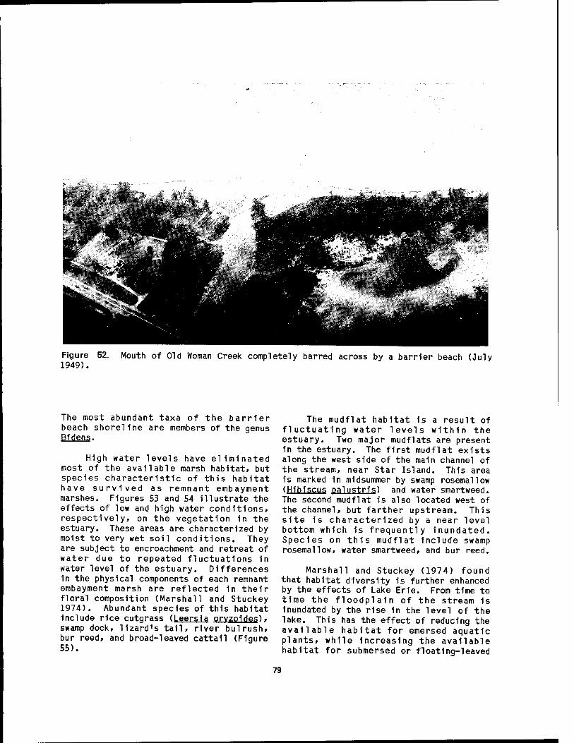
Figure 1949).
Mouth of Old Woman Creek completely barred across by a barrier beach (July
The most abundant taxa of the barrier beach shoreline are members of the genus Bidens.
High water levels have eliminated most of the available marsh habitat, but species characteristic of this habitat have survived as remnant embayment marshes. Figures 53 and 54 illustrate the effects of low and high water conditions, respectively, on the vegetation 1n the estuary. These areas are characterized by moist to very wet soil conditions. They are subject to encroachment and retreat of water due to repeated fluctuations in water level of the estuary. Differences in the physical components of each remnant embayment marsh are reflected 1n their floral composition (Marshall and Stuckey 1974). Abundant species of this habitat Include rice cutgrass (Leersla orvzoldes), swamp dock, lizard's tall, river bulrush, bur reed, and broad-leaved cattail (Figure 55).
The mudflat habitat is a result of fluctuating water levels within the estuary. Two major mudflats are present in the estuary. The first mudflat exists along the west side of the main channel of the stream, near Star Island. This area 1s marked 1n midsummer by swamp rosemallow (Hibiscus palustris) and water smartweed. The second mudflat is also located west of the channel, but farther upstream. This site is characterized by a near level bottom which is frequently inundated. Species on this mudflat include swamp rosemallow, water smartweed, and bur reed.
Marshall and Stuckey (1974) found that habitat diversity is further enhanced by the effects of Lake Erie. From time to time the floodplain of the stream 1s Inundated by the rise in the level of the lake. This has the effect of reducing the available habitat for emersed aquatic plants, while Increasing the available habitat for submersed or floating-leaved
79
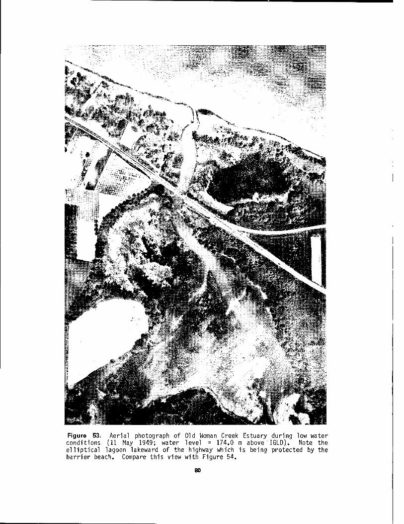
13111
Figure 53. Aerial photograph of Old Woman Creek Estuary during low water conditions (11 May 1949; water level = 174.0 m above IGLD). Note the elliptical lagoon lakeward of the highway which is being protected by the barrier beach. Compare this view with Figure 54.
80

Figure 54. Aerial photograph of Old Woman Creek Estuary during high water conditions (4 June 1973; water level = 174.8 m above IGLD). Note barrier beach has been breached, exposing the lagoon to wave attack. Compare this view with Figure 53.
81

Figure 55. Aquatic macrophytes in cove at Old Woman Creek Estuary; lizard's tail (Saururus cernuus) and swamp dock (Rumex verticillatus) in foreground, and oak-hickory forest in background (Marshall 1977).
aquatic plants. With a rise 1n water level the emersed vegetation survives 1n remnant embayment marshes or lies dormant 1n the flooded marsh soil. Marshall (1977) speculated that upon a reduction 1n water level many plant species of the embayment marshes would become re- established over the floodplain and also bring about the establishment of species new to the area. A correlation appears to exist between species diversity and the amount of sunlight received over an area. This is reflected 1n the high diversity of species in the open marsh and the low species diversity of the heavily wooded areas. Therefore, with the exposure of the marsh soil of the floodplain one would expect a highly diverse species composition in the open floodplain marsh due to the full sunlight received.
The barrier beach 1s also Influenced by Lake Erie. Because of disturbed conditions and a close proximity to the
lake, the beach should be the most likely site for the occurrence of plant species which have propagules that are carried by the water of the Take. This 1s apparently true 1n the case of Pennsylvania smartweed ( P Q ,1 y a a n .urn pensylyanicum var. eglandulosum). which is considered endemic to the Erie Islands 1n western Lake Erie. This species is presently considered rare and endangered. It 1s also unusual to find a stand of arrow arum as large as the colony 1n Old Woman Creek this far west 1n Lake Erie. The current high water conditions have apparently not affected its abundance, and may even have enhanced it. Lizard's tail also occurs as a very dense colony, which 1s restricted to a single embayment. This 1s a species of southern geographical affinity commonly found along river banks. The American water-lotus, also a southern species, migrated into the area following glaciation. With the advent of low water conditions, the lotus will have more
82
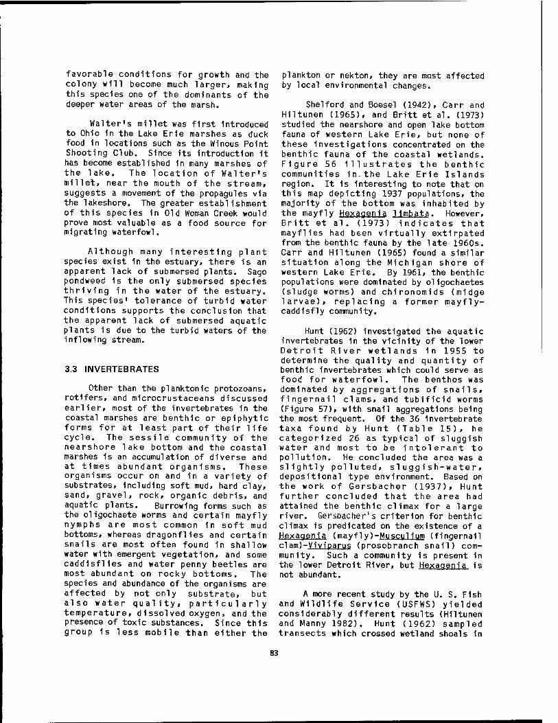
favorable conditions for growth and the colony will become much larger, making this species one of the dominants of the deeper water areas of the marsh.
Walter's millet was first introduced to Ohio in the Lake Erie marshes as duck food in locations such as the Winous Point Shooting Club. Since its introduction it has become established in many marshes of the lake. The location of Walter's millet, near the mouth of the stream, suggests a movement of the propagules via the lakeshore. The greater establishment of this species in Old Woman Creek would prove most valuable as a food source for migrating waterfowl.
Although many interesting plant species exist in the estuary, there is an apparent lack of submersed plants. Sago pondweed is the only submersed species thriving in the water of the estuary. This species' tolerance of turbid water conditions supports the conclusion that the apparent lack of submersed aquatic plants is due to the turbid waters of the inflowing stream.
3.3 INVERTEBRATES
Other than the planktonic protozoans, rotifers, and microcrustaceans discussed earlier, most of the invertebrates in the coastal marshes are benthic or epiphytic forms for at least part of their life cycle. The sessile community of the nearshore lake bottom and the coastal marshes is an accumulation of diverse and at times abundant organisms. These organisms occur on and in a variety of substrates, including soft mud, hard clay, sand, gravel, rock, organic debris, and aquatic plants. Burrowing forms such as the oligochaete worms and certain mayfly nymphs are most common in soft mud bottoms, whereas dragonflies and certain snails are most often found in shallow water with emergent vegetation, and some caddisflies and water penny beetles are most abundant on rocky bottoms. The species and abundance of the organisms are affected by not only substrate, but also water quality, particularly temperature, dissolved oxygen, and the presence of toxic substances. Since this group is less mobile than either the
plankton or nekton, they are most affected by local environmental changes.
Shelford and Boesel (1942), Carr and Hiltunen (1965), and Britt et al. (1973) studied the nearshore and open lake bottom fauna of western Lake Erie, but none of these investigations concentrated on the benthic fauna of the coastal wetlands. Figure 56 illustrates the benthic communities in.the Lake Erie Islands region. It is interesting to note that on this map depicting 1937 populations, the majority of the bottom was inhabited by the mayfly Hexagenia 1imbata. However, Britt et al . (1973) indicates that mayflies had been virtually extirpated from the benthic fauna by the late 1960s. Carr and Hiltunen (1965) found a similar situation along the Michigan shore of western Lake Erie. By 1961, the benthic populations were dominated by oligochaetes (sludge worms) and chironomids (midge larvae), replacing a former mayfly- caddisfly community.
Hunt (1962) investigated the aquatic invertebrates in the vicinity of the lower Detroit River wetlands in 1955 to determine the quality and quantity of benthic invertebrates which could serve as food for waterfowl. The benthos was dominated by aggregations of snails, fingernail clams, and tubificid worms (Figure 57), with snail aggregations being the most frequent. Of the 36 invertebrate taxa found by Hunt (Table 15), he categorized 26 as typical of sluggish water and most to be intolerant to pollution. He concluded the area was a slightly polluted, sluggish-water» depositional type environment. Based on the work of Gersbacher (1937), Hunt further concluded that the area had attained the benthic climax for a large river. Gersbacher's criterion for benthic climax is predicated on the existence of a Hexagenta (mavflv)-Muscu!1um (fingernail c1am)-Viviparus (prosobranch snail) com- munity. Such a community is present in the lower Detroit River, but Hexagenia is not abundant.
A more recent study by the U. S. Fish and Wildlife Service (USFWS) yielded considerably different results (Hiltunen and Manny 1982). Hunt (1962) sampled transects which crossed wetland shoals in
83
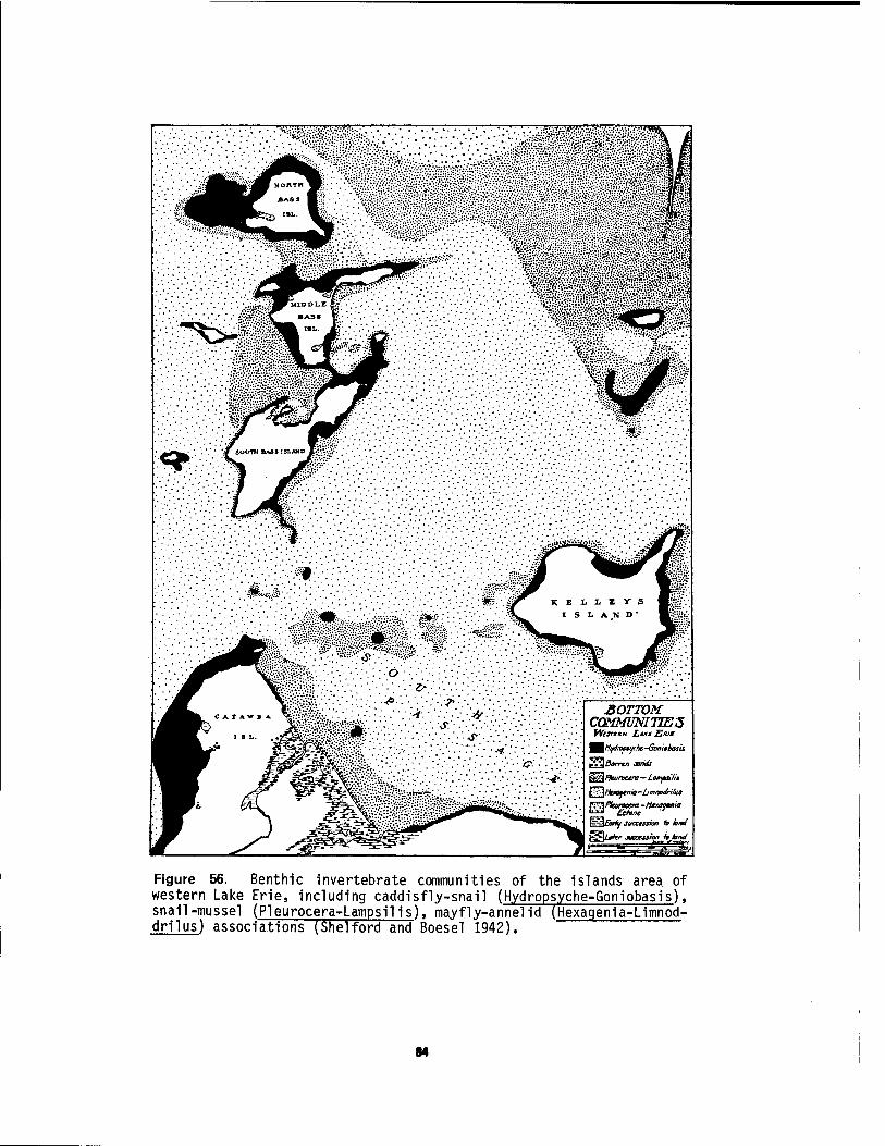
^^Hifdropiythe -Goniebasu
**** Ohne ^ t=^£äny juccestiofi A AW
f^U^fer juaess/on hknel
Figure 56. Benthic invertebrate communities of the islands area of western Lake Erie, including caddisfly-snail (Hydropsyche-Goniobasis), snail-mussel (Pleurocera-Lampsilis), mayfly-annelid (Hexagenia-Limnöd- drilus) associations (She!ford and Boesel 1942).
84
Figure 57. Invertebrate Detroit River
Distribution of aquatic communities 1n the lower (Hunt 1962).
the lower Detroit River where waterfowl were known to feed, whereas the USFWS study was 1n the same general location but samples were taken near the center of the channels on either side of Grosse He. In the deeper-water study, 49 macrozoobenthlc taxa were collected and ollgochaete worms were the most numerous (Table 16). A station north of Grosse lie yielded
115,760 ol1gochaetes/mz 1n July 1977. In Ontario waters of the Detroit River, the macrozoobenthos Included pollution-Intol- erant ephemeropterans (I.e., Hexaaenla) and the populations were more diverse than the Michigan waters. The low diversity of macrozoobenthos and the high proportion of pollutlon-tplerant ollgochaetes (9355) 1n Michigan waters of the river Indicate that the deeper waters are severely Impacted by pollution.
Sandusky Bay, particularly the upper (western) end and Inside Cedar Point spit, contains some of the finest coastal marshes bordering western Lake Erie. One of the most extensive Investigations of benthlc macrolnvertebrates 1n a Lake Erie estuary and coastal marsh was conducted 1n this bay by Herdendorf and Lindsay (1975) and Lindsay (1976). The nearshore open waters of the bay contain a benthlc community dominated by ollgochaete worms and chlronomid (midge) larvae. Three species of ollgochaete? (Branchlur^ sowerbYl, Limnodrllus hoffmelsterl. and Peloscolex ferox) and three species of chlronomlds (Chlronomus plumosus, Pro- cHdlUS cu,11c1form1S, and Coelotanvpus scapularls) comprise 90% of the benthlc fauna. In all, at least 50 benthlc texa are common, Including other annelids and dlpterans, crustaceans, gastropods, pele- cypods, larval Insects, hydrozoans, bryozoans, and sponges (Appendix G).
All of the ollgochaetes 1n the bay burrow 1n the mud, some constructing tube cases. They ell feed by Ingesting mud from which they extract soluble organic material and microorganisms. There appears to be commensal feeding among the ollgochaetes. The feces of one species serves as the food for another. Brlnkhurst (1974) found that these worms tend to migrate toward different worm species rather than their own species. The two most abundant species, Limnodrllus hQffme1st<jsr1 and Branch 1ura sowerbvi. have a one-year life cycle. The peak breeding activity for these species occurs at water temperatures around 15°C (Brinkhurst and Jamleson 1972); however, Lindsay (1976) found both adults and juveniles to be present year around 1n Sandusky Bay.
Of the three species of chlronomlds common 1n the bay, Procladlus bellus and
85
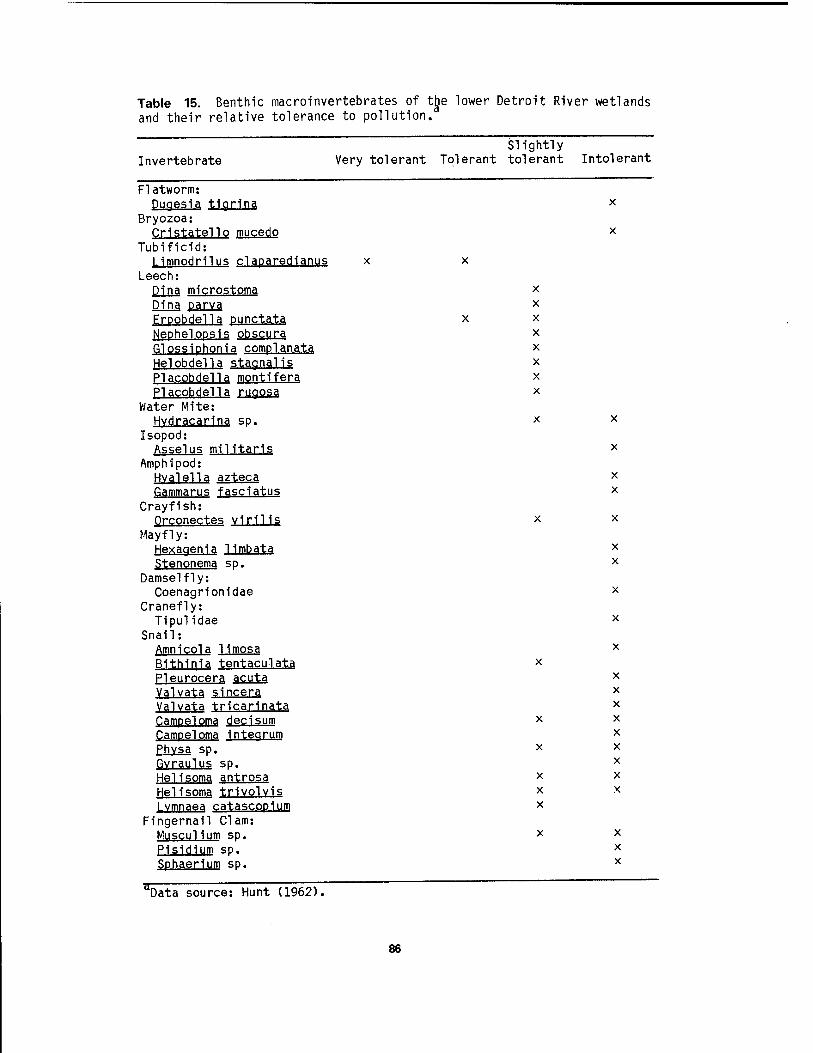
Table 15. Benthic macroinvertebrates of ttje lower Detroit River wetlands and their relative tolerance to pollution.
Invertebrate Slightly
Very tolerant Tolerant tolerant Intolerant
Flatworm: Dugesia tigrina
Bryozoa: Qristatello mucedo
Tubificid: Limnodrilus claparedianus
Leech: Dina microstoma Dina parva Erpobdella punctata Nephelopsis obscura Qlossiphonia complanata Helobdella staanalis Placobdella montifera Placobdella rugosa
Water Mite: Hvdracarina sp.
Isopod: Assel us militaris
Amphipod: Hvalella azteca Gammarus fasciatus
Crayfish: Orconectes viril is
Mayfly: Hexaaenia 1imbata Stenonema sp.
Damselfly: Coenagrionidae
Cranefly: Tipulidae
Snail: Amnicola limosa Bithinia tentaculata Pleurocera acuta Valvata si neera Valvata tricarinata Campeloma decisum Campeloma intearum Phvsa sp. Gvraulus sp. Helisoma antrosa Helisoma trivolvis Lvmnaea catascopium
Fingernail Clam: Musculium sp. Pisidium sp. Sphaerium sp.
x x x x x x x x
x x
X
X
X
X X
X
X X
X
X X
X X
X
X X
X
X
Data source: Hunt (1962).
86

Table 16. Benthlc macrolnvertebrate population of the lower Detroit River.3
Major Apri Composition
1 1977 Density
Julv 1977 Annual nie an taxa Composition Density Composition Density
(%) (no/m^) (%) (no/rrr) (%) (no/rrr)
Nematoda 1.5 230 0.4 121 0.8 179 01igochaeta 93.6 13,963 92.0 26,716 92.6 19,900 Polychaeta 0.4 63 2.7 784 1.9 399 Amphipoda 0.1 11 0.3 99 0.2 52 Isopoda <0.1 1 <0.1 2 <0.1 1 Diptera 1.2 175 0.8 227 0.9 199 Ephemeroptera 0.6 85 0.1 15 0.2 53 Gastropoda 0.5 69 1.7 484 1.2 262 Pelecypoda 0.9 131 0.9 257 0.9 190 % of Total 98.9 99.0 98.7
Data source: Hiltunen and Manny (1982).
Coelotanvpus scapularis are carnivorous predators. The third species, Chironomus plumosus, feeds primarily on plankton, periphyton, and aquatic plant tissue. Chironomus constructs a definite burrow in soft sediments, while the other two species do not. The predators feed on other chironomids and frequently inhabit the burrows of their prey (Lindsay 1976).
Other than studies 1n the Lake Erie islands region, lower Detroit River, and Sandusky Bay, investigations of inverte- brates in the coastal marshes of western Lake Erie are scarce. Lehman (1973) and Adams (1976) do provide lists of invertebrate species found in Navarre Marsh, a diked coastal wetland on Locust Point, midway between Toledo and Port Clinton, Ohio (Table 17). When Table 17 is compared with Appendix G the differences 1n the invertebrate fauna of an open, coastal wetland versus a protected, diked marsh are obvious. Open water habitats appear to be dominated by oligochaetes and dipterian larva, while protected marshes abound in other insect orders.
The importance of aquatic vegetation as a habitat for aquatic invertebrates 1s often overlooked 1n wetlands Investi- gations. Krecker (1939), working in western Lake Erie wetlands, noted that
submerged, leafy types of vegetation are more densely populated than are the emergent, hard surfaced, non-leafy types. He examined seven species of submersed plants (Figure 58) for both the composition and quantity of the animal population. Representatives of 29 taxa were found among these plants (Table 18), ranging from a maximum of 26 on El odea and 4 on Vallisnerla. An entirely different picture is presented when the plants are compared on the basis of individuals present per linear meter of plant. Myriophvllum with mean populations of 440 invertebrates per meter and Potamogeton crispus with 347 led all the others by a wide margin. Midge larvae (Chironomldae) and freshwater annelids (01 Igochaeta) together made up 59%-93% of the invertebrates on all plants except Elodea. On this plant, midges and annelids only comprised 2955, while the sessile rotifer, Melicerta, made up 50% of the epiphytic invertebrates.
Marsh Invertebrates, including immature and adult insects, snails, and crustaceans are Important In the diet of waterfowl. Ducklings of all species rely almost entirely on animal food during their first month (Beard 1953). Bartonek and Hickey (1969) found that 96% of the food consumed by juvenile canvasbacks consisted of animal material particularly
87

Table 17. Invertebrates Navarre Marsh, Ohio.3
collected in
Species
Phylum Annelida (segmented worms) Class Hirudinea (leaches)
Placobdella parasitica
Phylum Mollusca (soft-bodied animals) Class Gastropoda (snails)
Lvmnaea exilis (pond snail) Viviparus malleatus (oriental
mystery snail)
Phylum Arthropoda (joint-legged animals) Class Crustacea
Order Decapoda (shrimps, crayfishes) Palaemonetes kadiakensis (glass
shrimp) Orconectes immunis (crayfish) Procambarus blandingi (crayfish)
Class Insecta Order Odonata (dragonflies and
damselflies) Anax iunius (dragonfly nymph) Ischnura vertical is (damselfly
nymph)
Order Hemiptera (bugs) Hesperacorixa sp. (water boatman) Palmacorixa buenoi (water
boatman) Notonecta undulata (backswimmer) Belostoma fluminea (giant water
bug) Ranatra fusca (water scorpion) Gerris remigis (water strider)
Order Coleoptera (beetles) Dineutus americanus (whirligig
beetle) Tropisternus glaber (water beetle)
aData sources: Lehman (1973), Adams (1976).
daphnlds, amphipods, and various aquatic Insects.
Krull (1970) related the abundance, diversity, and seasonal occurrence of macrolnvertebrates to 12 species of
submerged aquatic plants in the Finger Lakes region of New York. Considering all 12 plants for the entire growing season, he found gastropods (especially Phvsa sp.), dragonflies, backswlmmers, and water boatmen were the most important. Leeches, amphipods, decapods, giant water bugs, and midges were of secondary Importance. On the average 1 g of animal material was associated with 100 g of plant material. Duckweed (Lemna fisulca), water stargrass (Heteranthera dubia), coontall (Cerato- phvllum demersutn), waterweed (Elodea cjüadjiisis.), and bladderwort (Utr1cular1a vulqars) were found to harbor the most abundant macroinvertebrate populations. The latter species is a small aquatic herb with bladders to catch invertebrates (Fassett 1957). Both bladderwort and waterweed are considered to be poor waterfowl food plants, but they are indirectly Important to waterfowl production because of the large quantities of invertebrates which furnish a source of animal protein.
During four different intervals of the Pleistocene epoch, which Itself lasted from about one million to about ten thousand years ago, the Lake Erie basin was covered with glacial 1ce. Within the glaciated region all benthlc organisms were destroyed, but each time the ice receded they relnvaded the previously ice- covered region. The Pleistocene mollusks pf the intergladal lakes and their paleoecology are well documented by La Rocque (1966). Many species, particularly the unlonld bivalves and the large prosobranch snails, require continuous waterway for migration. Glochidla may be carried over long distances while attached to their fish host. The rich molluscan fauna of the Lake Erie region was largely repopuVated from the 0hio-M1ss1ss1pp1 system when glacial meltwaters 1n this region flowed south. Additionally, Clarke (1981) speculated that most small snails (pulmanates) and small clams (sphaer11ds) are carried about Imbedded 1n the feathers of water birds, 1n mud attached to their feet or clamped to the appendages of large, flying aquatic Insects. Appendix H provides a listing of the mollusks associated with the coastal wetlands and nearshore waters. Appendix I contains

Figure 58. Submersed aquatic plants from Fishery Bay, South Bass Island, examined by Krecker (1939) for invertebrate animals (Table 18). Note: Vallisneria spiral is (=ameri- cana); Potamogeton compressus (=zosteriformis).
Table 18. Invertebrate animals found on various aquatic plants in western Lake Erie wetlands.
Population per 11near meter of submerged plants Invertebrate Ec
Ave Max Nf
Ave Max Va
Ave Max Pz PP
Ave Max Pc
tax a Ave Max Ave Max Ave Max
ANNELIDA Aeolosoma. <1 <1 1 4 1 5 Ch3etoga.?-ter 2 3 3 9 8 51 - - 5 5 2 3 6 21 Dero 1 3 <1 2 Na1s 12 34 52 98 133 596 4 4 125 125 59 78 78 217 Ophldonais - - 5 37 Stvlarla 10 28 6 22 27 69 - - 1 1 2 3 11 55
(continued)
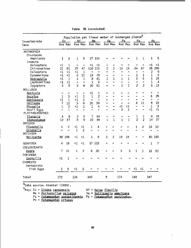
Table 18. (concluded)
Invertebrate taxa
Population per linear meter of submerged plants Is _M —MS _Jte _Ez Pp _Ec
Ave Max Ave Max Ave Max Ave Max Ave Max Ave Max Ave Max
ARTHROPODA Crustacea
Amphipoda Insecta Anisoptera Chironorr.idae Coleoptera Ephemeridae Hydroptila Leptoderidae Zygoptera
MOLLUSCA Amnicola Ancvlus Goniobasis Helisoma Phvsella Snail Eggs
PLATYHELMINTHES Planar la Stenostomum
BRYOZOA PI utnatel 1 a Urnatella
ROTIFERA Melicerta
NEMATODA COELENTERATA
PORIFERA SponqUla
CHORDATA Vertebrata
F1sh Eggs
Total
12 15 27 111 -- -- 11 15
<1 1 - - <1 <1 - - - - - - <1 <1 21 61 27 47 110 213 2 2 15 15 64 67 95 296 <1 <1 <1 1 29 <1 <1 6 21 19 79 - - - - 11 13 <1 1 11 8 41 11 11 3 5 5 23 <1 <1 -- 16 -- - - -- 14 59 38 20 61 -- 11 22 5 13
- - - - <1 1 -- -- -- -- 1 3 <1 1 12 -- -- -- 6 29
<1 1 <1 1 ---- -- -- -- 7 12 5 6 25 59 - - - - 6 11 8 22 1 2 <1 1 14 - - <1 <1 - - 13
2 2 - - <1 <1
48 23 7 34 -- -- 11 6 24 12 37 6 9 22 48 11 11 2 2 14 27
1 2 <1 <1 14 - - - - 1 2 10 52 - - 12 -- - --
80 188 <1 <1 16 2 2 18 18 - - 80 180
4 16 <1 <1 17 113 - 17
7 15 12 6 20 - - 5 5 1 1 15 52
<1 1 -- -- __■_ ___ __
<1
172 116 440 174
<1 <1
143 347
Data source: Krecker (1939).
Key: Ec = Elpdea. canadensls Nf = Na.1as flexlHs Ms = MyrlPphvUui" spicatum va = Vainsneria amerlcana, Pz = pot^mogetop zosterlformis Pp = Potamoge^on pectlnatus. Pc = potamogetpn crlspus
90
information on the habitat preference of these species.
Gastropods- Well-vegetated portions of unpolluted embayments, marshes, beach ponds, and sluggish tributary mouths are the most productive localities for freshwater snails 1n western Lake Erie. They live on submerged vegetation, on rocks, and on the bottom at the water's edge and out to a depth of several meters. Two subclasses, Prosobranchia and Pulmonata, are well represented 1n Lake Erie coastal marshes. Prosobranchia species are characterized by internal respiratory gills (ctenidia), or, as 1n Valvata, by external gills, and have operculum to seal the shell aperature. Pulmonata species do not have gills but obtain oxygen through a "lung-like" pulmonary cavity. Pulmonate snails, which have descended from land snails, must come to the surface periodically to take air into the lung. Dennis (1938) reported that pulmonates 1n the Bass Islands region were always found where there was considerable wave action or near the surface, while gilled snails were found 1n deeper more stagnant waters.
Most aquatic snails are vegetarians. The veneer of living algae which covers most submerged surfaces is their chief food, but dead plant and animal material is also frequently ingested. Dissolved oxygen is an Important limiting factor; most gilled species require high concentrations, and limpets such as perrissia are found only where the water remains near saturation (Pennak 1978). However, Campe!oma decisum, and Amnicola limosa have been collected in water with less than 2 ppm oxygen (Harman 1974). The concentration of dissolved solids 1n western Lake Erie, particularly calcium carbonate at 95 ppm, provides adequate essential materials for shell construction. Appendix I shows the habitat preferences for the 47 species of gastropods which have been reported for the coastal marshes and nearshore waters.
Pelecvpods. The bivalved molluscan fauna of western Lake Erie consists of three families. The majority of the species belong to the Unionldae (fresh- water mussels or naiades) and Sphaeriidae
(fingernail clams). The third family, Corbiculidae (little basket clams), Is represented by an Introduced Asiatic species. Bivalves are most abundant nearshore, especially 1n water less than 2 m deep. Stable gravel and sand substrates with a good current support the largest populations. Commonly mussels Inhabit substrates free of rooted vegetation, but there are numerous exceptions, including Anodonta qrandis and Quadrula quadrula.
Stomach contents of unionid mussels are commonly mud, desmlds, diatoms, and other unicellular algae, protozoans, rotifers, flagellates, and detritus. The largest populations of mussels develop below areas where disintegration of rich vegetation 1s occurring (Churchill and Lewis 1924).
The female pocket-book mussel (LampsilIs ventricosa) 1s capable of extending and pulsating the posterior edge of the mantle in such a way that it resembles an injured minnow (Clarke 1981). This activity attracts several marsh- associated fish species such as bluegill, white crapple, smallmouth bass, and yellow perch, and Increases the opportunities for juvenile mussels (glochldla) to attach themselves to a fish after they have been ejected from the parent. The larvae are released by the parent when Its light sensitive spots are stimulated, for example, by the shadow of a passing fish. Several unionid bivalves possess special mantle structures adapted to lure fish Into their vicinity. The glochidia of each species of freshwater mussel (corresponds to veliger larvae of marine bivalves) must attach to the gills and fins of a particular fish species or small group of species (Table 19) before further development can take place. Most glochidia never accomplish this, but those that do succeed remain attached for a few weeks as they metamorphose Into tiny mussels. The young mussels then drop from the fish to take up an Independent life on the lake bottom, moving about and siphoning water for respiration and for obtaining plankton as a source of nourishment. Appendix I Indicates the habitat preferences of the 64 species of pelecypods which have been reported for coastal marshes and nearshore waters.
91
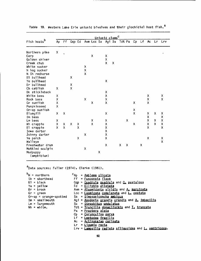
Table 19. Western Lake Erie unlonld bivalves and their gloch1d1al host fish.'
Fish hosts Unlonld clams
Ap Ff Qqp Ed Avm Lcc Sa Agi Su Tdt Pa Cp Lf Ac Lr Lrv
Northern pike X „ Carp Golden shiner Creek chub White sucker N hog sucker N Sh redhorse Bl bullhead X Ye bullhead Br bullhead X Ch catfish X X Bk stickleback White bass X Rock bass X Gr sunfish X Pumpkinseed X Or-sp sunfish Bluegill X X Sm bass Lm bass X Wh crappie X X X Bl crappie X X Iowa darter Johnny darter Ye perch Walleye Freshwater drum Mottled sculpin Mudpuppy
(amphibian)
X X
X X X
X X
X X X
X X X X
X X X X X X
X X
X X X
X X X X X
X X
X X
X X X X X
X X
aData sources: Fuller (1974), Clarke (1981).
N = northern Sh = shorthead Bl = black Ye = yellow Br = brook Gr = green Or-sp = orange-spotted Sm = smallmouth Lm = largemouth Wh = white.
"Ap = Amblema plicata Ff = FuscQn3la, f|a,va, Qqp = Quadrula quadrula and SL pusttllpsa Ed = EWPttP dnqtrtA Avm = Alasmldonta vir1d1s and A* marginal Lcc = Lasmlqona cQmplanqta, and L* CQSt3t3 Sa = S1mpson1concha amblgua Agi = Anodonta qrandls grandls and A* jmbeclHs Su = Strophltus undulatus Tdt = Trundlla donadformls and L. truncatfl Pa = Proptera £U±ä Cp = CaruncuHna ßaxyj Lf = Leptodea fragil 1s Ac = Actlnonalas garinata Lr = L1gum1a £g£±a Lrv = LampslHs radlata s1Houo1dea and L* ventrlgosa.
92

Crustacean?
Throughout Lake Erie's coastal wetlands the amphipod, Gammarus fasciatus, is an important food organism for yellow perch, walleye, freshwater drum, and catfish, and is one of the dominant macrozoobenthlc forms in the coastal marshes. Gammaru? is well equipped to cling to aquatic vegetation; each of its 14 pereiopods has a terminal claw which is used to grasp plant stems and seize prey. Clemens (1950) found that during the summer and fall in western Lake Erie, Gammarus was most common on beds of submerged vegetation, particularly ffotamogetop crispus, ^al.l.isneria, Myrio- phvllurn, and Cladophora glomerata. These 8- to 10-mm long omnivorous crustaceans readily devour both living and dead plant and animal matter. Aquatic plants (especially submerged forms), dead leaves, Zooplankton (Daphnia, Leptodora, and Cvclops), fellow members of this species, and their own moults and fecal pellets are the most common food items. Populations of these scuds also occur in deeper, offshore portions of western Lake Erie, but not in as great a density as in the vegetated areas.
Other notable crustaceans associated with wetlands include copepods and cladocerans (water fleas), isopods (aquatic sowbugs), ostracods (seed shrimp), and decapods (crayfish and shrimps). Because of the great variety of ecological niches, the shallow littoral zone of Lake Erie, especially in aquatic vegetation, is rich in cyclopoid and calanoid species. Harpacticoid copepods are more restricted to bottom debris 1n the wetlands. Cladocerans are important limnetic (open water) organisms in Lake Erie, but several species, including PaphnU PUlex and Sida crystal! ina, are abundant among the vegetation in the coastal marshes. Bacteria, algae, proto- zoans, and organic detritus are the chief foods of these filter feeders. Both of these microcrustacean groups, as well as protozoans, are trapped and ingested by bladderwort (Utricularia vulqaris) plants in the coastal marshes. Isopods seldom enter open water but prefer niches under vegetation, debris, and rocks. Asellus racovitzal is the common species in western Lake Erie. The nature of the
substrate appears to have little influence on the distribution of ostracods. In many cases, the same species can be found on algae, decaying vegetation, rooted aquatics, and mud (Pennak 1978). Crayfish are generally inhabitants of shallow water, seldom being found deeper than 1 m. Species such as Qrconectss immunis live in the water during warm months, but in the autumn they construct burrows along the edge of the marsh and live in them until the lake level rises and the weather becomes warmer 1n the spring.
Insects
The most conspicuous invertebrates associated with the coastal marshes are the myriad of insects. The dipterans (true flies) are the most abundant and Include the midges, mosqultos, and crane flies. Mayflies, dragonflies, and damsel- flies are also abundant groups of organisms which have an aquatic larval stage and then emerge to fly and mate over the marsh. The hemipterans (true bugs) are represented by diverse forms including the water strider, backswimmer, water boatman, and giant water bug (Belostoma sp.), which preys on tadpoles and small fish (Weiler 1981). Other Important Insect groups of the marshes include the caddisfHes and beetles. The former (Triaen sp. and Oecetis sp.) builds a case from bits of vegetation and sand. The latter includes the predaceous diving beetle (Dvtiscus sp.) and the gregarious whirlygigs (Qyr1nu.s sp.).
3.4 FISH
Wetlands are Important to fish production because they provide spawning and nursery habitat for wetland-dependent species, cover for juvenile and forage fish, and feeding areas for predator fish. Approximately 43 species of fishes are or once were associated with the coastal marshes of western Lake Erie. Twenty-six of these species are currently of significant recreational, commercial, or prey value. Fishes associated with coastal marshes can be divided into two categories: 1) species directly dependent on coastal marshes as adult habitats or spawning and nursery areas, and 2) species not dependent on marshes for such uses but which are usually common 1n coastal
93

marshes^ apparently making opportunistic grounds for important species in the lower use of them as spawning* nursery» and Detroit River and western Lake Erie are feeding areas. Spawning and nursery shown on Figures 59 and 60» respectively.
Figure 59. Spawning and nursery grounds of lake sturgeon, northern pike, carp, emerald shiner, white bass, and walleye in the lower Detroit River (Goodyear et al. 1982a).
94

Detroit River
Michigan GIZZARD SHAD
Detroit River Michigan
Detroit River r
Michigan /j NORTHERN PIKE
Toledo'
Maumee River
Toledo,
Maumee River
Detroit River
Michigan EMERALD SHINER
Toledo
Maumee River
Detroit River
Michigan CHANNEL CATFISH
Toledi
Maumee River
Detroit River
Michigan /fSMALLMOUTH BASS
Toled
Maumee River
Detroit River
Michigan ELLOW PERCH
Detroit River
Michigan
Maumee River
Toledi
Maumee River
Detroit River
Michigan FRESHWATER DRUM
Toled
Maumee River
Detroit River
Michigan WHITE BASS
Toled<
Maumee River
Detroit River
Michigan
Toledo
Maumee River
Viäs Spawning area 000 *. •00c Nursery area
I so
miles
Figure 60. Spawning and nursery grounds for important western Lake Erie fish species (Goodyear et al. 1982b).
95
Most of the fish fauna inhabiting the marshes consist of non-salmon id» warmwater» or coolwater species such as the minnow, catfish, and pike families. Because of the predominance of clayey and organic-rich substrates in wetlands, there is a prevalence of bottom feeders. Often as much as 90% of the standing fish crop in wetlands consists of forage species (Greenwood 1971). Large predator fish rely on visual contact to locate their prey. Because, however, many of the Lake Erie marshes, are turbid, associated species, including carp and bullheads must tolerate turbidity and si 1tation.
Trautman (1981) is the primary source of Information regarding fish in Lake Erie and their life histories, habitat associations, and utilization of wetlands. He provides detailed location maps for each species but site-specific information on individual wetlands is not included. The value of this work in understanding wetland utilization is considerable, though, because the detailed habitat descriptions for each species allow extrapolation of the probable fish community of most wetlands. Other useful works on the Detroit River and the Lake Erie nearshore fisheries include: Barnes (1979), Edmister (1940), Fraleigh et al. (1975), Goodyear et al. (1982a,b), Hartley and Herdendorf (1975), Hatcher and Nester (1983), Herdendorf et al. (1981b), Hunt and Mickelson (1976), Jaworski and Raphael (1978), Langlois (1954, 1965), Price (1963), Van Meter and Trautman (1970), and Zeitoun et al. (1978).
Currently, sport fishermen utilize the area from Vermilion to Lorain, Catawba, and the Lake Erie Islands area. Commercial fishermen utilize Sandusky Bay and the south shore of the western basin. Particular emphasis is on the vicinity near major ports. However, little site- specific information exists upon which to base value judgements of any individual wetland in terms of its importance to fish production for recreation or commercial harvest, or as a preserve for unique fish species or communities.
Species Composition
Many species of fish utilize the coastal wetlands of Lake Erie, but
dependency on aquatic vegetation for spawning, feeding, or cover has been demonstrated for comparatively few species. The most common wetland- dependent fish species include the longnose gar (Lepisosteus osseus), bowfin (Ami_a calva), central mudminnow (Umbra limi), grass pickerel (Esox amerjcanus), golden shiner (Notemigonus crvsoleucas), and pumpkinseed (Lepomis gibbosus). Several other wetland-dependent species are uncommon or rare in Lake Erie. These are the spotted gar (Lepisosteus oculatus), northern pike (Esox lucius), muskellunge (E. masquinonqy), pugnose minnow (Notropis emiliae), blackchln shiner (N. heterodon), blacknose shiner (Ü, heterolepis), tadpole madtom (Noturus g v r i n u s), banded killifish (Fundulus diaphanus), brook stickleback (Culaea 1 nconstans), mosquitofish (Gambusla affinis), Iowa darter (Etheostoma exile), and mottled sculpin (Cottus bairdi). The brook stickleback and mottled sculpin typically are small stream inhabitants with a strong affinity for vegetation. Although these two species are uncommon in the coastal waters of Lake Erie, they are locally common in inland waters. The mosquitofish 1s an introduced species which is not yet common. The northern pike is fairly common in Lake Erie and supports a minor recreational fishery, as does the abundant pumpkinseed. The extent of these fisheries is not determined. The muskellunge is virtually extirpated from western Lake Erie.
Several fish species found in Lake Erie range from common to abundant in wetlands and adjacent waters. The gizzard shad (Dorosoma cepedianum), carp (Cvprinus carpio), goldfish (Carassius aurgtus), fathead minnow (Pimephales promelas), bluntnose minnow (E. notatus), white sucker (Catostomus commersoni), black bullhead (Ictalurus me!as), brown bullhead (I. nebulosus), yellow bullhead (I. nfltalis.), bluegill (Lepomis macrochirus), largemouth bass (Micropterus salmoldes.), white crappie (Pomoxis annularis), and black crappie (E. n^qromaculatus) prefer quiet, low-gradient waters with bottoms of mud, silt, or clay. These species are generally cover-oriented and are common 1n the larger coastal wetlands of western Lake Erie; this is particularly true for the carp and bullheads, which are
96
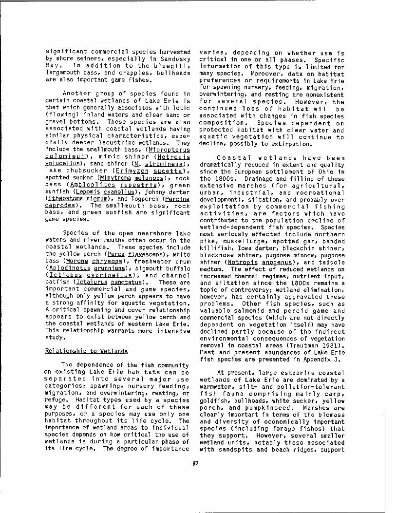
significant commercial species harvested by shore seiners, especially in Sandusky Bay. In addition to the bluegill, largemouth bass, and crappies, bullheads are also important game fishes.
Another group of species found in certain coastal wetlands of Lake Erie is that which generally associates with lotic (flowing) inland waters and clean sand or gravel bottoms. These species are also associated with coastal wetlands having similar physical characteristics, espe- cially deeper lacustrine wetlands. They include the smallmouth bass, (Micropterus do 1 omi eu i ) , mimic shiner (Notropis volucellus), sand shiner (R. stramineus), lake chubsucker (Erimvzon sucetta), spotted sucker (Minvtrema melanops), rock bass (Ambloplites rupestris), green sunfish (Lepomis cvanellus), johnny darter (Etheostoma nigrum), and logperch (Percina caprodes). The smallmouth bass, rock bass, and green sunfish are significant game species.
Species of the open nearshore lake waters and river mouths often occur in the coastal wetlands. These species include the yellow perch (Perca flavescens), white bass (Morone chrvsops), freshwater drum (Aplodinotus grunniens), bigmouth buffalo (IctlQbgs cvprinellu?) . and channel catfish (Ictalurus punctatus). These are important commercial and game species, although only yellow perch appears to have a strong affinity for aquatic vegetation. A critical spawning and cover relationship appears to exist between yellow perch and the coastal wetlands of western Lake Erie. This relationship warrants more intensive study.
Relationship to Wetlands
The dependence of the fish community on existing Lake Erie habitats can be separated into several major use categories: spawning, nursery feeding, migration, and overwintering, resting, or refuge. Habitat types used by a species may be different for each of these purposes, or a species may use only one habitat throughout its life cycle. The importance of wetland areas to individual species depends on how critical the use of wetlands is during a particular phase of its life cycle. The degree of importance
varies, depending on whether use 1s critical in one or all phases. Specific information of this type is limited for many species. Moreover, data on habitat preferences or requirements in Lake Erie for spawning nursery, feeding, migration, overwintering, and resting are nonexistent for several species. However, the continued loss of habitat will be associated with changes in fish species composition. Species dependent on protected habitat with clear water and aquatic vegetation will continue to decline, possibly to extirpation.
Coastal wetlands have been dramatically reduced 1n extent and quality since the European settlement of Ohio in the 1800s. Drainage and filling of these extensive marshes (for agricultural, urban, industrial, and recreational development), siltatlon, and probably over exploitation by commercial fishing activities, are factors which have contributed to the population decline of wetland-dependent fish species. Species most seriously effected include northern pike, muskellunge, spotted gar, banded killifish, Iowa darter, blackchin shiner, blacknose shiner, pugnose minnow, pugnose shiner (Notropis anogenus), and tadpole madtom. The effect of reduced wetlands on increased thermal regimes, nutrient input, and siltation since the 1800s remains a topic of controversy; wetland elimination, however, has certainly aggravated these problems. Other fish species, such as valuable salmonid and percid game and commercial species (which are not directly dependent on vegetation Itself) may have declined partly because of the indirect environmental consequences of vegetation removal in coastal areas (Trautman 1981). Past and present abundances of Lake Erie fish species are presented in Appendix J.
At present, large estuarlne coastal wetlands of Lake Erie are dominated by a warmwater, silt- and pollution-tolerant fish fauna comprising mainly carp, goldfish, bullheads, white sucker, yellow perch, and pumpkinseed. Marshes are clearly Important 1n terms of the blomass and diversity of economically Important species (Including forage fishes) that they support. However, several smaller wetland units, notably those associated with sandsplts and beach ridges, support
97
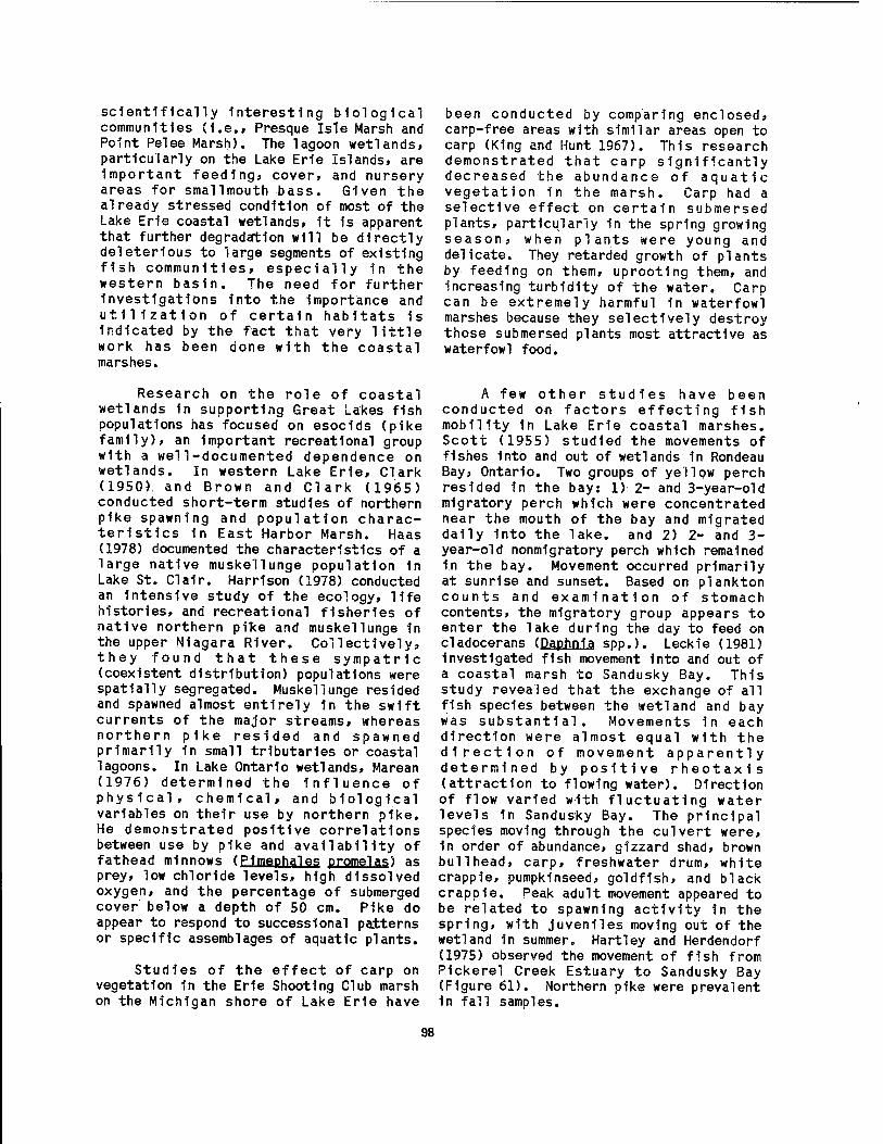
scientifically Interesting biological communities (I.e., Presque Isle Marsh and Point Pelee Marsh). The lagoon wetlands, particularly on the Lake Erie Islands, are Important feeding, cover, and nursery areas for smallmouth bass. Given the already stressed condition of most of the Lake Erie coastal wetlands, 1t is apparent that further degradation will be directly deleterious to large segments of existing fish communities, especially in the western basin. The need for further investigations into the importance and utilization of certain habitats is Indicated by the fact that very little work has been done with the coastal marshes.
been conducted by comparing enclosed, carp-free areas with similar areas open to carp (King and Hunt 1967). This research demonstrated that carp significantly decreased the abundance of aquatic vegetation in the marsh. Carp had a selective effect on certain submersed plants, particularly in the spring growing season, when plants were young and delicate. They retarded growth of plants by feeding on them, uprooting them, and increasing turbidity of the water. Carp can be extremely harmful in waterfowl marshes because they selectively destroy those submersed plants most attractive as waterfowl food.
Research on the role of coastal wetlands in supporting Great Lakes fish populations has focused on esodds (pike family), an Important recreational group with a well-documented dependence on wetlands. In western Lake Erie, Clark (1950). and Brown and Clark (1965) conducted short-term studies of northern pike spawning and population charac- teristics 1n East Harbor Marsh. Haas (1978) documented the characteristics of a large native muskellunge population in Lake St. Clalr. Harrison (1978) conducted an intensive study of the ecology, life histories, and recreational fisheries of native northern pifce and muskellunge In the upper Niagara River. Collectively, they found that these sympatric (coexistent distribution) populations were spatially segregated. Muskellunge resided and spawned almost entirely 1n the swift currents of the major streams, whereas northern pike resided and spawned primarily in small tributaries or coastal lagoons. In Lake Ontario wetlands, Marean (1976) determined the influence of physical, chemical, and biological variables on their use by northern pike. He demonstrated positive correlations between use by pike and availability of fathead minnows (Pimephales promelas) as prey, low chloride levels, high dissolved oxygen, and the percentage of submerged cover below a depth of 50 cm. Pike do appear to respond to successional patterns or specific assemblages of aquatic plants.
Studies of the effect of carp on vegetation in the Erie Shooting Club marsh on the Michigan shore of Lake Erie have
A few other studies have been conducted on factors effecting fish mobility in Lake Erie coastal marshes. Scott (1955) studied the movements of fishes into and out of wetlands in Rondeau Bay, Ontario. Two groups of yellow perch resided in the bay: 1) 2- and 3-year-old migratory perch which were concentrated near the mouth of the bay and migrated daily into the lake, and 2) 2- and 3- year-old nonmigratory perch which remained 1n the bay. Movement occurred primarily at sunrise and sunset. Based on plankton counts and examination of stomach contents, the migratory group appears to enter the lake during the day to feed on cladocerans (Daphnia spp.). Leckie (1981) Investigated fish movement into and out of a coastal marsh to Sandusky Bay. This study revealed that the exchange of all fish species between the wetland and bay was substantial. Movements in each direction were almost equal with the direction of movement apparently determined by positive rheotaxis (attraction to flowing water). Direction of flow varied with fluctuating water levels in Sandusky Bay. The principal species moving through the culvert were, 1n order of abundance, gizzard shad, brown bullhead, carp, freshwater drum, white crapple, pumpkinseed, goldfish, and black crapple. Peak adult movement appeared to be related to spawning activity in the spring, with juveniles moving out of the wetland in summer. Hartley and Herdendorf (1975) observed the movement of fish from Pickerel Creek Estuary to Sandusky Bay (Figure 61). Northern pike were prevalent in fall samples.
98
Figure 61. Fish collected in a trapnet set at the estuarlne mouth of Pickerel Creek in Sandusky Bay (November 1974); dominant species include northern pike, white bass» white crapple, yellow perch» gizzard shad» and carp (Hartley and Herdendorf 1975).
Snyder and Johnson (1984) are currently Investigating the fish community structure, movements» and reproduction 1n controlled and uncontrolled marshes 1n Sandusky Bay. Preliminary data from trapnet samples (2»650 hours of effort; 31,500 fish; 25 species) showed that the fish community 1n the controlled marsh was dominated by white crapple (29%), gizzard shad (19%), brown and black bullhead (17565 and carp (6%). Gizzard shad larvae, dominated the controlled wetland push-net samples. Strict monitoring of fish movements into and out of a controlled marsh (Wlnous Point Marsh) for one summer showed 2,434 fish entering the marsh while 1,640 left the marsh (Figures 62 and 63). Whereas, trapnet samples from the uncontrolled wetland (1,190 hours; 19,287 fish; 41 species) showed white perch
(Morone americana) to be dominant (62%), with gizzard shad (10%), white crapple (9%), and brown bullhead (5%) -also abundant. Gizzard shad and freshwater drum dominated the uncontrolled wetland larvae samples. From the first year of this study they conclude (on the basis of fish movement 1n and out of the controlled marsh, relative species count, and larvae sampling) that the contribution of the controlled marsh to the open-water fish community was small. The contribution of the uncontrolled wetland was potentially quite large, considering the easy access to Sandusky Bay and Lake Erie.
Pre-operatlonal monitoring of Navarre Marsh prior to the completion of the Davls-Besse Nuclear. Power Station at Locust Point yielded similar results for a controlled wetland (Reutter and Herdendorf 1974). Hoopnets (2.5 cm bar mesh) set 1n the marsh between April and November yielded seven species of fish and three species of turtles. The fish included bowfln, gizzard shad, and largemouth bass, in order of abundance. The turtles consisted of snapping (Chelvdra s.. serpent1na,)> Blandlng's (Emvdoldea blaMiogj,), and midland painted (Chrvsemvs Plcta maxalaaia). In general, the fish population within the controlled marsh was considered small and Isolated. In 1983» the same Investigators removed 1»250 kg (2,750 lb) of fish from a 2.4-ha wetland at the Bayshore Power Station in Toledo harbor as 1t was being dewatered for structural modification. The fish population consisted of 34 species, dominated by carp, yellow perch, emerald shiners, and spottail shiners.
3.5 AMPHIBIANS AND REPTILES
Amphibians and reptiles form two natural and distinct classes of vertebrate animals found 1n Lake Erie wetlands (Appendix K). Both groups are cold- blooded, deriving heat from outside sources and controlling their body temperature by moving to cooler or warmer environments as necessary. Amphibians, Including salamanders, newts, toads, and frogs, have moist, glandular skins and their toes are devoid of claws. Their young pass through a larval stage, usually aquatic, before they metamorphose into the
99
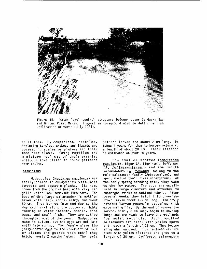
¥J,m Figure 62. Water level control structure between upper Sandusky Bay and Winous Point Marsh. Trapnet in foreground used to determine fish utilization of marsh (July 1984).
adult form. By comparison, reptiles, including turtles, snakes, and lizards are covered 1n scales or plates, and their toes bear claws. Young reptiles are miniature replicas of their parents, although some differ 1n color patterns from adults.
Amphibians
Mudpuppies (Necturus maculosus) are fairly common in embayments with soft bottoms and aquatic plants. Its name comes from the doglike head with wavy red gills which look somewhat like ears. The body of this large salamander 1s mottled brown with black spots, slimy, and about 30 cm. They burrow into mud during the day and crawl along the bottom at night, feeding on water insects, snails, fish eggs, and small fish. They are active throughout most of the year. Mudpuppies mate 1n autumn, but the eggs are not laid until late spring. The female glues the jelly-coated eggs to the underpart of logs or stones and guards them until they hatch, nearly 2 months later. The newly
hatched larvae are about 2 cm long. It takes 7 years for them to become mature at a length of about 20 cm. Their Hfespan is estimated at over 20 years.
The smaller spotted (Ambvstoma maculatum), tiger (A. tiarlnum), Jefferson (£. ieffersoni anum), and smallmouth salamanders (A- texanum) belong to the mole salamander family (Ambystomldae), and spend most of their lives underground. At the early spring breeding time, they take to the 1cy water. The eggs are usually laid in large cliusters and attached to submerged sticks or wetland debris. After several weeks they hatch into greenish- brown larvae about 1.3 cm long. The newly hatched larvae resemble tadpoles with external gills. By the end of summer the larvae, nearly 8 cm long, begin to develop lungs and are ready to leave the wetlands for moist woodlots. Adult spotted salamanders are black with yellow spots and reach a length of 18 cm. They become slimy when annoyed. Tiger salamanders are black with yellow blotches and grow to a length of 20 cm. Jefferson salamanders
100
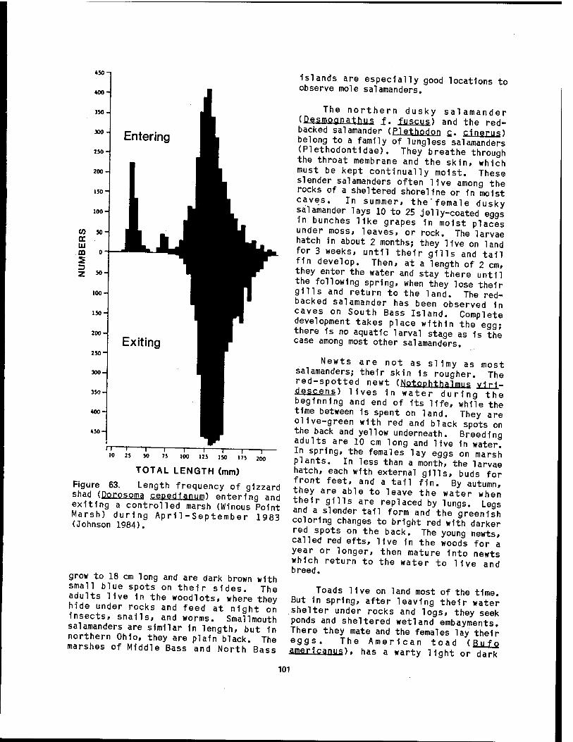
♦50-1
200
TOTAL LENGTH (mm)
Figure 63. Length frequency of gizzard shad (Porpsojia, cepedlanum) entering and exiting a controlled marsh (Winous Point Marsh) during April-September 1983 (Johnson 1984).
grow to 18 cm long and are dark brown with small blue spots on their sides. The adults live 1n the woodlots, where they hide under rocks and feed at night on Insects, snails, and worms. Smallmouth salamanders are similar 1n length, but 1n northern Ohio, they are plain black. The marshes of Middle Bass and North Bass
islands are especially good locations to observe mole salamanders.
The northern dusky salamander (DesmQgpa,t,h»S f. fuscus) and the red- backed salamander (Plethodon £. cineruO belong to a family of lung!ess salamanders (Plethodontidae). They breathe through the throat membrane and the skin, which must be kept continually moist. These slender salamanders often live among the rocks of a sheltered shoreline or fn moist caves. In summer, the'female dusky salamander lays 10 to 25 jelly-coated eggs in bunches like grapes 1n moist places under moss, leaves, or rock. The larvae hatch in about 2 months; they live on land for 3 weeks, until their gills and tall fin develop. Then, at a length of 2 cm, they enter the water and stay there until the following spring, when they lose their gills and return to the land. The red- backed salamander has been observed 1n caves on South Bass Island. Complete development takes place within the egg; there is no aquatic larval stage as 1s the case among most other salamanders.
Newts are not as siimy as most salamanders; their skin is rougher. The red-spotted newt (Notophth.a1mm viri- descens) lives in water during the beginning and end of Its life, while the time between 1s spent on land. They are olive-green with red and black spots on the back and yellow underneath. Breeding adults are 10 cm long and live In water. In spring, the females lay eggs on marsh plants. In less than a month, the larvae hatch, each with external gills, buds for front feet, and a tall fin. By autumn, they are able to leave the water when their gills are replaced by lungs. Legs and a slender tail form and the greenish coloring changes to bright red with darker red spots on the back. The young newts, called red efts, live 1n the woods for a year or longer, then mature into newts which return to the water to live and breed.
Toads live on land most of the time. But 1n spring, after leaving their water shelter under rocks and logs, they seek ponds and sheltered wetland embayments. There they mate and the females lay their eggs. The American toad (Bufo amertcanus)> has a warty light or dark
101

brown skin. The female's throat 1s light; the male's is marked with dark specks and swells out when he sings. In April the males arrive at the shore and start the mating chorus. The females lay their eggs in long strings of jelly in the water. In slightly over a week, the eggs hatch into black tadpoles which*grow quickly. When they are 2 months old, they metamorphose into tiny toads 1.3 cm long and begin a terrestrial life feeding on insects and worms.
Most of the year, frogs 1n the treefrog family (Hylidae) live on land, but in spring they find their way to ponds and marshes to mate and lay their eggs. The tiny spring peepers (Hy_lä c_. cxusifer.) are 'among the first to come out of hibernation. In March, crowds of peepers start the shrill piplngwhich is one of the first signs of spring. Female peepers lay their eggs separately on floating leaves and stems in shallow water. In about 10 days, tiny tadpoles hatch and within 3 months, metamorphose into 1.3-cm peepers. Using the sticky pads on their feet, they then climb shrubs and feed on insects. The western chorus frog (Pseudacris ±. triseriata), sometimes called the swamp treefrog, has a vibrant voice with regularly repeated "crreek" or "prreep" speeding up and rising in pitch toward the end. The cricket frog's (Acris crepltans) call 1s a clicking sound, resembling a cricket's chirp. Like the spring peeper, 1t is no more than 2.5 cm long and may be heard 1n ponds from April until June. Although the cricket frog belongs to the treefrog family, pads on their toes are too small for them to climb trees. Most of the time they live along the cattail and rush borders of ponds and marshes. Because of their ability to leap so high, they are sometimes called grasshopper frogs.
Members of the true frog family (Ranidae) include the pickerel frog (ßana. palustris), leopard frog (E- plpjen?)* and the bullfrog (R. catesbeiana). They are the typical frogs of ponds and marshes; all have long legs, smooth skin, separated fingers, and toes joined by webs. Pickerel frogs live in or near water except in summer when they may wander inland in search of insects and other creatures in the fields. They have dark
brown, rectangular spots on light brown backs and a light stripe along each side. In April, the males make a croaking sound in shallow water; females lay masses of jelly-coated eggs in the water. A full- grown 8-cm tadpole has a dark back, purplish tail crest, and an iridescent underside. The slightly larger leopard frog is green or brownish and the rounded dark spots on its back are outlined in white. The tadpoles are brown with black specks on the back, light underneath, and have translucent edges on their tails. Bullfrogs always live in or near water. These large frogs, 20 cm long, are the last to mate and lay their eggs. In June and July the males produce a "garrump" croak in ponds and embayments of the lake. The females lay thousands of small black jelly-coated eggs which float on the surface of the water in large masses over 1 m across. After a few days, the eggs hatch into tadpoles which take 2 years to grow to the frog stage. Full-grown bullfrog tadpoles are 13 cm long, splotchy brownish 1n color, and change Into 5-cm frogs which have the same coloring on the back and are white underneath. As bull- frogs grow, they become green on the back and the males have yellow throats in the summer.
Reptiles
The snapping turtle grows to over 70 cm long and may weigh more than 18 kg. It 1s the largest reptile in western Lake Erie and makes its home in ponds, marshes and embayments of the lake. The dark brown, upper shell does not cover its heavy neck, legs and saw-toothed tail, giving the head and legs room to move freely. When catching food, the snapping turtle darts its [head forward and snaps with powerful jaws. It eats fish, frogs, insects, crayfish, ducklings, and other creatures, as well as some aquatic plants. In spring, the female digs a hole in the soft, moist bank and deposits 20 or more round, white, hard-shelled eggs that are about 2.5 cm 1n diameter. They hatch in about 3 months into tiny turtles with long tails. Snapping turtles hibernate in the mud bottoms of the ponds and marshes.
The map (Cjra.ptemvs geographies), spotted (Clefflny aut±a±ä)» midland painted (Chrvsemvs picta marqinqta.) , box
102
(Jerrapene carolina) , and Blandlng's (EmydQldea blandJngl) turtles all belong to the water and box turtle family (Testudinidae). The map turtle prefers water and places where aquatic plants are thick. Its name comes from its olive- brown upper shell with light yellowish markings, which resemble a chart. This turtle grows to 25 cm long. Spotted turtles are scarce in the region; this reptile has been placed on the Ohio Endangered Species List. They often feed under water where they eat small fish and shellfish, but they also forage on land. Their 13-cm smooth highly arched black shells have bright yellow spots.
The midland painted turtle always lives near the water since it does all its eating under water. It will eat almost anything 1t finds, either dead or alive. The shell of the painted turtle grows to 18 cm in length and is shiny olive-brown or black with yellow lines on the back and red marks along the edges. Its head has yellow marks and its neck and legs have red stripes. The box turtle 1s mostly terrestrial, but sometimes enters the water to cool off or escape from an enemy. The plastron of this turtle 1s hinged and can be closed tightly against the carapace to form a box with the turtle inside. The carapace is 13 cm long, high, rounded, and is dark brown with yellow marks. Box turtles eat plants, insects, worms, slugs, and snails. The Blandlng's, or semibox turtle, also has a high hinged shell, but closure is less complete than the box turtle. It is essentially aquatic, but at times wanders about on land, although seldom far from the lake or marshes. The plastron is plain brownish gray with light spots that tend to run together forming bars or streaks. They also have bright yellow patches on the chin and throat. This turtle often hisses sharply when disturbed.
Soft-shelled turtles (Tr ionyx, spiplfera) are odd-looking aquatic creatures which prefer rivers. They are scarce in the region having only been reported from Catawba Island marshes (Langlois 1964). It has a light brown, flexible shell up to 25 cm in length. They commonly float over shallow muddy bottoms with only their snouts sticking up
for air. These turtles eat fish and some aquatic plants.
The Lake Erie water snake (Nerodia Slpecfon insularum) is the snake most often seen in or near the lake throughout the Islands region. It 1s a uniform green- brown, not the distinct light and dark brown of its close relative, the northern water snake (NerPdla £. sipedonK which Inhabits the mainland shore and some of the islands. The rarer Kirtland's water snake (ClPPpphfs kirtlandin has only been observed on South Bass Island. When alarmed, this snake can flatten its body making Itself almost ribbon-like and rigidly Immobile. It 1s a good swimmer but the least aquatic of the water snakes. Water snakes grow to a length of about 1.3 m. They catch and eat small animals which live 1n or near water, such as fish, frogs, insects, and mice. Water snakes are not poisonous, but they will hiss, coil, and strike if annoyed. They also secrete a foul-smelling substance from musk glands as a defense mechanism. Late 1n summer, the female bears alive 15 to 40 young. The Lake Erie water snake is fairly common around the Islands, particularly the uninhabited ones, and can be seen swimming along the shore with its head above water or sunning on flat rocks near the water's edge.
In addition to the water snakes, there are seven other common species of snakes on the island which belong to the Colubrld family. The garter snake (IJl.arpnophls siriaJ-Ls) is sometimes found near water where 1t eats frogs, toads, salamanders, crayfish, and minnows. It grows to 1 m long and its back is brown with three yellow stripes; underneath it is light yellow. The fox snake is a resident of the marshes which border western Lake Erie and the adjacent upland areas. This attractive snake 1s boldly patterned with background colors varying from yellowish to light brown to reddish and dark spots and blotches varying from chocolate to black. Unfortunately, the reddish head frequently causes it to be killed as a "copperhead," and Its black and yellowish coloration plus Its habit of vibrating the tail cause it to be slain as a "rattler." The black rat snake (Elaphe o. obspleta.) is a plain shiny black reptile. Its habitats range from rocky,
103
wooded cliffs to marshy shorelines; an excellent climber, it sometimes takes up residence in cavities high up in hollow trees. It constricts rats, mice, and birds in it strong coils as does its close relative, the fox snake. The northern brown, or Dekay's snake (Storeria deka^j), is small (generally not longer than 30 cm) gentle, and very common throughout the island region. It can be found near the marshes, in the moist woods, and near the rocky shoreline. The reddish-brown hog- nosed snake (Heterodon platvrhinos) is a serpent of extraordinary behavior which includes hissing, head-spreading, body inflating, and playing "possum." It has an upturned snout, hence the name. Frogs, toads, and tadpoles are the mainstay of its diet. The blue and the black racers (Coluber constrictor foxi and £. Q. constrictor) are fast-moving and slender. They kill their prey by holding them in their strong jaws while looping their body over the struggling victim and pressing it down, not by constriction as their scientific name suggests. They eat rats, mice, rabbits, birds, and frogs, and inhabitat woodlands, marshes, and lake and pond environs. The black racer 1s plain black both above and below; the blue racer is plain blue above and pale blue below.
Skinks are a family of lizards (Scincidae) which are smooth, shiny, alert, and active. Most species are terrestrial, foraging in the daylight but taking shelter at night, in bad weather, or from high temperatures. The five-lined skink (Eumeces fasciatus) is the only species found in the region and is not abundant. Hatch!ings have five white or yellowish stripes on a black back and bright blue tails. Adult females retain some of this striped pattern, but males usually become a nearly uniform brown or olive color. Their preferred habitats are cutover woodlots with rotting stumps and logs, moist rock ledges, and decaying debris accumulations at wetland margins.
3.6 BIRDS
The wetland habitat of the western Lake Erie coastal marshes supports a diversity of bird life (Appendix L). Resident and migratory species of waterfowl, waterbirds, wading birds, shore
birds, gulls and terns, raptors, and perching birds use the region for nesting, feeding, and resting. Noteworthy migratory species using the shoreline environment include the bald eagl e- '(üäliaeetgs 1eucocep halu s), osprey ( P a n <j j o n hal iaetus), and Kirtland's warbler (Dendroica kirtlandii). Waterfowl common- ly observed in the wetlands are mallards (Anas platvrhvnchos), wood ducks (Aix sponsa) , black ducks (Anas rubripes), blue-winged teal (Anas discors), and pintails (Anas acuta).
The character of the western Lake Erie shores varies from clay bluffs to sand and gravel beaches of rocky headlands to coastal marshes. The beaches attract spotted sandpipers (Actitis macularia) in summer, small flocks of shorebirds in migration, and patrolling gulls year around; but as Goodwin (1982) points out, the absence of significant tidal movement precludes large concentrations of feeding birds typical of the marine coast. The coastal marshes, mud flats associated with the larger streams, and embayments where algal mats accumulate are the places where waterbirds gather. The mud flats and algal accumulation frequently occur in the autumn, when Lake Erie water drops from its summertime high level.
Mainland Coastal Marshes
The coastal marshes and the wetlands associated with the mouth of streams along the Lake Erie shore have a rich array of breeding species. The extensive stands of cattail (Tvpha spp.) and other emergent plants as well as the open shallow water area provide habitat for many summer residents including pied-billed grebe (Podilvmbus podiceps), American bittern (Botaurus 1 esntioinosus), Canada goose (Branta canadensis), mallard, blue-winged teal, Virginia rail (BallUS IJmicoU), American coot (Fulica americana), common moorhen (gallinule) (Gallinula chloropus), marsh wren (Cistothorus palustris), common yellowthroat (Qeothvlpis trichas), and red-winged blackbird ( Ariel a i u s phoeniceus). Swampy woodlands are often associated with the larger coastal wetlands. In addition to the landbirds these areas support, the following waterbirds most commonly nest in the wooded habitats: great blue heron (Figure
104
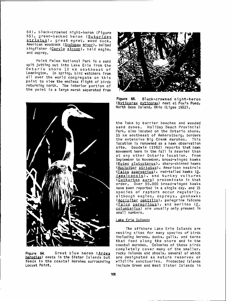
64), black-crowned night-heron (Figure 65),, green-backed heron (Butori des striatus) . great egret, wood duck, American woodcock (Scolopax minor), belted kingfisher (Cervle alcvon). bald eagle, and osprey.
Point Pelee National Park is a sand spit jutting out into Lake Erie from the Ontario shore 10 km southeast of Leamington. In spring, bird watchers from all over the world congregate on this point to view the endless flight of birds returning north. The interior portion of the point is a large marsh separated from
Figure 64. Great blue heron (Ardea herodias) nests in the Sister Islands but feeds 1n the coastal marshes surrounding Locust Point.
Figure 65. Black-crowned night-heron (Nytlcorax nvtlcorax) nest at Fox's Pond, North Bass Island, Ohio (Ligas 1952).
the lake by barrier beaches and wooded sand dunes. Holiday Beach Provincial Park, also located on the Ontario shore, 15 km southeast of Amherstburg, borders the extensive Big Creek marshes. This location is renowned as a hawk observation site. Goodwin (1982) reports that hawk movement here in the fall is heavier than at any other Ontario location. From September to November, broad-winged hawks (Buteo platvpterus), sharp-shinned hawks (Ace 1piter striatus), American kestrels (Falco sparverius), red-tailed hawks (ß. iamaicens is), and turkey vultures (Cathartes aura) predominate in that order. Over 30,000 broad-winged hawks have been reported 1n a single day, and 15 species of raptors occur regularly, although eagles, ospreys, goshawks (Accipiter gentilis), peregrine falcons (Falco peregri nus), and merlins (£. columbarius) are usually only present in small numbers.
Lake Erie Islands
The offshore Lake Erie Islands are nesting sites for many species of birds including herons, ducks, gulls, and terns that feed along the shore and in the coastal marshes. Colonies of these birds completely cover many of the smaller, rocky islands and shoals, several of which are designated as nature reserves or wildlife sanctuaries. Protected islands include Green and West Sister Islands in
105

Ohio and East Sister, Middle S'ister, Hen, and Chicken Islands in Ontario. Species known to nest on these Islands include the great blue heron, black-crowned night- heron, great egret, double-crested cormorant (Phalacrocorax auritus) (Figure 66), herring gull (Larus argentatus), ring-billed gull (L.'delawarensis), common tern (Sterna hirundo), and Caspian tern (.§. caspia).
Pelee Island, located about 15 km southwest of the tip of Point Pelee, has two nature reserves which feature coastal marsh habitats. At the northeast tip of the island, Lighthouse Point Provincial Nature Reserve includes Lake Henry which is separated from Lake Erie by a narrow barrter beach. Here dead trees standing in the lake provide nesting sites for colonies of double-crested cormorants and herring gulls. Lake Henry is also a favored foraging area for herons and egrets« Goodwin (1982) reports "rafts" of loons, grebes, and diving-ducks occasionally congregate offshore of Lighthouse Point in early spring. Fish Point Provincial Park Reserve is a 2-km- long-sand spit at the southernmost extremity of the island and includes Fox Pond and Mosquito Bay. The mature swamp forest which has developed here supports a large heronry. Great egrets, cattle egrets (Bubulcus ibis), black-crowned night-herons, and yellow-crowned night-
>**# * I
Figure 66. Group of juvenile double- crested cormorants (Phalacrocorax auritus) near Pelee Island, Ontario (Ligas 1952).
herons (Nvctanassa violacea), king rails (Ral lus elegans), and common moorhens, as well as a variety of shorebirds have been recorded from the lagoons and ponds at the base of the spit (Goodwin 1982). Offshore and on the extreme end of the spit, double-crested cormorants, great black- backed gulls (Larus marinus), herring gulls, Caspian terns, and piping plovers (Charadrius melodus) occur regularly.
Waterfowl Migration
The coastal marshes of western Lake Erie attract large numbers of migratory waterfowl. Located at a crossing point on two major flyways, these marshes attract ducks from eastern Canada heading for wintering grounds on the Mississippi River bottoms and ducks from the prairie provinces which winter along the Atlantic coast. Beds of wild celery are particularly attractive to great numbers of canvasbacks (Avthva valisineria), redheads (A. americana), and scaups (Avthva spp.) migrating southeastward to their wintering grounds on Chesapeake Bay (Andrews 1952).
Lincoln (1935) introduced the concept that all populations of migratory birds adhere to their respective flyways as they make their semiannual flights between breeding grounds and wintering grounds. Four distinctive flyways have been identified for North America, two of which cross western Lake Erie and Lake St. Clair: the Atlantic Flyway and the Mississippi Flyway. These routes are utilized by all of the migratory waterfowl and other waterbirds which frequent the coastal wetlands. Each flyway has its own individual population of birds, even those species which ha^ve a broad continental distribution. The breeding grounds of two or more flyways may, and often do, overlap broadly so that during the nesting season extensive areas may be occupied by birds of the same species, but belonging to different flyways. Bellrose (1968) refined the flyway concept by mapping migration corridors. He observed that each corridor is a web of routes as opposed to a single narrow band rigidly followed by waterfowl.
In the fall, the Atlantic Flyway receives accretion of waterfowl from
106

several interior migration path's starting at the breeding grounds on the Arctic tundra. Canada geese and diving ducks, including canvasbacks, redheads and scaup, come from their breeding grounds on the great northern plains of central Canada, fly southeasterly across the Great Lakes, crossing Lake Erie in the islands region, and continue over the mountains of Pennsylvania to winter along the Atlantic coast in Chesapeake and Delaware Bays. Concurrently, dabbling ducks such as mallards, black ducks, and blue-winged teals that have gathered in southern Ontario during the fall, also leave the feeding grounds, cross western Lake Erie and proceed southwest over a course that leads down the Ohio and Mississippi Valleys (Mississippi Flyway). However, part of this duck population, upon reaching the vicinity of the Lake St. Clair Delta, swings abruptly to the southeast, crosses the mountains, and winters, along the Atlantic coast (Lincoln 1950).
The Mississippi Flyway is easily the longest migration route of any in the Western Hemisphere. Its northern terminus is the Arctic coast of Alaska, while its southern end lies in the Patagonia region of Argentina. Although the main path of the flyway lies to the west of the Great Lakes, major branches follow the southern trend of Lake Michigan and the southwestern trend of Lake Erie and the Maumee River valley. Some of the black ducks, mallards, and teals that cross the Great Lakes in the vicinity of Lake St. Clair and western Lake Erie do not turn abruptly to the southeast, but continue on to the southwest as members of the Mississippi Flyway bound for the Gulf of Mexico coast rather than the Atlantic seaboard.
Fall waterfowl migration is at its peak in September and October, but the main shorebird passage is underway in August. As in the spring the western Lake Erie shoreline is an important factor in the concentration of migrants. The waterfowl hunting season usually begins in late September or early October in response to this accumulation in and around the coastal marshes.
Spring migration begins in late February with the appearance of ring- billed gulls in western Lake Erie. March and early April bring heavy waterfowl movement, ducks and loons (Gavia sp.) appearing in open leads as soon as the ice breaks up. Red-winged blackbirds move in large numbers starting in late March. The huge Canada goose movement at the west end of Lake Erie normally takes place in early April. With April and May comes the major push of spring migration, especially among the landbirds. Migrants are less selective than breeding birds in their choice of habitat, nevertheless, waterbirds prefer shorelines with pockets of vegetation. Coastal marshes and stream mouths commonly attract migrating dabbling ducks. The open water shorelines concentrate the diving duck migrants and other waterbirds including loons, grebes, cormorants, tundra swans (Cvgn us columbianys). redheads, canvasbacks, lesser scaups (Avthva afflnis), and red- breasted mergansers (Mergus serrator).
As waterfowl migrate between breeding grounds and wintering areas, they stop to rest and feed in wetlands. These wetlands are referred to as "concentration areas." The coastal wetlands of western Lake Erie provide some of the best areas of this type along the flyways. Concentration areas are characterized by an abundance of waterfowl foods, as well as by low wave energy and low human disturbance. Canvasbacks, redheads, American wlgeons (Anas americana). ring-necked ducks (Avthva col 1 aris) , and coots feed extensively on submersed plants, whereas shovelers (Anas clvpeata). oldsquaws (Clangula hvemalis), goldeneyes (Bucephala sp.), and mergansers appear to prefer crayfish, small fish, and other animal foods. Black ducks, mallards, pintails, teals, scaups, and buffleheads (B. albeola) select from both plant and animal foods. Canada geese and mallards also feed heavily on waste grains in agricultural fields. Food availability may be more important than food preference, especially during the spring migration when food supplies are less abundant. Food availability in wetlands is reduced by extreme high and low water levels, heavy siltation, turbidity, heavy hunting pressure, and other disturbances. In Lake Erie marshes, Bednarik (1975)
107
found that preferred natural foods of diving ducks, such as wild celery, appeared to be more adversely affected by turbidity and siltation than foods of dabbling ducks and geese.
The wintering areas for ducks, geese, swans, coots, and other waterfowl have been mapped in detail by Bell rose (1976). The Rockefeller Refuge 1n southwest Louisiana is a well-known wintering area for migratory waterfowl which cross the Great Lakes. Like the concentration areas, quality wintering habitat must provide abundant food and protection from waves and human disturbance. Over the years, certain waterfowl, particularly Canada geese, have modified their wintering activity by stopping at sites somewhat north of their former winter areas. In general, most state conservation agencies do not encourage the creation of resident wintering flocks, particularly 1n the Lake Erie region, because of the problem of waterfowl starvation during severe winters. Waterfowl that reach the spring breeding grounds in good condition tend to exhibit greater nesting success than those which are undernourished.
Dabbling ducks. These ducks are so called because they normally do not dive below the water for food, but merely dabble on the bottom 1n shallow water. Annually about 17,500,000 mallards and pintails migrate down flight corridors from Canada to the United States east of the Rocky Mountains (Bellrose 1968). The largest portion, about 12,275,000, enter the geographical confines of the Mississippi Flyway from the northern Great Plains. About 20% of these birds continue across the Mississippi Flyway and move down the Atlantic Flyway. In addition, another 650,000 black ducks move south from Ontario and Quebec.
Several corridors carrying dabbling ducks cross the Great Lakes region (Figure 67). An estimated 65,000 mallards, 35,000 wlgeons, and 25,000 pintails move eastward along the Chesapeake Bay Corridor, starting 1n the upper Mississippi River valley and progressing through Wisconsin, Michigan, and Ohio. It encompasses the marshes of Lake Erie from Monroe, Michigan, to Sandusky, Ohio. From these
marshes 1t 1s a 645-km, nonstop flight to Chesapeake Bay, where most of these ducks winter. The Black Duck Corridor extends southwestward from eastern Ontario, across the west end of Lake Erie to the confluence of the Wabash and Ohio rivers, and on south to Arkansas. Approximately 35,000 black ducks use this path.
Diving ducks. As the name suggests, these ducks normally dive below the water for food. About 4,200,000 diving ducks annually migrate south Into the United States east of the Rockies (Bell rose 1968). Slightly over 60% of these are scaup, mostly lesser scaups. Redheads are second in abundance at 20%, while canvasbacks and ring-necked ducks each form about 1% of the population. As with the dabbling ducks, numerous diving duck migration corridors cross the Great Lakes region (Figure 68).
The Southern Michigan Corridor takes the main flow of diving duck passage from eastern Wisconsin, across southern Mich- igan to Saginaw Bay and the Lake St. Cl a1r-Detroit R1ver-Lake Erie wetlands areas. Diving ducks congregate on Saginaw Bay to the extent that peak numbers Include 22,000 lesser scaups, 22,000 redheads, and 7,000 canvasbacks. Approx- imately 160 km to the south, peak populations of 380,000 lesser scaups, 260,000 canvasbacks, and 42,000 redheads have been observed from Lake St. Clalr to western Lake Erie. Although as many as 15,000 diving ducks may winter on the Detroit River, at least 700,000 fly on from Lake Erie to wintering grounds 1n the Atlantic Flyway. This route 1s known as the Chesapeake Bay Corridor and 1s a similar route to the one taken by mallards and pintails. The Central Ohio Corridor 1s a flight path that extends southward from Lake Erie to Florida. Radar observations of diving ducks moving south past Columbus, Ohio, and band recoveries from lesser scaups and redheads Indicate a passage of over 100,000 divers along this corridor.
Geese. More than any other species of waterfowl, Canada geese have radically altered their migration routes 1n the past few decades. Bell rose (1968) attributes this great change 1n their migration habits'to their rapid adoption of newly
108
ESTIMATED NUMBER USING A CORRIDOR:
23 101,000-350,000
31,000 - 100,000
Figure 67. Fall migration corridors for dabbling ducks (Tribe Anatini' across western Lake Erie (Bellrose 1968).
created waterfowl refuges. They are still in the process of evolving new migration corridors. Currently, about 1,300,000 Canada geese leave Canada in the fall for wintering grounds in the United States. The majority (600,000) use the Atlantic Flyway, while another 475,000 take the Mississippi Flyway. Most of the Atlantic Flyway crossings of the Great Lakes take place over Lake Ontario, but one corridor uses the islands and marshes of western Lake Erie (Figure 69). The main migration corridor for Canada geese in the Mississippi Flyway extends down the shores of Lake Michigan, then down the Mississippi River valley.
Snow geese (Chen caerulescens) utilize the Mississippi Flyway. Each October about 450,000 birds leave Canada for wintering grounds on the coastal marshes of Louisiana. The main corridors
follow the east and west shores of Lake Michigan, converging in the Mississippi River valley north of Louisiana. The easternmost flight corridor, used by about 15,000 geese, runs from the south end of James Bay to the marshes of western Lake Erie, then turns southwestward across Indiana. A somewhat larger number of birds use a corridor that extends from James Bay through Saginaw Bay, and then merges with the flight path from western Lake Erie.
Waterfowl Production
Because the production of young are involved, dependency of waterfowl on wetlands for breeding purposes is probably more crucial to their survival than their use of wetlands for wintering, resting, and feeding areas during migration.
109

ESTIMATED NUMBER USING A CORRIDOR
[ | 251.000 - 500.000 I
76.000-250.000 -N
26.000 - 75,000 MILES
Figure 68. Fall migration corridors for diving ducks (Tribe Aythyini' across western Lake Erie (Bellrose 1968).
Andrews (1952) studied waterfowl breeding at Winous Point Marsh on Sandusky Bay. Five species of ducks typically nest in this marsh—mallard, black duck, blue- winged teal, wood duck, and pintail. Hybridization between mallards and black duck was common. In the 400-ha wetland, the annual breeding pair population averaged approximately 21/km2. Only 12% of the nests were successful in producing one or more young. About 66% of the nests were terminated by predation. The common predators included yearling crows, fox snakes, raccoons, Norway rats, opossums, minks, and weasels. Another 19% of the nests were terminated by flood, and 3% by miscellaneous causes including fire. Most of the mallards and black ducks nested in dead vegetation of the previous year. Bluejoint grass which does not appear
until the middle of the nesting season, was the preferred nest cover. Muskrats appeared to benefit nesting waterfowl by opening up a solid stand of vegetation, allowing greater distribution of territorial pairs of ducks on open water. Muskrat houses werje also utilized as nesting and "loafing" sites. During Andrews' investigation, approximately 4,500 muskrats were removed annually from his study marsh by commercial trapping. The averge annual duck production from the marsh was 7 broods/km2 and 21 fledglings/km2. In addition to the 5 species studied by Andrews, Hicks (1935) cited nesting records for waterfowl species less common in western Lake Erie marshes. These include American wigeon, green-winged teal (Anas crecca), shoveler, and lesser scaup.
110
Figure 69. Fall migration corridors for Canada geese (Branta canadensis) across western Lake Erie (Rellrose 1968). j
Wadinc
All of the 11 species of common wading birds in western Lake Erie belong to the family Ardeidae (Appendix L). They occupy two habitats in the region, the rockbound Lake Erie Islands and the coastal marshes. The colonial nesting species known to inhabit the islands include great blue heron, great egret, black-crowned night-heron, and cattle er ret (Parris 1979). The green-backed 'feron is a solitary nester that prefers coastal wetlands but also inhabits the islands. American bittern (Figure 70) and least bittern (ixobrvchus exiljs_) are secretive, noncolonial nesters that are usually found in the coastal mainland marshes. In addition to these species, four others are residents of the coastal wetlands: yellow-crowned night-heron, snowy egret (E.qretta thula), tricolored
Figure 70. Young American bitterns (Botagrus lentioinosus) in the nest at Magee Marsh (Ligas 1952).
111

heron (Florida caerulea), and little blue heron (£. tricolor). Typically, herons and egrets arrive 1n the western Lake Erie region in early March and migrate southward in October. A small population of great blue herons may over-winter in this region. Upon their arrival at the colonies in the spring, courtship and nest building begin immediately. The first eggs are laid in early April. Clutch sizes range from three to seven eggs; the number of fledged birds is slightly over two per nest (Edford 1976).
Wading birds usually forage on the shorelines of the tributary streams and Lake Erie and within the coastal marshes. Their diet is primarily fish, but crayfish and insects are also eaten. Fish species most often consumed include carp, goldfish, yellow perch, gizzard shad, and freshwater drum. The insular nesting birds depend more heavily upon fish species common to Lake Erie than do the more Inland nesting birds (Meeks and Hoffman 1980). The green-backed heron diet varies slightly because they appear to feed on more invertebrates and smaller species of fish which inhabit the marshes.
Population studies of wading birds 1n western Lake Erie Indicate a total of 1,100 great blue heron, great egret, and black-crowned night-heron nests on West Sister Island in 1972-73 (Hoffman 1974); and 1,600 great blue heron, 200 great egret, and 3,000 black-crowned night-heron nests in 1976-77 (Scharf 1978). Parris (1979) reported the nests to number 1,158 and 1,167 for great blue herons, 100 and 100 for great egrets, and 600-1,000 for black-crowned night-herons, on West Sister for 1977 and 1978 respectively. Meeks and Hoffman (1980) found that in 1979, West Sister Island had the largest nesting populations of herons and egrets. Great blue heron nests numbered 950, black- crowned night-herons 1,000 nests, great egrets 50 nests, and cattle egrets 13 nests. Cattle egret nests were first recorded 1n Ohio in 1977 by Parris (1979) when he located five on West Sister Island. By 1978, the colony size had increased to 20 nests. East Sister Island contained 350 great blue heron nests, 500 black-crowned night-heron nests, and 50 great egret nests in 1979.
Meeks and Hoffman (1980) conducted surveys of heron and egret movement into and out of Navarre Marsh. Over 95% of the movements were in NNW or SSW directions, a direct alignment with West Sister Island, located 15 km offshore. During 1979, great blue herons were the most active species with a total of 631 flights, followed by black-crowned night-herons (511) and great egrets (77). Flights generally correlated with the population sizes of each species nesting on the islands. In general, herons and egrets' are crepuscular in nature, being more active during early morning and evening surveys. The period of highest activity was 0600-0800 hours (sunrise), with a total of 543 flights, followed by 444 flights during the 1800-2000 hour (sunset) surveys and 232 flights during the 1200- 1400 hour (noon) period. Great blue herons were observed to have daily movements of 256, 166, and 209 flights at sunrise, noon, and sunset, respectively. Black-crowned night-herons had 257, 50, and 204, and great egrets 30, 16, and 31, at sunrise, noon and sunset, respectively. Meeks and Hoffman (1980) concluded that the birds of West Sister Island nesting colonies used the mainland coastal marshes as feeding sites while they raised their young in the seclusion provided by the islands.
Gulls, Terns, and Cormorants
Gulls and terns, family Laridae, are the other principal colonial nesting species using the Lake Erie Islands. Herring gulls are the most abundant species, but ring-billed gulls are becoming more common and are now known to use the Toledo-Lucas County Port Authority Facility No. 3, a 100-ha "island" built by the U. S. Army Corps of Engineers from dredge materials in Maumee Bay (Scharf 1978). Common terns have a history of nesting on the Lake Erie Islands, but are now restricted to the diked spoil areas near Toledo Harbor. In the western Lake Erie region, gulls use the Lake Erie shoreline, its bays and inlets, and to a lesser extent open water areas of coastal marshes until freeze-up. At this time gulls use sanitary landfills as a site for food and also follow the lake ice edge, using 1t as they would the shoreline
112

(Meeks and Hoffman 1980). Herring gulls are typically scavengers feeding on dead fish» refuse, and other organic debris along the shoreline. They are also known to prey on young wetland birds whenever the opportunity presents itself. Herring gulls are especially prevalent in marshes during migration periods. Wherever reduced water levels concentrate small fish sufficiently to cause them to "surface" because of an oxygen stress, gulls can be found feeding on these moribund fish.
Herring gulls are the most commonly encountered colonial species. Evidence of their nesting—active nests, young in water, and/or abandoned nests—was seen on about half of the Lake Erie Islands. During the past decade they have begun to nest on rip-rap dike tops and in artificial Canada goose nesting structures within the coastal marshes. Gulls usually begin nesting on the islands in April. Re-nesting occurs if the first attempt is unsuccessful or the nest 1s destroyed. Generally three eggs are laid; however, clutches with two eggs are quite common. The double-crested cormorant, family Phalacrocoraddae, Is another colonial nesting bird on the Lake Erie islands. The most abundant cormorant in North America, it feeds almost entirely on fish obtained from the open lake.
Ligas (1952) studied the migration, nesting, and food habits of 22 species of piscivorous birds in western Lake Erie. In a natural-environment feeding experiment using freshwater drum, a 4- month-old herring gull consumed an average of 226 g/day during a 20-day period in November. In a similar experiment using emerald shiners, a 2-month-old common tern ate an average of 61 g/day, about 47% of the bird's average weight, during the 19- day test. Ligas concluded that while there is abundant evidence that fish- eating birds do consume large quantities of fish in Lake Erie, they primarily eat a few forage species, and are not detrimental to anglers or commercial fishermen. These birds also feed exten- sively on commercial discards, crayfish, insects, mudpuppies, salamanders, snakes, frogs, and other birds. There is one report of an overwintering great blue heron feeding on a rabbit on South Bass
Island (Dr. M. M1sk1men, Research Ornithologist, F. T. Stone Laboratory, Ohio State Univ., Put-1n-Bay, OH; pers. comm.)
Raptors
The bald eagle is one of the most spectacular avlan species residing in the Lake Erie coastal wetlands. Active nests are located 1n or near Magee Marsh, Ottawa Marsh, Toussaint Marsh, Cedar Point Marsh, Darby Marsh, Navarre Marsh, and Winous Point Marsh. Other raptors using the marshes Include osprey, red-tailed hawk, and American kestrel.
During September and October, thou- sands of migrating hawks congregate along the north shore and move southwest across Lake Erie 1n the vicinity of the Islands. The hawks sometimes fly 1n "kettles," a cylindrical formation used by species such as broad-winged hawks, turkey vultures, and red-tailed hawks in migration.
3.7 MAMMALS
The cattail marshes of western Lake Erie provide excellent food and building material for furbearers such as the muskrat (Ondatra zebethicus). Many other mammalian species in the region, such as raccoon (Procvon lotor) and white-tailed deer (Odocoileus vlrainianus), occupy multiple habitats including wetlands. Eastern cottontail (Svlv11aa u s floridanus), woodchuck (Marmota monax), and striped skunk (Mephiti s mephiti s) chiefly utilize the earthen dikes of managed marshes. Fox squirrels (Sciurus niqer) are found most commonly in the wooded margins of the wetlands. Long- tailed weasels (Mustela frenata), mink (M- vison), and red fox (Vylpes fulva) are occasional visitors to Lake Erie wetlands, feeding on rodents and marsh birds. The Norway rat (Rattus norveglcus) is a common predator on muskrats in the marshes (Bednarik 1956). In total, about 30 species of mammals can be found in the coastal marshes (Appendix M). The mammalian fauna of the Lake Erie Islands wetlands generally have a lower diversity than the mainland marshes.
113

When northwestern Ohio was first settled, the larger mammals, especially the predators, soon were exterminated. Some were killed for food or hides; others, because they preyed on livestock. Mayfield (1962) listed the years when they disappeared: buffalo (Bison bison) 1812, elk (Cervus elaphus) 1822, beaver (Castor canadensis) 1837, wolverine (Gulo gulo) 1842, panther (Feiis concolor) 1845, lynx (Felis lvnx) 1848, gray wolf (Canis lupus) 1860, black bear (Ursus americanus) 1860, bobcat (Felis rufus) 1878, porcupine (Erethizon dorsatum) 1884, deer 1889, and otter (Lutra canadensis) 1900. As the forests were razed, gray squirrels ( Sei urus carolinensis) and gray foxes (Urocvon cinereoargenteus) were replaced by fox squirrels and red foxes in about 1850. Red fox moved into the marshlands with the clearing of the land and remained numerous until about 1900 when they declined rapidly. Since 1935 their numbers, have climbed, stabilizing at a population similar to that of the late 1800s (Campbell 1982). Gray foxes also increased in the 1940s but have since dropped to a very limited population.
Formerly, opossums were confined largely to the southern portion of Ohio because of the forest barrier. As the trees were cut, they moved northward, becoming numerous in 1920. Highway kills indicate they are one of the more common medium-sized mammals in the coastal marsh. White-tailed deer disappeared in the late 1800s, but by about 1930 they returned to northwestern Ohio from Michigan. Campbell (1982) estimates that a distributed population of about 50 deer now live in the marshes of Lucas and Ottawa counties, Ohio. Apparently raccoons have been numerous since their first record in 1782.
Diking the Lake Erie marshes has been favorable to deer and to many of the small mammals such as opossum, skunk, red fox, voles, and shrews because it has furnished an excellent habitat and stabilized water levels. Muskrats have benefited from water level controls but they were undoubtedly abundant before 1900. They were an important source of income as well as food to the early French trappers (Campbell 1982). Through the years the sale of muskrat hides has financed many of the diking projects in the marshes. In
recent decades muskrats comprised more than 70% of all Ohio fur sales and nearly two-thirds of the cash value (Ohio Division of Wildlife 1971). However, Campbell (1982) points out that even if the pelts had no sale value, the furbearers now living in the marshes would have to be controlled in some way for two reasons: 1) to maintain a habitat equally favorable to all forms of wildlife and 2) to minimize the damage done to dikes by muskrats, woodchucks, and other burrowing mammals. He estimates that under favorable conditions, the muskrat pop- ulation could increase by 80% in 1 year.
Muskrats
Several structures observed in Lake Erie coastal marshes are associated with the activity of muskrats (Bednarik 1956). The most noticeable structure is the muskrat "house," a dome-shaped pile of emergent vegetation (Figure 71). The average house varies in size from 1 to 2.5 m in diameter at the base and from 0.7 to 3 m in height. They are located in stands of emergent vegetation or along the periphery of such stands. Houses are often constructed on protuberances in the marsh bottom, utilizing plants in the immediate area. The majority of houses are constructed in October and November. Building activity occurs mainly during periods of darkness. Typical densities of active muskrat houses in Winous Point Marsh average 4/ha. Small houses have one living chamber and larger houses have two or three living chambers above the water line. The living chamber is about 35 to 50 cm in height and is formed by the
Figure 71. Muskrat house under con- struction at Magee Marsh (Bednarik 1956).
114
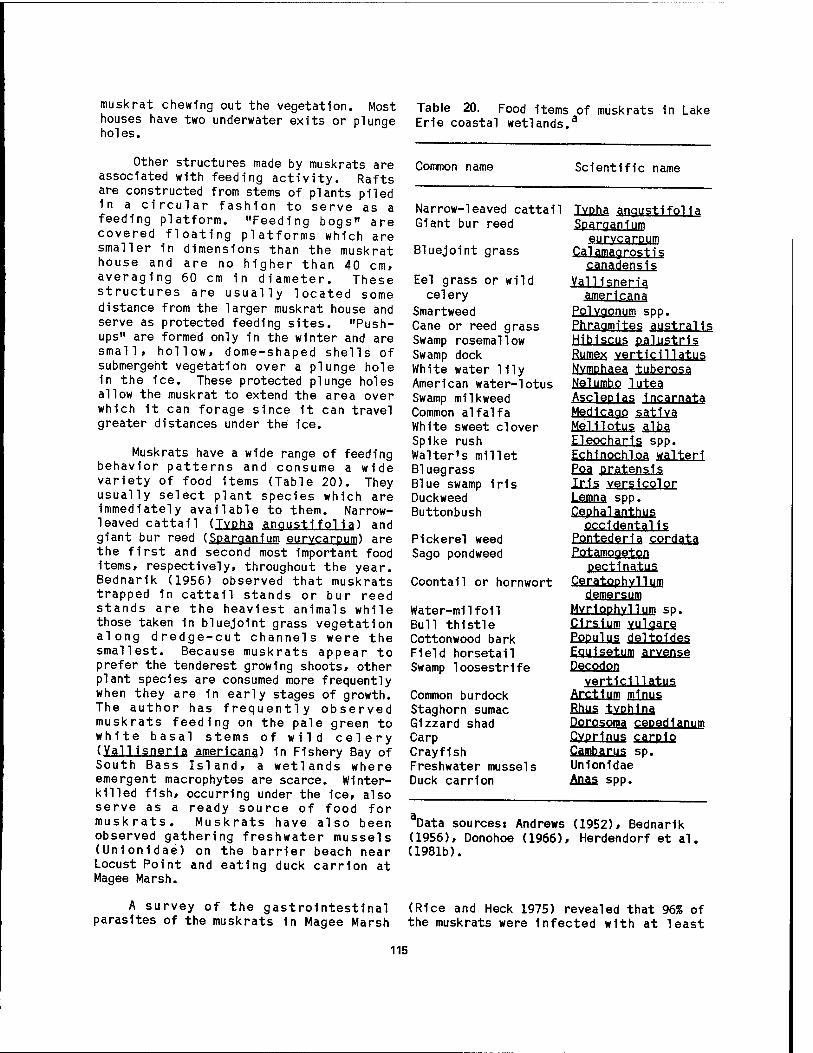
muskrat chewing out the vegetation. Most houses have two underwater exits or plunge holes.
Other structures made by muskrats are associated with feeding activity. Rafts are constructed from stems of plants piled in a circular fashion to serve as a feeding platform. "Feeding bogs" are covered floating platforms which are smaller in dimensions than the muskrat house and are no higher than 40 cm, averaging 60 cm in diameter. These structures are usually located some distance from the larger muskrat house and serve as protected feeding sites. "Push- ups" are formed only in the winter and are small, hollow, dome-shaped shells of submergeht vegetation over a plunge hole in the ice. These protected plunge holes allow the muskrat to extend the area over which it can forage since it can travel greater distances under the 1ce.
Muskrats have a wide range of feeding behavior patterns and consume a wide variety of food items (Table 20). They usually select plant species which are Immediately available to them. Narrow- leaved cattail (TYPha. angustifolia) and giant bur reed (Sparaanium eurvcarpum) are the first and second most important food items, respectively, throughout the year. Bednarik (1956) observed that muskrats trapped in cattail stands or bur reed stands are the heaviest animals while those taken in bluejolnt grass vegetation along dredge-cut channels were the smallest. Because muskrats appear to prefer the tenderest growing shoots, other plant species are consumed more frequently when they are 1n early stages of growth. The author has frequently observed muskrats feeding on the pale green to white basal stems of wild celery (Valllsneria americana) in Fishery Bay of South Bass Island, a wetlands where emergent macrophytes are scarce. Winter- killed fish, occurring under the ice, also serve as a ready source of food for muskrats. Muskrats have also been observed gathering freshwater mussels (Unlonidae) on the barrier beach near Locust Point and eating duck carrion at Magee Marsh.
A survey of the gastrointestinal parasites of the muskrats in Magee Marsh
Table 20. Food items of muskrats in Lake Erie coastal wetlands.3
Common name Scientific name
Narrow-leaved cattail Giant bur reed
Bluejolnt grass
Eel grass or wild celery
Smartweed Cane or reed grass Swamp rosemallow Swamp dock White water lily American water-lotus Swamp milkweed Common alfalfa White sweet clover Spike rush Walter's millet Bluegrass Blue swamp Iris Duckweed Buttonbush
Pickerel weed Sago pondweed
Coontail or hornwort
Water-milfoil Bull thistle Cottonwood bark Field horsetail Swamp loosestrife
Common burdock Staghorn sumac Gizzard shad Carp Crayfish Freshwater mussels Duck carrion
TYPha angustifolia Sparaanium
eurvcarpum Calamaorost.is cgnadensls
Valllsneria americana
Polygonum spp. Phragmjtes austral is Hibiscus palustrls Rumex verticil!atus NYfflPhaea, tuberosa NelUIPbo lui§j Ascleplas incarnata Medicare? satiya, Melilotus alba Eleocharis spp. Echinochloa walteri Efiä pratensj? Iris yerslcplor Lemna spp. Cephaianthys occidentals
Pontederla cordata Potamogeton
pectinatus Ceratophvll urn demersum
MYliPphYllUIP sp. C1r?1um vulgäre Populus deltPldes Equisetum arvense Decodon
vertlcillatus Arctlgm minus Rims tvphina DorPSPffia, cepedlanujn CYprlnus carptp Cambarus sp. Unlonidae Anas spp.
Data sources: Andrews (1952), Bednarik (1956), Donohoe (1966), Herdendorf et al. (1981b).
(Rice and Heck 1975) revealed that 96% of the muskrats were infected with at least
115
one of the following helminths: Echinostoma revolutum, Qu1nqueseria1is
auinaueserialls, HaidiS zjbethlcMS, and Tr1chur1s opaca. EchtnPüitQma, reypltum occurred most frequently 1n muskrat, but Qu1nqueser1al1s quinqueserjalis resulted in the highest mean number of parasites per infected muskrat.
The reproductive cycle of the muskrat on Wlnous Point Marsh has been documented by Bednarik (1956) and Donohoe (1966). Reproductive activity begins 1n January and ends in September» with the greatest activity occurring in February and March. The time of first mating is determined in part by the time of 1ce breakup. The gestation period varies from 20 to 28 days. Females usually have 2 Utters of young per season although some may have 3 litters. Placental scar counts indicate that the mean number of young per Utter is 11» but Bednarik concluded that at the time of birth, the average Utter size is 8.
Predation by mink occurs but 1s not an important influence on the muskrat population because of the low numbers of mink in the marshes. Predation on juvenile muskrats by raccoons and Norway rats occurs in early summer and is not an important mortality factor. Some mortality is attributed to hemorrhagic or "Errington's" disease. This disease can cause significant fluctuations 1n the muskrat populations 1n all the western Lake Erie marshes (Bednarik 1956).
The water level stability of the marsh areas influences the density of muskrats. Those areas with more stable water levels have more muskrat houses per unit area than areas with fluctuating water levels. This difference 1s attributed to the absence of excessive wave action on areas with stable water levels and the relationship between good muskrat food plants and stable water levels (Bednarik 1956). Also, marsh areas which are diked provide more suitable sites for bank dens. Stability of levels is also related to the productivity of the muskrat population (Donohoe 1966). The physiology of reproduction does not differ between areas of stable (or controlled water levels) and fluctuating (or uncontrolled water levels). But
productivity is higher in areas with stable water levels, and juvenile muskrats are heavier in these stable areas. Donohoe concluded that a higher density of muskrats occurs on areas with stable water levels because of a higher survival of juvenile muskrats on those areas. Muskrat can use drained areas year round by utilizing bank dens. After the area is reflooded, muskrats move in from other areas and construct houses in all types of emergent vegetation except bluejoint grass and annual weeds. Removal of water from the marsh in mid-March dramatically decreases the number of young muskrat produced. Marsh management practices generally allow for water depths great enough to prevent the marsh from freezing solid. When the marsh freezes solid, great mortality occurs in the muskrat population (Meeks 1969).
Sudden Increases in water levels can have a detrimental effect on the muskrat populations. Bednarik (1956) reported that rapid rises in water level caused by spring storms resulted in the destruction of many muskrat houses in open water areas of Magee Marsh. In April 1951, 354 muskrat houses were counted on the west units of Magee Marsh. Only 136 muskrat houses, of which 81 were under water, remained 3 weeks later following a spring storm. An Increase in water levels from winter to spring also decreases the number of active muskrat houses. Water levels rose 56 cm in the spring of 1952 and remained 28 cm above normal. The number of active muskrat houses decreased from 174 in the winter of 1951 to 37 in the winter of 1952. He also found that muskrats will excavate dike dens during periods of high water.
Raccoons
Several aspects of the life history of the raccoon in Winous Point Marsh were Investigated by a trapping and telemetry study (Urban 1970). The density of the raccoon population was estimated to be 17/km2. The juvenile to adult female ratio was 1.2:1.0, indicating a moderate productivity for the raccoon population. The mean weights of both adults and juveniles Increased from spring until early winter and then decreased over the
116

winter. The telemetry portion of the study provided information on raccoon movements, home range, and denning. Generally, raccoons spend the daytime period in or near dens. The amount of nocturnal movement is related to the size of the home range. Raccoons with larger home ranges move greater distances. Raccoons move at a mean rate of 162 m/hr. Male juvenile raccoons disperse from the marsh in the fall. Marshland is the major habitat type encompassed in an average night of travel and the habitat type in which raccoons spend the most time. Raccoons spend approximately 73% of the time in the vicinity of shallow water (Figure 72). They do not appear to search out waterfowl nests, since little change occurs in their movement patterns when waterfowl nesting is initiated. Dikes receive high usage in proportion to the amount of area they represent in the marsh. Movements of female raccoons en- compass more wooded area per night than the male raccoons. The area of the home range for the average raccoon was 51 ha (Table 21).
Food items of raccoons in Winous Point Marsh include muskrat, crayfish, fish, duck eggs, plant material, seeds, and birds (Andrews 1952; Bednarik 1956; Urban 1970). Fish, crayfish, and plant material were the chief food items in all seasons. Muskrat fur was found 1n only 8% of raccoon scats collected year round, but in 47% of scats collected in the spring. Andrews (1952) noted that chimney crayfish (Cqmba.rus limosum) 1s a favorite food of raccoons in the summer. Raccoons were re- sponsible for the termination of 39% of the waterfowl nests built on the Winous Point Marsh dikes in 1967 and 1968 (Urban 1970).
Some aspects of the life history of the raccoon were studied by Sagar (1956) 1n Magee Marsh. The mean litter size was 3.7 young. Breeding begins 1n late Jan- uary and ends 1n late March, with the peak of activity occurring 1n February. Wood duck boxes were the den sites most frequently used by raccoons, probably because of the lack of good den sites in the marsh.
Figure 72. Raccoon (Procyon lotor), a common predator of duck nests in Winous Point Marsh.
117
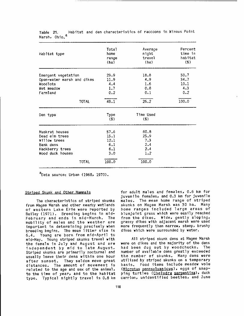
Table 21. Habitat and den characteristics of raccoons in Winous Point Marsh, Ohio.3
Total Average Percent Habitat type home night time in
range travel habitat (ha) (ha) (%)
Emergent vegetat' on 29.9 18.8 50.7 Open-water marsh and dikes 11.9 4.9 34.7 Woodlots 4.4 1.6 10.1 Wet meadow 1.7 0.8 4.3 Farmland
TOTAL
0.2 0.1 0.2
48.1 26.2 100.0
Den type Type (%)
Time Used (%)
Muskrat houses 57.6 60.8 Dead elm trees 15.1 25.9 Willow trees 12.1 7.3 Bank dens 6.1 2.4 Hackberry trees 6.1 2.4 Wood duck houses
TOTAL
3.0 1.2
100.0 100.0
Data source: Urban (1968, 1970).
Striped Skunk and Other Mammals
The characteristics of striped skunks from Magee Marsh and other nearby wetlands of western Lake Erie were reported by Bailey (1971). Breeding begins in mid- February and ends in mid-March. The mobility of males and the weather are important in determining precisely when breeding begins. The mean Utter size is 6.4. Young are born from mid-April to mid-May« Young striped skunks travel with the female in July and August and are independent by mid to late August. Striped skunks are primarily nocturnal and usually leave their dens within one hour after sunset. They seldom move great distances. The amount of movement is related to the age and sex of the animal, to the time of year» and to the habitat type. Typical nightly travel 1s 0.8 km
for adult males and females, 0.6 km for juvenile females, and 0.3 km for juvenile males. The mean home range of striped skunks on Magee Marsh was 30 ha. Many home ranges included large areas of bluejoint grass which were easily reached from the dikes. Wide, gently sloping, grassy dikes with adjacent marsh were used more frequently than narrow, steep, brushy dikes which were surrounded by water.
All striped skunk dens at Magee Marsh were on dikes and the majority of the dens had been dug out by woodchucks. The number of available dens greatly exceeded the number of skunks. Many dens were utilized by striped skunks on a temporary basis. Food items include meadow vole (Microtus pennsvlvanicus), eggs of snap- ping turtles (Qhelvdra serpent1na), duck carrion, unidentified beetles, and June
118

bugs (Ph.yllQghagq sp.). These food Items skunks 9%; Virginia opossums 4%; mink 1%; are abundant on Magee Marsh when the marsh and long-tailed weasels 1%. The Norway is drained in the summer, but may become rat on Winous Point Marsh eats crayfish, scarce once it is reflooded in the fall. fish, birds, juvenile muskrat, and duck
eggs (Bednarik 1956). The mink on Winous Duck eggs are food items for several Point Marsh eats fish, crayfish, muskrat,
mammalian species on Magee Marsh (Bailey and birds. Mink were responsible for the 1971). Of the waterfowl nests on Magee termination of 2% of the waterfowl nests Marsh in 1967 and 1968, red foxes found on dikes in 1967 and 1968 (Urban destroyed 45%; raccoons 17%; striped 1968).
119

CHAPTER 4.
ECOLOGICAL PROCESSES
The ecological value of Great Lakes coastal wetlands 1s immense, but 1s not often recognized by the public. The ecological processes within the coastal marshes of western Lake Erie are intimately related to the beneficial features which can be assigned to them. Some of the more important functions and values of these wetlands include:
1. Physical functions: a. groundwater recharge and flood
storage b. sedimentation basins c. pollution control by waste
assimilation, toxic substance absorption, and nutrient uptake
d. coastal protection from waves
2. Biological functions: a. food chain production and
energy flow b. fish production, spawning, and
nursery c. waterfowl migration, wintering
and nesting d. invertebrate and mammal habitat
3. Economic factors: a. agricultural uses (peat,
blueberries, etc.) b. commercial and sport fishing c. trapping of furbearers d. waterfowl hunting e. nonconsumptive recreation
(birdwatching, canoeing, etc.).
The resource value of coastal wetlands needs to be understood 1n terms of the entire ecosystem and the urgent need to protect and conserve all aspects of the system.
4.1 ORIGIN AND EXISTENCE OF COASTAL MARSHES
The basin occupied by western Lake Erie was created by glaciatlon, and its physical features and hydrology differ greatly from regions not exposed to Pleistocene ice sheets. In terms of earth history, the construction of the basin has been completed only recently. The Great Lakes as they are today (present outlets and approximate lake levels) date back less than 5,000 years. The processes of stream and shoreline erosion/accretion have made only moderate changes 1n the original topography, but these slight change are significant in the origin and development of coastal wetlands.
Prior to the Pleistocene Ice Age, the Great Lakes were nonexistent; the area was dissected by well-developed valleys and several major streams. When the continental ice cap developed to a thickness of several thousand meters in northeastern Canada, 1t spread southward into the present Great Lakes region. Tremendous amounts of bedrock were eroded and the debris entrained in the 1ce mass. As the ice sheets slowly melted and retreated progressively northward, this entrained debris was released and vast irregular deposits of till were laid down on the scoured bedrock surface. Occasionally blocks of ice were also entrained 1n the till and eventually formed the kettle, or bog, lakes of the upland areas adjacent to the Great Lakes.
Once the lakes became established, stream and shoreline processes provided favorable sites for wetlands. The most
120

significant processes Included: 1) delta formation, 2) estuary formation, and 3) sand bar/dune formation creating coastal lagoons. Although the gross configuration of the Great Lakes has been little altered since their glacial development, the above processes have established many favorable sites for wetlands. Except where bedrock 1s exposed or protective works construc- ted, the glacial or lacustrine overburden comprising the shores 1s still vulnerable to changes which can work to the benefit or destruction of coastal wetlands.
Delta Wetlands
A stream reaching a body of standing water, such as the St. Clalr River flowing Into Lake St. Clalr, at times builds a deposit, or delta, composed of the stream's sediment load. These deposits are commonly the site of extensive wetland development. Not all rivers build deltas; deltas may be lacking at the mouths of streams which enter the Great Lakes because their mouths are so exposed to wave and current action that sediments are removed as rapidly as they are deposited. Some streams also lack deltas because they carry so little load. Although each delta has Its own Individual form, four basic outlines are recognized: 1) arcuate, triangular outline, 2) digitate, bird-foot type, 3) cuspate, tooth-shaped form and 4) estuarlne, drowned valley (Strahler 1971).
The typical arcuate delta originates at an upstream apex and radiates lakeward by means of branched distributary channels to form a triangular shape. Sediments reaching the lakes from the distributary mouths are swept along the coast by wave- Induced currents to form curved bars enclosing shallow wetland lagoons; the delta shoreline is thus arcuate 1n plan, bowed convexly outward. The digitate, or bird-foot delta, contains long extensions of its branching distributaries into open water. This type of delta requires a gently sloping lake bottom 1n front of the river mouth, such as Lake St. Clalr, on which natural levees can be built up quickly.
The cuspate, or tooth-shaped delta, is normally formed when the stream has a single dominant mouth. Sediment from this
mouth builds the delta forward into deeper water while wave action sweeps the sediment away from the discharge to form a curving beach on both sides of the mouth, concave toward the lake. An estuarlne delta commonly fills a long narrow estuary that resulted from drowning of the lower part of the river valley because of a rise in lake level. Estuarlne deltas are characterized by deposltlonal Islands containing wetlands, such as found 1n the Maumee River Estuary.
Delta growth occurs when a stream enters a standing body of water as a jet or plume. The jet velocity 1s rapidly checked and sediment 1s deposited in lateral embankments (natural levees) in zones of less turbulence on either side of the jet, thus extending the stream channel Into the lake. The stream repeatedly breaks through the embankments to occupy different rad11 (distributary channels) and 1n time produces a deposit in semi- circular from, closely analogous to the alluvial fans found at the base of mountain ranges. The natural levees serve to isolate shallow 1nterd1str1butary ponds and marshes containing fine muds and organic detritus or peat (Stanley and Swift 1976).
The sediment structure of most deltas on the Great Lakes 1s produced by three sets of beds: 1) bottomset, 2) foreset, and 3) topset. Bottomset beds consist of fine-grained materials (silt and clay) carried farthest offshore and laid down on the bottom of the lake embayment Into which the delta 1s being built. Foreset beds are somewhat coarser (fine sand) and they represent the advancing front of the delta and the greater part of its bulk; they usually have a distinctly steeper slope (dip) than the bottom set beds over which they are slowly advancing. Topset beds He above the foreset beds and are in reality a continuation of the alluvial plain of which the delta 1s the terminal portion. It 1s on the foreset beds that delta wetlands normally develop. Unlike deltas formed along the ocean, freshwater deltas do not contain aggregates of fine particles Induced by electrolyte flocculatlon (due to the dissolved salts 1n the sea). Therefore, fine particles are carried offshore 1n lakes and are not Incorporated into the delta sediments.
121

Delta wetlands form a significant portion of the coastal wetlands in the Great Lakes region. Delta wetlands are gradational to estuarine and riverine wetlands. Such wetlands are common along the lower reaches of virtually all the major tributaries entering western Lake Erie.
Freshwater Estuarv Wetlands
The lower courses of several tributaries to the Great Lakes, particularly the more southerly lakes, are characterized by estuarine-type, or drowned stream, mouths. The flooded flat areas adjacent to these estuaries afford ideal sites for wetland development. The lower 25-km section of the Maumee River which flows into Lake Erie at Toledo, Ohio, possesses the largest drainage of any formation of this estuary on Lake Erie and is the result of a series of geologic events related to Pleistocene glaciation. The flow of the Maumee River was reversed from its southwestern direction when the glacial lakes drained from the Erie Basin as the ice sheet melted, exposing a lower Niagara River outlet. At that time, river velocities were accelerated by the base- level lowering, and the Maumee Valley was cut deeply into lacustrine deposits, glacial tills, and bedrock. With the weight of the ice removed, the outlet eventually rebounded and produced a rise in lake level. The lake encroached up the valley and formed the present drowned stream mouth which is analogous in many ways to a marine estuary. Virtually all of the tributaries entering Lake Erie have estuarine-type lower reaches and attendant wetlands. Here, masses of lake water can affect levels and quality for several kilometers upstream from traditional mouths (Brant and Herdendorf 1972).
The Maumee River estuary begins near Perrysburg, Ohio, at the most downstream bedrock riffle. As the water enters the estuary from the river, its velocity abruptly diminishes except during major runoff events, causing sedimentation of suspended particles. The deposits have formed a series of elliptical islands which foster wetland formation. Similar deposits are found in the Sandusky River
estuary and 1n the tributaries along the Michigan shore of Lake Michigan.
Coastal Lagoon Wetlands
In large bodies of water such as the Great Lakes, the shifting of sediments by nearshore currents can form basins where wetlands eventually develop. If sediments are deposited across the mouth of an embayment, a tributary outlet, or freshwater estuary, the blockage may result in the formation of a new pond or lagoon. Wave activity, too, has formed bars of sand and gravel, which likewise have closed off the mouths of embayments.
The usual way in which a lagoon capable of supporting a wetland 1s formed 1s by accretion of a bar across some irregularity or indentation of the coastline. The term "bar" is used here in a generic sense to include the various types of submerged or emergent embankments of sand and gravel built on the lake bottom by waves and currents. One of the most common types of bars associated with wetlands in the Great Lakes 1s a spit. This feature 1s a sand ridge attached to the mainland at one end and terminating in open water at the distal end. Spits that have extended themselves across or partially across embayments are termed baymouth or barrier bars. Commonly the axis of a spit will extend in a straight line parallel to the coast, but, where currents are deflected landward or unusually strong waves exist, growth of a spit may be deflected landward, resulting in the creation of a recurved spit or hook. Several stages of hook development may produce a compound recurved spit with a series of ponds separated by beach ridges. These ponds have provided excellent sites for wetland development along the shores of Lake Erie.
Existence of Coastal Marshes
Lake Erie 1s noted for Its severe northeast and northwest storms and the resultant wave attacks and rapid fluctuations in water level at the shoreline. The high energy produced at the shore by these storms precludes the development of fringing coastal wetlands.
122
Only where some type of natural or artificial protection is available against these harsh coastal processes (erosion, scour, and rapid transport or deposition of beach material and sediments) can marshes become established and continue to exist. Settling of the shore surrounding the western end of Lake Erie has greatly altered the natural shoreline. In the 1790s much of the western basin shoreline was fronted by barrier beaches which protected lagoons and massive wetlands (Kaatz 1955). Today these low shores are armed with stone dikes or protected with bulkheads. Sandy shores are now restricted to a few spits, such as Cedar Point, Ohio, Woodtick Peninsula, Michigan, and Point Pelee, Ontario, and places where littoral currents converge, such as Port Clinton and East Harbor, Ohio.
Based on these considerations, the coastal marshes of western Lake Erie fall into three categories, depending on the type of protection available to the wetland vegetation. As mentioned ear- lier, at one time the most important protection was that afforded by barrier bars or other natural features of the shore! ine which formed quiet lagoons and coastal embayments. Very few natural wetlands of this type still exist 1n western Lake Erie. One of the best remaining examples is the lagoon ("east bay" of Sandusky Bay) stabilized by Cedar Point sand spit. Other examples of natural-protection wetlands which still persist are those formed by rock-bound embayments in the islands region of western Lake Erie. Unfortunately, many of these embayments have been disturbed by the construction of small boat harbors.
Most of the lagoon-type coastal marshes, if they have not been drained or filled or engulfed by the lake, have been replaced by the second type: managed- waterfowl marshes which are now protected by earthen and rip-rap dikes. The high wave energy of Lake Erie and the record high water levels of 1972-1973 have taken a toll on the barrier beaches, necessitating the construction of armored dikes along much of the western basin shoreline. Large areas of wetlands are now protected 1n this manner by Federal,
State, and local agencies, as well as private shooting clubs.
The third type of protection is the natural isolation from lake storms provided by the estuaries of virtually all of the tributaries entering the western end of Lake Erie. At places, such as the Maumee River, the estuarine aspects of the drowned river mouth extend upstream at least 15 km. Large wetlands have developed along most of the estuaries where disturbance has been minimal. Estuarine coastal marshes form the majority of the naturally protected wetlands bordering western Lake Erie.
4.2 BIOLOGICAL PRODUCTIVITY
Although no specific works have been published on the intricacies of energy flow in Lake Erie coastal marshes, Tilton et al . (1978) have generalized the important processes in the Great Lakes based on studies in other coastal wetlands. The conversion of solar energy into biomass by autotrophs (e.g., green plants) is perhaps the most important process. Conversion into a form available to heterotrophs (organisms unable to synthesize food from inorganic substances) serves as the foundation for several complex and dynamic food webs.
The ultimate source of energy for the marsh ecosystem is the sun. Only a small fraction of the total available energy from the sun enters the food chain. The passage of this energy from one organism to another takes place along a particular food chain, which ^s made up of trophic levels. In most communities, food chains form complex food webs involving many different types of organisms, especially on the lower trophic levels. The first step in the food chain is always a primary producer, which in freshwater aquatic ecosystems may be one of three basic types: 1) macrophytes, 2) benthic microalgae, or 3) phytoplankton.
Several studies indicate that the macrophytes are the most important primary producers in the marshes (Wetzel 1975). These photosynthetic organisms use light energy to make carbohydrates and other
123
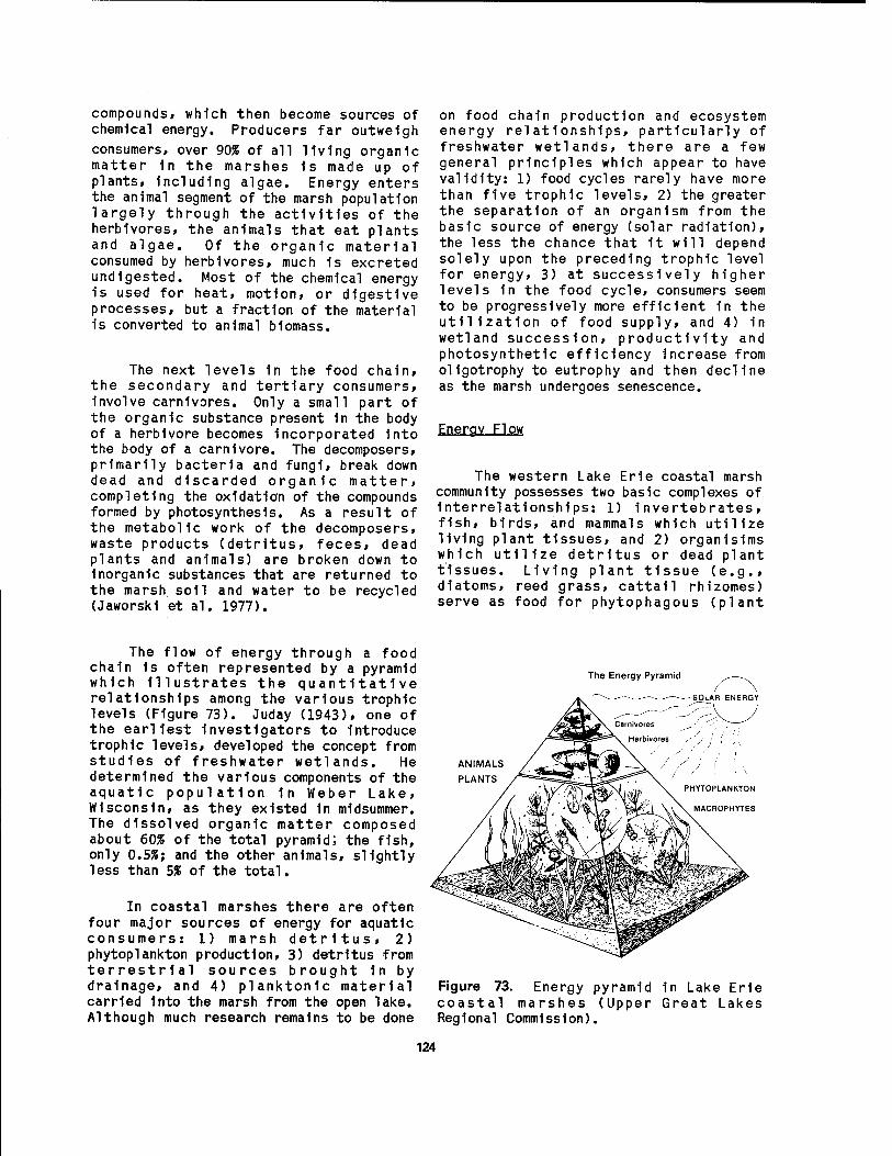
compounds» which then become sources of chemical energy. Producers far outweigh consumers, over 90% of all Hvlng organic matter In the marshes 1s made up of plants, Including algae. Energy enters the animal segment of the marsh population largely through the activities of the herbivores, the animals that eat plants and algae. Of the organic material consumed by herbivores, much 1s excreted undigested. Most of the chemical energy is used for heat, motion, or digestive processes, but a fraction of the material is converted to animal blomass.
The next levels 1n the food chain, the secondary and tertiary consumers, involve carnivores. Only a small part of the organic substance present 1n the body of a herbivore becomes incorporated into the body of a carnivore. The decomposers, primarily bacteria and fungi, break down dead and discarded organic matter, completing the oxidation of the compounds formed by photosynthesis. As a result of the metabolic work of the decomposers, waste products (detritus, feces, dead plants and animals) are broken down to inorganic substances that are returned to the marsh soil and water to be recycled (Jaworskl et al. 1977).
on food chain production and ecosystem energy relationships, particularly of freshwater wetlands, there are a few general principles which appear to have validity: 1) food cycles rarely have more than five trophic levels, 2) the greater the separation of an organism from the basic source of energy (solar radiation), the less the chance that it will depend solely upon the preceding trophic level for energy, 3) at successively higher levels 1n the food cycle, consumers seem to be progressively more efficient in the utilization of food supply, and 4) in wetland succession, productivity and photosynthetic efficiency increase from oligotrophy to eutrophy and then decline as the marsh undergoes senescence.
Energy Flow
The western Lake Erie coastal marsh community possesses two basic complexes of Interrelationships: 1) invertebrates, fish, birds, and mammals which utilize living plant tissues, and 2) organisims which utilize detritus or dead plant tissues. Living plant tissue (e.g., diatoms, reed grass, cattail rhizomes) serve as food for phytophagous (plant
The flow of energy through a food chain 1s often represented by a pyramid which Illustrates the quantitative relationships among the various trophic levels (Figure 73). Juday (1943), one of the earliest investigators to introduce trophic levels, developed the concept from studies of freshwater wetlands. He determined the various components of the aquatic population in Weber Lake, Wisconsin, as they existed 1n midsummer. The dissolved organic matter composed about 60% of the total pyramid; the fish, only 0.5%; and the other animals, slightly less than 5% of the total.
In coastal marshes there are often four major sources of energy for aquatic consumers: 1) marsh detritus, 2) phytoplankton production, 3) detritus from terrestrial sources brought 1n by drainage, and 4) planktonlc material carried Into the marsh from the open lake. Although much research remains to be done
The Energy Pyramid
ANIMALS
PLANTS
Figure 73. coastal
Energy marshes
Regional Commission),
pyramid (Upper
in Lake Erie Great Lakes
124

eating) animals such as stem-boring and Ieaf-m1n1ng Insects as well as certain aphlds and beetles. Many species of waterfowl graze extensively on plant material, and muskrats are Important plant consumers. The next higher trophic level 1n the first complex consists of animals which prey upon the phytophagous organisms. Spiders, predatory beetles, dragonfUes, certain fishes, frogs, birds, and small Insectivorous mammals are Important organisms of this upper trophic level.
The second complex consists of a vast number of insect larvae which rely on organic detritus as a direct energy source or by stripping mlcroblal populations from the surface of organic particles. Gastropods and annelids are also Important organisms 1n this detrltophagous complex. Whatever residual not utilized by these animals 1s subjected to further decomposition by bacterial and fungal populations. As with the phytophagous complex, there exists In the detrltophagous complex a wide spectrum of animals which prey on the detritus-feeding organisms. Several species of Insects, amphibians, mammals, and waterfowl compose this level, and many of these species are not selective 1n their prey, utilizing organisms from both complexes.
Teal (1962) found that a smaller percentage of the total energy represented 1n the primary production of wetlands passes through the phytophagous complex than the detrltophagous complex. In western Lake Erie, submergent vegetation tends to be inhabited and grazed more heavily than emergent forms (Krecker 1939) because the former type of aquatic macrophytes lack the more impenetrable structural tissues prevalent 1n the emergent type. Estimates of the pro- portion of material proceded through each complex (Tilton et al. 1978) favors the detritus web (80% to 95%) over the grazing web (5% to 20%). TUton et al. (1978) pointed out that the importance of an organism to an ecosystem may exceed Its role 1n energy flow. Muskrats use only a fraction of the available energy stored 1n the live plants they cut and harvest 1n the wetlands, but they may be of significant value to the detrltophagous
complex. Similarly, the teeming pop- ulations of phytophagous insects may consume only a small fraction of plant tissue, but through this activity may reduce the growth of host plants and the primary production of the wetland ecosystem.
Emergent Macrophvtes
The energy budgets for cattail marshes in Minnesota were investigated by Bray (1962) and may provide Insight for western Lake Erie wetlands. During the growing season the distribution of the various components of solar radiation energy was as follows:
Component Percent
albedo (reflection) 22.0 evapotransplration 38.4 conduction-convection 38.5 primary production 1.1
This apparently low utilization of solar radiation by Tvpha sp. 1s consistent with other wetland studies and supports the general view that most plant communities use only 155 to 2% of the total solar energy for primary production (Tilton et al. 1978). Phraamites sp. 1n Austrian wetlands ranges from 1.2% to 2.0% for May through July (Sleghardt 1973) and Spartina sp. In Georgian estuaries utilizes 1.4% of total solar radiation (Teal 1962). The uniformity of these results suggests that emergent marshes 1n western Lake Erie utilize approximately 1.2% of solar radiation for primary production.
Emergent wetland communities are among the most productive areas on earth. Westlake (1963) estimated that freshwater emergent macrophytes have a net primary productivity of 3,000 to 8,500 g/m2/yr, and are comparable in productivity to salt marshes and tropical rain forests. Productivity of freshwater submerged macrophytes ranges from 400 to 2,000 g/mVyr, less than half of their marine counterpart. Site specific primary productivity studies of coastal emergent marshes 1n western Lake Erie are scarce.
125
Lutz (1960) working In Ene Marsh of North Maumee Bay found soft-stem bulrush (Scirpus validus) had a peak shoot density of 284/nr and a seed weight of 54 g/m2 or 100,500 seeds/m2. Table 22 lists the maximum biomass and productivity of several emergent species (common in Lake Erie) for the Great Lakes region. Extrapolation of these data .to the coastal marshes of Lake Erie can provide an approximate and reasonable estimate of productivity, lypJia marshes appear to be one of the most productive communities, yielding values (approximately 2,500 g/m2/yr) near the lower end of the range expected for freshwater emergent macrophytes.
Submersed Macrophvtes
Although little work has been done on the productivity of submersed aquatic plants in Lake Erie» Dawson (1975)» Schloesser (1982)* and Schloesser and
Manny (1982) have studied these macrophytes in the St. Clalr R1ver-Lake
St. Cialr-Detroit River system. Results of these studies may provide some understanding of productivity in western Lake Erie. Dawson (1975) found that considerable spatial variation 1n standing crop exists within Anchor Bay of Lake St. Clair (Table 23). He estimated mean dry weights of various submerged communities to range from 4 g/m2 in shallow areas characterized by sparse cover of stonewort (QhäLä sp.) to 316 g/m2 in areas dominated by dense growths of water-milfoil (Myrlophvllum sjjicjium).
Schloesser (1982) studied the monthly abundance of submersed macrophytes in the St. Clair River, Lake St. Clair, and the Detroit River during the 1978 growing season (Table 24). He found that the amount of submersed vegetation was low in early spring. No vegetation was found in
Table 22. Biomass and productivity of emergent wetland plants of the Great Lakes region.3
Species
Maximum Net biomass production
Common name (g/m2) (g/m /yr)
broad-leaved cattail 1,360 2,456 hybrid cattail 4,000 1,440 giant bur reed 1,950 — common arrowhead 230 — manna gr&ss 4,800 — reed grass 2,695 — wild rice 550 630 spike-rush 185 — lake setiqe 1,400 1,186 beaked sedge 850 740 river bulrush _„ 1,530 great bulrush 2,080 — soft rush 1,745 ——
IyjJia lati folia Lafaa x SläJJ£a ^araarnum ejuxsajCßiUD Sacjülaria läiLffilia Glvceria grandis EJiraflfflttes aüstcalls Zlzjjiia aauatica Oe^cjiarjs sp, QäLSü iacjLsJris Ceiex rostra£a SciiDjis xlmdJiiiis SciEPJis mlidys iMneus effysü.5
Mean 1,620 1,330
a, Data source: Tilton et al. (1976).
12S

Table 23. Estimated standing crop biomass for submersed vegetation in Anchor Bay, Lake St. Clair.
Dominant taxa in community
(1974)
Weedbed area (kit/)
TOTAL 108.8
Range 1n dry weight
(g/m2)
Chara 31.2 Chara-Naias 25.6 Potamoaeton-Charq 13.7 Val1isnerla-Mvriophvl1 urn 12.0 Chara-Nitella g,Q Vallisnerlq americana 9.4 Myriophvllum 6.5 Heteranthera dubla 0.5
4-77 25 65 190
37-247 12-97
127-316 83
4-316
Data source: Dawson (1975).
Total submergents
(%)
10.3 8.6
11.8 29.9 11.0 7.3
20.5 0.6
100.0
Table 24. Seasonal estimates of standing crop biomass for submersed nacro- phytes at several locations in the Lake St. Clair-Detroit River system,3
Location (1978)
St. Clair River (Stag Island)
St. Clair Delta (Algonac)
Anchor Bay (Sand Island)
Clinton River (mouth)
Detroit River (Belle Isle)
Detroit River (Grosse lie)
Q£XJlelgbl.S3lM2l Dominant June July Aug Sept Oct Nov taxa
72 267 103 38 15
54 97 158 174 284
85 113 135 133 146
24 63 118 33 16
38 52 38 17
Potamogeton spp.
182 Potamogeton spp. IledM canadensis
69 f^nlQßJiylliiJS spicatum
J^lLLsneria jamerlcaaa
Yälllsüsriä IDierlcajLa
94 216 427 220 145 42 El odea fiäMdSlIäis
Detroit River (Sugar Island)
287 135 192 160 172
Data source: Schloesser (1982),
82 Esfcynogejoji exists
127
the Detroit River in April or May, and the only vegetation collected in Anchor Bay and the St. Clair River during these months consisted of decaying or dormant material from the previous growing season. One exception, Potamogeton crispus» does show an early (May-June) growth peak at the mouth of the Detroit River which may be beneficial to spawning fish and migrating waterfowl during that period (Figure 74).
30 r-
Belle Isle
^ Al! others
By mid-June dominant plants had sprouted new growth at stem and leaf nodes, and by mid-July new growth which did not originate from overwintering dormant material was found at all locations (Table 24). Higher maximum biomass values were generally observed at locations where dormant overwintering vegetation was observed in early spring. The maximum biomass was reached in June in the Detroit River mouth (Sugar Island, 284 g/m2); in July in the St. Clair River (267 g/m2); 1n August 1n the Clinton River mouth (118 g/m2), Detroit River head (53 g/m2) and Grosse lie (427 g/m2); and in October 1n the St. Clair Delta (284 g/m2) and Anchor Bay (146 g/m2). The submersed macrophytes became senescent and the biomass values decreased by late fall at all locations. The results of this study indicated that little or no submersed macrophyte growth takes place before June or after October In the river or lake. The dominant taxa found at each location are given in Table 75.
3001-
E 250
w 200 <o CO I 150 O £0 100 c (0 0) 50
0
150
125
100
75
50
25
0
Grosse He
Bodea canadensis
Sugar Island Myriophyllum
spicatum
A * y
Heteranthera — / \ y/Assäutxa PofamogefonX - crispus \
- 1 ' \ /v --\ / / \ S All others \ A—Ly-t -4 \ 1
M A S 1978
Figure 74. Seasonal growth of submersed macrophyte taxa in the Detroit River in g/m2 ash-free dry weight (Schloesser 1982).
Phytoplankton and Attached Algae
Several studies of phytoplankton productivity have been conducted in western Lake Erie (Cody 1972; McQuate 1954; Sheffield and Carey 1980; and Verduln 1962). However» few measurements have been taken directly in the coastal wetlands. McQuate (1954), working in the uncontrolled marshes at the upper end of Sandusky Bay, observed that small bays and open pockets within the beds of rooted aquatic vegetation provided "excellent cultural grounds" for plankton which are carried into the bay and eventually reach the waters of Lake Erie. He measured a photosynthetic rate of approximately 1,400 mg of carbon assimilated per day. This rate compares favorably with nearshore measurements made by other investigators in western Lake Erie, and as would be expected, is higher than values for offshore locations, the islands area, and central Lake Erie (Table 26). Considering relative biomass, phytoplankton is not as Important as the macrophytes 1n the total primary production occurring within the coastal marshes. However, 1t is significant 1n the zooplankton-flsh larvae food chain within the marshes.
128
Conversely, 1n the offshore portions of Sandusky, and Huron rivers. He concluded the lake, phytoplankters are the dominant primary producers.
Sullivan (1953) conducted a survey of the phytopl ankton populations 1n the estuarlne portions of the Maumee, Portage,
that the majority of the plankters found 1n the estuaries of these rivers were large plankters which entered the estuary with the Influx of lake water. The western basin tributaries, particularly the Maumee River, are often very turbid. Sullivan found that this high turbidity
Table 25. Dominant submersed aquatic macrophyte taxa of the Lake St. Clair- Detroit River system.
Taxa St. Clalr St. Clalr Lake St. Detroit Detroit
River Delta Clalr River River (Stag Is.) (Algonac) (Anchor Bay) (Belle Isle) (mouth)
Chara spp. Elfidga. canadensls rteteranthera duMa MvrlQphvnum spjcatum MäLLas fl9x.11 Is Potamogeton cHspus Pptampgeton grflmlneus Potamogeton Potamogeton
rlchardspnfi spp«
Valllsnerla airerlcana
X X X X
X X X X
X X
XXX
XXX
X X X
XXX
X X X X X
X X X X
Data sources: Dawson (1975), Schloesser (1982).
Table 26. Carbon assimilation by phytoplankton productivity 1n Lake Erie.
Measurement location Photosynthlc rate
(mg/C/m2/day) Data source
Western Lake Erie
Pointe Mouillee Pigeon Bay, Pt. Pelee Sandusky Bay Locust Point Niagara Reef South Bass Island:
2,197 1,775 1,438 1,223
833
Sheffield and Carey Sheffield and Carey Mediate (1954) Sheffield and Carey Cody (1972)
(1980) (1980)
(1980)
Fishery Bay Offshore, west coast
742 512
Cody (1972) Verduin (1962)
Central Lake Fr1e
Old Woman Creek, offshore 820 Sheffield and Carey (1980)
129

significantly limited the productivity of phytoplankton in the estuaries, and during freshets, also reduced primary productivity in the adjacent nearshore waters of Lake Erie.
McMinian (1951) studied the photosynthetic rate of filamentous algae (Cläjdfißiacä glomerata and Ulothrix zonata) attached to littoral boulders and rocky shorelines of Fishery Bay, South Bass Island. She found that this association, which included abundant periphytlc diatoms, had an average carbon fixation rate of 567 mg C/mz/day during a 4-month growing season. This rate 1s comparable to that obtained by Codv (1972) for phytoplankton (742 mg C/mVday) in the same bay (Table 26). McMillan determined the average yield of attached algae in this habitat to be 144 g/m2. Lorenz and Herdendorf (1982) obtained maximum standing crop values for Cladophora at Stony Point, Michigan (adjacent to Swan Creek Marsh), and South Bass Island of 184 g/m and 214 g/mS respectively. Monaco (1984), continuing this study, found that the vertical distribution of Cladophora was limited by light attenuation to a depth of about 2 m. Photosynthstically active radiation below 50 <uE/mZ/sec was determined to limit vertical colonization. The biomass values obtained for attached algae in western Lake Erie are comparable to those obtained by Schloesser (1982) for submersed macrophytes, particularly Potamogeton spp. and Myriophvllum sp., in Lake St. Clalr.
Nutrient Cvcljng
Coastal wetland vegetation immobilizes certain amounts of nutrients, a portion of which are released upon senescence and decay of the plants. Depending on the sedimentation characteristics of the wetland, nutrients are stored in the wetland as organic sediment or peat. In the marsh soils, microbial processes transform some of the nutrients from organic to inorganic forms. The net effect of these processes is generally a reduction in the concentration of nutrients in water flowing through the wetland. Therefore, the coastal marshes are important in controlling nutrient loading to nearshore waters of Lake Erie (Tilton et al. 1978).
Mudroch (1980) studied the geochemlcal composition of sediment, uptake of nutrients and metals by macrophytes, and nutrient and metal composition in the water at Big Creek Marsh on the north shore of eastern Lake Erie 1n Long Point Bay. The maximum concentrations of most metals (Pb, N1, Ca, Cr, and Zn) in marsh sediments were lower than concentrations found in Lake Erie surflcial muds, presumably due to uptake by the aquatic plants in the mud. Submerged plants (CJura. sp., Myriophvllum sp.» and EJotjea sp.) accumulated larger quantities of Ca, Pb, Cu, N1, Cr, and Cd than emergent plants (Tvpha spp.), but nutrient concentrations were relatively uniform for all species (Table 27). She found that the biomass production of the macrophytes in the marsh is related to the subhydric soil fertility as well as the nutrient content in the marshwater. She concluded that short-term supplies of nutrient-rich sewage to the surface subhydric soil layer can have a prolonged effect on macrophyte production by enrichment of the nutrient pool maintained in the perennial plant system.
Detritus Food Ohalg
The detritus food chain of Sandusky Bay 1s illustrated in Figure 75. Of the six dominant benthic macroinvertebrate species present, three are detMtivores, one is a grazer, and two are predacious. The three species of oligochaete detritivores function in a commensal aggregation to exploit the allochthanous and autothanous inputs to the bay. Additionally they use both the bacteria that grow on the surface of detritus particles and the products of bacterial activity. The one grazer 1s the larva of the chironomid Chironomus plumosus. it exploits the plankton, primarily diatoms and other algae, by entrapment on a spun net, which it ingests along with the plankton. Chironomus also grazes on diatoms, other periphyton, aquatic plant tissue, and decaying organic matter. The two predator species are also ch1ronom1ds. Cog!otan^ßüs is a voracious predator on other chironomid larvae while Procladius is a more general carnivore. Coelotanvpus preys on both Chironomus and Rrocladius, and members of its own species at times.
130

Table 27. Concentrations of nutrients and metals in wetland plants at the stage of maximum development, Big Creek Marsh, Long Point, Ontario.
Species Drv weight (%)
K N P Ca Pb DrY Cu
welaht (ua/n N1 Cr Cd Zn
TvDha latifolia Elodea canadensls Nuphar advena Mvrlophvnum heterophvllum Nvmphaea odorata Chara vulaarls
1.1 1.7 0.2 1.6 1.1 0.4 1.1 2.0 0.3 1.2 1.8 0.3 1.0 1.8 0.2 1.7 0.8 0.1
0.8 20.0 1.0 4.4 0.9 19.5
4 32 5
27 7
32
3 10 3 6 3 9
6 18 2
15 3 17
3 <1 18 15 3 18 4 <1 18 8 2 15 4 <1 14
10 2 14
Data source: Mudroch (1980).
Detritus
Bacteria
DETRITIVORES
Limnodrilus Peloscolex Branchiura
PRIMARY PRODUCERS
Phytoplankton Periphyton
I HERBIVORES
Chironomus
CARNIVORES
Coelotanypus Procladius
Figure 75. Diagram of the detritus food chain in Sandusky Bay Estuary, illustrating the role of benthic oligochaetes (modified from Lindsay 1976).
131
Procladlus feeds on other cMronomlds and also utilizes the three species of ollgochaetes.
Beaver (1942) and Weeks (1943) Investigated the heterotrophlc bacterial population 1n western Lake Erie sediment from various habitats (Table 28). They found that the open lake stations had much lower populations than the estuaries and coastal marshes. The high value at Put- In-Bay 1s probably related to pollution, while the other locations with high populations are more likely related to the high concentrations of macrophyte detritus. Weeks observed an Increase 1n the bacterial population 1n the Island areas which correlated with the high discharges of allochthonous (transported) materials from the Maumee and Portage rivers.
4.3 COMMUNITY PROCESSES
The western Lake Erie wetlands are actually composed of a variety of habitats Including open ponds, cattail and reed marshes, earthen dikes, barrier beaches, delta flats, and wooded swamps. Collectively these habitats are known as the coastal marsh community. Each habitat attracts its own species of plants, birds, mammals, reptiles, amphibians, and, in some cases, fish. The result is a greater variety in plant and animal life than 1n
any other area of equal size In the Interior of the bordering states and province. The overall conditions of the uncontrolled coastal marshes are still relatively primitive. Within those marshes where natural processes are allowed to take place, zonatlon and succession 1n response to changing environmental conditions are among the Important community processes. Water level fluctuation, and the resultant plant and animal response, is often the most significant driving force.
Plant Zonatlon
The protected marsh at Haunck's Pond on Middle Bass Island provides an excellent example of aquatic plant zonatlon 1n response to water depths. The basin containing the marsh appears to have been formed by a double tombolo which now connects two rock Islands with two sand spits built by alongshore currents. Eight zones, extending from open water to a shrub shoreline, have been Identified (Wood 1966):
1. open water 2. water Uly 3. dock 4. cattail
5. cutgrass 6. jewelweed 7. tall grass 8. shrub zone
Each zone 1s transitional and 1n none does one species dominate to the exclusion of all other species.
Table 28. Heterotrophlc bacterial populations in western Lake Erie.'
Location Bacterial colonies per gram of sediment (drv) Aerobic (20°C) Anerobic (20°C)
Western Lake Erie (m1d-bas1n) Fishery Bay, S. Bass Is. Portage River mouth Terwilliger's Pond, S. Bass Is. Haunck's Pond, M. Bass Is. Portage River Estuary Put-1n-Bay, S. Bass Is.
48 x 10" 52 x 10° 59 x 106
65 x 10b
85 x 10° 110 x 10b
104 x 10°
50 x 10" 43 x 10b
44 x 106
51 x 10b
65 x 10b
76 x 10b
75 x 10b
Data source: Beaver (1942).
132

Major species occurring 1n the open water zone are unattached floating plants such as duckweeds (Lemna minor. J.. trlsulccQ» large duckweed (Spirodelfl polv- j±j_za), and watermeal (Wolffia. qolum- biana), and submersed aquatic plants such as sago pondweed (Potamoaeton pectinatus). water milfoil (Myrlophvllum exalbescens). waterweed (Elodea canadensis). and coon- tall (Ceratophvllum demersum). July water depth In this zone ranges to 1 m.
Major species composing the water lily zone are spatterdock (Nuphar advena) and white water lily (Nvmphaea tuberosa). Species associated with this zone included water-plantain (Alisma plantago-aauatica). arrowhead (ggglttarla latifolia). and pickerel weed (Pontederia cordata). The water lily zone is actually several disjunct zones, together occupying a major portion of the wetland. July water depth in this zone ranges up to 1 m.
Two species of dock (Rumex crispus and ß. Y?rtis1ll3±ua) comprise the major cover of the dock zone. Plants thriving under the dock cover include spatterdock, white water lily, sedges, and in some areas rice cutgrass (Leersia orvzoides). Occasional hummocks support swamp- loosestrife (Decodon verticillatus) and buttonbush (Cephalanthus occidental is). July water depth in this zone ranges up to 50 cm.
Narrow-leaved cattail and broad- leaved cattail are codominant species of the cattail zone. Thriving as associates 1n this zone are sedges (Ca rex cxls±li§Hä» Sclrpus atrovirens. and 5. Xäl±dju_§), soft rush (Juncus effusus). bur reed (Sparganlufl eurvcarpum). cutgrass, and river bulrush (Scirpus fluviatnis). Early summer water depth in this zone ranges up to 15 cm. However, this zone was predominantly a mudflat.
In early summer, 5 to 15 cm of water covers the cutgrass zone. At this time water-plantain and spatterdock are common associates of cutgrass. As water levels fall, associated species are limited to sedges (Carex, cHstatella. £. comosa. CYPRUS Strlgosus, Sdrpus atrovirens. and iu .YflUdus), spike-rushes (Eleocharls lJlt9rnt9«J1a and £. sJdLJUä)» and ditch stonecrop (penthorum ssdfiliss).
The jewel weeds, Impatlens capensis. I. pall Ida,, occur 1n and A. paiiiud.
zone nearly to the exclus species. However, 1n cutgrass, spatterdock, an Additional associates of th1 cattail, sedges, rushes, (Mimulus ringens). skullcap epilobiifolia). and Iris sp.
the jewelweed ion of other wetter areas d dock occur. s zone include monkey flower (Scutellarla
The tallgrass zone is primarily composed of reed-canary grass (Phalaris arundinacea) and bluejolnt grass (Calatna- gr.Qs.tis canadensis), which in some areas attained a height of 2 m. Jewelweed and cattail are the only herbaceous associates. Small hummocks in this zone support white ash (Fraxinus americana). hackberry (Celtls occidental is), and choke cherry (Prunus vira1n1ana).
The shrub zone is composed primarily of saplings of species found in the nearby swamp forest such as bur-oak (Quercus macrocarpq), hackberry, slippery elm (Ulmus rubra), white ash (Fraxinus americana), and white mulberry (Morus Alkä)« Low growing plants occurring in this site include choke cherry, prairie rose (ß p sa setigera), and common elderberry (Sambucus canadensis).
Marsh Succession
Kormondy (1969) described wetland succession 1n beach ponds on a 6.5-km-long spit in Lake Erie known as Presque Isle near Erie, Pennsylvania (Figure 76). Owing to a combination of its sandy shore and exposure to violent lake storms, this spit developed as a series of hooks with the establishment of numerous finger!ike beach ponds over the past several thousand years. The ponds are created when an elevated bar of 'sand develops, thereby isolating a small portion of the lake; the ponds are seldom more than 100 to 200 m long, 10 to 20 m wide, and 1 m deep.
Some of the ponds are destroyed 1n a few days, months, or years by subsequent storms which either breach the sand bar or blow enough sand to fill 1n the depression. The better protected ponds survive these geological processes only to be subject to a biological fate: wetland succession. A 4-year-old pond 1s characterized by sparse pioneer vegeta-
133

i^%> UM
*-**
i %^ &$}dJkJät_
bulrushes * cottonwood
Chara cattail seedling
n #f
3J5Ü5;
r #| if % ff B cotton t ,_ blue-
wood bayberry Myrio-
idlnt bulrushes phyllum willow cattail
yellow ^ cotton- bay water pond- Myrio- bitte-
re wood berry lily weed phyllum bulrushes joint spikerusr "QV - - SHORELINE, 1790 | SHORELINE. 1957
Figure 76. Wetland succession in a Lake Erie beach pond at Presque Isle, Pennsylvania: A) 4 years old, B) 50 years old, C) 100 years old, and D) progressive shoreline changes (Jennings 1930; Pincus 1960; Kormondy 1962).
tion, such as stonewort (Chara sp.), bulrushes, cattail, and cottonwood (Populus deltoldes) seedlings. At 50 years, filling has occurred in the basin and encroaching vegetation has reduced the open water portion to about half of Its former area. The major vegetation then consists of water-milfoil, cattail, bulrushes (Scirpus sp.), bluejolnt, willow (Salix sp.), bayberry (Myrica sp.), and cottonwood. After 100 years the open water portion 1s almost obliterated and the vegetation has Increased 1n complexity. The dominant forms then Include water-milfoil, pondweed (Potamo- geton sp.), yellow water Hly (Nuphar advena), bulrushes, bluejolnt, splkerush,
bayberry, and cottonwood.
Sparseness of distribution and limitation of plant species mark the early ponds; increased density and heterogeneity characterize the older ponds, and the contrast 1s striking. From this analysis of succession, Kormondy (1969) concluded that the ponds or lagoons at the northeast end of Presque Isle are the youngest and that the spit has growth from the southwest because the ponds are Increasingly older 1n that direction. Similar development occurred on Cedar Point, at the entrance to Sandusky Bay, but commercial projects have altered the course of natural succession.
134

Animal Succession
Lake Erie coastal marshes and embayments are excellent habitat for Odonata (dragonfly) because of their quiet waters and abundant food supply. Kennedy (1922) studied the distribution of dragonfly species 1n relation to the occurrence of coastal marshes on the Lake Erie Islands. He observed a distinct species preference for wetlands 1n different successlonal stages. Of the nine wetlands Investigated, Put-1n-Bay Harbor on South Bass Island was the most open, exposed area, and Fox Marsh on North Bass Island was the most closed or advanced successlonally. Figure 77 Illustrates a succession gradation both 1n marsh development and species preference for the wetlands and the 25 species of dragonfly that occur 1n them. Kennedy concluded that the more advanced marsh species supplant the more primitive open lake species as the marshes mature or become more closed. The marsh species have all developed egg stages which can withstand Intermittently dry conditions.
The benthlc fauna of the nearshore waters of western Lake Erie, both 1n the density of population and variety of Its forms, depend upon the type of substrate, character of the vegetation, and depth of the water. Krecker and Lancaster (1933) found that such physical factors as temperature, oxygen, carbon dioxide, and pH were 1n general so uniform 1n the nearshore waters that they did not appear to be critical factors. The densest population was 1n less than 1 m of water. Half of the animals represented occurred In maximum numbers within the 15 cm contour although, due to great numbers of chlronomlds (midge larvae), the largest total population was at the 50 cm contour. Shelving rock shores were the most densely populated because of great numbers of chlronomid larvae and Lvmnaea but rubble shores had the greatest variety of animals present 1n maximum numbers. The smallest number of forms occurred on sand bottoms, the largest variety on rubble. Among the plants, bulrush was most densely populated, again due to great numbers of chlronomlds, but it also was Inhabited by
DRAGONFLY SPFCIFS OPEN MATER »-CLOSED POND
Fox's Pond
Smith's Pond
Q. U_ :*~ E
GamEhuS plagiatus Gomphus vastus Kgurocordulia vamaskensis Macroma illinjaieniis Araia moesta Enallagna carunculatum Enallagna exsulans Ischnura vertical Us Enallagna ebrium Tramea lacerata Anax .iunius Enallagna signatum Libellula pulchella Libellula luctuosa Lestes rectangularis Leucorrhinia intacta Ervthemis simplicicollis Nehalennia irene Pachydiplex longipennis Lestes forcipatus Sympetrum obtrusum Sympetrum vicinum Sympetrum rubicundulum Lestes uncatus lestes unquiculatus
xxxxxxx xxxxxxxxx xxxxxxxxx xxxxxxxxx xxxxxxxxxxxxx
xxxxxxxxxxxxxxxxxxxxxxxxxxxxxxxx xxxxxxxxxxxxxxxxxxxxxxxxxxxxxxxx xxxxxxxxxxxxxxxxxxxxxxxxxxxxxxxxxxx xxxxxxxxxxxxxxxxxxxxxxxxxxxxxxx
xxxxxxxxxxxxxxxxxxxxxxxxxxx xxxxxxxxxxxxxxxxxxxxxxxxxxxxx
xxxxxxxxxxxxxxxxxxxxxxxx xxxxxxxxxxxxxxxxxxxxxxxxxxx xxxxxxxxxxxxxxxxxxxxxxxx xxxxxxxxxxxxxxxxxxxxxxxx
xxxxxxxxxxxxxxxxxxxx xxxxxxxxxxxxxxxxxxxx xxxxxxxxxxxxxxxxxxxx xxxxxxxxxxxxxxxxxxxxxxx xxxxxxxxxxxxxxxxxxxxxxxx xxxxxxxxxxxxxxxxxxxxxxxx xxxxxxxxxxxxxxxxxxxxxxxx xxxxxxxxxxxxxxxxxxxxxxxx
xxxxxxxxx xxxxxxxxx
SUGAR ISLAND
Fischer's Pond
'\> RATTLESNAKE ISLAND
Vehrle s 9
■^fond BALLAST ISLAND
■ "-* "V SOUTH BASS i GREEN ISLAND \ ISLAND
Figure 77. Succession of dragonfly species as marshes on the Bass Islands develop and age from open water to closed ponds (Kennedy 1922).
135

the smallest variety of invertebrates. However» both Potamoqeton spp. and C1adophora sp. had more diverse animal populations (11 taxa). Because the benthic populations are dependent on water depth, a definite zonation occurs that rapidly adjusts, through a succession process, when water levels fluctuate.
Western Lake Erie has a combination of characteristics of large rivers (i.e., Detroit, Maumee, and Sandusky) and small streams (i.e., Swan, Crane, and Turtle). This situation, in conjunction with it being accessible to both faunal elements, has resulted 1n an unusual mixture of large river and headwater species in the fauna of the lake and coastal marshes. Stansbery (1960) found that as a result of this circumstance, the molluscan fauna of the nearshore waters has Intergraded. Relatively strong, persistent, alongshore currents (simulating stream conditions) were associated with rapid growth of Unionid mussels, whereas quiet waters resulted in stunting. Consequently, mussels in Lake Erie nearshore waters are more commonly found on shallow gravel bars than in the protected cattail marshes.
Zonation has also been demonstrated for larval fish populations in western Lake Erie (Cooper et al. 1981a, 1981b, 1983, 1984; Mizera et al. 1981). A series of studies in the estuaries and open waters of western Lake Erie have shown that the estuaries of the Maumee River and Sandusky River contained the highest densities of larval fish when compared with other nearshore and offshore areas. Gizzard shad, white bass, and freshwater drum dominated the estuarine populations. The highest density of yellow perch was found In nearshore areas associated with sandy bottoms, particularly north of Woodtick Peninsula and in the vicinity of Locust Point. The following depth/density relationship was observed for yellow perch:
Water depth (m) Maximum number/lOOm3
0-2 157.0 2-4 19.3 4-6 7.7 6-8 5.2 8-10 5.0
> 10 3.7
The same general relationship was found for most species, Indicating a greater preference for spawning and nursery grounds in the coastal areas.
Johnson (1984) believes that the most important factor influencing production of fish larvae in western Lake Erie marshes is predation. Although no information is available on predator-prey interactions involving larval fish in wetlands, related research has indicated habitat structure can be important in mediating the outcome of aquatic predator-prey interactions. Glass (1971) found that largemouth bass (Micropterus salmoides) predation success declined as the complexity of habitat structure increased. Crowder and Cooper (1979) concluded that areas of high structural complexity should create an effective refuge for prey and enhance their survival. However, Helfman (1979) found that shading produced by surface structures might also influence predator- prey interactions. He found prey-sized bluegill (Lepomis macrochi rus) were strongly attracted to shade produced by floats (1 m diameter) in ponds where no submerged structure was present. He concluded that prey fish in shade can detect a predator (in sun) long before the predator can detect the prey.
The aforementioned research shows that prey species and prey-sized fish may actively escape predators by disappearing into areas of high structural complexity or by seeking shade so as to gain the visual advantage. Consequently, fish larvae in wetlands may use floating habitat types to gain the visual advantage while other larvae may use submergent or emergent habitat types to hide from potential predators. Open water areas in western Lake Erie coastal marshes may be expected to have low larvae use during the day because of the Increased success of visual predators in this habitat type, but these areas, particularly the uncontrolled wetlands, may be important to fish larvae at night.
Variations in year-class strength (YCS) of western Lake Erie fishes may also be due to other factors, particularly the availability of plankton food to larval fish as they emerge from the estuaries. For example, walleye, which spawn in large
136

numbers on the riffles of the Maumee and Sandusky rivers (Cooper et al. 1981a), have shown a highly variable YCS, with strong correlation existing between the rate of spring warming of the nearshore waters and the number of young-of-the-year walleye captured during fall stock assessment surveys (Busch et al. 1975). This suggests that increase recruitment under more rapid warming (earlier in the spring) may be a result of temperature effects on critical food resources, such as the Zooplankton.
Temperature also strongly affects the production of Zooplankton. Culver and DeMott (1978) studied the seasonal variation of blomass, production, and species composition of Zooplankton in western Lake Erie and found that the plankton communities undergo a switch from domination by copepods in the spring to domination by cladocerans as the water warms. Because this transition occurs near the beginning of the planktivorous phase of many larval fish (Figure 78), the effect of temperature on the transition
CO
f 1500 a E
1000
I- Ü
Q o DC 0.
500
100
■»^™^™Gizzard Shad/Alewife Larvae Yellow Perch Larvae
Emerald Shiner Larvae
Freshwater Drum Larvae Rainbow Smelt Larvae
White Bass/White Perch Larvae
Figure 78. Seasonal variation in Zooplankton pro- ductivity, the relative contribution of zooplank- tonic taxa to that productivity, and the distribu- tion of major ichthyoplankton taxa in western Lake Erie for 1976. Note that all fish taxa show up in the ichthyoplankton prior to the June increase in Zooplankton production (Culver and Margraf 1984).
137

may strongly affect the availability of the larger Zooplankton (particularly cladocerans) for young fish.
Larval fish studies conducted 1n the vicinity of Locust Point 1n the mid-1970s (Cooper et al. 1981b; Mlzera et al. 1981) show that all fish taxa showed up 1n the ichthyoplankton samples prior to the June increase in Zooplankton production (Figure 78). Consequently, the YCS of fishes recruited during this time period was poor (Ohio Division of Wildlife 1984). Recruitment of yellow perch 1n 1983 was also poor. Although taken from different years, 1976 and 1983 diet information (Figure 79) shows that the shift from small zooplankters to the larger cladocerans did not take place until the perch had reached the juvenile stage (50 to 60 mm), presumably because the production of larval fish and cladocerans were out of phase by several weeks (Culver and Margraf 1984).
4.4 COASTAL MARSHES AS FISH AND WILDLIFE HABITAT
By their very nature (which most generally Includes a diversity of emergent, floating-leaved, and submersed aquatic plants) coastal marshes provide more food and shelter for wildlife than any other coastal or offshore habitat 1n
(larvae) 1976
(juvenile) 1983
Figure 79. Invertebrate diet for yellow perch larvae and juveniles, Illustrating a shift to the larger cladocerans as the fish grow and move out of the vegetated areas to feed 1n the open lake (Culver and Margraf 1984).
western Lake Erie. Invertebrates, particularly the crustaceans, Insects, and gastropods, are abundant on and among wetland vegetation. These organisms are Important food Items for more prized fish species and some of the mammals which dwell at the marshes edge. Some waterfowl and other birds rely on the marsh plants for sustenance, nesting sites, and cover, while others utilize the fish and invertebrates which inhabit the marshes. The foregoing sections of this chapter have discussed 1n some detail the utilization of coastal wetl?nds by the various animal groups.
An analysis of energy flow 1n the coastal marshes reveals that the entire heterotrophic component of the wetlands is dependent on organic matter produced through photosynthesis. One way that this material 1s utilized 1s through grazing of living tissues. Several species of waterfowl feed on various parts of aquatic macrophytes. The seeds of pondweed, sedges, smartweed, water shield, wild rice, and bulrush are preferred foods as are the foliage of pondweed, wild celery, naiad, duckweed, and water weed, and tubers or rootstocks of wild celery and sago pondweed (Tilton et al. 1978). Several mammals, Including muskrat and deer, browse heavily on many of the aquatic macrophytes. Phytophagous (plant- eating) insects, such as leafmlner beetles, are the food supply for several species of marsh birds, fishes, reptiles, and mammals.
Another form of plant utilization 1s the direct consumption of organic detritus and the Ingestion of the microblal populations associated with this particul ate organic matter. Many benthlc invertebrates rely completely on such food sources. These organisms 1n turn form the food supply for many vertebrates 1n the coastal marshes.
In addition to being a direct or Indirect food source for many species of animals, macrophytes provide cover and nesting areas for waterfowl. Several species of fish, such as northern pike, spawn 1n vegetated wetlands and musk rats prefer emergent vegetation for con- struction of their feeding platforms and houses (TUton et al. 1978).
138

CHAPTER 5.
WETLAND DISTURBANCE AND MARSH MANAGEMENT
One of the most significant environmental changes in western Lake Erie was the draining and filling of the extensive coastal marsh system. Prior to 1850» an extensive coastal marsh and swamp system covered an area of approximately 4»000 km2 between Vermilion, Ohio, and the mouth of the Detroit River and extended up
the Maumee River Valley into Indiana (Figure 80). This area was largely cleared, drained, and filled to provide agricultural land, lumber, and trans- portation routes, so that at present only about 150 km2 of coastal marshland remains. Most of this remaining marshland is encompassed by dikes. Between 1850 and
Lake Erie •
• £ m
-if <#
1800
1984 N
o •.
Figure 80. Extent of wetlands bordering western Lake Erie in 1800 compared to 1984 distribution of coastal marshes.
139

1900» as coastal marshes were drained and filled for conversion to agriculture, dikes were constructed to protect farmland from seasonal flooding and to separate them from adjacent open water and unfilled marsh (Trautman 1977). During this time the marshes of western Lake Erie gained considerable fame as waterfowl hunting areas.
After 1900, the rate of loss of the remaining marshlands accelerated due to increasing development pressure, changing lake water levels, increasing agricultural siltation, and wave erosion. During this period, groups of wealthy sportsmen interested in preserving quality waterfowl hunting in the area purchased most of the remaining marshland around western Lake Erie. Marshes were enclosed by a second generation of dikes equipped with gates and pumps to protect the marshes from flooding, siltation, and wave erosion and to permit water level regulation within marshes for the production of aquatic plants used by waterfowl. Since 1950, many of these privately owned marshes were acquired by the Ohio Department of Natural Resources and the U. S. Fish and Wildlife Service to be used as wildlife refuges;
public hunting, recreational areas, and natural areas; preserves; and state parks.
5.1 WETLAND DISTURBANCE
Draining and Filling
Black Swamp. The name "Black Swamp" refers to a large flat area in northwestern Ohio that once was lush marshland. Oriented northeast-southwest along the south side of the Maumee River, it was about 160 km long and 40 km wide (Figure 81). The swamp was on a broad plain that once was the bottom of an ancestral stage of Lake Erie. The former lake had a surface elevation nearly 70 m higher than the modern lake because of a glacial ice dam in the northeastern part of the Erie basin. Once the ice had melted back to the north and the lake had drained, the marshes formed on the lowest and flattest bottomlands where adequate natural drainage was the poorest. The black organic muck associated with the swamp gave the area its name (Forsyth 1960).
Figure 81. 1960).
Extent of the Black Swamp in northwestern Ohio (Forsyth
140
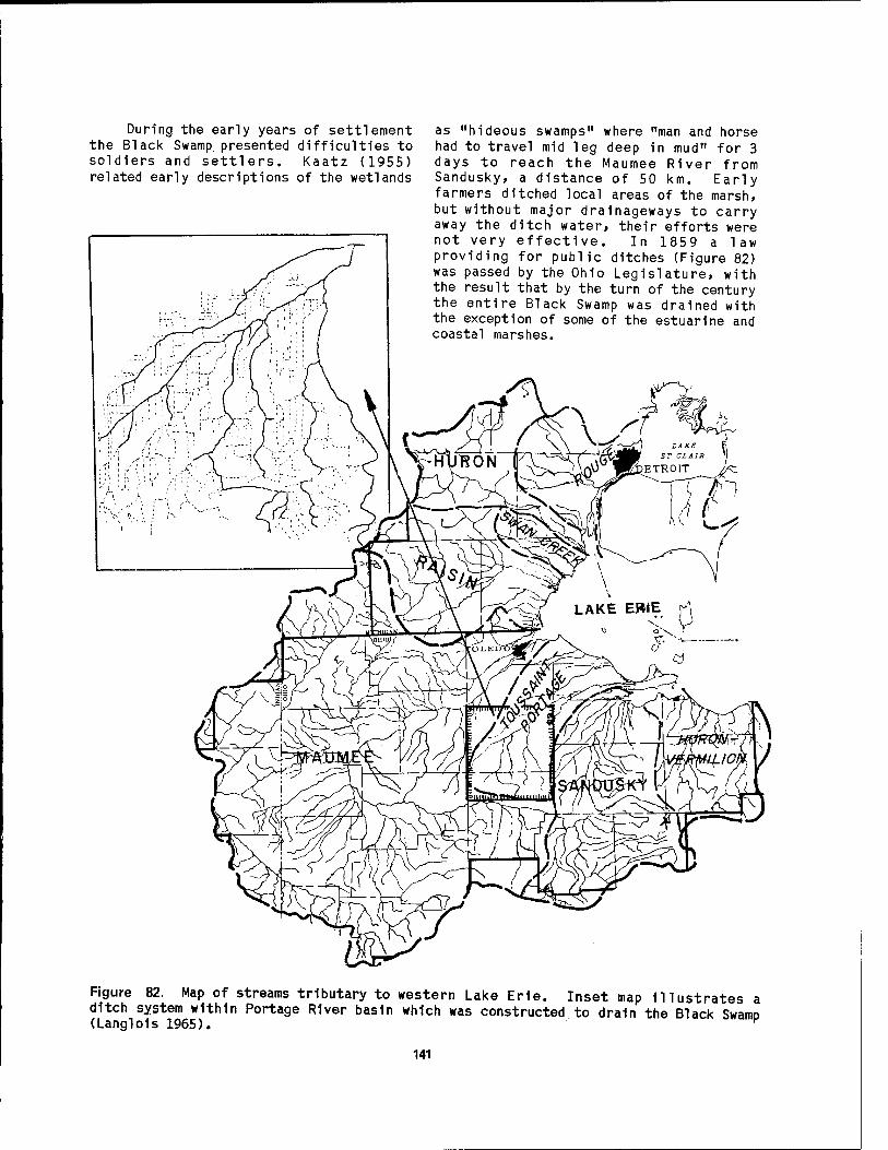
During the early years of settlement the Black Swamp, presented difficulties to soldiers and settlers. Kaatz (1955) related early descriptions of the wetlands
as "hideous swamps" where "man and horse had to travel mid leg deep in mud" for 3 days to reach the Maumee River from Sandusky, a distance of 50 km. Early farmers ditched local areas of the marsh, but without major drainageways to carry away the ditch water, their efforts were not very effective. In 1859 a law providing for public ditches (Figure 82) was passed by the Ohio Legislature, with the result that by the turn of the century the entire Black Swamp was drained with the exception of some of the estuarine and coastal marshes.
Figure 82. Map of streams tributary to western Lake Erie. Inset map Illustrates a ditch system within Portage River basin which was constructed to drain the Black SwaitiD (Langlols 1965). v
141

Recent wetland losses. In the past half century significant losses have occurred in coastal wetlands that remained after the initial draining of the lake plains. Most of this area, particularly south of the Detroit River mouth, is located in lagoons behind sand barriers. Table 29 presents the wetland losses that have taken place between 1916 and 1973 in Monroe and Wayne counties, Michigan. The Lake Erie water level for 1916 averaged 173.8 m, whereas the level in 1973 was 174.7 m. The losses have been attributed to continued drainage and fill, and to encroachment by Lake Erie as a result of record high water levels in 1973.
The development of the city of Monroe, Michigan, has had a particularly significant impact on the coastal wetlands. Only about 100 ha remain physically unaltered today in an area where 70 years ago the marshland were 10 times more extensive. Figure 83 depicts historical changes in land use in the vicinity of Monroe and the River Raisin Estuary. In 1915, agricultural activity
occupied the area west of the marsh. By 1975, development had taken place on the coastal barrier and had spread northward from the Raisin River, fragmenting and isolating smaller parcels of marsh. Identifiable causes of wetland alteration over the 60-year period include river channelization, private development, and public filling. At Sterling State Park the barrier was modified for recreational activities which are largely oriented toward Lake Erie, rather than toward the wetlands to the west. In addition to actual loss of wetland acreage, the quality of remaining wetlands has been seriously degraded (Jaworski and Raphael 1976).
This is a typical pattern for the loss of coastal wetlands throughout the western Lake Erie region. Development usually begins on the margins of the wetland and proceeds toward the center in an irregular fashion, often fragmenting the marsh into hydrologically isolated units.
Table 29. Coastal wetland losses and gains on the Michigan shore of western Lake Erie and the lower Detroit River.a
Wetland Area (1916) (ha)
Area (1967-73) (ha)
Net change
North Maumee Bay 564 328 -236 Toledo Beach Marsh 87 45 -42 Monroe/La Plalsance Bay 905 101 -804 Brest Bay/Stony Point 36 10 -26 Swan Creek 186 82 -104 Pointe MouHlee 340 257 -83 Rockwood Marsh 36 4 -32 Lower Detroit River and Marsh Creek 144 65 -79 Grosse lie 136 16 -120 Stony Island 26 28 +2 Celeron Island 38 20 -18
TOTAL 2,498 956 -1,542
aData source: Jaworski and Raphael (1978).
142

143

Water Level Fluctuations
High water. Perhaps the most dis- ruptive consequence of water level fluctuation in western Lake Erie» particularly high levels, is the destruction of the barrier beaches and exposure of the wetlands to wave erosion (Figure 84). During the high water period in 1952 and again in 1972-73 barrier beaches were breached in many locations. At the southwestern base of Little Cedar Point» northeast storms during the former period washed away the bar, allowing the lake to engulf a large section (1.5 km2) of marshland. This embayment, known as Potters Pond, has never been reclaimed. While such "wash- outs" remain devoid of submersed and floating-leaved communities, adjacent diked wetlands are colonized by emergent and submergent macrophytes.
Jaworski et al. (1981) investigated the impact of water level fluctuations at seven coastal wetlands on the Great Lakes. Two of these were located on Lake Erie: Woodtick Peninsula Marsh in Michigan and Tpussaint Marsh in Ohio. Tables 30 and 31 and Figures 85 and 86 show how the vegetation and configuration of these coastal marshes have changed through time in response to water level fluctuation and land use practices. The most noteworthy change that has occurred in the period of
Table 30. vegetation Michigan.3
Historical changes in wetland at Woodtick Peninsula Marsh,
Wetland typec
Psrcönt vegetation cover 1937 1964 1975
Open water 17 44 68 Floating/Submersed plants 8 3 0 Emergent plants 61 26 15 Meadow plants 10 3 1 Shrub-swamp 3 11 6 Developed/Agriculture 1 13 10
1ÖÖ TOO 1ÖÖ
a, Data source: Jaworski et al. (1981).
5Marsh area: 970 ha Water level data:
1937 (July 27) 173.96 m 1964 (May 27) 173.64 m 1975 (August 8) 174.47 m
Table 31. Historical changes 1n wetland vegetation at Toussalnt Marsh, 0h1o.a
Wetland typec
Percent vegetation cover 1950 1970 1977
Figure 84. Barrier beach at Magee Marsh being breached by waves during a northeast storm 1n November 1952 (Savoy 1956).
Open water 10 12 40 Floating/Submersed plants 0 3 20 Emergent plants 73 67 16 Meadow plants 3 0 5 Shrub-wooded 10 9 8 Developed/Agriculture 4 9 11
1ÖÖ Too Too
Data source: Jaworski et al. (1981),
3Marsh area: 715 ha Water level data:
1950 (October 6) 173.92 m 1970 (June 2) 174.10 m 1977 (June 10) 174.26 m
144

_<ßlJL- ,,,.,. S 197 5 Whiting
Bay Creek Station .
ra Bulrushes and Broad Leaved Emergents
E Cattails m Submersed and ^ Floating Vegetation El Sedge-Grassy Meadow
Shrubs
E2 Hardwood Trees
ig Agriculture and Developed
51 Managed Marsh
E3 Broad-Leaved Emergents Ü Sedge-Grassy Meadow E3 Young Emergents
E Cattails
H Vegetated Flats M Shrubs
EH Hardwood Trees
E3 Agriculture and Developed
Figure 85. Comparison of Woodtick Peninsula Marsh between 1937 and 1975, showing progressive loss of wetland vegetation (Jaworski et al. 1981).
time under consideration (1937-77) has been a dramatic increase in the percentage of open water and a corresponding decrease in the area covered by emergent plants. Most of this change is attributed to increased water levels.
The emergent plants in Magee Marsh are indicative of water level disturbances. Savoy (1956) reports that the low water level of 1900 (about 173.5 m above IGLD) was associated with cattails (60%)» bur reed (30%)» and bluejoint grass (10%) vegetation. In 1955, the water level was about 1 m higher and the swamp loosestrife (90%) was the dominant
emergent macrophyte» with cattails (5%) and bluegrass (5%) occupying small areas. Horsetail (Equisetum arvense) was also found locally along the marsh edge of the barrier beach. He attributed this "pronounced transformation" of the vegetative complex to the extreme changes in the water level of the marsh. Greater depths of water in the marsh during spring and summer are not favorable for the growth of cattail» one of the more desirable plants 1n controlled marshes. Loosestrife, however» shows a greater tolerance for extreme fluctuations than do most emergent marsh plants, and can encroach upon, and can almost entirely
145

1950
ED Mixed Emergents
E3 Cattails
E3 Sedge-Grassy Meadow
M Shrubs
H3 Hardwoods
□ Agriculture and Developed
NuclearPlant
0.5 1 Mi,
0 0.5 1 Km.
1977
Cattails
E3 Emergents (mixed;
0 Sedge-Grassy Meadow ' [^Developed or m Floating and Old Field
Submersed Shrubs
Dead Shrubs and Trees
s-iy^t.-'-'/% Limit of £&\s'T .'. Wetlands
y1 Rusha Creek
0 0.5 l Mi. 1 , ' i ' 0 0.5 1 Km.
Figure 86. Distribution of wetland vegetation in 1950 and 1977 at Toussaint Marsh, Ohio, showing an increase in the amount of open water in the marsh (Jaworski et al. 1981).
146

displace extensive stands of cattail. A plant community displacement model developed by Jaworski et al. (1981) for Lake St. Clair has been modified for use on Lake Erie to predict vegetation responses to changing water levels (Figure 87).
Water withdrawals. Water diversions for Lake Erie and the other Great Lakes have been proposed as a solution to critical water shortages in other regions of the United States. Manny (1984) investigated the potential impacts of such diversions on the fishery resources of the lakes. He pointed out that temporary water withdrawals by power plants currently operating in western Lake Erie entrain about 1 billion fish larvae per year—primarily gizzard shad» white bass, walleye, freshwater drum, and yellow perch. Patterson and Smith (1982) estimated that these losses equal about 10% of all young fish produced by these species each year in western Lake Erie. Manny concluded that permanent diversions would dewater wetlands which serve as spawning or nursery grounds for these and other fish species. He also observed that dewatered fish habitat would not be reestablished at the lower lake level for
the estuarine wetlands because of inlet elevation restrictions. The adverse effects on fish of additional water diversions from the Great Lakes would be greatest in Lake Erie, where water uses are already large enough to reduce the population of some economically important species.
Power-Generation Plants
Impingement and entrainment. Located on filled marshland at the mouth of the River Raisin, the Monroe Power Plant (3,150 MW) annually impinges 5 million fish (including 600,000 yellow perch), and entrains 20.7 million larval fish and 27.5 million fish eggs (Goodyear 1978). This plant also entrains 55.6 million macrozoobenthic organisms (77% chirono- mids) and 159,000 kg of Zooplankton. Because of the large demand for cooling water (92 m3/s), the entire flow of the River Raisin (average flow = 19 rr>3/s) is diverted through the plant most of the year. Although resident fish populations in the upper reaches of the river are little affected by the plant, those species that require access to both the estuary and to Lake Erie are denied a route of transit by the operation of this
FEET 575 -,
574 -
573 -
572 -
571 -
570-
569-
568-
Sedge Marsh
Shrub/Swamp
^ IETERS
L 175.0
- 174.5
* 174.0
- 173.5
-173.0
o
et >■ Ul _J
Q
1 1
Meadow _^
--
! i U-"" 1 I 1 Cattail
Mean Lake Level
Bulrush 1 Floating I Submersed
i
i
a 400 i i i
800
DISTANCE
1200 1600 1800 H
Figure 87. Aquatic macrophyte displacement model for western Lake Erie, showing community response to water level changes (modified from Jaworski et al. 1981).
147

plant. The combined impact of entrainment and impingement amounts to an annual loss of about 120»000 kg of yellow perch to the fishery. Other power generating plants of Grosse lie, Swan Creek, North Maumee Bay, Maumee River Estuary, and Locust Point are located in the proximity of coastal wetlands and have varying degrees of impact on the local fisheries. In addition to the Monroe plant, only those located in the vicinity of Maumee Bay have significant impingement and entrainment losses.
Tritium kinetics. The Davis-Besse Nuclear Power Station, constructed on the edge of Navarre Marsh, began operation in 1977. Tritium (3H) is produced in nuclear power reactors under normal operating conditions by several mechanisms. Tritium emits low-energy beta particles and has a physical half-life of 12.35 years. The estimated tritium release by the 872 MW David-Besse pressurized water reactor ranges from approximately 1,000 curies (Ci) per year (USAEC 1973) to 350 Ci per year (USNRC 1975) into Lake Erie. Retention of tritium in seven organisms from Navarre Marsh was studied by Adams (1973): two species of snails, crayfish, tadpoles, carp, bluegill, and mallard. After laboratory exposure for 48 hr in a tritiated water environment, the organisms studied were practically free of 3H following a period of 14 days in a tritium-free, enclosed environment within Navarre Marsh. After longer periods of exposure (1-2 weeks) the snail, Lvmnaea staanalis, and the mallard duck contained concentrations of bound 3H that were in excess of the marsh water.
all depths then decreased with time. Natural diffusion of tritiated water appears to adequately explain 3H movement into and from the sediment. Tritium levels in curly-leaf pondweed, pickerel weed, and smartweed generally tended to follow tritium levels in the marsh water. Unbound tritium uptake for crayfish, carp, and bluegill was rapid. Maximum levels were reached within 1 to 3 days of application. Bound tritium in these species took 7 to 20 days to reach a maximum level. Both unbound and bound tritium in all species decreased following maximum levels. White (1976) developed a simulation model of the tritium kinetics with the data from this investigation.
Additional research by Lehman (1973) in the Navarre Marsh enclosure showed that tritium can also be translocated in a freshwater marsh through food-web relationships. The highest average tritium concentrations were in the stem tissue of the emergent aquatic vegetation (111% of the water tritium level as compared to 23% for the submergent plant species). A high 3H level exhibited by several aquatic animals and bottom sediments in early autumn coincided with a loss of tritium of several species of aquatic plants. Lehman concluded that this translocation of 3H from aquatic vegetation to aquatic animals and sediment was a function of rapid uptake and assimilation of tritiated food in the aquatic food web and retention of tritium in the organic detritus in the bottom sediments.
Water Quality Degradation
Later experiments by Adams (1976) involved the tritium kinetics of Navarre Marsh. Ten Ci of tritium were introduced into a 2-ha enclosure in the marsh and the
H kinetics in the marsh water, bottom sediments, and selected aquatic plants and animals were determined. The tritium half-life in the water was 61 days, and only 3% of the initial tritium was present in the water after nearly 1 year. Following application, peak tritium levels in the sediment were observed on Day 13 for the top 1-cm layer, on Day 27 at the 5-cm depth, and on Day 64 at the 10-cm depth. No tritium movement below the 20- cm depth was observed. Concentration at
Turbidity. Suspended materials such as clay, silt, finely divided organic matter, wastes, bacteria, plankton and other microscopic organisms, and colloids are the main constituents in turbid waters. This material hampers the photosynthetlc process, reduces visi- bility, may hamper respiration, and settles to the lake bottom. Silt and clay are particularly damaging to gravel and rubble-type bottoms by filling interstices between gravel and stone, thereby damaging fish spawning habitats and the habitats of aquatic insects and other invertebrates, such as mollusks and crustaceans (Pinsak and Meyer 1976).
148
Turbidity throughout Maumee Bay and many of the estuarine and coastal marshes is high. The suspended solids load of the Maumee River averages about 1,200*000 tons/year. Part of this is deposited in the bay. Low settling rates (approx- imately 40 hr for 90% settling), characteristically low transparency, and high suspended sediment concentration in the estuary waters reflect the finely particulated character and low density of the suspended river sediments (Pinsak and Meyer 1976). The average concentration of suspended solids in Maumee Bay is 37 mg/1, but nearshore levels are generally over 50 mg/1.
Nutrient enrichment. Phosphorus, an important plant nutrient, goes through cycles of photosynthesis and decom- position. It is considered to be the nutrient that is most feasible to control for the purposes of limiting plant growth. High phophorus concentrations in combina- tion with other nutrients and favorable growth conditions are conducive to eutrophication, the most objectionable effect of this element. Stimulated algal growth and consequent die off can create objectionable odors in public water supplies and oxygen depletion problems in enclosed basins and wetlands. The major sources of phosphorus are atmospheric deposition, leaching of soil and rock, erosion, agricultural runoff, decom- position of plants and animals, chemical manufacturing, industrial and domestic sewage effluents, and detergents.
The Maumee River is the source of the highest phosphorus concentrations entering western Lake Erie (Herdendorf 1983), averaging about 180 mg/1 at the entrance to Maumee Bay (Figure 42). Although low in concentration when compared to the Maumee River, the Detroit River in 1980 contributed about 37% of the total load of phosphorus to Lake Erie, whereas the Maumee River accounted for 12% of the total load.
Nitrogen and silica are also important nutrients that generally occur in excess concentrations in western Lake Erie. Loadings from the drainage basins surrounding the lake are high. There is a direct relation between concentrations in nearshore waters of the lake and seasonal
variations in runoff, indicating the significance of diffuse sources. Although phosphorus levels in nearshore waters are showing a decreasing trend over the past decade, nitrogen is continuing to increase (Herdendorf 1983).
The estuaries and coastal marshes of western Lake Erie serve as sinks for many types of pollutants. Maumee Bay exhibits elevated numbers of tubificid worms (Figure 88), an indication of high organic pollution (Goodnight and Whitley 1960). Measurements in Old Woman Creek Marsh and Sandusky Bay by Krieger (1984) suggest that wetland plants incorporate some of the biologically available forms of phosphorus and nitrogen (entering from tributaries) which are more refractile to utilization by limnetic algae in the lake. As a result, enhanced plant growth may occur in the protected estuaries. Springer (1971) reports that the River Canard is an important source of nitrates, phosphates, and other nutrients as well as organic pollution for western Lake Erie. High nutrient levels must be due primarily to agricultural and natural drainage, as well as septic tank leakage, because industry wastes are not present in the drainage system and no major municipalities discharge into the river. Based on the high biological productivity, the classification of the estuarine portion of the river is eutrophic.
Toxic .substances. The transport and fate of pesticides in the largely agricultural watersheds surrounding west- ern Lake Erie is a matter of Increasing concern. A substantial increase in the Implementation of conservation tillage practices, is expected to reduce sediment and total phosphorus yields to the lake, but on the other hand such tillage methods (particularly no-tillage) require an increased application of pesticides. Many of the herbicides are water soluble, and their residues in streams may increase with conservation tillage (Logan 1981). The forecasted increase in pesticide application in the basin until the end of the century 1s approximately 2% per year for herbicides and 4% per year for insecticides. Baker et al. (1981) has shown that pesticide concentrations are highest in the Lake Erie tributaries during storm runoff events, particularly
149
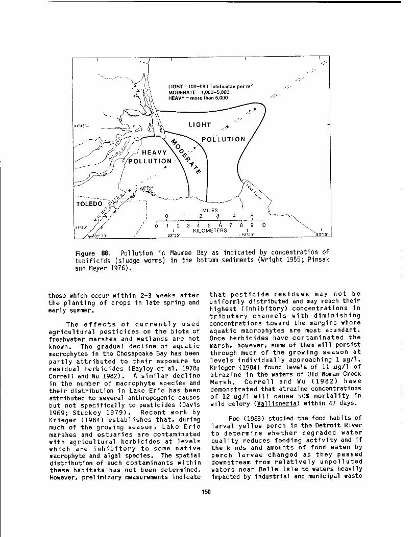
Figure 88. Pollution in Maumee Bay as indicated by concentration of tubificids (sludge worms) in the bottom sediments (Wright 1955; Pinsak and Meyer 1976).
those which occur within 2-3 weeks after the planting of crops in late spring and early summer.
The effects of currently used agricultural pesticides.on the biota of freshwater marshes and wetlands are not known. The gradual decline of aquatic macrophytes in the Chesapeake Bay has been partly attributed to their exposure to residual herbicides (Bayley et al. 1978; Correll and Wu 1982). A similar decline in the number of macrophyte species and their distribution in Lake Erie has been attributed to several anthropogenic causes but not specifically to pesticides (Davis 1969; Stuckey 1979). Recent work by Krieger (1984) establishes that, during much of the growing season, Lake Erie marshes and estuaries are contaminated with agricultural herbicides at levels which are inhibitory to some native macrophyte and algal species. The spatial distribution of such contaminants within these habitats has not been determined. However, preliminary measurements indicate
that pesticide residues may not be uniformly distributed and may reach their highest (inhibitory) concentrations in tributary channels with diminishing concentrations toward the margins where aquatic macrophytes are most abundant. Once herbicides have contaminated the marsh, however, some of them will persist through much of the growing season at levels individually approaching lug/1. Krieger (1984) found levels of 11 jug/1 of atrazine in the waters of Old Woman Creek Marsh. Correll and Wu (1982) have demonstrated that atrazine concentrations of 12 jug/1 will cause 50% mortality in wild celery (Vallisneria) within 47 days.
Poe (1983) studied the food habits of larval yellow perch in the Detroit River to determine whether degraded water quality reduces feeding activity and if the kinds and amounts of food eaten by perch larvae changed as they passed downstream from relatively unpolluted waters near Belle Isle to waters heavily impacted by industrial and municipal waste
150

discharges near Grosse lie. Larvae from the upper and lower portions of the river had similar dietsf mainly copepods and rotifers, but the incidence and rate of feeding of larvae collected near Grosse He was markedly reduced when compared to feeding behavior near Belle Isle.
Ice
Typically, each winter ice completely covers the western basin of Lake Erie and its coastal marshes and estuaries with the possible exception of the Detroit River mouth (Figure 89). When the ice is frozen fast to the shoreline it can provide protection for the barrier beaches and marsh substrate from wave attack. However, as the ice begins to break up in the spring or during temporary thaws, it can be destructive to wetland habitat. Langlois and Langlois (1984) observed large sections of ice broken from sheet ice that had been driven by the wind up onto the low shoreline of Middle Bass Island and had uprooted aquatic plants from the bed of Fishery Bay on South Bass Island during February 1946. This phenomenon is probably not a widespread disturbance in Lake Erie coastal marshes, but is likely to be of local importance from time to time.
Another problem associated with ice cover in marshes is winter fishkill. This often occurs when snow cover is sufficient to limit light penetration through ice below the compensation point for the submersed aquatic plants. Under these conditions, continued respiration eventually consumes the available oxygen, resulting in fish mortality. Winter fishkills have been reported for Magee Marsh (Bednarik 1956), but the extent of this problem in other marshes is unknown.
Fish and Wildlife Disturbances
Fishery, Since the advent of European colonization approximately 200 years ago, fish communities and habitats in Lake Erie have been radically changed by a series of largely cultural stresses. The original wetlands complex contained a fish community dominated by species which required water free of suspended sediment and a habitat rich in aquatic vegetation (Trautman 1981). At least 40 species of
Lake Erie fishes are dependent on or occur in coastal wetlands for at least some
Normal Winter Early Ice Cover
(January 15-25)
Normal Winter Mid-Season Ice Cover
(February 1-10)
Normal Winter Maximum Ice Cover
(February 20-28)
Normal Winter Early Decay Period
(February 25-March 5)
Mild Winter Maximum Ice Cover Severe Winter
Maximum Ice Cover
0 25 50 KM
OPEN WATER
CONSOLIDATED PACK (1.0 Coverage)
CLOSE PACK (.7 to .9 Coverage)
Figure 89. Ice cover in western Lake Erie under various conditions. Earliest opening and closing dates for Toledo Harbor, 7 March and 8 December; latest dates, 4 April and 21 December (Plnsak and Meyer 1976).
151

portion of their life history (Van Meter and Trautman 1970). Habitat loss has been considered the underlying cause for the historical and continuing decline of many fish species dependent on wetland habitat.
Most typical of these fish are the large esodds. Northern pike (Esox ludus) and the Great Lakes muskellunge (£. masquinonav) were once abundant and commercially important 1n coastal marshes of western Lake Erie (Trautman 1977, 1981). Both species migrate from the lake into the estuaries and coastal marshes shortly before or after ice breakup, spawning among submersed aquatic plants. After spawning, the adults, and later the young, move downstream into the lake. Dams began to be built along the lake tributaries in rapidly increasing numbers after 1800. The erection of a dam often prevented fishes from migrating upstream to prevent spawning. Some headwaters not dammed were ditched and drained, a practice which also destroyed considerable spawning habitat for these species. The diking and impounding of many marshes prevented the spawners from entering those habitats. By 1970 both fish were quite rare throughout Lake Erie; muskellunge has now been placed on the Ohio endangered species list.
Carp» a species introduced into the lake in 1880, is a troublesome fish in many western Lake Erie wetlands. They enter controlled marshes from the lake through weirs and screens and remain in the marsh throughout the year unless temporarily eradicated by poisoning or drawdown. Carp begin spawning in the marshes in late April and continue until early June. They retard the growth of aquatic vegetation in the marsh by consuming it and by roiling the water so that increased turbidity reduces photosynthetic efficiency (Hunt and Mickelson 1976). Stomach analyses of carp from Erie Marsh Indicated that they primarily consumed aquatic plants (King and Hunt 1967).
Poisoning with toxaphene and rotenone has been practiced in this marsh since 1953 for the eradication of carp and has been largely successful in removing most carp from the treated areas, but reproduction by remaining carp and
Invasion by Lake Erie carp through weirs has resulted 1n reestablIshment of this fish 1n the marsh. Beneficial results of carp removal Include Increased water clarity and plant growth. King and Hunt (1967) found that stonewort (Chara spp.) growth increased by 3,000%. Dissolved oxygen in the marsh water also rose an average 0.6 mg/1. Adverse effects of poisoning included some destruction of aquatic Invertebrates and possibly several waterbirds and water snakes (Natrix sp.). The use of toxaphene is no longer permitted by the Michigan Department of Natural Resources. The currently recommended program for carp control in Michigan coastal marshes involves continued use of rotenone to keep carp populations low and installation of small mesh screens on all culverts and weirs (Hunt and Mickelson 1976).
Waterfowl. Environmental changes have also taken place in western Lake Erie, and particularly in Maumee Bay, which have had an effect on waterfowl populations. Earlier, abundant aquatic vegetation attracted canvasback and redhead ducks. Factors that have combined to eliminate this vegetation are the suspended sediment load from the Maumee River, the dredging of the ship channel, and the introduction of carp (Pinsak and Meyer 1976). The birds dependent on aquatic vegetation for food have declined. The construction of large electric generating plants on the Maumee River Estuary has resulted in the release of large quantities of heated water which keeps local areas from freezing in the winter. This factor attracts waterfowl, wading birds, and gulls which congregate near the thermal outfalls in winter. The fish, which are either killed or trapped by thermal barriers, are eaten by the resident gull and heron populations (Campbell 1968). The establishment of State and Federal wildlife refuges and various private waterfowl marshes have helped maintain the present waterfowl populations. These refuges constitute an important element In local waterfowl conservation by providing important nesting and feeding areas for local waterfowl and by affording resting places for migrating birds.
152
5.2 WETLAND OWNERSHIP AND MANAGEMENT
The present system of coastal marshes around the western end of Lake Erie has a total area of approximately 280 km . Most of the marshes are highly managed, protected areas used as wildlife refuges, nature preserves, public fishing and hunting areas, and private hunting clubs. The majority are owned and managed by the U. S. Fish and Wildlife Service, Michigan Department of Natural Resources, Ohio Department of Natural Resources (ODNR), Parks Canada, Ontario Ministry of Natural Resources, and the Winous Point, Ottawa, and Erie Shooting Clubs.
The managed marshes provide excellent habitats for a great variety of wildlife, although their principal function is the attraction and production of waterfowl and furbearers. Ironically, these attractive and productive areas are presently of little value as spawning and nursery areas for economically important Lake Erie fish populations. The historical importance of Lake Erie's wetlands in supporting fish populations 1n the open lake, has long been recognized. At least 40 species of fish, 25 of which are significant game or commercial species, are dependent to some degree on the lake's wetlands as spawning and nursery areas. Notable among these are northern pike, muskellunge, carp, bullheads, sunfishes, crapples, and largemouth bass. Species such as gizzard shad, emerald shiner, spottall shiner, channel catfish, white bass, yellow perch, and freshwater drum seem to make opportunistic use of wetlands, but their degree of dependence is not known.
As described earlier in this report, as recently as 150 years ago the western end of Lake Erie was surrounded by an extensive marsh and swamp-forest system known as the Black Swamp. Settlement of the area proceeded at a rapid pace after the War of 1812. Between 1850 and 1920 most of the wetlands were drained and filled to provide agricultural land and sites for urban and commercial development. To some extent engendered by this development, some adverse environmental conditions—especially agricultural siltation, wave erosion, and water-level fluctuations—contributed to
wetland losses during this period. At the same time, the reputation of Lake Erie's wetlands as quality waterfowl hunting areas was spreading.
About 1920, groups of wealthy sportsmen and State and Federal agencies, alarmed at the rate of wetland loss, purchased most of the remaining wetland areas. These areas were enclosed by dikes to protect them from wave erosion, siltation, and water level fluctuation. Gates, Dumps, and flumes of various types were Installed to control water levels within the marshes. This made 1t possible to produce the right types and amounts of aquatic vegetation used by wildlife, thus enhancing the quality of the marshes as waterfowl and furbearer habitats. The result was the present system of controlled, managed marshes. Without controls, siltation and erosion would quickly eliminate most of the marshes.
Wfit1anfi Ownership
Appendix B lists 70 of the more prominent coastal marshes bordering western Lake Erie (Figure 3) and indicates their primary ownership. Most of the natural lagoon wetlands remaining along the coast are small and in private ownership with a few noteworthy exceptions. Sheldon Marsh which lies at the extreme eastern end of Sandusky Bay is protected from wave attack by Cedar Point spit. This marsh, owned by ODNR, Division of Natural Areas and Preserves, is reserved for scientific research and habitat preservation. Two other large, publicly owned lagoon marshes include Middle Harbor Marsh, part of East Harbor State Park, and Point Pelee Marsh within Point Pelee National Park.
The large, diked wetlands are primarily owned by three entities: 1) Federal agencies, 2) State agencies, and 3) private shooting clubs. Most of these wetlands are managed for waterfowl habitat. A few, like the diked areas used for disposal of harbor dredgings, support wetland vegetation as a secondary benefit. Examples of government-controlled diked- wetlands primarily set aside for waterfowl habitat, propagation, and hunting are Ottawa National Wildlife Refuge, Magee Marsh and Metzger Marsh Wildlife areas
153

(Ohio); Erie Marsh and Pointe Mouillee Marsh Wildlife areas (Michigan); and B1g Creek Marsh (Ontario). Winous Point Marsh and Moxley Marsh are two of the large, privately owned wetlands on Sandusky Bay which are protected by earthen and r1p-rap dikes, and which have pumping systems to control water levels within the marshes.
The estuarlne wetlands adjoining western Lake Erie have a mixed ownership including private, municipal, State, provincial, and Federal bodies. They vary from small marshes along the upper reaches of the estuaries to extensive wetlands near the mouth. Plat maps reveal that more individual parcels of land are estuaries than the other two types of wetlands. Within the next several decades, estuaries are likely to experience the greatest development pressure as waterfront property becomes scarce. Examples of publicly owned estuarine wetlands In.clude: Old Woman Creek Marsh (Ohio), Huron River Marsh (Michigan), and B1g Creek Marsh (Ontario).
Approximately 5,000 private water- fowling clubs control at least 10,000 km^ of waterfowl habitat in the Mississippi Flyway (Barclay and Bednarik 1968). In addition to providing hunting opportunities, these private clubs contribute materially to the waterfowl management efforts 1n the flyways by: 1) preserving valuable habitat, 2) Increasing utility of habitat through water level and vegetation management, 3) encouraging pro- duction of waterfowl, 4) aiding waterfowl distribution, and 5) investing substantial funds to maintain the quality of outdoor recreation. These clubs complement and supplement State and Federal programs aimed at preserving waterfowl habitat. Such investments would be difficult to match under public ownership.
Waterfowl hunting pressure 1n the Canadian Lake Erie and Lake St. Clair marshes 1s light. Springer (1971) explained this light pressure as a consequence of "severe" hunting restrictions on private marshes which make up 85% of the marshes along these lakes. The highest waterfowl capability areas 1n the Canadian portion of western Lake Erie occur in the marshy estuaries of the
Canard River and Big Creek. Private and provincial hunting areas are located in these marshes.
Wetland Management
At the time of Its discovery and early settlement, the North American con- tinent had an Immense waterfowl pop- ulation. Experts agree that no other area on the earth's surface ever supported such a vast number of so many different ducks and geese (Mississippi Flyway Council 1958). This is a legacy of the glacial ice sheets which left much of the northern United States and virtually all of eastern and central Canada dotted with lakes, coastal marshes, and prairie wetlands— ideal waterfowl habitat. The last glacier receded from the Great Lakes region about 10,000 years ago and from the breeding grounds in northwestern Canada only 6,000- 8,000 years ago. Therefore, about 5,000 years ago the climate of North America stabilized at conditions similar to those we have today--a climate that favors waterfowl breeding 1n the high latitudes and wintering in the middle to low latitudes. This circumstance set 1n motion the requirements for spring and fall migration along the flyways and migration corridors.
Long after the Initial settlement of the Great Lakes region, waterfowl hunting was free and harvest unlimited. But, as the advancing tide of homesteaders reached the north-central prairie states and provinces in the late 1800s, radical land use changes began. From that time on North American waterfowl habitat deteriorated. In the North, literally millions of acres of former nesting grounds were drained and put to the plow. In the South, not only agriculture, but also urbanization and Industrialization, continued to reduce available resting and wintering grounds.
The progressive decline in waterfowl numbers which followed these changes in land use eventually led to actions designed to save and enhance the remaining waterfowl populations. Spring hunting and commercial hunting were abolished in the 1920s. In the 1930s, the Federal government undertook regulation of migratory waterfowl, attempting to
154

proportion the annual harvest to annual production. This has been accomplished through a collective effort by State, provincial, and Federal agencies of the United States, Canada, and Mexico to obtain waterfowl data- and to standardize restrictions on shooting seasons and hours, bag limits, and prohibitions of certain kinds of baiting and live decoys. (Mississippi Flyway Council 1958).
Waterfowl and furbearers. Migratory waterfowl management is essentially based on controling plant succession to meet the seasonal needs of waterfowl. Intensive and economical management is best achieved by control of water levels, since fluctuation of water levels has a marked influence on the succession of aquatic plants (Kadlec 1962). Marsh managers in Ohio obtain the best results from drawdowns (by use of dikes and/or pumps) in May to create a nesting habitat for the summer (Figure 90), and reflooding in the fall to attract large numbers of fall migrants (Meeksl969). Partial reduction of water levels (rather than complete drying of the soil) exposes knolls used
for nesting and leads to an interspersion of suitable submerged, emergent and shoreline vegetation (Figure 91). Experimental tests show that where only partial drawdown was done, dense growths of smartweed (a good waterfowl food) developed along the dike and'other exposed areas while dense stands of emergents such as bulrush, water-milfoil, and spikerush developed on flooded areas. In tests where the water was not drawn down, less desirable water lilies and arrowhead covered most of the formerly open water areas. Meeks (1969) found that draining during mid- to late May allows muskrats to raise two litters without Interruption, and does not Interfere with duck nesting. No redraining of the marshes was done after the water was Initially removed; therefore, due to rain, some water was often present well into the growing season. The normal practice 1s to reflood the marshes 1n September.
In the Lake Erie region, the Mississippi Flyway Council serves as the "clearing house" for coordinated planning of the flyway. The council 1s a delegate
Figure 90. Winous Point Marsh during drawdown stage; emergent beds of American water-lotus (Nelumbo lutea) in foreground (July 1984).
155

Figure 91. Interior region of Winous Point Marsh, a controlled wet- land on the north shore of Sandusky Bay (July 1984).
organization, including in its membership administrative and technical repre- sentatives from the fish and game departments of all states and provinces in the flyway, a flyway coordinator assigned from the U. S. Fish and Wildlife Service, and members from other public agencies concerned with waterfowl research or management. The council facilitates the effective interchange of information between member agencies, assists 1n the coordination and integration of management programs, and encourages management research.
In recent decades most waterfowl populations have made encouraging recoveries from the low point of the early 1930s, when dlsasterous droughts in addition to drainage and changing land-use patterns, took their toll. Today, continental waterfowl populations have regained a measure of balance with the habitat which now remains for their use, and hunting regulations have been relaxed somewhat. Yet drainage continues, Indus- trialization further reduces habitat, and the number of waterfowl hunters continues to grow, emphasizing the need for continued sound management practices.
Fish. The dikes and management prac- tices essential to maintaining good, productive marshes are also generally believed to prevent fish from entering and using the marshes as spawning and nursery
areas (Johnson 1984). Drastic declines over the last 50-60 years 1n the abundance of marsh-dependent fish populations have been attributed 1n large part to the wholesale draining and filling of marshes before 1920 and subsequently to diking, which prevented fish from entering the remaining marshes. Dikes are constructed of a solid clay base, covered with rip- rap, and are placed such that water can enter or leave the marshes only through specially constructed channels. Screens are placed over flumes and gates to exclude carp (Figure 92). These screens also keep desirable fishes from entering and leaving the marshes.
Two aspects of controlled marsh management are problematic with respect to management of these marshes for fisheries. First, water leveis 1n these marshes must be maintained at] levels optimal for production of aquatic plants used by waterfowl and for control of dike erosion. During high lake water levels of high watershed runoff periods, particularly during spring, gates must be opened or pumps run to remove excess water and minimize dike erosion and silt deposition. During low lake water levels, such as occur during late summer and fall, pumps must be used to Introduce lake water 1n order to maintain minimum water levels for aquatic plant production, or gates may be opened to take advantage of high seiches and to admit water to the marshes, thus
156

LHnnu! pit Mater, leV+
el uCOntro1 structure between Sandusky Bay and Winous Point Marsh; note bar screen at left side to exclude carp (July
avoiding pump operating costs. The timing of these operations is generally dictated by climate and weather conditions, and marsh managers are often unable to provide access or egress to fishes which might otherwise use the marshes as spawning and nursery areas. Low water levels maintained during the summer are also conducive to dissolved oxygen depletion and summer fishkill. Second, marsh managers are compelled to exclude carp from controlled marshes, because this species readily overpopulates marshes, consumes desirable aquatic vegetation, and roils the water, thereby increasing turbidity and decreasing production of aquatic plants. Marsh managers are very reluctant to open gates unnecessarily during late spring and early summer, when carp spawning runs occur, even if desirable species are thereby excluded. Certain »marshes" are kept dewatered during spring and summer for the production of cash crops, such as soybeans and corn, then flooded for waterfowl attraction in the fall.
Regulatory and management agencies concerned with protecting Lake Erie fish populations generally oppose construction of dikes around shallow, estuarine bottomland areas because they supposedly keep fish from reaching spawning and
nursery areas. This is a justifiably cautious approach to protecting an important resource. However, without dikes these bottomland areas are little more than flooded mud flats with little aquatic vegetation. The importance of these flooded mud flats as fish spawning areas is not known but is currently being studied (Snyder and Johnson 1984). Many coastal landowners would like to establish controlled marshes in such areas. This may be desirable from the standpoint of creating economically valuable waterfowl and furbearer habitats where only "marginal" habitats presently exist.
5.3 PROSPECTS FOR THE FUTURE
The coastal wetlands of western Lake Erie have experienced progressive loss in area and quality for more than 100 years. As a result of natural processes and European settlement. Trautman (1977, 1981) has carefully documented the environmental degradation of the marshes that fringe the low shores of the lake. But more than presenting an account of despair, he gives a clear picture of the former magnificence of these wildlife habitats. This understanding is extremely important in designing any restoration, or for that matter any comprehensive management plan.
157
Within the last SO years the marshes have also experienced extreme f1 .actuations in water levels. From litre record How levels of the mid-1930s to the record high levels of the early 1950s, early 1970s, and mid-1980s, the coastal marshes have been in a constant state of flux. Such dramatic changes in the position of the marshes did not fit well into the development scheme imposed by settlement of the region. Therefore, as Lake Erie began to encroach, or more precisely reclaim former wetlands, it was resisted with massive structures, rather than allowed to re-establish new marshes further inland.
As a consequence, most of the marshes along the Ohio and Michigan shores, and some on the Ontario shore, exist only behind substantial dikes.; This is the price that must be paid to maintain a stable shoreline under varying water level conditions and still retain a semblance of coastal marshes. Fortunately, most of the large marshes are under ownership of public agencies and private hunting clubs that are committed to long-term preservation of a marsh ecosystem, albeit managed to enhance certain aspects of the ecosystem.
In the midst of the controlled wetlands are two excellent examples of a management strategy of letting nature take its course. Directly across the lake from one another, Old Woman Creek National Estuarine Research Reserve and Point Pelee National Park have adopted such a plan. These marshlands are not managed for any specific component of the environment and they are not artificialy protected from any natural environmental process. These marshes are natural laboratories for the study of coastal and wetland processes.
Although State and Federal regulatory and management agencies oppose the
construction of new controlled marshes, «st of the suitable, high quality marshlands remaining around Lake Erie are diked marshes. Water levels in these marshes are regulated; therefore, these marshes may not be accessible to spawning fish because of control structures. Conversely, uncontrolled marshes are easily accessible by spawning fish, but they are subject to storm surge, seiche activity, and high turbidity. In addition to erosion and siltation, these submerged bottomlands lack the desirable water quality and aquatic vegetation needed for spawning by sensitive species. Thus, a major problem facing effective conservation and management of Lake Erie fish stocks is the lack of information on controlled and uncontrolled use of wetlands by the Lake Erie fish community. Research comparing fish use of controlled marshes and shallow, uncontrolled estuarine bottomlands may help resolve this resource conflict. If the uncontrolled bottomlands are found to be of limited value as spawning and nursery areas, then perhaps their development into controlled marshes need not be discour- aged. Conversely, if controlled marshes are in fact found to be of limited value as spawning and nursery areas, new management practices to improve them as such, without significantly interfering with their principal role as waterfowl and furbearer habitats, need to be developed.
As development pressures continue to eat away at the smaller private marshes, a new strategy is evolving within the regulatory agencies. Rather than accept a piecemeal, fragmentation of marshes, agencies are negotiating various types of loss mitigation. These include not only the enhancement of existing low-quality marshes, but the establishment of both upland and deep-water marshes as replacement for lost habitat. This is an encouraging approach that will likely be expanded in the future.
158

REFERENCES
Adams» L.W. 1973. Retention of tritium- fn fresh-water »arsh organisms. M.S.. Tfoesfs» Ohio State Uinfv/ers1ty, Columbus. 74 pp.
Adams, L.W. 1976. Tritium fcinetics In a freshwater marsh ecosystem. Ph.D. D1ss., Onto State university, Columbus. 125 pp.
Ahlstrom, E.H. 1934. A quantitative study of rotator 1a in Terwi)tiger's Pond, Put-in-Bay, Ohio. Ohio Biol. Surv. Bull. 30. 36 pp.
Allen, H.L. 1971. Primary productivity, chemo-organotrophy and nutritional Interactions of epiphytic algae and bacteria on macrophytes 1n the littoral of a lake. Ecol. Monogr. 41(2):97-127.
Allen, R.T. 1970. The Great Lakes. Natural Sei. Canada Ltd., Toronto. 160 pp.
American Ornithlog1sts» Union. 1983. Check-list of North American birds, 6th ed. Allen Press, Inc., Lawrence, Kans. 877 pp.
Andrews, R. 1952. A study of waterfowl nesting on a Lake Erie marsh. M.S. Thesis, Ohio State University, Columbus. 85 pp.
Bailey, T.N. 1971. Biology of striped skunks on a southwest Lake Erie Marsh. Am. Midi. Nat. 85(1):196-207.
Baker, D.B., K.A. Krieger, and J.V. Setzler. 1981. The concentrations and transport of pesticides in northwestern Ohio rivers—1981. U.S. Army Corps Eng., Buffalo, Tech. Rep. Seri. 33 pp.
Barclayv JI.,» andi K..E. Etedin.art;fe. 1968. Private waterfowl stteetiiwj clubs 1n the MissfssüppT FTjpaäf.. Trans. N. Am. WildiK (flat.. Resoury Con*. 33tl3Q-142.
Barnes, M.D, 19J79. Inventory and review of literature data sources pertaining to Ichthyologlcal and fisheries research In the nearshore zone of Lake Erie. Ohio State Univ.* Columbus, Cent. Lake Erie Area Res. Tech. Rep. 127. 82 pp.
Bartolotta, R.J. 1978. Vascular flora and the success 1 on of plant commun 111 es of the earthen dikes bordering Sandusky Bay and western Lake Erie. M.S. Thesis, Ohio State University, Columbus. 139 pp.
Bartonek, J.C., and J.J. Hickey. 1969. Selective feeding by juvenile diving ducks 1n summer. Auk 86(3):443-457.
Bates, R.L., and J.A. Jackson, eds. 1980. Glossary of geology, 2nd ed. Am. Geol. Inst., Falls Church, Va. 749 pp.
Bayley, S., V.D. Stotts, P.F. Springer, and J. Steenls. 1978. Changes 1n submerged aquatic macrophyte pop- ulations at the head of Chesapeake Bay, 1958-1975. Estuaries 1:73-84.
Beard, E.B. 1953. The importance of beaver in waterfowl management at the Seney National Wildlife Refuge. J. Wildl. Manage. 17(4):398-436.
Beaver, W.C. 1942. Bacterial activities in the subaquatic soils of Lake Erie. Ohio J. Sei. 42(3):91-98.
Bednarik, K.E. 1956. The muskrat in Ohio Lake Erie marshes. Ohio Dep. Nat. Resour., Ohio D1v. Wild!. 67 pp.
159

Bednarik, K.E. 1975. Environmental impact assessment report» Magee Marsh Wildlife Area dike construction. Ohio Dep. Nat. Resour., Crane Creek Wildlife Exp. Sta., Oak Harbor. 13 pp.
Bellrose, F.C. 1968. Waterfowl migration corridors east of the Rocky Mountains in the United States. 111. Nat. Hist. Surv. Biol. Notes No. 61. 24 pp.
Bellrose, F.C. 1976. Ducks, geese, and swans of North America, 2nd ed. Stackpole Books, Harrisburg, Pa. 544 pp.
Bowman, R.S. 1951. Sedimentary processes along the southern shore of Sandusky Bay, vicinity of Willow Point. Ohio Dep. Nat. Resour., Div. Shore Erosion Tech. Rep. 2. 28 pp.
Brant, P.A., and C.E. Herdendorf. 1972. Delineation cf Great Lakes estuaries. Pages 710-718 in Proceedings 15th Conf. Great Lakes Res., Int. Assoc. Great Lakes Res., Ann Arbor, Mich.
Bray, J.R. 1962. Estimates of energy budgets for a Tvpha (cattail) marsh. Science 136:1119-1120.
Brinkhurst, R.O. 1974. The benthos of lakes. St. Martin's Press, New York. 190 pp.
Brinkhurst, R.O., and B.G. Jamieson. 1972. Aquatic oligochaetes of the world. University of Toronto Press, Toronto, Canada. 860 pp.
Burr, H.G. 1901. Plant study at Sandusky Bay. Ohio Nat. 1:93-94.
Burt, W.H. 1957. Mammals of the Great Lakes region. University of Michigan Press, Ann Arbor. 246 pp.
Busch, W.N., R.L. Scholl, and W.L. Hartman. 1975. Environmental factors affecting the strength of walleye year classes in western Lake Erie, 1960-1970. J. Fish Res. Board Can. 32:1733-1743.
Campbell, L.W. 1968. Birds of the Toledo area. The Blade, Toledo, Ohio. 330 pp.
Campbell, L.W. 1982. The Lake Erie marshes in Ohio between Toledo and Port Clinton. Toledo Edison Co., Toledo, Ohio. 234 pp.
Campbell, L.W., and M.B. Trautman. 1936. The status of Forster's tern in the western Lake Erie region of Ohio and Michigan. Auk 52(25:213-214.
Carman, J.E. 1946. The geological interpretation of scenic features in Ohio. Ohio J. Sei. 46(55:241-283.
Carr, J.F., and J.K. HUtunen. 1965. Changes in the bottom fauna of western Lake Erie from 1930 to 1961. Limnol. Oceanogr. 10(45:551-569.
Carr, J.F., V.C. Applegate, and M. Keller. 1965. A recent occurrence of thermal stratification and low dissolved oxygen in western Lake Erie. Ohio J. Sei. 65:319-327.
Britt, N.W., J.T. Addis, and R. Engel. 1973. Limnological studies of the island area of western Lake Erie. Ohio Biol. Surv. Bull. 4(35:1-89.
Brock, T.D. 1970. Photosynthesis by algal epiphytes of Utricularia in Ever- glades National Park. Bull. Mar. Sei. 20:952-956.
Brown, E.H., and CF. Clark. 1965. Length- weight relationship of northern pike, Esox lucius, from East Harbor, Ohio. Trans. Am. Fish. Soc. 94:404-405.
Chandler, D.C. 1940. Limnological studies of western Lake Erie, I: plankton and certain physical-chemical data of the Bass Island region, from September, 1938 to November, 1939. Ohio J. Sc1. 40:291-336.
Chandler, D.C. 1942. Limnological studies of western Lake Erie. II: Light penetration and its relation to turbidity. Ecology 23(15:41-52.
Churchill, E.P. Jr., and S.I. Lewis. 1924. Food and feeding In fresh-water mussels. Bull. U.S. Bur. Fish. 31:439-471.
160
Clark, C.F. 1950. Observations on the spawning habits of northern pike, Esox "lucius, in northwestern Ohio. Copeia 1950(4):285-288.
Clarke, A.H. 1981. The freshwater molluscs of Canada. National Museums of Canada, Ottawa. 446 pp.
Clemens, H.P. 1950. Life cycle and ecology of Gammarus fasciatus Say. Ohio State Univ., Put-in-Bay, Franz Theodore Stone Lab. Contrib. 12. 63 pp.
Coakley, J.P. 1972. Nearshore sediment studies in western Lake Erie. Pages 330-343 in Proceedings 15th Conf. Great Lakes Res., Int. Assoc. Great Lakes Res., Ann Arbor, Mich.
Cody, T.E. 1972. Primary productivity in the western basin of Lake Erie. Ph.D. Diss., Ohio State University, Columbus. 113 pp.
Conant, R. 1951. The reptiles of Ohio, 2nd ed. University of Notre Dame Press, South Bend, Ind. 284 pp.
Conant, R. 1975. A field guide to reptiles and amphibians of eastern and central North America. Houghton Miff1 in Co., Boston. 429 pp.
Cooper, C.L., W.C. Bartholomew, C.E. Herdendorf, J.M. Reutter, and F.C. Snyder. 1981a. Limnetic larval fish of the Maumee and Sandusky River estuaries. J. Great Lakes Res. 7(l):51-54.
Cooper, C.L., M.R. Heniken, and C.E. Herdendorf. 1981b. Limnetic larval fish in the Ohio portion of the western basin of Lake Erie, 1975- 1976. J. Great Lakes Res. 7(3):326- 329.
Cooper, C.L., J.J. Mizera, and C.E. Herdendorf. 1984. Distribution, abun- dance and entrainment of larval fishes in the western and central basins of Lake Erie. U.S. Environ. Protect. Agency, Proj. Summ. EPA- 600/53-84-017. 3 pp.
Core, E.L. 1948. The flora of the Erie islands, an annotated list of vascular plants. Ohio State Univ., Put-in-Bay, Franz Theodore Stone Lab. Contrib. 9. 106 pp.
Correll, D.L., and T.L. Wu. 1982. Atrazine toxicity to submersed vascular plants in simulated estuarine microcosms. Aquat. Bot. 14:151-158.
Cowardin,' L.M., V. Carter, F.C. Golet, and E.T. LaRoe. 1979. Classification of wetlands and deepwater habitats of the United States. U.S. Fish Wildl. Serv. FWS/OBS-79/31. 103 pp.
Crowder, L.B., and W.E. Cooper. 1979. Structural complexity and fish-prey interactions in ponds: a point of view. Pages 2-10 in D.L. Johnson and R.A. Stein, eds. Response of fish to habitat structure 1n standing water. N. Cent. Div. Am. F1sh. Soc, Spec. Publ. No. 6, Bethesda, Md.
Culver, D.A., and W.R. DeMott. 1978. Production of Zooplankton at nearshore stations 1n Lakes Ontario and Erie. Verh. Int. Verein. Limnol. 20:252-256.
Culver, D.A., and F.J. Margraf. 1984. Feeding ecology of age zero piscivores and forage fishes in the western basin of Lake Erie. Ohio State Univ., Columbus, Sea Grant Program R/LR-1. 13 pp.
Davis, C.C. 1969. Plants in Lakes Erie and Ontario, and changes of their numbers and kinds. Buffalo Soc. Nat. Sei. Bull. 25:18-44.
Cooper, C.L., C.E. Herdendorf, and J.J. Mizera. 1983. Limnetic larval fish in the nearshore zone of the south shore of the central basin of Lake Erie. Ohio J. Sei. 83(3):138-140.
Dawson , S.A. 1975. Waterfowl food production and utilization 1n Anchor Bay, Lake St. Clalr, Michigan. M.S. Thesis, University of Michigan, Ann Arbor. 124 pp.
161

Dennis, CA. 1938. Aquatic gastropods of the Bass Island region of Lake Erie. Ohio State Univ., Put-in-Bay, Franz Theodore Stone Lab. Contrib. 8:1-34.
Donohoe, R. 1966. Muskrat reproduction in areas of controlled and uncontrolled water level units. J. Wildl. Manage. 30(25:320-326.
Drynan, W.R. 1982. Pollution inputs to the Great Lakes. Pages 1168-1177 in Conf. Proceedings Oceans '82. Washington» D.C.
Edford, L.H. 1976. Breeding biology of the great blue heron in southwestern Lake Erie. M.S. Thesis, Ohio State University, Columbus. 152 pp.
Edmister, J.O. 1940. The fish and fisheries of Sandusky Bay. M.S. Thesis, Ohio State University, Columbus. 60 pp.
Fassett» N.C. 1957. A manual of aquatic plants. University of Wisconsin Press, Madison. 405 pp.
Forsyth, J.L. 1960. The Black Swamp. Ohio Dep. Nat. Resour., Div. Geol. Surv. 1 P.
Forsyth, J.L. 1971. Geology of the Lake Erie Islands and adjacent shores. Mich. Basin Geol. Soc. 63 pp.
Fraleigh, P.C., J.C. Burnham, G.H. Gronau, T. Kovacik, and E.J. Tramer. 1975. The Maumee Bay environmental quality study 1974. Final Rep. Lucas County Port Authority, Toledo. 288 pp.
Fuller, S.L. 1974. Clams and mussels (Mollusca:B1valviaj. Pages 215-273 in C.W. Hart Jr., and S.L. Fuller, eds. Pollution ecology of freshwater invertebrates. Academic Press, New York.
Gersbacher, W.M. 1937. The development of stream bottom communities in Illinois. Ecology 18:359-390.
Glass, N.R. 1971. Computer analysis of predation energetics In the largemouth bass. Pages 325-363 JJS
B.C. Patten, ed. Systems analysis anid simulation ecology, Vol.1. Academic Press» New York.
Goodnight, C.J., and L.S. Wtoftley. I960. Qligochaetes as indicators of pollution. Pages 139-142 in Proceedings 15th Industrial Waste Conference, Purdue Univ.» West Lafayette, Ind.
Goodwin, C.E. 1982. A bird-finding guide to Ontario. University of Toronto Press, Toronto, Canada. 248 pp.
Goodyear, CD. 1978. Evaluation of 316(b) demonstration, Detroit Edison's Monroe Power Plant. U.S. Fish Wildl. Serv.» Great Lakes Fisheries Lab. Admin. Rep. No. 83-3. 245 pp.
Goodyear, CD., T.A. Edsall, D.M. Dempsey, G.D. Moss, and P.E. Polanski. 1982a. Atlas of the spawning and nursery areas of Great Lakes fishes. Vol.8:Detro1t River. U.S. Fish Wildl. Serv. FWS/OBS-82/52. 33 pp.
Goodyear, CD., T.A. Edsall, D.M. Dempsey, G.D. Moss, and P.E. Polanski. 1982b. Atlas of the spawning and nursery areas of Great Lakes fishes. Vol.9:Lake Erie. U.S. Fish Wildl. Serv. FWS/OBS-82/52. 193 pp.
Gottschong, J.L. 1981. A guide to the mammals of Ohio. Ohio State Univ. Press, Columbus. 176 pp.
Greenwood, M.R. 1971. Untapped inland fisheries—freshwater commercial fishing resources. Pages 410-417 in S. Shapiro, ed. Our changing fisheries. U.S. Gov. Print. Off., Washington, D.C.
FWPCA. 1968. Lake Erie environmental Haas, R.S. 1978. The muskellunge in Lake summary 1963-1964. U.S. Dep. Inter., Federal Water Pollution Control Administration, Great Lakes Region. 170 pp.
St. Clair. Pages 334-339 in R.L. Kendall, ed. Selected coolwater fishes of North America. Am. Fish. Soc. Spec. Publ. 11.
162
Hall, V.L., and J.D. Ludwig. 1975. Evaluation of potential use of vegetation for erosion abatement along the Great Lakes shoreline. U.S. Army Corps Eng., Coastal Eng. Res. Cen. Misc. Paper No. 7-75. 54 pp.
Hatcher, CO., and R.T. Nester. 1983. Distribution and abundance of fish larvae in the St. Clair and Detroit Rivers. U.S. Fish Wildl. Serw., Great Lakes Fishery Lab., Ann Arbor, Mich. Admin. Rep. 83-5. 41 pp.
Harman, W.N. 1974. Snails (Mollusca: Gastropoda). Pages 275-312 in C.W. Hart Jr., and S.L. Fuller, eds. Pollution ecology of freshwater invertebrates. Academic Press, New York.
Harrison, E.J. 1978. Comparative ecologic life histories of sympatric populations of Esox lucius and Esox masquinongv in the upper Niagara River and its local watershed. Ph.D. Diss., State University of New York, Buffalo. 303 pp.
Harter, R.D. 1962. A study of the effect of moisture level and the resulting equilibria in a Toledo clay loam soil and the subsequent effect on plant growth. M.S. Thesis, Ohio State University, Columbus. 86 pp.
Harter, R.D. 1966. The effects of water levels on soil chemistry and plant growth of the Magee Marsh Wildlife Area. Ohio Dep. Nat. Resour., Div. Wildl. Ohio Game Monogr. 2. 36 pp.
Hartley, R.P., 1961. Bottom sediments in the island area of Lake Erie. Ohio Dep. Nat. Resour., Div. Shore Erosion Tech. Rep. 5. 79 pp.
Hartley, R.P., and C.P. Potos. 1971. Algal-temperature-nutritional relationships and distribution in Lake Erie 1968. U.S. Environ. Prot. Agency. Chicago, 111. 87 pp.
Hartley, S.M., and C.E. Herdendorf. 1975. Abundance and population trends of Sandusky Bay fishes. Pages 381-422 iß D.B. Baker, W.B. Jackson, and B.L. Prater, eds. Proceedings Sandusky River Basin Symposium. PLUARG/Int. Joint Comm., Great Lakes Regional Office, Windsor, Ont.
Helfman, G.S. 1979. Fish attraction to floating objects in lakes. Pages 49- 57 In D.L. Johnson and R.A. Stein, eds. Response of fish to habitat structure in standing water. N. Cent. Div. Am. Fish. Soc. Spec. Publ. No. 6.
Herdendorf, C.E. 1968. Sedimentation studies in the south shore reef areas of western lake Erie. Pages 188-205 In Proceedings 11th Conf. Great Lakes Res.', Int. Assoc. Great Lakes Res., Ann Arbor, Mich.
Herdendorf, C.E. 1969. Water masses and their movements in western Lake Erie. Ohio Dep. Nat. Resour., Div. Geol. Surv. Rep. Invest. 74. 7 pp.
Herdendorf, C.E. 1970. Lake Erie physical limnology cruise, midsummer 1967. Ohio Dep. Nat. Resour., Div. Geol. Surv. Rep. Invest. 79. 77 pp.
Herdendorf, C.E. 1975. Shoreline changes of Lakes Erie and Ontario with special reference to currents, sediment transport, and shore erosion. Bull. Buffalo Soc. Nat. Sei. 25(3):43-76.
Herdendorf, C.E. 1983. Lake Erie water quality 1970-1982: a management assessment. Ohio State Univ., Columbus, Cent. Lake Erie Area Res. Tech. Rep. 279. 144 pp.
Herdendorf, C.E. 1984. Inventory of the morphometric and limnologic characteristics of the large lakes of the world. Ohio State Univ., Columbus, Sea Grant Program Tech. Bull. 17. 78 pp.
Herdendorf, C.E., and L.L. Braidech. 1972. Physical characteristics of the reef area of western Lake Erie. Ohio Dep. Nat. Resour., Div. Geol. Surv. Rep. Invest. 82. 90 pp.
163

Herdendorf, C.E., and S.E. Herdendorf. 1983. Flora and fauna of the Islands region of western Lake Erie. Ohio State Univ., Columbus, Cent. Lake Erie Area Res. Tech. Rep. 285. 190 pp.
Herdendorf, C.E., and W.K. Lindsay. 1975. Benthlc macrolnvertebrate populations of Sandusky Bay. Pages 359-377 in. D.B. Baker, W.B. Jackson, and B.L. Prater, eds. Proceedings Sandusky River Basin symposium. PLUARG/Int. Joint Comm., Great Lakes Regional Office, Windsor, Ont.
Herdendorf, C.E., and M.E. Monaco. 1983. Association of Vorticella campanula and Anaboena f1os-aquae during a blue-green algal bloom 1n western Lake Erle. Ohio J. Sei. 83(55:270- 271.
Herdendorf, C.E., S.M. Hartley, and M.D. Barnes, eds. 1981a. Fish and wildlife resources of the Great Lakes coastal wetlands within the United States. Volume l:0verv1ew. U.S. Fish Wildl. Serv., Washington, D.C. FWS/OBS- 81/02-vl. 469 pp.
Herdendorf, C.E., S.M. Hartley, and M.D. Barnes, eds. 1981b. Fish and wildlife resources of the Great Lakes coastal wetlands within the United States. Volume 3:Lake Erie. U.S. Fish Wildl. Serv., Washington, D.C. FWS/OBS- 81/02-V3. 505 pp.
Herdendorf, C.E., S.M. Hartley, and M.D. Barnes, eds. 1981c. Fish and wildlife resources of the Great Lakes coastal wetlands within the United States. Volume 4:Lake Huron. U.S. Fish Wildl. Serv., Washington, D.C. FWS/OBS- 81/02-V4. 792 pp.
Herdendorf, C.E., D.E. Rathke, D.D. Larson, and L.A. Fay. 1977. Suspended sediment and plankton relationships in Maumee River and Maumee Bay of Lake Erie. Pages 247-282 ±n R.C. Romans, ed. Geobotany. Plenum Press, New York.
Hicks, L.E. 1935. Distribution of the breeding birds of Ohio. Ohio B1ol. Surv. Bull. 32:125-190.
Hiltunen, J.K., and B.A. Manny. 1982. Distribution and abundance of macrozoobenthos in the Detroit River and Lake St. Clair, 1977. U.S. Fish Wildl. Serv., Great Lakes Fish. Lab. Admin. Rep. 80-2. Ann Arbor, Mich. 87 pp.
Hobson, G. D.» C.E. Herdendorf, and C.F. Lewis. 1969. High resolution reflection seismic survey in western Lake Erie. Pages 210-224 j_D Proceedings 12th Conf. Great Lakes Res., Int. Assoc. Great Lakes Res., Ann Arbor, Mich.
Hoffman, R.D. 1974. Mercury in herons, egrets, and their nesting environment. M.S. Thesis, Ohio State University, Columbus. 85 pp.
Hohn, M.H. 1969. Qualitative and quantitative analyses of plankton diatoms, Lake Erie. Ohio Biol. Surv. Bull. 3(1):1-211.
Hough, J.L. 1958. Geology of the Great Lakes. University of Illinois Press, Urbana. 313 pp.
Hubschman, J.H. 1960. Relative daily abundance of planktonic Crustacea in the island region of western Lake Erie. Ohio J. Sei. 60:335-340.
Hunt, G.S. 1962. Water pollution and the ecology of some aquatic invertebrates in the lower Detroit River. Pages 29- 49 in Proceedings 5th Conf. of Great Lakes Res., Publ. No. 9, Great Lakes Res. D1v., U|niv. of Michigan, Ann Arbor.
Hunt, G.S Eco ._,,.-_ Shooting and
>., and P.G. Mickelson. 1976. logical studies at the Erie
snooting and Fishing Club Marsh and their management implications, Monroe County, Michigan. N. Am. Wildl. Found., Washington, D.C. 70 pp.
Hutchlnson, G.E. 1975. A treatise on limnology. Vol. 3:1imnologlcal botany. John Wiley and Sons, New York. 660 pp.
164
International Joint Commission. 1981. Report on Great Lakes water quality for 1981. IJC, Water Quality Board, Windsor, Ontario. 74 pp.
Jaworskl, E., J.R. McDonald, S. McDonald, and C.N. Raphael. 1977. General functions and values of freshwater wetlands In the glaciated midwest. Michigan State Univ., Kellogg B1ol. Stn. 69 pp.
Jaworskl, E., and C.N. Raphael. 1976. Modification of coastal wetlands in southeastern Michigan and management alternatives. Mich. Acad. 8(3):303- 317.
Jaworski, E., and C.N. Raphael. 1978. Fish, wildlife, and recreational values of Michigan's coastal wetlands. Mich. Dep. Natur. Res., Lansing. 209 pp.
Jaworskl, E., C.N. Raphael, P.J. Mansfield, and B.B. Williamson. 1981. Impact of Great Lakes water level fluctuations on coastal wetlands. Pages 106-300 in C. E. Herdendorf, S.M. Hartley, and M.D. Barnes, eds. Fish and wildlife resources of the Great Lakes coastal wetlands within the United States. Vol. ltOverview. U.S. Fish Wildl. Serv., Washington, D. C. FWS/OBS-81/02-vl.
Jennings, D.E. 1930. Peregrinating Presque Isle. Carnegie Mag. 4(6):171-175.
Kennedy, C.H. 1922. The ecological relationships of the dragonflies of the Bass Islands of Lake Erie. Ecology 3(4):325-336.
King, D.B., and G.S. Hunt. 1967. Effect of carp on vegetation in a Lake Erie marsh. J. Wildl. Manage. 31:181-188.
Kormondy, E.J. 1962. Recent evolution along Lake Erie. Cleveland Mus. Nat. H1st., Explorer 4(2):12-16.
Kormondy, E.J. 1969. Comparative ecology of sandsplt ponds. Am. Midi. Nat. 82(15:28-61.
Krecker, F.H. 1931. Vertical oscillations or seiches in lakes as a factor in the aquatic environment. Ecology 12(1):156-163.
Krecker, F.H. 1939. A comparative study of the animal population of certain submerged aquatic plants. Ecology 20(4):553-562.
Krecker, F.H., and L.Y. Lancaster. 1933. Bottom shore fauna of western Lake Erie: a population study to a depth of six feet. Ecology 14(2):79-93.
Krieger, K.A. 1984. Transport and assimilation of nutrients and pesticides 1n a Lake Erie estuary. Water Qual. Lab., Heidelberg College, Tiffin, Ohio. 29 pp.
Johnson, D.L. 1984. Preference of fish larvae for habitat types in a controlled Lake Erie wetland. Ohio State Univ., Water Res. Cent. 22 pp.
Krull, J.N. 1970. Aquatic plant- macroinvertebrate associations and waterfowl. J. Wildl. Manage. 34(4):707-718.
Juday, C. 1943. The summer standing crop of plants and animals 1n four Wisconsin lakes. Trans. W1s. Acad. Sc1., Arts, Letters 34:103-135.
Kaatz, M.R. 1955. The Black Swamp: a study 1n historical geography. Ann. Assoc. Am. Geogr. 35:1-35.
Landacre, F.L. 1908. The protozoa of Sandusky Bay and vicinity. Ohio State Acad. Sc1. Proc. 4(10):421-472.
Langlols, T.H. 1954. The western end of Lake Erie and its ecology. Edwards Brothers, Inc., Ann Arbor, Mlchiqan. 479 pp.
Kadlec, J.A. 1962. Effect of a drawdown on a waterfowl Impoundment. Ecology 43(2):267-281.
Langlols, T.H. 1964. Amphibians and reptiles of the Erie Islands. Ohio J. Sc1. 64(l):ll-25.
165
Langlois, T.H. 1965. Portage River water- shed and fishery. Ohio Dep. Nat. Resour., Div. Wild!. Publ. W-130. 22 pp.
Langlois, T.H., and M.H. Langlois. 1984. The ice of Lake Erie around South Bass Island, 1936-1964. The Ohio State Univ., Franz Theodore Stone Lab., Put-in-Bay. 154 pp.
La Rocque, A. 1966. Pleistocene Mollusca of Ohio. Ohio Div. Geol. Surv. Bull. 62, Pt. 1. Ill pp.
Leckie, F. 1981. Seasonal movements of crappie. M.S. Thesis, Ohio State University, Columbus. 40 pp.
Lehman, J.W. 1973. The translocation of tritium in a fresh-water marsh. M.S. Thesis, Ohio State University, Columbus. 167 pp.
Ligas, F.J. 1952. Migration, nesting, and food studies of the piscivorous birds of the Island region of Lake Erie. M.S. Thesis, Ohio State University, Columbus. 107 pp.
Lincoln, F.C. 1935. The waterfowl flyways of North America. U.S. Dep. Agric. Circ. 342. 12 pp.
Lincoln, F.C. 1950. Migration of birds. U.S. Fish Wildl. Serv. Circ. 16. 102 pp.
Lindsay, W.K. 1976. Sandusky Bay, Ohio as a distinct freshwater estuary. Ph.D. Diss., Ohio State University, Columbus. 290 pp.
Lowderu R.M. 1969. A vascular flora of Winous Point, Ottawa and Sandusky counties, Ohio. Ohio J. Sc1. 69:257- 284.
Lutz, R.W. 1960. The utilization and production of waterfowl foods at the Erie Marsh, Monroe County Michigan. M.S. Thesis, University of Michigan* Ann Arbor. 100 pp.
Manny, B.A. 1984. Potential impacts of water diversions on fishery resources in the Great Lakes. Fisheries 9(5):19-23.
Marean, J.B. 1976. The influences of physical, chemical, and biological characteristics of wetlands on their use by northern pike. M.S. Thesis, State University of New York, Syracuse. 175 pp.
Marshall, J.H. 1977. Floristic analysis of the vascular plants of the Old Woman Creek Estuary and contiguous uplands, Erie County, Ohio. M.S. Thesis, Ohio State University, Columbus. 101 pp.
Marshall, J.H., and R.L. Stuckey. 1974. Aquatic vascular plants and their distribution in the Old Woman Creek Estuary, Erie County, Ohio. Ohio State Univ., Columbus, Cent. Lake Erie Area Res. Tech. Rep. 196. 53 pp.
Mateer, C.L. 1955. A preliminary estimate of the average Insolation in Canada. Can. J. Agric. Sei. 35:579-594.
Mayfield, H. 1962. The changing Toledo region—a naturalist's point of view. Northwest Ohio Q. 34(2):83-104.
Logan, T.J. 1981. Pesticide use in the Lake Erie basin and the impact of accelerated conservation tillage on pesticide use and runoff losses. U.S. Army Corps Eng., Buffalo, N.Y. 30 pp.
Lorenz, R.C., and C.E. Herdendorf. 1982. Growth dynamics of C-ladophora glPJ&exaia. in western Lake Erie in relation to some environmental fac- tors. J. Great Lakes Res. 8(l):42-53.
McMillian, G.L. 1951. Photosynthesis rates of the algae, Cladophora glomerate (L.) Kutzing and Ulothrix zaXLälä Kutzing, growing naturally in western Lake Erie. M.S. Thesis, Ohio State University, Columbus. 18 pp.
McQjuate, A.G. 1954. Photosynthesis and respiration of the phytoplankton 1n Sandusky Bay. Ph.D. Diss., Ohio State University, Columbus. 44 pp.
166

Meeks, R.L. 1963. The effects of drawdown date on plant succession—a 7-year ecological study of four southwestern Lake Erie marsh units. M.S. Thesis, Ohio State University, Columbus. 87 pp.
Meeks, R.L. 1969. The effect of drawdown date on wetland plant succession. J. WUdl. Manage. 33:817-821.
Meeks, R.L., and R.D. Hoffman. 1980. Bird populations common to the Sister Islands—the role of Navarre Marsh. Toledo Edison Company, Toledo, Ohio. 60 pp.
Millie, D.F. 1979. The epiphytic diatom flora of three species of aquatic vascular plants common to three Lake Erie marshes. M.S. Thesis, Bowling Green State University, Bowling Green, Ohio. 205 pp.
Mississippi Flyway Council. 1958. Ohio waterfowl Identification guide. Ohio Dep. Nat. Resour. 48 pp.
Mizera, J.J., C.L. Cooper, and C.E. Herdendorf. 1981. Limnetic larval fish 1n the nearshore zone of the western basin of Lake Erie. J. Great Lakes Res. 7(1):62-64.
Monaco, M.E. 1984. An ecological Investigation of Cladophora olomerata and Its minimal light requirements for colonization. M.S. Thesis, Ohio State University, Columbus. 92 pp.
Moore, D.L. 1973. Changes in the aquatic vascular plant flora of East Harbor State Park, Ottawa County, Ohio, since 1895. M.S. Thesis, Ohio State University, Columbus. 193 pp.
Moseley, E.L. 1899. Sandusky flora: a catalogue of the flowering plants and ferns growing without cultivation, in Erie County, Ohio, and the peninsula and islands of Ottawa County. Ohio State Acad. Sc1. Spec. Pap. 1. 167 pp.
Moseley, E.L. 1905. Formation of Sandusky Bay and Cedar Point. Proc. Ohio Acad. Sei. 4(5):179-238.
Mudroch, A. 1980. Biogeochemical investigation of Big Creek Marsh, Lake Erie, Ontario. J. Great Lakes Res. 6(4):338-347.
Trappinn Ohio Division of Wildlife. 19"; 1n Ohio. Ohio Dep. Nat. Resour., Div. W1ldl. Publ. 115. 41 pp.
Ohio Division of Wildlife. 1984. Status of Ohio's Lake Erie fisheries. Ohio Dep. Nat. Resour., D1v. Wild!., Lake Erie Fisheries Unit. Sandusky. 21 pp.
Parris, R.W. 1979. Aspects of great blue heron (Ardea. herodias) foraging ecology 1n southwestern Lake Erie. M.S. Thesis, Ohio State University, Columbus. 110 pp.
Patterson, R.L., and K.D. Smith 1982. Impact of power plant entrainment of ichthyoplankton on juvenile recruitment of four fishes in western Lake Erie 1n 1975-1977. J. Great Lakes Res. 8(3):558-569.
Pearsall, W.H. 1950. The investigation of wet soils and Its agricultural Implications. Emp. J. Exp. Agric. 18:289-298.
Pennak, R.W. 1978. Fresh-water inverte- brates of the United States, 2nd ed. John WHey & Sons, New York. 803 pp.
Peterson, R.T. 1980. A field guide to the birds east of the Rockies. Houghton MlffHn Co., Boston. 384 pp.
Pieters, A.J. 1901. The plants of western Lake Erie, with observations on their distribution. Bull. U.S. Fish Comm. 21:57-79.
Plncus, H.J. 1960. Engineering geology of the Ohio shoreline of Lake Erie. Ohio Dep. Nat. Resour., Div. Shore Erosion. 7 sheets.
Plnsak, A.P., and T.L. Meyer. 1976. Environmental baseline for Maumee Bay. Great Lakes Basin Comm. MRB Ser. No. 9. 164 pp.
167
Poe, T.P. 1983. Food habits of larval yellow perch as a potential Indicator of water and habitat quality. U.S. Fish Wildl. Serv., Great Lakes Fishery Lab., Ann Arbor, Mich., Admin. Rep. 83-2. 21 pp.
Pratt, J.R., and B.H. Rosen. 1983. Associations of species Vorticella (Peritrichida) and planktonic algae. Trans. Am. Microsc. Soc. 102:48-52.
Preston, D.E. 1975. Natural history and vascular flora list of Davis-Besse Nuclear Power Plant property. M.S. Thesis, Bowling Green State University, Bowling Green, Ohio. 71 pp.
Price, J.W. 1963. A study of the food habits of some Lake Erie fish. Ohio Biol. Surv. Bull. 2(l):l-89.
Redmond, C.E., T.J. Hole? C.H. Innis, and M. Wachtman. 1971. Soil survey of Erie County, Ohio. U.S. Dep. Agric, Soil Cons. Serv., Washington, D.C. 166 pp.
Resio, D.T., and C.L. Vincent. 1976. Design wave information for the Great Lakes, Lake Erie. U.S. Army Eng. Water-ways Exp. Stn. Tech. Rep. H-76- 1-1. 148 pp.
Reutter, J.M., and C.E, Herdendorf. 1974. Pre-operational aquatic ecology monitoring program for the Davis- Besse Nuclear Power Station, Unit 1. Ohio State Univ., Columbus, Cent. Lake Erie Area Res. Tech. Rep. 137. 123 pp.
Reutter, J.M., and C.E. Herdendorf. 1980. Environmental impact appraisal of the Davis-Besse Nuclear Power Station, Unit 1 on the aquatic ecology of Lake Erie 1973-1979. Ohio State Univ., Columbus, Cent. Lake Erie Area Res. Tech. Rep. 172. 193 pp.
Reutter, J.M., and V.M. Reutter. 1977. An intensive study of phytoplankton in western Lake Erie at Put-in-Bay: July 1973-May 1974. Ohio State Univ., Cent. Lake Erie Area Res. Tech. Rep. 40. 23 pp.
Reutter, V.M., and J.M. Reutter. 1975. Zooplankton of western Lake Erie of Put-in-Bay: a quantitative study, April 1973-March 1974. Ohio J. Sei. 75(55:256-262.
Rice, E.W., and O.B. Heck. 1975. A survey of the gastrointestinal helminths of the muskrat, Ondatra zjbetMpgs,, collected from two localities in Ohio. Ohio J. Sei. 75(5)-.263-264.
Robbins, C.R., R.M. Bailey, C.E. Bond, J.R. Brooker, E.A. Lachner, R.N. Lea, and W. B. Scott. 1980. A list of common and scientific names of fishes from the United States and Canada, 4th ed. Am. Fish. Soc. Spec. Publ. 12. 176.pp.
Sagar, R.G. 1956. A study of factors affecting raccoon reproduction in Ohio. M/s. Thesis, Ohio State University, Columbus. 78 pp.
Savoy, D.D. 1956. Sedimentary processes along the Lake Erie shore at Magee Marsh, Ohio. M.S. Thesis, Ohio State University, Columbus. 101 pp.
Sawyer, C.N. 1954. Factors involved in disposal of sewage effluents to lakes. Sewage Ind. Wastes 26(3):317- 325.
Scharf, W.C. 1978. Colonial birds nesting on man-made and natural sites in the U.S. Great Lakes. U.S. Fish Wildl. Serv. Rep. FSW/OBS-78/15. 189 pp.
Schloesser, D.W. 1982. Seasonal growth of submersed aquatic macrophytes in the St. Clair-Detroit River ecosystem. U.S. Fish Wildl. Serv., Great Lakes Fishery Lab., Ann Arbor, Michigan. Admin. Rep. 82-5. 23 pp.
Schloesser, D.W., and B.A. Manny. 1982. Distribution and relative abundance of submersed aquatic macropytes in the St. Clair-Detroit River ecosystem. U.S. Fish Wildl. Serv., Great Lakes Fishery Lab., Ann Arbor, Mich. Admin. Rep. 82-7. 49 pp.
Scott, D.C. 1955. Activity patterns of perch, Perca flavescens, in Rondeau Bay of Lake Erie. Ecology 36:320-327.
168
Scott, S.L., ed. 1983. Field guide to the birds of North America. National Geographic Soc, Washington, D.C. 464 pp.
Scott, W.B., and E.J. Crossman. 1973. Freshwater fishes of Canada. Fish. Res. Board Can. Bull. 184. 966 pp.
Sheffield, C.T., and W.E. Carey. 1980. Primary productivity survey of the central and western basins of Lake Erie. Pages 231-271 iß C.E. Herdendorf, ed. Lake Erie nutrient control program—an assessment of its effectiveness in controlling lake eutrophication . U.S. Environ. Protect. Agency, EPA-600/3-80-062,
Shelford, V.E., and M.W. Boesel . 1942. Bottom animal communities of the island area of western Lake Erie in the summer of 1937. Ohio J. Sei. 42(5):179-190.
Sieghardt, H. 1973. Utilization of solar energy and energy content of different organs of Phraamites communis Trin. Pol. Arch. Hydrobiol. 20:151-156.
Stockner, J.F., and F.A. Armstrong. 1971. Perlphyton of the Experimental Lakes Area, northwestern Ontario. J. Fish. Res. Board Can. 28(2):215-229.
Stout, W., K. Ver Steeg, and G.F. Lamb. 1943. Geology of water in Ohio. Ohio Geol. Surv. Bull. 44. Columbus. 694 pp.
Strahler, A.N. 1971. The earth sciences. Harper and Row, New York. 824 pp.
Stuckey, R.L. 1968. Distributional history of Butomus umbel 1atus (flowering rush) in the western Lake Erie and Lake St. Clair region. Mich. Bot. 7:134-142.
Stuckey, R.L. 1971. Changes of vascular aquatic flowering plants during 70 years in Put-in-Bay Harbor, Lake Erie, Ohio. Ohio J. Sei. 71(6) :321- 342.
Stuckey, R.L. 1972. Taxonomy and distribution of the genus Rorippa (Cruciferae) in North America. Sida Contrib. Bot. 4(4):279-430.
Smith, H.G., E.E. Good, and J.M. Keener. 1973. Rare and endangered vertebrates of Ohio. Ohio J. Sei. 73(5):257-271.
Snyder, W.S., and D.L. Johnson. 1984. Fish community structure, movements, and reproduction in controlled and uncontrolled Lake Erie wetlands. Great Lakes Coastal Wetland Colloquium, 5-7 Nov. 1984, Michigan State Univ., East Lansing. Abstr. 2 pp.
Springer, J. ed. 1971. The Erie shoreline study. University of Western Ontario, London. 136 pp.
Stanley, D.J., and D.P. Swift. 1976. Marine sediment transport and environment management. John Wiley and Sons, New York. 602 pp.
Stansbery, D.H. 1960. The Unioninae (Mollusca, Pelecypoda, Naladacea) of Fishery Bay, South Bass Island, Lake Erie. Ph.D. Diss., Ohio State University, Columbus. 216 pp.
Stuckey, R.L. 1975. Aquatic vascular plants of the Sandusky River Basin. Pages 295-333 in D.B. Baker, W.B. Jackson, and B.L. Prater, eds. Proceedings Sandusky River Basin Symposium. PLUARG/Int. Joint Comm., Great Lakes Regional Office, Windsor, Ont.
Stuckey, R.L. 1979. The decline of flowering lake plants. Pages 21-31 JJQ
J. Rousmanielre, ed. The enduring Great Lakes. W.W. Norton and Co., New York.
Stuckey, R.L. 1980. Distributional history of Lvthrum salicaria (purple loose- strife) in North America. Bartonla 47:3-20.
Stuckey, R.L., and T. Duncan. 1977. Flora of the Erie Islands: Its origin, history, and change. Ohio State Univ., Franz Theodore Stone Laboratory, Put-1n-Bay, Ohio. 640 pp.
169

Sullivan, C.R. 1953. A phytoplankton survey of the estuarial portions of ten Ohio streams entering Lake Erie. M.S. Thesis, Ohio State University, Columbus. 27 pp.
Taft, C.E., and C.W. Taft. 1971. The algae of western Lake Erie. Ohio Biol. Surv. Bull. 4(1):1-189.
Teal, J.M. 1962. Energy flow 1n the salt marsh ecosystem of Georgia. Ecology 43:614-624.
Thompson, C. 1916. The reptiles and amphibians of Monroe County, Michigan. Mich. Geol. Biol. Surv. Publ. 20(4):59-64.
Tilton, D.L., R.H. Kadlec, and B.R. Schwegler. 1978. The ecology and values of Michigan's coastal wetlands. Mich. Dep. Natur. Res., Lansing. 209 pp.
USNRC. 1975. Environmental statement related to the proposed operation of Davis-Besse Nuclear Power Station, Unit 1. Docket No. 50-346, U.S. Nuclear Regulatory Comm., Office of Nuclear Reactor Regulation, Washington, D.C.
Van Meter, J.D., and M.B. Trautman. 1970. An annotated list of the fishes of Lake Erie and its tributary waters exclusive of the Detroit River. Ohio J. Sei. 70(l):65-78
Verber, J.L. 1955. The climates of South Bass Island, western Lake Erie. Ecology. 36(3):389-399.
Verber, J.L. 1957. Bottom deposits of western Lake Erie. Ohio Dep. Nat. Resour., Div. Shore Erosion Tech. Rep. 4. 4 pp.
Trautman, M.B. 1977. The Ohio country from 1750 to 1977 — a naturalist's view. Ohio Biol. Surv. B1ol. Notes No. 10. 25 pp.
Trautman, M.B. 1981. The fishes of Ohio, 2nd ed. Ohio State University Press, Columbus. 782 pp.
Trautman, M.B. 1984. The birds of western Lake Erie. Ohio State Univ., Columbus, Cent. Lake Erie Area Res. Manuscript. 720 pp.
Urban, D. 1968. The ecology of raccoons on a managed waterfowl marsh in southwestern Lake Erie. M.S. Thesis, Ohio State University, Columbus. 90 pp.
Urban, D. 1970. Raccoon populations, movement patterns, and predatlon on a managed waterfowl marsh. J. W1ldl. Manage. 34(2):372-382.
USAEC. 1973. Environmental statement related to construction of Davis- Besse Nuclear Power Station. Docket No. 50-346, U.S. Atomic Energy Comm. Directorate of Licensing, Washington, D.C.
Verber, J.L. 1960. Long and short period oscillations 1n Lake Erie. Ohio Dep. Nat. Resour., Div,. Shore Erosion. 80 pp.
Verber, J.L., and D.H. Stansbery. 1953. Caves in the Lake Erie Islands. Ohio J. Sei. 53(6):358-362.
Verduin, J. 1962. Energy flow through biotic systems of western Lake Erie. Pages 107-121 in H.J. Plncus, ed. Great Lakes basin. Am. Assoc. Adv. Sei. Publ. 71.
Vesper, S.J., and,R.L. Stuckey. 1977. The return of aquatic vascular plants into the Great Lakes region after Late-W1scons1n glaciation. Pages 283- 299 in R.C. Romans, ed. Geobotany. Plenum Pub. Corp., New York.
Walker, C.F. 1946. The amphibians of Ohio. Part 1: Frogs and toads. Ohio State Mus. Sei. Bull. 1(3):1-109.
Walters, L.J., T.L. Kovack, and C.E. Herdendorf. 1974. Mercury occurrence 1n sediment cores from western Lake Erie. Ohio J. Sc1. 74(1):1-19
170
Weeks, O.B. 1943. A survey of the heterotrophic bacterial population in the sediment of western Lake Erie. M.S. Thesis, Ohio State University, Columbus. 64 pp.
Weishaupt, CG. 1971. Vascular plants of Ohio, 3rd ed. Kendall/Hunt Publ. Co., Dubuque, Iowa. 292 pp.
Weiler, M.W. 1981. Freshwater marshes, ecology and wildlife management. University of Minnesota Press, Minneapolis. 146 pp.
Westlake, D.F. 1963. Comparison of plant productivity. Biol. Rev. 38:385-425.
Wetze!, R . G . Saunders pp.
1975. Limnology. W.B. Co., Philadelphia, Pa. 743
White, G.C. 1976. A simulation model of tritium kinetics in a freshwater marsh. Ph.D. Dis.s., Ohio State University, Columbus. 127 pp.
Wolfert, D.R., and J.K. Hiltunen. 1968. Distribution and abundance of the Japanese snail, Viviparus iaponlcus, and associated macrobenthos 1n Sandusky Bay, Ohio. Ohio J. Sc1. 68(l):32-40.
Wood, D.W. 1966. Vascular plant flora of Haunck's Pond, Middle Bass Island, Ottawa County, Ohio. M.S. Thesis, Ohio State University, Columbus. 59 pp.
Wright, S.L., H. Tiffany, and W.M. Tidd. 1955. Limnological survey of western Lake Erie. U.S. Fish Wildl. Serv. Spec. Sei. Rep. Fish. 139. 341 pp.
Zeitoun, I.H., J.A. Gulvas, J.E. Schaeffer, and N.C. Van Wagner. 1978. Progress report of the 1978 impingement and entrainment studies at the J.R. Whiting Plant. Consumers Power Company, Dep. Environ. Serv., Jackson, Mich. Tech. Rep. 13. 50 pp.
171

30?7?-tei
REPORT DOCUMENTATION PAGE
1. REPORT NO.
Biological Report 85(7.9) S. Recipient's Accession No.
4. Titl« and Subtitle
The Ecology of Coastal Marshes of Western Lake Erie: A Community Profile
S. Report Dete
February 1987
7. Authors)
Charles E. Herdendorf 8. Performing Organization Rapt. No.
9. Performing Organization Name and Address * 10. Project/Task/Worfc Unit No.
12. Sponsoring Organization Nama and Addraia
National Wetlands Research Center Fish and Wildlife Service U.S. Department of the Interior Washington, DC 20240
11. Contract(C) or Grant(G) No.
(C)
(G)
13. Typa of Report & Period Covered
14.
is. supplementary Note« *Author's address: Center for Lake Erie Area Research, The Ohio State University, Columbus, OH 43210
16. Abstract (Limit: 200 words)
Lake Erie, the southernmost of the Laurentian Great Lakes, is narrow and relatively shallow in comparison to other Great Lakes. The lake experiences extreme water level fluctuations and storm energy restricts the development of wetlands to protected areas within embayments, lagoons, or behind barriers. However, coastal marshes of western Lake Erie fringe the shorelines of Michigan, Ohio, and Ontario and encompass an area of 268 km2. This publication reviews the ecological data and information on the wetlands of Lake Erie, which are some of the more productive areas in the Great Lakes ecosystem. The geologic history of the Lake Erie leading to the development of wetlands, the present eivnronment, and present wetland distribution are presented as background in the opening chapters. Biological information available for the Lake Erie wetlands is discussed in detail, and ecological processes contributing to the evolution of wetlands, biological production, and community organization in the wet- lands are examined. A chapter on applied ecology addressing issues such as wetland loss, values of wetlands to fish and wildlife, management, and future prospects for Lake Erie wetlands completes the publication.
* Appendices (pp. 173-240) are on microfiche.
Document Analysis
Marshes Wetlands
Descriptors
Fish Mammals
Great Lakes Lake Erie
Invertebrates Birds
b. Identtfiers/Open-Ended Terms
Nutrient dynamics Trophic invertebrates
c. COSATI Field/Group
Water quality Anthropogenic influence
18. Availability Statement
Unlimited distribution
19. Security Class (This Report)
Unclassified 20. Security Class (This Page)
Unclassified
21. No. of Pages
240* 22. Price
(See ANSI-Z39.18) OPTIONAL FORM 272 (4-77) (Formerly NTIS-35) Department of Commerce
•it- U.S. GOVERNMENT PRINTING OFFICE: 1987—761—070/4nww.
Related Documents