Welcome message from author
This document is posted to help you gain knowledge. Please leave a comment to let me know what you think about it! Share it to your friends and learn new things together.
Transcript


THE EARTHS SURFACE IS
CHANGING


Hyndman and Wang,
1994
Vertical Motion Associated with Subduction
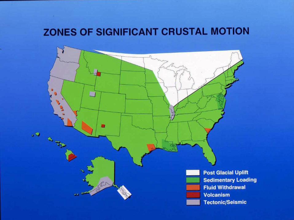
Positioning America for the Future
NATIONAL OCEANIC AND ATMOSPHERIC ADMINISTRATION
National Ocean Service
National Geodetic Survey

Horizontal velocities in the western U.S. relative to the North American Datum of 1983 as derived from geodetic observations.
Slide from R. Snay, NGS
-Times 8 years (2002-2010) -As will be seen realized with NAD 83(2011)Epoch2010 (tent. name)


THE PROJECT

CONUS Conterminous United States
CORS Continuously Operating Reference Stations
FGDC Federal Geographic Data Committee
GNSS Global Navigation Satellite System
GPS Global Positioning System
HTDP Horizontal Time Dependent Positioning
(NGS
software)
IGS International GNSS Service
MYCS Multi-Year CORS Solution
Epoch An epoch is a moment in time used as a
reference point.

NA2011 National Adjustment of 2011
NAD 83 North American Datum of 1983
NAVD 88 North American Vertical Datum of 1988
NADCON North American Datum Conversion (NGS
software) NGS National Geodetic Survey
NGSIDB National Geodetic Survey Integrated Data
Base
OPUS Online Positioning User Service

Original realization completed in 1986
◦ Consisted (almost) entirely of classical
(optical) observations
“High Precision Geodetic Network”
(HPGN) and “High Accuracy Reference
Network” (HARN) realizations
◦ Most done in 1990s, essentially state-
by-state
◦ Based on GNSS but classical stations
included in adjustments
National Re-Adjustment of 2007
◦ NAD 83(CORS96) and (NSRS2007)
◦ Simultaneous nationwide adjustment
(GNSS only)
New realization: NAD 83(2011) epoch
2010.00
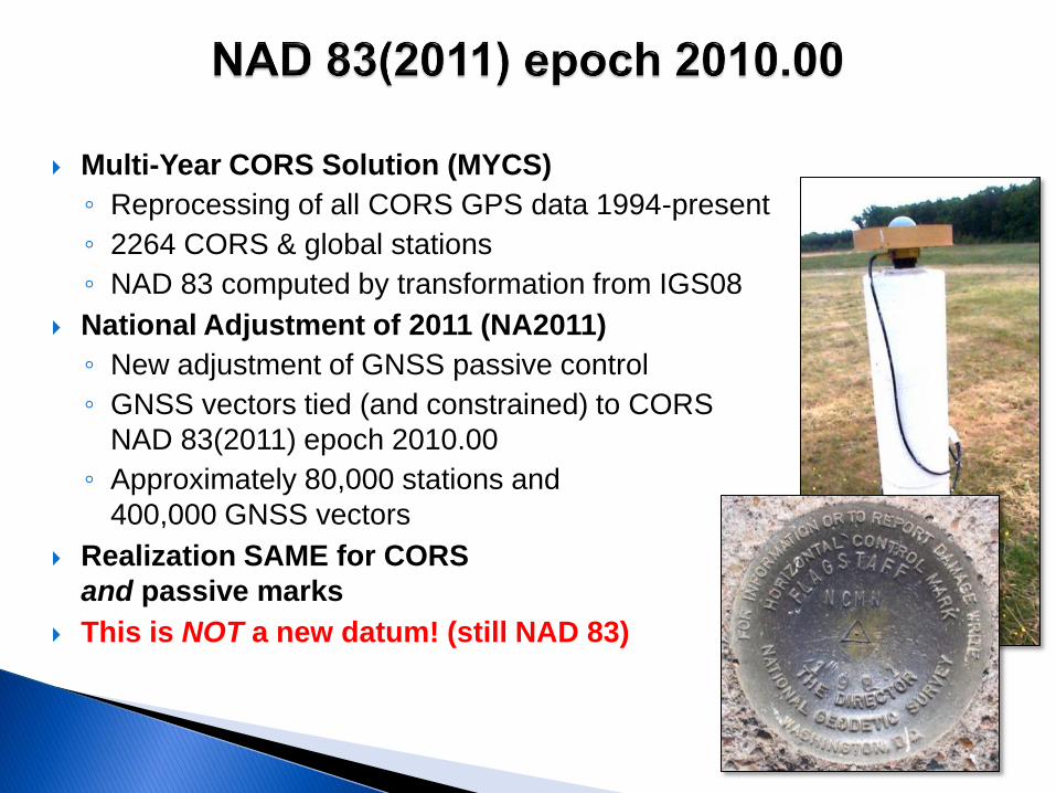
Multi-Year CORS Solution (MYCS)
◦ Reprocessing of all CORS GPS data 1994-present
◦ 2264 CORS & global stations
◦ NAD 83 computed by transformation from IGS08
National Adjustment of 2011 (NA2011)
◦ New adjustment of GNSS passive control
◦ GNSS vectors tied (and constrained) to CORS
NAD 83(2011) epoch 2010.00
◦ Approximately 80,000 stations and
400,000 GNSS vectors
Realization SAME for CORS
and passive marks
This is NOT a new datum! (still NAD 83)

The project is officially called the “National Adjustment of 2011”, abbreviated as NA2011. It is a nationwide, geometric adjustment of passive stations with positions determined using Global Navigation Satellite System (GNSS) technology and data, which includes the Global Positioning System (GPS).

NA2011 is called “geometric” because it will yield new values for latitude, longitude, and ellipsoid height; it will NOT affect the orthometric heights of stations. However, a future nationwide vertical adjustment is being considered to determine GNSS-derived orthometric heights based on the results of NA2011

NAD 83(2011) epoch 2010.00
◦ “2011” is datum tag year adjustment complete
◦ “2010.00” is “epoch date” (January 1, 2010)
Date associated with coordinates of control station
◦ Frame fixed to North American tectonic plate
Includes California, Puerto Rico, and US Virgin
Islands
NAD 83(PA11) epoch 2010.00
◦ Frame fixed to Pacific tectonic plate
NAD 83(MA11) epoch 2010.00
◦ Frame fixed to Mariana tectonic plate

There has been no datum change, that is, the origin,
scale and orientation of NAD 83(2011) are identical
to those of NAD 83(CORS96). The changes in
coordinates are driven by multiple factors including
the switch to absolute antenna calibrations,
new/revised processing algorithms, improved
discontinuity identification, longer data sets, and our
improved definition of the global reference frame.
However for the end user the biggest change is
caused by the new reference epoch, which has
changed by 8 years from 2002.00 to 2010.00.


CORS

Current
ITRF2000 1997.00
NAD83(CORS96) 2002.00
Relative antenna calibration
ITRF2000, defined by only 8 global stations
Upcoming
IGS08 (2011) 2005.00 NAD83(2011) 2010.00 Absolute ITRF2008 uses ~230
stations What does this all
mean?
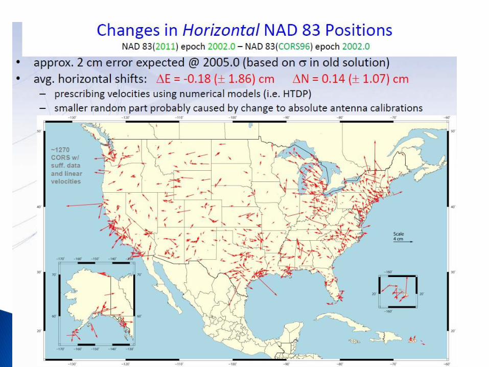
Average differences of NAD 83(2011) epoch 2002.00 minus NAD 83(CORS96) epoch 2002.00: East -0.18 1.86 cm; North 0.14 1.07 cm; Vertical 0.17 2.11 cm
< 2 mm +/- 1-2 cm (nationally)

The National Geodetic Survey (NGS) operates the Continuously Operating Reference Station (CORS) Network that provides Global Navigation Satellite System (GNSS) data in RINEX format, and associated positions.
Currently NGS provides these coordinates in ITRF00 epoch 1997.00, and in NAD 83(CORS96) epoch 2002.00.
NGS has completed a full reanalysis of all data from CORS and a set of global sites with the goal to compute a fully consistent set of coordinates, GPS satellite orbits and Earth Orientation Parameters (EOP).
This initial Multi-Year CORS (MYCS1) effort is the first of a series reprocessing projects that will occur periodically in the coming years.
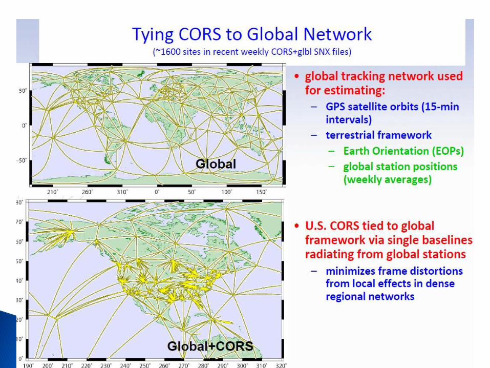
Slide by J. Griffiths and the MYCS Team


REGIONAL CORS NETWORK


NAD 83 CORS 96 VS NAD 83 2011
WASHINGTON NORTH ZONE
US FEET
NAD 83/CORS 96 US FT NAD 83 2011 US FT DIFFERENCE US FT
NAME PID# NORTHING EASTING ELLIPSE NAME PID# NORTHING EASTING ELLIPSE NORTH EAST ELLIPSE
BREW DK4088 414845.879 1921406.779 784.149 BREW DK4088 414845.921 1921406.848 784.093 -0.042 -0.069 0.056
CHWK DE6569 788881.079 1359188.777 571.226 CHWK DE6569 788881.146 1359188.871 571.948
CPXF AJ7202 -55042.405 1284192.490 1751.883 CPXF AJ7202 -55042.245 1284192.667 1751.899 -0.160 -0.177 -0.016
CHZZ AJ6959 -535726.824 833266.454 168.880 CHZZ AJ6959 -535726.552 833266.744 167.851 -0.272 -0.290 1.029
FTS1 AF9545 -274022.816 849551.966 -44.718 FTS1 AF9545 -274022.546 849552.318 -44.646 -0.270 -0.352 -0.072
FTS2 AF9580 -273923.323 849576.945 -43.943 FTS2 AF9580 -273923.072 849577.266 -43.907 -0.251 -0.321 -0.036
FTS5 DK4499 -274022.791 849551.990 -44.173 FTS5 DK4499 -274022.521 849552.339 -44.108 -0.270 -0.349 -0.065
FTS6 DK3581 -273923.320 849576.946 -43.422 FTS6 DK3581 -273923.055 849577.275 -43.373 -0.265 -0.329 -0.049
GOBS AF9664 -423645.214 1645179.516 2040.567 GOBS AF9664 -423645.139 1645179.585 2040.534 -0.075 -0.069 0.033
GWEN AF9636 -443744.277 1514229.524 2403.919 GWEN AF9636 -443744.124 1514229.675 2403.890 -0.153 -0.151 0.029
GWN2 AF9643 -443746.490 1514308.274 2406.285 GWN2 AF9643 -443746.355 1514308.397 2406.252 -0.135 -0.123 0.033
GWN5 DJ6121 -443744.221 1514229.564 2404.483 GWN5 DJ6121 -443744.122 1514229.685 2404.464 -0.099 -0.121 0.019
GWN6 DJ6123 -443746.450 1514308.281 2406.869 GWN6 DJ6123 -443746.359 1514308.393 2406.846 -0.091 -0.112 0.023
KELS AF9666 -314694.576 1117084.743 -50.840 KELS AF9666 -314694.388 1117084.921 -50.866 -0.188 -0.178 0.026
LIND AH2504 261.556 1713998.210 1549.843 LIND AH2504 261.653 1713998.306 1549.787 -0.097 -0.096 0.056
LINH CQ6015 261.574 1713998.230 1551.021 LINH CQ6015 261.665 1713998.325 1550.925 -0.091 -0.095 0.096
LNGB DG6523 85788.826 1162069.017 9.173
NEAH AF9672 496151.473 717895.152 1509.912 NEAH AF9672 496151.681 717895.528 1509.987 -0.208 -0.376 -0.075

ORS1 DG8527 -1029690.810 2107110.801 4718.258 ORS1 DG8527 -1029690.707 2107110.869 4718.232 -0.103 -0.068 0.026
ORS2 DG9793 -1029728.650 2107192.799 4721.195 ORS2 DG9793 -1029728.562 2107192.878 4721.165 -0.088 -0.079 0.030
P020 DG7408 9140.160 2206207.497 1576.657 P020 DG7408 9140.208 2206207.533 1576.608 -0.048 -0.036 0.049
P376 DH4503 -742618.354 1052121.428 594.572 P376 DH4503 -742618.135 1052121.510 594.602 -0.219 -0.082 -0.030
P415 DH4093 -111803.037 913011.487 -49.511 P415 DH4093 -111802.800 913011.716 -49.478 -0.237 -0.229 -0.033
P420 DG8344 -143324.545 1129161.185 244.261 P420 DG8344 -143324.352 1129161.331 244.284 -0.193 -0.146 -0.023
P432 DG8347 -136402.233 1426805.798 1047.426 P432 DG8347 -136402.103 1426805.893 1047.409 -0.130 -0.095 0.017
P446 DK4151 -315634.274 1117892.591 -52.861 P446 DK4151 -315634.064 1117892.688 -52.802 -0.210 -0.097 -0.059
P451 DH4096 -70363.590 2089344.223 1154.473 P451 DH4096 -70363.539 2089344.249 1154.424 -0.051 -0.026 0.049
P687 DH9589 -321032.573 1254367.701 1284.269 P687 DH9589 -321032.425 1254367.795 1284.308 -0.148 -0.094 -0.039
P690 DH4120 -296125.448 1296628.609 6821.650 P690 DH4120 -296125.277 1296628.710 6821.745 -0.171 -0.101 -0.095
P693 DH5819 -285003.908 1293663.172 6933.536 P693 DH5819 -285003.732 1293663.345 6933.546 -0.176 -0.173 -0.010
P695 DH5847 -289308.201 1303249.866 6614.226 P695 DH5847 -289307.972 1303249.920 6614.242 -0.229 -0.054 -0.016
P696 DH4123 -290131.354 1306422.834 5250.531 P696 DH4123 -290131.165 1306422.956 5250.577 -0.189 -0.122 -0.046
P697 DH4126 -293392.313 1300037.596 7266.872 P697 DH4126 -293392.040 1300037.560 7266.879 -0.273 0.036 -0.007
P698 DH4129 -298634.470 1304001.714 4854.764 P698 DH4129 -298634.306 1304001.832 4854.803 -0.164 -0.118 -0.039
P699 DH5850 -292492.542 1293307.460 7462.108 P699 DH5850 -292492.346 1293307.597 7462.157 -0.196 -0.137 -0.049
P702 DH5822 -251552.377 1258015.478 4284.952 P702 DH5822 -251552.178 1258015.588 4284.949 -0.199 -0.110 0.003
PABH AF9668 95972.772 802761.354 43.543 PABH AF9668 95973.071 802761.793 43.560 -0.299 -0.439 -0.017
PRDY DF8479 147833.033 1200504.755 271.876
RPT1 AF9503 145173.775 1258597.959 -31.299 RPT1 AF9503 145173.885 1258598.146 -31.345 -0.110 -0.187 0.046
RPT2 AF9608 145064.667 1258536.193 -31.217 RPT2 AF9608 145064.798 1258536.364 -31.214 -0.131 -0.171 -0.003
RPT5 DK4179 145173.782 1258597.956 -31.010 RPT5 DK4179 145173.934 1258598.131 -31.024 -0.152 -0.175 0.014
RPT6 DK4105 145064.693 1258536.231 -30.925 RPT6 DK4105 145064.845 1258536.352 -30.922 -0.152 -0.121 -0.003
SC00 AJ7205 -17884.342 1667579.033 3867.427 SC00 AJ7205 -17884.269 1667579.178 3867.427 -0.073 -0.145 0.000
SEAI DH7235 253836.745 1289958.889 -11.772 SEAI DH7235 253836.831 1289959.003 -11.781 -0.086 -0.114 0.009
SEAT AF9674 242038.056 1276633.133 146.578 SEAT AF9674 242038.149 1276633.269 146.542 -0.093 -0.136 0.036
SEAW AH7396 253836.629 1289958.788 -11.831 SEAW AH7396 253836.728 1289958.961 -11.906 -0.099 -0.173 0.075
SEDR AF9670 558073.752 1303451.466 99.245 SEDR AF9670 558073.855 1303451.606 99.219 -0.103 -0.140 0.026

SPN1 AJ1822 207740.648 2482674.988 2363.398 SPN1 AJ1822 207740.684 2482675.044 2363.378 -0.036 -0.056 0.020
SPN2 AJ1824 207748.956 2482760.874 2364.930 SPN2 AJ1824 207749.039 2482760.936 2364.884 -0.083 -0.062 0.046
SPN5 DK3591 207740.634 2482674.977 2364.037 SPN5 DK3591 207740.700 2482675.048 2363.955 -0.066 -0.071 0.082
SPN6 DK3593 207748.954 2482760.878 2365.520 SPN6 DK3593 207749.024 2482760.940 2365.441 -0.070 -0.062 0.079
THUN DF8481 42032.813 1278030.065 468.759
TWHL AJ7208 12877.099 1119176.832 353.116 TWHL AJ7208 12877.243 1119177.032 353.110 -0.144 -0.200 0.006
WHD1 AF9502 484328.157 1187173.606 46.447 WHD1 AF9502 484328.293 1187173.748 46.329 -0.136 -0.142 0.118
WHD2 AF9613 484228.422 1187171.084 35.856 WHD2 AF9613 484228.583 1187171.254 35.758 -0.161 -0.170 0.098
WHD5 DK4111 484328.150 1187173.622 46.847 WHD5 DK4111 484328.284 1187173.754 46.762 -0.134 -0.132 0.085
WHD6 DK4113 484228.441 1187171.106 36.322 WHD6 DK4113 484228.557 1187171.229 36.247 -0.116 -0.123 0.075
YELM DF8477 -13610.612 1197709.053 270.177
ZSE1 DF4068 107646.887 1304118.427 269.032 ZSE1 DF4068 107646.997 1304118.624 269.022 -0.110 -0.197 0.010

Why is NGS doing a national adjustment
a mere 4 years after the last adjustment
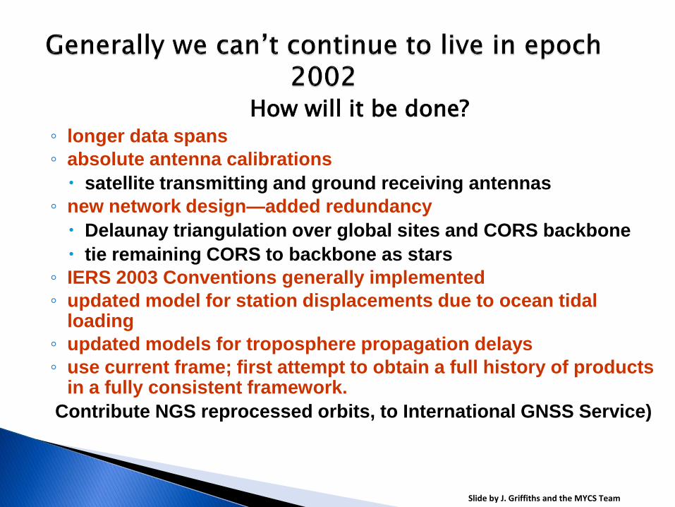
How will it be done? ◦ longer data spans
◦ absolute antenna calibrations
satellite transmitting and ground receiving antennas
◦ new network design—added redundancy
Delaunay triangulation over global sites and CORS backbone
tie remaining CORS to backbone as stars
◦ IERS 2003 Conventions generally implemented
◦ updated model for station displacements due to ocean tidal loading
◦ updated models for troposphere propagation delays
◦ use current frame; first attempt to obtain a full history of products in a fully consistent framework.
Contribute NGS reprocessed orbits, to International GNSS Service)
Slide by J. Griffiths and the MYCS Team

In order for the coordinates of passive stations to maintain consistency with the CORS’ representation of the NSRS, NGS will be doing another national adjustment this year
The datum tag that will be adopted for both CORS (active) and passive is NAD83(2011)
CORS (only) will be the control for the LSA

For NGS products and services to be mutually
aligned, it is necessary to perform an adjustment
(constrained to the new MYCS coordinates) of as
many GNSS vectors held in the NGS Integrated Data
Base (NGSIDB) as possible.

These vectors represent GNSS observations
between passive stations, and, importantly, between
passive stations and CORS (i.e., active stations).
The vectors tied to CORS will make it possible to
determine new coordinates on passive control that
are consistent with the MYCS.

All CORS with GNSS data archived by NGS were
included in the MYCS. The only CORS not included
are those that have no archived data, which consists
only of a small number of Cooperative CORS.
Of these, the only ones excluded were
decommissioned prior to becoming part of the NGS
CORS network and did not provide their historic
GNSS data to NGS. The Cooperative CORS
program is no longer in effect, and so all currently
operating CORS are simply “CORS”, and they are all
included in the MYCS. A list of previously operating
CORS that were not used in the MYCS will be
provided in the near future.

NGS is in the process of readjusting most, if not all,
of the passive vector control in the NGSIDB to make
it consistent with MYCS1 solution.
The results of this adjustment (National
Readjustment of 2011) will have the same reference
frame tag and epoch date as the MYCS1, namely
NAD 83(2011) epoch 2010.00.

A passive station is, in NGS terminology, a
conventional” ground station, e.g., a brass disk set in
a substantial structure, a steel rod driven vertically into
the ground until refusal, or other such stable physical
marks that can be occupied with survey equipment.
An active station is a GNSS antenna (and
associated receiver) in a fixed location providing
GNSS data to the public, such as a CORS,WSRN

GNSS observations (vectors) for all passive control stations in the
NGS Integrated Data Base (NGSIDB) connected (directly or indirectly)
to CORS with MYCS coordinates as of July 31, 2011 may be included
in the adjustment.
However, being “included in the adjustment” only assures that the
observations will be evaluated for their possible inclusion in the final
adjustment. As with any survey control network adjustment,
observations that do not “fit” well with other observation (i.e.,
“outliers”) will be rejected.
In some cases, this may result in passive control stations being
excluded from NA2011, in which case they will retain their previous
datum tag. Projects submitted after July 31, 2011 will be published
with NAD 83(NSRS2007) coordinates until NA2011 is completed. At
that time those projects in the queue will be adjusted to the new
realization and published on NAD 83(2011) epoch 2010.00.

Any passive station that does not have acceptable GNSS data will be excluded from NA2011, as will stations that are not (directly or indirectly) connected to a CORS in the MYCS.
For passive stations meeting these criteria, NGS intends to provide NAD 83(2011) epoch 2010.00 coordinates everywhere that is appropriate and can be determined accurately with respect to the MYCS.
This will include the conterminous US (CONUS) and Alaska, and it may include other locations outside CONUS as well. The decision as to what additional areas to include will be made during the course of the project. Stations not included in NA2011 will continue to have their positions referenced to the same datum realization used for current survey control prior to NA2011 (as indicated by the datum tag on NGS datasheets).

The answer is entirely dependent upon whether an
acceptable GNSS survey is ever performed at that
passive control mark. For non-GNSS (i.e.,
“classically” determined) control, the most accurate
way to determine coordinates consistent with a
modern realization of NAD 83 is to resurvey it using
geodetic quality GNSS data.
The intended use of this position will determine
whether an OPUS solution is sufficient or if a
complete GNSS survey submitted to NGS for
publication is required.

First, consult with NGS through the appropriate personnel or NGS headquarters personnel to ensure your project meets NGS requirements for projects performed during this time frame.
When performing the constrained adjustments, unless advised differently by NGS personnel, hold NAD 83(NSRS2007) coordinates for all published passive control and NAD 83(CORS96) coordinates for all CORS in the survey.
The same approach for constraining a survey should also be used for projects submitted to NGS that will be included in NA2011 (i.e., before the cut-off date).

Yes, those stations will have network and local accuracies computed and published along with the NAD 83(2011) epoch 2010.00 coordinates.
As with the NA2011 project itself, these accuracies will be provided in centimeters, and at the 95% confidence level in accordance with the Federal Geographic Data Committee (FGDC) Geospatial Positioning Accuracy Standards, Part 2
Based on the MYCS results, the average expected change is about 2
cm horizontally and 1 cm vertically (i.e., ellipsoid height).
However, these changes – especially the horizontal changes – vary
significantly. In addition, the largest part of the horizontal change is
due to time difference (velocity), especially in tectonically active
areas, such as California; when brought to a common time (2002.00),
the average horizontal change decreases to 0.2 cm.
A list of coordinate changes, from NAD 83(NSRS2007) epoch 2002.00
to NAD 83(2011) epoch 2010.00 will be provided to the public.

For the purposes of transforming the official coordinates of each geodetic control point, NGS will not create a transformation model. An interpolative transformation tool, like NADCON, functions only to apply gross consistent regional shifts to entire areas.
NGS will certainly examine the shifts in coordinates for such behavior, but the shifts in going to NAD 83(2011) from NAD 83(NSRS2007) are not expected to significantly exceed the formal errors of those shifts, nor are they expected to all move in one consistent direction regionally.
NGS does not endorse the idea of applying a simple interpolative tool to all surveys and maps in a region, as they each will have their own unique connections to surrounding geodetic control. Although NGS will look at all possibilities, there is already compelling evidence that a singular transformed dataset will have very limited applications, and may actually be highly misleading. This is especially the case as the size of the area and required spatial accuracy increase.

Good agreement with IGS type means
Pending approval from International GNSS Service (IGS)
9/23/2010 ION GNSS 2010 45

RESULTS

Diagram shows plots of average error for 5 points constrained for each of the three realizations. The MYCS coordinates fit the baselines observed much better than the other two.

• OPUS-Static – U.S. CORS Network – Fixed IGS ephemerides
– Computes independent double differenced baseline solutions between the unknown and 3 CORS
– Relative antenna models – Phase ambiguity integer
fixing – Relative troposphere
modeling – ITRF2000 reference
frame – Average position
solution – Peak – Peak error
reported
• OPUS-Net
– U.S. CORS Network & IGS Global Network
– Network approach
– Consists of 3 nearby CORS + up to 12 CGPS from global IGS network
– Absolute antenna models
– SV & ground
– Ocean tidal loading model
– Satellite weighting
– Relative troposphere modeling
– ITRF2008 reference frame
– Weighted least squares adjustment
– Weighted mean and standard deviations reported at 95%
OPUS-net info. From Dr. Neil Weston

WHAT ABOUT THE WSRN?


HTDP v 3.1

The “epoch” is the date associated with the coordinates of a control station. An epoch is a necessary part of a complete datum or reference frame name because coordinates can change with time (i.e., they may have non-zero velocities relative to some chosen, stable coordinate reference). For NA2011, the positions will be referenced to midnight January 1 of 2010 (epoch 2010.00). NGS has provided epoch dates for CORS and related products (such as OPUS) for many years, and for passive marks included in the 2007 national readjustment. This practice will continue for NA2011, and it will become more prevalent and consistent throughout NGS. Typically the epoch date is displayed with two decimal places.
Users should be aware that if the velocity of a station is known, then its position can be computed at different epochs; thus one datum tag can have multiple epochs. However, the accuracy of the computed position will depend on the accuracy of the velocity, which varies by station and location. Epoch dates on some stations may also change without changing the datum tag if a local episodic event (such as an earthquake) occurs that requires a local adjustment to determine new positions. In summary, epoch dates are needed to accommodate the precision of GNSS measurements and to recognize the dynamic nature of the Earth and its effect on coordinates.

Interactively estimate displacements between two dates.
Individual points entered interactively or
Points on a specified grid
Select NAD83(CORS96) or NAD83(NSRS2007)
Select the dot for Deci-year format


GRAVITY - GEOID12

New hybrid geoid model (likely “GEOID12”) ◦ Use NAD 83(2011) epoch 2010.00 ellipsoid heights on
NAVD 88 benchmarks
◦ Might also use OPUS-Database results on NAVD 88 BMs
May perform national vertical adjustment ◦ Constrain vertically to NAVD 88 benchmarks
Perform as simultaneous nationwide adjustment
◦ GNSS-derived orthometric heights
NAD 83(2011) ellipsoid heights with GEOID12
NOT a readjustment of NAVD 88 leveling

The GPS era brought fast, accurate ellipsoid heights – naturally this drove a desire for fast, accurate orthometric heights ◦ 1-2 cm accuracy is needed
Leveling the country can not be done again ◦ Too costly in time and money
Leveling yields cross-country error build-up
Leveling requires leaving behind marks ◦ Bulldozers and crustal motion do their worst

Yes, a new hybrid geoid model (GEOID12) will be produced.
Preliminary activities in this regard are currently underway.
Development of this model requires completion of NA2011 first;
hence it cannot be delivered coincidentally with NA2011
results.
As is obvious from the model name, NGS expects to deliver the
model in 2012.
As with NA2011, completion of the project will be determined
by meeting quality and completeness criteria.

Possibly. NGS is currently investigating the need
and feasibility of performing a nationwide vertical
adjustment of all GNSS-derived orthometric heights
in the NSRS. If performed, the GNSS-derived
orthometric heights determined for all stations in the
vertical adjustment will be consistent with NAD
83(2011) epoch 2010.00 and GEOID12, and they will
be referenced to the North American Vertical Datum
of 1988 (NAVD 88).

SCHEDULE

December 14, 2011. Finalize modified version of ADJUST and associated
project
adjustment user guidelines.
January 2, 2012. SDD performs IDB load.
o Final NAD 83(2011) epoch 2010.0 adjusted coordinates and accuracies for
passive marks
o Final NAD 83(2011) epoch 2010.0 adjusted coordinates and accuracies for
CORS
January 13, 2012. Determine final constrained NAD 83(PA11) and
(MA2011)
epoch 2010.0 adjusted coordinates (i.e., referenced to Pacific and Mariana
tectonic
plates)
o Delivered to SSD and loaded into NGSIDB
o Provide to Geoid Team to develop GEOID12 for Hawaii, American Samoa,
Guam, and CNMI.

January 31, 2012. NA 2011 final report submitted.
o Posted to NA2011 web page,
o Public announcement that adjustment is entirely complete
o Project closeout.
o NOTE: Loading of projects submitted after August 31, 2011 cutoff date will
continue beyond project closeout date if necessary.
February 15, 2012 ? . Projected delivery date for release of GEOID12 and
publication
of NAD 83(2011) epoch: 2010.00 coordinates. The release date of GEOID12 is
assumed, for the purposes here, to be February 15, 2012, but could easily vary
from
that date. Additionally, if there is a significant delay in the release of GEOID12 it
may be decided to release data sheets with NAD 83(2011) epoch 2010.00
coordinates
prior to delivery of GEOID12.
o Public Announcement that NAD 83(2011) epoch 2010:00 data sheets are
available
o Formal announcement submitted for publication in Federal Register

April 15, 2012. Cutoff date for projects
constrained to NAD 83 (NSRS2007).
Note this date is tentative as it is actually
determined as two months from release of
GEOID12 and the release of data sheets with
NAD 83(2011) epoch 2010.00 coordinates.

WSRN
Primary (New) Server will Operate in
NAD 2011 Beginning June 2011
Secondary (Legacy) Server will continue to
Operate in NAD 83 CORS 96 Epoch 2002.00
for at least one year (likely indefinitely)
Related Documents