THE DYNAMICS OF THE NORTH-WESTERN DELTA LITTORAL OF THE BLACK SEA DURING HISTORICAL PERIODS (DANUBE DELTA) Gheorghe ROMANESCU Keywords: Danube Delta, progradation, erosion, historical periods . The Danube Delta is situated in the north-western sector of the Black Sea basin, in a mobile region of the terrestrial crust (the Predobrudjan Depression). Its limits are: 4446'00'' N lat. (Periteasca), 45 30'00'' N lat. (South of Sasik Lake), 28 40'24'' E long. (ceatalul Chilia), 29 40'50'' E long. (east of the Chilia secondary delta). As for its surface of 5,600 km 2 , the Danube Delta, together with the flood-plain sector between Ceatalul Ismail and Galati city, represent the most important terminal plain of any European river (except the Volga and Kuban deltas on the territory of C.I.S.). The Ukrainian part, about one-fifth of the total Delta area, covers 125,000 ha of which 75,000 ha is land and 50,000 ha is water. The present study refers to the hydro-technical works built at the Sulina mouth (north) and Sf}ntu Gheorghe mouth (south). It is the central sector, the most important in the Danube Delta, where the geomorphologic processes get complicated because of local natural and human-induced factors. The first hydro-technical works at the Danube mouths were done by the European Danube Commission, set up in 1956, but whose projects started earlier, in 1858. Among such projects we can mention: the channelling of the Sulina arm, the „ecologisation‛ of other arteries within the delta and the building up of dams at the Sulina river mouth in order to assure the maritime navigation. The maritime sector between the two river mouths has a length of 33 km and it gets the impact of the maritime forces on that direction, and, most of the times, perpendicularly. The maritime stream system on the shore has been altered by the continuous advancement of the dams, which are 9 km long today. In the absence of the dams, the marine currents with north-south direction (about 9 months per year) and south-north (about 3 months per year), had an almost longitudinal route along the shore, and they annihilated at the north of Sf}ntu Gheorghe mouth. While the dams are advancing towards the sea, the north-south current is deviated from the initial route and, south of the Sulina mouth, it becomes circular, with strong impact between Sondei channel and Imputita brook. Because of this reason, this sector undertakes the highest erosion rate than any other sector in the entire Romanian delta littoral (5-10 m/an). The

Welcome message from author
This document is posted to help you gain knowledge. Please leave a comment to let me know what you think about it! Share it to your friends and learn new things together.
Transcript

THE DYNAMICS OF THE NORTH-WESTERN DELTA LITTORAL OF THE BLACK SEA DURING HISTORICAL PERIODS
(DANUBE DELTA)
Gheorghe ROMANESCU
Keywords: Danube Delta, progradation, erosion, historical periods.
The Danube Delta is situated in the north-western sector of the Black Sea basin, in a
mobile region of the terrestrial crust (the Predobrudjan Depression). Its limits are: 4446'00'' N lat. (Periteasca), 4530'00'' N lat. (South of Sasik Lake), 2840'24'' E long. (ceatalul Chilia), 2940'50'' E long. (east of the Chilia secondary delta). As for its surface of 5,600 km2, the Danube Delta, together with the flood-plain sector between Ceatalul Ismail and Galati city, represent the most important terminal plain of any European river (except the Volga and Kuban deltas on the territory of C.I .S.). The Ukrainian part, about one-fifth of the total Delta area, covers 125,000 ha of which 75,000 ha is land and 50,000 ha is water. The present study refers to the hydro-technical works built at the Sulina mouth (north) and Sf}ntu Gheorghe mouth (south ). It is the central sector, the most important in the Danube Delta, where the geomorphologic processes get complicated because of local natural and human-induced factors. The first hydro-technical works at the Danube mouths were done by the European Danube Commission, set up in 1956, but whose projects started earlier, in 1858. Among such projects we can mention: the channelling of the Sulina arm, the „ecologisation‛ of other arteries within the delta and the building up of dams at the Sulina river mouth in order to assure the maritime navigation. The maritime sector between the two river mouths has a length of 33 km and it gets the impact of the maritime forces on that direction, and, most of the times, perpendicularly. The maritime stream system on the shore has been altered by the continuous advancement of the dams, which are 9 km long today. In the absence of the dams, the marine currents with north-south direction (about 9 months per year) and south-north (about 3 months per year), had an almost longitudinal route along the shore, and they annihilated at the north of Sf}ntu Gheorghe mouth. While the dams are advancing towards the sea, the north-south current is deviated from the initial route and, south of the Sulina mouth, it becomes circular, with strong impact between Sondei channel and Imputita brook. Because of this reason, this sector undertakes the highest erosion rate than any other sector in the entire Romanian delta littoral (5-10 m/an). The

GHEORGHE ROMANESCU
522
north current, fully manifesting during winter, has a strong erosive impact next to the Sondei channel (south). The impact point at the shore is influenced also by the southern current, with south-north direction, with maximum manifestation during summer, when it pushes the northern current towards the „alluvia trap‛ and therefore, the maximum erosion occurs next to the Imputita brook (north). The circular current (similar to an Eckman cell) also gets a south-north direction at the impact with the littoral, with a more and more reduced speed next to the dams at the river mouth. As a result, the alluvia transport includes only very fine material. In the „alluvia trap‛ situated to the south of the advancing dams, the particle size of the sandy deposits is slightly different than that in the erosive sector of Sondei- Imputita. The slightly curved southwards direction of the jettis causes a slight diminution of the „Sulina bar‛ formation because the waves coming from offshore do not enter directly on the channel mouth and the alluvia deposition is slowed down. The lateral erosion is visibly increased between the two river mouths because the alluvia budget passing by is more and more reduced. In 1856 the Danube transported a solid discharge of 80million t/year, while the solid discharge in 2008 is about 20million t/year.
Introduction The littoral sector between the Sulina and Sf}ntu Gheorghe mouths is the
most complex from a dynamic and morphological point of view. This aspect was presented by almost all researchers who studied the genesis and evolution of the Danube Delta, as well as the influence of the marine factors on the deltaic littoral: C. Brătescu1, I.G. Vidraşcu2, G. V}lsan3, R. Cioc}rdel4, G. Petrescu5, V.P. Zenkovici6, P. Coteţ7, A.C. Banu8, N. Popp9, P. G}stescu, B. Driga10, C. Bondar11, P. G}stescu, B. Driga, C. Anghel12, N. Panin13, G. Romanescu14 etc.
Special attention was given to the analysis of the littoral changes occurring after the building up of several hydro-technical works, necessary to the navigation of the Danube arms, to the facilitation of the ship entrance in the main river mouths or the preservation of the littoral line in the limits of an adequate protection. The works that have been done at the Sulina mouth are the oldest and the most expensive, and they were, at the same time, those which influenced most significantly the alluvia transport on the delta littoral. In this case, the changes were analysed chronologically, during the modern and contemporary historical
1 BRĂTESCU 1923, p. 3-39. 2 VIDRAŞCU 1924. 3 V]LSAN 1935. 4 CIOC]RDEL 1937, p. 93-107. 5 PETRESCU 1957. 6 ZENKOVICI 1956, p. 86-90; ZENKOVICI 1957, p. 75-81. 7 COTEŢ 1960, , p. 61-77. 8 BANU 1963, p. 73-84. 9 POPP 1965, p. 82-101. 10 G]STESCU, DRIGA 1981, 33-47. 11 BONDAR 1983, p. 101-120. 12 G]STESCU, DRIGA, ANGHEL 1986. 13 PANIN 1974, p. 107-121; PANIN 1983, p. 175-184; PANIN 1989, p. 25-36. 14 ROMANESCU 1996, p. 267-295.
THE DYNAMICS OF THE NORTH-WESTERN DELTA LITTORAL
523
periods, as well as their effect on other hydro-geomorphologic processes occurring in the studied sector.
The knowledge of the hydro-geomorphologic processed occurring on the shore, leads to an adequate control of the dredging works, the directing of the alluvia and the banks protection.
Regional setting The Danube Delta is situated in the north-western sector of the Black Sea
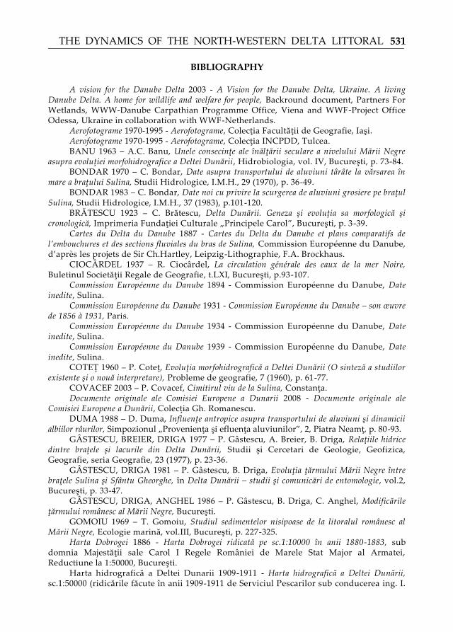
basin, in a mobile region of the terrestrial crust (the Predobrudjan Depression). Its limits are: 4446'00'' N lat. (Periteasca), 4530'00'' N lat. (South of Sasik Lake), 2840'24'' E long. (ceatalul Chilia), 2940'50'' E long. (East of the Chilia secondary delta). As for its surface of 5,600 km2, the Danube Delta, together with the flood-plain sector between Ceatalul Ismail and Galaţi city, represent the most important terminal plain of any European river (except the Volga and Kuban deltas on the territory of C.I.S.). The Ukrainian part, about one-fifth of the total Delta area, covers 125,000 ha of which 75,000 ha is land and 50,000 ha are water (Fig. 1).
The Romanian littoral of the Black Sea has a total length of 244 km and it stretches between the Musura arm mouth (in the north) and the locality of Vama Veche (in the south).
From a genetically and an altitudinal point of view, the littoral is divided into two distinct sectors:
- an accumulation northern sector, deltaic, situated between the Musura arm mouth (N) and the Midia Cape (S);
- a high abrasion sector between the Midia Cape (N) and Vama Veche (or the state frontier with Bulgaria, in the south).
The deltaic (accumulation) sector is 166 km long and represents 68% of the total length of the Romanian littoral.
The studied sector is situated between the Sulina arm mouth (to the north) and Sf}ntu Gheorghe arm mouth (to the south). It has a length of approximately 33 km (Fig. 2).
The advancement of the secondary Sulina delta and Sf}ntu Gheorghe respectively, is not significant, as the liquid flow, and the solid one respectively, transported on the two arms, is reduced, as compared to that of Chilia, which is much higher.
This sector represents the key of the present Sulina Delta genesis and of the formation of Sărăturile fluvio-maritime levee. It seems that 7000-2000 B.P. the Sulina Delta was of a triangular type and it advanced a lot towards the sea (ZENKOVICI, 1957; PANIN, 1989), and Sf}ntu Gheorghe II Delta did not exist. At the moment when the erosion of the Sulina Delta started, the eliminated material from the north deposited to the south, on a scissors system and gave birth to Sărăturile fluvio-maritime levee, which is Sf}ntu Gheorghe II Delta15.
The component material is dominated by the coarse and medium sand. The terrigenous sand represents 90% as comparing to the organogenous sand, representing only 10%16. The sectors situated south to the Sf}ntu Gheorghe arm
15 STĂNESCU, NICHIFOROV 1963, p. 9-53. 16 ROMANESCU 2005.

GHEORGHE ROMANESCU
524
have a higher and higher percentage of the organogenous sand (from 30-40% to 50% on the Razim Sinoie littoral bar)17. The greatest amount of alluvia comes from the fluviatile transport and less from the marine transport (Fig. 3).
Materials and methods For an exact quantification of the littoral advancement or withdrawal points
between the two river mouths, fields measurements have been done, as well as measurements on the old or new maps, on air-photographs, orto-photoplans and satellite images.
The measurements taken with Leica theodolite (produced in 1997), referred to the sea level and the level of the fluviatile waters next to the river mouths, reported to the average level of the Black Sea. The hydrological and geomorphologic measurements had never been done before 1856. The only map with data closer to the reality is the one realized by the Russian Military Topographic Headquarters in 1835. In his European Commission of the Danube mission, Ch. Hartley was helped by the English captain Spratt, the Austrian engineers Wex, Nobling and Pasetti (the director of the regularization works of the Rhine) and the German engineer Richardt. On the basis of the reports and maps referring to the Danube Delta, a global report was done, and the following proposals were made by Hartley: first a temporary fitting out of the Sulina arm course at the arm mouth; second, a general regularization proposal for the final navigation on the Sf.Gheorghe arm course.
The first hydrological measurements on the water level on the Danube arms were done in December 1856, at the same time with the setting up of European Commission of the Danube. These completed the military measurements that were done during the Crimean war, when Ch.Hartley got the mission of establishing the location of a future English military base in Sulina18.
In 1857, captain Spratt made hydrographical measurements at the mouth of the Sulina arm and on the continental shelf. In this case the first projects and evaluations on the route of the protection dams could be made. The reporting of the first organized measurements was done in August 1857 as a result of the measurements in the sector Tulcea and Sulina. The connecting of the Danube levels to the Black Sea levels was done by European Commission of the Danube in 1858.
In 1859, the zero mark was fixed, at the base of the Old Lighthouse in Sulina, by Ch. Hartley. Then, the surveyor’s pole was mounted in the quay in front of the European Commission of the Danube building, a reporting point in which the surveyor’s pole stayed for around 100 years. The zero level of the Danube at Sulina was reported to the zero referential system of the Black Sea and to the old ones used in Germany as reported to the Baltic Sea. The measurements were continued by European Commission of the Danube until 1926 when they were taken by the Hydraulic Service of Romania. On this occasion all the Romanian surveyor’s poles on the Danube were connected to the Sulina – Black Sea zero level. Starting 1869 the surveyor’s pole readings were done at 8, 14 and 20 hours,
17 ROMANESCU 2005. 18 Commission Européenne du Danube, 1931.
THE DYNAMICS OF THE NORTH-WESTERN DELTA LITTORAL
525
and starting 1969 the readings are done at 7, 13 and 19 hours19. While the protection dams at the Sulina mouth advanced, the position of the original surveyor’s pole on the E.C.D. quay remained unchanged, and therefore all the auxiliary surveyor’s poles advanced towards the sea with the dams. Until 1922 the position of these surveyor’s poles was maintained 1.4km away from the dam, and after that, other positions were established. In 1940 the new position was 5.6 km away, in 1960 - 7.2km away, in 1968 – 8.5km away. In order to compensate the read levels, thanks to AFDJ Galaţi (Lower Danube Fluviatile Administration), a continuator of the European Commission of the Danube administration for the Maritime Danube (Brăila-Sulina), in 1956 another spare surveyor’s pole was mounted at the zero level of the sea, on the basement of the fog signal, built in the south gulf of the Sulina town. On this occasion a second order precision levelling was executed, and it was finished in 1957, considering the settling that appeared in the last one hundred years, changing the support of the old surveyor’s pole.
The level measurements were always corroborates with other levels on the Romanian seacoast of the Black Sea (Constanţa, Mangalia). The zero level at Sulina has the same value on all the surface of the Danube Delta (Imputita levee, mouth of the Sf. Gheorghe arm, Portiţa mouth) surveyor’s pole installed in 1959. The difference between the constructions of the Constanţa and Mangalia ports as compared to the zero level at Sulina is +23cm.
The data on the littoral currents and the alluvia transport were taken from the literature20 (BONDAR, 1970; DUMA, 1988; PANIN et al., 1992; POPA, 1997; ROMANESCU, 1999), and they were completed with analysis of satellite images, air-photographs and ortho-photoplans surveyed in different periods, during a long period of time (1970-2008).
For the littoral dynamics, we have analysed a series of maps edited in 1835 (starting with the most accurate from a cartographic point of view), transformed to the same projection in order to avoid errors (Russian Map, edited in 1853; Dobrudja Map, on a 1:10000 scale, edited in the period 1880-1883; Cartes du delta du Danube et plans comparatifs de l’embouchures et des sections fluviales du bras de Sulina, 1887; Hydrographic Map of the Danube Delta, on a 1:50000 scale, 1909-1911; the Topographic Maps in Gauss projection, 1952, 1971-1972, 1991; Topo-hydrographic Map of the Danube Delta, on a scale of 1:25000; Air-photographs, 1970-1995; IRCM, 2004; Original Documents of the European Danube Commission, 2008). In the same context, field measurements were done using tape measure, in the points where hydrometric measuring staffs were installed by the Romanian Hydrological Headquarters, starting with the 60’s. Especially the sensitive points were considered, as being key factors in the understanding of the deltaic littoral dynamics.
In order to point out the particle size differentiation, in the erosion sectors and the deposition sectors, the quartering method was chosen, in order to differentiate the coarse, medium or fine sand, and clay. The sand was washed and
19 COVACEF 2003. 20 BONDAR 1970, p. 36-49; DUMA 1988, p. 80-93; PANIN, POPA, GAITA,
FARNOAGA, HERRY 1992, p. 57-75; POPA 1997, p. 135-147; ROMANESCU, 1999a, p. 174-192.
GHEORGHE ROMANESCU
526
dried up in the drying stove, and then it was sieved for 15 minutes using Retsch vibrator.
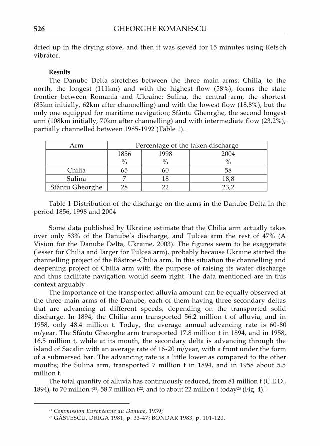
Results The Danube Delta stretches between the three main arms: Chilia, to the
north, the longest (111km) and with the highest flow (58%), forms the state frontier between Romania and Ukraine; Sulina, the central arm, the shortest (83km initially, 62km after channelling) and with the lowest flow (18,8%), but the only one equipped for maritime navigation; Sf}ntu Gheorghe, the second longest arm (108km initially, 70km after channelling) and with intermediate flow (23,2%), partially channelled between 1985-1992 (Table 1).
Arm Percentage of the taken discharge
1856 %
1998 %
2004 %
Chilia 65 60 58 Sulina 7 18 18,8
Sf}ntu Gheorghe 28 22 23,2 Table 1 Distribution of the discharge on the arms in the Danube Delta in the
period 1856, 1998 and 2004 Some data published by Ukraine estimate that the Chilia arm actually takes
over only 53% of the Danube’s discharge, and Tulcea arm the rest of 47% (A Vision for the Danube Delta, Ukraine, 2003). The figures seem to be exaggerate (lesser for Chilia and larger for Tulcea arm), probably because Ukraine started the channelling project of the B}stroe-Chilia arm. In this situation the channelling and deepening project of Chilia arm with the purpose of raising its water discharge and thus facilitate navigation would seem right. The data mentioned are in this context arguably.
The importance of the transported alluvia amount can be equally observed at the three main arms of the Danube, each of them having three secondary deltas that are advancing at different speeds, depending on the transported solid discharge. In 1894, the Chilia arm transported 56.2 million t of alluvia, and in 1958, only 48.4 million t. Today, the average annual advancing rate is 60 -80 m/year. The Sf}ntu Gheorghe arm transported 17.8 million t in 1894, and in 1958, 16.5 million t, while at its mouth, the secondary delta is advancing through the island of Sacalin with an average rate of 16-20 m/year, with a front under the form of a submersed bar. The advancing rate is a little lower as compared to the other mouths; the Sulina arm, transported 7 million t in 1894, and in 1958 about 5.5 million t.
The total quantity of alluvia has continuously reduced, from 81 million t (C.E.D., 1894), to 70 million t21, 58.7 million t22, and to about 22 million t today23 (Fig. 4).
21 Commission Européenne du Danube , 1939; 22 G]STESCU, DRIGA 1981, p. 33-47; BONDAR 1983, p. 101-120.

THE DYNAMICS OF THE NORTH-WESTERN DELTA LITTORAL
527
The maximum alluvia transport ever recorded in the Danube Delta, was of 178.7 million t in 1912, and the minimum, of 12.5 million t in 1866. The quantity of alluvial material deposited annually within the Danube Delta causes an average increase in the Delta’s area with about 4 cm/year24.
The process of the reduction of the solid discharge is continually diminishing due to the land improvement fitting outs, and the hydro-technical works over the whole Danube basin. This process would have negative impact on the development of the Danube Delta’s area, especially on the advancing rate, as this fact is corroborated with a slow but certain increase of the Black Sea level, as well. The phenomenon is also linked, although in a smaller proportion, to the prominent increase of the delta. This causes an elongation of the Danube water course, a decrease of the slope and, at the same time, a reduction of the capacity of transporting the solid material.
A result of the increase of the alluvia amount, in the special case of floods, is represented by the change (over an extremely short period of time) of the shore line. As an example, we can mention the maximum flooding recorded in 1897 which was, probably, of 35,000 m3/s, and caused the appearance, in front of the Sf}ntu Gheorghe mouth, of the Island of Sacalin.
The present alluvia discharge (mainly the sandy one) within the Danube, results especially from the erosion of sediments belonging to the river bed. This can be also clearly demonstrated by the gradual increase of the mechanical composition of the sediments in the river bed, downstream the Portile de Fier I barrage and then Porţile de Fier II. To a certain extent, it can be felt even at the mouths of the Danube (ex: see the mechanical composition histograms south of Sulina mouth).
As the stock of sandy material in the river bed is finite, the coarse solid discharge, mainly the bottom load, will continuously decrease. This will create a greater and greater shortage in the littoral sedimentary balance. Consequently, the withdrawing rate of the deltaic shore is more advanced than the advancing rate (except the sector Baia Musura, between the homonymous brook and the wide dike of the Sulina arm, respectively). The shore suffering a present process of erosion is about 60 km long, while the shore suffering an advancing process (shore line procreation) is about 50 km long25. Therefore, the sedimentary balance is negative at present, in the favour of the sea, and this situation corresponds and reflects the conditions on which the abrasion and accumulation processes develop along the Romanian shore of the deltaic sector.
Very important changes, with important impact on the littoral sedimentary balance, have been produced, mainly along the main arms of the Danube Delta, especially along Sulina and Sf}ntu Gheorghe.
The advancement dams towards the sea, at the Sulina arm mouth, reached a length of 9.4 km and are slightly bended southwards, for the maritime factors not to directly influence them. To the south of these dams, other three jettis were built, which can stop, to a great extent, the alluvia transported by the circular
23 DUMA 1988, p. 80-93. 24 G]STESCU, BREIER, DRIGA 1977, p. 23-36. 25 G]STESCU, DRIGA, ANGHEL 1986.

GHEORGHE ROMANESCU
528
littoral currents induced by the existence of advancement dams. They represent a so called „alluvia trap‛, permanently alluviated with materials coming from the Danube, and, to a smaller extent, by the maritime materials.
The deltaic littoral between the Sulina and Sf}ntu Gheorghe mouths is relatively straight, with small inflexions represented by small size gulfs or headlands which advance easily towards the sea. For this reason, the littoral drift is present on the whole alignment and, it mostly has the same direction.
The analysis of the satellite images, the air-photographs and ortho-photogrammes, taken sectorially and seasonally, clearly demonstrates the existence of a surface littoral current, induced by the significant advancement of the dams at the mouth of Sulina.
From literature, we know that, along the Romanian littoral, a dominant current with north-south direction (about 7 months a year) and another one with south-north direction (about 3 months a year) activate. These two currents annihilate each other next to the deltaic littoral in the northern part of Sf}ntu Gheorghe mouth. In winter, when the wind called „Crivat‛ is blowing, the north-south current has a maximum speed, and its terminal part is elongated southwards. In summer, when the south-north current is active, the terminal part of the current induced by the advancement dams bends strongly northwards and reaches the sectors next to Sulina.
The superposing of maps from different periods, in the case of many authors, indicated high value of erosion, especially between Sondei channel and Imputita brook (5-10 m/year in the period 1911-1985). The measurement in the field, in the period 1985-2005, indicated a retreat with values of 3-5 m/year and advancements of 8-10m/year next to the Sulina mouth and 3-5 m/tear next to the Sf}ntu Gheorghe mouth.
From the particle size point of view, a certain uniformity of the deposits is maintained, being classified in the category of middle and coarse sand, and with a slight increase of the fine sand and clay to the south of the „alluvia trap‛. As compared to the prior data on the particle size of the beach deposits26, an increase in the proportion of coarse sand is noticed especially after the building up of Porţile de Fier I barrage (1970).
The interpretation of the satellite images and of the other cartographic materials had in view the survey of the direction the littoral current gets, and its impact on the coast line. The measurements in the field, and the measurements on the cartographic materials, were done in the points indicating a quick transformation, in a positive or negative way. These measurements were simplified by the existence of a good hydrologic landmark network along the littoral line between Sulina and Sf}ntu Gheorghe, and also by the fact that these effects can be followed for a long period of time, considering the early scientific interest in the Danube Delta.
Discussion The currents along the Romanian littoral of the Black Sea have a clear
intermittent character, being generated to the greatest extend, by the action of the
26 GOMOIU 1969, p. 227-325.
THE DYNAMICS OF THE NORTH-WESTERN DELTA LITTORAL
529
north-south winds. Their intensity has values between 3-50 cm/s and they are connected to the fluviatile flow discharged by the rivers flowing in the north-western part of the sea27. The general current is intensified by the northern winds and blocked by the southern winds28.
The surface littoral currents, with high intensity and high stability, appear under the conditions of the long term winds, with speeds exceeding 8 m/s. Only under such conditions the wind current gets great depths (20-30m) and reached speeds over 15 cm/s. They are strongly influenced by the local factors. Offshore, the situation is simpler, as the general patter is given by the air mass circulation. For western or eastern winds, the marine circulation is strongly affected.
Before the analysis of the satellite images, the general opinion was that there is a single current with north-south direction along the Romanian littoral of the Back Sea. When the existence of two littoral currents (a northern one, strong and with long duration, and a southern one, weak and with short duration, and slightly perceptible sometimes) was established, the old ideas about the modelling of the littoral line started to be re-interpreted. To the south of Sulina channel mouth, under the action of the winds from the northern sector, but also as a result of the existence of the advancement dams, a circular current appears. It moves clockwise and included the whole mass of water next to the shore. In gulf of Musura, to the north of Sulina river mouth, the superficial masses of water are moved eastwards, and the depth waters westwards. Therefore, the surface current has a compensation character.
Under such circumstances, in summer time, when the southern current amplifies, the northern current is annihilated and its terminations are strongly deviated northwards, towards the „alluvia trap‛ next to the Sulina town. While during the occurrence of the northern current, with higher speeds and over a longer period of time, the erosion next to the shore is higher (Sondei channel), in summertime this process moves slightly northwards, and the erosion is weaker (Imputita brook). The erosion sector with the highest values is situated between Sondei channel and Imputita brook, exactly at the impact of the terminations of current deviated by the existence of the advancement dams at the Sulina river mouth. Next to Sf}ntu Gheorghe river mouth this current does not hit the shore perpendicularly, but it moves almost parallel to the shore, passing by a part of the alluvia material.
The alluvia material transported by the induced current (along the littoral area between Imputita brook and Sulina town it gets a south-north direction) is mostly deposited in the vicinity of the dams and epis of the Sulina arm. The decreasing depths in the „alluvia trap‛ permitted a strong development of shells and, consequently, the increase of the shelly sand proportion29 (Fig. 5).
The deposition of the alluvia material in the „Sulina secondary delta‛ is done in the „scissors‛ system: what is eroded in the sector of Sondei channel – Imputita brook, is deposited to the north of Mile 3 (to the east of Sulina town).
Practically, the influence of the induced current is felt between miles 3 and 8,
27 SERPOIANU 1964, p. 44-61; MARINESCU 1965, . 28 IRCM 2004. 29 ROMANESCU 1999b, 169-185.

GHEORGHE ROMANESCU
530
along 8-9 km. To the north of Mile 3, the induced current does not manifest and this is also a result of the shallow marine waters. In the „alluvia trap‛ the waves are felt and the epis built by men facilitate the development of the Sulina secondary delta.
The sedimentary deficit next to the deltaic littoral is a result of the fact that the dredged material at the Sulina arm river mouth is thrown offshore at great distance, and it does not enter the littoral circuit again.
If the same rhythm is maintained, the high erosion rate in the sector of Sondei-Imputita will lead, in about 30-40 years to the transformation of the Rosu-Rosulet lacustrine complex into a lagoon. If in this sector a lake will be transformed into a lagoon, to the north of the Sulina mouth, a gulf will become a lagoon, partially closed by a littoral bar which has already appeared at the surface.
In the sector between Mile 8 and Mile 12, the erosion phenomenon is weak, and the depositions are sporadic. The average erosion rate is 1-2 m/year. The transition point between erosion to accumulation is found in the area of Mile 12. To the south of this place, the littoral current is parallel to the shore and the alluvia transported by the northern current add to those transported by the southern current, in summer time, from the Sf}ntu Gheorghe river mouth. As the alluvia budget from the Sf}ntu Gheorghe arm and Sulina arm is more reduced to the north of the Sahalin island, the progradation is weaker here as compared to Sulina. The shore between Mile 12 and Mile 17 is advancing with average rate of 3-3 m/year (Mile 17) and 1m/year to the north (Mile 12).
Conclusions The erosion next to the deltaic littoral is influenced both by the natural
factors and by the human induced factors. The construction of the advancement dams (9.4 km seawards) at the river mouth of the Sulina arm caused a deviation of the general north-south current, transforming it, to a great extend, into a circular current.
The impact place of the circular littoral current is alternate, depending on the direction of winds and induced currents. When the winds blow from north, the impact between the circular current and the shore is represented by Sondei point. When the southern winds are blowing and implicitly the south-north current activates, the impact with the shore is moved northwards, to Imputita point.
The maximum shore erosion is manifested between Mile 2 and Mile 8, with an average yearly rate of 3-5 m in the last 15 years. This sector corresponds to the scavenging of the circular current influenced, in its development, by the existence of the south-north current as well.
The change in the shore line is done in four stages, from the appearance of a micro-gulf to the change of the coast line.
Our thanks go to the scientific team of the Geo-archaeology Laboratory within the
Faculty of Geography and Geology, Department of Geography, University „Alexandru Ioan Cuza‛ of Iasi, where the samples have been taken and analysed.
Also, we appreciate the help from the Danube Delta National Institute for Research and Design in Tulcea, by letting us use a series of air-photographs and satellite images.
THE DYNAMICS OF THE NORTH-WESTERN DELTA LITTORAL
531
BIBLIOGRAPHY
A vision for the Danube Delta 2003 - A Vision for the Danube Delta, Ukraine. A living Danube Delta. A home for wildlife and welfare for people, Backround document, Partners For Wetlands, WWW-Danube Carpathian Programme Office, Viena and WWF-Project Office Odessa, Ukraine in collaboration with WWF-Netherlands.
Aerofotograme 1970-1995 - Aerofotograme, Colecţia Facultăţii de Geografie, Iaşi. Aerofotograme 1970-1995 - Aerofotograme, Colecţia INCPDD, Tulcea. BANU 1963 – A.C. Banu, Unele consecinţe ale înălţării seculare a nivelului Mării Negre
asupra evoluţiei morfohidrografice a Deltei Dunării, Hidrobiologia, vol. IV, Bucureşti, p. 73-84. BONDAR 1970 – C. Bondar, Date asupra transportului de aluviuni t}r}te la vărsarea în
mare a braţului Sulina, Studii Hidrologice, I.M.H., 29 (1970), p. 36-49. BONDAR 1983 – C. Bondar, Date noi cu privire la scurgerea de aluviuni grosiere pe braţul
Sulina, Studii Hidrologice, I.M.H., 37 (1983), p.101-120. BRĂTESCU 1923 – C. Brătescu, Delta Dunării. Geneza şi evoluţia sa morfologică şi
cronologică, Imprimeria Fundaţiei Culturale „Principele Carol‛, Bucureşti, p. 3 -39. Cartes du Delta du Danube 1887 - Cartes du Delta du Danube et plans comparatifs de
l’embouchures et des sections fluviales du bras de Sulina, Commission Européenne du Danube, d’après les projets de Sir Ch.Hartley, Leipzig-Lithographie, F.A. Brockhaus.
CIOC]RDEL 1937 – R. Cioc}rdel, La circulation générale des eaux de la mer Noire, Buletinul Societăţii Regale de Geografie, t.LXI, Bucureşti, p.93-107.
Commission Européenne du Danube 1894 - Commission Européenne du Danube, Date inedite, Sulina.
Commission Européenne du Danube 1931 - Commission Européenne du Danube – son œuvre de 1856 | 1931, Paris.
Commission Européenne du Danube 1934 - Commission Européenne du Danube, Date inedite, Sulina.
Commission Européenne du Danube 1939 - Commission Européenne du Danube, Date inedite, Sulina.
COTEŢ 1960 – P. Coteţ, Evoluţia morfohidrografică a Deltei Dunării (O sinteză a studiilor existente şi o nouă interpretare), Probleme de geografie, 7 (1960), p. 61-77.
COVACEF 2003 – P. Covacef, Cimitirul viu de la Sulina, Constanţa. Documente originale ale Comisiei Europene a Dunarii 2008 - Documente originale ale
Comisiei Europene a Dunării, Colecţia Gh. Romanescu. DUMA 1988 – D. Duma, Influenţe antropice asupra transportului de aluviuni şi dinamicii
albiilor r}urilor, Simpozionul „Provenienţa şi efluenţa aluviunilor‛, 2, Piatra Neamţ, p. 80-93. G]STESCU, BREIER, DRIGA 1977 – P. G}stescu, A. Breier, B. Driga, Relaţiile hidrice
dintre braţele şi lacurile din Delta Dunării, Studii şi Cercetari de Geologie, Geofizica, Geografie, seria Geografie, 23 (1977), p. 23-36.
G]STESCU, DRIGA 1981 – P. G}stescu, B. Driga, Evoluţia ţărmului Mării Negre între braţele Sulina şi Sf}ntu Gheorghe, în Delta Dunării – studii şi comunicări de entomologie, vol.2, Bucureşti, p. 33-47.
G]STESCU, DRIGA, ANGHEL 1986 – P. G}stescu, B. Driga, C. Anghel, Modificările ţărmului rom}nesc al Mării Negre, Bucureşti.
GOMOIU 1969 – T. Gomoiu, Studiul sedimentelor nisipoase de la litoralul rom}nesc al Mării Negre, Ecologie marină, vol.III, Bucureşti, p. 227-325.
Harta Dobrogei 1886 - Harta Dobrogei ridicată pe sc.1:10000 în anii 1880-1883, sub domnia Majestăţii sale Carol I Regele Rom}niei de Marele Stat Major al Armatei, Reductiune la 1:50000, Bucureşti.
Harta hidrografică a Deltei Dunarii 1909-1911 - Harta hidrografică a Deltei Dunării, sc.1:50000 (ridicările făcute în anii 1909-1911 de Serviciul Pescarilor sub conducerea ing. I.
GHEORGHE ROMANESCU
532
Vidraşcu, Bucureşti. Harta Rusească 1835 - Harta Rusească, editată la 1835. Harta topografică 1952 - Hărţile topografice în proiecţie Gauss, 1952, Bucureşti. Harta topografică 1971-1972 - Hărţile topografice în proiecţie Gauss, 1971-1972,
Bucureşti. Harta topografică 1991 - Hărţile topografice în proiecţie Gauss, 1991 , Bucureşti. Harta topohidrografică a Deltei Dunării 1964 - Harta topohidrografică a Deltei Dunării,
sc.1:25000, Comitetul de Stat al Apelor, Bucureşti. IRCM 2004 – Institutul Rom}n de Cercetări Marine, Date inedite, Constanţa. MARINESCU 1965 – A. Marinescu, Contribuţii la studiul curenţilor marini din dreptul
litoralului rom}nesc al Mării Negre, Studii de Hidraulică, Bucureşti. PANIN 1974 – N. Panin, Evoluţia Deltei Dunării în impul Holocenului, Institutul de
Geologie şi Geofizică, Studii de Geologia Cuaternarului, seria H., 5, Bucureşti, p. 107 -121. PANIN 1983 – N. Panin, Black Sea coast line changes in the last 10,000 years a new
attempt at identifying the Danube mouths as described by ancients, Dacia, N.S., 37 (1983), 1-2, p. 175-184.
PANIN 1989 – N. Panin, Danube Delta. Genesis, evolution and sedimentology, Revue Roumaine de Géologie, Géophysique et Géographie, Serie Géographie, 33 (1989), p. 25 -36.
PANIN, POPA, GAITA, FARNOAGA, HERRY 1992 – N. Panin, A. Popa, C. Gaita, D. Farnoaga, J.V. Herry, Dinamica sedimentelor pe braţele Dunării în deltă. Modificările determinate de amenajările hidrotehnice, Lucrările celui de al IV-lea Simpozion „Provenienţa şi efluenţa aluviunilor‛, Piatra Neamţ, p. 57-75.
PETRESCU 1957 – I.G. Petrescu, Delta Dunării – geneză şi evoluţie, Bucureşti. POPA 1997 – A. Popa, Environment changes in the Danube delta caused by the
hydrotechnical works on the Sf}ntu Gheorghe branch, geo-eco-marina, 2, Constanţa, p. 135-147.
POPP 1965 – N. Popp, Modificări actuale în morfologia zonei litorale a Deltei Dunării, Studii de hidraulică, 9 (1965), 1, p. 82-101.
ROMANESCU 1996 – G. Romanescu, L’évolution hydrogéomorphologique du delta du Danube. Etape Pléistocene-Holocène inférieur, Z.Geomorph.N.F., Suppl.-Bd.106, Berlin-Stuttgart, p. 267-295.
ROMANESCU 1999a – G. Romanescu, The profile of the beaches and the changing of the natural coastal environment in the Sulina sector (the Danube delta) caused by the hydrotechnical works, International Geographical Union – Commission on Coastal Systems, The Delta’s: State-of-the-art protection and management, Tulcea, p. 174-192.
ROMANESCU 1999b – G. Romanescu, Studiul sedimentelor nisipoase din zona litorală Sulina, Factori şi procese pedogenetice din zona temperată, vol. 5, Iaşi, p. 169-185.
ROMANESCU 2005 – G. Romanescu, Morpho-hydrological evolution of the Danube Delta. Management of water resources and coastline evolution. Land use and the ecological consequences, Iaşi.
STĂNESCU, NICHIFOROV 1963 – S. Stănescu, I.D. Nichiforov, Zona de vărsare a Dunării. Monografia hidrologică, I.M.H., Bucureşti, p. 9-53.
SERPOIANU 1964 – G. Serpoianu, Observaţii asupra curenţilor marini de pe întinsul platou continental rom}nesc, Studii şi Cercetari ICPP, Bucureşti, p. 44-61.
V]LSAN 1935 – G. V}lsan, Rémarques complementaires | propos de la nouvelle hypothèse sur le delta du Danube, Buletinul Societăţii Rom}ne de Geografie, 54, Bucureşti.
VIDRAŞCU 1924 – I.G. Vidraşcu, La voie navigable maritime du Danube, Bucureşti. ZENKOVICI 1956 – V.P. Zenkovici, Zugadka Delty Dunaiya (The Danube Delta puzzle),
Priroda, 45 (1956), 3, Moscova, p. 86-90. ZENKOVICI 1957 – V.P. Zenkovici, Enigma Deltei Dunării, Analele Rom}no-Sovietice,
Geologie-Geografie, nr. 1, Bucureşti, p. 75-81.
THE DYNAMICS OF THE NORTH-WESTERN DELTA LITTORAL
533
Fig. 1 - Location of the Danube Delta in the Black Sea basin

GHEORGHE ROMANESCU
534
Fig. 2 - Geographic location of the studied sector: Chilia arm, to the north and Midia Cape, to the south.

THE DYNAMICS OF THE NORTH-WESTERN DELTA LITTORAL
535
Fig. 3 - The percentage of the terrigenous/organogenous material (T/O) and the tendency of the biogenous material accumulation (CaCO3) on the deltaic shore.
Fig. 4 - Dynamics of the solid discharge in front of the deltaic littoral.
1. Direction of the fluviatile and littoral currents; 2.Shore dynamics.

GHEORGHE ROMANESCU
536
Fig. 5 - Map of the littoral processes in the Sulina southern sector.
1. Musura (compensation) current; 2. Northern current; 3. Area of influence of the deviate current; 4. Alluvia trap; 5. Shore line progradation; 6. Relative equilibrum; 7. Abrasion; 8. Shore line in 1910; 9. Shore line in 1935; 10. Shore line in 1985; 11. Short dams (epis); 12. Brooks and channels; 13. Brooks and submarine channels; 14. Lakes; 15. Terrestrial miles; 16. Towns; 17. Dams.
THE DYNAMICS OF THE NORTH-WESTERN DELTA LITTORAL
537
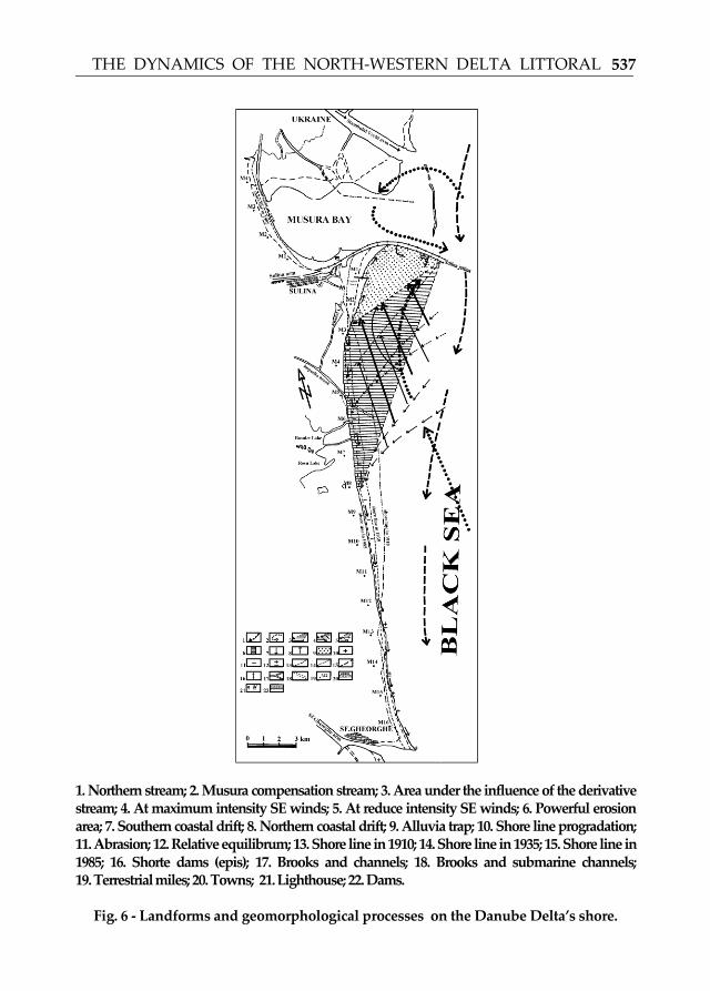
1. Northern stream; 2. Musura compensation stream; 3. Area under the influence of the derivative stream; 4. At maximum intensity SE winds; 5. At reduce intensity SE winds; 6. Powerful erosion area; 7. Southern coastal drift; 8. Northern coastal drift; 9. Alluvia trap; 10. Shore line progradation; 11. Abrasion; 12. Relative equilibrum; 13. Shore line in 1910; 14. Shore line in 1935; 15. Shore line in 1985; 16. Shorte dams (epis); 17. Brooks and channels; 18. Brooks and submarine channels; 19. Terrestrial miles; 20. Towns; 21. Lighthouse; 22. Dams.
Fig. 6 - Landforms and geomorphological processes on the Danube Delta’s shore.
Related Documents