The Danube Corridor Hypothesis and the Carpathian Basin: Geological, Environmental and Archaeological Approaches to Characterizing Aurignacian Dynamics Wei Chu 1 Published online: 29 May 2018 © The Author(s) 2018 Abstract Early Upper Paleolithic sites in the Danube catchment have been put forward as evidence that the river was an important conduit for modern humans during their initial settlement of Europe. Central to this model is the Carpathian Basin, a region covering most of the Middle Danube. As the archaeological record of this region is still poorly understood, this paper aims to provide a contextual assessment of the Carpathian Basin’s geological and paleoenvironmental archives, starting with the late Upper Pleistocene. Subsequently, it compiles early Upper Paleolithic data from the region to provide a synchronic appraisal of the Aurigna- cian archaeological evidence. It then uses this data to test whether the relative absence of early Upper Paleolithic sites is obscured by a taphonomic bias. Finally, it reviews current knowledge of the Carpathian Basin’s archaeological record and concludes that, while it cannot reject the Danube corridor hypothesis, further (geo) archaeological work is required to understand the link between the Carpathian Basin and Central and Southeastern Europe. Keywords Early modern humans · Danube corridor hypothesis · Carpathian Basin · Loess · Early Upper Paleolithic · Aurignacian Introduction: The Upper Paleolithic in the Carpathian Basin Current archaeological evidence suggests that modern humans entered Europe from East Africa either along the Mediterranean coast (Bar-Yosef 1998; Mellars 2006), through the East European Plain (Anikovich et al. 2007; Mellars 2004), and/or through a general axial trajectory along the Danube catchment from Southeastern into Central & Wei Chu [email protected] 1 Institute for Prehistory, University of Cologne, Weyertal 125, 50923 Cologne, Germany 123 J World Prehist (2018) 31:117–178 https://doi.org/10.1007/s10963-018-9115-1

Welcome message from author
This document is posted to help you gain knowledge. Please leave a comment to let me know what you think about it! Share it to your friends and learn new things together.
Transcript
The Danube Corridor Hypothesis and the CarpathianBasin: Geological, Environmental and ArchaeologicalApproaches to Characterizing Aurignacian Dynamics
Wei Chu1
Published online: 29 May 2018
© The Author(s) 2018
Abstract Early Upper Paleolithic sites in the Danube catchment have been put
forward as evidence that the river was an important conduit for modern humans
during their initial settlement of Europe. Central to this model is the Carpathian
Basin, a region covering most of the Middle Danube. As the archaeological record
of this region is still poorly understood, this paper aims to provide a contextual
assessment of the Carpathian Basin’s geological and paleoenvironmental archives,
starting with the late Upper Pleistocene. Subsequently, it compiles early Upper
Paleolithic data from the region to provide a synchronic appraisal of the Aurigna-
cian archaeological evidence. It then uses this data to test whether the relative
absence of early Upper Paleolithic sites is obscured by a taphonomic bias. Finally, it
reviews current knowledge of the Carpathian Basin’s archaeological record and
concludes that, while it cannot reject the Danube corridor hypothesis, further (geo)
archaeological work is required to understand the link between the Carpathian Basin
and Central and Southeastern Europe.
Keywords Early modern humans · Danube corridor hypothesis · Carpathian Basin ·
Loess · Early Upper Paleolithic · Aurignacian
Introduction: The Upper Paleolithic in the Carpathian Basin
Current archaeological evidence suggests that modern humans entered Europe from
East Africa either along the Mediterranean coast (Bar-Yosef 1998; Mellars 2006),
through the East European Plain (Anikovich et al. 2007;Mellars 2004), and/or through
a general axial trajectory along the Danube catchment from Southeastern into Central
& Wei Chu
1 Institute for Prehistory, University of Cologne, Weyertal 125, 50923 Cologne, Germany
123
J World Prehist (2018) 31:117–178
https://doi.org/10.1007/s10963-018-9115-1
Europe (Conard andBolus 2003, 2008). The last theory is supported by numerouswell-
studied and well-dated early Upper Paleolithic sites in the western Danube region, for
example,Hohle Fels,Willendorf II,Geißenklosterle, andKeilberg-Kirche (Conard and
Bolus 2008; Higham et al. 2012; Nigst 2006; Nigst et al. 2014; Teyssandier 2004;
Uthmeier 1996). Slightly older early Upper Paleolithic assemblages (Bachokirian and
Kozarnikian) are also found in the lower reaches of theDanube catchment, for example,
at Kozarnika, Temnata and Bacho Kiro, pointing to a hypothesized hominin starting
point in Southeastern Europe (Kozłowski 2004; Kozłowski and Otte 2000). Hominin
discoveries and dating projects have additionally identified an early presence of
anatomically modern humans in the Middle Danube catchment, exemplified by the
skeletal remains at the Peștera cu Oase (Trinkaus et al. 2003, 2012).Still, the role of the Danube catchment in early modern human migrations is
poorly understood, as the catchment’s early Upper Paleolithic sites have not been
verified and tested alongside the more extensive surrounding archaeological record.
Current archaeological research along the Danube catchment remains limited to
specific regions such as the surrounding highlands, the Inner Carpathians, Lower
Austria, southern Moravia, and the Dobruja province of the lower catchment; little
is known from the Basin itself (Anghelinu et al. 2012a; Iovița et al. 2014; Steguweitet al. 2009). Additionally, although a greater emphasis on collection re-examination,
site formation processes and re-dating efforts has helped to clarify erroneous sites,
many findspots remain poorly understood, while others with single and multiple
layers are only just being identified/re-excavated—for instance, Beregovo I and
Crvenka–At (Chu et al. 2014; Usik 2008). There is also surprisingly little discussion
among archaeologists about Middle Danube topographic and paleoclimatic
variability that could have influenced modern human migration.
To evaluate this, data from the Middle Danube catchment, here defined as the
Carpathian Basin, are compiled to explore the possible expansion of the early Upper
Paleolithic from Southeastern Europe into Central Europe. Known sites are positioned
within a broad synchronic perspective of modern human subsistence in the Carpathian
Basin across a varied spatial, climatic and environmental context. This paper draws on
archaeology, paleontology, geomorphology and climatology to explore the archae-
ological signal of the early Upper Paleolithic in the Carpathian Basin and to answer the
questions of how the early Upper Paleolithic record of the Carpathian Basin fits into
the Danube corridor hypothesis, and what avenues of research are the most promising.
Geological Background and Environmental Context
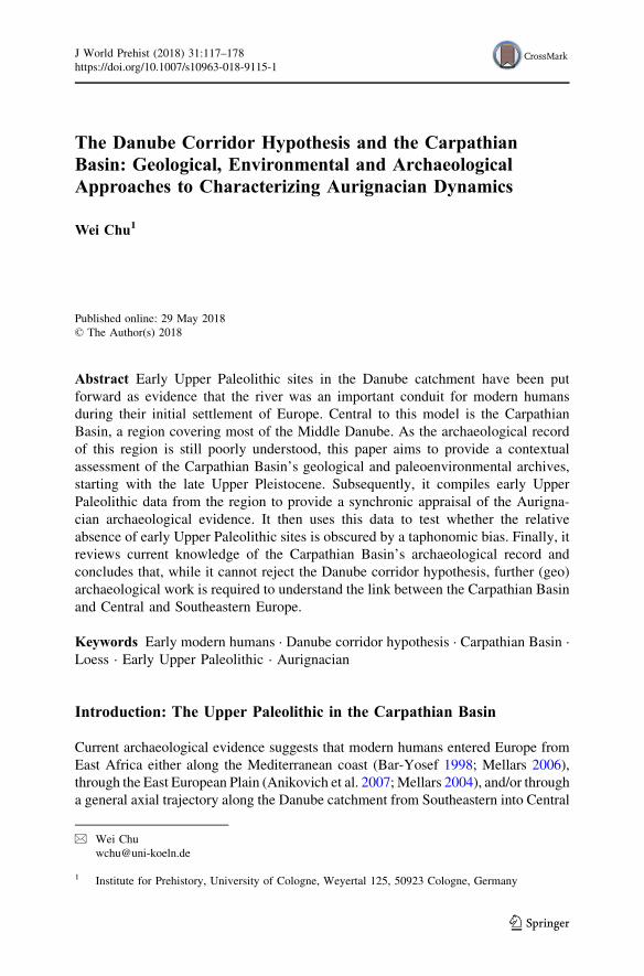
The Carpathian Basin is a back-arc basin around 200 m above mean sea level
(mamsl), located at the intersection of the Balkan Peninsula and Central and Eastern
Europe (Fig. 1). It measures roughly 400 km from north to south and 800 km from
Fig. 1 Map of the Carpathian Basin showing major physiographic features, principal early UpperPaleolithic localities and environmental proxies mentioned in the text. Red stars indicate majorarchaeological sites; black stars indicate minor archaeological sites. Blue circles indicate modern humanremains and black circles are loess profiles (see Tables 1 and 3 for locality information). Projection islatitude–longitude WGS84; DEM is SRTM (Color figure online)
c
118 J World Prehist (2018) 31:117–178
123
L
J World Prehist (2018) 31:117–178 119
123
east to west and is longitudinally bisected by the Danube and Tisza rivers.
Geographically, the Carpathian Basin is clearly demarcated—bounded to the north
and east by the Carpathians, to the west by the Alps/Dinarides, and to the south by
the Balkans. Politically, the Carpathian Basin is highly fragmented, though it is
primarily located within the borders of Hungary, eastern Croatia, western Romania,
southern Slovakia, northern Serbia, southwestern Ukraine and northern Bosnia and
Herzegovina.
The Carpathian Basin began forming during the Late Cretaceous and Cenozoic,
as a result of a collision between the Eurasian and Nubian plates (Horvath et al.
2015). Outward thrusting from the present Carpathian Basin was directed toward the
European platform and the Adriatic Sea. The interior regions of the thrust belts were
formed during the Mesozoic, while the exterior regions were formed later in the
Early Cenozoic (Royden et al. 1982). Gradual uplift of the Carpathian Mountains
resulted in subsidence associated with the Late Miocene retreat of the Paratethys
Sea to form the Pannonian Lake within the rough current boundary of the
Carpathian Basin (Horvath 1993).
By the beginning of the Late Miocene, as the Pannonian Lake retracted, it gave
rise to the Danube and Tisza river systems and an associated interconnected
paleolake system (Gabris and Nador 2007). From the Late Pliocene until the
beginning of the last glacial, the Danube, coming from the Visegrad Gorge, the
Tisza River from the Eastern part of the alluvial plain, and the paleo-Bodrog River
all converged on the south Tisza Graben (Kiss et al. 2015; Starkel et al. 2015).
Tectonic activity and global climatic cooling during the last glacial generally
resulted in a large braided river system across the basin (Mezosi 2017), but complex
regional tectonics, riparian vegetation and climate shaped local hydrology
differently. Rivers in uplifted/tectonically stable areas (broadly the western
Carpathian Basin) had narrow (a few kilometers wide), incised (hundreds of
meters) terraced valleys, whereas rivers in areas of net subsidence (broadly the
eastern Carpathian Basin) have buried terraces with heavy sedimentation and
floodplains that transformed into large, unstable alluvial plains (Perșoiu et al. 2017).
The Danube had a multi-channel, anastomosing pattern moving southeast across
the current Danube–Tisza Interfluve, where it built a broad alluvial fan (Gabris
1994; Mezosi 2017, p. 43). However, broadly 50 ka ago, tectonic activity forced the
river west into its current direction, where it began to incise, leaving behind a series
of (misfit) channels and dry surfaces across the abandoned eastern course (Kiss et al.
2015; Starkel et al. 2015). Thus, the former alluvial fans and floodplain levels
became dry surfaces, while the low-lying areas became subject to frequent
inundation.
By contrast, rivers in the subsiding Eastern Carpathian Basin were primarily
meandering during the last glacial (Cserkesz-Nagy 2012; Gabris et al. 2012).
Optically-stimulated luminescence (OSL) dates and sediment mineralogy suggest
that the Tisza ran 80 km east of its current trajectory c. 46–39 ka ago (Nador et al.
2007; Timar et al. 2005) and was prone to frequent tectonically influenced local and
regional channel avulsions (Gabris and Nador 2007; Perșoiu et al. 2017). However,
in the mid-altitude feeder rivers, there is evidence that between 45 and 37 ka ago,
120 J World Prehist (2018) 31:117–178
123
medium-sized rivers had shallow, gravel-bedded, braided channels (Perșoiu et al.
2017; Starkel et al. 2015).
The current course and morphology of the Danube and its main tributaries give a
false impression of the size and magnitude of the Pleistocene river systems, as their
regimes and planforms have changed markedly since the Holocene, due to increased
seasonal flow and a switch to small-scale meanders (Perșoiu and Radoane 2017).
The Danube channels were also heavily controlled in the nineteenth century through
extensive straightening and the construction of hundreds of levees and thousands of
km of drainage canals. The most extensive of these works were along the Tisza,
which was shortened by one-third (c. 500 km), while its 10–100 km wide floodplain
was reduced to 1–5 km (Cseko and Hayde 2004).
Nonetheless, the complex hydrological changes throughout the Quaternary in the
Carpathian Basin have left an abundant sedimentary archive throughout the basin.
Obtaining a cohesive understanding of the distribution of these sediments has been
problematic due to differences in cross-border source data (Lindner et al. 2017).
Still, a generalized picture for the area can be painted for Hungary and this can be
extrapolated to the wider region. In the interior mountain areas (e.g. the North
Hungarian Range), 1–25 m thick Quaternary rock fields, debris and lag gravels
appear infrequently; however, in the hilly regions, 0–140 m thick sediments are
comprised of nearly ubiquitous loess-paleosol complexes whose loose sediments
have been prone to mass wasting. In the basin, the surface of the higher alluvial fans
and low-lying floodplains are made up of fine and coarse Quaternary fluvial
sediments, whose thickness varies between 20 and 750 m (Jambor 2012).
This large amount of sedimentation in the Carpathian Basin, along with a lack of
appropriate geoarchaeological methods, has partly impeded the discovery of open-
air sites. While geochemical and microscopic methods have gained traction in
recent years, geoarchaeological research in the Carpathian Basin at a landscape
scale has mostly focused on tracing raw materials sources. However, many parts of
the Carpathian Basin have not been systematically surveyed, and advanced
geophysical techniques focused on locating new sites are still relatively unused (e.g.
remote sensing, magnetometry, electrical resistivity and ground-penetrating radar).
Additionally, the application of other field-based and laboratory methods to
elucidate site formation processes is also uncommon, which has been problematic
for the comprehensive understanding of site integrities and chronometric datings.
Environmental Context
As the focus of this paper is the early modern human occupation of the Carpathian
Basin, it is important to review late Upper Pleistocene climatic data to understand
the capacity, challenges and limitations for early humans inhabiting the region
(Muller et al. 2011). There are few methods of describing in detail the changes in
Pleistocene climatic conditions, due to the relatively rare occurrence of floral and
faunal remnants. As a result, the bulk of Pleistocene paleoclimatic reconstructions
for the Carpathian Basin are based upon loess deposits—fine-grained, friable, wind-
blown sediment accretions that cover many parts of the globe, and which in the
Carpathian Basin can be tens of meters thick (Markovic et al. 2015; Pye 1984;
J World Prehist (2018) 31:117–178 121
123
Rozycki and Wydzia 1991). It is generally accepted that some of the longest, most
continuous and best-studied loess deposits in Europe are found in the Carpathian
Basin (Fitzsimmons et al. 2012; Markovic et al. 2012a, b, 2014).
Loess, particularly when carbonate-rich, is archaeologically important because
Pleistocene sites, such as Willendorf II (Austria) or Mitoc-Malu Galben (Romania)
are frequently embedded within deposits (Haesaerts and Teyssandier 2003; Otte
et al. 2007; Nigst et al. 2014), often with extraordinary preservation (Handel et al.
2009). Loess deposits are also important because they are geographically
widespread, have long sedimentary records and can be used to derive paleoenvi-
ronmental proxies (Goldberg and Macphail 2009, p. 156; Zeuner 1956). However,
extracting ancient climatic details from loess records is seldom straightforward, as
loess-paleosol sequences are often obscured by incongruous reworked sediments
and disparate accumulation rates (Markovic et al. 2015). Though loess deposits are
nearly ubiquitous in the Carpathian Basin, they are rarely ‘typical’ (sensu Pye 1987,
p. 198), having been hydraulically eroded from higher elevations and redeposited
along the Danube floodplain throughout the Pleistocene (Buggle et al. 2008; Ujvari
et al. 2008). Therefore, loess-paleosol sequences are ideally dated using a
combination of radiometric dating techniques (radiocarbon, thermoluminescence
[TL], OSL, infrared stimulated luminescence [IRSL]) and multi- point/proxy
correlations. Still, the conditions for providing a high dating resolution record are
rarely met (Basarin et al. 2014; Buggle et al. 2009; Markovic et al. 2015; Necula
et al. 2013; Necula and Panaiotu 2008).
Paleoenvironmental information from loess is, at its simplest, inferred from the
number and types of embedded paleosols, but changes in rock magnetism,
geochemistry (biomarkers, isotopes), color, and grain size can also help to identify
and characterize specific soil/sediment formations (Buggle and Zech 2015; Schatz
2014; Schatz et al. 2015; Schreuder et al. 2016; Zech et al. 2013). When present,
biotic remnants such as mollusk shells (Markovic et al. 2007; Molnar 2015; Sumegi
et al. 2011, 2015), charcoal (Rudner and Sumegi 2001; Willis and van Andel 2004),
and/or osseous remains (Janossy 2011; Pazonyi et al. 2014) found within loess-
paleosol sequences can provide further insights into the paleoenvironment.
Given the current imprecision of these techniques, it is only possible to
extrapolate a generic, time-averaged paleoenvironmental reconstruction for the
Carpathian Basin during marine isotope stage 3 (hereafter MIS 3). Environmental
reconstructions based on oscillations in grain-size and magnetic susceptibility can
be used to determine broad-scale regional climate, but finer fluctuations cannot be
securely linked to North Atlantic Heinrich events without significant wiggle-
matching, which is difficult to reconcile from a dating perspective (Blaauw 2012).
Nevertheless, a combination of granulometry, geochemistry and magnetic suscep-
tibility from regional loess studies indicates that the Carpathian Basin had a
comparatively warmer, drier climate than the surrounding regions (Table 1). This
may have been consistent throughout the late Upper Pleistocene, and possibly even
earlier, as a result of the Carpathian uplift that created an atmospheric barrier to
North Atlantic climatic patterns (Antoine et al. 2009; Buggle et al. 2013).
Still, it is likely that there was significant paleodiversity across the Carpathian
Basin, as indicated by diverse loess paleosols suggesting cool-temperate biomes,
122 J World Prehist (2018) 31:117–178
123
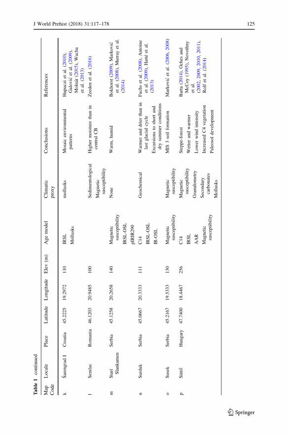
Tab
le1
Key
Upper
Pleistoceneenvironmentalproxiesderived
from
loess
Map
Code
Locale
Place
Latitude
Longitude
Elev(m
)Agemodel
Climatic
proxy
Conclusions
References
aBaranja
Croatia
45.8122
18.8203
95
IRSL
Mollusks
Magnetic
susceptibility
Granulometry
Calcimetry
Mineral
abundances
Mollusk
isotopes
Warm/open/arid—
interglacial
increased
pedogenic
ferrim
agnetic
mineralsin
palaeosols
possible
NW
winds
Banak
etal.(2012,2016),
Galovic
etal.(2009),
Molnar
(2015)
bCrvenka
Serbia
45.6617
19.4786
105
Magnetic
susceptibility
n-alakanes
Mollusks
Magnetic
susceptibility
Geochem
ical
granulometry
Grassland-dominated
ecosystem
,more
arid
grasses
andherbs
dominated
Markovic
etal.(2018),Zech
etal.(2013)
cDunaszekcso
Hungary
46.0700
18.7508
106
C14
OSL
pIR
OSL
pIRIR290
pIRIR225
Magnetic
susceptibility
Mollusks
Noloessaccumulationduring
MIS
3
Bradak
andKovacs(2014),
Ujvariet
al.(2014)
dGorjanovic
Croatia
45.3453
19.0123
30
pIRSL
Stratigraphy
Weakly
developed
palaeosol
indicates
clim
atic
fluctuations
Wacha(2011),Wachaand
Frechen
(2011)
eIrig
Serbia
45.0844
19.8661
185
AAR
magnetic
susceptibility
IRSL
Mollusks
Warmer
anddrier
Markovic
etal.(2007),
(2008)
J World Prehist (2018) 31:117–178 123
123
Tab
le1
continued
Map
Code
Locale
Place
Latitude
Longitude
Elev(m
)Agemodel
Climatic
proxy
Conclusions
References
fMadaras
Hungary
46.0372
19.2875
132
C14
Mollusks
Increase
indry
andwarm
lovingmollusks
HupucziandSumegi(2010),
Sumegiet
al.(2007),Willis
etal.(2000)
gMosorin
Serbia
45.2833
20.2333
123
Magnetic
susceptibility
n-alkanes
Mollusks
Environmentalconditions
less
volatile
Haggiet
al.(2013),Stevenset
al.
(2011),Zechet
al.(2013)
hOrlovat
Serbia
45.2500
20.5833
88
OSL
Granulometry
Magnetic
susceptibility
Stratigraphical
X-ray
flourescence
Colorimetric
nosoilcomplex;perhaps
eroded
Lukic
etal.(2014),Markovic
etal.(2014),Obrehtet
al.
(2015)
iPaks
Hungary
46.6403
18.8758
147
TL
IRSL
AAR
pIRIR290
Bluequartz
OSL
None
Highsedim
entation
Frechen
etal.(1997),Oches
and
McC
oy(1995),Pecsi
(1979),
Thielet
al.(2014),Wintleand
Packman
(1988)
jRuma
Serbia
45.0106
19.8542
123
magnetic
susceptibilityAAR
Sedim
entological
Magnetic
susceptibility
Mollusks
Drier
conditionsthan
in
other
parts
ofcentral
andsoutheastern
Europeduringthelater
partoftheMiddle
and
LatePleistocene
Markovic
etal.(2006)
124 J World Prehist (2018) 31:117–178
123
Tab
le1
continued
Map
Code
Locale
Place
Latitude
Longitude
Elev(m
)Agemodel
Climatic
proxy
Conclusions
References
kSarengradI
Croatia
45.2225
19.2972
110
IRSL
Mollusks
mollusks
Mosaic
environmental
patterns
Hupucziet
al.(2010),
Galovic
etal.(2009),
Molnar
(2015),Wacha
etal.(2013)
lSem
lac
Romania
46.1203
20.9485
100
Sedim
entological
Magnetic
susceptibility
Higher
moisture
than
in
central
CB
Zeeden
etal.(2016)
mStarı
Slankam
en
Serbia
45.1258
20.2658
140
Magnetic
susceptibility
IRSL-O
SL
pIRIR290
None
Warm,humid
Bokhorst(2009),Markovic
etal.(2008),Murray
etal.
(2014)
nSurduk
Serbia
45.0667
20.3333
111
C14
IRSL-O
SL
IR-O
SL
Geochem
ical
Warmer
anddrier
than
in
last
glacial
cycle
Excursionsto
shortand
dry
summer
conditions
Fuchset
al.(2008),Antoine
etal.(2009),Hatte
etal.
(2013)
oSusek
Serbia
45.2167
19.5333
130
Magnetic
susceptibility
Magnetic
susceptibility
MIS
3soilform
ation
Markovic
etal.(2006,2008)
pSutto
Hungary
47.7400
18.4467
256
C14
IRSL
AAR
Magnetic
susceptibility
Magnetic
susceptibility
Granulometry
Secondary
carbonates
Mollusks
Steppe-forest
Wetterandwarmer
Lower
windintensity
IncreasedC4vegetation
Paleosoldevelopment
Barta
(2014),Oches
and
McC
oy(1995),Novothny
etal.
(2002,2009,2010,2011),
Rolfet
al.(2014)
J World Prehist (2018) 31:117–178 125
123
Tab
le1
continued
Map
Code
Locale
Place
Latitude
Longitude
Elev(m
)Agemodel
Climatic
proxy
Conclusions
References
qSzeged-
Othalom
Hungary
46.2828
20.0967
85
C14
Sedim
entological
Magnetic
susceptibility
Geochem
ical
Mollusks
Tem
peratesteppe-forest
Sumegiet
al.(2007,2015)
rTitel
Serbia
45.2000
20.2833
119
magnetic
susceptibility
Granulometry
Geochem
ical
Windfrom
northwest
Interglacialsand
interstadials
wetter
duringthelast
130ka
Bokhorstet
al.(2011),Bokhorst
etal.(2009),Bokhorstand
Vandenberghe(2009)
sTokaj
Hungary
48.1258
21.4014
122
C14
IR50
pIRIR290
Geochem
ical
Mollusksn-alkanes
Slightlycooleranddrier
Productive,fertilesteppe-
grasslands,intensified
seasonal
clim
ate
reducedsedim
entation
Boreal
forest-steppe?
Steppe-grasslands?
Rudner
andSumegi(2001),
Schatzet
al.
(2011,2012,2014),(2015),
Sumegiet
al.(2007),Sumegi
andHertelendi(1998)
126 J World Prehist (2018) 31:117–178
123
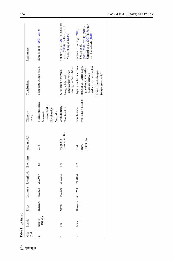
varying between steppe grasslands (Schatz et al. 2011) and forest steppe (Feurdean
et al. 2014; Kels et al. 2014), and their associated ecotones. It is evident that these
variations are in part due to complex geographical, geological, climatic and
meteorological deviations across both space and time. Additionally, local discrep-
ancies in geology, topography, soils, biota, aspect/exposure, wind and other
variables are all essential to understanding past microclimatic variations. However,
for the Late Pleistocene, these factors are largely unknown and difficult or
impossible to model.
In spite of this, the general results derived from loess records mesh well with
malacological studies suggesting that the Carpathian Basin was warmer and drier
than other parts of Europe during MIS 3 (57–29 ka ago), with patchy mosaic-like
variations in local climates (Molnar 2015; Rudner and Sumegi 2001; Willis et al.
2000; Willis and van Andel 2004). Mollusk faunal assemblages from loess sections
in the southern Carpathian Basin suggest particularly warm, arid environments, and
in some, thermophilic mollusks were found throughout the MIS 3 sediments,
suggesting a comparatively stable environment throughout the late Upper
Pleistocene.
Aside from the loess-derived proxies, there are few other climatic proxies
available from this time frame. However, those that do exist largely confirm the
prevailing depiction of an amenable climate. The large mammal and micromammal
assemblages from the exceptional Paleolithic cave sites in northwestern Croatia
(Veternica, Velika Pecina and Vindija) suggest relatively temperate environments
without dramatic oscillations in faunal composition throughout MIS 3 (Miracle
et al. 2010). This is additionally supported by the stable isotopes taken from the
Poleva Cave stalagmite (southwestern Romania) and the closest lake-core at Lake
Ochrid/Prespa in Northern Greece, which demonstrates a slight warming at 40 k
through an increase in arboreal pollen and organic input (Constantin et al. 2007;
Panagiotopoulos et al. 2014). These all suggest the MIS 3 record, which in Europe is
normally characterized as a period of climatic instability with dramatic alternations
between milder and colder conditions at millennial or sub-millennial timescales
(van Andel 2003), may have been comparatively muted in the Carpathian Basin.
A main thrust of paleoclimatic research has been to provide quantitative
estimates of both paleotemperature and precipitation, for which many models have
been derived from malacology and more recently from geochemistry. The main
results of these studies are presented in Table 2. Using mollusk assemblages
throughout the Carpathian Basin, Sumegi suggested that in the warmest month,
temperatures averaged 16–19 °C, while the average annual temperature hovered
around 10 °C—figures which, while colder, are still comparable to those today
(Krolopp and Sumegi 1995; Markovic et al. 2007; Sumegi and Krolopp 2002). In
the eastern Tokaj region, Sumegi and Hertelendi (1998) suggest that the average
July summer paleotemperatures were between 14 and 18 °C, depending on
topography and aspect. Mollusk paleotemperature reconstructions at Sutto also
showed similar-to-present mean July temperatures (21.5 °C) at the Irig section, in
Serbia.
Although still in a nascent phase, a recent focus of geological research has been
on transfer functions which mathematically convert geochemical proxies into
J World Prehist (2018) 31:117–178 127
123
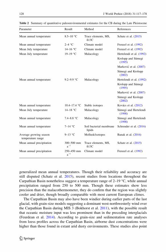
generalized mean annual temperatures. Though their reliability and accuracy are
still disputed (Schatz et al. 2015), recent studies from locations throughout the
Carpathian Basin nonetheless suggest a temperature range of 2–19 °C, while annualprecipitation ranged from 250 to 500 mm. Though these estimates show less
precision than the malacothermometer, they do confirm that the region was slightly
cooler and drier, though broadly comparable with most current European climes.
The Carpathian Basin may also have been windier during earlier parts of the last
glacial, with grain-size models suggesting a dominant west-northwesterly wind over
the Carpathian Basin during MIS 3 (Bokhorst et al. 2011), with the possible result
that oceanic moisture input was less prominent than in the preceding interglacials
(Feurdean et al. 2014). According to grain-size and sedimentation rate analyses
from loess profiles across the Carpathian Basin, airborne dust concentrations were
higher than those found in extant arid dusty environments. These studies also point
Table 2 Summary of quantitative paleoenvironmental estimates for the CB during the Late Pleistocene
Parameter Result Method References
Mean annual temperature 8.5–10 °C Trace elements, MS,
δ13CSchatz et al. (2015)
Mean annual temperature 2–4 °C Climate model Frenzel et al. (1992)
Mean July temperature 14–16 °C Climate model Frenzel et al. (1992)
Mean July temperature 19–19 °C Malacology Hertelendi et al. (1992)
Krolopp and Sumegi
(1995)
Markovic et al. (2007)
Sumegi and Krolopp
(2002)
Mean annual temperature 9.2–9.9 °C Malacology Hertelendi et al. (1992)
Krolopp and Sumegi
(1995)
Markovic et al. (2007)
Sumegi and Krolopp
(2002)
Mean annual temperature 10.4–17.4 °C Stable isotopes Kovacs et al. (2012)
Mean July temperature 14–18 °C Malacology Sumegi and Hertelendi
(1998)
Mean annual temperature 7.4–8.8 °C Malacology Sumegi and Hertelendi
(1998)
Mean annual temperature 7–14 °C Soil bacterial membrane
lipids
Schreuder et al. (2016)
Average growing season
temperature range
9–13 °C Mollusk/isotopes Banak et al. (2016)
Mean annual precipitation 300–500 mm
a−1Trace elements, MS,
δ13CSchatz et al. (2015)
Mean annual precipitation 250–450 mm
a−1Climate model Frenzel et al. (1992)
128 J World Prehist (2018) 31:117–178
123
to the occurrence of Late Pleistocene dust storms strong enough to have
occasionally impaired visibility across the landscape (Varga et al. 2012). At
present, it is difficult to extrapolate the frequency, duration or spatial extent of these
storms; however, given the persistent survival of diverse flora and fauna across the
Carpathian Basin, it would appear that they were both intermittent and localized.
Still, while the loess, mollusks, fauna and geochemistry offer a cohesive climatic
reconstruction for MIS 3, given the poor temporal resolution it is challenging to
definitively say whether the Carpathian Basin had a mosaic climate or if these
various biomes represent various periods and/or palimpsests throughout MIS 3.
These uncertainties are unlikely to be resolved anytime soon without improved
chronological models. Whatever the outcome of this debate, it is increasingly clear
that at some point during MIS 3, the climatic conditions of the Carpathian Basin
suggest an environment that would have supported ample wildlife and plant life and
created a hospitable habitat for modern humans for a possible later expansion of
modern humans into Central Europe.
The Early Upper Paleolithic of the Carpathian Basin: CurrentKnowledge
Paleolithic research in the Carpathian Basin has a long history that in its early phase
(c. 1900) was part of a larger pan-European interest in the antiquity of humans
(Romanowska 2016). Early scholars focused their efforts primarily on cave sites
(e.g. Doboș et al. 2010, p. 21; Lengyel et al. 2008), though, as elsewhere, their
excavations frequently resulted in poorly-documented, biased archaeological
collections lacking in contextual information.
As archaeological research grew, the increasing geopolitical fractionation of the
Carpathian Basin following World War I inhibited cross-border academic exchange,
with a greater propensity to publish in local languages and national publications
leading to divergent national archaeological methods and theory. Isolation meant
that some countries in the Carpathian Basin never fully implemented advancing
theoretical frameworks, continuing to use type fossils and adapting them to create a
menagerie of local lithic industries that did not traverse national borders,
complicating intraregional comparisons. Additionally, Paleolithic research was
increasingly used (to different extents) to advance Marxist perspectives and to
uphold ethnogeneses according to a culture-historical paradigm (Anghelinu 1998;
Bartosiewicz 2016; Dragoman and Oanta-Marghitu 2006).
Nevertheless, numerous early Upper Paleolithic sites in the Carpathian Basin are
known to contain important geochronological, paleontological and archaeological
evidence. The following section presents short descriptions of these sites and
positions them within a regional context. These data are drawn from sites located
across the Carpathian Basin within the Danube catchment (Hungary, Croatia,
Slovakia, Serbia, Romania, Ukraine, and Bosnia and Herzegovina) and broadly
situated across the same environmental conditions during MIS 3. This review
underscores the variable quality of archaeological data reporting, with the number
of lithics, assemblage compositions and stratigraphic context often being unclear or
J World Prehist (2018) 31:117–178 129
123
unreported. Thus, this study focuses on published sites defined as early Upper
Paleolithic or Aurignacoid (based on retouched blades/bladelet production,
carinated pieces and bone industry) and, ideally, sites for which cosmogenic dates
were provided. Where available, data extracted include site location, age, type
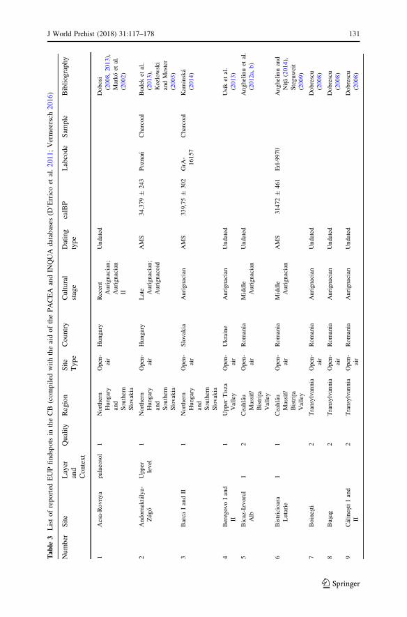
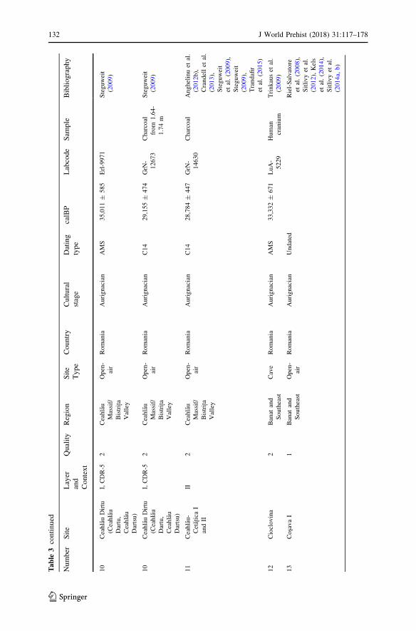
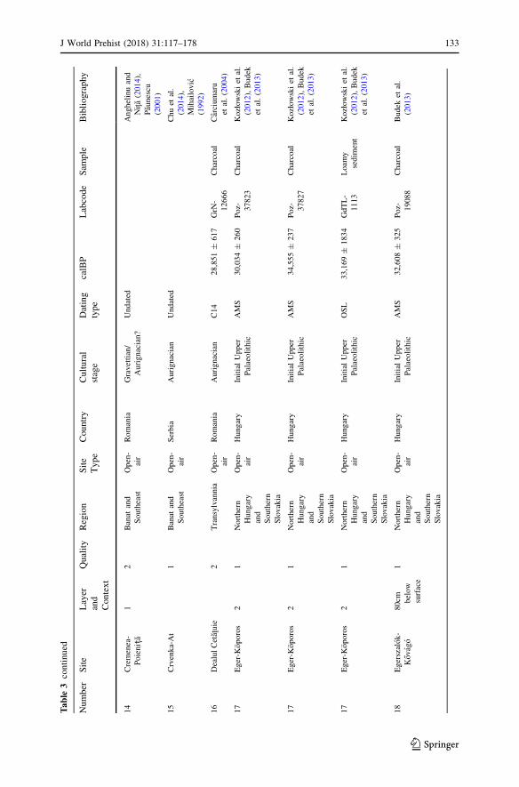
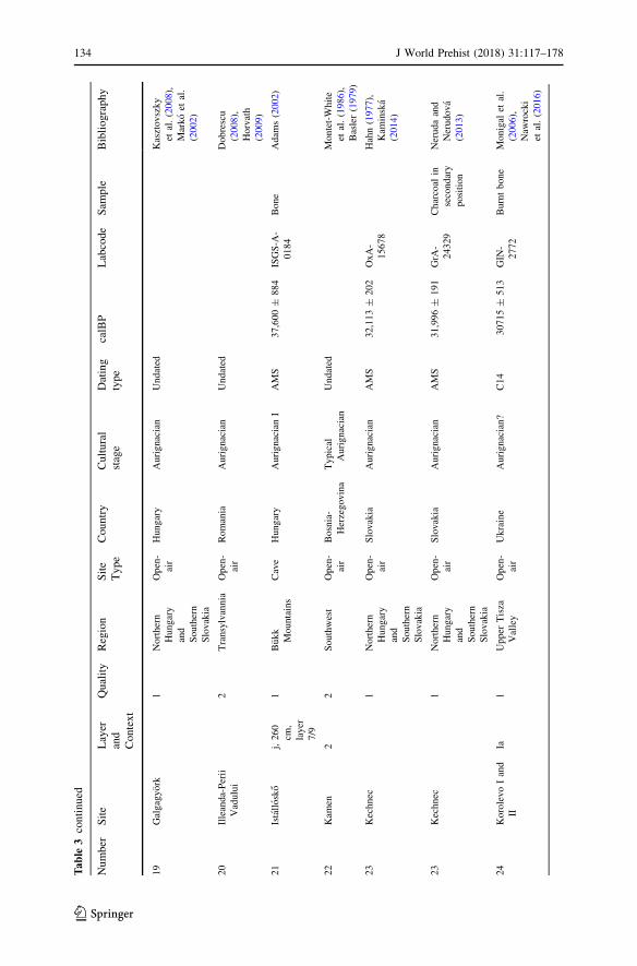
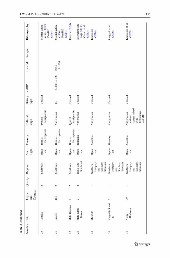
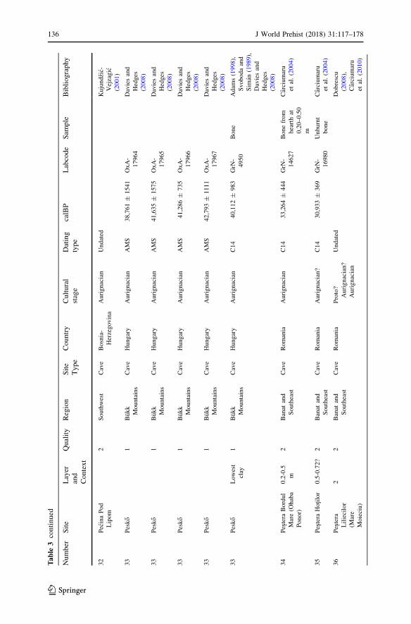
(open/cave), techno-typological attribution and radiometric dating (Table 3).
Additionally, sites are ascribed a quality value based on the presence of diagnostic
artifacts and independent chronological markers. The collation of this database of
early Upper Paleolithic archaeological sites provides a broader structure with which
to compare and contextualize the Carpathian Basin’s archaeological record. This
methodology not only allows for a wider reassessment of early modern human
subsistence but also provides the first systematic and synchronic comparison of the
role and importance of topography and climate in the modern human occupation of
the Carpathian Basin.
Important locations in the Carpathian Basin are found in the regions of Romania
(Banat, the Ceahlau Massif/Bistrița Valley and Transylvania), northern Hungary andsouthern Slovakia, Ukraine (Upper Tisza Valley), Bosnia and Herzegovina (the
southwest), and the exceptional karstic cave localities of the Croatian Zagorje and
Hungarian Bukk Mountains. Unfortunately, the dissociation of archaeological
assemblages and the poor quality of old excavations makes it difficult to assign
many of the key sites to specific time frames. Nevertheless, if correct, the
radiocarbon ages of the Peștera cu Oase indicate an early modern human presence in
the Carpathian Basin reaching back to at least 40 ka ago; it is therefore important for
assessing the nature and timing of the earliest modern human occupation of Europe.
Banat Sites and the Southeast
Perhaps the best-researched area of early Upper Paleolithic archaeology in the
Carpathian Basin is the Banat—a historical region shared by western Romania,
northwestern Serbia and southeastern Hungary, where open plains, marshes and
karstic mountains coexist in close proximity (Tasic et al. 2011). Here, stratified
Aurignacian sites are found close, spatially and temporally, to the multiple well-
dated early human remains at the Peștera cu Oase (Trinkaus et al. 2003, 2012), as
well as further afield in the southeastern Carpathian Basin at Muierii and Cioclovina
(Alexandrescu et al. 2010; Harvati et al. 2007; Soficaru et al. 2006, 2007; Trinkaus
et al. 2009).
Romanești is the best-known and most comprehensively documented Banat site.
This open-air site is situated on a low terrace plateau (212 mamsl) near the
confluence of two small streams, with archaeological deposits found throughout a
meter-deep sequence (Fig. 2). Here, layers of Aurignacian artifacts were found
intercalated between a quartzite Mousterian and Gravettian layers (Fig. 3). The
largest assemblage (level III) contains thousands of lithics, refitted knapping
debitage and typical Aurignacian tools suggestive of a highly-preserved knapping
locale (Kels et al. 2014; Sitlivy et al. 2014a, b). No organic remains have yet been
found, a situation that is not likely to change due to high soil acidity. However, OSL
and TL dates of sediments and heated artifacts indirectly and directly bracket the
Aurignacian levels between 42.1 and 39.1 ka ago (Schmidt et al. 2013; Sitlivy et al.
130 J World Prehist (2018) 31:117–178
123
Tab
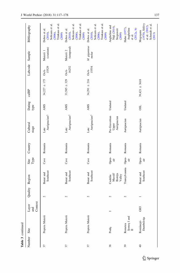
le3
Listofreported
EUPfindspotsin
theCB(compiled
withtheaidofthePACEA
andIN
QUA
databases
(D’Erricoet
al.2011;Vermeersch
2016)
Number
Site
Layer
and
Context
Quality
Region
Site
Type
Country
Cultural
stage
Dating
type
calBP
Labcode
Sam
ple
Bibliography
1Acsa-Rovnya
palaeosol
1Northern
Hungary
and
Southern
Slovakia
Open-
air
Hungary
Recent
Aurignacian;
Aurignacian
II
Undated
Dobosi
(2008,2013),
Markoet
al.
(2002)
2Andornaktalya-
Zugo
Upper
level
1Northern
Hungary
and
Southern
Slovakia
Open-
air
Hungary
Late
Aurignacian;
Aurignacoid
AMS
34,379±
243
Poznan
Charcoal
Budek
etal.
(2013),
Kozlowski
andMester
(2003)
3Barca
IandII
1Northern
Hungary
and
Southern
Slovakia
Open-
air
Slovakia
Aurignacian
AMS
339,75±
302
GrA
-
16157
Charcoal
Kam
inska
(2014)
4BeregovoIand
II
1Upper
Tisza
Valley
Open-
air
Ukraine
Aurignacian
Undated
Usiket
al.
(2013)
5Bicaz-Izvorul
Alb
12
Ceahlau
Massif/
Bistrita
Valley
Open-
air
Romania
Middle
Aurignacian
Undated
Anghelinuet
al.
(2012a,
b)
6Bistricioara
Lutarie
11
Ceahlau
Massif/
Bistrita
Valley
Open-
air
Romania
Middle
Aurignacian
AMS
31472±
461
Erl-9970
Anghelinuand
Nita(2014),
Steguweit
(2009)
7Boinesti
2Transylvannia
Open-
air
Romania
Aurignacian
Undated
Dobrescu
(2008)
8Busag
2Transylvannia
Open-
air
Romania
Aurignacian
Undated
Dobrescu
(2008)
9CalinestiIand
II
2Transylvannia
Open-
air
Romania
Aurignacian
Undated
Dobrescu
(2008)
J World Prehist (2018) 31:117–178 131
123
Tab
le3
continued
Number
Site
Layer
and
Context
Quality
Region
Site
Type
Country
Cultural
stage
Dating
type
calBP
Labcode
Sam
ple
Bibliography
10
CeahlauDirtu
(Ceahlau
Dartu,
Ceahlau
Dartsu)
I,CDR-5
2Ceahlau
Massif/
Bistrita
Valley
Open-
air
Romania
Aurignacian
AMS
35,011±
585
Erl-9971
Steguweit
(2009)
10
CeahlauDirtu
(Ceahlau
Dartu,
Ceahlau
Dartsu)
I,CDR-5
2Ceahlau
Massif/
Bistrita
Valley
Open-
air
Romania
Aurignacian
C14
29,155±
474
GrN
-
12673
Charcoal
from
1.64-
1.74m
Steguweit
(2009)
11
Ceahlau-
CetaticaI
andII
II2
Ceahlau
Massif/
Bistrita
Valley
Open-
air
Romania
Aurignacian
C14
28,784±
447
GrN
-
14630
Charcoal
Anghelinuet
al.
(2012b),
Crandellet
al.
(2013),
Steguweit
etal.(2009),
Steguweit
(2009),
Trandafir
etal.(2015)
12
Cioclovina
2Banat
and
Southeast
Cave
Romania
Aurignacian
AMS
33,332±
671
LuA-
5229
Human
cranium
Trinkauset
al.
(2009)
13
CosavaI
1Banat
and
Southeast
Open-
air
Romania
Aurignacian
Undated
Riel-Salvatore
etal.(2008),
Sitlivyet
al.
(2012),Kels
etal.(2014),
Sitlivyet
al.
(2014a,
b)
132 J World Prehist (2018) 31:117–178
123
Tab
le3
continued
Number
Site
Layer
and
Context
Quality
Region
Site
Type
Country
Cultural
stage
Dating
type
calBP
Labcode
Sam
ple
Bibliography
14
Cremenea-
Poienița
12
Banat
and
Southeast
Open-
air
Romania
Gravettian/
Aurignacian?
Undated
Anghelinuand
Nita(2014),
Paunescu
(2001)
15
Crvenka-At
1Banat
and
Southeast
Open-
air
Serbia
Aurignacian
Undated
Chuet
al.
(2014),
Mihailovic
(1992)
16
DealulCetatuie
2Transylvannia
Open-
air
Romania
Aurignacian
C14
28,851±
617
GrN
-
12666
Charcoal
Carciumaru
etal.(2004)
17
Eger-K
oporos
21
Northern
Hungary
and
Southern
Slovakia
Open-
air
Hungary
InitialUpper
Palaeolithic
AMS
30,034±
260
Poz- 37823
Charcoal
Kozłowskiet
al.
(2012),Budek
etal.(2013)
17
Eger-K
oporos
21
Northern
Hungary
and
Southern
Slovakia
Open-
air
Hungary
InitialUpper
Palaeolithic
AMS
34,555±
237
Poz- 37827
Charcoal
Kozłowskiet
al.
(2012),Budek
etal.(2013)
17
Eger-K
oporos
21
Northern
Hungary
and
Southern
Slovakia
Open-
air
Hungary
InitialUpper
Palaeolithic
OSL
33,169±
1834
GdTL-
1113
Loam
y
sedim
ent
Kozłowskiet
al.
(2012),Budek
etal.(2013)
18
Egerszalok-
Kovago
80cm below
surface
1Northern
Hungary
and
Southern
Slovakia
Open-
air
Hungary
InitialUpper
Palaeolithic
AMS
32,608±
325
Poz- 19088
Charcoal
Budek
etal.
(2013)
J World Prehist (2018) 31:117–178 133
123
Tab
le3
continued
Number
Site
Layer
and
Context
Quality
Region
Site
Type
Country
Cultural
stage
Dating
type
calBP
Labcode
Sam
ple
Bibliography
19
Galgagyork
1Northern
Hungary
and
Southern
Slovakia
Open-
air
Hungary
Aurignacian
Undated
Kasztovszky
etal.(2008),
Markoet
al.
(2002)
20
Illeanda-Perii
Vadului
2Transylvannia
Open-
air
Romania
Aurignacian
Undated
Dobrescu
(2008),
Horvath
(2009)
21
Istallosko
j,260
cm,
layer
7/9
1Bukk
Mountains
Cave
Hungary
AurignacianI
AMS
37,600±
884
ISGS-A
-
0184
Bone
Adam
s(2002)
22
Kam
en2
2Southwest
Open-
air
Bosnia-
Herzegovina
Typical
Aurignacian
Undated
Montet-White
etal.(1986),
Basler(1979)
23
Kechnec
1Northern
Hungary
and
Southern
Slovakia
Open-
air
Slovakia
Aurignacian
AMS
32,113±
202
OxA-
15678
Hahn(1977),
Kam
inska
(2014)
23
Kechnec
1Northern
Hungary
and
Southern
Slovakia
Open-
air
Slovakia
Aurignacian
AMS
31,996±
191
GrA
-
24329
Charcoal
in
secondary
position
Nerudaand
Nerudova
(2013)
24
KorolevoIand
II
Ia1
Upper
Tisza
Valley
Open-
air
Ukraine
Aurignacian?
C14
30715±
513
GIN
-
2772
Burntbone
Monigal
etal.
(2006),
Naw
rocki
etal.(2016)
134 J World Prehist (2018) 31:117–178
123
Tab
le3
continued
Number
Site
Layer
and
Context
Quality
Region
Site
Type
Country
Cultural
stage
Dating
type
calBP
Labcode
Sam
ple
Bibliography
25
Londza
2Southwest
Open-
air
Bosnia-
Herzegovina
Typical
Aurignacian
Undated
Montet-White
etal.(1986),
Pandzic
(2014)
26
Luscic
IIIb
2Southwest
Open-
air
Bosnia-
Herzegovina
Aurignacian
TL
33,048±
420
16/84
L-1894
Montet-White
(1996),
Pandzic
(2014)
27
MalaGradina
22
Southwest
Open-
air
Bosnia-
Herzegovina
Typical
Aurignacian
Undated
Pandzic(2014)
28
MaluDinu
Buzea
22
Banat
and
Southeast
Open-
air
Romania
Aurignacian
Undated
Anghelinuand
Nita(2014),
Cosacet
al.
(2013)
29
Milhost’
1Northern
Hungary
and
Southern
Slovakia
Open-
air
Slovakia
Aurignacian
Undated
Kam
inska
(2014)
30
NagyredeIand
II
21
Northern
Hungary
and
Southern
Slovakia
Open-
air
Hungary
Aurignacian
Undated
Lengyel
etal.
(2006)
31
Nizny
Hrabovec
99
1Northern
Hungary
and
Southern
Slovakia
Open-
air
Slovakia
Aurignacian
surface
scattermixed
with
Bohunician
andMP
Undated
Kam
inskaet
al.
(2009)
J World Prehist (2018) 31:117–178 135
123
Tab
le3
continued
Number
Site
Layer
and
Context
Quality
Region
Site
Type
Country
Cultural
stage
Dating
type
calBP
Labcode
Sam
ple
Bibliography
32
PecinaPod
Lipom
2Southwest
Cave
Bosnia-
Herzegovina
Aurignacian
Undated
Kujundzic-
Vejzagic
(2001)
33
Pesko
1Bukk
Mountains
Cave
Hungary
Aurignacian
AMS
38,761±
1541
OxA-
17964
Daviesand
Hedges
(2008)
33
Pesko
1Bukk
Mountains
Cave
Hungary
Aurignacian
AMS
41,635±
1575
OxA-
17965
Daviesand
Hedges
(2008)
33
Pesko
1Bukk
Mountains
Cave
Hungary
Aurignacian
AMS
41,286±
735
OxA-
17966
Daviesand
Hedges
(2008)
33
Pesko
1Bukk
Mountains
Cave
Hungary
Aurignacian
AMS
42,793±
1111
OxA-
17967
Daviesand
Hedges
(2008)
33
Pesko
Lowest
clay
1Bukk
Mountains
Cave
Hungary
Aurignacian
C14
40,112±
983
GrN
-
4950
Bone
Adam
s(1998),
Svobodaand
Sim
an(1989),
Daviesand
Hedges
(2008)
34
Peștera
Bordul
Mare(O
haba
Ponor)
0.2-0.5
m
2Banat
and
Southeast
Cave
Romania
Aurignacian
C14
33,264±
444
GrN
-
14627
Bonefrom
hearthat
0.20–0.50
m
Carciumaru
etal.(2004)
35
Peștera
Hotilor
0.5-0.72?
2Banat
and
Southeast
Cave
Romania
Aurignacian?
C14
30,933±
369
GrN
-
16980
Unburnt
bone
Carciumaru
etal.(2004)
36
Peștera
Liliecilor
(Mare
Moieciu)
22
Banat
and
Southeast
Cave
Romania
Proto?
Aurignacian?
Aurignacian
Undated
Dobrescu
(2008),
Carciumaru
etal.(2010)
136 J World Prehist (2018) 31:117–178
123
Tab
le3
continued
Number
Site
Layer
and
Context
Quality
Region
Site
Type
Country
Cultural
stage
Dating
type
calBP
Labcode
Sam
ple
Bibliography
37
Peștera
Muierii
2Banat
and
Southeast
Cave
Romania
Late
Aurignacian?
AMS
34,227±
175
OxA-
15529
Muierii1
(cranium)
Doboset
al.
(2010),
Soficaru
etal.
(2006),
Trinkauset
al.
(2009)
37
Peștera
Muierii
2Banat
and
Southeast
Cave
Romania
Late
Aurignacian?
AMS
33,585±
329
OxA-
16252
Muierii2
(tem
poral)
Doboset
al.
(2010),
Soficaru
etal.
(2006),
Trinkauset
al.
(2009)
37
Peștera
Muierii
2Banat
and
Southeast
Cave
Romania
Late
Aurignacian?
AMS
34,291±
216
OxA-
15554
M.giganteus
molar
Doboset
al.
(2010),
Soficaru
etal.
(2006),
Trinkauset
al.
(2009)
38
Podis
I2
Ceahlau
Massif/
Bistrita
Valley
Open-
air
Romania
Pre-G
ravettian
Upper
Aurignacian
Undated
Anghelinuand
Nita(2014),
Steguweit
(2009)
39
Rem
etea
SomosIand
II
2Transylvannia
Open-
air
Romania
Aurignacian
Undated
Hahn(1977),
Anghelinu
etal.
(2012a,
b)
40
Romanesti-
Dumbravita
GH3
1Banat
and
Southeast
Open-
air
Romania
Aurignacian
OSL
39,421±
3618
Mogoșanu
(1978),Sitlivy
etal.(2012),
Schmidtet
al.
(2013)
J World Prehist (2018) 31:117–178 137
123
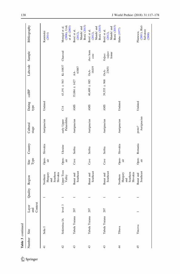
Tab
le3
continued
Number
Site
Layer
and
Context
Quality
Region
Site
Type
Country
Cultural
stage
Dating
type
calBP
Labcode
Sam
ple
Bibliography
41
SenaI
1Northern
Hungary
and
Southern
Slovakia
Open-
air
Slovakia
Aurignacian
Undated
Kam
inska
(2014)
42
Sokirnitsa
IAlevel
31
Upper
Tisza
Valley
Open-
air
Ukraine
earlyUpper
Palaeolithic
C14
43,191±
563
Ki-10837
Charcoal
Monigal
etal.
(2006),Usik
etal.(2003)
43
Tabula
Traiana
207
1Banat
and
Southeast
Cave
Serbia
Aurignacian
AMS
35,884±
1427
AA-
63887
Boricet
al.
(2012),
Mandic
and
Boric(2015)
43
Tabula
Traiana
207
1Banat
and
Southeast
Cave
Serbia
Aurignacian
AMS
40,409±
885
OxA-
16419
ibex
horn
core
Boricet
al.
(2012),
Mandic
and
Boric(2015)
43
Tabula
Traiana
207
1Banat
and
Southeast
Cave
Serbia
Aurignacian
AMS
39,555±
968
OxA-
23651
Vulpes
vulpes
femur
Boricet
al.
(2012),
Mandic
and
Boric(2015)
44
Tibava
1Northern
Hungary
and
Southern
Slovakia
Open-
air
Slovakia
Aurignacian
Undated
Hahn(1977)
45
Tincova
11
Banat
and
Southeast
Open-
air
Romania
proto?
Aurignacian
Undated
Paunescu,
(2001),Riel-
Salvatore
(2008)
138 J World Prehist (2018) 31:117–178
123
Tab
le3
continued
Number
Site
Layer
and
Context
Quality
Region
Site
Type
Country
Cultural
stage
Dating
type
calBP
Labcode
Sam
ple
Bibliography
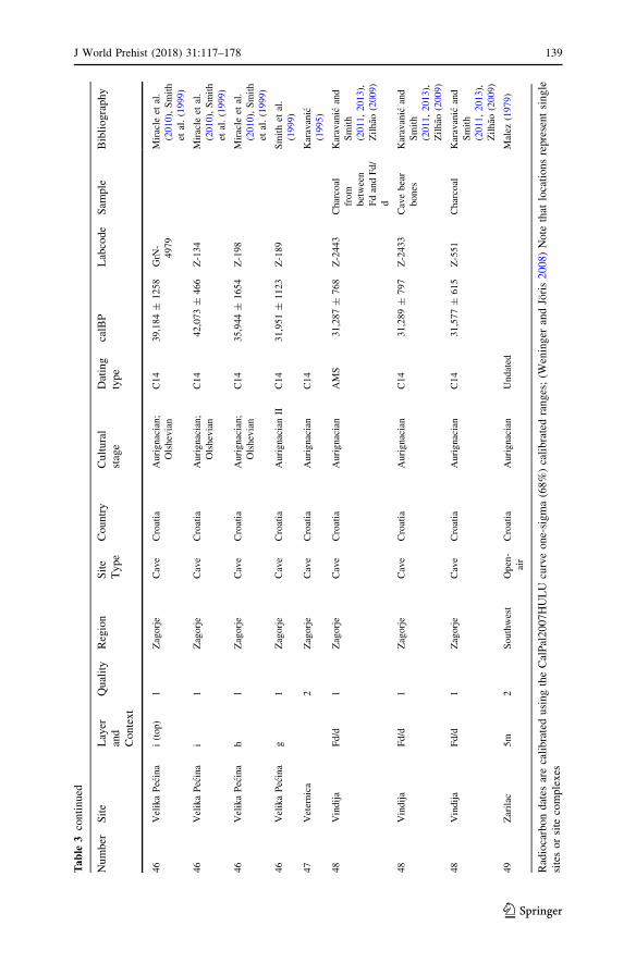
46
VelikaPecina
i(top)
1Zagorje
Cave
Croatia
Aurignacian;
Olshevian
C14
39,184±
1258
GrN
-
4979
Miracle
etal.
(2010),Smith
etal.(1999)
46
VelikaPecina
i1
Zagorje
Cave
Croatia
Aurignacian;
Olshevian
C14
42,073±
466
Z-134
Miracle
etal.
(2010),Smith
etal.(1999)
46
VelikaPecina
h1
Zagorje
Cave
Croatia
Aurignacian;
Olshevian
C14
35,944±
1654
Z-198
Miracle
etal.
(2010),Smith
etal.(1999)
46
VelikaPecina
g1
Zagorje
Cave
Croatia
AurignacianII
C14
31,951±
1123
Z-189
Smithet
al.
(1999)
47
Veternica
2Zagorje
Cave
Croatia
Aurignacian
C14
Karavanic
(1995)
48
Vindija
Fd/d
1Zagorje
Cave
Croatia
Aurignacian
AMS
31,287±
768
Z-2443
Charcoal
from
between
FdandFd/
d
Karavanic
and
Smith
(2011,2013),
Zilhao
(2009)
48
Vindija
Fd/d
1Zagorje
Cave
Croatia
Aurignacian
C14
31,289±
797
Z-2433
Cavebear
bones
Karavanic
and
Smith
(2011,2013),
Zilhao
(2009)
48
Vindija
Fd/d
1Zagorje
Cave
Croatia
Aurignacian
C14
31,577±
615
Z-551
Charcoal
Karavanic
and
Smith
(2011,2013),
Zilhao
(2009)
49
Zarilac
5m
2Southwest
Open-
air
Croatia
Aurignacian
Undated
Malez
(1979)
Radiocarbondates
arecalibratedusingtheCalPal2007HULU
curveone-sigma(68%)calibratedranges;(W
eninger
andJoris2008)Note
that
locationsrepresentsingle
sitesorsite
complexes
J World Prehist (2018) 31:117–178 139
123
0
100
Coş
ava
Rom
âneş
tiTi
ncov
a
ochr
e-gr
ey lo
am
sand
s an
d pe
bble
s
mic
a-ric
h sa
nds
clay
ey s
ands
At
mod
ern
soil
yello
w-w
hitis
h fin
e du
sty
laye
r
redd
ish
clay
with
pris
mat
ic
stru
ctur
ere
d ye
llow
ish
clay
ish
silt
iron
man
gane
se c
oncr
etio
ns
with
gra
vel
artif
act l
evel
50 150
200
250de
pth
(cm
)
foss
il ro
ot c
hann
els
Fig.2
ProfilesoffourBanat
sites(Coșava,
Romanești,TincovaandCrvenka–At;afterMogoșanu1978)
140 J World Prehist (2018) 31:117–178
123
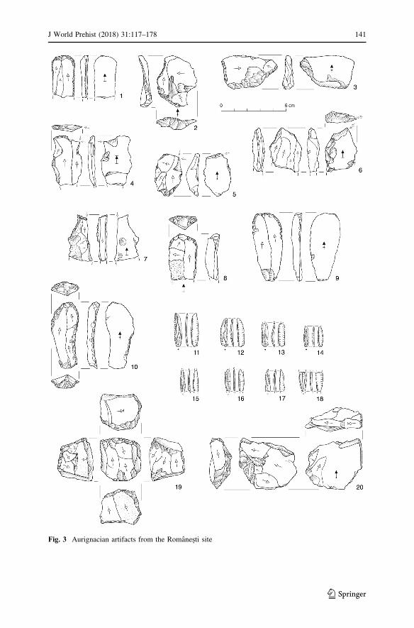
Fig. 3 Aurignacian artifacts from the Romanești site
J World Prehist (2018) 31:117–178 141
123
2012). Additionally, paleoenvironmental reconstructions based on sedimentology
and geochemistry of the embedding matrix suggest that the artifacts were deposited
during a period when a moderate, humid forest steppe predominated (Kels et al.
2014).
The twin site of Coșava (282 mamsl) is located 4 km across the Bega Valley.
Like Romanești, it was the object of two excavations during the 1960s. Based on
artifact depth and typology, the original excavator identified two Aurignacian layers
superimposed by a final Upper Paleolithic layer (Mogoșanu 1978). These layers and
their attributions were later reconfirmed by Sitlivy et al., who again noted the
presence of small debitage not present in the earlier collections (Kels et al. 2014;
Sitlivy et al. 2014a). This, in addition to sediment analyses, suggests limited post-
depositional processes associated with the lithic artifacts (Kels et al. 2014; Sitlivy
et al. 2014b). Dating the site has been problematic due to the absence of organic
remains and burned artifacts. OSL dates of underlying sediments are anomalously
old (61–50 ka BP), possibly due to sediment mixing in the lower archaeological
layers.
A third Banat site, Tincova, was first excavated in 1958–1960 (Nicolaescu-
Plopșor and Stratan 1961; Stratan 1962) and later by Mogoșanu and Stratan (1965–
1966; Mogoșanu 1978). Mogoșanu excavated an area of 280 m2 in the knickpoint of
a gully, recovering 2494 lithic artifacts. Some 500 of the artifacts are tools, leading
to the interpretation that the site was an Aurignacian workshop (Anghelinu et al.
2012a; Paunescu 2000). The high ratio of worked pieces and the low artifact density
(c. 9 artifacts/m3) may suggest an excavation bias, though recent research indicates
that this may not be the case (Chu, Zeeden, and Petrescu 2016).
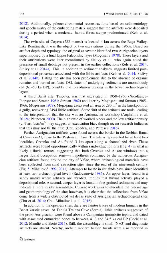
Further Aurignacian artifacts were found across the border in the Serbian Banat
at Crvenka–At, close to the Peștera cu Oase. The site is represented by at least two
localities, Crvenka and At, found 3 km apart along a channelized river. These
artifacts were found opportunistically within sand-extraction pits (Fig. 4) in what is
likely a fluvial terrace, suggesting that both Crvenka and At are windows into a
larger fluvial occupation zone—a hypothesis confirmed by the numerous Aurigna-
cian artifacts found around the city of Vrsac, where archaeological materials have
been collected from sand extraction sites since the end of the nineteenth century
(Fig. 5; Mihailovic 1992, 2011). Attempts to locate in situ finds have since identified
at least two archaeological levels (Radovanovic 1986). An upper layer, found in a
sandy matrix where artifacts are abraded, implies that fluvial activity played a
depositional role. A second, deeper layer is found in fine-grained sediments and may
indicate a more in situ assemblage. Current work aims to elucidate the precise age
and geomorphology of the site; however, it is clear that the collections from Vrsac
come from a widely-distributed yet dense suite of Aurignacian archaeological sites
(Chu et al. 2014; Chu, Mihailovic et al. 2016).
In addition to the open-air sites, there are fainter traces of modern humans in the
Banat karstic caves. At Tabula Traiana Cave (Serbia), lithic artifacts suggestive of
the proto-Aurignacian were found above a Campanian ignimbrite tephra and dated
with associated cutmarked bones to between 41.3 and 34.5 ka cal BP (Boric et al.
2012; Mandic and Boric 2015). Still, the assemblage is small (N=3) and diagnostic
artifacts are absent. Nearby, archaic modern human fossils were also reported in
142 J World Prehist (2018) 31:117–178
123
association with Paleolithic artifacts from Backi Petrovac; however, these valuable
finds were poorly described and are now lost (Radovic et al. 2014).
A stronger candidate for an early Aurignacian in the southeastern Carpathian
Basin karstic caves is the Peștera Liliecilor (Dobrescu 2008, p. 409; Nicolaescu-
Plopșor 1957). Excavations indicated a Mousterian layer superimposed by an
Aurignacian containing some 173 pieces, of which one-third are tools capped by a
Gravettian layer (Carciumaru et al. 2010, p. 37). Nevertheless, stratigraphies are
inconsistent and the provenience of the artifacts remains unclear (Carciumaru et al.
2010, p. 145).
There are further smaller, insecure Aurignacian findspots in the southeastern
Carpathian Basin. At the Peștera Bordul Mare, worked flints (N\18) and two faunal
artifacts overlay a Mousterian layer (Dobrescu 2008, p. 375; Paunescu 2001,
p. 296), but it is heavily disturbed with assorted post-Paleolithic material and the
radiocarbon dates of 33.7–32.8 ka cal BP cannot be securely linked to the
assemblage (Anghelinu and Nița 2014). The collection from Malu Dinu Buzea is
composed of massive blades, flakes and small-sized abandoned bladelet-cores with
few formal tools (Paunescu 2001, p. 363); however, recent research suggests a
taphonomic history that may position the assemblage to the final Upper Paleolithic
(Cosac et al. 2015). The site of Gornea has blades and endscrapers, but it remains
undated and most of the artifacts suggest that it is probably Middle Paleolithic
(Carciumaru and Anghelinu 2000; Mogoșanu 1978). The situation is similar to the
undated Peștera Hotilor, which shows a modest 15 retouched blade fragments that
have also been ascribed to the Aurignacian purely on a typological basis (Anghelinu
et al. 2012a).
Fig. 4 Early Upper Paleolithic artifacts from At, recovered in situ (Serbia; Chu, Mihailovic et al. 2016)
J World Prehist (2018) 31:117–178 143
123
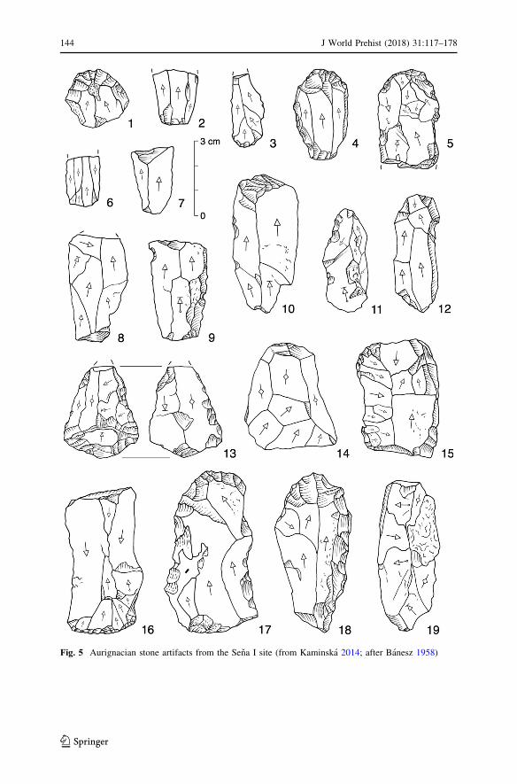
Fig. 5 Aurignacian stone artifacts from the Sena I site (from Kaminska 2014; after Banesz 1958)
144 J World Prehist (2018) 31:117–178
123
By contrast, the caves in the Romanian Banat show indisputable precocious
traces of modern humans through their well-dated skeletal remains. Unfortunately,
their associations with lithic residues remain either tenuous or absent. At the Peșteracu Oase, human fossils were found deep in a cave chamber with Pleistocene fauna,
but unfortunately without lithic artifacts. All surveys and excavations of the cave
entrances have failed to yield contemporaneous sediments or lithic residues,
possibly as a result of Late Pleistocene climate-driven erosion and/or rockfall.
At the Peștera Muierii, excavated in the early 1950s, archaic modern human
remains were later radiocarbon dated to 34 ka cal BP (Alexandrescu et al. 2010;
Soficaru et al. 2006). A small number of Aurignacian artifacts (N=60–80; mostly
blades and blade fragments) and three bone points were reported from the cave
(Paunescu 2000; Soficaru et al. 2006). However, the whereabouts and attribution of
these artifacts and their association with the fossils is uncertain, due to their
unsystematic recovery during excavation (Doboș et al. 2010, p. 41). Similarly, the
early modern human cranium from Peștera Cioclovina (c. 32.5 ka cal BP) was
associated with two blades, one flake and Ursus spelaeus vertebrae (Harvati et al.
2007). Further undated artifacts are reported from elsewhere in the cave, though
their typological attribution to the Aurignacian is disputed (Anghelinu and Nița2014).
In short, the geologically diverse Banat and southeastern Carpathian Basin have
many early Aurignacian sites (with, curiously, no apparent ‘transitional industries’),
in addition to many well-dated, well-attributed modern human remains of coeval
early Upper Pleistocene ages. Frustratingly, the two are not found in direct
association, with the former located mainly in open-air settings, while the latter is
exclusively found in karstic cave environments. It seems evident that a main goal of
research in this area is the connection of these two archives.
Ceahlău Massif and Bistrița Valley (Romania)
In the east of the Carpathian Basin, small Aurignacian assemblages are reported
from Ceahlau-Cetațica (I and II), Ceahlau-Darțu, Ceahlau-Podiș and Bistricioara-
Lutarie, all located along the middle terraces of the Bistrița River that bisects the
Eastern Carpathians. However, the scarcity of diagnostic artifacts and an atypically
young chronology have cast doubt on the authenticity of the Aurignacian sites
(Anghelinu, Nița, and Steguweit 2012; Steguweit et al. 2009; Trandafir et al. 2015).
Interestingly, there are many well-documented Aurignacian sequences found
across the watershed on the other side of the Carpathians (outside of the Carpathian
Basin) in the Prut Valley, where continuous sequences have been found at the large
sites like Mitoc-Paraul lui Istrati, Ripiceni-Izvor and Mitoc-Malu Galben that have
been well dated to between 37 and 32 ka cal BP (Damblon and Haesaerts 2007;
Honea 1990; Otte et al. 2007). Though the connections between these two areas
remain vague, some of the raw material in the Bistrița sites appears to have been
transported from the Moldavian plateau as well as the Dobruja region, suggesting an
early spatial connection across the Carpathians (Crandell, Nița, and Anghelinu
2013).
J World Prehist (2018) 31:117–178 145
123
Transylvania (Romania)
There are further finds in the hilly regions of historical Northern Transylvania, near
watercourses. Like the eastern Carpathian Basin in Romania, nearly all of the
Aurignacian sites provided small or poorly contextualized collections from surface
excavations lacking in typical diagnostic artifacts (Dobrescu 2008). The largest
archaeological assemblages are from Cremenea. At Poienița (c. 700 mamsl), tools
are mainly manufactured from large blocks, pebbles and plaques of poor quality
local flint that only allow for the production of large blades and flakes, complicating
a secure attribution to the Aurignacian (Margarit and Nița 2005).
In the Oaș-Maramureș regions, recent techno-typological reassessments of
Boinești, Remetea Șomoș I & II, Bușag and Calinești have suggested that there is an
Aurignacian component to the assemblages overlaying Mousterian accumulations
(Anghelinu and Nița 2014; Dobrescu 2008). However, the sediments may have been
reworked, perhaps some time during the Holocene (Tuffreau et al. 2013), making
them difficult to date and separate from the Mousterian and Gravettian elements
(Dobrescu 2008).
Northern Hungary and Southern Slovakia
In the north of the Carpathian Basin, there are indicators of an early Upper
Paleolithic presence in the North Hungarian Range and adjacent southern Slovakia.
Surveys have identified artifact surface scatters on river terraces and in valley cul-
de-sacs of the low foothills of the Bukk, Matra and Cserhat Mountains (Pentek and
Zandler 2013).
In eastern Slovakia, the Aurignacian is well known along the Hornad Valley in
the Kosice Basin (Hahn 1977; Kaminska 2014). Multiple sites in the villages of
Barca, Kechnec, Sena, Milhost’ and Cecejovce have been recognized for their
deeply cut ditches (Gräben) often containing stone-lined hearths and artifact
concentrations frequently interpreted as subterranean storage units and dwelling
structures (Fig. 5; Barta 1987). Unfortunately, most of these sites were found in
short, heavily-eroded sedimentary sequences and, except Barca I and Kechnec,
remain largely undated.
At Barca, charcoal yielded a date of 34± .3 ka cal BP, but this is considered a
minimum date because of subsequent sediment disturbance by later Neolithic
settlements. At Kechnec, two dates from charcoal suggest a later date around 32.1
± .2 ka cal BP; however, neither can be firmly connected to the Aurignacian
settlement (Kaminska 2014, p. 156). Perhaps partly as a result of these late dates, the
Kosice Basin sites are frequently designated as an iteration of the ‘Evolved
Aurignacian’ industry (Svoboda 2006).
There are also reported concentrations farther east in Slovakia, notably at Tibava,
that also contain ditches, stone-lined hearths and Aurignacian lithics (N=866)
similar to the Kosice Basin sites (Banesz 1960). Additionally, over one thousand
artifacts, predominantly flakes and blades and a few dozen tools manufactured
predominantly on local limnosilicite (i.e. limnoquartzite), were recovered from the
146 J World Prehist (2018) 31:117–178
123
areas of Nizny Hrabovec (I and II) and Posa that may be, but cannot be securely
demonstrated to be, late MIS 3 in age (Kaminska et al. 2000).
Though conspicuously absent on the other side of the Hornad Valley in Hungary,
early Upper Paleolithic artifacts have been recovered around the city of Eger on the
southwestern edges of the Bukk Mountains. The most well-known, Eger Koporos, is
interpreted as a palimpsest of late Middle Paleolithic, an early macroblade industry,
a Late Szeletian and a possible Aurignacian (Dobosi 1995; Mester 2000). The site
remains woefully unstratified but micromorphology, sedimentology, OSL and
radiocarbon dating suggest that the artifact-bearing colluvia formed some 25 ka ago,
indicating that the assemblages are at least that old (Dobosi 1995; Kozłowski et al.
2012).
Since the 1970s, surface finds have been collected from the nearby site of
Egerszalok-Kovago, located on a low-lying hill in the foreground of the Bukk
Mountains. Later systematic excavations recovered artifacts but were unable to find
stratified layers due to possible erosion. Based on techno-typology and raw material
types, artifacts were found to belong to four different industries: Szeletian, Initial
Upper Paleolithic, Aurignacian and a potential Gravettian (Kozłowski et al. 2009).
If compared to other dated regional assemblages, the Initial Upper Paleolithic
assemblage may date to between 40 and 35 ka ago, and the Aurignacian to between
35 and 28 ka ago (Budek et al. 2013; Kozłowski et al. 2009), though without
cosmogenic dating, these dates and attributions can only be seen as tentative.
Two other surface sites in the Eger region, Andornaktalya-Zugo and Gyilkos Hill
are attributed to the Late Aurignacian culture, based on their techno-typological
characteristics. However, these tools are atypical, as they are dominated by
endscrapers on flakes and there are Middle Paleolithic sidescrapers present (Budek
et al. 2013; Kozłowski et al. 2009).
There are further finds in the foothills of the Cserhat section of the North
Hungarian Range. At Acsa-Rovnya, excavations in 2001–2004 yielded over 500
artifacts, notable for many endscrapers on blades (Dobosi 2008, 2013). Many
locales in nearby Galgagyork have also yielded alleged Aurignacian finds that have
been typologically separated from the background palimpsest, though they are few
and always made on lower quality Szeletian felsitic porphyry (Kasztovszky et al.
2008; Marko et al. 2002).
The strongest case for an Aurignacian in northern Hungary is found in the Matra
Mountains and includes the surface scatters at Nagyrede I and II, where
approximately 2000 lithic artifacts were found, primarily manufactured on local
hydroquartzites (Lengyel et al. 2006). All of the recovered artifacts were surface
finds and attempts to recover in situ sediments were unsuccessful. However, most of
the tools are endscrapers, with no indication of earlier or later technocomplexes,
suggesting that the sites may represent discrete Aurignacian assemblages (Fig. 6).
The Northern Carpathian record has numerous early Upper Paleolithic findspots
and assemblages that are often confounded by regionally specific industries or
erosional palimpsests and are largely without stratigraphic and/or radiometrically-
dated context. Nevertheless, from a typological viewpoint, the Aurignacian record is
undeniable, even though open-air sites have been largely neglected, possibly as a
result of regional focus on the more famous cave sites in the Bukk Mountains. In
J World Prehist (2018) 31:117–178 147
123
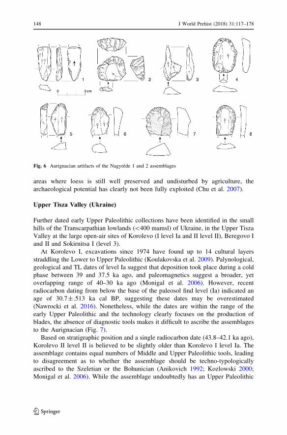
areas where loess is still well preserved and undisturbed by agriculture, the
archaeological potential has clearly not been fully exploited (Chu et al. 2007).
Upper Tisza Valley (Ukraine)
Further dated early Upper Paleolithic collections have been identified in the small
hills of the Transcarpathian lowlands (\400 mamsl) of Ukraine, in the Upper Tisza
Valley at the large open-air sites of Korolevo (I level Ia and II level II), Beregovo I
and II and Sokirnitsa I (level 3).
At Korolevo I, excavations since 1974 have found up to 14 cultural layers
straddling the Lower to Upper Paleolithic (Koulakovska et al. 2009). Palynological,
geological and TL dates of level Ia suggest that deposition took place during a cold
phase between 39 and 37.5 ka ago, and paleomagnetics suggest a broader, yet
overlapping range of 40–30 ka ago (Monigal et al. 2006). However, recent
radiocarbon dating from below the base of the paleosol find level (Ia) indicated an
age of 30.7± .513 ka cal BP, suggesting these dates may be overestimated
(Nawrocki et al. 2016). Nonetheless, while the dates are within the range of the
early Upper Paleolithic and the technology clearly focuses on the production of
blades, the absence of diagnostic tools makes it difficult to ascribe the assemblages
to the Aurignacian (Fig. 7).
Based on stratigraphic position and a single radiocarbon date (43.8–42.1 ka ago),
Korolevo II level II is believed to be slightly older than Korolevo I level Ia. The
assemblage contains equal numbers of Middle and Upper Paleolithic tools, leading
to disagreement as to whether the assemblage should be techno-typologically
ascribed to the Szeletian or the Bohunician (Anikovich 1992; Kozlowski 2000;
Monigal et al. 2006). While the assemblage undoubtedly has an Upper Paleolithic
Fig. 6 Aurignacian artifacts of the Nagyrede 1 and 2 assemblages
148 J World Prehist (2018) 31:117–178
123
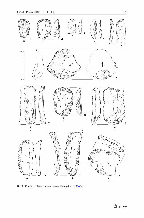
Fig. 7 Korolevo I/level 1a: tools (after Monigal et al. 2006)
J World Prehist (2018) 31:117–178 149
123
with blade production component, there are no typical Aurignacian tools in the
assemblage.
Large early Upper Paleolithic assemblages made from chert, quartz and andesite
were also found at Beregovo (I and II) in sands and gravels along ridges near the
Tisza River (Usik et al. 2006). The site has been excavated intermittently since the
1960s and recent work has focused on clarifying the chronostratigraphy, taphonomy
and human behavior of the site (Usik 2008). New research at Beregovo I, as part of
the Upper Tisza Valley Project, has suggested a proto-Aurignacian assemblage with
an early Upper Paleolithic age (Usik et al. 2013).
Additional assemblages were found at Sokirnitsa IA during limestone extraction.
The main cultural level (level 3) is found below a paleosol at a depth of 80–90 cm
within a horizon superimposing at least three discrete Middle Paleolithic horizons. It
contains a fully Upper Paleolithic blade industry, though the absence of typical
Aurignacian forms makes it difficult to make a formal attribution (Monigal et al.
2006; Usik et al. 2003). Level 3 artifacts were manufactured on local quartzite and
slate; however, some flint, chalcedony and andesite are believed to be semi-local,
possibly imported downstream from Korolevo. No faunal remains were recovered,
though a series of radiocarbon dates on charcoal fragments indicates a date of 43.2
± .5 ka cal BP (Ki-10837; Usik et al. 2003).
In the Upper Tisza Valley, early Upper Paleolithic assemblages are preserved in
well-stratified sequences. The dates and lithics point to assemblages that are clearly
early Upper Paleolithic in age. However, except for the ongoing work at Beregovo I,
researchers have been hesitant to ascribe them to the Aurignacian, and it remains
unclear to what extent these sites are techno-typologically connected to other sites
in the Carpathian Basin. Currently, these sites are seen as a local, short-lived
tradition, though more transnational comparative studies may help to contextualize
them within the broader region.
Southwest (Bosnia and Herzegovina)
Systematic archaeological research in the southwestern Carpathian Basin has been
underdeveloped and there have been few systematic surveys, excavations or techno-
typological studies of sites and assemblages. The known sites are located in the
northern foothills of the Dinaric Alpine karst in the Sava River catchment. Stratified
sites in this region are virtually unknown and assemblages are usually small and
reworked, making it difficult to provenance and accurately identify them techno-
typologically (Montet-White 1994; Montet-White et al. 1986). The potential for
bone preservation is also low, making it difficult to contextualize and date lithic
assemblages (Karavanic 1995). Still, limited early Upper Paleolithic artifacts have
been found in the northern region of Bosnia in open-air loam and/or eolian deposits
along the Sava and its tributaries (Basler 1979; Montet-White et al. 1986).
Recent work in northern Bosnia has focused on field surveying for new sites and
re-evaluating pre-existing site validities through small, targeted excavations.
Although most of the effort seems to have been dedicated to excavations at
Rastusa Cave, which failed to yield any Aurignacian assemblages (Jovanovic et al.
2014), there have also been excavations at the multi-layered site of Kamen, where a
150 J World Prehist (2018) 31:117–178
123
few recovered early Upper Paleolithic artifacts were deemed to be in secondary
position (Pandzic 2014).
Excavations at the stratified site of Luscic, from the 1950s to 1980s, yielded a
single Aurignacian layer with carinated pieces and blades from the Urinka Valley.
However, given that there were only 17 retouched tools and TL dates provided an
unusually young date (29–27 ka ago), this assemblage can only be seen as tentative
(Marriner et al. 2011; Montet-White et al. 1986). At Londza, Aurignacian artifacts
were similarly found within a 30 cm-thick deposit, possibly indicating longer-term
occupation. At the cave site of Pecina Pod Lipom, there is a known stratified layer
of later Aurignacian on elongated blades with various tools. However, as of yet,
there has been no techno-typological analysis of the site and it remains undated
(Kujundzic-Vejzagic 2001).
Northeast of these sites in western Slavonia (Croatia), a small collection of blades
and lithics alongside Pleistocene fauna was reported from Zarilac by M. Malez
(1979, p. 275). Nevertheless, the lack of systematic excavation of the site, as well as
the presence of Neolithic artifacts, suggests that the site may have been heavily
reworked. Additionally, the lithics have few, if any, Aurignacian characteristics and
are probably mixed with later prehistoric assemblages (Malez 1979; Paunovic et al.
2001; Vukosavljevic pers. comm.).
At present, the southwestern Carpathian Basin shows little evidence for an early
Upper Paleolithic, with known assemblages being both small and poorly contex-
tualized. Nevertheless, it seems likely that this apparent absence is in part due to low
research intensity.
Croatian Zagorje
One of the best-known Paleolithic regions in the Carpathian Basin is at its western
end in the karstic caves of the Zagorje in northern Croatia, near the Slovenian border
(Karavanic and Jankovic 2006; Paunovic et al. 2001). The importance of the caves
has been recognized since the work of Gorjanovic-Kramberger; most recently, they
have been exalted for their Neanderthal skeletal remains and the DNA and isotope
data that have been extracted from them. In spite of the region’s prehistoric
importance, only two of these sites have contributed modest early Upper Paleolithic
collections (Karavanic 1998).
Vindija Cave is a large cave excavated in the second half of the twentieth
century, first by S. Vukovic and later M. Malez (Karavanic 1998). This site is best
known for Layer G1, where late Neanderthal fossils were found associated with
early Upper Paleolithic artifacts (Jankovic et al. 2006; Karavanic 1995). Layer G1 is
sometimes attributed to the Aurignacian on the basis of four bone points and a
handful of Aurignacian tools. However, the authenticity of the artifacts and the level
of mixing is still debated (Karavanic et al. 2016; Karavanic and Patou-Mathis 2009)
and the lithic collection has also been suggested to be either Mousterian, Szeletian
or Olschewian (Karavanic and Smith 2011, 2013; Zilhao 2009). To complicate
matters further, there are conflicting radiocarbon dates from this level that place the
layer anywhere between 39 and 32 ka cal BP (see Ahern et al. 2004; Higham et al.
2006; Smith et al. 1999). Whatever the outcome of these debates, the bone points
J World Prehist (2018) 31:117–178 151
123
and the few Aurignacian artifacts indicate that Vindija is a possible early
Aurignacian site in the Carpathian Basin.
Malez also conducted excavations at the nearby cave of Velika Pecina, the last
one ending in 1970 (Karavanic 1998). A 12 m sequence of Quaternary sediments
was found: two Middle Paleolithic layers superimposed by five Upper Paleolithic
layers. The lowest Upper Paleolithic layer (i) dates to approximately 42–38 ka cal
BP based on radiocarbon dates; although an errant 6 ka cal BP old hominin cranial
fragment from the Upper Paleolithic layers suggests that there may have been some
mixing between the lower and the upper layers (Smith et al. 1999).
In spite of the Neanderthal fossils and associated Middle Paleolithic artifacts,
aside from bone points, there is little lithic evidence of an Aurignacian presence in
the Zagorje. Moreover, there are other caves in the area which, while rich in late
Middle Paleolithic stone artifacts, contain no reported traces of Aurignacian
assemblages (e.g. Krapina, Veternica). This absence is augmented by the lack of
open-air sites in the surrounding region, suggesting that while the early Upper
Paleolithic may have been present, the caves were only expediently used.
The Bükk Mountains (Hungary)
Another well-known karstic cave region within the Carpathian Basin is the
limestone Bukk Mountains of Northern Hungary, where the recent reinvestigations
of Szeleta (Adams 2002; Davies and Hedges 2008; Hauck et al. 2016) and Istallosko
caves (Adams 2002; Marko 2015) have brought the early Aurignacian and
transitional assemblages back into focus. Research in the archaeology of the Bukk
Mountains Late Pleistocene has focused on clarifying the chronology of the
Szeletian and its relationship to the Neanderthals and modern humans in Eastern
Europe through radiocarbon dating and tephra-chronologies (Davies et al. 2015).
In addition to the Szeletian industries, the Bukk Mountains have also yielded
possible Aurignacian assemblages, the most famous being from Szeleta Cave itself.
Though excavations have taken place at Szeleta since the beginning of the twentieth
century (Mester 2002, 2014; Siman 1995), stratigraphic and absolute dating
inconsistencies contribute to the uncertainties over the validity and age of the
Aurignacian in Hungary (Svoboda and Siman 1989; Siman 1995; Ringer 2002;
Lengyel and Mester 2008; Adams 2009). Due to the alleged presence of leaf-points
throughout the excavated sequence and erroneous dating results, the Szeletian and
Aurignacian of Szeleta Cave were seen as synchronous cultural complexes between
30 and 20 ka cal BP (Adams 2009; Adams and Ringer 2004). This view contradicted
earlier dating results and geochronological estimations that placed the onset of the
Szeletian between 46 and 37 ka cal BP (Geyh et al. 1969; Vogel and Waterbolk
1972). Recent attempts at clarifying the chronology from Szeleta failed due to a lack
of datable 14C (Davies and Hedges 2008).
Additionally, a recent reanalysis of the lithic assemblages at Istallosko suggests
that Aurignacian lithic artifacts were largely absent in the lower Aurignacian I layer,
except for some atypical fragmented blades and a bifacial tool. In the upper
Aurignacian II layer, the few Mladec/Olschewa-type osseous artifacts were
152 J World Prehist (2018) 31:117–178
123

associated with Gravettian flints, Middle Paleolithic tools and bifacial elements
(Marko 2015).
Further traces can be found a few kilometers south of Istallosko at Pesko Cave in
the western Bukk Mountains, at an elevation of 745 mamsl. The Pesko assemblage
was originally designated later Aurignacian, based on similarities to Istallosko
(Adams 1998, p. 15; Svoboda and Siman 1989). The lithic assemblage at Pesko is
small (N=27), but it is supplemented by four associated bone artifacts, one of which
has been dated to c. 42–40.5 ka cal BP (Davies and Hedges 2008).
The Bukk Mountains have also produced two possible early modern humans, but
these are poorly understood due to crude excavation techniques and radiocarbon
contamination issues (Lengyel and Mester 2008; Neruda and Nerudova 2013). At
Istallosko, a lower right second molar of a juvenile was found in one of the hearths
in the lowest Aurignacian layer (Vertes 1955) that was dated to 34 ka cal BP on
associated antler points (Davies and Hedges 2008), but it is unclear if the tooth can
be ascribed to modern humans (Malan 1955; Tillier et al. 2006). Of similar age but
lacking archaeological context is the modern human occipital bone from
Goromboly-Tapolca (30.3± .3 ka cal BP; Davies and Hedges 2008; Thoma and
Vertes 1975). These two finds indicate that modern humans were present in the
Bukk Mountains at least c. 35 ka cal BP. However, considering the earliest dates for
the Aurignacian at Pesko Cave, it is possible that modern humans were already
present in the region 7 ka earlier.
Like the cave sites in the Croatian Zagorje, the Bukk Mountain sites have long,
stratified sequences that have nonetheless created controversy as to the techno-
typological succession of the Middle to early Upper Paleolithic. What is becoming
increasingly clear is that, regardless of the outcome of debates surrounding
chronology and industries, the Aurignacian seems to be (aside from the few bone
artifacts) absent or at least thinly distributed and poorly contextualized. This is
directly in contrast to the open-air assemblages from the Slovakian–Hungarian
border regions, which testify to a stronger Aurignacian presence, even if they are not
well dated.
Raw Material Economy
Carpathian orogeny has provided the Carpathian Basin with abundant, easily
accessible igneous, metamorphic and sedimentary rocks and minerals that
potentially enable the spatial and landscape behaviors of the early Upper Paleolithic
archaeological record to be explored in considerable depth. However, while there is
a long history of research in the region, there are still significant gaps in identifying
and sourcing raw materials, even in the best-understood areas (Biro 2009). Still,
among the open-air sites, the raw material evidence is strongly suggestive of
locally-focused activities with sites located close to or at raw material sources
(Table 4).
At the Banat sites (Romanești, Coșava, Tincova and Crvenka–At), lithics are
primarily manufactured from a variable quality ‘Banat flint.’ Petrochemical
analyses indicate a local/meso-local source, possibly in the surrounding highlands
J World Prehist (2018) 31:117–178 153
123
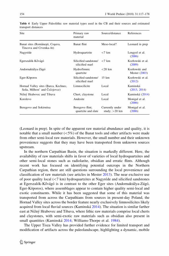
(Leonard in prep). In spite of the apparent raw material abundance and quality, it is
notable that a small number (\5%) of the Banat tools and other artifacts were made
from other semi-local raw materials. However, the small number and their unknown
provenience suggests that they may have been transported from unknown sources
upstream.
In the northern Carpathian Basin, the situation is markedly different. Here, the
availability of raw materials shifts in favor of varieties of local hydroquartzites and
other semi-local stones such as radiolarite, obsidian and erratic flints. Although
recent work has focused on identifying potential outcrops in the Northern
Carpathian region, there are still questions surrounding the local provenience and
classification of raw materials (see articles in Mester 2013). The near exclusive use
of poor quality local (\7 km) hydroquartzites at Nagyrede and silicified sandstones
at Egerszalok-Kovago is in contrast to the other Eger sites (Andornaktalya-Zugo,
Eger-Koporos), where assemblages appear to contain higher quality semi-local and
exotic constituents. While it has been suggested that some of this material was
transported from across the Carpathians from sources in present-day Poland, the
Hornad Valley sites across the border feature nearly exclusively limnosilicites likely
acquired from local fluvial sources (Kaminska 2014). The situation is similar farther
east at Nizny Hrabovec and Tibava, where lithic raw materials comprise local cherts
and claystones, with semi-exotic raw materials such as obsidian also present in
small quantities (Kaminska 2014; Williams-Thorpe et al. 1984).
The Upper Tisza Valley has provided further evidence for limited transport and
modification of artifacts across the paleolandscape, highlighting a dynamic, mobile
Table 4 Early Upper Paleolithic raw material types used in the CB and their sources and estimated
transport distances
Site Primary raw
material
Source/distance References
Banat sites (Romanești, Coșava,Tincova and Crvenka-At)
Banat flint Meso-local? Leonard in prep
Nagyrede Hydroquartzite \7 km Lengyel et al.
(2006)
Egerszalok-Kovago Silicified sandstone/
silicified marl
\7 km Kozłowski et al.
(2009)
Andornaktalya-Zugo Hydro/limnic
quartzite
\20 km Kozłowski and
Mester (2003)
Eger-Koporos Silicified sandstone/
silicified marl
15 km Kozłowski et al.
(2012)
Hornad Valley sites (Barca, Kechnec,
Sena, Milhost’ and Cecejovce)
Limnocilicite Local Kaminska
(2013, 2014)
Nizny Hrabovec and Tibava Chert, claystone Local Kaminska (2014)
Korolevo Andesite Local Monigal et al.
(2006)
Beregovo and Sokirnitsa Beregovo flint;
quartzite and slate
Currently under
study;[20 km
Monigal et al.
(2006)
154 J World Prehist (2018) 31:117–178
123
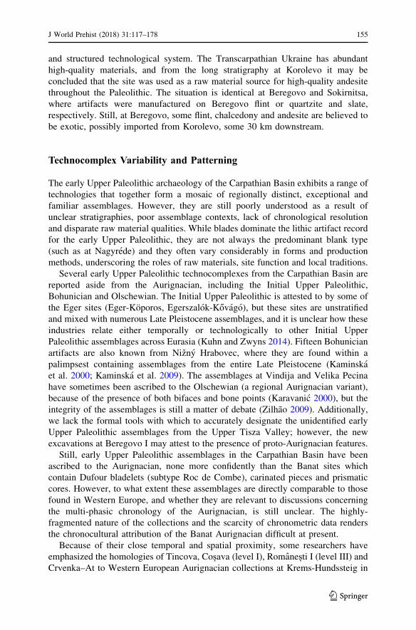
and structured technological system. The Transcarpathian Ukraine has abundant
high-quality materials, and from the long stratigraphy at Korolevo it may be
concluded that the site was used as a raw material source for high-quality andesite
throughout the Paleolithic. The situation is identical at Beregovo and Sokirnitsa,
where artifacts were manufactured on Beregovo flint or quartzite and slate,
respectively. Still, at Beregovo, some flint, chalcedony and andesite are believed to
be exotic, possibly imported from Korolevo, some 30 km downstream.
Technocomplex Variability and Patterning
The early Upper Paleolithic archaeology of the Carpathian Basin exhibits a range of
technologies that together form a mosaic of regionally distinct, exceptional and
familiar assemblages. However, they are still poorly understood as a result of
unclear stratigraphies, poor assemblage contexts, lack of chronological resolution
and disparate raw material qualities. While blades dominate the lithic artifact record
for the early Upper Paleolithic, they are not always the predominant blank type
(such as at Nagyrede) and they often vary considerably in forms and production
methods, underscoring the roles of raw materials, site function and local traditions.
Several early Upper Paleolithic technocomplexes from the Carpathian Basin are
reported aside from the Aurignacian, including the Initial Upper Paleolithic,
Bohunician and Olschewian. The Initial Upper Paleolithic is attested to by some of
the Eger sites (Eger-Koporos, Egerszalok-Kovago), but these sites are unstratified
and mixed with numerous Late Pleistocene assemblages, and it is unclear how these
industries relate either temporally or technologically to other Initial Upper
Paleolithic assemblages across Eurasia (Kuhn and Zwyns 2014). Fifteen Bohunician
artifacts are also known from Nizny Hrabovec, where they are found within a
palimpsest containing assemblages from the entire Late Pleistocene (Kaminska
et al. 2000; Kaminska et al. 2009). The assemblages at Vindija and Velika Pecina
have sometimes been ascribed to the Olschewian (a regional Aurignacian variant),
because of the presence of both bifaces and bone points (Karavanic 2000), but the
integrity of the assemblages is still a matter of debate (Zilhao 2009). Additionally,
we lack the formal tools with which to accurately designate the unidentified early
Upper Paleolithic assemblages from the Upper Tisza Valley; however, the new
excavations at Beregovo I may attest to the presence of proto-Aurignacian features.
Still, early Upper Paleolithic assemblages in the Carpathian Basin have been
ascribed to the Aurignacian, none more confidently than the Banat sites which
contain Dufour bladelets (subtype Roc de Combe), carinated pieces and prismatic
cores. However, to what extent these assemblages are directly comparable to those
found in Western Europe, and whether they are relevant to discussions concerning
the multi-phasic chronology of the Aurignacian, is still unclear. The highly-
fragmented nature of the collections and the scarcity of chronometric data renders
the chronocultural attribution of the Banat Aurignacian difficult at present.
Because of their close temporal and spatial proximity, some researchers have
emphasized the homologies of Tincova, Coșava (level I), Romanești I (level III) andCrvenka–At to Western European Aurignacian collections at Krems-Hundssteig in
J World Prehist (2018) 31:117–178 155
123
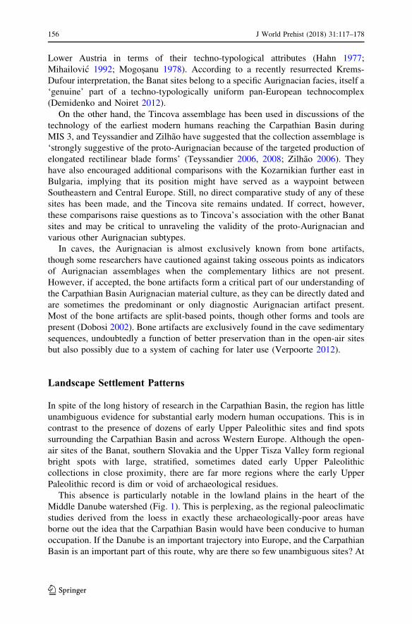
Lower Austria in terms of their techno-typological attributes (Hahn 1977;
Mihailovic 1992; Mogoșanu 1978). According to a recently resurrected Krems-
Dufour interpretation, the Banat sites belong to a specific Aurignacian facies, itself a
‘genuine’ part of a techno-typologically uniform pan-European technocomplex
(Demidenko and Noiret 2012).
On the other hand, the Tincova assemblage has been used in discussions of the
technology of the earliest modern humans reaching the Carpathian Basin during
MIS 3, and Teyssandier and Zilhao have suggested that the collection assemblage is
‘strongly suggestive of the proto-Aurignacian because of the targeted production of
elongated rectilinear blade forms’ (Teyssandier 2006, 2008; Zilhao 2006). They
have also encouraged additional comparisons with the Kozarnikian further east in
Bulgaria, implying that its position might have served as a waypoint between
Southeastern and Central Europe. Still, no direct comparative study of any of these
sites has been made, and the Tincova site remains undated. If correct, however,
these comparisons raise questions as to Tincova’s association with the other Banat
sites and may be critical to unraveling the validity of the proto-Aurignacian and
various other Aurignacian subtypes.
In caves, the Aurignacian is almost exclusively known from bone artifacts,
though some researchers have cautioned against taking osseous points as indicators
of Aurignacian assemblages when the complementary lithics are not present.
However, if accepted, the bone artifacts form a critical part of our understanding of
the Carpathian Basin Aurignacian material culture, as they can be directly dated and
are sometimes the predominant or only diagnostic Aurignacian artifact present.
Most of the bone artifacts are split-based points, though other forms and tools are
present (Dobosi 2002). Bone artifacts are exclusively found in the cave sedimentary
sequences, undoubtedly a function of better preservation than in the open-air sites
but also possibly due to a system of caching for later use (Verpoorte 2012).
Landscape Settlement Patterns
In spite of the long history of research in the Carpathian Basin, the region has little
unambiguous evidence for substantial early modern human occupations. This is in
contrast to the presence of dozens of early Upper Paleolithic sites and find spots
surrounding the Carpathian Basin and across Western Europe. Although the open-
air sites of the Banat, southern Slovakia and the Upper Tisza Valley form regional
bright spots with large, stratified, sometimes dated early Upper Paleolithic
collections in close proximity, there are far more regions where the early Upper
Paleolithic record is dim or void of archaeological residues.
This absence is particularly notable in the lowland plains in the heart of the
Middle Danube watershed (Fig. 1). This is perplexing, as the regional paleoclimatic
studies derived from the loess in exactly these archaeologically-poor areas have
borne out the idea that the Carpathian Basin would have been conducive to human
occupation. If the Danube is an important trajectory into Europe, and the Carpathian
Basin is an important part of this route, why are there so few unambiguous sites? At
156 J World Prehist (2018) 31:117–178
123
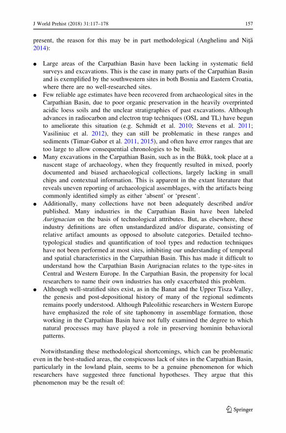
present, the reason for this may be in part methodological (Anghelinu and Nița2014):
● Large areas of the Carpathian Basin have been lacking in systematic field
surveys and excavations. This is the case in many parts of the Carpathian Basin
and is exemplified by the southwestern sites in both Bosnia and Eastern Croatia,
where there are no well-researched sites.
● Few reliable age estimates have been recovered from archaeological sites in the
Carpathian Basin, due to poor organic preservation in the heavily overprinted
acidic loess soils and the unclear stratigraphies of past excavations. Although
advances in radiocarbon and electron trap techniques (OSL and TL) have begun
to ameliorate this situation (e.g. Schmidt et al. 2010; Stevens et al. 2011;
Vasiliniuc et al. 2012), they can still be problematic in these ranges and
sediments (Timar-Gabor et al. 2011, 2015), and often have error ranges that are
too large to allow consequential chronologies to be built.
● Many excavations in the Carpathian Basin, such as in the Bukk, took place at a
nascent stage of archaeology, when they frequently resulted in mixed, poorly
documented and biased archaeological collections, largely lacking in small
chips and contextual information. This is apparent in the extant literature that
reveals uneven reporting of archaeological assemblages, with the artifacts being
commonly identified simply as either ‘absent’ or ‘present’.
● Additionally, many collections have not been adequately described and/or
published. Many industries in the Carpathian Basin have been labeled
Aurignacian on the basis of technological attributes. But, as elsewhere, these
industry definitions are often unstandardized and/or disparate, consisting of
relative artifact amounts as opposed to absolute categories. Detailed techno-
typological studies and quantification of tool types and reduction techniques
have not been performed at most sites, inhibiting our understanding of temporal
and spatial characteristics in the Carpathian Basin. This has made it difficult to
understand how the Carpathian Basin Aurignacian relates to the type-sites in
Central and Western Europe. In the Carpathian Basin, the propensity for local
researchers to name their own industries has only exacerbated this problem.
● Although well-stratified sites exist, as in the Banat and the Upper Tisza Valley,
the genesis and post-depositional history of many of the regional sediments
remains poorly understood. Although Paleolithic researchers in Western Europe
have emphasized the role of site taphonomy in assemblage formation, those
working in the Carpathian Basin have not fully examined the degree to which
natural processes may have played a role in preserving hominin behavioral
patterns.
Notwithstanding these methodological shortcomings, which can be problematic
even in the best-studied areas, the conspicuous lack of sites in the Carpathian Basin,
particularly in the lowland plain, seems to be a genuine phenomenon for which
researchers have suggested three functional hypotheses. They argue that this
phenomenon may be the result of:
J World Prehist (2018) 31:117–178 157
123
1. Low hominin demographic density (Karavanic and Smith 2013).
2. Land-use patterns favoring specific topographic zones in the early Upper
Paleolithic (Davies et al. 2003).
3. Biases in site visibility due to high-volume sedimentary deposition (Tuffreau
et al. 2014) and/or taphonomic processes in the region (Kels et al. 2014; Zilhao
and d’Errico 1999).
Understanding the relative validity of these three competing hypotheses is a
challenging prerequisite for confronting the role of the Carpathian Basin in early
modern human migration patterns.
As for the first hypothesis, the early Upper Paleolithic in the Carpathian Basin
truly appears to have particularly low site density, especially when compared to the
nearby dense site-concentrations of the Danube in Austria, Moravia and Western
Slovakia (Nigst 2006). Low hominin demographics may indeed be a factor in the
low findspot density and scanty artifact counts. While it is notoriously difficult to
extrapolate paleodemographic estimates, archaeological, climatic and genetic
studies agree that during the early Upper Paleolithic they were low indeed (Davies
et al. 2015; Fu et al. 2014, 2015, 2016; Seguin-Orlando et al. 2014). However, while
low population density may help explain the paucity of archaeological sites, it does
not explain the preference for open-air sites in the inner foothills.
As for the second hypothesis, there are few convincing explanations for land-use
patterns favoring specific topographic zones, that is, the assumption that the
foothills were preferred landscapes. Human foragers subsist through diverse land-
use strategies, making use of diverse ecotones as evidenced by their use of both the
foothills and high-altitude caves. This shifting between the plane and other
altitudinal belts would have allowed, even encouraged, modern humans to make use
of the diverse landscapes of the MIS 3 plain to increase their access to fresh water,
diverse fauna (including aquatic resources) and raw materials. Using southwestern
Romania as an example, Riel-Salvatore et al. (2008) have suggested that higher
altitudes positively correlate with artifact curation. Following this logic, we would
expect to find higher density sites within the plain itself, a scenario that is not played
out in the extant archaeological record.
The validity of hypothesis 3 hinges upon an assumption that there is a systematic
taphonomic skew towards the lowlands of the Carpathian Basin, due to either
reworking or high Late Pleistocene sedimentation. It is clear from many of the loess
profiles in the Danube Valley that several meters of sediments have been deposited
since early Upper Paleolithic hominins were present. Additionally, many of the
moderately sloped mid-altitude zones where most open-air early Upper Paleolithic
sites are located may have experienced significant erosion at the end of the
Pleistocene and in the Holocene.
Finally, it is worth pointing out that well-preserved sites and findspots do exist in
the plain, for instance at Crvenka–At and potentially Zarilac, which were both
identified in alluvial sediments at profound sedimentary depths and only as a result
of commercial activity. However, these examples are still by far the exception in the
Carpathian Basin, though the many finds and good faunal preservation suggest that
158 J World Prehist (2018) 31:117–178
123
there are more buried sites near fluvial terraces and paleolake shores that can yield
promising results.
In conclusion, scholars have argued that population size and land-use patterns
have influenced the composition of the Carpathian Basin’s early Upper Paleolithic
record. However, given the flexibility of early Upper Paleolithic hunters, the
availability of resources in the plain and the virtual absence of Pleistocene
archaeological material, it is likely that modern humans used a spectrum of the
Carpathian Basin’s ecotones and that the absence of archaeological sites in the basin
is a taphonomic bias that may be rectified with future research.
Discussion: Early Upper Paleolithic Hominin Dispersals and the DanubeCorridor Hypothesis
Conard and Bolus have asserted that the initial settlement of Europe, especially
Central Europe, by modern humans after approximately 40 ka ago was in part
achieved by humans ‘rapidly enter[ing] the interior of Europe via the Danube
Valley’ into the Swabian Jura. From there, they would have dispersed further west
via various forms of socio-cultural dynamics and/or environmental causality, the so-
called Kulturpumpe hypothesis (Conard and Bolus 2003). After reviewing current
knowledge of the Carpathian Basin’s climatic and archaeological record and the
various problems facing both, we return to the question, does the Carpathian Basin
early Upper Paleolithic record provide clear evidence for a rapid entry along the
Danube corridor during MIS 3?
In short, the Carpathian Basin early Upper Paleolithic record offers limited direct
support for this hypothesis beyond the early modern human fossils from the Peșteracu Oase (c. 42.5–40.5 ka cal BP), the lithic assemblages from Romanești (c. 42.1–39.1 ka), and to a lesser extent the single bone point from Pesko (c. 42–40.5 ka cal
BP), all of which are broadly coeval with the earliest evidence from the Swabian
Jura at Geißenklosterle (c. 43.1–41.5 ka cal BP) but post-date the early Aurignacian
remains at Willendorf II (c. 43.5 ka cal BP). This suggests that, at present, only a
tenuous direct link (spatially or temporally) can be made between these sites.
Furthermore, the other modern human remains at Muierii and Cioclovina and the
few securely attributed and radiocarbon-dated Aurignacian sites in the Carpathian
Basin all indicate dates that are later than those found farther upstream, pointing to a
more sustained occupation of the region.
Still, these limited data points do not refute the Danube corridor hypothesis and
there is little to suggest that the Danube could not have been a viable corridor into
Europe. By the Late Pleistocene, the incised Danube and Tisza river systems would
have created high (dry) alluvial banks that would have formed stable conduits for
both humans and fauna. Such rivers may have (in parts) occluded modern human
movement into areas of the Carpathian Basin; however, given the early Upper
Paleolithic sites west of the Tisza, it is clear that rivers did not pose definitive
obstacles to modern humans. Based on their known presence in the highlands (e.g.
Peștera cu Oase) and the residues of their movement throughout the foothills, it is
possible that they circumvented these barriers by fording the shallow, braided feeder
J World Prehist (2018) 31:117–178 159
123
rivers along the Carpathian rim. Additionally, if the early lithic remains from Tabula
Traiana Cave on the Western bank of the Danube Gorges (at its narrowest point) are
telling, we might also envisage scenarios where they traversed large rivers at
strategic points where channels narrowed or where river archipelagos were present
(e.g. Ada Kaleh Island). Such corridors may have only been periodically available
during droughts, or when lower seasonal discharge decreased stream flow and
channel breadth/depth exposing point/mid-channel bars, or when sustained cold
formed temporary ice bridges. Our current chronological/temporal resolution limits
our ability to understand the relationship between early Upper Paleolithic cultural
units and Pleistocene rivers, but such a use of the landscape may imply a familiarity
inconsistent with a speedy unidirectional dispersal (cf. Hussain and Floss 2016).
The modeled climate for the Carpathian Basin also suggests that there would
have been no critical barrier to modern humans entering the region, as is known
from periods in the Late Pleistocene (Maier et al. 2016). In fact, it appears that the
southern parts of the Carpathian Basin would have been amenable to human
occupation even during the colder climatic downswings of MIS 3. This may not
have been the case in the Northern Carpathian Basin, where the modeled climatic
temperatures indicate a region less temperate than in the south. Nevertheless,
climate was not a main challenge for modern humans entering the Carpathian Basin.
It is known from the repeated occupations at Willendorf that modern humans were
capable of surviving in the temperatures of GIS 11, colder and drier than present-
day and harsher than the climates their antecedents endured in the eastern
Mediterranean Levant during the Early Pleistocene or even earlier in East Africa. It
is also understood that modern humans had mastery of composite extrasomatic
technologies such as shelters, clothing and fire, as testified to by the purported
habitation structures and hearths at the Slovakian sites (e.g. Aiello and Wheeler
2003; Chu 2009). These would have provided both thermoregulatory benefits
against the prevailing cold and wind, and access to locations where fresh water and
the associated lithic and faunal resources could be found.
Returning to the most durable part of the archaeological record, the lithics, what
can they tell us about the use of the Danube as a corridor? Among the sites located
near rivers, for instance in the Banat and southern Slovakia, raw materials were
partly tethered to the local fluvial system. However, in other sites, the raw material
evidence demonstrates an overwhelming use of locally available lithic sources
(despite their quality) for both artifact blanks and tools. There are instances of
allochthonous artifacts from southern Poland found in northern Hungary/southern
Slovakia, but a guarded interpretation would regard them as stemming from
unrecognized local sources or geogenic transport, rather than as anthropogenic
traces of long-distance trade systems and wide hunting ranges. If these connections
are real, it is interesting to note that they would suggest a path through the
Carpathians rather than through the Danube corridor.
While the early Upper Paleolithic lithic assemblages suggest that there was some
local flexibility in morphotype, tool ratios, raw materials and flaking capacities, the
overall impression is of a blade-dominated industry. Yet where raw materials were
of poor quality or small size, hominins manufactured Aurignacian tools on flakes,
suggesting that broadly similar hominin behaviors, at least as expressed in lithic
160 J World Prehist (2018) 31:117–178
123
technology, were implemented across a range of habitats and environments. While
often the attribution of these assemblages to the Aurignacian is clear, ascribing them
to specific sub-industries (i.e. proto-Aurignacian, late Aurignacian) is difficult.
Furthermore, the association between the Carpathian Basin Aurignacian and the
early Upper Paleolithic of the Lower Danube sites in Bulgaria (e.g. Temnata, Bacho
Kiro) remains unclear.
The landscape settlement patterns of the Aurignacian in the Carpathian Basin
also do not suggest a migrating population forging upstream at a rapid pace. It is
true that little is known of the Aurignacian sites in the Carpathian Basin; however, it
is known that they were not expediently used. Instead, sites in the Carpathian Basin
mostly occupy large tracts of land, sometimes over kilometers long (e.g. Crvenka–
At), with considerable artifact density. In certain areas, such as southern Slovakia,
the discovery of habitation structures, storage pits and other ‘site furniture’, implies
a more sustained occupation at least on a semi-regular basis (Binford 1979).
Conard and Bolus (2003) have inferred that the animal, plant and lithic resources
afforded by the Danube River catchment, combined with a continuous source of
human populations from the East, would have set the stage for a precocious entry
into Western Europe of modern humans and their associated new technological
industries (i.e. the Aurignacian and its various relatives). However, drawing
migratory arrows linking similar archaeological findspots to track Pleistocene
hominin movements has repeatedly led to erroneous conclusions in the past. Though
the Carpathian Basin record currently supports the idea of an exogenous, early
entrance of the early Upper Paleolithic into the Carpathian Basin unrelated to any of
the preceding MP or transitional industries, the dispersal across the Carpathian
Basin is not suggestive of rapid demic expansion, as is evidenced by the relatively
late hybridization of the Peștera cu Oase fossil and implied by persistent Mousterian
technological elements (Fu et al. 2015; Horvath 2009; Noiret 2005).
This begs the question of where the makers of the early Upper Paleolithic in the
Carpathian Basin came from. Aside from a handful of Aurignacian sites (e.g. Bacho
Kiro, Temnata) and Kozarnika, whose link to the Aurignacian remains tenuous, no
other sites directly connect the Carpathian Basin Aurignacian to the south in the
Balkans. Additionally, Anatolia has also to provide empirical evidence of a
connection between Southwestern Europe and the early hominin technocomplexes
of the Levant. Therefore, a western source for the Carpathian Basin early Upper
Paleolithic is conceivable, especially considering the early Willendorf dates which,
if correct, pre-date any of the evidence in the Carpathian Basin. If the Danube was
as easy a conduit as has been suggested, it is equally likely that it may have seen
hominin movement in the opposite direction (Sitlivy et al. 2014). Indeed, increasing
genetic and archaeological evidence (Adler et al. 2008; Anikovich et al. 2007;
Lopez et al. 2016) supports the idea that the earliest modern humans coming from
the Middle East and into Europe may have bypassed Southeastern Europe (at least
overland), opting for a route running through the Caucasus, dispersing east through
the East European Plain and then north of the Carpathians.
The recent reanalysis of Central European early Upper Paleolithic assemblages
and possibly Initial Upper Paleolithic sensu lato finds farther east in the
geographically connected Moravian Plains (Bohunician) suggests that early modern
J World Prehist (2018) 31:117–178 161
123
humans were present in Central Europe far sooner than previously recognized
(Muller et al. 2011; Nigst et al. 2014; Richter et al. 2008, 2009). This notion could
lead to a major modification in our understanding of the origin and cultural
ontogeny of the Aurignacian technocomplex (Sitlivy et al. 2014).
This suggests that while hominins were undoubtedly present within the Middle
Danube catchment in the late Upper Pleistocene, it is currently difficult to tell from
the archaeological record whether they entered the Carpathian Basin on direct
‘highways’, in waves (Hublin 2015), or more piecemeal; furthermore, the evidence
is too sparse to suggest a directional trajectory. Indeed, the gap in the Danube record
suggests that the situation may be more complicated than has previously been
thought. Furthermore, climatic reconstructions, illustrated by advances in loess
stratigraphy, faunal/floral records and geochemistry, suggest a necessary diversion
from the rugged karstic regions of the basin that may have been more familiar
hunting areas for previous (Neanderthal) populations. This may have resulted in
more frequent or seasonal use of the lowlands within the earlier parts of MIS 3 that
may have prompted subsequent modifications in hominin subsistence behavior. A
prolonged/intense modern human presence in the Carpathian Basin throughout the
late Upper Pleistocene is testified to by a higher frequency of lithic sites with
increased artifact density. Increased sedimentation rates in the later part of the
Pleistocene may have also helped to offset the palimpsest effect that might have
skewed the record.
Conclusions, Summary and Future Research
Archaeological research has confirmed the presence of modern humans and early
Upper Paleolithic sites in scattered parts of the Carpathian Basin. Despite the
importance of the Carpathian Basin early Upper Paleolithic to paleoanthropological
models, there has been no systematic attempt to examine how Carpathian Basin
industries figure in linking the Aurignacian of Western Europe and the Bachokirian
and Kozarnikian of Southeastern Europe. In situations such as that of the earliest
occupation of Europe by modern humans, where the chronological resolution is
insufficient to transform the archaeological record into a coherent cultural narrative,
it is appealing to use large geographic features such as the Danube to explain
cultural migration routes. While rivers may have served as valuable migration axes
in the early Upper Paleolithic and even earlier (Ashton et al. 2006), they do not
preclude other productive biomes, which may have been welcome alternatives to
climatic variations in both annual and longer timescales. Furthermore, if the Danube
did play a role in the migration route of modern humans in the Carpathian Basin, we
currently lack the archaeological resolution to tell us in what direction it may have
been used.
This paper has reviewed the geological, climatological and archaeological record
of the Carpathian Basin, summed up in the following points:
162 J World Prehist (2018) 31:117–178
123
● The climate of the early Upper Paleolithic of the Carpathian Basin during MIS 3
is characterized by cool-temperate climates and possible mosaic environments
that would have provided access to a variety of potential resources.
● The early Upper Paleolithic of the Carpathian Basin has been refined in recent
years as a result of new excavations and fieldwork and/or the contextualization
of older collections, though most sites remain undated and poorly understood.
● The earliest modern human presence in the Carpathian Basin is testified to
directly by the Peștera cu Oase fossils and indirectly by early Aurignacian
assemblages in the Banat and a single directly-dated bone point from Pesko.
There are, additionally, early blade assemblages in the Upper Tisza Valley, with
additional sites in the Northern Carpathians and findspots elsewhere along the
foothills.
● Robust ages and site formation processes for most Carpathian Basin sites are
still largely unknown but are central to understanding the early Upper
Paleolithic archaeological record.
● Human traces in the lowlands of the Carpathian Basin are absent, probably as a
result of taphonomic biases.
● The perception of the Danube as a main artery for humans to flow into Europe is
undermined by a shortage of viable sites throughout the Carpathian Basin. A
better understanding of the chronology of early Upper Paleolithic assemblages,
as well as new discoveries, could present new challenges to, or confirmations of,
the Danube corridor hypothesis.
Given the sparse archaeological record, it is clear that robust testable hypotheses
concerning the early Upper Paleolithic record of the Carpathian Basin can only be
formulated with the location of new sites as opposed to the continued analysis of old
excavations, for which most stratigraphic/contextual information has now been lost
(e.g. the Bukk and Zagorje cave sites). Such an approach includes broadening our
search to areas where little research has been conducted, paying particular attention
to the basin margins, intermountain basins (e.g. Pozega Valley, Croatia), paleolake
shores and fluvial terraces where loess and other fine-grained mantles are thin or
accessible (Tourloukis 2016). Such efforts may be amplified by predictive modeling
(e.g. using slope, aspect, distance to water and lithic resources), systematic amateur
stray-find recording, and shallow geophysical techniques. Efforts may also
productively be directed towards the re-excavation of ‘flagship sites’, focused on
obtaining radiometric dates and understanding their site formation processes. Both
approaches are essential to building reliable archaeological distributions and
chronology for the Carpathian Basin early Upper Paleolithic record. Integrating
these methodological tools would enhance the reliability of model-bound
approaches, giving us a better understanding of how and when the earliest modern
humans entered Europe.
Acknowledgements This work benefitted from the support and discussions with Jurgen Richter and
Thomas Hauck. Andreas Maier and Christian Zeeden provided valuable comments on an earlier version
of this work. Many thanks also to Nikola Vukosavljevic, Gyuri Lengyel, Lubomıra Kaminska, Tımea
Kiss, Karin Kindermann, Adrian Doboș, Alexandru Ciornei and Zsolt Mester for helpful discussions. This
work has also been aided by Isabell Schmidt who helped refine the list of archaeological sites, Andreas
J World Prehist (2018) 31:117–178 163
123
Bolton, who helped design Fig. 1, Lutz Hermsdorf-Knauth and Janina Bosken who helped with Fig. 2,
and Anja Ruschmann, who helped with the artifact illustrations. I would also like to thank the Editor in
Chief Timothy Taylor and the Managing Editor Sarah Wright along with the anonymous referees for their
comments, which improved the final text. This paper has profited from the research of colleagues in the
European Paleolithic and Quaternary Science communities: any misrepresentations or errors are my own.
This research was undertaken at the University of Cologne as part of the Collaborative Research Center
806 (CRC 806) funded by the Deutsche Forschungsgemeinschaft (DFG).
Open Access This article is distributed under the terms of the Creative Commons Attribution 4.0
International License (http://creativecommons.org/licenses/by/4.0/), which permits unrestricted use, dis-
tribution, and reproduction in any medium, provided you give appropriate credit to the original author
(s) and the source, provide a link to the Creative Commons license, and indicate if changes were made.
References
Adams, B. (1998). The Middle to Upper Paleolithic transition in Central Europe: The record from theBükk Mountain region. Oxford: Archaeopress.
Adams, B. (2002). New radiocarbon dates from Szeleta and Istallosko caves, Hungary. Praehistoria, 3,53–55.
Adams, B. (2009). The Bukk Mountain Szeletian: Old and new views on ‘transitional’ material from the
eponymous site of the Szeletian. In M. Camps & P. R. Chauhan (Eds.), Sourcebook of Paleolithictransitions (pp. 427–440). New York: Springer.
Adams, B., & Ringer, A. (2004). New C14 dates for the Hungarian early Upper Palaeolithic. CurrentAnthropology, 45(4), 541–551. https://doi.org/10.1086/ca.2004.45.issue-4.
Adler, D. S., Bar-Yosef, O., Belfer-Cohen, A., Tushabramishvili, N., Boaretto, E., Mercier, N., et al.
(2008). Dating the demise: Neandertal extinction and the establishment of modern humans in the
southern Caucasus. Journal of Human Evolution, 55, 817–833.Ahern, J. C. M., Karavanic, I., Paunovic, M., Jankovic, I., & Smith, F. H. (2004). New discoveries and
interpretations of hominid fossils and artifacts from Vindija Cave, Croatia. Journal of HumanEvolution, 46(1), 27–67. https://doi.org/10.1016/j.jhevol.2003.09.010.
Aiello, L., & Wheeler, P. (2003). Neanderthal thermoregulation and the glacial climate. In T. H. van
Andel & W. Davies (Eds.), Neanderthals and modern humans in the European landscape during thelast glaciation: Archaeological results of the stage 3 project (pp. 147–166). Cambridge: McDonald
Institute for Archaeological Research.
Alexandrescu, E., Olariu, A., Skog, G., Stenstrom, K., & Hellborg, R. (2010). Os fossiles humains des
grottes Muierii et Cioclovina, Roumanie. L’Anthropologie, 114(3), 341–353. https://doi.org/10.1016/j.anthro.2010.05.004.
Anghelinu, M. (1998). Un decupaj analitic al arheologiei paleoliticului din romania. Materiale șiCercetări Arheologice, 11, 271–282.
Anghelinu, M., & Nița, L. (2014). What’s in a name: The Aurignacian in Romania. QuaternaryInternational, 351, 172–192. https://doi.org/10.1016/j.quaint.2012.03.013.
Anghelinu, M., Nița, L., Sitlivy, V., Uthmeier, T., & Baltean, I. (2012). Looking around Peștera cu Oase:
The beginnings of Upper Paleolithic in Romania. Quaternary International, 274, 136–157. https://doi.org/10.1016/j.quaint.2012.01.012.
Anghelinu, M., Nița, L., & Steguweit, L. (2012). Not that original after all: The chrono-cultural
framework of the Upper Paleolithic on the Bistrița Valley (Northeastern Romania). ArheologiaMoldovei, 35, 7–14.
Anikovich, M. (1992). Early Upper Paleolithic industries of Eastern Europe. Journal of World Prehistory,6(2), 205–245. https://doi.org/10.1007/BF00975550.
Anikovich, M., Sinitsyn, A., Hoffecker, J. F., Holliday, V., Popov, V., Lisitsyn, S., et al. (2007). Early
Upper Paleolithic in Eastern Europe and implications for the dispersal of modern humans. Science,315, 223–226. https://doi.org/10.1126/science.1133376.
164 J World Prehist (2018) 31:117–178
123
Antoine, P., Rousseau, D.-D., Fuchs, M., Hatte, C., Gauthier, C., Markovic, S. B., et al. (2009). High-
resolution record of the last climatic cycle in the southern Carpathian Basin (Surduk, Vojvodina,
Serbia). Quaternary International, 198(1–2), 19–36. https://doi.org/10.1016/j.quaint.2008.12.008.Ashton, N., Lewis, S. G., Parfitt, S. A., & White, M. J. (2006). Riparian landscapes and human habitat
preferences during the Hoxnian (MIS 11) interglacial. Journal of Quaternary Science, 21, 497–505.https://doi.org/10.1002/jqs.1032.
Banak, A., Mandic, O., Kovacic, M., & Pavelic, D. (2012). Late Pleistocene climate history of the
Baranja loess plateau: Evidence from the Zmajevac loess-paleosol section (northeastern Croatia).
Geologia Croatica, 65(3), 411–422.Banak, A., Mandic, O., Sprovieri, M., Lirer, F., & Pavelic, D. (2016). Stable isotope data from loess
malacofauna: Evidence for climate changes in the Pannonian Basin during the Late Pleistocene.
Quaternary International, 415, 15–24. https://doi.org/10.1016/j.quaint.2015.10.102.Banesz, L. (1958). Mladopaleoliticke objekty v Seni I. Slovenská Archeológia, 6, 5–20.Banesz, L. (1960). Die Problematik der Palaolithischen Besiedlung in Tibava. Slovenská Archeológia, 7,
7–58.
Barta, G. (2014). Paleoenvironmental reconstruction based on the morphology and distribution of
secondary carbonates of the loess-paleosol sequence at Sutto, Hungary. Quaternary International,319, 64–75. https://doi.org/10.1016/j.quaint.2013.08.019.
Barta, J. (1987). Problems of dwelling structures in the Palaeolithic of western Slovakia. Anthropologie,25(2), 105–110.
Bartosiewicz, L. (2016). Archaeology in Hungary 1948–1989. In L. R. Lozny (Ed.), Archaeology of thecommunist era: A political history of archaeology of the 20th century (pp. 195–233). New York:
Springer.
Bar-Yosef, O. (1998). On the nature of transitions: The Middle to Upper Palaeolithic and the Neolithic
revolution. Cambridge Archaeological Journal, 8(2), 141–163. https://doi.org/10.1017/
S0959774300001815.
Basarin, B., et al. (2014). Time-scale and astronomical forcing of Serbian loess-palaeosol sequences.
Global and Planetary Change, 122, 89–106. https://doi.org/10.1016/j.gloplacha.2014.08.007.Basler, Ð. (1979). Nalaziste Paleolitskog i Mezolitskog doba u Bosni i Hercegovini. Praistorija
jugoslovenskih zemalja–I–Paleolit i Mezolit (The Prehistory of the Yugoslav Countries–I–Paleolithicand Mesolithic) (pp. 313–330). Sarajevo: Svjetlost.
Binford, L. R. (1979). Organization and formation processes: Looking at curated technologies. Journal ofAnthropological Research, 35(3), 255–273.
Biro, K. T. (2009). Sourcing raw materials for chipped stone artifacts: The state-of-the-art in Hungary and
the Carpathian Basin. In B. Adams & B. S. Blades (Eds.), Lithic materials and Paleolithic societies(pp. 47–53). Hoboken: Wiley-Blackwell.
Blaauw, M. (2012). Out of tune: The dangers of aligning proxy archives. Quaternary Science Reviews, 36,38–49. https://doi.org/10.1016/j.quascirev.2010.11.012.
Bokhorst, M. (2009). Last glacial climate variability in Eastern and Central Europe as recorded in loessdeposits. Amsterdam: Vrije Universiteit Amsterdam.
Bokhorst, M., Beets, C. J., Markovic, S. B., Gerasimenko, N. P., Matviishina, Z. N., & Frechen, M.
(2009). Pedo-chemical climate proxies in Late Pleistocene Serbian–Ukrainian loess sequences.
Quaternary International, 198(1–2), 113–123. https://doi.org/10.1016/j.quaint.2008.09.003.Bokhorst, M., & Vandenberghe, J. (2009). Validation of wiggle matching using a multi-proxy approach
and its palaeoclimatic significance. Journal of Quaternary Science, 24(8), 937–947. https://doi.org/10.1002/jqs.1271.
Bokhorst, M., Vandenberghe, J., Sumegi, P., Łanczont, M., Gerasimenko, N. P., Matviishina, Z. N., et al.
(2011). Atmospheric circulation patterns in Central and Eastern Europe during the Weichselian
Pleniglacial inferred from loess grain-size records. Quaternary International, 234(1–2), 62–74.https://doi.org/10.1016/j.quaint.2010.07.018.
Boric, D., Dimitrijevic, V., White, D., Lane, C., French, C., & Cristiani, E. (2012). Early modern human
settling of the Danube corridor: The Middle to Upper Palaeolithic site of Tabula Traiana Cave in the
Danube gorges (Serbia). Antiquity, 86(334). http://www.antiquity.ac.uk/projgall/boric334/.Bradak, B., & Kovacs, J. (2014). Quaternary surface processes indicated by the magnetic fabric of
undisturbed, reworked and fine-layered loess in Hungary. Quaternary International, 319, 76–87.https://doi.org/10.1016/j.quaint.2013.02.009.
J World Prehist (2018) 31:117–178 165
123
Budek, A., Kalicki, T., Kaminska, L., Kozłowski, J. K., & Mester, Z. (2013). Interpleniglacial profiles on
open-air sites in Hungary and Slovakia. Quaternary International, 294, 82–98. https://doi.org/10.1016/j.quaint.2012.02.022.
Buggle, B., Glaser, B., Zoller, L., Hambach, U., Markovic, S. B., Glaser, I., et al. (2008). Geochemical
characterization and origin of Southeastern and Eastern European loesses (Serbia, Romania,
Ukraine). Quaternary Science Reviews, 27(9–10), 1058–1075. https://doi.org/10.1016/j.quascirev.2008.01.018.
Buggle, B., Hambach, U., Glaser, B., Gerasimenko, N., Markovic, S., Glaser, I., et al. (2009).
Stratigraphy, and spatial and temporal paleoclimatic trends in Southeastern/Eastern European loess-
paleosol sequences. Quaternary International, 196(1–2), 86–106. https://doi.org/10.1016/j.quaint.2008.07.013.
Buggle, B., Hambach, U., Kehl, M., Markovic, S. B., Zoller, L., & Glaser, B. (2013). The progressive
evolution of a continental climate in southeast-central European lowlands during the Middle
Pleistocene recorded in loess paleosol sequences. Geology, 41(7), 771–774. https://doi.org/10.1130/G34198.1.
Buggle, B., & Zech, M. (2015). New frontiers in the molecular based reconstruction of Quaternary
paleovegetation from loess and paleosols. Quaternary International, 372, 180–187. https://doi.org/10.1016/j.quaint.2015.02.046.
Carciumaru, M., & Anghelinu, M. (2000). The Carpathian Mousterian and the transition from Middle to
Upper Palaeolithic. In J. Orschiedt & G.-C. Weniger (Eds.), Neanderthals and modern humans–discussing the transition: Central Eastern Europe from 50.000–30.000 B.P. (pp. 190–195).
Mettmann: Neanderthal Museum.
Carciumaru, M., Cosac, M., Nițu, E.-C. (2004). Les datations C-14 et la succession culturelle du
Paleolithique, Epipaleolithique de la Roumanie. Annales d’Université ‘Valahia’ Târgoviște,Section d’Archeologie et d’Histoire, 6–7, 7–43.
Carciumaru, M., Nițu, E.-C., Dobrescu, R., & Ștefanescu, R. (2010). Paleoliticul din județul Brașov.Targoviște: Valahia University Press.
Chu, W. (2009). A functional approach to Paleolithic open-air habitation structures. World Archaeology,41, 348–362.
Chu, W., Hauck, T., & Mihailovic, D. (2014). Crvenka–At: Preliminary results from a lowland
Aurignacian site in the Middle Danube catchment. In D. Mihailovic (Ed.), Palaeolithic andMesolithic research in the central Balkans (pp. 69–75). Belgrade: Serbian Archaeological Society.
Chu, W., Lengyel, G., Zeeden, C., Pentek, A., Kaminska, L., & Mester, Z. (2017). Early Upper Paleolithic
surface collections from loess-like sediments in the northern Carpathian Basin. QuaternaryInternational. https://doi.org/10.1016/j.quaint.2017.05.017.
Chu, W., Mihailovic, D., Pantovic, I., Hauck, T., & Lehmkuhl, F. (2016). Archaeological excavations at
the site of At (Vrsac, Serbia). Antiquity, 90(352). http://antiquity.ac.uk/projgall/chu352.Chu, W., Zeeden, C., & Petrescu, S. (2016). The Early Upper Paleolithic of the Banat and recent research
at the Paleolithic site of Tincova. Banatica, 26(1), 51–72.Conard, N. J., & Bolus, M. (2003). Radiocarbon dating the appearance of modern humans and timing of
cultural innovations in Europe: New results and new challenges. Journal of Human Evolution, 44,331–371. https://doi.org/10.1016/S0047-2484(02)00202-6.
Conard, N. J., & Bolus, M. (2008). Radiocarbon dating the late Middle Paleolithic and the Aurignacian of
the Swabian Jura. Journal of Human Evolution, 55, 886–897. https://doi.org/10.1016/j.jhevol.2008.08.006.
Constantin, S., Bojar, A.-V., Lauritzen, S.-E., & Lundberg, J. (2007). Holocene and Late Pleistocene
climate in the sub-Mediterranean continental environment: A speleothem record from Poleva Cave
(southern Carpathians, Romania). Palaeogeography, Palaeoclimatology, Palaeoecology, 243(3–4),322–338. https://doi.org/10.1016/j.palaeo.2006.08.001.
Cosac, M., Muratoreanu, G., & Radu, A. (2013). Asezarea paleolitica de la “Malu Dinu Buzea” – sat
Cremenea, com. Sita Buzaului, jud. Covasna, Romania. O sinteza a campaniilor 2010–2013 – date
geomorfologice si stratigrafice. In A. Stavila & L. Maruia (Eds.), In memoriam Liviu Măruia:Timişoara, 7 decembrie 2013. 2 2. Szeged: JatePress Kiado.
Cosac, M., Muratoreanu, G., Radu, A., & Nița, L. (2015). The Palaeolithic settlement from Malu Dinu
Buzea (Cremenea village, Sita Buzaului commune, Covasna county). A synthesis of the excavation
campaigns from 2011–2013. Materiale și Cercetari Arheologice, 11, 81–100.Crandell, O., Nița, L., & Anghelinu, M. (2013). Long-distance imported lithic raw materials at the Upper
Palaeolithic sites of the Bistrița Valley (Carpathian Mts.), Eastern Romania. Lithics, 34, 30–42.
166 J World Prehist (2018) 31:117–178
123
Cseko, G., & Hayde, L. (2004). Danube Valley: History of irrigation, drainage, and flood control. NewDelhi: International Commission on Irrigation and Drainage.
Cserkesz-Nagy, A., Thamo-Bozso, E., Toth, T., & Sztano, O. (2012). Reconstruction of a Pleistocene
meandering river in East Hungary by VHR seismic images, and its climatic implications.
Geomorphology, 153–154, 205–218. https://doi.org/10.1016/j.geomorph.2012.02.025.
d’Errico, F., Banks, W. E., Vanhaeren, M., Laroulandie, V., & Langlais, M. (2011). PACEA geo-
referenced radiocarbon database. PaleoAnthropology, 2011, 1–12.Damblon, F., & Haesaerts, P. (2007). Les datations 14C a Mitoc-Malu Galben. In M. Otte, P. Haesaerts &
V. Chirica (Eds.), L’Aurignacien et le Gravettien de Mitoc-Malu Galben (Moldavie Roumaine) (pp.53–65). Liege: ERAUL 72.
Davies, W., & Hedges, R. (2008). Dating a type site: Fitting Szeleta Cave into its regional chronometric
context. Praehistoria, 9, 35–45.Davies, W., Valdes, P., Ross, C. A., & van Andel, T. H. (2003). The human presence in Europe during the
last glacial period III: Site clusters, regional climates, and resource attractions. In T. H. van Andel &
W. Davies (Eds.), Neanderthals and modern humans in the European landscape during the lastglaciation: Archaeological results of the stage 3 project (pp. 191–220). Cambridge: McDonald
Institute for Archaeological Research.
Davies, W., White, D., Lewis, M., & Stringer, C. (2015). Evaluating the transitional mosaic: Frameworks
of change from Neanderthals to Homo sapiens in Eastern Europe. Quaternary Science Reviews, 118(15), 211–242. https://doi.org/10.1016/j.quascirev.2014.12.003.
Demidenko, Y. E., & Noiret, P. (2012). The Siuren-I Aurignacian of Krems-Dufour type industries in the
context of the European Aurignacian. In Y. E. Demidenko, M. Otte, & P. Noiret (Eds.), Siuren Irock-shelter: From late Middle Paleolithic and early Upper Paleolithic to Epi-Paleolithic in Crimea(pp. 343–357). Liege: ERAUL 129.
Doboș, A., Soficaru, A., & Trinkaus, E. (2010). The prehistory and paleontology of the Peștera Muierii
(Romania). Liege: ERAUL 124.
Dobosi, V. T. (1995). Eger-Koporosteto: Revision d’une industrie a outils foliaces. Paléo. Supplément, 1(1), 45–55. https://doi.org/10.3406/pal.1995.1379.
Dobosi, V. T. (2002). Bone finds from Istallos-ko Cave. Praehistoria, 3, 79–102.Dobosi, V. T. (2008). Acsa: New open-air Aurignacian site in Hungary. In Z. Sulgostowska & R. Schild
(Eds.), Man, millennia, environment: Studies in honour of Romuald Schild (pp. 151–160). Warsaw:
Institute of Archaeology and Ethnology, Polish Academy of Sciences.
Dobosi, V. T. (2013). Acsa-Rovnya: Uj eredmenyek (Acsa-Rovnya: New results). Litikum, 1, 50–59.Dobrescu, R. (2008). Aurignacianul din Transilvania. Bucharest: Renaissance.Dragoman, R.-A., & Oanta-Marghitu, S. (2006). Archaeology in communist and post-communist
Romania. Dacia, 50, 58–76.Feurdean, A., Perșoiu, A., Tanțau, I., Stevens, T., Magyari, E. K., Onac, B. P., et al. (2014). Climate
variability and associated vegetation response throughout Central and Eastern Europe (CEE)
between 60 and 8 ka. Quaternary Science Reviews, 106, 206–224. https://doi.org/10.1016/j.
quascirev.2014.06.003.
Fitzsimmons, K. E., Markovic, S. B., & Hambach, U. (2012). Pleistocene environmental dynamics
recorded in the loess of the Middle and Lower Danube Basin. Quaternary Science Reviews, 41, 104–118. https://doi.org/10.1016/j.quascirev.2012.03.002.
Frechen, M., Horvath, E., & Gabris, G. (1997). Geochronology of Middle and Upper Pleistocene loess
sections in Hungary. Quaternary Research, 48(3), 291–312. https://doi.org/10.1006/qres.1997.1929.Frenzel, B., Pecsi, M., & Velichko, A. A. (Eds.). (1992). Atlas of paleoclimates and paleoenvironments of
the Northern Hemisphere: Late Pleistocene, Holocene. Budapest: Geographical Research Institute,
Hungarian Academy of Science.
Fu, Q., Hajdinjak, M., Moldovan, O. T., Constantin, S., Mallick, S., Skoglund, P., et al. (2015). An early
modern human from Romania with a recent Neanderthal ancestor. Nature, 524(7564), 216–219.https://doi.org/10.1038/nature14558.
Fu, Q., Li, H., Moorjani, P., Jay, F., Slepchenko, S. M., Bondarev, A. A., et al. (2014). Genome sequence
of a 45,000-year-old modern human from western Siberia. Nature, 514(7523), 445–449. https://doi.org/10.1038/nature13810.
Fu, Q., Posth, C., Hajdinjak, M., Petr, M., Mallick, S., Fernandes, D., et al. (2016). The genetic history of
Ice Age Europe. Nature, 534(7606), 200–205. https://doi.org/10.1038/nature17993.
J World Prehist (2018) 31:117–178 167
123
Fuchs, M., Rousseau, D.-D., Antoine, P., Hatte, C., Gauthier, C., Markovic, S., et al. (2008). Chronology
of the last climatic cycle (Upper Pleistocene) of the Surduk loess sequence, Vojvodina, Serbia.
Boreas, 37(1), 66–73. https://doi.org/10.1111/j.1502-3885.2007.00012.x.Gabris, G. (1994). Pleistocene evolution of the Danube in the Carpathian Basin. Terra Nova, 6(5), 495–
501. https://doi.org/10.1111/j.1365-3121.1994.tb00893.x.
Gabris, G., Horvath, E., Novothny, A., & Ruszkiczay-Rudiger, Z. (2012). Fluvial and aeolian landscape
evolution in Hungary: Results of the last 20 years research. Netherlands Journal of Geosciences, 91(1–2), 111–128. https://doi.org/10.1017/S0016774600001530.
Gabris, G., & Nador, A. (2007). Long-term fluvial archives in Hungary: Response of the Danube and
Tisza rivers to tectonic movements and climatic changes during the Quaternary—A review and new
synthesis. Quaternary Science Reviews, 26(22–24), 2758–2782. https://doi.org/10.1016/j.quascirev.2007.06.030.
Galovic, L., Frechen, M., Halamic, J., Durn, G., & Romic, M. (2009). Loess chronostratigraphy in eastern
Croatia: A luminescence dating approach. Quaternary International, 198(1–2), 85–97. https://doi.org/10.1016/j.quaint.2008.02.004.
Geyh, M., Schweitzer, F., Vertes, L., & Vogel, I. (1969). A magyarorszagi wurmi eljegesedes uj
kronologiai adatai. (New chronological data of the Weichselian glaciation in Hungary). FöldrajziKözlemények, 18, 5–18.
Goldberg, P., & Macphail, R. I. (2009). Practical and theoretical geoarchaeology. Malden: Wiley.
Haesaerts, P., & Teyssandier, N. (2003). The Early Upper Paleolithic occupations of Willendorf II (Lower
Austria): A contribution to the chronostratigraphic and cultural context of the beginning of the
Upper Paleolithic in Central Europe. In J. Zilhao & F. d’Errico (Eds.), The chronology of theAurignacian and of the transitional technocomplexes: Dating, stratigraphies, cultural implications(pp. 133–151). Lisbon: Instituto Portuges de Arqueologia.
Haggi, C., Zech, R., McIntyre, C., & Eglinton, T. (2013). On the stratigraphic integrity of leaf-wax
biomarkers in loess-paleosols. Biogeosciences Discussions, 10(10), 16903–16922.Hahn, J. (1977). Aurignacien, das ältere Jungpaläolithikum in Mittel- und Osteuropa. Koln: Bohlau
Verlag.
Handel, M., Simon, U., Einwogerer, T., & Neugebauer-Maresch, C. (2009). Loess deposits and the
conservation of the archaeological record: The Krems-Wachtberg example. Quaternary Interna-tional, 198(1–2), 46–50. https://doi.org/10.1016/j.quaint.2008.07.005.
Harvati, K., Gunz, P., & Grigorescu, D. (2007). Cioclovina (Romania): Affinities of an early modern
European. Journal of Human Evolution, 53(6), 732–746. https://doi.org/10.1016/j.jhevol.2007.09.009.
Hatte, C., Gauthier, C., Rousseau, D.-D., Antoine, P., Fuchs, M., Lagroix, F., et al. (2013). Excursions to
C4 vegetation recorded in the Upper Pleistocene loess of Surduk (northern Serbia): An organic
isotope geochemistry study. Climate of the Past, 9(3), 1001–1014. https://doi.org/10.5194/cp-9-1001-2013.
Hauck, T., Rethemeyer, J., Rentzel, P., Schulte, P., Fulop, R., Heinze, A., et al. (2016). Neandertals or
early modern humans? A revised 14C chronology and geoarchaeological study of the Szeletian
sequence in Szeleta Cave (Hungary). Archäologisches Korrespondenzblatt, 46(3), 271–290.Hertelendi, E., Sumegi, P., & Szoor, G. (1992). Geochronologic and paleoclimatic characterization of
Quaternary sediments in the Great Hungarian Plan. Radiocarbon, 34, 833–839.Higham, T., Basell, L., Jacobi, R., Wood, R., Ramsey, C. B., & Conard, N. J. (2012). Testing models for
the beginnings of the Aurignacian and the advent of figurative art and music: The radiocarbon
chronology of Geißenklosterle. Journal of Human Evolution, 62(6), 664–676. https://doi.org/10.1016/j.jhevol.2012.03.003.
Higham, T., Ramsey, C. B., Karavanic, I., Smith, F. H., & Trinkaus, E. (2006). Revised direct
radiocarbon dating of the Vindija G1 Upper Paleolithic Neandertals. Proceedings of the NationalAcademy of Sciences, 103(3), 553–557. https://doi.org/10.1073/pnas.0510005103.
Honea, K. (1990). Recent advances in modern archaeological dating (AMS, ESR, 234U-230Th): First
Oxford AMS dates for Mitoc-Malu Galben. Arheologia Moldovei, 13, 9–12.Horvath, I. (2009). The Early Upper Palaeolithic in Romania: Past and current research. In M. Camps &
C. Szmidt (Eds.), The Mediterranean from 50 000 to 25 000 BP: Turning points and new directions(pp. 137–162). Oxford: Oxbow Books.
Horvath, F. (1993). Towards a mechanical model for the formation of the Pannonian Basin.
Tectonophysics, 226(1–4), 333–357. https://doi.org/10.1016/0040-1951(93)90126-5.
168 J World Prehist (2018) 31:117–178
123
Horvath, F., Musitz, B., Balazs, A., Vegh, A., Uhrin, A., Nador, A., et al. (2015). Evolution of the
Pannonian Basin and its geothermal resources. Geothermics, 53, 328–352. https://doi.org/10.1016/j.geothermics.2014.07.009.
Hublin, J.-J. (2015). The modern human colonization of western Eurasia: When and where? QuaternaryScience Reviews, 118, 194–210. https://doi.org/10.1016/j.quascirev.2014.08.011.
Hupuczi, J., Molnar, D., Galovic, L., & Sumegi, P. (2010). Preliminary malacological investigation of the
loess profile at Sarengrad, Croatia. Open Geosciences, 2(1), 57–63. https://doi.org/10.2478/v10085-009-0048-x.
Hupuczi, J., & Sumegi, P. (2010). The Late Pleistocene paleoenvironment and paleoclimate of the
Madaras section (South Hungary), based on preliminary records from mollusks. Open Geosciences,2(1), 64–70. https://doi.org/10.2478/v10085-009-0044-1.
Hussain, S. T., & Floss, H. (2016). Streams as entanglement of nature and culture: European Upper
Paleolithic river systems and their role as features of spatial organization. Journal of ArchaeologicalMethod and Theory, 23(4), 1162–1218. https://doi.org/10.1007/s10816-015-9263-x.
Iovița, R., Doboș, A., Fitzsimmons, K. E., Probst, M., Hambach, U., Robu, M., et al. (2014).
Geoarchaeological prospection in the loess steppe: Preliminary results from the Lower Danube
survey for Paleolithic sites (LoDanS). Quaternary International, 351, 98–114. https://doi.org/10.1016/j.quaint.2013.05.018.
Jambor, A. (2012). Quaternary evolution. In J. Haas (Ed.), Geology of Hungary (pp. 201–213).
Heidelberg: Springer.
Jankovic, I., Karavanic, I., Ahern, J. C. M., Brajkovic, D., Mauch Lenardic, J., & Smith, F. H. (2006).
Vindija Cave and the modern human peopling of Europe. Collegium Antropologicum, 30(3), 457–466.
Janossy, D. (2011). Pleistocene vertebrate faunas of Hungary. New York: Elsevier.
Jovanovic, I., Pandzic, I., & Miracle, P. T. (2014). The chipped stone industry from Rastuša Cave. BanaLuka: University of Bana Luka.
Kaminska, L. (2013). Sources of raw materials and their use in the Palaeolithic of Slovakia. In Z. Mester
(Ed.), The lithic raw material sources and interregional human contacts in the Northern Carpathianregions (pp. 99–109). Krakow: Polska Akademia Umiejetnosci.
Kaminska, L. (2014). Staré Slovensko 2: Paleolit a Mezolit. Nitra: Archeologicky Ustav Sav Nitra.
Kaminska, L., Kozłowski, J., Kazior, B., Pawlikowski, M., & Sobczyk, K. (2000). Long term stability of
raw materials procurement systems in the Middle and Upper Palaeolithic of Eastern Slovakia: A
case study of the Topla/Ondava river valleys. Praehistoria, 1, 63–81.Kaminska, L., Skrdla, P., Kozlowski, J. K., & Tomaskova, S. (2009). Nizny Hrabovec: A site with
evolved Levallois technology in Eastern Slovakia. Eurasian Prehistory, 6(1–2), 57–64.Karavanic, I. (1995). Upper Paleolithic occupation levels and late-occurring Neandertal at Vindija Cave
(Croatia) in the context of Central Europe and the Balkans. Journal of Anthropological Research, 51(1), 9–35.
Karavanic, I. (1998). The Early Upper Paleolithic of Croatia. In F. Facchini, A. Palma di Cesnola, M.
Piperno, & C. Pretty (Eds.), XIII International Congress of prehistoric and protohistoric sciences.Proceedings (Vol. 2, pp. 659–665). Abaco: Forli.
Karavanic, I. (2000). Olschevian and appearance of bone technology in Croatia and Slovenia. In J.
Orschiedt & G.-C. Weniger (Eds.), Neanderthals and modern humans – Discussing the transition:Central Eastern Europe from 50.000–30.000 BP (pp. 159–168). Mettmann: Neanderthal Museum.
Karavanic, I., & Jankovic, I. (2006). The Middle and Early Upper Paleolithic in Croatia. OpusculaArchaeologica, 30, 21–54.
Karavanic, I., & Patou-Mathis, M. (2009). Middle/Upper Paleolithic interface in Vindija Cave (Croatia):
New results and interpretations. In M. Camps & P. R. Chauhan (Eds.), Sourcebook of Paleolithictransitions (pp. 397–405). New York: Springer.
Karavanic, I., & Smith, F. H. (2011). Middle/Upper Paleolithic interface at Vindija Cave (Croatia) in the
context of Central Europe and the Adriatic. In A. P. Derevianko & M. V. Shunkov (Eds.),
Characteristic features of the Middle to Upper Paleolithic transition in Eurasia (pp. 124–134).
Novosibirsk: Institute of Archaeology and Ethnography.
Karavanic, I., & Smith, F. H. (2013). Alternative interpretations of the Middle/Upper Paleolithic interface
at Vindija Cave (northwestern Croatia) in the context of Central Europe and the Adriatic.
Archaeology, Ethnology and Anthropology of Eurasia, 41(4), 11–20. https://doi.org/10.1016/j.aeae.2014.07.003.
J World Prehist (2018) 31:117–178 169
123
Karavanic, I., Sosic-Klindzic, R., Ahern, J. C. M., Condic, N., Jankovic, I., Zubcic, K., et al. (2016).
Recent research on the Croatian Middle/Upper Paleolithic interface in the context of Central and
Southeastern Europe. In K. Harvati & M. Roksandic (Eds.), Paleoanthropology of the Balkans andAnatolia: Human evolution and its context (pp. 153–169). Dordrecht: Springer.
Kasztovszky, Z. S., Biro, K., Marko, A., & Dobosi, V. (2008). Cold neutron prompt gamma activation
analysis: A non-destructive method for characterization of high silica content chipped stone tools
and raw materials. Archaeometry, 50(1), 12–29. https://doi.org/10.1111/j.1475-4754.2007.00348.x.Kels, H., Protze, J., Sitlivy, V., Hilgers, A., Zander, A., Anghelinu, M., et al. (2014). Genesis of loess-like
sediments and soils at the foothills of the Banat Mountains, Romania: Examples from the Paleolithic
sites Romanești and Coșava. Quaternary International, 351, 213–230. https://doi.org/10.1016/j.quaint.2014.04.063.
Kiss, T., Hernesz, P., Sumeghy, B., Gyorgyovics, K., & Sipos, G. (2015). The evolution of the Great
Hungarian Plain fluvial system: Fluvial processes in a subsiding area from the beginning of the
Weichselian. Quaternary International, 388, 142–155. https://doi.org/10.1016/j.quaint.2014.05.050.Koulakovska, L., Usik, V., & Haesaerts, P. (2009). Early Paleolithic of Korolevo site (Transcarpathia,
Ukraine). Quaternary International, 223–224, 116–130. https://doi.org/10.1016/j.quaint.2009.09.
031.
Kovacs, J., Fabian, S. A., Varga, G., Ujvari, G., Varga, G., & Dezso, J. (2011). Plio-Pleistocene red clay
deposits in the Pannonian Basin: A review. Quaternary International, 240(1–2), 35–43. https://doi.org/10.1016/j.quaint.2010.12.013.
Kovacs, J., Moravcova, M., Ujvari, G., & Pinter, A. G. (2012). Reconstructing the paleoenvironment of
East Central Europe in the Late Pleistocene using the oxygen and carbon isotopic signal of tooth in
large mammal remains. Quaternary International, 276–277, 145–154. https://doi.org/10.1016/j.
quaint.2012.04.009.
Kozłowski, J. K. (2000). The problem of cultural continuity between the Middle and Upper Paleolithic in
Central and Eastern Europe. In O. Bar-Yosef & D. R. Pilbeam (Eds.), The geography of Neandertalsand modern humans in Europe and the greater Mediterranean (Vol. 8, pp. 77–103). Boston:
Peabody Museum Bulletin.
Kozłowski, J. K. (2004). Early Upper Paleolithic Levallois-derived industries in the Balkans and in the
Middle Danube Basin. Anthropologie, 42(3), 263–280.Kozłowski, J. K., & Mester, Z. (2003). Un nouveau site du Paleolithique superieur dans la region d’Eger
(Nord-Est de la Hongrie). Praehistoria, 4–5, 109–136.Kozłowski, J. K., Mester, Z., Budek, A., Kalicki, T., Moskal-del Hoyo, M., Zandler, K., et al. (2012). La
mise en valeur d’un ancien site eponyme: Eger-Koporos dans le Paleolithique moyen et superieur de
la Hongrie du nord. L’Anthropologie, 116(3), 405–465. https://doi.org/10.1016/j.anthro.2012.05.004.Kozłowski, J. K., Mester, Z., Zandler, K., Budek, A., Kalicki, T., Moskal, M., et al. (2009). Le
Paleolithique moyen et superieur de la Hongrie du nord: Nouvelles investigations dans la region
d’Eger. L’Anthropologie, 113(2), 399–453. https://doi.org/10.1016/j.anthro.2009.04.005.Kozłowski, J. K., & Otte, M. (2000). The formation of the Aurignacian in Europe. Journal of
Anthropological Research, 56(4), 513–534.Krolopp, E., & Sumegi, P. (1995). Palaeoecological reconstruction of the Late Pleistocene, based on loess
malacofauna in Hungary. GeoJournal, 36(2–3), 213–222. https://doi.org/10.1007/BF00813173.Kuhn, S. L., & Zwyns, N. (2014). Rethinking the Initial Upper Paleolithic. Quaternary International, 347,
29–38. https://doi.org/10.1016/j.quaint.2014.05.040.
Kujundzic-Vejzagic, Z. (2001). Pecina Pod Lipom: Palaeolithic settlement on the Glasinac Plateau.
Herald of the National Museum of Bosnia and Herzegovina in Sarajevo, 48–49, 33–89.Lengyel, G., Beres, S., & Fodor, L. (2006). New lithic evidence of the Aurignacian in Hungary. Eurasian
Prehistory, 4(1–2), 79–85.Lengyel, G., & Mester, Z. (2008). A new look at the radiocarbon chronology of the Szeletian in Hungary.
Dating the Middle to Upper Palaeolithic boundary across Eurasia. Eurasian Prehistory, 5(2), 73–83.Lengyel, G., Szolyak, P., & Pacher, M. (2008). Szeleta Cave earliest occupation reconsidered.
Praehistoria, 9–10, 9–20.Lindner, H., Lehmkuhl, F., & Zeeden, C. (2017). Spatial loess distribution in the eastern Carpathian
Basin: A novel approach based on geoscientific maps and data. Journal of Maps, 13(2), 173–181.https://doi.org/10.1080/17445647.2017.1279083.
Lopez, S., van Dorp, L., & Hellenthal, G. (2016). Human dispersal out of Africa: A lasting debate.
Evolutionary Bioinformatics Online, 11(Suppl 2), 57–68. https://doi.org/10.4137/EBO.S33489.
170 J World Prehist (2018) 31:117–178
123
Lukic, T., Basarin, B., Buggle, B., Markovic, S. B., Tomovic, V. M., Raljic, J. P., et al. (2014). A joined
rock magnetic and colorimetric perspective on the Late Pleistocene climate of Orlovat loess site
(northern Serbia). Quaternary International, 334–335, 179–188. https://doi.org/10.1016/j.quaint.
2014.03.042.
Maier, A., Lehmkuhl, F., Ludwig, P., Melles, M., Schmidt, I., Shao, Y., et al. (2016). Demographic
estimates of hunter-gatherers during the Last Glacial Maximum in Europe against the background of
palaeoenvironmental data. Quaternary International, 425, 49–61. https://doi.org/10.1016/j.quaint.2016.04.009.
Malan, M. (1955). Zahnkeim aus der zweiten Aurignacien Schicht der Hole von Istallosko. ActaArchaeologica Academiae Scientiarum Hungaricae, 5, 145–148.
Malez, M. (1979). Nalaziste Paleolitskog i Mezolitskog Doba u Hrvatskog. In Praistorija jugoslovenskihzemalja, I. Paleolit i Mezolit (The Prehistory of the Yugoslav Countries, I. Paleolithic and Mesolithic)(pp. 227–277). Sarajevo: Svjetlost.
Mandic, M., & Boric, D. (2015). Pecina kod Trajanove Table. In J. Calic (Ed.), Caves in the DjerdapNational Park (pp. 84–89). Belgrade: J.P. Sluzbeni Glasnik.
Margarit, D., & Nița, L. (2005). Situl Paleolitic de la Cremenea-Poienița, județul Covasna: O ıncercare de
reinterpretare din perspectiva tehno-tipologica. Sargetia, 33, 9–18.Marko, A. (2015). Istallosko revisited: Lithic artefacts and assemblages, sixty years after. Acta
Archaeologica Academiae Scientiarum Hungaricae, 66(1), 5–38. https://doi.org/10.1556/072.2015.66.1.1.
Marko, A., Pentek, A., & Beres, S. (2002). Chipped stone assemblages from the environs of Galgagyork
(Northern Hungary). Praehistoria, 3, 245–258.Markovic, S. B., Bokhorst, M. P., Vandenberghe, J., McCoy, W. D., Oches, E. A., Hambach, U., et al.
(2008). Late Pleistocene loess-palaeosol sequences in the Vojvodina region, north Serbia. Journal ofQuaternary Science, 23(1), 73–84. https://doi.org/10.1002/jqs.1124.
Markovic, S. B., Hambach, U., Stevens, T., Basarin, B., O’Hara-Dhand, K., Gavrilov, M. M., et al.
(2012a). Relating the astronomical timescale to the loess-paleosol sequences in Vojvodina, northern
Serbia. In A. Berger, F. Mesinger, & D. Sijacki (Eds.), Climate change (pp. 65–78). Vienna:
Springer.
Markovic, S. B., Hambach, U., Stevens, T., Jovanovic, M., O’Hara-Dhand, K., Basarin, B., et al. (2012b).
Loess in the Vojvodina region (northern Serbia): An essential link between European and Asian
Pleistocene environments. Netherlands Journal of Geosciences, 91(1–2), 173–188. https://doi.org/10.1017/S0016774600001578.
Markovic, S. B., Oches, E. A., McCoy, W. D., Frechen, M., & Gaudenyi, T. (2007). Malacological and
sedimentological evidence for ‘warm’ glacial climate from the Irig loess sequence, Vojvodina,
Serbia. Geochemistry, Geophysics, Geosystems, 8(9), Q09008. https://doi.org/10.1029/
2006GC001565.
Markovic, S. B., Oches, E. A., Sumegi, P., Jovanovic, M., & Gaudenyi, T. (2006). An introduction to the
Middle and Upper Pleistocene loess-paleosol sequence at Ruma brickyard, Vojvodina, Serbia.
Quaternary International, 149(1), 80–86. https://doi.org/10.1016/j.quaint.2005.11.020.Markovic, S. B., Stevens, T., Kukla, G. J., Hambach, U., Fitzsimmons, K. E., Gibbard, P., et al. (2015).
Danube loess stratigraphy: Towards a pan-European loess stratigraphic model. Earth-ScienceReviews, 148, 228–258. https://doi.org/10.1016/j.earscirev.2015.06.005.
Markovic, S. B., Sumegi, P., Stevens, T., Schaetzl, R. J., Obreht, I., Chu, W., et al. (2018). The Crvenka
loess-paleosol sequence: A record of continuous grassland domination in the southern Carpathian
Basin during the Late Pleistocene. Palaeogeography, Palaeoclimatology, Palaeoecology. https://doi.org/10.1016/j.palaeo.2018.03.019.
Markovic, S. B., Timar-Gabor, A., Stevens, T., Hambach, U., Popov, D., Tomic, N., et al. (2014).
Environmental dynamics and luminescence chronology from the Orlovat loess-palaeosol sequence
(Vojvodina, northern Serbia). Journal of Quaternary Science, 29(2), 189–199. https://doi.org/10.1002/jqs.2693.
Marriner, G., French, C., & Rajkovaca, T. (2011). Geoarchaeological reconnaissance of the Banja Luka
and Doboj area of northern Bosnia and Herzegovina. Godišnjak Centra za Balkanološka Ispitivanja,40, 7–44.
Mellars, P. (2004). Neanderthals and the modern human colonization of Europe. Nature, 432(7016), 461–465. https://doi.org/10.1038/nature03103.
Mellars, P. (2006). Archeology and the dispersal of modern humans in Europe: Deconstructing the
‘Aurignacian’. Evolutionary Anthropology, 15(5), 167–182.
J World Prehist (2018) 31:117–178 171
123
Mester, Z. (2000). Sur la presence du silex de Swieciechow dans l’abri de Solyomkut (montagne de Bukk,
Hongrie). Praehistoria, 1, 83–93.Mester, Z. (2002). Excavations at Szeleta Cave before 1999: Methodology and overview. Praehistoria, 3,
57–78.
Mester, Z. (Ed.). (2013). The lithic raw material sources and interregional human contacts in the northernCarpathian regions. Krakow: Polska Akademia Umiejetnosci.
Mester, Z. (2014). Le Szeletien. In M. Otte (Ed.), Néandertal/Cro-Magnon: La rencontre (pp. 149–188).Arles: Editions Errance.
Mezosi, G. (2017). The physical geography of Hungary. Dordrecht: Springer.Mihailovic, D. (1992). Aurignacian flint industry from the site Crvenka–At near Vršac. M.A. Dissertation.
Belgrade: University of Belgrade.
Mihailovic, D. (2011). The Palaeolithic in northern Serbia. In N. Tasic, F. Drașovean, & B. Jovanovic
(Eds.), The prehistory of Banat: The Palaeolithic and Mesolithic (pp. 79–99). Bucharest: PublishingHouse of the Romanian Academy.
Miracle, P. T., Mauch Lenardic, J., & Brajkovic, D. (2010). Last glacial climates, ‘refugia’, and faunal
change in Southeastern Europe: Mammalian assemblages from Veternica, Velika Pecina, and
Vindija caves (Croatia). Quaternary International, 212(2), 137–148. https://doi.org/10.1016/j.quaint.2009.06.003.
Mogoșanu, F. (1978). Paleoliticul din Banat. Bucharest: Editura Academiei Republicii Socialiste
Romania.
Molnar, D. (2015). Paleoecological reconstructions of S. Transdanubian and E. Croatian loess-paleosolsequences using malacological and sedimentological investigations. Ph.D. Dissertation. Szeged:University of Szeged.
Monigal, K., Usik, V. I., Koulakovskaya, L., & Gerasimenko, N. P. (2006). The beginning of the Upper
Paleolithic in Transcarpathia, Ukraine. Anthropologie, 44(1), 61.Montet-White, A. (1994). Alternative interpretations of the late Upper Paleolithic in Central Europe.
Annual Review of Anthropology, 23(1), 483–506.Montet-White, A. (1996). Le paléolithique en ancienne Yougoslavie. Editions Jerome Millon.
Montet-White, A., Laville, H., & Lezine, A. M. (1986). Le Paleolithique en Bosnie du Nord:
Chronologie, environnement et prehistoire. L’Anthropologie, 90(1), 29–88.Muller, U. C., Pross, J., Tzedakis, P. C., Gamble, C., Kotthoff, U., Schmiedl, G., et al. (2011). The role of
climate in the spread of modern humans into Europe. Quaternary Science Reviews, 30(3–4), 273–279. https://doi.org/10.1016/j.quascirev.2010.11.016.
Murray, A. S., Schmidt, E. D., Stevens, T., Buylaert, J.-P., Markovic, S. B., Tsukamoto, S., et al. (2014).
Dating Middle Pleistocene loess from Stari Slankamen (Vojvodina, Serbia): Limitations imposed by
the saturation behaviour of an elevated temperature IRSL signal. CATENA, 117, 34–42. https://doi.org/10.1016/j.catena.2013.06.029.
Nador, A., Thamo-Bozso, E., Magyari, A., & Babinszki, E. (2007). Fluvial responses to tectonics and
climate change during the Late Weichselian in the eastern part of the Pannonian Basin (Hungary).
Sedimentary Geology, 202(1–2), 174–192. https://doi.org/10.1016/j.sedgeo.2007.03.001.Nawrocki, J., Łanczont, M., Rosowiecka, O., & Bogucki, A. B. (2016). Magnetostratigraphy of the loess-
palaeosol key Palaeolithic section at Korolevo (Transcarpathia, W. Ukraine). QuaternaryInternational, 339, 72–85. https://doi.org/10.1016/j.quaint.2014.12.063.
Necula, C., & Panaiotu, C. (2008). Application of dynamic programming to the dating of a loess-paleosol
sequence. Romanian Reports in Physics, 60(1), 157–171.Necula, C., Panaiotu, C., Heslop, D., & Dimofte, D. (2013). Climatic control of magnetic granulometry in
the Mircea Voda loess/paleosol sequence (Dobrogea, Romania). Quaternary International, 293, 5–14. https://doi.org/10.1016/j.quaint.2012.03.043.
Neruda, P., & Nerudova, Z. (2013). The Middle–Upper Palaeolithic transition in Moravia in the context
of the Middle Danube region. Quaternary International, 294, 3–19. https://doi.org/10.1016/j.quaint.2011.08.035.
Nicolaescu-Plopșor, C. S. (1957). Le Paleolithique dans la republique populaire roumaine a la lumiere des
dernieres recherches. Dacia, NS I, 41–60.Nicolaescu-Plopșor, C. S., & Stratan, I. (1961). Sapaturile de la Tincova. Materiale și Cercetări
Arheologice, 7, 29–31.Nigst, P. R. (2006). The first modern humans in the Middle Danube area? New evidence from Willendorf
II (eastern Austria). In N. J. Conard (Ed.), When Neanderthals and modern humans met (pp. 269–304). Tubingen: Kerns Verlag.
172 J World Prehist (2018) 31:117–178
123
Nigst, P. R., Haesaerts, P., Damblon, F., Frank-Fellner, C., Mallol, C., Viola, B., et al. (2014). Early
modern human settlement of Europe north of the Alps occurred 43,500 years ago in a cold steppe-
type environment. Proceedings of the National Academy of Sciences, 111(40), 14394–14399. https://doi.org/10.1073/pnas.1412201111.
Noiret, P. (2005). The Aurignacian in Eastern Europe. Anatolia, 29, 39–56.Novothny, A., Frechen, M., Horvath, E., Bradak, B., Oches, E. A., McCoy, W. D., et al. (2009).
Luminescence and amino acid racemization chronology of the loess-paleosol sequence at Sutto,
Hungary. Quaternary International, 198(1–2), 62–76. https://doi.org/10.1016/j.quaint.2008.01.009.Novothny, A., Frechen, M., Horvath, E., Krbetschek, M., & Tsukamoto, S. (2010). Infrared stimulated
luminescence and radiofluorescence dating of aeolian sediments from Hungary. QuaternaryGeochronology, 5(2–3), 114–119. https://doi.org/10.1016/j.quageo.2009.05.002.
Novothny, A., Frechen, M., Horvath, E., Wacha, L., & Rolf, C. (2011). Investigating the penultimate and
last glacial cycles of the Sutto loess section (Hungary) using luminescence dating, high-resolution
grain size, and magnetic susceptibility data. Quaternary International, 234(1–2), 75–85. https://doi.org/10.1016/j.quaint.2010.08.002.
Novothny, A., Horvath, E., & Frechen, M. (2002). The loess profile at Albertirsa, Hungary: Improvements
in loess stratigraphy by luminescence dating. Quaternary International, 95–96, 155–163. https://doi.org/10.1016/S1040-6182(02)00036-8.
Obreht, I., Buggle, B., Catto, N., Markovic, S. B., Bosel, S., Vandenberghe, D. A. G., et al. (2014). The
Late Pleistocene Belotinac section (southern Serbia) at the southern limit of the European loess belt:
Environmental and climate reconstruction using grain size and stable C and N isotopes. QuaternaryInternational, 334–335, 10–19. https://doi.org/10.1016/j.quaint.2013.05.037.
Obreht, I., Zeeden, C., Schulte, P., Hambach, U., Eckmeier, E., Timar-Gabor, A., et al. (2015). Aeolian
dynamics at the Orlovat loess-paleosol sequence, northern Serbia, based on detailed textural and
geochemical evidence. Aeolian Research, 18, 69–81. https://doi.org/10.1016/j.aeolia.2015.06.004.Oches, E. A., & McCoy, W. D. (1995). Aminostratigraphic evaluation of conflicting age estimates for the
‘young loess’ of Hungary. Quaternary Research, 44(2), 160–170. https://doi.org/10.1006/qres.1995.1060.
Otte, M., Chirica, V., & Haesaerts, P. (2007). L’Aurignacien et le Gravettien de Mitoc-Malu Galben(Moldavie Roumaine). Liege: ERAUL 72.
Panagiotopoulos, K., Bohm, A., Leng, M. J., Wagner, B., & Schabitz, F. (2014). Climate variability over
the last 92 ka in SW Balkans from analysis of sediments from Lake Prespa. Climate of the Past, 10(2), 643–660. https://doi.org/10.5194/cp-10-643-2014.
Pandzic, I. (2014). Arheološki dnevnik paleolitskih istraživanja: Archeological journal of Paleolithicresearch in Northern Bosnia. Banja Luka: Muzej Republike Srpske.
Paunescu, A. (2000). Paleoliticul și mezoliticul din spațiul cuprins ıntre Carpați și Dunare. Bucharest:Agir.
Paunescu, A. (2001). Paleoliticul si mezoliticul din spatiul Transilvan. Bucharest: Agir.Paunovic, M., Jambresic, G., Brajkovic, D., Malez, V., & Lenardic, J. M. (2001). Last glacial settlement
of Croatia: Catalogue of fossil sites dated to the OIS 2 & 3. Acta Geologica, 26(2), 27–70.Pazonyi, P., Kordos, L., Magyari, E., Marinova, E., Fukoh, L., & Venczel, M. (2014). Pleistocene
vertebrate faunas of the Sutto travertine complex (Hungary). Quaternary International, 319, 50–63.https://doi.org/10.1016/j.quaint.2013.02.031.
Pecsi, M. (1979). Lithostratigraphical subdivision of the loess profiles at Paks. Acta Geologica Hungarica,22, 409–418.
Pentek, A., & Zandler, K. (2013). Nyılt szıni Szeletien telep Szecsenke-Kis-Ferenc-hegyen (Open-air
Szeletian site at Szecsenke-Kis-Ferenc-Hegy). Litikum, 1, 37–51.Perșoiu, I. A., & Radoane, M. (2017). Fluvial activity during the Holocene. In M. Radoane & A.
Vespremeanu-Stroe (Eds.), Landform dynamics and evolution in Romania (pp. 469–488). New
York: Springer.
Perșoiu, I. A., Radoane, M., & Urdea, P. (2017). River behavior during Pleniglacial–Late Glacial. In M.
Radoane & A. Vespremeanu-Stroe (Eds.), Landform dynamics and evolution in Romania (pp. 443–
468). New York: Springer.
Pye, K. (1984). Loess. Progress in Physical Geography, 8(2), 176–217.Pye, K. (1987). Aeolian dust and dust deposits. London: Academic Press.
Radovanovic, I. (1986). Vrsac-At, Palaeolitsko nalaziste. Arheološki Pregled, 25, 11–12.
J World Prehist (2018) 31:117–178 173
123
Radovic, P., Lindal, J. A., & Roksandic, M. (2014). A re-examination of the human fossil specimen from
Backi Petrovac (Serbia). HOMO–Journal of Comparative Human Biology, 65(4), 281–295. https://doi.org/10.1016/j.jchb.2014.01.004.
Richter, J., Hauck, T., Vogelsang, R., Widlok, T., Le Tensorer, J.-M., & Schmid, P. (2012). ‘Contextual
areas’ of early Homo sapiens and their significance for human dispersal from Africa into Eurasia
between 200 ka and 70 ka. Quaternary International, 274, 5–24. https://doi.org/10.1016/j.quaint.2012.04.017.
Richter, D., Tostevin, G., & Skrdla, P. (2008). Bohunician technology and thermoluminescence dating of
the type locality of Brno-Bohunice (Czech Republic). Journal of Human Evolution, 55(5), 871–885.https://doi.org/10.1016/j.jhevol.2008.04.008.
Richter, D., Tostevin, G., Skrdla, P., & Davies, W. (2009). New radiometric ages for the early Upper
Palaeolithic type locality of Brno-Bohunice (Czech Republic): Comparison of OSL, IRSL, TL and
14C dating results. Journal of Archaeological Science, 36(3), 708–720. https://doi.org/10.1016/j.jas.2008.10.017.
Riel-Salvatore, J., Popescu, G., & Barton, C. M. (2008). Standing at the gates of Europe: Human behavior
and biogeography in the southern Carpathians during the Late Pleistocene. Journal of Anthropo-logical Archaeology, 27(4), 399–417. https://doi.org/10.1016/j.jaa.2008.02.002.
Ringer, A. (2002). The chronostratigraphy and Palaeo-human-ecology of the Middle and Upper
Palaeolithic in northeast Hungary, between 130,000 and 10,000 BP. Praehistoria, 3, 39–46.Rolf, C., Hambach, U., Novothny, A., Horvath, E., & Schnepp, E. (2014). Dating of a last glacial loess
sequence by relative geomagnetic palaeointensity: A case study from the Middle Danube Basin
(Sutto, Hungary). Quaternary International, 319, 99–108.Romanowska, I. (2016). Looking for the Palaeolithic in Central Europe: Research, impact, and
geopolitics. In L. R. Lozny (Ed.), Archaeology of the communist era: A political history ofarchaeology of the 20th century (pp. 323–427). New York: Springer.
Royden, L. H., Horvath, F., & Burchfiel, B. C. (1982). Transform faulting, extension, and subduction in
the Carpathian Pannonian region. Geological Society of America Bulletin, 93(8), 717–725. https://doi.org/10.1130/0016-7606(1982)93\717:TFEASI[2.0.CO;2.
Rozycki, S. Z., & Wydzia, V. I. I. (1991). Loess and loess-like deposits: Evolution of views on the genesisof loess, classical loess provinces, loess of the warm zone. Wrocław: Ossolineum.
Rudner, Z. E., & Sumegi, P. (2001). Recurring taiga forest-steppe habitats in the Carpathian Basin in the
Upper Weichselian. Quaternary International, 76–77, 177–189. https://doi.org/10.1016/S1040-6182(00)00101-4.
Schatz, A.-K. (2014). Towards a quantification of environmental and climatic factors between 60 and 20ka in SE Europe using geochemistry and luminescence dating. Tubingen: Universitat Tubingen.
Schatz, A.-K., Buylaert, J.-P., Murray, A., Stevens, T., & Scholten, T. (2012). Establishing a
luminescence chronology for a palaeosol-loess profile at Tokaj (Hungary): A comparison of quartz
OSL and polymineral IRSL signals. Quaternary Geochronology, 10, 68–74. https://doi.org/10.1016/j.quageo.2012.02.018.
Schatz, A.-K., Scholten, T., & Kuhn, P. (2015). Paleoclimate and weathering of the Tokaj (Hungary)
loess-paleosol sequence. Palaeogeography, Palaeoclimatology, Palaeoecology, 426, 170–182.
https://doi.org/10.1016/j.palaeo.2015.03.016.
Schatz, A.-K., Zech, M., Buggle, B., Gulyas, S., Hambach, U., Markovic, S. B., et al. (2011). The late
Quaternary loess record of Tokaj, Hungary: Reconstructing palaeoenvironment, vegetation and
climate using stable C and N isotopes and biomarkers. Quaternary International, 240(1–2), 52–61.https://doi.org/10.1016/j.quaint.2010.10.009.
Schmidt, C., Sitlivy, V., Anghelinu, M., Chabai, V., Kels, H., Uthmeier, T., et al. (2013). First
chronometric dates (TL and OSL) for the Aurignacian open-air site of Romanești-Dumbravița I,
Romania. Journal of Archaeological Science, 40(10), 3740–3753. https://doi.org/10.1016/j.jas.2013.04.003.
Schmidt, E. D., Machalett, B., Markovic, S. B., Tsukamoto, S., & Frechen, M. (2010). Luminescence
chronology of the upper part of the Stari Slankamen loess sequence (Vojvodina, Serbia). QuaternaryGeochronology, 5(2–3), 137–142. https://doi.org/10.1016/j.quageo.2009.09.006.
Schreuder, L. T., Beets, C. J., Prins, M. A., Hatte, C., & Peterse, F. (2016). Late Pleistocene climate
evolution in Southeastern Europe recorded by soil bacterial membrane lipids in Serbian loess.
Palaeogeography, Palaeoclimatology, Palaeoecology, 449, 141–148. https://doi.org/10.1016/j.
palaeo.2016.02.013.
174 J World Prehist (2018) 31:117–178
123
Seguin-Orlando, A., Korneliussen, T. S., Sikora, M., Malaspinas, A.-S., Manica, A., Moltke, I., et al.
(2014). Genomic structure in Europeans dating back at least 36,200 years. Science, 346(6213),1113–1118. https://doi.org/10.1126/science.aaa0114.
Siman, K. (1995). La grotte Szeleta et le Szeletien. Paléo. Supplément, 1(1), 37–43.Sitlivy, V., Chabai, V., Anghelinu, M., Uthmeier, T., Kels, H., Hilgers, A., et al. (2012). The earliest
Aurignacian in Romania: New investigations at the open air site of Romanești-Dumbravița I
(Banat). Quartär, 59, 85–130.Sitlivy, V., Chabai, V., Anghelinu, M., Uthmeier, T., Kels, H., Nița, L., et al. (2014a). Preliminary
reassessment of the Aurignacian in Banat (Southwestern Romania). Quaternary International, 351,193–212. https://doi.org/10.1016/j.quaint.2012.07.024.
Sitlivy, V., Nița, L., Baltean, I., Anghelinu, M., Uthmeier, T., Hilger, A., et al. (2014). Placing the
Aurignacian from Banat (Southwestern Romania) into the European early Upper Paleolithic context.
In M. Otte & F. le Brun-Ricalens (Eds.), Modes de contactes et de déplacements au PaléolithiqueEurasiatique (pp. 243–277). Liege: ERAUL 140.
Smith, F. H., Trinkaus, E., Pettitt, P. B., Karavanic, I., & Paunovic, M. (1999). Direct radiocarbon dates
for Vindija G1 and Velika Pecina Late Pleistocene hominid remains. Proceedings of the NationalAcademy of Sciences, 96(22), 12281–12286. https://doi.org/10.1073/pnas.96.22.12281.
Soficaru, A., Doboș, A., & Trinkaus, E. (2006). Early modern humans from the Peștera Muierii, Baia de
Fier, Romania. Proceedings of the National Academy of Sciences, 103(46), 17196–17201. https://doi.org/10.1073/pnas.0608443103.
Soficaru, A., Petrea, C., Doboș, A., & Trinkaus, E. (2007). The human cranium from the PeșteraCioclovina Uscata, Romania. Current Anthropology, 48(4), 611–619.
Starkel, L., Michczynska, D. J., Gebica, P., Kiss, T., Panin, A., & Perșoiu, I. (2015). Climatic fluctuations
reflected in the evolution of fluvial systems of Central-Eastern Europe (60–8 ka cal BP). QuaternaryInternational, 388, 97–118. https://doi.org/10.1016/j.quaint.2015.04.017.
Steguweit, L. (2009). Long Upper Palaeolithic sequences from the sites of Poiana Ciresului, Bistricioara
and Ceahlau-Dartsu (NE Romania). Preistoria Alpina, 44, 33–38.Steguweit, L., Carciumaru, M., Anghelinu, M., & Nița, L. (2009). Reframing the Upper Palaeolithic in the
Bistrița Valley (northeastern Romania). Quartär, 56, 139–157.Stevens, T., Markovic, S. B., Zech, M., Hambach, U., & Sumegi, P. (2011). Dust deposition and climate
in the Carpathian Basin over an independently dated last glacial–interglacial cycle. QuaternaryScience Reviews, 30(5), 662–681. https://doi.org/10.1016/j.quascirev.2010.12.011.
Stratan, I. (1962). Șantierul Tincova. Materiale și Cercetări Arheologice, 8, 123–125.Sumegi, P., Gulyas, S., Persaits, G., Gergely Pall, D., & Molnar, D. (2011). The loess-paleosol sequence
of Basaharc (Hungary) revisited: Mollusc-based paleoecological results for the Middle and Upper
Pleistocene. Quaternary International, 240(1–2), 181–192. https://doi.org/10.1016/j.quaint.2011.05.005.
Sumegi, P., & Hertelendi, E. (1998). Reconstruction of microenvironmental changes in the Kopasz Hill
loess area at Tokaj (Hungary) between 15 and 70 ka BP. Radiocarbon, 40(2), 855–863.Sumegi, P., & Krolopp, E. (2002). Quatermalacological analyses for modeling of the Upper Weichselian
palaeoenvironmental changes in the Carpathian Basin. Quaternary International, 91(1), 53–63.https://doi.org/10.1016/S1040-6182(01)00102-1.
Sumegi, P., Molnar, M., Svingor, E., Szanto, Z., Hum, L., & Gulyas, S. (2007). Results of radiocarbon
analysis of Upper Weichselian loess sequences from Hungary. Radiocarbon, 49(2), 1023–1030.https://doi.org/10.2458/azu_js_rc.49.2995.
Sumegi, P., Nafradi, K., Molnar, D., & Savai, S. (2015). Results of paleoecological studies in the loess
region of Szeged-Othalom (SE Hungary). Quaternary International, 372, 66–78. https://doi.org/10.1016/j.quaint.2014.09.003.
Svoboda, J. (2006). The Aurignacian and after: Chronology, geography and cultural taxonomy in the
Middle Danube region. In O. Bar-Yosef & J. Zilhao (Eds.), Towards a definition of the Aurignacian(pp. 259–274). Lisbon: Instituto Portuges de Arqueologia.
Svoboda, J., & Siman, K. (1989). The Middle–Upper Paleolithic transition in Southeastern Central
Europe (Czechoslovakia and Hungary). Journal of World Prehistory, 3(3), 283–322. https://doi.org/10.1007/BF00975325.
Tasic, N., Drașovean, F., & Jovanovic, B. (2011). The prehistory of Banat: The Palaeolithic andMesolithic. Bucharest: Publishing House of the Romanian Academy.
Teyssandier, N. (2004). Les débuts de l’Aurignacien en Europe: Discussion à partir des sites deGeissenklösterle, Willendorf II (p. 10). Paris: Krems-Hundssteig et Bacho Kiro.
J World Prehist (2018) 31:117–178 175
123
Teyssandier, N. (2006). The early Aurignacian in central Europe and its place in a European perspective.
In Towards a definition of the Aurignacian (Vol. 241, pp. 241–256). http://hal.archives-ouvertes.fr/
hal-00174678/. Accessed 7 Mar 2014.
Teyssandier, N. (2008). Revolution or evolution: The emergence of the Upper Paleolithic in Europe.
World Archaeology, 40(4), 493–519. https://doi.org/10.1080/00438240802452676.Thiel, C., Horvath, E., & Frechen, M. (2014). Revisiting the loess/palaeosol sequence in Paks, Hungary:
A post-IR IRSL based chronology for the ‘young loess series’. Quaternary International, 319, 88–98. https://doi.org/10.1016/j.quaint.2013.05.045.
Thoma, A., & Vertes, L. (1975). Hungary. In K. P. Oakley, B. G. Campbell, & T. I. Molleson (Eds.),
Catalogue of fossil hominids (Vol. 2). London: British Museum (Natural History).
Tillier, A.-M., Mester, Z., Henry-Gambier, D., Pap, I., Ringer, A., & Gyenis, G. (2006). The Middle–
Upper Palaeolithic transition in Hungary: An anthropological perspective. In V. Cabrera Valdes, F.
B. De Quiros Guidotti, & J. M. M. Fernandez (Eds.), En el centenario de la cueva de el Castillo: Elocaso de los Neandertales (pp. 90–106). Santander: Universidad Nacional de Educacion a Distancia
en Cantabria.
Timar, G., Sumegi, P., & Horvath, F. (2005). Late Quaternary dynamics of the Tisza River: Evidence of
climatic and tectonic controls. Tectonophysics, 410(1–4), 97–110. https://doi.org/10.1016/j.tecto.2005.06.010.
Timar-Gabor, A., Constantin, D., Markovic, S. B., & Jain, M. (2015). Extending the area of investigation
of fine versus coarse quartz optical ages from the Lower Danube to the Carpathian Basin.
Quaternary International, 388, 168–176. https://doi.org/10.1016/j.quaint.2014.09.065.Timar-Gabor, A., Vandenberghe, D. A. G., Vasiliniuc, S., Panaoitu, C. E., Panaiotu, C. G., Dimofte, D.,
et al. (2011). Optical dating of Romanian loess: A comparison between silt-sized and sand-sized
quartz. Quaternary International, 240(1–2), 62–70. https://doi.org/10.1016/j.quaint.2010.10.007.Tourloukis, V. (2016). On the spatio-temporal distribution of Mediterranean Lower Paleolithic sites: A
geoarchaeological perspective. In K. Harvati & M. Roksandic (Eds.), Paleoanthropology of theBalkans and Anatolia: Human evolution and its context (pp. 303–323). Dordrecht: Springer.
Trandafir, O., Timar-Gabor, A., Schmidt, C., Veres, D., Anghelinu, M., Hambach, U., et al. (2015). OSL
dating of fine and coarse quartz from a Palaeolithic sequence on the Bistrița Valley (Northeastern
Romania). Quaternary Geochronology, 30(1), 487–492. https://doi.org/10.1016/j.quageo.2014.12.005.
Trinkaus, E., Constantin, S., & Zilhao, J. (2012). Life and death at the Peștera cu Oase: A setting formodern human emergence in Europe. New York: Oxford University Press.
Trinkaus, E., Moldovan, O., Bılgar, A., Sarcina, L., Athreya, S., Bailey, S. E., et al. (2003). An early
modern human from the Peștera cu Oase, Romania. Proceedings of the National Academy ofSciences, 100(20), 11231–11236. https://doi.org/10.1073/pnas.2035108100.
Trinkaus, E., Soficaru, A., Doboș, A., Constantin, S., Zilhao, J., & Richards, M. (2009). Stable isotope
evidence for early modern human diet in Eastern Europe: Peștera cu Oase, Peștera Muierii and
Peștera Cioclovina Uscata. Materiale și Cercetari Arheologice, 5, 4–14.Tuffreau, A., Belescu, S., Dobrescu, R., & Ciornei, A. (2014). Occupations du Paleolithique superieur
ancien dans la plaine roumaine du Danube a Vadastra-Magura Fetelor et a Ciuperceni-la VII:
Industries lithiques, matieres premieres et deplacements. In M. Otte & F. le Brun-Ricalens (Eds.),
Modes de contactes et de déplacements au Paléolithique Eurasiatique (pp. 279–303). Liege: ERAUL140.
Tuffreau, A., Dobrescu, R., Balescu, S., & Valeanu, M. C. (2013). Boinești (departement de Satu-Mare):
Mousterien, Aurignacien et processus taphonomiques. Materiale și Cercetări Arheologice, 9, 7–40.Ujvari, G., Molnar, M., Novothny, A., Pall-Gergely, B., Kovacs, J., & Varhegyi, A. (2014). AMS 14C and
OSL/IRSL dating of the Dunaszekcso loess sequence (Hungary): chronology for 20 to 150 ka and
implications for establishing reliable age–depth models for the last 40 ka. Quaternary ScienceReviews, 106, 140–154. https://doi.org/10.1016/j.quascirev.2014.06.009.
Ujvari, G., Varga, A., & Balogh-Brunstad, Z. (2008). Origin, weathering, and geochemical composition
of loess in southwestern Hungary. Quaternary Research, 69(3), 421–437. https://doi.org/10.1016/j.yqres.2008.02.001.
Usik, V. I. (2008). The Upper Paleolithic of Transcarpathia: Chronology and cultural affinity of Beregovo
I Aurignacian. Materials and Investigations of Carpathian and Volyn Archeology, 12, 49–67.Usik, V. I., Koulakovska, L., Monigal, K., Gerasimenko, N., & Kovaliukh, N. N. (2003). The
investigation of the Sokirnitsa 1 and Shayan 1 Paleolithic sites (Transcarpathia, Ukraine)
archaeology and dates: 2003 excavation season. Praehistoria, 3–4, 179–194.
176 J World Prehist (2018) 31:117–178
123
Usik, V. I., Koulakovska, L., Nigst, P. R., & Haesaerts, P. (2013). Research on the Palaeolithic in
Transcarpathia. In Archaeological research in Ukraine 2012 (pp. 173–174). Kiev: Institute of
Archaeology, National Academy of Sciences of Ukraine.
Usik, V. I., Monigal, K., & Kulakovskaya, L. (2006). New perspectives on the Transcarpathian Middle to
Upper Paleolithic boundary. In N. J. Conard (Ed.),When Neanderthals and modern humans met (pp.213–232). Tubingen: Kerns Verlag.
Uthmeier, T. (1996). Ein bemerkenswert fruhes Inventar des Aurignacien von der Freilandfundstelle
Keilberg-Kirche bei Regensburg. Archäologisches Korrespondenzblatt, 26(3), 233–248.van Andel, T. H. (2003). Glacial environments I: The Weichselian climate in Europe between the end of
the OIS 5 interglacial and the Last Glacial maximum. In T. H. van Andel & W. Davies (Eds.),
Neanderthals and modern humans in the European landscape during the last glaciation:Archaeological results of the stage 3 project (pp. 9–20). Cambridge: McDonald Institute for
Archaeological Research.
Varga, G., Kovacs, J., & Ujvari, G. (2012). Late Pleistocene variations of the background aeolian dust
concentration in the Carpathian Basin: An estimate using decomposition of grain-size distribution
curves of loess deposits. Netherlands Journal of Geosciences, 91(1–2), 159–171. https://doi.org/10.1017/S0016774600001566.
Vasiliniuc, Ș., Vandenberghe, D. A. G., Timar-Gabor, A., Panaiotu, C., Cosma, C., & van den Haute, P.
(2012). Testing the potential of elevated temperature post-IR IRSL signals for dating Romanian
loess. Quaternary Geochronology, 10, 75–80. https://doi.org/10.1016/j.quageo.2012.02.014.Vermeersch, P. M. (2016). Radiocarbon Palaeolithic Europe Database, Version 20. Available at: http://
ees.kuleuven.be/geography/projects/14c-palaeolithic/index.html.
Verpoorte, A. (2012). Caching and retooling in Potocka zijalka (Slovenia). Implications for Late
Aurignacian land use strategies. Archäologisches Korrespondenzblatt, 42(2), 135–151.Vertes, L. (1955). Neuere Ausgrabungen und palaolithische Funde in der Hohle von Istallosko. Acta
Archaeologica Academiae Scientiarum Hungaricae, 5, 111–131.Vogel, J. C., & Waterbolk, H. T. (1972). Groningen radiocarbon dates. Radiocarbon, 14(1), 6–110.Wacha, L. (2011). Luminescence dating of loess from the island of Susak in the northern Adriatic Sea and
the ‘Gorjanović loess section’ from Vukovar in eastern Croatia. Ph.D. Dissertation. Berlin: FreieUniversitat Berlin.
Wacha, L., & Frechen, M. (2011). The geochronology of the “Gorjanovic loess section” in Vukovar,
Croatia. Quaternary International, 240(1–2), 87–99. https://doi.org/10.1016/j.quaint.2011.04.010.Wacha, L., Galovic, L., Koloszar, L., Magyari, A., Chikan, G., & Marsi, I. (2013). The chronology of the
Sarengrad II loess-palaeosol section (eastern Croatia). Geologia Croatica, 66(3), 191–203.Weninger, B., & Joris, O. (2008). A 14C age calibration curve for the last 60 ka: The Greenland-Hulu
U/Th timescale and its impact on understanding the Middle to Upper Paleolithic transition in
Western Eurasia. Journal of Human Evolution, 55, 772–781. https://doi.org/10.1016/j.jhevol.2008.08.017.
Williams-Thorpe, O., Warren, S. E., & Nandris, J. G. (1984). The distribution and provenance of
archaeological obsidian in Central and Eastern Europe. Journal of Archaeological Science, 11(3),183–212.
Willis, K. J., Rudner, E., & Sumegi, P. (2000). The full-glacial forests of Central and Eastern Europe.
Quaternary Research, 53(2), 203–213. https://doi.org/10.1006/qres.1999.2119.Willis, K. J., & van Andel, T. H. (2004). Trees or no trees? The environments of Central and Eastern
Europe during the last glaciation. Quaternary Science Reviews, 23(23–24), 2369–2387. https://doi.org/10.1016/j.quascirev.2004.06.002.
Wintle, A. G., & Packman, S. C. (1988). Thermoluminescence ages for three sections in Hungary.
Quaternary Science Reviews, 7(3), 315–320. https://doi.org/10.1016/0277-3791(88)90021-2.Zech, R., Zech, M., Markovic, S., Hambach, U., & Huang, Y. (2013). Humid glacials, arid interglacials?
Critical thoughts on pedogenesis and paleoclimate based on multi-proxy analyses of the loess-
paleosol sequence Crvenka, northern Serbia. Palaeogeography, Palaeoclimatology, Palaeoecology,387, 165–175. https://doi.org/10.1016/j.palaeo.2013.07.023.
Zeeden, C., Kels, H., Hambach, U., Schulte, P., Protze, J., Eckmeier, E., et al. (2016). Three climatic
cycles recorded in a loess-palaeosol sequence at Semlac (Romania)–Implications for dust
accumulation in south-eastern Europe. Quaternary Science Reviews, 154, 130–142. https://doi.org/10.1016/j.quascirev.2016.11.002.
Zeuner, F. E. (1956). Loess and Palaeolithic chronology. Proceedings of the Prehistoric Society, 21, 51–64. https://doi.org/10.1017/S0079497X00017400.
J World Prehist (2018) 31:117–178 177
123

Zilhao, J. (2006). Neandertals and moderns mixed, and it matters. Evolutionary Anthropology, 15(5), 183–195. https://doi.org/10.1002/evan.20110.
Zilhao, J. (2009). Szeletian, not Aurignacian: A review of the chronology and cultural associations of the
Vindija G1 Neandertals. In M. Camps & P. R. Chauhan (Eds.), Sourcebook of Paleolithic transitions(pp. 407–426). New York: Springer.
Zilhao, J., & d’Errico, F. (1999). The chronology and taphonomy of the earliest Aurignacian and its
implications for the understanding of Neandertal extinction. Journal of World Prehistory, 13(1), 1–68. https://doi.org/10.1023/A:1022348410845.
178 J World Prehist (2018) 31:117–178
123
Related Documents