THE COMMONS DATABASE The database assembled for ‘The Common Lands of England – A Biological Survey’ and commissioned by the Department of the Environment, Transport and the Regions 1. The Microsoft Access database file for this application is named ‘commons.mdb’. It contains a set of files that are related through the primary numeric field Commoncd. This is a unique identifier and allows data from the various files to be linked. 2. The commons database has been developed over a ten-year period. The database was originally designed as rudimentary day-to-day working tool for storing data generated from the analysis of commons registers and from the biological survey of commons. Many fields were created for particular analytic or local purposes, and sometimes only apply to parts of the database. It is for this reason that in this handbook only selected fields – more specifically, those used in the display windows of the Main Form of the Access database - are highlighted. They are termed here ‘active’ fields. Users of the database should disregard all but the active fields. 3. Before considering the display windows it is appropriate to comment on the contents of the files included in the database. These files are listed under the Tables menu. There are four main files in the database. File1 includes data derived either from the commons registers or from the analysis of maps (e.g. mid contour elevation of commons). This file contains 7039 records (i.e. the total number of registered commons – as at the time the registers were last consulted). File2 also contains information from the commons registers, but mainly it includes items derived from the biological survey. Needless to say, the latter apply only to the 3388 commons included in the field survey. It should be emphasised that the data gathered from the registers in both File1 and File2 relate to the time at which they were first consulted (mainly in the late 1980s). However, some records – most notably those included in the biological survey have been partially updated, following later references to the registers). For fully up-to-date information reference would need to be made to the registers themselves. For the majority of commons the date at which the registers were first consulted has been noted (see field DATE in File1), as has the time at which the biological survey itself was undertaken (see field VISDATE in File2 and sub-form Use and Management - below). In both File1 and File2, some of the fields are numeric and others are textual strings. Appendices 1 and 2 list the active fields for these two files. 4. In addition to some general identifier fields (e.g. registration CL number, county), File3 contains three main ‘text’ fields that describe biological attributes of the commons surveyed – vegetation, fauna (when readily available) and associated management issues (if any) – see Appendix 3. The file contains records for all 7039 commons, with the main fields being completed for the 3388 commons included in the survey.

Welcome message from author
This document is posted to help you gain knowledge. Please leave a comment to let me know what you think about it! Share it to your friends and learn new things together.
Transcript
THE COMMONS DATABASE
The database assembled for
‘The Common Lands of England – A Biological Survey’
and commissioned by the
Department of the Environment, Transport and the Regions
1. The Microsoft Access database file for this application is named ‘commons.mdb’.
It contains a set of files that are related through the primary numeric field
Commoncd. This is a unique identifier and allows data from the various files to be
linked.
2. The commons database has been developed over a ten-year period. The database
was originally designed as rudimentary day-to-day working tool for storing data
generated from the analysis of commons registers and from the biological survey of
commons. Many fields were created for particular analytic or local purposes, and
sometimes only apply to parts of the database. It is for this reason that in this
handbook only selected fields – more specifically, those used in the display windows
of the Main Form of the Access database - are highlighted. They are termed here
‘active’ fields. Users of the database should disregard all but the active fields.
3. Before considering the display windows it is appropriate to comment on the
contents of the files included in the database. These files are listed under the Tables
menu. There are four main files in the database. File1 includes data derived either
from the commons registers or from the analysis of maps (e.g. mid contour elevation
of commons). This file contains 7039 records (i.e. the total number of registered
commons – as at the time the registers were last consulted). File2 also contains
information from the commons registers, but mainly it includes items derived from
the biological survey. Needless to say, the latter apply only to the 3388 commons
included in the field survey.
It should be emphasised that the data gathered from the registers in both File1 and
File2 relate to the time at which they were first consulted (mainly in the late 1980s).
However, some records – most notably those included in the biological survey have
been partially updated, following later references to the registers). For fully up-to-date
information reference would need to be made to the registers themselves. For the
majority of commons the date at which the registers were first consulted has been
noted (see field DATE in File1), as has the time at which the biological survey itself
was undertaken (see field VISDATE in File2 and sub-form Use and Management -
below). In both File1 and File2, some of the fields are numeric and others are textual
strings. Appendices 1 and 2 list the active fields for these two files.
4. In addition to some general identifier fields (e.g. registration CL number, county),
File3 contains three main ‘text’ fields that describe biological attributes of the
commons surveyed – vegetation, fauna (when readily available) and associated
management issues (if any) – see Appendix 3. The file contains records for all 7039
commons, with the main fields being completed for the 3388 commons included in
the survey.

While the first three files have records that relate to particular commons, for File4 the
records are individual patches of Phase1 habitats within commons – 27029 in all.
These habitats can be related to the commons concerned by reference to the link
variable – Commoncd. In the file the Phase1 code is recorded, together with a short
description of the habitat category and its associated area (hectares). This file also
records any associations between commons and conservation areas. For the latter 14
numbered categories have been specified (Appendix 4). Also noted is the proportion
of the common that lies within these designations (if any).
5. The database includes two further files – Broadall and Pnats – both of which draw
on information contained in File4. The file Broadall lists the areas of Phase 1 habitats
for each of the 3388 commons included in the survey. The habitats are labelled using
the Phase1 codes. Also recorded are the areas under each of 21 Broad Habitat Types
defined in the UK Biodiversity Action Plan. The latter are labelled BH1-BH21. Codes
and descriptions for Phase 1 and Broad habitat categories are included in Appendix 5.
For reference purposes the translation of Phase 1 categories into Broad habitats is
detailed in Appendix 6. For convenience this file also includes records for those
commons not included in the biological survey.
The file Pnats includes all 7039 registered commons and records the association of
commons with particular types of protected areas (Appendix 7). Here all commons
have been tagged according to whether or not they lie wholly or partly within
National Parks, Areas of Outstanding Natural Beauty or Natural Areas. However for
all other conservation designations only those commons that were surveyed have been
addressed.
6. Information contained in any of the files described above can be scrutinised directly
by opening them individually under the Tables menu in the main database file.
For simple display of the full range of data from all of the files, however, an
integrated set of forms and sub-forms has been created. This set can be opened
through the Forms menu. The relevant file that should be opened here is called –
Main Form.
Although the majority of the items (fields) displayed are self-evident, some require
further comment:
1. Main Form
To aid referencing a set of fields are displayed at all times at the head of the form.
Primary Key : This is a unique number that has been assigned to each of the
registered commons. In most instances it is a compound of a number for the county in
which the common was registered and the number of the common in the commons
registers (CL number) – see below. Thus, 2001 is common CL1 in the county of
Bedfordshire (2). Field COMMONCD in File1.
Name/Description : This is the name of the common as recorded in the registers or
on OS maps. Where there is no such name then simple locational descriptions are
provided (e.g. roadside verge to north of town Y). Field NAME in File1.
CL Number : This is the number originally given to a common by the registration
authority. It identifies the commons in the common land registers. Field NUM in
File1.
Registration Authority : The name of the authority originally charged to open and
maintain the registers of common land (normally an administrative area, such as a
county or borough). Subsequent reorganisation of the boundaries and names of local
government areas means that many of these authorities no longer exist. Field REG in
File1.
County : The name of the county at the time the registers were consulted. These have
also been subject to change following local government reorganisation. Field CTY in
File1.
Parish : Name of parish(es) in which the common is mainly located (i.e. the
parish(es) in which the largest portion of the land is located, as determined from
1:50000 OS maps of common land boundaries). Field PARISH in File1.
2. Sub-Forms
(a) Site
Area : Area initially recorded in the registers (converted to hectares). Field
AREA_HC in File1. It should be noted that, for the commons surveyed, this
registered area may not be the same as the area derived by aggregating the calculated
areas of habitats (see (d) Habitats Types below). This latter area – the calculated area
in hectares – is recorded as TOT_HABIT in File2.
Easting : Easting co-ordinate (essentially a four-figure reference, but with zeros add
to make a six-figure reference for use in ArcView GIS). Field EAST in File1.
Northing : Northing co-ordinate (as above). Field NORTH in File1.
Map 1 : OS 10-km Square in which the common is dominantly located (i.e. the
parish(es) in which the largest portion of the land is located, as determined from
1:50000 OS maps of common land boundaries). Field MAP in File1.
Map 2 : OS 100-km Square in which the common is dominantly located (i.e. the
parish(es) in which the largest portion of the land is located, as determined from
1:50000 OS maps of common land boundaries). Field OS_SHEET in File1.
Contours : Low, Mid and High contour lines derived from OS 1:50000 maps. Fields
MINELEV, MIDELEV and MAXELEV in File1. Zero values should be regarded
as real (i.e. not 'missing').
Site : Brief description of location of common, derived from OS 1: 50000 maps and
other general information from sundry sources (where available). Information derived
from three fields – SITE in File1, GEN in File2 and ANOTES in File2
Contiguous Commons : This field lists those commons and greens that are
contiguous with the record being displayed. The commons concerned are identified by
their CL numbers. Contiguous commons were identified using 1:50000 maps of
commons boundaries prepared by RSRU. Field CONTIG in File1. A blank field
applies where there are no contiguous commons.
(b) Rights/Ownership
Rights of Pasture : Description of types of stock for which rights of pasture were
registered. Field STOCK in File1.
Other Rights of Common : Description of other rights of common (mainly turbary,
piscary, estovers, pannage and common in the soil). Field ORTS in File1.
Cross-referenced Rights : List of commons (CL numbers) to which rights are also
cross-referenced (if any). CREFS in File 1.
Grazing Intensities : Brief summary comment on levels of grazing on commons,
derived from field observations. This applies only to surveyed commons, where rights
of pasture are being exercised. This is a very subjective evaluation, based on on-site
assessments of habitat conditions, the numbers of registered rights (which may or may
not be exercised) and other local sources. Field GRAZINT in File2.
General Notes : General notes mainly relating to rights of common. Field GNOTES
in File2. This field may be blank, depending upon the information available.
Ownership : Notes on ownership summarised from registers at time consulted. Field
OWNERS in File2. This field may be blank, depending upon the information
available.
(c) Flora/Fauna
Vegetation : Description of habitat types and flora derived from field surveys and
other sources. The text (memo) field is VEG in File3.
Fauna : Description of fauna. Summary observations from field surveys and
occasionally other sources. The text (memo) field is FAUNA in File3.
See Appendix 3.

(d) Habitat Types
This sub-form lists all Phase1 habitat types recorded for the common concerned.
HCODE1 : Phase1 Habitat code (see Appendix 4). Field HCODE1 in File4.
H1 : Description of Phase1 habitat type. Field H1 in File4.
HAREA : Area (hectares) of each Phase1 habitat type. As calculated, using various
graphic devices (e.g. planimeter, digitising tablet).
Also included in this sub-form, but for visual summary purposes only, is a pie chart
showing the relative significance of each of the habitat types listed. It should be noted
that the Access charting system adopted here causes habitats with the same areas to
have the same colours in the chart. Thus, two habitats each covering an area of, say
1.5 hectares, will be accorded the same colour in the chart (e.g. yellow). For this
reason the charts should always be viewed with reference to the set of area statistics
from which they are derived. The colours for each habitat type are system selected for
each common (i.e. the colours assigned to a particular habitat type will vary from
common to common).
(e) Use and Management
This sub-form lists a wide range of activities/uses and indicates whether or not they
were noted on the common concerned during the field survey. There is no need to
detail all of the fields listed here (see Appendix 2). Suffice it to say that they are all
included in File2 with the character ‘y’ confirming presence of the specified
use/activity.
The sub-form also includes a field that records any brief observations made
concerning management issues at the time of the survey. This text field is MANAGE
in File3.
(f) Protected Areas
This sub-form indicates whether or not a common lies wholly or partly within
particular protected area designations. The fields that define these areas are contained
in file Pnats and are detailed in Appendix 7. This file also includes reference to the
association of commons with the Natural Areas defined by English Nature.
(g) Broad Habitats
This sub-form lists the areas in hectares of broad habitats for the commons surveyed.
These areas were derived from an aggregation of the areas calculated for Phase 1
habitat types. The correspondence between Phase 1 types and broad habitat types is
detailed in Appendix 6. Cells for habitats that do not occur on a common are left
blank. Those commons that were included in the survey (and for which habitat data
are available) can be filtered out by placing the cursor in the box that follows the

'Broad Habitat Area' label, and using the 'filter by form' icon to select those records
that have a recorded value for this field. To effect this select 'Is Not Null' from the
associated drop down menu and then click the 'Apply Filter' icon. This will select the
3374 commons for which broad habitats have been defined. Phase 1 habitats for 14
commons could not be classified (see Appendix 6).
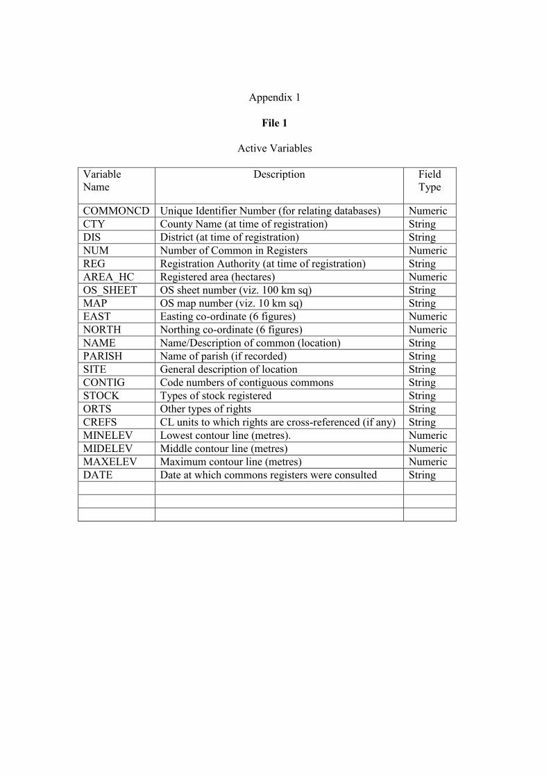
Appendix 1
File 1
Active Variables
Variable
Name
Description Field
Type
COMMONCD Unique Identifier Number (for relating databases) Numeric
CTY County Name (at time of registration) String
DIS District (at time of registration) String
NUM Number of Common in Registers Numeric
REG Registration Authority (at time of registration) String
AREA_HC Registered area (hectares) Numeric
OS_SHEET OS sheet number (viz. 100 km sq) String
MAP OS map number (viz. 10 km sq) String
EAST Easting co-ordinate (6 figures) Numeric
NORTH Northing co-ordinate (6 figures) Numeric
NAME Name/Description of common (location) String
PARISH Name of parish (if recorded) String
SITE General description of location String
CONTIG Code numbers of contiguous commons String
STOCK Types of stock registered String
ORTS Other types of rights String
CREFS CL units to which rights are cross-referenced (if any) String
MINELEV Lowest contour line (metres). Numeric
MIDELEV Middle contour line (metres) Numeric
MAXELEV Maximum contour line (metres) Numeric
DATE Date at which commons registers were consulted String
Appendix 2
File 2
Active Variables
Variable Name
Description Variable Type
COMMONCD Unique Identifier Number (for relating
databases)
Numeric
CTY County Name (at time of registration) String
DIS District (at time of registration) String
NUM Number of Common in Registers Numeric
REG Registration Authority (at time of registration) String
VC Vice-county code number. Numeric
VISDATE Date of Survey visit (if applicable) String
GEN Brief general comments on the common Text (Memo)
OWNERS Summary of statements made in Owners
section
of the registers
Text (Memo)
TOT_HABIT Calculated area of common land
(for surveyed commons). Zero values indicate
commons not surveyed.
Numeric
ANOTES Additional notes from registers (e.g. Acts);
highways network
Text (Memo)
HAY Evidence of hay-making ‘Y’ = Present
CATTLE Evidence of cattle grazing ‘Y’ = Present
COPPICE Evidence of coppicing ‘Y’ = Present
MOWN Evidence of mowing ‘Y’ = Present
SHEEP Evidence of sheep grazing ‘Y’ = Present
PLANT Evidence of plantations ‘Y’ = Present
BURN Evidence of burning ‘Y’ = Present
HORSE Evidence of horses ‘Y’ = Present
THIN Evidence of thinning ‘Y’ = Present
RECREATION Evidence of recreational activities
RABBIT Evidence of rabbits
POLL Evidence of pollarding ‘Y’ = Present
FISH Evidence of fishing activities ‘Y’ = Present
GROUSE Evidence of grouse ‘Y’ = Present
DUMPING Evidence of dumping activities ‘Y’ = Present
SOURCE Field survey or other sources consulted ‘Y’ = Present
FLOOD Evidence of flooding ‘Y’ = Present
SCRUB Evidence of scrub ‘Y’ = Present
FLUSH Evidence of flush ‘Y’ = Present
DEADWOOD Evidence of deadwood ‘Y’ = Present
TREES Evidence of trees ‘Y’ = Present
GNOTES General notes (particularly rights of common) Text (Memo)
FENCES Evidence of fencing ‘Y’ = Present
GARDEN Evidence of gardens ‘Y’ = Present
RUBDUMP Evidence of rubbish dumping ‘Y’ = Present
VEHDAM Evidence of vehicular damage ‘Y’ = Present
NEWROAD Evidence of new road construction ‘Y’ = Present
ENCROACH Evidence of encroachments ‘Y’ = Present
NORITES No rights recorded in registers ‘Y’ = Present
PASTURE Rights of pasture recorded in registers ‘Y’ = Present
SHEAP Rights to graze sheep recorded in registers ‘Y’ = Present
CATT Rights to graze cattle recorded in registers ‘Y’ = Present
HORSEPONY Rights to graze horses and/or ponies recorded
in registers
‘Y’ = Present
OTHLIVES Rights for other livestock recorded in
registers
‘Y’ = Present
ESTOVER Rights of estovers recorded in registers ‘Y’ = Present
PISCARY Rights of piscary recorded in registers ‘Y’ = Present
PANNAGE Rights of pannage recorded in registers ‘Y’ = Present
TURBARY Rights of turbary recorded in registers ‘Y’ = Present
SOIL Rights of common in the soil recorded in
registers
‘Y’ = Present
OTHRITE Other types of rights recorded in registers ‘Y’ = Present
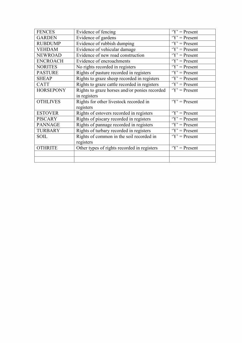
Appendix 3
File3
Active Variables
Variable
Name
Description Field Type
COMMONCD Unique Identifier Number (for relating databases) Numeric
CTY1 County Name (at time of registration) String
NUM Number of Common in Registers Numeric
REG Registration Authority (at time of registration) String
DIS District (former) This comes after NUM and REG String
FAUNA Details of fauna (where available) Text (Memo)
VEG Description of Vegetation (Phase1 habitats) Text (Memo)
MANAGE Observations on management (where available) Text (Memo)
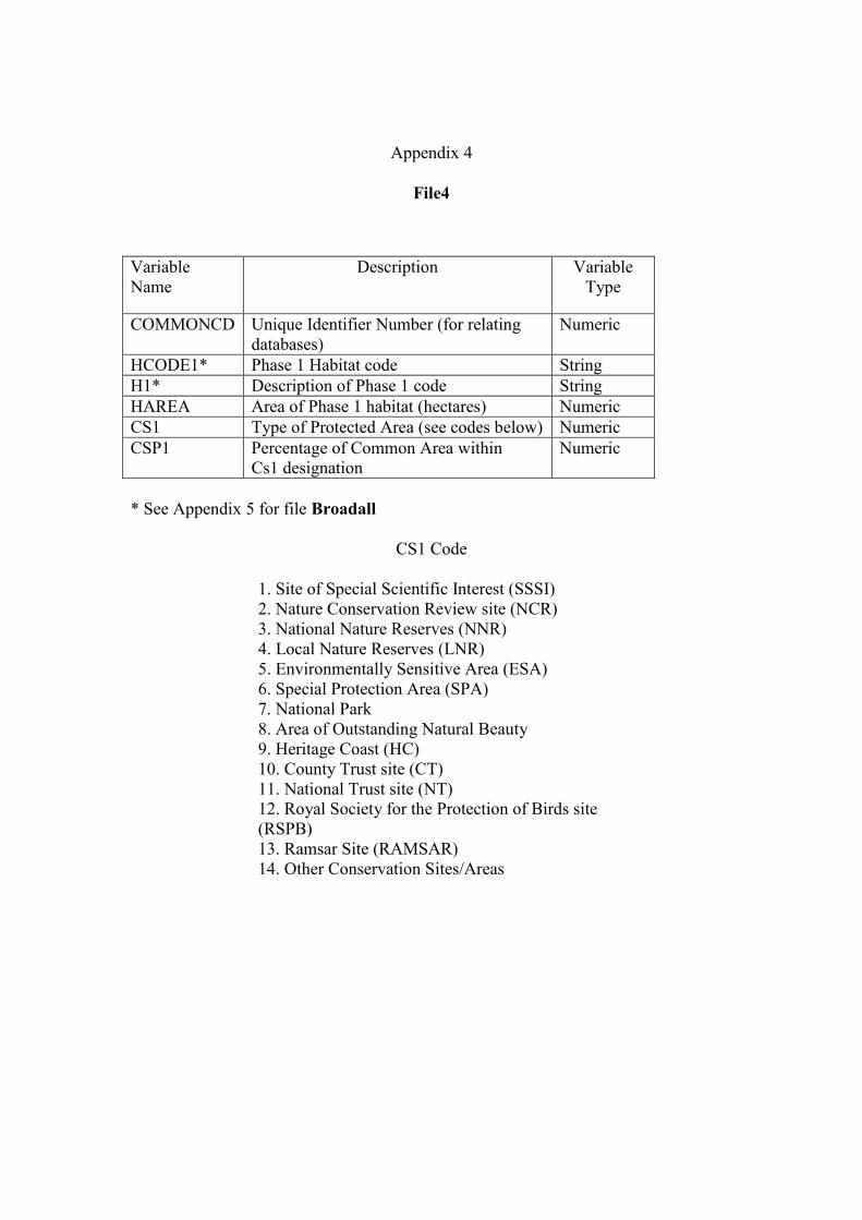
Appendix 4
File4
Variable
Name
Description Variable
Type
COMMONCD Unique Identifier Number (for relating
databases)
Numeric
HCODE1* Phase 1 Habitat code String
H1* Description of Phase 1 code String
HAREA Area of Phase 1 habitat (hectares) Numeric
CS1 Type of Protected Area (see codes below) Numeric
CSP1 Percentage of Common Area within
Cs1 designation
Numeric
* See Appendix 5 for file Broadall
CS1 Code
1. Site of Special Scientific Interest (SSSI)
2. Nature Conservation Review site (NCR)
3. National Nature Reserves (NNR)
4. Local Nature Reserves (LNR)
5. Environmentally Sensitive Area (ESA)
6. Special Protection Area (SPA)
7. National Park
8. Area of Outstanding Natural Beauty
9. Heritage Coast (HC)
10. County Trust site (CT)
11. National Trust site (NT)
12. Royal Society for the Protection of Birds site
(RSPB)
13. Ramsar Site (RAMSAR)
14. Other Conservation Sites/Areas

Appendix 5
File name : Broadall
The fields in this file are defined by the Phase 1 labels (e.g. A111) and Broad habitat
categories BH1-BH21. Recorded for each of these are the associated areas of common
land in hectares.
Phase 1 Codes
A Woodland and Scrub
A111 Broad-leaved Semi-natural Woodland
A112 Broad-leaved Plantation
A121 Coniferous Semi-natural
A122 Coniferous Plantation
A131 Mixed Semi-natural
A132 Mixed Plantation
A21 Dense Scrub
A22 Scattered Scrub
A3 Parkland scattered trees
A4 Recently-felled
B Grassland and Marsh
B11 Acidic Grassland : Unimproved
B12 Acidic Grassland : Semi-improved
B21 Neutral Grassland : Unimproved
B22 Neutral Grassland : Semi-Improved
B31 Calcareous Grassland Unimproved
B32 Calcareous Grassland Semi-improved
B4 Improved Grassland
B5 Marsh/Marshy Grassland
B6 Poor Semi-Improved Grassland
C Tall Herb and Fern (C)
C11 Bracken : Continuous
C12 Bracken : Scattered
C22 Upland Species-rich ledges
C31 Other : Tall Ruderal
C32 Other : Non-ruderal
D Heathland
D11 Dry Dwarf Shrub Heath : Acidic
D12 Dry Dwarf Shrub Heath : Basic
D2 Wet Dwarf Shrub Heath
D3 Lichen/Bryophyte Heath
D5 Dry Heath Acidic Mosaic
D6 Wet heath/acidic grassland mosaic
E Mire
E161 Blanket Bog
E162 Raised Bog
E17 Bog : Wet Modified
E18 Bog : Dry Modified
E21 Flush/Spring : Acid/Neutral
E22 Flush/Spring : Basic
E23 Flush/Spring Bryophyte Dominant
E31 Fen : Valley Mire
E32 Fen : Basin Mire
E33 Fen-flood plain
E4 Bare Peat
F Swamp, Marginal Habitats (F)
F1 Swamp
F21 Marginal
F22 Inundation
G Open Water
G1 Standing Water
G2 Running Water
H Coastland
H11 Intertidal Mud/Sand
H12 Intertidal Shingle
H13 Intertidal Rocks
H23 Saltmarsh /Dunes
H24 Saltmarsh/Plants
H26 Saltmarsh/Continuous
H3 Shingle
H4 Rock/Boulders
H5 Strandline Vegetation
H64 Sand Dune/Slack
H65 Sand Dune/grassland
H66 Dune Heath
H67 Dune Scrub
H68 Dune Open
H81 Maritime Cliff Hard
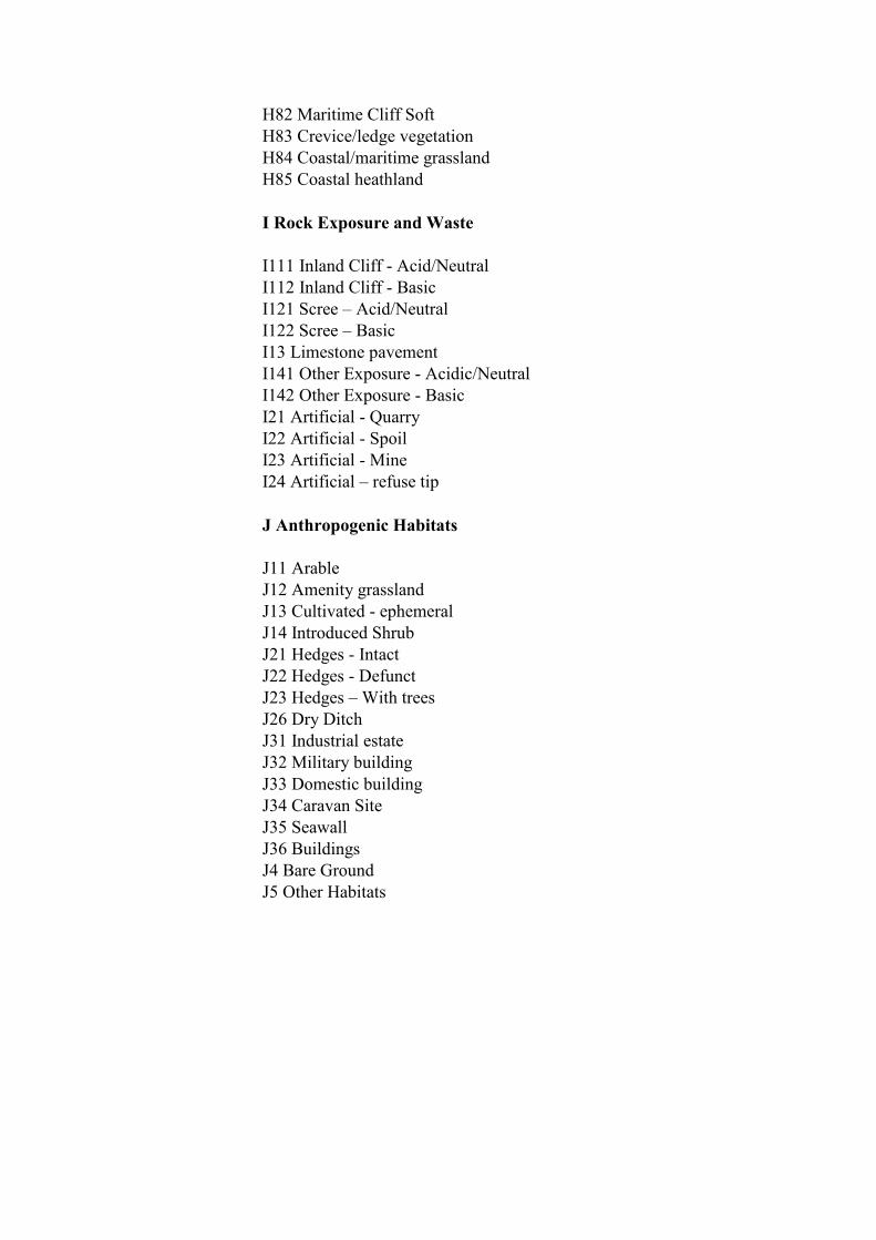
H82 Maritime Cliff Soft
H83 Crevice/ledge vegetation
H84 Coastal/maritime grassland
H85 Coastal heathland
I Rock Exposure and Waste
I111 Inland Cliff - Acid/Neutral
I112 Inland Cliff - Basic
I121 Scree – Acid/Neutral
I122 Scree – Basic
I13 Limestone pavement
I141 Other Exposure - Acidic/Neutral
I142 Other Exposure - Basic
I21 Artificial - Quarry
I22 Artificial - Spoil
I23 Artificial - Mine
I24 Artificial – refuse tip
J Anthropogenic Habitats
J11 Arable
J12 Amenity grassland
J13 Cultivated - ephemeral
J14 Introduced Shrub
J21 Hedges - Intact
J22 Hedges - Defunct
J23 Hedges – With trees
J26 Dry Ditch
J31 Industrial estate
J32 Military building
J33 Domestic building
J34 Caravan Site
J35 Seawall
J36 Buildings
J4 Bare Ground
J5 Other Habitats

Broad Habitats
BH1. Broadleaved, mixed and yew woodland
BH2. Coniferous woodland
BH3. Boundary and linear features
BH4. Arable and horticultural
BH5. Improved grassland
BH6. Neutral grassland
BH7. Calcareous grassland
BH8. Acid grassland
BH9. Bracken
BH10. Dwarf shrub heath
BH11. Fen, marsh and swamp
BH12. Bog
BH3. Standing water and canals
BH14. Rivers and streams
BH15. Montane habitats
BH16. Inland rock
BH17. Built up areas and gardens
BH18. Supralittoral rock
BH19. Supralittoral sediment
BH20. Littoral rock
BH21. Littoral sediment
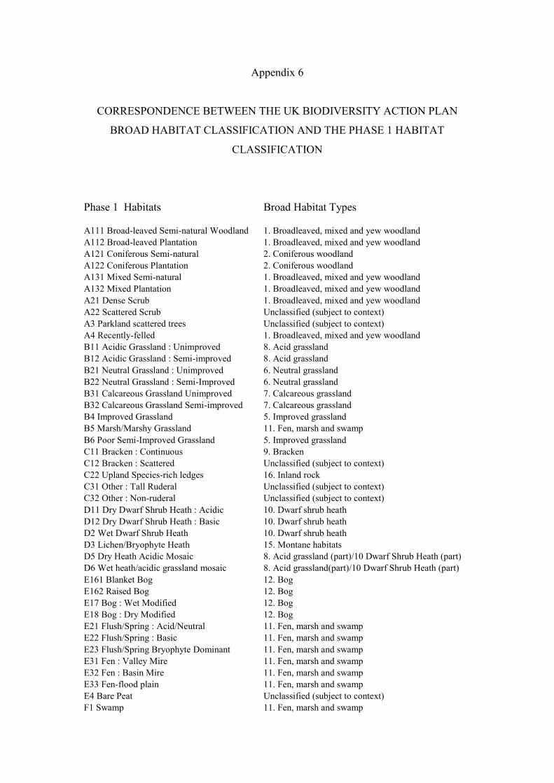
Appendix 6
CORRESPONDENCE BETWEEN THE UK BIODIVERSITY ACTION PLAN
BROAD HABITAT CLASSIFICATION AND THE PHASE 1 HABITAT
CLASSIFICATION
Phase 1 Habitats Broad Habitat Types
A111 Broad-leaved Semi-natural Woodland 1. Broadleaved, mixed and yew woodland
A112 Broad-leaved Plantation 1. Broadleaved, mixed and yew woodland
A121 Coniferous Semi-natural 2. Coniferous woodland
A122 Coniferous Plantation 2. Coniferous woodland
A131 Mixed Semi-natural 1. Broadleaved, mixed and yew woodland
A132 Mixed Plantation 1. Broadleaved, mixed and yew woodland
A21 Dense Scrub 1. Broadleaved, mixed and yew woodland
A22 Scattered Scrub Unclassified (subject to context)
A3 Parkland scattered trees Unclassified (subject to context)
A4 Recently-felled 1. Broadleaved, mixed and yew woodland
B11 Acidic Grassland : Unimproved 8. Acid grassland
B12 Acidic Grassland : Semi-improved 8. Acid grassland
B21 Neutral Grassland : Unimproved 6. Neutral grassland
B22 Neutral Grassland : Semi-Improved 6. Neutral grassland
B31 Calcareous Grassland Unimproved 7. Calcareous grassland
B32 Calcareous Grassland Semi-improved 7. Calcareous grassland
B4 Improved Grassland 5. Improved grassland
B5 Marsh/Marshy Grassland 11. Fen, marsh and swamp
B6 Poor Semi-Improved Grassland 5. Improved grassland
C11 Bracken : Continuous 9. Bracken
C12 Bracken : Scattered Unclassified (subject to context)
C22 Upland Species-rich ledges 16. Inland rock
C31 Other : Tall Ruderal Unclassified (subject to context)
C32 Other : Non-ruderal Unclassified (subject to context)
D11 Dry Dwarf Shrub Heath : Acidic 10. Dwarf shrub heath
D12 Dry Dwarf Shrub Heath : Basic 10. Dwarf shrub heath
D2 Wet Dwarf Shrub Heath 10. Dwarf shrub heath
D3 Lichen/Bryophyte Heath 15. Montane habitats
D5 Dry Heath Acidic Mosaic 8. Acid grassland (part)/10 Dwarf Shrub Heath (part)
D6 Wet heath/acidic grassland mosaic 8. Acid grassland(part)/10 Dwarf Shrub Heath (part)
E161 Blanket Bog 12. Bog
E162 Raised Bog 12. Bog
E17 Bog : Wet Modified 12. Bog
E18 Bog : Dry Modified 12. Bog
E21 Flush/Spring : Acid/Neutral 11. Fen, marsh and swamp
E22 Flush/Spring : Basic 11. Fen, marsh and swamp
E23 Flush/Spring Bryophyte Dominant 11. Fen, marsh and swamp
E31 Fen : Valley Mire 11. Fen, marsh and swamp
E32 Fen : Basin Mire 11. Fen, marsh and swamp
E33 Fen-flood plain 11. Fen, marsh and swamp
E4 Bare Peat Unclassified (subject to context)
F1 Swamp 11. Fen, marsh and swamp
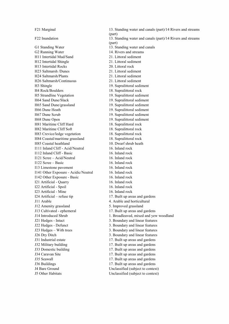
F21 Marginal 13. Standing water and canals (part)/14 Rivers and streams
(part)
F22 Inundation 13. Standing water and canals (part)/14 Rivers and streams
(part)
G1 Standing Water 13. Standing water and canals
G2 Running Water 14. Rivers and streams
H11 Intertidal Mud/Sand 21. Littoral sediment
H12 Intertidal Shingle 21. Littoral sediment
H13 Intertidal Rocks 20. Littoral rock
H23 Saltmarsh /Dunes 21. Littoral sediment
H24 Saltmarsh/Plants 21. Littoral sediment
H26 Saltmarsh/Continuous 21. Littoral sediment
H3 Shingle 19. Supralittoral sediment
H4 Rock/Boulders 18. Supralittoral rock
H5 Strandline Vegetation 19. Supralittoral sediment
H64 Sand Dune/Slack 19. Supralittoral sediment
H65 Sand Dune/grassland 19. Supralittoral sediment
H66 Dune Heath 19. Supralittoral sediment
H67 Dune Scrub 19. Supralittoral sediment
H68 Dune Open 19. Supralittoral sediment
H81 Maritime Cliff Hard 18. Supralittoral rock
H82 Maritime Cliff Soft 18. Supralittoral rock
H83 Crevice/ledge vegetation 18. Supralittoral rock
H84 Coastal/maritime grassland 18. Supralittoral rock
H85 Coastal heathland 10. Dwarf shrub heath
I111 Inland Cliff - Acid/Neutral 16. Inland rock
I112 Inland Cliff - Basic 16. Inland rock
I121 Scree – Acid/Neutral 16. Inland rock
I122 Scree – Basic 16. Inland rock
I13 Limestone pavement 16. Inland rock
I141 Other Exposure - Acidic/Neutral 16. Inland rock
I142 Other Exposure - Basic 16. Inland rock
I21 Artificial - Quarry 16. Inland rock
I22 Artificial - Spoil 16. Inland rock
I23 Artificial - Mine 16. Inland rock
I24 Artificial – refuse tip 17. Built up areas and gardens
J11 Arable 4. Arable and horticultural
J12 Amenity grassland 5. Improved grassland
J13 Cultivated - ephemeral 17. Built up areas and gardens
J14 Introduced Shrub 1. Broadleaved, mixed and yew woodland
J21 Hedges - Intact 3. Boundary and linear features
J22 Hedges - Defunct 3. Boundary and linear features
J23 Hedges – With trees 3. Boundary and linear features
J26 Dry Ditch 3. Boundary and linear features
J31 Industrial estate 17. Built up areas and gardens
J32 Military building 17. Built up areas and gardens
J33 Domestic building 17. Built up areas and gardens
J34 Caravan Site 17. Built up areas and gardens
J35 Seawall 17. Built up areas and gardens
J36 Buildings 17. Built up areas and gardens
J4 Bare Ground Unclassified (subject to context)
J5 Other Habitats Unclassified (subject to context)
Appendix 7
File : Pnats
Variable
Name
Description Variable Type
COMMONCD Unique Identifier Number (for relating
databases)
Numeric
AREA_HC Registered area (hectares) Numeric
EAST Easting co-ordinate (6 figures) Numeric
NORTH Northing co-ordinate (6 figures) Numeric
NATPARK Name of National Park (all commons) String
AONB Name of AONB (all commons) String
CNTRYPAR Name of Country Park (survey commons) String
NATAREAS Code number for Natural Areas (all
commons)
Numeric
NAME Name of Natural Area (all commons) String
CTRUST County Wildlife Trust ‘Yes’= Applies
ESA Environmentally Sensitive Area ‘Yes’= Applies
HCOAST Heritage Coast ‘Yes’= Applies
LNR Local Nature Reserve ‘Yes’= Applies
NCR Nature Conservation Review Site ‘Yes’= Applies
NNR National Nature Reserve ‘Yes’= Applies
NT National Trust ‘Yes’= Applies
OTHER Other Conservation sites ‘Yes’= Applies
RAMSAR Ramsar Site ‘Yes’= Applies
RSPB RSPB Site ‘Yes’= Applies
SPA Special Protection Area ‘Yes’= Applies
SSSI Site of Special Scientific Interest ‘Yes’= Applies

Related Documents

![Oracle Database - Wikimedia Commons · Introduction Présentation Oracle Database est un système de gestion de base de données (SGBD) des plus employés au monde[1]. Il fût créé](https://static.cupdf.com/doc/110x72/5c1f014f09d3f25d2e8bf3f0/oracle-database-wikimedia-commons-introduction-presentation-oracle-database.jpg)