
Welcome message from author
This document is posted to help you gain knowledge. Please leave a comment to let me know what you think about it! Share it to your friends and learn new things together.
Transcript
CHAPTER 1
THE COMING OF THE EARLIER NEOLITHIC, POTTERY ANDPEOPLE IN THE SOMERSET LEVELS
Clive Jonathon Bond
Abstract
This paper will discuss the reinterpretation of the pottery assemblages excavated by the Somerset Levels Project and associated withthe wooden tracks, for example the Sweet Track and an unpublished assemblagefrom a track at Burtle Bridge. Previous researchproduced limited statements on the motives behind individual discard events. Pottery assemblages are discussed with other materialculture to highlight the character of the earlier Neolithic settlement in the Brue Valley in central Somerset during the first part of the
fourth millennium Cal BC. Attention is drawn to the part played in pottery production, exchange and purposeful discard in a wetlandscape. The concept of domestic activity, as inferred by pottery distributions is questioned.
Introduction
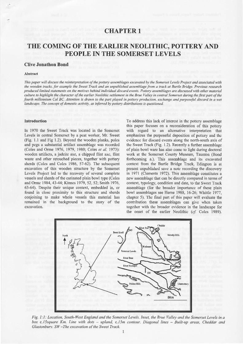
In 1970 the Sweet Track was located in the SomersetLevels in central Somerset by a peat worker, Mr. Sweet(Fig. 1.1 and Fig 1.2). Beyond the wooden planks, polesand pegs a substantial artifact assemblage was recorded(Coles and Orme 1976,1979,1980; Coles et al. 1973):wooden artifacts, a jadeite axe, a chipped flint axe, flintwaste and other retouched pieces, together with potterysherds (Coles and Coles 1986, 57-62). The subsequentexcavation of this wooden structure by the SomersetLevels Project led to the recovery of several completevessels and sherds of the carinated plain bowl type (Colesand Orme 1984,43-44; Kinnes 1979,52,52; Smith 1976,63-64). Despite their unique context, embedded in, orfound in close proximity to this structwe and sherdsconjoining to make whole vessels this material hasremained in the backsround to the story of theexcavation.
To address this lack of interest in the pottery assemblagethis paper focuses on a reconsideration of this potterywith regard to an altemative interpretation thatemphasizes the purposeful deposition of pottery and theevidence for discard events along the north-south axis ofthe Sweet Track (Fig. 1.2). Recently a further assemblageof plain bowl ware has also come to light during doctoralwork at the Somerset County Museum, Taunton (Bondforthcoming a.). This assemblage and its excavatedcontext from the Burtle Bridge Track, Edington is atpresent unpublished save a note recording the discoveryin l97l (Clements 1972). This assemblage constitutes anew assemblage that can be directly compared in terms ofcontext, typology, condition and date, to the Sweet Trackassemblage (for the broader importance of these plainbowl assemblages see Heme 1988, 16-26; Whittle 1977,chapter 5). The final part of this paper will evaluate thecontribution these assemblages can give when takentogether with the broader evidence in the landscape forthe onset of the earlier Neolithic (c/ Coles 1989).
Fig. I :1 : Location, South-LI/est England and the Somerset Levels. Inset, the Brue Valley and the Somerset Levels in abox c.I\square Km. Line with dots - upland, c.I1m contour. Diagonal lines - Built-up qreas, Cheddar andGlastonburv. SIV -The excavation ofthe Sweet Track.
I
Prehistoric Pottery: People, Pattem & Purpose C. J. Bond
In this paper discussion will draw out the agency ofpeople with their choice in materials, manufacture, useand their intentional selection of vessels for discard attwo very specific wetland localities. It is suggested thisbody of evidence gives ground for reassessing the use ofpottery find spots as plots on the two-dimensional mapsof the Brue Valley (Coles 1975, frg. l.I; Coles 1990, fig.13; Coles and Coles 1989,23).
Traditionally these find spots have been taken to indicatetle location of domestic debris and by inference a'settlement' locale (cf. Coles 1989, fig. l3). Instead, it isargued that pottery was bound into the use of thesewooden structures and tied to a distinctive set of ritualpractices. As such the pottery used perhaps attained aparticular cultural meaning with each vessel having anattendant biography which added to the sense of a'special deposit' in this wetland setting (Pollard 2001,322-325; Thomas 1996, 150-177, 1999,85, l l l , 124).Perhaps connotations of the pottery style, knowledge ofthose people or social corurections, origin ofmanufacture,signaled by these pots may have combined to demarcatethese vessels as 'special' and worthy as a votive offering.
The Sweet Track and its pottery assemblageThis track was located by Mr. Ray Sweet of the EclipsePeat Works during the cutting of ditches on ShapwickHeath in 1970 (Fig. 1.2). There had been the presence ofthe Cambridge archaeologist, Dr. J. M. Coles working inthe Somerset Levels since 1964 (Coles 1975, 7). Thenews of this discovery was quickly communicated and apreliminary excavation commenced. Initial observationsdemonstrated a wooden strucfure, of timbers, poles, pegsextending in a linear fashion north-south between theLimestone island of Westhay and the sand island ofShapwick Burtle (Fig.1.3). The trackway was named afterits discoverer, 'The Sweet Track'. As it was under threatofpeat extraction several excavations commenced, alongits line and a trench at its southem terminal (Coles et al.1973,257).
The structure was found to be rather like a 'catwalk' (Fig.1.3). This consisted of pegs that were driven into thephragmites swamp, with peat 'packing' undemeath. Thepeat packing lay on 'rails' that were placed on thecontemporary surface of the swamp and acted as afoundation. A single line of planks was then wedgedbetween the pegs and posts to act as a walkway (Coles elal. 1973,265; Coles and Orme 1976,34, ftg. 20). A greatvariety of wood was used; lime, oak, ash, hazel, alder andholly (ibid., 1973, 66). As excavation proceeded atdifferent locations, at Site R, along the track it wasrealized there was a second line of posts that was aparallel track (Coles and Orme 1976,39). Wooden plankswere associated with posts and it was observed that thesecond track was crossed by the Sweet Track and wasthus confirmed stratigraphically to be earlier. This trackwas called the Post-Track and whilst radiocarbon datesconfirmed both tracks to be earlier Neolithic, laterdendrochronology work suggested the Sweet Track to
date to 3806 BC and the Post-Track as dating to 3838 BC(Hillam et al. 1990,216-217). Sapwood from the SweetTrack demonstrated a felling date in the winter of 3807BC (Hillam et al. 1990,214-215). With this tree-ring datetogether the earlier clustering ofradiocarbon dates (Tablel.l) it was taken to confirm that the Sweet Track wasonly in use over as little as l0-15 years (Coles 1999, 165-166; Coles and Coles 1998, 5-6; Coles and Orme 1979,64; Coles in Hillam et al. 1990,218).
After thirteen separate excavations and a campaignextending from 1970 to 1984 (and recent evaluations,Brunning 1996) the Sweet Track structue is seen toextend 1.5 kilometers. Its course is confirmed to be north-south between the island of Westhay and ShapwickBurtle. Of that length, c.368.50 meters or 24.5o/o of thetrack has been excavated. This makes this structure themost investigated track in the Levels and perhaps evenelsewhere (Coles and Coles 1986). The wooden structureand its environmental data; beetles; pollen, evidence forwood working all play a key role in the narrative tied tothe track (Parker Pearson 1993, 15-16). However, fromthe outset of excavations artifacts were also excavatedbeside the Sweet Track, on top of the planks, hiddenbelow wood; wooden artifacts; a flint axe, arrowheads,flint waste; a jadeite axe, pottery (Coles and Coles 1986,57-62; Coles et al. 1973,278-292, fie. 2).The main findsto athact attention beyond the wood has been the highlypolished jadeite axe (Coles et al. 1974,216), the flintchipped axe and arrowheads (Coles and Orme 1976, frg.37), two of which retained their shafts and a third withbirch resin (Coles et al. 1973,291). Emphasis has beendrawn to the organic remains and the artifacts that reflectthat interest, or other analytical techniques, such as theattempt to gain trace element signatures for the flint axe(Coles and Coles 1986, 59; Coles el al. 1973, 289-290;Craddock et al. 1983, 153, table 3). Within this contextthe quantity of pottery excavated beside the Sweet Trackhas remained in the background.
Some 1 13 separate find spots (consisting of wood,pottery, lithics) were excavated along the line of theSweet Track. Thus an average of I find spot for every 30-31 meters excavated was recovered. Coles noticed duringexcavation the difference with the Sweet Track comparedto other tracks in the Levels, that there was a high yield ofartifacts along the track line (Coles and Orme 1976, 65,1979, 61; Coles el al. 1973,278). However this was notcommented on further. A closer consideration of thecontext of the pottery, spatial patterning either side andalong the Sweet Track will develop this aspect here.
From 9 trenches 2 yielded only pottery, but a total of 5gave pottery to be the main tlpe of artifact excavated(Fig. 1.4). The published account of the potteryassemblage derived from the Sweet Track is mainlyfocused on the typology, technology and culturalaffinities of the sherds (Kinnes 1979; Smith 1976), withonly limited discussion on the spatial distribution withinthe track, or between trenches (Coles and Orme 1984,
North
tffi-*,:--r%ffi:ff*h:d#g',*HEa.ua.*t,,"' #%il ffi{T"::;:4il"Hc#1" : W-nff-{u _ i;..;*"tr"ft ,i,' jiffi355""iffi ffis #si',ffi iffi .
wsti
Fry#,'i{;qru;trru',ffgftul-: ar*,.*;*#'*'ffi#ffi4mffi;:W}M;Jt#
ffi# %',j*N;:ffi%,T
Y*:Y'4; e*-ry
#tf 4i:.W. f:lf$
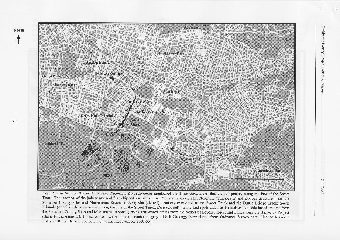
tfill E*#n,l'//.J@#jFig.l.2: The Brue Valley in the Earlier Neolithic. Key:Site codes mentioned are those excavations that yielded pottery along the line of the SweetTrack. The location of the jadeite axe and flint chipped axe are shown. Vertical lines - earlierNeolithic 'Trackways' and wooden structures from theSomerset County Sites and Monuments Record (1998); Star (closed) - pottery excavated at the Sweet Track and the Burtle Bridge Track; SouthTriangle (open) - lithics excavated along the line of the Sweet Track; Dots (closed) - lithic find spots dated to the earlier Neolithic based on data fromthe Somerset County Sites and Monuments Record (1998), reassessed lithics from the Somerset Levels Project and lithics from the Shapwick Project(Bond forthcoming a.). Lines: white - water; black - contours; grey - Drift Geology (reproduced from Ordnance Survey data, Licence Number:LA07683X and British Geological data, Licence Number 2001/55).
tso
o
qo
(D
oH
R"
t€o
a3H
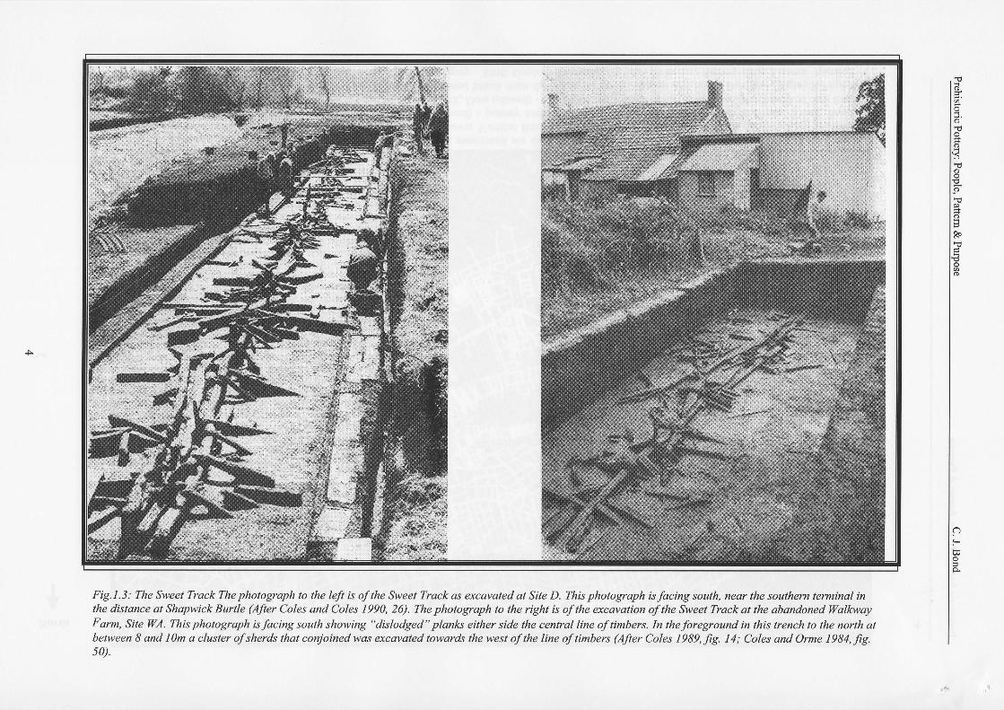
Fig.l.3: Ihe Sweet Track Ihe photogaph to the lef tu ofthe Sweet Tra.k as excavated at Site D. lhis photogaph it facirrg south, tt ar the southem terminal inthe distance at Shapwick Rnrtle (Afer Coles and Coles 1990, 26). The photogaph to the ngh is ofthe acavatian ofthe S\+eet Track at the obondoned Walbl'ayFarm, Site WA. This photograph isfacing sotrth showins "ditlodged" plank either side the centrat line ofnmber& In the foregound in rhit trench to the rrorth atbetween 8 and 10n a ch ster ofsher^ that conjoined was excatated torrords the west ofthe line oftimbery (After Coles 1989, fg. 14; Coles and Ome 1984, fg.50).
o
Ft
(Dq
o
I
R"
€o
aH
Prehistoric Pottery: People, Pattern & Purpose C. J. Bond
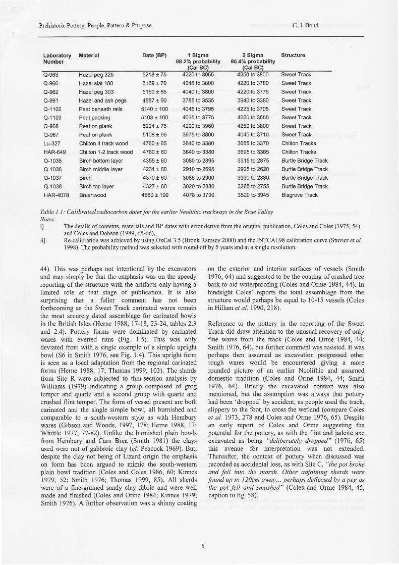
Laboratory MaterialNumber
Date (BP) 1 Sigma 2 Sigma Structure68.2%probabil i ty 95.4%probabil i ty
Q-966 Hazel slat 180
Q-962 Hazel peg 303
Q-99't
Q-1102
Q-1103 Peat packing
Q-968 Peat on plank
Q-1035 Birch bottom layer
Q-1036 Birch middle layer
Q-1037 Birch
Q-1038 Birch top layer
HAR-4078 Brushwood
Hazel and ash pegs 4887 t 90 3785 to 3535Peat beneath rails 5140 t 100 4045 to 3795
5159 I 70 4045 to 38005150 + 65 4040 to 3800
5103 t 100 4035 to 37755224!75 4220 to 3960
4355 t 60 3080 to 28954231 !60 2910 to 26954370 t 60 3085 to 29004327 t60 3020 to 2880
4880 1 100 4078 to 3790
Q-967 Peat on plank 5108 I 65 3975 to 3800
Lu-327 Chilton 4 track wood 4760 t 65 3640 to 3380
HAR-649 Chilton 1-2 track wood 4760 t 80 3640 to 3380
4220to3780 SweetTrack42201o3775 SweetTrack3940 to 3380 Sweet Track4225to3705 SweetTrack4220 to 3655 Sweet Track4250 to 3800 Sweet Track4045 to 3710 Sweet Track3655 to 3370 Chilton Tracks
3695 to 3365 Chilton Tracks3315 to 2875 Burtle Bridge Track2925 to 2620 Burtle Bridge Track3330 to 2880 Burtle Bridge Track3265 to 2755 Burtle Bridge Track3520 to 3945 Bisgrove Track
on the exterior and interior surfaces of vessels (Smith1976, 64) and suggested to be the coating of crushed treebark to aid waterproofing (Coles and Orme 1984, 44).lnhindsight Coles' reports the total assemblage from thestructure would perhaps be equal to 10-15 vessels (Colesin Hillam et al. 1990, 218).
Reference to the pottery in the reporting of the SweetTrack did draw attention to the unusual recovery of onlyfine wares from the track (Coles and Orme 1984, 441,Smith 1976, 64), but further comment was resisted. It wasperhaps then assumed as excavation progressed otherrough wares would be encountered giving a morerounded picture of an earlier Neolithic and assumeddomestic tradition (Coles and Orme 1984, 44; Smith1976, 64). Briefly the excavated context was alsomentioned, but the assumption was always that potteryhad been 'dropped' by accident, as people used the track,slippery to the foot, to cross the wetland (compare Coleset al. 1973,278 and Coles and Orme 1976,65). Despitean early report of Coles and Orme suggesting thepotential for the pottery, as with the flint and jadeite axeexcavated as being "deliberately dropped" (1976, 65)this avenue for interpretation was not extended.Thereafter, the context of pottery when discussed wasrecorded as accidental loss, as with Site C, "the pot brokeand fell into the marsh. Other adjoining sherds were
found up to I20cm oway... perhaps deflected by a peg asthe pot fell and smashed" (Coles and Orme 1984, 45,caption to fig. 58).
Table I. I : Calibrated radiocarbon dates for the earlier Neolithic trackways in the Brue ValleyNotes:il. The details of contexts, materials and BP dates with error derive from the original publication, Coles and Coles (1975,54)
and Coles and Dobson (1989, 65-66),iil. Re-calibration was achieved by using OxCal 3.5 (Bronk Ramsey 2000) and the INTCAL98 calibration curve (Stuvier er a/.
1998). The probability method was selected with round offby 5 years and at a single resolution.
44). This was perhaps not intentional by the excavatorsand may simply be that the emphasis was on the speedyreporting of the structure with the artifacts only having alimited role at that stage of publication. It is alsosurprising that a fuller comment has not beenforthcoming as the Sweet Track carinated wares remainthe most securely dated assemblage for carinated bowlsin the British Isles (Heme 1988, 17-18, 23-24,tables2.3and 2.4). Poffery forms were dominated by carinatedwares with everted rims (Fig. 1.5). This was onlydeviated from with a single example of a simple uprightbowl (56 in Smith 1976, see Fig. l.a). This upright formis seen as a local adaptation from the regional carinatedforms (Heme 1988, 17; Thomas 1999, 103). The sherdsfrom Site R were subjected to thin-section analysis byWilliams (1979) indicating a group composed of grogtemper and quartz and a second group with quartz andcrushed flint temper. The form of vessel present are bothcarinated and the single simple bowl, all bumished andcomparable to a south-western style as with Hemburywares (Gibson and Woods,1997, 178; Herne 1988, 17;Whittle 1977,77-82). Unlike the burnished plain bowlsfrom Hembury and Cam Brea (Smith 1981) the claysused were not of gabbroic clay (cf. Peacock 1969). But,despite the clay not being of Lizard origin the emphasison form has been argued to mimic the south-westernplain bowl tradition (Coles and Coles 1986, 60; Kinnes1979, 52; Smith 1976; Thomas 1999, 85). All sherdswere of a fine-grained sandy clay fabric and were wellmade and finished (Coles and Orme 1984; Kinnes 1979;Smith 1976). A further observation was a shinny coating
Prehistoric Pottery: People, Pattern & purposeC. J. Bond
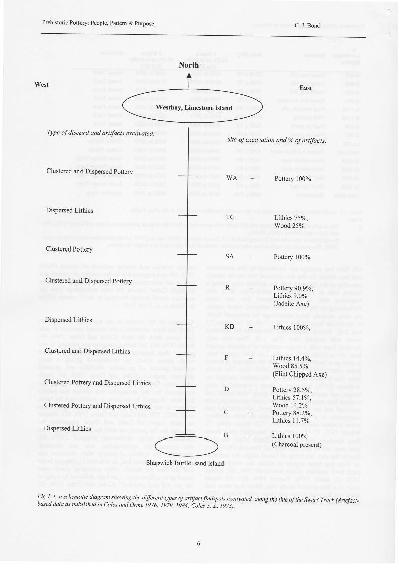
West
North
t
Type ofdiscard and artifacts excqvated:
Clustered and Dispersed Pottery
Dispersed Lithics
Clustered Pottery
Clustered and Dispersed Pottery
Dispersed Lithics
Clustered and Dispersed Lithics
Clustered Pottery and Dispersed Lithics
Clustered Pottery and Dispersed Lithics
Dispersed Lithics
TG
East
Site of excovation and o% of artifacts:
WA Pottery 100%
Lithtcs 7SYo,Wood25%
Pottery 100%
Pottery 90.9Yo,Lithics 9.0%(Jadeite Axe)
Lithics 100%,
Lithics l4.4yo,Wood 85.5%(Flint Chipped Axe)
Pottery 28.5Yo,Lithics 57.lyo,Wood l4.2YoPottery 88.2Yo,Lithics ll.7%o
Lithics 100%(Charcoal present)
R
D
C
Shapwick Burtle, sand island
!ig't tt a schematic diagray showirY the diferent types of artifactfindspots excavated along the line of the Sweet Track (Artefact-based data as published in Coles and orme 1976, Ig7g, ttg4;
-cotes etit. tczsl.
Prehistoric Pottery: People, Pattern & Purpose C. J. Bond
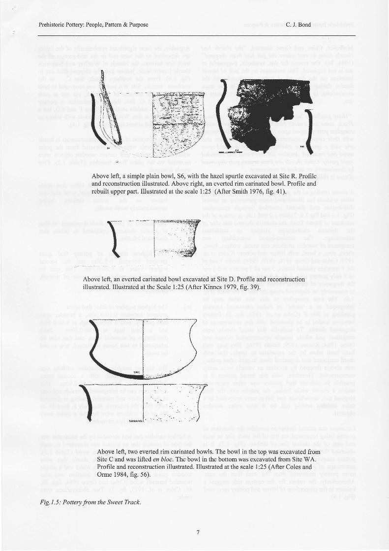
-lAbove left, a simple plain bowl, S6, with the hazel spurtle excavated at Site R. Profileand reconstruction illustrated. Above right, an everted rim carinated bowl. Profile andrebuilt upper part. Illustrated at the scale 1:25 (After Smith 1976, ftg. 4l).
Above left, an everted carinated bowl excavated at Site D. Profile and reconstructionillustrated. Illustrated at the Scale I :25 (After Kinnes 1979, fig. 39).
Above left, two everted rim carinated bowls. The bowl in the top was excavated fromSite C and was lifted en bloc. The bowl in the bottom was excavated from Site WA.Profile and reconstruction illustrated. Illustrated at the scale l:25 (After Coles andOmre 1984, fig. 56).
Fig.1.5: Potteryfrom the Sweet Track.
Prehistoric Pottery: People, Pattern & Purpose C. J. Bond
Moreover, Coles and Orme asserted, "the sherds hadclearly come to rest where the pot had been dropped"(1984,24). The reason for this, symbolic, purposeful ornot is not explored. This sentiment on the lack of humanintention on the discard of pottery continued with thedendro dating of all artifacts recovered in the trackexcavations, to 3806 BC with a span of 10-15 years ofuse.
"Many potsherds have been found alongside the SweetTrack, some underneath planks and others representingcomplete pots dropped upon the track or into the swampwith their contexts scattered. A pot with hazelnuts, andone with a spurtle or stirring-stick, were dropped uponwood and smashed. Another fell into reeds and subsidedmore gently. Other sherds arefrom broken pots dispersedbyfloodwaters, or kicked in annoyance..."(Coles in Hillam et al. 1990,218\.
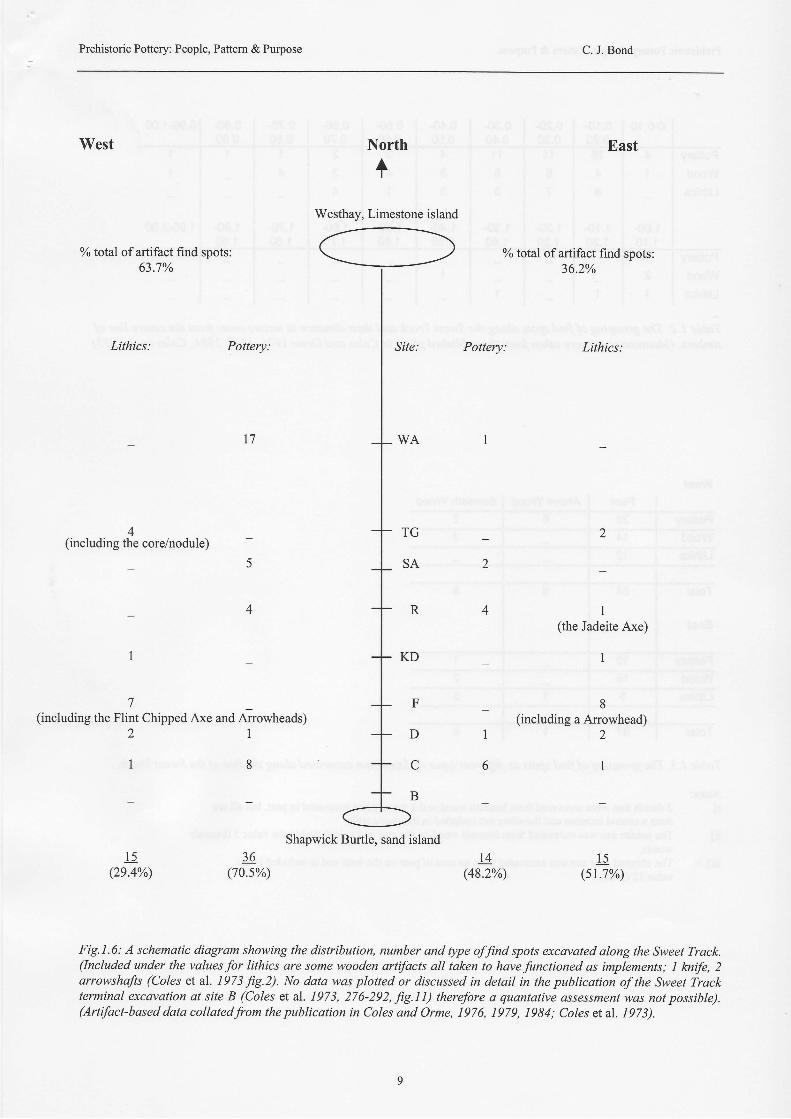
A closer reading of the published data on the pottery andother artifacts has illuminated some patteming on spatialdistribution and discard recorded through excavation(Fig. 1.a and Fig 1.6, Tables 1.2 and 1.3). A review of theaccounts of Sweet Track excavations showed that nine ofthe thirteen excavations yielded an artifactualassemblage. The artifact-based assemblage wascomposed of wooden artifacts; cut wood, wedges, bows,sticks, pins, a bowl, with lithics and pottery (Coles et al.1973; Coles and Orme 7976,1979,1984). Some 7 out ofthe 9 trenches yielded lithics, 5 out of9 pottery and 2 outof 9 only pottery Gig. l.a). A broad spatial patteming inthe frequency of material culture indicated lithics tendedto commonly be dispersed along the line of the track (Fig.1.6). The rare exception to this was what may beinterpreted as a 'cache' of flakes recovered beneathplanking at Site F (Coles et al. 1973, fie. 2).Potteryhowever tended to be clustered with few occurrences ofdispersed sherds. To underlie this trend sherds wereconjoined and whole vessels reconstructed (Coles andOrme 1984; Kinnes 1979; Smith 1976). This may wellhave been taken by the excavator to imply, that withsherd conjoined and deposited close to each other potterywas always dropped by accident as vessels were easilyreconstructed. Therefore, with this broad pattern it ispossible to indicate that pottery was often excavatedwithin a cluster while lithics, the jadeite axe, the flintchipped axe, arrowheads and flakes were recovered in amore isolated setting (all be it near other woodenobjects).
Comment can extend further to consider the direction ofpottery being recovered, on top of the track line or westand east of the central line of timbers (Fig. 1.7). It isobserved that both in the west and east there is morepottery recovered than lithics (Fig. 1.6). Moreover, as apercentage of pottery either side the track line there ismore pottery recovered from the west than the east.Alternatively, the values for the eastern side suggest abalance in the proportions oflithics and pottery recovered(Fig. 1.6).
Arguably, the most significant symbolically of the lithicsare deposited to the west and in the mid-section of thetrack line between the islands of Westhay and ShapwickBurtle (core/nodule, jadeite axe, the chipped flint axe inFig. 1.6). From the southem trench, Site C, to thenorthern trench, Site WA pottery was recovered in bothnorth and south sections of the track, yet not at eachterminal (Fig. 1.a). But, there is a reduction in potteryrecovery in the middle sections at Sites F and KD, but apresence again at Site WA. This contrasts with lithics asthey are recorded almost throughout (Fig. 1.a).
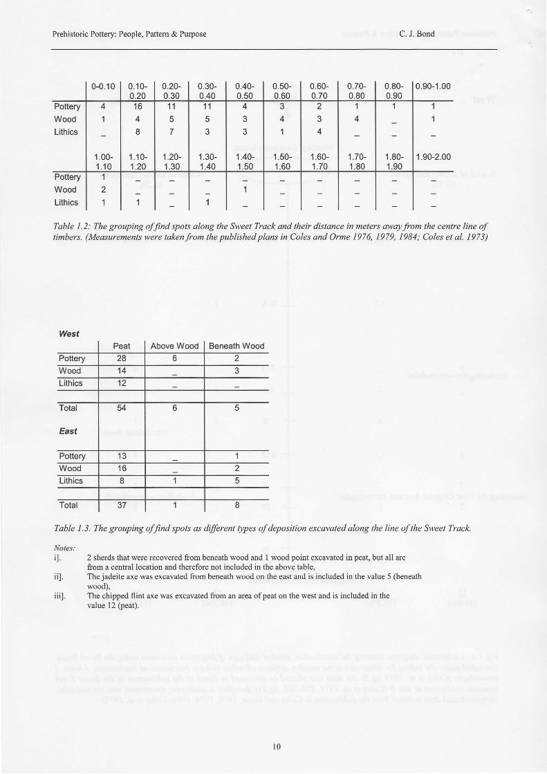
To study the direction of recovery measurements in bandsof 0.10m intervals were then extracted from the pointwhere lithics, pottery and certain wooden objects wererecorded on the plans from trenches (Table 1.2). Fivetrends emerged;
il. The number of pottery and lithic find spotsdecreased from the central point, west and east(taken as the centre timbers layingapproximately north-south),
iil. The number of pottery finds decreased >0.40mat greater distance, compared to lithics thatdecreased >0.30m,
iiil. The highest number of pottery find spotsgrouped between 0-0.20m and the secondhighest value at 0.20-0.30m. This can beinterpreted as perhaps two zones of discard,directly on or beside thestrucnlre,
ivl. The highest number of lithic find spotsgrouped between 0.10-0.30m, a broader spanthan pottery, with a second high at 0.30-0.50mand a third hiCh at 0.60-0.70m. Suchdistribution of material west, east can also beinterpreted as two zones of discard, near to andfar away,
v]. The highest number of wooden artifacts wasgrouped at 0.10-0.40, with a second morediffrrse value between 0.40-0.80m. Thisdistribution can be interpreted as beside and nearto the structure and material grading at distanceaway from the structwe. But, only 3, from 33, or9Yo of the artifacts were beyond a meter awayfrom the central line of timbers.
A further variable that was recorded by the excavator wasthe type ofcontext that an artifact was recovered in, suchas in peat, above wood, or beneath wood (Table 1.3).Excluded from this were the two sherds that wererecovered at a central point beneath wood and a singlewooden point from also a central location was alsorecorded beneath wood (Coles and Orme 1984, figs. 20,49; Coles et al. 1973, fig. 2). Two observations weremadel
Prehistoric Pottery: People, Pattern & Purpose C. J. Bond
West
Yototal ofartifact find spots:63.7%
Lithics: Pottery:
4(including the core/nodule)
7(including the Flint Chipped Axe and Arrowheads)
' t 1L I
North
+
F
D
C
B
Shapwick Burtle, sand island
East
o/ototal ofartifact find spots:36.2%
Lithics:
1(the Jadeite Axe)
1
8(including a Arrowhead)
2
I
1 5(sr.7%)
t 7
1
6
l 5(2e.4%)
36(70.s%)
t4(48.2%)
Fig.I.6: A schematic diagram showing the distribution, number and type ofJind spots excavated along the Sweet Track.(Included under the values for lithics are some wooden artifacts all taken to have functioned as implements; I knife, 2arrowshafis (Coles et al. 1973 fig.2). No datq was plotted or discussed in detail in the publication of the Sweet Trackterminal excavqtion at site B (Coles et al. 1973, 276-292, JiS.II) therefore a quantative assessment was not possible).(Artifact-based data collatedfrom the publication in Coles and Orme, 1976, 1979, 1984; Coles et al. 1973).
Westhay, Limestone island
Prehistoric Pottery: People, Pattern & Purpose C. J. Bond
0-0 .10 0.10-0.20
0.20- 0.30-0.40
0.40-0.50
0.50-0.60
0.60-0.70
0.70-0.80
0.80-0.90
0.90-1.00
Wood
Lithics
41
1.00-1 . 1 0
1 6
4
8
1 . 1 0 -1 .20
't1
57
1.20-1.30
1 15J
1.30-1.40
43J
1.40-1 .50
341
1.50-1 .60
234
1.60-1 .70
14
1.70-1 .80
1
1.80-1 .90
11
1.90-2.00
WoodLithics
121
1
Table 1.2: The grouping offind spots along the Sweet Trqck and their distance in meters awayfrom the centre line oftimbers. (Measurements were takenfrom the published plans in Coles and Orme 1976, 1979, 1984; Coles et al. 1973)
WestPeat Above Wood Beneath Wood
Pottery 28 o 2Wood 1 4 3Lithics 1 2
Total
East
54 6 5
Pottery 1 3 1
Wood 1 6 2thics 8 1 5
Total 37 1 8
Tqble 1.3. The grouping offind spots as dffirent types of deposition excavated along the line of the Sweet Track.
Notes:i]. 2 sherds that were recovered from beneath wood and I wood point excavated in peat, but all are
from a central location and therefore not included in the above table.ii]. Thejadeite axe was excavated from beneath wood on the east and is included in the value 5 (beneath
wood),iii]. The chipped flint axe was excavated from an area of peat on the west and is included in the
value 12 (peat).
l 0
4 5 6
ii. . 2
?:
i .'gt - q)'4. . , ' qr--1i*
a Ii li li I t s a c',i
--'*t-.,...a o
\--....---"-.J
dlth
.F
,7
{:i:t*:-:':::'a
tr\rtr4_ r $ .
"]*:r{:.}
i ) *m-T:::tx.:j:.::x
{|',, '.{
la' t : , \
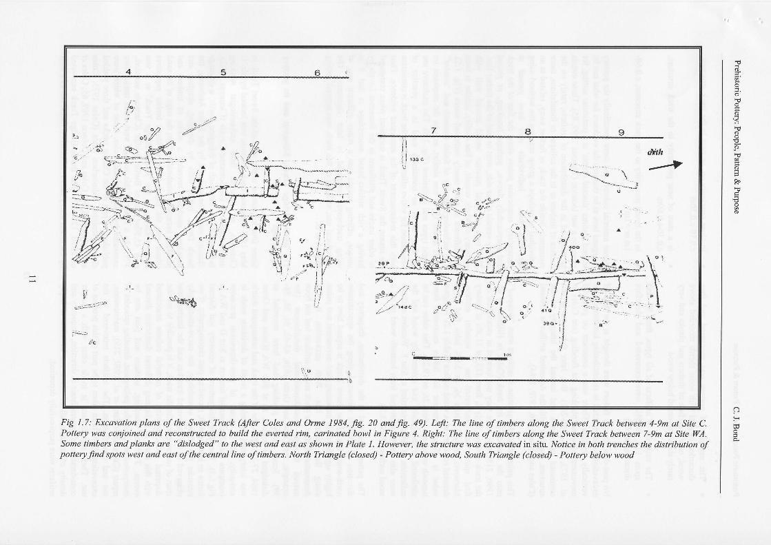
Fig 1.7: Ercavation plans of the Srvet Track (Afrer Col?s and Ome 1984, fg. 20 a d fg. 49). Left: The line of tinbew alons the Swea lrack between +9m at Site C.Pottery was conjoi ed and reco st ucted to build the ewrted rim, carinated bowl irr Fipte 4. Right: The line of tinberc along the Sueet Tmck bet' een 7-9m at Site WA.Sone tinbers and plsnb orc "dislodged" to the w?st and east 6 shornt in Phte L Howew\ the sfucture ylns excawted in |it!- Notice in both ienches the distribution ofpottery fnd spots N)est and east ofthe central line oftinbers. North biangle (closed) - Pottery oboyv wood, So rh Mangle (closed) - Pottery below wood
Eo
o
q
(D
@
(D-R"
I
(D
o
H
Prehistoric Pottery: People, Pattern & Purpose C. J. Bond
o The majority of pottery was recovered and thusdiscarded in peat with some sherds recorded abovewood, on the surface of timbers and planks and veryrarely sherds recorded below wood
o The majority of artifacts of all types, from 9l findspots ll3, 80.5oA, were excavated and thereforediscarded in peat
No post-depositional factors were thought at the time ofexcavation to have acted in redistributing horizontally orvedically artifacts. There was a comment on potentialmovement of wood planking via flooding (see Coles elql. 1973, 278, 280-281). But, later this issue is notcontinued in reports and instead the integrity of thestructure, together with the deposited artifact is stressed(Coles and Orme 1976,1979,1984).
This point raises the question if artifacts were "dropped"onto the surface of the track (Coles in Hillnan et al.1990, 218) why were they not located in excavation onthe track surface. Only 6, from l13, or 11.5% of potteryfind spots were recovered on a wooden surface.Moreover, only 1, from 26, or 3.8Yo lithic find spotsdenoted recovery on a wood surface (Table 1.2). A highervalue is offered however for lithics excavated frombeneath wood at 5, from 26, or l9.2Yo. This value can beattributed to the jadeite axe covered by wood and thecollection of flakes recorded at Site F. Wooden artifactswere also rarely recovered from beneath wood or on awood surface (Table 1.3).
The pattem observed in the distribution, frequency anddirection of artifacts recovered along the approximatenorth-south line of the Sweet Track is argued here to behighly significant in indicating past movement and pausealong the timber line. With excavation it wasdemonstrated how the track and its artifacts had not beenmoved through post-depositional disturbances (forexample, see Coles and Orme 1976, 42-43,51, 56, 58-59). Some timber planking had been recorded asdislodged or broken, as at Site WA (Coles and Orme1984,27-28). The line ofthe track and subsequent debriswas interpreted as being a result of decisions made inantiquity, not a result of post-deposition processes(compare the alignment of timbers at Site D and WA inFig.1.3). Therefore this pattem of recovery and discardforms an integral unit, recording past choreography. If weconsider the artifact assemblage, the micro-stratigraphyobserved in the excavated trenches and the limited timespan ofuse asserted for the track, it is possible to see thedispersal and clustering of material culture associatedwith this track as indicating different distinctive discardevents. Timbers, planking, artifacts and peat can beinterpreted as a complex palimpsest, denoting episodes ofrepair (Coles in Hillam et al. 1990,219), maintenance,use and modification. The artifacts recovered in theexcavations have been taken to be part ofthis process ofuse. Their significance is made clear with a deeperconsideration of the emphasis in direction, frequency anddensity of artifacts, all of which can be taken to implyartifacts were purposefully deposited;
o in close proximity on, or neax to the track structure,c.0.10-c.0.30m
o in a state of near proximity to the track sfructure,c.0.30-c.0.60m
o in the broad proximity to the track structure, c.0.60-lm or >lm
Hence material culture, and more specifically the potteryis argued here to be tied into the evidence for what can betermed distinct 'discard events' at a particular setting, forexample a wet location (Thomas 1999, 85). These eventsas recorded in the distribution of artifacts; rarely on thesurface of timbers or in the collapse or foundations, morecommonly beside the track, or further away, related to anindividual or perhaps a goup entering the wetland usingthe track line. Individuals may have paused atpadicularly auspicious points along the line of the trackand purposefrrlly thrown, perhaps breaking, or placedpottery vessels either side, west or east of the timber line.This type of ritual practice would accord well withrecovery of whole vessels, of fine quality, similar in formbut different in size, mostly carinated wares (Fig. 1.5).The technology, quality of finish (smooth and "coqted"as in Smith 1976) was similar, as was the emphasis onfabric types and inclusions (Fig. 1.8). The exclusive useof fine waxes as containers used in a practice ofveneration for votive offering along the track is consistentwith this reassessment of the excavated evidence. Thustle reason the Sweet Track is untypical when comparedto other tracks and platforms in the Somerset Levels byhaving a rich artifact-based assemblage is that it isunique, offering insight into a rather different way ofusing trackways compared to later structures. Theintentional use, walking of this track, was beyond gettingfrom A to B.
The Burtle Bridge Track, Edington and its potteryassemblage
Some four kilometers to the west of the Sweet Track inMay l97l a second track strucfure was located by Mr. CClements, an amateur field archaeologist workingindependently in the Somerset Levels (Clements 1972).In May l97l to the south of Edington Burtle, a drainagechannel was to be widened by the River Authority, theSouth Drain. Initial work by dredging, dragline andtrenching machines revealed a series of timbers andplanking extending southwards from the edge of the sandisland into the moors. One of these timber exposuresbecame known as the 'Burtle Bridge Track' as it wasonly 45.50m east of Burtle Bridge (Clements undated.,109). As a result of this salvage work other tracks wereexcavated by Clements and Coles, some of which werepublished as part of the Chilton tracks and three yieldedearlier Neolithic radiocarbon dates (Coles 1975; Colesand Coles 1975,541, Coles and Dobson 1989, 65; Coles etal. 1970, 126-12'7). The Burtle Bridge Track excavatedby Clements also yielded radiocarbon dates, but of a later
t2
Prehistoric Pottery: People, Pattern & Purpose C. J. Bond
r NorthI
Westhay,Limestone island
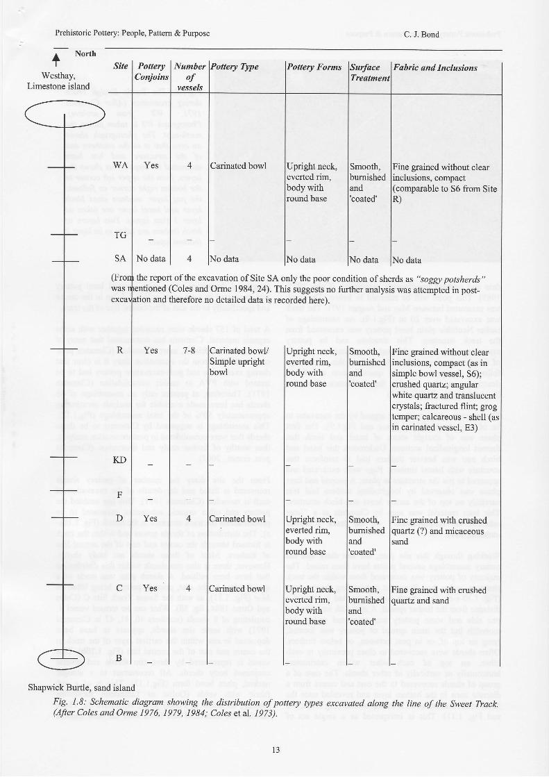
Site PotteryConjoins
Numberof
VCSSCIS
Pottery Forms
Carinated bowl Upright neck,nm,
body withround base
Fabfic and InclusionsTreatment
WA Yes Smooth,bumished
coated'
Fine grained without clearinclusions, compact(comparable to 56 from SiteR)
TG
SA No dataNo data | 4 lNo data o data lNo data
the report ofthe excavation ofSite SA only the poor condition ofsherds as "soggl potsherds"tioned (Coles and Orme 1984,24). This suggests no further analysis was attempted in post-
and therefore no detailed data is recorded here).
7-8 lCarinated bowV lUpright neck,lSimple upright leverted rim,
lbowl lbody with
I lroundbasetttltl
4 l."n*,"u0"*, l*nrnr*raI leverted rim,I lbodywith
I lroundbasetl4 lCainated bowl lUpright neck,
I leverted rim.
I lbodywith
I lround
base
t_t_Shapwick Burtle, sand island
Fig. 1.8: Schematic diagram showing the distribution of pottery types excavated along the line of the Sweet Track.(After Coles and Orme 1976, 1979, 1984; Coles etal. 1973).
1 3
Prehistoric Pottery: People, Pattem & Purpose C. J. Bond
date and perhaps questionable association (Coles 1975,1989). This point will be returned to below. The trackwas excavated between May and August 1971. The hackwas excavated over 20 m (Fi9.1.9). An assemblage ofearlier Neolithic plain bowl pottery was excavated fromthe track structure. This structure and its potteryassemblage remain unpublished. A preliminary analysisof this data is given below. Analysis of this assemblagefollowed the procedures for quantification and fabricdescription as set out by the Prehistoric CeramicsResearch Group (PCRG 1997).
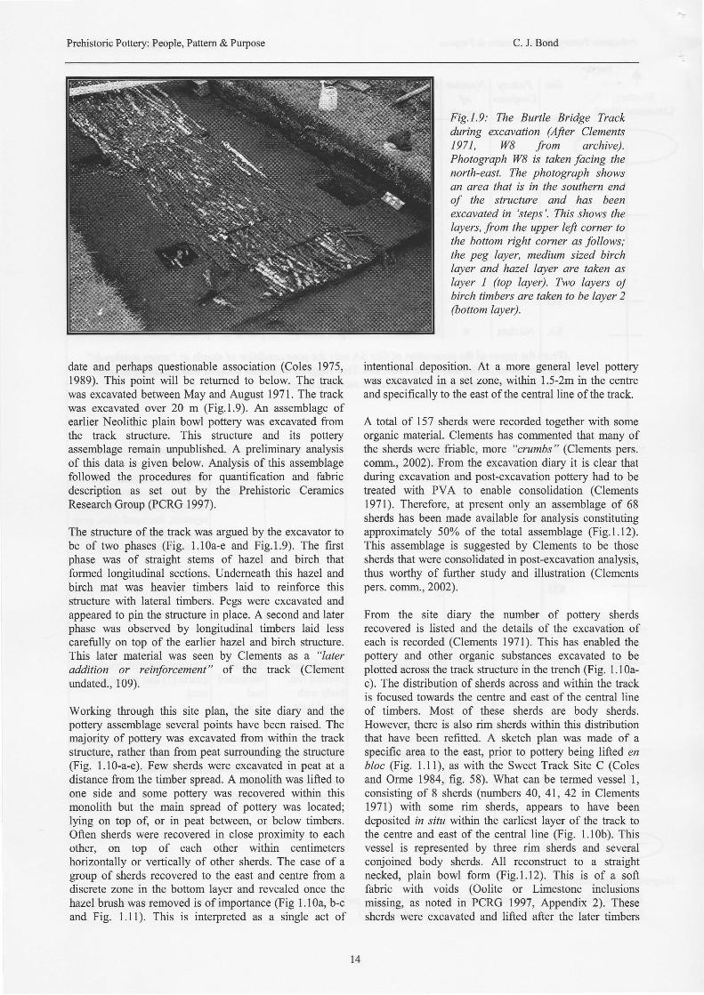
The structure ofthe track was argued by the excavator tobe of two phases (Fig. 1.10a-e and Fig.l.9). The firstphase was of shaight stems of hazel and birch thatformed longitudinal sections. Underneath this hazel andbirch mat was heavier timbers laid to reinforce thisstructure with lateral timbers. Pegs were excavated andappeared to pin the structure in place. A second and laterphase was observed by longitudinal timbers laid lesscarefully on top of the earlier hazel and birch structure.This later material was seen by Clements as a "lateraddition or reinforcement" of the track (Clementundated., 109).
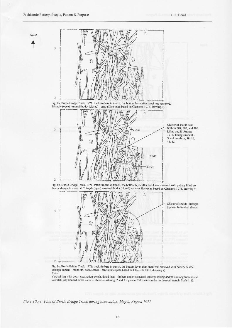
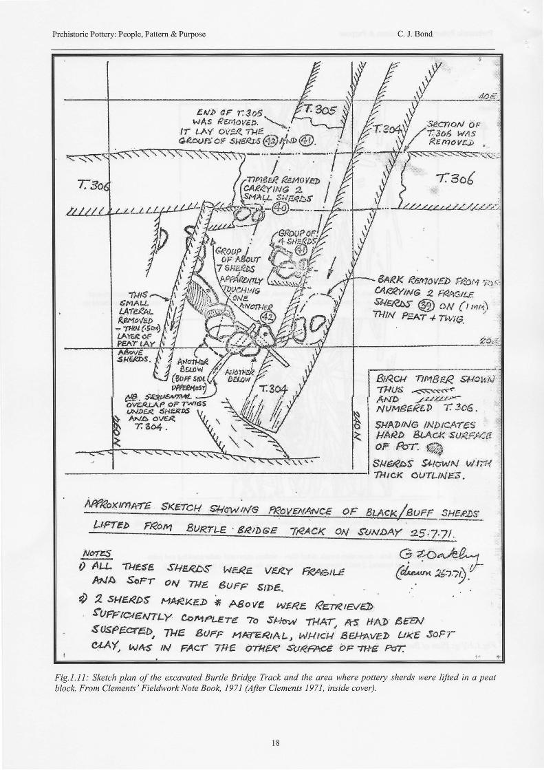
Working through this site plan, the site diary and thepottery assemblage several points have been raised. Themajority of pottery was excavated from within the trackstructure, rather than from peat surrounding the structure(Fig. 1.10-a-e). Few sherds were excavated in peat at adistance from the timber spread. A monolith was lifted toone side and some pottery was recovered within thismonolith but the main spread of pottery was located;lying on top of, or in peat between, or below timbers.Often sherds were recovered in close proximity to eachother, on top of each other within centimetershorizontally or vertically of other sherds. The case of agroup of sherds recovered to the east and centre from adiscrete zone in the bottom layer and revealed once thehazel brush was removed is of importance (Fig 1.10a, b-cand Fig. Lll). This is interpreted as a single act of
Fig.1.9: The Burtle Bridge Trackduring excavation (After Clements1971, W8 from archive).Photograph W8 is taken facing thenorth-east. The photograph showsan area that is in the southern endof the structure and has beenexcavated in 'steps'. This shows thelayers, from the upper left corner tothe bottom right corner as follows;the peg layer, medium sized birchlayer and hazel layer are taken aslayer 1 (top layer). Two layers oJbirch timbers are taken to be laver 2(bottom layer).
intentional deposition. At a more general level pofterywas excavated in a set zone, within 1.5-2m in the centreand specifically to the east of the central line of the track.
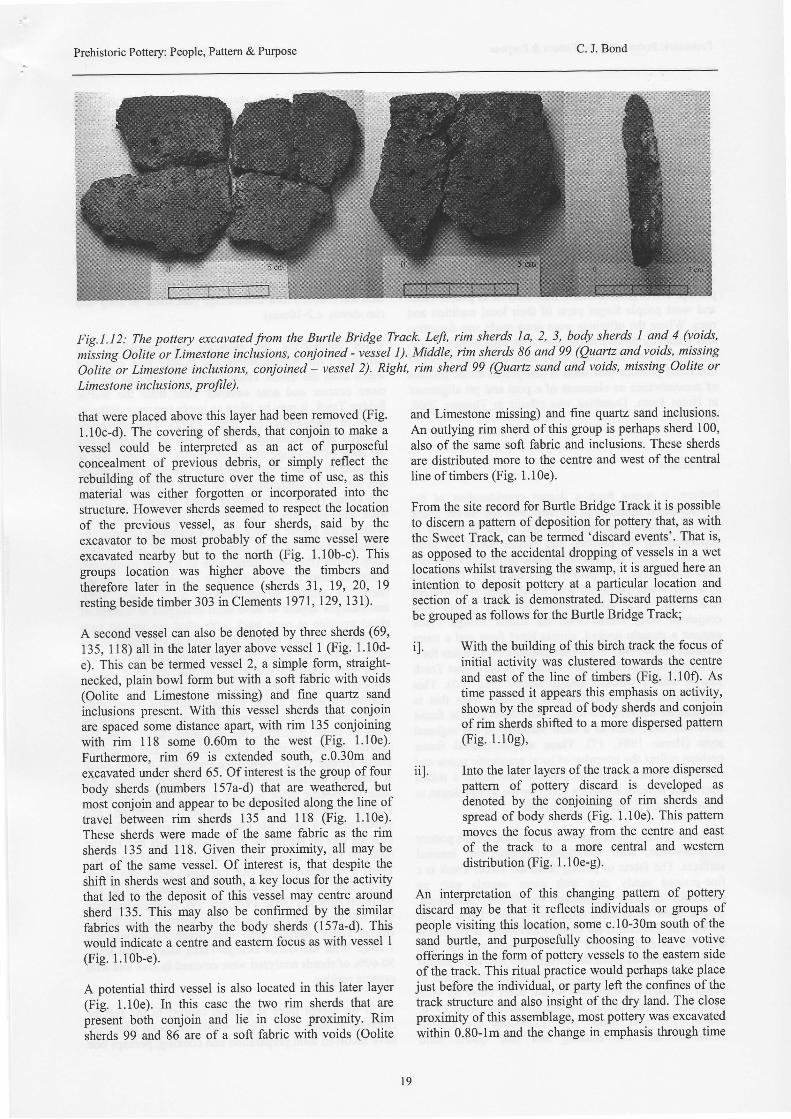
A total of 157 sherds were recorded together with someorganic material. Clements has commented that many ofthe sherds were friable, more "crumbs" (Clements pers.comm., 2002). From the excavation diary it is clear thatduring excavation and post-excavation pottery had to betreated with PVA to enable consolidation (Clementsl97l). Therefore, at present only an assemblage of 68sherds has been made available for analysis constitutingapproximately 50o/o of the total assemblage (Fig.1.12).This assemblage is suggested by Clements to be thosesherds that were consolidated in post-excavation analysis,thus worthy of further study and illustration (Clementspers. comm., 2002).
From the site diary the number of pottery sherdsrecovered is listed and the details of the excavation ofeach is recorded (Clements 1971). This has enabled thepoffery and other organic substances excavated to beplotted across the track structure in the trench (Fig. Ll0a-c). The distribution of sherds across and within the nackis focused towards the centre and east of the central lineof timbers. Most of these sherds are body sherds.However, there is also rim sherds within this distributionthat have been refitted. A sketch plan was made of aspecific area to the east, prior to pottery being lifted enbloc (Fig. l.ll), as with the Sweet Track Site C (Colesand Orme 1984, fig. 58). What can be tenned vessel l,consisting of 8 sherds (numbers 40, 41,42 in Clements1971) with some rim sherds, appears to have beendeposited in situ witlnn the earliest layer of the track tothe centre and east of the central line (Fig. l.l0b). Thisvessel is represented by three rim sherds and severalconjoined body sherds. All reconstruct to a straightnecked, plain bowl form (Fig.l.l2). This is of a softfabric with voids (Oolite or Limestone inclusionsmissing, as noted in PCRG 1997, Appendix 2). Thesesherds were excavated and lifted after the later timbers
l 4
Prehistoric Pottery: People, Pattern & Purpose C. J. Bond
North
tr
II
rt{li$iI
2 + _Fig. 84 Burtle Bridge Track, l97l: track timbers in trench, the bottom layer after hazel was removedTriangle (open) - monolith, dot (closed) - central line (plan based on Clements I 97 I , drawing 9)
l--r aJ I
lI
III
Tr.306I
Il r .| \i-/
Cluster ofsherds neartimbers 304, 305, and 306.Lifted on,25 August197 I . Triangle (open) -Sherd numbers; 39, 40,4l . 42.
2 -t':-:-* au" tt Y-^ LrLll \Ll:U2:rH!\fJ.Sdjli:"r, :-*--:-:* i-
Fig. 8b, Burtle Bridge Track, l97l: track timb€rs in trench, the bottom layer after hazel was removed with pottery lifted en6/oc and organic material. Triangle (open) - monolith, dot (closed) - central line (plan based on Clements I 97 l, drawing 9).
Cluster of sherds. Triangle(open) - Individual sherds.
2 - a . -
Fig. 8c, Burtle Bridge Track, I 97 I : track timbers in trench, the bottom layer after hazel was removed with pottery m rir?.Triangle (open) - monolith, dot (closed) - central line (plan based on Clements 197 I, drawing 9).Noles:Vertical line with dots - excavation trench, doted lines - timbers under excavated under planking and poles (longitudinal andlaterals), grey banded circle - area ofsherds clustering, 2 and 3 represent 2-3 meters in the north-south trench. Scale l:80.
Fig 1.10a-c: Plan of Burtle Bridge Track during exccvation, May to August l97l
t:
l 5
Prehistoric Pottery: People, Pattem & Purpose C. J. Bond
North
II;t-,
I
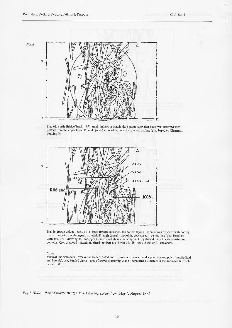
Fig. 8d, Burtle Bridge Track, I 971 : track timben in trench, the bottom layer after hazel was removed withpottery from the upper layer. Triangle (open) - monolith, dot (closed) - central line (plan based on Clements,drawing 9).
: ; f
Fig. 8e, Burtle Bridge Track, l97l : track timbers in trench, the bottom layer after hazel was removed with potterythat are conjoined with organic material. Triangle (open) - monolith, dot (closed) - central line (plan based onClements 1971, drawing 9). Star (open) - krdividual sherds that conjoin, Grey dashed line - line demonstratingconjoins, Grey diamond - Hazelnut. Sherd numbers are shown with B - body sherd, or R - rim sherd.
Notes:Vertical line with dots - excavation hench, doted lines - timbers excavated under planking and poles (longitudinaland laterals), grey banded circle - area ofsherds clustering, 2 and 3 represent 2-3 meters in the north-south hench.Scale l :80.
Fig. 1 .1 0d-e: Plan of Burtle Bridge Track during excavation, May to August I 97 1
t-III-iII
I
l 6
Prehistoric Pottery: People, Pattem & Purpose C. J. Bond
North
t rI
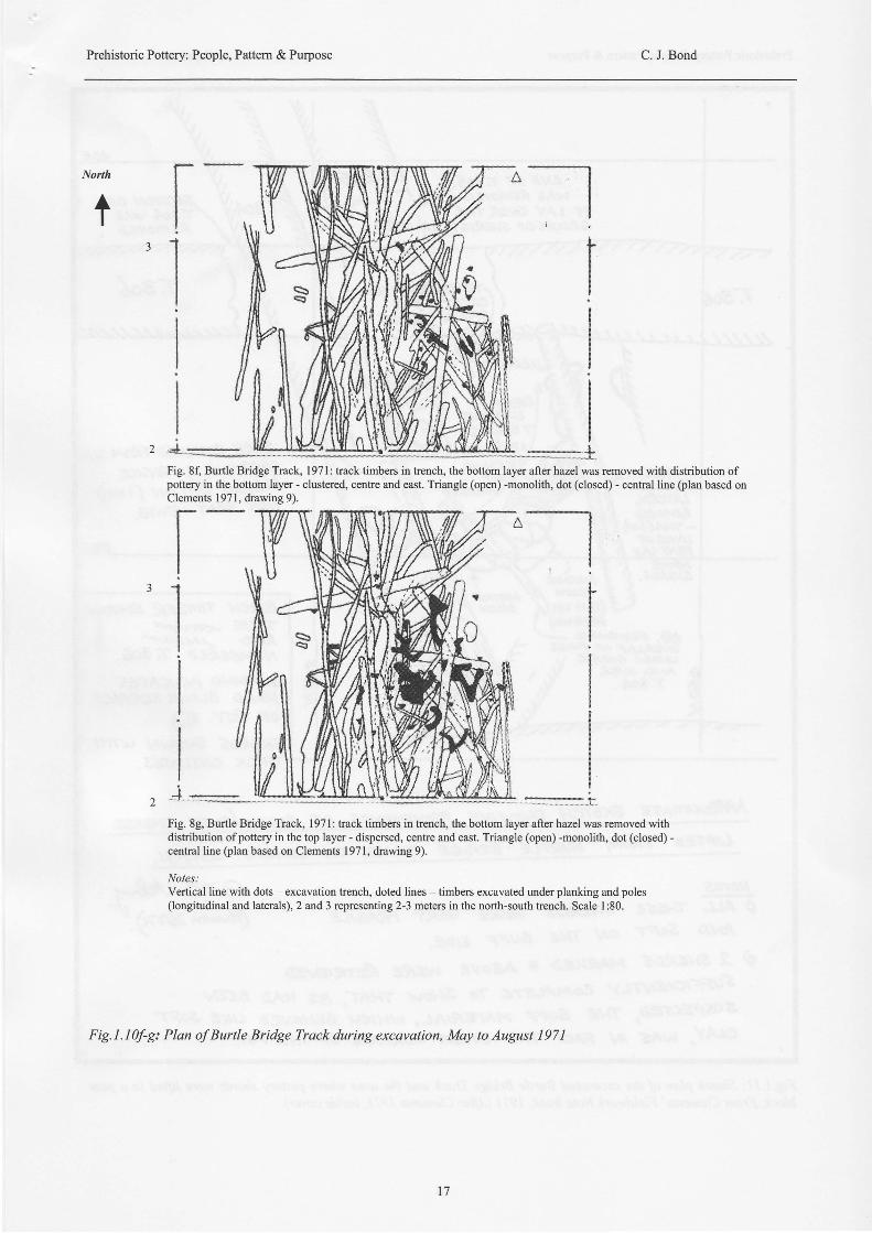
2 &_.Fig. 8f, Burtle Bridge Track, I 97 I : track timbers in trench, the bottom layer after hazel was rernoved with distribution ofpottery in the bottom layer - clustered, centre and east. Triangle (open) -monolith, dot (closed) - central line (plan based onClements 1971, drawing 9).
2a ::i:::::::::::l:::.i:
Fig. 8g, Burtle Bridge Track, l97l: track timbers in trench, the bottom layer after hazel was removed withdistribution ofpottery in the top layer - dispersed, centre and east. Triangle (open) -monolith, dot (closed) -central line (plan based on Clements 1971, drawing 9).
Notes:Vertical line with dots - excavation trench, doted lines - timbers excavated under planking and poles(longitudinal and laterals), 2 and 3 representing 2-3 meters in the north-south trench. Scale l:80.
Fig. 1 . I 0f-g: Plan of Burtle Bridge Track during excavation, May to August 197 I
t-'l
t 7
Prehistoric Pottery: People, Pattern & Purpose C. J. Bond
E^rD 0F 1305-wAs ftgr'tal,6D. \,
lr Ljdf Qv&*18 _. :je €{ilr;aF'sr{s&'s (}tt*
,T1/18ER REilaVED ,c4E*YtN6 *. tf+l*t. $ssacs t
'@oup lt K
aF A80ar q
,.30!
ttt;
sflEeos. S. if n^rorief
trif'Lff^t*'lf
UNA{R, {5H€f4t t/Ar\fA- O\lt4 V \Tso4. V. r
#trtdN Ol!'f3od r4#tsREmoyeb
tlSa{
&AflK EenavEb ffr3r4 7.apr,tAg&yu{e z FR&GltEst/e€os @ oa (r nrtTHIN Fref+ Trvta.
&Reu mn9eg */oltirJAHU$. .<srlt,errAArD J.talar>t'NUMSE4€D T 3t6.
SI.IADNE NbIf.J.fE:;HAAD 8.lAc).5dr€ffd"1fror tur. %Str64c,S Sl-toutv u,l t;ilT\ttcx *w*tu*s "
A*eoxmxre sKETct4nr:r<oxr:nkra SKETgH s/6Wr^/G Kavw$vqe of vuaq/sur,L .$,ryEe0s'
s4rNDAY ft5.7.?/ .
N.qrS0 AtJ* :rHa{E .fi/E.qc6: WEee, vERy *rqcJt$
,ib\JA $orr aN WE guFF s/D6.0 ft *teeas MM,KED * Agove wE&E Eewarfi
tuffew;ftty (fluliLlT€ 70 .Tr*or,{/ Ti4AT, *5 ftAg B#I\r$ilsprcnxo, we &uFF p1r6-6*,ot-, N4tctl, BE|.,A.I/ED trKE 3oF7-&t-At', wfts tN FAxT TftE orattr( €uReG aF T+€ rcT
G *od'eU
Wt*.2;).r
Fig.l.Il: Sketch plan of the excavated Burtle Bridge Track and the area where pottery sherds were lifted in a peatblock. From Clements' FieldworkNote Book, 1971 After Clements 1971, inside cover).
l 8
Prehistoric Pottery: People, Pattem & Purpose C. J. Bond
Fig.l.I2: The pottery excavated from the Burtle Bridge Track. Left, rim sherds Ia, 2, 3, body sherds I and 4 (voids,
mlssing Ooliti or Limestone inclusions, conjoined - vessel I). Middle, rim sherds 86 and 99 (Quartz and voids, missing
Oolite or Limestone inclusions, conjoined - vessel 2). Right, rim sherd 99 (Quartz sand and voids, missing Oolite or
Limestone inclusions, profile).
that were placed above this layer had been removed (Fig.1.10c-d). The covering of sherds, that conjoin to make avessel could be interpreted as an act of purposefulconcealment of previous debris, or simply reflect therebuilding of the structure over the time of use, as thismaterial was either forgotten or incorporated into thestructure. However sherds seemed to respect the locationof the previous vessel, as four sherds, said by theexcavator to be most probably of the same vessel wereexcavated nearby but to the north (Fig. 1.10b-c). Thisgroups location was higher above the timbers andtherefore later in the sequence (sherds 31, 19,20, 19resting beside timber 303 in Clements 1971, 129,731).
A second vessel can also be denoted by three sherds (69,135, I 18) all in the later layer above vessel I (Fig. 1.10d-e). This can be termed vessel 2, a simple form, straight-necked, plain bowl form but with a soft fabric with voids(Oolite and Limestone missing) and fine quartz sandinclusions present. With this vessel sherds that conjoinare spaced some distance apart, with rim 135 conjoiningwith rim 118 some 0.60m to the west (Fig. 1.10e).Furthermore. rim 69 is extended south, c.0'30m andexcavated under sherd 65. Ofinterest is the group offourbody sherds (numbers l57a-d) that are weathered, butmost conjoin and appear to be deposited along the line oftravel between rim sherds 135 and 118 (Fig. 1.10e).These sherds were made of the same fabric as the rimsherds 135 and 118. Given their proximity, all may bepart of the same vessel. Of interest is, that despite theshift in sherds west and south, a key locus for the activitythat led to the deposit of this vessel may centre aroundsherd 135. This may also be confirmed by the similarfabrics with the nearby the body sherds (157a-d). Thiswould indicate a centre and eastern focus as with vessel I(Fig.1. lOb-e).
A potential third vessel is also located in this later layer(Fig. l.lOe). In this case the two rim sherds that arepresent both conjoin and lie in close proximity' Rimsherds 99 and 86 are of a soft fabric with voids (Oolite
and Limestone missing) and fine quartz sand inclusions.An outlying rim sherd of this group is perhaps sherd 100,also of the same soft fabric and inclusions. These sherdsare distributed more to the centre and west of the centralline of timbers (Fig. 1.10e).
From the site record for Burtle Bridge Track it is possibleto discern a pattern of deposition for pottery that, as withthe Sweet Track. can be termed 'discard events'. That is,as opposed to the accidental dropping ofvessels in a wetlocations whilst traversing the swamp, it is argued here anintention to deposit pottery at a particular location andsection of a track is demonstrated. Discard pattems canbe grouped as follows for the Burtle Bridge Track;
il. With the building of this birch track the focus ofinitial activity was clustered towards the centreand east of the line of timbers (Fig. 1.10f). Astime passed it appears this emphasis on activity,shown by the spread ofbody sherds and conjoinof rim sherds shifted to a more dispersed pattern(Fig. 1.10g),
ii]. Into the later layers of the track a more dispersedpattern of pottery discard is developed asdenoted by the conjoining of rim sherds andspread ofbody sherds (Fig. 1.10e). This paffemmoves the focus away from the centre and eastof the track to a more central and westemdistribution (Fig. l. I 0e-g).
An interpretation of this changing pattem of potterydiscard may be that it reflects individuals or groups ofpeople visiting this location, some c.10-30m south of thesand burtle, and purposefully choosing to leave votiveofferings in the form ofpottery vessels to the eastem sideof the track. This ritual practice would perhaps take placejust before the individual, or party left the confines ofthetrack structure and also insight ofthe dry land. The closeproximity of this assemblage, most pottery was excavatedwithin 0.80-1m and the change in emphasis through time
l 9
Prehistoric Pottery: People, Pattern & Purpose C. J. Bond
(between what are interpreted by Clements' as layers Iand 2) would accord with this part of the track structureto be perceived as more than 5imply a set of timbers. Thissection of the birch track and its east side is interpretedhere as demonstrating evidence for the re-use of aconfined space for making offerings; bringing andplacing offerings perhaps within pottery at this setting.Some 38 of the 68 sherds examined also have soot ontheir surfaces and organic residue. Is it therefore notimpossible to imagine that a votive brew was drunk, orleft for the spirits to consume at this location? Potterymay have been broken, placed here. This debris thusdocumented the travels and ritual practices ofpeople overperhaps a few generations. It may then be as people cameand went people forgot parts of their local tradition andrites. Where the offerings were once made was forgottenand gradually pottery accumulated as time passed. Only,with time it was discarded away from the initial focus ofthis ritual practice (see what is interpreted as the processof remembrance as elements of a post and pit alignmentat Holm Farm, Dumfries was rebuilt in Thomas 2000,86).
Discussion
Pottery, it seems from a deeper consideration of theartifact-based assemblage derived from the Sweet Trackand the unpublished Burtle Bridge Track is central tounderstanding the function and unique nature of thesestructures. There are similarities and differences betweeneach assemblage. The poffery from the Sweet Track wasof a fine ware, mostly of a carinated form with evertedrims (Fig. 1.5).Alternatively, the rim sherds andconjoined body sherds from the Burtle Bridge Tracksuggest a straight-necked, simple bowl form and a moremedium fabric (Fig. 1.12). One example of a similar formof simple bowl pottery was excavated at the Sweet TrackSite R with a wooden spurtle nearby (Fig. 1.5). Thisvessel from the Sweet Track is the only form that iscomparable between the tracks. But, these upright formshave also been seen as a local variation to the regionalstyle (Heme 1988, 17). These simple neutral formsperhaps reflect the interplay of local pragmatic needs andcultural traditions more indelible in the potter's mindsthan those broader attributes given by the archaeologist toHembury ware (Cleal 1992, 302-304).
However, comparisons can be made in that all the potteryis well-made. with smoothed extemal and intemalsurfaces. The fabric of pottery from the Sweet Track is afine-grained sandy clay with some vessels with noinclusions or with Limestone (or Oolite) inclusions,qlrartz, shell or crushed flnt (cf. Kinnes 1979; Smith1976). The Limestone (or Oolite) inclusions is continuedwith the evidence in the shape of voids and the oddfragment observed from the earliest rim and body sherdsof vessel I at Burtle Bridge. Once again, this fabric invessel I also is comparable to the plain bowl 56 withinclusions weathered out, but being fine, in Smith 1976,63-64). The soft fabric with Limestone (or Oolite)inclusions that are missing and fine quartz sand
inclusions are similarly recorded with vessel 2 and 3 inthe later layer of the Bridge Burtle Track and are morecomparable to the carinated wares of the Sweet Track.The approximate diameters of pottery is also comparablewith vessel I giving an external rim diameter ofc.22ln'rcr, mirroring the Sweet Track vessel, 56 at220nwr (Smith 1976, 64). The other two vessels aresomewhat smaller, but with their limited rims, more opento question, yielding external rim diameters of, c.125mmand c.148run. The Burtle Bridge pottery appeared to bebetter fired than the finer wares of the Sweet Track, butexternal and intemal surfaces were consistent in colour.Pottery thickness is also consistent, ifnot slightly thickerthan the Sweet Track assemblage (thickness in body andrim sherds, c.9-l0mm).
When considering the evidence for burnishing and"coating" for wateqproofing the mostly fine carinatedwares from the Sweet Track compared with the thicker,more coarser and soot covered ware from the BurtleBridge Track, it may be taken to imply two very differenttypes of assemblage (cf. Cleal 1992). The differencebetween the assemblages can be seen as encompassingthe issue of the range of pottery fabrics and forms that isexpected to have occurred within a domestic assemblageand has been commented on by Smith (1976) and Colesand Orme (1984). The Sweet Track material is a fineware with elaborate forms, save the single simple bowl.Whereas the Burtle Bridge Track assemblage, despite thelimited number of rims present, but with many largerbody sherds (the body sherds give an upright profile anda sirrilar fabric) was exclusively composed of mediumwares of simple straight-necked plain bowls. Bothassemblages appeax to have been entangled in a form ofritual practice at each track with what are termed heredistinctive 'discard events' occurring at set points alongeach north-south track. However, both assemblages arefrom very different spectrums of the idealistic earlierNeolithic pottery assemblage, from fine to coarse wares,elaborate to simple forms. The fine carinated wares couldbe argued to fit a requirement for pottery that would beused in ritual practices, but the plain bowl, with thespurtle, or wooden stir at the Sweet Track Site R and theBurtle Bridge Track assemblage remains to be explained.A possible explanation may be that some vessels wereused in cooking prior to their journey along the track.Pottery function as with cooking, preparation andcontainment of foods has recently been argued to be tiedto a set way of seeing the world with rituals and routinetasks for the earlier Neolithic (Jones 1999). At the SweetTrack a complete vessel (E3, carinated bowl, see Smith1976) was found with hazelnuts remaining in it andnearby (Coles and Orme 1976, fi5.39). A single hazelnutwas also recorded near the pottery spread at the BurtleBridge Track together with other organic material (Fig.1.10d). With the Burtle Bridge Track assemblage some50-60% of sherds analyzed were covered in soot and withorganic residue.
So, if we accept there is a ritual context to the potteryrecorded at each track it is possible that such rites mayhave involved food preparation and cooking, perhaps one
20
Prehistoric Pottery: People, Pattern & Purpose C. J. Bond
ingredient being hazelnuts (as part of a local foodgathering regime, see Richards 2000,132). This foodstuffin turn would then be carried along the line of the track,in a suitable container and then either consumed byparticipants or left as an offering at that auspiciousjuncture in the path. Such a process would explain theemphasis and selection of certain pottery forms, their sizeand open-mouthed or more neutral pottery forms forinvolvement in this practice. Hence, between the SweetTrack and the Burtle Bridge Track the use of elaboratecarinated forms and simple bowl forms of mostly fine andless refined fabrics is demonstrated and also support theinterpretation of these structures as being more thanmundane pathways. These vessels would have beenembedded in a web of social meanings tied to thesignificance of eating food, even perhaps preparation ofan offering, or food for a feast, all of which wasindicative of an earlier Neolithic way of being (Thomas1996,98, 1999,87,98-99; Whittle 1996). This is beyondsimply the dietary factors and moves from the analysis ofpottery fomr, fabrics and assumed function to a socialcontext for the consumption of food and pottery use(Fairbaim 2000, ll8-l2l; Jones 1999,72; Richards 2000,132- 135; Richards and Hedges 1999, 893-896).Procurement of plants, including the wild as illustratedwith the excavation of pottery together with scatters ofhazelnuts, at the Sweet Track and perhaps the BurtleBridge Track demonstrate how within a mobile economysubstances could be bought to and used in a place(Edmonds 1997; Whittle 1997,2000). In this wetland,two wooden structures, with the coming together ofpottery and gathered plants and the catalyst of themovement of people north-south, or vice versa, wouldperhaps form the props of a set ritual. A ritual denoting asWhittle has asserted, that the Sweet Track was a placeperceived as retaining some fype of "spiritualsignificance " (199 6, 23 6).
Now, to refum to the track structures, patterns ofdeposition and a question of chronology. The SweetTrack when taken with the Post-Track can be seen as amulti-period track and setting (Hillam et al. 1990). Thisreuse of the setting of a trackway is also demonstratedwith the Burtle Bridge Track, with later less regulartimbers used (Clements l97l). Within the structure, thedeposition of material culture, arguably in both casessuggest reuse, of routine use, tasks being carried out atparticular points along each track. Some of these pointswere, it appears foci of continued discard, as clustersemerge of material culture (Fig. 1.7 and Fig. 1.10f-g).Clusters of pottery, wooden objects and some lithicsalong the Sweet Track were excavated yet others wouldbe more probably a single 'discard event', for examplethe jadeite axe and the chipped flint axe were set spatiallyapart (Coles and Orme 1976,24b; Coles et al. 1973, fig.2).
At the Burtle Bridge Track Clements saw the origin ofthe track to be linked with initial use of a bog oak, thatwas laid across the area of damp soils, a "wet lag"between the swamp and the Burtle sand island (Clementspers. comm., 2002). This situation is also recorded at the
southern terminal of the Sweet Track, Site B, on theShapwick Burtle. Here a bog oak is located in the lowestlevels abutting the sand island and directly below thetimbers for the track (Coles et ql. 1973, fig. 1l). In bothcases what may have been a very simple and natural'bridge' device, an uptumed bog oak formed the basis onwhich to build a more substantial structure. The SweetTrack was composed of various types of wood, hazel,oalg lime, ash and some birch. However, the BurtleBridge Track favoured almost exclusively birch timbers(save some hazel timbers recorded in Clements l97l), asis the case with the adjacent Chilton Tracks (Coles et al.1970).
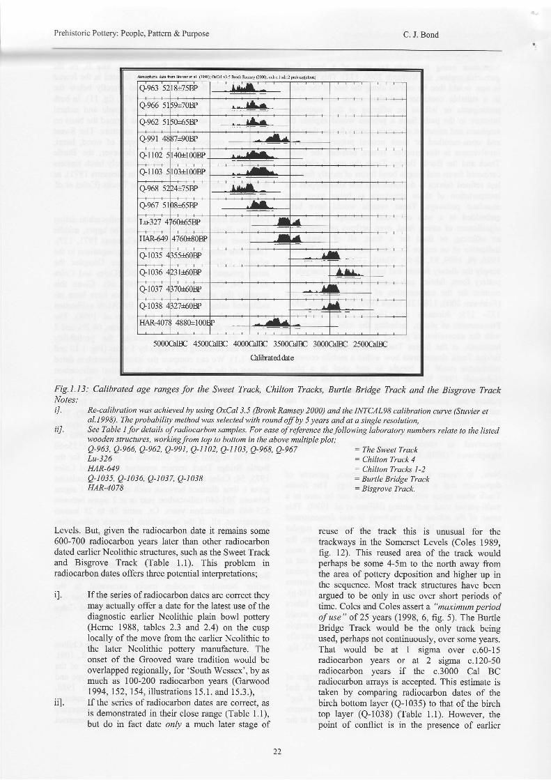
Four birch timbers were submitted for radiocarbon datingfrom the Burtle Bridge Track to date the upper, middleand lower layers of the structure (Clements 1971, 127).These four dates emerged but oddly in comparison to theadjacent Chilton Tracks, or Honeygore Complex theseries grouped to 3040-2870 Cal BC (Coles and Coles1975, 54; Coles and Dobson 1989, 64). Given thisanomaly this series of radiocarbon dates have been re-calibrated using OxCal 3.5 and the INCAL98 calibrationcurve (Bronk Ramsey 2000; Stuiver et al. 1998). Theradiocarbon dates are presented at I sigma, 68.2Yo and2sigma, 95.4% confidence following the probabilitymethod and rounding offranges by 5 years (Fig. 1.13 andTable 1.1). We can compare the latest radiocarbon datedelement of the Sweet Track with the earliest radiocarbondated element of the Burtle Bridge Track. The latestradiocarbon date from the Sweet Track made on a hazeland an ash peg gives at I sigma 3785-3535 Cal BC or at2 sigma 3940-3380 Cal BC (Q-991, 4887+90 BP). Thiscan be compared with the birch from the bottom layer ofthe Burtle Bridge Track giving at I sigma 3080-2895 CalBC or at 2 sigma 3315-2875 Cal BC (Q-1035 4355+60BP). The original young estimates as published for theBurtle Bridge Track remain apparent (Coles and Coles1975, 54; Coles and Dobson 1989, 65). This calculationgives a time distance between each structure at I sigmabetween 705-640 radiocarbon year or at 2 sigma between625-660 radiocarbon years. Or, some 26 to 28 humangenerations, all, if the association between radiocarbondate, structure and pottery is correct, falling within theearlier Neolithic! Following the analysis above, theBurtle Bridge Track pottery is of earlier Neolithic typeand of plain bowl cultural affinity (c/ Herne 1988). TheBurtle Bridge Track structure also is comparable to otherearlier Neolithic wooden tracks excavated in theSomerset Levels, for example the Honeygore Complexand the Bisgrove Track (Coles 1989; Coles and Coles1986; Coles et al.1970).
This track was excavated at a similar depth to the ChiltonTracks and in a fen wood ecology (Clements u. d., 109).All the pottery recovered from the lower layer of thetack and upper layer is of simple plain bowl type andtypologically earlier Neolithic in date (Herne 1988,tables2.3 and 2.4). Therefore, in terms of the materialculture the Burtle Bridge Track appears contemporarywith the other earlier Neolithic tracks in the Somerset
2 l
Prehistoric Pottery: People, Pattern & Purpose C. J. Bond
&mqbdc &ta tu tus d d. (190; &A v3.5 M kNy (2m); cub rl dl2 F* uqt"hl
q963 5 8+758P --i44.=-Q966 5 ;9r7OBF r-
Q962 5 ;0165BP tr--Q991 4l i7l90P a't
Ql102 ,|or1008P tr-
Ql l03 03+1008P r,-
Qe68 5 t4+7sB,P - ^14*=q967 s )8r65BP lrIri327 t 60165BP t I
IIAR-6494760rBOBP -/ t
Q1035 i55r60Bp rl
Q1036 131r60BF AAL^
qr037 , i70r60BP rl
Q1038 , i27fiDw ^- I
I]AR-4O? 4880+100r {,.t
5000CalBC 4500CalBC 4O00CHrc 3500G1BC 3000G1rc 2500CalBC
Calibateddate
Fig.I.I3: Calibrqted qge rqngesfor the Sweet Track, Chilton Tracl<s, Burtle Bridge Track and the Bisgrove TrackNotes:
n. Re-calibration was achieved by using OxCal 3.5 (Bronk Ramsey 2000) and the INTCALSS calibration curye (Stuvier eta1.1998). The probability method was selected with round off by 5 years and at a single resolution,
iil. See Table 1 for details ofradiocarbon samples. For ease ofreference thefollowing laboratory numbers relate to the listedwooden structures, workingfrom top to bottom in the above multiple plot;
Levels. But, given the radiocarbon date it remarns some600-700 radiocarbon years later than other radiocarbondated earlier Neolithic structures, such as the Sweet Trackand Bisgrove Track (Table 1.1). This problem inradiocarbon dates offers three potential interpretations;
il. Ifthe series ofradiocarbon dates are correct theymay actually offer a date for the latest use of thediagnostic earlier Neolithic plain bowl pottery(Heme 1988, tables 2.3 and 2.4) on the cusplocally of the move from the earlier Neolithic tothe later Neolithic pottery manufacture. Theonset of the Grooved ware tradition would beoverlapped regionally, for 'South Wessex', by asmuch as 100-200 radiocarbon years (Garwood1994, 1 52, 1 54, illustrations 1 5. 1. and 1 5.3.),
ii]. Ifthe series ofradiocarbon dates are correct, asis demonstrated in their close range (Table 1.1),but do in fact date only a much later stage of
Q-e63, Q-e66, Q-e62, Q-eet, Q-[102, Q-t 103, Q-e68, Q-e67Lu-326HAR-649Q-103s, Q-1036, Q-1037, g-1038HAR-4078
= The Sweet Track: Chilton Track 4: Chilton Tracks l-2: Burtle Bridge Track: Bisgrove Track.
reuse of the track this is unusual for thetrackways in the Somerset Levels (Coles 1989,f'rg. l2). This reused area of the track wouldperhaps be some 4-5m to the north away fromthe area of pottery deposition and higher up inthe sequence. Most track strucfures have beenargued to be only in use over short periods oftime. Coles and Coles assert a "maximum periodofuse" of25 years (1998, 6, fig. 5). The BurtleBridge Track would be the only track beingused, perhaps not continuously, over some years.That would be at I sigma over c.60-15radiocarbon years or at 2 sigma c.120-50radiocarbon years if the c.3000 Cal BCradiocarbon arrays is accepted. This estimate istaken by comparing radiocarbon dates of thebirch bottom layer (Q-1035) to that of the birchtop layer (Q-1038) (Table 1.1). However, thepoint of conflict is in the presence of earlier
22
Prehistoric Pottery: People, Pattern & Purpose C. J. Bond
Neolithic pottery. The earlier Neolithic potteryexcavated in this track is directly comparable tothat of the Sweet Track. That assemblage, asdetermined in tree-ring analysis is dated to 3806BC (Hillam et al. 1990,215; Coles 1999, table19.1, fig. 19.3). This pottery may well representthe first use of the Burtle Bridge Track some400-500 years before the last episode of usewhich yielded the four radiocarbon dates,
iiil. The series ofradiocarbon dates are incorrect andrepresent an unreliable date for the birch timberssampled (Clements 1971, 127), This is unlikelygiven the sampling technique employed and theclose range in dates (Table 1.1).
Either one of above points may be the case. However,recently Clements has conceded that this series ofradiocarbon dates, although taken at a level in order tosample the layers and date the structure, may well onlyhave dated a later section that was reused (Clements pers.comm., 2002). Therefore any relationship between theposition of the earlier Neolithic pottery in the trach thedating of that context and the timbers that wereradiocarbon dated is not beyond reasonable doubt. But, ifthe track was reused around c.3000 Cal BC as theradiocarbon dates at face value may suggest this would besometime after its use by people who discarded the earlierNeolithic pottery analyzed in this paper. This date stillremains well after the use of the Sweet Track, the ChiltonTracks, the Bisgrove or even the Honeygore Complex(Coles 1989, fig. 12; Coles and Coles 1998, fig. 4 and fig.5). If this is established this would imply the BurtleBridge Track was the only structure in the SomersetLevels that was initially used and then later reused oversuch an extensive period of time (Table l.l). At that latertime and higber in the sequence no pottery appears tohave been deposited. Perhaps the function and meaningof the track had changed for local communities.
Conclusion
This paper has aimed to raise the profile of both theSweet Track and unpublished Burtle Bridge Track andtheir unique pottery assemblages. With the Sweet Trackpottery had been recorded but its deposition not calledinto question and its function assumed to be domestic.Deposition was traditionally argued to be solely a resultof loss and accident. It is asserted here that thisassumption, together with the plotting of lithics andwooden structures across the wetlands of the Brue Valleyhas led to Sweet Track pottery assemblage to be viewedas originating from a settlement (c/ Coles 1989, fig. 13;Coles and Coles 1986, 59-60; Hillam et al. 1990,218).These settlement locations were then conjectured to benearby the terminals of the track (Coles 1975, ftg. l.l,1989, fig. l3). In the case of the Burtle Bridge Trackpottery assemblage it appears to be seen to represent aspecific locale for 'settlement' on the southern edge ofthe Edington Burtle island (c/ Coles 1989, fig. 13).
The analysis of the Burtle Bridge pottery assemblage anda preliminary evaluation of the excavation of the BurtleBridge Track has facilitated a reconsideration of the rolethat pottery played with the coming of the earlierNeolithic in the Brue Valley (Coles 1989, 1999; Colesand Coles 1998). Pottery is argued to have taken a centralrole in ushering in a Neolithic way of life into thislandscape; pottery and other types of artifact were takenbeyond the domestic sphere and discarded purposefullyinto a wetland, a less humanly controlled domain than thedry land. This can be argued to constitute taking ofelements of the domeslic (domus) principle away fromthe dry land where human settlement pervaded into theless tamed natural (agros) setting of the wetlands (cf.Hodder 1990, 255-256). With the building andmaintenance of the trackway, the deposition of pottery,lithics and wooden objects, including wooden "boards"(interpreted as derived from domestic buildings) wererecorded either side the length of the Sweet Track (Coleset al. 1973,280-281). This material culture can easily bethought of as the "Neolithic package" (Thomas 1991,1999). In this situation the highly symbolically chargedcombination of pottery, lithics, wood and organicmaterials would serve to signal the onset of this new wayof being in both the wet and dry land. The wetlands werein the process of being enculturated by a different way ofseeing and interpreting the landscape by the use of alinear order (Hodder 1990, 245), manifested in the north-south track alignments. Fresh ways of interpreting thisworld were made available to local communities (Thomas1996). The landscape, its ecological resources andmeaning would be thought afresh and past socialmeanings ascribed to aspects of this land manipulated(Bond 1999,2002).
Although the Sweet Track and Burtle Bridge Track werenorth-south trackways, they both consisted of verydifferent construction techniques. Both tracks hadmaterial culture deposited within, on the surface of, orbeside each. In both tracks material culture appears tohave been discarded in clusters, and as a more dispersedpattem. Pottery in both cases was excavated, andconjoined within discrete zones or clusters. Lithics,recovered from the Sweet Track were mainly recorded atdispersed points along the track line. As stated abovethere are differences in the patterning of the materialculture. In the deposition of artifacts with the tracks theSweet Track yielded pottery, lithics and wooden artifacts,whereas the section excavated of Burtle Bridge Trackonly produced pottery (Fig. 1.4 and Fig. 1.10a-e). TheSweet Track tended to yield more artifacts from thewestem side (Fig. 1.6), whereas the Burtle Bridge Trackgave most sherds from a more central and eastemdirection (Fig. 1.10f-g). The recovery of pottery from theSweet Track, as with other artifacts, was mainly from thesurface of the peat (Table 1.3). Few artifacts wererecovered from beneath or lying on the surface oftimbers. However, with the Burtle Bridge Track potterywas recorded from above, below wood and from areas ofpeat between timbers (Fig. 1.10a-e). Sherds were oftenexcavated below a cluster of sherds recovered higher upin the sequence of timbers; planks, poles placed
z5
Prehistoric Pottery: People, Pattem & Purpose C. J. Bond
longitudinally and laterally (for example, see Fig. l.ll).Differences in the specific way artifacts were depositedmay belie differences in set rites, or the tempo of thoserites.
At fust glance the location of 'discard events' appears tobe more confined at the Burtle Bridge Track in a setdiameter of no more than 0.80-lm for most sherds (Fig.l.l0f-g). This appears rather different to the broaderzones of adifact deposition of up to l.20mat the SweetTrack (for example, as in Fig. 1.7). However, this is notthe case with pottery at the Sweet Track Sites C, SA orWA which are recorded as clustering in zones rangingfrom <0.55m to <1.20m. Therefore, both the BurtleBridge Track and Sweet Track pottery assemblages arediscarded over comparable distances marking offparticular parts of each track line. This may be inferred asthe demarcation ofa confined space perhaps devoted to apredetermined set of rites and actions tied with a specificritual practice and discard event or events (c/ Pollard2001). Here selected artifacts with their specificbiographies would be purposefully placed (Thomas 1996,ls0-177).
Pottery was perhaps exchanged into this region (c/Peacock 1969; Whittle 1977,81-82). Certainly the styleof manufacture of carinated wares excavated at the SweetTrack imply an awareness of the south-westem style ofceramic tradition (Coles and Coles 1986, 60; Heme 1988,17; Thomas 1999, 85 Whittle 1977,77-82). The pofferyin the case of the Sweet Track was also deposited withthe various lithics; a chipped flint axe which indicateconnections with the peoples of the chalklands of Wessex(Bond 2002); the jadeite axe demonstrates a link with afar flung exchange system extending to continentalEurope (Coles et al. 1974). The wood that made theSweet Track also is argued to have come from differentparts of the surrounding landscape (Coles 1989; Colesand Coles 1986). The two themes that emerge are'connections' and'bringing together' different resourcesat particular locations along the track. It may be thatpeople perceived the surrounding micro-topography ofboth the Sweet Track and the Burtle Bridge Track asimportant. Thus, it is probable that certain v-iews towardsthe sand islands or into the wetlands were perceived asbeing imbued with social siglificance and connotations(for example, as with the cosmology forwarded for theStonehenge landscape by Darvill 1997, ll-12, fig. 1.3).People were higtrly knowledgeable of their environmentand the land would have probably carried meanings andeven association with stories held in oral tradition (c/Edmonds 1999, 23-26, chapter 4). These views wouldthen become settings of points along each track. In turnthe tracks would serve as a way into this ecologically richbut also mysterious wetland, where points along the waypeople paused to reflect and perhaps offer veneration toeven a spiritual force (Bond 2002). Central to this processof ritual practice would be the procurement of, ormanufacture, use and selection of individual pots(Thomas 1999,98-99, 124-125). These vessels would beseen as being most appropriate to carry the votiveoffering, and then to be intentionally discarded into this
wet locality. This was a place beyond the normaldomestic sphere of the hearth and family needs whereother pottery was made, used and broken. Instead aspecial significance is suggested and a unique context forthese two pottery assemblages (c/ Thomas 1999, 85;whittle 1996,236).
The distribution of pottery in the Brue Valley can nolonger be simply read as that of inferring settlement orthe broad attribution of a location of domestic activity(contra Coles 1975, fig. 1.1, 1989, fig. l3). These themesare better inferred through the now extensive evidence oflithic scatters (Bond forthcoming b.). These scatters arepalimpsests (Edmonds 1997), used and revisited over thelong term and cluster along the main north-south springlines leading down from the Polden Hills to the edge ofthe floodplain (Fig. 1.2). With the early date of 3807-6BC of the Sweet Track and deposition of pottery at thistime (Coles in Hillam et al. 1990) together with the nownewly documented plain bowl assemblage excavatedfrom the Burtle Bridge Track, it is asserted that thisevidence is central to understanding the process ofbecoming Neolithic in the Somerset Levels. From theoutset of the Neolithic pottery is implicated in theroutines and movement of people at an early date in thiswetland landscape. Pottery is tied into the establishmentof a sense of cultural tradition fixed into a changedperception of the land with new meanings and attendanthuman actions, purposefully deposited vessels at set'discard events'. The transformation of a habitual routine,such as the need for communities to cross a phragmitesswamp, into a need at specific points along a line oftimbers to perform a set of ritually orientated acts withinthe heart of this wetland is of major importance. Here theritual observance and the pragmatic needs of acommunity are bound together in a very distinctive way.This new data together with the reassessment of olderdata can be seen to underline the unique character ofthisemerging regional Neolithic society (Thomas 1998, 44,1999,227-228).
Similar themes of building structures in wood, earth, theuse of stone (in this case as artifacts, not monuments) andpottery are a clear signature of the creation of new formsof engagement with the world (Edmonds 1999, chapter 3;Thomas 1999, chapter 10, 2000, 79). But, here in theBrue Valley their material cultural outcome is ratherdifferent to that of the adjacent Wessex chalklands(emphasizing the character of the regional transfomration,as in Thomas 1998, 50-51, 55-56). Pottery is closelyimplicated in that process of becoming Neolithic with themastery of wood in a wet landscape forming a catalyst forhuman agency. Trackways, pottery and people are at theroot to our understanding of the coming of the earlierNeolithic in the Somerset Levels.
Acknowledgements
I would like to thank Mr. C Clements for being so kind inoffering access to the Burtle Bridge Track archive andbeing most helpful in clarifying details of the excavation.
24
Prehistoric Pottery: People, Pattem & Purpose C. J. Bond
His valuable efforts in the field are not wasted and can becommended. Mr. S C Minnitt (Taunton Castle, SomersetCounty Museum Service) bought the Edington Burtlepottery to my attention and also allowed the loan of theassemblage for study. Prof. J M Coles kindly replied tocorrespondence on details of the excavations of theSomerset Levels Project. Dr. R M J Cleal (The AlexanderKeiller Museum, Avebury) aided in the preliminaryidentification of the Burtle Bridge pottery and has been aconstant sowce of advice and support. Mr. C Normanwas also helpful in discussing the work of the SomersetLevels Project. I also acknowledge the guidance of mydoctoral supervisory team, Dr. I J N Thorpe and Dr. K NWilkinson (Department of Archaeology, King Alfred'sCollege, Winchester). It is hoped this paper serves tohighlight the high quality of the data and importance ofboth the archive and material culfure generated during theSomerset Levels Project, 1973-1989 (c/ Coles 1989).
With the publication of this paper the process of writing-up Clements' Burtle Bridge Track has now finallycommenced.
Bibliography
BOND, C, J., 1999. "Making tracks?" The SomersetLevels Project: an evaluation tenyears on. Paper given inthe session on Society in Nature. Views beyond a natureculture antithesis (ID at the Annuql TheoreticalArchaeologlt Reseqrch Group conference. School ofHistorical Studies, Cardiff Universitv. 1 4ft- I 7'hDecember1999.
BOND, C. J.,2002. The Sweet Track, Somerset: a placemediating culture and spirituality? Paper given in theSession on Sacred Landscapes at the Archaeologt andReligion conference. Ashbume Hall, University ofManchester, 2-4' September 2002.
BOND, C. J., forthcoming a. Prehistoric Settlement inSomerset: Landscopes, Material Culture andCommunities, 8,300 to 700 Cal BC. PhD thesis, KingAlfred's College, Winchester (an accredited college ofthe University of Southampton).
BOND, C. J., forthcoming b. The lithic assemblage fromShapwick, 1989-1999: reuniting the wet and drylandscape through lithic analysis. In M A Aston and C MGerrard (eds), The Shapwick Project. English HeritageArchaeological Reports. London: English Heritage.
BRONK RAMSEY, C., 2000. OxCal. 3.5. Oxford,Research Laboratory for Archaeology and the History ofArt, University of Oxford.
BRLINNING, R., 1996. Sweet Track assessment: aninterim report. Archaeology in the Severn Estuary, 6,3-8.
CLEAL, R. M. J., 1992. Significant form: ceramic stylesin the Earlier Neolithic of Southem England. In NSharples and A Sheridan (eds), Vessels for the Ancestors:
Essays on the Neolithic of Britain qnd lreland in Honourof Audrey Henshall, 286-303. Edinburgh: EdinburghUniversity Press.
CLEMENTS, C. F., undated. The Influence of a WetlandEnvironment on Neolithic Activity in and around the'Island' of Burtle, Somerset. Mlitt dissertationUniversity of Bristol. Unpublished.
CLEMENTS, C. F., 1971. Burtle Bridge Track FieldNote Book 1971. In possession of the author.Unpublished.
CLEMENTS, C. F., 1972. Somerset (Neolithic). Burrle.Archaeological Reviewfor 1971 CBA SWl6.
COLES, B. J., 1999. Somerset and the Sweet conundrum.In A F Harding, (ed) Experiment and Design:Archaeological Studies in Honour of John Coles, 163-169. Oxford: Oxbow Books.
COLES, B. J., & COLES, J. M., 1986. Sweet Track toGlastonbury. The Somerset Levels in Prehistory. London:Thames and Hudson
COLES, B. J., & COLES, J. M., 1998. Passages of time.Archaeologt in the Severn Estuary,9,3-16.
COLES, J. M., 1975. Archaeology in the SomersetLevels. Somerset Levels Papers, l,5 10.
COLES, J. M., 1989. Prehistoric settlement in theSomerset Levels. Somerset Levels Papers, 15, 14-33.
COLES, J. M., & COLES, M. M., 1975. Checklist ofradiocarbon dates relating to archaeological sites in theLevels. Somerset Levels Papers, 1,54-55.
COLES, J. M., & COLES, B. J., 1990. Prehistory of theSomerset Levels. Hertford: Stephen Austin and SonsLimited.
COLES, J. M., & DOBSON, M. J., 1989. Calibration ofradiocarbon dates from the Somerset Levels. SomersetLevels Papers, 15, 64-69.
COLES, J, M. & ORME, B. J., 1976. The Sweet Track,Railway Site. S omers e t L ev el s P ap ers, 2, 3 4 - 6 5.
COLES, J. M. & ORME, B. 1., 1979. The Sweet Track:Drove Site. Somerset Levels Papers, 5,43-64.
COLES, J. M. & ORME, B. J., 1980. The Sweet Track1980. Somerest Levels Papers, 7,6-12.
COLES, J. M. & ORME, B. J., 1984. Ten excavationsalong the Sweet Track (3200 bc). Somerset LevelsPapers,10, 5-45.
COLES, J. M., HIBBERT, F. A., & CLEMENTS, C. F.,1970. Prehistoric roads and tracks in Somerset, England:
25
Prehistoric Pottery: People, Pattem & Purpose C. J. Bond
- r : -
125-151. KJNNES, l. 4., 1979. Description of the Neolithic bowl.In J M Coles and B J Orme, The Sweet Track: Drove
COLES, J. M., HIBBERT, F. A., & CLEMENTS, C. F., Site. Somerset Levels Papers, 5,52,54.1973. Prehistoric roads and tracks in Somerset, England:3. The Sweet Track. Proceedings of the Prehistoric PARKER PEARSON, M., 1993. English Heritage BookSociety,38,256-293. of the Bronze Age Britain. London: Batsford/English
Heritage.COLES, J. M., ORME, B. J., BISHOP, A. C., &WOOLLEY, A. R., 1974. A jade axe from the Somerset PEACOCK, D. P. S., 1969 Neolithic pottery productionLevels. Antiquity, 48,216-220. in Comwall. Antiquity, 43,145-149.
CRADDOCK, P.T., COWELL, M. R., LEESE, M. N., & POLLARD, J., 2001. The aesthetics of depositionalHUGHES, M. J., 1983. The trace element composition of practice. World Archaeologt,33(ii),315-333.polished flint axes as an indicator of source.Archaeometry,25,l35-163. PCRG: Prehistoric Ceramics Research Group, 1997. The
stu$t of later Prehistoric Pottery: general policies andDARVILL, T., 1997. Neolithic landscapes: identity and guidelines for analysis and publication. Revised 1997.definition. In P Topping (ed), Neolithic landscapes. Occasional Papers, Numbers, I and 2. Salisbury,Neolithic Studies Group Seminar Papers 2. l-13. Oxbow Prehistoric Ceramics Research Group/Trust for WessexMonographs 86, Oxford: Oxbow Books. Archaeology.
EDMONDS, M.R., 1997., Taskscape, technology and RICHARDS, M. P.,2000. Humanconsumptionof planttradition. Analecta Praehistorica Leidensia.29.99-110. foods in the British Neolithic: direct evidence from bone
stable isotopes. In A S Fairbairn (ed), Plants in NeolithicEDMONDS, M.R., 1999. Ancestral Geographies of the Britain and Beyond, 123-135. Neolithic Studies SeminarNeolithic: Landscapes, Monuments and Memory. Papers 5. Oxford: Oxbow Books.London: Routledge.
RICHARDS, M. P., & HEDGES, R. E. M., 1999. AFAIRBAIRN, A. S., 2000. On the spread of crops across Neolithic revolution? New evidence of diet in the BritishNeolithic Britain, with special reference to the southem Neolithic. Antiquity,73,89l-897.England. In A S Fairbairn (ed), Plants in NeolithicBritain and Beyond. 107-121. Neolithic Studies Seminar SMITH, 1.F.,7976. The Pottery. In J M Coles and B JPapers 5. Oxford: Oxbow Books. Orme, The Sweet Track, Railway Site. Somerset Levels
Papers,2,63-64.GARWOOD, P., 1994. Grooved Ware in SouthemBritain: chronology and interpretation. In R M J Cleal SMITH, I. F., 1981. The Neolithic Pottery. In R. Mercer,and A MacSween (eds), Grooved Ware in Britain and Excavations at Cam Brea, Illogan, Comwall - a NeolithicIreland. 146-164. Neolithic Studies Seminar Papers 3. fortified complex of the third millennium BC. CornishOxford: OxbowBooks. Archaeology,20, 16l-185.
GIBSON, A., & WOODS, A., 1997. Prehistoric Pottery STUIVER, M., REIMER, P. J., BARD, E., BECK, J. W.,
for the Archaeologisr. Second Edition. Leicester: BURR, G. S., HUGHEN, K. A., KROMER, B.,Leicester University Press. McCORMAC., F. G., VAN DER PLICHT, J., &
SPURK, M., 1998. INTCAL9S radiocarbon ageHERNE, A., 1988. A time and a place for the Grimston calibration 24,000-0 cal BP. Radiocarbon, 40, 1041-Bowl. In J C Barrett and I A Kinnes (eds), The 1084.Archaeologt of Context in the Neolithic and Bronze Age:Recent Trends,9-29. Sheff,reld: Department of Prehistory THOMAS, J. S., 1991. Rethinking the Neolithic.and Archaeology. Cambridge: Cambridge University Press.
HILLAM, J., GROVES, C. M., BROWN, D. M., THOMAS,J.S., 1996. Time,Culture&Identity. London:BAILLE, M. G. L., COLES, J. M., & COLES, B. J., Routledge.1990. Dendrochronology of the English Neolithic. THOMAS, J. S., 1998. Towards a regional geography ofAntiquity,64,2l0-220. the Neolithic. In M R Edmonds and C Richards (eds),
Understanding the Neolithic of North-Western Europe,HODDER, I., 1990, The Domestication of Europe. 37-59. Glasgow, Cruithne Press.Oxford: Blackwell.
THOMAS, J. S., 1999. Understandins the Neolithic.JONES, A., 1999. The World on a plate: ceramics, food London: Routledge.technology and cosmology in Neolithic Orkaey. lMordArchaeology, 31(l), 55-77 .
Prehistoric Pottery: People, Pattem & Purpose C. J. Bond
THOMAS, J. S., 2000. The identity of place in NeolithicBritain: examples from Southwest Scotland. In A Ritchie(ed), Neolithic Orhtey in its European Context, 79-87.Cambridge, McDonald Institute Monographs.
WHITTLE, A. W. R., 1977. The Earlier Neolilhic ofSouthern England and its Continental Background.Report S35 Oxford: British Archaeological Reports.
WHITTLE, A. W. R., 1996. Europe in the Neolithic: theCreation of New Worlds. Cambridge: CambridgeUnivenity Press.
WHITTLE, A. W. R., 1997., Moving on and movingaround: Neolithic settlement mobility. In P Topping (ed),Neolithic Landscapes, 15-22. Neolithic Studies GroupSeminar Papers 2. Oxbow Monographs 86. Oxford:OxbowBooks.
WHITTLE, A. W. R., 2000. Bringing plants into thetaskscape. In A S Fairbairn (ed\, Plants in NeolithicBritain and Beyond, I-7. Neolithic Studies SerninarPapers 5. Oxford: OxbowBooks.
WILLIAMS, D. F,, 1976. Thin-section examination ofthe pottery. In J M Coles and B J Onne, The SweetTrack, Railway Site. Somerset Levels Papers, 2,64.
27
Related Documents


