Welcome message from author
This document is posted to help you gain knowledge. Please leave a comment to let me know what you think about it! Share it to your friends and learn new things together.
Transcript


THE COASTOF PUGET SOUND
>A>+<+- ><< GRA~T gpp@iLONPELL LiBRARY BoiLGtNC
tIRl, NARRAGANSETT BAY CIIIMP08NARRAGANSETT, R 1 0288k


First published in 1983 byWashington Sea Grant ProgramUniversity of Washington
Distributed by University of Washington PressSeattle, Washington 98195
Copyright «': 1983 by University of WashingtonPrinted in the United Statrs of A!nerica
Al! rights reserved. No part of this pubficatiot!!nay be reproducrd ortransmittetl in any fornt or by any means, electronic, or mechanical, incfu<th!gphotocopying, recording. or any information storage or retrieval »y»ten!without permission in writh>g from the puhli»her,
The U.S. Government is authorized to pro<hone and distribute reprtnt» for governmentalpurposes notwithstanrling any copyright notation th;! t!nay appear tu!roon.
Library of Congress Cataloging in Publication Data
Downing, john, 1946-The Coast of Puget Sound.
Puge't Sound hooks!Bibliography: p.inc 1 uncles index.1. Coasts � Washington State! Puget Sound. [I. Title,
II. Serio».GB458.8.D68 1983 551.4'57'097977 82-1 !961ISBN 0-295-95944-4
Publication of thi» hook was supported hv grants [04-5-158-48; 04-7-158-44021:NA79AA-D-00054: NA81AA-D-00030! from the Neth!nal !ceanic anrl Atlnospheric A<l-ministration and by funds from the Environmental Protection Agency. Writing andpublication was conducted by the Washington Sea Grant Program under project A PC-7.

for Mike, Elaine, and Kathy

Contents
About the Puget Sound Books ixPreface xi
Acknowledgments xiiiThe Coastal Zone and Its OriginGlacial Legacies 2Beaches 4
Coastal Deposition 11Coastal Erosion 13
River Deltas 17
Currents and Sediments Near Rivers 17Wetlands Accretion 18Marsh Plants 18
The Major Contributors 20Pristine Deltas 22
Developed Deltas 27High Energy Deltas 29
Waves and Nearshore Currents 33Some Wave Basics 33Generation of Waves 35
Wave Shoaling 37Refraction and Diffraction 38Nearshore Currents 40Tidal Currents 41
Sediment Transport 42Forces on the Seabed 43
Transport Modes 44Currents and Waves Together 45Sediment Budgets 46Beach Profi les 50
More on Beaches: The Details 53Gravel-Cobble Beaches 53Coastal Sediments 54
Mineral Composition 55Sediment Size 56
Coastal Features 59

Major Features 59Minor Features 60
6 Wave Climate 62Wind Patterns 62
Storms 64
Wave Generation Areas and Their Wave Spectra 67
7 Coastal Hazards 73Hazards of Coastal Cliffs 73
Landslides 73Earthflows 78
Soil Liquefaction and Subsidence 79Oil on Beaches 80
8 Development of the Coast: Progress and Problems 85The Permit 87Evaluation of Coastal Sites for Development 89
Wave Climate 90Extreme Water Levels 91
Floods and Landslides 93Beach and Coastline Stability 95
Controlling Coastal Erosion 100Nonstructural Remedies 100Vegetation 100Beach Nourishment 101
Bypassing 104Drift Logs 105Structural Remedies 10 >Bulkheads and Seawalls 108Revetments and Riprap 110Grains 112
Conclusion 113
Glossary 114Bibliography 119Index 123
vu

l;tJi:VrSO JNDINNRS
Editorial BoardProject Staff
Alyn DuxburyDirector
Kirk JohnsorrDesigner
Production Staff
For this Volume
!',1irahvth TwissLeague of Worrrerr VotersSeattle, WAKirk Jolrr>son
Designer/Illustrator
Supporting Staff
Di;rrra JvnsenLa<<ra J. MasonAlice Pitt
Patricia PeytonManaging Editor
An<lrva JarvelrrEditor
Carolyn J. Threadgi1 1Man<rs<,ript Editor
And rea JarvelaProduction Editor
Lawrence E. Birke, Jr.Arabian Bvchtel Company, Ltd.Saudi Arabia
B. C'Ienn Ledbvttvr
Formerly, Oceanographic Commissionof Was h i ngt onSeattle, WA
Alice Seed
Formerly. Pacific Searclr PressSeattle. WA
James C, TracyFormerly, Kitsap County Departrnvrrtof Community Devel<>prnentP<rrt Or<:hard, WA
Michael Waldich<r kFisheries and Oceans Can<< daWvst Varrcouver LaboratoryWest Vancouver, B,C.
A.O. Dennis Willows
Friday Harbor LaboratoriesDepartment of Zoologytirri vvrsi ty of Washrngton
Sponsor's Representatives
Howard S. Harris
Offi<.:e of Oceanography and Marine Svrvi<:vsOcearr Assessment Division
National Oce;r nic and Atmospheric Adrninistrati<rn
Robert C. RoushNational Ocearr ic and Atmospheric Administration
Funds to support the publication of thePuget Sound Books were providerl hv tire NationalOcearric;md Atrnosphvri<.: Administration NOAAjand by thv. Fnvironmental Proter tion Agency EPAj

About the Puget Sound Books
This book is one of a series of b<roks that have been commissionedto providv rcadvrs with useful information about Pugct Sound....
About its physical properties the shape and form of thc Sound, thephysical and chemical nature of its waters, a»d the interaction oftllcsc waters with the surrourlciillg sllorvllrlvs,
About the biological aspects of the Sound thc pl >nktor> that form thebasis of its food chains; the fishes that swim in this inland sea; theregions marinv, birds and mammals; and the habitats that nourish andprotect its wildlife.
About man's uses of the Sound his harvest of finfish, shellfish andeven seaweed; the transport of pcoplc and goods on these crowdedwaters: and the pursuit of rccrvation and esthetic fulfillment in thismarine set ting.
About man and his relationships to this region � the characteristics ofthe populations which surround Puget Sound; the governance ofman's activities and the management of the region's natural re-sourcvs; and finally, the historical uses of this magnificent re-source � Puget Sound.
To produce these books has required more than six y»ars arrd thvdedicatvd vfforts of more than one hundr»d p»op]c. This series was ini-tiatvd in 1977 through a survey of several hu»dred I!otcrstial rvadcrswith diverse and wide-ranging interests.
The collective preferences of thvsv, i»divi<luals became the stan-dards against which the project staff and thv, vditorial board dvtvrmincdthe scope of each volume a»d dccidvd upon the style and kind of prv-sentation appropriate for thc series.
In thc Spring of 1978, a prospectus outlining thcsv criteria«rrri<l i»-viting vxpressions of interest in writing any one of thv. volumes wasdistributed to individuals, institutions, ar>d organizations throughoutWestern Washington. The responses werc gr rtifyi»g. For each volumeno fewer than two and as many as eight outlinvs were submitted forconsideration by thc staff ari<l the editorial board. The authors whowere subsequently chosen were selected not only for thvir cxpcrtisv, in

a particular field but also for their ability to convey inforrriation in themanner requested.
Nevertheless, each book has a distinct flavor the result of eachauthor's style and demands of the subject being written about. Al-though each volume is part of a series, there has been little desire on thepart of the staff to eliminate the individuality of each volume. Inrlve l,creative yet responsible expression has been encouraged.
This series would riot have been undertaken without the substan-tial support of thc Pugct Sound Marine EcoSystems Analysis MESA!Project within the Office of Oceanography and Marine Services/OceanAssessment Division of the National Oceariic and Atmospheric Adrnin-istration. From the start, thv rvprcscntatives of this office have sup-ported the conceptual design of this svries, the writing, and tlir; produc-tion, Financial support for the project was also rccvivcd froni theEnvironmvntal Protectiori Agency and from the Washington Sea GrantProgram. All these agencies have supported tlic svrivs as part of theircoritinuing efforts to provide information ttiat is usvful in assessing ex-isting and potential environmental prohlvms, stresses, and uses of Pu-get Sound,
Any major undertaking such as this series requires tlie vfforts of agreat many people. Only the names of those most closely associatedwith the Puget Sound Books � the writers, the vditors, the illustratorsand cartographers, the editorial board, thc project's administrators aiidits sponsors � have been listed herc. All these people- � and manymore � have contributed to this svries, which is dedicated to thc pcoplcwho live, work, and play on and beside Puget Sound.
Alyn Duxbury and Patricia Peytonjuly 1983

Preface
The scope and design of this book have undergone many altera-tions since its beginning more than four years ago. At the outset, thebook was to present the state of oceanographical and geological knowl-edge of the coast of Puget Sound, The first order of business was neces-sarily to gather together all reports and studies of the subject. It becameapI>arent to me, during this early phase, that the beaches and shor> lincin the Pacific Northwest have not been studied as extensively as castcoast and California beaches. Information sources werc limited to re-gional inventories of coastal resources and studies of coastal engineer-ing I>roblerns at a few specific sites, mostly in populated areas.
In order to be valuable to readers of diverse backgrounds and var-ied exposure to the subject, thc scope of the book was expanded consid-erably. I decided that a major portion of it would cover some of thebasic principles of sediment transport and wave effects on bcachcs. Al-though these principles are treated in other books, I have used exam-ples of them taken exclusively from the shores of Pugct Sound to showtheir regional significance. In addition to these introductory materials,a major chapter is devoted to enginccring aspects of our beaches, Thisseemed an appropriate way to integrate existing oceanographic datawith basic principles and to provide some practical guidelines for theinterested I>ropcrty owner, planner, or developer, A spinoff of thc ex-pansion was that many more illustrations were included in the text.The added dimension of photographs. sketches, and graphs tnakes thesubjects more comprehensible to those who best conceptualize ideasgraphically, Text and illustrations work ti>gether to summarize existinginformation and to guide the reader to an understanding of the shore atmost locations of the Sound whcthcr or not thev have been studied pre-viously.
One of the reasons for reading a preface is to decide whcthcr toread the book, This book is intended for a wide readershiI>: it has infor-mation for thc owners, present and future, of shor<, property; back-ground data for engineers new to the area an<I unl'a>niliar with specificproblems encountered by developers of Pugct Sound shores; informa-tion for planners wishing to rcvicw coastal processes; and introductorylevel material for students of <.arth sciences,

The geographir:al scope of this book includes most of the inlandmarine coast of western Washington State with examples of coastal fea-tures drawn from a variety of locations in Pugct Sound. liood Canal,and the Strait of Juan dc Furca as well as from thv. San Juan Archipelagoand the eastern Strait of C'vorgia, Most of tire examples of coastal pro-cesses influenced by people, however, arv. concentrate<I in the popu-lated areas aborrt which more information is availablc. 'I'hese geograph-ical limitations underscore thv, rrcvrl for continuerl study of our coast ona regional basis as begun in thc carly 1970s urrdvr programs supportedbv thc Washington State; Shoreline Management Act and the FederalCoastal Zone Managvrrrerrt Act.
A brief note about terminologv is in order. Some rcarlvrs unfamili rrwith oceanographic disciplines may perceive tcchnical words as jargonand perhaps a nuisance. This perception may bc somewhat justified,but in rccvnt years it has become increasingly difficult to corrvcy newinformation without using terms that arv, shorthand for complex ideas.In this volume, I have used a moderate rrumber of tc<;!rrrical terms be,-cause many rvadvrs will have prior exposure to the subject anrl forthem thcsc terms are a convcnivrrce, For others, most technical tcrnrsare briefly defined where they first appear in the text. A complvtv, glos-sary is included as well, which will bc useful for those who wish topursue the morc, dvt riled accounts of case studies citvd in the bibliogra-phy.
My personal interest in writing this book grew from research of amore tcchnical nature into tire mechanism of sarrd movement orr open-ocean beaches. I was fascin<rted by the dynamics and ever-clr rngirrgcharactvr of the shore and felt some responsibility to make its processesunderstandable to others, lt is my hope that whatever your interestsmay be, the concepts of coastal processes and descriptions of the geo-logical evolution of our shores will Ivad you to incrrased enjoymcnt,understar!ding, and appreciation of the Pugvt Sounrl region and itsnearshorc environment.
John DowningJuly 1, 1983

Acknowledgments
It has bvcn a great pleasure workirrg witlr the marry irrdividualswho freely cor>tributed both technical and personal support during theprelraratiorr of this book. My interest in beaches and coastal oceanogra-phy grew from nrany hours spent with Hick Sternberg, School of0<:eanography, University of Washington, observing and discussingbvaches along the West Coast. Dick has taught me much about the sub-}ects in the book and without his guidance I could not have. written it.Special thanks also go to Carolyn Threadgill for hcr editorirrl «ssist«ncv.and patience while wc turned thc manuscript into a book and to KirkJohnson of Washington Sea Grant who helped me convey ideas betterthrough pictures.
Michael Ruef of the Washington State Department of Ecology con-tributed much of the information about coastal hazards. The chapterson bvaclr and coastal g<'ology developed from tlrv, exp<;rt;«lvi<:» «ridconsiderable discourse with Ralph Kculcr of thc U.S. Geological Sur-vey. Gilbert Bortleson and Robert Thorson, also of the. USGS, providedinteresting material and comments regarding historical shorelinechanges and the glacial geology of Puget Sound. Eugene Richey andJack IIeavner of the Department of Civil Engineering, University ofWashington, provided helpful guidance in the interpretation of thewave data providvd by them and by Don Birrell. Fislrcrics «nd Frrviron-ment Canada. Fric Nelson and Dave Schuldt, Navigation and Co rstalPlanning Division, U.S. Army Corps of Fnginccrs, Svattle District, do-natrd their time generously and provided access to open-file reports onmany of the coastal engineering studies.
Finally, I extend my deepest appreciation to my family and closefriends for the support and encouragement they provided while I wrotethis book.

VanCOuVer leiankl '»SW:.Bj$y»,,".�" 'mj'r'dp " k"'l"~<"ytj@gp ""~d
w, ry'»k m
Br tish Columbia
Wash ngton, sack +mennp'k en
,ahmooBay
WHATCOMellrekgttam
MIBakerMarrie
r',iTr'k'j 8
Skagrrrkrrer
Vlotana, 3 CSKAGIT
grramrrhr
SNOHOMISHip
elwha Dam .Glvnee Canyon Da
CLALLAMmood . r
Sk> ko man RrkerOlympic Peninsula
JEFFERSON
»o
o
MASON;. '.%we"m odom ' y
Dougall p
Cakier OkySream
PIERCE
THURST»ON MtRainier
Figure 1.1 Puget Sound and its approaches.
e ah w t yPort Ange es
KING
lrer Ca'
rrrayeCk~e iri Stale Parktread "**' " ' Green Biker
lmun .rr TBGOI1ta' mov
~ph~unryerde Beach

CHAPTER 1
The Coastal Zone and Its Origin
The coast of Puget Sound and its adjacent inland waterways arenatural phenomena which have a strong influence on the citizens ofWashington. Much of the aesthetic and commercial value of this coastderives from the wide variety of physical resources it offers, These re-sources result from a complex sequence of geological events which be-gan during the last Ice Age and continues to the present day. Amongthese events are at least two advances of glaciers into the Puget low-lands, with attendant oscillations in sea level, and the formation of sev-eral major rivers in the nearby Cascade and Olympic mountain ranges.Glaciation and the rivers of the region not only provided the sedimen-tary material necessary for beach formation along the coast, but estab-lished the natural trend of the nearly 3,220 kilometers �,000 miles! ofshoreline enjoyed today Fig. 1.1],
Because of its rich geological legacy, Puget Sound displays most ofthe coastal features found worldwide in the temperate latitudes, Thepattern and form of the coast vary greatly between the exposed shoresof the Straits of Juan de Fuca and Georgia and the more sheltered areasof southern Puget Sound. Rock cliffs rising vertically more than 100meters �28 feet! from breaking waves, broad tidal mud flats of imper-ceptible relief, and smooth sandy beaches all exist within a distance offewer than 50 kilometers �0 miles!.
The coastal features and resources of Puget Sound are best con-served and utilized through an understanding of their geological ori-gins and the processes at work on the shore, Introduction of these sub-jects in the first chapters of this book follows a course that begins withregional processes associated with glaciation and river sedimentationand proceeds to more local ones resulting from the effects of waves,such as beach erosion and deposition. Against this background, the en-gineering aspects of coastal structures, hazards, and development aredescribed to provide a practical view of coastal conditions as they existtoday,

Becrock
rv eas covered h>Oroglacral akes
Drill deaosits
c arl or1
0atw
Figure 1,2 Glacial sediments in the Vuget losvland. 1'ill is most ahundarttanil is a plentiful source of sanrl and gravel for heaches.
Glacial LegaciesBeaches, deltas, and other intertidal sedimentary features in Puget
Sound acquired their forms and textures in very recent geological time,during the last 5,000 years. A considerably longer period, about700,000 � 900,000 years, was required to complete events that providedthe geographical setting and raw materials for the ongoing coastal evo-lution observable today. In essence, the sedimentary features on theshore are the finishing touches on a gigantir sediment movement proj-ect begun long ago by glacial ice.
Continental glaciers containing up to 10,000 cubic kilometers�,383 cubic miles! of ice invaded the Puget lowland at least twice andprobably four times during the Pleistocene Epoch. Two aspects of Pleis-tocene glaciation are of consequence to the evolution of coastal fea-tures. First, glacial ice excavated several long, narrow valleys duringrecurrent cycles of advance and retreat. These valleys, once filled withice, now form Lake Washington, Lake Sammamish, Hood Canal, andthe major basins of Puget Sound. Numerous smaller depressions alsowere scoured in bedrock by glacial ice. These form the manynorth � south oriented bays, inlets, and passages adjacent to the mainbasins of Puget Sound. The arrangement of the present shorelines wasestablished 13,000 years ago when glacial ice retreated from the Pugetlowland. At that time coastal tnarine processes had a place to begin.
The other constituent necessary for shore processes is a largeamount of sediment. This was supplied in enormous quantities by each

Espetance Sand
in et sledded sand and si t
Lawtnn Clay ptoglaciallake depns ts!
Ncnglacialsand, sl 1, and clay
Nonglacialsediments
Figure 1.3 Glacial sediments of a coastal bluff. Vashon Till and a</vanceoutivash consist of tnainli saudi angl gravel. !'rnglani tl ink» <leposits arufill v, stl'ts ancf elavs.
cycle of Plcistoccnc glaciation. Figure, 1.2 shows the exterrsive rover oftill, outwash, and drift deposits vmplaccd by icc and meltwater streamsin the Puget lowland during the last glaciation. These deposits are morethan 100 nIeters �28 feet! thick at some locations and contain sctli-ments of widely varying sizes. Most of thv, present coastal scdirncrrta-tion around Pugct Sound was directly affected by thc last glaciation. lnfar t, largo boulders anrl outcrops of glacial lakv, rlay ran bv, found to-gether orI tho same beach «t IIIariy sites in the Sound. 'I'he strata of gla-cial material arv. quite romplvx becausv of thc variety of processes re-sponsible for their deposition. Poorly sorted ice-deposited sedimentswith nIany grain sizes form the compact till deposits exposed at mostshore bluffs Fig, 1,3!. Outwash sands and gravvls deposited by streamsthat drained thc ice, sheet and laminated «lay beds formed or> lake bot-toms at thv. odgo of thv, glaricr arv, also cornrnorI in shtiro bluff strata,Because these strata were distributed irregularly and were dt.forlIIoddifferently by ice loading aftvr dvposition, their mechanical strength,drainage capacity, slope stability, and resistance to processes that in-dure landslides vary widely from place to place.
Before waves anti currents began to rework glacial deposits on thvcoast, two events associated with tho rvtrvat of thv. irv. wore. conililctvd.First, melting of a massive ire slab averaging 900 meters �,<350 foot! inthickness caused the earth's rocky crust under the Vuget lowlaiId to bv,uplifted. l.Jplift was «ompleted about 6,000 years ago when the cruststabilized at its prcglarial level, Thc amount of uplift varied in a nearily


Neah Bay WA
Fnday Harbor, WA
Trend cm/century!
TimePeriod
1899-19721935-1972
Port Rates of sea level rise andfall.19.30'
21.34'Seait e, WA
� 13 58'Neah Bay, WA
Friday Harbor, WA
1935-1972
1934-1972 2.28'
Vancoover, B.C. � 0.90'8.40'
1911-19791940-1979
1910-1979 4.9031940-1979 . 2.703
Victoria. B.C.
1900 1910 i920 1930 1940 3950 1960 1970
'Vanicek �978!2Hicks and Crosby �974!3Wigen and Stephenson �979!
Figure 9.4 Long-termtrends of sea level at threeports solid lines!. A slightdrop of sea level at NeahBay was probably caused byupward movement of theearth's crust. Dotted linesindicate fluctuationscaused by oceanic condi-tions. Rates of sea levelrise or fall negativevalues! are given in thetable below.

Figure 1.5 Beach andshore features.
Sand and gravel beach withlongshore bar an d t rough.Sedimvnt from nvarbybluffs has built a dry bermand backshore area aboveMHHW.
Intertidal zone
Beaches adjacent to bulk-heads are commonlyeroded bvluw MHHtV be-cause thvse structures re-ducv the sediment supplyfrom the uplands. A man-rnade structure defines thecoastline.
a<e Upland
Intertidal zone
Beach
Coasta zone
profile of sediment-starvvdbvach. S ed i men t su pp 1 i edbv erosion of low bluffs hasnot kept up <vith its re-rnoval by waves, and no drybackshore area has de-vvloped.

Coastol Zone ond Its Origin
ticular beach are due to both the type of sediment and the balance be-tween its supply and removal.
Figure 1.5 shows cross sections of beaches typical of shores alongVuget Sound that are both exposed to moderate wave activity and ade-quately supplied with sediment. This area of the seabed and shore mayappear to be loosely defined, particularly with regard to legal coastalboundaries, plat surveys, and the like. The geographical limits of thebeach do, in fact, oscillate to and fro with the tide; seasonal cycles ofwinter storm erosion and summer growth of the beach can change theboundaries more dramatically. Such fluctuations cause some very diffi-cult legal problems, but they also serve as a reminder that the beachesare dynamic systems where terrestrial and marine processes affect oneanother rather than stable geographical entities, More importantly, thebeaches' constantly changing character keeps one's mind open to thewide variety of physical processes that continuously shape and reworkmost segments of the Puget Sound coast.
A beach consists of several parts; these include the backshore,beach face or foreshore, and low-tide terrace Fig. 1.5!. The backshore isthe portion of the beach that remains dry except during severe storms.It is the most highly valued part of the beach for recreational ups aswell as a natural barrier protecting the uplands from wave attar k. Un-fortunately, this resource is in very short supply on the sand-starvedbeaches of Puget Sound and permanent backshores exist along only 32percent of the shoreline.
The berm is the flat-topped portion of the backshore where sedi-ments accumulate when water from wave runup percolates into thebeach. Several berms of various sizes can form on a beach Fig. 1.6].Each berm crest marks the upper limit of wave runup during a timewhen similar-sized waves prevailed for one or perhaps several succes-sive high tides. Large berms, located high on the beach, are formed bystorm waves which occur during a high spring tide. Such berms arecomposed of coarse sediment and logs, not easily moved by smallwaves, and can persist for several years before being eroded by a storm.Smaller berms such as the ones lower down on the beach face areephemeral features and may persist for only a few days.
The sloped part immediately seaward of the berm crest is calledthe beach face or foreshore. Wave forces are the most intense in thisregion, and the beach face is continually modified through active sedi-ment movement as the tide rises and falls. The upper limit of sedirnent-starved beaches may be below mean higher high water where beachsediments rest against the base of a bluff or bulkhead Fig, 1,5!. Wherelongshore transport to a beach is blocked, the beach is eroded and de-velops a flat, low angle profile. The beaches at Swantown and MutinyBay, for example, are both sandy but the Swantown site was eroded justbefore the photograph was taken Fig. 1.7].

E CLC3E CO
E
SI>mme> >esI>
".uv'
Figure 1.6 YVinter and surn-mer profiles of a beachsholving bvrnls formed bychanging u ave activitv.Sand moved offshore bylarge winter waves is re-turned by Smaller vvavee tOrebuild the bear h in surn-BlPr.
Figure 1.7 Sandy l>vachwith flat gently sloping pn>-tile at Su anton n, a site onthe west shore of RVhidbelIsland exposed to largereeves.
Stvvp beach face and lvidvhackshore at tvfutiny Bay.IYhiclbey island, a moreshel tPI'e l site wtth a stvaclvsupple uf sancl.

:<rostol Zor>e orr<l tts Ori gi n
Seaward of the beach face a broad platform, called thc low-tide tvr-racv, extends out to about mean lower low water MLLW!. !n mostshorvs of the Sound thc low-tide tvrracv, consists of sandbars formed byncarshore currents and the continuous oscillatory water movementproduced by waves. These bars are a reservoir for sediment in transitalong the shore. Storage occurs here even when the upper part of thebeach is starved of sand and gravvl. In making beach obscrvatiorrs itshould hv. realized that all of thc features described above will not exist
on arr individual beach. For instance, only the coastline is obvious on abcachless rocky shore, Furthermore, the size of a particular feature willvary from one bear h to another, An experienced beach observer notesthe presence of all features, regardless of their size, as they each pro-vide clues about the present condition an� f<rturc stability of thc beach.
The, seaward limit of a beach vr<rics in relation to thc hottoni svdi-
rnent charactvristics sand, pvbblrs, cobblvs, and so forth! and thv, sizeof the. waves breaking on the shore. On exposed shores of Puget Soundbeaches can extend out to a depth of approximately 10 meters �;3 feet!;but along sheltered bays and passes where wind wave, growth is limitedthey may extend out to water depths of only 2 to 3 meters � � 10 fc<:t!.At some distance hcyo»d thc ir>tvrtidal zo»c, thr, watvr is sufficientlydeep that thc sedimc»t is rarely movcrl by waves «lorrc. In protc<:tedbays, where small waves move sediment at depths only a fcw tens ofcentimeters below mean lower low water, beaches occupy just the in-tertidal zor>c. Along the western shore of Dungcncss Spit, however, thcbeach is of much wider extent since large. storm waves move scdim«ntat much grcatvr depths and throw it far up or> thc shore,
Thv, landwarrl limit of thc bca<;h is <:allvd thv, «:>ast!inc; it divides
the region dominated by marine proccssvs wavvs an� currvnts! fromthc rvgion influenced by terrestrial processes. Waves and currents donot directly affect land stability or the quality of ground and surfacewaters beyond the coastline. Around Pugct Sound it is commonlymarked by a cliff or upland sedimentary deposit formed during the lastglaciation i.e,, geological process, Fig. 1.5!. The coastline may also bemarked by thv, sc'rward edge of a dune field, perm ment v<rg<.t rtion, or aman-made boundary such as a seawall. The upland area landward ofthc coastlinv can bv. included as part of thc coastal zonv,. t!plands arv.the landforms rsear thv shorv. irrcluding islarrds «r>d sva stacks! wlrichare located above the highest water lcvvl likely to occur in 50 to 100years.
Figure 1.8 :oastal features formed bl sediment deposition deltas, ti-
dal flats, anrl spits. River deltaLyre RiverStrait of Juan de Puca,high energy environnyent
Tidal liatsTnangle Cove.Camano sand
SpitsAcross Vaughn BayPierce County
Spit del ecting lheHoke RiverClal 1am County
Dungeness SpitClallam County
Prn ary n

Coostoi 7one and Its Origin
Coastal DepositionExtensive sedimentary deposits form in coast«l «rc«s where the
supply of sediment exceeds its removal by wavvs. Thv, largest <1<',Ir<!»it»in Pugct Sound formed under this condition are river delt«s, brrt tid«lflats, salt rnarshcs, spits, tombolos, cuspate forelands, and d»ncs rcs»ltfrom them as wvll, The appvarancc and relative location of major fea-tures in the coastal zond arv. illustrated in Figures 1.8 and 1.9.
River deltas form where, a strv,»n or river <lisch rrg :s sc<1irncnt toan estuary or coastal area faster than it is rvmovvd by marine pr<><:es»v».Deltas of many sizes occur in Puget Sound.
Tidal flats develop in partially enclosed or protected waters wherether , is lnw wave cn<'.rgy «nd a supply of sediment from tidal currentsor a riearbv river. In the past 5,000 years, tidal mud flats in Puget Soundhave formed at the mouths of most rivers arrd at tlr<; head» <>f <I»ict bays.They have a complex pattern of branching chari»cls through which wa-ter an� s '.dirncnt arv moved with the tides,
A spit is a narrow ridge of sand and gravel, exposed at high watvr,that vxtvnds from shore into deep water. The sand and gravel supplivdby coastal erosion is tr rr>sported to thv spit by nearshore currents. anddeposited where these currents slow in dvcp water or are diverted by achange in the alignment of the coast.
Spits may be relatively straight where wavvs cnniv. from onc dir< c-tion su :h «s thv spit across Vaughn Bay in Pierce County and thv, nncwest nf Steamboat island, More commonly, waves coming from a sec-ondary direction and wave refraction and diffraction will produce aninward curve at thc offshore ends of spits. A recurved spit can be seenat Dungeness,
Spits tend to straighten thc cnastlitrv. with tirn<,'. Th<;y grow acrossinde<it«tions in the shore and dcf lect mn»ths nf strcarns «nd rivers in
thc dircctiori of longshore transport, such as at Kydaka Pnir!t. Spitshave. vvvn formed across major bays, such as Sequin> Bay, where the,longshore transiiort directions vary seasonally arid multiplv. spits liavv,formed at the bay mouth.
On exposed shores with ad . Iuate sediment supply and wherewind and wave patterns arc complex, very large spits form with intri-cate shapes, Dungeness Spit, in thv. Strait of Ju«r! de Fuca, is one of thelargest features of this type in the world, Ediz Hook i» «r>otlrcr examplenearby, The dominant wi»d and wave dirc :ti<r» is from th<. wvst wheresand, suplilicd by cliff erosion, is carried alongshnrv, and dcpnsitc<l atthe offshnrv, cnd of these spits. At Dungeness, strong nnrthca»tvrlywinds occur diurnally d«ily! in the summer and during winter storms,These winds cause a reversal of longshore transport at the outer end ofDungeness Spit where Graveyard Spit has dcvclopcd from this secon-dary supply of sediment.
11

Figure 1.9 f:oasta! features formed hy sedinrent deposition � dunes.forelands, and tornhofos, TomboloDouble tombolo withagoon, Decatur kead,Decatur island,San Juan Islands
Cuspate forelandsA ki Point, Seattle
Point Morroe righllBainbr dge Island,cuspate foreland develop-ing from recurved spit
Plat Poi ~ t I eltlLopez IslandSan Juan Islands
Sand dunesCranberry LakeVrrhrdbcy is'anduncommon in PugelSound
A tombolo is a spit that connects an island with the adjacent shore.The sediments comprising a tombolo may come from two sources:beach sand from the mainland, and material eroded by waves from theisland itself. Tombolos form in the wave shadow, or lee side, of the is-
land where the shot e is proter trad'li om Iarue uva ves. 7 Ae v have a t arfet vof shapes depending on the dimensions of the island, its distance fromshore, and thc way in which sediment is supplied. A single tombolo is
12

:<><>»t >I Zor>e ai!<J Its Or igi»
o»v in whicli a sir!gle sa»dbar «<!»nects ttie isla» l to thc rnainlan<I. Adout!t > tomb<>l<> has two san<ltiars extendi!ig to thv. shorv. fror» the is-la>!d, ',»<.losi>ig a shall >w lagoon. Double tombolo» usually form irl;ir<.as with seasorial shifts in the dircctior! of lo»gshore transp<>rt.
Cuspate forelands are large triangular or «usp-like sedi»ic»tarv iv,�posits al<>rig thv. shore. C:uspatc forela» is in Puget S >»rid v,iry froiiihiiridrvds of meters to kilometers iri length, They may b<'. formed t>y:
~ converging wavv, directions o<.:curri»g in the lee of offshoresh<>als � arialogous to a t >mbolo except that a submarine featurvratti >r than a» island exists offshore;
~ seasonal changes in longshore transport directions inside 'i bay thatproduce a triangular dvposit of sand where currents rrivet;
~ recurved sI>its tlial connect with the shorv. at both ends, c»closi»g alagoor! that fills with sedimc»t and becom >'s a marst!.
Sand dunes are wind-formed deposits. Thv. sand c<impri»ingcoastal sarid du!ics co»!cs from adjacerit bcaclies. Duri<.s normally oc-cur»var bva< hes with widv back»horns wherv. there i» abund'>nt sa»dand strong wi»d. 'I'trey are rare i» Puget So ind th<>ugh example» <>ccurnear Cra»berry Lake ori nortliwcst Whidbey Island.Coastal Erosion
Sorriv parts of tlic coastal zonv, arc chara<;tvrizvd by tiigh sandycliffs or steep slopes of resistant bedrock that plunge t<> the beach ordire<.:tty into wat ,r. In these areas, tidal fluctuatio»s allow waves tostrike directly on thv. sea cliffs, !roding the coast >1 rocks ai!d sediments.Coastal erosion would apl>car to be a sin!plv. mechanical result of wavvsirnpactirig rock. Acti!ally, several proces»cs contrit>ute t<> the rern<ival ofmaterial from coastal cliffs. Tliese include:
~ qu;>rrying � extr iction of rocks or sc<iiment iry material by air an Iwater pressures it> breaking waves;
~ at!rasiot! grinding of coastal rocks by wave-agit itcd sand andgrav<>l;
~ watvr layer weathvring � rock <iisintegration t>y chemical reactionswith sca watvr and salt crystallization prcssurvs;
~ biological burrowing ar!d scrapi rig of coastal rock by organisms,and dissolutio» caused by t!iotogicat activity,As .'liffs vrode, tt!v loose matvrial falls onto tt!v, beach wher . it is
sorted by size and varying a»io ints are, removed bv waves ari I curr<;»ts.Thv, beaches in areas u»dvrgoirig erosior! reflect an initiala»cc betwc ,»the supply of material fror» the adjace»t < tiff and its r<;r»oval tiy wavvs.If thc supply of scdime»t is l'irge relative to the trarisportir!g capabili-ties of the w ives a»d nearshorv. current», then an ext >risive t! >ckshorc

Figure 1.10 C;oastal features produr:ed by erosion, Quarrying and abra-sion over the past several thousand years have prndu<:ed sea cliffs andstacks of bedrock along exposed rocky shores. ;obble-armored beaches bottom photol form vvhere sand is eroded by svaves. Sea ciitts
Trim Paint,Stuart Is and,San Juan Islands
sea stackNear Neah Bay,Strait al Juan de Fuca
Wave cut platformsFormed by erosion olbedrock. Sucia IslandSan Juan slands
Formeit by erasi ~ n afg anal till.Redondo Beach,King County
area develops Fig. 1.5j. At the other extreme, when the sediment sup-ply is limited, large waves and strong currents may remove the sandand mud from a beach and leave behind the gravel, cobbles, and boul-ders that are too large to be transported. The resulting layer of coarsesediments is called a residual deposit, and its effect is to armor thebeach face, protecting it from further erosion. Removal of this protec-tive layer for any purpose may begin a new cycle of beach erosion ac-

C<~u»teal Zone. <!n<I It» Orig~in
companied by a loss of beach and perhaps a retreating coastline,C:oastal erosion produces a variety of features that affect con<liti<>ns
on adjacent beaches. Some of these features characteristic of coastsaround Puget Sound are illustrated in Figure 1,10. The shore platformcan tak<. on many forms d«pending on the geological charactvristic» <!fthe cliff. Vvatur«s»uch as fractures. bedding planes, differences in rockre;sistancv, to <.rosion, and mechanical strength all influence the actual»hape of the shore platforn!. I'.xcvllent ex nnples of th» inHuence of rockcharacteristics on marine vrnsion are sv.v.n at thr. vntranc<. t<j I'<>»»il Hayon Sucia Island in San !uan County and where the Blakely Fornicationoutcrop» in central Puget Sound. IIere the sedimentary beds are tiltcrlvertically, tron<I in an ea»t- west direction, and outcrop at RestorationPoint nvar Port Hl <kely and across Puget Sound, at the Alki Point light-house. Waves have svlvctivvly vrodvd thv. lvss r<;si»tant beds on theshore platform, producing a crenulated surfacv, rathvr than <»rrioothonv as is «omrnon along shores cut into glacial matvrial.
Where th«, wav«, vnergy is high and/or the cliff mat«rial» arv. verysusceptiblv. to erosion, s«a cliffs can retreat substantial distances un<i<.rthe attack of waves. 'I'he cliff at the wvst »id«of Smith Island, for vxam-
ple, erodes at the averagv. rate of 0.60 m< ters I2.3 feet! per year, In otherareas sea cliff instability is rvlatvd mnrv, to uplan<l geology than to wav«,activity, as in Seattle at Discovery Park on the south side of West Pointand in the Magnolia Bluff area, where landsli<lcs have o<'curred.

~ Mean monfbty runoffMean annual runoff
Game met< « '. :b n
" raj'"::jktrfti :+af«a ,ogrfyj jaj.st!trit
Figure 2,2 Cirmtlation and paths of sedimvnt transport near a
Figure2.3 Tidal naud flatand a small delta in Oak-land 13ay, Mason County.
Figure 2.1 Monthly runoffof thv, Dvschutvs and Sno-homish rivers. Snow accu.-mulation in the Stlollotllishtwatershed results in a win-tvr minimum. DeschutesRiver runotf coincidvs withprecipitation hvcause it»watvrshvd dovs not recvivv.much snow.
or<pig j! nsft,g ttfljfr«'t",,':".'stt'M»,". att!!irr ' .';4< fj '! j' "I!~Q js ': jf' j ji'j.'*!" ftjly!sj,r«yy<<t» jrtj:r' "i'rrrt»a"'.<<Sj~j': ajo!"t< " q ",":"*r«rr r»tora»lyu : ~'"jyjtr" rtott! ': j;<A i» r ":!liras j",;; rtgttj;,:fjtfr;.jay>.;'.o i~,;::-!1».,j;*i« "%gj: 1!:,"tt fit;:;* ty !rlr'ta'grs'::s�iP:: i'yoj<'b'.:*: *Pj' jjtrt,<yyjj'f';"."."re'>" .l.",'fv«jj«j' «tui rjl! �,'j/g'jr . b»gift< . c«lrrjj�.,rs jj"'»,.g<!jityi rfjjjgr'f ' As!it<2 .a<tg«tl ', s t'<r!z'"' ' jli'a"u:y a'"S «ajjfft < ' rjlj-<m !fate«.'. tjj'r 'na«'Nr''jj«m..!<at..;t!r,"! "': @' rr' ... "lff ':+8"'*';*!::*,'fk'"."«fifa!it' "t":<!i'.*";!'!f<rj 'i"...< ' '; Fr«kr"'"al1'fa i«jt rjat/tj",a�'~" att »ijf «ur<jftr,,<<st r<o j!<tie.',.l! 'fry'. tk
,'Vp;
LIIA PTER 2
River Deltas
Rivers a»d streams rate well below the glaciers as suppliers of sedi-»1c»ts for building coastal landforms in Puget Sound, and yet their im-prints on shore evolution in the regio» have bee» major, The most re-markable features are the large deltas that have formed at the mouths ofmajor river valleys since the last glaciation. Thos» deltas developedwhere the rivers delivered a sufficiently large supply of sediment to fillup their lower valleys as the sea rose to its present level. Major riverdeltas have advanced substantial distances into the deep basins of Pu-get Sound, creating large areas of alluvium, 'I'hcse lands are agricultur-ally rich and also highly valued for industrial and commercial uses.
The currents and patterns of sedimentation at river mouths whichgive rise to these alluvial deposits are here described in ge»eral terms.In addition, several of the major river deltas are discussed in greaterdetail because of their unique geologic history or relevance to develop-ment of the coastal zone.
Currents and Sediments Near RiversDeilta growth has a seasonal nature that is linked to the variation of
freshwater discharge during the year, 'l'his variation is illustrated inFigure 2.1 which shows the mean monthly discharge of the Snohomishand Ueschutes rivers for a 30-year period. Similar variation in dis-charge occurs during the year in most of the larger rivers that receiveboth rainwater and snowmelt from the mountains, The relative heightof the winter and spring discharge peaks varies from river to river de-pending on the proportion of the drainage area that is covered withsnow. Rivers draining mountainous areas have peak discharges duringthe spring thaw, whereas those draining exclusively lowland areashave peak flows during the rainy periods of late fall and early winter.
Fresh water discharged from rivers and streams drives a system ofcurrents which moves the sediment that forms deltas at river mouths.In sheltered bays where waves and tidal currents do not mix the freshrunoff with the underlying denser salt water, stratification of the watercolumn develops and a slow landward flow of salt water near the bot-tom occurs Fig, 2.2!, This circulation pattern provides a return path forfine sediment as it settles out of the river plume. Fine sediment is
17

The C<Hist of P ig ,'t Soon !!Dotvning
trapped near river mouths in this manner an� forms thv, mud sho <Esand tidal flats that exist at the hea<is of most Iirote :te E bavs Fig, 2.;!],Svdim ,nt deposition rates can b<; very high in these are i» and arv, a crit-ical factor to be considered in thv, design of port facilities and <aviga-tion channels bvcause costly rnaintenanc<.. dredging may be n<:c ;ssary.
During periods of high iischarge, ;urrents are suffi ;ie<itly strong totransport sand and gravel on the dvltas, Transport ratvs of sand andgravel are particularly E!igh at thv lower stag<,s of the tide, At th<;setimes frvshwater flow is largely rvstricted to the distributary channelsand is in contact with the channel bed, During high tide thv, fasl. fresh-water current is lisplaced from the channvls by a wvdge of dvnsvr saltwat<;rand very littlv, material is transported along Itic channel beds,
Wetlands AccretionThe seaward progrvssion of thv. shoreli<ie a<.:ross the dolt<i with
ti<ne :rvates new w<,tlands by a process re<iuiring joint contributions bybiological and physical agvnts. A largv, 1'raction of alluvial soil is fine-grainvd minvr >1 n>aterial transported t<! the rivvr ivlta by flood wat<,rsan<1 tidal currvnts. In or<ivr for this niatvrial to svttle out of suspvnsion,current spvvds must be very low, usually 1ess than 0.20 meters per sec-ond �,4 knots!, Tidal flows infiltrate the wetlands through a nvtwork ofsmall channels and disperse suspvn<led sediment among the marshvegetation. Marshes are also inundated during winter and spring floo<lswhen sediment-laden river water overflows the distributary channellevevs. Once sediment-laden waters flood the marsbes, resistance of thevegetation slows the water, and fine sediment can then s<'ttle outamong the plants. Since the current spved re Euirvd to resuspend it ismuch greater than the current speed when deposition occurred, it istrapped thvre and the soil level buil ls upward as additional fine rnin-vral material is added, Figure 2.4 shows sediment mounds in salt marshvegetation that have developvd by this procvss.
Marsh PlantsA very special plant community has adapted to the fre Euent shift-
ing of the sand an<i gravel substrate by wind and wavvs and t<! the wid<'.fluctuations in the salinity nvar the dvlta shorv�The outvr pvrimetvrbeach is the main line of defvnse that protects unc<>nsolidat<.d depositsin the wvtlands from wave attack. At high tide most of th<. wave energythat reaches the delta is dissipated therv,. Just lan<iward of the berm tb»substrate remains relativ<.ly undisturbed for livriods of a yvar or morvbetwevn major storms, Small isolatvd plant communities spring up inEiunches ainong the <irift logs an<i other Ea<,ach debris. Yellow aE>ronia,silver beachweed, Furopean E>vachgrass, and Amvri<:an bea .hgrass arv,members of the pionevr Eivach piant assemblage <:ommonly found in

Hiver Delta»
Figure 2.4 kin<i <le!!ositsamong salt nlarsh vegeta-tion. an example ol geologi-cal n l biological process .shuil ling wetland ls together.
Figure 2.5 Heach grass,morning glory, knot wee la > l other shore veg .tationhelp to stabi! ix ; berms an<ibackshol e areas a� lprotectth n t'ron waves and win l.
Puget Sound. These stout plants provide shvltered environmvttt» thttttrap win<lblown sand which ovvr the years builds ttp t beach ridgv thatmay reach a fvw meters above mean higher high watvr Fig. Z.5j.
Or> top of and behind the beach ridgv, the mound-building plantsmergv. into denser vegvtation that tolerate» witt<lblown sant/ but not ex-tensivv, vrosion of the substrate. This community include»»vashorv.bluegrass, large-heade<l sedgv�gray beach pra, beach tnorning glory,beach knotweed, American beachgrass, Ameri<.an sea rocket, and beachpea. The ground cover of these plants, if dvnsv, and uniform, protectsthe beach ridge from wind vrosion quite well, Plant roots intermesh inthe sand and gravel and form a tight matrix that binds material tog ..therand anchors it to thv, beach ridge, The stems an� foliage shelter theridge surface from the direct attack by wind, Beach ridges built up inthis mannvr have been augmented by man-made levees on most largeriver deltas.
10

The Const of Puget Sound/Dowr>ing
The Major ContributorsThe twelve largest rivers irr thr, Pugct lowland not includir>g the
Fraser River! discharge about 3.2 million mvtric tons �.5 million shorttons! of sediment into thc Pugvt Sound annually, Thv. approximate vol-ume of this sediment is 1.8 million cubic meters �,4 million cubicyards! and were it all to bc deposited on the; bottom of Pugct Sourrd this could never lrappen! 'the, estuary prcscrrt today would be filled inabout 83,000 years. On the average, 90 percent of a river's sedimentload is suspended fine-grained material; the rest is coarser bedload,mostly sand.
Figure 2.6 illustrates thr rursoff and sediment rlischarge of majorrivers in the Puget lowland. Mean annual and average monthly runoffvalues are based on river gauging over the 30-year period from 1931 to1960 and accurately represent the hvdrologv of these rivers, Thc svdi-ment discharge data, however, werc acquired during 1- to 2-year peri-ods between 1904 and 1966 and arc useful only for comparing sedi-ment loads on a relative basis, It is not known if sediment loads duringthose years were represcntativv, of the long-term avvrages for any ofthese rivers.
The five rivers in the northern half of the Puget lowland, thcElwha, Nooksack, Skagit, Stillaguamish, ar>d Snohomish, contributv, 70percent of the fresh water discharged into Washington's intracoastalwaters. Four of these rivers, the Nooksack, Skagit, Stillaguamish, andSnohomish, introduce morc tlran 09 percent of the fluvial sediment tothe same area, It is not surprising, therefore, that thv, largest deltas arelocated in the northern lowland. The group of rivvrs including thcNooksack, Dungcncss, Elwha, Skagit, Snohomish, Puyallup, andNisqually has a similar annual cycle of runoff. Early fall runoff is lowfollowing the dry summer months; sedirncnt disrharge is at a minirnun!at this time as well, Runoff and sediment loads increase to a maximumduring the early winter months when there are frequent storms. Theheavy precipitation from winter storms falls on ground unprotected bysnow at the lower elevations so that soil erosion produces large sus-pended loads in these rivers. During this period, flooding of bottom-lands occurs and high velocity currents move scdirncnt, accumulatedin the river channels during lower water stages, onto thv delta platform.
As the pattern of monthly runoff suggests, thc deltas of these riversreceive a large fraction of their annual sediment input irr early winterand late spring. A dip in runoff follows thc winter peak becausr. muchof the precipitation is stored temporarily i» the snow pack of thv. highcatchment basins. High precipitation continues during thv. spring andrising air temperatures in the mountains melt the snow pack, releasinglarge volumes of meltwater to the drainage system. The combined run-off from meltwater and seasonally high prvci t>itatio]r produces a spri~g
20

Mean monthly runollMean annual runoll
Sediment dischargeRiver runolt
Sediment dischargeRiver runoffCLu! setns'!eo"!t err i i !1!la r
7Region River
16.3% 526,000 metric toris. yearNorth NooksackSound
38.7% 1,245,860 metric tonstryrtttrWhidtrey SkagitBasin
0.5% 15,950 metric tons yearStillaguamish
14,3% 461,I50 rnetrit; tons yearSnohomish
38%%d 122,870 metnc lons yearMain DuwamishBasin
%4% 526.460 metric tons'yearPuyatlup
3.5 %%d 113,410 metric tons. yearSouth Nisqua lySound
0.2'%%d 5,500 metric tons'yearDeschutes
4 5'%%d 143 880 metric tons yearHood SkokomishCana
0 3%%d 10 780 metric tons'yearHamrna Hamrna
0 4'%%d 14 080 metric tons 'yearDuckattush
0.9'%%d 27 500 metric tons'yearDosewallips
0 2%%d 5,500 metric tons'yearQutlcene
er 'e-I v 'alamm! ~e!:r, i a
21
Figure 2.6 Ri x ar rurroff Ir;ft!;tnt! sn<linaunt <list hargu r ight! of naa !or riv-e.rs irr I'trgot evotrnd. Proportions of toi rl st.r!irnt',nt disoharge �,22 rnetrir.:tons 'yrar! contributed bv irrriivirl ttrrl rivr'rs is inrl iratatl hy irtin t.ntagrs.iVotu that 1!te; sari itnont loads of the Puva!! u» artrl Nrrtrks,tt:k rivt;rs arelarge in proportiorr to rurroff l>ut tire litt!laguamish and Snohomis!t rivrirsare rr,!ativu!v i !r,rrr.

The Co<>st of Puget Sour>d/Dowr>ir>g
peak that is higher than the wintvr l>oak in most years. Suspended loadsin rivers during spring floods are riot as large as ori<. would expect fromthe high runoff since thc ground is protected frorr> the direct impact ofrain by a layer of snow «n<1 soil erosion at 1>ighvr elevations is less s<.�vere.
The watershcds of the Green and Dcschutcs rivvrs arc rt low cleva-tions and very little prccipitatiori is stored in a snow p;ick during thv,rainy winter months. Consequently, thv. rurioff an ] s<,dirr>cr>t dischargefollow th<' sal>ie seasonal trends as thv. regional precipitation. Seaso>ialvariation in the Stillaguamish runoff is a hybrid <rf thv. two above, t>at-terns; the winter peak is larger than the spring Ircak. A lower vct signifi-cant proportion of the catchment basin is at high altitudes; thus thelarge winter maximum in precipitation pred<>minates the run<rff <.urvc.
Pristine DeltasThe Nisqu illy arid Nooksack deltas are the most st«<lied examples
of sedimentation at river mouths ir> Vuget Sound. In comparison withother large deltas in the regior>, only»>inor aspects of them have beenmodified by man, so they provide good examplvs of natural scdin><.r>-tary features.
Nisqually delta Figure 2.7 illustrates thc r»aj<rr parts of thcNisqually in cross section. The i<iricr delta extends landward of mca»higher high water and consists of low-lying wetlands dissected l!ymany shallow tidal and distributarv char>rivls. 'I'he freshwater dis-charge and sediment load <>f thv. river pass through a network <>f distri-butary channels on route to the Sound, Between these distrihutariessmall marshy islands form. The outcr delta is iritertidal and lacks theterrestrial marsh vegetation of the inner dvlta. Like thc iriner delta, theintertidal surface is flat and is dividvd by a complex pattvrn of tidalchannels, At the outer edge, thc slopv. of the delta front steepens anddips offshorv. into deeper water. The horizontal scdi»ientary beds thatmake up thv. delta platform arc called topset beds. These consist of rr><>ddeposits rich in organic material that accumulate ir> the inner delta wvt-lands, sand deposits in tidal and distributary char>nels, and other intvr-tidal sediments of finer tvxture. The delta front consists of stvvperforeset beds which have accreted seaward over the previously existingbottom sediment. Forcsct and bottomset bvds usually consist of mudand fine sand, As thc delta front advances out into deeper water withtime, more and morc svdiment is required to produce r>cw surface areaon the delta platform. Therefore the rate of seaward advance of the,shoreline as thc delta grows in volume will decline with a coristaritsupply of river sediment.
The river is the major supplier of svdimcnts to the Nisqually dvlta.It discharges about 0,1 I million metri< tons �.12 million sh<>rt tor>s! of
22

Hir «r iUelt<rs
material into Ni»qually Rvach annually and ranks fourth as a s<.dirnvntsource amor>g the, rn major rivers. The sand and fir>c rnatvrial carrivd bythe rivvr move through the inner delta wctlar><l» in thc large distributar-ics, Because the sediment transport is «onfincd to channels, very littl<;of it accumulates on thc inrrvr delta. When the river's sediment loadrea«hcs the intertidal d<..lta, th<. »<>dirncnt dispersal patt<'.rn i» dvtvr-n>ined by the height of thv. tide and the intensity of wave rr><l <;urrentactivity at thv di»tributary mouths. At low tide thc suspended load andhcdload arv trarrsl>ortc<l across the intertidal delta in shallow channelsthat are extensions of thc mair> distrihutaries, At high tide these chan-nels are submerged and thv plum«.; >f suspended scdimvnt is move<iaborrt by tidal ar!d nvarshorv, «urrvnts, and the transport of sar><l an<icoarser material on thc l>c<l c<,a»vs. Longshore transport is arr<>ther pro-«css that carries scdimvnt to the Nisqually delta. ;oral>ared with theriver scdirnvrrt loa<l, the longshore contributions of svdimvnt are of mi-nor importance, but they are vital to thv. stability of the beaches onothvr more exposed deltas, Longshore transport provides the «oars<.material to form berms and beach ridgvs that can protect thv mar»he»and wetlands from wavv. attack,
Sediment fn>m thv, Nisqually River and lor>gsh<>rc»ourcc» ranleave thv, dvlta along the coast or across the delta front. Some of thematerial transported along the shore remains in the. nvarshorc zone andis incorporated directly into thv delta trarrsport system. Bedload mate-rial, primarily sand from the river. however, follows a morc cornplvxroute before it leaves the delta. At high tide, the bedload accumulatvs ir>bars or shoals near thc distribut try mouths. These bars arv, eroded bythe river when it rvoccupics distributary channels on thv. falling tide,Some of this matvrial is dispersed on the intertidal platform by wavesand tidal «urrcnts; the rest is transported in the distributary channels tothe delta front. Somv, of the sand dispersed from thv, di»tributary chan-nels is moved onshore by waves and ac<.umulatcs or> thv beach, '1'hissand then becomes part of the beach and rnovvs along the delta shore-line and down the coast.
The suspended load of the Nisqually River can escape thc delta vi rmore direct routes. At low ti<lc it is injected into the tidal flow at thcdelta front as a muddy plurne which is dispersed from thc delta duringsubsequent tidal cycles, During higher tidal phasvs thc plurne, of »u»-pendcd material dispvrsvs across the intertidal delta b< causv. thv. dvn-ser salir>c watvr displacvs the fresh water above its <;har>r>cl b<.d. Part ofthe material settles to the bed by the process illustrated in Vigure 2,2;the rest is carried offshore by the falling tidv,. Because of its modvratcwave climate, the Nisqually delta is an cx«client example of dvltai«sedimentation controllvd almost cntirvly by tidal and fluvial currcr>t»,
Figure 2.7 simplified c:rosssection of the Nisquajjydelta illustrating its majorparts. Points A and B are lo-c:ated on Figure 2.8.
Photo mosaic of the Yisquajjy delta at jow tide. The main distributaryappears ivhitc because of the. glacial rock flour suspended in the river. Photo c:ourtesy Corps of Engineers,!

I as Figure 2.8 Distribution andcomposition nf sand inXiquafty delta sediments,
Since the last glaciation, the Nisqually has filled an inlet with sedi-ment and advanced into the basin at about 50 meters �60 feet! per cen-tury. The constriction of the channel connecting the south and centralbasins of Puget Sound by delta sediment increased the tidal currentspeeds there until an equilibrium between sediment deposition anddispersal by currents was eventually reached. During the final phase ofdelta formation, these strong tidal flows carried most of the sedimentaway from the center of the delta. More extensive outward growth oc-curred along the east and west margins where tidal flows were weaker.The unique crescent shape of the outcr Nisqually delta reflects thesefinal events in its development.
The processes that move river sediment through the nearshore en-vironment are evident in composition, particle size, and distribution ofsediments on the delta surface. Before dams were built on the NisquallyRiver, much of the bedload carried to the delta derived from volcanicrocks exposed at the river's source near Mt. Rainier. Evidence of a vol-canic origin is quite apparent in the intertidal and marsh sedimentswhere a large portion of the coarse material consists of volcanic rockfragments. This dense material resists erosion and forms deposits onthe outer delta where tidal currents are vigorous. Pumice, a low-densityvolcanic material, is abundant in the silty sediments on the tidal flatsnear shore where currents are weak. Figure 2.8 illustrates the variationin abundance of these and other sediments across the delta.
Sand is abundant in the main distributary, on the delta front, andin the tidal channel at the mouth of McAllister Creek Fig. 2.0!. Thehigh percentage of sand in these deposits indi< ates that the sedimentsin these areas are moved primarily as bedload. As the tidal and distri-butary channels meander across the intertidal delta, they spread someof their sand load in finger-like deposits that extend out from the shore-line, The tidal flats to the east and west of the main distributary arecovered with finer material that contains up to 90 percent silt. Silt de-position occurs during river floods and high tides when there is little

Nisgnatty delta
Figure 2.9 Phvsioal c.hanges on the Nooksack and Kisctttalfydeltas cturing the past century. Fxtensive nese rxetlandshave fonued on the Xooksa<:k clelta: sxhereas the Nisctuagrdelta has retreated slightly. Souroe: Bortfeson et el .. 1c979!
Htslollcatfeat ~ resI'SLLWhdel alsSn ~ re»neWetlands
Preserti-dayfeatures:MLLWTidef lets
,, Shoreline::: Wetlands
wave activity. Some sand is resuspcndcd by storm waves and is carriedaway frotn the channels; small quantitics of sand transported in thisway are intermixed with the silts on the tidal flats.
Winter and late spring floods are vital to the Nisqually wetlandsbecause they supply the marshes with the fine sediment necessary forcontinued growth. Although the shoreli ne at thc mouth of theNisqually has been quite stable since 1878, Figure 2.cd shows that smalllosses of wetlands area, about 1.6 square kilometers �.62 square miles!,have occurred around the marshy islands near the main distributary.These losses may have resulted from natural shifts in the channel loca-tion that have occurred in the past 100 years.
More pronounced changes have occurred at the delta front since1878. The intertidal delta has rctrcatcd 75 to 300 meters �50 � 'l,000feet! and it appears that the rate of sediment supply to the delta front isnot in balanc:e with the rate of removal by tidal currents. Although thccause of the imbalance is not known with c:ertainty, a reduction in thcsupply of fluvial sediment is the most plausible explanation.
Nooksack delta This delta has undergone the most dramaticgrowth of any coastal sedimentary feature in the Puget Sound region inrecent times. Its growth is a good example of an imbalance between ma-rine processes, waves, and nearshorc currents that remove sedimentfrom the delta and the supply of river sediment to the delta. Wetlandshave advanced seaward over 1.5 kilometers �.cj3 miles! on thc inter-tidal platforfn, producing 3.0 square kilometers �.16 square rnilcs! of
26

River Del t<rs
new bottomland, The area of the intertidal delta has decrvascd as por-tions of it have evolved into subaerial wetlands. The eastern corrrcr,however, is encroaching on Hellingham Bay, creating costly shorrlingproblcrns in some navigation channels, Thesv, histori<.al trends in thedcvclopmcnt of the Nooksack delta are illustrated in Figure 2.9. He-twccn 1888 and 1972, the mairr river channel has cut across a large, ox-bow. Sev<.ral small interdistributary islands at the former river mouthhave coalesced into a much larger onc, occupying the westerrr half ofthe river valley, and islands havv formed in the eastern half of the val-ley as well. Just west of Marrietta, longshore movement of sand fromthe river has formvd a spit 0.3 kilometers �.19 nrilcs! tong that is grow-ing across the mouth of tire. vast distributary channel, What was an in-terti<lal bay fvwer than 100 yvars ago now is a group of islands that hascxtvndcd thc coastline out to the mouth of thv, river valley,
The intertidal platform of thv, Nooksack dvlta is covered with alayer of medium sand that contains about 12 percent silt and clay. Nu-merous shallow distributary channels 1,2 to 1.5 meters � 5 feet! deeplrave cut across thc delta platform sand. At low tide thc bcdload fromthe river moves seaward in these channels, but during high tide, waveand tidal currents disperse the channel sands evenly over thv, deltaplatform, The two-step procvss by which rivvr sarrd is distributed ovvrthv. intertidal delta is probably not < ontinuous, rather it re<tuires stormsto produce wirrd waves large enough to move the sarrd away from thechannels. Small waves during calm wvather move thes<. sands only inthe breaker zone. Part of the rivvr-derived sand on the innvr <!vita istransported onshore by waves and nourishes the beaches along thc sea-ward shores of the rnterdistributary islan<ls. L'orrtinued growth of thesebeaches with new material from the delta platform is important to thcgrowth of thc wetlands hvrc.
Very little river silt and clay are deposited perr»ancntly on the. in-tertidal delta. Waves and tidal currents arc sufficicrrtly vigorous to keepthis material in suspension and carry it to the deeper water seaward ofthe delta front. Deposits of this nratvrial 1.5 to 6,1 metvrs �.9 � 20 feet!thick have accumulated in the northerrr h;rlf of Bellingham Bay in post-glacial time.
Developed DeltasDuwamish delta Thv, Duwamish delta is the best exarrrplc in
thc Pugct Sound region of a natural delta crrr»lrlvtvly altered by man.Without lristorical survey data, it is nearly impossiblv, to recognize anvof thc dvlta's natural featurvs, Prior to cha»nvl straightening, tireDuwarnish Rivvr meandered widely over a sinuous cours<, or> thv. floodplain now the site of Boeing Field and thc south Seattle industrial com-
27


Jgrgsnsst ds ta
Figure 2.11 New tidal lats and wetlands have formed on theDungeness delta, and Dungeness Spit has grown over thepast century. The spit has grorrn 500 meters since 1855.[Souroe: Bortleson et al., tS79!
metric tons �.6 short tons! of sediment into Commencement Bay annu-ally. Commencement Bay is an ideal location for a port in many re-spects because the bay is sheltered from direct wave attack and it isnear large population and industrial centers. Since it was once a natu-ral delta system, however. sedimentation is a major problem in the arti-ficially dPPpcncd navigation channels and 1vatcrways. Tidal currentsin the bay are weak, causing much of the river's sediment load to accu-mulate in the navigation channels where it must bc removed by dredg-ing. The annual cost of channel maintenance offsets some of the costbenefits arising from the port facilities' geographical location.
High Energy DeltasDungeness delta Thc Dungeness River ranks last both in terms
of mean annual runoff and estimated sediment discharge 90 metric.tons [100 short tons] per year]. Nonetheless, the recent history of sedi-mentation on its delta has been an eventful one, The 1655 survey of thedelta revealed that a complex of spits had formed east of thc prcsent-day river mouth. These spits have grown across the delta front in a wes-terly direction substantially increasing thc wetlands at the river mouth Fig. 2.11!. Thc river mouth shifted about 600 meters �,970 feet! to thccast during the same period and eroded a small spit in the process.Duck Spit has extended at thc rate of about 5 meters �6 feet] per yearinto Dungeness Bay. The outer edge of the intertidal platform is nowlocated up to 0,50 kilometers �.31 miles! farther offshore than in 1855.

Th . .onst ot'Pug .t Soun<l/l!ow!!ing
These recent depositional vvv!!ts indicate that the fluvial svdimc<! tinput to the delta has vxcceded the rate of sediment removal by disper-sal procvsses, Waves and tidal currents, nevertheless. have. :ause f sig-nificant redistribution of fluvial sediment on thv lclta, a»<l thr. sl! !f!r. ofthe intertidal and wetlands areas near the river mouth shows signs ofsubstantial reworking. For example, tidal currvnts have cut anS-shaped channel across thv, western portior! >f thv, tidal flats. 'I'hischannel is maintained by thc scouring actin!! of water flow in and outof Dungeness Bay. Wind waves approaching from the northeast havebuilt a spit that <lcf facts thv, mai<! distributary about 0.40 kilornetvrs�,300 feet! to thc wvst. 'I'hc future of thc Dungvncss dclf «1 ,p<.r!<ls <:ri t-ically on the continued existence of Dungeness Spit as a n'!tural wavv,barrier. 'I'he spit has grown steadily over thc pasl 120 vvars at thr. ratv. of4.5 meters �5 feet! per year and, unlike, Fdic. Hook, it appears to be av<!ry stable feature. Consequently, conti<!uvd svaward growth of theDuTlg !n<!ss delta is vxpvctv�.
Elwha delta 'I'h<. I;lwha Riv .r flows i»to the deep and exposedwaters of thv. Strait of juan de Fuca. Its flood plain fills a shallow valleyin the northern foothills of the Olympics. The delta is 1<!t! :-sf!af!cd,symmetrical, and lacks the i>!tcnlistril!utary isla<!<ls a!!d vxtcnsivv wvt-lands that fringe other deltas formed in lvss vxf! !sc l watcrways. At thepresent time, the. Flwha River supplivs vvry little sediment to PugetSour!�. Thvrv. is cvirlcncc, howcvvr, that the Elwha River was a veryprominent sc<limcnt sourcv, in thv. recent geologic past,
Soon after the glaciers receded, the gradient of the river channelwas steep, cutting across extensive deposits of «nconsolidatc l gla<:i matvrial that had formed between the. Olympic foothills !nd thv, icv,-blocked Strait of Juan de Fuca. The glacial n!atvri!l was ,asily erodedand the river discharged large quantities of it into thv. Strait, forming ancxtensiv '. dvlta. Various stages in thc gn!wth of' this rlelta are illustratedin Figurc 2.12. Thc area of thc ancestral rlvlta during its carly growthwas at least five timvs that of thv, prvsvnt one. Moreover, it appears thatthe prevailing direction of w<svc al!proach and longshore transport wasfrom west to east as it is today. 'I'his is indicated by the morc vxtcnsivvsedimentation that occurred to the east of the river mouth and by thcshort east-trending spits that developed on the downdrift flank of thv,delta. Rising sea level and concurrent shore bluff vr !si<!n gra luallvshifted the location of these spits eastward and onshore. Fventually asingle large spit developed at the site of Fdic Honk and evolved into thefeature scen today, As sca level rose from33 meters �08 feet! to the,present level, thc gradient of thc rivvr decreased and the supply of gla-cial scdi!nent along its lower reaches diminished, causing a rc<luctionin the sediment discharge to the delta, Wave activity luring this periodprobably remained nearly constant an� at somv, point began removing

Eiwha della 1'igure 2.12 'oolot,i<:al hi»torv of tho I'livh~ <leltw >m<l I.'<liz l to >k»ver thet>a»t 9,000 y<,;>r». Ki»i»g»ee level an<i ~vive oro»ioo h;>vo <limi»i»he<! theih It»'»»ice so<i mow o<i mooh of it» >righ>al »e<lime>>t t<> K>lie Hool,
fluvial sediment from the delta front at about the same rate it was dis-chargvd there. The equilibrium between sediment supplv and dispersalresulted in the smaller delta that exists today. The evolution of thv,Flwha delta is one of the better known examples of how the interactior1among changing sea level, nvarshore, and fluvial proc<,sses can influ-vnce the sedimer1tary features along thv Puget Sound coast.
The sediment budget of the, Elwha delta is dvli«ately balanced atthv, prvsent timv,. Since 1910, the lower Elwha Dan> has reduced thebedload of ttt<. 1'.lwha River by 0 ! per«ent. The C'lyrrv» : rrtyon Dam,completed in 1<6, has further aggravated thv svdimvnt supply prob-lem. The current f lot> l control procvdure consists of releasrng wat<.r insurges to the lower E!wha channel whvn th : reservoir levels b<,cornocritic tlly high. These surgvs often occur durirrg high water and svriott»flooding of the outer delta results. Thv, procvdttrv, causes other, morep<,rrnartt,nt, damage as w .ll. lligh runoff erodvs th ; riv .r be l an l love<;deposits. trarrsporting the matvrial to the, iritertidal dvlt !. Since the sup-ply of coarse material from the upi>vr riv<.r is «ut off by the dams. sedi-ment is not redeposilvd in bottomlan<ls between floods and th<; los» is apermanent one.
Ar «retion of wvtlands on the Elwtt r proces ds slowlv bvcaus<; verylittle sediment is supplied to the marshes. lnotlter river ss stems, flood-ing of thv, interdistributary marshes occurs nror . fr«.1<t ',Htly arid less«atastrophically than on th , Flwha. Periodic irtund <lion of wetlandswith sedimvnt-laden river art<1 ti lal waters providvs thv, mirteral n1ate-rial necvssary to sustain the marsh plant community arrd to bttild up

The Coast of Puget Sound/Downing
the soil profile. Tidal flooding of thc Elwha delta is infrequent becauseof the high beach ridges that fringe the outer marshes. As a conse-quence of the short supply of fine-grained suspended sediment, theouter marshes have not developed above the groundwater table inmany places on the delta and they arc perennially swampy.
In view of the restricted sediment supply, it is surprising that theshore of the Elwha delta can survive the rigorous wave climate in theStrait of Juan de Fuca. The stability of thc shore at thc present time isdue in part to thc location of the delta at the end of the Freshwater Haytransport cell. Longshore transport of gravel and cobbles from thc erod-ing bluffs provides continuous nourishment for the beach ridge whichis thc primary protection from storm wave activity. The beach ridgeshave a natural capacity to absorb and dissipate wave energy, duc totheir porosity and rough surface, Minor breaches of thc beach ridge oc-cur from time to time; and werc the sediment supply from Freshv.aterHay to be interrupted, major erosion problems would be experienced,

CHAPTER 3
Waves and Nearshore Cmrrents
Waves supply energy to the beaches. They usually obtain this en-ergy from thc wind, temporarily store it as water motion kinetic en-ergy! and as elevated water position potential energy! and thentransmit it to the shore. Wave energy is abstract like the concept of thcr-inal energy in the flames that heat houses or propel cars. What is morerelevant here is the work done by the conversion or dissipation of theenergy. Wave energy dissipated on shore performs work in many forms:driving currents; mixing nearshore waters to make them homogenousin temperature, salinity, and dissolved pollutants; washing large logsonto the beach; eroding sea cliffs; transporting sediment; and some-times damaging man-made structures. Figure 3.1 illustrates son>c of thcmore destructive results of wave energy dissipation. Vessel wakes pro-duce. similar. but smal1er scaled, effects when they break along shoresof often travelled ship channels and hence arc included in the follow-ing discussion.
Some Wave BasicsWaves are characterized by their height, length, and period, as
shown in Figurc 3.2, Wave length is thc distance between successivecrests, wave height is the vertical distance from the crest to the trough,and the period is thc time required for two successive crests to pass afixed point. The speed of a wave traveling along the surface. is equal tothe length divided by thc period, The energy in a group of similarwaves is proportional to the wave height squared H'!, When there arcno waves the position of the water surface is called the still water level SWI.!,
With the cxccption of vessel wakes on a calm sca, uniform waveslike the ones depicted in Figure 3,2 are rarely obscrv«d in Puget Sound,At most locations, whcth«r or not the wind is blowing, several groupsof waves with different heights, periods, and directions of travel passone's observation point simultaneously. Combinations of wave groups Fig, 3.3a! occur continuously at all points on a disturbed sea surface,and the random motion produced by their interaction obscures the. un-derlying regularity of the individual waves. It is possible, however, toanalyze an irregular sea statistically by making use, of the notion thatrandom wave motion at any location is actually the superposition of

Figure 3.1 Ltamage to structures caused by rraves. Tnp left: Residencedemolished by logs at Sandy Point, Whatcom County Photo courtesyTom 'I'erich!. Tr>p right: Building r>n an eroding bluff at Sruith island.Strait of Iuan dv, Vuca Photo r:ourtesv Tnm Terich!, Bottom left: Steel-reinforr:vd r:oncrete seai> a!I which collapsed because of foundation ero-sion. S>rantorrn, Whidbey Island. Bottom right: Washout of retaining>call and 57-inch >rater main >vest r>f Port Ange!es. Clallam County Photo courtesy Corps of Engineers!.
many regular oscillations, In this way the motion can be separated intoits component sinusoids wave groups] and the energy or heights asso-ciated with individual wave groups estimated. Every wave group hasenergy related to its partir ular height and period. For example, a plot ofenergy, H~, versus wave period or frequency could be made for the fourregular wave groups of Figure 3.3a and this plot is called an energyspectrum, Wave spectra provide concise summaries of many attributesof complex wave motions.
The energy spectrum is a very practical aid to understanding thewave climate in Puget Sound as well as many engineering aspects ofcoastal structures affected by it. For example, one can estimate thc en-ergy in the sea surface from measured wave data. In addition, the signif-icant wave height and period, and maximum height of the waves in asea can be estimated from the energy spectrum. Thc significant waveheight and period are statistical estimates of the average height and pe-riod of the highest one-third of the waves comprising thc sea. In engi-neering work the maximum wave height is often estitnated by the aver-age of the highest one percent of the waves in the sea Hr! Hr isapproximately 1.7 times the significant wave height. These basic con-

Wave tengthWaveheight
Figure 3.2 Orbital motion of water under a wave moving frocn right toleft. Water motion is counterclockxvise, from solid dots to open circles.Orbit diameters are very small at a depth equal to one half the wavelength.
B
A 10 seconds 6 crn
B 4 secorids 10 crn
''., C 2 seconds 4 crn
0 1 SeCOnd 2 Crn
Resultant crave
;.rrriircnnd I 2 3 2 j: / 8 9 rn105 2 1Wave period in seconds
1 v .i . '"r Sii d'
Figure 3.3 A. Left: An irregular wave bottom! produced by the superpo-sition of four wave groups of different heights and periods. B. Right: En-ergy spectrum of the resultant wave,
cepts will be discussed again in Chapter 8, which treats wave effects oncoastal engineering structures in greater detail.
Generation of WavesWhen a breeze begins to blow over calm water, pressure fluctua-
tions in the moving air, and friction between it and stationary water,roughen the sea surface, generating small capillary waves. These wavesare very short and unstable and break, feeding their momentum andenergy to larger gravity waves as the wind speed freshens. The energytransfer from wind to sea increases rapidly during initial wave growthbecause the growing waves provide increased surface roughness for thewind to push against. After a short time, a truly random sea developsand the wave groups move downwind from the generation area in abroad, beamlike pattern.

Figure 3.4 Lvnergs' spectra ofu aves at Victoria. 13. :. ciur-ing the passage ol' a storm.
Wave lreqcenr;y n cycles per secondWave period in seconds io
32.5 2
~ average winrl speed;
~ amount of time the wind blows duration!;
~ the shape of the water body, most significantly the length of theunobstructed surface over which the wind is blowing fetch length]and fetch width:
~ water depth;
~ height of the adjacent uplands;
~ preexisting sea state.
Despite the number of variables involved, it is possible to predict thespectra of waves likely to develop in an area from fetch characteristicsand wind data reasonably accurately.
Spectra of wave records taken during thc arousal of the sea by astorm near Victoria, B.C. Fig. 3.4] illustrate some of these events. KVaveheight, length, and period grow with the amount of time the windblows and energy is transferred from the shorter waves to the longerones. The broad and spikey appearance of the spectrum of wind chopindicates that waves with many periods are generated early in thestorm. These waves create the irregular and confused appearance of thesea surface in the generation area. As the shorter waves break and dissi-pate, they give rise to longer ones with more uniform periods which areevident as a sharp wind wave peak in the spectrum. After the storm hasgone and the sea has dissipated, only a single narrow peak remains onthe spectrum. This corresponds to very regular swell waves from a dis-tant ocean storm.
The characteristics and energy spectra of waves generated at a spe-cific location are dependent on a variety of factors:

W rv .s and Nearshore Currents
Except on the shallow tidal flats in the larger bays and on the majorriver deltas, water depth is not thc main factor limiting thc growth ofwind waves on Puget Sound; more commonly a combination of fetchlength, width, and the sheltering effects of high surrorrnding terrainlimit their size, The ratio of fetch length to width provides a crude rnea-sure of thc effect that width restriction will have on wave growth. I'orexample, restricted fet<.:hcs such as Hood Canal, Saratoga Passage, andPort Susan have length-to-width ratios ranging from 9:1 to fi:1, Even ifthe wirrd blew parallel to these, fetches for a long time, thc waves gener-ated on them would have total energy and maximum wave height simi-lar to the waves generated by the same wind on a fetch of unrestrictedwidth, but 00 to 70 pvrcent shorter. This ratio is of consequence inwave prediction as will become clear in Chapter 8,
Wave ShoalingFigure 3,5 shows an idealized "snapshot" view of the changes in
wave height, length, watvr particle motion, and average water level thatoccur when waves move into shallow water. In deep water, water parti-«les move in vertical orbits that decrease rapidly with depth; water par-ticle motion due to leep-water waves is nearly zero at depths greaterthan half the wave length. As waves approach the shorv, water parti«lemotion extends to the bottom, and the orbits become elliptical in shape.As the wave progrvsses irrto shallower water, thc elliptic paths of thewater particles do not close and the water particles advance a short dis-tance in the direction of wave motion with each passing wave crest.Accompanying these changes in thc water motion are changes in thewave form; the crests become sharply peaked and the troughs broaderand shallower relative to still water level. With further shoaling thewaves become so steep and unstable that they break; and this occursapproximately at the point where the water depth is 1.25 to 2.20 timesthc wave height. Just prior to breaking, waves travel almost entirelyabove thc still water level and the watvr particles move onshore in «re-shaped surges. The shoreward motion of water particles due to wave.br .aking causes a current to flow in thc surf zone parallel to thc shorein the direction of wave travel. This is called the longshore currvnt andit is thc major agent that moves sand along a bca«h.
Wave energy dissipation is «ornpleted when the wavvs run up thebeach in a sheetlikc flow and percolate into it. Wave runup can supplylarge volumes of water to the upper beach during storms and is a floodhazard in low coastal areas. Thc zone of wave transform rtion may bconly a few meters wide in protected waters, but along the cxpos .dbeaches of the Strait of Juan de Fu«r it can bv, more than 100 mvtvrs�28 feet! wide during storms,

Be.w e eat
St Vva'ei Le e
' ,SetupStol Vtater Level
Surf zoneZone of transitionDeep water
Figure 3,5 Effects of shoaling water depthon waves traveling onto a beat:h top!.t:rests become more sharply peaked andwater is naoved toward shore, from opencircles to solid dots, with each passingevave. Plunging waves scour a depressionin the beat:h anti generate swash motionson the upper beach rightj,
Refraction and DiffractionThere is another very important effect of shoaling. Waves that ap-
proach a shore at an angle tend to be refracted, or rotated, so their crestsbecome parallel with the coastline. Refraction is easily visualized witha simple ray path or refraction diagram. Wave rays are imaginary linesperpendicular to wave crests IEig. 3.6!. Wave energy travels in the di-rection of these rays, thus a refraction diagram illustrates variations inthe direction of energy transfer as waves approach the beach. Areas onthe shore where wave rays converge receive more wave energy and willhave higher breaker heights than areas where rays diverge. Because ofrefraction, wave energy is concentrated at headlands and diminished inbays.
These effects are illustrated in the refraction diagrams of 8- and 12-second ocean swell at Ediz Hook, The 12-second swell is long, about225 meters �40 feet!, and is affected by the shoaling bottom at the 370-foot depth contour. The prominent outward bulge in the bottom fo-cuses the wave energy on the base of Ediz Hook but defocuses it at theend of the spit. The 8-second waves are not refracted until they are veryclose to shore. Since they are about half as long as the 12-second swelltheir energy is spread more evenly along the spit.
Stacks, jetties, and small islands which pierce the water surfaceproduce another wave phenomenon, called diffraction. This is the phe-nomenon by which waves travel around an object or through a narrowgap between objects and spread into the sheltered region behind them,It is an important consideration in the siting of structures on the coast.An example of diffraction patterns around a small island is shown in anair photo of Crescent Hay, Clallam County.

Figure 3,6 Top: Refractionof waves at a coast focuseswove energv on headlandsand spreads it in bay». s tid-dle: I,ong period cravesav>th greater length are morestronglv refracted byoffshore bathymetry thanshort Lvave». 13ottom: 4'5'avediftraction into a nlarinaand an inlet, and arouncl anisland.
Diffraction <Vai e crest patterns in ;re-scent Bay, :lalfam .ounty,produced l!y diffractionaround an island and avaveretraction on the beach.

Breakers
Lhhgshore carrot
Swash zehe
Figure a,7 Longshore r:urrent» generated by kvavvs breakir>g on a beach.Rip currents develop ivhere longshore currplsts are. deflected offshore hya headland nr xvhere suave heights are dinainished.
Nearshore CurrentsOne of the more important effects associated ~vith yvave shoaling
Fig. 3.5! is the transport of water toward the bear h by breaking waves,Shoaling waves push water onshore in much the same way that pres-sure moves water through other simple hydraulic systems such aspipes and open channels. One result is that water accumulates on thebeach face, producing an elevated water level called setup. Setup canbe as much as twenty percent of the breaker height. When the ~vavesbreak at a small angle to the beach, part of the pressure is directed par-allel with the beach and creates a longshore current [Fig. 3.7!.
Longshore currents flow along the beach in the same general direc-tion that the waves are moving: and the current speecl is determined bythe angle between breaker crests and the shoreline, as well as the waveheight. An estimate of the speed and direction of the ion shore currentcan be made easily by tossing a slightly buoyant object into the surfzone near the breaker line and noting the average rate and direction oftravel dove, n the beach as it oscillates with the passing waves, This sim-ple experiment should be performed at slack water so that tidalcur-rents are not included in the measurement.
Water moved onshore by waves docs not accumulate indefinitelyon the beach, and a nearshore circulation cell is established in whichwater moves shoreward in portions of the cell and seaward in others tomaintain a balance alongshore, Nearshore yvater moves parallel withthe beach as a longshore current, and then returns offshore as a rip cur-rent. Rip currents are one means by which water is returned offshorebeyond the surf zone. They form where breaker heights are low due torefraction, or where there is an obstacle to longshore flow. They are nar-row and swift where they penetrate the breaker line and can erodechannels in the beach sediment. But once outside the breakers theyspread laterally and decrease in speed quite rapidly. Rip currents areaccompanied by foam lines and discoloration of the water by wave-sus-

Figure 8.8 Surface ourrentsin the main basin of PugetSound during flood and ebbtides as simulated in a hy-draulic model. Tidal cur-rents are rreak in the headsof bays and su ift in chan-nels ennneeting large ba-sins. The phase of the tideis shosrn belorr.
~ tC Ie
pended sediment. They may extend up to 200 � 300 meters seaward onthe exposed beaches along the Strait of Juan de Fuca but are more com-monly much shorter, less than 50 meters. on beaches in the Sound.
Tidal CurrentsCurrents in Puget Sound are driven predominantly by thc scmi-
diurnal [twice daily! tide. In the major basins and passes of PugetSound, the swiftest surface currents flow in the channel centers. Tidalcurrents move slowly near shore because of bottom friction. especiallyalong coastal sectors with broad shallow areas offshore from the beach.The weaker tidal flows do not move much sediment in the shallowareas near shore. The exception occurs at the ends of the major points,Point Robinson, West Point, Point No Point, and Point Wilson, for ex-ample, and along the shores of narrov, passes such as Deception Pass,Port Townsend Canal, and Agate Pass that connect basins where largevolumes of water move as the tide rises and falls. Strong flows throughthese channels extend onto the beach during high tide and move sandand fine gravel without wave agitation.
The complex surface current patterns that are produced by thetides and the topography of Puget Sound can be visualized tvith the aidof physical or computer models. Several features occur in tidal flowwhich affect sedimentation patterns in Puget Sound. These are illus-trated by the current chart shown in Figure 3.H. These patterns wercrecorded by photographing small partit:les moving on the surface of amodel of Puget Sound at various phases of the tide. It is clear from thcflow patterns that tidal currents arc weak in the heads of most bays�these are areas of rapid deposition of mud and organic debris. Thestrong currents and large eddies formed at points of land and narrowpasses are also evident these areas of faster currents typically havecoarse bottom sediments, sand. and gravel, as the current speed andturbulence is sufficient to prevent deposition of fine particles.

:HAPTER 4
Sediment Transport
Sediment movement nearshore is the direct causv of many prob-lcrns that affect coastal development in Puget Sound, Somv. ar<. sirnplvand easily solved but others arv considcr<rbly niorc complex, havecostly solutions, and may require cxpcnsivc maintcnarrcc progranrs.Shoalirrg in the shallow harbors at Olympia and Shelton and destruc-tive erosion of developed spits such as Ediz Hook, for example, inter-fere with commerce and the use of shore propvrty. It is nvccssary tounderstand how waves and currents move sediments in ordvr to solve
these kinds of problems,In order for people's < oastal activities «rrd dcvclolrrncrrts to coexist
sensibly with the constantly shifting pattrrns of nvarshorv. vrosion anddeposition, the. rrvarby sedirrrcnt sources, sinks, and transport pathwaysmust bc identified. C:Iearly, it is»ot wise to develop con>mercial portfacilities in waters where large volumes of sediment accumulatv,. suchas the head of a bay, or to site a home on an unstable sandy bluff or onan eroding spit, In the past, siting and construr.tiorr dvcisiorrs have beersbased upon local knowledge of the scdimvnt«tion p«ttcrns in r <.:o rst rlarea and quite frequently they were correct, Ncw developments, how-ever, resow occur irr areas of Pugct Sourrd which arv. inappropriate for aplanned usage or whcrc local knowlcdgv, is unreliable simply becauseexisting information covvrs a short timv. span. Key project decisions inthc future will necessitate more complex engineering evaluations thanever bvfore. Thc basis for these evaluations consists largely of idvasabout sediment transport acquired from studies conducted in otherparts of the world and must be adapted to the Puget Sourrd region.
A concept that is often usvful when considvring coastal scdirrrcnta-tion and its effects on development is the transport cell, A trarrsporI <:cllis a segrncr~t of thc shore that includes a sorrrcv. of scdirnvrrt, a» arvawhere, it «ccllrllrll<ltvs, «Ird a corlr!vcting Ir<rth I!ctwcvrr tire two. In tireSound transport cells usually consist of eroding bluffs that supply scdi-mcrrt to a spit, tombolo, or other growing deposit downdrift Fig. 4.1j.In these transport cells, the beaches connecting the bluffs with the de-posit provide the pathway for sediment movement. Thc important «ttri-bute that distinguishes sources and sinks from the transport pathw«ysis that pathways neither corrtributc»or rcrrrovc scdirncr>t from thv, sys-
42

Figure 4.1 Sediment trans-port cell. Heron Island,Pierce I:ounty. Waves fromthe south remove sand andgravel from the bluffs souruel and transport italong the beach pathrwaylto a spit in deeper vvater sink .
tern, They only conduct it and little long-term erosion or depositionoccurs in them.
In the absence of historical data on river channel stability, blufferosion rates, and shoaling patterns for an area, the identification oftransport cells is difficult. Relationships between the local oceano-graphic conditions and the coastal geology are aids in the identificationprocess, The key parameters in most situations include the currentspeeds, the height and directional characteristics of the waves typicalof the area, and the particle size of the sediments that cover thc seabed.The purpose of this section is to summarize the important relationshipsamong thcsc factors.
Lift - ' Resottattl force. ~ ath of gartrcte
C fRRFNT M 'greg force
Figure 4.2 Forces that movea grain nf sand as it isscoured i'rum the sea bed bya r.urrent.
Force ot gravi
Forces on the SeabedWater flowing over loose sediment particles on thc seabed cxerts a
force on them which includes direct pressure on the upstream sides ofthe particle, as well as lift due to water flowing rapidly over the tops ofthe particles Fig, 4,2!. The roughness of the seabed, the intensity ofturbulence near the bottom, and average flow speed determine howlarge these forces will be. In a very general way, they vary with averageflow speed squared; that is, a two-fold increase in flow speed producesa four-fold increase in force, and a three-fold increase produces a nine-fold increase in force. and so on. The result of these combined forces is
that when the lift force on a sediment grain exceeds the gravitationalforce holding it down on the seabed, it will be suspended and trans-ported downstream. The water speed necessary to move sediment iscalled the erosion velocity, Figure 4,3 shows that the erosion velocity

I'i!:ure 4.a R;!!>v !f : rr '- lt I ! , it i .s shn I . I nr ;n ! a Iill'ixllllellll v !I ! ;lty [s !ll llilie! r ' Iuirvd to er ! l ; se li-I� '.lit grallla Of '1>nriO !a I!-l ill '. t lr K.
!ISLi! IN!fi
c 4 !UCJ
!OnE Il!VL3
�2>.~ >
4
Grain diameter Immi
increases witli grain sizv for most sizes. The vrosioi! yclo<:ity l ir silt;iii l<.:lay is highly variable� ti iwvyvr, bvcause of the :ohesix cii<.ss rcsulti»gfrom chemi :al an l liiological actin ity in thvsv, rii itcri tls, S<;dinicntcohesion cari «ause silts and clays to be very resistaril t<i cnisi<iii by .:ur-rents. Vor example, cohesive mud on a tidal flat caii resist erosion bx acurrvnt of up to 300 ccntimvtvrs pcr sc<.:oii l I.H feet per spcoild! butthis same current could easily crodv, 10.0-inillinivtvr �.4-inch! graycl.
Transport ModesOncv, in motion, thv. vertical distribution of sod itncrils iii t ti<t w it '.r
coluiiin is deterinined by flow turbulen< v. an ! th<1 svttling ratvs of thcsedimvnt particlvs. Flow turbulcncv ari l liarticlv, svttliiig countvractonv, another; turbulence diffuses scdimviit upwards, whereas scttliiig>tvnds to return it to the seabvd. Se;tt ling rates arv, deternIined by particlesize, density, and shape. Hot!I procvsscs, diffusion and settling. oe:e:ttrtogether so that sediment is cont inu;I!ly <IiaintaitIcd itI suspe.usiori. Theforces exerted on tttv, svahvd ran provide an estimate of thv, turbtilc»<;v,intensity, «s well as thc tcn lcncy of the flow to bP, uiiifor<iily loa lcd ormixei l with svdimvnt.
As an illustrati in of the effects of tu rbu le<i :v,,in d li,irticlv, svttliiigon the distribution of sediinviit stisliciidc<l iii I flow, «: iiisi lvr a chaii-iicl two meters G.G feet! deep in which current y<',lo<:it itis <:<tn b ', iiiii lcto chang>e, say from 0 to 150 ce.ntiinctcrs per svcond �. j feet pcr scc-on<l!, aii l tlic bcd caii bv. coniposcd of silt, sand, or gravel. Silt will besuspvndcd;ind well mixed through<iut thv. water :o!utnn for thc fttllrange of flow spiv is. :ravel, on thv other hand, can be suspended onlya fcw cvtitinictvrs above thv tied by a current of 150 centimeters pcrsecoiid. Figurc 4,4a shows these effects graphically.
Wherever the flow speed exceeds the erosion yclocity f<ir a givvnparticle size the particles are transported. Silt aiid clay arv, <.asili ticldin suspension because they scttlv, slowly and eire tr irisli<irtc<l i» su»-pended load. They also get uniformly mixvd tliroughout thv. tvatcr col-iiiiiil over a widv, range of flow spcvds. C:oarse sand and gravel roll

Scditnent Trnnsport
Gravel �G mm!Sand ? mm!Slit GS mmf
Vetecitt! r,rn scc !nd!
Pigttrc. 4.4 A. Above.. X' .rt i .,il li»trib»l ion� »! it. »ii l l, H!i l >!ravel ln u tl lul .Ilii»n '.l,tlvo meter» l , .'l!, lvit tl l i ffere!lt ' rrent» i>ee l.'i. H. I nit� '. K iii'1 it 1 1 ni !ill.'it>en letllon l ' nd be lion l fi!l ', su» l lvitli : >rrentsi>cell.!Kt -. >rrent speeri» l !ss tllan 30 .:r»,'se .,' !n l, s i»perl le l l le<i ln :re s ,s r<t il idly,ns in ti :ate l by th , dotted .nrv ,'.CI
1! I
Current speed . »re !n ! !
Currents and Waves TogetherThe principl .s of sediment suspensiott;tnd tratlsport by stc;t<ii
currvnts apply quite wvll, ever> whvn wave >notion occttrs xvith thtl cur-rvnts. Thv, hydraulic forces that lift sedinlent off thv svabed tttl i tttix itinto the water;tre the same. KVaves alotte tratlsport sediment iticffi-1 ivntly because they movv, it to and fro without t>vt tnotiot> as is pro-
along the bottom as bedload since susi>cnsion requires currents svvifterthan 150 ccntitneters per svcond. Finv to medium sand is trat>si>ortedi 1> one or both modes ref>ending on current spec<i. A 24-ve»t i meter pcrsvcond �.8-foot pvr sccondj currvnt moves sattd as b dioari, but cur-rvnts swifter than t>0 centimeters pvr seconti �.0 feet pvr st.cot>d! >no~ .sand in suspensiot> as well. The transport of svdiment itl suspension isa very vfficient procvss, as is shown on Figurc 4,4b. For example, a 40-centimeter pcr second �,3-foot per sc :.ondj currcttt moves ti>out 100times morc fit>c sand as suspvnded load than as l>vdload,


Sotfzooe
'0 OOO Ootl
l 000 COO
'00 OOIJ
ttl00>
47
IIIC V3
III
O 11.IIICOIIICIIIICSl
Figure 4.5 The process ofsand suspension under abreaking xvavv,. Intvnse tur-bulence under the plungingrVave SCOurs d shdllowtrough in lhe beat:h. Sandanti gravel are carried upthv, l>vatlh face by the swashdnd roll dorvn the beach inthe bat.kxvash.
Longshore current speedsvary nearshore; the highert:urrent speeds occur in themiddlv of the surf zone.
A%aves and longshore cur-rents transport sedimentalong oscillating paths. Therolling motion in thv, svvashis called beach drifting.
Wave energy flux foot-pooods:sec. ft ot beach!
I'igure 4.6 A graph for esti-mating longshore sandtransport rates from vvaveenergy flux,

Figure 4.7 Sediment bfor a segment of coastputs includv, longshoronshore transport, blusion, and beach nuurisment: outputs result frbeat:h erosion and ion
shore transport, Oftsnn" tnsses snr.'Isngshnre t anssa t 32K
Ssr'c, slrrr n, .n'S r"",,tr.' ' '
shti~r
Figure 4.8 Sediment bgvts top! and erosion middle! at Fdiz Hook, Holdnumbers are volumes ofmaterial added to thebeach; light numbers areun lu m vs of ma ter i a l v rod c d.Right: Beach erosion sccstoi Lhdiz Hook and remedyprior to thv, :orps of Fngi-neers bee<:h nourishmvntprogram

Sediment 'I'rar}op<}rt
<lcr evaluation. Thv. Iiriri<..ipal natural so<rr«cs of sediment to the box arcIrkrrff erosion, rivers, «rid littoral drift from tkic updrift coast. Majorlosses result from wave a«tion and pass through tkiv. <I<iwn<lrift and sva-ward boundaries of thv, c<iritrol box. Other gains «ri<l losses are man-«a<ised aiid «re importaiit wlicn dvvvlopment plans includv. <Ir<i<igirig orstru«tiirvs such as jetties, groiris, or se«walls that alter tli<. ri itur rl flowof sc<iirncnt through the area.
rfrvrv, ar<; rn«ny applications of this simple notion to real coastalproblenis, Whcri thv, inprrts and outputs to thv. b<;ix «rv, known, impactsof man-madv. structures on deposition and vrosi<in «an be predictedwith confidence. Wh<iri th<i inputs and outputs arc unkn<iwn, measure-ments of the erosion and deposition rates can be used to estimate them,
Recent shore protection work at Ediz Hook by the C<irkis of Erigi-necrs illustrates some of the potentials of this approach. Ediz Hook is al«rgv. spit that Iirotvcts the harbor at Port Angeles. Prior to 1930 thv. skiitwas «st«file feature because an advquatv, supply of beach material fr<rrrrvroding bluffs to the west offset tire const int removal of material bywave action. Drrrirrg 1930, a water main Iirotected by a 732-meter�.400-foot! bulkhead was built at the base of the til<iffs to supply waterto thc forest products facilitv lo««ted on the west c»d of I;diz Ilook.This dcvclopment stabilized thc bluff but also reducvd the supply ofl>cacli material to thv. spit. With the sediment supply cut off erosion ofthe exposed bvackics became a serious prof}lcm Fig. 4.8!. Iii 19,}H 1<}61the problem was aggravated when addition il shore protection was in-stalled, Since thvn thv, beaches have bvcri eroded to the point where.storm waves havv, caused major damage to thv, svrvi«v, roads near thcbase of the spit in recent years.
Thv, restoration of Ediz Hook included the piaccrrr<iiit of «ontinu-orrs rvvvtmvnt, an embankment of stone or concrete, «i<}rig thc bca«h atthv, basv. of tkie spit bv theCorps of Frigineers and pvriodi«replenish-ment of eroded lic««h material t<i Iircscrve the aesthetic arid rv«rea-tional qualities of the shore and to protect the toe of the revetment w ill.
In 1975, thv. Corps of Engineers con<i<i«tcd experimeiits to <lctcr-riline the optinial «ornposition of bvach feed material and replcriish-merit r«tcs required nn Fdiz IIook. In thvsv. stu<ii<is. they determin<i<l isuitable budget of beach material that would iss<rrc <r stable beach pro-filv.. Sincv. the exact littoral <irift rates and offshorv, losses of beach mate-rial werv. riot known, thv. rlispers«l of test material wa» rnoriitorvd atfour locations along the spit, I Jsi rig tliese data «nd inv. iri irririu«l erosionrates acquircrl from longer tvrrrr s<rrvcys �<34H 1970!, tlivi offshorelosses and longshorv transport rates were estimated IFig, 4,8!, Arr iritcr-esting aspect of the sediment budget for Fdiz I-look is thv, iri«rv, isc iri thclongshore transport along the spit. 'I'his o<'.«urs bv«ause at the tiasv. <if'thv sliit the angle of wave approach is nearly perpendicular to thv,

The Coust of Puget Sounci!Downing
<DIL1
E CIIW OlC4
3 COCJ
CS
CO Figure 4.9 Wave heights recorded at white Rook, H.C:. Storms and waveheights exceeding one meter solid lines across graphs! oeeur most fre-q U e o t I l' d U r h 1 g 'w'111 t e r m 0 o t h s,
beach but decreases toward the entl, resulting in stronger longshorecurrents and more sediment transport there.
The problems at Ediz Hook emphasize the importancv. of consider-ing sediment source, transport path, and sink as three identifiable partsto a longshore transport cell and the impar t of beach modifications thatalter onv or more of these parts, The success of the rehabilitation ofEdiz Hook will be an important arlvance in erosion control using thenatural transport system.
Beach ProfilesThc nearshore zone is constantly undergoing change in rvsponsv. to
the weather, stage of the tide, and wave conditions, Since longshoretransport is usually driven by waves, beach profiles respond moststrongly to fluctuations in wave conditions, Wave height and directionchange over time scales of hours, in response to storms, and seasonallyas well,
Puget Sound winters are characterized by freqttvnt storms andlarge waves Fig, 4.9!. Longshore currents transport substantiallygreater sediment loads along thc shore; the beach face is eroded, and ahigh berm forms in rvsponse to the strong swash associated with largewaves and high spring tides, The sediment on the beach face tends tobe coarser in winter because the finvr sediments are carried offshore ordowndrift by wavv, action to a less exposed beach. Thv. storm profilv.most prevalent in winter months is sketched in Figurc 4.10,
With the onset of spring and through thc summer months, stormwave activity diminishes, light northerly winds prvvail, and beaches
Ssmster prah e
Figure 4,10 Summer and ~vinter beach profiles develop as beach sedi-ment moves onshore and offshore during an manual cycle.
tend to rebuild a low-wave or "summer" profile Fig. 4.10!. Sand istransported to the beach from deposits formed offshore during storms.Deposition of finer material occurs on the beach face and a new bertn isconstructed reflecting low-wave conditions and the completion of theannual cycle. Although there is great variability in the storm frequencyfrom year to year, these trends are nonetheless observable most years.
Many beaches in Puget Sound are composed of lag gravel which issufficiently erosion resistant that the seasonal profile variations areslight. The only perceptible seasonal change is the deposition of a thinveneer of sand, usually less than 10 centimeters � inches! thick, on thebeach face during the summer followed by its disappearance in winter.
In many areas an additional annual cycle is a major change in wavedirection in response to seasonal wind patterns Fig. 6.1, p. 6Z!. Thischange can cause the area of sand deposition to shift along a beach,Many of the north � south oriented beaches in Puget Sound show thiscondition. Winter storms produce southerly winds and waves, andsand movement is from south to north along the beach. During the win-ter, coarse sediments often accumulate along the southern side of logs,small groins, stairways, and boat ramps that extend across the beach.During summer, northerly winds prevail, causing sand to migrate on-shore and to the south along these beaches. This causes sand to accu-mulate on the north side of any structures or logs that cross the beachface. People who live along the shore observe th'ese changes in orienta-tions and beach profile as the natural cycle of events in the nearshorezone. These changes are taken up in the next chapter.

Years before present
A 5000veer ...41'. Crurrrl
".! 3",�,trf
r!I ' '1 ~ acr c'rv, r"1 f a ' " '»rrr rrbr
A I CIICsrale Il drII PIC 0 v Sh»relrcc C»dallrrre
Figure 5.1 l;volution of a gravel and c:obblebeach over geologic: time. Lrosion of glacialmaterial and longshore transport cvas rapidduring initial stages l5,000 to 1.000 yearsi»afore present, but dPI:I'Pasecl sedimentsupplv in recent time has resulted in nar-ron bear.:hes of lag gravel and cobbles.Right: gca fee Pl sinCe the laSt glar:iation.
E ''X~
//
/
IC.,CICIIC CC Cfr dl"J I' CII 0 Wa'0' Ier'Cl. DI, adler .".I
Preseeuevel'C Delve2»
-30rrl Ier
� � cD
00

CHAPTER 5
More on BeachesThe Details
Gravel-Cobble BeachesBecause steep shore bluffs with adjacent gravel and cobble beaches
are so common in Pugct Sound, a simple picture model is given in Fig-ure 5.1 which illustrates the successive stages of their geological devel-opment, 'I'he model depicts thc dispersal of sediment from glacial de-posits by waves and currents to nearshore deposits, spits, bars, andbeaches. This process is a completely natural one, but as will becomeclear in subsequent chapters, development activities and man-madestructures can interfere with certain aspects of it.
The sva cliffs and bluffs that surround Puget Sound today did notexist 5,000 years ago, Instead, much of the coastal terrain at that timewas probably smooth and rounded like the present upland areas of thecentral Pugct lowlands,
Thv beaches in thc initial phase of formation might have resembledthe onv. sketched in Figure 5.1a. With time, the coastline moved pro-gressively landward as waves removed material from the uplands, ero-sion rates varied greatly from one location to another throughout theSound depending on wave climate and cliff stability, and thv rate of cliffre< ession depictvd in thc model is somvwhat arbitrary, Atter cliff ero-sion has proceeded for some time, a small beach develops from <natc-rial erodvd from thc headlands �.1bj, and a narrow low-tide terrace�cut into glacial material, extends offshore from the beach. At this pliasv.,cliffs exist on prominent headlands exposed to wave erosion; a»<l long-shorr, currents carry sediment away from the headlands to bays on ei-ther side. Since thv. cliff facv, is bounded by deep bays on botti sides, theentire sedinicnt supply to the beach conies from the local cliff, Also thelow-tide terrace is too iiarrow to dissipate murh wave energy before, itarrives at the beach. Consequentlv, sedimvnt is removed from the baseof thc cliff at nearly thv same rate it accumulates there.
Witt> continue l vrosion of headlands, thv. coastli<ic is straightenrrland wave attack on tlie shore is continuous <ilong ext<.risive segments ofthe coast, Sedinicnt is now supplied to beaches by longshore. currentsfrom remote, sources. The low-tidv terrace is wider and m ave <energy atthe cliff base is reduced, particularly at the lower phases of the tide Fig. 5,lcj. This is a healthy phase of brach evolution in Pugrt Sound.

The Const of Puget Sound/Downing
There is a plentiful supply of sand along major svgrncnts of thc <:o rst;cliff erosion rates are lower than during the; pre<.:@ding l>t!asv, bvc«usv,wave energy is dissip«tert on broa<1 low-ti<1<. tcrracvs, a!!d abu»dantbeach materia11ivs at the, base of thv, sva <,liffs. W<.lt-r><!urist!«. I b<> !ct!<!s
are effective wave buffcrs and bvach plant communitics and wetlandscan for!n behind then!, I;xa»!ples of these shores exist along some ex-posed sc<.:tions of thc wvst sidv, of Whidbey Island from I.;bey's I.ar!<lir!gsouth to Bush Point.
Figure 5,1d depicts a beach in a state of decay, Thc volurnv. of !natv.�rial at the cliff base is decreased grvatly. Th<> t><.a<:h tlas 1<!st r»ost of itssand and consists largely of gravvl an<1 <;<!t!blcs, which form an armor-like surface on the beach face and parts of thv. Iow-tide terrace. Thisbeach is not particul«!rly rttractivc»or enjoyable to walk upon becauseit is rough and lacks a broad dry berm. Since there is no backshorv,. thebeach face is usually sub!nerged at high tide and is of limitvd rvcrv«-tional value. Gravel beaches without backshores are thv rvsult of a!! in-
advquate sediment supplv and may indic«tc <'o«stat vrosio». Tt!«; :or!-struction of bulkheads, revetment, groir!», and othvr structurvs tostabilize sea cliffs reduces thc scdimvr!t supply to downdrift beaches;and in many ir!stances thvsc rncasur<!s trave rrn!vdied one conditionbut aggravated another because of man-caused reductions of scdimvntsupply. Bcachvs in this condition are becoming more prevalent in Pu-gct Sound, especially along highly developed and modifi<;d sv<:tior!s <>fthe coast.
Coastal SedimentsCareful observation of beach sediments exposed at low tide reveals
subtle differences in their characteristics from one location to another,
Bvach sediment may originate from thv, tvrrvstri«l or marine cnviror!-ment. Rivers, erosion of upland sediments and cliffs, and wind-t!lownsand are terrestrial; shells, animal body parts, and sandbars are marine.
Two of these sources, rivers and cliff erosion, dorni>!«tc t>c rct! sedi-mentation in Puget Sound. It is estimated that 3,2 million rnvtric tons�.5 million short tons! of sediment enter Pugvt Sour!<I from nlajor riv-ers and that another 2.7 mrllion mvtric tons �.0 r!!ittior! short tons!come from beach and clif l' erosion cvcry year. Ninety percent of theriver input is fine-grainc<l material that docs not form deposits on mostbeaches, Tbcrcforc, bc«!ch «r><I cliff erosion are the primary sources ofbeach scdimvnt.
From a distance all beach sediment looks verv sin!itar, but its char-
acteristics strongly reflect the physical and biological processes activeon a beach, These characteristics include: �! the proportion of biologi-cal to detrital rnatcrial [shell fragments versus mineral grains and ro«kfragments!; �] sedin!v!!t color dark vvrsus light minerals!: «nd I3!
Figure 5.2 Left; Classifica-tion of sediments by graindianreter. Right; A samplerof bea<:h sediments fromPugvt Sound; upper left.boulders: uppvr right, rnix-ture of cobbles and coarsesenti; middtv, left, cobblesand gravel; middle right,gravvl, shell. and coarsesand; lotver ivft, gravel;louver right, fine sand andshell.
Boulder256.0 Cobble
Gravel
Coarse sand
05 Fine sandSiltrclay
Grain diameter fmm!
grain size gravel versus sand! Fig. 5.Z!. The predominant grain size isrelated to the magnitude of wave energy dissipated on the beach whilemineral composition suggests the source material and, in some in-stances, thc pathway followed bv the sediment from ils source to thcbeach.
Mineral CompositionGlacial material on thc beach originated from the igneous, meta-
morphic, and sedimentary rocks of the Coast Mountains in British Co-lumbia and thc northern Cascade Range. Streams and rivers drainingQuaternary deposits and volcanic terrain in the Cascade and Olympicranges also contribute to the variety of sediment that is supplied to thebeaches.
Unlike many open ocean beaches in the temperate latitudes withsand of light-colored mineral grains, Vugel Sound beaches consist ofdarker materials. These materials are sands composed of:
~ plagioclase feldspar and hornblende dark minerals!;~ volcanic rock fragments weathered from the Cascade volcanoes
Mts. Baker, Rainier, and Glacier Peak!;~ marine basalt fragments from the Olympic Peninsula.

The Coast of Puget Sound/Downing
Beach cobbles and boulders are composed primarily of:
~ gray-green volcanic rock;~ dark and light-banded gneiss;
~ light-colored gran itic rock.
More exotic materials can be found in localized deposits; the strikingred and pink sand and gravel of ribbon chert at Lopez Island and thegarnet-rich sand in Tulalip and Livingston bays are but two exatnplcs.
Clam diggcrs are no doubt familiar with thc layered appearance ofsediment deposits on beaches and in sandbars exposed at low tide.Figurc 5.3 shows a shallow trcnch dug into the beach face. Thc horizon-tal beds intersecting with the onshore sloped layers cross-bedding]record the migration of a longshore bar up the beach face. Thc alternat-ing dark and light layers result from variations in the amount of dark-colorcd minerals in the sand composing each layer. These features re-cord the sorting of dark- and light-colored minerals on the beach be-cause of the unique hydraulic characteristics resulting from their size,shape, and density. Grains with similar hydraulic. characteristics, nota-bly settling speed, move together and form deposits at the same loca-
tion under certain wave conditions. e Figure 5.3 'I'rench in abeach exposed to large~eaves. Sorting ot sedinientbl sine anrl density pro-duces layering: sandbarrnor ernent prorlnces inter-ser ting la~ ers.
Sediment SizeGrain size is of more practical concern than color or composition
because several engineering properties of beaches, notably load bearingcapacity and permeability, depend on it. A classification scheme forsediment grains according to their diameter is given in Figure ».2.Many boulders scattered about the shores of Puget Sound were em-placed originally by glacial ice and are too heavy to be moved bv waves.Others have rolled onto the beach from upland outcrops of bedrock ortill. Thev provide sand-starved beaches with a measure of erosion pro-ter:tion because they dissipate wave energy which might otherwiseerode material from the backshorc and adjacent bluffs. Boulders also
50

More on Be<> <; kt es
Table 5.r l!iStrihution ofbeach si',itin>ent types hyiinunt> . 'l'able entries are insquare kiloiueters an<i per-centages are of the tot >Icoastal area.
Region County Rock Gravel Sand Mud/Sand MudWeStern Ctatlam
JettersonMasonThur stun
Total
2.5 7.1 14 6 0.0 0 2= 0.1 8.6 5.8 2.4 0 3' 0.1 7.4 2 3 I 1 3 4 'I
0.0 2.7 6.5 1.5 6.3
2.5 25.8 29 2 15 2 10 9' 1 /» 8/o 9/» 5/a 3/o
Central 15 2 17 703 ..011 5 3.51 7 4,6
18 7 2596>>/ 80/
0.0 0.8 3.80 0 3.5 7.30.3 32.9 13.8
--'0 1 7.1 4.3
0.4 44.3 29 2--:1 /o 13/o 9 /a
SnohornishKingKitsapPierce
Total
Northern WhatcomSkagitSan JuanIsland
Tota
7.8 1 1 1 1.91.4 39.0 1 5.24.3 0.4 - 0 1
18.5 1 6.6 0.2
32.0 67.1 17. 39'/o 20'/o 5'/o
0.2 2.20 2 5 11.5 44
.-:01 67
20 184- 1'/ 5'/
Combined total =:1'/» 26'/o 27'/» 31'/» 16O/»
trap <lrift logs whivh provide additional erosion protection. Table 5.1givvs thv. occurrvnc«of svdiment types by arva and percentages itt eachcounty,
Sediments at the other end of the size spa<:trurn, the silts an<i clays.form deposit» only in areas 1>rotected from wave a<.;tivily attd strongtidal c:urrvnts. Clay, sill, and fine san<I, collectiv«ly « tllecl the fin<;material of nearshorv, sedimvnt, ar« to<> vasily susp«rt<1vd and mov«. 1about by weak curr«ttts to remain on tkt<, br.ach for t<>ttg, Once silts an<1clays have settlvd to tttv, seabed durittg periods of slttck cttrrc,ttl attrlc;atm seas. ho+, «vvr, they c: an form t cohesive mud deposit th'tt is <i<riteresistant to «r<>sion by tidal currvnts. When mu<l is further stat>ilizvd byfit>rous plattt rn tterial, it forms clvposits that;tre surprisirtgty resistanttc> erosion evvn by storm wav«s.
S«<liments that accttrnulate nearshor« ttave a range of grain sizeswhic;h is dvtermin«d t>y thv, level of wav«attd currvttt a<:livity and the;size of svdiment available for transp<>rt. Along the shor«s from Wlti<t-bvy 1st;tnc1 to southern Puget Sound it is «ontmot> to havv, a range ofsedirnvnt sizes frorrt «lay to cobbles axailablv for tr'tt>sport bv xvavvs.These parti< les become sorted bi size as they mov« through thv. rt<> tr-sh<>re zone. Thv. fittes are winnow«<l <>ut of th« irtitial material an<1 c:;tr-riecl bv nvarsttore «ttrrents to calm waters away front the expos«<l partof the beach. Sand and gravvt are tnoxed less easily, hoiv«v<.r,;»t<t re-tnain on thv. wave-exposvcl t>ea<:tt, migrating along th«sit<>rv. in rv,-sponsv to waves and currettts. 'I'he coarsv, grttvel» ariel «<>t>blvs are evenmore resistant to movvrnvr>t hy waves artcl commonly 1'orrn;tn arinor ot>the face of a sattd-starved beach. Oftvrt within t tris armor de:posit fittv,materials catt a<-.«umulate bec:ausv. 1hvy are protv<lte<l from wai e ac:li<>rt.

Tabtc 5.2 .Iassifieation r>f coastal fi;atures basert on rrosir>n anri rtntiosrtion.
Loi,atious vvliere features arecommon
E.oastalPastures
Various major morphological features produced by a large supply of sedimentdeposited in a nearshore area. Examples, pages 10 and 12!
Depositional
~ Variety ol sediment lypes from mud to gravel Major river mouths � Skagit,depending on wave climate Nooksack, Nisqually, etc
River deltas
Southern Puget Sound Lynch Cove,Budd nlet, Henderson Bay. Eld Inlet
Spits Sand or mixed sand and gravel with largebackshore area Fine sediments in lagoon
~ Sand or mixed sand and gravel, lagoon or marshy San Juan Islands and StraiI of Juan dearea between double spits; large backshore area Fuca. common throughout Puget
Sound
Tomboios
Cuspate forelands ~ Sand or mixed sand and gravel beaches. largehackshore enc osing lagoon or marsh
Discovery Bay, west side Whidbey andCamano islands, eastern CIallamCounty Sequim Bay!, Diamond Point
Northwest Whidbey Island CranberryLake region!, otherwise rare mintracoastal areas of Washington
Dunes
Erosion resistant bedrock or sedimentary strata. Itfiinimum erosion or deposition:low scarps, minor depositional features Examples, page 14!
Neutral
ProlecIed shores in San Juan County
Large erosional scarps cut Into bedrock or unconsolidated sediment by marineprocesses. Occur in regions of vigorous wave action. Examples, page 14!
Erosional
Cuter Strait of Juan de Fuca. San JuanIslands exposed shores!
Erosiona scarpsin bedrock
Erosional scarpsrn unconso idaledsediment
Tidal flatS'Sa tmarshes nosubstantial Iluwalsediment input!
Beat.liiis iuiii Sertrmnrrt Lharacteristios
~ Wide mud and sand beaches, extensive intertidalbars and low-tide terrace
~ Sand, silt, clay sediment mixIures with densevegetation
~ Sand or mixed sand and gravel beach backshorewith sand dunes behind
~ Residual sediment gravel, cobb es, and boulders!armoring beach no backshore
~ Mixed sand, gravel, and cobb es on foreshore withsmall backshore area
~ Sma I shore platform of bedrock with or withoutveneer of boulders and cobbles
~ Wave-cul plaliorm with or without a veneer ofresidual sediment gravel, cobbles, and boulders!
~ Pocket beaches between rocky headlandscomposed of mixed sand, gravel. and cobbles, witha berm and backshore
~ Residual sediment grave, cobbles, and bou ders!arrnoring beach, no backshore
~ Cobble and rocks in aieas ol high wave action, nobackshore area
~ Mixed sand, gravel and cobbles on toreshore withsmall backshore area
Eastern Strait of Juan de Fuca-Dungeness SpiI. Ediz Hook. SequimBay, Port Madison, commonthroughout Puget Sound
Throughout Puget Sound whe~eg aciaf material is abundantWest side Whidbey Island, easlernStrait of Juan de Fuca Dungeness Port Angeles!

More ott Beaches
Coastal Features
Region County Oepositionat Neutral 6rosionel ModifiedTable 5.3 I3istribotiott oicoastal fr.at<<res oil acounty-bl-county basis.
19 87 3414 11/ 463 112 675 33 43
41 349 1901 '/0 1 1 '/a 6 '/0
809234
11832411'/
Western CtatlamJenersonMasonThurstonTotal
60 4 12 5422 lo 35 108
124 - 1 142 1 14106 15 105 134332 29 294 41011 /0 1 /o 10/0 13/o
SnohomishKingKitsapPierceTotal
Central
22 31 50 38176 22 67 5178 95 136 3
148 22 91 48424 170 344 1401 4'/0 6'/o 1 1 '/a 5 '/o
Northern WhatcomStragr tSan JuanislandTotal
8/o 32/o 24/oCombined total 36'/o
50
Major FeaturesIt is helpf tl t<! have a classification sch .�1< will< which to organize
thc great vari .ty <>f physical fvaturvs an<i coastal latt<lforms that onv <ob-serves along th<1 sh >res of Puget Sound. A scltvnac that has proved ttsv.-ful in geological studies artd for coaslal mttnagctttvnt i� othvr parts ofthe world is prcsvntecl in Table 5.2. With this schctne, a segment ot thc<toast <can hc plan .d ittto one of three major categories, depending on thcpredominance of <trosion and deposition alottg it. The features whichdistinguish am<tng dvpositional, cro»ional, attd neutral coasts are su n-marizc<l an<i locali<>ns where good examples of thvse features can befound in thv, r<agiota arv. given to aid thc reader in making use of thec lass i fioat i<»1 s eh <t tne.
Tablv, 5,3 ttclow sumtnarizcs thc <Iistributiott of coastal fcaturvs otta county-by-c<tunty basis. Thesv, data went obtained from an inventoryof coastal rcs turces conducted by lhv. Washington State Department <tfFcology. Un<lcr thc heading of mo lificd coasts are included thc sh<tr<;sthat have been developed for co urn<.r :ial or other purposes tnd httvestructures scawal ls. piers, log booms, etc.! on them,

The Const of Puget SoundTDotvning
Minor FeaturesThc shifting sand and gravel deposits on the shore produce a vari-
ety of minor sedimentary features that are found on Pugct Soundbeaches, These include wavy rhythmic features r alled cusps and lin-ear features called longshore or oblique bars Fig.,T.4!. The photographof the low-tide terrace at Semiahmoo Spit sho1vs two systems of ob-lique bars; each one results from a dominant direction of sand move-ment and wave attack on the spit. The presence of bars and cusps on abeach usually indicates adequate nourishment of the shorn with sedi-ment, that is, sufficient sand and gravel for the formation of these fea-tures, At some locations, these features remain immobile for severalyears, moving only during severe storzns. SSINIAHMQO
SPIT
ss !
Figure 5.4a Sandbars on thelou -tide terrace of Semiah-Inoo Spit. What ornCon n ty. I,o ngs ho re be raparallel the shoreline; ob-lique bars form at an angleto it. Waves from tvvo rlorni-nant directions i'ormed barsat this site. Photo courtesyCorps of Engineers!
Figure 5.4b Cusps on agrave l boa c h, I3e<:e pti onPass State Park.
60


C11APTFR t!
Wave Climate
Wav«s h !v«, ! gr«at i»1'luen . ! on tl! ! o . ; »ographi : co» litio»swh> :h shap -' s !d>nlentarv � 'pos ts along th ! !> [>os !d st!or !s»1 PugctSou» l, A : :orat ! !»f !l'nial! !» «b !ut w lv !s»ot. »»ly is a11 >ssentu>l part.of s !»s>l!l , : !'!stal 'I!sour !I»» !»ag !I» !»t but contribute>s to a» under-sta» li»g of the geologic history of the coastal zone as well. Wav«. effectsat a :oastal site can be assess !d o»lv if the water depth, tb«waveh ;ights, periods, and frequency of oc .urre»ce as well as th«dir«clio»s >f wave approach to the coast are known. Th«s«wav«properl i«s co»sti-tL te th«, wav : climate Ht H lor ation, LJ»lik > u> !t !'»rologic; clir»at«.,whi .h is rath«r .onsistent throughout th«, Pug«1 Sou»� r ;gio», wavecl>mat» v >ries quit» r >dically fror» 1>la : ; t > plac > because of the variedshape of thr. coast and upla»ds, fet .h 1 .ngth, water depth, a»d seasonal .;hanges in wind direction.
Since refraction and diffraction effects must be considered when
predicting wave conditions, a detailed description ol' wave clin>at«, o» !site-by-sit«. basis is bevond the scope of this volun>«.. I»st ;,>�, r»;>jorwave gen«ration areas are distinguished on the basis of pr«vailing windconditions and f«tch characteristics, and th«. deep-w;>t«r waves likely tooc .ur during stor ns as well as cal n periods at selected sites are givenbased on the li>niterl availahl«. data.
Wind PatternsWav«. climate in Puget Sound is linked dire .tly to th .' s«aso»al
wind patterns of th«, Pacific. Northw«st. Th«, ge >«ral flow ol' air overwest«rn Washingto» is from the w«st most of ll!e v !ar. W .; th«r svst !n sacquire moisture a»d mod«rat«. t«n>p«rature ov«r th ; N >rth Pacific a»dmov«. into the Pug .'t SOU >d region with th ! 'Pr«vailing west !rly winds.The Olympic Mountains and th«, Cascade Range channel these windsover the south and central areas of Puget Sound where they blowlargely north south Fig. I>.1!. These prevailing wind directions areparallel with the major channels, basins, passages, and inlets in theSound. Winds in the Strait of Juan de Fuca are similarly confined bythe gap between the Olympic Peninsula and Vancouver island, a»dblow predominantly east west.
During the winter, marine air enters th«. Puget lowland throughCh«halis gap south of the Olympic Peninsula and produces southerlywinds over most of lower Puget Sound. '1'he gap between the Cascade

Length nl arrow iridicales Irertncncyin pcrccnlage nl Ir>tel hpprly ohser<ral nns
92p
r<yeiage speedIrse than 9 kncls9 tS knots
~ r>vcr 1S keels
r'IS<<re: 6.1 S«gaol>«1 p;<tt<rr<>S of th««pirl<ISover vy«st«co '5'ast>ir>»<tor> L><r«t t<>r><>t<rr>-l>I<r ls t Il«rl«rll illa ltt lllflaellL«Oll Wl>1<Ist>««<t pa<i ctir««tin<> ngrr I'<>grt >Ot>r><t,
art<i Olynrpi<: rartgcs r;loses slightly and causes the air flow to act:clcratca» it rnovvs north, producing higher wind speeds ovllr lhe nortltcrtt wa-t<.rway» than over thv, lower Sound, For example, wind speeds exert<id 8meters p<.r second �6 knots! morc than ten days per merit th at WhidltcyIsland comp<tn,d to fivv. <lays pcr month at Olympia. Wirtd speed» <riscterrd to be f<tstcr on thv. cast side than on thr. west side, of the Sourtd.Wintvr winds are easterly over the Strait of Juan de Fuca from CapeFlattery to Port Angelrs and westerly from Whidbcy Island to Hunge-r><.»» Spit. A circ:ul<tr wind pattern dominalvs the San Juan Islands andtttc adjaccrrt coastal <lrcas from Fidalgo Islartd to Drayton llarbor. Thispattern t:onsists of southvrly winds to the vast of the Islands and rtor-therly wind» over Harn Strait to thc west.

'I'he Coast of Puget Soon i Downi»g
The regional winds veer to northwcsterlies during> th<> spring andcontinue to blow from thc northwest most of thc su un><.r. Sun>n>vrwesterlies in the Strait of Juan dc Fuca arv. brisk, 'I'h<.y pvnetrat . toWhidbcy Island and frc:shen during thc day «s»alar radiation on theinterior landmass heats the air;u>ci raises pr<>»»ur<. gradivnt» bvtweenthe cool ocean ancl warm lan<1. I!uring prolong<. I war>n weather, wes-terly thermal winds can blow continu<>u»ly through thc <>ig>ht. At PortAngeles. westvrlies over 8 mc:ters per second �6 knot»! occur 18, 21,and 15 days per month during June, July, and August respe .tivvly. AtWhidbcy Island, the wcsterlivs div<.rgv.; weak»outhcrly win<i» prevailfrom Padilla Hay to Drayton H <rbor an� gentle northerly E>reeves de-velop over Pugct Sound fro n Admiralty Inlet to Olympia. At Olympiathv, northerly breezes convergv. with thc o»»bore flow through the Chc-halis gap, rvsulting in vvry light surfacv winds ovvr the lower Souncl.With thr. c.xc:eption of thv. Strait ot' Jua>> <le Fuca, su>n>ner wind spredsexceed 8 meters pvr s<>concl I 1 6 knot »! only about four days per monthi>1 thc Puget Sour>d lowla>ld.
StormsStorms which bring vxtrcme ~vind <:onclitions to th ', Pug<.t Sound
region arcompany both high and low pressure»yst<un», Low prvssuresystvms are the morv, common an<1 bring thv, famili r periods of <:ool,rainv weather to the area, Fxtr;>tropical avalon<>» <lee»lop aroun<l deeplow-pressure systems whi<.h ocm>r in the central North Pa :ific. 'I'hesestorms usually follow a northeasterly track towarcl th» Pacific: North-wvst coast where they push inland ov»r Vancol<ver Islan<1. Major cy-clones not only generate intc,nsc w;>v<.;><:tivity, but al»o cause the s<,alevel to rise due to <Irprvssed atmo»phvric prcssur<> and the onshorv.flow of surface water drivvn by thc win�. It is tl>e co nbination of largewaves with el<.v;>tc� sea Icvc,'I th;>t rnakvs thc cyclone s<> destructivv..
Sevcrc cyclones that pass through thv, region l>ave a wir>d patternsimilar to the onc illustrate� in Figur . 6.2. Th > fr<; Iucncy and int<,'»sityof cyclones arc grvatest during thc winter but moderately high wavescan be produred by extratropical <.:yclones any tin>e from Octoberthrough May, The most hazardous times are in Dec:e>nber and January,howcvvr, when the highest ti<lcs of the year ocrur.
Late in the evening of Fvbru<>ry 12, 1�7<3, a dvcp, lo>v-pressure svs-tern move i ashorv. across the w<'.»I ',n l of Va»cou> <.r Island an l pro-duced very high surfacv. win�» over th<. w»stvr» half of Washington formore th»r> 12 hours. Thc»tor<n track ovvr the r<.gion is shown in I'igure6.2 an� thr, wind sp . ,�» >I »<,vvral reportir>g stations during the stormare rcprrsvntvcl by vv<;tor». 'I'hv. nun>bcr» on the vectors indicate the po-sition of the stor n <>t the tim<. thv. win l» were obsvrvv<l. This storm re-mained in po»ition» 4 an l 5 ov<.'r Van .'ouver Island for about tu'clve

43Position
of storm Time
Figure 6.2 Development ofdestru< tive vv inds duringthe severe oxtratropical cy!lone of 107j3. Ahoy e: Stormpo!iitioroi at !iix-I'loni' Inter-vals. Right: jL.orrespondingvvind speeds at sevencoastal sites
jjJ xAverage wind speed j',knotsi
1
2 3 4 5Noon Feb. 126 p.m.,'Feb 12Midnight Feb 126a m. Feb.13Noon Feb. 13
Figure tt.3 Damage to COE oxperitnental erosion control structuros atForbes point, '4'hidbey Island caused by the 1971t storm. I,ower left: Re-s et!nant of gabion mats vvhich failed because backfill was vvashed out byvv at es Right: Log-and-post seawall which failed because backfillrvashed out leaving> Cacin logs vulnerable to wave and drift log impacts.
The Coo»t of Vuget Sour«I/D<nvning
hours, and southerly winds avvraging 20 lnetcrs pcr se«.: ind �0 k»nts!for nnv.� to two-<ninutc periods wvrc prevalent in thc central S<iund.
Win<i» at Smith Island and IV<,»t Point in Seattle «vcr;<g<.d 20 me-ters pcr»I.«o<id for 6 hours. At T«toosh Island northw<i»t<irlics aver-aging ZO meters per second blew ulitil noon on the 1:3th, I,<<rgc, locallygcncrat<i<l wai es and ocean swell attacked shores exposed t<i tliv, north-west fr<un Clalla<n 13ay to Cap<. Vlattvry. Little. damage <vas <innv, byth<.sc wave», however, becausv, thv, tide was only half in at the time,causing tli<'. waves to brcak on thc lower bearh far<.. Str<i<ig»outherlywinds created high waves which liattervd most expo»vrl south facingbvachcs in thv. central Sound, At the southern tip of San Juan Island,wavvs cal<.ulated from win<i spvvd, duration. and fetch had a signifi-rant height of 2.4 meters 8 f<,vt!, Maximum wav<'. hvights nlay have cx-ccc<lcd 4.1 meters �3,4 fevt!, Th<', Hood Canal bridg<', was destr<iyed bywaves and 40 � 60 knot winds likely to occur only once per century,Although high winds from 13 tn 20 meters pcr second Zti to 40 knots!from this storm were very persistent at many locations, the major dam-agv l«shore propvrty arid beaches occurred during a liricf period carlyon the niorning of thc 1:tth when strong winds and large waves coin-ci<lvd with an abnormally liigli tide. During this peri<id, the mcasurvdwater level at Forbes Point, Whidbvy Island was .66 incters �.81 feet!abov<. thc predicted tid<.: and lnany of the shore Iir«tc<:tion structuresulidcr evaluation by thc COE sustained hvavy damage. Vig. b.;3!.
A less comrno<x but very destructive type <if storm orrurs whenvery roid high-prcss<lrv. air massvs spill over th<. Ca»radc Kangc fromthc continental intcri<ir. settle into the Pug<t lowlands, and produrcstrong northerly win<Is «vcr thc region. In ad<lition to thv. regional rv-vvrsal in wind direction, the wind fields associated with winter high-pressure systems arv. distinguished from ryclonic»toruis by two otherfeatures. First, the surface winds tend to blow obliquely across the ma-jor waterways, rather than paralleling them as do the prevailing windsfrom cyclones. Also, ttic duration of high win�» ovvr thc region i»longer since high-prvssure cvntcrs settle ill th<. lowlands rather th;<n<noving east in prrvailing wvsterlies and dissipatilig as do cvclonvs.
A Iiarticularly encrgetir, storm of this type occurr<i<l in January1961 Vig. 6.4! when northwesterly winds at Hei ingham <.xcvcded 18mvtvr» per second �6 knots! for 46 hours a<id 18 meters Iivr sc<:nnd ;36knots] for 27 hours. Whereas largv. wind waves prod«ccd liv a cyclonicstorm are likely to pvrsist only f<ir a single high tidv. cycle I>cr storm.stati«nary high-pressure syst<i<n» can produce extr<,m<i wave. activityduring as many as four cnnsccutiv<. high tidrs. Thv ii<itvntial devasta-tion by high-pressure storms is mitigated somewhat Eiy thc regional svalvvel depression they cau»v., by elevated atmospheric pr<;»surv. on thesva surface, arid thc offshore movement of wind-drivvn surface water,

Figure 6.4 High rvindspeeds during the northerlystorm of Januarv 1661rvhi<.h caused extensivebeach erosion and r:oastafflooding in northern PugetSound.
'r . IcAverage wind speed knots i
Wave Generation Areas and Their Wave SpectraThe Strait of Juan de Fuca and the Strait of Georgia are the ttvo
largest intracoastal wave generation areas. Both of these watenvays aredeep and relatively unobstructed by islands, The Strait of Juan de Fucastretches 115 kilometers �3 nautical miles! from Cape Flattery toDungeness Spit. It is a restricted seaway only 19.2 kilometers �0.5nautical miles! wide, hotvevcr, and the area over which the ~vind canblow and generate waves is reduced. For this reason the Strait has thefetcE1 characteristics of an open unrestricted E!ody of vvater only 55 kil-ometers �0 nautical miles! long. The open water and surrounding ter-rain of the Strait of Georgia are quite similar to those of the Strait ofJuan de Fuca and waves gerterated by equivalent tvind speeds are com-parable. Because of these similarities, the tvave climates of these straitsarc considered together.
The frequency of high wave activity drops substantially in thesummer and the ivave height per storm is lower as well p. 50!. Most ofthe energy in the sea during calm periods in the Strait oi Georgia resultsfrom waves with periods of 4 seconds or less. These waves are the shortsteep variety observed when the wind has recently started to blow: sea-men call them "wind chop." VVind chop consists of waves tvith many
fi7

'I'I> ; Coast of Puget Sound/Downing
different Eieights and periods, Its spectrum .onscqucntly resembles apicket fence and a dominant wave period is less obvious than during awell-developed storm. This is why the .ncrgy spectrum for thv earlyp<.riod of storm development at Victoria Harbor p, 36! appears soragged,On the basis ol' tl>e Canadian data f<>r thc Strait of .c<>rgi;». rc >so»-«bl > maximum wave height to expert luri»g winter storms wit!> wi» ls<>f 20 >netcrs pvr»ccond �0 knots! su»t«i»erl for several 1><iur» is 4.5>i>cters �4.8 fvvt!. This wave rould not travel very far ut> i» » beach,however. bcrausv, it would brcak in w<>ter about Ei.0 ni<;t<',r» �0 feet!d .ep. A wave of this size releases a tremendous am<i»»t !f energyagainst rigid structures in deep wat >r, li iwcver, and th . vncrgy releasewould be instant«»vous rather than gradual as o>i a gently sl >ped beachface. Strurturcs fixed or moored in deep water arc thu»»u»ceptiblc tothe. greatest dam«ge from large storm waves. I'or exam >lv, 3.7-<neter �2foot! breakers h >ve plucked armor ro :ks weighing m<>rc tl>an 4 tons offthe breakwater;>t Noah Bay, Thc basv. of the hreakw >ter is in about 8.0meters �0.0 feet! of water and thus very little wave energy is dissipatedby shoaling prior to wave impart ag»inst the structur<..
?n!y a small fraction of thc huge a>nount <if w >vv, <i>iergy producedoffshore actually arrives at thv, beaches along the Strait <if Juan de I uca.Many of the larger ocean wav >s ar<i rcfractrd >nt i La Per<>use an<iSwiftsurc lianks at the entrance to thc Strait where. s i>ne <if their energyis lost in breaking at sea. Opvn-o<:ean wave energy c»ter» thv, Straitthrough a small opening in thv ro«st only 19.2 kilometers �0.5 nautiralmiles! wide «»d is spread by refrartion in shallow water along morcthan 240 kilometers �30 nautical miles! of coast. Cradual spreading ofthe wave e>icrgy along thr coast greatly redu< cs thc wave heights at thcbearh. I vc» at Neah Bay whvrc l >rge ocean waves are cxpvcted because,of its proximity to the open ocean, breaker heights are much smallerthan at th , exposed beaches of Cape Flattery just 9 kilometers � nat>t>-cal miles! to the west. Rvfraction at the Ncah Bay breakw«ter <.:an rv,�duce ocean waves from 6,l-meter �0-foot! to 3,.i-m .ter �0.H-foot!breakers, for example p. 91!,Spits and bay mouth bars are the hest indicators of long-tvrmtrends in wave direction, since they grow in Ihv lirection of >ict long-shore sediment movemcnt. From Cape Flattery t > Dungeness,.spit an lbay mouth bar orientation consistently tend toward the east. Wavesfrom the west apparently have dominated thv. ncarshorv, current an<isediment transport prorcssvs along this section of the roast for manyhundreds or even thousands of' years.
Two dominant wave directions are indicated by spit orientationsalong the coast from Point Roberts to Lummi Isl«nd. The southern halfof this shore is exposed to thc waves generated by northwesterly winds

Wave Climate
on th<, Strait of Gvorgia; Sandy Point was built by these waves. Semiah-moo and Birch bays, howevvr, rcccivv rclrrtiv<rlv little wave energy fromthc Strait of Georgia sin<.:c thvy arv. sh<rltvrvd by Point Roberts. S«rnialr-moo Spit and small rr spits in Hivctr Hay � Terrell Creek Spit, for <.xarn-plc in lieut« that wave attack is predominantly fr<»n the souththr<ruglr southwvst. St<rrrn waves al tires« lor aliorrs will be about 75 per-cent of thc hvight of those from the rrorthw< st at Sarrdy I'oint Fig. 6.5!bc<;ause. thc op<.n <vater to the south of Svrniahmoo Hay is less exterrsiv«tharr in the Strait of Georgia,
Thv, large open waterwav surrounding Smith Island is at th<r junc-tion of three straits, Juan dc Fuca, Harn, and Rosario, an<i A lmiraltyInlet and is exposed to winds from most directions. It is «niquv, bv.�cause, unlike other wave, generation areas in th<, Pugvt Sound region, itis unrestricted. I.Jnfortunatcly, no open water wave rnvasurvmcnts havebeen rnadc herc. so little is known about their charrrctcristics. VictoriaHarbor, Ma<.kayc Harbor, Burrows Bay. Outer Vort Discovery. andDungcncss Bay are all exposed to thc Smith Island fetch and hav«sirni-lar wave conditions, Waves during cairn wvathcr will contain thc br»adbands of energy at thc short<,r wavv, periods typical of corr<litions nrea-sured in thv. Strait of Georgia Fig. 6.5], Ocr<an swvlls brcak on theshor«s with western exposures such as Dungcnvs» Spit and WhidbeyIsland from Admiralty Head to D<r'«:<Irti<rn Vass. Swell waves are not<rsually destructive, how«vcr, sirrcv, their vnergv is reduced by r«frac-tion. Storms generate seas in thv, Smith Island fetch with only about 15percent of thc cnvrgy charactvristic of storm waves gcrrvrat<rd in theStraits of Gvorgia and !uan de Fuca.
Thc Smith Island fetch is located at thc junctiorr of s<.vcral depres-sions in thc surrounding terrain which fu»»«l th<r wind; these includemrljor river valleys in addition to th«w<rtcrways mentioned above.From the general pattern of storm an l prevailing wind directions, it isclear that waves from scvcral lircctiorrs have dominated sedimentatiorr
on the coast surroundirrg thc Smitlr Island fetch in recent geologic timv,pvrhaps for the last 5,000 to 7,000 years. The shores around its northernrim arv. rocky from Dc«<'.Ption Pass to San Juan Island and havv. fewbeaches of fine material that reveal the predominant scdirnvnt transportand wave direction. The southern shores of this rvgi»n, ho< ever, show«violence of long-term wave attack from the rrorthwest and northeastdirc<'.tions. The intensrty and duration of wavv. attack from these direc-ti<rns appear to have been evenly distributed. Consequently, spits ofal>out equal size have dcvvlopcd off the west and east ends of Protvc-tion Island and in thv, mouth of Sequiru Hay Gibson Spit and Kiapotpoint!. Also Graveyard Spit, a major south-trending feature, has formedwithin Dungeness Bay, which indicates significant wave attack fromthe northeast.
69

C
32O 2
IO IO
99 hfiOri
h OO
h Of
fh !e If4 9nf 5I
are 2e !I
O Irh IIe@f"
Oes21'.I
~ er,
F
1nrIDID
OI2
O2
C h Ia 2 I: 'o 3
Wave period in seconds
Cobb 2 Vfctona, B.Cseamount
4 White Rack. B.C.3 Roberts Bank. B C.
70
The main basins of Puget Sound from Point Robinson to AdmiraltyHead, Saratoga Passage. and Port Susan arc all relatively restrictedfete:hes with length-to-width ratios ranging from 6:1 to CI:1. Althoughwind directions generally are parallel to these waterways, large wavesrarely develop on them.
VVave energy in sheltered bays arid harbors is diminished drasti-cally from thc lvvvls in the more open areas such as the Straits of Juande Fuca and C'corgia. The vvave spectra for Friday Harbor and FlliottHay shown on Figure 6.5 are representative of wave conditions in shel-tered waters during light to moderate winds. Friday Harbor is exposedto San Juan Channel through narrovv channels at both ends of l3rownIsland and very little nave energy pcnvtrates thc harbor from nearbywaterways, In Friday Harbor the spectrum represents waves generatedby southerly winds. San Juan Island shelters the harbor from southerlywinds and this spectrum is typical of calm wave conditions at other

I!
!I! l
4
I@IAre IQ4 Ie SI e
oe oeFigure 6.5 wave spectra at sevvralcoastal sitvs, Shaded spectra secremvasured during stormsu solicl linesarv, spectra during calm Is inds. Thelar est Is aves likely to or cur in Pu-got Sound have less than 2 pvI' centof thv, vnergy of storm Is aves in thenortheastern Pacific Cobb Sva-mount spectra, left!.
aI,
ECllillIllOlCO
7. Eliott Bay6. Possessio ~ Sound5 F ~ day Harbor
sites in the region. The wave energy ilevel is about the same as the levelsduring calm periods at Semiahmoo Bay, the Strait of Georgia, and El-liott Bay. The peak wave period is I onsiderably shorter, however, thanat other sites and results from the nearly complete isolation of FridayHarbor from longer period waves that might enter from more exposedadjacent waterways,
The Friday Harbor spectrum a characterizes waves generated bymoderate winds of 10 meters per second �0 knots! blowing parallel withthe length of the harbor less 1.0 kilometer!, 'A'aves under these 1vindconditions have periods of about 2.0 seconds: and there is a two-foldincrease in significant wave height and a three-fold increase in waveenergy. Wave data collected at Elliott Bay also characterize waves gener-ated by low wind speeds. Since Elliott Bay is more exposed to openwater and has a longer t'etch than Friday Harbor, wave lengths and peri-ods are typically longer. 2 � 2.5 seconds compared to 1.5 � 2.0 ser'onds.
71

The Const of' Pu get Sound/Downing
Sheltered watcrways are the prctcrrcd locations for small vv»svltraffic routes and moorage facilitics. Although thc wir><I wave climatvmay not bc dvstructive to the shoreline in thvsc confinvd and»hcllcrr;<Iareas, vvssel wakes can be a major problem. Thc shores <>f iithiir c<irn-rnercial port facilities such as Port Angeles, Commcnccrniinl Hi>y. Sii>-clair Inlet, and Fidalgo Bay are exposed to the damaging vffcct» ofvessel wakes. The unprotected banks of thc Swinomish Slough arv, liar-ticularly susceptible to damage from wakes at high tide,
l,ittle if any wave height data arc availablc for lowirr Pugvl Sour>�.The predominant direction of wave attack, howiivvr, is clearly inrli-cated bv the orientation of spits in thv, largiir inlvts. In Carr lr>lct. spits atFox Island, Horsehead Bay, Huge Creek, ar>d Glen Cove are oriented ina northerly direction. Spits have simil<>r orientations in Case Inlvt atWhiteman Cove, Dutchcrs Bay, V;>rrghr> Bay [p. 10], Dougall Point, andllerron Island. Thcsv. fvatures ii>dicatc that southiirly wincls arv. stroi>g-est and that thc winter wave i:limatv. dornir>atv» tlic longshorv scdiinru>ttransport in the area, Most frtchcs in the siiuthwest portioiis <rf theSound arc quite restrictcrl ii> width: al»ii thi. wind speeds, particularlyin thc vicinity of !lympia. arc lr>wcr tliai> in thc r><>rthern Soundthroughout thc yvar. Thv, comtiini>ti<in of these effvcts produces a lowenergy wave climate in thv, southern Sound.
72

CHAI'TER 7
Coastal Hazards
C'laciation in the. Pug ,t Ioivlarul;u!d sub»<',qu<u!t wave and <,urrenterosion have created coastal Iandl'orrn» <vhi<;h are u!!»table. Exposedcliff faces ar . apt to fail whcrv, un<]on;ut bv wav<.s ar! I »!turated withgroundwater. Areas which an> pr<>r!v to slope. lailun, arc geologicallyhazardou»; low areas have <>ther soil-related pn>bl >!r!» and are pvrio li-cally floodrd. Consequently. pvoplv now usir!g th<> coastal zor!c or c<>n-templating its futun. u»v, should bv. abl<> to n,«;>gnizc the. hazar<ls thatmav exist and how t<! contend with then!.
Hazards of Coastal ClipsLandslides
Thc movements of s<>il» and rock m;!t .ri<!l» <>r!»t .cp coastal terraincommon in this region inch!dv. land»lid<>», n>ckl'all». and cartht'low».I.andslidvs and varthflows occur in»urf<!cc»oil» and glacial <I<;po»itsand are prevalent natural features of thv, shoreline throughout PugetSound. Figur , 7.1 shows a major slidv in the face of a 90-!neter �00-foot! bluff composed of Vashon Till and un«onsoli<latcd sand andgravel. In a recent inventory of vlvvvn countivs i» thc Puget Sound rv-gion excluding Clallarn County] nearly 33 percent of the shoreline ap-peared unstable and morv, th<sn 700 coastal sitvs with active landslidvsor evidence of past landslidvs werc identified 'I'able 7.1]. In thc «<u!tralPuget Sound arva, Alki and Picnic poir!ts, Kedondo Beach, PvrkinsLane, and Duwamish Head are sites wlu.re slope stability problemshave bccomc critical in recent vvars bccau»e of increased development.Since groundwater and surfa«v. runoff are «ontributi»g factors to theseproblvms, most landslides coincide with hvavy precipitation andground frvezing during winter and early spring.
A I<Bud»lid , bvgitls al<>llg <! z<>nc <>f weak!!vss i!! slope Illaterialwh<u! it» weight >xcv > l» th > fri :tional rcsistancv, l! >l ling it in place.Thv, stvcpvr;!»l >pc, tl!<> rn<>rv. likely slippag>c will occur. Figure 7.Zshows fifty slid ',» <:at<',g >riznl by their associ<!tcd g>round slope, angl ;».Incrvasc» ol' rn<>n> th<!n 20 p >recut ir! thv «:rr!!ulative per«vr!tag>v oflandslides»cour <!t »lop<> angl<,s of appr<>xin!ately 15 ar!d 7;> <lvgrees.'I'hcsc l<rta indicate that slides ir! glacial material <.haractcristic of theSvattl ' ar .a ar . 'rllfrequcr!t or! slop<.» less than about 1;> Ivgrees but be-

100
oo
an
Sa
c '
I; uJ ..'!: lope10 Jo
Percent slope
goo~ps
e
15gQ '5, e,
qsQss QQ
718640 5 32 8'cTota
ae ono'ce
Cc
! ec0E
O0
0 ailam no dalaistandJeltersonK,ngKitsapIVlasonPierceSan JoanSkagitSnohomisnThorstonWhatcom
112 081 066050096072.013.0
4619.050.035.5
5 70,4 2'o33"2 6",c4 903 700 o
4o0.9 "c2.6'c1.8'c
1531562946576'1621191223
Figure 7.1 Large landslideof glacial sediment. !nosttvsand anrl gravel. at Posses-sion Beach, tV lidbey is-land. Photo <:ourtesy D.Frank. tkoGB!
Figure 7.2 increase of theprobability nf landslide oc-e.urrvnce u ith slope steep-ness. Shadvd rvctdnglvs in-dicate the incremental1 hanoe of probability perfirv, pvlcvnt of slopv, 't'ubbs, 1974 datal.
Table 7.1 Slopv, stabilityand landslide statisticssnmlnarizvd by COunty EYashtngton DOF. ddtd!.

Coast r I Hazards
coniv. very likely on sloprs steeper than 2.'> degrvc», Visiblr; signs ofslide activity othe',r than slope angle are debris accurnulatior!s at thcbase of a slope, barren scars ir! the cliff fa«e, lea»i»g trer.», <ind cra :k» intliv, soil near the cliff r.dge.
Visible signs provide supr;rficial eviden«e of thv, risk of a»lidv,. Ol'gr !atvr import<inca to slide forecasting are the, phvsical propvrti<;» of thr.ruat<!rial for«!irrg thv, slolics, Since these properties <irv difficult andcostly to deter<!!ir! , prior to a slidr:, most inforn!ation ori »!otic failurvshas bem! autuirvd when thv slope materials arv, exposed rfter sli<ling.Mv«hanical wcakrrvsses in slopes are usually associated with beddingsurfa«es an i fault plan<is in rock strata, as well as boundari<>» l>et!veeninatvrials of contrasting water prrmvability. Resistan<:e to slidir!g alongthese surfaces is attrib rtvd to many complex and interrelated f<i<:tars.Hydrostatic pressure is thc major fartor in glacial sedini rr!ts of thi» rv.-gion, and raii!wat<!r pvn:olati»n through the grourid raises! his pn>»»«reand the likvlihood»f slirle occ rrrcncc.
Most slidvs in th<! S<>attlr, area involve glacial sediinrr!ts in tlr<rstratigraphic section sho vrr in I'igrirv 1.:3 p. 3!, Thv Vashon 'I'il at thctop of the section is a n!ixturc of sc liments fn>m < lay to boulders, <.:on!-pacted bv the weiglit of glacial icv., and is rrlatively iml!ermeab!<i towater. The underlyir!g advar!c > outwa»h and Espcrarice Sand are riiore«ri ii'ormly sized mat vrials th n>righ which grou ndwater t>erco!at<,sfrrely. In contrast, the I.awtoir :l<ry is a fin«-grainvrl sedim<nit, largelysilt and clay, that has very low permeability. Major portions of this sec-tion arr: exposed in <.oastal bluffs throughout Puget Sourid, Many bluffsconsisting of thvse. materials arv. v<>ry unstable and a rapid ir!flux ofgroundwater can easily trigger slidir!g.
In most years, Puget Sour!d recviv<rs modvr;itv prer:ipitation. usu-ally as rain and at a rather st<iarh ratv�Thv, northern and central ar<rasrcccivv about 90 centiinvters �;> inch ,s! <ind th , southern areas recvii v,about 120 centimeters �0 i!!eh<!»! arlll ally. Some areas of C'lallalll aridSar! Juan counties are in tire rair! shadow <if thv Olympic Mountainsand rvceive only about 4:3 «entin!<rt rrs �7 in<;hvs! pvr vvar of pre«ipita-tion. Average morrthly prv«ipitali<in i» great»»t from October tliroughFvbruary Fig. 7.3!.
B e g I I! I! I 1! g 1 n n! I I f a 11, gi'0 ri r! d <v at e r p v r' .' 0 I at r» I 1 I h r'0 U g h t I! <> p v I'r!! >-able sai!d lay<!rs in coastal bluffs increases. raisir!g the w<itcr tabl ;slightly, 'rour!<lwatcr <i»vs not penetrate into the silt and clay birds, b rtflows through th > sanrl l iyers on lop of thcrn until it drairi» fnim thr;face of thv, bluff, As long as the rate of xvater ir!filtrati»ri is bal;in ;<>d bydrainagr. froni th ! sand !ayers, hyrlrostatic prvssure» <,illiin th ', »<<lidlayer ren!ain low <I<id slope. stability is unaffvctvd. 'A'h<.r! drairr<lgc lsbio«ked or irrfiltrati<>n incre;!ses rapidly. excvssive uat<.r pre»»rin>»buil i up in thc sand, Tire hydrostatic prrssrrre and a<ided w iig!it ot' thv
75

The Coast of Puget Sound/Downing
water, as well as its lubricating effe< ts brtwccn thv sand and clay lay-ers, cause the sand layer to yield to gravity and slidv., :onditions thatare vffectively thc reverse of thc abovv.situation also cause slid s. Thatis, hydrostatic pressure in a sand layer buil<ls up beneath clay-rich im-pcrmeablc material and <.aus ,s the impvr<nvable material to slide. Thelatter situation is much less common than thv. former.
The frequency of landslides in un ,onsolidated material, with otherfactors held constant, is most clos<.ly correlated with the supply ofgroundwater by rainfall Fig. 7.4]. Vigure 7.4 sum<narizes data docu-menting Seattle landslides of 1971 � '1972, a period when several stormsbrought intcns . short-term r;<infall to the area. It can bc seen thatlandslides arc fivv. timvs rnorv, likely whv» hcavy rainfall occurs in oncday than when the sa<nc «<nount of rain f«lls in a 2- to o-day period,
When geological and vnvironmcnt <l factors co<nbine to produceunstable slopes, sli lvs can bc initiate� <nore easily hy earthquakes andhuman activity. Pugvt Sound is locat '.d in a zonv. of relatively high seis-mic activity an� has bvcn affvctc l hy at least svvcn large earthquakes inmodern times. 'I'hc '1949 earthquake is the largest to have occurred inthe region. It had a magnitude of 7.1 on thv Richter scale. and its epicen-ter was located bctwcvn 'I'acoma and Olvmpia. An earthquake of thismagnitude is statisti :ally unlikely to occur morc than once in 160years. Aside t'ro<n th , direct effc :ts of this large earthquake on struc-tures, ground <notion from thc 1949 earthquake triggered a large slide atSalmon Beach on thv Tacon<a Narrows. This slide occurred along 400mvtvrs �,450 fvct! of shorv, bluff and involved more than onc millioncubic yards of glacial matvri«l. A slide of this size could bc Icvastatingif it occurrc� near a beach :otn<nunity locatvd below a bluff.
Also of concern with major seis<nically triggered slides are thcwaves that are gvnvr'<t .d when the material plunges into nearshorc wa-ters, According to local residents, thc Possession Heach slide IFig. 7.1!gcnvratcd a "twelve-foot wave" that damaged boats. homes, and foun-d;<tions in thv, nvarby area. Werv. a similar volume of material to slidv.into a dcvp svn<i-enclosed bay, a common feature in Puget Sound, waved;<mage to a Ija ', ;nt beach co<n<nunities could bc substantial. Vortu-natclv, <najor slides are relatively rare; and month-to-month s ,ismic ac-tivity is so low that it is not correlated with the observed monthly f'rv-qucncy of landsliding Vig. 7.3!.
Other kinds of slope failure oc .ur in the local gla -.ial deposits. InSk«git and Whatcom counties, for exa<nple, shore bluffs composed ofclay-rich glacio<narinc drift are pronv, to sliding, This material, consoli-dated whe» drv. Iosvs cohesion and shear strength when satur;<tc� withw«tvr and slu<nps o»to the beach, leaving characteristic bovvl-shap ,dscars in thc bluff face. The west and southwest facing shorvs at BirchBav and from Neptune Bvach to Whitchorn Point, as well as scvvral

over various time periodsTwo inches of rainfall
Figure 7.4 Landslide frequency versusdaily average rainfall Tuhhs, 1974datal.
Figure 7.3 Annual trends of precipitationand occurrence of landslides and earth-quakes. The peak in landslide frequency ishest cor~elated rvith peak precipitation hutlugs it hy three month».
77
sites around Bellinghatn Bay, are locations where these slides have oc-curred.
Slides in exposed bedrock usually happen after waves have under-cut the cliff foundation. Bedrock slides arc prevalent along the shoresof Clallam County, west of Agate Bay, where the coastal cliffs are com-posed of sedimentary rocks of the Twin Rivers Formation. In Skagit andWhatcom countics glacial scouring has steepened many bedrockslopes, creating upland slide hazards. Along Chuckanut Drive, south ofLarrabee State Park and at the east side of Chuckanut Bay, rockslideshave occurred along fractures and bedding planes that dip at a slightlysteeper angle than the slope faces. Similar slides have occurred re-cently along the southwest shore of Lummi Island and on Ika Island inSkagit Bay.
Rockfalls are distinguished from landslides in that they involvedislodged rock fragments that fall freely or roll clown slopes steeperthan 50 dcgrccs. Usually they occur suddenly or as an intermittent se-ries of very short events. Figurc 7.5 shows a small rockfall near Larra-bee Park, Skagit County. Under natural conditions, ror kfall can be initi-ated by excessive precipitation, seismic activity, wave erosion, andmultiple freeze-thaw cycles when ice in cracks wcdgcs the rock loose!,

The Coast of Puget Sound/Downing Figure 7,5 Roekfail nearLarrahee Park. Skagit keu[1t1, .
Since rockfalls arc confined to shores ~vith exposed cliffs of jointed orfaulted bedrock, they occur most frequently in the northern part of Pu-get Sound where these formations are exposed. In iVhatcom and Skagitcounties, rockfalls are common on Lummi Island, and at thc north cndof Cypress Island. At some coastal sites in Clallam. Jefferson, and SanJuan counties the bluffs are composed of c:cmented gravels, si]ts, andclays; and large slabs break off and fall when undercut by wave erosion,This occurs east of the Eluha River and near Green Point. ClallamCounty and in San Juan County along the western sides of Lopez andWa I d ra n islands.
EarthflowsEarthflows are surface phenomena in vvhich a fluid-like viscous
mixture of sediment, debris, and water f la~vs downslopc. 'I'hey are ini-tiated by torrential rainfall sometimes preceded by frost! ~vhich pro-duces a slurry of eroded soil. Earthflows are also possible in dry, non-cohesive sand and gravel deposits which rest on steep rocky slopes.Slight disturbances c: an cause these materials to flo~v rapidly doivn-slope. Earthf laws occur on north facing slopes of Miller Peninsula, Jef-ferson County and on Pigeon Point, AVhatcom County. At the latter lo-cation. forest fires destroyed the ground cover and may have enhancedthc rapid infiltration of thc soil by runoff ~vhich caused thc slides. Dryearthf!ows also occur in Quaternary sediments east of Green Point, Jef-ferson County and along thc east and west shores of Lopez Islancl, SanJuan County.
The frequency and severity ol' slope stability problems are in-creased by improper construction techniques and land developmentpractices. Of the Seattle landslides, mentioned earlier. at least 40 per-cent involved man-caused modifications to slopes or environmentalfactors that contributed to slope failure. In fact. all ol the natural factors
;r!<t»I<>] f f<!zo!'<f»
that lea l t<>»lop '. instahililv can br, r]uplic;ated by people in the :<!iir»cof norn>al ] !v<'.]opnIvnt >ctivitics. Exes»»ii v, runoft an<1 ii>filtration '!n.freclll '1>tlv pro luc !d 1!! irrigation. inacleqtiate drainagv, ol pavecl »ur-fa«:!», a!>cl Ihe r .n><!v>t] of trav»;>nc] ground covering plant» from slope».Sai>it'iry c]ra]i>fi<!] ]» pl<le '. adrlitional demanr]» on the internal <lrainage : >I!ac'ity of coa»tal blul'f». Thvsr, I!r;«:ticos prodiicv, I he, same haz;irc]ou»in !r<".!» !» it] grou!> ]ay<>l '.r;t» pvrior]» <>f intense rainf;ill. Modific:ati<!>isof natural ul!lai!d»lop<!» to provide hill»idc; building sit<;s, particularlvthe ren>o< al of it!aterial froiii th ! toe of a»l<!pe, can promot ; sliding inn>u .'h th '. »'!iii ! 'way thi>t w<iv ! !ro»ion do ;». Finallv, th ; additionalweight of fill mat<;ri<il plac:vd on in»table slop<!» may cause them to failil' their loacl-bearing ;<ipacity i» r,xci!c!<]vc].
Soil Liquefaction and SubsidenceMost shores along shvltrrvcl embaytnents, rleltas, and wetlands are
underlain with s<>turated orgai!ic-rich soils that are r ompressible andflow under external stressvs. Soil liqu<:fa<!tion occurs when highly po-rous fine sands and clays collapse an<i flow sideways in responsv. toincreases in external late.ral forces. Thvs<! for<!es may result from heavyconstruction, and soil shiftii>g is often triggvrer] by vibrations associ-ated with traffic, industrial, or svismi<.: activity. The onset of soil lique-faction usually acconipanies long p<!riods of prrci]!itation, irrigation.and other activities affor ting th<. grounc]water lvvvl. Once saturatedwith water, soil with slight agitation baal!<>v<!s like a fluir]t>er ause n>ostof the external stresses act directly on the pore water rather than on thP,partic:les of soil. Liquefied soil will flow oi> n.]alive]y flat grot>nd whenit is unevenly loaded. Soil ii! Ihe, liquefiv<l st<>l<! Can flow from tinder-neath and away from bu>lding foundations aiid oth !r»tructurvs.
Diff@re>>tial settl<n» ;!>t, on thv. <ill«;r hand, involvv» Ih ! c]ownwarclcllsplacPnlv ill of coil>pr !»»Ibl !'»llf'f >CI! !<!l '.! a] xvlth litt 1 '. ol !Io hot'1-zontal tnovemi! >l. It can r<;»ull I'rom tliv. <;oii! p;iction of org>ni<: materi-als ict the soil or the ren><!v<>l of p<>r ; wat<!'r from the soil »Irt!<:tttreIhi'oug]1 %veils 01' »p 'ing». In ;oii»t<>l af x>» of Vtlg ',I Sou>!d, svftl<,1ll !'Hl. 1smost frequently i:au»e<l by cotitp<><;tioii nf »i!h»<irf;i<: ; organic m;iterial<«i<i porous clavs r;>ther thai> w<il ;r r .1>!c!val from»oil.
'I'hv, hazard to dvvelopn>et>t» <in w;ili.r-»;itiiratv<l;>lli>vitim or c;stti 1-rine deposits in low :<!a»la] ar . i» i» <i <gr<iv>l ',<] by th<!ir uniquv, rr,�sponse to sei»mic: di»tt>rba>tce». S !i»rnic; w;ivv» l!ro<]iic<!c] by localearthquakes are amplified strongly whvt> th !y pass throiigh unconsoli-dated soils overlying bedrock, Ainpfifi«:>ti<»! of th<> wavv. form l>y a fac-tor of ten is possible Fig. 7.I!!; the result i» th<it l<irger grounrl m<!tionsand higher earthquake intensities ar« felt in l iw-Iving depositionalareas, The best documented instat>cv, of extensivr. grout!<] failurv. inthese modes occurred during tl>e. 1965 varthquake in Ih<; indu»tria]ized

Saturated al ~
Unsaturated a uvial soi
Figure 7.6 Amplification of a seismic wave passing through unconsoti-dated sediments.
areas near the Duwamish waterway. Most of this area was filled withunconsolidated soils dredged from nearby waterways. Triggered by theearthquake, these soils settled differentially, causing riverside struc-tures to shift laterally with extensive damage to foundations.
Oil on BeachesThere is a special class of hazards for which only people can be
held responsible. They result from the release of pollutants into coastalwaters. Historically, the major concerns related to coastal pollutionhave involved the biological resources of the coast, primarily cornmer-cial and recreational fisheries. Although these effects are, for the mostpart, beyond the scope of this book, oil spills must be considered acoastal hazard because pollution of beaches and estuarine shores candrastically alter their physical quality, Major oil spills in the recent pastsuch as those at Santa Barbara, California and along the Brittany Coastof France have focused attention worldwide on some of the physicaleffects of spills.
The grounding of the Amoco CGdiz off the French coast delivered431,550 barrels one barrel=42 gallons! of crude oil to 390 kilometersof beaches and rocky shores. Although damage of this magnitude is un-likely in Puget Sound since the open ocean waves that dispersed the oilso widely are not present in most of the region, very large quantities ofoil are transferred over navigable waters to land-based distribution sys-tems on a regular basis, In the period between 1972 and 1974, the quan-tity of oil transported on Puget Sound and its approaches increasedfrom 45,000 to 105,000 barrels per day. Until now �982!, most of thisoil has been brought here to meet regional energy needs, but transship-ment facilities and pipelines are now being considered to supply thefuture oil needs of midwestern states as well. These developmentscould increase the daily volumes of oil shipments to 1.3 million barrelsper day.
Public awareness of the risk of oil spills and the perception of pub-lic concern by the petroleum industry has spurred substantial improve-
80

Coostul Huzords
ment in the technology to handle oil safely. For these and other rea-sons, Puget Sound residents are Indeed fortunate not to haveexperienced a major oil spill. Nonetheless, with increased frequencyand size of oil shipments there is an attendant increase in the risk of aspill.
The primary route of oil tankers entering Puget Sound follows theStrait of Juan de Fuca, passes through Rosario Strait, and continues tothe oil refineries at Anacortes and Cherry Point Fig. 7.7!. Based onstudies of oil spills in other parts of the world with similar climate andcoastal setting, the IJ.S, Geological Survey has developed a system forranking coastal features according to their tendency to retain and accu-mulate spilled oil [Table 7.2!. This system assigns a vulnerability num-ber from 1 to 10 to segments of the coast, High vulnerability numbersindicate segments of the coast where oil is likely to accumulate anddegrade the shore physically for periods up to a decade. Lower vulnera-bility numbers inrlicate shorelines that retain oil for only a few weeksor months,
When crude oil is spilled on coastal waters, natural processes rap-idly change it physically and chemically Fig. 7.8!. Initially, the oilspreads out under the influence of gravity to form a thin film. Evapora-tion of the more volatile low-density components of the oil can accountfor losses of oil to the atmosphere of up to 20 percent in the first twodays after it is spilled. A smaller portion of the oil, depending on theweather, is oxidized by the sun or dissolves in the surface waters. Theremaining oil spreads on the surface and is transported by tidal cur-rents, waves, and the wind. In the process of spreading, water is mixedinto the oil and if the mixing is vigorous an oily emulsion with the con-sistency of chocolate mousse is formed. Because this emulsion islargely water, it can have a greater volume than the original spill, Inaddition to the other losses, some of the denser compounds which donot evaporate easily attach to suspended sediments in the water col-umn and sink to the seabed. The residual floating oil will find its wayto shore and accumulate on beaches and tidal mud flats. The volume ofstranded oil deposits is determined by a complex interaction of manyfactors; the major ones include wave climate, sediment porosity, andthe slope of the beach surfaces, Horizontal porous sediment surfaceswill hold more oil than steep bedrock surfaces.
On beaches, the onshore thrust of breaking waves herds the oil intopools and holds it against the beach. With time the oil pools move upthe beach under the influence of the tides and accumulate at the high-tide line. Once removed from the zone of wave action, the oil can per-colate into the beach and form asphalt-like mixtures with beach sedi-ments. The depth of oil penetration into the beach sediments dependson the oil viscosity and sediment size. Gravel beaches are more likely to

O.g
'...; g+t I
q',",:! 4'!<':f*.
,6!
;;:>,«'P;V« »"'.
m6
g
C
J
t'I
�', ~ "~ S; '"',' Y
:.i ...;"..: ~5
l'Z%lph'~@i!' I
sf p~ KAMIC 0 rtC.Q
> q ~0rlAf7 E.18
:kjfp], P<G30593 .p:~alii'ij,j, pipek net �
,! i< ii! jiggj,!';~,"4~''kii"/~i'
gR. fF;f, y! ' 4p'~/, '$'!'.

Figure 7.8 Chemical and physical processes that sveatherspilled crucle oil and disperse it in coastal u atvrs and onbeaches.
I'igure 7.7 Lvft: Map of oilspill vulnerabilitv for theshorvs of northern Pugetsound. An explanation ofthv, vulnerability rankingsis given in Table 7.2, page84, Inset: Primarv oil-tankerroutvs.
Exaporatror Photo oxidationSurface trans�orl
Diss luticn inrrttachmcnt r ~ sediment *ster petr. Tnpar;ic es and sink rrp
be deeply penetrated by oil than ones composed of fine sand, For exam-ple, penetration depths of more than 0.5 meters �,6 feet! have been ob-served on gravel anrl cobble beaches; 10 � 20-centimeter � � 8 inches!penetrations are likely on mixed sand and gravel beaches. Hut oilwould only percolate into the upper few centimeters of a fine sandbeach. In addition to percolation, the oil can be buried during cycles ofcoastal erosion and deposition. On exposed beaches of the Strait ofJuan de Fuca, oil stranded after winter erosion could be buried by asmuch as one to two meters of sediment during beach rebuilding in thesummer months.
Rocky shores are the least vulnerable to long-term accumulationsof spilled oil. The principal reasons are that these shores do not havesediment in the intertidal zone that could retain oil and horizontal sur-faces for oil to cling to are usually absent. The bedrock c! iffs exposetl tomoderate and high energy waves along the outer Strait of Juan de Fucaand parts of Rosario Strait resist oil because ivaves reflected from themtend to hold oil slicks several meters offshore. Also, if the base of a bed-rock cliff has been wetted by spray from avaves, oil does not cling to therock, In certain areas, wave-cut platfortns exist adjacent to rocky shores p. 14! and oil will accumulate on these platforms, particttlarly if tidepools and other irregularities exist there.
Tidal flats are the most vulnerable to long-term retention of spilledoil. The severity of the pollution varies somexvhat depending on thetype of sediments on the intertidal shore, In areas with low to moderatewave energy, the tidal flat is sandy and resists oil percolation into thebed below a few centimeters. Oil stranded on these shores is movedonto the beaches adjacent to the tidal flat by wave and tidal actionwhere percolation and retention is more likely. Muddy tidal flats, ho~v-ever, will retain oil because they exist in areas sheltered from wave ac-tivity. Oil retention in these areas is enhanr ed because clay and silt

The C:oust of Puget Sound/Dorvrting
tend to absorb oil and retain it for periods of several years.Sinr e theseshores have salt marshes adjacent to them there is additional risk thatoil will accumulate in the intertidal vegetation in the same way thatsediment does Fig. 2.4, p. 19!, Major tidal flats adjacent to the oil trans-port route are located at the Dungeness and Lummi rivers and in Sam-ish, Fidalgo, and Padilla bays. Figure 7.9 illustrates the relative,vulnerability to the retention of spilled oil of coastal areas along themajor oil transport route.
Unlike the geological and natural hazards discussed earlier withwhich people must contend as they de5. clop the coastal zone, oil spillsare man-caused hazards over which they fortunatelv have some controland responsibility.
Residence Timeof oil
U.S,G,S, NOAAranking rankingTable 7.2 Vulnerability
of coastal faaturvs tospillvd oil, expressed asresidence tin!o of oil,according to D.S.Gvologi cat Survey Figure7.7! and x!OAA Office ofOcearn>graphy andMarine Services/OceanAssessment Division Figurv 7.8! rankings.
Feature
Exposed rocky shoresWave-cut platformsFine-sand beaches
Days to weeksDays to weeksDays to weeks
12 23 4
Coarse-sand beaches Months 4 No rank-ing given
5 7Exposed sandy tidaflats
Sand and gravelbeaches
Months
Years
Gravel beaches YearsSheltered rocky shores YearsTidal mud flats YearsMarshes and lagoons 10 Years
7S9
10
6 S 910 ~ !
Figure 7.9 Vulnerability of coastal areas along oil transport routes tolong-tarm effects of spilled crudv oil. vulnerability rankings are givenin Table 7.2.
, �' ',�', <.",;;!,:,.::,',,'';;,;:�',,',:!''!i j<5>>::",t<ll".",'.~5 Cherry Point
;;'<5 i''.
'<<:.'!!f55: f I f 8888 8, 8 !<i,'. 1>i>!!5!'YY YXY'flax!!',<i'I>:49 I 8,8 8�88 If > I> ! I I 598994<:";;ji'~1!5'i!5!" .88 '5 -'1!8 l,,rI t,<ass,i 99i**,:,;;i<:e%:I 8 ' 8 888,5��,�555 .58 '<r
"'""@:',"'";''""5',<l l5'8.' I' 5''"" "' 58 Anacprtes
jj,;< n'u'*' ~
: 5'5 579<~ ff 555'<'i'< 1 "'~;:, pp!t tfir<gfr!es"'"9897:!*' "<, ''<," "'';:i<'I i,.;:!f!'!5 955 e58 5 ' '!f5<:'>h: "."<!
P/pppsed ~ ' ~58 5"5" ' "' 85edpipelines si9:-.j "'555."" ~ <'< '

CHAPTER 8
Development of the CoastProgress and Problems
Vr.<!t!I .'» varly <:oastal pn!jects <»! thv. »hon!» of I'«g<.t Soon i !r«!sth;<vv. bven pr;!ctir:;Il; nd uncomplicated ',ndv>vor» rl<sigr><!d t !»olv<>w<rt !'r < <:c<'.»» <«l l f>»h>ng pr'ob!enls, All a>'c:havologi '.<>I »it ! <!I C !nw >y,Sk;>git Cr!u»ty c<!ntains rr;lies of structures f<!r trdppir>g I'i»h b«ilt by In-dia»» 700 v !dl» <>g ! on a rlistributary of the Skagit Rivrrr, The» '. IX'>Iivv,An>eric.'ar> r>gin<!vr» had to complete o»ly a sh<>rt «l>r.c:kli»t I> !for «, ;<!n-struction <:<!ulcl bvgi». Thrc<! of thrir major <lvsigr> «;!»»irlvrati<!r>»wool i probably h >vv, b ;<;n to; �] select a suitable»ite ther<; w .r<; ma»yto .h !ose I'rorr! in tho»o lays!, �! lor atv. a source of <:o»structi !» nlr>t ;�1'ral. al>d �! d<1»igr> the»imp!est ai>propriate structur<;. 'I'he er>ti r<. pr<!-cess of »<!lving th<;»<! thrve <;nginevring probler»» may h«ve takr;»;> f<;w 'Iav» tO a l >w Wevk».
It> this r<;gion, <>» ir! <!thr:r hvavily develop ;<l <.oastdl <>reas <!f th .Unitv<I Slates, tho engi»<> !ring of <:oastal strur ture» which dff�<:t 1>at»r;>!proce»svs on a Idrge» :<>I ! has h '. :<!nle v<>ry conlpl !x. l h '. trlr> .' » ! .' !»-sary for the solution of prvcon»trur.tion «r>gineeri!>g probl<;rr>» I'or;>large coastal stru>.lure»uch;>» the Shilshol» Marina i» Seattl ! or th<;shore protvction structurv» <>n Fdiz Hook can b ; as long ds seve;r> y«,>r».Both desig»> co>npl !xiii»» <>nd proper;>tion tim<: have vscdlated rr!I>idlvir! the past fvw deca l !'» for a nurnbvr of reasons. A major !»e is th rt th .t!ort i on of thv. coast which i» undergo i�»g privatv, rleveloi>rne»t ha» i r>-creased clramati<:ally a»d !norv <!I;>boratr: structurvs are rectuired to «ti-lizc; a dwindling nu!nhr!r of »it<!», many of which are not vvry w<!llsuited fo ' the pldnnvcl dot lv> ty.
Inflationary trv!>ds it> th<! c<!»t» of mat<;rials, labor. and fi»d!>c.ir>ghave made the c:ost-to-ben<!fit ratio;!r> <;ssential considrration i!> all d !-sign work. I'inallv, tl>e publi ; i!>tvrv»t in the c:<>astal rr;»ources aff<!et«elby the projc,ct must;>I»o b ; :or!»idrr<>d, Public. .:Oncern oier vn< iro»-mrnta! issues hds forced th ; <I<;v<;Iopvr;>» well a» the r oast>rl engir>«..r toconsult with knowledg<!abl '. ;xi!<',rl» fror>! other di»ciplinvs such as thv.geologic;al. ocear>ograpl!ical, n><;t<;urologic:al. biologir.al. ar!rl fishvri<!»science;s rluring the projr;<:t rl<>»ign I>h;1»c.. Vc>r thesv, r<!asons, the clesig»>of coastal structurvs has h<!<:o!n . ! tr«ly intv!cli»ciplinary decisi<!n-n>ak-ing process. It involves th . applicati !r! of »ound technology as wvll dsvxtensive legal and admi»i»trdtivv. a«tie!n to gr!t a projer:t prol!osal

Tltv, ,oosi of Prr « !t Sot>or]/Downing
parce ~ tagr. olNuinber issued lola l sampledStructure Aciiyrty
DOCkS, p<e!S. and pilirigSDredqe and lilShore protection strucl ~ res bulktieads, breakwaters dikes groinslI loats arid boonis>tesse moorage arid repairSubmarine cab es arid pipesOullal anrl inlakr. stniclur s8ui clingsAquacultureDredge spoils disposalLoq diimps
249lgl>40
28".o22'l'D1 0 tl.
13<!8<
10'892823181/132
3<302',<2".a2<
ress than 1"
Table a.l I3ec elor<mer!t encl oocratrccotion aetivilles o» <;oastat areas ofPa»< t Sr!anil <i<erin» t i<i! l it<! 1>�»s Iriiiii : >It 1!<!or<it <I it <.
tliroiigh thv. p<!rmit «:q>tisition pro :vd>trv» intrnded to I!tote :I all influ-i;ncvd p;irties.
Hist<irii: illy. Ih<! 1!rii«:ip<tl co;islal <!rigiii<!<!ri»g l!r<!t<!in» h;ivr! :httr!g .d iri r ;»pot!sc. Io th ! v<iri<id tr<ir«l» iri dc!v<!lopri«!»I ol' tlie Viig<it,!ot>l!d r rgiot>. Lt>t .' 1!>I! !Ic! ',»Ili i' ',1>lit 1'y <!»g>1! ', !1's d '.<il t ['in! ir'I ly withw<it<!r ar..cvss piers, do :ks, a»cl : >>><>Is! ariel tli<; c!st;iblishtii<!tit cii i:i!<tst;>1Ir;>nsportalion lit!vs for lor !st procluc:ts ai«l i»tore:ity c:c!»>i» !r : !. A»sliip traffic vixpar!ded to >neet thv dvn!a»d» of grr!wii!g iiidustri ;s, sodid thv 1!robl !ri!s of r!<ivigation .1>at!»el and harbor tt!air!tenet!cci, ;c!r!-trc!l of shoalir>g, floodir>g, and c!rc!»ic!i! !Aitli »true;tore!»»uc:li a» lc;vc!c!»<ii!d s .awalls was a coinn!oi! cor!cori> riot oiily to rt!aiitlain l>at'bors butI<i protect adjacent upland».
'1'hv Ariny Corps of Engineers is re luir ,d by th . Riv .t'» ar«l Har'bc!rsAct of 1tI9 I lo review all plans at>d clesigns for developn!ents r!r i»i-provernents oi! thv. coasl aiid lo issue a pvrniit before construction >naybvgiii. bi rvcvrit y iars, i!ew lret!cls of coastal devvloprnet!t have oc-curred and some of these;!re appare»t i<t lite statistics oti COI'. pvrt!iilapplications given in 'I'able! 8.1. Navig'itic!t> a»d shipi!ii!g-rc!1>l<!� struc-tures remain at the top of the list as indicated by the, large pvrcentag<e ofpermits issuvd for projects involving pilings, buoys, and floats. '1'hesecond most prevalerit activity is filling which is related to the growingshortage of coastal construction sites with grades and slopes suitablefor current developn>ent t>vvds. Erosior> coritrol is thv. third n>ajorcoastal engineering problem in Puget !ound and agaiii reflects tliv. prvs-sures caused by the dwindling number of stablv., prot . ital coast;il sit<!s.
De clop me»t of I I! c Cou»t
In this <.:Iiaptvr»<!inc current trends in cnginrcring prar ti .c and as-pe«ts of the sitii>g and c<!r>»truction of c !'istal structiircs that arv. spv<.'ifi-cally related to tl>c <.or!diti<!i!» ir> thv, Viigcl Sound rvgion are discussed.Thr; intent is to a<xluaint !wf«!1'» ilnd futiin: <Icvclopcr» of shore I!n!p-crly with the basic pl!ases !f I<!ci»ion making that go into a so md vng<i-nvering job and givr. »univ. .x«ra i>l !» !I' wcl I-cngi nvcred projr;«is as r> ell;is son!<! that were i!<!l, It in><»t l>v. ,!nt!ha»ized th it this chaptrr is not aguide to vngineering pn!c ! lures n<!r <ir ! thv, dat;! I!n!»cnted with casestudies ne :vssarily appli<.; iblv t ! ncw ur I'ut«rv, projvr:ts, The COE Sf!oreProtcctior! Manual is th<', most gvr> !r<illy;iccvi!tvd compendium ofcoastal engineering procedur<!» riow avail«blc;ind is n,commended toanyonr: u ith a modcralv level of t<!clirii «l ki!owl !dg ,.
The PermitThe Shoreline Man«gc>nvnt Acl i» intcn«!c I to promote use of
coastal resoun:cs that: �! >nii!imixv, cnvironm<n!t'il damage, Z! en-hance public access and n!cn!ation, [3] <!ncouragv vater-dcpc»dentuses of coastal resour<.es, ar> l I4! prvsvrvv. «balance, between prupvrtyrights and environrnvi>tal pr !t ! .tion. W«tcr-depcnrlvnt activities;ircthose whi .h cannot exisl except <it c !ast il site»; ferry trrminals. aqua-culture, and port facilitics are ex;l>1>pic». Thc original role of the COE inthe permit process was to prevent <>It<!r;ition an<I obstruction of navig-able waters. Since the passage of Vc lcral Water Pollution Control Actamendments and the Clciu> Wat<!r Acl in thv. l I70», the COE missionhas been expanded. It now includes lli ! rnaintcr!an<.:c of watrr qualityin protected marshes, swai!>ps, «lid»irnilar valu;ible wetlands re-sources,
Many activities and structural improvements that alter the, physi-cal condition of the beach, shore., or adj«cvnl riplanrls require review,approval, or a forrnal pvrmit from a hivrarchy of k>cal, state,, and federalagencies, These agencies are chargvd with thc responsibility of pro-tecting the interests of the public at all levels from local to national, Forthc most part, local governments decide it' a project proposal is accept-able; however, approval i«ay be d !r!i ; I «t <iny level in tbv, permit sys-tr:m. Whether or not a per»iit is requin! I, il is u»«<!ll> most co»l effi-ci n!t and expedient for the I!ropvrty !wn<!r t<! con»«lt with an vnginceras wr:II '!s the te :hni<.al staff <>f ll>v appr<>I!ri«lc citv,!nrl co«nty I>lan-ning and building dvpartments t!cfore tl! ! <1<!»i«n pha»c. These in<livid-uals can make suggestions about tl>c vi!gii! !<!rin« fvasihility anrl lr:;>Iaspc ts of the project as well as giv<! guidai!c ! !i> p !rmit rrq«ircmvnts.
Table H.I lists most <!f the sh<!r<',liiiv. in>I!n!v<!rn<!nts ar!<I <ictiviticsthat may require a permit. W!>en any !f tl! vsc atf !ct n;ivigation <!r u «terquality s«award of the mean liigh water linc, a COE I! !rmit applic;itionIFnginccring Form 4:345! must bv. filed. F<!r COE per!nil», mvan high

Figure 8,1 Step» requirect to obtain a pvrrnit to ctcvelop or make improve-ments to a coa»tal »ite. Right: Detail of OOF, revie~v ~vhich occurs concur-rently ivith localgoverntnent action.
comments b, ihl.,restart rlt:e is
pe ~ t denied
rdstart
cohslri.ctioh
re pea li;rl
AG � Washington State Attorney General
Shoreline Permit Procedure
application submittedto local government
notice ct applcarioripab shed tsiic
depone h; opoh thr characterel rhe case th s ac!iuii
COE � Corps ot EngineersDOE � Washington Oeparlmenl ol Ecology
acpeacertilied
byOQf AG
ap,i ica ~ tIey ses p ilrls
app icahtIE'v'ses p arts

COE Review
water may be determined by a land survey. Figure 6.1 is a flow chartthat illustrates the steps necessary to obtain a permit. Certain projectsare exempt from DOE or Office of the Attorney General review, but notnecessarily COE review; these include:
~ developments worth less than $1000;
~ construction of emergency proter tion structures;
~ construction of bulkheads for single family resident es;~ construction of noncommercial docks for private use and worth
$2500 or less;
~ repairs to existing structures.
A well-written permit application for an acceptable project willtake a minimum of 68 days to be processed at the local and state levels.Army Corps of Engineers approval requires from 60 to 90 days, butsome of this processing time will overlap with the state review period.When an application is denied at the state or local level, grievancesamong private parties, local officials, and state agencies are settled by aShoreline Hearings Board, the impartial third party, or ultimately bythe State Superior Court. Applications denied by the COF, must be ne-gotiated separately with that agency,
Evaluation of Coastal Sites for DevelopmentDetermination of the suitability of a coastal site for a development
or structural improvement involves teclmical as weB as sociopoliticalassessments. The first step in the site evaluation is to make an inven-tory of the physical and environmental conditions:
~ meteorological precipitation, prevailing wind direction and speed,expected extreme storm wind speed and direction!;

'I'he Const nfl'ugef Sou>rd/Doivr!i»g>
~ local current regime a» i w;>vv, elii»«tc;
~ cnnditi<>n «iid st«hility <>f st«>r !lii«; r<ilc <in l I>r '.K'i>iting> <tir«.:tin« nflongshore transport. historical changvs of shorcli»c position!;
~ upland soil characteristics ai>d surficiat <>cnh!gy;
~ seabed <,onfiguralinii frnr>i .x I n, >r«. li igli w«t <! r to � 10 ill '.I '.I' s.
Wave Climate
Meteorological data and wave climate: assvssmc;nt gn t!aud-in-hai>dwith bathvmetry depth measurements! sincv, thv, height, pc:rincl, anclfrectucncy of occurrcn c of destructive wind waves arc dvtvrminvdlarge;ly from thvsc; thrc ! kinds of information, Thc best method of as-sessing tt>c wavv, clim;!tc is lo obtain long-term mcasuremcnts at thesitv ovc.r a pvrind when> both major storms «nd aver«<>c <.:onditions havei>ccurrcd. Wave height ancl pc,rincl vstimatcs c;!ii t>c rn'idv, i!ou vvcr, us-ing techni Iucs available in thc; tcc:hnical litcraturv.. 'I bc �;>I;> l<>r thiskind of prcdiction are very simple; nnv. ncvcls ni>ly thv. win<1 spc:v<1;iniidirci:tinr> curvvs for the site COE can supply thcsv, for manv sitrs! anci;>navigation ch;irt [scale larger than 1:150.000!.
Vrnrn thc'.sc an vstirr>;!tc <>f lhc significant w«vc height and period ofwin<1 wavvs on dvvp-watvr fvtchcs c: an I> > <>t>t;>i»c� froiri gr;iphs iri thcShc>r i Protection Vfcrr!ucrl. At locations whvrc; thv. fctcli i» rcstricti;cl or
sh<.tt<',ni t t!y upland terrain, cstimatvs of signific:ant wave'. hviglil;>ii�period given thvrc may be in error by 7 to 77 pvrccnt ancl � 24 lo 10pvrcvnt. resp > :tiv<!ty. Such vstimatvs rn ist bc <isc<1 cautiously, Fors»ir>v. <:nastal !r>gincvring prnjvcts, wave sp !i;tr««l a site must bc prc-<lictcd. 'I't>vsv. <!rc nvcvssary for analysvs nf motion and forces onrnnnrvd vvssvls <sr> t such structurvs as buoys, floating t!rvakw«ters, andpiers. In thesv situ<etio >s. thc gcncral c I«ation for winct w'>v '. sl>cctracan b» :«libr«ted with rr>casur<;d field data tn yivld rc'asnnat>lc sl>cctralvstiin«tc», Predictvd spcctr<> fnr lhc Scacrcst Marina sitv nn Ht tic!tt B;iy,Sv<!ttlc f<>r various wind spvcds <irv, shown in Fi<> irc H.2a.
Vessel wak !» <!ls ! <:ontribut<! tn thv, wav , clirn;iti! at somv c;naslal
sites, parti .:ularly sheltered orivs with hvavy vvss ,l tr iffic. A stucty was : !r«iu<:tcd at Svacrcst M<irin« lo vx«minv thv, wakv, ch;ir;«:tcristics of a
94-foot, 1,200-hors<!t>ower tugbo«t. Tti ! v !ss >l stvamrcl <>l<>ng courses atvarious distances from a wav ! s !>>sor <ir!<l thc wavv. hvights an<1 periodswerc rv :ord<!d. At distanvvs of less than 150 meters t;>00 feet! from th<,vcss !I tr<«:k. the wakv. was 0.'34 tn t!.77 mctcrs �,13 to 2,54 fret! highwith an av >r«gv, period nf 2..'I svcnnds. This wake is comparabl . inhvight ai><l pvrind t<> thv, vxpcctvd signific;>»t w;ivv. height and periodprnducvd hv <s 1> m<!ters pcr svcnnd t30 knots! i«>rth wind bio ving<>vvr Vllintt Hay. During a typical year, northvrly winds with spvccls of15 meters per sccnncl E!l<>w <>vcr Flliott Bay for a total of 44 t«>urs, l>utpersist for only about ti hours during ari inciividual storm. In a tous!,

3
XE
2Ill~:el
ra '0 5 2 l 25Wave period sec!
Figure 8.2 Left: Predicted wave energy spectra for various wind speeds atSeacrest Marina, Filiott 11ay, King County from Richey, 1978!. Right:Spreading of wave energy and reduction of wave heights at the tlfeah Haybreakwater caused bv refraction.
Puget Sound port, vessel wakes generated on a daily basis must bc adesign consideration because of the frequency of occurrence and size ofthe waves involved.
In addition to forecasting thc day-to-day wave climate to which acoastal structure will be exposed, a design wave must be determined.Thc design wave is the engineers' best guess at thc largest wave that islikely to influence the structure during its projected life.
In areas of Puget Sound that are shcltercrl from ocean swell, thedesign wave can be predicted by cxtendtng thc wind wave spectralanalvsis to include winds from the largest storm likely to occur duringthe project life. For example, the spectra for Z5 meters per second �0knots! winds at thc Seacrcst Marina, Seattle yield a design deep-waterwave 1.3 meters �.4 feet! high with a period of over 3.2 seconds. Atsites exposed to long period waves, the effects of refraction and shoal-ing must also be included in the design wave analysis. Figure II.Zbshows the site of the Ncah Hay breakwater and illustrates thc spreadingof wave rays and energy at the project location caused by the offshorebathymetry. The design deep-water wave height of 6.1 meters �0 feet!and period of 13 seconds were obtained frotn offshore wave data, Re-fracted wave heights are indicated at various sections of the breakwaterand it can be seen that the deep-water storm waves diminish in heightup to 50 percent because of refraction effects.Extreme Water Levels
Water level is another fundamental piece of information that is re-quired for evaluating the performance of coastal structures. Normalfluctuations in water level in Pugct Sound result from the astronomicaltides, seasonal variations in wind direction and the discharge of rivers,and fluctuations in barometric pressure. The annual maximum and
91

The Coost of Puget Sound/iUownit!g
minimum astronomic;tl tidal vlvvations for most »it<!» :<l� b«oE!t<lill !dfrom th« I J.S. De part mvnt of Commrn:v., N !AA Ti<l ! 'I'ttbl .». 'I'h<'.» . «1 !-vations v;try ovc.r an 18-year cyclv. but only by <t fc'.w c: !rttitn !tc!r»»o thatthe pr !c!iction» for anv vvar an; n;prc!»<!nl<ttiv ! <tt nu>»t sites. M«arl »c'al«v«l i» rising vvry grad !'tlly at thc! r<tt<! <!f abc>ut 20 c:vntin!et«r» �.li8feel! pvr cvntury in central Pug«t Sc!und at!cl must b«, «onsicl !'n! l i ! thc!d !»igt! of a devclopm !nt 1 h<tt i» it! tc!t!d !cl to last tllat. 101!g I!. 5!.
More. irrttt! !cliatc>'ly irr!pc!rtctnt, how«v«r. ar« th !»h !rt-tc!rill extremehigh wat«r I !v !l» «»»oc:i<>tv ] with storms sin<:v. tno»t c>f thv. property loss;!ncl »tructural tailurv» c:aus«d by wave alt<>c;k, flc>oding, and coastal e!ro-sion <trv, c:<tu»vd by th«rn.
I'iv«»torm-rvlat« l fac:tc! r» af1' !ct wat .r level:
~ I<> :ation of a»itv. r«lativ«. to thv, tr<t ',k !f tin! atmospheric pres»uredisturbanc:e;
~ »hape of offshore waterway» art<1 their orientation with rv»pvc:t tostorm wind clircctior!;
~ orientation of thv. shore with rvspect to the directiort of storm wavea p p r !;t :lt;
~ bathymetry of the n«arshore zone, primarily th . brach slope, clr!d»«crb !� rougllllc!»»;
~ proximity of a sit« to riv«r m<>utlt».
Most commonly. extreme high water lev«!s occttr whvn thv pas-sage of a low-prv»sure system over the regior! coir!cides with high tide,Thv. s«a surface rises under the center o thv, system bvcause of the re-d teed attnospheric pressure. In addition to thc. pressure effect, th«wit!d stress on the sea surfac;e ac«ot>!partying th«storm moves wat«r intltv. direction of the wind and can cause it to acc:umulate temporari! y inenclosed bays, Enclosed waterways such as Port Susan, East Souncl-Orcas Island, Case and Carr inlets, and Dabob Bay which open into th«direction of storm winds are subject to high water lvv«ls from win<]stress effects, Water level changes due to the combined effc;ct» of st!r-face atmospheric pressure and wind stress are called storm surgvs ar!dthe first two factors above rvlate to this phenomvnon. Thc; a»tror!omicaltide, storm surge, anrl riverine flooding may allcornbi»v, to rais« thestill water level at the shore. The third and fourth factors ir! conjunctionwith the local wave climate determine the additional and more tran-
sient increases in water level prorluc«d bv wave setup and runup on thebeach or on structures that may be located there. These latter «ffects arvthe most difficult and time c:onsuming to predi t be aus« the fac:torsthat control them ran vary over longshore distanc«s of 100 rrtetrr» 828feet! or less in Puget Sound.

Deveilopnrvtit of thrt Coast
Thc most rt;liablv. mvtltod for vstablishing represcrttatik e ttxtrltmchigh water levels for <r»itv. is to examine long-term tidt. Ittcasurt;tr«,trt»obtained in tilt. vit:irlity. which tnclurlr. severe storms. Art;tlyses of Ihi»kind have hct>rt dont. ft>r many I:oastal arvas in tlrt> rvgion hy lht; : !F,ar>d thv. Federal Lzmergttlrcy Management Agency FI,MA! 'l'<rblv. 8.Zj,Extrclrre high water Ivvt>I prvdictions can hc obtained from thrt»c agvu-cies irl the fornr of nrap» that show areas subject to coastal floodiltg.
Floods and LandslidesStatvwid» prot>crty losses in 14374 dollars cau»r>rl by fl H>tls anrl
lanclslides have hccn cstim;ttcd at 25 milliorr and 1 t rrrilliorr tlt>liars.l!cspite thvsv. su >stantial dollar amounts. no state or i'tttlltral g«itlttlirtcsprvscrrtly exist to assist thc rlcvelopcr or shorv property owtrvr irr mak-
Table $.2 Predicted attd observer high-water levels for selector coastallocations ro!alive to meat> lower low water!.
10-Year I00-Year feel! feel!
10 Year I 00 YearVeel! lent!Location
Clat am County
Location
Skagil County
Jetlerson CountySnohomlsh County
!eland County Pierce County
/tahe Obse<ved extreme higl. watei levels, December1977Bold: Levels include influence ol wave sefup and iunup
Changes in beach prohle oi structure may alterIhese levels Sr>urce Data Ironi DOE FEMA and COE
Clal am BayElwha DellaEdiz Hook Baser OuterEdiz Hook End! DuferPort AngelesDungeness Della Jamestown!
Port Townsend Bay Hadlock!Port Ludlow Bay Port Ludiow!Port Drscovery Bay Beckett Pl !Quilcene Bay Little Durrcene R !Hood Canal Dosewallips Delta!I-leod Canal Duckabush De ta!
Whidbey Is SwanlOwn!Whidbey Is Admiralty Bay!Possession Sound Columbia Beach!Port Susan Driftwood Shores!Mutiny Bay Shore Drive!Useless BayLagoon PtHolmes Harbor D>nes Pt !Oak Harbor Marina!
121212151112
7.5 8.2B.S 10.17.5 9.5
10.1 10.012.2 12,511,3 11.7
9.5 10.211.1 11.2
10,810 4 11.488 93
t06 11,286 9290 968 2 8.8
Goal lsSmilk BayBurrows BayAnacortesCypress IsPadilla BaySamish Bay
EdmondsMukilteoEverellTu alip Bay Hermosa Pl !Slanwood
Browns PtEast Msgualry DellaGig HarborWest Side Fox IsCase In ef Sunshine Beach>Draylon Passage Amsterdam Bay!
7 8 9.879 836 5 0.567 8766 7.16 9 8.968 89
82 1017.8 9.079 838 0 10.079 99
86 8995 f0794 9994 9998 FO I95 I00

The Const of Pugvt SoundrDorvning
Table 8.3 it:nastal landfnrrns and the; hazards assn!:iated»vith them. Lightnumbers indi!;ate the relative likelihood of landslides, flooding, etc.:bold numbers indicate the relativi, level of damage to strui:tures amlpropertv.
gQ
s 5 ts~tx p ei s~x
gyv!» 4' i gal@' ~>» 4'
s's ~Q ~QQp v, . ~!»! gX c4'. ~Qc ~x km+ v! k~+ 8v xs! %Q+ kN+ < vv! yQ
Hazards due togeological factorsi
Hazards caused byhydraulic effects
Coastal laodforms and features
Nearshore Beaches Foreshore 4/4
Backshore 4/42/1 3/1
nlertidalmudf ats 3/2 412
Wetlands Salt marsh,de tas 3/2 4/22/2 3/2
2/1 3/2Glacial and Low bluff~al uviafsediments
Hig h bluff' beach with backshore!
High bluff beach. no backshorel
Uplands 4/3
4/3
4/4
Bedrock Low c iff'
High c iffs
2/1 3/1
Most like y/Most impact' May be initiated by seismic or man-caused ground motion' Less than 3 meters ' More than 3 meters
ing informed land-use decisions that minimize the risks of losses fromcoastal hazards. This is not to say that the necessary information docsnot exist but rather that the responsibility for hazard assvssment restssquarely with the property owner or developer.
Table 8.3 is a summary of the hazards discussed in this vol«rnv, andtheir associations with easily distinguished coastal landforms and fva-turcs. lt alerts developers to the hazards that might exist at a <;oasta! siteand their frequvnc:y of occurrence and relative impacts. I'or example. asite, with uplands characterized by high cliffs of bedrock may have haz-ardous slopes prone to slides and rockfall as well as minor problenrsdue to wave erosion a comparatively low level of risk. A loxv-bluffsite composed of unconsolidatvd materials, in contrast, is potvntially amore risky area and may have associated with it all types othazardsincluding flooding, erosion, and slope failure.

Development of the Coast
Bulkheads Station Bol varienS fyeea Landshdes/ Bulkhead
Bulkhead
Restaurant MamaSea we I'
Sand Grave Graver Coddle
Sarrd
CreekCoarse sandfsravel Cnhhle
Figure 8.3 Field assessment of a <:oastalsite to determine. its suitability for de-velopment and strur:tural improvements.
Beach and Coastline StabilityBeach and coastline stability is the capability of coastal features to
resist changes caused by geological, environmental, or man-madeevents, If a site is not stable, structural improvements may fail prema-turvly and may adversely affect the stability of arvas adjacent to them aswell. Field evident e and historical records, and aerial photograph in-terpretation are the primary means to assess sitv, stability, Figure 3.1 p.34! illustrates costly and unfortunate situations that developed whenbeach stability was improperly evaluated; thvy are among many thatexist in the region.
Several questions concerning thc predevelopment shore condi-tions can be answcrvd by visiting the site. Figure 8.3 shows a map of aproject site at Poverty Bay, south central Pktget Sound, and is an exam-ple of a field assessment of physical conditions. The proposed develop-ment included the installation of a boat launching facility and rehabili-tation of an existing pier for public, fishing. Information displayed onthe site map was collected during a field visit to determine thc existingstability of the beach and probablc alterations to show conditions thatxvould result from the developmvnt. The map shows: �! distribution ofsedimentary materials on the beach sand, gravel, cobbles, boulders!, Z! type and extent of existing erosion control devices, �! beach profilelocations, and �! indications of erosion and slides.

I 4c! l > r»f >I Vc!g>ef Sour> I/13 >1«I!rr!g
Taf>te 8.4 Su>nrn,>r! of coax «l erosion ra!rs,
Rate crnlyr!Area
Strait of Juan de FucaExposed shores of Whidbey IslandPenn CoveSkagit County
Rocky shoresSand and gravel beachesWave-cut plafforrns in bedrock
60-90'30-1 65'10-15'
0,6~5.0>D. 1-0. 7~
' Maximum rates. Source: Keuler, personal communication,1979.
~ Source: Keuler, 1979.
S '.Vvr«l <:ocl :l lsior!» :ar! be draw from s!rch rer.:orlr! !is»an :c map-ping. Th ! p >t<;hy Ii»tribulior! of »and <u!d the unde!rlying gr !v<!I- :ohbl !»c!E>»trot<> ir! li :;!t ; th«l >u>r!d is in tr;n!sit along thi» scgmc;c! t c>l th > <:c>;!»Iand thc; »it<! i» I<><:;!I ! I or! a Ir;>r!»port path!vay. Sino« there is very Iittl<!s;!nd «v!ilabl ! for Iran»i>orl ir! lh<! longshore transport <:rll, vxt !n»ivcsrn!dy hca ;hc» h >v<! r!ot I ;v '.Iop ! I. A sn!«11 triangul«r deposit of »'>n�at Station A is <;videncc that Ior!gshore tr;>nsport i» lo thv. »oulh. 'I'heI'>n l»lid !s lo :;!ted at Station 0 suggest th >I thc hlufl'» towarcl th ! northol thv, »itc w<!rv. an active source of bc«<:h mat«rial b<>fc>rc Ihc ;onstru :�tior! of bulkh !ad» along thc bluffs. Erosion c..ontrol clvvirv», E>ulkhcacl»,<!�cl riprap have»tabili>!cd the ;oast1 inc at thc: expense of I he san� »u p-ply fc>r the loc«l beach. It was conc;Ludvd fr<>rn this «nd other evidvnceth<ct a propo»c>d pile-supported pier, bvir!g an r>p«r!»true.turv., wouldpr<>duc.e liltlc alteration at the project sit«, or along lh<! adj«c.cr!t shores,
Historical ir>formation;>E>oc!t past ;h;>ngc» c>f c:c><>»llir!«shal!c! <:an be<!c;ciuir<!d fro!!! old r!laps ar! I rl lv!gat!onal :h;!rt», »u>'v .'y pa!'ty notes.ground photographs. «ncl rliscu»»ic>n with Ic>r!g-tin!c re»i<le>!t» of thcproject area. The information sui>plic.cl by»c><:h c4ta pro ides usci'ulindications of Iong-tvrm c.:h,!ngc.» for pcrio l» c>f a c«r!tury or l«ss. 'I'hv,sc:ale of old maps is l!or Y>ally too» null Io»how :Il'lllg s alo!>g »Elortsegments of bc;ac.h, hc>w<!vc.r. Old»c!rvcy» «r«. hc! Ipful where surveyn!arkc!rs still exist; »inc:c; vstim;!ti<>r>» ol av .rag ! annual vn>»i >n ratescan E!v, made fron! change» in I h > loc:;clio>! ol' Ihc c:oastlir! ', with resp«c:Ito tE!rse markers. 'I'able If.4 list»»on!c av«rag>c! annual I>lutf rec;essior!rates determine;cl hy this moth<>cl. 'I'h«. rr>ost useful <>Id photogr«phs

Development of the Coast
show the extent and location of beach deposits relative tn fixed land-marks: nld buildings, piers, pilings or bulkheads, and natural objectssuch as large rocks or trees. YVhen thc season and date of a series nfphotographs can be documented, seasonal arid annual variation of thebeach profile can be distinguished.
Personal accounts about historical changes of the coastline gener-ally provide the least quantitative evidence because they rarely in< ludophysical measurements and there is uncertainty about thc exact datesof relevant events or how rlrarnatic the changes really werc. Nonethe-less, they are valuable in conjunction with other information. Sometopics about which shore residents should be questinnccl include:
~ chronic erosion difficulties and corrective remedies used;
~ location and dates of fill or excavation projects and the approxi-mate volumes of material involved;
~ major storms and flood levels or structural damage caused by them.
As an example of the value of personal accounts, consider thc two ae-rial photographs of Mutiny Bay, Whidbey Island taken in 1957 and1972 Fig. 8.4!. Analysis of these photographs alone xvould indicatethat the inlet and tidal embayment in the 1972 photograph were closed
Figure 8.4 Vertical air photos of the coastal zone at Mutiny Hay, Khidbeyisland. The tidal inlet in the 1957 photo vvas tilled for a development.

'I'hc ;oast of Puget Sound!Doivnirig
by longshorv. growth <if the spit at its mouth. This misinterpretation wasavoided when local reside»ts pointed out that thc area had taccn tillc<lfor development,
An extvnsivv, s<it <if vertical aerial lihotograiihs dating t>ack t<i 193 iis availablv. for many areas if the Pugvt Sour!d region. I!tiring th<i I;istdcradv. thv. C:OI; h<>s flow!> annual tvxcept 1971 and 1!�:!! c !<ist il envi-ronment survvill<i!>cv fligtits and copies of thvir photogral! tis c;in b» ob-tained at rc;is<!i>able :<ist. Othvr governmental agrncics. KY >shir>gtonState I!cpartrnvnt» of I: :otogy ar!d Natural Resourcrs, a» well as priv;itecompanies. rnaintai» librari<!s of aerial photograplis th it cin! hv, ob-t a I Il c d c I t h r I' 0 I > 1 0 i I 1 0 l f 0 I' l> fe e,
Figiirv. H.5 illustrates the results of an air ph !t i st i<ly t'or i smallproject ii> ccr>tral Pugct Sound. The <Iticstion t<i br, r<.s ilvcd >vaswhvthvr or not constructions at the bea<.;h had c;i»scil any ;h !»ge. ii! thetrvn<1 of coastal erosion and deposition on thc siiit at Ivl ill<.r C;reck. 'I'heanalysis sh<iwcd that cyclic events of growth;in<1 rvtr .<it <if tl>v spit hadbern <!cciirring loi!g before the shor», was dvvclopvd. It nas co»<;ludedthat pr<.s<int-day erosion of the spit is a natiiral fliict tiatior! of thc coast-line th<it is unr<i lated to activities at thc sit<,.
rsso>946
Figure 85 :v< its< nf et«sion en t gr<<tvth uf 8 su! ill sr!il reveal<i<I I!v eir»tl<! r< 'ttlulys e.
Another examplv, of air photo ii>tvrpretatio» is shown in Figurr. 8.6.ln this example 8 larg i rock revetincnt was constructed to protect <isludge storage Iiond froin wave attack. Since the structure rxtcn<1<i<labout 100 meters �28 f !et! across the prrexisti»g beach ir>d block<i<1longshore transport, thv, questioi! was whether or not it affected b i<<ohstability an<1 sedimentation at the site.. Historical evidci>cv, indi»<>tvdthat the south shore. of KV<ist Point, Seattle had beer> qiiitv, st<>t!l<. formore th;in 80 y iar» before, tl>e revetment was install<i<1 in 1962 � 1!>ti3,

Fit,utrejlrresnl1 1 0 t1Con ntl Vrehabilitation of the beachafter removal of the stodgestorage pond.
«e trajjsjj«t
jaaj 1981
- jj',,
September 1981Jelr 19l8
Since that time a sandy pocket beach accreted at thc southeast end ofthe revetment and the predominant direction of longshore transport,therefore, is from south to north at this site. Based on the volume ofmaterial deposited between 196;3 and 1967 when sand began to pass bythe structure, an average annual longshore transport rate of 765 cubicmeters �,000 cubic yards! per year was estimated. Concurrent with thcpocket beach accretion at the updrift southeast! end of the revetment.there was a loss of beach material from the northwest downdrift] endof the structure produced by the reduced supply of sand. Erosion, how-ever, decreased about four years after the project was completed be-cause sand then bypassed the revetment and there was adequate riprapto protect the low-lying backshore. The revetment was removed in 1961and the shore rehabilitated with an artificial gravel beach retained by ashort gravel and rock groin at the downdrift cnd. The performance ofthe artificial beach in the next decade will help provide valuable andlong-needed information about beach restoration in Puget Sound.
99

Thv. Coast of Puget Sour> I/L!o < riiiig
Controlling Coastal Erosion ;oastal erosion is a n ituriil procvss by which th» beachvs Iosv,
material that moves offshore or» ippli » othvr t>eac hes in the local ar<,;>.Typically, erosion is mar>ifest .<I by ii :hronic:;«>� grad ial loss of up-land area, Sincv bluff rec ;»sioi> rat<;» c<iii b<, iip to I ..'> metvrs ,> feet! peryear ar!d developvd shor >f>ont prot> >rtv c;in he y;>i i .d at onv, to twothousaiid dollars per lii>c.;!I I'oot. r ;»i<I >i!tial prop .rty owners iiricler-standably view the process a» ii serio i» <in<I c<>»tly thrv.;it to the value oftheir real vstate, l>1 sonlv. instan :<,» thv. oi>»vt <>f;ili >rosiot! proble>n cailbe both sudden and sever<> and en><;rg<;n<:! n><:a»un.» 'irv, re I >iced to re-du<! . financial losses. f'nr vxample, »t<!rr»s i!i 1!!f>7 iind 1<t70 prc><lur'edd '! n!age to the 4;rown Zvl I vrba .'h foci I i I ie» oi! I',<1 i@ I look t <>ta ling$30,000 ind $100,000 respectively. 'I'li<;n> are >ium >r<> i» soliitior!s toerosion problems, and these xary ii> con!pl >xity froin pl;inting yvg<;ta-tion to builcling massive oncrvtv struct ire». 'I'hv < rux of th . Problvm isto reduce thc. loss of shore prop<>rty to an a<: : ',ptablv, lvgni<, <yithoutc1isturbing the supply of sediment to adjacent b<.' ich .». S !mv. romvdiesused in P iget Sound are dvscribecl in tli<> following piig .s an<1 i «:>m-parison of their fvatures and relative costs is given in 'I' hl<> H.h.
Nonstructural Remedies
Thv Il>ost ecoi>o In> :al and '.nA'iron�>n >«tally soul> l way to c >pewith an erosion probl<irn is to ay«i<1 it, New stru<.tures sl><auld be set fiirenough bac:k from th , > lge of a rv<:eding bluff so that thvy are i!ot at-fected by er >»ioi> during thvir projected life. Unfortunately. this is notdoi>c by mai>y :oastal re»i<1 >nts bvcause their vic;w of the Sour!d andtliv. value of their propvrtv w<> ild bv, impaired. Construction svtliac:k,h<>wc.v<>r, cloes hav > adyant;ig<;»: thc; nati>r;>I process of bluff erosioi>;i idbeach n<>urishment ..oiitinuv»; b<.;> :h flora and fauna arv, riot disturb<>cland remain to be enjoy<>� in thvir n;it ural statv,.
VegetationVegvtation is aiiothvr r>on»tru<:tur >I liiiv, of clvfvnsv, against c,rosion,
Plants are quitv. <;I'fectiv<>;it »tabilizin t tie backshon.. ipland slopes.and dunes in locatioi>s wh<>re <>ro»ion i» i><>t very seyvr >. Plant foliageshelters soil surfa«:>s from th<; iinp;ict ol r;iin and sca-spray, Tree aridshrub roots bind loose inateri il» togethvr ii>t<i thv, soil pn>file ancl re;�duce their teiidency t > creep <l«wn»lopv,. V >gvtation is i self-main-tained. Iow-c:ost, and re>i<>wablv. for«> o i.rosin« control who»<; applica-tion <loes not rvquire a periiiit ur!der tl><; Sh<>rvlii!v, M;inagemcnt Act.
There has bvvn considerable exp<.rirr><; it;ition with the use nf vege-tation for erosion c:ontrol it> >tlier part» <>I' the >oui!try but little isknown of its effectiveness it> Pug<>t Sou«<1. 'I'h<> ;<>ri>s oi' I'.r>gincers haspiihlished guidelines for the sele<:tion ofappropriatv. pl;!nt »ponies,
Development of the Coast
Figure 8,7 Beach grassplanted to stabilize an arti-fioial beaoh at West Point,King County.
transplanting procedures, optimal planting times, and estimated costsof various treatments, Some of this information is applicable to localproblems.
Beach grass was planted on the backshore of the artificial beach atVVest Point Fig. 8.7!. As part of a larger experiment to evaluate low-costerosion control structures at Oak Harbor, '6'hidbey Island, the COEplanted a variety of native ground cover, Hookers willow, as well asintroduced species of snow berry, ocean spray, wild rose, and Euro-pean beachgrass on fill material behind its experimental structures.The purpose of the planting was to determine the colonization ratesand ground holding capabilities of these species. The experiment wasended prematurely by the February 1979 storm which heavily damagedthe erosion control test structures retaining the fill. Tall wheat grass,planted on the fill that remained after the storm, appears to be doingverv well. Future experiments of this type will provide useful informa-tion on erosion control with vegetation adapted to this region.
The U.S. Department of Agriculture Soil Conservation TechnicalServices Division maintains the Plant Material Center at Corvallis, Ore-gon. Various aspects of aquatic plant propagation are evaluated at thecenter and a limited inventory of plant materials is available for experi-mental use. Individuals and community groups considering vegetationas a means of erosion control are encouraged to contact the USDA cen-ter for technical advice.
Beach Nourishment
Augmenting the natural supply of beach sediment is an effectivemeans of controlling shore recession. Beach nourishment has beenused effectively for many decades in other parts of the Llnited Statesbut has been applied to Puget Sound beaches only recently. Nourish-ment projects are currently in progress at Ediz Hook, Sunnvside Beachnear Steilacoom, and at KVest Point in Seattle.

l I!e Const of Pugct Sou!id/Dov<'rllllg
Hca .h nourishme»l i» rnor<r attractivv. th;!n structural mvthods be- : ause thv. aesthetic valu<! >f lh«bc >ch is prrs<!rv<.d and thc s<!I>ply ofsand to beaches doxy<!drift i» irnprovvd. No»rishrncnt is not alwayspractir al, however, bc«ause fill m rt !rial can bc vvry rxpcnsivv, to ap-ply. Moreover, the buried beach flora <rr!<] I'<r !na may never completelyr«vstablislr themselves. Beach !rourishn!<!nl. Iikv, structural erosion con-trolprojvcts, requires a p«rr»it.
Several factors must bc ir!v«stigat«d in <lvl !rrr!ining thc feasibilityof beach nourishment. A sedi<r!«r!t budget for th<! sil > must bc ,stab-lishcd so that the y«arly rate of bear.;lr «rosiorr ;ar! bc dctcrrnin<!d [Fig.4.7. p, 4tl!, Long-terr» survey data provid«. the most <!<:r:ur;<I<. basis fordctrrmining these rates, but such dat<r <rr«u»ually «<!avail;<blv. or arccostlv to obtain, The volume of fill material r<.quir<.d m«st br, estimatedfrom shoreline recession rat«» ar!d beach char!g !s obs !rv;!blv. ir! otherhistorical data. A useful rulv, of thumb for vstiruatir!g Ihc m;rtvrial sup-ply rate and thc economics of a r!ourishn!ent proj<.cl i» that nnv. ;»hi :yard of fill material similar in size to tire beach sc<lirr! >r!t should hv.;rddcd pcr square foot of beach area to b«r«lrabilitate<l.
Since the size charact ',ristics of fill r»<rt<!ri<rl [propnrtio»» <>f sandand gravel! usually do not r»<!lch lh«. !!atural h !<r ;h»«dim<a!t vx;! :tlv,additional fill is required to co!»i«;r!sate for th<! silt, <:l<ly, !lid sar! l thailhc waves wash from thv, fill immediately after it is pl<< ; !d on thc bc;! :h.Table 8.5 lists the volum«s of various I'ill r»at«rial» r!cc !ss<rry to rvstnrca unit volume of beach at Fdiz l look. Applyir!g the above. rulc of th<rrr! t>,one foot of eroded beach along a ~t!-r!«!t<.r �00-foot!»<r :ti<>r! will rv,-quire 95 cubic meters [125 cubic yards! of upland pit-run gravel pcryear for initial restoration.
Nourishment is not a pern!,<rrcr!t solution to <!rosior! problvrns <rndmaterial must bc reapplied periodically to <»air!t<>ir! a slablv, he<! ;tr.Project costs for the initial rehabilitatior! and mai»t !»all '<'. i»el»dr. p< >-cur«ment ar!d hauling of fill and its pl,>c«me»t on th<! beach, an<i rv.�p[enishmcnt requirements. Because of its «rosio» resist >n<: ., coarsv fillmaterial is mosl er onomical. Possible losses of shellfish h ! l», »paw»-ing areas, primary productio», and recreatior!al value of a bc<>clr mu»tbc «arcfully assessed before replenishment with coarse materi<rl i» co»-sidcred. Coarse material also stccpens beach slopes significantly,
Kdiz Hook Case [pagv 49! Beach nourishment at Ediz Hook hastwo purposvs. First, the added material will protect the revet!»«r!l «ro-sion control structure from bving undercut by waves and secor!d, tirenat ural character of thc beach will bc preserved. For economic rraso»s,«oar»v, material was sr lected for the Ediz Hook beach nourishment pr<>j-vct. Cobb!vs and coarsv. gravel from an upland barrow site wvre placedon the lowvr b<!ach facv.. Stockpiles of feed material were graded afterplacvmcnt, but only to a limited degree, since it was anticipat ,d that

Dispersal of beach nourishment stockpllesFigure 8,8 1'ate ol hen<.hfan<i rllaterial f>la<:elf or>Edia Hook, C.lntfnm .o<lnty,n»<l h<'aeh profile eha<>g<es1 from :orna c>f f »gi<»><>rs!.
Table 8.5 h<lig Hook ore;rfillratios hy tvpe a»cl «our<:e ofheaeh fee<! <»ateriel <.uhiev;>r<ls per <:ohio yard ofhea<:hl
2Q 0>
ggr.tu
Dltshore and longshore ee,losses of test materials ~
Offshore sediments
Taken near baseol Ediz Hook
Taken near endol Ediz Hook
2 25
Upland gravel
Pit ron gravel 125
Processed gravel 0.9 diameter. one inch and larger!
103
wave action would complete the even dispersal of material along tirebeach.
Prcconstrtrction tests with the nourishment material indicated that
the wavvs dispvrscd thc fccd material rapidly, Figure 8.8 shows thedispersion of fvvd material from stockpiles after its placement, Initialcrosiort r;ttvs were about 500 cubic meters 850 cubic yards!/month per30 mctvrs �00 fvet! of bva .h but after 3 months the rates der reused 82pcrccr1'l t ! ' bout 1<j1 cubic motors �50 cubic yards! month pvr 80 me-ters. Reduced erosion rrsriltcd when the stockpiles of fill dcvcloped unatural an l stable beach profilv,. Most of the initial loss of fill lrutcriu!was offshore at site I �2 pvrcrnt!, but only 20 percent and 20 pcrcvrrtmovvd offshorv, from sitvs Il and III Fig. 8.8b!, The balance of offshorevvrsus longshorv, losses of bvach material at various locations on LzdizHook reflects th� longshore variation in wave energy produced by rv,�fraction Fig. 4.8!;rrrd the orientation of thr. !reach with respect to thedirection of wavv. approar h pp, 48 � 4 j!. Abottt 15,000 cubic. meters�0,000 cubic yards! of fill will be required annually to maintain thebvach anti protect thv. rvvctrncnt. Renourishment is provirlvd in 5-yearinstallmcrits <md the fill rrqttircrnvnts will be adjusted in response tothe beach conditions that develop during each installment.

Thc Co<<»t <>! Pugcl Sour>c!!D<>wl>!>lg
Sunnyside Beach Case In the eurlv 1900» « low, 5-acre head-land was cor>stru< tvd immedi«tvly north of Steilacoom, Pier e Countywith waste sand from a»earby gravel pit. A brach 305 nrctcrs �,000feet! long by 30 meters �00 feet! wide formed along thc»hor<> <>i' thcheadland. The town of Steilacoom constructed a park on the hc.adlar>din the 1920s and more recently a sewage treatment plant as well. 'I'heheadland is now in jeopardy because the beach which once protected itfrom erosion began to recede in the 1940» and 1950s und bank erosionrates near the sewage trvatmcrrt plant arv. about 0.9 rnvlcrs � feet! pvryear. An estimated 900 cubic yards of nraterial are lost from the bearhand headland annually. A 170-meter �50-foot! timber bulkhcacl in-stalled in 1967 failed to stop bank recession and a beach nourishmentprogram was begun to save the headland.
In 1975 thr. town of Steilacoom placed 13,HOO cubi<; rn<rtvr» �H,OOOcubic vards! of sand or> the lower beach face fronr a barge a»d la>rd-»caped the beach profile with bulldozers ut low tide, Despite these nrva-sures, COE surveys indicatrd that Sunnyside Beach wus still eroding ata moderate rate, Consequerrtly, ar> additional 3,200 cubic meters �,200cubic yards] of sand were placvd on thr. hcac:h irr l97H. Thc t'ute of themost rervnt fill is being monitored, but the unsatisfartory pvrforrnar>ccof initial nourishmc:nt suggests that the fill material may <rot hax v, bc!vrrsuitably resistant to thc; wave, climate and nearshore currents on thvbeach. Ha<i coarser fill matc:rial beer> sclcctvd initially. the beach nour-ishmcrrt might have been morc succrs»ful.
BypassingStructure,s su<.:h us breakwaters, jettivs, and groin» can interrupt or
pc,rmanvntly stop thc n«tural longshore movement of sediment. Thrsv,barriers cause bvarh acc:rction on the updrift side and beach erosion onthv, d<>wndrift sidv., altering thc sediment supply, This situation clcvcl-opc<i <rt West Point as disc:ussccl varlicr p. 99]. At an exposed site, thccro»ion of thv, downdrift segment can darnagc thc structure foundation«n<l rrsull in loss of upland arvas. An vffcctivv.;md <.ost efficientrncthocl of rrh<rbilitution is to transfc,r material accr<.tcd on the updrift»idv to thv. vroding hc«<:h.
'I'hv, drvclgc<l channel and attachcc! hrvakw uter constructed at Key-»tonc Harbor on Whidbvy Island in 194H intcrruptc<l s<'.dim<!nt move-mvnt along thv bra<;h on the north shorv of Admiralty Iiuv. This sile isvxposvd to a long fc.tch to th< south and waves morc: approxirn«tvly4,975 or<hie mvtcrs �,500 c:<>bi<; yards! of material pcr year to it fromAdmir<r lty H<',ud. Drvdging on a 4- t<> 5-y<.ur cycle is required to rcmovethis matvriul from th<. channrl. Thc: brra<:h to lh<! cast of the breakxvater
i» dcprivvd of mal<>ri«l and has vroclcd at ratv» r;rr>ging from 4.6 to 12,2rnvters �5 to 40 feet! pcr year, causirrg d;>mage to thc landward end of
104

Development of the Co<!st
the breakw'ltvr on several occasions !Fig. 6.9!. Sin<:v. 1960, th<1 Ircdgvdnlaterial h ls bvrn pl<lccd on thc east ben<:h to provide, an artifi<:i<!i scdi-lncllt sourc<l f<!r thv. bc<i ;hes downdrift from the harbor. 'I'hv. t!ypllssingoilvralion has <!stablishcd a balance between the rat .s of drc<lgillg <lnherosion oil thv el<st b ach and appears to bv effective!!, <;olltrolling It! ;<.:ritical erosion <II thv. base of thc breakwatvr. The east beach still n.�tnl<ltS abOut 6.1 rnVtVrS [20 feet! per year betWVCn dredgillg Opcrati<!nS,but flu<.;tuati !ns !f this nature are characteristic !f beaches ur«lcrg<!ingpvl'l Odil : n OUI'la h Ill en t.
DriA LogsMavvrick sawlogs, escapees fronl storage an� towing bo<!ms, lurn-
bcr, and whole trees uprooted and delivered to Pugct Sound by floodingrivers arc abundant and widely dispersed on bv<«;hvs throughout thvrcgioll. Thvsv, Inaterials become stranded on the b<«;kshorv, during highspring and storm tides, Drift logs form semipermanent sto<;kpileswhich trap bvach sediment and promote thv establishlnvnt of vcgvta-tion on beaches with large berms Fig. 8.10!. Onc , p;lrtially coveredwith sediment, logs form a partial wave barrier, Natur ll protc :tion ofshore bluffs is provided by drift logs in this manner along many unde-veloped bca lhcs in Puget Sound. On other beaches, logs <;rc«tc naturaltraps for sand movvd by wind and waves. Deposits of wind-bl<!wn sand0.5 to 1.0 meters �.6 � 3.3 feet! above the extreme high watvr I !vvl canform in this way.

TI>ri C:oust of Pugcf Sour<d Do>vr>i>ig>
Beaches without berms, on the contrary, oftvri are, al'fc<.:ted ad-versely by drift logs, Tliesc beaches typically ar<i ariiiorcd willi algav,-covvrvd gravel arid cobble. 'I'liis surface is bolli d»rabin «id slippery sothat logs skid nvvr it rath<,r tli<iii s<;our ii>ln it as tlicy dn i» a sai>dybciirh face. In this situatin», the logs can hero»ie. batteri»g rams whenmoved by storm waves at high tide. 'without a cushion of sand to slowthci», logs ran excavate largv. quantities of sediinent from the bluff and»iakc it available for transport along the beach. For example, a 10-meter�2-fnnt! sawlog 0.5 meter �0 inches! in diameter that i>as bveii in lhvwater for a while weighs about 2,050 kilugrams �,500 pouiids!. %VI>cnthis log is moving at 2 feet per sero>id in a brvakiiig wave. il caii <1<.liver<3,000-foot pourids of ciivrgy whvii it collirlvs witli a rigid structure ci>d-on Fig. 8.10!. Altlinugli most drill logs wash;isl><>r<. pea<:vfully duri»gcal»i sea <.nnditions, their morv. violv»t iiaturv. during storms must beconsidvred alniig witli other cxtr<uiic fnrcvs wh<ui dvsigning coastalslructures.
Structural Remedies
A variety of structural devices is employed to stabilize erosion-prone beaches and shore bluffs. The devices range in sopliisti<.atio»from ingc»ious homemade, slructures of drift logs lo r»assivc scawallsconstructed of stevl-rvi»for»cd ronrrvtv, Fig. It.10!. Thvy tall i»to thrvcgvneral categories arrnrding to how thvy prntvrt thv shnrvli»v.. 'I'hemost common device is thc bulkhead or seawall. 'I'his is a vertical,
shore-parallel structure that svrvvs twn purposes. First, a bulkhead re-tains the preexisting bank material as well as any backfill placed be-hind it: and second, the bulkhead is a rigid barrier that protects filledareas or existing ground from the direct impacts of breaking wax es,
A second category of structures includes revetme»ts, These consistof i»dividually emplaced pieces of stone, precast co»crete, or othermassive materials which arc assc>»bled or> thc beach to form a slopingmat parallel with thc shore. I J»like bulkheads. rcvctmc»ts absorb wavr.energy by providing a porous, rough surface to dissipate wavr. runup aswell as to drain water off thc beach. Thv. third type of structure is thegroin; and in contrast to the previous two devices, groins are con-structed perpendicular to the shoreline. They are low walls, usuallyless than 0.5 meter �0 inches! above the beach profile, that trap sedi-ment as it moves along the beach. Typically groins are installed ingroups, called groin fields, along an eroding stretch of beach, Figure8,10 shows a groin field that was installed at Birch 13ay in the 1930s.
Most bulkheads are installed by private property ow»crs, but priorto the Shoreline Management Act SMA! of 1971 very little informa-tion concerning bulkhead siting and design practire appropriate to Pu-gct Sound was available. Since then, the situation has greatly im-
106

Development of the Coast
proved, In 1978 the COE began to evaluate erosion control devices oflow to moderate cost and the Washington State Department of Ecology DOE] sponsored a regional study of erosion control. Both of these pro-grams were designed to provide useful background information for pri-vate individuals experiencing critical erosion problems. These agen-cies as well as the Washington State Department of Eisheries and localcounty planning organizations should be consulted for advice when anerosion control device appears to be required.
Shoreline protection measures are most successful when owners ofadjacent property coordinate efforts to control erosion because thr. re-sults are more effet:tive in terms of cost pcr lineal foot, durability of thestructure, and continuity of its appearance. Although the general guide-lines provided by local, state, and federal agencies can help to solvemany planning and design problems associated with erosion control,they are not a substitute for professional cnginccring services. An engi-neer experienced in coastal engineering principles can help reduce therisk of structural failure by designing protection for the conditions spe-cific to the site, Historically, many devices installed by private land-owners and developers were designed by upland contractors with littleknowledge of coastal processes and associated hazards at the water' s
edge. Figure 8.10 Examples of structures used for erosion conirol. U pper left:Stumps and drift wood placed at the edge of an eroding patio, Upperright: Com:rete grains on Birch Bay, Whatcom County. I.ower left:'Wooden post bulkhead, Juniper Beach, Island County. Lower right'. Steelreinforced concrete piling, west of Edie Hook, Clallam County.
107

1'he Coast of Pug> !t Sou!id Dot< ttittg
Bulkheads and Seawalls
Thcsv, stniclures are tlic least in liariii<itiv !<itli llic ii<iliir;il pn>-cess<."..i that occur or> the beach and generallv arc ll!c»!<is< i:i>st!! i>l' thcstni<:tiiralaltcrnativcs for controlling> erosioi!. X<!v<',rtliclcss. > t!kit<.;tds;irr, thc rn<ist frequently selected dvvicc i»stallr<l <>i! <! ir loc il st><>n!»hvcaiisr, they are considcrvd by many <;i>git!eers a»d t>nili<!rly au rii;rs I<>l>r, thv. ultimate brutc-fon:c solution to <!rosio» proE!!orris.
1'h<.rv, arc situations, however. whvn; lhe fill ret !iitii>ii;iii<l dur<ibil-ity rcquirvmr»ts make a bulkhead the only f<iasiblv. soluti<>ti. Hulk!i<>ad»h<tv ; two attra :five features. I' li'st, they take. ilp 1!till<<ital spl!«.'; »11 t<!beach and adja<.vnt upland bc<!ause they are vertical stru<:tur<;s. S<!i-<in<l. >i pr<>pvrly dcsig»c<l bu!khead ori an appropriate sile is a n;I itiv<!IyI!vr!>!at!rt!I sol<ltlotl th<1t r<>quit'es litt!<'. Ii!elntetlat!cv.. I i 1<ii! it 'th<.' loss oftish and shellfish rcsourcvs, lhc Washit!gtot! State Dep'!t'ttttct!t of Visli-rri<!s WI!F! hits established <.lvvations below which bulkli<ia<ls a»d to<;protvctiot! i!li!y <lot bc :ollstr tctcd, These arc set forth i!i W11I' �971]ari l sli<>iild bc r viewed bcforr, thc design of 'i bulkhead or s<;awall isI! !gut!,
A viiricty of matrrials <.;an br, iisi;d in the construction of a liulk-liead. Some <!f lit<i <> ptions;!rc shown i» Figure 8.11. Mat!y people thinkreit!for< ed co»cr it ! is thv, most <lurablv,: howe! cr, e!<amplvs <>l' its i»hrr-ciit w<!akt!esses ar<! pr !vali»it;ir<!und Vugvt Siiund. 1'he sra!vali atSwantowti, Whidbvy Island [p. 34! was a formidable but improperlvdesigned structure that cost morv. than $200 per lineal foot to co»struct.It was undermined by storm wavrs and collapsed a few months afterconstruction; and the filled area bvhind the seawall was eroded bywaves rendering the sitv. useless for thc planned development. The fail-ure of this structure illustrat<!s the major weakness of .oncrcte. its lowtvnsile strength. He<ause of this property, concrete structures that spanlong sections of bra<:It will f'ail unless adequatrly reinforced with steeland provided with a wide footing on soil with stable and uniforni load-bearing characteristics,
Another commo» r»odc. of bulkltviid failurv. is seaward bucklingcaused by thv. increased varth prvssurv, produced when the groundwa-ter level rises behind the structure,. Ilydrostatic pressure and thc. weightof fill material can topple import»<!able, concrvtc walls onto thc beachwhen drainage of groundwater through them is not provided.
The depth of thr, footing i» »is<> <;ritical t'or siirvival of a co�<;rclcstructure. Wave energy at higli till<; is dissipated <.xplosivcly at th<;structure facv aiid much <!I it is ref liii;I !<I t!>ick o»to lb<i I»!ach face infront of the wa!I, causing sc<>ur lcprcssi<i»» uli lo 0.t! 1!trt<ir � f !ct! deepat thc toe of the bulkhead. 'I'itis t» ist bc tttti :il><>t<;d. art<I ! <li!<;Ii tov,trench provided for the footing t<i ai:<;ot»t»odat<; pi>st oi!stntctii>n <iro-sion of the beach profilv.. Rock revet!!«.rtt or ripr;ip i» <ift<!n addvd at tli<!
100

f?evejopcnc;nt nf the Coast
toe to I>rc>te :t thr' ,footing from scour but, t<> 1>o c!ffvctivv., this materialmust bv pl<><: !d on a sizz:-graded bed of <:obb>l<.»;! c!d gl'«vc'.I 'to prevent itfro>n shifting down the beach, Figure tt.ll shows skvtches of two con-crete bulkh<!<>�» <:nnstructv I by private prc>pert>, <>wnvr». These bulk-heads <>rv, structur«lly sounrl except that the loc«ti<>c! nf th<: stevl rvin-fnrcemr.nt is nnt nptimally located to prev<;>!t tc.n»ir>c!;>I f'«ilare at thejunction of the w<!ll an� footing. Also, neith<;r c>t' th<! footings is placrdfar enoug>h below tho vxi»ting br«ch levvl to ac;c;n!!!m<><l;>tc! E>v«c.h scour.As «gener«l rul !, «conor ,tc structure h«s no n«>r ! int !<>rity th«n thv.footing that supports it.
Wood is an excvll<;nt construction matvrial for bulkh<>«<I» bv< >c>scit is co!npliant <>r!d re»ponds elastically when imp<! t<;d. It i» v«»ilytran»porte I and c:«n he «ssemhh.'d on the beach withnc!t hv«vy vrlc>it>-m<!r>t. Also, «won<1 bulkhe«d is !nore easily rep«irvd bc!<:«c!»v, <l«m«gvclsrctions c: an bv. repl«c: !d, Pressure treatmrc!t of th ! won<I w, ith I>r<.»<;rv«-tive rnmpoun<fs will greatlv prolong the life of the structu> <;,
Unlike cnnr retv. hulkhv,>rls which arv. <>ravity struct«r<>» th!!t rel~primarily on their ow!! mass «c>d v«rth pressure o!! the fn<>tic!g tn I>r<,-vent slippage and ov !rturning, woo lan bulkheads >!'e supt>nrtvrl b>vr.;rtical posts deeply buri !d in thv. beach. Additional I'>ter«1 »uppnrt i»prnviclod by tying thv upp<!r vnd» <>f thr: posts tn "dead!!!«n" ar>chars inthe backfill. Design skr.tchcs of the Ing post and use l tir<! bulkhv.'>dsr onstructvd at O«k Harbor bv thv. COE arv, shown in Figure 8.1 I, W«lltimbers also may be set vertic«l ly an� supported by longituclinal w«l<;s.This schetne recfuires that a !n >r ! 'vxtcnsive trench hv. excavate<1 t >;«:�«ommodatc the vvrtic«l timb !r», an� it shnulrl include ti<>hack» «n-chnrcd in the backfill t<> rvstr«in thv. hc!lkhe«rl against out v<!r I c!«rthprr,ssures.
Woorlen structurr;» with tcghtly fitted timbers >nay '>1»o rvrluir<;dr«inage if groundwater svvf>«g<! bvhind them is excv»siva. A !najnr r<;�sult of the COI. study wa» that « filter of plastic cloth or gravel is <!»»v»-tial tn prevent loss of backfill m«t<:rial through permeable d<.vi«:>». 'I'hc>importance of this dvsign rect >irc!cnent is illustrated nn page; t>5. 'I'h<>damage to the COV. tvst <l<!vicv» <.vidr,nt in th<!se ph<>togr«1>l!» v«»caused by the erosion of backfill hy wavv. o erwash drai!!i!!g thn>u hopen timber anrl panel joint» during the Fr'bruary 1<�<j st >r!!!. Withoutthe support of bac.kfill, th<! timbvr f«cings were rasily»!!!ash<;cl bybrv«king w«ves ancl drift lugs.
Adjacent and similarly <on»tructr<1 clevicrs performed l><;ttvr b<>-causv. gravel and plastic cloth filt<!!» prov<:nted thc loss <>f fill !>!ateri;!I.Of thr.s<! twn filters. the pla»ti«.: :l»th prove:cl suprrior at r<;t«ini!!g hac:k-fill matvrial. Gravel filters reef ! .'c.<I th<; Inss nf fill »igr!ifica!! 1ly but werc;not complr!tely»atisfac.tory. A!!othe;r r<!»ult nf the COL' stud> w«s tl!att>- t > 10-inch diameter angular rn< k I»h<>t rnckl prove<1 inadecluatc f<>r

TI!i! ;<a!»t of Pugvt Sr>und Bo«»ing
pn! t !<:t ion of the, t !c of th .' »t>'li .t Lr n'.» I>11'> l'!g t h '. »tom>. It »hl l'teel clow i!tliv bvacli I'ace leaving tl>c stnii tur<! I! i»v exp<!» !<I t ! wax c:;>ttac k,
Revetments and RiprapRevetment «all surf.><; !» arc <lc»igi><!<I ! hv, roiigli or stair-»topped
ar!d porous so tha! Tave» vv> I I br'cak !I! ill '. n»Iovviy. 4'l»»t ot thc !cavec»orgy is dissipated I>err»le»»ly i!i driving th<! w;>ter iip tl>c rough»lopethrough >vhich it drains back <Iowri t<! tli<! Iii;«<.Ii, Very lit tli; of thc ,ll-crgy is ref lccted offsliorv. to s ; !ur th<! 'bi!«cli, Hc «iii»c of it»;>vi<ilability,the, most comnion constru<.tii!n n>at !rial i» l«rgc;in<>iil >r rock» :allcdriprap. Extvr!sii e riprap protects tli ; r<>ilro id» il ! rig th<! va»trrri shore ofcentral Puget Sound betwvcr> Seattl !»i I I vcr<!tt.
Llcsign sketches of low-c:ost revetmcrit» !'valuatv<I by thv, COE itOak Harbor an: shown in Figure H.11. Onc exan!plc i» terra :vcl coursesof cement-filled bags which were st«eked on a 1:1 slopv, «nd cured inplace. Toe protection consisting of shot ro .:k a!>d a cloth filtvr w<!re pro-vi lcd. Since thc cvment rvvctment is nv«rlv inlper>I>l»<lhl ',. 2-in<:h di'im-ctvr plastic drain pipes werv, placed through tlie ba»<! <il' thi. dvvi .r, !»10-inch centers,
t.iabion mats werv, also tested at Oak IIarbor IVig. 8.11!. I I! !» ', �!'chcavy wi!'i!, ro ;k-filled bags, rvctangular in»h«p !, tliiil in; I;>id i!! n!;>l»on thc hvach fa<.:c, 'I'hry are usually laid on «gr«i !'I bc<I «r><l l!rovi<I<!<Iwit l! <i gr >vol or cloth filtc;r. After thc wire bag» in, a»sc»ibl ! I, I li<!y arc;till<!<I with cobbles and covered witli ivirv m !sli. 'I'li<! ba»c»f tli<! g;>-I!i<in» i»»ct in a tr<!» h to prevent shiftii>g an l proti! ;t !' I at thc t i<! !vith»l!<it n!<:k. A fvatun! of both ;crnent bag,!i>d gabio» rii<>t rcvclm !r>t» <!t-tractiv ! to thv, priv>tc propcrtv owner is thc case with wt!i !I! tlic! :;>r!bv, a»svn!bl<!d. On<;v, thc materials have be<a! hauled to tlii; hc«<:I>. iv<ill»car! bc <.mpl««:;d withoi!t heavy vctuipment. C:;!Iiio»s arc .<!r!ipliiiiit <ii!<l ; an flex and shift ahoi>t without rupturing wlicii poui»h; I h , «;iv !»:tl> !y <>Iso >i! b ! repaired in sections «hen dam ><>c l. 'I'hc i»«j ir itijc :-ti»i!» t ! rcvctrn !nt» arv, that considerable beach an!« i!!ust b ! ii» !<I torth !ir ;or!»tn>etio<i: and they are less app .;aling avsllictically tli;>i! !lt>cr;>It ! ri><> t i v !».
The ! .mvnt hag revetmcnts II'ig. 8,11j provecI thv. most li>r<>bli!»l!'»»tun! i I! th ! I'vbruary 197 t storm, hVl! vcs overtopp !<I t l>c!!> f !r»l«'-eral hour»»nd t!ound<!d thvm with large drift logs and <>tli<!r dcbri»;«><Iy 't thc lace !f l hv, »truct >irc stood up well to thv pounclirig. 1, i>'gc til !>i-titics of till ii><>l<!rial wcn! crodccl from behind the gabior>»!at», »irii.ctl> ! plastic cl<>th was n it an effective, filter ivhcr> used witt> tlic» !p<! rrri<!able stru et u n!». Con r» .r backfill a» d better fi lt vrs !nay bc i' ', til! I' .' Ito ii»prove lhvir durability. Similar problems arv experienced witliriprap aii l i!>any <it' thc rock» <!nd up wc;11 down the beach face vh !I' !they provid ! lit tl ! !ro»i !» protvction.

Figure 8.11 Erosion controlstructures
Steel-reinforced r.oncretesea ~vali.
Ret>ar
Timber-post bulkhvad vvithgravel filter to prevent>vashout of fill and cabletiebacks to resist overturn-ingg.
t ised-tire bulkhead sup-portvd by treated posts andrable tiebar:ks. Toe protec-tion prevents vrosion of lhepost foundations. To
Treated posts
Bulkhead of r:ement-filledbags, an alternative toformed concrete which is
costly to install. Toe pr
Gravelfiller
t abion mats on gravel fil-ter, 'I'hesv. devicvs can be instaHvd >vithout spar:isltoots and equipment.
Gravel filter
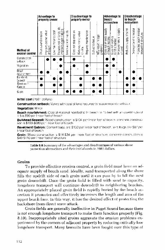
Initial COSt �981 dnlarS!
Construction setback: Varies with cost of land requ>red to accommodate sett>;«:kVegetation; MinorBeach nourishment: Cost of mater>al needed to fil t>each to 1!> !eet witt an overfi I ratio of1 5 is $90 pr r linear fool of hear:hBulkhead/Seawall: Wood construction is $104 pcr inc >r toot ol t>eai:h concrete :onstriic-lion is $100-$680 per lir>ear foot of beachRevetment/Gsbion: Cement bags are $133 per linear toot of beach w re ti;><3» r>r<> $9/ perl«iear foot of beachGroin; Wood construction is $14 $34 per linear foot of structure, concrete construction is$40-$110 per linear foot ot structure
1'able 8,6 Summary oi tf>e a<i vantages and rtisa<fvantagea of various shorel>r<>t<>r 1 i<»> alternatives anrt their initial costs in 1981 rir>liars.
GroinsTo i!rovi lc vfl'v :tivv, vrosion :ontrol, a >rr!it> I'ivl l rnu»t I>'rvc ari a l-
v tu tt� supply of bva :h s rn i. I I»ally, sanrl trar>si!r!rt� l f! I ! t>g tlr� shorefills thv, tip !rift si lv, of .a :h groir> ttr>til it :ar> l!<!»s hy to fill the !>vxtgroit> lown lrift, Or> :c thc groir> li il l is fill� l witli s;r» l to rapacity,lr!ngshorv. transport will :ontiriur> low» lrift lo r> .'igl>borir>g bva 'lies.An appropri ttcly pla :c l gn!in I'i il l i» r;!pi lly buri . l by thv. bcd :h a :� ;r ,tio» it promot is <!ri l cft'� :tiv ily ir> :rc i»c» tli ! length d» l ar td oi' tli lupp '.r b '.<! :h f<! ;� lri l t!i» w<!y. it has tl> i clesircd .'.fl '. :I of t'ot . .tir>g theh;! :kst>orc fr»I!> lrr'� it wirv ', dtld .'k.
Groin fie! ls are generally ineffe .tive ir> Puget!!ou»� becausv. thereis r>ot enough longshore transport to make them function properly I'ig,8.10!. Ir!appropriately sited groi»s aggravate the erosiot! problcrr>s '.x-pcri .»o ,� liy th i owners of adja ;cr>t property by rc lu :ing :riti :<illy loivlongshore transport. Many lawsuits l> vc b ;c» louglit over this type. of

D<rvviopment of thc Co rst
problem. In addition, groins eventually <lct<rriorat<, into rrnsightly iv.-posits of rubble where inadc<Iuately supplie<l witlr s r limcnt. For mostPuget Sound beaches, groirrs rrrc rrot considered 1< b ; rrr rffcctivv ero-sion control dcvic»,.
ConclusionThv. prccvding chaptvrs have. traced the evolution of thc coast of PugetSoun l frorrr its '«rrlv postglacial history to its present-clay development.Heing the first surnrnrrry vvt prvparr<i, this book is an introductiorr toprobl<rms that will hav<r to hc solved as devel<>pmvnt a<cclerates: it isbest usvd as a basis for f<rturc investigations. As programs to assess cn-vironrn<rntal aspects of thc coast that!vere. initi;rt<rd in the 1<j70s arcnor eluded <«rd th» information from them put to rrsc and field tested,the extent of knowl»dgv. will bv. ,nh;rncvd greatly. YVith understandingof the natural proc«ss»s that havv. crvatvd thc coastline and kno vledgeof the kinds of dcv .h!prncnt tlrat ar<. b<rncficial to it, citizens <md dev-elopers will be better lrrcpar«d to <.njoy thv. co rst as it is. or to alter it irra rcsponsilrl< manner. It will bv challenging for rll c<rnccrned to w;rt<:hthese changes oc<.ur and to participatv, in the managcrn mt of thcsv, pre-cious resources,

Glossary
Abrasion t'rinding <>f rock bv wave-agitated sand and gravel.Acrretion 'l'hv, growth of <i i>ca<;h by thc additi<>n of niatvrial tran»-
i>ortcd bv wind and u atcr.Alluvium Clav, silt. sand, and grav<>l deposited by str<><ims and rivers.Backshore L/ppcr l>art of tliv. beach bctwvcn ttie bvach fact.: a>id thc
coastlinv,; affected by sevcrv, storm waves.Backwash The s<>awar<l return >f water f<>llowing the uprush of a brcak-
>llg wave.Bar A»hallow-water dci>o»it of sand, gravel, or oth<>r u>iconsolidatcdmaterial for>ncd <>n tliv. sea floor by wav<>s and currents.
Bay mouth bar A bar extending partly or entirely >cro»» the, nio«th of abay.Beach Th<> zo>ic of unconsolidat<>d niaterial that is mov >d by waves.wind, and tidal c«rr<»its, extending landwar l to the <.'oastlinv,.
Beach erosion Tlic removal of bvach >natcrials by ivavcs, tidal and near-»lion> cur>'pllts, or w>lid,
Beach face Th<>»<><.tion of thc bearh n<>rmally exposed to thc <iction of>Yave Ll t»'us ll.
Beach nourishment Tlic process of rcplc>iishing a beach with sedimen-tary >natcrial,Beach profile A vertical <: ross section of a bvach perpendicular to theshoreline.
Beach scarp A steep slope t>rodured by wave erosion.Bedload A highly concentrated l<iycr of scdiincnt rolled along the.
»vabvd by waves and currents.Berm Thc nearly horizontal portion of the backshorc formed by
b<>ckw<i»h, usually above mvan Eiighcr high water lMHHW!.Breakwater A str«cturc proterting a shore area, harbor, or anchorage,
from wa v v».Bulkhead A retaining wall along the shore t<> prot .rt the uplands from
ivavcs,Bypassing Thc transfer of bvach material from thv, updrift side of aninlet or harbor <>ntra>ice to thc downdrift »idc.
Capillary wave Water ivavc «<>used by surface t .nsion and less thanthree centimct .rs Iong,
Coastal zone The land and sca are<i borderi ig the shoreline.Coastline Thc linc whvre t<>rrestrial procrssvs give way to marine pro-
cess .s, tidal curreiits, wind wave», etc.
114

Glossury
Cusp Roiin lrd low deposits of 1><.a :h material srparatcd by crvscent-shapcd trougl>s,
Datum A horizontal ref<.rc»c<. plane for water level inviisurrinvnts. Atidal datuin is Ivfincd by a spvcific phas<i of th<. tide.
Debris line A linv, markii>g t lie la»<lward limit of debris rnovi«l by storinwaves,
Deep water Water so d i<>f> tl»t surface waves are littlv, affected bv the<>era>> bottom, generally one-halt tlii. surface wave lengtli,
Delta A deposit <>f sr li ment formed at a riv<.r moiith.Detritus Sedimentary material d ;rived from the weatliering nf solid
rock.
Dolphiri A cluster of piles boun l tog ',ther.Downdrift Thc dirc<.:tion of in<>vvincnt of beach materi;ils.Dunes Ridgvs or niourids of wind-blown sand,Duration Thc length of tin><> thv. wind blows in tl>e samv, <1irection with-
out obstructioi>.
Eddy A cir< ular movein<.nt of water formed on thv. sidv, of a main cur-rent. f',ddi<'.s may bc created at points where the maiii stream passesohstructions or betwc<,n two adjacent < urr<ints flowing in opposit<idirc<.ti<ir>s.
Erosion The wearing away of land by thc action of natural forces,Estuary Thv. region near a river mouth where fresh wat >r and salt water
mix.
Extreme high water Th . Iiigl> water leve! that can bv. <.xprcted to occuronce in a 50- t<> lt�-year period.
Fetch length The horizont<il distanrc along open w<itcr over which tlicwind blows and genvrates waves.
Foreshore The beauti bvtwvrn mean liighvr high and mean lower lowwater lev ils.
Groin A structure built perpendicular to the shorclinv. to protvi:tagaii>st erosion and to trap san<I.
Headland A high steep-faced point of Iai>d extending into th<i sea,Hook A spit or narrow >pv. of sand or gravel whi<.:h turns lai>dward at
its outcr eiid.
igneous rock Rock forincd of once molteii min<.ral».Jetty A stra :tore cxtendiiig irito t lie wiitcr to protect a harbor or to direct
tidal currents.Kinetic energy Energy ass<>ciat ',d xvith motion,Lagoon A shallow wat<;r body connvcted to thc sea.Levee A dike or embankm .nt which protects 1 »>d from floods,Littoral Living on, or occurring o», th<. shore,Littoral drift Tbv, mud, s<ind, or gravel inaterial rnov<«l in the»earshon,
zone by w ivvs and currents.Longshore Parallel witli th v shorclinv.Longshore bar A sandbar parall<.l with the shorelir>e whirh is sub-
merged at higli tide.Longshore current 'l'he wave-g<,ncr;>ted current iri thr, nvarshore zone
flowing parallel with the shore.

Thc :or<st o!'Puget Sound/Dowrring
Longshore transport rate Thv. rate at which sedir»c»tary material isIuovcd alorlg the shore by waves and currents; usually expressed incubic yards tor meters! p<,r y<.ar.
Low-tide terrace A broad flat portion of the beach profile located nearthe mean lower low water l<.vv.l.
Mean higher high water MHHW! The average height of the higher highwaters over a 19-year period.
Mean lower low water MLLW! The average height of the lowvr lowwaters over «19-year period,
Mean sea level 'I'hc average height of the surface of ll«'. sca over a 1<j-y<r«r period, usually d<.tcrrni»ed from hourly tide gauge measure-ments.
Metamorphic rock Rock formed from svdiment or igneous material thathas been subjected to high pressurr, or tvmpcraturc.
Nearshore circulation Thv water circu latin» «lo»g the shore producvdby wavvs, wind, and tidal forces.
Nearshore current A current in thv, nvarshorv. zone gcncratv<l by th<'.combirred effects of waves, wind, and tides,
Nearshore zone A» indefinite zone extending seaward from thc shore-line well bvyond the breaker zonv., dcfirrirrg the area in which waterand scdirncntary material are moved by wave action,
Outfall A large pipv for discharging sewage or waste, water irrto lakes,rivers, or the ocean.
Percolation Water seepage through spac<rs b<r'tween sediment particlesor t!<rough porous structures.
Potential energy Energy associated with position, usually elevation.Propagation of waves The passage of waves through water,Quarrying Extraction of bedrock or sedimentary material by air or wa-
ter pressurrs in breaking waves.Quaternary Thv !ast two million years, thc most rccvrrt gvologic period
of thc CcI10/<!i<: Era.
Refraction diagram A chart of wavv crest or ray positions for a specificdeep-water wave period and direction.
Residual deposit ;oarse sediment, most commonly gravel a»d cobbles,r<'.maining after waves and currents have removed finer materials andtransported them elsewhere.
Revetment A facing of ston<., concrete, or <>ther mat<,rial to protvcl ascarp, vrnba<rkmv»t, or shore structure against erosion by waves orcu rr err ts.
Rill marks Tiny drainage channels in a beach formed by thv, sc<rwardflow of water.
Rip current A strorrg surface current flowing sc«ward, produced by thereturn flow of water transported to shore by waves and wind.
Ripple mark A small ridge of sand on thv, sr<abc<i produced by waves,wi»d, or currc»ts, with crests ivss than 30 centimeters one foot!apart and heights often less than 3.0 cvntimetcrs �.1 foot!.
Riprap A layer, facing, or protective mound of stonvs randomly placed

Glossary
to prcvc»t erosion of an cmb«nkmc»l or u»<lcrmining of a structure;also th >»t<>nc»o u» > l.
Scour Thc <.rosion of sedimentarv material at the base of a shore struc-ture by waves a»<l currents.
Sediment Thc material deposited by water or wind.Shoaling 'I'hc prop«gati»» and tr»n»for<n»ti<>n of wavvs in sl>allow wa-
tv,r.Shoreline I'h<> i»l<.r»<.cti<>n of sva and la»<1. Thc linc delineating thc
shoreline on lJ.S. Go»st »»d Geo<letic Survev lopogr»pl>ic»>ap» i»u»u»lly thv, mean high water line..
Shot rock Angular rock frag>»e»t» produc<>d by bla»ti»g in tuarri<.».Significant wave height Thc average height of thc one-third highest
waves of a >vavv' group,Signifirant wave period '1'hc estimated period of the o»c-t1>ird highest
wave» will>i» a group.Spit A point of land or a narrow shoal co»>f>os<.d of loose sedi>»cnt <>»<I
projv :ti»g i»to» b<><lv of water.Spring tide '1'he highest >»d low«st tide levels that occur «I t t>c timv of a
ncw or full moon Labout vv ,ry two weeks!. when the moon is alignedwith thc su» a»d tl>e earth.
Still water level Th«, elevation of the watvr surface when there ar<. »owa ves.
Stockpile Sedimentary material placed on a beach t<> replenish itthrough»a l u ra I I on <Is ho re. tran sport.
Storm surge A risv. of water level on the coa»t, abov«. Il>e pr dict v<l t i<1 v,,duc to w>nd a>i i baroln<>tri<. pressure on thc water surface,
Surf zone The area betw<>c» th«out«rmo»t brvakvr»»n<l thc shorewardlimit of <vavc uprush.
Suspended load Th«material su»pen<1<><1 in w;<tcr and move� by wavesand currents.
Swash mark '1'hv, tl>i» wavy line of fine san�, mica flakes, bits ofseaweed. and other matvrial left by wave upru»l> whc» it rcccdvsfro>n th<> I!<.»<:h.
Swell A group of long wind waves g<.»<,r»t<>'d by a distant stor<n that hastr«vvlcd far from its source; it has morc regular and longer pvriods,<>nd flatleI' crests 'tha» locally go»erat >d w>n l w<>vvs.
Tidal fIats Marshy or muddy areas of the seabed which arc covered a»duncovered by the risv. and fall of ii<1'>I v,atcr.
Tidal inlet A shallow inlet maintai»vd by lid«1 current».Tidal range Thv, <liff«rcncc in height bctwvc» consecutive high and! ow
waters.Till l J»stratified glacial drift <.:omposed of clay, sand, rocks, and gravel.Tombolo A spit that co»nvcls an i»l;>nd to thv, mainlan l or to another
island.
Updrift The direction opposite that of thr. pr<!dominant longshoremovement Le., downdrift] of littoral materials.
Uplands Landform» a ljacvnt to the coastli»<> and above extra»>v, highw >ter lcvv.l.
117

Th<; Const ot'Roget So <ndil!o! ning
Water layer weathering Rock disintegration by chemical reactionswith seawater and salt «rystallizafl<!n 1!n.ss<<n;s.
Wave climate l hy prevailing 'wavy <:hara<;t<!ristics height, t!<,ri<!d, an<1fryquency! and din;et i<!n !f wav» at!proach at a «oastal site.
Wav . <:r .'st 1 h ! t <! p !f a wav .'.Wave cut platform A horizontal surfac«produced hy wave erosion.
!su;! Ily hyl !w m<.;!r! l<!w !r I<!w w ! t ,'r,Wave diffraction Thy phon<! ne <!n by which wave energy passes
;!n!<u!� l!arriers such as breakwaters anc! j<!ttiesj and thn!ugh narrow !p !nings t ! spread into sheltered areas.
Wave direction Tho clirecti !n fro < which w<! ves approach an observer.Wave group A s !ries <!f w !vy» inwhi<,'h the wave height, period, and
dirycti<!n are the sa ne.Wave height 'l'hy vertical distan :r l!ytw ! ;n ! lj< ' !nt wav ! !n!sts and
troughs.Wave length Th<! h<!riz<!nt !l distan<:y bvtyyn;!ctja<:y st wave crests.Wave period 'I'irne between the passage of two successive wave crests,Wave ray A line drawn perpcr<di :ular to wav<! crests, the direction of
wave eue 'gy p 'opagat�<1,Wave reflection Wave c;nrrgy that is returned seaward when a wave
strik !s a st«.! 1! b<!ach or n !arly vertical stru< ture.Wave refraction Changes in the direction of wave passage in shallow
water.Wave runup The rush of water up the face ot a beach or structure pro-
duced by breaking waves. The maxim m v ;rtical height of waterabove still water level is the measure of runup.
Wave setup The accumulation of watyr in the surf zone an i above thc:still watyr lyvyl produc ',d by <!nsh<!r<.' transport in shoaling waves.
Wave spectrum A graph, table, or mathematical equation showing the<listrib !tion of wavy yn !rgy as a function of wave fry tue !<.'y or pe-riod. A spectrum may be c:omputed from wave measurements or pre-dicted from wavy theory.
Wave trough A shallow depression between successive wave crests:also that part of a wave below still water Ic;vel.
Wetlands Shallow tidal f4ts or swa!nps that are i !undatyd <nost of thetime with fresh, bra< kish, or salt water.
Wind chop Thy ste !p an� sh<!rt-cn!st !� w v !s th !t < n; g<!!u!rat<!d by amoderate. brac;zc; during the early growth of wind waves,
Wind waves Wavys generated by thy wincl.

Bibliography
Ad Ho ; .'<committee on ;enlogic I lazar<Is. 1974, ivI .'eting the gc'ol«gi<,a! hi>zardch illenge, Rcport to theWashii>gt<>ii Str>te l.vgisl >turv. Il<J75 sessi«n!. O!y u-p!a. Wash illgtol>
Adn., B. H., E. P. Rir.liv1.;rr>d I1, R. .;hrist !nsc;n. 107b. Fl«atii>g l!rv, >k>v<>ter fir,'Id;iss rssrn !nt progr>m, Friclav H;>rb«r. bV !shington. ;«astal Engineeririg Re-srar ;h Center, Ft. Bvlvoir, Virginia. Tec.hninal Report 7b-17,
Bagnold, R. A. 'I!15�. Fxperirnents on a gravity-free dispersioi> ot' large solii!spheres in a Neivtoi>tan> f!i>id under shear, Procvedii>g» of thr. Hr!yc>il Soc:ietyILi!i><lo i!. Ser. A, 225:4<J � f33.
Has<!olu, K. N. 1851. 'I'he relationship l!etweeii s >nd siz<! in<i beach face shape.'I'r >nsnctions o th<> Arr>r.rir: >i> ,<rr!phi sinn! I i!>ion..'32:808 � 874.
Br>rtl rs«n, '. :.. M. J. ;hrzastowski, inrl A. K. Ilclgerson. 1<J80. Historicalchanges of sh irvline;ind wetland at eleven major deltas in the I'uget Soul>dregion, Washiiigton. ILS. C:eologicai Survev. Atlas HA � 017.
Brets<:lirieicler, ;, L, 1<J58, Revisi<»>s in <vac e fore. casting: deep aiid sl>al!ow iva-ter. I'r<!<:vvdings of t!>e Sist!! C;oi>lc!rriiic<r oii C:r!r>st<>! Engine ;ring. Ami'.ric:;>nSociety of :ivil Eng>in<.vrs, Pp, 30 � b7.
Brun<lag<!, KV. L. Jr, 10 !O, Ri'.i;vnt svclirnent of the, Nis tna!ly Rivvr clelta, I'ugetS«i>n<l, W;>shingtnn. Itnpuhlishecl Master's 'I'hesis, Seattle: Itniversity ofWashingt«r>.
.'lifton, I I, E. 1<J > J. Bv<mli l<>n<inatioits: orig>in ar>d iiaturv.. Mori!>e 'c!olog<,7IU!;553 � 5�0,
.i'«»s<!l>, R. S. 1074. 'on<pi!at i«n «f v;irt l>q i > kii liypo«;!nters in western 1V ish-ll>gt«l>. Sti>te If YV >shingt !n Departmrnt of N >t>ir !I Rvs«iir ;es, InformationC;ir ;ular 53. !lyntpia, W>shingt«n
cle Joi!g, S, H.;inrl I I. I'. W. Siebenhuenvr, 1<372. Seasonal an<i se :u!ar variationsof sea level i!ri the Pacific r oast of Cane<la. 'I'he .'< nodio!> Sor> vvor,2b�!:.1 � 1<J.
De<>n, R. ', 1978. Rvvivw «f »ed in!ent tr >«sport r >latin«ships >1>d th r d rt<> base.Pr<!<.evrlir>gs of fhe 1V«rksh«p on Cr>o» ol S<!dimr>nt Tron»port, New >rk. I!el.:Dnivr!rsity «f Dvlaw ir ! Si!a 'rant, DEI -SC-1 5-78.
D<!xter, R, 5'.. D, F.. Andvrs<>n, F,. A. guin!an, L. S. C'ol<lstvi !. R, M, Stricklancl,R. M. Kocan, an<I M. Lanrlolt. 1881. A sum>nary of kno<vle<lge of Pug>etSounclrelet<;<I to r.liemical r.ontaminaiits. Seattle, %VA: National �<:vani : in<i Atrno-spheri : A<in>ii! istriitioii, NCJAA TM !MPA-13.
Ekr!><>i>, M. R. 1978. Er<>si<>ri r.:ontrol in a high ei>ergv <:«!st >I environn!ent.Ain<;ri<:;>n Soc:iotv of :ivil Fng>invvrs. .o;istal z,one C;onfereni:v,, Volume III:1b80 -1�98,
Fnvironment ,ana<la. '1V ivvs recorded off Roberts B<uik, l3. '.. Station 108, Fvb-riiary 7, 1<J74 to April: !, 1 J7�. M'>rine L'nvironmental Data Service File 108-5. !ttawa, 'a«ad'>,
, Wavvs rv<.<!r<lvd of Sturgeoii Baiik, B.C;.. St;itic!n 102. Mari>>e Fnvi-r<>i> >>viitiil Data Servir:e File 108-5,

Th<; Co rs o Pug<! ,'><>urrrJ/l>r»vr!rr!«
. Waves recorded oft White Rock, I3.C�Station 118. IU1 !rine Fnvirorr-r»ental Data Svrvice I'ile 108-5>.
. W;!vvs I' r, '.ofded off Victoria, H.C., St;!tr<»! 4. Mar!nv Fnvtrorrrne»ta D;rt;! Svrvi :c File 108-5,
Evans. I.. 1932. Silt disp<»a!l rt Nisqualty Power Plant. W !st<!rn C<instrur:ti<!ri!Nv«s let !vr, 7�4!:725> � 72 >.
Calvin. C. J 1972. A gross longshore trar!sport rate formula. Procrvdings of thr.'I'i!i! tevr!th .'or!ference on Co<!st !I Engineerir!g, American Society <>f Civil Fn-glnvvfs Vp 953 � 97<!
'i bert, H. N, 1973. 'I'he potenti>rl of Puget Sound as a basin for the testing ofmodels in a seaway. IJnpuhtished Master's 'I'hesis, Seattle: D<!iversity ofWash!llgh!ll.
I fund. H. M. 1967. Diffvrvntiatior> of be'«:h;!r><l <lunv sar! ls, using svttling vel !-<:itjvs <>f lig>lrt;r l t t>v,'>vv fnlnvr'als. J ! II'll<!I of Sccilimcrrt<!rr Pvtrolog!,37�]:514 � 520.
tlarris, R. .. 1954. Thv. surfacv, winds <>vvr Pugvt S<!und an<i the Strai of Juanrle Fur.a and their or.ear!ographic effects. I/npr!htished Master's Thesis. Seat-tle: Ur!ivvrs>ty >f Washington.
Hayes, M. O. 1972. Forms of sediment a .cun!ulatior> iu the bea .tr z !r!e. Irr:LV<! '<!s on be<!ches und r'vsu tirig svrlir>!vril transp >rt [R. E. Mvver, ed.l. Ne vY >rk: A :;«Ivrni<: Pres». Pp. 297 �: >.
Hicks. 'S. D. and J. E. :rosby. 1974. Trends anrl vari !t!ility ol y > rrly m ! rn s<! !levvl, D.S. N tional Oceanographir: an<i Atmospheric Arlministratinn Tech- !ical Mvm<>randum, Number 5>-1;!,
Hunter, R, L'., ll, E. .'Iifton, and R, L, Phillips, 1979. Depositior>a pro<:esses,sediment rrv structures, <r»d predicted vvrtical sequvr«ivs in t>arre I nearsh<>rvsystv ns, s<>uthvrn Orvg<>r! :oast. Jour< <!I of S<!dlrl!crll<rry Pet!'ology,49�J;711 � 728,
Intvragvncy ;ommittvv. for Outdo<>r Rv<:rvatir>r!. 1974, Accretion beach ir!ven-t<>rv, Vuget Sr!und, Ho<>d Canal, San Juan Island, Strait of Juan de F !ca.Olvmpia, Washington,
James. W. R. 1974. Borrow material texture and beact! fill stability. Procevdrflgsof thv Fourteenth Ir! emotional ;<>nfvrer!ce or> .'oustul Er!ginvvrir!g, Amvri-can Socivty >f Civil Fnginvvrs.
Kcuter, R. I'. 1979. ;oastal zone processes and geornorpt!ology of SkagitCounty, Washington. L!npubtishvd Mastvr's Thesis, Hellingham: WesternWashington State I!nivrrsity.
Knots >r!, V. I,, 1980. Expvriment rl <luna restoration ar!d stat!i!ization. NarrsetBeach, Cape Cod, Massachusvtts, Coastal Fngin«;;ring Rvsvarr:h Currier 'I'ectr-nicat Paper, Numt>er 80-5.
1977a. I'tenting guidelines h>r <luna creation;>nd stabilization.Coastat Fr!gir!vvrir!g> Research 'errter, Ft. Helvoir, Virginia. Technical Aid,Number 77-4.
1977b. Vtanting guidvlines for dune crvation and st' bilizati !ll.Coastal Fnginvering Research ;vntvr, Ft, Helvoir, Virginia, Tv<:t!ni .at Aid,Numb v r 7 7-;!,
Larsen, L. II, and D. R. Fvnton. 1974. Observ >ti<!ns of waves in thv. Nr!rth Pr!-cific. Proceedings oJ the Internutior!ol Symposium on Oceun W ivv, hrfcrrsurc-mcnt ond An<>lysis. America» S<>cietv of .'ivil L'ngineers, Nvw Orleans, Loui-si !n !, September 9 � 11, 1974. Pp. 197 � 213.
Laursen, L. M. '195>8. The total sedirncr!t lr>ad <>f streanrs. Journo of Hydroulicsf!ivision, Vrocevdings of thr; Americcn Soci<>ty r!f ;ivi Fng>iru!r!rs 84 HY1].Pp. 1530-1 to 1530-3fi.

IJ il>fiogra phy
I.<>rigt!et-Higgins, M. S,;in<] R, W. Stewart. 1<J84, Radiati<>ir stresses in waterwaves; a phy»i<: il <lis<ai »sion. with;>t>3>l i<:;>tions. Drcp Sert Hv»e<>n:h,11:529 � 582.
Matl>ews, W. H., J. '. Vyles, and II. W, Nasrnith. 1970. Postglacial r rustal rnove-nrents in s<>uthwestvru Hritisli ;olunrbia and adjacent Washington Statv.. ;anat]ian Journal oJ F«rth Sr:iertr:v, 7:890 � 702.
Maundrr, W. J. 1<J88, Synoptic: weather p itlvrn» in tire Pac.ific; Northwest.Northwvst S<:tvr><;e, 42�!:80 � 88.
M : ;rva, M. ancl J. II, I'eldmar>. '3977. Interim assrssrnvnt <>f Washington Stateshoreline management. ;<! rstaf Zone Man rgemvnt Joi>real. 8J2!:11!} � 150.
Mc 'ary, N.;in<> J. H. Lincoln, 1977. 'I'i<fr pririt». S rrf<tcc ticfail rtrrrr.nt» in I'ugvtSou«<I, Si;attl»;, Washington: W >shii>gtott Sea rant, WS 77-1.
Michel. W, II, 1988. Sea spvc;tri>»irnplified. Pror;ceding>s of the Apt'll 1907 ]Vfeet-ing of thc ,trff S<>r;lion of thr.,'ioricty oi Xavrtf Ar<:bitrc:t» and Marirte Vngi-nvvrs. Pp. 17 � 80.
Novak, I. D, 1972, Swash-aonv, <:ompetency of gravel-sire»vditnent. Marinr. ,cology, 18�!:8J5 � 84�.
Ploppcr, ;. S, 3!}7!}, Hyr]r;ti>li<: sorting arid Iot!gshorc !furl»pot't of bva :h»al>d,P ><:ific: roast of Washington. Dnpiibli»h<><l Di»»<.rt;>ti<!n. Nvw York: Syrar.useDnivcrsity,
Pugvt Sound 'ouncil of 'overnmvnts, 1<J75, Region >l disaster mitigation tvrh-»ic<tl stucly f<>r the :vntral Puget Sound region. Seat tlv,. Washington.
I'uget Sour>d Task I'orce of tlie Pa<:ifi : Northwest River Basins ;ommission.1970. ;omprelten»ivv. »turkey c>f water and related lancl resources. Pugvt Souiid;>nd;tdj;>i:vnt waters.
Reed. R. J 1!}80. I!cstruc:tiv ! !! in<]» <:;nt»e<l bv;tn orograptri :a]ly induced rneso-scale cyclorie. Huffefin of thc Amc.'rican !VI<;t<;r>rotc!gi«:rf So :i< tyfi 3 3 1!:184 i � 1;3,!,!.
Ri .ltvy, E. I'. 1978. WV]nd wave and boat wake analysis, Seacrest Marina, Seat-tlec, Wa»lit tlgtol>. Repot't pr'v pared f<!r the I'ort of Seattle.
Rubry, W, W, 19'J:3, The siav.-distribution of hvavy tt>it>vr«ls witltitt it water-laid» irtc]»t<!r>v�J<!tirnal of Srdimrr>terr Prtrofugy, ,'3�!::3-29,
Seville, T. Jr. 1'.}54. Thr, cffe<:t of fvtc:h width on wave generation. U.S. Army :orps of L'nginecrs, Beach I.rosi<>r> Boarrl, TM-7!}.
S .hwartz, M. I, <uid L V. 'rabert. 197;3, 'oastal pror esses and prehi»ti>ri<: rnari-tiittv. <:ulturvs. In: :oastal 'cor>tarp]>ofogv D. R. ;oates. vd.!.
S<>vlllour, R. J. 1<J77. L'»titnatir>g w<!vv. g>viivrat i<>n i>n rv»tri<:tvd fetches. Journaloi W rl<.'rrv<ty, Pr!rt, ,ra>»t<rl ar>cl 0<:r.<crt Divisi«n, Am<trio«n Soc;icly of L'ivifFr tg�in�«rr», I �;3 J WW2!;251 � 284.
State of Washington Departmrnt of I'ishvriv». 1971, :riteria governing th . dr.-sign of bulkheads, land fills. ari<l n>arinas in Pugvt Sound, liood ; anal, andStr;>it of Ju;it> <le Vu<:a f<!r pn!te<:tio» of fish and shellfish rrsources. Olyinpia,W >»I> it tg>t<! ti.
Stetv, of Wa»trit>gton Dvpartmrnt ot Tr >n»p<!rlatiori. 1980. Hood ; anal floatittgbridge, ph >sr I rcport, Dvtvrtnin«ti<>n of the c:ause of failure. Jfvrnpia, W'>»h-II>t't<!r>.
Stvrnbvrg, R, W. 1<J72, I'rcdir.;ting initi >I mr>ti >n ar>cl E!vclload transport of srdi-llletlt p'trticlcs it> the »ha!le>w t>larille el>virot>tnellt. In: Shcff s<. fiment trcrns-f>ort Swift, IJu<ute, ar>d I'ilkev, eds.!, Stroudsburg. PA: Dowc]vn, I lutnltinsontt> R<!s», In<:. I'p. 8 I 82.
. 1<J68. Vri :tion f« :tor» in tiilitl .Iianiiels with dift'ering bvd rougliness.'Vf«rior. .<!<!J<!gc, ti;24:3 2 '>0.
121

'I'jiv. :oust of Puget So !ncf D<!>< ning
. <JH7, Recent sedinzeiits in Bel]ingh<ur> Vu>y, Washing o>i, Nor ]>iv<is Saic;ncr.. 41�! 83 � 7!I.
',188. Rnur>di>ry layer observations in a tidal m>rrnnt. /oc>mal oft'eo !b> sinai Hrsrc!rclu 71 <J!:2175 � 2178,
'I'vrich. 'I'. A. 1978. Beach erosion prote<.tion in Vuget Sound, Anxerican Societyo] Cix il Ei>gii>enrs 'oust<>l Zone 'on fere.<!c;e, Vol. I! I:1J28 � 1'.>38.
, 1<J78, Pug>vt Sound slier>. ir<>taction stucly. Statv. ot' Wasliingtoii De-p<>rtn!in>1 of F<.n]ngy Rvpnrt. O y>r>pia, W<ashingto>r.
Thorson, R. M. 1<JHH. Ic:r,-short glaciatinn nf the Vugvt l<>wl in<], Wiishing>t<!n,during the Vashon St<ic]v I.ate Pleistocene!. Qno ernn>< H<.snnrch,18!8 !H � 321.
I J79. Isostatic effects of the last glaciation in the Vuget lowlaiid,Washington. U!>>published Hisser i> ioi>. Sea le: I!nivvrsily i>t' Wasliii>gt<>i>.
'I'ul!bs, D. W, 1!>75, C iusvs, n>ech >>>isa>s, ai><l prvdi<;tinn nf laiiclslicling in Svat-tle. Unpublished<] Dissertation, Seattle.;1 niversity of Washington.
. 1<174. I.andslidrs in S< attlr. St<>tv of W<ishington Dvp >rtmvnt of N !to-rsi Res<!urces, f!ivisi<!i> <!f C'en]ngy encl Earth Resources Information Circular,Nunibvr;>2.
U,S, Army Corps of Engineers. 1<J77. Permit program guic]e for applicants.Washi<igtoii, D.C.: Dv iartment of the Army. Office of the; Chief of Engineers, EP-1145-2-1.
. 1<�7. Shore: I'rnt«;: inn iv1 ><iu il, C<! >st il Fnginvvring Rvsvarch Cvnter,I' t, I]e voir, 'Virgini<>.
.S. Arin1 C<>rps <>f Engii>eers, Seattle District 1<J7<J, Shoreline erosion controldviunnstration project. Oak I]arbor. Wastiington Sectio<i,>4!. 18 February1<J78. Unpublishecl s orin dan>agv. rvpnrt.
1<J78, Design memorandu<n, brvakwatvr rehabilitation, Neah Hay,Washington.
, 1<J7 >. Gener;>] design memorandum, ['.die Hook be;>c;h erosion ron-trol
. 1975. Unpublished site conditioi> report, Keystone I]arbor, IslandCn>in v, Was>hillg o>1.
1<J71. Report on survey of Ediz f]ook lor beacl> ernsi<ii> ai>d relatedpurpnsvs. Port Angeles, Washington.
1 .S. Ariny Corps of Engineers, North P u;ific Division, 1<J71. Natural shorvlinv,study, inventory report Coluinhia-North Vacific region. Washington inc] Ore-go>>.
U.S. Coast an<] Oeodetic Survey. 1<J48. Tidal currei>t chart of Vuget Sound,snuthvrn p<art.
IES. 'enlogical Survey. 1<175. A st>i<]v of earthquake losses in the Puget Sound,W;ishingt<>n, <>rva, Open-File Report 75-375.
Vanic;ek, P. 1<J78. To the problem of noise rvduc:tion in sva-level records usec] invertical crustal iuoveinent detection, P]>] sirs of thc; Earth and P]<inv <iry Inte-riors. 17:285 � 280,
Wigv<i, S,O.;ii><l F.E. Stephenson. 198 >. Me<a> sea Ivvvl <>i> the Canaclian westc<»st, Procrc.c]ings of thr 2nd Si rnpnsiun> <>8 Prnblen!s Belated o the Hede-finition nf Nor h Am<iri<.<>n Vrrticn] f'rod<!tic Ne works, Ot awa: C<uiadiiuiInstitute nt S>irvi.ying. Pp. 107 � 124.
122

Index
123
i<br is o�. g. 1, ac retion, g, 99, �4Ad niralty Bay, 104Arlmiralty trad, 6<J, 70, 104Admiral ty in! vt, i4, 6<JAgate Bay, 77Aga t». Pas s, 4 1Alki Point. 15, 73alluvium, g, 17An>< ,ortes, 81Anny ,orps of Fnginer.rs responsibilitivs,
86Attornvy Cenvral, Washington State, 88
backshore. g, 7, 13, 99 � 101balan<.e bvl ween sediment supply and<emoval!, 7, 13bar, g, 60hays. 2, 9, 53, 68, 76bvaches, 1, 4 definvd!. 7 brrms!, 27
river!. 3.:13, 37, 40, 42. 46, 49, 50 � 51 profile!, Chap, 5, 80 � 84, 95,!1 i,98 � '102, 104-106, 108 � 110, 113
brach drifting, 46br.ach erosion, g, 7, .>3 � 45>, 94, 1 �-113bea :h face, g, 7, 40. 104, 112l>each nourishment, g, 101 � 104b»;ach profile, g, 7, 50 � 51, <J6, 102 � 104,
106beac:h sand, 12beach sediments. 54 � 55, 95beac:h and coast line! stability, 95 beddingplanes, 15bed!oar!, g, 43 � 45bar!rock, 2. 13. 15Bellingham Hay, Z7, 77berm, g, 7, Z3, 105, 106Birch Bay. 69, 7 iHlakely Formation, 15bluff,7,30,42,43,49.53,75.76,79.04,
100, 106bouldvrs, 3breakwater. g. 68, 104, 105Brown Is!anil. 70bulkhea I, g, 7, 54, 89, 95, 103, 106,
108-110Burrows Bay, 69Bush Point, 54Bypassing, g, 104 � 105
Cape Flattery, 63, 66 � fi8capillary wave, g, 35Carr Inlet, 72, 92
Cascade Ivlountains. 1, 55, 6'2, fi6Cherry Point. 81Chuckanut t>rive. 77 'la!la< > Bay, 6 ir:lay. 44, 57, 75, 7 i. 79, 84, 102cliffs, 1, erosion of, 13, 73 � 79, 94coastal <u<ginevrit>g prohlerns, 85 � 86coastal eroSion. 11, 13, 15, Chap, 7, 94, 95,
100 � 1'I:Icoastal features, major! 58, minor! 1 I, 60<'oastal n<e nagv tricot ..> 8roastal structurvs
history, 85>, 96 � 97permits, 86 � 89enginvering, 85 � 113erosion control, 106 � 113
coastal zoi'<e. g, 4. 9Chapter 1planning factors, 4river de!tas, 17feati< res, 58hasards, Chap. 7, 94
coastline, g, 1, 4, <J, Chap, 7, 94 � 9 i :OiE, see Corps of EngineersCo nmvncvment Hay, 28, 29, 72Con'way, 85Corps of Engineers, 4! , 86-8!I, 98, 100,
107,109,110 ,rrsc:ent Hay, 38Cranberry l.ak». 'I:I<.urrents, 3, 9, 11, 17 riv»,r!, 18, Z3 tir!el!.
26, 27, 29, 30, 33, 37, 40, 41, 44 vvlocity!, 45 waves!, 46, 57,!�, 104cusp, g. !0
cuspatv. forelancls, 11, 1 JCy pres s Is I and, 78
Dabob Bay. 92dams, 25. 31datum, gdebris line, gDeception Pass, 41, 69Deschutvs R<ver, 22deep watvr,g,37delta,g,1,11,17.19,22,23,29 � 32,79.
chap, 2dvlta, high energv, 29-32deposit!on, .'Irliffervntial settlemenl, 79 � 80diurna! winrls, 11DOE, see Washington State Department of
I',cologydolphin, g

jetty, g, 49, 104
Keystone Harbor, 104kinetic energy, g, 33kydaka point, 11
glacial lake clay. 3glaciation, 3
124
7'he :OaSI Of Pugr;I Sc!unc>/D !wning
doub I« tombolo, 1:IDougall Poirrt, 72downdr!ft, g. 104. 105, 112drainage. capac ity,,'!Dravton Harbor. 63 � h4drift glacial h 3drift logs. 7. 105 � 106Dm;k Spit, 29dunes, g, «J. 11. 13Dungeness Bay. 30, 69Dungeness delta, 29 � 30Dungeness River, 20, 29 �;�, 84Dungeness Spit. 9, 11, t�, 67 � 6<!«I uratlu<1, g, 36Dut<:hers Bay, 72Duwamish delta, 27 � 28Duwamish Head, 73Duwamish Waterway, 28, 80
East Sound � Orcas island, 92earth crust [vertical movement!. 4earthflows, 78 � 79earthquakes, 76. 79 � BDEhey's I.ending, 54eddirs, g. 41Ediz Hook, 11, 30. 38, 42, 49 � 50, 85,
'I 00-103Flliott Bay, 70-71, 90Elwha Dam, 31Elwha delta, 30-32Elwha River, 20, 30 � 32, 78Engineering I'orm 4345 COE permit app.h
87erosion, g, '13-15, 43, 44. 49, 53, 56, 57, 86,
94-96, 98, 99, 100-113erosion control, 100 � 113Esporan«e Sand, 75estuary, gextreme high water, g, 90, 92, «�. 105extreme water levels, 92-93
Federal Coastal Zone Management Act, 87Federal Emergency Management Agency
fFEMA!,93fete:h, 36, i2, Bh, h7, 69, 70, 71, 72, 90. 104fetch length, g, 70Fidalgo Bay, 72, 84Fidalgo Island, 63flooding. 20, 26, 86, 92, 93. 94, 97Forbes Point, 66foreshore, g. 7Fossil Bay, 15Fox Island. 72fraclures in bedrock!, 15Freshwater Bay, 32I'riday Harbor, 70-71
gla<.iers, 2Glacivr Prak, 55Glencove, 72 ;lynes Cunyorr Dam, 31gravel,44, 57, hO, 78,83,9'5, 99, 102, 1 �,
1DB, 109, 11D raveyar«I Spit, 11, 69Green Point. 78Green Rivvr, 22groin, g, 49, 5 I, 54, <J9, 104. 106, 112 � 113ground water, 9, 75, 73
Haro Strait. 69headland, g, 104Hvrron Island, 72Hood Canal, 2, 37, 66hook, gHorsehead Buy, 72Hugv Crvvk, 72Hylebos Waterway, 28hydrostatic pressure, 75icc. loading.,'!igneous rock, g, 55Ika Islarrd. 77infiltration, g, 75inlots, 2intertidal zone, g, 9,
La Perouse Bank, 68lagoon,g,13Lake Sammamish, 2I.a ke Washington, 2landslides, 3, 73-78, 94, 95Larrabee State Park, 77I.awton Clay, 75levee, g, 19liquvfied soil, 79 � 80littoral, glittoral drift, gl,ivingston Bay, 15, 56longshore bar, glongshore current, g. 37, 40, 46, 50, 53longshore transport, 46, 48, 96, 99, 112longshore transport rate, g, 49, 99Lopez island, 56, 78low-tide terrace, g, 7, 9Lumrni Island, 68, 77l,ummi River, 84
Mackaye Harbor, 69marine processes, 7, 9, 11, 15marsh plants, 18

McAllist<!r :reek, t5n>ean high w;!trr, 87 � 8!Imean higher high w«ler JMHHVI'!, g, 7m an lowe.r !ow water IMLL1V!. g, '.In! ! >n soa I<'.v !I, gmoclianir.al stre>igth, 3, 75, 15rn e I t w at <! r st rea»>s. 3mvtamorphi<. rock, g, Gi<iMilh!r :rr.ek,!IHMiller P<rninsula, 7Hminerals, Gi5i, 56Mu«n I!akvr, .>.iMount Ra!nirr, 25, 55iM u lrnv Ba'v. 7, 97
Veah Bay,4. iH>!<!arshore rirculatinn, 40. gnearshore current, 8, 4, 9, I l, l.'I, 40 � 41,
GH, 1 �nvarshnrr >»>r!v, g, 51 ..i7N !'ptuno Brar:h, 7fi � 77>Nisqually delta, 22 � 23, 25 � ZhNisqually River, 22 � 3. Z5 � 26N !AA tide tables, 92Nooks;>r:k delta. 22. Zh � Z7Nooksack River, 20. 22, 2fi � 28nn!>structura! erosion cur>tr<>l 100 � 10fi
0 >k Harbor, 101, 10<9 � 110oil spills. 80 � 84Olympia, 42, G3 � 64, 72, 76Olympic Mountains, 1, 5»., 62 � 63, 75Olyn>pic Peninsula, 62Outer Purl Diacov<!ry, 69outfall, gnut wash fglacia!J.:Iovort >pping, g
I'adi lie Bay, �, 84passr.s, 0passages, tpercolation, y�7. 75Prrkins Lanv,, 7:3permits for coastal devel<>p»rent, H i,
87 � 89, 102Picnic Point, 73P>grnr> I o<n'I, 78plant matvrial rvnter II !SDA!, 101Pleistocrm> Fpoch, 2. 3Point No Point, 41Point R<il>erts, iH � f>9Point Robinson. 70Point ! Vifson, 41Port I »wnsend .af>a I, 41Port Angrles. 49, 63, 72Port Blakely, 15>Port industrial w1tor<vay, ZHPort of Tan<> r>a. 28Port Susan, '.37, 70, 92
Possessi<>n Bea<.h, 7 ipotential envryv, g, 33P eve rt v Ba y,! I 5prist>nr 8 ! It<>s, ZZprupagatIu» uf vvaves, gI'«vallup delta, t8Puvallup River, 20, ZH
q>iarryir>g. g. I '3, 14Qua .mary, g>
R !<Inndn Beach, 73n>lra<:tiu» diagratn. g, 39,!residu,rl <Ieposit, g. 14revetmmi , g. 54,!!H. 99, 102, 106. 108,
110 � I �rill »>arks, 7,. 61r!p current, g, 40rippl<! mark, g, fill, Ii1riprap, 8, 99, 108. 110 � I I:IRivers a»d Harbors, Act uf 189!I. Hhrn< kfalls, 77 � 78, 94Rosari i 'Strait, H1, �3runup, g, 7, <93
Salmon I!ear.h, 7Gsalt n!arshes. 11Samish Bay, 84sa i<I, 9, 37. 44. 45, 54, 55, Hifi, 60,75, 7 i, 79,
H:I, H4. 95, 9'9, 102, 104. 10.!. 106, 112sandbar,!I, 1Z, 1;I,,i isand dunes, I:!S;In<ly Point. h!!scour, g, !09 � l10lian Juan !hannvl, 70Sar! J>lan Island. hfiSara uga Pass !ge, 37, 70sva cliffs,:i3sra Iv.vv.l, 4sea sta .ks, 9se as on a I .ye: I es. 7. 8Se',attlv., 4, 1:>, 28, 66, 73, 7.i, 79. 85,!�, 98sra-w; II, 9, 4!I, 5>H. 106, 10H � 110sedim >nt. g, 2. 3, 7, 0, 11. 17, 1!}, ZG, Z2. 23,
25, 27, 28, 29. 30. 40-41, Ohap. 4, 4fi, 50,5! 1. 5> 3, 54, .! Gi, Hi 6, 6 2, 6! I, 76. 76. 77. 7H,Ho. HI, 95,!IH, 10Z, 104, 105>
sediment l>udgots, 4h �:�sediment r<>s !rvuir, 9srd !Ir>t >1't srze, 5>fi, 57sodirne.nt, snurrv, 4!I, 50, .>4sediment stnrag<, 9sediment supply. 7, I 1, 12, 100svdimeri ary deposits, 11. 12Somiahmnn Bay, 71S<!miahmoo Spit, fi0Sequi»> Bay. 11. 69Shvlton. 42shoal ng g 37 42 4:I H i !!

Tj� oast of Pugvf Sound/Downing
shore processes, 2shorel>ne,, g. 90Shorelinv. H<>'arings Board, 88Shore! ine Managen!en Act, Washington
State!, 100, 106shot rock, g, 10!!, 110significant wave height, g, 1�, Jlsignifi<.ant wave period, g, '90, 91sill, 44, 57, 75, 78, 95, 102Sinclair Inlet, 72Site evaluation. 90 � 91 Sk<>git l!av, 77Skagit River. 20. 85slope failure. 73, '94, 102slope stability, ',3. 15Smith ~land,66. 69Snohomish river, 20spi'I, g, 11, 29, 42, 60, 68, 7Z. 98spring t!de, g, 7Steamboat Ish>nd, 11Steilacoonl. ! 04sli! I water level. g. 33Sti laguamish River. 20stockpile, 8, 10:!store>s, 4, 7, 9, ZQ, 36, 50 �.! !, 6 !, 64 � 66,
GH, 69, 72, 90, 91, 92,!�, 101. 105. 1 !h,10�
storm surg<, g, 92Strait of Georgia, 1, 67 � 71Strait of Juan de Ruva, 1, 11.:30, 32.:37, 41,
f � 64, 67 � 70, 81, 83Sucia Island. 15Sunnyside Bee<.h, 101, 104surf zone, g, 90susprndr.d load, g, 44, 45>Swantown, 7, 108swash mark, 61, gswell, g, '.36Swinomisb Slough, 72Swiftsure Bank, 68
'I'acoma, 28, 76'I'acoma Narrows, 7hTatoosh Island, 66Tenino, WA, 4T err vl I Creek Spit, 69terrestrial processrs, 7, 9tidal flats, g, 11, Hl, 83. 84tidal flow, 23, 41, 83, 93I lda Inlet, gtidal range. g. 66tides. 11, 31, 64, 66, 93. 104, 105till, g, '.3tombolo, g, 11, 12, 42transport cell, 42. 49, 50, 96transport path, 50Tulalip Bay. 56Twin Rivers I'or>nation, 76
unconsol idalrd sediment, 4updrift, g, 99, 104uplands, g. 9. 15!, 90, 100, 108uplift, 3, 4I!,S, Dv.pt. of Agricultur<. Soil
Conservalion Technical ServicesDivison lol
I BS. I!vpt. of Commer< e. 92
Vancouverlslan<l,62,64Vashon 'I'ill, 73, 75Vaughn i!ay. 11, 72vvgetation, <J, 18, ] 00 � 101Victoria, B.C., 36Vict<>ria Harbor, GB � 69
Waldron Island, 78Washington State Dept, ol' Fc<>l<>gy IJOL'!,
58, BH, 98, 10GWashingtonState I!rpt. of Risherivs
WDF!. 107, 108Washington State Dept. of Natural
Resour<.es DNR!, <!8Washingt<>n Statv, Superior Court. HHwater layrr weathering, g, 13water level, 9, 92-93waves. 3, 9, 11, 27, 29, 30, J3, Chap..'!, 4:!,
45 � 4h, 53, 57, Chap 6, 7;!, 8 !, Hl, 83, 90.91, 102. �4, 105>, 109
wave climate, g, 2:3, Chap. 6. 81, 90, 92.104
wavv. rrvst, g.,'�wave cut platforms, g, 14wave diffraction, g, 11. 38wave direction, g, 11, 43wavv energy, 14,:!:!.:!8, 53. 67 � 72, 91,
102, 103. 106wave I'orces, 7wavv, generation, 35, 62, 67 � 72wave group. g..'3:!.:�.; wave height, g, .'3:3,:34. 35, 43. 46, 50, BH,
70, 71, 72, 90, 91wave length, g, 33wave period. g..'�, hHwave ray, g, 38, <Jlwavv. rvfraction. g, 11, 38wave runup, g, 37, 9:!, 106wave setup, g, 40, 9:!!vave shadow,12wave spectrum, g, 34, 35, 36, 67 � 72. 90, 91wave trough. g, 33Weal I'oint, 41, 66>, 98. 101wr.tlanrls, g, 18, 79Whidbey Island, 4, '1 3, 54. 57. 63, 66, 69,
97, 101, 104, 1 !8Whitvmau Cove, 7Zwind chop, g, 67 � hHwind patterns, 62. 90wind waves, g, 4, 9, 90, 105

Other Books in this Series
The IV ter Link: A l listory of Puget Sound us aH .sv vr : ',
Daniel Jaok Chasan
Go> erning Puget SoundRobert L, Bish
Merino Birds and lUlomrnols of Pvg .t SovndTony Angell and Kenneth :. Bal :omb Ill
Th ; F .rtile Fjord: Plonktan in Puget SoundRi ;h rd M. Stri :kland

John Downing first became interested incoastal processes when he was an undergradu-ate studying geology at Rensselaer PolytechnicInstitute in Troy, New York,
When he received his bachelor's degree,Downing entered the U.S, Navy as a diving andexplosive ordnance disposal officer based inthe Pacific. In 1973, after a three-year stint inthe military service, Downing entered graduateschool at the University of Washington in Seat-tle. He completed a master of science degree inmarine geology and a doctor of philosophy de-gree in oceanography at that institution. In hisgraduate research, Downing concentrated onstudies of sand transport along beaches, To aidthese studies, he developed electronic instru-ments to measure sediment transport close toshore.
Since completing his graduate work,Downing has worked as senisir scientist for aSeattle oceanographic consulting,'-firm wherehe has done computer modeling and examinedthe effects of ice on offshore structMres.
His previous publications include journalarticles on sediment transport, oceanographicinstrumentation, and wave-sediment interac-tions. The Coast of Puget Sound is his firstbook,
An avid outdoorsman, Downing devoteshis leisure time to such pursuits as sailboat rac-ing, diving, climbing, and skiing.
ISBN 0-295-95944-4
Related Documents