ENGLISH The climb to Puig d’en Galileu Serra de Tramuntana Nature Area Photo: Gràcia Salas

Welcome message from author
This document is posted to help you gain knowledge. Please leave a comment to let me know what you think about it! Share it to your friends and learn new things together.
Transcript

EN
GLI
SH
The c
limb
to P
uig
d’e
n G
alile
uS
erra
de
Tram
unta
na N
atur
e A
rea
Ph
oto
: Grà
cia
Sal
as

The climb to Puig d’en GalileuSerra de Tramuntana Nature Area
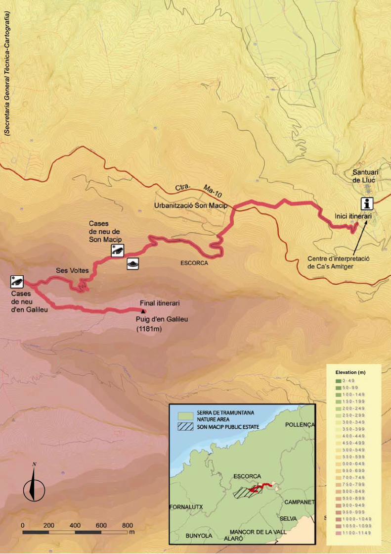
Today one of the quintessential hiking trails of the Serra de Tramuntana Nature Area, in the past this path was used by our ancestors when travelling on foot between Lluc and Sóller, with a cart while collecting charcoal, or by mule when making and transporting ice. Be sure to think about these arduous tasks as you go along – you may find the climb up to the top a bit easier! Difficulty: hardDistance: 4.7 kilometres (to the summit)Duration: 5 hours (round trip)If you follow the signs, there is no getting lost, yet you will need to be physically prepared for the considerable change in elevation on this itinerary. In the first section, there are several trails that cross one another; however, they are all properly marked by GR (Grand Route) signposting at each crossroads, so there is never any doubt about the trail you need to take.
Panoramic view from the summit of the Puig d’en Galileu (Photo: Gràcia Salas)
Ses Voltes Detour toCases de neu(icehouse complex)
Sta
rt o
f th
e it
iner
ary
Pu
ig d
’en
Gal
ileu
En
d o
f th
e it
iner
ary

Charcoal production floor with two sheds in the woods of Son Macip (Photo: Gràcia Salas)
1. Camí Vell from Lluc to Sóller
This itinerary begins at the Font Coberta, just next to the Lluc parking area, at an altitude of 475 metres. Your goal is to reach the 1188-metre summit of the Puig d’en Galileu. Thus, you will have to surmount a tough uphill climb that at some point may well leave you out of breath.
The Font Coberta marks the start of the old road to Sóller (Camí de Sóller), which today is signposted as GR-221. It is a stone-laid bridle path that runs up through the forest of Ca s’Amitger until it reaches the Andratx – Pollença highway (Ma – 10). Here you will cross the highway and continue on the other side, along a wider path. Once past a gateway, you will enter the holm oak forest of the Son Macip public estate, one of the most emblematic estates in the Serra de Tramuntana, where you will see charcoal production floors and small sheds virtually all along the trail. These structures bear witness to the intense charcoal production activity that once inhabited these emblematic woods.
2. Ses Voltes d’en Galileu and the Cases de neu de Son Macip (icehouse complex)
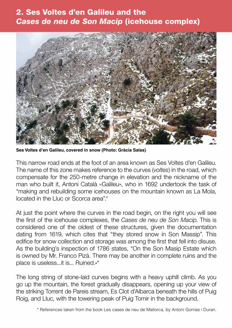
This narrow road ends at the foot of an area known as Ses Voltes d’en Galileu. The name of this zone makes reference to the curves (voltes) in the road, which compensate for the 250-metre change in elevation and the nickname of the man who built it, Antoni Català «Galileu», who in 1692 undertook the task of “making and rebuilding some icehouses on the mountain known as La Mola, located in the Lluc or Scorca area”.*
At just the point where the curves in the road begin, on the right you will see the first of the icehouse complexes, the Cases de neu de Son Macip. This is considered one of the oldest of these structures, given the documentation dating from 1619, which cites that “they stored snow in Son Massip”. This edifice for snow collection and storage was among the first that fell into disuse. As the building’s inspection of 1786 states, “On the Son Masip Estate which is owned by Mr. Franco Pizá. There may be another in complete ruins and the place is useless...it is... Ruined.»*
The long string of stone-laid curves begins with a heavy uphill climb. As you go up the mountain, the forest gradually disappears, opening up your view of the striking Torrent de Pareis stream, Es Clot d’Albarca beneath the hills of Puig Roig, and Lluc, with the towering peak of Puig Tomir in the background.
* References taken from the book Les cases de neu de Mallorca, by Antoni Gorrias i Duran.
Ses Voltes d’en Galileu, covered in snow (Photo: Gràcia Salas)
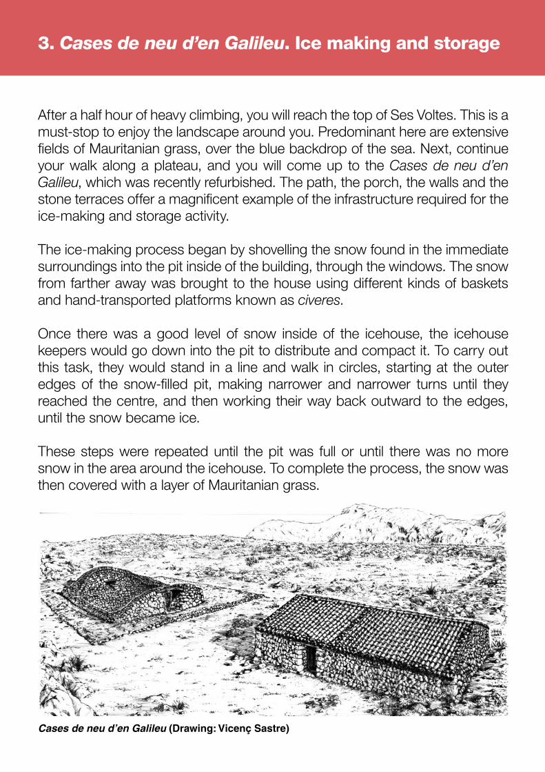
After a half hour of heavy climbing, you will reach the top of Ses Voltes. This is a must-stop to enjoy the landscape around you. Predominant here are extensive fields of Mauritanian grass, over the blue backdrop of the sea. Next, continue your walk along a plateau, and you will come up to the Cases de neu d’en Galileu, which was recently refurbished. The path, the porch, the walls and the stone terraces offer a magnificent example of the infrastructure required for the ice-making and storage activity.
The ice-making process began by shovelling the snow found in the immediate surroundings into the pit inside of the building, through the windows. The snow from farther away was brought to the house using different kinds of baskets and hand-transported platforms known as civeres.
Once there was a good level of snow inside of the icehouse, the icehouse keepers would go down into the pit to distribute and compact it. To carry out this task, they would stand in a line and walk in circles, starting at the outer edges of the snow-filled pit, making narrower and narrower turns until they reached the centre, and then working their way back outward to the edges, until the snow became ice.
These steps were repeated until the pit was full or until there was no more snow in the area around the icehouse. To complete the process, the snow was then covered with a layer of Mauritanian grass.
3. Cases de neu d’en Galileu. Ice making and storage
Cases de neu d’en Galileu (Drawing: Vicenç Sastre)

4. Transporting the ice
The icehouse keepers of Massanella, painting by Jaume Nadal (1750), conserved in the houses of Massanella.
With the arrival of the summer, ice was used more frequently for food conservation. The transporters would go up to the icehouses after dark, cut blocks of the ice known as pans de neu, wrap them up with Mauritanian grass to protect them from the elements, and place them on portadores, or carriers. Each mule pulled two carriers, equalling a local measurement known as a somada.
The ice was transported at night, to minimise its melting. The ice blocks were far smaller when they reached faraway destinations, such as Palma, Manacor, Felanitx and Artà. Those who are old enough to remember that era say that by the time the wagon reached the city, “it was all water”.
The fact that the icehouse keeper’s work survived in Mallorca until the first quarter of the 20th century has enabled the survival of some of the old icehouse work songs.

5. The icehouse keeper’s glossary*
Civera (Plural: Civeres): An instrument of transport made up of two long parallel bars with a platform in between.Espartera (Plural: Esparteres): Baskets that were carried on the back and fastened by means of a strap that went around the front of the carrier.Esportins: Braided-straw disk-shaped mats with two handles.Fumada: Rest period. On extremely cold days, this rest was taken every fifteen minutes; under normal conditions, it was taken every half hour. Pa de neu (Plural: Pans de neu): A compact mass of ice equivalent to one portadora (42,328 kg).Pala: A shovel, consisting of a rectangular wooden or iron plate attached to a handle. This tool was used to collect the snow. Portadores: A tool of transport. Essentially, a special double saddlebag connected by an upper thick straw strap at one side, designed to transport the ice on mules and donkeys. Each side of the saddlebag weighed 42,328 kilos, and served as a common measurement of weight.Somada: A measurement of weight. In the case of ice, it equalled 84.656 kilos. 1 somada=2 portadores.
*Adaptation of the definitions from the books Les cases de neu de Mallorca, by Antoni Gorrias, and Les cases de neu i els seus itineraris, by Lluís Vallcaneras.
6. What was the snow used for?
“Cold water is the most pleasant and natural medicine of all of those kept and dispensed by the pharmacy.” Through these words, written at the end of the 17th century, Dr. Pere Martí extolled the praises of the medicinal use of snow and chilled water. In fact, since ancient times, snow, ice and cold water had been used as a cure for disease: fever –which in past times was locally known as calentures–, fractures, bruises, sprains, burns, inflammations and other ailments were remedied with the snow.
In those days, the storage and sale of the snow was also profitable thanks to its gastronomic use, in the preparation and sale of ice cream. A very typical image in the streets of Palma in the 19th century was that of the small carts that sold the very popular aigo de neu or aigo gelada (similar to snow cones) and horchatas (blended tiger nut drinks). The snow was also an important delicacy on the fine tables of the upper classes.
7. Jerusalem sage
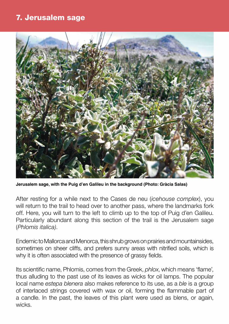
After resting for a while next to the Cases de neu (icehouse complex), you will return to the trail to head over to another pass, where the landmarks fork off. Here, you will turn to the left to climb up to the top of Puig d’en Galileu. Particularly abundant along this section of the trail is the Jerusalem sage (Phlomis italica).
Endemic to Mallorca and Menorca, this shrub grows on prairies and mountainsides, sometimes on sheer cliffs, and prefers sunny areas with nitrified soils, which is why it is often associated with the presence of grassy fields.
Its scientific name, Phlomis, comes from the Greek, phlox, which means ‘flame’, thus alluding to the past use of its leaves as wicks for oil lamps. The popular local name estepa blenera also makes reference to its use, as a ble is a group of interlaced strings covered with wax or oil, forming the flammable part of a candle. In the past, the leaves of this plant were used as blens, or again, wicks.
Jerusalem sage, with the Puig d’en Galileu in the background (Photo: Gràcia Salas)
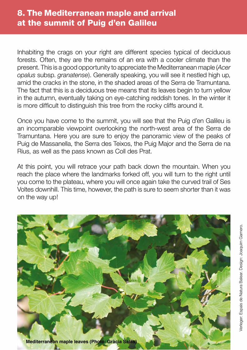
Inhabiting the crags on your right are different species typical of deciduous forests. Often, they are the remains of an era with a cooler climate than the present. This is a good opportunity to appreciate the Mediterranean maple (Acer opalus subsp. granatense). Generally speaking, you will see it nestled high up, amid the cracks in the stone, in the shaded areas of the Serra de Tramuntana. The fact that this is a deciduous tree means that its leaves begin to turn yellow in the autumn, eventually taking on eye-catching reddish tones. In the winter it is more difficult to distinguish this tree from the rocky cliffs around it.
Once you have come to the summit, you will see that the Puig d’en Galileu is an incomparable viewpoint overlooking the north-west area of the Serra de Tramuntana. Here you are sure to enjoy the panoramic view of the peaks of Puig de Massanella, the Serra des Teixos, the Puig Major and the Serra de na Rius, as well as the pass known as Coll des Prat.
At this point, you will retrace your path back down the mountain. When you reach the place where the landmarks forked off, you will turn to the right until you come to the plateau, where you will once again take the curved trail of Ses Voltes downhill. This time, however, the path is sure to seem shorter than it was on the way up!
8. The Mediterranean maple and arrival at the summit of Puig d’en Galileu
Mediterranean maple leaves (Photo: Gràcia Salas)
Verle
ger:
Espa
is d
e N
atur
a B
alea
r. D
esig
n: J
oaqu
im G
amer
o.
Elevation (m)
(Sec
reta
ria
Gen
eral
Tèc
nic
a-C
arto
gra
fia
)
Related Documents