The climate-sensitive Vesterisbanken area (central Greenland Sea): Depositional environment and paleoceanography during the past 250,000 years MARTIN ANTONOW1, PETER MARTIN GOLDSCHMIDT2j3 and HELMUT ERLENKEUSER2 1. Freiberg University of Mining and Technology, Institute of Geology, Bernhard-von-Cotta-Str. 2, D-09596 Freiberg, Germany 2. SFB 313, University of Kiel, Heinrich-Hecht-Platz 10, D-24118 Kiel, Germany 3. present address: PCD, Eckernforder Str. 259, D-24119 Kiel, Germany ABSTRACT Sedimentological, micropaleontological and geochemical studies of sediment cores from the Vesterisbanken region were used to reconstruct the sedimentation pattern, depositional history and paleoceanography for this area over the last 250,000 years. The dating and correlation of the sediments were based on oxygen isotope stratigraphy and absolute ages. The hemipelagic deposits near the Vesteris Seamount are characterised by biogenic, ter- restrial and volcanogenic sediment input that varies through time. The area was influenced by sporadic turbidity currents and thermohaline-induced contour currents. Ice-rafted debris occurred nearly throughout the investigated time interval. Primary production was higher during interglacial periods. Filter-feeding epifauna (C. zi~~~t~llt~rst~rji), an indicator of bottom cur- rents, dominated in isotope stages 7 and 5. During deglaciation (stage boundaries 8/7, 6/5 and 2/1, events 3.3 and 3.1), enorinous meltwater i n p ~ ~ t stabilised the water column, leading to periodic interruptions in deep water renewal. The influence of water masses from the Polar and Atlantic Domains in the Greenland Sea were very variable over time. The oceanic fronts in the Vesterisbanken area were always close together, allowing only a narrow Arctic Domain to exist. Although the area is rather unique in relation to other parts of the Greenland Sea, climatic data can be compared favourably to the established Late Pleistocene/Holocene sedimentation pattern in the northern North Atlantic. Due to their good correlation to ice core records from Greenland and Antarctica, the Vesterisbanken sediments present a high-resolution picture of global climate change. INTRODUCTION: THE VESTERIS SEAMOUNT IN THE GREENLAND SEA The Greenland Sea is one of the few links between the Arctic Ocean and the northern North Atlantic. This area is reinarkably sensitive to oceanographic and climatic changes because Polar and Atlantic water masses mix here. Morphologically, the Greenland Sea is framed by major fracture zones and ridges such as Knipovich and Mohns Ridges to the east and the Greenland continental slope/shelf to the west (Vogt, 1986). Tectonically, sea-floor spreading since the Paleocene led to a complex bathylnetry and gave rise to strong basaltic volca- nism that event~lally generated the Vesteris Seamount (73"301N, 9"101W,Fig. 1). Vesterisbanken rises from the Greenland abyssal plain up to 133 in water depth (Johnson & Campsie, 1976), thus for- ming the only intra-plate volcano in the ~~orthern North Atlantic. The goal of this investigation is to provide a reconstruction of the climatic development and the sedimentary environment of an area of the Greenland Basin that has been studied relatively little due to a thck ice cover linliting access. The In: Hass, H.C. & Kaminski, M.A. (eds.) 1997. Contributions to the Micropaleontology and Paleoceanogra- phy of the North Atlantic. Grz!ybozoski Fo~lildatio~l Spccinl Pllblicntion, no. 5, pp. 101-118 a - P6hocny Atlantyk

Welcome message from author
This document is posted to help you gain knowledge. Please leave a comment to let me know what you think about it! Share it to your friends and learn new things together.
Transcript
The climate-sensitive Vesterisbanken area (central Greenland Sea): Depositional environment and paleoceanography
during the past 250,000 years
MARTIN ANTONOW1, PETER MARTIN GOLDSCHMIDT2j3 and HELMUT
ERLENKEUSER2
1. Freiberg University of Mining and Technology, Institute of Geology, Bernhard-von-Cotta-Str. 2, D-09596 Freiberg, Germany
2. SFB 313, University of Kiel, Heinrich-Hecht-Platz 10, D-24118 Kiel, Germany
3. present address: PCD, Eckernforder Str. 259, D-24119 Kiel, Germany
ABSTRACT Sedimentological, micropaleontological and geochemical studies of sediment cores from the Vesterisbanken region were used to reconstruct the sedimentation pattern, depositional history and paleoceanography for this area over the last 250,000 years. The dating and correlation of the sediments were based on oxygen isotope stratigraphy and absolute ages.
The hemipelagic deposits near the Vesteris Seamount are characterised by biogenic, ter- restrial and volcanogenic sediment input that varies through time. The area was influenced by sporadic turbidity currents and thermohaline-induced contour currents. Ice-rafted debris occurred nearly throughout the investigated time interval. Primary production was higher during interglacial periods. Filter-feeding epifauna (C. zi~~~t~llt~rst~rji), an indicator of bottom cur- rents, dominated in isotope stages 7 and 5.
During deglaciation (stage boundaries 8/7, 6/5 and 2/1, events 3.3 and 3.1), enorinous meltwater i n p ~ ~ t stabilised the water column, leading to periodic interruptions in deep water renewal. The influence of water masses from the Polar and Atlantic Domains in the Greenland Sea were very variable over time. The oceanic fronts in the Vesterisbanken area were always close together, allowing only a narrow Arctic Domain to exist.
Although the area is rather unique in relation to other parts of the Greenland Sea, climatic data can be compared favourably to the established Late Pleistocene/Holocene sedimentation pattern in the northern North Atlantic. Due to their good correlation to ice core records from Greenland and Antarctica, the Vesterisbanken sediments present a high-resolution picture of global climate change.
INTRODUCTION: THE VESTERIS SEAMOUNT IN THE GREENLAND SEA The Greenland Sea is one of the few links between the Arctic Ocean and the northern North Atlantic. This area is reinarkably sensitive to oceanographic and climatic changes because Polar and Atlantic water masses mix here. Morphologically, the Greenland Sea is framed by major fracture zones and ridges such as Knipovich and Mohns Ridges to the east and the Greenland continental slope/shelf to the west (Vogt, 1986). Tectonically, sea-floor spreading since the Paleocene led to a complex
bathylnetry and gave rise to strong basaltic volca- nism that event~lally generated the Vesteris Seamount (73"301N, 9"101W, Fig. 1). Vesterisbanken rises from the Greenland abyssal plain up to 133 in water depth (Johnson & Campsie, 1976), thus for- ming the only intra-plate volcano in the ~~or the rn North Atlantic.
The goal of this investigation is to provide a reconstruction of the climatic development and the sedimentary environment of an area of the Greenland Basin that has been studied relatively little due to a thck ice cover linliting access. The
In: Hass, H.C. & Kaminski, M.A. (eds.) 1997. Contributions to the Micropaleontology and Paleoceanogra- phy of the North Atlantic. Grz!ybozoski Fo~lildatio~l Spccinl Pllblicntion, no. 5, pp. 101-118
a - P6hocny Atlantyk
Antonow, Goldschmidt and Erlenkeuser
central reasons and questions to be answered for this study are:
1. The determination of sedimentation in the Vesterisbanken area. - What depositional processes affected the study
area? -Was there a temporal variation of different
sedimentation patterns? 2. Paleoceanographic determination for the central
Greenland Sea area. - Which paleo-surface water masses influenced
the area around the Vesterisbanken and how variable is the position of the oceanic fronts?
- When did meltwater pulses change the isotopic character of the Greenland Sea?
3. The integration of these results into the pattern of Late Pleistocene-Holocene sedimentation and paleoceanography of the Greenland-Jceland- Norwegian Seas. - Does the paleoceanographic development of
the central Greenland Sea agree with that of other parts of the northern North Atlantic Ocean (e.g. the Norwegian and Iceland Seas)?
- Did unique sedimentary or paleoceanographic events occur?
4. A comparison with global climate variations. - Can the marine climate information from the
Vesterisbanken sediments be correlated with terrestrial signals from ice cores?
- How do the changes in the central Greenland Sea fit into the global framework of climate changes?
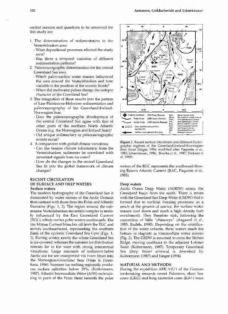
RECENT CIRCULATION OF SURFACE AND DEEP WATERS Surface waters The modern hydrography of the Greenland Sea is dominated by water masses of the Arctic Domain that contrast with those from the Polar and Atlantic Domains (Figs. 1, 2). The region around the sub- marine Vesterisbanken mountain complex is main- ly influenced by the East Greenland Current (EGC), which carries polar waters southwards. The Jan Mayen Current branches off from the EGC and moves southeastward, representing the southern flank of the cyclonic Greenland Sea Gyre (Figs. 1, 2). During winter, nearly the whole Greenland Sea is ice-covered, whereas the summer ice distribution retreats far to the west with strong interannual variations. Large amounts of sediment-laden Arctic sea ice are transported via Fram Strait into the Norwegian-Greenland Seas (Vinje & Finne- kasa, 1986). Summer ice melting regionally produ- ces surface salinities below 29%0 (Koltermann, 1987). Atlantic Intermediate Water (AIW) recircula- ting in parts of the Fram Strait beneath the polar
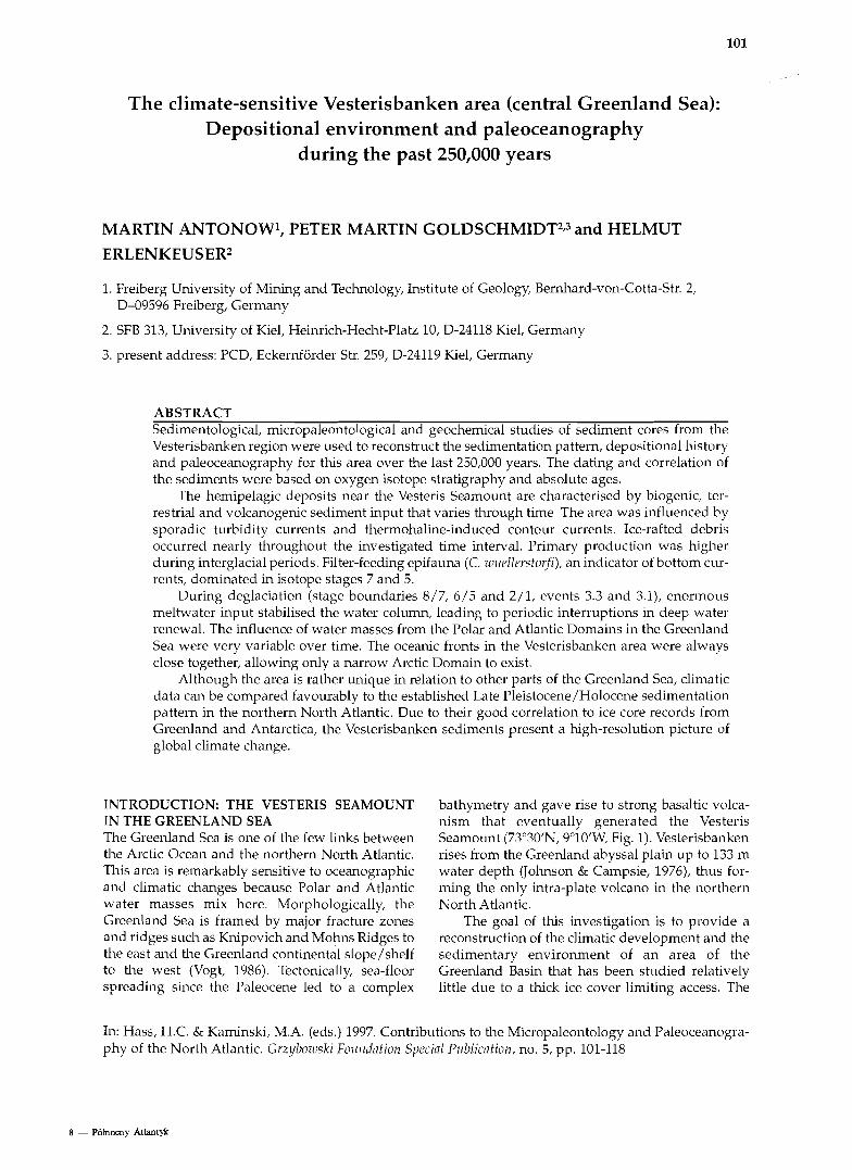
Figure 1. Recent surface circulation and different hydro- graphic regimes of the Greenland-lceland-Norwegian Seas (from Jiinger, 1994; modified after Paq~~ette 1.t a / . , 1985; Johaimessen, 1986; Bourke ct a/ . , 1987; Dickson ('t 01. 1988).
1WW 0" 1WE
-+ Vlskris Sralnoulll 1.01) Polar "'3nl;lin N41, NorlI~ Athtl~lic l)riKl - Pelur Fr,,nl ARD Arclic Lk,mi,in yVC;l Na~~-rrgi;n~~ IU,anrla~ll Cx#rrsnl 1Vr.t SpiI.l>wgcn Cnmrrem~l
waters of the EGC represents the southward-flow- ing Return Atlantic Current (RAC, Paquette et nl., 1985).
I
Deep waters Arctic Ocean Deep Water (AODW) enters the Greenland basin from the north. There it mixes with the Greenland Sea Deep Water (GSDW) that is formed due to surficial freezing processes: as a result of the genesis of sea-ice, the surface water masses cool down and reach a high density (salt enrichment). They therefore sink, following the convection of little "chimneys" (Aagaard e f nl., 1985; Rudels, 1990). Depending on the stratifica- tion of the water colulnn, these waters reach the bottom or stagnate as intermediate water lnasses (Fig. 2). The GSDW is assumed to cross the Mol~ns Ridge, moving southeast to the adjacent Lofoten Basin (Koltermam, 1987). Temporary Greenland Sea Deep Water renewal is described by Koltermam (1987) and Jiinger (1994).
1I"&c ~~~~i~ vr,,,,, AND ~ ~ l ~ , , ~ i ~ ~ , , , , , ~ i ~ I<SC I.** SpiIrlrl.gcn C<lr~.r.nl WAC Retu1'83 Altdttlic C#8r1'cnl 1
MATERIAL AND METHODS During the expedition ARK VII/l of the German ice-breaking research vessel Polnrsfrr~z, short box cores (GKG) and long kastenlot cores (KAL) were
Vesterisbanken (central Greenland Sea) during the past 250,000 years 103
Figure 2. Recent oceanography of the Greenland Sea after several authors (see text).
-
Central Greenland Sea
Influence of
from the East
--- N A W - North Atlantic
Water NSDW - Norwegian
c;,. 5" \v Deep Water Temperature Salinity Reference
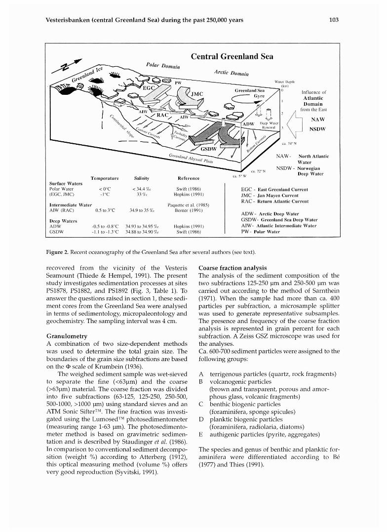
recovered from the vicinity of the Vesteris Seamount (Thiede & Hempel, 1991). The present study investigates sedimentation processes at sites PS1878, PS1882, and PSI892 (Fig. 3, Table 1). To answer the questions raised in section 1, these sedi- ment cores from the Greenland Sea were analysed in terms of sedimentology, micropaleontology and geochemistry. The sampling interval was 4 cm.
Surface Waters Polar Water < 0°C < 34.4 %< Swift (1986) (EGC. JMC) - I °C 33 %< Hopkills (1991)
Intermediate Water Pnquette et al. ( 1985) AIW (IIAC) 0.5 to 3OC 34.9 to 35 Ic(. Berner (1 99 1 )
Deep Waters AI)W -0.5 to -0.8"C 34.93 to 34.95 %r Hopkins (1991 ) GSDW - I . l to - I .3"C 34.88 to 34.90 Tr Swift (1986)
Granulometry A combination of two size-dependent methods was used to determine the total grain size. The boundaries of the grain size subfractions are based on the scale of Krumbein (1936).
The weighed sediment sample was wet-sieved to separate the fine (<63pm) and the coarse (>631un) material. The coarse fraction was divided into five subfractions (63-125, 125-250, 250-500, 500-1000, >I000 pn) using standard sieves and an ATM Sonic SifterTM. The fine fraction was investi- gated using the LumosedTM photosedimentometer (measuring range 1-63 pn). The photosedimento- meter method is based on gravimetric sedimen- tation and is described by Staudinger et 01. (1986). In comparison to conventional sediment decompo- sition (weight %) according to Atterberg (1912), this optical measuring method (volume %) offers very good reproduction (Syvitski, 1991).
EGC - East Greenland Current JMC - Jan Maycn Current R A C - Return Atlantic Current
A D W - Arctic Deep Water GSDW- Greenland Sea Deep Water A I W - Atlantic lntermediatc Water P W - I'olar Water
Coarse fraction analysis The analysis of the sediment composition of the two subfractions 125-250 pm and 250-500 pm was carried out according to the method of Sarnthein (1971). When the sample had more than ca. 400 particles per subfraction, a microsample splitter was used to generate representative subsamples. The presence and frequency of the coarse fraction analysis is represented in grain percent for each subfraction. A Zeiss GSZ microscope was used for the analyses. Ca. 600-700 sediment particles were assigned to the following groups:
A terrigenous particles (quartz, rock fragments) B volcanogenic particles
(brown and transparent, porous and amor- phous glass, volcanic fragments)
C benthic biogenic particles (foraminifera, sponge spicules)
D planktic biogenic particles (foraminifera, radiolaria, diatoms)
E authigenic particles (pyrite, aggregates)
The species and genus of benthic and planktic for- aminifera were differentiated according to Be (1977) and Thies (1991).
Antonow, Goldschmidt and Erlenkeuser
Figure 3. Bathymetry of the Greenland Basin and loca- tions of the stations around Vesterisbanken.
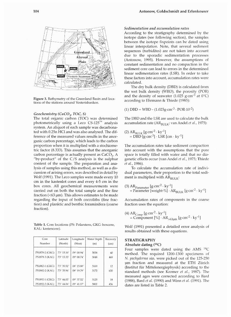
Geochemistnj (CaCOy TOC, S ) The total organic carbon (TOC) was determined photometrically using a Leco CS-125~'' analysis system. An aliquot of each sample was decarbona- ted with 0.25n HCI and was also analysed. The dif- ference of the measured values results in the anor- ganic carbon percentage, which leads to the carbon proportion when it is multiplied with a stochiome- tric factor (8.333). This assumes that the anorganic carbon percentage is actually present as CaC03. A "by-product" of the C/S analysis is the sulphur content of the sample. The preparation and ana- lysis of samples using this method, as well as a dis- cussion of arising errors, was described in detail by Wolf (1991). The Leco samples were made every 10 cm in the kastenlot cores and every 4-5 cm in the box cores. All geochemical measurements were carried out on both the total sample and the fine fraction (<63 ~un) . This allows estimates to be made regarding the input of both coccoliths (fine frac- tion) and planktic and benthic foraminifera (coarse fraction).
Table 1. Core locations (PS: Polarstern, GKG: boxcore, KAL: kastencore).
Sediinentation and accr~rnt~lation rates According to the stratigraphy determined by the isotope dates (see following section), the samples between the isotope fixpoints can be dated using linear interpolation. Note, that several sediment sequences (turbidites) are not taken into account due to the sporadic sedimentation processes (Antonow, 1995). However, the assumptions of constant sedimentation and no compaction in the sediment core can lead to errors in the determined linear sedimentation rates (LSR). In order to take these factors into account, accum~~lation rates were calculated.
The dry bulk density (DBD) is calculated from the wet bulk density (WBD), the porosity (POR) and the density of seawater (1.025 gcm3 at O°C) according to Elvmann & Thiede (1985):
Core
Number
PSl878-2 (GKG)
PSl878-3 (KAL)
FS1882-1 (GKG)
PS1882-2 (KAL)
PS1892-1 (GKG)
151892-3 (KAL)
(1) DBD = WBD - ( 1 . 0 2 5 ~ . c m ~ . POR.~O-*)
The DBD and the LSR are used to calculate the bulk accumulation rate (ARBULK; van Andel et nl., 1975):
Lat~tude
(North)
73" 15.10'
73" 15.33'
73' 35.52'
73" 35.96'
7.1' 44.05'
73" 44.06'
(2) ARB,,, [gem-* . k Y 1 = DBD [gem"] . LSR [cm . ky-']
The accumulation rates take sediment colnpaction into account with the assumptions that the pore space is totally filled wit11 water and that no dia- genetic effects occur (van Andel ef nl., 1975; Tl~iede et al., 1986).
To calculate the accumulation rate of indivi- dual parameters, their proportion to the total sedi- ment is multiplied with ARBULK:
Longitude
(West)
09' 00.94'
09' 00.73'
08" 23.80'
08" 19.29'
09" 37.52'
09" 41.17'
(3) ARparameter [g.cm-* . ky-'I = Parameter [weight-%] . ARBULK [gcrn-* . ky-'1
Accumulation rates of components in the coarse fraction uses the equation:
Water Depth
(m)
3038
.W48
3169
3175
3125
3002
(4) ARco,,,p [g'cm-' . ky-'] = Component [%] . AR,h3F,m [gcm-2. ky-'1
Recovery
(cm)
40
469
12
650
18
436
Wolf (1991) presented a detailed error analysis of results obtained with these equations.
STRATIGRAPHY Absolute dating ("T) Four samples were dated using the AMS 14C method. The required 1200-1300 specimens of N. pach!yderina sin. were picked out of the 125-250 pm fraction and measured at the ETH Ziirich (Institut fiir Mittelenergiephysik) according to the standard methods (see Kromer et a/., 1987). The measured ages were corrected according to Bard (1988), Bard ef 01. (1990) and Winn et 01. (1991). The dates are listed in Table 2.
Vesterisbanken (central Greenland Sea) during the past 250,000 years
Analysis of stable isotopes (6180, 613c) Duplessy (1978) and Ganssen (1983). The sampling Stable isotope analyses were carried out using 20- interval was 4 cm. The isotope ratios 61s0 and 613c 30 tests of N. yacl~!lderr?la sin. (125-250 ~ u n ) per were measured by means of a Finnigan MAT 251 sample according to the method described by mass spectrometer at the C-14 Laboratory of the
Universitv of Kiel, Germany. The results were cor-
Table 2. AMS ages of sediment samples. related to' the PDB standarh (Craig, 1957; Craig & Gordon, 1965). Statistical errors make LID to 0.09%11,
- 28.530 28.130 330
Antonow (1995) by comparing the isotope data to
PS1882-2 (KAI.) 18.630 18.230 the stratigraphy of Shackleton & Opdyke (1973,
40.610 40.210 1.020 1976), to the SPECMAP scale (Imbrie ct nl., 1984; Martinson ct nl., 1987) and to more recent results
PSl892-3 (KA1.) 32.230 31.830 from sites in the Norwegian-Greenlaid Sea
Scdiment
Table 3. Oxygen isotope stratigraphy and age/depth correlation of the sediment cores PS1878, PS1882, and PSl893 (note * markes 14C ages).
Termination
End I
Beginning
End TI
Beginning
End I11
Corc depth,
Age (ka)
for 6180 values and ~tp to 0.04%o for the 613C
Reference
I4C agc
Core depth PSI878 (cm) ,
measurements (H. Erlenkeuser, pers. comm., 1994). An oxygen isotope stratigraphy correlating the
investigated sediment cores was established by
CI'I'L'
Core depth PSI882 (c1n)
14C agc
Core depth PS 1892 (cm)
65 85
85
orlginnl
(cm)
Stdnd'ird
V Vogelsang (1990); S: Sarnthein et 01. (1992); W: Weinelt (1993); M: Marti~~son ct 01. (1987); I: Imbrie et al. (1984)
(ka) corrected
(k4
deviation
( 1 6 )
106 Antonow, Goldschmidt and Erlenkeuser
Cores PS1878-21-3 Cores PS1882-11-2 Cores PS1892-11-3
3180 ( % c ) vS. PDU 3I3c (Rc) vs. PDlI 8'0 (Zc) vs. PDU 2 ' 3 ~ (Zc) VS. PDU di80 ( I r ) vs. PDll 313c (%<) vs. PDIS 5 1 3 2 -01.5 0.0 0.5 1.11 5 4 3 I 11.0 0.5 1.11 5 4 3 2 4.5 ll.11 0.5 1.11
. .
0
50
iln, <
1.50
21s
250
300
350
4l*
.Is0
SIMI
550
h(n1
651 k p l h laf fcml
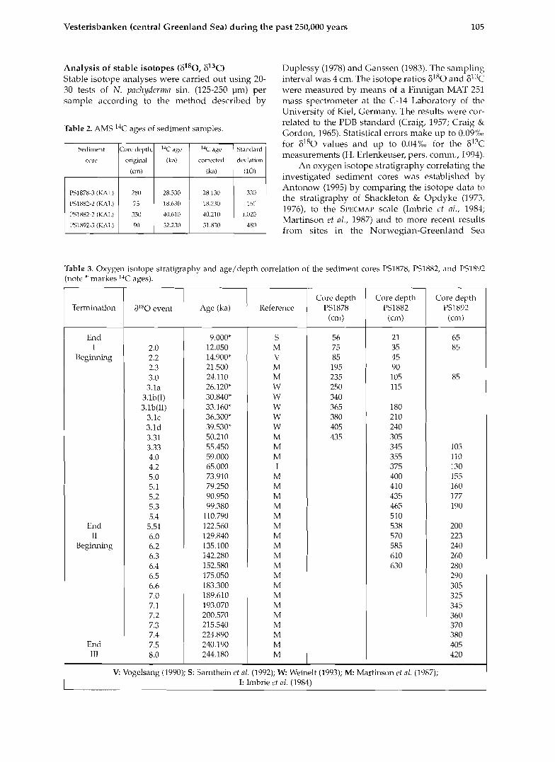
Figure 4. Stable isotope data (6180,613C) o f N. pncllyderrim sin. versus depth o f the cores PS1878, PSI882 and PSI892 (boxcore and kastencore). Oxygen isotope stages are marked.
(Vogelsang, 1990; Sarnthein et al., 1992; Weinelt, LSR for the Vesterisbanken area have increased sig- 1993; Jiinger, 1994). nificantly (Table 4). The maximum amount is 10
Generally, the ratios of the stable isotopes 6180 cm/ky at the end of Stage 3. The Vesterisbanken and 613c in the sediment cores presented in Fig. 4 LSR agree well with the valiies from the central are typical for rniddle/late Pleistocene to Holocene Greenland Sea (Jiinger, 1994) and with data from values in the Norwegian-Greenland Sea (Vogel- the east Greenland continental margin (Nam et nl., sang, 1990; Weinelt, 1993; Jiinger, 1994; Antonow, 1995; Nam, 1996) since isotope Stage 7. However, 1995, 1996; Nam el al., 1995). The sedimentary record from the sites near Vesterisbanken repre- sents the paleoceanographic history back to oxy-
Table 4. Mean linear sedimentation rates (LSR) since gen isotope Stage 8 (PS1892). Two of the cores Stage 8, (PSI878 and PS1882) contain high resolution records of Stages 2 and 3 (Fig. 4).
The oxygen isotope stratigraphy and age/depth correlation of sediment cores PS1878, PSI882 and PSI892 are presented in Table 3. The F 1 8 0 stratigraphy was complemented by the four 1 4 c - ~ ~ S ages and a magnetostratigraphic frame- work (Antonow, 1995; Nowaczyk & Antonow in press).
Sedimentation and accumulation rates In general, the linear sedimentation rates (LSR) of the Vesterisbanken cores vary between 0.4 and ca. 6 cm/ky. Since ca. 59 ka (Stage boundary 4/3), the
Oxygen
isotope stages
1
2
3
4
5
6
7
8
* Note: Low LSR are caused by erosion. " Data available only for the last 4,000 years of Stage 8.
Duration
(ky)
12.050
12.060
34.890
14.910
55.9.30
59.770
54.570
58.820
LSR
PSI878
(un/ky) 4.W
5.72
3.17
LSR
PSI882
(crn/ky) 2.24
3.65
3.75
2.21
1.64
2.05)
LSR
PSI892
(crn/ky)
5.39
0.00'
0.72'
2.21
1.05
1.62
1.71
3.76 "
Vesterisbanken (central Greenland Sea) during the past 250,000 years
the Vesterisbanken LSR vary significantly since Stage 3.
Accumulation rates were calculated from the LSR (see section 3). These results are discussed in the following sections.
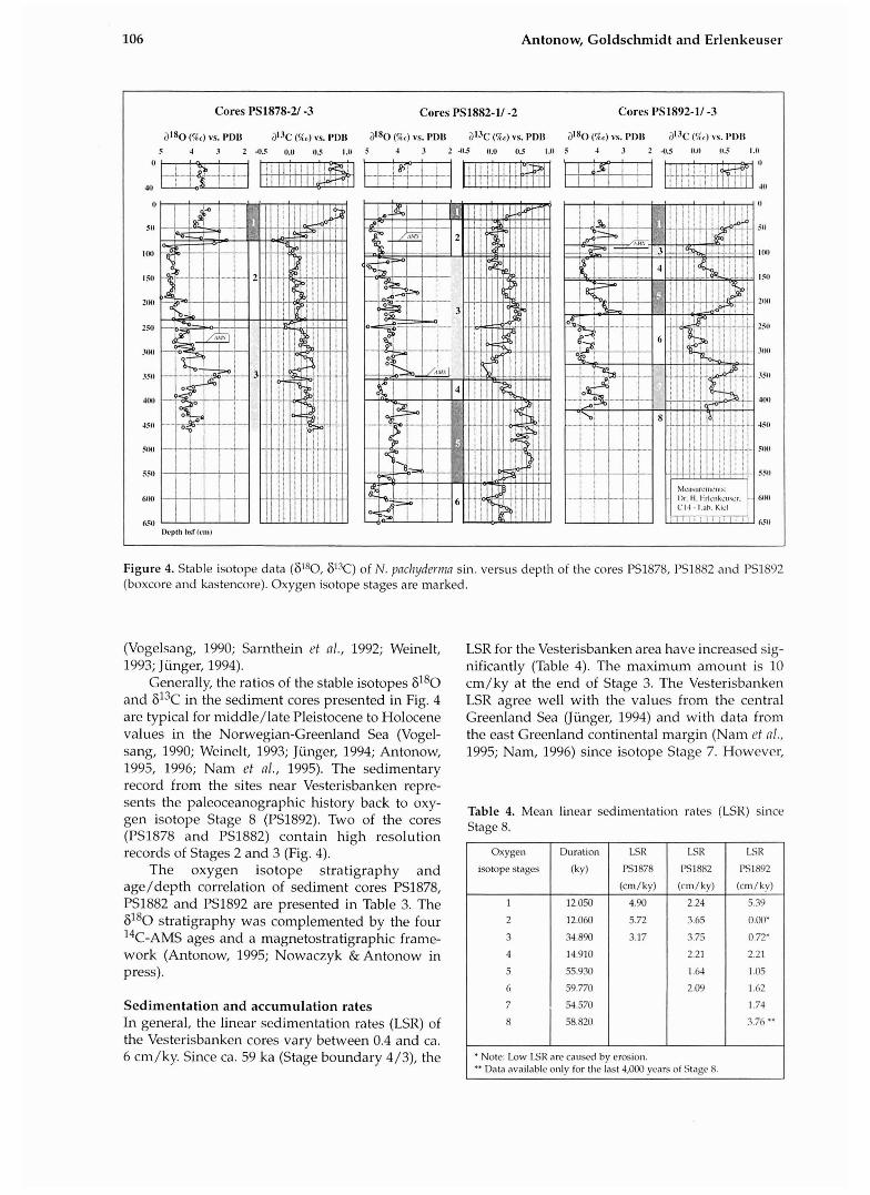
Vesterisbanken standard profile The raw data sets for several segments of the sediment column had to be synthesised to characterise the overall sedimentation pattern and paleoceanography of the Vesterisbanken region (Fig. 5). The follow- ing core segments were used in the core synthesis: PS1878-2 (GKG), 040 cm: undi- sturbed surface and near-surface sedi- ments; PS1878-3 (KAL), 45-435 cm: highest resolution of meltwater events in Stages 2 and 3; PS1882-2 (KAL), 310-535 cm: higher resolution of Stage 5 than in PS1892-3 (KAL); and PS1892-3 (KAL), >220 cm: con-
Figure 5. Standard profile of the Vesterisbanken region: Lithology and stable oxygen and carbon isotope records of N. pacl~ydcrnm sin. during the past 250,000 years.
lilha,lngy l a ~ l u p r S l ra l i~n tphy
Akh I*u?rn Ul'hicknes In cml 'IX0 Iq" M'pDI' r)IJc [%,I vs. P D I I
9 6 .3 I1 S 4 3 2 -0.5 11.11 0.5 1 .I1 I1
511
I I W I
1541
ZIWI
12 X 4 II L 3 l
Inuninlrd S m i a m . I'l'hirknr- In cnt I O i y ~ u n la,l#>pc SI;~gcs , \~v I hx 1
lilh#++!lr I.%md
0 Ilva~~*.l;g~e l ' ; r ~ a Vulr,~~licl;~r~~c !:.tin.\ 0 I..~IMIII:IIU~~ SCIIJIIICIII I';ICIC\
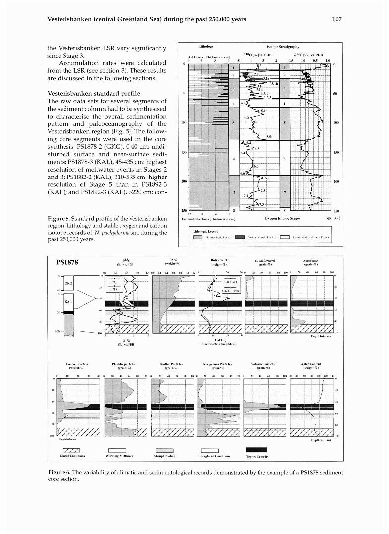
Figure 6. The variability of climatic and sedirnentological records demonstrated by the example of a PSI878 sediment core section.
108 Antonow, Goldschmidt and Erlenkeuser
tinuous sedimentation and the maximum stratigra- phic time period. Using this standard profile, it is possible to determine general trends of the chan- ging environments in this area.
VARIATIONS OF CLIMATIC AND SEDI- MENTOLOGIC SIGNALS: AN EXAMPLE OF A GLACIALIINTERGLACIAL TRANSITION The variations in the isotopic, geochemical and sedimentological signals indicate climatic trends that are important for correlating the cores and for determining sedimentological and paleoceano- graphical trends (for the complete data set and dia- grams of all investigated parameters, see Antonow, 1995). An example of these variations and their implications is shown in the topmost metre of the sediment profile from Core PSI878 (Fig. 6). Due to the very similar trends for the isotopic and sedi- mentological signals in the short box core (GKG) and the long kastenlot core (KAL), the two can be combined to provide a single normalised core.
The lower portion of the section (100-85 cm, 16.3-14.9 ka) shows "heavy" 6l80 conditions (Fig. 6). Very low TOC and low carbonate contents indi- cate dncial conditions. The coarse fraction (>63
PI), which consists mainly of planktic foramini- fera and terrigenous material (quartz and rock fragments), forms a relatively small part of the total sediment. Following the 61X0 maximum is a sec- tion (85-80 cm, 14.9-13.5 ka) with decreasing 813c conditions where the very small coarse fraction amount is primarily composed of sediment aggre- gates and terrigenous material.
Starting at ca. 80 cm (13.5 ka), the TOC content rises steadily. Drastically reduced 61X0 conditions correlate with increased terrigenous input, as is typical for warnzirz,y phnses, i.e. glacier melting events (Fig. 6). A short period of light oxygen iso- tope values is acconlpanied by increased terrige- nous input (IRD), decreased biogeiiic input and a decrease in the CaC03 content. The rest of the core consists of large proportions of biogenic compn- nents (including benthic species). The increased TOC content, the high 813c conditions and the moderate 6180 values are typical for irzteylncinl conditions. Benthic filter-feeders (C. zo~rellerstofi) also appear. A layer of tephra (volcanic glass) appears at 56-45 cm (9 ka); its coarse grains lead to losses in determining the water content (Fig. 6).
,
,111
IV I
1111
2x1
Volcanic Aslirs
1VI
.I,#,
Turbidilc Fncics
.- . . . . .
E Pelagic sedinwl~ts
D Upper la~ilinnlud unit (Clay -sill)
C Rippled unit, w:ivy 01' convolulr: I ~ I I I ~ I I : ~ ~ (sill - s:llld)
I 3 Lower laniinatrd 11ni1 (sancl)
A G~.:ldcd unit (lining apw;lrd. gravel -sand)
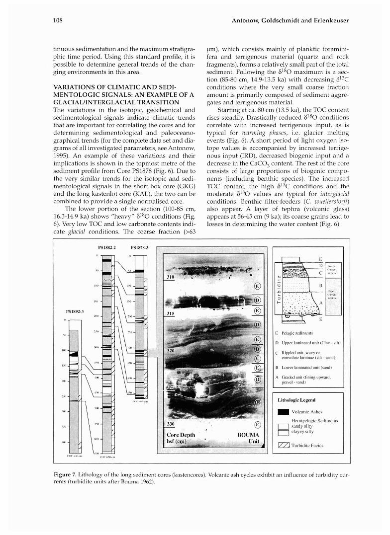
Figure 7. Lithology of the long sediment cores (kastencores). Volcanic ash cycles exhibit an influence of turbidity cur- rents (turbidite units after Bouma 1962).
Vesterisbanken (central Greenland Sea) during the past 250,000 years 109
SEDIMENTARY PALEOENVIRONMENT The Transpolar Drift transports large amounts of sediment-laden sea ice mainly from the Eurasian continental shelves across the North Pole to the Fram Strait, supplying mainly fine-grained ice-raf- ted de t r i t~~s (IRD) to the northern North Atlantic Ocean floor (e.g. Wollenburg, 1993). During glacial eras, another source of IRD was iceberg calving of the Greenland, Scandinavian and Barents Sea Ice Sheets. Within the Greenland Sea, IRD is currently distributed by the southward-flowing East Greenland C ~ ~ r r e n t and the cyclonic Greenland Sea Gyre, the Jan Mayen Current and the Return Atlantic Current. IRD abundance in Pleistocene sediments documents the persistent climatic con- trasts of severe polar conditions and iceberg mel- ting in parts of the Greenland Sea and in the Fram Strait (Bischof, 1990; Spielhagen, 1991; Baumann et nl., 1994; Goldschmidt, 1994, fliis voliinie; Nam et nl., 1995). The input of IRD is discussed in detail in the following section.
All sediment cores are made up of grey, green and brown lithogenic hemipelagic muds in the grain size range of clay to sandy silty clay. The cores closest to Vesterisbanken are interrupted by
successions of coarse-grained (>63 pn) black to fine-grained (<63 pm) olive green volcanic (basalt- ic) ash layers. These ash layers are composed of glass and rock fragments together with some crystalline components and can be classified as volcanoclastic turbidites (Fig. 7). They indicate an intensive Late Quaternary volcanic eruption phase since about 105 ka (Fig. 5). More detailed core descriptions of the cores are given in Thiede & Hempel (1991) and Antonow (1995).
Sedimentation in the area of Vesterisbanken was influenced by near-bottom currents (Michels, 1994; Antonow, 1995). There is a basic difference between gravitative and thermohaline current mechanisms in the marine environment. Gravitative current mechanisms create turbidites (Bouma, 1962) while thermohaline mechanisms induce bottom currents that follow bathymetric contours, leading to the deposition of contourites (Hollister & Heezen, 1972).
Deposits of both current mechanisms are evi- dent in the study area (Antonow, 1995). The lami- nated sections of the investigated cores were usual- ly interpreted as distal turbidites. But some of the investigated sediment characteristics (sorting, bio-
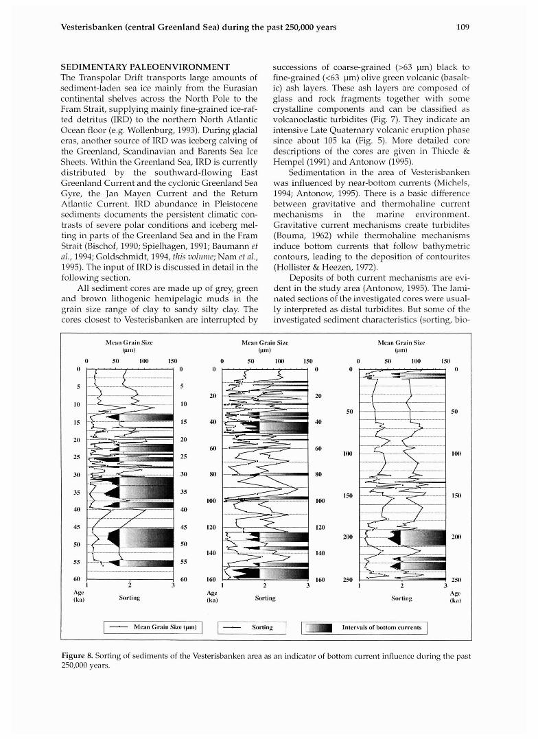
Figure 8. Sorting of sediments of the Vesterisbanken area as an indicator of bottom current influence during the past 250,000 years.
Meall Grain Sixc Mean Grain Sizc Mean Grail1 Size (~111) C m ) @111)
O 50 IM) 150 0 50 100 150 0 50 IUO I50 O 0 0 0 0
5 5 20 20
10 10 50
15 40 40 15
20 20 60 60
25 25 Ion
30 30 80 80
35 35 150 100 100
40 40
45 45 I20 120 200
50 50 140 140
55 55
60 60 160 160 250 I 2 3 I 2 3 I 2 3
Age Agc Sorti~ig Sorting Sorting AB
0ka) (ka) (k;~)
- Mean Grain Sizc (pm) - Sorting 1 Intervals of hotto111 currents I
Antonow, Goldschmidt and Erlenkeuser
turbation, thickness, normal and inverse grading, lamination) are typical for contour currents (Bouma & Hollister, 1973; Hesse & Chough, 1980; Chough & Hesse, 1985).
Most episodic current events (turbidites) occur during cooler phases (Stage boundary 8/7, Events 6.4,6.2,4.2 and 2.2) or they occur during meltwater pulses during the entire Stage 3 (Figs. 5 and 8). There are intervals where the sediments are very well sorted (sorting values <2; see Friedman and Sanders, 1978). These well-sorted layers generally correlate with smaller grain sizes of the silt fraction (>lo ~un , Fig. 8). During warmer times, thermoha- line circulation is stable, resulting in an intense cur- rent influence by contour currents (Event 5.5, Figs. 5, 8).
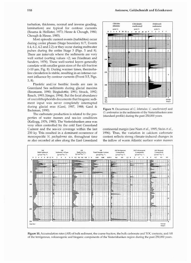
Planktic and/or benthic fossils are rare in Greenland Sea sediments during glacial maxima (Baumann, 1990; Birgisdottir, 1991; Struck, 1992; Bauch, 1993; Jiinger, 1994). But the local abundance of coccolithophorids documents that biogenic sedi- ment input was never completely interrupted during glacial eras (Gard, 1987, 1988; Gard & Backman, 1990). Figure 9. Occurrence of C. lobntulz~s, C. zvrrellerstorfi and
0. umbonatils in the sediments of the Vesterisbanken area The carbonate production is related to the pro- (standard profile) during the past 250,000 years.
perties of water masses and sea-ice conditions
Cibicides Cibicidoides Onilnnniis l n ~ f ~ ~ i ~ ~ s wueilers~nrji ~~rnbormrrrs
~~mln - * l ~p"ln%l 1zrrln.l 1
0 2 4 6 8 1 0 I 2 0 5 1 0 1 5 m ~ ( O 1 2 . 7 4 5
A a I\"I#,IW
( l u l l s1itgw
(Kellogg, 1976,1980). The Vesterisbanken area was very often controlled by the cold East Greenland Current and the sea-ice coverage witlun the last continental margin (see Nam e t al., 1995; Stein ct al., 250 ky. This resulted in a dominant occurrence of 1996). Thus, the variation in calcium carbonate monospecific N. pach!jderma sin. throughout time content reflects strong climate-induced changes in as also recorded at sites along the East Greenland the inflow of warm Atlantic surface water masses
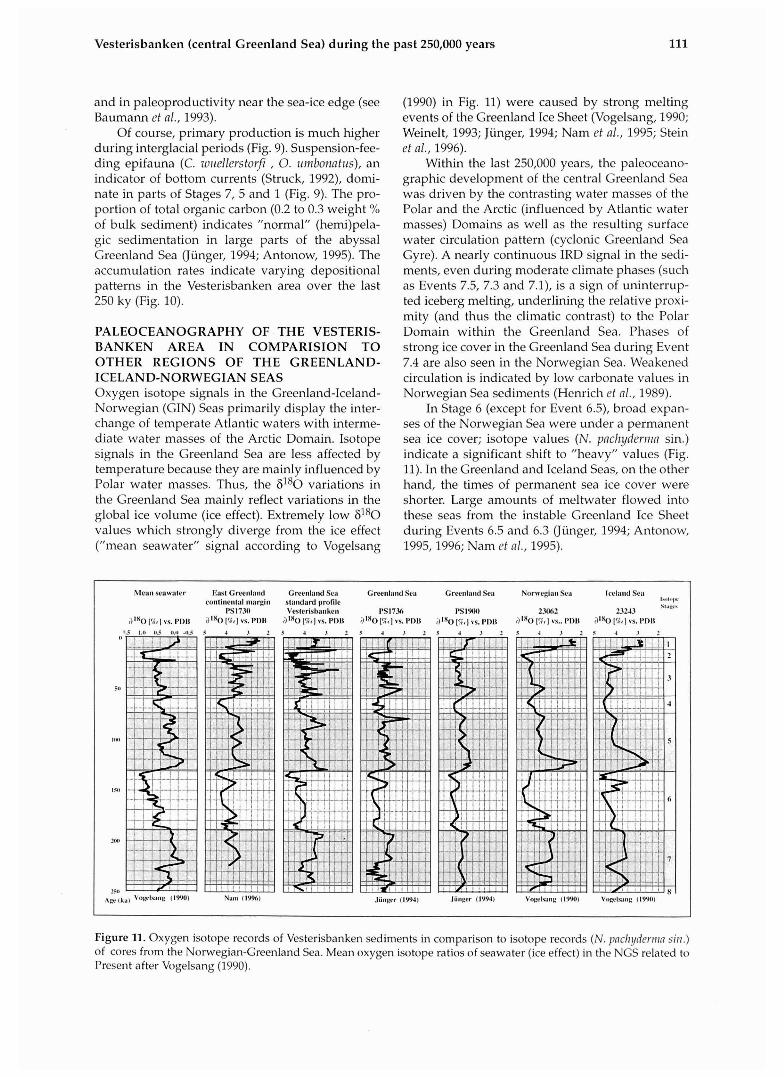
AN AH AN ,\ R AH ' l ' r r r i~e#~ou~ AH V~~lc;ln~vgcnlc A l l l i l ~ ~ g ~ ~ ~ l c IlaIk Sallrm~nl Scdinwnl> 63 pnl Ilulk-GIGO 'l'otal O r ~ ~ n i e Carlnn Carn~~"mtm#\ C~mqx>ttv~~l\ C~nt l~nne~~ lx
lg*cn~~.li:.l I ~g.s,wl.k? .I I ~g*at+ky.l I.1 1g*cnr2-~?.8 1 ~g*nn.l.ky.It IE *C~ I .~ .~Y .~ I 1x*cmw2 -kv-ll
II 2 4 L X 1 0 1 2 0 2 4 6 X (I 0 2 OAO.6 0.U I 0 0.113 0.06 0.090 0.4 0 s 12 0 2 4 6 8 0 11.3 ILL ID!)
50
I M
150
250
hgeIL;~) l ~ ~ t ~ q w s1;,gw
Figure 10. Accum~ilation rates (AR) of bulk sediment, the coarse fraction, the bulk carbonate and TOC contents, and AR of the terrigenous, volcanogenic and biogenic components of the Vesterisbanken region during the past 250,000 years.
Vesterisbanken (central Greenland Sea) during the past 250,000 years
and in paleoproductivity near the sea-ice edge (see Baumann et al., 1993).
Of course, primary production is much higher during interglacial periods (Fig. 9). Suspension-fee- ding epifauna (C, wriellerstor/i , 0. umbonatus), an indicator of bottom currents (Struck, 1992), domi- nate in parts of Stages 7, 5 and 1 (Fig. 9). The pro- portion of total organic carbon (0.2 to 0.3 weight % of bulk sediment) indicates "normal" (hemi)pela- gic sedimentation in large parts of the abyssal Greenland Sea (Junger, 1994; Antonow, 1995). The accumulation rates indicate varying depositional patterns in the Vesterisbanken area over the last 250 ky (Fig. 10).
PALEOCEANOGRAPHY OF THE VESTERIS- BANKEN AREA IN COMPARISION TO OTHER REGIONS OF THE GREENLAND- ICELAND-NORWEGIAN SEAS Oxygen isotope signals in the Greenland-Iceland- Norwegian (GIN) Seas primarily display the inter- change of temperate Atlantic waters with interme- diate water masses of the Arctic Domain. Isotope signals in the Greenland Sea are less affected by temperature because they are mainly influenced by Polar water masses. Thus, the 6180 variations in the Greenland Sea mainly reflect variations in the global ice volume (ice effect). Extremely low 6180 values which strongly diverge from the ice effect ("mean seawater" signal according to Vogelsang
(1990) in Fig. 11) were caused by strong melting events of the Greenland Ice Sheet (Vogelsang, 1990; Weinelt, 1993; Junger, 1994; Nam et al., 1995; Stein et al., 1996).
Within the last 250,000 years, the paleoceano- graphic development of the central Greenland Sea was driven by the contrasting water masses of the Polar and the Arctic (influenced by Atlantic water masses) Domains as well as the resulting surface water circulation pattern (cyclonic Greenland Sea Gyre). A nearly continuous IRD signal in the sedi- ments, even during moderate climate phases (such as Events 7.5, 7.3 and 7.1), is a sign of uninterrup- ted iceberg melting, underlining the relative proxi- mity (and thus the climatic contrast) to the Polar Domain within the Greenland Sea. Phases of strong ice cover in the Greenland Sea during Event 7.4 are also seen in the Norwegian Sea. Weakened circulation is indicated by low carbonate values in Norwegian Sea sediments (Henrich et a/., 1989).
In Stage 6 (except for Event 6.5), broad expan- ses of the Norwegian Sea were under a permanent sea ice cover; isotope values (N. pnch?/derrnn sin.) indicate a significant shift to "heavy" values (Fig. 11). In the Greenland and Iceland Seas, on the other hand, the times of permanent sea ice cover were shorter. Large amounts of meltwater flowed into these seas from the instable Greenland Ice Sheet during Events 6.5 and 6.3 (Jiinger, 1994; Antonow, 1995,1996; Nam et al., 1995).
h l e n ~ ~ scnwalcr Earl Cree~~land Crcenln~ld Scn Creenlnnd Scil Crce~~l~ntl Sen Nor\rcgin~~ .%I lccla~~d SC:I conlincnlnl nlargin slnndard prnlile l",,,*p
PSI73l Vcslcrishn~iliet~ PS 1736 PSI%Wl Z 3 M Z L1U3 s,,,p.
atno [%,I ,,s. pnll alXolv,l VS. PDU i)lxo [%,I v ~ . PI^ also [%,I VS. PDU ;)lXo [%,I Vs. I ~ D I I alXo [%,I VS.. PDIS alXo [%,I VS. IIDIS 8.5 1.11116 #).41.415 1 I .I 2 6 4 J 2 5 I J 2 5 4 3 2 5 I J 2 5 1 .I 2
t,
511
It*)
131
IN1
29) (k;,, \'t%<.l%:,nx II'J'M)
Figure 11. Oxygen isotope records of Vesterisbanken sediments in comparison to isotope records (N. pnclryderrrin sirr.) of cores from the Norwegian-Greenland Sea. Mean oxygen isotope ratios of seawater (ice effect) in the NGS related to Present after Vogelsang (1990).
112 Antonow, Goldschmidt and Erlenkeuser
At the start of Termination 11, isotopically "light" meltwater again covered large areas of the GIN Seas (Fig. 11). The meltwater pulses were tre- mendous throughout these seas, leading to inter- ruptions in convection (see Haake & Pflaumann, 1989). Isotopically "light" Atlantic Surface Water masses can be easily traced, especially in the Norwegian and Iceland Seas (Fig. 11). The inten- sive thermohaline surface water circulation in- creased the influence of temperate water masses in the Vesterisbanken area. The cores in the centre of the Greenland Sea Basin indicate very high rates of deep water renewal starting at Event 5.51; this is demonstrated by highly benthic 6I3c conditions (0. rrmbo~~atlrs; Jiinger, 1994). Based on bentluc oxy- gen isotope data, Birgisdottir (1991) and Bauch (1993) postulated a very low influence of Polar water masses in the Iceland Sea. As Stage 5 con- tinued, the Norwegian Sea water masses showed relatively stable Atlantic Water influence, while in the central Greenland Sea alternating influences of water masses separated by the Arctic Front have been reported (Henrich et nl., 1989, 1992; Junger, 1994; Antonow, 1995, 1996).
In Stage 4, high rates of terrigenous IRD input are seen not only in the Vesterisbanken area, but also in the Norwegian Sea (Henrich et al., 1989), the Iceland Sea (Birgisdottir, 1991), the Greenland Sea (Hamich, 1991; Jiinger, 1994), and the Fram Strait (Spielhagen, 1991; Hebbeln, 1992). This fact is in contrast to the situation near the east Greenland continental margin, where an IRD signal is distinctly reduced (Nam et al., 1995; Stein et al., 1996). The significant isotopic shift (by up to 0.25%0
F180, see Fig. 11) during Event 4.2 indicates contra- sting oceanographic conditions within the central Greenland Sea (cores PSI900 and PS1736) and the Vesterisbanken area (Junger, 1994; Antonow, 1995, 1996).
A reduced range of species (N. padz!/der~~la is the only planktic species present) indicates severe paleo-ecologic conditions, as was the case through- out the GIN Seas during Stage 3 (see Kellogg, 1976, 1977, 1980; Bauch, 1993). The benthic fauna was also reduced: only 0 . lrinborzatrrs was present in sig- nificant amounts at the beginning of Stage 3. The isotope signals (Fig. 11) give evidence of early mel- ting events that have been triggered by the weak inflow of warmer Atlantic water masses, as is recorded at the East Greenland continental margin (PS1730) as well as in the central Greenland Sea (cores PS1736, PS1900). Thus Stage 3, with its com- mon, strong meltwater pulses and the constant alternation of ice-free surface waters and nearly complete ice cover, is an extremely variable, clima- tically sensitive period in the Greenland Sea (Fig. 11). During Stages 2 and 3 the sedimentation rates are much higher than those within other time inter- vals (Table 4). Winnowing and redeposition of fine sediment particles along the Greenland continental shelf, the slope and the adjacent Greenland basin by the EGC are likely to have occured (see also Mienert et a]., 1992; Nam et al., 1995).
A drastic increase in the carbonate content (spread of biogenic production) at the beginning of Termination I can be seen in sediments througho~~t the GIN Seas (see Blaume, 1992; Henrich ct al., 1989; Koq Karpuz & Jansen, 1992). As in earlier
Figure 12. Ice-rafted debris (>I25 pm) o f the Vesterisbanken sediments in comparison with the extent of the Barents Sea and Scandinavian ice sheets.
Vesterisbanken (central Greenland Sea) during the past 250,000 years
episodes, the melting of the continental ice sheets resulted in meltwater input. As in the Norwegian Sea (Blaume, 1992), turbidity currents occurred at great depths in the Greenland Sea (Mienert et al., 1993; Antonow, 1995).
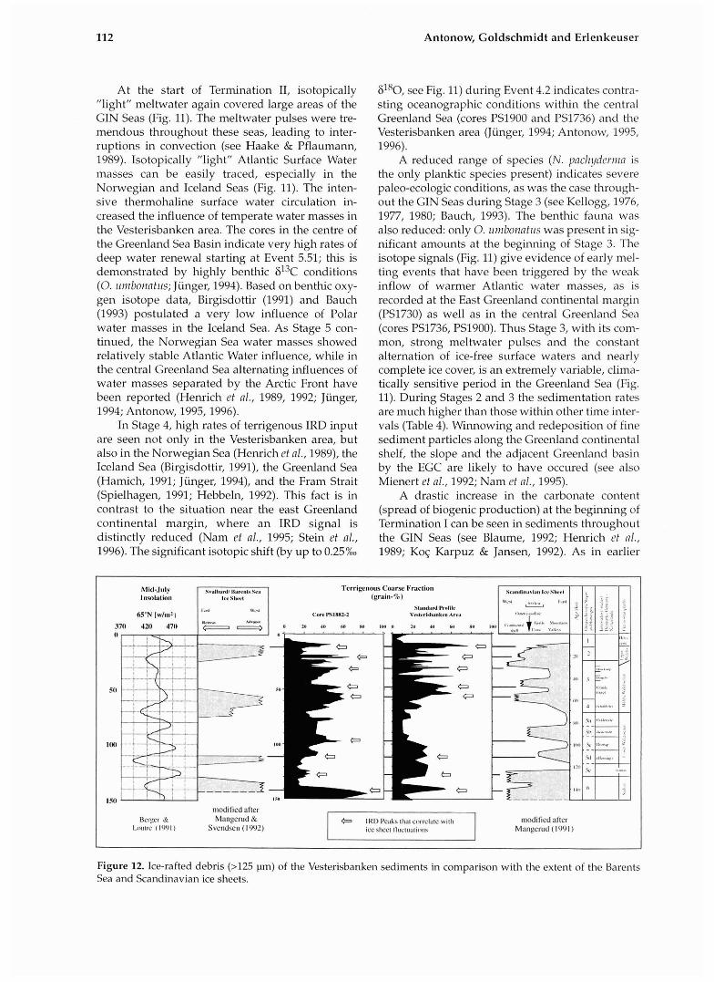
MARINE VESTERISBANKEN RECORDS VS. TERRESTRIAL DATA: LAND-SEA CORRELA- TION IRD records vs. oscillations of glaciers neighbo- ring the northern North Atlantic Variations in the input of terrigenous material (20- 80 grain % IRD) can be seen in the Vesterisbanken sediment cores (Fig. 12). The terrigenous particles (>I25 pm) consist mainly of monocrystalline (quartz, feldspar) and polycrystalline rock frag- ments (slate, volcanic fragments, sandstones and siltstones). Although their source areas cannot be precisely determined, it is likely that most of the rock fragments (excepting the volcanic fragments) come from Norway, Svalbard and the Barents Sea area (see Bischof, 1990; Baumann et al., 1994; Goldscl~midt, 1994, this vol~rnle). IRD originating in Greenland is generally carried southwards by the East Greenland Current (EGC) and would thus probably not be found in the study area.
Spielhagen (1991) interpreted the flow and ice cover of the EGC as stable over (at least) the last 200,000 years.
Mangerud & Svendsen (1992) used a continen- tal litho- and biostratigraphy for the last 140,000 years to reconstruct glacier oscillations in the Svalbard/Barents Sea area. Baumann et al. (1994) compared these terrestrial data with the marine IRD signal of cores from the northern Greenland Sea and found that the terrestrial data agreed well with the marine records.
The IRD signals of the Vesterisbanken sedi- ments correlate well with both the data from Mangerud & Svendsen (1992) and with the recon- struction of fluctuations of the Scandinavian Ice Sheet of Mangerud (1991). The recent surface cir- culation pattern (Norwegian Current - Atlantic Return Current - EGC/Jan Mayen Current; Fig. 1) and the results of Spielhagen (1991) regarding the longevity of the EGC show that icebergs from the Norway/Svalbard area could have reached the central Greenland Sea in the last 250 ky. Nearly every time that the corztinerztal glaciers had reached beyond the continental shelf or were retreating from it, the irlnrine IRD record shows a peak (Fig. 12). Glaciers become instable when passing the
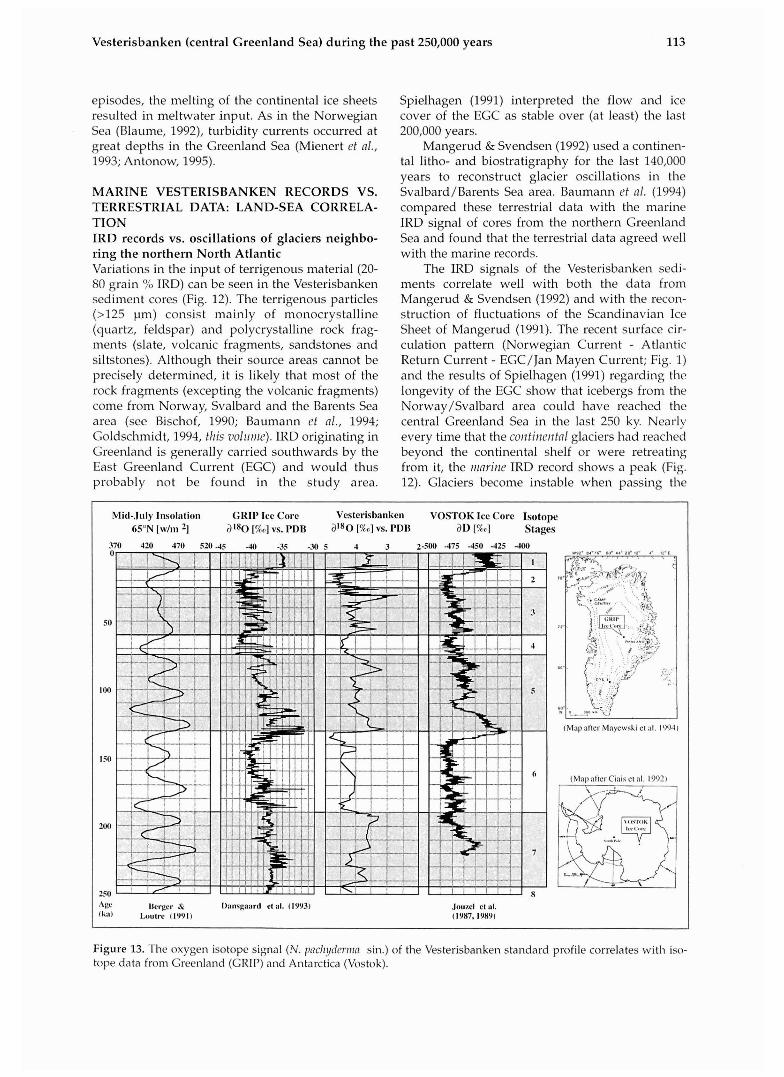
Mid-.Iuly Insolation GRIP Ice Core Vcsterisbanke~~ V O S T O K Ice Corc Isotope 6S0N [\v/m 3 ' 8 0 [%o] VS. PDB alXO [%a] VS. PDI3 aD [%,o] Stages
370 420 470 520 4 5 -40 -35 -30 5 4 3 2-500 -475 -450 -425 400
(Mnpnfter Mnyewski el nl. I')OJ)
A gc Ucrgcr IY: I)a~isgaartl ct al. (1993) Jo~lzcl e l al. (Im) Lnulrc II1)')I) (IYX7,19891
Figure 13. The oxygen isotope signal (N . p n c l ~ ~ c r n m sin.) o f the Vesterisbanken standard profile correlates with iso- tope data from Greenland (GRIP) and Antarctica (Vostok).
Antonow, Goldschmidt and Erlenkeuser
continental shelf, resulting in iceberg calving (see Heinrich, 1988), while glacier retreats with intense iceberg calving indicate the beginning of warming phases (see B a u m a ~ et al., 1994; Goldschmidt, 1995; Nam et al., 1995). In both cases, melting ice- bergs releasing their sediment load indicate tl-te extension of glaciers beyond the continental shelf or tl-te retreat therefrom. Although the marine sig- nal varies from core to core, it is much more detailed and continous than the terrestrial signal.
However, IRD peaks in the study area do not have to indicate the existence of glaciers (Fig. 12). At certain times during Stages 5 and 3, the IRD sig- nal must have been modified by iceberg-covered water masses of the Jan Mayen Current branching off of the EGC. Locnl melting processes in the Vesterisbanken area may also play a role.
Isotope signals (N. pachyderma) vs. ice core data Data from the Greenland Ice Core Project (GRIP) document higl-t-resolution series of temperature oscillations during the last 250,000 years (Dansgaard et nl., 1993). These so-called "Dansgaard-Oeschger cycles" are caused by cl~an- ges in the 6180 isotope ratios of the air masses above the Greenland ice sheet and correlate well wit11 paleosurface water mass temperatures deter- mined with N. pnchyderiiza of North Atlantic sedi- ment cores for the last 90,000 years (Bond et al., 1993).
In general, the oxygen isotope data of the n-ta- rine Vesterisbanken area are in good agreement with the terrestrial Greenland Ice Sheet isotopic record (Fig. 13). Extreme meltwater input reflects climatic fluctuations near Vesterisbanken during isotope Stages 6 and 3. Deviations of the climate records of the different sites are caused by regional influences within the Norwegian-Greenland Sea.
Orbital forcing of the documented Greenlai-td Sea climate records is evident. "Light" isotope values result from more intensive insolation (Berger & Loutre, 1991) and coincide wit11 the warm substages 7.5, 7.3, 7.1, 5.5, 5.1 and Termination I (Fig. 13).
The isotope record of tl-te Vesterisbanken sedi- ments corresponds better with the data froin the Vostok ice core (Antarctica) than those derived from the Greenland ice core (GRIP), wl-tich is com- plicated by internal deformation of the ice older than ca. 100 ka towards the glacier's basal zone. The sediments around Vesterisbanken thus arcluve the globnl climatic record. The thermohaline circu- lation is strongly col-tnected to climatic variations, which affects a rapid translation of the Polar Front and is well documented by the changing influence 01 different water masses. The sites around Vesterisbanken are situated in the narrow "battle- field" of oceanic frontiers and this makes it pos- sible to correlate their isotope signals and the l-tigl-t- resolution ice core records to oceanic circ~~lation
0-lsotnlr Slreligr;~yli! Scasolrul Mcllwstcr Icc-lal'liltg Uuttn~ti Currcnt SCBOIB~IB~I~ Sea Levcl CIt;~s~ge 3180 [?,I bs. I'l)U O p n \\'alcr 1)ischsrp lnle~~sity Vnlcso~ic ,\cti~,iI> ,1111
S,.,LC.
t i ia~t~ly bascd on bascd on ha%d on based on b a w l ott c'I1:~ppcll & cnrbonarr conrrnr isotope rrcol.ds IRD-signal current indicators reph~.a OL‘CLI~~CIICE: Shi~ckletoti ( 108hl
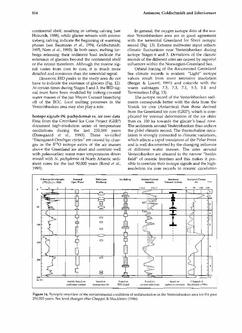
Figure 14. Synoptic overview of the environmental conditions of sedimentation in the Vesterisbanken area tor the past 250,000 years. Sea level changes after Chappel & Shackleton (1986).
Vesterisbanken (central Greenland Sea) during the past 250,000 years 115
(see Zahn, 1994).
CONCLUSIONS A general synthesis of the important sedimentation events and paleoceanographic determinations for the time since the end of Stage 8 is shown in Figure 14. The studies carried out on Vesterisbanken sedi- ments indicate the following: 1 The paleo-envirom~ent within the studied time interval is very variable. The sediments result from varying formation and transport processes: sedi- mentation patterns dominated by terrigenous, bio- genic and volcanogenic input alternate. Changes in the lithofacies usually occur due to climatic varia- tions; these changes are related to transitions bet- ween the oxygen isotope stages and substages. Large-scale meltwater events occurred during Terminations (111, I1 and I) and during fluctuations during the entire Stages 3 and 2. 2. Hen~ipelagic sedimentation in the Vesteris- banken area was mainly current-controlled and indicates variable ice cover. In addition to biogeni- cally dominated sedimentation patterns that were relatively constant over time, there were also time intervals in which episodic current-induced near- bottom particle transport was important. Particle deposition by suspension c~~rrents dominate over contour current processes. 3. Turbiditic volcanic sediments indicate episodes of volcanic activity at different times. Ca. 105 ka, intense volcai~ic activity occurred at Vesteris- banken. Eruptions occurred mainly when the sea level was high (Fig. 14). No volcanic activity took place since the beginning of the Holocene. It nppenrs that the Vesterisbanken volcanic episodes were coupled to warming phases (crustal rebound due to ice sheets disappearing from neighboring land masses?). 4. Despite the modification of the depositional environment caused by the existence of Vesteris- banken, general paleoclimatic information can be gleaned from the sediments. The sedimentological and paleoceanographical data from tlus part of the central Greenland Sea can be integrated into the pattern of Late Quaternary sedimentation of the northern North Atlantic and present a picture of globally controlled climate changes. 5. The correlation between terrestrial glacier oscil- lations and marine IRD signals is very good. The climate record in the marine deposits using oxygen isotope data (N. pnclzyderrizn sin.) has a very good resolution in the Vesterisbanken area and agrees well with data from high-resolution ice cores from polar landmasses.
ACKNOWLEDGEMENTS Many colleages and friends from the Geomar
Research Center for Marine Geosciences and at the Special Research Project SFB 313 at Kiel University encouraged and helped us: Britta Jiing-er, Heidemarie Kassens, Henning Bauch, Helmut Beese, Frank Blaume, Andre Freiwald, Christian Hass, Jens Holemann, Riidiger Henrich, Harald Hommers, Klas Lackschewitz, Klaus Michels, Jiirgen Mienert, Stefan Nees, Jan Rumohr, Robert Spielhagen, Jorn Thiede, Thomas Wagner, Hans- Joachim Wallrabe-Adanls, and Rainer Zahn. This paper benefitted from the review of Riidiger Stein and the critical comments of Christiai~ Hass. Thanks to Bernhard Fiirst for technical assistance in the preparation of the manuscript. Financial support was given by the German Research Foundation sponsoring the Special Research Project SFB 313. This is SFB 313 publication num- ber 304.
REFERENCES Aagaard, K., Swift, J. & Carmack, E. 1985. Thermohaline
c~rculation in the Arctic Mediterranean Seas. \or11 1101 o f Geopllysical Resenrcll, 90,4833-4846.
Antonow, M. 1995. Sedimentationsmuster Lun den Vesteris Seamount (zentrale Griinlandsee) in den letz- ten 250.000 Jahren. GEOMAR Report, 44, 1-127.
Antonow, M. 1996. S ;it uartsre Sedimentation im Gebiet roil Vesteris%ar%m: Paldozearrugri~phi,rhr und klimatische Ableitungen fiir die zentrale Cronlandsee. Zcr~tralblatt fiil- Geologic I L I I ~
l'aliiontolo~ie, Teil 1 (1 /2), 7-19. Atterberg, A. 1912. Die mechanische Bodenanalyse und
die Klassifikation der Biiden Mittelschwedens. O~terl~ntiol~ole M i t t e i l ~ ~ n ~ t v ~ fiir Bodenkunde, 1-314.
Bard, E. 1988. Correction of accelerator mass spectrome- try 14c ages measured in planktonic foraminifera: Paleoceanographic implications. l J ~ n l ~ o c ~ ~ ~ r ~ o ~ r a ~ ~ l ~ y , 3, 635-645.
Bard, E., Hamelin, B., Fairbanks, R.C. & Zindler, A. lC)C)O. Calibration of the 14c timescale over the past 30,001) years using mass spectrometric U-Th ages from Barbados corals. N a t ~ ~ w , 345, 241-213.
Bauch, H. 1993. Planktische Foraminiteren in1 Europaischen Nordmeer - ihre Bede~~tung fiir die
alao-ozeanographisclie Interpretation wahrend der Ltzten 600.000 JaIire Bericlrt~ .,IS dcra So , id~~: f i l l~ sclll~l?gsbt~reicl 313, 40, 1-108.
Baumann, K.-H. 1990. Veranderlichkeiten dcr Coccolithenflora des Euro aischen Nordmeeres im ,~ingquartdr. Berichh~ ails $ni ~ ~ ~ ~ ~ ~ ~ I E C ~ I I I I ~ ~ S ~ I ~ I ~ L ~ ~ C ~ I 373,22,1-146.
Baumann, K.-H., Lackschewitz, K.S., Spielha Ten, R.F. & Henrich, R. 1993. Reflection of continentnkice sheets in late Quaternary sediments from the Nordic Seas. Zcl~tralblatt fiir ~ i o l o g i e ~ l n d Paliiontolo~yic~, Teil 1, 718, 897-9 12.
Baumann, K.-H., Lackschewitz, K.S., Mangerud, I . , Spielhagen, R.F., Wolf-Welling, T.C.W., Henrich, R . & Kassens, H. 1994. Reflection o f Scandinavian ice sheet fluctuations in Norwegian Sea sediments during the last 150,000 years. Q ~ l n t e r ~ ~ n n j Research, 43, 185-1 97.
Be, A.W. 1977. An ecolo ical zoographic and taxonomic review of recent pla&tonk foraminifera. in: Ramsay, A.T.S. (ed.), Ocerlrlir 11licropalec7ntology, 1-100, Academic Press, London.
116 Antonow, G o l d s c h m i d t a n d Er lenkeuser
Beryer, A & Loutre, M.F. 1991. Insolation values for the c mate of the last 10 million years. @llntcri7nr!y Science Rcz?iezc), 10, 297-317.
Birgisdottir, L. 1991. Die palao-ozeanographische Ent- wicklung der Islandsee in den letzten 550.000 Iahren. Brricl~te 011s ~ P I I I So~~derfor~~I~~~i~gsbereicI~ 313, 34, 1-112.
Bischof, J. 1991. Dropstones im Europiiischen Nordmeer- Indikatoren fur Meeresstromunge~~ in den letzten 300.000 Iahren. Bericl~te 011s denr Sondl~~forsc l~r~ngs- b~:miclr 313, 30, 1-127.
Blaume, F. 1992. Hochakkumulationsgebiete am norwe- ~ i s c l ~ e n Kontinentalhang: Sedimentologische Ab- kilder Tc)pugraphie-gefulirtsl Strbmungsmuster. Bcricl~tc 011s rltnr Sor~tie~:forsclii~i~gsI~er~~iclr 333, 36, 1-150.
Bond, G.C., Broecker, W., johnsen, S. & McManus, J. 1993. Correlations between climate records from North Atlantic sediments and Greenland ice. Nntirrc, 365 (6442), 143-147.
B o ~ ~ m a , A.H. 1962. Serliii~entolo,y!y oJsoir~r,fl!ysclr deposits. A ~rnplric n ~prancli to fncies in l~r /~re tn t ion , 168 pp, Elsevier, ~ m s t e r d a m .
Bouma, A.H. & Hollister, C.D. 1973. Deep ocean basin sedimentation. In: Middleton, G.V. & Bounia, A.H. (eds.), Zlrbidites nnd deep i ~ l n t t ~ . seiiir~~rr7tntioi7. SEPM short course, Anaheim, 79-118.
Bourke, R.H., Newton, J.L., Paquette, R.G. & Tuimicliffe, M.D. 1987. Circulation and water masses of the East Greenland shelf. ]o1~ri7nl of Gec7pl1ysicnl Rescnrcll., 92, 6729-6740.
Chappel, J. & Shackleton, N.I. 1986. Oxygen isotopes and sea level. Nntr~rr, 324, 137-140.
Chough, S.K. & Hesse, R. 1985. Contourites from Eirik ridge, south of Greenland. Sedinzentnry Geology, 41, 185-199.
Ciais, P., Petit, I.R., Jouzel, J., Lorius, C., Barkov, N.I., Lipenkov, V. & Nikolajev, V. 1992. Evidence for a n early Holocene climatic optimum in the Antarctic deep ice-core record. Clinrnte Dyrmriiics, 6, 169-177.
Craig, H. 1957. Isotopic standards for carbon and oxygen and correction factors for mass-spectrometric anal sis of carbon dioxide. Gmclrir~iicn rind Cosrr~ocl~irnicn L t n , 12, 1-133.
Craig, H. & Gordon, L.I. 1965. Deuterium and ox gen-18 variations in the ocean and the marine atmospkere. In: Tongiorgi, E. (ed.), Stnble isotopes in ocranogrnpllic strr- dics nrld paleoterrzpernt~~res. Third SPOLETO conference on Nuclear Geology, Consilio Nazionale della Ricerche, Laboratorio di Geologia Nucleare, Pisa, 9- 130.
Dansgaard, W., Johnsen, S.J., Clausen, H.B., Dahl-Jensen, D., Gundestrup, N.S., Hammer, C.U., Hvidber , C.S., Steffensen, J.1). Sveinbj6rnsdottir. A.E., Jouze?, J. & Bond, C. 1993. Evidence for general instability of past climate from a 250-kyr ice-core record. Nntrlr?, 364, 218-220.
Dickson, R.R., Meincke, J., Malmberg, S.A. & Lee, A.J. 1988. The ,,great salinity anomaly" in the northern North Atlantic 1968-1982. Prt~~yress in Oceni~ogrnpl~y, 20, 103-151.
Du lessy, J C. 1978. lsotope studies. 117: Gribbin, J. (ed.), &irii"tic 6 1 1 1 w , 46-67, Cambridge University Press, Cambridge.
Ehrmam, W.K. & Thiede, J. 1985. Historv of Mesozoic and Cenozoic sediment fluxes to the ~ o r t l ~ Atlantic Ocean. Corztribrrtic~ns to Scdirrrrntology, 15, 1-109.
Friedman, G.M. & Sanders, J.E. 1978. Princi les of sedi- mmtology, 211 pp, John Wiley & Suns, d w York.
Ganssen, G. 7983. Dokumentation von kiistennahem Auftrieb anhand stabiler I s o t o ~ e in rezenten
Gard, G. 1987. Late Quaternary calcareous naru~ofossil biostratigraphy and sedimentation patterns: Frnni Strait, Arctica. Pnleocennogrnpl~~y, 5, 761-787.
Gard, G. 1988. Late Quaternary calcareous nannofossil biocl~ronology and paleo-oceanography of Arctic and Subarctic Seas. A4cdd. Stockholrirs LTI~Iv. Grol. Irrst., 275, 1-45.
Gard, C. & Backman, J. 1990. Synthesis of Arctic and Sub-Arctic coccolith biochronology and history of North Atlantic drift water influx during the last 500,000 years. 117: Bleil, U. & Tl~iede, J . (eds.); Gcoloyictil Ilistory of tlre Pol~7r O C L ~ I ~ S : Arctic vrrsrls Ailttlrctic, 417- 436, Kluwer Academic Publishers, Dordrecht.
Goldschmidt, P.M. 1994. The ice-rafting history in tlie Norwe~rian-Greenland Sea for the last two glacialfinter ~ l a c ~ a l cycles. Berrcl~tc, nrrs ticrir Sorldrlfor- s c l ~ ~ i n ~ s l i ~ ~ r ~ i c ~ 113, 50, 1-103.
Goldschmidt, P.M. 1995. Accum~~latic>n rates of coarse- rained terrigenous sediment in the Norwegian- ereenland Sea: Signals of continental glaciation. Mnrir~e Geolog!y, 128, 137-151.
Goldschmidt, P.M. tllis i~olrrrrrt. The ice-r'ifting history of coarse-grained sediments in the N o r w e ~ i a n - Greenland Sea for the last two glacial/intelekcid cycles.
Haake, F.W. & Pflaun~ann, U. 1989. Late Pleistocene tola- miniferal stratigraphy on the Voring Plateau, Norwegian Sea. Borens, 18, 343-356.
Hamicl~, A. 1991. Sedimentologische Untersuchungen eines Kernes (GIK 21906-2) der Gr(i1ilandsee. unpubl. diploma thesis, Univ. Kiel, 78 pp.
Hebbeln, D. 1992. Weiclwelian glacial history of the Svalbard area: correlating the marine and terrestrial records. Borens, 21, 295-304.
Henrich, R., Kassens, H., Vogelsang, E. & Tliiede, J. 1989. Sedimentary facies of glacial-interglacial cycles in tlie Norwegian Sea during the last 350 ka. Mnrinc GI-ology, 86, 283-319.
Henrich, R. 1992. Beckenanalyse des Europiiischen Nordmeeres: Pelagische und glaziomarine Sedime~it- einfliisse im Zeitraum 2.6 Ma bis Rezent. ~ ~ n p u b l . habil. thesis, Uruv. Kiel.
Hesse, R. & Chough, S.K. 1980. The Northwest Atlantic Mid-Ocean Channel of the Labrador Sea: 11. Deposition of parallel laminated levee-muds from the viscous sublayer of low density turbidity currents. Srdin~oltology, 27, 697-711.
FIollister, C.D. & Heezen, B.C. 1972. Geolo yic effects of ocean bottom currents. In: Gordon, A.L. h d . ) , Stridi(zs in p h ~ sicnl oceni~o~yrayli~y - A tribute to Gcor<y Wiist (712 Iris 80t1~ ~ i r t l ~ d o ~ y , 37-66, Chrdon and Breach, New York 2.
Imbrie, j., Hays, J.D., Marti~ison, D.G., Mclnt re, A. Mix, A.C., Morle J.J., Pisias, N.G., Pre i , w.L. Pr Shackleton, d, 1984. The orbital theory of Pleisk)cene climate: s i ort from a revised chro~iology ot the marine 6'98 record. In: Berger, A. et a 1 (eds.), Milankovitch and climate, Part 1, 269-305, Reidel, Dordrecht.
Johannessen, O.M. 1986. Brief overview of tlie physical oceano+raphy br: Hurdle, B.G. (ed.), TIr(: Ni7rtiic Sai7s. 103-12 , Sprrnger, New York.
Johnson, G.L. & Campsie, J. 1976. Morphology and struc- ture of the western J a n Mayen Fracture Zone. Norso. Polnrii~st. Arb., 1974, 69-81.
Jouzel, J., Lorius, C., Petit, J.R., Genthon, C., Barkov, N.I., Kotlyakov, V.M. & Petrov, V.N. 1987. Vostok ice core: a continuous isotope temperature record over the last climatic cycle (160,000 years). Nntlrrc,, 329, 403-409.
Foraminiferen vor ~ o r d w e s t - k f r i k a . Mcteo1.- Jouzel, J., Raisbeck, G., Benoist, J.P., Yiou, I:., Lorius, C.,
Vesterisbanken (central Greenland Sea) during the past 250,000 years
Raynaud, D., Petit, J.R., Barkov, N.I., Korotkevitch, Y.S. & Kotlyakov, V.M. 1989. The Antarctic climate over the late Glacial period. Qlmtertlnry Resernrch, 31, 135-150.
Junzer, B 1994. Tiefenwasseremeuerung in der ronlandsee wahrend der letzten 340.000 Jahre. GEO-
M A R Report, 35,l-103. Kellog , T.B. 1976. Late Quatemary climatic changes:
evignce from deep-sea cores of Norwegian and Greenland Seas. In: Cline, R.M. & Hays, J.D. (eds.), Investigation of Late Quaternar aleoceano raphy and paleoclimatology. ~ e o l o g i c a ~ L i e t y of jinericn Meinoir, 145, 77-110.
Kellogg, T.B. 1977. Paleoclimatolog and paleo-oceano- y p h y of the Norwegian and Ereenland Seas: The ast 450,000 years. Marine Micropnleoi~tol~~~y, 2, 235-
249. Kellogg, T.B. 1980. Paleoclimatology and paleoceanogra-
phy of the Norwegian and Greenland seas: glacial- interglacial contrasts. Borens, 9,115-137.
Koc Karpuz, N. & Jansen, E. 1992. A high-resolution dia- tom record of the last deglaciation from the SE Norwegian Sea: documentation of rapid climatic changes. Poleocc.nr~ogmphy, 7,499-520.
Koltermann, K.P. 1987. Die Tiefenzirkulation der Griinland-See als Folge des thermohalinen Systems des Europaischen Nordmeeres. unpubl. PhD thesis, Univ. Hamburg, 287 pp.
Krumbein, W.C. 1936. Application of logarithmic moments to size frequency distributions of sediments. ]oilrnnl of Sedinlentnry Petrology, 6,35-47.
Mangerud, 1.1991. The last ice age in Scandinavia. Strine, 34,15-30.
Mangen~d, J. & Svendsen, JI. 1992. The last interglacial- lacial period on Spitsbergen, Svalbard. Q~mternnry
tCieIfce R F D ~ ~ ' Z U S , 11, 633-664. Martinson, D.G., Pisias, N.G., Hays, J.D., Imbrie, J.,
Moore, T.C. & Shackleton, N.J. 1987. Age dating and the orbital theory of the Ice Ages: Development of a Idgh-resolution 0 to 300,000 years chronostratigraphy. Qrinternnry Resenrch, 27, 1-29.
Mayewski, P.A., Wumkes, M., Klinck, J., Twickler, M.S., Putscher, J.S., Ta lor, K.C., Cow, A.J., Waddington, E.D., Alley, R.B., 2 ~bb, J.E., Grootes, P.M., Meese, D.A., Ram, M., Whalen, M. & Wilson, A.T. 1994. Record Drilling Depth Struck in Greenland. EOS, 75, 113-124.
Michels, K. 1994. Striimunessortierune auartarer <,
~rdimente des ~ur0~6ischc; Kordrneeres: ' Analvse Sinkcrscl~\vindi~keitb-Vertriluncen. f l ,~rirlr/~~ nrrs
dern ~onde"rforsch~rl1gs~ereic/l 313, 55, ly127. Mienert, J., Kenyon, N.H., Thiede, J. & Hollender, F.-J.
1993. Polar continental margins: studies off East Greenland. EOS, 74, 225.
Mienert, J., Andrews, J.T. & Milliman, J.D. 1992. The East Greenland continental margin (65"N) since the last deglaciation: Changes in seafloor properties and ocean circulation. Mnriize G~ology, 106, 217-238.
Nam, S.I. 1996. Late Quaternary glacial/interglacial changes in paleoclimate and paleoceanographic circu- lation along the East Green and continental margin. unpubl. PhD thesis, Univ. Bremen.
Nam, S.T., Stein, R., Grobe, H. & Hubberten, H. 1995. Late Quaternary glacial-interglacial changes in sedi- ment composition at the East Greenland continental margin and their paleoceanographic implications. Mniire Geology, 122, 243-262.
Nowaczyk, N.R. & Antonow, M. in press. Magneto- stratigraphy of Greenland Sea Sediments I - Identification of the Mono Lake, Laschamp and Biwa I geomapetic polarity events. Geopllyslcnl Jolrrnnl
Paquette, R.G., Bourke, R.H., Newton, J.F. & Perdue, W. 1985. The East Greenland polar front in autumn. Jo~~rna l of Geoplrysicnl Resenrch, 90,4866-4882.
Rudels, B. 1990. Haline convection in the Greenland Sea. Deep Sen Research, 37,1491-1551.
Samthein, M. 1971. Oberflachensedimente im Persischen Golf und Golf von Oman TI. Quantitative Kom onentenanalyse der Crobfraktion. ,,Meteor" ~ o r s c f . - ~ r ~ e b i 1 . , C5, 1-113.
Samthein, M., Jansen, E., Amold, M., Duplessy, J.C., Erlenkeuser, H., Flat@ A , Veum, T., Vogelsang, E. & 33 . . Weinelt, M.S. 1992. 8 0 time-slice reconstruction of meltwater anomalies at Termination I in the Nortl~ Atlantic between 50 and 80°N. In: Bard, E. & Broecker, W.S. (eds.), TIie lost iieglncintion: nbsollite nrzd rndiocnrb- oiz chronologies, 183-200, Springer, Berlin.
Shackleton, N.J. & Opdyke, N.D. 1973. Oxygen isotope and paleomagnetic stratigraphy of Equatorial Pacific core V28-238: Oxygen isotope temperatures and ice volumes on a lo5 year and lo6 year scale. Ql~nterr~nry Resenrclz, 3,39-55.
Shackleton, N.J. & Opdyke, N.D. 1976. Oxygen isotope and paleomabmetic stratigraphy of Pacific core V28- 238 Late Pliocene to Latest Pleistocene. Grolo,yical Societ!/ of Anrericn Mmroir, 145, 449-464.
Spielhagen, R.F. 1991. Die Eisdrift iii der FramstraBe wahrend der letzten 200.000 Jahre. G E O M A R Rt~port, 4,l-133.
Spielhagen, R.F. & Thiede, J. 1994. Late Quatemar than- es in the Arctic ocean ice cover. Beric&e zrlr
~ o ~ n ~ r s d i r n g . 144, 101-105. Staudinger, G., Hangl, M. & Pechtl, P. 1986. Quick optical
measurement of particle distribution in a sedimentati- on apparatus. Pnrticle Chnmcteristics, 3, 158-162.
Stein, R., Grobe, H., Hubberten, H., Marienfeld, P. & Nam, S. 1993. Latest Pleistocene to Holocene changes in glaciomarine sedimentation in Scoresby Sund and along the adjacent East Greenland Continental Margin: Preliminary results. Geo-Mnrii~e Letters, 13, 9- 16.
Stein, R., Nam, S., Grobe, H. & Hubberten, H. 1996. Late Quaternary glacial history and short-term ice-rafted debris fluctuations 1 the East Greenland conti- nental margin. In: azt8rews, J.T., Austin, W.E.N., Bergsten, H. & Jennin s, A E (eds.), Late Quatemar); paleoceanography of i%e norih Atlantic margins, 135- 151, Geologicnl Society Specin1 Plrblicntion, 111, London.
Stein, R., Nam, S., Schubert, C., Vogt, C., Fiitterer, D. & Heinemeier, 1. 1994. The last deglaciation event in the eastern central Arctic Ocean. Sc~eizce, 264, 692-696.
Struck, U. 1992. Zur Palao-Okologie benthischer Foraminiferen im Europaischen Nordmeer wahrend der letzten 600.000 Jahre. Bericllte n r ~ s derir Sonderforschlrizgsl~ereic/l 313, 38, 1-89.
Syvitski, J.P.M. 1991. Principles, niphlods, nnd opplicntiorz cq' pnrticle size ni~nlysis. 368 pp, Cambridge University Press, Cambridge.
Thiede, J. & Hempel, G. (eds.) 1991. Die Expedition ARK- TIS-VII/l mit FS ,,Polarstern" 1990. Berichte ziir Polnrforsclz~~rzg, 80, 1-137.
Thiede, J., Suess, E. & Muller, P.J. 1982. Late Quatemary fluxes of major sediment components to the sea floor of the northwest African continental slope. 111: \I. Rad, U. et nl. (eds.), Geolo~'~j of the Nortlzruesf Afi.icni1 coilti- neiztnl nlnrgin, 605-631; Springer, Berlin.
Thies, A. 1991. Die Benthos-Foraminiferen im Euro- pischen Nordmeer. B~riclite nus dein Sondtv:for- sdilrngsbereidr313, 31, 1-73.
Van Andel, T.H., Heath, G.R. & Moore, T.C. 1975.
118 Antonow, Goldschmidt a n d Erlenkeuser
Cenozoic history and aleoceanography of the central Eqllatoriai Pacific. ~ c a ~ o ~ i c n l Socirty ofA~rrir icn M n n o i i , 143, 134.
Vinje, T. & Finnekasa, 0.1986. The ice transport throu ~h the Fram Strait. Norsk W l n i i n s t i t ~ i t t Skriftrr, 186, 1-3b.
Vogelsang, E. 1990. Palao-Ozeanographie des Euro- piiischen Nordmeeres an Hand stabiler Kohlenstoff- und Sa~~erstoffisotope. Bcriclitc 011s dcril Sanderfor- scl lr~;~~sbcrciclr 373, 23, 1-136.
Vogt, P.R. 1986. Geophysical and geochemical signatures and plate tectonics. In: Hurdle, B.G. (ed.), Tlze Nordic Sens, 413-662, Springer, Berlin.
Weinelt, M. 1993. Veranderungen der Oberfliichen- zirkulation im Europiiischen Nordmeer wahrend der
letzten 60.000 Jahre - Hinweise aus stabile11 Isotopen. Bciiclite nlis den1 S o ~ ~ d c i f i ~ r s c h r r ~ ~ ~ s b ~ ~ r ~ ? i c I ~ 313, 41, 1-106.
Wi~m, K., Samthein, M. & Erlenke~~sel; H. 1901. 6180 stratigra hy and chronology of Kiel sediment cores from tEe East Atlantic i<cyorLs G n ~ i q q i s ~ l i - Pnliiontolo~isclrcs Institlrt dcr ~inivcrsi t i i t K i d , 45, 99 pp.
Wollenburg, 1. 1993. Sedimenttransport durcli das arkti- sche Meereis: Die rezente lithogene und biogenc Materialfracht. Bcricl~te zrrr Polnrfirsclrrrrz,y, 127, '1-159.
Wolf, T.C.W. 1991. Palao-meaiiopri~hiscl~liin~tisclw Eritwicklung des Nbrdlichen Nor atlant~ks s e ~ t den1 spaten Neogen. G E O M A R Rcport, 5, 1-92.
Zahn, R. 1994. Core correlations. Natrrr.cl, 371, 289-290.
Related Documents