The City of Calgary Water Resources Erosion and Sediment Control Guidelines, 2017

Welcome message from author
This document is posted to help you gain knowledge. Please leave a comment to let me know what you think about it! Share it to your friends and learn new things together.
Transcript

The City of Calgary
Water Resources
Erosion and Sediment Control Guidelines, 2017

The City of Calgary | Water Resources 2017 | ISC: Unrestricted 2

Erosion and Sediment Control Guidelines, 2017 Edition 3
Objectives
Successful Erosion and Sediment Control (ESC) ultimately results from the combined efforts of all
stakeholders partnering to develop site-specific design and innovation, combined with timely
implementation, inspection, and maintenance of ESC measures.
The objectives of these guidelines are to provide an ESC framework that:
• Meets an overall goal of reducing ESC impacts to infrastructure and the environment.
• Achieves a high degree of compliance with ESC requirements
• Fosters a greater understanding of ESC issues in Calgary
• Facilitates an efficient and effective submission process
To meet these objectives, the Erosion and Sediment Control (ESC) Guidelines:
• Identify the people responsible for ensuring good ESC practices and their roles in the process
• Highlights the most common ESC regulatory requirements applicable to construction projects
or other soil-disturbing activities within Calgary
• Describe the physical processes that influence erosion and the movement of eroded
sediment that ESC designers and construction people need to know about
• Describe the planning and design of ESC measures and submissions of ESC plans to The
City of Calgary (The City)
These guidelines were prepared to help stakeholders understand, evaluate, and implement
effective ESC measures during construction.
Note: These Erosion and Sediment Control Guidelines are intended to support the planning
and design stages of projects in Calgary. For information on ESC implementation, maintenance,
and inspection requirements, refer to The City of Calgary’s Field Manual for Erosion and
Sediment Control.

The City of Calgary | Water Resources 2017 | ISC: Unrestricted 4
EROSION AND SEDIMENT CONTROL CONTACT INFORMATION
CONTACTING THE CITY OF CALGARY:
General ESC Questions: 3-1-1
Drainage Permits: Contact 3-1-1. Information on Drainage Permits is also available at
www.calgary.ca/esc
Key phrases to ensure that you are promptly connected with the ESC staff are:
• “Erosion and Sediment Control”
• “Erosion and Sediment Control Inspection”
• “Erosion and Sediment Control Approval”
• “Drainage Permit”
• “Drainage Permit Self-Assessment”
EMERGENCIES:
Immediate response required from Police, Fire and/or Emergency Medical Services: 9-1-1
RELEASE REPORTING:
Reports of releases (including sediment) must be made to:
• 3-1-1 (The City of Calgary)
• 1-800-222-6514 (Alberta Environment and Parks) 24-hour release reporting line

Erosion and Sediment Control Guidelines, 2017 Edition 5
Publication Information
LEGAL DISCLAIMER
Construction activities, including the operations, maintenance, and repair of infrastructure and
utilities, commonly disturb soil or sediments and create the potential for erosion, sedimentation,
and offsite releases of sediment and associated contaminants. The design, implementation, and
management of stormwater and erosion and sediment control practices require detailed
knowledge and practical expertise.
Guidance in this document is solely provided to assist users with basic information on
requirements, processes, and practices. While believed to be accurate, content is provided strictly
as is and without warranty of any kind.
The City of Calgary, its agents, and its consultants are not responsible for the accuracy of the
contents, and do not accept any liability for the results of any action taken on the basis of the
information provided in this document. In addition, information in this document must not be
construed as legal advice.
TITLE: Erosion and Sediment Control Guidelines
INTENT: This document provides information on control of erosion and sediment
during urban construction, and operations and maintenance activities
that disturb soil or sediments.
PREPARED FOR: The City of Calgary, Water Resources
VERSION: 2017 Edition
ADDITIONAL COPIES: To download an electronic copy: www.calgary.ca/esc
INFORMATION: Corporate Call Centre: 3-1-1 (within Calgary)
NOTE: Due to changing regulations and technology, The City of Calgary may periodically update
this manual. Please ensure you have a current version by visiting our website at:
www.calgary.ca/esc

The City of Calgary | Water Resources 2017 | ISC: Unrestricted 6
Table of Contents
Objectives ....................................................................................................................................... 3
Publication Information ................................................................................................................ 5
List of Tables .................................................................................................................................. 8
List of Figures ................................................................................................................................ 8
List of Photos ................................................................................................................................. 9
Commonly Used Acronyms ........................................................................................................ 10
1.0 Introduction ....................................................................................................................... 11
1.1 Why Control Erosion and Sediment? .............................................................................. 11
1.1.1 Source Control Philosophy ...................................................................................... 11
1.1.2 Erosion and Sediment on Construction Sites .......................................................... 12
1.1.3 Erosion and Sediment Control Design and Planning Objectives: ........................... 12
1.2 Erosion and Sediment Control Responsibilities .............................................................. 13
1.2.1 Owner....................................................................................................................... 13
1.2.2 Project Manager ....................................................................................................... 13
1.2.3 Designer ................................................................................................................... 13
1.2.4 Contractor (Implementation and Maintenance) ....................................................... 13
1.2.5 Site ESC Inspector ................................................................................................... 14
1.2.6 The City of Calgary .................................................................................................. 14
2.0 Regulatory Requirements ................................................................................................ 15
2.1 Overview ......................................................................................................................... 15
2.2 Municipal Legislation (The City of Calgary) .................................................................... 15
2.2.1 Drainage Bylaw ........................................................................................................ 15
2.2.2 Duty to Report Releases .......................................................................................... 17
2.3 Provincial and Federal Regulations ................................................................................ 18
2.3.1 Provincial Regulatory Requirements ....................................................................... 18
2.3.2 Federal Regulatory Requirements ........................................................................... 19
3.0 Erosion and Sediment Control Plans ............................................................................. 21
3.1 Overview ......................................................................................................................... 21
3.1.1 New Projects ............................................................................................................ 23
3.1.2 Amendments ............................................................................................................ 24
3.2 Erosion and Sediment Control Plan Submission Process .............................................. 25
3.2.1 Overview .................................................................................................................. 25
3.2.2 Stripping and Grading .............................................................................................. 25
3.2.3 Subdivision ............................................................................................................... 25
3.2.4 Multi-family/Industrial/Commercial/Institutional ....................................................... 26
3.2.5 City Capital Projects ................................................................................................. 26
3.2.6 Example ESC Drawings........................................................................................... 26

Erosion and Sediment Control Guidelines, 2017 Edition 7
4.0 Erosion and Sediment Control Plan Design Considerations ....................................... 27
4.1 Erosion and Sediment Control Design ............................................................................ 27
4.2 Design Considerations for Small Sites ............................................................................ 29
4.2.1 Overview .................................................................................................................. 29
4.2.2 Erosion and Sediment Control Practices for Small Sites ......................................... 29
4.3 Erosion and Sediment Control Design Requirements and Considerations for Stormwater
Low-impact Developments ......................................................................................................... 31
4.3.1 Overview .................................................................................................................. 31
4.3.2 LID Construction Planning ....................................................................................... 32
5.0 Site Assessment and Erosion Potential Evaluation ..................................................... 36
5.1 Overview ......................................................................................................................... 36
5.2 Erosion and Sediment Control Processes ...................................................................... 36
5.2.1 Detachment .............................................................................................................. 36
5.2.2 Entrainment .............................................................................................................. 37
5.2.3 Transport .................................................................................................................. 37
5.2.4 Deposition and Sedimentation ................................................................................. 38
5.3 Runoff-induced Erosion ................................................................................................... 38
5.3.1 Types of Runoff Induced Erosion ............................................................................ 39
5.4 Assessing Soil Erosion Potential .................................................................................... 41
5.4.1 Erosion and Sediment Control Design Goals: ......................................................... 41
5.4.2 Revised Universal Soil Loss Equation for Application in Canada ........................... 41
5.4.3 Annual Soil Loss (A-value) ...................................................................................... 42
5.4.4 Climate (R-value) ..................................................................................................... 42
5.4.5 Soil Erodibility Factor (K-value) ............................................................................... 42
5.4.6 Topographical Assessment (LS-value) .................................................................... 45
5.4.7 Erosion Control (C-value) ........................................................................................ 45
5.4.8 Sediment Control (P-value) ..................................................................................... 46
Appendix A: RUSLE Values Determination .............................................................................. 48
Particulate Sedimentation Times ............................................................................................... 48
Soil Types in the Calgary Area .................................................................................................. 49
Variables that Affect K-value .................................................................................................. 49
Determination of K-values .......................................................................................................... 51
LS-value Determination ............................................................................................................. 57
Definitions ............................................................................................................................... 57
Choosing a Slope Length (Uniform Slopes) ........................................................................... 57
LS-values for Thawing Ground............................................................................................... 59
LS-values for Complex Slopes ............................................................................................... 60
Erosion Control: C-value Determination .................................................................................... 65
Appendix B: Example ESC Drawings and RUSLEFAC/Pond Data ......................................... 67

The City of Calgary | Water Resources 2017 | ISC: Unrestricted 8
Appendix C: Glossary ................................................................................................................. 95
References ................................................................................................................................. 101
List of Tables
Table 5-1 Soil Erodibility Values (K) for Common Surface Textures ........................................... 44
Table A-1 Soil Particulate Settling Times (based on Alberta Transportation Appendix G Sediment
Containment System Design Rationale (March 18, 2003) ............................................................ 48
Table LS-3. Values for Topographic Factor (LS-value) for a High Ratio of Rill: Inter-rill Erosion 59
Table LS-4. Values for Topographic Factor (LS-value) for thawing soils where most of the
erosion is caused by surface flow (using m=0.5). ......................................................................... 60
Table LS-5. Slope length exponents for a range of slopes and rill/interrill erosion classes. ........ 63
Table LS-6. Soil Loss Factors for Irregular Slopes ........................................................................ 64
Table A-3 Irregular Slope Example Calculation ............................................................................ 64
Table A-4. C Values for Permanent Pasture, Range, and Idle Land (based on RUSLEFAC 1997)
....................................................................................................................................................... 65
List of Figures
Figure 3-1 Erosion and Sediment Control Drawings for Stages of Construction ......................... 22
Photo 1 Landscaping Design and Low-impact Development ........................................................ 31
Photo 2 Installing Low-impact Developments Last is the Preferred Construction Method ........... 33
Photo 3 Isolation Measures, Poly Sheeting ................................................................................... 34
Photo 4 Temporary Sod Cover ...................................................................................................... 34
Photo 5 Sheet Erosion ................................................................................................................... 39
Photo 6 Rill Erosion ....................................................................................................................... 39
Photo 7 Gully Erosion .................................................................................................................... 40
Photo 8 Channel Erosion ............................................................................................................... 40
Figure A-1 Soil Classification Systems (Handbook of Hydrology, David R. Maidment, 1992)..... 50
Figure A-2 Variables That Affect K-value Source: Agriculture and Agri-Food Canada, 2002 ..... 51
Figure A-3 Soil Structure Based on Soil Texture (RUSLEFAC) ................................................... 52

Erosion and Sediment Control Guidelines, 2017 Edition 9
Figure A-4 Soil Permeability Based on Soil Texture (RUSLEFAC) ............................................... 53
Figure A-5 Soil Structure Determination (Based on RUSLEFAC, 1997, Wall et al) ..................... 55
Figure A-6 Soil Permeability Determination (Based on RUSLEFAC, 1997, Wall et al) ............... 55
Figure A-7 Soil Erodibility Nomograph (Foster et al. 1981) .......................................................... 56
Figure A-8 Definition of Slope Length and Slope Grade .............................................................. 57
Figure A-9 Soil Loss, deposition and sediment yield from complex slope, concave-convex shape
....................................................................................................................................................... 61
Figure A-10 LS Determination for an Irregular Slope Example .................................................... 62
Figure A-11 Percent ground cover by grass or mulch .................................................................. 66
List of Photos
Photo 1 Sheet Erosion ................................................................................................................... 39
Photo 2 Rill Erosion ....................................................................................................................... 39
Photo 3 Gully Erosion .................................................................................................................... 40
Photo 4 Channel Erosion ............................................................................................................... 40
Photo 5 Landscaping Design and Low-impact Development ........................................................ 31
Photo 6 Installing Low-impact Developments Last is the Preferred Construction Method ........... 33
Photo 7 Isolation Measures, Poly Sheeting ................................................................................... 34
Photo 8 Temporary Sod Cover ...................................................................................................... 34

The City of Calgary | Water Resources 2017 | ISC: Unrestricted 10
Commonly Used Acronyms
°C degree Celsius
AEP Alberta Environment and Parks
ASTM ASTM International
CEPA Canadian Environmental Protection Act
Can-CISEC Canadian Certified Inspector of Sediment and Erosion Control
CPESC Certified Professional in Erosion and Sediment Control
DFO Fisheries and Oceans Canada
EI Erosivity Index
EPEA Environmental Protection and Enhancement Act (Alberta)
ESC erosion and sediment control
ha hectare
IDF Intensity-Duration-Frequency
LID low-impact development
m metre
m/s metre per second
MGA Alberta Municipal Government Act
mm millimetre
NPA Navigation Protection Act
NPP Navigation Protection Program
P.Ag. Professional Agrologist
P.Eng. Professional Engineer
P.L.Eng. Professional Licensed Engineer
PAM Polyacrylamides
P&D Planning & Development
RECP Rolled erosion control product
RUSLE Revised Universal Soil Loss Equation
RUSLEFAC Revised Universal Soil Loss Equation for Application in Canada
t/ha/y tonne per hectare per year
TDL Temporary Diversion Licence
The City The City of Calgary
U.S. United States
USDA U.S. Department of Agriculture
Erosion and Sediment Control Guidelines, 2017 Edition 11
1.0 Introduction
1.1 Why Control Erosion and Sediment?
Natural and geologically dynamic processes (including weathering, erosion, and plate tectonics)
can occur at very slow rates, and are a vital factor in maintaining environmental balance. Human
activities, including the removal of vegetation and topsoil during construction, can expose highly
erodible subsoil and can lead to accelerated rates of erosion and magnified volumes of sediment
released from site. The removal of soil-stabilizing vegetation, and the exposure and compaction
of fine-grained soils, can result in stormwater runoff and soil erosion rates that are orders of
magnitude greater than natural rates. Disturbed sediment can be transported from sites into
surrounding storm infrastructure where they settle out, reducing the storm drainage systems
capacity to convey stormwater. Removal of this sediment is costly and time consuming.
Sediments also contain deleterious substances like silt, hydrocarbons, metals, and fertilizers into
waterways. Half of the trace metals carried in runoff water are attached to sediment (Caltrans,
1996). These substances can negatively impact water quality and aquatic habitat, and by
extension the quality of life in Calgary and the broader watershed.
The following common terms and definitions are used in this guideline:
• Erosion refers to the physical detachment, entrainment, and transportation of soil particles
by erosive agents, commonly wind and water.
• Sediment refers to soil particles that have been detached and mobilized by soil erosion
agents.
• Sedimentation occurs when the energy of wind or moving water is less than the force of
gravity on soil particles, resulting in their deposition.
• Stormwater refers to rain or melt water collected on site.
• Drainage refers to the flow of collected rain or melt water on a site.
• Storm Drainage System/Stormwater Infrastructure are used synonymously and refer to
engineered conveyance systems for stormwater.
1.1.1 Source Control Philosophy
The management of eroded fine sediment can be very challenging, ineffective, and expensive, so
ESC efforts must be primarily directed at reducing soil loss at the source.
Many subsoils in the Calgary area contain high proportions of fine silt and clay-sized particles,
which can limit the effectiveness of filtration and settling practices proposed on construction sites.
Fine sediment may settle out in the storm drainage system; damage public and private property;
and negatively impact fish and fish habitat, water supply, flood control, navigation, and recreation.
Practices that focus on reducing soil loss through the control of runon and runoff, and temporary
and permanent stabilization of exposed soils, are collectively known as source control practices.
Controlling erosion at the source is the most effective and economical strategy in most situations.
Well-planned and implemented source control practices are best when complemented with
sediment control practices (ideally placed close to the source).

The City of Calgary | Water Resources 2017 | ISC: Unrestricted 12
1.1.2 Erosion and Sediment on Construction Sites
Construction site stormwater management, dust control, and erosion control are critical parts of
any construction activity that disturbs soil. Operational activities like site dewatering are a
potential source of sediment loading into the storm drainage system. Dust caused by disturbance
of exposed, dry subsoils by wind and equipment is also a significant problem in Calgary.
Even small construction sites and operations (such as underground utility repairs) need to
implement practices to minimize or control mud tracking, wind-blown dust, and water-borne
sediment transfer.
1.1.3 Erosion and Sediment Control Design and Planning Objectives:
ESC designers on a construction site must consider the following objectives:
• Limit soil loss for all exposed slopes to 2 tonnes per hectare per year (t/ha/y) or less.
• Identify and recognize the high value of environmental resources, infrastructure, and property
within, and adjacent to, construction sites. Protect it accordingly.
• Assist stakeholders in gaining a good understanding of erosion and sedimentation processes.
• Consider the importance of soil texture, site topography, and seasonal variations in climate.
• Plan and implement practices to control erosion at the source (this requires control of runon
and runoff, and provision of timely and effective soil cover and stabilization).
• Avoid using a ‘one size fits all’ approach to ESC Plan preparation.
• Clearly understand the purposes and limitations of specific ESC practices.
• Include specifications and requirements for ESC in pre-tender documents and contracts. Use
clear writing and plain language for ESC Plans so they will be easily understood by
contractors.
• Recognize that the ESC Plan is a living document and may require amendments during the
construction process.
• Hold preconstruction meetings and invite the appropriate stakeholders, including regulatory
agencies.
o For sites larger than 0.4 ha, be aware that ESC pre-construction meetings are
mandatory with the date and time sent out within the ESC Approval letter.
Note: 2 t/ha/y is the tolerable limit outlined by Agriculture and Agri-Food Canada for all soil
contributing runoff and sediments to streams or surface water supplies; shallow soils (<10cm)
over bedrock (Table 1.2, RUSLEFAC: Agriculture and Agri-Food Canada, 2002).

Erosion and Sediment Control Guidelines, 2017 Edition 13
1.2 Erosion and Sediment Control Responsibilities
This section provides a brief outline of ESC stakeholder responsibilities.
The successful planning, implementation, inspection and maintenance practices to control runon,
runoff, erosion, and sedimentation requires the cooperation of many project stakeholders
(landowners, consultants, project managers, homebuilders, contractors and trades, regulators,
and City of Calgary staff).
1.2.1 Owner
• Although the owner (who could be a private developer or a City Business Unit) may contract
out ESC Plan development to a specialist and ESC implementation to a contractor, the
owner is ultimately responsible for ESC on their land and for confirming compliance
with regulations.
• At the end of the project, the owner is responsible for confirming that the site is stabilized and
for approving the timely removal of temporary ESC measures.
1.2.2 Project Manager
• The project manager serves as the owner’s representative on a specific project.
• The project manager may also delegate the tasks of implementing and inspecting ESC on the
project.
• The project manager must confirm that ESC Plans have been submitted and approved, that
the information contained within the plans are being adhered to, that the ESC Plan is
understood by all site stakeholders, that a copy of the plan is available onsite, and that
changes to the plan are brought to the attention of The City ESC Inspector via amendments.
1.2.3 Designer
The City requires that ESC Plans be prepared by a Qualified Designer. A Qualified Designer must
hold a CPESC (Certified Professional in Erosion and Sediment Control), P.Eng. (Professional
Engineer), P.L.Eng. (Professional Licensed Engineer; called a Limited Licence in other
jurisdictions), or a P.Ag. (Professional Agrologist). Designer responsibilities include:
• The ESC designer must develop ESC Plans that meet regulatory requirements, can be
integrated with project scheduling, and can be clearly understood and implemented by the
contractor(s).
• During the development of the initial site ESC Plan, the ESC designer must visit the project
site to conduct a thorough site evaluation and risk assessment.
• The ESC designer must emphasize that the ESC Plan is a legally binding document which is
approved by The City prior to commencement of the project construction and will need to be
frequently reviewed. The ESC Plan must be updated as necessary to accommodate potential
changes throughout the construction stage of the project. Amendments to the approved ESC
Plan must be submitted to The City for approval.
1.2.4 Contractor (Implementation and Maintenance)
• The contractor is responsible for understanding and following the approved ESC Plan.

The City of Calgary | Water Resources 2017 | ISC: Unrestricted 14
• The contractor must implement the practices prescribed in the ESC Plan (including
amendments), and then accommodate a defined inspection and maintenance program.
• Where practices do not function as intended, the contractor must communicate observations
to the person responsible for submitting ESC Amendments.
• When the contractor has concerns or wishes to propose alternate ESC measures, they must
discuss them with the owner and ESC designer. The owner is responsible for ensuring the
amendment process and requirements are met and that the City ESC Inspector has
approved the amendment prior to implementation.
• Depending on contractual agreements, contractors may also be responsible for the removal
of temporary ESC practices once the contributing area is stabilized.
1.2.5 Site ESC Inspector
• Site ESC Inspectors must be meet the definition of a Qualified Inspector. This is a person
with the education and experience necessary to inspect a construction site to ensure the ESC
measures prescribed in the ESC Plan are being employed and are effective. Designation as
a Canadian Certified Inspector of Sediment and Erosion Control (Can-CISEC) is one method
of attaining the qualifications of a qualified inspector.
• Site ESC inspectors must clearly understand the ESC Plan; be able to recognize the effective
application of controls, and communicate concerns to the contractor.
• Site ESC inspectors must understand the need to document ESC practices (photos, inspection
and maintenance records, and amendments to the ESC Plan), and follow documentation
requirements.
1.2.6 The City of Calgary
• The City is responsible for the protection of the storm drainage system from discharges that
could impact the integrity of the system or the quality of storm drainage.
• The City ESC Inspector is responsible for reviewing ESC Plans submitted before construction
projects, and clearly communicating submission requirements to customers.
• City ESC Inspectors conduct ESC inspections on sites, to assess compliance with Approved
ESC Plans.
o City management and staff ensure ESC inspections are periodically undertaken as
required, and any areas of non-compliance identified and communicated with the
customer.
o City management and staff are responsible to confirm inspections and enforcement
are thorough and fair, with any enforcement for non-compliance following established
compliance assurance principles.

Erosion and Sediment Control Guidelines, 2017 Edition 15
2.0 Regulatory Requirements
Disclaimer: This section provides an overview of the common regulatory requirements that may
apply to projects and activities that could result in erosion and sedimentation. This information is
NOT offered, or intended to be used, as legal advice. Always obtain specific legal advice, and
contact all relevant regulatory agencies when planning a construction project.
2.1 Overview
This section provides a summary of some of the federal, provincial, and municipal statutes,
regulations, codes of practice, and bylaws containing provisions addressing (or inferring the
requirements for) the control and management of erosion, sedimentation, and water discharged
from construction sites. Although requirements are outlined in the following subsections, the list is
not intended to be all-encompassing.
2.2 Municipal Legislation (The City of Calgary)
The Alberta Municipal Government Act (MGA) grants municipalities in Alberta the authority to
create and enforce bylaws, and regulate private land uses through planning and zoning. Under
the act, Council has the power to regulate a system of licences, permits, or approvals, and has
the right to control drainage to water bodies and watercourses in their jurisdiction.
The following City bylaws and standards are applicable to the design and implementation of ESC
Plans and their impacts on the storm drainage system, the wastewater systems, and stormwater
management practices in Calgary. Copies of all City bylaws are available on The City of Calgary’s
website (www.calgary.ca).
2.2.1 Drainage Bylaw
The Drainage Bylaw, 37M2005, regulates storm drainage within Calgary and contains provisions
aimed at protecting storm drainage systems, and private and public property from adverse
effects.
The City and site owners must verify that the storm drainage system receives only water of the
quality and quantity for which it was designed. By reviewing, approving, and inspecting ESC
Plans, The City helps ensure that storm drainage systems are protected from prohibited materials
such as soil and sediment.
Certain materials and contaminants defined under the bylaw are prohibited from entering the
storm drainage system. These materials and contaminants may be defined by their ability to
directly or indirectly obstruct the flow of water within the storm drainage system, or they may have
an adverse effect on the storm drainage system, stormwater quality, human health or safety,
property, or the environment.
The Drainage Bylaw obligates the responsible party to report and mitigate any unauthorized
discharge of prohibited materials, whether accidental or intentional. Reporting of unauthorized
discharges is mandatory.

The City of Calgary | Water Resources 2017 | ISC: Unrestricted 16
• An approved ESC Plan is legally required before commencing soil movement on any
construction site greater than 0.4 hectare (ha).
• The ESC Plan outlines the owner’s commitment to reduce soil losses from their site
that can cause an adverse effect on the storm drainage system and the surrounding
and receiving environment.
• ESC Plans are often triggered under the Land Use Bylaw; however, they are
approved under the Drainage Bylaw.
A Stormwater Drainage Permit is required before allowing any impounded water from a parcel of
land to be directed into The City’s storm drainage system. This includes draining ponds on private
land and draining excavations during construction. To request a Stormwater Drainage Permit
phone 3-1-1 for more information on permits or visit www.calgary.ca/esc.
2.2.1.1 Community Standards Bylaw
The Community Standards Bylaw, 5M2004, regulates neighbourhood nuisances, and safety and
liability issues. This bylaw requires owners or occupiers of property to take precautions to prevent
dust or other airborne matter from escaping the premises.
• Dust control measures must be implemented at all constructions sites, regardless of size.
• It is important to keep in mind when planning and constructing sediment traps or ponds
on construction sites (especially for locations accessible to the public), that they not be
considered nuisances or pose a danger to public safety.
• An owner or occupier of a property must not allow an excavation, drain, ditch, or other
depression in the ground to become or remain a danger to public safety. A trap or pond
may be declared a nuisance and the owner or occupier of the property required to
eliminate the nuisance or danger.
2.2.1.2 Wastewater Bylaw
The Wastewater Bylaw, 14M2012, regulates the quality of wastewater discharge streams to
protect Calgary’s wastewater collection system and treatment plants. Designers of ESC Plans
must not rely on discharging site storm and/or groundwater into the sanitary (wastewater) system
but must dispose of it at an approved location with an approved permit.
• Discharge of stormwater or groundwater coming off a construction site cannot be directed
into a wastewater (sanitary) system.
2.2.1.3 Street Bylaw
The purpose of the Street Bylaw, 20M88, is to control and regulate the use of streets; and to
restrict and regulate activities on, adjacent, or near to streets. This bylaw relates to ESC Plans
regarding soil stockpiling activities and sediment control (especially tracking mud onto City
streets).
• Under the Street Bylaw, no person will place, dispose, direct, or allow any material
belonging to that person on a portion of a street unless authorized to do so by the Traffic
Engineer pursuant to this bylaw or pursuant to the Calgary Traffic Bylaw, 26M96; or by
any other bylaw.
o Material includes sand, gravel, earth, refuse, and building products.

Erosion and Sediment Control Guidelines, 2017 Edition 17
• Any person authorized under permit to develop private or public land adjacent to a street,
or other person acting on their behalf, must not allow mud, dirt, or other construction
debris to be tracked by motor vehicles from these lands onto a street.
2.2.1.4 Riparian Strategy
The City’s Riparian Strategy provides direction for the protection, restoration, and management of
riparian areas in Calgary (The City, 2014). Five riparian management categories (Conservation,
Restoration, Recreation, Flood and Erosion Control, and Developed) have been mapped along the
riparian areas of major rivers and streams in Calgary.
The City encourages the use of bioengineering designs that focus on reducing environmental
impacts within these areas.
• Under The City’s Riparian Decision Matrix for River Engineering Projects (The City, 2015),
traditional (hard) engineering techniques (like riprap slope reinforcement) are prohibited or
discouraged for bank stabilization projects located within Riparian Management Zones.
2.2.2 Duty to Report Releases
Provincial requirements associated with the Release Reporting Regulation (AR117/93) under the
Alberta Environmental Protection and Enhancement Act (EPEA) (Government of Alberta, 2016)
addresses the release of substances into the environment, and sets requirements for reporting
releases to Alberta Environment and Parks (AEP) and any other regulatory authority with
jurisdiction. The Release Reporting Regulation consolidates requirements and standardizes
reporting found in previous provincial legislation, such as the Clean Air Act and the Clean Water
Regulations, subsequently replaced by EPEA.
In the Release Reporting Regulation, any release, including sediment, into any watercourse or
surface water body requires immediate notification to AEP. Subsequent to immediate reporting,
written reports are required within 7 days.
The City of Calgary, as per the current Drainage Bylaw, 37M2005, Release of Prohibited
Substances, Section 5. (1), requires any person who releases, or causes or allows to be
released, any prohibited material into the Storm Drainage System in contravention to the Bylaw
must take all reasonable measures to immediately notify:
(a) the 9-1-1 emergency telephone number if there is any damage or immediate danger to:
(i) human health or safety;
(ii) property;
(iii) the environment; or
(iv) the Storm Drainage System;
(b) the City, by calling the 24-hour 3-1-1 telephone number;
(c) the owner of the Premises where the Release occurred; and
(d) any other Person that may be affected by the Release.

The City of Calgary | Water Resources 2017 | ISC: Unrestricted 18
Note: Releases must be reported as soon as a person knows or ought to have known of the
release. A person “ought to have known” a release has occurred when, based on the information
available, it is possible a release has occurred. That person will then confirm whether a release
has occurred and report accordingly.
2.3 Provincial and Federal Regulations
2.3.1 Provincial Regulatory Requirements
Current versions of all provincial acts, regulations, and codes of practice, including those listed in
this section, are available online from the Alberta Queen’s Printer (www.qp.alberta.ca).
2.3.1.1 Environmental Protection and Enhancement Act
The purpose of the EPEA is to support and promote the protection, enhancement, and wise use
of the environment. Under the act, it is prohibited to knowingly release or permit the release of a
substance into the environment in an amount, concentration, or level, or at a rate of release, that
is in excess of an approval or a regulation, or causes or may cause an adverse effect. The act
also creates a duty to report that includes all persons who release or cause a release of a
substance into the environment that may cause, is causing, or has caused an adverse effect.
An employee of a local authority or other public authority who discovers, is informed of or who
investigates a release of a substance into the environment must ensure AEP has been notified. If
the employee is unable to confirm release reporting to AEP has occurred, they have a legal
obligation under EPEA to report the release.
2.3.1.2 Wastewater and Storm Drainage Regulation
The Wastewater and Storm Drainage Regulation (AR119/93) is also part of EPEA and sets out
requirements for design and construction, substance release, extensions and replacement, and
operations of municipal, industrial, and privately owned wastewater and storm drainage systems.
This regulation prohibits the disposal of a substance into a wastewater or storm drainage system
that is in an amount, concentration, or level, or rate of release, that may impair the integrity of the
wastewater or storm drainage collection system, impair the operation or performance of a storm
drainage treatment facility or wastewater treatment plant, or impair the quality of storm drainage
or treated wastewater and the gases and sludge produced in the treatment process.
2.3.1.3 Water Act
The Alberta Water Act (Government of Alberta, 2014a) focusses on managing and protecting
Alberta’s water, while streamlining administrative processes through various regulations, codes of
practice, and guidelines. Under the act, AEP regulates work in and around water bodies,
including lakes, rivers, streams, and wetlands. The Water Act prohibits the alteration of water
flow, water level, and location of water for the purpose of removing an ice jam, or water drainage,
flood control, erosion control, or channel realignment infrastructure. Approval under the act is
required for activities related to placing, constructing, operating, maintaining, removing, or
disturbing ground, vegetation, or other material in or on any land, water, or water body that may
cause or may become capable of causing the siltation of water or the erosion of any bed or shore
of a water body.

Erosion and Sediment Control Guidelines, 2017 Edition 19
2.3.1.4 Water (Ministerial) Regulation
This regulation relates to site stormwater management. The Water (Ministerial) Regulation
(AR205/98), lists activities that are exempt from the approval requirement. Included in this list is
landscaping that is not in a watercourse, lake, or wetland if the landscaping does not result in an
adverse effect on the aquatic environment on any parcel of land, or does not change the flow or
volume of water on an adjacent parcel of land.
2.3.1.5 Water Act Codes of Practice
Under the Water Act are several Codes of Practice, including the:
• Code of Practice for Outfall Structures (2003),
• Code of Practice for Watercourse Crossings (2001),
• Code of Practice for Pipelines and Telecommunications Lines Crossing a Water Body
(2001).
Measures to prevent or control erosion and sedimentation when undertaking these activities are
included in the requirements found in these codes.
2.3.1.6 Public Lands Act
The Alberta Public Lands Act (Government of Alberta, 2014b) manages the access and work
conducted on Alberta public lands through written authorizations or dispositions that specify
requirements for activities. For work on public land, approval to undertake an activity in or near a
water body or watercourse may be required.
The act prohibits any activities involving the accumulation of waste material, debris, refuse, or
garbage on public land; injuriously affecting watershed capacity; disturbance that results or is
likely to result in injury to the bed or shore of any river, stream, watercourse, lake, or other body
of water or land; and the creation of any condition on public land that is likely to result in soil
erosion.
2.3.1.7 Soil Conservation Act
The intent of the Alberta Soil Conservation Act (Government of Alberta, 2010) is to protect soils
for agricultural purposes. In some cases, uncontrolled erosion and sedimentation on construction
projects within Calgary may lead to loss or deterioration of soil on adjacent agricultural land.
2.3.2 Federal Regulatory Requirements
Current versions of all federal legislation, including those listed in this section, are available online
from Justice Canada (www.justice.gc.ca).
2.3.2.1 Fisheries Act
The Fisheries Act was established to manage and protect fish and fish habitat, and is binding in
all Canadian provinces and territories. The act is administered by Fisheries and Oceans Canada
(DFO), although Environment Canada may also enforce sections of the Fisheries Act. In
November 2013, amendments to the Fisheries Act came in to force (DFO, 2013a).
The Fisheries Act prohibits the deposition of deleterious substances into waters frequented by
fish. Sediment is considered a deleterious substance; therefore, the erosion of exposed soils and
offsite transport of sediment into natural water bodies can violate the pollution prevention
provisions of this act.

The City of Calgary | Water Resources 2017 | ISC: Unrestricted 20
2.3.2.2 Navigation Protection Act
The Navigation Protection Act (NPA) (formerly, the Navigable Waters Protection Act) is a federal
law administered by Transport Canada that came into effect April 1, 2014 (Government of
Canada, 1985). The NPA is designed to protect the public’s right of navigation, and applies to
works constructed or placed in, on, over, under, though, or across scheduled navigable waters.
The Navigation Protection Program (NPP) ensures that works constructed in navigable
waterways are reviewed and regulated to reduce the risks to navigation. The NPP administers
and enforces the provisions of the NPA (Transport Canada, 2014a). This act applies to sediment
and debris releases that may affect the navigability of a waterway
2.3.2.3 Canadian Environmental Protection Act
The Canadian Environmental Protection Act, 1999 (CEPA) is jointly administered by Environment
Canada and Health Canada. Under the act, it is prohibited to release or permit the release of a
toxic substance into the environment in an amount, concentration, or level that is in excess of an
approval or a regulation that may cause significant adverse effects to the environment, and
human life and health (Government of Canada, 1999a).
With respect to ESC, this act applies to the release of sediment-laden water, as well as dust from
construction sites. The act includes requirements for reporting releases and the duty to take
reasonable remedial measures.

Erosion and Sediment Control Guidelines, 2017 Edition 21
3.0 Erosion and Sediment Control Plans
3.1 Overview
The owner or person responsible for a construction site is responsible for creating an ESC Plan
and obtaining approval from The City under Section 16(1) of the Drainage Bylaw, 37M2005. The
ESC Plan must indicate what measures will be employed to prevent soil erosion and the release
of a substance into the storm drainage system or into the environment that may cause an
adverse effect.
At a minimum, ESC Plans must consist of:
• A completed application form:
o See www.calgary.ca/esc for the most current copy.
• Drawings:
o See Figure 3-1 for typical drawing stages. Only those applicable should be
included in your ESC Plan.
• Reference to applicable standard specification numbers for those practices used from the
City of Calgary’s Standard Specifications for Erosion and Sediment Control.
• Supplementary Documents:
o This may include, but is not limited to: sieve analysis, nomograph, site photos,
and manufacturer’s specifications.
o See www.calgary.ca/esc for the most current requirements.
ESC Plans must identify the location, design, and timing of appropriate ESC practices throughout
all stages of construction. Figure 3-1 shows the typical progression of development and ESC
drawings required. Depending on the stages in your project you will only be required to submit a
selection of these drawing types along with your application. See Section 3.2 below for more
details on submission requirements for specific project types. After initial approval, amendments
to the plan may be required over the course of a development project.

The City of Calgary | Water Resources 2017 | ISC: Unrestricted 22
Figure 3-1 Erosion and Sediment Control Drawings for Stages of Construction
Typical project stages that would be addressed in an ESC Plan include:
• Details: ESC 0 is only required when non standard controls and practices are used. This
drawing would include drawing details for non-standard controls or practices proposed for the
project. Non standard practices are ESC practices that are not detailed within the Standard
Specifications for Erosion and Sediment Control.
• Before Stripping and Grading: shown as ESC 1 (Before), this part of the plan would describe
how the site looked prior to development.
• During Stripping and Grading: ESC 2 (During) describes how the ESC goals would be met if
there is a planned pause or defined step during stripping and grading. This drawing may also
be used if there is a need for an amendment after ESC Approval has been obtained (e.g.
ESC3 can’t be achieved prior to winter). If no ESC2 drawing is submitted as part of the plan,
it is likely that a well defined ESC10 will be required.
• Post Stripping and Grading: ESC 3 (Post) would show how the site would be protected post-
stripping and grading.
• Major Cuts and Fills: ESC 4 (Cut Fill) a separate cut and fill plan is required for sites with cut
and/or fill depths that are greater than 2 m.
• Before Development: ESC 5 (Before Development) describes how the site is protected prior
to starting construction of below and above ground infrastructure. In some cases, this
drawing could be the same as ESC 3.

Erosion and Sediment Control Guidelines, 2017 Edition 23
• Post Underground: ESC 6 (Post Underground) describes how the site is protected prior to the
start of construction of above ground infrastructure and after deep underground utilities have
been installed.
• Above Ground Work: ESC 7 (Above Ground Work) details the continued need for ESC while
new homes and other developments are being erected.
• Development Completion: ESC 8 (Development Completion) talks about how the site would
be stabilized following erection of new building(s).
• Landscaping: ESC 9 (Landscaping) details the final stabilization for the site. Quick and
successful establishment of ground cover is one of the best ways to ensure good ESC.
• Phasing: ESC 10 (Phasing) describes in detail in which order the site will be constructed.
Approximate durations for each stage are required on this drawing as well.
Each stage of construction is addressed in at least one drawing, but may require more than one
drawing in some cases. Where more than one drawing is required for a stage, the drawing should
be named with a lettering convention (e.g., ESC 7a & ESC 7b would represent two different sub-
stages of stabilization within the above ground work stage). Each drawing will also include a
series of notes and calculations supporting the assumptions and ESC practices selected (see
Appendix B for examples of ESC Drawings).
For the duration of the project, the construction site will either match an ESC drawing that is part
of the ESC Plan or be in a well-timed transition from one drawing to the next within the ESC Plan.
As construction schedules and conditions will change, the ESC Plan may need to be amended.
3.1.1 New Projects
The need for an ESC Plan for a new development is determined by the size of the proposed soil
disturbance area.
• Depending on conditions set out through the permitting process (Section 6.0 provides more
details) project sites may not require submission of an ESC Plan if their soil disturbance area
is:
a. Less than 0.4 ha;
b. Has low erosion potential; and is
c. Not in close proximity to critical areas
In these cases, ESC good housekeeping practices must be followed (see Standard Specifications
Erosion and Sediment Control [current edition] for more details).
• Project sites with a soil disturbance area equal to or greater than 0.4 hectares (ha) will
require the submission of an ESC Plan.
a. The ESC Plan must consist of an application, drawings, and supporting
documents. These documents are meant to provide a comprehensive plan for
ESC implementation, inspection, and maintenance practitioner(s) to follow during
construction.
• Project sites with a total soil disturbance area of greater than 65 ha require:
• an ESC Plan;
• a Phasing Plan Drawing (ESC10) which clearly shows how the soil disturbance area is to
be limited to 65 ha at any one time during development of the site; and

The City of Calgary | Water Resources 2017 | ISC: Unrestricted 24
• an ESC Large Site Safety Plan that is available to staff working on the construction site.
If soil disturbances must exceed 65 ha at any one time during development of the site, an ESC
safety assessment, that considers the transport of sediments from site by means of wind, water,
or vehicles must be conducted. The results of this assessment will be a written ESC Large Site
Safety Plan (ESC Safety Plan) that adequately identifies and mitigates any safety issues noted in
the initial assessment. The ESC Large Site Safety Plan is not required as part of an ESC Plan
Application, but must be made available upon request of a City ESC Inspector.
Sites with large soil disturbance areas are typically exposed for longer times and this contributes
to them having a higher risk of ESC issues than smaller sites. When reviewing the total number
and area of ESC Plans approved in 2016, sites with a proposed soil disturbance area of 65 ha
and greater made up 2% of ESC Plan submissions, but accounted for 23% of the land area
approved for development. Given these findings, sites with large soil disturbance areas require
additional planning, management and monitoring when it comes to mitigating ESC concerns.
The City understands that it is more efficient to develop larger tracts of land at one time, versus
smaller portions. Through consultation with ESC stakeholders, a quarter section of land (65 ha)
appears to be a reasonable area to develop in one construction season. Proponents of sites
greater than 65 ha are encouraged to discuss phasing plans and supplementary information
noted above with The City prior to submitting an ESC Plan Application.
For detailed information on ESC Plans and for a complete and up-to-date list of ESC Plan
requirements and templates, please visit The City’s ESC website at www.calgary.ca/esc.
Note: ESC Plans must be easily understood by contractors. Drawings will clearly identify where,
when, and how to implement controls and practices to manage water, erosion and sedimentation.
Effective planning and implementation requires the cooperation of the engineering consultant,
ESC designer, project manager, contractors, regulators, and other project stakeholders.
3.1.2 Amendments
Approved ESC Plans must be updated to account for any changes that may occur onsite that
affect the staging of work, location, or type of practices that were originally approved.
• Sites must submit an amendment prior to making changes to a construction site in order
to stay in compliance with their approved ESC Plan.
• The project owner or owner’s designate is responsible for submitting amendment
documentation to The City prior to implementing any proposed changes.
At a minimum, an amendment request must contain the:
a) Project name;
b) Project reference number (Development Permit, Development Agreement, Development
Liaison, Airport Development or Circulation Drawing number);
c) Municipal site address;
d) Notification that it is an amendment for a previous ESC Approval;
e) A detailed description of what is being amended;
f) Applicable amended drawing and details portions of the ESC Plan.

Erosion and Sediment Control Guidelines, 2017 Edition 25
For detailed information and the most up-to-date ESC Plan amendment requirements and
process, please visit The City’s ESC website at www.calgary.ca/esc
3.2 Erosion and Sediment Control Plan Submission Process
3.2.1 Overview
Site development within Calgary may take place under different authorizations (e.g. development
permits, development agreements). For more information on what authorization type your project
falls under, please refer to The City’s Planning & Development (P&D) website
(www.calgary.ca/PDA/) or phone 3-1-1.
Conditions set out in your authorization will outline ESC requirements for the site. If it is
determined that an ESC submission is required, one of the four different process categories
outlined in this section must be followed for submitting your ESC application and drawing set to
The City for review. Submission process categories are based on development types noted in the
following subsections. Please refer to the detailed submission process and requirement charts
located on The City’s ESC website (www.calgary.ca/ esc) for up-to-date information.
3.2.2 Stripping and Grading
Stripping and grading development involves removing existing vegetation (grubbing) and topsoil,
followed by cutting, filling, and grading of subsoils to create an appropriate base for future
development (e.g., utilities, roadways, and buildings).
3.2.3 Subdivision
Subdivision development takes place after stripping and grading is complete and typically
consists of final grading of land, delineation of individual building lots, installation of deep and
shallow utilities and surface improvements (e.g., installation of sidewalks, curbs and gutters,
homebuilding and asphalt).
Offsite Utility Installation
Offsites Utilities, often referred to as just ‘Offsites’, typically include deep sanitary, water and
storm installation. This work typically occurs in parallel with subdivision works, but may be
submitted as its own submission.
Row Housing
Row housing developments are single family attached units. These types of developments
will have ESC drawings that are prepared and submitted during the larger subdivision
approval process by the Developer and are governed by the associated subdivision
development agreement. Copies of these ESC drawings should be supplied by the Developer
to each individual builder who is constructing in the subdivision. If the builder wants to amend
the original ESC plans for their specific lots, they will follow the existing ESC amendment
process. For additional details on the ESC submission process, please refer to The City’s
ESC website (www.calgary.ca/esc) for up-to-date information.

The City of Calgary | Water Resources 2017 | ISC: Unrestricted 26
3.2.4 Multi-family/Industrial/Commercial/Institutional
These types of developments take place after stripping and grading is completed and lots have
been delineated through subdivision development. These developments involve lot-level deep
and shallow utility installation and building construction.
3.2.5 City Capital Projects
City Capital Projects involve any project that is funded by The City and managed by a Business
Unit or civic partner. These projects can vary from roadway widening to redevelopment of a City
park.
3.2.6 Example ESC Drawings
Appendix B presents example ESC drawings for a greenfield site to final build out and includes
stripping and grading drawings ESC 1 to ESC 4 and development drawings ESC 5 to ESC 10 for
a multi-family development. Examples of development drawings (ESC 5 to ESC 10) for a
subdivision development are also provided.

Erosion and Sediment Control Guidelines, 2017 Edition 27
4.0 Erosion and Sediment Control Plan Design
Considerations
4.1 Erosion and Sediment Control Design
Appropriate and effective erosion and sediment control will vary according to:
• Project type (e.g., linear, industrial, or residential)
• Duration of construction (e.g., how long between stripping of top soils until a permanent cover
has been established)
• Size of site (scale)
When developing ESC Plans, the Qualified Designer must carefully consider the project schedule
in selecting, designing, and laying out ESC practices. This will require communication between all
parties.
At a minimum, the following steps should be followed when creating your ESC Plan and selecting
ESC practices:
1. Define Project Extent and Proposed Activities:
• Provide a Project Description. Describe the works to be completed as part of the
project and expected extent of construction disturbance.
• Identify the Area to be Controlled. In addition to the construction site, identify adjacent
areas that could be adversely impacted by construction activities (existing vegetation to
be preserved, existing watercourses and/or wetlands and ponds, and residential areas),
and put adequate measures in place to protect these sensitive areas.
• Establish Construction Phasing (if needed). The construction stage of a project or
development is usually considered a temporary condition, which will normally be replaced
by permanent structures and facilities. However, the construction work may take place
over an extended period of time. Make sure management practices and controls are of
sufficient size, strength, and durability to outlast the expected construction schedule until
the site is permanently stabilized.
2. Characterize Existing Site Conditions:
• Conduct a Site Visit. To get the best understanding of site conditions and areas that will
require ESC attention a trip to site is required.
• Determine Soil Characteristics. Soil texture, soil structure, permeability, and chemistry
can affect the performance of many erosion control practices. Site-specific soil
characterization using sieve analysis and the development of K-values is a required
component of any ESC Plan (see Appendix A for more information on K-value
determination).
• Establish Topographic Contours. The selection and success of erosion control
practices are dependent on slope length and gradient. The ease or difficulty of diverting
clean runoff around the site is dependent on the terrain and drainage patterns. Therefore,
a site topographic survey is essential to determine how water will run off.
• Identify and Define Drainage Areas and Patterns. (Based on preconstruction
topography and construction design). Linear projects may have numerous drainage areas

The City of Calgary | Water Resources 2017 | ISC: Unrestricted 28
that must be addressed. Large, relatively flat grades may only generate sheet flow and
will also be suitable areas for locating detention facilities. Steeper slopes may be prone to
concentrated flows, especially at the toe of slopes.
• Identify Climate and Season Impacts. Using vegetation as an erosion control depends
on local climatic conditions (because they affect, for example, seed mix selection and
timing requirements). Soils that thaw in spring and have been left exposed prior to winter
freeze-up are particularly susceptible to erosion; therefore, it is essential to implement
erosion controls as part of pre-winter practices.
• Consider Accessibility. Some ESC practices require access for specialized equipment
(e.g., hydroseeding).
• Evaluate Costs. Choose the most cost-effective practices that provide the necessary
level of control for the required length of time.
3. Select ESC Practices, and Consider the following for Implementation:
• Divert Clean Runon and Runoff Around the Site and Away from Disturbed Areas. It
may be necessary to construct or install temporary diversion measures to divert water
away from exposed slopes or to safely convey water down exposed slopes.
• Determine Temporary and Permanent Erosion Control Needs for all Drainage
Channels and Sensitive Areas. Some erosion control practices are intended as
permanent measures (e.g., rock or grass lining, turf reinforcement mats, and check
dams); while others are temporary (e.g., mulch and tackifiers). Identify existing vegetation
to be preserved, existing watercourses to be protected from sediment, and existing
residential areas that require dust control.
• Determine Areas and Stages Suitable for Erosion Control using Vegetative or Non-
vegetative Measures, or a Combination of Measures. Until suitable vegetation cover
can be established, it may be necessary to implement additional practices, such as
mulch, tackifiers, and rolled erosion control products (RECPs) (see Standard
Specifications Erosion and Sediment Control).
• Determine Appropriate Sediment Control Requirements for Detaining and Treating
Sediment-laden Runoff. Large drainage areas can produce a significant amount of
runoff, resulting in a need for large detention or retention structures. The size of
structures required can be reduced by splitting up the large drainage areas or by phasing
activities that cause soil disturbance.
• Consult Manufacturer Specifications. When selecting some ESC practices,
manufacturer’s specifications provide valuable information on application, C-values,
P-values, performance, installation, inspection, and maintenance.
• Establish Winter Shutdown Requirements (for longer-term projects). Select and
design practices for controlling erosion and sedimentation on the site during winter
shutdown periods.
Note: For ESC purposes, winter has been defined as November 15th - April 15th. However, site
representatives must begin considering and taking steps to implement their site's Winterization
Plan by September 15th.

Erosion and Sediment Control Guidelines, 2017 Edition 29
4.2 Design Considerations for Small Sites
4.2.1 Overview
This section is intended to assist small parcel owners, developers, and contractors in designing
and planning ESC on small sites.
Small sites are defined as:
• Sites with an overall disturbed area less than 0.4 ha (1 acre), including:
Single-family residential and duplex developments Commercial, industrial, and multi-family sites
Note: Refer to Standard Specifications Erosion and Sediment Control for mandatory requirements
for small sites.
Controlling dust and sediment and managing stormwater onsite are critical tasks on small sites.
Uncontrolled construction activity can result in large quantities of sediment and other stormwater
pollutants moving offsite and into the storm drainage system and water bodies.
Every small site is unique and poses its own constraints and potential erosion risks. Even on
small sites it is the responsibility of the site developers and contractors to comply with all federal,
provincial, and municipal regulations.
Additional measures and regulatory permits may be required in the following circumstances:
• Sites adjacent to or within 100 m upstream of a water body
• Sites containing steep slopes
• Sites receiving runon from adjacent upstream areas
ESC practices for small construction sites (including single-family lots) must be proposed and in
place before contractors and homebuilders commence any grading activities, utility installation, or
building construction, and the ESC practices must remain in place until the site is permanently
stabilized.
4.2.2 Erosion and Sediment Control Practices for Small Sites
The following four general categories are practices for controlling erosion and sediment during
development and construction activities on small sites:
1. Site preparation
2. Stormwater management
3. Erosion control
4. Sediment control
4.2.2.1 Site Preparation
• Construction scheduling and staging: Construction must be scheduled to minimize the
potential for erosion and offsite transport of sediment and other pollutants. Additional controls
may be required during periods of high erosion potential (e.g., heavy rainfall events in
summer and rapid snowmelt).
• Perimeter protection: as described in the ESC Plan perimeter ESC measures must be
installed at this stage.

The City of Calgary | Water Resources 2017 | ISC: Unrestricted 30
• Existing vegetation or vegetative strip preservation: Preserving vegetation during site
preparation, and correctly placing and protecting soil stockpiles are critical. Where possible, a
vegetative buffer strip around the perimeter of the construction site should be preserved, as
this will help reduce runoff velocity and trap sediment before runoff reaches perimeter
controls.
• Topsoil salvage and placement: Long-term stockpiles (in place for more than 30 days)
must also be covered or stabilized with mulch and tackifier, vegetative cover, or other suitable
measures.
• Site access and egress: Construction entrances and exits must be stabilized (i.e., with
gravel pads, coarse woody slash, or plywood sheeting).
Note: Except in special cases approved by The City’s Roads Business Unit, storage of stockpiles
on streets (including back lanes and sidewalks) is not permitted (such material may be eroded
and washed into offsite areas and the storm drainage system). Likewise, material must not be
stockpiled such that it could leave a site and enter a City street (e.g, on driveways). Where
possible, locate stockpiles on a pervious surface, away from driveways, sidewalks, or other
drainage features. Where it is necessary to store piles of gravel or soil on streets, obtain a City
Street Use Permit (contact 3-1-1).
4.2.2.2 Stormwater Management
Erosion caused by concentrated discharge of stormwater from downspouts onto exposed soils is
a common problem on small sites, especially residential lots prior to landscaping.
A stormwater drainage permit must be obtained from The City prior to discharging any
impounded water (surface water and groundwater) to the storm drainage system (including
swales) or offsite.
4.2.2.3 Erosion Control
Small site construction projects in Calgary typically last from 12 to 18 months, with additional time
required for permanent stabilization. During this time, it is critical that exposed soils be stabilized
with an appropriate erosion control. Where feasible, permanent erosion control is recommended
for areas that can be brought to grade relatively quickly.
4.2.2.4 Sediment Control
Sediment-laden runoff, dust, and sediment tracking must be contained onsite for all small sites.
Use of adjacent streets for sediment trapping and deposition is not permitted.
The following should be considered for smaller sites:
• Identify all perimeter areas and onsite storm sewer inlets where sediment-laden runoff could
leave the construction site.
• Consider onsite perimeter controls (e.g, sediment, silt fence, or lot logs, such as compost
socks or straw or fibre wattles) to minimize the potential for offsite sedimentation.
Perimeter controls must be in place before any other grading or soil-disturbing activities
commence. Perimeter protection is also required around stockpiles in cases where material could
migrate offsite.
For more information on suitable ESC practices see the Standard Specifications Erosion Control
(current edition).

Erosion and Sediment Control Guidelines, 2017 Edition 31
4.3 Erosion and Sediment Control Design Requirements and
Considerations for Stormwater Low-impact Developments
4.3.1 Overview
Low-Impact Development (LID) ESC measures are part of the storm drainage system and must
be protected from sedimentation to function as designed.
If an existing LID is on the construction site, it must be:
• Identified as such on all drawings
• The ESC Plan must outline how the LID will be protected for the duration of the project.
LID is a philosophy that focusses on maintaining the functional relationship between terrestrial
and aquatic ecosystems. From a stormwater perspective, LID matches the post-development
hydrological regime with the predevelopment regime in:
• Discharge rate
• Runoff volume
• Water quality
LIDs work with natural systems to manage stormwater runoff by preserving and recreating natural
landscape features, and by minimizing hard surfaces (like asphalt and concrete) to create
functional and appealing site drainage (The City, 2016). Constructed systems, like cisterns and
water reuse systems, are also forms of LIDs.
LID practices typically rely on filtering stormwater runoff through a soil and vegetation complex, or
storing runoff in a retention system to be used at a later date.
Options for LID facilities include a variety of landscaping and design practices that ultimately
improve the quality and decrease the volume of stormwater entering waterways (Photo 5).
Photo 1 Landscaping Design and Low-impact Development
The City of Calgary | Water Resources 2017 | ISC: Unrestricted 32
Examples of LIDs include:
• Rain Gardens – These small landscape depression features use a soil and vegetation
complex to detain and filter runoff from an upstream catchment area. As runoff filters through
the soil and vegetation complex, pollutants and contaminates are removed through
biodegration, root absorption, and plant uptake. Rain gardens are more likely to be used in
residential applications, such as a single-family lot.
• Bioretention Facilities – Similar to rain gardens, these facilities are larger and typically
service a larger catchment area. Bioretention facilities are more likely found in commercial
and industrial sites and multi-family developments.
• Green Roofs – Also known as a living roof, the primary purpose of a green roof is to manage
flow rates and discharge volumes at the source prior to discharging into the offsite drainage
course. A green roof is a roof partially or completely covered with vegetation and a growing
medium, planted over a waterproofing membrane. It may also include additional layers, such
as a root barrier, and drainage and irrigation systems.
• Bioswales – These landscape elements are designed to remove silt and pollutants from
surface runoff water. Bioswales are gently sloping drainage swales comprising a soil and
vegetation complex that is used to infiltrate and treat runoff prior to discharging into the
receiving drainage course.
• Absorbent Landscapes – These landscapes consist of typical landscape features that use a
thicker, less-compacted layer of top soil below to maximize the water-holding potential of the
feature. Absorbent landscaping typically consists of flatter slopes that slow incoming runoff
and allow it to infiltrate through the vegetation and soil complex.
• Water Recycling and Reuse – This process involves retaining and storing excess runoff
during a rainfall event, typically by using cisterns or underground storage tanks to store and
retain peak stormwater flows, and reusing the stored water at a later date for irrigation or
other grey water uses.
If proper ESC measures are not employed upstream of the LID, sediment-laden runoff can enter
the LID, clogging the soil and vegetation complex, thereby reducing or eliminating its filtration
capacity. Sediment-laden runoff entering cisterns or storage tanks can cause operational
problems by silting up mechanical equipment used to discharge runoff. For these reasons, it is
imperative that that LID measures be protected until the upstream catchment area has been fully
stabilized, or proper ESC measures have been installed.
Note: Whether a LID practice has been in place for years or is currently under construction, it is
considered a critical area. Critical areas must be clearly identified in ESC documentation and
applications, and the application must outline how the critical area will be protected for the
duration of the project and until final stabilization.
4.3.2 LID Construction Planning
The primary considerations for LID construction planning are to ensure peak performance of the
LID at the construction completion stage. The first step to doing this is to identify the construction
method that will be used followed by selecting the most suitable ESC practices that align with the
construction method.

Erosion and Sediment Control Guidelines, 2017 Edition 33
4.3.2.1 Identify Construction Methods
LID construction methods are project stage specific. There may be more than one construction
method for the same LID, based on the stage it is constructed within. Although one construction
method may apply for all stages of construction, consider each stage separately when evaluating
the following LID construction methods.
1. Construction Phasing – Install LID Last
The preferred method of establishing a LID is to construct it after the upstream catchment area
has been fully stabilized (Photo 6).
Photo 2 Installing Low-impact Developments Last is the Preferred Construction Method
2. Isolation Measures
If upstream areas have not been stabilized, fully isolate LIDs that have been constructed or use
temporary sacrificial measures such as poly sheeting, sod, sand, or aggregate, with a separation
barrier, such as a geotextile (Photo 7). These measures must protect infrastructure and surface
facilities that have been installed from deposition and clogging by eroded sediment. Use signage
to alert those working on the site, as well as the public to the importance of protecting the LID.

The City of Calgary | Water Resources 2017 | ISC: Unrestricted 34
Photo 3 Isolation Measures, Poly Sheeting
Isolation measures are considered temporary and include poly sheeting; temporary sod
(Photo 8); and sand, mulch, or aggregate, with a separation barrier (e.g., geotextile fabric).
Photo 4 Temporary Sod Cover
Erosion and Sediment Control Guidelines, 2017 Edition 35
3. Structurally Designed Protection
Structurally designed protections are temporary or permanent controls placed to either prevent
the deposition of sediment into a source control practice or ensure deposited sediment is easily
cleaned out. Though good ESC practices must still be followed onsite, there is an extra level of
control that ensures the ESC practice is working the way it was designed. Good practices include:
• Diversion of runon around the LID(s)
• Adding silt fencing around the LID(s)
• Worker awareness of the importance of the LID(s) and frequent inspections to ensure ESC
measures are working as planned.
4.3.2.2 Select Erosion and Sediment Control Practices for Low-impact Development
Protection
Once the appropriate construction method has been selected for the proposed LID by
construction stage, ESC practices required to adequately protect the proposed LID will be
selected.
Any ESC practice can be used to protect or to work in conjunction with a LID facility. Selecting
ESC practices for LIDs follows a similar approach to the steps defined in Section 5, and as LIDs
are very sensitive to any sediment, the ESC practices selected must provide greater protection
than 2 t/ha/yr.
Detailed information related to LID installation and protection must be clearly documented and
included in the ESC Plan submitted to The City.
For more information on LIDs, refer to the Standard Specifications Erosion and Sediment Control.

The City of Calgary | Water Resources 2017 | ISC: Unrestricted 36
5.0 Site Assessment and Erosion Potential Evaluation
This section provides details on ESC processes and methods to assess the erosion potential of
construction sites in Calgary.
5.1 Overview
There are several key reasons for reducing sediment loss from sites. These include:
• Stopping sediments from entering the storm drainage system (where it is very costly to
remove);
• Eliminating eroded sediments from discharging into watercourses (and impacting fish
spawning areas and water quality in general);
• Preventing the loss of valuable organic soil materials (that provide mineral support, moisture
and rooting medium for plant growth).
• Maintaining regulatory compliance and protecting human health and safety.
Understanding the ESC processes and assessing erosion potential during the planning stage of a
project is essential to determining the degree to which ESC practices will need to be integrated
into development.
5.2 Erosion and Sediment Control Processes
Erosion, sediment transport, and sedimentation can be characterized by the four processes of
detachment, entrainment, transport, and deposition/sedimentation. The intensity and
duration of each of these processes determine, to a large degree, the severity of erosion events.
This section describes each of the four processes.
5.2.1 Detachment
Detachment refers to the breaking of bonds that hold a material together. Drag or tractive forces
exerted by soil erosion agents are resisted by inertia or cohesive forces between soil particles.
The forces are measured by velocity, discharge, soil particle shape, and roughness. Erosion is
initiated by drag, impact (raindrop impact), or tractive forces acting on soil particles.
The texture, structure, and organic matter content of exposed soils affect detachment (erodibility)
of soil particles. Soil can primarily be considered a mixture of different-sized inorganic materials
formed from parent material and influenced by several physical, chemical, and biological
variables over time.
Based on the U.S. Department of Agriculture (USDA) classification, mineral soils (inorganic
materials) are classified based on particle size, as follows:
• Gravels and cobbles (>2.0 mm in diameter)
• Sand (0.05- to 2.0 mm diameter),
• Silt (0.002- to 0.05 mm diameter),
• Clay (less than 0.002 mm diameter).
The cohesion and texture of soils have a major influence on detachment. Clay-sized particles
typically have a much higher resistance to detachment than larger soil particles like sand and
coarse silt, generally due to greater cohesive forces at the molecular level. Other factors

Erosion and Sediment Control Guidelines, 2017 Edition 37
influencing soil cohesion are organic matter content (stabilized organic matter in the soil acts like
glue to bind particles together, increasing cohesive strength) and soil moisture (moisture
improves cohesion up to a point then when the soil is saturated it decreases cohesion).
The majority of organic surface soils in the Calgary area are characterized as Black Chernozems
(see Appendix A for more information), with textures typically ranging from silty clay loam to fine
sandy loam. Much of the subsoil exposed during construction activities contains high proportions
of fine silt and clay-sized material with minimal organic matter. These fine materials can limit the
effectiveness of filtration and settling practices when trying to manage ESC issues.
Additional details about Calgary-specific soil characteristics and erodibility are provided in
Appendix A.
The two basic detachment mechanisms in soil erosion are raindrop impact and abrasion, which
are described as follows:
4. Raindrop Impact: The force of falling raindrops (rainfall impact) is a function of raindrop mass
and velocity. High-intensity rainfall events result in increased mass and velocity of raindrops
impacting the ground and result in increasing particle displacement.
5. Abrasion: Soil particles transported by water or wind can exert impact and friction on other
soil particles, resulting in additional detachment by rubbing (abrading) against them.
Note: Protecting exposed soil from raindrop impact by providing cover is the principal means of
controlling erosion. Implementing erosion control measures and inspection prior to, during, and
after high-intensity and long-duration rainfall events will effectively reduce the potential for
erosion. For more information on implementation and inspection of erosion control measures
please reference the City of Calgary’s Erosion and Sediment Control Field Manual (2017) and
Specifications Erosion and Sediment Control (2017)
5.2.2 Entrainment
Entrainment refers to the picking up of particles detached by erosive agents, such as wind and
water (Briggs et al., 1989). It generally takes much more energy to detach particles than to
entrain them, so entrainment usually automatically follows detachment. Entrainment is caused by:
1. Gravity: As a slope increases, an increasing proportion of the gravitational force operates
down the slope, and detached particles begin to lose resistance to entrainment. Detached
particles can be entrained by gravity as they are airborne or exposed to moving water.
2. Fluid Forces: Runoff and wind exert horizontal drag on particles. The density of the fluid is
also critical in determining horizontal drag.
5.2.3 Transport
In addition to material that becomes dissolved in flowing water, detached soil particles that are
entrained by air or water are transported in the following three ways:
1. Suspension: Suspended particles move in the water or air column without touching the
bottom. The smallest particles (clays and silts) are easily transported in suspension.
2. Saltation: Larger, denser particles are somewhat resistant to entrainment and fall in and out
of suspension. Falling particles can also dislodge other particles, setting them in motion.

The City of Calgary | Water Resources 2017 | ISC: Unrestricted 38
3. Traction: Detached particles that are partially entrained by flowing air or water are not
suspended, but slowly move along at the surface. Particles transported by traction move
much more slowly than flow velocity.
5.2.4 Deposition and Sedimentation
Deposition and sedimentation occurs when there is insufficient energy to keep eroded particles
entrained in air or water. This is typically caused by a reduction in flow velocity or turbulence.
Large particles are very sensitive to changes in flow velocity. A very small reduction in flow
velocity may be sufficient to change the entrainment and transport of large particles into
deposition. (See Appendix A: Particulate Sedimentation Times, for a discussion on how particle
size impacts the rate of deposition).
5.3 Runoff-induced Erosion
Precipitation hitting the ground is either stored (for example, snow and ice), absorbed (if the
ground is dry), or runs off (if the ground is saturated). Runoff over exposed soils occurs when the
quantity of water reaching the soil surface is greater than the ability of the soil to store it.
The amount of water a soil can absorb is based on the type of soil, how much water it is already
storing, the time it has to absorb the water, and whether the soil is frozen or not.
Rainfall-induced erosion occurs mainly when ambient temperatures are above 0 degrees Celsius
(°C); therefore, these guidelines focus on rainfall precipitation. However, melting snowfall must
also be managed on a construction site, especially in the early spring when large amounts of
snow may be in place above frozen ground. Note that RUSLEFAC applies for unfrozen soil only
and it remains the ESC designer’s responsibility to also ensure the construction site is protected
during the frequent freeze thaw cycles likely to occur every winter.
The amount of rainfall an area receives is governed by the following three factors:
1. Storm Intensity: As storm intensity increases, the volume of water reaching the exposed soil
may exceed the soil’s ability to absorb water, resulting in surface ponding, runoff, or both.
2. Storm Duration and Pre-existing Soil Moisture Conditions: Saturated soils recharge the
groundwater system, but they do so at very slow rates. As the duration of a storm event
lengthens, soils become increasingly saturated, increasing the potential for ponding, runoff,
or both. If the soil is dry before the storm, it may be capable of absorbing large amounts of
water. If, however, the soil recently experienced a weather event it may already be partially or
completely saturated, so any further moisture may readily run off and carry soil with it.
3. Soil Permeability and Infiltration Capacity: Fine-grained soils are generally more compact and
have smaller pore spaces than coarse-grained soils, resulting in reduced permeability and
water infiltration. Working a soil (i.e., scarifying or ripping) can increase permeability and
infiltration. Compaction of soils by heavy construction equipment, on the other hand,
decreases soil porosity, reduces infiltration, and can cause a marked increase in overland
flow.
The first two factors are particularly variable across Calgary, with different parts of the city
experiencing different storm intensities and durations.

Erosion and Sediment Control Guidelines, 2017 Edition 39
5.3.1 Types of Runoff Induced Erosion
Erosion caused by runoff can be classified into four types:
1. Sheet Erosion (Photo 1): Diffuse sheets of water moving across a soil surface (runoff) can
result in the entrainment and transport of soil particles detached by raindrop erosion, and to a
lesser degree, cause additional detachment of soil particles.
Photo 5 Sheet Erosion
2. Rill Erosion (Photo 2): Rills are long, narrow depressions or soil incisions 75 millimetres (mm)
or less in depth. On hill slopes, runoff generally only occurs as sheet flow for a small distance
before surface irregularities or turbulence cause runoff to concentrate. Water concentrates
into the path of least physical resistance, resulting in micro-channels called rills. As the flow
of runoff concentrates into channels, the friction between the flowing water and the soil
surface is reduced and velocity increases. The resulting increase in flow velocities increases
the erosion rate and the quantity of sediment transported. Road cuts and fills are particularly
susceptible to rill erosion. Once the depth of a rill exceeds 75 mm, formation of gullies occurs
(Fifield, 2005).
Photo 6 Rill Erosion
3. Gully Erosion (Photo 3): Deep, large channels called gullies can develop as an extension of
the process of rill development, resulting from further concentration of runoff over erodible

The City of Calgary | Water Resources 2017 | ISC: Unrestricted 40
soils and a dramatic increase in erosion rates. Gullies can be very costly and time-consuming
to repair. Gullies don’t customarily have water flowing through them constantly.
Photo 7 Gully Erosion
4. Channel Erosion (Photo 4): The erosion of the beds and banks of defined stream channels is
often caused by increased runoff volumes, longer-duration peak flows, and altered channel
base flow. Increased impervious cover and reduced infiltration resulting from soil compaction
and urbanization (asphalt roads and parking lots) are common causes of increased runoff
and peak discharges. Uncontrolled release of stormwater runoff in urbanized environments
can result in significant scour and undercutting of stream channels. Sediment deposits can
further alter stream channel characteristics and flow patterns.
Photo 8 Channel Erosion

Erosion and Sediment Control Guidelines, 2017 Edition 41
5.4 Assessing Soil Erosion Potential
5.4.1 Erosion and Sediment Control Design Goals:
The design goals are to:
• Limit soil erosion during site development (by ensuring soils are stabilized where exposed),
o Limit soil loss for all slopes to 2 tonnes per hectare per year (t/ha/y) or less;
▪ Look for innovative ways to discharge less than 2 t/ha/y from site.
• Locate sediment controls as close to the source of erosion as possible (when erosion
controls cannot be implemented)
5.4.2 Revised Universal Soil Loss Equation for Application in Canada
Soil loss can be estimated using the mathematical equation defined as the Revised Universal Soil
Loss Equation for Application in Canada (RUSLEFAC). RUSLEFAC is also used to assess
proposed mitigation practices. With RUSLEFAC, the designer can estimate the rate of soil loss
based on site-specific environmental factors, and then select and design ESC systems to address
those factors.
The City uses RUSLEFAC during the review of ESC Plans to verify that estimated soil loss during
the proposed project will not exceed the tolerable annual soil loss limit of 2 t/ha/y (for any given
slope). This does not mean sites are permitted to discharge up to this amount of soil; RUSLEFAC
is only used to confirm that the ESC Plan will reduce sediment losses and justify that the selected
ESC measures are adequate.
In addition, as construction sites are dynamic, and not all ESC practices are in place for the entire
duration of the project, erosion prediction calculations are required for each drawing submitted as
part of the ESC Plan (see Section 3).
Example ESC Plan drawings in Appendix B are supported by the hypothetical examples of
RUSLEFAC calculations provided in Appendix C.
The RUSLEFAC equation is defined as:
A = R * K * LS * C * P
Where:
A = Annual soil loss due to erosion (t/ha/y)
R = Erosivity index at a specific climatic location (320 for Calgary)
K = Index for soil erodibility based on a specific soil’s susceptibility to erosion
L = Topographic factor specific to length of the overland flow path
S = Topographic factor specific to steepness or slope of the overland flow path length
C = Cover and management factor
P = Support practices factor

The City of Calgary | Water Resources 2017 | ISC: Unrestricted 42
Note: RUSLEFAC only provides soil loss estimates rather than absolute soil loss data, and does
not determine when soil loss is excessive at a site or when erosion control systems have failed
(like during major weather events). The ESC designer makes these decisions based upon
numerous criteria, of which soil-loss and sediment-yield estimates are only two important
components.
Exercise caution when using RUSLEFAC, as calculations are only as accurate as the accuracy of
the input data.
Other limitations for RUSLEFAC include:
1. The component RUSLEFAC equations have not been verified for certain hill slope-length and
gradient limits.
2. RUSLEFAC does not produce watershed-scale sediment yields, and it is inappropriate to
input average watershed values for the computation of the RUSLE factors.
3. RUSLEFAC is limited to an estimation of erosion rates due to sheet and rill erosion.
RUSLEFAC cannot be used to estimate erosion rates caused by gully or channel erosion.
4. RUSLEFAC is based on average storm erosivity values and not individual short, high-
intensity rainfalls.
5.4.3 Annual Soil Loss (A-value)
For construction sites in Calgary, the following soil loss tolerance must be achieved using suitable
ESC practices applied within the site.
A ≤ 2.0 t/ha/y for every slope on site
5.4.4 Climate (R-value)
The R-value is derived from probability statistics resulting from analyzing rainfall records of
individual storms (see Section 4.3). Rainfall produces the erosive agents of raindrop impact and
overland flow. Rainfall amount and intensity determine erosivity. Rainfall erosivity varies by
location; therefore, the R-value describes erosivity at a location. The Erosivity Index (EI) for a
single storm event is the product of a storm’s energy (related to storm amount and intensity) and
maximum 30-minute intensity.
Note: Calgary construction sites use 320 as an annual R-value.
5.4.5 Soil Erodibility Factor (K-value)
Soil susceptibility to erosion is the opposite of resistance of erosion. This susceptibility is known
as soil erodibility, and the index for erodibility is the K-value. The K-value represents the rate of
soil loss per unit area as measured on a 3.7-metre (m) by 22-m plot (Agriculture and Agri-Food
Canada, 2002). The lower the K-value, the better a soil is at resisting erosion.
Erosion assessment begins with a review of the types of soils that will be disturbed during
construction, as well as soil materials that may be brought onto the site as fill. Although estimates
of soil texture, structure, and permeability can be made from geotechnical reports, The City
requires that all project sites have quantitative information on soil texture, obtained from soil

Erosion and Sediment Control Guidelines, 2017 Edition 43
sampling and laboratory particle size distribution data (to determine texture). The number of
samples needed to get a rough soil texture assessment of the site is normally at the discretion of
the geotechnical engineer (see Appendix A: Variables that Affect K-value).
The single most important factor affecting soil erodibility is soil texture (see Appendix A: Soil
Types in the Calgary Area). Determination of a soil’s texture is the first step in determining its K-
value.
Detailed geotechnical investigations are used to determine a soil’s texture by assessing particle
size distribution is a sample, as reported by percent weight of:
• Silt,
• Very fine sand,
• Sand greater than 0.10 mm
• Organic matter
Soil structure, soil permeability, and then k-values are determined once these size distributions
are known using design charts (see Appendix A).
A City of Calgary evaluation of 170 soil samples representing projects across Calgary had
average K-values of 0.042 but they could range from 0.01 to 0.079.
A summary of typical K-values based on soil textural class is shown in Table 4-1.
Note: If quantitative soil information is not available for your site and you are unable to
determine a K-value, The City will accept a K-value of 0.079.

The City of Calgary | Water Resources 2017 | ISC: Unrestricted 44
Table 5-1 Soil Erodibility Values (K) for Common Surface Textures
Textural Class Organic Matter Content
< 2% > 2% Average
Clay 0.032 0.028 0.029
Clay Loam 0.044 0.037 0.040
Coarse Sandy Loam - 0.009 0.009
Fine Sand 0.012 0.008 0.011
Fine Sandy Loam 0.029 0.022 0.024
Heavy Clay 0.025 0.020 0.022
Loam 0.045 0.038 0.040
Loamy Fine Sand 0.020 0.012 0.015
Loamy Sand 0.007 0.005 0.005
Loamy Very Fine Sand 0.058 0.033 0.051
Sand 0.001 0.003 0.001
Sandy Clay Loam - 0.026 0.026
Sandy Loam 0.018 0.016 0.017
Silt Loam 0.054 0.049 0.050
Silty Clay 0.036 0.034 0.034
Silty Clay Loam 0.046 0.040 0.042
Very Fine Sand 0.061 0.049 0.057
Very Fine Sandy Loam 0.054 0.044 0.046
Based on Revised Universal Soil Loss Equation for Application in Canada: 1997, Wall et al.
From Table 4-1 it can be seen that the best soil at resisting erosion is sand (K= 0.001, highlighted
in green) but the worst soil is very fine sand (K=0.061, highlighted in red).
This example illustrates the need to have a geotechnical professional quantify the soils based on
particles size, as the same general types of soils (sands) can have very different K-values and
subsequent impacts on soil erosion.
Note: Soil characteristics provided in these guidelines are meant only to provide general
information on soils and are not acceptable for ESC submissions. The developer must attain
K-values through site soil quantification by a geotechnical professional.

Erosion and Sediment Control Guidelines, 2017 Edition 45
5.4.6 Topographical Assessment (LS-value)
The effect of topography on erosion is accounted for by the LS-value, which combines the effects
of steepness of the overland flow path, the length of the path, and the profile shape of the flow
path (e.g., how steepness varies along the path).
A site may have many different slopes, each of which may contribute differently to potential
erosion. If more than a single slope or overland flow path exists, then each flow path must be
analyzed separately.
The overland flow path on many natural landscapes follows a complex hillslope profile, where the
upper part of the slope is convex (humped) and the lower part of the slope is concave (cupped). If
the lower portion of the slope is sufficiently flat, then deposition may actually occur.
As hillslope length and hillslope gradient increase, soil loss increases. As hillslope length
increases, total soil loss and soil loss per unit area increases due to the progressive accumulation
of runoff in the downslope direction. As the hillslope gradient increases, the velocity and erosivity
of runoff increases.
5.4.6.1 Interaction of Hill-Slope Length and Gradient
The hill-slope length (L) and gradient (S) terms are combined into a single topographic factor (LS),
representing the ratio of soil loss from a given hill-slope length and gradient to soil loss from a defined
unit plot. (See Appendix A: LS-values for more information.)
5.4.6.2 Non-uniform Hillslope Profiles
LS-values emphasize the importance of correctly identifying the configuration of the hillslope
profile in question. Accurate measurements of the field characteristics will produce the most
accurate estimates of the LS-value.
In many cases hillslope profiles are non-uniform, consisting of several segments of differing
lengths, gradients, and shapes, which necessitate special handling in RUSLEFAC. The hillslope
profile is divided into segments of uniform length and gradient characteristics, and the segments
are calculated individually.
See Appendix A for more information on assessing LS-values and Appendix C for sample
calculations.
5.4.7 Erosion Control (C-value)
Soil stabilization practices are the single most effective method to control erosion.
Fine sediment is difficult and expensive to manage; therefore, planning and implementing practices
designed to control stormwater, run on, and runoff and stabilize exposed soils must be the
primary objectives on all construction projects (See Appendix A for more information on C-values).
The C-value is one of the most influential variables in RUSLEFAC and represents a combined effect
of surface cover (plants), soil biomass, and cover management practices implemented to reduce
erosion. The purpose of source control is to prevent or minimize the detachment, entrainment, and
transport of sediment. Good planning and implementation of temporary and permanent erosion
control practices reduces the need for expensive, high-maintenance sediment control, and delivers
significant cost savings and better compliance with environmental regulations.

The City of Calgary | Water Resources 2017 | ISC: Unrestricted 46
As with other RUSLEFAC factors, the C-value is a ratio comparing the existing surface conditions
at the site to the standard conditions of a unit plot.
The C-value for construction sites is affected by the following:
• Surface covers (e.g., temporary or permanent vegetation, hydromulching, aggregate cover,
and rolled erosion control products)
• Soil biomass (all vegetative matter within the soil; residue helps to improve the flow of water
into the soil and the soil water-holding capacity)
C-values are important during and immediately following construction because the topsoil is often
stripped and stockpiled, causing a decrease in the incorporated biomass. Soil disturbance makes
the soil more erodible because the soil is less consolidated, and stable aggregates are broken up.
Vegetation cover on long-term topsoil stockpiles helps maintain the biological integrity of the
topsoil, which will help provide an improved erosion control and growing medium when the topsoil
is replaced during final site stabilization.
Note: C-values will vary based on slope, application rate, material, construction details, and
percent coverage, among other variables. The ESC designer must provide supporting information
for any C-value used (references from peer-reviewed journal or manufacturer’s specifications with
ASTM International [ASTM] testing completed) for practices and technologies in the ESC
documentation. Refer to product manufacturer’s specifications for product-specific C-values.
5.4.8 Sediment Control (P-value)
As stated, the first goal of an ESC practice is to avoid having to manage sediment in the first
place by applying proper erosion control techniques. However, when sediment must be managed,
the techniques described in this section are applicable.
The support practice value (P) in RUSLEFAC is the ratio of soil loss, with a specific support
practice to the corresponding loss for slopes freshly tilled up and down the slope. The P factor is
applied to proposed sediment control techniques with the RUSLEFAC equation.
Sediment controls can be divided into two categories:
1. Filtering Controls: Water is filtered through a porous filter media, allowing sediment to be
trapped on the filter. However, it is very difficult to filter fine sediment while providing
adequate flow rate. Soils in the Calgary area are not easily filtered once they are entrained in
water because of their size and electrical charge.
2. Settling and Impoundment: Water is retained or detained, or velocity is slowed sufficiently, to
allow sediment to settle out of suspension (through gravity). Settling of fine sediment can often be
improved by the controlled addition and mixing of chemicals known as flocculants or coagulants.
Supporting structural practices include buffer strips of close-growing vegetation, surface
roughening, sediment containment systems, and other soil management practices orientated on
or near the contour that result in the collection and storage of moisture and reduction of runoff. In
addition, many structures, such as gravel filters, silt fences, and bench terraces are used on
construction sites to control or minimize sediment transport.
The effectiveness of sediment control depends on:
• Soil texture

Erosion and Sediment Control Guidelines, 2017 Edition 47
• Sediment concentration in runoff
• Practices selected
• Installation, inspection, and maintenance of the practices
Sediment controls are generally only useful for retaining larger particles in low-volume, low-
velocity runoff. The effectiveness of sediment control decreases rapidly with decreasing particle
size, increasing runoff volumes and sediment loadings in runoff.
Sediment control is generally least effective when the need for sediment control is highest
(e.g., during intense rain events with high rates of runoff and sediment transport.)
Note: The P-value may be the least accurate and most subject to error of all the factors in
RUSLEFAC. The ESC designer must provide supporting information (such P-value references,
and field and laboratory data) for practices and technologies in the ESC documentation. Refer to
product manufacturer’s specifications for product-specific P-values.

The City of Calgary | Water Resources 2017 | ISC: Unrestricted 48
Appendix A: RUSLE Values Determination
Particulate Sedimentation Times
Particulates in a solution settle out according to Stokes Law.
The settling velocity (v) of a particle in metres per second is described as:
𝑣 = 𝑔𝑑2(𝛾𝑠 − 𝛾𝑓)
18𝜗𝛾𝑓
Where:
g = gravitational acceleration
d = particle diameter
s and f are specific gravity of solid and fluid, respectively
= kinematic viscosity of fluid
For example, by doubling the size of the particle, the settling velocity is increased by a factor of 4,
or the time needed to settle out the particle is reduced by ¾. This is important because the
amount of time needed for a soil to completely settle out depends very much on the sizes of the
particles within the soil. Some of the particles might settle quickly (gravels and sands), while
others may take days to settle (fine silts and clays).
Table A-1 is based on the time it takes a certain sized particle to settle 0.5 m; the design depth for
sediment ponds in Calgary. From Table A-1 you can see that it would be impractical to assume
that a pond would settle out clay particles, as the particles would take 285 hours (11.9 days) to
settle out. A pond might be effective for certain sized silts, however, as it would take from 0.25 to
2.8 hours for silts to settle out. Clay soil erosion is much better mitigated using cover techniques
rather than sediment control.
Table A-1 Soil Particulate Settling Times (based on Alberta Transportation Appendix G Sediment
Containment System Design Rationale (March 18, 2003)
Particle Size Settling Velocity Time to Settle 0.5 m
Clay: dia. <0.002 mm 4.87 x 10⁻⁵ cm/s 285 hours
Silt (fine) dia.= 0.01 mm 4.9 x 10⁻³ cm/s 2.83 hours
Silt (coarse): dia. = 0.05 mm 1.22 x 10⁻¹ cm/s 13.6 minutes
Sand (fine): dia. = 0.1 mm 4.76 x 10⁻¹ cm/s 3.5 minutes

Erosion and Sediment Control Guidelines, 2017 Edition 49
Soil Types in the Calgary Area
Soils may be broadly defined as organic or mineral.
The dominant organic soil classification in Calgary is Black Chernozemic. Alberta Agriculture and
Forestry describes (1994) Black Chernozemic soils as:
“…associated with grassland areas with the most available moisture and cooler
temperatures. These soils are characterized by the presence of a black surface
horizon that is 12 to 20 cm thick with organic matter generally in the range of 6 to
10 percent.”
The Calgary area also has many types of mineral soils ranging from small, colloidal clays, all the
way up to large, glacial erratics of 2-3 metres (m) in width or larger (like the Big Rock in Okotoks,
Alberta). A developer in the Calgary area might find any of the following mineral soils on their site:
• Clays
• Silts
• Sands
• Gravels
• Loess (wind deposited silts)
Variables that Affect K-value
Soils have different characteristics that impact erodibility. Mineral soils may be described in
different ways by different experts. Referring to Figure A-1, there are at least four different
classifications systems commonly in use today. They share some similarities around:
• What they call different soils; broadly, they describe cobbles and gravels, sands, silts, and
clays
• Use of particle size as the delineator between one type of soil and another
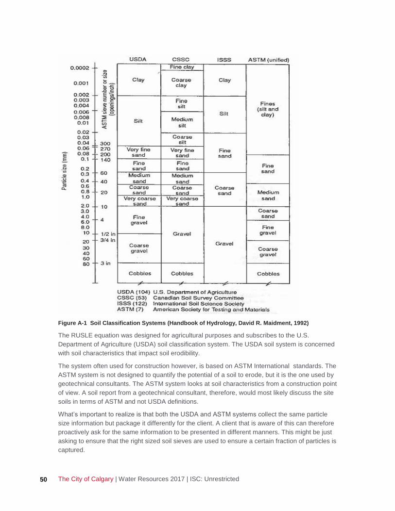
The City of Calgary | Water Resources 2017 | ISC: Unrestricted 50
Figure A-1 Soil Classification Systems (Handbook of Hydrology, David R. Maidment, 1992)
The RUSLE equation was designed for agricultural purposes and subscribes to the U.S.
Department of Agriculture (USDA) soil classification system. The USDA soil system is concerned
with soil characteristics that impact soil erodibility.
The system often used for construction however, is based on ASTM International standards. The
ASTM system is not designed to quantify the potential of a soil to erode, but it is the one used by
geotechnical consultants. The ASTM system looks at soil characteristics from a construction point
of view. A soil report from a geotechnical consultant, therefore, would most likely discuss the site
soils in terms of ASTM and not USDA definitions.
What’s important to realize is that both the USDA and ASTM systems collect the same particle
size information but package it differently for the client. A client that is aware of this can therefore
proactively ask for the same information to be presented in different manners. This might be just
asking to ensure that the right sized soil sieves are used to ensure a certain fraction of particles is
captured.

Erosion and Sediment Control Guidelines, 2017 Edition 51
When the erosion and sediment control (ESC) designer is ready to classify a soil from an ESC
perspective, the ESC designer must translate the ASTM information into USDA information to use
RUSLEFAC. The most important difference is in quantifying the amount of very fine sand, which
is a key variable in soil texture and soil erodibility. Delineating very fine sand means ensuring that
ASTM 40, 60, and 140 size sieves are utilized in the particle analysis (see Figure A-1) so that the
percentage of very fine sand can be found.
Other factors that impact soil erodibility are listed in Figure A-2.
Figure A-2 Variables That Affect K-value Source: Agriculture and Agri-Food Canada, 2002
Determination of K-values
The physical makeup of a soil determines its propensity to erode. A soil may be made of many
different sized particles, and those particles may have become stuck together into larger
aggregate particles called peds. Both the size of the individual particles and the size of the
aggregate peds are important in determining K-values.
Step 1: Determine the size of the particles for every soil type on the proposed site:
The size of all the particles can be determined by using a sieve analysis or by manual methods
used by trained ESC professionals. The following percentages are required:
• Percent (%) silt and very fine sand in a sample by weight (0.002 - to 0.10 mm diameter),
• Percent (%) sand by weight (0.10 - to 2.0 mm diameter)
• Percent (%) clay (less than 0.002 mm diameter)
• Percent (%) organic matter (by weight)

The City of Calgary | Water Resources 2017 | ISC: Unrestricted 52
Based on the percent clay and percent sand (as defined above) the ESC designer can quickly
find the soil texture class.
The soil texture triangle allows determination of soil properties using lab results (objective) rather
than field observations which should only be done by qualified ESC specialists.
Step 2: Determine the soil structure
Soil structure defines the frequency and shape of gaps between the soil aggregate peds. These
gaps can encourage water to flow through cracks and crevices and increase the rate of erosion.
Soil Structure is determined by using the information in Figure A-3 to describe the soil as:
• Very fine granular = 1
• Fine granular = 2
• Medium or coarse granular = 3
• Blocky, platy, or massive =4
Figure A-3 Soil Structure Based on Soil Texture (RUSLEFAC)

Erosion and Sediment Control Guidelines, 2017 Edition 53
Step 3: Determine the soil permeability
Related to soil structure is permeability which describes how easily water would flow through the
soil.
Soil permeability is determined by using the information in Figure A-4 to describe the soil’s
permeability as:
• Rapid = 1
• Moderate to rapid = 2
• Moderate = 3
• Slow to moderate = 4
• Slow = 5
• Very slow =6
Figure A-4 Soil Permeability Based on Soil Texture (RUSLEFAC)

The City of Calgary | Water Resources 2017 | ISC: Unrestricted 54
Step 4: Record the K-value
Example: A soil sample is run through a number of sieves and the following particle size
distribution is reported as:
• Percent Silt and Very Fine Sand: 45%
• Percent Sand: 25%
• Percent Clay: (by calculation) = 100% -45%-25%= 30%
• Percent sand: Starting at the bottom of the Soil Texture Triangle (see Figure A-5), the ESC
designer finds the value for 25% Sand and then strikes a line diagonally up (blue line)
• Percent clay: The ESC designer then finds the value for 30% clay on the left side of the
triangle and strikes a line to the right (green line). The green line crosses the blue line in the
area marked “clay loam”.
• This soil is defined as having a Clay Loam texture. This definition is used to find soil structure
and permeability.
• Organic matter: the geotechnical report determined that there is no organic material in the
soil.
• Soil Structure: Knowing the soil texture is Clay Loam, the ESC designer finds the Clay Loam
section on Figure A-5 to determine soil structure. In this case it is region 4 (contained within
the orange border), indicating that the soil has Type 4 structure, and is described as “blocky,
platy, massive”.

Erosion and Sediment Control Guidelines, 2017 Edition 55
Figure A-5 Soil Structure Determination (Based on RUSLEFAC, 1997, Wall et al)
• Soil Permeability: The soil permeability is determined knowing that the soil texture is a Clay
Loam. In Figure A-6 the ESC designer finds the area marked “Clay Loam”. The ESC designer
then confirms the region of the graph that the soil permeability is located in. In this case it is
region 4 (contained within the orange border), indicating that the soil has slow to moderate
permeability.
Figure A-6 Soil Permeability Determination (Based on RUSLEFAC, 1997, Wall et al)
The permeability is defined as Type 4, slow to moderate.

The City of Calgary | Water Resources 2017 | ISC: Unrestricted 56
Determining K-values:
Using the Foster Nomograph (Figure A-7), do the following:
• Starting at the left of the page, find the PERCENT SILT AND VERY FINE SAND mark (45%).
• Move horizontally right across the nomograph until you intersect the PERCENT SAND mark
(25%). Interpolation between curves is allowed.
• Now move up vertically until you intersect the % OM (Organic Matter) (0% in this case).
• Move horizontally to the right now.
• Continue moving to the right until you intersect the SOIL STRUCTURE mark (Type 4, blocky,
platy).
• Move directly down until you hit the PERMEABILITY mark (4, slow to moderate).
• Now move to the left horizontally to find the SOIL ERODIBILITY FACTOR (final K-value)
(0.49).
Figure A-7 Soil Erodibility Nomograph (Foster et al. 1981)
In summary, the K-value for this soil is 0.049.
The Qualified Designer must not rely on historical values. Each site needs to define the K-value
for the different soil types that will be encountered during construction.

Erosion and Sediment Control Guidelines, 2017 Edition 57
LS-value Determination
Information provided in this section comes from Predicting Soil Erosion by Water: A Guide to
Conservation Planning with the Revised Universal Soil Loss Equation Agricultural Handbook No.
703, (K.G. Renard et al., 1997).
Once the ESC designer has determined the potential for a soil to erode, the topography of the soil
is assessed. The effect of topography on erosion in RUSLEFAC is accounted for by the LS-value.
Soils erode when exposed soil comes into contact with water droplets. The energy of the falling
water breaks bonds between the particles (described by the K-value), and the water medium
provides a transport mechanism to carry the soil particles away. As the water flows down the
slope, it gains more kinetic energy that can lead to even more erosion. Finally, the water gains
enough energy to form rills and gullies.
Soils located on long, steep slopes will tend to erode more than comparable soils on short, flatter
slopes or in level areas.
The topography of the construction site, including lengths and gradients of slopes, must be
documented for both predevelopment and post-development conditions.
Definitions
Slope Length is the horizontal distance of a segment of slope to be analyzed.
Slope Gradient (also just called “grade” or “slope”) equals the change in vertical elevation over a
slope segment divided by the horizontal slope length of the same segment (Figure A-8), given in
percent (e.g., a 45° slope is defined as 100%.)
Figure A-8 Definition of Slope Length and Slope Grade
Choosing a Slope Length (Uniform Slopes)
A uniform slope is one where the steepness (slope), soil type, and cover management conditions
are comparable everywhere along the slope. A uniform slope is assumed in many RUSLEFAC
applications.
Top of slope segment (metres)
Bottom of slope segment (metres)
Slope Length (metres)
Slope Length (metres)
Top elevation – bottom elevation (metres) Slope (%) = X 100

The City of Calgary | Water Resources 2017 | ISC: Unrestricted 58
Slope length is defined as the horizontal length from the origin of overland flow (often, the top of a
hill or break in grade) to the point where either:
• The slope gradient decreases enough to allow deposition of soil
• The runoff becomes concentrated in a defined channel
The minimum and maximum lengths of a slope are defined by the slope’s ability, when hit by
rainfall, to form rills and then consolidate those rills into full channel flow.
L min= 4.6 m (15 feet), below this length, sheet flow is expected and will normally only form rills
after 4.6 m
L max= 122 m (400 feet), above this length, the rills are expected to consolidate into channels
(gullies)
Once the slope length of a uniform slope is determined and the slope gradient calculated, the
LS-value is selected from Table LS-3.
Table LS-3 assumes the land being assessed is a freshly prepared construction site (stripped of
organic soils).

Erosion and Sediment Control Guidelines, 2017 Edition 59
Table LS-3. Values for Topographic Factor (LS-value) for a High Ratio of Rill: Inter-rill Erosion
Slope Length in metres
Slope % 1 2 4.57 5 10 15 25 50 75 100 150 200 250 300
0.2 0.05 0.05 0.05 0.05 0.05 0.05 0.05 0.05 0.06 0.06 0.06 0.06 0.06 0.06
0.5 0.07 0.07 0.07 0.07 0.07 0.08 0.09 0.10 0.10 0.11 0.11 0.12 0.12 0.13
1 0.09 0.09 0.09 0.09 0.11 0.12 0.14 0.17 0.19 0.20 0.23 0.24 0.26 0.27
2 0.13 0.13 0.13 0.14 0.18 0.21 0.26 0.34 0.40 0.44 0.52 0.58 0.64 0.68
3 0.17 0.17 0.17 0.17 0.24 0.29 0.37 0.52 0.63 0.72 0.88 1.01 1.12 1.22
4 0.20 0.20 0.20 0.21 0.30 0.38 0.49 0.71 0.88 1.03 1.28 1.49 1.67 1.84
5 0.23 0.23 0.23 0.24 0.36 0.46 0.61 0.91 1.14 1.35 1.70 2.01 2.28 2.53
6 0.26 0.26 0.26 0.28 0.42 0.54 0.73 1.11 1.42 1.68 2.15 2.56 2.93 3.27
7 0.29 0.29 0.29 0.31 0.48 0.61 0.85 1.31 1.69 2.03 2.62 3.14 3.61 4.05
8 0.32 0.32 0.32 0.34 0.53 0.69 0.96 1.51 1.97 2.38 3.09 3.73 4.31 4.86
9 0.35 0.35 0.35 0.37 0.59 0.78 1.09 1.73 2.27 2.75 3.61 4.37 5.08 5.73
10 0.35 0.36 0.40 0.42 0.68 0.90 1.27 2.04 2.69 3.28 4.32 5.26 6.13 6.94
12 0.36 0.40 0.49 0.53 0.86 1.14 1.64 2.67 3.56 4.36 5.80 7.11 8.32 9.46
14 0.38 0.44 0.58 0.62 1.03 1.38 2.00 3.30 4.43 5.45 7.32 9.01 10.59 12.09
16 0.39 0.47 0.67 0.72 1.20 1.62 2.36 3.93 5.31 6.57 8.86 10.96 12.92 14.79
20 0.41 0.53 0.84 0.90 1.53 2.08 3.07 5.20 7.07 8.81 11.99 14.92 17.69 20.32
22 0.43 0.57 0.92 0.99 1.69 2.31 3.42 5.82 7.95 9.93 13.56 16.92 20.09 23.11
25 0.45 0.62 1.04 1.12 1.92 2.64 3.93 6.75 9.26 11.59 15.91 19.91 23.70 27.32
30 0.48 0.69 1.24 1.33 2.30 3.18 4.77 8.26 11.40 14.33 19.77 24.84 29.65 34.27
40 0.53 0.83 1.59 1.71 3.01 4.19 6.34 11.13 15.46 19.53 27.15 34.30 41.11 47.67
50 0.58 0.95 1.91 2.06 3.65 5.09 7.75 13.72 19.17 24.29 33.93 43.00 51.68 60.05
60 0.63 1.07 2.19 2.36 4.21 5.89 9.01 16.04 22.48 28.55 40.00 50.82 61.18 71.20
Source: RUSLEFAC Handbook, Agriculture Canada (modified by: Joe Buchner, CPESC)
Example: A slope drops a distance of 7 m over a slope length of 87 m. The slope gradient is
calculated as:
Slope (%) = (7/87) x 100% = 8.05 %
Looking at Table LS-3 and extrapolating gives us an LS-value of 2.17 for an 8% slope of 87 m in
length.
LS-values for Thawing Ground
When the RUSLEFAC analysis period includes a time of year when the soil will be frozen,
Table LS-4 is used for determining the LS value.

The City of Calgary | Water Resources 2017 | ISC: Unrestricted 60
Table LS-4. Values for Topographic Factor (LS-value) for thawing soils where most of the erosion is
caused by surface flow (using m=0.5).
Source: RUSLEFAC Handbook, Agriculture Canada
Using the same example for a uniform slope but now with the ground frozen and thawing
produces:
Slope Gradient = 8.05 %, Slope Length = 87 m
Looking at Table LS-4, we now get an LS-value of 1.76.
LS-values for Complex Slopes
Complex Slopes
A complex slope is one where the slope is not uniform, or the soil type(s) and land use conditions
change along it. These factors can all lead to erosion rates many times higher than on
comparable constant-slope hillsides.
Complex slopes may have both convex and concave sections. A convex slope is one where the
slope becomes steeper the further downhill you go. Erosion rates at the end of a convex slope
can be extremely high. A concave slope is one where the steepness decreases along the slope.
Concave slopes can become so flat that soil deposition may occur, which can reduce the amount
of sediment leaving the slope.
The overland flow path on many natural landscapes follows a complex hillslope profile, where the
upper part of the slope is convex and the lower part of the slope is concave. The slope must then

Erosion and Sediment Control Guidelines, 2017 Edition 61
be divided into two parts, an eroding portion and a depositional portion (Figure A-10). (The
RUSLEFAC equation is only applied to the eroding portion of the slope.)
Figure A-9 Soil Loss, deposition and sediment yield from complex slope, concave-convex shape
Source: USDA, May 2008, RUSLE2 User’s Reference Guide
Non-uniform/ Complex Hillslope Profiles
In many cases, hillslope profiles are complex, consisting of several segments of differing lengths,
gradients (slopes), and shapes, which necessitate special handling in RUSLEFAC. The hillslope
profile is divided into segments of uniform length and gradient characteristics, and the segments
are calculated individually.
LS-values emphasize the importance of correctly identifying the configuration of the hillslope
profile in question. Accurate measurements of the field characteristics will produce the most
accurate estimates of the LS-value, especially for non-uniform hillslope profiles consisting of more
than one segment.
The simplest irregular slope case is for soil and cover to be consistent along the slope. To apply
the irregular slope procedure, the following steps are taken:
• Step 1: Divide the convex, concave, and complex slopes into three to five equal-length
segments.
• Step 2: Determine the average slope for each segment
o List the segments in the order in which they occur on the slope, beginning at the top of
the slope
• Step 3: From Table LS-3 determine the original LS value for each segment (LSinit.)
• Step 4: From Table LS-5 determine the slope length exponent (for high rill /interill ratios) (m)
• Step 5: From Table LS-6 determine the slope loss factor (SLF) based on sequence of the
slope (1,2,3)
• Step 6: Multiply each segment’s revised LS value by its slope length factor divided by the
number of segments. This is the revised LS value for each segment LSrev.
o LSrev. = (LSinit. X SLF)/ number of segments

The City of Calgary | Water Resources 2017 | ISC: Unrestricted 62
• Step 7: Add all the revised LS values to determine the cumulative total LS value for the entire
slope
o LStotal = Ʃ (LSrev.)
Example: the ESC designer is presented with the following slope (Figure A-10):
Figure A-10 LS Determination for an Irregular Slope Example
• The slope is flat (concave) at the top, then becomes very steep before ending in a convex
depositional area.
• Step 1: divide the 75 m slope into equal sections. In this case the ESC designer chose to
divide the slope into three, 25 m sections
• Step 2: determine the slopes for each 25 m section
Segment 1: Slope (%) = [(1110 m – 1108 m)/ 25 m] x 100= 8%
Segment 2: Slope (%) = [(1108 m – 1101 m)/25 m] = 28%
Segment 3: Slope (%) = [(1101 m – 1100 m)/25 m] = 4%
• Step 3: Using Table LS-3, find the original LS value for each segment
Segment 1: 8% slope and 25 m length, LS = 0.96
Segment 2: 28% slope and 25 m length, LS = 4.44(extrapolated)
Segment 3: 4% slope and 25 m length, LS= 0.42
• Step 4: Using Table LS-5 determine the slope length exponent (m) for each segment,
assuming high Rill/ Interrill Ratios (exposed slopes)
Segment 1: Slope = 8%, m = 0.65

Erosion and Sediment Control Guidelines, 2017 Edition 63
Segment 2: Slope =28%, m = 0.79
Segment 3: Slope = 4%, m = 0.53
Table LS-5. Slope length exponents for a range of slopes and rill/interrill erosion classes.
• Step 5: Using the m values obtained in Step 4, and using Table LS-6, determine the soil loss
factor (SLF) for each segment
Segment 1: m = 0.65, SLF = 0.50
Segment 2: m = 0.79, SLF = 1.03
Segment 3: m = 0.53, SLF = 1.39
• Step 6: For each segment, multiple it’s original LS value by its SLF factor, then divide by the
total number of segments to determine the revised LS value for each slope segment
Segment 1: (0.96 x 0.50)/ 3 = 0.16
Segment 2: (4.65 x 1.03)/3 = 1.597
Segment 3: (0.49 x 1.39)/3 = 0.23
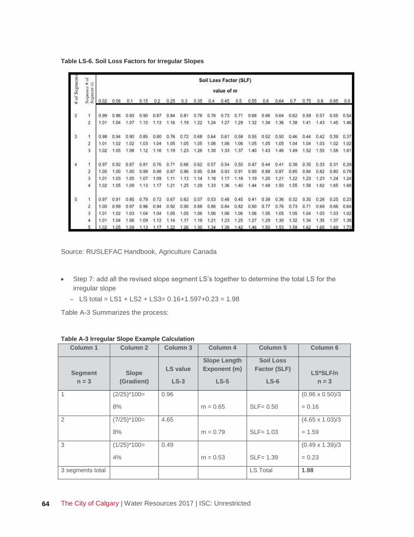
The City of Calgary | Water Resources 2017 | ISC: Unrestricted 64
Table LS-6. Soil Loss Factors for Irregular Slopes
Source: RUSLEFAC Handbook, Agriculture Canada
• Step 7: add all the revised slope segment LS’s together to determine the total LS for the
irregular slope
LS total = LS1 + LS2 + LS3= 0.16+1.597+0.23 = 1.98
Table A-3 Summarizes the process:
Table A-3 Irregular Slope Example Calculation
Column 1 Column 2 Column 3 Column 4 Column 5 Column 6
Segment
n = 3
Slope
(Gradient)
LS value
LS-3
Slope Length
Exponent (m)
LS-5
Soil Loss
Factor (SLF)
LS-6
LS*SLF/n
n = 3
1 (2/25)*100=
8%
0.96
m = 0.65
SLF= 0.50
(0.96 x 0.50)/3
= 0.16
2 (7/25)*100=
8%
4.65
m = 0.79
SLF= 1.03
(4.65 x 1.03)/3
= 1.59
3 (1/25)*100=
4%
0.49
m = 0.53
SLF= 1.39
(0.49 x 1.39)/3
= 0.23
3 segments total LS Total 1.98

Erosion and Sediment Control Guidelines, 2017 Edition 65
Erosion Control: C-value Determination
The Qualified Designer must provide supporting information for any C-value used (references
from peer-reviewed journal or manufacturer’s specifications with ASTM International [ASTM]
testing completed) for practices and technologies in the ESC documentation. Refer to product
manufacturer’s specifications for product-specific C-values. C-values will vary based on slope,
application rate, material, construction details, and percent cover, among other variables.
For example, per Table C-5 of the RUSLEFAC Handbook, a ground cover of 80 percent or more
of established grass with no appreciable canopy corresponds to a C-value of 0.01; whereas, a
20 percent grass ground cover corresponds to a C-value of 0.2 (Wischmeier and Smith, 1978).
Table A-4. C Values for Permanent Pasture, Range, and Idle Land (based on RUSLEFAC 1997)
Figure A-12 represents different coverage of an area and can help to visually confirm percent
ground cover by grass or mulch.

The City of Calgary | Water Resources 2017 | ISC: Unrestricted 66
Figure A-11 Percent ground cover by grass or mulch

Erosion and Sediment Control Guidelines, 2017 Edition 67
Appendix B: Example ESC Drawings and RUSLEFAC/Pond
Data

B0.489
C1.547
A0.830
PROJECT NAME
PHASE 1
BEFORE STRIPPING & GRADING
A 17-01 PRELIMINARY APPROVAL GG PB
RC
GG
TA
PB
2017-01-28
CGY-00081296-00
ESC1 A 0
CITY FILE No. DA2017-1234
DRAWING TITLE
PROJECT NAME
REV
APPROVED
DRAWN
CHECKED
DESIGN
DRAWING CODE
PROJECT NUMBER
DATE
ISS
PERMIT TO PRACTICE
SEAL
OWNER
CONSULTANT
SCALE
YY-MM ISSUE BY APPNo
SEAL
CITY FILE No.
TY
PE
C
TY
PE
C
RESIDENTIAL
ST
OR
M
MAIN
ST
OR
M
MAIN
ST
OR
M
MAIN
ST
OR
M
MAIN
ST
OR
M
MAIN
MULTIFAMILY
MU
LTIF
AMIL
Y
SE
DIM
EN
T
WY
NW
ER
OSIO
N
ST
NW
STORM MAIN
STORM MAIN
0 5 10 20 30m
1:1000
ON ARDW
CITY OF CALGARY OFFICE USE
MIN SIZE 5cm X 8cm
1341.0
1334.0
1334.0
1335.0
1335.0
1336.0
1336.0
1337.0
1337.01
338.0 1
338.0
1339.0
1339.0
1340.01
340.01
341.0
1342.0
1342.0
1343.0
1343.0
1344.0
1344.0
1345.0
1345.0
1338.0
1339.0
1340.0
1341.0
PATHWAY
EX LOCAL
SWALE
CONCRETE
1337.0
1337.0
1338.0 1
338.01
339.0
1339.0
1339.0
1340.0
1341.0
1342.0
1342.0
1342.0
1342.0
1343.0
1343.0
1343.0
1343.5
1343.0
1343.5
RESERVE
ENVIRONMENTAL
@ 30.5%=3.70LS3 17.8m
LS2 60.0
m
@ 3.8
%=0.7
4
LS1 47.7
m
@ 5.0
%=
0.8
8
1344.0
LEGEND:
CONSTRUCTION BOUNDARY
EXISTING GROUND CONTOURS
MINOR - 0.5m INTERVAL
EXISTING GROUND CONTOURS
MAJOR - 1.0m INTERVAL
DRAINAGE DIVIDES
DRAINAGE DIVIDE LABEL
DRAINAGE DIVIDE AREA IN ha
OVERLAND FLOW DIRECTION
RUN-ON / RUN-OFF LOCATIONS
STORM MAIN
SOLID TOP MANHOLE
GRATED TOP MANHOLE
CATCH BASIN
VEGETATION
TREES - INDIVIDUAL
TREES - OUTLINE
RETAINING WALL
A0.00
CONCRETE WALKWAYS/ASPHALT
PATHWAY
CONCRETE SWALE
PAVEMENT
1207.0
(INSERT PRODUCT NAME HERE)
HYDROMULCH (200.1.4)
SURFACE ROUGHENING (200.2.5)
SEDIMENT TRAP (200.2.2)
ACCESS (200.3.1)
STABILIZED GRAVEL
SILT FENCE (200.2.6)
12' STRAW WATTLE (200.2.1)

15
m
10m
20
m
10m
108m
44
m
0.03
D
C0.30
0.12
F
0.066
E
H0.28
0.96
G
B0.80
A0.31
PROJECT NAME
PHASE 1
DURING STRIPPING & GRADING
A 17-01 PRELIMINARY APPROVAL GG PB
RC
GG
TA
PB
2017-01-28
CGY-00081296-00
ESC2 A 0
DA2017-1234
DRAWING TITLE
PROJECT NAME
REV
APPROVED
DRAWN
CHECKED
DESIGN
DRAWING CODE
PROJECT NUMBER
DATE
ISS
PERMIT TO PRACTICE
SEAL
OWNER
CONSULTANT
SCALE
YY-MM ISSUE BY APPNo
SEAL
CITY FILE No.
ER
OSIO
N
ST
NW
SE
DIM
EN
T
WY
NW
MU
LTIF
AMIL
Y
MULTIFAMILY
ST
OR
M
MAIN
ST
OR
M
MAIN
ST
OR
M
MAIN
ST
OR
M
MAIN
ST
OR
M
MAIN
RESIDENTIAL
TY
PE
C
TY
PE
C
STORM MAIN
STORM MAIN
0 5 10 20 30m
1:1000
ON ARDW
CITY OF CALGARY OFFICE USE
MIN SIZE 5cm X 8cm
Vol=
100
m
D=
0.5
PO
ND 3
³
Vol=75m
D=0.5m
POND 1
³
1334.0
1334.0
1335.0
1335.0
1336.0
1336.0
1337.0
1337.01
338.0
1338.01
339.0
1339.0
1340.0
1340.0
1340.0
1340.0
1341.0
1341.0
1341.0
1341.0
1342.0
1338.0
1338.0
1339.0
1339.0
1340.0
1341.0
1342.0
1342.0
1342.0
1343.0
1343.0
1340.0
1341.0
1342.0
RESERVE
ENVIRONMENTALVol=~2900m
D=1m
POND 2
³
@ 3.7
%=
0.3
8
LS2 17.4
m
LS2+3=0.51
SEGMENTED
@ 7.0
%=0.5
7
LS3 13.5
m
@ 2.2%=0.20
LS8 10.6m
LS8+9=1.89
SEGMENTED
@ 30.3%=2.57
LS10 11.0m
@ 7.15%=0.77
LS7 21.0m
LS6+7=0.51
SEGMENTED
LS6 33.5m @ 3.7%=0.53
LS11
14.5
m
@ 8.9
%=0.7
5
LS4 39.8m @ 0.8%=0.13
=0.9
9
@ 29.5
%
LS5 3.2
m
LS1 34.8
m
@ 1.6
%=
0.2
4
1337.0
1343.5
1341.5
1343.5
@ 33.3%=2.55
LS9 10.0m
LEGEND:
CONSTRUCTION BOUNDARY
EXISTING GROUND CONTOURS
MINOR - 0.5m INTERVAL
EXISTING GROUND CONTOURS
MAJOR - 1.0m INTERVAL
DRAINAGE DIVIDES
DRAINAGE DIVIDE LABEL
DRAINAGE DIVIDE AREA IN ha
OVERLAND FLOW DIRECTION
RUN-ON / RUN-OFF LOCATIONS
STORM MAIN
SOLID TOP MANHOLE
GRATED TOP MANHOLE
CATCH BASIN
VEGETATION
TREES - INDIVIDUAL
TREES - OUTLINE
RETAINING WALL
A0.00
CONCRETE WALKWAYS/ASPHALT
PATHWAY
CONCRETE SWALE
PAVEMENT
1207.0
(INSERT PRODUCT NAME HERE)
HYDROMULCH (200.1.4)
SURFACE ROUGHENING (200.2.5)
SEDIMENT TRAP (200.2.2)
ACCESS (200.3.1)
STABILIZED GRAVEL
SILT FENCE (200.2.6)
12' STRAW WATTLE (200.2.1)

15
m
10m
108m
44
m
20
m
10m
J0.14
D0.03
C0.30
E
H
0.28
L0.02
0.30
K
G0.03
I0.41
F0.13
0.12
A0.31
0.80
B
0 5 10 20 30m
1:1000
ER
OSIO
N
ST
NW
SE
DIM
EN
T
WY
NW
MU
LTIF
AMIL
Y
MULTIFAMILY
ST
OR
M
MAIN
ST
OR
M
MAIN
ST
OR
M
MAIN
ST
OR
M
MAIN
ST
OR
M
MAIN
RESIDENTIAL
TY
PE
C
TY
PE
C
PROJECT NAME
PHASE 1
POST STRIPPING & GRADING
A 17-01 PRELIMINARY APPROVAL GG PB
RC
GG
TA
PB
2017-01-28
CGY-00081296-00
ESC3 A 0
STORM MAIN
STORM MAIN
DA2017-1234
DRAWING TITLE
PROJECT NAME
REV
APPROVED
DRAWN
CHECKED
DESIGN
DRAWING CODE
PROJECT NUMBER
DATE
ISS
PERMIT TO PRACTICE
SEAL
OWNER
CONSULTANT
SCALE
YY-MM ISSUE BY APPNo
SEAL
CITY FILE No.
CULVERT
ON ARDW
PATHWAY
EX LOCAL
SWALE
CONCRETE
Vol=
100
m
D=
0.5
PO
ND 3
³
20000m
TOP SOIL
³
Vol=75m
D=0.5m
POND 1
³
CITY OF CALGARY OFFICE USE
MIN SIZE 5cm X 8cm
1334.0
1334.0
1335.0
1335.0
1336.0
1336.0
1337.0
1337.01
338.0 1
338.0
1339.0
1339.0
1340.01
340.0
1341.0
1341.0
1342.0
1342.0
1343.0
1343.0
1344.0
1345.0
1338.0
1339.0
1340.0
1341.0
1337.0
1337.0
1338.0 1
338.01
339.0
1339.0
1339.0
1340.0
1342.0
1342.0
1342.0
1339.0
1340.0
1338.0
1341.0
1342.0
1343.0
1343.0
1342.0
1340.0
1341.0
1342.0
RESERVE
ENVIRONMENTAL
Vol=~2900m
D=1m
POND 2
³
LS6+7=0.43
SEGMENTED
LS2+3=0.51
SEGMENTED
LS8+9=1.89
SEGMENTED
LS1 27.0
m
@ 1.6
%=
0.2
2
LS11 42.0m @ 3.4%=0.55 LS13 28.9m @ 4.7%=0.62
@ 16.6%=1.90LS14 17.6m
@ 1
5.2%=
1.70
LS15 1
7.5m
LS4 39.8m @ 0.8%=0.13
=0.9
9
@ 29.5
%
LS5 3.2
m
LS6 33.5m @ 3.7%=0.53LS7 38.2m @ 2.6%=0.40
LS16 29.6m @ 0.8%=0.12
@ 7.0
%=0.5
7
LS3 13.5
m
@ 3.7
%=
0.3
8
LS2 17.4
m
@ 2.2%=0.20
LS8 10.6m
@ 33.3%=2.55
LS9 10.0m
@ 30.3%=2.57
LS12 11.0m
@ 30.0%=2.30
LS20 10.0m
@ 20.7%=1.61LS19 10.
2m
=2.4
9
@ 50.0
%
LS17 6.3
m
@ 14.6
%=
0.7
8
LS2 6.4
m
@50.0
%=
2.0
9
LS15 5.1
m
1343.5
1341.5
1343.5
1344.0
1342.0
LEGEND:
CONSTRUCTION BOUNDARY
EXISTING GROUND CONTOURS
MINOR - 0.5m INTERVAL
EXISTING GROUND CONTOURS
MAJOR - 1.0m INTERVAL
DRAINAGE DIVIDES
DRAINAGE DIVIDE LABEL
DRAINAGE DIVIDE AREA IN ha
OVERLAND FLOW DIRECTION
RUN-ON / RUN-OFF LOCATIONS
STORM MAIN
SOLID TOP MANHOLE
GRATED TOP MANHOLE
CATCH BASIN
VEGETATION
TREES - INDIVIDUAL
TREES - OUTLINE
RETAINING WALL
A0.00
CONCRETE WALKWAYS/ASPHALT
PATHWAY
CONCRETE SWALE
PAVEMENT
1207.0
(INSERT PRODUCT NAME HERE)
HYDROMULCH (200.1.4)
SURFACE ROUGHENING (200.2.5)
SEDIMENT TRAP (200.2.2)
ACCESS (200.3.1)
STABILIZED GRAVEL
SILT FENCE (200.2.6)
12' STRAW WATTLE (200.2.1)

I0.48
H0.216
A0.25
0.96
B
G0.15
D0.31
J0.30
70
m
17
m
17m
86m
44
m
17m
E0.07
C0.02
0.06
F
REVISS
PROJECT NAME
PHASE 1
SEAL
YY-MM ISSUE BY APPNo
A 17-01 PRELIMINARY APPROVAL GG PB
RC
GG
TA
PB
2017-01-28
CGY-00081296-00
B 1
SEAL
DRAWING TITLE
PROJECT NAME
REV
APPROVED
DRAWN
CHECKED
DESIGN
DRAWING CODE
PROJECT NUMBER
DATE
ISS
PERMIT TO PRACTICE
SEAL
OWNER
CONSULTANT
SCALE
YY-MM ISSUE BY APPNo
SEAL
CITY FILE No.
ER
OSIO
N
ST
NW
SE
DIM
EN
T
WY
NW
MULTIFAMILY
ST
OR
M
MAIN
ST
OR
M
MAIN
ST
OR
M
MAIN
RESIDENTIAL
TY
PE
C
TY
PE
C
STORM MAIN
STORM MAIN
ST
OR
M
MAIN
MU
LTIF
AMIL
Y
ST
OR
M
MAIN
EX
LO
CA
L
PA
TH
WA
Y
RETAINING WALL TO REMAIN
VEGETATION AND 3m
CONCRETE
SWALE
CITY OF CALGARY OFFICE USE
MIN SIZE 5cm X 8cm
PA
TH
WA
Y
EX LO
CA
L
PA
TH
WA
Y
EX
LO
CA
L
@ 31.2%=2.60
LS10 11.1m
TOP SOIL
20.000m}
@ 3.4%=0.55
LS2 42.0m
LS1 65.4
m
@ 1.9
%=
0.3
6
@ 16.6%=1.90
LS9 17.5m
Vol=145m
D=0.5m
POND 1
³
Vol=595m
D=0.5
POND 3
³
1338.0
1338.01339.0
1339.0
1340.0
1341.01
342.0
1336.0
1336.0
1337.0
1337.0
1338.0
1338.0
1339.0
1339.0
1340.0
1341.0
1342.0
1342.0
1343.0
1343.0
1334.0
1334.0
1335.0
1335.0
1336.0
1336.0
1337.0 1337.0
1338.0 1338.0
1339.0 1339.0
1340.0
1340.0
1341.0
1342.0
1342.0
1341.5
1341.5
1342.0
1343.0
1342.5
1341.0
1342.0
@ 32.6%=1.32
LS5 4.5m
Vol=2900m
D=1m
POND 2
³
LEGEND:
0 5 10 20 30m
1:1000
ON ARDW
1342.0
1340.01342.0
1342.0
1341.0
@ 24.2%=2.05
LS4 11.3m
LS8 30.8m @ 5.2%=0.72
LS6 22.6m @ 7.4%=0.84
LS3 31.2
m
@ 2.2
%=
0.3
1
@ 25.4%=2.53
LS7 13.9m
ESC3
AMENDMENT
POST STRIPPING AND GRADING
CONSTRUCTION BOUNDARY
EXISTING GROUND CONTOURS
MINOR - 0.5m INTERVAL
EXISTING GROUND CONTOURS
MAJOR - 1.0m INTERVAL
DRAINAGE DIVIDES
DRAINAGE DIVIDE LABEL
DRAINAGE DIVIDE AREA IN ha
OVERLAND FLOW DIRECTION
RUN-ON / RUN-OFF LOCATIONS
STORM MAIN
SOLID TOP MANHOLE
GRATED TOP MANHOLE
CATCH BASIN
VEGETATION
TREES - INDIVIDUAL
TREES - OUTLINE
RETAINING WALL
A0.00
CONCRETE WALKWAYS/ASPHALT
PATHWAY
STONE PAVERS
CONCRETE SWALE
PAVEMENT
BUILDING (ROOF)
CONCRETE PAD
STONE WALL
1207.0
WILL CONTAIN CONTENTS
OR WITH BORDER THAT
PLANTER BEDS - RAISED
CULVERT
(INSERT PRODUCT NAME HERE)
HYDROMULCH (200.1.4)
SURFACE ROUGHENING (200.2.5)
SEDIMENT TRAP (200.2.2)
ACCESS (200.3.1)
STABILIZED GRAVEL
CLEAN WASHED GRAVEL (200.1.6)
TURF SOD (200.1.2)
SILT FENCE (200.2.6)
@ 28.6%=1.56
LS11 6.5m


2.866

2.87 1.99 41.52.866


2.8 1.39 70.62.866


I0.48
H0.216
A0.25
0.96
B
G0.15
D0.31
J0.30
70
m
17
m
17m
86m
44
m
17m
E0.07
C0.02
0.06
F
REVISS
PROJECT NAME
PHASE 1
BEFORE DEVELOPMENT
SEAL
YY-MM ISSUE BY APPNo
A 17-01 PRELIMINARY APPROVAL GG PB
RC
GG
TA
PB
2017-01-28
CGY-00081296-00
ESC5 A 0
SEAL
DRAWING TITLE
PROJECT NAME
REV
APPROVED
DRAWN
CHECKED
DESIGN
DRAWING CODE
PROJECT NUMBER
DATE
ISS
PERMIT TO PRACTICE
SEAL
OWNER
CONSULTANT
SCALE
YY-MM ISSUE BY APPNo
SEAL
CITY FILE No.
ER
OSIO
N
ST
NW
SE
DIM
EN
T
WY
NW
MULTIFAMILY
ST
OR
M
MAIN
ST
OR
M
MAIN
ST
OR
M
MAIN
RESIDENTIAL
TY
PE
C
TY
PE
C
STORM MAIN
STORM MAIN
ST
OR
M
MAIN
MU
LTIF
AMIL
Y
ST
OR
M
MAIN
EX
LO
CA
L
PA
TH
WA
Y
RETAINING WALL TO REMAIN
VEGETATION AND 3m
CONCRETE
SWALE
CITY OF CALGARY OFFICE USE
MIN SIZE 5cm X 8cm
PA
TH
WA
Y
EX LO
CA
L
PA
TH
WA
Y
EX
LO
CA
L
@ 31.2%=2.60
LS10 11.1m
TOP SOIL
20.000m}
@ 3.4%=0.55
LS2 42.0m
LS1 65.4
m
@ 1.9
%=
0.3
6
@ 16.6%=1.90
LS9 17.5m
Vol=145m
D=0.5m
POND 1
³
Vol=595m
D=0.5
POND 3
³
1338.0
1338.01339.0
1339.0
1340.0
1341.01
342.0
1336.0
1336.0
1337.0
1337.0
1338.0
1338.0
1339.0
1339.0
1340.0
1341.0
1342.0
1342.0
1343.0
1343.0
1334.0
1334.0
1335.0
1335.0
1336.0
1336.0
1337.0 1337.0
1338.0 1338.0
1339.0 1339.0
1340.0
1340.0
1341.0
1342.0
1342.0
1341.5
1341.5
1342.0
1343.0
1342.5
1341.0
1342.0
@ 32.6%=1.32
LS5 4.5m
Vol=2900m
D=1m
POND 2
³
LEGEND:
CONSTRUCTION BOUNDARY
EXISTING GROUND CONTOURS
MINOR - 0.5m INTERVAL
EXISTING GROUND CONTOURS
MAJOR - 1.0m INTERVAL
DRAINAGE DIVIDES
DRAINAGE DIVIDE LABEL
DRAINAGE DIVIDE AREA IN ha
OVERLAND FLOW DIRECTION
RUN-ON / RUN-OFF LOCATIONS
STORM MAIN
SOLID TOP MANHOLE
GRATED TOP MANHOLE
CATCH BASIN
VEGETATION
TREES - INDIVIDUAL
TREES - OUTLINE
RETAINING WALL
A0.00
CONCRETE WALKWAYS/ASPHALT
PATHWAY
STONE PAVERS
CONCRETE SWALE
PAVEMENT
BUILDING (ROOF)
CONCRETE PAD
STONE WALL
1207.0
WILL CONTAIN CONTENTS
OR WITH BORDER THAT
PLANTER BEDS - RAISED
0 5 10 20 30m
1:1000
ON ARDW
1342.0
1340.01342.0
1342.0
1341.0
@ 24.2%=2.05
LS4 11.3m
LS8 30.8m @ 5.2%=0.72
LS6 22.6m @ 7.4%=0.84
LS3 31.2
m
@ 2.2
%=
0.3
1
@ 25.4%=2.53
LS7 13.9m
CULVERT
(INSERT PRODUCT NAME HERE)
HYDROMULCH (200.1.4)
SURFACE ROUGHENING (200.2.5)
SEDIMENT TRAP (200.2.2)
ACCESS (200.3.1)
STABILIZED GRAVEL
CLEAN WASHED GRAVEL (200.1.6)
TURF SOD (200.1.2)
SILT FENCE (200.2.6)
@ 28.6%=1.56
LS11 6.5m

REVISS
PROJECT NAME
PHASE 1
POST UNDERGROUND
SEAL
YY-MM ISSUE BY APPNo
A 17-01 PRELIMINARY APPROVAL GG PB
RC
GG
TA
PB
2017-01-28
CGY-00081296-00
ESC6 A 0
SEAL
CITY FILE No. DA2017-1234
DRAWING TITLE
PROJECT NAME
REV
APPROVED
DRAWN
CHECKED
DESIGN
DRAWING CODE
PROJECT NUMBER
DATE
ISS
0 5 10 20 30m
1:1000
PERMIT TO PRACTICE
SEAL
OWNER
CONSULTANT
SCALE
YY-MM ISSUE BY APPNo
SEAL
CITY OF CALGARY OFFICE USE
MIN SIZE 5cm X 8cm
CITY FILE No.
ON ARDW
ER
OSIO
N
ST
NW
SE
DIM
EN
T
WY
NW
MULTIFAMILY
ST
OR
M
MAIN
ST
OR
M
MAIN
ST
OR
M
MAIN
RESIDENTIAL
TY
PE
C
TY
PE
C
PA
TH
WA
Y
EX LO
CA
L
STORM MAIN
STORM MAIN
EX
LO
CA
L
PA
TH
WA
Y
CONCRETE
SWALE
VEGETATION AND
3m RETAINING WALL TO REMAIN
LS1 31.0
m
@ 1.8
%=
0.2
2
@ 14.6
%=
0.7
8
LS2 6.4
m
LS10 42.0m @ 2.2%=0.55 LS11 28.9m @ 5.2%=0.62@ 16.1%=1.90LS12 17.6m
LS15 29.6m @ 0.8%=0.12@ 23.2
%=
2.1
2
LS18 8.8
m
1338.0
1338.0
1339.0
1339.0 1
340.01
340.0
1341.0
1342.0
1342.0
1342.0
1334.0
1334.0
1335.0
1335.0
1336.0
1336.0
1337.0
1337.01
338.0
1338.01
339.0
1339.0
1340.0
1340.0
1340.0
1340.0
1341.0
1341.0
1341.0
1341.0
1342.0
@ 2.2%=0.20
LS8 10.6m
@ 33.3%=2.55
LS9 10.0m
LS8+9=1.89
SEGMENTED
LS3+4=0.52
SEGMENTED
=2.4
9
@ 50.0
%
LS16 6.3
m
@ 30.5%=2.57
LS17 11.0m
LS7 33.5m @ 3.7%=0.53
LS7+14=0.44
SEGMENTED
@ 7.0
%=0.5
7
LS4 13.5
m
@ 3.7
%=
0.3
8
LS3 17.4
m
LEGEND:
LS14 38.2m @ 2.6%=0.40
CONSTRUCTION BOUNDARY
EXISTING GROUND CONTOURS
MINOR - 0.5m INTERVAL
EXISTING GROUND CONTOURS
MAJOR - 1.0m INTERVAL
DRAINAGE DIVIDES
DRAINAGE DIVIDE LABEL
DRAINAGE DIVIDE AREA IN ha
OVERLAND FLOW DIRECTION
RUN-ON / RUN-OFF LOCATIONS
STORM MAIN
SOLID TOP MANHOLE
GRATED TOP MANHOLE
CATCH BASIN
VEGETATION
TREES - INDIVIDUAL
TREES - OUTLINE
RETAINING WALL
A0.00
CONCRETE WALKWAYS/ASPHALT
PATHWAY
STONE PAVERS
CONCRETE SWALE
PAVEMENT
BUILDING (ROOF)
CONCRETE PAD
STONE WALL
1207.0
WILL CONTAIN CONTENTS
OR WITH BORDER THAT
PLANTER BEDS - RAISED
CULVERT
(INSERT PRODUCT NAME HERE)
HYDROMULCH (200.1.4)
SURFACE ROUGHENING (200.2.5)
SEDIMENT TRAP (200.2.2)
ACCESS (200.3.1)
STABILIZED GRAVEL
CLEAN WASHED GRAVEL (200.1.6)
TURF SOD (200.1.2)
SILT FENCE (200.2.6)
MU
LTIF
AMIL
Y
ST
OR
M
MAIN
ST
OR
M
MAIN
108m
44
m
CULVERT
ST
OR
M
MAIN
ST
OR
M
MAIN
STORM MAINSTORM MAIN
STORM MAIN
ST
OR
M
MAIN
@50.0
%=
2.0
9
LS13 5.1
m
=0.9
9
@ 29.5
%
LS6 3.2
m
TOP SOIL
20 000m}
LS5 39.8m @ 0.8%=0.13
Vol=2900m
D=1m
POND 1
³
C0.30
G
B0.80
J0.14
K0.30
L0.48
0.02
E0.12
H0.03
F0.14
A0.31
I0.216
D0.03

REVISS
PROJECT NAME
PHASE 1
A 17-01 PRELIMINARY APPROVAL GG PB
RC
GG
TA
PB
2017-01-28
CGY-00081296-00
ESC7 A 0
DA2017-1234
ABOVE GROUND WORK
SE
DIM
EN
T
WY
NW
ER
OSIO
N
ST
NW
MU
LTIF
AMIL
Y
MULTIFAMILY
ST
OR
M
MAIN
ST
OR
M
MAIN
ST
OR
M
MAIN
ST
OR
M
MAIN
ST
OR
M
MAIN
RESIDENTIAL
TY
PE
C
TY
PE
C
PA
TH
WA
Y
EX LO
CA
L
STORM MAIN
STORM MAIN
ST
OR
M
MAIN
ST
OR
M
MAIN
STORM MAINSTORM MAIN
STORM MAIN
ST
OR
M
MAIN
TOP SOIL
20 000m}
VEGETATION AND
3m RETAINING WALL TO REMAIN
EX
LO
CA
L
PA
TH
WA
Y
@ 6.1
%=
0.5
2
LS13 13.9
m
=2.2
1
@40.1
%
6.8
m
LS15
PARKING RAMP
DRAWING TITLE
PROJECT NAME
REV
APPROVED
DRAWN
CHECKED
DESIGN
DRAWING CODE
PROJECT NUMBER
DATE
ISS
PERMIT TO PRACTICE
SEAL
OWNER
CONSULTANT
SCALE
YY-MM ISSUE BY APPNo
SEAL
CITY OF CALGARY OFFICE USE
MIN SIZE 5cm X 8cm
CITY FILE No.
EX 1.5m
RET WALL
EX 1.5m
RET WALL
CULVERT
CONCRETE
SWALE
@ 11.0%=0.83
LS12 11.2m
@ 16.0
%=1.54
LS8
14.1m
LS3 43.0m @ 2.2%=0.35
LS4 58.0m @ 1.6%=0.28
LS1 26.9
m
@ 2.0
%=
0.2
7
@ 0.7
%=0.
10
LS5
21.2
m
1342.0
1341.5
1344.5
1342.0
1341.5
1341.5@ 1.0
%=
0.1
3
LS2 17.9
m
0 5 10 20 30m
1:1000
ON ARDW
LS11 12.1m @ 30.8%=2.75
@ 39.9
%=
2.7
6
LS14 9.0
m
1338.0
1339.0
1340.0
1340.0
1341.0
1342.01343.0
1335.0
1336.0
1337.0
1338.0
1336.0
1337.0
1338.0
1339.0
1340.0
1341.0
LS10 32.4m @ 2.0%=0.29
LS9 50.0m @ 2.4%=0.41
LS9+10=0.44
SEGMENTED
@ 14.1%=1.47LS7 16.2m
@ 7.8%=0.92
LS6 24.2m
LS6+7=1.31
SEGMENTED
LEGEND:
CONSTRUCTION BOUNDARY
EXISTING GROUND CONTOURS
MINOR - 0.5m INTERVAL
EXISTING GROUND CONTOURS
MAJOR - 1.0m INTERVAL
DRAINAGE DIVIDES
DRAINAGE DIVIDE LABEL
DRAINAGE DIVIDE AREA IN ha
OVERLAND FLOW DIRECTION
RUN-ON / RUN-OFF LOCATIONS
STORM MAIN
SOLID TOP MANHOLE
GRATED TOP MANHOLE
CATCH BASIN
VEGETATION
TREES - INDIVIDUAL
TREES - OUTLINE
RETAINING WALL
A0.00
CONCRETE WALKWAYS/ASPHALT
PATHWAY
STONE PAVERS
CONCRETE SWALE
PAVEMENT
BUILDING (ROOF)
CONCRETE PAD
STONE WALL
1207.0
WILL CONTAIN CONTENTS
OR WITH BORDER THAT
PLANTER BEDS - RAISED
CULVERT
(INSERT PRODUCT NAME HERE)
HYDROMULCH (200.1.4)
SURFACE ROUGHENING (200.2.5)
SEDIMENT TRAP (200.2.2)
ACCESS (200.3.1)
STABILIZED GRAVEL
CLEAN WASHED GRAVEL (200.1.6)
TURF SOD (200.1.2)
SILT FENCE (200.2.6)
B20.30
F0.19
0.03
G0.54
B10.06
D0.04
E0.119
I0.48
0.386
C1
C20.30
J
0.05
H
A0.41

1338.0
PROJECT NAME
PHASE 1
DEVELOPMENT COMPLETION
A 17-01 PRELIMINARY APPROVAL GG PB
RC
GG
TA
PB
2017-01-28
CGY-00081296-00
ESC8 A 0
DA2017-1234E
RO
SIO
N
ST
NW
SE
DIM
EN
T
WY
NW
MU
LTIF
AMIL
Y
MULTIFAMILY
ST
OR
M
MAIN
ST
OR
M
MAIN
ST
OR
M
MAIN
ST
OR
M
MAIN
ST
OR
M
MAIN
RESIDENTIAL
TY
PE
C
TY
PE
C
PA
TH
WA
Y
EX LO
CA
L
STORM MAIN
STORM MAIN
ST
OR
M
MAIN
ST
OR
M
MAIN
STORM MAIN STORM MAIN
STORM MAIN
ST
OR
M
MAIN
TY
PE
C
TY
PE
K3
TYPE K3
TYPE K3
@ 25.2%=3.23
LS8 19.2m
@ 11.1%=0.87
LS9 11.7m
LS10 69.5m @ 0.6%=0.12
SEGMENTED LS2+3=1.31
LS14 14.0m @ 2.5%=0.25
LS13 16.0m @ 2.2%=0.23
@ 1.9
%=
0.1
9
LS12 13.0
m
LS11 26.0
m
@ 1.9
%=
0.2
5
DRAWING TITLE
PROJECT NAME
REV
APPROVED
DRAWN
CHECKED
DESIGN
DRAWING CODE
PROJECT NUMBER
DATE
ISS
PERMIT TO PRACTICE
SEAL
OWNER
CONSULTANT
SCALE
YY-MM ISSUE BY APPNo
SEAL
CITY OF CALGARY OFFICE USE
MIN SIZE 5cm X 8cm
CITY FILE No.
EXISTING VEGETATION AND
3m RETAINING WALL TO REMAIN
EX 1.5m
RET WALL
EX 1.5m
RET WALL
CULVERT
LS1 62.2m @ 2.6%=0.49
@ 16.1%=1.6
8
LS4
15.7
m
@ 29.6%=3.15
LS7 15.1m
@ 40.0
%=
2.3
6
LS5 7.4
m
1342.0
1342.0
1342.0
0 5 10 20 30m
1:1000
ON ARDW
0.23
G0.39
0.18
I0.06
0.35
F0.18
C0.33
J
B
A
H0.386
bldg0.54
1338.0
1339.0
1339.01
340.0
1340.0
1341.0
1341.01
342.01343.0
1342.0
1341.5
1334.0
1334.0
1335.0
1335.0
1336.0
1336.0
1337.0
1337.0 1338.0
1338.0
1339.0
1339.0
1340.0
1340.0
1341.0
1341.0
D0.09
E
@ 7.9%=0.93
LS2 24.1m
@ 14.1%=1.52LS3 17.0m
LEGEND:
SWALEEXISTING CONCRETE
CONSTRUCTION BOUNDARY
EXISTING GROUND CONTOURS
MINOR - 0.5m INTERVAL
EXISTING GROUND CONTOURS
MAJOR - 1.0m INTERVAL
DRAINAGE DIVIDES
DRAINAGE DIVIDE LABEL
DRAINAGE DIVIDE AREA IN ha
OVERLAND FLOW DIRECTION
RUN-ON / RUN-OFF LOCATIONS
STORM MAIN
SOLID TOP MANHOLE
GRATED TOP MANHOLE
CATCH BASIN
VEGETATION
TREES - INDIVIDUAL
TREES - OUTLINE
RETAINING WALL
A0.00
CONCRETE WALKWAYS/ASPHALT
PATHWAY
STONE PAVERS
CONCRETE SWALE
PAVEMENT
BUILDING (ROOF)
CONCRETE PAD
STONE WALL
1207.0
WILL CONTAIN CONTENTS
OR WITH BORDER THAT
PLANTER BEDS - RAISED
CULVERT
(INSERT PRODUCT NAME HERE)
HYDROMULCH (200.1.4)
SURFACE ROUGHENING (200.2.5)
SEDIMENT TRAP (200.2.2)
ACCESS (200.3.1)
STABILIZED GRAVEL
CLEAN WASHED GRAVEL (200.1.6)
TURF SOD (200.1.2)
SILT FENCE (200.2.6)
@ 40.0
%=
2.9
6
LS6 9.8
m
0.07

2.60


40
m
31
m
10
m
15
m
A1.41
B1.59
C0.22
D0.12
CALGARY ESTATES
PHASE 1
PRESENT CONDITIONS
A 17-01 PRELIMINARY APPROVAL GG PB
RC
GG
TA
PB
2017-01-28
CGY-00081296-00
ESC05 A 0
DA2017-1234
BA
LS
AM
DR
15m
40m
m31
m10
DRAWING TITLE
PROJECT NAME
REV
APPROVED
DRAWN
CHECKED
DESIGN
DRAWING CODE
PROJECT NUMBER
DATE
ISS
0 5 10 20 30m
1:1000
PERMIT TO PRACTICE
SEAL
OWNER
CONSULTANT
SCALE
YY-MM ISSUE BY APPNo
SEAL
CITY FILE No.
ON ARDW
Vol=480m
D=0.5m
POND 2
³
ST
OR
M
MAIN
ST
OR
M
MAIN
ST
OR
M
MAIN
STORM MAIN
STORM MAIN
1105.0
1105.0
1105.0
1105.0
1105.0
1105.0
1105.0
1105.0
1104.5
1104.5
1105.5
1104.0
1104.5
1104.5
1104.5
1105.5
1104.5
LS5 73
m
@ 1.1
%=
0.2
1
@ 4.8
%=0.5
0
LS8 19
m
@ 17.2%=0.89LS7 6m
LS6 96
m
@ 0.5
%=
0.1
1
@ 9.5
%=
0.7
2
LS9 12
m
CITY OF CALGARY OFFICE USE
MIN SIZE 5cm X 8cm
1106.0
1105.5
1105.0
1106.01
104.5
1105.5
LS2 38
m
@ 0.8
%=
0.1
3
18.3
%=
1.0
6
LS1 7
m
@
@7.6%=0.40
LS4 7m
@ 1.1%=0.13
LS3 15mVol=800m
D=0.5m
POND 1
³
Vol=112m
D=0.5m
POND 3
³
Vol=50m
D=0.5m
POND 4
³
LEGEND:
CONSTRUCTION BOUNDARY
EXISTING GROUND CONTOURS
MINOR - 0.5m INTERVAL
EXISTING GROUND CONTOURS
MAJOR - 1.0m INTERVAL
DRAINAGE DIVIDES
DRAINAGE DIVIDE LABEL
DRAINAGE DIVIDE AREA IN ha
OVERLAND FLOW DIRECTION
RUN-ON / RUN-OFF LOCATIONS
STORM MAIN
SOLID TOP MANHOLE
GRATED TOP MANHOLE
CATCH BASIN
TREES - INDIVIDUAL
TREES - OUTLINE
A0.00
1207.0
CONCRETE WALKWAYS/ASPHALT
PATHWAY
PHASE 1
PHASE 2
CONCRETE SWALE
PAVEMENT
LS10 24
m
@ 3
%=
0.3
7
LS1+2=0.37
SEGMENTED
LS3+4=0.27
SEGMENTED
(INSERT PRODUCT NAME HERE)
HYDROMULCH (200.1.4)
SURFACE ROUGHENING (200.2.5)
SEDIMENT TRAP (200.2.2)
ACCESS (200.3.1)
STABILIZED GRAVEL
STONE >2mm b/w 25% & 50%
PIT RUN GRAVEL (200.1.6)
CLEAN WASHED GRAVEL (200.1.6)
SILT FENCE (200.2.6)
EXISTING VEGETATION

29
m
31m
13
m
10
m
15
m
57
m
6m
62m
B0.34
A0.65
E0.76
H0.33
D0.12
C0.22
F0.61
G0.30
CALGARY ESTATES
PHASE 1
POST UNDERGROUND
A 17-01 PRELIMINARY APPROVAL GG PB
RC
GG
TA
PB
2017-01-28
CGY-00081296-00
ESC6 A 0
DA2017-1234
BA
LS
AM
DR
OA
K
ST
ELM WY
POPLAR AV
10m
16m
DRAWING TITLE
PROJECT NAME
REV
APPROVED
DRAWN
CHECKED
DESIGN
DRAWING CODE
PROJECT NUMBER
DATE
ISS
0 5 10 20 30m
1:1000
PERMIT TO PRACTICE
SEAL
OWNER
CONSULTANT
SCALE
YY-MM ISSUE BY APPNo
SEAL
CITY FILE No.
ON ARDW
m15
Vol=202m
D=0.5m
POND 3
³
CH
ES
TN
UT
GR
ST
OR
M
MAIN
ST
OR
M
MAIN
ST
OR
M
MAIN
STORM MAIN
STORM MAIN
Vol=357m
D=0.5m
POND 2
³
STORM MAIN
STORM MAIN
STORM MAIN
ST
OR
M
MAIN
ST
OR
M
MAIN
ST
OR
M
MAIN
ST
OR
M
MAIN
1105.0
1105.0
1105.0
1105.0
1105.0
1105.0
1105.0
1105.0
1104.5
1104.5
1105.5
1104.0
1104.5
1104.5
1104.5
1105.5
1104.5
1104.5
LS6 96
m
@ 0.5
%=
0.1
1
LS13 26m @ 0.7%=0.11
@ 9.5
%=
0.7
2
LS9 12
m
@ 4.8
%=0.5
0
LS8 19
m
@ 18.3
%=
1.0
6
LS1 7
m
LS11 47m @ 1.5%=0.25
%=
0.3
7
LS10 24
m
@ 3.0
@ 1.6
6=
0.2
3
LS15 30
m
LS14 33m @ 0.5%=0.09
LS5 89
m
@ 1.0
%=
0.2
0
LS5 50
m
@ 2.2
%=
0.3
7
LS2 37m @ 0.8%=0.13
STORM MAIN
Vol=50m
D=0.5m
POND 5
³
REACHES 30 DAYS
ON THESE LOCATIONS
PERIOD OF INACTIVITY
AREAS A,D,E+G IF THE
INSTALL HYDROMULCH IN
CITY OF CALGARY OFFICE USE
MIN SIZE 5cm X 8cm
1106.0
1105.5
1105.0
1106.0
1105.5
@ 1.1%=0.13
LS3 15m
@7.6%=0.40
LS4 7m
LS3+4=0.27
SEGMENTED
@ 17.2%=0.89LS7 6m
Vol=112m
D=0.5m
POND 4
³
Vol=232m
D=0.5m
POND 1
³
LEGEND:
CONSTRUCTION BOUNDARY
EXISTING GROUND CONTOURS
MINOR - 0.5m INTERVAL
EXISTING GROUND CONTOURS
MAJOR - 1.0m INTERVAL
DRAINAGE DIVIDES
DRAINAGE DIVIDE LABEL
DRAINAGE DIVIDE AREA IN ha
OVERLAND FLOW DIRECTION
RUN-ON / RUN-OFF LOCATIONS
STORM MAIN
SOLID TOP MANHOLE
GRATED TOP MANHOLE
CATCH BASIN
TREES - INDIVIDUAL
TREES - OUTLINE
A0.00
1207.0
CONCRETE WALKWAYS/ASPHALT
PATHWAY
PHASE 1
PHASE 2
CONCRETE SWALE
PAVEMENT
(INSERT PRODUCT NAME HERE)
HYDROMULCH (200.1.4)
SURFACE ROUGHENING (200.2.5)
SEDIMENT TRAP (200.2.2)
ACCESS (200.3.1)
STABILIZED GRAVEL
STONE >2mm b/w 25% & 50%
PIT RUN GRAVEL (200.1.6)
CLEAN WASHED GRAVEL (200.1.6)
SILT FENCE (200.2.6)
EXISTING VEGETATION
LS12 63
m
@ 0.7
%=
0.1
3

CALGARY ESTATES
PHASE 1
ABOVE GROUND CONSTRUCTION
A 17-01 PRELIMINARY APPROVAL GG PB
RC
GG
TA
PB
2017-01-28
CGY-00081296-00
ESC7 A 0
DA2017-1234
BA
LS
AM
DR
OA
K
ST
ELM WY
CH
ES
TN
UT
GR
POPLAR AV
ST
OR
M
MAIN
ST
OR
M
MAIN
ST
OR
M
MAIN
STORM MAIN
STORM MAIN
STORM MAIN
STORM MAIN
STORM MAIN
ST
OR
M
MAIN
ST
OR
M
MAIN
ST
OR
M
MAIN
ST
OR
M
MAIN
TYPE K2
1105.0
1105.0
1105.0
1105.0
1105.0
1105.0
1105.0
1105.0
1104.5
1104.5
1104.0
1104.5
1104.5
1104.5
1105.5
1104.5
1104.5
@ 9.5
%=
0.7
2
LS9 12
m
LS13 26m @ 0.7%=0.11
LS12 63
m
@ 0.7
%=
0.1
3
LS7 89
m
@ 1.0
%=
0.2
0
LS6 96
m
@ 0.5
%=
0.1
1
@ 18.3
%=
1.0
6
LS1 7
m
LS11 47m @ 1.5%=0.25
%=
0.3
7
LS10 24
m
@ 3.0
@ 1.6
6=
0.2
3
LS15 30
m
LS16 50
m
@ 2.2
%=
0.3
7
LS17 37m @ 0.8%=0.13
LS14 33m @ 0.5%=0.09
DRAWING TITLE
PROJECT NAME
REV
APPROVED
DRAWN
CHECKED
DESIGN
DRAWING CODE
PROJECT NUMBER
DATE
ISS
0 5 10 20 30m
1:1000
PERMIT TO PRACTICE
SEAL
OWNER
CONSULTANT
SCALE
YY-MM ISSUE BY APPNo
SEAL
CITY OF CALGARY OFFICE USE
MIN SIZE 5cm X 8cm
CITY FILE No.
ON ARDW
B0.34
A0.65
E0.76
H0.33
D0.12
C0.22
F0.61
G
1105.51105.0
1106.0
1105.5
1106.0
1105.5
@ 1.1%=0.13
LS3 15m
LS3+4=0.37
SEGMENTED
LS1+2=0.37
SEGMENTED
@ 0.8
%=
0.1
3
LS2 38
m
@ 1.66%=0.23
LS17 30m
LS7+17=0.40
SEGMENTED
@7.6%=0.40
LS4 7m
@ 17.2%=0.89LS7 6m
@ 4.8
%=0.5
0
LS8 19
m
LEGEND:
CONSTRUCTION BOUNDARY
EXISTING GROUND CONTOURS
MINOR - 0.5m INTERVAL
EXISTING GROUND CONTOURS
MAJOR - 1.0m INTERVAL
DRAINAGE DIVIDES
DRAINAGE DIVIDE LABEL
DRAINAGE DIVIDE AREA IN ha
OVERLAND FLOW DIRECTION
RUN-ON / RUN-OFF LOCATIONS
STORM MAIN
SOLID TOP MANHOLE
GRATED TOP MANHOLE
CATCH BASIN
TREES - INDIVIDUAL
TREES - OUTLINE
A0.00
1207.0
CONCRETE WALKWAYS/ASPHALT
PATHWAY
PHASE 1
PHASE 2
CONCRETE SWALE
PAVEMENT
(INSERT PRODUCT NAME HERE)
HYDROMULCH (200.1.4)
SURFACE ROUGHENING (200.2.5)
SEDIMENT TRAP (200.2.2)
ACCESS (200.3.1)
STABILIZED GRAVEL
STONE >2mm b/w 25% & 50%
PIT RUN GRAVEL (200.1.6)
CLEAN WASHED GRAVEL (200.1.6)
SILT FENCE (200.2.6)
EXISTING VEGETATION
0.30

CALGARY ESTATES
PHASE 1
PHASING PLAN
A 17-01 PRELIMINARY APPROVAL GG PB
RC
GG
TA
PB
2017-01-28
CGY-00081296-00
ESC10 A 0
DA2017-1234
DRAWING TITLE
PROJECT NAME
REV
APPROVED
DRAWN
CHECKED
DESIGN
DRAWING CODE
PROJECT NUMBER
DATE
ISS
0 5 10 20 30m
1:1000
PERMIT TO PRACTICE
SEAL
OWNER
CONSULTANT
SCALE
YY-MM ISSUE BY APPNo
SEAL
CITY OF CALGARY OFFICE USE
MIN SIZE 5cm X 8cm
CITY FILE No.
ON ARDW
LEGEND:
BA
LS
AM
DR
CH
ES
TN
UT
GR
POPLAR AV
OA
K
ST
ELM WY
CONSTRUCTION BOUNDARY
EXISTING GROUND CONTOURS
MINOR - 0.5m INTERVAL
EXISTING GROUND CONTOURS
MAJOR - 1.0m INTERVAL
DRAINAGE DIVIDES
DRAINAGE DIVIDE LABEL
DRAINAGE DIVIDE AREA IN ha
OVERLAND FLOW DIRECTION
RUN-ON / RUN-OFF LOCATIONS
STORM MAIN
SOLID TOP MANHOLE
GRATED TOP MANHOLE
CATCH BASIN
TREES - INDIVIDUAL
TREES - OUTLINE
A0.00
1207.0
CONCRETE WALKWAYS/ASPHALT
PATHWAY
PHASE 1
PHASE 2
CONCRETE SWALE
PAVEMENT
(INSERT PRODUCT NAME HERE)
HYDROMULCH (200.1.4)
SURFACE ROUGHENING (200.2.5)
SEDIMENT TRAP (200.2.2)
ACCESS (200.3.1)
STABILIZED GRAVEL
STONE >2mm b/w 25% & 50%
PIT RUN GRAVEL (200.1.6)
CLEAN WASHED GRAVEL (200.1.6)
SILT FENCE (200.2.6)
EXISTING VEGETATION


3.33 2.98 24.1


Erosion and Sediment Control Guidelines, 2017 Edition 95
Appendix C: Glossary
The following words and terms are used in this document when discussing erosion and sediment
control (ESC) and stormwater management. Some definitions are adapted from Erosion &
Sediment Control on Construction Sites (Spring, 2002). Some definitions were also adapted from
the Erosion & Sediment Control Participant’s Handbook (Malaspina University College, 2005).
Abrasion Erosion caused by particles carried by wind or water.
Accretion The outward growth of a bank or shoreline caused by sedimentation.
Base Flow Stream flow during dry periods, predominantly due to groundwater
recharge.
Berm A structure (generally compacted earthen material) built to contain or
divert runoff or, in the case of a compost berm, to detain and filter runoff
through stabilized organic material.
Best Management Practice Control or practice implemented to protect water quality and reduce
the potential for pollution associated with stormwater runoff. Often
abbreviated as BMP.
Capacity The effective carrying ability of a drainage structure (cubic metres per
second).
Channel Erosion Erosion of the bed or banks of a defined channel.
Check Dams Small dams constructed in channels subject to periodic runoff, with the
purpose of reducing water velocity, channel gradient, and erosion.
Clay Inorganic particles 0.0002 to 0.004 millimetres (mm) in diameter.
Cohesion The ability of individual soil particles to stick together.
Conveyance Any natural or constructed channel or pipe in which concentrated water
flows.
Culvert A closed conduit that allows water to pass under a road.
Deleterious Deleterious substances, as defined in the Fisheries Act, are substances
(or water containing a substance) that degrade or alter water quality so
that it is, or is likely to be, rendered dangerous to fish, fish habitat, or the
use of fish by humans. Water that is treated, processed, or changed from
a natural state and introduced into fish habitat could also harm fish, fish
habitat, or consumers of fish.
Deposition The settling of material due to gravity.
Detachment The breaking of bonds holding a material together (i.e., by raindrop
impact).

The City of Calgary | Water Resources 2017 | ISC: Unrestricted 96
Detention The temporary detention of stormwater for later release. This practice is
often used in sedimentation traps and basins to promote the settling of
sediment.
Discharge A volume of water flowing out of a drainage structure or facility
(measured in cubic metres per second or United States [U.S.] gallons
per minute). May also refer to a discharge of water from an excavation
as a result of dewatering.
Disturbed Areas Areas that have been purposefully cleared, grubbed, excavated, or
graded. Ground surface that has been disrupted by construction
activities, including construction access and roads, and staging and
storage sites, producing significant areas of exposed soil and stockpiles.
Ditch A small, artificial channel, usually unlined.
Diversion The interception and conveyance of runoff into an unnatural channel
(usually to protect a disturbed area).
Drainage Area A defined area of the land surface that runoff flows off of to a given
location.
Due Diligence The legal expectation or requirement that individuals and companies will
maintain a reasonable standard of care to protect worker safety and the
environment.
Entrainment The picking up of soil particles after they are detached by erosive agents.
Erosion The physical removal or detachment of soil particles, followed by the
entrainment and transport of the particles to another location.
Erosion Control The stabilization of soils using controls and practices, such as vegetation
cover, mulches, protective blankets, wattles, fascines, or engineered
materials.
Fascine A long bundle of live, woody material bound together and used for
biotechnical stabilization of river banks and slopes.
Grade The slope of a roadway, channel, slope, or natural ground.
Grading Earth-disturbing activities, including excavation, cutting, filling,
stockpiling, or any combination thereof.
Groundwater Subsurface water within a zone of saturated material (aquifer).
Grubbing Removing stumps, roots, or brush.
Gully Erosion Results when numerous rills join to cut deeper, wider channels. In turn,
gullying dramatically concentrates runoff and erosion rates..
Hydromulching Application of water-based slurry containing mulch (and tackifier) to the
soil.
Hydroseeding Similar to hydromulching, but with the addition of seed, fertilizer, and
other specialized soil amendments.
Erosion and Sediment Control Guidelines, 2017 Edition 97
Impoundment A natural or constructed containment for surface water.
Infiltration The movement of water through the soil surface into the ground.
Inlet The entrance into a ditch, culvert, storm drain, or other water
conveyance.
Lining Protective covering installed over a channel substrate or, in the case of a
pond, to prevent the infiltration of water.
Loading Usually refers to the total contribution of sediment and other pollutants
into stormwater and receiving waters from all sources.
Mulch A natural or artificial layer of plant residue or other material that covers
the land, preventing surface crusting, reducing erosion caused by wind
and raindrop impact, and, in many cases, aiding in establishing
vegetation by preserving moisture and reducing temperature fluctuations.
Non-point Source
Pollution Diffuse sources of contaminants (i.e., streets and driveways in a
residential subdivision). These sources can add to a cumulative problem
with serious health or environmental consequences.
Permanent Cover
Permeability The capacity for transmitting water through a material or into the soil.
Permit An authorization, licence, or a similar control document issued by The
City of Calgary (The City) or another regulatory body to conform to the
requirements of an environmental regulation or bylaw. Permits are
usually issued based on the review of a written application and other
information, and have conditions that must be adhered to.
Piping Seepage or subsurface flow often causing removal of soil, eroding larger
and larger pathways or “pipes.”
Precipitation The falling to ground of atmospheric moisture as rain, snow, or hail,
measured in depth or intensity.
Qualified Designer A person with designation as a Professional Agrologist (P.Ag.),
Professional Engineer (P.Eng.), Certified Professional in Erosion and
Sediment Control (CPESC), or Professional Licensee Engineer
(P.L.Eng). Also called the Project Designer.
Qualified Inspector A person with the education and experience necessary to inspect a
construction site to ensure the ESC measures prescribed in the ESC
Plan are being employed and are effective. Designation as a Canadian
Certified Inspector of Sediment and Erosion Control (Can-CISEC) is one
method of attaining the qualifications of a qualified inspector.
Raindrop Erosion The dislodging of soil particles caused by the impact of raindrops.
Retention The holding of runoff in a basin without release, except by means of
evaporation, infiltration, or emergency bypass.

The City of Calgary | Water Resources 2017 | ISC: Unrestricted 98
Revegetation The planting of indigenous plants to replace natural vegetation that is
damaged or removed as a result of construction activity or other forces.
Rill Erosion The formation of numerous, closely spaced streamlets due to the
increased concentration and velocity of sheet runoff on slopes.
Riparian The land area around a body of water that is critical in supporting aquatic
habitat (e.g., cover, filtration, and adsorption of pollutants, or soil
stabilization with roots).
Riprap Angular, durable rock meeting a design size gradation. Riprap is used to
control erosion in high-energy environments.
Rolled Erosion
Control Products
(RECPs) Biodegradable or synthetic soil coverings used to protect exposed soils
from erosion. Classes of RECPs included erosion control blankets, turf
reinforcement mats, and composite turf reinforcement mats.
Runoff A volume of surface water that exceeds the soil’s infiltration rate and
depression storage; thereby, running over the land surface. The portion
of precipitation that appears as flow in streams or drainage channels.
Sand Inorganic soil particles 0.06 to 2 mm in diameter.
Scheduling A document identifying major construction and soil-disturbing activities
and the time allotted to each activity for completion.
Scour Erosion caused by concentrated water flow, carrying away material by
abrasive action. Scour can commonly occur at the toe of stream banks,
often resulting in bank undercutting. Unprotected inlets and outlets at
stormwater conveyances are also prone to scour if not adequately
protected.
Sediment Control Capture (by settling or filtration) of sediment produced by erosion.
Sediment Soil particles detached and mobilized by erosion.
Sedimentation The gravitational deposit of transported material from flowing or standing
water or air. Sedimentation occurs when the energy of the transport
agent is less than gravitational forces acting on material.
Seepage The percolation of underground water through slopes, river banks, or at
the base of slopes. Seepage can often cause erosion or make the
stabilization of seepage-prone areas difficult.
Sequencing An orderly list of all major land-disturbing activities and the proposed
ESC measures associated with each.
Sheet Erosion The removal (entrainment) of thin layers of soil by sheets of flowing
water.
Sheet Flow The movement of water in broad, thin sheets across a surface.

Erosion and Sediment Control Guidelines, 2017 Edition 99
Silt Soil particles 0.004 to 0.06 mm in diameter.
Slope Texturing Roughening, tracking, furrowing, grooving, or benching of slope surfaces
to reduce flow path length; thus, controlling runoff and reducing erosion
potential.
Soil Disturbance Area The area of land stripped of vegetation and exposed to erosion.
Soil Stabilization Vegetative or structural soil cover used to control erosion (e.g.,
permanent and temporary seed, mulch, sod, and pavement).
Source Control An effort to control pollutants (such as sediment at the source).
Controlling runon and runoff, and quickly stabilizing exposed soils during
construction activities are all examples of source control.
Storm Sewer A system of structures (such as catch basins, underground pipes,
manholes, and outfalls) that collect and convey stormwater runoff to
treatment structures (such as storm ponds) or receiving water bodies. In
many areas of Calgary, storm sewers connect directly to receiving water
bodies; therefore, it is especially important that controls and practices are
developed and implemented to control point source and non-point source
pollution in such drainage areas.
Stormwater Runoff and ponded water resulting from precipitation, snowmelt, and
seepage.
Suspended Solids Organic or inorganic particles suspended in the water column (including
sand, silt, and clay particles).
Temporary Cover
Swale A shallow channel intended to collect and convey water during runoff
events.
Tackifiers Non-toxic, organic or polymer glues that bind mulch and other materials.
Topography The physical features (natural and constructed) of a land surface (i.e.,
flat, rolling, mountainous).
Total Suspended Solids (TSS) Usually expressed as mg/L, TSS represents the mass of
suspended material in a given volume of water.
Turbidity Turbidity is the ability of particles in water to reflect light. The higher the
amount of reflection, the more turbid a water is. High turbidity can
negatively impact fish habitat, and makes drinking water sources difficult
and expensive to treat. Turbidity can easily be measured in the field
using a handheld turbidity meter (measures light scattering). Results are
expressed in nephelometric turbidity units (NTU).
Turbulence Turbulence reflects an energy state of water where the flow regime is
chaotic. Turbulence occurs in flowing water that has a high velocity, and

The City of Calgary | Water Resources 2017 | ISC: Unrestricted 100
can be initiated by cross-currents; uneven, shallow substrates; and
eddies.
Water Body Surface waters, including rivers, streams, lakes, and wetlands.
Wetland An area that is inundated with surface water or groundwater at a
frequency and duration sufficient to support a prevalence of vegetation
adapted to saturated conditions (swamps, marshes, bogs, and similar
areas).
.

Erosion and Sediment Control Guidelines, 2017 Edition 101
References
1. Agriculture and Agri-Food Canada. 2002a. RUSLEFAC Revised Universal Soil Loss
Equation for Application in Canada. Ottawa, Ontario.
2. Agriculture and Agri-Food Canada. 2002b. RUSLEFAC — Revised Universal Soil Loss
Equation for Application in Canada: A Handbook for Estimating Soil Loss from Water
Erosion in Canada. G.J. Wall, D.R. Coote, E.A. Pringle, and I.J. Shelton, eds. Ottawa:
Research Branch, Agriculture and Agri-Food Canada. Contribution No. AAFC/AAC2244E. p.
117.
3. Alberta Transportation and Infrastructure. 2011. Design Guidelines for Erosion and
Sediment Control for Highways. Edmonton, Alberta, Canada. June.
4. Alexander, R. 2006. Standard Specifications for Compost for Erosion/Sediment Control.
Developed for the Recycled Materials Resource Center, University of New Hampshire,
Durham, New Hampshire, U.S.
5. American Association of State Highway and Transportation Officials (AASHTO). 2013.
Standard Specifications for Transportation Materials and Methods of Sampling and Testing;
Designation R 51-13; Compost for Erosion/Sediment Control (Filter Berms and Filter Socks).
Washington, D.C.
6. Applied Polymer Systems, Inc. (APS). Conservation Practice Standard Applied Polymer
Systems, Inc. (APS). 2000. Promotional Materials and Material Safety Datasheets regarding
Silt Stop (APS 630, 640, 705, 730, and 740) and Floc Log (APS 702, 703, 730, and 732)
polyacrylamide (PAM) products.
7. Briggs, D., et al. 1989. Handbook of Static Secondary Ion Mass Spectrometry. Chichester,
United Kingdom: Wiley.
8. California Stormwater Quality Association. 2003. California Stormwater Best Management
Practices MP Handbook.
9. Canadian Council of Ministers of the Environment (CCME). 2005. Guidelines for Compost
Quality. October.
10. Clackamas County Water and Environment Services. 2008. Erosion Prevention and
Sediment Control Planning and Design Manual. Oregon: Clackamas County Water and
Environment Services, Oregon.
11. Fifield, Jerald S. 2004. Designing for Effective Sediment and Erosion Control on
Construction Site on Sites. 2nd ed. Forester Communications Inc.
12. Foster, G.R., and V.A. Gerreira. 1981. “Deposition in uniform grade terrace channels.” Crop
production with conservation in the 80’s. St. Joseph, Michigan: Am. Soc. Agric. Eng. pp.
185-197.
13. Georgia Soil and Water Conservation Commission. 2016. Manual for Erosion and Sediment
Control in Georgia. 2016 Ed.
14. Government of Alberta. 1996. Drainage Regulation, AR119/93.
15. Government of Alberta. 2003. Drainage (Ministerial) Regulation AR120/93.

The City of Calgary | Water Resources 2017 | ISC: Unrestricted 102
16. Government of Alberta. 2010. Soil Conservation Act. R.S.A. 2000, c. S-15.
17. Government of Alberta. 2014a. Water Act. R.S.A 2000, c. W-3.
18. Government of Alberta. 2014b. Public Lands Act. R.S.A. 2000, c. P-40.
19. Government of Alberta. 2016. Environmental Protection and Enhancement Act.
20. Government of Canada. 1985. Fertilizers Act and Regulations.
21. Government of Canada. 1985. Navigable Waters Protection Act. R.S., c. N-22.
22. Government of Canada. 1992. Canadian Environmental Assessment Act. c. 37.
23. Government of Canada. 1994. Canadian Environmental Assessment Act – Inclusion List
Regulations. SOR/94-637.
24. Government of Canada. 1999a. Canadian Environmental Protection Act. c. 33.
25. Government of Canada. 1999b. Fisheries Act. R.S., 1985, c. F-14, Fisheries.
26. Lake Jr, D.W., 2016. New York State Guidelines for Urban Erosion and Sediment Control.
27. Maidment, David R. 1992. Handbook of Hydrology
28. Malaspina University College. 2005. Erosion and Sediment Control Course Participants’
Manual. Nanaimo, British Columbia.
29. Mitchell, J.K., and G.D. Bubenzer. 1980. Soil Loss Estimation, Soil Erosion. M.J. Kirby and
R.P.C. Morgan, eds. John Wiley & Sons.
30. North Carolina Department of Environment, Health and Natural Resources (NCDEHNR).
1991. Erosion and Sediment Control Erosion and Sediment Control Practices: Video
Modules.
31. Oregon Department of Environmental Quality. 2000. Best Management Practices for Storm
Water Discharges Associated with Construction Activities, BMP #31 – Flocculants and
Coagulants. February.
32. Prince Edward Island Department of Agriculture. 2001. Strict Liability Offences and Due
Diligence.
33. Province of Alberta, Canada. “Environmental Protection and Enhancement Act, R.S.A., c. M-
26”, (2000).
34. Province of Alberta, Canada. “Environmental Protection and Enhancement Act – Release
Reporting Regulation AR117/93”, (1993).
35. Province of Alberta, Canada. “Environmental Protection and Enhancement Act –
Wastewater and Storm
36. Province of Alberta, Canada. “Water Act – Water (Ministerial) Regulation AR205/98”, (1998).
37. Province of Alberta, Canada. “Water Act – Water (Ministerial) Regulation AR205/98, Code of
Practice for Outfall Structures on Water Bodies”, (2003).
38. Province of Alberta, Canada. “Water Act – Water (Ministerial) Regulation AR205/98, Code of
Practice for Pipelines and Telecommunication Lines Crossing a Water Body”. (2003).

Erosion and Sediment Control Guidelines, 2017 Edition 103
39. Province of Alberta, Canada. Water Act – Water (Ministerial) Regulation AR205/98, Code of
Practice for Watercourse Crossings. (2003).
40. Province of Alberta, Canada. “Water Act”, R.S.A., 2000., c., W-3. (2002).
41. Renard, K.G., et al., 1997. Predicting Soil Erosion by Water: A Guide to Conservation
Planning With the Revised Universal Soil Loss Equation.
42. RUSLE2 User’s Reference Guide.2008
43. Schueler, T. 1987. Controlling Urban Run-off: A Practical Manual for Planning and
Designing Urban Best Management Practices. Washington, D.C.: Metropolitan Washington
Council of Governments. (1982).
44. The City of Calgary, Water Resources (The City). 2011. Stormwater Management & Design
Manual.
45. The City of Calgary, Parks (The City). 2013. Development Guidelines and Standard
Specifications Landscape Construction.
46. The City of Calgary (The City). 2014. Riparian Strategy.
47. The City of Calgary (The City). 2015. Riparian Decision Matrix for River Engineering
Projects.
48. Transportation Association of Canada. 2005. National Guide to Erosion and Sediment
Control Erosion & sediment control on Roadway Projects. Ottawa. May.
49. U.S. Natural Resources Conservation Service (NRCS). 2002. Conservation Practice
Standard Code 450 - Anionic Polyacrylamide (PAM) Erosion Control. Alabama.
50. United States Composting Council (USCC). 2001. Compost Use on State Highway
Applications. Washington, D.C., U.S.
51. U.S. Environmental Protection Agency (EPA). 1992. Stormwater Management for
Construction Activities – Developing Pollution Prevention Plans and Best Management
Practices. Washington, DC. September.
52. Virginia Department of Conservation and Recreation (DCR). 2002. Erosion and Sediment
Control Erosion & Sediment Control Technical Bulletin #2; Application of Anionic
Polyacrylamide for Soil Stabilization and Stormwater Management.
53. Walker, D., CPESC. 2002. Erosion & Sediment Control on Construction Sites.
54. Wall, G.J., Coote, D.R., Pringle, E.A., Shelton, I.J. 1997. Revised Universal Soil Loss
Equation for Application in Canada (RUSLEFAC)
55. Wisconsin Department of Natural Resources. 2015. Erosion Control Land Application of
Anionic Polyacrylamide Code 1050.
56. Vancouver Island University. 2009. Erosion and Sediment Control Course Participants’
Manual. Nanaimo, British Columbia.
Related Documents