The central European floods of August 2002: Part 1 – Rainfall periods and flood development Uwe Ulbrich, Tim Bru ¨cher, Andreas H. Fink, Gregor C. Leckebusch, Andreas Kru ¨ger and Joaquim G. Pinto Institute for Geophysics and Meteorology, University of Cologne, Germany Record-breaking rainfall amounts and intens- ities were observed at several raingauges in cen- tral Europe during the first half of August 2002 (Fig. 1). They produced flash floods in small rivers in the Erz Mountains, the Bohemian Forest and in Lower Austria (see Fig. 2), fol- lowed by record-breaking floods of larger rivers fed from these areas. The Vltava submerged parts of the city of Prague on 13± 15 August, and subsequently the Elbe flooded parts of Dresden and further villages and towns located downstream. The gauge level of 9.40 m mea- sured at Dresden on 17 August 2002 is the highest level since 1275, exceeding the former maximum level of 8.77 m recorded in 1845 (Grollmann and Simon 2002). Parts of the Danube catchment were also affected by severe flooding. There were 100 fatalities connected with the floods in central Europe, and the eco- nomic loss is estimated at 9 billion Euros for Germany (German government’s estimate), 3 billion Euros for Austria, and 2.5 billion Euros for the Czech Republic (estimates from Boyle 2002). The event thus replaced the European winter storm Lothar of December 1999 (Ulbrich et al. 2001) as the most expensive weather-related catastrophe in Europe in recent decades (see Cornford 2002). In this study, we give an overview of the exceptional rainfall experienced over wide areas on 12/13 August 2002, and the resulting floods. Further events during early August 2002, in particular the event on 6/7 August in Lower Austria, are briefly mentioned. Flash floods arising from rainfall on 12 August 2002 We will initially focus on the river catchments located on the northern slopes of the Erz Mountains south of Dresden which were parti- cularly hit by flash floods on 12/13 August. The narrowflood plains of the Rivers MuÈ glitz, Weiû eritz and Mulde (Fig. 2) are located in a mainly forested area, with gneiss and mica slate bedrock beneath the surface layer. The village of Weesenstein on the banks of the small River MuÈ glitz was particularly hit by a flash flood. At the Dohna gauging station, located just 2 km downstream of Weesenstein, water levels rose by 1 m between 0930 and 1030 LT (local time ± Central European Summer Time, which is GMT + 2 hours) on 12 August 2002, and con- tinued to climb at a rate of about 0.5mh ± 1 until the telemetry transmissions failed after 1545 LT at a level of 3.57 m. According to press reports (Smoltczyk 2002) the MuÈ glitz contin- ued to rise throughout the afternoon (typical levels during previous days were about 0.2 m). Runoff was enhanced when the dam of an upstream flood-retention reservoir broke at about 1800 LT . The flood remained at record levels for about 10 hours throughout the night, destroying a quarter of the 40 houses of the vil- lage of Weesenstein. More than 24 hours later, at about 1600 LT on 14 August 2002, the waters of the River MuÈ glitz were still running through its former main street (Fig. 3, p. 391). The severity of the flash floodof the MuÈ glitz can be understood by examining 10-minute rainfall records for the synoptic station of Zinnwald-Georgenfeld (altitude 882 m above sea-level (a.s.l.)), which is located in the head- waters near to the catchment divide. Intense precipitation was first measured after 0400 LT (Fig. 4), followed by a sequence of intense rainfall peaks of more than 9 mm within 10 371 Weather Vol. 58 October 2003

Welcome message from author
This document is posted to help you gain knowledge. Please leave a comment to let me know what you think about it! Share it to your friends and learn new things together.
Transcript

The central European floods of August2002:Part 1 – Rainfall periods and flood development
Uwe Ulbrich, Tim Brucher, Andreas H. Fink, Gregor C. Leckebusch,Andreas Kruger and Joaquim G. PintoInstitute for Geophysics and Meteorology, University of Cologne, Germany
Record-breaking rainfall amounts and intens-ities were observed at several raingauges in cen-tral Europe during the first half of August 2002(Fig. 1). They produced flash floods in smallrivers in the Erz Mountains, the BohemianForest and in Lower Austria (see Fig. 2), fol-lowed by record-breaking floods of larger riversfed from these areas. The Vltava submergedparts of the city of Prague on 13± 15 August,and subsequently the Elbe flooded parts ofDresden and further villages and towns locateddownstream. The gauge level of 9.40m mea-sured at Dresden on 17 August 2002 is thehighest level since 1275, exceeding the formermaximum level of 8.77m recorded in 1845(Grollmann and Simon 2002). Parts of theDanube catchment were also affected by severeflooding. There were 100 fatalities connectedwith the floods in central Europe, and the eco-nomic loss is estimated at 9 billion Euros forGermany (German government’s estimate), 3billion Euros for Austria, and 2.5 billion Eurosfor the Czech Republic (estimates from Boyle2002). The event thus replaced the Europeanwinter storm Lothar of December 1999(Ulbrich et al. 2001) as the most expensiveweather-related catastrophe in Europe inrecent decades (see Cornford 2002). In thisstudy, we give an overview of the exceptionalrainfall experienced over wide areas on 12/13August 2002, and the resulting floods. Furtherevents during early August 2002, in particularthe event on 6/7 August in Lower Austria, arebriefly mentioned.
Flash floods arising from rainfall on 12August 2002
We will initially focus on the river catchments
located on the northern slopes of the ErzMountains south of Dresden which were parti-cularly hit by flash floods on 12/13 August.The narrow flood plains of the Rivers MuÈ glitz,Weiû eritz and Mulde (Fig. 2) are located in amainly forested area, with gneiss and mica slatebedrock beneath the surface layer. The villageof Weesenstein on the banks of the small RiverMuÈ glitz was particularly hit by a flash flood. Atthe Dohna gauging station, located just 2 kmdownstream of Weesenstein, water levels roseby 1m between 0930 and 1030 LT (local time± Central European Summer Time, which isGMT + 2 hours) on 12 August 2002, and con-tinued to climb at a rate of about 0.5mh± 1
until the telemetry transmissions failed after1545LTat a level of 3.57m. According to pressreports (Smoltczyk 2002) the MuÈ glitz contin-ued to rise throughout the afternoon (typicallevels during previous days were about 0.2 m).Runoff was enhanced when the dam of anupstream flood-retention reservoir broke atabout 1800LT. The flood remained at recordlevels for about 10 hours throughout the night,destroying a quarter of the 40 houses of the vil-lage of Weesenstein. More than 24 hours later,at about 1600LT on 14 August 2002, thewaters of the River MuÈ glitz were still runningthrough its former main street (Fig. 3, p. 391).
The severity of the flash flood of the MuÈ glitzcan be understood by examining 10-minuterainfall records for the synoptic station ofZinnwald-Georgenfeld (altitude 882m abovesea-level (a.s.l.)), which is located in the head-waters near to the catchment divide. Intenseprecipitation was first measured after 0400 LT
(Fig. 4), followed by a sequence of intenserainfall peaks of more than 9mm within 10
371
Weather Vol. 58 October 2003

minutes. According to Bartels et al. (1997)such intensities have an estimated returnperiod of about 1 year in this area and are thusnot unusual. After 1000 LT precipitation char-acteristics changed into a more steady rainfall.At that time (i.e. just over 6 hours after the firstpeak) the accumulated rainfall total hadalready exceeded 120mm ± a 12-hour totalwhich is expected to be exceeded only once in100 years (Bartels et al. 1997). A total of312mm of rain within 24 hours was reportedfor the time period between 0600 GMT on 12August and 0600 GMT on 13 August. This isabout three times the mean monthly rainfall for
August at Zinnwald, and the highest amount ofdaily precipitation ever measured in Germany(Deutscher Wetterdienst 2002). The oldrecord of 260mm was set at Zerlhain (Saxonia)in June 1906. Figure 4 also shows the record atFichtelberg (altitude 1215m a.s.l.), locatedsouth of Chemnitz, about 70 km south-west ofZinnwald. Rainfall characteristics are similar,but the intensities are lower. This area is partof the catchment of the River Mulde, whichdrains northwards, broadly parallel to the Elbe,until both rivers merge near Dessau. Townsalong the Mulde were also hit by severe floodsfollowing the rainfall events.
Fig. 1 Precipitation totals (shading, mm) and percentage values of mean monthly precipitation (station values in whiteboxes) for August (reference period 1961± 90) for accumulated rainfall from 0800 LT on 1 August 2002 to 0800 LT on 13August 2002. (Courtesy of B. Rudolf, Global Precipitation and Climate Centre and Deutscher Wetterdienst, Offenbach,Germany.)
Weather Vol. 58 October 2003
372

Fig. 2 Central Europe showing orography, and the relevant river network as well as geographical names mentioned inthe text
Fig. 4 10-minute averages of precipitation on 12 and 13 August 2002 at Zinnwald (black) and Fichtelberg (grey),together with accumulated totals. Times are local time.
373
Weather Vol. 58 October 2003
While rainfall was particularly extreme onthe north-eastern slopes of the Erz Mountains,extraordinary amounts of precipitation werealso observed further south in the westernCzech Republic, south-eastern Germany, andnorth-eastern Austria. Precipitation amountsof 104mm observed at Waldkirchen (in theBavarian Forest, Germany) on 12 August, forexample, have an estimated return period of100 years (Bavarian Water Board 2002a). Thetorrential rains in this area resulted in a floodin the River Regen (a westward-flowing left-bank tributary of the Danube) reaching peaklevels corresponding to a return period of 100±300 years. Even further south, rainfall of morethan 100mm in 24 hours in the north-easternAustrian Alps led to a very rapid flow increasein the River Salzach (a right-bank tributary ofthe Inn, which merges with the Danube atPassau). At Salzburg, gauge heights increasedfrom about 4.5 to 8.0m within 12 hours. Thepeak was reached in the afternoon of 12August when the flow reached 2300m3s± 1, avalue not observed since 14 September 1899(Wiesenegger 2002). Extreme rainfall was alsoobserved in the Bavarian Alps. A subsequentinundation of parts of Munich by the Isar wasonly prevented through the recently increasedcapacity of the Sylvenstein reservoir which islocated upstream (Bavarian Water Board2002b).
The Elbe flood wave
The extreme flow rates in many tributaries ofthe Elbe and Danube subsequently led tomajor floods in both rivers. The Danube floodproduced damage between the German± Aus-trian border and Vienna (Grollmann andSimon 2002), but data available to the authorsare insufficient to provide a satisfactorydescription of the flood wave. We will thusfocus on the Elbe flood in Germany. Down-stream of the Erz Mountains the river bed islocated in a broad glacial valley with gravel andsand beneath the surface, 10± 25m thick in theDresden area (SaÈ chsisches Landesamt fuÈ rUmwelt und Geologie 2003). Grassland dom-inates along the river banks.
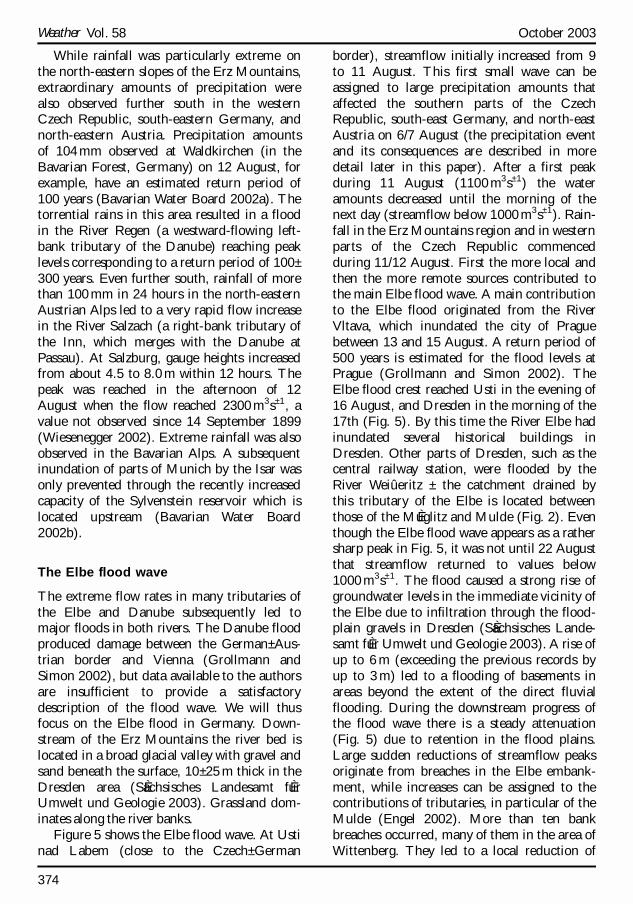
Figure 5 shows the Elbe flood wave. At Ustinad Labem (close to the Czech± German
border), streamflow initially increased from 9to 11 August. This first small wave can beassigned to large precipitation amounts thataffected the southern parts of the CzechRepublic, south-east Germany, and north-eastAustria on 6/7 August (the precipitation eventand its consequences are described in moredetail later in this paper). After a first peakduring 11 August (1100m3s± 1) the wateramounts decreased until the morning of thenext day (streamflow below 1000m3s± 1). Rain-fall in the Erz Mountains region and in westernparts of the Czech Republic commencedduring 11/12 August. First the more local andthen the more remote sources contributed tothe main Elbe flood wave. A main contributionto the Elbe flood originated from the RiverVltava, which inundated the city of Praguebetween 13 and 15 August. A return period of500 years is estimated for the flood levels atPrague (Grollmann and Simon 2002). TheElbe flood crest reached Usti in the evening of16 August, and Dresden in the morning of the17th (Fig. 5). By this time the River Elbe hadinundated several historical buildings inDresden. Other parts of Dresden, such as thecentral railway station, were flooded by theRiver Weiû eritz ± the catchment drained bythis tributary of the Elbe is located betweenthose of the MuÈ glitz and Mulde (Fig. 2). Eventhough the Elbe flood wave appears as a rathersharp peak in Fig. 5, it was not until 22 Augustthat streamflow returned to values below1000m3s± 1. The flood caused a strong rise ofgroundwater levels in the immediate vicinity ofthe Elbe due to infiltration through the flood-plain gravels in Dresden (SaÈ chsisches Lande-samt fuÈ r Umwelt und Geologie 2003). A rise ofup to 6m (exceeding the previous records byup to 3m) led to a flooding of basements inareas beyond the extent of the direct fluvialflooding. During the downstream progress ofthe flood wave there is a steady attenuation(Fig. 5) due to retention in the flood plains.Large sudden reductions of streamflow peaksoriginate from breaches in the Elbe embank-ment, while increases can be assigned to thecontributions of tributaries, in particular of theMulde (Engel 2002). More than ten bankbreaches occurred, many of them in the area ofWittenberg. They led to a local reduction of
Weather Vol. 58 October 2003
374

streamflow of more than 500m3s± 1 or 10%(Engel 2002) at this gauge. Controlled floodingof areas near the Havel estuary reduced theflood wave by about 75 million m3. Engel(2002) suggests that a favourable timing bothof dyke breaks and of the intentional floodingof retention areas significantly reduced theflood wave further downstream. Thus, thereturn periods of peak streamflow at down-stream locations are clearly below 100 years,while they exceeded 200 years at Usti andDresden (Engel 2002).
Further extreme rainfall events duringthe first half of August 2002
The extreme rainfalls on 11± 13 August 2002and the subsequent flooding were not uniqueduring the first half of this month. Extremeprecipitation amounts associated with wide-spread thunderstorm activity ± characterisedby large variations in rainfall intensity ± in abelt extending from northern Germany to Aus-tria had already been observed early in August2002. Precipitation sums from the first 12 daysof August amounted to some 150% of the aver-
age August rainfall in parts of northern Ger-many (North Sea and Baltic Sea coasts, seeFig. 1) (Deutscher Wetterdienst 2002). On 6and 7 August, there was a first large-scale rain-fall event in central Europe. It affected a regionencompassing the south-western part of theCzech Republic, Lower Austria, and south-eastern Germany.
More than 100mm of rain was observed atseveral weather stations in eastern Bavaria. Inspite of the fact that these amounts have returnperiods of 50± 100 years, they did not causemajor flood waves due to the low antecedentriver flows and still unsaturated soils (BavarianWater Board 2002a). For Lower Austria, how-ever, the local intensities and their conse-quences were much larger. At Zwettl-Stift,located in the Waldviertel ( forest quarter’ )about 250mm fell during 6 and 7 August, withmaximum intensities occurring around 2200GMT on 6 August and during the afternoon of7 August (Gutknecht et al. 2002). They led toa peak discharge of the River Kamp (of about800m3s± 1) with an estimated return periodof several thousand years (Gutknecht et al.2002).
Fig. 5 Development of the surge of the River Elbe, based on discharge rates at several gauge locations. Left to right isdownstream. (Courtesy of H. Engel and W. Wiechmann, Bundesanstalt fuÈ r GewaÈ sserkunde, Koblenz, Germany.)
375
Weather Vol. 58 October 2003

Concluding remarks
The first two weeks of August 2002 were char-acterised by extreme rainfall events in centralEurope. Two events (6/7 and 12/13 August)caused severe flooding, in particular in smallercatchments in the Waldviertel (Lower Austria,former event) and in the Erz Mountains (latterevent). Precipitation sums for the first half ofAugust clearly exceeded the respective monthlyaverage values in a belt from northern Ger-many to Austria. A new record for Germanywith respect to 24-hour totals (312 mm) wasset at Zinnwald weather station. The individualpeak 10-minute rainfall amounts at the samestation are, however, not uncommon. Due tothe duration of intensive rainfall, severe flood-ing of the Rivers Danube and Elbe wasinduced. The floods produced economic lossesexceeding those of the winter storm of Decem-ber 1999 (Lothar) which was previously themost expensive weather event in Europe. Theriver level at Dresden rose to a new recordheight, exceeding the peak of 1845 ± whensnowmelt and an ice dam were both contribu-tory factors. This should not detract from thefact that summer floods are relatively commonin central Europe. They are usually associatedwith a typical track of cyclones known amongGerman meteorologists as the `Vb-track’ . In asubsequent companion paper we will describethe specific synoptic conditions that led to thetwo main events (6/7 and 12/13 August), dis-cuss similarities with recent floods of neigh-bouring rivers (the Odra in 1997, the Vistula in2001), and relate the events to results frommodel simulations of greenhouse gas-inducedclimatic change.
Acknowledgements
We wish to thank H. Engel and W. Wiechmannof the German Federal Institute of Hydrology(Koblenz) for providing Fig. 5 and for theirreadiness in replying to our questions; theSaxonian State Office for Environment andGeology (Dresden) for providing the gaugelevel data for Dohna and a preprint of thereport on the groundwater effects of the floods;B. Rudolf of the Global Precipitation andClimate Centre (Offenbach) for providing Fig.
1; and Deutscher Wetterdienst (the GermanWeather Service) for providing the 10-minuterainfall measurements. We also thank Ms R.Lauber for providing the picture of Weesen-stein (Fig. 3). The work was supported by theEU project MICE (Modelling the Impacts ofClimate Extremes) under grant EVK2-CT-2001-00118.
References
Bartels, H., Malitz, G., Asmus, S., Albrecht, F. M.,Dietzer, B., GuÈ nther, T. and Ertel, H. (1997)StarkniederschlagshoÈ hen fuÈ r Deutschland, KOSTRA.Deutscher Wetterdienst, Offenbach
Bavarian Water Board (Bayerisches Landesamt fuÈ rWasserwirtschaft, Hochwassernachrichtendienst)(2002a) Hochwasser im August 2002, mitBerichtigungen vom 28.10.2002. Available onlinefrom http://www.bayern.de/lfw/hnd/hw110802/titelseite.htm
Ð Ð (2002b) Sylvensteinspeicher schuÈ tzt erneutMuÈ nchen vor Hochwasser-UÈ berschwemmungen.Press release 14 August 2002, available onlinefrom http://www.bayern.de/lfw/aktuelles/presse/14_08_02_sylvenstein.htm
Boyle, C. E. (2002) Eastern European floods causewidespread damage. Insur. J., September 2002,available from http://www.insurancejournal.com/magazines / southcentral / 2002 / 09 / 16 / features /23361. htm
Cornford, S. G. (2002) Human and economicimpacts of weather events in 2001. Bull. WorldMeteorol. Organ., 5151, pp. 257± 277
Deutscher Wetterdienst (German Weather Service)(2002) Extreme precipitation amounts in centralEurope from 1± 13 August 2002. Available onlinefrom http://www.dwd.de/en/FundE/Klima/KLIS/prod / spezial / regen / rr_extreme_200208_germany. pdf
Engel, H. (2002) Das Augusthochwasser 2002 im Elbe-gebiet. Available online from http://www.bafg.de/html/projekte/hydro/engel/ elbe2002.pdf
Grollmann, T. and Simon, S. (2002) Flutkatastro-phen ± Boten des Klimawandels. Z. Versicher., 5353,pp. 682± 689
Gutknecht, D., Reszler, C. and BloÈ schl, G. (2002)Jahrtausend-Hochwasser am Kamp? Availableonline from http://www.tuwien.ac.at/forschung/nachrichten/a-kamp.htm
SaÈ chsisches Landesamt fuÈ r Umwelt und Geologie(2003) Einfluss des August Hochwassers 2002 aufdas Grundwasser. Report available from SaÈ ch-sisches Staatsministerium fuÈ r Umwelt und Land-wirtschaft, 01075 Dresden, Germany, availableonline from http://www.umwelt.sachsen.de/de/
Weather Vol. 58 October 2003
376

wu/umwelt/lfug/lfug-internet/veroeffentlichungen/verzeichnis/Wasser/HWBericht.pdf
Smoltczyk, A. (2002) Die Wasser von Weesenstein.Der Spiegel, 26 August, pp. 76± 83
Ulbrich, U., Fink, A. H., Klawa, M. and Pinto, J. G.(2001) Three extreme storms over Europe inDecember 1999. Weather, 5656, pp. 70± 80
Wiesenegger, J. (2002) Das 100-jaÈ hrliche Hochwasseram 12. August 2002. Available online from http://www.salzburg.gv.at/themen/nuw/wasserwirtschaft/64-hydrographie/hochwasser.htm/hw-aug-2002.htm
The online documents referenced above aremirrored under http://www.meteo.uni-koeln.de/content/forschung/klimadiagnose/floods.html
Correspondence to: Dr U. Ulbrich, Institute forGeophysics and Meteorology, University ofCologne, 50923 KoÈ ln, Germany. e-mail: [email protected]# Royal Meteorological Society, 2003.doi: 10.1256/wea.61.03A
An extreme precipitation event in southernMorocco in spring 2002 and somehydrological implications
Andreas H. Fink and Peter KnippertzInstitute of Geophysics and Meteorology, University of Cologne, Germany
Between 30 March and 1 April 2002, a heavyrainstorm crossed the region stretching fromthe hyper-arid north-western Sahara, acrossthe arid southern foothills of the High Atlas, tothe latter’s main watershed. It caused excep-tional precipitation totals (Table 1). The72mm at the Moroccan town of Ouarzazate(see location map in Fig. 1), recorded between1800GMT on 31 March and 1800GMT on 1April, corresponded to 62% of the annual aver-age (Table 1) and to about seven times theaverage March rainfall. In contrast to the muchwetter region north of the Atlas chain, only
slightly more than 30 raindays (>0.1mm) peryear are observed at Ouarzazate and stormswith totals of more than 25mm are recordedless than once a year, displaying a large year-to-year variability (e.g. five years without a singleintense storm between 1980 and 1985, but fivestorms between late 1987 and early 1989). Thedescribed event is the highest daily accumula-tion measured since at least September 1977.Among the detrimental effects of the intenseprecipitation event are flash floods, flooding ofroads (Fig. 2(a)) and collapsing walls. Thephoto of the giant intermittent waterfall in the
Table 1 Accumulated precipitation (between 1800GMT on 30 March and 0000GMT on 2 April 2002) atconsidered stations with 3-hourly synoptic observations. Percentages of the respective annual averages are givenfor comparison.
Name WMONo.
Country Lat.(N)
Long.(W)
Height(m)
Accumulatedprecipitation
(mm)
% ofannualaverage
Agadir 60252 Morocco 30820’ 9834’ 23 13 5Sidi Ifni 60060 Morocco 29822’ 10811’ 66 26 18Ouarzazate 60265 Morocco 30856’ 6854’ 1140 72 62Errachidia 60210 Morocco 31856’ 4824’ 1042 31 25Bechar 60571 Algeria 31837’ 2814’ 816 13 15Tindouf 60656 Algeria 27840’ 8808’ 439 25 54Bir Moghrein 61401 Mauritania 25814’ 11837’ 364 11 26
377
Weather Vol. 58 October 2003

Fig. 3 View of the main road of Weesenstein, a village south of Dresden. The picture was taken on 14 August 2002, atabout 1600 LT, i.e. two days after the extreme rainfall. The regular bed of the River MuÈ glitz is located in the background.(See article on p. 371.)
# W. S. Pike
Developing cumulonimbus cloud on 31 July 1999, east of Woodlands St. Mary, Berkshire. This was one of the hottestdays of 1999 in south-east England and, by mid-evening, when this picture was taken, large convective clouds hadformed.
391
Weather Vol. 58 October 2003
Related Documents


