PHASE 1 COMPLETION REPORT THE CAMIGUIN COASTAL RESOURCE MANAGEMENT PROJECT NOVEMBER 2007-FEBRUARY 2011 Implemented by PROVINCIAL GOVERNMENT OF CAMIGUIN 5 MUNICIPAL GOVERNMENTS OF CAMIGUN DEPARTMENT OF ENVIRONMENT AND NATURAL RESOURCES Supported by NEW ZEALAND AID PROGRAMME Managed by TETRA TECH EM INC.

Welcome message from author
This document is posted to help you gain knowledge. Please leave a comment to let me know what you think about it! Share it to your friends and learn new things together.
Transcript

PHASE 1 COMPLETION REPORT
THE CAMIGUIN COASTAL
RESOURCE MANAGEMENT
PROJECT
NOVEMBER 2007-FEBRUARY 2011
Implemented by
PROVINCIAL GOVERNMENT OF CAMIGUIN
5 MUNICIPAL GOVERNMENTS OF CAMIGUN DEPARTMENT OF ENVIRONMENT AND NATURAL RESOURCES
Supported by
NEW ZEALAND AID PROGRAMME
Managed by
TETRA TECH EM INC.

PHASE 1 COMPLETION REPORT
THE CAMIGUIN COASTAL RESOURCE
MANAGEMENT PROJECT
NOVEMBER 2007-FEBRUARY 2011
Implemented by:
PROVINCIAL GOVERNMENT OF CAMIGUIN
5 MUNICIPAL GOVERNMENTS OF CAMIGUN
DEPARTMENT OF ENVIRONMENT AND NATURAL RESOURCES
In partnership with:
DEPARTMENT OF AGRICULTURE/BUREAU OF FISHERIES AND AQUATIC RESOURCES
DEPARTMENT OF TRADE AND INDUSTRY
DEPARTMENT OF TOURISM
DEPARTMENT OF EDUCATION
NATIONAL ECONOMIC AND DEVELOPMENT AUTHORITY
CAMIGUIN POLYTECHNIC STATE COLLEGE
Supported by:
NEW ZEALAND AID PROGRAMME
Contract No: CON/253/2
Philippines
Managed by:
TETRA TECH EM INC.
18th Floor, OMM-CITRA Bldg., San Miguel Ave. Ortigas Center
1605 Pasig City, Philippines

CCRMP Phase 1 Completion Report i
PREFACE
The Camiguin Coastal Resource Management Project (CCRMP) provides management and technical
assistance to the Camiguin Provincial Government and to its five local government units (LGUs),
coastal communities, non-government organizations (NGOs), and national government agencies to
improve and institutionalize the management of coastal resources in the island province of
Camiguin. It is funded by the New Zealand Aid Programme (NZAP) with the Department of
Environment and Natural Resources (DENR) as the lead implementing agency in partnership with the
Department of Agriculture-Bureau of Fisheries and Aquatic Resources (DA-BFAR), National Economic
and Development Authority (NEDA), Department of Tourism (DOT), Department of Trade and
Industry (DTI), Department of Education (DepEd), Camiguin Polytechnic State College (CPSC), LGUs,
Community Volunteer Organizations (CVOs), and People’s Organizations (POs).
The CCRMP, in its Project Design, would have two phases, Phase 1 and Phase 2, with a total project
term of five years, three years for Phase 1 and two Years for Phase 2. Phase 1 should have ended in
September 30, 2010, but was extended for five months (October 1, 2010 to February 28, 2011) to
allow for a mid-term review to be conducted by an Evaluation Team of experts and the latter’s
findings to feed into the Phase 2 Design.
This Phase 1 Completion Report discusses the implementation of the Life of Project Plan from
November 2007 to February 2011 including interventions, processes, lessons and progress towards
the achievement of the targets at the end of five (5) years (life of the Project). Any judgment or
assessment of impact at this time, therefore, would be premature. This Report also submits
recommendations that will enable Camiguin stakeholders to effectively build on the Project gains in
its Phase 2 and beyond.
Management services and technical support in Phase 1 of the CCRMP were provided by Tetra Tech
EM, Inc. through a Team of consultants and field staff. Tetra Tech EM Inc. was awarded a three-year
contract by NZAP to implement Phase 1 of CCRMP covering the period November 2007 to
September 30, 2010. This was extended to February 28, 2011. An intervening organizational
restructuring decision, however, has caused Tetra Tech EM Inc. in the Philippines not to pursue
Phase 2 of CCRMP as its Management Service Contractor.
The Project benefited from the wealth of experiences and lessons from the Coastal Resource
Management Project, a nation-wide nine-year CRM project funded by the United States Agency for
International Development and also managed by Tetra Tech EM Inc. The CCRMP Project Design
“borrowed” substantially and benefited much from the adaptation of its results framework and best
practices and tool kit, use of its Information, Education, and Communication materials and messages
and Municipal Coastal Data Base system, among others. Providing impetus to the Project were the
partner National Government Agencies (NGAs), through their Regional, Provincial, and Municipal
representatives and the Provincial and Municipal LGUs, who strived to deliver on their commitments
in the Project’s Memorandum of Agreement. The involvement and participation of the academe -
the Camiguin Polytechnic State College and the Department of Education – and the private sector,
headed by the Camiguin Tourism Association, brought to the Project fresh insight and more CRM
champions.
CCRMP salutes all those in government, especially the Local Government Units of, the fisherfolk,
women and youth of Camiguin, and the other sectors of society that the Project had the privilege to

CCRMP Phase 1 Completion Report ii
work with, for their engagement and participation in the wide range of action and activities that are
beginning to yield inspiring results.

CCRMP Phase 1 Completion Report iii
PROJECT HIGHLIGHTS
Year 1 (November 2007-September 2008)
Launching of CCRMP August 2007
Project Priority Setting Workshop December 2007
Creation of Provincial and 5 Municipal Coastal Resource Management Offices Designation of Provincial and Municipal CRM Officers
Creation of Technical Working Groups
Training of MTWG and barangay leaders on PCRA Conduct or PCRA

CCRMP Phase 1 Completion Report iv
Study tour to successful CRM sites in Bohol, Negros Oriental, and Cebu
1st Project Steering Committee Meeting
Turnover of equipment (computers, vehicles, GPS, etc.)
Municipal Coastal Database Training
Launching of Project website
Barangay CRM Planning Integrated CRM Orientation and Training
Municipal CRM Planning
CCRMP Phase 1 Completion Report v
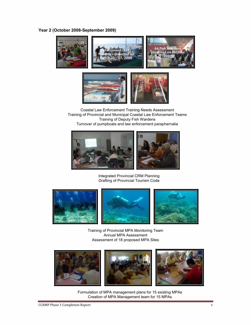
Year 2 (October 2008-September 2009)
Coastal Law Enforcement Training Needs Assessment
Training of Provincial and Municipal Coastal Law Enforcement Teams
Training of Deputy Fish Wardens
Turnover of pumpboats and law enforcement paraphernalia
Integrated Provincial CRM Planning
Drafting of Provincial Tourism Code
Training of Provincial MPA Monitoring Team
Annual MPA Assessment
Assessment of 18 proposed MPA Sites
Formulation of MPA management plans for 15 existing MPAs
Creation of MPA Management team for 15 MPAs

CCRMP Phase 1 Completion Report vi
Installation of MPA mooring and marker buoys in 15 MPAs
Installation of 15 MPA signboards
Zoning of Mantigue Island, Mahinog and White Island, Mambajao
Enactment of Mantigue Island Nature Park Ordinance
Drafting of White Island Marine Park Ordinance
Organization of the transport service providers of Mahinog, MAMSA
Standardization of tourist transport operations
Giant clam (T. derasa) stock enhancement in Pasil Reef, White Island and
Mantigue Island

CCRMP Phase 1 Completion Report vii
Year 3 (October 2009-September 2010)
Establishment of 16 new MPAs
Formulation of MPA Management Plans for 16 new MPAs
Formation of 16 new MPA Management Teams
Installation of MPA marker buoys
Training of 2nd batch of MPA Monitoring Team members
2010 annual mpa monitoring
Adoption of Mambajao Municipal CRM Plan Adoption of Mambajao CRM and Fisheries Code
Trained LGUs on Financial Management Installation and Training of QuickBook
Establishment of Financial Downloading Mechanism
Legitimization of the MPA Monitoring Team

CCRMP Phase 1 Completion Report viii
Establishment of Papillon Garden in Ardent
Hot Spring Resort in Mambajao
Training and Deputation of 2nd
batch of Deputy Fish Wardens
Establishment of Mangrove Boardwalk in
Benoni, Mahinog
Establishment of bottled sardines enterprise in Agoho, Mambajao
Establishment of Mussel Production in Benoni, Mahinog
Establishment of Seaweed Farming in Mambajao, Mahinog, Guinsiliban, and Sagay

CCRMP Phase 1 Completion Report 9

CONTENTS
TABLES AND FIGURES
ABBREVIATIONS AND ACRONYMS
PREFACE
PROJECT HIGHLIGHTS
CHAPTER 1. PROJECT BACKGROUND
1. PROJECT OBJECTIVES AND RESULT FRAMEWORK P 1-2 2. VISION, GOAL, AND OBJECTIVES P 2-3 3. PROJECT IMPLEMENTATION COMPONENTS P 3-4 CHAPTER 2. IMPLEMENTATION ACHIEVEMENT AND RESULTS
1. PROJECT LOGICAL FRAMEWORK P 5-12 2. ACCOMPLISHMENTS TOWARDS GOAL P 12-23 3. ACCOMPLISHMENTS TOWARDS OBJECTIVE 1 P 23-27 4. ACCOMPLISHMENTS TOWARDS OUTPUT 1 P 28-32 5. ACCOMPLISHMENTS TOWARDS OUTPUT 2 P 32-36 6. ACCOMPLISHMENTS TOWARDS OUTPUT 3 P 36-42 CHAPTER 3. PROJECT MANAGEMENT: PERFORMANCE AND LESSONS
1. EXCERPTS FROM EVALUATION REPORT P 43-46 2. MANAGEMENT STRATEGIES, APPROACHES, AND LESSONS P 46-49 CHAPTER 4. CHALLENGES FOR PHASE 2 AND SUSTAINABILITY
1. CHALLENGES FOR PHASE 2 P 50 2. RECOMMENDATIONS P 50-51 3. SUSTAINABILITY ISSUES P 51-52 4. LESSONS LEARNED FROM CCRMP EXPERIENCE P 52 REFERENCES USED IN TEXT
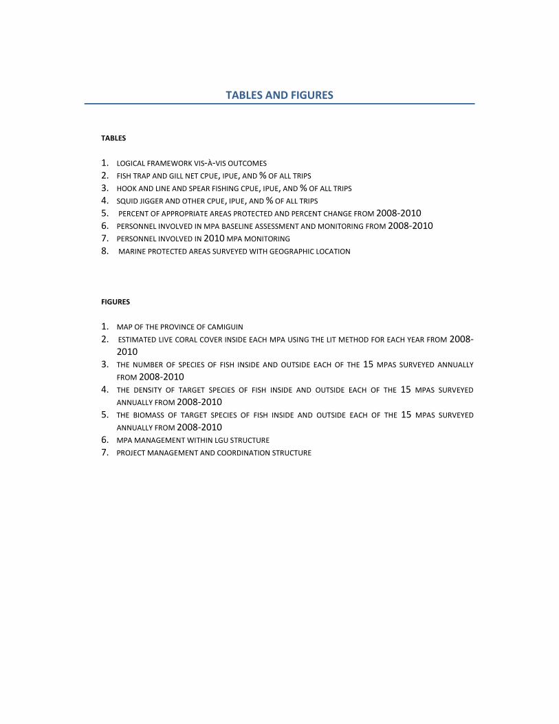
TABLES AND FIGURES
TABLES
1. LOGICAL FRAMEWORK VIS-À-VIS OUTCOMES 2. FISH TRAP AND GILL NET CPUE, IPUE, AND % OF ALL TRIPS 3. HOOK AND LINE AND SPEAR FISHING CPUE, IPUE, AND % OF ALL TRIPS 4. SQUID JIGGER AND OTHER CPUE, IPUE, AND % OF ALL TRIPS 5. PERCENT OF APPROPRIATE AREAS PROTECTED AND PERCENT CHANGE FROM 2008-2010 6. PERSONNEL INVOLVED IN MPA BASELINE ASSESSMENT AND MONITORING FROM 2008-2010 7. PERSONNEL INVOLVED IN 2010 MPA MONITORING 8. MARINE PROTECTED AREAS SURVEYED WITH GEOGRAPHIC LOCATION
FIGURES
1. MAP OF THE PROVINCE OF CAMIGUIN 2. ESTIMATED LIVE CORAL COVER INSIDE EACH MPA USING THE LIT METHOD FOR EACH YEAR FROM 2008-
2010 3. THE NUMBER OF SPECIES OF FISH INSIDE AND OUTSIDE EACH OF THE 15 MPAS SURVEYED ANNUALLY
FROM 2008-2010 4. THE DENSITY OF TARGET SPECIES OF FISH INSIDE AND OUTSIDE EACH OF THE 15 MPAS SURVEYED
ANNUALLY FROM 2008-2010 5. THE BIOMASS OF TARGET SPECIES OF FISH INSIDE AND OUTSIDE EACH OF THE 15 MPAS SURVEYED
ANNUALLY FROM 2008-2010 6. MPA MANAGEMENT WITHIN LGU STRUCTURE 7. PROJECT MANAGEMENT AND COORDINATION STRUCTURE

ABBREVIATIONS AND ACRONYMS
AIP
:
Annual Investment Plan
BCRM : Barangay Coastal Resource Management BD : Bantay Dagat BDC : Barangay Development Council BDP : Barangay Development Plan BEMO : Bohol Environment Office BFARMC : Barangay Fisheries and Aquatic Resource Management Council CBFMA : Cantaan Community-based Forest Management Agreement CBM : Community-Based Management CCMPC : Cantaan Centennial Multi-Purpose Cooperative CCRMP : Camiguin Coastal Resource Management Project CITES : Convention on International Trade in Endangered Species of Wild Fauna
and Flora CLE : Coastal Law Enforcement CMMD : Coastal and Marine Management Division CMMO : Coastal and Marine Management Office CPSC : Camiguin Polytechnic State College CPUE : Catch per Unit Effort CRM : Coastal Resource Management CRMO : Coastal Resource Management Officer CVOs : Community Volunteer Groups CWTS : Community Welfare Training Service DA-BFAR : Department of Agriculture- Bureau of Fisheries and Aquatic Resources DAO : DENR Administrative Order DBM Department of Budget and Management DENR : Department of Environment and Natural Resources DepEd : Department of Education DFW : Deputized Fish Warden DILG : Department of Interior and Local Government DOH : Department of Health DOST : Department of Science and Technology DOT : Department of Tourism DTI : Department of Trade and Industry EMB : Environmental Management Bureau ENRO : Environment and Natural Resources Office EO : Executive Order ERDS : Ecosystems, Research and Development Services FARMC : Fisheries and Aquatic Resource Management Council FASPO : Foreign-Assisted and Special Projects Office FISH : Fisheries Improved for Sustainable Harvest FVC : Fish Visual Census GIS : Geographic Information System GPS : Global Positioning System ICRM : Integrated Coastal Resource Management IEC : Information, Education and Communication

IIMS : Integrated Information Management System IIRR : International Institute for Rural Reconstruction IPUE : Income per Unit Effort LCE : Local Chief Executive LGU : Local Government Unit LHC : Live Hard Coral LIT : Line Intercept Transect LOP : Life-of-Project LQF : Liquid Quick Freezer L&C : Learning and Communication MAMSA : Mahinog Motorboat Service Association MAO : Municipal Agriculture Office MBDO : Mahinog Business Development Officer MCDP : Municipal Comprehensive Development Plan MCLET : Municipal Coastal Law Enforcement Team MCRM : Municipal Coastal Resource Management MENRO : Municipal Environment and Natural Resources Office MFARMC : Municipal Fisheries and Aquatic Resource Management Council MINaP : Mantigue Island Nature Park MLGU : Municipal Local Government Unit MOA : Memorandum of Agreement MPA : Marine Protected Area MPDC : Municipal Planning and Development Coordinator MSC : Management Services Contractor MSUNF : Mindanao State University – Naawan Foundation MTWG : Municipal Technical Working Group M&E : Monitoring and Evaluation NAMRIA : National Mapping and Resource Information Authority NEDA : National Economic and Development Authority NGA : National Government Agency NGO : Non-Government Organization NZAP : New Zealand Aid Programme PAMB : Protected Area Management Board PAO : Provincial Agriculture Office/Officer PAWCZMS : Protected Areas, Wildlife and Coastal Zone Management Service PCG : Philippine Coast Guard PCRA : Participatory Coastal Resource Assessment PCRM : Provincial Coastal Resource Management PCRMO : Provincial Coastal Resource Management Officer PEMSEA : Partnerships in Environmental Management for the Seas of East Asia PENRO : Provincial Environment and Natural Resource Office/Officer PLGU : Provincial Local Government Unit PMTDP : Philippine Medium Term Development Plan PNP : Philippine National Police POs : People’s Organizations PPDO : Provincial Planning Development Office PSC : Project Steering Committee PSES : Participatory Socio-Economic Survey PTWG : Project Technical Working Group RA : Republic Act RED : Regional Executive Director
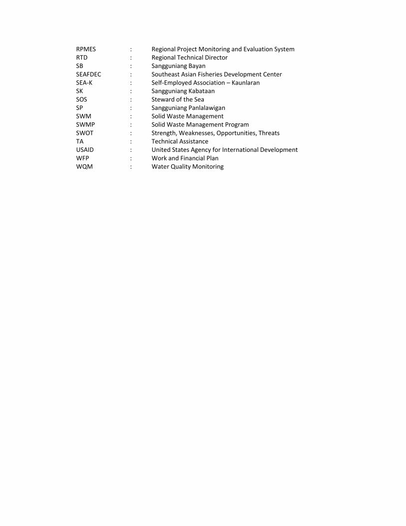
RPMES : Regional Project Monitoring and Evaluation System RTD : Regional Technical Director SB : Sangguniang Bayan SEAFDEC : Southeast Asian Fisheries Development Center SEA-K : Self-Employed Association – Kaunlaran SK : Sangguniang Kabataan SOS : Steward of the Sea SP : Sangguniang Panlalawigan SWM : Solid Waste Management SWMP : Solid Waste Management Program SWOT : Strength, Weaknesses, Opportunities, Threats TA : Technical Assistance USAID : United States Agency for International Development WFP : Work and Financial Plan WQM : Water Quality Monitoring

CCRMP Phase 1 Completion Report Page 1
CHAPTER 1
1. Project Objectives and Result Framework
1.1 Introduction and Rationale
The Philippine Medium Term Development Plan (PMTDP 2004-2010) recognized that coastal and marine
ecosystems are important sources of livelihood for about 70 percent of the country’s municipalities since
these are rich sources of fish and aquatic products used for food. The PMTDP also acknowledges the
indispensable ecological roles that the above ecosystems perform, such as flood and erosion control.
Habitats that can be found in the coastal areas include mangroves, coral reefs and sea grass beds which
are rich sources of fish and other aquatic products, breeding grounds and habitat for wildlife and natural
areas for recreation and tourism and other related activities.
Coastal Resource Management (CRM) also referred to as ‘coastal management’, ‘coastal area
management’, ‘integrated coastal management’, and ‘integrated coastal resource management’, has
been practiced in the Philippines for almost two decades.
CRM is defined (DENR, 2001 et al.) as the process of planning, implementing, and monitoring sustainable
use of coastal resources through participation, collective action and sound decision making. It is now
acknowledged that it is important to involve local communities in the management of their natural
resources in collaboration with local government units and that they will continue to do so if there is a
clear demonstration that greater and lasting benefits are derived from better and sustainable
management.
The Philippine Government solicited assistance from the New Zealand Government for coastal resource
management in Northern Mindanao. Three (3) sites nominated by the DENR in 1988 were investigated
through a pre-feasibility study. Of the three sites, Camiguin Island Province was assessed to have better
opportunities and less severe risks and constraints for the establishment of CRM than Gingoog Bay or
Murcielagos Bay. This was validated in the Feasibility Study (Tonkin and Taylor, 2000) and Post-Feasibility
Study (2002).
The Project was originally intended to be located only in three (Mahinog, Sagay and Guinsiliban) of the
five municipalities of Camiguin but the findings of the Pre-Feasibility Study (2002) and Design Phase
(2004) pointed to the appropriateness and need for CRM in all of the five municipalities, to include
Mambajao and Catarman. The following reasons were cited:
� The coastal as well as marine environment of the island can be made more productive if
managed as one single ecosystem as it would be more cost-effective if the management covered
the whole island instead of specific areas. It was also expected that the synergistic efforts of the
five LGUs and the Provincial Government would yield more and better results.
� Many of the issues mentioned during the Feasibility Study and Post-Feasibility Study, such as
commercial fishing within municipal waters by transients, pollution and lack of regulation in the
use of municipal coastal and marine resources, and siltation remained priority issues as shown by
the proceedings of the 2004 consultation with Camiguin stakeholders.
� The gains of the Project would benefit more families and communities and diffusion of
knowledge would be better effected if a broader community was involved. In addition,
institutionalization of CRM as a part of governance within the socio-political structure would be
more effective on a provincial scale, with all the five municipalities equally engaged and
benefited.
� All the municipalities in Camiguin are located along the coast and all were classified as 6th
class
(until last year) the poorest in the Philippines. To date, the Municipality of Mambajao has

CCRMP Phase 1 Completion Report Page 2
become a third class municipality, Mahinog, Catarman and Sagay are classified as fifth class,
while Guinsiliban remains a sixth class municipality.
� The entire island is also a province, thus ensuring political support, focus and integration in the
entire island.
� Majority of the fishers and coastal residents who were consulted were willing to actively
participate in a CRM Project.
� Camiguin Island was planned and promoted as a major ecotourism destination (Northern
Mindanao Development Plan – 1993-1998) because of its attractive natural attributes and the
quality and variety of its natural resources, thus necessitating conservation of marine habitats
and maintenance of water quality.
The Project’s Life of Project Work Plan was anchored on the two core coastal resource management
issues that were identified during the consultation process: (1) declining natural productivity and
integrity of coastal and marine ecosystems and (2) acute poverty and widening social inequity. Poverty is
widespread in the province and needed to be addressed hand in hand with natural resource issues
because households in Camiguin are mostly dependent on the coastal resources for food, livelihood and
recreation.
2. Vision, Goal, and Objectives
2.1 Vision
The CCRMP envisions an increased natural productivity and enhanced integrity of coastal and marine
resources while providing sustainable economic activities towards an improved quality of life among the
Camiguinons.
This means that based on an established baseline, the natural productivity of the coastal zone would
have improved and its integrity enhanced after five years as shown by (1) a stable or significant increase
in catch per unit effort of reef and reef-associated fish species; (2) significant increases in live coral cover,
increased fish density and size inside marine sanctuaries, and increased basal area of mangroves; (3)
significant improvement in overall water quality as indicated by increased water clarity over baseline; (4)
at least 10%1 of appropriate area for protection, particularly coastal habitats (10% of 1,128 ha = 112 ha),
are under protection (as Marine Protected Areas); and (5) gradual decrease in the incidence of
unsustainable fishing (illegal and destructive such as the use of compressor, cyanide, fine mesh nets,
etc.).
At the same time, the quality of life among the residents of Camiguin would be considered improved if
after five years (1) at least one major enterprise is developed and downstream economic activities
created per municipality; (2) the income of direct beneficiaries are increased; and (3) there is a marked
participation and representation of women in decision making and CRM-related activities.
2.2 Goals
In order to achieve the project vision, the CCRMP shall be implemented in 2 phases, Phase 1 having
duration of 3 years and Phase 2, 2 years. The goal for Phase 1 is the institutionalization of an integrated
coastal resource management system among local communities and in the province of Camiguin. The
goal of Phase 2 is to have ICRM sustainably implemented at the community level. For five years, it will
facilitate CRM implementation on a provincial scale but it will focus specific interventions on
communities with lesser risks and with relatively fair and good coastal resource condition.
1 Based on minimum requirements under the Fisheries Code.
CCRMP Phase 1 Completion Report Page 3
2.3 Objectives Project objectives for Phase 1 are to:
1) Institutionalize an integrated coastal resource management system at the barangay, municipal
and provincial levels in five years ; and
2) Strengthen capacities of Camiguin coastal communities, local government units, DENR, and other
institutions to protect and manage the municipal waters and the limited productive near shore
ecosystems and their resources.
Project objective for Phase 2 is the development of business/private sector, local government units and
local communities entrepreneurial capacities in sustainable coastal and marine resource based economic
enterprises
3. Project Implementation Components
Project implementation was divided into five components to ensure efficient administration and budget
allocation of funds for the implementation of the partners’ annual work and financial plans.
(1) Institutionalization,
(2) Pilot Area Development,
(3) Community-Based Projects,
(4) Resource Mobilization, and
(5) Learning and Communication.
Interventions for Institutionalization were directed towards enhancing and improving mechanisms in
governance, transparency, accountability and participation among local government units, national
agencies, civil society partners and private sectors in areas of research, planning, protection and
conservation, legislation, regulatory, enforcement, power of taxation and revenue generation, extension
/technical assistance, intergovernmental relations and networking to sustainably manage/develop
coastal and marine resources.
The component on Pilot Area Development was geared towards improving the condition and
productivity of the resource base. This in turn is expected to result in higher income to those dependent
on the resources.
THE COMMUNITY-BASED PROJECTS COMPONENT SOUGHT TO ADDRESS THE PROBLEM OF ACUTE POVERTY
AND WIDENING SOCIAL INEQUITIES BY PROVIDING INCOME-GENERATING OPTIONS FOR MAJORITY OF THE
RESIDENTS. SOME OF THESE HAVE BEEN FOUND TO EXIST IN THE ISLAND IN SMALL SCALE (E.G., ECO-
TOURISM) AND BEGAN TO BE ENHANCED IN THE THIRD YEAR OF THE PROJECT.
The Resource Mobilization component sought to address financial sustainability of CRM implementation.
The capacity of provincial and MLGUs to raise funds would be enhanced through trainings on the
preparation of feasibility studies, proposals and business plans and forums on potential opportunities and
windows from which assistance could be accessed.
The Learning and Communication component aimed to promote CRM through the development and
dissemination of Information, Education and Communication (IEC) materials, to facilitate the exchange of
information among CRM implementers, practitioners, and advocates and to raise public awareness on
CRM through participatory and popular activities.
CCRMP Phase 1 Completion Report Page 4
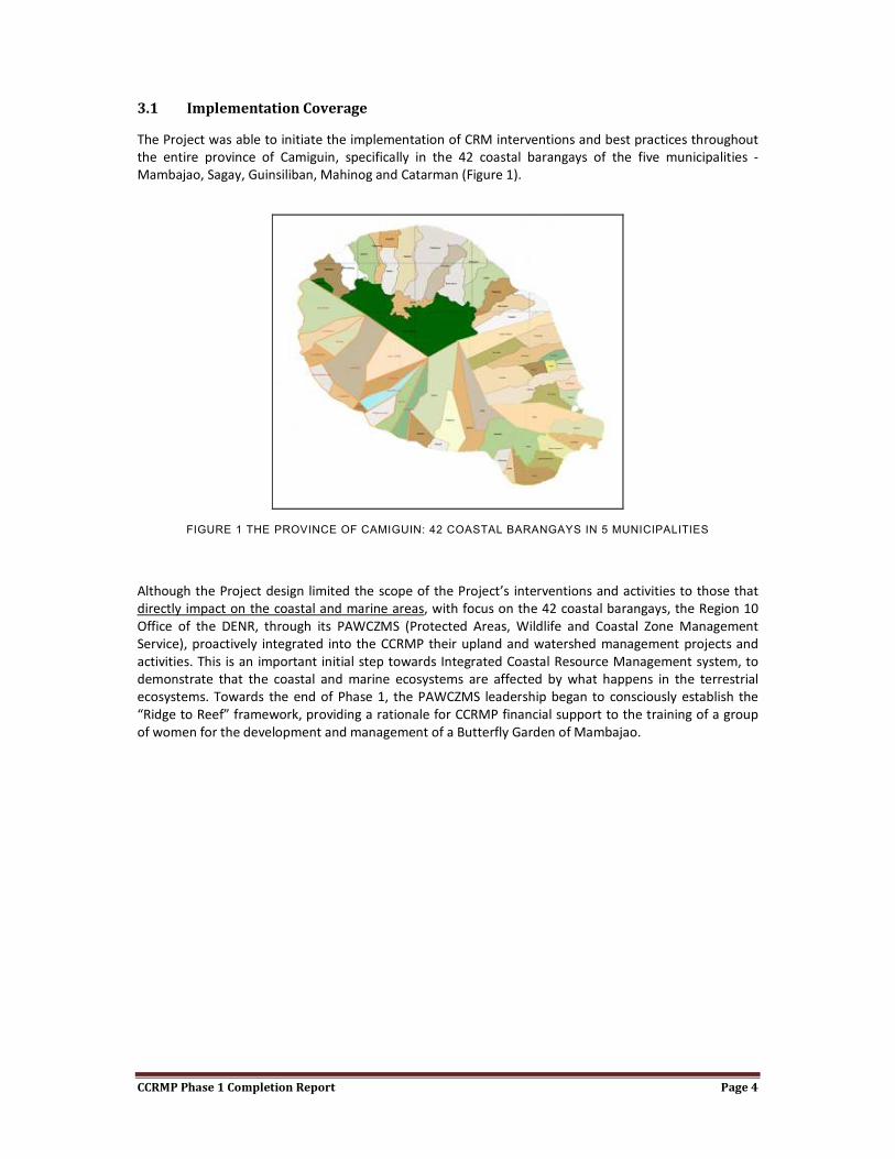
3.1 Implementation Coverage
The Project was able to initiate the implementation of CRM interventions and best practices throughout
the entire province of Camiguin, specifically in the 42 coastal barangays of the five municipalities -
Mambajao, Sagay, Guinsiliban, Mahinog and Catarman (Figure 1).
FIGURE 1 THE PROVINCE OF CAMIGUIN: 42 COASTAL BARANGAYS IN 5 MUNICIPALITIES
Although the Project design limited the scope of the Project’s interventions and activities to those that
directly impact on the coastal and marine areas, with focus on the 42 coastal barangays, the Region 10
Office of the DENR, through its PAWCZMS (Protected Areas, Wildlife and Coastal Zone Management
Service), proactively integrated into the CCRMP their upland and watershed management projects and
activities. This is an important initial step towards Integrated Coastal Resource Management system, to
demonstrate that the coastal and marine ecosystems are affected by what happens in the terrestrial
ecosystems. Towards the end of Phase 1, the PAWCZMS leadership began to consciously establish the
“Ridge to Reef” framework, providing a rationale for CCRMP financial support to the training of a group
of women for the development and management of a Butterfly Garden of Mambajao.
CCRMP Phase 1 Completion Report Page 5
CHAPTER 2. IMPLEMENTATION ACHIEVEMENT AND RESULTS
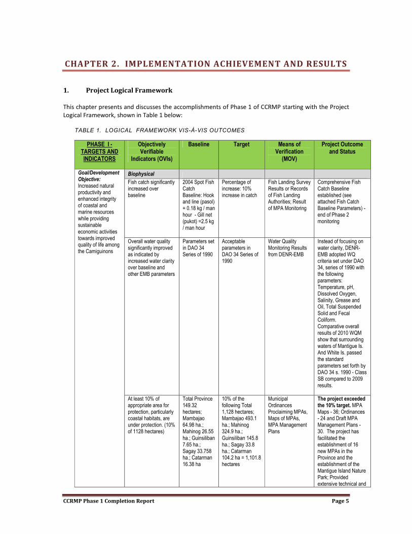
1. Project Logical Framework
This chapter presents and discusses the accomplishments of Phase 1 of CCRMP starting with the Project
Logical Framework, shown in Table 1 below:
TABLE 1. LOGICAL FRAMEWORK VIS-À-VIS OUTCOMES
PHASE I - TARGETS AND INDICATORS
Objectively Verifiable
Indicators (OVIs)
Baseline Target Means of Verification
(MOV)
Project Outcome and Status
Goal/Development Objective: Increased natural productivity and enhanced integrity of coastal and marine resources while providing sustainable economic activities towards improved quality of life among the Camiguinons
Biophysical
Fish catch significantly increased over baseline
2004 Spot Fish Catch Baseline: Hook and line (pasol) = 0.18 kg / man hour - Gill net (pukot) =2.5 kg / man hour
Percentage of increase: 10% increase in catch
Fish Landing Survey Results or Records of Fish Landing Authorities; Result of MPA Monitoring
Comprehensive Fish Catch Baseline established (see attached Fish Catch Baseline Parameters) - end of Phase 2 monitoring
Overall water quality significantly improved as indicated by increased water clarity over baseline and other EMB parameters
Parameters set in DAO 34 Series of 1990
Acceptable parameters in DAO 34 Series of 1990
Water Quality Monitoring Results from DENR-EMB
Instead of focusing on water clarity, DENR-EMB adopted WQ criteria set under DAO 34, series of 1990 with the following parameters: Temperature, pH, Dissolved Oxygen, Salinity, Grease and Oil, Total Suspended Solid and Fecal Coliform. Comparative overall results of 2010 WQM show that surrounding waters of Mantigue Is. And White Is. passed the standard parameters set forth by DAO 34 s. 1990 - Class SB compared to 2009 results.
At least 10% of appropriate area for protection, particularly coastal habitats, are under protection. (10% of 1128 hectares)
Total Province 149.32 hectares; Mambajao 64.98 ha.; Mahinog 26.55 ha.; Guinsiliban 7.65 ha.; Sagay 33.758 ha.; Catarman 16.38 ha
10% of the following Total 1,128 hectares; Mambajao 493.1 ha.; Mahinog 324.9 ha.; Guinsiliban 145.8 ha.; Sagay 33.8 ha.; Catarman 104.2 ha = 1,101.8 hectares
Municipal Ordinances Proclaiming MPAs, Maps of MPAs, MPA Management Plans
The project exceeded the 10% target. MPA Maps - 36; Ordinances - 24 and Draft MPA Management Plans - 30. The project has facilitated the establishment of 16 new MPAs in the Province and the establishment of the Mantigue Island Nature Park; Provided extensive technical and

CCRMP Phase 1 Completion Report Page 6
PHASE I - TARGETS AND INDICATORS
Objectively Verifiable
Indicators (OVIs)
Baseline Target Means of Verification
(MOV)
Project Outcome and Status
material assistance in the establishment of new MPAs; Facilitated the assessment of the Proposed MPA sites and preparation of technical maps for all MPAs
Overall reef, sea grass and mangrove health improved as indicated by significant increases in live coral cover, increased fish density and abundance inside marine sanctuaries, and increased basal area of mangroves over baseline
2008 - Table of Baseline Parameters
10% increase in LHC compared to baseline; 10% increase in fish abundance/density compared to baseline
MPA Annual Monitoring Reports, PRA Mid-Term and Post Project Reports
Live Coral Cover. On average, live coral cover remained the same, staying at 27%. Of the 15 MPAs surveyed, live coral cover increased in seven but decreased in eight. Overall Fish Diversity. On average, there was a reduction of 5.03% in the number of species of fish found in the MPAs around Camiguin. The decrease was greater outside the MPAs, with a reduction of 14.43%. Target Species Density. Taken as a whole, there was increase, on average, of 10.89% in the densities of target species inside the MPAs. But in the areas surveyed immediately outside the MPAs, densities of target species decreased, on average, by 13.70%. Target Species Biomass. Averaging all the 15 MPAs, the average biomass per 500m2 decreased by 45.18% inside the MPAs (from 6125.85g/500m2 in 2008 to 3358.36g/500m2 in 2010) and by 65.47% in the areas surveyed outside them (from 3013.61g/500m2 to 1040.60g/500m2).

CCRMP Phase 1 Completion Report Page 7
PHASE I - TARGETS AND INDICATORS
Objectively Verifiable
Indicators (OVIs)
Baseline Target Means of Verification
(MOV)
Project Outcome and Status
Socio-Economic
At least one enterprise developed and downstream economic activities created per municipality
None 1 CRM-Based Enterprise per Municipality
Enterprise organizational documents/business permits; Records of Members (gender disaggregated); Records of earnings/incomes; Survey of incomes of downstream economic activities
To be measured at the end of Phase 2: One Enterprise per Municipality Started; Guinsiliban - Bamboo Handicraft - 12 female, 5 male = 17; Mambajao Bamboo Handicraft - 3 female, 1 male = 4; Mahinog: MAMSA (with Business Permit)- 13 male; MINAP Ecotour Guide - 8 female; Sagay Seaweeds Cooperator - 15 male, 3 female = 18; Catarman: Conducted pre-FS for their proposed project on Dog Shark Oil
Increase in income of direct beneficiaries
Use CBMS 2009 Measured in
percentage increases
CBMS 2012 or CCRMP socio-economic monitoring form
To be measured at the end of Phase 2
Participation and representation of women in decision making and key CRM-related activities2
No information prior to project
Key decision making committees on CRM involve women who are active members
Presence of women in key committees; resolutions of decisions made
There was women representation in all CRM-Related activities based on attendance sheets. Most attendance sheets were not gender disaggregated and gender as a cross cutting theme was not emphasized from project start
Purpose/Immediate Objective Integrated coastal resource management system is institutionalized at the barangay, municipal and provincial levels in five years
5 municipalities have delineated their municipal waters, issued guidelines, implemented and monitored resource use within municipal waters
No delineations done prior to project
5 Municipalities Municipal Ordinances with technical descriptions of water boundaries and resource use regulations; Monitoring reports
100% Accomplished - 5 MLGUs with delineated municipal waters identify/clarify resource uses and maps.
Improvement in the rate of enforcement (number of illegal activities reported vis-à-vis responded to per municipality
No available data
100% action on reported illegal activities
Enforcement system showing reporting procedure, records of apprehensions, reward and sanction system; CLE Logbook entries or annual report of
A total of 110 seaborne patrol operations were conducted from January to September, 2010 by the 5 Municipal CLE Teams; 28 incidences of fishery law/ordinance violations
2 The Project Team thinks that this OVI is not consistent with socio-economic OVIs.

CCRMP Phase 1 Completion Report Page 8
PHASE I - TARGETS AND INDICATORS
Objectively Verifiable
Indicators (OVIs)
Baseline Target Means of Verification
(MOV)
Project Outcome and Status
apprehensions and actions taken
documented; actions taken against these violations were the imposition of fines, confiscation of fishing gears, reprimand and in one case, settlement
An integrated coastal resource management system is established and sustainably implemented at the BLGU and MLGU levels and fully coordinated and supported by the PLGU, which will be evaluated through an already established CRM certification system of DENR-CMMO
None Prior to Project
All Municipalities to have CRM Certificates
CRM Plans as implemented - Provincial ICM Plan; CRM Certificates for Municipalities; Enforcement System; CRMO offices and staff
Two LGUs - Catarman and Mambajao were awarded CRM Level 1 Certification Status by the Regional CRM Certification Committee in Year 2. In Year 3, Mahinog LGU achieved Level 2 Certification. Sagay and Guinsiliban have submitted required documents but have not presented
High Public Awareness especially school children on CRM
Information, Education and Communication is institutionalized at the P/MLGU levels and undertaken as part of the implementation strategy on CRM
All LGUs able to design their own materials; All CRMOs trained and implementing the Learning and Communication Action Plan; School and Barangay Based advocacy conducted
Functional LC Network with approved action plans implemented; List of IEC materials designed; number of schools and barangay orientations conducted
No of Persons Assigned for LC -28; Approved LC Action Plans - 7 (5 MLGUs, Province and DENR); No. of Persons Trained on Designing - 31; Launching of the Camiguin Steward of the Sea Movement; 18 Video-CD Kits distributed for School Based IEC;34 school based IEC on CRM conducted by the CRMOs; Province-Wide School Based Advocacy on CRM (also includes Solid Waste Management, Climate Change and Biodiversity Conservation) – 5 Municipal Forum; 1 Provincial Forum: Total attendance: 3,479; Science Teachers Orientation on CRM: 38
Conduct of Information Drive on SWM
58 Barangays conduct of info drive annually starting year 1
Information Materials; Reports on Information Drive
Conduct of Information Drive on Ecological and Solid Waste Management: Brigada sa Kabataan Launching: 194 (PLGU, MLGU-DILG Rep, DepEd Rep, SK); Coastal Clean-up

CCRMP Phase 1 Completion Report Page 9
PHASE I - TARGETS AND INDICATORS
Objectively Verifiable
Indicators (OVIs)
Baseline Target Means of Verification
(MOV)
Project Outcome and Status
(2008-2010) Inclusion of Solid Waste Management in the School and Barangay Based IEC; 5 Barangay (ABC Orientations) conducted (58 Barangays)
Outputs/Results 1) Integrated coastal resource management system institutionalized at the barangay, municipal and provincial levels
Functional and operational CRMO in 5 municipalities and coordinated by PCRMO
None Fully functional and funded CRM office and staff per municipality and the province
CRMO Office Space; CRMO Staff; Resolutions establishing CRMO and designating staff; CRMO annual budget (amount of allocation)
One Provincial and 5 Municipal CRM offices; 2 female and 4 males designated as CRM Officers; 5 Executive Orders and 1 Ordinance establishing the CRM Offices and CRM Officers; Budget counterparts allocated; accounting program established (Quick Book)
Resource and Socio-Economic Data Baseline Data Established
2004 baseline info as contained in Life Of Project
Updated resource and SE Data Baselines
Baseline Study reports
IIMS training and installation completed; population of data base on-going
42 Barangays, 5 Municipal and 1 Provincial CRM Plans formulated, adopted and implemented
None 42 Barangay Plans; 5 Municipal Plans; 1 Provincial CRM Plan
Approved BCRM, MCRM and PCRM Plans; Resolution adopting CRM Plans
42 barangay CRM Plans were completed. One (1) Municipal CRM and Annual Investment Plan (AIP) adopted by LGU Mambajao on April 12, 2010; Mahinog and Guinsiliban MCRM Plans Approved; 2 CRM Plans (Sagay and Catarman) are being finalized; Integrated Provincial CRM Plan still for consolidation/ Formulation
Municipal CRM Plan M & E System in place
None CRMP Model to be adopted and Used
M & E Reports Fish Catch Monitoring, Water Quality Monitoring, FASPO Monitoring, CCRMP Socio-Economic Monitoring
2) Strengthened capacities of Camiguin Coastal Communities (with equitable participation of women), local
LGU strengthened to formulate CRM Plans
No Information prior to Project
Key stakeholders and LGUs involved in all aspects of CRM Planning
Approved BCRM, MCRM and PCRM Plans
42 Coastal Barangay CRM Plans formulated and Adopted through Resolutions

CCRMP Phase 1 Completion Report Page 10
PHASE I - TARGETS AND INDICATORS
Objectively Verifiable
Indicators (OVIs)
Baseline Target Means of Verification
(MOV)
Project Outcome and Status
government units and other institutions to protect and manage the municipal waters and the limited productive near shore ecosystems and their resources
Barangay Leaders/representative (with the participation of women) from 42 coastal barangays trained on PRA and socio-economic survey
None Number of barangay leaders trained (men and women)
Training Reports; Survey Team Composition
Number of Barangay Leaders Trained: 941 men and 764 women. Total: 1,705
CLE Teams deputized and actively enforcing laws for coastal resource protection/ conservation
None 1 CLE Team per Municipality
Executive Order of Deputation; Annual report of Apprehensions and corresponding actions
5 Municipal Law Enforcement Teams consisting of a total of 53 members and one Provincial CLE Team organized; 30 MPA Law Enforcement Teams organized; 64 Ordinances/Resolutions enacted; 64 Barangay Fish Wardens trained and Deputized to monitor 15 existing MPAs; 84 Barangay Fish Wardens trained and Deputized to guard and monitor 16 new MPAs; 30 Multi-Sectoral MPA Management Teams to manage the 31 MPA sites
Multi-sectoral MPA (women's representation) management committees managing the MPAs
None 1 Multi-sectoral Management Committee per MPA
MPA Management Plans; Municipal or Barangay Resolutions Creating Committees; Minutes of Committee Meetings; Resolution Passed by Committees
On-going restructuring.
3. Business/private sector, local government units and local communities have developed entrepreneurial capacities in sustainable coastal and marine resource based economic enterprises
Fully functional ecotourism enterprises for Guinsiliban (Cantaan), Mahinog (Mantigue Island) and Mambajao (White Island) - Actually year 2 targets and indicators
None At least one enterprise per area
Visitor records (LGU) of ecotourism sites income/earnings records (boatmen, guides, food providers, LGU user fees, etc.); Municipal business registration/permits; Business Plan
Mahinog: Mantigue Island Nature Park: record shows that from Nov. 2008-August 2010, a total of 19,841 visitors went to Mantigue island. From Nov. 2008 to September, 2010, LGU revenues amounted to a total of PhP 778,610; Mahinog Motorboat Service Association composed of 20 members earned a gross total income of PhP 1,727,000;

CCRMP Phase 1 Completion Report Page 11
PHASE I - TARGETS AND INDICATORS
Objectively Verifiable
Indicators (OVIs)
Baseline Target Means of Verification
(MOV)
Project Outcome and Status
Quoebe Training Center and Vegetable Garden earned a total of PhP 21,785. Guinsiliban Interpretive Center - On going Negotiations; Mambajao Interpretive Center, for establishment; Mambajao Ardent Botanical and Zoological Garden (Papillion Garden) to enhance ecotourism potential of Ardent Hot Spring; Catarman proposed ecotourism site - Matangad Cave - inspected by DENR; Trainings Conducted: Catarman: Training on Abaca Handicraft; Guinsiliban: Bamboo and Nito Crafts; Mambajao: Product diversification of Coco Products; Production and Marketing assistance to 14 women of Barangay Balbagon
Marine-based value addition income- generating activities in Catarman and Sagay
None At least one per area
Sales Receipts/records
Sagay: Improvement and Packaging of Dried Squid: sales (Nov. - Dec. 2009) and (Feb. to March, 2010): 198.35 kilos; unsold: 81.59 kilos; income from sales: 63,625; net income: 10,975. Mahinog: Pilot Mussel Production; Catarman: FS for Dog Shark Oil; Mahinog: Abalone Culture; Trainings: Mambajao: Sardines Production
Seaweed farming for Guinsiliban, Mahinog, Sagay, Catarman and Mambajao
None At least one farm per area
Reports of Production; Reports of Sales; Business Plan
Guinsiliban: Seaweed Operators: income: PhP 9,275 from April to June, 2010; Sagay: 10 coastal families augmented their income by PhP 12,600 from April to June from sale of seaweed seedlings; Mahinog: 6,840.00 seaweeds income for the month of

CCRMP Phase 1 Completion Report Page 12
PHASE I - TARGETS AND INDICATORS
Objectively Verifiable
Indicators (OVIs)
Baseline Target Means of Verification
(MOV)
Project Outcome and Status
November and December, 2010
2. Accomplishments Towards the Goal
a. Increased Fish Catch. Fish catch monitoring is the most direct way of measuring the impact
of the Project on increased natural productivity. Key parameters measured in fish catch
monitoring were Catch per Unit Effort (CPUE) and Income per Unit Effort (IPUE). CPUE is the
total catch divided by the total amount of effort used to harvest the catch, expressed in Kg
per Man-Hour, it indicates fisheries productivity of the marine waters. IPUE is the total
income of the fisherman divided by the total amount of effort used to harvest the catch,
expressed in Peso (PhP) per Man-hour, and indicates the income derived from fishing. It is
influenced by the kind of fish caught and its value on the market. In both parameters, higher
values mean better fishing. An increase in these values over time means that fish catch has
increased for the same level of effort.
The Project has established a comprehensive fish catch baseline database that will be used
as basis for fish catch rates at the end of Phase 2 of the Project.
Fish catch baseline data was collected daily for a period of six months, from July 15, 2009 to
January 15, 2010. A fish catch survey questionnaire was used by barangay fish catch
enumerators trained by the Project. A total of 257 fishermen from 15 barangays with MPAs
were interviewed over the six-month period. 132 of these were fulltime fishermen, the rest
fished part time.
Fish catch data is stratified according to site and type of fishing gear as different types of
gear represent different types of effort, may catch different types of fish and so should not
be lumped.
CPUE and IPUE baselines according to site and type of fishing gear are as follows:
TABLE 2. FISH TRAP AND GILL NET CPUE, IPUE, AND % OF ALL TRIPS
Site
Fish trap Gill net
CPUE Kg/
Manhour
IPUE PhP/
Manhour
% of all trips3
CPUE Kg/
Manhour
IPUE PhP/
Manhour
% of all trips3
Agoho, Mambajao 2.70 155.81 100.00%
Kuguita, Mambajao 1.67 172.98 16.28% 1.16 113.53 16.28%
Poblacion, Mambajao
Magting, Mambajao 0.45 44.72 23.08% 0.28 27.98 30.77%
Binaliwan, Mahinog 0.35 26.14 64.29%
San Roque, Mahinog 0.38 39.37 42.86%
Mantigue, Mahinog 1.05 80.62 96.97%
Benoni, Mahinog 0.49 47.58 21.88%
3 % of all trips – percentage of trips made using this type of gear, out of all fishing trips (using all and any gear type) whose fishermen were interviewed. The figure gives a picture of which gear type is used predominantly in an area.

CCRMP Phase 1 Completion Report Page 13
Site
Fish trap Gill net
CPUE Kg/
Manhour
IPUE PhP/
Manhour
% of all trips3
CPUE Kg/
Manhour
IPUE PhP/
Manhour
% of all trips3
Cabua-an, Guinsiliban
0.78 73.47 32.00% 0.29 29.11 8.00%
Cantaan, Guinsiliban 0.70 77.73 19.51% 0.42 32.56 36.59%
Balite, Sagay
Manuyog, Sagay 3.00 268.47 58.21%
Bugang, Sagay 0.29 22.86 2.08% 2.55 244.55 4.17%
Bonbon, Catarman 0.71 88.60 16.07% 0.60 39.65 10.71%
TABLE 3. HOOK & LINE AND SPEAR FISHING CPUE, IPUE, AND % OF ALL TRIPS
Site
Hook & Line Spear fishing
CPUE Kg/
Manhour
IPUE PhP/
Manhour
% of all trips3
CPUE Kg/
Manhour
IPUE PhP/
Manhour
% of all trips3
Agoho, Mambajao
Kuguita, Mambajao 0.97 86.80 65.12%
Poblacion, Mambajao 1.14 110.12 30.61% 0.53 54.80 77.55%
Magting, Mambajao 0.44 35.50 38.46%
Binaliwan, Mahinog 1.19 109.38 14.29% 0.65 74.44 21.43%
San Roque, Mahinog 0.29 22.76 42.86%
Mantigue, Mahinog 3.89 77.78 1.52%
Benoni, Mahinog 0.97 86.56 71.88% 0.40 42.86 3.13%
Cabua-an, Guinsiliban 0.55 53.44 24.00% 0.63 53.43 40.00%
Cantaan, Guinsiliban 0.56 57.00 19.51% 0.50 60.00 2.44%
Balite, Sagay 1.92 113.69 30.00% 0.75 43.08 5.00%
Manuyog, Sagay 2.62 206.76 23.88% 2.80 280.00 1.49%
Bugang, Sagay 0.79 47.44 37.50%
Bonbon, Catarman 3.74 209.26 48.21% 1.39 169.69 21.43%
TABLE 4. SQUID JIGGER AND OTHER CPUE, IPUE, AND % OF ALL TRIPS
Site
Squid jigger Other
CPUE Kg/Manhour
IPUE PhP/Manhour
% of all trips3
% of all trips
Gear type
Agoho, Mambajao
Kuguita, Mambajao 2.33% Unspecified
Poblacion, Mambajao 2.04% Unspecified
Magting, Mambajao 7.69% Unspecified
Binaliwan, Mahinog 7.14% Unspecified
San Roque, Mahinog 14.29% Mixed
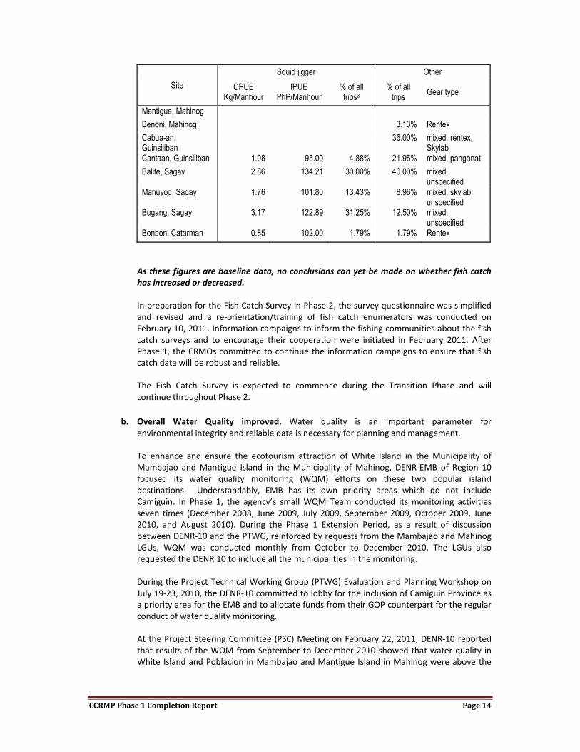
CCRMP Phase 1 Completion Report Page 14
Site
Squid jigger Other
CPUE Kg/Manhour
IPUE PhP/Manhour
% of all trips3
% of all trips
Gear type
Mantigue, Mahinog
Benoni, Mahinog 3.13% Rentex
Cabua-an, Guinsiliban
36.00% mixed, rentex, Skylab
Cantaan, Guinsiliban 1.08 95.00 4.88% 21.95% mixed, panganat
Balite, Sagay 2.86 134.21 30.00% 40.00% mixed, unspecified
Manuyog, Sagay 1.76 101.80 13.43% 8.96% mixed, skylab, unspecified
Bugang, Sagay 3.17 122.89 31.25% 12.50% mixed, unspecified
Bonbon, Catarman 0.85 102.00 1.79% 1.79% Rentex
As these figures are baseline data, no conclusions can yet be made on whether fish catch
has increased or decreased.
In preparation for the Fish Catch Survey in Phase 2, the survey questionnaire was simplified
and revised and a re-orientation/training of fish catch enumerators was conducted on
February 10, 2011. Information campaigns to inform the fishing communities about the fish
catch surveys and to encourage their cooperation were initiated in February 2011. After
Phase 1, the CRMOs committed to continue the information campaigns to ensure that fish
catch data will be robust and reliable.
The Fish Catch Survey is expected to commence during the Transition Phase and will
continue throughout Phase 2.
b. Overall Water Quality improved. Water quality is an important parameter for
environmental integrity and reliable data is necessary for planning and management.
To enhance and ensure the ecotourism attraction of White Island in the Municipality of
Mambajao and Mantigue Island in the Municipality of Mahinog, DENR-EMB of Region 10
focused its water quality monitoring (WQM) efforts on these two popular island
destinations. Understandably, EMB has its own priority areas which do not include
Camiguin. In Phase 1, the agency’s small WQM Team conducted its monitoring activities
seven times (December 2008, June 2009, July 2009, September 2009, October 2009, June
2010, and August 2010). During the Phase 1 Extension Period, as a result of discussion
between DENR-10 and the PTWG, reinforced by requests from the Mambajao and Mahinog
LGUs, WQM was conducted monthly from October to December 2010. The LGUs also
requested the DENR 10 to include all the municipalities in the monitoring.
During the Project Technical Working Group (PTWG) Evaluation and Planning Workshop on
July 19-23, 2010, the DENR-10 committed to lobby for the inclusion of Camiguin Province as
a priority area for the EMB and to allocate funds from their GOP counterpart for the regular
conduct of water quality monitoring.
At the Project Steering Committee (PSC) Meeting on February 22, 2011, DENR-10 reported
that results of the WQM from September to December 2010 showed that water quality in
White Island and Poblacion in Mambajao and Mantigue Island in Mahinog were above the

CCRMP Phase 1 Completion Report Page 15
standards for Class SB Waters set by the DENR Administrative Order (DAO) 34, Series of
2005.
The DENR-EMB provided copies of the laboratory results of the physical and chemical
analyses made from December 2008 to August 2010.
c. Marine Protected Areas4 strengthened and new ones established. Marine Protected Areas
(MPAs) have been proven to be an effective measure to restore damaged habitats, improve
biodiversity and maintain ecosystem health and processes, permitting fish to mature and
reproduce, resulting in increased biomass within the MPA and in contiguous seas (Russ et al.
2004).
At end of Phase 1, a total of 26% of the appropriate nearshore coastal habitats were
established as MPAs. The diverse nearshore coastal habitats of Camiguin include sandy
beaches, rocky headlands, coral reefs, mangroves, seagrasses, and lagoons (a total of
1,127.5517 hectares as shown in Table 5 below).
In 2007, upon the Project’s inception, a total area of 149.32 hectares was being protected as
Fish or Marine Sanctuaries under the aegis of the Provincial and Municipal Government
Units with the help of DENR-10, the academe (Xavier University, CPSC) and NGOs (Touch
Foundation, SUAKCREM Foundation). By 2010, the total area being protected rose to 289.38
hectares, with the establishment of the 16 new MPAs. This is a 94% increase in areas being
protected from the start until the end of Phase 1.
TABLE 5. PERCENT OF APPROPRIATE AREAS PROTECTED AND PERCENT CHANGE FROM 2008 TO 2010
Municipality
Near Shore Coastal Habitats
(in Hectares)
Total Protected Area
in 2008 (in Hectares)
Total Protected Area
in 2010 (in Hectares)
Percent Of Appropriate Areas
Protected (in Hectares)
Percent Change
2008-2010
Catarman 104.23 16.38 83.73 80% 411%
Guinsiliban 145.85 7.65 39.21 27% 413%
Mahinog 324.93 26.55 41.35 13% 56%
Mambajao 493.09 64.98 81.06 16% 25%
Sagay 59.45 33.76 44.03 74% 30%
Province 1,127.55 149.32 289.38 26% 94%
The 289.38 hectares under protection encompass all 15 existing and 16 newly established
MPAs. These areas are declared as Marine Protected Areas or Fish/Marine Sanctuaries
through Municipal Ordinance or Barangay Resolution. In Catarman, of the 83.73 hectares
being protected, 56.47 hectares have Barangay Resolutions that are still in the process of
being put into Municipal Ordinances.
4 For this report, Marine Protected Area (MPA) is used as an umbrella term that describes marine areas that restrict human activity to protect living, non-living, cultural, and/or historic resources. Protections include limits on development, fishing gear types, fishing seasons, catch limits, moorings, to complete bans on removing marine life of any kind. The term encompasses fish sanctuary or marine reserve, which can be subzones of the MPA.

CCRMP Phase 1 Completion Report Page 16
Throughout Phase 1, the Project strengthened the 15 existing MPAs and facilitated the
establishment of 16 new ones in the Province. MPA Management Teams were formed and
MPA Management Plans were formulated for all MPAs, except for Cantaan Fish Sanctuary5.
The MPA Management Plans were formulated through workshops with fisherfolk
representatives, Barangay Council members, Sangguniang Bayan (SB) representatives, the
CRM Officers, and the Municipal Planning and Development Coordinators (MPDCs). The MPA
management plans for the new MPAs were fed back and finalized with the Barangay
Councils and the management teams in April to July of 2010.
To facilitate the establishment of the new MPAs, coral and fish surveys were conducted from
July to September 2009 in 18 proposed sites to assess the suitability of the area for MPA
establishment. A workshop with the assessment team, the CRMOs and the MPDCs was
conducted in September 2009 to identify and select MPA sites. Of the 18 proposed sites, 16
were deemed suitable based on ecological and socio-economic criteria. The Project then
conducted a Training Course on the Establishment and Management of Marine Protected
Areas on February 2-5, 2010. This was attended by barangay council and fisherfolk
representatives of 17 barangays from the five Municipalities of Camiguin.
Outputs of this training course included the draft Barangay Resolutions for the establishment
of the MPAs. The new MPAs for Guinsiliban (3), Mahinog (3), Mambajao (2), and Sagay (1)
were legally established through Municipal Ordinances.
The Municipal Ordinances for the seven (7) new MPAs in Catarman were reviewed by their
respective Sangguniang Bayan (SB) but were not pushed through before the National and
Barangay Elections in May 2010 and October 2010, respectively. To orient and to gain the
support of the new Catarman Local Chief Executive (LCE) and SB, they were brought to a
study tour to successful CRM sites and MPAs in December 2010. At the end of Phase 1,
Catarman LGU was in the process of legislating the Catarman CRM Code of 2011 which
included the establishment of the 7 new MPAs. The Catarman CRM Code is expected to be
enacted during the Transition Phase of the Project.
Acknowledging that the partners, especially the barangay leaders and members, needed to
be equipped and supported to enable them to effectively and confidently perform their roles
and functions in the protection of their marine resources, the Project provided enforcement,
surveillance and monitoring materials and equipment for all the 31 MPAs in the Province. In
2009 and 2010, the Project provided MPA boundary marker buoys, sinkers, MPA billboards
as well as mobilization funds for the MPA Management Teams to install the marker buoys.
The buoys for seven new MPAs in Catarman were already provided to the CRM Office and
will be installed once the Catarman CRM Code of 2011 is enacted. Protection of the MPAs is
enforced through the establishment of boundary markers and patrolling by Deputized Fish
Wardens, with support from the Municipal Coastal Law Enforcement Team of each
Municipality. Day-to-day MPA administration and management tasks are done by designated
and trained MPA Management Teams.
The Project provided a total of six (6) MPA pumpboats, one (1) for Panghiawan MPA in
Catarman, one (1) for Cabuan MPA in Guinsiliban, and four (4) for Binaliwan Marine
Sanctuary, San Roque Marine Sanctuary, and Benoni Marine Sanctuary in Mahinog. The
5 Due to an unresolved issue between the DENR/ PENRO, the Provincial LGU, and the Cantaan Centennial Multi-Purpose Cooperative (CCMPC) regarding the cancellation of the Cantaan Community-based Forest Management Agreement (CBFMA), CCMPC eventually decided to restrict itself and have as little to do with the Project so as not to complicate the issue. They submitted a Resolution stating that the marine protected area in Cantaan is not an MPA but part of the CBFMA area. They did however receive materials for the MPA such as ropes, mooring buoys, marker buoys and the like from 2009 to 2010. The Cantaan Fish Sanctuary was also part of the annual MPA monitoring of the Project from 2008-2010.

CCRMP Phase 1 Completion Report Page 17
project also supported the construction of seven (7) MPA outposts in Mahinog, with each
barangay providing a 100% counterpart in the form of additional materials and labor.
The Project, in partnership with DENR10, prepared technical, georeferenced maps for the 31
MPAs. The maps were required for the enactment of the Municipal Ordinances. But more
importantly, the technical maps are tools in MPA management and law enforcement. It
shows the exact location and boundaries of the MPA in the area in terms of a coordinate
system and is used as a legal document in case of litigation. Updated georeferenced maps
were also prepared for the 15 existing MPAs.
Another strategy employed by the Project to ensure that the MPAs will continue to be
monitored after Project life was to train and facilitate the legitimization of a Provincial MPA
Monitoring Team. Trainings on Monitoring of Marine Protected Areas (MPAs) in Camiguin
Province were conducted in 2009 and 2010 The Provincial MPA Monitoring Team is
composed of 31 members from the LGUs, Academe (CPSC), Private Sector (Johnny’s Dive N’
Fun), and the Project.
The MPA Monitoring Team was trained on fish and benthic lifeform identification,
assessment methods for fish and benthic life forms, specifically Fish Visual Census (FVC) and
Line Intercept Transect (LIT), and SCUBA diving for the new members. The training included a
five-day practical training on actual MPA assessment.
d. Coral reef, seagrass and mangrove health improved. Project impact on the marine
ecosystem was assessed through underwater assessment of coral cover and fish stock. Data
for 2008 were collected by representatives from the partner agencies (CPSC and DENR),
personnel from the CCRMP and two volunteers (new graduates from the Bachelor of Science
in Marine Biology program of the Mindanao State University in Naawan), all of which were
marine biologists (except one). Data collection in 2009 was conducted by the same group of
people. The 2010 survey was conducted by the newly trained Provincial Monitoring Team.
The surveys were coordinated with the municipalities and barangays through the CRM
Officers and conducted with the assistance of the Bantay Dagat, using the Bantay Dagat boat
of the municipalities.
TABLE 6. PERSONNEL INVOLVED IN MPA BASELINE ASSESSMENT AND MONITORING FROM 2008 TO 2010
Name Field of Expertise Affiliation
Oliver T. Paderanga Marine Biology CPSC
Jean O. Polo Marine Biology DENR 10
Bernardo L. Jasma, Jr. Marine Biology Project Research Assistant
Ron Kirby Manit Marine Biology Project Volunteer
Ryan Neri Marine Biology Project Volunteer
Amida Diwata M. Jasma Coastal Resource Management CCRMP Project Officer
TABLE 7. PERSONNEL INVOLVED IN 2010 MPA MONITORING
Name Affiliation
Arturieto Ramigoso Catarman LGU
Edgardo Agbu Catarman LGU
Rowena Quimpo Guinsiliban LGU
Willy Lobido Mahinog LGU
Breseldo Ladera Mambajao LGU
James Gayramon Mambajao LGU
Valentine Epan Sagay LGU

CCRMP Phase 1 Completion Report Page 18
Deogracias Chaves Sagay LGU
Urbano Rojas Provincial LGU
Amida Diwata M. Jasma CCRMP Project Officer
Coral Reef
A baseline assessment and subsequent annual monitoring of fifteen existing MPAs and one
critical fishing ground (Table 8) in Camiguin were conducted from 2008 to 2010. Surveys
were done during the months of May-June every year. Since the reefs around Camiguin
generally lacked a defined reef crest, transects were laid on the reef at depths of 11-14
meters.
TABLE 8. MARINE PROTECTED AREAS SURVEYED WITH RESPECTIVE GEOGRAPHIC LOCATION
Site Latitude Longitude
MAMBAJAO
Medano White Island Fish Sanctuary 09° 15’ 49.85” 124° 39’ 30.6”
Kuguita Fish Sanctuary 09° 15’ 32.45821” 124° 41’ 17.18923”
Lagundi Fish Sanctuary 09° 15’ 13” 124° 43’ 20”
Magting Fish Sanctuary 09° 13’ 32.07” 124° 45’ 09.31”
Kabiling (Putingbalas) Fish Sanctuary 9.21208° 124.76786°
MAHINOG
Binaliwan Marine Sanctuary 09° 9.868’ 124° 47.446’
San Roque Marine Sanctuary 09° 9.218' 124° 47.778’
Magsaysay Island Marine Sanctuary 9.171649° 124.825912°
Benoni Marine Sanctuary 9.13437° 124.79965°
GUINSILIBAN
Cabuan Fish Sanctuary 9° 7' 22" 124° 48' 17"
Cantaan Fish Sanctuary
SAGAY
Balite Fish Sanctuary 9.082611° 124.759222°
Marianas Fish Sanctuary 9.09075° 124.752972°
Bugang-Mayana Marine Reserve
CATARMAN
Pasil Reef Marine Sanctuary
The transects that were used for the methods for the benthic lifeform and fish surveys were
the same transect tapes at the same position. Permanent markers were set up so that
transects lie at the same location for each consecutive survey. However, the permanent
markers were placed only in 2009 so that there may be slight differences in the placements
of the transect tapes in 2008 and 2009, even though the survey team did its best to place the
tapes in the exact same location. This slight difference in placement may have introduced
some variation in the readings between the two periods. The surveys of 2009 and 2010
already had the permanent markers in place, and so the location of the transect tapes
should be more or less the same6.
Indicators that were monitored were coral live hard cover (LHC) and fish number of species,
density, and biomass. LHC directly indicates the progress of MPA management in terms of its
goal in restoring and maintaining a sound and ecologically healthy benthic habitat. Increased
LHC means a healthier benthic habitat. The Line-Intercept-Transect method (English et al
6 Placement of the transect tape at the exact same location as that of the previous survey thus ensuring reading from the exact same line for the benthic survey cannot be ensured as there are several factors making this difficult: current causing the transect tape to bend in between markers, distance of the tape from the substrate, etc. Some variation is therefore to be expected.

CCRMP Phase 1 Completion Report Page 19
1997) was used to determine the percentage cover of the different benthic lifeforms and
substrates found on the sea bottom during the annual surveys.
The number of fish species indicates species richness; fish density and biomass indicate
improvements or deterioration in fish abundance and productivity and are fundamental
indicators of the success or failure of the MPA’s. The Fish Visual Census method was used to
estimate the abundance of the reef fishes in the respective sites during each survey period.
All fish encountered inside the survey belts were identified and their respective sizes
estimated. Identification of fish species was made primarily using the identification book of
Allen et al (2003) for tropical Pacific fishes and Fish Base.
The Project used fish biomass as an indicator/and or measure of natural productivity and
project impact because it is a production term, expressed in terms of average number of
kilos of fish (of all species) in a given area of the sea at any given time.
Coral Live Hard Cover (LHC)
On average, live coral cover remained the same, staying at 27%. Of the 15 MPAs surveyed,
live coral cover increased in seven but decreased in eight. Figure 2 shows the change in the
values of the live coral cover estimates inside each MPA during the course of the study
period (2008-2010).
Coral cover is not expected to change over a short term much with protection. It is good
enough that live coral cover does not decrease, unless natural disturbances, such as typhoon
or flash floods, occur. The result is therefore not surprising.
Fish Diversity, Density, and Biomass
Among all of the fish present in the MPAs, only the abundance of target species was
considered for this report as these are the fish that directly benefit from the protection
provided by the establishment of MPAs.
Overall fish diversity. On average, there was a reduction of 5.03% in the number of species
of fish found in the MPAs around Camiguin (an average of 47.67 species per MPA in 2008 to
45.27 species in 2009). The decrease was greater outside the MPAs, from an average of
40.40 species in 2008 to 34.57 species in 2010 (a reduction of 14.43%). There was an
increase in the number of species for most of the MPAs during the period 2008-2009, but
this increase was not maintained by all of those MPAs up through to 2010. Wherein during
FIGURE 2. ESTIMATED LIVE CORAL COVER INSIDE EACH MPA USING THE LIT METHOD FOR EACH YEAR FROM 2008 TO 2010

CCRMP Phase 1 Completion Report Page 20
the period 2008-2009, 11 of the 15 MPAs showed an increase in the total number of species
inside the MPA boundaries, only seven were able to hold on to this increase from the
baseline as almost all sites showed a decrease in the number of species in the period 2009-
2010. This period of decrease resulted in eight MPAs having fewer species in 2010 than they
had in 2008.
Figure 3. The number of species of fish inside and outside each of the 15 MPAs surveyed
annually from 2008 to 2010 shows the number of fish species found inside and outside the
MPAs for each survey period from 2008 to 2010.
Target species density. Taken as a whole, there was increase, on average, of 10.89% in the
densities of target species inside the MPAs, but this was offset by a decrease of 13.70% in
the areas surveyed immediately outside them. The densities increased in only eight of the 15
MPAs, but this increase was able to keep the overall average to a positive figure. Densities
remained higher within the MPAs (an average of 97.96 ind/500m2 per MPA in 2010)
compared to the areas outside them (an average of 62.10 ind/500m2 per area surveyed).
Figure 4 shows the density estimates of target fish species inside and outside the MPAs for
each survey period from 2008 to 2010.
Number of species of fish in each MPA from 2008-2010
FIGURE 3. THE NUMBER OF SPECIES OF FISH INSIDE AND OUTSIDE EACH OF THE 15 MPAS SURVEYED ANNUALLY FROM 2008 TO 2010

CCRMP Phase 1 Completion Report Page 21
Target species biomass. Averaging all the 15 MPAs, the average biomass per 500m2 decreased
by 45.18% inside the MPAs (from 6125.85g/500m2 in 2008 to 3358.36g/500m
2 in 2010) and by
65.47% in the areas surveyed outside them (from 3013.61g/500m2 to 1040.60g/500m
2). Biomass
increased during the period 2008-2009 (average increase of 11.41% inside the MPAs and 68.26%
outside them) but the decrease in biomass during 2009-2010 was so large that the resultant
biomass was lower than the baseline in 2008.
Figure 5 shows the biomass estimates of target fish species inside and outside the MPAs for each
survey period from 2008 to 2010.
Density (individuals/500m2) of target species in each MPA from 2008-2010
FIGURE 4. THE DENSITY OF TARGET SPECIES OF FISH INSIDE AND OUTSIDE EACH OF THE 15 MPAS SURVEYED ANNUALLY FROM 2008 TO 2010

CCRMP Phase 1 Completion Report Page 22
The results of the fish visual census consistently show an increase in fish diversity and
abundance (density and biomass) in the period between 2008 and 2009 and a decrease
during the period 2009-2010. An obvious cause of this is the El Niño phenomenon during this
period which was especially severe and caused an international crisis of coral bleaching.
Warming of the seawater is believed to be particularly favorable for the growth of bacteria
and other microorganisms, many of which are disease-causing agents and has been known
to cause steep drops in the abundance of fish in other areas in the past.
The change in composition of the monitoring team in 2010, although a welcome change in
terms of representing building up of the capabilities of the people of Camiguin and a
lessening of its reliance on outside expertise, may be perceived by some observers to have
affected the results of the survey due to their insufficient experience and skills compared to
the team that did the 2008 and 2009 baseline and monitoring surveys. The latter was
composed of marine biologists while the 2010 team was composed of LGU personnel freshly
trained to conduct underwater assessment surveys by the Project. Looking closely, however,
it seems that this may not necessarily be the case. It should be important to note that
several personnel are responsible for conducting the Fish Visual Census (FVC) around the
island. The results are consistent in the sense that all of their results show a decrease in
Biomass (g/500m2) of target species in each MPA from 2008-2010
FIGURE 5. THE BIOMASS OF TARGET SPECIES OF FISH INSIDE AND OUTSIDE EACH OF THE 15 MPAS SURVEYED ANNUALLY FROM 2008 TO 2010

CCRMP Phase 1 Completion Report Page 23
diversity and abundance at almost all sites which gives reason to believe that this decrease is
real and not due to the lack of skill of the monitoring team, but instead may be an effect of El
Niño.
Seagrasses
The multiple and simultaneous demands for direct technical assistance from the lean CRM
team (one Project Officer and one Specialist) made it impossible for the Project to conduct
interventions for the protection or improvement of seagrass habitats in Camiguin in Phase 1.
This is recommended for inclusion in the next Project phase.
Mangroves
The DENR-PENRO provided leadership and technical assistance in the rehabilitation of the
remaining mangrove areas and in improving the coastal forest cover in Camiguin. With the
Project’s support, the following were accomplished:
• Establishment of a beach tree nursery in Mayana, Sagay;
• Acquisition of 500 saplings of assorted fruit trees for river bank stabilization in South
Poblacion, Guinsiliban;
• Conduct of Community Awareness Seminar on Mangrove Protection at Barangay
Mayana, Sagay, Camiguin;
• Planting of 500 assorted beach type forest tree species along the coastal areas in
Barangay Cabuan, Guinsiliban in partnership with the Barangay Council of Cabuan.
The Camiguin Provincial Fisheries Office of BFAR also conducted mangrove planting activities
during the Month of the Ocean in May 2010, International Coastal-Clean Up Day in
September 2010, and Fisherfolk’s Congress in October 2010.
The MSC suggested to the DENR CCRMP focal person a study on available viable sites for
mangrove forest development in Camiguin to support the efforts of Camiguin’s
representative in Congress, Congressman Pedro P. Romualdo, to secure assistance for
mangrove development. Based on the PCRA results and as shown on the PCRA maps, the
total mangrove area of Camiguin is only 37.50 hectares, with Guinsiliban having the largest
area at 29.23 hectares. Mahinog has 8.04 hectares, Mambajao 0.231 hectares while
Catarman and Sagay do not have any mangrove forests.
3. Accomplishments Towards Objective 1:
a. Municipal waters delineated. One of the Project’s early achievements in Phase 1 was the
delineation of the municipal waters of the five municipalities of Camiguin. The total area of
the municipal waters of Camiguin is 144,038.010 hectares. With the delineation, LGU
jurisdiction and responsibility were defined in spatial terms, providing the LGUs’ executive
and legislative department’s clear guidance in specific areas of governance and legislation,
i.e. generation of revenues from the use of fisheries and aquatic resources, enforcement of
fisheries and environmental laws, and the development of an equitable and viable system
of allocating access and use rights to municipal fisheries and aquatic resources among its
residents.
b. Guidelines for resource use within municipal waters issued, implemented, and monitored.
The Mambajao LGU, with technical assistance from the Project and BFAR, adopted the
Mambajao Municipal Water Use Fee Ordinance and the Mambajao Comprehensive Fisheries
and Coastal Resource Management Code of 2010 (Municipal Ordinance No. 2010-06). The
Code decrees “that the Municipal Government of Mambajao will establish and maintain the
management, development, conservation, protection and ensure sustainable and equitable

CCRMP Phase 1 Completion Report Page 24
utilization of its coastal resources as provided by Republic Act 8550 (Fisheries Code of the
Philippines).” The Code also mandates the Municipal LGU to allocate funds for an integrated
coastal resource management, which includes the protection, preservation and the
regulation of the local fishing industry, the municipal waters and the marine resources of
Mambajao.
At the end of Phase 1 Catarman and Guinsiliban were in the process of formulating the
Fisheries Code for integration in their respective CRM Code.
c. I
m
p
r
o
v
e
m
e
nt in the rate of fisheries and environmental law enforcement. Coastal Resource
Management cannot succeed without effective coastal law enforcement. Although National
and Local Government Units pass commendable laws and ordinances for the protection and
management of coastal resources, illegal fishing and destructive practices remain prevalent
in coastal areas throughout the Philippines and Camiguin because of weak coastal law
enforcement (CRMP 2004).
The Project addressed this issue through training of community-based law enforcers (Deputy
Fish Wardens) and the formation of Municipal Coastal Law Enforcement Teams (MCLET).
These law enforcers were further capacitated through the formulation of a Coastal Law
Enforcement Operations Plan and provision of law enforcement paraphernalia such as
pumpboats, global positioning system (GPS) units, communication equipment, raincoats, and
flashlights.
A simple but effective system for recording incidents of illegal activities, apprehensions, and
actions taken was established in March 2010 to determine the improvement or decline of
the rate of fisheries and environmental law enforcement in the LGUs. Coastal law
enforcement teams and deputized fish wardens were provided with logbooks in which to
record activities related to CRM, especially apprehension of violators of Republic Act 8550
The Municipal Water Delineation Process
The series of ground activities leading to the delineation was undertaken during the first quarter of
project implementation. The Project assisted the municipalities in obtaining a copy of the initial National
Mapping and Resource Information Authority (NAMRIA) municipal water delineation for their respective
municipalities. Upon receiving their initial delineation, the LGUs validated these by identifying the
municipal boundary monument (MBN) which then served as their Coastal Terminal Points for drawing
the perpendicular line towards their coastal waters.
The NAMRIA certified the boundaries of the five municipal waters as indicated in the signed technical
descriptions. The certified copies together with data on length of shoreline and area of municipal waters
were sent back to the municipalities. All of the five municipalities enacted ordinances adopting the
municipal waters as delineated by NAMRIA.
Camiguin is the second Province in the Philippines to have fulfilled all the NAMRIA requirements for the
certification of their municipal waters.

CCRMP Phase 1 Completion Report Page 25
and of municipal ordinances on the protection and conservation of marine and coastal
resources.
A total of one hundred ten (110) seaborne patrol operations were conducted from January
to September 2010 by the five Municipal CLE Teams. Twenty eight (28) incidences of fishery
law/ ordinance violations were documented; actions taken against these violations were the
imposition of fines, confiscation of fishing gears, reprimand, and in one case, settlement.
The BFAR-PFO, as part of their institutional mandate, also conducted regular monitoring on
CITES7-listed fishery products in the ports of Balbagon, Mambajao and Benoni, Mahinog,
resorts in Mambajao and Catarman and in Mantigue and White Islands. Thus far, no
prohibited fish, fishery products and by-products were seen displayed in any of the
mentioned areas.
e. LGUs achieved CRM Certification. “In order to sustain project interventions, LGUs must
regularly monitor and evaluate the impacts of their CRM plans and programs, measure
performance against a set of benchmarks to evaluate progress, and periodically adjust
interventions to improve management effectiveness and efficiency. Tetra Tech can assist
DENR establish a CRM Certification system for the Province of Camiguin as a means of
sustaining and improving project interventions over time.” (CCRMP Life of Project Work Plan,
October 19, 2007)
The DENR-Region 10 adopted and led the implementation of the CRM Certification system
established by the USAID-funded Coastal Resource Management Project (CRMP) of the
DENR. The certification process, which was conducted separately and apart from the regular
project monitoring and evaluation activity, incidentally validated the LGUs’ implementation
of their CRM plans as the goals and objectives of the CRM plans led to the best practices and
milestones in the CRM Certification checklist and report card.
By the end of Phase 1, Mahinog had achieved Level 2 CRM Certification while Catarman and
Mambajao had achieved Level 1 Certification. Guinsiliban and Sagay were in the process of
completing documentation requirements for Level 1 Certification.
As incentive for achieving Level 1 Certification in 2009, the DENR 10 provided funding for the
establishment of CRM pilot projects such as a Zoological Park in Mambajao (PhP700,000)
and a Mangrove Boardwalk in Mahinog (PhP515,000). When Mahinog achieved Level 2
Certification in 2010, DENR 10 provided additional incentive for the improvement of the
Queobe Eco Park in San Miguel Mahinog (PhP 400,000). As incentive for Catarman which
achieved Level 1 Certification in 2010, it was awarded a PhP 95,000 grant from NZAP funds
for a giant clam enhancement project in Pasil Reef, Bonbon.
f. Increased public awareness on CRM, especially of school children. “Information, Education
and Communication plays an important role in creating awareness, mobilizing people and
making development participatory through advocacy and by transferring knowledge, skills
and techniques to the people. It is also critical for bringing about transparency in
implementation of the Project at the field level and for promoting the concept of
accountability and social audit” (CCRMP Life of Project Work Plan 2007).
g. Conducted reorientation/ orientation of local officials at the provincial and municipal
levels. This was accomplished through a one-day Project and CRM Orientation and Priority
Setting Workshop held on December 6, 2007 at the Convention Center in Mambajao. The
7 CITES (the Convention on International Trade in Endangered Species of Wild Fauna and Flora) is an international agreement between governments. Its aim is to ensure that international trade in specimens of wild animals and plants does not threaten their survival.
CCRMP Phase 1 Completion Report Page 26
one-day priority setting workshop was attended by the TWGs of the 5 municipalities, the
provincial LGU of Camiguin and representatives of government agencies and partner
institutions who were signatories to the Project Memorandum of Agreement (MOA). This
was followed by courtesy calls and project orientation sessions with the Local Chief
Executives (LCEs) of the municipalities. Likewise, orientation sessions with the Sangguniang
Bayan (SB) members in the five municipalities were conducted during the first quarter of
Project implementation. During these sessions, the Project Phase 1 goals and objectives
were presented.
Re-orientation of barangay council members was integrated in the Participatory Resource
and Socio-economic Assessment Trainings.
CRM and project orientation was embedded in all of the activities so that messages were re-
iterated and kept fresh in the stakeholders’ and participants’ stream of consciousness.
h. Formed the Camiguin Learning and Communication Network. The Provincial and Municipal
LGUs and the DENR-PENRO assigned a total of 28 personnel for Learning and Communication
(L&C) activities that were trained and organized into the L&C Network.
A total of seven (7) Learning and Communication Action Plans for Year 3 were formulated
and approved by the Governor, PENRO, and the five (5) Local Chief Executives.
A Basic Skills Training in the Preparation of IEC Materials was conducted on March 2 and 3,
2010. The participants’ knowledge and skills in the preparation of information, education
and communication (IEC) materials were enhanced. In the course of the training, IEC
materials were generated. Outputs of this training include twenty-seven (27) MPA
signboards, eight (8) Municipal/ CRM signboards, seven (7) Municipal/ CRM brochures, four
(4) posters, one (1) CCRMP booklet, six (6) Earth Day Tarpaulins, four (4) Livelihood
Tarpaulins. Signboards, tarpaulins, and posters have been put up in strategic, high traffic
locations such as the Benoni Port, in the Municipal Hall lobby, and along the highways.
i. Conducted information campaign on CRM. PowerPoint presentations on CRM, Biodiversity,
Climate Change and Solid Waste Management were reproduced and distributed to all CRM
Officers, MPDCs, PENRO, DepEd and PPDO.
The Project leveraged funds with the DENR-Region 10 Regional Executive Director Max
Dichoso for the establishment of a Learning and Communication Center at the second floor
of the DENR-PENRO Building in Mambajao, Camiguin. This Learning Center will house
materials, books, project data and documents as reference materials for students,
researchers who wish to learn about ICRM, environmental management systems, other
environment programs.
In the period of July 26, 2010 up to October 13, 2010, a total of forty (40) students and one
(1) CPSC faculty member have visited the Project Field Office to conduct research and to ask
for data on coral cover, fisheries, municipal waters, mangrove areas, and coastal resource
management.
BFAR-PFO conducted the celebration of Fish Conservation Week and the province-wide
participatory planting of mangrove as the primary activity and orientations on FAO 208
(Conservation of Rare, Threatened and Endangered Species) in 5 municipalities.
j. Conducted school-based IEC. In order to broaden the range of audiences to orient and
educate about CRM, the Project established linkages with the DepEd, CPSC, and Enigmata, a
non-government organization (NGO).

CCRMP Phase 1 Completion Report Page 27
For the first two years of the Project, CRM was mainstreamed in the Community Welfare
Training Service (CWTS) Program of the CPSC.
At the start of the Project, upon the instance of the Provincial Planning and Development
Officer (PPDO), the Sangguniang Kabataan (SK) Federation was tapped to spearhead school-
based IEC activities. SK members were trained and capacitated to be facilitators and
resource persons for CRM information and advocacy campaigns. They were mobilized to
coordinate and facilitate the province-wide advocacy on solid waste management (SWM),
celebration of the International Coastal Clean-up Day in 2008, and in the conduct of an
Environmental Youth Camp in 2009. After Year 2, however, the participation of the SK in the
Project was not sustained.
In partnership with the Camiguin SK and the DepEd’s Youth for Environment in Schools
Organization (YES-O), an Environmental Youth-Camp was conducted on May 4-7, 2009. The
objective of the Youth Camp was to enhance in selected young leaders of Camiguin the
knowledge, understanding and appreciation of their immediate environment with the
ultimate goal of developing within them a sense of environmental responsibility and unity
necessary for the sustainability and long term success of CRM in the Province.
In partnership with CPSC and the DepEd, school-based IEC modules/ teaching materials for
grade school teachers were prepared and completed in Year 2. However these were not
followed through.
In collaboration with the DepEd, thirty four (34) School based Information Education
Campaigns (IEC) on CRM conducted by the CRM Officers, a Province-Wide School Based
Advocacy on CRM (also includes Solid Waste Management, Climate Change and Biodiversity
Conservation) in partnership with the Department of Education (DepEd), DENR and the
LGUs, 5 Municipal Fora and a Provincial Forum which was attended by 3,479 students.
Various competitions involving school children were also done on: poster making, sayawit
(dance and song), slogan making, radio and TV broadcasting, poetry writing and
photography. A Science Teachers Orientation on CRM was attended by 38 elementary
teachers.
Video-CD kits on coastal resource management were distributed and shown in twenty-one
(21) elementary schools and one (1) high school in September 2010.
A CRM Orientation for thirty eight (38) elementary and high school science teachers was
conducted on August 26, 2010.
A province-wide school-based Advocacy on CRM (including solid waste management,
climate change, and biodiversity conservation) was conducted on September 14-17 and 22-
23, 2010. Total number of participants for the school-based activity was 3,479.
The Camiguin SOS (Steward of the Sea) Movement was launched on September 2010. The
Camiguin SOS was organized through the Project in partnership with the LGUs of Camiguin,
the DENR, and the DepEd to engage stakeholders, especially children, in protecting,
conserving, and effectively managing the coastal and marine ecosystems of Camiguin as
Stewards of the Sea.
k. Developed Project website. The Project launched the Project website www.ccrmp.com on
September 2009. However, after the first Information Technology Consultant left, this
website could no longer be accessed. In Year 3, another IT Specialist was engaged and the
website was relaunched as www.ccrmp.net. At end of Phase 1, despite numerous attempts
to activate it, the website again is no longer active.

CCRMP Phase 1 Completion Report Page 28
4. Accomplishments Towards Output 1:
a. Functional and operational CRM Offices established in the five Municipalities and
coordinated by a Provincial CRM Office. CRM Offices were established in all five
Municipalities and the Province in 2007 and early 2008. The institutional arrangements of
each CRM Office varied in each municipality. In Catarman and Mahinog, the CRM Office is
under the Municipal Agriculturist’s Office (MAO), in Guinsiliban and Sagay the CRM Office is
created under the Mayor’s Office, and in Mambajao, it is a Section under the newly created
Municipal Environment and Natural Resources Office (MENRO). The Provincial CRM Office is
under the PPDO which serves as the focal office to oversee the total implementation of
CCRMP at the Provincial level.
Each of the CRM Offices was equipped with desktop computer, combo
printer/scanner/photocopier, LCD projector, handheld Global Positioning System (GPS) unit,
diving equipment, reference materials on CRM, fish identification, IEC materials, coastal law
enforcement (CLE) pumpboats, radio communication equipment, and others. In addition, the
Provincial, Guinsiliban, Mahinog, and Sagay CRM Offices were improved and renovated with
assistance from the Project.
The CRM Offices were manned by designated or contracted (as in the case of Sagay) CRM
Officers and staff.
This CRM Officers (CRMOs) were trained and capacitated through continuous and varied
trainings on CRM principles and strategies, feasibility and proposal making, basic computer
use, operation of a geographic information system (GIS) software, and planning. The CRMOs
and their staff were given a special course by the MSC’s Finance and Administration Officer
on the use of Quickbook, a user-friendly electronic financial program that efficiently and
easily monitors and updates cash flow. On-site and on-the-job coaching and mentoring and
informal brainstorming sessions with CRMOs and MPDCs in the course of CRM
implementation were instrumental in effecting results and generating feedback.
b. Mainstreaming of CRM Offices and CRM Officer Position. While the structure and system of
the CRM Offices were sufficiently functional for the implementation of Phase 1 of the
Project, weaknesses in the prevailing institutional arrangements was a constant challenge to
the MSC and even within the LGU bureaucracy. Institutional arrangements were sought to
be strengthened to ensure the identity and sustainability of the CRM Offices and its
interventions through executive orders and legislative instruments.
A Resolution for the creation of a regular plantilla position for the Coastal Resource
Management Officer in the Municipalities of Catarman, Guinsiliban, Mahinog and Sagay was
drafted for approval by the Project Steering Committee Chairperson, Gov. Jurdin Jesus M.
Romualdo. The Resolution urged the members of the Project Steering Committee to strongly
recommend to the respective Municipal Mayors and Sangguniang Bayan members the
creation of a regular plantilla position for the Camiguin Coastal Resource Management
Officer not later than December 31, 2011.
During the 4th
PSC Meeting on February 22, 2011, Governor Romualdo pointed out that the
proposal to create a permanent or regular CRM position in the LGU would be subject to
Department of Budget and Management (DBM) rules and issuances specifically on personnel
services or PS limitations, specifically also for 5th
class municipalities and the province. He
suggested that for this Project’s sustainability, the Local Chief Executives (LCEs) should use
existing regular employees for the position. He added that the Resolution to create the
CRMO position will be passed eventually when the Province is financially stable and DBM
certification can be acquired.
CCRMP Phase 1 Completion Report Page 29
c. Creation of Technical Working Groups. The Technical Working Groups (TWGs) were created
at three levels: Project, Provincial and Municipal. At the Project level, the Project Technical
Working Group (PTWG) provides technical support to the members of the Project Steering
Committee (PSC). The TWGs functions cover the following: (a) policy development; (b)
project planning; (c) project implementation review; (d) project monitoring and evaluation;
(e) project financial management.
As agreed during the 1st
PSC meeting held last May 29, 2008, the Provincial TWG which was
later named Camiguin TWG (CTWG) to distinguish it from the Provincial TWG (PTWG), had
the following functions: provide technical support to the CRMO, along with other policy
making, planning, monitoring and evaluation functions, as specified in the Life-of-Project
(LOP) document.
d. Budget allocation for CRM in the LGU. The MSC, through monitoring visits and meetings
with Mayors, MPDCs and CRMOs, ensured the actual allocation of CRM funds from the LGU
budgets. Throughout the entire Phase 1, all the LGUs provided the committed counterpart
allocations for the Project through the MPDC or the MAOs for CRM personnel, fuel and
maintenance of law enforcement boats, fuel and maintenance for CRM vehicles,
communications, honoraria and livelihood funds of CRM volunteers. The Provincial
Government allocated and disbursed funds for CRM-related projects and administrative
expenses. The amounts allocated for CRM differed among the municipal LGUs, with
Mambajao earmarking the largest counterpart amount for CRM.
e. Resource and Socio-Economic Data Baseline Data Established. Resource and socio-
economic data baselines were established using participatory coastal resource assessment
(PCRA) methods (IIRR 1998, Walters et al. 1998, Deguit et al. 2004).
To prepare for the barangay level resource and socio-economic surveys, a 2-day CRM
Officers Orientation and Training on PCRA was conducted on March 6-7, 2008 in Mambajao.
The training was attended by the designated CRM Officers and staff of each municipality,
Fishery Technicians, Provincial CRM Personnel, one staff from the PENRO, and the Coastal
and Marine Management Division (CMMD) staff of the DENR-10 Regional Office.
f. Socio-economic surveys. Two-day municipal-level PCRA Orientation and Trainings were
conducted in the five municipalities prior to the barangal-level surveys. Barangay Captains,
Barangay Fisheries and Aquatic Resource Management Council (BFARMC) Chairpersons,
Fisherfolk Association representatives and Barangay Council Chairpersons on Fishery/
Environment, and MTWG members were trained to act as facilitators during the barangay-
level surveys.
Digitized base maps were prepared and printed for all 42 coastal barangays. Assistance from
the Fish Project/Tetra Tech Cebu Office was tapped for the preparation and printing of the
base maps.
During the assessment activity, at least 30 community members from each barangay
provided information, insight and data on the socio-demographic, habitat, and fishery-
related issues and concerns of their barangay through focus group discussions and activities
such as diagramming, transect walk, and community-mapping.
g. Coastal resource surveys. The participatory appraisal for coastal habitats, specifically coral
reefs, seagrass beds, and mangrove forests was completed in May 31, 2008 in all 42 coastal
barangays of Camiguin.
In each municipality, some members of the MTWG, representatives from the Barangay LGU,
and fisher folk were trained on participatory assessment methods for coral reefs, fish stock,

CCRMP Phase 1 Completion Report Page 30
fish catch, seagrass beds, and mangrove forests. After data gathering, the teams were
trained to analyze and present the data collected.
The socio-economic and resource data gathered for all the barangays were processed,
encoded, and compiled into a data book which was used in the barangay planning activities.
A comprehensive resource assessment report was also prepared, copies of which were
distributed to the five municipalities and the Provincial Government.
h. Computer and municipal coastal database program installed. As mentioned in an earlier
section, desktop computers were provided to the five Municipalities, Province, DENR-PENRO
Camiguin, DENR-10, and DA-BFAR Camiguin to house the municipal coastal database for
each municipality/partner agency. Desktop computers were provided instead of the
originally planned laptops because the desktops were found to be more appropriate to host
the database at the LGU level.
In 2008, the Camiguin MCD was programmed to suit the needs of the Province and the
municipalities. A training was conducted in November 2008 to teach CRM Officers and staff
how to use the program and to install the software into the database computers. The MCD
was found to be riddled with too many bugs to be operational. Thus, through several
consultations, the Project acted on the suggestion of DENR CMMO Director Carlo Custodio,
to replace the database system with the Integrated Information Management System (IIMS)
for coastal and marine resources.
The IIMS is a database system for storing and processing Integrated Coastal Resource
Management (ICRM) and other socio-economic data related to the use and management of
coastal resources. Reports generated from the IIMS will support systematic monitoring and
evaluation of ICRM programs and activities of the LGUs. The software was developed by the
Partnerships in Environmental Management for the Seas of East Asia (PEMSEA). DENR which
is the host agency for the project has issued a directive for all its Regional Offices to use the
software in developing their ICRM data base. There are nine (9) various classes of data that
can be stored in the IIMS and these are: (1)Regional Codes, Data Codes and Geo spatial
Category, (2) Biological and Bio-resources Data Category, (3) Socio-economic category, (4)
Demographic Category, (5) Institutional Category (6) Pollution sources category, (7)
Monitoring data category, ( 8) Physiographic data category, and (9) GIS Baseline information.
The training workshop for the installation, management, and maintenance of the Integrated
Information Management System (IIMS) was conducted as part of institutionalization of the
Monitoring and Evaluation (M&E) system for the implementation of the LGUs’ CRM
programs and activities. Seventeen (17) participants from the five MLGUs, the PLGU and the
PENRO DENR completed the training.
i. 42 Barangay, 5 Municipal, and 1 Provincial CRM Plans formulated, adopted, and
implemented.
Barangay CRM Plans. Barangay CRM Planning Orientation and Workshops in the five
municipalities were completed in August 2008. The workshops were conducted by clustering
three to four neighboring coastal barangays. The MPDCs were tapped as resource persons
during the workshops. They emphasized the value of the Management Plan as a tool for
each LGU to manage its territory and to promote the general welfare of its inhabitants. It
was agreed that the CRM Plan should be an integral part of the Barangay Development Plan
(BDP) and Municipal Comprehensive Development Plan (MCDP).
Six workshops were conducted during the cluster planning activity: (1) Validation of PCRA
data; (2) Issues Prioritization; (3) Strength, Weaknesses, Opportunities, Threats (SWOT)

CCRMP Phase 1 Completion Report Page 31
Analysis; (4) Vision and Mission setting; (5) Strategy Formulation; and (6) Coastal Zoning.
After each workshop, the outputs were immediately encoded (one computer and one
encoder was assigned for each barangay), presented (using LCD projector provided by
NZAP), commented on, revised in situ, and printed out. Printed copies were given to each
Barangay Captain for them to present to the Barangay Council for approval and adoption.
Soft copies are stored in the municipal desktop computers donated by NZAP. Computers and
encoders for the activity were provided by the MLGUs and the PLGU.
Each barangay was represented by members of the Barangay Development Council (BDC):
Brgy. Captain, Brgy. Secretary, Brgy. Councilor Environment/Agriculture, M/BFARMC and
Representatives from the different sectors of the community such as the Women’s Sector,
Fisherfolks, Youth, People’s Organization, and others.
In preparation for the planning activity, all PCRA data (socio-economic from PSES and
biophysical from PRA) were compiled and bound into PCRA Data books and were given to
the Barangay. A complete copy of the data and results was given to the MPDC/ CRM Officer
for filing in the Municipal CRM Office.
From August until September 2008, the Barangay LGUs refined and finalized their Barangay
CRM (BCRM) Plans with the guidance and support of the MTWGs and CCRMP staff. The
BCRM Plans were presented in public hearings and adopted by the respective barangay
councils. These activities were facilitated by the CRM Officer and CRM staff, with minimal
presence of the MSC Staff. By the end of Year 2, all BCRM Plans were adopted by their
respective Barangays.
Municipal CRM Plans adopted and implemented. The Mambajao Municipal CRM and
Annual Investment Plan (AIP) was adopted by the LGU on April 12, 2010 (Resolution No.
2010-04-25 - Resolution Adopting the Five-year Municipal Coastal Resource
Management Plan {2010-2014} of the Municipality of Mambajao, Camiguin). The Annual
Investment Plan (AIP) proposed by the MTWG for CRM (PhP 308,422,889.00) was
deliberated in a series of Sangguniang Bayan (Municipal Legislative Council) sessions to
which the MSC was invited to assist the CRMO explain and defend the Plan. Approval was
granted at a session at which the MSC Team Leader was asked to justify the financial plan,
which was adapted from the Municipal CRM Plan of Mambajao. The approval of the AIP was
a milestone achievement as this ensured that CRM will be implemented and will have
operational funds until 2014.
The Mahinog CRM Plan was approved by the LGU on October 5, 2009 (Resolution No. 160,
Series of 2009 – Resolution Approving the Coastal Resource Management Plan of the
Municipality of Mahinog for the Period 2009-2012). The Guinsiliban CRM Plan was
unanimously approved and adopted by the Sangguniang Bayan on October 11, 2010
(Municipal Resolution No. 35 - Resolution Approving and Adopting the Municipal Coastal
Resource Management Plan in the Municipality of Guinsiliban, Camiguin).
The comprehensive Catarman CRM Code and the Sagay CRM Plan were in the process of
being legislated at the end of Phase 1- Extension Period. In Catarman, the 2010 elections
resulted in completely new executive and legislative bodies. To enhance their understanding
and knowledge of CRM and to gain their support in legislating and implementing CRM, the
Project facilitated their site visit, conducted on December 20-23, 2010, to the Municipality of
Dauin in Negros Oriental where they had one-on-one interviews with their counterparts to
discuss how Dauin has implemented and has benefitted from CRM. This experience has
effectively engendered the enthusiasm and support of the Mayor, Vice-Mayor and the SB
members to implement CRM, especially MPAs, in the municipality. On December 14 and 15,

CCRMP Phase 1 Completion Report Page 32
2010, Catarman conducted a review and assessment of their draft CRM Plan and identified
more relevant and sustainable priority programs for CRM in their municipality.
Provincial CRM Plan drafted. The process of drafting the Provincial CRM Plan was initiated in
October 2009. A series of writeshops were conducted to draft the Integrated Provincial CRM
Plan. Although the Integrated Plan was expected to be in its final form during the last
quarter of Year 3, consolidation of the various inputs/chapters always had to give way to the
primary work load and priorities of the key CRM persons (PPDO, PCRMO, CRMOs, MPDCs).
The MSC sought commitment from the PPDO and PCRMO to set aside time during the
extension period to complete and deliver the output. The human resource problem of LGUs
was aggravated by the lay-off of casual employees after the elections.
At the end of Phase 1, the Provincial CRM Plan still was not finalized. Another date on March
was set to complete final draft of the Provincial CRM Plan.
Provincial Tourism Code. An important activity in relation to the development of ecotourism
in the province was the Tourism Code Formulation. A series of meetings with the
Sangguniang Panlalawigan (SP) Committee on Tourism was conducted to plan for activities
leading towards the drafting of the Provincial Tourism Code. The SP requested the Project to
facilitate and provide inputs on the process leading to the drafting of the Tourism Code.
Coastal Management Zones Delineated. Technical assistance was provided to the five
municipalities for the delineation of coastal management zones and developed the
corresponding maps. An orientation and planning meeting was conducted with the LGUs,
represented by the MPDCs, Municipal Assessors, and CRM Staff. They were tutored on the
use of GPS and GIS for coastal zoning. A strategic plan was made for the ground-truthing of
the coastal zones that were identified during the CRM planning workshops. Field validation
and ground-truthing of all coastal zones were done for all the municipalities. Data from the
ground truthing was processed using the GIS software MapInfo and plotted onto coastal
zoning maps.
The management zone plan and map have been useful in resolving resource development
and resource use issues and in protecting fisherfolk rights to access to coastal and marine
resources. For instance, based on a particular zone map, the intervention of the DENR-
PENRO was sought on the construction of a dike that would block fishers’ access to the sea.
The map is also currently being used by the Mambajao CRMO to request the BFAR to adjust
their plan to establish a marine park in the waters surrounding the White Island.
5. Accomplishments Towards Output 2:
a. LGUs strengthened to formulate CRM Plans. A series of workshops on CRM Planning was
conducted from June 2008 to October 2009, in which the CRM Officers and staff were guided
and trained on the development and preparation of a CRM plan. This training resulted in the
initial drafts of the 42 barangay CRM Plans, five municipal CRM plans, and one Provincial
CRM Plan. With guidance from the MSC, the CRM Officers and staff facilitated barangay-level
CRM Planning and provided coaching support to the barangay participants.
b. Barangay Leaders/ representatives (with the participation of women) from 42 coastal
barangays trained on PRA and socio-economic survey. Training modules and materials
developed by the International Institute for Rural Reconstruction (IIRR), USAID-funded
Coastal Resource Management Project (CRMP), and the Fisheries Improved for Sustainable
Harvest (FISH) Projects were used as reference materials.

CCRMP Phase 1 Completion Report Page 33
Training on participatory coastal resource appraisal methods was conducted in all five
municipalities between March to May 2008. PTWG members were trained to facilitate PCRA
using such methods as interviews, community mapping, transect walk, and trend and
calendar diagramming. The CRM officers and staff coordinated the preparation and actual
conduct of the barangay-level PCRA activities. DENR Region-10 staff served as resource
persons during the two-day PCRA Orientation and Training Seminar and assisted in
facilitating the barangay-level PCRA activities covering five municipalities. During the
barangay CRM planning activities, the PENRO-CRM officer and the BFAR provincial staff
provided facilitation assistance.
A series of trainings, workshops, and hands-on activities were conducted in March to May
2008 to enable barangay leaders from 42 barangays in five municipalities to conduct
participatory socio-economic surveys and resource assessment methods. Barangay Leaders,
fisher folk representatives, and MTWG representatives participated in the training and actual
field surveys. A total of 285 participants were trained, 103 or 36% of whom were female, and
182 or 64% were male.
c. Capacitated the LGUs and CRMOs in implementing CRM through study tours and trainings.
Acting on expressed capability-building expectations and needs of the LGUs and
acknowledging the value and benefits of well-planned learning experiences, the Project
conducted a series of trainings and study tours to capacitate and inspire the CRM Officers,
staff and LGU personnel to implement CRM.
d. Study tour to successful CRM sites in Bohol, Negros Occidental, and Cebu. A study tour was
conducted on August 25-29, 2008. The objectives of the study tour were: (1) to expose
participants (Camiguin LGUs and other partners) to the other municipalities and
communities implementing best CRM practices (MPAs, Alternative Livelihoods, Coastal Law
Enforcement, IEC, Fisheries Management interventions, Revenue Generating mechanisms)
and other successful environmental management and coastal tourism programs in Central
Visayas; (2) to provide opportunities for the LGUs and partner agencies to develop linkages
and learn from the host LGU/ community strategies and techniques on how to implement
successful ICRM Program; and (3) based from the learnings gained from the study tour, come
up with action plan and identify specific CRM interventions applicable to their municipalities
that could be included in the development of their municipal CRM Plans that will be
conducted on the last quarter of this year.
The study tour sites in Bohol were Ubay, Talibon, and Tagbilaran City. Ubay was chosen as
one of the sites because its LGU has fully institutionalized CRM and has a successful coastal
law enforcement program; Talibon was visited for its remarkable CRM interpretive center;
and Tagbilaran City was visited to touch base with the Bohol Environment Office (BEMO).
In Negros Oriental, the Island Barangay of Apo, Dauin, Bais City, and Dumaguete City were
visited. Apo Island was visited for their successful barangay-managed MPA and to learn
about how PAMB is managing the Apo Island Protected Landscape and Seascape; Dauin for
their holistic CRM Ordinance and successful LGU-managed MPAs; Bais City for their CRM
program which include habitat protection (Talabong Mangrove Reserve), solid waste
management (sanitary landfill), tourism (dolphin and whale watching); Dumaguete City for
its tourism facility, the Sidlakang Negros, and was also the base of the group while in Negros
Oriental.
In Cebu City, the group learned more about solid waste management at the barangay level in
Barangay Luz and at the household level by visiting the Eco-House of Hon. Nestor Archival in
Talamban, Cebu.
CCRMP Phase 1 Completion Report Page 34
The study tour was participated in by representatives from the Provincial LGU, the 5 MLGUs,
DENR10, DENR-PENRO, BFAR, and CPSC.
One of the perceived benefits from the study tour was the marked interest and eagerness
by the LGUs to implement CRM in their municipalities. They also picked up lessons from the
Municipality of Dauin especially on how to legislate a CRM Code.
Study tour to successful MPA sites in Bohol. To educate the Catarman barangay council and
to gain support in establishing MPAs in the barangay, the barangay leaders were brought to
successful MPA sites in Bohol on March 2010.
Study tour to successful MPA sites in Negros and Cebu. To enlighten the newly elected
Catarman LCE and SB about the importance of CRM and to gain their support, they were
brought to successful CRM sites in Negros Oriental and Cebu. The study tour was highly
successful in enlisting the full support and active participation of the Catarman LCE and SB in
implementing CRM in the municipality.
Basic Computer Training. Majority of the designated CRM Officers and their Provincial and
Municipal colleagues were not familiar with the use of computers and the CRM staff had
very low levels of computer appreciation. To improve their access to information and
facilitate document preparation, a hands-on computer training was provided primarily for
the CRMOs. The training program also aimed to develop among senior LGU officials and staff
the skills to operate a computer and use Microsoft Office programs such as Word, Excel and
Powerpoint.
Coaching/ mentoring of LGU staff on CRM Work and Financial Plan Implementation.
Coaching and monitoring of the CRMOs were conducted for easier monitoring and
implementation of each LGU’s Work and Financial Plan. QuickBook Professional version 10
was introduced, taught and coached to all CRMOs and the program itself was installed in
their computers. The LGUs are going to be recipients of one license of the multi-licenses
permit purchased by an International Charity Program based in UK. With the use of the
QuickBook Program, the CRMOs were able to monitor the LGU cash advances and
liquidations. Moreover, it has also proved to be very useful in the accomplishment of the
FASPO tracking form.
e. Coastal Law Enforcement Teams deputized and actively enforcing laws for coastal resource
protection/ conservation. The organization and training of the five (5) Municipal law
enforcement teams added value to the existing coastal law enforcement efforts and
operations of the LGUs and were deemed necessary interventions towards the
institutionalization of CRM in municipal and barangay LGUs.
Five Municipal Coastal Law Enforcement (CLE) Teams and one Provincial CLE Team were
organized and equipped to enforce RA 8550 and other environmental/ fisheries/ coastal
resource management Laws and Ordinances. Each Municipal and Provincial CLE Teams were
created on January 2009-February 2010 by the passing of Ordinances/ Resolutions. All the
CLE Teams were trained on March 2009 and provided with communication equipment
(handheld radio and antenna), life vests, megaphones, flashlights on October 2009. In
addition, the Municipal CLE Teams were provided with CLE pumpboats.
As of February 2010, fifty three (53) Municipal Coastal Law Enforcement Team members
belonging to five (5) Municipal Coastal Law Enforcement (CLE) Teams and one (1) Provincial
CLE Team had been organized and equipped to enforce RA 8550 and other environmental/
fisheries/ coastal resource management Laws and Ordinances.

CCRMP Phase 1 Completion Report Page 35
In Year 2, sixty-four (64) barangay Fish Wardens were trained and deputized to guard and
monitor the fifteen (15) existing MPAs. In Year 3, on September 6-10, 2010, a second batch
of eighty-four (84) participants were trained and deputized to guard and monitor the sixteen
(16) new MPAs. Also included in the training was the replacement of those who were
removed by the newly elected Local Chief Executives. The trainings were conducted in
partnership with BFAR 10 and BFAR-PFO. One hundred copies of the Philippine Fisheries
Code (RA 8550) were distributed by BFAR to the DFWs.
The Deputized Fish Wardens have official identification cards (IDs) duly signed by the BFAR
Region 10 Director and the Municipal Mayor. BFAR-PFO provides regular assistance in the
activation, re-organization, and regular meetings of the FARMCs.
The MCLETs and DFWs are actively submitting monthly operational reports to the CRMOs
and MAO. Mahinog and Guinsiliban conducted a DFW Implementer’s Forum in November to
December 2010.
f. MPAs managed by multi-sectoral management teams, with the participation of women.
Thirty one (31) multi-sectoral MPA Management Teams were formed from February 2009 to
February 2010 to support the LGUs in the management of the 15 original and 16 new MPAs
and in the implementation of the MPA Management Plans These teams are composed of
members of the Barangay Council, fisherfolks, women representatives, and community
volunteers.
The Management Teams of each of the MPAs represent the frontline of the Provincial drive
to establish and maintain MPAs around the island. They are also at the interface between
management and the community, ideally representing both of these sectors. For
management of the MPAs to be effective, these teams need to have a thorough
understanding and knowledge of MPAs and of their roles in the establishment and
management of these.
However, because of the national and local elections in 2010, the teams needed to be
reorganized, streamlined, and re-oriented on CRM. Thus, re-orientation and re-organization
activities were conducted from November 2009 until the end of Phase 1.
It was acknowledged late in Phase 1 that much of the Project’s MPA efforts were focused
mostly at the level of the Provincial and Municipal LGUs. During the extension period of
Phase 1, planning and capacity-building activities were directed at the barangay-based
management teams.
In the process of forming and capacitating the reorganized MPA Management Teams to
effectively manage the MPAs, it became increasingly essential to clarify how the MPAs
Management Teams fit within the larger framework of the Municipality and to define more
clearly the roles of the MPA Management Teams.
A meeting was conducted with the MPDCs and CRMOs to discuss and agree on the standards
and protocols of MPA Management Team formation, and how the Team fits into the context
of the LGU. With additional recommendations from Partner Agencies, the following
structure was agreed on:

CCRMP Phase 1 Completion Report Page 36
It was also agreed that the Municipal LGU is the overall manager of the MPA while the MPA
Management Team will be in charge of the day-to-day administration, management, and
enforcement of the MPA. The Punong Barangay will supervise the MPA Management Team
and will also serve as liaison between the MLGU and the MPA Management Team. The
Sangguniang Barangay and the Sangguniang Bayan will aid in policy-making and legislation.
The MTWG and the CRMO will provide technical assistance.
6. Accomplishments Towards Output 3:
a. Fully functional ecotourism enterprises for each municipality established. A field
assessment visit was conducted by the enterprise development specialist (EDS) in March
2008 to validate the enterprise development options identified in the LOP work plan. Site
visits were conducted in the pre-identified areas in Catarman (Fish Port, Sunken Cemetery),
Guinsiliban (Cabuan shoreline, Cantaan), Sagay (Balite and Manuyog), Mahinog (Queobe,
and Mantigue Island), and Mambajao (seaweed potentials for Anito and Tupsan).
Mahinog. Technical and material assistance was provided for the establishment of the
Mantigue Island Nature Park (MINaP), the formulation of its zoning and management plan,
and the establishment of User Fee Mechanisms. One outcome of this intervention is the
development of Mantigue Island as one of the prime tourist destinations in the Province of
Camiguin. Since November 2008, records show that 15,230 visitors have come to Mantigue
Island and that the LGU has generated revenues amounting to a total of PhP531,825 from
entrance fees, diving/snorkeling fees, rental for the use of miscellaneous amenities (e.g. boat
with viewing boxes, masks and snorkels, picnic sheds and tables, etc.)
FIGURE 6. MPA MANAGEMENT WITHIN LGU STRUCTURE

CCRMP Phase 1 Completion Report Page 37
As part of this development of MINaP, a series of trainings were conducted from January
2009 to March 2010 for the frontline service providers such as tour guides and caterers in
Mahinog. The trained tour guides of Mahinog were recently certified by the Department of
Tourism (DOT) and are in the process of obtaining bonafide Tour Guide IDs conferred by the
DOT, signed by the DOT 10 Regional Director.
In addition, Mahinog boatmen were organized in March 2009 to systematize the visitor
transport services to Mantigue Island, to institute transport services standards and to ensure
fair income for the boatmen The boatmen’s association, Mahinog Motorboat Service
Association (MAMSA) which is composed of 20 members recorded a gross total income of
PhP870,100 in September 2010 since it started operations in April 2009.
Under the Project, a Management Zone Map for Mantigue Island was developed and is a
useful and attractive learning guide on the Island (Figure 6). More importantly, the Map is
used by the Island’s managers and ecotour guides to point out to tourists specific areas in
the sea where they may dive, swim, snorkel, or conduct other allowed water activities.
Coastal law enforcers and boatmen trained under the Project also use the Map as reference
in the enforcement of their protection and sea use policies.
Technical and material assistance were provided for the establishment of the Mantigue
Island Nature Park (MINaP), the formulation of its zoning and management plan, and the
establishment of User Fee Mechanisms. One outcome of this intervention is the
development of Mantigue Island as one of the prime tourist destinations in the Province of
Camiguin. Records show that from November 2008 to August 2010, a total of 19,841 visitors
have come to Mantigue Island and that from November 2008 to September 2010, the LGU
has generated revenues amounting to a total of PhP778,610 from entrance fees,
diving/snorkeling fees, rental for the use of miscellaneous amenities (e.g. boat with viewing
boxes, masks and snorkels, picnic sheds and tables, etc.).
Part of the of the ecotourism package being developed in Mahinog is the Queobe Training
Center and Vegetable Garden. The establishment of the vegetable garden was also
supported by the project as an alternative income generating project. The vegetable garden
will ensure the consistent supply of quality produce for the food and restaurant sector of
Camiguin. Since July 2010, LGU-contracted staff and community workers have planted
cucumber, water melon, okra, squash, bitter melon, and beans and have earned
supplemental net income of PhP21,785.
The DENR 10, in coordination with the Ecosystems, Research and Development Services
(ERDS) conducted a carrying capacity study of Mantigue Island. Initial findings showed that
the carrying capacity of Mantigue Island is the following: Swimming area – 148 swimmers/
day; nature trekking area – 201 trekkers/day and scuba diving/snorkeling/area – 11 scuba
divers/snorkel/day. All in all, a total of 360 island visitors is the recommended limit per day.
The Project also contracted a scientist from the Silliman University to undertake a Climate
Change Vulnerability Assessment of Mantigue Island. The general finding was that
“Mantigue Island is deemed at risk to climate change as there are indications that all of the
predetermined climate change impacts are evident in the island”. A recommendation was
also made to refrain from constructing permanent structures on the island. The assessment
report was submitted to the Mahinog LGU.
Guinsiliban. In partnership with DTI Camiguin, a training on bamboo handicraft production
was conducted in Guinsiliban on December 2009. A total of 17 participants from Catarman,
Guinsiliban, and Mambajao were trained. At the end of Phase 1, nine (9) participants from
Guinsiliban produced and marketed bamboo products such as fans, baskets, and amakan
(woven bamboo slats).

CCRMP Phase 1 Completion Report Page 38
A draft of a co-management Memorandum of Agreement for the Guinsiliban Interpretative
Center was deliberated upon by the PTWG on June 23, 2010 Some members provided
suggestions on the content and implications of the MOA while the Guinsiliban MPDC
suggested to go ahead with the MOA and involve the newly-elected Mayor in the decision-
making. Inter-agency and inter-government discussions were initiated by the DENR on
management and operating arrangements that will maximize existing community
initiatives(specifically those of the Cantaan Centennial Multi-purpose Cooperative) and
contribute to the promotion and institutionalization of CRM in Camiguin. No further action
on the part of the DENR was reported and at the end of CCRMP’s Phase 1, the Local Chief
Executive identified and prepared a new site for the construction of the Guinsiliban
Interpretive Center.
Mambajao. A hand embroidery production group of 14 women in Barangay Balbagon was
developed, trained and provided marketing assistance by the Project. The identified site for
the Interpretative Center in Barangay Yumbing was validated by the barangay officials. A
plan was developed by the Municipal LGU. The Project downloaded PhP 240,000 to the LGU
for the establishment of the Interpretative Center.
Mahinog’s positive experience with MAMSA, the boatmen’s association providing transport
services to visitors to Mantigue Island, prompted the Mambajao MPDC and CRMO to request
MSC to assist in organizing the municipality’s three groups of boatmen from three
barangays. The White Island Boat Operators were organized and taken to an exposure and
educational trip to Mantigue Island. Consultations were conducted to standardize boat fare
to and from the White Island.
The Project, in partnership with the DENR 10 and the Mambajao LGU, established the Ardent
Botanical and Zoological Garden (Papillon Garden) in Tagdo, Mambajao to enhance the
ecotourism potential of Arden Hot Springs and to provide an alternative source of income for
the community as well as to generate local revenue. Although this site is not in the coastal
area but in the upland area of Mambajao, the Project supported this as part of a Ridge to
Reef strategy for integrated resource management. The personnel to manage the butterfly
garden were trained in June 2010. The butterfly garden is now operational and production
and rearing of butterflies are ongoing.
Catarman. A pre-feasibility study for Dog Shark Oil production was prepared and a proposed
ecotourism site by the LGU Catarman, the Matangad Cave in Catibac, Catarman, was
inspected by the DENR 10. The assessment was that the cave has ecological significance but
is not suitable for ecotourism due to its hazardous condition.
b. Marine-based value addition income-generating activities in Catarman, Mambajao and
Sagay. CRM staff and MTWG members were trained on the preparation of feasibility studies
and proposals on July and September 2009. This was participated by a total of 87
participants, 38 females and 49 males. Outcome of this training are feasibility studies on the
production and marketing of Dog Shark Oil by the Catarman LGU and Mussel Production by
the Mahinog LGU. Consequently, a Mussel Production pilot project was established in the
Benoni Lagoon in Mahinog.
The Project assisted in the improvement of the packaging for the dried squid product of the
women’s association, Balite SEA-K, in Balite, Sagay. The Project also assisted the association
in accessing funds and assistance from the DTI and DOST.
The Project assisted in the development and setting-up of a bottled sardines production
enterprise and training of a core group from Agoho Kalipi Women’s Association.

CCRMP Phase 1 Completion Report Page 39
c. Seaweed farming for Guinsiliban, Mahinog, Sagay, Catarman and Mambajao. Alternative
strategies and approaches were initiated with the following objectives in mind: (1) to
identify and engage nearshore-based families with entrepreneurial attitudes and
commitment and willingness to be partners with the least financial assistance from the
Project; (2) to establish the most appropriate methods and technologies to counter the
threats of unstable and extreme weather conditions and diseases caused by pollution and
poor management; (3) to increase the seaweed seedling base of Camiguin; and (4) to ensure
immediate cash income for the producers while laying the foundation for a more profitable
and larger seaweed production enterprise to supply dried seaweed to the seaweed
processing plants in Cebu.
Seaweed Farming
Family-managed seaweed nurseries were established in Guinsiliban, Mahinog and Sagay. In
Guinsiliban, the two (2) family operators earned an income of PhP 9,275.00 from April to
June this year from selling seaweed seedlings and dried seaweed. Ten (10) coastal families
in Sagay have augmented their household income by Php 12,600.00 from the sale of
seaweed seedlings, also in April to June.
BFAR-PFO provided technical assistance in the establishment of seaweed farms. It assisted in
the maintenance of one seaweed farm using Lantay (Bamboo Raft) Method in Cantaan,
Guinsiliban and two seaweed farms using Long-line Method in Magting, Mambajao and
Mantigue Island, Mahinog.
Mussel Culture
Mussel culture in Taguines Lagoon, Benoni, Mahinog was established as an alternative
livelihood for the Benoni Fisherfolk’s Association because it can be easily managed, has
economic viability (low capital and high returns) and has a promising local market. The
identified target market includes local consumers, resorts, and restaurants in Mahinog.
BFAR-PFO conducted regular (1) monitoring of harmful algal bloom/ red tide; (2) collection
of shellfish meat in samples for bio-assay; and (3) water quality analysis in Taguines Lagoon.
So far, no algal bloom/ red tide incidents have been reported from the area.
Abalone Culture
As a result of the April 2010 cross-visit to the Southeast Asian Fisheries Development Center
(SEAFDEC) in Tigbauan, Iloilo of the Mahinog Municipal Planning and Development
Coordinator (MPDC) Benito C. Paderanga and Mahinog Business Development Officer
(MBDO) Willy Lobido, abalone culture was established in Mantigue Island, Mahinog. BFAR
10 provided 5,000 pieces of juvenile abalone (Haliotis asinina) seeds. BFAR-PFO assisted in
the maintenance of the abalone culture in Mantigue Island. The abalone seeds will be
initially used to enhance the population of abalone in the island. The second or third
generation abalone will be produced for commercial purposes.
d. Support for fish processing and marketing. Through BFAR 10, LGU Mambajao was able to
acquire a Liquid Quick Freezer (LQF) from the Department of Agriculture (DA). The LQF will
enable the quick freezing of fishery products from Mambajao and the neighboring
municipalities for export to markets outside of Camiguin.
e. Product development. DTI-Camiguin conducted several trainings for the production of new
products for Camiguin: (1) Basic Training on Abaca Handicrafts conducted in Bonbon,
Catarman; (2) Dried Squid Production in Sagay; (3) Production of Bamboo and Nito crafts in
Guinsiliban; (4) Basic Skills in Sardine Production in Mahinog; and, (5) Financial assistance
and product diversification of coco products in Mambajao. The trainings have resulted to the
launching of new products such as abaca bags and hats for UGMAD 2010 (an annual trade

CCRMP Phase 1 Completion Report Page 40
fair). DTI-Camiguin is also working on the establishment of new markets for Camiguin
products.
f. Other Accomplishments and Activities:
ZEPTER. The Project conceptualized and initiated a project dubbed as ZEPTER (Zero Plastic
Through Recycling), which involved the creation of products such as bags and lamps from
recycled plastic materials. The concept, technology, and product prototypes were presented
to the Provincial and Municipal LGUs. The Provincial Governor passed a Memorandum
requiring the Provincial Government to take the lead in the collection of used
cellophanes/sando bags in support of this new enterprise-cum-waste management strategy.
All employees were requested to bring their used cellophane/ plastic bags to a collection box
at the Provincial Planning and Development Office every day, to ensure continuous raw
material supply for the producers.
ZEPTER training was conducted with the KALIPI-Mambajao Chapter and also at the
Guinsiliban National High School. The KALIPI-Mambajao Chapter adopted ZEPTER and taught
it to the other KALIPI Chapters in Catarman, Guinsiliban, Mahinog, and Sagay. Guinsiliban
National High School also adopted ZEPTER with the students leading the Project and
collecting plastic in their homes and school.
Through ZEPTER, ten (10) out-of-school youths were hired by the Mambajao LGU to process
the plastic materials and to create products from the recycled materials, following the
prototypes developed by the Project.
Networking and Partnership Building. Coordination and collaboration with the DENR,
Provincial LGU, Municipal LGUs, and Partner Institutions (CPSC, DA-BFAR, DOT, DTI, and
NEDA) were sustained throughout the Project. The Project was also able to link with the
private sector such as the Mambajao Rotary Club and tourism industry operators.
A working relationship has been established with the Provincial Tourism Office for the
Tourism Code formation. The Project has also provided advice and guidance to the
Provincial Tourism Officer.
Links with the private sector, specifically the dive tour operators (Action Geckos and Funky
Divers) were established during the bio-physical assessment and MPA monitoring activities.
A possible partnership was discussed especially in the areas of MPA establishment and
maintenance and IEC to divers and tourists on the importance of managing the coastal
habitats of Camiguin. Linkages with Camiguin Tourism Association were also established for
possible private sector representation of the organization of the PSC body.
Links with the seaweed industry specifically those located in Cebu were established by the
Enterprise Development Specialist as preparation for the projected seaweed (guso)
expansion in Mambajao. In addition, the Bureau of Fisheries and Aquatic Resources (BFAR)
was also involved.
In the preparation and actual conduct of the study tour activities, the Project established
links with the LGUs, POs, Projects and entities in Ubay, Talibon, and Tagbilaran in the
Province of Bohol; Apo Island, Dauin, Bais City and Dumaguete City in the Province of Negros
Oriental; and Cebu City. Donor collaboration was established with the Fisheries Improved for
Sustainable Harvest (FISH) Project which is funded by USAID. The Project linked up again
with the Ubay CEPU in preparation for the conduct of Fisherfolk Congress and Coastal Law
Enforcement trainings for Camiguin.

CCRMP Phase 1 Completion Report Page 41
Links with Enigmata, an NGO based in Balbagon, Mambajao, Camiguin Polytechnic State
College (CPSC) and the Department of Education (DepEd) were established to explore
possibilities for partnership in implementation of CRM IEC activities.
A possible collaboration with Mindanao State University – Naawan Foundation (MSUNF) was
explored in a meeting between the former CCRMP Team Leader and MSUNF President, Dr.
Asuncion de Guzman, on the Foundation’s upcoming research project in Camiguin on
vulnerable coastal fisheries as basis for developing adaptive measures to climate change. No
follow-through was done by either party.
CCRMP, in partnership with the Provincial LGU, MLGUs, BLGUs, DILG, DepEd, DOST, and
DENR-PENRO, supported the Camiguin Sangguniang Kabataan (SK) and launched the SK
Brigada sa Kabataan. The Project provided guidance and support to the SK Brigada sa
Kabataan which was expected to provide the main framework for implementing a number of
IEC activities, especially the school-based IEC activities.
Coordination from the provincial down to the grassroots level was undertaken in preparation
for the observance of the International Clean-up Day in Camiguin on September 20, 2008.
The Project initiated and supported the Province in coordinating the province-wide
participation of the International Coastal Clean-up Day on September 18, 2010.
Close coordination was established with BFAR and the PLGU during the planning and
preparation for the conduct of the 1st
Camiguin Fisherfolks Congress in October, as part of
the Lanzones Festival activities.
Upon the initiative of NZAP, the MSC initiated discussions with DISOP, a Belgium-based
funding agency that expressed interest in providing financial assistance for a project to focus
on capability-building and community development in coastal communities. Since DISOP
needed to adhere to a policy that does not allow them to provide funds to governments, the
MSC facilitated discussions between the DISOP Manager and the management of the
Philippine Rural Reconstruction Movement or PRRM, a non-Government organization (NGO)
that has been implementing a community development program in Camiguin, including a
micro-enterprise project for marginalized sectors. The project l has been approved in
principle.
Project orientation and field support before and during Ambassador Andrew Matheson’s
Camiguin visit on June 3-4, 2010.
Support to the Project Midterm Review and Evaluation Team.
g. Technical Assistance. The Project’s technical assistance (TA) encompassed a wide area
ranging from capability-building to in situ projects and activities, which addressed the
following primary issues: (1) weak institutional capability for coastal resource management,
(2) lack of community participation or inadequate social preparation, ie awareness-building
activities that enable communities and stakeholders to participate and get involved in an
undertaking, (3) poor/weak enforcement capabilities and mechanisms, (4) inadequate
capabilities to implement resource enhancement and conservation for critical areas, and (5)
limited enterprise development capabilities for sustainable economic activities.
Substantial technical assistance was extended in the development of barangay and municipal
CRM plans, Participatory Resource Assessment (PRA) and the Participatory Coastal Resource
Assessment (PCRA), rehabilitation and enhancement of old MPAs and establishment of new
MPAs, biophysical assessment of MPAs, organization and capacitation of Coastal Law
Enforcement Teams and MPA Management Teams. Focused and smaller capacitation
workshops were conducted, targeting the designated Coastal Resource Management
Officers (CRMOs). From their own testimonials, the CRMOs acknowledge that they have
CCRMP Phase 1 Completion Report Page 42
derived valuable direct and personal benefits from the Project – they have acquired
computer competence and are able to prepare their own reports and Power Point
presentations, more knowledge and awareness on CRM and environmental management
best practices, better planning, negotiation and facilitation skills.
The technical assistance employed a multi-pronged approach, with the TA team conducting
and facilitating activities simultaneously, taking on various forms and nuances as the TA
providers needed to be both proactive and reactive, oftentimes responding to the LGUs’ and
other sectors’ expressed needs and demands as these arose. The latter had to be conducted
beyond the allocated time and resources of the Project Team, since implementation funds
were limited to the activities identified in the quite rigid work and financial plan of each of
the seven (7) implementing partners (DENR, Provincial LGU, five municipal LGUs, BFAR). It
became evident early in the Project that there were serious human and material resource
constraints in the area of coastal resource management among the LGUs and even in the
Regional and Provincial DENR Offices. In Camiguin, the CCRMP focal person in the DENR for
the entire province is a forester by profession. Since CRM is a highly dynamic field,
additional training, on-going education, and internship are necessary.
The MSC Team endeavored to engage the government agencies, primarily the DENR, BFAR,
DOT, DTI, and NEDA in enhancing the knowledge and capability of LGUs, according to each
agency’s own area of expertise and concern. Partnership building efforts and back door
negotiations with resource agencies yielded additional technical and material assistance and
complemented and supplemented NZAP’s financial assistance.

CCRMP Phase 1 Completion Report Page 43
CHAPTER 3. PROJECT MANAGEMENT: PERFORMANCE AND
LESSONS
This chapter (Part 1) presents findings from the mid-term review by an experienced Evaluation team
composed of an international marine and coastal specialist and two local consultants specializing in
environmental economics and gender/community development. The review was carried out from mid-
November to mid-December 2010 with the primary objective of assessing the progress of Phase 1
implementation towards achieving the project goal and objectives against the following criteria:
effectiveness, efficiency, sustainability and value for money. The second part of the Team’s Terms of
Reference was the review of the draft of the Phase 2 design and assessment of its appropriateness against
the criteria of effectiveness, efficiency, sustainability and value for money.
Part 2 of this chapter discusses management strategies and experiences that enabled the Project to
generate significant and critical participation from the Camiguin stakeholders in the establishment of a
coastal resource management system across the entire province and in raising their awareness and
appreciation for the island’s natural resources. The section also contributes major lessons in project
management.
1. The following are excerpts from the Evaluation Report:
“The review team found that the Project has performed well. Many of the targets have been
accomplished most notable the Institutionalisation of CRM, the delineation of municipal waters and
implementation of Marine Protected Areas (MPAs). Preliminary work on enterprise development suggests
that some can be scaled up. Significant achievements have been made implementing a structure and
funding for sustaining CCRMP at the project end. There are suggestions that some of the livelihood
targets may be met but appropriate indicators and monitoring is weak. Significant improvements in
financial management and monitoring and evaluation will be needed for Phase 2.”
The detailed findings are summarised below.
Effectiveness of NZ inputs: There were delays in startup due to delayed signing. Some payments have
been delayed due to New Zealand requirements that funds were transfers after submission of invoices
and the MSC has had difficulty reconciling LGU expenses. There has been effective management from the
NZ Embassy in Manila and the active interest of the Ambassadors is appreciated.
The project anticipated 25% of project costs as counterpart funding. The Camiguin Local Governments
have been effective at delivering their share while other organisations have contributed less but the
project has shown weakness in tracking the funding from Philippine Government Agencies.
1.2 Achievement of Results
a. Outcome 1. Institutionalisation: An effective CRM system has been established. There are
now CRM Offices partly funded by local government, 42 Barangays and 5 Municipal CRM
Plans have been implemented and are being integration into Municipal development plans,
and a Provincial CRP is being developed. A major achievement has been the delineation of
municipal waters thus allowing the municipalities to exert control and management over
their waters. There has been some weakness in monitoring and establishment of a database.
CCRMP Phase 1 Completion Report Page 44
There has been a significant strengthening of fisheries enforcement; through training and
deputised of 64 fish wardens, and establishment of municipal and provincial Coastal Law
Enforcement teams and supply of over 20 patrol boats.
b. Outcome 2. Strengthen the capacity to protect and manage municipal waters and coastal
and marine resources: The project has assisted and rejuvenated 15 existing MPAs and is
initiating 16 new ones. The MPAs area is now 24% of the near shore costal habitat an
increase over the original 10% target. Biophysical surveys are suggesting there is an increase
in coral and fish biomass, while community perceptions suggest an increase in fish catch.
Rehabilitation of Mangroves and Watershed Areas has been carried out by DENR who have
established a mangrove nursery, and replanted, however, there is limited monitoring. Water
quality monitoring is being conducted by DENR but reports are irregular and not definitive,
with recent discussions with LGUs resulted in suggestions for improved monitoring.
Ecotourism sites have been identified, ecotourism plans developed for two MPAs, and
training carried out. Five dive sites are under increased management with assistance of the
dive industry; however there are issues with maintaining anchor buoys and anchor damage.
Sand beaches are now protected informally by the tourism industry but there is conflict with
the Province who sees sand quarrying as a source of revenues. Discussion has been initiated
with the Camiguin Tourism Association to exploring ways to strengthen the ecotourism
activities.
c. Outcome 3. Alternative Livelihood Activities/Enterprise Development: A number of
activities intended for Phase 2 have started including testing of pilot enterprises, capacity
building and training in close cooperation of Department of Trade and Industry.
Learning & communications: The communication strategy focused initially on schools and
youth but has been broadened. The review team was impressed with the large number and
range of materials produced and activities but have concerns that this component has not
been closely integrated with other project activities and monitoring is weak
Project Monitoring is an area of contention for local and regional partners. Issues are related
to reporting of fund disbursement, lack of transparency, and monitoring protocols
compounded by lack of clarity in the log frame design. There are additional issues in using
the NEDA and/or DENR forms although recent agreements are currently being implemented.
Implementation Monitoring: The biophysical indicators are being monitored using
acceptable CRM protocols but community monitoring approaches will be required to ensure
future sustainability. The use of logbooks to monitor enforcement with the fish wardens is
significant. Socio-economic indicators and baselines are week as is the monitoring of gender
issues.
d. Cross-cutting Themes: The New Zealand-Philippine Development Strategy issues of human
rights, gender and youth have not been addressed in the design or in programming. A
potential human rights issue has been identified on Mantique Island but it is out of the
project control. The report gives considerable details on the gender and youth issues and
makes suggestions on how to address them in a Phase 2.

CCRMP Phase 1 Completion Report Page 45
The environmental sustainability cross cutting theme has strongly been addressed.
However, there are potential issues in Phase 1ncluding enterprise development based on
dog shark oil and the need to increase the size of the MPAs.
Governance: the governance structure is complex (involving National, Regional, Provincial,
Municipal and Barangay levels) but is critical in obtaining commitment and involvement of all
levels of government. Similarly the CRM Offices has been crucial towards obtaining support
and funding from the LGUs. Some municipalities have been stronger than others and they
could assist in mentoring and sharing experiences with others.
The MSC: Tetra Tech has a capable field team and consultants who have good relations with
Camiguin (although there were some difficulties in the first two years). Communication has
been good with most partners but weaker with DENR-10. Narrative reporting is acceptable
but consultation with partners and timeliness have been lower than average and there is
considerable concern over financial management and reporting in terms of quality,
timeliness, and facilitation of counterpart funding. In spite of the weakness Tetra Tech has
been able to deliver most of the promised results. The review team was impressed with
current staff, local relations and progress towards results. Preliminary attempts were made
to make comparisons of MSC costs in other similar CRM projects in the Philippines. The
MSC seems to be consistent in the way they cost their activities. In terms of their multipliers,
they seem to apply high rates as a general rule, with those applied to the CCRMP project
similar to other non-USAID funded projects.
Value for money: An analysis of the financial records of the project and LGUs suggests a
favourable picture of value for money and the potential for sustainability. The LGUs have
been able to lever additional funds for CRM activities and have achieved partial cost
recovery. User fee systems have been set up in some municipalities. There are some increase
funds from penalties and fines, and increased income just starting from livelihood projects.
While this suggests that the Project has created value for money accurate measurements of
benefits and costs are not possible as there are no baselines established for the potential
benefits
Sustainability: There appears to be potential for CCRM to be sustainably financed by the
local stakeholders in the long-run. Substantial contributions already have been made by
LGUs towards CRM officers, staff and marine enforcement. User fees from ecotourism
activities are being collected so that partial cost recovery has been achieved in 2
municipalities. LGUs have allocated budgets for local CRM offices and activities sourced from
their regular allotments from the National Treasury. Sustainability is reinforced by
governance committees that engender a strong level of stakeholder support, the CRM
Offices, interaction with the tourism sector, and increased enforcement that increases
ecosystem integrity, along with education that is changing behaviour toward coastal
management.
e. Recommendations :
1. The NZ Embassy should ensure there is an extension to Phase 1 to ensure staff retention
and continuation of current activities until such time as a contract is in place for Phase 2.
2. Tetra Tech should be maintained as the MSC subject to further discussion on financial
issues.

CCRMP Phase 1 Completion Report Page 46
3. The MSC should explore the opening of a project financial account in Camiguin (or
Cagayan de Oro) to avoid direct transfers of project operating funds to staff bank
accounts.
4. Governance Structure should be simplified as suggested in the Phase 2 proposal. The
PSC should meet annually and steps taken to ensure there is adequate representation of
HQ and Regional Staff in attendance.
f. On Project Design. CCRMP has been designed based on considerable Philippine experience
in CRM and has incorporated all of the components deemed important for sustainability. It
has linked and focused on institutionalization from Barangay, Municipal, Provincial and
Regional which has ensured ownership and increased the potential for sustainability. The
biophysical approach has been strong, while the socio-economic has been weaker and cross-
cutting themes of human rights, gender and youth were not incorporated.
There were deficiencies in the log frame. Some Impacts and Outcomes are over optimistic,
some indicators are unachievable, not being monitored or do not have associated activities.
The project was designed such that the Phase 1 and 2 were separate so that Phase 2 will
need to be approved and tendered by the New Zealand Aid Programme. This has resulted in
considerable uncertainty among staff and may lead to a break in the project, loss of
momentum and difficulty in achieving Phase 2 results.
Estimated cost for five years was 116 million Philippine pesos (PhP) (NZ$ 3,625,000) with
75% from New Zealand and 25% from the Philippine and local governments. The Phase 1
budget was increased due to incorporation of some Phase 2 enterprise activities and
addition of Value-added tax payments not considered in the original budget. The project was
also extended an additional three months to January 31 2011 due to the delay in the mid-
term review. The resulting Phase 1 budget is expected to be about 10% higher than original
projections.”
2. Management Strategies, Approaches and Lessons
2.1 Management Strategies and Approaches
At the core of the implementation of the Project was the Management Services Contractor’s Project
Team that was tasked with both management of and implementation of the Life of Project Work Plan and
the provision of technical assistance to the Partners.
The complex and people-laden coordination and implementation structure of the Project (Figure 7)
required significant amount of time, effort and logistic support. Some members of the MSC Team
brought to the Project valuable experience and connections from similar foreign-funded projects which
were harnessed to minimize coordination and communication difficulties. The importance of people skills
was underscored in dealing with key personalities involved in the Project. The adaptive management
approach was employed – it was necessary for the project managers to take cautious risks and exercise
wise judgment in the face of numerous requests and demands for assistance that were in the “gray
areas”.
In the third year of Phase 1, technical assistance proceeded on a consciously consultative mode with the
management investing more time and effort on communications with the partners, including the LGU
officials. A more interactive relationship and partnership with the DENR-PENRO was developed, bringing
the PENR Office and Officer into the Project loop and ensuring that they performed a more active role in
CRM in general and the CCRMP in particular. A special order was eventually issued from the office of the
DENR Regional Executive Director of Region 10, creating the CCRMP Technical Working Committee
CCRMP Phase 1 Completion Report Page 47
(PTWC) and designating the PENR Officer as CCRMP Project Manager and six other DENR-PENRO key
persons. The MSC facilitated weekly meetings, when possible, with the PTWC but as expected, there
were weeks when the meeting had to be cancelled as the primary work of each of the committee
member had to be attended to first. The same situation obtains with the PSC, PTWG, MTWG, indicating
that project management designs need to take into consideration realities and limitations in government
institutions and units.
To address the growing concern that there was no appropriate venue for the actual project implementers
in the field to ventilate and seek action on critical concerns, the MSC in consultation with the MPDCs and
CRMOs, initiated and facilitated the Coastal Resource Management Implementation Forum (CRMIF). This
was a monthly gathering of MPDCs and CRMOs and other CRM implementers that included personnel of
BFAR-PFO, the Mahinog Business Development Office Manager, DENR-PENRO. At this forum,
implementation concerns and solutions that were not discussed in the PTWG meetings were tackled in a
more informal and open manner. The forums also encouraged the open exchange of experiences and
strategies that worked and provided useful lessons and insights for the MSC Team.

CC
RM
P P
ha
se 1
Co
mp
leti
on
Re
po
rt
Pa
ge
48
MA
YO
R’S
OFF
ICE
MU
NIC
IPA
L C
RM
OFF
ICE
R
RE
D D
EN
R 1
0
CH
IEF
CM
MD
MS
C F
IELD
OF
FIC
E
Pro
ject
Ma
na
ge
r/P
EN
RO
MS
C T
ea
m L
ea
de
r
MA
NA
GE
ME
NT
SE
RV
ICE
S
CO
NT
RA
CT
OR
(M
SC
)
TE
TR
A T
EC
H,
MA
NIL
A
GO
VE
RN
OR
’S O
FF
ICE
PR
OV
INC
IAL
CR
M O
FF
ICE
R
BA
RA
NG
AY
GO
VE
RN
ME
NT
OF
TH
E P
HIL
IPP
INE
S
(DE
PA
RT
ME
NT
OF
EN
VIR
ON
ME
NT
AN
D N
AT
UR
AL
RE
SOU
RC
ES
)
SE
CR
ET
AR
Y o
r D
ES
IGN
AT
E
NE
W Z
EA
LAN
D E
MB
AS
SY
Ma
na
ge
r –
Ne
w Z
ea
lan
d A
id P
rog
ram
me
PR
OJE
CT
ST
EE
RIN
G C
OM
MIT
TE
E (
PS
C)
Ch
air
:
Go
vern
or,
Ca
mig
uin
Co
-Ch
air
:
DE
NR
ASE
C f
or
FA
SPO
Vic
e C
ha
ir:
DE
NR
Re
gio
n-1
0 R
ED
Me
mb
ers
:
5
Ma
yors
(C
ata
rma
n,
Gu
insi
liba
n
Ma
hin
og
, Ma
mb
aja
o, S
aga
y)
N
ED
A R
eg
ion
10
D
A-B
FAR
10
C
MM
O
D
TI
Re
gio
n 1
0
D
OT
Re
gio
n 1
0
N
ew
Ze
ala
nd
Em
ba
ssy
M
UN
ICIP
AL
TE
CH
NIC
AL
WO
RK
ING
GR
OU
P
(MP
TW
G)
Ch
air
:
MP
DC
s
Co
-Ch
air
:
MA
O
Me
mb
ers
:
F
ish
ery
Off
ice
r D
esi
gn
ate
B
ud
ge
t O
ffic
er
T
rea
sure
r
M
FAR
MC
Ch
air
N
GO
P
EN
RO
/ D
EN
R R
ep
.
P
riva
te S
ect
or
PR
OJE
CT
TE
CH
NIC
AL
WO
RK
ING
GR
OU
P (
PT
WG
)
Ch
air
:
RE
D D
EN
R-1
0/R
TD
DE
NR
-10
Co
-Ch
air
:
PP
DO
//P
EN
RO
Me
mb
ers
:
CM
MD
Foca
l Pe
rso
n, B
FAR
-10
Foca
l Pe
rso
n, D
TI-
10
Foca
l Pe
rso
n, D
OT
-10
Foca
l Pe
rso
n,
NE
DA
-10
Foca
l Pe
rso
n, C
PS
C
Foca
l Pe
rso
n, D
ep
Ed
5 M
PD
C
PA
O
Pro
vin
cia
l Fis
he
rie
s O
ffic
er
Re
pre
sen
tati
ve
Pri
vate
Se
cto
r
NG
O
FIG
UR
E 7
. P
RO
JE
CT
MA
NA
GE
ME
NT
AN
D C
OO
RD
INA
TIO
N S
TR
UC
TU
RE

CCRMP Phase 1 Completion Report Page 49
2.2 Lessons in Project Management
• Technical service providers/project managers and staff must have high levels of competence,
consistency, constancy, sincerity and commitment.
• Information management and quality and timely communications are indispensable.
• Keep eyes on the goal but be prepared and willing to walk the extra mile.
• Walk the talk.
• Project reports are important.
• Too many management layers and committees can paralyze creativity and action.
• Roles, responsibilities, and accountabilities of each group involved should be clearly defined
at the start of the project.

CCRMP Phase 1 Completion Report Page 50
CHAPTER 4. CHALLENGES FOR PHASE 2 AND
SUSTAINABILITY
This chapter puts forward challenges for the next phase of CCRMP and presents the recommendations of
the Mid-Term Evaluation Team for Phase 2. Specific sustainability issues are also discussed in this
chapter.
1. Challenges for Phase 2
One of the challenges facing the next phase of the Project is its management and implementation
structure, which may need to be revisited and assessed for effectiveness, efficiency and sustainability. In
principle, it is necessary to provide for equal representation of all sectors and a check and balance system
in an externally-funded project. In reality, however, the simple task of having the Project Steering
Committee, Project Technical Working Group, the Municipal Technical Working Groups meet regularly
becomes a challenge because of the difficulty of getting a common time for a large group of busy people
from various institutions. The logistics involved in this undertaking can also be a strain in a Project that
has limited financial and human resources. The content and outputs of the Project’s technical working
groups and the follow-through work on the meetings also need to be examined and addressed.
Policies and mechanisms to ensure the equitable allocation and distribution of benefits from ecotourism
need to be a critical action area in the next phase of CCRMP as there are indications that some LGUs may
have other priorities in relation to the utilization of revenues from CRM-related ecotourism projects.
The sustainability of resource-based enterprises that the Project has initiated, e.g. seaweed farming,
bottled sardine production, squid processing, ecotourism may be threatened by climate changes and
global warming.
2. Recommendations
Phase 2 should build on the consolidated achievements and gains of Phase 1 in institutionalization,
MPA and resource management, and enterprise development. There should be a continuation of the
capacity building of LGUs and local communities; implement only modest new initiatives; simplify the
governance structure; and explore various cost effective ways to increase the manpower and
knowledge base of local government. Reinforce current sustainability efforts and develop new
approaches to enhance sustainability at the end of the CCRMP. (Mid-Term Review Evaluation Report,
February 2011)
The Mid-Term Review Mission submitted the following recommendations for the next phase of CCRMP:
• New Zealand Aid Programme and New Zealand Embassy should explore ways of increasing the
project budget particularly for Camiguin based initiatives in Phase 2. Suggestions include an
increase in project budget, separate funding of Technical Assistance to assist with the Tourism
Plan and ecotourism planning and development.
• Experience from other Philippine CRM projects should be incorporated in the M&E scheme for
Phase 2.
• Community-based indicators and community monitoring for both biophysical and socio-
economic should be explored to ensure sustainable monitoring after project completion.
• The issue of increasing size of MPAs and closer integration of neighboring MPAs should be
explored.
• Cross-cutting themes of gender and youth should be firmly incorporated into the design and
implementation of Phase 2.

CCRMP Phase 1 Completion Report Page 51
• A revised project log frame should be developed that clearly links Inputs-Activities-Outputs-
Outcomes-Impacts with appropriate indicators for the Phase 2.
• Enhanced resource management activities should also examine ways of managing the gleaning
(reef collecting) activities of women, youth and the elderly.
• There should be a limited scaling up of successful pilot enterprises.
• Pilot enterprises should also consider environmental impacts of the operations (e.g. dog fish oil,
seaweed farming).
• Learning and Communication activities should be firmly integrated with other project activities
and appropriate indicators and monitoring should be in place to measure outcomes.
3. Sustainability Issues.
The sustainability of CRM in Camiguin is anchored on the capacity of the LGUs to effectively carry out and
deliver CRM services. The sustainability issues relate both to the technical and the organizational and
operational needs of CRM implementation. Below are some specific issues:
a. Absence of a Permanent Office and/or Full-time Regular Personnel to Manage the
implementation of the ICRM Program in the Municipal and Provincial Government
The creation of the CRM offices and designation of counterpart staff to the project have
been basic requirements of the Project in order for the LGU to be fully engaged in the
implementation of project activities. The creation of the office and designation of personnel
were effected through Municipal or Provincial Executive Orders signed by the incumbent
Mayors and Governor. It would have been ideal if the officer or staff assigned are organic or
permanent employees and dedicated on ICRM implementation. Not all of the designated
CRMOs and staff are permanent employees, some of them have been hired on a daily wage
basis; in the case of designated permanent employees the CRM responsibilities are added on
functions to their primary jobs and therefore could not devote all of their time to ICRM
work. In the three years of CCRMP implementation we have observed
replacements/withdrawal of project-trained municipal staff due to insufficiency of funds,
work overload, or political affiliation. Executive Orders (EO) as legal basis in the creation of
an office in terms of permanency is seen as less stable than a Municipal Ordinance, since the
EO can be cancelled by any incumbent Mayor or Governor if the function being performed is
not in their priority agenda. In a training assessment conducted by the Institutional
Development Specialist the respondents, CRM and MTWG members, cited that they lack
expertise in ICRM and that there is a need to assign full time regular personnel to conduct
and manage ICRM activities.
Municipal fund for implementation of ICRM activities is insufficient due to a lack of
alternative sources of revenues. Furthermore, fees that the LGU collects are too low due to
an outdated municipal revenue code. CRM activities and related fees are not yet identified
and collection mechanisms have not been explored for inclusion in the revenue code. The
local government code places a cap of 55%on the annual municipal budget allocation for
personnel services. All the Municipalities have reached this ceiling and the only way that
they can create the new positions is to identify and legislate new sources of revenues and to
develop an effective and efficient way of tax and revenue collection.
b. Management of Marine Protected Areas
The following issues have been identified as stumbling blocks to the effective management of
MPAs:
• Laxity in the implementation/ enforcement of the MPA Ordinance, because of weak
reporting system and irregular patrolling of MPAs.

CCRMP Phase 1 Completion Report Page 52
• Unclear management system who are really the managers? The MPA management team
or the barangay council?
• Insufficient incentive and support for the MPA management teams, which are composed
of volunteers
• Low level of knowledge and awareness of majority of residents as project people,
especially the CRMOs and MTWGs, have mainly interacted only with the local barangay
officials and leaders
c. Community-Based Projects
• Livelihood recipients may not be inclined to sustain livelihood initiatives due to low
income returns or initial losses, in addition to lack of professional and technical guidance
and preparation.
• Improper selection of livelihood beneficiaries due to political interference or affiliation.
• Absence of community organizers/extension people.
d. Resource Mobilization
• Outdated Municipal Revenue codes which provide for very low fees for LGU services and
resources.
• LGU staff do not have the required skills and competence to conceptualize and prepare
project proposals that can be submitted for funding by other national government
agencies and the Donor community.
• Some LGUs do not have the counterpart funds for leveraging financial resources from
external agencies and institutions.
4. Lessons Learned from the CCRMP Experience
a. Plans are not carved in stone. Plans are management tools and must be reviewed regularly,
with planners, managers and implementers ready to accept called-for changes and
accountability for misfired and/or unimplemented plans.
b. How plans are implemented makes a difference. The best-laid plans do not guarantee the
attainment of desired results and impact because planning is different from implementation,
which is affected by the realities in the field and practical considerations – the absorptive
capacity of partners, time, money, relationships, and even the unpredictability of the weather
and emerging climate crises.
c. Integrate synergy Project components and interventions need to be unified through cross-
cutting themes and messages especially in CRM, which has complex issues requiring a wide
range of approaches. Similarly, CRM involves multiple groups of stakeholders who need to be
motivated to understand and be engaged in the CRM process.
d. Project vision, goals, objectives must be crafted and presented in such a way that these are
easily interwoven into the LGUs’ development agenda and plans.
e. Ownership and accountability, roles and functions must be clearly defined in Project design.
f. Clear, well-defined and measurable outputs and targets will prevent passing on of blame for
poor performance and failure to deliver results.

CCRMP Phase 1 Completion Report Page 53
REFERENCES USED IN TEXT
Deguit, E.T., R.P. Smith, W.P. Jatulan and A.T. White. 2004. Participatory coastal resource assessment
training guide. Coastal Resource Management Project of the Department of Environment and
Natural Resources, Cebu City, Philippines, 134 p.
IIRR. 1998. Participatory methods in community-based coastal resource management. 3 vols.
International Institute of Rural Reconstruction, Silang, Cavite, Philippines.
Russ, Garry R., Angel C. Alcala, Aileen P. Maypa, Hilconida P. Calumpong, and Alan T. White. 2004.
MARINE RESERVE BENEFITS LOCAL FISHERIES. Ecological Applications 14:597–606.
[doi:10.1890/03-5076]
Walters, J.S., J. Maragos, S. Siar and A.T. White. 1998. Participatory Coastal Resource Assessment: A
Handbook for Community Workers and Coastal Resource Managers. Coastal Resource
Management Project and Silliman University, Cebu City, Philippines, 113 p.

Camiguin Coastal Resource Management Project – Philippines
implemented by the Department of Environment and Natural Resources
and Provincial Government of Camiguin and
supported by the New Zealand Aid Programme
with technical and management support provided by Tetra Tech EM, Inc.
Related Documents