Welcome message from author
This document is posted to help you gain knowledge. Please leave a comment to let me know what you think about it! Share it to your friends and learn new things together.
Transcript


Who am I?
Managing director of a small Swiss company: Klokan Technologies GmbH.
Innovative geo applications in culture heritage.
Software development services & customization of open-source projects, participation on grants.
Clients: BL.uk, NLS.uk, David Rumsey (USA), NationaalArchief.nl, MZK.cz, Swiss libraries, ...
An easy-to-use gateway tohistorical maps in libraries
around the world.
OldMapsOnline.org

The project
Library catalogs & fulltext search fail on maps.
Search by geographical location / area
Indexing maps from several institutions
One click to view the map in high resolution
Free to access and open for contributions
Audience: general public, genealogists, historians, academics, researchers
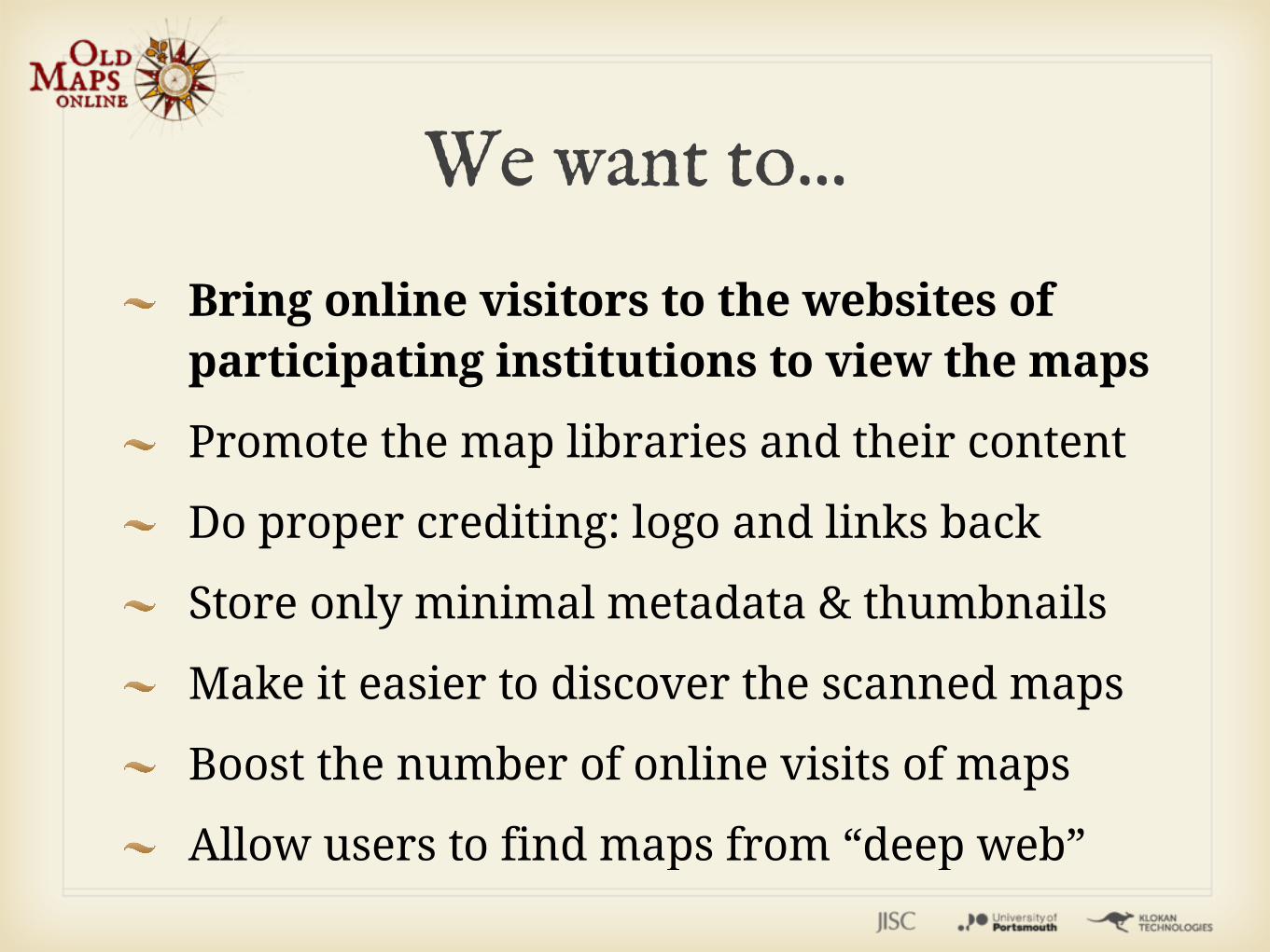
We want to...
Bring online visitors to the websites of participating institutions to view the maps
Promote the map libraries and their content
Do proper crediting: logo and links back
Store only minimal metadata & thumbnails
Make it easier to discover the scanned maps
Boost the number of online visits of maps
Allow users to find maps from “deep web”

Zoom in or out, or drag the main map to move sideways, until you can clearly see the part of the world you want maps for.
You can also use the search field on the top to find a place or define the
time period of interest with the sliders.


Sustainability
Project actively developed with the support from JISC (UK) until January 2013
Basic maintenance covered until 2018
Google Ads to help cover the hosting costs
Participation on a future research projects for improvements of the technology and optimizations of the map management

Technology
Based on the MapRank Search technology http://www.mapranksearch.com/
Released in 2010 by Klokan Technologies for Swiss project Kartenportal.ch, improved for Czech libraries and for David Rumsey
Useful for large metadata catalogs + geospatial digital repositories.
Details in the article published in D-Lib: doi:10.1045/september2011-oehrli

Technology
MapRank ranking: an advanced algorithm calculating coverage similarity of geographical area of query and area covered by every document and combining it with map scale, time range, predefined categories and traditional full text search.

Technology
Data indexing implemented specifically to provide ranked real-time results even for large databases. Traditional R-Tree indexing or Lucene are failing.
Server component: FastCGI, C++
Default user interface developed with Closure JavaScript Library + Closure Compiler.

How can you help?
Use the system & send us ideas for improvement and report bugs
Share: blog, twitter, facebook, google+
We are calling for institutions who would like to include their maps. It is for free. Institutions retain all the rights.
Submission of maps from individuals at later point (technically more problematic)

ContributeHigh resolution (300dpi+ or 2 Megapixel+) maps with a zoomable viewer online
Permanent URL with direct access - no password or payment required
Metadata with DublinCore elements supplied in a spreadsheet (XLS). Later OAI-PMH harvesting.
Bounding box (MARC 034, DCMI BOX, ...)
http://project.oldmapsonline.org/contribute

Bounding box
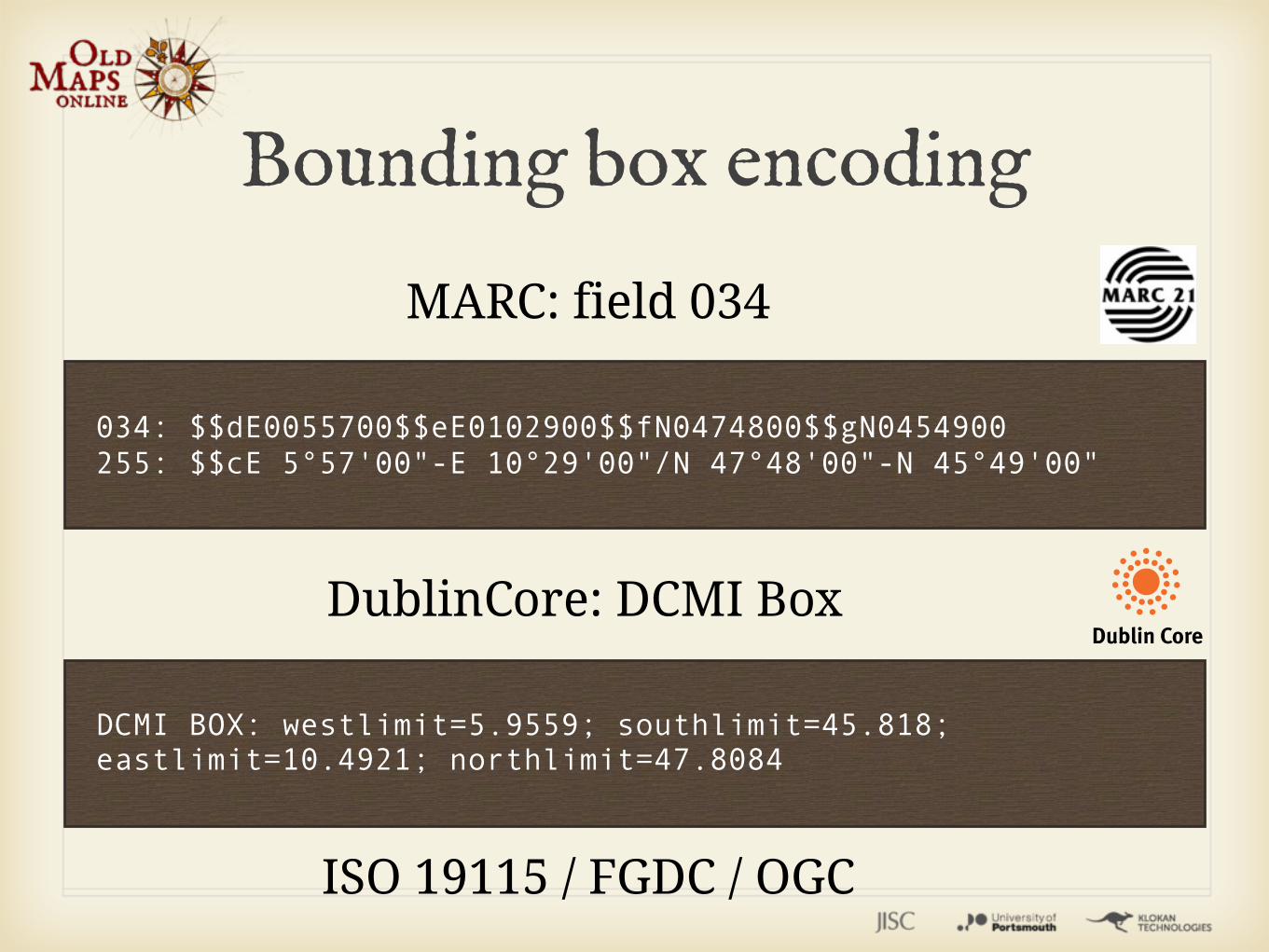
034: $$dE0055700$$eE0102900$$fN0474800$$gN0454900255: $$cE 5°57'00"-E 10°29'00"/N 47°48'00"-N 45°49'00"
MARC: field 034
DCMI BOX: westlimit=5.9559; southlimit=45.818; eastlimit=10.4921; northlimit=47.8084
DublinCore: DCMI Box
ISO 19115 / FGDC / OGC
Bounding box encoding

BoundingBox Tool
How to create such records?
Georeferencer Tool+ Geoparser Tool

BoundingBox Tool: Cataloguing while holding the physical maps - manual selection of the area on an online map(used by Swiss libraries, David Rumsey, ...)
Geoparser: Semi-automatic rapid process - with suggestion of the area by analyzing existing textual metadata.
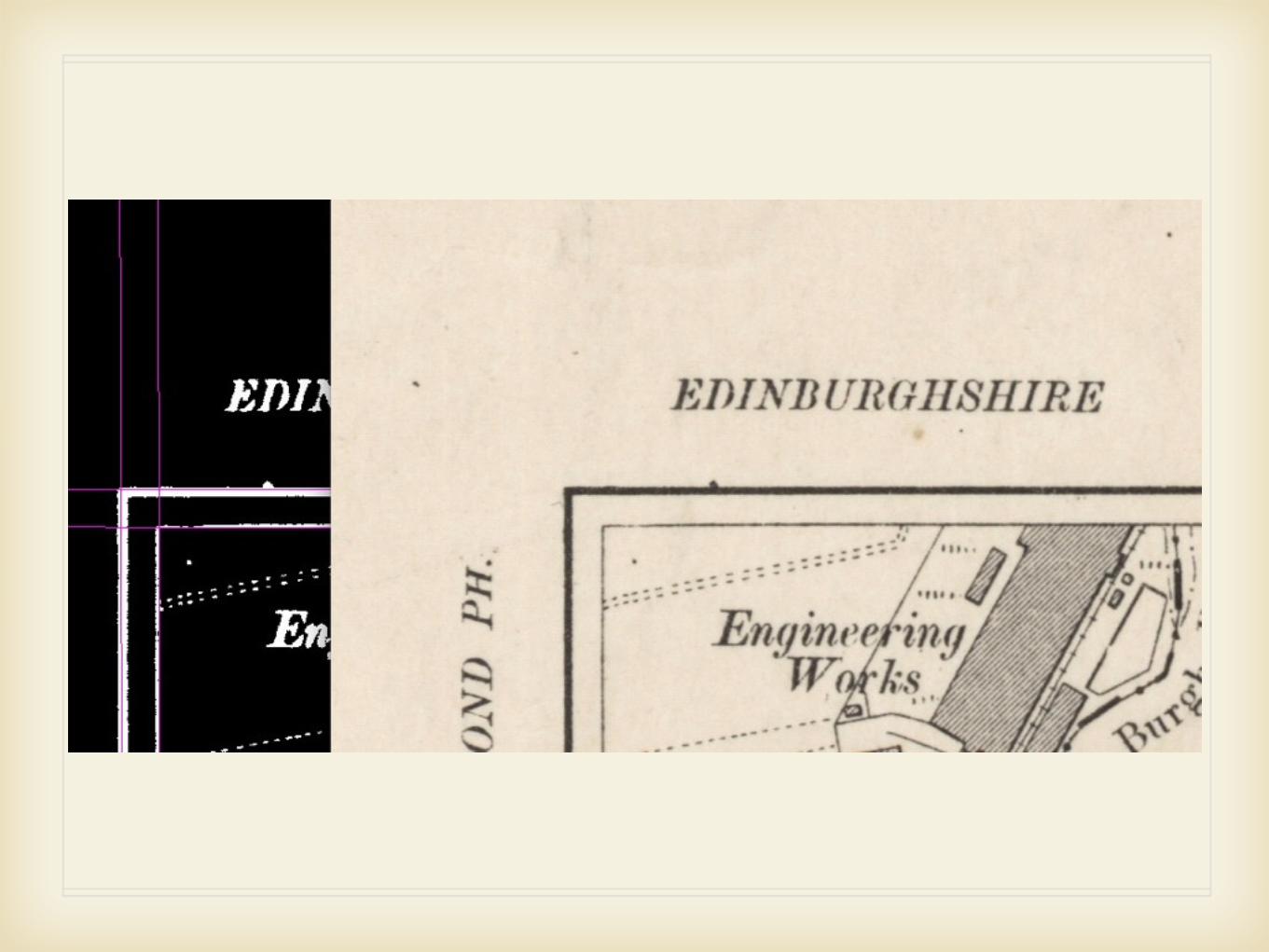
BoundingBox Tool


Enrichment of the online scanned maps
A tool which runs in a web browser
An online service - no software installation
Uses volunteers for metadata enrichment
Successful pilots in several institutions
Georeferencer Tool

20

21


3D visualization (Google Earth)
Accuracy analysis (MapAnalyst)
Bounding Box (metadata enrichment)
Institution can internally generate geodata (GeoTIFF)
Optional: WMS and WMTS for scanned maps in libraries. One per revision.
Georeferencer

It allows to turn the existing online scans into geodata in a web browser
3D visualization as a side product
Support true collaborative editing
It retains log of all operations (a la Wikipedia) - you can adjust it with a few clicks
Georeferencer

Enhanced crowdsourcing support:
Motivation, competition, rewarding, progress indicators, graphs - live widgets to include in the websites of the library
Georeferencer

Competitive Crowdsourcing

Easy integration with the institution website with a simple API and “intelligent links”. Widgets & live data outputs available.
Georeferencer

Target: open platform for personal online research with maps
Development started and continues in collaboration with R&D department of Moravian Library in Brno, Czech Republic
Shared development costs with all participating institutions
Future: Annotations (LinkedData), detection of duplicates, support of map series, etc.
Georeferencer


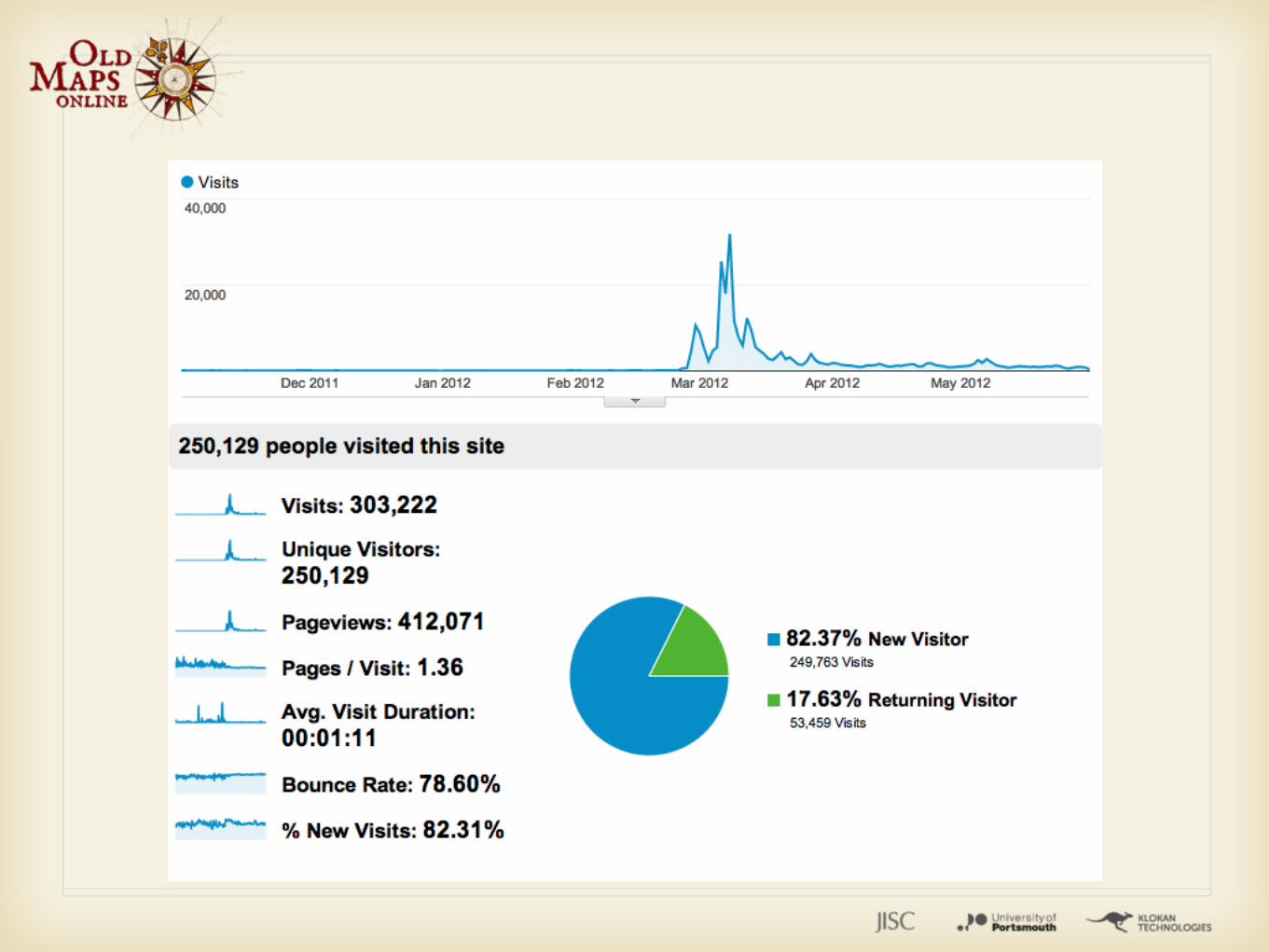
Old Maps Online Launch
Project announced in the end of February in New York and London
Over 30.000 visitors per day on the website after launch
Over 250.000 visitors since the beginning of the project
Two servers in a load balancer to handle the traffic after launch.

Publicity
Social Networks: Twitter, Facebook
Google Developer Showcase + Google I/O 2012
BBC History magazine online slideshow
La Stampa (Milan, Italy) newspaper
Gizmodo, Ars Technica, The Verge
Wired.jp (Japan), About.com Genealogy, Playtech.r (Romania), Portsmouth News (UK), ... TV spot in Catalonya: link

Old Maps Online
www.oldmapsonline.org
... thank you ...

http://www.youtube.com/watch?v=H_2pOU1FO6k
Culture Globe / Europeana Globe
IIPImage JPEG2000 / TIFF emulating Zoomify
Viewer for high resolution scans - mobile devices friendly - replacing Zoomify
Related Documents