63 All lesson videos and notes archived at http://www.sagemontchurch.org/learn/dr-jim-hastings-videos The Book of Exodus Lesson 8 Chapters 14 At the end of the last lesson, we introduced the traditional location of Etham as placed on most maps. As such, Etham was about a day’s journey from Succoth. In that lesson we did not cover the fact that Succoth was the name of a village area as well as the name of the region. For example, think about New York, New York where the city has the same name as the state. Such is the case with Succoth; therefore, it is difficult to pinpoint the actual location of Succoth because the Israelites might have made it just to the region rather than to the actual village. Modern scholars pinpoint the village of Succoth at today’s Tell el-Maskhuta which is near Ismailiya. In his book, Ancient Israel in Sinai, James K. Hoffmeier states that the name Maskhuta can be translated by its parts. “Ma” means place and “skhuta” is the root word transcribed as Succoth. By the time of Rameses II, two hundred years after the exodus, el- Maskhuta will be a military fortified zone in eastern Egypt to protect the capital but that was not the case at this time in the story. After leaving Succoth, the Israelites moved to Etham led by a cloud by day and a pillar of fire by night. This wording indicates that the congregation did, in fact, travel at night. Therefore we must ask the question, “was Etham a specific area about a day’s journey from Succoth or was it a larger region further away, in which case the Israelites had to travel by day and night to reach?” Perhaps we need to speed ahead and look at an itinerary of the journey from Egypt to Mount Sinai as recorded in the book of Exodus and the retelling of the story in the book of Numbers. Book of Exodus Book of Numbers Rameses Rameses Succoth Succoth Etham Etham Pi-hahiroth Pi-hahiroth Migdol Migdol Baal-Zephon Baal-Zephon Crossing of the Red Sea Crossing of the Red Sea Desert of Shur Desert of Etham Marah Marah Elim Elim Red Sea Red Sea Desert of Sin Desert of Sin Dophkah Dophkah Alush Alush Redphidim Redphidim Desert of Sinai Desert of Sinai Mount Sinai Mount Sinai

Welcome message from author
This document is posted to help you gain knowledge. Please leave a comment to let me know what you think about it! Share it to your friends and learn new things together.
Transcript

63 All lesson videos and notes archived at http://www.sagemontchurch.org/learn/dr-jim-hastings-videos
The Book of Exodus Lesson 8
Chapters 14
At the end of the last lesson, we introduced the traditional location of Etham as placed on most
maps. As such, Etham was about a day’s journey from Succoth. In that lesson we did not cover
the fact that Succoth was the name of a village area as well as the name of the region. For
example, think about New York, New York where the city has the same name as the state. Such
is the case with Succoth; therefore, it is difficult to pinpoint the actual location of Succoth
because the Israelites might have made it just to the region rather than to the actual village.
Modern scholars pinpoint the village of Succoth at today’s Tell el-Maskhuta which is near
Ismailiya. In his book, Ancient Israel in Sinai, James K. Hoffmeier states that the name
Maskhuta can be translated by its parts. “Ma” means place and “skhuta” is the root word
transcribed as Succoth. By the time of Rameses II, two hundred years after the exodus, el-
Maskhuta will be a military fortified zone in eastern Egypt to protect the capital but that was not
the case at this time in the story.
After leaving Succoth, the Israelites moved to Etham led by a cloud by day and a pillar of fire by
night. This wording indicates that the congregation did, in fact, travel at night. Therefore we
must ask the question, “was Etham a specific area about a day’s journey from Succoth or was it a
larger region further away, in which case the Israelites had to travel by day and night to reach?”
Perhaps we need to speed ahead and look at an itinerary of the journey from Egypt to Mount
Sinai as recorded in the book of Exodus and the retelling of the story in the book of Numbers.
Book of Exodus Book of Numbers Rameses Rameses
Succoth Succoth
Etham Etham
Pi-hahiroth Pi-hahiroth
Migdol Migdol
Baal-Zephon Baal-Zephon
Crossing of the Red Sea Crossing of the Red Sea
Desert of Shur Desert of Etham
Marah Marah
Elim Elim
Red Sea Red Sea
Desert of Sin Desert of Sin
Dophkah Dophkah
Alush Alush
Redphidim Redphidim
Desert of Sinai Desert of Sinai
Mount Sinai Mount Sinai

64 All lesson videos and notes archived at http://www.sagemontchurch.org/learn/dr-jim-hastings-videos
Notice in the list that Etham is mentioned only once in the Exodus story but twice in that of
Numbers. Looking at the Numbers list we see that Etham is mentioned before and after the
crossing of the Red Sea. How can that be? Such listings should cause a Bible student to pause
and investigate for the truth.
The desert of Etham in the Numbers list is
paired with the desert of Shur in that of
Exodus; both are deserts, indicating that they
are large areas rather than exact locations
such as villages. The desert of Shur is also
known as the wilderness of Shur. We
correctly think of deserts as being dry and
desolate. We do not generally think of a
wilderness as being the same as a desert but
the two are basically synonymous in Bible
terminology. Map 15 shows the
desert/wilderness of Shur as generally
accepted for centuries. Shur means wall and
the Eyptians built a wall on the east side of
the Land of Goshen as a protection from the
enemies who might approach from that direction. The
wall began near the Mediterranean Sea and proceeded
southwest as indicated in Map 16. To the Egyptians,
everything east of the wall was called the
desert/wilderness of Shur. It was first noted in the
Bible in Genesis 16. By looking at the topography of
the map we see that the majority of the
desert/wilderness of Shur is mountainous. Notice also
that the area extends past the Gulf of Aqaba.
Therefore, the Israelites could have been in the
wilderness of Shur before and after crossing the Red
Sea. On the map, below the wilderness of Shur, a
valley cuts across the Arabian Peninsula. Below the
valley, another mountainous area can be seen. It is called the wilderness of the Red Sea. We
must remember that Exodus 13:18 states that “God led the people around by the way of the
wilderness to the Red Sea,” indicating that they took the trade route out of Succoth that went
around the southern portion of the wilderness of Shur/Etham to the Aqaba instead of the trade
route out of Succoth that took them around the northern boundary of the wilderness to the Aqaba
and would add about 100 miles to the journey.
If the book of Exodus calls the region the desert of Shur and the book of Numbers calls it the
desert of Etham, is it possible that the two are the same? Stepping away from religious resources
and into the world of archeology, we find that the British explorer Sir Richard Frances Burton
chronicled his expeditions in his book The Gold of Midian. Burton lived from 1821 – 1890. We
Map 15: Desert/ Wilderness of Shur/Etham
Desert/Wilderness of
Shur also called
Desert/Wilderness of
Etham
. Succoth
Rameses .
Wilderness
of the
Red Sea
. Pelisium
. Heliopolis
Map 16: Wall of Shur and the two trade routes out of
Succoth to the fresh water at the head of the Aqaba.

65 All lesson videos and notes archived at http://www.sagemontchurch.org/learn/dr-jim-hastings-videos
can think of him as a true Indiana Jones type who spoke
more than 20 languages and explored Asia, Africa and the
Americas as well as the land of Midian searching for
ancient treasures of gold. Fortunate byproducts of his
detailed diaries were his hand-drawn maps. The details in
his maps were based on the places he visited and the
historical background that he learned from the local
people. On his maps he placed Etham as the highest peak
of the mountain range at the north end of the Gulf of
Aqaba. Several spellings exist for this mountain peak and
the range where it is found including Ithm, Itm, Yitm,
Lithm, and Ithem, depending on the dialect in use as noted
by T. E. Lawrence in his book The Seven Pillars of Wisdom (1926). Even modern maps still use
the name Ithm for the mountain peak.
Therefore, it is safe to assume that because the Israelites were leaving Succoth, which was
essentially located at the wall of Shur, they were headed east toward the wilderness or desert
beyond the wall. Furthermore, when recording the recapitulation of the event 40 years later,
Moses indicated the direction of the exodus from the land of Midian where the Israelites were
camped. Accordingly, the wilderness of Shur was the name of the mountain range from the
Egyptian perspective and the wilderness of Etham was the name from the Midian perspective.
Therefore, when the Israelites left Succoth, they headed east toward the wilderness of Etham and
the mountain for which it was named and the precise location of their campsites until they
reached the Gulf of Aqaba, the east finger of the Red Sea, is unknown. We must remember that
Exodus 13:20 states, “Then they set out from Succoth and camped in Etham on the edge of
the wilderness.” Succoth was located on the western boundary of the wilderness and the Mount
of Etham was located on the eastern boundary of the wilderness. Therefore, as was the custom
of Moses in both Genesis and Exodus, Exodus 13:20 is a summary of the beginning and intended
ending locations of the journey across the wilderness area to the fresh water at the head of the
Gulf of Aqaba where the mountain runoffs flow year round.
On map 17, the line indicates the probable direction
of the Israelites when they left Succoth. The line
shows the easiest route between the mountainous
ranges of the wilderness of Shur/Etham and the
wilderness of the Red Sea. Any other route would
require climbing and descending the mountains,
adding 100 or more miles to the trip. Had Pharaoh
not chased the Israelites, the people would have
crossed the mountain range near the Mount of Etham
and moved south to settle at the foot of Mount Sinai
as seen on Map 18. But evidently, Pharaoh and his
men nearly caught up with the Israelites about where the dot is at the end of the line on map 17.
Map 18: Route of Israelites to Sinai had Pharaoh not chased
after them.
Etham .
. Succoth
Shur
Map 17: Location of Mount Etham
Also known as Ithm, Itm, Yitm, Lithm, and Ithem
Etham .
. Succoth
Shur
66 All lesson videos and notes archived at http://www.sagemontchurch.org/learn/dr-jim-hastings-videos
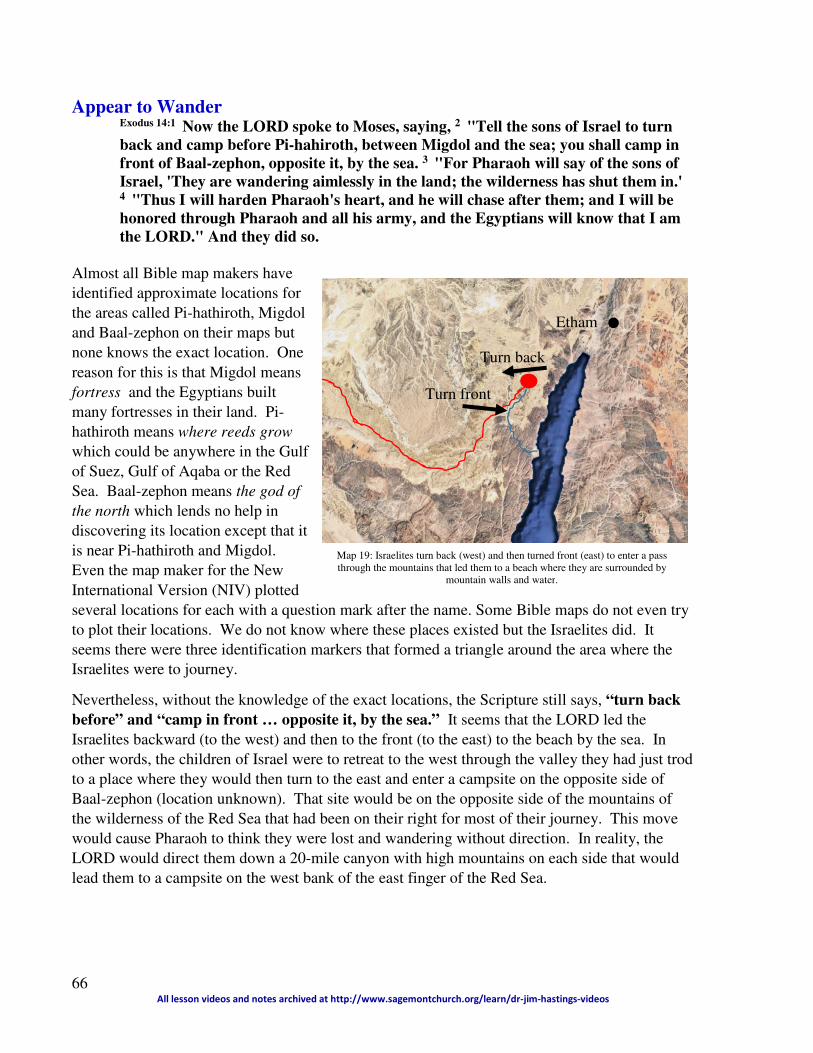
Etham .
Map 19: Israelites turn back (west) and then turned front (east) to enter a pass
through the mountains that led them to a beach where they are surrounded by
mountain walls and water.
Turn back
Turn front
Appear to Wander Exodus 14:1 Now the LORD spoke to Moses, saying, 2 "Tell the sons of Israel to turn
back and camp before Pi-hahiroth, between Migdol and the sea; you shall camp in
front of Baal-zephon, opposite it, by the sea. 3 "For Pharaoh will say of the sons of
Israel, 'They are wandering aimlessly in the land; the wilderness has shut them in.' 4 "Thus I will harden Pharaoh's heart, and he will chase after them; and I will be
honored through Pharaoh and all his army, and the Egyptians will know that I am
the LORD." And they did so.
Almost all Bible map makers have
identified approximate locations for
the areas called Pi-hathiroth, Migdol
and Baal-zephon on their maps but
none knows the exact location. One
reason for this is that Migdol means
fortress and the Egyptians built
many fortresses in their land. Pi-
hathiroth means where reeds grow
which could be anywhere in the Gulf
of Suez, Gulf of Aqaba or the Red
Sea. Baal-zephon means the god of
the north which lends no help in
discovering its location except that it
is near Pi-hathiroth and Migdol.
Even the map maker for the New
International Version (NIV) plotted
several locations for each with a question mark after the name. Some Bible maps do not even try
to plot their locations. We do not know where these places existed but the Israelites did. It
seems there were three identification markers that formed a triangle around the area where the
Israelites were to journey.
Nevertheless, without the knowledge of the exact locations, the Scripture still says, “turn back
before” and “camp in front … opposite it, by the sea.” It seems that the LORD led the
Israelites backward (to the west) and then to the front (to the east) to the beach by the sea. In
other words, the children of Israel were to retreat to the west through the valley they had just trod
to a place where they would then turn to the east and enter a campsite on the opposite side of
Baal-zephon (location unknown). That site would be on the opposite side of the mountains of
the wilderness of the Red Sea that had been on their right for most of their journey. This move
would cause Pharaoh to think they were lost and wandering without direction. In reality, the
LORD would direct them down a 20-mile canyon with high mountains on each side that would
lead them to a campsite on the west bank of the east finger of the Red Sea.

67 All lesson videos and notes archived at http://www.sagemontchurch.org/learn/dr-jim-hastings-videos
Pharaoh’s Change of Mind Exodus 14:5 When the king of Egypt was told that the people had fled, Pharaoh and his
servants had a change of heart toward the people, and they said, "What is this we
have done, that we have let Israel go from serving us?" 6 So he made his chariot
ready and took his people with him; 7 and he took six hundred select chariots, and
all the other chariots of Egypt with officers over all of them. 8 And the LORD
hardened the heart of Pharaoh, king of Egypt, and he chased after the sons of Israel
as the sons of Israel were going out boldly. 9 Then the Egyptians chased after them
with all the horses and chariots of Pharaoh, his horsemen and his army, and they
overtook them camping by the sea, beside Pi-hahiroth, in front of Baal-zephon. 10 And as Pharaoh drew near, the sons of Israel looked, and behold, the Egyptians
were marching after them, and they became very frightened; so the sons of Israel
cried out to the LORD.
In order to arrive at the beach on the Sea of Aqaba, the only way in was the pass from the canyon
as seen on map 19. It seems that Pharaoh had heard about the Israelites in the wilderness and
pursued them with 600 special chariots, most likely the parade chariots for festival events, as
well as all the war chariots. We have not addressed the predicament the Israelites were in but we
should now. Once Pharaoh and his men entered the valley leading to the Mount of Etham, there
were very few options for the Israelites to divert their journey in order to hide from the king. At
the approximate point on map 19 indicated by the dot, the Israelites could have scattered in many
directions but they still would have been in jeopardy of destruction by Pharaoh. The LORD was
guiding the Israelites with the cloud by day and fire by night and there was little chance that the
LORD would have let them scatter. He led them to a place where they had no place to turn
except to put their trust in Him.
Complaint to Moses Exodus 14:11 Then they said to Moses, "Is it
because there were no graves in Egypt that
you have taken us away to die in the
wilderness? Why have you dealt with us in this
way, bringing us out of Egypt? 12 "Is this not
the word that we spoke to you in Egypt,
saying, ' Leave us alone that we may serve the
Egyptians'? For it would have been better for
us to serve the Egyptians than to die in the
wilderness."
Trapped by the mountains against the sea, the Israelites
complained to Moses. Pharaoh and his men must have
followed them down the 20-mile cut in the canyon and they could see the dust he was stirring up.
How have we concluded that the Israelites were on the beach indicated on map 20? Four
hundred years after the exodus, King Solomon placed a column on each side of the Sea of Aqaba
where the crossing took place. The location of those columns was discovered in 1978 and
Map 20: Close-up view of the beach where the
Israelites were trapped by Pharaoh before they
crossed over the sea.

68 All lesson videos and notes archived at http://www.sagemontchurch.org/learn/dr-jim-hastings-videos
Picture 28: Current sign identifying the location of
Solomon's Column to identity the place of Israel's
Red Sea crossing. The pass in the background
shows the place where the Israelites entered the
beachfront. Pharaoh's men entered the same way.
The column was on its side near the edge of the
water when it was found in 1978. By 1990 it had
been stood up and placed in concrete. When it was
found the engraving was worn off by the rising
waters and blowing sand.
Picture 30: In 1978, a
matching column was also
found standing on the
Arabian side of the Red
Sea. The engraving
indicated that King
Solomon placed the
column there to identify the
Red Sea crossing of the
Israelites to the Arabian
side of the gulf. By 1990,
the column was replaced
by this marker.
Picture 29: View of the entire beach
from Picture 28
Picture 27: Location of two columns set by
King Solomon to mark the location of the Red
Sea crossing
Picture 27 shows the approximate location of each with
one on the Egyptian side and one on the Arabian side.
Picture 28 shows where the Egyptian side column once
stood. More than that, look at the canyon in the
background which was where the Israelites entered the
beach from the 20-mile path. That canyon was the only
way out from the beach without traveling by boat. That
canyon is the same entrance to the beach that Pharaoh
took in his attempt to overtake the Israelites. The
walls of the mountains were so high that no one
could climb them to escape the threat from Pharaoh.
It was at the entrance to this canyon pass that the
pillar of the cloud blocked Pharaoh from entering the
beach area. It was at this location that Pharaoh
“overtook them camping by the sea,” according to
Exodus 14:9.
Picture 30 shows the site of the column of Solomon
found on the Arabian side of the gulf. In 1978, the
engraving on this column read in Hebrew, Mizraim
(which is the original Hebrew word for Egypt),
Solomon, Edom, Death, Pharaoh, Moses,
Yahweh. Saudi Arabia removed this column and
replaced it with a flag and marker but no longer
allows non-Muslims to visit the location.
When the Israelites said to Moses, “Is it because
there were no graves in Egypt that you have
taken us away to die in the wilderness?
Why have you dealt with us in this
way, bringing us out of Egypt? Is this
not the word that we spoke to you in
Egypt, saying, 'Leave us alone that we
may serve the Egyptians'? For it
would have been better for us to serve
the Egyptians than to die in the
wilderness," they were on the beach
depicted in picture 29 with no way out as
depicted in picture 28 with Pharaoh
coming down the canyon.
Moses Replies Exodus 14:13 But Moses said to the people, "Do not fear! Stand
by and see the salvation of the LORD which He will
accomplish for you today; for the Egyptians whom you
Egyptian side
Arabian side

69 All lesson videos and notes archived at http://www.sagemontchurch.org/learn/dr-jim-hastings-videos
have seen today, you will never see them again forever. 14 " The LORD will fight for
you while you keep silent."
Moses was confidant before the people that Pharaoh could not harm them and he proclaimed that
message to them.
The LORD Speaks Exodus 14:15 Then the LORD said to Moses, "Why are you crying out to Me? Tell the
sons of Israel to go forward. 16 "And as for you, lift up your staff and stretch out
your hand over the sea and divide it, and the sons of Israel shall go through the
midst of the sea on dry land. 17 "And as for Me, behold, I will harden the hearts of
the Egyptians so that they will go in after them; and I will be honored through
Pharaoh and all his army, through his chariots and his horsemen. 18 " Then the
Egyptians will know that I am the LORD, when I am honored through Pharaoh,
through his chariots and his horsemen."
Moses was evidently not as personally confident as he portrayed himself to be before the people
because he must have cried out to the LORD. Here is an interesting response from the LORD.
“Why are you crying out to Me?” The LORD had led the people to the beach, the LORD
would lead them on to safety. The soul of Moses must have been deeply engaged with the LORD
so that whatever Moses thought, the LORD had designed. Moses announced that the LORD
would fight for the Israelites; the result of that action could not be predicted. Surely, Moses and
the Israelites thought the LORD would destroy the Egyptians with the pillar of fire, but not so!
The way the LORD fought for Israel was still to be revealed.
The LORD told Moses to “Tell the sons of Israel to go forward.” The Hebrew language did not
have a word for east, west, north or south; rather, they used the words forward, backward, left or
right. As we saw in Exodus 14:1-2, the LORD told the people to “turn back” which meant to go
west, then He told them to go “front” or forward which meant to go east. When they went east,
that track took them into the canyon that led to the beach where they were trapped by the water
of the gulf. As Pharaoh attempted to overtake them at that location, the only way to escape his
wrath was to walk east into the sea. Notice the promise from the LORD that says, “Israel shall
go through the midst of the sea on dry land.” But the LORD was not finished with Pharaoh;
He would make him so angry that he would send all his troops after the Israelites in the midst of
the mighty miracle that the LORD would perform to rescue the Israelites. That would be the key
to understanding how the LORD would fight for Israel. If there was any question in the minds of
the Egyptians that the LORD was the true God the immediate miracle would erase all doubts.
History tells us that Pharaoh lived to regret his decision to follow the Israelites when his troops
did not survive.
Angel of God Exodus 14:19 And the angel of God, who had been going before the camp of Israel,
moved and went behind them; and the pillar of cloud moved from before them and
stood behind them. 20 So it came between the camp of Egypt and the camp of Israel;

70 All lesson videos and notes archived at http://www.sagemontchurch.org/learn/dr-jim-hastings-videos
and there was the cloud along with the darkness, yet it gave light at night. Thus the
one did not come near the other all night.
The Egyptians were on their way through the canyon when the cloud that had been leading the
Israelites moved into the canyon so that the Egyptians could not see their way to move forward
or back. In that cloud, the Egyptians were in total darkness. Interestingly, the cloud caused
darkness for the Egyptians yet it reflected the light of the pillar of fire so the Israelites could see
their way through the sea with light in front and light in back. As recorded in the text, “Thus the
one did not come near the other all night.” The Israelites did not stay there all nigh. They
headed across the sea under the direction of the LORD.
Israel Moves Crosses on Dry Land Exodus 14:21 Then Moses stretched out his hand over the sea; and the LORD swept the
sea back by a strong east wind all night, and turned the sea into dry land, so the
waters were divided. 22And the sons of Israel went through the midst of the sea on
the dry land, and the waters were like a wall to them on their right hand and on
their left.
Much has been said since 1978 about the underwater topography of the seabed between the two
banks. The gulf can reach a maximum depth of 6,070 feet and at the location of the crossing the
distance was about 15 miles. Remember, the depth of 6,070 is the maximum; we have no way of
knowing the actual depth at the site of the crossing at that time; nevertheless, we can assume that
the depth was no greater than 6,070 feet. Therefore, we can assume that if the maximum depth
was 6,070 feet then the Israelites had to walk down 7.5 miles and up 7.5 miles on average. What
was the average angle of the descent and ascent?
In the worst case scenario, the Israelites had to descend and ascend a slope of 15.2 degrees. As
you can tell by the scaled example above, the crossing of the Red Sea at the location noted could
be accomplished by all.
Egyptian Pursuit Exodus 14:23 Then the Egyptians took up the pursuit, and all Pharaoh's horses, his
chariots and his horsemen went in after them into the midst of the sea. 24 And it
came about at the morning watch, that the LORD looked down on the army of the
Egyptians through the pillar of fire and cloud and brought the army of the
Egyptians into confusion. 25 And He caused their chariot wheels to swerve, and He
made them drive with difficulty; so the Egyptians said, "Let us flee from Israel, for
the LORD is fighting for them against the Egyptians." 26 Then the LORD said to
Moses, " Stretch out your hand over the sea so that the waters may come back over
the Egyptians, over their chariots and their horsemen." 27 So Moses stretched out
Egyptian side
7.5 miles 7.5 miles
1.1
4 m
iles
1.1
4 m
iles
Arabian side
Middle of the Gulf
71 All lesson videos and notes archived at http://www.sagemontchurch.org/learn/dr-jim-hastings-videos
his hand over the sea, and the sea returned to its normal state at daybreak, while the
Egyptians were fleeing right into it; then the LORD overthrew the Egyptians in the
midst of the sea. 28 And the waters returned and covered the chariots and the
horsemen, even Pharaoh's entire army that had gone into the sea after them; not
even one of them remained.
When Moses says, “And it came about at the morning watch,” it becomes clear that the
crossing of the Red Sea occurred at night. As Moses records this event in this book, he mentions
the morning watch. Such a time was not established at the time of the crossing; however, it will
be soon as the need for watchmen will become evident to protect the camp once they are in the
land of Midian. In this case, Moses names the time in the text as if it had already been
established. The first morning watch, the changing from the last night watchman to the first
morning watchman, occurred at sunrise or 6:00 AM. Therefore, roughly at 6:00 AM, the
Israelites had completed the journey across the seabed and were looking back over the 15 miles
they had traveled. At some time, the LORD had moved the cloud and Pharaoh had ordered his
men to pursue the Israelites though the sea on the dry land. Watching from the east bank, Moses
caused the sea walls to collapse and drowned Pharaoh’s army. As promised, the LORD had
fought the army of Pharaoh for the Israelites!
Israel Saved Exodus 14:29 But the sons of Israel walked on dry land through the midst of the sea,
and the waters were like a wall to them on their right hand and on their left. 30 Thus
the LORD saved Israel that day from the hand of the Egyptians, and Israel saw the
Egyptians dead on the seashore. 31 And when Israel saw the great power which the
LORD had used against the Egyptians, the people feared the LORD, and they
believed in the LORD and in His servant Moses.
What a miracle the Israelites experienced that day! Taking the Scripture in its literal sense, the
Israelites might have seen a wall of water on each side of them more than a mile high when they
were at the deepest point in the seabed. Most likely, they were not at the deepest point and the
grade was much less; yet even 100 feet of water, instead of a mile of water 15 miles wide
gushing in on the Egyptian army would have killed them all.
To the Israelites who had lived through the 10 plagues in Egypt, this must have been the greatest
of all the miracles to that point in their lives. It will not be the last.
Related Documents