Welcome message from author
This document is posted to help you gain knowledge. Please leave a comment to let me know what you think about it! Share it to your friends and learn new things together.
Transcript

The Blaine Site
Research Report No. 2

The Blaine Site
A Multiple Component Camp in theRed Valley of the Black HillsCuster County, South Dakota
byLinea SundstromNed HanenbergerJames DonohueGrant Smith
Michael McFaulKaren Lynn Traugh
Bruce PotterJane Watts
Research Report No. 2South Dakota State Historical Society
Archaeological Research Center2008

c©2008 by the South Dakota State Historical SocietyArchaeological Research CenterAll rights reservedPrinted in U.S.A.
v
Abstract
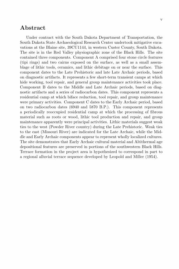
Under contract with the South Dakota Department of Transportation, theSouth Dakota State Archaeological Research Center undertook mitigative exca-vations at the Blaine site, 39CU1144, in western Custer County, South Dakota.The site is in the Red Valley physiographic zone of the Black Hills. The sitecontained three components. Component A comprised four stone circle features(tipi rings) and two cairns exposed on the surface, as well as a small assem-blage of lithic tools, ceramics, and lithic debitage on or near the surface. Thiscomponent dates to the Late Prehistoric and late Late Archaic periods, basedon diagnostic artifacts. It represents a few short-term transient camps at whichhide working, tool repair, and general group maintenance activities took place.Component B dates to the Middle and Late Archaic periods, based on diag-nostic artifacts and a series of radiocarbon dates. This component represents aresidential camp at which biface reduction, tool repair, and group maintenancewere primary activities. Component C dates to the Early Archaic period, basedon two radiocarbon dates (6940 and 5870 B.P.). This component representsa periodically reoccupied residential camp at which the processing of fibrousmaterial such as roots or wood, lithic tool production and repair, and groupmaintenance apparently were principal activities. Lithic materials suggest weakties to the west (Powder River country) during the Late Prehistoric. Weak tiesto the east (Missouri River) are indicated for the Late Archaic, while the Mid-dle and Early Archaic components appear to represent wholly localized cultures.The site demonstrates that Early Archaic cultural material and Altithermal agedepositional features are preserved in portions of the southwestern Black Hills.Terrace formation in the project area is hypothesized to correspond in part toa regional alluvial terrace sequence developed by Leopold and Miller (1954).

vi
vii
Acknowledgments
The Archaeological Research Center staff would like to extend their appreci-ation to the individuals who contributed their time and resources to the Blainesite project. The Center is indebted to the landowner, Rhett Davis, who allowedpersonnel access to his property for the testing phase of the investigations. TheSouth Dakota Department of Transportation (SDDOT) was an invaluable liai-son between SARC and the various highway contractors. The participation ofSDDOT in this capacity greatly facilitated the Center’s work in the field. SD-DOT further assisted the excavations by providing a road grader for the initialphase of site stripping. A special note of thanks is extended to SDDOT CusterCounty shop and the Regional Engineer, Don Krause, the Project Engineers,Gary Rice and Curt Grudniewski, the Grade Engineer, Larry Noem, the Main-tenance Coordinator, Leonard Faiman, and the Shop Foreman, Gordan Stolp.Gratitude is also due the Guernsey Stone and Construction Company of Om-aha, Nebraska, and the company’s Project Superintendent, Clinton Cheeney.Their cooperation and the loan of heavy equipment for the second phase of sitestripping was greatly appreciated.
James Donohue served as Principal Investigator for the Archaeological Re-search Center. Michael Fosha initially surveyed and recorded the Blaine site.Ned Hanenberger directed the testing phase and the mitigation excavation. Hewas assisted by Kurt Braun in the test phase and by Jane Watts and EduardoVega in the mitigaion phase. Crew members were Liz Amos, Pete Churchill,Marc Cool, Cara Dale, Barrie Davis, Edward Fosha, Wade Haakenson, DaveHolst, Joe Landon, Phillis Landon, Stan Landon, Calvin Long, Vaughn Lund-berg, Laura McLuckie, John Martin, Tressa Martin, Donna Michaelis, BrucePotter, Brenda Shierts, Candy Taft, and Mike Tuma.
The geomorphology and pedology study was subcontracted to LaRamie SoilService of Laramie, Wyoming. Mike McFaul, Grant Smith, and Karen LynnTraugh conducted this aspect of the study. The backhoe work was subcontractedto Andy’s Service of Newcastle, Wyoming, Andy Wolf, proprietor.
Ned Hanenberger directed the laboratory work. Jane Watts identified thefaunal remains. Bruce Potter and Calvin Long analyzed the artifacts and lithicdebris. Bruce Potter provided the lithic material descriptions, and Ned Hanen-berger provided the tool and ceramics descriptions. The feature fill and soilsample processing was done by Scott Bandalos, Dave Holst, and Rick Hanson.The artifacts were illustrated by Eduardo Vega. The plan maps and profileswere drawn by Calvin Long, assisted by Dave Holst. Photographs and videofootage were cataloged by Cara Dale.
Report preparation was subcontracted to Linea Sundstrom. She would liketo thank Pat Hofer, Ned Hanenberger, James Donohue, and Jane Watts ofthe Archaeological Research Center for providing information crucial to thecompletion of the report. Ann Johnson of the National Park Service, RockyMountain Regional Office, and Marcel Kornfeld and Charles Reher, both ofthe University of Wyoming, provided valuable information and advice aboutsettlement and subsistence patterns in the Black Hills.

viii
Contents
Abstract . . . . . . . . . . . . . . . . . . . . . . . . . . . . . . . . . . . vAcknowledgments . . . . . . . . . . . . . . . . . . . . . . . . . . . . . . vii
1 INTRODUCTION TO THE PROJECT 11.1 Introduction . . . . . . . . . . . . . . . . . . . . . . . . . . . . . . 11.2 History of Investigations at 39CU1144 . . . . . . . . . . . . . . . 2
2 ENVIRONMENTAL CONTEXT 72.1 The Black Hills Environment . . . . . . . . . . . . . . . . . . . . 7
2.1.1 Physical Geology . . . . . . . . . . . . . . . . . . . . . . . 72.1.2 Geology . . . . . . . . . . . . . . . . . . . . . . . . . . . . 102.1.3 Drainage . . . . . . . . . . . . . . . . . . . . . . . . . . . 112.1.4 Climate . . . . . . . . . . . . . . . . . . . . . . . . . . . . 112.1.5 Biology . . . . . . . . . . . . . . . . . . . . . . . . . . . . 122.1.6 Distribution of natural resources . . . . . . . . . . . . . . 13
2.2 The Site Environment . . . . . . . . . . . . . . . . . . . . . . . . 16
3 ARCHAEOLOGICAL CONTEXT OF THE PROJECT 213.1 The Area and Its Significance . . . . . . . . . . . . . . . . . . . . 213.2 Previous Investigations . . . . . . . . . . . . . . . . . . . . . . . . 223.3 Prehistory of the Black Hills . . . . . . . . . . . . . . . . . . . . . 27
3.3.1 Paleoindian . . . . . . . . . . . . . . . . . . . . . . . . . . 283.3.2 Early Plains Archaic . . . . . . . . . . . . . . . . . . . . . 303.3.3 Middle Plains Archaic . . . . . . . . . . . . . . . . . . . . 323.3.4 Late Archaic and Plains Woodland . . . . . . . . . . . . . 333.3.5 Late Prehistoric and Plains Village . . . . . . . . . . . . . 343.3.6 Protohistoric . . . . . . . . . . . . . . . . . . . . . . . . . 353.3.7 Historic . . . . . . . . . . . . . . . . . . . . . . . . . . . . 36
4 RESEARCH ORIENTATION 374.1 Research Objectives . . . . . . . . . . . . . . . . . . . . . . . . . 374.2 The Blaine Site Data . . . . . . . . . . . . . . . . . . . . . . . . . 384.3 Functional Site Types . . . . . . . . . . . . . . . . . . . . . . . . 394.4 The Resource Base . . . . . . . . . . . . . . . . . . . . . . . . . . 454.5 Settlement and Subsistence Models . . . . . . . . . . . . . . . . . 47
ix
x CONTENTS
4.5.1 Refuge Model . . . . . . . . . . . . . . . . . . . . . . . . . 514.5.2 Plains-Based Sporadic Use . . . . . . . . . . . . . . . . . 544.5.3 Plains-Based Seasonal Use . . . . . . . . . . . . . . . . . . 584.5.4 Combined Mountain Archaic and Plains-Based Seasonal
Use . . . . . . . . . . . . . . . . . . . . . . . . . . . . . . 604.6 Lithic Raw Material Studies . . . . . . . . . . . . . . . . . . . . . 654.7 Summary . . . . . . . . . . . . . . . . . . . . . . . . . . . . . . . 70
5 RESULTS 735.1 The Blaine Site Excavations . . . . . . . . . . . . . . . . . . . . . 735.2 Radiocarbon Dates . . . . . . . . . . . . . . . . . . . . . . . . . . 775.3 Features . . . . . . . . . . . . . . . . . . . . . . . . . . . . . . . . 79
5.3.1 Feature 1 . . . . . . . . . . . . . . . . . . . . . . . . . . . 825.3.2 Features 2, 3, 4, and 7 . . . . . . . . . . . . . . . . . . . . 825.3.3 Feature 5 . . . . . . . . . . . . . . . . . . . . . . . . . . . 865.3.4 Hearth features . . . . . . . . . . . . . . . . . . . . . . . . 86
5.4 Ceramics . . . . . . . . . . . . . . . . . . . . . . . . . . . . . . . 935.5 Lithic Tools . . . . . . . . . . . . . . . . . . . . . . . . . . . . . . 975.6 Lithic Debitage . . . . . . . . . . . . . . . . . . . . . . . . . . . . 1075.7 Tool: and Core:Debitage Ratio Analysis . . . . . . . . . . . . . . 1105.8 Tool Kit Analysis . . . . . . . . . . . . . . . . . . . . . . . . . . . 1115.9 Lithic Source Analysis . . . . . . . . . . . . . . . . . . . . . . . . 113
5.9.1 Lithic Raw Materials . . . . . . . . . . . . . . . . . . . . . 1135.9.2 Blaine Site Lithic Raw Materials . . . . . . . . . . . . . . 121
5.10 Unmodified Rock . . . . . . . . . . . . . . . . . . . . . . . . . . . 1275.11 Faunal Material . . . . . . . . . . . . . . . . . . . . . . . . . . . . 1285.12 Floral Material . . . . . . . . . . . . . . . . . . . . . . . . . . . . 1315.13 Seasonality Data . . . . . . . . . . . . . . . . . . . . . . . . . . . 131
6 GEOARCHAEOLOGICAL INVESTIGATIONS 1336.1 Introduction . . . . . . . . . . . . . . . . . . . . . . . . . . . . . . 1336.2 Physiography and Geology . . . . . . . . . . . . . . . . . . . . . . 1346.3 Background and Methods . . . . . . . . . . . . . . . . . . . . . . 1346.4 Results . . . . . . . . . . . . . . . . . . . . . . . . . . . . . . . . . 135
6.4.1 Ridge Top and Ucross Formation Sediments . . . . . . . . 1356.4.2 Pre-Kaycee Sediments . . . . . . . . . . . . . . . . . . . . 1406.4.3 Kaycee Formation Sediments . . . . . . . . . . . . . . . . 1436.4.4 The T1 Terrace . . . . . . . . . . . . . . . . . . . . . . . . 158
6.5 Conclusions . . . . . . . . . . . . . . . . . . . . . . . . . . . . . . 168
7 SUMMARY AND CONCLUSIONS 1717.1 Summary of Interpretations . . . . . . . . . . . . . . . . . . . . . 1717.2 Settlement Pattern Research Hypotheses . . . . . . . . . . . . . . 1747.3 Subsistence Economy Research Hypotheses . . . . . . . . . . . . 1817.4 Conclusions . . . . . . . . . . . . . . . . . . . . . . . . . . . . . . 183

CONTENTS xi
8 References Cited 187
A Supplemental Data 205A.1 Tool Descriptions from 39CU1144 . . . . . . . . . . . . . . . . . . 231A.2 Faunal Data from 39CU1144 . . . . . . . . . . . . . . . . . . . . 256
A.2.1 Systematics . . . . . . . . . . . . . . . . . . . . . . . . . . 258

xii CONTENTS
List of Figures
1.1 Location of 39CU1142 and 39CU1144, western Custer County,South Dakota . . . . . . . . . . . . . . . . . . . . . . . . . . . . . 2
1.2 The Blaine site (39CU1144) showing surface features and test units 4
2.1 Physiographic zones and drainage of the Black Hills . . . . . . . 92.2 Topographic location of the Blaine Site . . . . . . . . . . . . . . 172.3 View of the Blaine Site showing site environment . . . . . . . . . 18
3.1 Location of the Black Hills . . . . . . . . . . . . . . . . . . . . . 22
4.1 Distribution of radiocarbon dates from the Black Hills . . . . . . 394.2 Location of lithic raw material sources . . . . . . . . . . . . . . . 66
5.1 Excavation units, grader scrapes, and backhoe trenches at theBlaine site . . . . . . . . . . . . . . . . . . . . . . . . . . . . . . . 75
5.2 Excavation of Block B, 39CU1144 . . . . . . . . . . . . . . . . . 765.3 Excavation of Block A, 39CU1144 . . . . . . . . . . . . . . . . . 765.4 Excavation of geomorph trenches at the Blaine site . . . . . . . . 775.5 Belly-scraper operations at the Blaine site . . . . . . . . . . . . . 785.6 Feature 1 cairn . . . . . . . . . . . . . . . . . . . . . . . . . . . . 835.7 Feature 1 cairn, profile view, 39CU1144 . . . . . . . . . . . . . . 835.8 Tipi ring features 2, 3, 4, and 7, plan view . . . . . . . . . . . . . 845.9 Feature 2 tipi ring . . . . . . . . . . . . . . . . . . . . . . . . . . 855.10 Feature 4 tipi ring . . . . . . . . . . . . . . . . . . . . . . . . . . 855.11 Feature 5 cairn . . . . . . . . . . . . . . . . . . . . . . . . . . . . 865.12 Features 8 and 9 . . . . . . . . . . . . . . . . . . . . . . . . . . . 875.13 Feature 9 hearth . . . . . . . . . . . . . . . . . . . . . . . . . . . 875.14 Features 6, hearth, profile and plan views . . . . . . . . . . . . . 885.15 Feature 10, hearth, profile and plan views . . . . . . . . . . . . . 885.16 Features 11, 12, 13, and 14, hearths, profile and plan views . . . 895.17 Features 16, 17, 18, 19, and 20, hearths, profile and plan views . 905.18 Feature 17 hearth . . . . . . . . . . . . . . . . . . . . . . . . . . . 915.19 Features 21, 22, 23, and 24, hearths, profile and plan views . . . 925.20 Selected pottery from the Blaine site . . . . . . . . . . . . . . . . 94
xiii
xiv LIST OF FIGURES
5.21 Projectile points from the Blaine site . . . . . . . . . . . . . . . . 985.22 Selected bifaces from the Blaine site . . . . . . . . . . . . . . . . 1005.23 Selected bifaces from the Blaine site . . . . . . . . . . . . . . . . 1015.24 Selected bifaces from the Blaine site . . . . . . . . . . . . . . . . 1025.25 Selected lithic tools from the Blaine site . . . . . . . . . . . . . . 1035.26 Selected cores from the Blaine site . . . . . . . . . . . . . . . . . 104
6.1 Geomorphology of Window 1 profile . . . . . . . . . . . . . . . . 1376.2 Geomorphology of Window 2 profile . . . . . . . . . . . . . . . . 1386.3 Composite summary of sediment relationships at the Blaine Site 1396.4 Unit N396 E921 profile . . . . . . . . . . . . . . . . . . . . . . . . 1416.5 Unit N396 E902 profile . . . . . . . . . . . . . . . . . . . . . . . . 1426.6 A cross-section of Kaycee terrace and Post-Moorcroft/Lightning
sediments observed in Backhoe Trenches B and D . . . . . . . . . 1446.7 Pedon 1 profile, including Feature 8 . . . . . . . . . . . . . . . . 1456.8 Pedon 2 profile . . . . . . . . . . . . . . . . . . . . . . . . . . . . 1466.9 Geomorphology Window 4 profile . . . . . . . . . . . . . . . . . . 1476.10 Geomorphology Window 7 profile . . . . . . . . . . . . . . . . . . 1486.11 Geomorphology Window 10 profile . . . . . . . . . . . . . . . . . 1496.12 Unit N406 E972 profile . . . . . . . . . . . . . . . . . . . . . . . . 1506.13 Unit N412 E957 profile . . . . . . . . . . . . . . . . . . . . . . . . 1516.14 Unit N436 E909 profile . . . . . . . . . . . . . . . . . . . . . . . . 1526.15 Unit N436 E894 profile . . . . . . . . . . . . . . . . . . . . . . . . 1536.16 Unit N432 E903 profile . . . . . . . . . . . . . . . . . . . . . . . . 1546.17 Unit N452 E875 profile . . . . . . . . . . . . . . . . . . . . . . . . 1556.18 Unit N449 E867 profile . . . . . . . . . . . . . . . . . . . . . . . . 1566.19 Unit N408 E883 profile . . . . . . . . . . . . . . . . . . . . . . . . 1576.20 Unit N408 E870 profile . . . . . . . . . . . . . . . . . . . . . . . . 1596.21 Grainsize distribution of selected overbank deposits on the T2
(Kaycee) terrace . . . . . . . . . . . . . . . . . . . . . . . . . . . 1606.22 Pedon 3 profile . . . . . . . . . . . . . . . . . . . . . . . . . . . . 1626.23 Window 5, south wall profile . . . . . . . . . . . . . . . . . . . . 1636.24 Unit N464 E835 profile . . . . . . . . . . . . . . . . . . . . . . . . 1656.25 Grainsize distribution of selected overbank sediments on the T1
(Moorcroft/Lightning) terrace . . . . . . . . . . . . . . . . . . . . 167
List of Tables
1.1 Results of test excavation at 39CU1144 . . . . . . . . . . . . . . 41.2 Results of test trench excavation at 39CU1144 . . . . . . . . . . 5
3.1 Cultural sequence of the Northwestern Plains and Black Hills . . 28
4.1 Resource potential of Black Hills physiographic zones . . . . . . . 404.2 Edible plant remains from area sites . . . . . . . . . . . . . . . . 464.3 Faunal assemblages from excavated or tested sites in the Black
Hills . . . . . . . . . . . . . . . . . . . . . . . . . . . . . . . . . . 484.4 Summary of expected archaeological data for various settlement
pattern models hypothesized for the Black Hills . . . . . . . . . . 514.5 Lithic raw material sourcing patterns for Black Hills sites . . . . 57
5.1 Summary of radiocarbon analysis from the Blaine site, 39CU1144 785.2 Summary of features at 39CU1144 . . . . . . . . . . . . . . . . . 805.3 Distribution of cultural material associated with Feature 1 . . . . 825.4 Stone circle features at 39CU1144 . . . . . . . . . . . . . . . . . . 845.5 Comparison of various attributes of hearths associated with Com-
ponents A and B and Component C . . . . . . . . . . . . . . . . 935.6 Tool and core distribution by component . . . . . . . . . . . . . . 995.7 Lithic debitage size grade summary, including water screen samples1085.8 Lithic debitage size grade summary, excluding water screen samples1095.9 Tool:debitage and core:debitage ratios for assemblages from the
Blaine site . . . . . . . . . . . . . . . . . . . . . . . . . . . . . . . 1105.10 Debitage lithic raw material from 39CU1144 . . . . . . . . . . . . 1225.11 Tool lithic raw material from 39CU1144 . . . . . . . . . . . . . . 1255.12 Summary of unmodified rock from the Blaine site . . . . . . . . . 1285.13 Distribution of unmodified rock by component from excavation
units at the Blaine site . . . . . . . . . . . . . . . . . . . . . . . . 1295.14 Distribution of bone from 39CU1144 by number and weight . . . 129
6.1 Sediment textures and chemical properties of selected units at39CU1144 . . . . . . . . . . . . . . . . . . . . . . . . . . . . . . . 161
6.2 Grainsize distributions for selected units at 39CU1144 . . . . . . 166
xv

xvi LIST OF TABLES
A.1 Radiocarbon dates from the Black Hills . . . . . . . . . . . . . . 206A.2 Summary of Excavations at the Blaine Site . . . . . . . . . . . . 214A.3 Faunal data from the Blaine Site, 39CU1144 . . . . . . . . . . . . 256
Chapter 1
INTRODUCTION TOTHE PROJECT
1.1 Introduction
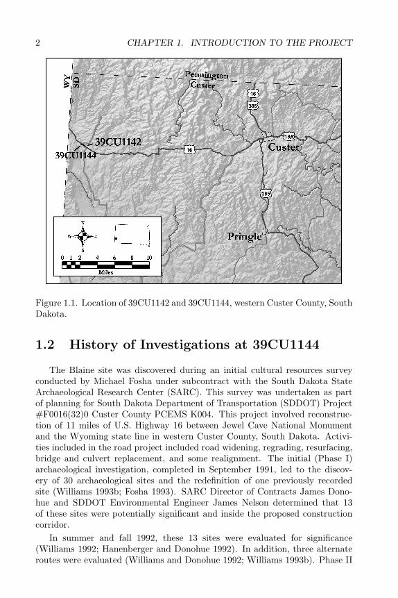
Planned improvements to U.S. Highway 16 between Jewel Cave NationalMonument and the South Dakota-Wyoming border necessitated archaeologicalwork in the area. A program of archaeological investigation was initiated toprevent damage to significant archaeological sites in the new highway right-of-way. Through a process of site survey and evaluation, it was determined thattwo sites in the right-of-way, 39CU1142 (Jim Pitts site) and 39CU1144 (Blainesite), merited intensive archaeological investigation prior to their destruction bythe planned road construction. The sites are located in the Red Valley physio-graphic zone in the southwestern Black Hills. They lie in extreme western CusterCounty, South Dakota, near the Wyoming-South Dakota line (Figure 1.1).
This report details the investigations at the smaller of these sites, 39CU1144,referred to here as the Blaine site. Initial investigations at the site indicatedthe possible presence of archaeological materials dating from the Early Archaicperiod (ca. 7500–5000 years before present) through the Late Prehistoric period(ca. 1500–200 years before present). The potential for stratified cultural depositsand the possible presence of Early Archaic materials were of particular interestto archaeologists. Both stratified sites and Early Archaic materials are rare inthe Black Hills (Sundstrom 1989; Cassells 1986). Initial evaluation indicatedthat data from the Blaine site could address a series of research questions basedon previous archaeological research in the Black Hills. These research questionsare presented in Chapter 4.
1
2 CHAPTER 1. INTRODUCTION TO THE PROJECT
Figure 1.1. Location of 39CU1142 and 39CU1144, western Custer County, SouthDakota.
1.2 History of Investigations at 39CU1144
The Blaine site was discovered during an initial cultural resources surveyconducted by Michael Fosha under subcontract with the South Dakota StateArchaeological Research Center (SARC). This survey was undertaken as partof planning for South Dakota Department of Transportation (SDDOT) Project#F0016(32)0 Custer County PCEMS K004. This project involved reconstruc-tion of 11 miles of U.S. Highway 16 between Jewel Cave National Monumentand the Wyoming state line in western Custer County, South Dakota. Activi-ties included in the road project included road widening, regrading, resurfacing,bridge and culvert replacement, and some realignment. The initial (Phase I)archaeological investigation, completed in September 1991, led to the discov-ery of 30 archaeological sites and the redefinition of one previously recordedsite (Williams 1993b; Fosha 1993). SARC Director of Contracts James Dono-hue and SDDOT Environmental Engineer James Nelson determined that 13of these sites were potentially significant and inside the proposed constructioncorridor.
In summer and fall 1992, these 13 sites were evaluated for significance(Williams 1992; Hanenberger and Donohue 1992). In addition, three alternateroutes were evaluated (Williams and Donohue 1992; Williams 1993b). Phase II
1.2. HISTORY OF INVESTIGATIONS AT 39CU1144 3
investigation involved test excavation by crews from the Black Hills NationalForest (Williams 1992) and the State Archaeological Research Center (Hanen-berger and Donohue 1992). Four of the sites were found to be eligible for inclu-sion to the National Register of Historic Places; however, only non-contributingportions of two of the sites would be affected by the highway project. It wasdetermined that highway construction would have no adverse effect on the lat-ter two sites. The South Dakota Historic Preservation Officer concurred withthis determination. It was recommended that mitigation of adverse effect onthe other two sites, 39CU1142 and 39CU1144, could be achieved through eitheravoidance or archaeological excavation. SDDOT personnel chose excavation asthe best means of mitigating damage to both sites. This report presents the re-sults of this Phase III mitigative excavation of 39CU1144. Results of mitigativeexcavation at 39CU1142 will be presented in a separate report.
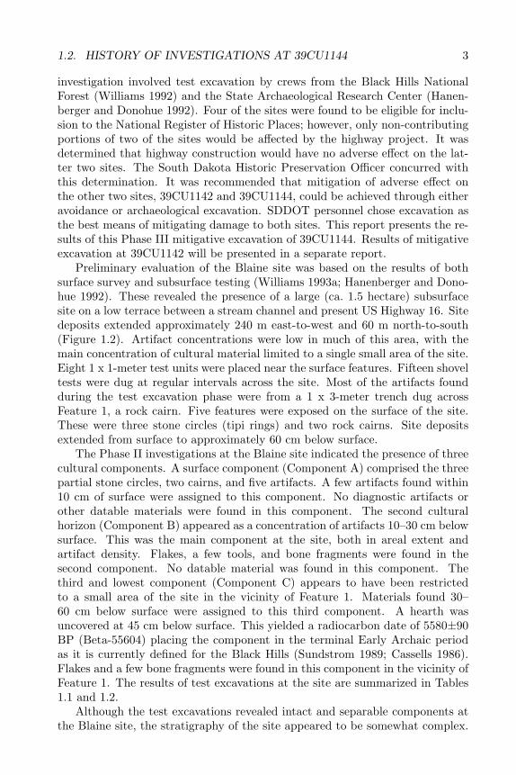
Preliminary evaluation of the Blaine site was based on the results of bothsurface survey and subsurface testing (Williams 1993a; Hanenberger and Dono-hue 1992). These revealed the presence of a large (ca. 1.5 hectare) subsurfacesite on a low terrace between a stream channel and present US Highway 16. Sitedeposits extended approximately 240 m east-to-west and 60 m north-to-south(Figure 1.2). Artifact concentrations were low in much of this area, with themain concentration of cultural material limited to a single small area of the site.Eight 1 x 1-meter test units were placed near the surface features. Fifteen shoveltests were dug at regular intervals across the site. Most of the artifacts foundduring the test excavation phase were from a 1 x 3-meter trench dug acrossFeature 1, a rock cairn. Five features were exposed on the surface of the site.These were three stone circles (tipi rings) and two rock cairns. Site depositsextended from surface to approximately 60 cm below surface.
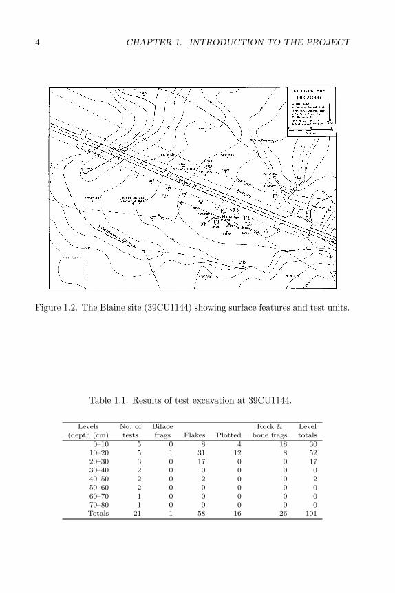
The Phase II investigations at the Blaine site indicated the presence of threecultural components. A surface component (Component A) comprised the threepartial stone circles, two cairns, and five artifacts. A few artifacts found within10 cm of surface were assigned to this component. No diagnostic artifacts orother datable materials were found in this component. The second culturalhorizon (Component B) appeared as a concentration of artifacts 10–30 cm belowsurface. This was the main component at the site, both in areal extent andartifact density. Flakes, a few tools, and bone fragments were found in thesecond component. No datable material was found in this component. Thethird and lowest component (Component C) appears to have been restrictedto a small area of the site in the vicinity of Feature 1. Materials found 30–60 cm below surface were assigned to this third component. A hearth wasuncovered at 45 cm below surface. This yielded a radiocarbon date of 5580±90BP (Beta-55604) placing the component in the terminal Early Archaic periodas it is currently defined for the Black Hills (Sundstrom 1989; Cassells 1986).Flakes and a few bone fragments were found in this component in the vicinity ofFeature 1. The results of test excavations at the site are summarized in Tables1.1 and 1.2.
Although the test excavations revealed intact and separable components atthe Blaine site, the stratigraphy of the site appeared to be somewhat complex.
4 CHAPTER 1. INTRODUCTION TO THE PROJECT
Figure 1.2. The Blaine site (39CU1144) showing surface features and test units.
Table 1.1. Results of test excavation at 39CU1144.
Levels No. of Biface Rock & Level(depth (cm) tests frags Flakes Plotted bone frags totals
0–10 5 0 8 4 18 3010–20 5 1 31 12 8 5220–30 3 0 17 0 0 1730–40 2 0 0 0 0 040–50 2 0 2 0 0 250–60 2 0 0 0 0 060–70 1 0 0 0 0 070–80 1 0 0 0 0 0Totals 21 1 58 16 26 101
1.2. HISTORY OF INVESTIGATIONS AT 39CU1144 5
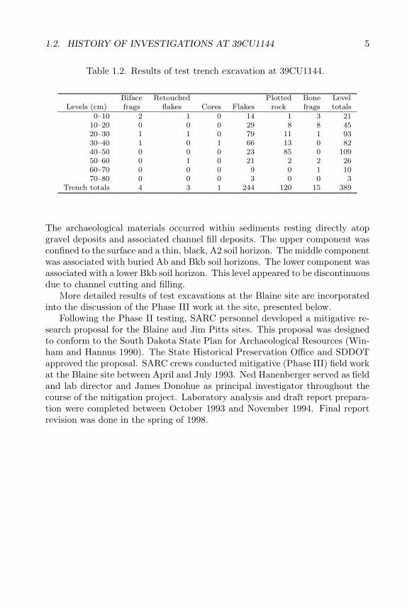
Table 1.2. Results of test trench excavation at 39CU1144.
Biface Retouched Plotted Bone LevelLevels (cm) frags flakes Cores Flakes rock frags totals
0–10 2 1 0 14 1 3 2110–20 0 0 0 29 8 8 4520–30 1 1 0 79 11 1 9330–40 1 0 1 66 13 0 8240–50 0 0 0 23 85 0 10950–60 0 1 0 21 2 2 2660–70 0 0 0 9 0 1 1070–80 0 0 0 3 0 0 3
Trench totals 4 3 1 244 120 15 389
The archaeological materials occurred within sediments resting directly atopgravel deposits and associated channel fill deposits. The upper component wasconfined to the surface and a thin, black, A2 soil horizon. The middle componentwas associated with buried Ab and Bkb soil horizons. The lower component wasassociated with a lower Bkb soil horizon. This level appeared to be discontinuousdue to channel cutting and filling.
More detailed results of test excavations at the Blaine site are incorporatedinto the discussion of the Phase III work at the site, presented below.
Following the Phase II testing, SARC personnel developed a mitigative re-search proposal for the Blaine and Jim Pitts sites. This proposal was designedto conform to the South Dakota State Plan for Archaeological Resources (Win-ham and Hannus 1990). The State Historical Preservation Office and SDDOTapproved the proposal. SARC crews conducted mitigative (Phase III) field workat the Blaine site between April and July 1993. Ned Hanenberger served as fieldand lab director and James Donohue as principal investigator throughout thecourse of the mitigation project. Laboratory analysis and draft report prepara-tion were completed between October 1993 and November 1994. Final reportrevision was done in the spring of 1998.

6 CHAPTER 1. INTRODUCTION TO THE PROJECT
Chapter 2
ENVIRONMENTALCONTEXT
2.1 The Black Hills Environment
2.1.1 Physical Geology
The Blaine site is located in the southwestern Black Hills in western CusterCounty, South Dakota. The Black Hills are the easternmost extension of theRocky Mountains. The Black Hills have been described structurally as an elon-gate dome or doubly plunging anticline, rising 3000–4000 feet above the sur-rounding high plains (DeWitt et al. 1986:9; Rich 1981). The Black Hills attaintheir highest elevation at Harney Peak, 7242 feet above sea level. The averageelevation of the Black Hills region is about 4000 feet. The elliptical Black Hillsuplift extends approximately 120 miles north to south and 50 miles east to west.It covers an area of about 6000 square miles (15,500 square km) (Froiland 1978;Rich 1981). About two-thirds of the Black Hills lie in western South Dakota,with the remaining area extending into northeastern Wyoming. The Black Hillsare structurally similar to other Rocky Mountain outliers (Prucha et al. 1965;Dandavati 1981:21).
The Black Hills takes its name from the Lakota Paha Sapa, Black Moun-tains. The name refers to the dark color imparted the hills by a dense cover ofponderosa pine. Several other unique physical features break the grassy highplains surrounding the Black Hills. These include the White River Badlands tothe southeast, Bear Butte on the northeastern periphery, and the Bighorn andLaramie mountains to the west.
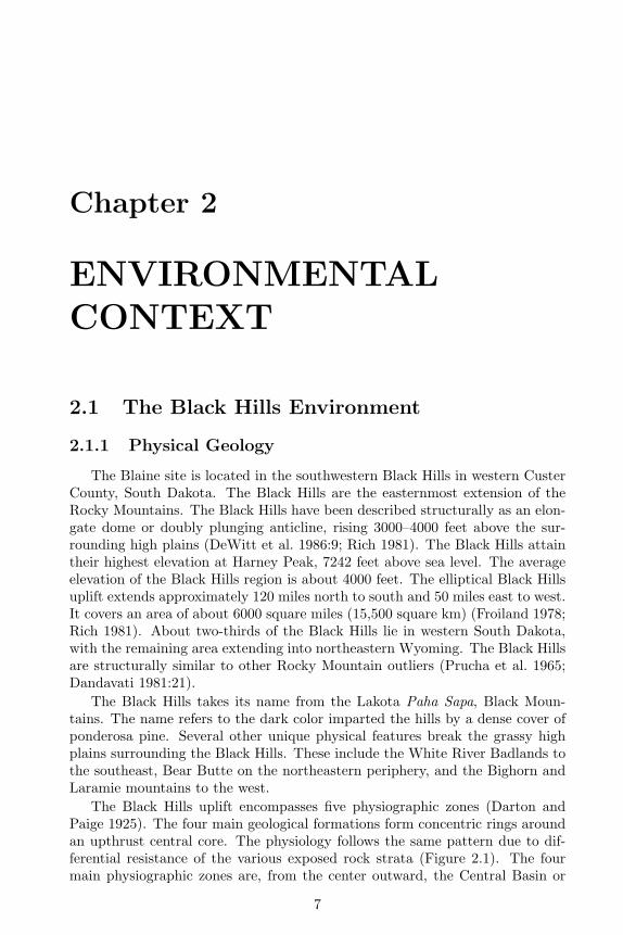
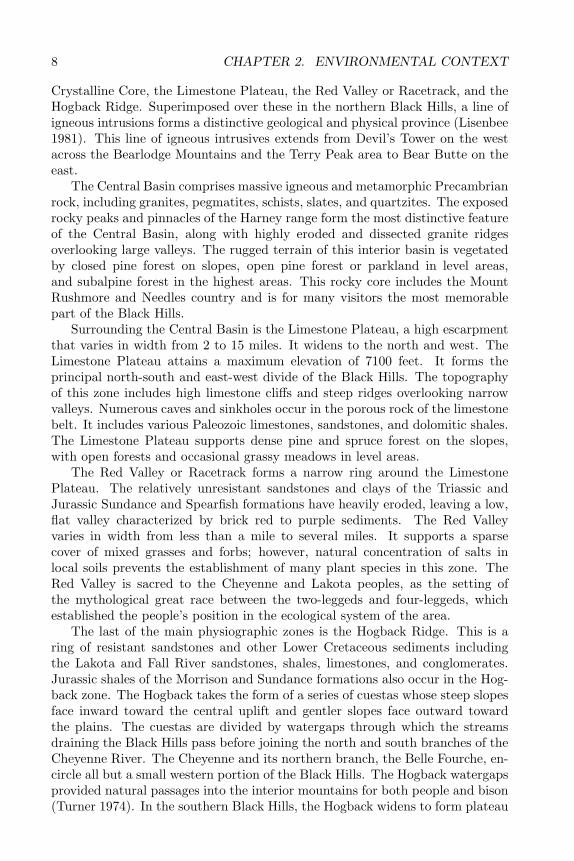
The Black Hills uplift encompasses five physiographic zones (Darton andPaige 1925). The four main geological formations form concentric rings aroundan upthrust central core. The physiology follows the same pattern due to dif-ferential resistance of the various exposed rock strata (Figure 2.1). The fourmain physiographic zones are, from the center outward, the Central Basin or
7
8 CHAPTER 2. ENVIRONMENTAL CONTEXT
Crystalline Core, the Limestone Plateau, the Red Valley or Racetrack, and theHogback Ridge. Superimposed over these in the northern Black Hills, a line ofigneous intrusions forms a distinctive geological and physical province (Lisenbee1981). This line of igneous intrusives extends from Devil’s Tower on the westacross the Bearlodge Mountains and the Terry Peak area to Bear Butte on theeast.
The Central Basin comprises massive igneous and metamorphic Precambrianrock, including granites, pegmatites, schists, slates, and quartzites. The exposedrocky peaks and pinnacles of the Harney range form the most distinctive featureof the Central Basin, along with highly eroded and dissected granite ridgesoverlooking large valleys. The rugged terrain of this interior basin is vegetatedby closed pine forest on slopes, open pine forest or parkland in level areas,and subalpine forest in the highest areas. This rocky core includes the MountRushmore and Needles country and is for many visitors the most memorablepart of the Black Hills.
Surrounding the Central Basin is the Limestone Plateau, a high escarpmentthat varies in width from 2 to 15 miles. It widens to the north and west. TheLimestone Plateau attains a maximum elevation of 7100 feet. It forms theprincipal north-south and east-west divide of the Black Hills. The topographyof this zone includes high limestone cliffs and steep ridges overlooking narrowvalleys. Numerous caves and sinkholes occur in the porous rock of the limestonebelt. It includes various Paleozoic limestones, sandstones, and dolomitic shales.The Limestone Plateau supports dense pine and spruce forest on the slopes,with open forests and occasional grassy meadows in level areas.
The Red Valley or Racetrack forms a narrow ring around the LimestonePlateau. The relatively unresistant sandstones and clays of the Triassic andJurassic Sundance and Spearfish formations have heavily eroded, leaving a low,flat valley characterized by brick red to purple sediments. The Red Valleyvaries in width from less than a mile to several miles. It supports a sparsecover of mixed grasses and forbs; however, natural concentration of salts inlocal soils prevents the establishment of many plant species in this zone. TheRed Valley is sacred to the Cheyenne and Lakota peoples, as the setting ofthe mythological great race between the two-leggeds and four-leggeds, whichestablished the people’s position in the ecological system of the area.
The last of the main physiographic zones is the Hogback Ridge. This is aring of resistant sandstones and other Lower Cretaceous sediments includingthe Lakota and Fall River sandstones, shales, limestones, and conglomerates.Jurassic shales of the Morrison and Sundance formations also occur in the Hog-back zone. The Hogback takes the form of a series of cuestas whose steep slopesface inward toward the central uplift and gentler slopes face outward towardthe plains. The cuestas are divided by watergaps through which the streamsdraining the Black Hills pass before joining the north and south branches of theCheyenne River. The Cheyenne and its northern branch, the Belle Fourche, en-circle all but a small western portion of the Black Hills. The Hogback watergapsprovided natural passages into the interior mountains for both people and bison(Turner 1974). In the southern Black Hills, the Hogback widens to form plateau
2.1. THE BLACK HILLS ENVIRONMENT 9
Figure 2.1. Physiographic zones and drainage of the Black Hills.
10 CHAPTER 2. ENVIRONMENTAL CONTEXT
and canyon country. The Hogback Ridge is vegetated by open pine forest onthe inner slopes and ridgetops and grasslands on the outer slopes.
Distinct soil types are associated with each of the main physiographic zones,as well as some smaller features such as alluvial deposits and three isolatedupland prairies or “balds” occurring in the interior uplift. Black Hills soils varywidely depending on the lithology of parent material, slope angle and aspect,vegetation, and drainage. As a whole, the Black Hills form the Gray Woodedsoil region of South Dakota. In general, soils within this region have developedunder timber in humid to subhumid climates (Froiland 1978). Rocky, poorlydeveloped soils characterize the more rugged areas, with rocky loams and siltloams in the more level areas and along stream channels.
2.1.2 Geology
The geologic history of the Black Hills is complex and well studied; thus,only a brief summary will be presented here. The following summary of BlackHills geologic history was abstracted from DeWitt et al. 1986. The Black Hillsuplift comprises rock strata of various ages extending outward from the cen-tral core in concentric rings from oldest to youngest. The central granites andpegmatites are as much as 2.5 billion years old (Zartman et al. 1964; Eckle-man and Kulp 1957), placing them well back into the Precambrian era andmaking them among the oldest rocks exposed on the continent. The outermostformations date to the mid-Tertiary period. The earliest events evident in thegeologic record are deposition of silty sediments during the Precambrian era.These were metamorphosed and deformed prior to 2.5 billion years ago, whengranitic rocks intruded into them. The granites were covered by sandy, silty,and conglomeritic sediments. These were intruded by mafic rocks about 2.2billion years ago. Iron-rich sediments interbedded with sand, silt, mud, andvolcanic rock were then deposited. These sediments were then metamorphosed,deformed, and intruded by a large body of granite about 1.7 billion years ago.No record exists from about 1.7 billion to 550 million years ago.
By 550 million years ago, the Precambrian rocks had been eroded and up-lifted to the surface. Over the next 200 million years of the Paleozoic, sandstoneand limestone were deposited across the area in a marine environment. Duringthe Mesozoic more marine sediments were deposited. During Laramide time,65 to 60 million years ago, deformation caused an elliptical doming of the area.This initiated erosion of Paleozoic and Mesozoic rocks in the center of the up-lift, exposing the Precambrian rocks and imparting its present configuration tomuch of the interior Black Hills.
About 60 to 50 million years ago, igneous intrusions took place in the north-ern Black Hills, causing local deformation of the older rocks. These Tertiaryintrusions formed many of the prominent physical features of the northern BlackHills. Renewed deposition took place from about 40 to 35 million years ago,during the Oligocene. About 30 million years ago, the Black Hills were againuplifted. Much of the more recent (Oligocene) sediment cover was removed andthe area achieved its present form (DeWitt et al. 1986). The Black Hills were
2.1. THE BLACK HILLS ENVIRONMENT 11
not glaciated during the Pleistocene (Froiland 1978) and probably served as arefuge for various plant and animal species displaced by glaciation to the west,east, and north. Gravel-capped terraces dating to the Pleistocene are foundthroughout the Black Hills (Plumley 1948; Martin 1991). Between three andfive of these high terraces remain in various study locations at 40–310 feet abovemodern stream channels. Three Holocene alluvial terraces are found along theCheyenne and Belle Fourche and some smaller streams underlain by SpearfishFormation and Inyan Kara Group rocks (Leopold and Miller 1954; Albanese1995). Most smaller streams, however, lack Holocene terrace development (Al-banese 1954).
2.1.3 Drainage
The Black Hills are drained by a large number of small streams extend-ing outward from the central uplift in a radial pattern (Rahn 1970), follow-ing the general west-to-east tilt of the region. Streams draining the northern,southern, and eastern Black Hills empty into the northern (Belle Fourche) andsouthern branches of the Cheyenne River. The Cheyenne empties into the Mis-souri farther east. A few intermittent west-flowing streams drain the extremewestern portion of the Limestone Plateau. Streams in the Black Hills crosscutgeologic strata, forming the aforementioned watergaps at the edges of the up-lift. Springs occur at some geologic contacts, most notably that between theSpearfish and Minnekahta formations at the boundary of the Red Valley andLimestone Plateau. Springs also dot the interior Limestone Plateau. Except-ing a few small sinks in the northern Limestone Plateau and a small lake nearBear Butte, no natural lakes are found in the Black Hills. Stream flow variesseasonally. All but the largest streams are intermittent.
2.1.4 Climate
The Black Hills area has a mountain-type semi-arid continental climate (Froi-land 1978). The climate is somewhat cooler and moister than elsewhere in thenorthern Great Plains. Summers are generally warm and dry, winters cold anddry. The weather is highly variable, with an overall annual temperature rangeaveraging 141◦F. The highest temperature on record is 112◦F and the lowestrecorded is -52◦F (Froiland 1978). Mean annual temperature is 45.6◦F. Tem-peratures are generally lower in the northern and central zone and higher inthe southern Hogback. The growing season is about 142 days in the southernHogback and is much shorter in the higher elevations. Annual precipitationranges from 17 to 29 inches, generally being highest in the northern sector andat the higher elevations. Most precipitation falls between April and September,with winter snow contributing less than the frequent spring and summer thun-derstorms and showers. Droughts are common and may be severe, especially inthe southern sector. Blizzards occur on the order of one to several each winter.Severe blizzards occur only every three or four years (Froiland 1978).
12 CHAPTER 2. ENVIRONMENTAL CONTEXT
Overall, the climate of the Black Hills is milder than that of the surroundingplains. In summer, temperatures are cooler and rainfall more frequent. Duringthe winter months the ground is free of snow much of the time. It is not unusualto have warm, sunny days occurring mid-season. Blizzards are not as commonand temperatures less severe. The Black Hills thus provide relief both winterand summer from the more extreme climatic conditions of the grasslands.
2.1.5 Biology
The diverse climate and topography of the Black Hills, as well as its isolationfrom similar environments, have resulted in a unique biological make-up (Froi-land 1978; Turner 1974; McIntosh 1931). Several biomes overlap in the BlackHills, including Cordilleran, Great Plains, Northern Coniferous, and Eastern De-ciduous types. Many species from these biomes reach their southern, eastern,or western limits in the Black Hills. Hybridization of some varieties contributesto the great biological diversity of the area.
Four main floral complexes are present in the Black Hills. The RockyMountain Coniferous Forest complex, dominated by ponderosa pine (Pinus pon-derosa), characterizes slopes and ridge tops throughout the interior uplift andHogback, with the Northern Coniferous Forest and Deciduous Forest complexesbeing largely restricted to patches in the northern and eastern portions of theuplift. The Red Valley, upland meadows, and stream valleys support a North-ern Great Plains Grassland complex (McIntosh 1931). The ponderosa forestfrequently has some grassy understory present. In places, pine forest is as-sociated with a lowland shrub component of current (Ribes spp.), mountainmahogany (Cercocarpus montanus), and sumac (Rhus spp.). In the drier ar-eas of the southern sector, western red cedar (Juniperus scopulorum) is theprincipal tree species, with a grassy understory and an associated shrub com-ponent of buffaloberry (Sheperdia canadensis), sumac, sagebrushes (Artemisiaspp.), and rubber rabbitbrush (Chrysanthumnus nauseosus). Principal grassspecies in the southern sector are little bluestem (Andropogon scoparius), bluegrama (Boutelona gracilis), buffalo grass (Buchloe dactyloides), and Japanesebrome (Bromus japonicus); dominant forbs are prickly pear (Opuntia spp.),yucca (Yucca glauca), and many others. Other principal grass species in andaround the Black Hills are needle-and-thread (Stipa comata) and green needle-grass (S. viridula) (Johnson and Nichols 1970).
The present fauna of the Black Hills includes large herbivores such as wapiti(Cervus canadensis), white tail deer (Odocoileus virginianus dacotensis), muledeer (O. hemionus hemionus), bison (B. bison bison), pronghorn (Antilocapraamericana americana), mountain sheep (Ovis canadensis auduboni), and moun-tain goat (Oreamnos americanus missoulae). The latter is an introduced species;bison, wapiti, pronghorn, and mountain sheep are reintroduced species. Carni-vores present in the area today are coyote (Canis latrans latrans), mountain lion(Felis concolor hippoestes), bobcat (Lynx rufus pallescens), lynx (L. canadensiscanadensis), and red fox (V. vulpes regalis). Grizzly bear (Ursus arctos horri-bilis) and gray wolf (Canis lupus irremotus) are now locally extinct; black bear
2.1. THE BLACK HILLS ENVIRONMENT 13
(U. americanus americanus) is either extinct or extremely rare. Smaller mam-mals present in the Black Hills include beaver (Castor canadensis missourien-sis), yellow-bellied marmot (Marmota flaviventris dacota), raccoon (Procyonlotor hirtus), and porcupine (Erethizon dorsatum bruneri), along with variousrabbits, chipmunks, squirrels, prairie dogs, muskrats, gophers, voles, rats, mice,and myotises (Turner 1974).
Other fauna include about a dozen species of snakes, 17 species of toads, anda few species of frogs, turtles, lizards, and salamanders. Raptorial birds includevarious species of owls, hawks, falcons, and eagles; other large birds are theturkey vulture (Cathartes aura), ruffled grouse (Bonasa umbellus), sharp-tailedgrouse (Pedioecetes phasianelles), and turkey (Meleagris gallopavo). Numeroussmaller bird species, including songbirds and waterfowl, are also present (Froi-land 1978).
2.1.6 Distribution of natural resources
Many of the natural resources of the Black Hills are also available in thesurrounding grasslands; however, the distribution in time and space of theseresources is different in the Black Hills than in the plains. Other resources,especially wood and lithic raw material, are much more abundant in the BlackHills than in the surrounding grasslands. To understand prehistoric settlementpatterns in the Black Hills region, it is necessary to understand resource dis-tribution. Each zone of the Black Hills contains a specific and unique suite ofresources (see Table 4.1 on page 40).
The Hogback and adjacent foothills form an ecotone between the high plainsand the interior Black Hills. The southern Hogback receives relatively little rain-fall, compared to the interior uplift, but the Cheyenne and its major tributariesprovide fairly reliable water sources. This area also provides shelter, wood, andbrowse not available in the surrounding grasslands. Outcrops of orthoquartziteand silicified siltstone, and gravel deposits including cherty silicates, were at-tractive to prehistoric people. Deer, mountain sheep, and other game formerlycongregated in and near the watergaps dissecting the southern Hogback wherewater and dense browse were readily available. Rock art suggests that these ar-eas were used for communal game hunts during the Archaic period and perhapsearlier (Sundstrom 1990, 1993a).
As was discussed above, the Red Valley operates ecologically as an extensionof the high plains surrounding the Black Hills (Turner 1974). Although the RedValley is separated from the high plains by the Hogback and foothills, bisonand pronghorn were able to enter it through Buffalo Gap and other watergaps.The Red Valley served as a sheltered wintering ground for these species (Turner1974). The high salt content of the Red Valley soils is attractive to bison.Extensive bison salt licks are visible today, particularly in cutbanks where buried“B” soil horizons are exposed. The mixed grass and forb vegetation of the RedValley provided forage for bison and pronghorn, essentially as they did on theopen plains. The abundant edible root plants endemic to the Red Valley wouldhave provided humans a potentially important secondary food resource.
14 CHAPTER 2. ENVIRONMENTAL CONTEXT
The Limestone Plateau is perhaps the richest resource area in the BlackHills. Chert, fresh water, deer, wapiti, small mammals, berries, and edibleforbs are abundant in this area. Grassland/forest ecotones dot the Limestones.Marshy areas contain an additional set of resources, including beaver, muskrat,and mink, and boxelder, willow, and berry bushes. This is also the present habi-tat of lodgepole pine. Archaeological data indicate that bison were present inthe upland prairies throughout much of prehistory. Large, multiple componentprehistoric camps are found at perennial springs throughout the Limestones.
The Central Core is a relatively resource poor area. It does, however, con-tain habitable rock shelters. Deer, elk, cottontail rabbit, jackrabbit, and marmotare found in this zone. Wood is abundant. Chokecherry, strawberry, and limberpine are found in the central zone. This is the principal habitat of bearberry, ahighly sought-after “tobacco.” The Bear Lodge range in northeastern Wyomingcontains essentially the same resources as the main portion of the Black Hills.In addition, mountain sheep probably were abundant there. Both the CentralCore and the Bear Lodge are rather poorly known archaeologically. The BlackHills contain few resources not available in the surrounding grasslands. Themajor plant and animal food resources, with a few exceptions, also occur inthe grasslands. Some studies indicate that edible plant densities may be higherin the Powder River Basin than in the Black Hills foothills (Latady and Due-holm 1985:83; Marlow 1979; Latady 1982). There are, however, five areas inwhich the Black Hills offer resource advantages over the surrounding region.These resource advantages are lithic raw material, wood, ecotone environments,seasonally successive food resources, and permanent water sources.
Black Hills lithic raw material is both abundant and of high quality. Quartz-ites from Flint Hill, Battle Mountain, and other large Hogback quarries werewidely used for stone tool production locally and regionally. These are hard,fine-grained quartzites ranging in color from maroon to purple, brown, gold,gray, pink, and white. The majority of bifacial tools from Black Hills sites aremade of this material, attesting to its knappability and durability. Morrison sili-cified siltstone (MSS) is a finer-grained, gray to brown, macrocrystalline materialthat outcrops abundantly in the foothills, Hogback, and interior Black Hills. Itis nearly identical in appearance and flaking quality to Tongue River silicifiedsediment. MSS was widely used for a variety of chipped stone tools, espe-cially during the Middle and Late Archaic periods. A coarser-grained quartziteoutcrops in the interior Black Hills; however, its use was restricted largely toexpedient chopping tools. Cryptocrystalline materials, including cherts, chal-cedonies, jaspers, and petrified wood, outcrop throughout the Black Hills. Theseinclude pieces of varying quality; however, easily worked cryptocrystallines areavailable in most areas of the Black Hills. Silicified shale or slate outcrops inthe central Black Hills; this material works well for chipped stone tools, but isnot particularly abundant in local archaeological assemblages. It is similar toporcellanite in appearance and flaking quality.
The Hogback and foothills contain abundant sandstones of varying hardness.This material was used extensively for grinding stones and other groundstonetools. Elliptical grooves cut into sandstone outcrops suggest tool sharpening,
2.1. THE BLACK HILLS ENVIRONMENT 15
although these may have functioned symbolically, as well (Sundstrom 1990).Granite from the central zone was also used for groundstone tools, especiallyhandstones.
Ethnographic records describe the acquisition of lodgepoles from the centralBlack Hills (cf. DeMallie 1984:155). One of three local pine species, lodgepolepine (Pinus contorta), is reported to have been preferred for this use, as its com-mon name suggests. Although lodgepole pine is now limited to a few isolatedstands, botanical data suggest it had a more widespread distribution prehistor-ically. It is not known whether wood for shelters was acquired from the BlackHills in prehistoric times.
Archaeological data suggest that wood may have been more important asfuel than as a building material. Numerous large hearth/roasting pit complexeshave been discovered in ecotone areas in and around the Black Hills. Winterhabitations with large or numerous interior hearths have also been recognized.This suggests that some food processing stations and cold season habitationswere sited specifically in regard to firewood sources.
The presence of specialized hafting/shafting sites in the Hogback and inte-rior Black Hills (Tratebas 1986) indicates the exploitation of local woody speciesfor tool shafts. Ethnographic sources suggest that green ash (Fraxinus pennsyl-vanica) may have been a preferred species for shafts (Gilmore 1977). Wood wasalso needed for atlatls, digging sticks, throwing sticks, thrusting spear points,and other tools. Bows recovered from archaeological sites in the northern plainsare made of juniper, chokecherry, or skunkbrush (Frison 1991). The Black Hillscontains a wide variety of hard and softwoods, which could have been adaptedto many purposes.
The Black Hills area includes grasslands/forest ecotones in four settings:the interface between the outer Hogback and the grasslands surrounding theBlack Hills; the largely unforested Red Valley; high meadows; and high-altitudeprairies or “balds.” With the exception of the Red Valley, these ecotone zonestend to contain large, repeatedly occupied, multicomponent sites with numeroushearths and diverse tool assemblages. The meadow sites appear to be seasonalbase camps or secondary camps. The sites in the outer Hogback and at the edgeof the balds are large, periodically reused hearth or fire pit complexes. Theseappear to have functioned primarily as plant food processing stations. The sitesappear to have been deliberately placed in areas where storable plant foods andfirewood were both abundant.
Ecotone zones also may have attracted game. Deer and wapiti favor the highaltitude meadows and balds, while the Red Valley was a major wintering groundfor bison and pronghorn. Archaeological research suggests that the large baldssupported small herds of bison (Buechler 1984; Saunders et al. 1994). Suchareas may have provided an optimal mix of game, edible plants, shelter, andwood.
The Black Hills also offers a resource advantage in the form of seasonallysuccessive food resources. This resource advantage is a function of the micro-climatology of mountainous areas. Simply put, plants mature later at higherelevations, due to the altitudinal temperature differential. This allows a longer
16 CHAPTER 2. ENVIRONMENTAL CONTEXT
gathering season for particular resources. For example, chokecherries ripen afull month earlier in the lower elevations of the Black Hills than in the cen-tral zone. This means that a group can follow the ripening plants up into thehigher altitudes through spring and summer, retreating again to the lower ele-vations as cold weather sets in in the uplands. This gives a group more time toamass storable foods such as pemmican (dried meat and berry mush preservedin rendered fat) for winter consumption.
The numerous springs and streams occurring throughout the Black Hills pro-vided a highly reliable source of fresh water. Annual precipitation is higher thanin the surrounding areas, especially in the northern and central Black Hills. Al-though water levels in the Cheyenne and Belle Fourche rivers vary widely withprecipitation levels in the higher Black Hills, neither of the rivers nor theirprincipal feeder streams ever dry up completely. Even under extreme droughtconditions water is easily found by traveling up the eastern edge of the BlackHills. Here the radial drainage pattern forms a ladderlike configuration with therungs leading from the interior Black Hills across the Red Valley and foothillsto the Cheyenne River. It is not clear how the high altitude springs respond todrought. The presence of a nearly complete archaeological sequence at severalof the springs suggests that they produce water except during extremely dryperiods. The general lack of Early Archaic components at these sites suggeststhe possibility that the springs failed during the Altithermal. Both archaeo-logical and paleoenvironmental studies of these sites will be needed before thispossibility can be systematically evaluated.
2.2 The Site Environment
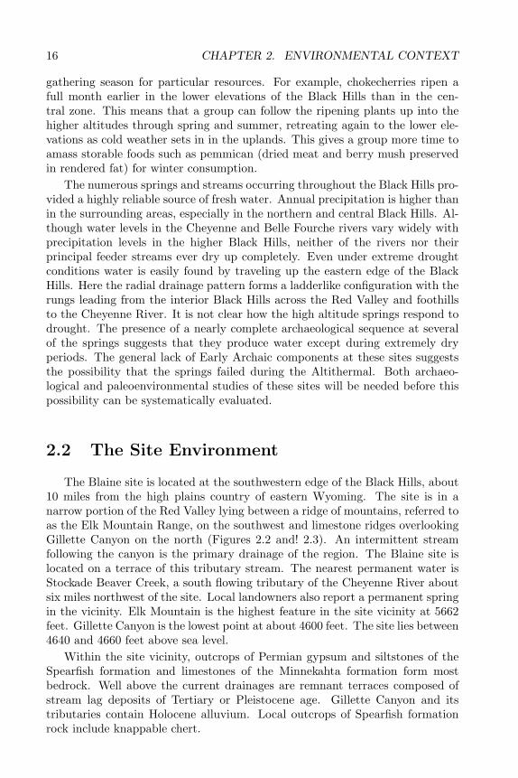
The Blaine site is located at the southwestern edge of the Black Hills, about10 miles from the high plains country of eastern Wyoming. The site is in anarrow portion of the Red Valley lying between a ridge of mountains, referred toas the Elk Mountain Range, on the southwest and limestone ridges overlookingGillette Canyon on the north (Figures 2.2 and! 2.3). An intermittent streamfollowing the canyon is the primary drainage of the region. The Blaine site islocated on a terrace of this tributary stream. The nearest permanent water isStockade Beaver Creek, a south flowing tributary of the Cheyenne River aboutsix miles northwest of the site. Local landowners also report a permanent springin the vicinity. Elk Mountain is the highest feature in the site vicinity at 5662feet. Gillette Canyon is the lowest point at about 4600 feet. The site lies between4640 and 4660 feet above sea level.
Within the site vicinity, outcrops of Permian gypsum and siltstones of theSpearfish formation and limestones of the Minnekahta formation form mostbedrock. Well above the current drainages are remnant terraces composed ofstream lag deposits of Tertiary or Pleistocene age. Gillette Canyon and itstributaries contain Holocene alluvium. Local outcrops of Spearfish formationrock include knappable chert.
2.2. THE SITE ENVIRONMENT 17
Figure 2.2. Topographic location of the Blaine Site.
Soils in the site vicinity fall into the Nevee-Gypnevee-Rekop and the Vanock-er-Sawdust-Paunsaugunt associations (Ensz 1990). Typical of the Red Valleyis the Nevee-Gypnevee-Rekop association. These soils are formed in materialderived from siltstone, sandstone, silty shale, and gypsum. These are typicallyAC soils formed on recent alluvium or on steep slopes. These are reddish siltyloam or loamy soils. The A horizons are yellowish red to reddish brown. The Chorizons are yellowish red, light red, or red. Soils on or near limestone bedrockare typically of the Vanocker-Sawdust-Paunsaugunt association. These soils arederived from weathered limestone and calcareous sandstone. These are brownloamy soils. The A horizons are dark grayish brown to dark brown, B horizonsbrown to pale brown, and C horizons are pale brown. A detailed discussion ofsoil formation at the Blaine site is presented in Chapter 6.
The site vicinity is vegetated by mixed grasses on the upland flats and alongdrainages, with open ponderosa pine forest on hillslopes and ridges overlooking
18 CHAPTER 2. ENVIRONMENTAL CONTEXT
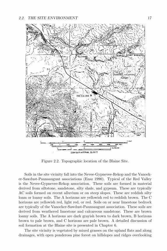
Figure 2.3. View of the Blaine Site showing site environment.
the site. Dominant plant species at the Blaine site are western wheatgrass, buf-falo grass, blue grama, sedges, sagewort, ball cactus, pricklypear, and segolily.Mountain mahogany occurs as an understory species within open ponderosaforest on the limestone ridge overlooking Gillette Canyon and the Blaine sitevicinity.
The large number of archaeological sites in the vicinity attests to its impor-tance to prehistoric peoples. More than 50 sites have been recorded near theBlaine site. These include a variety of tipi ring sites, small lithic scatters, andseasonal habitations. The Jim Pitts site, with Paleoindian through Late Prehis-toric components, lies only 75 meters from Blaine. A major rock art complexlies a few miles west of the site in Whoopup Canyon, Wyoming (Sundstrom1990; Tratebas 1992).
The location of the Blaine site at the juncture of the Red Valley, LimestonePlateau, and Hogback would have afforded its inhabitants access to a widevariety of natural resources. Chert outcrops in the immediate site vicinity anda variety of cherts and chalcedonies occur as secondary deposits in the gravelterraces near the site. Pricklypear, segolily, wild onion and other edible plantsare abundant. Perhaps the greatest resource advantage of the site vicinity isa combination of the natural attractiveness of the Red Valley to bison andpronghorn and the local occurrence of features such as arroyos, knickpoints,and canyons that could be used for trapping game. The location also offers aneasily accessible route to and from the high plains to the west. The tipi ring sitesin particular may represent encampments of plains-based groups seeking shelter,

2.2. THE SITE ENVIRONMENT 19
game, lithic raw material, or lodgepoles in the western Black Hills. Although therole played by this locality in earlier times is not clearly understood, excavationsat the Jim Pitts, Hawken, Vore, and Sanson sites indicate a long and nearlycontinuous tradition of bison trapping in the Red Valley. Rock art in WhoopupCanyon and other southern Black Hills localities spanning the Archaic periodillustrates a deer-trapping tradition of comparable intensity and duration in thenearby Hogback canyons (Sundstrom 1990; Tratebas 1992).

20 CHAPTER 2. ENVIRONMENTAL CONTEXT
Chapter 3
ARCHAEOLOGICALCONTEXT OF THEPROJECT
3.1 The Area and Its Significance
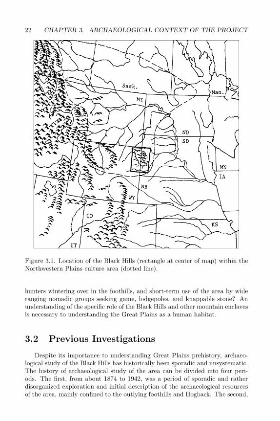
The Black Hills make up one of the most important and least understoodregions of the Great Plains culture area. Lying at the southeastern edge of theNorthwestern Plains culture subarea (Wedel 1961; Frison 1991) and immediatelynorth of the Central Plains culture subarea (Figure 3.1), the Black Hills areliterally an island of forest in a sea of grasslands (Froiland 1978). Due to itsunique physiographic and biologic make-up, the Black Hills area undoubtedlyattracted the attention of Great Plains dwellers from their earliest venturesinto the grasslands of what are now Wyoming, Montana, the Dakotas, andNebraska, whether as a place to be enjoyed and exploited for its unique andabundant resources or avoided as an odd or hostile place.
An understanding of how prehistoric peoples perceived and used the BlackHills is crucial to some of the most basic questions of human survival in the GreatPlains. Some of these questions concern the role of the Black Hills as a place ofrefuge when drought or extreme weather struck the open plains (Frison 1991;Wedel 1978; Buchner 1980; Bamforth 1988). Were the Black Hills perceivedprehistorically as an area with few resources to offer except on a temporary orspecialized basis (Lippincott 1990)? Or were they seen as a resource rich areathat could support year-round occupation (Sundstrom 1989)? Were adaptivepatterns in the Black Hills the same as those in the surrounding plains, orwere they specifically geared toward local resources (Sundstrom 1989)? Didthe Black Hills play a role in more than one adaptive pattern? What are theprehistoric precedents of adaptive patterns seen in the ethnographic record, suchas warm season use of the area by Missouri River villagers, plains-based bison
21
22 CHAPTER 3. ARCHAEOLOGICAL CONTEXT OF THE PROJECT
Figure 3.1. Location of the Black Hills (rectangle at center of map) within theNorthwestern Plains culture area (dotted line).
hunters wintering over in the foothills, and short-term use of the area by wideranging nomadic groups seeking game, lodgepoles, and knappable stone? Anunderstanding of the specific role of the Black Hills and other mountain enclavesis necessary to understanding the Great Plains as a human habitat.
3.2 Previous Investigations
Despite its importance to understanding Great Plains prehistory, archaeo-logical study of the Black Hills has historically been sporadic and unsystematic.The history of archaeological study of the area can be divided into four peri-ods. The first, from about 1874 to 1942, was a period of sporadic and ratherdisorganized exploration and initial description of the archaeological resourcesof the area, mainly confined to the outlying foothills and Hogback. The second,
3.2. PREVIOUS INVESTIGATIONS 23
from about 1946 to 1969, was a period of continued exploration and descrip-tion under the auspices of the Smithsonian Institution, culminating in attemptsto develop new classification systems for the information collected or to applyclassification systems that had been developed for other regions of the GreatPlains. The third period of archaeological study of the Black Hills, beginningabout 1971 and continuing to the present, comprised a large number of smallprojects conducted to satisfy the requirements of newly enacted federal and statecultural resource management regulations. The fourth and final period beganaround 1978 and also continues to the present. This was a period in which moreproblem-oriented approaches, as opposed to description and classification, wereemployed in archaeology projects in the area. This final period also saw thedevelopment of several studies that attempted to draw together the large bod-ies of information available about Black Hills archaeology into comprehensivestatements about the prehistory of the area.
The first archaeological explorations of the Black Hills were undertaken inci-dental to expeditions sponsored by the federal government and natural historymuseums to gather information about this relatively unexplored portion of theWest. The Black Hills Expedition of 1874, led by George A. Custer, was pur-portedly undertaken to assess the natural resource potential of the Black Hills,which was Indian land at the time. In fact, the real purpose was to investigaterumors of rich gold deposits. In his report, the expedition naturalist, WilliamLudlow, mentions the presence of old campsites and trails in the vicinity of RedCanyon in the southern sector (Ludlow 1875). At the time, the government wasmainly interested in these in reference to finding a militarily defensible trail intothe interior Black Hills, and Ludlow made no attempt to establish when or bywhom the remains were made.
The next published mention of archaeological sites in the Black Hills is in areport on an archaeological reconnaissance of Wyoming undertaken by Harlan I.Smith in 1907–8 for the American Museum of Natural History (H. Smith 1908).Smith discovered a few sites on the western periphery of the Black Hills andconcluded that the area probably had not been settled prior to the introductionof the horse. In this conclusion, Smith was following the conventional wisdomof the day which held that the Great Plains were uninhabitable until the horsewas introduced to the region—a view that was to persist well into the presentcentury (Wedel 1961).
William H. Over, self-educated naturalist and director of the University ofSouth Dakota (USD) Museum, conducted the first formal archaeological explo-rations into the interior Black Hills. Relying on the help and observations oflocal informants, Over identified prehistoric lithic quarries, rock art, and a pos-sible village in the Black Hills (Over 1924, 1934, 1941, 1948). Also relying onlocal reports, E.B. Renaud of the University of Denver made brief mention ofsouthern Black Hills sites in his reports on archaeological reconnaissance of thewestern plains (Renaud 1936). The following year, Renaud’s principal BlackHills informant published a short description of archaeological remains in thesouthern sector (Buker 1937).
24 CHAPTER 3. ARCHAEOLOGICAL CONTEXT OF THE PROJECT
In 1938, Over and the USD Museum, with Works Project Administrationfunding, excavated 14 rockshelters in the southern Black Hills (Meleen andPruitt 1941). Both ceramic-producing and nonceramic groups had occupiedthese shelters. Unfortunately, the field notes and most of the artifacts fromthis project were lost and no complete report was ever prepared. The last ofthe early exploratory projects in the Black Hills was the excavation of a smallportion of the Agate Basin site, on the extreme southwestern periphery, byFrank Roberts of the Smithsonian Institution (Roberts 1943). The site wasfound to be a Paleoindian bison kill, thus erasing whatever doubts might havestill lingered as to the antiquity of human occupation of the area. These earlystudies showed that archaeological remains were present in the area, that theseincluded diverse site types, and that at least some of the sites were prehistoric.The studies were too limited in scope and geographic extent to allow many otherconclusions. The assumption that the interior Black Hills were never occupiedprehistorically persisted in spite of these early studies, and few professionalarchaeologists bothered to question this assumption.
The second period of archaeological research in the area would begin tochange the situation. Dominated by projects conducted by the SmithsonianInstitution River Basin Surveys program, the period from 1946 to 1969 was atime of continued exploration, and—more importantly—the first attempts todefine and classify the various cultural complexes represented by archaeologicalremains in the area. Based on surveys and excavations at Angostura and Key-hole reservoirs, on the southern and northwestern perimeters of the Black Hills,respectively, Smithsonian archaeologists defined a series of complexes. Thesecomplexes could be arranged chronologically. Although radiocarbon dates werenot yet available for the area, a clearer outline of area prehistory began toemerge (Bauxer 1947; Beaubien n.d.; J. Hughes 1949; J. Hughes and Whiten.d.; Wheeler 1950, 1957; Mulloy 1954). Hughes and Wheeler proposed a ba-sic sequence for the area, largely extrapolated from better-known areas of thenorthern plains, thus providing a framework for subsequent research. Whilesome revision has been necessary, their sequence for the Black Hills has gener-ally stood the test of time.
Two other Smithsonian projects were influential in the development of BlackHills archaeology. The first was the excavation of the McKean site at the north-western edge of the Black Hills (Mulloy 1954). This project resulted in the def-inition of the McKean complex as representative of the Middle Archaic periodof area prehistory. In addition, the McKean project inspired the partial excava-tion of two other Middle Archaic sites on the northern and western edges of theBlack Hills by the University of South Dakota and the Wyoming ArchaeologicalSociety, respectively (Gant and Hurt 1965; Steege and Paulley 1964). A secondRiver Basin Surveys project surveyed the vicinity of Cottonwood Reservoir inthe southern Black Hills; however, no significant cultural remains were found(Mallory 1967). (For a summary of this project see Weston 1983.) Limitedinvestigations were also conducted at Deerfield Reservoir in the central BlackHills (Cooper 1947). The River Basin Surveys program was terminated in 1969.
3.2. PREVIOUS INVESTIGATIONS 25
The next period of archaeological study of the Black Hills, beginning about1971 and continuing to the present, has been dominated by cultural resourcemanagement (CRM) projects. A large number of surveys were conducted toassess the archaeological potential of areas slated for mining exploration, log-ging, highway and pipeline construction, and construction of public facilities andsmall dams. CRM archaeology arose in response to several new federal and stateantiquities-protection regulations. These projects were specifically designed toidentify and evaluate sites that might be eligible for inclusion in the NationalRegister of Historic Places and thus for special protection as important historicresources. Survey projects in the Black Hills were conducted by the US ForestService, the South Dakota State Archaeological Research Center, the Office ofthe Wyoming State Archaeologist, the Tennessee Valley Authority, the NationalPark Service, and private consultants under contract to the forenamed agencies.Reports of these projects number in the hundreds, and no attempt will be madeto list them here. (Interested readers are referred to Buechler 1984, Cassells etal. 1984, and Sundstrom 1989 for more detailed listings.)
These surveys resulted in the discovery of about 5000 previously unrecordedsites and, more importantly, gave the first realistic picture of the distribution anddiversity of archaeological remains in the area. CRM archaeologists discovereda wide variety of sites. Most were lithic scatters, representing either specialactivity areas or larger camp sites; many historic sites were found as well. Thesesurveys established that prehistoric sites were present throughout the Black Hillsand that the entire Northwestern Plains culture sequence, from Paleoindian toHistoric, was represented.
Most of the CRM survey reports were descriptive rather than analytical, butall contained detailed information on site morphology, artifact types, and en-vironmental variables. This information would prove invaluable both to futureCRM efforts and to the more analytical studies to follow. A few survey projectswent beyond the basic site descriptions to include analyses of settlement patternsin regard to distance to water, proximity of natural resources, topographic po-sition, and ecological zonation (Haug 1977, 1978a, 1978b; Chevance 1978, 1979;Tratebas 1978a, 1978b; Reher and Lahren 1977). Other studies examined toolto debitage ratios as a potential indicator of site function (Sigstad and Jolley1975; Tratebas 1978a, 1978b; Sundstrom 1981). These were important foraysinto more analytical studies of area prehistory.
Test-excavation projects followed some of the CRM surveys. Most of thesewere done by South Dakota State Archaeological Research Center personnel(Haug 1979, 1981; Haug et al. 1980; Tratebas 1978b, 1979; Tratebas and Vagstad1979; Hovde 1981; Sundstrom 1981). Two other CRM projects were an attemptto mitigate damage to a large central Black Hills occupation site (Buechler1984) and a series of test excavations at a federally administered reservoir inthe southern Black Hills (Weston 1983). While many of the sites were disap-pointing, others contained intact buried deposits. These testing projects servedto reiterate the diversity and complexity of Black Hills archaeology, as well asto protect the important sites from unmitigated destruction.
26 CHAPTER 3. ARCHAEOLOGICAL CONTEXT OF THE PROJECT
The large of amount of data collected during the CRM period of archaeolog-ical research in the Black Hills spurred an interest in more analytical, problem-oriented studies. This body of data was largely undigested, but it was sufficientlycomplete and systematic to allow the formulation of research questions. As inall human inquiry, the more the Black Hills archaeologists knew, the less theyknew. With the most intense period of CRM projects behind them, they couldadopt a somewhat more studied approach to the archaeology of the area. Thisperiod of problem-oriented research, from about 1977 to the present, has in-cluded five kinds of studies: intensive excavation of potentially important sites;what can be termed“thematic” surveys, aimed at discovering particular kinds ofsites; reinvestigation of previously studied sites; syntheses of previously collecteddata; and multidisciplinary research initiatives.
Major excavation projects have included investigations at the Hawken site,an Early Archaic bison kill on the northwestern periphery (Frison et al. 1976;Frison 1991); excavation of the Vore Site, a large Late Prehistoric bison trapat the northern edge of the Black Hills (Reher and Frison 1980); archaeologicalfield school projects held at the multicomponent Boulder Canyon site (Tratebas1977) and the Plains Village pattern Smiley-Evans site (L. Alex 1979; Chevance1984), both on the northern periphery; excavations at the Agate Basin site,a multicomponent Paleoindian site on the southwestern periphery (Frison andStanford 1982); excavations at the multicomponent Beaver Creek site in thesouthern Black Hills (L. Alex 1991); and mitigative excavations at 39LA117(Sundstrom et al. 1994). Although not an excavation project, a recent inten-sive study of rock art in Whoopup Canyon in the southern Black Hills Hogbackby Alice Tratebas of the Wyoming Bureau of Land Management can also beincluded in this category. Each of these sites was chosen specifically to an-swer questions about area prehistory, and these projects have contributed muchtoward piecing together past cultural patterns.
The second kind of problem-oriented study in the area, thematic surveys,includes five studies. The first was a 1980 search for Paleoindian sites along theCheyenne River outside the southern edge of the Black Hills (Hannus 1983).The same year, a survey and inventory of rock art sites was conducted in thesouthern Black Hills (Sundstrom 1984). Data from the rock art survey, alongwith other information on area prehistory, formed the basis for a doctoral dis-sertation (Sundstrom 1990). A third thematic survey sought to identify lithicquarries in the Black Hills and to systematically describe the various lithic typesderived from them; this was developed into a master’s thesis (Church 1990b).The Black Hills area was also included in a master’s thesis on lithic sources ofnortheastern Wyoming and southeastern Montana (Craig 1983). Another doc-toral dissertation reconstructed human subsistence ecology based on studies ofabout a hundred sites in the vicinity of Keyhole Reservoir in the northwesternBlack Hills area (Kornfeld 1989). Finally, a study of data collected during CRMsurveys and test-excavations explored the nature of tipi ring sites in and nearthe eastern and southern Black Hills (Hovde 1981).
The third kind of problem-oriented research involves the re-excavation ofpreviously studied sites. Two Black Hills sites important in the establishment
3.3. PREHISTORY OF THE BLACK HILLS 27
of the basic cultural chronology of the area were re-excavated. The first is thelate Paleoindian Angostura site on the southern periphery (Hannus 1986). Theother is the McKean site in the northwestern Black Hills, the type site for theNorthwestern Plains Middle Archaic period (Kornfeld and Todd 1985; Kornfeldand Larson 1986; Kornfeld et al. 1990). Both re-excavation of the site itself andsurvey of the surrounding area were undertaken as part of the latter project.
Other recently initiated problem-oriented research in the area has involvedthe reanalysis and synthesis of previously collected data. Recent works basedon data from CRM projects on Black Hills National Forest lands include anoverview of area prehistory, targeted for use by CRM personnel (Cassells et al.1984) and a doctoral dissertation using surface collections to reconstruct pre-historic settlement patterns (Tratebas 1986). Other overviews of Black Hillsprehistory have been written for the general public and for professionals (Cas-sells 1986; Sundstrom 1989).
The final category of problem-oriented research in the Black Hills can be de-scribed as multidisciplinary research initiatives. These include a survey, testing,and National Register nomination project at Inyan Kara mountain in the north-western Black Hills. This project combined archaeological and ethnographic re-search in evaluating the past and current cultural significance of the mountain(Buechler and Malone 1987). In 1993, the Black Hills National Forest and theIllinois State Museum initiated a multi-year paleoenvironmental research pro-gram, including archaeological, palynological, sedimentological, and other linesof research (e.g. Saunders et al. 1994).
While Black Hills archaeology got off to a slow start, the era of CRM explo-ration of the area and the more recent problem-oriented studies have resulted inthe accumulation of a substantial body of data as well as a number of publishedinterpretations of area prehistory. Because these raise as many questions asthey answer, interest in Black Hills archaeology continues to grow.
3.3 Prehistory of the Black Hills
Summaries of Black Hills and Northwestern Plains prehistory are widelyavailable (see Frison 1991; Sundstrom 1989; Tratebas 1986; Cassells et al. 1984;Cassells 1986, and numerous CRM reports on file at the South Dakota StateArchaeological Research Center, the Wyoming State Archaeologist’s Office, andthe Black Hills National Forest). This discussion, therefore, will give only abrief sketch of the culture history of the area, focusing on those periods, places,and issues of particular relevance to the present study.
Archaeological remains in the Black Hills have usually been referred to gen-eral cultural sequences developed for the Northwestern Plains, especially thatinitiated by William Mulloy (1958) and revised and expanded by George Fri-son (1991). The Black Hills data do not conform perfectly to this sequence(Sundstrom 1989); nevertheless, the Northwestern Plains sequence provides thebest current framework in which to place the Black Hills materials. The North-western Plains cultural sequence comprises four main divisions (Table 3.1): Pa-
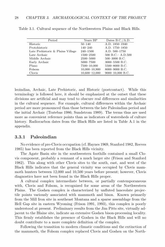
28 CHAPTER 3. ARCHAEOLOGICAL CONTEXT OF THE PROJECT
Table 3.1. Cultural sequence of the Northwestern Plains and Black Hills.
Period Years BP Dates B.C./A.D.Historic 50–140 A.D. 1850–1940Protohistoric 140–240 A.D. 1750–1850Late Prehistoric & Plains Village 240–1500 A.D. 500–1750Late Archaic 1500–2500 500 B.C.– A.D.500Middle Archaic 2500–5000 500–3000 B.C.Early Archaic 5000–7500 3000–5500 B.C.Plano 7500–10,000 5500–8000 B.C.Folsom 10,000–10,900 8000–9000 B.C.Clovis 10,600–12,000 9000–10,000 B.C.
leoindian, Archaic, Late Prehistoric, and Historic (postcontact). While thisterminology is followed here, it should be emphasized at the outset that thesedivisions are artificial and may tend to obscure real differences and similaritiesin the cultural sequence. For example, cultural differences within the Archaicperiod are more pronounced than those between the late Paleoindian period andthe initial Archaic (Tratebas 1986; Sundstrom 1989). The terms thus are usedmore as convenient reference points than as indicators of watersheds of culturehistory. Radiocarbon dates from the Black Hills are listed in Table A.1 in theappendix.
3.3.1 Paleoindian
No evidence of pre-Clovis occupation (cf. Haynes 1969, Stanford 1982, Reeves1985) has been reported from the Black Hills vicinity.
The Agate Basin site in the southwestern foothills contained a small Clo-vis component, probably a remnant of a much larger site (Frison and Stanford1982). This along with other Clovis sites to the south, east, and west of theBlack Hills indicates that the general vicinity was occupied by Clovis mam-moth hunters between 12,000 and 10,500 years before present; however, Clovisdiagnostics have not been found in the Black Hills proper.
A cultural complex intermediate between, or partially contemporaneouswith, Clovis and Folsom, is recognized for some areas of the NorthwesternPlains. The Goshen complex is characterized by unfluted lanceolate projec-tile points variously associated with mammoth and bison. Known primarilyfrom the Mill Iron site in southeast Montana and a sparse assemblage from theHell Gap site in eastern Wyoming (Frison 1991, 1993), this complex is poorlyunderstood at present. Preliminary results from the Jim Pitts site, virtually ad-jacent to the Blaine site, indicate an extensive Goshen bison-processing locality.This firmly establishes the presence of Goshen in the Black Hills and will nodoubt contribute to a more complete definition of the complex.
Following the transition to modern climatic conditions and the extinction ofthe mammoth, the Folsom complex replaced Clovis and Goshen on the North-
3.3. PREHISTORY OF THE BLACK HILLS 29
western Plains and elsewhere in North America. Folsom period occupation ofthe Black Hills is evidenced by extensive deposits at the Agate Basin site (Fri-son and Stanford 1982), by an overlook used in bison hunting in the westernfoothills (Hofman and Ingbar 1988), and by a redeposited Folsom tool assem-blage from the northwestern periphery (Kornfeld 1988). Folsom sites elsewheredate to between 10,850 and 10,375 BP (Frison 1991). Little is known of Folsomlife outside of bison-hunting activities. Since Folsom tool assemblages are morediverse than those of the Clovis complex, Folsom peoples may have been ex-ploiting a wider variety of resources and may have been more ethnically diverseand socially complex than their Clovis predecessors (Beckes and Keyser 1983).
Folsom may mark the beginning of what might by called a true Northwest-ern Plains cultural pattern—one that would persist in various forms until thelate protohistoric period when horses were widely adopted by native popula-tions. This is essentially a pattern of small, highly mobile, independent groups,probably based on family ties, pursuing a seasonal round of subsistence activ-ities that included joining together once or twice a year for communal huntsand otherwise dispersing into smaller camps. No evidence exists for such sea-sonal aggregation in Clovis times; thus, Clovis social organization probably wasessentially different from that of the post-Clovis period.
The trend toward more diverse use of both game and nongame resources iseven more marked in the Plano period, the last Paleoindian cultural tradition.The Plano rubric encompasses several distinct complexes, defined primarily onthe basis of projectile point types. From early to late Plano, these include AgateBasin, Hell Gap, Alberta, Cody/Scottsbluff-Eden, Frederick, Lusk, Angostura,and James Allen. Radiocarbon dates from Plano sites range from about 10,000to 7500 BP; the various complexes seem to overlap both temporally and spa-tially.
Three Plano sites have been excavated in the general vicinity of the BlackHills: the Hudson-Meng bison kill, about 50 miles south of the southern Hog-back (Agenbroad 1978); the Long (or Angostura) site, just outside the southernHogback (Wheeler 1957; Hannus 1986); and upper components of the AgateBasin site, in the southwestern foothills (Frison and Stanford 1982).
In the Black Hills proper, what appear to be Late Paleoindian projectilepoints have been found throughout the uplift during survey and testing projects;however, most of these finds have not been independently dated. These are mostcommon at large, multicomponent sites in high-altitude meadows, with fewerfinds occurring in the southern Hogback. These sites may represent the warmseason habitations of small groups of hunters from the plains surrounding theBlack Hills (Tratebas 1986). It is not known whether mountain-oriented groupsoccupied the Black Hills on a year-round basis. Such groups could have beenbased in rockshelters, which are not well-represented in the sample of identifiedPlano sites in the Black Hills and thus would not show up in the archaeologicalrecord as it currently stands (Tratebas 1986).
Both lanceolate and round-based stemmed projectile points have been as-signed to the Plano period in the Black Hills (Tratebas 1986). The chronologicalplacement of these various projectile point types has relied entirely on compar-
30 CHAPTER 3. ARCHAEOLOGICAL CONTEXT OF THE PROJECT
isons with point sequences from other areas of the Northwestern Plains and thusdemands further study before such artifacts can be considered reliable time di-agnostics.
Elsewhere on the Northwestern Plains, Plano complexes indicate a contin-ued emphasis on bison hunting. Ample evidence exists to confirm the use ofnatural features as bison traps and jump-offs. At the same time, the trend to-ward more a more diverse subsistence base continued, especially in mountainousareas. Other types of communal hunts were focused on the taking of mountainsheep or pronghorn (Frison et al. 1986), and remains of deer, wapiti, pronghorn,and smaller animals occur along with bison in Plano assemblages. No doubt,nongame resources were used as well, as the highly mobile Plano groups passedthrough their seasonal cycles of hunting and gathering; however, plants andother nongame resources are generally not preserved in archaeological depositsin the area. Features at some Plano sites indicate the use of portable structures,perhaps similar to the hide tipi.
Cultural diversity probably continued to increase during this period, as didgroup size and overall population density (Beckes and Keyser 1983). Beginningwith the late Plano, a division between a mountain-oriented subsistence pat-tern and a plains-oriented pattern is discernible. The Plains pattern stressedlarge-scale communal bison hunting, while the montane pattern was based onexploitation of diverse plant and animal resources, with seasonal movementsregulated by snow cover and other altitude-dependent variables. Both patternsare hypothesized to have been present in the Black Hills, with the mountain-oriented groups seasonally alternating between the Hogback and interior zonesand the plains-oriented groups occupying the foothills and Hogback zones dur-ing seasons or episodes of extreme conditions on the open plains (Sundstrom1989). An alternative hypothesis holds that during this period the Black Hillsinterior was used only for occasional hunting forays by small groups otherwisebased in the surrounding plains, although use of the area may have increasedlate in the period (Tratebas 1986). These hypotheses cannot be developed fur-ther until more Plano sites are excavated in the Black Hills and the geomorphichistory of the area is better known.
3.3.2 Early Plains Archaic
At the end of the Plano period, around 7500 BP, human groups occupyingthe Northwestern Plains were becoming more populous and were increasing theirability to exploit a diverse range of resources. At the same time, the climatewas changing from relatively moist, cool conditions to drier and warmer con-ditions. This climate change probably made the open plains environment lesshospitable to both bison and humans, and conversely made high-altitude envi-ronments more habitable due to reduced snowpack and amelioration of wintertemperatures (Benedict and Olson 1978; Benedict 1981).
Relatively few Early Archaic sites are found in the Northwestern Plains;however, whether this is due to partial abandonment of the area, depopulation,or geomorphic processes resulting in the destruction or deep burial of sites is a
3.3. PREHISTORY OF THE BLACK HILLS 31
matter of conjecture at this time. Early Archaic sites are relatively rare in theBlack Hills, as well (Sundstrom 1989; Cassells et al. 1984; Tratebas 1986). TheHawken site in the northwestern Black Hills, dated at about 6200 BP, indicatesthat at least the periphery was used for communal bison hunting (of the extinctvariety Boccidentalis) during this period (Frison 1991; Frison et al. 1976). EarlyArchaic levels at the Beaver Creek site, in the southern Limestone Plateau, con-tained projectile points similar to those from the Hawken site; however, a diversesubsistence base, probably focused on individual small game hunting and plantfood gathering, is indicated. A possible Hawken point was also found duringtest excavations at the multicomponent Victoria Creek site (39PN1124) in theinterior uplift. Like the Beaver Creek site, Victoria Creek indicates a diversesubsistence base, including large and small animals and plants such as hackberryand wild plum (Vallejo 1993). The few Early Archaic surface collections fromthe interior uplift usually co-occur with Plano assemblages and, like the Planoassemblages, include a variety of hunting and butchering tools, wood and lithictool manufacturing implements, and grinding stones (Tratebas 1986). Theseinterior sites suggest limited occupation by hunting parties, probably based inthe surrounding plains, as do the few sites Plano and Early Archaic sites presentin the Hogback.
Projectile points similar to Early Archaic types from elsewhere on the North-western Plains have been found at several sites in the central Black Hills.These include large side-notched and basally notched types similar to thosefrom Mummy Cave; side-notched Hawken types; and large, thin, broad-bladedcorner-notched points. Types similar to Bitterroot and Simonsen points havealso been found (Tratebas 1986). These points were used to tip atlatl darts.The atlatl and dart remained the main weapon system throughout the Archaic.As with the late Plano points, many of the Black Hills types have not yet beendefined and independently dated.
Little is known of the Black Hills Early Archaic at present. It has been hy-pothesized that a diversified, mountain-oriented subsistence pattern held swayin the Black Hills proper, with a residual pattern of large game hunting-basedsubsistence in the foothills (Sundstrom 1989). Surface collections from through-out the Black Hills suggest a continuation of the Plano pattern of plains-basedcommunal bison hunters making occasional seasonal use of the interior uplift(Tratebas 1986), while subsurface remains from the Beaver Creek site suggest adiversified hunting and foraging pattern (L. Alex 1991). The two basic subsis-tence patterns seen in the terminal Plano thus may both be represented in theBlack Hills area, either as separate adaptations or as different parts of a sea-sonal round. Some researchers have suggested that the Black Hills served as a“refuge” for human populations during the more severe climatic conditions of theAltithermal (Frison 1991; Wedel 1978; Bamforth 1988; Buchner 1980); however,this hypothesis is not well-supported by current Black Hills data (Sundstrom1992). There are fewer sites dating to the Early Archaic in the Black Hills thanany other period. This is the opposite of the pattern predicted by the refugehypothesis. Geomorphology studies increasingly suggest that many archaeolog-ical deposits dating to this period were removed by erosion. Thus, the apparent
32 CHAPTER 3. ARCHAEOLOGICAL CONTEXT OF THE PROJECT
lack of sites may be a result of natural processes instead of reduced populationlevels.
3.3.3 Middle Plains Archaic
The beginning of the Middle Plains Archaic is marked by a dramatic increasein the number of archaeological sites in the Northwestern Plains (Frison 1991;Vickers 1986). This is true for the Black Hills, as well; most prehistoric sitesthus far dated have been assigned to the Middle Archaic period (5000–2500 BP).
Three interrelated factors can be hypothesized to have produced the dis-tinctive cultural expression of the Middle Archaic. First, during this period,the Northwestern Plains climate returned to somewhat moister and cooler con-ditions. This led to improved forage for bison in grassland areas. Second, thehuman groups occupying the Northwestern Plains had learned during the leanertimes of the Early Archaic to use a large variety of resources. This trend to-ward diverse economic activities continued throughout the Middle Archaic inmountain and basin areas. Third, human population density appears to haveincreased rapidly during the Middle Archaic. Very probably, this populationincrease was facilitated by a combination of the first two factors—that is, morefood resources were available due to both technological advances and increasesin forage supporting larger populations of bison. Some evidence also exists thata depositional environment more conducive to site preservation developed atthis time. If so, the hypothesized population increase may be more apparentthan real.
Bison hunting activities seem to have intensified—especially in the openplains areas during this period—as compared to the preceding Early Archaic.Some of this trend may be more apparent than real, since geomorphic processesmay have destroyed or obscured some Early Archaic sites in open areas; however,bison populations no doubt increased significantly at this time. In mountainousareas the tradition of wide-spectrum foraging and hunting—with its roots in thePlano period—continued, with even more resources apparently being added tothe pool.
In the Black Hills, aspects of both patterns are expressed in the archaeo-logical record. Middle Archaic sites in the Black Hills include large, repeatedlyoccupied camps with numerous specialized hearths and other features; smallerwinter camps; and sites used for special activities such as tool-preparation, pro-cessing of plant foods, butchering/meat processing and post-hunt tool repair,and hide working (Sundstrom 1989; Tratebas 1986). Some of the Black Hillssites contain moderate amounts of bison bone; sites north and west of the BlackHills suggest communal hunting of bison and deer. In addition, probable MiddleArchaic rock art found throughout the southern Black Hills illustrates the useof artificial impoundments for the communal hunting of deer, pronghorn, and,rarely, bison (Sundstrom 1990). Sites in the general vicinity indicate communalhunting, individual hunting of bison and smaller game, and plant-food foraging.Use of tipis or similar habitations is indicated at a few sites in the area by circlesof stones possibly used as tent weights.
3.3. PREHISTORY OF THE BLACK HILLS 33
It appears that ethnically distinct groups were occupying the Black Hillsseasonally as part of a yearly round of subsistence activities (Keyser and Davis1984). Perhaps multiple groups were present in the area, each following a differ-ent seasonal round (Sundstrom 1989). At least two such seasonal rounds havebeen hypothesized: a pattern of warm season use of higher elevations, with win-ter use of the Hogback zone; and a pattern of seasonal forays into the BlackHills by groups based in the surrounding grasslands (Tratebas 1986; Sundstrom1989).
The presence of strikingly diverse lithic assemblages in Middle Archaic siteslends support to the hypothesized increased cultural diversity in the area. Infact, distinct patterns of lithic technology, burial practices, habitation types,and seasonal subsistence in Northwestern Plains Middle Archaic materials mayindicate that increased cultural diversity had by this time led to the formationof ethnically distinct macrobands occupying overlapping territories (Keyser andDavis 1984; Sundstrom 1989). This pattern may have characterized the regionthroughout the remainder of its prehistory.
3.3.4 Late Archaic and Plains Woodland
From about 2500 to 1500 years BP, the Northwestern Plains witnessed thedevelopment of several distinct cultural complexes. The first, initially defined inthe northern portions of the subarea, is termed the Pelican Lake complex. Thiswas followed in some areas by the Besant complex. Both had a bison-huntingsubsistence base in the northern Northwestern Plains and mixed bison-huntingand foraging subsistence base in the southern sector. Complex communal bi-son hunts were an important Besant adaptation throughout the NorthwesternPlains.
Several localized Plains Woodland complexes were contemporaneous withthe Pelican Lake and Besant complexes. Although the Late Woodland is pri-marily identified with the eastern plains and woodlands, similar developments,such as the production of pottery, were widely scattered throughout the west-ern plains, as well. In the Northwestern Plains, all of these Late Archaic/PlainsWoodland period complexes are similar in terms of lithic technology, subsis-tence, settlement pattern, and site morphology. The burial mounds and incipi-ent horticulture that characterize Woodland sites to the east are not present. Ingeneral, sites containing pottery are given Plains Woodland designations, whilethose without pottery are considered Late Archaic. The interrelationships ofthe two have not yet been defined.
Projectile points similar to Besant and Pelican Lake types have been foundthroughout the Black Hills; however, only a few small Late Archaic compo-nents have been excavated. A Late Archaic bison kill was excavated in thewestern Black Hills, but the results of the project remain unreported (Frison1991). Several rockshelter sites in the interior Black Hills and Hogback containsmall Besant assemblages including stone tools and ceramics. These appear torepresent short-term hunting camps.
34 CHAPTER 3. ARCHAEOLOGICAL CONTEXT OF THE PROJECT
Very little is currently known of either Plains Woodland or Late Archaicdevelopments in the area. A few very general observations can be made. First,the intense use of various Black Hills niches that typified the Middle Archaicseems to have been abandoned at this time in favor of a much more restricteduse of the area. While almost as many Late Archaic as Middle Archaic sitesexist, the Late Archaic sites are smaller and less diverse. Secondly, populationdensity seems to have decreased slightly in the Black Hills, perhaps becausethe residence base had shifted away from mountainous areas and onto the openplains and western periphery. In the latter areas, large, complex communal bisonhunts appear to have been the lynchpin of the subsistence round. Third, at leastweak Woodland influences were being felt around the northern, southern, andeastern peripheries of the Black Hills, although neither villages nor incipienthorticulture appeared.
It is hypothesized that the interior Black Hills were used for seasonal basecamps, smaller hunting camps, and small, sheltered winter camps, while useof the southern Black Hills Hogback was restricted to hunting and butcheringstations (Tratebas 1986). Sites in the western and southern foothills probablyrepresent the camps of plains-based communal bison hunters. These site typesreflect the reemphasis on hunting and continuation of the pattern of multiplesubsistence bases co-occurring in the area.
3.3.5 Late Prehistoric and Plains Village
The introduction of the bow and arrow marks the beginning of the LatePrehistoric period, sometime around 1500 years ago. Smaller, lighter projec-tile points evince this change. The general subsistence pattern was essentiallyunchanged from that of the Late Archaic, with a heavy reliance on communalbison hunting, especially in open plains areas. The mixed communal huntingand foraging pattern persisted in the mountains and foothills. Ceramics havebeen found at a few early Late Prehistoric sites in the Black Hills and vicinity,as have stone circles (tipi rings) (Frison 1991; Reeves 1983).
The latter half of the Late Prehistoric of the Northwestern Plains com-prises a large number of defined complexes and phases, which are basically alikein their material expressions and inferred subsistence and settlement patterns.These represent nomadic bison hunters who followed the bison herds and livedin hide tipis. Depending on the local environments in which they were based,these hunters also relied to some extent on nongame resources. The differentcomplexes are recognized primarily on the basis of projectile point styles.
Along the Missouri River and its immediate tributaries, Plains Village pat-tern cultures developed at this time. The Plains Village pattern developeddirectly out of the earlier Plains Woodland pattern and was characterized bylarge, semisedentary earthlodge settlements clustered along the major water-ways. Maize horticulture and seasonal bison hunting provided subsistence, withsurpluses being stored in underground pits. Actual villages are rare in theNorthwestern Plains proper; however, probable villages are reported from theBlack Hills, White River Badlands, and southeastern Montana plains. Other
3.3. PREHISTORY OF THE BLACK HILLS 35
sites seem to represent temporary camps used on seasonal bison hunts.Several types of Late Prehistoric/Plains Village period sites have been ex-
cavated in the Black Hills. These include tipi rings (Haug et al. 1980; Tratebas1979a); a large bison pit trap (Reher and Frison 1980); temporary camps used byMiddle Missouri village dwellers on hunting or lithic procurement expeditions(L. Alex 1979; R. Alex 1981); a possible Crow encampment (Wheeler 1957);and two settlements possibly linked to Middle Missouri cultures (R. Alex 1981).Surface collections suggest use of the interior Black Hills for residence sites anduse of the Hogback for various kinds of tool making and resource gathering(Tratebas 1986).
At present, little is known of the cultural dynamics of the Black Hills LatePrehistoric. The diversity of site types and artifact assemblages suggests thatat least three cultural patterns were current in the area: the communal bisonhunting pattern typical of the open plains; the mixed hunting and foragingpattern of the Wyoming Basins; and the semihorticultural, semisedentary villagepattern of the Missouri River and Central Plains.
3.3.6 Protohistoric
Between 1700 and 1800, Euroamerican influences and material objects beganto reach the Northwestern Plains in force. The introduction of the horse andgun, and the influence of the fur trade on the Upper Mississippi and HudsonBay, led to several changes in the cultures of the Northwestern Plains. Amongthese were greater mobility, increased social stratification based on access totrade goods, a shift away from the use of bison jumps and traps to hunting byriding directly into the herd, and the military dominance of mounted warriorsover pedestrian fighters (Secoy 1953). The Plains Indian warrior complex, withits highly structured system of recognizing individual accomplishments in battle,came to pervade nearly all aspects of Plains life by the end of this period (M.Smith 1937). At the same time, population shifts farther to the east caused arebound effect in the Northwestern Plains, as new groups entered the area andterritories shifted.
Archaeological remains dating to this period are rare in the Black Hills.This is probably because the sites are not recognized as such, rather than thatoccupation was not taking place. The Vore site is a periodically reused bisontrap in the northern Red Valley containing Late Prehistoric and Protohistoriccomponents. Kiowa-Apaches and Middle Missouri villagers may have used thesite. Preliminary investigations at the Kenzy site, a bison butchering stationin the Limestones, established that the site was used during the protohistoricperiod; however, few artifacts were found in association with the butcheredbison bone (Saunders et al. 1994). Rock art from the southern Black Hillshas been identified as having Shoshone, Siouan (unspecified), and Lakota orCheyenne cultural affiliation (Sundstrom 1990). Some of this rock art depictstrade items of non-native origin, such as guns and horses. Ethnographic sourcesestablish that the Black Hills area was occupied by the Crow, Ponca, Comanche,Kiowa, and Kiowa Apache (Gatacka) prior to the introduction of the horse
36 CHAPTER 3. ARCHAEOLOGICAL CONTEXT OF THE PROJECT
between A.D. 1700 and 1750 (Reher 1977; Reher and Frison 1980). Shoshoneterritory lay just west of the Black Hills during the latter portion of the LatePrehistoric period. During the early part of the Protohistoric period, the Crow,Kiowa, and Kiowa-Apache controlled the Black Hills (Hodge 1907; Mooney1898). Cheyenne, Arapaho, and Lakota groups moving in from the east andnorth replaced them later in the Protohistoric. The latter alliance dominatedthe area from about 1770 on, having displaced the Crow to the northwest andthe Kiowa and Kiowa-Apache to the south.
In 1805, Lewis and Clark’s informants placed the Cheyenne in the BlackHills (Mooney 1898:167). The Kiowa were then centered on the north forkof the Platte, while their Kiowa-Apache allies were on the headwaters of theCheyenne River, just west of the Black Hills. Lakota oral histories indicate thatLakota bands entered the Black Hills as early as 1775 and soon claimed the areaas their own.
3.3.7 Historic
The first non-natives began to enter the Black Hills country in the first quar-ter of the nineteenth century. These were explorers and fur traders, with whomthe Lakota and their allies willingly coexisted. Over the next quarter century,the trickle of whites passing through Lakota territory turned into a steady andever-increasing stream, as the settlement of Utah and the Oregon country, theCalifornia gold rush, and the race to build a transcontinental railroad all drewEuropean Americans westward. In 1868, all of western South Dakota was setaside as a reservation for the Lakota; they were also guaranteed free access tothe Powder River country for hunting (Kingsbury 1915). By 1875, reports ofgold had been confirmed by the Black Hills Expedition, and entire towns hadsprung up near the gold strikes. The Powder River war of 1876 was fought overthe question of these treaty violations. In spite of Lakota victories over Crookand Custer that year, the Indians were forced by 1877 to cede the Black Hillsand Powder River country to the US government, which opened the country toEuroamerican settlement.
Prospecting soon gave way to a more stable economy based on mining, log-ging, and ranching. Some of the old gold-rush towns survived this transition,while others grew up around the new industries. Today, the largest part of theBlack Hills is federal and state owned parks and forests. Logging, mining, cattleranching, and tourism are the main industries.
Chapter 4
RESEARCHORIENTATION
4.1 Research Objectives
Mitigative research at the Blaine site was based on a formal research design.This addressed four main objectives:
• Establish a site-specific cultural chronology.
• Generate data on aspects of prehistoric settlement and subsistence systemsfor the various periods represented in site deposits.
• Determine patterns of lithic procurement and use.
• Establish the ecological, geomorphic, and geoarchaeological context of thesite deposits.
The research objectives address a series of questions about prehistoric useof the Black Hills summarized by Sundstrom et al. (1994:5):
An understanding of how prehistoric peoples perceived and used theBlack Hills may well be a key to understanding the most basic ques-tions of human survival in the Great Plains. Were the Black Hillsa place of refuge when drought or extreme weather struck the openplains (cf. Frison 1991, Wedel 1978, Bamforth 1988)? Was the areaoccupied only during such times of climatic stress or during certainseasons of the year, or was occupation of the area continuous? Werethe Black Hills shared by disparate groups based in the surroundingplains, or was there a single mountain-adapted culture surroundedby plains-oriented peoples?
37
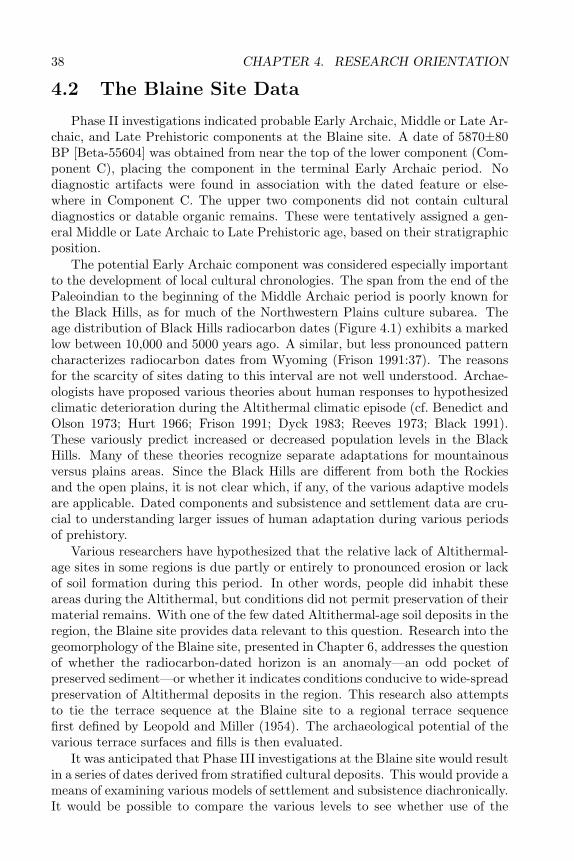
38 CHAPTER 4. RESEARCH ORIENTATION
4.2 The Blaine Site Data
Phase II investigations indicated probable Early Archaic, Middle or Late Ar-chaic, and Late Prehistoric components at the Blaine site. A date of 5870±80BP [Beta-55604] was obtained from near the top of the lower component (Com-ponent C), placing the component in the terminal Early Archaic period. Nodiagnostic artifacts were found in association with the dated feature or else-where in Component C. The upper two components did not contain culturaldiagnostics or datable organic remains. These were tentatively assigned a gen-eral Middle or Late Archaic to Late Prehistoric age, based on their stratigraphicposition.
The potential Early Archaic component was considered especially importantto the development of local cultural chronologies. The span from the end of thePaleoindian to the beginning of the Middle Archaic period is poorly known forthe Black Hills, as for much of the Northwestern Plains culture subarea. Theage distribution of Black Hills radiocarbon dates (Figure 4.1) exhibits a markedlow between 10,000 and 5000 years ago. A similar, but less pronounced patterncharacterizes radiocarbon dates from Wyoming (Frison 1991:37). The reasonsfor the scarcity of sites dating to this interval are not well understood. Archae-ologists have proposed various theories about human responses to hypothesizedclimatic deterioration during the Altithermal climatic episode (cf. Benedict andOlson 1973; Hurt 1966; Frison 1991; Dyck 1983; Reeves 1973; Black 1991).These variously predict increased or decreased population levels in the BlackHills. Many of these theories recognize separate adaptations for mountainousversus plains areas. Since the Black Hills are different from both the Rockiesand the open plains, it is not clear which, if any, of the various adaptive modelsare applicable. Dated components and subsistence and settlement data are cru-cial to understanding larger issues of human adaptation during various periodsof prehistory.
Various researchers have hypothesized that the relative lack of Altithermal-age sites in some regions is due partly or entirely to pronounced erosion or lackof soil formation during this period. In other words, people did inhabit theseareas during the Altithermal, but conditions did not permit preservation of theirmaterial remains. With one of the few dated Altithermal-age soil deposits in theregion, the Blaine site provides data relevant to this question. Research into thegeomorphology of the Blaine site, presented in Chapter 6, addresses the questionof whether the radiocarbon-dated horizon is an anomaly—an odd pocket ofpreserved sediment—or whether it indicates conditions conducive to wide-spreadpreservation of Altithermal deposits in the region. This research also attemptsto tie the terrace sequence at the Blaine site to a regional terrace sequencefirst defined by Leopold and Miller (1954). The archaeological potential of thevarious terrace surfaces and fills is then evaluated.
It was anticipated that Phase III investigations at the Blaine site would resultin a series of dates derived from stratified cultural deposits. This would provide ameans of examining various models of settlement and subsistence diachronically.It would be possible to compare the various levels to see whether use of the
4.3. FUNCTIONAL SITE TYPES 39
Figure 4.1. Distribution of radiocarbon dates from the Black Hills (number xyears before present). Dates are uncalibrated.
site had changed over time. Material from the site could also be comparedwith that from other dated archaeological components from the Black Hills andNorthwestern Plains.
Another principal objective in our study of the Blaine site was to providedata relevant to questions about prehistoric settlement and subsistence in theBlack Hills. In doing this, the material culture of the site was examined interms of functional site types. Functional classification of the Blaine site com-ponents relied on a consideration of artifact density, tool type assemblages, toolto debitage ratios, and feature type, density, and configuration.
4.3 Functional Site Types
The correct identification of functional site types is an important prerequisiteto tests of the various settlement pattern models proposed for the Black Hills.This applies especially to the distinction between base camps, temporary campsassociated with resource exploitation, and special activity stations. In manycases, the various sites described as bases, residential camps, or special purposecamps (such as hunting camps) are largely undefined, except as associations oftool types and, in some cases, feature types.
Generalized models of hunter-gatherer subsistence and settlement systemscan provide a basis for more exact definition of functional site types in the BlackHills. Several such models were considered in formulating definitions of func-tional site types applicable to the Black Hills situation. An assumption is madehere that hunter-gatherer models are appropriate for Black Hills data. This as-sumption is based on the lack of evidence for other kinds of subsistence systemsin the Black Hills and the Northwestern Plains in general. In other areas of thenorthern Great Plains such as the central Missouri River, where semihorticul-
40 CHAPTER 4. RESEARCH ORIENTATION
tural economies were developed prehistorically, hunting and gathering remainedan important component of the subsistence system. The question in the BlackHills is not whether subsistence was based on hunting and gathering, but themore exact nature of the hunting and gathering subsistence systems which weredeveloped there.
Of the numerous studies of hunter-gatherer site type classification, thoseof Binford and Binford (1966), Greiser (1985), Roper (1981), and Tratebas(1986) formed the basis for the research design on which this study is based(Donohue and Hanenberger 1993). Functional types used by Bender and Wright(1988) and Black (1991) in their models of high-altitude adaptations will alsobe considered here.
The first and most basic classification defines two main site types: mainte-nance and extraction (Binford and Binford 1966). Maintenance sites containevidence of activities related to the technological requirements of the group andto food procurement and consumption. These are base camps. Extractive sitesreflect a restricted range of activities conducted by task groups in extractinga limited number of specific resources. A third site type, the transient camp,comprises the remains from overnight camps used by traveling bands.
Greiser (1985) follows the Binford classification system in recognizing twobasic site types, but further defines and subdivides these to reflect central Plainsadaptive patterns. According to her classification system, maintenance sitesare expressed as camp sites at which a variety of activities occurred, includingtool manufacturing, hide preparation, food preparation, and various kinds ofsocial interaction. Criteria for recognizing maintenance sites include settingswith sufficient water and fuel to maintain a small group for a period of at leastseveral days; features associated with preparation, processing, and storage offood; diverse subsistence remains; and structural features.
Greiser (1985) defines three classes of extractive sites: kill sites, processingsites, and quarry sites. Kill sites are defined as locations at which at least onemammoth or two ungulates were killed. Criteria for recognizing kill sites include:settings that can be utilized for natural traps or placement of constructed traps,such as arroyos, box canyons, cliffs, and bogs; features such as drive lines,corrals, and hearths; tool kits dominated by butchering tools and projectilepoints; faunal remains dominated by a single species; and faunal assemblagescontaining the least desirable elements of the carcass.
Table 4.1: Resource potential of Black Hills physiographic zones. Resource list does not includeanimal species not found in archaeology sites or in rock art (e.g. squirrel, black bear, grizzlybear, mountain lion, raccoon), non-food plants, non-storable plant foods such as shoots, orplant species used only as starvation foods or for medication. Animal resources are biasedtoward mammalian species.
Zone ResourcesFoothill bison, pronghorn, mule deer, whitetail deer,
jackrabbit, desert cottontail, prairie dog, porcu-pinewoodponderosa pine seeds and bark

4.3. FUNCTIONAL SITE TYPES 41
Table 4.1: continued
Zone Resourceswestern: Morrison silicified siltstoneeastern: cherts and chalcedonieseastern: acorns and hazelnutsprairie turnip, pricklypear, onion, sego lily, wildlicorice, scarlet globemallow, sunflower, bushmorning glory, yucca, “weedy“ species (goosefootand other chenopods, ragweed, dock, smartweed)chokecherry, plums, sumac, sandcherry, rose, buf-faloberry, snowberry, skunkbrush. hackberryfish and shellfish in Belle Fourche and Cheyenneriversgrasslands/forest ecotone
Hogback Morrison silicified siltstone; high qualityquartzites; cherts and chalcedoniessandstone for groundstone toolswatergaps and arroyos for trapping gamenumerous rock sheltersmule deer, jackrabbit, mountain sheepwoodponderosa pine seeds and barkchokecherry, plum, skunkbrush, hackberryprairie turnip, bush morning glory, onion, segolily, wild licorice, scarlet globemallow
Red Valley primary habitat for bison, pronghorn, elk, prairiedogmule deer, whitetail deer, desert cottontailgrass forage for bisonwinter shelter for bison and humans“salt” licks for bisonsego lily, onion, goosefoot
Limestone good quality cherts and chalcedonies, quartzitesperennial springsrockshelterssemimarsh areas with beaver, muskrat, and minkwoodponderosa pine seeds and bark; white spruce barkgrasslands/forest ecotoneprimary habitat for mule deer, whitetail deer, andelkcottontail, jackrabbit, marmot, bison, porcupinelodgepoleschokecherry, buffaloberry, huckleberry, rose, Ore-gon grape, serviceberry, currant, nannyberry,grouseberry, raspberry, gooseberry, swamp cur-rant, hawthornsunflower, onion, mountain wafer parsnip,“weedy“ species
Riparian: boxelder, willow, serviceberry, hawthornbeaver
Mountain prairie: pricklypear, sego lilyjackrabbitbison, elk, and deerforest/grasslands ecotone
Central Core granite for groundstone toolsrock shelters
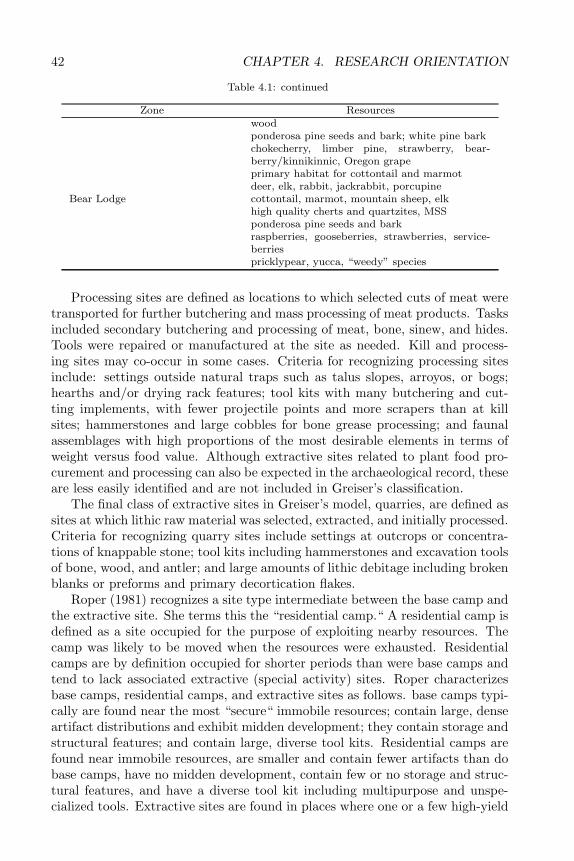
42 CHAPTER 4. RESEARCH ORIENTATION
Table 4.1: continued
Zone Resourceswoodponderosa pine seeds and bark; white pine barkchokecherry, limber pine, strawberry, bear-berry/kinnikinnic, Oregon grapeprimary habitat for cottontail and marmotdeer, elk, rabbit, jackrabbit, porcupine
Bear Lodge cottontail, marmot, mountain sheep, elkhigh quality cherts and quartzites, MSSponderosa pine seeds and barkraspberries, gooseberries, strawberries, service-berriespricklypear, yucca, “weedy” species
Processing sites are defined as locations to which selected cuts of meat weretransported for further butchering and mass processing of meat products. Tasksincluded secondary butchering and processing of meat, bone, sinew, and hides.Tools were repaired or manufactured at the site as needed. Kill and process-ing sites may co-occur in some cases. Criteria for recognizing processing sitesinclude: settings outside natural traps such as talus slopes, arroyos, or bogs;hearths and/or drying rack features; tool kits with many butchering and cut-ting implements, with fewer projectile points and more scrapers than at killsites; hammerstones and large cobbles for bone grease processing; and faunalassemblages with high proportions of the most desirable elements in terms ofweight versus food value. Although extractive sites related to plant food pro-curement and processing can also be expected in the archaeological record, theseare less easily identified and are not included in Greiser’s classification.
The final class of extractive sites in Greiser’s model, quarries, are defined assites at which lithic raw material was selected, extracted, and initially processed.Criteria for recognizing quarry sites include settings at outcrops or concentra-tions of knappable stone; tool kits including hammerstones and excavation toolsof bone, wood, and antler; and large amounts of lithic debitage including brokenblanks or preforms and primary decortication flakes.
Roper (1981) recognizes a site type intermediate between the base camp andthe extractive site. She terms this the “residential camp.“ A residential camp isdefined as a site occupied for the purpose of exploiting nearby resources. Thecamp was likely to be moved when the resources were exhausted. Residentialcamps are by definition occupied for shorter periods than were base camps andtend to lack associated extractive (special activity) sites. Roper characterizesbase camps, residential camps, and extractive sites as follows. base camps typi-cally are found near the most “secure“ immobile resources; contain large, denseartifact distributions and exhibit midden development; they contain storage andstructural features; and contain large, diverse tool kits. Residential camps arefound near immobile resources, are smaller and contain fewer artifacts than dobase camps, have no midden development, contain few or no storage and struc-tural features, and have a diverse tool kit including multipurpose and unspe-cialized tools. Extractive sites are found in places where one or a few high-yield
4.3. FUNCTIONAL SITE TYPES 43
resources occur, are small and contain few artifacts, lack storage and habitationfeatures, and contain specialized tool kits geared toward procurement and initialprocessing of particular resources.
A more fine-grained site type classification was based on a principal compo-nents analysis of 212 surface collections from the Black Hills (Tratebas 1986).This analysis delineated 12 tool class associations representing functional sitetypes for each of two areas: the southern Hogback/foothills zone and the interiorBlack Hills. These site types include a variety of extractive sites and residentialor base camps. Another set of site types, termed expediency/distance camps areinterpreted as transient camps (cf. Binford and Binford 1966). Because chrono-logical data were included in the analysis, some of these site types are tied toparticular periods or cultures (Tratebas 1986).
Bender and Wright (1988) recognize the following site function types inmountain-based settlement systems: base camp, secondary base, special usehunting, special use quarrying, and special use gathering. The high-elevationbase camp is the basic site type. Base camps can be recognized by high artifactfrequencies, high artifact diversity, and comparatively large size. They are foundnear resources needed for the physical comfort of the group, such as water,shelter from prevailing winds, early snowmelt, level areas, and ground coversuitable for camping. Accessibility (in terms of distance and elevational change)is also a factor in siting base camps. Base camps are located without particularregard for food sources. Since the most desirable combinations of accessibilityand physical comfort factors will be found in only a few areas of a mountainousenvironment, base camps tend to be occupied repeatedly. Base camps shouldcontain artifacts and features representing some of the activities of all residentindividuals, i.e. the entire social unit (cf. Binford 1979).
According to this model, once a base camp was established, a series of for-aging activities emanated from the camp. This would create a series of satellitespecial activity sites. These sites are recognizable by their small size, special-ized tool kits, and distribution without regard to habitability and accessibility.Gathering sites tend to be located close to the base camps. Gathering per se isnot likely to generate visible archaeological remains; however, activities associ-ated with gathering will be expressed at the associated base camps. Grindingstones and roasting pits in particular are interpreted as evidence for plant gath-ering near base camps. Sites associated with hunting activities, in contrast,tend to be sparse and widely dispersed. Mountain-based hunters cover large,overlapping territories in pursuit of game. Primary processing of larger gameanimals tends to occur at the kill site. Hunting sites associated with this patterntake the form of small lithic concentrations and overlooks on promontories. Thethird kind of special activity site, the quarry, is recognized by the presence oflarge, dense clusters of lithic debris at and near outcrops.
The broad spectrum settlement pattern model implies the presence of oneother site type: the secondary base. This site type is necessitated by resourceprocurement activities that take task-specific groups far from the base camp.When returning to the base camp requires great effort, a secondary base will beestablished nearer the particular resource being exploited. The critical distance

44 CHAPTER 4. RESEARCH ORIENTATION
depends on the relative accessibility of the local terrain. Secondary bases canbe quite close to base camps if the terrain is especially difficult to traverse. Asa focus of diverse activity, but not of band-level domestic life, these sites arecharacterized by high functional diversity and moderate size. They are locatedin areas remote from base camps, but not necessarily in highly habitable areas.They are, however, located in the most habitable areas within the range of aspecific resource.
Bender and Wright’s secondary base may be equivalent to sites in the BlackHills described as intermediate between Binford’s residential base and field camp(Tratebas 1986). Although Tratebas concluded that no true base camps werepresent in the Black Hills, it is possible that primary and secondary bases cannotbe easily distinguished on the basis of surface artifact scatters alone. The habi-tation sites Tratebas selected for test excavation appear to have been limited tosecondary bases (or residential camps) and specialized hunting stations/camps;more likely candidates for base camp status, such as McKean and Deerfield,were not included in the study. Bender and Wright’s special use sites are ofcourse equivalent to the resource extraction sites described in the other models.There seems to be no equivalent for Tratebas’s Distance/Expediency site type inBender and Wright’s classification; however, this type may be considered equiv-alent to Binford’s transient camp (Binford and Binford 1966). This may be asite type specific to a plains-based subsistence system, in which trips throughthe Black Hills were irregular and unscheduled in regard to nonmobile resourceavailability.
The concept of “site“ is both necessary and limiting to exploration of thevarious models outlined above. Many of the activities proposed for the vari-ous models would not leave material remains in the form of recognizable sites.Lodgepole cutting, plant food gathering, and netting or snaring of small animalswould not have created readily visible sites. Subsistence patterns with a heavyreliance on large game will be more easily identified as “sites“ in the archaeo-logical record than those emphasizing plant foods, because bone is larger andmore durable than most plant remains. On the other hand, subsistence systemsbased on large game hunting will be difficult to detect in areas away from killand butchering sites. Supplementary subsistence activities included in such sys-tems will have a low level of visibility in the archaeological record. Jumps andarroyo traps frequently were used several or many times, creating highly visi-ble sites. The effort expended in discovering, constructing, and/or maintainingthese procurement facilities tended to anchor a group or groups to a specific ter-ritory. Within these territories, however, group movements depended primarilyon the availability of bison and pronghorn (i.e. herd migrations and populationfluctuations). In other words, the highly mobile and flexible nature of groupmovements reflected the mobility of the bison and pronghorn herds that formedthe subsistence base.
In subsistence patterns based on plants and nonmigratory game, group move-ments tend to be anchored to a series of stable or predictable resources. Ratherthan following the herds, people schedule their movements around the seasonalavailability of various resources. In mountainous areas, this includes following
4.4. THE RESOURCE BASE 45
the ripening plant foods up into higher elevations in the summer and returningto the lower elevations in the fall. Base camps are located with respect to avail-ability of water, fuel, and shelter necessary for maintenance of the group andideally within less than a half day’s walk of resource patches. Sites meeting theseconditions tend to be frequently reused, sometimes over periods of thousandsof years. As a seasonal round becomes increasingly regularized and scheduled,more permanent features such as storage pits, tool caches, and pit houses ap-pear. The effort expended in constructing such features implies an intention toreturn to a site on a regular basis. Tool or preform caches and reused hearthor roasting pit complexes demonstrate that sites were being used for the samepurpose, e.g. plant food processing, throughout long spans of prehistory.
4.4 The Resource Base
Before describing and evaluating the various settlement pattern models pro-posed for the Black Hills, it is necessary to consider what resources were offeredby the area, especially in contrast to the surrounding grasslands. Each physio-graphic zone of the Black Hills contains a unique set of resources (Table 4.1).
The information presented in Table 4.1 is a compilation of data from botan-ical and ethnobotanical studies, as well as field observations (Turner 1974; Froi-land 1978; Latady and Dueholm 1985; Van Bruggen 1971; Gilmore 1977; John-son and Nichols 1970; Rogers 1980; Kindscher 1987; Greiser 1985; Swetnam1984; Haberman 1986; Keyser 1986). Plant resources listed in Table 4.1 arelimited to those items for which ethnobotanical or regional archaeological data(Table 4.2) suggest regular use as food. Plants used primarily for medicine,fibers, or dyes are not included. “Survival“ or starvation foods are also omit-ted, as are introduced species such as lambsquarters. Plants used only in theform of springtime shoots or potherbs are not included, as these are assumed tohad have little effect on settlement patterning. Ubiquitous food plants, such aswestern wheatgrass, prairie junegrass, and sage, are similarly excluded from theresource list for two reasons. First, there is little ethnographic or archaeologi-cal evidence that these were used as food sources in the region. Second, thesespecies are found in much greater abundance in grasslands environments thanin the Black Hills.
Animal species are limited to those found in regional archaeological contexts(including rock art) suggesting their use as food. The sparse nature of faunaldata from Black Hills sites, as well as their uneven geographic distributions makeit difficult to draw generalizations about this aspect of prehistoric subsistencesystems (Table 4.3). It now appears that communal bison kills and other largescale bison procurement were limited to the Red Valley. The Deerfield site,high in the central Limestones contained elements of at least four bison; how-ever, most bone at the site was unidentifiable. Large scale bison procurementis not indicated for Deerfield. A long series of periodic, seasonal occupations ofthe site produced the four bison. Bison was also found at the nearby Kenzy site;however, it was not clear from preliminary investigations whether isolated kills
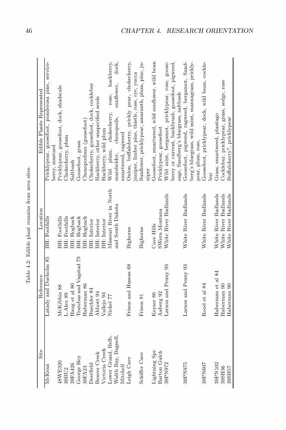
46 CHAPTER 4. RESEARCH ORIENTATIONT
ab
le4.2
:E
dib
lep
lant
rem
ain
sfr
om
are
asi
tes.
Sit
eR
efer
ence
Loca
tion
Ed
ible
Pla
nts
Rep
rese
nte
dM
cKea
nL
ata
dy
an
dD
ueh
olm
85
BH
:F
ooth
ills
Pri
ckly
pea
r,goose
foot,
pon
der
osa
pin
e,se
rvic
e-b
erry
,m
ust
ard
48W
E320
McK
ibb
in88
BH
:F
ooth
ills
Pri
ckly
pea
r,goose
foot,
dock
,sh
ad
scale
39B
U2
L.A
lex
89
BH
:F
ooth
ills
Ch
okec
her
ry,
plu
m39FA
426
Hau
get
al
80
BH
:H
ogb
ack
Salt
bu
shG
eorg
eH
eyT
rate
bas
an
dV
agst
ad
79
BH
:H
ogb
ack
Goose
foot,
gra
ss39FA
23
Hab
erm
an
86
BH
:H
ogb
ack
Ch
enop
od
ium
(goose
foot)
Dee
rfiel
dB
uec
hle
r84
BH
:In
teri
or
Ch
okec
her
ry,
goose
foot,
dock
,co
ckle
bu
rB
eaver
Cre
ekA
bb
ott
94
BH
:In
teri
or
Hack
ber
ry,
oth
eru
nsp
ecifi
edse
eds
Vic
tori
aC
reek
Vallej
o93
BH
:In
teri
or
Hack
ber
ry,
wild
plu
mL
ow
erG
ran
d,
Hel
b,
Walt
hB
ay,
Bagn
ell,
Mit
chel
l
Nic
kel
77
Mis
sou
riR
iver
inN
ort
han
dS
ou
thD
akota
Wild
plu
m,
chokec
her
ry,
rose
,h
ack
ber
ry,
mars
hel
der
,ch
enop
od
s,su
nfl
ow
er,
dock
,sm
art
wee
d,
ragw
eed
Lei
gh
Cave
Fri
son
an
dH
use
as
68
Big
horn
sO
nio
n,
bu
ffalo
ber
ry,
pri
ckly
pea
r,ch
okec
her
ry,
jun
iper
,lim
ber
pin
e,th
istl
e,ro
se,
rye,
yu
cca
Sch
iffer
Cave
Fri
son
91
Big
horn
sS
un
flow
er,p
rick
lyp
ear,
am
ara
nth
,p
lum
,p
ine,
ju-
nip
erL
ightn
ing
Sp
r.K
eyse
r86
Cave
Hills
Goose
foot,
smart
wee
d,
wild
sun
flow
er,
wild
bea
nB
art
on
Gu
lch
Aab
erg
92
SW
ern
Monta
na
Pri
ckly
pea
r,goose
foot
39P
N972
Lars
on
an
dP
enny
93
Wh
ite
Riv
erB
ad
lan
ds
Wild
min
t,b
ergam
ot,
pri
ckly
pea
r,ro
se,
goose
-b
erry
or
curr
ent,
bu
ckb
rush
,goose
foot,
pig
wee
d,
sage,
San
db
erg’s
blu
egra
ss,
salt
bu
sh39P
N975
Lars
on
an
dP
enny
93
Wh
ite
Riv
erB
ad
lan
ds
Goose
foot,
pig
wee
d,
ragw
eed
,b
ergam
ot,
San
d-
ber
g’s
blu
egra
ss,
wil
dm
int,
man
nagra
ss,
pri
ckly
-p
ear,
plu
m,
rose
,39P
N607
Rood
etal
84
Wh
ite
Riv
erB
ad
lan
ds
Goose
foot,
pri
ckly
pea
r,d
ock
,w
ild
bea
n,
cock
le-
bu
r39P
N102
Hab
erm
an
etal
84
Wh
ite
Riv
erB
ad
lan
ds
Gra
ss,
smart
wee
d,
pla
nta
go
39S
H36
Hab
erm
an
90
Wh
ite
Riv
erB
ad
lan
ds
Cock
leb
ur,
pri
ckly
pea
r,gra
ss,
sed
ge,
rose
39S
H57
Hab
erm
an
90
Wh
ite
Riv
erB
ad
lan
ds
Bu
ffalo
ber
ry?,
pri
ckly
pea
r
4.5. SETTLEMENT AND SUBSISTENCE MODELS 47
or a large scale communal drive is indicated for the site (Saunders et al. 1994).The faunal assemblage from the Beaver Creek site in the southern Limestoneshas received only preliminary analysis; however, deer dominates the faunal as-semblages from most levels at the site. Limited testing of the Victoria Creeksite in the interior Black Hills revealed a mix of large and small game. Diagnos-tics artifacts and a radiocarbon date suggest primary use of the site during theMiddle and Early Archaic and late Paleoindian periods, with less evidence foran early Late Archaic occupation. (A second radiocarbon date is anomalouslyrecent.) The remaining sites are located in the Hogback or western foothills.These contain varying mixes of deer, bison, pronghorn, and smaller animals.None of these contain evidence for large scale bison procurement. About 100panels of Paleoindian and/or Archaic rock art from the southern Hogback de-picts a variety of hunting methods, including communal hunts using nets andpursual of individual animals using atlatls and snares (Sundstrom 1990). Thevast majority of the animals depicted are deer, with lesser numbers of pronghornand mountain sheep. Bison are depicted on only two panels.
Plant food resources in the foothills and Hogback are generally similar tothose found in the surrounding grasslands, with the exception of ponderosapine. Some ethnographic evidence exists for use of ponderosa pine bark forfood (Swetnam 1984); however, it does not appear to have been a primary foodsource. Archaeological evidence for intensive use of ponderosa bark or seeds isalso lacking; thus, this potential food source is not viewed as a major “draw.“ Inthe foothills, shelter from inclement weather, wood for fuel and tools, lithic rawmaterial, and habitable rock shelters are the most important potential resources.Rock art dating from Paleoindian through Middle Archaic times from about 18sites in the southern Hogback depicts communal animal trapping using nets orother enclosures (Sundstrom 1990). This suggests use of Hogback watergaps fortrapping herd animals, especially deer and mountain sheep.
Given this stable suite of resource advantages in the Black Hills, were prehis-toric settlement patterns specifically geared to take advantage of them? Severalsettlement pattern models have been proposed for the Black Hills. Each ofthese predicts a specific set of archaeological data types, including functionalsite types, lithic raw material resource patterning, and subsistence remains.
4.5 Settlement and Subsistence Models
Settlement pattern models provide a means of exploring the range and in-tensity of prehistoric use of specific habitats. Such models are built on datafrom ethnographic, ethnoarchaeological, and ecological studies. These modelscan then be used to formulate research questions for archaeological investiga-tions. The material expressions of conditions predicted by the models are thusdirectly tested against archaeological data. Increasingly specific models havebeen developed for various levels of technology, geographic areas, and habitattypes.
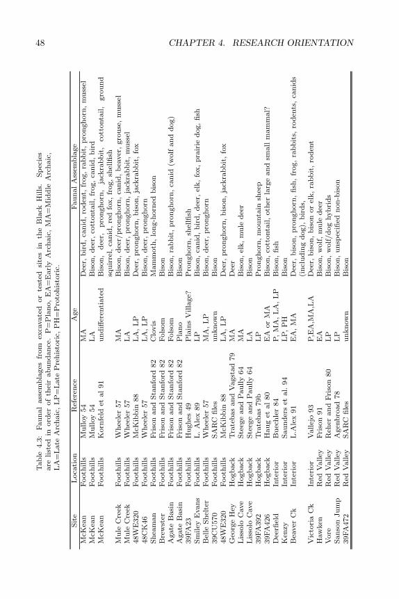
48 CHAPTER 4. RESEARCH ORIENTATIONT
ab
le4.3
:F
au
nal
ass
emb
lages
from
exca
vate
dor
test
edsi
tes
inth
eB
lack
Hills
.S
pec
ies
are
list
edin
ord
erof
thei
rab
un
dan
ce.
P=
Pla
no,
EA
=E
arl
yA
rch
aic
,M
A=
Mid
dle
Arc
haic
,L
A=
Late
Arc
haic
,L
P=
Late
Pre
his
tori
c,P
H=
Pro
toh
isto
ric.
Sit
eL
oca
tion
Ref
eren
ceA
ge
Fau
nal
Ass
emb
lage
McK
ean
Footh
ills
Mu
lloy
54
MA
Dee
r,b
ird
,ca
nid
,ro
den
t,fr
og,
rab
bit
,p
ron
gh
orn
,m
uss
elM
cKea
nF
ooth
ills
Mu
lloy
54
LA
Bis
on
,d
eer,
cott
onta
il,
frog,
can
id,
bir
dM
cKea
nF
ooth
ills
Korn
feld
etal
91
un
diff
eren
tiate
dB
ison
,d
eer,
pro
ngh
orn
,ja
ckra
bb
it,
cott
onta
il,
gro
un
dsq
uir
rel,
can
id,
red
fox,
frog,
shel
lfish
Mu
leC
reek
Footh
ills
Wh
eele
r57
MA
Bis
on
,d
eer/
pro
ngh
orn
,ca
nid
,b
eaver
,gro
use
,m
uss
elM
ule
Cre
ekF
ooth
ills
Wh
eele
r57
LA
Bis
on
,d
eer,
pro
ngh
orn
,ja
ckra
bb
it,
mu
ssel
48W
E320
Footh
ills
McK
ibb
in88
LA
,L
PD
eer,
pro
ngh
orn
,b
ison
,ja
ckra
bb
it,
fox
48C
K46
Footh
ills
Wh
eele
r57
LA
,L
PB
ison
,d
eer,
pro
ngh
orn
Sh
eam
an
Footh
ills
Fri
son
an
dS
tan
ford
82
Clo
vis
Mam
moth
,lo
ng-h
orn
edb
ison
Bre
wst
erF
ooth
ills
Fri
son
an
dS
tan
ford
82
Fols
om
Bis
on
Agate
Basi
nF
ooth
ills
Fri
son
an
dS
tan
ford
82
Fols
om
Bis
on
,ra
bb
it,
pro
ngh
orn
,ca
nid
(wolf
an
dd
og)
Agate
Basi
nF
ooth
ills
Fri
son
an
dS
tan
ford
82
Pla
no
Bis
on
39FA
23
Footh
ills
Hu
gh
es49
Pla
ins
Villa
ge?
Pro
ngh
orn
,sh
ellfi
shS
miley
Evan
sF
ooth
ills
L.
Ale
x89
LP
Bis
on
,ca
nid
,b
ird
,d
eer,
elk,
fox,
pra
irie
dog,
fish
Bel
leS
hel
ter
Footh
ills
Wh
eele
r57
MA
,L
PB
ison
,d
eer,
pro
ngh
orn
39C
U570
Footh
ills
SA
RC
file
su
nkn
ow
nB
ison
48W
E320
Footh
ills
McK
ibb
in88
LA
,L
PD
eer,
pro
ngh
orn
,b
ison
,ja
ckra
bb
it,
fox
Geo
rge
Hey
Hogb
ack
Tra
teb
as
an
dV
agst
ad
79
MA
Dee
rL
isso
loC
ave
Hogb
ack
Ste
ege
an
dP
au
lly
64
MA
Bis
on
,el
k,
mu
led
eer
Lis
solo
Cave
Hogb
ack
Ste
ege
an
dP
au
lly
64
LA
Bis
on
39FA
392
Hogb
ack
Tra
teb
as
79b
LP
Pro
ngh
orn
,m
ou
nta
insh
eep
39FA
426
Hogb
ack
Hau
get
al
80
EA
or
MA
Bis
on
,co
ttonta
il,
oth
erla
rge
and
small
mam
mal?
Dee
rfiel
dIn
teri
or
Bu
ech
ler
84
P,
MA
,L
A,
LP
Bis
on
,fi
shK
enzy
Inte
rior
Sau
nd
ers
etal.
94
LP
,P
HB
ison
Bea
ver
Ck
Inte
rior
L.A
lex
91
EA
,M
AD
eer,
bis
on
,p
ron
gh
orn
,fi
sh,
frog,
rab
bit
s,ro
den
ts,
can
ids
(in
clu
din
gd
og),
bir
ds,
Vic
tori
aC
kIn
teri
or
Vallej
o93
P,E
A,M
A,L
AD
eer,
bis
on
,b
ison
or
elk,
rab
bit
,ro
den
tH
aw
ken
Red
Valley
Fri
son
91
EA
Bis
on
,w
olf
,m
ule
dee
rV
ore
Red
Valley
Reh
eran
dF
riso
n80
LP
Bis
on
,w
olf
/d
og
hyb
rid
sS
an
son
Ju
mp
Red
Valley
Agen
bro
ad
78
LP
Bis
on
,u
nsp
ecifi
edn
on
-bis
on
39FA
472
Red
Valley
SA
RC
file
su
nkn
ow
nB
ison
4.5. SETTLEMENT AND SUBSISTENCE MODELS 49
In the northern Great Plains, settlement pattern models have been developedfor various areas and culture types. Along the upper Missouri, a semiseden-tary, semihorticultural settlement pattern is recognized. Plains Village patterncultures followed a highly structured seasonal round, spending early summerthrough fall in aggregated earthlodge settlements along the river, leaving thevillages in summer to travel north or west to the bison hunting grounds, anddispersing to isolated camps in the wooded lowlands during the winter months.This pattern was followed by the historic Mandans, Hidatsas, and Arikaras,except that they wintered in aggregated settlements in the lowlands.
In the open plains, a fully nomadic bison-hunting culture developed. Smallfamily groups or bands dispersed to hunt bison throughout most of the year,congregating at midsummer into larger camps for trade, socialization, and of-fensive raids. Limited gathering of berries and prairie turnips supplementedthe diet. The pre-equestrian Blackfoot and Arapaho exemplify this pattern.Writing in 1805, Larocque described this pattern for the Crow:
They wander about in leather tents and remain where there arebuffaloes and elks. After having remained a few days in one placeso that game is no more so plentiful as it was they flit to anotherplace where there are buffaloes or deers and so on all year round(Larocque 1805 cited in Wood and Thiessen 1985:206).
In the Bighorns and Rocky Mountains, seasonally scheduled movements be-tween local resource areas facilitated a diverse economy based on exploitationof a wide variety of plants, large and small vertebrates, shellfish, and insects.This pattern is similar to that followed by nonequestrian Great Basin culturessuch as the Ute and Paiute.
Unlike other areas of the West, no ethnographic descriptions of human adap-tation to the Black Hills in pre-horse days are available. By the time the first pri-vate and government expeditions penetrated the area, the Lakota and Cheyennebands then in control of the Black Hills had completed their shift to a fully eques-trian way of life. The Warren Expedition of 1857 was turned away from theBlack Hills by a large band of Minneconjou and Hunkpapa Lakotas.
They were encamped near large herds of buffalo, whose hair notbeing sufficiently grown to make robes, the Indians were, it maybe said, actually herding the animals....The intention of the Indianswas to retain the buffalo in their neighborhood till their skins wouldanswer for robes, then to kill the animals by surrounding one band ata time and completely destroying each number of it...(Warren 1857cited in McLaird and Turchen 1973).
This quasi-pastoralist pattern, based on acquisition of large herds of horsesand centered on the hide trade, was a response to contact with non-natives.Precontact use of the Black Hills was presumably much different; however, theethnographic record is silent in this regard.

50 CHAPTER 4. RESEARCH ORIENTATION
During the protohistoric period, mounted hunters ranged the open countryaround the Black Hills in a wide ranging and flexible annual round. The vastLakota and Cheyenne territory covered an area including what is now westernSouth Dakota, southwestern North Dakota, eastern Montana, eastern Wyoming,and northwestern Nebraska. These plains-based groups ventured into the BlackHills to hunt and to get lodgepoles and lithic raw material, but were not perma-nent residents of the uplift. They may have occasionally sought winter refugeand hunted bison in the foothills, Hogback, and Red Valley as well. Duringthis period, the Black Hills were viewed as a prime hunting ground, as StandingBear related:
At this time [1875] I was about fifteen years old and I heard SittingBull say that the Black Hills was just like a food pack and thereforethe Indians should stick to it. At that time I just wondered aboutwhat he had said and I knew what he meant after thinking it overbecause I knew that the Black Hills were full of fish, animals, and lotsof water, and I just felt that we Indians should stick to it. Indianswould rove all around, but when they were in need of something,they could just go in there and get it (Standing Bear n.d. cited inDeMallie 1984:163–164).
It is not known whether this pattern was followed prehistorically. Horsetravel is not easy in heavily wooded portions of the Black Hills and pasturageis limited. A significant reduction in use of the Black Hills may have accompa-nied adoption of horse culture. Group territories were probably much smallerprior to horse travel. Acquisition of the horse was a key element in taking anddefending the large territories claimed by protohistoric plains tribes. Clearly,ethnographic descriptions of the Lakotas, Cheyennes, and other groups occu-pying the Black Hills in protohistoric and historic times cannot be expected toprovide an accurate model of prehistoric use of the area.
Because reliable ethnographic models are not available, settlement patternmodels for the Black Hills have largely been based on archaeological data. Fivealternatives have been proposed. The first two of these view the Black Hills asperipheral to the main, open plains, habitat. According to these two models, theBlack Hills area was used only occasionally, as a refuge from dry conditions or asan occasional source of special resources, by full-time bison hunters based on theopen plains. The third model views the Black Hills as part of a regular seasonalround which included both the surrounding plains and the mountain uplift.The fourth model proposes year-round occupation of the Black Hills by hunter-gatherers using scheduling to exploit a broad range of local resources. Thefifth model proposes a combination of the other patterns, with simultaneous orsequential use of the Black Hills by both full-time hunter-gatherers and seasonalor sporadic visits by plains-based bison hunters.
These are summarized in Table 4.4. Each model is discussed and evaluatedin more detail below.
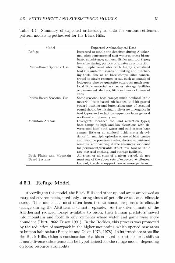
4.5. SETTLEMENT AND SUBSISTENCE MODELS 51
Table 4.4. Summary of expected archaeological data for various settlementpattern models hypothesized for the Black Hills.
Model Expected Archaeological DataRefuge Increased or stable site densities during Altither-
mal; sites concentrated near water sources; bison-based subsistence; nonlocal lithics and tool types;few sites during periods of greater precipitation
Plains-Based Sporadic Use Small, ephemeral sites with highly specializedtool kits and/or discards of hunting and butcher-ing tools; few or no base camps; sites concen-trated in single-resource areas, such as stands oflodgepole pine or quartzite outcrops; much non-local lithic material; no caches, storage facilitiesor permanent shelters; little evidence of reuse ofsites
Plains-Based Seasonal Use Some seasonal base camps; much nonlocal lithicmaterial; bison-based subsistence; tool kit gearedtoward hunting and butchering; part of seasonalround should be missing; little or no divergence intool types and reduction sequences from generalnorthwestern plains types
Mountain Archaic Divergent, localized tool and reduction types;base camps at high and low elevations with di-verse tool kits; both warm and cold season basecamps; little or no nonlocal lithic material; evi-dence for multiple episodes of use of base campsand resource processing sites; diverse subsistenceremains, emphasizing stable resources; evidencefor permanent/reusable structures, tool or lithicraw material caching, and storage facilities.
Both Plains and Mountain-Based Systems
All sites, or all sites of a given period, do notmeet any of the above sets of expected attributes.Instead, the data support two or more patterns
4.5.1 Refuge Model
According to this model, the Black Hills and other upland areas are viewed asmarginal environments, used only during times of periodic or seasonal climaticstress. This model has most often been tied to human responses to climaticchange during the Altithermal climatic episode. As the drier climate of theAltithermal reduced forage available to bison, their human predators movedinto mountain and foothills environments where water and game were moreabundant (Hurt 1966; Frison 1991). In the Rockies, this process was promotedby the reduction of snowpack in the higher mountains, which opened new areasto human habitation (Benedict and Olson 1973, 1978). In intermediate areas likethe Black Hills, either a continuation of a bison-based subsistence or a shift toa more diverse subsistence can be hypothesized for the refuge model, dependingon local resource availability.
52 CHAPTER 4. RESEARCH ORIENTATION
The refuge model has received wide acceptance in reference to the Black Hills(cf. Wedel 1978; Bamforth 1988; Buchner 1980; Frison 1991). This is largely dueto work at the Hawken site in the northern Red Valley (Frison et al. 1976; Frison1991). The site was an arroyo trap used for communal bison kills and a nearbybutchering area. These portions of the site were radiocarbon dated to 6270 and6470 BP, respectively. This falls about in the middle of the Altithermal as it isusually defined for the Great Plains. According to this interpretation, Hawkenindicates that the large-scale communal bison hunting pattern established onthe high plains during the Paleoindian period shifted to the Black Hills andother upland areas as people and bison sought refuge from the drier high plains(Frison et al. 1976; Frison 1991).
The refuge model has more recently come under attack (Bender and Wright1988; Black 1991; Sundstrom 1992). Black (1991) and Bender and Wright (1988)suggest the upland refuge concept largely is a product of cultural bias on thepart of archaeologists working in the Great Plains and Rocky Mountains. Whilethis may be an oversimplification, Black Hills data provide little support for therefuge model. The model predicts an increase in population density, or at leastmaintenance of stable population levels, in the Black Hills during the periodfrom 8000–5000 BP, when dry conditions were at a maximum; however, thisactually represents the period of lowest population density. Both radiocarbondata (Figure fig4.1) and counts of archaeological components suggest a sharpdrop in human use of the Black Hills during this interval. Moreover, there isno corresponding reduction in population density with the return of moisterclimatic conditions during the Middle Archaic period, as would be expected ofa temporary refuge area occupied only out of desperation. Instead, populationlevels appear to increase significantly during the Middle Archaic period. About145 sites with Middle Archaic components are found in the Black Hills area,compared to fewer than 30 Early Archaic sites. (An intermediate number ofsites date to the Paleoindian period). If the perceived drop in population densityin the Black Hills during the Altithermal is an artifact of preservation, therefuge hypothesis is still unsupported, because such widespread erosion wouldbe a clear indicator that climate was as unstable in the Black Hills as it waselsewhere in the Great Plains. This does not argue for improved availability ofwater and game in the Black Hills. The refuge model also predicts that sites willbe concentrated near permanent water sources. Again, the data do not meetthe prediction. The numerous large, multicomponent spring-side sites in theinterior Black Hills almost always lack Early Archaic components (Sundstrom1992).
Perhaps the most fundamental problem with this model is that it necessar-ily assumes that refuge areas were unoccupied except during times of stress.Otherwise these areas would be unavailable, since they would already be in useby local groups. Since regional climatic episodes would likely reduce the carry-ing capacity of both the plains and all but the highest upland areas, localizedgroups could not just “move over“ to accommodate refugees from the drier openplains. Although not intensively explored, Paleoindian components are foundthroughout the Black Hills, including peripheral zones and the interior. Large,
4.5. SETTLEMENT AND SUBSISTENCE MODELS 53
multicomponent spring or stream-side base camps are common in the higherBlack Hills. Many contain Paleoindian or Paleo/Early Archaic transition di-agnostics (West Camp Spring, Ditch Creek, Trail Draw, Deerfield, 39CU1048,39PN795). While there is clearly a shift toward more intensive and inclusive useof the Black Hills during the Middle Archaic period (Tratebas 1986; Sundstrom1989), it is clear that both the interior uplift and the exterior zones were beingexploited prior to the onset of the Altithermal. Nor do the few Early Archaicsites thus far identified in the Black Hills show any pronounced tendency tooccur near water. Overall, the refuge model is not well supported by data fromthe Black Hills.
Although the Hawken site in the northern Red Valley appeared to confirmthe refuge model for the Black Hills (Frison et al. 1976; Frison 1991), a closer lookat the data suggest otherwise. Ecologically, the Red Valley is an extension of theHigh Plains. The saline Red Valley soils support only grasses and forbs. Faunalspecies are essentially the same as those found in the high plains to the westof the Black Hills (Turner 1974). It is reasonable to assume that this zone wasunforested throughout Black Hills prehistory, although data have not yet beencollected to test this assumption. Bison moved freely between the Red Valleyand the open plains via watergaps in the Hogback (Turner 1974). An adaptivepattern based on exploitation of local bison herds would be expected for atleast some sites in the Red Valley. The Hawken site provides just one exampleof this pattern; others include the Sanson Buffalo Jump (Agenbroad 1988),the Vore site (Reher and Frison 1980), and possibly 39FA472 and 39CU570(SARC records). With the possible exception of 39CU570 and 39FA472, thesesites contain evidence of large-scale bison procurement. Preliminary data fromthe Jim Pitts site, immediately north of the Blaine site, suggest use of thelocality for bison hunting and processing during the Clovis/Folsom transition(Donohue pers. comm. 1994). These sites suggest a continuity of plains-likesubsistence activities concentrated in the Red Valley throughout most of BlackHills prehistory. The Middle and Late Archaic periods are not represented in thebison-bone bearing components of these sites. This may be a result of samplingerror or may reflect a trend away from bison hunting in the Red Valley duringthese periods. In any case, it is clear that Hawken does not represent a specialpattern limited to the Altithermal and/or Early Archaic.
The two best known Early Archaic sites in the Black Hills, Hawken andBeaver Creek, contain only local lithics, although some porcellanite was presentin a mixed Paleoindian/Early Archaic component at 39LA117 and very smallamounts of Badlands plate chalcedony and Knife River Flint were found inthe combined Paleoindian through Late Archaic deposit at 39PN1124. Thepredicted emphasis on nonlocal lithics thus is not indicated. While Hawkenseems to reflect a continued emphasis on large scale bison procurement in theRed Valley, Beaver Creek indicates a much more diverse economic base includingdeer, small mammals, frogs, and plant foods. The similarities in projectile pointforms between Hawken and Beaver Creek suggest the possibility that the sitesrepresent different portions of a seasonal round, or at least different subsistenceactivities occurring within a single culture.
54 CHAPTER 4. RESEARCH ORIENTATION
4.5.2 Plains-Based Sporadic Use
The second variant of the Black Hills as marginal environment model canbe termed the Plains-based Sporadic Use model. This model was developed inresponse to investigations at the Vore site in the northern Red Valley betweenthe Black Hills proper and the Bearlodge mountains (Reher and Frison 1980).The Vore Site is a Late Prehistoric sinkhole bison jump. Using a combinationof radiocarbon, stratigraphic, sediment, and lithic raw material source analyses,a detailed model of use of this bison jump was proposed. Between 1500 andthe early 1600s A.D. during the first half of the Little Ice Age or Neoboreal cli-matic episode, a drought cycle caused cyclical fluctuations in bison populations.Bison were “harvested“ only when bison populations peaked. These peaks gen-erally occurred 3–4 years after precipitation peaks, at the maturation of largecalf crops. The distribution of bone middens within varved sediments at Voreindicates that kills took place from 11 to 34 years apart, when bison popula-tions had attained a critical density. The bison jump was not being used in theintervening periods of lower bison density. In the later 1600s and the 1700s, asprecipitation continued to increase, area bison populations may have supportedmore frequent, or even continual, harvesting. Even then, individual bison jumpsprobably were used only every 5–10 years (Reher and Frison 1980:59).
Lithic data suggest that the Vore buffalo jump was operated by aggregatesof several groups from west, southwest, and north of the Black Hills. The mainterritory of groups using the Vore site shifted north over time from southeasternWyoming to the Powder River Basin. The relatively small number of locallithics at Vore strongly supports the hypothesized wide-ranging territories ofthose groups using the site and the view that the Black Hills was peripheral tothe main territories. Overall, the assemblage comprised 66% Hartville Upliftmaterials, 10.5% Powder River basin porcellanite, 6.4% Knife River Flint, 3.9%dendritic chalcedony (of unknown derivation), and only 6.6% local Hogbackquartzites (Reher and Frison 1980). The Vore site model predicts more frequentsocial aggregation, leading to more complex social organization, during periodsof increased effective moisture when herds would have increased and cooperativekills would have taken place more frequently. Lithic raw material diversity anddistance-to-lithic-source were used as indices of group mobility and dispersionversus aggregation. In general, the users of the Vore site had a relatively lowdegree of dispersion and fairly high mobility. This suggests the aggregation ofcentralized bands (Reher and Frison 1980:133). The Vore site data suggest thatas group dispersion increased, mobility decreased.
Although the authors do not attempt to reconstruct the other portions ofthe subsistence round followed by the Vore site users, a locus outside the BlackHills is clearly implied. They suggest that the jump was operated first by agroup (possibly the Kiowa) centered in southeast Wyoming and later by groupscentered in the Powder River basin immediately west of the Black Hills. Groupsfrom the upper Missouri may also have used the site during its later years. Oneof the explicit assumptions guiding the research at Vore was that “enclave“ ar-eas including uplands and riverine environments were occupied only seasonally,
4.5. SETTLEMENT AND SUBSISTENCE MODELS 55
because “these resources cannot by themselves provide a secure basis for ex-tensive occupation of grasslands areas“ (Reher and Frison 1980:43). Such areaswere used primarily when buffalo availability was low; thus, the availability ofbison is seen as the principal controlling factor in settlement and subsistencepatterning. In summary, Reher and Frison’s model proposes use of the BlackHills only during times of environmental stress in the surrounding plains or dur-ing peaks in bison population density in the Red Valley. The specifics of bisonprocurement in the Red Valley, and associated social structure, depended onlocal environmental conditions, particularly precipitation.
The results of the Vore site investigations seem to contradict the authors’assertion that the Black Hills would have been especially attractive during timesof low moisture (Reher and Frison 1980:6, 30), at least as far as the Red Valley isconcerned. In fact, bison availability at Vore seems to have depended mainly onthe regional moisture regime, just as on the open plains. Bison were continuallyavailable in “harvestable“ numbers at Vore only during the latter portion ofthe Little Ice Age. During other periods, bison levels were too low to supportsustained exploitation in the Red Valley. Again, evidence suggests that the RedValley was an extension of the high plains environment, rather than a refugefrom drought.
The Sporadic Use subsistence and settlement model is supported for someperiods by functional analysis of a non-random sample of surface collectionsfrom sites throughout the Black Hills (Tratebas 1986). In this study, principalcomponents analysis was used to define a set of site types related to variousfunctions, local environments, and archaeological periods. Tratebas recognized11 functional/temporal site types for the southern Black Hills periphery and 12for the interior uplift. Site types defined for the peripheral zone are: MiddleArchaic residential camp; Late Prehistoric and Middle Archaic winter camp;Late Archaic residential camp; Paleoindian activity location or residence; andspecial activity sites related to initial wood or bone working, shaft or haft notch-ing, hafting or rehafting, bone breaking, primary knapping, biface manufacture,armament and hunt staging, and armament or wood tool manufacturing. Sitetypes defined for the interior include Late and Middle Archaic residential camp;Middle Archaic residential camp; Late Prehistoric and Late Archaic residen-tial camp; Paleoindian residential camp; Middle Archaic “distance and expe-diency“; and special activity sites for initial butchering, secondary butchering(two types), hide working, bone tool manufacturing, shaft manufacturing/repairand hafting, and tool manufacturing and hafting. This information was thenuse to define settlement patterns for various periods of Black Hills prehistory.
According to Tratebas’s model, use of the interior Black Hills during thePaleoindian and Early Archaic periods was largely limited to summer or fallhunting forays concentrated in the western Limestone Plateau. Weapons prepa-ration and repair and faunal processing took place at these sites. Little usewas made of the Hogback zone except for occasional lithic procurement or toolproduction. This suggested that most of the seasonal round took place on theopen plains outside the Black Hills, although Tratebas noted that additionaldata from unsampled areas might change this view. Middle and Late Archaic
56 CHAPTER 4. RESEARCH ORIENTATION
groups continued the pattern of using the interior Black Hills for fall and summerhunts; however, both large residential camps and smaller hunting camps occur.In contrast to the earlier periods, most production of nonlithic tools shifted tothe Hogback zone during the Middle and Late Archaic. Winter habitation alsotook place in the Hogback zone. A wide ranging seasonal round including theplains outside the Black Hills is hypothesized for these periods. During theLate Archaic, use of the Hogback for winter habitation decreased and use ofthe interior for winter camps increased. The presence of bison processing campsin foothills areas suggests a renewed emphasis on a plains-oriented bison-basedsubsistence during the Late Archaic. This pattern continued for the Late Pre-historic. By then use of the Black Hills was largely restricted to short-term coldseason hunting forays in the interior and peripheral zones. Some lithic procure-ment and tool production also took place in the Hogback. Most of the seasonalround took place in the open plains outside the Black Hills and was focused oncommunal bison hunting.
Tratebas’s study is essentially in agreement with the Sporadic Use modelfor the Paleoindian, Early Archaic, and Late Prehistoric periods. A differentpattern is indicated for the Middle and Late Archaic periods. The Vore site datesto the Late Prehistoric period. Thus, the Late Prehistoric settlement proposedby Reher and Frison (1980) is supported by Tratebas’s research. The suggestedavoidance of upland areas except during times of environmental stress, however,is not supported. Archaeological components dating to the Altithermal followessentially the same patterns of distribution and site function as pre-AltithermalPaleoindian components. A shift toward more intensive and regularized useof the Black Hills does not occur until the Middle Archaic period, when sitedensities increase significantly in both uplands and plains areas (cf. Frison 1991).By this time, the Altithermal was over.
Other data are equivocal in regard to the Plains-based Sporadic Use model.Very small camps with specialized tool kits geared toward hunting, butchering,and projectile production and repair occur throughout the Black Hills; however,with the exception of four small hunting camps in the Bearlodge mountains,these sites do not contain significant amounts of nonlocal lithic material (Table4.5). Some Late Archaic and Late Prehistoric components at the large, multi-component spring-side base camps may represent occasional use of these sitesby hunting parties from the plains; however, this is not clear from the limitedinvestigations thus far undertaken at these sites.
The presence of base camps, storage caches, and possible pit house featuresalso contradicts the model. Such site types and features are widely distributedboth areally and temporally. Although quarry sites exist throughout the BlackHills, site patterning otherwise suggests selection based on proximity to water,wood, and other resources needed for group maintenance, rather than specialresources. A few sites in the Bearlodge Mountains and the southwestern foothillsdo suggest that the western edge of the Black Hills functioned within a PowderRiver Basin based settlement system to a limited extent, especially during theearly Late Archaic period.
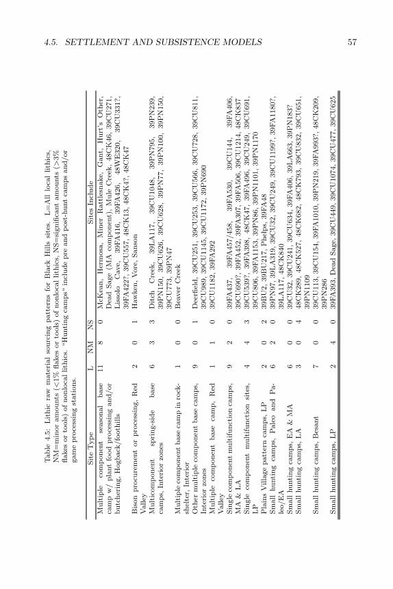
4.5. SETTLEMENT AND SUBSISTENCE MODELS 57T
ab
le4.5
:L
ith
icra
wm
ate
rial
sou
rcin
gp
att
ern
sfo
rB
lack
Hills
site
s.L
=A
lllo
cal
lith
ics,
NM
=m
inor
am
ou
nts
(<1%
flakes
or
tools
)of
non
loca
llith
ics,
NS
=si
gn
ifica
nt
am
ou
nts
(>3%
flakes
or
tools
)of
non
loca
llith
ics.
“H
unti
ng
cam
ps“
incl
ud
ep
rean
dp
ost
-hu
nt
cam
ps
an
d/or
gam
ep
roce
ssin
gst
ati
on
s.
Sit
eT
yp
eL
NM
NS
Sit
esIn
clu
de
Mu
ltip
leco
mp
on
ent
seaso
nal
base
cam
pw
/p
lant
food
pro
cess
ing
an
d/or
bu
tch
erin
g,
Hogb
ack
/fo
oth
ills
11
80
McK
ean
,H
erm
osa
,M
iner
Ratt
lesn
ake,
Gant,
Hu
rt’s
Oth
er,
Dea
dS
age
(MA
com
ponen
t),
Mu
leC
reek
,48C
K46,
39C
U271,
Lis
solo
Cave,
39FA
416,
39FA
426,
48W
E320,
39C
U331?,
39FA
422?,
39C
U557,
48C
K13,
48C
K4?,
48C
K47
Bis
on
pro
cure
men
tor
pro
cess
ing,
Red
Valley
20
1H
aw
ken
,V
ore
,S
an
son
Mu
ltic
om
pon
ent
spri
ng-s
ide
base
cam
ps,
Inte
rior
zon
es6
33
Dit
chC
reek
,39L
A117,
39C
U1048,
39P
N795,
39P
N239,
39P
N150,
39C
U626,
39C
U628,
39P
N77,
39P
N100,
39P
N150,
39C
U773,
39P
N47
Mu
ltip
leco
mp
on
ent
base
cam
pin
rock
-sh
elte
r,In
teri
or
10
0B
eaver
Cre
ek
Oth
erm
ult
iple
com
pon
ent
base
cam
ps,
Inte
rior
zon
es9
01
Dee
rfiel
d,
39C
U251,
39C
U253,
39C
U566,
39C
U728,
39C
U811,
39C
U989,
39C
U1145,
39C
U1172,
39P
N690
Mu
ltip
leco
mp
on
ent
base
cam
p,
Red
Vall
ey1
10
39C
U1182,
39FA
292
Sin
gle
com
pon
ent
mu
ltif
un
ctio
nca
mp
s,M
A&
LA
92
039FA
437,
39FA
457/458,
39FA
530,
39C
U144,
39FA
406,
39C
U690?,
39FA
452,
39FA
307,
39FA
506,
39C
U1214,
48C
K837
Sin
gle
com
pon
ent
mu
ltif
un
ctio
nsi
tes,
LP
44
339C
U539?,
39FA
398,
48C
K47,
39FA
496,
39C
U249,
39C
U691,
39C
U806,
39FA
1153,
39P
N86,
39P
N1101,
39P
N1170
Pla
ins
Villa
ge
patt
ern
cam
ps,
LP
20
239B
U2,
39B
U217,
Ph
elp
s,39FA
48
Sm
all
hu
nti
ng
cam
ps,
Pale
oan
dP
a-
leo/E
A6
20
39P
N97,
39L
A319,
39C
U32,
39C
U249,
39C
U1199?,
39FA
1180?,
39L
A117,
48C
K840
Sm
all
hu
nti
ng
cam
ps,
EA
&M
A6
00
39C
U32,
39C
U241,
39C
U634,
39FA
406,
39L
A663,
39P
N183?
Sm
all
hu
nti
ng
cam
ps,
LA
30
448C
K289,
48C
K527,
48C
K682,
48C
K793,
39C
U832,
39C
U651,
39P
N1109
Sm
all
hu
nti
ng
cam
ps,
Bes
ant
70
039C
U113,
39C
U154,
39FA
1010,
39P
N219,
39FA
993?,
48C
K209,
39P
N286
Sm
all
hu
nti
ng
cam
ps,
LP
24
039FA
393,
Dea
dS
age,
39C
U449,
39C
U1074,
39C
U477,
39C
U625

58 CHAPTER 4. RESEARCH ORIENTATION
4.5.3 Plains-Based Seasonal Use
Taken as a whole, Tratebas’s research suggests a third settlement and subsis-tence model for the Black Hills. This can be termed the Plains-Based SeasonalUse model. According to this model, none of the groups occupying the BlackHills was based solely in the mountains or plains. Instead, seasonal use of bothareas is indicated for all of Black Hills prehistory, although the interior BlackHills were used more intensively during the Middle Archaic. Middle Archaicsites suggest a highly structured, scheduled (cf. Binford 1982) seasonal round.At other times, settlement patterns emphasized more use of the open plainsand a more irregular and flexible seasonal round. A complete definition of theseasonal round of each period would require data from outside the Black Hillsand was beyond the scope of Tratebas’s study.
The basic patterns of site types and distributions defined by Tratebas (1986)have generally been confirmed by later archaeological investigations in the BlackHills (SARC files). Later work has led to the recognition of rockshelter habi-tations in the interior and Hogback zones as a typical Late Archaic site type(Noisat 1990); however, these sites do not contradict the pattern of small, short-term winter hunting camps defined in Tratebas’s model. The Early Archaicperiod is better known now, due to limited excavation of the Beaver Creekrockshelter (L. Alex 1991; Martin et al. 1993) and the discovery of several otherEarly Archaic sites in the interior Black Hills. Data from the Early Archaic stillare not adequate to more accurately define settlement patterns for the periodusing this model.
Tratebas asserts that the Black Hills area lacks base camps, as defined byBinford (1980). Instead, Black Hills residences fall somewhere between res-idential base camps and field camps as defined by Binford (Tratebas 1986).Residences in the Black Hills may be of comparable duration to Binford’s fieldcamps, but may have housed the entire social group, rather than special activ-ity task forces. Other residence sites in the Black Hills were occupied by taskgroups, especially for hunting and meat processing. According to Tratebas, thelack of true base camps in the Black Hills may extend to the NorthwesternPlains in general.
Tratebas’s interpretation of Black Hills residential sites as primarily short-term occupations is the basis for her assertion that no mountain-based settle-ment patterns existed in the area. This fits well both with task-specific models,like Tratebas’, and with the refuge model. These models view mountainous ar-eas as resource poor, marginal environments. According to this view, the BlackHills environment does not have the potential to support human populations ona long-term basis. Instead, human occupation would have been based in grass-lands areas where resource potential was most concentrated. This view hasrecently been reiterated specifically in reference to the Black Hills by Lippincott(1990):
The Black Hills are often viewed as a cool, elevated and forestedrefugium or sanctuary from the hot dry grasslands. In reality they
4.5. SETTLEMENT AND SUBSISTENCE MODELS 59
are more like other forested areas where biotic diversity, energy cap-ture and net production are much less than in grassland commu-nities. Coniferous forest soils decay very slowly and are able tosupport relatively few, large herbivorous vertebrates. Contrastingly,grassland soils contain large amounts of humus and can be amaz-ingly productive. Also of importance is the characteristic of largegrassland herbivores to be prolific and gregarious. Therefore currentconsiderations on the overall importance of the Black Hills shouldbe from a perspective of a temporary or specialized nature.
Archaeological data do not consistently fit the predictions of the Plains-Based Seasonal Use model. The model predicts the presence of seasonal basecamps with significant amounts of nonlocal lithic material. Tools should besimilar to types found in the surrounding areas. The complete seasonal roundshould not be present in the Black Hills, as the uplift would have been usedonly part of the year. Fall-winter-spring occupation of the foothills, Hogback,and Red Valley is one reasonable scenario. Plains-based groups seeking foodand shelter could have followed bison herds into the Red Valley during the falland returned to the high plains with warmer weather.
Fewer than half (18/45) of the reused base camps in the Hogback, foothillsand interior Black Hills contain any nonlocal lithics, and only 6 (5 Interiorand 1 Red Valley) contain significant proportions of nonlocal lithic material(Table 4.5). While typical northwestern plains projectile point types are foundin components representing all periods of Black Hills prehistory, more divergentlocal types also occur in the Plano, Early Archaic, and Late Archaic periods.Evidence for plant food processing at the peripheral base camps suggests alate summer to fall occupation; however, with the exception of Mule CreekRockshelter, these have strongly local lithic raw material assemblages. It isdifficult to account for the near total lack of tools made from nonlocal materials,if these sites were indeed used on a regular basis by plains-based groups. The twoprobable Archaic winter camps thus far identified (George Hey and 39FA426)also contain only local lithics. These sites contained living floors that mayindicate pit house structures, although neither postmolds nor distinct pit profileswere detected in the limited investigations at the two sites.
The discovery of postmold features at two Late Paleoindian and/or EarlyArchaic sites (Victoria Creek and Trail Draw) may also indicate construction ofwinter shelters in the interior Black Hills (Vallejo 1993; Tratebas and Vagstad1979). A pit house feature at the Middle Archaic McKean site, a circular livingfloor at the Early or Middle Archaic 39FA426, and a postmold feature in a Be-sant component at 48CK209 suggest possible construction of winter shelters inthe western foothills and southern Hogback during these periods. Unfortunately,excavation techniques at these sites were not adequate to clarify the functionand seasonality of these structures. In general, archaeological field methodsused in the Black Hills have not been adequate to detect pit house features.Only local lithics are reported from the sites with possible pit house features.
60 CHAPTER 4. RESEARCH ORIENTATION
By contrast, a hypothesized Late Prehistoric winter camp, 39CU806, con-tained local debitage, but had a projectile point made of Knife River Flint (Rom1987; author’s analysis of lithics at SARC). The latter site contained stone cir-cle features, rather than more substantial structural remains. Site 39FA392,an early Late Prehistoric winter camp, may provide a pattern intermediate be-tween the Late Prehistoric tipis and the Archaic pit houses. This site containedthe remains of an intensively used circular structure (tipi or wickiup) whichhad been placed over a dish-shaped depression dug into the sandstone bedrock(Tratebas 1979b). The latter site contained some hearth burials and artifactssimilar to two other early Late Prehistoric sites in the Black Hills, 39FA71 and39FA30 (SARC files reported in Tratebas 1979b; Wheeler 1957). No nonlocallithics were reported for 39FA392; however, it is possible that nonlocal materi-als, such as Knife River Flint, were included in the chalcedony which comprised10% of the surface collection and 2% of the subsurface material. The inclusionof bone awls (at 39FA392 and 39FA71) and pottery (at 39FA30) with burials isstrikingly similar to Plains Village burial customs.
To summarize, both the reused seasonal base camps and the probable win-ter camps have a strongly local “look“ until Late Prehistoric times. It is pos-sible that some of the single component multifunction camps and some of thesmall pre- and post-hunt camps represent winter occupations of dispersed familygroups. With few exceptions, however, these also have strongly local lithic rawmaterial assemblages. The exceptions are the undated short-term base camp39CU539 and the four Pelican Lake hunting camps in the Bearlodge. Anotherpossibility is that selection of sites for testing and excavation is biased toward themore intensive occupation remains of locally based groups. The more ephemeralremains of temporary use by plains-based groups may have not attracted moreintensive archaeological work. The greater prevalence of nonlocal lithic materialsin surface collections than in excavated components lends considerable supportto this possibility. On the other hand, the surface collections are more likely todate to the Late Prehistoric and Protohistoric and thus may accurately reflecta pattern of use of nonlocal lithics that was largely confined to those periods.In any case, an exclusively plains-based settlement system is not indicated forany period, including the Late Prehistoric.
4.5.4 Combined Mountain Archaic and Plains-Based Sea-sonal Use
Other researchers have questioned Tratebas’s interpretation of these pat-terns as indicating only plains-oriented settlement systems. The fourth set-tlement pattern model proposed for the Black Hills recognizes both mountain-and plains-based settlement patterns (Sundstrom 1989, 1993). This recognizes aMountain Archaic pattern in addition to the previously recognized Plains-BasedSeasonal Use pattern. These may have coexisted during some or all of area pre-history. Another version of this combined settlement pattern model recognizesa shift from plains- to mountain-based settlement patterns in the Black Hillsduring the Middle Archaic period (Noisat et al. 1991). In other words, the two
4.5. SETTLEMENT AND SUBSISTENCE MODELS 61
patterns occur sequentially, but not contemporaneously. The main differencebetween Tratebas’s model and the later two models is that Noisat (et al. 1991)and Sundstrom (1989, 1993) recognize localized upland settlement patterns, asopposed to only plains-based settlement patterns.
Sundstrom (1989, 1993) proposes that settlement distributions in the BlackHills resulted from the operation of two distinct economic patterns. One isthe plains-oriented bison hunting pattern recognized by Tratebas and other re-searchers following Frison’ s (1991) model for the Northwestern Plains. (Itshould be noted, however, that Frison [1991] recognizes the existence of as yetundefined mountain-foothills adaptive patterns in uplands areas throughout theNorthwestern Plains.) According this combined pattern model, groups adheringto the Plains-Based Sporadic Use settlement pattern spent most of their time inopen plains areas in a largely unscheduled, nomadic seasonal round, followingthe bison herds and entering the outer Black Hills only for occasional winterhabitation and gathering of wood and lithic raw material. Use of the interioruplift was even more restricted and sporadic.
Groups adhering to the Mountain Archaic or Mountain Tradition settlementpattern are hypothesized to have spent the entire seasonal round in the BlackHills, moving from the peripheral zones into the interior as spring snow meltand availability of plant and game resources permitted. These groups essen-tially followed the ripening berries and other edible plants up into the higherelevations, returning to the more sheltered Hogback, Red Valley, and foothillsin the late fall. Deer, pronghorn, mountain sheep, rabbit, and other small ani-mals, along with plant foods such as chokecherry, pricklypear, and possibly segolily and other roots, formed the subsistence base. This was a regularized orscheduled (cf. Binford 1982) subsistence pattern, with groups returning to siteson a periodic, seasonal basis to exploit particular resources. Ecotone areas suchas the exterior Hogback and high elevation meadows and prairies or “balds“were favored for periodically reoccupied, warm season base camps with nearbyspecial activity sites.
This broad-spectrum mountain-based settlement pattern blossomed duringthe Middle and Late Archaic; however, it was not restricted to these periods.The term Mountain Archaic is intended to connote an “archaic“ pattern of adap-tation (i.e. scheduled, broad-spectrum foraging), not “Archaic“ in the temporalsense. Sundstrom (1989, 1993a) recognizes late Paleoindian and Early Archaicprecedents for the Mountain Archaic pattern at sites such as Ray Long andBeaver Creek. This suggests coexistence of mountain- and plains-based settle-ment patterns for most, if not all, of Black Hills prehistory. The hypothesizeddual settlement patterns would place some of the winter habitations of bothgroups in the Hogback and foothills zone; these sites may be distinguishable bytheir greater or lesser amounts of nonlocal lithic material. The model furtherpredicts that special activity sites, such as lithic quarries and shaft productionstations, with significant amounts of nonlocal lithic materials or nonlocal lithicreduction technologies should occur at resource rich areas throughout the BlackHills. The mountain-oriented pattern should be expressed archaeologically asa series of large, reoccupied residential base camps in resource rich areas, with

62 CHAPTER 4. RESEARCH ORIENTATION
smaller special activity sites associated. These should contain local lithics andreduction sequences (cf. Keyser and Fagan 1987). Subsistence remains at themountain-oriented sites should reflect a broad array of resources, with little orno bison.
No systematic attempt has been made to test Sundstrom’s model. Studiesof site patterning in the central Rockies support Sundstrom’s proposed broad-spectrum mountain-based settlement pattern model (Bender and Wright 1988;Black 1991). In these areas, as well as the Bighorns and Montana Rockies, amountain-based settlement pattern is now recognized. This has variously beentermed the Mountain Tradition by (Black 1991), the Mountain Branch (Husted1969), Mountain Complex (Grady 1971), and Montane Tradition (Wheeler andMartin 1984). Bender and Wright (1988) note that occupation of mountainousenvironments in Colorado, Wyoming, and Montana was continuous from latePaleoindian through Late Prehistoric times. The stable levels of occupationin uplands even during the Altithermal climatic period suggest to Bender andWright a highly resilient and successful form of adaptation. This adaptationwas based on scheduled seasonal exploitation of a wide variety of resources.These authors argue that a broad spectrum strategy is the most resilient formof adaptation in the face of environmental perturbations such as the droughtcycles of the Northwestern Plains.
Site patterning in the interior Black Hills matches that predicted for theMountain Tradition, derived from studies in the central Rockies (Bender andWright 1988; Black 1991). Bender and Wright (1988) interpret the pattern oflarge, periodically reoccupied base camps, surrounded by smaller satellite activ-ity areas and camps, as indicative of a scheduled, broad-spectrum subsistencepattern based on seasonal movements between higher and lower elevations. Theyspecifically reject the refuge model and task-specific models like that proposedby Tratebas (1986) for this pattern of site distribution. Black (1991) essentiallyagrees with Bender and Wright, but notes the spatial overlap of mountain- andplains-based settlement patterns in foothills areas in the central Rockies.
Although these two studies tend to support Sundstrom’s model, the BlackHills are different from the central Rockies. The studies cannot be applied tothe Black Hills uncritically. Elevational differences are less pronounced in theBlack Hills than in the Rocky Mountains proper. Snowpack is more limitedin extent in the Black Hills, with many interior areas remaining open to travelyear-round. Plains-based groups could easily penetrate to the core of the BlackHills, while a similar trek in the Rockies would involve much greater distancesand difficulty. More research is needed before Sundstrom’s model can be eitherconfirmed or revised to more accurately reflect the Black Hills situation.
This model predicts the development of divergent, localized tool types andlocalized raw material assemblages. Multiple function base camps should occurat both high and low elevations. Both warm and cold season base camps orresidential camps should be present in the Black Hills, reflecting seasonal move-ment. Base camps should be located to maximize access to water, wood, terrainsuitable for camping, and access to resource patches. These sites are expectedto exhibit evidence of multiple episodes of use, with site function remaining sta-
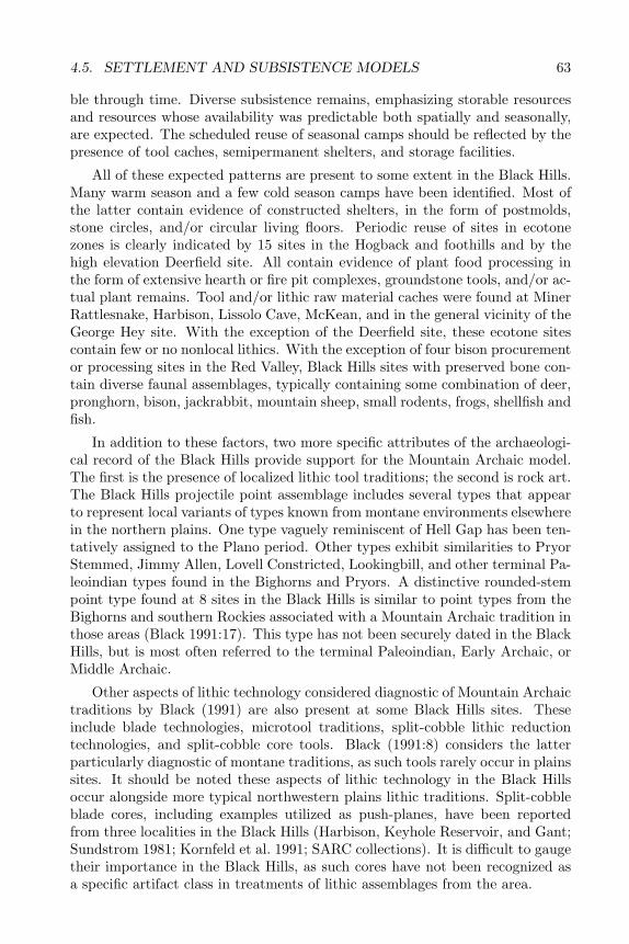
4.5. SETTLEMENT AND SUBSISTENCE MODELS 63
ble through time. Diverse subsistence remains, emphasizing storable resourcesand resources whose availability was predictable both spatially and seasonally,are expected. The scheduled reuse of seasonal camps should be reflected by thepresence of tool caches, semipermanent shelters, and storage facilities.
All of these expected patterns are present to some extent in the Black Hills.Many warm season and a few cold season camps have been identified. Most ofthe latter contain evidence of constructed shelters, in the form of postmolds,stone circles, and/or circular living floors. Periodic reuse of sites in ecotonezones is clearly indicated by 15 sites in the Hogback and foothills and by thehigh elevation Deerfield site. All contain evidence of plant food processing inthe form of extensive hearth or fire pit complexes, groundstone tools, and/or ac-tual plant remains. Tool and/or lithic raw material caches were found at MinerRattlesnake, Harbison, Lissolo Cave, McKean, and in the general vicinity of theGeorge Hey site. With the exception of the Deerfield site, these ecotone sitescontain few or no nonlocal lithics. With the exception of four bison procurementor processing sites in the Red Valley, Black Hills sites with preserved bone con-tain diverse faunal assemblages, typically containing some combination of deer,pronghorn, bison, jackrabbit, mountain sheep, small rodents, frogs, shellfish andfish.
In addition to these factors, two more specific attributes of the archaeologi-cal record of the Black Hills provide support for the Mountain Archaic model.The first is the presence of localized lithic tool traditions; the second is rock art.The Black Hills projectile point assemblage includes several types that appearto represent local variants of types known from montane environments elsewherein the northern plains. One type vaguely reminiscent of Hell Gap has been ten-tatively assigned to the Plano period. Other types exhibit similarities to PryorStemmed, Jimmy Allen, Lovell Constricted, Lookingbill, and other terminal Pa-leoindian types found in the Bighorns and Pryors. A distinctive rounded-stempoint type found at 8 sites in the Black Hills is similar to point types from theBighorns and southern Rockies associated with a Mountain Archaic tradition inthose areas (Black 1991:17). This type has not been securely dated in the BlackHills, but is most often referred to the terminal Paleoindian, Early Archaic, orMiddle Archaic.
Other aspects of lithic technology considered diagnostic of Mountain Archaictraditions by Black (1991) are also present at some Black Hills sites. Theseinclude blade technologies, microtool traditions, split-cobble lithic reductiontechnologies, and split-cobble core tools. Black (1991:8) considers the latterparticularly diagnostic of montane traditions, as such tools rarely occur in plainssites. It should be noted these aspects of lithic technology in the Black Hillsoccur alongside more typical northwestern plains lithic traditions. Split-cobbleblade cores, including examples utilized as push-planes, have been reportedfrom three localities in the Black Hills (Harbison, Keyhole Reservoir, and Gant;Sundstrom 1981; Kornfeld et al. 1991; SARC collections). It is difficult to gaugetheir importance in the Black Hills, as such cores have not been recognized asa specific artifact class in treatments of lithic assemblages from the area.
64 CHAPTER 4. RESEARCH ORIENTATION
Another defining characteristic of the Mountain Archaic tradition is the pres-ence of rock art with stylistic links to Great Basin styles. Pecked Realistic rockart in the Black Hills shows clear associations with the general western or GreatBasin rock art tradition. This style of rock art in the Black Hills can be securelydated to the Archaic era on the basis of subject matter (atlatls) and its strati-graphic, geomorphic, and physical contexts (Sundstrom 1990). It may extendback into the Paleoindian period, as well, if AMS radiocarbon dates on micro-scopic organic matter sealed under patinas covering rock art can be consideredreliable (Tratebas 1992). The rock art depicts capture of deer, mountain sheep,and pronghorn using nets or other artificial enclosures. Just such a hunting netwas recovered from a Mountain Tradition site in the Absorokas and dated 8860BP (Frison et al. 1986). The latter site was considered typical of Mountain Tra-dition sites in its apparent links to Desert Archaic materials occurring fartherwest (Black 1991:17).
While these factors present a strong argument for including the Black Hillsin Black’s Mountain Tradition, not all Black Hills sites seem to fit the pattern.Many Late Prehistoric and some Paleoindian sites in the Black Hills containnonlocal lithic material and look more like high plains sites than MountainArchaic sites. During the long span of the Archaic and the latter portion of thePlano period, however, a Mountain Archaic tradition seems to have been firmlyentrenched in the Black Hills.
The final settlement pattern model proposed for the Black Hills refers specif-ically to the Middle Archaic period (Noisat et al. 1991) and is a variant of theCombined Plains-Based Seasonal Use and Mountain Archaic model. This modelhypothesizes a shift in settlement pattern during this period. During the earlyMiddle Archaic, a “pulsatory“ settlement pattern (cf. Butzer 1982) held sway.This is essentially the same as Tratebas’s plains-based settlement pattern. Ter-ritories were very large, with seasonal base camps concentrated in open plainsareas. Human use of the interior was largely limited to short-term huntingforays. During the late Middle Archaic period, this shifted to an “oscillatory“settlement pattern. This would have resulted in a less uniform site distribution,with large base camps and associated satellite resource extraction camps con-centrated at stable resource bases in both the uplands and lowlands. Interveningareas were only minimally exploited and should contain few or no sites. This isessentially the pattern recognized in Sundstrom’s mountain-oriented settlementpattern model.
Whether the mountain-based settlement pattern in the Black Hills reflects aMountain Archaic Tradition continuing from Paleoindian through Archaic times(Sundstrom 1989, 1993a), or was a short-term development restricted to thelate Middle Archaic period (Noisat et al. 1991), or did not exist at all (Tratebas1986) is a question that demands further study. All three of these models followthe earlier refuge model in attributing shifts in settlement patterns to climaticfactors. The near total lack of paleoenvironmental data from the Black Hillsmakes this aspect of the three models difficult to assess. All that can be saidat this point is that the intensification of use of upland territories in the MiddleArchaic period apparently corresponds not with dry conditions, as the refuge
4.6. LITHIC RAW MATERIAL STUDIES 65
model predictes, but with a return to less extreme climatic conditions.
4.6 Lithic Raw Material Studies
Few clear patterns emerge from a consideration of the use of local versusnonlocal lithic raw materials in the Black Hills. A recent study (Andrefsky1994) suggests that lithic sourcing studies may yield different results in areasin which a wide variety of lithic types is available locally. In such areas, bothexpedient and patterned tools may be made of local materials. Few sites in theBlack Hills contain more than a handful of exotic lithics. Amounts of nonlocalmaterials in excess of 3% in either debitage or tool assemblages are consideredsignificant here.
The vast majority of sites thus far investigated in the Black Hills contain onlylocal materials (Table 4.5). In addition to this strong local bias, two problemsinherent in the available data make any conclusions tentative. First, lithic typeswere not well defined at the time most of the data were compiled. Researchersnoted the difficulty of separating Knife River Flint from similar chalcedoniesfrom the Flattop quarries in Colorado and from outcrops in the White RiverBadlands. The distribution of purple to brown chalcedonies is now known tobe quite wide-spread (Hoard et al. 1993); outcrops of such material are now re-ported from Wind Cave National Park in the southern Black Hills (SARC files).The term Spanish Diggings has most often been used to describe quartzites andcherts from the Hartville Uplift in southeastern Wyoming (cf. Reher and Fri-son 1980), but at least one researcher also included local Black Hills materialsin this category (Tratebas and Vagstad 1978). Identical dendritic and mottledcherts occur in the Black Hills proper. Many comparative collections of BlackHills materials are incomplete and thus do not recognize the variability of lo-cal types. For example, quartzite quarries can be found in several areas of thesouthern Hogback, with types ranging from coarse, poorly cemented types tofine-grained, highly siliceous materials. Hogback quartzites range from whites,tans, pinks, grays, and lavenders to dark brown, maroon, purple, and gold.Mottled and banded types occur locally as well. Lithic procurement sites in theBearlodge Mountains have only recently been discovered and described (Church1990; Buechler and Malone 1987).
In this study, types defined as nonlocal include obsidian, porcellanite (Por-cellanite 1 and 2), Badlands plate chalcedony (Silicate 3 subset), and Knife RiverFlint (Silicate 9). No obsidian was found at the Blaine site; however, the otherthree types do occur. Figure 4.2 shows the nearest source locations for thesematerials. The nearest source for obsidian is the Yellowstone area of north-western Wyoming and eastern Idaho. Porcellanite occurs in the Powder RiverBasin, just west of the Black Hills. Plate chalcedony outcrops throughout theWhite River Badlands just east of the Black Hills. Tan to brown chalcedonies,variously referred to as Flattop or Scenic chalcedony, outcrop widely in WhiteRiver Group formations and can be found in eastern Colorado, northwesternNebraska, and southwestern South Dakota (Hoard et al 1993). These are not
66 CHAPTER 4. RESEARCH ORIENTATION
Figure 4.2. Location of lithic raw material sources.
readily distinguishable from chalcedonies outcropping locally in the Black Hills.Knife River Flint was obtained from quarries on the upper Missouri in NorthDakota. Spanish Diggings cherts are also noted, but cannot confidently be clas-sified as nonlocal due to the presence of nearly identical materials in the PahaSapa formation in the Black Hills proper (Church 1987:10; Church 1988:5). Themain Spanish Diggings (Silicate 10) quarry sites are located in the Hartville up-lift immediately southeast of the Black Hills proper. Given the relatively poorquality of the data, a detailed statistical treatment of lithic source patterningin the Black Hills is not justified. Instead, general patterns will be discussedwithin the context of the hypotheses presented in Table 4.4.
No clear lithic source patterning marks the bison procurement sites in theRed Valley. The Late Prehistoric Vore buffalo trap in the northern Red Valleyhas by far the greatest amount of nonlocal lithics of any Black Hills site. It con-tained 66.5% Spanish Diggings materials, 10.5% porcellanite, 6.4% Knife River
4.6. LITHIC RAW MATERIAL STUDIES 67
Flint, 3.9% dendritic chalcedony (of unknown source), and only 6.6% Hogbackquartzite (Reher and Frison 1980). Even allowing for some misidentification oflocal materials as Spanish Diggings, the high percentages of nonlocal materialare striking. By contrast, the nearby Hawken site, an Early Archaic bison trapand butchering site contained only local lithics (Frison et al. 1976; Frison 1991).A small sample of lithics from the Late Prehistoric Sanson Buffalo Jump in thesouthern Red Valley also contained only local materials (Agenbroad 1988).
Periodically reused seasonal base camps in the Hogback and foothills zoneshave strongly local lithic components. These are the large fire pit or hearthcomplexes that dot the peripheries of the Black Hills, as well as two small tipiring camps in the eastern foothills. Each contains two or more components dat-ing between Plano and Late Prehistoric times. Of 18 sites, 12 contained onlylocal lithics, while the remaining 6 contained very minor amounts of nonlocalmaterials. The 146 tools at 39FA422 in the southern Hogback included three ofnonlocal material: a small, shallowly side-notched projectile point and a scraperof Knife River Flint and a knife of Badlands plate chalcedony. The remainingtools and debitage were local (Haug et al. 1980). Site 39CU331, a Middle Ar-chaic base camp in the eastern Black Hills, contained a single obsidian flake(Noisat 1992). This site may contain additional components not discovered inthe limited testing. The Middle Archaic Gant site in the northeastern foothillscontained one drill fragment of Knife River Flint (Gant and Hurt 1965). Themixed Plano through Late Prehistoric assemblage from 39FA416 in the southernHogback contained three tools of nonlocal material out of an assemblage of 234tools. These were pointed bifaces of a possibly nonlocal black chert and KnifeRiver Flint, and a Badlands knife. Less than 1% of the debitage was porcellan-ite; the remainder was local (Haug et al. 1980). Of 128 tools at 48WE320 inthe western foothills, only a porcellanite Late Prehistoric projectile point and aKRF scraper can be counted as nonlocal. The 2516 pieces of debitage included2 porcellanite and 3 KRF flakes (McKibbin 1988). The small amount of porcel-lanite is striking, given the location of the site at the eastern edge of the PowderRiver Basin. A stronger western component was evident at the Mule Creek site,in the western foothills. There small amounts of porcellanite and obsidian werepresent throughout the Middle Archaic through Late Prehistoric components(Wheeler 1957).
Interestingly, multicomponent base camps in the interior Black Hills have asomewhat stronger nonlocal signal than those in the peripheral zones. Of 23 suchsites, 16 contained only local lithics. Three other sites contained insignificantamounts of nonlocal material.
Four of the interior base camps contained significant amounts of nonlocal ma-terial. The debitage assemblage at 39LA117 contained 4% porcellanite, whilethe tools included 8% porcellanite and 2% plate chalcedony. In addition, 41% ofthe debitage and 8% of the tools from 39LA117 were of chalcedony (Sundstromet al. 1994). While this was considered a local material, it is possible that someKRF or Scenic/Flattop chalcedony was included in the category. The debitageassemblage from Deerfield contained 1% porcellanite and smaller amounts ofobsidian, NVN glass, and KRF; however, 7.9% of the utilized flakes and 9.2%
68 CHAPTER 4. RESEARCH ORIENTATION
of shaped tools were made of nonlocal materials (Buechler 1984). The tool as-semblage from 39PN77 contained a single KRF scraper, comprising 3.8% of thetools at the site (Tratebas and Vagstad 1979). No figures are available for deb-itage lithic raw material types at Ditch Creek; however, KRF and porcellanitewere present. About 5% of the shaped tools and retouched flakes were made ofKRF; no porcellanite tools were reported (Tratebas and Vagstad 1979).
Six spring-side sites and the Beaver Creek rockshelter contained only lo-cal lithics. The remaining three spring-side base camps contained very minoramounts of nonlocal lithics. A multiple component base camp in the Red Valley,39FA292, contained only local material (Weston 1983). A second possible RedValley base camp, 39CU1182, had a single tool of Badlands plate chalcedony inits artifact assemblage (Wolf and Miller 1992a).
Single component multiple use camps (base camps or more temporary res-idential camps) dating to the Middle and Late Archaic contain localized lithicassemblages. Nine of 11 sites in the Black Hills sites fitting this descriptioncontain only local lithic material. Site 48CK837 contained several blade coresof NVN glass (Kornfeld et al. 1991). Site 39CU1214 contained small amountsof obsidian and porcellanite debitage (Wolf and Miller 1992b).
By contrast, nearly two-thirds of the 11 single component multiple use campsdating to the Late Prehistoric contain nonlocal lithics. Four sites contained onlyminor amounts of nonlocal materials; three had significant amounts; and fourcontained only local lithics. Plains Village pattern sites dating to the LatePrehistoric also contained fairly high amounts of nonlocal lithics. Two of foursites in this category contained significant amounts of nonlocal lithics, includingporcellanite, KRF, Badlands plate chalcedony, and obsidian.
The small Late Prehistoric pre- and post-hunt camps and game processingstations contain slightly more localized lithic assemblages. Two sites, 39CU449and 39CU1074, contained only local materials. Four other sites contained verysmall amounts of nonlocal lithics. Small hunting camps of probable Besantaffiliation suggest even greater localization. None of the seven sites in thiscategory contained any nonlocal lithic material. The three Pelican Lake-erasmall hunting camps identified in the Black Hills proper had only local material;however, four Pelican Lake hunting camps in the western Bearlodge mountainscontained significant amounts of porcellanite and obsidian. Of eight Paleoindianor Early Archaic hunting camps in the Black Hills, two contained minor amountsof nonlocal lithics.
The overall trend in the Black Hills data is toward highly localized rawmaterial assemblages. This is not surprising given the wide availability andvariety of local stone. These same factors also make the nonlocal lithics ofparticular interest. Since it was not necessary to import lithic raw material intothe Black Hills, such materials can be taken as reliable indicators of movementsof people, despite the low amounts of nonlocal materials involved. Several sitesappear to confirm the hypothesized occasional use of the Black Hills by groupscentered in the Powder River basin to the west. These include the four early LateArchaic hunting camps in the Bearlodge mountains, 39LA117, and 39FA496.More regular use of the Black Hills by groups from the west is suggested by
4.6. LITHIC RAW MATERIAL STUDIES 69
the lithic assemblages from the Mule Creek, Deerfield, and Vore sites. Vorein particular seems to represent the wholesale import of both lithic materialsand bison hunting and butchering techniques from the high plains west andsouthwest of the Black Hills. Deerfield and Mule Creek, by contrast, appear torepresent seasonal base camps at which a variety of activities, including plantfood processing and storage, took place.
A different pattern is seen in the distribution of KRF and Badlands platechalcedony. Site 39FA422 in the southern Hogback contained a small, shal-lowly side-notched projectile point of KRF, as well as a KRF scraper and aBadlands knife. Such shallowly side-notched points have not been securelydated. Their stratigraphic context at the Ditch Creek site suggests that theydate to the Middle Archaic or Middle/Late Archaic transition. At Ditch Creekas at 39FA422 these points were associated with KRF debitage. Another ofthese points, made of KRF-like material, was found at 48CK46 in the westernfoothills (Wheeler 1957). Another KRF side-notched point was recovered fromthe Deerfield site; however, the exact morphology of this point is not clear fromthe report. Site 39FA416 in the southern Hogback contained another of theshallowly side-notched KRF points and a Badlands knife. An undated singlecomponent camp in the eastern Red Valley, 39CU539, contained a projectilepoint midsection of a dark chalcedony, which was identified as KRF or Scenicchalcedony. Half of all debitage at the site was comprised of the brown to blackchalcedony; a single obsidian decortication flake was also found.
If these data are representative, occasional or seasonal use of the Black Hillsby groups from the Middle Missouri area may have started as early as the Mid-dle/Late Archaic transition. Badlands plate chalcedony is occasionally includedin Plano, Middle Archaic, and Late Prehistoric components; however, the clear-est age association for the Badlands and KRF material is initial Late Archaic.Both types tend to occur as finished tools, rather than debitage, strongly sug-gesting seasonal movement into the Black Hills from the Middle Missouri area.As these seasonal huntng groups reached the Black Hills they discarded theirexpended tools and presumably replaced them using locally available raw ma-terial.
A more complete exploration of this possible early Middle Missouri use ofthe Black Hills awaits more secure dating of the shallowly side-notched pointstyle. The apparent correlations between early Late Archaic short-term camps,shallowly side-notched points, and Badlands plate chalcedony and KRF begadditional research.
These observations generally agree with patterns suggested by Tratebas’sprincipal components analysis of surface assemblages from the Black Hills. Inthe latter study, Late Archaic sites were correlated with use of Badlands chal-cedonies (Tratebas 1986), an association also seen in the assemblages currentlybeing studied. An association between Late Prehistoric occupation and use ofporcellanite and obsidian is also indicated by both studies.
The major point of disagreement between this and Tratebas’s study is inMiddle Archaic lithic source patterning. Tratebas suggested that Middle Ar-chaic sites were characterized by use of porcellanite, KRF, and Badlands chal-
70 CHAPTER 4. RESEARCH ORIENTATION
cedony. The present study, by contrast, generally associated porcellanite withLate Prehistoric components and KRF and Badlands with Late Archaic compo-nents. While about half of the multicomponent spring-side sites contained somenonlocal material, none of the single component Middle Archaic sites containednonlocal lithics. There are two possible explanations for this discrepancy. Thefirst is that the inclusion of mixed component surface assemblages in the prin-cipal components analysis influenced its results (Tratebas 1986). The secondis that some periods of prehistory are characterized by more than one lithicraw material use pattern. Both studies provide some evidence for the latterexplanation. For example, KRF consistently occurs in components containingprobable initial Late Archaic projectile points, but single component Late Ar-chaic base camps and hunting camps lack KRF. The strong pattern of localizedlithic sources suggested by Besant and Pelican Lake hunting camps is broken bythe presence of porcellanite projectile points at four hunting camps in the Bear-lodge and at a high-altitude base camp in the interior Black Hills (39LA117).This suggests that lithic use patterns vary with both site function and culturalaffiliation. The gross temporal divisions may no longer be adequate for studiesof lithic source patterning. At the same time, it is clear that different types ofcontemporaneous sites exhibit differences in lithic source patterning.
4.7 Summary
In all probability, no single mountain-based or plains-based settlement pat-tern can adequately account for the totality of archaeological evidence in theBlack Hills. Evidence for both patterns occurs in the Black Hills in variousplaces and at various times. It should be remembered that Tratebas’ work wasbased on a nonrandom sample of surface collections. Her position that basecamps are not present in the area might have been altered if sites such as Gant,McKean, Deerfield, 39CU330, and 48WE320 were included in the sample. Theseall provide evidence of large, periodically reoccupied multiple activity camps inecotone zones. They generally fit the definition of a base camp as a place whereentire social units gathered on a regular basis.
On the other hand, movement between the high plains of the Powder Rivercountry and the western Black Hills is clearly indicated by lithic raw mate-rial assemblages from both areas. Ethnographic data also support the view ofthe Black Hills as an area used principally for extraction of special resources,rather than as a home base for groups occupying the high plains at the timeof initial contact with non-natives. This information is difficult to evaluate,however, since the wide-spread adoption of horse culture had arguably alreadytransformed protohistoric plains people from hunters and gatherers to a quasi-pastoralists. Horses are not well suited to either mountainous habitats or tobroad-spectrum subsistence systems. The acquisition of horses by some groupsappears to have ultimately permitted to the conquest of nonequestrian groupsand their removal from the Black Hills. The area was then used only as anoccasional resource extraction area by groups following a plains-based economy
4.7. SUMMARY 71
based on horse pastoralism and highly specialized bison hunting.Prehistoric populations based on the plains probably have always used ar-
eas such as foothills, mountain slopes, and wooded stream valleys for wintershelter and acquisition of resources such as wood and lithic raw material. Inaddition, plains communal big-game hunting adaptations have probably alwaysincluded exploitation of a wide variety of plant and animal species as secondaryor seasonal resources. By the same token, mountain-based groups may havemade occasional use of bison as local conditions permitted. For example, thehigh elevations or “balds” in the interior Black Hills probably supported localpopulations of bison, which may have been a major food resource for groupsfollowing a basic Mountain Tradition subsistence pattern. The Deerfield site(Buechler 1984) can be argued to represent just such a mixed pattern.
These factors make it difficult to draw a strict dichotomy between the twobasic settlement patterns. A comprehensive view of settlement and subsistencein the Black Hills will require a consideration of a variety of site attributes,including patterns of lithic raw material distribution, defined tool associations(tool kits), patterns of lithic debitage discard, feature-artifact associations, pat-terns of site reoccupation, direct subsistence data (seeds, bone scrap, etc.), andsite setting in regard to natural resources and other sites. Are sites distributedrandomly across the environment, as is typical of unscheduled, hunting-basedsubsistence systems, or do sites tend to be tied to high-yield resource areas,as is typical of broad-spectrum subsistence strategies based on resource pre-dictability and scheduling? Do sites exhibit evidence of periodic reoccupationor do they represent single-use habitations? What kinds of resource extractionare associated with residential sites? Do the features and tools indicate use ofresources not directly preserved in site deposits? Is there evidence of middens,storage facilities, constructed housing, or other indicators of stable, periodic, orlong-term occupation of a site? Were excavations at sites used for comparativeanalysis adequate to detect such features? (Historically, this has not been thecase in the Black Hills.) These and other issues need to be factored in to ourapproaches to questions about prehistoric use and perceptions of the Black Hillsand other uplands environments.

72 CHAPTER 4. RESEARCH ORIENTATION
Chapter 5
RESULTS
5.1 The Blaine Site Excavations
Table A.2 in the appendix lists the Blaine site excavations, including the1992 testing phase. Two types of excavation were employed: hand excavationand machine excavation. The hand excavations include Block A, Block B, BlockC, the features, the test units, and the shovel tests. The excavation techniquewas shovel skimming. All of the soil from the hand excavations was either dryscreened through 1/4-inch mesh or kept for later flotation and water screen-ing through a 405-micron mesh. A total of 108.6 square meters were handexcavated at the Blaine site. An additional 3955 square meters were exposedthrough grader operations. Backhoe trenches conducted for the geomorphologystudy provided additional subsurface exposure (Figure 5.1). The shovel testspreceded the test units and discovered the presence of buried materials on thesite. These tests were roughly 40 cm diameter, postlike holes taken to a depthof about 50 cm. The 15 shovel tests were dug during the 1992 testing phase.Except for a 1x2-meter excavation that cross-sectioned a cairn (Feature 1) thetest units were 1x1-meter units excavated independently. The tests were gener-ally noncontiguous units spread across the site area, but some of the units wereadjoining. These adjoining units were test expansions, usually following whatappeared to be potential features. Except for a few shallow tests located withinthe surface features (the stone alignments), the test units were taken down tothe first gravel horizon. Some of the units on the north side of the highwaywere taken down to a second, or even third, gravel horizon. Most of the 44test units were excavated in 1993. The block excavations were composed ofcontiguous 1x1-meter units in which the unit levels were dug simultaneously. Arandomized 1.5% soil sample was taken from blocks A and B. The soil sampleswere 25x25-centimeter blocks of soil located within selected units. These sam-ples were later water screened. Block A (5x5 m) was the mitigative excavationof stone alignment surface feature, Feature 2. Block B (5x5 m) was situatedover an area that showed the best potential for unearthing substantial Late Ar-
73
74 CHAPTER 5. RESULTS
chaic remains (Figure 5.2). The placement of Block B was based on materialsrecovered from Test Unit N412E874 and subsequent surrounding tests units.Block C (2x2 m) was a small excavation within the center of the surface stonealignment, Feature 4. The subsurface features consisted of hearths or fire pits.These features were treated as units in and of themselves. They were excavatedin halves, typically a north half and a south half. This technique provided afeature profile in which to expose multiple lenses or layers and feature morphol-ogy. All of the feature fill was saved for later flotation. Individual features aredescribed below. Backhoe Block A was partially excavated by machinery. Thisapproximately 55-meter block was an expedient excavation. The purpose of thisblock was to expose a large area over what was thought to be the oldest cul-tural layer present at the Blaine site. A few test units north of the highway haduncovered cultural remains just below the first gravel horizon. If this horizonwas the stratigraphic equivalent of the first gravel horizon located south of thehighway, cultural materials there would predate Feature 6, radiocarbon datedat 5580 BP. A backhoe was used to remove the overburden above the gravel.The gravel horizon was then removed by hand and the block was leveled off.The hand excavation started at 52 to 54 cm b.s. (elevation 1410.60 to 1410.72)with shovel skimming (Figure 5.3). The excavation was terminated at 56 to64 cm b.s. (elevation 1410.54 to 1410.62). Unlike the other blocks, this blockwas excavated as a single unit and level. All soil was screened, and a single soilsample was taken.
Machine excavations included the geomorph trenches and windows, the strip-ping, and a telephone-trench. Nine trenches and ten windows were excavated forthe geomorphology and soils studies (Figure 5.4). Features 8 and 9 were exposedduring the trenching. The geomorph trenches were 24 in. wide and extended toa depth of at least the first gravel horizon. The geomorph windows were deepbackhoe probes into terrace deposits. A small, T-shaped trench was dug by USWest Communications for replacement of a telephone line pedestal. The trenchwas located approximately at the center of the site area on the north side of thehighway. The digging was monitored, and a single tool was piece-plotted duringthe trenching. The telephone trench was not included in the site grid system.
The site was stripped in order to expose areas not covered by the handexcavations. The main purpose of this was to ensure that features had not beenmissed. When encountered, tools, cores, flake concentrations, and bone werepiece-plotted and collected. There were two stripped areas, designated I andII. Stripped Area I was on the north side of the highway and Stripped Area IIwas on the south side. The stripping was conducted in two phases. In the firstphase a roadgrader, furnished by the Custer County SDDOT shop, stripped offthe O, A, and the Ab soil horizons. This was essentially removing the blacktopsoil and exposing the top of the lighter B horizon soils, a depth of roughly7 to 10 cm. The grader made two passes. The first pass was very shallow,about 5 cm. This effectively removed the sod in order to expose any featuresassociated with the stone alignments and what was thought to be the depth ofthe Late Prehistoric component (Componont A). The second pass removed theremaining Ab horizon in hopes of exposing features associated with the Middle
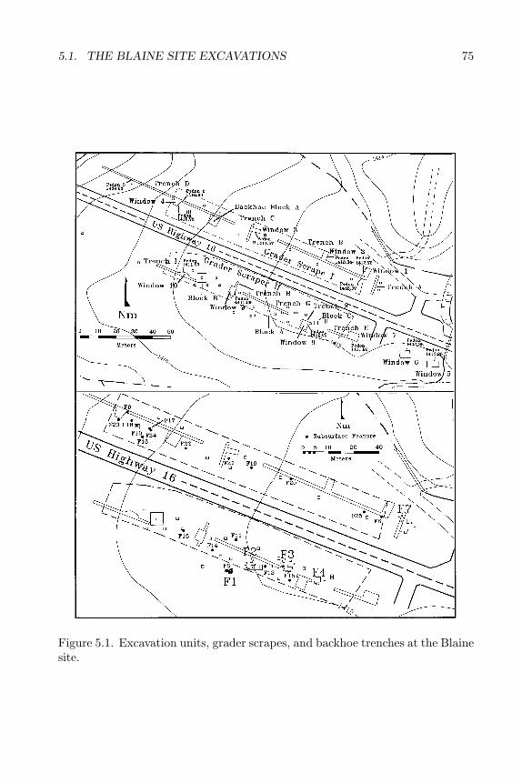
5.1. THE BLAINE SITE EXCAVATIONS 75
Figure 5.1. Excavation units, grader scrapes, and backhoe trenches at the Blainesite.
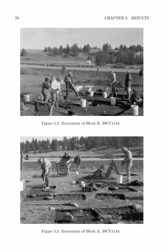
76 CHAPTER 5. RESULTS
Figure 5.2. Excavation of Block B, 39CU1144.
Figure 5.3. Excavation of Block A, 39CU1144.
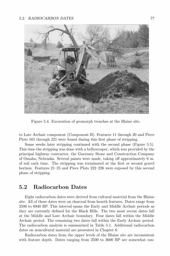
5.2. RADIOCARBON DATES 77
Figure 5.4. Excavation of geomorph trenches at the Blaine site.
to Late Archaic component (Componont B). Features 11 through 20 and PiecePlots 165 through 221 were found during this first phase of stripping.
Some weeks later stripping continued with the second phase (Figure 5.5).This time the stripping was done with a bellyscraper, which was provided by theprincipal highway contractor, the Guernsey Stone and Construction Companyof Omaha, Nebraska. Several passes were made, taking off approximately 6 in.of soil each time. The stripping was terminated at the first or second gravelhorizon. Features 21–25 and Piece Plots 222–226 were exposed by this secondphase of stripping.
5.2 Radiocarbon Dates
Eight radiocarbon dates were derived from cultural material from the Blainesite. All of these dates were on charcoal from hearth features. Dates range from2500 to 6940 BP. This interval spans the Early and Middle Archaic periods asthey are currently defined for the Black Hills. The two most recent dates fallat the Middle and Late Archaic boundary. Four dates fall within the MiddleArchaic period. The remaining two dates fall within the Early Archaic period.The radiocarbon analysis is summarized in Table 5.1. Additional radiocarbondates on noncultural material are presented in Chapter 6.
Radiocarbon dates from the upper levels of the Blaine site are inconsistentwith feature depth. Dates ranging from 2500 to 3600 BP are somewhat ran-
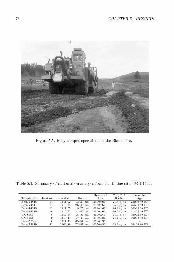
78 CHAPTER 5. RESULTS
Figure 5.5. Belly-scraper operations at the Blaine site.
Table 5.1. Summary of radiocarbon analysis from the Blaine site, 39CU1144.
Measured 13C/12C CorrectedSample No. Feature Elevation Depth Age Ratio AgeBeta-74815 14 1411.92 13–30 cm 2490±60 -24.5 o/oo 2500±60 BPBeta-74817 17 1410.74 26–43 cm 2560±60 -25.6 o/oo 2550±60 BPBeta-74818 19 1411.55 8–25 cm 3120±60 -26.9 o/oo 3090±60 BPBeta-74816 16 1410.72 22–40 cm 3160±60 -26.2 o/oo 3140±60 BPTX-8153 8 1412.54 15–34 cm 3190±60 -24.3 o/oo 3200±60 BPTX-8154 9 1410.49 17–40 cm 3580±80 -24.1 o/oo 3600±80 BPBeta-55604 6 1411.43 45–57 cm 5580±90 – –Beta-74819 23 1409.88 72–87 cm 6950±80 -25.9 o/oo 6940±80 BP
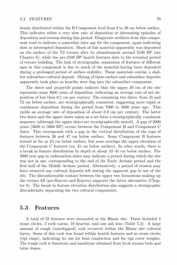
5.3. FEATURES 79
domly distributed within the B Component level from 8 to 26 cm below surface.This indicates either a very slow rate of deposition or alternating episodes ofdeposition and erosion during this period. Diagnostic artifacts from this compo-nent tend to indicate a somewhat later age for the component, again indicatingslow or interrupted deposition. Much of this material apparently was depositedon the surface of the T2 terrace after its abandonment around 3100 BP (seeChapter 6), while the pre-3100 BP hearth features date to the terminal periodof terrace building. The lack of stratigraphic separation of features of differentages in this component is due to much of the material having been depositedduring a prolonged period of surface stability. These materials overlay a shal-low subsurface cultural deposit. Mixing of these surface and subsurface depositsapparently took place as hearths were dug into the subsurface component.
The dates and projectile points indicate that the upper 30 cm of the siterepresents some 3600 years of deposition, indicating an average rate of net de-position of less than 0.1 cm per century. The remaining two dates, from 45 and72 cm below surface, are stratigraphically consistent, suggesting more rapid orcontinuous deposition during the period from 7000 to 5600 years ago. Thisyields an average rate of deposition of about 0.3 cm per century. The lattertwo dates and the upper dates taken as a set form a stratigraphically consistentsequence (although the upper dates are stratigraphically mixed). A gap of 2000years (3600 to 5600 BP) occurs between the Componont B and Componont Cdates. This corresponds with a gap in the vertical distribution of the tops offeatures between 26 and 47 cm below surface. Some Componont B featuresextend as far as 43 cm below surface, but none overlaps the upper elevation ofthe Componont C features (ca. 45 cm below surface). In other words, there isa break in feature distribution by depth at about 43–45 cm below surface. The2000 year gap in radiocarbon dates may indicate a period during which the sitewas not in use, corresponding to the end of the Early Archaic period and thefirst half of the Middle Archaic period. Alternatively, a period of erosion mayhave removed any cultural deposits left during the apparent gap in use of thesite. The disconformable contact between the upper two formations making upthe terrace fill (pre-Kaycee and Kaycee) supports the latter alternative (Chap-ter 6). The break in feature elevation distribution also suggests a stratigraphicdisconformity separating the two cultural components.
5.3 Features
A total of 25 features were excavated at the Blaine site. These included 4stone circles, 2 rock cairns, 18 hearths, and one ash lens (Table 5.2). A largeamount of rough (nonchipped) rock occurred within the Blaine site culturallayers. Some of this rock was found within hearth features and as stone circles(tipi rings), indicating its use for heat conduction and for tipi cover weights.The rough rock is limestone and sandstone obtained from local stream beds andtalus slopes.
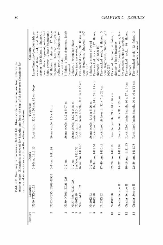
80 CHAPTER 5. RESULTST
ab
le5.2
:S
um
mary
of
featu
res
at
39C
U1144.
Sto
ne
circ
led
imen
sion
sare
from
exte
rior
toex
teri
or
edge.
Ele
vati
on
sre
cord
edfo
rh
eart
hs
are
from
the
top
of
the
featu
re;
elev
ati
on
sfo
rca
irn
san
dst
on
eci
rcle
sare
from
the
bott
om
of
the
featu
re.
Fea
ture
Loca
tion
Dep
thT
yp
e/si
zeC
onte
nts
1N
390.2
7E
901.5
20–80cm
,1411.1
3R
ock
cair
n,
220
x150
cm,
85
cmd
eep
Larg
elim
esto
ne
bou
lder
wit
has-
soci
ate
dfl
ake,
tool,
an
db
on
esc
att
er(1
30
flakes
,1
shatt
er,
1co
re,
bif
ace
fragm
ent,
reto
uch
edfl
ake,
gra
ver
,17
bon
efr
agm
ents
)2
N392–N
395,
E909–E
935
0–7
cm,
1411.9
8S
ton
eci
rcle
,4.5
x4.4
m40
flakes
,1
shatt
er,
17
bon
efr
agm
ents
,st
emm
edp
roje
ctile
poin
t,p
oin
tb
lad
efr
agm
ent,
re-
tou
ched
flake
3N
389–N
396,
E921-9
28
0–7
cmS
ton
eci
rcle
,5.4
2x
5.0
7m
5fl
akes
,1
bon
efr
agm
ent,
kn
ife
fragm
ent
4N
387-3
88,
E937-9
38
0–7
cmS
ton
eci
rcle
,4.6
2x
2.7
8m
2fl
akes
,1
reto
uch
edfl
ake
5N
390E
890
Surf
ace
,1410.3
3R
ock
cair
n,
2.4
x2.0
mN
on
e(n
ot
exca
vate
d)
6N
391.2
5E
901.3
245–57
cm,
1411.4
3R
ock
-filled
basi
nh
eart
h,
90
x95
x12
cmF
ire-
crack
edro
ck,
591
flakes
,3
bon
efr
agm
ents
,ch
arc
oal;
13C
5580
BP
7N
410E
973
0–7
cmS
ton
eci
rcle
,6.4
4x
5.2
6m
5fl
akes
,2
pie
ces
of
wood
8N
440E
890
15–34
cm,
1412.5
4R
ock
-lin
edb
asi
nh
eart
h,
74
x55
x19
cmF
ire-
crack
edro
ck,
117
flakes
,ch
arc
oal;
13C
3200
BP
9N
453E
862
17–40
cm,
1410.4
9R
ock
-lin
edp
ith
eart
h,
32
x?
x23
cmF
ire-
crack
edro
ck,
4fl
akes
,5
bon
efr
agm
ents
,ch
arc
oal;
13C
3600
BP
10
N449E
866
52–70
cm,
1410.2
8P
oss
ible
hea
rth
,59
x46
x18
cmF
leck
sof
charc
oal,
4fl
akes
,1
shatt
er,
1b
on
efr
agm
ent
11
Gra
der
Scr
ap
eII
14–27
cm,
1411.6
9B
asi
nh
eart
h,
34
x31
x13
cm11
flakes
,6
bon
efr
agm
ents
,fe
wfi
re-c
rack
edro
cks
on
surf
ace
12
Gra
der
Scr
ap
eII
10–16cm
b,
1411.9
5R
ock
-filled
basi
nh
eart
h,
80
x77
x6
cmF
ire-
crack
edro
ck,
68
flakes
,ch
arc
oal
13
Gra
der
Scr
ap
eII
22–36
cm,
1411.3
8R
ock
-lin
edb
asi
nh
eart
h,
60
x46
x14
cmF
ire-
crack
edro
ck,
52
flakes
,3
bon
efr
agm
ents
,ch
arc
oal
5.3. FEATURES 81T
ab
le5.2
:co
nti
nu
ed
Fea
ture
Loca
tion
Dep
thT
yp
e/si
zeC
onte
nts
14
Gra
der
Scr
ap
eII
13–30
cm,
1411.6
1R
ock
-filled
basi
nh
eart
h,
59
x43
x17
cmF
ire-
crack
edro
ck,
38
flakes
,1
bon
efr
agm
ent,
charc
oal;
13C
2500
BP
15
Gra
der
Scr
ap
eII
24
cm,
1411.9
21
Hea
rth
of
ind
eter
min
ate
shap
e18
flakes
,ch
arc
oal
16
Gra
der
Scr
ap
eI
22–40
cm,
1410.7
2B
asi
nh
eart
h,
50
x58
x18
cm121
flakes
,220
bon
efr
agm
ents
,ch
arc
oal;
13C
3140
BP
17
Gra
der
Scr
ap
eI
26–43
cm,
1410.7
4R
ock
-lin
edb
asi
nh
eart
h,
68
x60
x17
cmT
wo
layer
soffi
re-f
ract
ure
dro
ck,
135
flakes
,ch
arc
oal;
13C
2550
BP
18
Gra
der
Scr
ap
eI
14-3
1cm
,1410.5
6R
ock
-filled
basi
nh
eart
h,
57
x57
x14
cmF
ire-
crack
edro
ck,
130
flakes
,44
shatt
er,
112
bon
efr
agm
ents
,ch
arc
oal
19
Gra
der
Scr
ap
eI
8–25
cm,
4111.5
5R
ock
-filled
basi
nh
eart
h,
57
x56
x17
cmF
ire-
crack
edro
ck,
28
flakes
,36
bon
efr
agm
ents
,ch
arc
oal;
13C
3090
BP
20
Gra
der
Scr
ap
eI
17–26
cm,
1411.8
7B
asi
nh
eart
h,
56
x40
x9
cmF
ire-
crack
edro
ck,
2b
on
efr
ag-
men
ts,
charc
oal
21
Gra
der
Scr
ap
eI
47–60
cm,
1411.0
5B
asi
nh
eart
h,
59
x54
x13
cmF
ire-
crack
edro
ck,
51
flakes
,173
bon
efr
agm
ents
,ch
arc
oal
22
Gra
der
Scr
ap
eI
65–75
cm,
1410.6
5B
asi
nh
eart
h,
41
x38
x10
cmF
ire-
crack
edro
ck,
37
flakes
,115
bon
efr
agm
ents
,ch
arc
oal
23
Gra
der
Scr
ap
eI
72–87
cm,
1409.8
8R
ock
-lin
edb
asi
nh
eart
h,
81
x62
x15
cmF
ire-
crack
edro
ck,
322
flakes
,ch
arc
oal;
13C
6940
BP
24
Gra
der
Scr
ap
eI
89–98
cm,
1410.1
6B
asi
nh
eart
h,
53
x51
x9
cmF
ire-
crack
edro
ck,
104
flakes
,ch
arc
oal
25
Gra
der
Scr
ap
eI
88
cm,
1411.7
4A
shan
dro
cksc
att
erF
ire-
crack
edro
ck,
18
flakes
,ch
arc
oal
1E
levati
on
of
bott
om
of
hea
rth
;to
pof
featu
red
estr
oyed
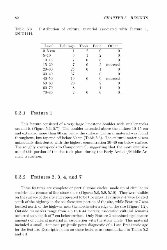
82 CHAPTER 5. RESULTS
Table 5.3. Distribution of cultural material associated with Feature 1,39CU1144.
Level Debitage Tools Bone Other0–5 cm 1 2 0 05–10 6 1 2 010–15 7 0 6 015–20 7 0 5 charcoal20–30 25 0 1 030–40 37 0 040–50 19 0 0 charcoal50–60 20 2 060–70 8 1 070–80 2 0 0 0
5.3.1 Feature 1
This feature consisted of a very large limestone boulder with smaller rocksaround it (Figure 5.6, 5.7). The boulder extended above the surface 10–15 cmand extended more than 80 cm below the surface. Cultural material was foundthroughout, but tapered off below 60 cm (Table 5.3). The cultural material wasunimodally distributed with the highest concentration 30–40 cm below surface.The roughly corresponds to Componont C, suggesting that the most intensiveuse of this portion of the site took place during the Early Archaic/Middle Ar-chaic transition.
5.3.2 Features 2, 3, 4, and 7
These features are complete or partial stone circles, made up of circular tosemicircular courses of limestone slabs (Figures 5.8, 5.9, 5.10). They were visibleon the surface of the site and appeared to be tipi rings. Features 2–4 were locatedsouth of the highway in the southeastern portion of the site, while Feature 7 waslocated north of the highway near the northeastern edge of the site (Figure 1.2).Outside diameters range from 4.5 to 6.44 meters; associated cultural remainsoccurred to a depth of 7 cm below surface. Only Feature 2 contained significanceamounts of cultural material in association with the stone circle. This materialincluded a small, stemmed projectile point diagnostic of a Late Prehistoric agefor the feature. Descriptive data on these features are summarized in Tables 5.2and 5.4.

5.3. FEATURES 83
Figure 5.6. Feature 1 cairn.
Figure 5.7. Feature 1 cairn, profile view, 39CU1144.
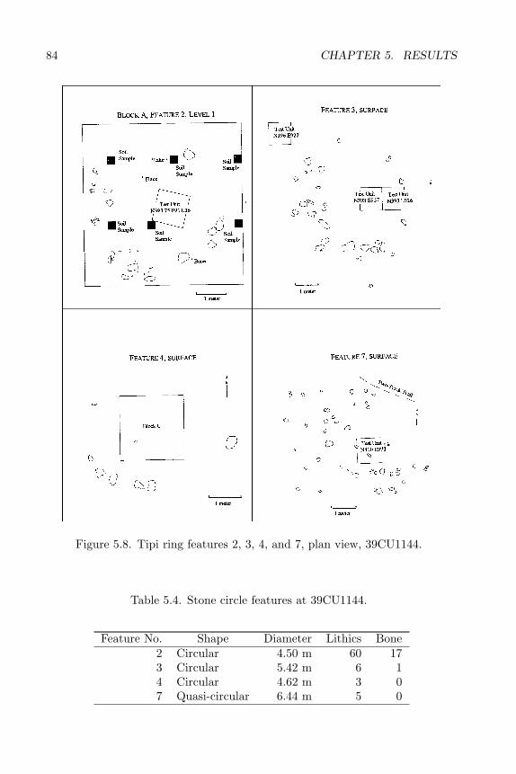
84 CHAPTER 5. RESULTS
Figure 5.8. Tipi ring features 2, 3, 4, and 7, plan view, 39CU1144.
Table 5.4. Stone circle features at 39CU1144.
Feature No. Shape Diameter Lithics Bone2 Circular 4.50 m 60 173 Circular 5.42 m 6 14 Circular 4.62 m 3 07 Quasi-circular 6.44 m 5 0
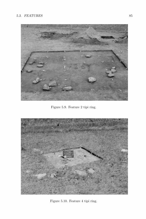
5.3. FEATURES 85
Figure 5.9. Feature 2 tipi ring.
Figure 5.10. Feature 4 tipi ring.

86 CHAPTER 5. RESULTS
Figure 5.11. Feature 5 cairn.
5.3.3 Feature 5
This feature was a rock cairn located near the intermittent stream drainageat the southern boundary of the site (Figure 5.11). The feature was not exca-vated and no artifacts were found near it on the surface.
5.3.4 Hearth features
Features 8 and 9 are rock-lined hearths found in the geomorph trenchesD and B north of the highway (Figures 5.12–5.13). They appear to relateto Componont B. Feature 6 relates to Componont C (Figure 5.14). This is thehearth radiocarbon dated to 5580 BP. Feature 10 is a possible basin hearth foundbelow a gravel stratum in Unit N449E866 in the 60–70-centimeter level (Figure5.15). This feature contained a possible flake and a few flecks of charcoal, butneither its age nor origin could be accurately determined. Features 11–20 werefound during the intial grader stripping. These include various types of shallowbasin hearths associated with component B (Figures 5.16–5.17). Features 21–24 were found in the second phase of grader stripping and are associated withComponent C. These also comprise various types of basin hearths (Figure 5.19).
Attributes of the upper (Componont B) and lower (Componont C) hearthswere compared (Table 5.5). The Componont C hearths tend to be bigger thanthe Componont B hearths. Hearth sizes range from 6160 cm2 to 1054 cm2 withan average size of 3955.5 cm2 in Componont B and from 8550 cm2 to 1558 cm2
in Componont C with an average size of 3224.2 cm2. The lower hearths tend
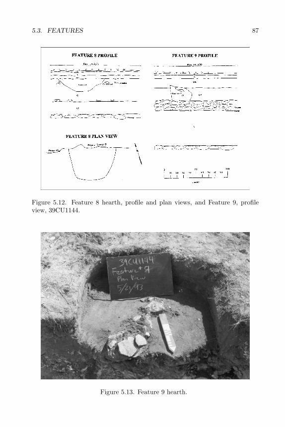
5.3. FEATURES 87
Figure 5.12. Feature 8 hearth, profile and plan views, and Feature 9, profileview, 39CU1144.
Figure 5.13. Feature 9 hearth.
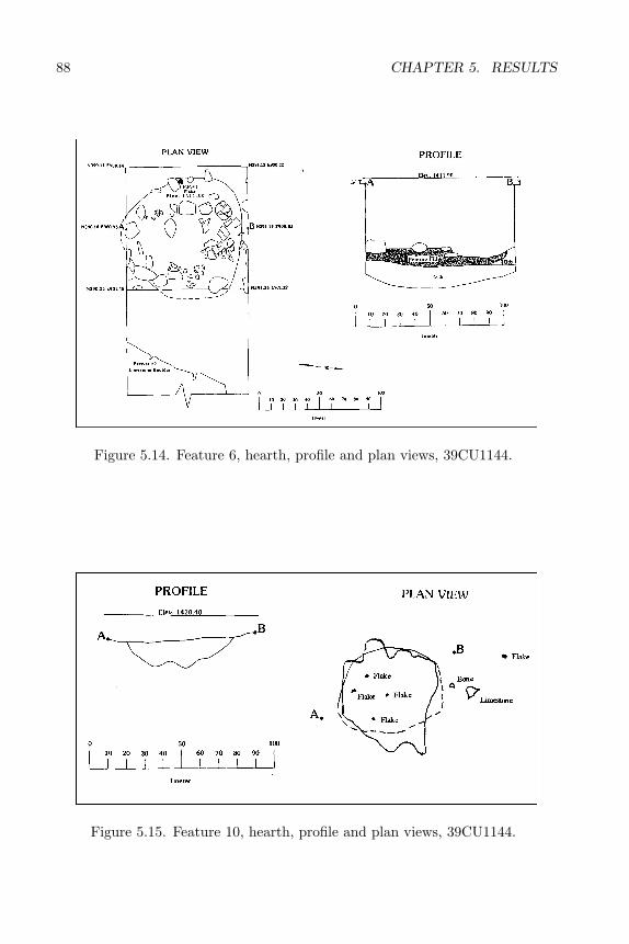
88 CHAPTER 5. RESULTS
Figure 5.14. Feature 6, hearth, profile and plan views, 39CU1144.
Figure 5.15. Feature 10, hearth, profile and plan views, 39CU1144.
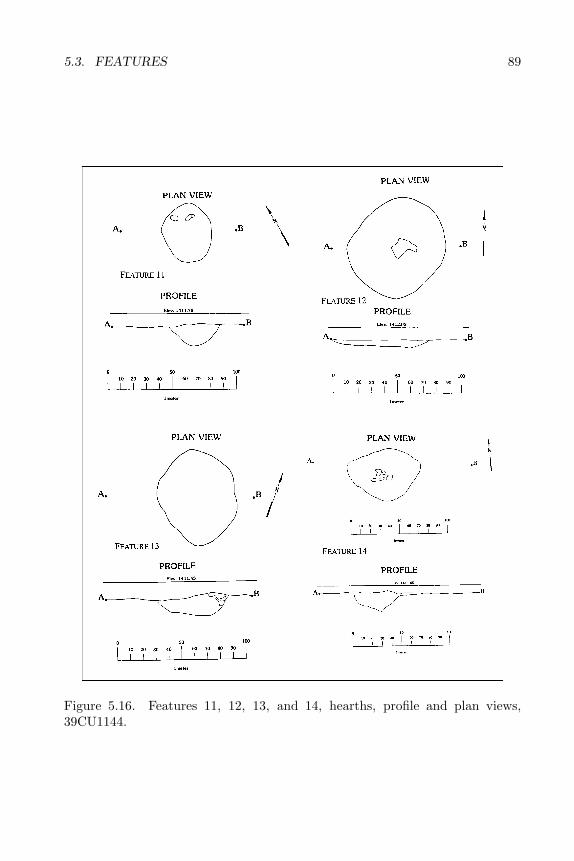
5.3. FEATURES 89
Figure 5.16. Features 11, 12, 13, and 14, hearths, profile and plan views,39CU1144.

90 CHAPTER 5. RESULTS
Figure 5.17. Features 16, 17, 18, 19, and 20, hearths, profile and plan views,39CU1144.
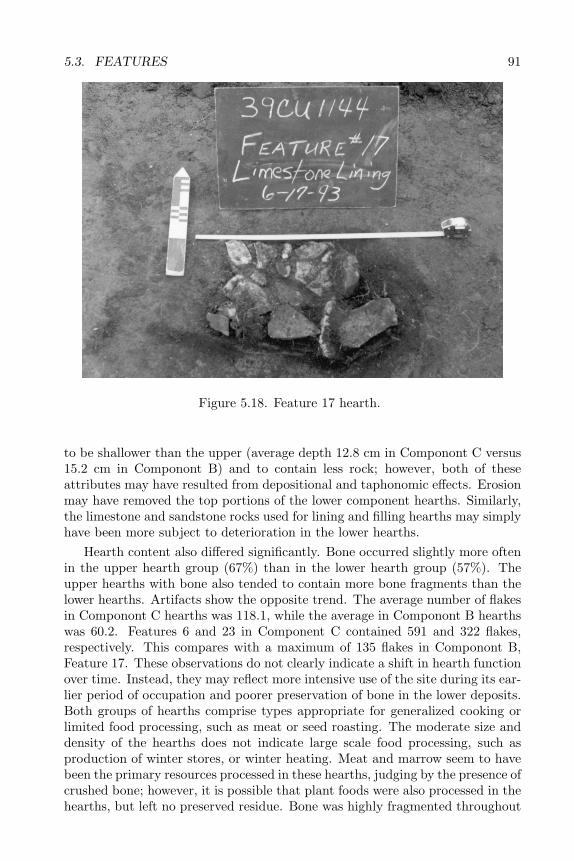
5.3. FEATURES 91
Figure 5.18. Feature 17 hearth.
to be shallower than the upper (average depth 12.8 cm in Componont C versus15.2 cm in Componont B) and to contain less rock; however, both of theseattributes may have resulted from depositional and taphonomic effects. Erosionmay have removed the top portions of the lower component hearths. Similarly,the limestone and sandstone rocks used for lining and filling hearths may simplyhave been more subject to deterioration in the lower hearths.
Hearth content also differed significantly. Bone occurred slightly more oftenin the upper hearth group (67%) than in the lower hearth group (57%). Theupper hearths with bone also tended to contain more bone fragments than thelower hearths. Artifacts show the opposite trend. The average number of flakesin Componont C hearths was 118.1, while the average in Componont B hearthswas 60.2. Features 6 and 23 in Component C contained 591 and 322 flakes,respectively. This compares with a maximum of 135 flakes in Componont B,Feature 17. These observations do not clearly indicate a shift in hearth functionover time. Instead, they may reflect more intensive use of the site during its ear-lier period of occupation and poorer preservation of bone in the lower deposits.Both groups of hearths comprise types appropriate for generalized cooking orlimited food processing, such as meat or seed roasting. The moderate size anddensity of the hearths does not indicate large scale food processing, such asproduction of winter stores, or winter heating. Meat and marrow seem to havebeen the primary resources processed in these hearths, judging by the presence ofcrushed bone; however, it is possible that plant foods were also processed in thehearths, but left no preserved residue. Bone was highly fragmented throughout
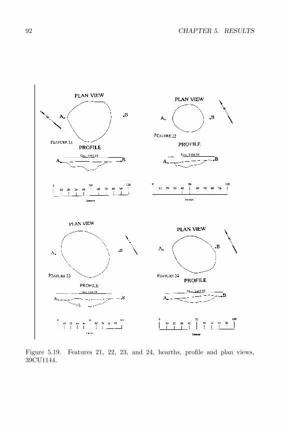
92 CHAPTER 5. RESULTS
Figure 5.19. Features 21, 22, 23, and 24, hearths, profile and plan views,39CU1144.
5.4. CERAMICS 93
Table 5.5. Comparison of various attributes of hearths associated with Compo-nents A and B and Componont C, 39CU1144.
Component A&B Component CAttribute Count Percentage Count Percentage
Shallow basin 6 50 5 71Basin 0 42 0 0Rock-filled 4 33 1 14Rock-lined 4 33 1 14Bone present 8 67 4 57Flakes present 11 92 7 100
the feature assemblages. A few pieces were recognizable as artiodactyl remains,while the remainder were identifiable only as mammal bone.
The most obvious difference between the two groups of hearths is in thelarger number of flakes associated with the lower hearths. This may reflect amore intense use of the site area during the Early Archaic than during the Mid-dle and Late Archaic. This greater intensity could mean either more frequentor more prolonged occupations of the site. Because Componont C occurs inpockets, rather than as a continuous deposition, the degree of site use intensityis otherwise difficult to assess. More intensive use of the site during its ear-lier period of use was also indicated by distribution of artifacts associated withFeature 1.
5.4 Ceramics
In total, 137 pottery sherds were recovered. Although most of these were ex-tremely fragmented, they appear to represent two types of pottery (Figure 5.20).The first type is represented by a single rim sherd, with the remaining sherds allrepresenting the second type. All were found near the surface of the site. It ispossible that only two or three vessels are represented by the sherds recoveredat the Blaine site.
The single sherd (#212) representing Type 1 pottery was found in Block Bexcavations in the western portion of the site. It is a very small fragment ofwhat appears to be a section of the rim. The rim appears to have been verythin (0.28 cm). Two narrow (0.20 cm) parallel trailed lines are present on thesherd exterior. The temper is either a find sand or grit (crushed rock). Thepaste appears hard and resistive. The interior is smoothed and is reddish brown(5YR4/3). The exterior appears oxidized and is buff or reddish yellow (5YR6/6).Vessel shape and rim angle are indeterminate. Although the presence of a singletiny sherd does not permit many conclusions, this pottery is generally similarto Middle Missouri types in its thinness, hardness, and trailed decoration. Suchpottery is occasionally found in very small amounts in peripheral zones of the
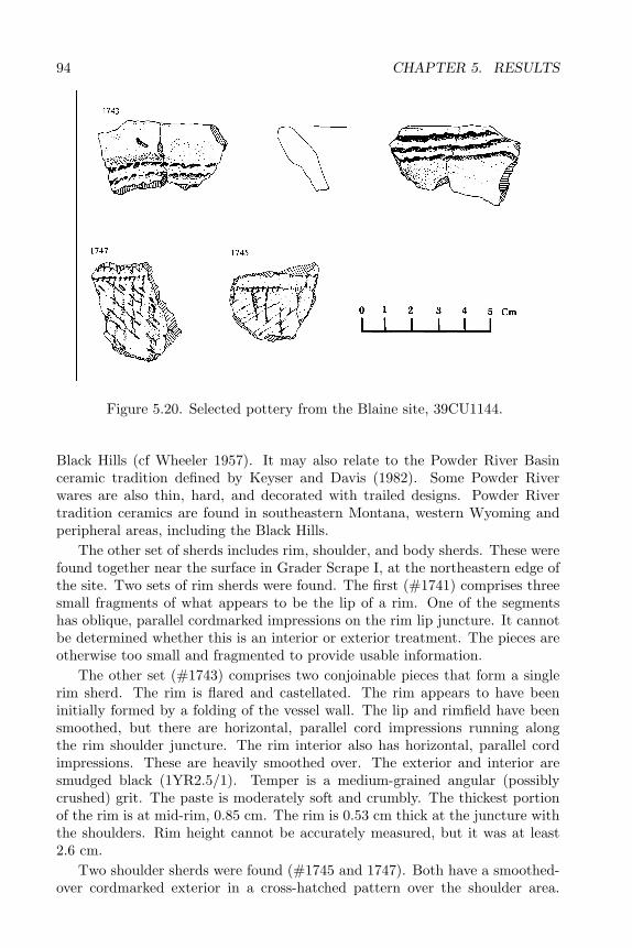
94 CHAPTER 5. RESULTS
Figure 5.20. Selected pottery from the Blaine site, 39CU1144.
Black Hills (cf Wheeler 1957). It may also relate to the Powder River Basinceramic tradition defined by Keyser and Davis (1982). Some Powder Riverwares are also thin, hard, and decorated with trailed designs. Powder Rivertradition ceramics are found in southeastern Montana, western Wyoming andperipheral areas, including the Black Hills.
The other set of sherds includes rim, shoulder, and body sherds. These werefound together near the surface in Grader Scrape I, at the northeastern edge ofthe site. Two sets of rim sherds were found. The first (#1741) comprises threesmall fragments of what appears to be the lip of a rim. One of the segmentshas oblique, parallel cordmarked impressions on the rim lip juncture. It cannotbe determined whether this is an interior or exterior treatment. The pieces areotherwise too small and fragmented to provide usable information.
The other set (#1743) comprises two conjoinable pieces that form a singlerim sherd. The rim is flared and castellated. The rim appears to have beeninitially formed by a folding of the vessel wall. The lip and rimfield have beensmoothed, but there are horizontal, parallel cord impressions running alongthe rim shoulder juncture. The rim interior also has horizontal, parallel cordimpressions. These are heavily smoothed over. The exterior and interior aresmudged black (1YR2.5/1). Temper is a medium-grained angular (possiblycrushed) grit. The paste is moderately soft and crumbly. The thickest portionof the rim is at mid-rim, 0.85 cm. The rim is 0.53 cm thick at the juncture withthe shoulders. Rim height cannot be accurately measured, but it was at least2.6 cm.
Two shoulder sherds were found (#1745 and 1747). Both have a smoothed-over cordmarked exterior in a cross-hatched pattern over the shoulder area.
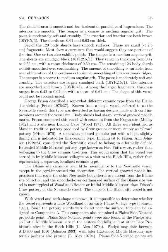
5.4. CERAMICS 95
The rimfield area is smooth and has horizontal, parallel cord impressions. Theinteriors are smooth. The temper is a coarse to medium angular grit. Thepaste is moderately soft and crumbly. The exterior and interior are both brown(10YR5/3). The sherds are 0.61 and 0.63 cm thick.
Six of the 129 body sherds have smooth surfaces. These are small (< 2.5cm) fragments. Most show a curvature that would suggest they are portions ofthe rim. One or two also exhibit polish. The temper is a medium angular grit.The sherds are smudged black (10YR2.5/1). They range in thickness from 0.47to 0.52 cm, with a mean thickness of 0.50 cm. The remaining 126 body sherdsexhibit smoothed-over cordmarking. The amount of smoothing is variable, fromnear obliteration of the cordmarks to simple smoothing of intracordmark ridges.The temper is a coarse to medium angular grit. The paste is moderately soft andcrumbly. The exteriors are largely smudged black (10YR2.5/1). The interiorsare smoothed and brown (10YR5/3). Among the larger fragments, thicknessranges from 0.42 to 0.92 cm with a mean of 0.61 cm. The shape of this vesselcould not be reconstructed.
George Frison described a somewhat different ceramic type from the Blainesite vicinity (Frison 1976:37). Known from a single vessel, referred to as theNewcastle vessel, this type was described as having designs made with cord im-pressions around the vessel rim. Body sherds had sharp, vertical grooved paddlemarks. Frison compared this vessel with ceramics from the Hagan site (Mulloy1942) and a site near Ludlow Cave (Wood 1971). All three were identified asMandan tradition pottery produced by Crow groups or more simply as “Crow”pottery (Frison 1976). A somewhat pointed globular pot with a high, slightlyflaring rim is indicated for this ceramic type. In contrast to Frison, Ann John-son (1979:24) considered the Newcastle vessel to belong to a formally definedExtended Middle Missouri pottery type known as Fort Yates ware, rather thanbelonging to the Crow ceramic tradition. This would mean that the vessel wascarried in by Middle Missouri villagers on a visit to the Black Hills, rather thanrepresenting a separate, localized ceramic type.
The Blaine site ceramics bear little resemblance to the Newcastle vessel,except in the cord-impressed rim decoration. The vertical grooved paddle im-pressions that cover the other Newcastle body sherds are absent from the Blainesite collection and the smoothed-over cordmarked surface of the Blaine site ves-sel is more typical of Woodland/Besant or Initial Middle Missouri than Frison’sCrow pottery or the Newcastle vessel. The shape of the Blaine site vessel is notknown.
With vessel and neck shape unknown, it is impossible to determine whetherthe vessel represents a Late Woodland or an early Plains Village type (Johnson1993). Since the pottery sherds were found near the surface, they can be as-signed to Componont A. This component also contained a Plains Side-Notchedprojectile point. Plains Side-Notched points were also found at the Phelps site,an Initial Middle Missouri site in the eastern foothills, and at other Late Pre-historic sites in the Black Hills (L. Alex 1979a). Phelps may date betweenA.D.900 and 1050 (Johnson 1993), with later (Extended Middle Missouri) ma-terials perhaps also present (L. Alex 1979a). Plains Side-Notched points are
96 CHAPTER 5. RESULTS
generally dated to the period between A.D. 1300–1700 (Kehoe 1966). Thesedata, and the lack of Late Woodland-era radiocarbon dates from the Blainesite, suggest that the ceramics belong to a Plains Village or Late Prehistoriccultural tradition, rather than a Woodland tradition.
While the Blaine site vessel can clearly be classified as belonging to the“Mandan” ceramic tradition, as opposed to the Intermountain ceramic tradi-tion, its more specific cultural affiliation is not clearly indicated. The term“Crow pottery” is misleading, because no evidence exists that the historic orprotohistoric Crow were the actual or sole producers of these ceramics (Johnson1979; Wood and Downer 1977; Keyser and Davis 1982). Splinter groups wereleaving the Middle Missouri area to resettle in areas farther west throughoutmuch if not all Middle Missouri prehistory. The exact number and timing ofthese resettlements are not known. In addition, the historic practice of MiddleMissouri villagers traveling west to hunt bison on a seasonal basis may have beena long-standing tradition in the area, as the Late Archaic Besant and Sonotacomplex remains imply. Northern plains groups historically raided and tradedfor both ceramics and the women who produced them. Thus, the presence ofa single Mandan tradition pot at the Blaine site does not necessarily indicateoccupation of the site by either Crow or Middle Missouri tradition groups. Thepossibility that the ceramic tradition represented at the Blaine site developedin situ out of a preexisting Besant ceramic tradition also must be considered.The Mandan ceramic tradition as defined by Mulloy (1942) and Frison (1976)recognizes the general eastern (Middle Missouri) affiliation of the tradition, asopposed to the Intermontane ceramic tradition, but is not otherwise useful indefining interassemblage relationships (Johnson 1979; Alex 1979b; Keyser andDavis 1982).
Recognizing these problems, Keyser and Davis (1982) proposed the term“Powder River Basin tradition” for the Middle Missouri-related ceramics foundin that vicinity in eastern Wyoming and Montana. This terminology permitsthe possibility that the tradition developed early in this area from a generalMiddle Missouri base, without tying it to any particular group. Powder RiverBasin tradition ceramics are described as thin-walled, gobular jars with vagueshoulders and moderately high S-shaped, straight, or flaring rims. Lips areflattened or slightly rounded and sometimes decorated with notches or ovalpunctates. Other decoration may take the form of incised (trailed) lines onshoulders or vertical paddle marks on rims. Cord-impressed designs do notoccur. Surfaces were wiped, scraped, rubbed, and/or polished smooth prior tofiring. Keyser and Davis include the western Black Hills in the range of thisceramic type.
While Keyser and Davis (1982:296) recognize some similarities between Pow-der River Basin tradition ceramics and Riggs and Fort Yates wares of the Ex-tended and Terminal variants of the Middle Missouri Tradition, they specifythat such attributes as castellated and filleted rims characteristic of Riggs andFort Yates wares do not occur in the Powder River Basin ceramics. This wouldplace the Blaine site vessel outside the Powder River Basin tradition. Severalother attributes of the Blaine site vessel are typical of various Initial Middle
5.5. LITHIC TOOLS 97
Missouri and early Coalescent Tradition wares. These include cord-roughening,flared lip, cord-impressed and incised decorations, and a distinct rim shoulderjuncture. Other IMM and Coalescent attributes, including braced rims andvertically brushed necks, are not seen on the Blaine site vessel.
In short, the Blaine site ceramics shed little light on the identity of the Com-ponont A occupants of the site. Both ceramic types suggest general connectionsto the east in the Middle Missouri subarea, but only the first type closely re-sembles Middle Missouri pottery. Many of the attributes of the more completeBlaine pot are intermediate between Woodland and Powder River or MiddleMissouri Coalescent tradition types. This would tend to support the possibilityof a localized ceramic tradition; however, the additional specimens that couldconfirm its existence have yet to be found. Lithic raw material types suggesteda localized occupation of the site during the Late Prehistoric period, with someeastern (probably Middle Missouri) elements in the Late Archaic materials. Un-fortunately, the Blaine site ceramics were found in the grader scrape and werenot associated with datable material. The stylistics of the ceramics do not ex-actly match any formally described types. Until northwestern plains ceramictraditions are more accurately defined, the sherds from the Blaine site will havelittle diagnostic value. The pottery is of more significance as an indicator of thediversity of activities taking place at the site. It suggests use of the site by anentire social unit, rather than a specialized task group.
5.5 Lithic Tools
In total 68 specimens representing 61 lithic tools were found at the Blainesite. In addition 13 cores are included in the tool descriptions in the appendix.All are chipped stone. No ground stone tools or hammerstones were found.Tools were identified by formal type where possible, i.e. projectile point, scraper,biface, graver. Nonformal retouched flakes are also included in the tool inven-tory. These were identified on the basis of edge modification. No formal use-wearanalysis was done; however, obvious use-wear is noted in the descriptions anddiscussion below. Description of cores and bifaces follows Callahan’s (1979)biface reduction model for Clovis materials from eastern North America. Al-though this reduction trajectory was developed for an area and time perioddifferent from that represented at the Blaine site, the model has been widelyused for biface descriptions referring to a wide range of regions and time periods.Callahan’s model has been applied to northern plains materials (e.g. Keyser andDavis 1984; Metcalf and Black 1985; Keyser and Fagan 1987).
Materials found on or within 7–10 cm of the surface were grouped togetheras the Componont A assemblage. Componont A tools include six bifaces andbiface fragments, fragments of five projectile points, three retouched flakes, andone graver. Two cores were found in this upper component (Table 5.6).
The projectile points found at this level included one Plains Side-Notchedarrowpoint (#157), a stemmed or corner-notched arrowpoint (#1579), a frag-ment from a notched arrowpoint (#1575) and two notched dart points (#1479
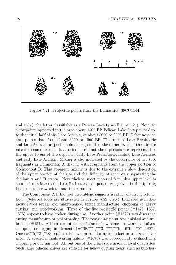
98 CHAPTER 5. RESULTS
Figure 5.21. Projectile points from the Blaine site, 39CU1144.
and 1537), the latter classifiable as a Pelican Lake type (Figure 5.21). Notchedarrowpoints appeared in the area about 1500 BP Pelican Lake dart points dateto the initial half of the Late Archaic, or about 3000 to 2000 BP. Other notcheddart points date from about 3500 to 1500 BP. This mix of Late Prehistoricand Late Archaic projectile points suggests that the upper levels of the site aremixed to some extent. It also indicates that three periods are represented inthe upper 10 cm of site deposits: early Late Prehistoric, middle Late Archaic,and early Late Archaic. Mixing is also indicated by the occurrence of two toolfragments in Componont A that fit with fragments from the upper portion ofComponont B. This apparent mixing is due to the extremely slow depositionof the upper portion of the site and the difficulty of accurately separating theshallow A and B strata. Nevertheless, most material from this upper level isassumed to relate to the Late Prehistoric component recognized in the tipi ringfeatues, the arrowpoints, and the ceramics.
The Componont A lithic tool assemblage suggests a rather diverse site func-tion. (Selected tools are illustrated in Figures 5.22–5.26.) Indicated activitiesinclude tool repair and maintenance, biface manufacture, chopping or heavycutting, and woodworking. Three of the five projectile points (#1479, 1537,1575) appear to have broken during use. Another point (#1579) was discardedduring manufacture or resharpening. The remaining point was finished and un-broken (#157). All but one of the six bifaces show some use-wear, as knives,choppers, or digging implements (#769/771/773, 777/779, 1670, 1727, 1827).One (#775/781/783) appears to have broken during manufacture and was neverused. A second manufacturing failure (#1670) was subsequently utilized as achopping or cutting tool. All but one of the bifaces are made of local quartzites.Such large bifacial knives are suitable for heavy cutting tasks, such as butcher-
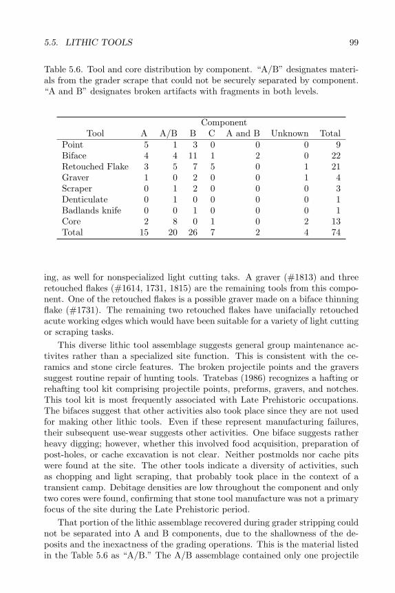
5.5. LITHIC TOOLS 99
Table 5.6. Tool and core distribution by component. “A/B” designates materi-als from the grader scrape that could not be securely separated by component.“A and B” designates broken artifacts with fragments in both levels.
ComponentTool A A/B B C A and B Unknown Total
Point 5 1 3 0 0 0 9Biface 4 4 11 1 2 0 22Retouched Flake 3 5 7 5 0 1 21Graver 1 0 2 0 0 1 4Scraper 0 1 2 0 0 0 3Denticulate 0 1 0 0 0 0 1Badlands knife 0 0 1 0 0 0 1Core 2 8 0 1 0 2 13Total 15 20 26 7 2 4 74
ing, as well for nonspecialized light cutting taks. A graver (#1813) and threeretouched flakes (#1614, 1731, 1815) are the remaining tools from this compo-nent. One of the retouched flakes is a possible graver made on a biface thinningflake (#1731). The remaining two retouched flakes have unifacially retouchedacute working edges which would have been suitable for a variety of light cuttingor scraping tasks.
This diverse lithic tool assemblage suggests general group maintenance ac-tivites rather than a specialized site function. This is consistent with the ce-ramics and stone circle features. The broken projectile points and the graverssuggest routine repair of hunting tools. Tratebas (1986) recognizes a hafting orrehafting tool kit comprising projectile points, preforms, gravers, and notches.This tool kit is most frequently associated with Late Prehistoric occupations.The bifaces suggest that other activities also took place since they are not usedfor making other lithic tools. Even if these represent manufacturing failures,their subsequent use-wear suggests other activities. One biface suggests ratherheavy digging; however, whether this involved food acquisition, preparation ofpost-holes, or cache excavation is not clear. Neither postmolds nor cache pitswere found at the site. The other tools indicate a diversity of activities, suchas chopping and light scraping, that probably took place in the context of atransient camp. Debitage densities are low throughout the component and onlytwo cores were found, confirming that stone tool manufacture was not a primaryfocus of the site during the Late Prehistoric period.
That portion of the lithic assemblage recovered during grader stripping couldnot be separated into A and B components, due to the shallowness of the de-posits and the inexactness of the grading operations. This is the material listedin the Table 5.6 as “A/B.” The A/B assemblage contained only one projectile
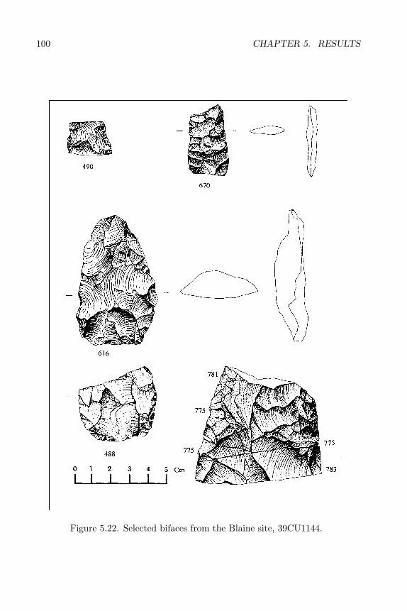
100 CHAPTER 5. RESULTS
Figure 5.22. Selected bifaces from the Blaine site, 39CU1144.

5.5. LITHIC TOOLS 101
Figure 5.23. Selected bifaces from the Blaine site, 39CU1144.

102 CHAPTER 5. RESULTS
Figure 5.24. Selected bifaces from the Blaine site, 39CU1144.
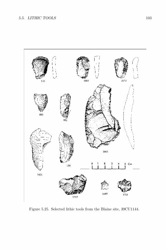
5.5. LITHIC TOOLS 103
Figure 5.25. Selected lithic tools from the Blaine site, 39CU1144.
104 CHAPTER 5. RESULTS
Figure 5.26. Selected cores from the Blaine site, 39CU1144.
5.5. LITHIC TOOLS 105
point (#1637), a nondiagnostic tip fragment. Other tools found in the upperlevels of the grader scrape include five retouched flakes, four bifaces, a scraper,and a denticulate. This assemblage also contained eight cores, ranging fromspheriod and discoid types to tested nodules with one or two flakes removed.These cores include a wide variety of local lithic materials, including cherts thatoutcrop in the immediate site vicinity.
The retouched flakes from this assemblage included two decortication flakeswith bifacial retouch on one or both lateral edges forming an acute cutting edge(#1653,1687). On two other retouched flakes continuous steep unifacial retouchforms steep, convex edges suitable for hide processing or other heavy scrapingtasks (#1652, 1709). These are made of a variety of local cherts and chal-cedonies. A similar function is indicated by the single formal scraper includedin this assemblage (#1673). This is a keeled endscraper with use-wear evidentalong a lateral edge. This is made from Silicate 4, a local milky chalcedony. Theremaining retouched flake (#1663) is a very large, bladelike, bifacial thinningflake or local quartzite. Continous unifacial edge retouch along the lateral edgesof its dorsal side form a concave working edge like that of a spokeshave. Thisartifact is similar to large flake knives from Paleoindian levels of the adjacentJim Pitts site. These were produced on very large bladelike bifacial thinningflakes of local quartzites.
Two of the 4 bifaces from the A/B assemblage were tip portions of Stage3 or 4 bifaces (#1677, 1713). These appear to have been utilized. A thickStage 2 biface fragment (#1697) appears to have broken during manufacture.A complete Stage 2 biface (#1719) is unbroken, but has no apparent use-wear.These large bifaces appear to have been suitable for heavy cutting tasks or mayhave been preforms for lighter tools. A different function is indicated for the lastartifact in the A/B assemblage. This denticulated core-reduction flake probablywas used for shredding fibrous material, such as roots or bark (#1717). Theseartifacts are made of a variety of local materials.
Materials found 7-10 and 27-30 cm below surface were included in Com-ponont B. This component had the highest number of tools of the four assem-blages. This level contained three projectile point fragments, 11 bifaces, sevenretouched flakes, two gravers, two scrapers, and a Badlands knife. In contrast tothe mixed A/B grader scrape assemblage, the B assemblage contained no cores.Projectile point fragments from levels correlated with Componont B includeda corner notched dart point conforming to the Pelican Lake type (#331). Thisartifact is nearly complete; however, the corners of the base and one shoulderbarb have broken off. The remaining two fragments (#672, 970) are nondiag-nostic tip portions. One of these is from a dart-sized point or point preform.The Pelican Lake point and one tip are made of chert that outcrops in the im-mediate site vicinity. The remaining tip is made of local (southern Black Hills)quartzite.
Three other biface fragments (#490, 670, 675) appear to be portions of pro-jectile point preforms. These show no use-wear and appear to be discardedmanufacturing failures. One (#670) is a small lanceolate preform with a bro-ken tip. Another set of bifaces (#265, 536, 616, 1539) are thick, complete or
106 CHAPTER 5. RESULTS
fragmentary Stage 2 (initial edging) bifaces discarded unused. Four of the pre-forms and Stage 2 bifaces were made of chert outcropping in the immediate sitevicinity. Two others were of unidentifiable chert, and one was of local quartzite.Another thick, Stage 2 biface fragment (216) had minute step-fractures alongan acute retouched edge probably indicating use of the tool fragment. This toolwas made of a chert that outcrops both locally and in the Hartville uplift south-east of the Black Hills proper. One Componont B artifact is a tiny fragment ofa biface made from site-vicinity chert (#14). Other bifaces include a utilizedStage 3 tip portion (#1543), a utilized Stage 4 biface base fragment (#488), anda nonutilized midsection of a very large Stage 3 or 4 biface (#775/781/783), anda tip portion from a Stage 3 or 4 biface (#777/779) all made of local quartzite.The latter two artifacts had fragments in levels correlated with Componont A,as well as in Componont B.
Retouched flakes from Componont B include a variety of forms. Four havesteep, unifacially retouched edges suitable for scraping (#130, 294, 533). Thelatter specimen (#533) also has a more acute unifacially retouched edge. Abroken lamellar flake with minute retouch or use-wear along the lateral anddistal edges (#203) may have been used for light cutting or shaft shaving. Otherspecimens have knifelike edges formed by bifacial or unifacial retouch along alateral edge (#21, 885, 915). These are expedient tools suited to a variety oflight cutting tasks. Other Componont B tools include two gravers (#725, 1049)and two endscrapers (#116, 1065) made of local materials. The final tool fromthis assemblage is a bifacial knife (#1003), made on a thin tablet of Badlandschalcedony. Such Badlands knives are most commonly found in Late Archaicassemblages in the Black Hills.
Componont B tools suggest a variety of functions, including hide-processing,shaft repair or production, and lithic tool production. The latter appears to havebeen a principal focus of the Componont B occupation. Cherts outcropping inthe immediate site vicinity were being shaped into bifacial tools and blanks.The recovery of a Pelican Lake projectile point made of such chert indicatesthat hunting weapons were one focus of this knapping activity.
For purposes of this discussion, all materials found lower than 27-30 cmbelow surface were grouped together as Componont C. This assemblage includedone biface fragment, five retouched flakes, and one core. The biface fragment(#1515) is the tip of a very thin Stage 3 or 4 biface of local silicified siltstone.The biface broke and was discarded during manufacture.
The remaining tools assigned to Componont C are a diverse set of retouchedflakes. One is a flake fragment with unifacial retouch or heavy use-wear along oneedge of a fracture (#981). This forms a steep, straight working edge probablyused as a push-plane. Another retouched flake (#1087) is a tabular chert pebblewith sporadic bifacial retouch. The working edges are steep and straight withheavy use-wear in the form of step-fractures and crushing. This tool would havebeen suitable for heavy scraping or planing. Another tool (#1161) is a tertiaryflake with continuous unifacial edge retouch along one lateral edge forming asteep, slightly concave working edge. Use-wear is apparent along this and otheredges of the tool. A heavy scraping or planing function is proposed for this tool.
5.6. LITHIC DEBITAGE 107
The remaining two retouched flakes are lighter tools suitable for cutting or lightscraping tasks. One (#1371) is a bifacial thinning flake with minute unifacialedge retouch along a small portion of the distal edge, forming a straight, acuteworking edge. The other (#1451) is a large lamellar flake with minute edgeretouch or use-wear along the lateral edges. The working edges are straight toslightly convex and acute.
These tools suggest a different focus from either of the other two components.The push-planes indicate that processing of wood or roots may have been aprimary function of the site. Since other woodworking tools, such as adzes,are not present, the latter possibility is most plausible. This would suggesta somewhat specialized function for the site during the period represented byComponont C. The site may have been used as a root-processing site duringthis period as indicated both by the planing tools and by the presence of basinhearths. The remaining tools indicate light cutting or scraping, but do not pointto any particular activity.
Two additional tools and two cores from the grader excavation could notbe confidently assigned to components. One tool (#1683) is a heavily usedretouched flake resembling a keeled endscraper. The other (#1725) is a fragmentof a projectile point or point preform retouched to produce a graver. One core(#1667) is spheroid, made of a Black Hills or Hartville Uplift chert, and appearsto have been utilized as a chopping implement. The other (#1679) is an irregularblock core of site-vicinity chert.
5.6 Lithic Debitage
Size grade analysis was done for all debitage from the site. A summary ofthis analysis is presented in Tables 5.7 and 5.8.
Components A and B have similar size grade profiles, with most debitagefalling in the 1.5-centimeter size grade and tapering off on either side of thatpoint. Componont A contained about as many flakes less than 0.5 cm as flakesin the 1.0-centimeter size grade, while Componont B had very little debitage inthe lowest size grade. This difference may reflect a focus in Componont A ontool finishing and resharpening, while lithic reduction in Component B was morefocused on primary and secondary reduction. When water screen samples areeliminated, Componont C displays a size grade profile similar to Componont A;however, the waterscreen samples tip the Componont C profile heavily towardthe lowest size grade. This reflects the very high percentage of tiny debitageassociated with Feature 6. Of 591 pieces of debitage associated with this fea-ture, 568 were less than 0.5 cm. The bimodal distribution of debitage sizes inComponont C further confirms that Feature 6 had a debitage discard patterndistinct from that of the rest of site. The reason for this specialized distributionis not clear.
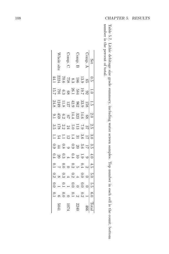
108 CHAPTER 5. RESULTS
Table
5.7.L
ithicdebitage
sizegrade
summ
ary,including
water
screensam
ples.T
opnum
berin
eachcell
isthe
count;bottom
number
isthe
percentof
total.
Set0.5
1.01.5
2.02.5
3.03.5
4.04.5
5.05.5
6.0T
otalC
omp.
A65
92158
6837
1717
92
00
1466
13.919.7
33.914.6
7.93.6
3.61.9
0.40.0
0.00.2
Com
p.B
186584
962323
11331
2010
54
02
22408.3
26.142.9
14.45.0
1.40.9
0.40.2
0.20.0
0.1C
omp.
C758
68127
6724
129
40
41
01074
70.66.3
11.86.2
2.21.1
0.80.3
0.00.3
0.10.0
Whole
site2224
7911249
459178
5444
207
81
65041
44.115.7
24.89.1
3.51.1
0.90.4
0.10.2
0.00.1
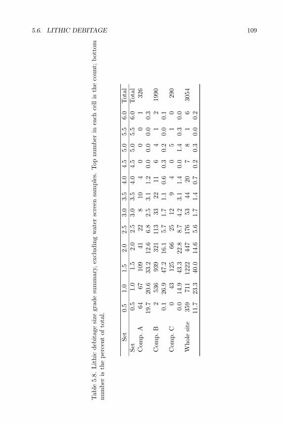
5.6. LITHIC DEBITAGE 109
Tab
le5.
8.L
ithi
cde
bita
gesi
zegr
ade
sum
mar
y,ex
clud
ing
wat
ersc
reen
sam
ples
.T
opnu
mbe
rin
each
cell
isth
eco
unt;
bott
omnu
mbe
ris
the
perc
ent
ofto
tal.
Set
0.5
1.0
1.5
2.0
2.5
3.0
3.5
4.0
4.5
5.0
5.5
6.0
Tot
alSe
t0.
51.
01.
52.
02.
53.
03.
54.
04.
55.
05.
56.
0T
otal
Com
p.A
6467
109
4122
810
40
00
132
619
.720
.633
.212
.66.
82.
53.
11.
20.
00.
00.
00.
3C
omp.
B2
536
939
321
113
3322
116
41
219
900.
126
.947
.216
.15.
71.
71.
10.
60.
30.
20.
00.
1C
omp.
C0
4312
566
2512
94
05
10
290
0.0
14.9
43.3
22.8
8.7
4.2
3.1
1.4
0.0
1.4
0.3
0.0
Who
lesi
te35
971
112
2244
717
653
4420
78
16
3054
11.7
23.3
40.0
14.6
5.6
1.7
1.4
0.7
0.2
0.3
0.0
0.2
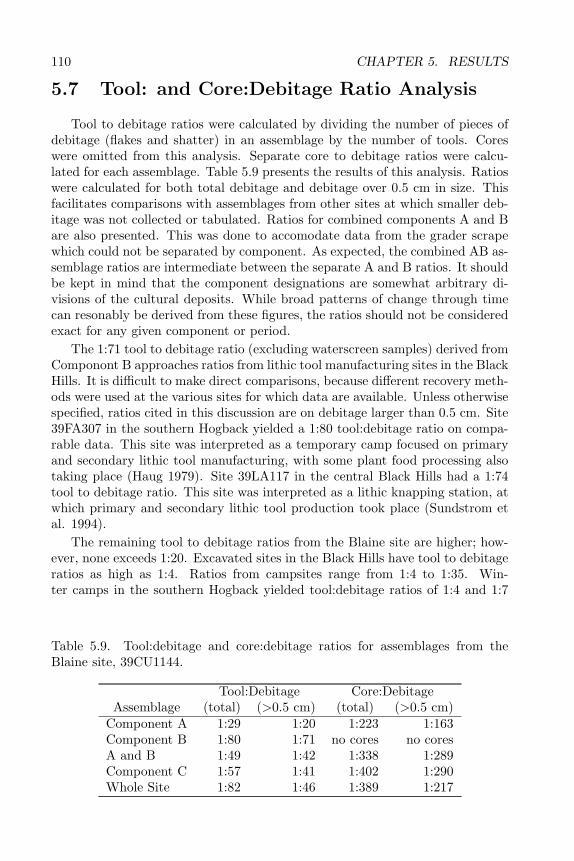
110 CHAPTER 5. RESULTS
5.7 Tool: and Core:Debitage Ratio Analysis
Tool to debitage ratios were calculated by dividing the number of pieces ofdebitage (flakes and shatter) in an assemblage by the number of tools. Coreswere omitted from this analysis. Separate core to debitage ratios were calcu-lated for each assemblage. Table 5.9 presents the results of this analysis. Ratioswere calculated for both total debitage and debitage over 0.5 cm in size. Thisfacilitates comparisons with assemblages from other sites at which smaller deb-itage was not collected or tabulated. Ratios for combined components A and Bare also presented. This was done to accomodate data from the grader scrapewhich could not be separated by component. As expected, the combined AB as-semblage ratios are intermediate between the separate A and B ratios. It shouldbe kept in mind that the component designations are somewhat arbitrary di-visions of the cultural deposits. While broad patterns of change through timecan resonably be derived from these figures, the ratios should not be consideredexact for any given component or period.
The 1:71 tool to debitage ratio (excluding waterscreen samples) derived fromComponont B approaches ratios from lithic tool manufacturing sites in the BlackHills. It is difficult to make direct comparisons, because different recovery meth-ods were used at the various sites for which data are available. Unless otherwisespecified, ratios cited in this discussion are on debitage larger than 0.5 cm. Site39FA307 in the southern Hogback yielded a 1:80 tool:debitage ratio on compa-rable data. This site was interpreted as a temporary camp focused on primaryand secondary lithic tool manufacturing, with some plant food processing alsotaking place (Haug 1979). Site 39LA117 in the central Black Hills had a 1:74tool to debitage ratio. This site was interpreted as a lithic knapping station, atwhich primary and secondary lithic tool production took place (Sundstrom etal. 1994).
The remaining tool to debitage ratios from the Blaine site are higher; how-ever, none exceeds 1:20. Excavated sites in the Black Hills have tool to debitageratios as high as 1:4. Ratios from campsites range from 1:4 to 1:35. Win-ter camps in the southern Hogback yielded tool:debitage ratios of 1:4 and 1:7
Table 5.9. Tool:debitage and core:debitage ratios for assemblages from theBlaine site, 39CU1144.
Tool:Debitage Core:DebitageAssemblage (total) (>0.5 cm) (total) (>0.5 cm)
Component A 1:29 1:20 1:223 1:163Component B 1:80 1:71 no cores no coresA and B 1:49 1:42 1:338 1:289Component C 1:57 1:41 1:402 1:290Whole Site 1:82 1:46 1:389 1:217
5.8. TOOL KIT ANALYSIS 111
(Tratebas 1978b, 1979b). Warm season camps yield somewhat lower ratios,from 1:12 at the Beaver Creek rockshelter (L. Alex 1991) to 1:27 at 39LA117(Sundstrom et al. 1994). Ratios for other hypothesized camping sites include1:29 for the lower component of 39FA396 (Tratebas 1979b) and 1:35 for 39PN90(Tratebas and Vagstad 1979).
The ratios in Components B and C at the Blaine site (1:71 and 1:41, respec-tively) suggest a site function more geared toward stone tool production duringthe periods represented by the lower components. No comparable assemblagesare available from lithic tool production sites. Three knapping stations yieldedan average tool:debitage ratio of 1:39; however, this was calculated from surfacecollections, rather than excavated material (Tratebas 1978a). Since tools areon average larger and thus more visible than debitage and less susceptible toremoval by run-off, a lower ratio would be expected for excavated collections.The B and C component ratios probably indicate multiple-function occupationsof the site, with lithic tool production an important activity.
The combined A and B assemblage had a tool to debitage ratio of 1:42. Thisis approximately equal to the average of the separate A and B assemblages, andsuggests that the separate A and B samples are representative of the componentsas a whole. It further confirms that the grader scrape assemblage is indeed amix of these two components.
The core to debitage analysis is not particularly instructive, except to notethat the Componont A assemblage had proportionately more cores than theother assemblages. The combined A and B assemblage from the grader scrapehad a much greater number of cores, 8 as compared to 2 in component A and0 in component B. This probably reflects a concentration of knapping activitiesaway from the habitation features (tipis). The separate A and B componentassemblages were largely derived from excavation of the stone-circle features.While this explanation makes intuitive sense, it is difficult to establish withcertainty. The relatively low core to tool ratio probably reflects an emphasis onsecondary lithic processing and tool resharpening, as opposed to primary lithictool production.
5.8 Tool Kit Analysis
The data were examined to determine whether tool clusters were present atthe site. Componont A included a varied tool assemblage including a graver, tworetouched flakes, two arrowpoints, two dart points, and four Stage 3 or 4 bifaces.The two arrowpoints were found in the Feature 2 tipi ring. The Feature 4 tipiring contained a single retouched flake. A graver, a retouched flake, and a usedStage 3 or 4 biface were associated with the Feature 1 cairn. The remainingComponont A tools were not associated with features. This distribution suggeststhat repointing of arrows took place both inside and outside the living space,while manufacture of new tools took place mainly outside the living space. TheFeature 1 boulder may have provided a convenient seat for persons engagedshaping stone tools and wood handles or shafts, as both debitage and tool

112 CHAPTER 5. RESULTS
distributions suggest. Componont A materials from Block B included a largebifacial digging tool, a Stage 3 biface midsection, a used Stage 3 or 4 biface tip,and a dartpoint. This distribution again suggests that bifacial tool productiontook place primarily outside the living areas during this period of use of thesite. The exact function of the large bifacial tool is not known; however, it issimilar to tools found along the Missouri River and used for digging cache pits.Perhaps it was used to prepare holes for tipi poles, as neither subsurface hearthsnor cache pits were associated with the tipi rings. Alternatively, this may havebeen a root-digging tool that broke during repair and was discarded.
Componont B tools included a dart point or preform near the Feature 1 cairn,again suggesting production of bifacial tools in this area of the site. Two brokenretouched flakes with lateral retouch were associated with the Feature 2 tipiring, suggesting some specialized activity there, perhaps related to hideworkingor food preparation. Two unused Stage 2 bifaces were found in a mixed ABassemblage near the Feature 3 tipi ring. A fragment of a Badlands knife wasfound inside the tipi ring. This again suggests discard of broken bifaces withinthe living space, while production of new bifacial tools took place outside thetipis. A retouched flake was found near the Feature 4 tipi ring.
The Componont B level of Block B contained the largest concentration oftools at the site. These included a cobble scraper, several retouched flakes, oneused and four unused Stage 2 bifaces, used and unused fragments of Stage 3and 4 bifaces, broken projectile points, a graver, and a retouched pebble. Thesesuggest an activity area devoted to biface production and repair or rehafting ofbifacial tools. The discard pattern indicates that worn-out tools and manufac-turing failures were discarded together.
Block B contained five tools that could not clearly be assigned to either ofthe upper components. These AB tools included a tested chert nodule, twoblocky chert cores, a denticulated flake or shredder, and a used Stage 2 or 3biface tip. With the exception of the shredder, these artifacts conform well tothe Componont B emphasis on biface production from local chert nodules. Theshredder may belong to the more diverse Componont A tool kit.
Two keeled scrapers were found in the AB assemblage northwest of the tipirings. This clearly indicates a hide-working area, probably associated with theComponont A occupation of the site. Their location near, but not in, the tipirings suggests that the tipis were present when these tools were in use.
An area northwest of the Feature 7 tipi ring contained several artifacts ap-parently related to stone tool production or repair. These included a split-cobblecore, a spheroid core, two used biface tips, and a retouched flake. Other coresand bifacial manufacturing failures were found near the Feature 3 and Feature 4tipi rings. At the northwestern limit of the site, a utilized core (chopper), aspokeshave, and a bifacially retouched flake (flake knife) were found in the ABassemblage. The Component B assemblage in the same area included a graverand a scraper. This suggests that some specialized tasks, including woodwork-ing, were taking place at the periphery of the site.
While some of these tool distributions from Components A and B appearto represent tool kits and/or special activity areas, the associations may be
5.9. LITHIC SOURCE ANALYSIS 113
spurious. The radiocarbon dates and distribution of diagnostic artifacts clearlyindicate that the upper 30 cm of the site incorporates some 3000 years of archae-ological materials, with considerable stratigraphic mixing of deposits. Thus, themembers of an apparent set of tools may in fact have been deposited at widelydifferent times.
Componont C comprised five retouched flakes and a biface fragment. A corewas also found at this level. No potential tool concentrations or tool kits werenoted in the Componont C assemblage.
5.9 Lithic Source Analysis
Lithic material from the Blaine site was identified as to source area throughcomparison with type collections at SARC. Selected samples were analyzedthrough macroscopic, microscopic (10x–40x), and shortwave ultraviolet lightobservation in order to determine accurate lithic source locations. The resultsof this analysis were then applied to the various research hypotheses outlinedabove.
5.9.1 Lithic Raw Materials
This section provides a detailed analysis of the different lithic materials foundat the Blaine site. The chipped stone assemblage is classified into material typesbased on observations utilizing macroscopic, microscopic (10x–40x), and shortwave ultraviolet light methods. Various lithic types and the reasons for themajor separations are described below.
The analysis focused on isolating lithic characteristics that can be observedwith relatively simple methods. These characteristics include the following:color (matched to a Rock-Color Chart, Geological Society of America, 1984),color texture (banded, mottled, or streaked), translucency (translucent or opaque),luster (dull, waxy, glassy, or sparkling), patina (presence or absence), fracture(conchoidal, subconchoidal, or blocky), attributes (dendrites, fucoids, vesicles,veins, vugs, ooliths, or crystal casts), grain size (silt to coarse sand), grainshape (rounded, subangular, or angular), sorting among grains (very well sortedto very poorly sorted), and fluorescence (none, a weak lemon yellow, weak limegreen, strong lime green, and orange).
Using these methods, comparisons were made between the assemblage itselfand type collections housed at SARC. The type collections derive mainly fromChurch’s work in the Bearlodge region of the Black Hills but also include diversecollections from western South Dakota. Based on studies of regional lithic re-sources (Miller 1991; Church 1990) and regional mineralogy (Roberts and Rapp1965), the chipped stone assemblage is divided into three groups: tektosilicates,porcellanites, and orthoquartzites.
There was a large amount of rough (nonchipped) rock associated with theBlaine site cultural layers. Some of this rock was found within hearth featuresand as stone alignments (tipi rings), suggesting use for heating and tent weights.
114 CHAPTER 5. RESULTS
The rough rock is mostly limestone and sandstone, obtainable from local streambeds and talus slopes.
Tektosilicate refers to a mineral class that incorporates the vast majority ofthe cryptocrystalline rocks. The grains of these rocks are so fine that they can-not be viewed under low power (40) magnification. Tektosilicates are quartz, orpure to nearly pure silica. The tektosilicates include agate, chert, chalcedony,flint, quartz, obsidian, opal, and silicified wood. When irradiated with ultra-violet light of an appropriate wavelength, certain tektosilicates will luminescepredictable colors due to the presence of certain mineral properties. Undershortwave ultraviolet light, cherts will not luminesce, chalcedony will luminescelime green, Knife River Flint will luminesce orange, and silicified wood will lumi-nesce lemon yellow (Roberts and Rapp 1965; Fahrenbach 1991). Identificationof quartz was based on lack of color and its easily recognized glassy appearance.An abbreviated term, silicate, is used for the purpose of presentation.
Silicate 1. This is one of the more abundant types of lithic material foundat the Blaine site. The common colors are grayish red purple (5RP4/2) to palepurple (5P6/2) and pale red (5R6/2). The cortex is very rough with colorsranging from pale reddish brown (10R5/4) to pale red (10R6/2). The materialranges from a dull to waxy luster and is opaque.
The dominant characteristics of this material are color mottling and thepresence of light colored milky inclusions. These inclusions luminesce lime greenand range in size from 1 to 2 mm. These inclusions may be some form ofchalcedony.
Silicate 1 has many traits that distinguish it from other silicates. It containsvugs, crystal casts, and veins. No patination was found on this lithic type.The majority of the specimens exhibit good to excellent conchoidal fracturecharacteristics.
Silicate 1 corresponds with Williams’s Type 1 Spearfish formation chert froma recorded procurement site, 39CU1145, adjacent to 39CU1144. Williams notedtwo types of cherts found at 39CU1145. The first type conforms to Silicate 1.The second is believed to conform to Silicate 2. Type 1 Spearfish formationcherts are described as mottled purple, gray, and white cherts that display an-gular to blocky fracture characteristics (Williams 1992:5). Williams’s Type 1cherts were noticed in nodule form in outcrops from the gypsum beds of theSpearfish formation. Type 2 Spearfish formation cherts are described as beinginferior quality with colors predominately reds, browns, and yellows (Williams1992:6). Williams’s Type 2 cherts were noticed in outcrops from the siltstonebeds of the Spearfish formation. Silicate 2. This is the most abundant silicatefound at the Blaine site. This silicate is believed to conform to the aforemen-tioned Type 2 chert identified by Williams in the Spearfish formation. Thecommon colors of the Blaine site materials are pink (5RP8/2), grayish pink(5R8/2), grayish orange pink (10R8/2), pale red (10R6/2), grayish red (5R4/2),yellowish gray (5Y7/2), dark yellowish orange (10YR6/6), and very light gray(N8). The cortex of Silicate 2 is rough and unpolished with moderate orangepink (5YR8/4, and 10R7/4) to moderate reddish orange (10R6/6) coloration.The material has a very dull luster and is opaque.
5.9. LITHIC SOURCE ANALYSIS 115
A very noticeable trait of this material is the amount of color mottling witha wide variety of colors. Concentric banding of this material was noticeable onlywithin nodules. Crystal casts and veins occur near the cortex, but not in themiddle of the nodules. The specimens display no patination. This type doesnot fluoresce. The fracturing characteristics of this silicate vary tremendously,from excellent to poor.
Silicate 3. This group probably corresponds to what is commonly referredto as clear chalcedony. This type fluoresces weak to bright lime green over themajority of its surface. Common colors are pale yellowish brown (10YR6/2),dark yellowish brown (10YR4/2), moderate brown (5YR4/4), and pale brown(5YR5/2). Many in this group are colorless, while the other examples haveuniform light brown coloration. The cortex is rough and unpolished. Thecommon cortex colors are very pale orange (10YR8/2) and very light gray (N8).The material has a waxy luster. It is ususally transparent with a few specimensbeing translucent.
Many of the specimens exhibit milky inclusions. This appears to be a com-mon trait of this silicate. These inclusions do not luminesce. Ooliths are present,but these spherical inclusions are found only a few millimeters from the outercortex. Patination is common. The material has excellent conchoidal fracture.
Silicates of this type, clear chalcedonies, are reportedly abundant in thePahasapa and Minnelusa formations of the Black Hills (Tratebas 1979:65). Noneof the specimens are a good match with the SARC samples. This category alsoincluded a single piece of Badlands plate chalecdony from the White RiverBadlands.
Silicate 4. This group probably corresponds to what is commonly referredto as milky chalcedony. This type fluoresces weak to bright lime green overmost of the surface, as does Silicate 3. The difference is that Silicate 4, beingmilky, is much less transparent than Silicate 3, which is clear. There is alsomore variation in color. Silicate 4 ranges anywhere from light brown (5YR6/4)to white (N9) or very light gray (N8). The cortex varies from rough to polished(waterworn). Cortex colors are the same as the Silicate 3, very pale orange(10YR8/3) to very light gray (N8). The material has a waxy luster and is fairlytranslucent.
There are some milky inclusions, or possible ooliths, suspended within thematrix, similar to the Silicate 3 group. Veins occur in some of the specimens,but not most. The material has excellent conchoidal fracture characteristics.
Silicates of this kind, milky chalcedonies, are abundant in the Pahasapaand Minnelusa formations of the Black Hills (Tratebas 1979:65). The actuallocations of procurement sites are unknown.
Silicate 5. This type is poorly represented in the Blaine site assemblage.This group likely conforms to chert commonly referred to as jasper or ferrug-inous chert. Material of this type was grouped together due to its distinctive,homogeneous red color. Color is homogeneous in all of the specimens, rangingfrom very dark red (5R2/6) to dusky red (5R3/4). The cortex is comprisedof a rough matrix with colors from moderate reddish orange (10R6/6) to palereddish brown (10R5/4). This material type has a waxy luster and is opaque.
116 CHAPTER 5. RESULTS
This type does not luminesce under ultraviolet light.There are some inclusions within this material, both milky ooliths and black
specks. The ooliths are very noticeable without magnification, but they areuncommon. The black specks can only be seen with the aid of magnification.These black specks are either discolorations or possibly dark cherty inclusions.Some of the larger pieces contain large veins. These veins appear to affect thefracture characteristics, but all samples exhibit excellent conchoidal fracture.
The origin of this material is unknown, but it is believed that ferruginouschert replaces thin dolomite beds in the Cambrian and Ordovician Deadwoodformation in the Black Hills (Lovering 1972:131).
Silicate 6. This form of silicate is quartz or rock crystal. In this report,quartz is subdivided into clear and milky forms.
Silicate 6 is the clear colorless variety. Cortex is not present. It does notluminesce, the luster is glassy, and it is transparent. There is no patination.
Fracture lines run throughout this type, a quality that is a normal traitfor many types of quartz. This material displays a wide variety of fracturingcharacteristics, ranging anywhere from blocky to good conchoidal capabilities.The regional source of quartz is from veins within the Precambrian schist or ascrystals in pegmatites found in the central Black Hills (Tratebas 1979:66).
Silicate 7. This silicate is the milky variety of quartz. It varies widely incolors anywhere from light brown (5YR6/4) to white. Some specimens with apinkish tint (5R7/4) may be more appropriately called rose quartz. Cortex ispresent on one specimen. Cortex color ranges from very pale orange (10YR8/2)to moderate orange pink (5YR8/4). Cortex is very rough and unpolished. Thismaterial ranges from transparent to translucent. The luster is glassy. It doesnot luminesce and there is no patination.
One specimen has vugs, crystal casts, and some bright red to white inclu-sions. The most noticeable of these traits are the inclusions. The vugs andcrystal casts are only present near the cortex. This material displays a widevariety of fracturing characteristics, ranging anywhere from blocky to good con-choidal capabilities.
Silicate 8. This silicate is believed to be silicified wood. In some cases it isextremely difficult to distinguish between silicified wood, Knife River Flint, andsome milky forms of chalcedony. It was anticipated that the silicified wood wouldfluoresce a consistent lemon yellow to a dull lemonish orange, but some silicifiedwood did not fluoresce at all. In other instances, silicified wood fluoresced nearlythe same bright orange as the Knife River Flint. The determining factor was thepresence of parallel layers or growth rings indicative of silicified wood; however,in smaller specimens this may not be apparent.
Common colors at the Blaine site are predominantly browns, varying inshades from a grayish brown (5YR3/2), some moderate browns (5YR3/4, and5YR4/4), to a pale brown (5YR5/2). Cortex is not present. The material rangesfrom nearly translucent to opaque, depending on the size and color of the spec-imen. The luster is waxy. Most specimens are patinated, which compoundedthe identification problems.
5.9. LITHIC SOURCE ANALYSIS 117
The most noticeable trait of Silicate 8 is the presence of parallel layersthought to be wood grain and growth rings. These traits are often visiblewithout the aid of low power magnification (40). Another noticeable trait arewhite to off-white ooliths.
Silicified wood is the result of replacement of the organic material in woodyplants by silica. The quality of material is dependent upon how well silicareplacement has progressed. The fracture quality of the material can vary agreat deal. Specimens from the Blaine site display a wide range of fracturecharacteristics, varying from blocky to excellent conchoidal fracture.
Silicified wood is very common in the northwestern areas of South Dakota,but the closest source is the Lakota formation in the Black Hills system, specif-ically the Fuson Member (Chevance 1979:20).
Silicate 9. This group is believed to be Knife River Flint, a high qualityand widely traded silicate. The specimens from the Blaine site are fairly uni-form in color, primarily dark brown. Color ranges from dusky brown (5YR2/2),dusky yellowish brown (10YR2/2), grayish brown (5YR3/2), to moderate brown(5YR3/4). Cortex can vary in color from white (N9) to yellowish gray (5R7/2).Occasional staining of the cortex results in a bright yellowish orange color(10YR8/6). Cortex is polished from water action. The material ranges frombeing nearly translucent in smaller, thinner pieces to opaque in large cobbles.The luster is waxy. The majority of the specimens fluoresce a bright orange.A small number did not fluoresce. The patina on Knife River Flint is oftenreferred to as a rind, or an “orange rind,” which emphasizes the orange colorunder ultraviolet light (Clayton, Bickley, and Stone 1970:287).
Color mottling was noticeable in specimens from the Blaine site in the formof darker colored bedding planes or lenses. All the Blaine site specimens displayexcellent conchoidal fracture.
Knife River Flint is primarily a secondarily deposited material, as the pol-ished cortex indicates. This silicate type also occurs as primary deposits alongthe Knife River valley in North Dakota (Clayton, Bickley, and Stone 1970:282).
Silicate 10. The Silicate 10 type includes a variety of materials commonlygrouped as “Spanish Diggings” cherts. This material is known as a high qualitychert. Many colors exist within the Blaine site assemblage, including the moretypical caramel coloring of dark yellowish orange (10YR6/6) and moderate yel-lowish brown (10YR5/4). The other color variations include pale yellowishorange (10YR8/6), yellowish browns (10YR4/2, and 10YR2/2), brownish black(5YR2/1), olive gray (5Y4/1), and reds (5R6/6, 5R5/4, and 5R4/6). The cortexis a rough matrix, usually white (N9), very light gray (N8), or very pale orange(10YR8/2). The material is opaque. Luster can range from very dull to waxy.There is no patina on any of the specimens.
A distinctive trait of some of the Silicate 10 group is the presence of darkdendrites that run throughout the matrix. These dendrites consist of mineralcrystals, probably an oxide of manganese. Most specimens also have notablecolor mottling. The mottling seems to be exclusive to the darker colored sam-ples, such as the dark browns and the grays. Vugs are present in a few specimens.All of the specimens exhibit excellent conchoidal fracture. The material does
118 CHAPTER 5. RESULTS
not fluoresce, and there is no discernable patination.The Spanish Diggings Quarries are located in southeastern Wyoming. The
chert is obtained from the Guernsey formation in the Hartville Uplift in south-eastern Wyoming (Saul 1964:186). Virtually identical chert, particularly thedendritic, caramel colored chert, occurs in the Black Hills. Two types were col-lected by Church, one in Pennington County (39PN88), and one in LawrenceCounty (39LA138). These two lithic types derive from the Pahasapa formation(Church 1987:10 and 1988:5)
Silicate 11. This material was segregated because it was found throughoutthe site area. Its frequency, however, was relatively low. It does not matchany of the samples within the SARC lithic collection. The colors consist ofdiffering hues of gray: yellowish gray (5Y7/2), pale olive (10Y6/2), light olivegray (5Y5/2), grayish olive (10Y4/2), and olive gray (5Y3/2). No cortex ispresent on the specimens. The material is opaque with a waxy luster.
The most noticeable trait is the presence of veins composed of a white, siltymaterial. Dendrites are also present within the matrix. Milky inclusions werevisible under magnification (10x–40x). These inclusions range from 0.5 mm toless than 0.1 mm. Some streaking is apparent in this type but only in a minorityof specimens. The material possesses excellent conchoidal fracture. This typefluoresces bright lime green. The origin of this silicate is unknown.
Silicate 12. This silicate was also segregated because it occurred throughoutthe site area. It does not match any of the samples in the SARC lithic collection.The colors are light bluish gray (5B7/1), medium bluish gray (5B5/1), very paleblue (5B8/2). These colors co-occur in the form of mottling in a majority ofthe specimens. No specimens had cortex. The material is opaque with a waxyluster.
Mottling is apparent in most specimens. The material possesses good toexcellent conchoidal fracture. This type does not fluoresce. No patination wasobserved on this type of material. The origin of this material is unknown.
Other Silicates. A sizable group of silicates lacked commonalities that wouldwarrant their separation into types. These are referred to as simply “othersilicates.”
Porcellanite is a metamorphic shale produced by subsurface coal burns. Theunique origin of these rocks begins with the burning of underground coal seamsthat are thick enough to generate enough heat to metamorphose the overlyingshale and clay. The burning apparently starts by spontaneous combustion on acoal seam’s surface exposure and works back underground along the vein. Asthe overlying strata lose their support they collapse onto the coal bed, therebycreating a network of cracks or fissures leading to the surface. These fissures, inturn, act as vents allowing fresh oxygen to reach the fire below (Rogers 1917:4).It is along these fissures that different types of porcellanites are produced dueto the extreme amount of heat created by the burning coal. These types oflithic materials can be found wherever there exist large deposits of subsur-face coal. These areas include Montana, Wyoming, North Dakota, and SouthDakota. Four types of metamorphosed rock are produced from these burningcoal seams: baked shales, nonvitreous and vitreous porcellanite, fused glass,
5.9. LITHIC SOURCE ANALYSIS 119
and fused shale and clinker (Fredlund 1976:208). Of the four types listed above,two were particularly used by prehistoric populations in the region. These arethe abundant red or gray vitreous and nonvitreous porcellanites, and to a lesserextent, the natural or fused glass.
During the analysis of the lithic assemblage of the Blaine site it became ap-parent that porcellanite was represented by two different forms: a semivitreousporcellanite and a vitreous porcellanite. These two different forms are very easyto recognize due to the presence of vesicles. Vesicles result from small bubbles ofair forming within the stone by the expansion of gas or steam during solidifica-tion. The heat produced from these coal burns affects the manner in which theporcellanite fuses together, generating a streaked appearance from flowage linesand some abrupt color changes. Both types are comprised of such fine grainedmaterials that the grains are not visible under low power magnification (40x).However, with low power magnification (40x), the vesicles of the material arequite apparent. These vesicles are a distinctive trait of porcellanites, and theyform the basis for the separation of the two types below.
Porcellanite 1. This is a semivitreous form of porcellanite. The color at theBlaine site is homogeneous dark reddish brown (10R3/4). No cortex is present.The material is opaque with a waxy to semiglassy luster. This type possessesvery small, infrequent vesicles visible at low magnification (10–40x). Many fewervesicles are present in the semivitreous form than in the vitreous form. Thereare some color variations due to the flowage of the molten shale. As the moltenshale begins to cool and solidify, these flowage lines become more pronouncedin the form of color variations. These color variations are present in all of theforms of semivitreous porcellanite found. No patination is present on any of thespecimens. The material does not fluoresce. This material displays excellentconchoidal fracture.
Porcellanite 2. This is a vitreous form of porcellanite. The vitreous porcel-lanite has more color varieties than the semi-vitreous porcellanite. The commoncolors are reds, grays, and black. The reds range from blackish red (5R2/2) tovery dusky red (10R2/2). The grays range from medium light gray (N6) tomedium dark gray (N4). The only black noticed is pure black (N1). No cortexis present. The material displays a glassy luster and is opaque to semitranslucentin thin flakes. It does not luminesce.
The most noticeable trait of vitreous porcellanite is the high frequency ofvesicles and their variations in size. Many of these vesicles can be seen withoutthe aid of low power magnification. There is no patination of the material. Thismaterial displays excellent to poor conchoidal fracture.
Orthoquartzites are extremely resistant sedimentary sandstones in which theclastic material is particularly well cemented by silica. Quartz grains are a majorconstituent of the orthoquartzites presented below, although some of the rockhas a significant amount of matrix composed of finer silts and clays. The ortho-quartzites have been subdivided largely on the basis of grain size, grain sorting,and the character of the matrix. An abbreviated term for orthoquartzites,quartzite, is used here.
120 CHAPTER 5. RESULTS
Quartzite 1. This type of quartzite is fairly distinct. It incorporates ortho-quartzites commonly referred to as Hogback or Black Hills quartzites. It comesin many colors, most commonly reds, browns, and olive grays. Reds rangefrom pale red (5R6/2), moderate reds (5R5/4, 5R4/6), grayish reds (5R4/2,10R4/2), to very dark red (5R2/6). Browns range in color from light browns(5YR6/4, 5YR5/6), pale brown (5YR5/2), moderate browns (5YR4/4, 5YR3/4,and 10YR5/4), to dusky browns (5YR2/2, and 10YR2/2). Olive grays rangefrom light olive gray (5Y5/2) to dark olive gray (5Y3/2). Matrix is transparent.Cortex was not present. The material displays a sparkling luster and is generallyopaque, but thin flakes can be translucent. This type does not luminesce.
Dark particles and veins occur in some specimens. Dark particles are presentin nearly all material of this type. These dark particles may be mineral inclu-sions. Rock fragments and/or cherts are also visible within the matrix. Theveins occur in a minority of the specimens. Individual grain sizes are often dif-ficult to distinguish, perhaps due to transparent matrix or outgrowths of thequartz grains. Grain size appears uniform, with a majority being medium tofine. These grains range from subrounded to rounded and are well sorted. Thistype of quartzite has excellent conchoidal fracture.
Hogback, or Black Hills, quartzites are known from many recorded quartzitequarries in the Hogback that encircles the Black Hills. One of the better knownquarry areas is the Fall River formation Flint Hill quarry (39FA95) in FallRiver County (Witzel and Hartley 1976:13). This quarry lies approximately fiftykilometers southeast of the Blaine site and could have been an important lithicprocurement site for the its occupants. Most of the Blaine site orthoquartzitesare classified as Quartzite 1.
Quartzite 2. This type of quartzite has been segregated due to its finer grainsize and an opaque white to yellowish white matrix. Colors include light reds(5R7/4, and 5R8/2), tans (10YR8/6, and 10YR8/2), shades of white (N9, andN8), and grays (N7,N6,N5,N4, and N3). Cortex is not present. This material isopaque and displays a dull to sparkling luster. Quartzite 2 does not luminesce.
Some color mottling and streaking is visible within the darker specimensof Quartzite 2. A few inclusions result in minute discolorations of the ma-trix. Grain size ranges from fine to very fine. Individual grains are roundedand bonded together with a white and/or yellowish white matrix. Within thismatrix are inclusions that vary in color from white to black. The grains arewell sorted. This material displays excellent conchoidal fracture. This type isprobably Hogback or Black Hills quartzite, as well.
Quartzite 3. This material was grouped together due to its very fine grain sizeand heavy color streaking. The colors are predominantly oranges (10YR8/2 and10Y6/6), browns and tans (5YR6/4 to a 5YR3/4), olives (5Y6/4 and 5Y3/2),and reds (5R4/2 and 10R4/2). Cortex is not present on the samples. The lusteris typically dull, but the quartz grains will, at times, refract light to give asparkling effect.
This type of quartzite does not luminesce and patina is not present. Thematerial is opaque. Color streaking is apparent on all specimens and is a hall-mark of the Quartzite 3 type. The grains of this material are very fine to silty,
5.9. LITHIC SOURCE ANALYSIS 121
and are predominantly well sorted. The grains are suspended within a matrixderived from fine silts and clays. This type has good to excellent conchoidalfracture.
Quartzite 3 is identical to samples of upper Jurassic Morrison formation or-thoquartzites collected by Church in the Bearlodge range of the Black Hills,Crook County, Wyoming. The samples come from two nonused source locales,4MR48CK and 3MR48CK (Church 1990:45–47 and Figure 31). Church’s sam-ples are limited but provide sufficient evidence of a match with Quartzite 3. Thismaterial is often referred to as silicified sediment or silicified siltstone. Morrisonsilicified sediment has been reported in the southwestern Black Hills along thePilger and Elk Mountain escarpments (Tratebas 1979:64).
Other Quartzites. A small group of quartzites lacked commonalities thatwould warrant their separation into types. These are simply referred to as“other quartzites.”
5.9.2 Blaine Site Lithic Raw Materials
Investigations at the Blaine site yielded 2838 pieces of debitage identifiableas to lithic raw material. Another 2221 pieces, consisting primarily of tiny debrisfrom the waterscreen samples, were not identifiable to lithic source. The lithicassemblage includes 68 tools or tool fragments.
The Blaine site chipped stone assemblages are strongly localized. Two chertsoutcropping in the site vicinity, Silicates 1 and 2, account for 46.3% of theidentifiable lithic raw material in the debitage assemblage (Table 5.10). Localorthoquartzites make up another 21.2% of the identifiable debitage. The onlynon-local materials identified in the debitage assemblage are Porcellanite 1, Por-cellanite 2, and Silicate 9 (Knife River Flint). Combined, these make up only1.3% of the debitage assemblage. Silicate 10, Spanish Diggings Chert, is foundboth within the Black Hills and in the nearby Hartville uplift. This accountsfor another 1.6% of the debitage. The four potential exotics combined make uponly 2.9% of the debitage assemblage.
Within the tool assemblage, the only definitely imported material was a sin-gle bifacial knife made of Badlands plate chalcedony (Table 5.11). This amountsto 1.5% of the lithic tool assemblage. Three additional tools were made of Sili-cate 10, Spanish Diggings chert, which may or may not be exotic. These includea biface fragment, a projectile point blade fragment, and a retouched flake. Acore with possible use-wear was also made of Silicate 10. Counting Silicate 10 asnonlocal and counting the S10 core as a tool, 7.2% of the tool assemblage is madeof nonlocal material. Silicate 10 occurs in significantly higher proportions in thetool assemblage (5.8%) than in the debitage assemblage (1.6%). This providessome support for a nonlocal origin for this material, since tools are more likelythan debitage to be imported long distances (Binford 1979; Andrefsky 1994).The presence of the Silicate 10 core suggests than some of this material mayhave been carried to the site in nodule form; however, this would seem to argueagainst long distance transport of the material. All in all, the tool assemblageprovides little support for the existence of differential curation and/or import
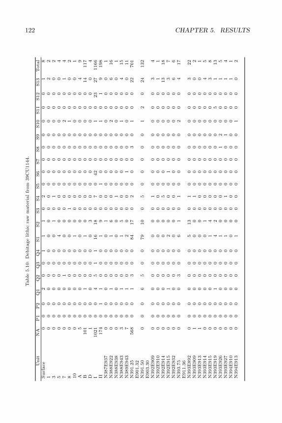
122 CHAPTER 5. RESULTST
able
5.1
0:
Debit
age
lith
icra
wm
ate
rial
from
39C
U1144.
Unit
NA
P1
P2
Q1
Q2
Q3
Q4
S1
S2
S3
S4
S5
S6
S7
S8
S9
S10
S11
S12
S13
Tota
lSurf
ace
00
02
00
11
10
20
00
00
00
01
81
00
00
00
00
00
00
00
00
00
02
23
00
00
00
00
10
10
00
00
00
00
25
00
00
00
04
00
00
00
00
00
00
47
00
00
10
00
00
00
00
00
20
01
48
00
00
00
00
01
00
00
00
10
00
210
00
00
00
01
00
00
00
00
00
00
1A
50
00
00
00
00
00
00
00
00
04
9B
101
00
10
00
10
00
00
00
00
00
14
117
D1
00
00
00
03
00
00
00
00
00
04
I1021
00
45
11
16
18
07
042
00
01
023
27
1166
II174
01
10
00
19
00
10
00
01
01
9198
N387E
937
00
00
00
00
10
00
00
00
00
00
1N
388E
922
00
01
00
01
60
00
00
00
20
06
16
N388E
938
00
00
00
00
00
10
00
00
00
00
1N
388E
943
30
01
00
01
50
00
00
00
10
04
15
N389E
943
70
01
00
02
00
00
10
00
00
00
11
N391.2
5E
901.3
2568
00
13
00
84
17
02
00
03
01
00
22
701
N391.5
0E
903.3
00
00
65
00
79
10
05
00
00
01
20
24
132
N392E
909
00
00
00
00
00
10
00
00
00
03
4N
392E
910
00
00
00
00
00
00
00
00
00
01
1N
392E
914
00
00
00
00
00
50
00
00
00
013
18
N392E
915
00
01
00
02
00
00
10
00
00
03
7N
392E
932
00
00
00
00
00
00
00
00
00
06
6N
393.7
5E
911.3
60
00
03
00
61
01
00
00
02
00
417
N393E
892
00
00
00
05
13
01
00
00
00
00
322
N393E
909
10
00
00
00
00
10
00
00
00
00
2N
393E
913
10
00
00
00
00
00
00
00
00
00
1N
393E
914
00
00
00
00
10
00
00
00
00
04
5N
393E
915
00
00
00
01
40
00
00
00
00
03
8N
393E
919
00
01
00
04
20
00
00
00
05
01
13
N393E
926
00
00
00
01
00
00
00
12
00
01
5N
393E
927
00
00
00
01
00
10
00
01
00
01
4N
394E
910
00
00
00
00
00
00
00
00
00
01
1N
394E
913
00
00
00
01
00
00
00
00
10
00
2
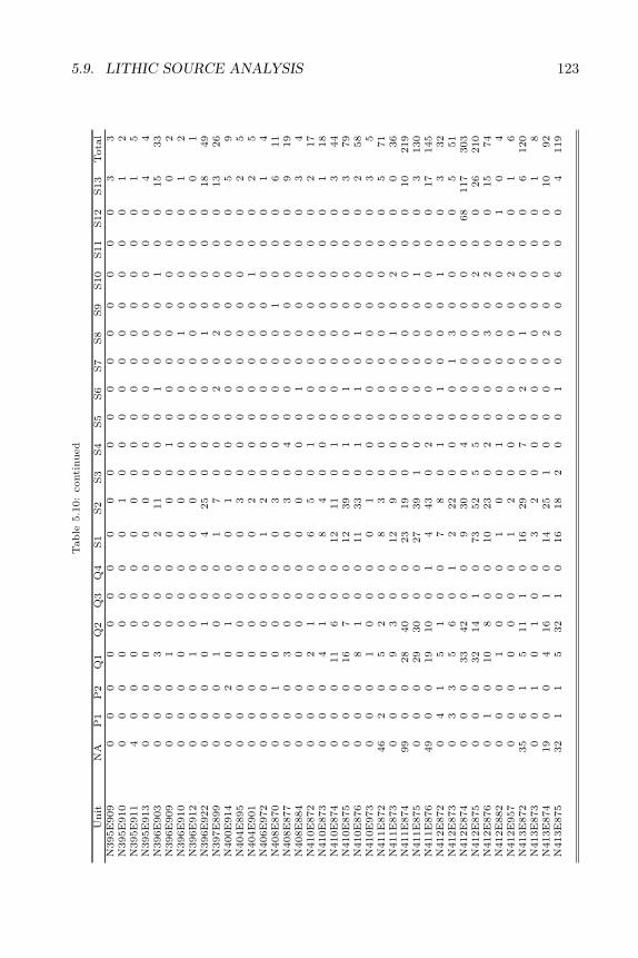
5.9. LITHIC SOURCE ANALYSIS 123T
able
5.1
0:
conti
nued
Unit
NA
P1
P2
Q1
Q2
Q3
Q4
S1
S2
S3
S4
S5
S6
S7
S8
S9
S10
S11
S12
S13
Tota
lN
395E
909
00
00
00
00
00
00
00
00
00
03
3N
395E
910
00
00
00
00
10
00
00
00
00
01
2N
395E
911
40
00
00
00
00
00
00
00
00
01
5N
395E
913
00
00
00
00
00
00
00
00
00
04
4N
396E
903
00
03
00
02
11
00
01
00
01
00
15
33
N396E
909
00
01
00
00
00
10
00
00
00
00
2N
396E
910
00
00
00
00
00
00
00
10
00
01
2N
396E
912
00
01
00
00
00
00
00
00
00
00
1N
396E
922
00
00
10
04
25
00
00
01
00
00
18
49
N397E
899
00
01
00
01
70
00
20
20
00
013
26
N400E
914
00
20
10
00
10
00
00
00
00
05
9N
404E
895
00
00
00
00
30
00
00
00
00
02
5N
404E
901
00
00
00
00
20
00
00
00
10
02
5N
406E
972
00
00
00
01
20
00
00
00
00
01
4N
408E
870
00
10
00
00
30
00
00
01
00
06
11
N408E
877
00
03
00
00
30
40
00
00
00
09
19
N408E
884
00
00
00
00
00
00
10
00
00
03
4N
410E
872
00
02
10
06
50
10
00
00
00
02
17
N410E
873
00
04
10
08
40
00
00
00
00
01
18
N410E
874
00
011
60
012
11
01
00
00
00
00
344
N410E
875
00
016
70
012
39
01
01
00
00
00
379
N410E
876
00
08
10
011
33
01
01
01
00
00
258
N410E
973
00
01
00
00
10
00
00
00
00
03
5N
411E
872
46
20
52
00
83
00
00
00
00
00
571
N411E
873
00
09
30
012
90
00
00
10
20
00
36
N411E
874
99
00
28
40
00
23
19
00
00
00
00
00
10
219
N411E
875
00
029
30
00
27
39
10
00
00
01
00
3130
N411E
876
49
00
19
10
01
443
02
00
00
00
00
17
145
N412E
872
04
15
10
07
80
10
10
00
10
03
32
N412E
873
03
35
60
12
22
00
00
13
00
00
551
N412E
874
00
033
42
00
930
04
00
00
00
068
117
303
N412E
875
00
032
14
10
73
52
55
00
00
02
00
26
210
N412E
876
01
010
80
010
23
02
00
03
02
00
15
74
N412E
882
00
01
00
01
00
10
00
00
00
10
4N
412E
957
00
00
00
01
20
00
00
00
20
01
6N
413E
872
35
61
511
10
16
29
07
02
01
00
00
6120
N413E
873
00
10
10
03
20
00
00
00
00
01
8N
413E
874
19
00
416
10
14
25
10
00
02
00
00
10
92
N413E
875
32
11
532
10
16
18
20
01
00
06
00
4119
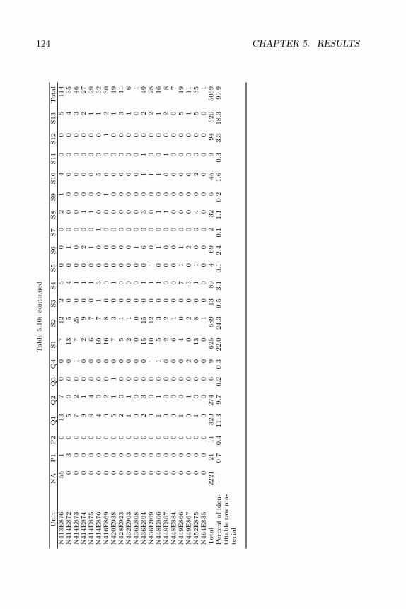
124 CHAPTER 5. RESULTST
able
5.1
0:
conti
nued
Unit
NA
P1
P2
Q1
Q2
Q3
Q4
S1
S2
S3
S4
S5
S6
S7
S8
S9
S10
S11
S12
S13
Tota
lN
413E
876
55
10
13
70
07
12
25
00
02
14
00
5114
N414E
872
03
05
00
013
50
40
10
00
00
04
35
N414E
873
00
07
20
17
25
01
00
00
00
00
346
N414E
874
00
09
10
02
90
10
20
10
00
02
27
N414E
875
00
08
40
06
70
10
10
10
00
01
29
N414E
876
00
04
00
010
71
30
01
00
50
01
32
N416E
869
00
00
20
016
80
00
00
01
00
12
30
N420E
938
00
05
11
07
30
10
00
00
00
01
19
N428E
923
00
02
00
05
10
00
00
00
00
03
11
N432E
903
00
01
10
02
10
00
00
00
00
01
6N
436E
808
00
00
00
00
00
00
10
00
00
00
1N
436E
894
00
02
30
015
15
01
06
03
01
10
249
N436E
909
00
00
00
110
12
01
10
00
01
00
228
N448E
866
00
01
10
15
30
10
10
10
10
01
16
N448E
867
00
00
00
02
20
00
00
10
01
02
8N
448E
884
00
00
00
06
10
00
00
00
00
00
7N
449E
866
00
01
00
04
00
71
10
00
00
05
19
N449E
867
00
00
10
20
20
30
20
00
00
01
11
N452E
875
00
01
00
013
80
11
00
40
20
05
35
N464E
835
00
00
00
00
10
00
00
00
00
00
1T
ota
l2221
21
11
320
274
69
625
689
13
89
469
232
645
994
520
5059
Perc
ent
of
iden-
tifiable
raw
ma-
teri
al
—0.7
0.4
11.3
9.7
0.2
0.3
22.0
24.3
0.5
3.1
0.1
2.4
0.1
1.1
0.2
1.6
0.3
3.3
18.3
99.9
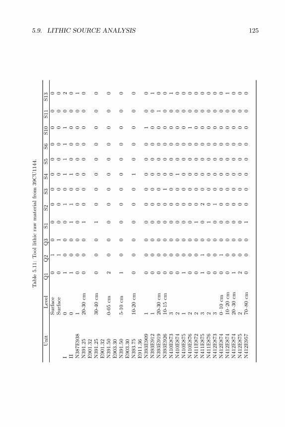
5.9. LITHIC SOURCE ANALYSIS 125T
ab
le5.1
1:
Tool
lith
icra
wm
ate
rial
from
39C
U1144.
Un
itL
evel
Q1
Q2
Q3
S1
S2
S3
S4
S5
S6
S10
S11
S13
Su
rface
01
00
00
00
00
00
Su
rface
01
10
00
00
00
00
I0
10
00
10
11
11
02
II0
10
01
10
10
00
00
N387E
938
10
00
00
00
00
00
1N
391.2
5E
901.3
220-3
0cm
00
01
00
00
00
00
N391.2
5E
901.3
230-4
0cm
00
01
00
00
00
00
N391.5
0E
903.3
00-0
5cm
20
00
00
00
00
00
N391.5
0E
903.3
05-1
0cm
10
00
00
00
00
00
N393.7
5E
911.3
610-2
0cm
00
00
00
10
00
00
N393E
909
10
00
00
00
00
10
0N
393E
912
10
00
00
00
00
00
1N
393E
919
20-3
0cm
00
00
00
00
00
10
N393E
926
10-1
5cm
00
00
01
00
00
00
N410E
873
30
00
00
00
00
00
1N
410E
874
20
00
00
01
00
00
0N
410E
875
11
00
00
00
00
00
0N
410E
876
20
00
00
00
00
10
0N
411E
872
20
00
10
00
00
00
0N
411E
875
31
10
02
00
00
00
0N
411E
876
20
00
10
00
00
00
0N
412E
873
30
00
01
00
00
00
0N
412E
874
0–10
cm0
10
00
00
00
00
0N
412E
874
10–20
cm0
00
00
00
00
00
1N
412E
874
20–30
cm1
00
00
00
00
00
0N
412E
875
22
00
00
00
00
00
0N
412E
957
70–80
cm0
00
10
00
00
00
0
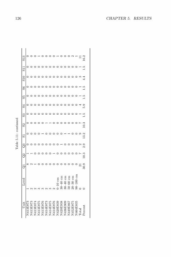
126 CHAPTER 5. RESULTST
ab
le5.1
1:
conti
nu
ed
Un
itL
evel
Q1
Q2
Q3
S1
S2
S3
S4
S5
S6
S10
S11
S13
N413E
873
18
10
00
00
00
00
0N
413E
873
22
10
00
00
00
00
0N
413E
874
21
00
00
00
00
00
0N
413E
875
30
00
00
00
00
00
1N
413E
876
30
00
10
00
00
00
0N
414E
873
20
00
01
00
00
00
0N
414E
875
30
00
01
00
00
00
0N
414E
876
20
10
00
00
00
00
0N
420E
839
0–10
cm0
00
00
00
00
00
1N
420E
938
30–40
cm0
01
00
00
00
00
0N
436E
909
30–40
cm0
00
10
00
00
00
0N
449E
867
50–60
cm0
00
10
00
00
00
0N
452E
875
20–30
cm0
00
00
00
00
00
2N
464E
835
90–100
cm0
00
00
00
00
00
1T
ota
l0
21
72
97
14
11
31
11
Per
cent
030.9
10.3
2.9
13.2
10.3
1.5
5.9
1.5
1.5
4.4
1.5
16.2
5.10. UNMODIFIED ROCK 127
of exotic lithic materials.Knife River Flint debitage (Silicate 9) was confined to Components A and B.
The 6 pieces of KRF debitage occurred between 5 and 20 cm below surface. Notools of this material were found at the Blaine site. As was noted in Chapter 4,use of this material in the Black Hills generally correlates with early Late Archaicoccupations. This agrees with the horizontal distribution of this raw materialtype, which is largely confined to the Middle to Late Archaic component of thesite. The single Badlands knife fragment was also found in the Middle to LateArchaic component of this site. Badlands knives, Knife River Flint, and LateArchaic diagnostics commonly co-occur in the Black Hills.
The two kinds of porcellanite were confined to the upper 20 centimeters ofthe site in Components A and B. No porcellanite tools were found. Porcellaniteis generally correlated with Late Prehistoric occupations in the Black Hills (seeChapter 4).
Silicate 10 debitage, Spanish Diggings chert, is more widely distributed. Itoccurs primarily 0–20 cm below surface, but a few pieces were found at 20–30and 40–50 cm below surface. The three tools and possible core-tool made ofSilicate 10 were found at or within 7 cm of the surface, placing them in Com-ponont A (Late Prehistoric). Together with ceramics from the site and thelimited distribution of porcellanite, this provides a weak indicator of a shifttoward a western or southwestern, rather than eastern, orientation correspond-ing to the Late Prehistoric component. Rather than migration or trade fromthe Middle Missouri subarea, as suggested by the Knife River Flint and Bad-lands knife in the Late Archaic component, links to the eastern Powder RiverBasin and/or the Platte River Valley are suggested by the Silicate 10 tools, theporcellanite debitage, and possibly the ceramics in the Late Prehistoric compo-nent. It should be stressed, however, that all of these materials occur as minorconstituents of strongly localized artifact assemblages.
In summary, lithic assemblages from the Blaine site indicate a strong andpersistent trend toward use of local materials. This overall local lithic procure-ment pattern is interrupted by a weak trend toward greater use of nonlocalmaterials during the Late Archaic and Late Prehistoric periods. Use of KnifeRiver Flint and Badlands plate chalcedony is associated with Late Archaic useof the site, while porcellanite and Spanish Diggings chert are associated withthe Late Prehistoric occupation. All of these trends conform with previousobservations of Black Hills lithic material sourcing patterns.
5.10 Unmodified Rock
Rough, or non-chipped, rock was found in abundance at the Blaine site. Thisrock appears to have been largely used as heating stones and tent weights. Therock was evaluated according to three criteria: material type, form of material,and size. Material types included limestone, sandstone, siltstone, and chert(Table 5.12). Both tabular and rounded (waterworn) forms occurred. Theunmodified rock included three size categories: pebble (less than 6.4 cm), cobble
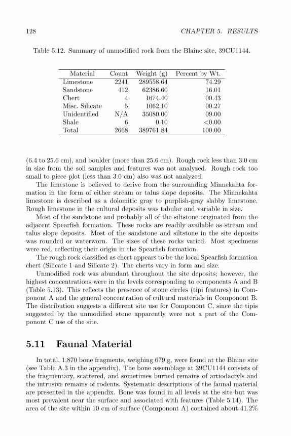
128 CHAPTER 5. RESULTS
Table 5.12. Summary of unmodified rock from the Blaine site, 39CU1144.
Material Count Weight (g) Percent by Wt.Limestone 2241 289558.64 74.29Sandstone 412 62386.60 16.01Chert 4 1674.40 00.43Misc. Silicate 5 1062.10 00.27Unidentified N/A 35080.00 09.00Shale 6 0.10 <0.00Total 2668 389761.84 100.00
(6.4 to 25.6 cm), and boulder (more than 25.6 cm). Rough rock less than 3.0 cmin size from the soil samples and features was not analyzed. Rough rock toosmall to piece-plot (less than 3.0 cm) also was not analyzed.
The limestone is believed to derive from the surrounding Minnekahta for-mation in the form of either stream or talus slope deposits. The Minnekahtalimestone is described as a dolomitic gray to purplish-gray slabby limestone.Rough limestone in the cultural deposits was tabular and variable in size.
Most of the sandstone and probably all of the siltstone originated from theadjacent Spearfish formation. These rocks are readily available as stream andtalus slope deposits. Most of the sandstone and siltstone in the site depositswas rounded or waterworn. The sizes of these rocks varied. Most specimenswere red, reflecting their origin in the Spearfish formation.
The rough rock classified as chert appears to be the local Spearfish formationchert (Silicate 1 and Silicate 2). The cherts vary in form and size.
Unmodified rock was abundant throughout the site deposits; however, thehighest concentrations were in the levels corresponding to components A and B(Table 5.13). This reflects the presence of stone circles (tipi features) in Com-ponont A and the general concentration of cultural materials in Componont B.The distribution suggests a different site use for Componont C, since the tipissuggested by the unmodified stone apparently were not a part of the Com-ponont C use of the site.
5.11 Faunal Material
In total, 1,870 bone fragments, weighing 679 g, were found at the Blaine site(see Table A.3 in the appendix). The bone assemblage at 39CU1144 consists ofthe fragmentary, scattered, and sometimes burned remains of artiodactyls andthe intrusive remains of rodents. Systematic descriptions of the faunal materialare presented in the appendix. Bone was found in all levels at the site but wasmost prevalent near the surface and associated with features (Table 5.14). Thearea of the site within 10 cm of surface (Componont A) contained about 41.2%
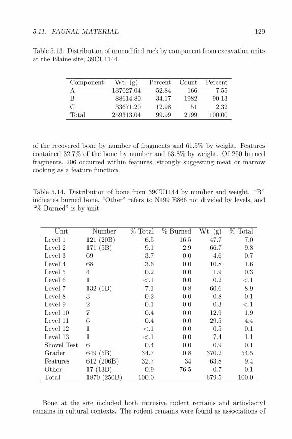
5.11. FAUNAL MATERIAL 129
Table 5.13. Distribution of unmodified rock by component from excavation unitsat the Blaine site, 39CU1144.
Component Wt. (g) Percent Count PercentA 137027.04 52.84 166 7.55B 88614.80 34.17 1982 90.13C 33671.20 12.98 51 2.32Total 259313.04 99.99 2199 100.00
of the recovered bone by number of fragments and 61.5% by weight. Featurescontained 32.7% of the bone by number and 63.8% by weight. Of 250 burnedfragments, 206 occurred within features, strongly suggesting meat or marrowcooking as a feature function.
Table 5.14. Distribution of bone from 39CU1144 by number and weight. “B”indicates burned bone, “Other” refers to N499 E866 not divided by levels, and“% Burned” is by unit.
Unit Number % Total % Burned Wt. (g) % TotalLevel 1 121 (20B) 6.5 16.5 47.7 7.0Level 2 171 (5B) 9.1 2.9 66.7 9.8Level 3 69 3.7 0.0 4.6 0.7Level 4 68 3.6 0.0 10.8 1.6Level 5 4 0.2 0.0 1.9 0.3Level 6 1 <.1 0.0 0.2 <.1Level 7 132 (1B) 7.1 0.8 60.6 8.9Level 8 3 0.2 0.0 0.8 0.1Level 9 2 0.1 0.0 0.3 <.1Level 10 7 0.4 0.0 12.9 1.9Level 11 6 0.4 0.0 29.5 4.4Level 12 1 <.1 0.0 0.5 0.1Level 13 1 <.1 0.0 7.4 1.1Shovel Test 6 0.4 0.0 0.9 0.1Grader 649 (5B) 34.7 0.8 370.2 54.5Features 612 (206B) 32.7 34 63.8 9.4Other 17 (13B) 0.9 76.5 0.7 0.1Total 1870 (250B) 100.0 679.5 100.0
Bone at the site included both intrusive rodent remains and artiodactylremains in cultural contexts. The rodent remains were found as associations of
130 CHAPTER 5. RESULTS
disarticulated skeletal elements. Most of the limbs were unbroken or fracturedmidshaft, including such delicate elements as fibulae. Elements show abrasion,some rounding, and lack of some of the more delicate processes. The incompletenature of the skeletons, along with the mechanically damaged nature of thebones suggests predepositional erosion, mixing, and/or transport. The rodentremains are in better condition and less soil-stained then the artiodactyl remains,suggesting that they are of more recent origin than the larger mammals. Thepresence of the rodent bones also is evidence of postdepositional bioturbationat the site.
The nonrodent remains consist of soil-stained, small bone pieces or crackedlimb fragments. The extreme fragmentation of bone at the site probably is theresult of intential breakage for bone grease extraction or other food processingactivity. Many of the limb fragment edges are roughened or splintered in ap-pearence, possibly caused by alternate drying and wetting of the bone on andbelow the surface. Two fragments (#1306, #1620) have rodent gnaw markswhich suggests the remains were exposed for some time before burial. Largerfragments also display the pitting and fine grooving caused by the acid actionon the bone of plant root growth in the humic A horizon.
Some bone is more clearly culturally modified. Burned bone made up 13.4%of the bone assemblage. Burned bone was limited to unidentifiable large animalremains. Of this, 82.4% was found in or near features. Burned bone was alsofound in Level 1 (8.0%), Level 2 (2.0%), Level 7 (0.4%), the grader scrape(2.0%), and Unit N499E866, level unknown (5.2%). Apart from this burnedbone, there is little other evidence of human modification of bone at the site.One rib fragment (#1085) has a triangular cut mark along a worn, broken endand another rib fragment (#1620) has several small cut marks along one edge.Limb fragment #1691 from the Grader Scrape displays cutmarks and green(fresh bone) flaking along one edge, however, the bone is unstained and is inmuch better condition that the other large mammal remains. It is assumed tobe of modern origin.
Much of the bone from 39CU1144 is fragmentary. The small sample sizesuggests that little bone was processed or discarded at the site. Much of the bonecould have been destroyed due to surface weathering and removal by scavengers;however, older, more fragile, and appreciably more bone was preserved at nearby39CU1142. This confirms the contention that meat processing was not a majoractivity at the Blaine site. At the same time, the limited amounts of bone atthe sight appear to have been heavily processed. Large animal bone appears tohave been deliberately smashed in order to extract the bone marrow.
The identification of faunal elements was made with reference to compar-ative collections at the State Archaeological Research Center and the SouthDakota School of Mines and Technology, Museum of Geology. Reference wasalso made to several published works (Gilbert 1980; Olsen 1985; Schmid 1972)and a master’s thesis (Abbott 1989). None of the bone was in poor enoughcondition to require the use of preservatives. Glues were also not used in anybone reconstruction. The bone was dry brushed and left unwashed.
5.12. FLORAL MATERIAL 131
Identification of specimens beyond the ordinal level was difficult due to thefragmentary nature of the material. Only 3.8% of the bone assemblage wasidentifiable to the species level, with 0.1% identifiable to the genus level and2.8% to the ordinal level. The remaining 93.3% was identifiable only as mammalbone.
The minimum number of individuals was defined as the least number of in-dividuals represented by a particular left or right body part (Klein 1980). Usingthis method 7 individuals were recognized from 39CU1144: 3 Eutamius min-imus, 1 Marmota flaviventris, 1 Bison bison, 1 Microtus sp., and 1 Odocoileussp. The biases in this method are that it will overemphasize species with morebody parts, species with more diagnostic elements, and species that are lessprone to fragmentation.
In summary, the Blaine site contains very limited amounts of bone scrap.The vast majority of bone from the site is in the form of small, unidentifiablefragments. The data indicate limited use of bison and deer. Other ungulatesmay be represented in the mass of unidentifiable bone fragments; however, this isimpossible to ascertain given the fragmented nature of the bone. Although mar-mot has been identified in archaeological contexts elsewhere in the northwesternplains (Frison 1991:265), the marmot remains from the Blaine site appear to benaturally rather than culturally deposited.
In its faunal assemblage, Blaine contrasts with other Red Valley sites. Thesetypically contain only bison, or bison and wolf or dog, remains. The Vore sitecontained small amounts of deer bone among a prodominantly bison assemblage(Reher and Frison 1980). Blaine also contains less bone overall than the otherinvestigated Red Valley sites. This no doubt reflects a functional difference, asthe other Red Valley sites represent bison kill sites. The small amount of bonepresent at Blaine precludes a kill or meat processing function for the site. Thedata are more consistent with limited meat and marrow consumption in thecontext of short-term habitation.
5.12 Floral Material
The few seeds found within the Blaine site deposits were uncharred andare assumed to be non-cultural. Charcoal was not identified. No other floralremains were found at the site.
5.13 Seasonality Data
Very little information is available concerning the seasonality of site use atthe Blaine site. The site is somewhat sheltered and outside the zone of heavysnowpack; thus, it could reasonably have been used at any time of the year.The bone assemblage did not contain any usable seasonality indicators, such asidentifiable fetal or juvenile bison remains. The small size of the fire hearths sug-gests a cooking function, rather than heating facilities. This indirectly suggests

132 CHAPTER 5. RESULTS
warm-season use of the site. The lack of ground stone tools may also indicate awarm-season occupation. In the Black Hills, such artifacts are most commonlyassociated with winter or late fall occupations (Tratebas 1986). Overall, sea-sonality signals are weak, but somewhat suggestive of summer use of the site.The limited seasonality data are consistent throughout the site assemblage. Inother words, no change in seasonality through time could be detected from theavailable data.
Chapter 6
GEOARCHAEOLOGICALINVESTIGATIONS
6.1 Introduction
Geoarchaeological evaluation of the soil/sediment relationships at the Blainesite (39FA1144) had two goals. The primary goal was to assess the potential ofsediments within the study area to contain intact archaeological deposits andto assess the stratigraphic integrity of the archaeological materials encounteredduring excavation. An additional goal was to document the terrace sequence atthe Blaine site and determine its relationship to regional alluvial chronologiesand paleoenvironmental models. These goals were considered important notonly to the archaeological investigations at 39CU1144, but to predictive modelsof human-terrain relationships within the region.
Cultural materials at 39CU1144 are associated with the higher of two alluvialterraces within Gillette Canyon, a relatively small valley on the southwesternmargin of the Black Hills physiographic section (Fenneman 1931:8). Based ontheir elevations, soil/sediment records, and the position of radiocarbon-datedcultural features and soil horizons, these two terraces are tentatively correlatedto the middle to late Holocene Kaycee and Moorcroft terraces recognized inthe adjacent Powder River Basin (Leopold and Miller 1954; Figure 6.1). TheKaycee equivalent terrace is of primary concern to archaeological investigationsat 39CU1144 because Early Archaic and younger cultural components are asso-ciated with sediments in the top meter of this terrace fill. Component A (LatePrehistoric) is found on and near the surface of the Kaycee equivalent terrace.Component B (Middle and Late Archaic) extends from about 10 to 45 cm be-low the surface of this terrace, and Component C (Early Archaic) extends fromabout 45 to 90 cm below surface. No archaeological materials were found in thelower, Moorcroft terrace.
133
134 CHAPTER 6. GEOARCHAEOLOGICAL INVESTIGATIONS
6.2 Physiography and Geology
The Gillette Canyon study area is located at the southwestern margin of theBlack Hills, an isolated mountain range within the Great Plains physiographicprovince (Fenneman 1931:8). Gillette Canyon is a small valley occupied by anephemeral tributary of the Cheyenne River. Two alluvial terraces are presentwithin Gillette Canyon at the Blaine site. They are bounded by small ephemeraldrainages on their northern, southern, and western margins and by limestoneoutcrops to the east. The bedrock outcropping immediately adjacent to the39CU1144 study area is Minnekahta Formation limestone of Lower Permianage. Opeche Formation shale of the same age underlies the site (Love et al.1977).
6.3 Background and Methods
Geoarchaeological investigations at the Blaine Site were guided by two work-ing hypotheses. The first was that the terrace sequence at Blaine could be cor-related to regional alluvial terrace sequences. If correlations were found, thesequence of terrace building and down-cutting could then be related to regionalpaleoenvironmental models. The second, alternative, hypothesis was that thealluvial chronology at the site was unique and not comparable to the regionalmodel.
The prevailing alluvial terrace sequence for the Wyoming-Montana-SouthDakota tri-state area is the classic model developed by Leopold and Miller(1954). This model identifies three Holocene terraces in the region. Theseterraces resulted from changing climatic conditions as evidenced by differencesin geomorphic processes, stratigraphic sequences, and pedogenic development.The oldest is the Kaycee terrace. It is a fill terrace consisting of coarse alluvialgravels of either the late Pleistocene (Arvada Formation), the early Holocene(Ucross Formation), or both, overlain by finer grained alluvium of the middleto late Holocene (Kaycee Formation, ca. 4000–2500 BP, Leopold and Miller1954). This terrace chronology is an idealized composite sequence. Even withinLeopold and Miller’s study area it is uncommon to see all three terraces ata given locale. In addition, the dates suggested by Leopold and Miller werelargely inferential, because absolute dating techniques were still in their infancyat the time of their study. Subsequent studies within the region have refinedLeopold and Miller’s (1954) original chronology (e.g. Haynes and Gray 1965;Reider 1980, 1982, 1983, 1990).
To address the two hypotheses and their paleoenvironmental implications,soils, sediments, and terrace morphologies were examined using standard geolog-ical and pedological procedures. Within eight representative backhoe trenches(Trenches A–I), ten backhoe pits (Geomorphology Windows 1–10) and 27 ar-chaeological test units, soil/sediment relationships were described to documenttheir pedogenic and geologic characteristics (Birkeland 1984; Guthrie and Wit-try 1982; Krumbein and Sloss 1963; USDA Soil Survey Staff 1975). Where
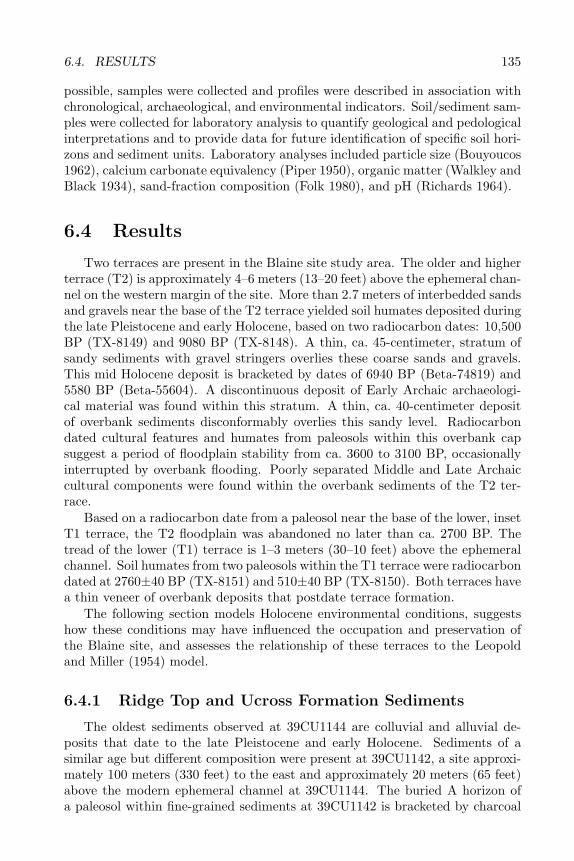
6.4. RESULTS 135
possible, samples were collected and profiles were described in association withchronological, archaeological, and environmental indicators. Soil/sediment sam-ples were collected for laboratory analysis to quantify geological and pedologicalinterpretations and to provide data for future identification of specific soil hori-zons and sediment units. Laboratory analyses included particle size (Bouyoucos1962), calcium carbonate equivalency (Piper 1950), organic matter (Walkley andBlack 1934), sand-fraction composition (Folk 1980), and pH (Richards 1964).
6.4 Results
Two terraces are present in the Blaine site study area. The older and higherterrace (T2) is approximately 4–6 meters (13–20 feet) above the ephemeral chan-nel on the western margin of the site. More than 2.7 meters of interbedded sandsand gravels near the base of the T2 terrace yielded soil humates deposited duringthe late Pleistocene and early Holocene, based on two radiocarbon dates: 10,500BP (TX-8149) and 9080 BP (TX-8148). A thin, ca. 45-centimeter, stratum ofsandy sediments with gravel stringers overlies these coarse sands and gravels.This mid Holocene deposit is bracketed by dates of 6940 BP (Beta-74819) and5580 BP (Beta-55604). A discontinuous deposit of Early Archaic archaeologi-cal material was found within this stratum. A thin, ca. 40-centimeter depositof overbank sediments disconformably overlies this sandy level. Radiocarbondated cultural features and humates from paleosols within this overbank capsuggest a period of floodplain stability from ca. 3600 to 3100 BP, occasionallyinterrupted by overbank flooding. Poorly separated Middle and Late Archaiccultural components were found within the overbank sediments of the T2 ter-race.
Based on a radiocarbon date from a paleosol near the base of the lower, insetT1 terrace, the T2 floodplain was abandoned no later than ca. 2700 BP. Thetread of the lower (T1) terrace is 1–3 meters (30–10 feet) above the ephemeralchannel. Soil humates from two paleosols within the T1 terrace were radiocarbondated at 2760±40 BP (TX-8151) and 510±40 BP (TX-8150). Both terraces havea thin veneer of overbank deposits that postdate terrace formation.
The following section models Holocene environmental conditions, suggestshow these conditions may have influenced the occupation and preservation ofthe Blaine site, and assesses the relationship of these terraces to the Leopoldand Miller (1954) model.
6.4.1 Ridge Top and Ucross Formation Sediments
The oldest sediments observed at 39CU1144 are colluvial and alluvial de-posits that date to the late Pleistocene and early Holocene. Sediments of asimilar age but different composition were present at 39CU1142, a site approxi-mately 100 meters (330 feet) to the east and approximately 20 meters (65 feet)above the modern ephemeral channel at 39CU1144. The buried A horizon ofa paleosol within fine-grained sediments at 39CU1142 is bracketed by charcoal
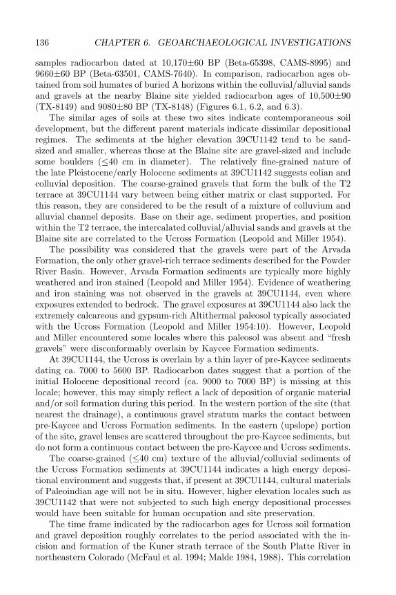
136 CHAPTER 6. GEOARCHAEOLOGICAL INVESTIGATIONS
samples radiocarbon dated at 10,170±60 BP (Beta-65398, CAMS-8995) and9660±60 BP (Beta-63501, CAMS-7640). In comparison, radiocarbon ages ob-tained from soil humates of buried A horizons within the colluvial/alluvial sandsand gravels at the nearby Blaine site yielded radiocarbon ages of 10,500±90(TX-8149) and 9080±80 BP (TX-8148) (Figures 6.1, 6.2, and 6.3).
The similar ages of soils at these two sites indicate contemporaneous soildevelopment, but the different parent materials indicate dissimilar depositionalregimes. The sediments at the higher elevation 39CU1142 tend to be sand-sized and smaller, whereas those at the Blaine site are gravel-sized and includesome boulders (≤40 cm in diameter). The relatively fine-grained nature ofthe late Pleistocene/early Holocene sediments at 39CU1142 suggests eolian andcolluvial deposition. The coarse-grained gravels that form the bulk of the T2terrace at 39CU1144 vary between being either matrix or clast supported. Forthis reason, they are considered to be the result of a mixture of colluvium andalluvial channel deposits. Base on their age, sediment properties, and positionwithin the T2 terrace, the intercalated colluvial/alluvial sands and gravels at theBlaine site are correlated to the Ucross Formation (Leopold and Miller 1954).
The possibility was considered that the gravels were part of the ArvadaFormation, the only other gravel-rich terrace sediments described for the PowderRiver Basin. However, Arvada Formation sediments are typically more highlyweathered and iron stained (Leopold and Miller 1954). Evidence of weatheringand iron staining was not observed in the gravels at 39CU1144, even whereexposures extended to bedrock. The gravel exposures at 39CU1144 also lack theextremely calcareous and gypsum-rich Altithermal paleosol typically associatedwith the Ucross Formation (Leopold and Miller 1954:10). However, Leopoldand Miller encountered some locales where this paleosol was absent and “freshgravels” were disconformably overlain by Kaycee Formation sediments.
At 39CU1144, the Ucross is overlain by a thin layer of pre-Kaycee sedimentsdating ca. 7000 to 5600 BP. Radiocarbon dates suggest that a portion of theinitial Holocene depositional record (ca. 9000 to 7000 BP) is missing at thislocale; however, this may simply reflect a lack of deposition of organic materialand/or soil formation during this period. In the western portion of the site (thatnearest the drainage), a continuous gravel stratum marks the contact betweenpre-Kaycee and Ucross Formation sediments. In the eastern (upslope) portionof the site, gravel lenses are scattered throughout the pre-Kaycee sediments, butdo not form a continuous contact between the pre-Kaycee and Ucross sediments.
The coarse-grained (≤40 cm) texture of the alluvial/colluvial sediments ofthe Ucross Formation sediments at 39CU1144 indicates a high energy deposi-tional environment and suggests that, if present at 39CU1144, cultural materialsof Paleoindian age will not be in situ. However, higher elevation locales such as39CU1142 that were not subjected to such high energy depositional processeswould have been suitable for human occupation and site preservation.
The time frame indicated by the radiocarbon ages for Ucross soil formationand gravel deposition roughly correlates to the period associated with the in-cision and formation of the Kuner strath terrace of the South Platte River innortheastern Colorado (McFaul et al. 1994; Malde 1984, 1988). This correlation
6.4. RESULTS 137
Fig
ure
6.1.
Geo
mor
phol
ogy
ofW
indo
w1
profi
le.
The
Kay
cee/
pre-
Kay
cee
cont
act
is32
cmbe
low
surf
ace.
The
pre-
Kay
cee/
Ucr
oss
cont
act
was
not
dete
rmin
ed,
but
prob
ably
falls
atab
out
111
cmbe
low
surf
ace.
138 CHAPTER 6. GEOARCHAEOLOGICAL INVESTIGATIONS
Figure
6.2.G
eomorphology
ofW
indow2
profile.T
heK
aycee/pre-Kaycee
contactis
at57
cmbelow
surface.T
hepre-
Kaycee/U
crosscontact
was
notdeterm
ined,but
probablylies
at95
cmbelow
surface.
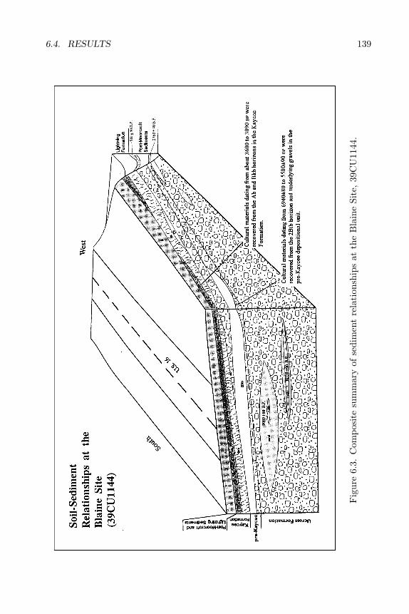
6.4. RESULTS 139
Fig
ure
6.3.
Com
posi
tesu
mm
ary
ofse
dim
ent
rela
tion
ship
sat
the
Bla
ine
Site
,39
CU
1144
.
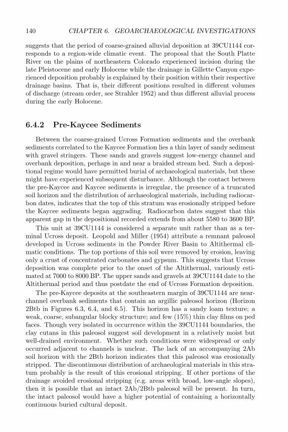
140 CHAPTER 6. GEOARCHAEOLOGICAL INVESTIGATIONS
suggests that the period of coarse-grained alluvial deposition at 39CU1144 cor-responds to a region-wide climatic event. The proposal that the South PlatteRiver on the plains of northeastern Colorado experienced incision during thelate Pleistocene and early Holocene while the drainage in Gillette Canyon expe-rienced deposition probably is explained by their position within their respectivedrainage basins. That is, their different positions resulted in different volumesof discharge (stream order, see Strahler 1952) and thus different alluvial processduring the early Holocene.
6.4.2 Pre-Kaycee Sediments
Between the coarse-grained Ucross Formation sediments and the overbanksediments correlated to the Kaycee Formation lies a thin layer of sandy sedimentwith gravel stringers. These sands and gravels suggest low-energy channel andoverbank deposition, perhaps in and near a braided stream bed. Such a deposi-tional regime would have permitted burial of archaeological materials, but thesemight have experienced subsequent disturbance. Although the contact betweenthe pre-Kaycee and Kaycee sediments is irregular, the presence of a truncatedsoil horizon and the distribution of archaeological materials, including radiocar-bon dates, indicates that the top of this stratum was erosionally stripped beforethe Kaycee sediments began aggrading. Radiocarbon dates suggest that thisapparent gap in the depositional recorded extends from about 5580 to 3600 BP.
This unit at 39CU1144 is considered a separate unit rather than as a ter-minal Ucross deposit. Leopold and Miller (1954) attribute a remnant paleosoldeveloped in Ucross sediments in the Powder River Basin to Altithermal cli-matic conditions. The top portions of this soil were removed by erosion, leavingonly a crust of concentrated carbonates and gypsum. This suggests that Ucrossdeposition was complete prior to the onset of the Altithermal, variously esti-mated at 7000 to 8000 BP. The upper sands and gravels at 39CU1144 date to theAltithermal period and thus postdate the end of Ucross Formation deposition.
The pre-Kaycee deposits at the southeastern margin of 39CU1144 are near-channel overbank sediments that contain an argillic paleosol horizon (Horizon2Btb in Figures 6.3, 6.4, and 6.5). This horizon has a sandy loam texture; aweak, coarse, subangular blocky structure; and few (15%) thin clay films on pedfaces. Though very isolated in occurrence within the 39CU1144 boundaries, theclay cutans in this paleosol suggest soil development in a relatively moist butwell-drained environment. Whether such conditions were widespread or onlyoccurred adjacent to channels is unclear. The lack of an accompanying 2Absoil horizon with the 2Btb horizon indicates that this paleosol was erosionallystripped. The discontinuous distribution of archaeological materials in this stra-tum probably is the result of this erosional stripping. If other portions of thedrainage avoided erosional stripping (e.g. areas with broad, low-angle slopes),then it is possible that an intact 2Ab/2Btb paleosol will be present. In turn,the intact paleosol would have a higher potential of containing a horizontallycontinuous buried cultural deposit.
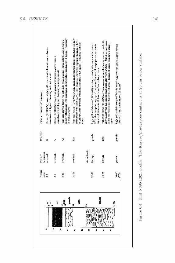
6.4. RESULTS 141
Fig
ure
6.4.
Uni
tN
396
E92
1pr
ofile
.T
heK
ayce
e/pr
e-K
ayce
eco
ntac
tis
at26
cmbe
low
surf
ace.
142 CHAPTER 6. GEOARCHAEOLOGICAL INVESTIGATIONS
Figure
6.5.U
nitN
396E
902profile
The
Kaycee/pre-K
ayceecontact
isat
33cm
belowsurface.
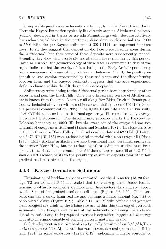
6.4. RESULTS 143
Comparable pre-Kaycee sediments are lacking from the Power River Basin.There the Kaycee Formation typically lies directly atop an Altithermal paleosol(caliche) developed in Ucross or Arvada Formation gravels. Because relativelyfew archaeological sites in the northern plains date to this period (ca. 7000to 5500 BP), the pre-Kaycee sediments at 39CU1144 are important in threeways. First, they suggest that deposition did take place in some areas duringthe Altithermal, but that some of these deposits were subsequently eroded.Secondly, they show that people did not abandon the region during this period.Taken as a whole, the geomorphology of these sites as compared to that of theregion indicates that the scarcity of sites dating to the Early Archaic period maybe a consequence of preservation, not human behavior. Third, the pre-Kayceedeposition and erosion represented by these sediments and the disconformitybetween them and the Kaycee sediments suggests that the area experiencedshifts in climate within the Altithermal climatic episode.
Sedimentary units dating to the Altithermal period have been found at otherplaces in and near the Black Hills. Only one other stream terrace of Altithermalage is known from the area. A terrace fill along Box Elder Creek in PenningtonCounty included alluvium with a mollic paleosol dating about 6700 BP (Dono-hue personal communication 1998). The Agate Basin Site about 45 km southof 39FA1144 contained an Altithermal-age arroyo fill disconformably overly-ing a late Pleistocene fill. The disconformity probably marks the Pleistocene-Holocene boundary ca. 8000 BP, but the exact age of the arroyo fill was notdetermined except as Altithermal (Frison and Stanford 1982). The Hawken Sitein the northwestern Black Hills yielded radiocarbon dates of 6270 BP (RL-437)and 6470 BP (RL-185) from archaeological material within an arroyo fill (Frison1991). Early Archaic artifacts have also been found near perennial springs inthe interior Black Hills, but no archaeological or sediment studies have beendone at these sites. The presence of an Altithermal age terrace fill at 39CU1144should alert archaeologists to the possibility of similar deposits near other lowgradient reaches of streams in the region.
6.4.3 Kaycee Formation Sediments
Examination of backhoe trenches excavated into the 4–6 meter (13–20 feet)high T2 terrace at 39CU1144 revealed that the coarse-grained Ucross Forma-tion and pre-Kaycee sediments are more than three meters thick and are cappedby 13–48 cm of fine-grained overbank sediments (Figures 6.3–6.20). This over-bank cap has a sandy loam texture and contains a minor amount (ca. 3%) ofpebble-sized clasts (Figure 6.21; Table 6.1). All Middle Archaic and youngerarchaeological materials at the Blaine site are within this thin cap of overbanksediments. The fine-grained nature of the sediments containing the archaeo-logical materials and their proposed overbank deposition suggest a low energydepositional regime capable of burying cultural materials in situ.
Soil development in the overbank cap typically consists of an O/A/Ab/Bkbhorizon sequence. The Ab paleosol horizon is overthickened (or cumulic, Birke-land 1984) in some exposures (Figure 6.19), indicating multiple episodes of
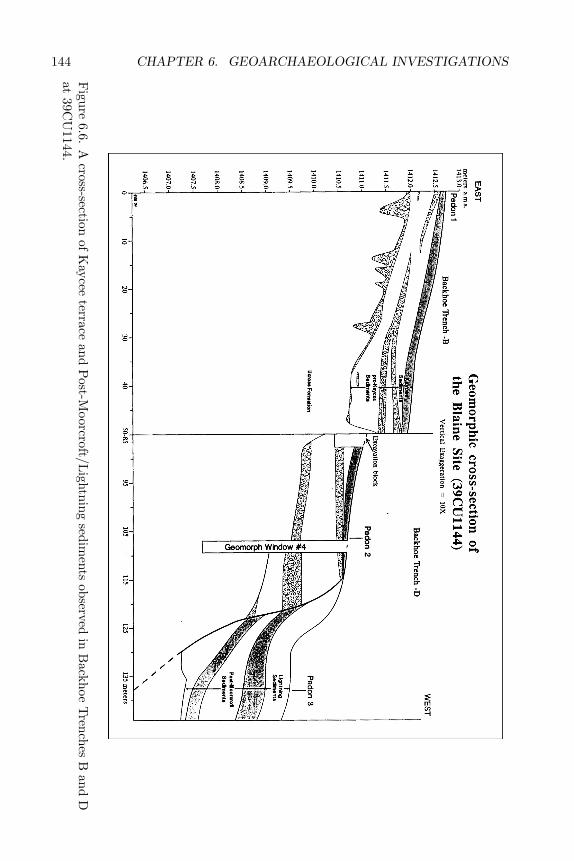
144 CHAPTER 6. GEOARCHAEOLOGICAL INVESTIGATIONS
Figure
6.6.A
cross-sectionof
Kaycee
terraceand
Post-M
oorcroft/Lightning
sediments
observedin
Backhoe
Trenches
Band
Dat
39CU
1144.
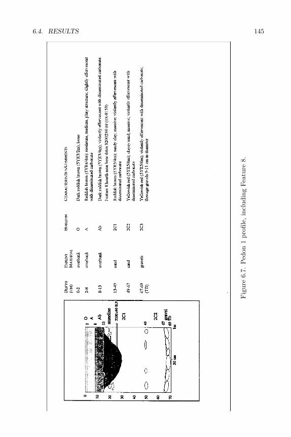
6.4. RESULTS 145
Fig
ure
6.7.
Ped
on1
profi
le,
incl
udin
gFe
atur
e8.
146 CHAPTER 6. GEOARCHAEOLOGICAL INVESTIGATIONS
Figure
6.8.P
edon2
profile,39C
U1144.
Kaycee/pre-K
ayceecontact
isat
23cm
belowsurface.
Pre-K
aycee/Ucross
contactis
at39
cmbelow
surface.
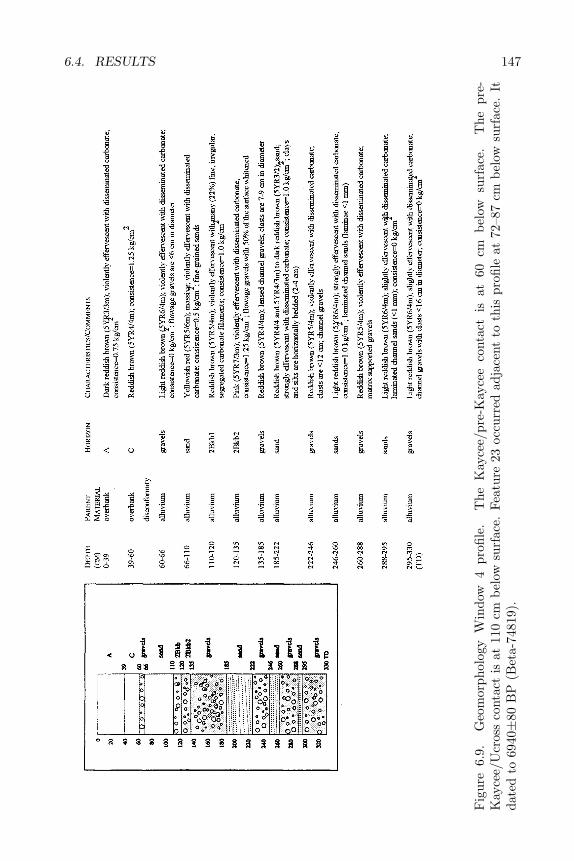
6.4. RESULTS 147
Fig
ure
6.9.
Geo
mor
phol
ogy
Win
dow
4pr
ofile
.T
heK
ayce
e/pr
e-K
ayce
eco
ntac
tis
at60
cmbe
low
surf
ace.
The
pre-
Kay
cee/
Ucr
oss
cont
act
isat
110
cmbe
low
surf
ace.
Feat
ure
23oc
curr
edad
jace
ntto
this
profi
leat
72–8
7cm
belo
wsu
rfac
e.It
date
dto
6940±
80B
P(B
eta-
7481
9).
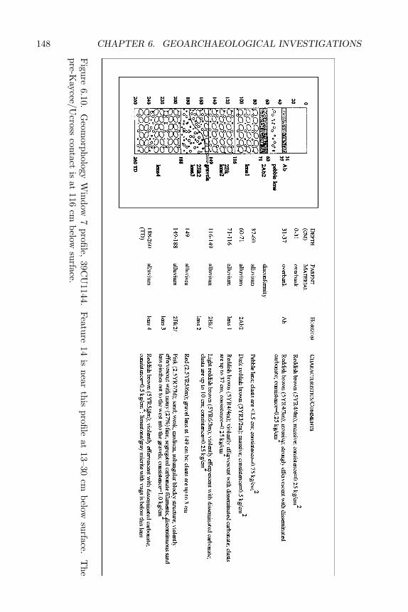
148 CHAPTER 6. GEOARCHAEOLOGICAL INVESTIGATIONS
Figure
6.10.G
eomorphology
Window
7profile,
39CU
1144.Feature
14is
nearthis
profileat
13–30cm
belowsurface.
The
pre-Kaycee/U
crosscontact
isat
116cm
belowsurface.

6.4. RESULTS 149
Fig
ure
6.11
.G
eom
orph
olog
yW
indo
w10
profi
le.
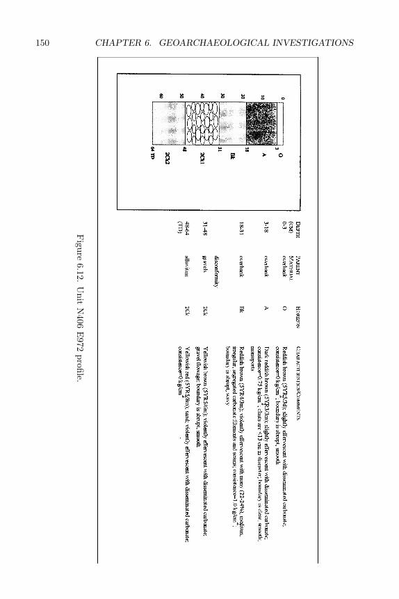
150 CHAPTER 6. GEOARCHAEOLOGICAL INVESTIGATIONS
Figure
6.12.U
nitN
406E
972profile.
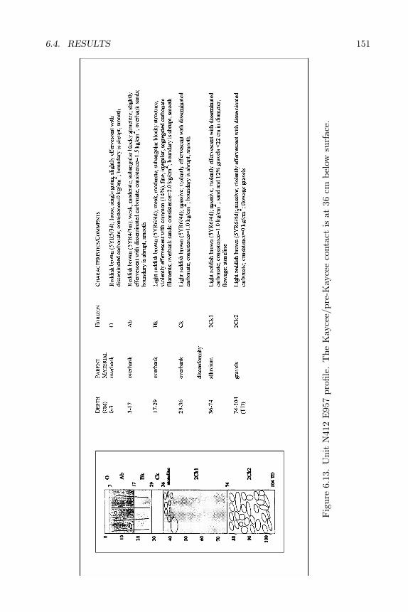
6.4. RESULTS 151
Fig
ure
6.13
.U
nit
N41
2E
957
profi
le.
The
Kay
cee/
pre-
Kay
cee
cont
act
isat
36cm
belo
wsu
rfac
e.
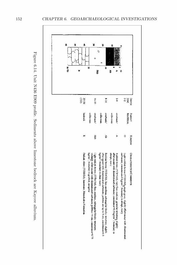
152 CHAPTER 6. GEOARCHAEOLOGICAL INVESTIGATIONS
Figure
6.14.U
nitN
436E
909profile.
Sediments
abovelim
estonebedrock
areK
ayceealluvium
.
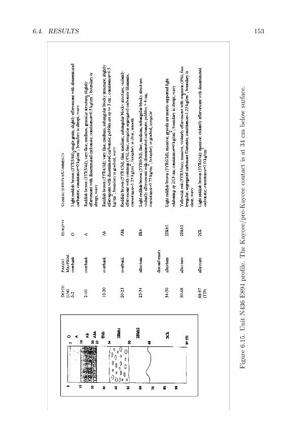
6.4. RESULTS 153
Fig
ure
6.15
.U
nit
N43
6E
894
profi
le.
The
Kay
cee/
pre-
Kay
cee
cont
act
isat
34cm
belo
wsu
rfac
e.
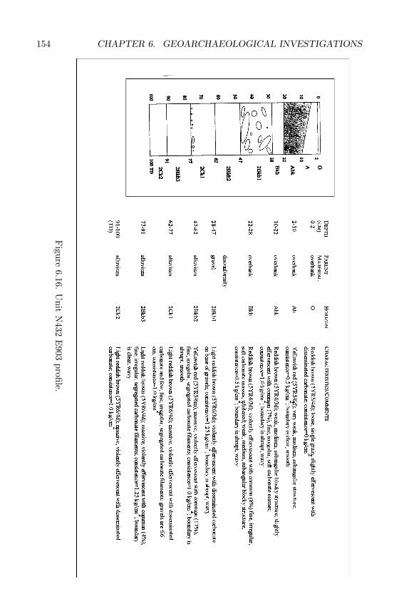
154 CHAPTER 6. GEOARCHAEOLOGICAL INVESTIGATIONS
Figure
6.16.U
nitN
432E
903profile.
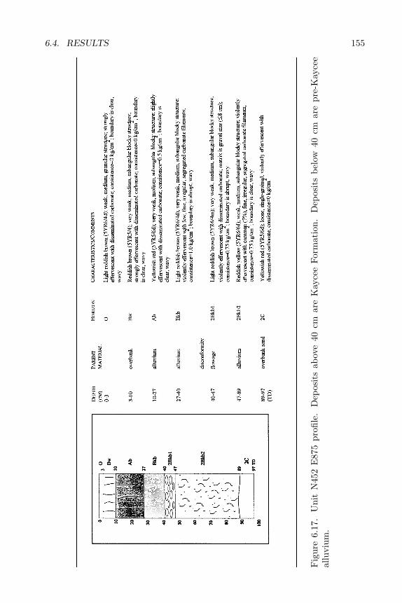
6.4. RESULTS 155
Fig
ure
6.17
.U
nit
N45
2E
875
profi
le.
Dep
osit
sab
ove
40cm
are
Kay
cee
Form
atio
n.D
epos
its
belo
w40
cmar
epr
e-K
ayce
eal
luvi
um.
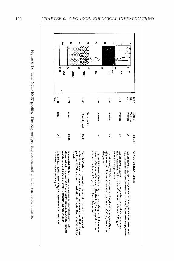
156 CHAPTER 6. GEOARCHAEOLOGICAL INVESTIGATIONS
Figure
6.18.U
nitN
449E
867profile.
The
Kaycee/pre-K
ayceecontact
isat
49cm
belowsurface.
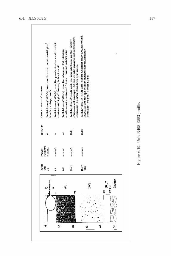
6.4. RESULTS 157
Fig
ure
6.19
.U
nit
N40
8E
883
profi
le.
158 CHAPTER 6. GEOARCHAEOLOGICAL INVESTIGATIONS
overbank flooding. Hearths at 39CU1144 are associated with the Ab horizonand intrude into the Bkb horizon (Figures 6.7 and 6.8). The upper portions ofthe hearths are within the cumulic Ab horizon, indicating that the occupationsat 39CU1144 took place during a period when overbank flooding was common.The fact that the hearths intrude into the Bk horizon may imply that the hearthbuilders preferred the durability of this calcareous horizon for the constructionof such features. An association of intrusive cultural features with calcareoussoil horizons has also been noted for Late Prehistoric sites in the Southwest(McFaul et al. 1993). None of the hearths extend into the lower 2Btb horizon,perhaps because this is capped by a gravel in many places that would makedigging difficult.
Radiocarbon ages of soil humates and charcoal obtained from hearths withinthe overbank sediments indicate that this upper cap was deposited from ca. 3600to 3100 BP (Beta-74819 and 74818). Two hearths on the T2 terrace (Features 4and 17) date to ca. 2500 BP (Beta-74815 and 74817). Since these postdate the2760±40 BP (TX-8151) Ab2 soil in the inset T1 terrace (Figures 6.3 and 6.22),they represent occupations of the T2 surface after stream incision to the T1 level.For this reason, the ca. 3100 BP time frame indicated by Features 8 (3198±60BP, TX-8153) and 19 (3090±60 BP, Beta-74817) is considered to approximatethe abandonment of the T2 floodplain and incision to the T1 level. The ca.3600–3100 BP time frame, the position of the terrace, soil development, andsediment characteristics suggest that the upper T2 overbank sediments correlateto the Kaycee Formation in the Powder River Basin and that the T2 terrace of39CU1144 correlates to the Kaycee terrace (Leopold and Miller 1954). In thePowder River Basin, the Kaycee is estimated to have formed between 4000 and2500 BP (Leopold and Miller 1954). In addition, the ca. 3100 BP time framefor abandonment of the Kaycee or T2 terrace corresponds to the end of the LateTriple Lakes glacial advance in the Colorado Front Range (Benedict 1981, 1985).Thus, the overbank sediments, soil development, and abandonment of the T2or Kaycee terrace at 39CU1144 probably relate to climatic events. The ca.6940–3090 BP age of the overbank cap and pre-Kaycee sediments also suggeststhat the upper 10–90 cm of the Kaycee terrace have the potential to yield EarlyArchaic and later cultural materials.
The uppermost sediments on the T2 terrace, those containing the modernA horizon, were not radiocarbon dated due to the likelihood of modern hu-mate contamination. However, a radiocarbon age of 510±40 BP (TX-8150) wasdetermined for humates in a buried paleosol at Geomorphology Window 5 (Fig-ure 6.23). This date suggests that, after channel incision to the T1 level, boththe T1 and T2 terraces were occasionally inundated. Late Prehistoric archae-ological materials were associated with the surface and upper 10 cm of the T2terrace.
6.4.4 The T1 Terrace
The tread of the lower or T1 terrace at 39CU1144 is 1–3 meters (3–10 feet)above the ephemeral stream channel. Sediments of this terrace consist entirely
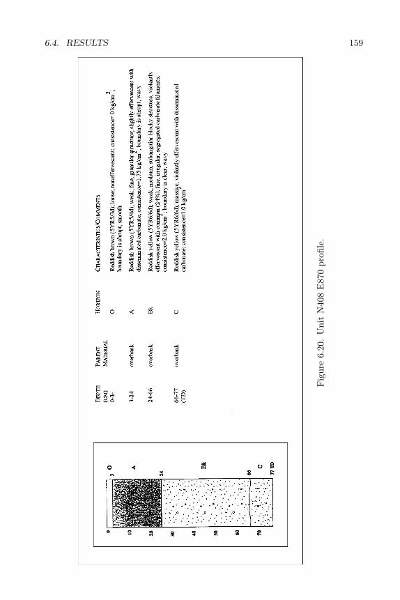
6.4. RESULTS 159
Fig
ure
6.20
.U
nit
N40
8E
870
profi
le.
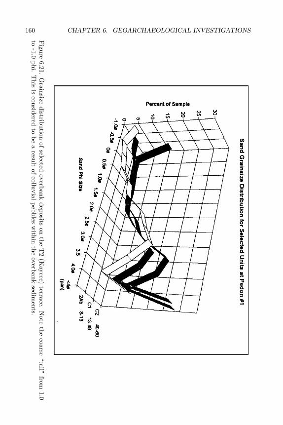
160 CHAPTER 6. GEOARCHAEOLOGICAL INVESTIGATIONS
Figure
6.21.G
rainsizedistribution
ofselected
overbankdeposits
onthe
T2
(Kaycee)
terrace.N
otethe
coarse“tail”
from1.0
to-1.0
phi.T
hisis
consideredto
bea
resultof
colluvialpebbles
within
theoverbank
sediments.
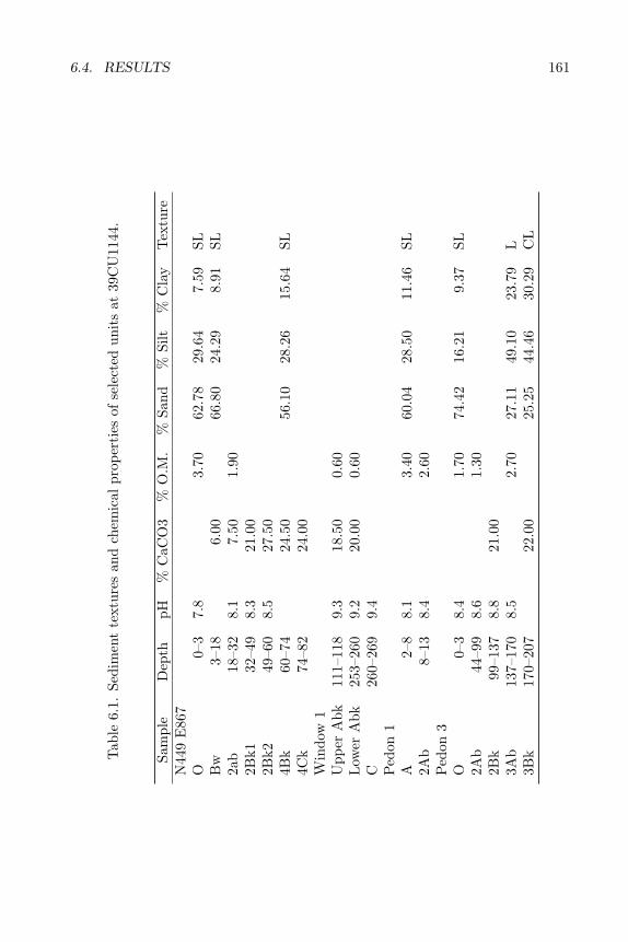
6.4. RESULTS 161
Tab
le6.
1.Se
dim
ent
text
ures
and
chem
ical
prop
erti
esof
sele
cted
unit
sat
39C
U11
44.
Sam
ple
Dep
thpH
%C
aCO
3%
O.M
.%
Sand
%Si
lt%
Cla
yT
extu
reN
449
E86
7O
0–3
7.8
3.70
62.7
829
.64
7.59
SLB
w3–
186.
0066
.80
24.2
98.
91SL
2ab
18–3
28.
17.
501.
902B
k132
–49
8.3
21.0
02B
k249
–60
8.5
27.5
04B
k60
–74
24.5
056
.10
28.2
615
.64
SL4C
k74
–82
24.0
0W
indo
w1
Upp
erA
bk11
1–11
89.
318
.50
0.60
Low
erA
bk25
3–26
09.
220
.00
0.60
C26
0–26
99.
4P
edon
1A
2–8
8.1
3.40
60.0
428
.50
11.4
6SL
2Ab
8–13
8.4
2.60
Ped
on3
O0–
38.
41.
7074
.42
16.2
19.
37SL
2Ab
44–9
98.
61.
302B
k99
–137
8.8
21.0
03A
b13
7–17
08.
52.
7027
.11
49.1
023
.79
L3B
k17
0–20
722
.00
25.2
544
.46
30.2
9C
L
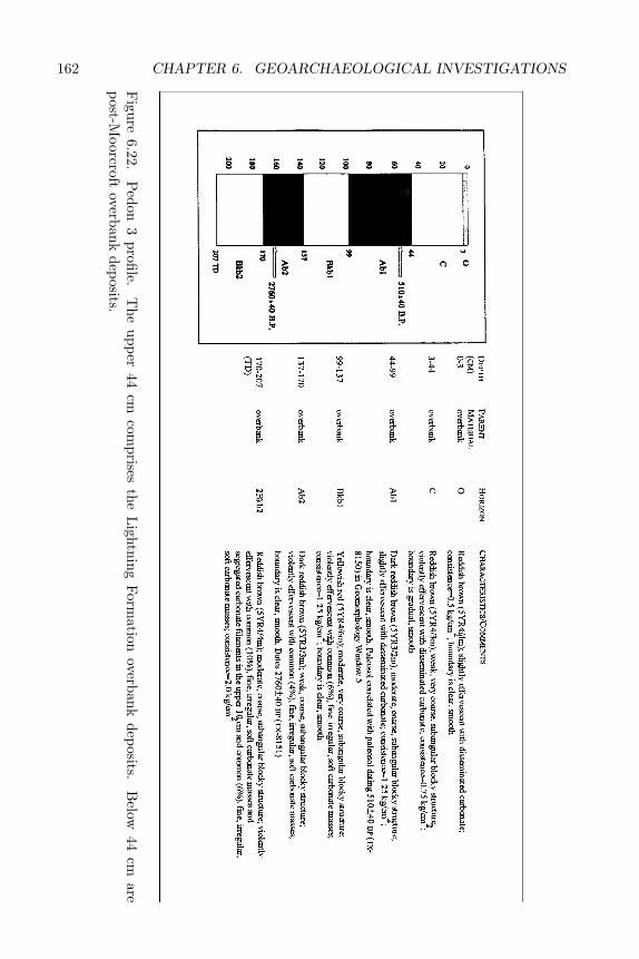
162 CHAPTER 6. GEOARCHAEOLOGICAL INVESTIGATIONS
Figure
6.22.P
edon3
profile.T
heupper
44cm
comprises
theL
ightningForm
ationoverbank
deposits.B
elow44
cmare
post-Moorcroft
overbankdeposits.
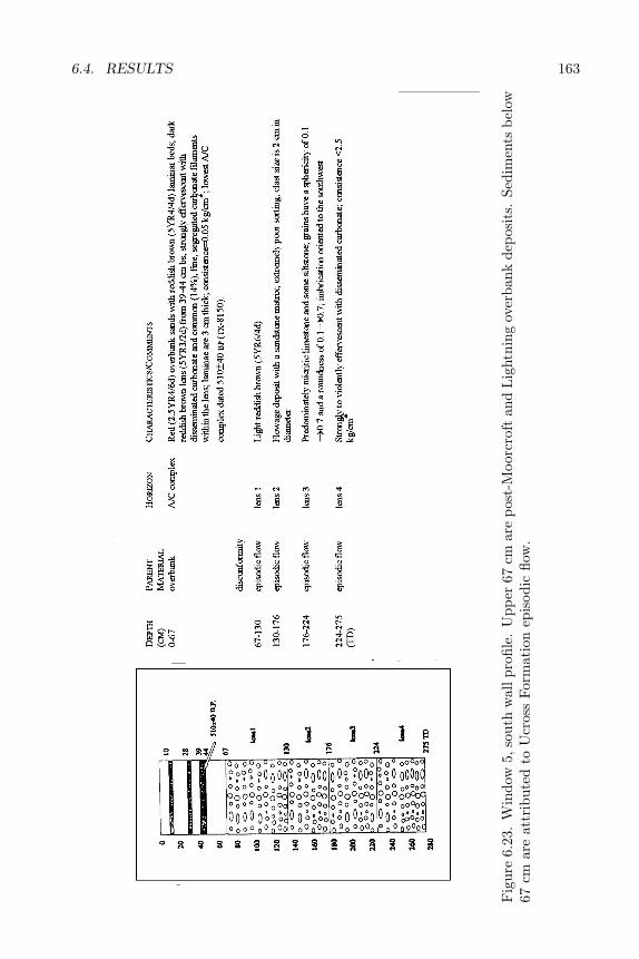
6.4. RESULTS 163
Fig
ure
6.23
.W
indo
w5,
sout
hw
allp
rofil
e.U
pper
67cm
are
post
-Moo
rcro
ftan
dL
ight
ning
over
bank
depo
sits
.Se
dim
ents
belo
w67
cmar
eat
trib
uted
toU
cros
sFo
rmat
ion
epis
odic
flow
.

164 CHAPTER 6. GEOARCHAEOLOGICAL INVESTIGATIONS
of fine-grained overbank alluvium that range in texture from silty loam to clayloam (Figures 6.22, 6.23, 6.24; Table 6.2). The T1 terrace sediments do notcontain a colluvial pebble component like the T2 terrace sediments (Figure 6.25).This suggests that hillslopes during the deposition of the T1 fill have beencomparatively more stable than during T2 formation (after Knox 1972, 1984).That is, the hillslope conditions may have been less subject to erosion during thepast ca. 3100 years than during earlier portions of the Holocene. This may bedue to climate influenced increases in vegetation densities and/or the fact thatincision to the T1 involved less elevation change than previous incision events.The small amount of incision may be a key factor because slope angles wouldbe less and, therefore, less subject to erosion. Decreased erosion also suggeststhat the finer textured younger sediments also have an increased potential toyield in situ buried cultural materials.
The overbank sediments of the T1 terrace contain two buried paleosols thatboth exhibit cumulic A horizons overlying Bk horizons with Stage 1 carbonateaccumulations (Gile et al. 1966; Figure 6.22). Stage 1 carbonate accumulationssuggest a soil forming interval of at least 1000 years (Karlstrom 1988). Radio-carbon ages for humates in the buried A horizons indicate that the Ab2 wasburied after 2760±40 BP (TX-8151) and the Ab1 was buried after ca. 510±40BP (TX-8150; Figure 6.22). The age of humates in the Ab1 horizon is based oncorrelation of this paleosol to a similar paleosol on the T2 terrace (Figures 6.22and 6.23). The ages of these paleosols, combined with the proposed ca. 3100 BPincision of the T1 terrace, suggest the archaeological potential of the lower ter-race at 39CU1144 is limited to Late Archaic and younger cultural components.The fine-grained nature of the overbank deposits also suggests that, if present,cultural materials recovered from the T1 terrace are probably buried in situ.
The height and position of the T1 sediments together with ages of humateswithin these sediments suggest that the T1 floodplain abandonment resultedfrom Moorcroft incision followed by post-Moorcroft (our term) and Lightningdeposition (Leopold and Miller 1954). In their studies of the terraces in thePowder River Basin, Leopold and Miller (1954) described a period of terraceformation at 4450–550 BP (Moorcroft cut terrace), characterized by neither de-position nor soil formation. The Lightning terrace, on the other hand, was de-scribed as a fill terrace devoid of soil formation that dated 500–100 BP. ThoughLeopold and Miller did not encounter sediments and soils dating 4450–550 BP,subsequent investigations in northeastern Wyoming have frequently encoun-tered alluvial sediments containing buried Fluvents (Entisols) that date fromca. 5000–200 BP (Reider 1990). The T1 terrace observed at 39CU1144 has pa-leosols and sediments dating within the period Leopold and Miller propose forMoorcroft incision. These paleosols were dated at 2760±40 BP and 510±40 BP(Figure 6.22). Since 39CU1144 does contain evidence of an incision event thatroughly correlates to the Moorcroft incision proposed by Leopold and Miller(1954), we propose the term “post-Moorcroft” for sediments at 39CU1144 thatdate ca. 3000–500 BP. In addition to the post-Moorcroft sediments, there are44 cm of overbank sediments capping the 510±40 BP paleosol that are correlatedto the Lightning Formation.
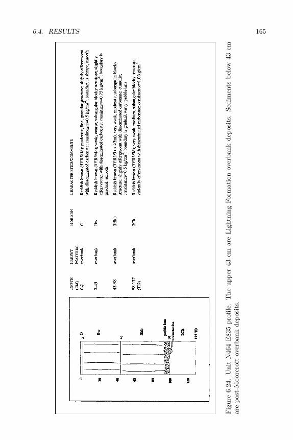
6.4. RESULTS 165
Fig
ure
6.24
.U
nit
N46
4E
835
profi
le.
The
uppe
r43
cmar
eL
ight
ning
Form
atio
nov
erba
nkde
posi
ts.
Sedi
men
tsbe
low
43cm
are
post
-Moo
rcro
ftov
erba
nkde
posi
ts.
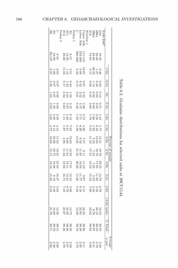
166 CHAPTER 6. GEOARCHAEOLOGICAL INVESTIGATIONS
Table
6.2.G
rainsizedistributions
forselected
unitsat
39CU
1144.
Perc
ent
of
sam
ple
Avera
ge
-1.0φ
-0.5φ
0φ
0.5φ
1.0φ
1.5φ
2.0φ
2.5φ
3.0φ
3.5φ
4.0φ
<4.0φ
(pan)
%T
ota
lφ
size
N449
E867
2A
b18-3
20.4
60.0
40.1
30.5
11.4
34.7
714.2
118.7
820.3
513.7
06.7
818.5
399.7
02.9
32B
k1
32-4
91.2
70.3
60.8
22.0
53.5
86.3
213.8
416.7
017.0
511.8
25.5
920.1
299.5
32.7
92B
k2
49-6
056.2
21.1
30.8
20.8
01.0
61.9
25.3
37.3
47.6
55.5
32.4
09.7
899.9
70.4
14C
k74-8
20.1
50.0
90.2
50.6
61.7
93.5
911.2
317.3
119.5
015.4
27.0
022.6
299.6
23.0
9W
indow
1U
pp
er
Abk
111-1
18
18.6
70.8
72.4
23.2
63.7
34.2
07.5
79.1
111.5
39.8
75.5
122.2
298.9
62.1
1L
ow
er
Abk
253-2
60
0.0
80.4
22.5
24.3
75.7
16.2
09.3
211.0
516.0
411.7
78.1
622.8
598.4
92.8
5C
260-2
69
0.3
20.1
50.2
10.4
01.5
04.3
813.2
521.5
526.2
013.2
65.4
613.0
999.7
82.7
9P
edon
1A
b8-1
33.5
10.4
41.5
62.4
76.1
37.0
312.6
314.9
317.8
112.4
45.6
814.7
299.3
62.5
02C
113-4
91.1
01.3
33.2
43.9
74.4
04.2
18.6
011.0
416.1
113.5
56.7
925.0
299.3
62.8
72C
249-6
011.0
30.1
70.3
20.6
31.1
51.9
75.9
611.2
218.9
216.7
57.4
923.8
799.4
62.7
8P
edon
3C
3-4
40.0
50.0
70.3
80.9
62.4
94.1
311.8
319.2
525.5
016.4
75.6
412.3
699.1
52.8
0A
b44-9
91.0
60.6
70.9
71.5
63.2
88.1
223.9
622.7
516.0
68.1
92.4
810.6
099.7
02.3
8B
k99-1
37
0.2
70.4
61.0
32.0
23.2
04.7
910.6
015.1
518.4
415.4
66.5
821.7
099.7
12.9
6
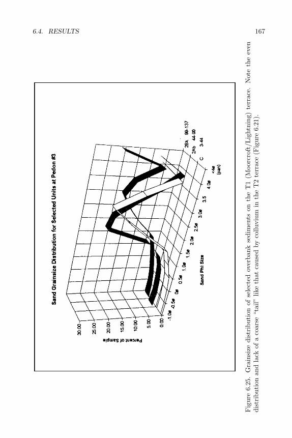
6.4. RESULTS 167
Fig
ure
6.25
.G
rain
size
dist
ribu
tion
ofse
lect
edov
erba
nkse
dim
ents
onth
eT
1(M
oorc
roft
/Lig
htni
ng)
terr
ace.
Not
eth
eev
endi
stri
buti
onan
dla
ckof
aco
arse
“tai
l”lik
eth
atca
used
byco
lluvi
umin
the
T2
terr
ace
(Fig
ure
6.21
).
168 CHAPTER 6. GEOARCHAEOLOGICAL INVESTIGATIONS
This apparent discrepancy between the terrace sequence observed by Leopoldand Miller (1954) and that observed in the 39CU1144 study area can be ex-plained by the position of 39CU1144 within its drainage basin. Whereas Leopoldand Miller’s observations were conducted primarily on higher order perennialstreams, the 39CU1144 terraces are associated with a low order, ephemeralstream near the head of a drainage basin. The proposed climatic events thatled to the formation of three terraces in the lower portions of the Powder RiverBasin may have been expressed differently at basin margin locales and resultedin the formation of only two terraces in Gillette Canyon. This proposal is sup-ported by the fact that alluvial incision works its way headward in a drainage.It is possible that either the ca. 510 BP Lightning incision event did not reachthis portion of the basin or that the relatively close proximity of bedrock to thesurface in Gillette Canyon severely limited incision.
Also unlike the Powder River Basin locales, after the Moorcroft incision,sporadic overbank deposition occurred from ca. 3000 to 500 BP on both the T1and T2 terraces in Gillette Canyon. Occasional overbank deposition alternatingwith periods of stability resulted in the development of two paleosols on the T1terrace. In addition, the position and/or bedrock controls of Gillette Canyonalso appear to have limited Lightning terrace formation to strictly a depositionalevent. This is based on the observation that Lightning-age sediments cap thepost-Moorcroft sediments and do not occur as a separate terrace. Thus, the lateHolocene terrace sequence observed at 39CU1144 is considered a variation onthe Powder River Basin terrace sequence (Leopold and Miller 1954) that reflectsthe study area’s position within its drainage. There is a sediment record fromca. 4450–550 BP in the 39CU1144 study area and another from 7000–5600 BPthat were absent in terraces described in the largely perennial portions of thePowder River Basin. This suggests that the headward segments of drainagebasins in the region have a higher potential to contain in situ, buried EarlyArchaic and younger cultural components than do downstream locales.
6.5 Conclusions
Geoarchaeological observations of the two terraces in the 39CU1144 studyarea suggest that they are a variation of the Kaycee, Moorcroft, and Light-ning terrace sequence proposed by Leopold and Miller (1954; Figure 6.1). Thehigher elevation fill terrace is considered a Kaycee equivalent with more than2.5 meters of Ucross Formation overlain by about 45 cm of pre-Kaycee sandsand gravels. Comparable pre-Kaycee deposits were not present at Leopold andMiller’s study sites. Above these is a 13–48 cm cap of Kaycee Formation sedi-ments. These are, in turn, capped by up to 10 cm of post-Moorcroft/LightningFormation sediments. At 39CU1144 humates from paleosols dating 10,500±90(TX-8149) and 9080±80 (TX-8148) BP were observed in sandy lenses interca-lated with gravels in Ucross Formation sediments. The coarse-grained natureof the Ucross Formation sediments at 39CU1144 suggests that the formationis unlikely to contain in situ buried Paleoindian materials. Cultural features
6.5. CONCLUSIONS 169
within the proposed pre-Kaycee Formation sediments at 39CU1144 yielded agesbetween 7000 and 5600 BP. This range of radiocarbon ages brackets an episodeof periodic overbank deposition, channel cutting and filling, and soil formation.Although the top of this soil was removed by erosion, buried Early Archaicarchaeological materials still remain at this level.
Deposition of coarse alluvial sediments at 39CU1144 (Ucross Formation andpre-Kaycee deposits) was followed by deposition of finer-grained overbank sed-iments on the T2 floodplain. TheSE sediments are considered equivalent tothe Kaycee Formation (Figures 6.6 and 6.3). Dates on hearths in this forma-tion range from about 3600 to 2300 BP. These provide a minimum age for thisdeposit of 3600 BP. Hearth dates later than 2700 BP must represent use OFthe terrace surface after its floodplain was abandoned and the lower terracewas formed. Buried Middle and Late Archaic archaeological components of theBlaine site are associated with the Kaycee Formation sediments.
The Kaycee terrace (T2) was abandoned after 3090 BP. This is based on theage of the youngest hearth on the T2 terrace that predates the oldest paleosolon the inset T1 terrace (2760 BP). Multiple episodes of fine-grained “post-Moorcroft” overbank deposition and soil formation followed abandonment andresulted in the development of two paleosols that dated 2760±40 and 510±40BP. A final period of sediment accumulation after 510 BP correlates to thedevelopment of the Lightning fill terrace in the Powder River Basin (Leopold andMiller 1954). The sediments preserved in the 39CU1144 vicinity that date 2260-510 BP represent a period of non-deposition in other portions of the PowderRiver Basin. This suggests that the potential of ephemeral alluvial locales onbasin margins to yield Late Archaic and younger cultural materials is greaterthan locales in perennial portions of drainage basins.

170 CHAPTER 6. GEOARCHAEOLOGICAL INVESTIGATIONS
Chapter 7
SUMMARY ANDCONCLUSIONS
7.1 Summary of Interpretations
The Blaine site comprises a series of cultural deposits on a stream terracein the southwestern Red Valley of the Black Hills. The extensive excavationsundertaken to mitigate anticipated damage to the site produced only a modestamount of cultural material. Deposits representing some 7000 years of humanuse of the site yielded only about 5200 artifacts, about half of which were tinyflakes from waterscreen samples. Faunal and floral remains were also scant,although the 25 features do attest to both camping and food processing at thesite. This stands in contrast to the richer Jim Pitts site lying just east of theBlaine site. While the Blaine site is far from spectacular, it nevertheless has astory to tell. It may in fact provide a more representative picture of prehistoriclife in the Black Hills than the more impressive bison kills and densely occupiedfoothills sites.
The exact timespan of the earliest occupation of the Blaine site is not clear.Component C hearths were radiocarbon dated at 5580 and 6940 BP. Culturalmaterial found both above and below these hearths was assigned to Compo-nent C. This lowest cultural stratum is not continuous, but appears as pocketsof sediment within an alluvial matrix. The spotty nature of this stratum makesit somewhat difficult to interpret. The divergent radiocarbon dates suggest thecomponent represents a series of short-term uses rather than a single occupationof the site. The large proportion of planing or heavy scraping tools and rela-tive abundance of hearths suggest a somewhat specialized function for the site,perhaps related to processing roots or other fibrous plant foods. The relativelylarge amount of debitage associated with the Component C features indicatesa fairly intensive use of the site. This can translate as either a few long-termcamps or many short-term camps. In either case the number of people involvedwas probably minimal, perhaps comprising a special task group rather than an
171

172 CHAPTER 7. SUMMARY AND CONCLUSIONS
entire band or extended family. The tool kit is not recognizably gender-linked;however, the lack of projectile points, butchering tools, and hide-working toolssuggests that an entire social unit was not present at the site.
The site may represent a remnant activity area associated with a larger siteor may have been a special resource extraction or processing site. The presenceof some bison and other large mammal bone in Component C suggests theformer. A core and 402 pieces of debitage were also found in the Component Cexcavations, suggesting that lithic tool manufacture was at least a secondaryfocus of the site. Much of this material was associated with Feature 1, the largelimestone boulder. This, like the bone, suggests that the site served as a campas well as a root or wood processing station. Several large fire-pit or hearthcomplexes in ecotone areas of the Black Hills are hypothesized to have served inpart as plant food processing sites. These include 48WE302, 39CU214, McKean,Gant, and an unnamed site near the Gant site (McKibbin 1988; Reher 1981;Kornfeld et al. 1991; Gant and Hurt 1965). A combination root-processingand pre-hunt gearing function was suggested for the smaller Harbison site inthe eastern Red Valley (Sundstrom 1981). All of these contained some artifactsand/or features not directly associated with root processing, suggesting that thetask was carried out in or near a camp. All date to the Middle and/or LateArchaic period.
The relatively intensive use of the site suggested by the concentrated dis-tribution of artifacts and features may well reflect scheduled, seasonal reuse ofthe site. As was noted above (Chapter 4), stable, immobile resources such asvegetation communities tend to be reoccupied more frequently than the less pre-dictable sites of game kills and butchering stations. This possibility is difficultto assess given the discontinuous distribution of the Component C materials.
Although lithic concentrations are highest at this level, bone concentrationswere lowest in this component. This suggests that faunal resources were unim-portant during Component C times relative to the later components. While itis possible that the Component C bone was for some reason more subject toweathering processes, this explanation is at odds with the apparent steady orrapid rate of deposition during this period of occupation of the site. While arelative paucity of bone and lack of a hunting-related tool kit in Component Cfit neatly with a hypothesized reduction in bison and other game during theAltithermal, the cultural deposit is too incomplete to allow conclusions in thisregard.
The middle levels of the Blaine site, assigned to Component B, suggest ashift in the focus of the site. The tool assemblage of Component B indicatesa Late Archaic date, while the radiocarbon dates indicate that the componentincludes Middle Archaic materials, as well. An age of roughly 3600 to 2000 BPis indicated for this component. This mixing is due to a lack of deposition on theterrace surface between ca. 3100 and 500 BP. Tools in Component B are mostappropriate for secondary butchering and general purpose tasks, rather thanforming a specialized tool kit. Tratebas (1986) lists projectile points, choppers,sidescrapers, and gravers, along with endscrapers, light retouched flakes, andperforators, as the artifacts types most commonly associated with Late Archaic
7.1. SUMMARY OF INTERPRETATIONS 173
residence sites. Except for a lack of perforators and the rather large number ofbifaces, this fits the Component B assemblage fairly well. The unfinished bi-faces and the relatively abundant debitage suggest that bifacial tool productionoverlay the more general residence function as a principal site function. It maybe that the habitation site was chosen at least in part for its proximity to highquality cherts and chalcedonies and that the Middle and Late Archaic residentsof the site took advantage of this handy resource by gearing up on bifacial tools.The tendency to “gear up” on specialized tools suggests a somewhat regular-ized, scheduled seasonal round of subsistence activities. The mass productionand/or caching of bifacial tool blanks shows that the site’s occupants were antic-ipating and planning for hunting. Scheduling is often indicated for Middle andLate Archaic sites in the Black Hills and elsewhere in the northwestern plains(Chapter 4).
Bifaces included three projectile point preforms and four Stage 2 bifaces,most of which are of cherts outcropping in the immediate site vicinity. A finishedPelican Lake point is also made of this local chert. The ratio of tools to debitagein this component, 1:71, also reflects an emphasis on stone tool production. Thebroken Stage 3 and 4 quartzite biface fragments indicate that these artifacts werecarried to the site and used there until broken beyond repair. The chert bifacesbeing produced at the Blaine site may have been made in part to replace toolsmade elsewhere in the Black Hills and expended at the site.
The hearth features, diverse tools, and abundance of unmodified rock indi-cate that the site was not used exclusively as a lithic knapping station. Half ofthe 12 hearths assigned to Component B were radiocarbon dated. These datesfell between 2500 and 3600 years BP, indicating a late Middle Archaic age for thehearth features. This suggests that activities represented by the hearths, suchas food processing and camping, may have been limited to the Middle Archaicoccupation of the site; however, it is possible that some of the undated hearthsbelong to the Late Archaic occupation. The lack of Middle Archaic projectilepoint blanks or fragments in Component B further suggests that hunting toolproduction, repair, and replacement were not emphasized during the MiddleArchaic occupation of the site to the extent that they were during the LateArchaic occupation.
A few pieces of Knife River Flint debitage and a Badlands knife in Compo-nent B suggest weak ties to the Missouri River area to the east. In the BlackHills, these materials are most commonly found in early Late Archaic compo-nents. The amounts of exotic lithic raw material in this assemblage are nothigh enough to suggest regular interaction with areas to the east, but may indi-cate sporadic use of the site by eastern-oriented groups perhaps on an irregularseasonal basis.
Component A is perhaps the most easily interpreted of the three components.This component includes both Late Archaic and Late Prehistoric diagnostics;however, no radiocarbon dates were available to confirm this hypothesized age.The stone circle features clearly indicate a camp site. The sparse artifact scatterand the lack of hearths or permanent habitation or storage facilities indicatesshort-term use of the site. This component contained 41% of the bone found at
174 CHAPTER 7. SUMMARY AND CONCLUSIONS
the site, suggesting that the trend toward increased reliance on faunal resourcesindicated for Component B continued into the Late Prehistoric period as well.The amount of bone is still small. Meat consumption in the context of anephemeral camp, rather than a kill or butchering station is indicated. Thediverse projectile point assemblage from this component indicates that it wasproduced through a series of brief occupations through the latter portion of theLate Archaic and the early portion of the Late Prehistoric period.
The small assemblage of tools also reflects the diverse activities associatedwith basic group maintenance. Unlike Component B, the bifacial tools in Com-ponent A are mostly used tools carried to the site and discarded there afteruse. The bifacial blanks or preforms characteristic of Component B are largelylacking in Component A. The tool to debitage ratio is also much higher, 1:20,as compared with 1:71 in Component B. While some lithic tool production didtake place during this period of use of the Blaine site, it was not a main focusof activity. The small amount of pottery found at the site also suggests a briefcamp. This component fits well the pattern expected for a sporadically reusedshort-term transient camp site.
7.2 Settlement Pattern Research Hypotheses
The settlement pattern models discussed above (Chapter 4) provide a the-oretical basis for a series of research questions around which the Blaine siteinvestigations were organized (Donohue and Hanenberger 1993). The questionsrecognize the existence of four main functional site types: base camp, residentialcamp, transient camp, and special activity or resource extraction station.
Hypothesis 1: One or more of the components of 39CU1144 are base campsassociated with a mountain-based, broad spectrum settlement system. Basecamps are typified by:
• location near significant or high-yield resources,
• comparatively large areal extent, high debris density, and tool kit diversity,
• and structural and/or storage features.
Features should include hearths, domestic structures, and in particular stor-age facilities. Midden formation or secondary deposition of refuse should beevident. base camps are a central focus of locally based and relatively close-ranging resource exploitation. They should contain mixed frequencies of lithicraw material types representing the range and availability of lithic resources inthe catchment area for the base camp for some patterned and most non-patternedtools. If the base camp represents a particularly localized settlement pattern, suchas the proposed mountain pattern, patterned tools should also reflect local (i.e.Black Hills) lithic resources.
This question was addressed through several lines of evidence. Because sitefunction may have changed over time, each component of the Blaine site was
7.2. SETTLEMENT PATTERN RESEARCH HYPOTHESES 175
considered separately. Identification of site type is based on the various factorslisted above. Features such as middens, multiple occupation levels, structures,and storage facilities are especially relevant to determinations of site function.Tool-to-debitage ratios and degree of tool diversity are also keys to site function.Given the location of 39CU1144 near known quarry sites in the Black Hills andthe restricted catchment area postulated for mountain-based hunter-gatherers,both patterned and non-patterned tools were expected to be made of local lithicsif the localized, mountain-based settlement pattern is represented at the site.Alternatively, if the site functioned within a plains-based settlement pattern,nonlocal lithics would be expected for at least some of the patterned tools.Expedient (non-patterned) tools should still reflect local lithic types.
None of the three components appears to represent a base camp. Artifactdensities are consistently low, except around some features. While structuralremains are present in the form of the Component A stone circles, these donot indicate permanent or semi-permanent structures, as they contained fewartifacts and no features. No storage pits, caches, or middens were found. Thesite is near significant resources areas; however, its specific location offers fewadvantages over other locations in the general area.
Hypothesis 2. Components at the Blaine site represent residential camps.Residential camps should exhibit artifact varieties and distributions similar tothose found in base camps. The locational attributes for residential camps arealso the same as for base camps. Tool kit varieties, though similar to those frombase camps, should exhibit lower densities and frequencies. The size, intensity,and duration of the occupation are more limited than those for base camps. Con-sequently, storage features and incidents of midden development or secondarydeposition are limited or non-existent. Lithic material type frequencies shouldreflect local sources if the site was utilized by mountain-based groups and exhibitmore mixed source assemblages if both mountain and plains environments wereexploited as part of the seasonal round.
The archaeological delineation of residential camps is problematical, sincethe differences between base camps and residential camps are more of degreethan kind. Important features in differentiating between the two site types arethe number and variety of feature types, variety of tool types, and incidenceof secondary deposition or midden development. All of these should be lesspronounced and exhibit more restricted distributions in residential camps. Thefull complement of groups activities should not be represented at residentialcamps, because they were not occupied by the complete social unit. Residentialcamps should be less extensive due to their shorter duration.
Following the Bender and Wright model, this hypothesis can be rephrasedto examine whether components of the Blaine site represent secondary bases.While the secondary base is similar to the residential camp, Bender and Wright’sclassification permits a more exact set of criteria for differentiation. Further-more, the model is specifically designed to describe adaptations in mountainousregions. Criteria specifically related to site locations and expected feature con-figuration are listed for secondary bases, in addition to the attributes listedabove for residential camps. According to Bender and Wright’s model, sec-
176 CHAPTER 7. SUMMARY AND CONCLUSIONS
ondary bases are, by definition, remote in terms of distance or accessibility frombase camps. While base camps are located at sites offering maximum comfortand accessibility, secondary bases are located in less favorable settings near sea-sonally available high-yield resource areas. Secondary camps are less likely tohave been periodically reoccupied. Features at secondary bases are less diverse,because these sites tend to be focused on procurement and processing of a singlemain resource. Evidence for gathering can be found at either a base camp ora secondary base; however, the secondary bases will exhibit a more restrictedrange of species and/or processing activities than do base camps.
Plains tradition base camps will by definition be located in open plains areas.These can be expected to contain a higher percentage of specialized huntingtools, such as projectile points, knives, and scrapers, and fewer tools associatedwith nonhunting activities than would mountain tradition base camps. Plainstradition secondary bases or residential camps in mountain or foothills areasare more difficult to distinguish from mountain tradition sites. These secondarysites are less likely to contain a strong hunting component. They presumablyresulted from seasonal or occasional deviation from the large scale communalhunting pattern in order to exploit secondary resources such as smaller game,food plants, or trees, or to take shelter from harsh weather. In general, plainstradition sites should contain a less diverse tool kit, because these groups are lesslikely to have developed or adopted a complete set of tool technologies adaptedto plant and small animal exploitation. In particular, microtools, microblades,and multipurpose tools should be rare in plains tradition sites.
Roasting pits, caches, and storage pits would be more commonly found inthe secondary bases or residential camps of mountain tradition groups, as wouldother evidence for periodic reuse of a site. Roasting pits are associated with massprocessing of plant foods. Caches, storage facilities, and multiple occupationfloors reflect the periodic return to sites near stable and abundant resources,such as plant foods or migrating animals, permitted by a scheduled, broadspectrum subsistence pattern. Faunal assemblages from mountain traditionsites will be more diverse than those from plains tradition sites and may includespecies such as jackrabbit and prairie dog eschewed by the plains oriented bisonhunters. Mountain tradition secondary bases are also expected to contain moreground stone tools and other artifacts associated with plant food processing,such as unifacial scrapers with heavy stepped use-wear.
Component B of the Blaine site can be interpreted as a residential site. Itcontained a moderately dense artifact distribution reflecting a variety of activi-ties. Group maintenance (food preparation and consumption, tool repair) andprimary biface production are the main activities indicated by the Component Bassemblage. As was noted above, the Blaine site is located near significant fau-nal, floral, and lithic resources, as well as near water and sheltered terrain.These locational attributes are associated with both base camps and residentialcamps. The size, intensity, and duration of the Component B occupations areintermediate between those expected for base camps and extractive sites. Fea-tures are also consistent with a residential camp interpretation. No structuralor storage features were found. Lithic materials are strongly local, with a weak
7.2. SETTLEMENT PATTERN RESEARCH HYPOTHESES 177
eastern signal in the form of small amounts of Knife River Flint and Badlandsplate chalcedony.
Component B does not fit the definition of the secondary base developed forhigh altitude regions (Bender and Wright 1988). It lacks attributes of regularlyreoccupied sites, such as caches, storage pits, and well defined multiple occupa-tion living floors. The site location is not remote from ideal habitation areas, aswould be expected of a secondary base. Specialized resource procurement andprocessing is not indicated for this component, except for the use of local chertsfor biface production. This lithic resource is not seasonally restricted and thusdoes not fit the expected pattern of seasonal use of high-yield resource areas.
Component A does not fit either the residential camp or the secondary base.This component lacks evidence for specialized resource extraction or processing,as would be expected as one attribute of secondary bases and residential camps.This component seems to represent a very short-term camp occupied by anentire social unit.
Component C may have been a residential camp; however, the discontin-uous nature of the deposits makes any conclusions tenuous. This componentdoes include a variety of features and tool types, suggesting a camp at whichprocessing of roots or other fibrous material took place, along with limited toolproduction and general group maintenance. This also fits Bender and Wright’sdescription of a secondary base; however, the locational attribute of remote-ness is not met by the Blaine site. The apparent emphasis on plant use andthe relative paucity of faunal remains is consistent with the mountain traditionsubsistence model; however, other expected mountain tradition attributes, suchas caches and roasting pits, are not present.
In summary, this hypothesis is confirmed. Component B and, to a lesserextent, Component C conform to the residential base site type. Component Calso fits the description of a secondary base except that its location is not remotefrom areas suitable for base camps. Component B more closely resembles theresidential camp defined by Roper (1981), while Component C displays moreattributes of the mountain tradition secondary base as defined by Bender andWright (1988).
Hypothesis 3. Components at the Blaine site represent extractive site ac-tivities. If this is an extractive site, the excavations should document specificactivities loci covering small areas and exhibiting limited, task-specific tool kitinventories. Features expected at extractive sites are limited to hearths and task-specific facilities. Extractive sites associated with lithic and faunal procurementand processing activities are more readily discernible than those associated withplant procurement and processing.
Three kinds of extractive sites are defined for plains-based settlement sys-tems: kill sites, processing (secondary butchering) sites, and quarries (Greiser1985). For mountain-based settlement systems, four kinds of extractive sites aredefined: hunting, quarrying, and gathering (Bender and Wright 1988). Each ofthese site types was considered separately in regard to the Blaine site.
Quarrying can be ruled out as a function of the Blaine site. No significantoutcrops of knappable stone occur at the site. Knappable cherts outcrop at
178 CHAPTER 7. SUMMARY AND CONCLUSIONS
nearby site 39FA1145 and within the gravel terraces at the Blaine site. Theformer was used for biface production at the site, but the local gravels appearto have been used mainly for expedient tools. No significant lithic raw materialprocurement activities took place at the Blaine site.
The low density of bone, the presence of habitation features (tipi rings),and the lack of a primary butchering tool kit (cf. Tratebas 1986) at the Blainesite do not fit the pattern expected for a kill site. Neither the current nor theprehistoric topography of the site was conducive to game trapping. A highpercentage of broken projectile points is also expected for kill sites. The smallnumber of projectile points found at the Blaine site are mainly distal portionsapparently discarded during reshafting of arrows and darts.
A faunal processing/secondary butchering function was considered for thissite. Numerous locations in the immediate site vicinity could have served asnatural game traps. Archaic rock art in Whoopup Canyon just a few mileswest of the Blaine site suggests that canyons in the immediate vicinity wereused for communal hunts of deer, pronghorn, and mountain sheep, apparentlyusing nets or corrals rather than natural traps. The Blaine site locale, on aflat bench overlooking a stream, would have provided a comfortable and easilyreached location for meat processing. Such sites can be expected to contain largeamounts of bone scrap (but not complete carcasses), numerous cutting tools,and possibly hearths. Midden development, secondary deposition of artifacts,and extensive, diversified tool kits are not expected.
Although tertiary processing activities such as hide working, meat drying,and pemmican production may have taken place at extractive sites (cf. Donohueand Hanenberger 1993:33), a more likely pattern is removal to base camps,secondary bases or residential camps for this work. These activities take severaldays to accomplish and thus would require that a camp be established nearbyor that the meat and hides be transported to an existing camp. In addition, arelatively large labor force (including both sexes) is needed for these processingactivities, so they are likely to have been done at or near a camp occupied byan entire social group. For these reasons, scraping tools, groundstone tools, anddrying rack features and fire pits or hearths are expected at secondary basesand base camps, but may not be present at faunal processing/ or secondarybutchering sites. Anvils and hammerstones for smashing bone may or may notbe present at base camps and secondary bases, depending on the meat storagetechniques being used. Smashed bone is associated with the production ofpemmican for long term storage.
Secondary butchering is proposed as one function of Component B, due tothe presence of a tool kit appropriate for such activity. The limited amountof bone present at the site and the diverse tool and feature assemblage, how-ever, indicate that this faunal processing took place in the context of on-siteconsumption rather than large scale processing of meat for storage.
A site function limited to plant or microfaunal gathering is less likely for theBlaine site, simply because such sites are usually “invisible” in the archaeologicalrecord (Greiser 1985; Bender and Wright 1988). Gathering activities tend to beexpressed as processing features at secondary bases, rather than at the actual
7.2. SETTLEMENT PATTERN RESEARCH HYPOTHESES 179
extraction site (Bender and Wright 1988). Large-scale plant food processinggenerally takes place at a secondary base or residential camp established forthat purpose, or at a base camp if the desired resource happens to be availablenearby. The processing of roots, wood, or other fibrous plant materials wassuggested for Component C. This appears to have taken place in the context ofa secondary base or residential camp. The actual extraction site or sites wouldhave been in the immediate site vicinity or in nearby stands of trees.
In summary, none of the components at the Blaine site represents an ex-tractive site. Processing activities (biface reduction and meat preparation andconsumption in Component B and plant processing in Component C) apparentlytook place at campsites away from resource extraction areas.
Lithic raw material type distributions at the Blaine site were expected toreflect the catchment area of the group using the site. If these were mountain-oriented groups, few or no exotic lithics should be present. If they were plains-based groups, nonlocal lithics were expected at least among the patterned tools.Expedient tools would, however, reflect local procurement. Lithic raw materialdistributions were expected to reflect direction of movement, and the likelyhome base of the group or groups utilizing the site if consistent patterns oflithic source distributions were found in the various components. In addition,the presence of a diverse set of nonlocal lithic resources was expected to reflecta high degree of group mobility, while a homogenous and/or localized lithic rawmaterial assemblage would reflect a low degree of mobility.
The Blaine site lithic raw material assemblages are strongly localized. Al-though there is a high degree of diversity, this reflects the local availability oflithic types, rather than large catchments or territories. Very small amountsof Knife River Flint and Badlands plate chalcedony in Component B and por-cellanite in Component A provide a weak indication of connections to the east(Missouri River) and west (Powder River Basin), respectively. Many of the uti-lized bifacial tools were being replaced with bifaces made of cherts outcroppingin the immediate site vicinity. This suggests a quite restricted territory and alow degree of mobility throughout the time span represented at the site. Thisappears to have been most pronounced in Component C, which contained onlylocal lithics.
Hypothesis 4. Components at the Blaine site represent transient or bivouacsites. If the site was a bivouac, extensive low frequencies of expedient tool typesare expected. Disproportionate frequencies of specific source lithic types or exoticlithic types, possibly indicating directionality, are expected to occur. Features, ifany, are expected to consist of small, low intensity burn hearths. Documentedtransient/bivouac sites are rare in the Northwestern Plains. The occurrence ofsuch sites, however, is undisputed. The seasonal usage of particular locationsalong trails as overnight camps, while in transit to and from resource areas,would eventually result in the accumulation of extensive lithic debris scatters.
Although somewhat difficult to quantify, this potential function for theBlaine site demands consideration. Location of the site alongside a major high-way certainly raises the possibility that a trail into the interior Black Hills passedby the site in prehistoric times, as well. Tool kit diversity for bivouac sites should
180 CHAPTER 7. SUMMARY AND CONCLUSIONS
be low, relatively redundant and weighted toward expedient tool types (Trate-bas 1986). If the camp is situated along traditional routes to and from areascontaining primary lithic resources, disproportionately high frequencies of lithictypes derived from those areas are expected to occur. In the case of the Blainesite, these lithic types could include porcellanite from the Powder River country(Porcellanites 1 and 2), Morrison silicified siltstone from the western foothills ofthe Black Hills (Quartzite 3), quartzite from the southern Hogback (Quartzites1 and 2), and various cherts and chalcedonies from the interior uplift (Silicates1-8, 11-13).
Component A conforms fairly well to the pattern expected for transientsites. The few stone circle features, the cairns (which may have served as trailmarkers), and low artifact density in the upper component at the Blaine site fitwell with a hypothesized transient camp or bivouac function for the later occu-pations. The Component A assemblage contained few exotic lithics; however,the small amount of porcellanite is consistent with a hypothesized seasonalor sporadic use of the foothills area by groups centered in the Powder RiverBasin. Hearths and storage features are absent from this component. The onlystructural features are the stone circles. These suggest temporary, short-termoccupation, rather than investment in permanent shelter.
Hypothesis 5. Components of the Blaine site are multifunctional at the syn-chronic or diachronic levels. All of the above site types can and do occur as as-sociated, overlapping, and mixed component assemblages in a synchronic sense.Various components, during different periods, may reflect changes in the func-tion of a site over time.
This hypothesis addresses the possibility that the Blaine site may have serveda variety of functions over time or may have served more than one functionat once. If multiple functions occurred simultaneously, separate activity areasshould be recognizable based on distinctive distributions of tool kits, features,and lithic debris classes.
As has been noted above, the Blaine site did serve different functions atdifferent times. The lowest stratum appears to represent a residential campor secondary base at which the processing of fibrous plant material was a pri-mary function. The middle component also represents a campsite and can beclassified as a residential camp. Biface reduction and group maintenance activ-ities were the primary focus of the series of short-term camps represented byComponent B. Possible activity areas recognized within this component weredevoted to lithic tool manufacturing, tool repair, and food preparation. Thiscomponent encompasses both Middle and Late Archaic materials, which seemto reflect slightly different functions. It appears that biface reduction was aprimary emphasis during the Late Archaic, while group maintenance was themain focus during the Middle Archaic. In the upper component, hide workingand stone tool production took place away from the living spaces (tipi rings),while stone tool repair apparently took place both inside and away from livingareas.

7.3. SUBSISTENCE ECONOMY RESEARCH HYPOTHESES 181
7.3 Subsistence Economy Research Hypotheses
These first five hypotheses address two questions: What was the functionof the Blaine site? Did the site function within a broad-spectrum mountain-based settlement system or within a plains-based settlement system focused onlarge-scale bison procurement? Both of these questions present methodologicalchallenges to the archaeologist. Problems in differentiating various kinds of sitefunctions were reviewed above.
The distinction between mountain and plains oriented settlement patternsmay also be difficult to determine archaeologically, especially in a peripheralarea like the Red Valley. It has been argued elsewhere (Sundstrom 1992) thatthe Red Valley functions ecologically more as an extension of the open highplains than as part of the Black Hills as a mountain environment. In his studyof the mammalian fauna of the Black Hills, Turner (1974) recognizes a “tran-sition” life-zone comprising the arid prairie uplands and stream valleys, thesemiarid Red Valley, and the basal slopes of the foothills. Steppe-associatedmammals including desert cottontail, black-tailed prairie dog, black-footed fer-ret, pronghorn, and bison are largely limited to this zone. Both bison andpronghorn migrated between the Red Valley and the grasslands surroundingthe Black Hills via watergaps in the Hogback, such as the Buffalo Gap (Turner1974:20-22). Since their human predators in all likelihood migrated in concertwith the herds, a grasslands-type adaptation might be expected in the RedValley. The Hawken, Vore, and Sanson sites, communal bison kills located inthe Red Valley, lend support to this hypothesis. Other communal bison kill orprocessing sites had not been identified in the Black Hills prior to investigationsat the Blaine and Jim Pitts sites. In terms of the Black Hills as a whole, bisonprocurement and processing sites in the Red Valley appear to be anomalous.
In their model of high-altitude, broad spectrum settlement pattern, Benderand Wright place hunt-related sites into the special activity (resource extrac-tion) site category. Residential sites are not directly associated with hunting.This is because hunting in the high country is aimed at individual animals orsmall herds. The animals and the kills are small, relative to large-scale commu-nal bison hunting on the high plains, and hunters can easily complete the initialbutchering at the kill site or transport the entire carcass back to the base campor secondary base for processing. Under these conditions, there would be littleincentive to move the camp to the animal; instead, the animal could be moved tothe base camp (or secondary base). Greiser (1985) recognized two kinds of sitesassociated with hunting in plains-based settlement patterns: kill sites and sec-ondary processing sites. Like Bender and Wright (1988), Greiser (1985) definesthese as extractive sites; however, Greiser’s model is geared toward communalprocurement of bison and mammoth, since an assumption is made that initialbutchering took place at the kill site. Both the actual faunal remains and theconfiguration of hunt-related sites thus can differentiate between the plains andmountain hunting patterns.
Current models of plains-based and mountain-based settlement patterns pro-pose a specialized economy based on communal bison procurement for the plains
182 CHAPTER 7. SUMMARY AND CONCLUSIONS
pattern and a diverse, broad-spectrum economy for the mountain model (Fri-son 1991; Husted 1969; Bender and Wright 1988; Sundstrom 1992; Black 1991).In areas like the Bighorns and central Rockies, the mountain-based subsistencepattern is easily recognized. Species such as deer, mountain sheep, jackrabbit,pronghorn, and canids clearly dominate the archaeological record. Bison boneis rare or absent. The camps, kills, and processing sites of the plains-based sub-sistence pattern may contain a few non-bison elements; however, bison is thedominant species at the vast majority of sites related to this pattern. The BlackHills situation is not so clear cut. Faunal remains are quite rare in Black Hillssites. Many sites contain a mixture of very small amounts of bone from bisonand smaller animals. Often bone is broken and crushed to the extent that itcannot be identified. At what point should a faunal assemblage be identified as“diverse”? Should the number of species present be the criterion for diversity,or should estimated meat-weight of various species represented in an assem-blage be the deciding factor? Does the presence of any bison bone indicate aplains-based subsistence? One goal of the Blaine site excavations was to providedata relevant to a more exact definition of these characteristics as applied tothe Black Hills situation.
Ideally, these questions should be addressed either by examining faunal datafrom a large number of contemporaneous sites and particularly material frombase camps and residential camps or secondary bases. Unless a large sample ofsites is available, extractive sites will tend to yield a skewed view of subsistencepatterns, because they are focused on the procurement and processing of justone or two food resources. Data from sites from each of the major environ-mental zones included in a hypothesized group territory are needed to form acomplete picture of seasonal subsistence activities. Researchers need to developa statistical description of the hypothesized broad spectrum versus specializedsubsistence assemblages.
Such data sets have not yet been generated. Apart from the communal bisonkills at the Vore and Hawken sites, few faunal assemblages have been describedfrom the Black Hills. These sites, together with the Sanson buffalo jump andHawken II site, confirm the presence of large-scale communal bison kills in theRed Valley during the Early Archaic, Middle Archaic, Late Prehistoric, andProtohistoric periods. These sites contain very few non-bison faunal elements.Sites from elsewhere in the Black Hills tend to contain more mixed faunal as-semblages (Table 4.3). The Agate Basin site, a bison kill located southwestof the Black Hills contained few non-bison elements. The Smiley-Evans site isa Plains Village seasonal hunting base camp on the northern periphery of theBlack Hills. Bison dominated its faunal assemblage.
Faunal material from the Blaine site adds to this data base. It provides amuch needed sample of bone from non-kill contexts in the Red Valley.
Hypothesis 1. The Early Archaic period in the Black Hills is typified byspecialized, communal bison hunting based economies.
Clearly, a single site cannot confirm or refute this hypothesis. Instead, thisstudy will address the evidence that the Blaine site provides in regard to ques-tions of Early Archaic subsistence in the Black Hills. The hypothesis is also
7.4. CONCLUSIONS 183
examined from a diachronic perspective. Each component of the site is consid-ered separately in order to detect changes in subsistence orientation over time.The alternative to the stated hypothesis is that the Blaine site operated withina settlement and subsistence pattern that was not based on communal bisonhunting. If non-bison faunal remains or plant food remains equal or outnumberbison elements at the Blaine site, the site can be interpreted as representing adiverse rather than specialized subsistence base. If bison comprises more than60 percent of the faunal assemblage, a specialized, bison-based subsistence basecan be inferred.
Too little identifiable bone was present at the Blaine site to provide con-vincing evidence for a specialized bison economy. Any reasonable test of thishypothesis would require that the majority of bone from the site be identifiableas to species. Only 3.8% of the Blaine site faunal assemblage could be iden-tified to species, including noncultural (intrusive) marmot and other rodents.This translated to a minimum of one bison and one deer. The tool kit found inComponent C suggests that plant foods were more important at this site duringthe Early Archaic than were animal foods. This does not mean that bison andother game were not important resources during this period. Instead, it appearsthat other gathering, as well as hunting, was important to the Early Archaicsubsistence economy. The kind of large-scale, specialized bison hunting seen atthe Hawken site is not in evidence at the Blaine site.
7.4 Conclusions
The limited archaeological material recovered during mitigative excavationat the Blaine site provides a glimpse of human activities in the southwesternRed Valley during the span of the Archaic and early Late Prehistoric periods.The shallow uppermost component suggests use of the site as a transient campduring the Late Prehistoric period. The site area was evidently used for oneor more tipi camps by groups traversing the Red Valley on their way into orout of the Black Hills. The presence of southern Black Hills quartzites andporcellanites from the Powder River country suggest a basic east to west, orplains to foothills, route of migration. Tool repair and hide working took placeat this camp or camps, but occupation was too brief to leave substantial arti-fact deposits. The cultural affiliation of the Late Prehistoric occupants of theBlaine site is unknown. Pottery associated with the Late Prehistoric componentdoes not match any regional pottery styles. This suggests a localized ceramictradition perhaps reflecting use of the site by some group centered in or nearthe western foothills. The lack of non-native trade items indicates a prehistoricage for the deposit, as does the mixing of Late Prehistoric and Late Archaicmaterials in the component.
The middle component of the Blaine site contains Late Archaic and MiddleArchaic materials. Although no accurate separation could be made of thesematerials due to the shallowness of the deposits, it appears that most or all of thenumerous hearths found in the middle component date to the last millennium of
184 CHAPTER 7. SUMMARY AND CONCLUSIONS
the Middle Archaic period, while most of the biface reduction features date tothe early Late Archaic period. This component is interpreted as representing aresidential camp at which biface reduction, tool repair, and group maintenanceactivities took place. A few pieces of Knife River Flint and Badlands platechalcedony suggest a weak connection to the Missouri River area, probablycorresponding to the Late Archaic occupation of the site. Otherwise, use of thesite by a strongly localized group appears to be indicated for this component.
The lower component is estimated to date between about 7000 and 5800 BP.This corresponds to both the Early Archaic cultural period and the Altithermalclimatic episode in the Black Hills. A series of short-term camps are representedby this component. Artifact density is fairly high, suggesting either frequent orintensive occupations. It is possible that groups were returning to this locationon a periodic basis, perhaps to gather and process root foods such as sego lily,wild onion, or prairie turnip. The tool assemblage lacked projectile points, butcontained several tools suitable for processing fibrous materials. Little bone wasfound in the component, relative to the middle and upper components. Thissuggests an emphasis on plant resources, rather than animal resources, duringthis period of site use.
Conclusions about the Blaine site are limited by the small amount of datarecovered, the lack of horizontal separation of the upper components, and theapparent loss by erosion of some of the lower component. By itself, the informa-tion from this site is of limited value; however, when considered together withthe rapidly growing body of archaeological data from the Black Hills, the Blainesite helps clarify several questions about prehistoric use of the area.
Three observations are of particular significance. First, the highly localizedlithic raw material assemblage strongly suggests the presence of locally basedgroups, especially during the Early and Middle Archaic periods, whose sea-sonal range may have been limited to the Black Hills. Second, the presenceof Missouri River materials in association with the Late Archaic occupation ofthe site and the presence of porcellanites in association with the Late Prehis-toric occupations amplify patterns observed in other archaeological data fromthe Black Hills. These suggest that the Black Hills-Missouri River interactionsphere observed at the time of initial contact with non-native people may havebeen established as early as the Late Archaic period. A Powder River country-Black Hills interaction sphere appears to have been a later development andmay have been limited to use of the western foothills during winter by bisonhunters from the Wyoming basins. Third, subsistence appears to have changedover time from a broad spectrum gathering and hunting pattern in the Earlyand Middle Archaic to a greater emphasis on large game hunting in the LateArchaic and Late Prehistoric.
Perhaps the greatest contribution of the Blaine site study is establishing thatthis area of the Black Hills was in use during the Early Archaic period. The ar-chaeological data establish a human presence in the southwestern Red Valley atthis time. The geomorphological study confirms that sedimentary deposition didtake place in some areas of the Black Hills during the hypothesized Altithermalclimatic episode. Such deposits can be expected to have been partially pre-
7.4. CONCLUSIONS 185
served in areas like the Red Valley. The Red Valley may have been a naturalsediment trap during periods of low precipitation. As vegetation cover dimin-ished in the higher elevations due to decreased or sporadic precipitation, moresediment was washed into streams draining into the Red Valley. The reducedvolume of water was insufficient to carry this load of sediment across the gentlergradient of the Red Valley and through the Hogback watergaps. This meantthat sediment built up in some portions of the lowlands as erosion was takingplace in upland areas. The subsequent preservation of these deposits dependedon the paths taken by rejuvenated streams during subsequent periods of greaterprecipitation. No doubt many of the Altithermal deposits were scoured away,especially in and near the narrow watergaps; however, data from the Blaine siteclearly indicate that the rapidly down-cutting streams left some pockets of sedi-ment preserved as stream terraces. Such terraces can be correlated with regionalterrace sequences and, by inference, with regional climatic shifts. Armed withthis knowledge, archaeologists can now begin to more systematically examinethe human occupation of the Black Hills during the Altithermal and its largerimplications for human response to climate change.

186 CHAPTER 7. SUMMARY AND CONCLUSIONS
Chapter 8
References Cited
Aaberg, Steve1992 The Plant Macrofossil Record from Barton Gulch (24MA171): A Case
for Systematic Plant Exploitation and Preparation During the Pale-oindian Period in Montana, paper presented at the 50th Plains An-thropological Conference, Lincoln, NE.
Abbott, Jane1989 The Paleoecology of the Late and Post-Archaic Section of the Beaver
Creek Shelter (39CU779), Wind Cave National Park, Custer County,South Dakota. Unpublished M.S. thesis, South Dakota School of Minesand Technology, Rapid City.
1994 Personal communication, South Dakota Archaeological Research Cen-ter.
Agenbroad, Larry D.1978 The Hudson-Meng Site: An Alberta Bison Kill in the Nebraska High
Plains. University Press of America, Washington, DC.1988 The Sanson Buffalo Jump: Custer County, South Dakota. Draft
manuscript on file, South Dakota Archaeological Research Center,Rapid City.
Albanese, John1995 Overview Study Concerning the Natural Destruction of Prehistoric
Sites Within the Black Hills National Forest, South Dakota andWyoming. Report for Black Hills National Forest, Custer, SouthDakota.
Alex, Lynn1979a 39BU2: A Fortified Site in Western South Dakota, South Dakota Ar-
chaeological Society Newsletter 9:3–7.1979b The Ceramics from Ludlow Cave, Harding County, South Dakota, Ar-
chaeology in Montana 20:49–62.1989 Archaeological Testing and Analysis of Prehistoric Fortifications in
Butte County, South Dakota. South Dakota State Historical Preser-vation Center, Vermillion.
187
188 CHAPTER 8. REFERENCES CITED
1991 The Archaeology of the Beaver Creek Shelter (39CU779): A Prelimi-nary Statement. National Park Service, Rocky Mountain Region, Se-lections from the Division of Cultural Resources, No. 3.
Alex, Robert A.1981 Village Sites Off the Missouri River, in The Future of South Dakota’s
Past, edited by Larry J. Zimmerman and Lucille C. Stewart, SouthDakota Archaeological Society Special Publication 2.
Andrefsky, William, Jr.1994 Raw-Material Availability and the Organization of Technology, Amer-
ican Antiquity 59:21–34.Antevs, Ernst
1948 The Great Basin, with Emphasis on Glacial and Post-glacial Times,University of Utah Bulletin 38:168–191.
Bamforth, Douglas B.1988 Ecology and Human Organization on the Great Plains, Plenum, New
York and London.Bauxer, J. Joseph
1947 Preliminary Appraisal of the Archeological and Paleontological Re-sources of Angostura Reservoir, Fall River County, South Dakota,Smithsonian Institution, River Basin Surveys, Missouri Basin Project,National Park Service, Midwest Archeological Center, Lincoln, NE.
Beaubien, Paul L.n.d. Summary of Archeological Sites in Region Two Considered for Basin-
Wide Report1956 National Park Service, Midwest Archeological Center, Lincoln, NE.
Beckes, Michael R., and James D. Keyser1983 The Prehistory of the Custer National Forest: An Overview, USDA
Forest Service, Custer National Forest, Billings, MT.Bender, Susan J., and Gary A. Wright
1988 High-Altitude Occupations, Cultural Process, and High Plains Prehis-tory: Retrospect and Prospect, American Anthropologist 90:619–639.
Benedict, James B.1981 The Fourth of July Valley: Glacial Geology and Archaeology of the
Timberline Ecotone, Center for Mountain Archaeology Research Re-port 2, Ward, CO.
1985 Arapaho Pass: Glacial Geology and Archaeology at the Crest of theColorado Front Range, Center for Mountain Archaeology Research Re-port 3, Ward, CO.
Benedict, James B., and Byron L. Olson1973 Origin of the McKean Complex: Evidence from Timberline, Plains
Anthropologist 18:323–327.1978 The Mount Albion Complex: A Study of Prehistoric Man and the Al-
tithermal, Center for Mountain Archeology Research Report 1, Ward,CO.
Binford, Lewis R.
189
1977 Forty-seven Trips: A Case Study in the Character of ArchaeologicalFormation Processes, in Stone Tools as Cultural Markers: Change,Evolution, and Complexity, edited by R.V.S. Wright, pp. 24–36, Aus-tralian Institute of Aboriginal Studies, Canberra.
1979 Organization and Formation Processes: Looking at Curated Technolo-gies, Journal of Anthropological Research 35:255–273.
1980 Willow Smoke and Dogs’ Tails: Hunter-Gatherer Settlement Systemsand Archaeological Site Formation, American Antiquity 45:4–20.
1982 The Archaeology of Place, Journal of Anthropological Archaeology 1:5–31.
Binford, Lewis R., and Sally R. Binford1966 A Preliminary Analysis of Functional Variability in the Mousterian of
Levallois Facies, American Anthropologist 68(Pt.2):238–295.Birkeland, Peter W.
1984 Soils and Geomorphology, Oxford University Press, New York.Black, Kevin D.
1991 Archaic Continuity in the Colorado Rockies: The Mountain Tradition,Plains Anthropologist 36:1–29.
Bouyoucos, G.J.1962 Hydrometer Method Improved for Making Particle Size Analysis of
Soils, Agronomy Journal 54:464–465.Buchner, Anthony P.
1980 Cultural Responses to Altithermal (Atlantic) Climate Along the East-ern Margins of the North American Grasslands, 5500 to 3000 B.C.,National Museum of Man Mercury Series, Archaeological Survey ofCanada Paper 97.
Buechler, Jeff1984 Report of Data Retrieval and Test Excavations at the Deerfield Site
(39PN214), Pennington County, South Dakota, South Dakota StateArchaeological Research Center, Contract Investigation Series 106.
Buechler, Jeff, and Patricia A. Malone1987 An Intensive Cultural Resource Inventory Survey of Inyan Kara Moun-
tain, Crook County, Wyoming, Dakota Research Services, Rapid City,S.D. for Black Hills National Forest, Custer, SD.
Buker, Leon W.1937 Archaeology of the Southern Black Hills, American Antiquity 3:79–80.
Butzer, Karl W.1982 Archaeology as Human Ecology, Cambridge University Press, New
York.Callahan, Errett
1979 The Basics of Biface Knapping in the Eastern Fluted Point Tradi-tion: A Manual for Flintknappers and Lithic Analysts, Archaeology ofEastern North America 7:1–180.
Cassells, E. Steve1986 Prehistoric Hunters of the Black Hills, Johnson Books, Boulder, CO.
Cassells, E. Steve, David B. Miller, and Paul V. Miller
190 CHAPTER 8. REFERENCES CITED
1984 Paha Sapa: A Cultural Resource Overview of the Black Hills NationalForest, South Dakota and Wyoming, USDA Forest Service, Black HillsNational Forest, Custer, SD.
Chevance, Nicholas1978 An Archaeological Survey in the Southern Black Hills, South Dakota
State Archaeological Research Center for Wyoming Mineral Corpora-tion.
1979 Cultural Resources Survey in the Driftwood Canyon and Long Moun-tain Regions, Fall River County, South Dakota, South Dakota StateArchaeological Research Center for Union Carbide Corporation.
1984 Curation Theory and Assemblage Variability: A Test from the Smiley-Evans Site (39BU2), South Dakota, unpublished M.A. thesis, Depart-ment of Anthropology, University of Nebraska, Lincoln.
Church, Tim1987 Prehistoric Lithic Resources of the Black Hills, South Dakota: Progress
Report–1985-1986, unpublished manuscript, Department of Anthro-pology, University of Montana, Missoula.
1988 Prehistoric Lithic Resources of the Black Hills, South Dakota: ProgressReport—1987, unpublished manuscript, Department of Anthropology,University of Montana, Missoula.
1989 Prehistoric Lithic Resources of the Black Hills, South Dakota: ProgressReport—1988, unpublished manuscript, Department of Anthropology,University of Montana, Missoula.
1990a Prehistoric Lithic Resources of the Black Hills, South Dakota: ProgressReport—1989-1990, unpublished manuscript, Department of Anthro-pology, University of Montana, Missoula.
1990b An Investigation of Prehistoric Lithic Resources in the Bear LodgeMountains, Wyoming, unpublished M.A. thesis, Department of An-thropology, University of Montana, Missoula.
Clayton, Lee, W.B. Bickley, Jr., and W.J. Stone1970 Knife River Flint, Plains Anthropologist 15:282–289.
Cooper, Paul L.1947 Preliminary Appraisal of the Archeological and Paleontological Re-
sources of Deerfield Reservoir, Pennington County, South Dakota,Smithsonian Institution, River Basin Surveys, Missouri Basin Project,National Park Service, Midwest Archeological Center, Lincoln, NE.
Craig, Carolyn1983 Lithic Source Analysis and Interpretation in Northeastern Wyoming
and Southeastern Montana, unpublished M.A. thesis, Department ofAnthropology, University of Wyoming, Laramie.
Dandavati, Kumar S.1981 Continental and Near-Shore Depositional Environments of the Inyan
Kara Group, Southeastern Black Hills, South Dakota, in Geology ofthe Black Hills, South Dakota and Wyoming, edited by Frederick J.Rich, pp. 19–31, American Geological Institute, Falls Church, VA.
Darton, N.H., and Sidney Paige1925 Central Black Hills Folio, U.S. Geological Survey Bulletin 219.
191
DeMallie, Raymond J., editor1984 The Sixth Grandfather: Black Elk’s Teachings Given to John G. Nei-
hardt, University of Nebraska Press, London and Lincoln.DeWitt, Ed, J.A. Redden, Anna Burack Wilson, and David Buscher
1986 Mineral Resource Potential and Geology of the Black Hills NationalForest, South Dakota and Wyoming, U.S. Geological Survey Bulletin1580.
Donohue, James A., and Ned Hanenberger1993 Archaeological Mitigative Research Design for Sites 39CU1142 and
39CU1144, research design submitted to the South Dakota Deparmentof Transporation, Pierre, S.D., January 1993, by the South DakotaState Archaeological Research Center, Rapid City.
Dyck, Ian1983 The Prehistory of Southern Saskatchewan, in Tracking Ancient
Hunters: Prehistoric Archaeology in Saskatchewan, edited by HenryT. Epp and Ian Dyck, Saskatchewan Archaeological Society, Regina.
Eckleman, W.R., and J.L. Kulp1957 Uranium-Lead Method of Age Determination; Part Two: North Amer-
ican Localities, Geological Society of America Bulletin 68.Ensz, Edger H.
1990 Soil Survey of Custer and Pennington Counties, Black Hills Parts,South Dakota, U.S. Dept. of Agriculture, Soil Conservation Serviceand Forest Service, in cooperation with the South Dakota AgriculturalExperiment Station.
Fahrenbach, Mark D.1991 Lithic Material from 39CU779 and Its Source, Appendix 2 in The
Archeology of Beaver Creek Shelter (39CU779): A Preliminary State-ment, by Lynn Marie Alex, report prepared for the National ParkService by South Dakota School of Mines and Technology, Rapid City.
Fenneman, Nevin M.1931 Physiography of the Western United States, McGraw-Hill, New York.
Folk, R.1980 Petrology of Sedimentary Rocks, Hamphill, Austin, TX.
Fosha, Michael R.1993 Letter Report on an Intensive Cultural Resources Survey of the Pro-
posed Road Reconstruction of U.S. 16 from the Wyoming Line Eastto Jewel Cave, South Dakota, Letter report submitted to the SouthDakota Department of Transportation, Pierre, S.D., April 1993, bythe South Dakota State Archaeological Research Center, Rapid City.
Fredlund, Dale E.1976 Fort Union Porcellanite and Fused Glass: Distinctive Lithic Materials
of Coal Burn Origin on the Northern Plains, Plains Anthropologist21:207–211.
Frison, George C.1976 Crow Pottery in Northern Wyoming, Plains Anthropologist 21:29–44.1991 Prehistoric Hunters of the High Plains, 2nd edition, Academic Press,
New York.
192 CHAPTER 8. REFERENCES CITED
1993 The North American Paleoindian: A Wealth of New Data, But StillMuch to Learn, in Prehistory and Human Ecology of the WesternPrairies and Northern Plains, edited by Joseph A. Tiffany, Plains An-thropologist Memoir 27.
Frison, George C., R.L. Andrews, R.C. Carlisle, and Robert Edgar1986 A Late Paleoindian Animal Trapping Net from Northern Wyoming,
American Antiquity 51:352–361.Frison, George C., and Marion Huseas
1968 Leigh Cave, Wyoming, Site 48WA304, Wyoming Archaeologist 11:20–33.
Frison, George C. and Dennis J. Stanford1982 The Agate Basin Site: A Record of the Paleoindian Occupation of the
Northwestern High Plains, Academic Press, New York.Frison, George C., Michael Wilson, and Diane J. Wilson
1976 Fossil Bison and Artifacts from an Early Altithermal Period ArroyoTrap in Wyoming, American Antiquity 41:28–57.
Froiland, Sven G.1978 Natural History of the Black Hills, Center for Western Studies, Au-
gustana College, Sioux Falls, SD.Gant, Robert, and Wesley R. Hurt, Jr.
1965 39MD9, The Gant Site, Museum News, #26, University of SouthDakota Museum.
Gilbert, B. Miles1980 Mammalian Osteology, published by the author, Laramie, WY.
Gile, L.H., F.F. Peterson, and R.B. Grossman1966 Morphological and Genetic Sequences of Carbonate Accumulation in
Desert Soils, Soil Science 101:347–360.Gilmore, Melvin R.
1977 Uses of Plants by the Indians of the Missouri River Region, Universityof Nebraska Press, Lincoln.
Grady, J.1971 The Wilbur Thomas Shelter and Its Relationship to Other Sites in the
Rocky Mountains and the Plains, Southwestern Lore 36:85–89.Greiser, Sally T.
1985 Predictive Models of Hunter-Gatherer Subsistence and SettlementStrategies on the Central High Plains, Plains Anthropologist Memoir20.
Guthrie, R.L., and J.E. Witty1982 New Designations for Soil Horizons and Layers and the New Soil Sur-
vey Manual, Soil Science Society of America Journal, 46:443–444.Haberman, Thomas W.
1986 Comment on McKean Plant Food Utilization, Plains Anthropologist31:237–240.
1990 Floral and Faunal Identification from Flotation Samples, AppendixC in The Fog Creek Archeological Sites, Badlands National Park, byAnn M. Johnson, draft version, 1994, National Park Service, RockyMountain Region, Denver.
Haberman, Thomas W., Therese Chevance, and Patricia Malone

193
1984 Cultural Resource Investigations Along the Proposed Route of Highway44 Between Scenic and Interior, Pennington County, South Dakota,Volume 1, Reach 1 Sites, South Dakota State Archaeological ResearchCenter, Contract Investigations Series 119.
Hanenberger, Ned, and James A. Donohue1992 Letter Report on the Evaluation of Nine Archaeological Sites Lo-
cated on Privately Owned Land Within the Proposed U.SHighway16 Improvement Project Right-Of-Way, Small Roads F 0016(32)0Custer County,South Dakota, PCEMS K004: The Evaluation of Sites39CU93, 39CU1132, 39CU1135, 39CU1141, 39CU1142, 39CU1144,39CU1150, 39CU1151, and 39CU1210, Letter report submitted to theSouth Dakota Department of Transportation, Pierre, S.D., Novem-ber 1992, by the South Dakota State Archaeological Research Center,Rapid City, SD.
Hannus, L. Adrien1983 editor, A Cultural Resources Survey of a Portion of the South Fork of
the Cheyenne River, Fall River County, South Dakota, South DakotaState University Archaeology Laboratory Publications in Anthropol-ogy, 1.
1986 Report on 1985 Test Excavations at the Ray Long Site (39FA65),Angostura Reservoir, Fall River County, South Dakota, South DakotaArchaeology 10:48–104.
Haug, James K.1977 Cultural Resources Survey of the Proposed U.S. Highway 18 Right-
of-Way, Between Edgemont and Minnekahta, South Dakota, SouthDakota State Archaeological Research Center.
1978a Cultural Resources Survey in the Southern Black Hills, South Dakota,South Dakota State Archaeological Research Center.
1978b Cultural Resources Survey of Selected Silver King Mine Properties inCuster and Fall River Counties, South Dakota, South Dakota StateArchaeological Research Center.
1979 Archaeological Test Excavations at Long Mountain, South Dakota,South Dakota State Archaeological Research Center, Contract Inves-tigation Series 2.
1981 Approaches to the Analysis of Large Lithic Scatters: The Highway 18Project, South Dakota, in The Future of South Dakota’s Past, editedby Larry J. Zimmerman, South Dakota Archaeological Society SpecialPublication 2.
Haug, James K., Jeanette E. Buehrig, John A. Moore, and James A. Sartain1980 Archaeological Excavations in the Highway 18 Right-Of-Way, Fall
River County, South Dakota, 1978-1979, South Dakota State Archae-ological Research Center, Contract Investigation Series 20.
Haynes, C. Vance, Jr.1969 The Earliest Americans? Science 166:709–715.
Haynes, C. Vance, Jr., and Donald C. Grey1965 The Sister’s Hill Site and Its Bearing on the Wyoming Postglacial
Alluvial Chronology, Plains Anthropologist 10:196–217.
194 CHAPTER 8. REFERENCES CITED
Hoard, Robert J., John R. Bozell, Steven R. Holen, Michael D. Glascock, HectorNeff, and J. Michael Elam
1993 Source Determination of White River Group Silicates from Two Ar-chaeological Sites in the Great Plains, American Antiquity 58:698–710.
Hodge, F.W.1907 Handbook of American Indians North of Mexico, Bureau of American
Ethnology Bulletin 30.Hofman, Jack, and Eric Ingbar
1988 A Folsom Hunting Overlook in Eastern Wyoming, Plains Anthropolo-gist 33:337–350.
Hovde, David M.1981 Archaeological Excavations of Stone Circle Sites on the Southern Black
Hills Periphery and Cheyenne River Drainage, South Dakota StateArchaeological Research Center, Contract Investigation Series 36a.
Hughes, Jack T.1949 Investigations in Western South Dakota and Northeastern Wyoming,
American Antiquity 14:226–277.Hughes, Jack T., and Theodore E. White
n.d. The Long Site: An Ancient Camp in Southwestern South Dakota, Na-tional Park Service, Midwest Archeological Center, Lincoln, NE.
Hurt, Wesley R.1966 The Altithermal and the Prehistory of the Northern Plains, Quater-
naria 8:101–113.Husted, Wilfred M.
1969 Bighorn Canyon Archeology, Smithsonian Institution River Basin Sur-veys: Publications in Salvage Archeology, 12, National Park Service,Lincoln, NE.
Johnson, Ann M.1979 The Problem of Crow Pottery, Archaeology in Montana 20:17–29.1993 Initial Middle Missouri in Western South Dakota: A Summary, in
Prehistory and Human Ecology of the Western Prairies and NorthernPlains, edited by Joseph A. Tiffany, Plains Anthropologist Memoir 27.
Johnson, James R., and James T. Nichols1970 Plants of South Dakota Grasslands: A Photographic Study, South
Dakota State University, Agricultural Experiment Station Bulletin 56.Karlstrom, Eric T.
1988 Rates of Soil Formation on Black Mesa, Northeast Arizona: AChronosequence in Late Quaternary Alluvium, Physical Geography9:301–327.
Kehoe, Thomas F.1966 The Small Side-Notched Point System of the Northern Plains, Amer-
ican Antiquity 31:827–841.Keyser, James D.
1985 The Archaeological Identification of Local Populations: A Case Studyfrom the Northwestern Plains, Plains Anthropologist 30:85–102.
1986 The Evidence for McKean Complex Plant Utilization, Plains Anthro-pologist 31:225–235.
Keyser, James D., and Carl M. Davis
195
1982 Ceramics from the Highwalker Site: A Study of Late Prehistoric PeriodCultural Systematics on the Northwestern Plains, Plains Anthropolo-gist 27:287–303.
1984 Lightning Spring: 4000 Years of Pine Parkland Prehistory, Archaeologyin Montana 25:1–64.
Keyser, James D., and John L. Fagan1987 ESP: Procurement and Processing of Tongue River Silicified Sediment,
Plains Anthropologist 32:233–256.1993 McKean Lithic Technology at Lightning Spring, in Prehistory and Hu-
man Ecology of the Western Prairies and Northern Plains, edited byJoseph A. Tiffany, Plains Anthropologist Memoirs, 27.
Kindscher, Kelly1987 Edible Wild Plants of the Prairie, University Press of Kansas,
Lawrence.Kingsbury, George W.
1915 History of Dakota Territory, S.J. Clarke, Chicago.Klein, R.G.
1980 The Interpretation of Mammalian Faunas from Stone Age Archaeo-logical Sites, with Special Reference to Sites in the Southern CapeProvince, South Africa, in Fossils in the Making: Vertebrate Taphon-omy and Paleoecology, edited by K.W. Butzer and L.G. Freeman, pp.223–246, University of Chicago Press, Chicago.
Knox, J.C.1972 Valley Alluviation in Southwestern Wisconsin, Association of Ameri-
can Geographers Annals 62:401–410.1984 Responses of River Systems to Holocene Climates, pp. 26–41 in
Late Quaternary Environments of the United States, Volume 2, TheHolocene, edited by H.E. Wright, Jr., University of Minnesota Press,Minneapolis.
Kornfeld, Marcel1988 The Rocky Folsom Site: A Small Folsom Assemblage from the North-
western Plains, North American Archaeologist 9:197–222.1989 Affluent Foragers of the Northwestern High Plains: An Analysis
of the Spatial Organization of Technology, unpublished dissertationprospectus, Department of Anthropology, University of Massachusetts,Amherst.
Kornfeld, Marcel, Kaoru Akoshima, and George C. Frison1990 Stone Tool Caching on the North American Plains: Implications of
the McKean Site Tool Kit, Journal of Field Archaeology 17:301–309.Kornfeld, Marcel, George C. Frison, and Mary Lou Larson, editors
1991 Keyhole Reservoir Archaeology: Glimpses of the Past from NortheastWyoming, draft report submitted to the Bureau of Reclamation, U.S.Dept. of the Interior, Bismarck, ND.
Kornfeld, Marcel, and Mary Lou Larson1986 Identification and Characterization of Surfaces at the McKean Site,
Wyoming Archaeologist 29:69–82.Kornfeld, Marcel, and Lawrence C. Todd, editors

196 CHAPTER 8. REFERENCES CITED
1985 McKean/Middle Plains Archaic: Current Research, University ofWyoming Occasional Papers on Wyoming Archaeology, 4.
Krumbein, W.C., and L.L. Sloss1963 Stratigraphy and Sedimentation, second edition, W.H. Freeman, San
Francisco.Larson, Thomas K., and Dori M. Penny, editors
1993 Results of Archaeological Investigations at 39PN972, 39PN974,39PN975, and 39PN976, Pennington County, South Dakota, Larson-Tibesar Associates, Laramie, WY.
Latady, William R., Jr.1982 The Wagensen Site: Late Prehistoric Settlement and Resources in the
Central Powder River Basin, unpublished M.A. thesis, University ofWyoming, Laramie.
Latady, William R., Jr., and Keith R. Dueholm1985 A Preliminary Study of the Modern Vegetation and Possible Resources
at the McKean Site, in McKean/Middle Plains Archaic: Current Re-search, edited by Marcel Kornfeld and Lawrence C. Todd, OccasionalPapers on Wyoming Archaeology 4:79–86, University of Wyoming,Laramie.
Leopold, Luna B., and John P. Miller1954 A Post-Glacial Chronology for Some Alluvial Valleys in Wyoming,
United States Geological Survey Water-Supply Paper 1261.Lippincott, Kerry
1990 A Proposal for an Archaeological Reconnaissance Survey of SelectedPortions of Lawrence County, South Dakota, document on file, SouthDakota State Archaeological Research Center, Rapid City.
Lisenbee, Alvis1981 Studies of the Tertiary Instrusions of the Northern Black Hills Uplift,
South Dakota and Wyoming: A Historical Review, in Geology of theBlack Hills, South Dakota and Wyoming, edited by Frederick J. Rich,pp. 106–125, American Geological Institute, Falls Church, VA.
Love, J.D., Ann Coe Christiansen, and Laura W. McGrew1977 Geologic Map of the Newcastle 1◦x2◦ Quadrangle, Northeastern
Wyoming and Western South Dakota, United States Geological SurveyMap MF-883.
Lovering, T.G.1972 Jasperoid in the United States—Its Characteristics, Origin, and Eco-
nomic Significance, Geological Survey Professional Paper 710, U.S.Government Printing Office, Washington, DC.
Ludlow, William1875 Report of a Reconnaissance of the Black Hills of Dakota, Made in the
Summer of 1874, U.S. Government Printing Office, Washington, DC.Malde, Harold E.
1984 Geology of the Frazier Site, Kersey, Colorado, 1984 AMQUA FieldGuide, Paleoindian Sites from the Colorado Piedmont to the SandHills, Northeastern Colorado.
197
1988 Geology of the Frazier Site, Kersey, Colorado, pp. 85–90 in Guide-book to the Archaeological Geology of the Colorado Piedmont and HighPlains of Southeastern Wyoming, edited by Vance T. Holliday, De-partment of Geography, University of Wisconsin, Madison.
Mallory, Oscar L.1967 Unpublished fieldnotes and weekly reports, Cottonwood Springs
project, Smithsonian Institution, River Basin Surveys, documents onfile, National Park Service, Midwest Archeological Center, Lincoln,Neb., and South Dakota State Archaeological Research Center, RapidCity.
Marlow, Clayton B.1979 Plant Resources of the Western Powder River Basin, in Western Pow-
der River Basin Consultant Reports, Vol. 3., edited by Charles A.Reher, pp. 68–101, Wyoming State Archaeologist’s Office, Laramie.
Martin, James E.1991 Black Hills in Quaternary Nonglacial Geology, in The Geology of North
America, edited by Roger B. Morrison, Geological Society of AmericanVolume K-2.
Martin, James E., Robert A. Alex, Lynn Marie Alex, Jane P. Abbott, RachelC. Benton, and Louise F. Miller
1993 The Beaver Creek Shelter (39CU779): A Holocene Succession in theBlack Hills of South Dakota, in Prehistory and Human Ecology of theWestern Prairies and Northern Plains, edited by Joseph A. Tiffany,Plains Anthropologist Memoir 27.
McFaul, Michael, Grant D. Smith, and Karen L. Traugh1993 Geoarchaeologic and Paleoclimatic Interpretations, pp. 39–64 in Re-
sults of Phase I Data Recovery on the Proposed Route N-2007 Ex-tension, Apache County, Arizona, compiled by Scott K. Kuhr, ZuniArchaeologic Enterprise, Zuni Pueblo, NM.
McFaul, Michael, Karen Lynn Traugh, Grant D. Smith, and Christian J. Zier1994 Geoarchaeologic Analysis of South Platte River Terraces, Kersey, Col-
orado, Geoarchaeology 5(9).McIntosh, A.D.
1931 A Botanical Survey of the Black Hills of South Dakota, Black HillsEngineer 12:159–276.
McKibbin, Anne1988 Archaeological Excavations at 48WE320, Weston County, Wyoming,
Metcalf Archaeological Consultants, Eagle, CO.McLaird, James D., and Lesta V. Turchen
1973 The Dakota Explorations of Lieutenant Gouverneur Kemble Warren,1855–1856–1857, South Dakota History 3(4).
Meleen, Elmer E., and J.J. Pruitt1941 A Preliminary Report on Rock Shelters in Fall River County, South
Dakota. unpublished manuscript on file, South Dakota State Archae-ological Research Center, Rapid City.
Metcalf, Michael D., and Kevin D. Black
198 CHAPTER 8. REFERENCES CITED
1985 Archaeological Excavations at Three Sites in the Cave Hills, HardingCounty, South Dakota, Archaeological Consultants, Eagle, Colo., andArchaeological Energy Consulting, Casper, WY.
Miller, James C.1991 Lithic Resources, in Prehistoric Hunters on the High Plains, by George
Frison, pp. 449–476, Academic Press, New York.Mooney, James
1898 Calendar History of the Kiowa Indians, Bureau of American Ethnol-ogy Annual Report 17.
Mulloy, William T.1942 The Hagen Site, University of Montana Publications in the Social Sci-
ences, 1.1954 The McKean Site in Northeastern Wyoming, Southwestern Journal of
Anthropology 10:432–460.1958 A Preliminary Historical Outline for the Northwestern Plains, Univer-
sity of Wyoming Publications in Science, 22(1).Newton, Henry, and W.P. Jenney
1880 Report on the Geology and Resources of the Black Hills of Dakota, U.S.Government Printing Office, Washington, DC.
Nickel, Robert K.1977 The Study of Archaeologically Derived Plant Materials from the Mid-
dle Missouri Subarea, in Trends in Middle Missouri Prehistory: AFestschrift Honoring the Contributions of Donald J. Lehmer, editedby W. Raymond Wood, Plains Anthropologist Memoir 13.
Noisat, Brad1990 The National Register of Historic Places Evaluation of 103 Cultural
Resources in the Black Hills National Forest, Custer Ranger District,Custer and Fall River Counties, South Dakota, Niwot ArchaeologicalConsultants, Niwot, CO.
1992 The National Register of Historic Places Evaluation of 12 CulturalResources in the Black Hills National Forest, Custer Ranger District,Custer and Pennington Counties, South Dakota, Niwot ArchaeologicalConsultants, Niwot, CO.
Noisat, Brad, Paul V. Miller, and Jeff Buechler1991 A Cultural Overview Update of the Black Hills National Forest, South
Dakota-Wyoming, draft report prepared by Niwot Archaeological Con-sultants, Niwot, Colorado, for the Black Hills National Forest, Custer,SD.
Olsen, Stanley1985 Mammal Remains From Archaeological Sites: Part 1—Southeastern
and Southwestern United States, Papers of the Peabody Museum ofArchaeology and Ethnology, 56(1).
Over, William H.1924 A Prehistoric Flint Quarry in South Dakota, Sunshine State Magazine
5:28–29.1934 Archaeology in South Dakota, University of South Dakota Museum,
Archaeological Studies Circulars, 1.
199
1941 Indian Picture Writing in South Dakota, University of South DakotaMuseum, Archaeological Studies Circulars, 4.
1948 Prehistoric Mining in South Dakota, Museum News Vol. 9, Universityof South Dakota Museum, Vermillion.
Piper, C.S.1950 Soil and Plant Analysis, Interscience, New York.
Plumley, William J.1948 Black Hills Gravels: A Study in Sediment Transport, Journal of Ge-
ology 56:526–577.Prucha, J.J., J.A. Graham, and R.P. Nickelson
1965 Basement-Controlled Deformation in Wyoming Province of RockyMountain Forelands, American Association of Petroleum GeologistsBulletin 49:966–992.
Rahn, Paul H.1970 General Geology of the Black Hills, South Dakota, and Its Relationship
to Streamflow [map], Guidebook and Road Logs for 23rd Annual Meet-ing, Rocky Mountain Section, Geological Society of America, edited byJ.P. Gries, South Dakota School of Mines and Technology, Rapid City.
Reeves, Brian O.K.1973 The Concept of an Altithermal Cultural Hiatus in Northern Plains
Prehistory. American Anthropologist 75(5):1221–1253.1983 Culture Change in the Northern Plains: 1000 B.C. to A.D. 1000, Ar-
chaeological Survey of Alberta Occasional Paper 20.1985 Northern Plains Culture Historical Systems, in Contributions to Plains
Prehistory: The 1984 Victoria Symposium, edited by David B. Burley,Archaeological Survey of Alberta Occasional Paper 26.
Reider, Richard G.1980 Late Pleistocene and Holocene Soils of the Carter/Kerr-McGee Ar-
chaeological Site, Powder River Basin, Wyoming, Catena 7:301–315.1982 The Soil of Clovis Age at the Sheaman Archaeological Site, Eastern
Wyoming, Contributions to Geology, edited by Donald W. Boyd andJason A. Lillegraven, 21:195–200, University of Wyoming, Laramie.
1983 Soils and Late Pleistocene-Holocene Environments of the Sister’s HillArchaeological Site Near Buffalo, Wyoming, Contributions to Geol-ogy, edited by Donald W. Boyd and Jason A. Lillegraven, 22:117–127,University of Wyoming, Laramie.
1987 Soil Formation and Paleoenvironmental Interpretation at the HornerSite, Park County, Wyoming, pp. 347–360 in The Horner Site: TypeSite of the Cody Cultural Complex, edited by George C. Frison, Aca-demic Press, New York.
1990 Late Pleistocene and Holocene Pedogenic and Environmental Trendsat Archaeologic Sites in the Plains and Mountain Areas of Coloradoand Wyoming, pp. 335–360 in Archaeological Geology of North Amer-ica: Geological Society of America Centennial Special Volume 4, editedby N.P. Lasca and J. Donohue, Geological Society of America, Boulder,CO.
Reher, Charles A.
200 CHAPTER 8. REFERENCES CITED
1977 Ethnology and Ethnohistory, in Archaeology of the Eastern PowderRiver Basin, Wyoming, edited by George M. Zeimans and Danny N.Walker, Office of the Wyoming State Archaeologist, Laramie.
1981 draft manuscript of Silver King Mine survey and test excavation re-port, on file, South Dakota State Archaeological Research Center,Rapid City.
Reher, Charles A., and George C. Frison1980 The Vore Site, 48CK302:A Stratified Buffalo Jump in the Wyoming
Black Hills, Plains Anthropologist Memoir 16.Reher, Charles A., and Larry A. Lahren
1977 A Preliminary Evaluation of Archaeological Resources and an Assess-ment of Impacts: Wolf Canyon Project, Fall River County, SouthDakota, Anthro Research, Livingston, MT.
Renaud, E.B.1936 Archaeological Survey of the High Western Plains: Southern Wyoming
and Southwestern South Dakota, Summer 1935; Seventh Annual Re-port, Department of Anthropology, University of Denver.
Rich, Frederick J., editor1981 Geology of the Black Hills, South Dakota and Wyoming, American
Geological Institute, Falls Church, VA.Richards, L.A.
1964 Alkaline-Earth Carbonate by Gravimetric Loss of Carbon Dioxide,Saline and Alkaline Soils, edited by L.A. Richards, Agricultural Hand-book #60, United States Department of Agriculture, Washington, DC.
Roberts, Frank H.H.1943 A New Site, American Antiquity 8:300.
Roberts, William L., and George Rapp, Jr.1965 Mineralogy of the Black Hills, South Dakota School of Mines and Tech-
nology Bulletin 18, Rapid City.Rogers, Dilwyn J.
1980 Lakota Names and Traditional Uses of Native Plants by Sicangu(Brule) People in the Rosebud Area, South Dakota, Rosebud Educa-tional Society, St. Francis, SD.
Rogers, G. Sherburne1917 Baked Shale and Slag formed by the Burning of Coal Beds, Shorter
Contributions to General Geology, Professional Paper 108A:1–10, U.S.Geological Survey, Washington, DC.
Rom, Lance1987 A Level III Cultural Resource Inventory of the Elk Mountain Timber
Sale, in Custer County, South Dakota, and Weston County, Wyoming,Black Hills National Forest, Custer, SD.
Rood, Ronald J., Patricia Malone, Therese Chevance, and Thomas W. Haber-man
1984 Cultural Resource Investigations Along the Proposed Route of Highway44 Between Scenic and Interior, Pennington County, South Dakota,Volume 2, Reach 2 Sites, South Dakota State Archaeological ResearchCenter, Contract Investigations Series 120.
201
Roper, Donna C., editor1981 Prehistoric Cultural Continuity in the Missouri Ozarks: The Truman
Reservoir Mitigation Project, report submitted to the U.S. Army Corpsof Engineers, Kansas City District.
Saul, John M.1964 Study of the Spanish Diggings, Aboriginal Flint Quarries of Southeast-
ern Wyoming. National Geographic Research Reports, pp. 183–199,National Geographic Society, Washington, DC.
Saunders, Jeffrey J., Bonnie W. Styles, and Eric C. Grimm1994 Castle Creek Paleoenvironments Project: Report on the Excavations at
the Kenzy Site, Illinois State Museum Quaternary Studies Program,Technical Report 93-797.
Scott, Karen W., Paul H. Sanders, and Larry Welty1981 Final Report of the Federal Bentonite Cultural Resource Inventory in
Crook County, Wyoming, report on file, Office of the Wyoming StateArchaeologist, Laramie.
Schmid, Elisabeth1972 Atlas of Animal Bones, Elsevier Publishing.
Secoy, Frank R.1953 Changing Military Patterns on the Great Plains, American Ethnolog-
ical Society Monograph 21.Sigstad, John S., and Robert Jolley
1975 An Archaeological Survey of Portions of Fall River and Custer Coun-ties, South Dakota, South Dakota State Archaeological Research Cen-ter.
Smith, Harlan I.1908 An Archaeological Reconnaissance in Wyoming, American Museum of
Natural History Journal 8:23–26, 106–110.Smith, Marian W.
1937 The War Complex of the Plains Indians, Proceedings of the AmericanPhilosophical Society 78:425–461.
Stanford, Dennis J.1982 A Critical Review of Archaeological Evidence Relating to the Antiq-
uity of Human Occupation of the New World, in Plains Indian Stud-ies: A Collection of Essays in Honor of John C. Ewers and Waldo R.Wedel, edited by Douglas H. Ubelaker and Herman J. Viola, Smithso-nian Contributions to Anthropology, 30.
Steege, L.C., and D.G. Paulley1964 Lissolo Cave, Wyoming Archaeologist 7:25–33.
Strahler, A.N.1952 Dynamic Basis of Geomorphology, Geological Society of America Bul-
letin 63:1117–1142.Sundstrom, Linea
1981 Hermosa-Hayward Project: Test Excavations in the Eastern BlackHills, South Dakota State Archaeological Research Center, ContractInvestigation Series 34.
202 CHAPTER 8. REFERENCES CITED
1984 Rock Art of the Southern Black Hills, in Rock Art of Western SouthDakota, edited by L. Adrien Hannus, South Dakota ArchaeologicalSociety Special Publication 9.
1989 Culture History of the Black Hills with Reference to Adjacent Areas ofthe Northern Great Plains, J&L Reprint, Lincoln, NE.
1990 Rock Art of the Southern Black Hills: A Contextual Approach, GarlandPublishing, New York.
1992 The Refuge That Wasn’t: Altithermal Subsistence and Settlementin the Black Hills, paper presented at the 50th Plains Conference,Lincoln, NE.
1993a Cultural Resources Overview of the Black Hills Middle Plains Archaic,manuscript on file, Black Hills National Forest, Custer, SD.
1993b Fragile Heritage: Prehistoric Rock Art of South Dakota, South DakotaHistorical Preservation Center, Vermillion.
Sundstrom, Linea, Renee Boen, Steve Keller, and Jane Abbott1994 Mountain Meadow Sites in the Northern Black Hills: A Mitigation
Study of Three Sites Along the Nemo-Sturgis Road, Lawrence County,South Dakota, South Dakota Archaeological Research Center, Con-tract Investigation Series 822.
Swetnam, T.W.1984 Peeled Ponderosa Pine Trees: A Record of Inner Bark Utilization by
Native Americans, Journal of Ethnobiology 4:177–190.Tratebas, Alice M.
1977 Excavations at the Boulder Canyon Site, South Dakota ArchaeologicalSociety Newsletter 7:4–5.
1978a Archaeological Surveys in the Black Hills National Forest, SouthDakota, 1975–1977, South Dakota State Archaeological Research Cen-ter.
1978b Preliminary Report on Archaeological Investigations Near StoneQuarry Canyon, Fall River County, South Dakota Archaeological So-ciety Newsletter 8:7–9.
1979a Archaeological Surveys in the Black Hills National Forest, SouthDakota: 1977–1978, South Dakota State Archaeological Research Cen-ter, Contract Investigations Series 5.
1979b Archaeological Excavations Near Stone Quarry Canyon, Black HillsNational Forest, South Dakota, South Dakota State ArchaeologicalResearch Center, Contract Investigation Series 7.
1986 Black Hills Settlement Patterns: Based on a Functional Approach,unpublished Ph.D. dissertation, Indiana University, Bloomington.
1992 Cultural Continuity in Paleoindian and Archaic Petroglyphs, paperpresented at the 50th Plains Anthropological Conference, Lincoln, NE.
Tratebas, Alice M., and Kristi Vagstad1979 Archaeological Test Excavations of Four Sites in the Black Hills Na-
tional Forest, South Dakota, South Dakota State Archaeological Re-search Center, Contract Investigation Series 6.
Turner, Ronald W.1974 Mammals of the Black Hills of South Dakota and Wyoming, University
of Kansas Museum of Natural History, Miscellaneous Publication 60.
203
United States Department of Agriculture Soil Survey Staff1975 Soil Taxonomy, Agricultural Handbook 436, USDA, Washington, DC.
Vallejo, Robert G.1993 A Level III Heritage Resources Inventory of the Whisper Timber Sale
in Pennington County, S.D., Black Hills National Forest, Custer, SD.Van Bruggen, Theodore
1971 Wildflowers of the Northern Plains and Black Hills, National ParkService, Badlands Natural History Association, Bulletin 3.
Vickers, J. Roderick1986 Alberta Plains Prehistory: A Review, Archaeological Survey of Alberta
Occasional Paper 27.Walkley, A., and I.A. Black
1934 An Examination of the Degtjareff Method for Determining Soil Or-ganic Matter and a Proposed Modification of the Chromic Acid Tri-tation Method, Soil Science 37:29–38.
Wedel, Waldo R.1961 Prehistoric Man on the Great Plains, University of Oklahoma Press,
Norman.1978 The Prehistoric Plains, in Ancient Native Americans, edited by Jesse
D. Jennings, Freeman, San Francisco.Weston, Timothy, editor
1983 Archeological Investigations at Cold Brook and Cottonwood SpringsReservoirs, Fall River County, South Dakota, University of KansasMuseum of Anthropology, Project Report Series 50.
Wheeler, C.W., and G. Martin1984 Windy Gap: Aboriginal Adaptation to Middle Park, Grand County,
Colorado, Colorado Historical Society, Office of Archaeology and His-toric Preservation, Denver.
Wheeler, Richard P.1950 Archaeological Investigations in Angostura Reservoir, Cheyenne River
Basin, South Dakota, abstract, Nebraska Academy of Sciences andAffiliated Societies Proceedings.
1957 Archeological Remains in the Angostura Reservoir Area, South Dakota,and in the Keyhole and Boysen Reservoir Areas, Wyoming, NationalPark Service, Midwest Archeological Center, Lincoln, NE.
Williams, Roger R.1992 National Register Evaluation of Sites 39CU1145, 39CU1153,
39CU1164, and 39CU1165 in the Black Hills National Forest AlongU.S. Highway 16, Western Custer County, South Dakota, SouthDakota State Archaeological Research Center, Contract InvestigationsSeries 775.
1993a An Intensive Cultural Resources Inventory and Evaluation of SitesAlong Three Proposed Alternate Routes for U.S. Highway 16 in theVicinity of Jewel Cave National Monument, Western Custer County,South Dakota, South Dakota State Archaeological Research Center,Contract Investigations Series 788.
204 CHAPTER 8. REFERENCES CITED
1993b An Intensive Cultural Resources Inventory of the Proposed Realign-ment of U.S. Highway 16 from the Wyoming-South Dakota Borderto Jewel Cave National Monument, Western Custer County, SouthDakota, South Dakota State Archaeological Research Center, ContractInvestigations Series 817.
Williams, Roger R, and James A. Donohue1992 A Preliminary Report on an Intensive Cultural Resources Survey
of Three Alternate Routes for U.S. Highway 16 in the Vicinity ofJewel Cave National Monument, Custer County, South Dakota, SouthDakota State Archaeological Research Center, Contract InvestigationsSeries 704.
Winham, R. Peter, and L. Adrien Hannus1990 South Dakota State Plan for Archaeological Resources, South Dakota
State Archaeological Research Center, Rapid City, SD.Witzel, Frank and John Hartley
1976 Two Possible Source Areas for the Quartzite Artifacts of the Hudson-Meng Site–A Comparative Study, Transactions of the NebraskaAcademy of Sciences and Affiliated Societies 3:12–18.
Wolf, Phyllis A., and Paul V. Miller1992a A Level III Cultural Resource Inventory of Selected Parcels on the Elk
Mountain Ranger District, Black Hills National Forest, Custer andFall River Counties, South Dakota, Frontier Cultural Services, Custer,SD.
Wolf, Phyllis A., and Paul V. Miller1992b A Level III Cultural Resource Inventory of the Bullflats, Michaud,
Ninemile, and Cold Brook Timber Sales, Custer Ranger District, BlackHills National Forest, Custer and Fall River Counties, South Dakota,Frontier Cultural Services, Custer, SD.
Wood, W. Raymond1971 A Pottery Find Near Ludlow Cave, South Dakota, Plains Anthropol-
ogist 16:117–120.Wood, W. Raymond and Alan S. Downer
1977 Notes on the Crow-Hidatsa Schism, Plains Anthropologist 22(Pt.2):83–100.
Wood, W. Raymond and Thomas D. Thiessen, editors1985 Early Fur Trade on the Northern Plains: Canadian Traders Among
the Mandan and Hidatsa Indians, 1738-1818, University of OklahomaPress, Norman.
Zartman, R.E., J.J. Norton, and T.W. Stern1964 Ancient Granite-Gneiss in the Black Hills, South Dakota, Science
145:479–481.

Appendix A
Supplemental Data
205
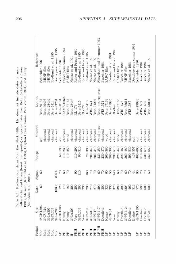
206 APPENDIX A. SUPPLEMENTAL DATAT
ab
leA
.1:
Rad
ioca
rbon
date
sfr
om
the
Bla
ckH
ills
.L
ist
does
not
incl
ud
ed
ate
son
non
-cu
ltu
ral
charc
oal
len
ses
(fore
stfi
red
eposi
ts)
or
reje
cted
date
sfr
om
Bel
leR
ock
shel
ter
(Fri
son
1991),
McK
ean
(Korn
feld
etal.
1993),
Cla
yto
nD
raw
(Cow
an
,P
ers.
com
m.
1994),
an
dK
enzy
(Sau
nd
ers
etal.
1994).
Per
iod
Sit
eD
ate
Sig
ma
Ran
ge
Mate
rial
Lab
no.
Ref
eren
ceM
od
48C
K1396
60
60
soil
Bet
a-8
0137
Sch
nei
der
1996
Mod
39C
U624
charc
oal
Bet
a-6
0497
BH
NF
file
sM
od
39L
A305
charc
oal
Bet
a-2
8446
BH
NF
file
sM
od
39FA
205
charc
oal
Bet
a-5
414
Fre
dlu
nd
etal.
1985
Mod
39L
A783
100.2
0.8
%ch
arc
oal
Bet
a-8
3704
Fosh
ap
ers
com
m1995
LP
48C
K1388
120
70
50–190
soil
Bet
a-8
0134
Sch
nei
der
1996
PH
Ken
zy170
60
110–230
charc
oal
CA
MS
-16622
Sty
les
per
sco
mm
1994
PH
Ken
zy180
70
110–250
wood
Bet
a-6
7167
SA
RC
file
sH
39L
A305
200
charc
oal
Bet
a-2
8446
Nois
at
etal.
1991
PH
HV
ore
200
90
110–290
charc
oal
RL
-173
Reh
eran
dF
riso
n1980
PH
39FA
205
200
110
90–310
charc
oal
Bet
a-5
415
Fre
dlu
nd
etal.
1985
PH
HV
ore
230
charc
oal
RL
-172
Reh
eran
dF
riso
n1980
PH
39FA
205
230
160
70–390
charc
oal
Bet
a-5
413
Fre
dlu
nd
etal.
1985
PH
H39L
A319
270
70
200–340
charc
oal
WIS
-1674
Nois
at
etal.
1991
PH
H39P
N47
270
70
200–340
charc
oal
Bet
a-2
4297
Nois
at
etal.
1991
LP
PH
39P
N1170
290
60
230–350
wood
post
sB
eta,
not
rep
ort
edS
hev
elan
dan
dF
lem
mer
1993
PH
HD
eerfi
eld
300
70
230–370
charc
oal
WIS
-1571
Bu
ech
ler
1984
LP
Ken
zy320
60
260–380
wood
Bet
a-6
7169
SA
RC
file
sL
P48C
K34
330
50
280–380
charc
oal
Bet
a-4
1985
Korn
feld
etal.
1991
LP
Vore
370
140
230–510
charc
oal
RL
-349
Reh
eran
dF
riso
n1980
LP
Ken
zy380
60
320–440
wood
Bet
a-6
7166
SA
RC
file
sL
PD
eerfi
eld
390
70
320–460
charc
oal
WIS
-1572
Bu
ech
ler
1984
LP
39P
N1124
420∗
60
360–480
charc
oal
Bet
a-6
8611
BH
NF
file
sL
PD
eerfi
eld
460
70
390–530
charc
oal
WIS
-1587
Bu
ech
ler
1984
Bla
ine
513
44
469-5
57
soil
Don
ohu
ep
ers
com
m1994
LP
49C
K1395
570
90
480–660
soil
Bet
a-7
9983
Sch
nei
der
1996
LP
Dee
rfiel
d580
70
510–650
charc
oal
WIS
-1589
Bu
ech
ler
1984
LP
Dee
rfiel
d600
70
530–670
charc
oal
WIS
-1565
Bu
ech
ler
1984
LP
39FA
23
600
50
550–650
charc
oal
Bet
a-4
3004
Nois
at
etal.
1991
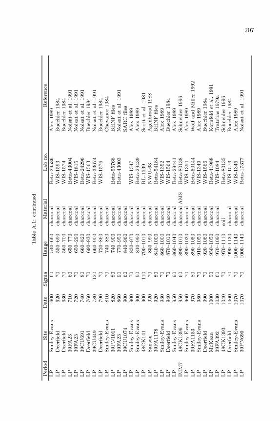
207T
ab
leA
.1:
conti
nu
ed
Per
iod
Sit
eD
ate
Sig
ma
Ran
ge
Mate
rial
Lab
no.
Ref
eren
ceL
PS
miley
-Evan
s600
60
540–660
charc
oal
Bet
a-2
9536
Ale
x1989
LP
Dee
rfiel
d620
70
550–690
charc
oal
WIS
-1593
Bu
ech
ler
1984
LP
Dee
rfiel
d630
70
560–700
charc
oal
WIS
-1574
Bu
ech
ler
1984
LP
39FA
23
710
60
650–770
charc
oal
Bet
a-4
3004
Nois
at
etal.
1991
LP
39FA
23
720
70
650–290
charc
oal
WIS
-1815
Nois
at
etal.
1991
LP
39C
U691
740
80
660–820
charc
oal
Bet
a-2
4296
Nois
at
etal.
1991
LP
Dee
rfiel
d760
70
690–830
charc
oal
WIS
-1563
Bu
ech
ler
1984
LP
39C
U449
780
120
660–900
charc
oal
Bet
a-3
3674
Nois
at
etal.
1991
LP
Dee
rfiel
d790
70
720–860
charc
oal
WIS
-1576
Bu
ech
ler
1984
LP
Sm
iley
-Evan
s810
70
740–880
charc
oal
Ch
evan
ce1984
LP
39P
N1011
820
80
740–900
charc
oal
Bet
a-5
5768
BH
NF
file
sL
P39FA
23
860
90
770–950
charc
oal
Bet
a-4
3003
Nois
at
etal.
1991
LP
39C
U1074
900
60
840–960
charc
oal
SA
RC
file
sL
PS
miley
-Evan
s900
70
830–970
charc
oal
WIS
-1347
Ale
x1989
LP
Sm
iley
-Evan
s900
90
810–990
charc
oal
Bet
a-2
9439
Ale
x1989
LP
48C
K141
900
110
790–1010
charc
oal
RL
-1539
Sco
ttet
al.
1981
LP
San
son
920
70
850–990
charc
oal
NW
U-6
3A
gen
bro
ad
1988
LP
39FA
1178
920
80
840–1000
charc
oal
Bet
a-5
4184
BH
NF
file
sL
PS
miley
-Evan
s930
70
860–1000
charc
oal
WIS
-1352
Ale
x1989
LP
Dee
rfiel
d940
70
870–1010
charc
oal
WIS
-1564
Bu
ech
ler
1984
LP
Sm
iley
-Evan
s950
90
860–1040
charc
oal
Bet
a-2
9441
Ale
x1989
IMM
?48C
K1396
950
60
890–1010
charc
oal
AM
SB
eta-8
0138
Sch
nei
der
1996
LP
Sm
iley
-Evan
s960
70
890–1030
charc
oal
WIS
-1350
Ale
x1989
LP
39FA
1153
970
80
890–1050
charc
oal
Bet
a-5
0144
Wolf
an
dM
ille
r1992
LP
Sm
iley
-Evan
s980
70
910–1050
charc
oal
WIS
-1349
Ale
x1989
LP
Dee
rfiel
d990
70
920–1060
charc
oal
WIS
-1566
Bu
ech
ler
1984
LP
McK
ean
1000
50
950–1050
charc
oal
Bet
a-4
1988
Korn
feld
etal.
1991
LP
39FA
392
1030
60
970–1090
charc
oal
WIS
-1084
Tra
teb
as
1979a
LP
48C
K1393
1040
70
970–1110
soil
Bet
a-8
0135
Sch
nei
der
1996
LP
Dee
rfiel
d1060
70
990–1130
charc
oal
WIS
-1573
Bu
ech
ler
1984
LP
Sm
iley
-Evan
s1070
70
1000–1140
charc
oal
WIS
-1346
Ale
x1989
LP
39P
N690
1070
70
1000–1140
charc
oal
Bet
a-1
7377
Nois
at
etal.
1991
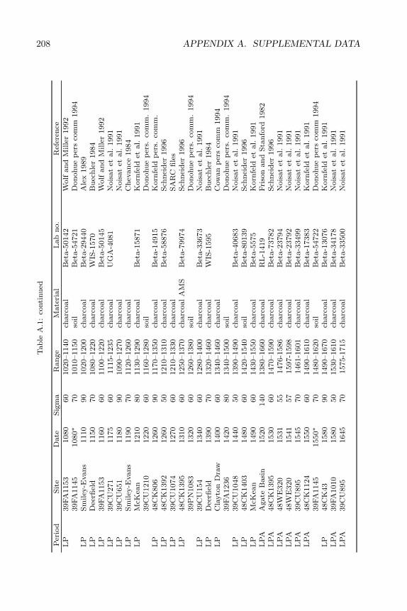
208 APPENDIX A. SUPPLEMENTAL DATAT
ab
leA
.1:
conti
nu
ed
Per
iod
Sit
eD
ate
Sig
ma
Ran
ge
Mate
rial
Lab
no.
Ref
eren
ceL
P39FA
1153
1080
60
1020–1140
charc
oal
Bet
a-5
0142
Wolf
an
dM
ille
r1992
39FA
1145
1080∗
70
1010–1150
soil
Bet
a-5
4721
Don
ohu
ep
ers
com
m1994
LP
Sm
iley
-Evan
s1110
90
1020–1200
charc
oal
Bet
a-2
9440
Ale
x1989
LP
Dee
rfiel
d1150
70
1080–1220
charc
oal
WIS
-1570
Bu
ech
ler
1984
LP
39FA
1153
1160
60
1100–1220
charc
oal
Bet
a-5
0145
Wolf
an
dM
ille
r1992
LP
39C
U271
1175
60
1115-1
235
charc
oal
UG
A-4
081
Nois
at
etal.
1991
LP
39C
U651
1180
90
1090–1270
charc
oal
Nois
at
etal.
1991
LP
Sm
iley
-Evan
s1190
70
1120–1260
charc
oal
Ch
evan
ce1984
LP
McK
ean
1210
80
1130–1290
charc
oal
Bet
a-1
5871
Korn
feld
etal.
1991
39C
U1210
1220
60
1160–1280
soil
Don
ohu
ep
ers.
com
m.
1994
LP
48C
K806
1260
90
1170–1350
charc
oal
Bet
a-1
4915
Korn
feld
per
s.co
mm
.L
P48C
K1392
1260
50
1210–1310
charc
oal
Bet
a-5
8876
Sch
nei
der
1996
LP
39C
U1074
1270
60
1210–1330
charc
oal
SA
RC
file
sL
P48C
K1395
1310
60
1250–1370
charc
oal
AM
SB
eta-7
9974
Sch
nei
der
1996
39P
N1083
1320
60
1260–1380
soil
Don
ohu
ep
ers.
com
m.
1994
LP
39C
U154
1340
60
1280–1400
charc
oal
Bet
a-3
3673
Nois
at
etal.
1991
LP
Dee
rfiel
d1390
70
1320–1460
charc
oal
WIS
-1595
Bu
ech
ler
1984
LP
Cla
yto
nD
raw
1400
60
1340–1460
charc
oal
Cow
an
per
sco
mm
1994
39FA
1236
1420
80
1340–1500
soil
Don
ohu
ep
ers.
com
m.
1994
LP
39C
U1048
1440
50
1390–1490
charc
oal
Bet
a-4
0683
Nois
at
etal.
1991
LP
48C
K1403
1480
60
1420–1540
soil
Bet
a-8
0139
Sch
nei
der
1996
LP
McK
ean
1490
60
1430–1550
charc
oal
Bet
a-5
575
Korn
feld
etal.
1991
LP
AA
gate
Basi
n1520
140
1380–1660
charc
oal
RL
-1419
Fri
son
an
dS
tan
ford
1982
LP
A48C
K1395
1530
60
1470–1590
charc
oal
Bet
a-7
3782
Sch
nei
der
1996
LP
A48W
E320
1531
55
1476-1
586
charc
oal
Bet
a-2
3794
Nois
at
etal.
1991
LP
A48W
E320
1541
57
1597-1
598
charc
oal
Bet
a-2
3792
Nois
at
etal.
1991
LP
A39C
U895
1545
70
1461-1
601
charc
oal
Bet
a-3
3499
Nois
at
etal.
1991
LP
A48C
K1124
1550
60
1490–1610
charc
oal
Bet
a-1
7383
Korn
feld
etal.
1991
39FA
1145
1550∗
70
1480–1620
soil
Bet
a-5
4722
Don
ohu
ep
ers
com
m1994
LP
48C
K43
1580
90
1490–1670
charc
oal
Bet
a-1
3076
Korn
feld
etal.
1991
LP
A39FA
1010
1580
50
1530–1610
charc
oal
Bet
a-3
4178
Nois
at
etal.
1991
LP
A39C
U895
1645
70
1575-1
715
charc
oal
Bet
a-3
3500
Nois
at
etal.
1991
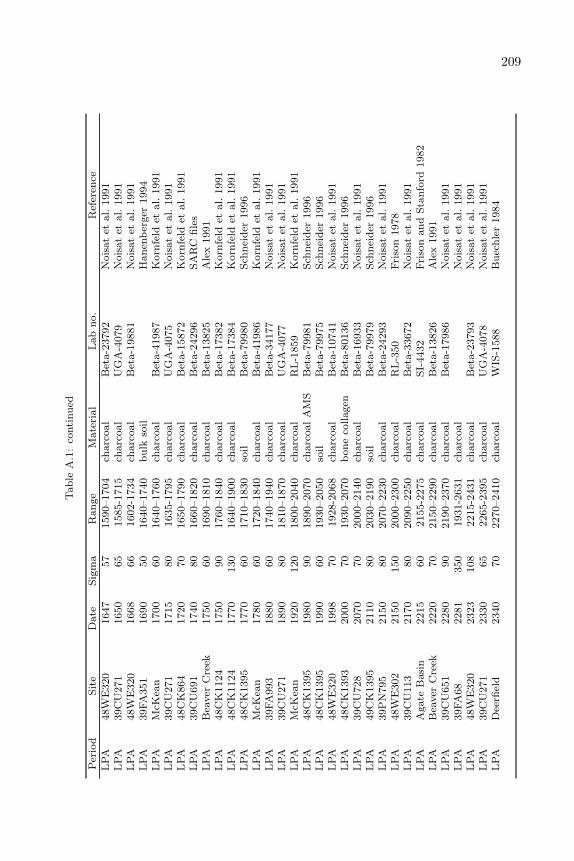
209T
ab
leA
.1:
conti
nu
ed
Per
iod
Sit
eD
ate
Sig
ma
Ran
ge
Mate
rial
Lab
no.
Ref
eren
ceL
PA
48W
E320
1647
57
1590–1704
charc
oal
Bet
a-2
3792
Nois
at
etal.
1991
LP
A39C
U271
1650
65
1585-1
715
charc
oal
UG
A-4
079
Nois
at
etal.
1991
LP
A48W
E320
1668
66
1602-1
734
charc
oal
Bet
a-1
9881
Nois
at
etal.
1991
LP
A39FA
351
1690
50
1640–1740
bu
lkso
ilH
an
enb
erger
1994
LP
AM
cKea
n1700
60
1640–1760
charc
oal
Bet
a-4
1987
Korn
feld
etal.
1991
LP
A39C
U271
1715
80
1635-1
795
charc
oal
UG
A-4
075
Nois
at
etal.
1991
LP
A48C
K864
1720
70
1650–1790
charc
oal
Bet
a-1
5872
Korn
feld
etal.
1991
LP
A39C
U691
1740
80
1660–1820
charc
oal
Bet
a-2
4296
SA
RC
file
sL
PA
Bea
ver
Cre
ek1750
60
1690–1810
charc
oal
Bet
a-1
3825
Ale
x1991
LP
A48C
K1124
1750
90
1760–1840
charc
oal
Bet
a-1
7382
Korn
feld
etal.
1991
LP
A48C
K1124
1770
130
1640–1900
charc
oal
Bet
a-1
7384
Korn
feld
etal.
1991
LP
A48C
K1395
1770
60
1710–1830
soil
Bet
a-7
9980
Sch
nei
der
1996
LP
AM
cKea
n1780
60
1720–1840
charc
oal
Bet
a-4
1986
Korn
feld
etal.
1991
LP
A39FA
993
1880
60
1740–1940
charc
oal
Bet
a-3
4177
Nois
at
etal.
1991
LP
A39C
U271
1890
80
1810–1870
charc
oal
UG
A-4
077
Nois
at
etal.
1991
LP
AM
cKea
n1920
120
1800–2040
charc
oal
RL
-1859
Korn
feld
etal.
1991
LP
A48C
K1395
1980
90
1890–2070
charc
oal
AM
SB
eta-7
9981
Sch
nei
der
1996
LP
A48C
K1395
1990
60
1930–2050
soil
Bet
a-7
9975
Sch
nei
der
1996
LP
A48W
E320
1998
70
1928-2
068
charc
oal
Bet
a-1
0741
Nois
at
etal.
1991
LP
A48C
K1393
2000
70
1930–2070
bon
eco
llagen
Bet
a-8
0136
Sch
nei
der
1996
LP
A39C
U728
2070
70
2000–2140
charc
oal
Bet
a-1
6933
Nois
at
etal.
1991
LP
A49C
K1395
2110
80
2030–2190
soil
Bet
a-7
9979
Sch
nei
der
1996
LP
A39P
N795
2150
80
2070–2230
charc
oal
Bet
a-2
4293
Nois
at
etal.
1991
LP
A48W
E302
2150
150
2000–2300
charc
oal
RL
-350
Fri
son
1978
LP
A39C
U113
2170
80
2090–2250
charc
oal
Bet
a-3
3672
Nois
at
etal.
1991
LP
AA
gate
Basi
n2215
60
2155-2
275
charc
oal
SI-
4432
Fri
son
an
dS
tan
ford
1982
LP
AB
eaver
Cre
ek2220
70
2150–2290
charc
oal
Bet
a-1
3826
Ale
x1991
LP
A39C
U651
2280
90
2190–2370
charc
oal
Bet
a-1
7986
Nois
at
etal.
1991
LP
A39FA
68
2281
350
1931-2
631
charc
oal
Nois
at
etal.
1991
LP
A48W
E320
2323
108
2215-2
431
charc
oal
Bet
a-2
3793
Nois
at
etal.
1991
LP
A39C
U271
2330
65
2265-2
395
charc
oal
UG
A-4
078
Nois
at
etal.
1991
LP
AD
eerfi
eld
2340
70
2270–2410
charc
oal
WIS
-1588
Bu
ech
ler
1984
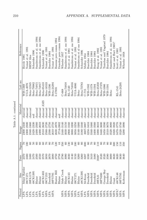
210 APPENDIX A. SUPPLEMENTAL DATAT
ab
leA
.1:
conti
nu
ed
Per
iod
Sit
eD
ate
Sig
ma
Ran
ge
Mate
rial
Lab
no.
Ref
eren
ceL
PA
Min
erR
att
ler
2370
70
2300–2440
charc
oal
WIS
-1369
Hovd
e1981
LP
A39C
U271
2400
100
2300–2500
charc
oal
UG
A-4
076
Nois
at
etal.
1991
LP
A39FA
1178
2400
60
2340–2460
charc
oal
Bet
a-1
2345
BH
NF
file
sL
PA
48C
K1395
2470
50
2420–2330
soil
Bet
a-7
9982
Sch
nei
der
1996
LP
AB
lain
e2500
60
2490–2560
charc
oal
Bet
a-7
4815
Su
nd
stro
met
al.
ms
1994
MP
AB
lain
e2550
60
2490–2610
charc
oal
Bet
a-7
4817
Su
nd
stro
met
al.
ms
1994
LP
A48C
K1403
2570
60
2510–2630
charc
oal
AM
SB
eta-8
5410
Sch
nei
der
1996
MP
A39C
U253
2650
70
2580–2720
charc
oal
Bet
a-1
6533
Nois
at
etal.
1991
LP
AD
eerfi
eld
2670
80
2590–2750
charc
oal
WIS
-1590
Bu
ech
ler
1984
MP
A39P
N795
2680
70
2610–2750
charc
oal
Bet
a-2
4294
Nois
at
etal.
1991
Bu
ster
Hill
2750
120
2630–2870
charc
oal
I-17835
Han
nu
sp
ers
com
m1994
Bla
ine
2758
44
2714-2
802
soil
Don
ohu
ep
ers
com
m1994
MP
AM
ule
Cre
ek2790
350
2440–3140
charc
oal
C-6
68
Wh
eele
r1957
MP
AB
lain
e3090
60
3030–3150
charc
oal
Bet
a-7
4818
Su
nd
stro
met
al.
ms
1994
MP
A48C
K143
3030
130
2900–3160
charc
oal
RL
-1540
Sco
ttet
al.
1981
MP
AB
lain
e3140
60
3080–3200
charc
oal
Bet
a-7
4816
Su
nd
stro
met
al.
ms
1994
MP
A39C
U271
3150
100
3050–3250
charc
oal
UG
A-4
080
Nois
at
etal.
1991
LP
AB
lain
e3200
60
3140–3260
charc
oal
Bet
a-
Su
nd
stro
met
al
ms
1994
MP
A48C
K1395
3260
80
3180–3340
charc
oal
Bet
a-7
3783
Sch
nei
der
1996
LP
AM
cKea
n3287
600
2687-3
887
charc
oal
C-7
15
Mu
lloy
1954
MP
AD
eerfi
eld
3330
80
3250–3410
charc
oal
WIS
-1592
Bu
ech
ler
1984
MP
AD
eerfi
eld
3410
70
3340–3480
charc
oal
WIS
-1578
Bu
ech
ler
1984
MP
AD
eerfi
eld
3480
80
3400–3560
charc
oal
WIS
-1594
Bu
ech
ler
1984
MP
A39FA
31
3500∗
110
3390–3610
charc
oal
Bet
a-2
5358
Hau
get
al.
1992
MP
A39P
N690
3520
80
3440–3600
charc
oal
Bet
a-1
7378
Nois
at
etal.
1991
MP
AG
eorg
eH
ey3520
70
3450–3590
charc
oal
WIS
-1086
Tra
teb
as
an
dV
agst
ad
1979
MP
AD
eerfi
eld
3590
80
3510–3670
charc
oal
WIS
-1591
Bu
ech
ler
1984
MP
AB
lain
e3600
80
3520–3680
charc
oal
Bet
a-
Su
nd
stro
met
al.
ms
1994
MP
AG
ant
3620
300
3320–3920
charc
oal
Gant
an
dH
urt
1965?
MP
A?
48C
K148
3620
150
3470–3770
charc
oal
RL
-1541
Sco
ttet
al.
1981
MP
A39P
N795
3630
110
3520–3740
charc
oal
Bet
a-2
4295
Nois
at
etal.
1991
MP
AK
olt
erm
an
3640
350
3290–3990
charc
oal
Wh
eele
r1958
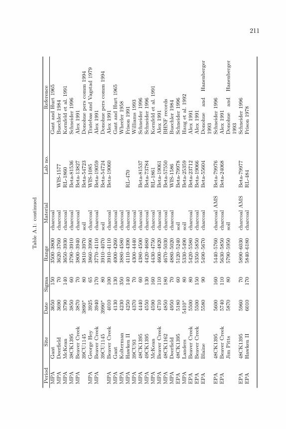
211T
ab
leA
.1:
conti
nu
ed
Per
iod
Sit
eD
ate
Sig
ma
Ran
ge
Mate
rial
Lab
no.
Ref
eren
ceM
PA
Gant
3650
150
3500–3800
charc
oal
Gant
an
dH
urt
1965
MP
AD
eerfi
eld
3690
70
3620–3760
charc
oal
WIS
-1577
Bu
ech
ler
1984
MP
AM
cKea
n3790
140
3650–3930
charc
oal
RL
-1860
Korn
feld
etal.
1991
MP
A38C
K1395
3850
60
3790–3910
charc
oal
Bet
a-8
1536
Sch
nei
der
1996
MP
AB
eaver
Cre
ek3870
70
3800–3940
charc
oal
Bet
a-1
3827
Ale
x1991
39C
U1145
3890∗
80
3810–3970
soil
Bet
a-5
4723
Don
ohu
ep
ers
com
m1994
MP
AG
eorg
eH
ey3925
65
3860–3990
charc
oal
WIS
-1085
Tra
teb
as
an
dV
agst
ad
1979
MP
AB
eaver
Cre
ek3940
170
3770–4110
charc
oal
Bet
a-1
9059
Ale
x1991
39C
U1145
3990∗
80
3910–4070
soil
Bet
a-5
4724
Don
ohu
ep
ers
com
m1994
MP
AB
eaver
Cre
ek4010
100
3910–4110
charc
oal
Bet
a-1
9060
Ale
x1991
MP
AG
ant
4130
130
4000–4260
charc
oal
Gant
an
dH
urt
1965
MP
AK
olt
erm
an
4230
350
3880–4580
charc
oal
Wh
eele
r1958
MP
AH
aw
ken
II4250
140
4110–4390
charc
oal
RL
-470
Fri
son
1991
MP
A39C
U93
4370
70
4300–4440
charc
oal
William
s1993
MP
A48C
K1395
4440
60
4380–4500
charc
oal
Bet
a-8
1537
Sch
nei
der
1996
MP
A49C
K1395
4550
130
4420–4680
charc
oal
Bet
a-7
3784
Sch
nei
der
1996
MP
AM
cKea
n4590
160
4430–4750
charc
oal
RL
-1861
Korn
feld
etal.
1991
MP
AB
eaver
Cre
ek4710
110
4600–4820
charc
oal
Bet
a-1
9061
Ale
x1991
MP
A48C
K1162
4850
180
4670–5030
charc
oal
Bet
a-5
7550
BH
NF
reco
rds
MP
AD
eerfi
eld
4950
70
4880–5020
charc
oal
WIS
-1586
Bu
ech
ler
1984
EP
A48C
K1395
5180
60
5120–5240
soil
Bet
a-7
9978
Sch
nei
der
1996
MP
AL
an
der
s5410∗
80
5330–5490
soil
Bet
a-2
5359
Hau
get
al.
1992
EP
AB
eaver
Cre
ek5500
80
5420–5580
charc
oal
Bet
a-2
3712
Ale
x1991
EP
AB
eaver
Cre
ek5500
150
5350–5850
charc
oal
Bet
a-1
9066
Ale
x1991
EP
AB
lain
e5580
90
5490–5670
charc
oal
Bet
a-5
5604
Don
ohu
ean
dH
an
enb
erger
1993
EP
A48C
K1395
5600
160
5440–5760
charc
oal
AM
SB
eta-7
9976
Sch
nei
der
1996
EP
AB
eaver
Cre
ek5740
110
5630–5850
charc
oal
Bet
a-2
4068
Ale
x1991
Jim
Pit
ts5870
80
5790–5950
soil
Don
ohu
ean
dH
an
enb
erger
1993
EP
A48C
K1395
5960
70
5890–6030
charc
oal
AM
SB
eta-7
9977
Sch
nei
der
1996
EP
AH
aw
ken
II6010
170
5840–6180
charc
oal
RL
-484
Fri
son
1978
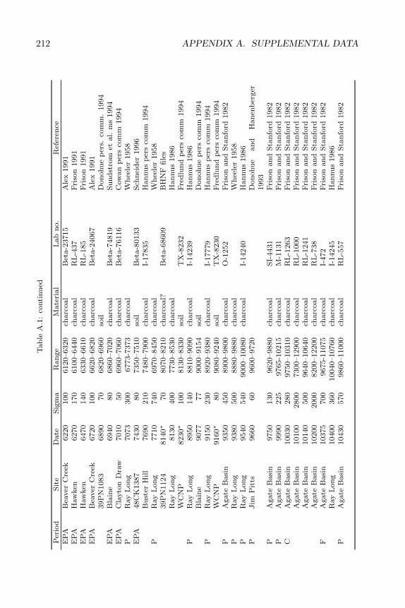
212 APPENDIX A. SUPPLEMENTAL DATAT
ab
leA
.1:
conti
nu
ed
Per
iod
Sit
eD
ate
Sig
ma
Ran
ge
Mate
rial
Lab
no.
Ref
eren
ceE
PA
Bea
ver
Cre
ek6220
100
6120–6320
charc
oal
Bet
a-2
3715
Ale
x1991
EP
AH
aw
ken
6270
170
6100–6440
charc
oal
RL
-437
Fri
son
1991
EP
AH
aw
ken
6470
140
6330–6610
charc
oal
RL
-185
Fri
son
1991
EP
AB
eaver
Cre
ek6720
100
6620–6820
charc
oal
Bet
a-2
4067
Ale
x1991
39P
N1083
6890
70
6820–6960
soil
Don
ohu
ep
ers.
com
m.
1994
EP
AB
lain
e6940
80
6860–7020
charc
oal
Bet
a-7
4819
Su
nd
stro
met
al.
ms
1994
EP
AC
layto
nD
raw
7010
50
6960–7060
charc
oal
Bet
a-7
6116
Cow
an
per
sco
mm
1994
PR
ay
Lon
g7073
300
6773-7
373
charc
oal
Wh
eele
r1958
EP
A48C
K1387
7430
80
7350–7510
soil
Bet
a-8
0133
Sch
nei
der
1996
Bu
ster
Hill
7690
210
7480–7900
charc
oal
I-17835
Han
nu
sp
ers
com
m1994
PR
ay
Lon
g7710
740
6970–8450
charc
oal
Wh
eele
r1958
39P
N1124
8140∗
70
8070–8210
charc
oal?
Bet
a-6
8609
BH
NF
file
sR
ay
Lon
g8130
400
7730–8530
charc
oal
Han
nu
s1986
WC
NP
8230∗
100
8130–8330
soil
TX
-8232
Fre
dlu
nd
per
sco
mm
1994
PR
ay
Lon
g8950
140
8810–9090
charc
oal
I-14239
Han
nu
s1986
Bla
ine
9077
77
9000–9154
soil
Don
ohu
ep
ers
com
m1994
PR
ay
Lon
g9150
230
8920–9380
charc
oal
I-17779
Han
nu
sp
ers
com
m1994
WC
NP
9160∗
80
9080–9240
soil
TX
-8230
Fre
dlu
nd
per
sco
mm
1994
PA
gate
Basi
n9350
450
8900–9800
charc
oal
O-1
252
Fri
son
an
dS
tan
ford
1982
PR
ay
Lon
g9380
500
8880–9880
charc
oal
Wh
eele
r1958
PR
ay
Lon
g9540
540
9000–10080
charc
oal
I-14240
Han
nu
s1986
PJim
Pit
ts9660
60
9600–9720
Don
ohu
ean
dH
an
enb
erger
1993
PA
gate
Basi
n9750
130
9620–9880
charc
oal
SI-
4431
Fri
son
an
dS
tan
ford
1982
PA
gate
Basi
n9990
225
9765-1
0215
charc
oal
M-1
131
Fri
son
an
dS
tan
ford
1982
CA
gate
Basi
n10030
280
9750–10310
charc
oal
RL
-1263
Fri
son
an
dS
tan
ford
1982
Agate
Basi
n10100
2800
7300–12900
charc
oal
RL
-1000
Fri
son
an
dS
tan
ford
1982
Agate
Basi
n10140
500
9640–10640
charc
oal
RL
-1241
Fri
son
an
dS
tan
ford
1982
Agate
Basi
n10200
2000
8200–12200
charc
oal
RL
-738
Fri
son
an
dS
tan
ford
1982
FA
gate
Basi
n10375
700
9675-1
1075
charc
oal
I-472
Fri
son
an
dS
tan
ford
1982
Ray
Lon
g10400
360
10040–10760
charc
oal
I-14245
Han
nu
s1986
PA
gate
Basi
n10430
570
9860–11000
charc
oal
RL
-557
Fri
son
an
dS
tan
ford
1982
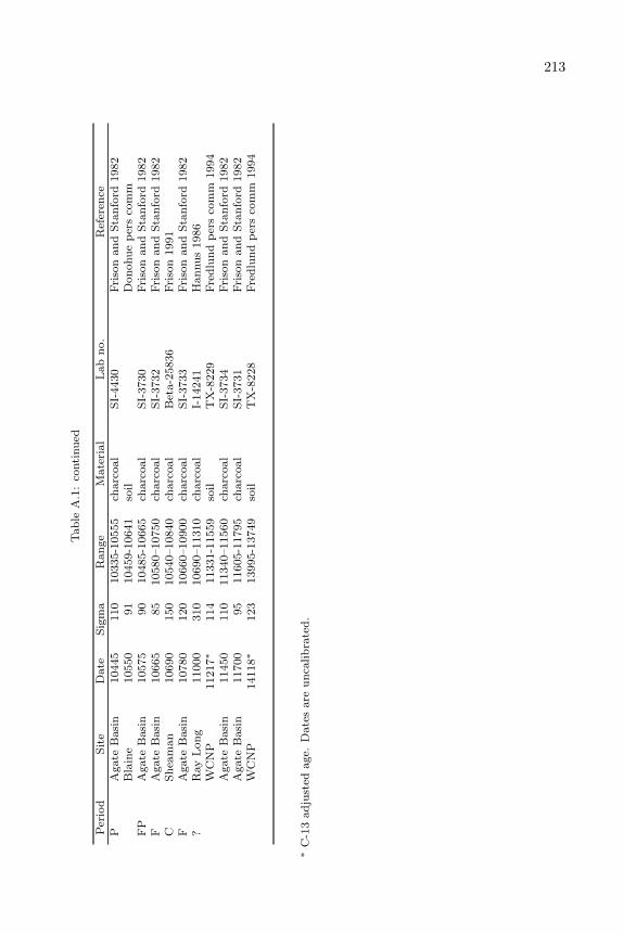
213T
ab
leA
.1:
conti
nu
ed
Per
iod
Sit
eD
ate
Sig
ma
Ran
ge
Mate
rial
Lab
no.
Ref
eren
ceP
Agate
Basi
n10445
110
10335-1
0555
charc
oal
SI-
4430
Fri
son
an
dS
tan
ford
1982
Bla
ine
10550
91
10459-1
0641
soil
Don
ohu
ep
ers
com
mF
PA
gate
Basi
n10575
90
10485-1
0665
charc
oal
SI-
3730
Fri
son
an
dS
tan
ford
1982
FA
gate
Basi
n10665
85
10580–10750
charc
oal
SI-
3732
Fri
son
an
dS
tan
ford
1982
CS
hea
man
10690
150
10540–10840
charc
oal
Bet
a-2
5836
Fri
son
1991
FA
gate
Basi
n10780
120
10660–10900
charc
oal
SI-
3733
Fri
son
an
dS
tan
ford
1982
?R
ay
Lon
g11000
310
10690–11310
charc
oal
I-14241
Han
nu
s1986
WC
NP
11217∗
114
11331-1
1559
soil
TX
-8229
Fre
dlu
nd
per
sco
mm
1994
Agate
Basi
n11450
110
11340–11560
charc
oal
SI-
3734
Fri
son
an
dS
tan
ford
1982
Agate
Basi
n11700
95
11605-1
1795
charc
oal
SI-
3731
Fri
son
an
dS
tan
ford
1982
WC
NP
14118∗
123
13995-1
3749
soil
TX
-8228
Fre
dlu
nd
per
sco
mm
1994
∗C
-13
ad
just
edage.
Date
sare
un
calib
rate
d.
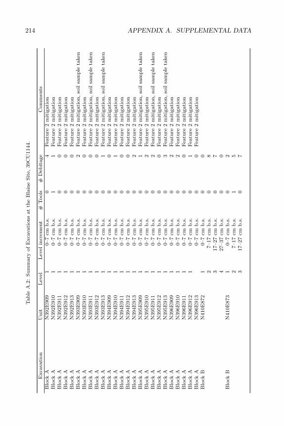
214 APPENDIX A. SUPPLEMENTAL DATAT
ab
leA
.2:
Su
mm
ary
of
Exca
vati
on
sat
the
Bla
ine
Sit
e,39C
U1144.
Exca
vati
on
Un
itL
evel
Lev
elin
crem
ent
#T
ools
#D
ebit
age
Com
men
tsB
lock
AN
392E
909
10–7
cmb
.s.
04
Fea
ture
2m
itig
ati
on
Blo
ckA
N392E
910
10–7
cmb
.s.
11
Fea
ture
2m
itig
ati
on
Blo
ckA
N392E
911
10–7
cmb
.s.
00
Fea
ture
2m
itig
ati
on
Blo
ckA
N392E
912
10–7
cmb
.s.
00
Fea
ture
2m
itig
ati
on
Blo
ckA
N392E
913
10–7
cmb
.s.
00
Fea
ture
2m
itig
ati
on
Blo
ckA
N393E
909
10–7
cmb
.s.
02
Fea
ture
2m
itig
ati
on
,so
ilsa
mp
leta
ken
Blo
ckA
N393E
910
10–7
cmb
.s.
00
Fea
ture
2m
itig
ati
on
Blo
ckA
N393E
911
10–7
cmb
.s.
00
Fea
ture
2m
itig
ati
on
,so
ilsa
mp
leta
ken
Blo
ckA
N393E
912
10–7
cmb
.s.
00
Fea
ture
2m
itig
ati
on
Blo
ckA
N393E
913
10–7
cmb
.s.
01
Fea
ture
2m
itig
ati
on
,so
ilsa
mp
leta
ken
Blo
ckA
N394E
909
10–7
cmb
.s.
00
Fea
ture
2m
itig
ati
on
Blo
ckA
N394E
910
10–7
cmb
.s.
01
Fea
ture
2m
itig
ati
on
Blo
ckA
N394E
911
10–7
cmb
.s.
00
Fea
ture
2m
itig
ati
on
Blo
ckA
N394E
912
10–7
cmb
.s.
00
Fea
ture
2m
itig
ati
on
Blo
ckA
N394E
913
10–7
cmb
.s.
02
Fea
ture
2m
itig
ati
on
Blo
ckA
N395E
909
10–7
cmb
.s.
01
Fea
ture
2m
itig
ati
on
,so
ilsa
mp
leta
ken
Blo
ckA
N395E
910
10–7
cmb
.s.
02
Fea
ture
2m
itig
ati
on
Blo
ckA
N395E
911
10–7
cmb
.s.
02
Fea
ture
2m
itig
ati
on
,so
ilsa
mp
leta
ken
Blo
ckA
N395E
912
10–7
cmb
.s.
00
Fea
ture
2m
itig
ati
on
Blo
ckA
N395E
913
10–7
cmb
.s.
03
Fea
ture
2m
itig
ati
on
,so
ilsa
mp
leta
ken
Blo
ckA
N396E
909
10–7
cmb
.s.
02
Fea
ture
2m
itig
ati
on
Blo
ckA
N396E
910
10–7
cmb
.s.
02
Fea
ture
2m
itig
ati
on
Blo
ckA
N396E
911
10–7
cmb
.s.
00
Fea
ture
2m
itig
ati
on
Blo
ckA
N396E
912
10–7
cmb
.s.
01
Fea
ture
2m
itig
ati
on
Blo
ckA
N396E
913
0–7
cmb
.s.
00
Fea
ture
2m
itig
ati
on
Blo
ckB
N410E
872
10–7
cmb
.s.
00
27–17
cmb
.s.
08
317–27
cmb
.s.
07
427–37
cmb
.s.
00
Blo
ckB
N410E
873
10–7
cmb
.s.
02
27–17
cmb
.s.
15
317–27
cmb
.s.
07
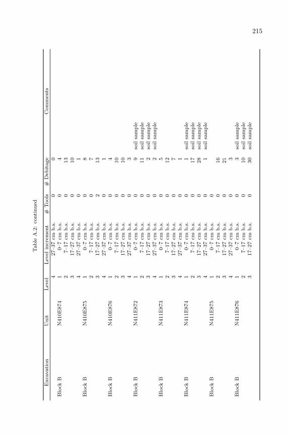
215T
ab
leA
.2:
conti
nu
ed
Exca
vati
on
Un
itL
evel
Lev
elin
crem
ent
#T
ools
#D
ebit
age
Com
men
ts4
27–37
cmb
.s.
00
Blo
ckB
N410E
874
10–7
cmb
.s.
04
27–17
cmb
.s.
013
317–27
cmb
.s.
010
427–37
cmb
.s.
01
Blo
ckB
N410E
875
10–7
cmb
.s.
08
27–17
cmb
.s.
07
317–27
cmb
.s.
213
427–37
cmb
.s.
01
Blo
ckB
N410E
876
10–7
cmb
.s.
04
27–17
cmb
.s.
010
317–27
cmb
.s.
010
427–37
cmb
.s.
03
Blo
ckB
N411E
872
10–7
cmb
.s.
09
soil
sam
ple
27–17
cmb
.s.
011
soil
sam
ple
317–27
cmb
.s.
02
soil
sam
ple
427–37
cmb
.s.
02
soil
sam
ple
Blo
ckB
N411E
873
10–7
cmb
.s.
05
27–17
cmb
.s.
012
317–27
cmb
.s.
07
427–37
cmb
.s.
01
Blo
ckB
N411E
874
10–7
cmb
.s.
01
soil
sam
ple
27–17
cmb
.s.
017
soil
sam
ple
317–27
cmb
.s.
028
soil
sam
ple
427–37
cmb
.s.
01
soil
sam
ple
Blo
ckB
N411E
875
10–7
cmb
.s.
02
7–17
cmb
.s.
016
317–27
cmb
.s.
021
427–37
cmb
.s.
03
Blo
ckB
N411E
876
10–7
cmb
.s.
03
soil
sam
ple
27–17
cmb
.s.
010
soil
sam
ple
317–27
cmb
.s.
030
soil
sam
ple
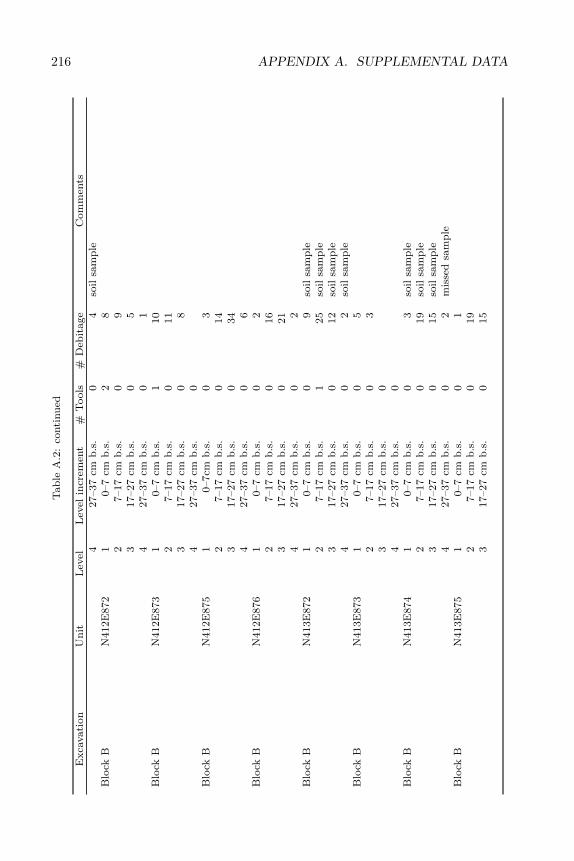
216 APPENDIX A. SUPPLEMENTAL DATAT
ab
leA
.2:
conti
nu
ed
Exca
vati
on
Un
itL
evel
Lev
elin
crem
ent
#T
ools
#D
ebit
age
Com
men
ts4
27–37
cmb
.s.
04
soil
sam
ple
Blo
ckB
N412E
872
10–7
cmb
.s.
28
27–17
cmb
.s.
09
317–27
cmb
.s.
05
427–37
cmb
.s.
01
Blo
ckB
N412E
873
10–7
cmb
.s.
110
27–17
cmb
.s.
011
317–27
cmb
.s.
08
427–37
cmb
.s.
0B
lock
BN
412E
875
10–7cm
b.s
.0
32
7–17
cmb
.s.
014
317–27
cmb
.s.
034
427–37
cmb
.s.
06
Blo
ckB
N412E
876
10–7
cmb
.s.
02
27–17
cmb
.s.
016
317–27
cmb
.s.
021
427–37
cmb
.s.
02
Blo
ckB
N413E
872
10–7
cmb
.s.
09
soil
sam
ple
27–17
cmb
.s.
125
soil
sam
ple
317–27
cmb
.s.
012
soil
sam
ple
427–37
cmb
.s.
02
soil
sam
ple
Blo
ckB
N413E
873
10–7
cmb
.s.
05
27–17
cmb
.s.
03
317–27
cmb
.s.
04
27–37
cmb
.s.
0B
lock
BN
413E
874
10–7
cmb
.s.
03
soil
sam
ple
27–17
cmb
.s.
019
soil
sam
ple
317–27
cmb
.s.
015
soil
sam
ple
427–37
cmb
.s.
02
mis
sed
sam
ple
Blo
ckB
N413E
875
10–7
cmb
.s.
01
27–17
cmb
.s.
019
317–27
cmb
.s.
015
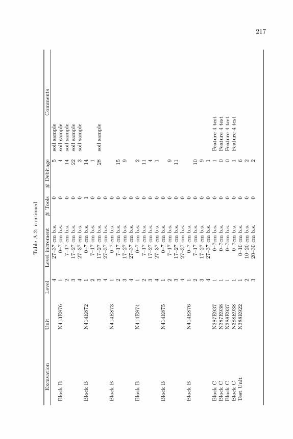
217T
ab
leA
.2:
conti
nu
ed
Exca
vati
on
Un
itL
evel
Lev
elin
crem
ent
#T
ools
#D
ebit
age
Com
men
ts4
27–37
cmb
.s.
05
soil
sam
ple
Blo
ckB
N413E
876
10–7
cmb
.s.
04
soil
sam
ple
27–17
cmb
.s.
014
soil
sam
ple
317–27
cmb
.s.
022
soil
sam
ple
427–37
cmb
.s.
03
soil
sam
ple
Blo
ckB
N414E
872
10–7
cmb
.s.
114
27–17
cmb
.s.
01
317–27
cmb
.s.
028
soil
sam
ple
427–37
cmb
.s.
0B
lock
BN
414E
873
10–7
cmb
.s.
02
7–17
cmb
.s.
015
317–27
cmb
.s.
09
427–37
cmb
.s.
0B
lock
BN
414E
874
10–7
cmb
.s.
02
27–17
cmb
.s.
011
317–27
cmb
.s.
04
427–37
cmb
.s.
01
Blo
ckB
N414E
875
10–7
cmb
.s.
02
7–17
cmb
.s.
09
317–27
cmb
.s.
011
427–37
cmb
.s.
0B
lock
BN
414E
876
10–7
cmb
.s.
02
7–17
cmb
.s.
010
317–27
cmb
.s.
09
427–37
cmb
.s.
01
Blo
ckC
N387E
937
10–7cm
b.s
.0
1F
eatu
re4
test
Blo
ckC
N387E
938
10–7cm
b.s
.0
0F
eatu
re4
test
Blo
ckC
N388E
937
10–7cm
b.s
.0
0F
eatu
re4
test
Blo
ckC
N388E
938
10–7cm
b.s
.0
1F
eatu
re4
test
Tes
tU
nit
N388E
922
10–10
cmb
.s.
06
210–20
cmb
.s.
02
320–30
cmb
.s.
02
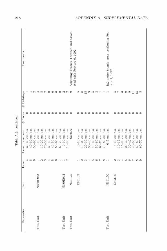
218 APPENDIX A. SUPPLEMENTAL DATAT
ab
leA
.2:
conti
nu
ed
Exca
vati
on
Un
itL
evel
Lev
elin
crem
ent
#T
ools
#D
ebit
age
Com
men
ts4
30–40
cmb
.s.
01
540–50
cmb
.s.
01
650–60
cmb
.s.
02
Tes
tU
nit
N388E
943
10–10
cmb
.s.
04
210–20
cmb
.s.
05
320–30
cmb
.s.
02
430–40
cmb
.s.
00
540–50
cmb
.s.
00
650–60
cmb
.s.
00
760–70
cmb
.s.
00
Tes
tU
nit
N389E
943
10–10
cmb
.s.
02
210–20
cmb
.s.
02
Tes
tU
nit
N391.2
5S
urf
ace
09
Ad
join
ing
Fea
ture
1tr
ench
an
dass
oci
-ate
dw
ith
Fea
ture
6,
1992
E901.3
21
0–10
cmb
.s.
05
210–20
cmb
.s.
08
320–30
cmb
.s.
015
430–40
cmb
.s.
09
540–50
cmb
.s.
05
650–60
cmb
.s.
03
760–70
cmb
.s.
01
870–80
cmb
.s.
01
Tes
tU
nit
N391.5
01
0–5
cmb
.s.
01
1x2-m
eter
tren
chcr
oss
sect
ion
ing
Fea
-tu
re1,
1992
E903.3
02
5–10
cmb
.s.
05
310–15
cmb
.s.
07
415–20
cmb
.s.
06
520–30
cmb
.s.
09
630–40
cmb
.s.
09
740–50
cmb
.s.
011
850–60
cmb
.s.
015
960–70
cmb
.s.
05
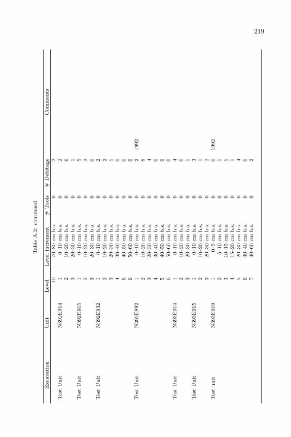
219T
ab
leA
.2:
conti
nu
ed
Exca
vati
on
Un
itL
evel
Lev
elin
crem
ent
#T
ools
#D
ebit
age
Com
men
ts10
70–80
cmb
.s.
02
Tes
tU
nit
N392E
914
10–10
cmb
.s.
02
210–20
cmb
.s.
06
320–30
cmb
.s.
01
Tes
tU
nit
N392E
915
10–10
cmb
.s.
05
210–20
cmb
.s.
02
320–30
cmb
.s.
00
Tes
tU
nit
N392E
932
10–10
cmb
.s.
02
210–20
cmb
.s.
02
320–30
cmb
.s.
01
430–40
cmb
.s.
00
540–50
cmb
.s.
00
650–60
cmb
.s.
00
Tes
tU
nit
N393E
892
10–10
cmb
.s.
02
1992
210–20
cmb
.s.
08
320–30
cmb
.s.
04
430–40
cmb
.s.
00
540–50
cmb
.s.
00
650–60
cmb
.s.
00
Tes
tU
nit
N393E
914
10–10
cmb
.s.
04
210–20
cmb
.s.
00
320–30
cmb
.s.
01
Tes
tU
nit
N393E
915
10–10
cmb
.s.
03
210–20
cmb
.s.
01
320–30
cmb
.s.
02
Tes
tu
nit
N393E
919
10–5
cmb
.s.
00
1992
25–10
cmb
.s.
01
310–15
cmb
.s.
01
415–20
cmb
.s.
01
520–30
cmb
.s.
04
630–40
cmb
.s.
00
740–60
cmb
.s.
02
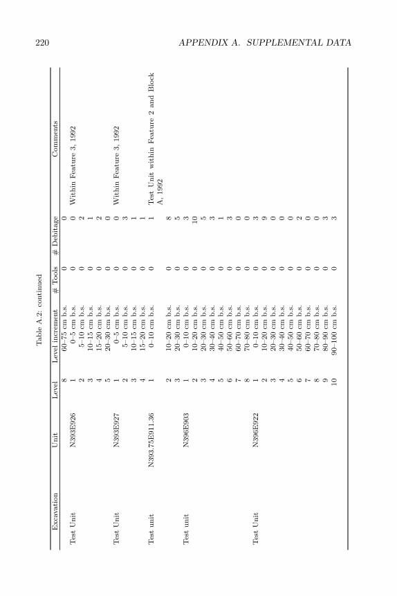
220 APPENDIX A. SUPPLEMENTAL DATAT
ab
leA
.2:
conti
nu
ed
Exca
vati
on
Un
itL
evel
Lev
elin
crem
ent
#T
ools
#D
ebit
age
Com
men
ts8
60–75
cmb
.s.
00
Tes
tU
nit
N393E
926
10–5
cmb
.s.
00
Wit
hin
Fea
ture
3,
1992
25–10
cmb
.s.
02
310–15
cmb
.s.
01
415–20
cmb
.s.
02
520–30
cmb
.s.
00
Tes
tU
nit
N393E
927
10–5
cmb
.s.
00
Wit
hin
Fea
ture
3,
1992
25–10
cmb
.s.
03
310–15
cmb
.s.
01
415–20
cmb
.s.
01
Tes
tu
nit
N393.7
5E
911.3
61
0–10
cmb
.s.
01
Tes
tU
nit
wit
hin
Fea
ture
2an
dB
lock
A,
1992
210–20
cmb
.s.
08
320–30
cmb
.s.
05
Tes
tu
nit
N396E
903
10–10
cmb
.s.
03
210–20
cmb
.s.
010
320–30
cmb
.s.
05
430–40
cmb
.s.
03
540–50
cmb
.s.
01
650–60
cmb
.s.
03
760–70
cmb
.s.
00
870–80
cmb
.s.
00
Tes
tU
nit
N396E
922
10–10
cmb
.s.
03
210–20
cmb
.s.
09
320–30
cmb
.s.
00
430–40
cmb
.s.
00
540–50
cmb
.s.
00
650–60
cmb
.s.
02
760–70
cmb
.s.
00
870–80
cmb
.s.
00
980–90
cmb
.s.
03
10
90–100
cmb
.s.
03

221T
ab
leA
.2:
conti
nu
ed
Exca
vati
on
Un
itL
evel
Lev
elin
crem
ent
#T
ools
#D
ebit
age
Com
men
tsT
est
Un
itN
397E
899
10–10
cmb
.s.
011
210–20
cmb
.s.
00
320–30
cmb
.s.
04
430–40
cmb
.s.
00
540–50
cmb
.s.
00
650–60
cmb
.s.
00
Tes
tu
nit
N400E
914
10–10cm
b.s
.0
22
10–20
cmb
.s.
05
320–30
cmb
.s.
01
430–40
cmb
.s.
00
540–50
cmb
.s.
00
650–60
cmb
.s.
00
Tes
tu
nit
N404E
895
10–10cm
b.s
.0
12
10–20
cmb
.s.
01
320–30
cmb
.s.
03
430–40
cmb
.s.
00
540–50
cmb
.s.
00
650–60
cmb
.s.
00
760–70
cmb
.s.
00
870–80
cmb
.s.
00
980–90
cmb
.s.
00
10
90–100
cmb
.s.
00
Tes
tU
nit
N404E
901
10–10
cmb
.s.
02
210–20
cmb
.s.
01
320–30
cmb
.s.
01
430–40
cmb
.s.
01
540–50
cmb
.s.
00
Tes
tu
nit
N406E
972
10–10
cmb
.s.
02
10–20
cmb
.s.
00
320–30
cmb
.s.
00
430–40
cmb
.s.
00
540–50
cmb
.s.
00
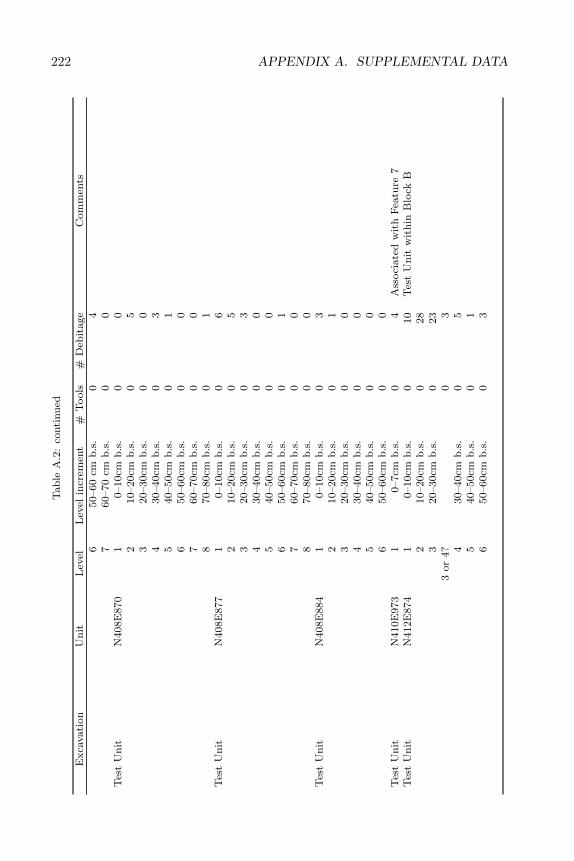
222 APPENDIX A. SUPPLEMENTAL DATAT
ab
leA
.2:
conti
nu
ed
Exca
vati
on
Un
itL
evel
Lev
elin
crem
ent
#T
ools
#D
ebit
age
Com
men
ts6
50–60
cmb
.s.
04
760–70
cmb
.s.
00
Tes
tU
nit
N408E
870
10–10cm
b.s
.0
02
10–20cm
b.s
.0
53
20–30cm
b.s
.0
04
30–40cm
b.s
.0
35
40–50cm
b.s
.0
16
50–60cm
b.s
.0
07
60–70cm
b.s
.0
08
70–80cm
b.s
.0
1T
est
Un
itN
408E
877
10–10cm
b.s
.0
62
10–20cm
b.s
.0
53
20–30cm
b.s
.0
34
30–40cm
b.s
.0
05
40–50cm
b.s
.0
06
50–60cm
b.s
.0
17
60–70cm
b.s
.0
08
70–80cm
b.s
.0
0T
est
Un
itN
408E
884
10–10cm
b.s
.0
32
10–20cm
b.s
.0
13
20–30cm
b.s
.0
04
30–40cm
b.s
.0
05
40–50cm
b.s
.0
06
50–60cm
b.s
.0
0T
est
Un
itN
410E
973
10–7cm
b.s
.0
4A
ssoci
ate
dw
ith
Fea
ture
7T
est
Un
itN
412E
874
10–10cm
b.s
.0
10
Tes
tU
nit
wit
hin
Blo
ckB
210–20cm
b.s
.0
28
320–30cm
b.s
.0
23
3or
4?
03
430–40cm
b.s
.0
55
40–50cm
b.s
.0
16
50–60cm
b.s
.0
3
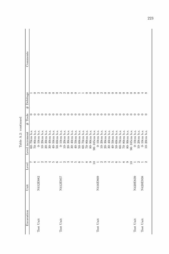
223T
ab
leA
.2:
conti
nu
ed
Exca
vati
on
Un
itL
evel
Lev
elin
crem
ent
#T
ools
#D
ebit
age
Com
men
ts7
60–70cm
b.s
.0
18
70–80cm
b.s
.0
0T
est
Un
itN
412E
882
10–10cm
b.s
.0
22
10–20cm
b.s
.0
23
20–30cm
b.s
.0
04
30–40cm
b.s
.0
05
40–50cm
b.s
.0
06
50–60cm
b.s
.0
0T
est
Un
itN
412E
957
10–10cm
b.s
.0
22
10–20cm
b.s
.0
23
20–30cm
b.s
.0
04
30–40cm
b.s
.0
05
40–50cm
b.s
.0
06
50–60cm
b.s
.0
17
60–70cm
b.s
.0
18
70–80cm
b.s
.0
09
80–90cm
b.s
.0
010
90–105cm
b.s
.0
0T
est
Un
itN
416E
869
10–10cm
b.s
.0
02
10–20cm
b.s
.0
23
20–30cm
b.s
.0
04
30–40cm
b.s
.0
05
40–50cm
b.s
.0
06
50–60cm
b.s
.0
07
60–70cm
b.s
.0
08
70–80cm
b.s
.0
09
80–90cm
b.s
.0
010
90–105cm
b.s
.0
0T
est
Un
itN
420E
839
10–10cm
b.s
.0
02
10–20cm
b.s
.0
0T
est
Un
itN
420E
938
10–10cm
b.s
.0
42
10–20cm
b.s
.0
8
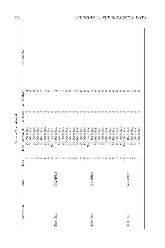
224 APPENDIX A. SUPPLEMENTAL DATAT
ab
leA
.2:
conti
nu
ed
Exca
vati
on
Un
itL
evel
Lev
elin
crem
ent
#T
ools
#D
ebit
age
Com
men
ts3
20–30cm
b.s
.0
24
30–40cm
b.s
.0
05
40–50cm
b.s
.0
06
50–60cm
b.s
.0
07
60–70cm
b.s
.0
28
70–80cm
b.s
.0
19
80–90cm
b.s
.0
010
90–105cm
b.s
.0
1T
est
Un
itN
428E
923
10–10cm
b.s
.0
22
10–20cm
b.s
.0
13
20–30cm
b.s
.0
14
30–40cm
b.s
.0
05
40–50cm
b.s
.0
36
50–60cm
b.s
.0
17
60–70cm
b.s
.0
28
70–80cm
b.s
.0
09
80–90cm
b.s
.0
010
90–105cm
b.s
.0
0T
est
Un
itN
432E
903
10–10cm
b.s
.0
52
10–20cm
b.s
.0
03
20–30cm
b.s
.0
04
30–40cm
b.s
.0
05
40–50cm
b.s
.0
06
50–60cm
b.s
.0
07
60–70cm
b.s
.0
08
70–80cm
b.s
.0
09
80–90cm
b.s
.0
010
90–105cm
b.s
.0
0T
est
Un
itN
436E
808
10–10cm
b.s
.0
02
10–20cm
b.s
.0
13
20–30cm
b.s
.0
04
30–40cm
b.s
.0
0
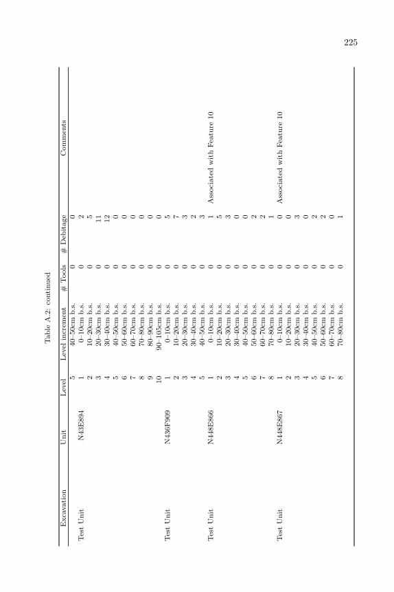
225T
ab
leA
.2:
conti
nu
ed
Exca
vati
on
Un
itL
evel
Lev
elin
crem
ent
#T
ools
#D
ebit
age
Com
men
ts5
40–50cm
b.s
.0
0T
est
Un
itN
43E
894
10–10cm
b.s
.0
22
10–20cm
b.s
.0
53
20–30cm
b.s
.0
11
430–40cm
b.s
.0
12
540–50cm
b.s
.0
06
50–60cm
b.s
.0
07
60–70cm
b.s
.0
08
70–80cm
b.s
.0
09
80–90cm
b.s
.0
010
90–105cm
b.s
.0
0T
est
Un
itN
436F
909
10–10cm
b.s
.0
52
10–20cm
b.s
.0
73
20–30cm
b.s
.0
34
30–40cm
b.s
.0
25
40–50cm
b.s
.0
3T
est
Un
itN
448E
866
10–10cm
b.s
.0
1A
ssoci
ate
dw
ith
Fea
ture
10
210–20cm
b.s
.0
53
20–30cm
b.s
.0
34
30–40cm
b.s
.0
05
40–50cm
b.s
.0
06
50–60cm
b.s
.0
27
60–70cm
b.s
.0
28
70–80cm
b.s
.0
1T
est
Un
itN
448E
867
10–10cm
b.s
.0
0A
ssoci
ate
dw
ith
Fea
ture
10
210–20cm
b.s
.0
03
20–30cm
b.s
.0
34
30–40cm
b.s
.0
05
40–50cm
b.s
.0
26
50–60cm
b.s
.0
27
60–70cm
b.s
.0
08
70–80cm
b.s
.0
1
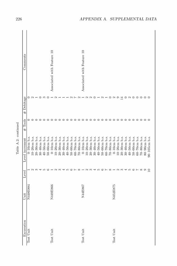
226 APPENDIX A. SUPPLEMENTAL DATAT
ab
leA
.2:
conti
nu
ed
Exca
vati
on
Un
itL
evel
Lev
elin
crem
ent
#T
ools
#D
ebit
age
Com
men
tsT
est
Un
itN
448E
884
10–10cm
b.s
.0
02
10–20cm
b.s
.0
23
20–30cm
b.s
.0
14
30–40cm
b.s
.0
05
40–50cm
b.s
.0
36
50–60cm
b.s
.0
0T
est
Un
itN
449E
866
10–10cm
b.s
.0
1A
ssoci
ate
dw
ith
Fea
ture
10
210–20cm
b.s
.0
23
20–30cm
b.s
.0
14
30–40cm
b.s
.0
15
40–50cm
b.s
.0
16
50–60cm
b.s
.0
27
60–70cm
b.s
.0
78
70–80cm
b.s
.0
2T
est
Un
itN
44E
867
10–10cm
b.s
.0
1A
ssoci
ate
dw
ith
Fea
ture
10
210–20cm
b.s
.0
23
20–30cm
b.s
.0
24
30–40cm
b.s
.0
05
40–50cm
b.s
.0
16
50–60cm
b.s
.0
27
60–70cm
b.s
.0
18
70–80cm
b.s
.0
0T
est
Un
itN
452E
875
10–10cm
b.s
.0
22
10–20cm
b.s
.0
93
20–30cm
b.s
.0
14
430–40cm
b.s
.0
05
40–50cm
b.s
.0
26
50–60cm
b.s
.0
07
60–70cm
b.s
.0
08
70–80cm
b.s
.0
09
80–90cm
b.s
.0
010
90–105cm
b.s
.0
0
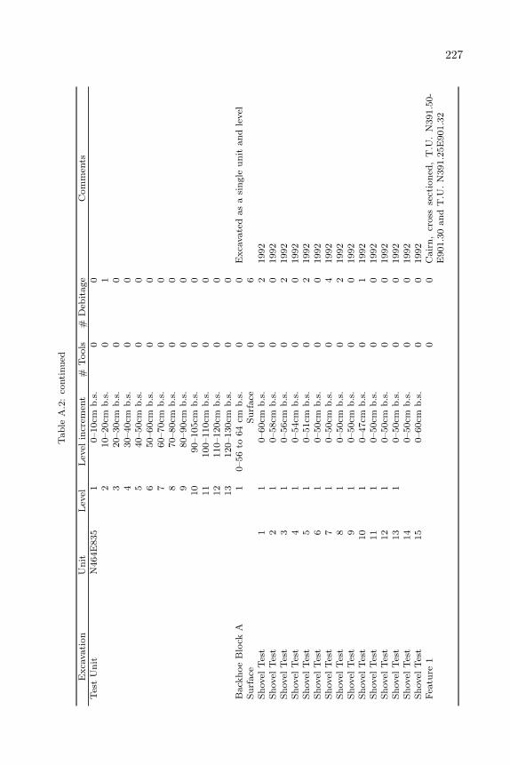
227T
ab
leA
.2:
conti
nu
ed
Exca
vati
on
Un
itL
evel
Lev
elin
crem
ent
#T
ools
#D
ebit
age
Com
men
tsT
est
Un
itN
464E
835
10–10cm
b.s
.0
02
10–20cm
b.s
.0
13
20–30cm
b.s
.0
04
30–40cm
b.s
.0
05
40–50cm
b.s
.0
06
50–60cm
b.s
.0
07
60–70cm
b.s
.0
08
70–80cm
b.s
.0
09
80–90cm
b.s
.0
010
90–105cm
b.s
.0
011
100–110cm
b.s
.0
012
110–120cm
b.s
.0
013
120–130cm
b.s
.0
0B
ack
hoe
Blo
ckA
10–56
to64
cmb
.s.
00
Exca
vate
das
asi
ngle
un
itan
dle
vel
Su
rface
Su
rface
06
Sh
ovel
Tes
t1
10–60cm
b.s
.0
21992
Sh
ovel
Tes
t2
10–58cm
b.s
.0
01992
Sh
ovel
Tes
t3
10–56cm
b.s
.0
21992
Sh
ovel
Tes
t4
10–54cm
b.s
.0
01992
Sh
ovel
Tes
t5
10–51cm
b.s
.0
21992
Sh
ovel
Tes
t6
10–50cm
b.s
.0
01992
Sh
ovel
Tes
t7
10–50cm
b.s
.0
41992
Sh
ovel
Tes
t8
10–50cm
b.s
.0
21992
Sh
ovel
Tes
t9
10–50cm
b.s
.0
01992
Sh
ovel
Tes
t10
10–47cm
b.s
.0
11992
Sh
ovel
Tes
t11
10–50cm
b.s
.0
01992
Sh
ovel
Tes
t12
10–50cm
b.s
.0
01992
Sh
ovel
Tes
t13
10–50cm
b.s
.0
01992
Sh
ovel
Tes
t14
0–50cm
b.s
.0
01992
Sh
ovel
Tes
t15
0–60cm
b.s
.0
01992
Fea
ture
10
0C
air
n,
cross
sect
ion
ed,
T.U
.N
391.5
0-
E901.3
0an
dT
.U.
N391.2
5E
901.3
2
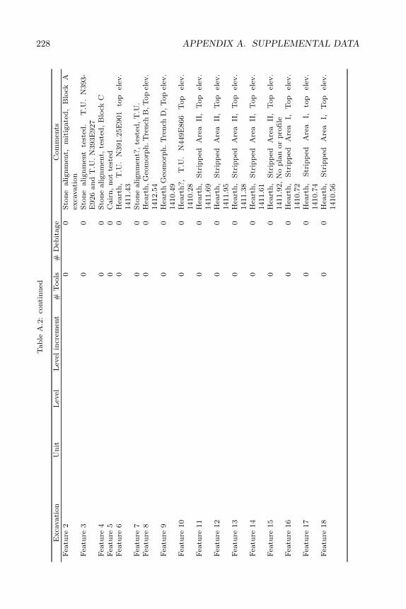
228 APPENDIX A. SUPPLEMENTAL DATAT
ab
leA
.2:
conti
nu
ed
Exca
vati
on
Un
itL
evel
Lev
elin
crem
ent
#T
ools
#D
ebit
age
Com
men
tsF
eatu
re2
00
Sto
ne
align
men
t,m
itig
ate
d,
Blo
ckA
exca
vati
on
Fea
ture
30
0S
ton
eali
gn
men
tte
sted
.T
.U.
N393-
E926
an
dT
.U.
N393E
927
Fea
ture
40
0S
ton
ealign
men
t,te
sted
,B
lock
CF
eatu
re5
00
Cair
n,
not
test
edF
eatu
re6
00
Hea
rth
,T
.U.
N391.2
5E
901
top
elev
.1411.4
3F
eatu
re7
00
Sto
ne
align
men
t?,
test
ed,
T.U
.F
eatu
re8
00
Hea
rth
,G
eom
orp
h.T
ren
chB
,T
op
elev
.1412.5
4F
eatu
re9
00
Hea
rth
Geo
morp
h.
Tre
nch
D,
Top
elev
.1410.4
9F
eatu
re10
00
Hea
rth
?,
T.U
.N
449E
866
Top
elev
.1410.2
8F
eatu
re11
00
Hea
rth
,S
trip
ped
Are
aII
,T
op
elev
.1411.6
9F
eatu
re12
00
Hea
rth
,S
trip
ped
Are
aII
,T
op
elev
.1411.9
5F
eatu
re13
00
Hea
rth
,S
trip
ped
Are
aII
,T
op
elev
.1411.3
8F
eatu
re14
00
Hea
rth
,S
trip
ped
Are
aII
,T
op
elev
.1411.6
1F
eatu
re15
00
Hea
rth
,S
trip
ped
Are
aII
,T
op
elev
.1411.9
2,
No
pla
nor
pro
file
Fea
ture
16
00
Hea
rth
,S
trip
ped
Are
aI,
Top
elev
.1410.7
2F
eatu
re17
00
Hea
rth
,S
trip
ped
Are
aI,
top
elev
.1410.7
4F
eatu
re18
00
Hea
rth
,S
trip
ped
Are
aI,
Top
elev
.1410.5
6
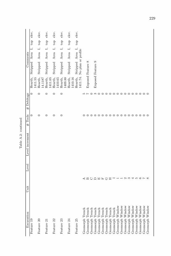
229T
ab
leA
.2:
conti
nu
ed
Exca
vati
on
Un
itL
evel
Lev
elin
crem
ent
#T
ools
#D
ebit
age
Com
men
tsF
eatu
re19
00
Hea
rth
,S
trip
ped
Are
aI,
top
elev
.1411.5
5F
eatu
re20
00
Hea
rth
,S
trip
ped
Are
aI,
top
elev
.14.1
187
Fea
ture
21
00
Hea
rth
,S
trip
ped
Are
aI,
top
elev
.1411.0
5F
eatu
re22
00
Hea
rth
,S
trip
ped
Are
aI,
top
elev
.1410.6
5F
eatu
re23
00
Hea
rth
,S
trip
ped
Are
aI,
top
elev
.1409.8
8F
eatu
re24
Hea
rth
,S
trip
ped
Are
aI,
top
elev
.1410.1
6F
eatu
re25
Hea
rth
,S
trip
ped
Are
aI,
top
elev
.1411.7
4.
No
pla
nor
pro
file
Geo
morp
hT
ren
chA
05
Geo
morp
hT
ren
chB
07
Exp
ose
dF
eatu
re8
Geo
morp
hT
ren
chC
00
Geo
morp
hT
ren
chD
03
Exp
ose
dF
eatu
re9
Geo
morp
hT
ren
chE
00
Geo
morp
hT
ren
chF
00
Geo
morp
hT
ren
chG
00
Geo
morp
hT
ren
chH
00
Geo
morp
hT
ren
chI
00
Geo
morp
hW
ind
ow
10
0G
eom
orp
hW
ind
ow
10
0G
eom
orp
hW
ind
ow
20
0G
eom
orp
hW
ind
ow
30
0G
eom
orp
hW
ind
ow
40
0G
eom
orp
hW
ind
ow
50
0G
eom
orp
hW
ind
ow
60
0G
eom
orp
hW
ind
ow
70
0G
eom
orp
hW
ind
ow
80
0
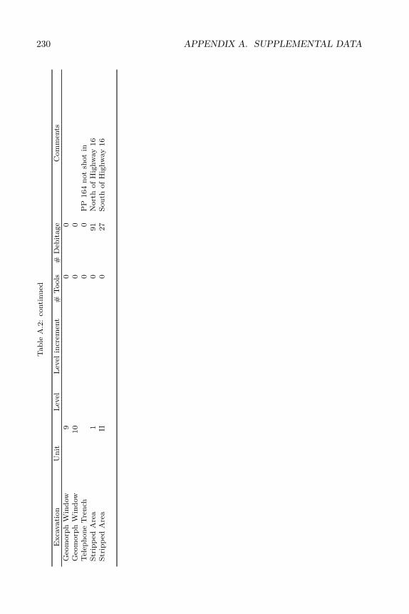
230 APPENDIX A. SUPPLEMENTAL DATAT
ab
leA
.2:
conti
nu
ed
Exca
vati
on
Un
itL
evel
Lev
elin
crem
ent
#T
ools
#D
ebit
age
Com
men
tsG
eom
orp
hW
ind
ow
90
0G
eom
orp
hW
ind
ow
10
00
Tel
eph
on
eT
ren
ch0
0P
P164
not
shot
inS
trip
ped
Are
a1
091
Nort
hof
Hig
hw
ay
16
Str
ipp
edA
rea
II0
27
Sou
thof
Hig
hw
ay
16
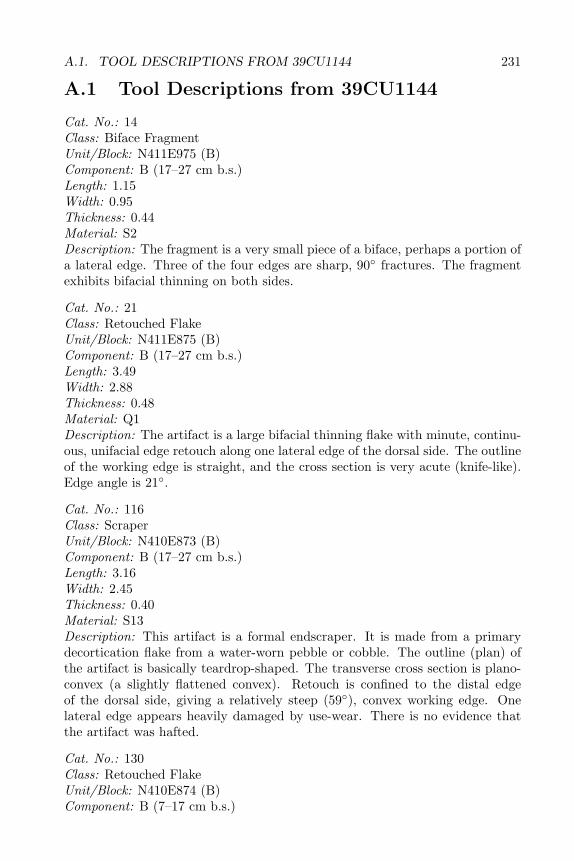
A.1. TOOL DESCRIPTIONS FROM 39CU1144 231
A.1 Tool Descriptions from 39CU1144
Cat. No.: 14Class: Biface FragmentUnit/Block: N411E975 (B)Component: B (17–27 cm b.s.)Length: 1.15Width: 0.95Thickness: 0.44Material: S2Description: The fragment is a very small piece of a biface, perhaps a portion ofa lateral edge. Three of the four edges are sharp, 90◦ fractures. The fragmentexhibits bifacial thinning on both sides.
Cat. No.: 21Class: Retouched FlakeUnit/Block: N411E875 (B)Component: B (17–27 cm b.s.)Length: 3.49Width: 2.88Thickness: 0.48Material: Q1Description: The artifact is a large bifacial thinning flake with minute, continu-ous, unifacial edge retouch along one lateral edge of the dorsal side. The outlineof the working edge is straight, and the cross section is very acute (knife-like).Edge angle is 21◦.
Cat. No.: 116Class: ScraperUnit/Block: N410E873 (B)Component: B (17–27 cm b.s.)Length: 3.16Width: 2.45Thickness: 0.40Material: S13Description: This artifact is a formal endscraper. It is made from a primarydecortication flake from a water-worn pebble or cobble. The outline (plan) ofthe artifact is basically teardrop-shaped. The transverse cross section is plano-convex (a slightly flattened convex). Retouch is confined to the distal edgeof the dorsal side, giving a relatively steep (59◦), convex working edge. Onelateral edge appears heavily damaged by use-wear. There is no evidence thatthe artifact was hafted.
Cat. No.: 130Class: Retouched FlakeUnit/Block: N410E874 (B)Component: B (7–17 cm b.s.)
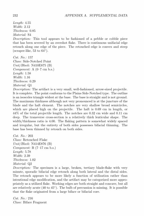
232 APPENDIX A. SUPPLEMENTAL DATA
Length: 4.55Width: 2.12Thickness: 0.85Material: S4Description: This tool appears to be fashioned of a pebble or cobble piecethat has been severed by an overshot flake. There is continuous unifacial edgeretouch along one edge of the piece. The retouched edge is convex and steep(scraper-like, 53 to 64◦).
Cat. No.: 157Class: Side-Notched PointUnit/Block: N410E875 (B)Component: A (0–7 cm b.s.)Length: 1.58Width: 1.16Thickness: 0.29Material: Q1Description: The artifact is a very small, well-fashioned, arrow-sized projectile.It is complete. The point conforms to the Plains Side-Notched type. The outlineis an isosceles triangle widest at the base. The base is straight and is not ground.The maximum thickness although not very pronounced is at the juncture of theblade and the haft element. The notches are very shallow broad semicircles,which are placed high on the projectile. The haft is 0.69 cm in length, or44% of the total projectile length. The notches are 0.32 cm wide and 0.11 cmdeep. The transverse cross-section is a relatively thick lenticular shape. Thewidth/thickness ratio is 4.00. The flaking pattern is somewhat widely spacedand irregular, but the entirety of both sides possesses bifacial thinning. Thebase has been thinned by retouch on both sides.
Cat. No.: 203Class: Retouched FlakeUnit/Block: N414E876 (B)Component: B (7–17 cm b.s.)Length: 5.78Width: 2.39Thickness: 1.02Material: Q2Description: The specimen is a large, broken, tertiary blade-flake with veryminute, sporadic bifacial edge retouch along both lateral and the distal sides.The retouch appears to be more likely a function of utilization rather thanintentional edge modification, and the artifact may be categorized more appro-priately as a utilized flake. Working edges are both straight and concave, but allare relatively acute (40 to 45◦). The bulb of percussion is missing. It is possiblethat the flake originated from a large biface or bifacial core.
Cat. No.: 216Class: Biface Fragment
A.1. TOOL DESCRIPTIONS FROM 39CU1144 233
Unit/Block: N410E876 (B)Component: B (7–17 cm b.s.)Length: 2.80Width: 4.70Thickness: 1.50Material: S10Description: This is a fragment of a Stage 2 (initial edging) biface. The blank(Stage 1 biface) appears to have been a large, tertiary (little or no cortex)core reduction flake. The plan cannot be ascertained, and the length-widthorientation is also uncertain. The cross section is thick and irregular. Thewidth/thickness ratio was probably less than 3.13. The offset of the lineal edgesis moderate (somewhat wavy). Very thick edges are also present. The edgeangles (from the “spine plan”, or centered edge angles) vary from 40 to 64◦.Most of the flake scars occur along one edge of one side. A few deeply gougedscars penetrate the center of the biface. Very deep step- and hinge-fracture scarsare present. The broken edge is a slight hinge-fracture. Minute step-fracturesalong an acute retouched edge probably indicate utilization.
Cat. No.: 265Class: BifaceUnit/Block: N414E875 (B)Component: B (17–27 cm b.s.)Length: 5.57Width: 5.44Thickness: 1.97Material: S2Description: This artifact is a complete Stage 2 biface. The outline is a roughsubtriangular shape. The transverse cross-section is a rough lenticular shape.The width/thickness ratio is 2.76. The offset of the lineal edges is wide (verywavy), and the edges are thick. The edge angles range from 50 to 80◦. Theflake scars are often deeply gouged and deep step-fractures are present. Theflake scars are largely confined to the biface edges, but a few scars reach thecenter. Most of the thinning occurs on one face; flaking on the other side isminimal. There is no readily observed evidence that the biface was utilized.
Cat. No.: 294Class: Retouched FlakeUnit/Block: N411E872 (B)Component: B (7–17 cm b.s.)Length: 3.40Width: 2.20Thickness: 0.90Material: S1Description: This tool is fashioned from a tertiary flake (core reduction flake).A small area of the distal edge of the dorsal side possesses edge retouch, creatinga small, straight and relatively steep (45◦) working edge.
234 APPENDIX A. SUPPLEMENTAL DATA
Cat. No.: 331Class: Corner-Notched PointUnit/Block: N414R873 (B)Component: B (7–17 cm b.s.)Length: 1.95Width: 1.88Thickness: 0.44Material: S2Class: This is a well-fashioned, dart-sized corner-notched point of Pelican Laketype. In relationship to the point size, it has deep (0.52 cm) and relativelybroad (0.25 cm) U-shaped corner notches. The base is not complete, but itappears to have been slightly constricted (not as wide as the blade), giving theshoulders distinctive barbs. The base is concave with “eared” corners. Thereis no indication of basal grinding. The base, 0.58 cm in length, comprisesless than one-fourth of the projectile length. The blade outline has straightsides. The transverse cross-section is a very symmetrical, thin, lenticular shape.The width/thickness ratio would have exceeded 4.27. The point of maximumthickness is at the juncture of the blade and the haft element. Both sides arecovered by bifacial thinning. The blade exhibits close, very uniform flake scars.The lineal edges of the blade are sharp and straight. Edge angles range from29 to 34◦. The base has been thinned by retouch on either side. There is asharp, 90◦ fracture truncating the blade tip. One of the shoulder barbs and thecorners of the base are also broken.
Cat. No.: 488Component: Biface FragmentUnit/Block: N411E874 (B)Component: B (17–27 cm b.s.)Length: 3.69Width: 4.10Thickness: 0.76Material: Q2Description: The fragment probably represents a Stage 4 (secondary thin-ning) biface. The artifact is one end (probably the base) of a biface. Thewidth/thickness ratio is 5.39. The transverse cross section is a flattened lenticu-lar shape. The edge angles fall between 25 to 34◦. The outline appears to havebeen regular (uniform and symmetrical), and the offset of the lineal edges isrelatively moderate (somewhat wavy). The flake scars are widely spaced. Flakescars are shallow with minimal gouging, but several prominent step-fracturescars are present. Opposing flake scars contact to at least the center of thebiface. A sharp, slightly hinged fracture runs parallel to the biface width (endshock fracture?). One lateral edge possesses minute step-fracture scars and hasbeen either ground or dulled by use-wear.
Cat. No.: 490Class: Biface Fragment
A.1. TOOL DESCRIPTIONS FROM 39CU1144 235
Unit/Block: N411E875Component: B (17–27 cm b.s.)Length: 1.80Width: 2.29Thickness: 0.43Material: S2Description: This artifact fragment is either a midsection of a point blade ora midsection of a preform (Stage 5 biface). The artifact has a thin, lenticularcross section. The edge angles are 24◦. The offset of the lineal edges is minimalwith essentially straight and very sharp edges. The lateral flake scars extendwell beyond the center of the piece. One side of the artifact displays a largeend-thinning or impact fracture scar. Both broken ends are relatively straight90◦ fractures.
Cat. No.: 533Class: Retouched FlakeUnit/Block: N413E876 (B)Component: B (17–27 cm b.s.)Length: 4.58Width: 3.07Thickness: 1.47Material: S1Description: The item is a secondary decortication flake (core reduction flake)with continuous bifacial edge retouch along one lateral edge and the distal edge.The retouched edges are convex but vary from steep (67◦) to acute (38◦).
Cat. No.: 536Class: BifaceUnit/Block: N411E876 (B)Component: B (7–17 cm b.s.)Length: 5.96Width: 4.70Thickness: 1.84Material: S1Description: This is a complete Stage 2 biface. The outline is roughly oval.The transverse cross-section is thick and very irregular. The width/thicknessratio is 2.55. Lineal edges are widely offset (very wavy). The edges are thick,with angles between 54 and 69◦. Flake scars are deeply gouged and deep step-and hinge-fractures are common. The flake scars are widely spaced and largelyconfined to the biface edges. There is no readily observed use-wear on theartifact.
Cat. No.: 616Class: BifaceUnit/Block: N412E873 (B)Component: B (17–27 cm b.s.)Length: 6.81

236 APPENDIX A. SUPPLEMENTAL DATA
Width: 4.16Thickness: 1.35Material: S2Description: This is a complete Stage 2 biface with a roughly ovate outline. Thetransverse cross-section is thick and plano-convex. The width/thickness ratio is3.08. The edges are relatively thick, with edge angles of 40–60◦. The offset ofthe lineal edges is wide. Flake scars are widely spaced and often gouged. Deepstep-fracture scars are present. One face has almost no flake scarring; the otherside has minimal flake scar contact at the biface center. The biface does notappear to have been utilized.
Cat. No.: 670Class: Biface FragmentUnit/Block: N412E8785 (B)Component: B (7–17 cm b.s.)Length: 3.76Width: 2.15Thickness: 0.48Material: Q1Class: This specimen is a Stage 5 biface (projectile point preform). It appearsto have had a uniform lanceolate shape. The tip is missing. The transversecross-section is a thin lenticular shape. The edge angles are 24◦. The width/thickness ratio is 4.48. The offset of the lineal edges is very close, essentiallystraight. Flake scars are closely spaced and morphologically similar. Deeplygouged flake scars and step-fractures are absent. Opposing flake scars undercutthe biface center and, often, almost the entire width. The straight base has beenthinned by bifacial retouch. Ground edges are not present. The broken edge isa sharp 90◦ fracture that runs obliquely to the biface width. The artifact showsno obvious signs of being utilized.
Cat. No.: 672Class: Point TipUnit/Block: N412E875 (B)Component: B (7–17 cm b.s.)Length: 0.91Width: 0.94Thickness: 0.30Material: Q1Description: The item is the very tip of a projectile point. This small fragmentexhibits overall bifacial retouch.
Cat. No.: 675Class: Biface FragmentUnit/Block: N413E875 (B)Component: B (17–27 cm b.s.)Length: 2.78Width: 0.85
A.1. TOOL DESCRIPTIONS FROM 39CU1144 237
Thickness: 0.35Material: S13Description: The fragment is a long sliver of a biface edge. It possesses a hingefracture running parallel with to the edge (overshot fracture?). The flake scarsare very close and morphologically similar, perhaps indicative of a fragmentoriginating from a projectile or preform.
Cat. No.: 725Class: GraverUnit/Block: N413E874 (B)Component: B (7–17 cm b.s.)Length: 2.88Width: 2.05Thickness: 0.53Material: Q1Description: The tool appears to be a bifacial thinning flake with a point orspur produced on a lateral edge of the dorsal side. The point projects 0.44 cmfrom the edge.
Cat. No.: 769Class: Biface FragmentUnit/Block: N413E873 (B)Component: A (0–7 cm b.s.)Length: 4.74 (9.26)Width: 4.16 (6.65)Thickness: 1.47 (1.67)Material: Q1Description: This fragment fits with Catalog #771 and 773. The fragmentscombine to form most of what is a very large Stage 3 biface. The outline appearsto have been a uniform ovate shape. The transverse cross-section is a relativelythin, lenticular shape. The edge angles are 36–45◦. The width/thickness ratiois 3.98. The lineal edges are moderately widely offset (wavy). Flake scarsexhibit some gouging (deep scars) and relatively deep step-fractures are present.Opposing flake scars are widely spaced and contact at some portions of the centerof both faces, but undercutting of the center is absent. The artifact is shatteredinto five pieces. Some of this fracturing occurred during excavation (hit by ashovel), but the biface tip and base were broken previously. The base is missing.It has been truncated by a hinge-fracture. The biface exhibits polish over someof the flake scar ridges, covering an area of about 3 by 6 cm down the center ofone face. This suggests use as a digging implement. Some of this polishing hasbeen removed by succeeding flake scars, perhaps indicating tool rejuvenation.The combined fragments produce a length of 9.26 cm, a width of 6.65 cm, anda thickness of 1.67 cm.
Cat. No.: 771Class: Biface FragmentUnit/Block: N413E873 (B)
238 APPENDIX A. SUPPLEMENTAL DATA
Component: A (0–7 cm b.s.)Length: 4.39Width: 3.62Thickness: 1.46Material: Q1Description: The fragment fits with Catalog #769 and 773. See Catalog #769for a description.
Cat. No.: 773Class: Biface FragmentUnit/Block: N413E873 (B)Component: A (0–7 cm b.s.)Length: 4.05Width: 2.83Thickness: 1.47Material: Q1Description: The fragment fits with Catalog #769 and 771. See Catalog #769for a description.
Cat. No.: 775Class: Biface FragmentUnit/Block: N413E873 (B)Component: A (0–7 cm b.s.)Length: 6.21 (6.22)Width: 4.01 (6.74)Thickness: 1.35 (1.47)Material: Q1Description: This fits with Catalog #781 and 783. The joined fragments formpart of a midsection of what appears to have been a very large Stage 3 or Stage4 biface. The outline of the artifact appears to have been uniform. The existingtransverse cross-section is a thin, lenticular shape. Edge angles range from 31 to40◦. The width/thickness ratio cannot be ascertained. The offset of the linealedges is moderately close (somewhat wavy). Flake scarring, for the most part, isrelatively shallow and not deeply gouged; however, some shallow step- and hinge-fractures are present. The lateral thinning scars contact and undercut much ofthe biface center. The biface exhibits multiple fractures running parallel to thewidth. At least three fractures are apparent. For the most part, the fracturesare steep, 90◦ snaps with slight hinging. These may be end shock fractures.The lateral edges of the biface are sharp and lack any conspicuous evidence ofwear. With the fragments joined, the length is 6.22 cm, the width is 6.74 cm,and the thickness is 1.47 cm.
Cat. No.: 777Class: Biface FragmentUnit/Block: N413E873 (B)Component: A (0–7 cm b.s.)Length: 1.78 (4.30)
A.1. TOOL DESCRIPTIONS FROM 39CU1144 239
Width: 4.29 (4.29)Thickness: 0.93 (0.93)Material: Q2Description: This is a Stage 3 (primary thinning) or Stage 4 biface. The frag-ment fits with Catalog #779. Fragments 777 and 779 fit to make the tip of abiface; they are described here as one item. The artifact is too incomplete for awidth/ thickness ratio. The transverse cross-section is lenticular. Edge anglesare 35–40◦. The offset of the lineal edge is close (not extremely wavy). Theoutline appears to have been very regular. For the most part, the flake scarsare close and morphologically similar with minimal gouging; however, there areseveral deep step-fracture scars. The artifact has two hinge fractures (end shockfractures?) parallel to the biface width. Combined, the fragments have a lengthof 4.30 cm, a width of 4.29 cm, and a thickness of 0.93 cm. Minute step-fracturesare noticeable along the edges of the artifact, probably indicating utilization.
Cat. No.: 779Class: Biface FragmentUnit/Block: N413E873 (B)Component: B (7–17 cm b.s.)Length: 2.94Width: 2.76Thickness: 0.80Material: Q2Description: The fragment fits with Catalog #777. See #777 for a description.
Cat. No.: 781Class: Biface FragmentUnit/Block: N413E873 (B)Component: B (7–17 cm b.s.)Length: 1.86Width: 1.02Thickness: 0.95Material: Q1Description: This fragment fits with Catalog # 775 and 783. See #775 for adescription.
Cat. No.: 783Class: Biface FragmentUnit/Block: N413E873 (B)Component: B (7–17 cm b.s.)Length: 6.71Width: 1.98Thickness: 1.38Material: Q1Description: This fragment fits with Catalog #775 and 781. See #775 for adescription.
240 APPENDIX A. SUPPLEMENTAL DATA
Cat. No.: 885Class: Retouched FlakeUnit/Block: N393.75 E911.36 (TU)Component: B (10–20 cm b.s.)Length: 2.62Width: 2.01Thickness: 0.71Material: S4Description: This appears to be a broken secondary decortication flake (corereduction flake) with continuous unifacial edge retouch along one lateral edgeof the ventral side. The retouched edge is convex and acute (25◦).
Cat. No.: 915Class: Retouched FlakeUnit/Block: N393E919 (TU)Component: B (20–30 cm b.s.)Length: 1.90Width: 1.61Thickness: 0.33Material: S11Description: The artifact is a broken (tertiary?) flake with continuous bifacialretouch along one edge (flake edge cannot be determined). The working edge isirregular and acute (28◦).
Cat. No.: 970Class: Point TipUnit/Block: N391.25 E901.32 (TU)Component: B (20–30 cm b.s.)Length: 2.16Width: 1.75Thickness: 0.41Material: S1Description: The specimen is the tip portion of a preform or relatively large(dart-sized) projectile point. The piece exhibits bifacial thinning dressing theentirety of both sides. The broken edge is a sharp 90◦ fracture that runs parallelto the artifact width.
Cat. No.: 981Class: Retouched FlakeUnit/Block: N391.25 E901.32 (TU)Component: C (30–40 cm b.s.)Length: 3.58Width: 1.30Thickness: 0.69Material: S1Description: This tool is a flake piece (the distal end of a tertiary core reduc-tion flake?) with unifacial retouch and/or heavy use wear along one edge of a
A.1. TOOL DESCRIPTIONS FROM 39CU1144 241
fracture. The fracture is a sharp, slightly hinged break. The working edge isstraight and very steep (82◦). The wear would indicate a heavy planing action.
Cat. No.: 1003Class: Knife FragmentUnit/Block: N393E926 (TU)Component: B (10–15 cm b.s.)Length: 1.80Width: 1.73Thickness: 0.45Material: S3Description: This artifact is a small fragment of a “Badlands Knife” (platechalcedony knife). The fragment exhibits regular, continuous bifacial retouchthat is confined to about 0.5 cm of the edge margin. The faces of the artifactappear to be cortex and unmodified. The working edge is very acute (21). Theplate was quite thin, less than 0.5 cm in thickness.
Cat. No.: 1049Class: GraverUnit/Block: N452E875 (TU)Component: B (20–30 cm b.s.)Length: 1.26Width: 1.00Thickness: 0.33Material: S13Description: The tool is a small flake or shatter fragment with one edge unifa-cially retouched into a sharp point or spur. The spur protrudes from the flakeedge about 0.4 cm.
Cat. No.: 1065Class: ScraperUnit/Block: N452E875 (TU)Component: B (20–30 cm b.s.)Length: 3.12Width: 1.92Thickness: 0.79Material: S13Description: This artifact fits the definition of the classic keeled endscraper. Itis fashioned of a tertiary flake (core reduction flake) with a pronounced centralridge running the length of the dorsal side. The flake thickens toward the distalend. The outline is essentially oval. The transverse cross-section is plano-convex.There is no unifacial thinning of the flake; all retouch is confined to the distaledge of the dorsal side. The retouch forms a very steep (73◦) convex workingedge. There is no indication that the scraper was hafted.
Cat. No.: 1087Class: Retouched Flake
242 APPENDIX A. SUPPLEMENTAL DATA
Unit/Block: N464E835 (TU)Component: C (90–100 cm b.s.)Length: 3.70Width: 2.48Thickness: 0.69Material: S13Description: This artifact appears to be a fragment of a tabular, water-wornchert pebble that exhibits sporadic bifacial retouch. The flake scars are generallyconfined to the edges, but some continue well into the center of the piece. Asharp hinge-fracture is present along an entire edge of the artifact. The workingedges are essentially straight and steep (59–65◦). These edges appear heavilydamaged with pronounced step fractures and crushing.
Cat. No.: 1161Class: Retouched FlakeUnit/Block: N449E867 (TU)Component: C (50–60 cm b.s.)Length: 1.95Width: 3.14Thickness: 0.79Material: S1Description: This is a tertiary flake (core reduction flake) with continuous uni-facial edge retouch along one lateral edge of the dorsal side. The retouchededge is slightly concave and very steep (74◦). The artifact also exhibits minutescarring along several other edges suggesting additional utilization.
Cat. No.: 1371Class: Retouched FlakeUnit/Block: N436E909 (TU)Length: C (30–40 cm b.s.)Length: 2.84Width: 2.34Thickness: 0.45Material: S1Description: The item appears to be a bifacial thinning flake with minute,unifacial edge retouch along a small portion of the distal edge of the dorsal face.The working edge is straight and acute (24◦).
Cat. No.: 1451Class: Retouched FlakeUnit/Block: N412E957 (TU)Component: C (70–80 cm b.s.)Length: 6.09Width: 3.01Thickness: 1.12Material: S1Description: This tool is a large, irregular-shaped, tertiary blade-flake (probably
A.1. TOOL DESCRIPTIONS FROM 39CU1144 243
a core reduction flake) with minute, continuous to sporadic, bifacial edge retouchalong the lateral edges. The working edges are convex to straight and largelyacute (24–49◦). Tool may be better described as a utilized flake.
Cat. No.: 1479Class: Point BaseUnit/Block: N420E839 (TU)Component: A (0–10 cm b.s.)Length: 0.89Width: 2.15Thickness: 0.43Material: S13Description: The specimen is a basal fragment of a relatively large (dart-sized)notched point. The artifact is not complete enough to determine the notch type.The base is straight and it does not exhibit grinding. The fragment has overallbifacial retouch. The base is 2.15 cm in width.
Cat. No.: 1515Class: Biface FragmentUnit/Block: N420E938 (TU)Component: C (30–40 cm b.s.)Length: 3.54Width: 3.48Thickness: 0.65Material: Q3Description: This is a Stage 3 or 4 biface. The artifact is the tip of whatappears to have been a very thin biface, but the width/thickness ratio cannotbe ascertained. The transverse cross-section of the fragment is a flattened,lenticular-shape. The edges are thin (32–35◦). The outline appears to havebeen very regular. The offset of the lineal edge is relatively close (not extremelywavy). Flake scarring is close with only moderate to minimal gouging, but someshallow step-fracture scars are present. The fragment exhibits a sharp, slightlyhinged fracture that runs parallel to the biface width. This may be an endshock fracture and hence indicate failure and then discard of the biface duringmanufacture. The edges exhibit minute step-fracture scars, indicating use-wear.
Cat. No.: 1537Class: Corner-Notched PointUnit/Block: N412E874 (TU)Component: A (0–10 cm b.s.)Length: 3.24Width: 2.26Thickness: 0.45Material: Q2Description: This artifact is a large, well-fashioned, dart-sized corner-notchedprojectile. The point conforms to the generalized Pelican Lake type. Relativeto the point size, the notches are narrow (0.25 cm) and shallow (0.35 cm). The
244 APPENDIX A. SUPPLEMENTAL DATA
notches are U-shaped. The base is a deep concave with rounded “ears” at thecorners. Basal grinding is absent. The haft element is low on the projectile;the base element, with a length of 0.73 cm, is less than one-fourth of the totalprojectile length. The shoulders are barbed. The blade outline is ovate. Thetransverse cross-section is a thin lenticular shape. The edge angles fall between24 and 31◦. The width/thickness ratio is 5.02. The point of maximum thicknessis just above the juncture of the haft and the blade. Maximum width is at theshoulders; the base appears to have been only slightly narrower. Both sides ofthe artifact are entirely dressed by bifacial thinning. The lateral edges of theblade exhibit close, uniform retouch that creates a sharp, straight lineal edge.The base has been thinned by retouch on both sides. The tip of the blade istruncated by a slightly hinged fracture, and one of the corner ears of the basehas been broken off.
Cat. No.: 1539Class: Biface FragmentUnit/Block: N412E874 (TU)Component: B (10–20 cm b.s.)Length: 5.86Width: 4.01Thickness: 1.43Material: S13Description: This specimen is a fragment of a Stage 2 biface. The biface blank(Stage 1) appears to have been a core reduction flake (secondary decortication?).The piece was in the very initial process of edging before failure and discard;most of both faces are void of flake scars. The edges are generally thick, withthe edge angles ranging from 45 to 80◦. A sharp 90◦ fracture truncated a sizableportion of the flake. The fragment does not appear to have been utilized.
Cat. No.: 1543Class: Biface FragmentUnit/Block: N412E874 (TU)Component: B (20–30 cm b.s.)Length: 4.26Width: 4.08Thickness: 0.88Material: Q1Description: This is probably a Stage 3 biface. The artifact is the end (tip?)fragment of a biface. The width/thickness ratio is 4.63. The transverse crosssection is a thin, slightly irregular lenticular shape. The outline appears tohave been semi-regular. The offsets of the lineal edges are moderate (somewhatwavy). Some of the biface edges are relatively thick. Edge angles are 47–61◦. The flake scars are relatively widely spaced and minimally gouged. A fewshallow step-fractures are present. The lateral flake scars contact at, or slightlyundercut, the center. The broken edge (end shock fracture?) runs across thebiface width and is sharp and slightly hinged. The edges of the artifact appear
A.1. TOOL DESCRIPTIONS FROM 39CU1144 245
ground or dulled by use-wear.
Cat. No.: 1575Class: Point BladeUnit/Block: N393E909 (A)Component: A (0–7 cm b.s.)Length: 1.13Width: 0.81Thickness: 0.26Material: S10Description: The artifact is a blade fragment of a notched projectile point.The points of fracture occur at the notching and the blade tip, leaving only thelower portion of the blade element. Notching is discernable, but the type cannotbe determined. The fragment appears to come from a small, probably arrow-sized, projectile. The maximum width of the blade is 1.13 cm. The maximumthickness of the blade is 0.26 cm. The fragment exhibits overall bifacial thinning.
Cat. No.: 1579Class: Stemmed PointUnit/Block: N393E912 (A)Component: A (0–7 cm b.s.)Length: 2.08Width: 1.35Thickness: 0.51Material: S13Description: The projectile is a small, arrow-sized stemmed point. Notches runoblique to the point median such that the point could be construed as corner-notched. The point is complete. This point may be an aberrant type, but theoutline is rather irregular and the flaking is sporadic, perhaps indicating theartifact was either unfinished or being reworked because of damage. The stemhas straight sides and a straight base; the blade is roughly triangular. Edgegrinding is not apparent. The haft is low on the projectile. The haft element is0.50 cm in length, or about 25% of the overall point length. The thickest portionis at the midsection of the blade. The projectile has a thick, asymmetrical cross-section. The width/thickness ratio is 2.65. The point exhibits overall bifacialthinning.
Cat. No.: 1614Class: Retouched FlakeUnit/Block: N387E938 (C)Component: A (0–7 cm b.s.)Length: 2.43Width: 1.70Thickness: 0.90Material: S13Description: This appears to be a broken tertiary flake (core reduction flake)with continuous unifacial edge retouch along one lateral edge of the ventral side.
246 APPENDIX A. SUPPLEMENTAL DATA
The retouched edge is straight and acute (26◦).
Cat. No.: 1637Class: Point TipUnit/Block: GS I (#219)Component: A or BLength: 0.89Width: 0.75Thickness: 0.27Material: S13Description: This tool fragment is the very tip of a projectile point. The frag-ment exhibits overall bifacial retouch or thinning.
Cat. No.: 1652Class: Retouched FlakeUnit/Block: GS I (#199)Component: A or BLength: 3.85Width: 3.25Thickness: 1.70Material: S13Description: The specimen is a large, thick, broken secondary decorticationflake (core reduction flake) with continuous unifacial edge retouch along thedistal edge of the dorsal side. The retouched edge is convex and steep (68◦).The artifact is similar to the classic keeled endscraper. It has a dorsal ridgerunning the length of the flake and the distal edge of the dorsal side possessessteep retouch. Its form, however, is irregular, and the edge retouch appears lessdeliberate.
Cat. No.: 1653Class: Retouched FlakeUnit/Block: GS I (#219)Component: A or BLength: 3.08Width: 1.74Thickness: 0.87Material: S6Description: The artifact is a secondary decortication flake (core reduction flake)with continuous bifacial edge retouch along a single (proximal?) edge. Theretouched edge is slightly convex and acute (37◦).
Cat. No.: 1655Class: CoreUnit/Block: GS I (#219)Component: A or BLength: 5.43Width: 3.43
A.1. TOOL DESCRIPTIONS FROM 39CU1144 247
Thickness: 1.87Material: S4Description: This is a split cobble of milky chalcedony. Flakes have not beenremoved from this piece. The material appears to have been tabular in formand the surfaces are water worn.
Cat. No.: 1657Class: CoreUnit/Block: GS I (#215)Component: A or BLength: 12.97Width: 9.59Thickness: 5.88Material: Q3Description: This is a large, cobble-sized bifacial core. It has a thick, roughdisc shape. The striking platform is formed by the edges of two opposite faces.Flakes have been removed around the circumference of both faces. The flakescars terminate at the center of the core. The core does not exhibit water-wornsurfaces. About 5 cm of an edge possesses pronounced step-fracture scarring,suggesting that the core may have been utilized as a chopping implement.
Cat. No.: 1662Class: CoreUnit/Block: Surface (#1)Component: ALength: 5.16Width: 3.63Thickness: 2.87Material: S13Description: This block core has a single flake driven from an unprepared plat-form. Alternatively, the artifact may represent one-half of a split nodule. Thecortex is rough, and the shape is irregular.
Cat. No.: 1663Class: Retouched FlakeUnit/Block: GS I (#215Component: A or BLength: 9.46Width: 5.13Thickness: 1.07Material: Q1Description: The tool is a very large bifacial thinning flake with continuousunifacial edge retouch along the lateral edges of the dorsal side. The flake isparticularly long and is less than one centimeter short of being classified as ablade-flake. One entire lateral edge possesses continuous, deliberate edge re-touch that creates a long, slightly convex working edge. This edge falls betweensteep and acute, 38–51◦. Except at the juncture with the proximal end, the
248 APPENDIX A. SUPPLEMENTAL DATA
other lateral edge possesses minute edge retouch (use-wear?) along a steep(50◦) concave working edge. This forms a spokeshave-like working edge. Thejuncture with the proximal end has deliberate, steep (63◦) retouch along a con-vex edge, similar to an endscraper. This artifact is somewhat reminiscent ofthe large, so called “flake knives” from Paleoindian layers at the Jim Pitts Site.These flake knives were similarly fashioned from very large, blade-like bifacialthinning flakes.
Cat. No.: 1664Class: CoreUnit/Block: Surface (#2)Component: ALength: 9.34Width: 6.93Thickness: 5.20Material: S4Description: This tested core is an irregular, cobble-sized chunk with a singleflake struck from an unprepared platform. The chunk does not appear to havebeen water worn.
Cat. No.: 1667Class: CoreUnit/Block: GS I (#)Component: UnknownLength: 6.49Width: 4.55Thickness: 4.18Material: S10Description: The multifaceted core has a general globular shape. It has mul-tiple (more than two) striking platforms and faces. The cortex is rough. Onerelatively sharp edge exhibits a series of deep step-fracture scars and battering,perhaps indicating use of the core as a chopper.
Cat. No.: 1670Class: Biface FragmentUnit/Block: Surface (#5)Component: ALength: 5.43Width: 3.51Thickness: 2.15Material: S13Description: This item is a fragment of a Stage 2 biface. It appears to havebeen split longitudinally by a massive overshot flake. The fracture is a verypronounced hinge-fracture. The transverse cross-section appears to have been athick, rough lenticular shape. The width/thickness ratio cannot be ascertained.The offset of the lineal edges is wide. Very thick edges are present; the angles arefrom 64 to 67◦. Most of the flake scars are limited to the edges. Deep step- and
A.1. TOOL DESCRIPTIONS FROM 39CU1144 249
hinge-fractures are present. It appears that there was an attempt to rejuvenatethe biface; several flakes were removed after breakage. Two edges appear to beheavily damaged by use-wear, perhaps indicating its use as a heavy cutting orchopping tool.
Cat. No.: 1673Class: ScraperUnit/Block: GS I (#221)Component: A or BLength: 2.99Width: 2.03Thickness: 0.72Material: S4Description: The artifact conforms to the classic keeled endscraper. The toolwas fashioned from either a primary or secondary decortication flake (core re-duction flake). The outline is basically teardrop-shaped. The transverse cross-section is plano-convex. A central ridge runs the length of the dorsal side. Allretouch is unifacial and limited to the edges of the dorsal side. The distal edgeand one lateral edge possess continuous retouch, producing a steep (62◦), con-vex working edge at the distal end and a slightly convex, relatively steep (49◦)working edge at the lateral edge. The other lateral edge exhibits minute edgescarring, possibly use-wear, along a straight, acute (27◦) working edge.
Cat. No.: 1675Class: CoreUnit/Block: GS I (#214)Component: A or BLength: 6.33Width: 3.00Thickness: 2.00Material: Q4Description: This spheroid core possesses multiple platforms and faces. It isbasically cylindrical in shape. The existing cortex appears water worn.
Cat. No.: 1677Class: Biface FragmentUnit/Block: GS I (#210)Component: A or BLength: 2.55Width: 3.73Thickness: 0.73Material: S2Description: This item is probably the end (tip?) of a Stage 3 biface. Thetransverse cross-section is a thin lenticular shape. The edge angles are 29–43◦. The offset of the lineal edges is moderate (wavy). The flake scars aremoderately gouged and relatively deep step-fractures are present. The brokenedge is oblique to the biface width and is a sharp 90◦ snap. Some apparent edge
250 APPENDIX A. SUPPLEMENTAL DATA
scarring may indicate that the artifact was utilized.
Cat. No.: 1679Class: CoreUnit/Block: GS I (#)Component: UnknownLength: 3.88Width: 2.78Thickness: 2.36Material: S2Description: This is an irregular block core. It has two unprepared opposingplatforms. The flakes were removed in opposite directions on two different faces.The cortex is rough.
Cat. No.: 1683Class: Retouched FlakeUnit/Block: GS I (#)Component: UnknownLength: 2.70Width: 1.52Thickness: 0.66Material: S5Description: The tool is a tertiary flake (probably a core reduction flake) withsporadic unifacial edge retouch along the distal and a portion of one lateraledge of the dorsal side. Together, the retouched edges form a steep (61–77◦)angular edge. This artifact resembles the classic keeled endscraper in severalways: it has a dorsal ridge running the length of the flake, the distal edge of thedorsal side possesses steep retouch, the flake outline is roughly teardrop-shaped,and the transverse cross-section is plano-convex. The working edge, however,appears angular rather than smoothly convex, and the retouched edge is lessdeliberate. The working edge also appears heavily damaged by use-wear in theform of deep step-fractures.
Cat. No.: 1685Class: CoreUnit/Block: GS I (#220)Component: A or BLength: 4.63Width: 3.42Thickness: 1.75Material: S2Description: This is an irregularly spheroid, pebble-sized core with multiple(more than two) platforms and faces. The cortex is rough.
Cat. No.: 1687Class: Retouched FlakeUnit/Block: GS I (#202)

A.1. TOOL DESCRIPTIONS FROM 39CU1144 251
Component: A or BLength: 3.21Width: 2.88Thickness: 0.79Material: S10Description: This specimen appears to be fashioned of a primary decorticationflake (core reduction flake). The flake has sporadic, bifacial edge retouch alongboth lateral sides. The working edges are essentially straight and largely acute(35–49◦).
Cat. No.: 1695Class: CoreUnit/Block: GS II (#165)Component: A or BLength: 9.51Width: 9.10Thickness: 3.2Material: S2Description: This tested core is a cobble-sized, tabular chunk with a single flakeremoved from an unprepared platform. The item does not appear water worn.
Cat. No.: 1697Class: Biface FragmentUnit/Block: GS II (#175)Component: A or BLength: 6.16Width: 2.68Thickness: 2.37Material: S2Description: The artifact is a fragment of what appears to have been a verythick Stage 2 biface. Flake scars are very deeply gouged (“hollow ground” scars)and its lineal edge is widely offset (very wavy). There is no overt indication ofutilization on the fragment.
Cat. No.: 1703Class: CoreUnit/Block: GS II (#186)Component: A or BLength: 6.55Width: 5.59Thickness: 4.29Material: S1Description: This block core has a single prepared platform with flakes drivenoff two faces in a single direction. The cortex is rough. The core has a basicblock-like form.
252 APPENDIX A. SUPPLEMENTAL DATA
Cat. No.: 1709Class: Retouched FlakeUnit/Block: GS II (#167)Component: A or BLength: 4.75Width: 4.19Thickness: 1.60Material: S4Description: This artifact is a large secondary decortication flake (core reductionflake) with continuous unifacial edge retouch along one lateral edge of the dorsalside. The retouched edge is convex and steep (47–54◦).
Cat. No.: 1713Class: Biface FragmentUnit/Block: GS II (#180)Component: A or BLength: 2.93Width: 3.38Thickness: 0.88Material: Q1Description: The fragment is the end (tip?) of a Stage 2 or Stage 3 biface.The transverse cross-section is basically plano-convex. The width/thicknessratio cannot be ascertained. The offset of the lineal edges is moderately close(slightly wavy). The blank (Stage 1) appears to have been a large flake. Onone face (the ventral face?) the flaking is confined to the edges. On the otherface (the dorsal face?) the flaking exhibits contact with the biface center. Asingle prominent step-fracture is present, but the rest of the flake scarring isquite shallow. The edges are relatively thin. The edge angles measure 32–46◦.The broken edge is a slightly hinged fracture that cuts the biface width (endshock fracture?). Some minute edge scarring may indicate that the biface wasutilized.
Cat. No.: 1715Class: CoreUnit/Block: GS II (#170)Component: A or BLength: 5.74Width: 4.59Thickness: 3.99Material: S5Description: This is a rough conical block core with a single prepared platform.Flakes have been removed in a single direction over two faces. The cortex isrough.
Cat. No.: 1717Class: DenticulateUnit/Block: GS II (#168)
A.1. TOOL DESCRIPTIONS FROM 39CU1144 253
Component: A or BLength: 4.05Width: 2.65Thickness: 1.00Material: S13Description: This tool is recognized as a denticulate or shredder. It is a tertiaryflake (core reduction flake) with unifacial notching along the distal edge of thedorsal side. The notching gives the effect of a pronounced serrated edge. Thenotched edge is straight and alternates between steep to acute (33–60◦).
Cat. No.: 1719Class: BifaceUnit/Block: GS II (#176)Component: A or BLength: 5.88Width: 3.57Thickness: 1.36Material: S1Description: This is a complete Stage 2 biface. The width/thickness ratio is2.62. The transverse cross section is thick and irregular. The edge angles are44–57◦. The offset of the lineal edges is moderate to wide. The flake scars aretypically gouged (very pronounced) with numerous step- and hinge-fractures.The lateral flake scars are largely confined to the edge of the artifact and do notcontact or undercut the center. The artifact has no overt appearance of beingutilized.
Cat. No.: 1721Class: CoreUnit/Block: GS II (#169)Component: A or BLength: 8.60Width: 9.64Thickness: 5.12Material: S12Description: This tested core is a nodule with one side heavily faceted by ther-mal and/or frost spalls. A single flake has been removed from an unpreparedplatform.
Cat. No.: 1725Class: GraverUnit/Block: II (#164)Component: UnknownLength: 1.95Width: 1.66Thickness: 0.37Material: Q2Description: This artifact appears to be a reworked fragment of either a pro-
254 APPENDIX A. SUPPLEMENTAL DATA
jectile point blade or a point preform (Stage 5 biface). The fragment possessesbifacial thinning over the entirety of both sides. One lateral edge of the piecehas been retouched to produce a short spur. This spur protrudes 0.33 cm froman otherwise straight edge.
Cat. No.: 1727Class: Biface FragmentUnit/Block: Surface (#4)Component: ALength: 5.21Width: 3.83Thickness: 0.87Material: Q3Description: The specimen is a nearly complete Stage 4 biface; the tip hasbeen broken off. The outline is a regular subtriangular shape. The transversecross-section is a flattened lenticular shape. The edge angles are 35–42◦. Thewidth/thickness ratio is 4.40. The offset of the lineal edges is close (only slightlywavy). Flake scarring is closely spaced. The scars are relatively regular inmorphology and not gouged. A few shallow step-fractures are present on oneside. Opposing flake scars contact or undercut the center of the biface. Thebroken edge is an irregular hinge-like fracture that is basically parallel to thebiface width. This may be an end shock fracture or possibly a fracture madeby an overshot flake. One edge of this fracture has been retouched, perhaps inan attempt to rejuvenate the biface. Minute flake scars are present along theartifact edges, suggesting that the biface was used.
Cat. No.: 1731Class: Retouched FlakeUnit/Block: Surface (#6)Component: ALength: 2.54Width: 2.15Thickness: 0.46Material: Q2Description: This is a broken bifacial thinning flake with minute, continuous,unifacial edge retouch along both lateral edges, one on the dorsal side and oneon the ventral side. Both working edges are broken. The remaining portions ofthe working edges are one straight and the other angular, forming a V-shape(graver?). Both edges are acute (34–41◦).
Cat. No.: 1813Class: GraverUnit/Block: N391.50 E903.30 (TU)Component: A (0–5 cm b.s.)Length: 1.41Width: 1.05Thickness: 0.48

A.1. TOOL DESCRIPTIONS FROM 39CU1144 255
Material: Q1Description: This item is either small a flake fragment or shatter (a bulb ofpercussion is not present). Material cortex is not present. One edge of the itemhas a spur or point that projects out 0.36 cm. This point appears to have beenutilized, but its creation appears to be opportunistic breakage. The oppositeedge has been retouched to form a diminutive, steep convex working edge.
Cat. No.: 1815Class: Retouched FlakeUnit/Block: N391.50 E903.30 (TU)Component: A (0–5 cm b.s.)Length: 1.88Width: 1.11Thickness: 0.30Material: Q1Description: The specimen is a broken flake with continuous, unifacial edgeretouch along one edge of the ventral side. The working edge is straight andacute (40◦). Cortex is not present on the piece.
Cat. No.: 1827Class: Biface FragmentUnit/Block: N391.50 E903.30 (TU)Component: A (5–10 cm b.s.)Length: 4.85Width: 4.23Thickness: 1.07Material: Q1Description: This artifact is an end (probably the tip) fragment of a Stage 3 or 4biface. The transverse cross-section is slightly plano-convex. The width/thick-ness ratio cannot be ascertained. The outline appears to have been ratherregular. The edges are quite thin. Edge angles are 34–38◦. The flake scarringis somewhat widely spaced and morphologically variable. Shallow step-fracturescars are present. The broken edge is a sharp 90◦ fracture that is parallel tothe biface width (end shock fracture?). Minute flake scarring along the edgesprobably indicates the artifact was used.
Cat. No.: 1868Class: CoreUnit/Block: N391.50 E903.30Component: C (40–50 cm b.s.)Length: 5.54Width: 3.90Thickness: 2.00Material: S1Description: A single flake has been driven from a prepared platform of thisblock core. The cortex is rough.
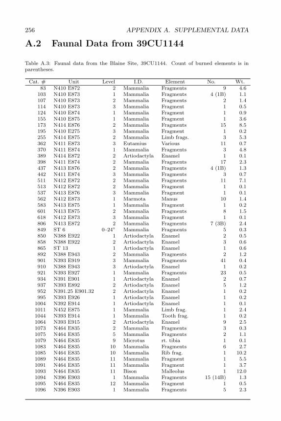
256 APPENDIX A. SUPPLEMENTAL DATA
A.2 Faunal Data from 39CU1144
Table A.3: Faunal data from the Blaine Site, 39CU1144. Count of burned elements is inparentheses.
Cat. # Unit Level I.D. Element No. Wt.83 N410 E872 2 Mammalia Fragments 9 4.6
103 N410 E873 1 Mammalia Fragments 4 (1B) 1.1107 N410 E873 2 Mammalia Fragments 2 1.4114 N410 E873 3 Mammalia Fragment 1 0.5124 N410 E874 1 Mammalia Fragment 1 0.9155 N410 E875 1 Mammalia Fragment 1 3.6173 N414 E876 2 Mammalia Fragments 15 8.5195 N410 E275 3 Mammalia Fragment 1 0.2255 N414 E875 2 Mammalia Limb frags. 3 5.3362 N411 E873 3 Eutamius Various 11 0.7370 N411 E874 1 Mammalia Fragments 3 4.8389 N414 E872 2 Artiodactyla Enamel 1 0.1398 N411 E874 2 Mammalia Fragments 17 2.3437 N413 E876 2 Mammalia Fragments 4 (1B) 1.3442 N411 E874 3 Mammalia Fragments 3 0.7511 N412 E872 2 Mammalia Fragments 11 7.1513 N412 E872 2 Mammalia Fragment 1 0.1537 N413 E876 3 Mammalia Fragment 1 0.1562 N412 E873 1 Marmota Manus 10 1.4583 N413 E875 1 Mammalia Fragment 1 0.2601 N413 E875 2 Mammalia Fragments 8 1.5618 N412 E873 3 Mammalia Fragment 1 0.1806 N413 E872 2 Mammalia Fragments 7 (3B) 2.4849 ST 6 0–24” Mammalia Fragments 5 0.3850 N388 E922 1 Artiodactyla Enamel 2 0.5858 N388 E922 2 Artiodactyla Enamel 3 0.6865 ST 13 1 Artiodactyla Enamel 1 0.6892 N388 E943 2 Mammalia Fragments 2 1.2901 N393 E919 3 Mammalia Fragments 41 0.4910 N388 E943 3 Artiodactyla Enamel 1 0.2921 N393 E927 1 Mammalia Fragments 23 0.5934 N391 E901 1 Artiodactyla Enamel 2 0.7937 N393 E892 2 Artiodactyla Enamel 5 1.2952 N391.25 E901.32 2 Artiodactyla Enamel 1 0.2995 N393 E926 1 Artiodactyla Enamel 1 0.2
1004 N392 E914 1 Artiodactyla Enamel 1 0.11011 N452 E875 1 Mammalia Limb frag. 1 2.41044 N393 E914 1 Mammalia Tooth frag. 1 0.21064 N393 E915 2 Artiodactyla Enamel 9 2.51073 N464 E835 2 Mammalia Fragments 3 0.31075 N464 E835 5 Mammalia Fragments 2 1.11079 N464 E835 9 Microtus rt. tibia 1 0.11083 N464 E835 10 Mammalia Fragments 6 2.71085 N464 E835 10 Mammalia Rib frag. 1 10.21089 N464 E835 11 Mammalia Fragment 1 5.51091 N464 E835 11 Mammalia Fragment 1 3.71093 N464 E835 11 Bison Malleolus 1 12.01094 N396 E903 1 Mammalia Fragments 15 (14B) 1.31095 N464 E835 12 Mammalia Fragment 1 0.51096 N396 E903 1 Mammalia Fragments 5 2.3
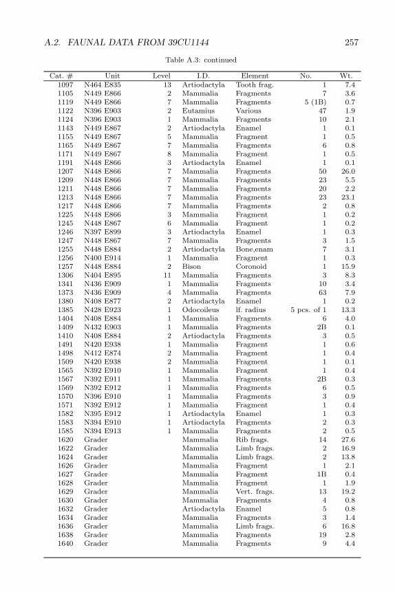
A.2. FAUNAL DATA FROM 39CU1144 257
Table A.3: continued
Cat. # Unit Level I.D. Element No. Wt.1097 N464 E835 13 Artiodactyla Tooth frag. 1 7.41105 N449 E866 2 Mammalia Fragments 7 3.61119 N449 E866 7 Mammalia Fragments 5 (1B) 0.71122 N396 E903 2 Eutamius Various 47 1.91124 N396 E903 1 Mammalia Fragments 10 2.11143 N449 E867 2 Artiodactyla Enamel 1 0.11155 N449 E867 5 Mammalia Fragment 1 0.51165 N449 E867 7 Mammalia Fragments 6 0.81171 N449 E867 8 Mammalia Fragment 1 0.51191 N448 E866 3 Artiodactyla Enamel 1 0.11207 N448 E866 7 Mammalia Fragments 50 26.01209 N448 E866 7 Mammalia Fragments 23 5.51211 N448 E866 7 Mammalia Fragments 20 2.21213 N448 E866 7 Mammalia Fragments 23 23.11217 N448 E866 7 Mammalia Fragments 2 0.81225 N448 E866 3 Mammalia Fragment 1 0.21245 N448 E867 6 Mammalia Fragment 1 0.21246 N397 E899 3 Artiodactyla Enamel 1 0.31247 N448 E867 7 Mammalia Fragments 3 1.51255 N448 E884 2 Artiodactyla Bone,enam 7 3.11256 N400 E914 1 Mammalia Fragment 1 0.31257 N448 E884 2 Bison Coronoid 1 15.91306 N404 E895 11 Mammalia Fragments 3 8.31341 N436 E909 1 Mammalia Fragments 10 3.41373 N436 E909 4 Mammalia Fragments 63 7.91380 N408 E877 2 Artiodactyla Enamel 1 0.21385 N428 E923 1 Odocoileus lf. radius 5 pcs. of 1 13.31404 N408 E884 1 Mammalia Fragments 6 4.01409 N432 E903 1 Mammalia Fragments 2B 0.11410 N408 E884 2 Artiodactyla Fragments 3 0.51491 N420 E938 1 Mammalia Fragment 1 0.61498 N412 E874 2 Mammalia Fragment 1 0.41509 N420 E938 2 Mammalia Fragment 1 0.11565 N392 E910 1 Mammalia Fragment 1 0.41567 N392 E911 1 Mammalia Fragments 2B 0.31569 N392 E912 1 Mammalia Fragments 6 0.51570 N396 E910 1 Mammalia Fragments 3 0.91571 N392 E912 1 Mammalia Fragment 1 0.41582 N395 E912 1 Artiodactyla Enamel 1 0.31583 N394 E910 1 Artiodactyla Fragments 2 0.31585 N394 E913 1 Mammalia Fragments 2 0.51620 Grader Mammalia Rib frags. 14 27.61622 Grader Mammalia Limb frags. 2 16.91624 Grader Mammalia Limb frags. 2 13.81626 Grader Mammalia Fragment 1 2.11627 Grader Mammalia Fragment 1B 0.41628 Grader Mammalia Fragment 1 1.91629 Grader Mammalia Vert. frags. 13 19.21630 Grader Mammalia Fragments 4 0.81632 Grader Artiodactyla Enamel 5 0.81634 Grader Mammalia Fragments 3 1.41636 Grader Mammalia Limb frags. 6 16.81638 Grader Mammalia Fragments 19 2.81640 Grader Mammalia Fragments 9 4.4
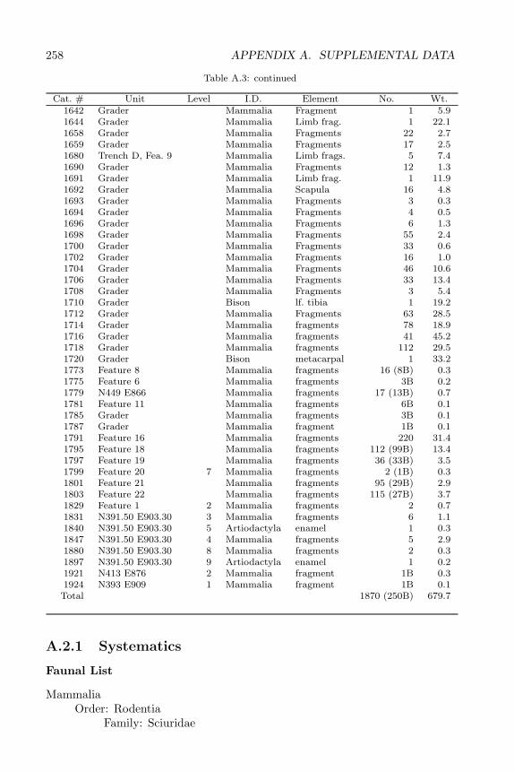
258 APPENDIX A. SUPPLEMENTAL DATA
Table A.3: continued
Cat. # Unit Level I.D. Element No. Wt.1642 Grader Mammalia Fragment 1 5.91644 Grader Mammalia Limb frag. 1 22.11658 Grader Mammalia Fragments 22 2.71659 Grader Mammalia Fragments 17 2.51680 Trench D, Fea. 9 Mammalia Limb frags. 5 7.41690 Grader Mammalia Fragments 12 1.31691 Grader Mammalia Limb frag. 1 11.91692 Grader Mammalia Scapula 16 4.81693 Grader Mammalia Fragments 3 0.31694 Grader Mammalia Fragments 4 0.51696 Grader Mammalia Fragments 6 1.31698 Grader Mammalia Fragments 55 2.41700 Grader Mammalia Fragments 33 0.61702 Grader Mammalia Fragments 16 1.01704 Grader Mammalia Fragments 46 10.61706 Grader Mammalia Fragments 33 13.41708 Grader Mammalia Fragments 3 5.41710 Grader Bison lf. tibia 1 19.21712 Grader Mammalia Fragments 63 28.51714 Grader Mammalia fragments 78 18.91716 Grader Mammalia fragments 41 45.21718 Grader Mammalia fragments 112 29.51720 Grader Bison metacarpal 1 33.21773 Feature 8 Mammalia fragments 16 (8B) 0.31775 Feature 6 Mammalia fragments 3B 0.21779 N449 E866 Mammalia fragments 17 (13B) 0.71781 Feature 11 Mammalia fragments 6B 0.11785 Grader Mammalia fragments 3B 0.11787 Grader Mammalia fragment 1B 0.11791 Feature 16 Mammalia fragments 220 31.41795 Feature 18 Mammalia fragments 112 (99B) 13.41797 Feature 19 Mammalia fragments 36 (33B) 3.51799 Feature 20 7 Mammalia fragments 2 (1B) 0.31801 Feature 21 Mammalia fragments 95 (29B) 2.91803 Feature 22 Mammalia fragments 115 (27B) 3.71829 Feature 1 2 Mammalia fragments 2 0.71831 N391.50 E903.30 3 Mammalia fragments 6 1.11840 N391.50 E903.30 5 Artiodactyla enamel 1 0.31847 N391.50 E903.30 4 Mammalia fragments 5 2.91880 N391.50 E903.30 8 Mammalia fragments 2 0.31897 N391.50 E903.30 9 Artiodactyla enamel 1 0.21921 N413 E876 2 Mammalia fragment 1B 0.31924 N393 E909 1 Mammalia fragment 1B 0.1
Total 1870 (250B) 679.7
A.2.1 Systematics
Faunal List
MammaliaOrder: Rodentia
Family: Sciuridae
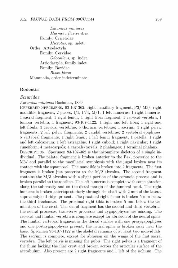
A.2. FAUNAL DATA FROM 39CU1144 259
Eutamius minimusMarmota flaviventris
Family: CricetidaeMicrotus, sp. indet.
Order: ArtiodactylaFamily: Cervidae
Odocoileus, sp. indet.Artiodactyla, family indet.Family: Bovidae
Bison bisonMammalia, order indeterminate
Rodentia
SciuridaeEutamius minimus Bachman, 1839Referred Specimens. 93-107-362: right maxillary fragment, P3/-M3/; rightmandible fragment, 2 pieces, I/1, P/4, M/1; 1 left humerus; 1 right humerus;1 sacral fragment; 1 right femur, 1 right tibia fragment; 1 cervical vertebra, 1lumbar vertebra, 1 fragment; 93-107-1122: 1 right and left tibia; 1 right andleft fibula; 3 cervical vertebrae; 5 thoracic vertebrae; 1 sacrum; 3 right pelvicfragments; 2 left pelvic fragments; 2 caudal vertebrae; 2 vertebral epiphyses;5 vertebral fragments; 1 right femur; 1 left femur fragment; 1 patella; 1 rightand left calcaneum; 1 left astragalus; 1 right cuboid; 1 right navicular; 1 rightcuneiform; 4 metacarpals; 4 carpals/tarsals; 2 phalanges; 1 terminal phalanx.Description. Specimen 93-107-362 is the incomplete skeleton of a single in-dividual. The palatal fragment is broken anterior to the P4/, posterior to theM3/ and parallel to the maxillarial symphysis with the jugal broken near itscontact with the squamosal. The mandible is broken into 2 fragments. The firstfragment is broken just posterior to the M/2 alveolus. The second fragmentcontains the M/3 alveolus with a slight portion of the coronoid process and isbroken parallel to the rootline. The left humerus is complete with some abrasionalong the tuberosity and on the distal margin of the humeral head. The righthumerus is broken anterioposteriorly through the shaft with 2 mm of the lateralsupracondyloid ridge present. The proximal right femur is broken 5 mm belowthe third trochanter. The proximal right tibia is broken 5 mm below the ter-mination of the crest. The sacral fragment has the second and third vertebrae;the neural processes, transverse processes and zygapophyses are missing. Thecervical and lumbar vertebra is complete except for abrasion of the neural spine.The lumbar vertebral fragment is the dorsal surface with one prezygapophysesand one postzygapophyses present; the neural spine is broken away near thebase. Specimen 93-107-1122 is the skeletal remains of at least two individuals.The sacrum is complete, except for abrasion on the wings of the first sacralvertebra. The left pelvis is missing the pubis. The right pelvis is a fragment ofthe ilium lacking the iliac crest and broken across the articular surface of theacetabulum. Also present are 2 right fragments and 1 left of the ischium. The
260 APPENDIX A. SUPPLEMENTAL DATA
left tibia is complete except for missing the medial malleolus. The right tibiais missing a portion of the medial condyle. The right femur is complete. Theleft distal femur fragment is broken approximately midshaft. The left fibula iscomplete and unworn. The right fibula consists of a 7 mm shaft fragment and aportion of the proxiaml end broken 1.5 cm from the head. The patella is com-plete and unworn. The thoracic vertebrae are abraded and lack processes andportions of the centrum. The cervical vertebrae are fairly complete; 1 with anabraded transverse process, 1 lacking a transverse process. The caudal vertebraeare complete and unabraded. The ankle elements, metacarpals, carpals/tarsalsand phalanges are complete. The 4 mm terminal phalanx is triangular in cross-section and gently curved along its palmar surface.Discussion. Specimen 93-107-362 was identified based upon tooth morphol-ogy. The upper cheek teeth of the similarly sized sciurid Eutamius minimus canbe distinguished from Spermophilus tridecemlineatus by their smaller size, lessdeveloped cingulum, and lower cusp height. The lower cheek teeth of Eutamiuscan be distinguished from Spermophilus by the lower cusp height and better de-veloped posteroanterior cusp. The postcranial elements are assumed to belongto Eutamius based upon their association with the cranial elements. Specimen93-107-1122 was identified based on the characteristics of the complete tibia.Complete Eutamius minimus and Spermophilus tridecemlineatus tibiae are thesame length; however the tibial shaft of Eutamius is laterally thinner, the dis-tal end is one-half as large; the medial malleolus is thinner across its widthbut relatively longer; and in side view, the fibular semi-lunar notch is morepronounced.Marmota flaviventris Audubon and Bachman, 1841Referred Specimen. 93-107-562: 3 right metacarpals, 4 right carpals, 2 claws,1 bone fragment.Description. All of the manus elements are complete. The claws are 7 mmlong, triangular in cross-section and are slightly curvate. The three metacarpalsare 1.2 cm, 2.5 cm and 3 cm long and have a distinctive triangular-shaped,strongly lipped proximal articular surface. The four carpals range in size from1.1-1.5 cm.Discussion. The distinctive metacarpals of the specimen were compared tothose of a number of comparatively sized animals. The metacarpal of Lepus,Sylvilagus, Mephistis, and Castor lack the distinctive triangular-shaped, lippedproximal articular surface. The Procyon metacarpal also lacks the triangular,lipped proximal articular surface and also has less pronounced articular ridgeson the distal articular surface. The metacarpal of Sciurus niger is similar inappearance to that of Marmota but it is noticeably smaller.em CricetidaeMicrotus, sp. indet.Referred Specimen. 93-107-1079: right tibia.Description. Specimen 93-107-1079 is a right fused tibia and fibula. The fibulais broken 6 mm from the proximal end of the fibula. The tibia is complete exceptfor a missing 3 mm portion of the tibial crest and a worn and abraded distalend. The proximal end is unworn and has a triangular-shaped articular surface
A.2. FAUNAL DATA FROM 39CU1144 261
of the tibial tuberosity and a pronounced tibial crest. The distal end, thoughworn, has a well-developed medial malleolus.Discussion. Microtus and Peromyscus tibiae are similar is size but have severaldistinguishing characteristics: 1) proximally, the tibial crest of Microtus is morepronounced, and the tibial tuberosity gives the articular surface a triangularshape, whereas in Peromyscus the articular surface is oval; 2) from ventralview, the distal articular surface of the Peromyscus tibia has a smaller, lesspronounced medial malleolus and a hook-shaped fibular semi-lunar notch; 3)anterior and posterior to the notch, the borders of the tibia are more heavilydeveloped in Microtus than Peromyscus.
Artiodactyla
CervidaeOdocoileus, sp. indet.Referred Specimen. 93-107-1385: left proximal radius.Description. Specimen 93-107-1385 is a left proximal radial fragment with acomplete articular surface. The shaft is jaggedly broken approximately 3.5 mmbelow the radial notch on the posterior surface and approximately 1.0 mm onthe anterior surface. The anterolateral and posterolateral corner of surface forarticulation with the internal condyle of the humerus is broken away.Discussion. The radius was identified by 1) its size, 2) the deep, U-shapedradial notch, and 3) the lack of a prominence on the anterolateral corner of themesial articular surface.BovidaeBison bison Linne, 1758Referred Specimens. 93-107-1093: left lateral malleolus; 93-107-1097: rightP2/; 93-107-1257: right coronoid process fragment; 93-107-1710: left distal tibia;93-107-1720: left proximal metacarpal.Description. Specimen 93-107-1093 is a complete, slightly abraded, left lat-eral malleolus. Specimen 93-107-1097 is an extremely well-worn premolar whoseocclusal surface is almost completely worn away. Only an remnant amount ofenamel is left on the sides of the tooth and occlusal surface. Specimen 93-107-1257 is a mandibular fragment broken parallel across the hinge from the dorsaledge of the articular process. The edge of the coronoid process is broken awayand is abraded. Specimen 93-107-1710 is a fragment of the tibia surrounding theinner malleolus process. Specimen 93-107-1720 is a metacarpal fragment with aportion of the ventral articular surface and dorsal shaft intact. The element isbroken along the ventral edge of the mesial articulation and along the dividingridge between the mesial and medial articular surface. The upper portion of thevascular groove remains intact; 5 cm of jaggedly broken shaft remains along thedorsal surface.Discussion. The lateral malleous was distinguished from other large artio-dactlys based on its large size and its short, broad process of articulation withthe lateral malleolus groove on the tibia. The coronoid process of Bison bisoncan be separated from Cervus canadensis based on its larger size and the gentler
262 APPENDIX A. SUPPLEMENTAL DATA
curvature and more acute angle of the posterior border of the coronoid process.The upper premolar was identified by its size, its square, columnar shape, andthe remnant occlusal pattern. The tibial fragment was identified by the absenceof the flexor digitalis groove and the large, V-shaped inner coronoid process.The metacarpal was identified by the placement of the vascular groove and theshape of the medial articular surface.Artiodactyla, family indet.Referred Specimens. 93-107-389: tooth enamel fragment; 93-107-850: 2tooth enamel fragments; 93-107-858: 3 tooth enamel fragments; 93-107-865:tooth enamel fragment; 93-107-910: tooth enamel fragment; 93-107-934: 2tooth enamel fragments; 93-107-937: 5 tooth enamel fragments; 93-107-952:tooth enamel fragment; 93-107-995: tooth enamel fragment; 93-107-1004: toothenamel fragment; 93-107-1064: 9 tooth fragments; 93-107-1097: tooth enamelfragment;93-107-1143: tooth enamel fragment; 93-107-1191: tooth enamel frag-ment; 93-107-1246: tooth enamel fragment; 93-107-1255: 7 tooth and bonefragments; 93-107-1380: tooth enamel fragment; 93-107-1410: tooth enameland 2 bone fragments; 93-107-1582: tooth enamel fragment; 93-107-1583: toothenamel and bone fragment; 93-107-1632: 5 tooth enamel fragments; 93-107-1795: 2 tooth enamel fragments; 93-107-1840: tooth enamel fragment; 93-107-1897: tooth enamel fragment.Discussion. The specimens are enamel fragments which display the ridged,high-crowned, selenodont characteristics of artiodactyl teeth. The associatedbone is fragmentary and unidentifiable.
Mammalia, order indet.
Referred Specimens. 93-107-83: 9 bone fragments; 93-107-103: 4 bone frag-ments (1 burned); 93-107-107: 2 bone fragments; 93-107-114: bone fragment;93-107-124: bone fragment; 93-107-155: bone fragment; 93-107-173: 15 bonefragments; 93-107-195: bone fragment; 93-107-255: 3 limb fragments; 93-107-370: 3 bone fragments; 93-107-398: 17 bone fragments; 93-107-442: 3 bonefragments; 93-107-437: 4 bone fragments (1 burned); 93-107-511: 11 bone frag-ments; 93-107-513: bone fragment; 93-107-537: bone fragment; 93-107-583:bone fragment; 93-107-601: 8 bone fragments; 93-107-618: bone fragment; 93-107-806: 7 bone fragments (3 burned); 93-107-849: 5 bone fragments; 93-107-892: 2 bone fragments; 93-107-910: 41 bone fragments; 93-107-921: 23 bonefragments; 93-107-1011: limb fragment; 93-107-1044: tooth enamel fragment;93-107-1073: 3 bone fragments; 93-107-1075: 2 bone fragments; 93-107-1083:6 bone fragments; 93-107-1085: rib fragment; 93-107-1089: limb fragment; 93-107-1091: bone fragment; 93-107-1094: 14 burned bone fragments, 1 toothenamel fragment; 93-107-1095: bone fragment; 93-107-1096: 5 bone fragments;93-107-1105: 7 bone fragments; 93-107-1119: 5 bone fragments (1 burned); 93-107-1124: 10 bone fragments; 93-107-1155: bone fragment; 93-107-1165: 6 bonefragments; 93-107-1173: bone fragment; 93-107-1207: 50 bone fragments; 93-107-1209: 23 bone fragments; 93-107-1211: 20 bone fragments; 93-107-1213: 23bone fragments; 93-107-1217: 2 bone fragments; 93-107-1225: bone fragment;
A.2. FAUNAL DATA FROM 39CU1144 263
93-107-1245: bone fragment; 93-107-1247: 3 bone fragments; 93-107-1256: bonefragment; 93-17-1306: 3 bone fragments; 93-107-1341: 10 bone fragments; 93-107-1373: 63 bone fragments; 93-107-1404: 6 bone fragments; 93-107-1409: 2burned bone fragments; 93-107-1491: bone fragment; 93-107-1498: bone frag-ment: 93-107-1509: bone fragment; 93-107-1565: bone fragment; 93-107-1567:2 burned bone fragment; 93-107-1569: 6 bone fragments; 93-107-1570: 3 bonefragments; 93-107-1571: bone fragment; 93-107-1585: 2 bone fragments; 93-107-1620: 14 rib fragments; 93-107-1622: 2 limb fragments; 93-107-1624: 2 limbfragments; 93-107-1626: bone fragment; 93-107-1627: burned bone fragment;93-107-1628: bone fragment; 93-107-1629: 13 vertebral fragments; 93-107-1630:4 bone fragments; 93-107-1634: 3 bone fragments; 93-107-1636: 6 limb frag-ments; 93-107-1638: 19 bone fragments; 93-107-1640: 9 bone fragments; 93-107-1642: bone fragment; 93-107-1644: 1 limb fragment; 93-107-1658: 22 bonefragments; 93-107-1659: 17 bone fragments; 93-107-1680: 5 limb fragments;93-107-1690: 12 bone fragments; 93-107-1691: limb fragment; 93-107-1692: 16scapular reports; 93-107-1693: 3 bone fragments; 93-107-1694: 4 bone frag-ments; 93-107-1696: 6 bone fragments; 93-107-1698: 55 bone fragments; 93-107-1700: 33 bone fragments; 93-107-1702: 16 bone fragments; 93-107-1704: 46 bonefragments; 93-107-1706: 33 bone fragments; 93-107-1708: 3 bone fragments; 93-107-1712: 63 bone fragments; 93-107-1714: 78 bone fragments; 93-107-1716: 41limb fragments; 93-107-1718: 112 bone fragments; 93-107-1773: 16 bone frag-ments (8 burned); 93-107-1775: 3 burned bone fragments; 93-107-1779: 17 bonefragments (13 burned); 93-107-1781: 6 burned bone fragments; 93-107-1785: 3burned bone fragments; 93-107-1787: burned bone fragment; 93-107-1791: 220burned bone fragments; 93-107-1795: 112 bone fragments (99 burned), 1 toothenamel fragment; 93-107-1797: 36 bone fragments (33 burned); 93-107-1799:burned bone fragment, tooth enamel fragment; 93-107-1801: 95 bone fragments(29 burned): 93-107-1803: 115 bone fragments (27 burned): 93-107-1829: 2bone fragments; 93-107-1831: 6 bone fragments; 93-107-1847: 2 bone and 3tooth enamel fragments; 93-107-1880: 2 bone fragments; 93-107-1921: burnedbone fragment; 93-107-1924: burned bone fragment.Discussion. The material was too fragmentary to assign to any particularmammalian order with confidence. None of the material displays any cut marksor other human modification.
Related Documents