the BIG idea e L,qssu frt\ig"fln"\&4 Chapter 17 online resources: Content Review, two Visual izations, two Resource Centers, Math Tutorial, Test Practice

Welcome message from author
This document is posted to help you gain knowledge. Please leave a comment to let me know what you think about it! Share it to your friends and learn new things together.
Transcript
the BIG idea
e L,qssu frt\ig"fln"\&4
Chapter 17 online resources:Content Review, twoVisual izations, two ResourceCenters, Math Tutorial,Test Practice

the BIA id,qa
How Does GoldAir Moue?Hold one hand near the topof a refrigerator door andthe other hand near the bot-tom. Open the refrigeratordoor just a little bit.
Observe and ThinkHow did each hand feelbefore and after you openedthe door? How did the air move?
How Does Weother Moue?Collect newspaper weather maps for threeconsecutive days. ldentify at least one flaggedline on a map (identifying a weather front) andtrack the line's movementover the three days.
Observe and ThinkWhat type of weatherdid you find each daywhere the line passed?Why did this line movethe way it did?
lnternet Activity:Weother SofetyGo to ClassZone.com to find information aboutweather safety. Find out the types of dangerousweather that mayaffect your region_.
Observe and ThinkWhat can you doahead of time tobe ready for severeweather?
c1f---ffi,?ri,NKS
Severe Weather Code: MDLO11
Gi@mfflm@@8,
Chapter 17: Weather Fronts and Storms 573
4
Continental air massesform over land,
Air masses are large bodies of air:
Polar air masses are cold.
Yesterday thetemperature fellas a cold front
passed us.
the boundary betweentwo air masses
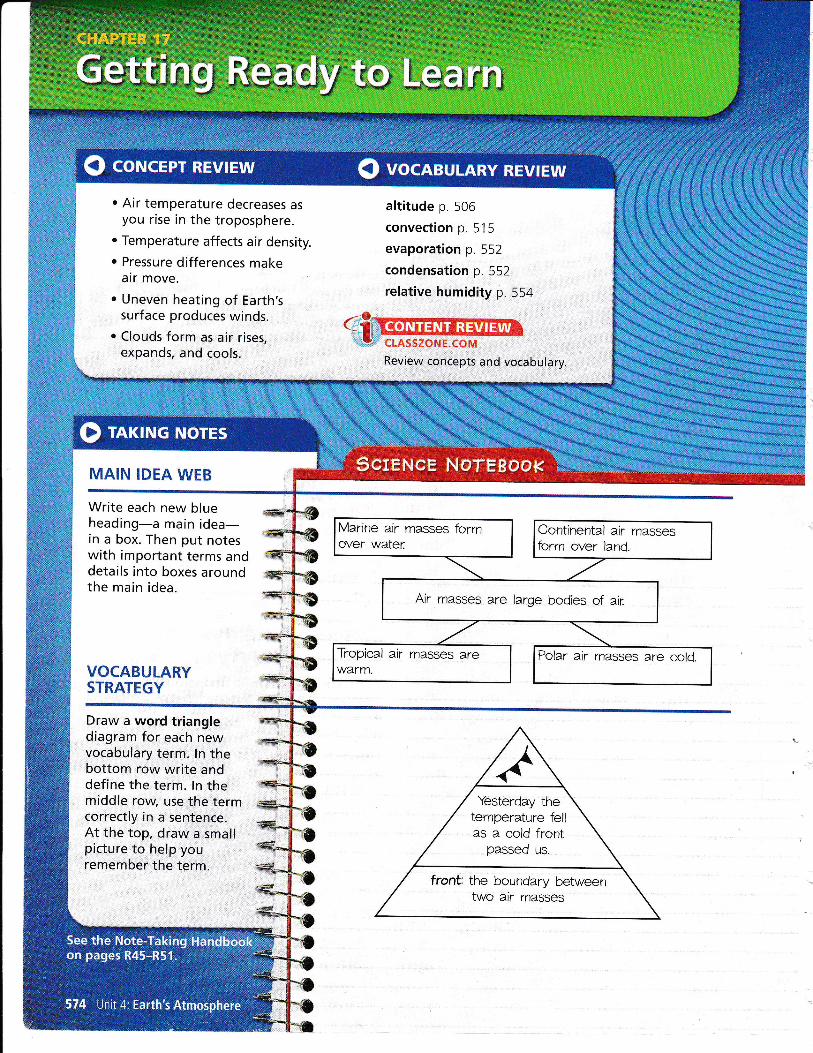
@ eut ice into one bowl and warm water intoa second bowl. Leave the third bowl empty.
@ elace each bowl in a different box and
cover the box with piastic wrap. Wait a
few minutes.
@ nut your hand into each box in turn.
BEFORE, you learned. Air pressure changes with
location and altitude. Water vapor in the atmosphere
condenses when air rises
EXPTORE Air Masses
How does an air mass form?PROCEDURE
NOW; you will learn. What air masses are. What happens when air
masses meet. How pressure systems affect
the weather
MI\TERIITLS. 3 bowls. ice. warm water. 3 shoeboxes. plastic wrap
VOCABULARY
air mass p. 575
front p. 578
high-pressuresystem p. 580
low-pressure systemp. 581
MAIN IDEA WEB
Organize important termsand details about air masses.
WHAT DO YOU THINK?. How would you describe the air in each box?. Which box's air feels the most humid? Why?
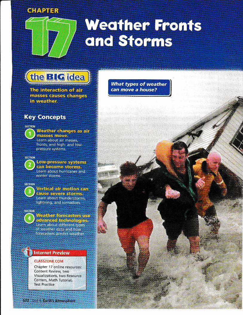
Air masses are large bodies of air.You have probably experienced the effects of air masses-one day is
hot and humid, and the next day is cool and pleasant. The weather
changes when a new air mass moves ihto your area. An air.mass is a
large volume of air in which t_e_rypcfalqre and humidity are nearly thesame in different locations at the same altitude. An air mass can cover
many thousands of square kilometers.
An air mass forms when the air over a large region of Earth sits inone place for many days. The air gradually takes on the characteristics
of theland or water below it. Where Earth's surface is cold, the airbecomes cold. Where Earth's surface is wet, the air becomes moist.As an air mass moves) it brings its temperature and moisture tonew locations.
Explain how the weather can change with the arrival of a new airmass. Your answer should include two ways that weather changes'
:J,
Chapter 17:Weather'Fronts and Storms 575
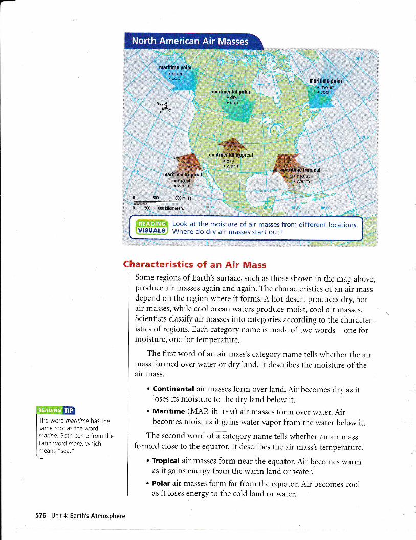
chraracteristics of an Air MassSome regions of Earth's surface, such as those shown in the map above,produce air masses again and again. The characteristics of an air massdepend on the region where it forms. A hot desert produces dry, hotair masses, while cool ocean waters produce moist, cool air masses.Scientists classify air masses into categories according to the character-istics of regions. Each category name is made of two v/s1d5-sns fs1moisture, one for temperature.
The first word of an air mass's category name tells whether the airmass formed over water or dry land. It d.escribes the moisture of theair mass.
. Continental air masses form over land. Air becomes dry as itloses its moisture to the dry land below it.
o Maritime (MAR-ih-rna) air masses form over water. Airbecomes moist as it gains water vapor from the water below it.
The second word of a category name tells whether an air massformed close to the equator. It describes the air mass's temperature.
Tropical air masses form near the equator. Air becomes warmas it gains energy from the warm land or water.
Polar air masses form far from the equator. Air becomes coolas it loses energy to the cold land or water.
The word maritime has thesame root as the wordmarine. Both come from theLatin word mare, whichmeans "Sea."
576 Unit 4: Earth's Atmosphere
The combination of words gives the characteristics of the air mass.
A maritime tropical air mass is moist and warm, while a continentalpolar air mass is dry and cold.
LnE*Pirlg",iWhat can you tell from each word of an air mass's name?
Movement of an Air MassAir masses can travel away from the regions where they form. Theymove with the global pattern of winds. In most of the United States,
air masses generally move from west to east. They may move alongwith the jet stream in more complex and changing patterns.
When an air mass moves to a new region, it carries along itscharacteristic moisture and temperature. As the air moves over Earth's
surface, the characteristics of the surface begin to change the air mass.
For example, if a continental polar air mass moves over warm water,the air near the surface will become warmer and gain moisture. These
changes begin where the air touches the surface. It may take days orweeks for the changes to spread upward through the entire air mass.
An air mass that moves quickly may not change much. If it movesquickly enough, a continental polar air mass can move cold air from
_northern Canada all the way to the southern United States.
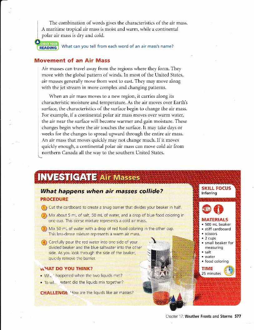
What happens when air masses collide?PROCEDURE
Q Cut the cardboard to create a snug barrier that divides your beaker in half.
@ Vix about 5 mL of salt, 50 mL of water, and a drop of blue food coloring in
one cup. This dense mixture represents a cold air mass.
@ Vix 50 mL of water with a drop of red food coloring in the other cup.
This less-dense mixture represents a warm air mass.
@ Carefully pour the red water into one side of yourdivided beaker and the blue saltwater into the otherside. As you look through the side of the beaker,
quickly remove the barrier.
uu'HAT' mO Y0{., TP{[NK?
. Wl,. ' happened when the two liquids met?
. To wl, extent did the liquids mix together?
CFIAff-tEzuG& 'row are the liquids like air masses?
,1
@oMATERIALS. 500 mL beaker. stiff cardboard. scissors. 2 cups. small beaker for
measuring. salt. water. food coloring
flME {&25 minutes " ry
Chapter 17:Weather Fronts and Storms 577
See how the air movesin warm fronts and coldfronts.
Weather changes where air masses meet.When a new air mass moves over your area) you can expect the weatherto change. Perhaps you have heard a weather forecaster talk aboutfronts. A front is a boundary between air masses. The weather near afront can differ from the weather inside the rest of an air mass. As oneair mass pushes another, some of the air at the boundary will bepushed upward. Clouds can form in this rising air. The weather oftenbecomes cloudy or stormy as a front passes. Afterward, you experiencethe temperature and humidity of the air mass that has moved in.
Fronts and WeatherDifferent types of fronts produce different patterns of weather. \rVhena cold, dense air mass pushes warmer air, it produces a cold front.When a warm air mass pushes colder air, it produces a warm front.These names tell you which way the temperature will change but nothow much it will change. A cold front can turn a heat wave into normalsummer weather or turn cold winter air into very cold weather.
How would the weather change if a cold front movedinto your area?
Q coH fronts can move into regions quickly. As you can see on page579, a cold front is steeper than the other types of fronts. As amass of cold, dense air moves forward, warmer air ahead of it ispushed upward. Water vapor in the warm air condenses as the airrises. Cold fronts often produce tall cumulonimbus clouds andprecipitation. Brief, heavy storms are likely. After the storms, theair is cooler and often verv clear.
Q warm fronts move more slowly than cold fronts. Warm air movesgradually up and over a mass of denser and colder air. Moisture inthe warm air condenses all along the sloping front, producingcloud-covered skies. As a warm front approaches, you may first see
high cirrus clouds, then high stratus clouds, then lower and lowerstratus clouds. Often, a warm front brings many hours of steadyrain or snow. After the front piisses, the air is warmer.
Q stationary fronts occur when air masses first meet or when a coldor warm front stops moving. For a while, the boundary betweenthe air masses stays in the same location-it stays stationary. Theair in each air mass can still move sideways along the front o1upward. The upward air motion may produce clouds that rcover
the sky, sometimes for days at a time. When the front sta-rts
moving, it becomes a warm front if the warm air advances andpushes the cold air. If the cold air moves forward instead, the frontbecomes a cold front.
I Organize the notes you* take about fronts.
cLASSZONE.COM
578 Unit 4: Earth's Atmosphere

'
As fronts mov-,offiross Earth's surface, they produce changes in the... :
ffiPREDlcTWhichcitywillthecoldfrontaffectnext?
Chapter 17:Weather Fronts and Storms 579
A system includes differentparts that work together.
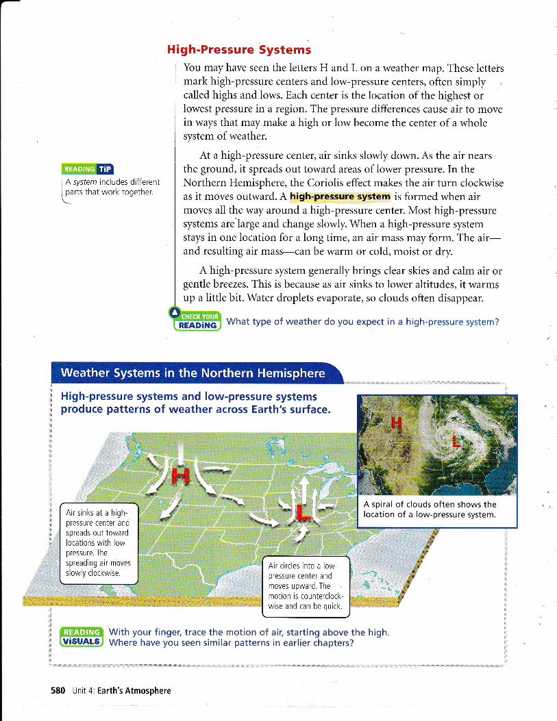
High-Pressure SystemsYou may have seen the letters H and L on a weather map. These letteismark high-pressure centers and low-pressure centers, often simplycalled highs and lows. Each center is the location of the highest orlowest pressure in a region. The pressure differences cause air to movein ways that may make a high or low become the center of a wholesystem of weather.
At a high-pressure center, air sinks slowly down. As the air nears
the ground, it spreads out toward areas of lower pressure. In theNorthern Hemisphere, the Coriolis effect makes the air turn clockwiseas it moves outward. A high-pressure system is formed when airmoves all the way around a high-pressure center. Most high-pressuresystems are'large and change slowly. When a high-pressure systemstays in one location for a long time, an air mass may form. The air-and resulting air mass-can be warm or cold, moist or dry.
A high-pressure system generally brings clear skies and calm air orgentle breezes. This is because as air sinks to lower altitudes, it warmsup a little bit. Water droplets evaporate, so clouds often disappear.
What type of weather do you expect in a high-pressure system?
High-pressure systems and low-pressure systemsproduce patterns of weather across Earth's surface.
3i
1"""'"
ffiffiffi With your fingel trace the motion of air; starting above the high., tU$!If!# Where have you seen similar patterns in earlier chapters?
:a:
:;
A spiral of clouds often shows thelocation of a low-pressure system.Air sinks at a high-
pressure center andspreads out towardlocations with lowpressure. The
spreading air moves
slowly clockwise.Air circles into a low-pressure center and
moves upward. The
motion is counterclock-wise and can be quick.
580 Unit 4: Earth's Atmosphere
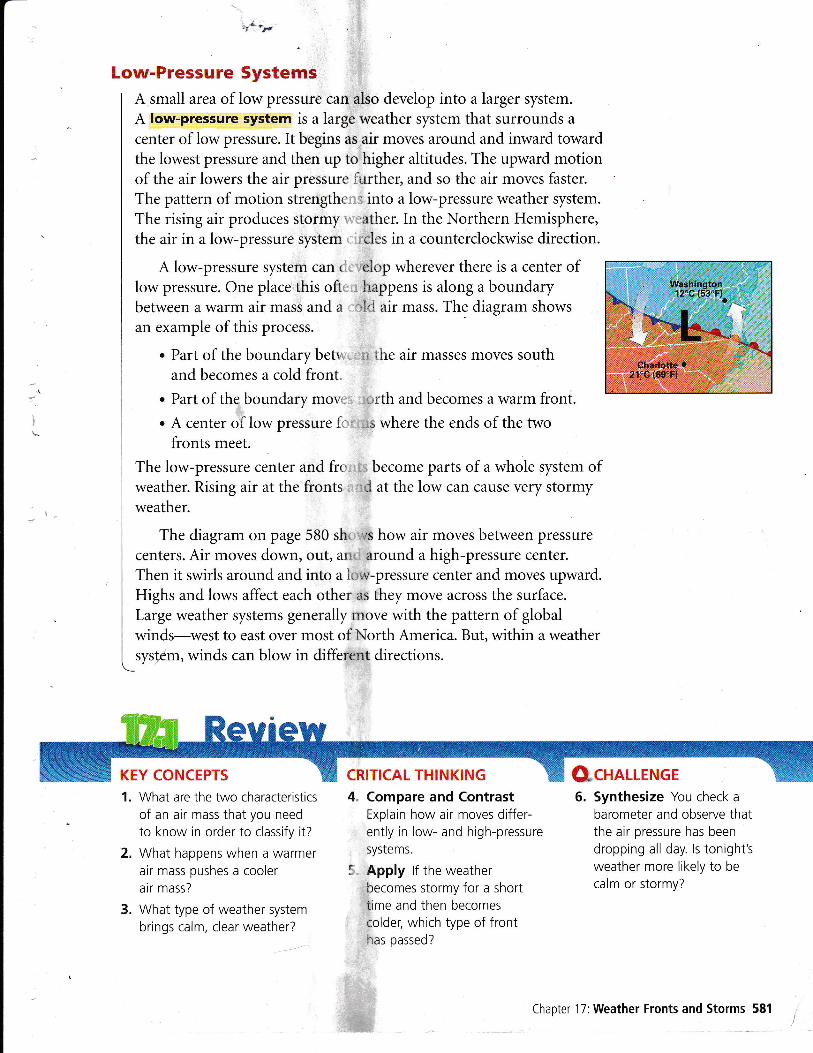
Low-Pressure SystemsA small area of low pressure can also develop into a larger system.
A low-pressure system is a large weather system that surrounds a
center of low pressure. It begins as air moves around and inward towardthe lowest pressure and then up to higher altitudes. The upward motionof the air lowers the air pressure i'rrrther, and so the air moves faster.
The pattern of motion strengthr, , into a low-pressure weather system.
The rising air produces stormy ather. In the Northern Hemisphere,the air in a low-pressure system ,'cles in a counterclockwise direction.
A low-pressure system can < 'elop wherever there is a center oflow pressure. One place this oft, happens is along a boundarybetween a warm air mass and a !'1 air mass. The diagram shows
an example of this process.
. Part of the boundary betr r lhe air masses moves southand becomes a cold front
. Part of the boundary mov, :,rth and becomes a warm front.
. A center of low pressure f, ,s where the ends of the twofronts meet.
The low-pressure center and frl become parts of a whole system ofweather. Rising air at the fronts ri at the low can cause very stormyweather.
The diagram on page 580 sh. -rs how air moves between pressure
centers. Air moves down, out, ar: around a high-pressure center.
Then it swirls around and into a ii,;v-pressure center and moves upward.Highs and lows affect each other as they move across the surface.
Large weather systems generally move with the pattern of globalwinds-west to east over most of North America. But, within a weathersystem, winds can blow in different directions.
KEY CONCEPTS CRITICAL THINK!NG CfcHnllENGE1. What are the two characteristics
of an air mass that you need
to know in order to classify it?
2. What happens when a warmerair mass pushes a cooler
air mass?
3. What type of weather system
brings calm, clear weather?
4. Compare and ContrastExplain how air moves differ-ently in low- and high-pressuresystems.
i Apply lf the weatherbecomes stormy for a shorttime and then becomescolder, which type of fronthas passed?
6. Synthesize You check a
barometer and observe thatthe air pressure has beendropping all day. ls tonight'sweather more likely to be
calm or stormy?
Chapter 17:Weather Fronts and Storms 581
,

Movement of a FrontScientists measure the speeds of weather fronts to forecast weatherconditions. The speed at which a front moves is an example of a
rate. A rate can be written as a ratio. For example, the rate of a
front that moves a distance of 500 kilometers in 1 day can bewritten as follows.
500kilometers:1dayThe map below shows the movement of a cold front over four
consecutive days. Use the map scale to determine the distance thatthe front moves on each day.
Answer the following questions.
1. What was the fronts rate of movement between Wednesdayand Thursday? Express your answer as a ratio.
?:1day
2. What was the front's rate of movement between Friday andSaturday? Express your answer as a ratio.
3. What was the mean rate of the front's movement fromWednesday to Saturday? Remember, mean means "average."Express your answer as a ratio.
CP$&Le-ffiruffiffi Use the rate from Wednesday to Saturdayto estimate the day on which the front must have movedthrough 5an Francisco.
Cold Front Movement
)'
Wednesday
B7,!g
g_#
0 500 1000 kilometers
Saturday
Friday 'eL*ig1:wLi.Fluaqii=!!-Ii.-a+&!li;tr
=i;:ie.eri-.g

BEFORE, you learned. Moving air masses cause
changes in weather. A low-pressure system brings
stormy weather
D(PTORE Hurricanes
NOW you will learn. How hurricanes develop. About the dangers of
h u rrica nes. About different types of
winter storms
VOCABULARY
tropical storm p. 583
hurricane p. 583
storm surge p. 585
blizzard p. 586
the
., 13 about hurricanes.
@ Crumple a piece of paper, then flatten
What things make hurricanes lose strength?PROCEDURE MATERIALS
. sheet of paperr top
it out. Crumple and flatten it out again.
@ Spin the top on the flattened paper.
Count the seconds until it stops spinning.
@ Spin the top on a smooth surface. Countstops spinning.
WHAT DO YOU THINK?How does the texture of the surfaceaffect the rate at which the top loses energy?
Hurricanes form over warm ocean water.Near the equator, warm ocean water provides the energy that can turna low-pressure center into a violent storm. As water evaporates fromthe ocean, energy moves from the ocean water into the air. This energymakes warm air rise faster. Thll clouds and strong winds develop. Aswinds blow across the water from different directions into the low, theCoriolis effect bends their paths into a spiral. The winds blow fasterand faster around the low, which becomes the center of a storm system.
A tropical storm is a low-pressure system that starts near theequator and has winds that blow at 65 kilometers per hour (40 mi/h)or more. A hurricane (HUR-ih-KAyN) is a tropical low-pressure systemwith winds blowing at speeds of 120 kilometers per hour (74 milh) ormore-strong enough to uproot trees. Hurricanes are called typhoonsor cyclones when they form over the Indian Ocean or the western
_Pacific Ocean.
Chapter 17:Weather Fronts and Storms 583
notes

Watch the progress ofa hurricane.
Formation of HurricanesIn the eastern United States, hurricanes most often strike betweenAugust and October. Energy from warm water is necessary for alow-pressure center to build into a tropical storm and then into a
hurricane. The ocean water where these storms develop only gets
warm enough-26"C (80"F) or more-near the end'of summer.
Tiopical storms and hurricanes generally move westward with thetrade winds. Near land, however, they will often move north, south, oreven back eastward. As long as a storm stays above warm water, it can
grow bigger and more powerful. As soon as a hurricane moves overland or over cooler water, it loses its source of energy. The winds lose
strength and the storm dies out. If a hurricane moves over land, therough surface of the land reduces the winds even more I
The map below shows the progress of a storm. The tropicalstorm gained energy and became a hurricane as it moved westward.When the hurricane moved north, the storm lost energy and was
called a tropical storm again as its winds slowed.
What is the source of a hurricane's energy?
Eye: The small centerof a hurricane is clear
and calm because air is
moving downward.
Eye wall: Just out-side the eye, the air
swirls upward very
quickly. lt is like a wallof stormy weather.
584 Unrt 4: Earth's Atmosphere
cii@"_F cr-lsszoNE.coM

At the center of a hurricane is a small area of clear weather,20-50 kilometers (10-30 mi) in diameter, called the eye. The storm'scenter is calm because air moves downward there. Just around the eye,the air moves very quickly around and upward, forming a tall ring ofcumulonimbus clouds called the eye wall. This ring produces veryheavy rains and tremendous winds. Farther from the center, bandsof heavy clouds and rain spiral inward toward the eye.
Effects of HurricanesA hurricane can pound a coast with huge waves and sweep the landwith strong winds and heavy rains. The storms cause damage anddangerous conditions in several ways. Hurricane winds can lift cars,uproot trees, and tear the roofs off buildings. Hurricanes may alsoproduce tornadoes that cause even more damage. Healy rains fromhurricanes may make rivers overflow their banks and flood nearbyareas. When a hurricane moves into a coastal area, it often pushes ahuge mass of ocean water known as a storm surge. In a storm surge,the sea level rises several meters, backing up rivers and flooding theshore. A storm surge can be destructive and deadly. Large waves addto the destruction. A hurricane may affect afi area for a few hours or a
few days, but the damage may take weeks or even months to clean up.
What are the effects of hurricanes? Make a list for your answer.
The National Hurricane Center helps people know when toprepare for a hurricane. The center puts out a tropical-storm orhurricane watch when a storm is likely to strike within 36 hours.People may be evacuated, or moved away for safety, from areas wherethey may be in danger. As the danger gets closer-24 hours or less-the center issues a tropical-storm or hurricane warning. The warning
_stays in effect until the danger has passed.
COMPARE AND CONTRAST These pictures show a shorelineand after Hurricane Fran in 1996. Compare the houses, road,
in North Carolina beforeand water in the two pictures.
HURRICANES
. Before a storm,prepare a plan toIeave the area.
Gather emergency
supplies.
o Listen to weaiherreports for storm
updates.
. Secure loose
objects outside, and
cover windows.
. If ordered toevacuate, leave
immediately.
. During a storm, stay
indoors and awayfrom windows.
. After a storm, be
aware of power lines,
hanging branchetand flooded areas.
Chapter 17:Weather Fronts and Storms 585
VOCABULARY.l Remember to add a
l* word triangle diagram'' , for blizzard.
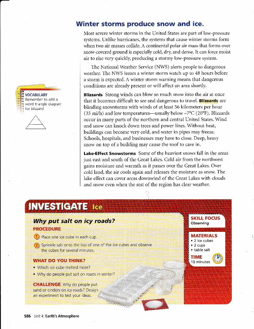
Why put salt on icy roads?PROCEDURE
@ ntace one ice cube rn each cup.
@ Sprinkle salt onto the top of one of the ice cubes and observe
the cubes for several minutes.
WHAT DO YOU T}IINK?. Which ice cube melted more?
. Why do people put salt on roads in winter?
CHAI-LENGE Why do people put
sand or cinders on icy roads? Design
an experiment to test your ideas.
Winter storms produce snow and ice.Most severe winter storms in the United States are part of low-pressuresystems. Unlike hurricanes, the systems that cause winter storms formwhen two air masses collide. A continental polar air mass that forms over
snow-covered ground is especially cold, dry and dense. It can force moistair to rise very quickly, producing a stormy low-pressure system.
The National Weather Service (NWS) alerts people to dangerous
weather. The NWS issues a winter storm watch up to 48 hours beforea storm is expected. A winter storm warning means that dangerous
conditions are aheady present or will affect an area shortly.
Blizzards Strong winds can blow so much snow into the air at once
that it becomes difficult to see and dangerous to travel. Blizzards are
blinding snowstorms with winds of at least 56 kilometers per hour(35 mi/h) and low temperatures-usuallybelow -7"C (20"F).Blizzardsoccur in many parts of the northern and central United States. Windand snow can knock down trees and power lines. Without heat,
buildings can become very cold, and water in pipes may freeze.
Schools, hospitals, and businesses may have to close. Deep, healysnow on top of a building may cause the roof to cave in.
Lake-Effect Snowstorms Some of the heaviest snows fall in the areas
just east and south of the Great Lakes. Cold air from the northwestgains moisture and warmth as it passes over the Great Lakes. Overcold land, the air cools again and releases the moisture as snow. Thelake effect can cover areas downwind of the Great Lakes with cloudsand snow even when the rest of the region has clear weather.
MATERIALS. 2 ice cubes. 2 cups. table salt
TIME10 minutes
586 Unit 4: Earth's Atmosphere

T'UINTER STORMS
. Before a storm,prepare emergency
kits for home and car.
o Listen to weatherreports for updates.
. lf caught in a storm,
find or make a shelterand try to stay dry.
. lf you are in a car ortruck, make sure theexhaust pipe is clear
and open a windowa little bit.
. Use a colored cloth,fire, or Iight to help
rescuers find you.
. Exercise a little tokeep warm and keep
blood flowing to your
fingers and toes.
o lf at home, stay inside
even if there is no
heat or power. Wear
layers of clothing.
CRITICAL THINKING1. Where and when do
hurricanes form?
2. ln what two ways can
hurricanes cause floods?
3. List thre6 of the possible
dangers from winter storms.
4. Compare and ContrastWhat are the differencesbetween the eye and the eyewall of a hurricane?
5. Compare What do hurricanesand winter storms have
in common?
6. Apply lf the wind is blowingfrom the west and theconditions are right for lake-effect snow, will the snow fallto the north, south, east, orwest of a lake? Drawing a
diagram may help you workout an answer.
Chapter 17:Weather Fronts and Storms 587
I lce Storms \A4ren rain falls onto freezing-cold ground, conditions can
I become dangerous. The cold rain freezes as it touches the ground and
] other surfaces. This freezing rain covers everything with hear,y, smooth
I ice. The ice-covered roads become slippery and dangerous. Drivers may
| find it hard to steer and to stop their cars. Branches or even whole treesmay break from the weight of ice. Falling branches can block roads,
i tear down power and telephone lines, and cause other damage.
I Damage from ice storms can sometimes shut down entire cities.
oREADilirG What type cf preei;:itation oecurs in each type af w,inter stori.n?
&cnnuENGE
VOCABULARY
thunderstorm p. 588
tornado p. 591
BEFORE, you learnedo Fronts produce changes in
weather. Rising moist air can produce
clouds and precipitation
D(PLORE Lightning
Does miniature li'PROCEDURE
Ql Use a thumbtack to attach tcenter of a piece of foil.
@ Rub the foam tray quickly
several times on the wool. Set
@ Usinq the eraser as a handle, pick up thefoil and set it onto the tray. Slowly moveyour finger close to the foil.
WHAT DO YOU THINK?What happened when you touched the foil?
NOW you will learnr How thunderstorms developr About the effects of
thunderstormsr About tornadoes and their
effects
cause thunder?MATERIALS. thumbtacko eraser. aluminum foil. plastic foam tray. wool fabric
the
o
Thunderstorms form from rising moist air.If you have ever shuffled your shoes on a carpet, you may have felt asmall shock when you touched a doorknob. Electrical charges collected
In a similar way, electrical build up near the tops andbottoms of clouds as pellBts of i up and down through theclouds. Suddenly, a charge spar.
or between a cloud and the groone part of a cloud to another
The spark of electricity, called
lightning, causes a bright flash t. The air around the lightning is
briefly heated to a temperature r than the surface of the Sun. Thisfast heating produces a sharp of air that travels away from thelightning. When the wave , you hear it as a crack ofthunder. A thunderstorm is a with lightning and thunder.
588 Unit 4: Earth's Atmosphere
ls thunder a cause or a of lightning?
VOCABULARY
Put new terms intoa word triangle diagram.

Formation of ThunderstormsThunderstorms get their energy from humid air. When warm, humidair near the ground moves vertically into Coo-lei air above, the risingair, or updraft, can build a thunderstorm quickly.
Q Rising humid air forms a cumulus cloud. The water vapor releases
energy when it condenses into cloud droplets. This energy increasesthe air motion. The cloud continues building up into the tallcumulonimbus cloud of a thunderstorm.
Q Ice particles form in the low temperatures near the top of the cloud.As the ice particles grow large, they begin to fall and pull cold airdown with them. This strong downdraft brings heavy rain orhail-the most severe stage of a thunderstorm.
Q fhe downdraft can spread out and block more warm air frommoving upward into the cloud. The storm slows down and ends.
Thunderstorms can form at a cold front or within an air mass.At a cold front, air can be fo.cediplard quickly. Within an air mass,uneven heating can produce convection and thunderstorms. In someregions, the conditions that produce thunderstorms occur almost dailyduring part of the year. In Florida, for example, the wet land and airwarm up during a long summer day. Then, as you see in the diagram,cool sea breezes blow in from both coasts of the peninsula at once.The two sea breezes together push the warm, humidair over the land upward quickly.Thunderstorms form in the rising air.
In contrast, the summer air along thecoast of California is usually too dry toproduce thunderstorms. The air overthe land'heats up, and a sea breezeforms, but there is not enoughrmoisturein the rising warm air to form cloudsand precipitation.
Chapter 17:Weather Fronts and Storms 589
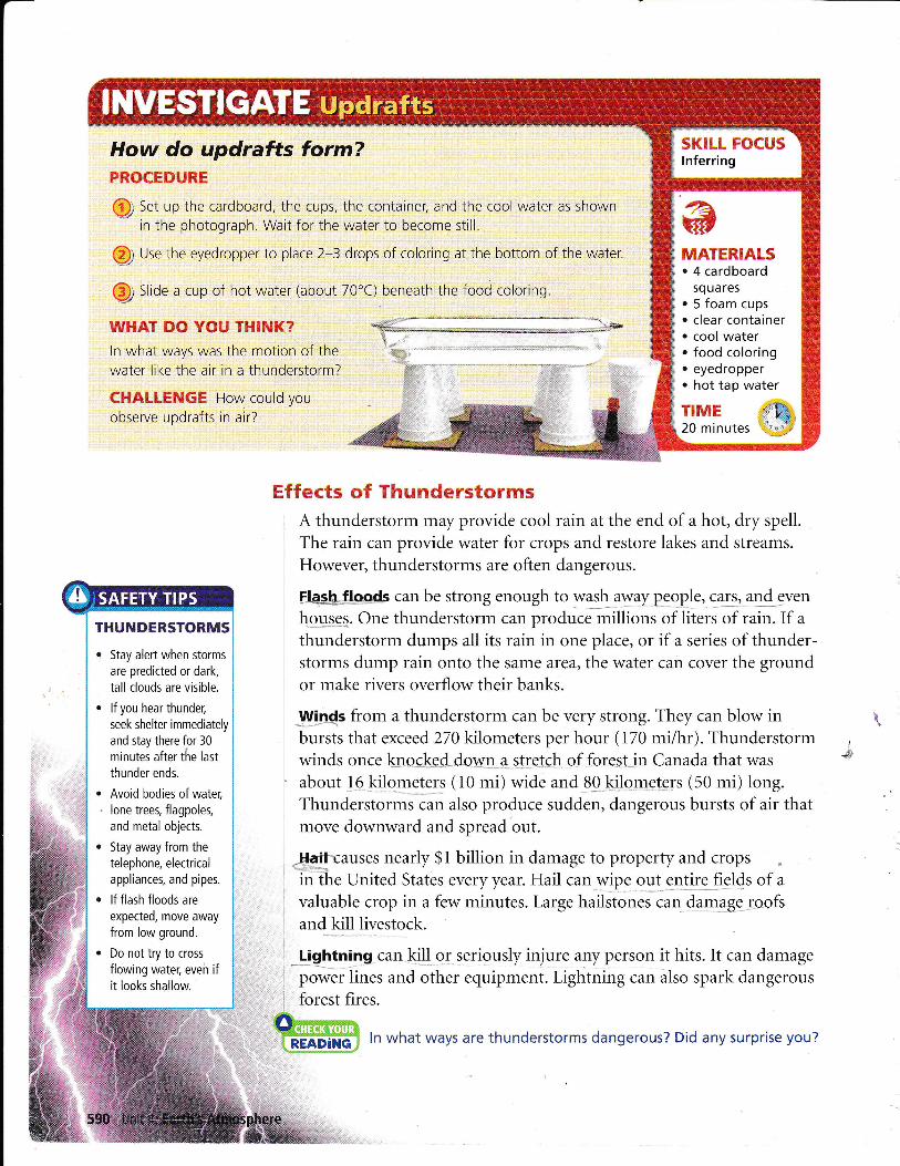
How do updrafts form?PROCEDURE
@; Set up the cardboard, the cups. the container, and the cool water as shownin the photoqraph. Wait for the water to become still
@ Use the eyedropper to place 2-3 drops of coloring at the bottom of the water.
@ StiOe a cup of hot water (about 70"C) beneath the food coloring
WHAT DO YOU THINK?ln what ways was the motion of thewater like the air in a thunderstorm?
CHIILLENGH How could you
observe updrafts in air?
Effects of ThunderstormsA thunderstorm may provide cool rain at the end of a hot, dry spell.
The rain can provide water for crops and restore lakes and streams.
However, thunderstorms are often dangerous.
HeshJods can be strong enough to was.h awayll*e-o.ple, calqrenld JVen
h.gg_ssS. One thunderstorm can produce millions of liters of rain. If a
thunderstorm dumps all its rain in one place, or if a series of thunder-storms dump rain onto the same area, the water can cover the groundor make rivers overflow their banks.
.U{ipds from a thunderstorm can be very strong. They can blow inbursts that exceed 270 kilometers per hour (170 mi/hr). Thunderstormwinds once kno-c-kd-doruq4_Alfej.e-h- qf fore-sln Canada that was
about 1-6.kilometers (10 mi) wide and_8Q kilq.mqt€-rs (50 mi) long.ffr""a.irt*il;; also produce sudden, dangerous bursts of air thatmove downward and spread'out.
#f[-l-causes nearly $1 billion in damage to property and crops .in ihe United States every year. Hail can wipe_ 9.11_gf!fg fi4ds of avaluable crop in a few minutes. Large hailstones caq_&Iqaglroofsand kill livestock.
-Lfgl$lng can-1-<i."]!-o1 seriously injure any person it hits. It can damage
power lines and other equipment. Lightning can ilso spark dangerousforest fires.
MATERMLS. 4 cardboard
squares
' 5 foam cups. clear container. cool water. food coloring. eyedropperr hot tap water
TIME20 minutes
THUilDERSTORMS
r Stay alert when storms
are predicted or dark,
tall clouds are visible.
. lf you hear thunder,
seek shelter immediately
and stay there tor 30
minutes after the last
thunder ends.
. Avoid bodies of water;
' lone trees, flagpoles,
and metal objects.
. Stay away from the
telephone, electricalappliances, and pipes.
. lf flash floods are
expected, move awayfrom low ground.
r Do not try to cross
flowing water; eveh ifit looks shallow.
ffi ln what ways are thunderstorms dangerous? Did any surprise you?
\

Tornadoes form in severe thunderstorms.Under some conditions, the up-and-down air motion that producestall clouds, lightning, and hail may produce a tornado. A tornado is aviolently rotating column of air stretching from a cloud to the ground.A tornado moves along the ground in a winding path underneath thecloud. The column may even rise off the ground and then come downin a different place.
You cannot see air moving. A tornado may become visible whenrqalgr 4LoILeLs eppgg: below the cloud inthe centgr glthe_ ptalit,gcolurhn. A tornado may lift dust and debris from the ground, so theffifrom;f the column becomes visible, as you see in the photographsbelow Water droplets and debris may make a tornado look like anupright column or a twisted rope.
What makes a tornado become visible?
More tornadoes occur in North America than anywhere else in theworld. Warm, humid air masses move north from the Gulf of Mexicoto the central plains of the United States. There, the warm air masses
often meet cold, dense air and form thunderstorms.In the spring, thewinds in this region often produce the conditions that form tornadoes.A thunderstorm may form a series of tornadoes or even a group oftornadoes all at once.
A spinning column of air is
not called a tornado unlessit touches the ground. lf ittouches water instead, it is
called a waterspout.
.i
As a tornado forms,a funnel cloud seems
to stretch down from
the cloud above.
Chapter 17:Weather Fronts and Storms 591

Effects of TornadoesThe powerful winds of a tornado can cause damage
as the bottom of the tornado moves along theground. Tornado winds can also pick up and slamdirt and small objects into buildings or anythingelse in the tornado's path.
The most common tornadoes are smalland last only a few miniites.-Their winds maybe strong enough to break branches off trees,
damage chimneys, and tear highway billboards.A typical path along the ground may be 100
meters (300 ft) wide and 1.5 kilometers (1 mi) long.
Larger tornadoes are less common but have
stronger winds and last longer. &9g!2Qpef.-9".tof tornadoes are strong enough to knock overlarge trees, lift cars off the ground, and tear theroofs off houses. Very few-about 1 percent of all
tornadoes-are violent enough to lift or completely deilolilh sturdybuildings. These huge tornadoes may last more than two hours.You can find more details about tornadoes in the Appendix.
Paths of TornadoesA tornado moves along with its thunderstorm. It travels at the same
pace and weaves a path that is impossible to predict. A tornado mayappear suddenly and then disappear before anyone has time to reportit. However, the conditions that form tornadoes may persist, so citizens'reports are still useful(he National Weather Service issues a tornadowatch when the weather conditions might produce torq?does. A tornadowarning is issued when a tornado has been detected. )
TORNADOES
r Listen for tornado
warnings when severe
weather is predicted.
. lf you are in a car ormobile home, get out
and go into a sturdy
building or a ditch or
depression.
. Go to the basement
if possible.
r Avoid windows and
open areas.
. Protect your head
and neck.
KEY CONCEPTS
1. What conditions produce
thunderstorms?
2. How can rain from thunder-storms become dangerous?
3. How do tornadoescause damage?
4. Compare What do hail and
tornadoes have in common?Hint: Think about how each
forms.
5. Synthesize Which type offront is most likely to produce
thunderstorms and tornadoes?Explain why.
Q CHALLENGE
6. Compare and Contrastlf you saw the photographabove in a newspaper. whatdetails would tell you that thedamage was due to a tornadoand not a hurricane?
592 Unit 4: Earth's Atmosphere
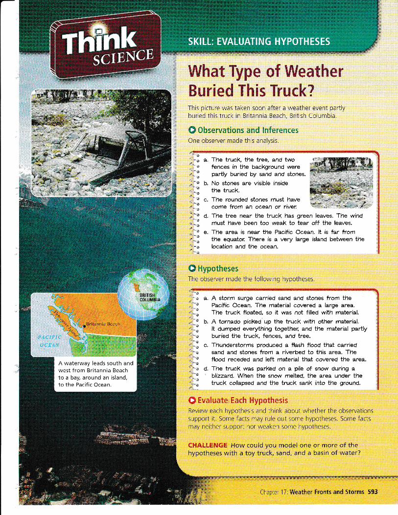
What Type of WeatherBuried This Truck?This picture was taken soon after a weather event partlyburied this truck in Britannia Beach, British Columbia.
O Observations and lnferencesOne observer made this analysis.
a. The trucl( the tree, and twofences in the background weregartly buried by sand and stones.
b. No stones are visible insidethe trucK
c. The rounded stones must have .*,;j;"d;b,ffi,*come from
^n o".Ln"Jiil;- ffi'ffi
d. The tree near the truck has green leaves. The windmust have been too weak to tear off the leaves.
e. The area is near the Pacihc Ocean. lt is fur fromthe equator: There is a very large island between thelocation and the ocean.
O HypothesesThe observer made the following hypotheses.
a. A storm surge carried sand and stones from thePacific Ocean. The material covered a large area.The trucK floated, so it was not filled with material.
b. A tornado picked'up the trucl< with other material.It dumped everything together: and the material parLlyburied the truck, fences, and tree.
c. Thunderstorms produced a flash flood that carriedsand and stones from a riverbed to this area. Theflood receded and left material that covered tne area.
d. The truck was parked on a pile of snow during a' blizzard. When the snow melted, the area under the
truck collapsed and the truck sank into the ground.
0 Evaluate Each HypothesisReview each hypothesis and think about whether the observationssupport it. Some facts may rule out some hypotheses. Some factsmay neither support nor weaken some hypotheses.
C}IALI-ENGE How could you model one or more of thehypotheses with a toy truck, sand, and a basin of water?
Chapter 17:Weather Fronts and Storms 593
EVALUATING HYPOTHESES
BEFORE, you learned. Weather changes when air
maSses move. High-pressure systems bring
I'Qlt.wealn",.. Fronts and low-pressure
systems bring stormy weather
D(PTORE Weather Maps
What does a weather map show?PROCEDURE
NOW, you will learn. How weather data are collected. How weather data are displayed. How meteorologists forecast
the weather
MATERIALSnewspaperweather map
VOCABULARYmeteorologist p. 594
isobar p. 597
'f o Vake a word tr,angle' ' for mefeorologist.
A
a@ Use the map to check the weather
Look at the weather outside. Write downthe conditions you observe.
conditions for your
WHAT DO YOU THINK?. What symbols on the map do you recognize?o How does the information on the weather map
compare with the weather you observed outs de?
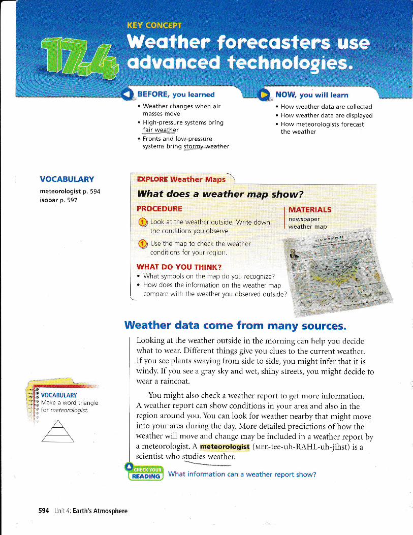
Weather data come from many sources.
] Looking at the weather outside in the morning can help you decide
I what to wear. Different things give you clues to the current weather.
I If you see plants swaying from side to side, you might infer that it iswindy. If you see a gray sky and wet, shiny streets, you might decide to
I wear a rarncoat.I
I You might also check a weather report to get more information.A weather report can show conditions in your area and also in the
I region around you. You can look for weather nearby that might move
I into your area during the day. More detailed predictions of how the
I weather will move and change may be included in a weather report by
] a meteorologist. A meteorologist (uul-tee-uh-RAHL-uh-jihst) is a
I scientist who studies weather.mtild
Rffi&{mi[*& Wlrat irrforry"i.:ti*n can a rnrealher report :lllow?
.i1ffi
594 Unit 4: Earth's Atmosphere
KEY COI{CEPT

In order to predict the weather, meteorologists look at past andcurrent conditions. They use many forms of technology to gather
data. The illustration below shows how weather information is gath-ered. For example, radar stations and satellites use advancedtechnologies to gather data for large areas at a time.
Instruments within the atmosphere can make measurements oflocal weather conditions. Newer instruments can make measurements
frequently and automatically and then report the results almostinstantly. Instruments are placed in many ground stations on land andweather buoys at sea. Instruments can also be carried by balloons,ships, and planes. These instruments report a series of measurements
along a path within the atmosphere.
Learn more aboutweather forecasting andyour local weather.
cLASSZONE.COM
Satellites orbit Earth above the
atmosphere. lmages can show
cover, warm and cool regions,
and invisible water vapor.
'itlrer ualloon/
n@gpl6as+r'nflasure-ments of the air atdlfferent altitudes as they
carry instruments hiqh
into the stratosphere.
Airplanes and shipscan carry instrument packages
that make measurements
wherever they go.
(Weather bqbyt\eco rd the-r*e'aher f a r.\-_-/_,Irom crtres. lhey also
measure conditions in
the ocean that affectthe atmosphere.
Ground stations hold
instruments that measure
air pressure, temperature,
dew point, precipitation,wind speed, wind direction,
and cloud cover,
Chapter '17:Weather Fronts and Storms 595
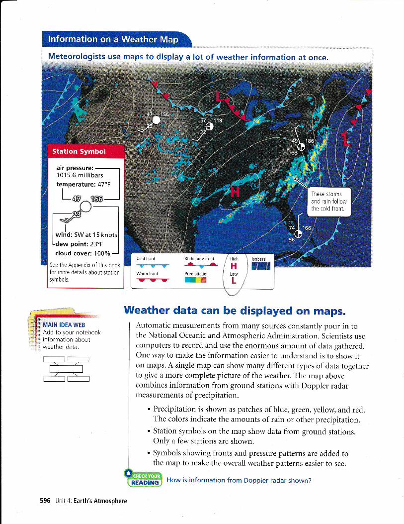
Meteorologists use
*irla, sw at 15 knots
cloud cover:100%
See the Appendix of this bookfo' no'e details aboui starionsymbols.
MAIN IDEAWEBAdd to your notebookinformation aboutweather data
to display a lot of weather information at once.
Weather data can be displayed on maps.
I Automatic measurements from many sources constantly pour in to
I the National Oceanic and Atmospheric Administration. Scientists use
I computers to record and use the enormous amount of data gathered.
I One way to make the information easier to understand is to show it
I on maps. A single map can show many different types of data together
I to give a more complete picture of the weather. The map above
I combines information from ground stations with Doppler radar
I measurements of precipitation.
| . Precipitation is shown as patches of blue, green, yellow"and red.
I The colors indicate the amounts of rain or other precipitation.t^I . Station symbols on the map show data from ground stations.
I O"ly a few stations are shown.
| . Symbols showing fronts and pressure patterns are added to
I the map to make the overall weather patterns easier to see.
M How is information from Doppler radar shown?
595 Unit 4: Earth's Atmosphere

I Computer programs are used to combine information from many
I ground stations. The resulting calculations give the highs,lows, and
I fronts that are marked on the map. The cold front near the East Coast
I nur triangles to show that the front is moving eastward. This cold
I front produced the heavy rain that is visible in the Doppler radar data.LI
Air Pressure on Weather MapsThe map below shows conditions from the same date as the map onpage 596. Thin lines represent air pressure. An isobar (EYE-suh-neHn)
is a line that connects places that have the same air pressure. Each iso-bar represents a different air pressure value. A11 the isobars together,combined with the symbols for highs and lows, show the patterns ofair pressure that produce weather systems.
Each isobar is labeled with the air pressure for that whole line inunits called millibars (MIHL-uh-neHnz). A lower number means a
lower air pressure. As you read earlier, differences in pressure cause airto move. Meteorologists use isobars to understand air motion.
Sometimes air-pressure measurements are listed in inches of mer-cury. This unit comes from an old type of barometer that measures
how high the air pressure pushes a column of mercury, a liquid metal.Computer-controlled instruments are used more often today, but themeasurements may be converted to inches of mercury.
v
)','!
/so- means "equal," andbar means "pressure. "
Lines close together show a
big difference in air pressure.
Expect strong winds here.
Lines are far apart where the
air pressure is almost even.
Expect calm air or lightbreezes near this high.
Chapter 17:Weather Fronts and Storms 597
lsobars show pressure which determine

This visible-light satellite image shows clouds fromabove. The patches of white are clouds.
This infrared satellite image also shows clouds, butuses colors to show where there are tall clouds.
map on page 596.Find a location on these maps and theWhat were the weather conditions?
The colors on this map-re.pf-effgt jjllglg n L IgIr s es
of te m pe ratu re -1' e-e|--"*
-'".'.,-'...-i.l.!,'.".".""-'.*--
Satellite lmages and Special MapsSatellites take different types of images from space. Some images recordthe visible light that reflects off clouds and Earth's surface. clouds andsnow-covered land look white in sunlight. Unfortunately, visible-lightimages do not show much at night.
Another type of image shows infrared radiation given off by thewarm surface and cooler clouds. These infrared images can showcloud patterns even at night because objects with different temperaturesshow up differently. Air temperatures change with altitude, so infraredimages also show which clouds are low and which are high or tall. Youcan see in the maps above how visible and infrared satellite images showsimilar clouds but different details. outlines of the states have beenadded to make the images easier to understand.
Data from ground stations and other sources can be used to makeother types of maps. The map at left shows the pattern of temperatureson the same date as the images above and the map on page 596. Othermaps may show winds or amounts of pollution. A map can be madeto show any tnre of measurement or weather prediction. Different typesof maps are often used together to give a more complete picture of thecurrent weather.
598 Unit 4: Earth's Atmosphere
Why would a weather report show more than one map?
Forecasters use computermodels to predict weather.
Instruments can only measure the currentweather conditions. Most people want to knowwhat the weather will be like in the future.
Forecasters can make some predictions fromtheir own observations. If they see cirrus cloudsabove and high stratus clouds to the west, theymight infer that a warm front is approaching. They would predictweather typical for a warm front-more clouds, then rain, and even-
tually warmer weather. If they also have information from other places,
the forecasters might be able to tell where the warm front is already
and how fast it is moving. They might be able to predict how soon itwill arrive and even how warm the weather will be after the front passes.
Computers have become an important tool for forecasting weather.
When weather stations send in data, computers can create maps rightaway. Computer models combine many types of data to forecast whatmight bappen next. Different computer models give different types offorecasts. Scientists study the computer forecasts, then apply theirknowledge and experience to make weather predictions.
Forecasting the weather is complicated. As a result) some forecasts
are more dependable than others. The farther in advance a forecast
is made, the more time there is for small differences between thepredicted and the actual weather to add up. For this reason, short-range forecasts-up to three days in advance-are the most accurate.
Forecasts of fast-changing weather, such as severe storms, are less
accurate far in advance. It is best to watch for new predictions close
to the time the storm is forecast.
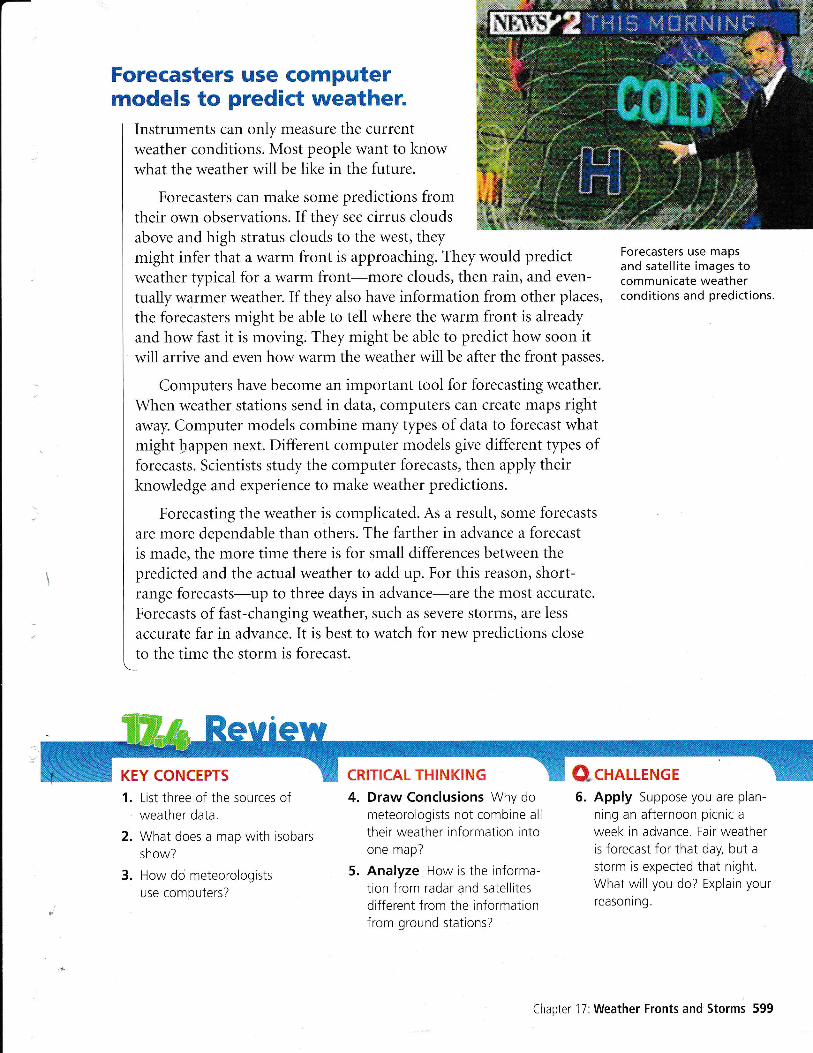
Forecasters use mapsand satellite images tocommunicate weatherconditions and predictions.
KEY CONCEPTS CRITICAL THINKING
1. List three of the sources ofweather data.
2. What does a map with isobars
show?
3. How do meteorologists
use computers?
4. Draw Conclusions Why dometeorologists not combine all
their weather informatron intoone map?
5. Analyze How is the informa-tion from radar and satellitesdifferent from the rnformationfrom ground stations?
5. Apply Suppose you are plan-
ning an afternoon picnic a
week in advance. Fair weatheris forecast for that day, but astorm is expected that night.What will you do? Explain yourreasoning.
Chapter 17:Weather Fronts and Storms 599
Q,cHnUENGE

I
Design a qEHlffisWeather CenterOVERVIEW AND PURPOSE The accuracy of a weatherforecast depends largely on the type and quality of the data thatit is based on. ln this lab. you will use what you have learnedabout weather to
. observe and measure weather conditions
. record and analyze the weather-related data
Survey the possible sources of weather data in and around yourclassroom. You can use a thermometer to record the outside airtemperature. You can observe cloud types and the amount ofcloud cover from a window or doorway. You can also observeprecrpitation and notice if it is heavy or light. lf there is a flag inview, use it to find the wind direction and to estimate wind speed.
Assemble or make tools for your observations" You may want tomake a reference chart with pictures of different cloud types orother information. Decide if you wish to use homemade weatherinstruments. You may have made a barometer, a psychrometer,and a rain gauge already. lf not, see the instructions on pages541,560, and 563. You may also wish to do research to learnhow to make or use other weather instruments.
Make an initial set of observations.Write down the date and time in yourScience Notebook. Record the readingsfrom the thermometer andother instruments.
ir .i
Q erocedure

5
Decide how to record your observations of theclouds, the wind, and any precipitation. Organizeyour notes to make it easy for you to record laterobservations in a consistent way.
Create a chart with a row for each type of obser-vation you are making. You might darken frac-
tions of circles to record amounts of cloud cover,
as in the station symbols on page 596. Make
sure each row has a heading and enough roomfor numbers, words, or sketches. lnclude a rowfor notes that do not belong in the data rows.
Record your observations every day at the same
time. Try to make the observations exactly thesame way each time. lf you have to redraw your
chart, copy the information carefully.
2. COMPARE AND C0NTRAST Look atyour graphs for patterns in your data. Some
aspects of weather change at the same timebecause they are related to each other. Did
one type of change occur before a differenttype of change? lf so, this pattern may helpyou predict weather.
rMt l-Q "S:xlv{:.- "." *.*---*rff[S
1. INTERPRET Did a front pass through your
area during the period you observed? Whatobservations helped you answer this question?
2. EVATUATE Why was it necessary toobserve at the same time each day?
3. APPLY lf you predicted that each day's
weather would be repeated the next day,
how often would you be right?
---_-__-_-__-1
_0 obr.rlr. "rd jrnalvze i,[,55" 'i!
1. GRAPH Graph the data you collected thatrepresent measurable quantities. Use graphs
that are appropriate to your data. Often a
simple Iine graph will work. Choose an
appropriate scale and interval based on therange of your data. Make the x-axis of eachgraph the same so that you can compare thedifferent types of data easily.
Q lruvrsilGATE Further
CHALLENGE Locate a newspaper weatherpage for the period during which you weremaking your weather observations. How do theweather data reported for your area comparewith your measurements? How do you accountfor any differences you notice in the data?
-....,*
FG
''E)
qi,
'u)
,$.rs
e -'e;
't '\-' - rr,1
*r rS:r*xg: : i,-;rl{,r;t iio ai*ra!,:iifr.., !
$
a Weather Center
DailY Weather Chart
ilrecipitation (cm)
Chapter 17:Weather Fronts and Storms 501
thq ffiilS ideaTlre intaraction of air mafisesin waather.
{aus6s changescLASSZONE.COM
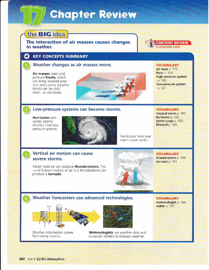
0) Weather changes as air masses move.v VOCABULARYair mass p. 575front p. 578high-pressure systemp.580
low-pressure systemp 581
Air masses meet andproduce fronts, whichcan bring lowered pres-sure and stormy weather.Fronts can be cold,warm, or stationary.
,aCffi"lir
ffi Low-pressure systems can become storms. VOCABULARYtropical storm p. 583hurricane p. 583storm surge p. 585blizzard p 586
Hurricanes andwinter stormsdevelop from low-pressure systems.
Hurricanes form overwarm ocean water.
Vertieal air motion {an causeSevere storms.
Rising moist air can produce thunderstorms. Theup-and-down motion of air in a thunderstorm canproduce a tornado.
ffi1 Weather forecasters use advanced technotogies.':r,+;!ty'
VOCABULARYmeteorologist p
isobar p. 597
Weather informaiion comesfrom many sources.
Meteorologists use weather data andcomputer models to forecast weather.
602 Unit 4: Earth's Atmosphere
!r+i];i:;ifi:;i;;:;
tI+:xlii:::r[ :]t+1:i
:: :ii:i!:!i::l:ir r:!i: :i :rit :i
Describe each term below, using the relatedterm as part of the description.
'Ibrm Related'Ibrm Description
EXAMPLEhurricane low-pressure
systema low-pressuresystem in thetropics with windsat least 120 km/h
1. front arr mass
2. low-pressuresystem
low-pressurecenter
3. storm surge hurricane
4. tropical storm low-pressuresystem
5. air mass humidity
6. thunderstorm convection
T.tornado thunderstorm
S.blizzard low-pressuresystem
Multiple Choice Choose the letter of thebest answer.
9. What qualities are nearly the same at differentlocations in a single air mass?
a. temperature and pressure
b. temperature and humidity
c. air pressure and wrnd speed
d. air pressure and humidity
10. Which is the name for an air mass that formsover the ocean near the equator?
a. maritime tropical
b. maritime polar
c. continental tropical
d. continental polar
11. A mbteorologist is a scientist who
a. predicts meteor showers
b. studies maps
c. studies the weather
d. changes the weather
12. An isobar shows locations with the same
a. temperature
b. rainfall
c. air pressure
d. wind speed
13. Which is produced when a warm air masspushes a colder air mass?
a. a stationary front c. a warm front
b. a cold front d. a thunderstorm
14. Which can be measured in inches of mercury?
a. air pressure c. hail
b. temperqture d. lightning
15. Which source provides measurements for justone location?
a. ground station c. weather balloon
b. radar station d. satellite
16. Compared with warm fronts, cold fronts are
a. faster moving c. more cloudy
b. less dense d. less steep
17. Whichstatement is usually true ofhigh-pressure systems in North Amerrca?
a. They bring fair weather.
b. They change quickly.
c. The air in them is cold and dense.
d. The air in them moves counterclockwise.
18. Thunderstorms often begin with the rising ofa. cool, dry air c. warm, dry air
b. cool, humid air d. warm. humid air
19. What is the relationship between lightningand thunder?
a. They have separate causes.
b. They have the same cause.
c. Lightning causes thunder.
d. Thunder causes Iightning.
Short Answer Write a short answer toeach question.
20. Why are hurricanes in the eastern UnitedStates more likely in autumn than in spring?
21. What causes lake-effect snow?
22. ln what four ways can thunderstormsbe dangerous?
Chapter 17:Weather Fronts and Storms 503
Reviewing Vocabulary

Use this weather map to answer the next sixquestions. The numbers under each city nameare the highest and the lowest temperaturefor the day in degrees Fahrenheit.
23. INFER Name and describe the air mass that has
moved south to Omaha from Canada.
24. IDENIIFY EFFECTS How are two low-pressuresystems affecting the weather near Boston?
25. PREDICT Explain whether Washington, D.C., orOrlando is more likely to have a big change inweather in the next two days.
26. COMPAREAND CONIRAST Explain the differencein temperature between Oklahoma City andLittle Rock.
27. PREDICI How will the weather in Little Rockchange in the next day or two?
28. APPLY Does this map indicate that it is
hurricane season? Explain your reasoning.
CONNECT Describe todays weather and explainwhat fronts and pressure systems might beinfluencing it.
COMPAREAND CONTRAST Use a Venn diagramto compare images from visible light andinfrared radiation.
PREDICT For each set of conditions listed in thechart, write a weather prediction.
COMPARE How is the air motion in the eye o{a hurricane similar to the air motion at a high-pressure center?
EVALUATE Which type of storm is mostdangerous? Explain your reasoning.
t1're BIG idea41. APPTY Look again at the photograph on pages
512-573. Now that you have finished thechapter, how would you change yourresponse to the question on the photooraph?
42. SEQUENCE Draw a storyboard with at least foursketches to show how cool, sunny weathermight change into warm, rainy weather.
I
[::ultlT pnsJEeTs ,
I
I Checkyour schedule for your unit project. HowI are you doinq? Be sure that you have placed data
I or notes from your research in your project foider.\_
T,lll* +**
lri+:
S1. l.{,&iJ '
J*j;: + ,
. tittle Rock A, -*,.,6OIZA G &,,, .r*i.::!irithrilr
4r-
ri:J:
Orlandoat 73154
?0*r,r,a*:.- i. it5
Conditions Prediction
31. A cold front is moving into anarea thal has warm, moist air
32. A warm front is moving into anarea that has cold, dense air
33. A cool sea breeze is blowinginland, causing warm, humid airto rise.
34. Air pressure is faliing andthe temperature is rising.
35. Air pressure is increasing andthe temperature is steady.
36. A thunderstorm is developingspinning winds at its center
37. A low-pressure center is overthe Atlantic Ocean where thewater temperature is above270C (81"D.
38. Cold air is pushing warm airwhere the air is 2"C (36"F)and the ground is -3"C (27"fl.
504 Unit 4: Earth's Atmosphere
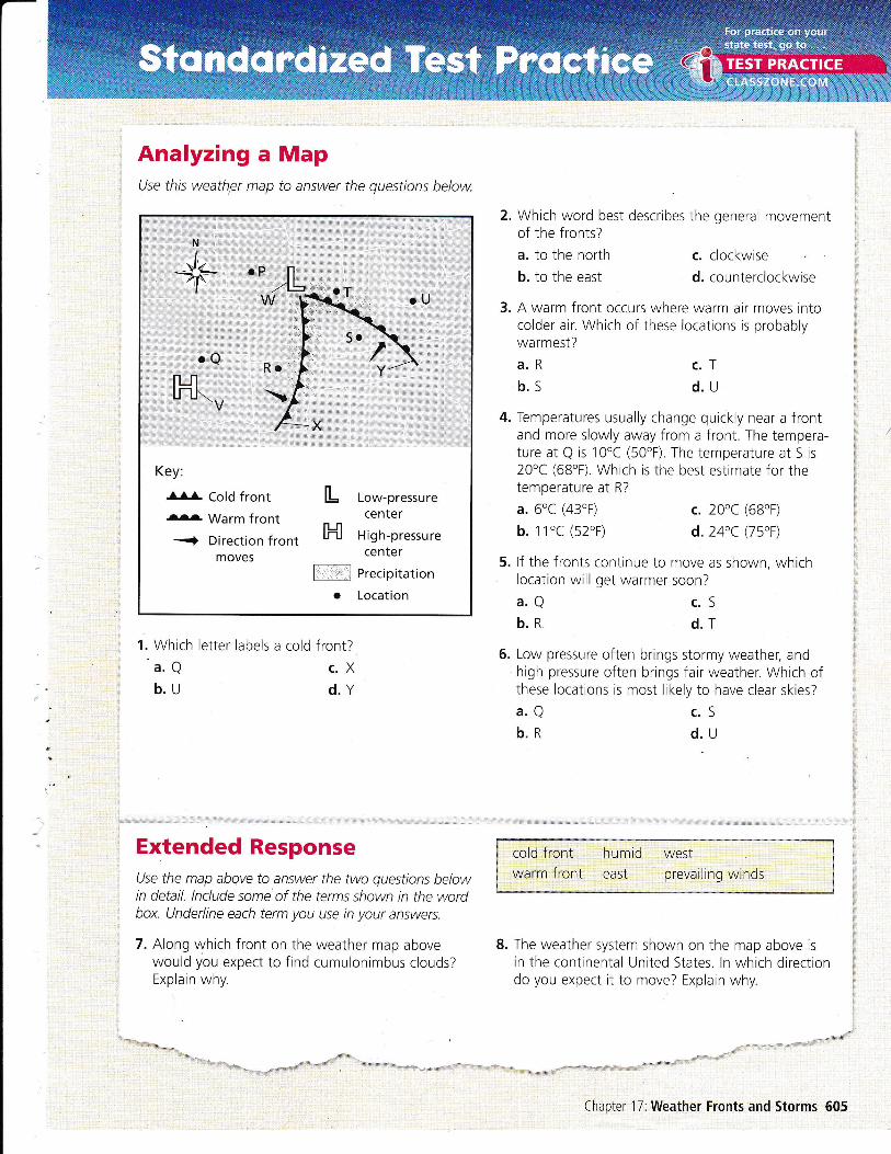
Analyzing aUse this weath,er map
Mapto answer the questions below.
2. Which word best describes the general movementof the fronts?
a. to the north
b. to the east
3. A warm front occurs where warm air moves intocolder air. Which of these locations is probablywarmest?
a.Rb.s
4. Temperatures usually change quickly near a frontand more slowly away from a front. The tempera-ture at Q is 10'C (50"F). The temperature at S is20"C (68'F). Which is the best estimate for thetemperature at R?
a. 6"C (43'F)
b. 1 1'C (52'F)
5. lf the fronts continue to move as shown, whichlocation will get warmer soon?
a.Qb.R
6. Low pressure often brings stormy weather, andhigh pressure often brings fair weather. Which ofthese locatrons is most likely to have clear skies?
c. clockwise
d. counterclockwise
c.Td.u
c. 20"C (68"F)
d.24'C (75't)
c.Sd.T
1. Which letter labels
a.Qb.u
a cold front?
c.Xd.Y
a.Qb.R
c.Sd.u
Extended ResponseUse the map above to answer the two questions belowin detail. lnclude some of the terms shown in the wordbox. Underline each term you use in your answers.
7. Along which front on the weather map abovewould you expect to find cumulonimbus clouds?Explain why.
cold front humid westwarm front east prevailing winds
8. The weather system shown on the map above is
in the continental United States. ln which directiondo you expect it to move? Explain why.
Key:
-AlL Cold front....... Warm front
3 Direction frontmoves
L Low-pressurecenter
F{ High-pressurecenter
N, Precipitation
o Location
Chapter 17:Weather Fronts and Storms 605
'Rttt..,,,',.}ti
Related Documents