J Geod (2011) 85:133–150 DOI 10.1007/s00190-010-0422-2 ORIGINAL ARTICLE The AUSGeoid09 model of the Australian Height Datum W. E. Featherstone · J. F. Kirby · C. Hirt · M. S. Filmer · S. J. Claessens · N. J. Brown · G. Hu · G. M. Johnston Received: 7 June 2010 / Accepted: 15 October 2010 / Published online: 19 November 2010 © The Author(s) 2010. This article is published with open access at Springerlink.com Abstract AUSGeoid09 is the new Australia-wide gravi- metric quasigeoid model that has been a posteriori fitted to the Australian Height Datum (AHD) so as to provide a product that is practically useful for the more direct deter- mination of AHD heights from Global Navigation Satel- lite Systems (GNSS). This approach is necessary because the AHD is predominantly a third-order vertical datum that contains a ∼1 m north-south tilt and ∼0.5 m regional distor- tions with respect to the quasigeoid, meaning that GNSS- gravimetric-quasigeoid and AHD heights are inconsistent. Because the AHD remains the official vertical datum in W. E. Featherstone (B ) · J. F. Kirby · C. Hirt · M. S. Filmer · S. J. Claessens Western Australian Centre for Geodesy, and The Institute for Geoscience Research, Curtin University of Technology, GPO Box U1987, Perth, WA 6845, Australia e-mail: [email protected] J. F. Kirby e-mail: [email protected] C. Hirt e-mail: [email protected] M. S. Filmer e-mail: [email protected] S. J. Claessens e-mail: [email protected] N. J. Brown · G. Hu · G. M. Johnston National Geospatial and Reference Systems Project, Geospatial and Earth Monitoring Division, Geoscience Australia, GPO Box 378, Canberra, ACT 2601, Australia e-mail: [email protected] G. Hu e-mail: [email protected] G. M. Johnston e-mail: [email protected] Australia, it is necessary to provide GNSS users with effective means of recovering AHD heights. The gravi- metric component of the quasigeoid model was computed using a hybrid of the remove-compute-restore technique with a degree-40 deterministically modified kernel over a one-degree spherical cap, which is superior to the remove- compute-restore technique alone in Australia (with or without a cap). This is because the modified kernel and cap com- bine to filter long-wavelength errors from the terrestrial gravity anomalies. The zero-tide EGM2008 global gravi- tational model to degree 2,190 was used as the reference field. Other input data are ∼1.4 million land gravity anom- alies from Geoscience Australia, 1 × 1 DNSC2008GRA altimeter-derived gravity anomalies offshore, the 9 × 9 GEODATA-DEM9S Australian digital elevation model, and a readjustment of Australian National Levelling Network (ANLN) constrained to the CARS2006 mean dynamic ocean topography model. To determine the numerical integration parameters for the modified kernel, the gravimetric com- ponent of AUSGeoid09 was compared with 911 GNSS- observed ellipsoidal heights at benchmarks. The standard deviation of fit to the GNSS-AHD heights is ±222 mm, which dropped to ±134 mm for the readjusted GNSS- ANLN heights showing that careful consideration now needs to be given to the quality of the levelling data used to assess gravimetric quasigeoid models. The publicly released version of AUSGeoid09 also includes a geometric com- ponent that models the difference between the gravimet- ric quasigeoid and the zero surface of the AHD at 6,794 benchmarks. This a posteriori fitting used least-squares collocation (LSC) in cross-validation mode to determine a correlation length of 75 km for the analytical covariance func- tion, whereas the noise was taken from the estimated stan- dard deviation of the GNSS ellipsoidal heights. After this LSC surface fitting, the standard deviation of fit reduced to 123

Welcome message from author
This document is posted to help you gain knowledge. Please leave a comment to let me know what you think about it! Share it to your friends and learn new things together.
Transcript
J Geod (2011) 85:133–150DOI 10.1007/s00190-010-0422-2
ORIGINAL ARTICLE
The AUSGeoid09 model of the Australian Height Datum
W. E. Featherstone · J. F. Kirby · C. Hirt ·M. S. Filmer · S. J. Claessens · N. J. Brown ·G. Hu · G. M. Johnston
Received: 7 June 2010 / Accepted: 15 October 2010 / Published online: 19 November 2010© The Author(s) 2010. This article is published with open access at Springerlink.com
Abstract AUSGeoid09 is the new Australia-wide gravi-metric quasigeoid model that has been a posteriori fittedto the Australian Height Datum (AHD) so as to provide aproduct that is practically useful for the more direct deter-mination of AHD heights from Global Navigation Satel-lite Systems (GNSS). This approach is necessary becausethe AHD is predominantly a third-order vertical datum thatcontains a ∼1 m north-south tilt and ∼0.5 m regional distor-tions with respect to the quasigeoid, meaning that GNSS-gravimetric-quasigeoid and AHD heights are inconsistent.Because the AHD remains the official vertical datum in
W. E. Featherstone (B) · J. F. Kirby · C. Hirt · M. S. Filmer ·S. J. ClaessensWestern Australian Centre for Geodesy, and The Institutefor Geoscience Research, Curtin University of Technology,GPO Box U1987, Perth, WA 6845, Australiae-mail: [email protected]
J. F. Kirbye-mail: [email protected]
C. Hirte-mail: [email protected]
M. S. Filmere-mail: [email protected]
S. J. Claessense-mail: [email protected]
N. J. Brown · G. Hu · G. M. JohnstonNational Geospatial and Reference Systems Project,Geospatial and Earth Monitoring Division, Geoscience Australia,GPO Box 378, Canberra, ACT 2601, Australiae-mail: [email protected]
G. Hue-mail: [email protected]
G. M. Johnstone-mail: [email protected]
Australia, it is necessary to provide GNSS users witheffective means of recovering AHD heights. The gravi-metric component of the quasigeoid model was computedusing a hybrid of the remove-compute-restore techniquewith a degree-40 deterministically modified kernel over aone-degree spherical cap, which is superior to the remove-compute-restore technique alone in Australia (with or withouta cap). This is because the modified kernel and cap com-bine to filter long-wavelength errors from the terrestrialgravity anomalies. The zero-tide EGM2008 global gravi-tational model to degree 2,190 was used as the referencefield. Other input data are ∼1.4 million land gravity anom-alies from Geoscience Australia, 1′ × 1′ DNSC2008GRAaltimeter-derived gravity anomalies offshore, the 9′′ × 9′′GEODATA-DEM9S Australian digital elevation model, anda readjustment of Australian National Levelling Network(ANLN) constrained to the CARS2006 mean dynamic oceantopography model. To determine the numerical integrationparameters for the modified kernel, the gravimetric com-ponent of AUSGeoid09 was compared with 911 GNSS-observed ellipsoidal heights at benchmarks. The standarddeviation of fit to the GNSS-AHD heights is ±222 mm,which dropped to ±134 mm for the readjusted GNSS-ANLN heights showing that careful consideration now needsto be given to the quality of the levelling data used toassess gravimetric quasigeoid models. The publicly releasedversion of AUSGeoid09 also includes a geometric com-ponent that models the difference between the gravimet-ric quasigeoid and the zero surface of the AHD at 6,794benchmarks. This a posteriori fitting used least-squarescollocation (LSC) in cross-validation mode to determine acorrelation length of 75 km for the analytical covariance func-tion, whereas the noise was taken from the estimated stan-dard deviation of the GNSS ellipsoidal heights. After thisLSC surface fitting, the standard deviation of fit reduced to
123
134 W. E. Featherstone et al.
±30 mm, one-third of which is attributable to the uncertaintyin the GNSS ellipsoidal heights.
Keywords Regional quasigeoid modelling ·Vertical datums · Heights · EGM2008 · Australia
1 Motivation
AUSGeoid98 (Featherstone et al. 2001) has served Austra-lia reasonably well for over a decade, principally for thedetermination of Australian Height Datum (AHD; Roelseet al. 1971) heights from GNSS (Global Navigation Satel-lite Systems) surveys (e.g., Featherstone 2008), but also forthe reduction of terrestrial geodetic-surveying data to theGeocentric Datum of Australia 1994 (GDA94) (Featherstone1997; Featherstone and Rüeger 2000). It has also foundapplications in geology (Miranda et al. 2008), environmentalgeoscience (McLaren and Wallace 2010) and physical ocean-ography (Deng et al. 2009). Since 1998, several new data-sets have become available, principally from the GravityRecovery and Climate Experiment (GRACE; Tapley et al.2004) and the EGM2008 global gravitational model (Pavliset al. 2006), making it appropriate for the computation ofa new AUSGeoid model. Another motivation is our better
understanding of the many deficiencies in the AHD (e.g.,Featherstone 2002, 2004, 2006; Featherstone and Filmer2008; Filmer and Featherstone 2009), making it necessaryto now model the surface of zero elevation of the AHDso as to provide a more useful ‘product’ for GNSS users(Featherstone 1998).
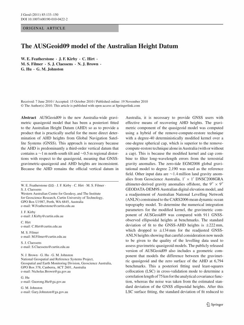
However, the high spatial resolution (∼8 km overAustralia) and good quality of EGM2008 in Australia(Claessens et al. 2009) has set new challenges for regionalgravimetric geoid and quasigeoid determination becausethe residual component is small (shown later). Before-hand, EGM2008 has revealed previously known and someunknown problems with AUSGeoid98 (Fig. 1). The stripedpatterns offshore, some >0.5 m in magnitude, are due toship-track gravity data that had not been crossover adjusted(cf. Featherstone 2009), although the metadata available tothe AUSGeoid98 Development Team indicated that theyhad been. Near Perth (∼116◦E,∼32◦S) for instance, off-sets among ship tracks of ∼40 mGal also distorted AUS-Geoid98 onshore. At that time, it was incorrectly attributedto the extremely steep quasigeoid gradient of ∼100 mm/ kmassociated with the mass-density contrast across the DarlingFault (Lambeck 1987; Darbeheshti and Featherstone 2009),but it was later found to be due to erroneous ship-track data(Claessens et al. 2001; Kirby 2003; Featherstone 2009). As
Fig. 1 Differences (m)between EGM2008 andAUSGeoid98 (Lambertprojection)
123
The AUSGeoid09 model 135
an interim solution, a small patch was applied to the releasedversion of AUSGeoid98, where the gravimetric model wasfitted to 99 GPS-AHD points using least-squares colloca-tion (LSC) over the Perth metropolitan region (Featherstone2000). Anecdotal evidence from Australian State and Terri-tory geodetic agencies indicates that similar problems havebeen encountered in a few other coastal zones (cf. Fig. 1),but no patches were applied in these regions.
Figure 1 also shows long-wavelength differences of∼0.2 m in magnitude on land and in marine areas wherethey are not swamped by the erroneous ship-track data.These are due to the use of GRACE data in EGM2008,whereas AUSGeoid98 was based on the pre-GRACE EGM96model (Lemoine et al. 1998). Similar patterns are seen in anexperimental GRACE-augmented version of AUSGeoid98(Featherstone 2007). The ∼1 m differences in and around theGulf of Carpentaria (centred at ∼140◦E,∼15◦S in Fig. 1) aremore enigmatic. Tregoning et al. (2008) use GRACE data toidentify a non-tidal variation in sea surface height in thisregion, which will contaminate satellite-altimeter-derivedgravity anomalies and a quasigeoid model based on them (cf.Fig. 1). At present, it is not possible to isolate or quantify thiseffect because of the lack of decent control data in this region,so it is left for later study. In this regard, we recommendthat producers of GRACE gravity field models and satellite-altimeter-derived gravity anomalies also invest some effortin the Gulf of Carpentaria region to resolve this enigma.
As an aside on terminology, AUSGeoid98 was a geoidmodel, but Australia is more suited to the use of a quasi-geoid model because the AHD uses a normal-orthometricheight system (e.g., Featherstone and Kuhn 2006). Since thenormal-orthometric height system used in the AHD (Roelseet al. 1971) does not use any gravity observations, it istheoretically and practically inconsistent with a quasige-oid model, with the largest differences between normal andnormal-orthometric heights reaching ∼0.2 m in the Austra-lian Alps (Filmer et al. 2010). Although the ∼1 m north-south tilt (Featherstone 2004, 2006) and ∼0.5 m regionaldistortions (Featherstone and Filmer 2008; Filmer andFeatherstone 2009) in the AHD with respect to the quasigeoidare the main drivers for the need to fit the gravimetric quas-igeoid to the AHD, this is an additional consideration whenattempting to make AUSGeoid09 more compatible with theAHD. Finally, neither the AHD nor the quasigeoid is an equi-potential surface of the Earth’s gravity field, so cannot be usedto describe fluid flow exactly.
Yet another motivation for AUSGeoid09 is the increaseduse of GNSS for absolute rather than relative height determi-nation (cf. Featherstone 2001), where the quasigeoid height(aka height anomaly) is subtracted from the GNSS-derivedellipsoidal height to yield an AHD height at a single point.Previously, quasi/geoid height differences were applied overGNSS baselines (i.e., to ellipsoidal height differences) to
determine AHD height differences (Kearsley 1988a,b), i.e.,relatively so that correlated errors would cancel. This meantthat, for a while, deficiencies in AUSGeoid98 went largelyunnoticed. Nowadays, GNSS approaches, such as precisepoint positioning (PPP; Zumberge et al. 1997) or onlinepost-processing services, such as AUSPOS (http://www.ga.gov.au/geodesy/sgc/wwwgps/), mean that only one GNSSreceiver need be used; hence, a trend towards height trans-formations in the absolute sense (e.g., Featherstone andDent 2002). This means that correlated errors no longercancel as much, and AUSGeoid98 users have encountereddiscrepancies of>1 m in some extreme cases between GNSS-derived and published AHD heights. This has made it neces-sary to apply post-survey adjustments to the GNSS-derivedAHD heights (e.g., Featherstone et al. 1998a), which is par-ticularly inconvenient for real-time GNSS applications (e.g.,Featherstone and Stewart 2001).
As an interim solution (i.e., until the AHD can beredefined or some other reference surface adopted for allheights in Australia), it is meanwhile pragmatic to distort thegravimetric-only quasigeoid to better model the surfaceof zero elevation of the AHD (cf. Featherstone 1998),and we have already conducted experiments in this regard(Featherstone 2000; Soltanpour et al. 2006; Featherstone andSproule 2006; Darbeheshti and Featherstone 2010). In muchof the geodetic literature, this has been called a ‘correction’or ‘corrector’ surface,1 but which is a misnomer becausethe gravimetric quasi/geoid is not being corrected at all; it isbeing distorted to fit a vertical datum that also contains errors.Although this approach does give a practically useful prod-uct for the more direct transformation of GNSS heights tothe AHD, it does not necessarily provide an improved modelof the classical quasigeoid. Moreover, it does not mean thatthe problems with the AHD have been resolved; they havejust been masked for the time being. This important subtletyseems to have been ignored in the majority of literature onthis a posteriori fitting approach.
This paper describes the computation of AUSGeoid09as a model of the surface of zero elevation of the AHD,focussing partly on the new challenges (and benefits) thatEGM2008 has set for regional quasigeoid modelling. Asinput data, AUSGeoid09 uses EGM2008 to degree 2,190as the reference field, DNSC2008GRA altimeter-derivedgravity anomalies offshore (Andersen et al. 2010) becausethe Australian ship-track data are unreliable (Featherstone2009), recomputed land gravity anomalies (Hackney andFeatherstone 2003) from Geoscience Australia’s nationalgravity database (Murray 1997), a 9′′×9′′ grid of gravimetricterrain corrections (cf. Kirby and Featherstone 2002), spirit-levelled heights from the Australian National Levelling
1 An exception is the US National Geodetic Survey, which uses theterm ‘conversion’ surface (cf. Smith and Roman 2001).
123
136 W. E. Featherstone et al.
Fig. 2 Coverage of the July2009 release of GeoscienceAustralia’s land gravity database
Network (ANLN), mean dynamic ocean topography esti-mates at 32 tide-gauges from the CARS2006 climatologi-cal model (Ridgway et al. 2002), and around 1,000 GNSS-observed ellipsoidal heights at benchmarks. One key differ-ence in the Australian case is that EGM2008 uses the 5′ × 5′DTM2006 elevation model (Pavlis et al. 2006), whereasAUSGeoid09 uses the 9′′ × 9′′ GEODATA-DEM9S eleva-tion model (Hutchinson et al. 2008). AUSGeoid09 is pro-vided at a 1′ × 1′ grid resolution over the area 108◦E ≤λ ≤ 160◦E, 8◦S ≤ ϕ ≤ 46◦S, which reduces interpolationerrors for users, but has to be balanced against the file-sizeof ∼236 Mb (>7 million points).
2 Data pre-processing
2.1 EGM2008
The fully normalised zero-tide spherical harmonic coeffi-cients of EGM2008, to degree 2,190, were used as thereference field for AUSGeoid09. The synthesis used aslightly modified version of theharmonic_synth.f soft-ware (http://earth-info.nga.mil/GandG/wgs84/gravitymod/egm2008/index.html), adapted to run on our Sun UNIXworkstations and to make the outputs compatible withour data formats. All values were computed relative toGRS80 (Moritz 1980) so as to be compatible with theGDA94, and including a correct computation of the zero-degree term rather than via the erroneous treatment inKirby and Featherstone (1997). Point quasigeoid heights
were computed on a 1′ × 1′ grid over the area 108◦E ≤λ ≤ 160◦E, 8◦S ≤ ϕ ≤ 46◦S, whereas the ellipsoidalapproximation option in harmonic_synth.f was usedto approximate areal means by point gravity anomalies foreach 1′ × 1′ grid cell.
2.2 GA land gravity data
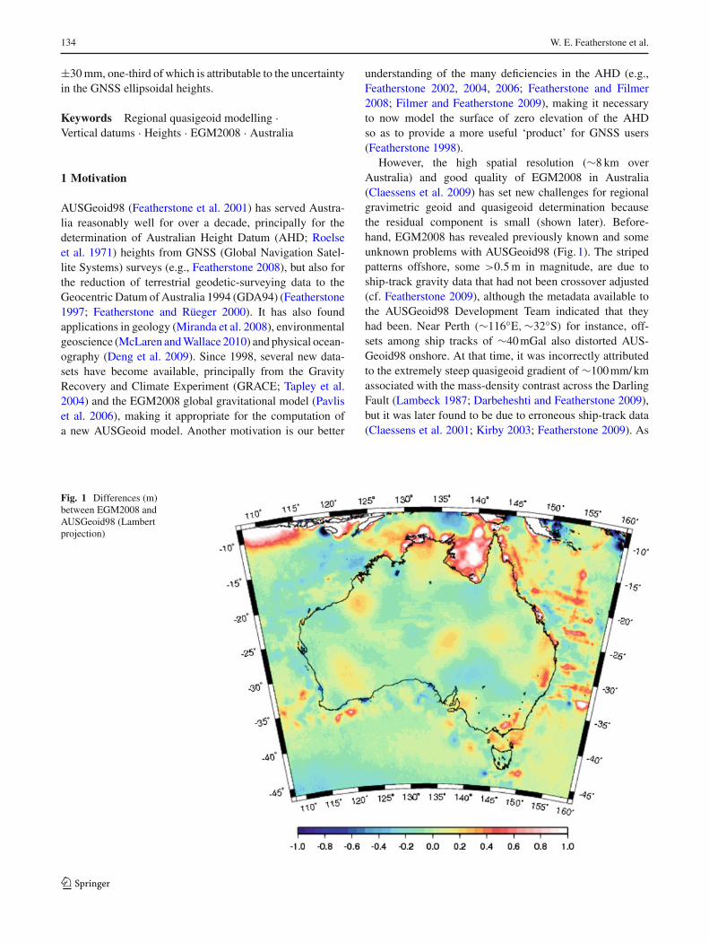
The gravimetric component of AUSGeoid09 uses the July2009 land gravity data release from Geoscience Australia(GA), which was downloaded via GADDS (http://www.gadds.ga.gov.au/). The GA gravity database then comprised∼1.4 million observations (Fig. 2), roughly twice as manyas used in AUSGeoid98. When compared with Fig. 1 inFeatherstone et al. (2001), the dense patches in Fig. 2 herereflect the newer data collected in areas of commercialresource prospectivity or scientific interest.
Most of these newer gravity data were coordinated usingGNSS in dense grids (typically 2–4 km, but down to 50 min some areas of particular interest or of steep gravity gradi-ents), but the 7–11- km-spaced reconnaissance gravity data(Fraser et al. 1976) is still held in the GA database (palerareas in Fig. 2). Unfortunately, however, there is no docu-mentation on the GNSS reference frame used [e.g., GDA94versus the various realisations of the International TerrestrialReference Frame (ITRF)] or the quasi/geoid model used torecover the elevations of these newer gravity observations.This is a deficiency in the GA database because the prove-nance of the data cannot be scrutinised. Moreover, any errors
123
The AUSGeoid09 model 137
in the quasi/geoid model used to transform heights will prop-agate into the computed gravity anomalies.
Anecdotal evidence from some of the gravity data acqui-sition contractors suggests that a variety of quasi/geoid mod-els have been used over time. However, these are likely to bemore accurate than the heights in the reconnaissance data(∼ ±10 m; Barlow 1977), which were determined withbarometers, but could be long-wavelength in nature becauseof the clover-leaf pattern used to control barometer and gra-vimeter drift (Bellamy and Lodwick 1968). It is conceiv-able that, over time, Australia will be completely covered byGNSS-coordinated gravity surveys, thus allowing the solu-tion of the quasigeoid via a fixed boundary-value problem (cf.Kirby 2003). The short-wavelength quality of the Australiangravity anomalies appears to be generally quite good, despitethe vast areas involved and challenging conditions for field-work. Sproule et al. (2006) used LSC to reject only∼100 landgravity observations in the GA database. Unfortunately, nei-ther the raw data nor the metadata are in a format that allowsfor automated error propagation of mean gravity anomalyerror estimates. This is another deficiency in the GA gravitydatabase.
In addition, GA has adopted a new gravity datum called theAustralian Absolute Gravity Datum 2007 (AAGD07; Traceyet al. 2007), but which is not connected to the InternationalGravity Standardisation Network (IGSN71; Morelli et al.1971). Instead, it is based on Micro-g Lacoste A10 absolutegravity observations at 60 sites across Australia. The datumchange was applied by GA by subtracting 78 µGal from allgravity values in the database, which had previously beentied to the IGSN71 (Wellman et al. 1985). Since a constantgravity anomaly integrated over a spherical cap yields a con-stant quasigeoid height (cf. Featherstone and Olliver 1997),the constant bias, estimated to be <10 mm, from this differ-ent gravity datum is insignificant in relation to the facts thatthe zero-degree term in the quasigeoid is indeterminate andvertical datums are offset from one another. Finally, the tidalsystem of the GA gravity observations remains unknown (cf.Featherstone et al. 2001).
2.3 Computation of mean land gravity anomalies
Determination of the quasigeoid by discretized numericalintegration requires mean gravity anomalies on the topogra-phy, as per Molodensky’s theory (Molodensky et al. 1962;Heiskanen and Moritz 1967). Because land gravity obser-vations are often sampled irregularly based on the ease offield access, care needs to be exercised to determine rep-resentative mean gravity anomalies. Different approacheshave been used in different parts of the world (e.g., Janakand Vanícek 2005), but the Australian situation is some-what unique. As an ancient continent, Australia is heavily
weathered with a mean topographic height of ∼270 m (Hirtet al. 2010), but it exhibits some very large
(>500 kgm−3
)
mass-density contrasts due to geology, ranging from softsediments to dense Archean cratons. For instance, gravityanomalies change by over 100 mGal over a few kilometresacross the Darling Fault in Western Australia (Darbeheshtiand Featherstone 2009).
Goos et al. (2003) and Zhang and Featherstone (2004)have shown that simple planar Bouguer gravity anomalies inAustralia are well suited to interpolation, which is fortuitousbecause this allows the computation of more representativemean gravity anomalies on the topography by reconstructionusing a high-resolution digital elevation model (Featherstoneand Kirby 2000). First, point simple planar Bouguer grav-ity anomalies were recomputed from the GA database usinggeodetic formulas (Hackney and Featherstone 2003) for all∼1.4 million land gravity observations. A constant topo-graphic mass-density of 2,670 kgm−3 was used as thereis yet no 3D topographic mass-density model of Austra-lia, and Molodensky’s theory for the computation of thequasigeoid makes no assumption about topographic mass-density.
These point simple planar Bouguer gravity anomalieswere interpolated onto the same 9′′ × 9′′ grid as the GEO-DATA-DEM9S elevation model using the GMT (Wessel andSmith 1998) “surface” algorithm, which uses a tensionedspline (Smith and Wessel 1990). Based on the recommen-dation in the GMT manual pages for potential field data,a tension factor of T = 0.25 was used. In this regard, thereremains some conjecture as to whether a 2D interpolationtechnique should be applied to what is effectively a 3D field(e.g., Forsberg and Tscherning 1981; Vanícek et al. 2004).This remains for future study, but based on the comparisonsbetween interpolated and observed Bouguer anomalies (cf.Sproule et al. 2006; Goos et al. 2003; Zhang and Featherstone2004), this 2D interpolation approach appears sufficient inAustralia. Spherical Bouguer anomalies and their associatedterrain corrections were not used because they are similar tothe planar Bouguer anomalies (Kuhn et al. 2009) so offer noapparent advantage during this gridding stage.
Molodensky free-air anomalies (i.e., on the topography)were ‘reconstructed’ from the 9′′ × 9′′ grid of interpolatedBouguer anomalies by adding the simple planar Bouguerplate term computed from the GEODATA-DEM9S eleva-tion model. The 9′′ × 9′′ grid of planar gravimetric terraincorrections, used to approximate the Molodensky G1 term(cf. Moritz 1968; Sideris 1990; Val’ko et al. 2008), werethen added to the 9′′ × 9′′ grid of reconstructed Molodenskyfree-air anomalies. This high-resolution grid was generalisedusing area-weighted means to give a 1′ × 1′ grid of meanMolodensky gravity anomalies on the topography. The fulljustification for this approach is detailed in Featherstone andKirby (2000).
123
138 W. E. Featherstone et al.
2.4 DNSC2008GRA marine gravity anomalies
Given that ship-track gravity data around Australia are gen-erally unreliable, and most cannot be crossover adjustedbecause of ill-conditioning (Featherstone 2009), altimeter-derived gravity anomalies had to be used exclusively inAUSGeoid09. DNSC2008GRA (Andersen et al. 2010) waschosen over Sandwell and Smith v18.1 (Sandwell and Smith2009) based on a comparison of the two with a limited amountof test data in the Australian coastal zone (Claessens 2010).This showed that EGM2008GRA agrees more closely withsubsets of reliable shipborne and airborne gravity data thanSandwell and Smith v18.1 in two test areas close (<50 km) tothe Australian coast. In addition, the EGM2008 DevelopmentTeam took DNSC2008GRA to be “better” within ∼195 kmof the coasts (Pavlis et al. 2006). As such, DNSC2008GRAwas chosen in preference because AUSGeoid09 will have agreater usage near the coasts of Australia, where the majorityof the population resides.
2.5 Merging land and marine data: the coastal zone problem
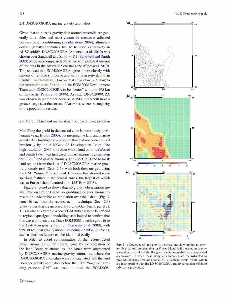
Modelling the geoid in the coastal zone is notoriously prob-lematic (e.g., Hipkin 2000), but merging the land and marinegravity data highlighted a problem that had not been noticedpreviously by the AUSGeoid98 Development Team. Thehigh-resolution GMT shoreline with island options (Wesseland Smith 1996) was first used to mask marine regions fromthe 1′ × 1′ land gravity anomaly grid (Sect. 2.3) and to maskland regions from the 1′ × 1′ DNSC2008GRA marine grav-ity anomaly grid (Sect. 2.4), with both then merged usingthe GMT “grdmath” command. However, this showed somespurious features in the coastal zones, the largest of whichwas at Fraser Island (centred at ∼ 153◦E,∼ 25◦S).
Figure 3 (panel a) shows that no gravity observations areavailable on Fraser Island, so gridding Bouguer anomaliesresults in undesirable extrapolation over this island (Fig. 3,panel b) such that the reconstruction technique (Sect. 2.3)gives values that are incorrect by >20 mGal (Fig. 3, panel c).This is also an example where EGM2008 has been beneficialto regional quasigeoid modelling, as it helped to confirm thatthis was a problem area. Since EGM2008 is such a good fit tothe Australian gravity field (cf. Claessens et al. 2009), with95% of residual gravity anomalies being <5 mGal (Table 1),such a spurious feature can be identified easily.
In order to avoid contamination of the reconstructedmean anomalies in the coastal zone by extrapolation ofthe land Bouguer anomalies, the latter were augmentedby DNSC2008GRA marine gravity anomalies, where theDNSC2008GRA anomalies were concatenated with the landBouguer gravity anomalies before the GMT “surface” grid-ding process. GMT was used to mask the EGM2008-
Fig. 3 a Coverage of land gravity observations showing that no grav-ity observations are available on Fraser Island; b if these point gravityanomalies are gridded, the Bouguer gravity anomalies are extrapolatedocean-wards; c when these Bouguer anomalies are reconstructed togive Molodensky free-air anomalies, >20 mGal errors result, whichare incompatible with the DNSC2008GRA gravity anomalies offshore(Mercator projection)
123
The AUSGeoid09 model 139
Table 1 Statistics of theresidual mean gravity anomaliesused in the gravimetriccomponents of AUSGeoid98and AUSGeoid09, showing theimprovement offered byEGM2008
Units (mGal) Residual mean gravity anomaliesused for AUSGeoid98 after removalof EGM96 to degree 360 (2′ × 2′grid)
Residual mean gravity anomaliesused for AUSGeoid09 after removalof EGM2008 to degree 2,190(1′ × 1′ grid
)
No 1,781,101 7,113,600
Max 197.44 105.97
Min −282.70 −87.69
Mean −0.90 −0.09
STD ±15.01 ±2.49
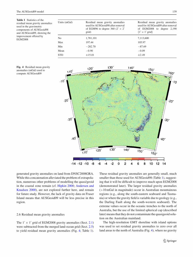
Fig. 4 Residual mean gravityanomalies (mGal) used tocompute AUSGeoid09
generated gravity anomalies on land from DNSC2008GRA.While this concatenation alleviated the problem of extrapola-tion, numerous other problems of modelling the quasi/geoidin the coastal zone remain (cf. Hipkin 2000; Andersen andKnudsen 2000), are not explored further here, and remainfor future study. However, the lack of gravity data on FraserIsland means that AUSGeoid09 will be less precise in thisregion.
2.6 Residual mean gravity anomalies
The 1′ × 1′ grid of EGM2008 gravity anomalies (Sect. 2.1)were subtracted from the merged land-ocean grid (Sect. 2.5)to yield residual mean gravity anomalies (Fig. 4; Table 1).
These residual gravity anomalies are generally small, muchsmaller than those used for AUSGeoid98 (Table 1), suggest-ing that it will be difficult to improve much upon EGM2008(demonstrated later). The larger residual gravity anomalies(>10 mGal in magnitude) occur in Australian mountainousregions (e.g., along the south-eastern seaboard and Tasma-nia) or where the gravity field is variable due to geology (e.g.,the Darling Fault along the south-western seaboard). Theextreme values occur in the oceanic trenches to the north ofAustralia, but the use of the limited spherical cap (describedlater) means that they do not contaminate the quasigeoid solu-tion on the Australian mainland.
The high-resolution GMT shoreline with island optionswas used to set residual gravity anomalies to zero over allland areas to the north of Australia (Fig. 4), where no gravity
123
140 W. E. Featherstone et al.
data were available to the AUSGeoid09 Development Team.If not done, spuriously large residual anomalies contami-nate the results because of extrapolation of the large gravitygradients associated with the subduction zone between theAustralian and Eurasian and Pacific Plates. Because no datahave been used on land in these regions, AUSGeoid09 mustbe used with caution in countries to the north of Australia.
2.7 GNSS-ANLN data
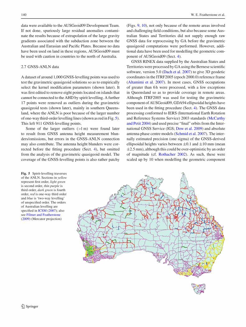
A dataset of around 1,000 GNSS-levelling points was used totest the gravimetric quasigeoid solutions so as to empiricallyselect the kernel modification parameters (shown later). Itwas first edited to remove eight points located on islands thatcannot be connected to the AHD by spirit levelling. A further17 points were removed as outliers during the gravimetricquasigeoid tests (shown later), mainly in southern Queens-land, where the ANLN is poor because of the larger numberof one-way third-order levelling lines (shown as red in Fig. 5).This left 911 GNSS-levelling points.
Some of the larger outliers (>1 m) were found laterto result from GNSS antenna height measurement blun-ders/omissions, but errors in the GNSS-ANLN connectionmay also contribute. The antenna height blunders were cor-rected before the fitting procedure (Sect. 4), but omittedfrom the analysis of the gravimetric quasigeoid model. Thecoverage of the GNSS-levelling points is also rather patchy
(Figs. 9, 10), not only because of the remote areas involvedand challenging field conditions, but also because some Aus-tralian States and Territories did not supply enough rawGNSS data for reprocessing by GA before the gravimetricquasigeoid computations were performed. However, addi-tional data have been used for modelling the geometric com-ponent of AUSGeoid09 (Sect. 4).
GNSS RINEX data supplied by the Australian States andTerritories were processed by GA using the Bernese scientificsoftware, version 5.0 (Dach et al. 2007) to give 3D geodeticcoordinates in the ITRF2005 (epoch 2000.0) reference frame(Altamimi et al. 2007). In most cases, GNSS occupationsof greater than 6 h were processed, with a few exceptionsin Queensland so as to provide coverage in remote areas.Although ITRF2005 was used for testing the gravimetriccomponent of AUSGeoid09, GDA94 ellipsoidal heights havebeen used in the fitting procedure (Sect. 4). The GNSS dataprocessing conformed to IERS (International Earth Rotationand Reference Systems Service) 2003 standards (McCarthyand Petit 2004) and used precise “final” orbits from the Inter-national GNSS Service (IGS; Dow et al. 2009) and absoluteantenna phase centre models (Schmid et al. 2007). The inter-nally estimated precision (one sigma) of the GNSS-derivedellipsoidal heights varies between ±0.1 and ±10 mm (mean±2.5 mm), although this could be over-optimistic by an orderof magnitude (cf. Rothacher 2002). As such, these werescaled up by 10 when modelling the geometric component
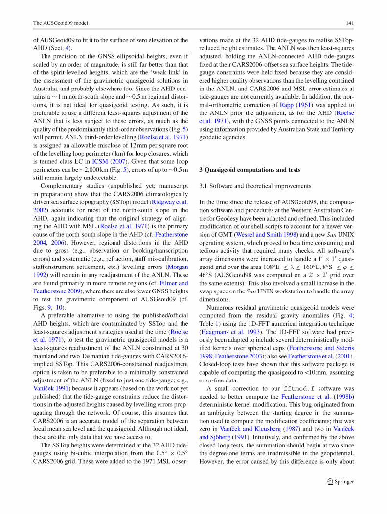
Fig. 5 Spirit-levelling traversesof the ANLN. Sections in yellowrepresent first order, light greenis second order, thin purple isthird order, dark green is fourthorder, red is one-way third orderand blue is ‘two-way levelling’of unspecified order. The ordersof Australian levelling arespecified in ICSM (2007); alsosee Filmer and Featherstone(2009) (Mercator projection)
123
The AUSGeoid09 model 141
of AUSGeoid09 to fit it to the surface of zero elevation of theAHD (Sect. 4).
The precision of the GNSS ellipsoidal heights, even ifscaled by an order of magnitude, is still far better than thatof the spirit-levelled heights, which are the ‘weak link’ inthe assessment of the gravimetric quasigeoid solutions inAustralia, and probably elsewhere too. Since the AHD con-tains a ∼1 m north-south slope and ∼0.5 m regional distor-tions, it is not ideal for quasigeoid testing. As such, it ispreferable to use a different least-squares adjustment of theANLN that is less subject to these errors, as much as thequality of the predominantly third-order observations (Fig. 5)will permit. ANLN third-order levelling (Roelse et al. 1971)is assigned an allowable misclose of 12 mm per square rootof the levelling loop perimeter ( km) for loop closures, whichis termed class LC in ICSM (2007). Given that some loopperimeters can be ∼2,000 km (Fig. 5), errors of up to ∼0.5 mstill remain largely undetectable.
Complementary studies (unpublished yet; manuscriptin preparation) show that the CARS2006 climatologicallydriven sea surface topography (SSTop) model (Ridgway et al.2002) accounts for most of the north-south slope in theAHD, again indicating that the original strategy of align-ing the AHD with MSL (Roelse et al. 1971) is the primarycause of the north-south slope in the AHD (cf. Featherstone2004, 2006). However, regional distortions in the AHDdue to gross (e.g., observation or booking/transcriptionerrors) and systematic (e.g., refraction, staff mis-calibration,staff/instrument settlement, etc.) levelling errors (Morgan1992) will remain in any readjustment of the ANLN. Theseare found primarily in more remote regions (cf. Filmer andFeatherstone 2009), where there are also fewer GNSS heightsto test the gravimetric component of AUSGeoid09 (cf.Figs. 9, 10).
A preferable alternative to using the published/officialAHD heights, which are contaminated by SSTop and theleast-squares adjustment strategies used at the time (Roelseet al. 1971), to test the gravimetric quasigeoid models is aleast-squares readjustment of the ANLN constrained at 30mainland and two Tasmanian tide-gauges with CARS2006-implied SSTop. This CARS2006-constrained readjustmentoption is taken to be preferable to a minimally constrainedadjustment of the ANLN (fixed to just one tide-gauge; e.g.,Vanícek 1991) because it appears (based on the work not yetpublished) that the tide-gauge constraints reduce the distor-tions in the adjusted heights caused by levelling errors prop-agating through the network. Of course, this assumes thatCARS2006 is an accurate model of the separation betweenlocal mean sea level and the quasigeoid. Although not ideal,these are the only data that we have access to.
The SSTop heights were determined at the 32 AHD tide-gauges using bi-cubic interpolation from the 0.5◦ × 0.5◦CARS2006 grid. These were added to the 1971 MSL obser-
vations made at the 32 AHD tide-gauges to realise SSTop-reduced height estimates. The ANLN was then least-squaresadjusted, holding the ANLN-connected AHD tide-gaugesfixed at their CARS2006-offset sea surface heights. The tide-gauge constraints were held fixed because they are consid-ered higher quality observations than the levelling containedin the ANLN, and CARS2006 and MSL error estimates attide-gauges are not currently available. In addition, the nor-mal-orthometric correction of Rapp (1961) was applied tothe ANLN prior the adjustment, as for the AHD (Roelseet al. 1971), with the GNSS points connected to the ANLNusing information provided by Australian State and Territorygeodetic agencies.
3 Quasigeoid computations and tests
3.1 Software and theoretical improvements
In the time since the release of AUSGeoid98, the computa-tion software and procedures at the Western Australian Cen-tre for Geodesy have been adapted and refined. This includedmodification of our shell scripts to account for a newer ver-sion of GMT (Wessel and Smith 1998) and a new Sun UNIXoperating system, which proved to be a time consuming andtedious activity that required many checks. All software’sarray dimensions were increased to handle a 1′ × 1′ quasi-geoid grid over the area 108◦E ≤ λ ≤ 160◦E, 8◦S ≤ ϕ ≤46◦S (AUSGeoid98 was computed on a 2′ × 2′ grid overthe same extents). This also involved a small increase in theswap space on the Sun UNIX workstation to handle the arraydimensions.
Numerous residual gravimetric quasigeoid models werecomputed from the residual gravity anomalies (Fig. 4;Table 1) using the 1D-FFT numerical integration technique(Haagmans et al. 1993). The 1D-FFT software had previ-ously been adapted to include several deterministically mod-ified kernels over spherical caps (Featherstone and Sideris1998; Featherstone 2003); also see Featherstone et al. (2001).Closed-loop tests have shown that this software package iscapable of computing the quasigeoid to <10 mm, assumingerror-free data.
A small correction to our fftmod.f software wasneeded to better compute the Featherstone et al. (1998b)deterministic kernel modification. This bug originated froman ambiguity between the starting degree in the summa-tion used to compute the modification coefficients; this waszero in Vanícek and Kleusberg (1987) and two in Vanícekand Sjöberg (1991). Intuitively, and confirmed by the aboveclosed-loop tests, the summation should begin at two sincethe degree-one terms are inadmissible in the geopotential.However, the error caused by this difference is only about
123
142 W. E. Featherstone et al.
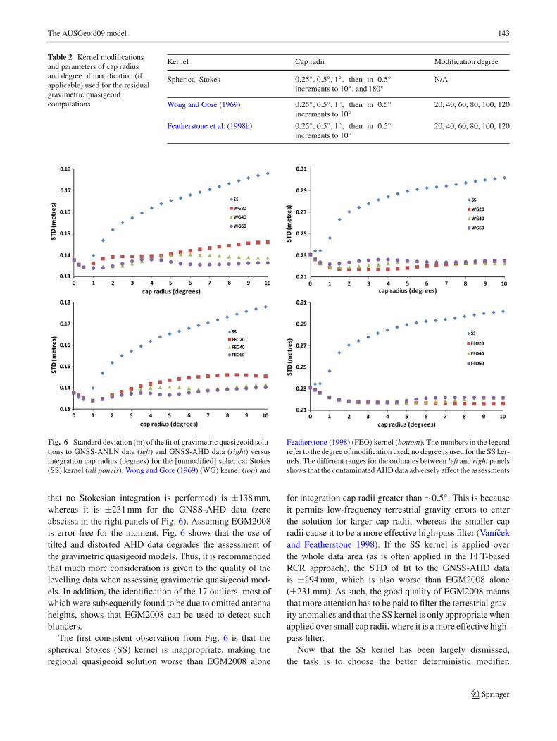
3%, which from the values in Table 3 amounts to <1 mm inthe quasigeoid height.
Explicit consideration of ellipsoidal corrections to accountfor the spherical approximation embedded in the fundamen-tal equation of physical geodesy (e.g., Heiskanen and Moritz1967) was not needed. This is because they are diminishedby calculating gravity anomalies from EGM2008 in ellipsoi-dal approximation (cf. Hipkin 2004). Rather than computingadditional ellipsoidal terms (cf. Huang et al. 2003) for thedeterministically modified kernel, the ellipsoidal correctioncan be ignored simply by using the geocentric radius to thesurface of the ellipsoid of each computation point as the ref-erence radius in Stokes’s formula (Claessens 2006).
As an additional improvement over AUSGeoid98, a 9′′ ×9′′ grid of gravimetric terrain corrections (cf. Kirby andFeatherstone 2002) has been used in AUSGeoid09. For AUS-Geoid98, it was necessary to generalise the then available9′′ ×9′′ GEODATA-DEM9S elevation model to a 27′′ ×27′′grid (Featherstone et al. 2001). Later investigations (Kirbyand Featherstone 2001) showed that this was due to errors inthe earlier DEM. These have now been corrected. Remainingfor future work is the computation of terrain corrections andMolodensky G1 terms from a digital elevation model derivedfrom the Shuttle Radar Topography Mission (SRTM).
3.2 Deterministically modified kernels and spherical caps
By way of background, there are two seemingly ‘opposing’schools of thought on the remove-compute-restore (RCR)versus the modified kernel approaches to quasigeoid deter-mination (cf. Sjöberg 2005), but we choose to use a hybridcombination of them (cf. Featherstone et al. 2001). The ben-efit of the RCR approach, especially when using EGM2008,is that the residual quantities are small (Tables 1, 3; alsosee Figs. 4, 7) so are less subject to any approximationand numerical integration errors in the residual quasige-oid computations. The benefit of the modified kernel and alimited spherical cap is that they preferentially adapt thefiltering properties of the convolution so as to reduce long-wavelength errors coming from the terrestrial data (Kears-ley 1988a; Gilliland 1994; Forsberg and Featherstone 1998;Vanícek and Featherstone 1998). Although seemingly uniqueto Australia (cf. Featherstone et al. 2001 and shown later),such a hybrid approach appears to have also been effectiveelsewhere (e.g., Omang and Forsberg 2002; Denker et al.2008).
Long-wavelength and systematic errors originating fromterrestrial gravity anomalies (e.g., Heck 1990) have plaguedregional gravimetric quasi/geoid computations for manyyears, although they have more recently been masked bya posteriori fits to GNSS levelling. Because the full reportor paper on EGM2008 has not yet been published, inference
from Pavlis (1998, 2000) has been used to assume that someform of high-pass filtering of the terrestrial gravity anomalieswas used during the computation of EGM2008. If no filteringis applied to the terrestrial gravity anomalies, especially overcontinent-sized regions, then regional quasi/geoid modelswill become contaminated by long-wavelength errors, whichis undesirable because of the good quality of the low-degreeGRACE static gravity field models. This is another challengeset by GRACE and EGM2008, where filtering of terrestrialgravity anomalies is needed for regional quasi/geoid compu-tations. In Australia, we choose to use the modified kernelto do this, but it remains for future study to investigate othermethods of filtering.
The 1′×1′ grid of residual mean gravity anomalies (Fig. 4)was 1D-FFT numerically integrated for different kernel mod-ification scenarios (Sect. 3.3) to produce a 1′ × 1′ grid ofpoint residual quasigeoid undulations that was added to the1′ ×1′ grid of point EGM2008 quasigeoid heights (Sect. 2.1)and then compared with both the GNSS-AHD and read-justed GNSS-ANLN data to determine suitable integrationparameters. These comparisons used bicubic interpolation ofabsolute, rather than relative, height differences from eachcomputed grid (cf. Featherstone 2001). The idea here isthat the readjusted ANLN data are less contaminated by thenorth-south slope and less subject to regional distortions inthe AHD, thus giving a more objective assessment of thegravimetric-only quasigeoid solution. Of course, errors inthe ANLN remain a hindrance.
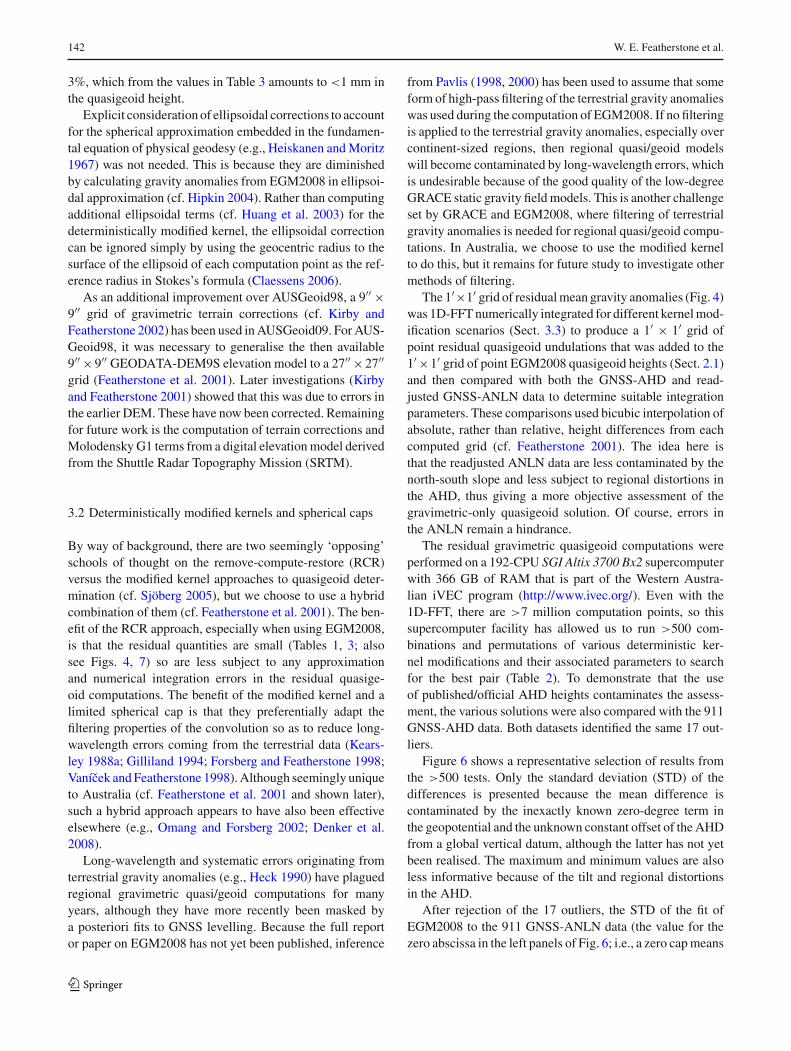
The residual gravimetric quasigeoid computations wereperformed on a 192-CPU SGI Altix 3700 Bx2 supercomputerwith 366 GB of RAM that is part of the Western Austra-lian iVEC program (http://www.ivec.org/). Even with the1D-FFT, there are >7 million computation points, so thissupercomputer facility has allowed us to run >500 com-binations and permutations of various deterministic ker-nel modifications and their associated parameters to searchfor the best pair (Table 2). To demonstrate that the useof published/official AHD heights contaminates the assess-ment, the various solutions were also compared with the 911GNSS-AHD data. Both datasets identified the same 17 out-liers.
Figure 6 shows a representative selection of results fromthe >500 tests. Only the standard deviation (STD) of thedifferences is presented because the mean difference iscontaminated by the inexactly known zero-degree term inthe geopotential and the unknown constant offset of the AHDfrom a global vertical datum, although the latter has not yetbeen realised. The maximum and minimum values are alsoless informative because of the tilt and regional distortionsin the AHD.
After rejection of the 17 outliers, the STD of the fit ofEGM2008 to the 911 GNSS-ANLN data (the value for thezero abscissa in the left panels of Fig. 6; i.e., a zero cap means
123
The AUSGeoid09 model 143
Table 2 Kernel modificationsand parameters of cap radiusand degree of modification (ifapplicable) used for the residualgravimetric quasigeoidcomputations
Kernel Cap radii Modification degree
Spherical Stokes 0.25◦, 0.5◦, 1◦, then in 0.5◦increments to 10◦, and 180◦
N/A
Wong and Gore (1969) 0.25◦, 0.5◦, 1◦, then in 0.5◦increments to 10◦
20, 40, 60, 80, 100, 120
Featherstone et al. (1998b) 0.25◦, 0.5◦, 1◦, then in 0.5◦increments to 10◦
20, 40, 60, 80, 100, 120
Fig. 6 Standard deviation (m) of the fit of gravimetric quasigeoid solu-tions to GNSS-ANLN data (left) and GNSS-AHD data (right) versusintegration cap radius (degrees) for the [unmodified] spherical Stokes(SS) kernel (all panels), Wong and Gore (1969) (WG) kernel (top) and
Featherstone (1998) (FEO) kernel (bottom). The numbers in the legendrefer to the degree of modification used; no degree is used for the SS ker-nels. The different ranges for the ordinates between left and right panelsshows that the contaminated AHD data adversely affect the assessments
that no Stokesian integration is performed) is ±138 mm,whereas it is ±231 mm for the GNSS-AHD data (zeroabscissa in the right panels of Fig. 6). Assuming EGM2008is error free for the moment, Fig. 6 shows that the use oftilted and distorted AHD data degrades the assessment ofthe gravimetric quasigeoid models. Thus, it is recommendedthat much more consideration is given to the quality of thelevelling data when assessing gravimetric quasi/geoid mod-els. In addition, the identification of the 17 outliers, most ofwhich were subsequently found to be due to omitted antennaheights, shows that EGM2008 can be used to detect suchblunders.
The first consistent observation from Fig. 6 is that thespherical Stokes (SS) kernel is inappropriate, making theregional quasigeoid solution worse than EGM2008 alone
for integration cap radii greater than ∼0.5◦. This is becauseit permits low-frequency terrestrial gravity errors to enterthe solution for larger cap radii, whereas the smaller capradii cause it to be a more effective high-pass filter (Vanícekand Featherstone 1998). If the SS kernel is applied overthe whole data area (as is often applied in the FFT-basedRCR approach), the STD of fit to the GNSS-AHD datais ±294 mm, which is also worse than EGM2008 alone(±231 mm). As such, the good quality of EGM2008 meansthat more attention has to be paid to filter the terrestrial grav-ity anomalies and that the SS kernel is only appropriate whenapplied over small cap radii, where it is a more effective high-pass filter.
Now that the SS kernel has been largely dismissed,the task is to choose the better deterministic modifier.
123
144 W. E. Featherstone et al.
Table 3 Statistics of theresidual gravimetric componentsof AUSGeoid98 andAUSGeoid09, showing theimprovement offered byEGM2008 because the residualsare smaller
Units (m) Residual AUSGeoid98 with respectto EGM96 to degree 360 (2′ × 2′grid)
Residual AUSGeoid09 withrespect to EGM2008 to degree2,190
(1′ × 1′ grid
)
No 1,781,101 7,113,600
Max 3.506 0.244
Min −11.422 −0.619
Mean −0.049 −0.005
STD 0.409 0.028
The Wong and Gore (1969) (WG) modified kernel is thesimplest of all the deterministic modifiers; it only subtractsthe low-degree Legendre polynomial terms from the SS ker-nel (cf. Omang and Forsberg 2002). The Featherstone et al.(1998b) (FEO) modified kernel is more sophisticated becauseit combines the benefits of several other modifiers, notablyby minimising the L2 norm of the truncation bias and causingit to converge to zero more quickly. The deterministic mod-ifications listed in Featherstone (2003) were also trialed, butthe general conclusions reached are the same as presentedbelow.
First, whether a simple WG or a more sophisticatedFEO deterministic modification is applied, the results arejust as good as (for small cap radii) or better than (forlarge cap radii) the SS kernel (Fig. 6). Somewhat subjec-tively, the FEO kernel was chosen over the WG and SSkernels, but it does give slightly smoother and less oscil-lating results versus cap radii. It is also chosen on the-oretical grounds as it combines the benefits of numerousother modifiers (Featherstone et al. 1998b). The one-degreecap radius gives the best improvement over EGM2008,but it is only ∼±10 mm in STD (Fig. 6, left panel).This is a strong reflection of the new challenges thatEGM2008 has set for regional quasi/geoid computation.Looking at Tables 1 and 3, the residual quantities beingdealt with are considerably smaller than when dealing withEGM96 to degree 360. Quite simply, EGM2008 is a goodmodel of the quasigeoid over Australia (cf. Claessens et al.2009).
The choice of the degree of modification is also somewhatsubjective since the results for different degrees are near-identical for the one-degree spherical cap radius. A degree-40 modification was chosen ultimately for the following rea-sons. First, the results oscillate more for higher degrees ofFEO modification in Fig. 6 because the modified kernel oscil-lates more, so the kernel value at the centre of each cell isnot representative of the mean across the cell in the numer-ical integration. Second, from the analysis of Koch (2005),the stochastic properties of GRACE-only static gravity fieldsindicate that up to degree-60 is more reliable. Hence, a com-
promise was made between degree-60 and the very smoothresults achieved for the degree-20 kernel (Fig. 6, bottom pan-els).
A curious feature is seen when comparing the left andright panels of Fig. 6, where the agreement becomes slightlyworse than EGM2008 alone for larger cap radii for the GNSS-ANLN data, whereas it is consistently better than EGM2008for the GNSS-AHD data, improving with increasing capradius for the FEO kernels. This is enigmatic, but it is possi-bly due to the distortions in the AHD masking the selectionof the best integration parameters. The results in the left pan-els of Fig. 6 are considered more reliable, first because of thelower STD, but also intuitively because the larger cap radiuslessens the power of the high-pass filtering of terrestrial dataerrors, thus giving worse results, as was the extreme case forthe SS kernel.
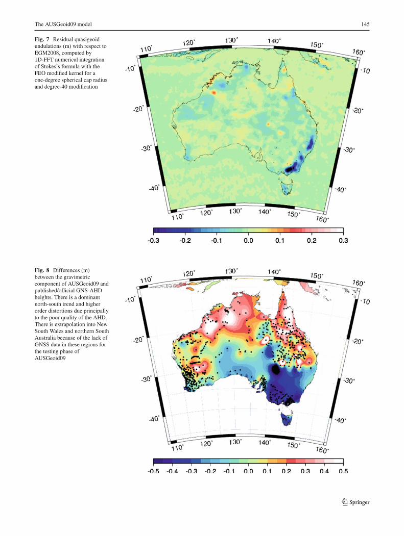
3.3 The residual gravimetric quasigeoid
Figure 7 shows the residual gravimetric quasigeoid com-puted from the residual gravity anomalies (Fig. 5) by the 1D-FFT technique with a degree-40 FEO modified kernel over aone-degree-radius spherical cap. From Table 3, this residualgravimetric quasigeoid is an order of magnitude less thanthe residual-to-EGM96 value computed for AUSGeoid98(Featherstone et al. 2001), reflecting the reduction in theomission error by the degree-2,190 expansion of EGM2008.The larger residual quasigeoid signal in the Great DividingRange along the south-eastern seaboard and in Tasmania isdue to topography. However, there are few GNSS-levellingpoints in these regions to properly quantify any improvementoffered. As such, it is recommended that good quality level-ling and GNSS data are acquired in mountainous regions iftopographical effects are to be assessed more objectively.
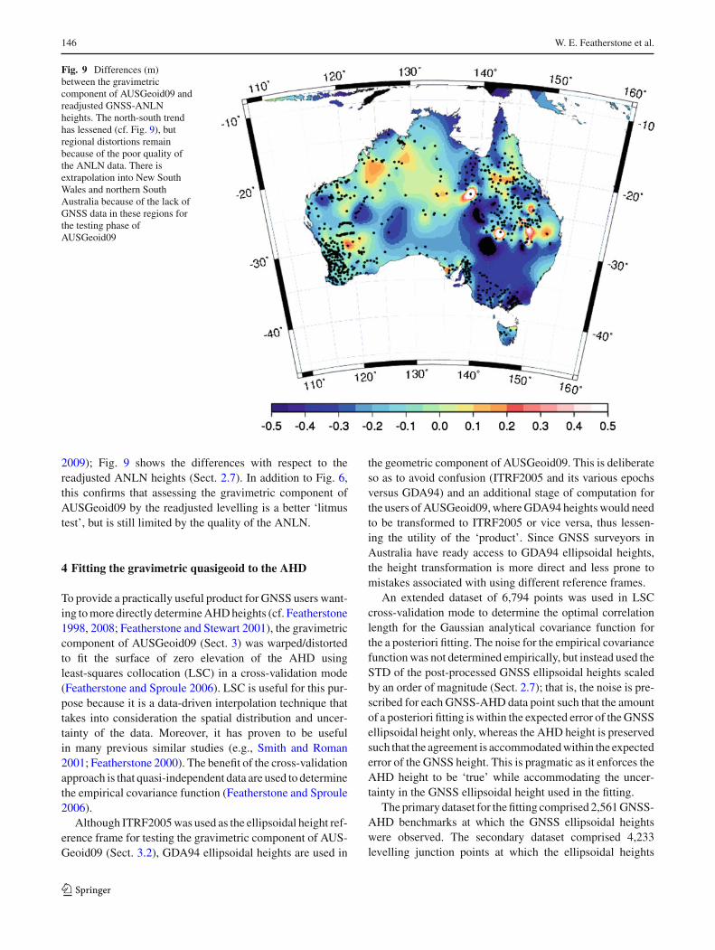
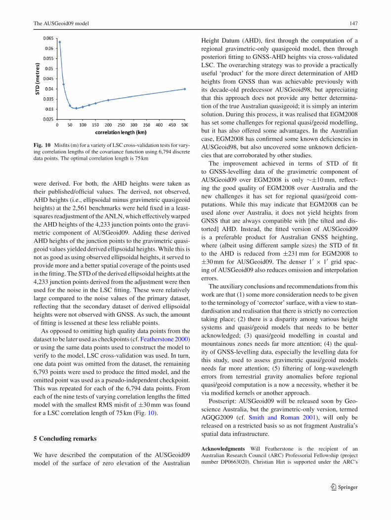
Figures 8 and 9 show the differences between the gravi-metric-only component of AUSGeoid09 and GNSS-levellingdata: Fig. 8 maps the differences with respect to the pub-lished/official AHD heights showing the north-south tilt andregional distortions in the AHD (cf. Featherstone 2004, 2006;Featherstone and Filmer 2008; Filmer and Featherstone
123
The AUSGeoid09 model 145
Fig. 7 Residual quasigeoidundulations (m) with respect toEGM2008, computed by1D-FFT numerical integrationof Stokes’s formula with theFEO modified kernel for aone-degree spherical cap radiusand degree-40 modification
Fig. 8 Differences (m)between the gravimetriccomponent of AUSGeoid09 andpublished/official GNS-AHDheights. There is a dominantnorth-south trend and higherorder distortions due principallyto the poor quality of the AHD.There is extrapolation into NewSouth Wales and northern SouthAustralia because of the lack ofGNSS data in these regions forthe testing phase ofAUSGeoid09
123
146 W. E. Featherstone et al.
Fig. 9 Differences (m)between the gravimetriccomponent of AUSGeoid09 andreadjusted GNSS-ANLNheights. The north-south trendhas lessened (cf. Fig. 9), butregional distortions remainbecause of the poor quality ofthe ANLN data. There isextrapolation into New SouthWales and northern SouthAustralia because of the lack ofGNSS data in these regions forthe testing phase ofAUSGeoid09
2009); Fig. 9 shows the differences with respect to thereadjusted ANLN heights (Sect. 2.7). In addition to Fig. 6,this confirms that assessing the gravimetric component ofAUSGeoid09 by the readjusted levelling is a better ‘litmustest’, but is still limited by the quality of the ANLN.
4 Fitting the gravimetric quasigeoid to the AHD
To provide a practically useful product for GNSS users want-ing to more directly determine AHD heights (cf. Featherstone1998, 2008; Featherstone and Stewart 2001), the gravimetriccomponent of AUSGeoid09 (Sect. 3) was warped/distortedto fit the surface of zero elevation of the AHD usingleast-squares collocation (LSC) in a cross-validation mode(Featherstone and Sproule 2006). LSC is useful for this pur-pose because it is a data-driven interpolation technique thattakes into consideration the spatial distribution and uncer-tainty of the data. Moreover, it has proven to be usefulin many previous similar studies (e.g., Smith and Roman2001; Featherstone 2000). The benefit of the cross-validationapproach is that quasi-independent data are used to determinethe empirical covariance function (Featherstone and Sproule2006).
Although ITRF2005 was used as the ellipsoidal height ref-erence frame for testing the gravimetric component of AUS-Geoid09 (Sect. 3.2), GDA94 ellipsoidal heights are used in
the geometric component of AUSGeoid09. This is deliberateso as to avoid confusion (ITRF2005 and its various epochsversus GDA94) and an additional stage of computation forthe users of AUSGeoid09, where GDA94 heights would needto be transformed to ITRF2005 or vice versa, thus lessen-ing the utility of the ‘product’. Since GNSS surveyors inAustralia have ready access to GDA94 ellipsoidal heights,the height transformation is more direct and less prone tomistakes associated with using different reference frames.
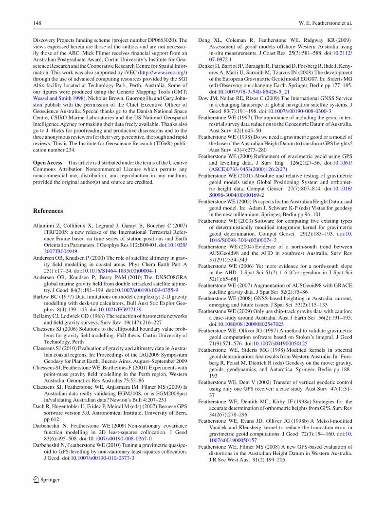
An extended dataset of 6,794 points was used in LSCcross-validation mode to determine the optimal correlationlength for the Gaussian analytical covariance function forthe a posteriori fitting. The noise for the empirical covariancefunction was not determined empirically, but instead used theSTD of the post-processed GNSS ellipsoidal heights scaledby an order of magnitude (Sect. 2.7); that is, the noise is pre-scribed for each GNSS-AHD data point such that the amountof a posteriori fitting is within the expected error of the GNSSellipsoidal height only, whereas the AHD height is preservedsuch that the agreement is accommodated within the expectederror of the GNSS height. This is pragmatic as it enforces theAHD height to be ‘true’ while accommodating the uncer-tainty in the GNSS ellipsoidal height used in the fitting.
The primary dataset for the fitting comprised 2,561 GNSS-AHD benchmarks at which the GNSS ellipsoidal heightswere observed. The secondary dataset comprised 4,233levelling junction points at which the ellipsoidal heights
123
The AUSGeoid09 model 147
Fig. 10 Misfits (m) for a variety of LSC cross-validation tests for vary-ing correlation lengths of the covariance function using 6,794 discretedata points. The optimal correlation length is 75 km
were derived. For both, the AHD heights were taken astheir published/official values. The derived, not observed,AHD heights (i.e., ellipsoidal minus gravimetric quasigeoidheights) at the 2,561 benchmarks were held fixed in a least-squares readjustment of the ANLN, which effectively warpedthe AHD heights of the 4,233 junction points onto the gravi-metric component of AUSGeoid09. Adding these derivedAHD heights of the junction points to the gravimetric quasi-geoid values yielded derived ellipsoidal heights. While this isnot as good as using observed ellipsoidal heights, it served toprovide more and a better spatial coverage of the points usedin the fitting. The STD of the derived ellipsoidal heights at the4,233 junction points derived from the adjustment were thenused for the noise in the LSC fitting. These were relativelylarge compared to the noise values of the primary dataset,reflecting that the secondary dataset of derived ellipsoidalheights were not observed with GNSS. As such, the amountof fitting is lessened at these less reliable points.
As opposed to omitting high quality data points from thedataset to be later used as checkpoints (cf. Featherstone 2000)or using the same data points used to construct the model toverify to the model, LSC cross-validation was used. In turn,one data point was omitted from the dataset, the remaining6,793 points were used to produce the fitted model, and theomitted point was used as a pseudo-independent checkpoint.This was repeated for each of the 6,794 data points. Fromeach of the nine tests of varying correlation lengths the fittedmodel with the smallest RMS misfit of ±30 mm was foundfor a LSC correlation length of 75 km (Fig. 10).
5 Concluding remarks
We have described the computation of the AUSGeoid09model of the surface of zero elevation of the Australian
Height Datum (AHD), first through the computation of aregional gravimetric-only quasigeoid model, then throughposteriori fitting to GNSS-AHD heights via cross-validatedLSC. The overarching strategy was to provide a practicallyuseful ‘product’ for the more direct determination of AHDheights from GNSS than was achievable previously withits decade-old predecessor AUSGeoid98, but appreciatingthat this approach does not provide any better determina-tion of the true Australian quasigeoid; it is simply an interimsolution. During this process, it was realised that EGM2008has set some challenges for regional quasi/geoid modelling,but it has also offered some advantages. In the Australiancase, EGM2008 has confirmed some known deficiencies inAUSGeoid98, but also uncovered some unknown deficien-cies that are corroborated by other studies.
The improvement achieved in terms of STD of fitto GNSS-levelling data of the gravimetric component ofAUSGeoid09 over EGM2008 is only ∼±10 mm, reflect-ing the good quality of EGM2008 over Australia and thenew challenges it has set for regional quasi/geoid com-putations. While this may indicate that EGM2008 can beused alone over Australia, it does not yield heights fromGNSS that are always compatible with [the tilted and dis-torted] AHD. Instead, the fitted version of AUSGeoid09is a preferable product for Australian GNSS heighting,where (albeit using different sample sizes) the STD of fitto the AHD is reduced from ±231 mm for EGM2008 to±30 mm for AUSGeoid09. The denser 1′ × 1′ grid spac-ing of AUSGeoid09 also reduces omission and interpolationerrors.
The auxiliary conclusions and recommendations from thiswork are that (1) some more consideration needs to be givento the terminology of ‘corrector’ surface, with a view to stan-dardisation and realisation that there is strictly no correctiontaking place; (2) there is a disparity among various heightsystems and quasi/geoid models that needs to be betteracknowledged; (3) quasi/geoid modelling in coastal andmountainous zones needs far more attention; (4) the qual-ity of GNSS-levelling data, especially the levelling data forthis study, used to assess gravimetric quasi/geoid modelsneeds far more attention; (5) filtering of long-wavelengtherrors from terrestrial gravity anomalies before regionalquasi/geoid computation is a now a necessity, whether it bevia modified kernels or another approach.
Postscript: AUSGeoid09 will be released soon by Geo-science Australia, but the gravimetric-only version, termedAGQG2009 (cf. Smith and Roman 2001), will only bereleased on a restricted basis so as not fragment Australia’sspatial data infrastructure.
Acknowledgments Will Featherstone is the recipient of anAustralian Research Council (ARC) Professorial Fellowship (projectnumber DP0663020). Christian Hirt is supported under the ARC’s
123
148 W. E. Featherstone et al.
Discovery Projects funding scheme (project number DP0663020). Theviews expressed herein are those of the authors and are not necessar-ily those of the ARC. Mick Filmer receives financial support from anAustralian Postgraduate Award, Curtin University’s Institute for Geo-science Research and the Cooperative Research Centre for Spatial Infor-mation. This work was also supported by iVEC (http://www.ivec.org/)through the use of advanced computing resources provided by the SGIAltix facility located at Technology Park, Perth, Australia. Some ofour figures were produced using the Generic Mapping Tools (GMT;Wessel and Smith 1998). Nicholas Brown, Guorong Hu and Gary John-ston publish with the permission of the Chief Executive Officer ofGeoscience Australia. Special thanks go to the Danish National SpaceCentre, CSIRO Marine Laboratories and the US National GeospatialIntelligence Agency for making their data freely available. Thanks alsogo to J. Hicks for proofreading and productive discussions and to thethree anonymous reviewers for their very perceptive, thorough and rapidreviews. This is The Institute for Geoscience Research (TIGeR) publi-cation number 234.
Open Access This article is distributed under the terms of the CreativeCommons Attribution Noncommercial License which permits anynoncommercial use, distribution, and reproduction in any medium,provided the original author(s) and source are credited.
References
Altamimi Z, Collilieux X, Legrand J, Garayt B, Boucher C (2007)ITRF2005: a new release of the International Terrestrial Refer-ence Frame based on time series of station positions and EarthOrientation Parameters. J Geophys Res 112:B09401. doi:10.1029/2007JB004949
Andersen OB, Knudsen P (2000) The role of satellite altimetry in grav-ity field modelling in coastal areas. Phys Chem Earth Part A25(1):17–24. doi:10.1016/S1464-1895(00)00004-1
Andersen OB, Knudsen P, Berry PAM (2010) The DNSC08GRAglobal marine gravity field from double retracked satellite altime-try. J Geod 84(3):191–199. doi:10.1007/s00190-009-0355-9
Barlow BC (1977) Data limitations on model complexity; 2-D gravitymodelling with desk-top calculators. Bull Aust Soc Explor Geo-phys 8(4):139–143. doi:10.1071/EG977139
Bellamy CJ, Lodwick GD (1968) The reduction of barometric networksand field gravity surveys. Surv Rev 19(147):216–227
Claessens SJ (2006) Solutions to the ellipsoidal boundary value prob-lems for gravity field modelling. PhD thesis, Curtin University ofTechnology, Perth
Claessens SJ (2010) Evaluation of gravity and altimetry data in Austra-lian coastal regions. In: Proceedings of the IAG2009 SymposiumGeodesy for Planet Earth, Buenos Aires, August–September 2009
Claessens SJ, Featherstone WE, Barthelmes F (2001) Experiments withpoint-mass gravity field modelling in the Perth region, WesternAustralia. Geomatics Res Australas 75:53–86
Claessens SJ, Featherstone WE, Anjasmara IM, Filmer MS (2009) IsAustralian data really validating EGM2008, or is EGM2008justin/validating Australian data?. Newton’s Bull 4:207–251
Dach R, Hugentobler U, Fridez P, Meindl M (eds) (2007) Bernese GPSsoftware version 5.0, Astronomical Institute, University of Bern,pp 612
Darbeheshti N, Featherstone WE (2009) Non-stationary covariancefunction modelling in 2D least-squares collocation. J Geod83(6):495–508. doi:10.1007/s00190-008-0267-0
Darbeheshti N, Featherstone WE (2010) Tuning a gravimetric quasige-oid to GPS-levelling by non-stationary least-squares collocation.J Geod. doi:10.1007/s00190-010-0377-3
Deng XL, Coleman R, Featherstone WE, Ridgway KR (2009)Assessment of geoid models offshore Western Australia usingin-situ measurements. J Coast Res 25(3):581–588. doi:10.2112/07-0972.1
Denker H, Barriot JP, Barzaghi R, Fairhead D, Forsberg R, Ihde J, Keny-eres A, Marti U, Sarrailh M, Tziavos IN (2008) The developmentof the European Gravimetric Geoid model EGG07. In: Sideris MG(ed) Observing our changing Earth. Springer, Berlin pp 177–185.doi:10.1007/978-3-540-85426-5_21
Dow JM, Neilan RE, Rizos C (2009) The International GNSS Servicein a changing landscape of global navigation satellite systems. JGeod 83(7):191–198. doi:10.1007/s00190-008-0300-3
Featherstone WE (1997) The importance of including the geoid in ter-restrial survey data reduction to the Geocentric Datum of Australia.Aust Surv 42(1):45–50
Featherstone WE (1998) Do we need a gravimetric geoid or a model ofthe base of the Australian Height Datum to transform GPS heights?.Aust Surv 43(4):273–280
Featherstone WE (2000) Refinement of gravimetric geoid using GPSand levelling data. J Surv Eng 126(2):27–56. doi:10.1061/(ASCE)0733-9453(2000)126:2(27)
Featherstone WE (2001) Absolute and relative testing of gravimetricgeoid models using Global Positioning System and orthomet-ric height data. Comput Geosci 27(7):807–814. doi:10.1016/S0098-3004(00)00169-2
Featherstone WE (2002) Prospects for the Australian Height Datum andgeoid model. In: Adam J, Schwarz K-P (eds) Vistas for geodesyin the new millennium. Springer, Berlin pp 96–101
Featherstone WE (2003) Software for computing five existing typesof deterministically modified integration kernel for gravimetricgeoid determination. Comput Geosci 29(2):183–193. doi:10.1016/S0098-3004(02)00074-2
Featherstone WE (2004) Evidence of a north-south trend betweenAUSGeoid98 and the AHD in southwest Australia. Surv Rev37(291):334–343
Featherstone WE (2006) Yet more evidence for a north-south slopein the AHD. J Spat Sci 51(2):1–6 [Corrigendum in J Spat Sci52(1):65–68]
Featherstone WE (2007) Augmentation of AUSGeoid98 with GRACEsatellite gravity data. J Spat Sci 52(2):75–86
Featherstone WE (2008) GNSS-based heighting in Australia: current,emerging and future issues. J Spat Sci 53(2):115–133
Featherstone WE (2009) Only use ship-track gravity data with caution:a case-study around Australia. Aust J Earth Sci 56(2):191–195.doi:10.1080/08120090802547025
Featherstone WE, Olliver JG (1997) A method to validate gravimetricgeoid computation software based on Stokes’s integral. J Geod71(9):571–576. doi:10.1007/s001900050125
Featherstone WE, Sideris MG (1998) Modified kernels in spectralgeoid determination: first results from Western Australia. In: Fors-berg R, Feissl M, Dietrich R (eds) Geodesy on the move: gravity,geoids, geodynamics, and Antarctica. Springer, Berlin pp 188–193
Featherstone WE, Dent V (2002) Transfer of vertical geodetic controlusing only one GPS receiver: a case study. Aust Surv 47(1):31–37
Featherstone WE, Dentith MC, Kirby JF (1998a) Strategies for theaccurate determination of orthometric heights from GPS. Surv Rev34(267):278–296
Featherstone WE, Evans JD, Olliver JG (1998b) A Meissl-modifiedVanícek and Kleusberg kernel to reduce the truncation error ingravimetric geoid computations. J Geod 72(3):154–160. doi:10.1007/s001900050157
Featherstone WE, Filmer MS (2008) A new GPS-based evaluation ofdistortions in the Australian Height Datum in Western Australia.J R Soc West Aust 91(2):199–206
123
The AUSGeoid09 model 149
Featherstone WE, Kirby JF (2000) The reduction of aliasing in gravityanomalies and geoid heights using digital terrain data. Geophys JInt 141(1):204–212. doi:10.1046/j.1365-246X.2000.00082.x
Featherstone WE, Kirby JF, Kearsley AHW, Gilliland JR, JohnstonGM, Steed J, Forsberg R, Sideris MG (2001) The AUSGeoid98geoid model of Australia: data treatment, computations and com-parisons with GPS-levelling data. J Geod 75(5–6):313–330.doi:10.1007/s001900100177
Featherstone WE, Kuhn M (2006) Height systems and vertical datums:a review in the Australian context. J Spat Sci 51(1):21–42
Featherstone WE, Rüeger JM (2000) The importance of using devia-tions of the vertical in the reduction of terrestrial survey data toa geocentric datum. Trans-Tasman Surv 1(3):46–61 [Erratum inAust Surv 47(1):7]
Featherstone WE, Sproule DM (2006) Fitting AUSGeoid98 to theAustralian height datum using GPS data and least squares col-location: application of a cross-validation technique. Surv Rev38(301):573–582
Featherstone WE, Stewart MP (2001) Combined analysis of real-time kinematic GPS equipment and its users for heightdetermination. J Surv Eng 127(2):31–51. doi:10.1061/(ASCE)0733-9453(2001)127:2(31)
Filmer MS, Featherstone WE (2009) Detecting spirit-levelling errors inthe AHD: recent findings and some issues for any new Australianheight datum. Aust J Earth Sci 56(4):559–569. doi:10.1080/08120090902806305
Filmer MS, Featherstone WE, Kuhn M (2010) The effect of EGM2008-based normal, normal-orthometric and Helmert orthometric heightsystems on the Australian levelling network. J Geod 84(8):501–513. doi:10.1007/s00190-010-0388-0
Forsberg R, Tscherning CC (1981) The use of height data in gravityfield approximation by collocation. J Geophys Res 86(B9):7843–7854
Forsberg R, Featherstone WE (1998) Geoids and cap sizes. In:Forsberg R, Feissl M, Dietrich R (eds) Geodesy on the move:gravity, geoids, geodynamics, and Antarctica. Springer, Berlin pp194–200
Fraser AR, Moss FJ, Turpie A (1976) Reconnaissance gravitysurvey of Australia. Geophysics 41:1337–1345. doi:10.1190/1.1440683
Gilliland JR (1994) Cap sizes in geoid calculations. Aust J GeodPhotogramm Surv 60:95–108
Goos JM, Featherstone WE, Kirby JF, Holmes SA (2003) Experimentswith two different approaches to gridding terrestrial gravity anom-alies and their effect on regional geoid computation. Surv Rev37(288):92–112
Haagmans R, de Min E, van Gelderen M (1993) Fast evaluation of con-volution integrals on the sphere using 1D FFT, and a compari-son with existing methods for Stokes’ integral. Manuscripta Geod18(3):227–241
Hackney RI, Featherstone WE (2003) Geodetic versus geophysical per-spectives of the ‘gravity anomaly’. Geophys J Int 154(1):35–43.doi:10.1046/j.1365-246X.2003.01941.x [Errata in 154(2): 596,doi:10.1046/j.1365-246X.2003.02058.x and 167(2): 585, doi:10.1111/j.1365-246X.2006.03035.x]
Heck B (1990) An evaluation of some systematic error sources affect-ing terrestrial gravity anomalies. Bull Geod 64(1):88–108. doi:10.1007/BF02530617
Heiskanen WH, Moritz H (1967) Physical geodesy. Freeman, San Fran-cisco
Hipkin RG (2000) Modelling the geoid and sea-surface topography incoastal areas. Phys Chem Earth Part A 25(1):9–16. doi:10.1016/S1464-1895(00)00003-X
Hipkin RG (2004) Ellipsoidal geoid computation. J Geod 78(3):167–179. doi:10.1007/s00190-004-0389-y
Hirt C, Filmer MS, Featherstone WE (2010) Comparison and vali-dation of recent freely-available ASTER-GDEM ver1, SRTMver4.1 and GEODATA DEM-9S ver3 digital elevation modelsover Australia. Aust J Earth Sci 57(3):337–347. doi:10.1080/08120091003677553
Huang J, Véronneau M, Pagiatakis SD (2003) On the ellipsoidal cor-rection to the spherical Stokes solution of the gravimetric geoid. JGeod 77(3–4):171–181. doi:10.1007/s00190-003-0317-6
Hutchinson MF, Stein JA, Stein JL (2008) GEODATA 9 second digi-tal elevation model version 3 and flow direction grid: user guide.Fenner School of Environment and Society, Australian NationalUniversity and Geoscience Australia
ICSM (2007) Standards and practices for control surveys. Special Pub-lication 1 (SP1), version 1.7, Intergovernmental Committee onSurveying and Mapping, Canberra
Janak J, Vanícek P (2005) Mean free-air gravity anomalies in themountains. Stud Geophys Geod 49(1):31–42. doi:10.1007/s11200-005-1624-6
Jekeli C, Serpas JG (2003) Review and numerical assessment of thedirect topographical reduction in geoid determination. J Geod77(3–4):226–239. doi:10.1007/s00190-003-0320-y
Kearsley AHW (1988a) Tests on the recovery of precise geoid heightdifferences from gravimetry. J Geophys Res 93(B6):6559–6570.doi:10.1029/JB093iB06p06559
Kearsley AHW (1988b) The determination of the geoid-ellipsoid sep-aration for GPS levelling. Aust Surv 34(1):11–18
Kirby JF (2003) On the combination of gravity anomalies and gravitydisturbances for geoid determination in Western Australia. J Geod77(7–8):433–439. doi:10.1007/s00190-003-0334-5
Kirby JF, Featherstone WE (1997) A study of zero- and first-degreeterms in geopotential models over Australia. Geomatics Res Aust66:93–108
Kirby JF, Featherstone WE (2001) Anomalously large gradients in the“GEODATA 9 Second” digital elevation model of Australia, andtheir effects on gravimetric terrain corrections. Cartography 30:1–10
Kirby JF, Featherstone WE (2002) High-resolution grids of gravimetricterrain correction and complete Bouguer corrections over Austra-lia. Explor Geophys 33(4):161–165. doi:10.1071/EG00109
Koch KR (2005) Determining the maximum degree of harmonic coeffi-cients in geopotential models by Monte Carlo methods. Stud Geo-phys Geod 49(3):259–275. doi:10.1007/s11200-005-0009-1
Kuhn M, Featherstone WE, Kirby JF (2009) Complete spherical Bou-guer gravity anomalies over Australia. Aust J Earth Sci 56(2):209–219. doi:10.1080/08120090802547041
Lambeck K (1987) The Perth Basin: a possible framework for its for-mation and evolution. Explor Geophys 18(2):124–128. doi:10.1071/EG987124
Lemoine FG, Kenyon SC, Factor JK, Trimmer RG, Pavlis NK, ChinnDS, Cox CM, Klosko SM, Luthcke SB, Torrence MH, WangYM, Williamson RG, Pavlis EC, Rapp RH, Olson TR (1998) Thedevelopment of the joint NASA GSFC and the National Imag-ery and Mapping Agency (NIMA) geopotential model EGM96,NASA/TP-1998-206861, National Aeronautics and Space Admin-istration, USA
McCarthy DD, Petit G (eds) (2004) IERS Conventions 2003, Techni-cal Note 32, International Earth Rotation and Reference SystemsService, Verlag des Bundesamts für Kartographie und Geodäsie,Frankfurt am Main, Germany
McLaren S, Wallace MW (2010) Plio-Pleistocene climate change andthe onset of aridity in southeastern Australia. Global Planet Change71(1–2):55–72. doi:10.1016/j.gloplacha.2009.12.007
Miranda JA, Wallace MW, McLaren S (2008) The Norwest Bend For-mation: implications for the evolution of Neogene drainage insoutheastern Australia. Sediment Geol 205(1–2):53–66. doi:10.1016/j.sedgeo.2008.01.007
123
150 W. E. Featherstone et al.
Molodensky MS, Eremeev VF, Yurkina MI (1962) Methods for studyof the external gravity field and figure of the Earth. Israeli Programfor Scientific Translations, Jerusalem
Morelli C, Gantar C, Honkaslo T, McConnel RK, Tanner TG, Szabo B,Uotila U, Whalen CT (1971) The International Gravity Stan-dardisation Network (IGSN71), Special Publication 4 of BulletinGéodésique
Morgan PJ (1992) An analysis of the Australian Height Datum: 1971.Aust Surv 37(1):46–63
Moritz H (1968) On the use of the terrain correction in solving Molo-densky’s problem, Report 108, Department of Geodetic Scienceand Surveying. Ohio State University, Columbus
Moritz H. (1980) Geodetic Reference System 1980. Bull Géod54(3):395–405. doi:10.1007/BF02521480
Murray AS (1997) The Australian national gravity database. AGSO JAust Geol Geophys 17:145–155
Omang OCD, Forsberg R (2002) The northern European geoid: a casestudy on long-wavelength geoid errors. J Geod 76(6–7):369–380.doi:10.1007/s00190-002-0261-x
Pavlis NK (1998) Observed inconsistencies between satellite-only andsurface gravity-only geopotential models. In: Forsberg R, FeisslM, Dietrich R (eds) Geodesy on the move: Gravity, Geoids, Geo-dynamics, and Antarctica. Springer, Berlin Heidelberg New Yorkpp 144–149
Pavlis NK (2000) On the modelling of long wavelength systematicerrors in surface gravimetric data. In: Schwarz K-P (ed) Geod-esy beyond 2000. Springer, Berlin pp 131–136
Pavlis NK, Factor JK, Holmes SA (2006) Terrain-related gravimetricquantities computed for the next EGM. In: Forsberg R, Kiliçoglu A(eds) 1st international symposium of the international gravity fieldservice, gravity field of the Earth, General Command of Mapping,Special Issue 18, Istanbul, pp 318–323
Pavlis NK, Holmes SA, Kenyon SC, Factor JK (2008) An Earth Grav-itational Model to degree 2160: EGM2008. In: Paper presented atthe general assembly of the European Geosciences Union, Vienna
Rapp RH (1961) The orthometric height, MS Dissertation. The OhioState University, Columbus
Ridgway KR, Dunn JR, Wilkin JL (2002) Ocean interpolation by four-dimensional least squares—application to the waters around Aus-tralia. J Atmos Ocean Technol 19(9):1357–1375. doi:10.1175/1520-0426(2002)019<1357:OIBFDW>2.0.CO;2
Roelse A, Granger HW, Graham JW (1971) The adjustment of theAustralian levelling survey 1970–1971, Report 12, Division ofNational Mapping, Canberra
Rothacher M (2002) Estimation of station heights with GPS. In:Drewes H, Dodson A, Fortes LPS, Sánchez L, Sandoval P (eds)Vertical reference systems. Springer, Berlin pp 81–90
Sandwell DT, Smith WHF (2009) Global marine gravity from retrackedGeosat and ERS-1 altimetry: ridge segmentation versus spread-ing rate. J Geophys Res Solid Earth 114:B01411. doi:10.1029/2008JB006008
Schmid R, Steigenberger P, Gendt G, Ge M, Rothacher M (2007) Gen-eration of a consistent absolute phase center correction modelfor GPS receiver and satellite antennas. J Geod 81(12):781–798.doi:10.1007/s00190-007-0148-y
Sideris MG (1990) Rigorous gravimetric terrain modeling using Mol-odensky’s operator. Manuscripta Geod 15:97–106
Sjöberg LE (2005) A discussion on the approximations made in thepractical implementation of the remove-compute-restore tech-nique in regional geoid modeling. J Geod 78(11–12):645–653.doi:10.1007/s00190-004-0430-1
Smith WHF, Wessel P (1990) Gridding with continuous curvaturesplines in tension. Geophysics 55(3):293–305. doi:10.1190/1.1442837
Smith DA, Roman DR (2001) GEOID99 and G99SSS: 1-arc-minutegeoid models for the United States. J Geod 75(9–10):469–490.doi:10.1007/s001900100200
Soltanpour A, Nahavandchi H, Featherstone WE (2006) The use of sec-ond-generation wavelets to combine a gravimetric geoid modelwith GPS-levelling data. J Geod 80(2):82–93. doi:10.1007/s00190-006-0033-0
Sproule DM, Featherstone WE, Kirby JF (2006) Localised gross-errordetection in the Australian land gravity database. Explor Geophys37(2):175–179. doi:10.1071/EG06175
Tapley BD, Bettadpur S, Watkins M, Reigber C (2004) The Grav-ity Recovery and Climate Experiment: mission overview andearly results. Geophys Res Lett 31:L09607. doi:10.1029/2004GL019920
Tracey R, Bacchin M, Wynne P (2007) AAGD07: a new absolute grav-ity datum for Australian gravity and new standards for the Austra-lian National Gravity Database, ASEG Extended Abstracts. doi:10.1071/ASEG2007ab149
Tregoning P, Lambeck K, Ramillien G (2008) GRACE estimates ofsea surface height anomalies in the Gulf of Carpentaria, Australia.Earth Planet Space Lett 271(1–4):241–244. doi:10.1016/j.epsl.2008.04.018
Val’ko M, Mojzeš M, Janák J, Papco J (2008) Comparision of twodifferent solution to Molodensky’s G1 term. Stud Geophys Geod52(1):71–86. doi:10.1007/s11200-008-0006-2
Vanícek P (1991) Vertical datum and NAVD88. Surv Land Inform Syst51(2):83–86
Vanícek P, Tenzer R, Sjöberg LE, Martinec Z, FeatherstoneWE (2004) New views of the spherical Bouguer gravity anomaly.Geophys J Int 159(2):460–472. doi:10.1111/j.1365-246X.2004.02435.x
Vanícek P, Kleusberg A (1987) The Canadian geoid—Stokesianapproach. Manuscripta Geod 12(1):86–98
Vanícek P, Sjöberg LE (1991) Reformulation of Stokes’s theory forhigher than second-degree reference field and modification of inte-gration kernels. J Geophys Res Solid Earth 96(B4):6529–6539
Vanícek P, Featherstone WE (1998) Performance of three types ofStokes’s kernel in the combined solution for the geoid. J Geod72(12):684–697. doi:10.1007/s001900050209
Wellman P, Barlow BC, Murray AS (1985) Gravity base station networkvalues, Report 261, Australian Geological Survey Organisation,Canberra
Wessel P, Smith WHF (1996) A global self-consistent, hierarchical, andhigh-resolution shoreline database. J Geophys Res 101(B4):8741–8743. doi:10.1029/96JB00104
Wessel P, Smith WHF (1998) New, improved version of Generic Map-ping Tools released. EOS Trans Am Geophys Union 79(47):579
Wong L, Gore R (1969) Accuracy of geoid heights from modifiedStokes’ kernels. Geophys J R Astron Soc 18(1):81–91
Zhang KF, Featherstone WE (2004) Investigation of the roughness ofthe Australian gravity field using statistical, graphical, fractal andFourier power spectrum techniques. Surv Rev 37(293):520–530
Zumberge JF, Heflin MB, Jefferson DC, Watkins MM, WebbFH (1997) Precise point positioning for the efficient and robustanalysis of GPS data from large networks. J Geophys Res102(B3):5005–5017. doi:10.1029/96JB03860
123
Related Documents


