THE ARCHAEOLOGY OF THE IFUGAO AGRICULTURAL TERRACES: ANTIQUITY AND SOCIAL ORGANIZATION A DISSERTATION SUBMITTED TO THE GRADUATE DIVISION OF THE UNIVERSITY OF HAWAI‘I IN PARTIAL FULFILLMENT OF THE REQUIREMENTS FOR THE DEGREE OF DOCTOR OF PHILOSOPHY IN ANTHROPOLOGY May 2010 By Stephen B. Acabado Dissertation Committee: Miriam T. Stark, Chairperson P. Bion Griffin James Bayman John Peterson Jefferson Fox Matthew McGranaghan

Welcome message from author
This document is posted to help you gain knowledge. Please leave a comment to let me know what you think about it! Share it to your friends and learn new things together.
Transcript
THE ARCHAEOLOGY OF THE IFUGAO AGRICULTURAL TERRACES: ANTIQUITY AND SOCIAL ORGANIZATION
A DISSERTATION SUBMITTED TO THE GRADUATE DIVISION OF THE UNIVERSITY OF HAWAI‘I IN PARTIAL FULFILLMENT OF THE
REQUIREMENTS FOR THE DEGREE OF
DOCTOR OF PHILOSOPHY
IN
ANTHROPOLOGY
May 2010
By
Stephen B. Acabado
Dissertation Committee:
Miriam T. Stark, Chairperson
P. Bion Griffin James Bayman John Peterson Jefferson Fox
Matthew McGranaghan

© 2010, Stephen B. Acabado

iii
ACKNOWLEDGMENTS
This dissertation is both a culmination and beginning of a new chapter in my pursuit for academic excellence. I have faced hurdles and challenges through several stages of this quest, but I am fortunate to receive generous support from various individuals and agencies. With their assistance, I present my contribution to the archaeological anthropology of the Philippines and Southeast Asia.
My introduction to anthropology (and archaeology) was initiated when my parents bought a set of Children’s Encyclopedia when I was just learning to read. I was first drawn to the discipline, first, because of the romance associated with it, and of course, Young Indy. Because of the early introduction to anthropology and archaeology, I already knew that I wanted to be someone who studies culture and history. This interest was cultivated by my elementary and high school teachers (where I was constantly excelling in History and Social Studies subjects!), for this, I am thankful to them for the challenges and opportunities that shaped my foundation in the Social Sciences.
I am grateful to the anthropological foundation I received from the University of the Philippines. My commitment to a four-field approach to anthropology was fortified in this institution. It was in my undergraduate program that I fully understood that there is more to archaeology than the archaeology of Indiana Jones – though I will be lying if I say that Dr. Jones did not influence my choice of profession.
My sincere gratitude also goes to the East West Center and Asian Cultural Council for providing me with the all-important financial support to start my graduate training in anthropology at the University of Hawaii. In addition, the Department of Anthropology at UHM also offered support with a three-year Teaching Assistantship tenure. Awards from the Arts and Sciences Advisory Council, Graduate Student Organization, Dai Ho Chun Scholarship, and Ligaya Fruto Scholarship Fund also enhanced the development of this dissertation. Thanks also to KCC and Carl Hefner for the lecturer position that had been my source of livelihood while completing this dissertation.
I am also thankful to receive a National Science Foundation Dissertation Improvement Grant (NSF BCS07-04008) and to the Council of Learned Societies/Henry Luce Foundation Initiative for East Asian Archaeology and Early History. Timely completion of this dissertation was made possible because of these awards.
This dissertation is also credited to many individuals: Dr. Michael Graves provided the initial encouragement to pursue a landscape approach to the study of Ifugao rice terraces; John Vogler, then with the East West Center, was responsible for my training in GIS. Although I do not have formal training in GIS applications, he kindly provided personal guidance in spatial analysis; Dr. Thomas Dye (T.S. Dye and Colleagues) introduced me to the use of Bayesian statistics in radiocarbon determinations; Dr. Victor Paz and the Archaeological Studies program (University of the Philippines) for their logistical and crew support during the field season Ifugao; Dr. Gary Huss (University of Hawaii) for lending instrumentation needed to identify wood taxa; Dr. Florence Soriano and the staff (Forest Products Research and Development Institute, University of the Philippines-Los Baños) for help in wood taxa identification; and to Dr.

iv
Fernando Zialcita, Dr. Jesus Peralta, and Dr. Harold Conklin for insightful conversations on Ifugao and Philippine anthropology. Special thanks are also owed to the National Mapping Resource Information Authority of the Philippines for providing SPOT Images of Central Cordillera and to the Katipunan Arkeologist ng Pilipinas, Inc (Philippine Archaeology Guild), the National Museum of the Philippines (through Prof. Wilfredo Ronquillo and Director Corazon Alvina) , and the Indigenous Peoples Commission-CAR office for assistance in the permitting process.
Sincere appreciation is also owed to the Archaeological Studies Program, University of the Philippines for offering invaluable assistance during the fieldwork component of this investigation. UP-ASP provided highly-trained excavation crew members for this research. To Taj Vitales, Aya Ragrario, Jane Carlos, Janine Ochoa, Roel Flores, Leee Neri, Jack Medrana, Donna Ariola, Migs Canilao, Mindy Ceron, Tara Reyes, Anna Pineda, Edwin Valientes, Iza Campos, and Rose Delson, MABALOS!
To my committee members, I am indebted to your tireless guidance. Dr. Miriam Stark, my committee chairperson, provided me with all the help I needed to complete this dissertation and for my development as an anthropological archaeologist. She offered opportunities and challenges that made my UHM experience comfortable. To Doc, as we say in Bikol, Mabalos!
Dr. Bion Griffin, my MA committee chair, facilitated my transition to life in Hawaii. He adopted me during my first few days in Honolulu and kept my homesickness at bay with his sense of humor. To El Doc (and Nanay Annie), ti-agngina!
My other committee members, Dr. James Bayman, Dr. John Peterson, Dr. Jefferson Fox, and Dr. Matthew McGranaghan, offered valuable comments and suggestions that made this dissertation an intersection of ethnohistory, ethnography, spatial analysis, and archaeology. I am grateful for determined guidance.
My graduate training in anthropology at the University of Hawaii could not have been possible without the opportunities afforded by two individuals in the Philippines: Dr. William A. Longacre (Tito Bill) and Dr. Francisco A. Datar (Bossing Kiks). Tito Bill introduced me to Doc during her brief visit to the Philippines in 1999. This meeting resulted to my eventual acceptance to the graduate program of UHM and EWC Fellowship. Through the years, Tito Bill has given me professional and personal support.
When I was finishing my undergraduate degree in anthropology at the University of the Philippines, Dr. Datar was the anthropology department chairperson. I was also a student assistant in the department. Dr. Datar recognized my interest in archaeology and he was quick to provide opportunities, challenges, and support for my engagement in the discipline. Perhaps, my present success can be attributed to his encouragement that shaped my perspectives in life. For all that I have achieved, and will accomplish in the future, mabalos po!
I am also particularly grateful to the people of Ifugao, especially to the people of Poitan, Viewpoint, Ambalyu, and Bocos, who kindly welcomed and assisted the field crew and me in the investigation reported here. To Apu Pedro (Dimiag), Mang Delfin, Mang Allan, Kag. Ruben Tid-ong, Kap. Ruben Bumipol, Kap. Allan Cutiyug, Doris Beyer, Maureen Salvador, and Armand Camhol maraming salamat! Thanks also to the

v
Local Government of Banaue, Provincial Government of Ifugao, and the Save the Ifugao Terraces Movement for the support extended during my fieldwork. My special thanks goes to the following people, for friendship (and kava sessions): Robert “Barefoot Bob” Alexander, Tarcisius “Tara” Kabutaulaka, Don Kiriau, Ronney Kenitahana, Dennis Tanay, Wils Ganileo, Budiman Tamimi, Krispin Fernandes, Herman Kelen, Saam Noonsuk, Maggie and Brett Bodemer, Suzanne Finney, Yoko Nojima, Keri Fehrenbach, Adam Lauer, Paul Christensen, Asami Nago, Satomi and Hilal Kurban, Nancy Cooper, Joe Genz, Jovel Ananayo, Umin and Yiting Ru, and a lot more friends that are not included in this list. To Dr. Christian Peterson, Dr. Barry Rolett, Dr. Alice Dewey, Dr. Nancy Cooper, Shawn Fehrenbach, Adam Lauer, Sugato Dutt, Hidie Niedo, and Cy Calugay, thank you for reading and suggesting changes in the various versions of this work. I alone am responsible for the final product and take responsibility for any errors of fact or interpretation. Most of all, I am greatly indebted to my parents (Celsa and Badong) unconditional support in everything I do. I drifted away from academic life during high school, but they gave me the chance to correct my mistakes. Thank you also, to my siblings (Tintin and John), whom I only see once in two years since moving to Manila for college, for taking up the responsibility of caring for our parents’ well-being while I am away. Lastly, to Blanche and Leka, thank you for being my inspiration and for embracing and enduring the life away from family and luxury. I dedicate this work to you.

vi
ABSTRACT This project explores the relationship between irrigation management and social
organization of the Ifugao in the Northern Philippines. Agricultural intensification studies
in traditional societies shed light on the relationship between increasing social
stratification and production intensification. While archaeologists have long associated
large-scale agricultural systems with centralized political organization, recent
anthropological studies have identified the limitations of this assumption. This historical
ecological study examines the sustainability of Ifugao irrigated-terrace farming, and
documents dynamic and recursive linkages between the Ifugao and their environment. Its
focus on the apparent disjunction between water management and sociopolitical
stratification identifies factors that underlie the sustainability of Ifugao agriculture, and
structural correlates that generate an intensive agricultural landscape.
The sustainability of Ifugao agriculture is related to the social structure that links
individuals through attachment to the agricultural field. As such, this investigation
establishes the nature of Ifugao social organization through the “house” concept.
Corollary to determining cultural patterns in Ifugao, this project aims to resolve debates
on the antiquity of the entire Cordillera terraced field tradition. Archaeological and
ethnohistoric work will confirm whether the conventional ‘long history’ or the revisionist
‘short history’ more accurately represents the occupational history of this region.
The research uses multiple methods to investigate the history and growth of the
highland Ifugao system: 1) Geographic Information Systems technology to identify the
topographic locations that were best suited for settlement and terrace construction; 2)

vii
archaeological excavations to determine the age of individual settlements and terraces,
and 3) ethnographic research with Ifugao farmers to determine how labor is deployed to
construct and maintain their irrigation terraces.
Research sites are located in the UNESCO World Heritage Sites of Ifugao
Province (Cordillera, Philippines), where little previous archaeological research has been
undertaken. The need for such research is particularly urgent because the area's ancient
terraces are rapidly deteriorating as increasing numbers of Ifugao farmers leave their
traditional farming occupations and their rice terraces fall into disuse. This study will
generate archaeological findings that are directly relevant to understanding and
preserving Ifugao irrigation technology and heritage, and also expands our
anthropological knowledge of water management in the non-industrial world.

viii
Table of Contents ACKNOWLEDGMENTS ................................................................................................. iii ABSTRACT ....................................................................................................................... vi LIST OF TABLES ............................................................................................................ xii LIST OF FIGURES ......................................................................................................... xiv SECTION I: BACKROUND .............................................................................................. 1 CHAPTER I: ETHNOHISTORY, ETHNOGRAPHY, ECOLOGY, AND ARCHAEOLOGY .............................................................................................................. 2
1.1 INTRODUCTION .................................................................................................... 2
1.2 OBJECTIVES ......................................................................................................... 15
1.3 HISTORICAL ECOLOGY AND THE LANDSCAPE APPROACH ................... 16
1.4. ANTHROPOLOGY, AGRICULTURAL INTENSIFICATION, WATER MANAGEMENT, AND SOCIAL ORGANIZATION ................................................ 17
1.4.1 Intensification as an Anthropological Concept ................................................ 19
1.4.2 Water Management Systems and Managerial Requirements .......................... 23
1.5 TIME PERIOD ....................................................................................................... 24
1.6 DISSERTATION ORGANIZATION .................................................................... 24 CHAPTER II: THE IFUGAO ........................................................................................... 29
2.1 INTRODUCTION .................................................................................................. 29
2.2 THE PHILIPPINE CORDILLERA ........................................................................ 31
2.2.1 Cordillera and the Colonial Era ....................................................................... 33
2.2.2 The Ifugao Province ......................................................................................... 35
2.3 THE NATURAL ENVIRONMENT ...................................................................... 38
2.4 SUBSISTENCE STRATEGIES ............................................................................ 40
2.4.1 The Agricultural Cycle..................................................................................... 42
2.5 AGRICULTURAL TERRACES ............................................................................ 44
2.5.1 Terrace-Construction Steps .............................................................................. 46
2.6 THE IFUGAO SOCIAL ORGANIZATION .......................................................... 48 CHAPTER III: RESEARCH DESIGN AND DATA DESCRIPTION ............................ 51
3.1. INTRODUCTION ................................................................................................. 51

ix
3.2. METHODOLOGY ................................................................................................ 52
3.2.1 GIS ................................................................................................................... 55
3.2.2 Ethnographic Interviews .................................................................................. 60
3.2.3 Excavations ...................................................................................................... 60
3.3 LANDSCAPE AND ARCHAEOLOGICAL DATASETS .................................... 66
3.3.1 Landscape Data ................................................................................................ 66
3.3.2 Archaeological Data ......................................................................................... 68
3.4. SUMMARY ........................................................................................................... 76 CHAPTER IV: THE IFUGAO AGRICULTURAL LANDSCAPES: AGRICULTURE, ENVIRONMENT AND OWNERSHIP ........................................................................... 77
4.1 INTRODUCTION .................................................................................................. 77
4.1.1 Suite of Ifugao Agricultural Strategies ............................................................ 81
4.1.2 Customary Land Tenure .................................................................................. 85
4.2 COMMON-POOL RESOURCE (CPR) THEORY ................................................ 88
4.3 DISTRIBUTION OF RICE TERRACES IN NORTH CENTRAL CORDILLERA....................................................................................................................................... 89
4.3.1 Rice Agricultural Land Use and the Environment ........................................... 90
4.4 SWIDDEN FIELDS .............................................................................................. 100
4.4.1 Swidden Cultivation in Southeast Asia.......................................................... 101
4.4.2 Studies on Swidden Farming in Southeast Asia ............................................ 102
4.4.3 Current Issues in Swidden Studies in Southeast Asia .................................... 103
4.5 IFUGAO SWIDDEN FIELDS AND THE ENVIRONMENT ............................. 105
4.6 RELATIONSHIP BETWEEN THE DISTRIBUTION OF SWIDDEN FIELDS AND AGRICULTURAL TERRACES ...................................................................... 114
4.7 SUMMARY: THE IFUGAO AGRICULTURAL SYSTEM ............................... 116 SECTION II: CULTURE HISTORY ............................................................................. 122 CHAPTER V: ................................................................................................................. 123
IFUGAO TERRACE ANTIQUITY ............................................................................... 123
5.1 INTRODUCTION ................................................................................................ 123
5.2 BARTON’S AND BEYER’S INFLUENCE ........................................................ 124
5.2.1 Keesing and Ethnohistory of Northern Luzon ............................................... 127

x
5.2.2 Lambrecht and the Hudhud ............................................................................ 132
5.2.3 Maher and the First Radiocarbon Determinations ......................................... 134
5.3 FIELD INVESTIGATIONS ................................................................................. 136
5.3.1 Chronometric Data ......................................................................................... 139
5.3.2 Methods.......................................................................................................... 140
5.4 RADIOCARBON RESULTS AND MAHER’S DATES .................................... 141
5.5 DATING THE IFUGAO TERRACES: BAYESIAN APPROACH .................... 143
5.6 FINDINGS AND DISCUSSION .......................................................................... 148 CHAPTER VI: HISTORICAL TRAJECTORY OF THE IFUGAO RICE FIELD SYSTEMS: PRELIMINARY EXPANSION CHRONOLOGY .................................... 154
6.1 INTRODUCTION ................................................................................................ 154
6.1.1 Historical Ecology Approach ......................................................................... 155
6.1.2 Previous Dates from Ifugao ........................................................................... 156
6.1.3 Maher’s Banaue Dates ................................................................................... 158
6.2 SITES .................................................................................................................... 158
6.2.1 Results ............................................................................................................ 160
6.2.2 Maher’s Dates from other Ifugao Sites .......................................................... 160
6.3 RECENT DATES FROM BANAUE ................................................................... 162
6.3.1 Synthesis of Ifugao 14C and TL dates ............................................................ 163
6.4 TARO (AROIDS)-FIRST MODEL ...................................................................... 168
6.4.1 Taro and Southeast Asian Archaeology ......................................................... 171
6.5 TARO CULTIVATION IN THE PHILIPPINE CORDILLERAS ....................... 172
6.5.1 I’wak Wet Taro Cultivation ........................................................................... 175
6.6 SUMMARY AND DISCUSSION ........................................................................ 178 SECTION III: SOCIAL ORGANIZATION ................................................................... 184 CHAPTER VII: DEFINING IFUGAO SOCIAL ORGANIZATION: “HOUSE” AND SELF-ORGANIZING PRINCIPLES AMONG THE IFUGAO .................................... 185
7.1 INTRODUCTION ................................................................................................ 185
7.1.1 Hydraulic Societies and Ifugao Agricultural System..................................... 188
7.1.2 Neo-Evolutionary and Lineage Models ......................................................... 191
7.2 HOUSE SOCIETIES ............................................................................................ 193

xi
7.2.1 House Model .................................................................................................. 194
7.2.2 The Ifugao as a House Society ....................................................................... 197
7.2.3 Defining Ifugao as a House Society............................................................... 208
7.3 SOCIAL ORGANIZATION AND COMPLEX ADAPTIVE SYSTEMS ........... 208
7.4 HOUSE SOCIETY AND SELF-ORGANIZATION............................................ 210
7.5 SUMMARY .......................................................................................................... 218 CHAPTER VIII: CONCLUSIONS AND FUTURE DIRECTIONS ............................. 220
8.1 INTRODUCTION ................................................................................................ 220
8.2 LANDSCAPE APPROACH AND IFUGAO TERRACE ARCHAEOLOGY .... 222
8.3 CONTRIBUTIONS .............................................................................................. 225
8.3.1 Contributions to Wider Ifugao and Philippine Scholarship ........................... 226
8.3.2 Contributions to Philippine and Southeast Asian Archaeology ..................... 228
8.3.3 Broader Impacts ............................................................................................. 232
8.4 FUTURE DIRECTIONS ...................................................................................... 233 APPENDIX 1: INTERVIEW GUIDE ............................................................................ 234 BIBLIOGRAPHY ........................................................................................................... 236

xii
LIST OF TABLES Table 2.1. Land use categories of the Ifugao (adapted from Conklin, 1980:7-8). ............ 41 Table 2.2. The agricultural cycle of Ifugao (adapted from Conklin, 1980:13-37). .......... 43
Table 3.1. Research activities and schedule. ..................................................................... 52 Table 3.2. Botanical samples recovered from three (3) excavation units in Bocos, Banaue, Ifugao. ............................................................................................................................... 72
Table 4.1. Land Classification in the Philippines (from Revilla 1981). ........................... 87 Table 4.2. Summary of terrace features from individual agricultural districts. ................ 93 Table 4.3. Correlation matrix between land area of individual rice terrace and elevation, slope, aspect, distance to hamlets, and distance to water source in each agricultural district. .............................................................................................................................. 94 Table 4.4. Results of linear regressions between size of individual rice terrace and elevation. ........................................................................................................................... 95 Table 4.5. Results of linear regression between size of individual rice terraces and slope............................................................................................................................................ 96 Table 4.6. Results of linear regression between size of individual rice terrace and distance to nearest source of water (significance placed at 10% 0.1). ............................................ 98 Table 4 7.Results of linear regression between size of individual rice terrace and distance to nearest hamlet. .............................................................................................................. 99 Table 4.8. Summary of swidden field features from individual agricultural districts. ... 107 Table 4.9. Correlation matrix between land area of individual swidden fields and elevation, slope, aspect, distance to hamlets, and distance to water source in each agricultural district. ......................................................................................................... 108 Table 4.10. Results of linear regression between size of individual swidden field and elevation. ......................................................................................................................... 109 Table 4.11. Results of linear regression between size of individual swidden field and slope. ............................................................................................................................... 112
Table 5 1. Dates proposed for the inception of the Ifugao rice terraces. ........................ 127

xiii
Table 5.2. Radiocarbon determinations collected by Maher (1973). .............................. 135 Table 5.3. Radiocarbon dates on Pinus kesiya charcoal obtained from the Bocos terrace system, Banaue, Ifugao (Table taken from Acabado 2009:809). ................................... 140 Table 5.4. Probability analyses of pre-Spanish or post-Spanish construction of Bocos rice terrace walls (Table taken from Acabado 2009:811). ..................................................... 150
Table 6.1. Dates obtained by Maher from the vicinity of Banaue. ................................. 157 Table 6.2. Radiocarbon dates obtained from Burnay district. Note that excavation at Boble did not provide datable materials. ........................................................................ 161 Table 6.3. TL dates from Kiyyangan Village and Bintacan Cave. ................................. 162 Table 6.4. Agricultural districts and sites tested during the 2007 field season. .............. 162 Table 6.5. Radiocarbon determination results from the 2007 field season. ................... 163 Table 6.6. Peralta’s (1982) calculations of I’wak taro and sweet potato production. ..... 176 Table 6.7. Calculations for cultivating wet and dry taro and amount of time needed to feed a household member (data obtained from Peralta 1982:54-55) .............................. 177
Table 7 1. Productivity estimates for puntunagans (ritual plots/parcels) for every agricultural district (himpuntunagan). ............................................................................ 213 Table 7.2. Ifugao rituals associated with rice production and consumption (adapted from Pagada 2006). .................................................................................................................. 214

xiv
LIST OF FIGURES Figure 1.1. Agricultural terraces of Bannawol Agricultural District in Banaue, Ifugao (photo credit: H. Conklin and A. Javellana) ....................................................................... 7 Figure 1.2. Location of map of the Municipality of Banaue, Ifugao Province ................... 8 Figure 1.3. Agricultural Districts in North Central Ifugao. .............................................. 10 Figure 2.1. Major ethnolinguistic groups in the Philippine Cordillera (adapted from Lewis 1992a). .............................................................................................................................. 32 Figure 2.2. Present-day Northern Luzon provinces. ......................................................... 36 Figure 2.3. Digital Elevation Model of North Central Cordillera. .................................... 39 Figure 2.4. Annual rainfall by month: eight-year averages from Bayninan records (1962-1970), adapted from Conklin 1980. .................................................................................. 43 Figure 2.5. Cross section of an Ifugao pond field in a concave-slope valley with area sampled for excavation (adapted from Conklin 1980:16). ............................................... 45 Figure 2.6. Terraces constructed in the 1970s. ................................................................. 48 Figure 3.1. Location of Bocos excavation units in relation to the rest of Banaue terrace systems. ............................................................................................................................. 54 Figure 3.2. The thirteen (13) agricultural districts that were selected for landscape analyses. ............................................................................................................................ 57 Figure 3.3. Terraced rice fields (right) and swidden fields (left) in North Central Cordillera. ......................................................................................................................... 58 Figure 3.4. Distribution of hamlets (right) and drainage system (left) in North Central Cordillera. ......................................................................................................................... 59 Figure 3.5. Location of excavation units in Ifugao agricultural terraces. ......................... 61 Figure 3.6. The Bocos terrace system and excavation units in relation to other agricultural districts. ............................................................................................................................. 62 Figure 3.7. Typical profile of Bocos excavation units. ..................................................... 65

xv
Figure 3.8. Ifugao water jar, cooking pot, and effigy pot as described by Maher (1973). (Images taken from Maher 1973:58-59). .......................................................................... 70 Figure 3.9.Sherds recovered during the 2007 excavations that are similar to earthenware ceramics describe by Maher (1973): A) Lip and body of cooking pot; B) part of an effigy pot (ear?); and, C1 and C2) water jar handle. 70 Figure 4.1. Ifugao province with the location of the Municipalities of Banaue and Kiangan, Ifugao (inset: Hanga and Talugtug terraces in Viewpoint, Banaue, Ifugao.). ... 80 Figure 4.2. Profile of an Ifugao terrace system. ................................................................ 83 Figure 4.3. Average locations of irrigated terraces (perpetual tenure) and swidden fields (transient tenure) relative to distance to hamlets, distance to water source, and slope. .... 86 Figure 4.4. Distribution of rice terraces across the thirteen (13) agricultural districts of North Central Cordillera. .................................................................................................. 91 Figure 4.5. Frequency distribution of the average elevation of terraced rice fields (X values = number of terraced rice fields). .......................................................................... 92 Figure 4.6. Frequency distribution of the average slope of rice fields (X values = number of terraced rice fields). ...................................................................................................... 96 Figure 4.7. Frequency distribution of the aspect of terraced rice fields. .......................... 97 Figure 4.8. Frequency distribution of the minimum distance of rice fields from villages (X values = number of terraced rice fields). ..................................................................... 99 Figure 4.9. Distribution of swidden fields across the thirteen (13) agricultural districts of North Central Cordillera. ................................................................................................ 110 Figure 4.10. Frequency distribution of the average elevation of swidden fields (X values = number of swidden fields). .......................................................................................... 111 Figure 4.11. Frequency distribution of the average slope of swidden fields. ................. 113 Figure 4.12. Frequency distribution of the minimum distance of swidden fields from hamlets. ........................................................................................................................... 114 Figure 4.13.Distribution of rice terraced and swidden fields in North Central Cordillera topography. ..................................................................................................................... 117

xvi
Figure 5.1. Keesing’s of terracing technology: Area 1, present-day Pangasinan and La Union Provinces for Amburayan, Lepanto, and Bontok; and, Area 2, present-day provinces of Isabela and parts of lowland Ifugao. .......................................................... 129 Figure 5.2. Maher’s excavation profile for If1 (1973). ................................................... 136 Figure 5.3. Location of excavation units in the Bocos terrace system. Rasa at 1040m asl; Mamag at 1060m asl; Achao at 1070m asl; and, Linagbu at 1340m asl. Alimit river is the main source of water of Banaue terraces. Linagbu, which is located near the summit of of the mountain gets water from an irrigation ditch whose source is a tributary of Alimit river, 3 kilometers away. Unit names used are based on local place names. (Figure taken from Acabado 2009:806). ............................................................................................... 137 Figure 5.4. Typical profile of excavation units and location of charcoal samples in the Bocos terrace system (Figure taken from Acabado 2009:809). ...................................... 147 Figure 5.5. Posterior densities of terrace wall construction of the Bocos terrace system (Figure taken from Acabado 2009:812). ......................................................................... 151 Figure 6.1. Approximate locations of Maher’s 1973 excavation units. If1 and If2 are located in Nabyun agricultural district (bottom inset) while If3 and If4 are located in Bannawol agricultural district (top inset). ...................................................................... 159 Figure 6.2. Units sampled for terrace construction chronology in the Bocos terrace system. Lower left units are adjacent to Alimit river. .................................................... 167 Figure 6.3. Probable migration route from the Magat river basin to the interior of Ifugao province. Dates used are the earliest dates that indicate presence of human settlements (from Maher 1973, 1984, 1985). ..................................................................................... 168 Figure 6.4. Location of Boyasyas, Nueva Vizcaya in relation to Ifugao areas mentioned in this study. This I’wak settlement is located on the southern edge of the Cordillera. ..... 174 Figure 7 1. Extent of relationships between Bayninan residents to other agricultural districts. Conklin (1980:82-83) obtained this information from a prestige feast (marriage) in 1966. Red polygon shows extent of the bride’s effective kindred while Black polygon illustrates the groom’s effective kindred. ........................................................................ 202 Figure 7.2. Extent of Bayninan residents’ consanguineal links with other agricultural districts in 1966. They make up the consanguineal network upon which every family depends for potential and actual support in economic, political, social, and ritual affairs (adapted from Conklin 1980:33). .................................................................................... 204

xvii
Figure 7.3. Pig and water buffalo skulls on display in an Ifugao house and a Kadangyan restingon a hagabi (photo: Beyer collection). ................................................................. 207 Figure 7.4. Locations of ritual plots in each agricultural district during Conklin’s study.......................................................................................................................................... 212 Figure 7.5. Ifugao rituals associated with the agricultural cycle (adapted from Guimbatan et al. 2007). ..................................................................................................................... 215 Figure 7.6. A weir diverting water from river source ca. 5 kilometers away from supplied terraces. ........................................................................................................................... 216 Figure 8.1. Culture-historical for development of Ifugao agricultural terraces. ............. 231

SECTION I: BACKROUND

2
CHAPTER I: ETHNOHISTORY, ETHNOGRAPHY, ECOLOGY, AND
ARCHAEOLOGY 1.1 INTRODUCTION Landscapes are manifestations of humanity’s interactions with the environment. As such,
a landscape approach provides significant contributions in understanding history and
culture. This dissertation exemplifies the increasing importance of the meaning and use
of the landscape in comprehending cultural patterns. I combine spatial analysis,
ethnohistoric, and ethnographic approaches to reconstruct Cordillera culture-history and
to define the nature of Ifugao social organization.
Establishing the cultural chronology of the Philippine Cordillera sets up resolution
on the antiquity of Ifugao agricultural terraces and provides answer to question on
population movements before the arrival of the Spanish in northern Philippines. It will
also anchor discussions on the relationships between the landscape, agricultural systems,
and social organization. The terraced1
1 I use the terms agricultural and rice terraces (interchangeably) to refer to these irrigated paddy fields.
fields of the Philippines’ Central Cordillera
illustrate a remarkable modification of marginal landscape to suit rice production. This
environmental alteration coupled with intensification of agricultural production has long
been viewed by anthropologists as complementary. More recently however,
anthropology has offered a more nuanced view in which intensification is a process
(where water management and construction of monumental architecture are components)
(Lansing 1991, 1993; Schoenfelder 2000; Scarborough et al. 2000; Mabry 1996; Glick

3
1996; Glick and Kirchner 2000). Ethnographic (i.e. Hunt and Hunt 1974, 1976; Hunt
1988; Geertz 1980, Netting 1974) and archaeological (Pérez Rodríguez 2006; Glick
1970; Doolittle 1990; Downing and Gibson 1974) applications of this model have
revealed some of its limitations and shortcomings. These studies have confirmed that
many communities have traditional means of dispute resolution and cooperation that
permit large-scale irrigation outside of centralized polity.
This dissertation research investigates the Ifugao landscape to examine the nature
of social relationships within and among multiple rice-terraced watersheds in the
municipality of Banaue, Ifugao. The communities that constructed these fields are
organized into bilateral descent groups (Drucker 1977) that are integrated into a series of
regionally-anchored hierarchies (Crumley 2001). The Ifugao installed their remarkable
agricultural terraces at least three hundred years ago. To this day, community networks
of kin and non-kin are responsible for their ongoing maintenance (Eder 1982; Dulawan
2001).
The Ifugao rice-terraced fields represent portions of an agricultural system that
consists of intensive and extensive components that require complex technological
knowledge and intricate social organization. Their distribution occur over a wide range of
edaphic and climatic regimes and support population densities of as many as 250
individuals per square kilometer of cultivable land (in the 1970s) (Conklin 1980:6).
There is clear evidence of Ifugao agricultural intensification, at least, in the last
three hundred years. The presence of environmental modification and magnificent
architectural success provides us with insight on how these people made up for the

4
agriculturally-marginal environment of their locale. It also manifests a ranked social
system that is required for maintaining an agricultural system that relies on water sharing.
Previously, this water management and intensified agricultural production has been
viewed as impetus for the development of a centralized polity (Wittfogel 1957) and
differential access to resources. However, there is no indication that the Ifugao were
politically centralized at the time of Spanish contact at ca. AD 1750 (Scott 1974).
There have been significant numbers of studies on Ifugao agricultural and social
systems. Foremost of these is Conklin’s (1967, 1980) nearly two decades of
ethnoecological research that detailed the workings of terraced pond-field, swiddening,
and forest woodlot management of the Ifugao. There are also the classics of the early
Philippine anthropology. At the turn of the century two prominent figures in Philippine
anthropology began an intensive investigation of the ethnology of the Ifugao (Barton,
1919, 1950, 1955; Beyer, 1926, 1955). In 1924, Francis Lambrecht concerned himself
with the task of understanding and reporting on Ifugao customs (1929, 1962, and 1967).
Other recent ethnographies of the Ifugao include gender studies (McCay 2003;
Kwiatkowski 1999), oral tradition (Stanyukovich 2003), culture change (Sajor 2000), and
general ethnography (Medina 2003). There are quite a number of ethnographic
published materials regarding the Ifugao (or on the peoples of the Cordillera) dating back
to the Spanish era (ca. AD 1750s-AD 1896) (i.e. Alarcón, 1975; Antolín, 1970),
archaeological research, however, is almost non-existent.
Contacts with the Spanish and later German explorers provided the earliest
historical depiction of the agricultural systems of Cordillera populations (Scott 1975a,

5
1975b). These accounts however, are restricted mostly to Benguet groups. Thus,
information on the prehistory (and even on contact-period) of the Central Cordillera
region is limited. There are only two archaeological projects that were conducted in
Ifugao province. Maher’s (1973, 1975, 1985) series of archaeological and
ethnoarchaeological investigations provided insights into the antiquity of terracing and
early settlements. In the late 1970’s Robert Fox carried out excavations in the
Municipality of Banaue. Unfortunately, his untimely death did not allow him to write and
submit a report. However, these studies are significant to my present investigations.
In this study, the results of a four-month archaeological research program in
Banaue, Ifugao are combined with ethnographic data and Geographic Information
Systems (GIS) database on agricultural fields in an attempt to understand human-
environment interaction, managerial requirements of maintaining the Ifugao rice terraces,
and provide radiometric age determinations for a Banaue terrace system.
Looking at the interaction between human communities and the environment is
important in understanding the social organization of the Ifugao, especially on how they
manage irrigation systems. Similar to Lansing’s (1990) Balinese study, Ifugao
communities recognize the advantages of cooperation – in water-sharing, land
distribution, and inheritance. Cooperation is paramount in the Ifugao world – as
illustrated by the existence of monkalun (third party mediator) and customary work
groups (ugbu and baddang). These Ifugao institutions also show the importance of
avoiding confrontation.

6
The developmental trajectory of agricultural terraces in the Philippine Cordilleras
is still poorly understood. The presence of early settlements within the town center of
Banaue, Ifugao (as told by oral-historical accounts) provides an opportunity to investigate
the antiquity of terrace farming in the area. Consequently, early settlements/villages also
offer a chance to intensively investigate the dynamics of agricultural development and
social organization of the Ifugao.
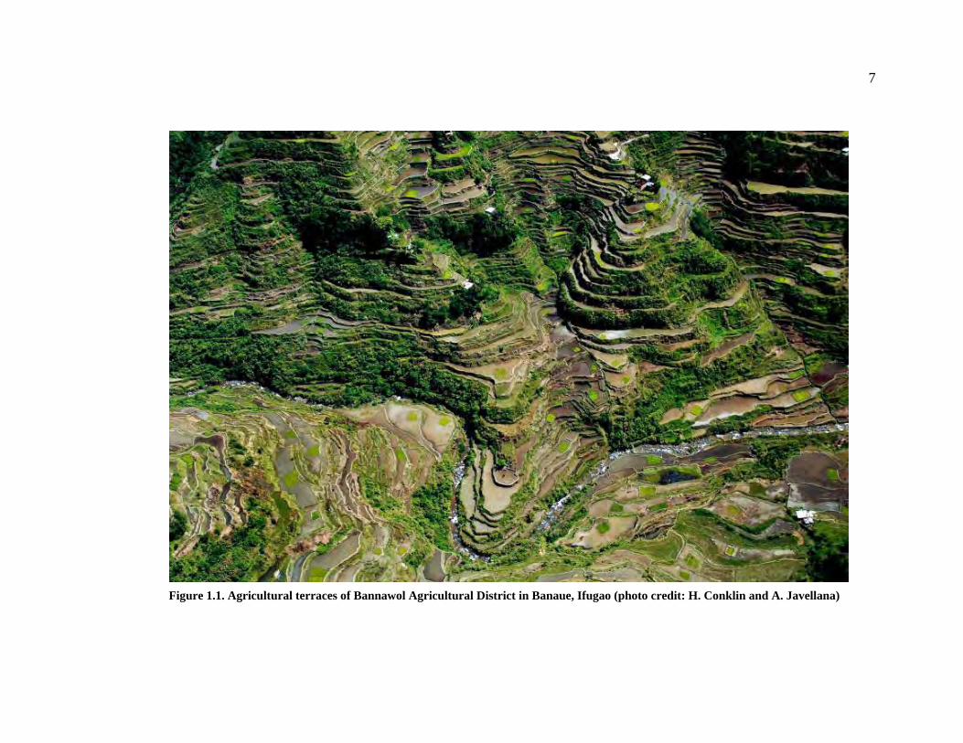
7
Figure 1.1. Agricultural terraces of Bannawol Agricultural District in Banaue, Ifugao (photo credit: H. Conklin and A. Javellana)

8
Figure 1.2. Location of map of the Municipality of Banaue, Ifugao Province

9
Central Cordilleran agricultural systems appear to have some common features
(Bodner 1986; Conklin 1980). Aside from terraced pond fields that are irrigated either by
springs or streams (or both) through a series of canals, we also see the presence of
swidden fields that produce taro, sweet potatoes, legumes, and other vegetables. This
feature is interesting because intensive rice farming and extensive swiddening are both
present in this agricultural system – a characteristic termed complementary agricultural
system by Rambo (1996).
Despite this general similarity, differences throughout the region (Central
Cordillera) have been recognized and can be identified today. Ecological variations
present recognizable patterning. A seasonal distribution of an average 3,000 mm annual
rainfall (as opposed to ca. 1800 mm annual rainfall in other regions), the rugged
topography, and irrigated ponded terraces and interspersed patches of woodlots that
occupy the gentler slopes, often occurring with settlements in the lower portions of
valleys (Conklin, 1980:1) distinguish Ifugao from other areas in the region.
Appreciating and understanding the unique dynamics of Ifugao agricultural system
require an awareness of environmental and cultural attributes of the Ifugao. An historical
ecological approach fits this need. The methodological theory of historical ecology is
increasingly being considered as a compelling approach in understanding human-
environment interaction (Balée 2006). The realization that there is a need to look at
multiple lines of evidence, including the history of landscapes, has contributed to the
growing influence of the approach. Accordingly, this study seeks to promote better
understanding of human-environment interaction by applying a landscape approach to

10
investigate relationships between agricultural production and environmental factors in
Ifugao.
Figure 1.3. Agricultural Districts in North Central Ifugao.

11
The term “landscape” in this study refers to what Crumley and Marquardt
(1990:73) consider as “the spatial manifestation of the relations between humans and
their environment”. The landscape is the imposition of culture onto the physical
environment or nature and associated with this is the decision-making opportunities to
allocate differential energy expenditures on the environment.
New theoretical developments in the so-called “complexity” sciences suggest that
many “systems” in nature are self-organizing. This more recent theoretical approach
holds much promise for explaining the organization of human activities, such as irrigation
agriculture. Theories of self-organization consider self-ordering mechanisms of complex
systems and at order-oriented behavior of opportunistic organisms, differentiating such
order from that seen, for example, in snowflakes (Kauffman 1995:8). In contrast to
perspectives that emphasize the mechanism of natural selection, order in nature is not
random or accidental.
The view that human practices are reproduced through cognitive and motivating
structures is useful for the analysis of Ifugao landscape and social dynamics. This is
evident in Lansing’s (1991, 1995; Lansing and Kremer 1993) explanation of the
emergence of Bali’s yield-enhancing, autonomous systems of agriculture-managing water
temples. This view hypothesizes that optimization systems, such as the Bali case, may
emerge in the absence of centralized control or a high degree of socio-political
stratification. When elites do emerge and try co-option, local mechanisms of resistance
forestall subjugation, even as productivity in a system is elevated.

12
Models of self-organization offer a promising approach for examining human-
environmental interaction. Although Ifugao villages are politically autonomous, they
practice a remarkable level of agricultural intensification across multiple watersheds that
require inter-community cooperation. The interconnection between the environment,
swidden fields, rice terraces, water management, and social organization provides a
valuable opportunity to examine a self-organizing system in a contemporary setting that
also has ancient antecedents.
Ethnographic studies of irrigation systems have also provided evidence of the
different ways in which people organize themselves in managing a landscape (irrigation
channels and land use categories). Mabry (1996:1-7) pointed out, for example, that local
irrigation systems are often quite flexible, even in the face of significant and rapidly
changing social and environmental conditions. For that and other reasons, complex
irrigation systems do not necessarily require centralized modes of political control.
Economic independence can also explain the autonomy of villages in Ifugao.
Since agricultural production (intensive and extensive cultivation and animal
domestication) insures the survival of the minimal economic unit (extended family in a
hamlet), there is no need to develop centralization, although cooperation and sharing of
the water is essential. We also see cooperation in other aspects of Ifugao life: conflict
resolution, for instance, suggests that the Ifugao would avoid physical confrontation
(Barton 1930:109-110). The existence of monkalun, or mediator, appears to be an
excellent prevention for cycles of raiding and/or taking of heads.

13
A minimal economic unit is the social unit (extended family in a hamlet) that can
adjust and endure the harshest circumstances presented by the physical and cultural
environment. Leone (1968:7-10) surmised that a group that is dependent on agriculture
can feed itself without relying from other groups. When farmers face food shortage or a
difficult season of the year, they rely on stored surpluses and do not change the range of
people they depend on. If agriculture leads to self-sufficiency where the need for
cooperation between villages is decreased to insure survival, it is possible that
agricultural dependence can lead to an increased social differentiation, at the same time
veering away from political centralization.
An increasing the degree of dependence on agriculture is probably directly
associated with decrease in regional cooperation, communication, and interaction.
Villages become more economically self-sufficient and self-reliant and simultaneously
become isolated from their neighbors.
The distribution of the rice terraces, and the intricacies of water sharing in
Banaue, Ifugao give rise to another debate: the antiquity of terracing and rice cultivation
in Ifugao. Although Maher’s series of archaeological investigations (1973, 1975, 1985)
provided radiometric dates, the context of his charcoal samples were not clearly
explained. A major component of this study is to offer a terrace growth model through
landscape analysis. I am making the assumption that areas first settled and subsequently
cultivated are those that are optimal for agricultural production (i.e. stable source of
water, gentle slope, etc.). This growth model based on general characteristics of the
landscape will then be anchored with C14 age determinations.

14
Postulations on the age of the Ifugao rice terraces have been based on two main
models. One maintains that the Ifugao started building terraces as early as two to three
thousand years ago. The other claims that terrace construction in the area is a recent
development, influenced by migration to Central Cordillera of lowland groups pushed by
the pressure of Spanish expansion into Northern Luzon at ca. AD 1572 (Keesing 1962).
Appropriately, the interpretation of greater age is the older of the two. Barton and Beyer,
through estimates of how long it would have taken to construct the elaborate systems
which fill valley after valley of Ifugao, proposed dates between 2000-3000 years ago
(Maher 1973).
For more than half a decade, no competing model was proposed for the age of the
Cordillera rice terraces: Barton’s and Beyer’s estimates were either accepted or rejected
without any alternative position. However, by the 1960s evidence has come in that
mounted a strong challenge to the older hypothesis and supports the view of a relatively
recent move into Ifugao territory, probably associated in some way with Spanish
pressure. Even with these interests, Conklin (1967) points out that despite the richness of
reporting on many aspects of Ifugao culture, such fundamental activities as terrace
construction have been given scant attention.
Based on these debates, the growth model of terrace systems in Ifugao is
developed and consequently used to infer relative ages of rice terraces. Radiocarbon
dates obtained from a terrace system (Bocos) were utilized to anchor the growth model.
These dates are integrated into a GIS landscape database to and develop expansion
model. These are discussed in Chapters V and VI.

15
The Municipality of Banaue (where the above-mentioned areas are located) was
chosen for this investigation because of the existence of high-resolution land use maps
prepared by Conklin (1972, 1980). Moreover, these areas were also the center of
Maher’s ethnographic and archaeological studies. Banaue also offers the most accessible
terrace systems (it is the tourism capital of Ifugao) and the agricultural cycle in the area
coincide with the fieldwork schedule.
In my previous Ifugao landscape analysis, land use pattern in Ifugao is correlated
with some environmental aspects (i.e. location of swidden and rice fields vis-à-vis
settlements and sources of water) (Acabado 2003). This work investigated the
relationship between land usage and the landscape in Ifugao and showed that the
environment is influencing the decision of the people in choosing specific plots of land
for wet-rice farming or swiddening.
A two-pronged landscape analyses was used in this study. A fine resolution,
village-scale analysis was carried out to establish terrace distribution vis-à-vis landscape
characteristics. The results of this initial analysis were then utilized to model a region-
scale distribution of cultural features across the landscape. Archaeology and
ethnographic interviews were also geared towards understanding village-scale dynamics.
1.2 OBJECTIVES As mentioned above, this work aims to understand the history of the Ifugao agricultural
terraces and the communities that constructed them. Using information from
ethnohistoric sources, ethnographic description, spatial analyses, and archaeology, I seek
to achieve the following goals:

16
1. Establish the antiquity of an agricultural terrace system utilizing Bayesian
modeling. The model developed in this work can be used to establish age of other terrace systems.
2. Assess ethnohistoric information regarding population movements related to the arrival of the Spanish in northern Philippines;
3. Provide archaeological chronology for the origins and expansion of agricultural terraces. An aroids-first model is proposed in relation to this goal;
4. Describe the Ifugao agricultural landscape, emphasizing the importance of a tripartite system of swiddening, intensive rice cultivation, and agroforestry management. This system is then used to discuss agrarian ecology issues; and,
5. Define the Ifugao social organization in terms of the “house concept” and relate this to self-organizing principles; These goals are integrated to investigate anthropological and archaeological
issues that relate to human-environment interaction. Specific chapters are devoted to
accomplish each objective and are interconnected with each other. Defining Ifugao social
organization provides us with the basis for looking at water management and agricultural
issues. Antiquity and chronology models serve as anchors of social organizational issues.
1.3 HISTORICAL ECOLOGY AND THE LANDSCAPE APPROACH
This work utilizes historical ecology to investigate Ifugao culture and history. The
development of historical ecology as a methodological approach had been a boon to the
understanding of human-environment interactions. It focuses on the relationships
between humans and the environment in which they live in. As opposed to other similar
approaches that are either anthro-centric (human ecology), environment-centric
(environmental history), historical ecology provides a balanced perspective that involves
investigating this relationship across time and space. Balée (2006) offered a
comprehensive review of the development of the approach.

17
The importance of historical ecology in archaeology lies in the constant dialogue
between human decision making and the environment. Since the landscape is considered
a human artifact, we can then reconstruct history through the analysis of the landscape.
Indeed, archaeological investigations are increasingly incorporating environmental
analysis. Since the early beginnings of the discipline, the influence of environmental
factors in understanding culture change was explicit in both theory and method of
archaeology (and anthropology in general). However, even with the inclusion of this
approach in archaeological reconstructions, it did not produce a unifying theoretical and
methodological tool. In fact, the term landscape in archaeological literature can mean
anything (Ingerson 1994).
I define the landscape as the spatial manifestation of the relations between
humans and their environment. As such, people make decisions based on their mental
models of how the world works. Their view of the landscape (and culture change) is also
based on the dialectics of change: landscapes are manifestations of the totality of human
life, that is, the dynamic tension between infrastructure and the superstructure
characterizes human life (Crumley and Marquardt 1987; Anschuetz et al. 2001). Thus, we
see the relationship between the need for cooperation and autonomy in Ifugao water
management in relation to their environment.
1.4. ANTHROPOLOGY, AGRICULTURAL INTENSIFICATION, WATER MANAGEMENT, AND SOCIAL ORGANIZATION The relationship between irrigation agriculture and social organization is a perennial
topic of anthropological debate. One reason lies in the impression that intensified

18
agricultural systems require centralized management and demographic demand
(Wittfogel 1955, 1957; Steward 1955; Boserup 1965, 1981, 1990); another relates to the
destructive environmental signatures of irrigated farming (Redman 1999; Denevan 1992,
2001; Erickson 2006a).
Boserup’s (1965, 1981, 1990) and Wittfogel’s (1955, 1957) theories of
agricultural change and political transformation provided archaeologists with empirical
models that attempted to explain subsistence and organizational change over time. Many
archaeologists have been attracted to Boserup’s theoretical framework because it
complements their efforts to examine sociopolitical development according to various
neoevolutionary schemes (Morrison 1994:136). Boserup’s model provided a useful
context for incorporating fragmentary archaeological evidence obtained from different
periods and diverse regions into a broader framework of interpretation. Boserup’s model
is, however, relatively deterministic and unilinear in that it lacks historical proof and it
conflates a variety of agricultural strategies (Morrison 1996:583-584).
Similarly, Wittfogel argued that large-scale hydraulic agriculture was (by
necessity) orchestrated by a centralized administrative apparatus to mobilize and
coordinate labor for irrigation, to engage in hydraulic engineering, and to provide the
capital. Fifty years ago, anthropologists conceptualized this as a simple issue of water
management and elite control. More recently, anthropology has offered a more nuanced
view in which intensification is a process (and water management is one component).
Glick showed that irrigation communities in medieval Spain operated without the
oversight of a centralized political organization. Work on Balinese rice terrace systems

19
(e.g. Lansing 1991, 1993; Schoenfelder 2000; Scarborough et al. 2000) illustrates another
example of a complex hydraulic system that operates in the absence of a centralized
administrative body. Instead, the Bali system is coordinated by socially-equivalent
members of different watersheds or subak (Lansing 1991:37-49; cf. Hauser-Schäublin
2003). Mabry (1996:1-7) also pointed out that local irrigation systems are often quite
flexible, even in the face of significant and rapidly changing social and environmental
conditions. These studies have shown that complex irrigation systems do not necessarily
require centralized modes of political control.
Historical ecology provides another way of looking at intensification and social
change. It views landscapes as products of human decisions, creativity, technology, and
cultural institutions (Balée 1998, Denevan 2001, Erickson 2000). Landscapes are
conceptualized through historical and cultural traditions. In this study, the Ifugao
landscape is a product of social institutions. As such, the modification of the environment
is not an adaptation, but rather is the application of a suite of information passed down
from earlier generations (Erickson 2003:456).
1.4.1 Intensification as an Anthropological Concept
The process of agricultural intensification interests anthropologists because of its
implication for the development of cultural complexity. These changes are considered
especially important because of anthropology’s goal of explaining culture across time and
space. Moreover, intensification of agricultural production offers an illustration of the
relationship between human behavior and the natural environment.

20
Within anthropology, archaeology is specifically concerned with changes, so
great interest is taken in studies of intensification of production, or the development of
cultural systems and relationships within a culture. The relationships between
intensification of production and complexity have been considered as mutually-occurring
phenomena, with debates often tying degrees of intensification to interpretations of
sociopolitical complexity (i.e. early states) and economic organization. With such studies
of agricultural intensification providing insights regarding long-term patterns of change,
they are considered important for understanding changes in the history of humankind.
Archaeological perspectives of intensification of production induce debates and
discourses about changes in subsistence and the development of surplus production and
social complexity (Morrison 1994:111). These debates include analyses of “broad
spectrum revolution” (Cohen 1977; Flannery 1965; Harris 1977: Strauss et al. 1980), the
origins and adoption of agriculture (Binford 1968; Bender 1978, 1981, 1985; Bronson
1975; Cohen 1977; Dennel 1985; Flannery 1965, 1973; Harris 1969, 1977; MacNeish
1958; Sherratt 1980; Zvelebil 1986), the development of irrigation (Adams 1966;
Boserup 1965; Steward 1955), specialized craft production (Muller 1984; Spence 1981;
Wright and Johnson 1975), climate and subsistence change (Thurston and Fisher 2007;
Seltzer and Hastorf 1990), and the co-evolution of agricultural and socio-political
systems (Schoenfelder 2000; Fisher, et al. 1999; Higham and Maloney 1989). Such
issues serve as bases for discussions on intensification.

21
1.4.1.1 Definitions of Intensification
This study follows Brookfield’s (1972) and Boserup’s (1965) definitions of
intensification, which involves increasing labor inputs and investments in order to raise
production significantly per unit of land or labor. There are a number of ways to increase
productivity, but all of them involve additional inputs of time and energy. In foraging
societies, an increase in gathering is almost synonymous to increase in labor inputs per
unit of land in food producing societies, as well as increasing the efficiency of production
in craft producing groups (Morrison 1994:115). In this view of intensification, three
significant aspects are apparent: spatial, energy capital, and technological. These are
exemplified by foragers that increase the spatial extent and duration of their food-
gathering; farmers that raise the level of production by increasing labor input and
improved technology; and, specialists that develop more efficient equipment and skill.
The nature of intensification then cannot be viewed through a single lens. The
multi-dimensional character of this phenomenon should serve as a distinguishing factor
to separate it from simple expansion or increase, and innovation (Morrison 1994: 115;
Brookfield 1984). Inherent in the archaeological concept of intensification is the
temporal dimension of the process. Agricultural practices happen in a precise cycle
within a given span of time. Thus, archaeologists can look at the long-term temporal
trends in strategies of intensification and view it as a long-term process rather than as a
single event. This implies multiple paths of intensification rather than a single route from
long to short fallows (Morrison 1994:115).

22
Boserup’s (1965:43) definition of agricultural intensification rests on several
factors: amount of land cropped, technology, labor input and population. In her model,
she depicts agricultural intensification as a function of the increase of population.
Moreover, the amount of land used for agricultural production is dependent upon the
amount of labor available within a specific region. The frequency of cropping, labor
input, and the quantity of output are interconnected in the patterns of changes that lead to
intensification of production.
Brookefield (1972:31) similarly presents intensification of production as a
manifestation of increases in inputs (labor or cropping frequency) that are ultimately
aimed at improving production. However, he differs with the Boserupian view in the
absence of population pressure as basis for intensification. For him, intensification of
production is tied to the concept of efficiency through consideration of marginal and
average productivity obtained by the additional inputs.
The models of intensification presented above, although, agreeing on the aspect of
labor inputs and increases in production, contradict one another issue of causation. It is
apparent that Boserup emphasizes demographic root while Brookefield emphasizes social
impetus. Moreover, Boserup provides a unilinear mode of change, while Brookfield’s
argument lies on a multiple lines of probable routes.
The labor component of agricultural intensification is seen as a major variable in
the intensification process. As Scarborough noted (2003), labor organization likely led to
greater social complexity. It is however, difficult to archaeologically quantify compared
to other aspects of technology. One way to determine the role of labor in archaeological

23
studies is the use of contemporary observations and landscape analysis and compare them
to archaeological information.
1.4.2 Water Management Systems and Managerial Requirements
The relationship between complex irrigation systems and social complexity has
generated models on how anthropologists represent long-term culture change. Indeed,
when Wittfogel proposed the idea of hydraulic civilization (1955), anthropologists where
quick to apply his perspective into socio-organizational change, both in ancient and
contemporary societies. In the course of the use of this model, however, anthropologists
discovered that complex hydraulic systems do not necessarily lead to social complexity.
It is accepted among anthropologists that the water systems entails some form of
management. This acceptance, however, varies in the degree of organizational
complexity (i.e. Lansing 2000; Erickson 1993; Earle and Doyel 2008; cf. Kolata 1997).
The prevention of conflicts and disruption of societal dynamics is probably the most
important task of water system organization, but the degree of organization complexity
will determine how conflicts are resolved.
Water management systems develop from the interplay between the physical and
cultural environments and emphasize cooperative organization. These result in the
equitable sharing of water through a consensus often sanctioned by the formality and law.
As in religious systems, the more flexible and encompassing the rules of access and
usage are, the more lasting and resilient the water management system (Scarborough
2000:3). Stated differently, the systems with best chance of uninterrupted longevity have
slowly evolved on the highly variable landscapes from which people make a living. Even

24
under appreciable stress, water management systems tend to persevere because of their
adaptability.
1.5 TIME PERIOD This work looks at a broad span of Ifugao ethnography and archaeology to
address issues raised above. Ethnographic sections of this dissertation utilize early
ethnographies of Beyer and Barton, Conklin’s ecological work, and recent ethnographies
to establish patterns in Ifugao social organization. The use of early ethnographies does
not suggest that the Ifugao are unchanging, rather these were utilized to make analogies
between the present, recent memory, and undocumented past. I discuss Ifugao social
organization in terms of what has been written and compare them to contemporary
observations to conceptualize patterns (i.e., house societies and Ifugao social
organization).
I argue that patterns observed from these ethnographies can be extended to how
the Ifugao might have organized themselves before the expansion of Spanish colonists.
Specifically, archaeological dating (of agricultural terraces) in this investigation, provide
the time frame of the development of the agricultural system and associated social
organization. The periods investigated in this work are distributed in different chapters of
this dissertation.
1.6 DISSERTATION ORGANIZATION This dissertation is organized into three major sections: Section I (Background) provides
a background on the issues discussed throughout the volume; Section II (Culture history)
discusses cultural chronology and antiquity of the ifugao agricultural terraces; and,

25
Section III (Social Organization) defines the Ifugao social organization in terms of the
house concept. In addition, the last section synthesizes findings of this volume.
The preceding sections have introduced the issues that this work aims to address.
Succeeding chapters discuss these issues more extensively. Chapter II provides an
overview of the Ifugao and their environment. This chapter also provides the background
for much of the later chapters.
Chapter III is devoted to describing the process of obtaining data relevant to the
questions and goals of this study. I also present datasets (spatial, ethnographic, and
archaeological) gathered for this investigation. More than half of the information used to
answer my research questions were based on datasets provided by GIS.
The application of GIS to archaeology has had an immense effect on how
contemporary research is being carried out. Destruction of sites can be evaded by non-
evasive research using remotely sensed data; identification of sites can be accomplished
quicker; hypotheses can be tested without even going to the field; and many more
functions of GIS are being applied to archaeology. In this study, information provided by
GIS is used to focus both ethnographic and archaeological investigations. The dataset is
also utilized for the growth model presented in the succeeding chapter.
In Chapter IV, I illustrate the agricultural landscape of the Ifugao and associated
agrarian issues. Special focus is given to the relationship between intensive and
extensive cultivation systems. As this chapter illustrates, the assumed evolutionary
relationship between the two types of farming systems is inaccurate. Moreover, sections
in this chapter set up the bases for developing a growth model for rice-terrace expansion.

26
Chapter V deals with the debate on the antiquity of the Ifugao agricultural
terraces. Radiocarbon determinations obtained by this study are presented in this chapter.
The use of Bayesian modeling is also introduced as an excellent dating methodology for
the rest of the Philippine Cordillera agricultural terraces.
In Chapter VI, I describe models for the possible initial arrival of groups of
people and subsequent development of agricultural terraces in Ifugao (and the rest of the
Cordillera). Previous archaeological, historical, and linguistic studies that shed light on
the culture history of general Cordillera populations are reviewed. Since archaeological
investigations in this region (and specifically, Ifugao) are fragmentary, reconstructing the
prehistory of Cordillera will come from multiple lines of evidence.
In Chapter VII, I define the Ifugao social organization and relate this to self-
organizing principles. Moreover, concept of house societies and how this fit the Ifugao
social organization is introduced. Discussions on the Ifugao social organization in this
chapter utilize information from early ethnographies of Barton and more recent work of
Conklin. Results of interviews with key informants are also integrated in this chapter.
By completing this study, I aim to contribute to discussions on anthropological
issues of complexity and heritage management. I examine anthropological issues that
include relationship between agricultural and irrigation systems with emergent
complexity; pathways to intensification; and organizational entailments of irrigation
systems. Such work informs on theoretical foundations of studies of agricultural systems
and social organization by applying the model of self-organizing systems, providing
empirical data to similar studies in island Southeast Asia (Lansing 1991, 1993;

27
Scarborough 1999; Schoenfelder et al. 2000) and elsewhere (Glick 1970, 1996; Erickson
1993), and provides an historical ecological approach in the study of emergent
complexity. Most importantly, this research looks at the material manifestations of the
link between agricultural systems and social organization.
Moreover this study also offers a much needed reference point in archaeological
studies of the northern Philippine highlands. The GIS modeling, as well as radiocarbon
dates, provides a baseline for further studies in other areas of the Philippine Cordillera.
This aspect is significant because only two archaeological investigations have been done
in the Cordillera region in nearly four decades (see Maher 1973, 1978, 1985; Bodner
1986 [for Bontoc]) and an almost complete absence of archaeological chronology in the
area remains.
The implications of this research to the area being studied are profound. As
mentioned above, the Ifugao rice terraces are rapidly deteriorating and the Ifugao people
are losing both their tangible and intangible heritage to changes brought about by
economic and political transformations. The rice terraces are examples of landesque
capital (Brookfield 1984: 36; Blaikie and Brookfield 1987: 9) and the assimilation of
Ifugao social organization to that of the state together with the low status given to farmers
and the rapid disappearance of traditional knowledge, could further spell degradation of
the terraces. One of the overarching goals of this study is to contribute to heritage
conservation programs in Ifugao, in both tangible and intangible heritage. I aim to
contribute to the preservation of the rice terraces in two ways. First, this research will
open avenues for educating local people (and broader Filipino society) on the importance

28
of preserving our cultural heritage. Secondly, the data that I will gather from this research
will be freely available for any agency or individual that is working on developing a
preservation/conservation program on the rice terraces and Ifugao culture.

29
CHAPTER II: THE IFUGAO 2.1 INTRODUCTION My introduction to the Ifugao started when I was taking a Philippine social studies class
in elementary school. Back then, we discussed the Ifugao as example of “original”
Filipino because of the failure of the Spanish to conquer them completely. The gist of the
topic and the message that the lecture seem to convey is still fresh in my mind: the Ifugao
were “untamed”, un-Christianized, and thus, different from lowlanders. Ironically, the
lecture also talked about the Ifugao rice terraces as emblematic of Filipino achievement –
that is, “we” (Filipinos) were able to overcome environmental constraints. It is sad that
this perception is still prevalent in Philippine society: we appropriate the Ifugao
agricultural terraces as our own, but think of the builders of these monumental structures
as inferior individuals.
The Ifugao are one of several minority ethnolinguistic groups in the northern
Philippines. They are well-known throughout the country and the anthropological world
because of their extensive rice terraces. At the turn of the 20th century two prominent
figures in Philippine anthropology began an intensive investigation of the Ifugao (Barton
1919, 1955; Beyer 1926, 1955). In 1924, Francis Lambrecht focused on documenting
traditional Ifugao customs (1929, 1962, and 1967). In 1967 and 1980, Conklin produced
the two most important works on the Ifugao agricultural system and land use. Other
recent ethnographies of the Ifugao include gender studies (McCay 2003; Kwiatkowski
1999), oral tradition (Stanyukovich 2003), culture change (Sajor 2000), and general
ethnography (Medina 2003).

30
The first Spanish description of the Ifugao rice terraces comes from an 1801 letter
of Fray Juan Molano, OP for his provincial (head of the Dominicans) (Scott 1974:199).
The irrigated, stone-walled fields were already known to the Spanish during the first
expeditions to Kiangan (ca. 40 km south of Banaue) in the 1750’s, but formal description
did not come until the successful Spanish occupation of the town in 1793. The valley of
Banaue, however, was not discovered by Europeans until 1868 (Scott 1974:238).
Descriptions of Cordillera peoples (including the Ifugao), were already available
to the Spanish when they encountered lowland populations in present-day Ilocos,
Cagayan Valley, and Nueva Vizcaya. These peoples (called the Igorots generically by
the Spanish) had their first contacts with the Europeans at ca. AD 1572 (Scott 1970)
because of their gold mines. Adelentado Miguel de Legaspi heard about the rich mines
of the northern Philippines a few months after he planted the Spanish soil on Philippine
soil in Febraruray 1565, and within six months of his capture of Manila in 1571, his
grandson, Juan de Salcedo, was preparing an expedition to explore the west coastal
region of northern Luzon which was the emporium for the Igorot gold (Scott 1974:9).
The Ifugao territory did not possess rich gold deposits, their Benguet neighbors
did. They, however, were still in the sights of the Spanish colonizers because of their
“pagan” beliefs. They were characterized by the Spanish as “unpacified, warlike tribes”
that present challenges to the Spanish forces. For them to have free reign in search of the
Igorot gold, the pagan tribes have to be subdued first. This resulted in multiple military
campaigns in and around the Cordilleras. These early intrusions of the conquistadors to

31
northeastern Luzon and subsequently, areas adjacent to present-day Nueva Vizcaya are
the main sources of information for contact period Ifugao (and the Igorot world).
2.2 THE PHILIPPINE CORDILLERA The Philippine Cordillera is considered as the ancestral homeland of the Igorots (generic
term given by the Spanish to the peoples they encountered in the northern Luzon
hinterlands which literally means, “people of the mountain”). It is home to seven major
ethnolinguistic groups: the Kankanaeys, the Bontocs, the Kalingas, the Ifugaos, the
Tingguians/Itnegs, the Apayao and Ibaloy. There are, however, “other” ethnolinguistic
groups that do not consider themselves as members of the groups listed above.
Cordillera peoples share similarities in culture and history at the same time,
exhibits diversity (Goda 2001). The most comprehensible of these similarities can be
observed in their concept of land ownership and land management. In Ifugao (and the
rest of the Cordilleras), rice land holdings is the measure of one’s wealth and status in the
society.
The land management theme is easily seen in their rice production techniques
(terracing). Although production is not driven by market factors (traditionally), we see
intensification in all of these communities, due perhaps to the value of rice in the culture.
Attached to this rice production (and terracing) dynamics is the communal management
of communal land and resources (forest and water sources).

32
Figure 2.1. Major ethnolinguistic groups in the Philippine Cordillera (adapted from Lewis 1992a).

33
2.2.1 Cordillera and the Colonial Era The initial intrusion of the Spanish in the Cordillera highlands was encouraged by
information about the presence of gold in the area (Scott 1980, Regpala 1990). There
first forays in the region in AD 1572 was a failure due to the ruggedness of the
topography. However, this activity allowed the Spaniards to establish camps in the
lowland areas of Pangasinan and Ilocos (Keesing 1962). From these camps, Spanish and
Filipino mercenaries again and again would carry out expeditions to the Cordilleras and
the Igorots would repulse these incursions. In these expeditions, the Spanish were able to
establish camps in Lepanto province, but encountered persistent attacks from the local
inhabitants.
It was not until AD 1787 that the colonial government was able to set up
permanent administrative region in the Cordillera (though, only in the Lepanto province).
According to Scott (1974:3-4), it was neither gold nor the gospel that brought these
foreigners in full force to the region, with new all-weather firearms, but tobacco
(although gold and access to China and its trade were the two primary objective of
Spanish colonization). During this period, the Spanish colonial government imposed a
monopoly of tobacco production and distribution in the territory. The Igorots did not
comply with this edict and would grow their own tobacco or ambush shipments of these
products and sell them in Ilocos or Pangasinan. This prompted the colonial
administration to send forces to the area. This final thrust was able to subjugate some
parts of Lepanto (Benguet and Bontoc), Nueva Vizcaya and Cagayan Valley (which are
considered as lowlands). The territories of Ifugao, Kalinga, Apayao, Tinguian, and

34
Bontoc were not successfully placed under the Spanish crown. Only the Kankanai and
Ibaloi were completely controlled by these forces – probably because of the proximity to
the lowlands of these groups. The establishment of the Spanish colonial administration in
the area brought schools and missionaries in the region.
Regpala (1990:116-117) attributes the activities of the Spanish during this period
to the three Gs (god, gold, and glory). She asserts that the Igorots did not fully succumb
to the Spanish might. The lands of the Ifugao, Kalinga, Bontoc, Apayao, and Tinguians
were not occupied by the Spanish military. Furthermore, the camps established by the
latter were constantly attacked by nearby groups. Regpala (1990:117-118), exemplifying
the perceived distinction of Igorots, gives credit to the war-like nature of the Cordillera
people and geography of the area in their successful defiance of the Spanish aims. The
emphasis on land (with its associated subsistence and prestige importance) would give
them reason to fight against foreign attempts to place their territories under control. This
assertion was also illustrated in Barton’s Autobiographies of Three Pagans (1930) and
Half-Way Sun (1978) where he described Ifugaos defending themselves against
neighboring groups who try to access their lands.
The establishment of the Spanish administration in Lepanto (present-day
Benguet) ushered in a lasting consequence to the relationship between the lowland
Filipinos and the Cordillera inhabitants. Scott (1974:7) argues that the dichotomy that
exists today between lowland Filipino’s dominance on the one hand, and the continued
defiance of the Igorots against outside hegemony and misconception of primitiveness on
the other hand, can be attributed to the Spanish aims.

35
The end of the Spanish regime saw the arrival of the Americans in the
Philippines. Scott’s (1974) portrayal of the relationship between these new colonialist
and the “natives” was an amicable one. Regpala (1990:122-123) pointed out that these
friendly relations could be a product of a different administrative strategy that was
employed by the Americans. The initial arrival of the American was met with doubts,
but the use of anthropologists in understanding the people helped to “pacify” and put
“order” in the region.
2.2.2 The Ifugao Province The Central Cordillera Highlands in the Northern Philippines (Figure 2.2) is dominated
by the terraced rice fields of the Ifugao. It lies on the central part of the Cordillera
mountain range in the northern Philippines. It is bounded by the Mountain Province on
the north, by the Magat River on the east, the province of Nueva Vizcaya on the south, by
Benguet province in the west. It has a total area of 2,525 km2 distributed over eleven
municipalities: Kiangan, Lagawe, Hengyon, Banaue, Mayoyao, Aguinaldo, Alfonso
Lista, Lamut, Hungduan, Tinog, and Asipulo (Dulawan 2001:1). The area covered by
this study is the municipality of Banaue, wherein 60 km2 of terraces, swidden fields,
settlements, and other features of the Ifugao landscape that was included in the land use
maps prepared by Conklin (1980).

36
The area lies on the east of the Cordilleran divide, 17° north of the equator.
Settlements and human made features in the landscape lie between 1,000 and 1,500
meters above sea level (Conklin 1980:1), with some mountain ridges rise up to 2,500 m
Figure 2.2. Present-day Northern Luzon provinces.

37
above sea level. The year-round abundance of water (annual rainfall exceeds 3,000 mm)
makes it feasible for wet-rice agriculture even steep slopes, with landscape modification.
Irrigated ponded terraces and interspersed patches of woodlots occupy the gentler slopes
often occurring with settlements in the lower portions of valleys (ibid). During the period
of Conklin’s study, average population density within the area range from 100 to over
250 per square kilometer.
Local subsistence activities are directly associated with the dominant features of
the area – the rice terraces, swidden fields, and private forests (muyong). These features
played an important part in the daily lives of the people that, presumably, built them – the
ancestors of present-day Ifugao. Their daily lives were influenced by the cosmology,
social relations, and ideology that are associated with the activities related to the rice
terraces; terrace-building, maintenance, planting and harvesting (Dulawan 2001; Goda
2001).
The rice terraces are also considered as one of the symbols of Filipino cultural
heritage. As a matter of fact, the Banaue rice terraces were enshrined in UNESCO’s
program for protection in 1995 and were reclassified on the List of World Heritage in
Danger in 20012
The importance of the rice terraces in the Filipino culture, however, did not
stimulate interest in the antiquity of the area. As of the moment, there are only two
archaeological field-based investigations have been done in the area (Beyer 1955; Maher
1973). Beyer’s work, however, was not based on any archaeological evidence (Maher
.
2 http://whc.unesco.org/archive/repcom01.htm#sec8

38
1973: 40). The only archaeological research done in the area then, is Maher’s 1973 work.
Other archaeologists have worked in other parts of the Cordillera (i.e. Bodner 1986), I
will refer to their work in Chapters V and VI.
As mentioned in the introduction, this paper is aimed at understanding the spatial
organization of the rice terraces, swidden fields, and settlements. Examining distribution
across the landscape in relation to slope, aspect, and elevation of the topography, is the
primary objective of this study. Moreover, this study will serve as a baseline for further
research in the area.
2.3 THE NATURAL ENVIRONMENT The complex topography of Ifugao can be best exemplified by the Digital Elevation
Model presented in Figure 2.3. According to Conklin’s (1980:4) observations, there are
many contrasts in the topography of the province. There are steep sloping valleys in the
north and gentle gradual slopes closer to tributaries, pine-covered northern slopes and
relatively open rolling land in the east and southeast, high regular slopes and lower
dishlike vales, and occasional almost regular basin-like formations ranging from the
steeper slopes of Battad through Mayoyao subvalleys to the singular and almost flat open
area between Kiangan and Lagawe.
Settlements in this rugged topography are usually concentrated on valleys with
stable source of water. As Figure 2.3 shows, irrigated terraces dominate the hillside of
North central Cordillera. Chapter IV provides a detailed description of the distribution of
agricultural features (i.e. agricultural terraces and swidden fields) relative to
environmental parameters.

39
Figure 2.3. Digital Elevation Model of North Central Cordillera.

40
2.4 SUBSISTENCE STRATEGIES Traditionally, the Ifugao are agriculturalists who have cultivated their locale for at least
300 years (Maher 1973). During the 1960s, their agricultural system is governed by
integrated patterns of mixed farming that include the management of private forests
(muyong), swidden cultivation of sweet potatoes, pond-field cultivation of rice, inter-
cropping of many secondary domesticates (i.e. sweet potatoes, potatoes, cabbage, and
other cash crops), and the raising of pigs, chickens, and other forms of livestock (Conklin
1980:36).
The pattern of agricultural system of the Ifugao is complex. Ecological, social,
and cultural factors, including indigenous knowledge of how these factors are linked to
each other and efficient utility affects this pattern. Table 2.1 summarizes the land use
categories of the Ifugao. Three of these land use categories, namely, swidden fields,
house terrace, and pond field, had been highlighted for specific consideration in this
study.

41
Table 2.1. Land use categories of the Ifugao (adapted from Conklin, 1980:7-8).
LAND USE Local Term Land Usage Description
Mapulun Grassland exposed ridge and slopeland; untilled; with low herbaceous grasses; public (in any given region); unmanaged; minimal value; source of roof thatch, game; not cultivated without new irrigation sources; usually far from densely inhabited areas
‘Inalāhan Forest slopeland; undisturbed soil, naturally woody cover; public (for residents of same watershed region); unmanaged; source of firewood, forest products, game.
Mabilāu Caneland (high grassland, cane grassland, secondary growth Miscanthus association): mostly slopeland, unworked soil, covered with various stages of second-growth herbaceous and ligneous vegetation dominated by dense clumps of tall canegrass; some protection and management (canegrass much used for construction, fencing, etc.).
Pinugū Woodlot slopeland; unturned soil; covered with high tree growth (timber and fruit trees, climbing rattans, etc.); privately owned and managed (some planting of tree, vine, and bamboo types), with definite boundaries; valued for timber, other products, and protection of lower farmland from runoff and erosion.
Hābal Swidden slopeland, cultivated and often contour-ridges” heavily planted with sweet potatoes; moderately intercropped (including rice below 600-700 m); discrete temporary boundaries for cultivation period of several years.
Latāngan House Terrace leveled terrace land; surface smooth or paved but not tilled; primarily house and granary yards; workspace for grain drying, and so forth; discrete, often fenced or walled.
Na’īlid Drained Field leveled terrace land, surface ditched and mounded (usually in cross-contoured fashion) for cultivation and drainage of dry crops such as sweet potatoes, legumes; discrete boundaries, privately owned; kept in this temporary state for a minimum number of seasons before shifting to permanent form of terrace use.
Payo Pond Field leveled, terraced farmland, bunded to retain water for shallow inundation of artificial soil; carefully maintained for cultivation of wet-field rice, taro, and other crops; privately owned, discrete units, permanent stone markers.

42
2.4.1 The Agricultural Cycle The agricultural cycle of the Ifugao has two major phases (Conklin 1980:13-35). Phase I
begins with field preparation (terrace formation), followed by planting (crop initiation).
Phase II on the other hand, starts during the dry season and ends with grain production
(crop cultivation) (for a comprehensive discussion on the subject, refer to Conklin, 1980)
(Table 2.2 outlines the Ifugao agricultural cycle).
Today, this agricultural cycle still serves as a general guide to farming activities in
Banaue, Ifugao. The introduction of new rice varieties, however, has somewhat disrupted
the cycle in some areas. In Banaue, the “traditional” rice (tinawon) is a single-cropping
season variety. It is interesting that the planting season in Banaue does not fall during the
heavy rainy periods Figure 2.4).

43
Table 2.2. The agricultural cycle of Ifugao (adapted from Conklin, 1980:13-37).
PHASE SEASON Duration ACTIVITIES Phase I
Off Season
July or early August to late November until the first week or December
Weeding, treading, and wet mulching Spading Wall cleaning
Planting Season
Late November or Early December until late March
Second weeding and wet mulching Margin cleaning Soil preparation Rice panicle planting Green manuring Dike finishing Seedling transplanting Field marking Second field marking
Phase II
Dry Season
Late March or early April until mid- or late June
Seed planting Swidden clearing Swidden planting Rice weeding Irrigation tending Wall weeding Margin weeding
Harvest Season
Late June until July
Rice roasting Early reaping Rice bundling
0
50
100
150
200
250
300
350
400
450
500
Aug Sept Oct Nov Dec Jan Feb Mar Apr May Jun Jul
MM
Figure 2.4. Annual rainfall by month: eight-year averages from Bayninan records (1962-1970), adapted from Conklin 1980.

44
2.5 AGRICULTURAL TERRACES
Agricultural terraces are symbols of humanity’s accomplishment to modify the
environment to suit their needs. Terracing is not exclusively practiced in Asia, in fact,
they are found worldwide (Vogel 1988; Johnson et al 1982; Conklin 1980; Lansing
1991). Studies of these agricultural systems have brought about issues such as
environmental adaptation and land use history, population dynamics and agricultural
intensification, settlement patterns, and culture history of groups constructing and using
terraces. Agricultural terraces are planting platforms located in any artificially flattened
surface that include a retaining wall that holds back or accumulate soil (Spencer and Hale
1961:3; Denevan 1980; Field 1966). Treacy and Denevan (1994:93) observed that
agricultural terraces are can be located on steeply sloping terrain (up to 70%) as well as
on gentle slopes (less than 5%). As the preceding sections illustrate, this observation is
accurate in the Ifugao case.
The Ifugao terraces (as in China and the rest of Southeast Asia) are primarily used
for rice cultivation. As such, Treacy and Denevan (1994:101) characterize these fields as
horizontal with earthen bunds extending along the retaining wall edges to pond water
(Figure 5.2). The construction of these terraces signifies labor-intensive environmental
modification. The preceding section illustrates the relationship between the natural
environment and the distribution of rice terraces in North Central Cordillera.

45
Figure 2.5. Cross section of an Ifugao pond field in a concave-slope valley with area sampled for excavation (adapted from Conklin 1980:16).

46
2.5.1 Terrace-Construction Steps In the past twenty years, construction of new agricultural terraces in Banaue,
Ifugao is virtually on a standstill. This might be attributed to the fact that almost all
terraceable area in the region has been modified. However, several Ifugao farmers
recalled and described the process of constructing new agricultural terraces (payao) from
scratch.
According to these informants, the primary consideration in the construction
process is the availability of water source. They contend that the slope of the area being
terraced is just secondary to the stability of water flow – they would be able to create
terraces even on areas with more than 40° gradient. Thus, the first step in the construction
of new terraces is the excavation of irrigation channel. All of the informants mentioned
that they tapped in to existing irrigation system. Customarily, tapping on existing
irrigation channel involves a payment (adang), usually pigs, to the original builder/owner
of the channel. It also entails an agreement that all of the canal users contribute to
maintenance and repair.
Once excavation of irrigation channel is completed, the area to be terraced is
cleared of vegetation – although most of terraces were once swidden fields. This is
followed by ritual called nun-agang, which seeks permission from the spirits (using
chicken bile). If the mumbaki (Ifugao religious specialist) reads a good omen, the
construction commences.
Excavation of the koheng (canal for discharging soil and water) is the second step
in the terrace construction process. Leveling of the panad (surface area for cultivation –

47
by taking out the topsoil [la-lad]) follows this step. The last step in the process is wall
construction. If additional payao are needed to be constructed, steps on koheng
excavation, leveling, and wall construction are repeated.
One of my informants started to construct a six-level agricultural terrace (Figure
2.4) in 1970 and completed work in 1978. He worked on the construction 3 months per
year, between the months of September and December, right after the harvest season and
just before the sowing period. This ensures that the soil and other debris from the
construction do not ruin rice planted on the payaos downstream. It took him 24-human
labor months complete the six-level terrace.
Information regarding terrace construction is important in the Bayesian model
presented in Chapter VII. The informants noted that organic materials are not used in
terrace wall construction, thus radiocarbon samples taken from the terrace walls are not
directly associated with the archaeological event being dated. The construction process
also alludes to the need for cooperation in maintaining the irrigation system and
observing the agricultural calendar.

48
2.6 THE IFUGAO SOCIAL ORGANIZATION The nature of Ifugao social organization had been described in previous ethnographic
studies (Barton 1919, 1922, 1930, 1938, 1955; Lambrecht 1929, 1962; Conklin 1967,
1980; Dulawan 2002; Pagada 2006; Medina 2003; Kwiatkowski 1999). Dulawan
(2002:5) and Conklin (1980:5) illustrate the Ifugao social world as being guided by their
kinship system. Dulawan (2002) described this kinship system as bilateral which reach
up to the fourth ascending generation and include dead ancestors. These dead ancestors
play one of the vital functions in the everyday life of the Ifugao, from their cosmology, to
Figure 2.4. Figure 2.6. Terraces constructed in the 1970s.

49
politics, to subsistence (Barton, 1946; Scott, 1974). The structure of the Ifugao culture
underlie an abiding concern with the competitive development of land for terracing and
rice production, elaborate traditional rituals that on all occasions involve interaction with
deceased kinsmen, and a deep interest in status and rank and the inherited wealth the
latter customarily require (Conklin, 1980:5).
Conklin (1967; 1980) and Dulawan (2001) illustrate the Ifugao kinship reckoning
as bilateral. The strongest bond that ties individuals is the kinship system. Because of
this, the concept of vengeance against non-kin transgression is prevalent in this society. If
a member of a kindred was wronged by an individual from another member of a different
kindred, conflict between those concerned groups will include every individual member
of the involved kindred (Dulawan 2001:5). Monogamy is an idealized custom among the
Ifugao. Incest taboo against close relatives is strictly observed (up to the fourth-cousin
on both mother’s and father’s side). However, there is a ritual that can be carried out to
break this rule called pong-a. Residence is ambilocal and newly-wed couples can
establish residences in settlements closest to the more productive rice-fields inherited by
both partners at marriage (Conklin, 1980:5). Thus, settlements, or hamlets (as Conklin
termed the residential area), are made up of families whose larger agricultural holdings
tend to be located in the same area. The bonds that link non-kin neighbors mainly come
from common ecological concerns. They do not, however, diminish the primary bonds of
collective responsibility associated with inheritance, litigation, and indemnities that
typify kinship relations based on consanguinity (p.6).

50
Ifugao social structure is an essential component of rice cultivation and swidden
farming. Cooperation among kin during terrace building, planting, harvesting, repair of
walls and irrigation channels, and different rituals require precise coordination. As an
example, the existence of cooperative work-groups (uggbu and baddang – which are
regulated by kinship and territorial affiliation) is responsible for community-wide
cooperation – a necessity in the Ifugao landscape and agricultural system. Chapter VII
discusses the nature of Ifugao social organization in detail.

51
CHAPTER III: RESEARCH DESIGN AND DATA DESCRIPTION
3.1. INTRODUCTION This chapter provides a general description of the approaches used in this study. This
investigation utilized GIS technology, ethnographic interviews, and archaeological
exacavations in understanding Ifugao landscape, culture, and history. GIS technology
enabled the research to develop a model of the spatial and temporal correlations between
cultural features (villages, swidden fields, and rice pondfields) and natural environmental
attributes (topographic features). This information was integrated to infer the growth and
development of habitation settlements and agricultural terraces in the region. Once this
model had been constructed, I used it to devise a sampling strategy to gather appropriate
charcoal samples via sub-surface excavation.
I use the GIS database to generate estimates of labor that people invested in
terrace construction. Analysis of the GIS database was also used to assess the potential
productivity of various terraces and swidden fields. Meanwhile, excavation units offer an
opportunity to recover charcoal from beneath terrace walls. Radiocarbon determinations
from these excavation units help establish a model for dating construction and expansion
of Ifugao terrace systems.
The methods used to obtain data were congruent to the research questions listed in
the introductory chapter of this volume. Landscape (GIS) data served as the initial stage
in understanding the relationship between agricultural features, environment, and social
institutions; ethnography and archaeological excavations provided fine-grained

52
information on agricultural practices, social organization, and terrace-construction
technology
3.2. METHODOLOGY
My study of Ifugao agriculture and social organization included four stages of
research (Table 3.1): GIS-based analyses of the Ifugao landscape; a field survey that
involved GPS mapping, archaeological excavations; ethnographic interviews; and
laboratory and data analysis. The first stage requires digitization of topographic and land
use maps as well as satellite and aerial photographs to develop a digital elevation model
of the Ifugao region. Estimates of labor and agricultural productivity were also
developed for one terrace system using the GIS database and information that I culled
from the ethnographic interviews.
Table 3.1. Research activities and schedule.
Stage Activity 1 GIS-based
analyses of the Ifugao landscape
1. Digitize and analyze topographic maps as well as develop land use classification and digital elevation model from aerial and satellite photographs of North Central Cordillera. 2. Develop estimates of soil productivity from data culled from the GIS-database (above) and data from the Bureau of Soils and Water Management, the Department of Agriculture and precipitation data from the Philippine Atmospheric, Geophysical and Astronomical Services Administration (PAGASA). 3. Develop productivity estimates vis-à-vis labor requirement for a specific terrace system through the GIS-database 4. Develop construction sequence of terrace systems. I hypothesize that the sequence of construction of the rice terraces in Ifugao starts from areas near sources of water (rivers, springs) and on relatively gentler slopes.
2 Field Survey: GPS mapping, and interviews
1. Interview farmers (and terrace builders) about the optimum areas for terracing. 2. Take GPS points from sites identified by informants as the oldest terrace systems and systems that exhibit optimal features for agricultural production.
3 Survey: excavations
A terrace system identified by GIS and local informants as the oldest was chosen for excavation: Four 1m x 1m excavations within the terrace were carried out: one excavation unit nearest to the river, another unit in a terrace located 10 meters farther up, another unit near the village, and one on mountain top terraces.
4 Data analysis and write up

53
Simple regression analyses were used to examine environmental data in the GIS
database. I expect that certain environmental conditions underlie the suitability of areas
that were/are optimal for wet rice agriculture and terracing in the highlands of Northern
Luzon. Research in Bali (Lansing 1991; Scarborough et al. 2000), for example,
demonstrates how water was shared between upstream and downstream populations
elsewhere in Southeast Asia. I applied a similar perspective to investigate the social
organization of irrigation among the Ifugao. In this vein, I expect that earliest
construction of rice terraces among the Ifugao began near sources of water (rivers,
springs) and on areas that had relatively gentle slopes.
Stage two (field survey) of my study focused on GPS mapping and subsurface
excavations, to acquire samples for radiocarbon dating guided by a Bayesian Model.
Sites for mapping were selected after I had constructed the GIS database. In consultation
with Ifugao informants, I selected well-preserved sites for excavations (Figure 3.1).

54
Figure 3.1. Location of Bocos excavation units in relation to the rest of Banaue terrace systems.

55
Between June and September 2007, with the help of graduate students from the
Archaeological Studies Program of the University of the Philippines and local Ifugao farmers,
terrace wall excavations were undertaken. These coincided with the “off season” (i.e.,
late July to late November) of the Ifugao agricultural calendar (Conklin 1980:13-37).
This phase marks the time when farmers often repair damaged walls. This period
ensured that my fieldwork will not disrupt major agricultural activities, such as the
preparation of fields and planting of rice.
3.2.1 GIS This section briefly describes the process of digitizing eight land use maps of North
Central Ifugao that were originally prepared by Conklin (1972). The eight maps that
were digitized were composed of the Gohang, Bannawol, Pula, Ogwag, and Kinnakin,
Amgode, Hengyon, and Linge plates (Conklin 1972). The eight plates that were digitized
were composed of several agricultural districts. However, only the complete agricultural
districts, or to some extent comprehensive enough, were chosen for analysis. These were
the agricultural districts of: Amganad; Bannawol; Bayninan; Kinnakin; Lugu; Nabyun;
Ogwag; Pugo; Pu’itan; Tam’an; Kababuyan, Nunggawa, and, Hengyon (Figure 3.2).
I began this project during my MA work in 2003 and continued to digitize the
maps for my PhD research. Some of the features were later digitized with the help of
Gilbert Gonzales. The whole process took almost five years to complete. The completion
of the GIS database was an important stage in my PhD work: the fieldwork component
(excavations and interviews) was set up by the landscape information provided by the

56
GIS database. In this manner, this dissertation is a continuation of the work I began
during my MA program.

57
Figure 3.2. The thirteen (13) agricultural districts that were selected for landscape analyses.

58
The land use maps of North Central Ifugao that were prepared by Conklin in the
late 1960’s to early 1970’s were scanned and digitized using heads up digitizing in the
software ArcGIS. Four thematic features that were directly significant to this paper were
selected for individual digitizing. These were: 1) the terraced rice fields and swidden
fields (Figure 3.3); and, 2) settlements/villages and the drainage system (Figure 3.4). To
develop digital elevation model (DEM), topographic contours with 20 meter intervals
were also included in the digitizing (based on Conklin’s 20m contour relief).
Figure 3.3. Terraced rice fields (right) and swidden fields (left) in North Central Cordillera.

59
The “heads up” (or manual) digitizing was carried out using ArcView. ArcView
was also used to generate data on elevation, land area, distances, the aspect, and the
slope. The last two items were generated from the Digital Elevation Model (DEM). The
spatial relations/object generated from the digitized maps were placed into an MS Excel
spreadsheet. Multiple regression analysis and correlation coefficients were run to
determine relationships between the features of interest and the statistical significance of
the relationships. The level of confidence used for this study was set at 95%. Spatial
autocorrelation however, was not carried out in this exercise because I believe that many
factors influenced the cultural features in the landscape of the Ifugao.
Figure 3.4. Distribution of hamlets (right) and drainage system (left) in North Central Cordillera.

60
3.2.2 Ethnographic Interviews
The primary purpose of ethnographic interviews in this study is geared towards
understanding Ifugao agricultural practices that ultimately informs self-organization as
well as developing Bayesian model for dating construction and use of Ifugao agricultural
terraces. Utilizing previous ethnographies and similar studies (i.e. Lansing et al 1990), I
conducted informal, unstructured interviews with key informants (Appendix I lists these
questions as well as sample answers). Five (5) community elders were chosen primarily
because of their ages and apparent experience in the agricultural practices and general
culture of the Ifugao. My research assistant, Maureen Salvador (an Ifugao), interviewed
three (3) of the informants while I interviewed the other last two. Four of the interviews
were conducted within three days and served as my introduction to the community. The
fifth (5) became my guide while mapping the terraces. As such, I was able to carry out
an in-depth interview for two weeks.
These interviews focused on questions about cooperative work (and the concept
of reciprocity), rituals associated with agricultural events, and activities that relate to
construction and maintenance/repair of terrace walls. As discussed in Chapters IV and
VII, information provided by these interviews resulted in the development of
methodology for establishing the antiquity of the terraces and determining the social
organization of the Ifugao (Chapters V, VI and VII).
3.2.3 Excavations
Subsurface archaeological excavations in this investigation were carried out to
obtain charcoal samples within and beneath the terrace walls (Figure 3.5) in the Bocos

61
terrace system (Figure 3.6). Although the primary objective is to acquire datable
charcoal in solid context, we also collected earthenware sherds (presented in succeeding
sections) during the course of the excavations. The selection of the Bocos terrace system
as sampling site for archaeological excavations was based on GIS-modeling and oral
history (discussed in Chapter 5).
Excavation Unit
Figure 3.5. Location of excavation units in Ifugao agricultural terraces.

62
Figure 3.6. The Bocos terrace system and excavation units in relation to other agricultural districts.

63
Excavations and gathering of charcoal samples were guided by a Bayesian model
(Buck et al. 1996) developed to address the intermixture of materials in agricultural
layers (discussed in Chapter V). Following Dye’s (in press) call for a standard
methodology for calibrating 14C results and incorporation of stratigraphic information in
the calibration, this investigation utilized use of Bayesian modeling to date agricultural
terraces, which by nature have layers with a chaotic mixture of materials. Anywhere in
the world, dating agricultural terraces presents methodological difficulties because of
their construction technology and use. However, as this study illustrates, a Bayesian
approach addresses the problem by incorporating stratigraphy, ethnographic information
and 14C dates in the calibration process. Consequently, charcoal samples were obtained
from two main strata – from the layer just beneath the current agricultural soil and
underneath the terrace wall foundation. These samples provided the required information
to calibrate radiocarbon determinations and date the archaeological event of terrace wall
construction.
3.2.3.1 Bocos Excavation Sites Using the information gleaned from the digitized land use maps and ethnographic data on
rice terracing practices in Ifugao, I identified four excavation units within the Bocos
terrace system (Municipality of Banaue, Ifugao) to obtain charcoal samples for
radiocarbon determinations. These excavation units were selected based on their
proximity to the river, with the assumption that units nearest to the river would provide
the earliest dates (Keesing 1962: 322; Maher 1973). Moreover, the Bocos system is
64
located on the southernmost section of the Banaue terrace systems. Working on the
assumption that populations were moving up the valley through Alimit River, then,
Bocos terraces should be the oldest in the Banaue area. More importantly, the
environmental features of Bocos suggest less energy requirement for terrace-building and
more optimal for wet-rice production; less slope gradient, better water source, and
adjacent to a large village.
During the summer of 2007, with the help of graduate students from the
Archaeological Studies Program of the University of the Philippines and local Ifugao
farmers, I excavated two units located near Alimit River, one excavation unit in the
middle of the terrace system and one excavation unit on mountain top terraces. Following
Conklin’s (1980) cross-sectional illustration of an Ifugao pond field and information
culled from local Ifugao farmers, I chose to excavate the wall section of the terraces. I
believe that the wall foundation is the best location for dating the construction of a
particular terrace. Ifugao farmers stated that even though some terrace walls occasionally
collapse, wall foundations (kopnad) generally remain in their original place.
Two charcoal samples acquired from each excavation unit were used for 14C
dating. These were collected from the layer beneath the wall foundation and from the
layer within which the wall foundation is located. All of the excavation units yielded
similar stratigraphic profiles: Layer I, cultivated soil (luyo); Layer II, hard earth fill and
wall foundation (haguntal and gopnad, respectively); and Layer III, original valley floor
(doplah) (Figure 3.7). Three of the four excavation units provided data that corresponded
with the Bayesian model for dating rice terrace construction used in this study (discussed

65
below). The unit located in the middle of the system (Achao) produced a single charcoal
sample from Layer II, thus, the information provided by unit Achao was used to support
the use-date of the terrace. All of the charcoal samples were remains of Pinus kesiya
Royle ex Gordon, commonly known as Cordillera pine, which has a lifespan of 100–150
years (Kha 1965: 25–6).
Figure 3.7. Typical profile of Bocos excavation units.

66
3.3 LANDSCAPE AND ARCHAEOLOGICAL DATASETS
This section briefly describes datasets obtained from my 2007 fieldwork and
subsequent laboratory analyses. Detailed description for landscape data is presented in
Chapter IV, while excavated information, specifically, radiocarbon determinations, is
discussed in Chapters V and VI. This section aims to provide an overview of all the
datasets used for succeeding sections.
3.3.1 Landscape Data
Spatial aspects of Ifugao landuse and the extent to which geographic and
environmental factors determine the location of agricultural lands. Datasets obtained to
determine the relationships between the environment and distribution of Ifugao
agricultural features include the following:
1. The relationship between types of agricultural land use and population?
I examined the relationship between the amount of land used for villages (land area as
a proxy indicator of population density) and the total land area utilized for food
production (terraced rice fields and swidden fields). The following information were
generated based on the available data:
a. The total area of rice fields to amounts of settlement areas (as settlement is a proxy indicator of population);
b. The amount of land used for swidden cultivation and amount of land occupied for settlements;
c. The amount of swidden land to rice fields land; d. The size of agricultural district and relative percentage of land used for swidden
fields; and, e. The size of agricultural district and average size of rice fields.

67
2. Relationship between amounts of land used for irrigated rice fields and proximity to drainages and villages. A visual/qualitative examination of the topography of North-Central Ifugao
suggests that the characteristics of this topography determine the land area and location
occupied by terraced rice fields. Using the spatial data generated from the digitized
maps, I investigated the relationship between the land area occupied by terraced rice
fields and environmental factors. To evaluate this relationship, I examined the following
elements of the landscape:
a. The land area of the rice fields and their relationship to the average elevation of the topography where these rice fields are located;
b. The land area of the rice fields and their relationship to the average slope of the topography where these rice fields are located;
c. The land area of the rice fields and their relationship to the average aspect of the topography where these rice fields are located;
d. The land area of the rice fields and their relationship to their minimum distance from natural drainages; and,
e. The land area of the rice fields and their relationship to their minimum distance from villages.
3. Do elevation, slope, and aspect influence the configuration of swidden fields? Similar to the previous analyses, visual/qualitative examination of the topography
of North-Central Ifugao suggests that topographic characteristics determine the land area
and locations occupied by swidden fields. Using the spatial data generated from the
digitized maps, I investigated the relationship between the land area occupied by swidden
fields and environmental factors. To evaluate this relationship, I examined the following
elements of the landscape:
a. The land area of the swidden fields and their relationship to the average elevation of the topography where these rice fields are located;
b. The land area of the swidden fields and their relationship to the average slope of the topography where these rice fields are located;

68
c. The land area of the swidden fields and their relationship to the average aspect of the topography where these rice fields are located.
d. The land area of the swidden fields and their relationship to their minimum distance to natural drainages;
e. The land area of the swidden fields and their relationship to their minimum distance to rice fields; and,
f. The land area of the swidden fields and their relationship to their minimum distance from villages.
By examining these factors, I expected to find correlations between the amounts
of land used for agricultural production and the land area occupied by villages.
Moreover, I also expected that the relationships between environmental factors and land
use should be correlated as well. These results provide baseline data for determining
optimal areas for agricultural production.
Moreover, finding statistically significant relationships between these factors will
indicate the importance of environmental variables in determining land use. The complex
topography of the North-Central Ifugao and the imposing terraced rice fields illustrate the
link between the natural environment and culture. We know that humans modify the
environment to satisfy the requirements for food production, but the factors that influence
humans’ choice of modification have to be analyzed. I believe that this study of the land
use of the Ifugao will shed light on this topic.
3.3.2 Archaeological Data
Subsurface excavations provided datable charcoal samples needed for
determining the antiquity of the Bocos terrace system. Moreover, the excavation also
provided information on earthenware pottery used by the Ifugao, botanical remains, and
general stratigraphy of the terraces. Radiocarbon determinations will be discussed
exhaustively in the succeeding chapters, this section provides descriptions of type of

69
earthenware recovered, botanical remains that are related to rice and taro cultivation, and
general stratigraphy of Ifugao agricultural terraces.
3.3.2.1 Earthenware Ceramics
Academic interest in Ifugao culture has never waned since pioneering
anthropologists started investigating Ifugao social dynamics. These studies however,
mainly focused on the intangible aspect of Ifugao lifeways, so little has been done on
their material culture. Maher (1973), Solheim and Schuler (1969), as well as Conklin
(1963) provided glimpses of Ifugao pottery tradition, but these accounts do not agree with
Jenks’ (1905) description of Bontoc (a neighboring group) earthenware complex.
Maher (1973:57-67) provides information on pottery-making traditions in Ifugao
in the 1960s. He also included illustrations of pots produced during this time and
mentioned that this tradition was already disappearing during the course of his initial
fieldwork (1960-1963). Today, earthenware ceramics in Ifugao are imported.
Pottery sherds recovered during excavations were similar to Maher’s (1973) and
Solheim and Schuler’s pottery descriptions. These were all recovered from agricultural
fields, presumably used by farmers for food storage. I have observed farmers bringing
lunch to the fields.

70
Figure 3.9. Ifugao water jar, cooking pot, and effigy pot as described by Maher (1973). (Images taken from Maher 1973:58-59).
Figure 3.8.Sherds recovered during the 2007 excavations that are similar to earthenware ceramics describe by Maher (1973): A) Lip and body of cooking pot; B) part of an effigy pot (ear?); and, C1 and C2) water jar handle.

71
3.3.2.2 Botanical Remains Soil samples were taken from Bocos excavation units for water flotation to recover
botanical remains. Two graduate students from the Archaeological Studies Program,
University of the Philippines, Ma. Jasminda Ceron and Anna Jane Carlos processed and
analyzed these samples. Samples obtained from the excavations include rice, weeds
associated with rice cultivation, pine tree remains, betel nut, and tubers (Table 3.2). These
samples were collected from Layers II and II.

72
Table 3.2. Botanical samples recovered from three (3) excavation units in Bocos, Banaue, Ifugao.
Excavation Unit
Layer number
Depth below surface (cm)
charred parenchymatous tissues
transformed seeds untransformed seeds
Rasa 20 1 charred 2 charred rice hull 2 rice hull(?), 1 prob. Chenopodium cf. ambrosioides or gromphrena celesioides Mart.
30 34 charred Ageratum conyzoides, 2 charred Oxalis stricta or corniculata, 13 charred elim Spilanthes Jacq. Sp., 9 charred Portulaca cf. olleraceae, 10 prob charred prob. Scirpus grossus Linn.f., 23 charred Paspalum, 1 charred prob Euphorbia geniculata Ort. (=E. heterophylla Linn), 3 prob charred cf. Argemone platyceras, 4 charred prob fimbristylis, 8 charred prob Scirpus cf. smithii, 1 charred prob Scirpus cf. nevadensis, 19 charred prob Scirpus cf. debilis, 6 charred prob. Scirpus cf. heterochaetus, 12 prob charred prob Polygonum cf. convolvulus or densiflorum, 11 prob charred prob Eclipta alba (l.) Hassk. (+E. Prostrata Linn.), 17 charred prob Eichhornia crassipes (Mart.) Solms, 14 prob charred cf. Eleocharis acicularis, 22 prob charred cf. Najas guadalupensis or graminea, 5 charred Eleusine indica (L.) Gaertn., 2 charred prob. Fimbristylis dichotoma (L.) Vahl., 1 grass, 3 prob charred cf. Digitaria adscendens or Pennisetum polystachyon (L.) Schult. Or Ryynchelytrum repens (Willd.) C.E. Hubb.
56 prob Monochoria vaginalis (Burm.f.) Presl or Monochoria vaginalis (Burm.f.) Presl var. plantaginea Solms, 2 Ageratum conyzoides, 2 prob Najas guadalupensis or graminea, 20 prob Phyllanthus Urinaria L., 37 prob. Scirpus grossus Linn.f., 9 cf. Eleocharis acicularis, 25 Unt(?) prob charred cf. Najas guadalupensis or graminea

73
50 3 charred cf. Rumex cripus, 11 charred Polygonum cf. densiflorum, 1 charred Scripus cf. debilis, 6 charred Scirpus cf. heterochaetus, 2 charred Scirpus cf. smithii, 1 charred Scirpus cf. nevadensis, 1 charred Portulaca oleraceae, 1 prob charred Aegeratum platyceras, 1 prob charred cf. Eschscholtzia californica, 1 charred Eleusine Indica (L.), 1 charred Paspalum, 2 prob charred Euphorbia geniculata Ort., 1 prob charred Solanum
5 cf. Scirpus Grossus Linn. F., 1 prob. Monochoria vaginalis (Burm.f.) Presl or Monochoria vaginalis (Burm.f.) Presl var. Plantaginea Solms, 44 Ageratum conyzoides L., 1 Papaver dubium, 6 cf. Rumex crispus, 5 Scripus cf. debilis, 6 (medium) 4 (large) prob. Papaver dubium, 3 prob untransformed prob papaver dubium, 2 cf. Eschscholtzia californica, 2 Phyllanthus urinaria L., 1 prob Phyllanthus cf. urinaria
100 charred rice hull, 2 charred grass 20 3 charred 2 charred Eclipta alba (L.) Hassk.,
3 charred cyperus cf. pulcherrimus, 17 charred prob cyperus cf. procerus, 5 charred scirpus cf. smithii, 1 charred Eichhornia crassipes (Mart) Solms, 1 prob charred prob. Eichhornia crassipes (Mart) Solms, 1 charred Panicum, 3 prob charred prob. Fimbristylis cf. dichotoma (L.) Vahl or miliacea, 1 charred(?) elim. Portulaca oleraceae
4 Phyllanthus urinaria L., 1 prob. Monochoria vaginalis (Burm.f.) Presl or Monochoria vaginalis var. Plantaginea Solms, 18 cyperus cf. pulcherrimus, 2 Scirpus cf. debilis, 1 prob cyperus iria, 1 prob papaver dubium, 2 Solanum, 7 cf. Eschscholtzia californica
Figure 3.2. (continued) Botanical samples recovered from three (3) excavation units in Bocos, Banaue, Ifugao.

74
Achao 20 3 charred 2 charred Eclipta alba (L.) Hassk., 3 charred cyperus cf. pulcherrimus, 17 charred prob cyperus cf. procerus, 5 charred scirpus cf. smithii, 1 charred Eichhornia crassipes (Mart) Solms, 1 prob charred prob. Eichhornia crassipes (Mart) Solms, 1 charred Panicum, 3 prob charred prob. Fimbristylis cf. dichotoma (L.) Vahl or miliacea, 1 charred(?) elim. Portulaca oleraceae
4 Phyllanthus urinaria L., 1 prob. Monochoria vaginalis (Burm.f.) Presl or Monochoria vaginalis var. Plantaginea Solms, 18 cyperus cf. pulcherrimus, 2 Scirpus cf. debilis, 1 prob cyperus iria, 1 prob papaver dubium, 2 Solanum, 7 cf. Eschscholtzia californica
50 1 charred 6 charred grass, 1 charred prob. Monochoria vaginalis (Burm.f.) Presl or Monochoria vaginalis Purm.f.) Presl var. Plantaginea Solms
1 grass, 1 cf. najas guadalupensis or graminea, 4 prob. Chenopodium cf. ambrosioides L. or gomphrena celosioides Mart.
50 215 charred elim Spilanthes Jacq. Sp., 3 charred eclipta alba (L.) Hassk., 4 charred cf. Sphenoclea zeylanica Gaertn., 57 charred , cf. Najas Guadalupensis or graminea, 7 charred Polygonum cf. convolvulus, 3 charred polygonum cf. cilinode, 2 charred Scirpus cf. debilis, 5 charred Scirpus cf. heterochaetus, 15 charred Scirpus cf. smithii, 14 charred prob Eichhornia crassipus (Mart.) Solms, 3 charred oxalis stricta or corniculata, 5 charred(?) Eleusine indica (L.) Gaertn., 11 charred ageratum conyzoides L., 18 charred(?) cf. Argemone platyceras, 6 charred cf. rumex crispus, 2 charred and 3 prob charred Fimbristylis cf. baldwiniana or dichotoma (L.) Vahl, 12 charred cf Eschscholtzia californica, 4 charred cf. cichorium intybus, 3 charred prob scirpus grossus Linn. F.
4 charred grass, 1 eclipta alba (L.) Hassk., 1 cf. Sphenoclea zeylanica Gaertn., 7 cf. Najas guadalupensis or graminea, 27 prob Monochoria vaginalis (Burm. F.) Presl or Monochoria vaginalis (Burm. F.) Presl var. Plantaginea Solms, 9 Scirpus cf. debilis, 22 prob Eichhornia crassipus (Mart.) Solms, 5 Oxalis stricta or corniculata, 6 Phyllanthus urinaria L., 16 cf. Rumex crispus, 1 prob Eleocharis cf. acicularis, 3 prob Scirpus grossus Linn. F.
Figure 3.2. (continued) Botanical samples recovered from three (3) excavation units in Bocos, Banaue, Ifugao.

75
75 4 charred cf. Najas guadalupensis or graminea, 1 charred prob. Monochoria vaginalis (Burm.f.) Presl or Monochoria vaginalis (Burm.f.) Presl var. Plantaginea Solms, 1 charred prob. Cyperus cf. Pulcherrimus, 1 mineralized Eclipta Alba (L.) Hassk., 5 charre prob. Polygonum convolvulus
80 4 charred 12 elim. Spilanthes Jacq., 28 charred & 5 mineralized? cf. Njas guadalupensis or graminea, 1 Oxalis stricta, Boehemia cf. plantanifolia, 1 eclipta alba
5 Phyllanthus urinaria L., 38 Eleocharis cf. oleraceae or Scirpus sp., 12 elim. Spilanthes Jacq. Sp., 2 cf. Najas guadalupensis or graminea
Linagbu 60 1 charred Cyperus cf. procerus, 2 charred Spilanthes Jacq. Sp., 3 charred Cyperus cf. Pulcherrinaus, 1 prob. charred prob. Eichhornia crassipus (Mart) Solms
3 prob untransformed cf. Eschscholtzia californica
80
Figure 3.2. (continued) Botanical samples recovered from three (3) excavation units in Bocos, Banaue, Ifugao.

76
3.4. SUMMARY
This Chapter briefly described the processes performed and information obtained
for this study. Essentially, this research used landscape analysis, ethnography,
ethnohistory, and archaeology to investigate the agricultural system of the Ifugao. The
first three components (landscape analysis, ethnography, and ethnohistory) guided the
archaeological endeavor.
This study demonstrates the increasing importance of a multipronged approach in
archaeology. The absence of prior solid archaeological in Ifugao was mitigated by robust
spatial and ethnographic information. As illustrated by succeeding Chapters, these
datasets (spatial and ethnographic) are the foundation of this research.

77
CHAPTER IV: THE IFUGAO AGRICULTURAL LANDSCAPES:
AGRICULTURE, ENVIRONMENT AND OWNERSHIP
4.1 INTRODUCTION The Ifugao agricultural terraces offer a means to better understand agricultural ecology
and relationships between the landscape and human organization. Similar to other
agricultural systems in Southeast Asia, the complexity of Ifugao agriculture can be
considered an “agro-ecosystem” (sensu O’Connor 1995). The existence of intensive
agriculture, swidden, and agroforestry in the region provides an opportunity to look into a
living agricultural system where components are interrelated and integrated into
economic, political, and religious spheres. Moreover, the Ifugao agricultural system
presents a case study to address agricultural problems, economic and ecological
sustainability of current farming systems, and the implications of state agricultural
policies.
This chapter attempts to discuss issues in agrarian ecology as exemplified in the
Ifugao case. A significant section of this chapter describes the distribution of agricultural
terraces and swidden fields using information from GIS database. Related to issues in
agrarian ecology, I also discuss the relationships between intensive rice terracing,
swidden farming, and agroforestry (Ifugao forest management). Informed by the Ifugao
example, I aim to focus on the suitability of agrarian systems that incorporate multiple
strategies in dealing with production risks. Corollary to this, I intend to show that there is

78
no evolutionary relationship between swiddening and intensive cultivation in the Ifugao
agricultural system.
Previous archaeological models for agricultural intensification assumed that there
was a direct link between population and production system (Boserup 1965). These
models however, focused on lowland civilizations (i.e. Egypt, Mesopotamia, China) that
suggest that population increase might have influenced intensification of production,
thus, making swiddening and gardening less suitable. In highland Southeast Asia, the
relationship between extensive (swiddening and gardening) and intensive systems is
different. The presence of both farming systems suggests that risk minimization strategy
is an important aspect in how populations choose a specific subsistence system. Thus,
ethnographic studies in Southeast Asia (e.g. Rambo 1996, Conklin 1980) challenges
dominant intensification models.
In Ifugao, swiddening and intensive cultivations and agroforestry are part of a
sustainable system. The former has been blamed for most deforestation and
desertification elsewhere, the Ifugao agricultural system (swidden, terracing, and
agroforestry) provide for significant forest cover. I also argue that populations practicing
a combination of swiddening and intensive forms of cultivation demonstrate valuable risk
options. Following Bayman and Sullivan’s (2008) application of common-pool resource
theory (Ostrom 1990, Smith and Wishnie 2000), I will illustrate, through landscape
analysis, how the Ifugao cope with the constraints provided by a mountainous
environment (e.g. slope, water source, distance to village).

79
In discussing agrarian ecological issues, I start with a description of the
distribution of agricultural systems in the North Central Cordillera relative to
environmental parameters (elevation, slope, aspect, distance to villages, and distance to
water source). The Ifugao agricultural system (specially, terraced rice pondfields) is
unique for archaeologists, they are still being used after more than 400 years (see Chapter
5, this volume). As opposed to other agricultural systems of archaeological interest (i.e.
Mimbres Valley, Mexico and Andean raised fields), the Ifugao case study provides us
with both ethnographic and archaeological evidence for understanding human-
environment interactions.
Since the dataset used in this chapter involves information obtained in the 1960s,
landscape description focuses on present-day distribution of Ifugao agricultural systems.
When I use the term “traditional”, I refer to practices that are “indigenous” to the Ifugao,
as explained by local farmers – traditional in the sense that the practices are not
influenced by “green revolution” methods. Currently, Ifugao farmers employ both
“traditional” and modern methods (use of synthetic fertilizer, pesticides, and IRRI rice
varieties) of farming introduced after the 1960s.

80
The Ifugao agricultural system also contributes to issues in agrarian ecology. As
the distribution of terraces and swidden fields in the Ifugao landscape shows, the terrain
of North Central Cordillera did not prevent the cultivation of domesticated rice (or
probably, taro) – a crop that is adapted to leveled and well-watered area. The existence of
swiddening in the Ifugao agricultural suite also shows exploitation of less productive
(marginal) soil/locations. At the same time, the Ifugao provides a case study where
intensive and extensive production systems co-exist, thus contesting the suggestion that
swiddening is an inferior subsistence strategy; rather, it is a complementary system
This chapter also presents GIS-analysis of the distribution of the Ifugao
agricultural fields (terraces and swidden fields) relative to topographic parameters. The
Figure 4.1. Ifugao province with the location of the Municipalities of Banaue and Kiangan, Ifugao (inset: Hanga and Talugtug terraces in Viewpoint, Banaue, Ifugao.).

81
data presented in this section are also used in discussing antiquity (Chapter VII) and
expansion (Chapter VI) of Ifugao agricultural terraces. The areas described in this section
are located in the North Central Cordillera, in the heart of Ifugao province (Figure 4.1).
These areas were chosen because of the existence of land use maps prepared by Conklin
(1972). Chapter V discusses the antiquity of the agricultural systems described in this
section.
4.1.1 Suite of Ifugao Agricultural Strategies The Ifugao agricultural system experienced a transition from subsistence to simple
commodity production after the 1930s (McKay 2003:288). This change was accompanied
by integration to wider Philippine state market economy. Previously, agricultural
products (especially, rice) were meant for household consumption (including feasts).
After the 1930s, the need for monetary wealth resulted in Ifugao agricultural products
being exported for sale. Yet, agricultural production and small animal husbandry still
dominate sources of livelihood for most of the Ifugao.
After WWII, Ifugao experienced outmigration for lowland and overseas
employment. Remissions from Ifugaos working abroad and in Philippine cities as well as
low-status afforded to farming have greatly diminished the value of Ifugao farming
technologies. However, the emergence of Ifugao identity in the midst of integration in
wider Philippine society (and globalization) in the last decade, a revival of both tangible
and intangible heritage has taken shape. This is evident in the resurgence of the
importance given to agricultural terraces and rituals associated with farming activities.
Today, intensive (irrigated terraces – cultivated with rice and vegetables) and extensive

82
(swidden fields – cultivated with root crops) productions are both practiced in Ifugao.
Moreover, forms of arboriculture (with the introduction of mangoes, avocadoes, and
coffee) and garden horticulture (source of vegetables) have been added to the suite of
Ifugao agricultural strategies. These products are either sold in local markets or exported
to lowland towns.
The suite of Ifugao agricultural strategies is illustrated in Figure 4.2. Within a
particular watershed, several types of land use categories make up the agricultural
system: Two types of forest cover: Inalahan/hinuob: upslope public forest often
composed of open access communal areas; muyong/pinugo: privately owned woodlots
and managed with definite boundaries; uma (swidden): unirrigated slopeland, cultivated
with root crops (usually, sweet potatoes); latangan (House terrace): residential site; na-
ilid (drained field): leveled terraced area for cultivation and drainage of dry crops such as
sweet potatoes and legumes; and, payoh (irrigated rice field): leveled, terraced farmland,
bunded to retain water.

83
An important aspect of Ifugao agricultural terrace ecology and maintenance is the
land use category of muyong/pinugo, or privately-owned woodlots. These woodlots
serve as the watershed of a particular terrace system and are invaluable for terraces whose
primary source of water are the springs located in these woodlots. Although hydrologic
studies in the last three decades suggest that forest cover uses more groundwater
(Hamilton and King 1983:123, Bruijnzeel 1990, Saberwal 1998), these woodlots protect
low-lying fields from runoffs and erosion, and maintain supply of surface and irrigation
water (through cloud-intercept), stabilizes relative humidity, improve soil’s nutrients and
physical and chemical properties (Conklin 1980:8; Serrano 1990). Indeed, increases in
logging activities in the vicinity of Banaue in the early 1980s accelerated runoffs and
Figure 4.2. Profile of an Ifugao terrace system.

84
evapotranspiration, intensifying Ifugao’s water shortage during the dry season (Eder
1982).
The addition of carving industry in the Ifugao economic base after the 2nd World
War and intervention of the national government in forest conservation negatively
affected the management of the muyong system (Sajor 1999:1). These carvings are sold
locally, especially in the tourist town of Banaue. Although carving industry itself was not
a problem, the disruption of how the Ifugaos use their forest products became the impetus
for illegal logging activities. Undeniably, agroforestry and agricultural ecological issues
stand out in discussion of the Ifugao landscape.
4.1.1.2 Wet-Rice Cultivation Intensive systems of cultivation have been the primary focus of anthropologists in
relating subsistence patterns to social complexity (Morrison 1994, 1996; Brookfield
1972; Hunt and Hunt 1976; Adams 1966). The central management of large irrigation
systems (and intensification associated with these systems) has been seen as the impetus
for the emergence of social complexity. However, there are still a significant number of
irrigation systems being run by local community organizations in Southeast Asia (Barker
and Molle 2004) and very little attention has been paid to these systems, which causes
gaps in knowledge.
Examples of these community-based irrigation systems include densely populated
lowland-Philippine areas of Ilocos and less densely populated province of Isabela. Lewis
(1971) provides a description of the zanjera irrigation societies in these provinces. The
zanjera practitioners in Isabela are Ilocano migrants from Ilocos (who were originally

85
members of community-organized irrigation associations). Lewis suggested that since
Ilocos and Isabela had different resource base, the migrants in Isabela did not form local
irrigation associations. He further concludes that the presence of local irrigation
associations in Ilocos is a reflection of the differences in the respective natural and social
environments of Isabela and Ilocos. Similarly, Siy (1982), who looked at the same
zanjera systems, and Yoder et al. (1987), observing irrigation communities in the
foothills of Nepal, came to the same conclusion: the need for mobilizing labor to gain
access to water through the construction and maintenance of canals and dams was among
the most important factors accounting for sustainable farmer-managed irrigation systems.
In Ifugao, irrigation channels feed most rice fields and cooperation among fields
sharing a water source is apparent. The need for this cooperation is most emphasized in
areas of intense population pressure or limited water supplies, or both, where the
organization of community labor and management is essential to gain access to and share
water, and to minimize conflicts (Tang 1992; Ostrom 1992) (Chapter VII provides
detailed discussion on the issue of cooperation in relation to the plausibility of self-
organizing systems).
4.1.2 Customary Land Tenure Barton (1965:35-37) listed two types of traditional land tenure among the Ifugao:
perpetual and transient tenures. Perpetual tenure applies to labor-intensive terraces and
privately-owned forest plots while transient tenure applies to swidden fields or fields that
are located on steep slopes that quickly loose fertility – common property (Figure 4.3).

86
The Ifugao customary land tenure was observed by Conklin (1980:32) and still
understood by contemporary Ifugao.
Specific parcels/terrace fields are owned by a family and passed on to the eldest
offspring (rule of primogeniture). This entails that the property is not divided up in
succeeding generations. Siblings of the person that inherited the fields could either help
in maintaining the agricultural property of the oldest sibling or leave and establish and
construct a new set of rice terraces. Even if an owner abandons a set of rice fields and
another person repairs and cultivates it, the original owner would still secure the property
after the latter completes the right to use the land – usually an equal number of years that
the fields were abandoned. Moreover, the latter is not required to ask for permission
from the owner to work on an abandoned field.
0
50
100
150
200
250
300
Distance to Hamlets (meters)
Distance to Water Source (meters)
Slope (x°)
Terraces
Swidden
Figure 4.3. Average locations of irrigated terraces (perpetual tenure) and swidden fields (transient tenure) relative to distance to hamlets, distance to water source, and slope.

87
Transient tenure, as mentioned above, applies to swidden fields. These fields are
cultivated for between 2-6 years and then left to fallow for several years. During the time
of Barton’s study, sweet potato made a large part of subsistence in Banaue, thus swidden
fields were cultivated longer. Once the fields are abandoned, the person who cleared the
area still has a claim on it. Once the field regains its fertility slowly, the first person that
begins clearing the field becomes its owner for a new term of years. It is rare that
conflicts arise over swidden fields.
With a stronger Philippine national government after the 2nd World War, the
Ifugao has been subjected to national policies that eventually affected their traditional
land tenure system (Sajor 1999). The Ifugao does not have land titles to their ancestral
domain. Most of Ifugao is located in slopes between 15° and 20°, as such, they are
categorized as public forests and woodland, based on the Revised Forestry Code of the
Philippines (Table 4.1). Thus, what is alienable and disposable to the Ifugao is
“inalienable” according to government regulations. The state’s imposition of land
categories has greatly affected the Ifugao customary land tenure system, and the
maintenance and preservation of the landscape.
Table 4.1. Land Classification in the Philippines (from Revilla 1981).
Category Characteristic
Forestlands Slope of 18° or greater
Alienable and Disposable Slope of less than 18°

88
4.2 COMMON-POOL RESOURCE (CPR) THEORY The Ifugao agricultural system illustrates the complementary nature of swidden fields,
forest cover, and irrigated terraces (commons and private property). As such, the
presence of commons property in Ifugao illustrates the viability of using CPR theory
(Ostrom 1990) in explaining the apparent stratification in Ifugao society and access to
lands. I utilize this model to understand Ifugao access to particular land (or property) by
using ethnographic information and landscape data. As discussed above, the types of
Ifugao land tenure are indicative of social ranking and thus, provide a window in
understanding pre-capitalist Ifugao social structure.
Bayman and Sullivan (2008:7-8) provided an overview of the development of
CPR and its usefulness in explaining the evolution of property in pre-capitalist societies.
Basically, a CPR is a resource system that is available for all members of a community to
use (Ostrom 1990:30). These resources are usually limited, therefore, agreed upon rules
are instituted that all joint users understand.
The application of CPR theory in Ifugao is important in understanding the
negotiations on ownership of rice and swidden lands and commons forest resources. As
discussed above, the tri-partite agriculture system in Ifugao illustrates the dynamic mix of
social, economic, and environmental conditions that will favor the emergence of private
ownership. The succeeding sections provide descriptions of the agricultural lands and
their respective environmental features. The descriptions provided will be used as
supporting evidence for the applicability of CPR in the Ifugao case. A synthesis will be
presented in the summary section of this chapter.

89
4.3 DISTRIBUTION OF RICE TERRACES IN NORTH CENTRAL CORDILLERA This section presents results of the Ifugao GIS project, and builds upon my previous
research (Acabado 2003) and illustrates the distribution of Ifugao agricultural fields. A
specific rice terrace’s or swidden field’s location depends on ecological, social, and
cultural factors, including the knowledge of how these elements are interrelated and
effectively utilized (Conklin 1980:7). Present-day Ifugao terrace systems are
manifestation of these interrelated factors. This section aims to illustrate the spatial
characteristics of rice-terraced field distribution across the Ifugao landscape.
As mentioned above, the Ifugao environment is considered as marginal for
intensive wet-rice systems. The region is located in the interior of the Cordillera
mountain range, as such, the topography is typically rugged. Average slope where
irrigated pondfields are located is 18° (Acabado 2003:56). In contrast to lowland
intensive systems, where paddy fields are located on gentle slopes, it is apparent that
energy investment and environmental modification in Ifugao is high.
Expanding on my MA Thesis (Acabado 2003), the land area of individual terraces
is compared to basic environmental parameters3
3 Units of analysis used in the GIS investigations include individual terraces and swidden fields; measurement of land areas involved planemetric features.
. Relationships between the sizes of
individual terraces (31,805 individual rice terraces) to environmental parameters
(elevation, slope, aspect, distance to water source, and distance to villages) are presented
in this section. Features of individual agricultural districts (14) as well as regional
(aggregate) characteristics are analyzed. Information used in this section was obtained

90
from digitized land use maps produced by Conklin (1972) and processed through
ArcGIS.
4.3.1 Rice Agricultural Land Use and the Environment The value of permanent agricultural property among the Ifugao, with rice fields as a
primary example, rests on several factors other than the size or land area of the field
(Conklin 1980:32). These factors include: water sources; water loss (due to seepage,
earthworms); distance from residence; immediate surroundings; shape of valley (e.g.
deep concave); shape of bench terraced surface; conditions of embankment (walling);
quality of soil; type of fill; and protection from floods, avalanches (ibid).
The GIS-database developed in this investigation included distance from water
sources and hamlets. In addition, several environmental factors were analyzed to
describe the distribution of rice terraces. These include elevation, slope, and aspect.
These datasets were then evaluated using statistical correlation and simple regression.
Linking environmental characteristics to the distribution of the terraced fields in
the Cordillera would give us insights on optimal areas for agricultural production. As
Chapters V and VI shows, areas that were optimal for crop production would have been

91
Figure 4.4. Distribution of rice terraces across the thirteen (13) agricultural districts of North Central Cordillera.

92
0100020003000400050006000
Cou
nt
Elevation (Meters)
Distribution of Terraces Relative to Elevation
the first to be exploited. As such, this section provides a description of the distribution
rice terraces vis-à-vis environmental factors.
The average elevation of the rice fields or terraces in North Central Ifugao is
obtained at 1049 meters above sea level. However, the frequency distribution of the
elevation of the rice fields was placed between 720 – 1515 meters above sea level, with
860 meters above sea level as the mode (Figure 4.5). Conklin (1980:4-5) listed the
highest terraces to reach the limits of 1600 meters above sea level. Table 4.2 summarizes
variables listed above.
Figure 4.5. Frequency distribution of the average elevation of terraced rice fields (X values = number of terraced rice fields).

93
Table 4.2. Summary of terrace features from individual agricultural districts.
Agricultural District
Agricultural District Land Area
Rice Terrace Total Land Area
Average Rice Terrace Land Area
Rice Terrace Average Elevation
Rice Terrace Average Slope
Rice Terrace Modal Aspect
Rice Terrace Average Distance to Hamlets
Rice Terrace Average Distance to water source
Amganad 1,396,391.84 451,891.40 545.76 1087.26 9.1 East 99.4 80.71 Bannawol 14,740,766.56 1,920,254 240.24 1190.94 22.39 Southeast 161.1 61.97 Bayninan 3,148,382.44 281,382 305.85 965.37 15.84 Southeast 215.69 112.52 Hengyon 3,946,415.27 931,944.44 361.49 915.75 15.26 Southeast 174.72 112.1 Kababuyan 9,236,065.89 2,135,471.48 308.23 1051.62 16.36 Southeast 146.81 91.83 Kinnakin 10,517,644.28 80,266 255.92 1018.47 20.27 Southeast 231.09 80.64 Lugu 1,318,099.38 339,176.80 454.66 1176.68 14.13 East 114.01 76.53 Nabyun 1,243,466.56 129,308.60 278.08 957.58 19.58 East 118.48 55.4 Nunggawa 1,097,366.80 400,726.30 453.31 880.88 13.46 Southeast 173.47 49.29 Ogwag 4,381,036.86 406,547.50 321.63 834.41 14.48 Southeast 219.63 43.81 Pugo 1,859,161.52 497,748.50 437.77 1098.08 16.28 East 165.97 62.99 Puitan 4,512,982.28 1,084,772.50 266.006 959.31 18.79 Southeast 181.39 69.09 Tam’an 1,449,110.59 248,394.80 286.42 1050.12 20.46 Southeast 222.26 45.91 All Terraces 58,846,890.27 9622384 302.5431 1049.23 17.93 Southeast 163.01 62.07

94
Table 4.3. Correlation matrix between land area of individual rice terrace and elevation, slope, aspect, distance to hamlets, and distance to water source in each agricultural district.
Agricultural District
Correlation (elevation)
Correlation (slope)
Correlation (aspect)
Correlation (Distance
to Hamlets)
Correlation (Distance to H2O source
Observations
Amganad 0.009 -0.13578 0.002344 0.028295 -0.0633 828 Bannawol -0.015 -0.10946 0.0136 -0.01762 0.051286 7993 Bayninan -0.049 -0.222 0.018 0.00498 -0.03614 920 Hengyon -0.20 -0.178 -0.006 -0.15449 0.01696 2578
Kababuyan -0.17 -0.144 0.03 -0.09014 0.00646 6928 Kinnakin 0.07 -0.14 0.03 -0.04284 -0.03645 3127
Lugu -0.017 -0.206 0.001 -0.03729 -0.01072 746 Nabyun 0.177 -0.269 -0.006 -0.11946 0.133212 465
Nunggawa 0.009 -0.073 -0.047 -0.06043 0.036331 884 Ogwag -0.097 -0.213 -0.012 -0.12612 0.138637 1264 Puitan 0.005 -0.140 -0.006 -0.07701 0.110398 4078 Pugo 0.006 -0.153 0.017 -0.05654 0.039211 1137
Tam’an 0.037 -0.063 0.096 0.032305 0.041189 867
Environmental parameters investigated in this study indicate that they influence
the size of individual terrace for rice agriculture in most agricultural districts. Table 4.4
shows the correlation between size of individual terraces and environmental parameters
used. Moreover, Tables 4.4 to 4.7 illustrate the results of simple linear regression
between the same variables. It is interesting to note that results of the linear regression
analysis show significant (p value) relationship between terrace distribution and the
environment. However, the strength of the relationships (R Square) is not strong enough
suggesting that there are other aspects acting on the distribution.

95
Table 4.4. Results of linear regressions between size of individual rice terrace and elevation.
District Correlation Correlation Coefficient (R square)
Elevation Coefficient
P-value N
All Terraces
-0.063052965 0.003976 -0.22711 2.1735E-29 31804
Amganad 0.009953 9.91E-05 0.318612 0.774899 828 Bannawol -0.01525 0.000233 -0.04318 0.172738 7993 Bayninan -0.04908 0.002409 -0.49334 0.136866 920 Hengyon -0.20074 0.040298 -1.95934 7.61E-25 2578 Kababuyan -0.17144 0.029391 -1.15567 7.59E-47 6928 Kinnakin 0.072241 0.005219 0.211505 5.27E-05 3128 Lugu -0.01779 0.000317 -0.35595 0.627502 746 Nabyun 0.177481 0.031499 1.864391 0.000119 465 Nunggawa 0.009777 9.56E-05 0.276106 0.771587 884 Ogwag -0.09743 0.009492 -0.88732 0.000523 1264 Poitan 0.005372 2.89E-05 0.027069 0.731633 4078 Pugu 0.006484 4.2E-05 0.096899 0.827107 1137 Tam’an 0.037097 0.001376 0.25883 0.275225 867
A strong relationship exists between terrace size and topographic slope. Except
for Tam’an, terraces of all agricultural districts were being influenced by slope. As
expected, there is an inverse relationship between the amounts of land used for rice
agriculture and the slope of the topography. The average slope of the rice fields was
placed at 17.9°, while most of the fields were situated between slopes of 11.59° to 25.11°
(Figure 4.6). To sum up, slope does not appear to be a determining factor of intensified
rice production. Although, it may have influenced land usage, other factors might have
had stronger effects on the amount of land converted to rice agriculture.

96
Table 4.5. Results of linear regression between size of individual rice terraces and slope.
District Correlation Correlation Coefficient (R square)
Slope Coefficient
P-value N
All Terraces
-0.183687665 0.033741 -9.77166 2.2E-239 31804
Amganad -0.13578 0.018436 -19.7682 8.88E-05 828 Bannawol -0.10946 0.011983 -4.33699 9.75E-23 7993 Bayninan -0.22201 0.049287 -13.2609 9.77E-12 920 Hengyon -0.17848 0.031854 -12.1053 6.79E-20 2578 Kababuyan -0.188 0.035345 -13.4127 3.86E-56 6928 Kinnakin -0.14497 0.021015 -5.5011 3.75E-16 3128 Lugu -0.20662 0.04269 -20.8484 1.23E-08 746 Nabyun -0.26901 0.072368 -19.1395 3.76E-09 465 Nunggawa -0.09595 0.009206 -9.48851 0.004299 884 Ogwag -0.21327 0.045484 -14.0895 1.81E-14 1264 Poitan -0.14079 0.019822 -7.29227 1.67E-19 4078 Pugu -0.15391 0.023689 -13.3655 1.84E-07 1137 Tam’an -0.06334 0.004011 -3.49004 0.062312 867
Figure 4.6. Frequency distribution of the average slope of rice fields (X values = number of terraced rice fields).
0
500
1000
1500
2000
2500
3000
3500
4000
02.
5 57.
5 1012
.5 1517
.5 2022
.5 2527
.5 3032
.5 3537
.5 4042
.5 4547
.5 5052
.5 55M
ore
Cou
nt
Slope (x°)
Distribution of Terraces Relative to Slope

97
0100200300400500600700800
0 15 30 45 60 75 90 105
120
135
150
165
180
195
210
225
240
255
270
285
300
315
330
345
Mor
e
Cou
nt
Azimuth
Distribution of Terraces Relative to Aspect
Most of the rice fields in this study are facing the east, the southeast, and south
(Figure 4.7). The direction where these rice fields are facing is consistent with Conklin’s
findings that the south and east facing slopes are greener than other directions. North and
northwest facing terraces are minimal, probably due to the relatively small amount of
sunlight received in these locations.
Nearly 75% of the terraced rice fields are within 125 meters of a water source
(irrigation channel) (Figure 4.7). It is interesting to note that 7 agricultural districts
showed there is no causal – that is statistically significant – relationship between the
amount of land used for rice agriculture and the proximity to drainages. This might mean
that these areas have springs as source of water.
Figure 4.7. Frequency distribution of the aspect of terraced rice fields.

98
Table 4.6. Results of linear regression between size of individual rice terrace and distance to nearest source of water (significance placed at 10% 0.1).
District Correlation Correlation Coefficient (R square)
Distance to water Source coefficient
P-value N
All Terraces
0.059015625 0.003482844 0.505267964 6.05E-26 31804
Amganad -0.0633 0.004007 -1.04278 0.068686 828 Bannawol 0.051286 0.00263 0.349648 4.49E-06 7993 Bayninan -0.03614 0.001306 -0.16857 0.273539 920 Hengyon 0.01696 0.000288 0.087219 0.389363 2578 Kababuyan 0.00646 4.17E-05 0.026562 0.590824 6928 Kinnakin -0.03645 0.001329 -0.12534 0.041524 3128 Lugu -0.01072 0.000115 -0.11893 0.770021 746 Nabyun 0.133212 0.017745 1.888526 0.004006 465 Nunggawa 0.036331 0.00132 0.816449 0.280574 884 Ogwag 0.138637 0.01922 1.775929 7.5E-07 1264 Poitan 0.110398 0.012188 0.92659 1.56E-12 4078 Pugu 0.039211 0.001538 0.672115 0.186425 1137 Tam’an 0.041189 0.001697 0.566627 0.225674 867
The distribution of terraces in relation to their proximity to hamlets is not very
strong. Only 30% of the terraces are located within 110 meters of the nearest hamlet.
The rest of the distribution (70%) is located between 111 meters to 985 meters. Conklin
listed the proximity to hamlets as an important factor for assessing the value of
agricultural land. The results of the regression analysis of land used for rice agriculture
and the minimum distance of the fields from hamlets suggest the same pattern, although 5
of the 13 agricultural districts showed statistically insignificant relationship. This
exception (rice-field and distance to hamlet relationship) might be a function of the size
of the agricultural district and the concentration of hamlets (as in the case of Hengyon
and Kababuyan).

99
Table 4 7.Results of linear regression between size of individual rice terrace and distance to nearest hamlet.
District Correlation Correlation Coefficient (R square)
Distance to hamlets Coefficient
P-value N
All Terraces
-0.070614035 0.004986 -0.27639 1.9E-36 31804
Amganad 0.028295 0.000801 0.499089 0.41615 828 Bannawol -0.01762 0.00031 -0.05284 0.115213 7993 Bayninan 0.00498 2.48E-05 0.015251 0.880102 920 Hengyon -0.15449 0.023867 -0.53135 3.08E-15 2578 Kababuyan -0.09014 0.008124 -0.41122 5.63E-14 6928 Kinnakin -0.04284 0.001835 -0.07871 0.016588 3128 Lugu -0.03729 0.001391 -0.50598 0.309052 746 Nabyun -0.11946 0.014271 -1.18912 0.009926 465 Nunggawa -0.06043 0.003652 -0.42322 0.072535 884 Ogwag -0.12612 0.015907 -0.26028 6.88E-06 1264 Poitan -0.07701 0.005931 -0.17676 8.49E-07 4078 Pugu -0.05654 0.003197 -0.35702 0.05667 1137 Tam’an 0.032305 0.001044 0.088129 0.342067 867
0
200
400
600
800
1000
1200
1400
1600
1800
2000
10 50 90 130
170
210
250
290
330
370
410
450
490
530
570
610
650
690
730
770
810
850
890
930
970
Cou
nt
Distance (Meters)
Distance of Terraces to Hamlets
Figure 4.8. Frequency distribution of the minimum distance of rice fields from villages (X values = number of terraced rice fields).

100
4.4 SWIDDEN FIELDS For countless inhabitants of upland areas, shifting cultivation has been an integral part of
their way of life as well as an important means of subsistence. Its practice involves the
rotation of fields between short periods of cropping and longer periods of fallowing.
Although it has many forms (Thrupp, et al 1997, Spencer 1966, Conklin 1957), burning
seems to be one of its unifying and indispensable aspects (Peter and Neunscwander
1988).
Shifting cultivation is also referred to as swiddening cultivation or farming
(especially in the anthropological literature). It is also referred to, in a rather derogatory
term of slash-and-burn farming. In many popular literatures, the term slash-and-burn, as
well as shifting cultivation, is reserved to describe tropical subsistence systems that are
being practices by “primitive” peoples. Studies however, show that peoples who engage
in this type of farming are not primitives, either in technology or culture (Peters and
Neunscwander 1988), and its geographic distribution is not historically limited to the
tropics. Though presently, most of the people who practice shifting cultivation are
located in the tropics. Swiddening is an Old English term that means “burned clearing”
(Ekwall 1955, Izikowitz 1955, Conklin 1957).
For the remainder of this section, I intend to use the term swidden cultivation (and
occasionally interchange it with shifting cultivation) to describe the forms in Southeast
Asia. Swidden cultivation is characterized by a rotation of fields between short periods
of cropping (generally, one to three years) and longer periods of fallow, some last up to
twenty or more years (Watters 1964, Conklin 1957).

101
Conklin (1957) pointed out that previous definitions of swiddening referred to it
as any undetermined number of agricultural systems within which critical limits and
significant relations of time, space, technique, and local ecology are rarely made explicit.
Frequently, it implies an aimless, unplanned, nomadic movement or an abrupt change in
location, either of which may refer to the cropping area, to the cultivator, or both. Aside
from being ambiguous, and in many cases, inaccurate, these assumptions and
implications about shifting cultivation does not focus attention on the most widely shared
characteristic of these systems: burning and fallowing (Conklin 1957).
4.4.1 Swidden Cultivation in Southeast Asia In Southeast Asia, swidden cultivation is largely confined to the upland areas. Most
lowland food production systems in this region have adopted and developed sedentary,
full-scale, intensive, monocrop farming. Since the 1950s, numerous studies have been
made that concern swiddening, most notable of them is Conklin’s (1957) documentary of
the Hanunoo that dispelled the prevailing negative views about upland shifting
cultivation. Others, such as Spencer (1966), Ruthenberg (1963), Geertz (1967), and
many others have also written and described the swidden systems of Southeast Asia and
changes that took place on these systems.
Practically all countries in Southeast Asia have some form of swidden cultivation,
although the areas where these are practiced are considered marginalized (upland, far-off
places). Resource managers and policy makers perpetuate the idea that this farming
practice is a single, simple system of farming in which forest vegetation is cut and burned
to make room for swidden fields. Furthermore, swidden practitioners are regarded as

102
inferior and the practice of swiddening itself is a substandard form of cultivation.
Spencer (1966) pointed out this misconception by stating that “shifting cultivation is an
ancient, primitive system today and a remnant of the past, not followed by civilized
peoples.” One may get the impression that shifting cultivation is a narrow system unto
itself and unrelated to a general way of life, casually and totally discarded by all who
learn of a more productive system of crop growing. Swiddening is not a single form of
technique. Spencer, in the same material, listed at least 18 distinct types in Southeast
Asia alone. Brookfield and Padoch (1994) adds that swiddening is not a single system
but many, even thousands of systems.
This idea of primitiveness grew out of the negative characteristic of shifting
cultivation in the 1950s and earlier. These were:
1. being practiced on very poor soils 2. representing an elementary agricultural technique which utilizes no tool except
the axe 3. being marked by a low level of population 4. involving a low level of consumption
4.4.2 Studies on Swidden Farming in Southeast Asia Conklin (1957) pioneered and set the stage for a deeper research of swidden cultivation in
Southeast Asia. His study among the Hanunoo Mangyan of Mindoro in the Philippines
showed that swidden systems are not primitive and are sustainable forms of agriculture –
more environmental-friendly than most intensive farming. In his work, he categorized
two types of swiddening: partial and integral systems of cultivation. The former refers to
those farmers who practice swidden cultivation for a purely economical end, while the
latter describes those whose culture are strongly tied in with cultivation (religion, rituals,

103
community dynamics, etc are associated with the subsistence strategy. He also pointed
out that between these two, partial systems are not environmentally viable. This typology
of swidden systems is interesting because, as I will point out later, the general perception
that swidden cultivators are to be blamed for forest degradation and deforestation, may be
attributed to partial systems of shifting cultivation.
Geertz (1967) echoed Conklin’s assertion that integral systems are sustainable. In
his study of subsistence change in Java, he stated that, in ecological terms, the most
distinctive positive characteristic of swidden agriculture ( and the characteristic most in
contrast with wet-rice agriculture) is that it is integrated into, and when genuinely
adaptive, maintains the general structure of the pre-existing natural ecosystems into
which it is projected. In his study of agricultural involution, he looked into the advantage
of practicing swidden cultivation as well as the maladaptiveness of the farming
technique. Basically, Geertz’ hypothesis focused on population pressure for changes in
agricultural practices, particularly, swiddening.
4.4.3 Current Issues in Swidden Studies in Southeast Asia Swidden farming has been a subject of debate and intervention since the colonial era, and
it has often been a subject of public misconceptions and stereotyping (Thrupp, et al
1997). As mentioned above, many in the environment and development community have
criticized swidden farming as primitive, backward, destructive, or wasteful form of
agriculture, and as a mere precursor to what are perceived to be more modern, sustainable
and sedentary forms of agriculture.

104
During the last three four decades, anthropologists and geographers have tried to
point out to policy makers and development planners that swiddeners (at least those who
practice the integral system) are not to be blamed for forest degradation and deforestation
(Conklin 1957, Fox 2000, Kunstadter 1978, Thrupp, et al 1997). Fox (2000) wrote on the
relationship of the practices of the swiddeners and land-use/land cover change in
mainland Southeast Asia (including Yunnan) and Indonesia. In this work, he presents a
new look at how forests fare under shifting cultivation, which clearly demonstrates that
efforts to eliminate the ancient practice have actually contributed to deforestation, loss of
biodiversity, and reduction in carbon storage. Similarly, de Jong (1997) contended that
the programs designed to reduce the threat that swidden agriculture supposedly poses for
Indonesia’s forests will necessarily lead to a significant reduction of the high biodiversity
typical of many areas that are under swidden cultivation. Both of these writers agree that
the real threat to tropical forests is posed by the steady advance of large-scale permanent
and commercial agriculture because settled agriculture permanently eliminates complex
forests and replaces them with crops of a single species, such as rubber, palm oil, coffee,
or bamboo, or by annuals, such as maize, cassava, and ginger.
In the highlands of Thailand, Kunstadter and Chapman (1978) brought out a
similar perspective and pointed to rapid population growth, urbanization, and the
application of science and technology to agriculture as having profound effects on the
relationships between shifting cultivators and their natural and social environments. They
suggest that government policies on land tenure and population would have positive
impact on this aspect of forest conservation. Many studies covered of land use/land cover

105
change found that population growth leads to short fallow periods, longer cultivation
periods, and monocropping (or lesser variety of cultivated crops) contributes highly to
forest degradation. Schmidt-Vogt (1998) also challenged the policy makers’ and
development planners’ existing orthodoxies about the impacts of swidden, and suggested
that well-maintained swiddens may result in greater species diversity than most
reforestation projects, and sometimes a greater incidence of useful plants than pre-
existing forest. Furthermore, Fox (2000) argues that policies that are aimed to eliminate
shifting cultivation have actually contributed to deforestation, loss of biodiversity, and
reduction in carbon storage.
Almost all of the current discussions of swiddening and its effects to the
environment revolve around deforestation or forest degradation. Since swiddening
temporarily replaces the forest uses of the land that are being cultivated, swiddening is
considered deforestation (Rao 1989). Logging, on the other hand, is considered as forest
degradation because it only reduces the extent and quality of the forest cover (Rao 1989).
4.5 IFUGAO SWIDDEN FIELDS AND THE ENVIRONMENT In Ifugao society, rice is both economically and ritually valued. In fact, the amount of rice
land holdings is one of the bases for an individual’s social standing (wealth). The Ifugaos
also prefer to eat rice than sweet potatoes (grown on swidden fields). Conklin (1980,
1967) and Brosius (1988) observed that sweet potato provides more than half of the
starch requirements of the Ifugao during the period of their studies (between 1960 and
1980). This explains the prestige value of rice in Ifugao culture. With this in mind, we
would expect that the distribution of swidden fields in the Ifugao environment would be

106
inversely correlated to the distribution of rice terraces (under the assumption that Ifugaos
reserved their more productive/irrigable agricultural lands for rice production).
The shifting cultivation of the Ifugao is a form of complementary partial swidden
farming (Conklin 1967). All of the districts have access to swidden land and no district
relies solely on swidden cultivation. Burned clearings on hillsides, too steep or unsuited
for irrigated terracing, are cropped for about three years and then fallowed for two or
three times that period (Conklin, 1980:24). Similar to statistical tests I ran with the
distribution of rice terraces, this section also tested the amount of land used for swidden
cultivation against the same environmental parameters used to analyze rice fields.
Statistical analysis used to determine the influence of environmental parameters
used in this investigation to the distribution of swidden fields suggests that Ifugao
farmers are able to cultivate most marginal areas for dry-crop production. Compared
with rice fields, swidden plots are located in less productive areas. This distribution,
however, does not mean that swidden fields offer less produce than rice fields (Chapter
VI provides related discussion). The summary of descriptive statistics of swidden fields is
presented in Table 4.8.

107
Table 4.8. Summary of swidden field features from individual agricultural districts.
District District Land Area (m2)
Total Land Area (m2) (Swidden)
Average land Area (m2) (Swidden)
Average Elevation
(masl) (Swidden)
Average Slope
(Swidden)
Modal Aspect
(Swidden)
Average Dist Ham
Average Dist H2O
Amganad 1,396,391.84 2654.38 1522.28 1124.83 28.84 Southeast 257.348 30.442 Bannawol 14,740,766.56 524144.6 2104.99 1317.69 29.754 Southeast 254.291 51.038 Bayninan 3,148,382.44 174473.9 2957.18 969.13 24.86 Southeast 3.72881 155.526 Hengyon 3,946,415.27 249540.1 3465.83 993.84 30.07 South 292.379 117.886 Kababuyan 9,236,065.89 17528.2 2655.51 1141.44 27.57 East 261.654 70.475 Kinnakin 10,517,644.28 554276.6 5381.32 1064.22 32.52 South 249.816 69.047 Lugu 1,318,099.38 22192.8 1387.05 1177.2 21.09 South 152.045 57.091 Nabyun 1,243,466.56 75056.7 3752.83 976.51 25.38 Southeast 137.321 66.744 Nunggawa 1,097,366.80 19797.02 2199.66 947.45 23.82 East 277.880 72.582 Ogwag 4,381,036.86 319764.18 4503.72 930.95 28.89 East 508.787 50.638 Poitan 1,859,161.52 360002.72 3564.38 1042.61 29.5 South 222.616 80.158 Pugu 4,512,982.28 54242.01 3190.7 1228.05 29.4 Northeast 308.117 34.295 Taman 1,449,110.59 98893.14 2472.32 1159.18 30.23 Southeast 281.737 44.003

108
Table 4.9. Correlation matrix between land area of individual swidden fields and elevation, slope, aspect, distance to hamlets, and distance to water source in each agricultural district.
Agricultural District
Correlation (elevation)
Correlation (slope)
Correlation (aspect)
Correlation (Distance
to Hamlets)
Correlation (Distance to H2O source
Observations
Amganad 0.468983 0.452375 0.139429 -0.17976 0.289175 7 Bannawol 0.037481 0.036473 0.041678 0.05564 0.146613 249 Bayninan -0.33779 0.016765 -0.06571 0.473095 -0.02932 59 Hengyon 0.254787 0.065294 0.250413 0.213035 0.026399 72
Kababuyan 0.204918 0.27128 0.055075 0.367693 0.070887 120 Kinnakin 0.191788 0.391377 0.028379 0.12674 -0.11261 103
Lugu -0.55655 0.194846 -0.06242 -0.28644 -0.10554 16 Nabyun -0.04847 -0.09833 0.498477 -0.12743 -0.12669 20
Nunggawa 0.759376 0.284935 0.524692 0.684208 0.094622 9 Ogwag 0.109374 0.044092 0.145462 0.084822 -0.02841 71 Puitan 0.206665 0.352753 -0.00813 0.173175 0.476065 101 Pugo 0.739497 0.321626 0.254348 0.232813 0.604193 17
Tam’an 0.301636 0.388874 -0.07859 0.272405 0.141693 40 All Swidden
Fields -0.02018 0.176663 0.080786 0.14419 -0.06742 594
Ethnographic information on the locations of swidden fields suggests that these
are located on higher elevation than rice fields. As expected, statistical correlation
provided significant results on the relationship (inverse) between elevation and the
amount of land used for swidden fields (Table 4.10). The average elevation of the
swidden fields in the study area was placed at 1124 meters above sea level – about 75
meters higher than rice fields. The distribution of the swidden fields across the different
elevation of the topography was also unevenly distributed (Figure 4.10).

109
Table 4.10. Results of linear regression between size of individual swidden field and elevation.
District Correlation Correlation Coefficient (R square)
Elevation coefficient
P-value N
Amganad 0.468983 0.219945 5.045367 0.288417 7 Bannawol 0.037481 0.001405 1.218041 0.556087 249 Bayninan -0.33779 0.114102 -16.8973 0.008884 59 Hengyon 0.254787 0.064917 50.9438 0.030781 72 Kababuyan 0.204918 0.041991 4.813197 0.024759 120 Kinnakin 0.191788 0.036783 17.55174 0.05229 103 Lugu -0.55655 0.309744 -9.03653 0.025151 16 Nabyun -0.04847 0.00235 -2.56657 0.839185 20 Nunggawa 0.759376 0.576652 27.38535 0.01762 9 Ogwag 0.109374 0.011963 8.197389 0.363892 71 Poitan 0.206665 0.042711 9.087778 0.038121 101 Pugu 0.739497 0.546856 107.1025 0.000692 17 Tam’an 0.301636 0.090985 9.803681 0.058552 40 All Swidden Fields
-0.02018 0.000407 -0.71892 0.546693 894

110
Figure 4.9. Distribution of swidden fields across the thirteen (13) agricultural districts of North Central Cordillera.

111
Conklin (1980:25) described the average slope of the swidden fields in Bayninan
to be about 35° with some reaching 45°. He also noted that slopes unsuitable for irrigated
rice agriculture were used for swidden cropping. Moreover, he added that most
individual swidden plots measure less than one-fourth of a hectare. With the use of
steeper slopes, it is assumed that there will be a direct relationship between the slope of
the topography and the amount of land used for swidden cultivation. The results of the
correlation illustrated this, except for Nabyun, swidden fields in 12 agricultural districts
have positive relationship with topographic slope (Table 4.11). This exception might be
a result of small number of swidden fields (N=12) and relatively smoother slope of the
agricultural district. Substantial distribution of swidden fields was placed at 28.7° (with
the highest reaching at least 49.66°) (Figure 4.11), which is consistent with Conklin’s
020406080
100120140
Cou
nt
Elevation (Meters)
Distribution of Swidden Fields Relative to Elevation
Figure 4.10. Frequency distribution of the average elevation of swidden fields (X values = number of swidden fields).

112
findings. The median of the distribution is located a 29.7° suggesting that energy
expenditure and knowledge of soil erosion will limit swidden cultivation.
Table 4.11. Results of linear regression between size of individual swidden field and slope.
District Correlation Correlation Coefficient (R square)
Slope coefficient
P-value N
Amganad 0.452375 0.204643 31.64609 0.30813 7 Bannawol 0.036473 0.00133 14.46315 0.566758 249 Bayninan 0.016765 0.000281 8.205376 0.899711 59 Hengyon 0.065294 0.004263 110.7177 0.585808 72
Kababuyan 0.27128 0.073593 93.35295 0.002726 120 Kinnakin 0.391377 0.153176 487.669 4.35E-05 103 Lugu 0.194846 0.037965 22.92431 0.469594 16 Nabyun -0.09833 0.009668 -68.3931 0.680036 20 Nunggawa 0.284935 0.081188 108.324 0.457386 9
Ogwag 0.044092 0.001944 37.67552 0.71503 71
Poitan 0.352753 0.124435 272.5528 0.000297 101
Pugu 0.321626 0.103443 379.3121 0.208078 17
Tam’an 0.388874 0.151223 208.7635 0.01314 40
All Swidden Fields
0.176663 0.03121 129.6288 1.06E-07 894

113
Distance between agricultural fields (pond and swidden fields) and hamlets (Stone
1991) in Ifugao is important because of the cooperative nature of labor distribution in the
area. As Chapter VII will discuss, the Ifugao practices shared labor (uggbu and
baddang), especially in the labor-intensive rice fields. Chisolm (1979) provided a model
where farmers travel 1-2 km to tend to their intensive farm fields and further for swidden
fields. In Ifugao this seems to be the norm. Intensive rice fields are located within ca.
160m of a hamlet while the average distance of swidden fields from the nearest hamlet is
located at ca. 246m (Figure 4.13).
The results suggest that intensive rice fields have to be near hamlets, probably
because of labor requirement and the need to maintain irrigation channel. Since swidden
fields are less intensive and are usually tended to by an individual or a household,
0
20
40
60
80
100
120
02.
5 57.
5 1012
.5 1517
.5 2022
.5 2527
.5 3032
.5 3537
.5 4042
.5 4547
.5 5052
.5 55M
ore
Cou
nt
Slope (x°)
Distribution of Swidden Fields Relative to Slope
Figure 4.11. Frequency distribution of the average slope of swidden fields.

114
distance traveled is not as important as what see in rice fields. In addition, Conklin
(1980:24-25) mentioned that most of the gentle slopes in Ifugao has been terraced. This
implies that more swidden fields and larger swidden fields would be located at distances
that are somewhat farther from villages and rice fields.
4.6 RELATIONSHIP BETWEEN THE DISTRIBUTION OF SWIDDEN FIELDS AND AGRICULTURAL TERRACES Recently, the evolutionary relationship between intensive and extensive cultivation
systems has been questioned in light of ethnographic information that illustrates the
importance of swiddening to highland populations. Similarly, this chapter supports the
contention that intensive and extensive systems have complementary relationship rather
05
10152025303540
10 50 90 130
170
210
250
290
330
370
410
450
490
530
570
610
650
690
730
770
810
850
890
930
970
Cou
nt
Distance (Meters)
Distribution of Swidden Fields Relative to Distance to Hamlets
Figure 4.12. Frequency distribution of the minimum distance of swidden fields from hamlets.

115
than an evolutionary one. Furthermore, I argue that the presence of swidden fields
among intensive cultivators is a risk minimizing strategy.
Common among Southeast Asian highland populations is the presence of
agroecosystems that provides a different view of intensification. Rambo (1996), Hung et
al. (2001) illustrates a subsistence pattern in the mountain region of Vietnam that is
similar to what we observe in Ifugao. This suggests that the complementarity of
swiddening, household gardening, animal husbandry, and an intensive paddy rice system,
serve to buttress seasonality of cropping as well as any climatic fluctuations that might
affect annual growing cycles.
Among the Ifugao, this risk minimization is supported by the distribution of
swidden fields across the Ifugao landscape. Thirteen (13) of the agricultural districts
investigated show significant distribution vis-à-vis area for rice production. This is also
illustrated by Conkin’s observation (1967) that sweet potatoes cultivated in swiddens
provide more than half of the carbohydrate requirement in Ifugao in the 1960s and 1970s.
The Ifugao agricultural system adds to the increasing data that refutes the
evolutionary relationship between swiddening (long-fallow) and intensive forms of
production. These extant models underrepresent upland tropical agrarian systems and
thus failed to include the significance of complementary systems in intensification
arguments. As this study shows, the Ifugao (at least in Banaue) practice annual wet-rice
cropping that involves short-fallow (4-6 months) and single harvest per year. As
discussed above, this harvest is not sufficient to supply the carbohydrate needs of the
population, thus rice cultivated in irrigated terraces is more of a prestige good.

116
In regards to labor requirements, Conklin (1980:37) calculated that one hectare of
highland pond-field surface area requires a minimum of 630 days of farm labor per year.
Direct swidden work requires 250 days of agricultural labor per hectare per year, and
maintaining a hectare of woodlot requires an average of about 20 human-labor hours a
year. Although production estimates for swidden fields are non-existent, calculations on
work hours provide an impression that this farming system supplies substantial resource.
Upland populations are able to farm paddy fields and swidden fields because of the
seasonality of labor demands (cropping cycles), and thus each system complements the
other.
4.7 SUMMARY: THE IFUGAO AGRICULTURAL SYSTEM The topographic locations of terraced rice fields and swidden fields in North Central
Cordillera (Figure 4.15) suggest that the two subsistence patterns are interrelated.
Although wet-terraced fields are clustered along relatively gentler slopes and swidden
fields are scattered on higher elevations and steeper gradients, production requirements,
consumption needs, and social factors (i.e. status and prestige) provide evidence of the
complementarity of the two subsistence patterns. Thus, landscape as well as ethnographic
information obtained for this chapter underscores the interrelatedness of the two
production strategies in a single integrated system.

117
Figure 4.13.Distribution of rice terraced and swidden fields in North Central Cordillera topography.

118
The primary goal of this chapter was to determine the relationships between land
use and environmental factors and relate them to agrarian issues discussed in succeeding
chapters. Discussions on intensification of production, antiquity, expansion, and
hydraulic management ultimately lead to the effect of landscape. Within intensification
debates and Brookefield’s definition of intensification of production (1965:43-44), the
landscape of the Ifugao can be categorized as marginal for full-scale agricultural
production and especially marginal for wet rice cultivation. Thus, tests used in this
section provided empirical information on the energy needed for rice terracing in Ifugao
(i.e. slope, distance to water source and hamlets).
Slope was a factor in determining types of land use which is consistent with the
findings of Conklin regarding the effects of slope on rice terracing and swidden
cultivation. Values are statistically significant and had the strongest effect on the amounts
of land used for all the types of studied features: terraced rice and swidden fields.
Additionally, the results reveal a high correlation between the amounts of land devoted to
farming and the size of villages such that the percentage of land used for rice agriculture
and swidden cultivation seemed to be a function of the population. This relationship
between larger agricultural districts and the amounts of land used for plant production
can be viewed as a “incentive factor”. Because the environment approaches optimality
with more sources of water and land area available for cultivation, larger basins can
attract and sustain larger populations.
The distribution of swidden fields was affected by topographic factors used in this
study.This difference might be caused by the different types of technology employed by

119
these types of plant cultivation. With rice agriculture, the intensive nature of production
requires people to drastically modify their environment and thus offset the effects of
marginal lands. In doing so, they are able to remain on particular land sites and do not
need to consistently move to less favorable fields. Swidden cultivation, however,
represents agricultural extensification such that people cultivate a particular land area for
only three years before moving to cultivate another area while allowing the original land
area to remain fallow for six years before returning to it (Conklin, 1980). Thus, these
different practices help to explain the location of swidden fields on relatively steeper
slopes and more marginal lands.
Ethnographic information corroborates results of the GIS analysis carried out in
this study. Moreover, these datasets suggest that swiddening and wet-rice cultivation in
Ifugao are characterized by: (1) diversified system that usually uses both paddy and
swidden; (2) they started with paddy and then added swidden; (3) some people who do
not have enough paddy use swidden. These features of Ifugao agroecology imply risk
minimization that combines two subsistence patterns. The interrelatedness of the
strategies employed by the Ifugao (and other upland populations in Southeast Asia)
challenges the unilineal model of agricultural intensification from swidden to wetfield
agriculture.
Although the model presented has produced statistically significant numbers in
the regional analyses, this study focused explicitly on environmental-deterministic
factors. The coefficients of determination reflect that less than half of the processes that
have affected land usage in North Central Ifugao have been explained by these factors.

120
Social aspects of intensification as well as of land use, as proposed by Brookefield (1972,
1982), Bender (1985), and Bronson (1975), might be among the other factors that played
significant roles in the processes in Ifugao.
As such, social factors and the apparent unpredictability of the terrain in terms of
agricultural production, leads to the importance of commons land (public woodlots
available for swiddening). Although swidden fields become a semi-private property
because of energy investment of the person/family that cleared the area, the concept of
common property serves as a buffer to the variability and limited access to rice fields.
Furthermore, conversion to a permanent private land holding (rice field) is too expensive
for an individual/family. Ifugao custom demands a series of rituals and feasts before a
person of lower status can claim a land. Thus, social norms restrict the conversion of
commons property to private landholding.
The distribution of land use categories described in this investigation provides
support for the application of CPR theory for the presence of commons property
“traditional” Ifugao society. Ethnographic information and agricultural practices also
corroborate this assertion. Since the area cultivates a single-harvest per year rice variety,
rice land holdings and eating rice on a regular basis becomes a social symbol. The more
substantial produce from swidden fields is considered a common food, devoid of prestige.
The themes discussed in this chapter provide an indication of the amount of
information that can be obtained from the Ifugao agricultural terraces. Although this
chapter is not exhaustive, it presented the importance of environmental factors in
people’s choice of land usage and their influence to human strategies. The succeeding

121
chapters will discuss the antiquity and social organization of the Ifugao agricultural
terrace.

SECTION II: CULTURE HISTORY

123
CHAPTER V: IFUGAO TERRACE ANTIQUITY
5.1 INTRODUCTION The origins and age of the Ifugao rice terraces in the Philippine Cordillera continue to
provoke interest and imagination in academic and popular debates. While one reason can
be attributed to the existence of two alternative models of the antiquity of these
agricultural marvels – that have significant repercussions for Southeast Asian and
Philippine prehistory, another lies in the symbolic importance of the rice terraces in
humanity’s connection to the landscape. In fact, these monumental structures have
become emblematic of the world’s cultural landscape heritage (UNESCO 1995).
Ethnographic studies of Ifugao go back to early Spanish contacts (Antolín 1789,
Alarcón 1857). During the first half of the 20th century, intensive investigation of the
Ifugao was carried out by noted figures in Philippine anthropology ( Barton 1919, Beyer
1955, Lambrecht, 1929) and peaked with Conklin’s (1967, 1980) description of the
landscape and agricultural system. These studies provided information and snapshots of
Ifugao life as well as the basis for this research. Moreover, these early researchers also
resulted in debates on the dating of arrival of the Ifugao in Central Cordillera and the
subsequent construction of rice terraces.
The debates on the age of Ifugao rice terraces are still intense, even though
archaeological and ethnographic studies that try to provide resolution are only a handful.
These debates are essentially based on two extreme clusters – pre-Hispanic model (as
early as 2000-3000 years BP) and post-contact trend (as late as 300 BP). Ironically, a

124
majority of the population (and scholars) adheres to the former model although it is not
based on empirical observations.
These debates remain intense because of the implications that are attached to the
antiquity of the terraces. Filipino scholars, specifically archaeologists, tend to adhere to
the “earlier” model not because of the evidence provided by Beyer and Barton, but
because of nationalistic sentiments. Similarly, most Ifugao that I interacted with prefer
the same “earlier” dating. Considering the imposition of national policies after the World
War II, especially as these relate to land tenure and access to ancestral domain, a much
older date provides validation for their (Ifugao) claim to the land. Indeed, the Indigenous
Peoples Rights Act of 1997 stipulates that indigenous groups provide evidence of
customary land ownership (IPRA 1997, Section 3).
This chapter deals with the debates on the antiquity of the Ifugao rice terraces. I
start with the presentation of the basis for both “earlier” and ‘later” models and end with
how these models tie in with the archaeological data obtained by my research. In
addition, I aim to promote the idea that an older or later dating does not diminish the
heritage value of the rice terraces. As this chapter will later show, the modification of the
Ifugao landscape provides a lot of information about Ifugao social and environmental
dynamics.
5.2 BARTON’S AND BEYER’S INFLUENCE The proposed dates for the inception of the Ifugao rice terraces rest on two extreme
models: the 2,000-year old hypothesis and post-Spanish (post-AD 1600s). The former
was put forward by H.O. Beyer, pPerhaps the most prominent of all anthropologists who

125
studied the Ifugao. Beyer is considered as the Father of Philippine Anthropology and the
Ifugao held a special place in his personal and professional life – he married an Ifugao
and was considered by the Ifugao themselves as one of their own. He and Roy Barton
(1919) were credited for proposing the 2000-3000 BP dating for the construction of the
rice terraces. It is ironic, however, that despite Beyer’s standing in Philippine
anthropology, his discussions of Ifugao antiquity did not include any systematic
archaeological data. As Maher (1973:40) once said, Beyer’s “…discussion of Ifugao
Antiquity has had to take place without the benefit of a single shovelful of archaeological
evidence.”
Although Beyer’s and Barton’s models were known to be weak, the dates that
they proposed continues to be considered as the authoritative date for the inception of the
Ifugao rice terraces. Locals (Ifugao) and scholars have tended to adhere to their proposed
dates, perhaps due to lack of studies that would refute their positions; or possibly,
because of the attached value to earlier (or older) dates.
Barton and Beyer arrived to their conclusion through estimates of the amount of
time it would have taken to construct the elaborate agricultural terrace systems that fill
the valleys of Central Cordillera. For Beyer, his proposed dates fit the larger issue of the
peopling of the Philippines (Waves of Migration Theory, Beyer 1947). He contends that
two to three thousand years were needed to cover the Cordilleras with rice terraces (1955:
394). He was, however, not explicit on how he came up with the estimate.
Similarly, Barton’s contribution to the earlier model is significant because it
pushes the antiquity of the Ifugao people and terraces to as early as 3,000 years ago. His

126
reconstruction of Ifugao folklore (1930, 1919:11) suggests that terrace-building is a long
process and the current configuration and distribution of the Ifugao terraces could not
have been produced in just a few hundred years.
For almost half a century, no one challenged Barton’s and Beyer’s positions.
Their assumption of Ifugao origins and terrace inception, in fact, almost became the truth
and still is being considered as fact by most locals. Tourists in the area are usually
welcomed by billboards advertising the 2000-year old dates; travel and other websites
similarly indicate earlier dates. Indeed, any discussions of later dates will surely become
a source of passionate disagreements. Maher (1973:40) blames this to the propensity of
pioneer anthropology to use tangential evidence in temporal reconstructions.
Despite the vigor of studies on many aspects of Ifugao culture, it is interesting to
note that focus on rice terraces (archaeological and even documenting terrace
construction) is deficient—a fact pointed by Conklin (1967) and persists even today.
After the pioneering studies of Barton and Beyer, only one study (Maher 1973) aimed to
look into the antiquity of the rice terraces.
In the 1960s, two studies refuted Barton’s and Beyer’s earlier models. Keesing
(1962) and Dozier (1966) argued that terrace-building in the Cordillera’s might be
younger than they seem – as late as the arrival of the Spanish in the Philippine lowlands.
Their models, though based on multiple lines of evidence (except archaeology!) and
seemed to be more solid that the earlier assumption, were heard but later ignored by
many. It seems that there is a tendency for people to stick to the “exotic” past.

127
These studies (Keesing 1962 and Dozier 1966) as well as Lambrecht’s (1967)
(Table 5.1) analyses of Ifugao oral tradition (Hudhud) suggest later construction date for
the terraces. The succeeding section discusses the bases of their arguments. These
analyses and reconstructions also form the main corpus of ethnohistoric information
included in the calibration of radiocarbon determinations presented in this study.
Table 5 1. Dates proposed for the inception of the Ifugao rice terraces.
Author Date Major Points Barton (1919) and Beyer (1955) 2000-3000 YBP Estimated how long it would
have taken to construct the elaborate terrace systems which fill valley after valley of Ifugao country
Keesing (1962) and Dozier (1966)
<300 YBP Movements to upper elevation of Cordillera peoples were associated with the Spanish pressure
Lambrecht (1967) <300 YBP Used lexical and linguistic evidence by analyzing Ifugao romantic tales (hudhud); Observed short duration of terrace building and concluded a recent origin of the terraces.
Maher (1973: 52-55) 205 ± 100 YBP 735 ± 105 YBP
Radiocarbon dates from two house platforms
5.2.1 Keesing and Ethnohistory of Northern Luzon Keesing’s (1934, 1962) hypothesis on the origins of the rice terraces is based on
ethnohistoric information (mainly from Spanish-era accounts). His main point rests on
accounts that Spanish pressure forced lowland groups to move to the highlands of the
Cordillera to evade the rush of Europeans. Moreover, he wrote that hectares and hectares
of rice terraces can be constructed in just several years (1962:323) and not thousands of
years as previously proposed. Moreover, he stressed that there was a dearth of reference
to “the great terracing system” in the early Spanish accounts. He further argued that this

128
lack of reference might suggest that rice terracing in the Cordilleras is of comparatively
recent innovation (1962:319), but did not reject the idea of local development. Lowland-
mountain contacts are known even before the Spanish arrival. These contacts might have
facilitated the movement of lowland peoples to the highlands when the foreigners
established bases in their locales.
These lowland groups were already wet-rice cultivators, as suggested by Reid’s
(1991) analysis of rice terms. When faced with the problems of the rugged terrain of the
Cordilleras, they already possessed the knowledge and technology to construct walled
fields, divert water, and select the best variety of rice suitable to higher elevations. On
the other hand, local highland populations might have developed the same innovations
(terracing) for their taro and other root crop cultivars. Due to the previous contacts
between these populations, the arrival of lowland refugees facilitated their smooth
merger.
Keesing’s putative origin of terracing technology across the entire Cordilleras
points to one of the following two locations: 1) groups from the west coast of Luzon
(present-day Pangasinan-La Union areas); and, 2) groups from Magat river area (present-
day lowland Ifugao and Isabela) in the east and spread westward (Figure 5.1). He further
added that the ancestors of Amburayan, Lepanto, and Bontok peoples could have been
migrants from the west coast, and the Ifugao were separate migrants from the Magat area
(1962:321). The terracing techniques could correspondingly have become established
initially on one or the other side of the Cordillera backbone, and then spread across it
(ibid).

129
Figure 5.1. Keesing’s of terracing technology: Area 1, present-day Pangasinan and La Union Provinces for Amburayan, Lepanto, and Bontok; and, Area 2, present-day provinces of Isabela and parts of lowland Ifugao.

130
Spanish accounts tell of lowland refugees moving back to their locales during
Salcedo’s conquest and his succesors from 1572 onwards. Settlement and community
organization of the Lepanto and Bontok, based on a series of wards or neighborhoods
with each own ceremonial center or “men’s house”, could have been a product of
previously scattered hamlets (Eggan 1941:13). This side of the Cordillera, contacts with
lowlands, or other Asians and Europeans were more frequent.
As for the Ifugao, Keesing (1962:322) provides a possibility of an eastern or
Cagayan Valley origin. He uses the Ifugao as his example for lowlanders evading the
Spanish. He argues that this group has a Magat River origin and left the area because of
Spanish pressures. The first Spanish expeditions described the Magat River area as
heavily populated, thus, Ifugao must have come from Matung, Lamut, or other river
courses into present-day Ifugao territory (Figure 5.1).
The overarching argument proposed by Keesing is the possibility that the
terracing system developed as late as the beginning of the Spanish colonization, thus
challenging the 2000-year old model of Beyer and Barton. Although Spanish documents
regarding Central Cordillera are scant, one glaring point stands out: not a single reference
to the rice terraces exist before the AD 1801 (Keesing 1962:322-323).
Two other lines of evidence support his rejection of early origins of the terraces.
First, the 1932 construction of a new irrigation ditch in the Mainit area of Bontok opened
way for several hectares of new rice terraces to be built. With this observation, he
surmised that even a hundred years of active building could undoubtedly accomplish an
amazingly extensive series of new or extended terraces. This was supported by Dozier’s

131
(1966) study of the northern Kalinga where the rapid spread of irrigated terracing was
still being recounted by people during the period of his fieldwork (1960s). Another
evidence lies with the traditional crop cycle common in nearly all parts of the Cordillera.
Except for the Tinguian (Abra), planting season starts in the dry winter, around
December or January. Two factors have been suggested as favoring a winter cropping
timetable in the mountains: first, the greater control which can be exercised over water
during drier winter months compared with often torrential runoff in the late summer
period; and second, the placement of the harvest time in the warmer summer, which
favors ripening grain.
The upper Magat valley is located at ca. 500 meters above sea level, with cool and
cloudy winters. If a theory of a Cagayan side origin of the Ifugao and of wet terracing is
favored, this valley might have been the staging area for varieties of rice suited to
mountain conditions (Keesing 1962:324-325). Some references to the Ifugao and Isinai
which corroborate Keesing’s hypothesis were discovered by W. Henry Scott in 1967
(cited from Lambrecht 1967:322). These references were originally in Spanish and
translated into English by W.H. Scott:
From a manuscript of Fr. Franciso Antolin, entitled “La Mission de Ituy” (AD 1793):
“These Isinay neither remember nor have any tradition of their ancestors having migrated or lived on other lands or mountains than those where they are nowadays, notwithstanding what was said by the missionaries and referred to in the first part of our [i.e. Aduarte’s] History with the words: ‘It [the Isinay tribe] is a tribe which never was regarded with fear or respect by those around them. They formerly lived in the plains and wide countryside adjoining the province of Cagayan in places now possessed by the Yogad and Gaddang tribes. And since these [latter tribe]) were more warlike, they drove them [the Isinay] from their ancient lands and encroaching upon them little by little, forced them to retire to the narrow valleys which they inhabit today.’ But this was said with no more

132
foundation than finding in the plain near Carig [i.e. Santiago de Carig, Southern Isabela] some excavations and pilapiles (stone walls) with signs of having been, in ancient times, fields of rice and gabi [Colocasia esculenta, L. Scott, Aracea] with water for irrigation. I specifically inquired [about this] from the oldest Filipinos of Carig, and they told me that the traces of irrigated fields made it certain that they [the ancient settlers] had them; but that they [the Filipinos of Carig] did not know if they were Igorots [i.e. Ifugao]”
5.2.2 Lambrecht and the Hudhud Maher (1973: 42-45) assessed Lambrecht’s contribution to the discussions on the
antiquity of the Ifugao through the analysis of the Hudhud. The Hudhud is a non-ritual
chant that tells about adventures and romances of generations and generations of Ifugaos.
These are oral traditions recounted from one generation to the next in what was once a
non-literature culture.
In this analysis, Lambrecht builds an argument based on lexical and linguistic
evidence from the tales and arrived at the same conclusion as Keesing’s – late origins of
the terraces. He noted that since Keesing’s hypothesis lacks solid support, he attempted
to espouse the same idea with details from the hudhud and his personal observations. In
supporting Keesing’s claim, he also alluded to his experience in Ifugao where he
observed several stone-walled terraces were built by a group of five Ifugao men within
two months (1967:320).
Lambrecht’s use of the Hudhud as indicator of wet-rice terrace farming in the
Ifugao area is notable. He considers the origins of terraced agriculture as preceding the
Hudhud, as it discusses the terraces. He, however, points out that the terraces are
mentioned emphatically as being around the “center” where the wealthier families live,
but are conspicuously not mentioned in the topographic descriptions of the areas of

133
neighboring or outlying villages, whereas today terraces are abundant in both regions.
Lambrecht thinks that these topographic descriptions in the Hudhud aptly describe the
modern configuration of Ifugao rice terraces. He believes that the rice terraces are only
slightly older than the Hudhud epics and that the age of the Hudhud can be determined if
the construction date of the terraces are established (1967:318-326).
Another anomaly that Lambrecht found between the landscape description in the
Hudhud tales and present-day Ifugao is the presence of the kadaklan motif. He interprets
this as a large river, particularly one which has “a pantal, a ‘river bed’, wide and long
enough to serve as battlefield for the kind of spear fights described in the narrations” and
“stretches of river reed, growing in its bed so extensive as to provide an excellent hiding
place for someone waiting to waylay enemy (1967:326). There are various references to
the kadaklan motif in the Hudhud, however, there is no such river in present-day Ifugao.
Lambrecht believed that this large river bed motif can be traced to the Magat or Cagayan
river areas. Since there were no mentions of Ifugao in the early Spanish accounts in the
Cagayan, he dismisses the latter as the origins of the Ifugao. He hypothesized that Ifugao
must have settled in the Magat River area (in the Paniquy area for thos would later settle
in the Kiangan region) before they entered Ifugao. In this narrow valley, the Ifugao
would have learned wet-rice cultivation from the Isinay of the Ituy region toward the end
of the 16th century or the beginning of the 17th century.
Lambrecht’s final evidence lies with the extensive genealogies he has recorded.
Genealogical knowledge is the basis in determining ownership of terraced rice fields
among the Ifugao. The relationship between the genealogical system (and inheritance rule

134
of primogeniture) and terrace system convince Lambrecht that there is justification to use
genealogical depth as a measure for the age of the terraces (1967:336). The Kiangan
genealogy goes back twelve generations when it was recorded in 1950. He estimates 22.5
years per generation and arrives at AD 1680 as likely beginning for the genealogical
record. Assuming that the rice terrace system preceded this date by several generations,
he places its acquisition by the Ifugao in the early seventeenth century, a dating that
neatly supports the thesis that Ifugao culture found its form and place under the pressure
of Spanish expansion.
Lambrecht’s, Keesing’s, and Dozier’s arguments for a “later” model seem to be
more empirically based than the “earlier” model. However, the 2,000-year old
proposition still dominated both the scholarship and popular debates regarding the
antiquity of the Ifugao rice terraces. Lack of archaeological support and radiocarbon
determinations might be the reason behind this. At the time when Lambrecht, Keesing,
and Dozier were writing their monographs, Robert Maher started his two-decade long
Ifugao ethnographic and archaeological investigations (1960-1983). His studies provided
a promise to settle the issue of terrace antiquity.
5.2.3 Maher and the First Radiocarbon Determinations The only significant archaeological contribution to the antiquity debates of the rice
terraces is Maher’s (1973) study. Although this research has its flaws, it still is the only
archaeological survey (before my investigations) that aimed to answer the age of the rice
terraces with empirical archaeological information. Site selection for sampling was based
on ethnographic information on older terrace systems (Maher 1973:45-47).

135
Maher’s work provided radiocarbon dates for the rice terraces that predated the
arrival and expansion of the Spanish in northern Luzon (Table 5.2). These dates are the
only published C14 determinations that relates to the Ifugao rice terraces and thus, are
very important for establishing chronology in the region. Furthermore, his investigations
seem to support the preHispanic date for inception of the Ifugao rice terraces (1973: 67-
68).
Table 5.2. Radiocarbon determinations collected by Maher (1973).
Site 14C Age Material Calibrated Dates (CalAD, 2σ – 95%)
Descriptions
If1 205 ± 100 BP
Charcoal (Runo reed)
A.D. 1470-1879 Sample taken from a pond-field
If2 55E85
325 ± 110 BP
Charcoal (no description presented)
A.D. 1401-1808 Sample taken from house platform
If2 85E90
695 ± 100 B.P
Charcoal (no description presented)
A.D. 1157-1428 Sample taken from midden on slope
If2 85E95
735 ± 105 B.P
Charcoal (no description presented)
A.D. 1039-1406 Sample taken from midden on slope
If3 2950 ± 250 B.P.
Charcoal (no description presented)
1409 – 916 B.C. Sample was taken from a house platform; No depth or layer description included in published article; Early date might not represent terracing.

136
Figure 5.2. Maher’s excavation profile for If1 (1973).
5.3 FIELD INVESTIGATIONS
This study is a major component of a broader research program on the Ifugao rice
terrace systems. I began studying the Ifugao landscape as part of an MA program that
eventually led to a thesis on the distribution of rice terraces in Banaue, Ifugao (Acabado
2003). This MA thesis was mainly based on Conklin’s (1972) landuse maps of North
Central Cordillera, Philippines.
Conklin’s (1967; 1972; 1980) intensive studies of the Ifugao agricultural system
provided baseline information on the distribution of rice terraces and swidden fields in
the Banaue, Ifugao landscape. His investigations produced the landmark landuse maps
(1967) and the Ifugao Ethnographic Atlas (1980). I digitized these land use maps using

137
GIS software and used their data to select optimal locations for archaeological
excavations (Figure 5.3).
Figure 5.3. Location of excavation units in the Bocos terrace system. Rasa at 1040m asl; Mamag at 1060m asl; Achao at 1070m asl; and, Linagbu at 1340m asl. Alimit river is the main source of water of Banaue terraces. Linagbu, which is located near the summit of of the mountain gets water from an irrigation ditch whose source is a tributary of Alimit river, 3 kilometers away. Unit names used are based on local place names. (Figure taken from Acabado 2009:806).

138
Using the information gleaned from the digitized land use maps and ethnographic
data on rice terracing practices in Ifugao, I identified four excavation units within the
Bocos terrace system (Municipality of Banaue, Ifugao) to obtain charcoal samples for
radiocarbon determinations. These excavation units were selected based on their
proximity to the river, with the premise that units nearest to the river would provide the
earliest dates (Keesing 1962: 322; Maher 1973). Moreover, the Bocos system is located
on the southernmost section of the Banaue terrace systems. Working on the assumption
that populations were moving up the valley through Alimit River, then, Bocos terraces
should be the oldest in the Banaue area. More importantly, the ecological setting of
Bocos suggest relatively less energy required for terrace-building and more optimal for
wet-rice production: less slope gradient, better water source, and closer to village.
Between June and September 2007, and with the help of graduate students from
the Archaeological Studies Program of the University of the Philippines and local Ifugao
farmers, I excavated two units located near Alimit river, one excavation unit in the
middle of the terrace system, and one excavation unit on mountain top terraces.
Following Conklin’s (1980) cross-sectional illustration of an Ifugao pond field (Figure
5.4) and information culled from local Ifugao farmers, I chose to excavate the wall
section of the terraces. I believe that the wall foundation is the best location for dating the
construction of a particular terrace. Ifugao farmers stated that even though some terrace
walls occasionally collapse, wall foundation (kopnad) generally remains in their original
place.

139
Two charcoal samples acquired from each excavation unit were used for 14C
dating. These were collected from the layer beneath the wall foundation and from the
layer within which the wall foundation is located. All of the excavation units yielded
similar stratigraphic profiles: Layer I, cultivated soil (luyo); Layer II, hard earth fill and
wall foundation (haguntal and gopnad, respectively); and, Layer III, original valley floor
(doplah) (Figure 7.4). Three of the four excavation units provided data that corresponded
with the Bayesian model for dating rice terrace construction used in this study (discussed
below). The unit located in the middle of the system (Achao) produced a single charcoal
sample from Layer II, thus, the information provided by unit Achao was used to support
the use-date of the terrace. All of the charcoal samples were remains of Pinus kesiya
Royle ex Gordon, commonly known as Cordillera pine, which has a lifespan of 100-150
years (Kha 1965:25-26).
5.3.1 Chronometric Data The collected charcoal samples were submitted to the NSF-Arizona AMS Laboratory
(Table 5.3). Dating at this laboratory was performed using a conventional stable isotope
mass spectrometer to provide δ13C measurements. Calibrations of the 14C determination
results were done using the online program BCal. BCal is a Bayesian calibration
program that provides the user a means to include archaeological, historical and
stratigraphic information into the calibration procedure.

140
╪Depth below surface *Conventional radiocarbon age (Stuiver and Polach 1997) ** Parts per thousand, ‰ *** Calibration program BCal (http://bcal.sheffield.ac.uk, Buck et al. 1999)
5.3.2 Methods Seven 14C dates on Pinus kesiya Royle ex Gordon (wood taxa identified by Dr. Florence
Soriano and the staff of Forest Products Research and Development Institute, University
of the Philippines – Los Baños) charcoal from the Bocos rice terrace system (Table 5.3)
provide the data needed to construct an absolute chronology for the stratigraphic and
construction sequences of Banaue rice terraces. This dataset allows integration of relative
stratigraphic information through a Bayesian statistical framework (Buck
et al. 1996, 1992, 1991). This approach has the ability to include information on relative
ages of dated events that can be used to constrain the calibrated ages of dated samples.
Thus, we can assume that the calibrated age of a sample will always be younger than the
calibrated age of a sample recovered from a stratigraphically older deposit, regardless of
the relative 14C ages of the two samples.
Table 5.3. Radiocarbon dates on Pinus kesiya charcoal obtained from the Bocos terrace system, Banaue, Ifugao (Table taken from Acabado 2009:809).
Lab. no. Unit DBS╪ Dep. Unit (Layer)
CRA* δ13C** CalAD (BCal)***
AA78973 Mamag 85 cm Layer II 119 +-38 25.2 1687-1862 AA78974 Mamag 130 cm Layer III 485 +-39 -27.5 1325-1460 AA78971 Rasa 35 cm Layer II 313 +-38 -24.4 1620-1800 AA78972 Rasa 52 cm Layer III 164 +-38 -26.0 1527-1757 AA78969 Linagbu 55 cm Layer II 180 +-38 -26.5 1736-1867 AA78970 Linagbu 75 cm Layer III 131 +-38 -29.3 1663-1753 AA78975 Achao 75 cm Layer II 193 ± 35 -25.0 1646-1809

141
Linagbu and Rasa excavation units yielded inverted 14C ages. However, due to
their stratigraphic relationships, these samples were restored to their correct relative ages
– layer under the terrace wall is untouched, and thus, older than the layer above it (even
with intermixing of materials). As a result, the addition of stratigraphic information to the
calibration procedure improves the archaeological interpretibility of the age-estimations.
Guided by a Bayesian framework, we are provided with a means to obtain age estimates
for events that were not directly dated, which is useful in this case because it is possible
to estimate ages of depositional unit boundaries and as a result, the dating of wall
construction. This stratigraphic relationship can be illustrated in the following simple
equation:
E3>E2>E1 (where E3: Layer III; E2: Layer II; E1: Layer I; and >: older than)
The single 14C determination provided by excavation unit Achao offers
information on the period of use of this terrace. The use-date of Achao agrees with the
results of the Bayesian calibration of the other three units (Mamag, Rasa, and Linagbu):
While riverine terraces (Mamag and Rasa) showed earlier dates and mountain-top terrace
(Linagbu), later dates, Achao presented intermediate date.
5.4 RADIOCARBON RESULTS AND MAHER’S DATES Results of radiocarbon determinations of this research (Table 5.3) suggest similar date
ranges with those obtained by Maher (Table 5.2). However, the use of Bayesian
modeling (discussed in the succeeding section) provides a different scenario. Moreover,
methodological issues weaken Maher’s initial results.

142
Although Maher’s main purpose in using radiocarbon determinations is providing
dates for the inception of the rice terraces, context of carbon samples used were not
explicitly mentioned. Taphonomic processes and agricultural activities in agricultural
terraces make samples for radiocarbon determination problematic. Intermixing of
materials in cultivated soils is highly possible. This makes it difficult to generate solid
evidence for the construction of the rice terraces. As mentioned in previous sections,
Maher obtained his samples from layers (Figure 5.2) that were probably disturbed by
agricultural activities, thus the absence of context and modeling weaken his results.
Moreover, the earliest dates presented by the radiocarbon determinations were
taken from samples not directly associated with rice terraces, but rather from a house
platform and a midden. While they may provide evidence for human occupation of the
area, they still cast questions to the construction and later expansion of the rice terraces.
The only sample that relates directly to a rice terraces is If1 site. This sample came from
a layer he calls Zone B, we know that agricultural soils are highly disturbed by plowing.
Moreover, water flow might have brought some of the samples he used in that specific
layer. Without contextualizing the samples, he dated the layer and not the construction of
the terraces.
The succeeding section attempts to address the limitations of Maher’s dates. This
section is also a major component of this dissertation. Although I do not promise to
establish the antiquity of the Ifugao rice terraces, the model presented would be able to
provide a strategy to obtain and calibrate radiocarbon samples for all terrace systems in

143
the Philippine Cordillera. Information provided by Maher’s investigations were
invaluable for the development of the research design used in the next several sections.
5.5 DATING THE IFUGAO TERRACES: BAYESIAN APPROACH Radiocarbon dating provides archaeologists with a powerful means to determine the
timing of events in the distant past (for detailed discussion, refer to Taylor 1987, Schiffer
1986). In archaeology, a piece of organic material recovered from a particular context
may be associated with an event of interest. This organic sample is sent to a laboratory to
measure the ratio of 14C and the stable carbon isotope 12C. The laboratory converts this
ratio to a conventional 14C age (Stuiver and Polach 1977) and provides this to the
archaeologist along with an estimate of the uncertainty of the measurement. The
conventional 14C age is then calibrated by the archaeologist to gain an estimate of the age
of the sample in calendar years, expressed as a range of years, rather than a single year, to
take into account the uncertainties of the laboratory measurement and the calibration
procedure.
Several calibration options exist. However, a calibration that is only based on the
laboratory information generates an age estimate suggesting when the dated sample was
alive and growing within an animal or plant. This is usually useful information, but in
many cases, it does not necessarily relate to the age of the archaeological event of
interest.
According to Dye (in press:108-110), another reason that a 14C date might not
relate directly to the age of an archaeological event is that the sample comes from a

144
different, though stratigraphically related, context. This is the case when the
archaeological event of interest did not leave behind pieces of plants or animals suitable
for dating with the 14C method. An example of this type of event in Ifugao is the
construction of stone walls where river boulders were used as terrace-wall foundations,
but plant and animal parts were not used. An archaeologist hoping to estimate the age of
the structure might recover material older than the structure from the sediment beneath it,
or, less commonly, material younger than the structure from sediment that buried it, but
there is no material suitable for 14C dating that is directly associated with the construction
event. In situations such as these, the archaeologist may use a Bayesian calibration
procedure that integrates information about the relative ages of the 14C date and the event
of interest, in addition to the conventional 14C age returned by the laboratory.
The ability of Bayesian calibration integrating chronological information of
different types provides a powerful approach (Buck et al. 1996). Consider the Ifugao
terrace construction technique, wherein some layers are made up of earth fill. Using
organic samples taken from earth-filled layers for dating might be invalid because of the
high possibility of mixing of materials within different layers. As is the case in this study,
there are date inversions (lower layers provided later dates than upper layers) in two
excavation units. If we rely on the calibrated information provided by the laboratory, we
might have to choose between the two inverted dates and subsequently, get rid of the
other date. This option is based solely on the predilection of the interpreting
archaeologist, which might not be explicitly addressed in the report of results. Another
archaeologist having the same data with different set of predilections will likely choose

145
another option and arrive at a different result. There is nothing in the approach that will
help decide whose answer is most likely correct.
In contrast, the Bayesian approach starts with what is known about the relative
ages of the two samples and then modifies this knowledge in the light of the 14C dating
information. Samples from this report were taken from the layer under the terrace wall
and the layer where the terrace wall is located. Since the layer under the terrace wall is
untouched (according to Ifugao terrace construction technology), it is safe to assume that
the bottom layer is older than the one above it. Using the BCal calibrating software
package (Buck et al. 1999), the samples yield calibrated ages that agree with their
stratigraphic positions (see section on the Interpretation of Chronometric Results). There
is no longer a need to resort to ad hoc procedures to interpret the results in an
archaeologically meaningful way. By taking into account the hard-won stratigraphic
information collected in the field, the Bayesian calibration yield results that are
immediately interpretable (Dye in press:110) (note: for a detailed description of Bayesian
calibration in archaeology, see Buck et al 1996).
5.5.1 The Model The primary objective of this 14C calibration is to estimate the most probable period of
terrace wall construction and use. However, classical calibrations of 14C determinations
only provide date range of the life of the Pinus. Thus, it is useful to use Bayesian
modelling to produce estimates of wall construction and subsequent use.
I put forward a model in which the construction of rice terrace walls in the
Banaue Valley, Bw, is included as a statistical parameter in the calibration of radiocarbon

146
dates obtained from the area. This model applies to the datasets provided by excavation
units Mamag, Rasa, and Linagbu. In this model, each layer corresponds to a period (the
beginning of which will be represented by α variables and the end by β variables): Layer
III, initial occupation of the valley, represented by α3- β3, with θi as the 14C
determination; Layer 2, use-date of the terrace, represented by α2- β2, with θii as the 14C
determination; and, Layer I, cultivated soil, represented by α1- β1. Given the stratigraphic
and 14C information, it is possible to formulate a model of the relationships among
depositional units and unknown calendar ages of events represented by two 14C dates (for
each unit).
This research represents the initial Ifugao occupation of the area by α3 and β3, with
θi representing the 14C determination. Since there is no a priori information relating to
the calendar dates of the occupation, we assume the date of initial occupation lies
between 2950 BP (earliest 14C date from the valley of Banaue provided by Maher [1973])
and AD 1868 (Spanish discovery of the valley with significant populations [Scott 1974]).
Therefore, archaeological and 14C information from terrace stratigraphy can be expressed
in the following relationships:
α3 > θi > β3 > α2 ≥ Bw > θii > β2 > α1 > β1
(This model was implemented using the BCal software package; > means older than)
Events in the Layer III deposit, exemplified by α3-β3, are likely to have occurred
either very early in the colonization period, or before the Ifugao arrival in the area. Thus,
it is safe to assume that events in layer III deposits pre-date significant Ifugao rice terrace
construction activities (Layer II) at Banaue. Even if 14C samples came from earth fillings,

147
the Bayesian model takes into account that the layer is younger than the layer under the
wall foundation.
Figure 5.4. Typical profile of excavation units and location of charcoal samples in the Bocos terrace system (Figure taken from Acabado 2009:809).

148
5.6 FINDINGS AND DISCUSSION This Chapter outlined debates and issues on the antiquity of the Ifugao agricultural
terraces. Although new radiocarbon determinations and the use of Bayesian modeling
will not put these issues and debates to rest, they provide us with an empirically-based
strategy to settle the construction date of these features. Later dates obtained from Bocos
terraces do not preclude an earlier construction section for other terrace systems, but the
Bayesian model employed in this study suggests that sites sampled are younger than what
is commonly believed.
The Bayesian framework used in this Chapter in the calibration of 14C dates, is
extremely broad in its scope (Buck et al. 1996). In theory, it can be applied to almost any
archaeological situation and any dating material. In illustrating the power of Bayesian
framework, I attempted to solve the difficulty of dating agricultural terraces, where
information on the age of events was obtained from 14C dating, stratigraphy, Ifugao
tradition, and events recorded historically. Radiocarbon dates have been seen as the only
definitive proof of Ifugao terrace antiquity, but the nature of terracing technology rules
out ad hoc procedure in choosing 14C samples from different layers. The most secure
sample (layer under the terrace wall) is related to wall construction, but does not directly
date the construction event. Bayesian approach then, provides us with the tool to
determine the age of the event in interest.
It appears that there was an explosion of terrace building in the valley of Banaue
after AD 1585 (Table 5.4). The Bayesian modeling employed in this investigation shows
that the Bocos terrace system saw rapid terrace expansion between ca. AD 1486 to AD

149
1788–302 years from the valley floor to the mountain top. The results of calibration and
modeling of this study counter-indicate Beyer’s and Barton’s hypotheses (2,000 to 3,000
YBP) while supporting Keesing’s and Lambrecht’s (post-Spanish) arguments.
Furthermore, there is also an indication of temporal change, as illustrated by the dates
generated for terrace wall construction.
Whether this expansion reflects the elite (kadangyan) demand for surplus (rice-
land holdings is one of the major determinants of Ifugao social ranking) or based on
commoners’ (nawatwat) exploitation of marginal environments to move up the social
ladder, remains unclear. Despite the likely increase in population due to lowland groups
escaping the Spanish, contact-period descriptions of Ifugao settlements point to low
population densities; the startling high population density found in the twentieth century
could be a later development, resulting in extension of terraces to steeper slopes and in
higher step formations (Keesing 1962:321-324). However, these movements could be
the impetus for more terrace construction.
If the initial terrace expansion coincides with the arrival of the Spanish in the
northern Luzon lowlands in AD 1585, this correlation may suggest that indigenous
population migration away from the Spanish and into this highland refugium was
significant enough to expand terrace systems. By the time the Europeans explored the
eastern fringes of the Ifugao territory in the 1750s (Kiangan and Lagawe locales), Ifugao
populations already established long-term settlements within Ifugao province. Antolin
(1789) observed abandoned agricultural terraces in the Cagayan and Magat River valleys
similar to the Ifugao terraces. This observation suggests that there were Ifugao or

150
terracing populations in these lowland areas before and during the contact period. These
populations might have joined highland groups to avoid the Spanish colonizers.
Table 5.4. Probability analyses of pre-Spanish or post-Spanish construction of Bocos rice terrace walls (Table taken from Acabado 2009:811).
This contention is supported by early estimates of populations and villages in
lowland northeastern Luzon. Fray Antonio Campo listed 100 lowland villages in Dupax,
Nueva Vizcaya area in AD 1739. When Fray Antonio Antolin made a count in AD 1789,
only 40 villages remained (Antolin 1789). Furthermore, the original Monforte expedition
of AD 1660 listed 50 villages located higher on the Cordillera still exist in the 20th
century (Scott 1974:175).
Excavation Unit Elevation (meters above sea level)
Post-Spanish (Post-AD1585) Probability
Mamag 1040 74.6%
Rasa 1060 98.5% Linagbu 1340 99.9%

151
Figure 5.5. Posterior densities of terrace wall construction of the Bocos terrace system (Figure taken from Acabado 2009:812).

152
The dating of the Ifugao agricultural terraces provides several contributions to
Philippine and Southeast Asian. First, the Bayesian model offers an approach to date
other agricultural terrace system in the Cordillera and the rest of Southeast Asia. Second,
the radiocarbon determinations and subsequent calibrations from the Bocos agricultural
terraces suggests that the suite of agricultural strategies of ancient Filipinos include
terracing, indeed, terraces can be seen across the Philippine archipelago – not as
magnificent as what we see in the Cordilleras, but illustrates similar technology. This
means that lowland agricultural terraces, such as those that have been reported for the
Quezon Province (Salazar, pers comm 2009), should provide evidence of earlier dates
and should offer archaeological examples of agricultural terraces in the Philippines.
Furthermore, the Spanish-impetus I put forward at the beginning of this Chapter
echoes W. Scott’s (1972) and J. Scott’s (2009) assertion that the seeming differences we
see between lowland and highland populations in the Philippines (and the rest of
Southeast Asia) are results of colonialism and history. If there were substantial Ifugao
population in the lowlands before the Spanish push to the north, there should not be any
distinction between highland dwellers and lowland groups. The romance of an earlier
construction date of the rice terraces enhances this impression. Also, the failure of the
Spanish to fully subjugate Cordillera groups presents the idea that the Igorots are
“original” Filipinos and a later date would strip this status away from the Ifugao and
other Cordillera groups.
The radiocarbon dates presented in this study do not preclude the absence of
earlier agricultural terrace tradition in Ifugao territory (perhaps, taro). However, the

153
extent of the rice terraces that we see today must be a product of historical population
movements in ca. AD 1500-1600. They also suggest that populations that settled in
Ifugao already had the social organization suited for intensive rice cultivation. To
conclusively put the question of Ifugao rice terrace antiquity to rest, sampling from
different terrace systems and valleys should be undertaken and the results calibrated
using Bayesian models similar to those developed here.

154
CHAPTER VI: HISTORICAL TRAJECTORY OF THE IFUGAO RICE
FIELD SYSTEMS: PRELIMINARY EXPANSION CHRONOLOGY
6.1 INTRODUCTION Results of the radiocarbon determinations and calibrations (discussed in the previous
chapter) provide us with an idea of the relative age and rapid expansion of Ifugao terrace
systems. The late age and rapid development imply that original terrace builders were
organizationally capable of intensive rice cultivation. The results also offer a Boserupian
explanation of intensification – increases in population due to “refugee” movements.
This Chapter discusses the development, expansion, and intensification processes in
Ifugao subsistence strategy.
Specifically, this Chapter reviews previous archaeological studies and absolute
ages (by Maher) in Ifugao and compares them with new information obtained in this
investigation. This comparison is then used to develop an intensification and expansion
model of Ifugao agricultural systems. Moreover, a taro-first model is proposed for initial
construction of agricultural terraces in the region.
The origins, development, and expansion of the Ifugao agricultural terrace system
represent dynamics between landscape and social organization. In other parts of the
world, the existence of similar complex and labor-intensive agricultural features
ultimately lead to discussions of “complexity” or stratified polities (Ladefoged and
Graves 2008, Lansing 1999). In Ifugao, the “complexity” issue is not yet understood. Due

155
to “late” European discovery and the absence of ethnohistoric information, pre-contact
Ifugao social organization remains poorly known, and – in the absence of an indigenous
record -- archaeological methodologies offer the only strategy for studying the pre-
Hispanic Ifugao social system. Using an archaeological approach allows us to understand
aspects of Ifugao-environment interaction, and make sociocultural inferences from those
patterns.
This chapter examines the development of the Ifugao terrace systems, utilizing
historical ecological approach that includes previous archaeological research (Maher
1983, 1981, 1975, 1973), my own radiocarbon determinations, landscape data, and
ethnohistoric and ethnographic information culled from the works of Keesing,
Lambrecht, and Conklin. The main goal of this chapter is to present a plausible
development and expansion model of Ifugao terraces using GIS-based landscape
information and anchored by radiocarbon determinations. In addition, anthropological
implications associated with incremental vs. rapid expansion and intensification of the
agricultural system will also be discussed.
6.1.1 Historical Ecology Approach Historical ecology provides a methodological approach to investigate production
intensification and social change. It views landscapes as products of human decisions,
creativity, technology, and cultural institutions (Balée 1998, Denevan 2001, Erickson
2000). As such, landscapes are conceptualized through historical and cultural traditions.
In this study, the Ifugao landscape is a product of social institutions and the modification

156
of the environment is a product of a suite of information passed down from earlier
generations (Erickson 2003:456).
The development and expansion of Ifugao agricultural terraces is investigated
using multiple lines of evidence. The terraces themselves are considered as “historical
structures” (Braudel 1980, Little and Shackel 1989) that provide links to events, places,
things, and relations that are expressed over time. As such, a better understanding of the
historical trajectory of these agricultural features will present awareness of the
interconnection between cultural tradition, biogeophysical processes, and political
economy.
To identify the depth of Ifugao landscape history, previous archaeological studies
are presented. These are then compared with results of recent studies and synthesized to
develop a model for the expansion chronology of Ifugao agricultural terraces.
Ethnographic, ethnohistoric, and environmental information are also integrated in the
model.
6.1.2 Previous Dates from Ifugao Radiocarbon and thermoluminescence dates have been proposed for Ifugao terraces and
settlements in the 1970s and 1980s (Maher 1985, 1981, 1973) (Table 6.1). These dates,
although based on the prevailing technology during that period, failed to establish the
timing of colonization and subsequent agricultural expansion in the North-Central
Cordillera. Moreover, a detailed analysis and synthesis of the dates provided by Maher
has not yet been done.

157
Table 6.1. Dates obtained by Maher from the vicinity of Banaue.
Site Lab ID # 14C Age Material Calibrated Dates (CalAD, 2σ – 95%)
Descriptions
If1 GX0668 205 ± 100 BP
Charcoal (Runo reed)
A.D. 1470-1879 Sample taken from a pond-field
If2 55E85
GX1900 325 ± 110 BP
Charcoal (no description presented)
A.D. 1401-1808 Sample taken from house platform
If2 85E90
GX1901 695 ± 100 B.P
Charcoal (no description presented)
A.D. 1157-1428 Sample taken from midden on slope
If2 85E95
GX2184 735 ± 105 B.P
Charcoal (no description presented)
A.D. 1039-1406 Sample taken from midden on slope
If3 GX2138 2950 ± 250 B.P.
Charcoal (no description presented)
1409 – 916 B.C. Sample was taken from a house platform; No depth or layer description included in published article; Early date might not represent terracing.
Poitan GX 3138 530±140 BP
No data presented
A.D. 1208-1793 From underground chamber (Poitan)
Poitan GaK5238 530±100 No data presented
A.D. 1274-1631 From underground chamber (Poitan)
Recent advances in computer science and the application of Bayesian statistics
(Buck et al 1996) in the calibration of absolute dating methods allow us to synthesize
Maher’s dates and combine them with more recent data. This synthesis will also provide
us with the opportunity to correlate colonization, expansion, and intensification with
landscape characteristics (through GIS analyses). Furthermore, a growth model that
incorporates archaeological chronology, distribution of terraces, and environmental
parameters will be developed.

158
6.1.3 Maher’s Banaue Dates Maher (1973) excavated four (4) habitation sites in the Municipality of Banaue that
produced the first set of radiocarbon dates that purportedly support issues on the antiquity
of the terraces. Site selection in his excavations was guided by information obtained
from contemporary Ifugao culture. The most significant considerations were based on
information regarding access to rice land holdings, topographic locations of rice fields
and villages, and, assumption that the first fields were constructed in location having the
most stable source of water (Maher 1973:46).
As discussed in Chapter V, samples for radiocarbon determinations that Maher
collected lacked some contextual information. I reviewed his field notes (curated at the
Smithsonian Institution’s National Anthropological Archives) with hopes of obtaining
more information regarding his published dates on Ifugao archaeology and to strengthen
the validity of his studies’ results. I did find excellent ethnographic data, archaeological
description, however, was deficient.
6.2 SITES Maher excavated habitation sites, designated as If-1, If-2, If-3, and If-4. These sites were
selected based on the considerations listed above as well as their locations relative to their
respective drainage systems. If-1 and If-2 were located near the northwestern boundary of
the Nabyun agricultural district (Figure 6.1) in the upper reaches of its drainage system.
If-3 and If-4 were located near the present market and administrative town of Banaue.
Both are at the bottom of the valley, one on each bank of the Alimit River, which is the
principal stream draining central Ifugao.

159
Figure 6.1. Approximate locations of Maher’s 1973 excavation units. If1 and If2 are located in Nabyun agricultural district (bottom inset) while If3 and If4 are located in Bannawol agricultural district (top inset).

160
6.2.1 Results Results Maher’s radiocarbon determinations gave him sufficient data to contend that the
Ifugao rice terraces were pre-Hispanic in origin. While Maher’s conclusions are valid,
the terraces might have been used initially for taro cultivation (Eggan 1972, Keesing
1962). Galvey reported irrigated fields of root crops in Benguet in 1829 (Keesing
1962:319-320). It is possible that changes in population composition and density resulted
in crop modification from taro to rice (Acabado 2009:813).
6.2.2 Maher’s Dates from other Ifugao Sites Maher also conducted excavation in lower elevation sites in Ifugao province, namely,
Bintacan Cave and Burnay agricultural district (Boble and Kiyyangan villages). These
excavations provided thermoluminescence dates that suggest early settlements and
movement of people along the Ibulao River. Although caution has to be taken in
considering these dates because of the dearth of information on the laboratory that
processed the TL dates, these are dates that provide information on early settlers of the
province – and eventual development of agricultural terracing technology.
Maher conducted these studies with an aim to expand his earlier works on higher
elevation agricultural districts of Bannawol, Poitan, Amganad, and Nabyun (radiocarbon
determinations presented from these sites are presented in Table 6.1). There is a
difference of almost 600 meters in elevation between the Banaue and Burnay agricultural,
and thus, a corresponding softening of the relief. The area (present-day Lagawe and
Kiangan) is more favorable for agricultural production, with larger fields and longer

161
growing season. Construction of terrace fields is relatively easier and with higher
production rate.
Two villages In the Burnay district, Banghallan and Boble were chosen for
exploratory excavations based on oral history that indicated that these were the earliest
villages in the district (Maher 1981:226). Another site, which is located on the same
Ibulao river floodplain as Kiyyangan and Boble, Bintacan cave, was also excavated.
These areas were chosen by Maher to compare the highland Ifugao with probable earlier
lower elevation sites.
The radiocarbon and TL dates (Tables 6.2 and 6.3) obtained in these sites suggest
earlier settlements than those from higher elevation Banaue sites. Based on these dates,
Maher strongly challenged Keesing’s and Lambrecht’s view that the Ifugao moved to
their present territory under pressure from the Spanish. However, I believe that Keesing’s
and Lambrecht’s hypothesis is more likely – that various settlements in the lowlands
disappeared after the Spanish push to the north. People from these villages might have
joined the upper elevation (Ifugao) groups.
Table 6.2. Radiocarbon dates obtained from Burnay district. Note that excavation at Boble did not provide datable materials.
Site Lab ID # 14C Age Material Calibrated Dates (CalAD, 2σ – 95%)
Banghallan 1 (If-20)
GaK-6442 890±310 Charcoal (no description presented)
AD441-AD1648
Banghallan 2 (If-20)
UGA-1541 1340±375 Charcoal (no description presented)
176BC-AD 1338

162
Table 6.3. TL dates from Kiyyangan Village and Bintacan Cave.
Site Level Info TL Date Bintacan Cave Level F 1620 BP Alpha 476 Level E 1420 BP (±20%) Alpha 480 Level C 760 BP (±20%) Alpha 479 Kiyyangan Village No data 820 BP, Alpha 566 720 BP, Alpha 671
6.3 RECENT DATES FROM BANAUE One of the goals of my dissertation research is to validate Maher’s dates from the valley
of Banaue, therefore, I excavated areas that were adjacent to his original excavation sites.
In addition, since Maher’s report of the dates he obtained was sketchy, the methodology
utilized in this study as well as the radiocarbon dates gathered were employed to give us
the opportunity to use Maher’s dates and combine them with recent samples to come up
with a chronology for Banaue.
Table 6.4. Agricultural districts and sites tested during the 2007 field season.
District Sites tested Context Dates excavated
Poitan Gawwa Village edge and abandoned rice fields
July 2009
Bannawol Ambalyu Village July 2009
Bocos Rice terrace and Village August 2009
As discussed in previous chapters, three localities within the municipality of
Banaue were excavated. Two areas are present-day villages (Poitan and Ambalyu) and
the majority of the excavated units are from the terraces of Barangay Bocos (Table 6.5).
In addition to Maher’s ethnographic bases, I utilized GIS landscape analyses to choose

163
fields to excavate, with the primary assumption that the optimal areas for rice production
(i.e. gentle slope and proximity to water source) would provide earlier dates.
Table 6.5. Radiocarbon determination results from the 2007 field season.
Excavation unit
Lab ID # Material Depth 14C age BP Cal AD (95.4% Probability)
Alang AA78965 Charcoal: Pinus kesiya Royle ex Gordon (PIKE)
60 cm 137+-38 1669-1946
Tupla-1 AA78966 Charcoal: PIKE 48 cm 59+-37 1689-1926
Tupla-2 AA78967 Wood: PIKE 75 cm post-bomb+- <1950 Lukahi AA78968 Charcoal: PIKE 110 cm post-bomb+- <1950
Linagbu AA78969 Charcoal: PIKE 125 cm 180+-38 1648-1954
Linagbu AA78970 Charcoal: PIKE 55 cm 131+-38 1669-1944
Rasa AA78971 Wood: PIKE 75 cm 313+-38 1473-1650
Rasa AA78972 Wood: PIKE 35 cm 164+-38 1661-1953 Mamag AA78973 Wood: PIKE 52 cm 119+-38 1677-1941
Mamag AA78974 Wood: PIKE 85 cm 485+-39 1326-1469
Achao2 AA78975 Charcoal: PIKE 130 cm 193+-35 1645-1955 Poitan-1 AA78976 Animal Bone 75 cm 148+-47 1665-1952
6.3.1 Synthesis of Ifugao 14C and TL dates Radiometric dates obtained from Ifugao localities show a trend of movement from lower
elevation to higher elevation areas and extension from riverine agricultural fields to
mountain-top fields (Figure 6.4). This set of dates suggests that settlements in present-
day Ifugao province pre-date the arrival of the Spanish. However, the earlier dates do not
imply the presence of irrigated rice agriculture.
Moreover, these dates suggest rapid expansion of agricultural terraces in this set
of agricultural districts. The most reliable date for the existence of the terraces, at least in

164
the Banaue valley, is calibrated to AD1326-1469 (2-sigma). We do not have solid dates
for agricultural fields in the Lagawe-Kiangan area, but it is safe to assume that these
systems are older than the Banaue terrace systems. GIS data illustrate that environmental
conditions in these areas are better for rice production than any other areas in Ifugao.
If we accept Maher’s earliest TL date for Kiyyangan Village (820 BP: AD1130)
and 14C dates for Banghallan (1340±375: 176BC-AD 1338), then, there is no question
about the presence of settlements in these highland areas before the Spanish push to the
northern Philippines. However, determination of intensification of agricultural
production occurred during these periods is still problematic. The absence of
demographic data on these periods adds to the difficulty of establishing intensification
and construction of irrigated fields.
Contact period information, however suggest that 50 years after the initial contact
between the Spanish and northeastern Luzon Philippine groups, more than half of the
listed (in 1620) villages disappeared (Antolin 1789). Villages that were located in the
highlands of Cordillera (at least in the Benguet side – listed by the Monforte expedition)
were still present in the 20th century (Scott 1974:175). Antolin recorded a specific case
where entire inhabitants of Matunu valley withdrew deeper into the interior of the
Cordillera, except for those that converted to Christianity and were assimilated in the
lowland towns. Antolin attributes this withdrawal to the presence of the Fort San Juan
Bautista in the town of Aritao, one of the lowland settlements in the foot of the Cordillera
Central.

165
Antolin also attributed the existence of large highland settlements in the
Cordillera to the cultivation of irrigated rice and taro as well as sweet potato (there is a
strong likelihood that sweet potato was introduced to the Philippines before European
contact) in swidden fields in all of highland Cordillera. While this large population
density could be attributed to certain ecological variable, the cultivation of sweet potato
and taro suggest that rice might be a newer introduction to the suite of crops of the
Ifugaos. However, these crops might have been introduced at the same time, but shifted
emphasis due to population increase.
A feature of wet terracing in almost all of the Cordillera (except the Tinguian of
Abra) groups is the agricultural cycle that starts in the drier winter season – December or
January (Keesing 1962:323-324). Two factors have been suggested as favoring a winter
cropping timetable in the mountains: first, the greater control which can be exercised over
water during the drier winter months compared with the often torrential runoff in the late
summer period; and second, the placement of the harvest time in the warmer summer,
which favors ripening the grain. Barton explains that there is not enough sunlight during
the period of June-December (the regular cropping season for lowland rice) to mature
rice crops, thus the winter rice cropping in Ifugao. Keesing suggests that the upper Magat
Valley, with its cool and cloudy winters, located as it is at an elevation of around 500
meters above sea-level might be a staging area for varieties of rice suited for mountain
cultivation.
Ethnohistoric and ethnographic sources support an eastern Luzon origin of
present-day Central Cordillera groups (as noted in Chapter 5.2.2). This dataset, together

166
with recent archaeological findings, suggest a recent rice-terracing tradition in the region.
However, irrigated taro might have preceded the cultivation of rice, as proposed by
Eggan (1967) and Keesing (1962) and supported by Antolin’s and Galvey’s observations.
In this case, we can assume that wet-rice agriculture started in present-day Magat Valley,
and rapidly expanded to Central Cordillera. Reid’s (1991) reconstruction of Proto-
Nuclear Southern Cordillera indicates that Ifugao and neighboring Bontoc were already
wet-rice cultivators when they reached their present-day regions.

167
Figure 6.2. Units sampled for terrace construction chronology in the Bocos terrace system. Lower left units are adjacent to Alimit river.

168
6.4 TARO (AROIDS)-FIRST MODEL The issue of tubers-first in the origins and development of agriculture was initiated by
Sauer (1952) and modified by Gorman (1977) for Southeast Asian chronology. A focus
of this model, especially in Southeast Asia, is the cultivation of taro (Colocassia
esculenta schott) and yam (Dioscorea alata L.) before the explosion of wet-rice farming.
According to Gorman, there might have been a co-domestication of both root crops and
rice. This is an apparent move away from the previous model where domestication was
Figure 6.3. Probable migration route from the Magat river basin to the interior of Ifugao province. Dates used are the earliest dates that indicate presence of human settlements (from Maher 1973, 1984, 1985).

169
seen as a series that started with vegetative planting of root/stem tubers and culminated in
irrigated rice farming (Sauer 1952). These models however, did not flourish for lack of
evidence. As Glover (1985) stated, there was just not enough paleobotanical support for
a tubers-first model. Even advances in phytolith studies did not produce new information
as illustrated by the dearth of recent publications on taro origins. Genetic studies,
however, provide a better picture (i.e., Kreike et al 2004).
Previously, the introduction of taro and rice in the Philippines was attributed to
Austronesian dispersal (Bellwood 1980). This contention is based on the absence of both
domesticates in the cultivars of the islands before the appearance of the Austronesians.
However, recent information contends that taro might have a Pan-South East Asian origin
(Matthews 2009; Kreike et al. 2004) and was around for a much longer time in Luzon
(Paz 2001; pers comm., April 2009). Related to this issue is the development of intensive
rice agriculture. In contrast to Mainland Southeast Asia, where it was hotly debated, the
introduction of domesticated rice to the Philippines and the rest of island Southeast Asia
has always been considered as an Austronesian introduction. With the probable early
dates for taro cultivation in Luzon, this model (diffusion of agricultural technology) could
be revamped.
In fact Tsang (1995) suggested that taro could have been present in the
Philippines much earlier than the dispersal of mainland taro agriculturalists. The
identified taro tissue obtained by Tsang at Lal-lo, Cagayan was dated (4875 ± 90 BP
[3940 BC-3379BC]) to a layer earlier than the known arrival of the human populations

170
who had previously cultivated it (Austronesian speakers). Nevertheless, this issue has not
yet been resolved.
In the past, domesticated Colocasia esculenta or taro is known to be of a pan-
tropical Asian origin (Vaughan & Geissler 1997; Heywood 1993), most likely in western
mainland Southeast Asia (Massal & Barrau 1956). It is widely cultivated all over
Southeast Asia and the Pacific mainly for its vegetative organs or corms. The corms of
taro must be prepared by roasting or boiling in order to neutralize the calcium oxalate
crystals in the corm that may lead to mouth irritations. The corm contains around 25
percent starch, some protein and up to 13 mg/100 g vitamin C (Pollock 2000; Vaughan &
Geissler 1997:190).
In the Pacific, taro has been one of the more conspicuous cultivars brought by
Austronesian speakers. Cultivation can be dryland (swidden fields) or in more intensive
pondfields. Kirch’s (1994) work on Futuna and Alofi and McElroy’s work (2007) on
Moloka’i provides an overview of these systems in the Pacific. In the Philippines, there
is still a dearth of archaeological understanding of the role of taro in both social
organization and development of agricultural systems.
Since both yam and rice were part of the supposed cultivars brought by mainland
agriculturalists on their voyage from Southeastern China to the Pacific (and Madagascar),
and if we accept that taro is endemic to Southeast Asia, it safe to assume that, depending
on the ecological variable, these people would choose the best plant suited for a particular
environment (as the case in the Pacific). In the Philippines, the earliest evidence of rice
was dated at ca 3400 ± 125 BP (2025BC-1432BC) (Snow et al 1986). We do not have a

171
secure date for taro yet, but new information suggests that it predates rice (Paz 2001,
Tsang 1995, Matthews and Gosden 1997). Keesing (1962:319) indicated that the
techniques associated with wet rice agriculture may have developed on the terraces in the
Cordillera from earlier cultivation of taro and other root crops.
6.4.1 Taro and Southeast Asian Archaeology The role of taro (Colocassia escolenta) in Southeast Asian prehistory has not reached the
level of importance as we see in Pacific archaeology (see Spriggs 2002). This might be
due to the focus on rice and attached “complexity” debates with the emergence of wet
rice cultivation. In fact, only one study highlights the importance of root crops in
archaeobotanical reconstructions (Paz 2004). Paz (2004) has pushed for the use of
archaeobotanical evidence in understanding various chronologies in Wallacea. In his
PhD dissertation work, he suggests that populations in Wallacea were exploiting a wide
variety of plants, including Colocasia esculenta and Dioscorea alata after 5500 BP.
There are two major varieties of taro characterized by corm shape. Botanists
described these as var. esculenta (dasheen type) and var. antiquorum (eddoe type). It has
been suggested that of the two varieties, C. esculenta var. esculenta is diploid and var.
antiquorum is triploid (Kuruvilla and Singh 1981; Irwin et al. 1998). It is generally
accepted that the majority of triploids are of Asian origin (Matthews 1990). Further
studies showed that Asian taro has higher genetic variation than Pacific types, with
Indonesia being the area with the greatest diversity (Lebot and Aradhya 1991, Kreike et
al 2004).

172
These genetic studies support an insular Southeast Asian origin of C. esculenta.
Its introduction to peninsular Southeast Asia and the Pacific is not fully understood yet.
Some archaeologists credit the Austronesian expansion (Bellwood 1980, 2006) to the
spread of this cultivar. Indeed, taro is a major crop in the suit of cultivars brought to
remote Oceania by Austronesian speakers. However, very early dates in highland New
Guinea (Denham et al 2004) and Luzon (Tsang 1995) compel us to rethink this model.
Nevertheless, population movements (specifically, Austronesian speakers)
brought with them suites of cultivars (Haberle 1998; Harlan 1986,1971; Vavilov 1950,
1926), with rice and taro as major crops. Since taro is not as labor intensive as rice
cultivation, we can assume that without population pressure, taro could have been utilized
instead of rice. If it is endemic to Island Southeast Asia, it is most likely that they
(Austronesians) incorporated it in their suite.
The ecological parameters of the Philippine Cordillera suggest that cultivating
taro would be more ideal or better than rice. The amount of energy needed to modify the
landscape for wet rice production is too high compared to taro, even with the wet variety.
Thus, this section supports the hypothesis that taro was cultivated in the Cordillera before
wet rice terracing. The influx of refugees (see Chapter 5, this volume) during the contact
period provided the demographic impetus for the shift to wet rice production.
6.5 TARO CULTIVATION IN THE PHILIPPINE CORDILLERAS Most Cordillera groups are now rice cultivators, whether in irrigated paddy fields and
terraces, or in swidden fields. Although the use of root crops, specifically sweet potato,

173
has been emphasized in some areas (e.g. Kankana-ey and the Ikalahan), still, the basic
staple and the only relevant feast food is rice (Peralta 1982:15). Rice has become an
integral part of rituals in the Cordillera and elsewhere in the Philippines. Taro, on the
other hand, has become less important. As opposed to rice, taro plots are grown in small,
isolated terraces, or in catch basins.
The I’wak remains the solitary example of Philippine groups that remained
associated with the dry cultivation of taro as their principal crop. In fact, taro has
maintained its ritual significance among the I’wak. Between 1975 and 1980, Peralta
conducted an intensive study of their agricultural system that can be used to model pre-
rice Cordillera. Peralta focused his studies on the taro producing I’wak (some I’wak
groups are already rice cultivators; taro, however, remained the core of their rituals).
The I’wak are located in the southern slopes of the Cordillera, in the present-day
town of Santa Fe, Nueva Vizcaya (Figure 6.4). Spanish documents refer to this group by
a variety of names: Yguat, Dumanggui, Aua, Awa, Oak, Alagot, and Dangatan (Peralta
1982:11). The Spanish first encountered this group ca. AD 1591, and Antolin (1970)
wrote in 1739 that they were living in some 30 villages. In 1755, Father Lobato reported
that a hostile Awa had about forty-eight settlements and that they occupied “rugged
crags” without even a place to graze cattle or to work fields. He also observed that the
principal food of the people were gabi roots (taro tubers) which they planted on the
slopes of the mountains, which suggests swidden cultivation.

174
Figure 6.4. Location of Boyasyas, Nueva Vizcaya in relation to Ifugao areas mentioned in this study. This I’wak settlement is located on the southern edge of the Cordillera.

175
6.5.1 I’wak Wet Taro Cultivation Peralta’s (1982) work with the I’wak provides us with an insight on the relationship
between population size and root-crop cultivation. As mentioned in Spanish accounts,
most of the early groups they encountered subsisted on taro and sweet potato. Even when
there are rice fields, both of these root crops are still a major part of the locals’ diet. In
his study of the Ifugao, Conklin (1980: 25, 37) indicated that almost half of carbohydrate
needs by the Ifugao actually comes from sweet potato (Ipomea batatas).
Of particular interest in my study is Peralta’s documentation of I’wak’s wet taro
cultivation. Although the group that he documented was also farming dry variety, the
terracing technology could be directly related to the shift to irrigated rice. Wet taro is
grown in catch basins, along edges of slow streams, and principally in low terraced fields
with constant source of water. When taro is planted, it is relatively independent of
rainfall and does not involve a seasonal cycle of cultivation.
The cultivation of wet taro in terraced fields is dependent upon the source of
water. Taro terraced-pondfields are usually constructed lower than the water source to
ensure constant water-flow (irrigated taro requires regularly flowing water because fields
with standing water will rot the corm). If a wider field is built, the higher it will be
located on the mountain side, and the farther it is from the water source. In this case, the
irrigation canals have to be extended so that the fields can be ponded and the cost of
construction and maintenance grows relatively more expensive in terms of labor
expenditure.

176
Peralta (1982) studied 12 households in Lab-aw, however, only four (4)
households were farming wet taro (Table 6.6). The basis for selecting areas for wet taro
cultivation rests on the availability of controllable water supply. Controlling water is
essential in terraced pondfields because severe flooding can ruin the entire crop. Land
must be located in places where water can be drained when necessary and the amount of
water flow can be regulated. In Peralta’s study, only four (4) households had this
ecological setting to construct terraced pondfields.
Table 6.6. Peralta’s (1982) calculations of I’wak taro and sweet potato production.
Household #
Membership Wet Taro
Dry Taro
Hectares in Fallow
Expected Productivity (kg)
Productivity (wet and dry) (kg)
Sweet potato Productivity (kg)
1 8 0 .95 6.55 3491.24 558.59 1955.09
2 1 .3 .25 1.95 2021.24 2021.24 7074.35
3 4 .005 .45 2.04 1672.12 477.74 1672.11
4 7 0 .75 2.25 2756.24 580.26 2030.91
5 4 0 .75 4.25 2756.24 734.99 2572.49
6 3 0 .50 1.75 1837.49 612.49 2143.75
7 3 0 .40 2.1 1469.99 587.99 2057.99
8 3 0 .60 1.9 2204.99 734.99 2572.49
9 1 .09 .32 2.09 1506.74 1506.75 5273.60
10 4 0 .20 1.05 734.99 244.99 857.49
11 7 .02 .95 4.03 3564.74 648.13 2268.48
12 7 0 .6 4.40 2204.99 464.20 1624.73

177
As opposed to wet taro cultivation, dry taro is more widespread. The I’wak’s
practice of uma is similar to other swidden practices across the Cordillera, clearing forest
lands for cultivation and leaving them to fallow. In I’wak, dry cultivation constitutes the
majority of their taro supply.
The combination of dry and wet taro cultivation among the I’wak provide them
with their preferred source of starch, however, according to Peralta’s calculations
(1982:51-75), there is still a deficit in taro production. He based this on the amount of
produce and household food requirements. This deficit is supplemented by sweet potato
uma that arguably, produces surplus.
In terms of labor requirements, Peralta suggested that cultivating wet taro requires
less time and effort (Table 6.7). His calculations are based on the amount of time needed
to plant the whole field (p. 54-55). However, labor requirements for the construction and
maintenance of the field were not included in the calculations.
Table 6.7. Calculations for cultivating wet and dry taro and amount of time needed to feed a household member (data obtained from Peralta 1982:54-55)
Type of Agriculture Land Area (in Ha)
Number of work units
Number of Work Hours
Labor Hours ratio per consumer
Wet Taro (through
terracing)
0.415 9 9 1
Dry Taro (through
swidden)
6.72 34 128 2.61

178
6.6 SUMMARY AND DISCUSSION The idea that taro could be the initial cultivar in the Cordillera is not new. Keesing (1962)
noted that taro is ceremonially planted even in the coastal Ilocos regions of Luzon
because it has religious significance among the Kankana-ey and Bontok. Scott (1958: 90)
has also written about the ritual planting of taro to inaugurate the agricultural season in
Sagada (Bontok, Mountain Province), and that in the pun-amahan (ritual boxes) of the
Ifugao mumbaki (ritual practitioners), taro stems may be found. The significance has not
been explained. Antolin noted that the larger size of Ifugao settlements implied the
existence of taro and rice, the reason why they had not been reduced to the Christian
towns (Notices, folder 7).
Physical evidence for the tuber-first model, however, remains small. Even this
study produced only indirect evidence – although a taro corm was recovered from the
terrace wall layer of the Mamag excavation unit from flotation sample. However, the 14C
dates, ethnohistoric, and ethnographic information fit a model that would give credence
to the cultivation of taro (supplemented by sweet potato) before shifting to rice-based
farming. If there was little population pressure in the Cordillera before the arrival of the
Spanish, then taro and sweet potato could have been sufficient to support the population –
as presented by Peralta.
Other ethnohistoric accounts that might point to the development of taro
pondfields into wet-rice fields are cited by early Spanish accounts translated by Blair and
Robertson (1903-1909) that tell of the probable absence of irrigated rice production in
Luzon. It was not until 1589, 30 years after the arrival of the Spanish in Manila, when

179
the first irrigation system in the Tagalog area was mentioned (Blair and Robertson 1903-
1909: VII: 174; VIII: 252; XII: 210). Similarly, northwest Luzon did not have irrigated
rice fields until 1630 in Ilocos and 1640 in Pangasinan (Keesing 1962: 306). Two
Spanish accounts (ibid) actually took credit for introducing irrigation agriculture in north
Luzon (Ilocos and Cagayan). The absence of irrigation systems in the Spanish documents
could be attributed to the fact that in the Tagalog, Pampanga, Pangasinan, and Ilocos
areas, the planting season begins around midyear, during the monsoon season – a detail
that might suggest flood recession agriculture similar to practices in mainland Southeast
Asia, especially, Cambodia (Ledgerwood and Fox 1999). On the shores of Laguna de
Bay (Puliran then), farmer sowed rice seeds into the overbank flood every year (F.
Zialcita, personal communication, August 31, 2009).
There is no reason why taro could not have preceded rice as the primary
carbohydrate, and that rice gained prominence only after the supposed demographic
change as a result of Spanish contact. Growing taro requires fewer labor inputs than does
growing either dry or wetfield rice. There would be no benefit in growing rice over other
root crops (in a purely economical sense). The Ifugao practiced shifting cultivation, a
more land extensive practice (however can operate with the same number of workers).
With probably less slave raiding (for more labor) compared to coastal communities,
which are more vulnerable to piracy, the Ifugao did not have the need to acquire people
to farm the fields. So rice would be less ideal than taro. But when rice and increased
population emerge, rice then becomes the main staple of the Ifugao economy, which then

180
embeds within cultural factors that spur the continuance of rice intensification and hide
the purely economical factors (i.e. the Bulol, status associated with rice-land holdings).
As such, this study suggests that population increase was the main impetus to
intensify their cultivation system and shift to a dietary emphasis on rice. Ethnohistoric
information suggests that there was a drastic population decrease in the eastern lowland
fringes of the Cordillera (Scott 1974:175; Antolin 1789). Although we do not have
concrete data on the probable cause for this population decline, as in other parts of the
world, we could attribute this to European diseases and the process of reduccion (Newson
2009). These could have pushed significant populations to take refuge in mountains.
Keesing (1962:49-51, 155-156) and Cole (1922:243) mentioned historical movement of
Ibaloi and Tinguian/Itneg to inner Cordillera to evade Spanish taxation.
In other parts of the Cordillera, the Spanish recorded villages that subsisted on
sweet potato and taro, and did not explicitly mention wet-rice as a farming strategy (Scott
1974, Keesing 1962, Eggan 1967, Dozier 1966). There was no need for a more
productive wet-rice cultivation, which needs more labor and capital investment. The
arrival of lowland refugees, however, changed this. Since lowland groups would have
been rice eaters, there this could be supported by present-day Ifugao folklore/religion that
sweet potato is an inferior food source and cultivating sweet potato in terraced areas is
destructive for the terraced structure.
Anthropological models of intensification usually involve some form of
demographic shift (Boserup 1965), though Morrison (1994), Brookfield (1972), and
Stone and Downum to (1999), questioned the centrality of intensification by population

181
increase. While their criticisms are based on specific examples where intensification
occurred even without demographic change, the Ifugao case provides us with proxy
indicators for rise of population density.
Assuming that the Ifugao already had pondfields for taro and sweet potato in
swidden fields, the shift to wet-rice cultivation could have occurred after the arrival of
lowland groups. This assumption is supported by ethnohistory, ethnography, and
archaeological chronology. Pondfield taro itself is a form of intensified production, if we
apply the above-mentioned assumption to subsistence change in Ifugao, we would be
able to establish diachronic changes in land use, agricultural systems, and social
organization.
Implicit in my model is the existence of settlements subsisting on taro and sweet
potato in the interior of the Cordilleras. Taro pondfields were then expanded to
accommodate wet-rice – this includes expanding the drainage/irrigation system. We
could also assume that the social organization of the wet-rice cultivators assimilated the
local populations. From taro, sweet potato, and dry rice producing settlements, the
increase in population initiated the shift to wet-rice and sweet potato dominated diet.
When rice-terracing populations took hold of the economic system in Ifugao,
rapid development soon followed. Scarborough (2001:13) proposed two models in
explaining development of agriculturally based, complex societies: accretional and
expansionist. These two approaches are linked with the concepts of hierarchy and
heterarchy: The accretional path is associated with heterarchy, where the development of
agricultural systems is stable and the modification of the landscape has fewer risks than

182
the more rapid, expansionist approach. If resources are abundant, slow agricultural
growth is possible with measured population growth and by steadily improving the long-
term productivity of water sources and soil.
The expansionist approach, on the other hand, radically and rapidly exploits
resources necessary for certain kinds of statecraft. Many management risks are taken,
even with minimal resources. Innovative technology, harnessing new varieties of edible
plants, or more effectively distributing an old crop can significantly alter the course of an
agricultural system (Scarborough 1991). Rapid agrarian growth usually accompanies
major population increases, which can place the society at risk if the population exceeds
the resource base (Culbert 1977; Renfrew 1978). Rapid decline, even catastrophe, is a
possible consequence of the expansionist approach. Nevertheless, during periods of
extreme resource stress, an adaptive realignment of the sociopolitical system may result if
social collapse can be averted. Groups employing the exploitative approach to resource
acquisition and consumption are highly hierarchical in their organization.
Henley’s (2002) study on environmental resource and use in Northern Sulawesi
and the Philippines presents an example of how intensification might have proceeded
with demographic change. Henley (2002:29) suggests that, at least in historical times,
Southeast Asia was never underpopulated in relation to available means of production.
Extending this finding to pre-European Southeast Asia, exploitation of readily available
agricultural regions – as in Cordillera – could have occurred in an accretional path.
Although we seem to acknowledge the marginality of Cordillera landscape, populations

183
that settled and exploited the region could have thought otherwise. They had the
technology and means to modify the rugged terrain for intensive and irrigated farming.

SECTION III: SOCIAL ORGANIZATION

185
CHAPTER VII: DEFINING IFUGAO SOCIAL ORGANIZATION: “HOUSE”
AND SELF-ORGANIZING PRINCIPLES AMONG THE IFUGAO
7.1 INTRODUCTION The agricultural terraces of the Ifugao offer excellent opportunity to understand the
relationship between agricultural production and social organization. Previously, it was
assumed that a production system (subsistence or craft) is correlated with a specific form
of social structure (White 1959: 144-145, Sahlins and Service 1960: 21, Childe 1968: 23-
24). This view however, has since been critiqued and replaced by a more nuanced view
of culture change.
Case studies from Southeast Asia (presented in Chapter 7.1.1) challenge the
standard equation of intensification with political centralization. These case studies also
provide an alternative perspective on the relationship between intensive cultivation
systems and social organizational structures that support them offer an alternative
perspective to models of the development of political centralization. In Ifugao, however,
this relationship remains unexplored. Although generations of scholars (Barton 1919,
1930; Beyer 1955; Lambrecht 1962; Keesing 1967; McCay 2003; Medina 2003;
Kwiatkowski 1999) have influenced Ifugao research, Conklin’s (1967, 1980) study
remains the sole authority in understanding the Ifugao production system and social
organization. Thus, this Chapter attempts to contribute to Ifugao scholarship that deals
with production and social structure. Discussions in this chapter are informed by

186
ethnographic studies mentioned above, by Lansing et al’s (1999) studies of the Balinese
terraced landscape, and by the “house concept” (Levi-Strauss 1982, Waterson 1990,
Gillespie 2000). This Chapter argues that Ifugao society neither fits the neoevolutionary
typologies of chiefdom or segmentary lineage societies and that the concept of kinship is
insufficient in understanding Ifugao social organization.
Since most datasets in this Chapter were obtained from early ethnographies and,
supposedly, customary (or “traditional”) Ifugao culture (through interviews), the social
organization discussed is not applied to contemporary Ifugao culture. I do not intend to
show that the Ifugao is a monolithic culture, rather, I attempt to illustrate the continuity
and negotiations between what is “traditional” and contemporary culture. However, I
also maintain that what we see in the ethnographic present might be analogous to what
took place in the past.
More importantly, this Chapter focuses on defining Ifugao customary social
organization and the role of self-organization (within a complex adaptive system
framework) in the concept of uggbu and baddang (cooperative labor groups). Since
almost all published materials on Ifugao refer to cognatic descent without explaining how
the descent rules apply to cohesion of kindred and continuity of kin property, I examine
the “house” (Levi-Straus 1982, Waterson 1996) concept and how this operates on Ifugao
social structure. Analysis of Ifugao social organization suggests that it does not fit any of
the neo-evolutionary models (i.e. chiefdoms, segmentary, or tribal) and I put forward a
proposal that the Ifugao social organization is better understood with the use of the
“house” concept.

187
The nature of Ifugao social organization is also juxtaposed with Wittfogel’s
hydraulic theory. This investigation is then compared with the Balinese case study
(Lansing 1999). Although the social organization of the Ifugao differs remarkably from
the Balinese, the intensive agricultural system and management of irrigation are similar.
As opposed to the Wittfogelian model, both the Balinese and the Ifugao case study do not
seem to have a centralized irrigation management, at least in the ethnographic present. In
fact, both systems support a model that points to the emergence of self-organization
(Kauffman 1993; 1995, Schoenfelder et al 1999).
Lansing’s (1999) work in Bali proposes a model wherein self-organization
emerged due to a “need to balance multiple agro-ecological concerns in a crowded
landscape of terraced rice fields could feasibly have been responsible for the emergence
of Bali's yield-enhancing autonomous "complex adaptive system" of agriculture-
managing water temple congregations” (Schoenfelder 2003:xv). This is comparable to
Ifugao terrace systems where the expansion of terraced fields placed pressure on land and
water and resulted in pest increase. These pressures provided the impetus for
villages/settlements sharing a water source and whose fields are contiguous to work
together and pool resources. This process corresponds to a self-organizing model, a term
used by complexity theorists (e.g. Kauffman 1993), where order is generated by events
within the system (landscape and agricultural system) and not by outside influence.
Utilizing this model, I posit that the local irrigation management of the Ifugao is a
result of the need for cooperation to control water and land distribution as well as pest
management. The synchronization of farming activities (headed by the tomona, the ritual

188
leader of an agricultural district), signaled by rituals substantiates this assertion. Hamlets
within a watershed/agricultural district (Figure 7.3) form an informal group (baddang)
that is tasked for agricultural-related activities. Similar to Bali, rituals and function-
specific informal groups may have been a result of self-organization processes (refer to
later discussion: Chapter 7.4).
Investigating self-organization in Ifugao includes studies of synchronization of
agricultural activities and its effects on productivity, pest management, and water
distribution. I hypothesize that the role of the tomona and synchronization of activities is
directed towards pest management, labor availability, and irrigation distribution. This is
analogous to the Balinese subak system (Lansing 1999, Schoenfelder 2003:xv).
7.1.1 Hydraulic Societies and Ifugao Agricultural System Wittfogel’s (1957) focus on Asian agrarian systems provided a working model for
archaeologists attempting to unravel the relationship between management (bureaucracy)
and irrigation systems. For some, Wittfogel’s assumptions are straightforward: that the
necessity to muster the labor force necessary for huge flood control works and irrigation
systems was conducive to totalitarian organization, and thus, offered an impetus for
centralized control – a model the Wittfogel termed Asiatic mode of production. Water-
control structures were constructed for both irrigation and flood control. These structures
made it possible to produce food surpluses and offered opportunity for populations to
engage in other cultural activities. Moreover, other non-agricultural constructions
(monumental constructions) emerged with the appearance of large-scale water control
systems. These installations, coupled with developments in farming technologies

189
increased food supply that permitted population growth, the limits of the growth being
determined by the limited water supply to a society equipped with pre-industrial
techniques (Steward et al. 1955).
The classic example of Wittfogel’s hydraulic society is China, although he
surmised that the model should also fit the development of early states such as Egypt,
Mesopotamia, and the Indus Valley. However, these examples are considered as large-
scale (territory and population), and the model might not apply to smaller-scale, but
similar, complex hydraulic systems. In fact, critics were fast to point out instances where
impressive hydraulic works were not necessarily the result of a powerful, centralized,
bureaucratic and despotic state (Bali: Lansing 1991; Sri Lanka: Leach 1961), while, on
the other hand, there was no shortage of such states associated with modest hydraulic
achievements (Wijeyewardene 1971).
Most of the works that the centered on the debate on Asian despotism were
carried out in search of hydraulic societies in Asia – as support for Wittfogel’s
hypothesis. Some investigated and attempted to link irrigation and state formation in
Java (see discussion in Christie 1995). Other support for Asian despotism was also
provided by Groslier’s (1979) study on the Khmer Empire and the “hydraulic city” of
Angkor – although current scholarship believes that Angkorian polity had little control
over most of its regions except to extract tribute. These in turn encouraged more analysis
of Asian ancient hydraulic feats (e.g., Stargardt 1986 and Stargardt 1992 on Burma and
southern Thailand), but are seen as products of imagination (Stott 1992; de Bernon 1997).

190
It is a fact, however, that agro-hydraulic kingdoms have supported high
population density. These complex hydraulic systems appear to be managed by a central
authority. Based on this, it might be suggested that the process of centralization rests on
both hydraulic system and demographics: that the non-centralized complex irrigation
systems that we see today (and probably, in prehistory) had low population density.
However, we also see autonomous local systems of irrigation in heavily populated
areas (Ilocos region in northern Philippines, Java and Bali in Indonesia). The assertion
that population density is a factor in centralized management of irrigation systems is no
longer tenable. On the other hand, if we look at the importance of water control in a
society’s social organization, we might be able to see a dichotomy between centralized
and autonomous irrigation systems. Harnessing water on a large scale has been
associated with the formation of many of early powerful states, while water was also a
structuring element of community formation where small streams could be diverted or
dammed for use in agriculture (Barker and Molle 2004:9).
In the next several sections, I will attempt to link the autonomous nature of Ifugao
water management to their social organization. I also introduce the concept of “house”
(Levi-Strauss 1982:174) as central to the management of Ifugao properties, especially,
rice land holdings. Originally, Lévi-Strauss conceptualized the “house” as a kinship
category, he also noted that many societies refer to their “houses” as the bases for their
identities (1982:174, 1987:152). From these observations, he defined the house as a
recurring social phenomena – a personne morale (a corporate entity with its own identity
and responsibility) that maintains an estate composed of both material and immaterial

191
property over many generations through both descent and marriage ties. A house
"perpetuates itself through the transmission of its name, its goods, and its titles down a
real or imaginary line, considered legitimate as long as this continuity can express itself
in the language of kinship or of affinity and, most often, of both" (Lévi-Strauss
1982:174).
However, subsequent use has shown that the concept is too vaguely defined as
kinship category. It is more useful as a reference to corporate groups with specific
functions, often better described as an economic, political or ritual unit (Carsten and
Hugh-Jones 1995:19; Gillespie 2000; Sellato 1987:200). Consanguineal and affinal links
are representations where the house’s integrity and continuity are expressed, but "they do
not construct or define the house as social group, they follow from it" (Marshall
2000:75). In this work, I modify Lévi-Strauss’ use of the house concept and refer to the
ritual field (puntonagan) as the link to household relationships – a puntonagan society.
7.1.2 Neo-Evolutionary and Lineage Models The use of the concept of lineage is one of the fundamental approaches in anthropological
studies of social organization. The notion of lineage as a group of related people is useful
in most ethnographic investigations. However, it is difficult to apply in other studies in
which living informants cannot be interviewed. Furthermore, the comparative value of
lineage concepts has been criticized for misrepresenting indigenous conceptions and for
ignoring extra-kinship variables such as locality, production, and political power (Kuper
1982, 1993).

192
Julian Steward’s (1948) Handbook of South American Indians was one of the
earliest attempts to classify and understand social organizations. Influenced by
evolutionary perspective, as applied to cultural ecology, he classified cultures (South
American) based on degrees of evolutionary development and described the correlation
between social organization and the environment. Similarly (and probably inspired by
Steward’s work), Service (1962) proposed the oft-cited typological models of bands,
tribes, chiefdoms, and states.
In the last several decades, these classificatory models in anthropology have been
criticized, with emphases on the concepts of tribe (Fried 1975) and chiefdoms (e.g.
Feinman and Nietzel 1984, Upham 1987). These criticisms were based on the ambiguity
of typological characteristics (i.e. no clear boundaries between the different classificatory
types). In fact, Feinman and Nietzel as well as Upham proposed the concept of “middle-
range societies” as alternative classification system that includes the features of tribe and
chiefdoms. Other “alternative” models include segmentary lineage (Southall [1972] in
Africa), which still fall under a classificatory system, but incorporates kinship distance
and obligations (closer kin help each other against more distant kin). Segmentary lineage
as well as the other “alternatives” to neo-evolutionary typologies, although useful to most
archaeologists because they provide us with empirical models and they capture
organizational variety and/or address the classificatory ambiguity (Neitzel and Anderson
1999) of archaeological cultures, they are still classificatory and ontological (Saitta 2005,
Kuper 1982).

193
Another alternative that has recently developed in anthropology and is gaining
increased interest is Lévi-Strauss’ (1982, 1987) house concept. Although the concept is
not devoid of weakness, it is not exclusively descriptive and avoids classifying
population (or culture) through typological schemes. Rather, the concept contributes to
understanding the dynamic between kinship relationships and social organization.
7.2 HOUSE SOCIETIES
This section explores the idea of “house” (Lévi-Strauss 1982, 1987) as an alternative
view in the investigation of Ifugao social organization. The use of this idea is different
from Waterson’s (1990) work that looked at house architecture as an extension of
cosmologies. I argue that the “house” concept is useful to understand Ifugao social
organization, however, it is applied to the categories of himpuntunagan (agricultural
district and puntonaan (ritual plot) (the concept refers to the corporate body and not the
physical structure of the house). Thus, when I use the term “house”, I refer to the social
structure of the Ifugao as well as the agricultural field (puntonaan) that links individuals.
I utilize the concept to explain Ifugao social structure, as originally proposed by Lévi-
Strauss (1982, 1987): a “house” is "a corporate body holding an estate made up of both
material and immaterial wealth, which perpetuates itself through the transmission of its
name, its goods, and its titles down a real or imaginary line, considered legitimate as long
as this continuity can express itself in the language of kinship or of affinity and, most
often, of both." The concept is used in this work to refer, not on the physical house but to
the continuity of material possessions and links that connect individuals. By integrating

194
the estate and kinship as a single component, some of the criticisms of lineage models
can be addressed and alternative perspectives, as expressed by the Ifugao themselves, can
be presented.
Descriptions of Ifugao lineage construction almost exclusively focus on property
inheritance and obligations to their respective kin (Barton 1919, Brosius 1988). The role
of descent on social organizing principles of the Ifugao, however, has not been
investigated exhaustively. Ethnographies (i.e. Conklin 1980; 1967, Barton 1930) describe
the nature of descent among the Ifugao as bilateral, with the concept of primogeniture as
the rule for inheritance. I also propose that the primogeniture rule is extended in other
aspects of Ifugao life, especially in decisions concerning agricultural production and
conflict resolution.
7.2.1 House Model Lévi-Strauss discovered anomalies in several ranked societies (Gonzalez-Ruibal 2005)
that did not fit into traditional kinship typologies. To deal with these anomalies, he
developed the concept of sociétiés à maison (house societies), where the house is the
fundamental component of social organization, although he always considered house
societies as another kinship type (Lévi-Strauss 1987:151).
Chance (2000:485-487) and González-Ruibal (2005:144-146) reviewed the
development of the house concept and linked it to Lévi-Strauss’ apparent dilemma in
characterizing the Kwakiutl numaym (or numayma). He arrived at the idea of house
while thinking of the difficulties that Boas encountered in trying to characterize the
Kwakiutl numaym (or numayma) as a clan. Combining patrilineal and matrilineal

195
descent, exogamy and endogamy, and a preoccupation with social ranking, the numaym
did not fit any of the established anthropological categories. Boas eventually gave up and
came to see the numaym as unique.
Lévi-Strauss (1982:176-184) turned to the noble houses of Europe in the twelfth
and thirteenth centuries to address this problem of the numaym typology. This
comparison revealed a characteristic common to both the numaym and European noble
houses: an attempt to disguise social or political maneuvers under the cloak of kinship.
Like the numaym, the feudal European houses exhibited contradictory features when
analyzed through kinship theory. Fictive kinship was frequently employed, both
patronyms and matronyms were assumed and inherited, marriage with both close and
distant relatives varied with changing political fortunes, and hereditary rights coexisted
with rights bestowed through voting. Despite a widespread patrilineal bias, the European
house did not abide by strict lineage rules for succession and inheritance, nor was it
dependent on the biology of reproduction for its continuity (Chase 2000:486).
Recently, applications of the concept, both in archaeology and ethnography,
increased (Carsten and Hugh-Jones, 1995; Joyce and Gillespie, 2000). Although these
works attempted to address the limitations of previous models, the new perspective is not
devoid of problems: authors have utilized it in investigations of seemingly diverse
cultures, from egalitarian groups (Chesson 2003; Rivière 1995; Waterson 1995); to
domestic structures (Borič, 2003); and to labeling societies, such as the ancient Maya
(Gillespie 2000; Joyce 2000). The concept has also been used for Polynesia (i.e. Kahn
and Kirch 2003) – a region where the idea of chiefdom and segmentary societies seem to

196
have been “perfected.” The methodological approach, however, of applying the house
concept in archaeology is very much similar to Flannery and Winter’s (1976) domestic
analysis.
Utilizing the above-mentioned definition, the house concept then, refers to not
just a kinship group, but a named, corporate body with an estate that it seeks to preserve
intact through various, often contradictory, means. Gillespie (2000:9) has stated the
advantages of this point of view:
“A focus on the house can thus enable anthropologists to move beyond kinship as a "natural" and hence privileged component of human relationships. Houses are concerned with locale, subsistence, production, religion, gender, rank, wealth, and power, which, in certain societies, are expressed in principles and strategies of consanguinity and affinity.”
The strategies of house societies in maintaining their estates and reproducing their
members (continuity) are best understood over the course of multiple generations
(Gillespie 2000a; Levi-Strauss 1987). As such, it can be studied historically and applied
to archaeology. To date, the house model has been employed most extensively in
ethnographic studies of Southeast Asia (particularly Indonesia) and to a lesser extent in
South America (e.g., Carsten and Hugh-Jones 1995b; Macdonald 1987). Indeed,
Waterson’s (1995:67) application of the house follows Levi-Strauss' contention that the
concept of the house is useful among "societies which are in the throes of a political
transition towards a greater concentration of power in the hands of a few, with a shift
from kinship-based to more complex political, economic, and religious structures of
organization".

197
The house concept has been ethnographically applied throughout much of Island
Southeast Asia (Waterson 1995, Sparkes and Howell 2003, Errington 1987), with
substantial emphasis on highland minority groups. This could be because of the
inapplicability of neo-evolutionary and other typological models to these groups. Indeed,
as the Ifugao case study suggests, their political organization neither fits the classic
definition of a tribe nor chiefdom. Using the lineage concept and “middle-range”
typology on the other hand fails to explain the links between groups that are not related
by consanguinity and affinity.
7.2.2 The Ifugao as a House Society The study of kinship in anthropology has long been dominated by two central issues: 1)
the relationships linking families to larger kinship groups that incorporate multiple
families and endure longer than a single family; and, 2) the relationships between kin ties
and locality, that is, between “blood” and “soil” (Kuper 1982:72, Gillespie 2000:1).
Among the Ifugao, kinship studies have emphasized its bilateral reckoning system
(Dulawan 2001:5, Barton 1938:5, Conklin 1980:5). As in most of the Austronesian
world, the Ifugao has a cognatic kinship system – also known as bilateral and
undifferentiated. This system incorporates all consanguine-related individuals, including
dead ancestors up to the fourth generation. Barton (1938:5-9, 52-54), in one of the
earliest ethnographies of the Ifugao, mentioned that blood-relations are paramount to
social relationships, that even marriages can be dissolved if a conflict arises between
blood-relatives of spouses. When the Spanish first encountered the Ifugao, they observed
that the latter were organized in village-level kinship groups. Each household (probably

198
within a hamlet) is involved in political, economic, and religious decisions of the group –
most likely because of the web of relationships that links the households to a larger unit.
These households often count on these links to provide allies in times of conflict or
disputes.
Cognatic systems are structurally similar to a lineage (Gillespie 2000:475-476)
and “involve principles relating to the inclusion and exclusion of descendants of the focal
ancestor” (Goodenough 1970:46). Studies of cognatic systems have shown that these
groups effectively divide themselves into corporate groups that resemble unilineal
descent groups in that their members recognize a common ancestor, control their
collective property, maintain names and identifying emblems and regulate marriage
(Barnes 962:5, Davenport 1959:558-559). Residence patterns are such that these groups
could be relatively dispersed or more localized (Davenport 1959:559, Goodenough 1955)
– characteristics shared by the Ifugao – illustrated by meat distribution pattern (Figure
7.1). In fact, the Ifugao combines kinship and residence, so non-kin is considered
members of a village (which I relate to the concept of “house”) and play important roles
in the continuity of the group (or estate). This is most notable in agricultural activities,
especially in the availability of labor.
However, the cognatic typology does not explain the existence of groups that are
linked into networks that encompass different levels of society (Henderson and Sabloff
(1993:456). Explaining and understanding social groupings should begin with the
purpose or function of the group and should only then proceed with how its members
conceive or enact relationships to one another (Scheffler 1964:130). The common

199
assumptions that social organization is best understood according to rules for dividing the
populace into units, and that the classificatory terminology of anthropology is sufficient
for this task, is no longer acceptable (Levi-Strauss 1987:153-155). Levi-Strauss (1982,
1987) and Bourdieu (1977:33) called attention to local understandings of social
arrangements as they are enacted in daily practice. Kinship is better considered “the
product of strategies (conscious or unconscious) oriented towards the satisfaction of
material and symbolic interests and organized by reference to determinate sets of
economic and social conditions” (Bourdieu 1977:36).
In addition, water management among the Ifugao is subsumed in the
communities’ agricultural activities. Conklin (1967, 1980), Barton (1919, 1930), and
others have indicated the centrality of rice production in the Ifugao worldview. As the
above discussion presents, the Ifugao do have complex hydraulic systems that are
managed autonomously.
As discussed above, the use of kinship categories is insufficient to understand
Ifugao social organization. The cognatic nature of the Ifugao descent system is apparent
in almost all aspect of their daily lives, especially as they relate to marriage, ancestor
veneration, and property inheritance. However, kinship rules might not be followed
strictly to ensure the perpetuity of the group (or the house). The following section details
these examples and provides support for the suitability of the house concept in
understanding Ifugao social organization.

200
7.2.2.1 Inheritance Patterns As discussed above, the Ifugao follow the rule of primogeniture – the eldest sibling
inherits, if not all, most of the property of the parents. This is most emphasized in the
transfer of rice-land holdings and ensures undivided perpetuation of the estate from one
generation to the next (especially in rice terraces, which presumably were constructed by
the current owner’s ancestors). Claiming ownership of a particular rice field entails clear
genealogical link with the original owner or builder of the fields. An Ifugao priest
(mumbaki) often recites this link during rituals. Connected to this practice is the Ifugao’s
ancestor veneration, where the connection between the living and the dead is reinforced
by every ritual activity. This system of inheritance fits the description of an estate where
land is held corporately by the elite and passed on through the same bloodline.
Relying solely on the use of kinship in understanding these phenomena would be
deficient because, as expressed in earlier studies that used the concept of the “house”,
kinship categories are not exclusively adhered to. With the primogeniture rule, almost all
of a family’s wealth is passed on to the oldest offspring, it is this sibling’s call if s/he is
willing to share or distribute some of the wealth to her/his siblings. Since the Ifugao
follows a cognatic rule, rule of primogeniture seems contradictory. If siblinghood is a
strong bond, why would most of the property (estate) of the family pass on to just one
child? Moreover, genealogical reconstructions (and ancestor veneration), especially
when referring to rice terrace ownership, follows a single line (owners), the spouse (male
or female) is lost. In this case, a mumbaki’s incantations would appear to be a unilineal
category.

201
7.2.2.2 Marriage and Meat Distribution Marriage patterns and ritual feasts also show the extent of relationships between
individuals and hamlets. Figure 7.1 illustrates meat sharing and the relationship
established by marriage between a man from Bayninan and a woman from Bannawol. As
Figure 7.1 illustrates, interlocking personal kindred are emphasized in meat-share
distribution in a marriage feast (Conklin 1980:83).

202
Figure 7 1. Extent of relationships between Bayninan residents to other agricultural districts. Conklin (1980:82-83) obtained this information from a prestige feast (marriage) in 1966. Red polygon shows extent of the bride’s effective kindred while Black polygon illustrates the groom’s effective kindred.

203
Meat sharing data and marriage patterns indicate that fixed territories do not
bound kinship relationships. These links are called upon during times of conflicts and/or
mediation. As shown by Conklin’s study, a particular hamlet can be linked to multiple
hamlets and agricultural districts (Figure 7.1). However, the link is strongest and most
important bonds are those of siblings and parents. And this bond provides the weakest
usage in kinship categories and models.
Conklin (1980:83) demonstrates many of the most significant relationships in
lfugao economic and social life in Figures 7.1 and 7.2. According to Conklin, each of the
alignments, linkages, and events depicted has multiple purposes and ramifications.
However, the special attention given to possession of permanent agricultural land, to
residence in district communities, and particularly to local and extended bonds of kinship,
reflects a strong, interrelated, and constant set of primary concerns in Ifugao culture.
From minor farming activities to the inheritance of land and the settlement of feuds, local
decisions usually involve some form of collective responsibility based firmly on
consanguineal kinship. Thus, the closest families in adjacent or neighboring hamlets are
those in which at least one senior member of each household is related to the other as
parent, child, or sibling. Within some larger settlements, of course, there are often
additional links.

204
Figure 7.2. Extent of Bayninan residents’ consanguineal links with other agricultural districts in 1966. They make up the consanguineal network upon which every family depends for potential and actual support in economic, political, social, and ritual affairs (adapted from Conklin 1980:33).

205
7.2.2.3 Property and Conflict Resolution Commons lands – which are usually upslope public forest (hinuob) – can be accessed by
anyone, but once a spot has been cleared and cleaned for swidden cultivation, it becomes
the property of the individual (and his family) who farmed the area. Even when the area
is under fallow, the household that cleared and cultivated the area can claim the land as
their property. However, other Ifugaos may gather resources (such as firewood) in the
area, but only branches that fell off can be obtained. Non-owners are not allowed to cut
trees, without the permission of the owner. Cutting a tree without the consent of the
owner results in a reprimand. If the offense is repeated, the owner can demand payment
through a third party negotiator (monkalun). A third transgression signifies a lack of
respect in the owner and may result in violence.
Conflicts on property boundaries are more serious, and are settled through
providing evidence of genealogical ties to the original cultivators of the area in question.
The two parties also undergo trial by ordeal (haddaccan) supervised by the council of
elders or by a third party mediator. The haddaccan involves either i bultong or i uggub.
The i bultong ordeal involves a wrestling match between the contending parties,
but not necessarily the individuals in conflict. A substitute (a relative) is chosen to ensure
opponents are evenly matched. The i uggub, on the other hand, entail throwing of runo
(reed) fronds and eggs at one another. After the performance of the ordeal, a peace-pact
rite (hidit) is carried out to ensure reconciliation between the two parties, in the presence
of the mediator and other witnesses.

206
7.2.2.4 House and Material Manifestation Houses, as architectural structures and symbols of group cohesion, convey important
meanings to both community members and outsiders. The Ifugao (bale – house as
structure) expresses the political and economic status of its owner. Feasts sponsored can
be seen in the number of pig and water buffalo skulls that adorn the walls of the Ifugao
bale (Figure 7.3). The hagabi (the wooden seat associated kadangyan status) is also
positioned under the bale to show the social rank of the owner of the head of the house
(Figure 7.3)

207
Figure 7.3. Pig and water buffalo skulls on display in an Ifugao house and a Kadangyan restingon a hagabi (photo: Beyer collection).

208
7.2.3 Defining Ifugao as a House Society As discussed above, kinship and lineage categories are inadequate to understand Ifugao
social organization. I suggest that the concept of the “house” provides more information
and explanation about Ifugao social organization. Kinship models offer description of
relationships but do not explain causality. The concept of the “house” makes this
available.
I listed three Ifugao customary cultural practices (which are not exhaustive) that
support my argument that the house concept fits the Ifugao social organization. The
Ifugao inheritance rule ensures the continuity of property ownership (estate) of the
household; marriage and meat distribution illustrate that fixed territories do not bound
relationships; and conflict resolutions almost always involve property claims.
The house concept operates in Ifugao political, economic, and religious realms.
This societal organization is also related to the idea of self-organization: rituals associated
with economic (agricultural) activities, seem to be linked with self-organization. Thus,
the concept of house is the organizing force behind Ifugao social organization.
7.3 SOCIAL ORGANIZATION AND COMPLEX ADAPTIVE SYSTEMS Principles of self-organizing systems acting on the Ifugao political economy and
agricultural production are considered an aspect of Complex Adaptive Systems (CAS).
Nonlinear models of culture change question hierarchical positions of entities. Holland
(1995:4-6) describes CAS as a dynamic network of many agents (which may represent
cells, species, individuals, firms, nations) acting in parallel, constantly acting and reacting

209
to what the other agents are doing. The control of a CAS tends to be highly dispersed and
decentralized. If there is to be any coherent behavior in the system, it has to arise from
competition and cooperation among the agents themselves. The overall behavior of the
system is the result of a huge number of decisions made every moment by many
individual agents. As such, CAS considers agency and human decision-making in
modeling change. Lansing (2003) provides an excellent review of the development and
application of CAS in anthropology.
The most notable use of CAS in anthropology is the development of models for
emergence of order (within the population level). Processes that were once assumed to
have been a result of chance at individual level are now viewed as predictable at the level
of society as a whole (Lansing 2003: 185). Indeed, Park (1992) and Lansing et al. (1998)
have applied the CAS and self-organizing principles in their studies of political
stratification and irrigation management.
In my application of CAS and self-organization in Ifugao agriculture and political
organization, I employed simple qualitative analysis of rituals associated with farming,
the timing of the rituals, and the Ifugao agricultural cycle. Although CAS and self-
organization modeling depends substantially on mathematical computations, the
qualitative approach utilized in this study provide evidence of the plausibility of self-
organizing principles acting on Ifugao polity. The succeeding section discusses this in
detail.

210
7.4 HOUSE SOCIETY AND SELF-ORGANIZATION Ifugao social organization, as described above, neither fits neo-evolutionary models nor
the traditional kinship systems that focuses on blood relations. Present-day Ifugao social
dynamics provides a glimpse of a pragmatic behavior that shifts depending on economic,
political, and social impetus. The Ifugao that we encounter today is definitely different
from the Ifugao that constructed the terraces. However, we see negotiations between
“traditional” and “modern” suites of behaviors.
This section discusses the possibility that customary agricultural practices in
Ifugao have organizing principle, especially those activities arranged by a village ritual
head (tomona): that the role of the tomona is to synchronize agricultural activities to
manage available labor, control water use and pest management, increase productivity,
and to provide continuity to the “house” or village. Moreover, the customary communal
workgroup (ugbu and baddang) fits into the theme of cooperation and reciprocity that
guarantees stability of the system. This principle, as discussed in earlier chapters and
sections is termed self-organization (Kauffman 1993, 1995), where human activities seem
to create order (organization) out of disorder. Lansing et al’s (1990) studies on the
Balinese provide a model for this principle, although this particular study does not have
the same amount of data that the former had.
The concept of puntunagan (ritual plot or parcel) and the existence of tomona
(village ritual head) in “traditional” Ifugao society offer a starting point in investigating
the self-organizing principle and advantage of synchronizing agricultural activities in the
agricultural terraces of Ifugao (and probably the Cordillera). Puntunagan is a plot or

211
parcel in the “center” of an agricultural district (himpontunagan) (Conklin 1980:110)
owned by the tomona. The puntunagan is traditionally the first to be cleaned, planted,
transplanted, harvested, and other activities related to terrace agriculture. Moreover,
these activities are signaled by specific rituals (Table 7.1) sponsored by the tomona.
Once a tomona has performed the ritual and started a particular agricultural activity, other
members of the himpuntunagan can start to work on their fields, however, larger fields
(owned by the elite, kadangyan) might be worked on first because of labor requirements.
Similar to the Balinese subak system (Lansing et al 1990), this synchronization
might have something to do with water and pest control, labor distribution, and
productivity. Although the locations (Figure 7.5) of these puntugan do not appear to be
important in controlling the aspects mentioned above, the rituals that signal the start of
every agricultural activity provide the mechanism where the Ifugao cope with the
problems associated with terrace agriculture.
Table 7.1 shows the productivity of the puntunagans and the average productivity
of the rest of the himpuntunagan.4
This set of information suggests that puntunagans are
not the most productive field in their respective districts. In fact, productivity of each of
the ritual field is ten times smaller than the most productive field in their district.
4 Data estimates were based from Conklin’s 1980 study.

212
Figure 7.4. Locations of ritual plots in each agricultural district during Conklin’s study.

213
Table 7 1. Productivity estimates for puntunagans (ritual plots/parcels) for every agricultural district (himpuntunagan).
Ritual Plots
District Land Area (Ritual Plot) (m2)
Slope (Ritual Plot) (xº)
Yield (Ritual Plot) (kg)
Ave Yield (Ag. Dist) (kg)
Largest Field (Ag. Dist) (m2)
Largest Yield (Ag. Dist) (kg)
Amganad 3297.63 10.15 576 91 5823.67 975
Bannawol 754.2 2.92 132 40 4597.7 770
Bayninan 3126.59 10.47 546 51 5804.53 972
Hengyon 3414.53 1.99 596 61 4385.34 734
Kababuyan 1353.51 21.91 236 52 5915.23 990
Kinnakin 977.12 20.06 171 43 4397.07 735
Lugu 1313.13 0 229 76 5424.4 908
Nabyun 5944.66 0 1038 47 5944.66 995
Nungawa 1906.32 1.73 333 76 11010.98 1843.31
Ogwag 2975.94 10.72 520 54 3827.19 641
Poitan 1623.5 9.45 283 45 6475.26 1084
Pugu 4556.66 0 796 73 5941.36 995
Tam'an 5924.75 21.89 1035 48 5924.75 992

214
Table 7.2. Ifugao rituals associated with rice production and consumption (adapted from Pagada 2006).
Ritual Purpose
Lohwang Ritual conducted after field seed bed preparation
Loa-ah Ritual performed before sowing rice
Opdah Follow-up for rice seed ritual
Tinongur or boge Transplanting ritual
Toong Ritual for newly built rice field
Ulpi Thanksgiving ritual after all rice fields are planted
Hagophop Second thanksgiving ritual sponsored by kadangyan (elite)
Alup or hanglag Pre-harvest ritual
Lodah Rice harvest ritual – performed when a person is working on another person’s field
Topdad Rice harvest ritual sponsored by the tomona to formally start rice harvesting season
Pumbuto-an Harvest ritual
Torchag Ritual conducted before placing the bulol (rice guardian) rice in the granary
Hu-ap Closing of the punham-an (sacred box used in rituals)
Ubaya Ritual for driving away evil spirits
Luat Ritual conducted at the end of harvest season
Apoy Ritual before consumption of stored rice
Bahle Kadangyan-sponsored ritual
Tamol Laying of herbs in the fields meant to kill worms and other pests
Gito Ritual performed for weather disturbance (i.e. thunderstorm) during the agricultural period

215
Figure 7.5. Ifugao rituals associated with the agricultural cycle (adapted from Guimbatan et al. 2007).

216
The practice of puntunaan and tomona apply to the ecology of Ifugao agricultural
terraces. The Ifugao acquire water for their fields from streams, springs, and rivers.
There are no dams or irrigation tanks to store water. However, the rivers that they tap
into have sufficient water to supply most of the fields. Stream- and spring-fed terraces
are different, they rely on the seasonality of water flow (the locations of terraces and
relative optimality for rice production is associated with its value). Tapping rivers (and
streams) requires construction of kilometers-long irrigation channels, beginning at a weir
(Figure 7.7) upstream to divert part of the flow into irrigation channels. These irrigation
channels, in turn, supply water to terrace systems. There are also irrigation channels that
are being supplied by all three water source (rivers, streams, and springs).
Figure 7.6. A weir diverting water from river source ca. 5 kilometers away from supplied terraces.

217
According to Lansing (1991:39), to appreciate the level of precision required for
the system to work, it is necessary to understand the basic dynamics of the paddy
ecosystem. This includes knowledge about nutrient cycles that characterize the wet and
dry nature of paddy fields. The cyclical nature of paddy-rice cultivation implies a need
for synchronization and cooperation among farmers.
Mutual support among farmers within a terrace system, thus, is paramount to the
effectiveness of drying or flooding fields as a method of pest control. A single farmer’s
attempt to reduce pests on a field without the coordination of other farmers would be
futile because pests will simply migrate from field to another field. However, if all fields
in the system are burned or flooded in coordination with the rest of the fields, pest
populations can be reduced. Synchronization of activities related to pest control would
make both kinds of fallow (burnt or flooded) effective for reducing population of rice
pests. Just as individual farmers manage their paddies by controlling the flow of water, so
do larger social groups control pest cycles by synchronizing irrigation schedules. The role
of water in the microecology of the paddy – creating resource pulses – is duplicated on a
larger scale by flooding or draining large blocks of terraces (Lansing 1991:40).
This synchronization is evident in the concept of puntunagan and tomona.
Although more work is necessary for a deeper understanding of these processes, the main
principle revolves around organization and ecology of rice production. As mentioned in
Chapter I, self-organization seem to have emerged amidst the need to maintain Ifugao
societies. Cooperation, rather than centralized control, is vital in the endurance of Ifugao
societies.

218
7.5 SUMMARY
In defining the social organization of the Ifugao, I use the concept of “house”, originally
proposed by Levi-Strauss, to explain the web of relationships that make up the Ifugao
social system. The limitation of traditional kinship explanatory models in understanding
the perpetuation of an “estate” provides a take-off point in utilizing the house concept to
characterize Ifugao social organization. Kinship analysis is insufficient to explain the
variation and flexibility exhibited by Ifugao society.
As discussed in previous sections, belonging to a “house” (or himpuntunagan)
seems more appropriate in looking at the links of an individual to a wider social web.
Thus, relations in an himpuntunagan are the organizing unit in Ifugao. Furthermore, this
analytical concept (“house”) directly relates to self-organizing principles acting on Ifugao
agricultural practices and extends to their social organization. It seems that landscape
and social forces create a need for cooperation.
The social organizational aspect of water management and agricultural system
among the Ifugao appears to be guided by self-organization. As opposed to explanations
associated with Witfoggel’s model, there is clearly no indication that managing Ifugao an
agricultural resource was moving towards centralization. Even in contemporary Ifugao
social setting, there seems to be resentment to the national and local governments’ effort
to control the use of water and land. Relationships based on the house concept possibly
operated on Ifugao communities described by early ethnographic accounts of Barton
(1919). We can also assume that these relationships were present during the mid-17th
century when production intensification and terrace expansion occurred.

219
Environmental limitations to agricultural production seem to have favored self-
organization and the elaboration of ranking. If the onset of migration to the inner
Cordillera was spurred by the arrival of the Spanish, as the radiocarbon dates support, it
is possible that himpuntunagan relationships intensified during this process. The formal
establishment of Spanish presence in the region in the mid-19th century did not result in
centralization, as what occurred in the lowlands. Rather, it probably caused more
fragmentation.

220
CHAPTER VIII: CONCLUSIONS AND FUTURE DIRECTIONS
8.1 INTRODUCTION This dissertation provides us with new sets of information that has significant
implications to the history and development of the Ifugao agricultural terraces. The
cultural historical reconstructions presented in this volume offer the first attempt to
develop a model to establish Cordillera regional chronology and the historical
relationship between upland and lowland populations. In addition, results of this
investigation also provide evidence that challenges dominant archaeological perspectives
on subsistence patterns and the link between social organization and production system.
The Bayesian model developed to calibrate radiocarbon determinations obtained
by this study serves as the first step to establish the antiquity of the entire Cordillera
terrace tradition. The model’s apparent success in determining construction sequence in
the Bocos terrace system makes it a solid approach to accomplish this objective (confirm
the age of other terrace systems across the Philippine Cordillera). Moreover, the dates
provided by the determinations and subsequent calibrations suggest that the “long
history” model espoused by Beyer and Barton is no longer tenable for the Bannawol
terrace systems.
Results of the culture historical reconstruction then, support population movement
directly related to the arrival of the Spanish in the Philippines. As the Bayesian model
imply, intensification of production and expansion of terrace systems in the Bannawol

221
district coincided with the advance of the Spanish conquistadors to northern Philippines.
Although some of the dates provided by the calibrations appear to be earlier than the
physical arrival of the Spanish in the Cagayan Valley region, it can be assumed that the
establishment of Spanish garrisons in Manila and Central Luzon (Pampanga) created a
“ripple effect” that spurred the movement of Cagayan Valley populations to the interior
of the Cordillera. The nature of this movement is still unclear, but I believe that sporadic
movement occurred before the physical arrival of the Spanish ca. AD 1591 (Keesing
1962:20-5) in the Cagayan Valley and a massive migration followed right after the
establishment of the garrison in the region.
As the above assumption imply, small-scale populations were already present in
the interior of the Cordilleras before the influx of the “refugees”. This suggests that
subsistence strategies practiced by the original settlers were no longer sufficient to feed a
growing population. By making use of an historical ecological approach, this
investigation hypothesizes that the infrastructure for irrigated-rice cultivation existed in
the interior region in the form of wet-taro fields. With increases in population (rice-
eating migrants), these taro fields could have been converted into rice fields. Moreover,
existing subsistence strategies (swiddening and gardening) were incorporated in the
production system capable of supporting a growing population.
The ensuing subsistence strategy (agroecology) combined several forms of
production technology to mitigate risks presented by a mountainous environment. This
finding (and other examples from upland systems in Southeast Asia) challenges the
supposed evolutionary relationship between swiddening and intensive rice cultivation.
222
Landscape and ethnographic information provides us with evidence to this
complementary production system.
The interrelatedness of subsistence strategies established the need for cooperation
among Ifugao farmers and villages. This is exemplified by the nature of Ifugao social
organization based on the ‘house” concept and the application of self-organizing
principles. Since the Ifugao production system is a form of risk-minimization, political
and economic autonomy provides added assurance to the survival of the minimal
economic unit (hamlet) in the region. Thus, the existence of complex irrigation and
agricultural systems does not necessarily correlate with political centralization.
Findings of this study attest to the effectiveness of the landscape approach in
looking at subsistence patterns and change. The relevance of complementary agricultural
systems has given us the opportunity to revisit debates on the evolutionary relationship
between “simple” and intensive systems. As the Ifugao terrace archaeology suggests, the
inclusion of production systems from Southeast Asia in the equation of subsistence
patterns and social structures that support them, would produce a different view of
history.
8.2 LANDSCAPE APPROACH AND IFUGAO TERRACE ARCHAEOLOGY The landscape approach employed in this investigation provided a model and a number
of hypotheses in understanding Ifugao prehistory and social organization. Resolving the
issue of terrace antiquity offered several more themes that are relevant to the culture
history of Cordillera in particular, and northern Luzon in general. Ethnohistoric

223
information suggests a drastic population decline in the eastern fringes of the Cordillera
(Scott 1974, Keesing 1962) 50 years after the initial contact with the Spanish. This
population decline had been explained through either European diseases – deaths
(Newson 2009) or migration to the interior of the Cordillera mountain range (Keesing
1962).
There is, however, no empirical evidence yet for population decline through
diseases. Information on population density in the region is also scant, although early
Spanish accounts identified substantial number of villages in the Cagayan lowlands that
had disappeared after initial contact. Keesing proposed that the disappearance of villages
might be associated with population movement to avoid Spanish taxation. The
Cordillera, thus, became a refugium of sorts.
Population movement could have occurred even before the arrival of Spanish
forces in the region. A “ripple-effect” could have taken place that prompted lowland
groups to move up to the mountains and join settlements already established there. This
hypothesis suggests a massive movement of population.
Radiocarbon determinations utilized to determine the construction date of the
terraces suggest a similar scenario. There were small-scale settlements in Ifugao before
the 1600’s and that these populations were wet-taro and dry-rice cultivators. At the onset
of Spanish push to the north, we see a corresponding expansion (intensification of
production) of the agricultural system (terrace-expansion). Evidence from the study area
(discussed in Chapter V) suggests that it took eight generations, ca. 250 years, to
construct irrigated agricultural terraces from the edge of the river to the mountaintops.

224
This migration can be considered an act of active resistance against the Spanish –
similar to mass suicides of Balinese courts against the Dutch. It suggests that the social
organization of pre-Hispanic populations in present-day Cagayan Valley had the
mechanism for large-scale movements. It also indicates that the lowland and highland
Philippines (at least in Luzon) would have the same patterns before Spanish colonization.
Consequently, this information implies that the arrival of “refugees” initiated agricultural
intensification and subsequently expanded social stratification.
The social ranking that emerged in Ifugao can be related to the ritual and social
significance of rice. As mentioned in the previous chapters, customary Ifugao status is
based mainly on rice-land holdings. This could have limited everyone’s access to lands
optimal for rice production.
Ranking however did not develop into centralized control of resources – because
of the need for cooperation and the importance of commons property. The
unpredictability of the Cordillera environment and inadequacy of rice production led to
the formation of a tripartite Ifugao agricultural system, which is related to social
organization: while rice signifies social prestige, swidden fields and house gardens supply
most of the nourishment of the population.
Investigation on Ifugao landscape and social organization offer deeper
understanding of Cordillera culture history and ethnography. As such, this dissertation
provides several important contributions to Philippine and Southeast Asian anthropology.

225
8.3 CONTRIBUTIONS
This research offers a much needed reference point in archaeological studies of northern
Philippine highlands. The GIS modeling, as well as radiocarbon dates provide a baseline
for further studies in other areas of the Philippine Cordillera. This aspect is significant
because almost four decades has passed since the last archaeological excavation was
conducted in the province (Maher 1973, 1978, 1985) and an almost complete absence of
archaeological chronology in the area remains.
Chapters V and VI shed light on the long running debate on the age of the Ifugao
agricultural terraces. Chapters IV and VII established Ifugao social organization and the
interaction between landscape and human behavior. These chapters offer a glimpse of
how a multifaceted approach (ethnohistory, ethnography, spatial analysis, and
archaeology) results in a better understanding of human history. The absence of prior
archaeological chronology, discussions on the relationships between agricultural and
irrigation systems with social organization seems a tall task. However, with a three-
pronged research strategy, this dissertation addressed issues significant to the
archaeology and ethnography of the Ifugao. I believe that this monograph will pave the
way and hopes that this serves as baseline research for further investigations in the
region.
This dissertation provides four major contributions: 1) complementary discussions
on Ifugao social organization by proposing the concept of house society and self-
organization; 2) descriptions of the distribution of agricultural terraces and swidden fields
in the Ifugao landscape by digitizing land use maps prepared by Conklin; 3) an historical

226
development and intensification model based on Ifugao agroecology; and 4) proposal of a
later date of the Banaue agricultural terraces and development of a working model to date
other agricultural terraces in the Philippine Cordillera.
This work also contributes to larger Philippine and Southeast Asian anthropology
and history. As mentioned earlier, the perceived differences between uncolonized
(highland) and colonized (lowland) groups are results of history and colonialism, rather
than differences in biology or environment. It is my hope that this study serves to change
these perceptions.
8.3.1 Contributions to Wider Ifugao and Philippine Scholarship This dissertation is intended to shed light on the relationships between Ifugao social
organization and landscape. Previous scholars have characterized Ifugao social
organization within lineage and kinship discourses. While these perspectives are useful
in understanding the webs of Ifugao social relationships, they are inadequate in
explaining how these webs are constructed.
The use of the house concept, in addition to previous scholarship that utilized
kinship models, provide us with the tool to investigate Ifugao social organization that
early ethnographers encountered. Establishing the house concept also allows us to
investigate the self-organizing nature of agriculture-related rituals. I argued earlier that
self-organization was responsible in the decentralized nature of Ifugao irrigation
management. This finding suggests that cooperation is the overriding concern in the
Ifugao agricultural system – as exemplified by the practice of baddang/uggbu.

227
The managerial aspect of irrigation management and agricultural system among
the Ifugao appears to be guided by self-organization. In contrast to explanations
associated with Witfoggel’s model, there is no indication that managing Ifugao
agricultural resources was moving towards centralization. Even in contemporary Ifugao
social setting, there seems to be resentment to the national and local governments’ effort
to control the use of water and land.
Related to the discussion on agricultural systems, this work dealt with agrarian
issues that relate to the relationship between intensive agricultural terraces and extensive
swidden fields. While the prevailing wisdom on this theme focuses on the evolutionary
relationship between the two systems, information on the distribution of the irrigated
terraces and swidden fields – and ethnographic data – suggest that this is not applicable to
the Ifugao case. Throughout history, swidden fields yielded more resources than irrigated
rice terraces in Ifugao (Conklin 1967, Scott 1972, Keesing 1967). As such, I argue that
the relationship between the two systems is based on risk minimization.
The importance of the Ifugao tripartite agricultural structure was also argued.
Most studies on agrarian ecology focused on food production systems, and forest
management was often ignored. The work of Sajor (1993) suggests that local
agroforestry management is vital to the preservation of forest cover and watershed
maintenance in Ifugao. I extend this argument and include agroforestry as part of the
Ifugao agricultural system. As Eder’s (1982) study indicated, forest cover is important in
the preservation of the Ifugao terraces.

228
8.3.2 Contributions to Philippine and Southeast Asian Archaeology
The origins and age of the Ifugao rice terraces in the Philippine Cordillera continue to
provoke interest and imagination in academic and popular debates. For Southeast Asian
scholars, dating these terraces is critical for understanding Philippine prehistory and
Southeast Asian patterns more generally. Beyond the scholarly community, the terraced
Ifugao landscape has captured the world’s imagination as an important cultural landscape
(UNESCO 1995). To date however, insufficient work has been undertaken to determine
either when the terraces were first constructed, or the period of time involved in creating
this tiered landscape.
As mentioned earlier, Barton and Beyer proposed a 2- to 3-thousand-year-old
origin for the Ifugao rice terraces (Barton 1919; Beyer 1955), using ethnographic
observations and qualitative speculations on how long it would have taken the Ifugao to
modify the rugged topography of the area. This ‘long history’ has become a kind of
received wisdom that finds its way into textbooks and national histories (Jocano 2001,
UNESCO 1995).
At the other end of the spectrum, several scholars proposed a more recent origin
of the Ifugao rice terraces. Evidence from lexical information and ethnohistoric
documents suggests that the terraced landscapes of the Ifugao are the end-result of
population expansion into the Cordillera highlands in response to Spanish colonization.
Lowland-mountain contacts are known even before the Spanish arrival. These contacts
might have facilitated the movement of lowland peoples to the highlands when the
Spanish established bases in their locales.

229
Resolving the antiquity of the entire Cordillera terraced field tradition requires
archaeological work to determine whether the conventional ‘long history’ or the
revisionist ‘short history’ more accurately represents the occupational history of this
region (Acabado 2009). Such work requires regional-scale research in different provinces
across the mountainous region, beginning with areas within Ifugao province. This
dissertation addressed three issues that concern the antiquity of Ifugao agricultural
terraces: antiquity, origins, and a Bayesian model/methodology to determine the age of
all terrace systems.
Related to the antiquity of the Ifugao agricultural terrace systems are the
possibility of a tuber-first cultivation system among the Ifugao (and the rest of the
Cordillera). Keesing’s (1962:51-52, 117) analysis of Ibaloi tales tells of taro, yam, and
sweet potato as sources of food. Bodner (1986:432-433) echoes this assertion in her work
among the Bontok (a neighboring group of the Ifugao). This information, and new
findings from the Ifugao case study, strongly suggests that taro was a pre-rice staple in
cultivated irrigated fields. Chapter VII argues that taro cultivation was replaced by rice
production after the arrival of lowland refugees.
Issues discussed in Chapters VI and VII are important factors in general
Philippine archaeology. As pointed out in earlier sections, the prehistory of the
Philippines is virtually unknown, especially the region where this study was carried out.
By providing absolute dates from secure contexts, this work is able to contribute to
establishing general chronology in Philippine archaeology.

230
The dearth of published, well-documented information for most of the Philippines
makes any attempt at establishing chronology and developing models difficult. This
dissertation relied on ethnohistoric, ethnographic, and ecological datasets to come up
with archaeological conjectures that resulted in models proposed in Chapters VI and VII.
To summarize these findings, I put forward a culture historical model in Figure 8.1.

231
Pioneer settlers
Arrival of lowland groups evading the Spanish
Taro and other dry-crop cultivation
Adoption of rice cultivation Swidden cultivation
Rice is embedded in rituals and prestige
Access to rice and rice-lands is limited
Social stratification
Expansion Intensification
Population increase
Figure 8.1. Culture-historical for development of Ifugao agricultural terraces.

232
8.3.3 Broader Impacts The implications of this research to the area being studied are profound. As mentioned in
previous sections, the Ifugao rice terraces are rapidly deteriorating and the Ifugao people
are losing both their tangible and intangible heritage to changes brought about by
economic and political transformations. The rice terraces are examples of landesque
capital (Brookfield 1984: 36; Blaikie and Brookfield 1987: 9), and the assimilation of the
Ifugao into the larger Philippine society together with the low status given to farmers and
the rapid disappearance of traditional knowledge could further spell degradation of the
terraces. One of the overarching goals of this study is to contribute to heritage
conservation programs in Ifugao, in both tangible and intangible heritage. This
dissertation contributed to the preservation of the rice terraces in two ways. First, this
research will open avenues for educating local people (and broader Filipino society) on
the importance of preserving our cultural heritage. Secondly, the data generated from this
research will be available for any agency or individual that is working on developing a
preservation/conservation program on the rice terraces and Ifugao culture.
Initial results of this investigation have been made available to various publics
through the SITMo (Save the Ifugao Terraces Movement), the provincial government of
Ifugao, the University of the Philippines, and the National Museum (Philippines). These
institutions will also be provided with copies of publications relating to the study.

233
8.4 FUTURE DIRECTIONS This work serves as a vehicle for further investigations in understanding the history of
agricultural terraces and culture in the Philippine Cordilleras. The Bayesian methodology
developed in Chapter V and terrace system expansion chronology proposed in Chapter VI
can be applied to all agricultural terraces in the region as well as in other parts of the
Philippines (and Southeast Asia). Results of radiocarbon determinations and use of a
Bayesian model presented in Chapter V provide promising avenue for finally establishing
the origins, construction, and expansion of Philippine agricultural terraces. In addition,
the use of house society to characterize the Ifugao social organization could be further
explored and extended to other Cordillera groups (i.e., Kalinga, Bontoc, Ibaloi) that share
similar patterns with the Ifugao.
Studies in other areas of Ifugao (and the Cordillera) will help calibrate the core
assumptions mentioned in this volume. Since there is a likelihood of migration to the
uplands as a response to the arrival of the Spanish, the interior of the Cordillera became a
refugee destination. Early radiocarbon dates from future excavations should cluster
around AD 1500. This will revise the dominant wisdom in Philippine history and open
more research opportunities in this time period.

234
APPENDIX 1: INTERVIEW GUIDE A. Irrigation Management:
1. Who manages/decides on irrigation matters? a. Repair/maintenance b. Water allocation
2. What fields/who share the same water source/drainage in a terrace system? 3. If two or more terrace systems share a specific drainage system, what are the
mechanisms for sharing and cooperation? 4. Conflict/Cooperation
a. Are there any conflicts that arose due to water allocation? Between terraces systems (or villages) that share a common source of water?
b. How are these conflicts settled? c. If there is a new terrace being built, who decide whether the new terrace
will get water from the shared drainage? d. Who has access to water and rice fields?
5. Government intervention (local and national governments) a. What are the communities' reactions to government intervention (i.e. green
revolution, conservation programs, irrigation management)? How does the community settle leadership conflict between traditional elder and appointed managers?
6. What do they do if there is a water shortage? B. Rice Yield and Swidden Yields
1. Are swidden fields converted into rice fields? Would someone acquire the status of kadangyan with the acquisition of rice fields? What degree of influence or decision-making rights do these new kadangyan possess?
2. How would you know if a swidden field is ready to be converted into rice fields? 3. Who make the decision to convert the fields? 4. Who makes the decision to abandon rice fields? 5. Who decides on land allocation? 6. Who decides on scheduling (labor sharing, planting, flow of water, etc)? 7. How did the new market economy and access to money, affected status/prestige
in the Ifugao? 8. Is the amount of land holdings proportional to influence possessed? 9. Does college degree influence status in the community?
C. Risk Minimization
1. Do families own both rice fields and swidden fields? 2. What is the proportion between the sizes of swidden fields to rice fields? 3. Who cultivates the rice fields? The swidden fields?

235
4. Who decides water allocation during water shortage? 5. For inter village/terrace systems that shares water source, how do they negotiate
water allocation? Is there any association/organization (traditional and government-sponsored) that discusses issues such as this?
6. What are the lfugao's reactions to government sponsored economic and political changes to traditional social organization?
D. Agricultural Practices 1. Description of agricultural practices.
a. scheduling, agricultural calendar, labor-sharing 2. Ritual/prohibitions 3. What are optimum areas for rice and swidden cultivations?
236
BIBLIOGRAPHY ACABADO, S. 2003. Land Use and Agricultural Intensification: GIS-Based Analysis of the Ifugao Landscape. MA Thesis, University of Hawaii. _________. 2009. A BayesianAapproach to Dating Agricultural Terraces: A Case from
the Philippines. Antiquity 83:801-214.
ADAMS, R. 1966. The Evolution of Urban Society. Chicago: Aldine. AGONCILLO, T.C. 1990. History of the Filipino People (8th edition ed.). Quezon City: Garotech Publishing. ALARCÓN, R. 1965. A Description of the Customs of the People of Kiangan, Bunhian and Mayaoyao in 1857 by Fray Ruperto Alarcón. Journal of the Folklore Institute 2:78-100
ANTOLIN, F. 1970. Notices of the Pagan Igorots in 1789. Asian Folklore Studies 19:177-249.
ANSCHUETZ, K., R. WILSHUSEN, and C. SCHEICK.2001. An Archaeology of Landscapes: Perspectives and Directions. Journal of Archaeological Research 9(2):157-207. ASIAN DEVELOPMENT BANK. 1989. Rainfed Agriculture in Asia and the Pacific. Manila. Asian Development Bank.
BACDAYAN, A.S. 1974. Securing Water for Drying Rice Terraces: Irrigation, Community Organization, and Expanding Social Relationships in a Western Bontoc Group, Philippines. Ethnology 13:3:247-260.
BALÉE, W. 1998. Advances in Historical Ecology. New York: Columbia University Press. BARKER, R. and F. MOLLE. 2002. Perspectives on Asian Irrigation. Paper Presented at the Conference on Asian Irrigation in Transition–Responding to the Challenges Ahead, 22-23 April 2002 Workshop, Asian Institute of Technology, Bangkok, Thailand BARNES, G. 1990. Paddy Soils Now and Then. World Archaeology 22:1: 1-17.
BARNES, J. A. 1962 African Models in the New Guinea Highlands. Man 62:5-9.

237
BARTON, R. F. 1919. Ifugao Law. University of California Publications in American Archaeology and Ethnology 15:1-186.
__________.1922. Ifugao Economics. University of California Publication in American Archaeology and Ethnology15 5 385-446.
__________. 1930. The Half-Way Sun: Life Among the Headhunters of the Philippines. New York: Brewer and Warren. __________. 1938. Philippine Pagans: The Autobiographies of Three Ifugaos. London: George Routledge & Sons Ltd. __________.1949. The Kalingas: Their Institutions & Custom Law. Chicago: Chicago University Press. __________.1955. Mythology of the Ifugaos. Philadelphia. American Folklore Society.
BELLWOOD, P. 1997. Prehistory of the Indo-Malaysian Archipelago. Honolulu: University of Hawaii Press.
_____________. 1980. The Peopling of the Pacific. Scientific American 243:174-185. _____________. 1996. The Origins and Spread of Agriculture in the Indo-Pacific Region. In The Origins and Spread of Agriculture and Pastoralism in Eurasia, D. Harris (ed). London. University College Press.
BELLWOOD, P. and E. DIZON. 2008. Austronesian Cultural Origins: Out of Taiwan, via the Batanes Islands, and Onwards to Western Polynesia. In Past Human Migrations in East Asia: Matching Archaeology, Linguistics and Genetics, Alicia Sanchez-Mazas, Roger Blench, Malcolm D. Ross, Ilia Peiros and Marie Lin (eds). London: Routledge.
BENDER, B. 1978. Gatherer-hunter to Farmer: A Social Perspective. World Archaeology 10:204-222. ___________. 1981. Gather-hunter Intensification. In Economic Archaeology: Towards an Integration of Ecological and Social Approaches. A. Sheridan and G. Bailey (eds). British Archaeological Reports International Series 96, pp. 149-158.
___________. 1985. Emergent Tribal Formations in the North American Midcontinent. American Antiquity 50:52-62.
BEYER, H.O. 1926. Recent Discoveries in Philippine Archaeology. Proceedings of the Third Pan-Pacific Science Congress, Tokyo, pp. 2469-2491

238
___________. 1947. Outline Review of Philippine Archaeology by Islands and Provinces. Philippine Journal of Science 77:205-374. ___________. 1948. Philippine and East Asian Archaeology and its Relation to the Origins of Pacific Island Populations. Manila: National Research Council of the Philippines, Bulletin No. 29. ___________. 1955. The Origins and History of the Philippine Rice Terraces. Proceedings of the Eight Pacific Science Congress, 1953. National Research Council of the Philippines, Quezon City. BINFORD, D. 1966. Smudge Pits and Hide Smoking: The Use of Analogy in Archaeological Reasoning. American Antiquity 32:1:1-12. ____________. 1972. An Archaeological Perspective. New York: Seminar Press. BLAIKIE, P. and H. BROOKFIELD. 1987. Land degradation and society. New York: Methuen, Inc. BLAIR, E. and J. ROBERTSON. 1907. The Philippine Islands: 1493-1898. Ohio: The Arthur H. Clark Company. BODNER, C. 1986. On the Evolution of Agriculture in Central Bontoc. PhD Dissertation, University of Missouri-Columbia. BORIČ, D., 2003. Deep Time Metaphor: Mnemonic and Apotropaic Practices at Lepenski Vir. Journal of Social Archaeology 3(1):46–74. BOSERUP, E. 1981. Population and Technological Change: Study of Long Term Trends. University of Chicago Press, Chicago. ____________. 1965. The Conditions of Agricultural Growth. Aldine Publishing Company, Chicago. BOURDIEU, P. 1977. Outline of a Theory of Practice. Cambridge: Cambridge University Press. BRAUDEL, F. 1980. On History (Translated by S. Matthews). Chicago: University of Chicago Press BRONSON, B. 1975. The Earliest Farming: Demography as Cause and Consequence. In Population, Ecology, and Social Evolution, B. Spooner (ed). Mouton, The Hague. BROOKFIELD, H. 1984. Intensification Revisited. Pacific Viewpoint 25:15-44.

239
____________. 1972. Intensification and Disintensification in Pacific Agriculture: A Theoretical Approach. Pacific Viewpoint 13:211-238. BROOKFIELD H.C. and C. PADOCH. 1994. Appreciating Agrodiversity: A Look at the Dynamism and Diversity of Indigenous Practices. Environment 36(5):6-15.
BROSIUS, P. 1988. Significance and Social Being in Ifugao Agricultural Production. Ethnology 17:1:97-110.
_____________. 1990. After Duwagan: Deforestation, Succession and Adaptation in Upland Luzon, Philippines. Michigan Studies South and S. E. Asia, University of Michigan.
BRUIJNZEEL, L. 1990. Hydrology of Moist Tropical Forests and Effects of Conversion: A State of Knowledge Review. Amsterdam: UNESCO. BRUMFIEL, E. 1991. Agricultural Development and Class Stratification in the Southern Valley of Mexico. In Land and Politics in the Valley of Mexico: A Two-thousand Year Perspective, H. Harvey (ed). Albuquerque: University of New Mexico Press. BUCK, C., W. CAVANAGH, AND C. LITTON. 1996. The Bayesian Approach to Interpreting Archaeological Data. New York: John Wiley and Sons. BUCK C.E., J.A. CHRISTEN and G.N. JAMES. 1999. BCal: An On-line Bayesian Radiocarbon Ralibration Tool. Internet Archaeology, 7. BUCK, C., C. LITTON, AND A. SMITH. 1992. Calibration of Radiocarbon Results Pertaining to Related Archaeological Events. Journal of Archaeological Science, 19:497-512. BUCK, C., J. KENWORTH, C. LITTON, AND A. SMITH. 1991. Combining Archaeological and Radiocarbon Information: A Bayesian Approach to Calibration. Antiquity, 65:808-821. BURLING, R. 1965. Hill Farms and Padi Fields: Life in Mainland Southeast Asia. Englewood Cliffs, N.J.:Prentice-Hall. CAPISTRANO, D.A. and G.G. MARTEN. 1986. Agriculture in Southeast Asia. In Traditional Agriculture in Southeast Asia, G.G. Marten (ed). Boulder. Westview Press. CARSTEN, J. and S. HUGH-JONES. 1995. About the House: Lévi-Strauss and Beyond. Cambridge: Cambridge University Press. CHANCE, J. 2000. The Noble House in Colonial Puebla, Mexico: Descent, Inheritance,

240
and the Nahua Tradition. American Anthropologist, 102(3):485-502. CHESSON, M.S., 2003. Households, Houses, Neighborhoods and Corporate Villages: Modeling the Early Bronze Age as a House Society. Journal of Mediterranean Archaeology 16:1:79–102. CHISOLM, M.1962. Rural Settlement and Land Use. London. Hutchinson University Library. CHRISTANTY, L. 1986. Shifting Cultivation and Tropical Soils: Patterns, Problems, and Possible Improvements. In Traditional Agriculture in Southeast Asia, G.G. Marten (ed). Boulder. Westview Press. CHRISTIE, J.W. 1995. State Formation in Early Maritime Southeast Asia: A Consideration of the Theories and the Data. Bijdragen tot deTaal- Land- en Volkenkunde, 151:2:235-288
CLAERHOUT, A. 1967. The Songs of a People: Igorot Customs in Eastern Luzon. Chicago. University of Chicago.
CLARK, G. 2003. Gender at Work in Economic Life. Walnut Creek, CA. AltaMira Press.
COLE, F.C. 1922. The Tinguian: Social, Religious, and Economic Life of a Philippine Tribe. Publication 209, Field Museum of Natural History.
CONELLY, W.T. 1983. Upland Development in the Tropics: Alternative Economic Strategies in a Philippine Frontier Community. PhD Thesis, Santa Barbara. CONDOMINAS, G. 1977. We Have Eaten the Forest: The Story of a Montagnard Village in The Central Highlands of Vietnam. New York. Hill and Wang.
CONKLIN, H. C. 1954. An Ethnoecological Approach to Shifting Agriculture. Transactions of the New York Academy of Sciences, 2nd Series 17:133-142.
_____________.1957. Hanunuo Agriculture: A Report on Integral System of Shifting Cultivation in the Philippines. Rome: FAO of the United Nations.
_____________. 1961. The Study of Shifting Cultivation. Current Anthropology 2(1):27-61.
_____________. 1967. Some Aspects of Ethnographic Research in Ifugao. New York Academy of Sciences, Transactions, 30: 99-121.

241
_____________. 1972. Land use in North Central Ifugao. New York: American Geographical Society. _____________. 1980. Ethnographic Atlas of Ifugao. London. New Haven. CORCORAN, E. 1992. The Edge of Chaos: Complexity is a Metaphor at the Santa Fe Institute. Scientific American 267:17-22.
COSTIN, C. L. 1991. Craft Specialization: Issues in Defining, Documenting, and Explaining the Organization of Production. Archaeological Method and Theory 3:1-56.
CRUMLEY, C. L. 1994. Historical Ecology: A Multidimentional Ecological Orientation. In Historical ecology: Cultural knowledge and changing landscapes, edited by C. Crumley, School of American Research, Santa Fe, pp. 1-16. _____________. 1995. Heterarchy and the Analysis of Complex Societies. In Heterarchy and the Analysis of Complex Societies, R. Ehrenheich, C. Crumley, and J. Levy (eds), pp. 1-5. Archaeological papers of the American Anthropological Association, No. 6. Washington, DC. _____________. 2001. New Directions in Anthropology and Environment: Intersections. Walnut Creek. CA.: AltaMira Press.
CRUMLEY, C. and W. MARQUARDT. 1987. Regional dynamics in Burgundy. In Regional dynamics: Burgundian landscapes in historical perspectives. C. Crumley and W. Marquardt (eds). New York: Academic Press.
CULBERT, T.P. 1977. Maya Development and Collapse: An Economic Perspective. In Social Process in Maya Prehistory: Studies in Honor of Sir Eric Thompson, N. Hammond (ed). London: Academic Press.
DAVENPORT, W.H. 1959. Nonunilinear Descent and Descent Groups. American Anthropologist, 61(4):557-572.
DE READT, J. 1991. Similarities and Differences in Lifestyles in the Central Cordillera of Northern Luzon, Philippines. In Profiles in Cultural Evolution: Papers from a Conference in Honor of Elman R. Service, Rambo & Gillogly (eds), Ann Arbor. Museum of Anthropology, University of Michigan.
______________. 1996. Buaya Headhunting and its Ritual: Notes from a Headhunting Feast in Northern Luzon. In Headhunting and the Social Imagination in Southeast Asia, J. Hoskins (ed). Stanford. Stanford University Press.
De BERNON, O. 1997. Note sur l’hydraulique théocratique angkorienne. Bulletin de
242
l’Ecole Française d’Extrème Orient, Tome LXXXIV:340-348. DE DATTA, S.K. 1981. Principles and Practices of Rice Production. New York: John Wiley and Sons.
DE JONG, W. 1997. Developing Swidden Agriculture and the Threat of Biodiversity Loss. Agriculture, Ecosystems and Environment 62:187-197.
DE JONG, W., U. CHOKKALINGAM, and G.A.D. Perera. 2001. The Evolution of Swidden Fallow Secondary Forests in Asia. Journal of Tropical Forest Science 13(4):800-815. DENEVAN, W. M. 1980. Tipología de configuraciones agrícolas prehispánicas. América Indigena 40:619-652. ______________. 1992. The Pristine Myth: The Landscapes of the Americas. Association of American Geographers 82(3):369-385. ______________. 2001. Cultivated Landscapes of Native Amazonia and the Andes. Oxford: Oxford University Press.
DENHAM, T., S. HABERLE, and C. LENTFER. 2004. New Evidence and Revised Interpretations of Early Agriculture in New Guinea. Antiquity 78:839-857.
DENNEL, R. 1985. European Economic Prehistory: A New Approach. London: Academic Press. DOOLITTLE, W. 1990. Canal Irrigation in Prehistoric Mexico: The Sequence of Technological Change. Austin: University of Texas Press.
DORALL, R. F., 1990. The Dialectic of Development : Tribal Responses to Development Capital in the Cordillera Central, Northern Luzon, Philippines. In Tribal peoples and development in Southeast Asia, Lim Teck Ghee & A. G. Gomes (eds). Malaya. Department of Sociology and Anthropology, University of Malaya.
DOVE, M. 1983. Ethnographic Atlas of the Ifugao: Implications of Theories of Agricultural Evolution in Southeast Asia. Current Anthropology 24:516-520.
____________. 1984. Government versus Peasant Beliefs Concerning Imperata and Eupatorium: A Structural Analysis of Knowledge, Myth, and Agricultural Ecology in Indonesia. Honolulu. East West Center. East West Center Working Paper no. 54.
_____________. 1985. Swidden Agriculture in Indonesia: The Subsistence Strategies of the Kalimantan Kantu'. New York. Mouton.

243
DOWNING, T. and M. GIBSON. 1974. Irrigation’s Impact on Society. Tucson: University of Arizona Press.
DOZIER, E.P. 1966. Mountain Arbiters: The Changing Life of a Philippine Hill People. Tucson. Universoty of Arizona Press.
___________. 1967. The Kalinga of Northern Luzon, Philippines. New York. Holt, Rinehart and Winston.
DOZINA, G. E.; HERDT, R. W. 1974. Upland Rice Farming in the Philippines. Manila. International Rice Research Institute.
DRUCKER, C. 1977. To Inherit the Land: Descent and Decision in Northern Luzon. Ethnology 16:1:1-20. DULAWAN, L. 2001. Ifugao: Culture and History. Manila: National Commission on Culture and the Arts.
DUMIA, M. A. 1979. The Ifugao World. Quezon City. New Day Publishers.
DYE, T.S. In press. Traditional Hawaiian Surface Architecture: Absolute and Relative Dating, in T. S. Dye (ed.) Research Designs for Hawaiian Archaeology: Agriculture, Astronomy and Architecture. Honolulu (HI): Society for Hawaiian Archaeology.
EARL, T. 2002a. Archaeology, Property, and Prehistory. Annual Reviews in Anthropology 29:39-60.
_________. 2002b. Political Economies of Chiefdoms and Agrarian States. In Bronze Age Economics: The Beginnings of Political Economies. Boulder: Westview Press.
EARL, T. and D. DOYEL. 2008. The Engineered Landscapes of Irrigation. In Economies and transformation of landscapes, C. Pool and L. Cliggett (eds). Lanham, MD; Altamira Press.
EDER, J. F. 1982. No Water in the Terraces: Agricultural Stagnation and Social Change at Banaue, Ifugao. Philippine Quarterly of Culture and Society, 10:101-116.
EGGAN, F. 1941. Some Aspects of Culture Change in the Northern Philippines. American Anthropology 43:11-18. _________.1967. Some Aspects of Bilateral Social Systems in the Northern Philippines. In Studies in Philippine Anthropology in Honor of H. Otley Beyer, Zamora, M.D. (ed). Quezon City. Alemar-Phoenix.

244
EKWALL, E. 1955. Slash-and-Burn Cultivation: Contribution to Anthropological Terminology. Man 55(1955):135–136. ELLEN, R. 1982. Environment, Subsistence, and System: The Ecology of Small Scale Social Formations. Cambridge: Cambridge University Press.
ERICKSON, C.L. 1994. Raised Fields as a Sustainable Agricultural System from Amazonia. Paper presented in the Symposium entitled "Recovery of indigenous technology and resources in Bolivia". Atlanta: XVIII International Congress of the Latin American Studies Association.
____________. 1995. Archaeological Methods for the Study of Ancient Landscape of the Llanos de Mojos in the Bolivian Amazon. In Archaeology in the Lowland American Tropics: Current Analytical Methods and Application. P. Stahl (ed). Cambridge: Cambrdige University Press. _____________. 2000. An Artificial Landscape Fishery in the Bolivian Amazon. Nature, 408:109-193. _____________. 2003. Historical Ecology and Future Explorations. In Amazonian Dark Earths: Origins, Properties,Management, edited by J. Lehman, pp. 455-500. The Netherlands: Kluwer Academic Press. _____________. 2006a. The Domesticated Landscapes of the Bolivian Amazon.” In Time and Complexity in Historical Ecology, W. Balée and C. Erickson (eds), pp. 235-278. New York: Columbia University Press. _____________. 2006b. Intensification, Political Economy, and the Farming Community: In Defense of a Bottom-Up Perspective of the Past. In Agricultural strategies, J. Marcus and C. Stanish (eds), pp 334-363. Los Angeles: Cotsen Instittue of archaeology, UCLA. ERICKSON, C. and W. BALÉE. 2006. Time, Complexity, and Historical Ecology. In Time, Complexity, and Historical Ecology, W. Balée and C. Erickson (eds). New York: Columbia University Press.
ERICKSON, C. L. and CANDLER, K. L. 1989. Raised Fields and Sustainable Agriculture in the Lake Titicaca Basin of Peru. In Fragile Lands of Latin America: Strategies for Sustainable Development, J. Browder (ed) Boulder, Colorado. Westview Press.
ERRINGTON, S. 1979. The Cosmic House of the Buginese. Asia 1(5):8-14. _____________. 1987. Incestuous Twins and the House Hocieties of Island Southeast

245
Asia. Cultural Anthropology 2:403-44. _____________. 1989. Meaning and Power in a Southeast Asian Realm. Princeton, N.J.: Princeton University Press. FIELD, C. 1966. A Reconnaissance of Southern Andean agricultural Terracing. PhD Dissertation. University of California, Los Angeles. FEINMAN, G. AND J. NIETZEL. 1984. Too Many Types: An Overview of Sedentary Prestate Societies in the Americas.” In Advances in Archaeological Method and Theory, Vol. 3, M. Schiffer (ed). New York: Academic Press. FISHER, C., H. POLLARD, and C. FREDERICK. 1999. Intensive Agriculture and Socio-Political Development in the Lake Patzucaro Basin, Michoacan, Mexico. Antiquity 73:642-649. FLANNERY, K. 1965. The Ecology of Early Food Production in Mesopotamia. Science 147:1247-1256. FLANNERY, K. and M. WINTER. 1976 Analyzing household activities. In The Early American Village, K. Flannery (ed). New York: Academic Press.. FRIED, M. 1975.The Notion Tribe. Menlo Park, CA: Cummings Publishing. GAFFNEY, G., Z. STANCIC, and H. WATSON. 1996. Moving from Catchments to Cognition: Tentative Steps Towards a Larger Archaeological Context for GIS. In Anthropology, Space, and Geographic Information Systems. M. Aldenderfer and H. Maschner (eds). New York: Oxford University Press. GEERTZ, C. 1980. Negara. New Jersey: Princeton University Press. GLICK, T. 1970. Irrigation and Society in Medieval Valencia. Cambridge, Massachusetts: Harvard University Press. ____________. 1996. Irrigation and Hydraulic Technology: Medieval Spain and its Legacy. Aldershot, Hampshire: Ashgate Publishing Ltd. GLICK, T.and H. KIRCHNER. 2000. Hydraulic Systems and Technologies of Islamic Spain: History and Archeology. In Working with Water in Medieval Europe: Technology and Resource-Use, P. Squatriti (ed). Leiden: Brill.
FOX, J. 2000. How Blaming ‘Slash and Burn’ Farmers is Deforesting Mainland Southeast Asia. Asia Pacific 47-1-8.

246
FOX, J., D.M. TROUNG, T. RAMBO, N.P. TUYEN, L.T. CUC, and S. LEISZ. 2000. Shifting Cultivation: A New Paradigm for Managing Tropical Forests. BioScience 50(6):521-528.
FOX, J., K. KRUMMEL, S. YARNASARN, M. EKASINGH., and N. PODGER. 1995. Land Use and Landscape Dynamics in Northern Thailand: Assessing Change in Three Upland Watersheds. Ameba 24:328-334.
FOX, J. and J. LEDGERWOOD. 1999. Dry-Season Flood Recession Rice in the Mekong Delta: Two Thousand Years of Sustainable Agriculture? Asian Perspectives 38(1):37-50.
FOX, James. 2000. Maritime Communities in the Timor and Arafura region: Some Historical and Anthropological Perspectives. In Modern Quaternary Research in Southeast Asia, S. O'Connor and P. Veth (eds). Rotterdam: A.A. Balkema.
FOX, R.B. and E.H. FLORY. 1974. The Filipino People: Cultural-Linguistic Map of the Philippines. Manila: National Museum.
FRY, H. T. 1983. History of the Mountain Province. Quezon City: New Day Publishers
GEERTZ, C. 1963. Agricultural Involution: The Processes of Ecological Change in Indonesia. Berkeley: University of California Press. _____________. 1980. Organization of the Balinese Subak. In Irrigation and Agricultural Development in Asia: Perspectives from the Social Sciences, E. W. Coward, Jr. (ed), pp. 70-90. Ithaca, NY: Cornell University Press. GILLESPIE, S. 2000a. Beyond Kinship: An Introduction. In Beyond Kinship, R. Joyce and C. Gillespie (eds). Philadelphia: University of Pennsylvania Press. _____________. 2000b. Lévi-Strauss: Maison and Société à Maisons. In Beyond Kinship, R. Joyce and C. Gillespie (eds). Philadelphia: University of Pennsylvania Press. GLOVER, I. 1985. Some Problems Relating to the Domestication of Rice in Asia. In Recent Advances in Indo-Pacific Prehistory. V. N. Misra and P. Bellwood (eds), pp. 265-274. New Delhi: Oxford & IBH. GODA, T. 2001. Cordillera: Diversity in Culture Change (Social Anthropology of Hill People in Northern Luzon, Philippines. Quezon City: New Day Publishers. GONZAGA, V.B. 1983. Peasants in the Hills: A Study of the Dynamics of Social Change among the Buhid Swidden Cultivators in the Philippines. Quezon City: University of the Philippines Press.

247
GONZALES, R. 2001. Joint Learning with GIS: Multi-Actor Resource Management. Agricultural Systems 73:99-111. GOLDSMITH, E. 1998. Learning to Live with Nature: The Lessons of Traditional Irrigation. The Ecologist 28(3). GONZÁLEZ-RUIBAL, A. 2005. House Societies vs. Kinship-Based Societies: An Archaeological Case from Iron Age Europe. Journal of Anthropological Archaeology 25:144–173 GOODENOUGH, W. H. 1955 A Problem in Malayo-Polynesian Social Organization. American Anthropologist 57(1):71-83. _____________.1970. Description and Comparison in Cultural Anthropology. Cambridge: Cambridge University Press. GORMAN, C. 1977. A Priori Models and Thai Prehistory: A Reconsideration of Agriculture in Southeastern Asia. In Origins of Agriculture, C. Reed (ed). The Hague: Mouton. GRAVES, M. and T. LADEFOGED. 2002. An Introduction to Pacific Landscapes. In Pacific Landscapes: Archaeological Approaches. T. Ladefoged and M. Graves (eds). Easter Island Foundation, Los Osos, CA.
GRIFFIN, P. B. 1988. National Policy on minority cultural communities: the Philippine case. Southeast Asian Journal of Social Science 16:2: 5-16.
GROSLIER, B.P. 1979. Le Cité Hydraulique Angkorienne Exploitation ou Surexploitation Du Sol? Bulletin de l’École Française d’Extrême Orient 66:161-202. GUY, G.S. 1958. The Economic Life of the Mountain Tribes of Northern Luzon, Philippines. Journal of East Asiatic Studies 7:1:1-87. HABERLE, S. G. 1998. Can Climate Shape Cultural Development?: A View Through Time. Resource Management in Asia-Pacific Working Paper No. 18. Canberra: Resource School for Pacific and Asian Studies, ANU. HAMILTON, L. and P. King. 1983. Tropical Forested Watersheds: Hydrologic and Soils Response to Major Eses or Conversions. Boulder, Colorado: Westview. HARRIS, D. 1969. Agricultural Systems. Ecosystems, and the Origin of Agriculture. In The Domestication and Exploitation of Plants and Animals, P. Ucko and G. Dimbleby (eds). Duckworth. London.

248
___________. 1976. Alternative Pathways Toward Agriculture. In The Origins of Agriculture, C. Reed (ed). Mouton: The Hague.
___________. 1981. The Prehistory of Human Subsistence: A Speculative Outline. In Food,Nnutrition, and Evolution, D.N. Walcher and N. Kretchner (eds). New York: Masson.
HARLAN, J. R. 1971. Agricultural Origins: Centers and Noncenters. Science 174:468-474. ___________. 1986. Plant Domestication: Diffuse Origins and Diffusions. In The Origin and Domestication of Cultivated Plants. C. Barigozzi (ed), pp. 21-34. Amsterdam: Elsevier. HAUSER-SCHAUBLIN, B. 2003. The Precolonial Balinese State Reconsidered: A Critical Evaluation of Theory Construction on the Relationship between Irrigation, the State, and Ritual. Current Anthropology 44(2):153-181. HAYDEN, B. 1998. Practical and Prestige Technologies: The Evolution of Material Systems. Journal of Archaeological Method and Theory 5:1-55. ____________. 2001. Richman, Poorman, Beggarman, Chief: The Dynamics of Social Inequality. In Archaeology at the Millenium: A Sourcebook, G. Feinman and T.D. Price (eds). New York: Kluwer Academic/Plenum Publishers. ____________. 2003. Were Luxury Foods the First Domesticates? Ethnoarchaeological Perspectives from Southeast Asia. World Archaeology 34(3):458-469. HENDERSON, J.S., and J.A. SABLOFF. 1993 Reconceptualizing the Maya Cultural Tradition: Programmatic Comments. In Lowland Maya Civilization in the Eighth Century A.D. J.A. Sabloff and John S. Henderson (eds).Washington, DC: Dumbarton Oak HENLEY, D. 2002. Population and Environment in Island Southeast Asia: An Historical View with Special Reference to Northern Sulawesi. Singapore Journal of Tropical Geography 23:2:167-206. HEYWOOD, V. H. 1993. Flowering Plants of the World. London: BT Batsford Ltd.
HIGHAM, C.F. 1989. Rice Cultivation and the Growth of Southeast Asian Civilization. Endeavour, New Series 13:2:82-88.
HIGHAM, C. and B. MALONEY. 1989. Coastal Adaptation, Sedentism, and Domestication: A Model for Socio-Economic Intensification in Prehistoric Southeast

249
Asia. In Foraging and Farming: The Evolution of Plan Exploitation. D. Harris and G. Hillman (eds). London: Unwin Hyman. HOWARD, D. 2001. The Last Filipino Headhunters. San Francisco: Last Gap of San Francisco. HUTTERER, K. 1973. Reciprocity and Exchange among the Ifugao. Philippine Quarterly of Culture and Society 1:33-38 HUNG, D, T.C. TRUNG, and L.T. CUC. 2001. Agroecology. In Bright Peaks, Dark Valleys: A Comparative Analysis of Environmental and Social Conditions and Development Trends in Five Communities in Vietnam’s Northern Mountain Region, L.T Cuc and A.T. Rambo (eds). Hanoi: The National Publishing House. HUNT, R. 1988. Size and the Structure of Authority in Canal Irrigation Systems. Journal of Anthropological Research 44:325-355. HUNT, E. and R. HUNT. 1974. Irrigation, Conflict, and Politics: A Mexican Case. In Irrigation’s Impact on Society, T. Downing and M. Gibson (eds). Tucson: University of Arizona Press. _____________. 1976. Canal Irrigation and Local Social Organization. Current Anthropology 17:389-411.
HUTTERER, K. L. 1973. Basey Archaeology: Prehistoric Trade and Social Evolution in the Philippines. Ph.D. Thesis. Honolulu: University of Hawaii.
_____________. 1974. Evolution of Philippine Lowland Societies. Mankind 9:4:287-299.
_____________. 1977. Prehistoric Trade and the Evolution of Philippine Societies: A Reconsideration. Economic Exchange and Social Interaction in Southeast Asia: Perspectives from Prehistory, History, and Ethnography 13:177-196.
_____________. 1987. Philippine Archaeology: Status and Prospects. Journal of Southeast Asian Studies 18:2:235-249.
HUTTERER, K. L. and W. MACDONALD. 1982. Houses Built on Scattered Poles: Prehistory and Ecology in Negros Oriental, Philippines. Cebu City: University of San Carlos Press.
INGERSON, A. 1994. Tracking and Testing the Nature-Culture Dichotomy. In Historical Ecology: Cultural knowledge and changing landscapes, C. Crumley (ed), pp. 30-41. Santa Fe, NM: School of American Research.

250
IRWIN, S.V.,P. KAUFUSI, K. BANKS, R. DE LA PENA, and J.J. CHO. 1998. Molecular Characterization of Taro (Colocasia esculenta) using RAPD markers. Euphytica 99:183–189. IZIKOWITZ, K.G. 1951. Lamet, Hill Peasants in French Indochina. Etnologiska Studier 17. Göteborg, Sweden. JOCANO, F.L. 1997. Filipino Prehistory: Rediscovering Precolonial Heritage. Quezon City: Punlad Research House. Jochim, M. 1990. Archaeology as Long-Term Ethnography. American Anthropologist 93:308-321. JOHNSON, K., E.A. OLSON, and S. MANANDHAR. 1982. Environmental Knowledge and Response to Natural Hazards in Mountainous Nepal. Mountain Research and Development 2:175–188. JOYCE, R. and S. GILLESPIE. 2000. Beyond Kinship: Social and Material Reproduction in House Societies. Philadelphia: University of Pennsylvania Press.
JUNKER, L. L. 1990. Long-Distance Trade and the Development of Socio-Political Complexity in Philippine Chiefdoms of the First Millennium to Mid-Second Millennium A.D. Ph.D. Thesis. Ann Arbor: University of Michigan.
_____________. 1994. The Development of Centralized Craft pPoduction Systems in A.D. 500-1600 Philippine Chiefdoms. Journal of Southeast Asian History 25:1:1-30.
_____________. 1996. Hunter-Gatherer Landscapes and Lowland Trade in the Prehispanic Philippines. World Archaeology 27:3:389-410.
_____________. 1998. Integrating History and Archaeology in the Study of Contact Period Philippine Chiefdoms. International Journal of Historical Archaeology 2:4:291-320.
_____________. 1999. Raiding, Trading, and Feasting: The Political Economy of Philippine Chiefdoms. Honolulu: University of Hawaii Press.
JUNKER, L. L., K. MUDAR, and M. SCHWALLER. 1994. Social Stratification, Household Wealth and Competitive Feasting in 15th-16th Century Philippine Chiefdoms. Research in Economic Anthropology 15 307-358.
KAUFFMAN, S. 1993. The Origins of Order: Self-Organization and Selection in Evolution. Oxford: Oxford University Press.

251
_____________. 1995. At Home in the Universe: The Search for the Laws of Self-Organization and Complexity. Oxford: Oxford University Press. KEESING, F. 1962. The Ethnohistory of Northern Luzon. Stanford: Stanford University Press. KHA, N. 1965. The Forests of Pinus khasya and Pinus merkusii of Central Vietnam (Translated by Denys B. Fanshawe). Oxford: Commonwealth Forestry Institute. KAHN, J. and P. KIRCH. 2003. The Ancient 'House Society' of the Opunohu Valley, Mo'orea: Overview of an Archaeological Project, 2000-2002. In Bilan de la Recherche Archéologique en Polynésie française 2001-2002, H. Marchesi (ed), pp. 21-36. Service de la Culture et du Patrimoine: Dossier d'Archéologie Polynésienne 2, Punaauia.
KIRCH, P. 1994. The Wet and the Dry: Irrigation and Agricultural Intensification in Polynesia. Chicago: University of Chicago Press.
KOLATA, A.L. 1983. The South Andes. In Ancient South Americans, edited by J. D. Jennings, San Francisco: W.H. Freeman. _____________. 1986. The Agricultural Foundations of the Tiwanaku State: A View from the Heartland. American Antiquity 51:748-762. _____________. 1991. The Technology and Organization of Agricultural Production in the Tiwanaku State. Latin American Antiquity 2:99-125. KOLB, M.J. 1997. Labor Mobilization, Ethnohistory, and the Archaeology of Community in Hawaii. Journal of Archaeological Method and Theory 4:3: 265-285. KREIKE, C., H.J. VAN ECK, and V. LEBOT. 2004. Genetic Diversity of Taro, Colocasia esculenta (L.) Schott, in Southeast Asia and the Pacific. Theoretical and Applied Genetics.109, 761-768. KUNSTADTER, P. 1978. Subsistence Swidden Systems. In Farmers in the Forest: Economic Development and Marginal Agriculture in Northern Thailand, P. Kunstadter, E.C. Chapman, and Sanga Sabhasri (eds). Honolulu: University of Hawaii Press. KUNSTADTER, P. and E.C. CHAPMAN. 1978. Problems of Shifting Cultivation and Economic Development in Northern Thailand. In Farmers in the Forest: Economic Development and Marginal Agriculture in Northern Thailand, P. Kunstadter, E.C. Chapman, and Sanga Sabhasri (eds). Honolulu: University of Hawaii Press. KUMMER, D.M. and B. TURNER. 1994. The Human Causes of Deforestation in Southeast Asia. BioScience 4:323-328.

252
KUPER, A. 1982. Lineage Theory: A Critical Retrospect. Annual Review of Anthropology 11:71-95 ____________. 1993. The “House” and Zulu Political Structure in the Nineteenth Century. Journal of African History 34:469-87. KURUVILLA KM, SINGH A .1981. Karyotypic and Electrophoretic Studies on Taro and its Origin. Euphytica 30:405–513.
KWIATKOWSKI, L. 1999. Struggling with Development: The Politics of Hunger and gGender in the Philippines. Colorado: West View Press.
LACSINA, L. 2004. An Examination of the Archaeological Features of Batanes, Northern Philippines: Ijangs, Nakavajayans and Burials. Proceedings of the Society of Philippine Archaeologists, 2004. Manila: KAPI.
LADEFOGED, T. and M. GRAVES. 2008. Variable Development of Dryland Agriculture in Hawai‘i: A Fine-Grained Chronology from the Kohala Field System, Hawai‘i Island. Current Anthropology 49: 771-802. LAMBRECHT, F. 1929. Ifugaw Villages and Houses. Publications of the Catholic Anthropological Conference 1:3:117-141.
____________. 1962. Religion of the Ifugao. Manila: The Philippine Sociological Review. ____________. 1967. The Hudhud of Dinulawan and Bugan at Gonhadan. Saint Louis Quarterly 5:527-71 LANSING, J. S. 1991. Priests and Programmers: Technologies of Power in the Engineered Landscape of Bali. Princeton, NJ: Princeton University Publishers. LANSING, S. and J.N. Kremer. 1993. Emergent Properties of Balinese Water Temple Networks: Coadaptation on a Rugged Fitness Landscape of Bali. American Anthropologist 95:97-114.
LAWLESS, R. 1973. Hunting and Fishing among the Kalinga. Asian Studies 11:3:83-109.
LEACH, E. 1961. Pul Eliya: A Village in Ceylon. Cambridge: Cambridge University Press.

253
LEBAR, F. M., 1975. Ethnic Groups of Insular Southeast Asia. Vol. 2. Philippines and Formosa. New Haven: HRAF.
LEBOT V, ARADHYA M .1991. Isozyme Variation in Taro [Colocasia esculenta (L.) Schott] from Asia and the Pacific. Euphytica 56:55–66.
LEONE, M. 1968. Neolithic Economic Autonomy and Social Distance. Science 162:1150-1151.
LÉVI-STRAUSS, C. 1982. The Way of the Masks (translated from French by Sylvia Modelski). Seattle: University of Washington Press.
______________. 1987. Anthropology and Myth: Lecture 1951-1982. Oxford: Blackwell.
LEWIS, H. 1980. Irrigation Societies in the Northern Philippines. In Agricultural Development in Asia: Perspectives from the Social Sciences. E.W. Coward, Jr. (ed). Ithaca: Cornell University Press.
LEWIS, M. 1991. Elusive Societies: A Regional Cartographic Approach to the Study of Human Relatedness. Annals of the Association of American Geographers 81:4:605-626.
______________. 1992a. Wagering the Land: Ritual, Capital, and Environmental Degradation in the Cordillera of Northern Luzon, 1900-1986. Berkeley: University of California Press.
_____________. 1992b. Agricultural Regions in the Philippine Cordillera. Geographical Review 82:1:29-42.
LITTLE, B. and P. SHACKEL. Scales of Historical Anthropology: An archaeology of colonial Anglo–America. Antiquity (62)240: 495–509. MABRY, J. 1996. Canals and Communities. Tucson: The University of Arizona Press. MACNEISH, R. 1958. Preliminary Archaeological Investigations in the Sierra de Tamaulipas, Mexico. Transactions of the American Philosophical Society 48:1-210. MAHER, R. 1973. Archaeological Investigations in Central Ifugao. Asian Perspectives 16:1: 39-70. _____________. 1978. The Great Ifugao War: A Study in Archaeology and Oral History. Asian Perspectives 18:1:63-74. _____________. 1984. Kiyyangan Village of Ifugao Province, Philippines. Philippine

254
Quarterly of Culture and Society 12(2):116-127. _____________. 1985. Archaeological Investigations in the Burnay District of Southeastern Ifugao, Philippines. Asian Perspectives 24: 223-236. _____________. 1989. Excavations in Bintacan Cave, Ifugao Province, Philippines. Asian Perspectives 27:1:59-70. MACDONALD, C. 1987. Histoire d'un Project: De la Notion de "Maison" chez Levi-Strauss a la Comparaison des Societes en Asie du Sud- Est Insulaire. In De la Hutte au Palais: Societes "a Maison" en Asie du Sud-Est Insulaire. C.Macdonald, (ed). Paris: CNRS Press. MALTHUS, T. 1872. An Essay on the Principle of Population, 7th Ed. London: Reeves and Turner. MARTEN, G.G. 1986. Traditional Agriculture in Southeast Asia: A Human Ecology Perspective. Boulder: Westview Press.
MARTIN, E. and R. YODER. 1987. Organizational Structure for Resource Mobilization in Hill Irrigation Systems. In International Irrigation Management Institute. Irrigation management in Nepal: Research Papers from a National Seminar, Kathmandu, Nepal: IIMI Pub. 88-07
MASFERRE, E. 1988. People of the Philippine Cordillera: Photographs 1934-1956. Manila: Devcon I.P.
MASSAL, E., and J. BARRAU. 1956. Food Plants of the South Sea Islands. Technical Paper 94. Noumea: South Pacific Commission. MATTHEWS, P. J. 1995. Aroids and the Austronesians. Tropics 4(2), 105-126.
MATTHEWS, P.J., E. M. G. AGOO, D. N. and D. A. MADULID. 2009. Ethnobotany and Ecology of Wild Taros (Colocassia esculenta) in the Philippines: Implications for Domestication and Dispersal in the Past and Present. Paper presented at the 19th International Meeting of the Indo-Pacific Prehistory Association, Hanoi, Vietnam, November 28-December 5, 2009.
MATTHEWS, P.J, and C. GOSDEN. 1997. Plant Remains from Waterlogged Sites in the Arawe Islands, West New Britain Province, Papua New Guinea: Implications for the History of Plant Use and Domestication. Economic Botany 51:121-133.

255
MATTHEWS, P., and R. TERAUCHI. 1994. The Genetics of Agriculture: DNA Variation in Taro and Yam. In Tropical Archaeobotany. J. Hather (ed), pp. 251-262. London: Routledge. McCAY, D. 2003. Cultivating New Local Futures: Remittance Economies and Land-Use Patterns in Ifugao, Philippines. Journal of South East Asian Studies 34:2:285-306. McELROY, W. 2007. The Development of Irrigated Agriculture in Wailau Valley, Molaka‘i Island, Hawai‘i. Unpublished PhD Dissertation, University of Hawaii. MEDINA, C. 2003. Understanding the Ifugao Rice Terraces. Baguio City, Philippines: Saint Louis University, Cordillera Research and Development Foundation. MOLANO, J. 1972. A Description of Kiangan in 1801 (Translated by W.H. Scott). In Notes on the History of the Mountain Provinces – II, University of Baguio Journal, 7: 133-137.
MORRISON, K. D. 1994. The Intensification of Production: Archaeological Approaches. Journal of Archaeological Theory and Method and Theory, 1:2:111-159.
________________. 1996. Typological Schemes and Agricultural Change: Beyond Boserup in South India. Current Anthropology, 37(4): 583-608. MULLER, J. 1984. Mississippian Specialization and Salt. American Antiquity 49:489-507. MURDOCK, G.P. 1949 Social Structure. New York: MacMillan. _____________.1960 Cognatic Forms of Social Organization. In Social Structure in Southeast Asia. George Peter Murdock (ed). New York: Viking Fund Publication in Anthropology, 29. NETTING, R. 1974. The System Nobody Knows: Village Irrigation in the Swiss Alps.” In Irrigation’s Impact on Society, T. Downing and M. Gibson (eds). Tucson: University of Arizona Press. _____________. 1993. Smallholders, Householders: Farm Families and the Ecology of Intensive, Sustainable Agriculture. Stanford: Stanford University Press. NEWSON, L. 2009. Conquest and Pestilence in the Early Spanish Philippines. Honolulu: University of Hawaii Press. O’CONNOR, R. 1995. Agricultural Change and Ethnic Succession in Southeast Asian States: A Case for Regional Anthropology. Journal of Asian Studies 54(4):968-996.

256
ODUM, H.T. 1983. Systems Ecology: An Introduction. New York: Wiley.
OLOFSON, H. 1981. Adaptive Strategies and Change in Philippine Swidden-Based Societies. Laguna, Philippines: Forest Research Institute.
ORTLOFF, C. M. MOSELEY, and R. FELDMAN. 1982. Hydraulic Engineering Aspects of the Chimu Chicama-Moche Intervalley Canal. American Antiquity 47:572-595. OSTROM, E., 1992. Crafting Institutions for Self-Governing Irrigation Systems. San Francisco: ICS Press. ____________. 1990 Governing the Commons: The Evolution of Institutions for Collective Action. Cambridge: Cambridge University Press. PADOCH, C., E. HARWELL, and A. SUSTANTO. 1998. Swidden, Sawah, and In-Between: Agricultural Transformation in Borneo. Human Ecology 26:3-20. PARK, T. 1992. Early Trends Toward Class Stratification: Chaos, Common Property, and Flood Recession Agriculture. American Anthropologist 94(1):90–117.
PAZ, V. 2001. Archaeobotany and Cultural Transformation: Patterns of Early Plant Utilisation in Northern Wallacea. Unpublished PhD Thesis, Cambridge University.
__________. 2003. Terms to Ponder for a Southeast Asian Archaeologist. In Semantics and Systematics: Philippine Archaeology, Proceedings of the Society of Philippine Archaeologists. Manila. KAPI.
PERALTA, J T. 1982. I'wak Alternative Strategies for Subsistence. A Micro-Economic Study. The I'wak of Boyasyas, Nueva Vizcaya, Philippines. National Museum of the Philippines Anthropological Papers.
_____________. 2001. Reflections on Philippines Culture and Society: Festschrift in Honor of William Henry Scott. Quezon City: Ateneo de Manila University Press. PETERS, W. and L. NEUENSCHWANDER. 1988. Slash and Burn. Moscow, Idaho: University of Idaho Press. PÉREZ RODRÍGUEZ, V. 2006. States and Households: The Social Organization of Terrace Agriculture in Postclassic Mizteca Alta, Oaxaca, Mexico. Latin American Antiquity 17(1):3-22.
PETERSON, J. 2003. Landscape Contexts for Historical Archaeology in the Visayas. In Semantics and Systematics: Philippine Archaeology, Proceedings of the Society of Philippine Archaeologists. Manila. KAPI.

257
POLLOCK, N. J. 2000. Taro. Vol. 1. The Cambridge World history of Food. Cambridge: Cambridge University Press.
PRICE, D.H. and R. HUNT. 1994. Wittfogel's Neglected Hydraulic/Hydroagricultural Distinction. Journal of Anthropological Research 50(2):187-212.
PRICE, T.D. and G.M. FEINMAN. 1995. Foundations of Social Inequality. New York: Plenum Press.
PRILL-BRETT, J. 1985. Stone Walls & Waterfalls: Irrigation and Ritual Regulation in the Central Cordillera, Northern Philippines. In Cultural Values & Human Ecology in Southeast Asia, Hutterer, Rambo & Lovelace (eds.) Ann Arbor. Center for South and Southeast Asian Studies, University of Michigan.
_____________. 1986. The Bontok: Traditional Wet-Rice and Swidden Cultivators of the Philippines. In Traditional Agriculture in Southeast Asia: A Human Ecology Perspective, G. Marten (ed). Boulder: Westview Press.
RAMBO, T.A. 1990. Slash-and-Burn Farmers: Villains or Victims. Earthwatch 39:10-12. _______________. 1996. The Composite Swiddening Agroecosystem of the Tay Ethnic Minority of the Northwestern Mountains of Vietnam. In Montane Mainland Southeast Asia in Transition, Rerkasem, B. (ed). Chiang Mai: Chiang Mai University Consortium. RAMBO, T.A. and P.E. SAJISE. 1984. An Introduction to Human Ecology Research on Agricultural Systems in Southeast Asia. Honolulu: East West Center.
REID, L. 1991. Terms for Rice Agriculture and Terrace Building in Some Cordilleran Languages of the Philippines. In Austronesian terminologies: Continuity and change A. K. Pawley and M. D. Ross (eds), 363-388. Pacific Linguistics C-127. Canberra: Australian National University.
ROSALDO, R. 1981. The Social Relations of Ilongot Subsistence. In Adaptative Strategies and Change in Philippine Swidden-Based Societies, Olofson, H. (ed). Laguna: Forest Research Institute.
REGPALA, M. H. R. 1990. Resistance in the Cordillera: a Philippine Tribal People's Historical Response to Invasion and Change imposed from outside. In Tribal Peoples and Development in Southeast Asia, L. T. Ghee & A. G. Gomes (eds). Malaya: Department of Sociology and Anthropology, University of Malaya.
RENFREW, C. 1978. Varna and the Social Context of Early Metallurgy. Antiquity 52: 197-203.

258
REVILLA, A.V. 1981. Land Assessment and Management for Sustainable Uses in the Philippines. In Assessing Tropical Forest Lands: Their Suitability for Sustainable Use. R. Carpenter (ed). Dublin: Tycooly. RIVIÈRE, P., 1995. Houses, Places and People: Community and Continuity in Guiana. In About the House. Lévi-Strauss and Beyond. J. Carsten and S. Hugh-Jones (eds.). Cambridge: Cambridge University Press.
ROSALDO, R. 1988. Ethnic Concentration: The Ilongots in Upland Luzon. In Ethnic Diversity and the Control of Natural Resources in Southeast Asia, T. Rambo, K. Hutterer and K. Gillogly (eds). Ann Arbor. Center for South and Southeast Asian Studies, University of Michigan.
ROSCOE, P.B. 1993. Practice and Political Centralisation: A New Approach to Political Evolution. Currrent Anthropology 34(2):111-140. RUTHENBERG, H. 1980. Farming Systems in the Tropics. Oxford: Clarendon Press. SABERWAL, V. 1997. Science and Dessicationist Discourse of the 20th Century. Environment and History 3(1997): 309-43. SAITTA, D. 2005. Dialoguing with the Ghost of Marx: Mode of Production in Archaeological Theory. Critique of Anthropology 25:27-35. SAHLINS, M. 1972. The Original Affluent Society. In Stone Age Economics, by Marsall Sahlins. Chicago. Aldine Publishing Company. SAJOR, E. 1999. Cutting Trees and the Dynamics of Social Change: The Case of the Ifugao Muyong in the Philippine Uplands. Working Papers, Institute of Social Studies #294.
__________.2000. Local History and Actor Strategies in an Ifugao vVllage. In Old Ties and New Solidarities, C. McDonald and G. Pesigan (eds). Quezon City: Ateneo de Manila Press.
SANDOR, J., P. GERSPER, and J. HAWLEY. 1991. Prehistoric Agricultural Terraces and Soils in the Mimbres Area, New Mexico. World Archaeology 22:1:70-86. SAUER, C. 1969. Agricultural Origins and Dispersal: The Domestication of Animals and Foodstuffs, 2E. Cambridge: The M.I.T. Press. SCARBOROUGH, V. 1999 . Early Statecraft on Bali: The Water Temple Complex and the Decentralization of the Political Economy. Research in Political Anthropology 20: 299-330.

259
______________. 2003. The Flow of Power: Ancient Water Systems and Landscapes. Santa Fe: School of American Research. SCARBOROUGH, V., J. SCHOENFELDER and J.S. LANSING . 2000. Ancient water management and landscape transformation at Sebatu, Bali. Bulletin of the Indo-Pacific Prehistory Association Bulletin 20, pp. 79-92. SCHEFFLER, H.W. 1964. Descent Concepts and Descent Groups: The Maori Case. Journal of the Polynesian Society 73:126-133. SCHIFFER, M.B. 1986. Radiocarbon Dating and the “Old Wood” Problem: The Case of the Hohokam Chronology. Journal of Archaeological Science 13:13–30. SCHMIDT-VOGT, D. 1998. Defining Degradation: The Impacts of Swidden on Forests in Northern Thailand. Mountain and Research Development 18:135-149.
SCHOENFELDER, J. 2000. The Co-Evolution of Agricultural and Sociopolitical Systems in Bali. The Indo Pacific Prehistory Association Bulletin 20 (Melaka Papers, Volume 4).
SCHURR, M R. and M. SCHOENINGER. 1995. Associations Between Agricultural Intensification and Social Complexity: An Example from the Prehistoric Ohio valley. Journal of Anthropological Archaeology 14(3):315-339.
SCOTT, W.H. 1969. On the Cordillera: aALook at the Peoples and Cultures of the Mountain Province. Manila: CS Enterprises.
_________________. 1970. Igorot Responses to Spanish Aims: 1576-1896. Philippine Studies 18:695-717.
_________________. 1974. The Discovery of the Igorots. Quezon City: New Day Publishers.
_________________. 1975. German Travelers on the Cordillera (1860-1890). Manila: The Filipiniana Book Guild.
_________________. 1979. Class Structure in the Unhispanicized Philippines. Philippine Studies 27:137-59.
_________________. 1982. The Spanish Occupation of the Cordillera in the 19th Century. In Philippine Social History: Global and Local Transformations, A. McCoy and E. de Jesus (eds). Honolulu: University of Hawaii Press.

260
SELLATO, B. 1987. "Maisons" et Organisation Sociale en Asie du Sud-Est. In De la Hutte au Palais: Socites "a Maison" en Asie du Sud- Est Insulaire. C. Macdonald (ed). Paris: CNRS Press. SELTZER, G. and C. HASTORF. 1990. Climatic Change and its Effects on Prehispanic Agriculture in the Central Peruvian Andes. Journal of Field Archaeology 17:397-414. SERVICE, E. 1962. Primitive Social Organization: An Evolutionary Perspective. New York: Random House. SHERRAT, A. 1978. Plough and Pastoralism: Aspects of the Secondary Products Revolution. In Pattern of the Past, I. Hodder, G. Isaac, and N. Hammond (eds). Cambridge: Cambridge University Press. SIY, R.Y. 1988. Community resource management: Lessons from the Zanjera. Quezon City, Philippines: University of the Philippines Press.
SNOW, B.E. and R. SHUTLER, Jr. 1985. The Archaeology of Fuga Moro Island: New Approaches for the Isolation and Explanation of Diagnostic Ceramic Assemblages in Northern Luzon, Philippines. Cebu City: University of San Carlos Press.
SNOW, B.E., R. SHUTLER, Jr., and D. NELSON, J. S. VOGEL, and J.R. SOUTHON. 1986. Evidence of Early Rice Cultivation in the Philippines. Philippine Quarterly of Culture and Society 14:3-11
SOUTHALL, A. 1972. Alur Society: A Study in Processes and Types of Domination. Nairobi: Oxford University Press. SPARKES, S. and S. HOWELL. 2003. The House in Southeast Asia: A Changing Social, Economic, and Political Domain. New York: RoutledgeCurzon. SPENCE, M. 1981. Obsidian Production and the State in Teotihuacan. American Antiquity 46:769-788. SPENCER, J.E. 1966. Shifting Cultivation in Southeast Asia. Berkeley: University of California Press. SPENCER, J.E., and G.A. HALE. 1961. The Origin, Nature, and Distribution of Agricultural Terracing. Pacific Viewpoint 2:1-40.
SPIELMANN, K A. 2002. Feasting, Craft Specialization, and the Ritual Mode of Production in Small-Scale Societies. American Anthropologist 104:195-207.
SPRIGGS, M. 1989a. The Dating of Island Southeast Asian Neolithic. Antiquity, 63:587-612.

261
_____________. 1989b. The Past, Present, and Future of Traditional Taro Irrigation in the Pacific: An Example of Traditional Ecological Knowledge. South Pacific Regional Environment Programme Occasional Paper Series, Noumea, New Caledonia.
_____________. 1991. Considering Meacham's considerations on Southeast Asia. Bulletin of the Indo-Pacific Prehistory Association, 11:408-411.
______________. 2000. Out of Asia: The Spread of Southeast Asian Pleistocene and Neolithic maritime Cultures in Island Southeast Asia and the Western Pacific. In Modern Quaternary Research in Southeast Asia, S. O'Connor and P. Veth (eds). Rotterdam. A.A. Balkema.
______________. 2002. Taro Cropping System in the Southeast Asian-Pacific Region: An Archaeological Update. In Vegeculture in Eastern Asia and Oceania, S. Yoshida and P. Matthews (eds). JCAS Symposium Series 16, National Museum of Ethnology, Osaka, Japan.
______________. 2003. Chronology of the Neolithic Transition in Island Southeast Asia and the Western Pacific: A view from 2003. The Review of Archaeology 24(2):57-80.
STAHL, A. 1993. Concepts of Time and Approaches to Analogical Reasoning in Historical Perspective. American Perspective 58:235-260. STANYUKOVICH, M.V. 2003. A Living Shamanistic Oral Tradition: Ifugao Hudhud, the Philippines. Oral Tradition 18:2:249-251. STARGARDT, J. 1986. Hydraulic works and Souhteast Asian polities. In Southeast Asia in 9th to 14th centuries, D. Marr and A. Milner (eds). Singapore: ISEAS/RSpacs, ANU. ____________. 1992. Water for Court or Countryside? Archaeological Evidence from Central Burma and South Thailand Reconsidered. In The Gift of Water, J. Riggs (ed). London, School of Oriental and African Studies.
STARK, M.T. 1991. Ceramic Production and Community Specialization: A Kalinga Ethnoarchaeological Study. World Archaeology 23:1:64-78.
______________. 1995. Economic Intensification and Ceramic Specialization in the Philippines: A View from Kalinga. Research in Economic Anthropology 16:179-226.
STEWARD, J. 1955. Theory of Culture Change: The Methodology of Multilinear Evolution. University of Illinois Press, Urbana. STEWARD, J. H., R.M. ADAMS, D. COLLIER, A. PALERM, K.A. WITTFOGEL, and R.L. BEALS. 1955. Irrigation Civilizations: A Comparative Study. Social Science

262
Monographs I. Washington, D.C., USA: Pan American Union. STONE, G..and C. DOWNUM. 1999. Non-Boserupian Ecology and Agricultural Risk: Ethnic Politics and Land Control in the Arid Southwest. American Anthropologist 101:113-128. STOTT, P. 1992. Angkor: Shifting the Hydraulic Paradigm. In The Gift of Water: Water Management, Cosmology and the State in Southeast Asia. J. Rigg (ed). London: SOAS. STUIVER, M. and H. POLACH. 1977. Reporting of 14C data. Radiocarbon19:3: 355-363. TAKAKI, M. 1977. Aspects of Exchange in a Kalinga Society, Northern Luzon. Ph.D. Dissertation, Yale University. TANG S.Y. 1992. Institutions and Collective Action: Self-Governance in Irrigations. San Francisco: ICS Press. TAYLOR, R.E. 1987. Radiocarbon Dating: An Archaeological Perspective. Orlando: Academic Press. THRUPP, L.A., S.B. HECHT, J. BOWDER, O. LYNCH, N. MEGATELI, and W. O’BRIEN. 1997. The Diversity and Dynamics of Shifting Cultivation: Myths, Realities, and Policy Implications. Washington, D.C. World Resources Institute. THURSTON, T. and C. FISHER. 2007. Seeking a Richer Harvest: An Introduction to the Archaeology of Subsistence Intensification, Innovation, and Change. In Seeking a Richer Harvest: The Archaeology of Subsistence Intensification, Innovation, and Change, T. Thurston and C. Fisher (eds). New York: Springer. TREACY, J.M., and W.M. DENEVAN. 1994. The Creation of Cultivable Land Through Terracing. In The Archaeology of Garden and Field. N.F. Miller and K.L. Gleason (eds), pp. 91-110. Philadelphia: University of Pennsylvania Press. TSANG, C.H. 1995. New Archaeological Data from both Sides of the Taiwan Straits and their Implications for the Controversy about Austronesian Origins and Expansion. In Austronesian Studies Relating to Taiwan. P. J.-K. Li, C.-h. Tsang, Y.-k. Huang, D.-a. Ho, and C.-y. Tseng (eds), pp. 185-226. Taipei: Academica Sinica. __________. 1998. Preliminary Report on Archaeological Surveys and Excavations on the Northern Luzon Coast of the Philippines. Newsletter of the Southeast Asian Studies 6:17-33.

263
UNESCO. 1995. Rice Terraces of the Philippine Cordilleras http://whc.unesco.org/pg.cfm?cid=31&id_site=722 UPHAM, S. 1987. A Theoretical Consideration of Middle-Range Societies. In Chiefdoms in the Americas, R.D. Drennan and C.A Uribe (eds). Landham, MD: University Press of America. VAUGHAN, J. G., and C. A. GEISSLER. 1997. The New Oxford Book of Food Plants. Oxford: Oxford University Press. VAVILOV, N. I. 1926. Studies on the Origin of Cultivated Plants. Bulletin of Applied Botany 16:139-248. ___________. 1950. The Origin, Variation, Immunity and Breeding of Cultivated Plants. Chronica Botanica 13:1- 366. VOGEL, H. 1988. Impoundment Type Bench terracing with Underground Conduits in Jibal Haraz, Yemen Arab Republic. Transactions of the Institute of British Geographers 13:29-38. VOSS, J. 1987. The Politics of Pork and the Rituals of Rice: Redistributive Feasting and Commodity Circulation in Northern Philippines. In Beyond the New Economic Anthropology, Clammer, J. (ed). Basingstoke. Macmillan. WATERSON, R. 1990. The Living House: An Anthropology of Architecture in Southeast Asia. Kuala Lumpur and Singapore: Oxford University Press. ____________.1995. Houses and Hierarchies in Island Southeast Asia. In About the House: Lévi-Strauss and Beyond, J. Carsten and S. Hugh-Jones (eds). Cambridge: Cambridge University Press. WATTERS, R.F. 1961. The Nature of Shifting Cultivation: A Review of Recent Research. Pacific Viewpoint 1:59-99. WHEATLEY, D. and M. GILLINGS.. 2003. Spatial Technology and Archaeology: The Archaeological Applications of GIS. Taylor and Francis, New York. WIJEYEWARDENE, G. 1971. Patrons and Pau Liang. Journal of the Siam Society, 59:2:229-34. WITTFOGEL, K. 1955. Development Aspects of Hydraulic Societies. In Irrigation Civilizations: A Comparative Study, J. Steward. Washington (ed), DC: Pan American Union, Social Science Monograph. _____________. 1957. Oriental Despotism. New Haven: Yale University Press.

264
WRIGHT, H. and G. JOHNSON. 1975. Population, Exchange, and Early State Formation in Southwestern Iran. American Anthropologist 77:267-289. YOSHIDA, S. 1981. Fundamentals of Rice Crop Science. Manila, Philippines: International Rice Research Institute. ZIEDLER, J.A. C.E. BUCK, and C.D. LITTON. 1998. Integration of Archaeological Phase Information and Radiocarbon Results from the Jama River Valley, Ecuador; a Bayesian approach. Latin American Antiquity 9:160-79. ZVELEBIL, M. 1970. Mesolithic Prelude and Neolithic Revolution. In Hunters in Transition, M. Zvebil (ed). Cambridge: Cambridge University Press.
Related Documents