The Application of Geomorphic Reclamation Methods in Wyoming Marcelo Calle Jonathan Stauffer Wyoming Department of Environmental Quality Geomorphic Reclamation and Natural Stream Design at Coal Mines, A Technical Interactive Forum April 28-30 Bristol, Virginia

Welcome message from author
This document is posted to help you gain knowledge. Please leave a comment to let me know what you think about it! Share it to your friends and learn new things together.
Transcript
The Application of Geomorphic Reclamation
Methods in WyomingMarcelo Calle
Jonathan Stauffer
Wyoming Department of Environmental Quality
Geomorphic Reclamation and Natural Stream Design at Coal Mines, A Technical Interactive
Forum
April 28-30 Bristol, Virginia
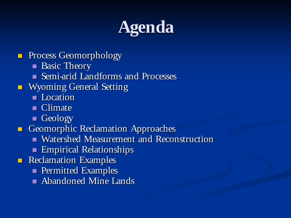
Agenda
Process Geomorphology Basic Theory Semi-arid Landforms and Processes
Wyoming General Setting Location Climate Geology
Geomorphic Reclamation Approaches Watershed Measurement and Reconstruction Empirical Relationships
Reclamation Examples Permitted Examples Abandoned Mine Lands

Process Geomorphology
A delicate balance or equilibrium exists between landforms and process.
This balance is created by the interaction of energy, force and resistance.
Changes in force and/ or resistance may push the system beyond the limits (threshold) of stability.
Temporary disequilibrium and major response towards establishing a new equilibrium.
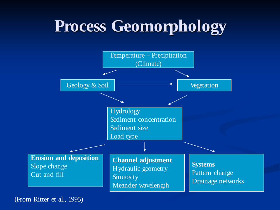
Process Geomorphology
Erosion and depositionSlope changeCut and fill
Geology & Soil
Channel adjustmentHydraulic geometrySinuosityMeander wavelength
SystemsPattern changeDrainage networks
Temperature – Precipitation(Climate)
Vegetation
HydrologySediment concentrationSediment sizeLoad type
(From Ritter et al., 1995)

Process Geomorphology (cont.)
Time
Gra
dien
t
Geomorphic time
•Cyclic
•Graded
•Steady
Perception of ‘Stability’
Schumm and Lichty, (1965)
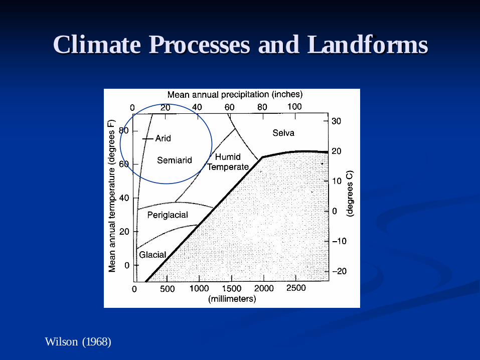
Climate Processes and Landforms
Wilson (1968)

Climate Processes and Landforms (cont.)
Semiarid (10-20 in. annual precipitation)
Dominant Geomorphic Processes Running water Weathering (especially
mechanical) Rapid mass movements
Landscape characteristics Pediments Fans Angular slopes with coarse
debris badlands
(Wilson, 1968)
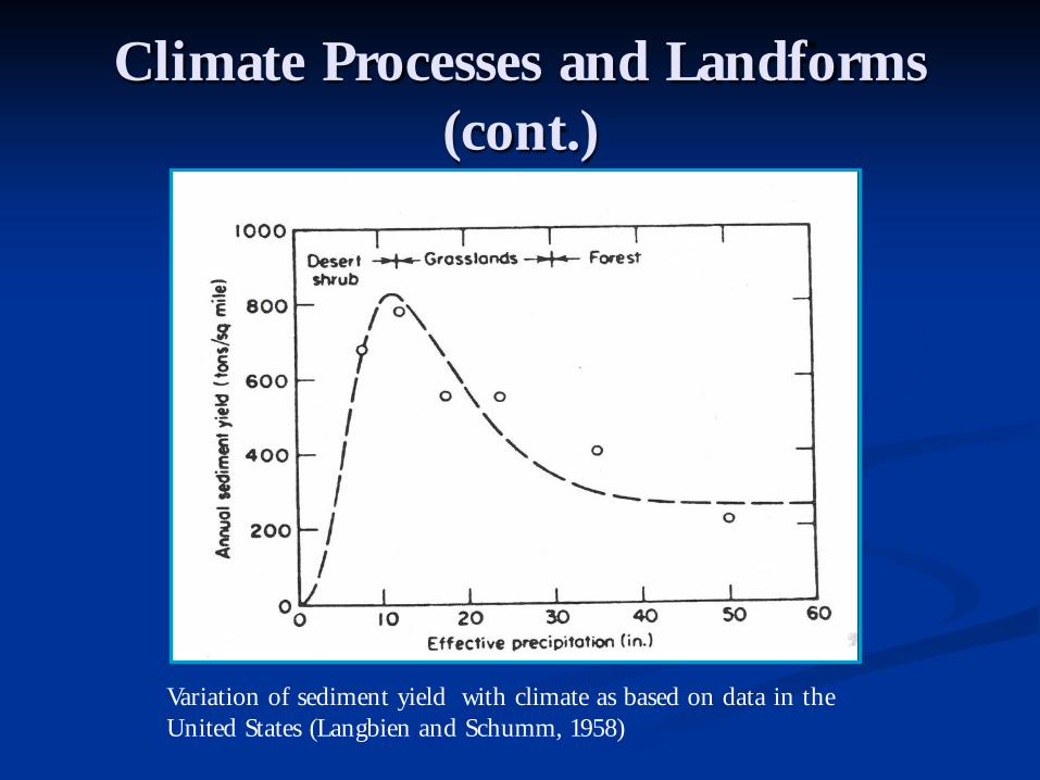
Variation of sediment yield with climate as based on data in the United States (Langbien and Schumm, 1958)
Climate Processes and Landforms (cont.)
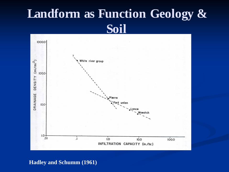
Landform as Function Geology & Soil
Hadley and Schumm (1961)

Landform as Function Vegetation
From Chorley, Schumm and Sugden (1984)

Landform Process as Function Vegetation
Cumulative sediment yields vs. percent vegetation cover on an experimental 9 X 15 meter watershed having a 10 percent gradient, at 30, 60, 120 and 180 minutes (from Rogers and Schumm, 1991)
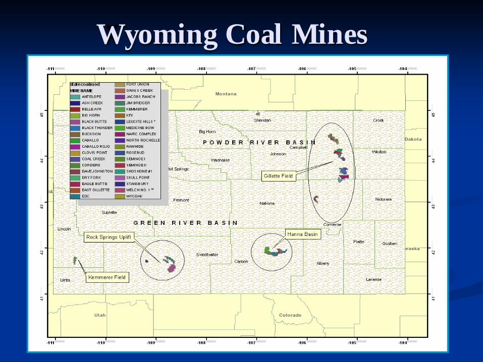
Wyoming Coal Mines
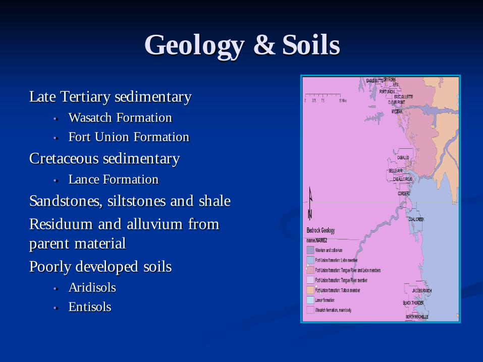
Geology & Soils
Late Tertiary sedimentary• Wasatch Formation
• Fort Union Formation
Cretaceous sedimentary• Lance Formation
Sandstones, siltstones and shale
Residuum and alluvium from parent material
Poorly developed soils• Aridisols
• Entisols
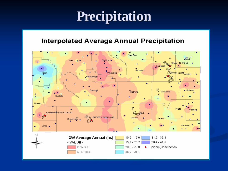
Precipitation

Precipitation (cont.)Annual Average for Period of Record
0
5
10
15
20
25
30
1925
1930
1935
1940
1945
1950
1955
1960
1965
1970
1975
1980
1985
1990
1995
2000
2005
Prec
ipta
tion
(in.) Kemmerer WTR
TRTMT (1948-2006)
Bitter Creek 4 NE(1962-2005)
Lawver 10 SW(1948-1978)
Gillette 9 ESE(1925-2005)
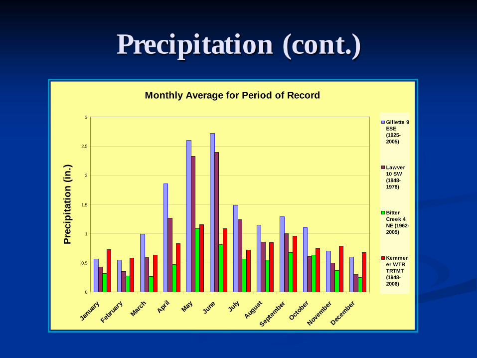
Precipitation (cont.)
Monthly Average for Period of Record
0
0.5
1
1.5
2
2.5
3
Janua
ry
Febru
ary
March
April
MayJu
ne July
August
Septem
ber
October
Novem
ber
Decem
ber
Prec
ipita
tion
(in.)
Gillette 9ESE(1925-2005)
Lawver10 SW(1948-1978)
BitterCreek 4NE (1962-2005)
Kemmerer WTRTRTMT(1948-2006)

Surface Water Systems

Flow Frequency Curve for Bitter Creek at USGS Gaging Station No. 09216562 (1976-
1981)
0.01
0.1
1
10
100
1000
0.10% 1.00% 10.00% 100.00%
Percentage of Time Exceeded
Dis
ch
arg
e (
cfs
)
Mean of Monthly Streamflows for the Little Powder River Below Corral Creek USGS 06324890. Period of Record August 1977 to
July 1983
05
1015
2025
30
Jan Feb Mar Apr May Jun Jul Aug Sep Oct Nov Dec
Dis
ch
arg
e (
cf
Surface Water Systems (cont.)

Watershed Measurement & Reconstruction
Drainage Basin Morphometry Areal Relief Linear
Hillslopes Gradient Aspect Profile
Channel Characterization

Drainage Basin Morphometry
Measurements that describe a landform Individual measurements can be used to create
relationships Quantifiable in numeric units or dimensionless
values (ratios) Classified as:
• Areal relationships • Linear relationships• Relief relationships

Drainage Basin Morphometry (cont.)
Linear Relationships
Horton Analysis
Stream number in each order
Total stream number in basin
Average Stream length
Total Stream length
Bifurcation ratio
11
11
2
2
3

Drainage Basin Morphometry (cont.)
Areal Relationships
Drainage area for each stream order
Drainage density (D)
Constant of channel maintenance (inverse of D)
(Eagle Butte Mine Permit #420, 2006)
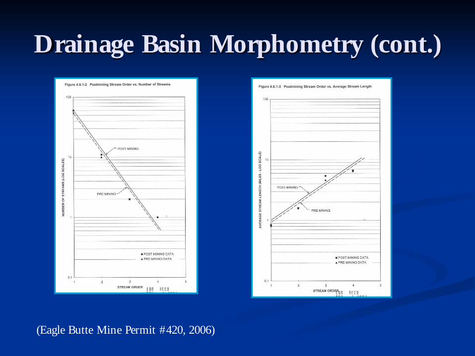
Drainage Basin Morphometry (cont.)
(Eagle Butte Mine Permit #420, 2006)
Drainage Basin Morphometry (cont.)
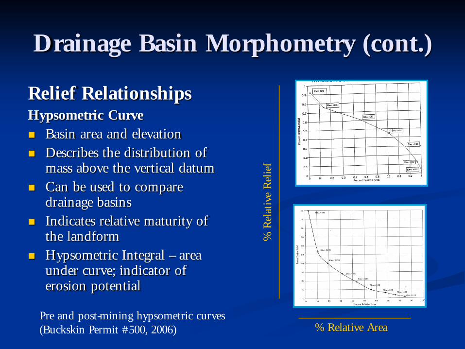
Relief RelationshipsHypsometric Curve Basin area and elevation Describes the distribution of
mass above the vertical datum Can be used to compare
drainage basins Indicates relative maturity of
the landform Hypsometric Integral – area
under curve; indicator of erosion potential
% Relative Area
% R
elat
ive
Rel
ief
Pre and post-mining hypsometric curves (Buckskin Permit #500, 2006)
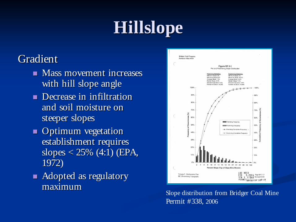
Hillslope
Gradient Mass movement increases
with hill slope angle Decrease in infiltration
and soil moisture on steeper slopes
Optimum vegetation establishment requires slopes < 25% (4:1) (EPA, 1972)
Adopted as regulatory maximum
Slope distribution from Bridger Coal Mine Permit #338, 2006

Hillslopes (cont)
Aspect South facing slopes are
more susceptible to erosion
More solar radiation Less soil moisture and
less vegetation Drainage density averages
11.3 mi/mi2 for southern slopes and 5.2 mi/mi2for north facing slopes (Hadley, 1962)
Slope aspect distribution (Bridger Coal Mine Permit #338, 2006)

Hillslopes (cont)
Profile Convex
• Rapid increase of soil loss with increasing gradient progressing down slope
Uniform• Gradual increase of soil loss as move down
the slope
Concave• Soil loss greatest near the top of hillslope
decreasing towards the toe
Complex• Soil loss greatest in midslope inflection and
decreasing downslope towards the toe
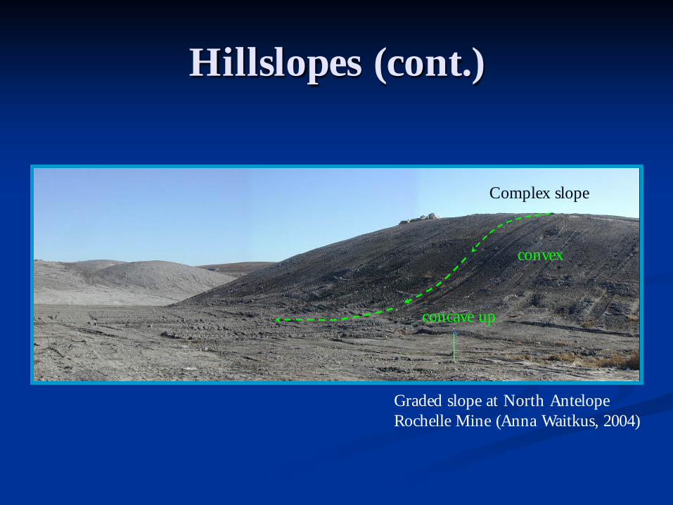
Hillslopes (cont.)
Graded slope at North Antelope Rochelle Mine (Anna Waitkus, 2004)
Complex slope
convex
concave up

Hillslopes (cont)
Reclaimed slopes at Rosebud Mine (Pam Rothwell, 2003)
Reclaimed slopes at Seminoe II Mine (Pam Ross, 2003)

Channel Characterization
Baseline inventory Longitudinal profiles
gradient shape
Cross sections area depth top width wetted perimeter hydraulic radius
Channel pattern wavelength (λ) amplitude (A) radius of curvature (r)
A
λ
r

Based solely on observation rather than theory. An empirical relationship requires only confirmatory data irrespective of theoretical basis.
Historically the discovery of empirical relationships has been important as a stepping stone to the discovery of true theoretical relationships.
An empirical equation is simply a mathematical statement of one or more empirical relationships in the form of an equation.
Empirical Relationships

Empirical Relationships (cont.)
Regression analysis for basin order as function of drainage area in eastern Powder River Basin (Lowham, 1993)

Empirical Relationships (cont.)
Regression analysis for various natural drainage basin variables in eastern Powder River Basin (Lowham, 1993)

Empirical Relationships (cont.)
Regression analysis for various natural drainage basin variables in eastern Powder River Basin (Lowham, 1993)
Regression equation Correlation CoefficientBasin length (BL) = 1.85 Area (A) 0.51 0.96Basin relief (R) = 227 A 0.28 0.71R = 163 BL 0.52 0.72Used Relief (UR) = 2.56 R 0.69 0.73Channel length = 0.92 BL 1.16 0.98Channel slope = 0.00036 BL -0.89 UR .90
0.96
Total channel length = 3.22 A 0.86 0.96

Empirical Relationships (cont.)Day Loma Uranium Project
Lidstone & Associates -Fort Collins, Colorado
(Lidstone, 2008)

Empirical Relationships (cont.)
P2 = 41.3 A 0.60 A^ -0.05 Gf Plains
P2 = 6.66 A 0.59 A^ -0.03 PR 0.60 Gf High Desert
W = 0.98 P20.54
AC = 0.173 P21.02
Regression equations for estimating channel hydraulic characteristics in Wyoming plains and high desert (Lowham, 1993)
P2 = Predicted bankfull discharge
A = Drainage area
PR = Average annual precipitation
Gf = Dimensionless geographic factor
W = Bankful channel width
AC= Cross sectional area
Empirical Relationships (cont.)
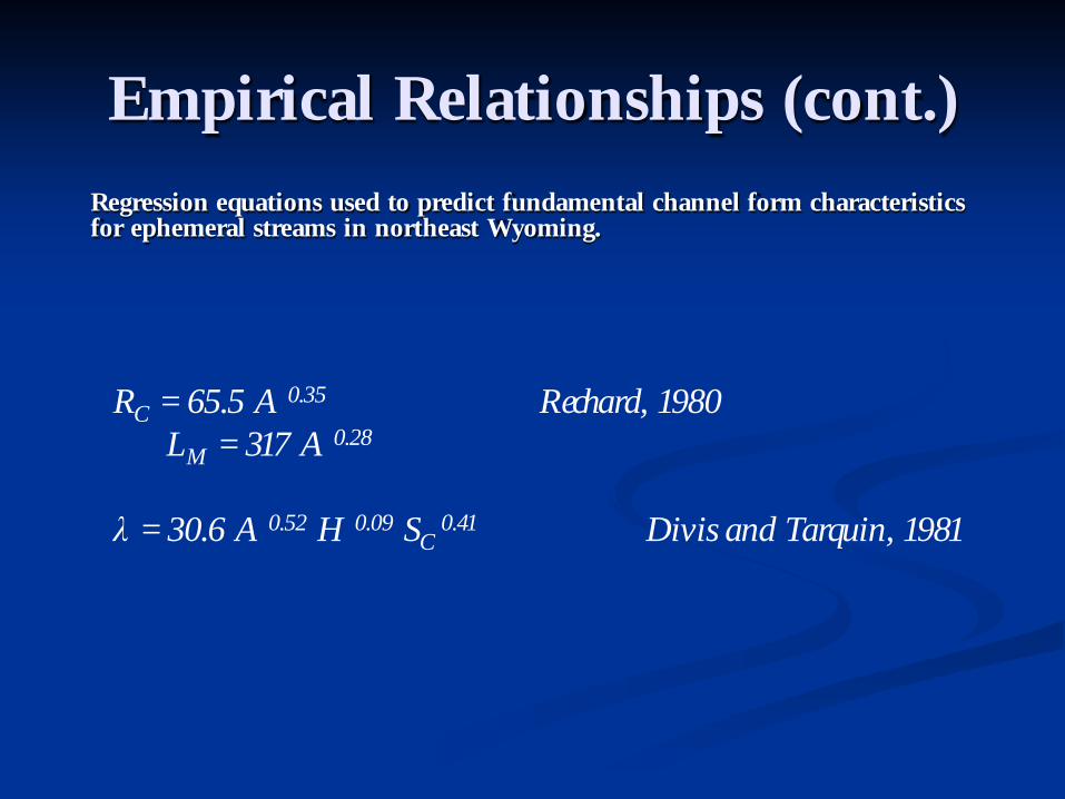
RC = 65.5 A 0.35 Rechard, 1980LM = 317 A 0.28
λ = 30.6 A 0.52 H 0.09 SC 0.41 Divis and Tarquin, 1981
Regression equations used to predict fundamental channel form characteristics for ephemeral streams in northeast Wyoming.

Reclamation Examples
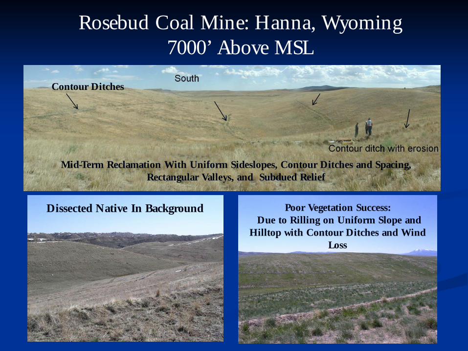
Rosebud Coal Mine: Hanna, Wyoming7000’ Above MSL
Contour Ditches
Mid-Term Reclamation With Uniform Sideslopes, Contour Ditches and Spacing, Rectangular Valleys, and Subdued Relief
Dissected Native In Background Poor Vegetation Success:Due to Rilling on Uniform Slope and
Hilltop with Contour Ditches and Wind Loss
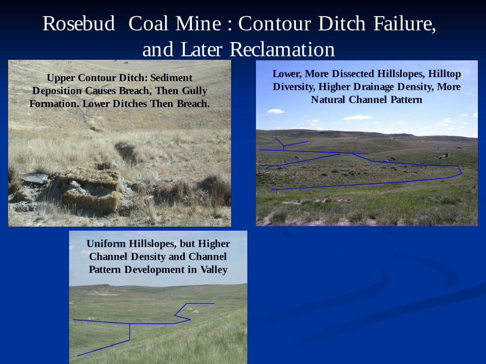
Rosebud Coal Mine : Contour Ditch Failure, and Later Reclamation
Upper Contour Ditch: Sediment Deposition Causes Breach, Then Gully Formation. Lower Ditches Then Breach.
Uniform Hillslopes, but Higher Channel Density and Channel Pattern Development in Valley
Lower, More Dissected Hillslopes, Hilltop Diversity, Higher Drainage Density, More
Natural Channel Pattern

Dave Johnston Coal Mine : Glenrock, Wyoming 4500’ Above MSL
Dragline Pit and Spoil at Dave Johnston
Main Channel Reconstruction After Pit Backfill – All Channels at Dave Johnston
are Ephemeral
Final Reclaimed Hillslopes at Dave Johnston –Relatively Dissected, Flatter Slopes, Concave
Profiles, Higher Vegetative Diversity
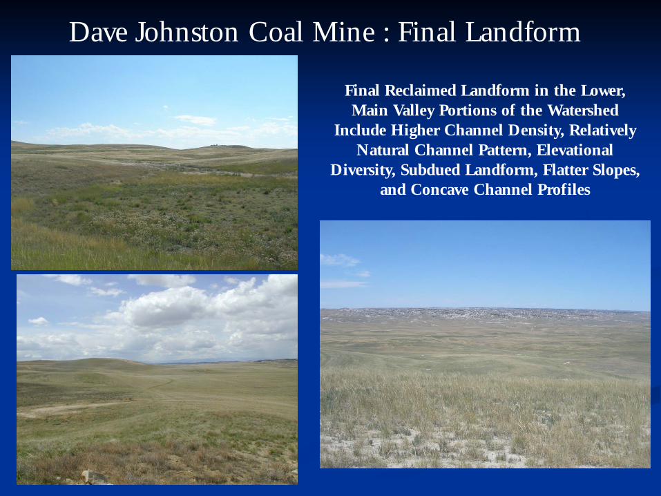
Dave Johnston Coal Mine : Final Landform
Final Reclaimed Landform in the Lower, Main Valley Portions of the Watershed
Include Higher Channel Density, Relatively Natural Channel Pattern, Elevational
Diversity, Subdued Landform, Flatter Slopes, and Concave Channel Profiles

Final Reclaimed Landform in the Upper Portions of the Watershed Include Ridgetop
Diversity, Relatively Natural Channel Pattern, Increased Hillslope
Dissection/Higher Drainage Density, Lower Ridgetops, Flatter Slopes, and Complex and
Concave Hillslope Profiles (and a Wind Energy Project in 2009)
Dave Johnston Coal Mine : Final Landform

Little Medicine Bow River: Main-Stem, Perennial Stream
AML Project: Uranium Mining District – Perennial Stream Restoration in a Regional Valley. Sinusoidal Channel Pattern, Pre-Mining Relationships Used in an Analog-Based Design . This Methodology is the
Typical Approach to Perennial and Intermittent Stream Restoration in Wyoming Mine Reclamation.
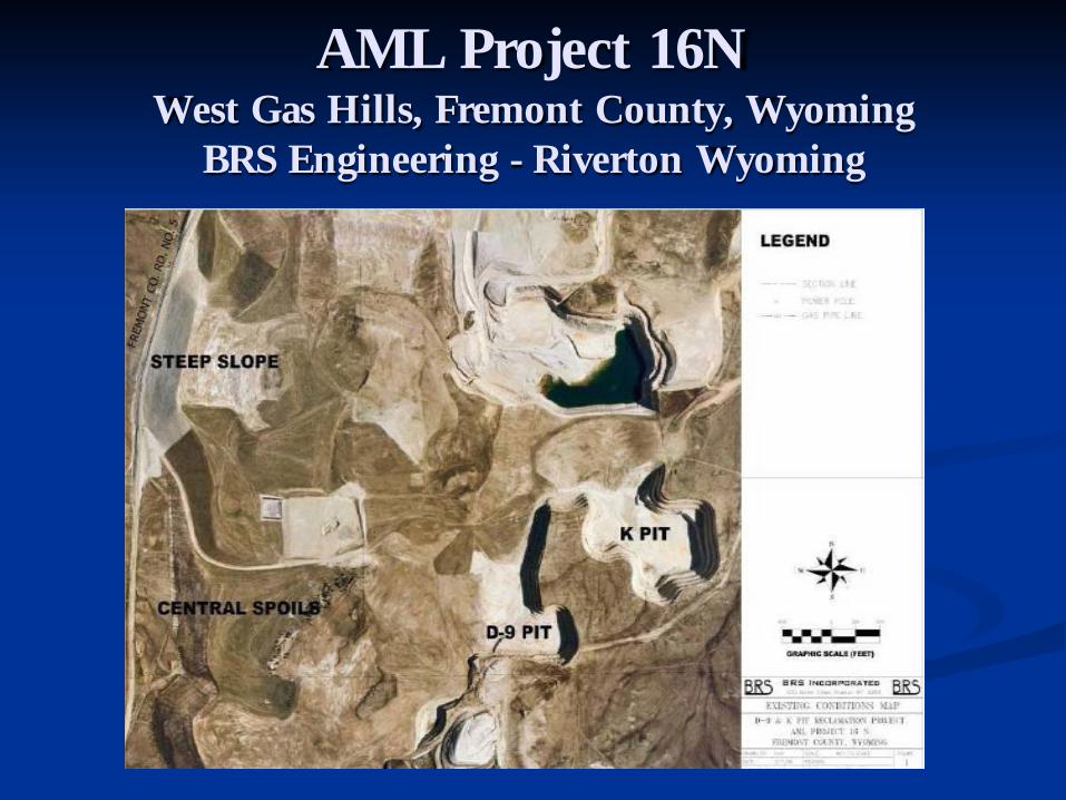
AML Project 16NWest Gas Hills, Fremont County, Wyoming
BRS Engineering - Riverton Wyoming

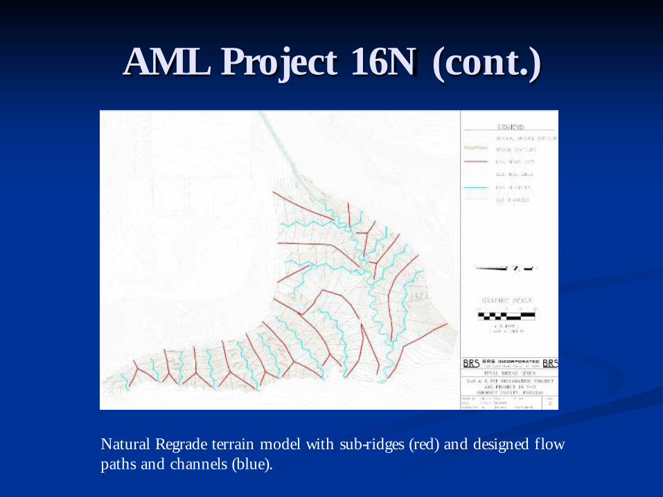
AML Project 16N (cont.)
Central spoils with poorly vegetated, long uniform slopes demonstrating significant rilling.
AML Project 16N (cont.)
Natural Regrade terrain model with sub-ridges (red) and designed flow paths and channels (blue).
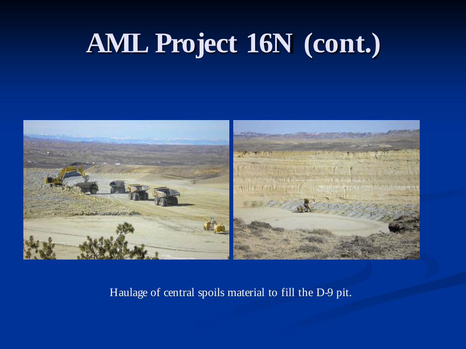
AML Project 16N (cont.)
Haulage of central spoils material to fill the D-9 pit.

AML Project 16N (cont.)
GPS control dozers contouring valleys and divides and applying suitable cover material.
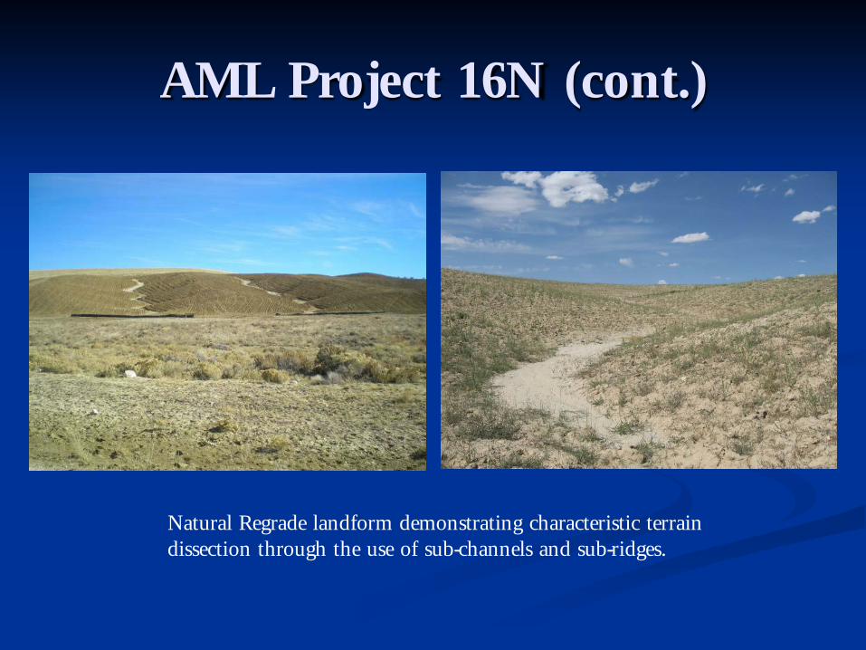
AML Project 16N (cont.)
Natural Regrade landform demonstrating characteristic terrain dissection through the use of sub-channels and sub-ridges.

AML Project 16N (cont.)
New landform that enhanced the topographic diversity and opened the viewshed.

AML Project 16NWest Gas Hills, Fremont County, Wyoming
Final reclamation landform; note traditional reclamation slopes utilizing contour ditches in background.

Closing Remarks


Questions?

References1. Divis, A. a. (1981). The geohydrologic regime of the Powder River Basin. Wheatridge, Colorado: Environmental Science
Associates.2. Dury, G.H.. 1964. Theoretical implications of underfit streams. U.S.Geol. Survey Prof. Paper 452-C3. Hadley, R.F., 1962, Some effects of microclimate on slope morphology and drainage basin development: U.S.
Geological Survey Research, 1961, pp. B-32 to B-33.4. Langbiem, W.B., and Schumm, S.A., 1958, Yield of Sediment in relation to mean annual precipitation: Transactions of
American Geophysical Union, v. 39, pp. 1076-1084.5. Leopold, L.B., and Wolman, M.G.1957. Riverchannel patterns; braided, meandering and staight. U.S.Geol. Survey Prof.
Paper 282-B6. Lidstone & Associates. (2008). Geomorphic and Hydraulic Analysis of the Day Loma Area. Fort Collins, CO.7. Lowham, H. a. (1993). Characteristics of fluvial systems in the plains and deserts of Wyoming. U.S. Geological Survey Water-
Resources Investigations Report 91-4153.8. Martin, L.J., D.L. Naftz, Lowham, and J.G. Rankl, 1988. Cumulative Potential Hydrologic Impacts of Surface Coal
Mining in the Eastern Powder River Structural Basin, Northeastern Wyoming. U.S. Geological Survey Water-Resources Investigations Report 88-4046
9. Peltier, L., 1950, The Geographical cycle in periglacial regions as it is related to climatic geomorphology: Annals, Association of American Geographers, v.40, pp. 214-236.
10. Rechard, R. (1980). Suggested stream pattern restoration for the eastern Powder River Basin. Second Wyoming Mining Hydrology Symposium (pp. 214-248). Water Resources Research Institute.
11. Ritter, Dale F., Kochel, R. Craig, Miller, Jerry R., Process Geomophology12. Schumm, S. (1956). Evolution of drainage systems and slopes in badlands at Perth Amboy, New Jersey. Geol. Soc.
America Bull. , 67:597-646.13. U.S. Environmental Protection Agency, 1972, Guidelines for erosion and sediment control planning and
implementation: Environmental Protection Series, EPA R2-72-015.14. Wilson, L., “Morphogenetic Classification” in Encyclopedia of Geomorphology, ed. by R.W. Fairbridge, copyright
1969 Dowden, Hutchinson & Ross, Inc.
Related Documents


