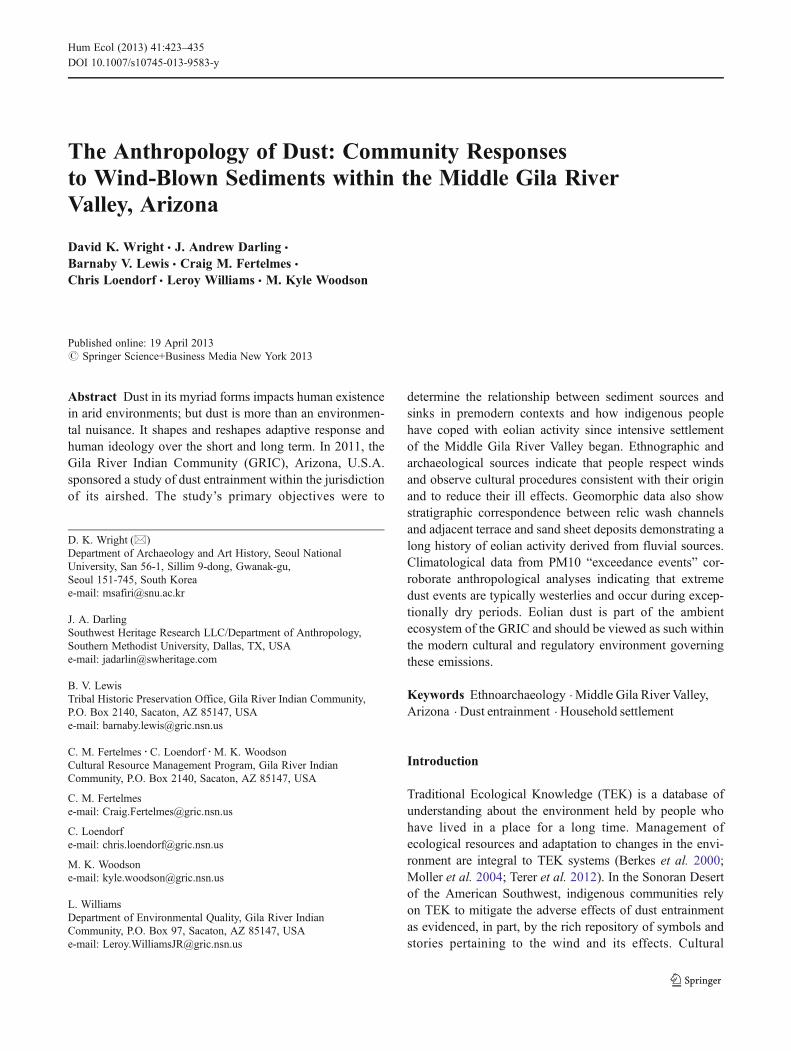
The Anthropology of Dust: Community Responses to Wind-Blown Sediments within the Middle Gila River Valley, Arizona David K. Wright & J. Andrew Darling & Barnaby V. Lewis & Craig M. Fertelmes & Chris Loendorf & Leroy Williams & M. Kyle Woodson Published online: 19 April 2013 # Springer Science+Business Media New York 2013 Abstract Dust in its myriad forms impacts human existence in arid environments; but dust is more than an environmen- tal nuisance. It shapes and reshapes adaptive response and human ideology over the short and long term. In 2011, the Gila River Indian Community (GRIC), Arizona, U.S.A. sponsored a study of dust entrainment within the jurisdiction of its airshed. The study’s primary objectives were to determine the relationship between sediment sources and sinks in premodern contexts and how indigenous people have coped with eolian activity since intensive settlement of the Middle Gila River Valley began. Ethnographic and archaeological sources indicate that people respect winds and observe cultural procedures consistent with their origin and to reduce their ill effects. Geomorphic data also show stratigraphic correspondence between relic wash channels and adjacent terrace and sand sheet deposits demonstrating a long history of eolian activity derived from fluvial sources. Climatological data from PM10 “exceedance events” cor- roborate anthropological analyses indicating that extreme dust events are typically westerlies and occur during excep- tionally dry periods. Eolian dust is part of the ambient ecosystem of the GRIC and should be viewed as such within the modern cultural and regulatory environment governing these emissions. Keywords Ethnoarchaeology . Middle Gila River Valley, Arizona . Dust entrainment . Household settlement Introduction Traditional Ecological Knowledge (TEK) is a database of understanding about the environment held by people who have lived in a place for a long time. Management of ecological resources and adaptation to changes in the envi- ronment are integral to TEK systems (Berkes et al. 2000; Moller et al. 2004; Terer et al. 2012). In the Sonoran Desert of the American Southwest, indigenous communities rely on TEK to mitigate the adverse effects of dust entrainment as evidenced, in part, by the rich repository of symbols and stories pertaining to the wind and its effects. Cultural D. K. Wright (*) Department of Archaeology and Art History, Seoul National University, San 56-1, Sillim 9-dong, Gwanak-gu, Seoul 151-745, South Korea e-mail: [email protected] J. A. Darling Southwest Heritage Research LLC/Department of Anthropology, Southern Methodist University, Dallas, TX, USA e-mail: [email protected] B. V. Lewis Tribal Historic Preservation Office, Gila River Indian Community, P.O. Box 2140, Sacaton, AZ 85147, USA e-mail: [email protected] C. M. Fertelmes : C. Loendorf : M. K. Woodson Cultural Resource Management Program, Gila River Indian Community, P.O. Box 2140, Sacaton, AZ 85147, USA C. M. Fertelmes e-mail: [email protected] C. Loendorf e-mail: [email protected] M. K. Woodson e-mail: [email protected] L. Williams Department of Environmental Quality, Gila River Indian Community, P.O. Box 97, Sacaton, AZ 85147, USA e-mail: [email protected] Hum Ecol (2013) 41:423–435 DOI 10.1007/s10745-013-9583-y

Welcome message from author
This document is posted to help you gain knowledge. Please leave a comment to let me know what you think about it! Share it to your friends and learn new things together.
Transcript
The Anthropology of Dust: Community Responsesto Wind-Blown Sediments within the Middle Gila RiverValley, Arizona
David K. Wright & J. Andrew Darling &
Barnaby V. Lewis & Craig M. Fertelmes &
Chris Loendorf & Leroy Williams & M. Kyle Woodson
Published online: 19 April 2013# Springer Science+Business Media New York 2013
Abstract Dust in its myriad forms impacts human existencein arid environments; but dust is more than an environmen-tal nuisance. It shapes and reshapes adaptive response andhuman ideology over the short and long term. In 2011, theGila River Indian Community (GRIC), Arizona, U.S.A.sponsored a study of dust entrainment within the jurisdictionof its airshed. The study’s primary objectives were to
determine the relationship between sediment sources andsinks in premodern contexts and how indigenous peoplehave coped with eolian activity since intensive settlementof the Middle Gila River Valley began. Ethnographic andarchaeological sources indicate that people respect windsand observe cultural procedures consistent with their originand to reduce their ill effects. Geomorphic data also showstratigraphic correspondence between relic wash channelsand adjacent terrace and sand sheet deposits demonstrating along history of eolian activity derived from fluvial sources.Climatological data from PM10 “exceedance events” cor-roborate anthropological analyses indicating that extremedust events are typically westerlies and occur during excep-tionally dry periods. Eolian dust is part of the ambientecosystem of the GRIC and should be viewed as such withinthe modern cultural and regulatory environment governingthese emissions.
Keywords Ethnoarchaeology . Middle Gila River Valley,Arizona . Dust entrainment . Household settlement
Introduction
Traditional Ecological Knowledge (TEK) is a database ofunderstanding about the environment held by people whohave lived in a place for a long time. Management ofecological resources and adaptation to changes in the envi-ronment are integral to TEK systems (Berkes et al. 2000;Moller et al. 2004; Terer et al. 2012). In the Sonoran Desertof the American Southwest, indigenous communities relyon TEK to mitigate the adverse effects of dust entrainmentas evidenced, in part, by the rich repository of symbols andstories pertaining to the wind and its effects. Cultural
D. K. Wright (*)Department of Archaeology and Art History, Seoul NationalUniversity, San 56-1, Sillim 9-dong, Gwanak-gu,Seoul 151-745, South Koreae-mail: [email protected]
J. A. DarlingSouthwest Heritage Research LLC/Department of Anthropology,Southern Methodist University, Dallas, TX, USAe-mail: [email protected]
B. V. LewisTribal Historic Preservation Office, Gila River Indian Community,P.O. Box 2140, Sacaton, AZ 85147, USAe-mail: [email protected]
C. M. Fertelmes :C. Loendorf :M. K. WoodsonCultural Resource Management Program, Gila River IndianCommunity, P.O. Box 2140, Sacaton, AZ 85147, USA
C. M. Fertelmese-mail: [email protected]
C. Loendorfe-mail: [email protected]
M. K. Woodsone-mail: [email protected]
L. WilliamsDepartment of Environmental Quality, Gila River IndianCommunity, P.O. Box 97, Sacaton, AZ 85147, USAe-mail: [email protected]
Hum Ecol (2013) 41:423–435DOI 10.1007/s10745-013-9583-y
practices as embodied by site settlement structures, oraltraditions and medicinal interventions reflect constraints onhumans who inhabit a specific ecological niche. As ecolog-ical realities shift in response to land degradation, habitatenrichment or climatic change, cultural practices adapt,reflecting existing and pre-existing natural conditions (Mc-Intosh et al. 2000).
Across the world, tribal governments and organizationsare taking an increasing role in setting public policy inmanaging their own ecological resources (Barrera-Bassolset al. 2006; Miller et al. 2010; Wilson et al. 2010). A centralchallenge facing communities located in areas that are eco-logically vulnerable to climate change is developing strate-gies to cope with increasing aridity and its side effects(Hagerman et al. 2012). In the 21st century, unprecedentedthreats to water availability, air quality and biodiversity canbe justifiably perceived as a clear and present danger to thesurvival of an indigenous community’s social and economicwellbeing (Molnar 2010). At the same time, regulationsimposed by extra-community entities (such as federal, stateor provincial governments) meant to mitigate ecologicalthreats are often detached from TEK and evoke memoriesof colonial relationships from the not-too-distant past.
This study analyzes fine sediment entrainment and dis-cusses deep-time cultural perspectives regarding dust withinthe Gila River Indian Community (GRIC). The work wasconducted by the GRIC-Cultural Resource ManagementProgram (GRIC-CRMP) in conjunction with the GRIC De-partment of Environmental Quality (GRIC-DEQ) to assessambient dust levels present in the GRIC and to providegeomorphic and cultural evidence for a long history of dustentrainment within the Middle Gila River Valley (MGRV).The project is interdisciplinary and relies on geomorpholo-gic, geochemical, archaeological, ethnographic, and clima-tological datasets to contextualize fine sediment entrainmentwithin the study area. This report focuses on the anthropol-ogy of dust entrainment within the MGRV and how TEKaugments scientific methods designed to monitor and miti-gate the effects of dust entrainment on public policy andhuman health.
Environmental/Physiographic Setting
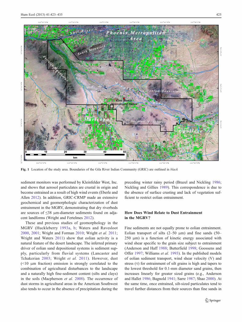
The MGRV is situated within the Sonoran Desertsubprovince of the Basin and Range physiographic prov-ince, locally referred to as the Phoenix Basin. The basin isrimmed by mountain chains, which restrict the fluvial chan-nels. The valley contains three major landforms: the riverchannel, terraces, and bajadas (Waters 1996). Huckleberry(1993a, b, 1995), Waters (2008) and Waters and Ravesloot(2000, 2001, 2003) present an evolutionary model of theMiddle Gila River showing a succession of channel
aggradation from the early Holocene atop an incised Pleis-tocene substrate (Fig. 1). An eolian sand sheet covers largeportions of the Pleistocene terrace.
The Gila River is the primary drainage in this geographiczone, and its major tributary washes include (from west toeast) the Santa Cruz and McClellan washes, and the LittleGila River. Upstream diversions and dams of the Gila Riverconstructed during the early Euroamerican settlement of thecatchment resulted in a transformation of the fluvial systemfrom perennial to seasonally intermittent flow. The flood-plains of the MGRV are now broad with low gradients andthe river is characterized by low stream velocity whenflowing. Regular surface flow is only present in a few placeson the lower sections of the Middle Gila River, such as nearthe confluence with the Santa Cruz Wash. Thus, largeswaths of sediment are exposed to wind entrainment forthe majority of each year.
The GRIC is located within the Upper Sonoran Desertbiome, which is generally hot and arid. This region ischaracterized as having five meteorological seasons: a cool(lows of 1 °C) and slightly rainy winter (December 1–February 15), a mild and dry spring (February 16–April30), a hot foresummer with low humidity (May 1–June30), a hot summer (41 °C) with high humidity (July 1–September 30), and a warm fall with low humidity (October1–November 30) (Phillips and Comus 2000). The wettestmonths are typically July and August, during which after-noon thunderstorms develop and produce heavy but local-ized rainfall. A secondary period of precipitation occurs inthe winter when large storms from the Pacific Ocean enterthe region. Rainfall associated with these storms is typicallygentle and widespread. The months of April, May, and Juneare the driest. Occasionally, late summer or early fall trop-ical storms from the eastern mid-Pacific are steered overArizona and contribute considerable rainfall to the region(Hirschboek 1985; Smith 1986). The Phoenix Basin typi-cally receives <250 mm/yr of precipitation, while portionsof the Gila River headwaters fall within the 500–750 mm/yrisohyet (Sheppard et al. 2002).
Previous Studies on Eolian Activity
In 2011, GRIC-DEQ and GRIC-CRMP began a study toassess the ambient dust present in the GRIC. The UnitedStates Environmental Protection Agency (EPA) has set anationwide air quality standard of 400 μg/m3 for <10 μmparticulate matter (PM10) under the authority of Title I ofthe Clean Air Act (42 U.S.C. §7401 et seq., 1970). Since2010, GRIC has held jurisdiction over its own airshed and istherefore responsible for identifying sources of PM10 aspart of the effort to remain in compliance with the CleanAir Act. A speciation study of PM10 sediments collected in
424 Hum Ecol (2013) 41:423–435
sediment monitors was performed by Kleinfelder West, Inc.and shows that aerosol particulates are crustal in origin andbecome entrained as a result of high wind events (Eberle andAllen 2012). In addition, GRIC-CRMP made an extensivegeochemical and geomorphologic characterization of dustentrainment in the MGRV, demonstrating that dry riverbedsare sources of ≤38 μm-diameter sediments found on adja-cent landforms (Wright and Fertelmes 2012).
These and previous studies of geomorphology in theMGRV (Huckleberry 1993a, b; Waters and Ravesloot2000, 2001; Wright and Forman 2010; Wright et al. 2011;Wright and Waters 2011) show that eolian activity is anatural feature of the desert landscape. The inferred primarydriver of eolian sand depositional systems is sediment sup-ply, particularly from fluvial systems (Lancaster andTchakerian 2003; Wright et al. 2011). However, dust(<10 μm fraction) emission is strongly correlated to thecombination of agricultural disturbances to the landscapeand a naturally high fine-sediment content (silts and clays)in the soils (Macpherson et al. 2008). The occurrence ofdust storms in agricultural areas in the American Southwestalso tends to occur in the absence of precipitation during the
preceding winter rainy period (Brazel and Nickling 1986;Nickling and Gillies 1989). This correspondence is due tothe absence of surface crusting and lack of vegetation suf-ficient to restrict eolian entrainment.
How Does Wind Relate to Dust Entrainmentin the MGRV?
Fine sediments are not equally prone to eolian entrainment.Eolian transport of silts (2–50 μm) and fine sands (50–250 μm) is a function of kinetic energy associated withwind shear specific to the grain size subject to entrainment(Anderson and Haff 1988; Butterfield 1998; Goossens andOffer 1997; Williams et al. 1993). In the published modelsof eolian sediment transport, wind shear velocity (V) andstress (τ) for entrainment of silt grains is high and tapers tothe lowest threshold for 0.1-mm diameter sand grains, thenincreases linearly for greater sized grains (e.g., Andersonand Hallet 1986; Bagnold 1941; Sarre 1987; Shao 2000). Atthe same time, once entrained, silt-sized particulates tend totravel further distances from their sources than fine sands in
Fig. 1 Location of the study area. Boundaries of the Gila River Indian Community (GRIC) are outlined in black
Hum Ecol (2013) 41:423–435 425
sustained wind conditions (Pye 1995). Therefore, silt en-trainment necessitates not only ample sediment supply, butalso high velocity winds.
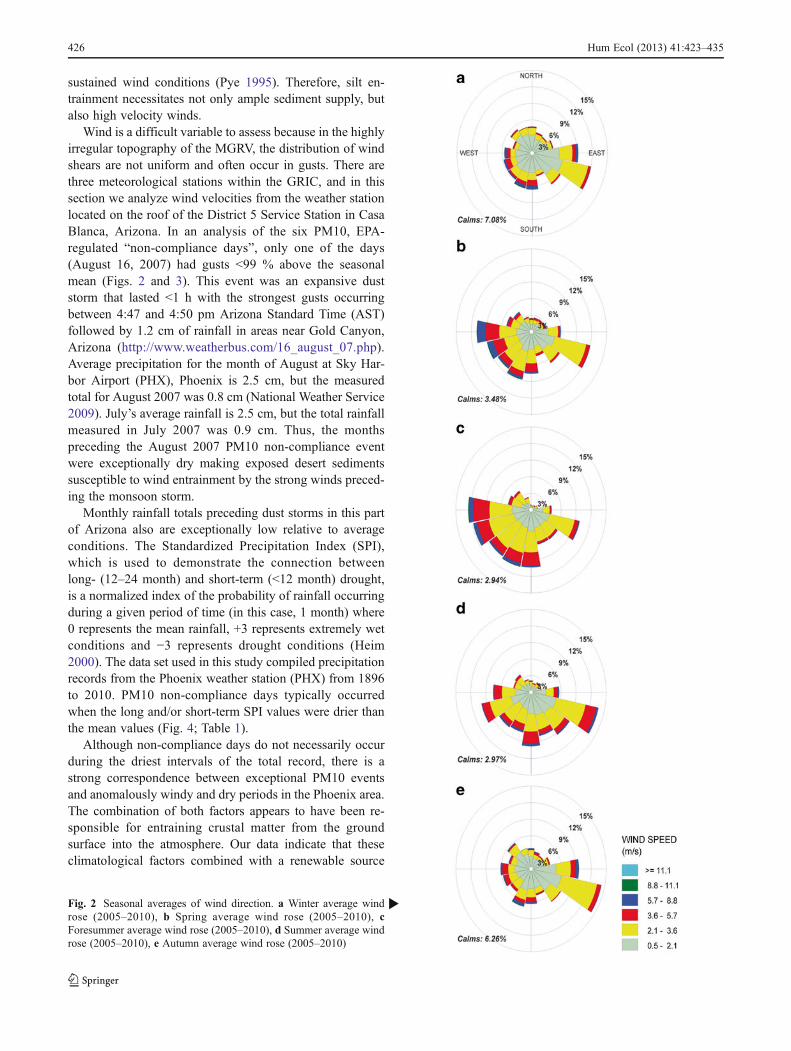
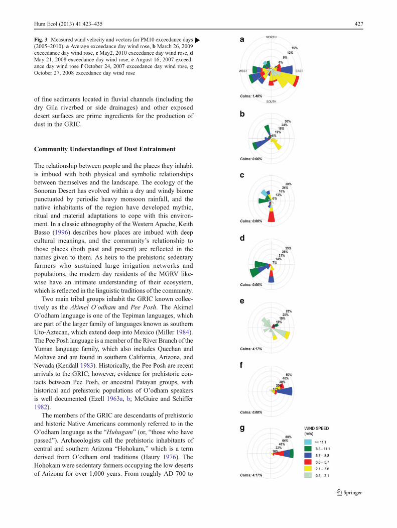
Wind is a difficult variable to assess because in the highlyirregular topography of the MGRV, the distribution of windshears are not uniform and often occur in gusts. There arethree meteorological stations within the GRIC, and in thissection we analyze wind velocities from the weather stationlocated on the roof of the District 5 Service Station in CasaBlanca, Arizona. In an analysis of the six PM10, EPA-regulated “non-compliance days”, only one of the days(August 16, 2007) had gusts <99 % above the seasonalmean (Figs. 2 and 3). This event was an expansive duststorm that lasted <1 h with the strongest gusts occurringbetween 4:47 and 4:50 pm Arizona Standard Time (AST)followed by 1.2 cm of rainfall in areas near Gold Canyon,Arizona (http://www.weatherbus.com/16_august_07.php).Average precipitation for the month of August at Sky Har-bor Airport (PHX), Phoenix is 2.5 cm, but the measuredtotal for August 2007 was 0.8 cm (National Weather Service2009). July’s average rainfall is 2.5 cm, but the total rainfallmeasured in July 2007 was 0.9 cm. Thus, the monthspreceding the August 2007 PM10 non-compliance eventwere exceptionally dry making exposed desert sedimentssusceptible to wind entrainment by the strong winds preced-ing the monsoon storm.
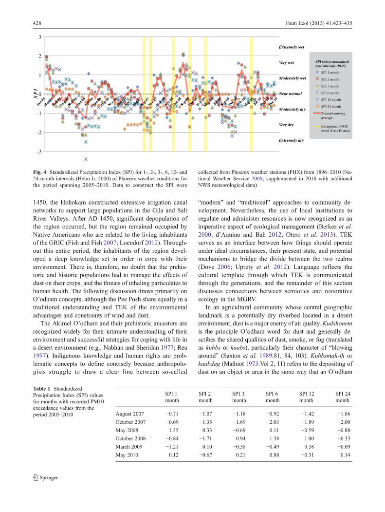
Monthly rainfall totals preceding dust storms in this partof Arizona also are exceptionally low relative to averageconditions. The Standardized Precipitation Index (SPI),which is used to demonstrate the connection betweenlong- (12–24 month) and short-term (<12 month) drought,is a normalized index of the probability of rainfall occurringduring a given period of time (in this case, 1 month) where0 represents the mean rainfall, +3 represents extremely wetconditions and −3 represents drought conditions (Heim2000). The data set used in this study compiled precipitationrecords from the Phoenix weather station (PHX) from 1896to 2010. PM10 non-compliance days typically occurredwhen the long and/or short-term SPI values were drier thanthe mean values (Fig. 4; Table 1).
Although non-compliance days do not necessarily occurduring the driest intervals of the total record, there is astrong correspondence between exceptional PM10 eventsand anomalously windy and dry periods in the Phoenix area.The combination of both factors appears to have been re-sponsible for entraining crustal matter from the groundsurface into the atmosphere. Our data indicate that theseclimatological factors combined with a renewable source
Fig. 2 Seasonal averages of wind direction. a Winter average windrose (2005–2010), b Spring average wind rose (2005–2010), cForesummer average wind rose (2005–2010), d Summer average windrose (2005–2010), e Autumn average wind rose (2005–2010)
b
426 Hum Ecol (2013) 41:423–435
of fine sediments located in fluvial channels (including thedry Gila riverbed or side drainages) and other exposeddesert surfaces are prime ingredients for the production ofdust in the GRIC.
Community Understandings of Dust Entrainment
The relationship between people and the places they inhabitis imbued with both physical and symbolic relationshipsbetween themselves and the landscape. The ecology of theSonoran Desert has evolved within a dry and windy biomepunctuated by periodic heavy monsoon rainfall, and thenative inhabitants of the region have developed mythic,ritual and material adaptations to cope with this environ-ment. In a classic ethnography of the Western Apache, KeithBasso (1996) describes how places are imbued with deepcultural meanings, and the community’s relationship tothose places (both past and present) are reflected in thenames given to them. As heirs to the prehistoric sedentaryfarmers who sustained large irrigation networks andpopulations, the modern day residents of the MGRV like-wise have an intimate understanding of their ecosystem,which is reflected in the linguistic traditions of the community.
Two main tribal groups inhabit the GRIC known collec-tively as the Akimel O’odham and Pee Posh. The AkimelO’odham language is one of the Tepiman languages, whichare part of the larger family of languages known as southernUto-Aztecan, which extend deep into Mexico (Miller 1984).The Pee Posh language is a member of the River Branch of theYuman language family, which also includes Quechan andMohave and are found in southern California, Arizona, andNevada (Kendall 1983). Historically, the Pee Posh are recentarrivals to the GRIC; however, evidence for prehistoric con-tacts between Pee Posh, or ancestral Patayan groups, withhistorical and prehistoric populations of O’odham speakersis well documented (Ezell 1963a, b; McGuire and Schiffer1982).
The members of the GRIC are descendants of prehistoricand historic Native Americans commonly referred to in theO’odham language as the “Huhugam” (or, “those who havepassed”). Archaeologists call the prehistoric inhabitants ofcentral and southern Arizona “Hohokam,” which is a termderived from O’odham oral traditions (Haury 1976). TheHohokam were sedentary farmers occupying the low desertsof Arizona for over 1,000 years. From roughly AD 700 to
Fig. 3 Measured wind velocity and vectors for PM10 exceedance days(2005–2010), a Average exceedance day wind rose, b March 26, 2009exceedance day wind rose, c May2, 2010 exceedance day wind rose, dMay 21, 2008 exceedance day wind rose, e August 16, 2007 exceed-ance day wind rose f October 24, 2007 exceedance day wind rose, gOctober 27, 2008 exceedance day wind rose
b
Hum Ecol (2013) 41:423–435 427
1450, the Hohokam constructed extensive irrigation canalnetworks to support large populations in the Gila and SaltRiver Valleys. After AD 1450, significant depopulation ofthe region occurred, but the region remained occupied byNative Americans who are related to the living inhabitantsof the GRIC (Fish and Fish 2007; Loendorf 2012). Through-out this entire period, the inhabitants of the region devel-oped a deep knowledge set in order to cope with theirenvironment. There is, therefore, no doubt that the prehis-toric and historic populations had to manage the effects ofdust on their crops, and the threats of inhaling particulates tohuman health. The following discussion draws primarily onO’odham concepts, although the Pee Posh share equally in atraditional understanding and TEK of the environmentaladvantages and constraints of wind and dust.
The Akimel O’odham and their prehistoric ancestors arerecognized widely for their intimate understanding of theirenvironment and successful strategies for coping with life ina desert environment (e.g., Nabhan and Sheridan 1977; Rea1997). Indigenous knowledge and human rights are prob-lematic concepts to define concisely because anthropolo-gists struggle to draw a clear line between so-called
“modern” and “traditional” approaches to community de-velopment. Nevertheless, the use of local institutions toregulate and administer resources is now recognized as animperative aspect of ecological management (Berkes et al.2000; d’Aquino and Bah 2012; Otero et al. 2013). TEKserves as an interface between how things should operateunder ideal circumstances, their present state, and potentialmechanisms to bridge the divide between the two realms(Dove 2006; Uprety et al. 2012). Language reflects thecultural template through which TEK is communicatedthrough the generations, and the remainder of this sectiondiscusses connections between semiotics and restorativeecology in the MGRV.
In an agricultural community whose central geographiclandmark is a potentially dry riverbed located in a desertenvironment, dust is a major enemy of air quality.Kudshonemis the principle O’odham word for dust and generally de-scribes the shared qualities of dust, smoke, or fog (translatedas kuhbs or kuubs), particularly their character of “blowingaround” (Saxton et al. 1989:81, 84, 103). Kuhbsmah-th orkuubdag (Mathiot 1973:Vol 2, 11) refers to the depositing ofdust on an object or area in the same way that an O’odham
Table 1 StandardizedPrecipitation Index (SPI) valuesfor months with recorded PM10exceedance values from theperiod 2005–2010
SPI 1month
SPI 2month
SPI 3month
SPI 6month
SPI 12month
SPI 24month
August 2007 −0.71 −1.07 −1.18 −0.92 −1.42 −1.86
October 2007 −0.69 −1.35 −1.69 −2.03 −1.89 −2.00
May 2008 1.35 0.33 −0.69 0.11 −0.59 −0.88
October 2008 −0.84 −1.71 0.94 1.38 1.00 −0.33
March 2009 −1.21 0.10 −0.38 −0.49 0.58 −0.09
May 2010 0.12 −0.67 0.21 0.88 −0.31 0.14
-3
-2
-1
0
1
2
3
Jan-0
5
Mar
-05
Jun-0
5
Aug-05
Nov-0
5
Jan-0
6
Apr-06
Jun-0
6
Aug-06
Nov-0
6
Jan-0
7
Apr-07
Jun-0
7
Sep-0
7
Nov-0
7
Feb-0
8
Apr-08
Jul-0
8
Sep-0
8
Dec-0
8
Feb-0
9
May
-09
Jul-0
9
Sep-0
9
Dec-0
9
Feb-1
0
May
-10
Jul-1
0
Oct-10
Dec-1
0
SPI 1 month
SPI 2 month
SPI 3 month
SPI 6 month
SPI 12 month
SPI 24 month
2-month moving average
Exceptional PM10event (Casa Blanca)
SPI values normalizedtime intervals (PHX)
Extremely wet
Very wet
Moderately wet
Near normal
Moderately dry
Very dry
Extremely dry
SP
I
Fig. 4 Standardized Precipitation Index (SPI) for 1-, 2-, 3-, 6, 12- and24-month intervals (Helm Jr. 2000) of Phoenix weather conditions forthe period spanning 2005–2010. Data to construct the SPI were
collected from Phoenix weather stations (PHX) from 1896−2010 (Na-tional Weather Service 2009; supplemented in 2010 with additionalNWS meteorological data)
428 Hum Ecol (2013) 41:423–435
speaker would understand the term juvuh-ah-dahk [jevudag],“to be dusty” (Mathiot 1973:Vol 1, 419). However, there aresome compelling differences. The traditional association ofgusting winds and whirlwinds with physical destruction and"wind sickness" appeals to the phonemic association and thespiritual values of kubs or kuubs as either dust or smoke ratherthan jevud, which may refer to earth, dirt, or soil. This dis-tinction in contemporary contexts aptly defines the differencebetween health risks associated with dust and dirt (jevud) andits impact on a clean domestic environment versus the spiri-tual hazards that may come from dust, smoke or fog (kuubs),bitter wind (siv hevel), or whirlwinds (sivlik). O’odhamspeakers acknowledge that both kuubdag and jevudag areequally valid expressions of the dust concept. However, in aconsideration of Akimel O’odham TEK and strategies forcoping with wind and dust, jevudag can connote a morecontemporary relationship of dirt and dust accessible to EPAstandards and the Clean Air Act; whereas kuubdag appeals totraditional concepts accessible through TEK and O’odhamtraditional cultural values, an important aspect of dust man-agement not taken into account when establishing air qualitystandards.
Anthropologist Aleš Hrdlička (1908), who traveled ex-tensively through the American Southwest in the early 20thcentury, records that Akimel O’odham women would chasewhirlwinds (sivlik) from their houses with sticks. Overturnedobjects would have to be purified with ashes or contact withthem could cause deformities. “Flattened or twisted branches”produced by whirlwinds could be recovered from the field andhad the power to cure overturned objects (Hrdlička 1908:244).Bahr et al. (1974:74–75) and Underhill (1946:297) refer tosickness associated with whirlwinds including pains in thelegs and dizziness. As Bahr et al. (1974: 298) note, theappropriate remedy identified as ‘O’hon k’e-wúso (“drawand get cured”) utilized sand paintings. Use of sand paintingappears to be unique among the other O’odham rituals thatrely mainly on curing songs; however, inferentially, it seemsappropriate that sand paintings would be suitable for treatinginfirmities caused by wind-borne dust. Russell (1908:265)records that songs and ocotillo (Fouquieria spendens) gumwere used to remedy the effects of leg-swellings caused bywind.
“Westerlies” (out of the west and heading east) were thestrongest seasonal winds of the year. Akimel O’odhamidentify the hevel ki or the wind’s house, as one or moreshrines located on the eastern slopes of the Estrella Moun-tains. These shrines were once considered extremely dan-gerous among all O’odham, as disrespect would bringviolent winds and storms. Given that the Estrella Mountainsdefine the western boundary of the GRIC, locating the windhouse there makes sense as the origin point of destructivewesterlies coming from the direction of the setting sun andthe Gulf of California. Hevel kiik (pl. of ki) or wind houses
are described as subterranean openings or caves in thewestern mountains that serve as outlets for winds originatingin distant places that may be threats to spiritual and physicalhealth and property—just as visitors to these places canbecome spiritually empowered and should be purified be-fore reentering the community. Huwult Makai [sic, “windmagician”] is the O’odham deity, who Russell (1908:251)identifies as the maker of strong gusting winds in the springand whose house, presumably the hevel ki, is third along thesun’s path from the east to the west, further emphasizing theideological significance of shifting annual weather patternsand the destructive potential windstorms.
Russell (1908:324) records a wind song, which describesboth the animistic properties of wind, its connection with theAkimel O’odham wind houses, as well as the characteristicsof whirlwinds:
Wind now commences to sing;Wind now commences to sing.The land stretches before me,Before me stretches away.Wind’s house now is thundering;Wind’s house now is thundering.I go roaring o’er the land,The land covered with thunder.Over the windy mountains;Over the windy mountains,Came the myriad-legged wind;The wind came running hither.The Black Snake Wind came to me;The Black Snake Wind came to me,Came and wrapped itself about,Came here running with its song.
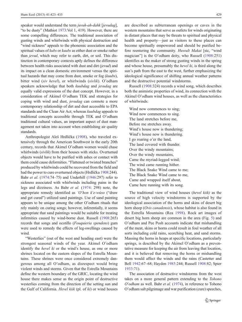
The traditional view of wind houses (hevel kiik) as thesource of high velocity windstorms is supported by theideological association of the horns and skins of desert bighorn sheep (Ovis canadensis), whose habitat is also found inthe Estrella Mountains (Rea 1998). Rock art images ofdesert big horn sheep are common in the area (Fig. 5) andO’odham and Pee Posh accounts indicate that mishandlingof the meat, skins or horns could result in foul weather of allsorts including cold rains, scorching heat, and sand storms.Massing the horns in heaps at specific locations, particularlysprings, is described by the Akimel O’odham as a preven-tative measure for keeping the air from leaving that location,and it is believed that removing the horns or mishandlingthem would affect the winds and the rains (Castetter andBell 1942:67–68; Hayden 1985:244; Russell 1908:82; Spier1933:71).
The association of destructive windstorms from the westtakes on a more general pattern extending to the TohonoO’odham as well. Bahr et al. (1974), in reference to TohonoO’odham salt pilgrimage and war purification (cure) speeches,
Hum Ecol (2013) 41:423–435 429
specifically associates the spring and foresummer westerlies/southwesterlies with O’odham siw hewel [bitter winds, inAkimel O’odham siv hevel]. As one salt pilgrimage speechstates, Tas huduñig baso ke:k g siw hewel [At the base of thesunset stands the bitter wind] (Underhill et al. 1979:62). Bahret al. (1974:144–146), suggesting that these bitter winds arethose very violent storms from the west, which precede thesummer monsoons and typically bring no rain but carry thepotential for uprooting trees and spreading destruction.Lloyd’s (1911:121) re-telling of the O’odham creation storyalso identifies the siv hevel [seev-hur-whirl] as emanatingfrom an old woman, a wind so powerful it could throw dirtand rocks out of a canal, clearing it so that the water wouldflow (see also Bahr et al. 1994:136).
Such observations are essential to an emic system ofAkimel O’odham classification of the changing seasons,which consists of a detailed understanding of recurrent shiftsin rain and wind patterns. Dangerous associations of the westwith the destructive power of bitter winds, warfare, and tradi-tional salt gathering may be related to the prevailing tradition-al wisdom that it is risky to orient one’s doorway facing to thewest. This observation is contrary, but does not contradict, theadage that houses must be built with the doorway facing easttowards the rising sun (see also Nabokov and Easton 1989;Russell 1908:154). However, it is generally forgotten thatRussell (1908) goes on to state the following:
A more practical motive for placing the doors on theeast side is to avoid the southwest winds which blowin the afternoon during nearly the entire year andwhich are especially strong during the month ofMarch. The wind usually begins to blow at about 10in the morning and increases to a velocity of 10 milesan hour by mid-afternoon, after which it decreasesuntil midnight.
The traditional Akimel O’odham practice of orientinghouse doorways downwind in an easterly direction mayactually have little to do with the rising sun and instead,serve to protect the structure and its inhabitants from thedestructive properties of siv hevel. Taking siv hevel intoconsideration over the more positive aspects of an east-facing entryway serves to explain the variability of houseorientations specifically with respect to doorways. Suchkinds of “patterns of conduct” (Basso 1996:144–148) reflectthe deep understanding of the ecology gleaned from gener-ations of settlements in the MGRV. This assumption will betested in the section below as we examine archaeologicaldata from studies of Hohokam households within and adja-cent to the GRIC.
Archaeological Data Relating to Dust
Archaeological understandings of the MGRV can bridgethe divide between millennia-scale geomorphologicalstudies of eolian activity (Wright and Fertelmes 2012;Wright et al. 2011), traditional approaches to understand-ing dust and wind, modern instrumentation that recordairborne particulates to the micrometer, and regulatoryframeworks that establish thresholds for healthy air qual-ity standards. When collected carefully, archaeologicaldata have the potential to serve as a long-term proxyfor understanding landscape evolution and how humansrespond to environmental events like wind blown dust(PM10 entrainment). Modern semiotic associations re-garding wind and dust entrainment are difficult to tracedirectly into the archaeological record, but studies ofHohokam settlement systems correlatively illustrate theexistence of socially-disruptive eolian activity and a cor-responding cultural adaptation to mitigate its effects.
In a previous study of Hohokam settlement at GR-893 inDistrict 6, a series of optically stimulated luminescence(OSL) dates on sand that infilled irrigation canals and ra-diocarbon ages on archaeological features demonstrated thatsettlement at the site shifted to avoid encroachment of theeolian sand sheet in the form of sand dunes (Ravesloot et al.2007; Wright and Forman 2010; Wright et al. 2011). Threeseparate irrigation canals were excavated by the Hohokam atsubsequently later ages and, in turn, were consumed byblowing sand that originated from aggrading fluvial chan-nels during the Colonial and early Classic Periods (AD 750–1350). Although the sediments that infilled the canals wereprimarily comprised of sands (>75 μm), the data clearlyshow how human settlement has been forced to adjust toeolian activity for a very long time.
Sand sheet movement is usually a localized phenomenon,including that which disrupted life at GR-893, and is the resultof a supply of fine to medium sands (Wright et al. 2011).
Fig. 5 Rock art from the Estrella Mountains depicting big horn sheep.Photo taken by Chris Loendorf
430 Hum Ecol (2013) 41:423–435
However, dust entrainment is a larger scale occurrence inwhich hundreds to thousands of hectares are impacted simul-taneously, affecting localities encompassing more than onesite on a regional scale. For evidence of how prehistoricpeople managed dust, we must examine a different type ofbehavior in the record of archaeological settlement.
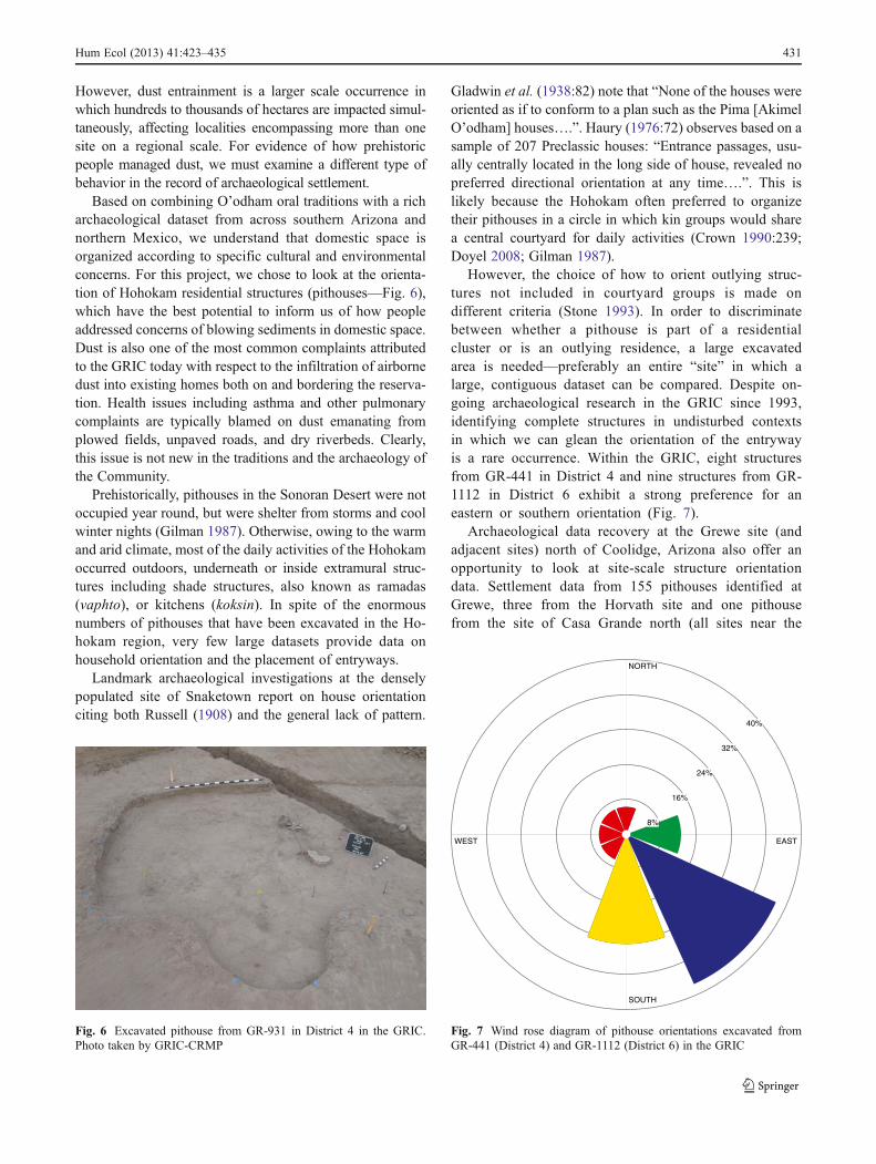
Based on combining O’odham oral traditions with a richarchaeological dataset from across southern Arizona andnorthern Mexico, we understand that domestic space isorganized according to specific cultural and environmentalconcerns. For this project, we chose to look at the orienta-tion of Hohokam residential structures (pithouses—Fig. 6),which have the best potential to inform us of how peopleaddressed concerns of blowing sediments in domestic space.Dust is also one of the most common complaints attributedto the GRIC today with respect to the infiltration of airbornedust into existing homes both on and bordering the reserva-tion. Health issues including asthma and other pulmonarycomplaints are typically blamed on dust emanating fromplowed fields, unpaved roads, and dry riverbeds. Clearly,this issue is not new in the traditions and the archaeology ofthe Community.
Prehistorically, pithouses in the Sonoran Desert were notoccupied year round, but were shelter from storms and coolwinter nights (Gilman 1987). Otherwise, owing to the warmand arid climate, most of the daily activities of the Hohokamoccurred outdoors, underneath or inside extramural struc-tures including shade structures, also known as ramadas(vaphto), or kitchens (koksin). In spite of the enormousnumbers of pithouses that have been excavated in the Ho-hokam region, very few large datasets provide data onhousehold orientation and the placement of entryways.
Landmark archaeological investigations at the denselypopulated site of Snaketown report on house orientationciting both Russell (1908) and the general lack of pattern.
Gladwin et al. (1938:82) note that “None of the houses wereoriented as if to conform to a plan such as the Pima [AkimelO’odham] houses….”. Haury (1976:72) observes based on asample of 207 Preclassic houses: “Entrance passages, usu-ally centrally located in the long side of house, revealed nopreferred directional orientation at any time….”. This islikely because the Hohokam often preferred to organizetheir pithouses in a circle in which kin groups would sharea central courtyard for daily activities (Crown 1990:239;Doyel 2008; Gilman 1987).
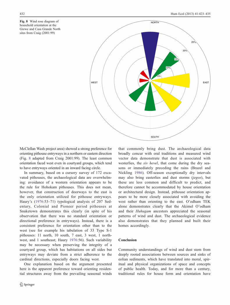
However, the choice of how to orient outlying struc-tures not included in courtyard groups is made ondifferent criteria (Stone 1993). In order to discriminatebetween whether a pithouse is part of a residentialcluster or is an outlying residence, a large excavatedarea is needed—preferably an entire “site” in which alarge, contiguous dataset can be compared. Despite on-going archaeological research in the GRIC since 1993,identifying complete structures in undisturbed contextsin which we can glean the orientation of the entrywayis a rare occurrence. Within the GRIC, eight structuresfrom GR-441 in District 4 and nine structures from GR-1112 in District 6 exhibit a strong preference for aneastern or southern orientation (Fig. 7).
Archaeological data recovery at the Grewe site (andadjacent sites) north of Coolidge, Arizona also offer anopportunity to look at site-scale structure orientationdata. Settlement data from 155 pithouses identified atGrewe, three from the Horvath site and one pithousefrom the site of Casa Grande north (all sites near the
NORTH
SOUTH
WEST EAST
8%
16%
24%
32%
40%
Fig. 7 Wind rose diagram of pithouse orientations excavated fromGR-441 (District 4) and GR-1112 (District 6) in the GRIC
Fig. 6 Excavated pithouse from GR-931 in District 4 in the GRIC.Photo taken by GRIC-CRMP
Hum Ecol (2013) 41:423–435 431
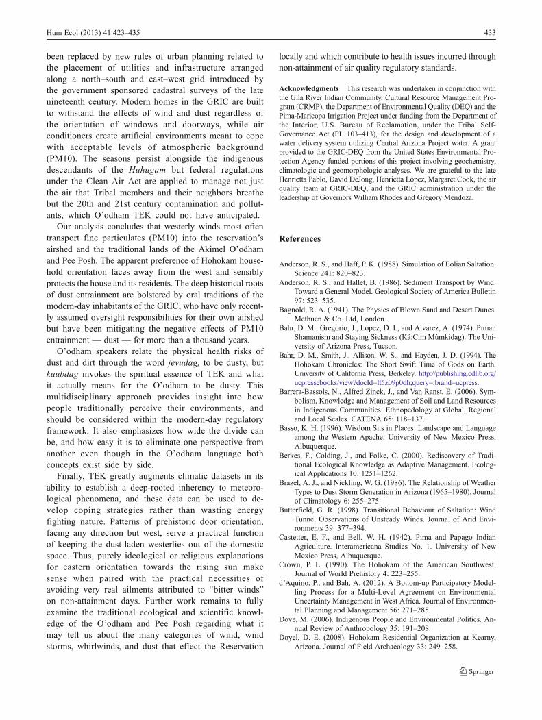
McClellan Wash project area) showed a strong preference fororienting pithouse entryways in a northern or eastern direction(Fig. 8 adapted from Craig 2001:99). The least commonorientation faced west even in courtyard groups, which tendto have entryways oriented in an inward facing circle.
In summary, based on a cursory survey of 172 exca-vated pithouses, the archaeological data are overwhelm-ing: avoidance of a western orientation appears to bethe rule for Hohokam pithouses. This does not mean,however, that construction of doorways to the east isthe only orientation utilized for pithouse entryways.Haury’s (1976:53–71) typological analysis of 207 Sed-entary, Colonial and Pioneer period pithouses atSnaketown demonstrates this clearly (in spite of hisobservation that there was no standard orientation ordirectional preference in entryways). Instead, there is aconsistent preference for orientation other than to thewest (see for example his tabulation of 33 Type S-1pithouses: 11 north, 10 south, 7 east, 3 west, 1 north-west, and 1 southeast; Haury 1976:56). Such variabilitymay be necessary when preserving the integrity of acourtyard group, which has habitations on all sides butentryways may deviate from a strict adherence to thecardinal directions, especially doors facing west.
One explanation based on the argument presentedhere is the apparent preference toward orienting residen-tial structures away from the prevailing seasonal winds
that commonly bring dust. The archaeological databroadly concur with oral traditions and measured windvector data demonstrate that dust is associated withwesterlies, the siv hevel, that come during the dry sea-sons or immediately preceding the rains (Brazel andNickling 1986). Off-season exceptionally dry intervalsmay also bring easterlies and dust storms (jegos), butthese are less common and difficult to predict, andtherefore cannot be accommodated by house orientationor architectural design. Instead, pithouse orientation ap-pears to be more closely associated with avoiding thewest rather than orienting to the east. O’odham TEKalone demonstrates clearly that the Akimel O’odhamand their Huhugam ancestors appreciated the seasonalpatterns of wind and dust. The archaeological evidencealso demonstrates that they planned and built theirhomes accordingly.
Conclusion
Community understandings of wind and dust stem fromdeeply rooted associations between sources and sinks ofeolian sediments, which have translated into moral, spir-itual and physical organizations of space and conceptsof public health. Today, and for more than a century,traditional rules for house form and orientation have
NORTH
SOUTH
WEST EAST
5%
10%
15%
20%
25%
Fig. 8 Wind rose diagram ofhousehold orientation at theGrewe and Casa Grande Northsites from Craig (2001:99)
432 Hum Ecol (2013) 41:423–435
been replaced by new rules of urban planning related tothe placement of utilities and infrastructure arrangedalong a north–south and east–west grid introduced bythe government sponsored cadastral surveys of the latenineteenth century. Modern homes in the GRIC are builtto withstand the effects of wind and dust regardless ofthe orientation of windows and doorways, while airconditioners create artificial environments meant to copewith acceptable levels of atmospheric background(PM10). The seasons persist alongside the indigenousdescendants of the Huhugam but federal regulationsunder the Clean Air Act are applied to manage not justthe air that Tribal members and their neighbors breathebut the 20th and 21st century contamination and pollut-ants, which O’odham TEK could not have anticipated.
Our analysis concludes that westerly winds most oftentransport fine particulates (PM10) into the reservation’sairshed and the traditional lands of the Akimel O’odhamand Pee Posh. The apparent preference of Hohokam house-hold orientation faces away from the west and sensiblyprotects the house and its residents. The deep historical rootsof dust entrainment are bolstered by oral traditions of themodern-day inhabitants of the GRIC, who have only recent-ly assumed oversight responsibilities for their own airshedbut have been mitigating the negative effects of PM10entrainment — dust — for more than a thousand years.
O’odham speakers relate the physical health risks ofdust and dirt through the word jevudag, to be dusty, butkuubdag invokes the spiritual essence of TEK and whatit actually means for the O’odham to be dusty. Thismultidisciplinary approach provides insight into howpeople traditionally perceive their environments, andshould be considered within the modern-day regulatoryframework. It also emphasizes how wide the divide canbe, and how easy it is to eliminate one perspective fromanother even though in the O’odham language bothconcepts exist side by side.
Finally, TEK greatly augments climatic datasets in itsability to establish a deep-rooted inherency to meteoro-logical phenomena, and these data can be used to de-velop coping strategies rather than wasting energyfighting nature. Patterns of prehistoric door orientation,facing any direction but west, serve a practical functionof keeping the dust-laden westerlies out of the domesticspace. Thus, purely ideological or religious explanationsfor eastern orientation towards the rising sun makesense when paired with the practical necessities ofavoiding very real ailments attributed to “bitter winds”on non-attainment days. Further work remains to fullyexamine the traditional ecological and scientific knowl-edge of the O’odham and Pee Posh regarding what itmay tell us about the many categories of wind, windstorms, whirlwinds, and dust that effect the Reservation
locally and which contribute to health issues incurred throughnon-attainment of air quality regulatory standards.
Acknowledgments This research was undertaken in conjunction withthe Gila River Indian Community, Cultural Resource Management Pro-gram (CRMP), the Department of Environmental Quality (DEQ) and thePima-Maricopa Irrigation Project under funding from the Department ofthe Interior, U.S. Bureau of Reclamation, under the Tribal Self-Governance Act (PL 103–413), for the design and development of awater delivery system utilizing Central Arizona Project water. A grantprovided to the GRIC-DEQ from the United States Environmental Pro-tection Agency funded portions of this project involving geochemistry,climatologic and geomorphologic analyses. We are grateful to the lateHenrietta Pablo, David DeJong, Henrietta Lopez, Margaret Cook, the airquality team at GRIC-DEQ, and the GRIC administration under theleadership of Governors William Rhodes and Gregory Mendoza.
References
Anderson, R. S., and Haff, P. K. (1988). Simulation of Eolian Saltation.Science 241: 820–823.
Anderson, R. S., and Hallet, B. (1986). Sediment Transport by Wind:Toward a General Model. Geological Society of America Bulletin97: 523–535.
Bagnold, R. A. (1941). The Physics of Blown Sand and Desert Dunes.Methuen & Co. Ltd, London.
Bahr, D. M., Gregorio, J., Lopez, D. I., and Alvarez, A. (1974). PimanShamanism and Staying Sickness (Ká:Cim Múmkidag). The Uni-versity of Arizona Press, Tucson.
Bahr, D. M., Smith, J., Allison, W. S., and Hayden, J. D. (1994). TheHohokam Chronicles: The Short Swift Time of Gods on Earth.University of California Press, Berkeley. http://publishing.cdlib.org/ucpressebooks/view?docId=ft5z09p0dh;query=;brand=ucpress.
Barrera-Bassols, N., Alfred Zinck, J., and Van Ranst, E. (2006). Sym-bolism, Knowledge and Management of Soil and Land Resourcesin Indigenous Communities: Ethnopedology at Global, Regionaland Local Scales. CATENA 65: 118–137.
Basso, K. H. (1996). Wisdom Sits in Places: Landscape and Languageamong the Western Apache. University of New Mexico Press,Albuquerque.
Berkes, F., Colding, J., and Folke, C. (2000). Rediscovery of Tradi-tional Ecological Knowledge as Adaptive Management. Ecolog-ical Applications 10: 1251–1262.
Brazel, A. J., and Nickling, W. G. (1986). The Relationship of WeatherTypes to Dust Storm Generation in Arizona (1965–1980). Journalof Climatology 6: 255–275.
Butterfield, G. R. (1998). Transitional Behaviour of Saltation: WindTunnel Observations of Unsteady Winds. Journal of Arid Envi-ronments 39: 377–394.
Castetter, E. F., and Bell, W. H. (1942). Pima and Papago IndianAgriculture. Interamericana Studies No. 1. University of NewMexico Press, Albuquerque.
Crown, P. L. (1990). The Hohokam of the American Southwest.Journal of World Prehistory 4: 223–255.
d’Aquino, P., and Bah, A. (2012). A Bottom-up Participatory Model-ling Process for a Multi-Level Agreement on EnvironmentalUncertainty Management in West Africa. Journal of Environmen-tal Planning and Management 56: 271–285.
Dove, M. (2006). Indigenous People and Environmental Politics. An-nual Review of Anthropology 35: 191–208.
Doyel, D. E. (2008). Hohokam Residential Organization at Kearny,Arizona. Journal of Field Archaeology 33: 249–258.
Hum Ecol (2013) 41:423–435 433
Eberle, R. F., and Allen, V. K. (2012). Exceptional Events Demonstra-tion Report for the Gila River Indian Community. KleinfelderWest, Inc., Tempe, Arizona.
Ezell, P. H. (1963a). Is There a Hohokam-Pima Culture Continuum?American Antiquity 29: 61–66.
Ezell, P. H. (1963b). The Maricopas. An Identification from Documen-tary Sources. Anthropological Papers of the University of ArizonaNumber 6. University of Arizona Press, Tucson.
Fish, S. K., and Fish, P. R. (eds.) (2007). The Hohokam Millennium.School for Advanced Research Press, Santa Fe, New Mexico.
Gilman, P. A. (1987). Architecture as Artifact: Pit Structures andPueblos in the American Southwest. American Antiquity 52:538–564.
Gladwin, H. S., Haury, E. W., Sayles, E. B., and Gladwin, N. (1938).Excavations at Snaketown: Material Culture. Medallion Papers25. Gila Pueblo, Globe, Arizona.
Goossens, D., and Offer, Z. Y. (1997). Aeolian Dust Erosion onDifferent Types of Hills in a Rocky Desert: Wind Tunnel Simu-lations and Field Measurements. Journal of Arid Environments37: 209–229.
Hagerman, S., Witter, R., Corson, C., Suarez, D., Maclin, E. M.,Bourque, M., and Campbell, L. (2012). On the Coattails ofClimate? Opportunities and Threats of a Warming Earth for Bio-diversity Conservation. Global Environmental Change 22: 724–735.
Haury, E. W. (1976). The Hohokam: Desert Farmers and Craftsmen:Excavations at Snaketown, 1964–1965. University of ArizonaPress, Tucson.
Hayden, J. D. (1985). Food Animal Cremations of the Sierra Pinacate,Sonora, Mexico. The Kiva 50: 237–248.
Heim Jr., R. R. (2000). Drought Indices: A Review, Chapter 11. InWilhite, D. A. (ed.), Drought: A Global Assessment. Routledge,London, pp. 159–167.
Hirschboek, K. (1985). Hydroclimatology of Flow Events in the GilaRiver Basin, Central and Southern Arizona. PhD Thesis. Depart-ment of Geosciences, University of Arizona, Tucson.
Hrdlička, A. (1908). Physiological and Medical Observations amongthe Indians of Southwestern United States and Northern Mexico.GPO, Washington, D.C.
Huckleberry, G. A. (1993a). Late-Holocene Stream Dynamics on theMiddle Gila River, Pinal County, Arizona. PhD Thesis. Depart-ment of Geosciences, University of Arizona, Tucson.
Huckleberry, G. A. (1993b). Surficial geology of the Middle Gila RiverArea, North-Central Pinal County, Arizona. Report No. 93–3.Arizona Geological Survey, Tucson.
Huckleberry, G. A. (1995). Archaeological Implications of Late Holo-cene Channel Changes on the Middle Gila River, Arizona.Geoarchaeology 10: 159–182.
Kendall, M. B. (1983). Yuman Languages. In Sturtevant, W. C. (ed.),Handbook of North American Indians Vol 10, Southwest.Smithsonian Musuem, Washington, D. C., pp. 4–12.
Lancaster, N., and Tchakerian, V. P. (2003). Late Quaternary EolianDynamics, Mojave Desert, California. In Enzell, Y., Wells, S. G.,and Lancaster, N. (eds.), Paleoenvironments and Paleogydrologyof the Mohave and Southern Great Basin Deserts, Boulder, Col-orado. Special Paper No. 368. Geological Society of America,Boulder, Colorado, pp. 231–249.
Lloyd, W. J. (1911). Aw-Aw-Tam Indian Nights: Being the Myths andLegends of the Pimas of Arizona. The Lloyd Group, Westfield,NJ.
Loendorf, C. (2012). The Hohokam-Akimel O’odham Continuum:Sociocultural Dynamics and Projectile Point Design in the Phoe-nix Basin, Arizona. GRIC Anthropological Research PapersNumber 5. University of Arizona Press, Tucson.
Macpherson, T., Nickling, W. G., Gillies, J. A., and Etyemezian, V.(2008). Dust Emissions from Undisturbed and Disturbed Supply-
Limited Desert Surfaces. Journal of Geophysical Research 113:F02S04.
Mathiot, M. (1973). A Dictionary of Papago Usage. University ofIndian Press, Bloomington.
McGuire, R. H., and Schiffer, M. B. (1982). Hohokam and Patayan:Prehistory of Southwestern Arizona. Academic, New York.
McIntosh, R. J., Tainter, J. A., and McIntosh, S. K. (eds.) (2000). TheWay the Wind Blows: Climate History and Human Action. Co-lumbia University Press, New York.
Miller, A. M., Davidson-Hunt, I. J., and Peters, P. (2010). TalkingAbout Fire: Pikangikum First Nation Elders Guiding Fire Man-agement. Canadian Journal of Forest Research 40: 2290–2301.
Miller, W. R. (1984). The Classification of the Uto-Aztecan LanguagesBased on Lexical Evidence. International Journal of AmericanLinguistics 50: 1–24.
Moller, H., Berkes, F., Lyver, P. O., and Kislalioglu, M. (2004).Combining Science and Traditional Ecological Knowledge: Mon-itoring Populations for Co-Management. Ecology and Society 9:http://www.ecologyandsociety.org/vol9/iss3/art2/.
Molnar, J. J. (2010). Climate Change and Societal Response: Liveli-hoods, Communities, and the Environment. Rural Sociology 75:1–16.
Nabhan, G. P., and Sheridan, T. E. (1977). Living Fencerows of the RioSan Miguel, Sonora, Mexico: Traditional Technology for Flood-plain Management. Human Ecology: An Interdisciplinary Journal5: 97–112.
Nabokov, P., and Easton, R. (1989). Native American Architecture.Oxford University Press, Oxford.
National Weather Service (2009). Phoenix Monthly Precipitation from1896 to Present. http://www.wrh.noaa.gov/psr/climate/climatetable.php?wfo=psr&month=All&parm=MonthlyPcpn&site=PHX Accessed September 2, 2011.
Nickling, W. G., and Gillies, J. A. (1989). Emission of Fine-GrainedParticulates from Desert Soils. In Leinen, M., and Sarnthein, M.(eds.), Paleoclimatology and Paleometeorology: Modern and PastPatterns of Global Atmospheric Transport. Kluwer AcademicPublishers, Dordrecht, The Netherlands, pp. 133–165.
Otero, I., Boada, M., and Tàbara, J. D. (2013). Social-EcologicalHeritage and the Conservation of Mediterranean Landscapes un-der Global Change. A Case Study in Olzinelles (Catalonia). LandUse Policy 30: 25–37.
Phillips, S. J., and Comus, P. W. (2000). A Natural History of theSonoran Desert. Arizona-Sonoran Desert Museum, Tucson.
Pye, K. (1995). The Nature. Origin and Accumulation of Loess Qua-ternary Science Reviews 14: 653–667.
Ravesloot, J. C., Woodson, M. K., and Boley, M. J. eds. (2007).Results of testing and data recovery, Sfpp, Lp, east line expansionproject, Arizona portion. Cochise, Pima, Pinal, and MaricopaCounties, Arizona. WAS Technical Report No. 2007–04. WilliamSelf Associates, Inc., Tucson, Arizona.
Rea, A. M. (1997). At the Desert’s Green Edge: An Ethnobotany of theGila River Pima. University of Arizona Press, Tucson, Arizona.
Rea, A. M. (1998). Folk Mammalogy of the Northern Pimas. Univer-sity of Arizona Press, Tucson.
Russell, F. (1908). The Pima Indians. Government Printing Office,Washington D.C. Reprinted 1975, University of Arizona Press,Tucson.
Sarre, R. D. (1987). Aeolian Sand Transport. Progress in PhysicalGeography 11: 157–182.
Saxton, D., Saxton, L., and Enos, S. (1989). Dictionary, Papago/Pima-English. O’otham-Milgahn. University of Arizona Press, Tucson.
Shao, Y. (2000). Physics and Modeling of Wind Erosion. KluwerAcademic Publishers, Dordrecht.
Sheppard, P. R., Comrie, A. C., Packin, G. D., Angersbach, K., andHughes, M. K. (2002). The Climate of the Us Southwest. ClimateResearch 21: 219–238.
434 Hum Ecol (2013) 41:423–435
Smith, W. (1986). The Effects of Eastern North Pacific Tropical Cy-clones on the Southwestern United States. N.O.A.A. TechnicalMemorandum NWS WR-197, U.S. Department of Commerce,Washington, D.C.
Spier, L. (1933). Yuman Tribes of the Gila River. University of Chi-cago Press, Chicago.
Stone, T. (1993). Small Site Function and Duration of Occupation inthe Hohokam Northern Periphery. The Kiva 59: 65–82.
Terer, T., Muasya, A. M., Dahdouh-Guebas, F., Ndiritu, G. G.,and Triest, L. (2012). Integrating Local Ecological Knowl-edge and Management Practices of an Isolated Semi-AridPapyrus Swamp (Loboi, Kenya) into a Wider ConservationFramework. Journal of Environmental Management 93: 71–84.
Underhill, R. M. (1946). Papago Indian Religion. Columbia UniversityPress, New York.
Underhill, R. M., Bahr, D. M., Lopez, B., Pancho, J., and Lopez, D.(1979). Rainhouse & Ocean. Speeches for the Papago Year.University of Arizona Press, Tucson.
Uprety, Y., Asselin, H., Bergeron, Y., Doyon, F., and Boucher, J.-F. (2012). Contribution of Traditional Knowledge to Ecolog-ical Restoration: Practices and Applications. Ecoscience 19:225–237.
Waters, M. R. (1996). Surficial geologic map of the Gila River IndianCommunity. P-MIP Technical Report No. 96–1. Cultural Re-source Management Program, Gila River Indian Community,Sacaton, Arizona.
Waters, M. R. (2008). Alluvial Chronologies and Archaeology of theGila River Drainage Basin, Arizona. Geomorphology 101: 332–341.
Waters, M. R., and Ravesloot, J. C. (2000). Late Quaternary Geologyof the Middle Gila River, Gila River Indian Reservation, Arizona.Quaternary Research 54: 49–57.
Waters, M. R., and Ravesloot, J. C. (2001). Landscape Change and theCultural Evolution of the Hohokam Along the Middle Gila Riverand Other River Valleys in South-Central Arizona. AmericanAntiquity 66: 285–299.
Waters, M. R., and Ravesloot, J. C. (2003). Disaster or Catastrophe:Human Adaptation to High- and Low-Frequency Landscape Pro-cesses - a Reply to Ensor, Ensor, and Devries. American Antiquity68: 400–405.
Williams, J. J., Butterfield, G. R., and Clark, D. G. (1993). Aerody-namic Entrainment Threshold: Effects of Boundary Layer FlowConditions. Sedimentology 41: 309–328.
Wilson, G. R., Edwards, M. J., and Smits, J. K. (2010). Support forIndigenous Wildlife Management in Australia to Enable Sustain-able Use. Wildlife Research 37: 255–263.
Wright, D. K., and Fertelmes, C. M. (2012). D*U*S*T: Developingunderstanding of sediment transport, Gila River Indian Commu-nity, Arizona. P-MIP Technical Report No. 2011–13. CulturalResource Management Program, Gila River Indian Community,Sacaton, Arizona.
Wright, D. K., and Forman, S. L. (2010). Geomorphologicaltesting of eolian landforms, Gila River Indian Community,Arizona. P-MIP Tec Report 2008–05. Cultural ResourceManagement Program. Gila River Indian Community, Saca-ton, Arizona.
Wright, D. K., Forman, S. L., Waters, M. R., and Ravesloot, J. C.(2011). Holocene Eolian Activation as a Proxy for Broad-ScaleLandscape Change on the Gila River Indian Community, Arizona.Quaternary Research 76: 10–21.
Wright, D. K., and Waters, M. R. (2011). Results of geomorphic testexcavations along the Middle Gila River within the Gila RiverIndian Community, Arizona. P-MIP Report No. 11. CulturalResource Management Program. Gila River Indian Community,Sacaton, Arizona.
Hum Ecol (2013) 41:423–435 435
Related Documents