The Amazon Basin CE 397 Transboundary Waters Christine Lynch Feb 7, 2012

Welcome message from author
This document is posted to help you gain knowledge. Please leave a comment to let me know what you think about it! Share it to your friends and learn new things together.
Transcript

The Amazon BasinCE 397 Transboundary Waters
Christine Lynch
Feb 7, 2012
The Amazon’s International Importance
Global Importance to:Water
Carbon Cycle
Climate
Biodiversity
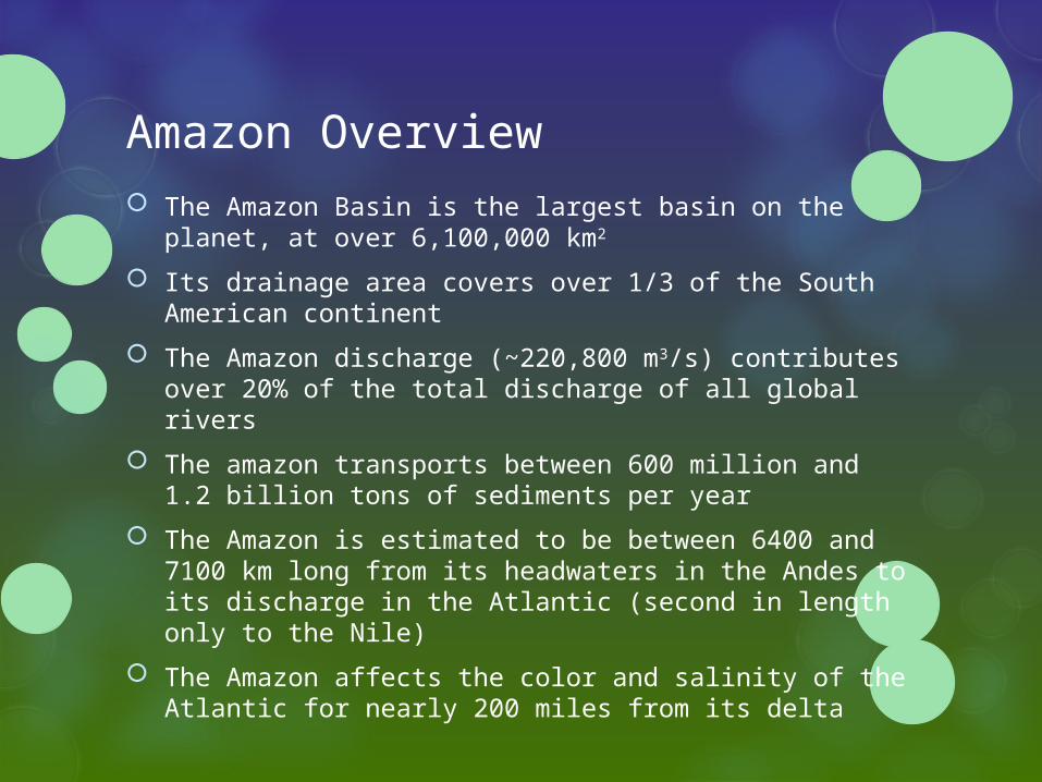
Amazon Overview
The Amazon Basin is the largest basin on the planet, at over 6,100,000 km2
Its drainage area covers over 1/3 of the South American continent
The Amazon discharge (~220,800 m3/s) contributes over 20% of the total discharge of all global rivers
The amazon transports between 600 million and 1.2 billion tons of sediments per year
The Amazon is estimated to be between 6400 and 7100 km long from its headwaters in the Andes to its discharge in the Atlantic (second in length only to the Nile)
The Amazon affects the color and salinity of the Atlantic for nearly 200 miles from its delta
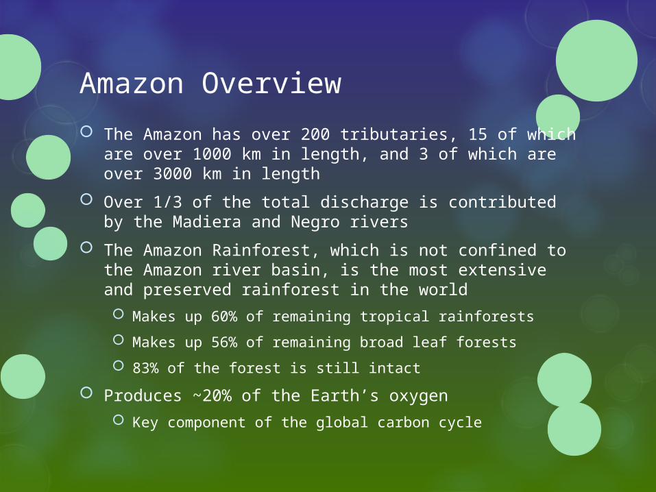
Amazon Overview
The Amazon has over 200 tributaries, 15 of which are over 1000 km in length, and 3 of which are over 3000 km in length
Over 1/3 of the total discharge is contributed by the Madiera and Negro rivers
The Amazon Rainforest, which is not confined to the Amazon river basin, is the most extensive and preserved rainforest in the world Makes up 60% of remaining tropical rainforests
Makes up 56% of remaining broad leaf forests
83% of the forest is still intact
Produces ~20% of the Earth’s oxygen Key component of the global carbon cycle

Division of the Amazon
The Amazon Basin is shared between 7 countries: Brazil
Peru
Ecuador
Bolivia
Columbia
Venezuela
Guyana
Languages include Portuguese, Spanish, and hundreds of critically endangered native languages
The Amazon Rainforest extends beyond the river basin boundaries and includes Suriname and French Guiana
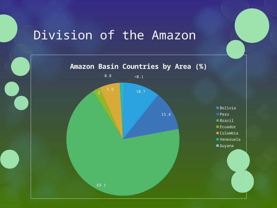
Division of the Amazon
10.7
11.4
69.1
25.9
0.8 <0.1
Amazon Basin Countries by Area (%)
BoliviaPeruBrazil EcuadorColombia Venezuela Guyana

Division of the Amazon
Bolivia
Peru
Brazil
Ecuador
Colombia
Venezuela
Guyana
0 10 20 30 40 50 60 70
Country Area included in the Amazon Basin (%)
Division of the Amazon
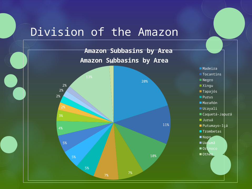
Amazon Subbasins by Area
20%
11%
10%
7%7%
5%
5%
5%
4%
3%
2%
2%
2%2%
13%
1%
Amazon Subbasins by Area
Madeira Tocantins NegroXingu Tapajós PurusMarañónUcayali Caquetá-Japurá JuruáPutumayo-IçáTrombetas NapoUatumã OrinocoOther

Division of the Amazon Human density in the Amazon is low and concentrated in
urban areas 5 cities have >1,000,000 inhabitants, 3 cities have over 300,000
inhabitants. Major population centers are generally located along larger rivers
Deforested cities are “heat islands,” subject to flooding and having cloud to ground lighting occurring at rates >3 times as often as in nearby forests
The Brazilian Amazon, the most densely populated portion of the Amazon, has about 3.3 inhabitants/km2, much lower than the average of 20 inhabitants/km2 in the remainder of Brazil. The low population density is a preserving factor in the basin,
but results in a failure to prioritize collection of data
Though the population of the Amazon (~10 million) is less dense than that of the countries it is part of, its growth rates range from 5.2-7.2%, well above the national averages of Amazon countries
Climate
The Amazon Rainforest is a major climate regulator Absorbs incoming radiation at equator to lower
temperatures
Annual mean temperature over entire basin varies from 24 to 26˚C
Absorbs and stores moisture
Recycles between 1/2 and 2/3 of regional rainfall
Mean annual rainfall greatly varies spatially, generally oscillating between 1000-3600 mm with more at the mouth and less in the interior, but exceeding 8000 mm in the Andean coastal region
75% of the energy that drives atmospheric circulation comes from the heat released during tropical rainfall
Climate
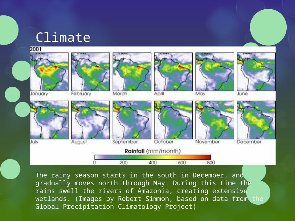
The rainy season starts in the south in December, and gradually moves north through May. During this time the rains swell the rivers of Amazonia, creating extensive wetlands. (Images by Robert Simmon, based on data from the Global Precipitation Climatology Project)

Climate
El Niño Higher than normal temperatures in the Equatorial Pacific
Significantly reduces Amazon precipitation
Droughts
Fish are concentrated in deeper channels, making fishing easier and resulting in a decline in fish stock during subsequent years
La Niña Higher than normal temperatures in the Equatorial Pacific
Opposite effect – increased rainfall
Flooding
Climate - Deforestation Between 2000 and 2007, the Brazilian Amazon was
deforested at a rate of 19,368 km2/yr. During this time, an area of forest larger than Greece was destroyed Brazil is the world’s 4th largest climate polluter, with 75% of
their greenhouse gas emissions attributed to deforestation and land use change. 59% of this is from loss of forest and burning in the Amazon.
The removal of forest (done using slash and burn techniques) reduces the retention of humidity in the soil’s top layer for 1
meter in depth
Facilitates sudden evaporation of water previously retained in forest canopy
Increases albedo (reflectiveness) and temperature
Reduces porosity of soil, causing faster rainfall drainage, erosion, and silting of rivers and lakes
Climate - Deforestation Widespread convection has been documented in
deforested areas, forming shallow cumulous clouds which usually do not evolve into nimbus clouds and as a result may not produce rain
Forests expel hygroscopic salts and organic fibers along with water during evapotranspiration, and these act as water vapor condensation nuclei at higher elevations. This process results in formation of abundant clouds and represents almost 50% of recycled rainfall.
The Amazon is estimated to store between 80-120 billion tons of carbon. If destroyed, it will emit roughly 50 times the annual greenhouse gas emissions from the U.S.
Amazon rain is generally acidic. It is unknown at this time whether this is due to naturally occurring carbonic acids, or nitrous and sulfuric acids from fossil fuel burning and deforestation

Climate - Deforestation Compared to the pasture it is generally replaced with:
Forests absorb ~11% more solar radiation
The average albedo of the Amazon forest is 13.4%, of pastures, 18%
The average temperature in the Amazon is ~ 24.1˚C, in pastures it is 33 ˚C
The daily temperature variation of Amazon soils at 20 cm did not exceed 2.8 ˚C, though under pastures it was 8 ˚C
The volumetric moisture content in the upper 1 m of pasture soil is about 15% less than under nearby forest
Deeper forest roots can pump more soil moisture to the surface, producing 20-30% more air humidity and consequently 5-20% more precipitation than pastures
Several numeric models have suggested that large-scale deforestation would diminish superficial drainage by 10-20% and increase the surface air temperature by 0.6-2 ˚C, resulting in huge changes in the regional water cycle
Land Use
Land use tied to deforestation and thus inextricably connected to climate and water cycle
Early settlement of the Amazon occurred mainly in the várzeas due to their river resources, including the fertile alluvial soils which supported agriculture and cattle. These activities were supplemented by hunting and gathering. Hunting for subsistence and skins has virtually eliminated
turtles and freshwater manatees from some areas
Prior to 1960s, economy based on extraction of natural resources, primarily rubber, cocoa, and fish Rubber the main export until the beginning of the 20th century, when
competition from SE Asia, a decline in rubber demand, and fungal plague brought the decline of the Amazon’s rubber production around 1950

Land Use Construction of roads and highways in the 1960s altered
social structure and settlement of the Amazon region Highways parallel to large rivers led to increased deforestation
along rivers
Logging companies built roads deep into forests and away from rivers, enabling extraction and export of timber but also of settlement away from rivers
Timber is collected primarily for export. Deforestation of flooded forests for timber (and cattle) remove important feeding grounds for several commercially valuable fish, and also negatively affects the harvesting of Brazilian Nuts
Road construction negatively impacted surface water by preventing normal flow, flooding some areas while drying others
Connected Amazon to the rest of Brazil
Allowed easier access to mining centers - after 60s mining of bauxite and gold became important and people began to migrate from the rivers to areas near these industries

Land Use Mining
15% of the world’s supply of bauxite
Some of the largest suppliers of iron and steel to world markets
Mining is scattered but has environmental impacts – primarily alluvial gold
Gold mining contributes to high mercury levels in fish and releases geologic arsenic
Mining of bauxite in Oriximiná, Pará, almost destroyed Batata Lake by extensive silting, though there was no legal punishment for the company responsible
Agriculture Rice, cassava, corn, and beans are subsistence farmed, while
Soya, coffee, and cacao are produced commercially
Fertilizers create local eutrophication
Brazilian Nuts, rubber, and açaí, although many medicinal and aromatic plants are harvested for pharmaceutical and cosmetic industries

Land Use - Cattle Cattle ranching is responsible for the majority of Amazon
deforestation
Brazil has the largest commercial cattle heard in the world and has been the world’s largest beef exporter since 2003
In 2006 cattle occupied 79.5% of land already in use in the Brazilian Legal Amazon (this includes forest outside of the Amazon Basin) and 3 head of cattle per inhabitant
Around 40% of Brazil’s cattle are located within the Amazon, and this is where the most growth or cattle ranching occurs
Belched methane from livestock constitutes roughly 30% of greenhouse gas emissions from agriculture, making it one of the largest agricultural sources.
Greenhouse gas emissions from beef are 13 kg CO2-eq per kg. This means consuming a kg of beef represents roughly the same greenhouse gas emissions as flying 100 km of a flight, per passenger.

Land Use - Cattle
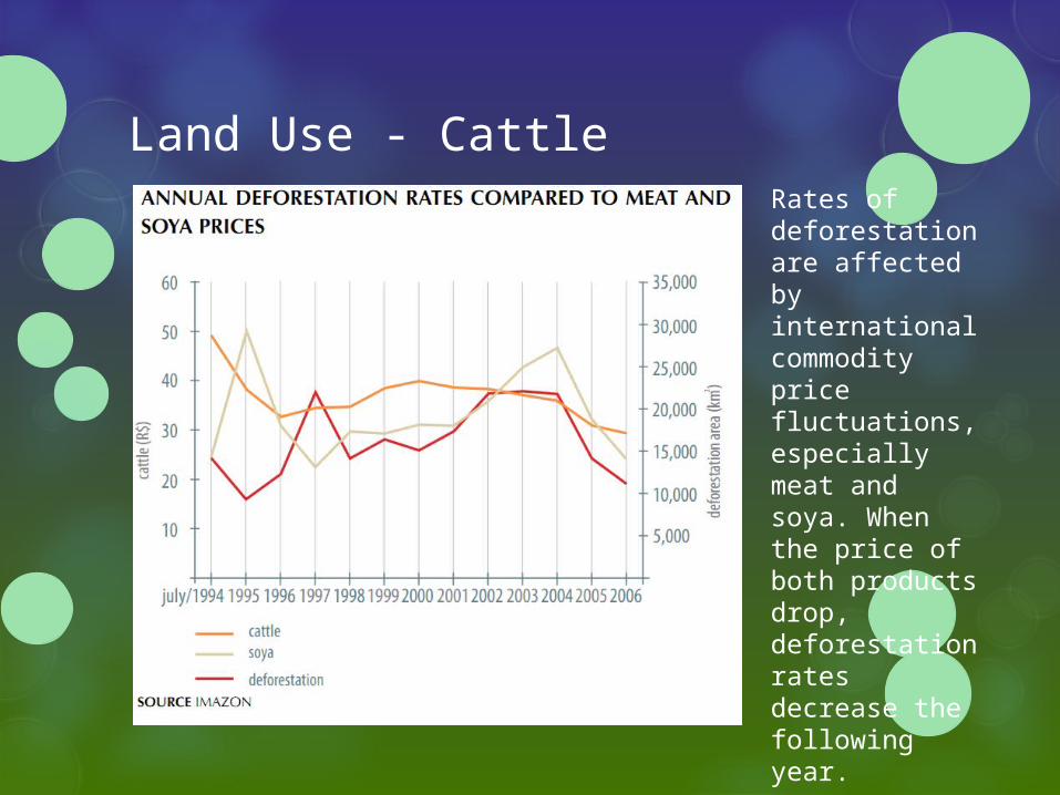
Land Use - CattleRates of deforestation are affected by international commodity price fluctuations, especially meat and soya. When the price of both products drop, deforestation rates decrease the following year.

Water Use Navigation
Ports in Iquitos (Peru) and Porto Velho city (Brazil) receive ships that travel over 3500 km along the rivers
Estimated that over 40,000 km of waterways within the basin are navigated by various types of craft
Not all rivers are navigable
Fishing Over 200 species of fish are exploited, but the commercial
market is based only on a few dozen
Of these two are already considered overexploited
Conflicts between local subsistence fishers and commercial fishermen in the várzea and industrial fishermen in the estuary
Protect healthy stocks from commercial practices
Introduction of alien species in Andean waters

Water Use - Dams
Hydroelectric energy is complemented by fuel-burning thermo-electric centers
Dams create habitat fragmentation, interrupt fish migration, and substitute river habitats with lake habitats Local extinction of migratory species possible but
unrecorded
Poor knowledge of species makes assessment of impacts difficult
Case study: Tucuruí Hydroelectric Dam on the Tocantins River
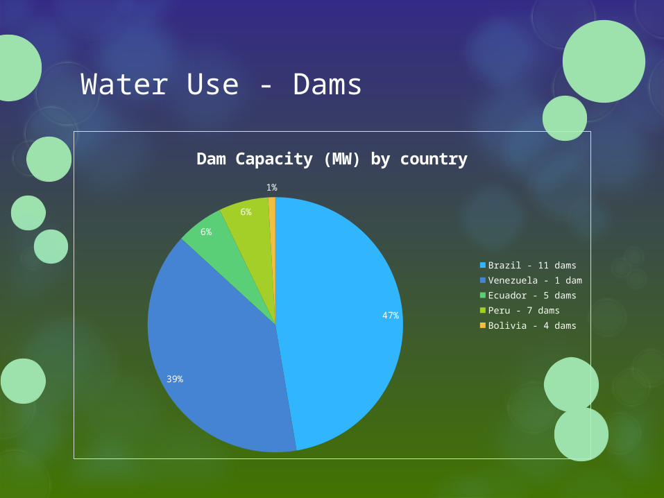
Water Use - Dams
47%
39%
6%
6%
1%
Dam Capacity (MW) by country
Brazil - 11 damsVenezuela - 1 damEcuador - 5 damsPeru - 7 damsBolivia - 4 dams
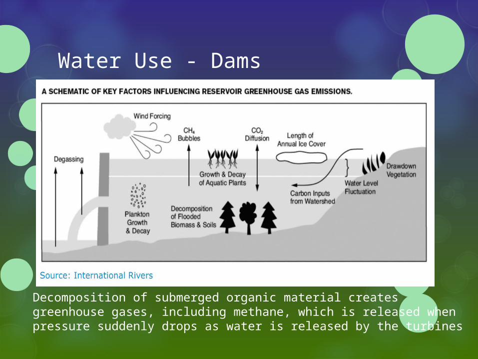
Water Use - Dams
Decomposition of submerged organic material creates greenhouse gases, including methane, which is released when pressure suddenly drops as water is released by the turbines
Water Use - Dams
According to Brazil’s National Institute for Space Research (INPE), the world’s 52,000 large dams contribute to more than 4% of the total warming impact of human activities, and dam reservoirs are the largest single source of human-caused methane emissions.
A molecule of methane does 34 times more damage than a molecule of CO2
According to one analysis, greenhouse emissions from hydroelectric production of the Curuá-Una Dam in Para, Brazil, were 3.5 times higher than if the electricity had been produced by its fossil fuel burning counterparts
Drying conditions in the Amazon may make hydropower a less viable power source

Health
Health is negatively impacted mostly in deforested areas Malaria, hepatitis, yellow fever, and dengue exhibit a
tendency to break out after habitats are modified
Arsenic has been found in rivers due to deforestation and mining (as well as a small amount of natural geologic arsenic from the Andes)
Mercury from gold mining has impacted fish In one village, the hair from people who ate fish contained
twice as much mercury as from those who didn’t
This was a village that obtained most of its protein from beef
Obligation of the Amazon Countries?
In 1990, the Brazilian Amazon contributed 3.5% of GDP, despite occupying over 45% of Brazil
“…rainforest land converted to cattle operations yields the landowner $60 per acre; if timber is harvested, the land is worth $400 per acre. However, if medicinal plants, fruits, nuts, rubber, chocolate, and other renewable and sustainable resources are harvested, the land will yield the landowner $2,400 per acre.” The Healing Power of Rainforest Herbs (Square One Publishers, Inc. Garden City, NY 11040, © Copyrighted 2004) By Leslie Taylor
Do you believe it is truly possible for countries to sustainably harvest from the Amazon in a way that is no less profitable than alternative methods?
If not, do you think is it the responsibility of the Amazon countries to sacrifice their economic potential for the good of the rainforest?

Questions?
Related Documents