111 The Acheulian Culture of the Hunsgi-Baichbal Valleys, Peninsular India: A Processual Study by K . Paddayya, Poona One of the fundamental aspects of the epistemology of empirical sciences concerns the employment of a series of artificial constructs. These constructs, formally known as concepts, serve as 'file holders in which man's mind files his knowledge of existents they subsume' (Rand 1979, 88); they constitute the armoury for deciphering and explaining the character of the phenomenal world. In tune with theinfinite nature of the reality itself the conceptual apparatus undergoes continuous refinement and reformulation and is therefore never a closed system. Archaeology very much forms part of this epistemological process. As Binford (1981, 24) puts it , our task is one of 'developing cognitive means for identifying properties of the past or diagnosing the archaeological record and thereby giving meaning to the archaeological record'. He has designated this work as middle-range research, which has emerged as a major methodological trend in modern archaeology. The site concept is one of the important tools employed by the archaeologist for partitioning the archaeological record into epistemologically meaningful analytical units. In the antiquarian stage the concern with the archaeological record was one of 'Sunday afternoon-outings' and the interest lay essentially in collecting good-looking objects distributed across the Iandscape rather as isolated items than as clusters of such items. Thanks to the Three-Age system the antiquarian pursuit achieved a scientific status and it was now held possible to reconstruct from the archaeological record knowledge about the human past. Attention soon shifted from individual objects to their spatial cooccurrences and associations; the later became the units of observation for both stratigraphical and cultural purposes. The interest in sites containing associations of objects became a major concern in the second half of the 19th century. The importance of an area or the work of a personwas often judged in terms of the number and size of the sites found and investigated. The importance given to sites can be gauged from the fact that in many cases cultures were named afterprominent sites. This site-oriented approach to the archaeological record overflowed into the 20th century. Commencing from the 30s and 40s of the century, a research trend had set in which favoured a horizontal or regional approach to the archaeological remains. Grahame Clark's study of the post- pleistocene hunter-gatherer cultures of northern Europe, the Iandscape approach to archaeological sites pioneered in England by Crawford, Cyril Fox and other workers, and Gordon Willey's Viril valley project in Peruare some of the well-known examples of this orientation. Because these studies took into account and mapped all possible types of archaeological sites and features available in the respective areas, they allowed one for the first time to understand something of the structure of the past cultures. With the emergence of the New Archaeology as a major force in the early sixties and its well-known bias towards culture process, this regional approach became an explicit component of research design. In this respect Binford' s 1964 paper entitled 'A consideration of archaeological research design' is one

Welcome message from author
This document is posted to help you gain knowledge. Please leave a comment to let me know what you think about it! Share it to your friends and learn new things together.
Transcript

111
The Acheulian Culture of the Hunsgi-Baichbal Valleys, Peninsular India: A Processual Study
by K . Paddayya, Poona
One of the fundamental aspects of the epistemology of empirical sciences concerns the employment of a series of artificial constructs. These constructs, formally known as concepts, serve as 'file holders in which man's mind files his knowledge of existents they subsume' (Rand 1979, 88); they constitute the armoury for deciphering and explaining the character of the phenomenal world. In tune with theinfinite nature of the reality itself the conceptual apparatus undergoes continuous refinement and reformulation and is therefore never a closed system.
Archaeology very much forms part of this epistemological process. As Binford (1981, 24) puts it, our task is one of 'developing cognitive means for identifying properties of the past or diagnosing the archaeological record and thereby giving meaning to the archaeological record'. He has designated this work as middle-range research, which has emerged as a major methodological trend in modern archaeology.
The site concept is one of the important tools employed by the archaeologist for partitioning the archaeological record into epistemologically meaningful analytical units. In the antiquarian stage the concern with the archaeological record was one of 'Sunday afternoon-outings' and the interest lay essentially in collecting good-looking objects distributed across the Iandscape rather as isolated items than as clusters of such items. Thanks to the Three-Age system the antiquarian pursuit achieved a scientific status and it was now held possible to reconstruct from the archaeological record knowledge about the human past. Attention soon shifted from individual objects to their spatial cooccurrences and associations; the later became the units of observation for both stratigraphical and cultural purposes. The interest in sites containing associations of objects became a major concern in the second half of the 19th century. The importance of an area or the work of a personwas often judged in terms of the number and size of the sites found and investigated. The importance given to sites can be gauged from the fact that in many cases cultures were named afterprominent sites. This site-oriented approach to the archaeological record overflowed into the 20th century.
Commencing from the 30s and 40s of the century, a research trend had set in which favoured a horizontal or regional approach to the archaeological remains. Grahame Clark's study of the postpleistocene hunter-gatherer cultures of northern Europe, the Iandscape approach to archaeological sites pioneered in England by Crawford, Cyril Fox and other workers, and Gordon Willey's Viril valley project in Peruare some of the well-known examples of this orientation. Because these studies took into account and mapped all possible types of archaeological sites and features available in the respective areas, they allowed one for the first time to understand something of the structure of the past cultures.
With the emergence of the New Archaeology as a major force in the early sixties and its well-known bias towards culture process, this regional approach became an explicit component of research design. In this respect Binford' s 1964 paper entitled 'A consideration of archaeological research design' is one

112 K. Paddayya
publication which has exercised seminal influence on the workers. Binford argued that 'The methodology most appropriate to the study of cultural process is a regional approach in which we attempt to gain reliable and representative information concerning the internal structure and ecological setting of successive cultural systems' (1972, 160). Thanks especially to salvage projects such as those connected with cultural resource management (CRM) under operation in areas like North America, this approach has not only found wide application but has undergone multi-sided elaboration with the introduction of procedures like nonrandom sampling, intensive survey, multistage fieldwork , locational models , etc. (e. g., Redman and Watson 1970; Redman 1973; 1987; Schiffer, Sullivan and Klinger 1978; Johnson 1977; Ammerman 1981).
During the last one decade or so this regional appi:oach has undergone elaboration to such an extent that adefinite negative attitude has been generared against the site concept. We have, for example, the non-site approach of Thomas (1975), the off-site approach of Foley (1981), the 'scatter between the patches' approach of the late Glynn Isaac (Isaac and Harris 1975, Isaac and Marshall 1981), the 'siteless' survey of Dunnell and Dancy (1983) and the distributional archaeology of Eben (1986). In all these approaches there is the tacit assumption that the site concept has outlived its utility and is an impediment to our understanding of culture process, some even going to the extent of advocating its scrapping. While one cannot deny the importance of the regional-scale investigations for understanding the adaptation pattern of a human group, the reaction against the site concept is probably overstretched. For, the archaeological fall-out of the activities of a human group is bound to differ in spatial intensity. It may be expected to contain nodal points resulting from occupational redundancy and/ or prolonged use as weil as diffuse and meagre scatters produced by ephemeral activities. The study of both these types of fall-out and their interrelationships is a prerequisite for appreciating the full breadth of the adaptation pattern of a human community.
lt is this general research attitude which the author has adopted in his investigations of the archaeological record pertaining to the Acheulian culture of the Hunsgi-Baichbal valleys of Peninsular India. These investigations are in progress since 1974, and in his previous publications the author has provided information about the results at different stages of work (Paddayya 1977a; b; 1978; 1979; 1982). The present paper offers a general account of the study with special reference to the methodology adopted and the main conclusion about the cultural system. This study forms part of a larger project dealing with the archaeological remains of the area ranging from Lower Palaeolithic sites to Iron Age remains of the first millennium B. C.
The present project acquired added significance and urgency as the area was to be brought within the purview of a major irrigation scheme undertaken by the provincial government of Karnataka. Under this scheme water would be brought to the area by a major canal taking off from the giant water reservoir built at a place called Narayanpur on the river Krishna (about 20 km southwest of the present area). In fact, certain parts of the area have already been brought under irrigation during the last two to three years (1985-87); crops like the millets (Sorghum vulgare PERS. and pearl millet), sunflower, groundnut and cotton benefit from this facility. One will not find it hard to imagine the kinds of impact or alteration which the archaeological record will be subjected to when an area, hitherto under traditional farming in which the wooden plough drawn by a pair of bullocks penetrates the ground no deeper than six to eight inches, is brought under irrigation. This issue concerns the effects of both landsurface modifications like levelling with heavy machinery and intensive use of the plots to raise two or more crops where one could earlier have just one crop annually. It is therefore a matter of gratification for the author that the archaeological sites of the area under study could be recorded before the commencement of the new land-use system.
The Acheulian Culture of the Hunsgi-Baichbal Valleys, Peninsular India: A Processual Study 113
I
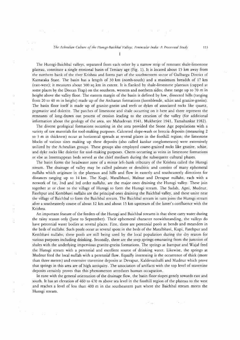
The Hunsgi-Baichbal valleys, separated from each other by a narrow strip of remnant shale-limestone plateau, constitute a single erosional basin ofTertiary age (Fig. 1). lt is located about 15 km away from the northern bank of the river Krishna and forms part of the southwestern sector of Gulbarga District of Karnataka State. The basin has a length of 30 km (north-south) and a maximum breadth of 17 km (east-west); it measures about 500 sq.km in extent. lt is flanked by shale-limestone plateaux (capped at some places by the Deccan Trap) on the southern, western and northern sides; these range up to 70 m in height above the valley floor. The eastern margin of the basin is defined by low, dissected hills (ranging from 20 to 40 m in height) made up of the Archaean formations (hornblende, schistand granite-gneiss). The basin floor itself is made up of granite-gneiss and reefs or dykes of associated rocks like quartz , pegmatite and dolerite. The patches of Iimestone and shale occurring on it here and there represent the remnants of long-drawn out process of erosion leading to the creation of the valley (for additional information about the geology of the area, see Mahadevan 1941, Mukherjee 1941 , Tamahankar 1982).
The diverse geological formations occurring in the area provided the Stone Age populations with a variety of raw materials for tool-making purposes. Calcreted slope-wash or breccia deposits (measuring 2 to 3 m in thickness) occur as horizontal spreads at several places in the foothill region; the Iimestone blocks of various sizes making up these deposits (also called kankar conglomerates) were extensively utilized by the Acheulian groups. These groups also employed coarse-grained rocks like granite, schist, and dyke rocks like dolerite for tool-making purposes. Cherts occurring as veins in Iimestone formations or else as Intertrappean beds served as the chiefmedium during the subsequent cultural phases.
The basin forms the headwater zone of a minor left-bank tributary of the Krishna called the Hunsgi stream. The drainage of valley may be called palmate or dendritic and consists of many ephemeral nullahs which originate in the plateaux and hills and flow in easterly and southeasterly directions for distances ranging up to 14 km. The Kupi, Maralbhavi, Malnur and Devapur nullahs, each with a network of 1st, 2nd and 3rd order nullahs, are the major ones draining the Hunsgi valley. These join tagether at or close to the village of Hunsgi to form the Hunsgi stream. The Sadab, Agni, Mudnur, Fatehpur and Kembhavi nullahs are the principal ones draining the Baichbal valley, and these unite near the village of Baichbal to form the Baichbal stream. The Baichbal stream in turn joins the Hunsgi stream after a southeasterly course of about 12 km and about 15 km upstream of the latter's confluence with the Krishna.
An important feature of the feeders of the Hunsgi and Baichbal streams isthat these carry water during the rainy season only (June to September). Their ephemeral character notwithstanding, the valleys do have perennial water bodies at several places. First, there are perennial pools at bends and meanders in the beds of nullahs. Suchpools occur at several spots in the beds of the Maralbhavi, Kupi, Fatehpur and Kembhavi nullahs; these pools are still being used by the local population during the dry season for various purposes including drinking. Secondly, there are the seep springs emanating from the junction of shales with the underlying impervious granite-gneiss formations. The springs at Isampur and Wajal feed the Hunsgi stream with a perennial and excellent source of drinking water. Likewise, the springs at Mudnur feed the local nullah with a perennial flow. Equally interesting is the occurrence of thick (more than three meters) and extensive travertine deposits at Devapur, Kaldevanhalli and Mudnur which prove that springs in this area are of high antiquity. The association of artifacts with the top Ievel of travertine deposits certainly proves that this phenomenon antedates human occupation.
In tune with the general orientation of the drainage flow, the basin floor slopes gently towards east and south. lt has an elevation of 460 to 470 m above sea Ievel in the foothill region of the plateau to the west and reaches a Ievel of less than 400 m in the southeastern part where the Baichbal stream meets the Hunsgi stream.

114 K. Paddayya
Far from being a uniformly sloping surface, the valley floor presents a gently rolling topography resulting from the presence of a series of flattened, tongue-shaped sweeps of land separated from one another by shallow, linear-shaped depressions (8 to 10 km long and up to half a kilometre broad). These depressions mark the ancient drainage tracts of pre-Acheulian age; the present-day nullahs occupy their bottom portions. The sides of these drainage tracts gently rise upwards and merge with the abovementioned flattened sweeps of land serving as interfluves (5 to 20 m high) between the present-day nullah courses. Considering the long time duration that must necessarily be provided for in the degradation of land-surface covered with hard formations like granites by overland processes other than true river action, it seems safe to assume that this undulating morphology of the basin floor was already in existence in its gross form much before the Acheulian groups appeared on the scene. The engineers of the Irrigation Department have very intelligently aligned the distributary canals (taking off from the main canal which follows the foothill zone of the shale-limestone plateaux flanking the western side of the valley) along the summits of the interfluves, so that water could be reached by gravity flow to fields occupying both the elevated and low-lying parts of the valley floor through a network of lateral canals and field-channels .
From the point of view of climate, the area formspart of the semi-arid and drought-prone Deccan, and receives an average annual rainfall of about 650 mm.This is contributed solely by the southwest monsoon which lasts from mid-June through September. On account of the meagre and unreliable nature of the rainfall, the area often experiences drought conditions leading to partial or complete crop failure . With a view to overcoming these vagaries of the nature the government has undertaken the major irrigation project on the Krishna mentioned earlier.
Wood-cutting for land reclamation, overgrazing by domestic flocks and other forms of human interference with the ecosystem since the commencement of agricultural way of life some four thousand years ago have resulted in a more or less complete denudation of biological environments of the area. Nevertheless, the small patches of scrub jungle preserved on rocky grounds at a few places in the valley allow us to group the vegetation of the area under a complex known as the Hardwickia-Anogeissus series (Gaussen et al. 1965; 1966). Excepting small fauna comprising fishes, amphibians, birds and animals like the hare, the jackal, and the porcupine, wild life has practically disappeared from the area.
Based upon our observations about the sediments found in the area and the fossil fauna recovered from some of the archaeological sites, the following inferences may be made about its palaeoenvironmental setting. It is beyond doubt that the basin-like form of the area and the rolling topography of its floor had already come into existence prior to human occupation. Considering the fact that monsoonal climate has been a fearure of the Indian subcontinent since Lower Pleistocene times, one could safely include the Hunsgi-Baichbal valleys wirhin the operation of this climatic regime. As at present, the year consisted of a diseinet wet or rainy season and a dry season. The thick travertine deposits found in the area are a sure evidence that seep springs were active in the past also. The area was clothed in a good cover of savannah woodland type of vegetation; the strearn courses supported thick gallery forests. From the fact that the relict patches of vegetation have yielded as many as 50 species of wild plant foods comprising leafy greens, fruits, berries, etc. , we seem to be fully justified in inferring that the area offered rich and varied plant foods to the prehistoric groups. That the area also supported rich animal life is proved by the occurrence of fossilized bones of wild animals such as the cattle, the horse, the elephant and some cervids. All these considerations - a sheltered topography with unlimited supplies of raw materials of different types, perennial surface water hoclies in the form of spring flows and pools in nullah beds and a range of plant and animal foods - rendered the basin into a very favourable habitat and accounts for its rich and uninterrupted human occupation. We must now turn our attention to an examination of its manifestation in the archaeological record.

The Acheulian Culture of the Hunsgi-Baichbal Valleys, Peninsular India: A Processual Study
PLATEAUX I H ILLS • MODERN VILLAGE
VALL EY F LOO R ~ STREAM
COUNTOUR ( Metus , A bovli M. S. L. ) AC HEU LIA N SI T ES
ROADS • EARLY e SECONDARY S IT E
•••- NARAYAN PUR LEFT BANK CANA L WIIH TUNN EL ® L A T E ® NON - SITE
DISTRIBUTDRY CANA L •®F WIT H FAUNA •E EXCAVAT ED
' 5 w
,_., SPRIN G 0 I 2 3 w L;;;;J
w WAT ER POO L Kl LOMETRES
SAPRE
Fig. 1. Map of the Hunsgi-Baichbal valleys showing the distribution of Acheulian sites m relation to
topography, drainage and other features.
115

116 K. Paddayya
II
Since the aim of the project was to understand the development of land-use patterns across time (culture process in its diachronic perspective) and also because of the grave threat posed to the archaeological record by the introduction of irrigation, efforts have been made right from the beginning of the project to record all possible types of evidence belonging to the Acheulian, Middle Palaeolithic, Upper Palaeolithic,Mesolithic, Neolithic and Iron Age Megalithic cultures. Since the present paper is concerned with the Acheulian culture, our observationswill be confined to the methodology adopted for investigating sites of this culture.
Any attempt to study past human cultures from the processual point of view necessarily emails a regional orientation to the archaeological record. The adoption of the regional approach is particularly meaningful in those cases where the regions could be defined with reference to one or more natural features rather than administrative Iimits. The reason is simple: in an overwhelming number of cases human groups have a tendency to gear their adaptations to the natural features of their respective habitats ( topography, drainage, flora and fauna, rock and soil formations, etc., or a combination of these features) .
Grigg (1976) has elsewhere given an excellent account of the evolution of the concept of region in geography over a period of two centuries. While emphasizing the regional approach to economic problems, Smith (1976a: 6; seealso 1976b for comments on regional social systems) writes; ' ... regional approach mediates between locallevel and macro-level approaches, thereby complementing each; that it allows concrete conceptualization of systemic economic problems; and that it attends to non-economic variables'. Both because they form a diseinet topographical entity and also because they serve as the headwater zone of a stream, the Hunsgi-Baichbal valleys may be said to constitute a good example of a natural area. The tri-junction of the Archaean formations, the Bhima sedimentary rocks and the Deccan Trap, and the presence of seep springs creating perennial water bodies are other considerations which support our treatment of the two valleys as a natural area.
The adoption of regional approach1 calls for: i) a reasonable understanding of the terrain conditions and raw materials and ii) its integration with the archaeological record of the area concerned. Some observations have already been made about the former aspect and additional remarks will be made at a later stage. Let us briefly consider the methodology used for investigating the archaeological record itself.
An important aspect of the investigation of Acheulian sites of the area concerns their closeness to surface. Unlike the East African and European Palaeolithic sites which are buried under a thick sedimentary cover, these sites are essentially surface and sub-surface occurrences. The overlying deposits (mostly black cotton soil) measure from a few centimetres to half a meter in thickness. These sites serve as a very good instance of what the American archaeologists call 'plowzone archaeology' (O 'Brien and Lewareh 1978, 1981). It is important to recall here that the vast majority ofPalaeolithic sites in Peninsular Irrdia belong to this type. Unfortunately, Indian prehistorians have so far adopted a negative attitude towards these sites. Their closeness to surface has generared a feeling that they are all disturbed and as such cannot serve as a reliable basis for reconstructing Stone Age lifeways. The potentialities of such sites
l Obviously mistaking our team for one of the many survey parties of the Irrigation Department which were working in the area simultaneously in connection with the Iay-out of distributary canals and field-channels, one of the (illiterate!) villagers whom we had encountered during one of our daily field-trips asked us whether we too were carrying out a ' lateral survey' of the area. Notwithstanding the difference between the intent of our work and that of the Irrigation Department, this phrase is an apt characterization of the regional approach adopted in the present study and serves to distinguish ir from the srream-bound, vertical approach meant for the discovery of cliff-sections.

The Acheulian Culture of the Hunsgi-Baichbal Valleys, Peninsular India: A Processual Study 117
are now being realized the world over (Lewarch and O'Brien 1981; seealso Samson 1985, 106; Bower 1986) and 'plowzone archaeology' is devoted to the development of field and analytical techniques for their study. Sofaras India is concerned, the writer has already pointed out elsewhere that these sites are , as it were, naturally excavated and therefore entail much less time and effort in terms of field investigation (Paddayya 1987a, 80). Secondly, while sites with thick sections may be important for pursuing culture history Ievel of research, these 'plowzone' sites allow one to translate the regional approach into reality and thereby make it possible to reconstruct cultures from the processual point of view which, pace Binford (1972, 117), 'refers to the dynamic relationships (causes and effects) operative among the components of a system or between systematic components and the environment.' In fact , one could even go to the extent of saying that any genuine progress in prehistoric research in India will depend on our ability to develop field and laboratory techniques for investigating these sites and decode their meanings.
The field strategy adopted for investigating these sites included both survey and excavation. The basin floor survey was of the intensive type and covered all sectors. lt was spread over eight seasons, each Iasting 20 to 30 days. In almost all cases the months of January through March were preferred for this survey work, since by this time crops would be harvested in a substantial nurober of cases and thereby enhance the visibility of sites. Even in the case of agricultural plots where harvesting was yet to take place, site discovery was not much of a problern because the crops (especially cotton and oil seeds) in this dry farming belt are sparse and stunted enough that one could walk across a field without much difficulty and without missing the archaeological features. The survey was clone entirely on foot . On a few occasions an automobile was used in order to show sites across the basin to visiting archaeologists or eise for studying the macro-level features of valley.
Since the aim was one of acquainting oneself as closely as possible with the area's archaeological record , the whole of the basin floor was surveyed without resorting to sampling of any kind. During the survey maps prepared by the Survey of India (at the scale of two cm = one km, and 20 m contour interval) as also a geological map at the scale of one inch to four miles were used. These maps gave ample information about relief features, extent of various geological formations including dykes, courses of minor and major nullahs, spots of seepage springs, rocky patches, extent and types of soil cover, erosional remnants on the valley floor, etc. During the last three or four years use was also made of the one meter-interval contour maps (at the scale of 1 cm = 80 m) prepared by the Irrigation Department.
The survey crew usually consisted of four members walking at a distance of about 50 metres from one another. Features like the stream courses, rocky patches, travertine deposites, kankar conglomerates and raw material exposures like dykes served as the 'guides' for the crew. Depending on field logistics survey extended for 6 to 8 hours a day and trekking a distance of 15 km, was quite common. Whenever a site or featurewas recognized or spotted signs were made to the other members of the crew who would close in excitedly to the feature concerned, much in the fashion of the members of a hunting party coming together after a kill was accomplished and announced.
Once a site was found, details were noted about various features associated with it- its relation to nullah course, closeness to rocky outcrops, and raw material veins and plateaux slopes, soil features in the immediate vicinity and extent of disturbance caused by ploughing. Wherever necessary trial pits were sunk to ascertain the thickness and horizontal extent of the cultural Ievel. In the case of well-preserved sites a site map was prepared showing the distribution of both natural and cultural features as noted on surface. In the initial stages artifactual collections were of a 'grab' type, but later on whole collections were made from sampled grids.
The efficacy of the above-mentioned strategy could be judged from the fact that, apart from major sites, even what are called non-sites and isolated fossil bone pieces could be discovered during the survey. The occurrences of this latter type are indeed so minor that the spots will be beyond recognition once the

118 K. Paddayya
scant cultural material is lifted up. The discovery of such a large number of sites running to several dozens was certainly aided by the fact that practically the whole of the basin floor has been brought under agricultural activities. Annual ploughing of the land and consequent shuffling and reshuffling of the upper portion of the soil sediment and its contents have no doubt enhanced the visibility of sites. lt is an altogether different matter that these very activities constitute a curse on the archaeologist, since they have sometimes led to serious alterations in the vertical and I or horizontal positions of cultural material.
The survey data was supplemented by excavations at three localities. Locality V at Hunsgi was excavated for two seasons (1975 and 1976) and locality VI for one season in 1977 (for details, see Paddayya 1982, 19-40). Locality VI at Yediyapur was excavated in 1986 (Paddayya 1987b). These excavations have served to clarify many cultural and non-cultural aspects of the sites. Weshall now briefly present the results of these field investigations.
III
Both in respect of spatial distribution and stratigraphical context and in terms of cultural contents the Acheulian culture differs markedly from other cultures. The sites belonging to this culture are strictly confined to the basin floor and no sites have been found on the plateaux and hill surfaces flanking the basin floor nor in the area surrounding the valley. The nearest known complex of sites outside the valley is in the Bagalkot area of the neighbouring Bijapur district. From the succeeding Middle Palaeolithic onwards, sites begin to occur in a regular way even on the hill/plateau surfaces and also in the adjoining areas. One could therefore conclude that the area, as against its insular character during the Acheulian phase, becomes now part of a wider cultural zone.
The differences between these cultures in respect of their sedimentary contexts are equally striking. The Acheulian Ievel usually overlies bedrock or kankar conglomerate or travertine; at a few places it is associated with brownish clay. The Middle Palaeolithic Ievel occurs either on bedrock or as a lense in brownish clay. The Upper Palaeolithic sites are associated with black soil, while the Mesolithic and Neolithic horizons occur above this sediment. Another important difference concerns the utilization of raw materials. The Acheulian assemblages are based on the working of Iimestone as weil as coarse-grained rocks like dolerite, schist and granite-gneiss. Brownish chert procured as nodules either from veins in Iimestone formations or from lntertrappean beds forms the chief raw material of the Middle and Upper Palaeolithic assemblages. Whitish or cream-coloured chert found assmall nodules in Iimestone beds was employed by the Mesolithic groups. With sedentary life (as implied by thick and extensive habitation debris), animaland plant domestication, and manufacture of ground stone tools forming its main traits, the Neolithic culture represents a radical departure from the preceding hunting-gathering way of life.
Coming to the Acheulian culture itself, the area has made known about 100 sites (see map in Fig. 1).2
Of these, one dozen localities are secondary in character; here the artifacts occur in fluviatile gravel deposits found in the beds of the feeders of the Hunsgi and Baichbal streams. The remaining occurrences are primary localities where the cultural material occurs in a more or less in situ context, i. e. , at or in close proximity of original spots. The cultural scatters, as they are exposed today, are squarish, oval, circular or elliptical on plan; they are 10 to 20 cm thick and measure from a few metres to 50 or 60 m across. Based upon the estimated artifactual yields, these occurrences are classified into four size
2 In the author's opinion these are rnore appropriately called localities or occurrences rather than sites. In the present paper these three terrns will be used imerchangeably. This nurnber is exclusive of about 20 instances of isolated artifacts which after Thornas (1975) rnay be called non-sites.

The Acheulian Culture of the Hunsgi-Baichbal Valleys, Peninsular India: A Processual Study 119
categories: small (up to 25 specimens); medium (26 to 100 specimens); large (101 to 200 specimens); and very large (above 200 specimens).
Locality V at Fatehpur (abbreviated as FI'R-V on the map in Fig. 1) is one of the largest occurrences found in the area. It consists of a sloping patch of agricultural land and lies two kilometres southwest of the village of Kembhavi . Eight artifactual clusters have been identified here in the course of detailed field investigations (sec Figs. 2 to 8.). The distribution of artifacts, rock pieces and raw material blocks noted in the sampled areas of clusters 1 and 5 is shown in Figs. 9 and 10, respectively.
The culturallevel rests in a majority of cases directly on weathered bedrock (be it granite, schist, shale or Iimestone) and is capped by black soil. In a few cases it overlies travertine or kankar conglomerates. All these occurrences belong to the Early Acheulian. More importantly, in abour a dozen cases the cultural material occurs as a lense in soft brownish clay overlying bedrock. The assemblages from this clay deposit are characterized by reduction in the size of artifacts and by thin cross-sections and fine surface flaking. One could therefore regard these sites as representative of a developed or later tradition within the culture.
... -.... \ I • ' I ' . ' .. __ ~
0 10 20 30 L.O 50 ' 1ww! ...... I METRES
_. . ' '
FATEHPUR 
120 K. Paddayya
Fig. 3. Artifacts and rock pieces scattered on surface at duster 4, Fatehpur V. Note the shale-limestone plateau in the background.
Fig. 4. Close view of artifacts and rock pieces at duster 4, Fatehpur V.

The Acheulian Culture of the Hunsgi-Baichbal Valleys, Peninsular India: A Processual Study 121
Fig. 5. Artifacts and rock pieces scattered on surfce at duster 5, Fatehpur V.
Fig. 6. Close view of artifacts and rock pieces at duster 5, Fatehpur V.

122 K. Paddayya
Fig. 7. Artifacts and rock pieces scattered on surface at duster 6, Fatehpur V. Note the rill channel on the left-hand side.
Fig. 8. Close view of artifacts and rock pieces at duster 6, Fatehpur V.

The Acheulian Culture of the Hunsgi-Baichbal Valleys, Peninsular Jndia: A Processual Study 123
." D lbo 0 ... <::>
0 .... •" Q {J 0 •• u ...
& 0 0 ()<) 0 0 0 ~ .. 0
0 0
D . ., ., ...
~ aO (/ 0 .... . ., .... .. .,.
~·· () .,.
•· 0 0 ." C)
." 0 .. " 0 0 0 ()
D 0
OD 0 \)
D CJ<J o 0
_., 0 ," ., ., ••• •• 22 " ... 0 ...
4" 0 •,. ~ ... •" D 4., •" ." .,
OD 0 D '" 0 0 •SS
0 ... ()
0 ... .... .,. ." D •" ...
Q D [J Cl c> PSI (J (7 0 ,.
D'V [>
0 C> D 0 ()00 C> ., 0
... 0 \) 0
•• .. .. .. .. 0 ." •• Do D () .,. D . .,
0 \> . .,
0 ." 0 . o .... •" 0 0 0 \:) '(::> 0 .. ,. 0 D t>
~" Q ."
0 0 ,.. ~1f
cJ • c:::J () •·· () •" " {) .... .,. C> 6 0 . ., ~., oo C> o -·~ .. -.. ... ... ... 0 I)
0 <::::> ." 0-32 0 (] D o .... ~,, ... ...
D '\)
0 ()
0 0 Oo •. , D 0 D CO N
• ARTIFACTS ( FINISHED TOOLS + DEBIT AGE ) t 0 RO CK PIECES , RAW MATERIAL BLOCK S ( GRANITE , DOLERITE, SCHIST, OUARTZ, CHERT, Etc. )
0 2 0 '0 60 8 0 100
w w w CMS
Fig. 9. Plot showing the distribution of artifacts and rock pieces from sampled area of duster 1, Fatehpur V.

124 K. Paddayya
A,•' o \) D 1:> [?> ." .,. Cl e:;,
0 ._" ... . ,. Cl D 0
0 C;,
0 . " • ... ... " <:>
,. 0 (] D . ., 0 " . " 0 a
# ' ' " ~ .. . .. ." 0 0 •• ... u \) 0 ... ... ...
. " ~" 0 ," ... "' 0 D [) ... ()
•• ... D ... \) ()
6 6 C> <:l 0 . "
0 ••• . ., • ... 0 0 D
., ." 0 ." 0 ... \)
<7 c () C::J ... ... . " 0
0 ... ' " •• 0 . " Q ~ ~ ..
.~ ~ .. . " " " ...
~ 0 ." ~" 0 ... 6
. .. 0 0
() . " .... ... . ,,
0 ," ... l U 0 ." ...
N
• ARTlFAC TS I FINISHE D TOOLS + DEB ITAGE l
0 ROCK PIECES , RAW MATERIAL I GRA NITE, DOLE RITE, SC HI S T , QUAR TZ ,CHERT, Etc . ) t 0 20 40 6 0 80 100 ...... lwwal .....,
C M 5
Fig. 10. Plot showing the distribution of artifacts and rock pieces from sampled area of duster 5, Fatehpur V.
Limestone is the principal raw material employed on sites in the Hunsgi valley; it was obtained as nodules fram slope wash deposits and kankar conglomerates and as river cobbles. But there are some localities araund Hunsgi where, as prampted by the occurrence of dykes in the vicinity, other rocks like dolerite were extensively worked upon. This eclecticism really picks up and becomes quite common on the Baichbal valley sites. Any rack that was available on and araund the sites (be it granite or its variants, dolerite , schist, and limestone) was put to good use.
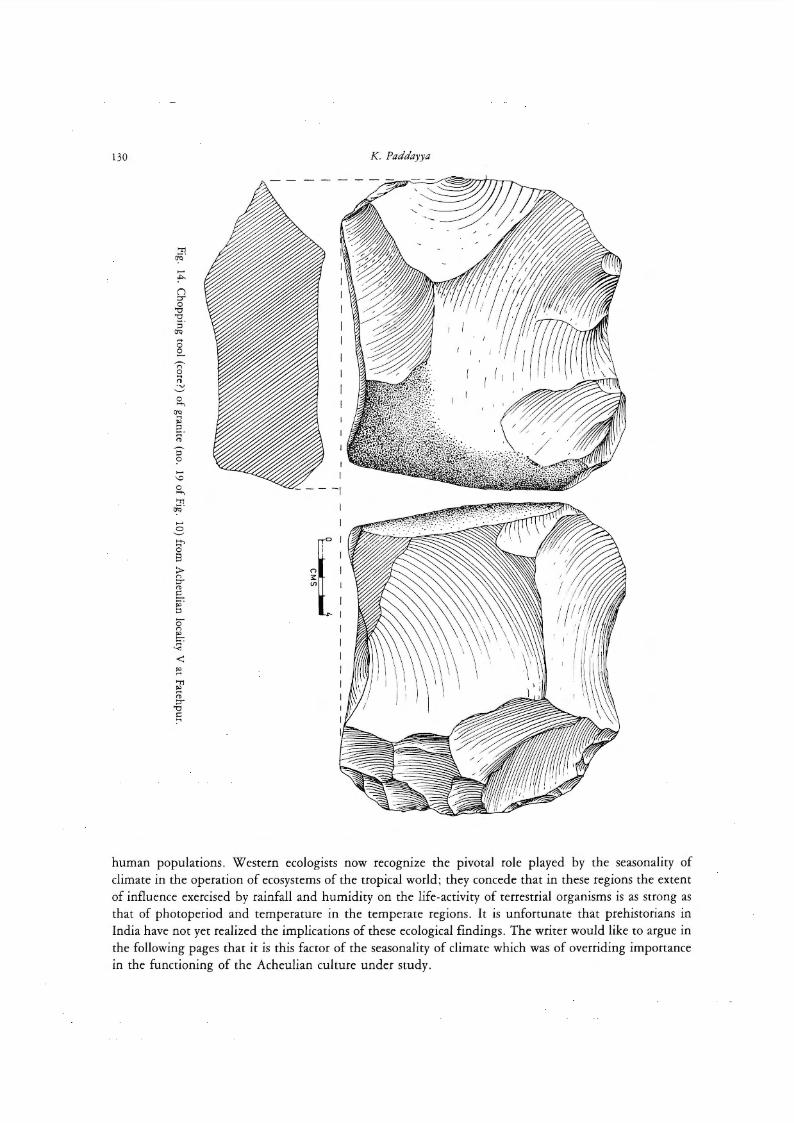
Speaking in a general way, the assemblages are characterized by the occurrence of cleavers, handaxes , knives and chopping tools as the major types. Other types like polyhedrans, picks, discoids, hammer-

The Acheulian Culture of the Hunsgi-Baichbal Valleys, Peninsular lndia: A Processual Study 125
stones and scrapers occur in varying proportions at different sites (Figs. 11-14). Chert is commonly used for making smaller artifacts like scrapers, points, etc That most of the sites witnessed manufacturing activities is proved by the occurrence of both raw material blocks of various sizes and waste products including chips measuring just a centimetre across. As for the adaptive role of these lithic assemblages, it seems reasonable to infer that the artifact types were put to use in operations like scraping, cutting, slicing, mincing and chopping relating to procurement and processing of animal and plant foods, preparation of tools and weapons on organic materials like wood and bone, construction of dwelling structures, etc.
An interesting aspect of the culture is the cooccurrence of fossil fauna along with cultural remains at about 15 localities near Hebbai Buzurg, Kaldevanhalli, Kupi, Devapur, Wajal, Sadab, Teggihalli, Yediyapur and Fatehpur (Paddayya 1985). It is for the firsttime in the Indian context that animal bones have been found on primary Lower Palaeolithic sites of the open air type: the fauna reported earlier from other parts of the country was obtained from alluvial deposits. The assemblage consists of both dental and post-cranial remains, and the species include Bos namadicus, Equus sp., Elephas sp. and some unidentified species of Cervidae family. On account of its relatively small size the assemblage does not offer much scope for taphonomic investigations. Nevertheless, some of the specimens from Hebbai Buzurg-11 and Teggihalli-11 bear signs of human exploitation.
Various site features noted during survey (location away from stream beds, discreteness of scatters of stone artifacts and animal fossils, regular occurrence of raw material blocks and waste products, and Iack of features like surface smoothening of artifacts associated with river action) clearly show that at these localities the culturallevel is preserved in a primary context. Excavations were conducted at three localities (Hunsgi V and VI and Yediyapur VI) to verify this observation.
At all these places the culturallevel is associated with rocky ridges or patches of granite-gneiss forming part of the sloping surfaces of ancient drainage tracts. These ridges appear to have been preferred both because these provide a hard surface for occupation and also because the naturally formed open spaces enclosed by rock boulders proved to be ideal spots for creating artificial shelters made up of poles, branches and grasses or leaves. The excavated culturallevel measured up to 25 or 30 cm in thickness and from 60 to 100 sq.m in extent. lt consisted of both raw material blocks, finished tools and debitage. At Yediyapur VIinone sector (10 to 12 sq. m in extent) of the excavated area, a concentration of artifacts of brownish chert was found, while the other parts of the trench yielded !arge artifacts of coarse-grained rocks. In addition to supporting our observation emanating from survey that chert was used by the Acheulian groups as a regular feature, this evidence gives some clues about possible intrasite patterning or site structure. Features like the sharp edges of artifacts, Iack of any preferred orientation in the positions of artifacts and presence of debitage of even small sizes once again go to support the view that these Ievels are primary in character and are unconnected with any fluvial activity.
There is then the problern of grouping of sites along functional lines. This is an interesting issue but one which cannot be understood adequately at the moment. One must recall here Binford's recent reinterpretation of the Oldowan and Acheulian sites of East Africa which the earlier writers had described as camp sites. Binford would now see these as mere 'magnet locations in the environment' containing resources in the form of leftovers of kill sites/ death sites of animals, for procuring wich the early hominids brought stone tools in the course of their non-random exploitation of the environment. In short, he treats these places as 'the consequences of many discrete, nonintegrated events of tool manufacture, use and discard' (Binford 1987, 26). lt is however highly doubtful if this interpretation holds good in the case of all sites in the Hunsgi-Baichbal valleys. Considering the fact that a number of these sites, particularly those betonging to the !arge and very !arge categories, are located on suitable spots like rocky ridges and yield a !arge number of artifacts together with raw material blocks and waste products, it would appear that these are much more than opportunistic locations for extracting energy from naturally available

126 K. Paddayya
4 0 I !wwl !wwl
C MS
4 laawzl M..wwl
CMS
2
Fig. 11. Stone artifacts from Acheulian locality V at Fatehpur. 1. cleaver of granite (no. 23 of Fig. 9); 2. tongue-shaped handaxe of granite (no. 33 of Fig. 10).

The Acheulian Culture of the Hunsgi-Baichbal Valleys, Peninsular India: A Processual Study 127
:~;---6-.J I I CMS
I ' 4
Fig. 12. Srone arrifacts from Acheulian locality V at Fatehpur. 1. discoid of granite; 2. discoid of quarrz; 3. dolerite chip (no. 27 of Fig. 10); 4. granite chip (no. 35 of Fig. 10).
pockets. These sites appear to be multipurpose locations where residential, tool-making and foodprocessing activities took place. There are certain features like differential weathering and reflaking of artifacts which suggest that some of these localities were occupied more than once.
There are also some localities like Hebbai Buzurg II and Teggihalli II yielding artifacts (but little debitage) and animal bones in limited numbers; these could be somewhat like Binford's 'magnet locations ' to which stone tools were carried in order to extract naturally available or procured food resources. These could have served as kill and butchering locations attached to nearby occupation Stations. Then there are a few localities which appear to preserve evidence of curation. One of the localities near Mudnur has yielded about two dozen massive handaxes of Iimestone without any associated raw material blocks and waste products. This assemblage was probably a cache meant for future use.

128 K. Paddayya
CMS
2
0 2 t::=-
CMS
3
Fig. 13. Stone artifacts from Acheulian locality V at Fatehpur. 1. !arge flake of granite with an arched working edge; 2. backed knife on a granite flake; 3. blade-like flake of quartzite.

The Acheulian Culture of the Hunsgi-Baichbal Valleys, Peninsular India: A Processual Study 129
Finally, we have the non-sites and small sites with limited artifactual yields and spread all over the Iandscape in a random fashion. These may be interpreted as short duration single-episode spots involving an individual or a small group and food-collecting/processing activities Iasting from a few hours to a few days. As such these sites may have served as satellites of !arger sites.
Finally, even a cursory Iook at the distribution of occurrences across the basin floor will bring out two prominent clusters or agglomerations, one each in the Hunsgi and Baichbal valleys (see map in Fig. 1). Both these clusters are linear concentrations lying along limited stretches of nullah courses. The first one is found on the Hunsgi nullah between the villages of Devapur and Hunsgi. Here in a stretch of over 3 km 16 localities occur on either bank of the Hunsgi nullah (including half of these on the Devapur nullah; Paddayya 1982, 84-86). Of these, 11 sites (including the excavated localities Hunsgi V and VI) belong tothelarge and very large classes. The banks (particularly the left one) of the Devapur nullah are occupied by travertine measuring over 4 m in thickness, while the Hunsgi nullah stretch is covered by granite developing here and there into low ridges.
The second duster occurs on the Fatehpur nullah in the Baichbal valley. In a stretch of about 4 km between the village of Fatehpur lying in the foothill zone of the plateaux and the valley floor village of Yediyapur over 15 localities have been identified (Paddayya, 1989). Most of thesealso belong to the very large and large groups, and occur on the right bank of the nullah. Granite is the major rock formation here and is criss-crossed by pegmatite, aplite and quartz veins, and dolerite dykes . Barring one locality associated with soft brownish clay the cultural Ievel is invariably found on weathered bedrock and is capped by a thin veneer of black soil. The localities are situated up to a few hundred metres away from one another and up to a distance of 300m from the nullah course and 6 to 7 m above its bed. As against these clusters the other localities are randomly dispersed all over the valley floor - on or along nullah courses, in the foothill zone, on the sloping surfaces and summits of the interfluves, and near sources of raw material.
IV
Pooling together the foregoing observations about the palaeoenvironmental setting and archaeological record of the area: What could one say about the functioning of the Acheulian cultural system? This issue could be approached best from the Settlement system perspective, the seminal ideas of which can be traced back to Lewis and Sally Binford's (1966; seealso 1979) interpretation of the Mousterian variability in functional terms. These ideas were later on refined by Jochim (1976) and other workers . While Settlement pattern is descriptive and narrower in scope and merely refers to the number, nature and distribution of archaeological features and sites, Settlement system is an explanatory concept. It seeks to discover functional interrelationships among various classes of sites and their articulation with the external environment so as to ensure the survival of the population group concerned. The application of the Settlement system model of human adaptations hinges on two basic premises: a) man is a component element of the ecosystem and b) that human cultural mechanisms and their articulation with the biophysical and social environment produces a series of patterned relationships at the behaviourallevel, which in turn find their reflection in the archaeological record. Jochim (1976, 11) considers resource use schedule, site placement and demographic arrangement as the three crucial aspects of settlement systems.
The premise that man is but one element of the ecosystem could be best translated into reality by adopting the nested model of nature (also known as the principle of biological hierarchy). This principle allows one to figure out how changes or perturbations in the non-living part of the ecosystem have repercussions on the plant and animal communities, and how these in turn influence the mode of life of
130 K. Paddayya
::1 ~ ...... :!"-(") ::r 0
"0 "0 s· Cl<>
8 g_ ~ ('>
0 .., ~
0 ....., Cl<> .., "' 2.
" -;-~
G 0 .....,
g ...... 3 :::-
{ 0 8 > ('>
::r ... E... ~-::l
0 ('>
~ Q < ~ 'Tl ~ ... ::r
"0 c ~
human populations. Western ecologists now recognize the pivotal role played by the seasonality of climate in the operation of ecosystems of the tropical world; they concede that in these regions the extent of influence exercised by rainfall and humidity on the life-activity of terrestrial organisms is as strong as that of photoperiod and temperature in the temperate regions. It is unfortunate that prehistorians in India have not yet realized the implications of these ecological findings . The writer would like to argue in the following pages that it is this factor of the seasonality of climate which was of overriding importance in the functioning of the Acheulian culture under study.

The Acheulian Culture of the Hunsgi-Baichbal Valleys, Peninsular lndia: A Processual Study 131
The paucity of biological remains on the Acheulian sites essentially renders our account of the palaeoenvironments of the region into a projection of the present-day features into the past. As has been pointed out earlier, the valley form of the area, the undulating basin floor and the drainage responsible for it were already developed prior to human occupation. Considering the active roJe played by anthropogenic factors during the last 4 000 years, the area surely supported rich wildlife and a thicker vegetation cover in the past. Monsoonal climate with at least periodically higher precipitations than that of today could be visualized as another important attribute of the natural setting of the area. The year consisted of a wet season and a dry season. Whatever limited ethnographic evidence pertaining to wild plant and animal foods and water sources that could be gathered from the area shows marked differences between the two seasons, so much so that they could even be called 'economic' seasons - the wet season characterized by plentiful supply of wild plant foods, small fauna and ubiquity of surface water bodies; and the dry season showing considerable reduction in both these resources.
Such being the nature of the ecosystem and its resource structure, what sort of annual resource management strategy could one expect the Acheulian population to adopt? One could safely expect these groups to adopt Binford's (1983, 339- 343) 'mapping on' or forager strategy which allows the consumers themselves to pursue the seasonally shifting resources through a series of residential moves and adjustments in group size. More specifically, based upon the structure and seasonal variability available in the resource base, particularly water sources, one can infer two major principles or strategies that governed the functioning of the Acheulian cultural system, viz., dry season aggregation and wet season dispersal. It is gratifying to note that this predicted annual activity-cycle finds good reflection in the archaeological record.
As has already been stated, there are two major clusters of sites in the area: one along the Hunsgi nullah and the other along the Fatehpur nullah. These clusters appear to mark dry season aggregation sites. While the waterholes in other parts of the area completely dry up during the dry season, these two patches preserve perennial waterholes in the form of a perennial flow in the Hunsgi nullah and water pools in the bed of the Fatehpur nullah at three or four spots, all fed by seep springs. The occurrence of travertine deposits shows that seep springs were active even in the past, creating perennial sources of drinking water. The fact that a majority of sites of these clusters belong to very !arge and !arge classes and that some of these have multiple occupation spots and features like differential weathering and rechipping noticeable on some of the specimens are further clues that these two patches witnessed repeated human occupation.
In addition to providing excellent drinking water, these two nullah courses would support gallery forests (with some edible species like Phoenix sylvestris, Balanites roxburghii, etc.) and thereby offer cooler spots for camping purposes. Likewise, the rocky ridges and islands along the courses would offer ideal grounds for erecting temporary residential shelters. Based upon the inferred fact that the productivity of vegetation as weil as that of small fauna is at its lowest both quantitatively and in terms of species composition, it seems reasonable to deduce that the Acheulian groups depended essentially on large game hunting during this season.
In this connection it is interesting to recall that some of the sites of these groups, e.g. Fatehpur IX, Y ediyapur IV and Hunsgi XIV have yielded remains of wild cattle, wild horse and deer along with cultural remains. The vegetation thickets would further serve as hideouts for capturing !arge mammals coming in search of drinking water, just as the waterholes themselves would offer good opportunities for scavenging death sites or left-overs of kill sites of predatory animals.
Their aggregation to these two land patches notwithstanding, the Acheulian groups could still easily exploit other sectors of the basin floor and even the plateaux as part of their daily foraging range. The ethnographic record about some of the extant hunter-gatherer groups like the Australian Aborigines and the !Kung Bushmen of Africa teils us that annual seasonal aggregations, over and above being responses

132
LEAFY GREENS
IBJfl.lJ.LUS TEBBESTBIS LINN
SABBASIPALLE &
~ PBECATOBIUS LINN
4 bi\CTUCA BUNCINATA DC.
5 DIGEBA ABVENSIS FOBSK
CELOSIA ABGENTEA LINN
KIBASALIPALLE &
ALIPALLE &
COCCULUS VILLOSUS DEC.
10 MUKTIBELLE &
11 POBTULACA OLEM_Q~A LINN
12 PREMNA LATIFOLIA BOX 8
13 SAUBUDUCHIPALLE &
14 HIBISCUS CANNASINUS LINN
FRUITS/BERRIES/PODS
15 CUCUMISSP.
16 KABCHIKAYA &
17 COCCINASP.
18 GAPPARIS ZEYLANICA LINN
19 ffiOSOPIS SPICIGE~ LINN
20 TAMARINDUS INDICA LINN
21 PHOENIX SYL VESTBIS BOX B
22 ZIZYPHUS JUJUBA LAMK
23 GAPPARIS APHYLLA ROTH 24 BALANITES BOXBURGHII PLANCH
25 LAUDIHANNU &
26 KABUKILAHANNU &
27 CARISSA CABANDAS LINN
28 KABEHANNU&
29 GREWIASP. (?)
30 JOLADAHANNU &
31 AEGLE MARMElOS CORREA
32 UUPIHANNU&
33 CORD lA MYXA LINN
34 KALCHALLAHANNU &
35 FICUS INFECTORIA BOX B
36 FICUS GLOMEBATA BOX 8
37 Ef.RONIA UMONIA LINN
38 §.YZIUM CUMIW-LINN
39 GREWIA SP (?)
40 ANNONA SQUAMOSA LINN
41 AZADIRECHTA INDICA LINN
42 KAKIHANNU&
43 SEMECABPUS ANACARDIUM LINN
44 ALIPALLE &
SEEDS
45 SEEDS OF LEAFY GREEN PLANTS (IRIBULUS TEBRESTBIS LINN, LACTUCA RUNCINATA DC., GORJIPALLE AND KIRASALIPALLE)
46 SEEDS OF INDIGOFERA UNIFOLIA REIZ, AND PROBABL Y ALSO OF OTHER GRASSES LIKE INDIGOFEBA GLANDULOSA WILLD, ECH1Nc5CHLQA,PANICUM
AND ELEUSINE SPECIES
47 SEEDS OF FRUIT-TREES (SEMECARPUS ANACARDIUM LINN AND TAMARINDUS INDICA LINN)
MISCELLANEOUS 48 LEPIOTA SP. (?) (MUSHROOMS)
49 CHAKKERAMAKKERA (TUBER) &
50 KARCHIKAYA (TUBER) &
51 ACACIA ARABIGA WILLD (GUM)
K. Paddayya
FEB MAR APA MAY JUN JUL AUG SEP OCT NOV DEC JAN
-~
!illif_: & INDICATES KANNADA NAME
RR. WARKE
Fig. 15. Chart showing ehe monch-wise distribution of wild plant foods of ehe Hunsgi-Baichbal valleys (after Paddayya 1982).

The Acheulian Culture of the Hunsgi-Baichbal Valleys, Peninsular India: A Processual Study 133
to economic considerations, could serve several social, ideological and biological purposes such as exchange of information and materials, marriage brockering, and resolution of group conflicts by way of realignment of groups.
The fragmentation of the population into individual bands or families and their spread all over the basin floor in the ensuing wet season is facilitated by several factors . First, the precipitation caused by the monsoon would replenish even the 1st, 2nd and 3rd order feeders of the major nullahs of the area as well as valley floor pans; and as such drinking water would be freely available all over the area. Secondly, precipitation has a dramatic effect on vegetation which responds immediately to the availability of soil moisture. Plant foods of various types (leafy greens, seeds of grasses and leafy green plants, and fruits/berries) are now not only more numerous and moreabundant but are available all over the area including the plateau (Fig. 15). The procurement of these foods is essemially a matter of gathering, collecting and picking, and as such emails but a rudimentary Ievel of technology. Vegetation cover (particularly herbaceous growth) and availability of watet in turn enrich animal life; and this is particularly so in the case of small fauna comprising fishes, insects, amphibians, freshwater mussels , landsnails, crabs, etc. which would be available all over the area (Paddayya 1982, 72-73). The fragmemation and dispersal of the population would also allow it to exploit more fully the food and other resources of the surrounding plateau and hills. Temporary leaf or grass shelters could be raised within a few hours' time for coping up with special weather conditions like heavy rain, wind and cold; alternately, retreat could be made to the shallow shelters and rock overhangs formed on the faces of shale-limestone tablelands and in the hills of the Archaean formations.
This phenomenon of seasonal fusion and fission, forming as it does the pivotal mechanism in the functioning of the Acheulian culture of the present area, has many ethnographic parallels in the extant hunter-gatherer populations of Australia, Africa and North America (for details see Paddayya 1982, 89-91). As for the identification of this principle in the Pleistocene archaeological record, Bunn (1987 , 395) has recently suspected its presence at the Olduvai Gorge localities in East Africa. Further, some of the European Upper Palaeolithic sites such as Altamira, Laugerie-Haute, Pincevent and Pavlov have been interpreted as regional aggregation sites (e.g. Conkey 1980).
From the foregoing account of the Acheulian settlement system it is clear that, contrary to popular notions about the mobility of hunter-gatherer groups, the nomadism involved here was restricted in scope; it was intraregional and was geared to the explicitation of seasonally shifting water and food resources. This kind of mobility recalls what Walter Taylor (1964) had called 'water-tethered' nomadism. It contrasts sharply with the situation presented by temperate zone groups like the Eskimos of Alaska where a bunter would have covered an area of about 300 000 sq. km during his life-time (Binford 1983, 115). However, our emphasis on the intraregional mobility of the Acheulian groups of the present area should not be mistaken to mean that they had no comacts whatsoever with the Acheulian populations of neighbouring areas. Nothing could be further from the truth. Such periodic contacts with outside groups, as entailed by prolonged droughts and other natural situations of stress, alone must have ensured the long-term viability of the human population.
The author sometimes wonders what the results of his study of the culture would have been like if he had adopted the culture-history paradigm, as typified by the stratigraphical approach, in lieu of the regional oriemation aimed at understanding culture process. He would surely have concentrated all his efforts on the survey of stream courses for locating cliff-sections containing implementiferous fluviatile deposits like gravels and silts. It is doubtful if this stream-bound, linear approach would have ever entailed him to Iook for sites in the foothill zone, on the interfluves and other parts of the basin floor. Once stream sections are located, relative positions of various sediments would have been noted and selective collections of stone artifacts made from them. Thereupon a stratigraphical-cum-cultural sequence would have been framed up; and with it a relative dating of the cultures would have been

134 K. Paddayya
attempted. The knowledge of the cultures themselves would have been limited to typo-technological analyses of the secondarily derived lithic assemblages and finally their comparisons with similar ones from other areas in and outside the country. From all this it is obvious that such a study would have been clone without ever directly bringing the Stone Age groups into the picture and withour involving any attempt to understand their adaptive behaviour with reference to the biophysical environments of valley.
The Settlement system perspective employed in the present study surely marks a significant improvement over the above-mentioned vertical approach inasmuch as a Stone Age culture has now been sought to be understood beyond the study Ievel of 'stones' and 'more stones' . In Palaeolithic research there are not many studies which are region-oriented and based on intensive surveys.
Garth Sampson's (1985) work in central and upper Seacow valley of Southern Africa is one such example. He has discovered about 250 Acheulian sites in an area of 5 000 sq. km . In IndiaJacobson's (1985) work in Raisen District of Madhya Pradesh constitutes an excellent example. He found over 90 sites in an area measuring about 175 sq. km in extent. Unfortunately, however, Jacobson had to discontinue his investigations before he could put the sites and their setting in an interpretative framework. As to the present research project, it is much more than a site discovery; it has made a bold attempt to view a Paleolithic culture as a system of interrelated units and to consider the organizational behaviour of a prehistoric group as an aspect of the working of the ecosystem.
Notwithstanding the fundamental shift it marks in the theory and methodology of Palaeolithic research in India, the present study has some limitations which are worth pointing out. The project has essentially involved the job of an archaeologist. This may sound a bit odd when scientific or interdisciplinary research is the order of the day in the discipline. Owing to various practical difficulties and the general paucity of biological materials the collaboration of colleagues from geo- and bioarchaeology was far from regular and had to remain at a low Ievel. Hence the environmental reconstructions and the cultural implications derived from these are at best to be taken as rough guidelines rather than final conclusions. Any refinements that may be effected later in our reconstruction of the palaeoenvironmental setting of the valleys will add to the existing knowledge of the Acheulian Settlement system.
Secondly, the foregoing study of the Acheulian culture of the area from the point of view of culture process is of the gross-level type and leaves many details unattended to. In a way this work underscores the fact that all improvements in knowledge-acquisition are sooner or later accompanied by a call to get back to basics. In the present case one is inevitably led to the topic of middle-range research. Schiffer (1987) calls it the study of formation processes of the archaeological record. Aspects relating to site structure and variability, adaptive role played by technology, and intraseasonal changes in resource distribution and population movement need to be understood more thoroughly. This is not a small task considering the fact that the sites of foraging groups in the tropical areas are in general "organizationally undifferentiated and seasonally redundant. " Site contexts and contents obviously call for a closer examination.
Then there is the problern of secondary versus primary sites. One needs to investigate the Iandsurrace (its slope, geology and drainage) at the micro-level and the various erosional/depositional processes, wind action, etc. for identifying the various agencies that led to the preservation/ disturbance of cultural horizons (Paddayya 1987c). The author's ongoing studies in the area are entirely devoted to the resolution of this problem. Reexamination of a representative number of sites in the two valleys has made known a tremendous variability in the depositional contexts of sites. At one end we have true secondary sites yielding artifacts in fluviatile deposits. At the other extreme there are primary occurrences where human occupation took place on weathered rock surface (granite, sandstone, shale, etc.) or eise on soft sediments like brown clay and travertine. Lying between these two extremes there are other contexts such as colluvial scree, washes and pediment fillings . No less interesting is the site variability in terms of
The Acheulian Culture of the Hunsgi-Baichbal Valleys, Peninsular India: A Processual Study 135
cultural features - !arge and small sites yielding both finished tools and debitage, sites showing no evidence of on-the-spot chipping, sites with fossil fauna and even situations which may be called caches and food-processing spots. This study, as and when completed, should Iead to the formulation of a set of propositions that might be helpful in understanding the formation processes of Palaeolithic sites in other parts of Peninsular India as weil.
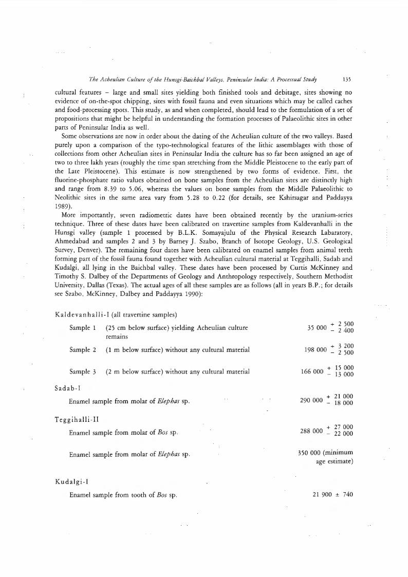
Some observations are now in order about the dating of the Acheulian culture of the two valleys. Based purely upon a comparison of the typo-technological features of the lithic assemblages with those of collections from other Acheulian sites in Peninsular India the culture has so far been assigned an age of two to three lakh years (roughly the time span Stretching from the Middle Pleistocene to the early part of the Late Pleistocene). This estimate is now strengthened by two forms of evidence. First, the fluorine-phosphate ratio values obtained on bone samples from the Acheulian sites are distinctly high and range from 8.39 to 5.06, whereas the values on bone samples from the Middle Palaeolithic to Neolithic sites in the same area vary from 5.28 to 0.22 (for details, see Kshirsagar and Paddayya 1989).
More importantly, seven radiometric dates have been obtained recently by the uranium-series technique. Three of these dates have been calibrated on travertine samples from Kaldevanhalli in the Hunsgi valley (sample 1 processed by B.L.K. Somayajulu of the Physical Research Labaratory, Ahmedabad and samples 2 and 3 by Barney]. Szabo, Branch of Isotope Geology, U.S. Geological Survey, Denver). The remaining four dates have been calibrated on enamel samples from animal teeth forming part of the fossil fauna found together with Acheulian cultural material at Teggihalli, Sadab and Kudalgi, all lying in the Baichbal valley. These dates have been processed by Curtis McKinney and Timothy S. Dalbey of the Departments of Geology and Anthropology respectively, Southern Methodist University, Dallas (Texas). The actual ages of all these samples are as follows (all in years B.P.; for details see Szabo, McKinney, Dalbey and Paddayya 1990):
Kaldevanhalli-I (all travertine samples)
Sampie 1 (25 cm below surface) yielding Acheulian culture remams
Sampie 2 (1 m below surface) without any cultural material
Sampie 3 (2 m below surface) without any cultural material
Sadab-1
Enamel sample from molar of Elephas sp.
Teggihalli-II
Enamel sample from molar of Bos sp.
Enamel sample from molar of Elephas sp.
Kudalgi-1
Enamel sample from tooth of Bos sp.
35 000 + 2 500 - 2 400
198 000 + 3 200 - 2 500
166 000 + 15 000 - 13 000
290 000 + 21 000 - 18 000
288 000 + 27 000 - 22 000
350 000 (minimum age estimate)
21 900 ± 740

136 K. Paddayya
The date for sample 1 at Kaldevanhalli and also the date for enamel sample from Kudalgi are unusually young and therefore stand as anamolies. In the case of Kaldevanhalli the young age of travertine may be due to the fact that the sediment has some impurities and shows some signs of localized reshuffling. As concerns the date from Kudalgi-I, McKinney and Dalbey (personal communication) feel that the 'young date is probably due to extensive weathering; this tooth was very friable and in the cleaning of the dentine small fragments of enamel had to be used' . Another possibility isthat the tooth really belongs to a post-Acheulian time horizon because it was found not on the cultural scatter proper but in its immediate vicinity. The remaining five dates bracket the culture between one and a half and three and a half lakh years. This time range compares favourably with the absolute dates for other Acheulian sites in the coumry (Didwana in Rajasthan, Son valley in Madhya Pradesh and Hiran valley in Gujarat); the ages of these sites range from one to two lakh years.
Acknowledgements The project was financially supported by Deccan College, Poona, and University Grants Commission, New Delhi. The
author is grateful to these institutions for this prolonged financial support. His attempts to give meaning to the archaeological record of the area greatly benefited from a four-month stay in the U.S. as a Senior Fulbright Fellow and discussions among others with Professors]. Desmond Clark and Lewis R. Binford. The author is profoundly thankful to Mrs. Sharada Nayak, Director of the United States Educational Foundation in India, New Delhi, and the International Council for Exchange of Scholars, Washington, D.C. for affording him this great opportunity. Mr. R.B. Warke, photographercum-draughtsman at Deccan College, Poona, and workmen Doddappa Baichbal and Basappa Kadimani, both from the village of Hunsgi, were unfailing members of the field crew since 1975 . Their contribution to the success of the Hunsgi-Baichbal valleys project is simply enormaus and cannot be adequately expressed in words. The author' s doctor-friend S.R. Biradar and teacher-friend Mr. Basappa Amarannvar, both from Hunsgi, and a host of others comprising engineers and officers of the Upper Krishna Irrigation Project, teachers and simple village folk extended many courtesies and wholehearted cooperation during fieldwork spread over more than a decade. The author appreciates too the efforts of Professor B.L.K. Somayajulu, and Drs. Barney J. Szabo, Cunis McKinney and Timothy S. Dalbey in dating travertine/ tooth-enamel samples from the Hunsgi-Baichbal valleys.
References cited
AMMERMAN, A. J. , 1981: Surveys and archaeological research. Annual Review of Anthropology 10, 63-88. BINFORD, L. R. , 1972: An Archaeological Perspective. New York, Seminar Press. -, 1981: Bones: Ancient Men and Modern Myths. New York, Academic Press. -, 1983: Working at Archaeology. New York, Academic Press. -, 1987: Searching for carnps and missing the evidence? Another Iook at the Lower Palaeolithic. In: The Pleistocene Old
World, edited by Olga SoFFER, pp. 17-31. New York, Plenum Publishing Coporation. BINFORD, L. R. and S. R. BINFORD, 1966: A preliminary analysis of functional variability in the Mousterian of Levallois facies.
In: Recent Studies in Palaeoanthropology, edited b. J. Desmond Clark and F. Clark Howell (Special Publication of American Anthropologist) , pp. 238- 295. Menasha, Wisconsin, American Anthropological Association.
- , 1979: Stone tools and human behaviour. In: Human Ancestors, edited by G. LI. Isaac and R. E. F. Leakey, pp. 92 - 101. San Francisco, W. H. Freeman.
BowER, J., 1986: A survey of surveys: aspects of surface archaeology in sub-Saharan africa. The African Archaeological Review 4, 21-40.
BUNN, H. T. , 1987: Comments on R.]. Blumenschine's paper on 'Characteristics of an early hominid scavenging niche '. Current Anthropology 28, 383-407.
CoNKEY, M. W., 1980: The identification of prehistoric hunter-gatherer aggregation sites: the case of Altamira. Current Anthropoloy 21 , 609- 630.
DuNNELL, R. C. and W . S. DANCY, 1983: The siteless survey: a regional scale data collection strategy. In: Advances in Archaeological Method and Theory, Vol. 6, edited by M. B. Schiffer, pp. 267-285. New York, Academic Press.
EBERT,]. I. , 1986: Distributional Archaeology: Nonsite Discovery, Recording, and Analytical Methods for Application to the Surface Archaeological Record. Ph. D. Dissertation, Department of Anthropology, University of New Mexico.

The Acheulian Culture of the Hunsgi-Baichbal Valleys, Peninsular India: A Processual Study 137
FOLEY, R. A. , 1981: Off Site Archaeology and Human Adaptations in Eastern Africa: An Analysis of Regional Artefact Density in the Amboseli, Southern Kenya. Oxford, B. A. R. International Series No. 97.
GAUSSEN, H., et al., 1965: International map of vegetation and of environmental conditions - sheet Bombay. New Delhi, Indian Council of Agricultural Research.
-, 1966: Carte Internationale du Tapis Vegetal- Notice de Ia Feuille Bombay. Pondichery, French Institute. GRIGG, D. , 1967: Regions, models and classes. In: Integrated Models in Geography, edited by R. J. Chorley and P.
Haggett, pp. 461-509. London, Methuen.
ISAAC, G. LI. andJ. W. K. HARRIS, 1975: The scatter between the patches. Paper delivered at the Kroeber Anthropological Society meetings, Berkeley. As quoted by Isaac, Harris and Marshall (1981).
ISAAC, G. LI., J. W. K. HARRIS, and Fiona MARSHALL, 1981: Small is informative: the application of the study of mini-sites and least effort criteria in the interpretation of the early Pleistocene archaeological record at Koobi Fora, Kenya. Paper presented at the International Union of Prehistoric and Protohistoric Sciences, Mexico City.
JACOBSON,J., 1985: Acheulian surface sites in Central India. In: Recent Advances in Indo-Pacific Prehistory, edited by V. N. Misra and P. Bellwood, pp. 49-57. New Delhi, Oxford and IBH Publishing Co.
JocHIM, M. A., 1976: Hunter-Gatherer Subsistence and Settlement: A Predictive Model. New York, Academic Press. JoHNSON, G .. A., 1977: Aspecrs of regional analysis in archaeology. Annual Review of Anthropology 6, 479-508.
KsHIRSAGAR, A. and K. PADDAYYA, 1989: Relative chronology of Stone Age cultures of Hunsgi-Baichbal valleys, North Karnataka, by fluorine analysis. Bulletin of the Deccan College Post-graduate and Research Institute 47-48, 143-146.
LEWARCH, D. E. and M. J. O·BRIEN, 1981: The expanding roJe of surface assemblages in archaeological research. In: Advances in Archaeological Method and Theory, Vol. 4, edited by M. B. Schiffer, pp. 297-342. New York, Academic Press.
MAHADEVAN, C., 1941: Geology of the south and southwestern parts of Surapur taluk of Gulbarga district. Journal of the Hyderabad Geological Survey 4, 102-161.
MUKHERJEE, S. K., 1941: Geology of parts of Surapur and Shahpur Taluks, Gulbarga district. Journal of the Hyderabad Geological Survey 4, 9-54.
O·BRIEN, M. J. and D. E. LEWAReH (editors), 1978: Recent approaches to surface data and sampling. The Western Canadian Journal of Anthropology, vol. VIII.
-, 1981: Plowzone Archaeology: Contributions to Theory and Technique. Nashville, Tennessee, Vanderbilt University. PADDAYYA, K., 1977a: The Acheulian culture of the Hungsi valley (Shorapur Doab), peninsular India. Proceedings of the
American Philosophical Society 121, 383-406. -, 1977 b: An Acheulian occupation site at Hungsi , peninsular India: a summary of the results of two seasons of excavation
(1975 -76). World Archaeology 8, 344-355. -, 1978: New research designs and field techniques in the Palaeolithic archaeology of India. World Archaeology 10,
94-110. - , 1979: Excavation of a new Acheulian occupation site at Hunsgi, peninsular India. Quartär 29 - 30, 139- 155 . -, 1982: The Acheulian Culture of the Hunsgi Valley (Peninsular India): A Settlement System Perspective. Poona, Deccan
College. -, 1985: Acheulian occupation sites and associated fossil fauna from the Hunsgi-Baichbal valleys, peninsular India.
Anthropos 80, 653-658. -, 1987a: The stone Age cultural systems of the Baichbal valley, Gulbarga district, Karnataka: a preliminary report .
Bullering of the Deccan College Research Institute 46, 77-100. -, 1987b: Excavation of an Acheulian occupation site at Yediyapur, peninsular India. Anthropos 82, 610-614. - , 1987c: The place of the study of site formation processes in prehistoric research in India. In: Natural Formation Processes
and the Archaeological Record, edited by D. T. Nash and M. D. Petraglia, pp. 74-85. Oxford, BAR International Series.
-, 1989; The Acheulian culture localities along the Fatehpur nullah, Baichbal valley, Karnataka (Peninsular India). In: Old Problemsand New Perspectives in the Archaeology of South Asia, edited by J. Mark Kenoyer, pp. 21-28. Madison, University of Wisconsin Press.
RAND. A. , 1979: Introduction to Objectivist Epistemology. New York, New American Library. REDMAN. C.L., 1978: Multistage fieldwork and analytical techniques. American Antiquity 38, 61-79. - , 1987: Surface collection, sampling, and research design: a retrospective. American Antiquity 52 , 249- 285. REDMAN, C.L. and Patty J. WATSON, 1970: Systematic, intensive surface Collection. American Antiquity 35, 279-291. SAMPSON, C. GARTH, 1985: Atlas of Stone Age Settlement in the Central and Upper Seacon Valley. Bloomfontein, Memoire
van die Nasionale Museum, No. 20.

138 K. Paddayya
SCHIFFER, M. B., A. P. SuLLIVAN and T. C. KilNGER, 1978: The design of archaeological Surveys. World Archaeology 10, 1-28.
SMITH, C. A., 1976 a: Regional economic systems: linking geographical models and socioeconomic problems. In: Regional Analysis, Vol. I (Economic Systems), edited by Carol A. Smith, pp. 3-63 . New York, Academic Press.
-, 1976 b: Analysing regional social systems. In: Regional Analysis, Vol. II (Social Systems), edited by Carol A. Smith, pp. 3-20. New York, Academic Press.
SZABO, B. J., C. McKINNEY, T. S. DALBEY and K. PADDAYYA, 1990: On the age of the Acheulian culture of the Hunsgi-Baichbal valleys, Peninsular India. Bulletin of the Deccan College Post-graduate and Research Institute 50 (GoldenJubilee Volume), 317-321.
TAMAHANKAR, A.R., 1982: Geology of the Area around Kembhavi, Gulbarga District, Karnataka, India. Ph. D . Dissenation, University of Poona.
TAYLOR, W. W., 1964: Tethered nomadism and water territoriality: an hypothesis. Acts of the 35th International Congress of Americanists, Mexico City, pp. 197-203. (As Quoted by Binford (1983).
THOMAS, D. H., 1975: Nonsire sampling in archaeology: up the creek without a site? In: Sampling in Archaeology, edited by J. W. Mueller, pp. 61-81. Tuscon, University of Arizona Press.
Related Documents