Mauro Dolce Mauro Dolce Director Director - - Seismic Risk Office, Seismic Risk Office, Italian Civil Protection Department, Italian Civil Protection Department, Professor of Earthquake Engineering, Professor of Earthquake Engineering, University of Naples, Federico II University of Naples, Federico II The Abruzzo Earthquake: Effects and Mitigation Measures Disaster Prevention Workshop Stockholm, Hasselbacken, 27-29th of July, 2009

Welcome message from author
This document is posted to help you gain knowledge. Please leave a comment to let me know what you think about it! Share it to your friends and learn new things together.
Transcript

Mauro DolceMauro DolceDirector Director -- Seismic Risk Office, Seismic Risk Office,
Italian Civil Protection Department, Italian Civil Protection Department, Professor of Earthquake Engineering, Professor of Earthquake Engineering,
University of Naples, Federico IIUniversity of Naples, Federico II
The Abruzzo Earthquake: Effects and Mitigation Measures
Disaster Prevention WorkshopStockholm, Hasselbacken,
27-29th of July, 2009

6 April 2009 H. 3.32 a.m.
Ml 5.8 Ml 5.8 –– RichterRichterMwMw 6.3 6.3


FromFrom 06.04.2009 06.04.2009 toto 06.05.2009: 06.05.2009:
148148 earthquakesearthquakes 3.0 <= Ml < 4.03.0 <= Ml < 4.0 1313 earthquakesearthquakes 4.0 <= Ml < 5.04.0 <= Ml < 5.0 33 earthquakesearthquakes Ml >= 5.0Ml >= 5.0
TOTAL NUMBER OF TOTAL NUMBER OF EARTHQUAKES IN LEARTHQUAKES IN L’’AQUILA AQUILA AREA IN ONE MONTH AREA IN ONE MONTH

Totale scosse dal 6 aprile 2009
9532
2.0≤M<3.0 17003.0≤M<4.0 1904.0≤M<5.0 19
M≥5.0 3

1. Organization of the Italian CP System
2. Seismic Risk in Italy and the Abruzzo Eq
3. Civil Protection rescue and technical activities
4. Conclusion
OUTLINE

PRESIDENCY OF THE COUNCIL
OF MINISTERS
National Fire-
fighters CorpPolicePrefectures
I.N.G.V.C.N.R.National Institutes
118
Revenue Guard CorpsArmyNavyAir ForceCarabinieri
TERNA
Coastal GuardANASNational Highway National Railway
State Forest Corps
ISPRA
Interior
Economy and Finance
Foreign Affairs
Environment
University and Research
Infrastructures
Defence
Agricultural Policy and Forestry
Communications
Economic Development
Health
Cultural Heritage
Regions
Provinces
Municipalities
Transportation
Public Education
THE NATIONAL CIVIL THE NATIONAL CIVIL PROTECTION SYSTEMPROTECTION SYSTEM
Department of Civil
Protection

Head of Department
Deputy head of DepartmentTECNICAL-OPERATIVE AREA
Deputy head of DepartmentTECHNICAL-ADMIN. AND
RISOURCE MANAGEMENT AREA
I - Forecasting, assessment,mitigation of
NATURAL RISKS
II - Forecasting, assessment,mitigation of
ANTHROPOGENIC RISKS
III - Assessment, prevention,mitigation of
SEISMIC RISK
IV- EMERGENCYMANAGEMENT
V - Major events, Technological Resources
and Innovation
VI - Volunteers andInternational relationship
VII - Administrationand balance
VIII- Aeronautics Activities
Communication,Development,
and management relations
Press Office
Operative team(DL 245/2005)
Secretariatof the Head of Department
Legal Advisor
Head of Department Office
Organization of the Civil Protection Dept.

Emergency management Training and Education Emergency management Training and Education
Vulnerability, Technical Regulations and post- Emergency management
Vulnerability, Technical Regulations and post- Emergency management
Monitoring systemsMonitoring systems
Office III – Evaluation, Prevention and MItigation of Seismic Risk
Seismic Risk Assessment Functional Centre -
SRS
Competence Centres for Seismic Risk:
RELUISEUCENTRE
INGV
Organization of the Seismic Risk Office

INGVINGV
RANRAN
TechnicalTechnicalTeamsTeams
Seismometric network ground motion parameters (event
localization, magnitudo) to start SIGE
Macroseismic survey
Damage survey and safety assessment
SIGESIGE
Expected structural damageExpected number of casualties
Economic loss evaluation
1 2
6
5 4
1 3
9
7
1 01 1
1
23
1 4
8
OSSOSS
Strong motion networkStrong motion data to produce
shake maps
Structure monitoring system network for damage evaluation
THE MAIN ACTIVITIES OF THE OFFICE AND OF THE RELATED COMPETENCE CENTRES AR E MONITORED AND SYNTHESISED IN THE FUNCTIONAL CENTRE TO SUPPORT DECISIONS AFTER AN EVENT
FUNCTIONAL CENTRE – SEISMIC RISK SECTOR

COMPETENCE CENTRES OF DPC
• INGV (Seismic surveillance, Seismological research projects, Emergency technical support)
• ReLUIS (Earthquake engineering research projects, Emergency technical support)
• EUCENTRE (Earthquake engineering research projects, Emergency technical support)

1. Organization of the Italian CP System
2. Seismic Risk in Italy and the Abruzzo Eq
3. Civil Protection rescue and technical activities
4. Conclusion
OUTLINE

-
10.000,00
20.000,00
30.000,00
40.000,00
50.000,00
60.000,00
1968 1972 1978 1980 1983 1990 1997 2000 2002 2003 2003
Costo dei terremoti in Italia tra il 1968 ed il 2003 (€ 2005)
-
20.000
40.000
60.000
80.000
100.000
120.000
140.000
1968
1969
1970
1971
1972
1973
1974
1975
1976
1977
1978
1979
1980
1981
1982
1983
1984
1985
1986
1987
1988
1989
1990
1991
1992
1993
1994
1995
1996
1997
1998
1999
2000
2001
2002
2003
COST OF LAST 40 YEARS ITALIAN EARTHQUAKES (M€-2005)

BasedBased on last on last twotwo centurycentury historyhistory, the , the followingfollowing numbersnumbers can can bebe expectedexpected::
SEISMIC RISK XXI CENTURYSEISMIC RISK XXI CENTURY PROJECTIONSPROJECTIONS
500 - 2000 dead or injured people / year50000-200000 in the XXI century
€ 1 - 2 billions / year€ 100-200 billions in the XXI century
N.B.: The cost estimation is relevant to houses only. Overall costs should include also public and office buildings, monumental buildings, factories and infrastructure. Possible increases are of the order of 50-100%
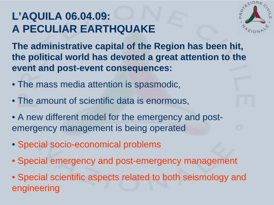
LL’’AQUILA 06.04.09: AQUILA 06.04.09: A PECULIAR EARTHQUAKEA PECULIAR EARTHQUAKEThe administrative capital of the Region has been hit, The administrative capital of the Region has been hit, the political world has devoted a great attention to the the political world has devoted a great attention to the event and postevent and post--event consequences:event consequences:
•• The mass media attention is spasmodic, The mass media attention is spasmodic,
•• The amount of scientific data is enormous, The amount of scientific data is enormous,
•• A new different model for the emergency and postA new different model for the emergency and post-- emergency management is being operatedemergency management is being operated
•• Special socioSpecial socio--economical problemseconomical problems
•• Special emergency and postSpecial emergency and post--emergency managementemergency management
•• Special scientific aspects related to both seismology and Special scientific aspects related to both seismology and engineeringengineering


Onna

Tempera

1. Organization of the Italian CP System
2. Seismic Risk in Italy and the Abruzzo Eq
3. Civil Protection rescue and technical activities
4. Conclusion
OUTLINE

The first response of CP System

National Fire Brigades
Army Air Force
Navy
Police
Regions and Local Autonomies
Italian Red
Cross
State Corps of
Foresters
Agency for environment protection
National Institute for geophysics
and volcanology
Alpine Rescue Corps
National health system
National Research Council
Volunteers organisations
Head of Civil Protection
An Operational Committeeis set up within the Department of Civil Protection to ensure a unified direction and coordination of emergency management
Dams Agency
Agency for road maintenance
HighwayTrains
Postmaster
Railway
Electricity management
agencies
Monitoring forecast
team
Telecommunications companies
Italian Television
Agency for flight control
COCO--ORDINATIONORDINATION
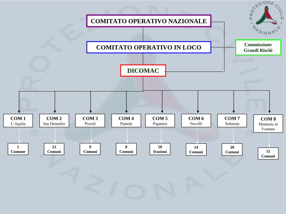
COM 2San Demetrio
COM 1L’Aquila
COM 3Pizzoli
COM 4Pianola
COM 5Paganica
COM 6Navelli
COM 7Sulmona
COM 8Montorio
al Vomano
12 Comuni
9Comuni
8Comuni
10frazioni
COMITATO OPERATIVO IN LOCO
COMITATO OPERATIVO NAZIONALE
DICOMAC
Commissione Grandi Rischi
14Comuni
20Comuni 15
Comuni
1 Comune

AUXILIARY FUNCTIONS
Operational
Co-ordination
Assistance to people
Cultural Heritage
Local Government
Search and Rescue activities
Damage Survey
Lifelines
Telecommunications
Transport and Viability Control
Resources Management
Volunteers
Mass media and Information Management
Health Assistance
Technical and Scientific Support

Organization Units_____________________________________VVF 2245VVF - CAPI 10Forze Armate 1487Corpo Forestale dello Stato 138Polizia di Stato 647Arma dei Carabinieri 214Guardia di Finanza 286EI SMOM 10CRI 500Colonne mobili regionali 3367organizazioni nazionali volontariato 2.296CISOM 80CNSAS 2ISPRA 10CNR 15ENEA 7INGV 36ENAV 4H3G 10TERNA 11AUTOSTRADE 10AISCAT 167ANAS 50POSTE ITALIANE 49GRUPPO FERROVIE DELLO STATO 10ENEL 235PROVINCIA AQ 252DPC 120________________________________________________________Total 12268
Personnel deployed:
MORE THAN
12 000
PEOPLE INVOLVED IN THE EMERGENCY
ACTIVITIES
Last Update - 16.04.2009

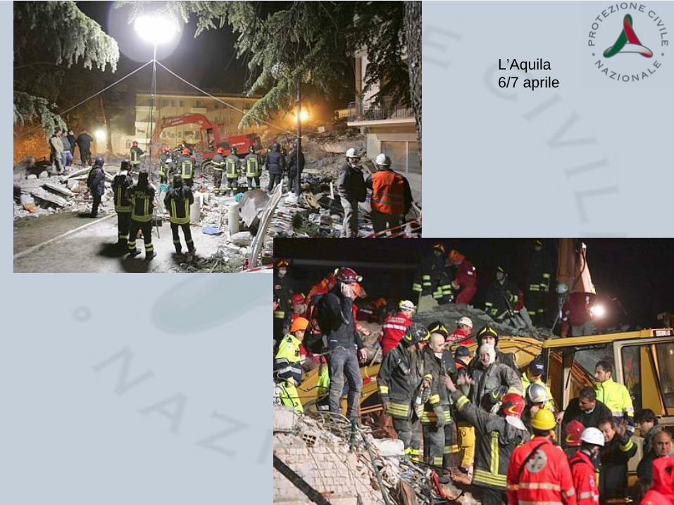
L’Aquila6/7 aprile
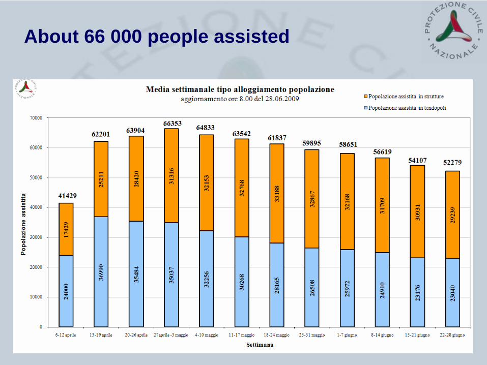
About 66 000 people assisted

People assisted - Tents


2’5’
EPICENTER AND MAGNITUDE EVALUATION
Collecting and processing of seismometric network data by INGV
15’60’
SIMULATED DAMAGE SCENARIOS AND DATA PROCESSING OF MONITORING SYSTEMS
Software simulation of the earthquake impact on constructions, Collecting and processing of soil and strategic building accelerometric data
6 h 150 h
SITE SURVEYS FOR MACROSEISMIC AND COSEISMIC EFFECTS
Site evaluation of Mercalli Intensity, Geological surveys for landslides, surface faulting and soil liquefaction
6 h 3 m
TEMPORARY MONITORING OF SOIL AND STRUCTURES
Installing of temporary soil accelerometric stations and structure monitoring systems
24 h 6 m
POST – EARTHQUAKE DAMAGE AND SAFETY ASSESSMENT
Building inspections for damage and usability assessment.Provisional works.Temporary housing.
PHASES 2-3: POST-EVENT TIMETABLE OF TECHNICAL ACTIVITIES

Example M 4.0First locations after 30”Final after 120-200”ML based on 159 channels
Information to DPC in 2’ max

Simulation Scenario
Scenario average estimates: about • 1200 people involved in building collapse• 26000 homeless • 18000 unusable dwellings• 135000 damaged dwellings

Real dataReal data• 300 victims
• 1500 injured
• 65.579 assisted people
• 44.533 buildings (population 130.008) to be inspected in the area of Intensity VI (MCS scale). From the first 60000 surveys about 25% of the buildings inspected results severely damaged
22 bambini (età inferiore ai 16 anni)173 femmine119 maschi
Fonte: DPC

typical typical arrangement arrangement of a stationof a station
213 213 digital stations connected via GPRS/GSMdigital stations connected via GPRS/GSM
1111
remote digital stationsremote digital stations
130130
scheduled digital stations scheduled digital stations (within 2008)(within 2008)
119119
analogicanalogic
stations are not includedstations are not included in the mapin the map
In the near
future: 570 (20 km grid) digital
stations
connected
in real time
DPC – STRONG MOTION NETWORK (RAN)
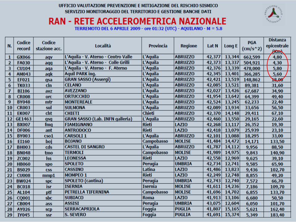


Distribution of the RAN sttations nearest to the epicentre of the main shock

6 aprile AQg Ml=5.8 Repi =4.3 km comp EW
Maximum Acceleration: 510.83843994cm/sec2at time t=3.68sec
Maximum Velocity: 35.95829093cm/secat time t=3.205sec
Maximum Displacement: 3.75762048cmat time t=3.37sec

Period [sec]543210
Res
pons
e A
ccel
erat
ion
[cm
/sec
2]
900850800750700650600550500450400350300250200150100
500
6 aprile AQg Ml=5.8 Repi =4.3 km comp EW
Period [sec]543210
Res
pons
e D
ispl
acem
ent [
cm]
11
10
9
8
7
6
5
4
3
2
1
0
Spettri di accelerazione e spostamento al 5%
Stazione Aquila –Colle dei Grilli all’estremità SW della valle dell’Aterno con PGA=0.5 g
ABRUZZO EQMACROSEISMIC
SURVEY
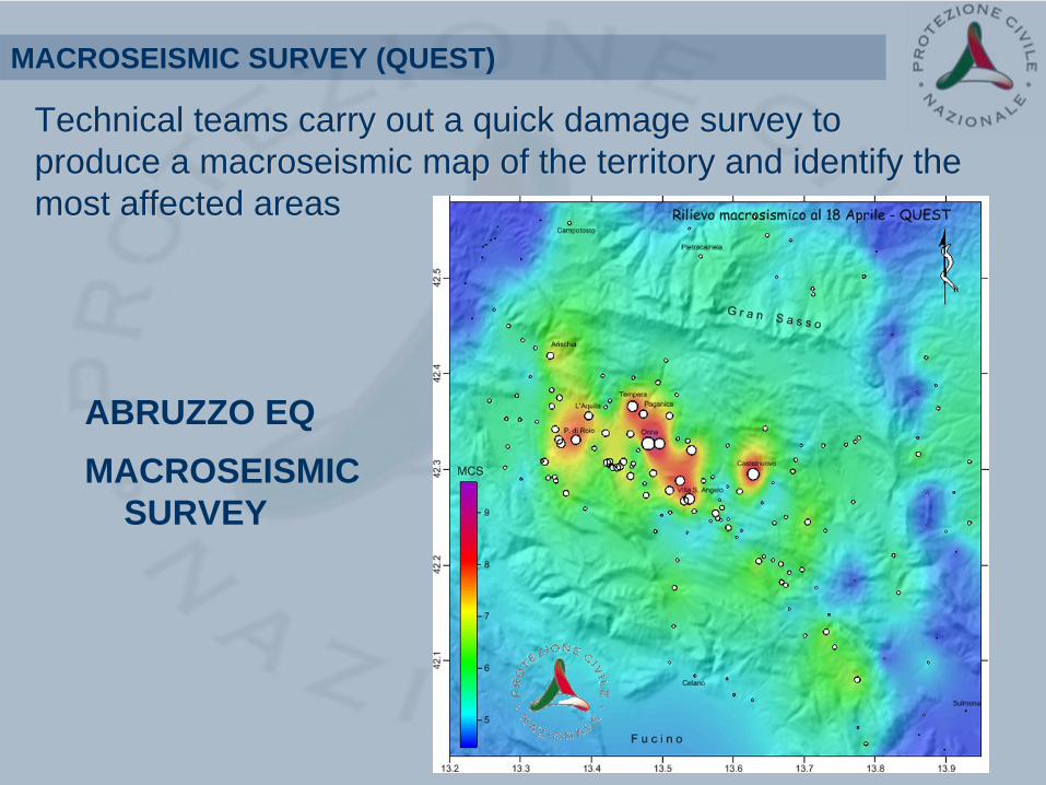
Technical teams carry out a quick damage survey to Technical teams carry out a quick damage survey to produce a macroseismic map of the territory and identify the produce a macroseismic map of the territory and identify the most affected areasmost affected areas
MACROSEISMIC SURVEY (QUEST)

Technical teams carry out surveys aimed at recognising, mapping and evaluating earthquake effects on the natural environment:• landslides• surface faulting and fracturing• soil liquefactions
Retaining wall failureUmbria-Marche, Italy, 1997
Surface faulting Irpinia, Italy, 1980
GEOLOGICAL SURVEY

Frane di crollo45%
Sfornellamenti, crollo di cavità
sotterranee5%
Dissesti di versante
41%
Fenomeni di altro genere
8%Criticità idrauliche
1% Tipologia dei dissesti
127 sopralluoghi geologici ed idrogeologici
Hydrogeological phenomena

San Demetrio nei Vestini
(coordinate-. 42,2909 -13,5765)Tipo effetto: Frane spondaliDescrizione: Crepacci e fenditure nel terreno con parziale franamento delle sponde del lago, probabile variazione livello acqua

Portable instrument (mobile network)
In order to increase the amount of strong motion data during the aftershocks, a mobile strong motion network is installed in the epicentral area
TEMPORARY STRONG MOTION MONITORING NETWORK
GSM – serv.SMS
Serial Serial ModemModem
GPSGPS
Acceleration PEAKS
ACCELEROGRAMS
GSM – serv.SMS

Poggio Cancelli DAM 09/04 21.38 Ml=4.9 Repi =7.1 km comp NS
filt 0.1 -50 Hz
Maximum Acceleration: 335.59900435cm/sec2at time t=7.52sec
Maximum Velocity: 8.65877221cm/secat time t=7.75sec
Maximum Displacement: 0.63990379cmat time t=7.79sec

Current number of DPC-RAN fixed and temporary (strong motion) stations in Abruzzo:
• 21 RAN teletransmitting temporay stations activated after the mainshock
• 17 RAN teletransmitting fixed stations
• 38 total number RAN stations in Abruzzo (+ (+ additionaladditional stationsstations byby otherother institutionsinstitutions))

roofing floor
surrounding land BUILDING
master
slaveslave
visual contact
Typical sensor layout for temporary monitoring of buildings
The upper floor is monitored with two radio-linked biaxial sensors. A triaxial is added in the surrounding land.
Elaborations are made in local mode and immediately transmitted.
TEMPORARY MONITORING OF STRUCTURES
To keep under control some fundamental strategic buildings in the affected area (hospitals, etc.) and detect any damage due to aftershocks, 15 monitoring systems have been installed after the earthquake

PRESIDENZA DEL CONSIGLIO DEI MINISTRI
DIPARTIMENTO DELLA PROTEZIONE CIVILE OSSERVATORIO SISMICO DELLE STRUTTURE
MONITORAGGIO STRUTTURALE NELLE REPLICHE SISMICHE
UFFICIO VALUTAZIONE PREVENZIONE E MITIGAZIONE DEL RISCHIO SISMICO SERVIZIO MONITORAGGIO DEL TERRITORIO E GESTIONE DELLE BANCHE DATI PARAMETRI MODALI DEGLI EDIFICI MONITORATI
Freq. 1 [Hz] Freq. 2 [Hz] Smorz. 1 [%] Smorz. 2 [%]
1 Municipio di Pizzoli (AQ) (COM 3)
23-4-2009
4.48 (Long.)
6.47 (Trasv.)
3.9 3.5
2 Scuola materna Via Scarfoglio L’AQUILA (COM 1)
3 Istituto Comprensivo di San Demetrio Ne’ Vestini (AQ) (COM 2)
23-4-2009
5.76 (Long.)
6.41 (Trasv.)
3.6
3.0
4 Corpo centr. Pal.Comando Sc.Guardia Finanza all'Aquila (DICOMAC)
22-4-2009
2.46 (Long.)
4.54 (Trasv.)
4.3
3.1
5 Istituto comprensivo capoluogo di Montereale
6 Corpo lat.SUD Pal.Comando Sc.Guardia Finanza all'Aquila (DICOMAC)
22-4-2009
2.46 (Long.)
4.52 (Trasv.)
4.5
3.3
7 Corpo lat.NORD Pal.Comando Sc.Guardia Finanza all'Aquila (DICOMAC)
22-4-2009
2.45 (Long.)
4.51 (Trasv.)
4.5
3.1

Municipio di Pizzoli (AQ) (COM 3) Struttura Comune e Provincia Pizzoli (AQ) Indirizzo Piazza Municipio, 13 – 67017 Pizzoli (AQ) Latitudine; Longitudine 42,4361 N; 13,3017 E Morfologia Edificio con piano rialzato e piano primo Sistema costruttivo Muratura Ingombro massimo in pianta 40.90 m x 13.50 m Altezza alla gronda 10.00 m Foto
Piante con sensori

Evento PGA [g] (3)
PSA [g] (4)
Fa=PSA(i)/PGA(i)(5)
Dmax [mm] (6)
DRIFT max [‰] (7)
06-04-2009 23:15 UTC M=4.8
0.082 0.073
0.22 A4 (X) 2.68 5.09
A5-A2 (Y) 0.59
07-04-2009 09:26 UTC M=4.7
0.026 0.034
0.11 A7 (X) 4.30 3.00
A7-A1 (X) 0.35
07-04-2009 17:47 UTC M=5.3
0.047 0.069
0.18 A7 (X) 3.76 7.05
A5-A2 (Y) 0.82
07-04-2009 21:34 UTC M=4.2
0.030 0.040
0.10 A7 (X) 3.33 2.36
A7-A1 (X) 0.27
08-04-2009 22:56 UTC M=4.3
0.023 0.019
0.082 A6 (Y) 4.32 1.85
A6-A2 (Y) 0.21
09-04-2009 00:53 UTC M=5.1
0.15 0.14
0.54 A4 (X) 3.60 14.50
A7-A1 (X) 1.69
09-04-2009 03:14 UTC M=4.2
0.011 0.011
0.042 A5 (Y) 3.81 0.99
A5-A2 (Y) 0.12
09-04-2009 04:32 UTC M=4.0
0.011 0.010
0.030 A4 (X) 2.73 0.71
A5-A2 (Y) 0.08
09-04-2009 19:38 UTC M=4.9
0.073 0.065
0.26 A6 (Y) 3.98 6.95
A7-A1 (X) 0.81
13-04-2009 21:14 UTC M=4.9
0.094 0.068
0.22 A6 (Y) 3.22 4.61
A5-A2 (Y) 0.54

USABILITYPost-earthquake usability evaluation is a quick and temporarily limited assessment, based on expert judgement of specially trained technical teams, on visual screening and on easily collected data, aimed to detect if, during the current seismic crisis, damaged buildings can be used, being reasonably safeguarded the human life.
A) USABLE Building can be used without measures. Small damage, but negligible risk for human life.
B) USABLE WITH COUNTERMEASURES
Building is damaged, but can be used when short term countermeasures are taken
C) PARTIALLY USABLE Only a part of the building can be safely used
D) TEMPORARILY UNUSABLE
Building to be re-inspected. Unusable until the new inspection.
E) UNUSABLE Building can not be used due to high structural, non structural or geotechnical risk for human life. Not necessarily imminent risk of total collapse.
F) UNUSABLE FOREXTERNAL RISK
Building could be used, but it cannot due the high risk caused by external factors (heavy damaged adjacent or facing buildings, possible rock falls, etc.)
POST-EARTHQUAKE DAMAGE/USABILITY ASSESSMENT

62 258
Damage and usability assessmentNo. of inspections carried out until 18.05.09
7 April 06 July
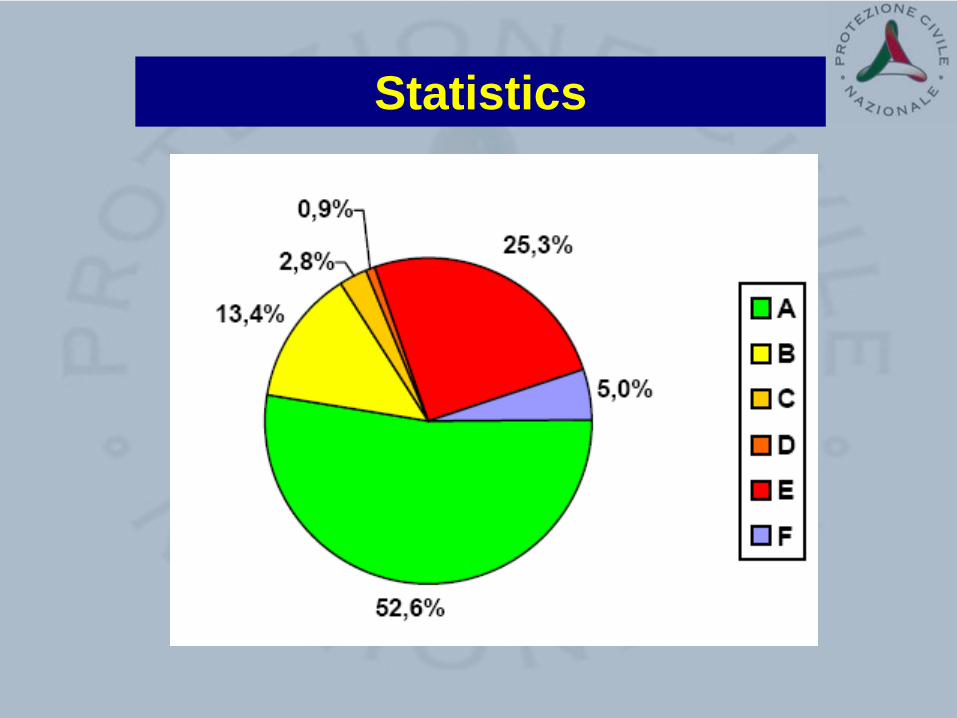
Statistics

DAMAGE AND USABILITY OF SCHOOLS
- Schools had priority in the damage assessment activities and most of them were inspected in the first days after the earthquake
- In l’Aquila municipality 106 school buildings have been inspected
- In the Province of L’Aquila, inspections in 64 municipalities have been carried out: 309 buildings were inspected

Inspections Percentage Outcome324 23,3% Edifici AGIBILI
181 13,0%Edifici AGIBILI CON PROVVEDIMENTI
733 52,8% Edifici INAGIBILI32 2,3% Edifici PARZIALMENTE AGIBILI
85 6,1%Edifici TEMPORANEAMENTE INAGIBILI
33 2,4% Edifici INAGIBILI per cause esterne
No. Inspections1373
Cultural Cultural heritageheritage

POST-EARTHQUAKE PROVISIONAL WORKS


POST-EMERGENCY ACTIVITIES – TEMPORARY HOUSES
S. GIULIANO DI PUGLIA - 2002INSTALLATION OF TEMPORARY PREFABRICATED TIMBER HOUSES

Il Decreto Abruzzo del 28 aprile 2009 n.39Il Decreto Abruzzo del 28 aprile 2009 n.39
I PUNTI PRINCIPALI
Il piano C.A.S.E.
Contributi per la ricostruzione e riparazione di edifici pubblici e privati
Imprese, lavoro e famiglia: le agevolazioni
Sospensioni e dilazioni di termini di legge e scadenze
Riduzione del rischio a livello nazionale

L’Aquila Maggio 2009
Objectives and design pylosophySTRATEGIA TRADIZIONALE
IMMEDIATO tende
PROVVISORIO baracche prefabbricate
DEFINITIVO nuove abitazioni
STRATEGIA ALTERNATIVA
IMMEDIATO tende
PROVVISORIOAbitazioni ad elevatistandard qualitativi
- Abitazioni e quartieri disponibili in cinque/sei mesi - Sicurezza antisismica di “isolato urbano” - Elevato livello dello standard abitativo - Elevato livello tecnologico orientato all’autosufficienza impiantistica - Sostenibilità ambientale e bioedilizia
Project C.A.S.E.OBJECTIVE:
• 150 buildings
• 4000 apartments for
• 12-14000 homeless
• IN 6 MONTHS

L’Aquila Maggio 2009
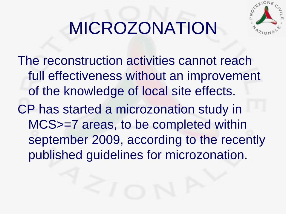
MICROZONATION
The reconstruction activities cannot reach full effectiveness without an improvement of the knowledge of local site effects.
CP has started a microzonation study in MCS>=7 areas, to be completed within september 2009, according to the recently published guidelines for microzonation.
G8 MEETINGS IN LG8 MEETINGS IN L’’AQUILAAQUILA
SEISMIC SAFETYSEISMIC SAFETY

0.48g0.48g
0.50g0.50g
0.67g0.67g
Strong motion records (RAN)
GdFGdF SchoolSchool complexcomplex
BuildingsBuildings hosting G8 hosting G8 experiencedexperienced strongerstronger earhquakeearhquake thanthan currentcurrent code design code design earthquakeearthquake requiresrequires
ByBy courtesycourtesy of T. Sanòof T. Sanò

Seismic safety of the buildings of the School of “Guardia di finanza” – L’Aquila INVESTIGATIONS AFTER THE QUAKE
1.1. Visual Visual inspectioninspection forfor damagedamage and and postpost--earthquakeearthquake safetysafety assessmentassessment
SlightSlight damagedamage toto non non structuralstructural elementselementsNO NO structuralstructural damagedamage
2.2. ReRe--evaluationevaluation of the design of the design documentsdocumentsComplianceCompliance withwith modernmodern seismicseismic code code detailingdetailing
3.3. Material (concrete) Material (concrete) testingtestingComplianceCompliance withwith design design requirementsrequirements
4.4. DynamicDynamic identificationidentification
5.5. PermanentPermanent dynamicdynamic monitoringmonitoring6 6 buildingsbuildings nownow 16 16 buildingsbuildings duringduring G8G8
6.6. ReRe--analysisanalysis forfor seismicseismic safetysafety assessmentassessmentin progress in progress positive positive preliminarypreliminary resultsresults
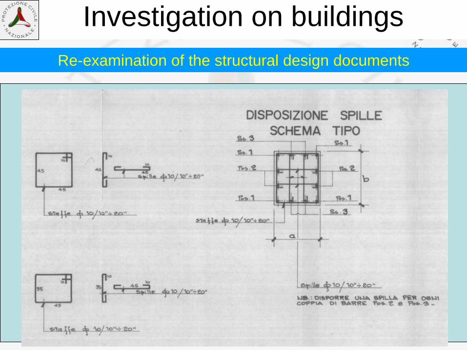
Investigation on buildingsRe-examination of the structural design documents

Summary of investigations carried out until now
Type of investigation quantità Non-destructive tests (SonReb type) 500 Material (Concrete)
testing Tests on drilled cores 80
Dynamic characterisation of structures (No. of buildings) 50 Dynamic characterisation of
structures Continuous monitoring 6
Numerical analysis of seismic risk (VC) 16 Modellazione strutturale Finite element numerical analysis 20
Competence Centre of Civil Protection University No. of
operators University of Basilicata 10
University of Naples - Federico II 6
University of Perugia 6 Reluis
University of Molise 4
Eucentre University of Pavia 20
TOTAL OPERATORS 46

COMPETENCE CENTRES OF DPC
• INGV (Seismic surveillance, Emergency technical support, Seismological research projects)
• RELUIS (Emergency technical support, Earthquake engineering research projects)
• EUCENTRE (Emergency technical support, Earthquake engineering research projects)
In the past three years, PC research funds amounted to about 10 M€ / year

CONCLUSION
The effectiveness of the response of Civil Protection to the seismic event of Abruzzo can be ascribed to the full involvement and cooperation of the different components of the Civil Protections system, including the volunteer organisation.
Rescue operations and technical evaluations could therefore fully exploit the great potential of all of them.

• Monitor soil and structures with mobile instrumentation, to evaluate aftershock effects,
• survey earthquake effects on natural (landslides, liquefactions, soil fractures, etc.) and built environment (macroseismic survey, damage assessment, etc.).
As far as the scientific components are concerned, their support to technical evaluations has come out to be precious in many activities due to their structured involvement through the competence centers, to:
Also in post-event activities important synergies are established between research and CP:
EARTHQUAKES REPRESENT FULL SCALE EXPERIMENTS THAT PROVIDE SIGNIFICANT AND
STIMULATING HINTS FOR SCIENTISTS.

THANKS
FOR YOUR ATTENTION
Related Documents