The 450 Field Exercise… The Big Picture

Welcome message from author
This document is posted to help you gain knowledge. Please leave a comment to let me know what you think about it! Share it to your friends and learn new things together.
Transcript

8/14/2019 The 450 Field Exercise
http://slidepdf.com/reader/full/the-450-field-exercise 1/22
The 450 Field Exercise…
The Big Picture

8/14/2019 The 450 Field Exercise
http://slidepdf.com/reader/full/the-450-field-exercise 2/22
The 450 Field Exercise…
1. Field survey of features (sketch w/coordinates)• And collect GPS data (waypoints) at the same time
2. Creation of vector data sets
3. Creation of raster data sets
4. Assign real-world coordinates to vector & raster data5. Create metadata for the data sets
6. Create overlay maps of different data sets
• Compare with GPS data and Air Photo, etc.
7. Write a summary report of the process

8/14/2019 The 450 Field Exercise
http://slidepdf.com/reader/full/the-450-field-exercise 3/22
GPS used to obtain X-Y
coordinates AND to actually
record a waypoint of thefeature location (to be used
later)

8/14/2019 The 450 Field Exercise
http://slidepdf.com/reader/full/the-450-field-exercise 4/22
Transfer your sketch to graph paper
8/14/2019 The 450 Field Exercise
http://slidepdf.com/reader/full/the-450-field-exercise 5/22
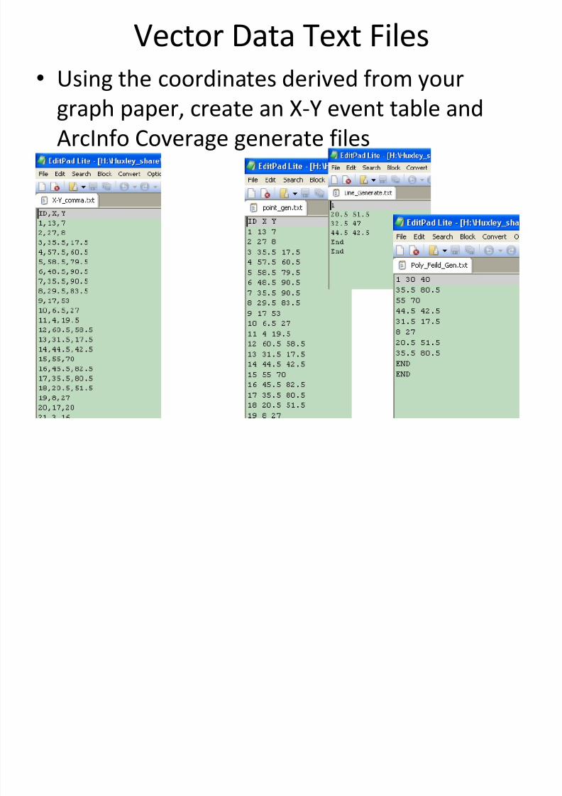
Vector Data Text Files
• Using the coordinates derived from your
graph paper, create an X-Y event table and
ArcInfo Coverage generate files

8/14/2019 The 450 Field Exercise
http://slidepdf.com/reader/full/the-450-field-exercise 6/22
Deliverables 1
• Bring to class:
– Copy of your sketch (1 per team) w/ names on it
– Your graph paper (w/board coordinates)
– Your X-Y Event Table
– Your 3 Generate Files

8/14/2019 The 450 Field Exercise
http://slidepdf.com/reader/full/the-450-field-exercise 7/22
GIS (Vector) Data From Text Files
• Using X-Y Event Table create an X-Y Event
Layer and export that to a shapefile

8/14/2019 The 450 Field Exercise
http://slidepdf.com/reader/full/the-450-field-exercise 8/22
GIS (Vector) Data From Text Files
• Using generate files create coverages (point,
line and polygon)
8/14/2019 The 450 Field Exercise
http://slidepdf.com/reader/full/the-450-field-exercise 9/22
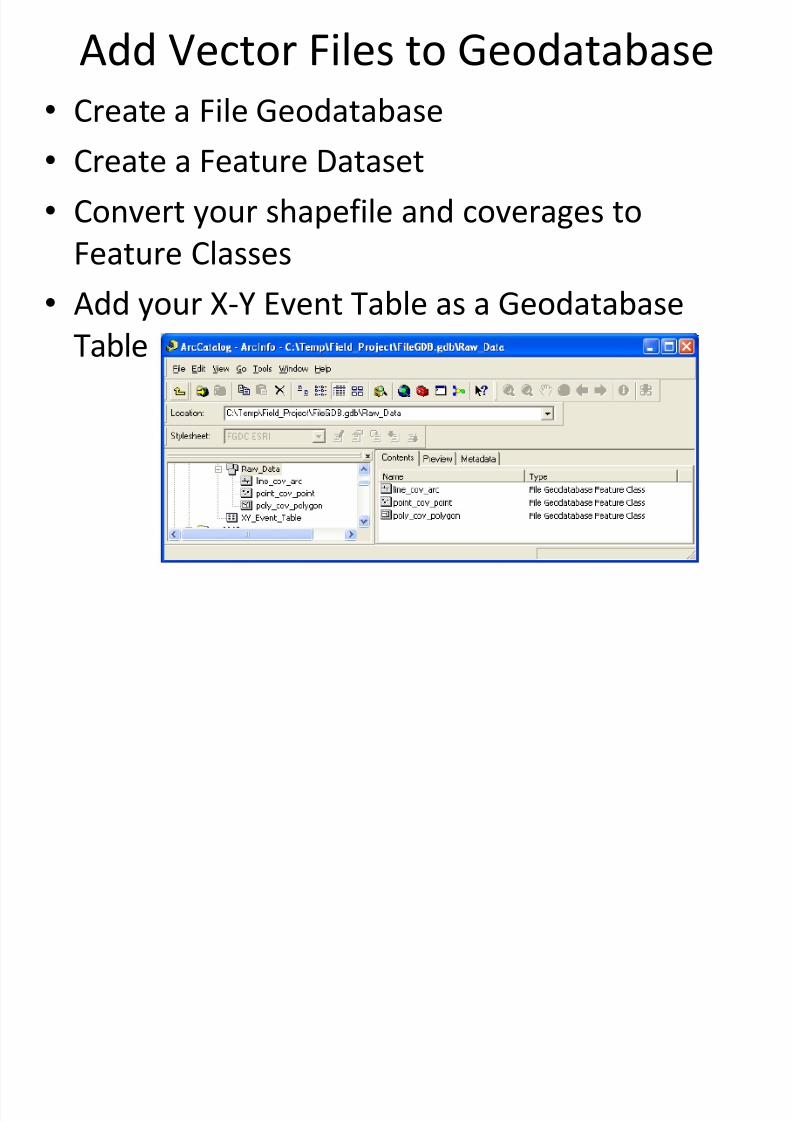
Add Vector Files to Geodatabase
• Create a File Geodatabase
• Create a Feature Dataset
• Convert your shapefile and coverages to
Feature Classes
• Add your X-Y Event Table as a Geodatabase
Table

8/14/2019 The 450 Field Exercise
http://slidepdf.com/reader/full/the-450-field-exercise 10/22
Add Vector Files to Geodatabase
• Create Metadata for your Geodatabase and
everything in it (Feature Dataset, Feature
Classes and Table)
8/14/2019 The 450 Field Exercise
http://slidepdf.com/reader/full/the-450-field-exercise 11/22
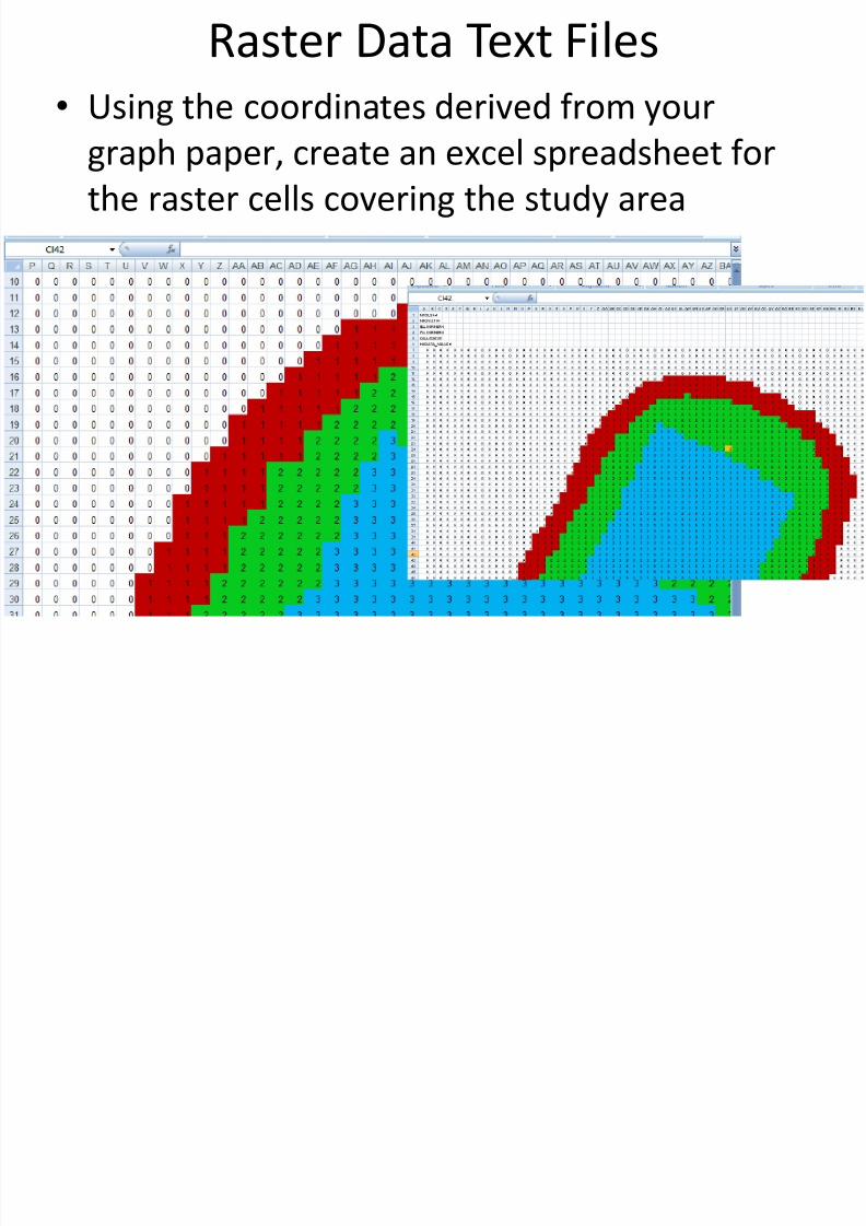
Raster Data Text Files
• Using the coordinates derived from your
graph paper, create an excel spreadsheet forthe raster cells covering the study area

8/14/2019 The 450 Field Exercise
http://slidepdf.com/reader/full/the-450-field-exercise 12/22
Raster Data Text Files• Add a ‘header’ to the file and export this
spreadsheet to a text file to create an ‘ascii’raster text file

8/14/2019 The 450 Field Exercise
http://slidepdf.com/reader/full/the-450-field-exercise 13/22
Raster Data Text Files

8/14/2019 The 450 Field Exercise
http://slidepdf.com/reader/full/the-450-field-exercise 14/22
GIS (Raster) Data From Text Files
•
Using your ascii raster text file, create a rasterGRID of the study area

8/14/2019 The 450 Field Exercise
http://slidepdf.com/reader/full/the-450-field-exercise 15/22
Add Raster Files to Geodatabase
• Add Grid to the File Geodatabase
• Create Metadata for your Geodatabse raster

8/14/2019 The 450 Field Exercise
http://slidepdf.com/reader/full/the-450-field-exercise 16/22
Deliverables 2 (Lab 5)
• Bring to class:
– X-Y Event shapefile (board coordinates)
– 3 Coverages (board coordinates)
– Grid (board coordinates)
– Geodatabase (board coordinates)
• With feature datasets, classes, raster, etc.
• Including Metadata
• Post to web (for grading): – Map(s) showing the 4 vector & 1 raster layers

8/14/2019 The 450 Field Exercise
http://slidepdf.com/reader/full/the-450-field-exercise 17/22
Assign Real-Wold Coordinates
(Vector Data)
• Reformat your X-Y Event Table to UTM
coordinates
• Create X-Y Event Layer and Feature Class in UTM

8/14/2019 The 450 Field Exercise
http://slidepdf.com/reader/full/the-450-field-exercise 18/22
Assign Real-Wold Coordinates
(Vector Data)
• Use Spatial Adjustment tools to relocate your
coverage data to UTM coordinates

8/14/2019 The 450 Field Exercise
http://slidepdf.com/reader/full/the-450-field-exercise 19/22
Assign Real-Wold Coordinates
(Vector Data)
• Re-project your GPS data (shapefiles) from
WGS-84 to UTM-83 (feature classes)

8/14/2019 The 450 Field Exercise
http://slidepdf.com/reader/full/the-450-field-exercise 20/22
Assign Real-Wold Coordinates
(Raster Data)
• Reformat your ascii raster header information
• Create a new raster Grid in UTM coordinates
•
Import UTM raster into Geodatabase

8/14/2019 The 450 Field Exercise
http://slidepdf.com/reader/full/the-450-field-exercise 21/22
Document Your Work
• Metadata (for your geodatabase)
– Feature datasets (Raw & UTM)
– Feature classes (Board Coordinates & UTM)
– Raster (Board Coordinates & UTM)
– Tables
• Maps (overlays of different layers along with
Air Photo and/or GPS data)
• Written Summary
• Web page

8/14/2019 The 450 Field Exercise
http://slidepdf.com/reader/full/the-450-field-exercise 22/22
Deliverables 3 (Lab 6)
• Bring to class:
– Vector data (UTM)
– Grid (UTM)
– Geodatabase (UTM vector & rasters & metadata)
• Hand (for grading)
– Metadata from Geodatabase
• Post to web (for grading):
– Map(s) with UTM vector and raster layers & GPS
– Written explanation of process
Related Documents