The 14 July 2001 hailstorm in northeastern Spain: diagnosis of the meteorological situation E. Tudurı ´ a,b , R. Romero b , L. Lo ´pez c , E. Garcı ´a c , J.L. Sa ´nchez c , C. Ramis b, * a Instituto Nacional de Meteorologı ´a, Centro Meteorolo ´gico en Illes Balears, Palma de Mallorca, Spain b Group of Meteorology, Departament de Fı ´sica, Universitat de les Illes Balears, Carretera de Valldemossa km 7,5 07122, Palma de Mallorca, Spain c Laboratorio de Fı ´sica de la Atmo ´sfera, Instituto de Medio Ambiente, Universidad de Leo ´n, Leo ´n, Spain Accepted 28 March 2003 Abstract Hail producing thunderstorms developed over the Ebro valley (NE Spain) during the evening of 14 July 2001, affecting mainly the Lerida province. Hail stones as large as 3 cm in diameter produced damage on 2979 ha of fruit trees, vineyard and cornfields. The thunderstorms developed ahead of a cold front, which was moving from the Gulf of Biscay towards inland Spain. Meteosat images and radar data demonstrate that the storms formed over the central part of the Ebro valley and moved towards the east attaining their maximum development in Lerida province. A diagnosis, using data from ECMWF, shows that at surface there was a cyclonic circulation over northeastern Spain and at medium levels (500 hPa) a trough with cold air located towards northwestern Spain. The Q vector diagnosis demonstrates that the forcing for upward vertical motions was rather weak at both low and medium levels over the area where the thunderstorms developed. However, a significant frontogenesis contribution is identified over the Ebro valley. A more detailed handmade analysis shows that over the Ebro valley there was a thermal mesolow, which favoured the inland entrance of humid air from the Mediterranean. Frontogenesis and the humid air intrusion coexisted where remote-sensing observations indicated that the storms developed. A numerical study of the event using the MM5 model has been carried out. In a control experiment, the model is able to develop the thermal mesolow and reproduce, quite well, the convergence produced by the front as well as the timing of the event. In order to study the genesis and influence of the thermal mesolow, another simulation has been performed without consideration of solar radiation. The results indicate that the thermal mesolow does not develop, the convergence ahead of the cold front is significantly weakened and the front itself becomes 0169-8095/03/$ - see front matter D 2003 Elsevier B.V. All rights reserved. doi:10.1016/S0169-8095(03)00072-3 * Corresponding author. E-mail address: [email protected] (C. Ramis). www.elsevier.com/locate/atmos Atmospheric Research 67 – 68 (2003) 541 – 558

Welcome message from author
This document is posted to help you gain knowledge. Please leave a comment to let me know what you think about it! Share it to your friends and learn new things together.
Transcript

The 14 July 2001 hailstorm in northeastern Spain:
diagnosis of the meteorological situation
E. Tudurıa,b, R. Romerob, L. Lopezc, E. Garcıac,J.L. Sanchezc, C. Ramisb,*
a Instituto Nacional de Meteorologıa, Centro Meteorologico en Illes Balears, Palma de Mallorca, SpainbGroup of Meteorology, Departament de Fısica, Universitat de les Illes Balears,
Carretera de Valldemossa km 7,5 07122, Palma de Mallorca, SpaincLaboratorio de Fısica de la Atmosfera, Instituto de Medio Ambiente, Universidad de Leon, Leon, Spain
Accepted 28 March 2003
Abstract
Hail producing thunderstorms developed over the Ebro valley (NE Spain) during the evening
of 14 July 2001, affecting mainly the Lerida province. Hail stones as large as 3 cm in diameter
produced damage on 2979 ha of fruit trees, vineyard and cornfields. The thunderstorms developed
ahead of a cold front, which was moving from the Gulf of Biscay towards inland Spain. Meteosat
images and radar data demonstrate that the storms formed over the central part of the Ebro valley
and moved towards the east attaining their maximum development in Lerida province. A
diagnosis, using data from ECMWF, shows that at surface there was a cyclonic circulation over
northeastern Spain and at medium levels (500 hPa) a trough with cold air located towards
northwestern Spain. The Q vector diagnosis demonstrates that the forcing for upward vertical
motions was rather weak at both low and medium levels over the area where the thunderstorms
developed. However, a significant frontogenesis contribution is identified over the Ebro valley. A
more detailed handmade analysis shows that over the Ebro valley there was a thermal mesolow,
which favoured the inland entrance of humid air from the Mediterranean. Frontogenesis and the
humid air intrusion coexisted where remote-sensing observations indicated that the storms
developed. A numerical study of the event using the MM5 model has been carried out. In a
control experiment, the model is able to develop the thermal mesolow and reproduce, quite well,
the convergence produced by the front as well as the timing of the event. In order to study the
genesis and influence of the thermal mesolow, another simulation has been performed without
consideration of solar radiation. The results indicate that the thermal mesolow does not develop,
the convergence ahead of the cold front is significantly weakened and the front itself becomes
0169-8095/03/$ - see front matter D 2003 Elsevier B.V. All rights reserved.
doi:10.1016/S0169-8095(03)00072-3
* Corresponding author.
E-mail address: [email protected] (C. Ramis).
www.elsevier.com/locate/atmos
Atmospheric Research 67–68 (2003) 541–558
increasingly progressive. As a result, thunderstorms do not develop and very little precipitation
falls in the area.
D 2003 Elsevier B.V. All rights reserved.
Keywords: Thunderstorm; Hail; Remote sensing
1. Introduction
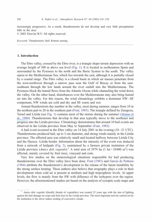
The Ebro valley, crossed by the Ebro river, is a triangle shape terrain depression with an
average height of 300 m above sea level (Fig. 1). It is located in northeastern Spain and
surrounded by the Pyrenees to the north and the Iberic System to the south. The valley
opens to the Mediterranean Sea, which lies towards the east, although it is partially closed
by a coastal range. The Ebro valley is a closed basin in which air masses penetrate from
the west-northwest through a narrow pass near the Gulf of Biscay or from the east-
southeast through the low lands around the river outfall into the Mediterranean. The
Pyrenees block the humid flows from the Atlantic Ocean while channeling the wind down
the valley. On the other hand, disturbances over the Mediterranean may also bring humid
air into the valley. For this reason, the wind climatology exhibits a dominant NW–SE
component, NW winds are cold and dry and SE warm and wet.
Annual thunderstorm day number in the valley, most during summer, ranges from 10 in
the northern part to 20 in the southern part (Font, 1983). The triangle defined by Zaragoza,
Teruel and Lerida (see Fig. 1) contains most of the storms during the summer (Alonso et
al., 1994). Thunderstorms that develop in that area typically move to the northeast and
progress into the Lerida province. Climatology demonstrates that around 10 hail events are
observed in the Lerida province from May to September (Font, 1983).
A hail event occurred in the Ebro valley on 14 July 2001 in the evening (18–21 UTC).
Thunderstorms produced hail, up to 3 cm diameter, and strong winds mainly in the Lerida
province. The affected area was relatively small and located halfway between Lerida City
and the Huesca–Lerida border. Information about the intensity of the event was deduced
from a network of hailpads (Fig. 2), maintained by a farmers private institution of the
Lerida province (Amics dels vegetals).1 A total area of 2979 ha (1 ha = 10000 m2) was
affected, mainly covered by fruit trees, vineyard and corn.
Very few studies on the meteorological situations responsible for hail producing
thunderstorms over the Ebro valley have been done. Font (1983) and Garcıa de Pedraza
(1964) attribute the thunderstorm’s development to the release of the latent instability by
the strong surface heating. These authors also believe that orography plays a role in their
development when cold air is present at medium and high tropospheric levels. At upper
levels, the flow is mainly from the SW with difluence of the isohypses over the region.
However, the aforementioned studies are based on the analysis of synoptic scale maps and
1 Amics dels vegetals (literally friends of vegetables) was created 25 years ago with the aim of fighting
against the hail damage on crops and fruit trees in the Lerida province. The most important activity carried out by
the institution is the silver iodure seeding of convective clouds.
E. Tudurı et al. / Atmospheric Research 67–68 (2003) 541–558542
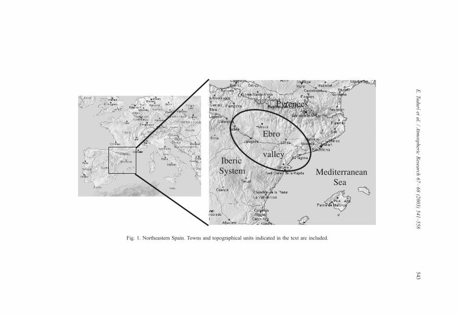
Fig. 1. Northeastern Spain. Towns and topographical units indicated in the text are included.
E.Tudurıet
al./Atmospheric
Resea
rch67–68(2003)541–558
543

do not identify clear mechanisms explaining the development of Ebro valley thunder-
storms. A detailed mesoscale analysis of a hail event in Catalonia (Ramis et al., 1999)
demonstrates that it was caused by a thermal mesolow over Catalonia. A thermal mesolow
over the Ebro valley was a crucial factor in the catastrophic flash flood event over the
Spanish Pyrenees (Romero et al., 2001).
In this work, a detailed analysis of the ingredients and mechanisms responsible for the
hail-producing thunderstorms in the Ebro valley on 14 July 2001 is presented. It is
interesting to note that the event was very well predicted by the regional meteorological
centres located in Zaragoza and Barcelona. In fact, the prediction bulletins for 14 July
issued by both centres, the previous evening included ‘‘thunderstorms during the
afternoon and evening with hail and heavy rain mainly in the area close to the
Pyrenees’’. However, the present study highlights some aspects not normally considered
in operational forecasting that could help to improve the understanding of the mecha-
nisms and factors involved in the genesis of hail producing thunderstorms in the Ebro
valley.
The paper is organized as follows. Section 2 describes the remote sensing observations
of the hail producing thunderstorms, Section 3 presents a diagnostic study of the
meteorological situation and Section 4 provides the results from numerical simulations
of the event, and finally, Section 5 includes the conclusions.
Fig. 2. The area affected by hail in the Lerida province, depicted by isocontours of energy values (J m� 2) deduced
from the hailpads. White rectangles represent the hailpads network.
E. Tudurı et al. / Atmospheric Research 67–68 (2003) 541–558544

2. Remote sensing observations
A series of Meteosat IR images every 30 min shows a cloud band associated with a cold
front moving from the NW towards the SE during 14 July. At noon, the cloud band was
located over the Gulf of Biscay, but northeastern Spain remains still free of clouds.
Prefrontal thunderstorms developed to the east of Zaragoza City, very quickly increased its
size, and moved towards the NE during the evening (Fig. 3), affecting mainly the Lerida
province. Cloud top temperature reached � 64 jC.A radar operated by the Universidad de Leon and located close to Zaragoza provides
information on the storm’s horizontal and vertical structure. The radar data confirm that
thunderstorms developed more or less over eastern Zaragoza province, and moved very
quickly towards the northeast. All thunderstorms followed the same path. Maximum
reflectivity values were 48 dBZ (Fig. 4, upper panel). Vertical Integrated Liquid water
content (VIL) grid values (Green and Clark, 1972) calculated from the reflectivity vertical
profile (Zi) using the expression
VIL ¼Z h2
h1
3:44� 10�6½ðZi þ Ziþ1Þ=2�47dz
attain 6.4 kg m� 2 at some points (Fig. 4, lower panel). This is lower than values
referenced in previous works for hail producing storms in United States (Dye and Martner,
1978; Kitsmiller et al., 1995). Cross-sections through the convective storms (not shown)
do not display any identifiable structure characteristic of severe convection (Weisman and
Klemp, 1986). Echoes present a bell-shaped structure without any asymmetry.
3. Diagnostic study
ECMWF analysis on 14 July 2001 at 1200 UTC shows that at low levels (Fig. 5a),
there was a cold northwesterly flow over Gulf of Biscay and the Iberian peninsula
behind a strong cold front. In addition, a weak cyclonic circulation was located over
northeastern Spain and the western Mediterranean. At 500 hPa (Fig. 5b), a trough was
located west of France, inducing southwesterly flux over Spain. Very cold air at upper
levels was associated with the trough but far to the northwest with respect to the Ebro
valley.
At 1800 UTC at low levels (Fig. 5c), the cyclonic circulation centred over the Spanish
Mediterranean coast has strengthened significantly. Over northeastern Spain frontogenesis
has occurred; the axes of dilatation and contraction can be identified along the northeast–
southwest and northwest–southeast directions, respectively. The cold front has been
blocked in its advance towards the southeast as a consequence of the above-mentioned
cyclonic circulation. The thunderstorms developed over the area where frontogenesis has
been identified. Hence, the lifting mechanism necessary to propel rising surface air parcels
to their level of free convection could have been supplied by the secondary circulation
associated with the cold front (Carlson, 1991). At 500 hPa (Fig. 5d), the trough moved
eastward, but the cold air was still far from the area where the thunderstorms developed.
E. Tudurı et al. / Atmospheric Research 67–68 (2003) 541–558 545
Fig. 3. Meteosat IR images on 14 July 2001. Upper panel: at 1800 UTC. Lower panel: at 2200 UTC. Colours
indicate temperatures (jC) according to the scale.
E. Tudurı et al. / Atmospheric Research 67–68 (2003) 541–558546

Fig. 4. Upper panel: Maximum reflectivity (dBZ, according to the scale) given by the radar (C-band, 5 cm)
located at Zaragoza at 1805 UTC. The black arrow indicates the thunderstorms motion direction. Down panel:
VIL grid values at 2028 UTC.
E. Tudurı et al. / Atmospheric Research 67–68 (2003) 541–558 547

A Q vector-based diagnosis (Hoskins and Pedder, 1980) at low and medium levels has
been applied in order to quantify the synoptic scale upward vertical forcing and
consequently thunderstorm development potential. Results (not shown) demonstrate that
at both 1200 and 1800 UTC, the forcing is very weak over northeastern Spain, but at least
the large-scale environment is not suppressive for convection.
To confirm the frontogenesis processes over northeastern Spain, the ground relative
helicity (Davies-Jones et al., 1990) between p0 = 1000 and p1 = 700 hPa has been
calculated by means of the expression
GRH ¼ �Z z1
z0
!k !
V � A!V
Az
!dz ¼ �
Z p1
p0
!k !
V � A!V
Ap
!dp
where!V is the horizontal wind. GRH is a measurement of the integrated temperature
advection between the considered levels, as it has been demonstrated by Tudurı and Ramis
(1997) and then:
GRH ¼ �Z p1
p0
R
fpð�!
V rpTÞdp
where R is the specific gas constant of dry air, f is the Coriolis parameter, p is the pressure
and T the temperature.
Fig. 5. Meteorological situation on 14 July 2001 from ECMWF analysis. At 1200 UTC: (a) 925 hPa, (b) 500 hPa.
At 1800 UTC: (c) 925 hPa and (d) 500 hPa. Solid lines are isohypses (gpm), dashed lines are isotherms (jC).
E. Tudurı et al. / Atmospheric Research 67–68 (2003) 541–558548
Fig. 6a shows that at 1800 UTC 14 July 2001, when the first thunderstorms developed,
there was an area of warm air advection off the Spanish Mediterranean coast, but cold
advection over inland Spain and France. Then, frontogenesis is clear over the Ebro valley,
Fig. 6. (a) Ground relative helicity (GRH, m2 s� 2) for the 1000–700 hPa layer on 14 July 2001 at 1800 UTC.
Solid line, positive values (warm advection); dashed line, negative values (cold advection). (b) Water vapour flux
divergence (10� 2 g m� 2 s� 1) for the 1000–700 hPa layer at the same time. Solid line, positive values
(divergence); dashed line, negative values (convergence).
E. Tudurı et al. / Atmospheric Research 67–68 (2003) 541–558 549
an area with accentuated GRH gradient. Therefore, the cold front appears as a plausible
factor for triggering the convection over the area.
A necessary ingredient for convection feeding and maintenance is the convergence of
water vapour flux, which is clearly present over eastern Spain (Fig. 6b). Finally, significant
latent instability must exist where strong vertical motions lie to support rapidly growing
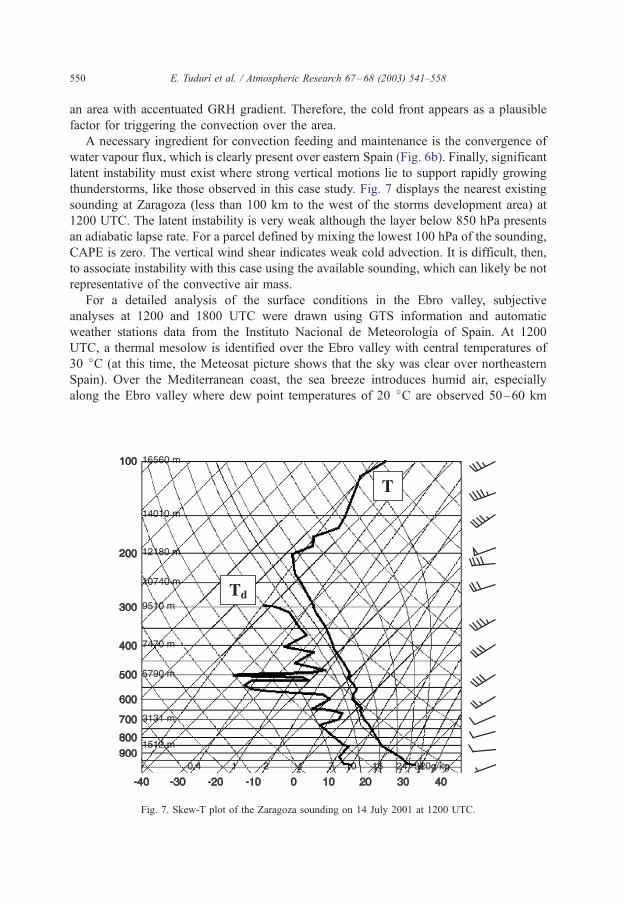
thunderstorms, like those observed in this case study. Fig. 7 displays the nearest existing
sounding at Zaragoza (less than 100 km to the west of the storms development area) at
1200 UTC. The latent instability is very weak although the layer below 850 hPa presents
an adiabatic lapse rate. For a parcel defined by mixing the lowest 100 hPa of the sounding,
CAPE is zero. The vertical wind shear indicates weak cold advection. It is difficult, then,
to associate instability with this case using the available sounding, which can likely be not
representative of the convective air mass.
For a detailed analysis of the surface conditions in the Ebro valley, subjective
analyses at 1200 and 1800 UTC were drawn using GTS information and automatic
weather stations data from the Instituto Nacional de Meteorologıa of Spain. At 1200
UTC, a thermal mesolow is identified over the Ebro valley with central temperatures of
30 jC (at this time, the Meteosat picture shows that the sky was clear over northeastern
Spain). Over the Mediterranean coast, the sea breeze introduces humid air, especially
along the Ebro valley where dew point temperatures of 20 jC are observed 50–60 km
Fig. 7. Skew-T plot of the Zaragoza sounding on 14 July 2001 at 1200 UTC.
E. Tudurı et al. / Atmospheric Research 67–68 (2003) 541–558550

inland. At 1800 UTC (Fig. 8), the thermal low is still present over the Ebro valley and
has forced the humid Mediterranean air to penetrate well inland. Dew point temperatures
of 20 jC are observed 150–180 km into the valley. In fact, the storms developed where
and when the humid Mediterranean air reached the frontogenesis zone. Taking into
account the location of thunderstorm development and their moisture source, it now
becomes evident that the Zaragoza sounding is not representative of the convective
environment of this event. The Zaragoza city sounding shows a low-level layer that is
very different from the Mediterranean air that has reached inland Spain forced by sea
breezes and the thermal mesolow. This fact demonstrates the difficulty for a general
definition of proximity sounding, which cannot be built based only in terms of distance
and time; some dynamical and geographical aspects have to be taken into account as
well.
Fig. 8. Subjective surface analysis on 14 July 2001 at 1800 UTC over northeastern Spain. Full lines, isobars
(hPa); dashed lines, isotherms (jC); wavy line, isodrosoterms (constant dew point temperature, jC).
E. Tudurı et al. / Atmospheric Research 67–68 (2003) 541–558 551

4. Numerical simulations
To complement the information obtained from the previous analysis and strengthen the
physical interpretation of the identified mechanisms, numerical simulations of the event
have been performed using the MM5-v3 model (Grell et al., 1994). Three domains of 18, 6
and 2 km horizontal grid resolutions (Fig. 9) and 31 vertical levels have been considered.
These domains interact with each other through a two-way nesting strategy. Initial and
boundary conditions, updated every 12 h, come from NCEP analyses. These data are
interpolated into the model grid points and then improved using GTS data (Benjamin and
Seaman, 1985).
Two experiments have been carried out. The control experiment (CE) considers a
31 h simulation (from 14 July at 0000 UTC to 15 July at 0700 UTC) using full
physics. Parameterization of convection following the Kain-Fritsch scheme (Kain and
Fritsch, 1990) has been considered for domain 1 (18 km) but no convective scheme
has been introduced in the two inner domains, then convective processes in the latter
are fully explicit. In order to study the influence of solar radiation on the
development of the thermal mesolow and its role on the convective episode, a new
experiment has been carried out in similar conditions to the CE, but without solar
component active in the radiation scheme (Mlawer et al., 1997). This experiment is
referred to as NRE.
Fig. 9. The three domains and horizontal grid resolutions used for the numerical simulations. The inner domain
contains the Ebro valley.
E. Tudurı et al. / Atmospheric Research 67–68 (2003) 541–558552
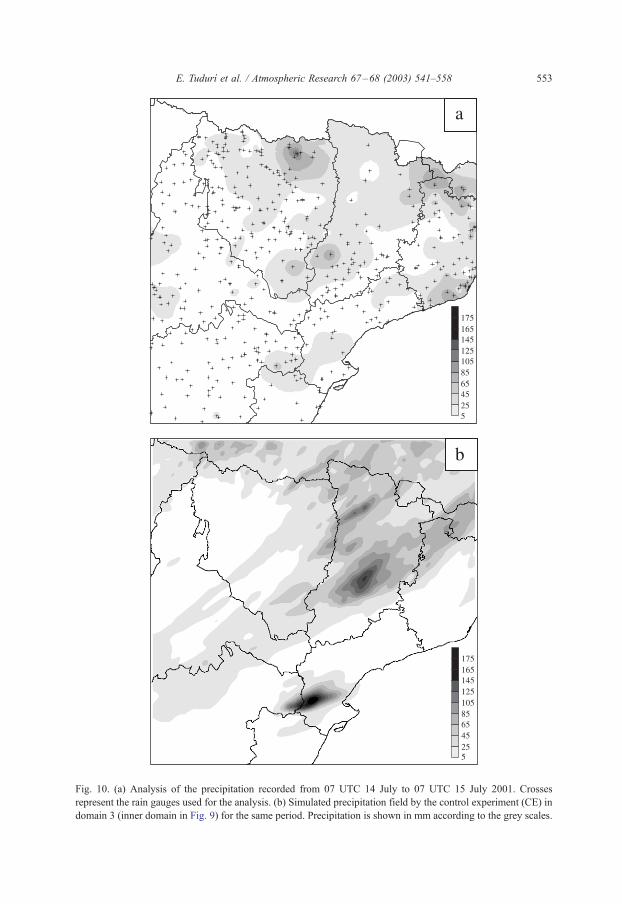
Fig. 10. (a) Analysis of the precipitation recorded from 07 UTC 14 July to 07 UTC 15 July 2001. Crosses
represent the rain gauges used for the analysis. (b) Simulated precipitation field by the control experiment (CE) in
domain 3 (inner domain in Fig. 9) for the same period. Precipitation is shown in mm according to the grey scales.
E. Tudurı et al. / Atmospheric Research 67–68 (2003) 541–558 553
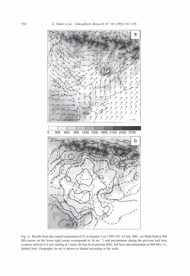
Fig. 11. Results from the control experiment (CE) in domain 3 on 1700 UTC 14 July 2001. (a) Wind field at 900
hPa (arrow on the lower right corner corresponds to 10 ms� 1) and precipitation during the previous half hour
(contour interval is 4 mm starting at 1 mm); (b) Sea level pressure (hPa, full line) and temperature at 900 hPa (jC,dashed line). Orography (in m) is shown as shaded according to the scale.
E. Tudurı et al. / Atmospheric Research 67–68 (2003) 541–558554

Fig. 10a presents the observed 24 h accumulated precipitation field at 07.00 UTC 15
July in an area defined by domain 3 of the simulations. Fig. 10b shows the CE 24
h simulated precipitation for the same period as in Fig. 10a. Although no solid
precipitation was simulated by the model, the general spatial distribution is similar to
the observed one, but model amounts are significantly higher. In any case, it has been
considered accurate enough to justify a further analysis of the simulated pressure,
temperature and wind fields.
Fig. 11a shows model results for domain 3 of 900 hPa wind field and last 30 min
rainfall at 1700 UTC 14 July. The wind field shows well-developed sea breezes along
the coast, which penetrates inland about 100–120 km into the Ebro valley. Wind from
the NW appears over the north part of the valley, which defines, in conjunction with the
sea breeze, convergences in the central part of the valley. Precipitation mainly occurs
over the convergence zone. Fig. 11b shows sea level pressure at 900 hPa temperature at
1700 UTC 14 July. A low pressure system with two centres is evident over the Ebro
valley where the maximum temperatures are located, suggesting a thermal nature of the
mesolow.
The 24 h accumulated precipitation by the NRE experiment (Fig. 12) is much lower
than in the CE. Precipitation occurrence is practically restricted to the Pyrenees, and there
is no sea breeze at 1700 UTC (Fig. 13a). The wind is from the west everywhere over the
domain and no convergences appear, implying weak, if any vertical forcing. The sea
level pressure field at 1700 UTC becomes much simpler than in the CE (Fig. 13b). No
Fig. 12. Simulated precipitation field by the no radiation experiment (NRE) in domain 3 from 07 UTC 14 July to
07 UTC 15 July 2001. Precipitation is shown in mm according to the grey scale.
E. Tudurı et al. / Atmospheric Research 67–68 (2003) 541–558 555

Fig. 13. As in Fig. 11 but for the no radiation experiment (NRE).
E. Tudurı et al. / Atmospheric Research 67–68 (2003) 541–558556

thermal mesolow appears, and as a result, the pressure gradient over the Ebro valley is
very weak.
5. Conclusions
We analysed a particular hail event that occurred over the Ebro valley (northeastern
Spain) on 14 July 2001. The analysis focussed on the role different factors and
mechanisms had in controlling the genesis and evolution of the hailstorms. Satellite and
radar information demonstrate that a succession of thunderstorms developed very
quickly over the central part of the valley during the evening and moved towards
the northeast over the Lerida province. Some of these thunderstorms produced hail,
although the maximum radar reflectivity was 48 dBZ and calculated grid VIL 6.3 kg
m� 2. Both parameters are derived from a C-band (5 cm wavelength) radar and appear
to be lower than characteristic values for hail producing thunderstorms in the United
States.
At synoptic scale, the convective event can be associated with an approaching cold
front from the NW into the Ebro valley. A low level cyclonic circulation that developed
over the Spanish Mediterranean coast enhanced the cold front and therefore the secondary
circulations associated with it. These secondary circulations would provide the necessary
lifting for the low level air parcels to reach their level of free convection. In addition,
diagnostic products reveal that strong water vapour flux convergence is forced at low
levels ahead of the front (an important ingredient for the development and maintenance of
the convective cells).
However, this broad synoptic scenario is strongly modulated by the genesis of a
mesolow over the Ebro valley of thermal origin. The structure and thermal character
of this mesoscale feature have been identified by means of a subjective analysis of
surface data and high-resolution model simulations. This mesolow enhances the
inflow of humid Mediterranean air, rooted in the coastal sea breezes, towards the
central part of the valley. Satellite information shows that convection developed over
the area where the moist tongue interacted with the prefrontal upward motion branch,
at about 1800 UTC. Clearly, then, this case shows that the spatial and temporal
variability of convective environments can be very high. This fact emphasizes the
difficulty for a correct characterization of the convective air mass stability using the
current radiosonde network. In this sense, the Zaragoza sounding (only 80–100 km
far from our convective area, but to its west) meets the proximity sounding criteria,
but it was found to be unrepresentative of the environment which supported the
convection.
This and previous case studies (Ramis et al., 1999; Romero et al., 2001) strongly
suggest that, when acting in combination with other upward motion sources such as fronts
or vorticity centres aloft, the development of thermal mesolows in northeastern Spain
becomes an important mechanism for the genesis and organization of severe convective
events in the area. Presumably, these mesolows are a very common feature over the arid
central Ebro valley during summer. However, they are generally insufficiently sampled in
standard meteorological analysis and, therefore, a more extensive use of surface data
E. Tudurı et al. / Atmospheric Research 67–68 (2003) 541–558 557

would be advisable in the operational framework for a better nowcasting and monitoring
of convective developments.
Acknowledgements
Precipitation raw data and satellite images were provided by the Instituto Nacional de
Meteorologıa of Spain. Radar products come from the University of Leon, Spain. The
authors appreciate the comments and specific suggestions from an anonymous reviewer
that helped to improve the paper. This study has been partially sponsored by CICYT and
MCyT grants CLI99-0269 and REN2002-03482.
References
Alonso, S., Portela, A., Ramis, C., 1994. First considerations on the structure and development of the Iberian
thermal low-pressure system. Ann. Geophys. 12, 457–468.
Benjamin, S.G., Seaman, N.L., 1985. A simple scheme for improved objective analysis in curved flow. Mon.
Weather Rev. 113, 1184–1198.
Carlson, T.N., 1991. Mid-Latitude Weather Systems. Harper Collins, London, UK. 507 pp.
Davies-Jones, R., Burgess, D., Foster, M., 1990. Test of helicity as a tornado forecast parameter. Preprints of
Sixth Conf. on Severe Local Storms. Amer. Meteorol. Soc., Chicago IL, pp. 107–111.
Dye, J.E., Martner, B.E., 1978. The relationship between radar reflectivity factor and hail at the ground for
Northeast Colorado thunderstorms. J. Appl. Meteor. 17, 1335–1341.
Font, I., 1983. Climatologıa de Espana y Portugal. Instituto Nacional de Meteorologıa, Madrid. 269 pp.
Garcıa de Pedraza, L., 1964. La prediccion del tiempo en el Valle del Ebro. Instituto Nacional de Meteorologıa,
Madrid. 99 pp.
Green, D.R., Clark, R.A., 1972. Vertically integrated liquid water—a new analysis tool. Mon. Weather Rev. 100,
534–552.
Grell, G.A., Dudhia, J., Stauffer, D.R., 1994. A description of the fifth-generation Penn State/NCAR mesoscale
model (MM5). NCAR Tech. Note NCAR/TN-398 + STR. 117 pp.
Hoskins, B.J., Pedder, M.A., 1980. The diagnosis of middle latitude synoptic development. Q. J. R. Meteorol.
Soc. 106, 707–719.
Kain, J.S., Fritsch, J.M., 1990. A one-dimensional entraining/detraining plume model and its application in
convective parameterization. J. Atmos. Sci. 47, 2784–2802.
Kitsmiller, D.H., Churma, M.E., Filiaggi, M.T., 1995. Severe Local Storms and Large-Hail Probability Algo-
rithms in the System for Convection Analysis and Nowcasting (SCAN). Techniques Development Laboratory,
Silver Spring, MD.
Mlawer, E.J., Taudman, S.J., Brown, P.D., Iacono, M.J., Clough, S.A., 1997. Radiative transfer for inhomoge-
neous atmosphere: RRTM, a validated correlated-k model for the longwave. J. Geophys. Res. 102 (D14),
16663–16682.
Ramis, C., Lopez, J.M., Arus, J., 1999. Two cases of severe weather in Catalonia (Spain): a diagnostic study.
Meteorol. Appl. 6, 11–27.
Romero, R., Doswell III, C.A., Riosalido, R., 2001. Observations and fine-grid simulations of a convective
outbreak in northeastern Spain: importance of diurnal forcing and convective cold pools. Mon. Weather Rev.
129, 2157–2182.
Tudurı, E., Ramis, C., 1997. The environments of significant convective events in the western Mediterranean.
Weather Forecast. 12, 294–306.
Weisman, M.L., Klemp, J.B., 1986. Characteristics of isolated convective storms. In: Ray, P.S. (Ed.), Mesoscale
Meteorology and Forecasting. American Meteorological Society, Boston, MA, USA, pp. 331–358.
E. Tudurı et al. / Atmospheric Research 67–68 (2003) 541–558558
Related Documents