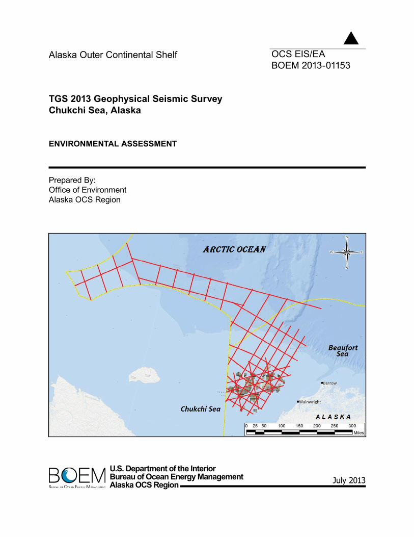
U.S. Department of the Interior Bureau of Ocean Energy Management Alaska OCS Region OCS EIS/EA BOEM 2013-01153 Alaska Outer Continental Shelf TGS 2013 Geophysical Seismic Survey Chukchi Sea, Alaska ENVIRONMENTAL ASSESSMENT Prepared By: Office of Environment Alaska OCS Region July 2013

Welcome message from author
This document is posted to help you gain knowledge. Please leave a comment to let me know what you think about it! Share it to your friends and learn new things together.
Transcript
U.S. Department of the InteriorBureau of Ocean Energy ManagementAlaska OCS Region
OCS EIS/EABOEM 2013-01153
Alaska Outer Continental Shelf
TGS 2013 Geophysical Seismic SurveyChukchi Sea, Alaska
EnvIROnMEnTAl ASSESSMEnT
Prepared By:Office of EnvironmentAlaska OCS Region
July 2013

This Page Intentionally Left Blank

2013 TGS Seismic Survey Environmental Assessment
Acronyms and Abbreviations i
Acronyms and Abbreviations ~ ....................................Approximately AAC ..............................Alaska Administrative Code ACIA .............................Arctic Climate Impact Assessment ACP ...............................Arctic Coastal Plain ADEC ............................Alaska Department of Environmental Conservation ADF&G .........................Alaska Department of Fish and Game AEWC ...........................Alaska Eskimo Whaling Commission AFMP ............................Arctic Fishery Management Plan AO .................................Arctic Oscillation AQCR ............................Air Quality Control Regions bbl ..................................Barrel/Barrels BOEM ...........................Bureau of Ocean Energy Management BOEMRE ......................Bureau of Ocean Energy Management, Regulation and Enforcement CAA ..............................Clean Air Act or Conflict Avoidance Agreement CEQ ...............................Council on Environmental Quality CFR ...............................Code of Federal Regulations CO .................................carbon monoxide COMIDA .......................Chukchi Offshore Monitoring in Drilling Area CWA ..............................Clean Water Act dB re 1 μPa ....................Decibels in Relation to a Reference Pressure of 1 Micropascal DPP................................Development and Production Plan EA..................................Environmental Assessment EEZ ................................U.S. Exclusive Economic Zone EFH ...............................Essential Fish Habitat EIS .................................Environmental Impact Statement EJ ...................................Environmental Justice EP ..................................Exploration Plan EPA ...............................U.S. Environmental Protection Agency ESA ...............................Endangered Species Act FLIR ..............................Forward Looking Infrared (a forward looking thermal imaging camera system) FMP ...............................Fishery Management Plan FONSI ...........................Finding of No Significant Impact FR ..................................Federal Register G&G ..............................Geological and Geophysical hr ...................................Hour Hz ..................................Hertz IHA ................................Incidental Harassment Authorization in ....................................Inch IPCC ..............................Intergovernmental Panel on Climate Change ITA ................................Incidental Take Authorization IWC ...............................International Whaling Commission kt ....................................Nautical Mile Per Hour (1 Knot = 1.853 Km/H) kW .................................Kilowatt Lease Sale 193 ...............Chukchi Sea OCS Oil and Gas Lease Sale 193 LOA ...............................Letter of Authorization m ....................................Meter M/V ...............................Marine Vessel min .................................Minute MMO .............................Marine Mammal Observer MMPA ...........................Marine Mammal Protection Act MMS ..............................Minerals Management Service NAAQS .........................National Ambient Air Quality Standards NEPA ............................National Environmental Policy Act NHPA ............................National Historic Preservation Act

Environmental Assessment 2013 TGS Seismic Survey
ii Acronyms and Abbreviations
NMFS ........................... National Marine Fisheries Service NMML .......................... National Marine Mammal Laboratory NO2 .............................. Nitrogen Dioxide NOAA .......................... National Oceanic and Atmospheric Administration NOx ............................... Nitrogen Oxides NPDES ......................... National Pollutant Discharge Elimination System NPFMC ........................ North Pacific Fisheries Management Council NSB .............................. North Slope Borough OCS .............................. Outer Continental Shelf OCSLA ......................... Outer Continental Shelf Lands Act PEA .............................. Programmatic Environmental Assessment PM ................................ Particulate Matter PSD ............................... Prevention of Significant Deterioration psi ................................. Pounds Per Square Inch PSO ............................... Protected Species Observer PSO ............................... s .................................... Second SBS ............................... Southern Beaufort Sea Stock of Polar Bears SEIS .............................. Supplemental Environmental Impact Statement SHPO ............................ State Historic Preservation Office SO2 ................................ Sulfur Dioxide TGS .............................. TGS-NOPEC Geophysical Company. TTS ............................... Temporary Threshold Shift U.S. ............................... United States of America USC. ............................. United States Code USDOC ........................ U.S. Department of Commerce USDOI .......................... U.S. Department of the Interior USFWS ......................... U.S. Fish and Wildlife Service USGS ............................ United States Geological Survey VGP .............................. Vessel General Permit VOC .............................. Volatile Organic Compounds

2013 TGS Seismic Survey Environmental Assessment
Table of Contents iii
Table of Contents
Acronyms and Abbreviations .................................................................................................................. i
1.0 Purpose and Need ............................................................................................................................ 1
1.1. Purpose of the Proposed Action ............................................................................................. 1 1.2. Background ............................................................................................................................ 1 1.3. Previous Applicable Analyses ................................................................................................ 2
2.0 Proposed Action and Alternatives ................................................................................................... 5
2.1. Summary of Alternatives ....................................................................................................... 5
2.1.1. Alternative 1- No Action ........................................................................................... 5 2.1.2. Alternative 2 – Proposed Action ................................................................................ 5
2.2. Alternatives Considered But Not Analyzed ........................................................................... 5 2.3. Description of the Alternatives .............................................................................................. 5
2.3.1. Alternative 1-No Action ............................................................................................ 5 2.3.2. Alternative 2-Proposed Action .................................................................................. 5
3.0 Affected Environment .................................................................................................................... 13
3.1. Expected Operating Conditions ........................................................................................... 13
3.1.1. Climate Change ....................................................................................................... 13 3.1.2. Meteorology ............................................................................................................. 13 3.1.3. Ice Conditions .......................................................................................................... 14 3.1.4. Sea State .................................................................................................................. 16
3.2. Resources ............................................................................................................................. 16
3.2.1. Air Quality ............................................................................................................... 16 3.2.2. Water Quality........................................................................................................... 16 3.2.3. Lower Trophic Levels .............................................................................................. 17 3.2.4. Fish .......................................................................................................................... 18 3.2.5. Marine and Coastal Birds ........................................................................................ 19 3.2.6. Marine Mammals ..................................................................................................... 24 3.2.7. Subsistence, Environmental Justice, Public Health, Economy, and
Archaeological Resources ....................................................................................... 26
4.0 Environmental Consequences ........................................................................................................ 31
4.1. Alternative 1 – No Action .................................................................................................... 32
4.1.1. Direct and Indirect Effects ....................................................................................... 32 4.1.2. Cumulative Effects .................................................................................................. 32
4.2. Alternative 2 – Proposed Action .......................................................................................... 33
4.2.1. Air Quality ............................................................................................................... 33 4.2.2. Water Quality........................................................................................................... 34 4.2.3. Lower Trophic Levels. ............................................................................................. 35 4.2.4. Fish .......................................................................................................................... 35 4.2.5. Marine and Coastal Birds ........................................................................................ 37 4.2.6. Marine Mammals ..................................................................................................... 38 4.2.7. Subsistence Activities, Environmental Justice, Public Health and
Employment ............................................................................................................. 42
5.0 Consultation and Coordination ...................................................................................................... 45

Environmental Assessment 2013 TGS Seismic Survey
iv Table of Contents
5.1. Endangered Species Act Consultation .................................................................................. 45 5.2. Essential Fish Habitat Consultation ...................................................................................... 45 5.3. Marine Mammal Protection Act ........................................................................................... 45 5.4. Archaeological Resources .................................................................................................... 46 5.5. Public Involvement ............................................................................................................... 46 5.6. Reviewers and Preparers ...................................................................................................... 46
Glossary ................................................................................................................................................ 49
References ............................................................................................................................................. 51
Appendix A: Levels of Effect Definitions ......................................................................................... A-1
Appendix B: Cumulative Effects . ...................................................................................................... B-1
Appendix C: Air Quality ..................................................................................................................... C-1
List of Tables
Table 1. Marine fish (common and taxonomic names) that commonly occur in the region of the project area. .............................................................................................................. 19
Table 2. Anadromous fish occurring in offshore marine environment in the northern Chukchi Sea in the region of Proposed Action. ............................................................................ 19
Table 3. Birds listed as threatened or candidate (four species) or abundant in the project area (five species) have the greatest potential for adverse effects and are described further. These nine species were carried forward to the Environmental Consequences Section 4.2.5. .......................................................................................... 20
Table 4. July 2012: Gasoline Prices per Gallon across Alaska. ................................................... 29
List of Figures
Figure 1. Proposed Action Area. ..................................................................................................... 7
Figure 2. Weekly Maximum Percentage of Ice Incursion into proposed Seismic area within Chukchi Sea Planning area by two degree latitude increments (Based on archived NIC Data). ...................................................................................................................... 15
2013 TGS Seismic Survey Environmental Assessment
Purpose and Need 1
1.0 PURPOSE AND NEED
TGS, a geoscience data company, submitted a Geological and Geophysical (G&G) permit application to the Bureau of Ocean Energy Management (BOEM) on February 12, 2013 to conduct a two-dimensional (2D) seismic survey within an area that encompasses the U.S. Chukchi Sea and International waters totaling 5,968 miles (9,604 kilometers). The Proposed Action will take place between July 15, 2013, and October 31, 2013. BOEM’s jurisdiction with respect to issuing a permit for G&G surveys (30 CFR 551) is only the Federal Action area within United States waters. BOEM does not have jurisdiction in International Waters, unless the area is within the U.S. Exclusive Economic Zone (see Figure 1 on page 7).
1.1. Purpose of the Proposed Action The Outer Continental Shelf Lands Act (43 USC §1332) requires the Outer Continental Shelf (OCS) to be made available for expeditious and orderly development, subject to environmental safeguards, in a manner which is consistent with the maintenance of competition and other national needs. The purpose of the proposed seismic program is to gather geophysical data that will be used to identify and map potential hydrocarbon-bearing formations and the geologic structures that surround them. This information will provide critical insight into the geologic evolution, basin architecture, and depositional and structural history of the petroleum system.
BOEM has prepared this Environmental Assessment (EA) to determine whether the Proposed Action would result in significant effects to the environment, and to assist the agency in making an informed decision on the proposed action in accordance with the following:
National Environmental Policy Act (NEPA) (42 USC 4231 et seq).
Council on Environmental Quality (CEQ) regulations at 40 CFR 1500 (specifically 1501.3(b) and 1508.27).
Department of the Interior (DOI) regulations at 43 CFR Part 46.
DOI policy in Section 516, Chapter 15 of the Department of the Interior Manual (DM) (516 DM 15).
Permit applications to conduct such seismic survey activities are submitted pursuant to Federal regulations for Geological and Geophysical (G&G) Explorations of the Outer Continental Shelf (OCS) at 30 CFR 551.
1.2. Background
The 2013 TGS Proposed Action is designed to support future oil and gas exploration within the Proposed Action area (project area). Seismic operations must be conducted in ice-free open waters to safely tow the 8,100 m (8,858 yd ) long hydrophone solid streamer, and the two proposed vessels do not have ice-breaking capabilities. Thus, TGS’s seismic operations are contingent on the availability and locations of ice-free waters within the project area. To avoid pack ice conditions, TGS will employ the scout vessel, satellite imagery, and consultations with ice experts to plan and execute the survey.
In support of the 2013 TGS Proposed Action, TGS submitted the following:
An application for Permit to Conduct Geological or Geophysical Exploration for Mineral Resources or Scientific Research on the Outer Continental Shelf (BOEM forms 0327 and 0328).
Updated Plan of Operations 2013.
2013 Chukchi Sea 2D Seismic Survey Environmental Evaluation Document.

Environmental Assessment 2013 TGS Seismic Survey
2 Purpose and Need
Marine Mammal Monitoring and Mitigation Plan (submitted to National Marine Fisheries Service (NMFS) April 12, 2013).
Incidental Harassment Authorization (IHA) application to the NMFS (submitted April 12, 2013).
Letter of Authorization (LOA) request to the United States Fish and Wildlife Service (USFWS) (submitted April 18, 2013).
BOEM has determined to analyze the Proposed Action in the OCS through an environmental assessment (EA) under 40 CFR 1501.3. BOEM's jurisdiction is limited to the portion of the Proposed Action in the OCS (i.e., the federal action). Accordingly, consistent with 40 CFR 1508.25(a), the EA analyzes the effects of the International waters portion of the Proposed Action as indirect effects of the federal action.
1.3. Previous Applicable Analyses BOEM has completed numerous NEPA reviews of Chukchi Sea OCS activities. Recent NEPA reviews relevant to the proposed action analyzed here include the following:
Environmental Assessment – ION Geophysical 2012 Seismic Survey Beaufort Sea and Chukchi Sea, Alaska (OCS EIS/EA BOEM 2012-081) October 2012 (USDOI, BOEM, 2012) (Hereafter “2012 ION Seismic Survey EA”).
Environmental Assessment - Shell Gulf of Mexico, Inc., 2012 Revised Outer Continental Shelf Lease Exploration Plan, Chukchi Sea, Burger Prospect, Alaska. (OCS EIS/EA BOEM 2011-061) December 2011 (USDOI, BOEM, 2011) (hereafter “2012 Shell Chukchi Sea EP EA”).
Final Supplemental Environmental Impact Statement, Chukchi Sea Planning Area, Oil and Gas Lease Sale 193 (OCS EIS/EA BOEMRE 2011-041) August 2011 (USDOI, BOEMRE, 2011) (hereafter “Sale 193 Final SEIS”).
Environmental Assessment, Beaufort Sea and Chukchi Sea Planning Areas, ION Geophysical, Inc. Geological and Geophysical Seismic Surveys, (OCS EIS/EA BOEMRE 2010-027) September 2010 (USDOI, BOEMRE, 2010a) (hereafter “2010 ION Seismic Survey EA”).
Final Programmatic Environmental Assessment, Arctic Ocean Outer Continental Shelf, Seismic Surveys – 2006 (OCS EIS/EA MMS 2006-038) June 2006 (USDOI, MMS, 2006) (hereafter “2006 Seismic PEA”).
Final Environmental Impact Statement, Chukchi Sea Planning Area Oil and Gas Lease Sale 193 and Seismic Surveying Activities in the Chukchi Sea (OCS EIS/EA MMS 2007-026) May 2007 (USDOI, MMS, 2007b) (hereafter “Lease Sale 193 and Seismic Surveying EIS”).
The EA and EIS documents above are available on the BOEM website, Alaska Region page at: http://www.boem.gov/ak-eis-ea/. Relevant sections of some of these documents are summarized and incorporated by reference in this EA.
This EA builds upon these previous analyses by analyzing site- and project-specific information, and by incorporating new information from recent scientific studies.
The EA considers information and analysis submitted by the project applicant. Consistent with 40 CFR 1506.5(a), BOEM independently evaluated and confirmed the accuracy of TGS’s Environmental Evaluation Document (EED) which was submitted with the permit application. To the extent BOEM disagrees with relevant analysis contained in the EED, BOEM's position is set forth in the EA.

2013 TGS Seismic Survey Environmental Assessment
Purpose and Need 3
This EA considered and incorporated relevant data and issues raised during the public comment period from April 24, 2013 through midnight May 10, 2013. Further information is available at Section 5.5., Public Involvement.

This Page Intentionally Left Blank

2013 TGS Seismic Survey Environmental Assessment
Proposed Action and Alternatives 5
2.0 PROPOSED ACTION AND ALTERNATIVES
2.1. Summary of Alternatives
2.1.1. Alternative 1- No Action
Under this alternative, BOEM would not approve the 2013 TGS Geophysical Exploration Permit Application and the proposed seismic survey would not occur.
2.1.2. Alternative 2 – Proposed Action
Under this alternative, BOEM would approve the 2013 TGS Geophysical Exploration Permit Application and the 2D seismic survey would occur in the U.S. Chukchi Sea and International waters beginning approximately July 15 and concluding approximately October 31, 2013.
2.2. Alternatives Considered But Not Analyzed The following two alternatives were considered but not further analyzed for the reasons explained below. Additional alternatives suggested by public comments, such as suspending all oil and gas exploration in the Arctic, were not considered because they did not meet the purpose and need.
The use of alternative technologies to acquire geological and geophysical data. The alternatives to using an impulsive airgun as a sound source include:
― Marine Vibrators (hydraulic and electric)
― Low-frequency Acoustic Source
― Deep-Towed Acoustics/Geophysics Systems
― Low Frequency Passive Seismic Methods
Use of these alternative technologies was not considered as they are in various stages of development and none of the systems with the potential to effectively replace airguns as a seismic source are currently commercially available.
The use of technology-based mitigation measures to lessen the impacts of airguns in the water. These include:
― Air Gun Silencer
― Bubble Curtain
BOEM reviewed and considered published information on the use of these mitigation measures and determined that both would be impractical using currently available technology (Spence et al., 2007; Sixma, 1996; Sixma and Stubbs, 1998).
2.3. Description of the Alternatives
2.3.1. Alternative 1-No Action
Under this alternative, BOEM would not approve the 2013 TGS Geophysical Exploration Permit Application and the proposed seismic survey would not occur. TGS would not be able to identify and map potential hydrocarbon-bearing formations and the geologic structures that surround them, which could slow or prevent future development of these formations.
2.3.2. Alternative 2-Proposed Action
Under this alternative, BOEM would approve the 2013 TGS Geophysical Exploration Permit Application and the 2D seismic survey would occur in the U.S. Chukchi Sea. Effects analysis will include the portion of the Proposed Action in International Waters, but the BOEM approval is limited
Environmental Assessment 2013 TGS Seismic Survey
6 Proposed Action and Alternatives
to the area under U.S. jurisdiction. A G&G permit from BOEM does not approve activities in International waters.
2.3.2.1. Overview
TGS proposes to conduct approximately 9,600 km (5,965 mi) of 2D marine seismic surveys along pre-determined lines in U.S. and International waters of the Chukchi Sea (Figure 1) during the 2013 open water season. Operations cannot be conducted in unbroken ice and pack ice will be avoided. The purpose of the proposed seismic program is to gather geophysical data using a 3,280 cubic inch (in3) seismic source array and an 8,100 meter (m) (8,858 yard (yd)) long hydrophone solid streamer towed by the seismic vessel. Results of the 2D seismic program will be used to identify and map potential hydrocarbon-bearing formations and the geologic structures that surround them.
TGS plans to enter U.S. waters sometime between July 15 and August 15, 2013. Approximately 35 days of seismic operations are expected to occur over a period of about 45-60 days in U.S. waters. In addition, up to 33 days of seismic operations occur in international waters (depending on ice and weather conditions) but those operations would not be subject to permitting by BOEM. Seismic operations are proposed to occur along pre-determined track lines (see Figure 1) at speeds of approximately four to five knots. Seismic operations will be conducted up to 24 hours per day to the extent possible, except as potentially needed for shut-down mitigation for marine mammals. The full 3,280 in3 sound source will only be run during seismic acquisition operations on and near the end and start of survey lines. Seismic acquisition requires the full array to be energized at the start of the line. The ramp-up will be timed to provide time to deal with mechanical problems (such as an airgun that must be switched out) before the start of the line. This results in the array being at full power shortly before the start of the line. Full power is used beyond the shotpoint end of the line to provide data collection for the full streamer length. During turns and transits between seismic lines, a single “mitigation” airgun (60 in3 or smaller) is proposed to be operated as a mitigation measure.
Seismic operations must be conducted in ice-free open waters to safely tow the (8,858 yd) m long hydrophone solid streamer. Furthermore, the two proposed vessels do not have ice-breaking capabilities. Thus, TGS’ seismic operations are contingent on the availability and locations of ice-free waters within the project area. To avoid pack ice conditions, TGS will employ a scout vessel, satellite imagery, and conduct consultations with ice experts to plan the survey. The survey will progress within ice-free areas of the project area, which includes both the area in the U.S. Chukchi Sea under BOEM jurisdiction, and the area in International Waters outside of BOEM jurisdiction.

2013 TGS Seismic Survey Environmental Assessment
Proposed Action and Alternatives 7
Figure 1. Proposed Action Area. Source: TGS (2013c).
2.3.2.2. Seismic Survey and Support Vessels
The survey will be conducted from the M/V Geo Arctic (Geo Arctic), a Russian A2 ice class vessel, which is 81.8 m (268 ft) long with a beam of 14.8 m (49 ft) and a draft of 5.4 m (17.9 ft). Geo Arctic has a cruising speed of 12 knots (kts) (22.2 kilometers per hour (kph)), but would travel at a speed ranging from about 4-5 kts (7.4-9.3 kph) while conducting seismic operations.
Scout/Monitoring Vessel
The vessel to be used is the M/V Norseman (Norseman), a 108 ft (33 m) research vessel. The primary purpose of this vessel is to search for marine mammals and scout for ice and other navigation hazards ahead of the seismic vessel.
2.3.2.3. Schedule
The operation will start sometime between July 15 and August 15, 2013, and once started, will continue 24 hours a day, subject to acquiring permits and authorizations (G&G permit, IHA, LOA) and vessel availability. The survey will be conducted first in ice-free areas. Data acquisition will not occur in unbroken pack ice. TGS will employ the Norseman, satellite imagery, and conduct consultations with ice experts to plan the survey to avoid pack ice. The survey vessel will acquire seismic, gravity and magnetic data along the track lines shown on Figure 1 at a speed of about 4.5 knots (8.3 kph). The survey vessel will tow a 3,280 in3 (53,750 cm3) seismic source and an 8,100 m (8,858 yd) hydrophone cable. The seismic source will be towed 118 m (387 ft) behind the survey vessel at a depth of 6 m (20 ft). The hydrophone cable will be towed at a depth of 10 m (33 ft) (Figure 2). The survey vessel has limited maneuverability when towing the cable and source. The survey vessel will require a twelve kilometer run in at the start of the lines and a four kilometer run out at the conclusion of the lines.

Environmental Assessment 2013 TGS Seismic Survey
8 Proposed Action and Alternatives
2.3.2.4. Sound Generation
Source Array Configuration
The seismic survey vessel (Geo Arctic) is equipped with four soft float sub-arrays designed to be configured as a single or dual array. For the proposed Chukchi Sea 2D survey the four sub-arrays will be used to configure a 3,280 in3 array. A more advanced discussion of the Proposed Action’s equipment and techniques may be found at TGS (2013c: Sec. 4, (esp. subsections 4.2.1 - 4.2.7 and Figures 2 and 3)).
Towing techniques
The airguns on each sub array will be suspended on gun plates hanging from a flexible float. Separation between each array is achieved by adjusting the separation ropes between arrays and the towing ropes to booms. The complete array consists of clusters, two airgun elements suspended side by side using bars to fix the cross line distance between the airgun elements. Single guns are also suspended. Spare airgun elements are built into the design; this is done to allow for some failure, thus reducing the environmental impact caused by having to make repairs that cause loss of time and data.
Source Triggering
Data acquisition is initiated by the navigation system generating a pulse, which triggers a timing controller starting the recording instruments and generating a pulse that initiates the firing system to System to fire the airguns. The firing system sends a time break to the recording system and fires the guns after a pre-defined delay.
2.3.2.5. Monitoring and Mitigation
The survey is located at least 50 mi (80 km) away from the coast and 55 mi (88 km) from the closest community.
Protected species Observers (PSOs)
To adequately monitor proposed exclusion zones during all daylight seismic operations, five PSOs will be based aboard the seismic vessel with at least three aboard the scout vessel Norseman. The Norseman will be deployed to monitor the 160 dB isopleth in front of the seismic ship.
Proposed Exclusion Zone
The current NMFS and FWS guidelines and exclusion zones for marine mammals are defined as the distances within which received sound levels are ≥180 dB re 1 μPa (rms) for whales and walrus and ≥190 dB re 1 μPa (rms) for ice seals and polar bears. Planned exclusion zone radii are based on JASCO sound modeling if the 3,280 in3 array and included a 10% precautionary factor above the modeled results (Zykov et al., 2013). Upon arrival to the project area, sound source levels for the equipment will be measured and verified against the modeled sounds. This sound source verification (SSV) test will empirically establish more exact distances to the 190 dB, 180 dB rms, and 160 dB isopleths. TGS will adhere to the modeled exclusion zones during the SSV, and then adhere to refined exclusion zones developed during the SSV testing (TGS, 2013b).
Procedure for Commencement of Operations
Vessel based PSOs (both scout and seismic vessels) will monitor the area 30 minutes in advance of the startup of the array to ensure that there are no marine mammals near the source before beginning the ramp-up. PSOs may use night vision binoculars to aid visibility during periods of darkness and/or low visibility. A mitigation element is a single source element of low volume that can be maintained for routine activities, such as changing between lines, during maintenance, or during periods of darkness, fog, or high sea states (low visibility) (A single 60 in3
(or smaller) airgun in the seismic source array will be used as a mitigation seismic source (TGS, 2013b)). If the mitigation source

2013 TGS Seismic Survey Environmental Assessment
Proposed Action and Alternatives 9
element remains in operation, there is no need for the 30 minute visual monitoring in advance of the ramp-up of the full seismic source.
Soft Start Procedure
The intent of a soft-start (ramp-up) procedure is to warn cetaceans of pending seismic operations and to allow sufficient time for those animals to leave the immediate vicinity. Under normal conditions, it is assumed that cetaceans will find the source sound aversive and will move away before hearing damage or physiological effects occur (Richardson et al., 1995; Richardson, 1997). The process begins with a single source element, which is one of the smaller chamber volumes, activating it at the planned cycle time. The number of source elements being used is then gradually increased until the full-array is operational. TGS intends to follow the NMFS ramp-up guidelines with a ramp-up rate of no more than 6 dB per 5-minute period (unless otherwise required).
Procedure for ongoing operations
TGS will implement a 180 dB exclusion zone for cetaceans and a 190 dB exclusion zone for seals. The seismic source will be shut down any time a marine mammal enters the defined safety zone. PSOs will watch for marine mammals from the bridge of the seismic vessel and the scout vessel throughout the survey. Exclusion zones for marine mammals are commonly defined by the areas within which specific sound level thresholds are exceeded. These have been quantified by the US National Marine Fisheries Service (NMFS) (50 CFR Part 18.118). NMFS policy regarding exposure of marine mammals to high-level sounds is that whales should not be exposed to impulse sounds exceeding 180 dB re 1μPa (rms) and seals should not be exposed to impulse sounds exceeding 190 dB re 1 μPa (rms). These sound levels are the received levels above which it cannot be certain that there will be no injurious effects, auditory or otherwise, to marine mammals.
Reporting
During the seismic program, TGS will provide brief summary reports to NMFS on an agreed schedule. A report summarizing results of the SSV and refined monitoring exclusion zones for the seismic sources will be submitted 5 days after the completion of testing and recovery of seabed data modules. PSOs will submit a report to NMFS within 90 days of the end of the program of the results of the vessel based PSO program, including estimates of takes by harassment. This report will adhere to the requirements established by the NMFS IHA and USFWS LOA and will include the following:
A summary of the monitoring effort.
Analysis of factors affecting the visibility and detecting of marine mammals by monitoring.
Analysis of distribution and abundance of marine mammal sightings, and description of marine mammal behavior in relation to date, location, ice conditions, and operations.
Estimates of takes based upon density estimate derived from monitoring and survey efforts.
Estimates of “take by harassment.”
Timing of Operations
Dependent on weather, ice conditions, etc., TGS plans to enter Alaskan waters sometime between July 15, 2013 and August 15, 2013, and survey in Alaskan waters first. The survey in the Alaskan water will take approximately 35 days. When terminating the lines on the international border (see Figure 1), TGS will acquire at least 16 km (10 mi) in international waters. Dependent upon safety, ice conditions, and priorities, TGS may acquire more data during acquisition on a particular line before turning and transiting back to Alaskan waters. Up to approximately 6,088 km (3,783 mi) of seismic operations with the full sound source are planned to be conducted during this period in U.S. waters as

Environmental Assessment 2013 TGS Seismic Survey
10 Proposed Action and Alternatives
follows: 5,973 km (3,711 mi) of pre-plot lines plus approximately 115 km (71 mi) for 1-km (0.62 mi) run-in and 5-km (3.1 mi) run-out between seismic lines. In addition, approximately 1,556 km (967 mi) with the single 60 in3 (or smaller) mitigation airgun are planned to be conducted during turns and transits between lines. When the Alaskan seismic survey is complete, TGS plans to conduct up to about 33 days of seismic operations in international waters (weather and ice contingent). This would involve up to approximately 3,691 km (2,293 mi) of seismic operations with the full seismic source as follows: 3,631 km (2,256 mi) of pre-plot lines plus about 60 km (37.3 mi) of 1-km run-in and 5-km run-out between pre-plot lines. In addition, approximately 812 km (505 mi) with the single 60 in3 (or smaller) mitigation airgun are planned to be conducted during turns and transits between seismic lines. Seismic operations are planned to end by 31 October in international waters.
Logistical Support
Crew change, resupply and refueling
TGS plans to carry out crew change, resupply, and refueling every 35 days, inshore, either off Nome or Wainwright dependent on weather, safety concerns & logistics. Refueling will be conducted by barge either at Nome or Wainwright. Crew change will be by small boat or landing craft after the seismic ship has anchored close to shore, either off Nome or Wainwright.
Emissions and Waste Discharges
The vessels and towed array will generate underwater noise. The vessels also generate atmospheric, light, liquid, and solid emissions. Discharges and emissions from this program will be similar to those of any standard marine vessel. These emissions and discharges are described below.
Noise Emissions
The firing of an air source generates an oscillating bubble in the surrounding water. At the time of firing, the pressure of the air inside the cylinder far exceeds the outside pressure in the surrounding water. This difference in pressure causes a bubble to rapidly expand in the water around the air source. It is this initial bubble expansion that generates the relatively broadband seismic pulse. Sound decreases with distance from the source. This is referred to as transmission loss and it is influenced by geometric spreading loss and attenuation. Pressure measured at some distance away for the air source array is determined by using the model of spherical and cylindrical spreading. Sound travels out in a progressively large area from the sound source in all directions. There are many factors that contribute to decay of a sound wave, including frequency and local conditions such as water temperature, water depth, and bottom conditions.
Atmospheric Emissions
Atmospheric emissions will result from vessel and equipment exhaust. These emissions are minor and will be reduced through best management practices and preventative maintenance procedures. These include properly maintaining and routinely inspecting ship equipment, controlling vapor loss from fuel tanks, and avoiding engine idling when not in use. Emissions from ship engines and onboard equipment will comply with pertinent regulations.
Liquid Emissions
Ballast water will be stored in dedicated ballast tanks to improve vessel stability. No oil will be present in these tanks or in any discharged ballast/preload water. If oil is suspected to be in the water, it will be tested and, if necessary, treated to ensure that oil concentrations in the discharge do not exceed 15 mg/L as required by the MARPOL 73/78 (International Convention for the Prevention of Pollution from Ships, 1973, and the Protocol of 1978 related thereto), and the International Maritime Organization (IMO). Bilge water often contains oil and grease that originate in the engine room and machinery spaces. Before discharge, bilge water is treated in accordance with MARPOL 73/78, and

2013 TGS Seismic Survey Environmental Assessment
Proposed Action and Alternatives 11
IMO using an oil/water separator. The extracted water is tested to ensure that the discharges contain no more than 15 mg/L of oil. TGS will implement best practices to maintain equipment and avoid release of flotation fluid. Further, the contracted seismic vessel is equipped with solid-streamer technology, as this type of streamer is not reliant on flotation fluid to achieve a neutral ballast state, thus greatly reducing the risk of an accidental spill.
Solid Waste
All solid waste will be transferred to shore and disposed of at an approved facility. Any hazardous materials (e.g., oily rags) will be handled separately in hazardous materials containers. Sanitary and food wastes will be macerated to a particle size of 6 mm (0.24 in) or less and then discharged as required by regulations.
Light Emissions
The survey vessel will carry operational, navigation, and warning lights. Working areas will be illuminated with floodlights as required for compliance with occupational health and safety standards and will be fully equipped with emergency lighting. If a helideck is present, it will be floodlit and have omni-directional guidance lights with an average illumination intensity of between 20 and 25 candelas. Hazards in the vicinity of the helideck will also have omni-directional hazard lighting. Lighting will comply with relevant offshore standards/regulations.
Special Conditions for Marine and Coastal Birds
The following mitigation measures/special conditions originate in the Biological Opinion (USFWS, 2012) with minor technical changes based upon implementation of similar mitigation and monitoring measures by industry in 2012. Upon implementation, the proposed action would be in conformance with the 2012 Biological Opinion.
1. No TGS operations may take place in the Ledyard Bay Critical Habitat Unit (LBCHU), an area important to spectacled eiders. The only exception for TGS vessels to enter the LBCHU is for reportable marine casualties as defined in 46 CFR 4.05-1 or hazardous conditions as defined by 33 CFR 160.204. Entries into the LBCHU due to marine casualties or hazardous conditions must be reported to BSEE- Environmental Enforcement Division (BSEE-EED) and BOEM, Resource Evaluation Office (BOEM-RE) within 24 hours of occurrence.
2. TGS will minimize the use of high-intensity work lights on their vessels, especially within the 20-m bathymetric contour. Exterior lights will only be used as necessary to illuminate active, on-deck work areas during periods of darkness or inclement weather; otherwise they will be turned off. Interior and navigation lights should remain on as needed for safety.
3. All birds encountered on TGS vessels (birds landing on or striking the vessel) are to be reported within 3 days of occurrence to BSEE-EED and BOEM-RE. Each report shall include the following items to be considered complete:
Date and Time the bird was first observed.
Location of vessel in decimal degrees (format: latitude XX.XXXX longitude –XXX.XXXX).
Species, identified to lowest possible taxonomic level using standardized AOU codes.
Weather (at time bird first observed): wind speed, fog, rain/snow.
General weather 24 hours prior to bird observation.
Photographs of each bird (if practicable).
Vessel operational status: at anchor/adrift or underway/in transit.

Environmental Assessment 2013 TGS Seismic Survey
12 Proposed Action and Alternatives
Any indications that lighting may have factored into attracting birds to the vessel (was extra lighting on because it was dark or a specific activity was ongoing?).
Any additional comments on bird behavior, physical description, injury or fate.

2013 TGS Seismic Survey Environmental Assessment
Affected Environment 13
3.0 AFFECTED ENVIRONMENT
The following subsections summarize environmental conditions that could affect or be affected by the Proposed Action. Each summary focuses on information relevant to understanding potential environmental impacts. More detailed discussion of the marine, coastal, and human environment of the Chukchi Sea Planning Areas is contained within the broader NEPA documents listed in Section 1.3.
3.1. Expected Operating Conditions The North Slope of Alaska, adjacent to the Chukchi Sea, is classified as a polar tundra climate characterized by moderate winds, cold temperatures during the winter, cool temperatures in the summer, and little annual precipitation (Ahrens, 2009). The region is dominated by subfreezing temperatures for most of the year, and the area is almost totally ice covered from early December to mid-May. During the fall and winter months, winds can be strong and prolonged, leading to extreme ice pressures and dangerous wind-chill conditions. Winds over the Chukchi Sea are northwesterly in the autumn and winter months. Following a brief warm and snow-free season during June, July, and August, temperatures will fall sharply, skies will be partly cloudy, and precipitation will decrease gradually throughout the period from October through December.
3.1.1. Climate Change
The project area is located in the Chukchi Sea OCS of the Arctic region, which is of particular importance to global climate and especially sensitive to climate change. This section describes climate and climate change in the Arctic and how changes in Arctic climate may affect the natural resources evaluated in this environmental review.
The continued loss of sea-ice, already determined to be occurring in the Arctic, could increase the presence of internal ocean waves bringing deep waters that are rich in nutrients to the surface. Changes to habitat are already evident as the shrub-line and the tree line are moving farther north and species from other biomes and ecosystems are moving into Alaskan systems, which indicates a change in distribution and abundance of particular species. This shift in migration routes could affect food sources of several species or species groups. Coastal erosion could occur that further alters habitat, and storm surges may produce changes in the dynamics of rivers and deltas affecting fish populations. Effects of thawing permafrost could influence the construction or operation of proposed onshore base camps associated with proposed oil and gas actions.
3.1.2. Meteorology
The proposed seismic operations would occur from approximately July 15 through October 31, 2013 in U.S. and International waters in the Chukchi Sea. The average temperature in July will range from 34 degrees Fahrenheit (°F) (1.2 degrees Celsius °C) to 52°F (11.1°C) decreasing to 11°F (-11.7°C) to 21°F (-6.1°C) by October. The record low temperature in October has been as low as -19 to -32°F (-28.3 to -35.5°C) in the communities along the North Slope adjacent to the Chukchi Sea. Most of the annual precipitation falls in the summer with an average of 2.35 (6 cm) inches falling in each month of July and August and 1.56 in (4 cm) in each month of September and October (WRCC, 2012). The average wind speed can be expected to be 6-11 miles per hour (MPH) (2.68-4.92 meters per second (m/s)) generally from the east-northeast. A multiyear meteorological study by Veltkamp and Wilcox (2007) shows that while wind direction is influenced by the Brooks Range over the North Slope, the incidence of wind channeling is strongest on the eastern coastline near Barter Island. Influence from the mountain range decreases to the west and shows little impact west of Barrow where wind direction in the Chukchi Sea is influenced more by surface pressure systems. When considering the average wind speeds and temperatures common to the North Slope, daily wind chills will likely be 27°F (-2.8°C ) in the months of July and August decreasing to -4°F (-15.6°C) by late October.

Environmental Assessment 2013 TGS Seismic Survey
14 Affected Environment
Occasional sudden storms can occur and the lack of natural wind barriers can result in unrestricted winds. These storms bring cold temperatures and occur most frequently between September and November. The combined effect of cold temperatures and strong winds during storms makes the North Slope a wind-chill risk to persons exposed to outside conditions for even brief periods of time. In extreme cases the wind chill could drop as low as -41°F (-40.6°C) in October.
3.1.3. Ice Conditions
This sea-ice description builds upon discussion in sections III.A.4 of the Sale 193 Final EIS/Sale 193 Final SEIS and TGS (2013a: Section 4.3). Salient points from these documents are summarized as follows. There are three general forms of sea ice in the project area (including the nearshore where refueling could take place): (1) landfast ice, which is attached to the shore, is relatively immobile, and extends to variable distances offshore; (2) stamukhi ice, which is grounded and ridged ice; and (3) pack ice, which includes first-year and multiyear ice and moves under the influence of winds and currents.
TGS’s Proposed Action activities are planned for the Arctic summer “open-water” season. The project area is approximately 60 mi seaward of the typical extent of landfast ice during the time of operations. Stamukhi ice is not anticipated in the project area at the time of operations. Pack ice could move into the project area during the time of operations due to wind or currents.
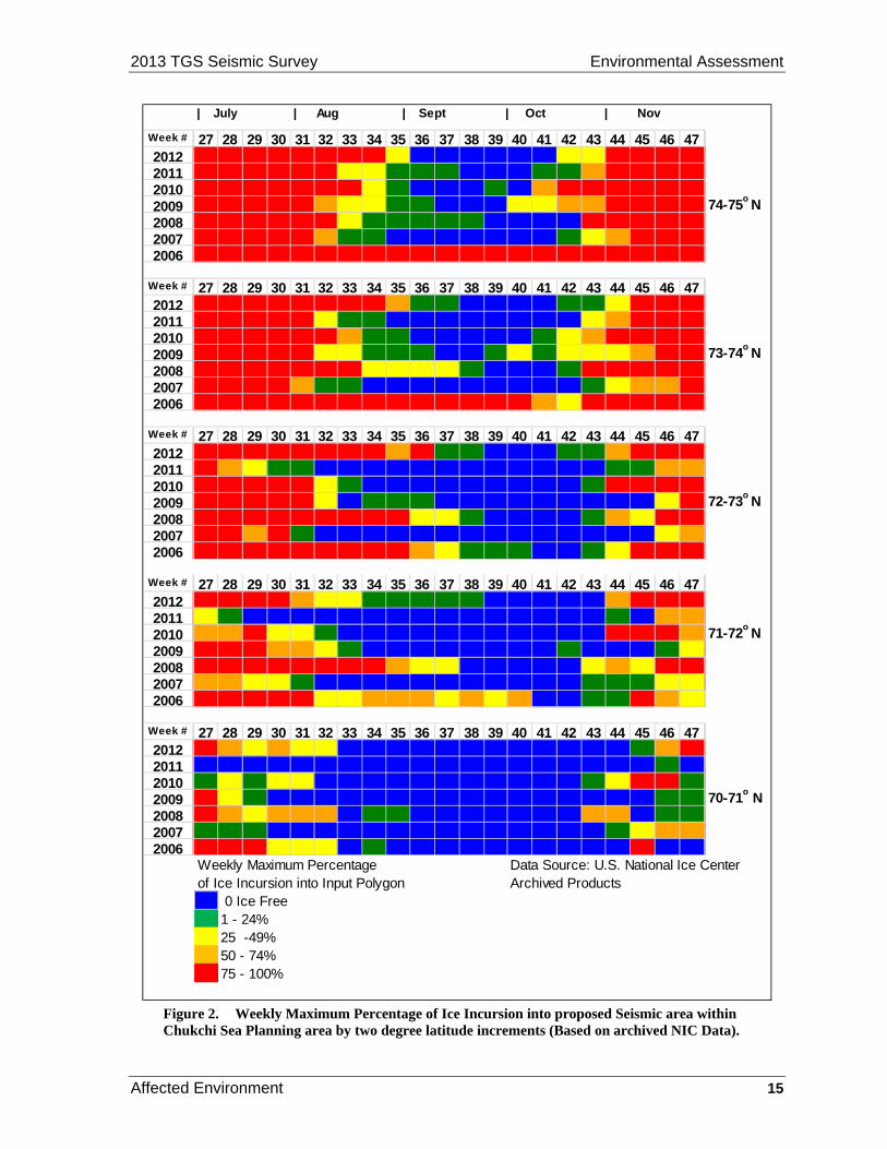
The concentration of Arctic sea ice reaches its northern minimum in mid to late September. The Arctic sea ice begins growing southward again with the onset of freezing temperatures. In the Chukchi Sea, the landfast ice begins forming in early October in the lagoons and late October to early November in the nearshore region (Mahoney et al., 2012, Leidersdof et al., 2012.). A weekly analysis of the National Ice Center (NIC) sea ice data, from 2006 through 2012, shows great variability year to year in sea ice coverage from July to October (Figure 2). Sea ice coverage in the project area generally increases from south to north.
The predominant ice stages within the survey area in October are thin first-year ice (30-70 cm (11.8-27.6 in)), new ice, and young ice (10-30 cm (3.9-11.8 in)) in patches and small floes; however, multiyear ice floes can be blown by wind into the Survey Areas at any time.
2013 TGS Seismic Survey Environmental Assessment
Affected Environment 15
28 29 33 36 37 38 40 41 42 44 45 46 47100 100 100 0 0 0 0 0 40 98 100 100 100
100 100 49 13 3 0 0 1 8 96 100 100 100
100 100 100 0 0 0 0 56 75 100 100 100 100
100 100 39 8 0 0 47 30 52 93 90 100 100 74-75o
N100 100 41 8 4 2 0 0 0 100 100 100 100
100 100 10 0 0 0 0 0 9 59 84 95 100
100 100 100 100 100 100 100 100 86 100 100 100 100
28 29 33 36 37 38 40 41 42 44 45 46 47100 100 100 19 2 0 0 0 14 47 100 100 100
100 94 10 0 0 0 0 0 0 68 83 100 100
100 100 68 0 0 0 0 10 35 99 99 96 91
100 100 28 4 0 0 29 20 28 49 51 78 100 73-74o
N100 100 77 42 35 21 0 0 3 100 98 100 100
100 99 2 0 0 0 0 0 0 37 55 64 95
100 100 100 100 97 80 85 58 28 100 100 100 100
28 29 33 36 37 38 40 41 42 44 45 46 47100 100 100 76 3 3 0 0 17 57 99 100 100
70 35 0 0 0 0 0 0 0 4 3 53 61
100 100 8 0 0 0 0 0 0 90 90 97 85
100 100 0 1 0 0 0 0 0 0 0 28 81 72-73o
N100 100 100 36 46 14 0 0 0 55 29 77 100
98 55 0 0 0 0 0 0 0 0 0 29 51
100 100 83 66 32 24 18 0 0 45 100 100 94
28 29 33 36 37 38 40 41 42 44 45 46 47100 95 44 15 10 6 0 0 0 56 84 99 100
9 0 0 0 0 0 0 0 0 13 0 52 52
70 76 0 0 0 0 0 0 0 96 100 100 63 71-72o
N100 84 11 0 0 0 0 0 7 0 0 18 43
100 96 78 42 39 0 0 0 0 65 38 81 94
56 27 0 0 0 0 0 0 0 4 24 43 48
100 100 45 61 44 58 55 0 0 9 100 66 25
28 29 33 36 37 38 40 41 42 44 45 46 4771 47 0 0 0 0 0 0 0 0 11 55 100
0 0 0 0 0 0 0 0 0 0 0 5 0
31 3 0 0 0 0 0 0 0 49 99 100 7
35 4 0 0 0 0 0 0 0 0 0 3 4 70-71o
N66 37 0 0 0 0 0 0 0 66 0 6 24
20 7 0 0 0 0 0 0 0 4 42 52 56
100 100 0 0 0 0 0 0 0 0 100 0 0
Weekly Maximum Percentage Data Source: U.S. National Ice Centerof Ice Incursion into Input Polygon Archived Products
0 0 Ice Free1 - 24%25 -49%50 - 74%75 - 100%
0 0100 47 41 35 1 02006
0 017 0 0 0 0 02007
0 59100 56 74 64 1 12008
0 093 0 0 0 0 02009
0 922 46 48 0 0 02010
0 00 0 0 0 0 02011
0100 69 26 25 0 0201231 32 34 35 39
043Week # 27 30
68 34 9
0 0 1
68 0 44
0 0 0
0 0 0
0 0 0
23 0 035 39 43
100 100 96 39 61
57 49 6 0 0
20062007
100 99 84 99 79
100 66 65 38 0
20082009
6 0
35 0 0 0 0
20102011
100 98 61 342012
52 33 31
1827 30 31 32 34Week #
17 20100 100 100 91 85 892006
0 099 94 7 0 0 02007
0 20100 100 100 100 88 762008
0 0100 99 86 49 1 22009
0 596 75 79 25 0 02010
0 085 7 3 0 0 02011
0 11100 100 100 95 80 67201231 32 34 35 39 43Week # 27 30
86 84100 100 100 100 100 1002006
0 15100 100 69 7 0 02007
0 99100 100 100 100 44 392008
4 32100 100 100 32 16 72009
0 71100 100 100 94 2 12010
0 36100 79 76 41 4 02011
0 21100 100 100 100 100 53201239 4327 30 31 32 34 35Week #
100 100100 100 100 100 100 1002006
0 35100 100 100 54 8 02007
0 100100 100 100 100 7 82008
0 61100 100 100 60 34 172009
1 99100 100 100 100 43 82010
66100 100 100 86 33 18
36100 100 100 100 100 3731 32 34 35
2011
020120
Week #
| July | Aug | Sept | Oct | Nov
39 4327 30
Figure 2. Weekly Maximum Percentage of Ice Incursion into proposed Seismic area within Chukchi Sea Planning area by two degree latitude increments (Based on archived NIC Data).

Environmental Assessment 2013 TGS Seismic Survey
16 Affected Environment
3.1.4. Sea State
East-northeast winds predominate in the Chukchi Sea in July-October with a frequency of 40-60% and the scalar mean wind speed ranges from 2 - 9 m/s (4.5-20 mph) (Brower et al., 1988; Weinzapfel et al., 2011; Stegall and Zhang, 2012). With the onset of ice cover in November, wave height diminishes and is generally < 1.5 m (5 ft) (Brower et al., 1988).
Stegall and Zhang (2012) noted increasing trends of areal averaged monthly mean and 95th percentile wind speeds for July through November. October had the strongest increase in the areal averaged wind speeds from 7 m/s (23 feet per second (fps)) in 1979 to 10.5 m/s (34.4 fps) in 2009. The frequency of extreme wind events shows an increasing trend with October, showing 8% more extreme wind events in 2009 compared to 1979 (Stegall and Zhang, 2012).
3.2. Resources
3.2.1. Air Quality
The existing condition of air quality in the vicinity of the Proposed Action is largely a function of the few emission sources existing on the coastline of the North Slope and meteorological conditions, mainly wind, over the open sea. The offshore waters of the Chukchi Sea typically experience steady winds averaging 13 miles per hour and have periods of stronger winds, which have a tendency to disperse and dilute air pollutants within the surrounding air. Stronger wind results in more turbulent air, which decreases pollutant concentrations and reduces the environmental impact (Ahrens, 2009). As such, wind conditions over the project area together with the relatively few pollutant sources either onshore or offshore causes the quality of the air over the affected area to be consistently better than required by Federal standards (ADEC, 2010).
3.2.2. Water Quality
Several important studies have contributed to the knowledge of water quality and seafloor sediment characteristics in the Chukchi Sea including: Dunton et al. (2012), Trefry, Trocine and Cooper (2012); Grebmeier and Cooper (2012); Weingartner and Danielson (2010); Neff et al. (2010); Feder et al. (1994); Naidu et al. (1997); Woodgate, Aagaard, and Weingartner (2005); and Chernyak et al. (1996). Information on water quality in the Chukchi Sea is presented in the following NEPA documents and is incorporated here by reference: Biological Evaluation in Support of the Chukchi Sea Oil and Gas Exploration NPDES General Permit (EPA, 2012); Sale 193 Final SEIS (USDOI, BOEMRE, 2011); Lease Sale 193 and Seismic Surveying EIS (USDOI, MMS, 2007).
Water quality is a term used here to describe the chemical, physical, and biological characteristics of water, usually in respect to its suitability for a particular purpose such as protection of fish, shellfish, and wildlife. Important water quality properties include temperature, salinity, density, dissolved oxygen, nutrients, organic carbon, chlorophyll, total suspended sediment, light transmissivity, trace metal concentrations, and hydrocarbon concentrations. All these properties are important in determining the distribution, movement and feeding grounds of marine biota. Because the water column interacts continuously with seafloor surface sediments (e.g. deposition and suspension of particulate matter), these two aspects of overall water quality are tightly linked.
Water quality in the Chukchi Sea naturally varies throughout the year related to seasonal biological activity and naturally occurring processes, such as formation of surface ice, seasonal plankton blooms, naturally occurring hydrocarbon seeps, seasonal changes in turbidity due to terrestrial runoff, and localized upwelling of cold water. The rivers and streams that flow directly into the northeast Chukchi Sea contribute freshwater to the marine system, affecting salinity, temperature and other aspects of water quality. River waters from the southern Chukchi coastline are carried north by the Alaska Coastal current and also influence the northern Chukchi nearshore environment.

2013 TGS Seismic Survey Environmental Assessment
Affected Environment 17
Weingartner and Danielson (2010) examined the variations in winds, sea ice and water property distributions from July to October in 2008 and 2009 in the northeastern Chukchi Sea. They found surface salinity ranges of 28.5 to 31.5 practical salinity units (psu) and surface temperature ranges of -1.0 to 5°C (30.2 to 41°F) within 10 m (32.8 ft) depth. Seasonal changes in water masses were documented over the two seasons of research cruises. They found that cold, salty winter water is replaced with warmer, fresher summer water and that surfacewater temperatures are warmer and fresher throughout the season when compared to bottom waters.
Regional industrial impacts on water quality have been and are relatively low at this time. Five exploration wells were drilled in the Chukchi Sea between 1989 and 1991. The Red Dog zinc mine, operating since 1989, discharges wastewater under permit that is received by the Wulik River which flows into the southern Chukchi Sea (between Kivilina and Point Hope) which moves northwards with the Alaska Coastal Current.
Currently, the water quality of the Chukchi Sea is within the criteria for the protection of marine life according to Clean Water Act, Section 403 and no waterbodies are identified as impaired (Clean Water Act, Section 303) within the Arctic Region by the State of Alaska. Anthropogenic (human-generated) pollution in the Chukchi Sea is primarily related to: aerosol transport and deposition of pollutants (AMAP, 1997, 2004); pollutant transport into the region by sea ice, biota and currents (Chernyak et al., 1996); discharges from international ship traffic (and consequent potential for marine invasive species); and effects from increasing carbon dioxide in the atmosphere. The potential for ocean acidification is currently a concern in the Chukchi Sea. As carbon dioxide increases in the atmosphere, the ocean absorbs more carbon dioxide, lowering the pH and bioavailability of calcium carbonate over time.
Vessel discharges are regulated under the EPA Vessel General Permit. The Vessel General Permit allows for certain waste streams to be discharged up to limitations set by the permit. Effluent guidelines have been established for the following types of “pollutants” (as defined in EPA regulations): aquatic nuisance species, nutrients, pathogens (including E. Coli & fecal coliform), oil and grease, metals, most conventional pollutants (Biochemical Oxygen Demand, pH, Total Suspended Solids), and other toxic and non-conventional pollutants with toxic effects (such as greywater, bilge water, sediment, coolant waters, etc.).
3.2.3. Lower Trophic Levels
The shallow continental shelf of the Chukchi Sea is among the largest in the world (Grebmeier et al., 2006). The Chukchi Sea has some of the highest primary productivity found in the Arctic regions due to advective processes which drive warm, nutrient-rich Pacific Ocean waters northward to meet the upwelling of deep Arctic Ocean abyssal depths in the Chukchi and Beaufort Seas (Codispoti et al., 2005). These waters are also strongly influenced by organic nutrients from freshwater discharges of numerous coastal rivers (Dunton, Weingartner, and Carmack, 2006). Biological processes produce a diverse invertebrate and planktonic fauna exhibiting typically short food web interactions with vertebrate predators (Gradinger, Bluhm, and Iken, 2010). Productivity in these OCS waters is reliant upon seasonal shifts in the deposition of organic carbon to the benthic environments through phytoplankton blooms in spring and fall and seasonal melting of sea-ice and subsequent release of ice algae and the numerous epontic organisms living on the ice (Gradinger, 2009).
Offshore benthic invertebrate communities can be quite abundant and diverse, often consisting primarily of cnidarians, echinoderms, molluscs, polychaetes, copepods, and amphipods (Darnis, Barber, and Fortier, 2008). Epontic (on ice) organisms are distributed widely in the Chukchi Sea, consisting primarily of amphipods, euphausiids, nematodes, and ice algae (USDOI, MMS, 2006; Gradinger, Bluhm, and Iken, 2010). Epontic organisms are strongly regulated by availability of light and nutrients, which are in turn dependent upon seasonality and thickness of ice flows and the advection of water masses and the nutrients they carry (Hopcroft et al., 2008).

Environmental Assessment 2013 TGS Seismic Survey
18 Affected Environment
Pelagic and ice algae planktonic species are important contributors to primary production in the proposed study area by both direct impact (consumption by filter feeding pelagic organisms such as the planktivorous bowhead whale) and indirect impact (release of organic material drifting to the benthos due to reduction of phytoplankton and zooplankton by microbial processes). Pelagic phytoplankton blooms, including concurrent zooplankton and meroplankton populations, tend to occur in early June and late July to August (Hopcroft, Questel, and Clarke-Hopcroft, 2010; Dunton, Schonberg, and McTigue, 2009). Bloom density and duration are dependent upon ice conditions, available light, and nutrients. Pelagic plankton blooms may vary considerably by season and interanually, possibly due to timing of nutrient flows from the Bering Sea (Kirchman et al., 2009). Ice algae potentially extend the season of primary production by 1-3 months past the summer pelagic bloom cycle, with its contribution of organic carbon to the ecosystem in the late summer and early winter dependent upon climatic and weather conditions (Wang, Cota, and Comiso, 2005).
3.2.4. Fish
Several important studies have contributed to the knowledge of the fish species that occur in the Chukchi Sea including: Norcross et al., 2010; Mecklenberg et al., 2007; Mecklenburg, Mecklenburg, and Thorsteinson, 2002; Barber et al., 1997; Frost and Lowry, 1983; Gillispie et al., 1997; Hopcroft et al., 2008; and Alverson and Wilimovsky, 1966. A more detailed discussion of fish in the Chukchi Sea is presented in the following documents and is incorporated here by reference: Lease Sale 193 FEIS (USDOI, MMS, 2007) and Sale 193 Final SEIS (USDOI, BOEMRE, 2011).
The Chukchi Sea and western Beaufort Sea support at least 98 fish species representing 23 families (Mecklenburg, Mecklenburg, and Thorsteinson, 2002).
Marine Fish in the Northern Chukchi Sea
The most common marine fishes (adult and juvenile) documented in various research cruises in the northern Chukchi Sea include: Arctic cod; saffron cod; Bering flounder; yellowfin sole; sculpin species; sand lance; capelin; eelpout species; snailfish; alligator fish; and prickleback species (Table 1).
The distribution of demersal marine fish in the northern Chukchi Sea was found to be a function of salinity, substrate type (sediment type and per cent gravel) and bottom water temperature (Norcross et al., 2010; Barber et al., 1997; Mecklenburg et al., 2007).
Some Chukchi Sea marine fish species associate with drifting or fast ice to feed, hide and spawn; these species are referred to as cryopelagic fishes. Most notable of the cryopelagic fish species in the northern Chukchi Sea is the Arctic cod which associates with ice in various life stages and seasons for shelter and as a forage habitat to feed on microorganisms on the underside of the ice. Under-ice amphipods are an important food source for arctic cod (Lonne and Gulliksen, 1989; Gradinger and Bluhm, 2004). Rough, irregular textures of the underside-ice may provide preferred habitat for arctic cod to avoid predators (Cross, 1982).
NOAA and UAF, in cooperation with BOEM, conducted surfacewater, midwater and benthic marine fish sampling in the northern Chukchi Sea in August and September, 2012 (Mueter et al., 2012; NOAA, AFSC, 2012). The most abundant fish species caught on these research cruises included Arctic cod, capelin, Pacific herring, yellowfin sole, chum salmon, Arctic staghorn sculpin, daubed shanny (prickleback), saffron cod and sand lance (Table 1). Lab analyses and report preparation are currently underway for these Chukchi Sea cruises.

2013 TGS Seismic Survey Environmental Assessment
Affected Environment 19
Table 1. Marine fish (common and taxonomic names) that commonly occur in the region of the project area.
Species Scientific Name
Arctic cod Boreogadus saida
Saffron cod Eleginus gracilis
Bering flounder Hippoglossoides robustus
Yellowfin sole Limanda aspera
Sculpin species Family Cottidae
Sailfin sculpin species Family Hemitripteridae
Pacific herring Clupea pallasii
Sand lance Ammodytes hexapterus
Pink salmon Chum salmon Oncorhynchus gorbuschaOncorhynchus keta
Capelin Mallotus villosus
Eelpout species Family Zoarcidae
Alaska plaice Pleuronectes quadrituberculatus
Starry flounder Platichthys stellatus
Snailfish Family Liparidae
Alligator fish Family Gasterosteidae
Prickleback species Family Stichaeidae
Anadromous Fish in the Northern Chukchi Sea
Anadromous fish that spend part of their life at sea and return to spawn in rivers and streams along the Arctic coast include five species of Pacific salmon (Oncorhynchus sp.) (Table 2). Of the five species, pink salmon (O. gorbuscha) and chum salmon (O. keta) occur most commonly in the northern Chukchi environment. Juvenile pink and chum salmon were captured in substantial numbers in offshore surveys that extended as far north as Point Lay during the autumn of 2007 (Moss et al., 2009). There are indications of small runs of chinook salmon in the Kugrua River, through Elson Lagoon (Fechhelm and Griffiths, 2001, citing George, pers. commun.), and strays have been captured in the Kuk River, near Wainwright (Craig and Halderson , 1986).
Other anadromous fish in the northern Chukchi Sea include rainbow smelt; Dolly Varden-sea-run and arctic lamprey which spend some of their life in the marine environment and return to freshwater to spawn (Table 2). Several fish species such as capelin, sand lance, saffron cod and some sculpin species are not considered anadromous or coastwise migratory fish but they regularly move from offshore to nearshore for spawning and rearing in nearshore habitats.
Table 2. Anadromous fish occurring in offshore marine environment in the northern Chukchi Sea in the region of Proposed Action.
Species Species Latin Name
Pink salmon Oncorhynchus gorbuscha
Chum salmon Oncorhynchus keta
Coho salmon Oncorhynchus kitsutch
Chinook salmon Oncorhynchus tshawytscha
Rainbow smelt Osmerus mordax
Dolly Varden (sea-run) Salvelinus malma
Arctic lamprey Lamptera camschatica
3.2.5. Marine and Coastal Birds
Most marine birds that occur in the Chukchi Sea are there during the open-water season. Arrival times usually coincide with the formation of leads during spring migration to coastal breeding areas. Spring migration for most species takes place between late March and late May.

Environmental Assessment 2013 TGS Seismic Survey
20 Affected Environment
Some birds that breed on the North Slope migrate to or through the project area (Figure 1) twice each year. Some marine and coastal birds may breed outside of the project area, but spend time in the Chukchi Sea after breeding or during their non-breeding seasons. Departure times from the Chukchi Sea for the fall and winter vary between species and often by sex within the same species, but most marine and coastal birds will have moved out of the Chukchi before the formation of sea ice.
Full descriptions of the most important marine and coastal bird species in the Chukchi Sea were provided in the Lease Sale 193 and Seismic Surveying EIS (USDOI, MMS, 2007), and the Sale 193 Final SEIS (USDOI, BOEMRE, 2011). These descriptions are summarized and updated with site-specific information below. Recent information, especially from the Klondike and Burger prospects (over 50 miles offshore in the Chukchi Sea), is consistent with previous descriptions, and existing information is sufficient to fully evaluate the potential effects of the two alternatives.
Descriptions of Species or Species Groups
Marine and coastal birds potentially affected by this action can be grouped according to certain aspects of their life-history or status: ESA-listed birds, loons and waterfowl, and seabirds (Table 3).
The timing and specific location of the Proposed Action influence which birds could be affected.
Table 3. Birds listed as threatened or candidate (four species) or abundant in the project area (five species) have the greatest potential for adverse effects and are described further. These nine species were carried forward to the Environmental Consequences Section 4.2.5.
Species Threatened or candidate species
Abundant in offshore action area
Carried forward under effects analysis
ESA-Listed Species
Spectacled Eider Yes Yes
Steller’s Eider Yes Yes
Kittlitz’s Murrelet Yes Yes
Yellow-billed Loon Yes Yes
Loons and Waterfowl
Long-tailed Duck Yes Yes
Common Eider Yes Yes
King Eider Yes Yes
Seabirds
Northern Fulmar Yes Yes
Short-tailed Shearwater Yes Yes
Note: An empty cell indicates Not Applicable.
ESA-listed and Candidate Birds
The distribution, abundance, and legal status of birds designated as threatened or listed as candidate species under the ESA are most recently described in USFWS (2012). These include the Steller’s eider (Polysticta stelleri; threatened), the spectacled eider (Somateria fisheri; threatened), the Kittlitz’s murrelet (Brachyramphus brevirostris; candidate species), and the yellow-billed loon (Gavia adamsii; candidate species) and are often collectively referred to as ESA-listed birds. Because of their special status under ESA, the potential effects to all four species are analyzed in the Environmental Consequences section (Section 4.2.5).
Spectacled Eider. The North Slope spectacled eider population seems to be stable, at least since the initiation of aerial surveys of the Arctic Coastal Plain (ACP) in 1992 (Larned, Stehn, and Platte, 2009). Spectacled eiders breed in low densities across the Alaskan ACP east to about the Shaviovik River. Males leave the breeding grounds along the ACP for the ocean around mid – to – late June at the onset of incubation by female eiders. Males are followed by females whose nests fail, and finally by successful breeding females and young birds in August and September. Spectacled eiders migrate

2013 TGS Seismic Survey Environmental Assessment
Affected Environment 21
west along the Alaska coast as far as 40 km (6.2 mi) offshore. Most spectacled eiders molt in the Ledyard Bay Critical Habitat Unit and will have migrated from the Beaufort Sea by mid-October. Spectacled eiders occur less frequently offshore in the Chukchi Sea; however, a small number of adult males and hatch-year birds may migrate to molting areas in Russia, likely taking a western route from Barrow (Sexson, 2013; Gall and Day, 2012).
Steller’s Eider. A small number of Steller’s eiders breed on the Alaskan ACP, most conspicuously near Barrow. Steller’s eiders are rare as the breeding season progresses due to molt migration, failed breeding, etc. As with the more common spectacled eider, these birds move to nearshore coastal waters after their breeding season. Few, if any, Steller’s eiders would concentrate in southern areas of the Chukchi Sea during or after the open-water season, but low numbers would be passing through the area starting as early as May and as late as November.
Yellow-billed Loon. The yellow-billed loon is relatively rare in the U.S. Arctic region (North, 1994). Dau and Bollinger (2009) reported an average of fewer than 50 yellow-billed loons during late-June surveys of the coast and barrier islands between Omalik Lagoon (Chukchi Sea) and the Canadian Border (2005-2009). Of the approximately 3,300 yellow-billed loons present on the breeding grounds on the North Slope, primarily between the Meade and Colville rivers in the National Petroleum Reserve-Alaska (NPR-A), it is likely that there are fewer than 1,000 nesting pairs because some of the 3,300 are nonbreeders. Additionally, there are approximately 1,500 yellow-billed loons (presumably juvenile nonbreeders) that remain in nearshore marine waters or in large rivers during the breeding season. In total, there are fewer than 5,000 yellow-billed loons on the Arctic coast breeding grounds and near shore marine habitat (Earnst et al., 2005). There may be approximately 1,500 yellow-billed loons, presumably non-breeding adults and immatures, in near shore marine waters or in large rivers during the breeding season.
Yellow-billed loons typically nest on low islands or narrow peninsulas on the edges of large, deep, tundra lakes. Breeding yellow-billed loons typically remain on their lakes until young are fledged.
Most yellow-billed loons from the ACP have moved into nearshore coastal waters by September. In addition, approximately 8,000 yellow-billed loons from the Canadian Arctic travel across the Chukchi Sea during spring and fall migration between Canada and wintering grounds in eastern Asia (Schmutz et al., 2010). Most loons stay very close to shore during fall migration until they reach the Lisburne Peninsula, where they head farther out to sea towards the Bering Strait (Rizzolo and Schmutz, 2010).
Yellow-billed loons were observed at the Burger Prospect during seabird surveys in 2008 and 2009 (Gall and Day, 2012). Most sightings of yellow-billed loons represented low numbers of birds during the survey period; however, 24 were observed during the early fall period in 2009. Eight yellow-billed loons were reported by Gall and Day (2012) near Hanna Shoal in 2011, about 100 miles from the coastal mainland. No yellow-billed loons were observed during seabird surveys in the Chukchi Sea in late August and early September 2011 (Kuletz, 2011) or in 2012 (Labunski and Kuletz, 2012; Reedy and Kuletz, 2012). Low numbers, patchy distributions, and specific habitat requirements may make yellow-billed loons more susceptible to environmental perturbations such as disturbance, habitat alterations, and oil spills than species that are more abundant, widely distributed, and able to exploit a greater diversity of habitats. Yellow-billed loon numbers are considered to be declining (74 FR 12932, March 25, 2009).
Kittlitz’s Murrelet. This species may nest as far north as Cape Beaufort. Breeding along the ACP is unlikely due to lack of suitable habitat. Kittlitz’s murrelets have been observed on an infrequent basis in the Chukchi Sea as far north and east as Point Barrow, but there appears to be a great deal of annual variation in their occurrence. Small numbers of Kittlitz’s murrelets were recorded during late fall seabird surveys in the Klondike and Burger Prospect areas in 2009 and 2010, but none were observed in 2008 (Gall and Day, 2012). Murrelet foraging areas occur in the Chukchi Sea (Day et al., 2011). Murrelet foraging areas may occur offshore near Barrow. Recent telemetry studies have
Environmental Assessment 2013 TGS Seismic Survey
22 Affected Environment
documented that many Kittlitz’s in the Arctic are from other regions of Alaska, most notably the Gulf of Alaska and Aleutian Islands (Madison et al., 2011). Kittlitz’s murrelet numbers in these regions are declining (Day et al., 2011)
Other Birds
Loons and Waterfowl. The Pacific loon (Gavia pacifica), red-throated loon (G. stellata), Pacific brant (Branta bernicla nigricans), lesser snow goose (Chen caerulescens caerulescens), greater white-fronted goose (Anser albifrons frontalis), and tundra swan (Cygnus columbianus) occur in nearshore coastal waters of the Chukchi Sea (USDOI, MMS, 2007; USDOI, BOEMRE, 2011). Waterfowl species that are more abundant and occur in more offshore areas of the Chukchi Sea include the long-tailed duck (Clangula hyemalis), the common eider (Somateria mollissima), and the king eider (Somateria spectabilis) and are described below.
Long-Tailed Duck. The long-tailed duck population has decreased considerably since 1989, but it remains a common species in the Chukchi Sea during the open-water period (Mallek, Platte, and Stehn, 2007).
In late June and early July, most male and nonbreeding female long-tailed ducks migrate to coastal molting areas where they are flightless for a 3- to 4-week period. Breeding females molt on freshwater lakes during the last phases of duckling development before departing the North Slope in fall. The molt is an energetically costly time, and long-tailed ducks have abundant food resources in the shallow water lagoons (Flint et al., 2003). Many long-tailed ducks molt in Kasegaluk Lagoon and Peard Bay on the Chukchi Sea coast. Molting long-tailed ducks tend to stay in or near the lagoons, feeding heavily in passes between barrier islands and the open ocean (Johnson, Frost, and Lowry, 1992; Johnson, Wiggins, and Wainwright, 1992; Kinney, 1985).
The long-tailed duck is a common species in the Chukchi Sea after the first week of September until late October. While most long-tailed ducks migrate within 45 km (28 mi) of shore, infrequent observations of long-tailed ducks in pelagic waters occur in late September (Divoky, 1987). Aerial surveys along coastal habitats of the entire ACP typically observe fewer than 7,500 long-tailed ducks, with about two-thirds of these associated with mainland habitats (Dau and Bollinger, 2009). Fewer than 70 long-tailed ducks were observed during any survey period at the Burger Prospect during seabird surveys (2008-2010) and most survey periods observed no long-tailed ducks (Gall and Day, 2012).
Common Eider. Common eiders nest on barrier islands or spits along the coast, more along the Beaufort Sea than the Chukchi Sea. In 2007, total birds and indicated breeding pairs surveyed along the Beaufort Sea coast were down 37.6% and 44.0%, respectively, from 2006 counts of 3,102 birds and 1,207 pairs. Total birds and indicated breeding pairs in 2007 were down 30.0 and 27.8%, respectively, from the 1999-2006 averages of 2,766±885 (1 standard deviation, range 1,353- 4,449) birds and 937±264 (1 standard deviation, range 572-1,340) pairs (Dau and Larned, 2007). Common eider numbers appear to be declining in the region.
Beginning in late June, postbreeding male common eiders begin arriving in molting areas in the Chukchi Sea; by late August, most common eiders in the Chukchi Sea are molting males. When traveling along the northwest coast of Alaska, these eiders tend to stay along the 20-m isobath, approximately 48 km (29 mi) from shore. Most breeding female common eiders and hatch-year birds begin to migrate to molt locations in late August and September. Common molt areas in the Chukchi Sea are near Point Lay, Icy Cape, and Cape Lisburne. Kasegaluk Lagoon and Peard Bay also are important locations for molting and during migration. After the molt is completed, some common eiders move offshore into pelagic waters, but most eiders remain close to shore. Less than 10 common eiders were observed at the Burger, Klondike, or Statoil prospects during seabird surveys in

2013 TGS Seismic Survey Environmental Assessment
Affected Environment 23
2008, 2009, and 2010 (Gall and Day, 2012). A small number of common eiders were reported by Gall and Day (2012) in the Hanna Shoal survey area in 2011.
King Eider. Most king eiders migrate through the Chukchi Sea by the middle of May, dependent upon the location and timing of offshore leads (Barry, 1986). Most king eiders nesting on the North Slope between Icy Cape and the western boundary of ANWR nested in three general areas: between the Colville River and Prudhoe Bay, southeast of Teshekpuk Lake and a large area near Atqasuk (Larned, Stehn, and Platte, 2006). Dau and Larned (2005, 2006, 2007, 2008) surveyed the Chukchi Sea and Beaufort Sea coastlines and found 810, 3048, 1621, and 2227 king eiders in 2005, 2006, 2007, and 2008, respectively.
Many post-breeding male king eiders move to staging areas along the Chukchi Sea in mid-to-late July. Ledyard Bay and Peard Bay appear to be particularly important to molting and migrating king eiders (Oppel, Dickson, and Powell, 2009). Hundreds of thousands of king eiders move through the Chukchi Sea during their migration from breeding grounds in eastern Canada. No more than two king eiders were observed during any seabird survey period in 2008 or 2010 at the Klondike and Burger prospects and no king eiders were observed in 2009 (Gall and Day, 2012). Eight king eiders were reported by Gall and Day (2012) near Hanna Shoal in 2011, about 100 miles from the coastal mainland.
The king eider population in the region appeared to remain stable between 1953 and 1976 but declined by 56% between 1976 and 1996 (Suydam et al., 2000).
Seabirds
The common murre (Uria aalge), thick-billed murre (U. lomvia), tufted puffin (Fratercula cirrhata), horned puffin (F. corniculata), black-legged kittiwake (Rissa tridactyla), black guillemot (Cepphus grylle), Ross’ gull (Rhodostethia rosea), ivory gull (Pagophila eburnea), Arctic tern (Sterna paradisaea), pomarine jaeger (S. pomarinus), parasitic jaeger (S. parasiticus), long-tailed jaeger (S. longicaudus), and glaucous gull (Larus hyperboreus) occur in the Chukchi Sea (USDOI MMS (2007); USDOI, BOEMRE (2011b). Seabird species that are more abundant and occur in offshore areas include the northern fulmar (Fulmarus glacialis) and the short-tailed shearwater (Puffinus tenuirostris) and are described below.
Northern Fulmar. Fulmars do not breed in the Arctic region, and those observed during the summer are nonbreeders or failed breeders from southern areas. Fulmars are most numerous from late August to mid-September. Divoky (1987) estimated 45,000 northern fulmars in pelagic waters of the southern Chukchi Sea during late August to mid-September. Flocks totaling in the low hundreds were observed during the late summer and early fall around the Klondike and Burger prospects during seabird surveys in 2008, 2009, and 2010 (Gall and Day, 2012).
Short-Tailed Shearwater. Shearwaters do not breed in the Arctic region. These birds breed in the Southern Hemisphere. At northern latitudes, short-tailed shearwaters likely forage at highly productive patches of euphausiids and amphipods. Divoky (1987) reported short-tailed shearwaters north of Barrow and into Arctic Canada, depending on the presence of sea ice. In certain years, an estimated 100,000 short-tailed shearwaters passed Point Barrow in one day in mid-September (Divoky, 1987).
Gall and Day (2012) suggested that the shearwaters can rapidly respond to changes in oceanic conditions and exploit food resources when and where they are available. Kuletz (2011) reported over 4,000 shearwaters during a seabird survey in the Chukchi Sea in late August – early September 2011 (the most abundant species reported), with many flocks numbering between 150-300 birds. These observations were consistent with those of Bankert (2012). Similarly, flocks totaling in the low hundreds were observed during the early fall around the Klondike, Burger, and Statoil prospects during seabird surveys in 2008-2011 (Gall and Day, 2012); however, during the early fall period in

Environmental Assessment 2013 TGS Seismic Survey
24 Affected Environment
2009, almost 12,000 short-tailed shearwaters were observed near the Klondike Prospect. Over 1,800 short-tailed shearwaters were reported by Gall and Day (2012) near Hanna Shoal in 2011, about 100 miles from the coastal mainland.
3.2.6. Marine Mammals
Eight cetacean species (bowhead whale, fin whale, humpback whale, gray whale, minke whale, beluga whale, killer whale, and harbor porpoise) could occur in the Chukchi Sea during the open-water period. Five pinniped species (Pacific walruses and four species of ice seals: ringed, bearded, spotted, and ribbon seals) could be encountered in the Chukchi Sea. Polar bears may be encountered offshore. For more detailed life history, stock, population size, and other information for these species, see the Lease Sale 193 EIS (USDOI, MMS, 2007). Most species will occur in low densities and encounters would be most common within 100 km of shore where waters are less than 200 m deep or along the shelf break.
Very low numbers of ribbon seals, harbor porpoises, fin whales, humpback whales, minke whales, and killer whales have been observed in the Chukchi Sea, but these six species will not be discussed further in this analysis because an encounter with them is not reasonably foreseeable.
Bowhead whales, gray whales, beluga whales, walruses, bearded seals, ringed seals, spotted seals, and polar bears are more abundant species in the Chukchi Sea, and are likely to be encountered during the Proposed Action. These eight species are described below and are carried forward in the analysis (Section 4.3.6).
Bowhead Whale. Bowhead whales in the project area are listed as endangered under the ESA. The Western Arctic bowhead whale stock visits the Chukchi Sea seasonally during the open water season. They are estimated to number around 10,314 individuals, with an estimated 3.2% annual rate of increase (Allen and Angliss, 2013). Most bowheads reside in the eastern Beaufort Sea throughout the summer (Moore, Clarke, and Ljungblad, 1989; Moore and Reeves, 1993; Moore et al., 2000; Moore et al., 2002), though recent tagging information suggests some bowhead whales remain in the Chukchi Sea later in the fall than previously believed, and overwinter in the Chukchi Sea (Quakenbush et al., 2010). In autumn, bowheads leave the Beaufort Sea, traveling across the Chukchi Sea to Chukotka Peninsula waters and Bering Sea wintering areas from mid-September through November (Moore et al., 1995). The Proposed Action is positioned across the fall migration route of bowheads leaving the Beaufort Sea.
Gray Whale. An estimated 18,000 gray whales comprise the Eastern Pacific Stock. They feed on benthic and pelagic invertebrates and small fishes, and are most common in coastal and shoal waters with little sea ice, particularly in larger bays and near Barrow Canyon (Allen and Angliss, 2012). Gray whales are seasonal migrants to the Bering and Chukchi Seas, arriving in late spring after bowheads have passed through and most of the ice has receded.
Beluga Whale. The Beaufort Sea (BSS) and the Eastern Chukchi Sea (ECS) stocks of beluga whales occur in the northeastern Chukchi Sea. These stocks total over 36,000 individuals and population trends are unknown or presumed declining (Allen and Angliss, 2012). Both stocks overwinter in the Bering Sea and summer in the Beaufort Sea and Chukchi Sea, using spring lead systems to migrate around western and northern Alaska in April and May (Richard, Martin, and Orr, 2001; Allen and Angliss, 2012). Moore (2000) and Moore, DeMaster, and Dayton (2000) suggested belugas select deeper water near the continental shelf break to feed on fish, independent of ice cover. Consequently, they would be likely to be encountered in the northern portions of the project area.
Bearded Seal. Bearded seals in the Chukchi Sea are considered to be part of the Beringian Distinct Population Segment (BDPS) of the circumpolar bearded seal population (Allen and Angliss, 2012). The BDPS was listed as threatened under the ESA in 2012 because of the anticipated effects of climate change on their habitat (77 FR 31068, December 28, 2012). Allen and Angliss (2012) offered

2013 TGS Seismic Survey Environmental Assessment
Affected Environment 25
a rough population estimate of 155,000 for the BDPS of bearded seals based on the analyses in Cameron et al. (2010) and recommended a theoretical maximum annual net productivity rate of 12% for this population. Most BDPS bearded seals summer in the Chukchi Sea, feeding mostly on benthic invertebrates and some fishes (Burns, 1970; Stirling, Kingsley and Calvert, 1982; Stirling, 1997). Physiological limitations on their foraging depth restrict bearded seals to continental shelf waters no deeper than 200 meters. They are commonly observed in the Chukchi Sea during the open water season.
Ringed Seal. The ringed seal was listed as threatened under the ESA in 2012 because of the anticipated effects of climate change on its habitat (77 FR 31066, December 28, 2012). The Arctic subspecies of ringed seal is the most abundant seal species in the Chukchi. Conservative population estimates exceed 1,000,000 with an estimated annual maximum theoretical net productivity rate of 12%. They are the most common marine mammal during the open water season. Arctic ringed seals are dispersed in the open-water season, foraging on fishes and pelagic invertebrates (Kelly et al., 2010; Allen and Angliss, 2013).
Spotted Seal. The Alaskan stock of spotted seals inhabits the Bering Sea and Chukchi Sea. Recent population estimates exceed 141,000 individuals in the eastern and central Bering Sea during winter, and NMFS assumes the population’s theoretical net productivity rate is about 12% (Allen and Angliss, 2012). Spotted seals are more abundant in the southern Chukchi Sea than the northern Chukchi Sea, with large numbers hauling out in coastal protected areas such as Kasegaluk Lagoon and Peard Bay. Spotted seals periodically rest on sea ice or at coastal haulouts when not foraging on a variety of pelagic fish and invertebrate species.
Pacific Walrus. The Pacific walrus was designated a candidate species under the ESA in 2011 (76 FR 7634, February 10, 2011). The USFWS determined that although listing the species as threatened or endangered was warranted, the listing was precluded by other higher priority actions. Pacific walruses are typically associated with the moving pack ice year-round. Pacific walruses are usually found in waters of 100 m or less, possibly because of higher productivity of benthic invertebrates in the shallower water (Fay, 1982). They winter in the Bering Sea and the majority of the population is found during the summer and early fall throughout the Chukchi Sea. Pacific walrus are uncommon in the Chukchi Sea during late fall and winter. Recent reports indicate that climate change can cause walrus to move to terrestrial haulouts in the Chukchi Sea in summer when the sea ice retreats northward. This increases the likelihood of injury and death during stampedes at crowded haulouts, particularly for calves (Fischbach et al., 2009).
Polar Bear. The polar bear was listed as threatened throughout their range under the ESA (73 FR 28212, May 15, 2008). Polar bears occur on the pack and shorefast ice, along the coast, and on barrier islands. There are two polar bear stocks recognized in Alaska: the southern Beaufort Sea stock (SBS) and the Chukchi/Bering Seas stock (CBS), though there is considerable overlap between the two in the project area. Polar bear habitat use and distribution may reflect more than prey availability; it also may reflect time allocated for hunting prey and the use of retreat habitats (Durner et al., 2004). Modeling of polar bear ice habitat selection show that shallow-water areas where different ice types intersect are preferred (Durner et al., 2004; Durner et al., 2009).
The USFWS established critical habitat for the polar bear on December 7, 2010 (74 FR 76058). On January 11, 2013, the U.S. District Court in Alaska issued an order setting aside the USFWS Critical Habitat designation for polar bears as the result of a lawsuit filed by the State of Alaska, the Alaska oil and Gas Association and the Arctic North Slope Regional Corporation (Case 3:11-cv-00025-RRB).
Environmental Assessment 2013 TGS Seismic Survey
26 Affected Environment
3.2.7. Subsistence, Environmental Justice, Public Health, Economy, and Archaeological Resources
Subsistence activities are a critical element of North Slope Borough (NSB) social systems. Communities dependent on subsistence consider it a collective and cultural right (and duty) rather than an individual right since a limited number of individuals usually provide for the larger community (Ristroph, 2010). Subsequent sections of this EA address specific components of socio-cultural and socio-economic resources of communities closest to the Proposed Action: Wainwright and Point Lay. Other communities in the NSB with relatively close proximity to the Proposed Action include Barrow to the northeast and Point Hope to the southwest. Potential impacts of this Proposed Action on subsistence, environmental justice, public health and the economy will be addressed in subsequent sections.
3.2.7.1. Subsistence Activities
Subsistence activities are of high cultural value to Iñupiat of the North Slope. Subsistence activities provide a sense of identity and are an important food security and economic pursuit. Subsistence is viewed by Alaska Natives not just as an activity that is embedded in the culture; it is viewed as the very culture itself (Wheeler and Thornton, 2005). Because subsistence plays such an important role in Alaska Native culture and society, a reduction (or even a perceived reduction) in the availability of subsistence foods impact food security and contributes to social pathology (Wernham, 2007). Wainwright and Point Lay are coastal communities situated approximately 55 to 60 miles from the Proposed Action. Barrow and Point Hope are situated approximately 100 to 125 miles (+/-) from the Proposed Action. Iñupiat marine subsistence harvest activities have been identified to occur approximately 20 miles offshore in these communities (WTC, 2008: Map 1). Iñupiat whaling traditions are unquestionably important and harvest of other resources including other marine animals, fish, birds, and land based animals are important to local communities by providing dietary variety and nutrition, as well as providing long-term, sustainable nutritional needs when few or no bowhead whales are taken.
Subsistence Communities
The Proposed Action is located 50 miles from the coast and 55 miles from the nearest community.
Wainwright. The Village of Wainwright, located on the Chukchi Sea approximately 72 miles southwest of Barrow, lies along a wave-eroded coastal bluff on the west side of a narrow peninsula which separates Wainwright Inlet from the Chukchi Sea. Wainwright residents rely on a variety of both marine and terrestrial subsistence resources throughout the year. Subsistence-harvest areas are depicted in detail in the Wainwright Traditional Council’s Conservation Plan Map Book 2008 (WTC, 2008). Marine and land based animals such as bowhead whale, seals, walrus, salmon and other fish, along with land based animals comprise a significant portion of Wainwright residents’ subsistence diet (WTC, 2008). A survey found that over 90% of Wainwright households depend on subsistence foods to some extent and nearly one-third of households depend on subsistence foods for more than half of their annual nutrition (NSB, 2004).
Point Lay. The Village of Point Lay is located on the Chukchi Sea coast 150 miles southwest of Barrow. Point Lay is protected from the open ocean by the Kasugaluk Lagoon, an area where traditional hunting of beluga whales occurs each year in July. Point Lay also utilizes migratory animals for subsistence resources. Residents harvest whales, seal and fish along with land based animals. Approximately 77% of the households in Point Lay participate in the local subsistence economy and of those households, 75% are heavily reliant on subsistence resources, where one-half or more of household diets consisted of local resources (Shepro, Maas et al., 2003).
2013 TGS Seismic Survey Environmental Assessment
Affected Environment 27
Barrow. Barrow is the economic, transportation and administrative center for the North Slope Borough. Located on the Chukchi Sea coast 300 miles (480 km) north of the Arctic Circle, Barrow is the northernmost community in the United States. Barrow residents, like those in Wainwright and Point Lay, rely on marine animals, fish, birds, and land based animals for subsistence. During some harvest years, marine mammal harvests accounted for up to 73% of the total subsistence harvest in Barrow (SRB&A, 2010).
Point Hope. Point Hope, located near the end of a triangular spit jutting 15 miles into the Chukchi Sea, lies 250 miles southwest of Barrow. Point Hope uses the Chukchi Sea for purposes of subsistence hunting and harvesting. Subsistence activities throughout the year revolve around whales, other marine animals, fish and land based animals. Approximately 93% of households in Point Hope participate in the local subsistence economy (Shepro, Maas et al., 2003). Approximately two-thirds of Point Hope residents obtain half or more of their diet from local subsistence resources (Shepro, Maas et al., 2003).
Subsistence Resources
The following discussion regarding subsistence resources will combine the four villages and their use of each resource.
Whales (Bowhead and Beluga). Bowhead (Aåviq) and beluga (Qiøalugaq) whales are a subsistence resource of paramount importance. Consequently, descriptions of the social organization pertaining to whaling crews, the hunt, quantity, and distribution of whales dominate subsistence discourse in NSB Iñupiat Eskimo communities. Whaling as a subsistence activity underscores cultural and economic life of Arctic Villages with harvest occurring primarily during spring and summer months in all four communities (AEWC, 2012). Wainwright and Barrow harvest April through May (Bowhead) and June through August (Beluga) with Point Lay and Point Hope harvesting April through June (Bowhead) and mid-June through mid-July (Beluga). Wainwright conducts a fall hunt for Bowhead whales in October. Harvest locations are approximately10 to 15 miles (16 km to 24 km) off shore into the Chukchi Sea. Locations of harvest also include coastal lagoons for Wainwright and Barrow, Point Lay hunters harvest as far offshore as 20 miles (32km), and Point Hope harvest in open waters near shorelines (Bacon, 2009). Migration and characteristics of bowhead and beluga whales are discussed in Section 3.2.6. Whaling traditions, unquestionably important, do not minimize harvest of other resources including other marine mammals, fish, birds, and land based mammals important for Iñupiat diet and nutrition if few or no bowhead whales are taken (Applied Sociocultural Research, 2010.
Seal (Ringed, Spotted, and Bearded). In late spring during break up, ring seal (natchiq) may disappear in late spring and are replaced by spotted seal (qasigiaq). Spotted seal and bearded seal (Ugruk) are most prevalent during the summer (Ivie and Schneider, 1988). Spotted seal gather on shallow spits and bays west of Wainwright and hunters consider late summer and fall to take seals when they are fat and will float after being harvested. Most Wainwright seal harvests are taken in Kuk Lagoon but may travel offshore as far 40 miles (64km). Bearded seals are taken along the coast but are often hunted west of Wainwright during July through August (SRB&A, 2012). Point Lay residents primarily hunt ringed and spotted seals. Ringed seal, available throughout most of the year, is difficult to locate in ice-free months when pack ice is farther offshore (July and August). The peak of ring seal harvest occurs from April through June. Ring seal is sometimes taken incidentally to walrus and bearded seal harvests in June and July around Point Lay. In Point Lay, the majority of bearded seals are harvested in June and sometimes as late as August if hunters follow ice north. Bearded seal hunting usually takes place 5 to 6 miles (8-10km) offshore, but hunters may go farther out as they look for walrus. In Barrow, seals are the second most commonly harvest mammal after bowhead whales (SRB&A, 2012). Seal hunting for Barrow residents occurs both close to shore during winter and spring and in the open ocean during the months of June through August. Hunters

Environmental Assessment 2013 TGS Seismic Survey
28 Affected Environment
travel from 30 to 60 miles (48-96 km) to take seals with distances varying year to year due to changing conditions and weather. Bearded seals are harvested June through August. Point Hope, after whaling season, turns their attention to hunting seal hunting. In June and July seal may be found on ice flows directly in front of the coastal village of Point Hope. Traditionally, residents of Point Hope have regarded the southern portion of the Chukchi Sea as an area of particular abundance when subsistence harvesting (Ivie and Schneider, 1988).
Walrus. Walrus (Aiviq) hunting occurs in the Chukchi Sea for Wainwright residents south to Point Lay June through August and taken along the coast near the village. Point Lay hunters also harvest walrus June through August. Walrus are harvested between Cape Beaufort and Icy Cape with hunters traveling offshore approximately 25 miles (40 km). In Barrow, walrus harvest occurs during July and August and coincides with the bearded seal hunt (SRB&A, 2010). Hunters in Barrow commonly travel no farther than 40 or 50 miles (64-80 km) offshore to subsistence use areas (SRB&A, 2012). Point Hope harvests May through July up to 20 miles (32 km) offshore between Cape Thompson and Cape Lisburne.
Fish (Salmon, Tomcod, Lingcod, Trout, Grayling, Smelt). Fishing is an important subsistence resource and an economic resource to these communities. Many of these fish are harvested in rivers but many are also harvested in coastal waters and in open waters. Fish such as salmon, tom cod, lingcod, trout Arctic grayling and smelt are just a few of the species making up the majority if fish harvested by these four communities.
3.2.7.2. Environmental Justice
Executive Order 12898 (EO), “Federal Actions to Address Environmental Justice in Minority Populations and Low-Income Populations,” requires each Federal agency to consider environmental justice to be part of its mission and to evaluate whether Proposed Actions would have “disproportionately high adverse human health and environmental effects on minority populations and low income populations.” The intent of the EO is to promote fair treatment of people of all races, so no person or group of people bears a disproportionate share of the negative effects from the country’s domestic and foreign programs. Specific to the NEPA process, the EO requires that proposed projects be evaluated for environmental justice issues. According to the 2010 Census, 90.1% of the population (556 residents) of Wainwright, 88.4% (189 residents) of Point Lay, 61.2% (4,212 residents) of Barrow, and 89.5% (674 residents) of Point Hope are Alaska Native (specifically Iñupiat) or American Indian, an identified minority group, thus meeting the 50% population threshold for an affected area.
For centuries, survival in the Arctic has centered on the pursuit of subsistence foods and materials and the knowledge needed to harvest these resources. Development of Iñupiat culture depends on passing on traditional knowledge and beliefs about subsistence resources. This knowledge includes observations of game behavior, how to use those observations to successfully locate and harvest game, and how hunters and their families should behave to ensure successful harvests in the future. (Spencer, 1976). For Iñupiat, subsistence and culture continue to be inextricably intertwined. Although there have been substantial social, economic, and technological changes in Iñupiat way of life, subsistence continues to be the central organizing value of Iñupiat sociocultural systems. Iñupiat remain socially, economically, and ideologically loyal to their subsistence heritage. Large amounts of subsistence foods are shared within and between the communities and the people one gives to and receives from are major components of what comprises significant kin ties (Heinrich, 1963; Alaska Consultants, 1984). Disruption of subsistence harvest patterns could alter these cultural values and affect community social structure.

2013 TGS Seismic Survey Environmental Assessment
Affected Environment 29
3.2.7.3. Public Health
Before non-natives arrived in Alaska, Alaska Natives worked hard catching, hunting and picking their next meal. Life and resulting good health were based on subsistence. Subsistence is not only an important cultural right, it keeps communities healthy and provides food in otherwise economically disadvantaged areas.
A healthy community is the infrastructure upon which is built an economically viable society. Good health is a prerequisite to human productivity and development (Basavanthappa, 2008). Communities are social systems with their own pattern of interaction that results from the interrelationship of many systems within each community. Individual status, roles, and positions function together in an attempt to achieve a certain goal of these systems, as evidenced by subsistence whaling crew structures in Iñupiat society. Subsistence food gathering is not only central to Iñupiat culture, but also to survival and good health (GAO, 2009).
Socio-cultural identities incorporate traditions values, norms, and sanctions that are accepted and reinforced by the people. This identity influences lifestyles and priorities placed on various elements of life such as subsistence harvests. Prevailing attitudes and values about health and illness and about traditional medicines are directly associated with a community’s health.” It is essential to Native ways of life, essential for cultural survival (Morehouse and Holleman, 1994).
Average gasoline prices per gallon vary across Alaska, by region, creating higher food prices which directly impact health. Communities in the North Slope report average gasoline retail prices at $6.35 to $6.36 per gallon.
Table 4. July 2012: Gasoline Prices per Gallon across Alaska.
Level Gulf Coast Interior Northern Northwest Southeast Southwest Western
High $7.13 $10.00 $9.65 $7.60 $6.01 $9.09 $8.03
Low $4.15 $4.08 $5.00 $5.00 $3.92 $4.70 $6.00
Average $5.31 $6.12 $6.35 $6.36 $4.74 $6.23 $6.91
Source: Current Community Conditions- Alaska Fuel Price Report July 2012: http://www.commerce.state.ak.us/dca/pub/Fuel_Report_2012_July.pdf.
The lack of accessibility to a variety of reasonably priced nutritious and fresh foods or subsistence harvest foods can be an obstacle to achieving recommended diet (Block and Kouba, 2005). Research shows that people in low income communities pay proportionately more for food that people living in higher income communities. This issue in the NSB plays a role in environmental justice, public health and economic sustainability. In some communities research has shown that there is an association between (i) under-nutrition, malnutrition and high obesity rates, and (ii) decreased economic and social resources (Black and Macinko, 2008). A decrease in subsistence harvests, coupled with high local prices, could result in less nutritious food being the only option available to many families.
Understanding and improving public health in NSB communities is critical to prioritizing health issues, community health promotion and strategic planning efforts related to public health issues. Healthy Iñupiat communities increase cultural sustainability and increase economic opportunities.
In July 2012, the NSB published a “Baseline Community Health Analysis Report for the North Slope (NSB, 2012).” This report identified pertinent health information for all North Slope Borough residents and included individual community health profiles for Anaktuvuk Pass, Atqasuk, Barrow, Kaktovik, Nuiqsut, Point Hope, Point Lay, and Wainwright. Findings include:
The subsistence way of life: participation in subsistence activities and subsistence food use are both high in the NSB, forming the foundation of community life. Not only are subsistence foods rich in nutrients and protective against chronic diseases such as diabetes

Environmental Assessment 2013 TGS Seismic Survey
30 Affected Environment
and heart disease, but participation in subsistence provides physical exercise, social interaction, and a source of cultural pride and continuity.
Commitment of local leadership to supporting strong cultural values and subsistence participation in school, home, work, and community environments through policies such as subsistence leave, community festivals and feasts, and many other programs may be imparting resilience and contributing to mental and physical health in the community.
The nutritional contents of the large variety of subsistence foods used have not been completely analyzed. As a result, the nutritional value and impacts on subsistence diets is not completely understood. Subsistence foods harvested and used in North Slope communities have been found to be nutrient-dense, providing important sources of protein and energy as well as many other important nutrients such as iron, zinc, selenium, vitamins A, E and C, and particularly the essential long-chain omega-3 fatty acids. These fatty acids have been suggested or shown to be important in the prevention of many chronic diseases, including elevated blood pressure and cholesterol, heart disease, stroke, diabetes, arthritis, depression, and some cancers. Omega-3 fatty acids are also important for healthy fetal development (NSB, 2012).
Economy
OCS oil and gas activities generate economic benefits for the NSB, State of Alaska, and the Federal government in the form of direct and indirect employment, personal income associated with employment, and various types of revenues accruing to each level of government. The NSB receives revenues primarily from property taxes from high value onshore oil and gas infrastructure. The State of Alaska receives revenues from oil and gas activities in the form of property taxes, state corporate income tax, revenues associated with the Trans-Alaska Pipeline System (TAPS and Section 8(g) OCSLA revenue sharing. Oil and gas activities generate revenues for the Federal government through bonus bids, rental revenues, and royalties.
The NSB is a mixed economy, characterized by a traditional cash economy and subsistence economy. The NSB economy is characterized by high unemployment and underemployment. Training programs and workforce development will continue to be important in the future to increase the low number of NSB residents that receive employment and personal income in the oil industry. More local hire is needed to increase employment and personal income benefits from oil and gas activities within the local communities.
For a more detailed description of the structure and composition of the NSB economy, see the MMS study on the “North Slope Economy, 1965 to 2005” (USDOI, MMS, 2006b).
3.2.7.4. Archaeological Resources
The TGS 2D seismic plan of operations will have no effect on archaeological resources. No geotechnical work will be performed and no land based activities have been identified in the plan of operations. Therefore, discussion of archaeological resources will not be carried forward into the Analysis section.

2013 TGS Seismic Survey Environmental Assessment
Environmental Consequences 31
4.0 ENVIRONMENTAL CONSEQUENCES
The following subsections analyze potential direct, indirect, and cumulative effects on environmental resources as a result of Alternative 1 - No Action, and Alterative 2 - Proposed Action.
Each alternative is analyzed for direct and indirect effects to the resources identified in Section 3.0. The analysis also identifies, where appropriate, mitigation that could be used to limit adverse effects. Potential cumulative effects are then discussed under each resource category. Each cumulative effects subsection analyzes the potential for the Proposed Action to contribute incrementally to impacts from past, present and reasonably foreseeable future actions that could affect each resource. The cumulative effects scenario (past, present, and reasonably foreseeable activities in the project area) is presented in Appendix B. The cumulative effects analyses tier from the cumulative effects analyses in the previous, broader-scope NEPA documents cited in Section 1.3.
A level of effect determination (i.e., negligible, minor, moderate, or major) is provided by resource. Level of effect definitions are provided in Appendix A.
The scope of the cumulative effects assessment includes the incremental impact from the action alternatives plus the aggregate effects of other activities that are known to occur or that can be reasonably expected to occur at the same time as, and in the vicinity of the proposed action, and which have a potential to affect the same resources as the proposed action. Therefore, the duration and geographic scope of a proposed action are critical in determining what other past, present, and reasonably foreseeable future actions are relevant to the cumulative effects analysis for each affected resource. The Proposed Action by TGS will occur in a 9600 km area in the U.S. Chukchi Sea and International waters, and will occur over an approximate 60 day period between July 15 and October 31. To the extent that effects for a given resource are temporary and local to this area, these effects are not likely to add incrementally to other actions occurring outside of the area (e.g. Russia) or outside of that timeframe. Cumulative effects analyses in this section reflect consideration of these constraints specific to each resource (see also Appendix B – Cumulative Effects Scenario).
Refueling. This EA considers the impacts of one accidental refueling spill. Refueling, if necessary, will be done at Nome or nearshore Wainwright (TGS, 2013b: pp. ES-1 & ES-3). TGS will conduct crew changes and refueling every 35 days (TGS, 2013b: section 7.3). For purposes of analysis, a seismic vessel transfer spill during refueling was estimated to have a volume range from <1-13 barrels (bbl) (USDOI, BOEMRE, 2010a, b) for Alternative 2. The <1 bbl minimum volume represents a fuel spill where dry quick disconect and positive pressure hoses function properly. The 13 bbl maximum spill volume represents a spill where spill prevention measures fail and fuel lines rupture. For Alternative 2, fuel spills could range from zero bbl if no fuel spills occur to <1 bbl-13 bbl if there is a spill during refueling, and spill prevention equipment functions properly (<1 bbl) or fails completely (13 bbl).
Previous NEPA analyses, such as those for Statoil and ION (USDOI, BOEMRE, 2010b; USDOI, BOEM, 2012), concluded a <1-13 bbl spill would be localized and temporary. A <1 bbl fuel spill could persist for up to 30 hours in open water and up to 5 days in broken ice; a 13 bbl fuel spill could persist for up to 2 days in open water and up to 10 days in broken ice. Although TGS is not planning on operating in ice, ice blowing into the project area or oil spreading into ice was considered for estimates of fuel oil persistence.
Invasive Species. An “invasive species” is defined as “a species whose introduction does or is likely to cause economic or environmental harm or harm to human health where it is introduced.” (Executive Order 13112 of February 3, 1999: Invasive Species). Potential vectors for introducing aquatic invasive species are ballast-water discharge, fouled ship hulls, and equipment placed overboard (e.g., anchors, seismic airguns, hydrophone arrays).

Environmental Assessment 2013 TGS Seismic Survey
32 Environmental Consequences
The U.S. Coast Guard (USCG) developed regulations (33 CFR 151) that implement provisions of the National Invasive Species Act of 1996 (NISA). Vessels brought into the State of Alaska or Federal waters are subject to these USCG regulations, which are intended to reduce the transfer of invasive species. The regulations require operators to remove "fouling organisms from hull, piping, and tanks on a regular basis and dispose of any removed substances in accordance with local, State, and Federal regulations” (33 CFR 151.2035(a)(6)). The regulations, however, do not specifically call for the same removal procedures for ocean-bottom cables or seismic equipment. There is a low potential for pelagic organisms and seaweed to become entrained in equipment towed during a seismic survey (Kinloch, Summerson, and Curran, 2003). Typical organisms that are returned with the seismic streamers are jellyfish tentacles and shark teeth. These items are removed from the streamer by hand before it is rewound on the drum. A systematic cleaning and scraping of equipment at the completion of a survey, as the equipment is brought onboard the vessel, is another way to minimize transfer of marine species and ensure that the equipment is stored properly prior to transit to a new location.
4.1. Alternative 1 – No Action
4.1.1. Direct and Indirect Effects
Under Alternative 1 –No Action, BOEM would disapprove the 2013 TGS G&G Seismic Survey Application #13-02 and TGS’s proposed seismic survey would not occur. Not issuing the permit for the survey could result in delay in understanding of the geophysical makeup of the Chukchi Sea and lost or delayed opportunities for discovery and extraction of natural resources and any associated economic benefits. It might also delay the acquisition of information on the extent of OCS oil and gas resources, and the ability to evaluate the evolution of the petroleum system at the basin level, including identifying source rocks, migration pathways, and play types.
Under Alternative 1 –No Action, there would be no disturbance attributable to the Proposed Action activities to any resources described in Section 3.0. There would then be no seismic survey effects on air or water quality, fisheries, lower trophic populations, EFH, marine and coastal birds, marine mammals, polar bear critical habitat, or accessibility of marine mammals for subsistence activities.
4.1.2. Cumulative Effects
The Arctic Ocean ecosystem is rapidly changing, with melting sea ice and increasing sediment input from numerous regional river systems. Open-water seasons are longer than in years past, allowing for increased sunlight and a reduction in multi-year ice. Activities currently ongoing in the U.S. Arctic region or which may occur in the foreseeable future and affect OCS resources include: increased marine vessel and air traffic, fuel and petroleum spills, permitted and non-permitted discharges, long-distance aerosol-transported pollutants, climate warming, sea ice melting, ocean acidification, and risk of invasive species from ship hulls and deployed equipment. Specific activities known to be scheduled to occur during 2013 are summarized and included in Appendix B, Cumulative Effects Scenario, of this EA.
The 2006 Seismic PEA and the Lease Sale 193 SEIS provide detailed descriptions of past activities, reasonably foreseeable future activities, and the environmental consequences of these activities in the Beaufort Sea and Chukchi Sea. If the Proposed Action does not take place, no additional effects would be added to the effects associated with ongoing or reasonably foreseeable future activities in the Beaufort Sea or Chukchi Sea.

2013 TGS Seismic Survey Environmental Assessment
Environmental Consequences 33
4.2. Alternative 2 – Proposed Action
4.2.1. Air Quality
4.2.1.1. Direct and Indirect Effects
The operation of diesel marine engines on vessels proposed for the seismic survey would cause emissions of air pollutants, including greenhouse gases. An inventory of the expected emissions was prepared to disclose and assess the effect of the additional emissions in the project area. A thorough examination of emission sources is included in Appendix C, Air Quality, and includes the emission inventory. The emissions would occur primarily from operation of the main and auxiliary engines aboard the seismic ship and the support vessel.
The emission inventory analysis shows that the combination of emissions from both vessels would not cause emissions of any pollutant to exceed the established threshold defining a minor source, which is 100 tons per year. Further, persistent moderate winds, and less frequent episodes of strong winds, which are typically found over the open waters of the Chukchi Sea, have a tendency to disperse and mix air pollutants within the surrounding air. Stronger winds cause greater turbulence in the air and greater dilution of pollutants which decreases pollutant concentrations and reduces the environmental impact (Ahrens, 2009). Thus, when considering the wind conditions over the project area, the lack of stationary sources in the Proposed Action, and the relatively low emissions caused by the Proposed Action, the quality of the air over the project area, including onshore air quality, would remain better than required by federal standards (ADEC, 2010). As such, the potential impact to air quality conditions would be negligible.
4.2.1.2. Cumulative Effects
The Proposed Action includes the use of marine vessels for a short-term time frame. However, the project may occur simultaneously with other reasonably foreseeable activities in the same region of the Chukchi Sea (e.g., Shell Exploration and Production will be conducting ancillary activities in the Chukchi Sea during the 2013 summer season).
Any additional activities occurring during the same time period and in the same general area requiring the use of marine vessels may contribute to the air emissions from the Proposed Action. A thorough description of cumulative operations on the Chukchi Sea OCS is provided in Appendix B Cumulative Effects Scenario, Section B-3 Impact Sources.
Alaska Department of Environmental Conservation (ADEC, 2011) provides results from the most recent air quality monitoring on the North Slope using equipment installed by industrial sources. Outside Prudhoe Bay there are few monitors, and monitors are nearly non-existent west of there. Of the eight sites, only one is outside Prudhoe Bay, which is in Wainwright. The monitors placed in Wainwright would detect and record any impacts from onshore sources of emissions, as well as impacts from vessel traffic, if present. The Wainwright monitored data, reporting during 2009 and 2010, shows concentrations of the criteria pollutants are consistently well below the National Ambient Air Quality Standards (NAAQS). The pollutant most commonly linked to vessel traffic and other combustion sources is nitrogen dioxide (NO2). The Wainwright monitor shows average one hour average concentrations of NO2 to be 60.2 micrograms per cubic meter (µg/m3), 32 percent of the NAAQS set at 188 µg/m3; the 24-hour average concentration of coarse particulate matter (PM10) is 79 µg/m3, 53 percent of the NAAQS set at 150 µg/m3. Concentrations of carbon monoxide are less than 10 percent of the average eight-hour standard and the other pollutants show even lower percentages.
Consequently, the relative lack of emissions as a result of the Proposed Action, along with few onshore emission sources, and when accounting for the wind conditions over the open sea, the pollutants would be well diluted and dispersed even when considering additional emissions from other operations whether present onshore or offshore. Thus, based on the information currently

Environmental Assessment 2013 TGS Seismic Survey
34 Environmental Consequences
available concerning the recent past, present, and foreseeable future projects in the Chukchi Sea, and considering the negligible air quality impact of emissions occurring due to the Proposed Action, only negligible to minor cumulative air quality impacts would be expected.
4.2.2. Water Quality
4.2.2.1. Direct and Indirect Effects
The Proposed Action in the U.S. Chukchi Sea will operate 24 hours per day for approximately 35 days between approximately July 15 to October 31, 2013. The airgun sub-arrays would pass through the water at approximately 6 m below the surface and the receiver streamer (8,100 m (8,858 yd) length) would pass through the water at approximately 10 m below the surface. This operation would occur over 9,600 km (5,965 mi) of track line in the U.S. Chukchi Sea (6,088 km (3,783 mi)) and international waters (3,631 km (2,256 mi)).
Under the proposed plan of operation treated bilge water, greywater, sanitary water, ballast water, and deck runoff would be discharged under the Vessel General Permit issued by EPA. Residual oil from separated bilge water and separated ballast water would be permitted to be discharged at concentrations not greater than 15 mg oil/l of water. These permitted discharges would negatively affect the water quality in the surfacewater and upper water column (depending on the depth of discharges) in the immediate area of the discharge over an area encompassing 9,600 km (5,965 mi) of trackline during 35 days in the U.S. Chukchi Sea, and 33 days in international waters.
There is a potential for a fuel spill during refueling operations in at Nome or near Wainwright. A fuel spill would introduce hydrocarbons to the surface water and would reduce water quality characteristics in the surface layer in the immediate area of the spill. The spill could persist for up to 30 hours causing decreased water quality in the surfacewater.
There is a low risk of introducing invasive species through ballast water carried in from other seas. Invasive species, which include microbes and pathogens, could affect the quality of water if they were introduced and if they survived to reproduce in abundance.
Overall, most of the effects to water quality would be to the top 20 m (65.6 ft) of water because the operation will take place at these depths. The exception for this would be the potential for invasive species which, if introduced and thrived, could affect the water quality at all depths depending on the species’ limitations to adapt.
Across the project area and across the 3-month activity period, this alternative would have a negligible effect on water quality in the vicinity of the survey vessels.
Mitigation. Mitigation measures 1 and 2 of MMS (2007) section II.B.4 would mitigate some of the effects of the Proposed Action on water quality.
4.2.2.2. Cumulative Effects
There are several factors that are currently influencing the Arctic environment including the presence and transit of cargo barges, cruise ships, research vessels and ongoing oil and gas industrial activities (refer to Appendix B, Cumulative Effects Scenario). These activities would discharge permitted effluents, and could cause vessel fuel spills, vessel accidents. Ocean acidification due to increased carbon dioxide in the atmospheres is documented as ongoing and is currently one of the main effects on water quality in the region.
In light of the baseline of these existing activities, the proposed seismic survey over the maximum duration of the Proposed Action would contribute a negligible effect to the current overall cumulative effects on water quality.

2013 TGS Seismic Survey Environmental Assessment
Environmental Consequences 35
4.2.3. Lower Trophic Levels.
4.2.3.1. Direct and Indirect Effects
Direct effects to lower trophic level resources from activities associated with the Proposed Action would be limited to energy emitted during the 2D seismic survey, and the potential of a 1-13 bbl accidental oil spill. Indirect effects would include disturbance of lower trophic populations due to vessel operations.
Vessel operations and the noise associated with ship operations are not known to have adverse effects on benthic invertebrate populations. However, available evidence suggests that seismic survey noise in the environment is not completely without consequences to pelagic invertebrate populations. Off the coast of Spain in 2001 and 2003, beaching of giant squid (Architeuthis dux) coincided with vessels conducting seismic surveys using air guns. Investigations found pathological damage to the statocyst organs (a sensory organ comparable to the mammalian cochlea) of the beached squid (André et al., 2011). In response to these occurrences, experimental work was conducted by André et al. (2011) using four cephalopod species. This study indicated changes in the statocyst organ as a result of low-energy, high-frequency sound. Experimentation was carried out using two squid species, one octopus species, and one cuttlefish species, which were exposed to sound energy simulated to approximate air-gun energy intensity levels similar to those used during G&G seismic studies (the study utilized sound intensities of 152 dB to 175 dB at frequencies of 50 Hz to 400 Hz). While the work above clearly demonstrates morphological and physiological effects on individuals under specific controlled circumstances, it does not indicate that the proposed action will have more than temporary effects on invertebrate populations in proximity to the air gun array. Effects on populations of invertebrates as a result of the Proposed Action would be negligible.
There is potential for a fuel spill during refueling operations. As described above (under Fuel Spill Scenario), a potential spill would be of low volume and persistence, and therefore, should a fuel spill occur, it would be localized and temporary and only effect upper pelagic and surface plankton organisms. These effects would be negligible to lower trophic populations.
4.2.3.1. Cumulative Effects
Cumulative effects include the potential effects of energy emitted by air-gun arrays during survey operations and other boat operations. The cumulative effects also include those ongoing, planned, or reasonably foreseeable activities discussed in Section 3.0 and Appendix B, Cumulative Effects. Ocean acidification due to increased carbon dioxide in the atmosphere is also documented as ongoing and is currently one of the main effects on water quality which subsequently potentially effects lower trophic populations in the region. The incremental contribution of the Proposed Action to overall cumulative effects on lower trophic populations is expected to result in a negligible level of effect.
4.2.4. Fish
4.2.4.1. Direct and Indirect Effects
The majority of the U.S. Chukchi Sea proposed for survey is less than 300 m (984 ft) deep; some areas reach to depths of approximately 1,200 m (3,937 ft).
The airgun sub-arrays would pass through the pelagic environment at approximately 6 m below the surface. The receiver streamer (8,100 m length (8,858 yd)) would pass through the pelagic environment at approximately 10 m below the surface. The width of the entire array is 41 m. This operation would occur over 9,600 km (5,965 mi) of track line. The seismic source would be a 3,250 in3 array discharged about every 10 seconds.
The Geo Arctic has a draft of 5.45 m (17.9 ft).

Environmental Assessment 2013 TGS Seismic Survey
36 Environmental Consequences
There are six types of potential effects to adult and sub-adult fish in the survey area:
Physical disturbance of fish in the pelagic environment at depths from 0 to 10 m (32.8 ft) from vessel transit, towing of sound source array, and towing of receiver streamers.
Physical disturbance of fish using broken ice habitat (ice at <25%) (Figure 2) (Note: this refers to figure 2, ”Weekly Maximum Percentage of Ice Incursion into proposed Seismic area”) at depths from 0 to 10 m (32.8 ft) from vessel transit, towing of sound source array, and towing of streamer.
Disturbance of fish in surface water, water column and at seabottom from airguns discharged at 6 m (19.7 ft).
Disturbance of fish in surface water, water column, and at seabottom from vessel noise (engines, propellers, cavitation, and ice shifting).
Exposure of fish in coastal area to physical disturbance and noise in transit to refueling location
Exposure of fish in coastal area to small fuel spill ranging from <1 bbl up to <13 bbl.
Pelagic species near the surface and upper water column, such Arctic cod, adult salmon, capelin, herring, and similar species, would be affected by physical disturbance, noise and airgun discharge. These fusiform swimmers would startle causing scattering of fish away from food sources; decreased feeding efficiency; redistribution of fish schools and shoals; and interference with sensory orientation and navigation (Purser and Radford, 2011; Fay, 2009). Scattering could reduce exposure of receive levels of seismic energy if the fish were able to swim far enough (width of proposed array is 41 m (134.5 ft)) and in the shortest direction away from the entire array.
Sedentary, burrowing, territorial, and benthic-obligated fish in the project area would be exposed to a higher level of seismic survey sound source due to their limited swimming behaviors, obligate life history characteristics, and behavioral traits. Seismic survey activity and noise may adversely affect foraging and reproductive behaviors of these benthic-obligate fish.
Eggs, larvae and age-0 fish in the project area would be exposed to a higher level of seismic survey activity due to their inability or limited ability to swim out of the range of the physical disturbance, noise, or airgun discharge. There would be injury and mortality to these life stages of fishes in the surface to 10 m (32.8 ft) deep.
There is a potential for a fuel spill during refueling operations in at Nome or near Wainwright. A fuel spill would introduce hydrocarbons to the surface water and would cause acute toxicity effects on fish in the surface layer in the immediate area of the spill. The spill could persist for up to 30 hours causing acute and chronic effects to fish eggs and larvae in the surface water.
Vessel discharges (bilge water, greywater, ballast water, brine water) would be regulated under the EPA Vessel General Permit. The regulated discharges could affect the water quality in the immediate area of surface dwelling fish. Adults and sub-adults would be able to reduce exposure by swimming out of the direction of the discharge; the effect of vessel discharges on eggs, larvae and age-0 life stages could cause acute effects.
There is a low probability risk of introducing invasive species through deployment of seismic equipment brought in from other seas. Invasive species, including microorganisms, could affect fish through disease and competition for food or habitat.
This alternative would have a negligible effect on fish, their habitat and prey in the immediate vicinity of the survey vessels. Across the project area and across the 3-month activity period, however, the combined effects of the activities would have a minor level of effect.

2013 TGS Seismic Survey Environmental Assessment
Environmental Consequences 37
Mitigation. Mitigation measures 1 and 2 of MMS (2007) section II.B.4 would mitigate some of the effects of the Proposed Action on fish.
4.2.4.2. Cumulative Effects
There are several factors that are currently influencing the Arctic environment such as the presence and transit of cargo barges, cruise ships, research vessels and ongoing oil and gas industrial activities (refer to Appendix B, Cumulative Effects). These activities would discharge permitted effluents, increase noise levels, and could cause vessel fuel spills.
In light of the baseline of these existing activities, the proposed seismic survey over the maximum duration of the Proposed Action would contribute a minor effect to the current overall cumulative effects on fish. The effect of the Proposed Action, when combined with past, present and reasonably foreseeable future activities, would be minor for fish throughout the region. The incremental contribution of the Proposed Action would result in a minor level of effect.
4.2.5. Marine and Coastal Birds
4.2.5.1. Direct and Indirect Effects
Potential effects of the Proposed Action on coastal and marine birds are summarized according to:
Disturbance from the physical presence of vessels.
Disturbance from noise by vessels or seismic airguns.
Birds striking with vessels.
Mortality from fuel spills from vessels.
Vessels could disturb birds in their path. There is an energetic cost to repeatedly moving away from vessel disturbances as well as a cost in terms of lost foraging opportunities or displacement to an area of lower prey availability. Seismic survey activity is expected to have only temporary and localized disturbance effects on relatively small numbers of certain marine bird species that are distributed in low density over the project area. Any displacement to these birds is expected to be temporary. No operations would take place in the Ledyard Bay Critical Habitat Unit, an area important to spectacled eiders.
During the course of normal feeding or escape behavior, some birds could conceivably be near enough to an airgun to be injured by a pulse. The reactions of birds to airgun noise suggest that a bird would have to be very close to the airgun to receive a pulse strong enough to cause injury, if that were possible at all. Injury to birds in offshore waters is expected to result in a negligible level of effect because birds are most likely to move away from slow-moving seismic vessels well in advance of the towed seismic-airgun array.
Seabirds, attracted to lights and vessels in nearshore waters, could collide with a vessel and be injured or killed. Marine and coastal birds could be disoriented by storms or collide with vessels during inclement weather (e.g., fog, rain) or darkness. Vessels operating in marine environments often encounter passerines and shorebirds species when the birds are migrating. In 2012, Shell Gulf of Mexico, Inc. and Shell Offshore, Inc. (collectively referred to as Shell) conducted an exploration drilling program in the Chukchi and Beaufort seas. Shell reported that at least 131 birds were observed on their drillships and support vessels, eighty-two (63%) of which were dead, or died aboard the vessel. In some cases, it appeared that some birds sought refuge on the vessel in inclement weather and used it to rest and continue migration. In other cases, exhausted birds alighted on the vessels and did not survive. The injuries and mortalities, however, strongly indicated birds collided with the vessel superstructures and died or later succumbed to injuries. Using these preliminary data, TGS could experience up to 22 bird strikes over a full season, of which not all would be expected to

Environmental Assessment 2013 TGS Seismic Survey
38 Environmental Consequences
be fatal. Of these, shearwaters, auklets and passerines would be the most frequent species groups reported. This low number of strikes affecting a broad diversity of species over a season would not be expected to result in a population-level effect. The level of bird mortality from vessel collisions for most species would be considered a minor level of effect.
While no listed eiders, yellow-billed loons, or Kittlitz’s murrelets were documented by Shell to interact with their vessels, king and common eiders, a grebe, and several auklet species were reported. These reports suggest that listed spectacled or Steller’s eiders, loons, or murrelets could be involved in future collisions. TGS proposes to work primarily in areas further from shore where bird densities are typically lower. While unlikely and not reasonably expected to occur, a yellow-billed loon or a Kittlitz’s murrelet striking a TGS vessel (and dying) would be considered a significant effect because these species populations are declining and the loss of one yellow-billed loon or Kittlitz’s murrelet would not be recovered in a generation.
This assessment is predicated on implementation of special conditions described in Section 2.3.2.5. TGS must report specific information on all birds found on their vessel within specified timeframes. This reporting is intended to allow BOEM (and USFWS) to monitor the incidental take under the Endangered Species Act and review or modify ongoing TGS operations if large numbers of migratory birds or ESA-species are being harmed. TGS will avoid the Ledyard Bay Critical Habitat Unit, as per special conditions in Section 2.3.2.5.
Should a fuel spill of the magnitude defined in the Section 4.0 fuel spill scenario occur during refueling, a small number of birds in the immediate vicinity of the vessel could be affected, depending on current and wind patterns. Few birds are likely to be in the area during refueling. In the unlikely occurrence of a fuel spill, there is some potential for a limited amount of individual bird mortality (and all birds contacted by spilled fuel are assumed to die), which could result in a minor level of effect; however, it is most likely that spill prevention and response measures would minimize adverse effects to marine and coastal bird populations. Should part of a seismic streamer rupture, released fluid may also impact marine and coastal birds, but the fluid is anticipated to volatize quickly and not persist long enough to affect many, if any, marine and coastal birds.
Overall, the Proposed Action is expected to have a negligible level of effect on marine and coastal birds.
4.2.5.2. Cumulative Effects
Appendix B, Cumulative Effects Scenario, identifies other activities that could overlap in space and time with the Proposed Action. The direct and indirect effects of the Proposed Action would have a negligible level of effect because there are few activities that would occur in space and time with the Proposed Action, and none of those activities are expected to have more than negligible to minor impacts. The incremental contribution of the Proposed Action to overall cumulative effects on marine and coastal birds is expected to result in a minor level of effect.
4.2.6. Marine Mammals
4.2.6.1. Direct and Indirect Effects
The potential effects from geophysical and geologic surveys on marine mammals in the Chukchi Sea have been evaluated by the Programmatic Environmental Assessment (USDOI, MMS, 2006), the Lease Sale 193 EIS (USDOI, MMS, 2007), the National Marine Fisheries Service review of the Incidental Harassment Authorization, and the Programmatic Biological Opinion (NMFS, 2013). Relevant portions of these analyses are summarized below and incorporated by reference.
Potential effects of the Proposed Action on marine mammals are summarized in categories of:
Disturbance from the physical presence of vessels.

2013 TGS Seismic Survey Environmental Assessment
Environmental Consequences 39
Disturbance from vessel and seismic airgun noise.
Vessels striking marine mammals.
Fuel Spill. Refueling, if necessary, will be done every 35 days at Nome or nearshore Wainwright (TGS 2013b: pp. ES-1 & ES-3) where few marine mammals are likely to be present. The volume of a potential spill is small as described above (see Fuel Spill Scenario). A fuel spill is not anticipated to affect marine mammals in the project area.
Physical Presence of Vessels. Generally, marine mammals resting on ice (especially walruses and ice seals), would enter the water if closely approached by a vessel. PSOs and vessel crew would be on constant look-out for marine mammals on ice or in the water and would avoid close approaches that might disturb marine mammals. Careful monitoring and avoidance procedures will minimize impacts to marine mammals from vessel disturbance.
Vessel and Airgun Noise. Vessels have a transitory and short-term presence in any specific location. Marine mammals typically avoid vessels operating in open water, including vessels engaged in conducting seismic survey operations (Richardson et al., 1995a, b). Vessels produce continuous low frequency sounds (frequently at 160 dB) that would be detected at sufficient distances to allow marine mammals to slowly move away from the vessel.
Firing airgun arrays produce pulsed sounds, typically in 8–14 second intervals, with most of the energy being released in a narrow frequency range. PSOs would be on duty during periods of airgun operation. NMFS uses a 160 dB sound source level as the standard to assess Level B harassment impacts. Estimates of incidental take by harassment are based upon the 160 dB level. PSOs will monitor the identified exclusion zones according to procedures outlined in the Incidental Take Authorizations—Incidental Harassment Authorization (IHA) from NMFS and Letter of Authorization (LOA) from USFWS—to avoid or minimize incidental takes and ensure that the Proposed Action will not have more than a negligible level of effect on marine mammals.
Most marine mammals avoid vessels in open water. Mitigation measures (identified in the IHA/LOA) would avoid or minimize potential effects of seismic sources on marine mammals. If a marine mammal nears or enters the exclusion zone, the seismic airgun array is powered down or shut down. PSOs should initiate a power down before a marine mammal enters the exclusion zone. Power downs reduce the size of the exclusion zone; shut downs are seldom required
Collisions. The absence of collisions involving industry vessels and marine mammals in the Arctic (despite decades of spatial and temporal overlap) suggests that the probability of collision is low (NMFS, 2013). A collision between a seismic vessel and a slow-moving whale is very unlikely because seismic vessels move slowly, at survey speeds of around 5 kts, and do not change direction quickly. Further, vessels are directed via the ITAs (IHA/LOA) to avoid close approaches to marine mammals. Walruses and seals are highly agile in the water and unlikely to be injured by large slow-moving vessels. No vessel/marine mammal collisions are anticipated to occur as a result of the Proposed Action.
Species-Specific Effects
The eight marine mammal species most likely to be present in the project area during all or part of the survey period are bowhead whales, gray whales, beluga whales, bearded seals, ringed seals, spotted seals, walruses, and polar bears.
Bowhead Whale. The Proposed Action would begin after most bowheads have migrated out of the Chukchi Sea and into the Beaufort Sea. Bowhead whales are responsive to noise in their environment, and their primary response to seismic surveys has been to avoid such operations, though responses have varied. Vessel noise associated with the Proposed Action should not affect bowheads because

Environmental Assessment 2013 TGS Seismic Survey
40 Environmental Consequences
airgun noise would exceed the vessel noise, subsuming the vessel noise inside the larger envelope of airgun noise.
Typical monitoring and operational procedures as identified in the IHA are anticipated to reduce the potential for adverse impacts, including disturbance from vessel presence, vessel or airgun sounds, or collisions. A negligible level of effect to bowhead whales is expected.
Gray Whale. Gray whales feed widely across the continental shelf waters of the Chukchi Sea but are most often observed in shallow and nearshore areas where they generally feed on benthic species. Primary concentration areas on the Alaskan coast occur along the Chukchi Sea coast, particularly in protected waters and bays.
Gray whales are anticipated to be affected in a manner consistent with that described for bowhead whales. Low numbers of gray whales are expected to be encountered in the Chukchi Sea. Typical monitoring and operational procedures as identified in the IHA are anticipated to reduce the potential for adverse impacts, including disturbance from vessel presence, vessel or airgun sounds, or collisions. A negligible level of effect to gray whales is expected.
Beluga Whale. Some belugas in the Chukchi Sea could be encountered during the Proposed Action. The main fall migration corridor of beluga whales is ~100+ km north of the coast. Erbe and Farmer (2000) suggested that belugas may be displaced by seismic noise, which may result in some increased energetic costs. However, belugas typically associate with sea ice in the Chukchi Sea, and the Proposed Action would avoid sea ice. Any belugas in the vicinity of survey activities could be affected in the same manner as bowhead or gray whales. Typical monitoring and operational procedures as identified in the IHA are anticipated to reduce the potential for adverse impacts, including disturbance from vessel presence, vessel or airgun sounds, or collisions. A negligible level of effect to beluga whales is expected.
Pacific Walrus. Vessel traffic could disturb walruses at sea and may briefly alter the movements or foraging of walrus by temporarily displacing some animals as vessels pass through an area. Such traffic is expected to have a short-term (a few hours to a few days) effect on walrus movements or distributions. Adult walruses and sub-adults have the ability to cover large distances in a relatively small amount of time. Walrus cows and calves usually concentrate near haulouts of residual sea ice or along the Chukchi coast. Repeated disturbances from vessel traffic could have energetic costs and have the potential to separate walrus calves from cows; however, because of the expected lack of sea ice in most of the survey area during the open water season and the distance between the survey area and coastal haulout sites, BOEM does not expect many walrus cow/calf pairs to be affected. Disturbance effects are likely to be limited to short term deflections from vessel/seismic survey activities.
Typical monitoring and mitigation measures as identified in the LOA are anticipated to reduce the potential for adverse impacts to walruses, including disturbance from vessel presence, vessel or airgun sounds, or collisions. In prior years, vessels have encountered large numbers of walruses moving between offshore areas and coastal haulouts. During these periods, it is possible that greater than average numbers of walruses may be encountered or they may be encountered over a longer time-period. A minor level of effect to walruses is expected, based on the assumption that a large number of walruses have the potential to move through a portion of the survey area.
Bearded Seal. Bearded seals occur throughout the project area and some bearded seals could be encountered during the Proposed Action. Based on past observations effects from the Proposed Action could consist of disturbing or displacing bearded seals. Previous industry surveys noted bearded seals often responded by observing vessels from the sea surface as the vessels passed by (Funk et al., 2010; Blees et al., 2011; Brueggeman, 2009). NMFS uses the 160 dB and 190 dB sound source level standards to assess Level B and Level A harassment, respectively, to ice seals. NMFS

2013 TGS Seismic Survey Environmental Assessment
Environmental Consequences 41
(2013) suggested bearded seals mostly remain unaffected by noises up to 189 dB in intensity, implying injuries could only occur when noise levels equal or exceed 190 db. Typical monitoring and operational procedures as identified in the IHA are anticipated to reduce the potential for adverse impacts, including disturbance from vessel presence, vessel or airgun sounds, or collisions. A negligible level of effect to bearded seals is expected.
Ringed Seal. Ringed seals are likely to be the most commonly encountered marine mammal during the Proposed Action. Impacts to ringed seals should amount to brief disturbance or temporary displacement, consistent with those described for bearded seals. Typical monitoring and operational procedures as identified in the IHA are anticipated to reduce the potential for adverse impacts, including disturbance from vessel presence, vessel or airgun sounds, or collisions. A negligible level of effect to ringed seals is expected.
Spotted Seal. Spotted seals are likely to be encountered during the Proposed Action. The impacts to spotted seals should be similar to those described for bearded seals and ringed seals. Typical monitoring and operational procedures as identified in the IHA are anticipated to reduce the potential for adverse impacts, including disturbance from vessel presence, vessel or airgun sounds, or collisions. A negligible level of effect to spotted seals is expected.
Polar Bear. Seismic operations are planned for the open water season when there is less than 10% ice cover in the survey area. Any polar bears encountered during the course of the Proposed Action would most likely be swimming in open water. Polar bears typically swim with their heads above water, making them less susceptible to impacts from seismic airguns. Based on previous monitoring efforts for similar projects, BOEM anticipates that vessels traversing open water will encounter few, if any, polar bears. The disturbance created by the presence and noise of seismic survey vessels is brief. Typical monitoring and operational procedures as identified in the LOA are anticipated to reduce the potential for adverse impacts, including disturbance from vessel presence, vessel or airgun sounds, or collisions. A negligible level of effect to polar bears is expected.
Summary of Effects
There are eight marine mammal species that could be in the Chukchi Sea when the Proposed Action may occur. While there are relative differences to the number of each population that could be encountered by the seismic vessel during the Proposed Action, potential adverse interactions for all species are reduced by typical monitoring and operational procedures as identified in the IHA and LOA. These are anticipated to reduce the potential for adverse impacts, including disturbance from vessel presence, vessel or airgun sounds, or collisions. A negligible level of effect for all marine mammals is expected, with the exception of walrus. Walrus could be encountered more frequently during a brief migration during the open water season; the potential for adverse impacts to walruses could reach a minor level of effect.
4.2.6.2. Cumulative Effects
Appendix B, Cumulative Effects Scenario, identifies other activities that could overlap in space and time with the Proposed Action. The small number of vessels associated with the Proposed Action would be insufficient to measurably add to the existing impacts of vessel traffic on marine mammals in the Chukchi Sea.
Few activities are occurring concurrently with the Proposed Action in the Chukchi Sea. Shell is conducting ancillary activity surveys, but would not operate in close proximity (within 15 mi (24 km) of the TGS surveys. Airgun operations from the Proposed Action, when combined with the Shell ancillary activity surveys would not appreciably raise the overall level of effects to marine mammals from seismic noise beyond negligible because the effects are concentrated on the vessel location, which is typically moving slowly across open water. Noise effects are localized and do not persist across seasons.

Environmental Assessment 2013 TGS Seismic Survey
42 Environmental Consequences
Similar vessel traffic and vessel noise levels have only had a negligible cumulative effect on marine mammals in the Chukchi Sea to date and vessel collisions with marine mammals have not been documented.
Effects of climate change in the U.S. Chukchi Sea include loss of resting and foraging habitat for polar bears, walrus, and ice seals. The Proposed Action does not have a clear causal connection to climate change.
The Proposed Action is not anticipated to measurably add to the cumulative effect of climate change, airgun noise, vessel noise, vessel traffic, or collision risk to marine mammals in the Chukchi Sea. A possible minor level of effect to walruses could occur over a localized area but would not persist across seasons, not increasing the cumulative effect of effect beyond negligible. The incremental impact of the entire Proposed Action when added to these cumulative effects for marine mammals would be negligible.
4.2.7. Subsistence Activities, Environmental Justice, Public Health and Employment
4.2.7.1. Direct and Indirect Effects
TGS plans to enter the project area between mid-July and mid- August 2013 for approximately 35 days of seismic operations in U.S. waters and 33 days in international waters. Open water seismic operations can only start when the project area has minimal ice, which typically occurs around July 25. Seismic data collection will involve consistent use of airguns over a 24-hour period schedule and will be shut down when marine mammals are observed.
Subsistence Activities
The project area is located in open water, 50 mi (80 km) from the nearest shoreline and 55 mi (88 km) from the nearest on-shore community. Timing and locations of proposed seismic survey operations should avoid affecting subsistence harvests for NSB communities who utilize the Chukchi Sea for resources. The largest potential source of conflict with subsistence activities may be derived from the effects of noise associated with seismic survey vessel operations and airgun noise on the abundance and distribution of marine mammal species in subsistence harvest areas.
Iñupiat hunters from the NSB conduct subsistence harvests during the Proposed Action timeframe and mitigation measures identified in the NMFS IHA and the USFWS LOA (as authorized by the MMPA) will be in place to mitigate impacts to subsistence harvests.
The NMFS IHA and the USFWS LOA will require TGS to (1) have Protected Species Observers (PSOs) aboard all TGS vessels to monitor for and avoid or minimize adverse effects from seismic sound exposure to marine mammals; and (2) PSOs will be in direct contact with local communities to resolve potential conflicts with subsistence activities. In addition, provisions of any NMFS IHA require activities to have no unmitigable adverse effects on subsistence harvests.
Based on the short duration and spatial location of the Proposed Action, effects on subsistence activities should not be long-term but will be limited to the season in which the seismic work is conducted: 15 July- 31 October, 2013. The Proposed Action is anticipated to result in negligible to minor levels of effect on subsistence resources as defined in Appendix A.
Environmental Justice
Executive Order 12898 sets thresholds on adverse impacts which have "disproportionately high and adverse human health or environmental effects on minority and low income populations".
Based on the spatial location (>50 mi (80 km) from the nearest community) and short-term duration of the Proposed Action, there is no potential to have disproportionately high long-term direct and

2013 TGS Seismic Survey Environmental Assessment
Environmental Consequences 43
indirect effects on Environmental Justice. The significance threshold regarding environmental justice effects from this Proposed Action will be negligible to minor.
Public Health
Participation in traditional subsistence activities is a vital part of maintaining Iñupiat health and cultural integrity on the North Slope. In addition to providing nutritious food, exercise, and social interaction community events such as traditional whaling feasts celebrate subsistence as a source of cultural pride. This imparts resilience and contributes to good mental and physical health in the community. Subsistence nutrition is the key to sustainable public health status in Nuiqsut.
The Proposed Action is limited in duration and is located more than 50 miles offshore, allowing for continued subsistence harvests sufficient to maintain nutritional status. Therefore, effects on public health will be negligible.
Economy
The Proposed Action is short term and temporary, involving low levels of new employment and associated income and no generation of property tax revenues accruing to the NSB or State of Alaska, and is therefore expected to have a negligible cumulative effect on employment, income, and revenue levels of the NSB.
4.2.7.2. Cumulative Effects
Cumulative impacts of Alternative 2 on subsistence marine hunting will be caused by spatial and temporal perturbations of marine mammals. Mitigation measures proposed by TGS include abiding by the terms of the NMFS IHA and a 2013 Conflict Avoidance Agreement. Impacts will be limited to the duration of the Proposed Action.
If the Proposed Action is conducted, no effects should last beyond the life of this action. TGS’s Proposed Action will have no long term impact on species and subsequent subsistence harvest once work is completed and impacts will be negligible to minor.
Subsistence Activities
Due to the limited spatial and temporal perturbations of marine mammals no effects should be felt beyond the life of this action. The Proposed Action will have no long-term impact on future subsistence harvests once work is completed and impacts on subsistence will be negligible to minor.
Public Health
The Proposed Action will occur offshore and should have no measurable effects on public health and well- being. Due to the short-term nature and spatial location of the Proposed Action, its effects should not disrupt harvest patters as to disrupt long-term nutritional status of the communities. Impacts of this Proposed Action will have no measurable effects nor long-term consequences for public health or well-being. Impacts to public health will be negligible.
Environmental Justice
Based on the short-term duration and spatial location of the Proposed Action, there is no potential to have cumulative, disproportionately high effects on Environmental Justice. Cumulative impacts from this Proposed Action will be negligible.
Economy
The Proposed Action is short term and temporary and is expected to have a negligible cumulative effect on employment, income, and revenue levels of the NSB.

This Page Intentionally Left Blank

2013 TGS Seismic Survey Environmental Assessment
Consultation and Coordination 45
5.0 CONSULTATION AND COORDINATION
5.1. Endangered Species Act Consultation Section 7(a)(2) of the ESA requires each Federal agency to ensure that any action they authorize, fund, or carry out is not likely to jeopardize the continued existence of a listed species or result in the adverse modification of designated critical habitat. The BOEM consults with USFWS and NMFS for listed species under each Service’s jurisdiction.
On May 8, 2012, The USFWS issued a Biological Opinion and Conference Opinion for oil and gas activities in the Beaufort and Chukchi Sea Planning Areas on polar bears, polar bear critical habitat, spectacled eiders, spectacled eider critical habitat, Steller’s eiders, Kittlitz’s murrelets, and yellow-billed loons to BOEM and BSEE (USFWS, 2012). On May 23, 2013, BOEM notified USFWS that it had reviewed TGS’s proposed activities and with the addition of minor technical changes to mitigation measures concerning vessel/bird encounters and through special conditions of a G&G permit to TGS; BOEM’s approval of the permit is covered by and consistent with the Biological Opinion.
On April 2, 2013, NMFS a Biological Opinion for oil and gas activities in the Beaufort and Chukchi Sea Planning Areas on bowhead whales, fin whales, and humpback whales, North Pacific right whales, Arctic ringed seals, and Beringia DPS bearded seals to BOEM (NMFS, 2013). On May 10, 2013, BOEM notified NMFS that it had reviewed TGS’s proposed activities and BOEM’s approval of the permit would be consistent with the Biological Opinion.
5.2. Essential Fish Habitat Consultation In accordance with the Magnuson-Stevens Fishery Conservation and Management Act of 1976, as amended, federal agencies are required to consult with NMFS on any proposed action that may adversely affect designated EFH within or near the project area. The consultation includes an assessment of EFH within the project area and a description of measures to avoid, minimize, or otherwise offset potential adverse effects to the designated EFH.
BOEM submitted an EFH assessment for the 2013 TGS G&G proposed action to NMFS on June 28, 2013 (USDOI, BOEM, 2013). The assessment included descriptions of habitat as defined by the Arctic Fishery Management Plan (FMP) for saffron cod and Arctic cod adult and late juvenile larval stages (NPFMC, 2009). Also included are analyses of adult and late juvenile Pacific salmon EFH as defined and approved by the Salmon FMP (NPFMC, 1990). In summary, the proposed action may adversely affect adult and juvenile Arctic cod EFH; maturing adult, immature adult, and juvenile pink and chum salmon EFH. NMFS responded by letter on July 8, 2013, in which they concluded that the proposed action may adversely affect adult and juvenile Arctic cod, and maturing adult, immature adult, and juvenile pink and chum salmon EFH; NMFS made several conservation recommendations, including adhering to the Ice Management Plan, the Fuel Transfer Plan, the Hazard Analysis and Critical Control Point Plan for Invasive Species, and ensuring oil spill response vessel operators are aware of the information on important habitats in the Geographic Response Areas for the North Slope. They also recommended requiring the removal of fouling organisms from hulls, piping, and tanks in accordance with Coast Guard regulations at 33 CFR 151.
5.3. Marine Mammal Protection Act TGS has committed to obtaining incidental take authorizations (ITA) in the form of an Incidental Harassment Authorization (IHA) from NMFS and a Letter of Authorization (LOA) from FWS. ITA mitigation and monitoring requirements are generally intended to limit potential adverse impacts to marine mammals to a negligible level of effect and preclude unmitigable impacts to subsistence uses.

Environmental Assessment 2013 TGS Seismic Survey
46 Consultation and Coordination
The MMPA requires that authorized activities have no unmitigable adverse impact on subsistence uses of marine mammals.
TGS’s 2013 proposed G&G survey incorporates mitigation measures from their April 1, 2013, IHA application to NMFS, and their April 18, 2013 LOA request to FWS. Those measures include TGS’s Marine Mammal Monitoring and Mitigation Plans. Permit approval for the proposed G&G survey would be conditioned on TGS’s receipt of both an IHA and a LOA.
5.4. Archaeological Resources The Proposed Action does not include any bottom-disturbing activities or any other activities with the potential to affect historic resources as defined under the National Historic Preservation Act (NHPA). BOEM approval of the Proposed Action would therefore not require consultation under Section 106 of the NHPA.
5.5. Public Involvement Public participation regarding TGS’s proposed 2013 activities has been provided for through a combination of public notification of BOEM’s receipt of the application and a public notice of EA preparation. On April 24, 2013, BOEM posted a request for public input on preparation of an Environmental Assessment for the TGS Geophysical 2013 2D Seismic Survey in the US Chukchi Sea and International Waters to the BOEM Alaska website. Comments were accepted at http://www.regulations.gov through midnight May 10, 2013. The BOEM received six comments: three from individual commenters, one from the North Slope Borough, one from the Alaska Eskimo Whaling Commission, and one from Earth Justice commenting on behalf of eight other non-governmental organizations. Concerns expressed in these comments included the effects of seismic survey activity on subsistence resources (marine mammals, fish, waterfowl), cumulative effects, health impacts, air and water quality impacts, data gaps, better use of Conflict Avoidance Agreements, and the inadequacy of time and materials for public review. Subject matter experts at BOEM reviewed the comments and addressed substantive issues or concerns in the Environmental Assessment, as appropriate. The public comments are available to view at: http://www.regulations.gov/#!documentDetail;D=BOEM-2013-0018.
5.6. Reviewers and Preparers The persons responsible for the review of TGS’s permit application and supporting information and analysis, and preparation of this EA are listed below:
Name Title
Gene Augustine Wildlife Biologist
Sue Banet Supervisory Geologist
Mary Cody Wildlife Biologist
Christopher Crews Wildlife Biologist
Dan Holiday Biological Oceanographer
Melanie Hunter NEPA Coordinator
Richard Knowles Supervisory Environmental Protection Specialist
Virginia Raps Air Quality Specialist / Meteorologist
Mark Schroeder Wildlife Biologist
Pete Sloan Geologist

2013 TGS Seismic Survey Environmental Assessment
Consultation and Coordination 47
Name Title
Caryn Smith Oceanographer / Oil Spill Analysis
Bill Swears Technical Editor
Jennifer Youngblood Socioeconomic Specialist

This Page Intentionally Left Blank
2013 TGS Seismic Survey Environmental Assessment
49
Glossary Airgun: An airgun is a device that releases compressed air into the water column, creating an acoustical energy pulse with the purpose of penetrating the seafloor.
Cryosphere: the places on surface of the Earth where water is in its solid form, where low temperatures freeze water and turn it into ice.
Exclusion Zone: Also synonymously referred to as a safety zone within the TGS source material, the exclusion zone is an area around the seismic-survey-sound source within a designated sound-level isopleth wherein marine mammals may be exposed to sounds that are considered a Level A take by NMFS. The exclusion zones are based on sound levels of 180 dB (for cetaceans and walrus) and 190 dB (for ice seals and polar bears). The exclusion zones must be clear of marine mammals prior to survey commencement, and must remain free of marine mammals during survey operations.
Harrassment: The MMPA defines “harassment” as “any act of pursuit, torment, or annoyance which (i) has the potential to injure a marine mammal or marine mammal stock in the wild [Level A harassment]; or (ii) has the potential to disturb a marine mammal or marine mammal stock in the wild by causing disruption of behavioral patterns, including, but not limited to, migration, breathing, nursing, breeding, feeding, or sheltering [Level B harassment].”
Isopleth: A line on a map connecting points at which a given variable has a specified constant value. For seismic surveying, isopleths connect points of equal sound level (e.g. 160 dB, 180 dB, 190 dB).
Power-down Procedure: Reduction of the sound output of the airgun array to a level that would avoid exposing any marine mammal to the 180 or 190 dB (depending upon the species) exclusion zone.
Protected Species Observer (PSO): Formerly Marine Mammal Observer (MMO). PSOs are trained observers whose responsibilities are to observe, record, and inform the vessel crew of any sighted protected species. PSOs duties include watching for and identifying marine mammals; recording their numbers, distances, and reactions to the survey operations; and documenting “take by harassment” as defined by NMFS and/or USFWS.
Ramp-up Procedure: Ramp-up of an airgun array consists of a gradual increase in sound level and a step-wise increase in the number and total volume of airguns firing until the full volume is achieved. The intent of ramp-up is to “warn” marine mammals in the vicinity of the airguns and to allow sufficient time for those animals to leave the area and avoid any potential injury or impairment of their hearing. Under normal conditions, animals sensitive to these activities are expected to move out of the area. Seismic surveys, including airgun testing or tuning, use the ramp-up procedures described below to allow whales and other marine mammals to depart the exclusion zone before seismic surveying begins.
Ramp-up procedures during seismic survey operations are as follows.
Visually monitor the entire full array exclusion zone and adjacent waters for the absence of marine mammals for at least 30 min before initiating ramp-up procedures. If no marine mammals are detected, (15 min for ice seals and polar bears or 30 min for baleen whales and Pacific walrus), ramp-up procedures may be initiated.
Initiate ramp-up by firing a single airgun, preferably the smallest in terms of energy output (dB) and volume.
Continue ramp-up by gradually activating additional airguns over a period of at least 20 min, but no longer than 40 min, until the desired operating level of the airgun array is obtained.
Environmental Assessment 2013 TGS Seismic Survey
50
Safety Zone: see Exclusion Zone.
Shut-down Procedure: Airgun operations may not be conducted when marine mammals are present within the exclusion zone. If a marine mammal is seen swimming toward the exclusion zone, the airguns may first be powered down to avoid exposing the marine mammal to the 180/190 dB level, depending on species. If the animal reaches the single airgun exclusion zone, the array must be shut down. Likewise, if a marine mammal surfaces within single airgun exclusion zone, the seismic survey must be shut down. If the airgun array is shut-down for any reason during darkness or poor weather, it may not be re-energized until conditions allow for the exclusion zone to be effectively monitored.
Start-up Procedure: Start-up is the initiation of airgun activity preparatory to ramp-up (either initial operation in the survey area, or subsequent to a shut-down). Start-up of airgun operations may not commence unless the 180 dB exclusion zone has been visible for at least 30 min prior to start-up, and no marine mammals are observed within the exclusion zone for 15 min (ice seals and polar bears) or 30 min (baleen whales and Pacific walrus). If the array is shut-down pursuant to observation of a marine mammal, airgun operations may resume after the mammal has been observed to clear the exclusion zone for single airgun actuation or no marine mammals are observed within the exclusion zone for 15 min (ice seals and polar bears) or 30 min (baleen whales and Pacific walrus).
Take/Taking: The term “take” under the MMPA means “to harass, hunt, capture, or kill, or attempt to harass, hunt, capture, or kill any marine mammal.” Under the MMPA, the ‘taking’ of marine mammals, incidental or otherwise, without a permit or exemption is prohibited, with a few exceptions. One such exception (as stated in Sections 101(a)(5)(A) and (D)) is for the incidental, but not intentional, “taking,” by U.S. citizens, while engaging in an activity (other than commercial fishing) of small numbers of marine mammals of a species or population stock provided that the taking will have a negligible impact on such species or stock, will not have an unmitigable adverse impact on the availability of such species or stock for taking for subsistence uses, and the permissible methods of taking and requirements pertaining to the mitigation, monitoring, and reporting are set forth. Additionally, pursuant to Section 101(a)(5)(D) of the MMPA monitoring plans are required to be independently peer reviewed where the proposed activity may affect the availability of a species or stock for taking for subsistence uses.

2013 TGS Seismic Survey Environmental Assessment
REFERENCES
Ahrens, C.D. 2009. Meteorology Today: An Introduction to Weather, Climate, and the Environment. 9th ed. Belmont, CA: Brooks/Cole|Cengage learning.
Alaska Consultants: Braund, S.R. 1984. Subsistence Study of Alaska Eskimo Whaling Villages. Alaska: The Consultants.
Alaska Department of Environmental Conservation (ADEC). 2010. State Air Quality Control Program: State Implementation Plan [public review draft]. October 7, 2010.
Alaska Department of Environmental Conservation (ADEC). 2011. Emissions, Meteorological Data, and Air Pollutant Monitoring for Alaska’s North Slope. Prepared by MACTEC Engineering & Consulting under contract 18-6004-17. Juneau, AK: ADEC, Division of Air Quality. 125 pp. http://dec.alaska.gov/air/ap/docs/North_Slope_Energy_Assessment_FINAL.pdf
Alaska Natives Commission. 1994. Alaska Natives Commission- Final Report Vol. I-III. Anchorage, AK: Alaska Natives Commission.
Allen, B. M., and R. P. Angliss. 2013. Alaska marine mammal stock assessments, 2012. U.S. Dep. Commer., NOAA Tech. Memo. NMFSAFSC-245, 282 pp. Springfield, VA: USDOC, NOAA, NMFS, Alaska Fisheries Science Center.
Allen. B. M., and R. P. Angliss. 2012. Alaska marine mammal stock assessments, 2011. U.S. Dep. Commer., NOAA Tech. Memo. NMFSAFSC-206, 276 pp. Springfield, VA: USDOC, National Technical Information Service. http://www.nmfs.noaa.gov/pr/pdfs/sars/ak2011.pdf.
Alverson, D.L. and N.J. Wilimovsky. 1966. Fishery investigations of the southeastern Chukchi Sea. In: N.J. Wilimovsky and J.N. Wolfe (eds), Environment of the Cape Thompson region, Alaska. Book 2, p.843-860. U.S. Atomic Energy Commission, Energy Res. Dev. Admin., Tech inf. Center, Oak Ridge, Tenn. U.S. Dept. of Commerce National Technical Information Services PNE-481.
AMAP. 1997. Arctic Monitoring and Assessment Programme. Arctic Pollution Issues: A State of the Arctic Environment Report. Oslo, Norway: 1997. 188 pp.
AMAP. 2004. Arctic Monitoring and Assessment Programme. AMAP Assessment 2002: Persistent Organic Pollutants in the Arctic. Oslo, Norway: Arctic Monitoring and Assessment Programme. 309 pp.
André, M., M. Solé, M. Lenoir, M. Durfort, C. Quero, A. Mas, A. Lombarte, M. van der Schaar, M. López-Bejar, M. Morell, S. Zaugg, and L. Houégnigan. 2011. Low-frequency sounds induce acoustic trauma in cephalopods. Frontiers in Ecology and the Environment 2011. DOI: 10.1890/100124
Applied Sociocultural Research. 2010. Annual Assessment of Subsistence Bowhead Whaling Near Cross Island, 2009. Anchorage, AK: USDOI, BOEM, Alaska OCS Region. 14 April. 124pp. http://alaska.boemre.gov/reports/2009rpts/2009_Assmt/2009_0421_AnnualRpt.pdf.
Bacon, J.J., T.R. Hepa, H.K. Brower, Jr., M. Pederson, T.P. Olemaun, J.C. George, and B.G. Corrigan. 2009. Estimates of Subsistence harvest for villages on the North Slope of Alaska, 1994-2003. Barrow, AK: North Slope Borough, Department of Wildlife Management.
Bankert, A. 2012. 2012 Cruise Report. CHAOZ (Chukchi Acoustic, Oceanographic, and Zooplankton) Study. Seabird Observations (including personal communications with M. Schroeder, BOEM-OE). Anchorage, AK: USDOI, BOEM, Alaska OCS Region.

Environmental Assessment 2013 TGS Seismic Survey
52 References
Barber, WE, RL Smith, M. Vallarino, RM Meyer. 1997. Demersal fish assemblages of the northeastern Chukchi Sea, Alaska . Fishery Bulletin 95 (2): 195-209.
Barry, T.W. 1986. Eiders of the Western Canada Arctic. In: Eider Ducks in Canada, A. Reed, ed. CWS Report Series No. 47. Ottawa, Ont., Canada: Canadian Wildlife Series, pp. 74-80.
Basavanthuppa, B.T. 2008. Community Health Nursing. 2nd ed.New Dehli, India: Jaypee Bros. Medical Publishers.
Black, J and J. Macinko. 2008. Neighborhoods and obesity. Nutrition Reviews 66: 2-20. DOI: 10.1111/j.1753-4887.2007.00001.
Blees, M.K., K.G. Hartin, D.S. Ireland, and D. Hannay. (eds.) 2011. Marine mammal monitoring and mitigation during open water seismic exploration by Statoil USA E&P Inc. in the Chukchi Sea, August–October 2011: 90-day report. LGL Rep. P1192. Rep. from LGL Alaska Research Associates Inc., LGL Ltd., and JASCO Research Ltd. for by Statoil USA E&P Inc., Nat. Mar. Fish. Serv., and U.S. Fish and Wild. Serv. 202 pp.
Block, D., and J. Kouba. 2005. A comparison of the availability and affordability of a market basket in two communities in the Chicago area. Public Health Nutrition 9: 837-849. DOI: 10.1017/PHN2005924.
Brower, W.A., Jr., R.G. Baldwin, J. C.N. Williams, J.L. Wise, and L.D. Leslie. 1988. Climatic Atlas of the Outer Continental Shelf Waters and Coastal Regions of Alaska, Vol III, Chukchi-Beaufort Sea. OCS Report MMS 87-0013 and NAVAIR 50-1C-553. Asheville, NC and Anchorage, AK: USDOD, NOCD; USDOI, MMS, Alaska OCS Region; and USDOC, NOAA, NOS.
Brueggeman, J.J. 2009. Marine Mammal surveys at the Klondike and Burger Survey Areas in the Chukchi Sea during the 2008 Open Water Season. Anchorage, AK: ConocoPhillips Alaska, Inc. and Shell Exploration and Production. 45 pp.Alaska Department of Environmental Conservation (ADEC). 2013. Division of Water: Imparied Waterbodies 303(d) List. http://dec.alaska.gov/water/
Burns, J.J. 1970. Remarks on the distribution and natural history of pagophilic pinnipeds in the Bering and Chukchi Seas. J. Mammal. 51(3):445-454.
Chernyak, S.M. Clifford P. Rice, Laura L. McConnell. 1996. Evidence of currently-used pesticides in air, ice, fog, seawater and surface microlayer in the Bering and Chukchi seas. Marine Pollution Bulletin, Vol. 32 (5), 410-419.
Codispoti, L.A., C. Flagg, V. Kelly, and J.H. Swift. 2005. Hydrographic conditions during the 2002 SBI process experiments. Deep Sea Research Part II: Topical Studies in Oceanography 52 (24-26): 3199-3226.
Craig, P. and L. Haldorson. 1986. Pacific salmon in the North American Arctic. Arctic 39(1), 2-7.
Cross, W.E. 1982. Under-ice biota at the Pond Inlet ice edge and in adjacent fast ice areas during spring. Arctic 35(1): 13-27.
Darnis, G., D.G. Barber, and L. Fortier. 2008. Sea ice and the onshore-offshore gradient in pre-winter zooplankton assemblages in southeastern Beaufort Sea. Journal of Marine Systems 74 (3-4): 994-1011.
Dau, C.P. and K.S. Bollinger. 2009. Aerial Population Survey of Common Eiders and Other Waterbirds in Near Shore Waters and Along Barrier Islands of the Arctic Coastal Plain of Alaska, 1-5 July 2009. Anchorage, AK: Department of the Interior, Fish and Wildlife Service, 20 pp.

2013 TGS Seismic Survey Environmental Assessment
References 53
Dau, C.P. and W.W. Larned. 2005. Aerial Population Survey of Common Eiders and Other Waterbirds in Near Shore Waters and Along Barrier Islands of the Arctic Coastal Plain of Alaska, 24-27 June 2005. Anchorage, AK: Department of the Interior, Fish and Wildlife Service, 19 pp.
Dau, C.P. and W.W. Larned. 2006. Aerial Population Survey of Common Eider and Waterbirds in Near Shore Waters and along Barrier Islands of the Arctic Coastal Plain of Alaska, 25-27 June 2006. Anchorage, AK: Department of the Interior, Fish and Wildlife Service, 19 pp.
Dau, C.P. and W.W. Larned. 2007. Aerial Population Survey of Common Eiders and Other Waterbirds in Near Shore Waters and Along Barrier Islands of the Arctic Coastal Plain of Alaska, 22-24 June 2007. Anchorage, AK: Department of the Interior, Fish and Wildlife Service, 18 pp.
Dau, C.P. and W.W. Larned. 2008. Aerial Population Survey of Common Eiders and Other Waterbirds in Near Shore Waters and Along Barrier Islands of the Arctic Coastal Plain of Alaska, 24-26 June 2008. Anchorage, AK: Department of the Interior, Fish and Wildlife Service, 21 pp.
Day, R.D., A.E. Gall, A.K. Prichard, G.J. Divoky, and N.A. Rojek. 2011. The status and distribution of Kittlitz’s Murrelet Brachyramphus brevirostris in northern Alaska. Marine Ornithology 39:53-63.
Divoky, G.J., 1987. The Distribution and Abundance of Birds in the Eastern Chukchi Sea in Late Summer and Early Fall. Unpublished final report. Anchorage, AK: Department of Commerce, National Ocean and Atmospheric Administration and Department of the Interior, Minerals Management Service, 96 pp.
Dunton, K., S. Schonberg, and N. McTigue. 2009. Characterization of Benthic Habitats in Camden Bay (Sivulliq Prospect and Hammerhead Drill Sites), Beaufort Sea Alaska. Anchorage, AK: Shell Alaska, 67 pp.
Dunton, K.H., L. Cooper, J. Grebmeier, H.R. Harvey, B. Konar, D. Maidment, S.V. Schonbergand, J. Trefry. 2012. Chukchi Sea Offshore Monitoring in the Drilling Area (COMIDA): Chemical and Benthos (CAB) Final Report. Prepared for Bureau of Ocean Energy Management. OCS Study BOEM 2012-012. 311 pp.
Dunton, K.H., T. Weingartner, and E.C. Carmack. 2006. The nearshore western Beaufort Sea ecosystem: Circulation and importance of terrestrial carbon in Arctic coastal food webs. Progress in Oceanography 71 (2-4): 362-378.
Durner, G., D. Douglas, R. Nielson, S. Amstrup, T. McDonald, I. Stirling, M. Mauritzen, E. Born, O. Wiig, E. DeWeaver et al. 2009. Predicting 21st-Century Polar Bear Habitat Distribution from Global Climate Models. Ecological Monographs. 79: 25.
Durner, G.M., S.C. Amstrup, R. Neilson, and T. McDonald. 2004. The use of Sea Ice Habitat by Female Polar Bears in the Beaufort Sea. OCS Study MMS 2004-014. Anchorage AK: USDOI, MMS, Alaska OCS Region.
Earnst, S.L., R.A. Stehn, R.M. Platte, W.W. Larned, and E.J. Mallek. 2005. Population Size and Trend of Yellow-Billed Loons in Northern Alaska. The Condor 107:289-304.
EPA. 2012. Biological Evaluation In Support of the Chukchi Sea Oil and Gas Exploration NPDES General Permit. (NPDES Permit No.: AKG-28-8100). January 2012. http://yosemite.epa.gov/r10/water.nsf/npdes+permits/arctic-gp.
Erbe, C. and D.M. Farmer. 2000. Zones of impact around icebreakers affecting beluga whales in the Beaufort Sea. J. Acoust. Soc. Am. 108: 1332-1340.
Fay, F. 1982. Ecology and Biology of the Pacific Walrus, Odobenus Rosmarus Divergens Illiger.Washington, D. C.: U. S. Fish and Wildlife Service, North American Fauna.

Environmental Assessment 2013 TGS Seismic Survey
54 References
Fay, R. 2009. Soundscapes and the sense of hearing in fishes. Integ. Zool. 4(1): 26-32.
Fechhelm, R G and W.B. Griffiths. 2001. Status of Pacific Salmon in the Beaufort Sea, 2001. Anchorage, AK: LGL Alaska Research Assocs., Inc., 13 pp.
Feder HM, Naidu AS, Jewett SC, Hameedi JM, Johnson WR, Whitledge TE. 1994. The northeastern Chukchi Sea: benthos-environmental interactions. Mar Ecol Prog Ser. 111:171–190
Fischbach, A., D. Monson, and C. Jay. 2009. Enumeration of Pacific Walrus Carcasses on Beaches of the Chukchi Sea in Alaska Following a Mortality Event, September 2009. U.S. Geological Survey Open-File Report 2009-1291.
Fischbach, A.S., D.H. Monson, and C.V. Jay. 2009. Enumeration of Pacific walrus carcasses on beaches of the Chukchi Sea in Alaska following a mortality event, September 2009. U.S. Geological Survey Open-File Report 2009-1291:10. http://pubs.usgs.gov/of/2009/1291/.
Flint, P.L., J.A. Reed, J.C. Franson, T.E. Hollmen, J.B. Grand, M. Howell, R.B. Lanctot, D.L. Lacroix, and C.P. Dau. 2003. Monitoring Beaufort Sea Waterfowl and Marine Birds. OCS Study, MMS 2003-037, prepared by USGS-Alaska Science Center. Anchorage, AK: USDOI, BOEMRE, Alaska OCS Region. 125 pp.
Frost, K.J. and L.F. Lowry. 1983. Demersal Fishes and Invertebrates Trawled in the Northeastern Chukchi and Western Beaufort Seas, 1976-1977. NOAA Technical Report NMFS SSRF-764. Seattle, WA: USDOC, NOAA, NMFS, 22 pp.
Funk, D.W., D.S. Ireland, R. Rodrigues, and W.R. Koski. 2010. Joint Monitoring Program in the Chukchi and Beaufort Seas, Open Water Seasons, 2006-2008. LGL Alaska Report P1050-2, Prepared by LGL Alaska Research Associates, Inc., LGL Ltd., Greeneridge Sciences, Inc., and JASCO Research, Ltd., for Shell Offshore, Inc., and the NMFS and USFWS. 506 pp. plus Appendices.
Gall, A.E. and R.H. Day. 2012. Distribution and abundance of seabirds in the northeastern Chukchi Sea, 2008-2011. Unpublished Report for ConocoPhillips Company, Shell Exploration & Production Company, and Statoil USA E & P, Inc. by ABR, Inc. – Environmental Research & Services. Fairbanks, AK: Shell E&P. 54 pp. http://www.fairweatherscience.com
Gillispie, J.G., R.L. Smith, E. Barbour, and W.E. Barber. 1997. Distribution, abundance, and growth of Arctic cod in the Northeastern Chukchi Sea. Am. Fish. Society Symposium 19: 81-89.
Government Accountability Office. 2009. Alaska Native Villages: Limited Progress has been made on Relocating Villages Threatened by Flooding and Erosion. GAO-09-551. Washington, DC: Government Accountability Office.
Gradinger, R. 2009. Sea-ice algae: Major contributors to primary production and algal biomass in the Chukchi and Beaufort Seas during May/June 2002. Deep Sea Research Part II: Topical Studies in Oceanography 56 (17): 1201-1212.
Gradinger, R. and B. Bluhm. 2004. In-situ observations on the distribution and behavior of amphipods and Arctic cod (Boreogadus saida) under the sea ice of the High Arctic Canada Basin. Polar Biology 27: 595-603.
Gradinger, R., B. Bluhm, and K. Iken. 2010. Arctic sea-ice ridges--Safe heavens for sea-ice fauna during periods of extreme ice melt? Deep Sea Research Part II: Topical Studies in Oceanography 57(1-2): 86-95.

2013 TGS Seismic Survey Environmental Assessment
References 55
Grebmeier, J.M. and L.W. Cooper. 2012. Water Column Chlorophyll, Benthic Infauna and Sediment Markers. In Chukchi Sea Offshore Monitoring in the Drilling Area (COMIDA): Chemical and Benthos (CAB) Final Report. Prepared for Bureau of Ocean Energy Management. OCS Study BOEM 2012-012. 311 pp.
Grebmeier, J.M., L.W. Cooper, H.M. Feder, and B.I. Sirenko. 2006. Ecosystem dynamics of the Pacific-influenced northern Bering and Chukchi Seas in the Amerasian Arctic. Progress in Oceanography 71(2-4): 331-361.
Hopcroft, R., B. Bluhm, R. Gradinger, T. Whitledge, T. Weingartner, B. Norcross, and A. Springer. 2008. Arctic Ocean Synthesis: Analysis of Climate Change Impacts in the Chukchi and Beaufort Seas with Strategies for Future Research. 184 p. Fairbanks, AK: Institute Marine Sciences, UAF.
Hopcroft, R., J. Questel, and C. Clarke-Hopcroft. 2010. Oceanographic Assessment of the Planktonic Communities in the Klondike and Burger Survey Areas of the Chukchi Sea; Report for Survey Year 2009. 54 pp.
Ivie, P., and W. Schneider. 1979. Wainwright Synopsis. In Native livelihood and dependence: a study of land use values through time. pp. 75-87. Prepared by NSB Contract Staff under 105(c) land use Study. Anchorage, Alaska: USDOI, National Petroleum Reserve in Alaska.
Johnson, S.R., D.A. Wiggins, and P.F. Wainwright. 1992. Use of Kasegaluk Lagoon, Chukchi Sea, Alaska, by Marine Birds and Mammals, II: Marine Birds. Unpublished report. Herndon, VA: Department of the Interior, Minerals Management Service, pp. 57-510.
Johnson, S.R., K.J. Frost, and L.F. Lowry. 1992. Use of Kasegaluk Lagoon, Chukchi Sea, Alaska, by Marine Birds and Mammals. OCS Study MMS 92-0028. Anchorage, AK: Department of the Interior, Minerals Management Service, Alaska OCS Region, 627 pp.
Kelly, B.P., J.L. Bengtson, P.L. Boveng, M.F. Cameron, S.P. Dahle, J.K. Jansen, E.A. Logerwell, J.E. Overland, C.L. Sabine, G.T. Waring, and J.M. Wilder. 2010. Status review of the ringed seal (Phoca hispida). USDOC, NOAA Tech. Memo. NMFS-AFSC-212. 250 pp. Seattle, WA: USDOC, NOAA, Alaska Fisheries Science Center. http://www.afsc.noaa.gov/Publications/AFSC-TM/NOAA-TM-AFSC-212.pdf.
Kinloch M, R. Summerson, and D. Curran. 2003. Domestic vessel movements and the spread of marine pests: Risks and management approaches. Published report by Bureau of Rural Sciences (Department of Agriculture, Fisheries and Forestry), November 2003. 168pp. Canberra, Australia: National Oceans Office.
Kinney, P.J., ed. 1985. Environmental Characterization and Biological Utilization of Peard Bay. OCS Study MMS 85-0102. Anchorage, AK: USDOI, MMS, Alaska OCS Region, pp. 97-440.
Kirchman, D.L., V. Hill, M.T. Cottrell, R. Gradinger, R.R. Malmstrom, and A. Parker. 2009. Standing stocks, production, and respiration of phytoplankton and heterotrophic bacteria in the western Arctic Ocean. Deep Sea Research Part II: Topical Studies in Oceanography 56(17): 1237-1248.
Kuletz, K. 2011. 2011 CHAOZ Cruise Seabird Survey Report. A. Bankert (USFWS), observer, K. Kuletz, Principal Investigator. Report to BOEM. Anchorage, AK: USDOI, BOEM, Alaska OCS Region.
Labunski, E., and K. Kuletz. 2012. RUSALCA I 2012 – Marine Bird and Mammal Surveys, July 10-20, 2012. Cruise report. Migratory Bird management, US Fish and Wildlife Service, Anchorage.5 pp.
Larned, W.W., R. Stehn, and R. Platte. 2006. Eider Breeding Population Survey Arctic Coastal Plain, Alaska 2006. Anchorage, AK: USDOI, FWS.

Environmental Assessment 2013 TGS Seismic Survey
56 References
Larned, W.W., R. Stehn, and R. Platte. 2009. Waterfowl Breeding Population Survey Arctic Coastal Plain, Alaska 2008. Anchorage, AK: USDOI, USFWS Migratory Bird Management, 42 pp.
Leidersdof, C.B., C.P. Scott, and K.D. Vaudrey. 2012. Freeze-Up Processes in the Alaskan Beaufort and Chukchi Seas. In Arctic Technology Conference. December 3-5, 2012, Houston TX: Offshore Technology Conference OTC 23807.
Lonne, O. and B. Gullickson. 1989. Size, age, diet of polar cod (Boreogadus saida) in ice covered waters. Polar Biology 9: 187-191.
Madison, E., J. Piatt, M. Kissling, D. Douglas, M. Arimitsu, E. Lance, K. Kuletz, G. Drew, and E. Cooper. 2012. Post-breeding movements of Kittlitz’s Murrelet from the Gulf of Alaska and Aleutian Islands to the Arctic. Paper presented at the 39th Pacific Seabird Group Meeting held February 7-11, 2012, Turtle Bay Hawaii.
Mahoney, A.R., H. Eicken, L.H. Shapiro, R. Gens, T. Heinrichs, F. Meyer, and A.G. Gaylord. 2012. Mapping and Characterization of Recurring Spring Leads and Landfast Ice in the Beaufort and Chukchi Seas. USDOI, BOEM OCS Study 2012-0069. Anchorage, AK: USDOI, BOEM. 154 pp.
Mallek, E.J., R. Platte and R. Stehn. 2007. Aerial Breeding Pair Surveys of the Arctic Coastal Plain of Alaska - 2006. Fairbanks, AK: USDOI, USFWS, Waterfowl Management. 25 pp.
Mecklenburg, C. W.; T.A. Mecklenburg, and L.K. Thorsteinson. 2002. Fishes of Alaska. Bethesda, MD: American Fisheries Society; 2002.
Mecklenburg, C.W., D.L. Stein, B.A. Sheiko, N.V. Chernova, T.A. Mecklenburg, and B.A. Holladay. 2007. Russian–American Long-term Census of the Arctic: benthic fishes trawled in the Chukchi Sea and Bering Strait, August 2004. Northwest Nat 88:168–187
Moore, S.E. 2000. Variability in cetacean distribution and habitat selection in the Alaskan Arctic, autumn 1982-91. Arctic 53(4):448-460.
Moore, S.E. and R.R. Reeves. 1993. Distribution and movement. pp. 313-386 In: J.J. Burns, J.J. Montague and C.J. Cowles (eds.), The Bowhead Whale. Spec. Publ. 2. Soc. Mar. Mammal., Lawrence, KS. 787 pp.
Moore, S.E., D.P. DeMaster and P.K. Dayton. 2000. Cetacean habitat selection in the Alaskan Arctic during summer and autumn. Arctic 53(4):432-447.
Moore, S.E., J.C. George, K.O. Coyle, and T.J. Weingartner. 1995. Bowhead whales along the Chukotka coast in autumn. Arctic 48(2):155-160.
Moore, S.E., J.M. Waite, L.L. Mazzuca and R.C. Hobbs. 2000. Mysticete whale abundance and observations of prey associations on the central Bering Sea shelf. J. Cetac. Res. Manage. 2(3): 227-234.
Moore, S.E., J.M. Waite, N.A. Friday, and T. Honkalehto. 2002. Distribution and comparative estimates of cetacean abundance on the central and southeastern Bering Sea shelf with observations on bathymetric and prey associations. Progr. Oceanogr. 55:249-262.
Moore, S.E., J.T. Clarke and D.K. Ljungblad. 1989. Bowhead whale (Balaena mysticetus) spatial and temporal distribution in the central Beaufort Sea during late summer and early fall 1979-86. Rep. Int. Whal. Comm. 39:283-290.
Morehouse, T., and M. Holleman. 1994. When Values Conflict: Political Accommodation of Alaska Native Subsistence. ISER Occasional Paper. Anchorage, AK: Institute of Social and Economic Research, UAA.

2013 TGS Seismic Survey Environmental Assessment
References 57
Moss, J.H., J.M. Murphy, E.V. Farley, L.B. Eisner, and A.G. Andrews. 2009. Juvenile pink and chum salmon distribution, diet, and growth in the northern Bering and Chukchi seas. N. Pac. Anadr. Fish Comm. Bull. 5: 191–196.
Mueter, F., E. Farley, R. Lauth, and A. Andrews. 2012. Daily Research Cruise Reports August 8 – September 19, 2012: Arctic Ecosystem Integrated Survey (Arctic Eis) Surface/Midwater/Bottom Trawl and Oceanographic Survey in the Northeastern Bering Sea and Chukchi Sea. Lead Investigator F. Mueter (University of Alaska, Fairbanks) in collaboration with scientists at the NOAA Alaska Fisheries Science Center.
Mueter, F., E. Farley, R. Lauth, and A. Andrews. 2012. Daily Research Cruise Reports August 8 – September 19, 2012: Arctic Ecosystem Integrated Survey (Arctic Eis) Surface/Midwater/Bottom Trawl and Oceanographic Survey in the Northeastern Bering Sea and Chukchi Sea. Lead Investigator F. Mueter (University of Alaska, Fairbanks) in collaboration with scientists at the NOAA Alaska Fisheries Science Center.
Naidu, A.S., A. Blanchard, J.J. Kelley, J.J. Goering, M.J. Hameed, and M. Baskaran. 1997. Heavy metals in Chukchi Sea sediments as compared to selected circum-arctic shelves. Marine Pollution Bulletin. 35(7 – 12): 260 – 269.
Neff, J.M., G.S. Durell, J.H.Trefry and J.S.Brown. 2010. Environmental Studies in the Chukchi Sea 2008: Chemical Characterization. Prepared for ConocoPhillips Alaska Inc. and Shell Exploration & Production, Alaska. Prepared by Battelle Memorial Institute, Exponent Inc., Florida Institute of Technology, Neff & Associates. 157 pp.
NMFS. 2013. Endangered Species Act Section 7(a)(2) Biological Opinion: Oil and Gas Leasing and Exploration Activities in the U.S. Beaufort and Chukchi Seas, Alaska. April 2, 2013. NMFS Consultation Number: F/AKR/2011/0647. Juneau, AK: USDOC, NOAA, NMFS, Alaska Region. 527 pp. https://alaskafisheries.noaa.gov/protectedresources/esa/section7/arcticbiop2013.pdf.
NOAA, AFSC, National Marine Fisheries Service, Alaska Fisheries Science Center. 2012. Cruise Synopsis for the 2012 Arctic Ecosystem Integrated Survey (Arctic Eis) Surface/Midwater trawl and Oceanographic Survey in the Northeastern Bering Sea and Chukchi Sea. Compiled by Alex Andrews, Auk Bay Laboratories, NOAA Alaska Fisheries Science Center, 17109 Point Lena Loop Road, Juneau, AK 37 p.
Norcross BL, Holladay BA, Busby MS, Mier KL. 2010. Demersal and larval fish assemblages in the Chukchi Sea. Deep Sea Res II 57:57–70.
North Pacific Fishery Management Council (NPFMC). 1990. Fishery Management Plan for the Salmon Fisheries in the EEZ off the Coast of Alaska. Anchorage, AK: NPFMC, 210 pp
North Pacific Fishery Management Council (NPFMC). 2009. Fishery Management Plan for Fish Resources of the Arctic Management Area. Anchorage, AK: NPFMC, 147 pp.
North Slope Borough (NSB). 2004. 2003 Economic profile and census report. Vol. IX. North Slope Burough, AK: North Slope Borough Department of Planning and Community Services.
NSB. 2012. Baseline Community Health Analysis Report: A Report on Health and Wellbeing. Prepared by Jana McAninch, Editor. July, 2012. Barrow, AK: NSB, Department of Health and Social Services. http://www.north-slope.org/departments/health/report_content.php.
North, M.R. 1994. Yellow-billed Loon, No. 121. The Birds of North America. A. Poole and F. Gill, eds. American Ornithologists' Union and Academy of Natural Sciences.
Oppel, S., D.L. Dickson, and A.N. Powell. 2009. International importance of the eastern Chukchi Sea as a staging area for migrating king eiders. Polar Biology 32:775-783.
Environmental Assessment 2013 TGS Seismic Survey
58 References
Purser, J and A.N. Radford. 2011. Acoustic noise induces attention shifts and reduces foraging performance in three-spined sticklebacks (Gasterosteus aculeatus). PloS One Open Access 6(2): 1-8.
Quakenbush, LT., J.J. Citta, J.C. George, R.J. Small and M. P. Heide-Jørgensen. 2010. Arctic 63(3): 289-307. http://www.jstor.org/stable/20799597
Reedy, M. and K. Kuletz. 2012. COMIDA 2012 _ Marine Bird and Mammal Surveys, August 5-25, 2012. Cruise Report. Migratory Bird management, US Fish and Wildlife Service, Anchorage. 8 pp.
Richard, P.R., A.R. Martin and J.R. Orr. 2001. Summer and autumn movements of belugas of the eastern Beaufort Sea stock. Arctic 54(3):223-236.
Richardson, W.J. 1997. Northstar Marine Mammal Monitoring Program, 1996: Marine mammals and acoustical monitoring of a seismic program in the Alaskan Beaufort Sea. Final Report LGL Report TA2121-2. Prepared for BP Exploration (Alaska) Inc. and National Marine Fisheries Service by LGL Ltd and Greenridge Sciences Inc., LGL Ltd., Anchorage.
Richardson, W.J., C.R. Greene Jr., J.S. Hanna, W.R. Koski, G.W. Miller, N.J. Patenaude and M.A. Smultea, with R. Blaylock, R. Elliott and B. Würsig. 1995b. Acoustic effects of oil production activities on bowhead and white whales visible during spring migration near Pt. Barrow, Alaska – 1991 and 1994 phases. OCS Study MMS 95-0051; LGL Rep. TA954. Prepared by LGL Ltd., King City, Ont. Herndon, VA:USDOI, BOEM. 539 pp. NTIS PB98-107667.
Richardson, W.J., C.R. Greene, Jr., C.I. Malme and D.H. Thomson. 1995a. Marine Mammals and Noise. Academic Press, San Diego. 576 pp.
Ristroph, E.B. 2010-2011. Alaska Tribes' Melting Subsistence Rights. Arizona Journal of Environmental Law & Policy. 1(1): 48-91.
Rizzolo, D.J. and J.A. Schmutz. 2010. Monitoring marine birds of concern in the eastern Chukchi nearshore area (loons). Annual Report 2010 for Minerals Management Service, Alaska Region OCS. Alaska Science Center, U.S. Geological Survey. 48 pp.
Schmutz, J.A., D.J. Rizzolo, K.G. Wright, F. Jair, C.R. DeSorbo, D.M. Mulcahy, and S.E. McCloskey. 2010. Migratory patterns of loons: A contrast among populations and species. 14th Alaska Bird Conference, Nov. 16-18, 2010, Anchorage, AK. http://ak.audubon.org/files/Audubon%20Alaska/documents/2010AlaskaBirdConferenceProgram.pdf
Sexson, M. 2013. Spectacled Eider Satellite Telemetry Research at the Alaska Science Center. http://alaska.usgs.gov/science/biology/seaducks/spei/index.php
Shepro, C.E., D.C. Maas. 2003. North Slope Borough 2003 Economic Profile and Census Report. Barrow, AK: North Slope Borough, Department of Planning and Community Services. Vol. IX.
Sixma, E. 1996. Bubble Screen Acoustic Attenuation Test #1. Western Atlas/Western Geophysical Report. Conducted for Shell Venezuela. Houston, TX: Western Atlas International, Inc.
Sixma, E. and S. Stubbs. 1998. Air Bubble Screen Noise Suppression Tests in Lake Maracaibo. Congreso Venezolano de Geofisica, 1996. Caracas, Venezuela: Sociedad Venezolana de Ingenieros Geofiscos.
Spence, J., R. Fischer, M. Bahtiarian, L. Boroditsky, N. Jones, and R. Dempsey. 2007. Review of Existing and Future Potential Treatments for Reducing Underwater Sound from Oil and Gas Industry Activities. NCE Report 07-001 produced by Noise Control Engineering, Inc. London, UK: Joint Industry Programme on E&P Sound and Marine Life.

2013 TGS Seismic Survey Environmental Assessment
References 59
Spencer, R.F. 1976. The North Alaskan Eskimo: A Study in Ecology and Society. New York, NY: Dover Publications.
Stegall, S.T. and J. Zhang. 2012. Wind Field Climatology, Changes, and Extremes in the Chukchi-Beaufort Seas and Alaska North Slope during 1979-2009. Journal of Climate. 25(23): 8075-8089.
Stephen R. Braund & Associates (SRB&A). 2010. Subsistence Mapping of Nuiqsut, Kaktovik, and Barrow. MMS OCS Study Number 2009-003. Anchorage, Alaska: Stephen R. Braund and Associates.
Stephen R. Braund & Associates (SRB&A). 2012. Summary of Marine Subsistence Uses: Barrow and Wainwright, Alaska. October 2012. Anchorage, AK: PEW Environment Group. http://oceansnorth.org/sites/default/files/page_attachments/SciencePaper-MarineSub-011013.pdf.
Stirling, I. 1997. The Importance of Polynyas, Ice Edges, and Leads to Marine Mammals and Birds. Journal of Marine Systems 10:9-21.
Stirling, I., M. Kingsley and W. Calvert. 1982. The distribution and abundance of seals in the eastern Beaufort Sea, 1974-79. Can. Wildl. Serv. Occas. Pap. 47:25 pp.
Suydam, R.S., D.L. Dickson, J.B. Fadely, and L.T. Quakenbush. 2000. Population Declines of King and Common Eiders of the Beaufort Sea. The Condor 102(1):219-222.
TGS. 2013a. 2013 Chukchi Sea 2D Seismic Survey Environmental Evaluation Document. Prepared by ASRC Energy Services, Alaska Inc. Houston TX: TGS. 169 pp.
TGS. 2013b. Marine Mammal Monitoring and Mitigation Plan: Supplement to the Request for an Incidental Harassment Authorization for the Non-Lethal Taking of Marine Mammals in Conjunction with a Proposed Marine 2D Seismic Program Chukchi Sea, Alaska, 2013. Prepared by ASRC Energy Services, SES, and Entiat River Technologies. Houston TX: TGS. 169 pp.
TGS. 2013c. Chukchi Sea 2D 2013 Plan of Operations: Regional 2D Seismic Reflection Survey. March 11, 2013. Houston, TX: TGS. 31pp.
Trefry, J.H., R.P. Trocine, and L.W. Cooper. 2012. Distribution and Provenance of Trace Metals in Recent Sediments of the Northeastern Chukchi Sea. In Chukchi Sea Offshore Monitoring in the Drilling Area (COMIDA): Chemical and Benthos (CAB) Final Report. Prepared for Bureau of Ocean Energy Management. OCS Study BOEM 2012-012. 311 pp.
USDOI, BOEM. 2011. Environmental Assessment: Shell Revised Chukchi Sea Exploration Plan, Burger Prospect. OCS EIS/EA BOEM 2011-061. Anchorage, AK: USDOI, BOEM, Alaska OCS Region.
USDOI, BOEM. 2012. ION Geophysical 2012 Seismic Survey Beaufort Sea and Chukchi Sea, Alaska - Environmental Assessment. OCS EIS/EA BOEM 2012-081, USDOI, BOEM, Anchorage, AK. 102 pp. http://www.boem.gov/ak-eis-ea/
USDOI, BOEM. 2013. Essential Fish Habitat Assessment: TGS Chukchi Sea 2D 20 13 Seismic Reflection Survey. July 28, 2013. Submitted to NOAA, NMFS, Alaska Region. Anchorage, AK: USDOI, BOEM, Alaska OCS Region. 10pp.
USDOI, BOEMRE. 2010a. Environmental Assessment: Beaufort Sea and Chukchi Sea Planning Areas, ION Geophysical, Inc. Geological and Geophysical Seismic Surveys Beaufort and Chukchi Seas. OCS EIS/EA BOEMRE 2010-027. Anchorage, AK: USDOI, BOEM, Alaska OCS Region. 68 pp. http://www.boem.gov/ak-eis-ea/
USDOI, BOEMRE. 2010b. Chukchi Sea Planning Area Statoil USA E&P Inc. Geological & Geophysical Permit 2010 3D/2D Seismic Acquisition. OCS EIS/EA BOEMRE 2010-020, USDOI, BOEMRE, Anchorage, AK. 74 pp. http://www.boem.gov/ak-eis-ea/
Environmental Assessment 2013 TGS Seismic Survey
60 References
USDOI, BOEMRE. 2011. Oil and Gas Lease Sale 193, Chukchi Sea - Final Supplemental Environmental Impact Statement. OCS EIS/EA BOEMRE 2011-041. Anchorage, AK: USDOI, BOEM, Alaska. http://www.boem.gov/ak-eis-ea/.
USDOI, MMS. 2006a. Final Programmatic Environmental Assessment – Arctic Ocean Outer Continental Shelf Seismic Surveys – 2006. OCS EIS/EA MMS 2006-038. June 2006. 305 pp. Anchorage, AK: USDOI, BOEM, Alaska OCS Region. http://www.boem.gov/ak-eis-ea/.
USDOI, MMS. 2006b. North Slope Economy, 1965 to 2005. Minerals Management Service, April 2006. OCS Study MMS 2006-020. http://www.boem.gov/BOEM-Newsroom/Library/ Publications/2006/2006_020.aspx.
USDOI, MMS. 2007. Oil and Gas Lease Sale 193 and Seismic Surveying Activities in the Chukchi Sea. Final Environmental Impact Statement. OCS EIS/EA MMS 2007-026. Anchorage, AK: USDOI, BOEM, Alaska. http://www.boem.gov/ak-eis-ea/.
USFWS. 2012. Biological Opinion and Conference Opinion for Oil and Gas Activities in the Beaufort and Chukchi Sea Planning Areas on Polar Bears (Ursus maritimus), Polar Bear Critical Habitat, Spectacled Eiders (Somateria fischeri), Spectacled Eider Critical Habitat, Steller’s Eiders (Polysticta stelleri), Kittlitz’s Murrelets (Brachyramphus brevirostris), and Yellow-billed Loons (Gavia adamsii). May 8, 2012. Fairbanks, AK: USDOI, FWS, Fairbanks Fish and Wildlife Field Office. 205 pp. http://alaska.fws.gov/fisheries/endangered/pdf/OCS_Planning_Areas(Beaufort_and_Chukchi_Seas)_2012.pdf.
Veltkamp, B. & Wilcox, J.R. 2007. Study Final Report for the Nearshore Beaufort Sea meteorological Monitoring and Data synthesis Project. Contract 1435-01-05-CT-39037. OCS Study MMS 2007-011. Anchorage, AK: USDOI, MMS, Alaska OCS Region.
Wainwright Traditional Council (WTC). 2008. Wainwright Traditional Use Area Conservation Plan Map Book. Final - August 18, 2008. June Childress, President Wainwright AK: Wainwright Traditional Council.
Wang, J., G.F. Cota, and J.C. Comiso. 2005. Phytoplankton in the Beaufort and Chukchi Seas: Distribution, dynamics, and environmental forcing. Deep Sea Research Part II: Topical Studies in Oceanography 52(24-26): 3355-3368.
Weingartner, T.J.O. and S. Danielson. 2010. Physical Oceanographic Measurements in the the Klondike and Burger Survey Areas of the Chukchi Sea: 2008 and 2009. Prepared for; Conoco Phillips, Inc. and Shell Exploration and Production Company. Institute of Marine Science, University of Alaska Fairbanks, AK. October, 2010. 49 pp.
Weinzapfel, R., G. Harvey, J. Andrews, L. Clamp, and J. Dykas. 2011. Winds, Waves and Sea Ice during the 1999-2007 Open Water Seasons of the Beaufort and Chukchi Seas. May 2-5, 2011. Houston, TX. Offshore Technology Conference.
Wernham, A. 2007. Inupiat Health and Proposed Alaskan Oil Development: Results of the First Integrated Health Impact Assessment/Environmental IMpact Statement for Proposed Oil Development on Alaska's North Slope. Ecohealth. 4: 500-513.
Western Region Climate Center (WRCC). 2012. Climate Summary for Alaska. Data for Point Lay, Wainwright, Cape Listurne, and Barrow obtained from the WRCC Website. http://www.wrcc.dri.edu/summary/Climsmak.html.
Wheeler, P. and T. Thornton. 2005. Subsistence Research in Alaska: A Thirty Year Retrospective. Alaska Journal of Anthropology 3(1):69-103.

2013 TGS Seismic Survey Environmental Assessment
References 61
Woodgate, R. A., K. Aagaard, and T. J. Weingartner. 2005. A year in the physical oceanography of the Chukchi Sea: Moored measurements from autumn 1990-1991, Deep-Sea Res., Part II, 52, 3116-3149. doi: 10.1016/j.dsr2.2005.10.016.

This Page Intentionally Left Blank

APPENDIX A
LEVEL OF EFFECTS DEFINITIONS AND ABBREVIATIONS

This Page Intentionally Left Blank
2013 TGS Seismic Survey Environmental Assessment
Appendix A i
Appendix A - Table of Contents
1. Introduction .................................................................................................................................. A-1
2. Levels of Effect ............................................................................................................................ A-1
2.1 Air Quality ......................................................................................................................... A-1 2.2 Water Quality ..................................................................................................................... A-2 2.3 Lower Trophic Organisms ................................................................................................. A-3 2.4 Fish ..................................................................................................................................... A-4 2.5 Marine and Coastal Birds ................................................................................................... A-5 2.6 Marine Mammals ............................................................................................................... A-6 2.7 Sociocultural Systems ........................................................................................................ A-7 2.8 Subsistence ......................................................................................................................... A-8 2.9 Economy ............................................................................................................................ A-8 2.10 Public Health ...................................................................................................................... A-9 2.11 Environmental Justice ...................................................................................................... A-10 2.12 Archaeology ..................................................................................................................... A-10

This Page Intentionally Left Blank
2013 TGS Seismic Survey Environmental Assessment
Appendix A A-1
1. Introduction This appendix defines and explains the levels of effect used in the EA to evaluate potential environmental impacts. Impacts are described in terms of frequency, duration, general scope, and/or size and intensity. Each level considers such factors as the nature of the impact, the spatial extent, recovery times, and the effects of mitigation. The terms negligible, minor, moderate, and major are used to describe the relative degree or anticipated level of effect of an action on a specific resource. Following each term listed below for a specified resource are the general characteristics used to determine the anticipated level of effect. For each term, best professional judgment was used to evaluate the best available data concerning the affected resource.
For each resource, a “significance threshold” is also provided. Adverse impacts that do not meet the significance threshold are considered “not significant.” Required mitigation measures may reduce otherwise “significant” impacts to a level of “not significant.”
The absence of a significant effect does not equate to “no effect.” As shown in the four-category scale, and in the numerous analyses that BOEM has undertaken, effects from activities can be adverse and noticeable before they reach the significance threshold. Furthermore, in the cumulative effects analysis, BOEM analyzes the combined effects of projected activities with other actions, because BOEM recognizes that effects that individually do not reach this significance threshold may exceed that significance threshold when considered collectively.
2. Levels of Effect
2.1 Air Quality The levels of effect applied to the air quality analysis are based on the results of two levels of analyses, the emission inventory, and if required, the more rigorous ambient air analysis based on computer dispersion modeling.
2.1.1 Significance Threshold
A significant effect on air quality is determined when
1. Project-related emissions cause an increase in pollutant concentrations over the nearest onshore area of at least 20 square kilometers that
a. exceeds half of any of the National Ambient Air Quality Standards (NAAQS) (except for ozone); or
b. exceeds half of the maximum allowable increase for any pollutant for the Prevention of Significant Deterioration (PSD) for a Class II area under 40 CFR 52.21(c) or 18 AAC 50.020(b); or
c. is expected to exceed half the ozone NAAQS based on an analysis of the potential increase in the ozone precursor emissions of volatile organic compounds (VOC) and nitrogen oxides (NOX); or
2. Design concentrations violate the NAAQS or if applicable, the Alaska Ambient Air Quality Standards (AAQS).
2.1.2 Level of Effects
Negligible
Emission rates would be less than 100 tons per year for VOCs and all pollutants regulated under the NAAQS, and, if applicable, the Alaska AAQS.

Environmental Assessment 2013 TGS Seismic Survey
A-2 Appendix A
Minor
Emission rates would be equal to or greater than 100 tons per year for VOCs and all pollutants regulated under the NAAQS, and, if applicable, the Alaska AAQS.
Moderate
Project-related emissions cause pollutant concentrations of at least one pollutant to exceed one-half of the PSD maximum allowable increases; or
Project-related emissions cause pollutant concentrations of at least one pollutant to exceed one-half of the NAAQS, and, if applicable, the Alaska AAQS; or
Increases in emissions of NOX and VOC would result in the formation of ozone to a level that would be expected to exceed one-half the ozone NAAQS.
Major
Design concentrations of at least one pollutant would equal or exceed one-half the NAAQS, and, if applicable, one-half the Alaska AAQS; or
Increases in emissions of NOX and VOC would result in the formation of ozone to a level that would be expected to equal or exceed the ozone NAAQS.
2.2 Water Quality The levels of effect applied to water quality analysis consider the context and intensity of impacts, EPA’s NPDES permitting program, and criteria under 40 CFR 125.122:
1. The quantities, composition and potential for bioaccumulation or persistence of the pollutants to be discharged;
2. The potential transport of such pollutants by biological, physical or chemical processes;
3. The composition and vulnerability of the biological communities which may be exposed to such pollutants, including the presence of unique species or communities of species, the presence of species identified as endangered or threatened pursuant to the Endangered Species Act, or the presence of those species critical to the structure or function of the ecosystem, such as those important for the food chain;
4. The importance of the receiving water area to the surrounding biological community, including the presence of spawning sites, nursery/forage areas, migratory pathways, or areas necessary for other functions or critical stages in the life cycle of an organism.
5. The existence of special aquatic sites including, but not limited to marine sanctuaries and refuges, parks, national and historic monuments, national seashores, wilderness areas and coral reefs;
6. The potential impacts on human health through direct and indirect pathways;
7. Existing or potential recreational and commercial fishing, including finfishing and shellfishing;
8. Any applicable requirements of an approved Coastal Zone Management plan;
9. Such other factors relating to the effects of the discharge as may be appropriate;
10. Marine water quality criteria developed pursuant to section 304(a)(1).
2.2.1 Significance Threshold
Significant effect on water quality is determined by any of the following: (1) the action is likely to violate its National Pollution Discharge Elimination System permit; (2) in the event of an accidental spill of crude oil or refined oil, total aromatic hydrocarbon or total aqueous hydrocarbon criteria for the Alaska marine or fresh-water quality standards are exceeded; or (3) the action is otherwise likely to introduce changes in the physical, chemical, or biological characteristics of a waterbody which

2013 TGS Seismic Survey Environmental Assessment
Appendix A A-3
case an unreasonable degradation of the marine environment as defined at 40 CFR 125.121 and determined in accordance with 40 CFR 125.122.
2.2.2 Level of Effects
Negligible:
Temporary and localized impacts to water quality that do not cause an unreasonable degradation under 40 CFR 125.122.
Minor:
Long-term and/or widespread impacts to water quality that do not cause an “unreasonable degradation” under 40 CFR 125.122.
Moderate:
Impacts to water quality that exceed NPDES permit criteria or cause a temporary or localized “unreasonable degradation” under 40 CFR 125.122.
Major:
Impacts to water quality that cause long-term and widespread “unreasonable degradation” under 40 CFR 125.122.
2.3 Lower Trophic Organisms
2.3.1 Significance Threshold
An adverse impact that results in a decline in abundance and/or change in distribution requiring three or more generations for the indicated population to recover to its former status.
2.3.2 Level of Effects
Negligible:
No measurable impacts. Population-level effects are not detectable.
Localized, short-term disturbance or habitat effect experienced during one season that is not anticipated to accumulate across multiple seasons.
No population level impacts to reproductive success or recruitment are anticipated.
Mitigation measures are implemented fully and effectively or are not necessary.
Minor:
Population-level effects are not detectable.
Widespread annual or chronic disturbances or habitat effects not anticipated to accumulate across 1 year, or localized effects that are anticipated to persist for more than 1 year.
Mitigation measures may be implemented on some, but not all, impacting activities, indicating that some adverse effects are avoidable.
Unmitigatable or unavoidable adverse effects are short term and localized.
Moderate:
Disturbances could occur, but not on a scale resulting in population-level effects.
Widespread annual or chronic disturbances or habitat effects could persist for more than one year and up to a decade.

Environmental Assessment 2013 TGS Seismic Survey
A-4 Appendix A
Widespread implementation of mitigation measures for similar activities may be effective in reducing the level of avoidable adverse effects.
Unmitigatable or unavoidable adverse effects are short term and widespread, or long term and localized.
Major
Disturbances occur that result in measurable population-level effects.
Widespread seasonal, chronic, or effects from subsequent seasons are cumulative and are likely to persist for more than 1 decade.
Mitigation measures are implemented only for a small portion of similar impacting activities, but more widespread implementation for similar activities could be more effective in reducing the level of avoidable adverse effects.
Unmitigatable or unavoidable adverse effects are widespread and long lasting.
2.4 Fish
2.4.1 Significance Threshold
An adverse impact that results in a decline in abundance and/or change in distribution requiring three or more generations for the indicated population to recover to its former status.
2.4.2 Level of Effects
Negligible:
No measurable impacts. Population-level effects are not detectable.
Localized, short-term disturbance or habitat effect experienced during one season that is not anticipated to accumulate across multiple seasons.
No mortality or impacts to reproductive success or recruitment are anticipated.
Mitigation measures are implemented fully and effectively or are not necessary.
Minor:
Population-level effects are not detectable. Temporary, nonlethal adverse effects to some individuals.
Widespread annual or chronic disturbances or habitat effects not anticipated to accumulate across 1 year, or localized effects that are anticipated to persist for more than 1 year.
Low mortality levels may occur, measurable in terms of individuals or <1% of the local post-breeding fish populations.
Mitigation measures may be implemented on some, but not all, impacting activities, indicating that some adverse effects are avoidable.
Unmitigatable or unavoidable adverse effects are short term and localized.
Moderate:
Mortalities or disturbances could occur, but not on a scale resulting in population-level effects.
Widespread annual or chronic disturbances or habitat effects could persist for more than 1 year and up to a decade.
2013 TGS Seismic Survey Environmental Assessment
Appendix A A-5
Some mortality could occur but remains limited to a number of individuals insufficient to produce population-level effects.
Widespread implementation of mitigation measures for similar activities may be effective in reducing the level of avoidable adverse effects.
Unmitigatable or unavoidable adverse effects are short term and widespread, or long term and localized.
Major
Mortalities or disturbances occur that have measureable and thus significant population-level effects.
The action may adversely affect an endangered or threatened species or its habitat in a way that has been deemed to be critical under the Endangered Species Act of 1973.
For fishes, the anticipated mortality is estimated or measured in terms of tens of thousands of individuals or >20% of a local breeding population and/or >5% of a regional population, which may produce short-term, localized, population-level effects.
Widespread seasonal, chronic, or effects from subsequent seasons are cumulative and are likely to persist for more than 1 decade.
Mitigation measures are implemented only for a small portion of similar impacting activities, but more widespread implementation for similar activities could be more effective in reducing the level of avoidable adverse effects.
Unmitigatable or unavoidable adverse effects are widespread and long lasting.
2.5 Marine and Coastal Birds
2.5.1 Significance Threshold
Threatened and Endangered Species: An adverse impact that results in a decline in abundance and/or change in distribution requiring one or more generation for the indicated population to recover to its former status.
All Other Marine and Coastal Birds: An adverse impact that results in a decline in abundance and/or change in distribution requiring three or more generations for the indicated population to recover to its former status.
2.5.2 Level of Effects
Negligible
Localized short-term disturbance or habitat effect experienced during one season that is not anticipated to accumulate across one year.
No mortality is anticipated.
Mitigation measures implemented fully and effectively or are not necessary.
Minor
Widespread annual or chronic disturbances or habitat effects not anticipated to accumulate across one year, or localized effects that are anticipated to persist for more than 1 year.
Anticipated or potential mortality is estimated or measured in terms of individuals or <1% of the local post-breeding population.

Environmental Assessment 2013 TGS Seismic Survey
A-6 Appendix A
Mitigation measures are implemented on some, but not all, impacting activities, indicating that some adverse effects are avoidable.
Unmitigatable or unavoidable adverse effects are short-term and localized.
Moderate
Widespread annual or chronic disturbances or habitat effects anticipated to persist for more than one year, but less than a decade.
Anticipated or potential mortality is estimated or measured in terms of tens or low hundreds of individuals or <5% of the local post-breeding population, which may produce a short-term population-level effect.
Mitigation measures are implemented for a small proportion of similar impacting activities, but more widespread implementation for similar activities likely would be effective in reducing the level of avoidable adverse effects.
Unmitigatable or unavoidable adverse effects are short-term but more widespread.
Major
Widespread annual or chronic disturbance or habitat effect experienced during one season that would be anticipated to persist for a decade or longer.
Anticipated or potential mortality is estimated or measured in terms of hundreds or thousands of individuals or <10% of the local post-breeding population, which could produce a long-term population-level effect.
Mitigation measures are implemented for limited activities, but more widespread implementation for similar activities would be effective in reducing the level of avoidable adverse effects.
Unmitigatable or unavoidable adverse effects are widespread and long lasting.
2.6 Marine Mammals
2.6.1 Significance Threshold
Threatened and Endangered Species: An adverse impact that results in a decline in abundance and/or change in distribution requiring one or more generation for the indicated population to recover to its former status.
All Other Marine Mammals: An adverse impact that results in a decline in abundance and/or change in distribution requiring three or more generations for the indicated population to recover to its former status.
2.6.2 Level of Effects
Negligible:
No measurable impacts and no population-level effects.
May cause brief behavioral reactions such as temporary avoidances of or deflections around an area.
Localized, short-term disturbance or habitat effects experienced during one season are not anticipated to accumulate across multiple seasons.
No mortality or detectable impacts to reproductive success or recruitment are anticipated.
Mitigation measures are fully implemented or are not necessary.

2013 TGS Seismic Survey Environmental Assessment
Appendix A A-7
Minor:
Low but measurable impacts with no population-level effects.
A small number of mortalities are unlikely but possible.
May cause behavioral reactions such as avoidances of or deflections around an area.
Localized, disturbance or habitat effects experienced during one season may accumulate across subsequent seasons, but not over one year.
Mitigation measures are fully implemented or are not necessary.
Moderate:
Mortalities or disturbances could occur, but no detectable population-level effects.
A small number of mortalities are likely, but not to an extent resulting in detectable population level effects.
Adverse impacts to ESA-listed species could occur.
Widespread annual or chronic disturbances or habitat effects could persist for more than one year and up to a decade.
Widespread implementation of mitigation measures for similar activities may be effective in reducing the level of avoidable adverse effects.
Unmitigated or unavoidable adverse effects may be short term and widespread, or are long term and localized.
Major:
Mortalities or disturbances occur that have detectable population-level effects.
For marine mammals, mortality might occur at or above the estimated Potential Biological Removal (PBR) as a result of the proposed action.
For fish and benthic invertebrates, the anticipated mortality is estimated or measured in terms of tens of thousands of individuals or >20% of a local breeding population and/or >5% of a regional population, which may produce population-level effects.
Widespread seasonal or chronic effects are cumulative and are likely to persist for more than one decade.
Mitigation measures are implemented only for a small portion of similar impacting activities, but more widespread implementation for similar activities could be more effective in reducing the level of avoidable adverse effects.
Unmitigatable or unavoidable adverse effects are widespread and long lasting.
2.7 Sociocultural Systems Sociocultural systems include social organization, cultural values, and institutional arrangements.
2.7.1 Significance Threshold
A disruption of social organization, cultural values, and/or institutional arrangements with a tendency towards displacement of existing social patterns.
2.7.2 Level of Effects
Negligible:
Periodic disruption of social organization, cultural values, and/or institutional arrangements occurs without displacement of existing social patterns.

Environmental Assessment 2013 TGS Seismic Survey
A-8 Appendix A
Minor:
Disruption of social organization, cultural values, and/or institutional arrangement occurs for a period of less than one year, without a tendency toward displacement of existing social patterns.
Moderate:
Chronic disruption of social organization, cultural values, and/or institutional arrangements occurs for a period of more than one year, without a tendency toward displacement of existing social patterns.
Major:
Disruption of social organization, cultural values, and/or institutional arrangements with a tendency towards displacement of existing social patterns.
2.8 Subsistence
2.8.1 Significance Threshold
Adverse impacts which disrupt subsistence activities, or make subsistence resources unavailable, undesirable for use, or only available in greatly reduced numbers, for a substantial portion of a subsistence season for any community.
2.8.2 Level of Effects
Negligible: Subsistence resources could be periodically affected with no apparent effect on subsistence harvests.
Minor: Adverse impacts to subsistence activities are of an accidental and/or incidental nature and limited to a short-term (within one season or the duration of the project).
Moderate: Adverse impacts which disrupt subsistence activities, or make subsistence resources unavailable, undesirable for use, or only available in greatly reduced numbers, for a substantial portion of a subsistence season for any community.
Major: Adverse impacts resulting in one or more important subsistence resources becoming unavailable, undesirable for use, or available only in greatly reduced numbers for any community.
2.9 Economy The effects levels used for this analysis focus on the impacts associated with the Proposed Action on socioeconomic systems, including employment, personal income, and revenues accruing to the local, state, and federal government.
2.9.1 Significance Threshold
Economic effects that would cause important and sweeping changes in the economic well-being of the residents or the area or region. Local employment is increased by 20% or more for at least 5 years.
2.9.2 Level of Effects
Negligible
No measurable effects beyond short term, periodic impacts.

2013 TGS Seismic Survey Environmental Assessment
Appendix A A-9
Minor
Adverse impacts to the affected activity or community are avoidable with proper mitigation.
Impacts would not disrupt the normal or routine functions of the affected activity or community. Economic systems would be impacted for a period of up to 1 year.
Once the impacting agent is eliminated, the affected activity or community will return to a condition with no measurable effects from the proposed action without any mitigation.
Moderate
Impacts to the affected activity or community are unavoidable. Proper mitigation would reduce impacts substantially during the life of the project.
Effects on economic systems would be unavoidable for a period longer than 1 year.
The affected activity or community would have to adjust somewhat to account for disruptions due to impacts of the project.
Once the impacting agent is eliminated, the affected activity or community will return to a condition with no measurable effects from the proposed action if proper remedial action is taken.
Major
Impacts to affected community are unavoidable.
Proper mitigation would reduce impacts somewhat during the life of the project.
The affected activity or community would experience unavoidable disruptions to a degree beyond what is normal.
Once the effect producing agent is eliminated, the affected activity or community may retain measurable effects of the proposed action indefinitely, even if remedial action is taken.
2.10 Public Health
2.10.1 Level of Effects
Negligible
Infrequent minor acute health problems, not requiring medical attention.
No measurable effects on normal or routine community functions.
No long-term consequences for Public Health or well being.
Minor
Public Health affected, but the effects would not disrupt normal or routine community functions for more than one week.
Effects would not occur frequently.
Effects would not affect large numbers of individuals.
Effects could be avoided with proper mitigation.
Moderate
Adverse effects on Public Health occurring for brief periods of time that do not result in or incrementally contribute to deaths or long-term disabilities.
Environmental Assessment 2013 TGS Seismic Survey
A-10 Appendix A
Effects can be prevented, minimized, or reversed with proper mitigation.
Effects could occur more frequently than minor events, but would not be frequent.
Major
Effects on Public Health would be unavoidable and would contribute to the development of disabilities, chronic health problems, or deaths.
Alternatively, occurrence of minor health problems with epidemic frequency.
Effective mitigation might minimize the adverse health outcomes but would not be expected to reverse or eliminate the problem.
2.11 Environmental Justice Executive Order 12898 requires Federal Agencies to evaluate whether proposed projects would have “disproportionately high and adverse human health or environmental effects of its programs, policies, and activities on minority populations and low income populations.”
2.11.1 Significance Threshold
The significance threshold for Environmental Justice is when minority or low-income populations experience disproportionate, high adverse human health or environmental effects from the proposed action. Disproportionately high adverse impacts are those impacts which exceed the significance thresholds for subsistence, sociocultural, or public health effects for minority populations or low income populations.
2.11.2 Level of Effects
The levels of effect for Environmental Justice correspond to the levels of effects for subsistence, sociocultural, or public health effects as experienced by minority populations or low income populations.
2.12 Archaeology
2.12.1 Level of Effects
Negligible
This category equates to No Historic Properties Affected as defined by 36 CFR 800.4(d)(1), the Code of Federal Regulations that promulgates Section 106 of the National Historic Preservation Act of 1966 as amended.
Minor
This category equates to a finding of No Historic Properties Affected when the Agency identifies a potential conflict within an Area of Potential Effect due to the presence of a geomorphological feature and revises the plan to avoid it prior to consultation with the State Historic Preservation Officer.
Moderate
This category equates to a finding of No Adverse Effect as defined by 36 CFR 800.5(b) when the SHPO identifies a conflict that requires a change in plan to avoid effects on an Historic Property as defined by 36 CFR 800.16(l)(1&2).

2013 TGS Seismic Survey Environmental Assessment
Appendix A A-11
Major
This category equates to a finding of Adverse Effect as defined by 36 CFR 800.5(C) requiring mitigation and a Memorandum of Agreement.

This Page Intentionally Left Blank

APPENDIX B
CUMULATIVE EFFECTS SCENARIO

This Page Intentionally Left Blank

i
Appendix B - Table of Contents
B-1. Cumulative Effects Defined ...................................................................................................... B-1
B-2. Cumulative Effects Scenario ..................................................................................................... B-1
B-3. Impact Sources .......................................................................................................................... B-1
3.1. Marine Vessel Traffic ......................................................................................................... B-1 3.2. Aircraft Traffic ................................................................................................................... B-2 3.3. Subsistence Activities and Other Community Activities ................................................... B-2 3.4. Scientific Research Activities ............................................................................................. B-2 3.5. Oil and Gas Related Activities ........................................................................................... B-5 3.6. Climate Change and Ocean Acidification .......................................................................... B-5
B-4. References ................................................................................................................................. B-7

This Page Intentionally Left Blank

2013 TGS Seismic Survey Environmental Assessment
Appendix B B-1
B-1. CUMULATIVE EFFECTS DEFINED
The Council on Environmental Quality (CEQ) Regulations defines cumulative effects at 40 CFR 1508.7:
Sec. 1508.7 Cumulative impact.
“Cumulative impact” is the impact on the environment which results from the incremental impact of the action when added to other past, present, and reasonably foreseeable future actions regardless of what agency (Federal or non-Federal) or person undertakes such other actions. Cumulative impacts can result from individually minor but collectively significant actions taking place over a period of time.
B-2. CUMULATIVE EFFECTS SCENARIO
The scope of this assessment includes the incremental impact from the action alternatives plus the aggregate effects of other activities that are known to occur or that can be reasonably expected to occur at the same time as, and in the vicinity of the proposed action, and which have a potential to affect the same resources as the proposed action.
B-3. IMPACT SOURCES
The main sources of impacts which could have a cumulative impact with the proposed action on the resources in the Arctic OCS are: (1) marine vessel traffic, (2) aircraft traffic, (3) subsistence and other community activities, (4) scientific research activities, and (5) oil and gas-related activities.
3.1. Marine Vessel Traffic Past marine vessel traffic has been associated with subsistence hunting, oil exploration, research, and military activities. Weather and ice have traditionally limited marine vessel traffic in the proposed exploration area to July through September.
The number of marine vessels in both the Beaufort and Chukchi Seas has increased in recent years due to advances in the technology of ice strengthening and ice breaking capacities of marine vessels, changes in ice cover and classifications of ice, increases in use of both the Northeast Passage over Russia and the Northwest Passage through Canada for commercial and tourist voyages, and increased interest in scientific and economic pursuits in the area. Reasonably foreseeable traffic in the region includes small craft involved in the fall whaling hunt at Barrow and Wainwright; USCG vessels; cargo vessels; other supply ships, tugs, and barges; cruise ships; and vessels associated with scientific endeavors. The USCG estimates that from 2008 to 2010 the number of vessels in the Arctic increased from around 100 to more than 130, and the number of transits through the Bering Strait increased from around 245 to more than 325 (USCG, 2011). The estimated number of miles of non-seismic vessel traffic in the Chukchi Sea for July through October increased from approximately 2,000 miles in 2006 to more than 11,500 miles in 2010 (Marine Exchange of Alaska, 2011). Vessel tracks from 2009 indicate vessel transits in the vicinity of Barrow and Wainwright are traditionally concentrated along the coast (Marine Exchange of Alaska, 2011).
Marine vessels are the greatest contributors of anthropogenic sound introduced to the Chukchi Sea. Sound levels and frequency characteristics of vessel sound generally are related to vessel size and speed. Larger vessels generally emit more sound than do smaller vessels. Same size class vessels travelling at higher rates of speed generally emit more sound than the same vessels travelling at lesser speeds. Vessels underway with a full load, or vessels pushing or towing loaded non-powered vessels, generate more sound than unladen vessels in a similar size class. The most common sources of marine vessel mechanical components that generate sound waves are propulsion engines, generators, bearings, pumps, and other similar components. Operations and navigation equipment, including fathometers and sonar equipment,
Environmental Assessment 2013 TGS Seismic Survey
B-2 Appendix B
are also inclusive of onboard mechanical components that cumulatively create and propagate sound into the marine environment through the vessel hull. The most intense level of sound pressure introduced into the water from an underway marine vessel originates from cavitation associated with the energy of spinning propellers. Moored vessels can generate sound from the operation of engines and pumps. Cranes or other similar operational equipment performing construction activities or other work functions may transmit sound directly to the marine environment through the air-water interface or indirectly through propagation of sound waves through hulls or other support structures.
3.2. Aircraft Traffic Air traffic has increased in recent years, mostly from increases in academic and commercial ventures, and increases in military operations. Aircraft traffic in the Arctic includes fixed wing and helicopter flights for research programs and marine mammal monitoring operations; cargo flights for supplies to villages and for commercial ventures including oil and gas related activities (such as crew changes and supply flights); flights for regional and inter-village transport of passengers; air-ambulance and search and rescue emergency flights; general aviation for the purpose of sport hunting and fishing or flightseeing activities; and multi-governmental military flights. An average of 306 commercial flights per month occurred from Wainwright airport between July and October, 2000 to 2008 (Bureau of Transportation Statistics, 2009).
3.3. Subsistence Activities and Other Community Activities Subsistence hunting and other community activities associated with regional native villages such as Wainwright and Point Lay have persisted for millennia, and are expected to continue during the period of Proposed Action. Marine traffic associated with subsistence hunting consists of small craft used during fishing, seal hunting, and whale hunts. Vessel traffic associated with other community activities consists primarily of supply barges traveling close to shore, within state waters. Overall, vessel traffic associated with native village activities within the project area is expected to be very low.
3.4. Scientific Research Activities A considerable scientific research effort by governmental, non-governmental, and academic organizations operating from marine vessels and aircraft occurs annually in the Beaufort Sea and Chukchi Sea. The programs conducted by these organizations are generally expected to have ended for the season, or end for the season during October, but may produce cumulative impacts on resources analyzed for the Proposed Action. Marine environmental baseline studies involve deployment of oceanographic equipment for collecting water and sediment samples, and use of nets and trawls for fish sampling and collection of phytoplankton, zooplankton, benthic invertebrates, and pelagic invertebrates. Also continuing will be observations of marine and coastal birds and marine mammals using standardized survey transect methods and passive acoustic monitoring. Metocean buoys and acoustic wave and current meters will continue to be deployed for studies of physical oceanography and climate. Previous environmental assessments, such as the environmental assessment for Shell’s Beaufort Sea marine research program, describe the techniques used and the effects of these programs in detail (USDOI, BOEMRE, 2011).
Hanna Shoal Ecosystem Study (Hanna Shoal). Approximately July – October 2013, with similar proposed operating schedules through 2016. This research project will include benthic sampling, food web analysis, and contaminant measurements and focuses on the Hanna Shoal area, located between the boundary of the Chukchi Sea and Arctic Ocean waters and the Burger prospect. Water column primary and secondary production and biomass also will be measured. Cruise zooplankton data will be supplemented by data from moored zooplankton-sensing acoustic Doppler current profilers (ADCP) (units that are capable of distinguishing copepod and euphausid biomass signatures). Moored and shipboard instruments of currents, sea ice drift, and hydrography (including geochemistry) will examine circulation and density fields. Instrument moorings will be used for long term profiling of temperature and salinity, including under ice measurements in winter. Additional oceanographic data may be obtained from other projects such as the proposed extension of the Chukchi oceanographic study. These data

2013 TGS Seismic Survey Environmental Assessment
Appendix B B-3
include HF radar, moored ADCPs, meteorological buoys, and gliders. Formal integration with the results of other BOEM-funded projects will be made through the planned “Marine Mammal/Physical Oceanography Synthesis” to provide upper trophic components to the study. Coordination will occur with other international, NSF, NOAA, ADEC, and industry research in the Chukchi Sea.
2013 Arctic Ecological Integration Study (Arctic EIS). Also known as NSL AK-11-08, the Distribution of Fish, Crab and Lower Trophic Communities in the Chukchi Sea Lease Area. This study proposes to develop a broader understanding of abundance and distribution of demersal and pelagic fish, crab, and lower trophic communities needed to evaluate and mitigate the effects of offshore oil and gas development. PI’s will conduct the second of a two-year field study in 2013 with fisheries and lower trophic surveys in the Chukchi Sea region to obtain baseline data on the structure and function of these ecosystems. Sampling locations range from the northeastern Bering Sea to the northwestern Chukchi Sea. The abundance of pelagic fish, jellyfish, and large zooplankton will be estimated with a multi-frequency echo-sounder and ground-truthed using pelagic gear. A series of coordinated bottom trawls will use the same survey methodology used by in the 1990/1991 Chukchi Sea Survey, and the RUSALCA surveys 2004-2008. The results will extend the time series (2004-2008) and build upon the earlier surveys (1990, 1991) of demersal fish and invertebrate communities. To further interpret the distribution of fishes and their importance as prey, water column properties (temperature, salinity, light level, chlorophyll fluorescence) will be measured at all trawl stations.
2013 Pacific Arctic Group (PAG). Ongoing activities in the general Beaufort Sea and Chukchi Sea regions include multinational efforts carried out by the Pacific Arctic Group (PAG). Organized under the International Arctic Science Committee (IASC), the PAG mission is to serve as a Pacific Arctic regional partnership to plan, coordinate, and collaborate on science activities of mutual interest to the Arctic region. Some of these activities could coincide in time and space with TGS’ proposed 2013 seismic survey, or Shell’s proposed 2013 Ancillary Activities. The Diversified Biological Observatory is a multi-national cooperative effort coordinated by the PAG, with the USA, Canada, Russia, Japan, China, and Korea contributing cruise data from past, ongoing, and planned research programs. The programmatic sampling includes continuation of collections from prior and existing research stations, including BOEM-funded projects. Focus is on four geographical research areas within the Bering Sea, Bering Strait, Chukchi Sea, and Beaufort Sea. This work includes the synthesis of studies in fields including physical oceanography, marine chemistry, biological oceanography and marine biology (primary productivity, zooplankton, phytoplankton, ice algae, epontic, pelagic, and benthic collections), and marine mammal and marine bird ecology (PAG, 2011).
Low-level Aerial Coastal Survey. This monitoring effort includes implementation of aerial surveys of coastal areas to approximately 23 mi (37 km) offshore between Point Hope and Point Barrow. These surveys will continue until exploration drilling operations in the Chukchi Sea are completed. Flight altitudes and speeds will comply with LOA and 4MP guidelines. These flights will occur in addition to activities described in the Aircraft Traffic section of this appendix. Saw-tooth flight transects were designed by placing transect start/end points every 34 mi (55 km) along the offshore boundary of this 23 mi (37 km) wide nearshore zone, and at midpoints between those points along the coast. The transect line start/end points will be shifted along both the coast and the offshore boundary for each survey based upon a randomized starting location, but overall survey distance will not vary substantially. The coastline transect will simply follow the coastline or barrier islands. “No-fly” zones around coastal villages or other hunting areas established during communications with village representatives will be in place until the end of the hunting season.
Satellite Tracking of Bowhead Whales: Habitat Use, Passive Acoustic and Environmental Monitoring (AK-12-02) This study will track the movements and document the behavior of bowhead and gray whales using satellite telemetry. Tagging operations will focus on locations nearby St.Lawrence Island during the months of April and May; Barrow during the months of May and September/October; and in Canada during July and August. Only smaller vessels used by tagging crews will be involved.
Environmental Assessment 2013 TGS Seismic Survey
B-4 Appendix B
Bowhead whale vocalization rates and ambient noise levels will be documented using an acoustic tag to develop analysis of call rates relative to behavior and disturbance. Tags equipped with environmental sensors will be deployed to monitor, summarize, and transmit ambient oceanographic conditions as bowheads migrate.
Use of the Chukchi Sea by Endangered Baleen and Other Whales (Westward Extension of BOWFEST) (AK-12-07) Also known as ARCWEST, this study will involve as yet to be determined vessel or vessels that will deploy moorings within 70 km (38 M) of Chukchi Sea shoreline between Point Hope and Barrow with the intention of monitoring the occurrence and movements of large whales transiting through the area. The study will provide a full visual and acoustic survey between Dutch Harbor and the Bering Strait and Wainwright. Humpback, fin, and gray whales will be tagged in the region as practical. Cruises will be organized to extend similar research activities to those areas during years 3-4 of the study. Oceanographic surveys, including prey sampling, will be conducted in association with cruises, and will include studies of foraging ecology of bowheads using similar methods to those employed in the Beaufort Sea. Instrumented moorings may be deployed for year-around monitoring of oceanography and sound. The study will be integrated with other ongoing studies in the regions including aerial surveys, passive acoustic monitoring and oceanography. Analysis of acoustic data from new and existing recording packages will investigate the occurrence of gray, humpback, fin and bowhead whales on a year-round basis.
Aerial Surveys of Arctic Marine Mammals Project. ASAMM surveys are conducted in the western Beaufort and northeastern Chukchi Seas (68°N-72°N latitude and 140°W-169°W longitude), extending from the coast to a maximum of approximately 315 km offshore, encompassing 230,000 km2. Two teams are required to cover the study area: one team, based out of Barrow, Alaska, surveys the northeastern Chukchi Sea and the other team, based out of Deadhorse, Alaska, surveys the western Beaufort Sea. Fixed-wing, twin-turbine Aero Commander aircraft were used for all surveys in 2012. These aircraft have a 5.5-hour flight endurance and are outfitted with bubble windows for downward visibility. Line-transect surveys are flown every day, weather and logistics permitting, at an altitude of 1,200 ft in the Chukchi Sea and 1,500 ft in the Beaufort Sea. The ASAMM project is conducted by the National Marine Mammal Laboratory (NMML), funded by the Bureau of Ocean Energy Management (BOEM), and permitted through the National Marine Fisheries Service (NFMS) and the U.S. Fish and Wildlife Service. Daily reports from the 2012 field season as well as previous years’ reports are available on the NMML website.
USGS Walrus Tagging Research Studies. The USGS in collaboration with the USFWS and ADF&G will be working to achieve 3 separate goals in the Chukchi Sea, two of which may impact cumulative effects in the Chukchi Sea OCS. First stage of the work will be in the month of June for a walrus age composition study. This will occur onboard the Norseman II in the southern Chukchi Sea in collaboration with ADFG and USFWS. The purpose of this project is to estimate the age structure of the walrus population for input into population models. From approximately July 11 – 25 will be a study involving deployment of satellite tags on walruses from onboard the Norseman II in the Hanna Shoal region. The purpose of this work is to continue to document walrus movements and use of the northeastern Chukchi Sea in response to the loss of summer sea ice habitat. The third phase of this project is approximately September 10 – 20 for the deployment of satellite tags on walruses hauled out on land and will not impact offshore activities.
Conoco Phillips Chukchi Sea Environmental Studies Program (CSESP). The existing environment in the vicinity of the Devils Paw prospect has been studied since the early 1970’s. The CSESP, funded by COP, Shell, and Statoil, has voluntarily conducted and participated in comprehensive environmental studies within and near the prospect in 2008 through 2012 and will continue at least through 2013 to gather baseline data on biological, chemical, and physical resources in the proposed prospect area. These studies include biological, chemical, geological and physical oceanography work utilizing acoustics, sea floor sediment sampling, contaminant studies, plankton community assessments, benthic and pelagic

2013 TGS Seismic Survey Environmental Assessment
Appendix B B-5
invertebrate studies, marine fisheries studies, distribution and abundance of seabirds, marine mammal acoustical monitoring, observation and ecology, and marine archaeology. In addition to these baseline studies, COP will be implementing a comprehensive environmental monitoring program that encompasses the study of the before, during, and after environments that would be affected by proposed exploration activities.
3.5. Oil and Gas Related Activities Past oil and gas related activities in the Beaufort Sea and Chukchi Sea OCS include exploration wells, exploration seismic surveys, shallow geologic hazards surveys, geotechnical sampling programs, baseline biological studies and surveys, biological, chemical and physical oceanography monitoring programs, and other environmental studies and sampling programs including ongoing work funded by industry for the purpose of understanding the environment within and outside the project areas.
Current reasonably foreseeable oil and gas activities in the Arctic OCS during 2013 include Shell’s proposed ancillary activities in the Chukchi Sea.
Shell Chukchi Sea Ancillary Activity. Shell plans to conduct ice gouge surveys in 2013 in Federal waters of the OCS as part of its overall feasibility study to identify and evaluate seabed conditions in its Alaska prospects. Shell plans to conduct site clearance and shallow hazards surveys of potential exploratory drilling locations in the Chukchi Sea. These surveys gather data on: (1) bathymetry, (2) seabed topography and other seabed characteristics (e.g., ice gouges), (3) potential shallow geohazards (e.g., shallow faults and shallow gas zones), and (4) the presence of any possible archeological features (prehistoric or historic e.g., middens, shipwrecks). Marine surveys for site clearance and shallow hazard surveys can be accomplished by one vessel with acoustic sources. Shell plans to conduct site clearance and shallow hazards surveys along approximately 1,988 mi (3,200 km) of tracklines in the Chukchi Sea. These surveys will characterize the upper 3,128 ft (1,000 meters (m) of the seabed and sub seafloor topography and measure water depths of potential exploratory drilling locations using acoustic methods.
SAExploration, Inc. Beaufort Sea 3D Seismic Survey. SAExploration, Inc. (SAE) submitted a Geological and Geophysical (G&G) permit application to the Bureau of Ocean Energy Management (BOEM) on April 5, 2013 to conduct a three-dimensional (3D) ocean-bottom seismic survey in the U. S. Beaufort Sea. The survey would be conducted over a 60 day period between July 1, 2013 and October 15, 2013. The Proposed Action would occur in shallow waters of the Colville River Delta area in Harrison Bay of the Alaskan Beaufort Sea in both Federal and State jurisdictional waters.
3.6. Climate Change and Ocean Acidification Climate change is an ongoing consideration in evaluating cumulative effects on environmental resources of the Arctic region (NOAA, 2011). It has been implicated in changing weather patterns, changes in the classification and seasonality of ice cover, ocean surface temperature regimes, and the timing and duration of phytoplankton blooms in the Chukchi Sea. These changes have been attributed to rising carbon dioxide (CO2) levels in the atmosphere and corresponding increases in the CO2 levels of the waters of the world’s oceans. These changes have also led to the phenomena of ocean acidification (IPCC, 2007; Royal Society, 2005). This phenomenon is often called a sister problem to climate change, because they are both attributed to human activities that are leading to increased CO2 levels in the atmosphere. The capacity of the Arctic Ocean to uptake CO2 is expected to increase in response to climate change (Bates and Mathis, 2009). Further, ocean acidification in high latitude seas is happening at a more advanced rate than other areas of the ocean. This is due to the loss of sea ice that increases the surface area of the Arctic seas. The resultant exposure of surface water lowers the solubility of calcium carbonate, resulting in lower saturation levels of calcium carbonate within the water that in turn leads to lower available levels of the minerals needed by shell-producing organisms, such as pteropods, foraminifers, sea urchins, and molluscs (Fabry et al., 2009; Mathis, Cross, and Bates, 2011).

This Page Intentionally Left Blank
2013 TGS Seismic Survey Environmental Assessment
Appendix B B-7
B-4. REFERENCES
Arctic Marine Shipping Assessment. 2005. http://www.arctic.gov/publications/AMSA/current marine use.pdf.
Bates, N.R., and Mathis, J.T., 2009, The Arctic Ocean marine carbon cycle; evaluation of air-sea CO2 exchanges, ocean acidification impacts and potential feedbacks, Biogeosciences Discussions 6. pp. 6695-6747. http://www.biogeosciences-discuss.net/6/6695/2009/bgd-6-6695-2009-print.pdf.
Bureau of Transportation Statistics, Research and Innovative Technology Administration, 2009. http://www.bts.gov/.
Shell. 2011. 2012 Shell Revised Exploration Plan for the Chukchi Sea. Shell Gulf of Mexico Inc. http://alaska.boemre.gov/ref/ProjectHistory/2012_Shell_CK/2012x_.HTM.
Fabry, V.J.; McClintock, J.B.; Mathis, J.T.; Grebmeier, J.M., 2009, Ocean acidification at high latitudes: the bellwether. Oceanography, 22(4) 160-171.
Intergovernmental Panel on Climate Change (IPCC) 2007. Climate Change 2007: Synthesis Report. Contribution of Working Groups I, II and III to the Fourth Assessment Report of the Intergovernmental Panel on Climate Change [Core Writing Team, Pachauri, R.K and Reisinger, A. (eds.)]. IPCC, Geneva, Switzerland, 104 pp. http://www.ipcc.ch/.
Marine Exchange of Alaska, 2011. http://www.mxak.org/.
Mathis, J.T., Cross, J.N., and Bates, N.R., 2011, Coupling primary production and terrestrial runoff to ocean acidification and carbonate mineral suppression in the eastern Bering Sea. Journal of Geophysical Research, 116, C02030, doi:10.1029/2010JC006453.
NMML (National Marine Mammal Laboratory). 2011a. Cetacean Assessment & Ecology Program BOWFEST Survey Project: Preliminary Data. http://www.afsc.noaa.gov/NMML/cetacean/ bwasp/flights_BOWFEST.php.
NMML (National Marine Mammal Laboratory). 2011b. Cetacean Assessment & Ecology Program. COMIDA Survey Project: Preliminary Data. http://www.afsc.noaa.gov/NMML/cetacean/bwasp/flights_COMIDA.php.
Pacific Arctic Group (PAG). 2011. http://pag.arcticportal.org/.
USDOC, NOAA. 2011. State of the Climate Global Analysis. http://www.ncdc.noaa.gov/sotc/global/.

This Page Intentionally Left Blank

APPENDIX C
AIR QUALITY

This Page Intentionally Left Blank

2013 TGS Seismic Survey Environmental Assessment
Appendix C i
Appendix C - Table of Contents
Air Quality ............................................................................................................................................ C‐1
C‐1. Existing EPA Air Quality Classification on the Alaska North Slope ............................................ C‐2
C‐2. Regulatory Review ..................................................................................................................... C‐2
2.1 BOEM Air Quality Regulatory Program and Clean Air Act ......................................................... C‐3 2.2 International Control of Pollution from Ships ........................................................................... C‐3 2.3 U.S. 1980 Act to Prevent Pollution from Ships to Implement MARPOL .................................... C‐5
C‐3. M/V Geo Arctic and the R/V Norseman Research Vessel Emission Certification ...................... C‐6
C‐4. Emission Sources Onshore ......................................................................................................... C‐7
C‐5. Emission Inventory for TGS Marine Diesel Engines ................................................................... C‐8
C‐6. References ............................................................................................................................... C‐10
List of Figures
Figure C-1. TGS proposed 2013 2D Seismic Survey plan for the Eastern Chukchi Sea OCS. ....... C-1
Figure C-2. Photograph of the Wärtsilä-Sulzer RTA96-C two-stroke marine diesel engine for the Emma Maersk (Denmark). ..................................................................................... C-4
Figure C-3. M/V Geo Arctic to be used by TGS as a seismic vessel. .............................................. C-6
Figure C-4. R/V Norseman Research Vessel to be used by TGS as a scout vessel. ........................ C-7
List of Tables
Table C-1. MARPOL Annex VI NOX Emissions Limits ............................................................... C-5
Table C-2. Marine Diesel Engine Emission Factors ...................................................................... C-9
Table C-3. Marine Vessel Engine Power Output Specifications .................................................... C-9
Table C-4. Emission Inventory ....................................................................................................... C-9

This Page Intentionally Left Blank
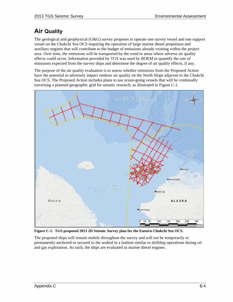
2013 TGS Seismic Survey Environmental Assessment
Appendix C C-1
Air Quality The geological and geophysical (G&G) survey proposes to operate one survey vessel and one support vessel on the Chukchi Sea OCS requiring the operation of large marine diesel propulsion and auxiliary engines that will contribute to the budget of emissions already existing within the project area. Over time, the emissions will be transported by the wind to areas where adverse air quality effects could occur. Information provided by TGS was used by BOEM to quantify the rate of emissions expected from the survey ships and determine the degree of air quality effects, if any.
The purpose of the air quality evaluation is to assess whether emissions from the Proposed Action have the potential to adversely impact onshore air quality on the North Slope adjacent to the Chukchi Sea OCS. The Proposed Action includes plans to use ocean-going vessels that will be continually traversing a planned geographic grid for seismic research, as illustrated in Figure C-1.
Figure C-1. TGS proposed 2013 2D Seismic Survey plan for the Eastern Chukchi Sea OCS.
The proposed ships will remain mobile throughout the survey and will not be temporarily or permanently anchored or secured to the seabed in a fashion similar to drillship operations during oil and gas exploration. As such, the ships are evaluated as marine diesel engines.
Environmental Assessment 2013 TGS Seismic Survey
C-2 Appendix C
C-1. Existing EPA Air Quality Classification on the Alaska North Slope
Impacts from pollutants emitted over the open sea are influenced predominately by wind, which is the mechanism that dilutes and disperses air pollutants, and is also the means to transport pollutants across large areas. The impacts are further influenced by the route and speed of the ship. The existing air quality conditions near an onshore area are influenced primarily by the number and type of emissions sources located onshore. Winds are fairly persistent over the coastline adjacent to the Chukchi Sea where the area is flat and open to the winds of the Arctic Ocean. The mean annual wind speed is about 13 miles per hour (5.8 meters per second or 11.3 knots), defined on the Beaufort scale as a moderate breeze, which is sufficient to cause dispersion and diffusion of air pollutants (Wang, Wu, Cheung, and Lam, 2000; NOAA, 2010). The Arctic is characterized by episodes of strong winds and the vast open area on the North Slope provides little to slow them down (Spall, Pickart, Fratantoni et al., 2007).
The existing air quality conditions are determined by the EPA based on data obtained from emission monitoring equipment located near communities on the North Slope coastline. The National Ambient Air Quality Standards (NAAQS) are compared to the monitored data to determine how often and to what extent federal standards are violated over a specific geographical area. The air quality is classified within the geographical area by the EPA based on this data. These geographical areas are referred to as air quality control regions (AQCR) and are defined by authority of the EPA.
There are four such AQCRs defined in Alaska. The North Slope land area adjacent to the Chukchi Sea OCS is included in the Northern Alaska Intrastate AQCR (40 CFR Part 81). The northern Alaska area is defined by the EPA as a clean air resource, meaning the monitors are not recording pollutant concentrations high enough to consistently violate federal standards. Also, the area is classified as an attainment area, meaning all federal requirements for healthful air quality are being maintained over the long-term.
C-2. Regulatory Review Outside air, referred to in a regulatory context as ambient air, becomes a concern when potential exists for harmful gases, particles, and other contaminants to build up in the lower atmosphere sufficient to cause measurable damage to human health, wildlife, or property (Monks, Granier, & Stohl, et al., 2009). Thus, the EPA established the NAAQS to serve as a point of reference for determining when the potential for harm exists. The NAAQS define the numerical limits (criteria) above which concentrations of the most common air pollutants may be harmful; pollutant concentrations are expressed in terms of mass per volume, or micrograms per cubic meter of air (µg/m3). The NAAQS are updated periodically by the EPA and are provided at http://www.epa.gov/air/criteria.html. The six common air pollutants for which NAAQS exist are:
Carbon monoxide (CO);
Nitrogen dioxide (NO2);
Sulfur dioxide (SO2);
Fine particulate matter (PM2.5);
Coarse particulate matter (PM10);
Ozone; and
Lead.
The EPA requires controls on stationary and mobile emission sources so that the NAAQS can be attained and maintained through local, state, and federal regulations. The regulations for controlling stationary emission sources are distinctly different from regulations applying to mobile sources.
2013 TGS Seismic Survey Environmental Assessment
Appendix C C-3
Emissions from a single stationary source tend to affect the same downwind area on a consistent basis over a period of time due to the prevailing wind, whereas emissions from a mobile source are dispersed over a much larger area as the continuously moving source approaches and then moves farther away from a sensitive location (daycare, park, etc.). A single mobile source is less likely to cause a buildup of pollutants sufficient to exceed the NAAQS. However, when there are scores of mobile sources concentrated in a relatively small area, such as a highway corridor during rush hour, Federal standards are, on occasion, exceeded. Thus, the EPA requires that engines be controlled at the point of manufacture, which reduces emissions not only on the highway corridor during rush hour, but on all the roadways wherever the vehicle is operated, thus reducing emissions on a local and regional scale, and over the long term. In a similar way, the EPA has a coordinated strategy to focus efforts to reduce emissions from large marine diesel engines, on ships flagged in both the United States and in other countries.
Marine diesel engines, similar to engines on board the vessels proposed for the Proposed Action, emit primarily nitrogen oxides (NOX), which includes NO2, and particulate matter. The pollution from marine vessels is the result of operating two types of engines on ships, main propulsion engines and auxiliary engines. The main propulsion engines on very large ships are designated as “Category 3” marine diesel engines. Category 3 engines may be more than three stories high and as long as two school buses, as shown in Figure 2, the Finnish Wärtsilä-Sulzer RTA96-C two-stroke marine diesel engine. Auxiliary engines aboard a vessel might range in size from small portable generators to locomotive-size engines and are designated as “Category 1” and “Category 2” engines.
2.1 BOEM Air Quality Regulatory Program and Clean Air Act
The BOEM Air Quality Regulatory Program (AQRP) (30 CFR 550 Subpart C) does not apply to the TGS survey vessels or any other emission sources or emissions resulting from the Proposed Action. The BOEM AQRP applies only to a facility, as defined under 30 CFR 550.105, which requires the facility to be permanently or temporarily attached to the seabed for the purpose of drilling during oil and gas exploration, development, and production. The authority and jurisdiction allowed BOEM under the AQRP is further limited to compliance of facility emissions with the national ambient air quality standards, to the extent that activities authorized by OCS Lands Act (OCSLA) significantly affect the air quality of any State; anything different is beyond the limited authority of BOEM (42 USC 1334(a)(5)). The EPA rule for the Prevention of Significant Deterioration (PSD) and the requirement for a Title V permit under the Clean Air Act as given under 40 CFR Part 55, also are not applicable.
2.2 International Control of Pollution from Ships
The EPA and U.S. Congressional reports concur that large ships similar in size to container ships, tankers, and cruise ships are not trivial contributors to regional and global air pollution (EPA, 2013b & Copeland, 2008). According to the EPA, pollution from large marine diesel engines is expected to contribute more than 2.1 million tons of NOX emissions each year by 2030, and increase PM2.5 emissions to 170,000 tons per year (EPA, 2013a).

Environmental Assessment 2013 TGS Seismic Survey
C-4 Appendix C
Figure C-2. Photograph of the Wärtsilä-Sulzer RTA96-C two-stroke marine diesel engine for the Emma Maersk (Denmark).
Source: Internet availability at http://www.gizmag.com/go/3263/picture/6197/
Emissions from the main propulsion engines onboard ocean-going vessels, including those operating on the OCS, are controlled at the point and time of manufacturer (OEM, Original Equipment Manufacturer) and must meet emission standards imposed by the International Maritime Organization (IMO). The IMO is the United Nations specialized agency with responsibility for maritime safety and security, and is concerned with the prevention of marine pollution from ships. Established in 1959, the IMO includes the United States as a signatory country and the U.S. EPA is a participant on the U.S. delegation to the IMO. In 1973, IMO adopted the MARPOL (short for marine pollution) Convention to minimize specific types of pollution of the seas.
2.2.1 MARPOL, International Convention on the Prevention of Pollution from Ships
MARPOL refers to the International Convention on the Prevention of Pollution from Ships, which established a set of agreed-upon standards and criteria (conventions) intended to minimize and prevent pollution from ships. MARPOL consists of six annexes (documents), where each describes regulations for pollution prevention at sea. Each annex is specifically dedicated to rules and regulations of a particular harmful substance. The annexes include the prevention of pollution by oil from ships (Annex I in 1983); prevention of pollution by noxious liquid substances in bulk (Annex II in1983); pollution by harmful substances carried by sea in packaged form (Annex III in1992); sewage pollution by ships (Annex IV in 2003); garbage pollution from ships (Annex V, revised for 2013), and the prevention of air pollution from ships (Annex VI revised in 2010) (IMO, 2013). The provisions of each annex are legally binding and enforceable only when ratified by member countries (signatories) whose combined gross tonnage reflects at least half (50 percent) of the world’s gross tonnage. MARPOL applies to all vessels operating in U.S. waters as well as ships operating within 200 nautical miles of the coast of North America.
2.2.2 MARPOL Revised ANNEX VI
MARPOL Revised Annex VI (Annex VI) has been ratified by 59 countries, including the U.S., representing approximately 84 percent of the world’s gross tonnage. As such, the provisions of Annex VI became legally binding and enforceable beginning July 1, 2010 (IMO, 2010). Hence, U.S. OEMs of specific marine diesel engines are required to meet the Annex VI emission standards for NOX, and the fuel used in the engines must reduce emissions of SOX. Engines not subject to the emission standards of the 2010 Annex VI may be subject to standards set forth in the previous versions of the
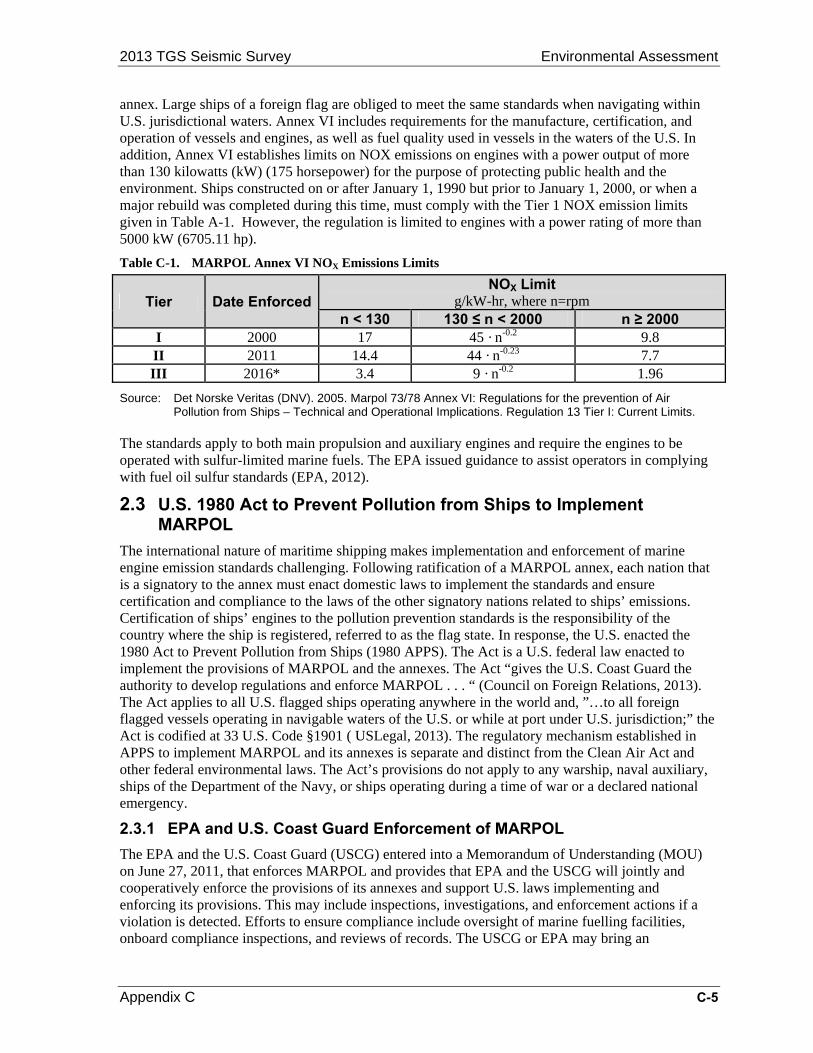
2013 TGS Seismic Survey Environmental Assessment
Appendix C C-5
annex. Large ships of a foreign flag are obliged to meet the same standards when navigating within U.S. jurisdictional waters. Annex VI includes requirements for the manufacture, certification, and operation of vessels and engines, as well as fuel quality used in vessels in the waters of the U.S. In addition, Annex VI establishes limits on NOX emissions on engines with a power output of more than 130 kilowatts (kW) (175 horsepower) for the purpose of protecting public health and the environment. Ships constructed on or after January 1, 1990 but prior to January 1, 2000, or when a major rebuild was completed during this time, must comply with the Tier 1 NOX emission limits given in Table A-1. However, the regulation is limited to engines with a power rating of more than 5000 kW (6705.11 hp).
Table C-1. MARPOL Annex VI NOX Emissions Limits
Tier Date Enforced NOX Limit
g/kW-hr, where n=rpm n < 130 130 ≤ n < 2000 n ≥ 2000
I 2000 17 45 · n-0.2 9.8 II 2011 14.4 44 · n-0.23 7.7 III 2016* 3.4 9 · n-0.2 1.96
Source: Det Norske Veritas (DNV). 2005. Marpol 73/78 Annex VI: Regulations for the prevention of Air Pollution from Ships – Technical and Operational Implications. Regulation 13 Tier I: Current Limits.
The standards apply to both main propulsion and auxiliary engines and require the engines to be operated with sulfur-limited marine fuels. The EPA issued guidance to assist operators in complying with fuel oil sulfur standards (EPA, 2012).
2.3 U.S. 1980 Act to Prevent Pollution from Ships to Implement MARPOL
The international nature of maritime shipping makes implementation and enforcement of marine engine emission standards challenging. Following ratification of a MARPOL annex, each nation that is a signatory to the annex must enact domestic laws to implement the standards and ensure certification and compliance to the laws of the other signatory nations related to ships’ emissions. Certification of ships’ engines to the pollution prevention standards is the responsibility of the country where the ship is registered, referred to as the flag state. In response, the U.S. enacted the 1980 Act to Prevent Pollution from Ships (1980 APPS). The Act is a U.S. federal law enacted to implement the provisions of MARPOL and the annexes. The Act “gives the U.S. Coast Guard the authority to develop regulations and enforce MARPOL . . . “ (Council on Foreign Relations, 2013). The Act applies to all U.S. flagged ships operating anywhere in the world and, ”…to all foreign flagged vessels operating in navigable waters of the U.S. or while at port under U.S. jurisdiction;” the Act is codified at 33 U.S. Code §1901 ( USLegal, 2013). The regulatory mechanism established in APPS to implement MARPOL and its annexes is separate and distinct from the Clean Air Act and other federal environmental laws. The Act’s provisions do not apply to any warship, naval auxiliary, ships of the Department of the Navy, or ships operating during a time of war or a declared national emergency.
2.3.1 EPA and U.S. Coast Guard Enforcement of MARPOL
The EPA and the U.S. Coast Guard (USCG) entered into a Memorandum of Understanding (MOU) on June 27, 2011, that enforces MARPOL and provides that EPA and the USCG will jointly and cooperatively enforce the provisions of its annexes and support U.S. laws implementing and enforcing its provisions. This may include inspections, investigations, and enforcement actions if a violation is detected. Efforts to ensure compliance include oversight of marine fuelling facilities, onboard compliance inspections, and reviews of records. The USCG or EPA may bring an

Environmental Assessment 2013 TGS Seismic Survey
C-6 Appendix C
enforcement action for a violation, which may result in criminal and/or civil liability. The EPA and USCG issued a joint letter to industry regarding Annex VI requirements (EPA, 2013a).
2.3.2 U.S. Required Certifications and Examinations
Each diesel engine regulated under MARPOL aboard U.S. flagged vessels must have an Engine International Air Pollution Prevention (EIAPP) certificate issued by the EPA to document the engine meets the MARPOL NOX standard. Some vessels are also required to have an International Air Pollution Prevention Certificate (IAPP) issued by the USCG. Ship operators must also maintain records onboard documenting compliance with the emission standards and fuel requirements. Non-U.S. flagged ships are subject to examination under Port State Control while operating in U.S. waters.
C-3. M/V Geo Arctic and the R/V Norseman Research Vessel Emission Certification
The vessels proposed for conducting the TGS G&G survey are the seismic vessel, M/V Geo Arctic, shown in Figure 3, and the scout vessel, R/V Norseman, photographed in Figure 4. TGS has confirmed that both vessels meet the appropriate NOX emission standards and will operate using the low-sulfur fuel requirements specified under MARPOL.
Figure C-3. M/V Geo Arctic to be used by TGS as a seismic vessel.
The M/V Geo Arctic was built in 1988 and underwent a major rebuild in 1997. The main (propulsion) engines are rated at 3090 kW (4143.76 hp) for the Zgoda-Sulzer 6ZL 40/48 engines, with an engine speed of 225 revolutions per minute (rpm). The two Cigielski auxiliary engines, 8AL 20/24, are rated at 548 kW (734.88 hp) and 225 rpm.
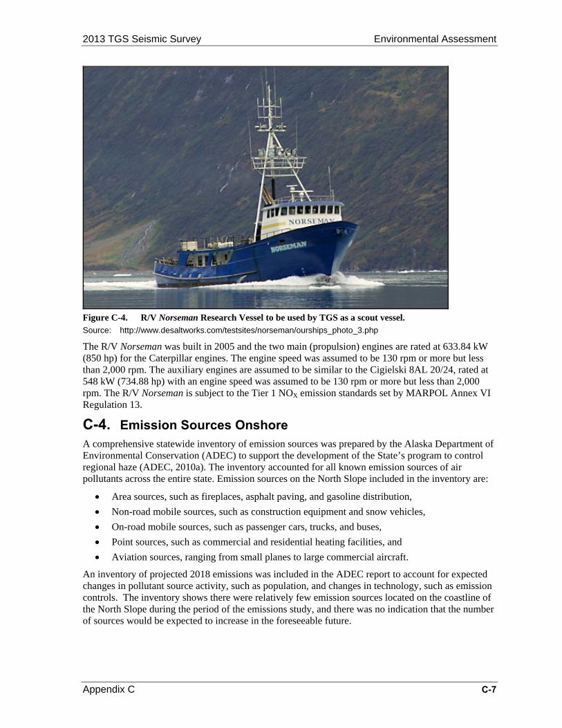
2013 TGS Seismic Survey Environmental Assessment
Appendix C C-7
Figure C-4. R/V Norseman Research Vessel to be used by TGS as a scout vessel. Source: http://www.desaltworks.com/testsites/norseman/ourships_photo_3.php
The R/V Norseman was built in 2005 and the two main (propulsion) engines are rated at 633.84 kW (850 hp) for the Caterpillar engines. The engine speed was assumed to be 130 rpm or more but less than 2,000 rpm. The auxiliary engines are assumed to be similar to the Cigielski 8AL 20/24, rated at 548 kW (734.88 hp) with an engine speed was assumed to be 130 rpm or more but less than 2,000 rpm. The R/V Norseman is subject to the Tier 1 NOX emission standards set by MARPOL Annex VI Regulation 13.
C-4. Emission Sources Onshore A comprehensive statewide inventory of emission sources was prepared by the Alaska Department of Environmental Conservation (ADEC) to support the development of the State’s program to control regional haze (ADEC, 2010a). The inventory accounted for all known emission sources of air pollutants across the entire state. Emission sources on the North Slope included in the inventory are:
Area sources, such as fireplaces, asphalt paving, and gasoline distribution,
Non-road mobile sources, such as construction equipment and snow vehicles,
On-road mobile sources, such as passenger cars, trucks, and buses,
Point sources, such as commercial and residential heating facilities, and
Aviation sources, ranging from small planes to large commercial aircraft.
An inventory of projected 2018 emissions was included in the ADEC report to account for expected changes in pollutant source activity, such as population, and changes in technology, such as emission controls. The inventory shows there were relatively few emission sources located on the coastline of the North Slope during the period of the emissions study, and there was no indication that the number of sources would be expected to increase in the foreseeable future.

Environmental Assessment 2013 TGS Seismic Survey
C-8 Appendix C
C-5. Emission Inventory for TGS Marine Diesel Engines An emission inventory was prepared that reflects the operation of the two marine vessels proposed in the TGS seismic survey plan. As there would be no baseline of marine emissions associated with the no-action alternative, the emissions in the inventory should be considered the total net emission increase caused by the Proposed Action.
The emission inventory was prepared using EPA-approved methodologies provided in the Analysis of Commercial Marine Vessels Emissions and Fuel Consumption Data (EPA, 2000); and emission information available under MARPOL Annex VI (DNV, 2005) The inventory includes an evaluation of the following pollutants:
CO;
NOX, where emissions of NOX are assumed to be made up entirely of NO2;
SOX, where emissions of SOX are assumed to be made up entirely of SO2;
Particulate matter (where emissions of PM are assumed to be made up entirely of PM10)
Volatile organic compounds (VOC)
Carbon dioxide (CO2)
Although a criteria pollutant, an assessment of ozone emissions was not included in the analysis. This is because ozone is not emitted directly by a source; rather ozone is formed through the secondary photochemical reaction between emissions of the precursor pollutants, NOX and volatile organic compounds (VOC), and sunlight. As such, an inventory of NOX and VOC emissions is provided and serves as an indicator of potential ozone development in the project area. While not a criteria pollutant, CO2 is considered a greenhouse gas that contributes to global climate change, and is included in the inventory. Diesel fuel contains no lead, a criteria pollutant; thus, the analysis did not include an inventory of lead emissions.
Emissions from operation of the vessels’ engines were calculated using the standard EPA method of applying the output power (horsepower) to the emission factors expressed as pounds per horsepower-hour (lb/hp-hr), and the number of total operating hours. The emission factors are summarized in A-2, which are given in the equivalent units of pounds of pollutant per engine horsepower-hour (lb/hp-hr) and kilograms of pollutant per engine kilowatt-hour (kg/kW-hr). The emission rates allow the quantity of each pollutant to be calculated based on the operating power of the vessels’ engines.
The emission factors in A-2 were applied to the specific equipment aboard the vessels using modeling assumptions derived from the EPA Analysis of Commercial Marine Vessels Emissions and Fuel Consumption Data (EPA, 2000). The ship-specific data is summarized in Table A-3. Both ships are assumed to operate engines 24 hours per day, for 65 days proposed in the survey plan, or 1,560 hours. The power output was assumed to be 72 percent to allow for lower power settings during slow cruise and maneuvering operations rather than continuous maximum cruise speed. The data from Table A-2 and Table A-3 were used to calculate total project emissions, which are summarized in Table A-4.
The primary criteria pollutants caused by engines operated on the survey vessels are NO2, SO2, and CO. Emissions of NO2 emissions are caused by the high pressures and temperatures during the combustion process, whereas emissions of CO, PM, and VOC are due to incomplete combustion. Ash and metallic additives in the fuel contribute to the content of PM10 in the exhaust. Emissions of SO2 are mainly linked to the sulfur content of the fuel rather than any combustion variable. While emissions of CO2 are high, CO2 is not considered a criteria pollutant and is not regulated for mobile sources. Emissions from the combined operation of the two vessels would not have the potential to exceed 100 tons per year for any regulatory pollutant. Therefore, the emissions are considered de minimis and the vessels’ engines are not subject to any regulatory control or review.
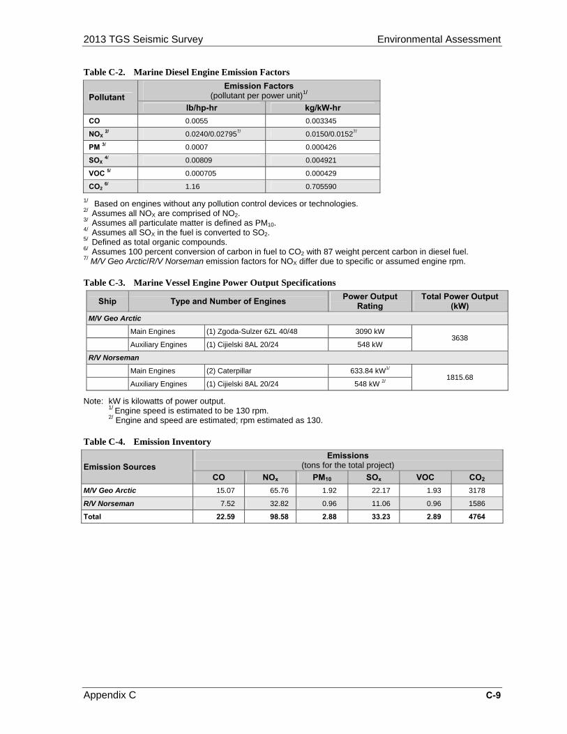
2013 TGS Seismic Survey Environmental Assessment
Appendix C C-9
Table C-2. Marine Diesel Engine Emission Factors
Pollutant Emission Factors
(pollutant per power unit)1/
lb/hp-hr kg/kW-hr
CO 0.0055 0.003345
NOX 2/ 0.0240/0.027957/ 0.0150/0.01527/
PM 3/ 0.0007 0.000426
SOX 4/ 0.00809 0.004921
VOC 5/ 0.000705 0.000429
CO2 6/ 1.16 0.705590
1/ Based on engines without any pollution control devices or technologies. 2/ Assumes all NOX are comprised of NO2. 3/ Assumes all particulate matter is defined as PM10. 4/ Assumes all SOX in the fuel is converted to SO2. 5/ Defined as total organic compounds. 6/ Assumes 100 percent conversion of carbon in fuel to CO2 with 87 weight percent carbon in diesel fuel. 7/ M/V Geo Arctic/R/V Norseman emission factors for NOX differ due to specific or assumed engine rpm.
Table C-3. Marine Vessel Engine Power Output Specifications
Ship Type and Number of Engines Power Output
Rating Total Power Output
(kW)
M/V Geo Arctic
Main Engines (1) Zgoda-Sulzer 6ZL 40/48 3090 kW 3638
Auxiliary Engines (1) Cijielski 8AL 20/24 548 kW
R/V Norseman
Main Engines (2) Caterpillar 633.84 kW1/ 1815.68
Auxiliary Engines (1) Cijielski 8AL 20/24 548 kW 2/
Note: kW is kilowatts of power output. 1/ Engine speed is estimated to be 130 rpm. 2/ Engine and speed are estimated; rpm estimated as 130.
Table C-4. Emission Inventory
Emission Sources Emissions
(tons for the total project)
CO NOx PM10 SOx VOC CO2
M/V Geo Arctic 15.07 65.76 1.92 22.17 1.93 3178
R/V Norseman 7.52 32.82 0.96 11.06 0.96 1586
Total 22.59 98.58 2.88 33.23 2.89 4764

Environmental Assessment 2013 TGS Seismic Survey
C-10 Appendix C
C-6. References Copeland, C. 2008. Cruise Ship Pollution: Background, Law and Regulations, and Key Issues.
Congressional Research Service (CRS) Report for Congress, Order Code RL32450. Available from the National Council for Science and the Environment (NCSE) Website at http://www.earth-forum.com/NLE/CRSreports/08Jun/RL32450.pdf
Council on Foreign Relations. 2013. “Act to Prevent Pollution from Ships.” Available at http://www.cfr.org/environmental-pollution/act-prevent-pollution-ships/p28533
Det Norske Veritas (DNV). 2005. Marpol 73/78 Annex VI: Regulations for the prevention of Air Pollution from Ships – Technical and Operational Implications. Regulation 13 Tier I: Current Limits.
EPA. 2000. Analysis of Commercial Marine Vessels Emissions and Fuel Consumption Data (EPA420-R-00-002). Washington, DC: USEPA Office of Transportation and Air Quality. 158 p.
Environmental Protection Agency (EPA). 2012. Memorandum from the EPA Air Enforcement Division (Phillip Brooks) to the U.S. Coast Guard Inspections and Compliance Office and EPA OECA Mobile Source Enforcement Personnel. June 26, 2012. http://www.epa.gov/enforcement/air/documents/policies/mobile/finalfuelavailabilityguidance-0626.pdf
Environmental Protection Agency (EPA). 2013a. MARPOL Annex VI. Available on the EPA Air Enforcement Website at http://www.epa.gov/enforcement/air/marpolannex.html
Environmental Protection Agency (EPA). 2013b. Transportation and Air Quality: Ocean Vessels and Large Ships. Available on the EPA Website at http://www.epa.gov/otaq/oceanvessels.htm
International Maritime Organization (IMO). July 1, 2010. “Air pollution from ships cut, with entry into force of MARPOL amendments.” Available at http://www.imo.org/MediaCentre/PressBriefings/Pages/MARPOL-Annex-VI-EIF.aspx
International Maritime Organization (IMO). 2013. “International Convention for the Prevention of Pollution from Ships (MARPOL).” Available at http://www.imo.org/About/Conventions/ListOfConventions/Pages/International-Convention-for-the-Prevention-of-Pollution-from-Ships-(MARPOL).aspx
Monks, P.S., Granier, C., Fuzzi, S., Stohl, A., Williams, M.L., Akimoto, H., and Amann, M., et al. 2009. Atmospheric composition change – global and regional air quality. Atmospheric Environment 43 (33): 5268-5350. doi: 10.1016/j.atmosenv.2009.08.021
Spall, M.A., Pickart, R.S., Fratantoni, P.S., and Plueddemann, A.J. 2007. Western Arctic shelfbreak eddies: Formation and transport. Journal of Physical Oceanography 38(8): 1644-1688. doi: 10.1175/2007JPO3829.1
USLegal. 2013. “Act to Prevent Pollution from Ships Law and Legal Definition.” Available at http://definitions.uslegal.com/a/act-to-prevent-pollution-from-ships/
Wang, T., Wu, Y.Y., Cheung, T.F. and Lam, K.S. 2000. A study of surface ozone and relation to complex wind flow in Hong Kong. Atmospheric Environment 35(18): 3203-3215. doi:10.1016/S1352-2310(00)00558-6
Related Documents