This article was downloaded by: [USGS Libraries Program] On: 17 April 2012, At: 18:29 Publisher: Taylor & Francis Informa Ltd Registered in England and Wales Registered Number: 1072954 Registered office: Mortimer House, 37-41 Mortimer Street, London W1T 3JH, UK International Journal of Remote Sensing Publication details, including instructions for authors and subscription information: http://www.tandfonline.com/loi/tres20 Testing a high-resolution satellite interpretation technique for crop area monitoring in developing countries M. T. Marshall a b , G. J. Husak a , J. Michaelsen a , C. Funk a , D. Pedreros a & A. Adoum b a Department of Geography, University of California at Santa Barbara, Santa Barbara, CA, 93106-4060, USA b AGRHYMET Regional Centre, No. 0425, rue 001 Boulevard de l'Université, Quartier Université, Commune V, Niger Available online: 09 Aug 2011 To cite this article: M. T. Marshall, G. J. Husak, J. Michaelsen, C. Funk, D. Pedreros & A. Adoum (2011): Testing a high-resolution satellite interpretation technique for crop area monitoring in developing countries, International Journal of Remote Sensing, 32:23, 7997-8012 To link to this article: http://dx.doi.org/10.1080/01431161.2010.532168 PLEASE SCROLL DOWN FOR ARTICLE Full terms and conditions of use: http://www.tandfonline.com/page/terms-and- conditions This article may be used for research, teaching, and private study purposes. Any substantial or systematic reproduction, redistribution, reselling, loan, sub-licensing, systematic supply, or distribution in any form to anyone is expressly forbidden. The publisher does not give any warranty express or implied or make any representation that the contents will be complete or accurate or up to date. The accuracy of any instructions, formulae, and drug doses should be independently verified with primary sources. The publisher shall not be liable for any loss, actions, claims, proceedings, demand, or costs or damages whatsoever or howsoever caused arising directly or indirectly in connection with or arising out of the use of this material.

Welcome message from author
This document is posted to help you gain knowledge. Please leave a comment to let me know what you think about it! Share it to your friends and learn new things together.
Transcript

This article was downloaded by: [USGS Libraries Program]On: 17 April 2012, At: 18:29Publisher: Taylor & FrancisInforma Ltd Registered in England and Wales Registered Number: 1072954 Registeredoffice: Mortimer House, 37-41 Mortimer Street, London W1T 3JH, UK
International Journal of RemoteSensingPublication details, including instructions for authors andsubscription information:http://www.tandfonline.com/loi/tres20
Testing a high-resolution satelliteinterpretation technique for crop areamonitoring in developing countriesM. T. Marshall a b , G. J. Husak a , J. Michaelsen a , C. Funk a , D.Pedreros a & A. Adoum ba Department of Geography, University of California at SantaBarbara, Santa Barbara, CA, 93106-4060, USAb AGRHYMET Regional Centre, No. 0425, rue 001 Boulevard del'Université, Quartier Université, Commune V, Niger
Available online: 09 Aug 2011
To cite this article: M. T. Marshall, G. J. Husak, J. Michaelsen, C. Funk, D. Pedreros & A. Adoum(2011): Testing a high-resolution satellite interpretation technique for crop area monitoring indeveloping countries, International Journal of Remote Sensing, 32:23, 7997-8012
To link to this article: http://dx.doi.org/10.1080/01431161.2010.532168
PLEASE SCROLL DOWN FOR ARTICLE
Full terms and conditions of use: http://www.tandfonline.com/page/terms-and-conditions
This article may be used for research, teaching, and private study purposes. Anysubstantial or systematic reproduction, redistribution, reselling, loan, sub-licensing,systematic supply, or distribution in any form to anyone is expressly forbidden.
The publisher does not give any warranty express or implied or make any representationthat the contents will be complete or accurate or up to date. The accuracy of anyinstructions, formulae, and drug doses should be independently verified with primarysources. The publisher shall not be liable for any loss, actions, claims, proceedings,demand, or costs or damages whatsoever or howsoever caused arising directly orindirectly in connection with or arising out of the use of this material.
International Journal of Remote SensingVol. 32, No. 23, 10 December 2011, 7997–8012
Testing a high-resolution satellite interpretation technique for crop areamonitoring in developing countries
M. T. MARSHALL*†‡, G. J. HUSAK†, J. MICHAELSEN†, C. FUNK†,D. PEDREROS† and A. ADOUM‡
†Department of Geography, University of California at Santa Barbara, Santa Barbara,CA 93106-4060, USA
‡AGRHYMET Regional Centre, No. 0425, rue 001 Boulevard de l’Université, QuartierUniversité, Commune V, Niger
(Received 22 July 2008; in final form 13 September 2010)
District-level crop area (CA) is a highly uncertain term in food production equa-tions, which are used to allocate food aid and implement appropriate food securityinitiatives. Remote sensing studies typically overestimate CA and production, assubsistence plots are exaggerated at coarser resolution, which leads to overopti-mistic food reports. In this study, medium-resolution (MR) Landsat 7 EnhancedThematic Mapper Plus (ETM+) images were manually classified for Niger andcorrected using CA estimates derived from high-resolution (HR) sample image,topographic and socioeconomic data. A logistic model with smoothing splines wasused to compute the block-average (0.1◦) probability of an area being cropped.Livelihood zones and elevation explained 75% of the deviance in CA, while MRdid not add explanatory power. The model overestimates CA when compared tothe national inventory, possibly because of temporal changes in intercropping andthe exclusion of some staple crops in the national inventory.
1. Introduction
The target of halving the number of undernourished people in developing countriesmade at the 1996 World Food Summit in Rome is far from being achieved, as thenumber of undernourished people has decreased from 823 million to 820 million peo-ple since the beginning of the 1990s (FAO 2008). In sub-Saharan Africa, the trend inundernourished has continued to rise for the past 30 years. In Niger, where povertyand malnutrition are a staggering 63% and 40%, respectively, the 2004 drought led toa 12% drop in crop production from the 5-year average. With insufficient and spo-radic rains at the end of the 2007 growing season, access to food in 2008 was impaired(USAID 2007). In Niger, and in many countries in Africa, the limited purchasingpower of people, combined with food shortages, requires preventative market-basedstrategies such as import planning to combat food insecurity on the continent.
Population growth in poverty-stricken regions often leads to farming intensifica-tion in climate-sensitive areas (e.g. agro-pastoral), as farmers with low purchasingpower are forced to increase production to meet growing demand (Bjerknes 1969).
*Corresponding author. Email: [email protected]
International Journal of Remote SensingISSN 0143-1161 print/ISSN 1366-5901 online © 2011 Taylor & Francis
http://www.tandf.co.uk/journalshttp://dx.doi.org/10.1080/01431161.2010.532168
Dow
nloa
ded
by [
USG
S L
ibra
ries
Pro
gram
] at
18:
29 1
7 A
pril
2012

7998 M. T. Marshall et al.
Crop production estimates at the district and national levels are therefore becomingimportant in long-term planning of food security initiatives, natural resources man-agement, and desertification prevention. For a given crop, production is the productof yield and crop area (CA). The latter is typically derived from ground truth anddemographic surveys. The CA term is highly uncertain; field samples are typicallytoo few to extrapolate to the district or national level and the majority of plots con-tain two (or more) crops, both (or all) of which are assigned the total CA of theplot, so that when total CA is calculated as the aggregate of all plots on all farms,overestimates occur. In addition, field samples are costly and time-consuming, partic-ularly in remote areas of the world. Satellite image interpretation provides an efficientand cost-effective alternative to traditional CA estimation, and as such has been usedwith several broad-scale surveys in Canada, Europe and the USA: Statistics Canada(Ryerson et al. 1985), Monitoring Agriculture with Remote Sensing (Taylor et al.1997) and the Italian AGRIT Project (Giovacchini and Brunetti 1992), and the LargeArea Crop Inventory Experiment (MacDonald et al. 1975), respectively.
CA estimation from satellite imagery is typically calculated using the product of theresolution of an image and the area of an agricultural feature delineated with a spec-tral classifier (Taylor et al. 1997) or by direct pixel count (MacDonald and Hall 1980,Latham et al. 1983, Sridhar et al. 1994, Shao et al. 2001). Studies in West Africa pri-marily used coarse-resolution Advanced Very High Resolution Radiometer (AVHRR)data to establish linear (Maselli et al. 1992) or polynomial (Groten 1993) relationshipsbetween the Normalized Difference Vegetation Index (NDVI) and crop yield. To avoidproblems of extrapolating these functions over time, a time average of NDVI at theend of the growing season when agricultural landcover has a much higher chloro-phyll content than background vegetation has also been attempted (Rasmussen 1992).These methods often lead to serious overestimation of CA in subsistence-based agri-cultural systems, as the spectral characteristics of uncultivated land are obscured atrelatively coarse resolution (Ozdogan and Woodcock 2006). Colocation inaccuraciesand considerable overlap between spectral categories can induce further error (Tayloret al. 1997). Regression estimators developed from the proportion of CA in groundsurveys with predetermined segments (area frames) in satellite imagery can producehighly accurate CA estimates (Pradhan 2001). However, this method is limited bythe cost and difficulty of taking field measurements. The use of high-resolution (HR)satellite imagery in the absence of ground data to determine the bias estimator is arelatively unexplored area, although a study involving Landsat 7 Enhanced ThematicMapper Plus (ETM+) and IKONOS imagery for a high production zone in Ethiopiashows promise, as the unbiased estimates explained 77% of the deviance in agriculturalsurveys (Husak et al. 2008).
The current study produces unbiased estimates of CA for the primary crop-producing season in Niger for 2005. The objectives of this study were: (1) to determineCA from medium-resolution (MR) satellite imagery and area frames defined by theshape and extent of HR satellite imagery; (2) to derive a bias estimator from statisticalcomparison of area frames with MR satellite imagery; and (3) to compare unbiasedCA estimates with estimates produced by the national survey. Unlike the Ethiopianstudy, which focused on a small crop-producing region, estimates in this study weremade nationwide. In addition, this study investigated parameters for the statisticalmodel that better represents the spatiotemporal distribution of CA in Niger: mapsof major livelihood zones, latitude, precipitation, NDVI, slope, and elevation wereanalysed together with the HR bias estimator.
Dow
nloa
ded
by [
USG
S L
ibra
ries
Pro
gram
] at
18:
29 1
7 A
pril
2012
Using high-resolution area frames for crop production 7999
2. Materials and methods
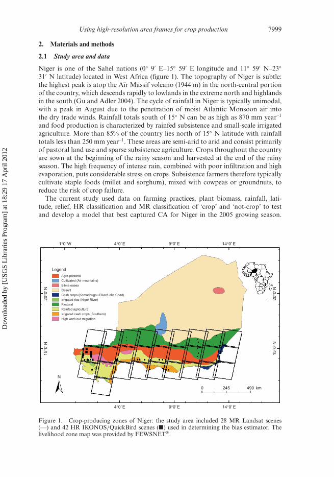
2.1 Study area and data
Niger is one of the Sahel nations (0◦ 9′ E–15◦ 59′ E longitude and 11◦ 59′ N–23◦31′ N latitude) located in West Africa (figure 1). The topography of Niger is subtle:the highest peak is atop the Aïr Massif volcano (1944 m) in the north-central portionof the country, which descends rapidly to lowlands in the extreme north and highlandsin the south (Gu and Adler 2004). The cycle of rainfall in Niger is typically unimodal,with a peak in August due to the penetration of moist Atlantic Monsoon air intothe dry trade winds. Rainfall totals south of 15◦ N can be as high as 870 mm year–1
and food production is characterized by rainfed subsistence and small-scale irrigatedagriculture. More than 85% of the country lies north of 15◦ N latitude with rainfalltotals less than 250 mm year–1. These areas are semi-arid to arid and consist primarilyof pastoral land use and sparse subsistence agriculture. Crops throughout the countryare sown at the beginning of the rainy season and harvested at the end of the rainyseason. The high frequency of intense rain, combined with poor infiltration and highevaporation, puts considerable stress on crops. Subsistence farmers therefore typicallycultivate staple foods (millet and sorghum), mixed with cowpeas or groundnuts, toreduce the risk of crop failure.
The current study used data on farming practices, plant biomass, rainfall, lati-tude, relief, HR classification and MR classification of ‘crop’ and ‘not-crop’ to testand develop a model that best captured CA for Niger in the 2005 growing season.
1°0′ W
Agro-pastoral
Cultivated (Air mountains)
Bilma oases
Desert
Cash crops (Komadougou River/Lake Chad)
Irrigated rice (Niger River)
Pastoral
Rainfed agriculture
Irrigated cash crops (Southern)
High work out-migration
4°0′ E
Legend
9°0′ E 14°0′ E
4°0′ E
N
9°0′ E 14°0′ E
0 245 490 km
20°0
′ N15
°0′ N
20°0
′ N15
°0′ N
Figure 1. Crop-producing zones of Niger: the study area included 28 MR Landsat scenes(—) and 42 HR IKONOS/QuickBird scenes (�) used in determining the bias estimator. Thelivelihood zone map was provided by FEWSNET®.
Dow
nloa
ded
by [
USG
S L
ibra
ries
Pro
gram
] at
18:
29 1
7 A
pril
2012
8000 M. T. Marshall et al.
These data included polygons delineating primary livelihood zones in Niger, 0.05◦resolution seasonal (September–November) average and cumulative grids of ModerateResolution Imaging Spectroradiometer (MODIS)-Terra 16-day NDVI from 2000 to2008 and Famine Early Warning System Network (FEWSNET) Africa rainfall esti-mates from 1998 to 2008, respectively, the Shuttle Radar Topography Mission (SRTM)90 m resolution digital elevation model (DEM) for northern Africa, 0.61 cm/1 m res-olution September–November 2005 QuickBird/IKONOS panchromatic images, and30 m resolution September–October 2005 Landsat 7 ETM+ composites. The mapdelineating livelihood zones was developed from preliminary interviews and work-shops with key informants at the national and regional level and later refined througha series of local meetings and visits (FEWSNET 2005). The livelihood zones include:agro-pastoral, cultivated Aïr Mountains, Bilma Oasis, desert, cash crops of Lake Chadand the Komadougou River, irrigated rice, pastoral, rainfed agriculture, irrigated cashcrops, and high work out-migration. The MODIS product is available for downloadon the Earth Observing System (EOS) data gateway. The DEM was processed bythe Food and Agriculture Organization Environment and Natural Resources Service(FAO-SDRN). Slope and elevation were determined using standard flow routingalgorithms available in ArcGIS®.
The NDVI is a composite of red and near-infrared (NIR) reflectance detected by theMODIS satellite. The NDVI is particularly sensitive to plant biomass, as plants tend toabsorb red light and reflect NIR more during photosynthesis (Huete et al. 2002). Theindex is sensitive to several atmospheric effects, including scatter and absorption ofenergy by aerosols, carbon dioxide (CO2) and water vapour, so several processing stepsare typically performed to enhance the sensitivity of the index to vegetation dynamics.The 16-day compositing scheme used and described in Cihlar et al. (1994) reducesatmospheric interference present in the daily data. MODIS data include flags thatdetail the reliability and quality of the data. These flags were used to mask out pixelsin the 16-day composites that contained cloud cover and high aerosol quantity. Finally,a piecewise weighted least squares regression smoothing technique described in Swetset al. (1999) was applied to make the dataset continuous and more consistent withplant phenology.
The satellite imagery and the Rapid Landcover Mapping (RLCM) tool used to per-form the classification were freely provided by the United States Geological Survey(USGS) EROS Data Center in Sioux Falls, SD. The RLCM tool was developed inArcGIS for the manual classification of landcover area using satellite imagery and astratified sampling regime. The grid is a set of vector points that can be overlaid withsatellite imagery. Each point or sample can be selected and classified while visualizingcorresponding satellite images. The grid of samples and corresponding attribute infor-mation can then be exported into various formats for analysis. Forty-two HR imagesstratified over 12 MR images were used to develop the bias estimator. An additional16 MR images were classified to determine the nationwide CA. The area covered bya single HR image ranged between 400 km2 in the more productive agricultural areasto 25 km2 in the less productive agricultural areas, while the Landsat images had anarea close to 30 000 km2. The HR imagery covered nearly 6000 km2 of the area cov-ered by the MR imagery. Landsat and QuickBird/IKONOS images were cloud free(<1% cloud cover) and registered in a Lambert Equal Area Azimuthal projection(datum WGS-84) for comparative purposes with the aforementioned data products.Standard radiometric and geometric corrections and georeferencing were performedby the EROS Data Center, DigitalGlobe, and GeoEye for Landsat, QuickBird, and
Dow
nloa
ded
by [
USG
S L
ibra
ries
Pro
gram
] at
18:
29 1
7 A
pril
2012

Using high-resolution area frames for crop production 8001
IKONOS imagery, respectively. The Landsat imagery retained systematic data gaps(SLC-off). The MR and HR images were collected towards the end of the primarygrowing season. It was expected that the greatest contrast in texture and shape ofplanted/harvested fields and natural photosynthetic vegetation occurs at this time.Sown fields would be effective for classification as well, as emergent crops tend to haverelatively lower photosynthetic rates than other vegetation; however, cloud-free imageswere not available at the beginning of the rainy season.
District and sub-district estimates of CA in Niger have been made by the Enquêtepour la Production et l’Estimation des Rendements (EPER) since the mid-1970s. TheEPER uses a two-step process to determine CA: villages are randomly selected in pro-portion to village size from a sub-district first, and then within each selected village,farms are randomly selected with uniform probability. The area of the selected farmsprovides an average, which is multiplied by the total number of farms in a sub-districtfrom the national census to calculate the district total. The district totals were not usedin this study because of severe problems with double counting. To account for dou-ble counting at the national level, EPER uses adjustment factors derived in Adamou(2001) to estimate CA for each staple crop. These fractions allow EPER to estimate thetotal planted area, accounting for the fact that the same field shares two crops and istherefore counted twice in food production estimates. The fractions are determined forcowpea and groundnuts, as these crops are most commonly mixed with other staplecrops. In Adamou (2001), 89% of the CA in cowpea is represented in the total esti-mated area of millet grown. To determine the total area of millet grown, EPER simplysubtracts 89% of the area reported as cow pea from the millet total. Similarly, the totalarea of sorghum without cowpea can be estimating using the cowpea to sorghum pro-portion of 41%. These two figures are then added to the remaining cowpea area. Fortyper cent of groundnuts are counted in other crops, so 40% of the area is removed fromthe groundnut total and the remainder is added to the group total. Other crops are arelatively lower proportion of CA and are therefore ignored. The fractions are derivedfor national estimates of CA, so estimates at the sub-district or district level are notpossible at this time.
2.2 Classification of HR and MR imagery
Interpretation of HR and MR imagery consisted of the manual classification of sam-ples with the RLCM tool. A grid of unclassified samples was overlaid with the satelliteimagery and classified individually or in clusters as ‘crop’ or ‘not-crop’. The assignedsamples were given a unique identifier that was later merged with information onNDVI, precipitation, latitude, slope, elevation, and livelihood zone. More than onesample can be classified at a time using the RLCM tool, so the scale at which sampleswere visualized depended on the size and shape of features being classified, the com-plexity of the landscape, and the resolution of the imagery being interpreted. The HRimagery was interpreted as a single greyscale band, while Landsat images were inter-preted from three-band composites that enhanced the photosynthetic features (green,red and NIR or mid-IR). The HR image frames and corresponding Landsat subsetswere sampled at 500 m intervals, while the full Landsat scenes used to determine unbi-ased CA estimates for the entire country were sampled at 2 km intervals. For bothhigh- and low-frequency samples, the remaining indicators of CA were extracted fromtheir respective data sources and assigned to the corresponding interpreted samples.It was assumed that minor colocation errors in the various datasets are accounted
Dow
nloa
ded
by [
USG
S L
ibra
ries
Pro
gram
] at
18:
29 1
7 A
pril
2012
8002 M. T. Marshall et al.
for in the block averaging technique described later. After omitting samples that wereidentified as cloud, cloud shadow or ‘no data’ due to Landsat SLC-off, more than18 500 high-frequency and 144 800 low-frequency samples were used to derive thebias estimator and unbiased estimates, respectively.
A visit to Niger was made to determine the general feasibility of using HR imageryin lieu of actual field visits. The scope of the survey was limited by budget and timeconstraints, so it was not considered in the validation phase. The field survey was per-formed in early October of 2007 to evaluate six IKONOS images taken in the previousmonth. The sampling regime consisted of 125 stratified roadside pairs. The latitudeand longitude of each sample were determined using a Garmin ETREX 2 (spatialerror <15 m) and recorded in ArcGIS, along with a crop or not-crop classifier. Theinterpretation of the HR imagery was not performed in a Geographic InformationSystems (GIS) environment. Instead, HR interpretation was made independent offield survey results using snapshots of the sample locations overlaid with correspond-ing HR imagery provided by the field personnel. This prevented registration errorsbetween interpretations made in the field and remote sensing imagery.
2.3 Statistical analysis
Logistic regression generalized linear modelling (McCullagh and Nelder 1989) wasused to represent the binary response (crop/non-crop estimate for HR satelliteimagery) to various potential predictors. In a simple multivariate logistic regressionmodel, the probability of an area being crop p is defined as the logistic transforma-tion of a linear function. The logistic coefficient is defined as the log of the odds ratio(probability of an event/probability of no event):
log(pj/(1 − pj)) = β0 +∑
βijxij (1)
where β0 and β ij are that intercept and slope coefficients of the odds ratio, respectively,and x is the independent variable i (livelihood zone, MR crop or not-crop, NDVI, ele-vation, slope, and latitude) for block j. The possibility of a non-linear relationship wasinvestigated using smoothing spline models in a generalized additive model frame-work (Hastie et al. 2001). Spline functions are piecewise polynomial fits. The modelbecomes:
log(pj/(1 − pj)) = β0 +∑
fij(xij) (2)
where fij(xij) is the spline function for the independent variable i and block j. Eachvariable is added in a stepwise selection process. Each successive predictor explainsthe deviance not explained by predictors already included in the model. This reducesthe effects of multicollinearity. The basic modelling approach used here was a modifiedversion of the model presented in Husak et al. (2008). There are two main differences.First, the independent variables with the exception of MR were averaged over 0.1◦blocks to reduce the impact of possible misregistration errors and to facilitate interpre-tation of the results. The block size was a tradeoff between overpopulating the samplesize using smaller blocks and obscuring details using larger blocks. The number of500 m crop (non-crop) samples in the HR blocks divided by the total number of sam-ples in each block was used to calculate probability in the logistic model. Continuouspredictors such as slope and elevation were averaged. The aggregation produced 155
Dow
nloa
ded
by [
USG
S L
ibra
ries
Pro
gram
] at
18:
29 1
7 A
pril
2012
Using high-resolution area frames for crop production 8003
blocks with 1 to 484 interpreted samples per block. The median was 89 samples perblock, and approximately three-quarters of the blocks had at least 40 samples. Thenumber of interpreted samples varied because the sampling grid was chosen indepen-dent of the distribution of HR imagery, and the blocks were adjusted so that they didnot overlap two or more livelihood zones.
The second difference involved a change in the way the livelihood zone (land useindicator) was used in the model. In the Ethiopian analysis, the data were partitionedbased on land use and separate models were fit with the remaining predictors for eachlandcover class. In that case, there were strong relationships between elevation, slopeand probability of crop that varied between different classes. In this study the liveli-hood zone predictor was used first as a mask to remove all desert pixels from theanalysis and then as a nominal predictor in a single model fit over all non-desertlivelihood zones.
3. Results
The high-frequency samples were distributed among the primary crop-producinglivelihood zones: 30% agro-pastoral, 14% irrigated cash crops, 13% high work out-migration, 5% pastoral, 24% rainfed agriculture, and 14% irrigated rice. The absenceof agricultural landcover in the pastoral zone reflects the low representation of sam-pling there. Desert was not sampled, as agricultural landcover was assumed to benegligible. The remaining livelihood zones were aggregated into the aforementionedcategories that best represented their climatic, eco-physiological, textural and topo-graphic characteristics. Overall, 23% of the HR samples were classified as cropland.The HR evaluation with ground data is not robust enough to consider for validation,but was a convenient and inexpensive collection of samples used for proof of concept.Of the 249 samples classified from the field visit and HR image interpretation, 38.1%were crop and there was agreement for 223 of the samples, giving an overall accuracyof 89.6%. The errors of omission and commission were very similar, resulting in amodelled estimate of crop at the samples that was within 1.5% of the field survey.
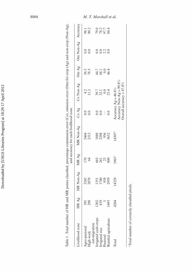
A total of 16 268 Landsat samples (crop = 1961 and not-crop = 14 307) were cor-rectly classified when compared to the HR on a sample-by-sample basis, while theremaining 2265 samples were classified incorrectly, yielding an overall accuracy of87.8%. The errors of omission were substantially higher for crop than non-crop, whilethe errors of commission were moderately higher for non-crop than crop livelihoodzones. This tendency is particularly strong in the wetter (agricultural) livelihood zones.A summary of the commission errors, omission errors, and accuracies for each liveli-hood zone are presented in table 1. The overall accuracy was highest for the pastorallivelihood zone, followed by agro-pastoral, high work out-migration, rainfed agricul-ture, irrigated cash crops, and irrigated rice. The omission errors were highest for highwork out-migration and irrigated rice. The commission and omission errors (withthe exception of pastoral) for crop and non-crop, respectively, were both 0%. Agro-pastoral had a high omission error, which was countered by a low commission errorfor non-crop.
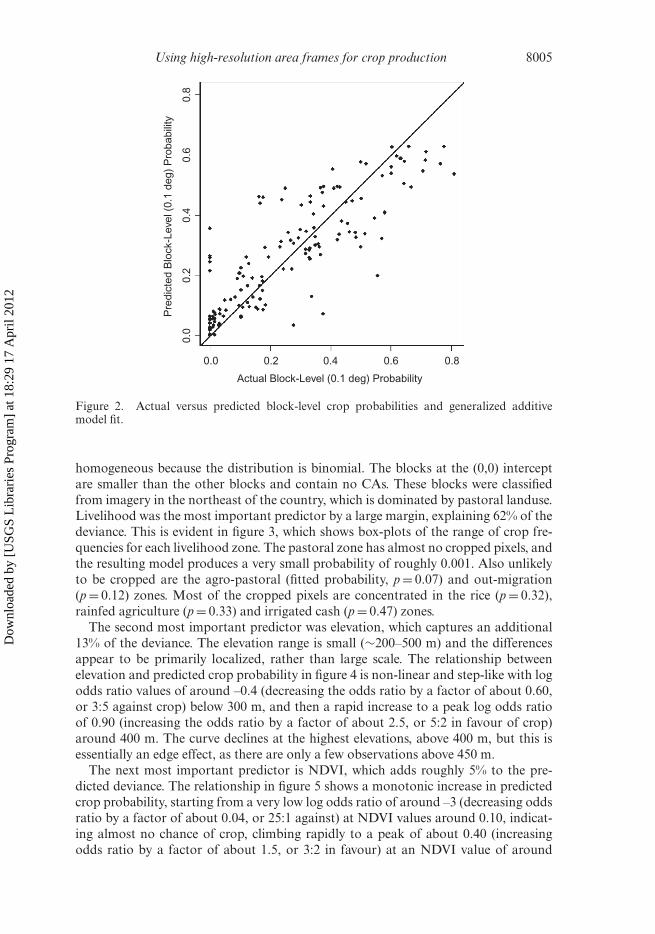
The final logistic model used livelihood zone, NDVI and elevation as predictors. Themodel explained 84% of the binomial distribution deviance. The deviance explainedis comparable to the variance explained in a linear model. Figure 2 shows the actualblock-level crop pixel frequencies and predicted probabilities. The value of R2, whichis used to illustrate the relationship between the two, is 0.73. The residuals are not
Dow
nloa
ded
by [
USG
S L
ibra
ries
Pro
gram
] at
18:
29 1
7 A
pril
2012
8004 M. T. Marshall et al.
Tab
le1.
Tota
lnum
ber
ofH
Ran
dM
Rpo
ints
clas
sifie
d,pe
rcen
tage
com
mis
sion
erro
r(C
o),o
mis
sion
erro
r(O
m)
for
crop
(Ag)
and
non-
crop
(Non
-Ag)
,an
dac
cura
cyfo
rea
chliv
elih
ood
zone
.
Liv
elih
ood
zone
HR
Ag
HR
Non
-Ag
MR
Ag
MR
Non
-Ag
Co
Ag
Co
Non
-Ag
Om
Ag
Om
Non
-Ag
Acc
urac
y
Agr
o-pa
stor
al39
152
4317
054
640.
04.
256
.50.
096
.1H
igh
wor
kou
t-m
igra
tion
298
2078
6423
120.
011
.278
.50.
090
.2
Irri
gate
dca
shcr
ops
1202
1351
665
1888
0.0
39.7
44.7
0.0
79.0
Irri
gate
dri
ce81
917
4026
122
980.
032
.168
.10.
078
.2P
asto
ral
195
823
936
—0.
00.
02.
297
.7R
ainf
edag
ricu
ltur
e14
9329
5980
036
520.
023
.446
.40.
084
.4
Tota
l42
0414
329
1961
∗14
307∗
Acc
urac
yA
g=
46.6
%A
ccur
acy
Non
-Ag
=99
.8%
Ove
rall
accu
racy
=87
.8%
∗ Tot
alnu
mbe
rof
corr
ectl
ycl
assi
fied
pixe
ls.
Dow
nloa
ded
by [
USG
S L
ibra
ries
Pro
gram
] at
18:
29 1
7 A
pril
2012
Using high-resolution area frames for crop production 8005
0.8
0.6
0.4
Actual Block-Level (0.1 deg) Probability
Pre
dict
ed B
lock
-Lev
el (
0.1
deg)
Pro
babi
lity
0.2
0.0
0.0 0.2 0.4 0.6 0.8
Figure 2. Actual versus predicted block-level crop probabilities and generalized additivemodel fit.
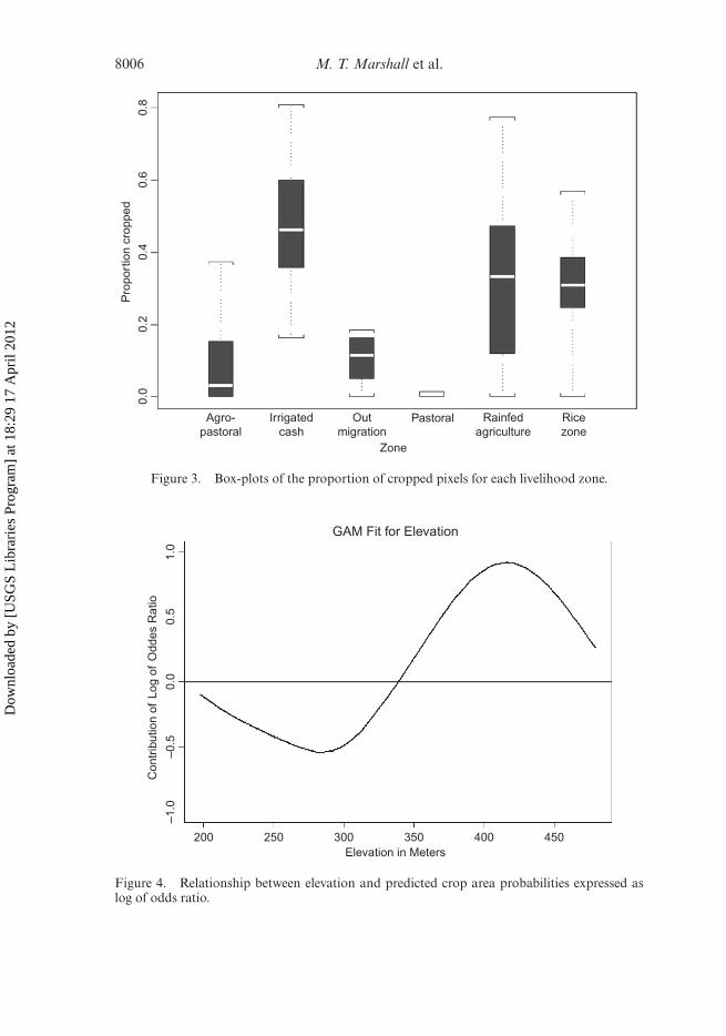
homogeneous because the distribution is binomial. The blocks at the (0,0) interceptare smaller than the other blocks and contain no CAs. These blocks were classifiedfrom imagery in the northeast of the country, which is dominated by pastoral landuse.Livelihood was the most important predictor by a large margin, explaining 62% of thedeviance. This is evident in figure 3, which shows box-plots of the range of crop fre-quencies for each livelihood zone. The pastoral zone has almost no cropped pixels, andthe resulting model produces a very small probability of roughly 0.001. Also unlikelyto be cropped are the agro-pastoral (fitted probability, p = 0.07) and out-migration(p = 0.12) zones. Most of the cropped pixels are concentrated in the rice (p = 0.32),rainfed agriculture (p = 0.33) and irrigated cash (p = 0.47) zones.
The second most important predictor was elevation, which captures an additional13% of the deviance. The elevation range is small (∼200–500 m) and the differencesappear to be primarily localized, rather than large scale. The relationship betweenelevation and predicted crop probability in figure 4 is non-linear and step-like with logodds ratio values of around –0.4 (decreasing the odds ratio by a factor of about 0.60,or 3:5 against crop) below 300 m, and then a rapid increase to a peak log odds ratioof 0.90 (increasing the odds ratio by a factor of about 2.5, or 5:2 in favour of crop)around 400 m. The curve declines at the highest elevations, above 400 m, but this isessentially an edge effect, as there are only a few observations above 450 m.
The next most important predictor is NDVI, which adds roughly 5% to the pre-dicted deviance. The relationship in figure 5 shows a monotonic increase in predictedcrop probability, starting from a very low log odds ratio of around –3 (decreasing oddsratio by a factor of about 0.04, or 25:1 against) at NDVI values around 0.10, indicat-ing almost no chance of crop, climbing rapidly to a peak of about 0.40 (increasingodds ratio by a factor of about 1.5, or 3:2 in favour) at an NDVI value of around
Dow
nloa
ded
by [
USG
S L
ibra
ries
Pro
gram
] at
18:
29 1
7 A
pril
2012
8006 M. T. Marshall et al.
Pro
port
ion
crop
ped
0.0
0.2
0.4
0.6
0.8
Zone
Agro-pastoral
Irrigatedcash
Outmigration
Pastoral Rainfedagriculture
Ricezone
Figure 3. Box-plots of the proportion of cropped pixels for each livelihood zone.
1.0
0.5
Con
trib
utio
n of
Log
of
Odd
es R
atio
0.0
200 250 300 350 400 450Elevation in Meters
–0.5
–1.0
GAM Fit for Elevation
Figure 4. Relationship between elevation and predicted crop area probabilities expressed aslog of odds ratio.
Dow
nloa
ded
by [
USG
S L
ibra
ries
Pro
gram
] at
18:
29 1
7 A
pril
2012

Using high-resolution area frames for crop production 8007
–3
Con
trib
utio
n to
log
of o
dds
ratio
–2–1
01
NDVI value0.10 0.15 0.20 0.25 0.30 0.35
Figure 5. Relationship between NDVI value and predicted crop area probabilities expressedas log of odds ratio.
0.25, and then basically becoming flat. It appears that NDVI can indicate areas wherethere will not be any CA, but is less successful at distinguishing between crop andnot-crop in areas with NDVI values above the threshold of around 0.25. MR satelliteinterpretation explained the remaining (<1%) deviance in the model. As with NDVI,the MR relationship had a threshold effect, with a rapid rise in predicted crop prob-abilities around MR frequencies of about 0.4. MR satellite imagery was not includedas an explanatory variable in the final model given its low contribution and apparentinability to capture agriculture in Niger.
The model was extrapolated nationwide using the low-frequency classified sampleset and predictors (livelihood zone, NDVI, and elevation) to obtain estimates of thetotal CA. The 2 km data were again aggregated into 0.1◦ blocks and then probabilityestimates were produced based on the slope and intercept of the HR analysis. Figure 6shows the estimated frequencies. There is a clear latitudinal stratification even thoughlatitude was not included explicitly. This mainly reflects the fact that latitude is implicitin the livelihood zones, which show strong latitudinal stratification as well. The totalpredicted CA was 9 008 500 ha, or 16.7% of the total non-desert land area, with astandard error of ±171 162 ha. Bootstrap resampling was used to determine the stan-dard error. The national estimate provided by EPER for 2005 was 7 454 571 ha, whichis outside the limits of model error.
4. Discussion
The primary objectives of this study were to obtain unbiased estimates of CA usingMR satellite imagery and HR sub-sets and to compare these estimates to nationalinventories. It is difficult to make direct comparisons between the results of this study
Dow
nloa
ded
by [
USG
S L
ibra
ries
Pro
gram
] at
18:
29 1
7 A
pril
2012

8008 M. T. Marshall et al.
16
Estimated Proportion of Cropped Pixels
14N
orth
Lat
itude
12
4 8East Longitude
12
<0.0010.001–0.050.05–0.20.2–0.32>0.32
Figure 6. Modelled probability of cropped pixels.
and the existing national estimate, as the proportions defined in Adamou (2001) weredetermined from 2001 scale statistics, which may not account for temporal shifts indouble cropping. For example, 2005 was a good harvest year, so optimistic farmersmay have shifted their strategy and intercropped less, which would lead to lower 2005proportions and a higher CA. This would suggest that the national survey underesti-mates CA using the 2001 proportions. In addition, other staples with lower CA, suchas rice and maize were not included in the EPER total. The USGS produced two landuse maps for Niger using Landsat imagery from 1975 and 2000. Agricultural land usefor Niger in 2000 was estimated to be 9 292 400 ha, which is nearly one and a half timesmore than the 2001 adjusted national estimate. Based on the results of the confusionmatrix, the USGS estimate should be somewhat lower for 2000 than shown, whichwould reflect an estimate less disparate from the EPER estimate. The relatively highomission errors for crop and commission errors for non-crop indicate a strong inter-preter bias towards classifying a pixel as non-crop at coarser resolutions. This resultsin a lower accuracy for agriculture in MR classification. Therefore, use of coarse satel-lite imagery would lead to an underestimation of CA for Niger and also perhaps forother extremely arid regions of the world. This appears to be in contradiction or atleast a caveat to the Ethiopia study, which showed that commission and omissionerrors were typically higher for non-agriculture, leading to an overestimation of CA.The confusion matrix should be viewed with caution because of the disproportionatesample sizes of crop and non-crop. The confusion matrix was standardized (not shownhere) to account for disproportionate sample sizes. The results were similar to thoseshown in table 1. Standardization is difficult because of the low (0%) commission andomission errors for crop and non-crop, respectively; non-agriculture in HR is neverclassified as agriculture in MR (type II error). Colocation errors between HR and MRsamples may further inhibit interpretation of the confusion matrix as well. The biasis lower for livelihoods with relatively less vegetation (pastoral and agro-pastoral), asreflected in the lower commission errors for non-crop. This could reflect the difficultyof interpreting agriculture and natural vegetation at coarser resolution when pixelsare more mixed. One advantage of the logistic model is that it assumes a binomialdistribution, so the assumptions of normality, as in the confusion matrix, are irrele-vant. It appears from model development that the HR–MR hybrid model produces
Dow
nloa
ded
by [
USG
S L
ibra
ries
Pro
gram
] at
18:
29 1
7 A
pril
2012
Using high-resolution area frames for crop production 8009
CA estimates that more closely resemble ground estimates than MR alone. The modelalso reveals that the inclusion of MR interpretation in the model shows no real costbenefit over HR interpretation alone. The use of HR imagery for bias estimation andextrapolation of unbiased CA estimates using data on livelihood, elevation and NDVIappears to be the most cost-effective technique for estimating CA.
The use of this technique is crucial for food security monitoring and response tofamine. Field surveys in developing countries are often too sparse because of poorinfrastructure, leading to extra expense, unanticipated delays and a biased sample.Four interpreters took approximately 5 days to classify the 18 500 HR samples. Thisequates to approximately 1 day for an individual to interpret an image frame with 1000samples. If the low-frequency classification is included in the time budget, approxi-mately two additional weeks with two image interpreters were need to complete theinterpretation. The low-frequency interpretation takes less time, because features wereless distinct in the coarser Landsat imagery and downloading/uploading is reduced.The rate at which low- and high-frequency samples were classified is far superior tothe number of samples that could be visited on the ground in less than 1 month. Withaccess to the USGS image library, the opportunity to analyse imagery at no cost makesthis method even more viable.
The livelihood zones, which capture physical gradients such as rainfall and temper-ature and the associated change in lifestyle, are the most important predictor of CA inNiger. The low probability of CA north of the 15◦ N latitude is a clear demarcation ofmonsoonal and semi-arid climates, as well as agricultural and pastoral livelihoods inthe country. The model shows that farmers generally farm in the southern highlands(>300 m). These areas are near Zinder and are the most populated in the country.Given the high correlation between elevation and CA and the subtleness of relief inthe country, it appears that elevation is an indicator of population density. Livelihoodzone, which is the most likely predictor variable to explain population density, is notsignificantly correlated with elevation. The slope shows a relatively weak relationshipwith CA and this most probably reflects the subtleness of relief in Niger. The inabilityof NDVI to improve CA estimates above a value of 0.25 is due to the relatively coarseresolution of the NDVI product and the presence of mixed pixels. Images (includingNDVI) were chosen towards the end of the growing season, so that agriculture, whichtypically has a stronger signal than natural vegetation at this time, would maximizedelineation between the two. In moderate to densely vegetated areas (NDVI >0.25),the ability of NDVI to delineate CA is lower, because natural vegetation acts to lowerthe NDVI signal. Niger is a sparsely vegetated country, so NDVI gives some addedexplanatory power. It is expected that, in countries with more dense vegetation, NDVIwould add less explanatory power to the model. Precipitation was also considered asa potential predictor but was excluded because of its high correlation with NDVI.
Errors in the MR interpretation can be partially attributed to misclassification andcolocation errors. Misclassification is a problem that can be improved with bettertraining and tools to aid the classification of MR imagery in countries where MRimagery is a more significant predictor of CA than in Niger. Additionally, attemptsto automate the classification of HR and MR imagery could reduce the humantime investment involved and yield results consistent with the manual interpretation.Colocation errors are inherent and difficult to accommodate without investing consid-erable time to coregistering the various datasets that were used to develop the model.
The simple test of the HR interpretation, in lieu of ground truth, confirmeda high level of correspondence between the field assessment of crop and theimage interpretation. It should be noted that time and cost constraints limited the
Dow
nloa
ded
by [
USG
S L
ibra
ries
Pro
gram
] at
18:
29 1
7 A
pril
2012

8010 M. T. Marshall et al.
significance and robustness of this test, as the sample size was too small and limitedto roadside samples. One additional step that proved beneficial to the 2007 HR andfield comparison was access to notes and photographs from the field trip. This aidedthe image interpreter by revealing general patterns in texture, shape and brightness ofvegetated areas in the region, without biasing actual data samples. This sort of train-ing does not require much investment but proved to be extremely valuable in helpinglandscape interpretation and ultimately the determination of whether a data samplewas crop.
Technicians working at the Regional Centre for Mapping of Resources in Nairobi,Kenya are now using the methods outlined in this article to estimate CA for many foodinsecure countries in Africa using HR or HR–MR satellite imagery provided freely bythe USGS. Using the technique developed and outlined in this article, they have beenable to determine bias estimators for given growing seasons with modest accuracy.The initial bias estimator developed for each country is used as an educated guess forrapid response, while the latest HR images are used to re-evaluate the bias estimatorto account for temporal changes over growing seasons.
5. Conclusions and implications
This study highlights the benefit of maximizing the use of digital spatial data andproducts to provide cost-effective CA estimates for countries in Africa. In addition,the study demonstrates the ability of HR imagery to substitute for ground truth inregions where such techniques are currently not feasible, and the added benefit of usinga minimal set of training imagery to guide interpretation of HR imagery. With thisdevelopment, it is possible to design extensive sampling regimes that can be interpretedusing HR imagery and provide ‘ground truth’ over large areas. The relationships devel-oped can then be extrapolated over entire countries using data such as livelihoodzones, elevation, and NDVI. The added benefit of an HR–MR hybrid model is limitedin Niger and should be evaluated on a country-by-country basis. For early-warningnetworks, the methodology discussed here enhances the use of an area-frame sam-pling approach, where image interpretations provide wide-area crop percentages thatcan be confidently used to build statistical models relating physical and sociologicalinformation to CA.
The introduction and application of this method in government-sponsored officesin Niger will undoubtedly save time and money when considering the limitations offield sampling. The bias estimator can be used to provide initial estimates of CA fora given growing season, but more importantly, the methodology presented here canbe used by regional offices provided with HR imagery and existing vector productsthroughout Africa. Automated classification approaches, including segmentation ofmoderate resolution imagery for CA estimation, remain unexplored. Their applicationin countries with mixed agriculture and pastoral landcover, like Niger, could show aclear advantage over spectral classifiers because structurally these landcover types arefairly dissimilar, while spectrally they are similar. The time saved using segmentationwould undoubtedly further reduce resource expenditures.
AcknowledgementsThis work was supported by the US Agency for International Development througha US Geological Survey cooperative agreement (04HQAG0001). Special thanks toMike Budde at USGS-EROS for processing and providing the NDVI data used in thisarticle.
Dow
nloa
ded
by [
USG
S L
ibra
ries
Pro
gram
] at
18:
29 1
7 A
pril
2012

Using high-resolution area frames for crop production 8011
ReferencesADAMOU, M., 2001, Etude de la diversité génétique des niébés (Vigna unguiculata (L.) Walp.) du
Niger: caractères agromorphologiques [Study of the genetic diversity of cowpeas (Vignaunguiculata (L.) Walp.) in Niger: agromorphological characteristics]. Thesis, UniversitéAbdou Moumouni, Niamey, Niger.
BJERKNES, J., 1969, Satellite mapping of the Pacific tropical cloudiness. Bulletin of the AmericanMeteorological Society, 50, pp. 313–322.
CIHLAR, J., MANAK, D. and D’IORIO, M., 1994, Evaluation of compositing algorithms forAVHRR data over land. IEEE Transactions on Geoscience and Remote Sensing, 32, pp.427–437.
FAO, 1999, The State of Food Insecurity in the World 1999 (Rome, Italy: Food and AgricultureOrganization).
FAO, 2008, FAOSTAT-Crops (Rome, Italy: Food and Agriculture Organization of the UnitedNations).
GIOVACCHINI, A. and BRUNETTI, A., 1992, Agricultural statistics by remote sensing in Italy:an ultimate cost analysis. In Proceedings of the Conference on the Application of RemoteSensing to Agricultural Statistics, F. Toselli and J. Meyer-Roux (Eds.), 26–27 November1991, Institute for Remote Sensing Applications, Joint Research Centre, Ispra, VillaCarlotta, Belgirate, Lake Maggiore, Italy (Brussels-Luxembourg: ECSC-EEC-EAEC),pp. 87–93.
GIOVACCHINI, A. and BRUNETTI, A., 1992, Agricultural statistics by remote sensing in Italy:an ultimate cost analysis. In Proceedings of the Conference on the Application ofRemote Sensing to Agricultural Statistics (Luxembourg City, Luxembourg: Office forPublications of the EC).
GROTEN, S.M.E., 1993, NDVI – crop monitoring and early yield assessment of Burkina Faso.International Journal of Remote Sensing, 14, pp. 1495–1515.
GU, G. and ADLER, R.F., 2004, Seasonal evolution and variability associated with the WestAfrican monsoon system. Journal of Climate, 17, pp. 3364–3377.
HASTIE, T., TIBSHIRANI, R. and FRIEDMAN, J., 2001, The Elements of Statistical Learning: DataMining, Inference, and Prediction, 1st ed. (New York: Springer-Verlag).
HUETE, A., DIDAN, K., MIURA, T., RODRIGUEZ, E.P., GAO, X. and FERREIRA, L.G., 2002,Overview of the radiometric and biophysical performance of the MODIS vegetationindices. Remote Sensing of Environment, 83, pp. 195–213.
HUSAK, G.J., MARSHALL, M.T., MICHAELSEN, J., PEDREROS, D., FUNK, C. and GALU,G., 2008, Crop area estimation using high and medium resolution satellite imageryin areas with complex topography. Journal of Geophysical Research, 113, D14112,doi:10.1029/2007JD009175.
LATHAM, J. S., FERNS, D. C., COLWELL, J. E., REINHOLD, R. and JEBE, E. H., 1983, Monitoringthe changing areal extent of irrigated lands of the Gefara plain, Libya. Advances inSpace Research, 2, pp. 57–68.
MACDONALD, R. B. and HALL, F. G., 1980, Global crop forecasting. Science, 208, pp. 670–679.MACDONALD, R.B., HALL, F.G. and ERB, R.B., Proceedings of Second Symposium on Machine
Processing of Remotely Sensed Data, 18-1-1B-23, C. D. McGillem (Ed.) (New York:Institute of Electrical and Electronics Engineers, Inc.).
MASELLI, F., CONESE, C., PETKOV, L. and GILABERT, M.A., 1992, Use of NOAA-AVHRRNDVI data for environmental monitoring and crop forecasting in the Sahel: preliminaryresults. International Journal of Remote Sensing, 13, pp. 2743–2749.
MCCULLAGH, P. and NELDER, J.A., 1989, Generalized Linear Models, 2nd ed. (New York:Chapman & Hall).
OZDOGAN, M. and WOODCOCK, C.E., 2006, Resolution dependent errors in remote sensing ofcultivated areas. Remote Sensing of Environment, 103, pp. 203–217.
PRADHAN, S., 2001, Crop area estimation using GIS, remote sensing and area frame sampling.International Journal of Applied Earth Observation and Geoinformation, 3, pp. 86–92.
Dow
nloa
ded
by [
USG
S L
ibra
ries
Pro
gram
] at
18:
29 1
7 A
pril
2012
8012 M. T. Marshall et al.
RASMUSSEN, M.S., 1992, Assessment of millet yields and production in northern Burkina Fasousing integrated NDVI from the AVHRR. International Journal of Remote Sensing, 13,pp. 3431–3442.
RYERSON, R.A., DOBBINS, R.N. and THIBAULT, C., 1985, Timely crop area estimates fromLandsat. Photogrammetric Engineering and Remote Sensing, 51, pp. 1735–1743.
SHAO, Y., FAN, X., LIU, H., XIAO, J., ROSS, S., BRISCO, B., BROWN, R. and STAPLES, G., 2001,Rice monitoring and production estimation using multitemporal RADARSAT. RemoteSensing of Environment, 76, pp. 310–325.
SRIDHAR, V.N., DADHWAL, V.K., CHAUDHARI, K.N., SHARMA, R., BAIRAGI, G.D. andSHARMA, A.K., 1994, Wheat production forecasting for a predominately unirrigatedregion in Madhya Pradesh (India). International Journal of Remote Sensing, 15, pp.1307–1316.
SWETS, D.L., REED, B.C., ROWLAND, J.D. and MARKO, S.E., 1999, A weighted least-squaresapproach to temporal smoothing of NDVI. In ASPRS Annual Conference: from Imageto Information, 17–21 May 1999, Portland, Oregon (Bethesda, MD: American Societyfor Photogrammetry and Remote Sensing).
TAYLOR, J.C., SANNIER, C., DELINCÉ, J, GALLEGO, F.J., 1997, Regional Crop Inventories inEurope Assisted by Remote Sensing: 1988–1993. Synthesis Report, EUR 17319 EN(Luxembourg: Office for Publications of the EC), 71 pp.
USAID, 2007, Niger Food Security Update (Niamey, Niger: United States Agency forInternational Development).
Dow
nloa
ded
by [
USG
S L
ibra
ries
Pro
gram
] at
18:
29 1
7 A
pril
2012
Related Documents