Testimony before the U.S. Senate Committee on Energy and Natural Resources Hearing on: The Potential for Infrastructure Improvements to Create Jobs and Reduce the Cost of Living Through All-of-the-Above Energy and Mineral Production in Alaska March 30, 2017 Submitted by: Steven Masterman State Geologist and Director Division of Geological & Geophysical Surveys Alaska Department of Natural Resources I. Introduction Chairwoman Murkowski, Ranking Member Cantwell, and honorable members of the Senate Committee on Energy and Natural Resources – my name is Steven Masterman and I am Alaska’s State Geologist and Director of the Alaska Department of Natural Resources (ADNR) Division of Geological & Geophysical Surveys (DGGS). On behalf of Alaska Governor Bill Walker and ADNR Commissioner Andy Mack, I thank you for this opportunity to testify on the immense potential for energy and mineral production in Alaska and the important role federal infrastructure improvements play in developing these resources. We applaud your efforts to build our state and benefit our country as a whole by revitalizing the United States’ energy and minerals supply chain, supporting well-paying jobs, and reducing our dependency on foreign supplies. In my testimony today I will highlight the vast potential for all-of-the above energy and mineral development in Alaska, summarize the current state of infrastructure and resource information in our state, and identify some of the areas in need of improvement to spur investment and development. I will list examples of major infrastructure projects and conclude with a number of federal actions that can help make real economic and lifestyle improvements in our state. As I will mention throughout my testimony, Alaska’s storehouse of natural wealth is truly a national asset, with national benefits if responsibly utilized. I very much appreciate your time and consideration. II. Alaska’s Immense Energy and Mineral Potential Alaska holds some of the world’s most prospective areas for hydrocarbon and mineral discovery on the planet. My fellow witness Kara Moriarty of the Alaska Oil and Gas Association is an excellent source of information on Alaska’s oil and gas opportunities and infrastructure needs and, as her testimony focuses on these topics, my testimony will focus more on the role our mineral potential can play in providing jobs and stable livelihoods to Alaskans. However, I would be remiss if I did not highlight that Alaska’s oil and gas is our most economically important natural resource. The

Welcome message from author
This document is posted to help you gain knowledge. Please leave a comment to let me know what you think about it! Share it to your friends and learn new things together.
Transcript
Testimony before the U.S. Senate Committee on Energy and Natural Resources
Hearing on:
The Potential for Infrastructure Improvements to Create Jobs and Reduce the
Cost of Living Through All-of-the-Above Energy and Mineral Production in Alaska
March 30, 2017
Submitted by:
Steven Masterman State Geologist and Director
Division of Geological & Geophysical Surveys Alaska Department of Natural Resources
I. Introduction
Chairwoman Murkowski, Ranking Member Cantwell, and honorable members of the Senate Committee on Energy and Natural Resources – my name is Steven Masterman and I am Alaska’s State Geologist and Director of the Alaska Department of Natural Resources (ADNR) Division of Geological & Geophysical Surveys (DGGS). On behalf of Alaska Governor Bill Walker and ADNR Commissioner Andy Mack, I thank you for this opportunity to testify on the immense potential for energy and mineral production in Alaska and the important role federal infrastructure improvements play in developing these resources. We applaud your efforts to build our state and benefit our country as a whole by revitalizing the United States’ energy and minerals supply chain, supporting well-paying jobs, and reducing our dependency on foreign supplies.
In my testimony today I will highlight the vast potential for all-of-the above energy and mineral development in Alaska, summarize the current state of infrastructure and resource information in our state, and identify some of the areas in need of improvement to spur investment and development. I will list examples of major infrastructure projects and conclude with a number of federal actions that can help make real economic and lifestyle improvements in our state. As I will mention throughout my testimony, Alaska’s storehouse of natural wealth is truly a national asset, with national benefits if responsibly utilized. I very much appreciate your time and consideration.
II. Alaska’s Immense Energy and Mineral Potential
Alaska holds some of the world’s most prospective areas for hydrocarbon and mineral discovery on the planet. My fellow witness Kara Moriarty of the Alaska Oil and Gas Association is an excellent source of information on Alaska’s oil and gas opportunities and infrastructure needs and, as her testimony focuses on these topics, my testimony will focus more on the role our mineral potential can play in providing jobs and stable livelihoods to Alaskans. However, I would be remiss if I did not highlight that Alaska’s oil and gas is our most economically important natural resource. The

Testimony of Steven Masterman, State of Alaska Hearing on the Potential for Infrastructure Improvements in Alaska
2
infrastructure improvements needed to continue their development will be critical to Alaska’s economy in the future, and there is an important federal role to be filled. Oil and gas production from state lands has been our economic backbone for decades, and we hope – with additional investment and infrastructure development – it will continue to be a key part of our economy in the coming years as well. We are hoping to also see infrastructure build-out and energy development on adjoining federal lands of the North Slope, and appreciate your attention and leadership in this area.
To date, our state has brought to market approximately 17 billion barrels of oil and has played a critical role in meeting the United States’ energy needs with reliable domestic supplies. Regarding natural gas, every day producers on Alaska’s North Slope reinject a volume of natural gas so large that it could satisfy much of Canada’s daily demand. If processed into liquefied natural gas (LNG) it could be shipped to the Pacific Rim in quantities that would measurably decrease our national trade deficit. However, utilizing this gas is dependent on exactly the topic under discussion today – major infrastructure development in the form of an international-scale natural gas pipeline and LNG liquefaction facility.
In addition to these known resources, Alaska remains a prime location for new discoveries and new projects. As has been widely reported, just this year the largest domestic onshore oil discovery in 30 years occurred on Alaska’s North Slope at Armstrong and Repsol’s Horseshoe/Pikka discovery. Both new explorers and longtime Alaskan producers continue to find huge, conventional, onshore oil fields in Alaska. Ongoing federal infrastructure support will be necessary to continue this kind of success and bring these finds to market.
I know that other witnesses here will be talking about infrastructure needs for some of Alaska’s other natural resources, such as the transmission infrastructure needed to bring renewable power to market – from wind to hydropower and everything in between – and the benefits of distributed renewable generation. In southeast Alaska we need access to timber, and the associated infrastructure to move that timber to market. Along our coasts, we need port facilities, especially in the Arctic as international transit opportunities begin to open. Our fisheries, long one of Alaska’s most valued and valuable renewable resources, are certainly a source of economic energy and an area for continued investment. I am glad that these other witnesses are here to provide details on these important topics.
The focus of my testimony is primarily Alaska’s mineral potential and its infrastructure needs. There is little question that this potential is immense. Mining exploration companies routinely rank Alaska in the top 5 jurisdictions globally in terms of mineral potential, and the 2015 Fraser Institute Survey of Mining Companies ranked Alaska second worldwide for mineral potential, behind only Western Australia and ahead of Nevada. What we know of Alaska’s geology, the scale of the finds that have been made, and the deposits that are already being produced tell us that Alaska contains abundant undiscovered and undeveloped mineral resources.
This point can be well illustrated by statistics on five metals that all have important applications in today’s technologies and advanced industries: Copper, Lead, Zinc, Gold, and Silver. All of these metals can be found in abundance in Alaska – of the entire world’s known resources defined by exploration drilling, Alaska contains 4%, 4%, 8%, 6%, and 4% of each respectively. The U.S.
Testimony of Steven Masterman, State of Alaska Hearing on the Potential for Infrastructure Improvements in Alaska
3
Geological Survey (USGS) estimates that undiscovered resources may be several times the size of those already discovered. This places Alaska’s mineral resources on a world stage.
III. Alaska is Underexplored and Needs Information and Infrastructure Investment
Resource potential generally translates into resource production. Investment in information and infrastructure must be put into the system to support exploration and, eventually, development. In almost every area of Alaska’s resource potential there are numerous opportunities to support jobs by providing this information and infrastructure investment.
Productive but Underexplored Petroleum Systems
Before focusing on Alaska’s mineral development needs, I wanted to reiterate the need to continue to support exploration and production of Alaska’s hydrocarbon resources. Recent discoveries totaling 2.5 billion barrels of new North Slope oil highlight the region’s remaining onshore potential, and we hope to see more of these successes. One key piece of information infrastructure the federal government can provide is updated USGS resource assessments recognizing these new discoveries. These new play types largely fall outside of current USGS assessments of undiscovered oil on the North Slope – not to mention they already exceed some of the predicted volumes of potential oil. Prior to updating these assessments, federal efforts are required to improve publicly available knowledge of the petroleum geology in these areas.
Despite recent discoveries, Alaska’s North Slope remains underexplored, with 500 exploration wells on the North Slope compared to the State of Wyoming’s approximately 19,000. Nor does the North Slope possess the vast network of distribution and collection infrastructure of other areas. While the recent discovery at Pikka is the largest onshore oil field discovered in North America in the last 30 years, there has been little exploration to the west of this discovery, an area with virtually no infrastructure for 200 miles. Federal support for additional east-west infrastructure in this region would facilitate exploration and production and could also connect communities and reduce the cost of living in the region.
Another area for potential federal partnership and support is locating adequate supplies of sand and gravel for infrastructure construction across the North Slope, especially in western areas around the National Petroleum Reserve – Alaska (NPR-A). These materials are in short supply in existing production areas and onshore and offshore sand and gravel resource assessments are critically needed to locate supplies for ongoing operations and future construction.
High-risk, high-reward research into developing Alaska’s unconventional gas hydrates, heavy oil, and shale-hosted resources should be a national focus, because these resources represent an immense national asset. If technological advances allow economically viable production from any of these resource classes, it would change the United States role in the energy world.
New Infrastructure for Geologic Data Preservation
As Director of my Division, I also must take a moment to boast about our recently renovated and upgraded Geologic Materials Center (GMC). Our new facility allows us to host one of the largest repositories for geologic materials in the nation. The GMC in Anchorage makes decades of accumulated geologic materials and samples available for industry and academic research, and for Alaska’s students. Continuing to preserve and add physical rock and drill samples as well as
Testimony of Steven Masterman, State of Alaska Hearing on the Potential for Infrastructure Improvements in Alaska
4
archiving, digitizing and serving at-risk geologic data is a national benefit, and we have appreciated the assistance of the USGS. These materials are irreplaceable and an invaluable resource for current and future geologists and engineers. Increased federal support for geologic data preservation could facilitate future resource development by allowing tomorrow’s explorers to build on prior work – especially as new federal areas in the NPR-A see their first production.
Untapped Mineral Potential
Alaska’s mineral resources are dramatically underdeveloped compared to other jurisdictions. I mentioned above that Alaska ranked between Western Australia and Nevada for mineral potential – but our current production statistics could not be further apart. Alaska currently has five large operating metal mines. Western Australia, not even twice as large as Alaska, has almost forty times as many operating mines – 192. Nevada, less than a sixth of the size of Alaska, has 97 – almost twenty times as many. The impact of this underdevelopment on Alaska’s economy can be measured in dollars – the gross value of mineral production per square mile of territory is $100,000 for Western Australia and $65,000 for Nevada. For Alaska, it is less than $5,000.
Limited Road Access
Alaska has very few roads. While the State has 17% of the nation’s land mass and is by far the largest state, we have 0.4% of the nation’s total lane-miles of road. The limited road system has real impacts on the cost of transportation of goods to communities throughout the state, and presents real challenges to the exploration and development of mineral resources. Mining operations often require a great amount of equipment and supplies to come to the mine site, and without road access additional transportation costs inhibit development in the many roadless areas of Alaska.
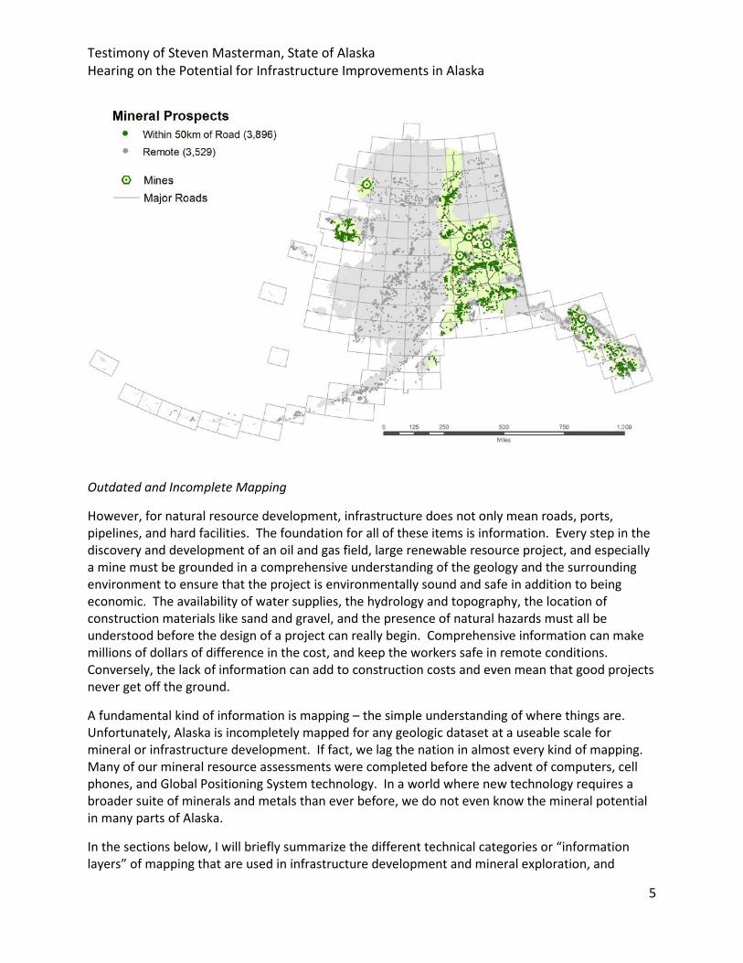
Many of the roads in Alaska today date back to prior infrastructure efforts to access mineral or energy resources, often gold. A quick look at the map below shows that half of Alaska’s known mineral prospects lie within 30 miles (50km) of a road. All of the currently operating large mines in Alaska were within 50 miles, and 5 of the 6 were within 30 miles, of existing roads or the coastline at the time of their discovery. The majority of Alaska’s advanced exploration or development projects also lie within 30 miles of a road or the coast. Simply put, road access facilitates mineral discovery, production, jobs, and local connectivity.
Testimony of Steven Masterman, State of Alaska Hearing on the Potential for Infrastructure Improvements in Alaska
5
Outdated and Incomplete Mapping
However, for natural resource development, infrastructure does not only mean roads, ports, pipelines, and hard facilities. The foundation for all of these items is information. Every step in the discovery and development of an oil and gas field, large renewable resource project, and especially a mine must be grounded in a comprehensive understanding of the geology and the surrounding environment to ensure that the project is environmentally sound and safe in addition to being economic. The availability of water supplies, the hydrology and topography, the location of construction materials like sand and gravel, and the presence of natural hazards must all be understood before the design of a project can really begin. Comprehensive information can make millions of dollars of difference in the cost, and keep the workers safe in remote conditions. Conversely, the lack of information can add to construction costs and even mean that good projects never get off the ground.
A fundamental kind of information is mapping – the simple understanding of where things are. Unfortunately, Alaska is incompletely mapped for any geologic dataset at a useable scale for mineral or infrastructure development. If fact, we lag the nation in almost every kind of mapping. Many of our mineral resource assessments were completed before the advent of computers, cell phones, and Global Positioning System technology. In a world where new technology requires a broader suite of minerals and metals than ever before, we do not even know the mineral potential in many parts of Alaska.
In the sections below, I will briefly summarize the different technical categories or “information layers” of mapping that are used in infrastructure development and mineral exploration, and
Testimony of Steven Masterman, State of Alaska Hearing on the Potential for Infrastructure Improvements in Alaska
6
identify areas where Alaska is especially in need of investment and improvement. As you will see, across most of Alaska, these layers are incomplete, outdated, and unavailable in digital formats used by modern explorers. The primary information layers include geologic, geophysical, and geochemical, mineral resource assessments, topography, and hazards mapping.
Basic Geologic Mapping
Basic Geologic maps describe the fundamental geologic features of areas – such as the age of various rock formations, the different structures that are present, and the distribution of different rock types at the surface. This information forms the basis for initial mineral exploration by providing an understanding of what kind of minerals may be present. Without geologic information, explorers and infrastructure builders are working with a blank canvas.
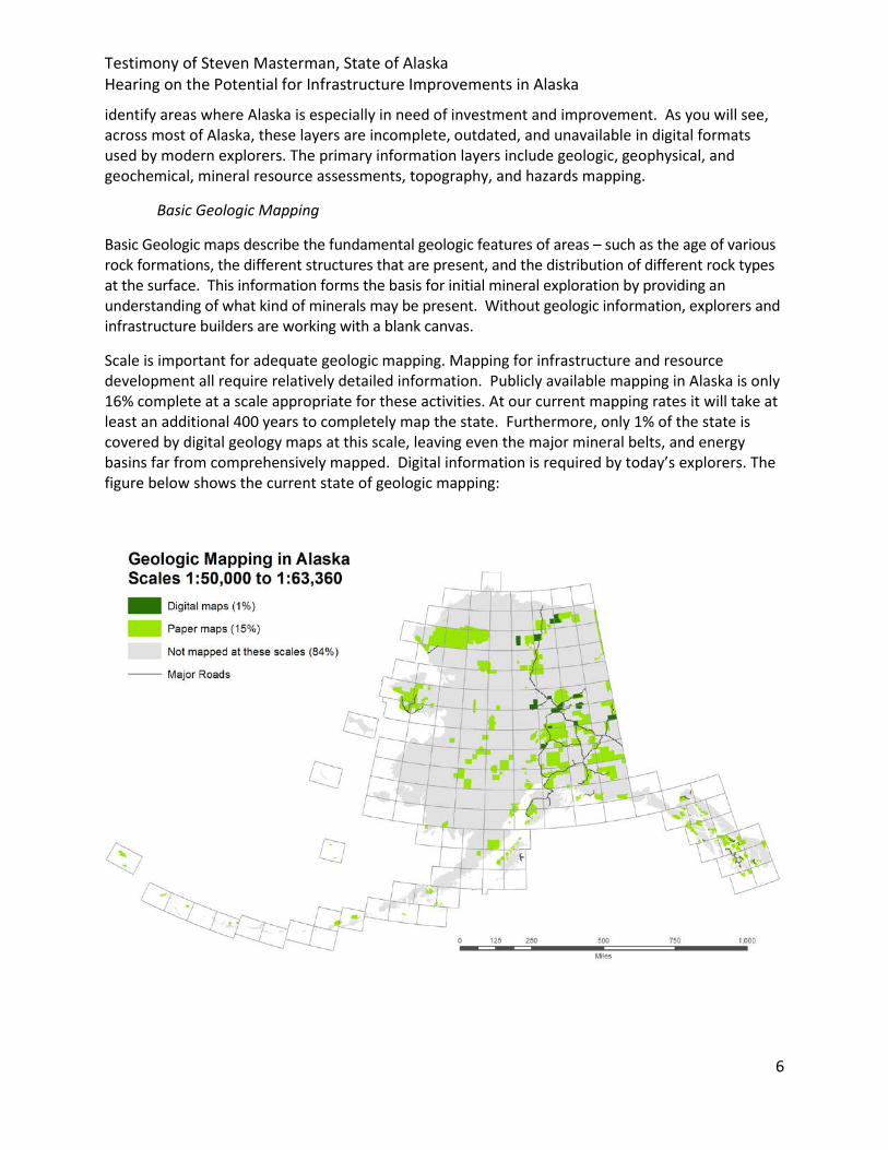
Scale is important for adequate geologic mapping. Mapping for infrastructure and resource development all require relatively detailed information. Publicly available mapping in Alaska is only 16% complete at a scale appropriate for these activities. At our current mapping rates it will take at least an additional 400 years to completely map the state. Furthermore, only 1% of the state is covered by digital geology maps at this scale, leaving even the major mineral belts, and energy basins far from comprehensively mapped. Digital information is required by today’s explorers. The figure below shows the current state of geologic mapping:
Testimony of Steven Masterman, State of Alaska Hearing on the Potential for Infrastructure Improvements in Alaska
7
Geophysical Mapping Geophysical maps display the electric, magnetic and radiogenic characteristics of rocks in an area, and often contribute to construction of geologic maps. Geophysical data allows geologists to “see” beneath dense tree or soil cover. Today, high quality information can be relatively quickly gathered using helicopter and airplane based tools. Alaska is about 4% mapped by high-quality airborne geophysical surveys. In addition to being a tool to better understand unexplored and undeveloped resources, geophysical mapping around existing infrastructure is important to identify permafrost, groundwater, sand and gravel resources, and geologic hazards. When coupled with good geologic maps, geophysical information can be very valuable to explorers. This kind of data has already led to numerous mineral discoveries in Alaska, including gold that is currently being produced from the Pogo gold mine. As more geophysical mapping is completed we expect to see increased investment in exploration and production in several different prospective areas.
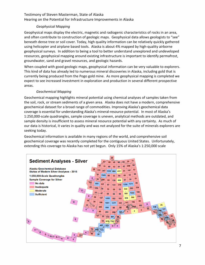
Geochemical Mapping Geochemical mapping highlights mineral potential using chemical analyses of samples taken from the soil, rock, or stream sediments of a given area. Alaska does not have a modern, comprehensive geochemical dataset for a broad range of commodities. Improving Alaska’s geochemical data coverage is essential for understanding Alaska’s mineral-resource potential. In most of Alaska’s 1:250,000-scale quadrangles, sample coverage is uneven, analytical methods are outdated, and sample density is insufficient to assess mineral resource potential with any certainty. As much of our data is historical, it varies in quality and was not analyzed for the suite of minerals explorers are seeking today. Geochemical information is available in many regions of the world, and comprehensive soil geochemical coverage was recently completed for the contiguous United States. Unfortunately, extending this coverage to Alaska has not yet begun. Only 15% of Alaska’s 1:250,000 scale
Testimony of Steven Masterman, State of Alaska Hearing on the Potential for Infrastructure Improvements in Alaska
8
quadrangles have adequate stream sediment coverage and modern analyses for a metal as common as silver, and many other metals and minerals have much less information. Federal focus on soil geochemistry and stream sediment geochemical mapping will be critical to Alaska’s infrastructure planning and future mineral development.
Mineral Resource Assessments
Mineral resource assessments are a compilation of different kinds of information that assess the quantity of a mineral or commodity likely to be present within a geographic area. Many of Alaska’s energy and mineral resource assessments were conducted decades ago. Many of them are outdated or inaccurate to the extent that some single oil and mineral discoveries contain more resources than the assessment predicted for a specific petroleum play, or mineral model, in an entire region.
In general, these estimates of undiscovered resources have underestimated volumes, in some cases considerably, because they are based on historical or incomplete data. For a region as underexplored as Alaska, new technology and new data will likely show more potential than is currently recognized. These assessments need to be updated to reflect recent oil and mineral deposit discoveries. Additionally, for minerals such as rare earth elements that underlie advanced technology and modern military hardware, assessments that were begun with state funding, but due to recent budget constraints, have been suspended, need to be completed. The nation needs to update these assessments to understand its domestic supplies of critical and strategic minerals. However, to successfully do so the portfolio of geologic, geophysical, and geochemical information for these areas must be improved as well.
Topographic Mapping
Topography is the three dimensional surface of the earth, and an accurate understanding of it is critical to the planning and development of infrastructure. The USGS is the nation’s principal civilian mapping agency, and is in the midst of a national effort to collect modern, highly accurate topographic data through its 3D Elevation Program. The result of this program will be coast-to-coast elevation data with far more detail than previously available. The elevation data collected by this program and resulting topographic maps will improve the usefulness of other geologic data and aid in the design of new infrastructure.
In Alaska, the USGS will soon complete the acquisition of interferometric synthetic aperture radar (IFSAR) data, which allows for high resolution contour mapping of the surface. This is a good first step to improved mapping in Alaska, but many additional geospatial layers need to be completed to have a full understanding of Alaska’s complex topography. Light Detection and Ranging (LIDAR) data will need to be gathered to further understand topography in areas where IFSAR data is not high enough in resolution, and bathymetric data is needed to support maritime infrastructure development, coastal security, offshore oil and mineral resource assessments, and coastal hazards analyses. While Alaska has been making progress in this area, it has only come through dedicated federal focus and investment to move it forward in partnership with the State. We appreciate this collaborative partnership which has been led by the Alaska Mapping Executive Committee under the leadership of the Department of the Interior.
Testimony of Steven Masterman, State of Alaska Hearing on the Potential for Infrastructure Improvements in Alaska
9
Geologic and Seismic Hazard Mapping and Monitoring
The same geologic richness and complexity that creates Alaska’s abundant mineral resources has also created an environment ripe with geological hazards, including permafrost, landslides, active faults, 54 active volcanoes, and numerous areas prone to large earthquakes. Any infrastructure project must understand how these hazards impact safe and efficient operations before it can be undertaken.
When undertaking capital investment, risk is cost. And the best way to mitigate the risk and cost of geologic hazards is comprehensive information about their likelihood coupled with active monitoring.
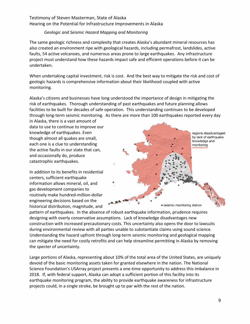
Alaska’s citizens and businesses have long understood the importance of design in mitigating the risk of earthquakes. Thorough understanding of past earthquakes and future planning allows facilities to be built for decades of safe operation. This understanding continues to be developed through long-term seismic monitoring. As there are more than 100 earthquakes reported every day in Alaska, there is a vast amount of data to use to continue to improve our knowledge of earthquakes. Even though almost all quakes are small, each one is a clue to understanding the active faults in our state that can, and occasionally do, produce catastrophic earthquakes.
In addition to its benefits in residential centers, sufficient earthquake information allows mineral, oil, and gas development companies to routinely make hundred-million-dollar engineering decisions based on the historical distribution, magnitude, and pattern of earthquakes. In the absence of robust earthquake information, prudence requires designing with overly conservative assumptions. Lack of knowledge disadvantages new construction with increased precautionary costs. This uncertainty also opens the door to lawsuits during environmental review with all parties unable to substantiate claims using sound science. Understanding the hazard upfront through long-term seismic monitoring and geological mapping can mitigate the need for costly retrofits and can help streamline permitting in Alaska by removing the specter of uncertainty.
Large portions of Alaska, representing about 10% of the total area of the United States, are uniquely devoid of the basic monitoring assets taken for granted elsewhere in the nation. The National Science Foundation’s USArray project presents a one-time opportunity to address this imbalance in 2018. If, with federal support, Alaska can adopt a sufficient portion of this facility into its earthquake monitoring program, the ability to provide earthquake awareness for infrastructure projects could, in a single stroke, be brought up to par with the rest of the nation.

Testimony of Steven Masterman, State of Alaska Hearing on the Potential for Infrastructure Improvements in Alaska
10
Alaska’s 54 active volcanoes also present unique challenges, both for local infrastructure and international and military aviation safety. Volcanic ash from eruptions presents a threat to military aircraft engaged in national defense and in military training exercises, and to passenger and freight flights between North America and the Far East. In fact, over 90% of air traffic between North America and Asia crosses airspace that can be affected by Alaska’s volcanoes. Improvements to maintain functional geophysical monitoring networks at high threat and very high threat volcanoes under new digital standards required by the National Telecommunications and Information Administration (NTIA) are unattainable at current funding levels. Especially in the context of the State’s current fiscal circumstances, federal support will be critical to keep the national interests in hazard mapping and monitoring progressing to current standards and levels.
Materials and Construction Supplies Identification
Finally, improvements in the resource information above can have an important practical benefit to infrastructure projects – identifying soil conditions suitable for construction and identifying the presence of sand and gravel, armor stone, and railroad ballast along transportation corridors. In Alaska this kind of information is only very sporadically publicly available, and additional information about it would increase competition and drive down costs for these challenging projects.
IV. Alaskan Infrastructure Improvements Will Promote Local Economies and Benefit the Country as a Whole
Energy and minerals investment are cornerstones of Alaska’s state economy, through employment and economic activity during the exploration phase and the additional royalty and tax revenue benefits when prospects are brought into production. Infrastructure built to support projects can also decrease the cost of living by providing energy supplies to communities, increasing public access, and lowering the price of goods and services. For projects that occur in remote areas, they can often be a significant source of well-paying jobs that bring a community together. For a mine like Red Dog in Northwest Alaska, it can be an economic engine for an entire region. However, Alaska’s resources are also a national level asset, and their development and production yields national benefits.
One significant national contribution Alaska’s mineral resources could provide is supply security. In 2016, the United States imported 100% of 20 mineral commodities and was dependent on foreign sources for over 50% of its usage for an additional 51 mineral commodities. This reliance has increased from just two years ago in 2014, when the USGS reported 19 mineral commodities were 100% imported and 41 were over 50% imported. At a time when domestic infrastructure investment is a national priority, the United States is becoming even more dependent on foreign supplies of minerals rather than producing domestic supplies. With federal infrastructure support, Alaska’s storehouse of mineral wealth could be key to reversing this trend. As shown in the chart below, almost all of these minerals are historically, currently, and potentially available from Alaskan deposits.

Testimony of Steven Masterman, State of Alaska Hearing on the Potential for Infrastructure Improvements in Alaska
11
Alaska and the United States are competing with countries all around the world to produce minerals and receive the associated economic and security benefits. In many of these countries or states, governments support their domestic industry through the same kind of infrastructure projects we are discussing today - baseline resource information and national road, airport, and sea port investments. In the United States, geological data collection and distribution has long been recognized as a key investment and responsibility for federal and state governments through their geologic surveys.
Without a federal partnership for resource infrastructure, Alaskan supplies and Alaskan projects will be at a disadvantage in the international marketplace, and the national trend of increasing reliance on imports of minerals and metals may continue. Only those large companies that can bear the cost of collecting the raw data and developing their own infrastructure portfolios will be able to do business, exploration costs will be higher, and competition will suffer. The remote regions of Alaska that may have the most potential, may see very little exploration at all.
However, with federal leadership and partnership, we can build an information and infrastructure base that will promote Alaska’s potential to lead the nation in mineral production, and safeguard our economy and military from reliance on entirely foreign supplies of materials. There has never been a better time to develop natural resource information, as computing and communications
Testimony of Steven Masterman, State of Alaska Hearing on the Potential for Infrastructure Improvements in Alaska
12
technology allow more data to be gathered in a day than a team would do in a season when Alaska’s resource information was initially developed. In summary, the more we know about Alaska’s natural resources, the more well-designed and economically important infrastructure we will be able to put into place, resulting in more employment and economic benefits accruing to Alaska and the United States.
V. Alaska’s Numerous Significant Potential Development and Infrastructure Projects
In addition to the general infrastructure issues and benefits summarized in my testimony so far, I wanted to provide highlights of a number of significant ongoing resource and infrastructure development projects in Alaska. This list is by no means exhaustive, but all of these projects could benefit, along with their associated economic and employment opportunities, from the information and infrastructure investments I have presented. I will also summarize the work of the Alaska Industrial Development and Export Authority (AIDEA), which functions as a state infrastructure support fund.
The Alaska Natural Gasline Project
Alaska has been working hard to develop what may be the largest infrastructure project in our nation's history – an 800 mile large diameter natural gas line to bring Alaska's immense natural gas resources to market. Over $600 million has already been spent to date on engineering, design, and regulatory permitting for the main three components of the project:
o A gas conditioning plant on the North Slope o An 800-mile gas pipeline o A liquefaction plant and port at tidewater
The potential gas supply for this project are the massive volumes of natural gas that are daily reinjected back into the North Slope oil fields to provide the additional pressure needed to extract more oil. Much of that gas is no longer needed for pressurization and is now available to be sold in world markets. This volume of gas is significant enough to provide almost twice Korea’s demand and up to 80 percent of Japan’s, two of the world’s largest consumers of LNG.
This project’s scope and impact would be analogous to the construction of the Trans Alaska Oil Pipeline, which created over 70,000 constructions jobs, across the United States supplying equipment, materials, and personnel. In addition to the job growth and economic stimulus within Alaska and the United States, the international sale of this volume of LNG, primarily throughout Asia, could reduce the United States' trade deficit by up to 20 percent.
Additionally, development begets development. Building this pipeline would vastly improve the potential economics of oil exploration across the North Slope, because it would provide a way to take associated natural gas finds to market in addition to oil finds. This enhanced natural gas availability could strengthen the development of other industries in Alaska - such as mining and industrial products development - and support the U.S. military's Alaska-based Arctic operations. The virtuous cycle of growth from all of this additional development would boost employment, promote trade that puts U.S. interests first, and strengthen the United States' strategically important position in the Arctic and Pacific theaters. Marketing these vast amounts of Alaskan LNG

Testimony of Steven Masterman, State of Alaska Hearing on the Potential for Infrastructure Improvements in Alaska
13
to the Pacific Rim would also have a huge geopolitical impact - allowing our nation's allies to cut their dependence on energy supplies from our potential adversaries and economic competitors.
AIDEA – The State’s Vehicle for Financing Infrastructure Development
AIDEA is a state government entity that provides innovative financing for mineral and infrastructure projects to lower project capital and borrowing costs. Expended funds are repaid by the development over the course of its operation. Similar use of federal funds for major project infrastructure elements has been used to reduce capital costs and incentivize development of national energy and mineral resources, and the State would be happy to explore and further describe this work with federal partners.
AIDEA, as a public corporation of the State of Alaska, has a mission to promote the health, security, and general welfare of Alaska through increasing job opportunities and otherwise encouraging the economic growth of the state, including the development of its natural resources, through support for manufacturing, industrial, energy, export, and small business enterprises. AIDEA provides various means of financing, including through partnership with other financial institutions, private sector enterprises, economic development groups, and guarantee agencies, to advance these kinds of projects. AIDEA has assisted Alaskan companies in industries across the state for 50 years and has facilitated more than $12 billion in export and investment activity. More than 90 percent of AIDEA’s customers are small and medium-sized companies, and a substantial amount of its annual activity brings jobs and cost of living benefits in Alaska’s rural areas.
A frequently cited example of a successful AIDEA project is the “Red Dog Road”, formally titled the DeLong Mountains Transportation System. It was opened in 1989 by AIDEA to facilitate the Red Dog mine development with a 50-year repayment period. As of 2026, the bonds that financed the road will be paid down by the mine and the transportation system will operate at a profit. Many of the projects enumerated in my testimony could explore similar infrastructure partnerships with AIDEA or potential federal partners.
Ambler Mining District Industrial Access Project (AMDIAP)
The Ambler Mining District in northern Alaska contains numerous prospects for copper, gold, lead, zinc, and silver production. The U.S. Congress has previously recognized the mineral potential of the area and the role access could play to support its economic development. The AMDIAP project could provide all-weather surface access to the Ambler Mining District to facilitate development of several of these deposits, and enable further exploration and characterization of the area's resources. The 225-mile road is modeled on AIDEA's successful DeLong Mountain Transportation System.
The Donlin Gold Project
The Donlin Gold project, currently going through permitting and National Environmental Policy Act (NEPA) review, has gold reserves and resources in excess of 40 million ounces. It is a remote project in western Alaska that requires significant new infrastructure: a power generation plant, mill, wastewater treatment plant, conveyor systems, warehouses, truck shop and offices, a port site on the Kuskokwim River, and a 30-mile long access road from port to the mine. In addition, a new airstrip, camp and port near Bethel will be built. Power required for the mining operations is
Testimony of Steven Masterman, State of Alaska Hearing on the Potential for Infrastructure Improvements in Alaska
14
proposed to be produced from an on-site natural gas-fired generation facility, with natural gas supplies from the Cook Inlet basin via a 312-mile long, 14-inch diameter steel pipeline. As an example of the local cost-of-living benefits, this pipeline will also serve as a new energy source for the surrounding villages, reducing their power costs.
The Graphite Creek Project
Located on the Seward Peninsula, approximately 50 miles from Nome, this is the largest graphite deposit in the United States and could supply the nation’s graphite needs for decades. Natural graphite is a “Supply Critical Mineral”, and currently there is no domestic production. Infrastructure needed for the project is anticipated to include a 16-mile, all-season access road and a power generating facility. In addition, the project is exploring opportunities to locate their graphite reprocessing facility in Alaska, which, with infrastructure and financing support, would be an additional boost for local employment and economics.
The Palmer Project
Located approximately 35 miles from Haines in Southeast Alaska, Palmer is a high-grade copper-zinc deposit with tremendous expansion potential. Future infrastructure needs would include a 15 mile access road and a power generating facility. Development of this project would be a new economic engine in a region that has lost its significant timber industry in the last several decades.
Bokan Mountain
The Bokan property on Prince of Wales Island is the largest heavy rare earth deposit in the U.S. Approximately 40% (by weight) of the rare earth elements contained on the property are heavy rare earths elements – which are especially useful in advanced technology and military applications. Infrastructure required includes road development and a processing facilities, either at the mine site or in Ketchikan approximately 35 miles away. The Alaska State Legislature has already approved AIDEA support for the project in recognition of its local and national importance.
The Niblack Project
The Alaska Legislature has also authorized AIDEA to support the Niblack Project, a copper-gold, zinc-silver deposit on Prince of Wales Island. The construction and operation of a mineral processing mill, dock, and loading facilities at the Gravina Island Industrial Complex in Ketchikan would, like the previous two projects, provide a jobs boost and a new economic center in Southeast Alaska.
Information Gathering to Address Coastal Community Challenges
Many coastal communities in Alaska are situated in dynamic locations exposed to natural ocean processes and events. These communities are challenged by a lack of construction materials, and continuous erosion from large storms. Many communities do not have safe, reliable transportation routes to shelter and evacuation areas in the event of large storms or tsunamis. Continued federal support for ongoing federal-state collaborative community resilience, water level, coastal mapping, and storm surge modelling efforts are all needed to strengthen at-risk coastal communities around Alaska’s western and northern shores.

Testimony of Steven Masterman, State of Alaska Hearing on the Potential for Infrastructure Improvements in Alaska
15
Western Alaska Access Roads
The Road to Tanana officially opened in late August 2016. The road project brings significant benefits to the community of Tanana by reducing freight and cargo costs, reducing travel costs for residents and visitors, and increasing access to mineral exploration in the Interior. The $13.7 million-dollar project involved constructing 20 miles of new road and upgrading 14 miles of existing road.
Continuing this road effort west to the Seward Peninsula would expand these demonstrated economic benefits to a larger area; provide a transportation link to a broad geographic region that is currently constrained by remote access, and improve access to mineral-rich areas along the route.
Kotzebue to Cape Blossom Road
The Cape Blossom Road project would construct a new 12 mile two-lane, gravel road connecting Kotzebue to a potential port site at Cape Blossom. This would improve transportation efficiency and reduce the cost of shipping freight between cargo barges and the Northwest Arctic Borough communities.
VI. Conclusion – the Continued Need for Federal Support
As presented above, one of the key roles the federal government can play in supporting mineral development in Alaska is to strengthen its longstanding role and responsibility of developing information infrastructure about Alaska’s resources and geologic characteristics. Whether for identifying new prospects or designing the infrastructure needed to develop known prospects, this kind of information is a critical foundation. The federal government would be well served in collecting this information for the international-level resource opportunities in Alaska.
The national interests in infrastructure development in Alaska are significant – increasing domestic supply security of our mineral portfolio, increasing our competitiveness, strengthening America’s position in the Arctic, boosting our economies, and potentially reducing the nation’s trade imbalance. These are the kind of benefits that should be recognized in a new chapter of federal partnership and investment in Alaska. With solid federal support, we look forward to fulfilling Alaska’s role as a storehouse for our nation’s resource wealth – and the jobs and cost-of-living benefits utilizing these resources will bring.
Related Documents