Terry Fox Unification Relay September 2015 – Anglophone West School District Saint Mary’s Academy to John Caldwell School Map #1

Welcome message from author
This document is posted to help you gain knowledge. Please leave a comment to let me know what you think about it! Share it to your friends and learn new things together.
Transcript

Terry Fox Unification Relay September 2015 – Anglophone West School District
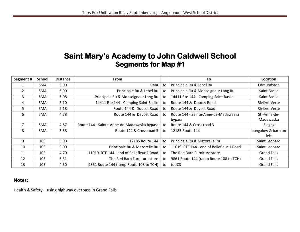
Saint Mary’s Academy to John Caldwell School
Map #1
Terry Fox Unification Relay September 2015 – Anglophone West School District
Saint Mary’s Academy to John Caldwell School Segments for Map #1
Segment # School Distance From To Location
1 SMA 5.00 SMA to Principale Ru & Lebel Ru Edmundston
2 SMA 5.00 Principale Ru & Lebel Ru to Principale Ru & Monseigneur Lang Ru Saint Basile
3 SMA 5.08 Principale Ru & Monseigneur Lang Ru to 14411 Rte 144 - Camping Saint Basile Saint Basile
4 SMA 5.10 14411 Rte 144 - Camping Saint Basile to Route 144 & Doucet Road Rivière-Verte
5 SMA 5.18 Route 144 & Doucet Road to Route 144 & Devost Road Rivière-Verte
6 SMA 4.78 Route 144 & Devost Road to Route 144 - Sainte-Anne-de-Madawaska bypass
St.-Anne-de-Madawaska
7 SMA 4.87 Route 144 - Sainte-Anne-de-Madawaska bypass to Route 144 & Cross road 3 Siegas
8 SMA 3.58 Route 144 & Cross road 3 to 12185 Route 144 bungalow & barn on left
9 JCS 5.00 12185 Route 144 to Principale Ru & Mazorelle Ru Saint Leonard
10 JCS 5.00 Principale Ru & Mazorelle Ru to 11019 RTE 144 - end of Bellefleur 1 Road Saint Leonard
11 JCS 4.70 11019 RTE 144 - end of Bellefleur 1 Road to The Red Barn Furniture store Grand Falls
12 JCS 5.31 The Red Barn Furniture store to 9861 Route 144 (ramp Route 108 to TCH) Grand Falls
13 JCS 4.60 9861 Route 144 (ramp Route 108 to TCH) to to JCS Grand Falls
Notes:
Health & Safety – using highway overpass in Grand Falls
Terry Fox Unification Relay September 2015 – Anglophone West School District
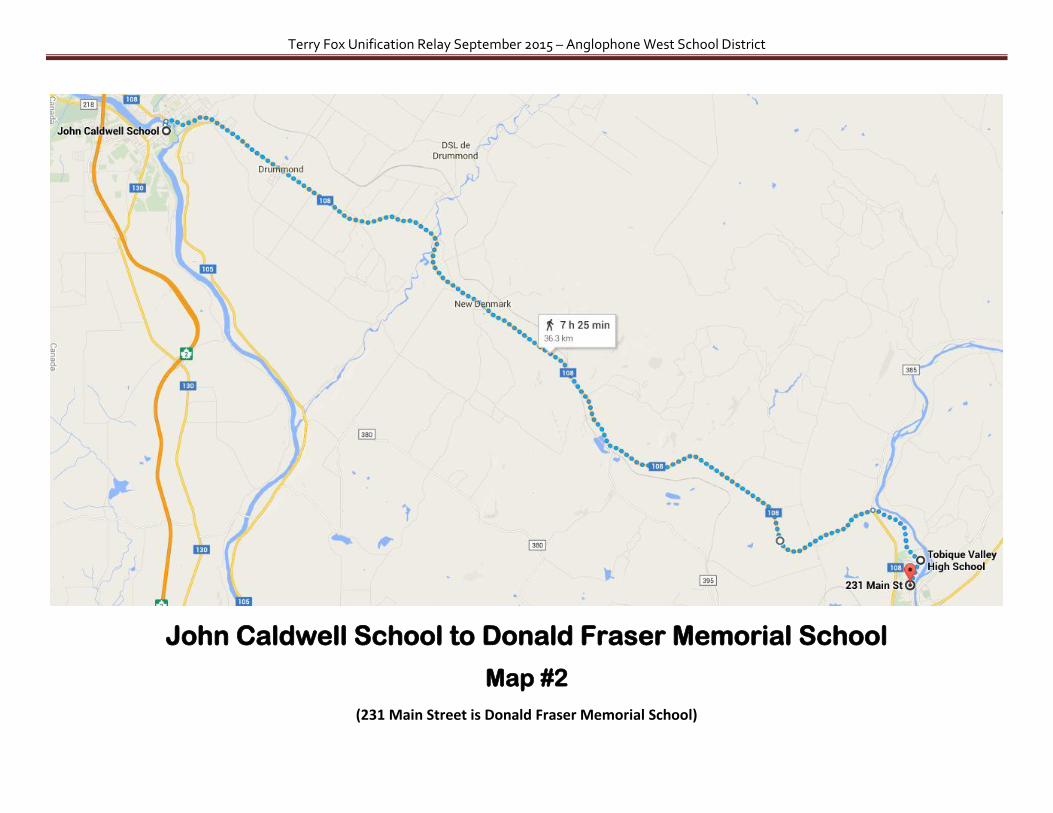
John Caldwell School to Donald Fraser Memorial School
Map #2
(231 Main Street is Donald Fraser Memorial School)
Terry Fox Unification Relay September 2015 – Anglophone West School District
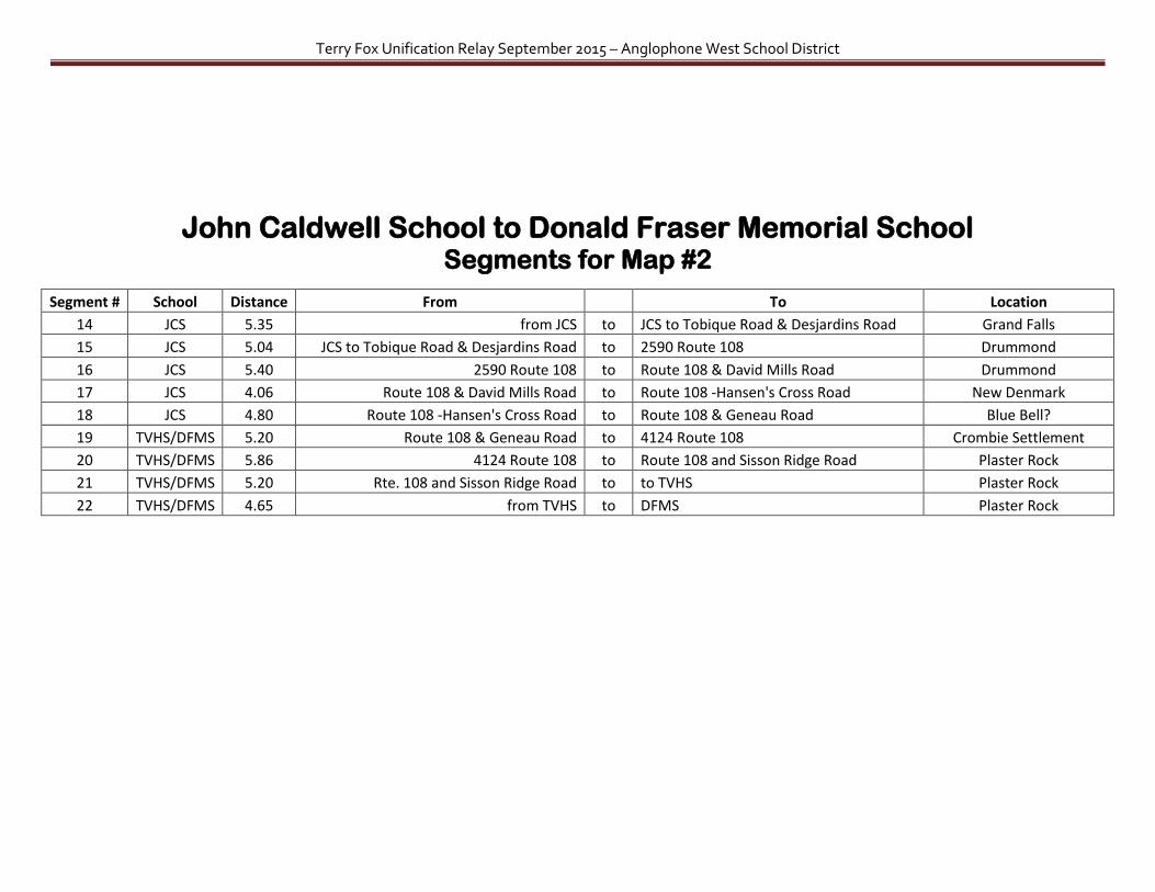
John Caldwell School to Donald Fraser Memorial School Segments for Map #2
Segment # School Distance From
To Location
14 JCS 5.35 from JCS to JCS to Tobique Road & Desjardins Road Grand Falls
15 JCS 5.04 JCS to Tobique Road & Desjardins Road to 2590 Route 108 Drummond
16 JCS 5.40 2590 Route 108 to Route 108 & David Mills Road Drummond
17 JCS 4.06 Route 108 & David Mills Road to Route 108 -Hansen's Cross Road New Denmark
18 JCS 4.80 Route 108 -Hansen's Cross Road to Route 108 & Geneau Road Blue Bell?
19 TVHS/DFMS 5.20 Route 108 & Geneau Road to 4124 Route 108 Crombie Settlement
20 TVHS/DFMS 5.86 4124 Route 108 to Route 108 and Sisson Ridge Road Plaster Rock
21 TVHS/DFMS 5.20 Rte. 108 and Sisson Ridge Road to to TVHS Plaster Rock
22 TVHS/DFMS 4.65 from TVHS to DFMS Plaster Rock
Terry Fox Unification Relay September 2015 – Anglophone West School District
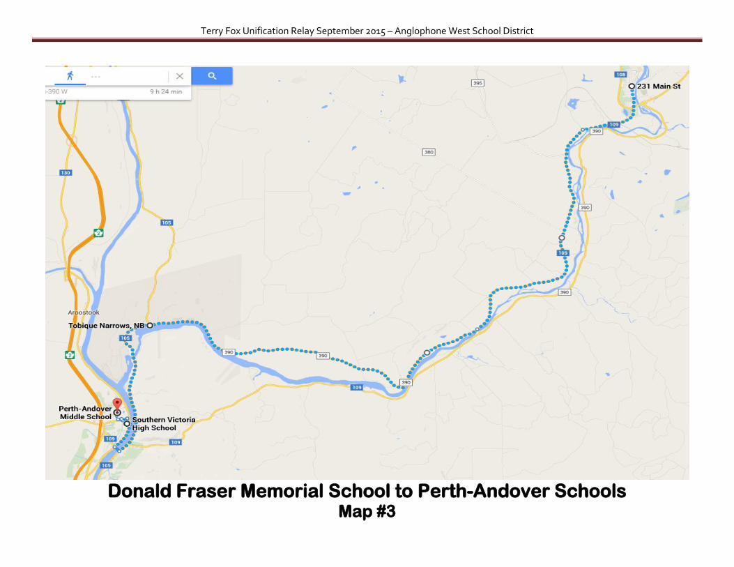
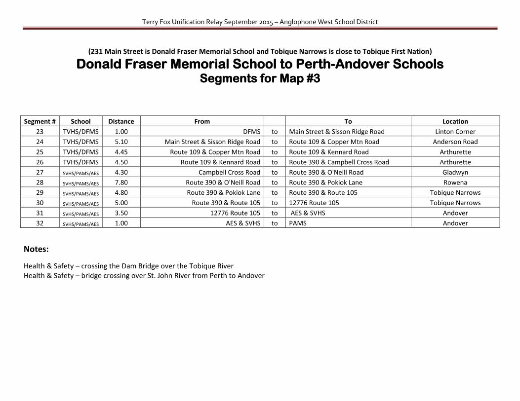
Donald Fraser Memorial School to Perth-Andover Schools Map #3
Terry Fox Unification Relay September 2015 – Anglophone West School District
(231 Main Street is Donald Fraser Memorial School and Tobique Narrows is close to Tobique First Nation)
Donald Fraser Memorial School to Perth-Andover Schools Segments for Map #3
Segment # School Distance From
To Location
23 TVHS/DFMS 1.00 DFMS to Main Street & Sisson Ridge Road Linton Corner
24 TVHS/DFMS 5.10 Main Street & Sisson Ridge Road to Route 109 & Copper Mtn Road Anderson Road
25 TVHS/DFMS 4.45 Route 109 & Copper Mtn Road to Route 109 & Kennard Road Arthurette
26 TVHS/DFMS 4.50 Route 109 & Kennard Road to Route 390 & Campbell Cross Road Arthurette
27 SVHS/PAMS/AES 4.30 Campbell Cross Road to Route 390 & O'Neill Road Gladwyn
28 SVHS/PAMS/AES 7.80 Route 390 & O'Neill Road to Route 390 & Pokiok Lane Rowena
29 SVHS/PAMS/AES 4.80 Route 390 & Pokiok Lane to Route 390 & Route 105 Tobique Narrows
30 SVHS/PAMS/AES 5.00 Route 390 & Route 105 to 12776 Route 105 Tobique Narrows
31 SVHS/PAMS/AES 3.50 12776 Route 105 to AES & SVHS Andover
32 SVHS/PAMS/AES 1.00 AES & SVHS to PAMS Andover
Notes:
Health & Safety – crossing the Dam Bridge over the Tobique River Health & Safety – bridge crossing over St. John River from Perth to Andover

Terry Fox Unification Relay September 2015 – Anglophone West School District
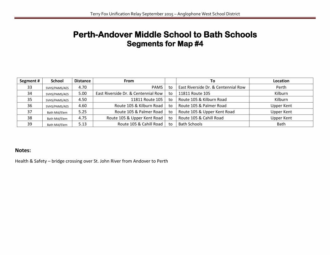
Perth-Andover Middle School to Bath Schools Map #4
Terry Fox Unification Relay September 2015 – Anglophone West School District
Perth-Andover Middle School to Bath Schools Segments for Map #4
Segment # School Distance From To Location
33 SVHS/PAMS/AES 4.70 PAMS to East Riverside Dr. & Centennial Row Perth
34 SVHS/PAMS/AES 5.00 East Riverside Dr. & Centennial Row to 11811 Route 105 Kilburn
35 SVHS/PAMS/AES 4.50 11811 Route 105 to Route 105 & Kilburn Road Kilburn
36 SVHS/PAMS/AES 4.60 Route 105 & Kilburn Road to Route 105 & Palmer Road Upper Kent
37 Bath Mid/Elem 5.25 Route 105 & Palmer Road to Route 105 & Upper Kent Road Upper Kent
38 Bath Mid/Elem 4.75 Route 105 & Upper Kent Road to Route 105 & Cahill Road Upper Kent
39 Bath Mid/Elem 5.13 Route 105 & Cahill Road to Bath Schools Bath
Notes:
Health & Safety – bridge crossing over St. John River from Andover to Perth

Terry Fox Unification Relay September 2015 – Anglophone West School District
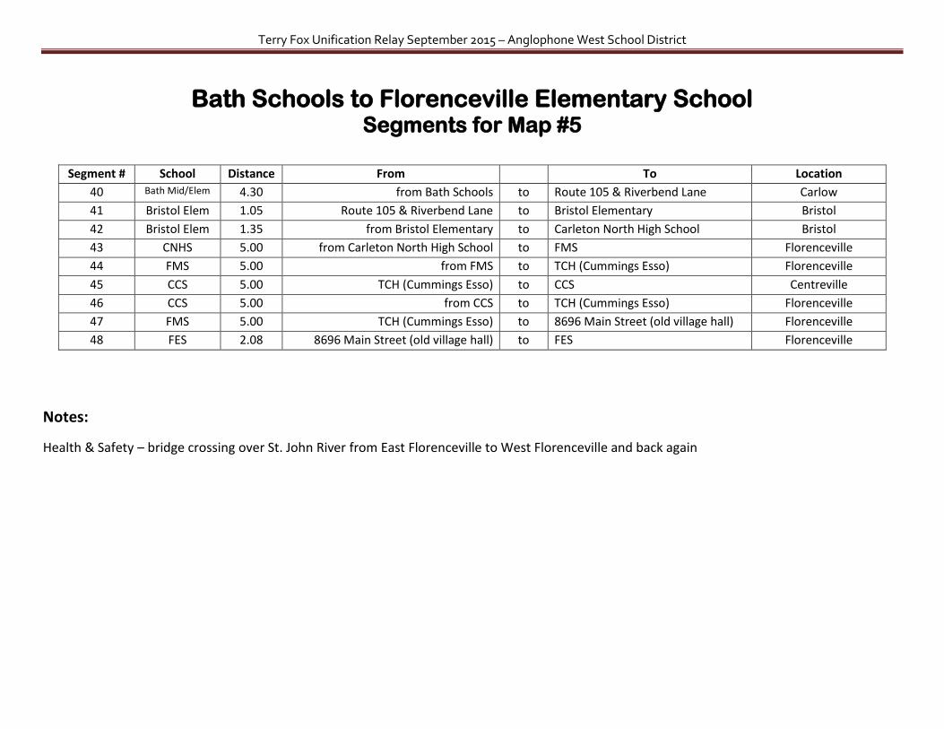
Bath Schools to Florenceville Elementary School Map #5
Terry Fox Unification Relay September 2015 – Anglophone West School District
Bath Schools to Florenceville Elementary School Segments for Map #5
Segment # School Distance From To Location
40 Bath Mid/Elem 4.30 from Bath Schools to Route 105 & Riverbend Lane Carlow
41 Bristol Elem 1.05 Route 105 & Riverbend Lane to Bristol Elementary Bristol
42 Bristol Elem 1.35 from Bristol Elementary to Carleton North High School Bristol
43 CNHS 5.00 from Carleton North High School to FMS Florenceville
44 FMS 5.00 from FMS to TCH (Cummings Esso) Florenceville
45 CCS 5.00 TCH (Cummings Esso) to CCS Centreville
46 CCS 5.00 from CCS to TCH (Cummings Esso) Florenceville
47 FMS 5.00 TCH (Cummings Esso) to 8696 Main Street (old village hall) Florenceville
48 FES 2.08 8696 Main Street (old village hall) to FES Florenceville
Notes:
Health & Safety – bridge crossing over St. John River from East Florenceville to West Florenceville and back again
Terry Fox Unification Relay September 2015 – Anglophone West School District
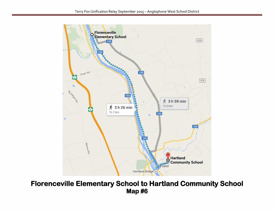
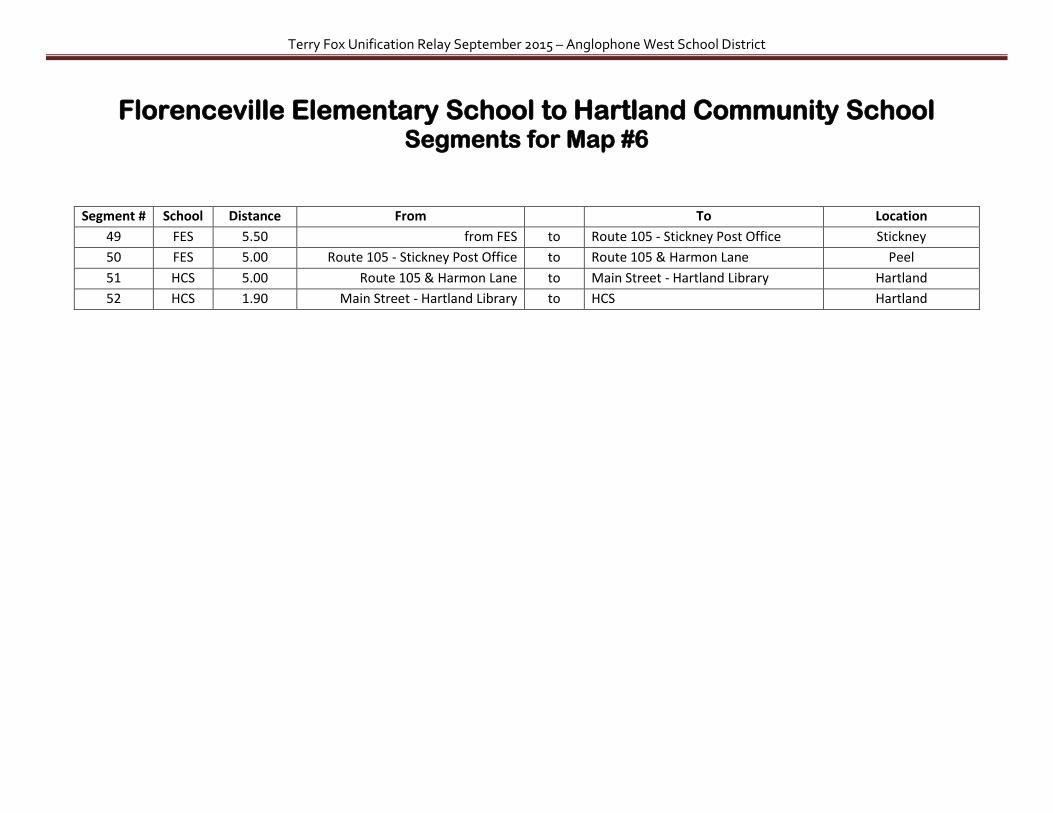
Florenceville Elementary School to Hartland Community School Map #6
Terry Fox Unification Relay September 2015 – Anglophone West School District
Florenceville Elementary School to Hartland Community School Segments for Map #6
Segment # School Distance From To Location
49 FES 5.50 from FES to Route 105 - Stickney Post Office Stickney
50 FES 5.00 Route 105 - Stickney Post Office to Route 105 & Harmon Lane Peel
51 HCS 5.00 Route 105 & Harmon Lane to Main Street - Hartland Library Hartland
52 HCS 1.90 Main Street - Hartland Library to HCS Hartland

Terry Fox Unification Relay September 2015 – Anglophone West School District
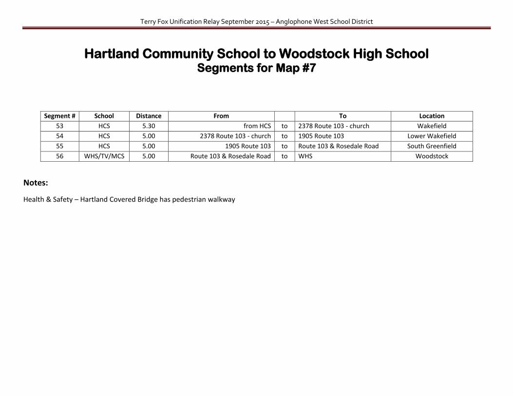
Hartland Community School to Woodstock High School Map #7
Terry Fox Unification Relay September 2015 – Anglophone West School District
Hartland Community School to Woodstock High School Segments for Map #7
Segment # School Distance From To Location
53 HCS 5.30 from HCS to 2378 Route 103 - church Wakefield
54 HCS 5.00 2378 Route 103 - church to 1905 Route 103 Lower Wakefield
55 HCS 5.00 1905 Route 103 to Route 103 & Rosedale Road South Greenfield
56 WHS/TV/MCS 5.00 Route 103 & Rosedale Road to WHS Woodstock
Notes:
Health & Safety – Hartland Covered Bridge has pedestrian walkway
Terry Fox Unification Relay September 2015 – Anglophone West School District
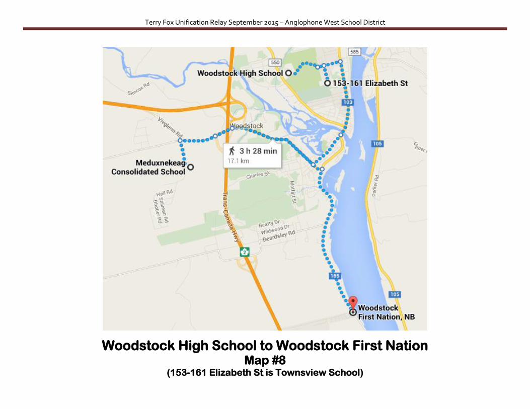
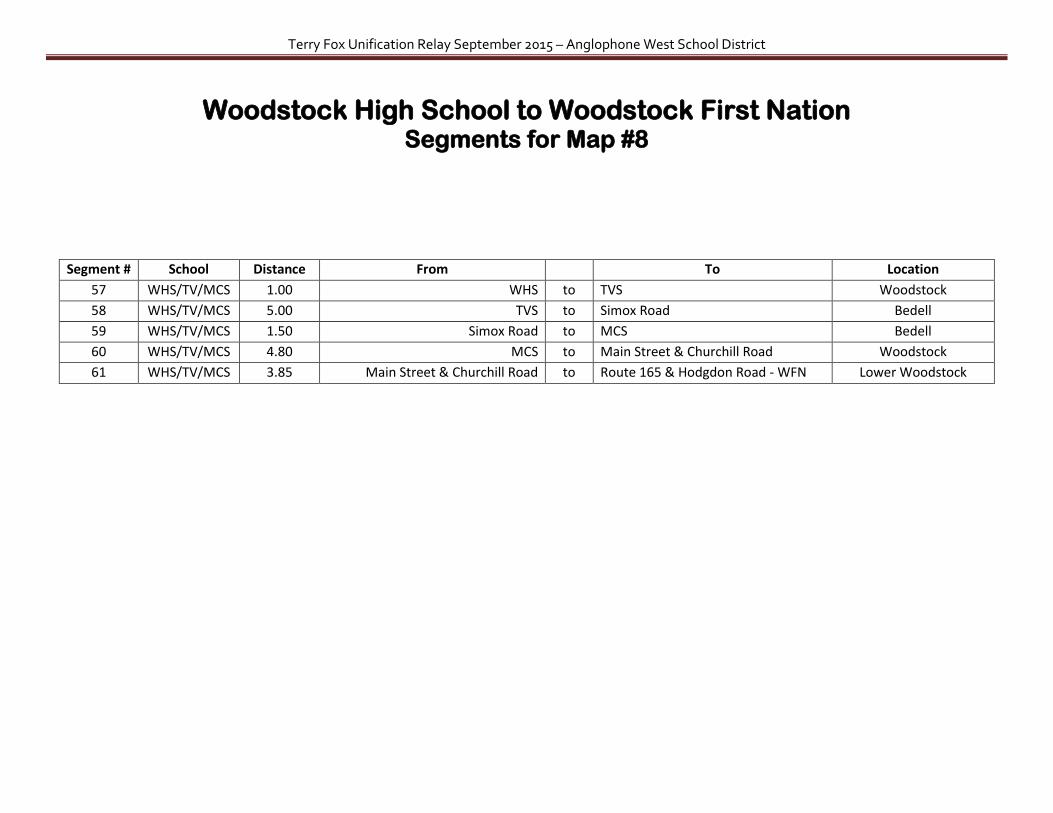
Woodstock High School to Woodstock First Nation Map #8
(153-161 Elizabeth St is Townsview School)
Terry Fox Unification Relay September 2015 – Anglophone West School District
Woodstock High School to Woodstock First Nation Segments for Map #8
Segment # School Distance From To Location
57 WHS/TV/MCS 1.00 WHS to TVS Woodstock
58 WHS/TV/MCS 5.00 TVS to Simox Road Bedell
59 WHS/TV/MCS 1.50 Simox Road to MCS Bedell
60 WHS/TV/MCS 4.80 MCS to Main Street & Churchill Road Woodstock
61 WHS/TV/MCS 3.85 Main Street & Churchill Road to Route 165 & Hodgdon Road - WFN Lower Woodstock
Terry Fox Unification Relay September 2015 – Anglophone West School District
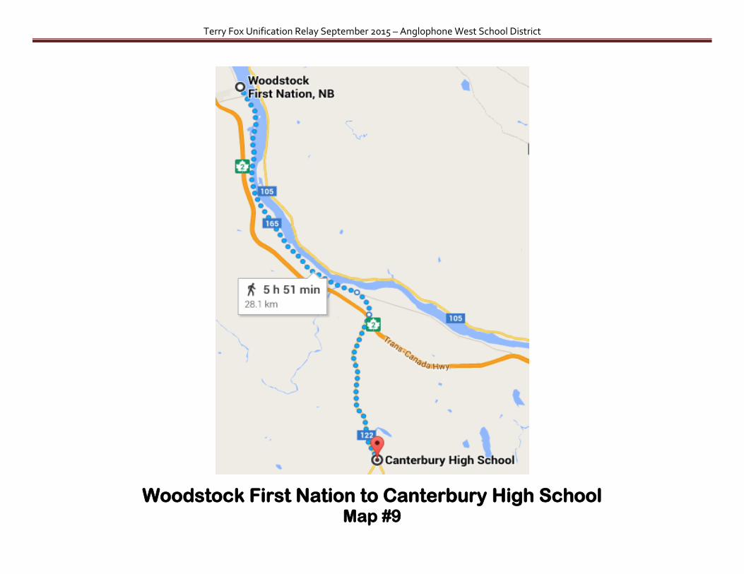
Woodstock First Nation to Canterbury High School Map #9
Terry Fox Unification Relay September 2015 – Anglophone West School District
Woodstock First Nation to Canterbury High School Segments for Map #9
Segment # School Distance From To Location
62 WHS/TV/MCS 5.53 Route 165 & Hodgdon Road to Route 165 & Punkin Lane Hay Settlement
63 WHS/TV/MCS 5.00 Route 165 & Punkin Lane to #798 Route 165 & Fort Meductic Hay Settlement
64 WHS/TV/MCS 4.00 #798 Route 165 & Fort Meductic to Route 165 & Main Street Meductic
65 CHS 4.75 Route 165 & Main Street to Route 122 & Johnson Settlement Road Dow Settlement
66 CHS 4.50 Route 122 & Johnson Settlement Road to #806 Route 122 Canterbury
67 CHS 3.70 #806 Route 122 to CHS Canterbury

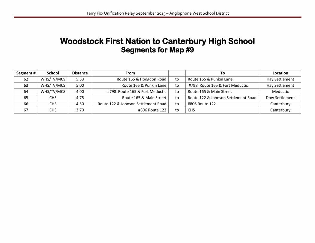
Terry Fox Unification Relay September 2015 – Anglophone West School District
Canterbury High School to Nackawic Bridge Map #10
Terry Fox Unification Relay September 2015 – Anglophone West School District
Canterbury High School to Nackawic Bridge Segments for Map #10
Segment # School Distance From To Location
68 CHS 4.50 CHS to #806 Route 122 Canterbury
69 CHS 4.75 #806 Route 122 to Route 122 & Johnson Settlement Road Dow Settlement
70 CHS 5.00 Route 122 & Johnson Settlement Road to 178 Temple Road (statue of white horse) Meductic
71 CHS 5.00 178 Temple Road (statue of white horse) to Temple Road - middle of nowhere Ritchie
72 CHS 4.50 Temple Road - middle of nowhere to End of Ritchie Road Ritchie
73 NHS/NMS/NES 5.00 End of Ritchie Road to Pokiok Road – torn down Irving gas station Pokiok
Notes:
Health & Safety – End of Ritchie road crosses water on foot bridge that is not accessible by car
Terry Fox Unification Relay September 2015 – Anglophone West School District
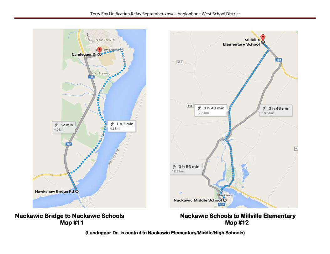
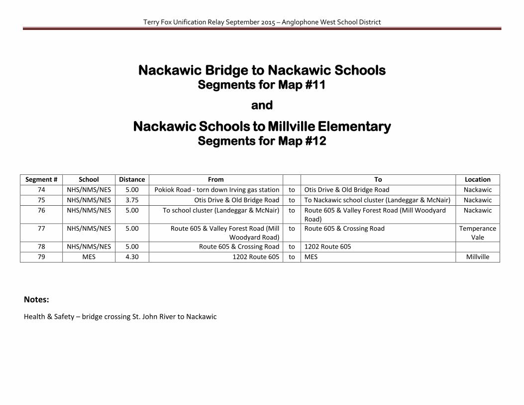
Nackawic Bridge to Nackawic Schools Nackawic Schools to Millville Elementary Map #11 Map #12
(Landeggar Dr. is central to Nackawic Elementary/Middle/High Schools)
Terry Fox Unification Relay September 2015 – Anglophone West School District
Nackawic Bridge to Nackawic Schools
Segments for Map #11
and
Nackawic Schools to Millville Elementary Segments for Map #12
Segment # School Distance From To Location
74 NHS/NMS/NES 5.00 Pokiok Road - torn down Irving gas station to Otis Drive & Old Bridge Road Nackawic
75 NHS/NMS/NES 3.75 Otis Drive & Old Bridge Road to To Nackawic school cluster (Landeggar & McNair) Nackawic
76 NHS/NMS/NES 5.00 To school cluster (Landeggar & McNair) to Route 605 & Valley Forest Road (Mill Woodyard Road)
Nackawic
77 NHS/NMS/NES 5.00 Route 605 & Valley Forest Road (Mill Woodyard Road)
to Route 605 & Crossing Road Temperance Vale
78 NHS/NMS/NES 5.00 Route 605 & Crossing Road to 1202 Route 605
79 MES 4.30 1202 Route 605 to MES Millville
Notes:
Health & Safety – bridge crossing St. John River to Nackawic
Terry Fox Unification Relay September 2015 – Anglophone West School District
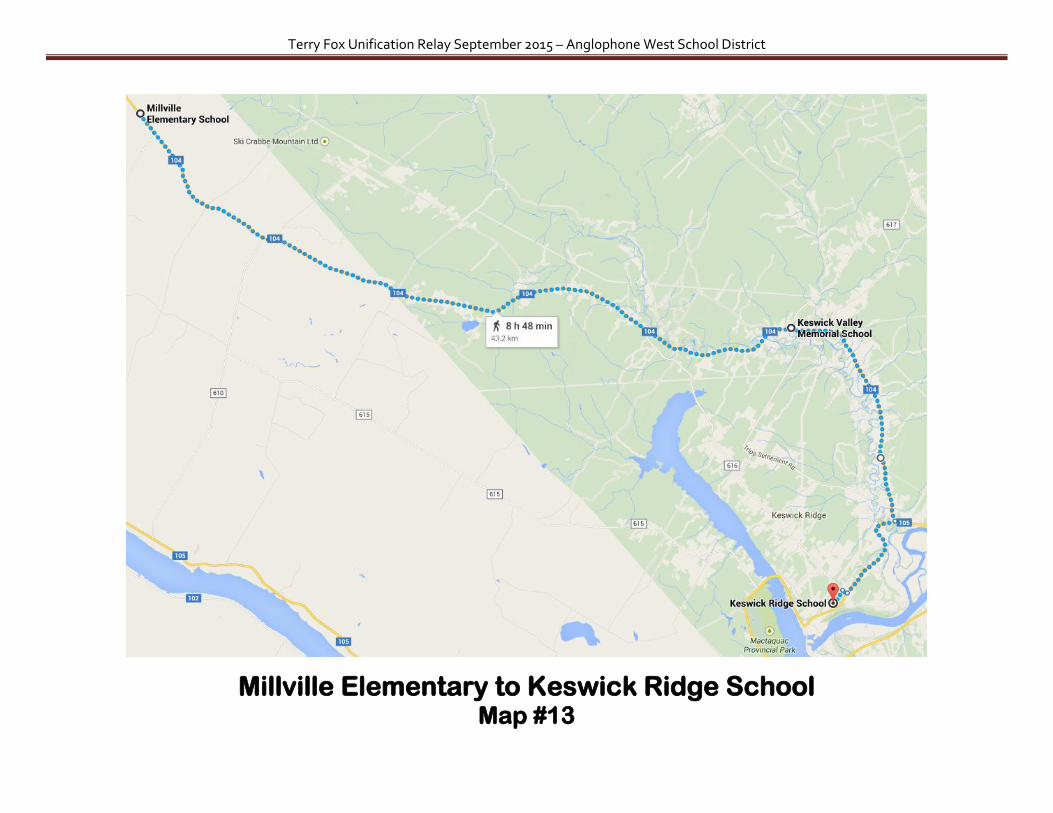
Millville Elementary to Keswick Ridge School Map #13

Terry Fox Unification Relay September 2015 – Anglophone West School District
Millville Elementary to Keswick Ridge School Segments for Map #13
Segment # School Distance From
To Location
80 MES 4.50 MES to Route 104 & Valley Forest Road (or Napadogan Rd.?)
in the middle of nowhere
81 MES 4.40 Route 104 & Valley Forest Road
(or Napadogan Rd.?) to 3081 Route 104 Upper Hainesville
82 MES 3.75 3081 Route 104 to Route 104 & Grub Road Lower Hainesville
83 KVMS 5.00 Route 104 & Grub Road to Route 104 & Central Hainesville Road
84 KVMS 5.00 Route 104 & Central Hainesville Road to Route 104 & Route 616 Morehouse Corner
85 KVMS 4.60 Route 104 & Route 616 to Route 104 & Sisson Settlement Road Burtt’s Corner
86 KVMS 1.76 Route 104 & Sisson Settlement Road to KVMS Burtt's Corner
87 KVMS 6.50 KVMS to 373 Route 104 (yellow house past chick hatchery)
Burtt’s Corner
88 KRS 5.00 373 Route 104
(yellow house past chick hatchery) to Route 105 & Potato Lane (vegetable stand) Mouth of Keswick
89 KRS 4.00 Route 105 & Potato Lane (vegetable stand) to KRS Keswick Ridge

Terry Fox Unification Relay September 2015 – Anglophone West School District
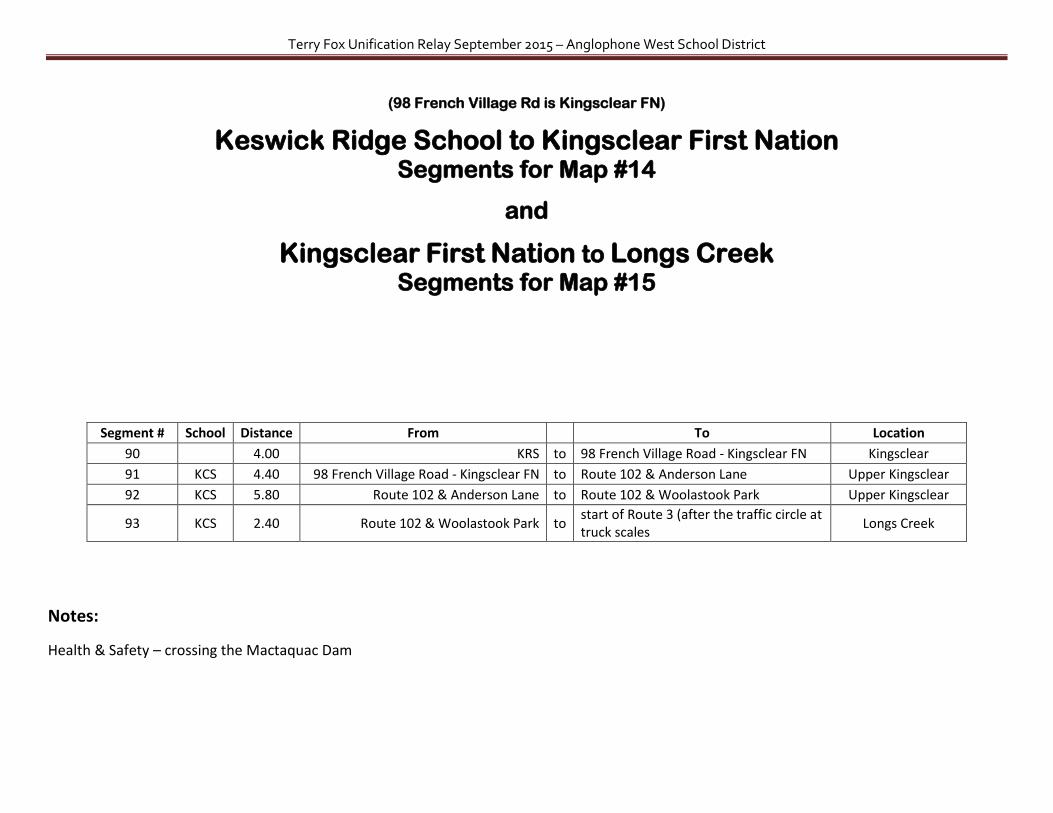
Keswick Ridge School to Kingsclear First Nation Kingsclear First Nation to Longs Creek Map #14 Map #15
Terry Fox Unification Relay September 2015 – Anglophone West School District
(98 French Village Rd is Kingsclear FN)
Keswick Ridge School to Kingsclear First Nation Segments for Map #14
and
Kingsclear First Nation to Longs Creek Segments for Map #15
Segment # School Distance From
To Location
90
4.00 KRS to 98 French Village Road - Kingsclear FN Kingsclear
91 KCS 4.40 98 French Village Road - Kingsclear FN to Route 102 & Anderson Lane Upper Kingsclear
92 KCS 5.80 Route 102 & Anderson Lane to Route 102 & Woolastook Park Upper Kingsclear
93 KCS 2.40 Route 102 & Woolastook Park to start of Route 3 (after the traffic circle at truck scales
Longs Creek
Notes:
Health & Safety – crossing the Mactaquac Dam

Terry Fox Unification Relay September 2015 – Anglophone West School District
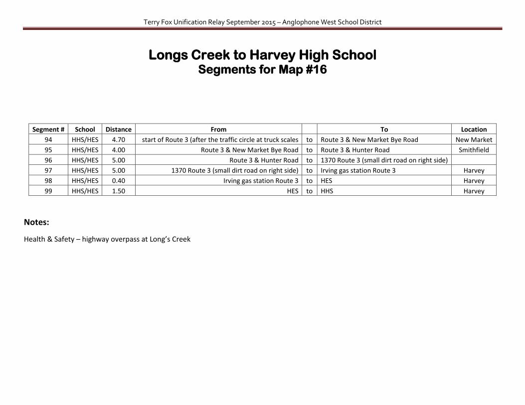
Longs Creek to Harvey High School Map #16
(1908 New Brunswick 3 is Harvey Elementary)
Terry Fox Unification Relay September 2015 – Anglophone West School District
Longs Creek to Harvey High School Segments for Map #16
Segment # School Distance From
To Location
94 HHS/HES 4.70 start of Route 3 (after the traffic circle at truck scales to Route 3 & New Market Bye Road New Market
95 HHS/HES 4.00 Route 3 & New Market Bye Road to Route 3 & Hunter Road Smithfield
96 HHS/HES 5.00 Route 3 & Hunter Road to 1370 Route 3 (small dirt road on right side)
97 HHS/HES 5.00 1370 Route 3 (small dirt road on right side) to Irving gas station Route 3 Harvey
98 HHS/HES 0.40 Irving gas station Route 3 to HES Harvey
99 HHS/HES 1.50 HES to HHS Harvey
Notes:
Health & Safety – highway overpass at Long’s Creek

Terry Fox Unification Relay September 2015 – Anglophone West School District
Harvey High School to McAdam High School Map #17

Terry Fox Unification Relay September 2015 – Anglophone West School District
Harvey High School to McAdam High School Segments for Map #17
Segment # School Distance From
To Location
100 HHS/HES 4.00 HHS to Route 3 & Swan Road Manners Sutton
101 HHS/HES 5.50 Route 3 & Swan Road to Route 3 & Route 635 York Mills
102 HHS/HES 3.50 Route 3 & Route 635 to Route 4 & Reynold Road Thomaston Corner
103 McAdamHS/MES 5.00 Route 4 & Reynold Road to 467 Route 4 (Unique Family Gifts)
104 McAdamHS/MES 5.00 467 Route 4 (Unique Family Gifts) to 1055 Route 4
105 McAdamHS/MES 5.00 1055 Route 4 to Harvey Road & Quality Way
106 McAdamHS/MES 1.50 Harvey Road & Quality Way to McAdam Elem McAdam
107 McAdamHS/MES 1.20 McAdam Elem to McAdam High McAdam
Note: at this point the relay could pick up again at Route 3 & Route 640 the next day or the return trip through Harvey to Route 640 by using the following segments:
Segment # School Distance From
To Location
108 McAdamHS/MES 5.00 McAdam High to
1385 Route 4 (going back towards Harvey)
109 McAdamHS/MES 5.00 1385 Route 4 (going back towards Harvey) to 895 Route 4
110 McAdamHS/MES 5.00 895 Route 4 to Route 4 & Christie Ridge turning spot
111 HHS/HES 5.00 Route 4 & Christie Ridge turning spot to 3225 Route 3
112 HHS/HES 5.40 3225 Route 3 to Route 3 & Frog Lake Road Coburn
113 HHS/HES 5.10 Route 3 & Frog Lake Road to Route 3 & Charlie Little Road Harvey
114 HHS/HES 5.80 Route 3 & Charlie Little Road to Route 3 & Route 640 Acton

Terry Fox Unification Relay September 2015 – Anglophone West School District
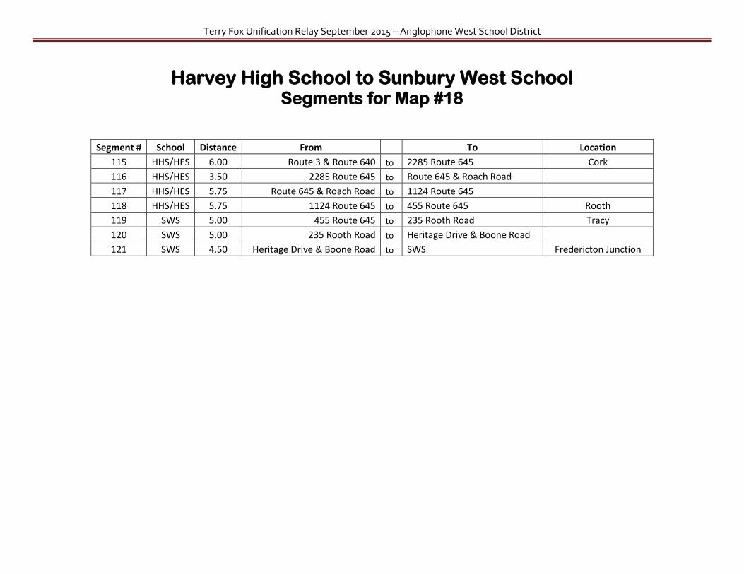
Harvey High School to Sunbury West School Map #18
(20-24 Prides Landing Rd is SWS)
Terry Fox Unification Relay September 2015 – Anglophone West School District
Harvey High School to Sunbury West School Segments for Map #18
Segment # School Distance From
To Location
115 HHS/HES 6.00 Route 3 & Route 640 to 2285 Route 645 Cork
116 HHS/HES 3.50 2285 Route 645 to Route 645 & Roach Road
117 HHS/HES 5.75 Route 645 & Roach Road to 1124 Route 645
118 HHS/HES 5.75 1124 Route 645 to 455 Route 645 Rooth
119 SWS 5.00 455 Route 645 to 235 Rooth Road Tracy
120 SWS 5.00 235 Rooth Road to Heritage Drive & Boone Road
121 SWS 4.50 Heritage Drive & Boone Road to SWS Fredericton Junction
Terry Fox Unification Relay September 2015 – Anglophone West School District
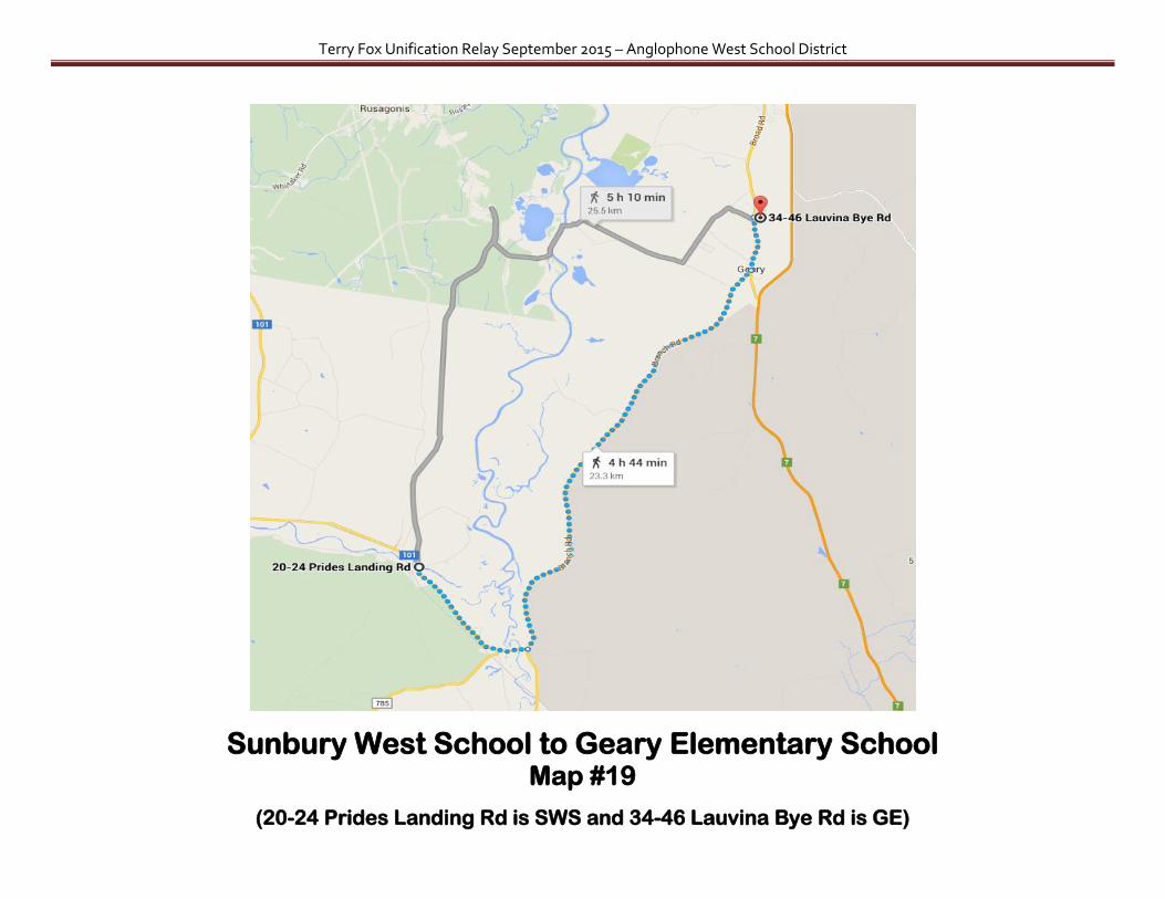
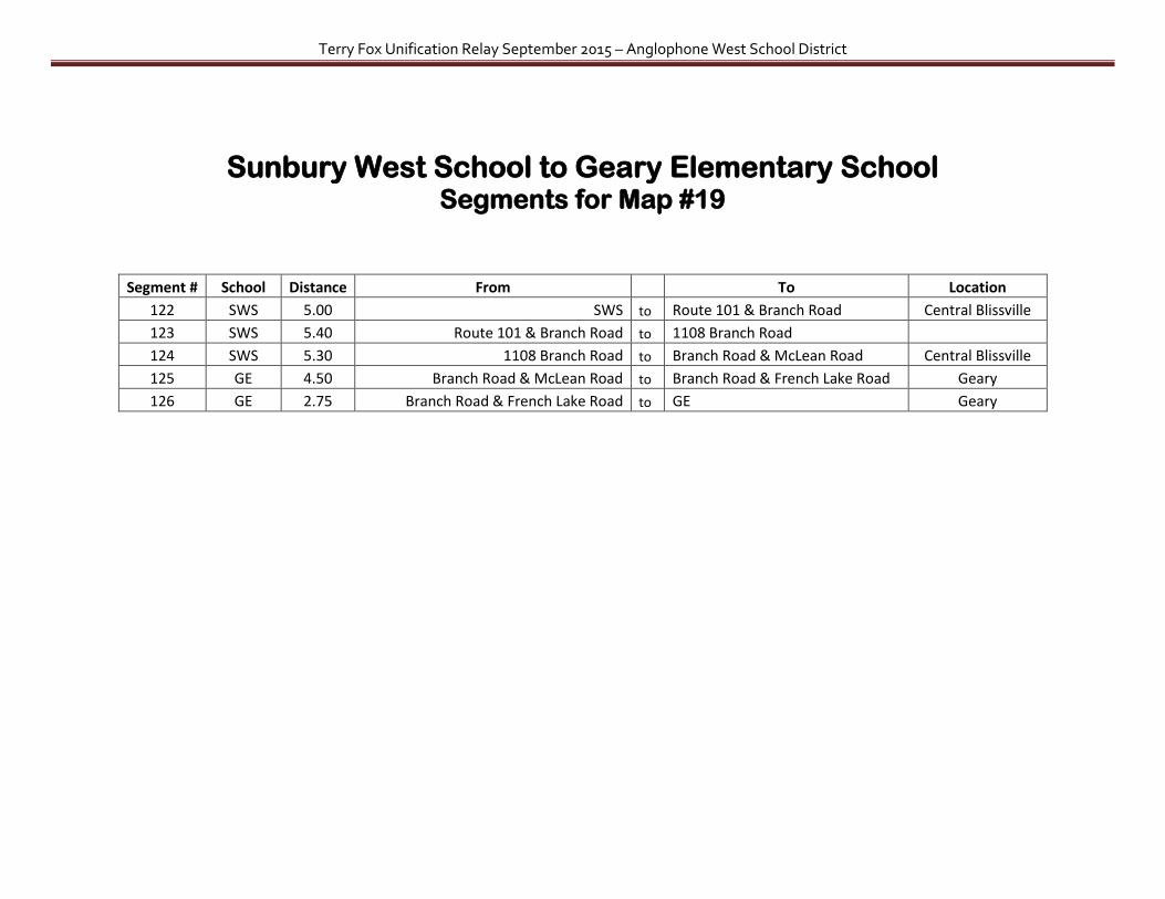
Sunbury West School to Geary Elementary School Map #19
(20-24 Prides Landing Rd is SWS and 34-46 Lauvina Bye Rd is GE)
Terry Fox Unification Relay September 2015 – Anglophone West School District
Sunbury West School to Geary Elementary School Segments for Map #19
Segment # School Distance From
To Location
122 SWS 5.00 SWS to Route 101 & Branch Road Central Blissville
123 SWS 5.40 Route 101 & Branch Road to 1108 Branch Road
124 SWS 5.30 1108 Branch Road to Branch Road & McLean Road Central Blissville
125 GE 4.50 Branch Road & McLean Road to Branch Road & French Lake Road Geary
126 GE 2.75 Branch Road & French Lake Road to GE Geary

Terry Fox Unification Relay September 2015 – Anglophone West School District
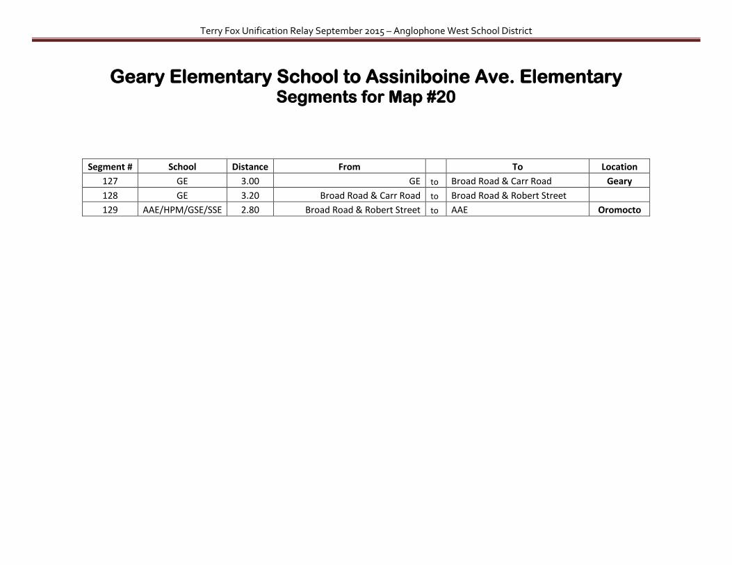
Geary Elementary School to Assiniboine Ave. Elementary Map #20
(22-32 Lauvina Bye Rd is GE)
Terry Fox Unification Relay September 2015 – Anglophone West School District
Geary Elementary School to Assiniboine Ave. Elementary Segments for Map #20
Segment # School Distance From
To Location
127 GE 3.00 GE to Broad Road & Carr Road Geary
128 GE 3.20 Broad Road & Carr Road to Broad Road & Robert Street
129 AAE/HPM/GSE/SSE 2.80 Broad Road & Robert Street to AAE Oromocto
Terry Fox Unification Relay September 2015 – Anglophone West School District
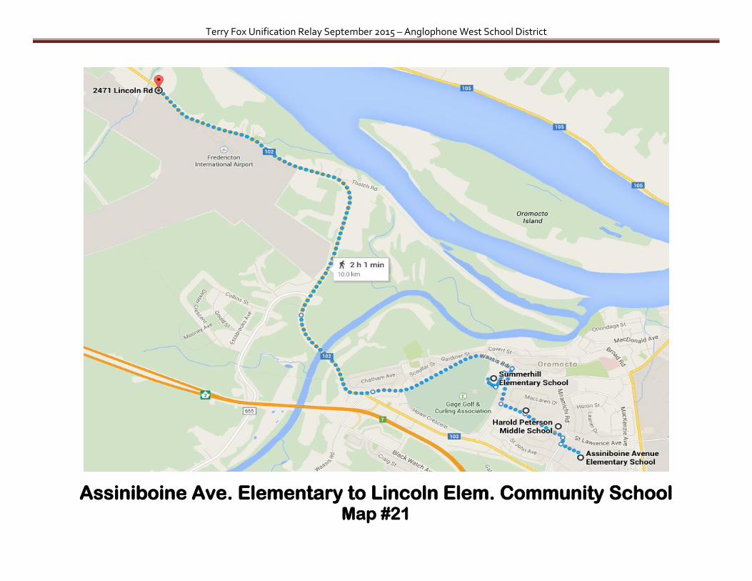
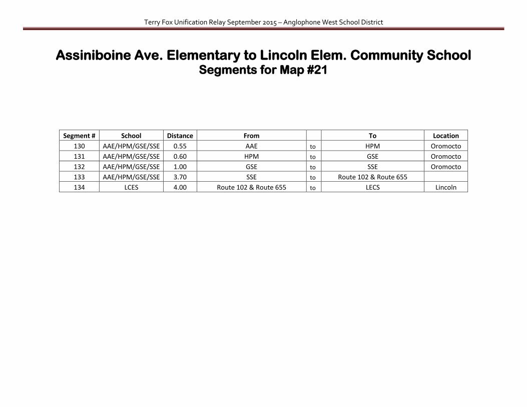
Assiniboine Ave. Elementary to Lincoln Elem. Community School Map #21

Terry Fox Unification Relay September 2015 – Anglophone West School District
(2471 Lincoln Road is LECS)
Terry Fox Unification Relay September 2015 – Anglophone West School District
Assiniboine Ave. Elementary to Lincoln Elem. Community School Segments for Map #21
Segment # School Distance From
To Location
130 AAE/HPM/GSE/SSE 0.55 AAE to HPM Oromocto
131 AAE/HPM/GSE/SSE 0.60 HPM to GSE Oromocto
132 AAE/HPM/GSE/SSE 1.00 GSE to SSE Oromocto
133 AAE/HPM/GSE/SSE 3.70 SSE to Route 102 & Route 655
134 LCES 4.00 Route 102 & Route 655 to LECS Lincoln
Terry Fox Unification Relay September 2015 – Anglophone West School District
Lincoln Elem. Community School to Burton Elementary School Map #22

Terry Fox Unification Relay September 2015 – Anglophone West School District
Lincoln Elem. Community School to Burton Elementary School Segments for Map #22
Segment # School Distance From
To Location
135 LCES 4.00 LECS to Route 102 & Route 655 Lincoln
136 OHS/HAE/RVM 4.50 Route 102 & Route 655 to OHS Oromocto
137 OHS/HAE/RVM 0.80 OHS to HAE Oromocto
138 OHS/HAE/RVM 0.70 HAE to RVM Oromocto
139 OHS/HAE/RVM 4.50 RVM to 175 Route 102
140 BE 5.00 175 Route 102 to BE Burton
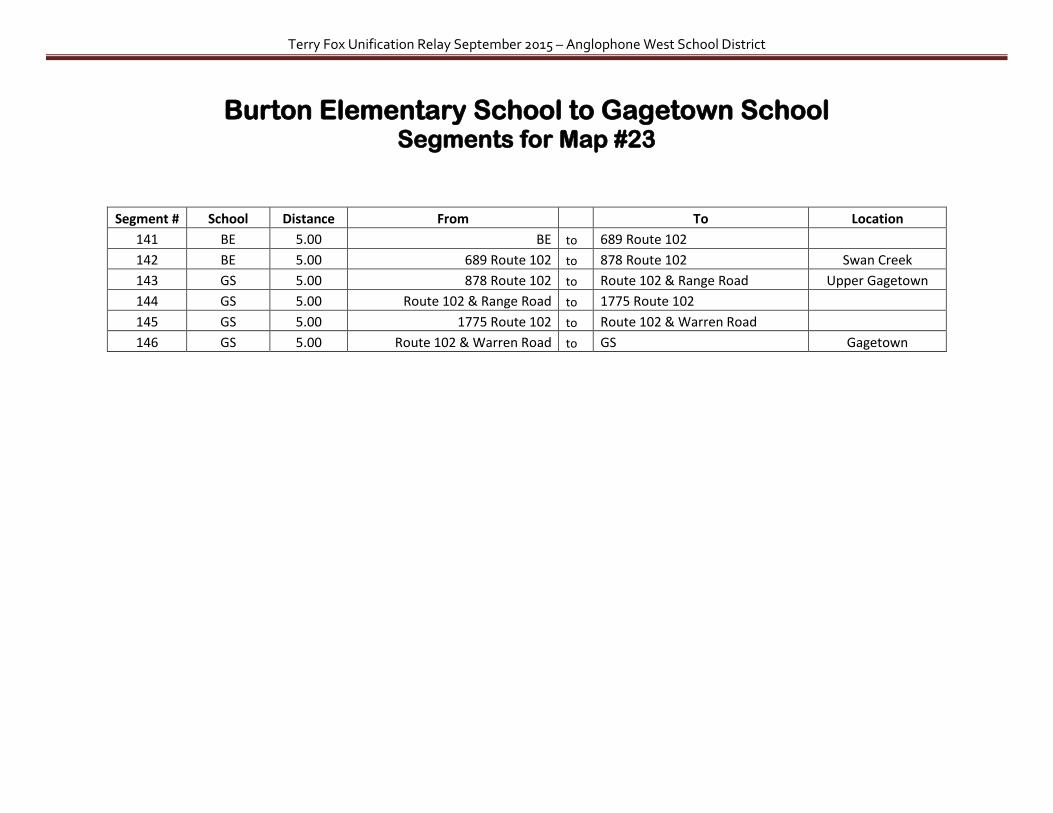
Terry Fox Unification Relay September 2015 – Anglophone West School District
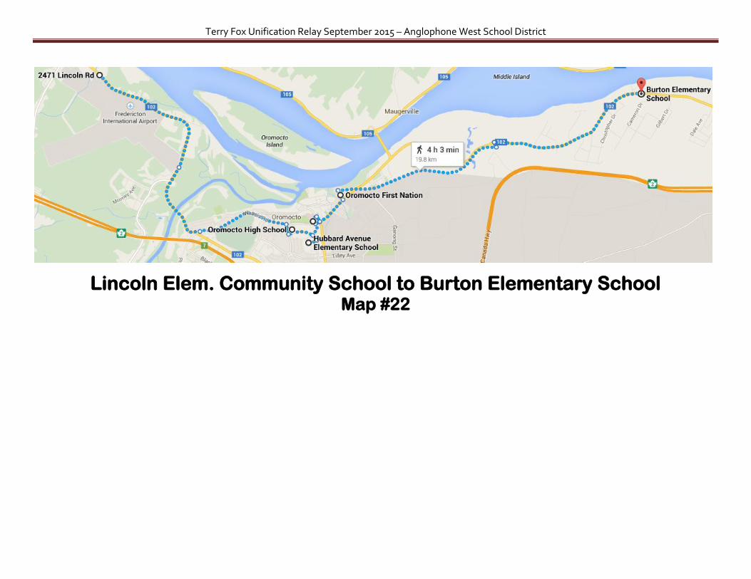
Burton Elementary School to Gagetown School Map #23
(6 Loomcroft Ln is Gagetown School)
Terry Fox Unification Relay September 2015 – Anglophone West School District
Burton Elementary School to Gagetown School Segments for Map #23
Segment # School Distance From
To Location
141 BE 5.00 BE to 689 Route 102
142 BE 5.00 689 Route 102 to 878 Route 102 Swan Creek
143 GS 5.00 878 Route 102 to Route 102 & Range Road Upper Gagetown
144 GS 5.00 Route 102 & Range Road to 1775 Route 102
145 GS 5.00 1775 Route 102 to Route 102 & Warren Road
146 GS 5.00 Route 102 & Warren Road to GS Gagetown

Terry Fox Unification Relay September 2015 – Anglophone West School District
Gagetown School to Cambridge-Narrows School Map #24

Terry Fox Unification Relay September 2015 – Anglophone West School District
(Lakeview Rd. is Cambridge-Narrows School)
Gagetown School to Cambridge-Narrows School Segments for Map #24
Segment # School Distance From
To Location
147 GS 3.00 GS to Ferry crossing to other side of river Scovil
148 CN 5.00 Ferry crossing to 520 Route 715 Lower Jemseg
149 CN 5.00 520 Route 715 to Route 715 & Route 695 Jemseg
150 CN 4.00 Route 715 & Route 695 to Route 695 & Reardon Road
151 CN 4.00 Route 695 & Reardon Road to Bridge Drive & Knight Road
152 CN 5.80 Bridge Drive & Knight Road to CNS Cambridge Narrows
Notes:
Health & Safety – using the Gagetown Ferry

Terry Fox Unification Relay September 2015 – Anglophone West School District
Cambridge-Narrows School to Youngs Cove Youngs Cove to Chipman Forest Ave. School Map #25 Map #26
(Lakeview Rd is Cambridge-Narrows School)

Terry Fox Unification Relay September 2015 – Anglophone West School District
Cambridge-Narrows School to Youngs Cove Segments for Map #25
and
Youngs Cove to Chipman Forest Ave. School Segments for Map #26
Segment # School Distance From
To Location
153 CN 5.00 CN to Lakeview Road & Pine Grove Lane
154 CN 5.00 Lakeview Road & Pine Grove Lane to 385 Union Settlement Road
155 CN 5.20 385 Union Settlement Road to Route 105 & V Wiggins Road Codys
156 CN 4.80 Route 105 & V Wiggins Road to Route 105 & Route 10 Youngs Cove
157 6.00 Route 105 & Route 10 to Route 10 & Cumberland Point Road
158 5.75 Route 10 & Cumberland Point Road to Route 10 & Cumberland Bay South Road
159 4.60 Route 10 & Cumberland Bay South Road to Route 10 & Cox Point Road
160 CPE/CFA 5.25 Route 10 & Cox Point Road to Route 10 & Drillon Road
161 CPE/CFA 5.00 Route 10 & Drillon Road to Main Street & Industrial Park Road
162 CPE/CFA 5.00 Main Street & Industrial Park Road to CFA Chipman
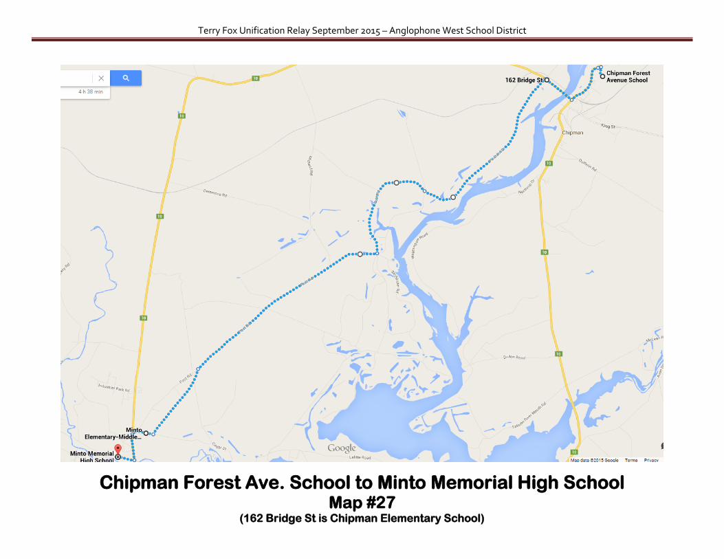
Terry Fox Unification Relay September 2015 – Anglophone West School District
Chipman Forest Ave. School to Minto Memorial High School Map #27
(162 Bridge St is Chipman Elementary School)

Terry Fox Unification Relay September 2015 – Anglophone West School District
Chipman Forest Ave. School to Minto Memorial High School Segments for Map #27
Segment # School Distance From
To Location
163 CPE/CFA 2.80 CFA to CPE Chipman
164 CPE/CFA 5.00 CPE to 386 Pleasant Dr. Post Road (going to Minto)
165 CPE/CFA 5.00 386 Pleasant Dr. Post Road (going to Minto) to 777 Post Road (going to Minto)
166 CPE/CFA 4.00 777 Post Road (going to Minto) to 1205 Post Road (going to Minto)
167 MintoHS/MES 5.00 1205 Post Road (going to Minto) to 1745 Post Road Minto
168 MintoHS/MES 3.00 1745 Post Road to Minto Elem Minto
169 MintoHS/MES 2.70 Minto Elem to Minto Memorial High Minto
Note: at this point the relay could pick up again at Chipman Forest Ave. School or the return trip from Minto to Chipman by using the following segments:
Segment # School Distance From
To Location
170 MintoHS/MES 5.00 Minto Memorial High to 1745 Post Road Minto
171 MintoHS/MES 5.00 1745 Post Road to 1205 Post Road
172 CPE/CFA 4.00 1205 Post Road to 777 Post Road (going to Chipman)
173 CPE/CFA 5.00 777 Post Road (going to Chipman) to 386 Pleasant Dr. Post Road (going to Chipman)
174 CPE/CFA 4.85 386 Pleasant Dr. Post Road (going to Chipman) to 76 McLeod Ave Chipman
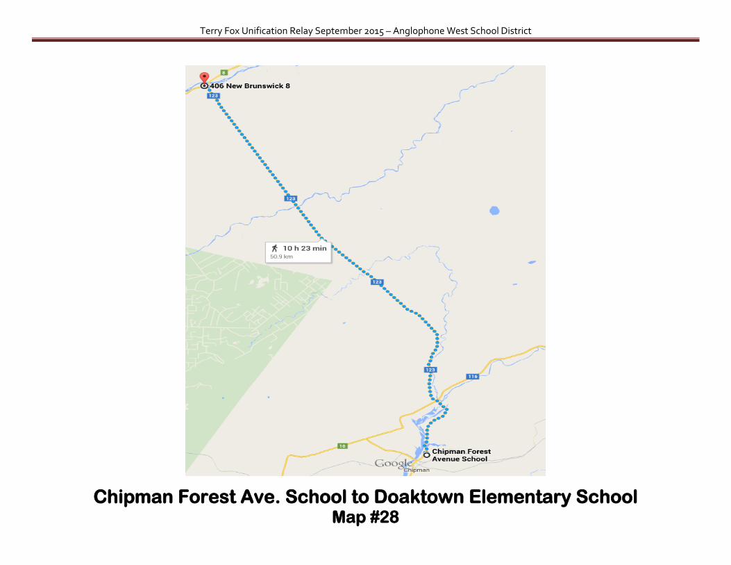
Terry Fox Unification Relay September 2015 – Anglophone West School District
Chipman Forest Ave. School to Doaktown Elementary School Map #28
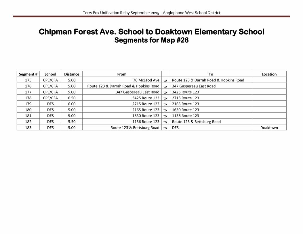
Terry Fox Unification Relay September 2015 – Anglophone West School District
Chipman Forest Ave. School to Doaktown Elementary School Segments for Map #28
Segment # School Distance From
To Location
175 CPE/CFA 5.00 76 McLeod Ave to Route 123 & Darrah Road & Hopkins Road
176 CPE/CFA 5.00 Route 123 & Darrah Road & Hopkins Road to 347 Gaspereau East Road
177 CPE/CFA 5.00 347 Gaspereau East Road to 3425 Route 123
178 CPE/CFA 6.50 3425 Route 123 to 2715 Route 123
179 DES 6.00 2715 Route 123 to 2165 Route 123
180 DES 5.00 2165 Route 123 to 1630 Route 123
181 DES 5.00 1630 Route 123 to 1136 Route 123
182 DES 5.50 1136 Route 123 to Route 123 & Bettsburg Road
183 DES 5.00 Route 123 & Bettsburg Road to DES Doaktown

Terry Fox Unification Relay September 2015 – Anglophone West School District
Doaktown Elementary School to Upper Miramichi Elementary School Map #29
(7263 is Central NB Academy)

Terry Fox Unification Relay September 2015 – Anglophone West School District
Doaktown Elementary School to Upper Miramichi Elementary School Segments for Map #29
Segment # School Distance From
To Location
184 DES 4.00 DES to Lyons Lane Nelson Hollow
185 DES 4.50 Lyons Lane to 7719 Route 8 New Brandon
186 CNBA 3.50 7719 Route 8 to CNBA New Brandon
187 CNBA 5.25 CNBA to Porter Cove Road Ludlow
188 UMES 3.50 Porter Cove Road to Route 8 & Bamford Road Ludlow
189 UMES 4.00 Route 8 & Bamford Road to UMES Boiestown

Terry Fox Unification Relay September 2015 – Anglophone West School District
Upper Miramichi Elementary School to Stanley Schools Map #30

Terry Fox Unification Relay September 2015 – Anglophone West School District
Upper Miramichi Elementary School to Stanley Schools Segments for Map #30
Segment # School Distance From
To Location
190 UMES 5.40 UMES to Route 8 & Tom Brown Road
191 UMES 5.00 Route 8 & Tom Brown Road to 5169 Route 8 Astle
192 UMES 5.30 5169 Route 8 to A Street (mailboxes) McGivney
193 UMES 5.00 A Street (mailboxes) to Route 8 & Arbor Lane South Portage Baptist Bible Church
194 SES/SRHS 5.00 Route 8 & Arbor Lane to Pleasant Valley Road & Armstrong Rd
195 SES/SRHS 5.00 Pleasant Valley Road & Armstrong Rd to Cross Creek Road & Dump Road Cross Creek Station
196 SES/SRHS 3.25 Cross Creek Road & Dump Road to 499 Route 107 & Cross Creek Road
197 SES/SRHS 4.75 499 Route 107 & Cross Creek Road to SES/SRHS Stanley

Terry Fox Unification Relay September 2015 – Anglophone West School District
Stanley Schools to Royal Road School Map #31
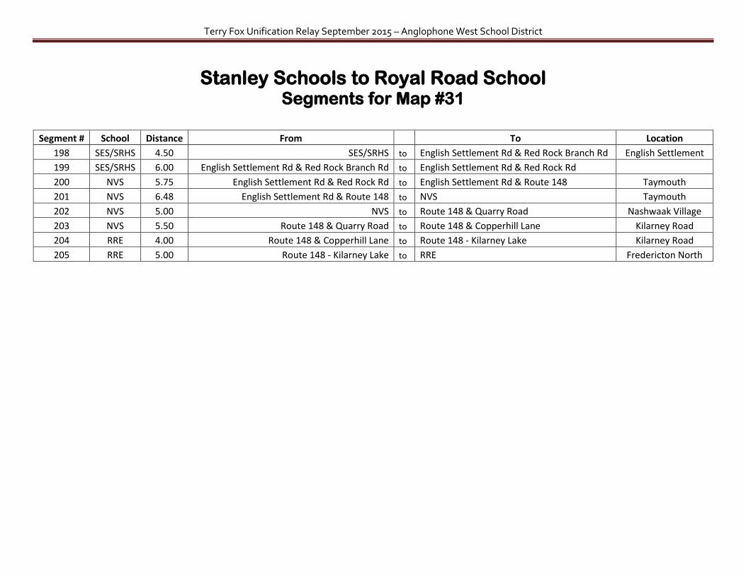
Terry Fox Unification Relay September 2015 – Anglophone West School District
Stanley Schools to Royal Road School Segments for Map #31
Segment # School Distance From
To Location
198 SES/SRHS 4.50 SES/SRHS to English Settlement Rd & Red Rock Branch Rd English Settlement
199 SES/SRHS 6.00 English Settlement Rd & Red Rock Branch Rd to English Settlement Rd & Red Rock Rd
200 NVS 5.75 English Settlement Rd & Red Rock Rd to English Settlement Rd & Route 148 Taymouth
201 NVS 6.48 English Settlement Rd & Route 148 to NVS Taymouth
202 NVS 5.00 NVS to Route 148 & Quarry Road Nashwaak Village
203 NVS 5.50 Route 148 & Quarry Road to Route 148 & Copperhill Lane Kilarney Road
204 RRE 4.00 Route 148 & Copperhill Lane to Route 148 - Kilarney Lake Kilarney Road
205 RRE 5.00 Route 148 - Kilarney Lake to RRE Fredericton North

Terry Fox Unification Relay September 2015 – Anglophone West School District
Fredericton North Schools Map #32
(513 Union St is St. Mary’s First Nation)
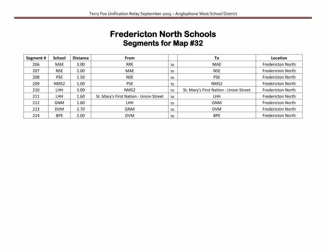
Terry Fox Unification Relay September 2015 – Anglophone West School District
Fredericton North Schools Segments for Map #32
Segment # School Distance From
To Location
206 MAE 3.00 RRE to MAE Fredericton North
207 NSE 2.00 MAE to NSE Fredericton North
208 PSE 1.50 NSE to PSE Fredericton North
209 NMS2 1.00 PSE to NMS2 Fredericton North
210 LHH 3.00 NMS2 to St. Mary's First Nation - Union Street Fredericton North
211 LHH 1.60 St. Mary's First Nation - Union Street to LHH Fredericton North
212 GNM 1.60 LHH to GNM Fredericton North
213 DVM 2.70 GNM to DVM Fredericton North
214 BPE 2.00 DVM to BPE Fredericton North

Terry Fox Unification Relay September 2015 – Anglophone West School District
Fredericton South Schools – Part 1 Map #33
(Skyline Acres is Bliss Carmen School)

Terry Fox Unification Relay September 2015 – Anglophone West School District
Fredericton South Schools – Part 1 Segments for Map #33
Segment # School Distance From
To Location
215 FHE 4.50 BPE to FHE Fredericton
216 LSE 1.00 FHE to LSE Fredericton South
217 BCM 1.00 LSE to BCM Fredericton South
218 GSM 4.30 BCM to GSM Fredericton South
219 CSE 1.50 GSM to CSE Fredericton South
220 GCE 4.30 CSE to GCE Fredericton South
Note: the segment below could be omitted because most of it will backtracked in Part 2
221 KCS 5.50 GCE to KCS Fredericton South
Notes:
Health & Safety – using pedestrian bridge to cross St. John River

Terry Fox Unification Relay September 2015 – Anglophone West School District
Fredericton South Schools – Part 2 Map #34
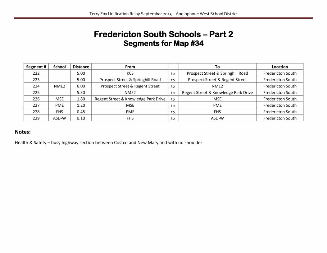
Terry Fox Unification Relay September 2015 – Anglophone West School District
Fredericton South Schools – Part 2 Segments for Map #34
Segment # School Distance From
To Location
222 5.00 KCS to Prospect Street & Springhill Road Fredericton South
223 5.00 Prospect Street & Springhill Road to Prospect Street & Regent Street Fredericton South
224 NME2 6.00 Prospect Street & Regent Street to NME2 Fredericton South
225 5.30 NME2 to Regent Street & Knowledge Park Drive Fredericton South
226 MSE 1.80 Regent Street & Knowledge Park Drive to MSE Fredericton South
227 PME 1.20 MSE to PME Fredericton South
228 FHS 0.45 PME to FHS Fredericton South
229 ASD-W 0.10 FHS to ASD-W Fredericton South
Notes:
Health & Safety – busy highway section between Costco and New Maryland with no shoulder
Related Documents