Territorial vulnerability analysis: the case studies M. C. Treu 1 , M. Samakovlija 2 & M. Magoni 2 1 DiAP, 2 CEDAT, Politecnico di Milano Abstract This is the second of three papers presented by the Politecnico di Milano. The papers present the first results of the European research project QUATER (“QUARTER” TERritorial QUAlity, territorial risk management systems of municipality”, project INTERREG IIIB MEDOC, research group of Politecnico di Milano coordinated by Maria Cristina Treu). The research aim is the development of a territorial management system for territorial risk decrease/reduction (natural and anthropogenic risks) and quality improvement. This paper presents the critical aspects and results which have come out of the first applications of the vulnerability assessment method proposed. The method has been applied on three Municipalities localised in the Lombardy Region (northern part of Italy). The research tests the procedure manual of the territorial risks/quality management by case studies. Keywords: territorial risks (natural and anthropogenic), territorial sensitivity, territorial vulnerability, GIS, indicators. 1 Introduction The QUATER method is used for environmental and human risk mitigation at Municipal level. It is based on three analysis steps that require the use of GIS. In the case studies the analysed risks were different in nature and intensity and were often simultaneously present with a “domino effect”. For example, in Toscolano Maderno, the major risk was the seismic risk that include all the Municipal area, but there was also some areas involved in landslide risk or alluvial risk in the proximity of Toscolano stream. © 2004 WIT Press, www.witpress.com, ISBN 1-85312-736-1 Risk Analysis IV, C. A. Brebbia (Editor)

Welcome message from author
This document is posted to help you gain knowledge. Please leave a comment to let me know what you think about it! Share it to your friends and learn new things together.
Transcript
Territorial vulnerability analysis: the case studies
M. C. Treu1, M. Samakovlija2 & M. Magoni2 1DiAP, 2CEDAT, Politecnico di Milano
Abstract
This is the second of three papers presented by the Politecnico di Milano. The papers present the first results of the European research project QUATER (“QUARTER” TERritorial QUAlity, territorial risk management systems of municipality”, project INTERREG IIIB MEDOC, research group of Politecnico di Milano coordinated by Maria Cristina Treu). The research aim is the development of a territorial management system for territorial risk decrease/reduction (natural and anthropogenic risks) and quality improvement. This paper presents the critical aspects and results which have come out of the first applications of the vulnerability assessment method proposed. The method has been applied on three Municipalities localised in the Lombardy Region (northern part of Italy). The research tests the procedure manual of the territorial risks/quality management by case studies. Keywords: territorial risks (natural and anthropogenic), territorial sensitivity, territorial vulnerability, GIS, indicators.
1 Introduction
The QUATER method is used for environmental and human risk mitigation at Municipal level. It is based on three analysis steps that require the use of GIS. In the case studies the analysed risks were different in nature and intensity and were often simultaneously present with a “domino effect”. For example, in Toscolano Maderno, the major risk was the seismic risk that include all the Municipal area, but there was also some areas involved in landslide risk or alluvial risk in the proximity of Toscolano stream.
© 2004 WIT Press, www.witpress.com, ISBN 1-85312-736-1Risk Analysis IV, C. A. Brebbia (Editor)

In the case of Seriate, the major risk was alluvial risk, because the Serio River divides the urban area into two parts. Also seismic risk was present but at low level. Then there were two other important risks: the dangerous substances transport and the indirect technological risk, induced by an industry located in the near Municipality.
Figure 1: Localization of case studies.
2 The preliminary analysis step (level 1)
The first level of analysis needs the construction of the basic knowledge. In this phase all information about the municipal territory is organised in systems. The systems analysed are: environmental system, urban system, agricultural system, road and technological network system, over Municipality planning system. If the Municipality doesn’t have a SIT the first action is to develop a GIS. This action is based on the transfer of every municipal information and data (paper or electronic) into GIS system. This action needs the internal municipal office collaboration to find data and information to guarantee its future updating. In the case studies there wasn’t a GIS system, so the first action we took was to enter and organise the data in collaboration with a municipal person that was responsible for every procedure. The data and information was not homogeneous. For example the technological network information wasn’t complete because it is managed by a private company. Another action we took was finding this external information. Every data and information is structured in a chart (Table 1) supported by cartography.
© 2004 WIT Press, www.witpress.com, ISBN 1-85312-736-1Risk Analysis IV, C. A. Brebbia (Editor)
784 Risk Analysis IV
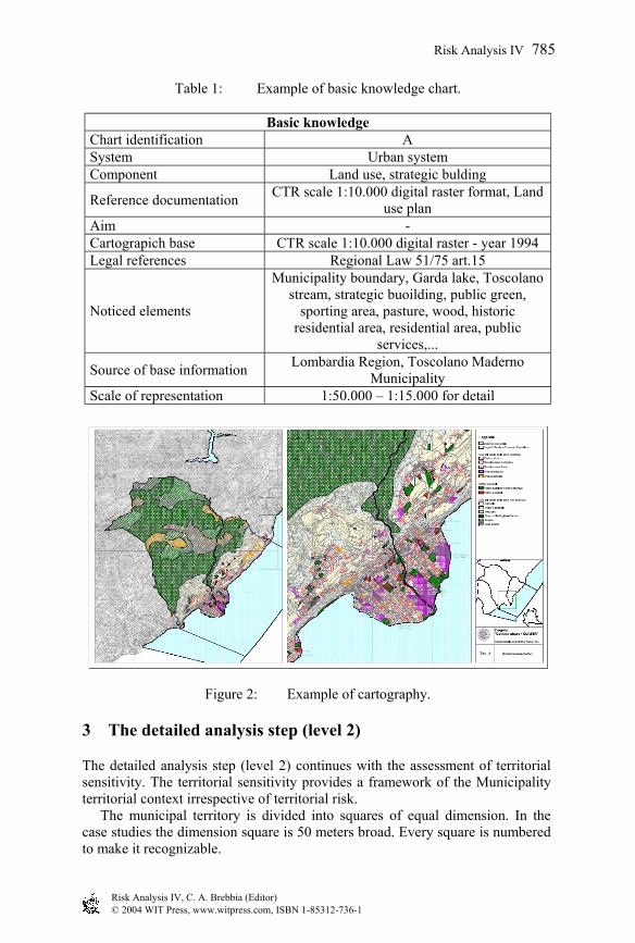
Table 1: Example of basic knowledge chart.
Basic knowledge Chart identification A System Urban system Component Land use, strategic bulding
Reference documentation CTR scale 1:10.000 digital raster format, Land use plan
Aim - Cartograpich base CTR scale 1:10.000 digital raster - year 1994 Legal references Regional Law 51/75 art.15
Noticed elements
Municipality boundary, Garda lake, Toscolano stream, strategic buoilding, public green,
sporting area, pasture, wood, historic residential area, residential area, public
services,...
Source of base information Lombardia Region, Toscolano Maderno Municipality
Scale of representation 1:50.000 – 1:15.000 for detail
Figure 2: Example of cartography.
3 The detailed analysis step (level 2)
The detailed analysis step (level 2) continues with the assessment of territorial sensitivity. The territorial sensitivity provides a framework of the Municipality territorial context irrespective of territorial risk. The municipal territory is divided into squares of equal dimension. In the case studies the dimension square is 50 meters broad. Every square is numbered to make it recognizable.
© 2004 WIT Press, www.witpress.com, ISBN 1-85312-736-1Risk Analysis IV, C. A. Brebbia (Editor)
Risk Analysis IV 785

Figure 3: Example of square division.
For every square the territorial sensitivity index has been calculated with the following matrix.
Pondering factors
Node and Network rare/unique/of value areas, critical
facilities and historical buildings or with people concentration
NNr NNt Cf/lb Bpc Ra Apc
Use of soil
Initi
al V
alue
1,5 1,5 1,25 2,25 1,25 2,25 Residential
areas high density
10 15 15 12.5 22.5 12.5 22.5
Residential areas
medium density 8 12 12 10 18 10 18
Residential areas
low density 5 7.5 7.5 6.25 11.25 6.25 11.25
Public services areas 4 6 6 5 9 5 9
Productive areas 3 4.5 4.5 3.75 6.75 3.75 6.75 Agricultural
areas 2 3 3 2.5 4.5 2.5 4.5
Environmental areas 1 1.5 1.5 1.25 2.25 1.25 2.25
Figure 4: Sensitivity assessment matrix.
© 2004 WIT Press, www.witpress.com, ISBN 1-85312-736-1Risk Analysis IV, C. A. Brebbia (Editor)
786 Risk Analysis IV

This is the formula used:
TSI s = LU * (NNr + NNt +Cf/lb + Bpc + Ra + Apc)
TSI s = Territorial sensitivity index of square LU = Value of land use NNr = Importance of road node and network NNt = Importance of technological node and network Cf/lb = Importance of critical facilities and historical/listed buildings Bpc = Importance of buildings an high density of people presence Ra = Importance of rare/unique/of value areas Apc = Importance of areas an high density of people presence
Figure 5: Example of territorial sensitivity (Seriate).
Figure 6: Example of technological risk and alluvial risk (Seriate).
© 2004 WIT Press, www.witpress.com, ISBN 1-85312-736-1Risk Analysis IV, C. A. Brebbia (Editor)
Risk Analysis IV 787

The initial value of the different soil use or the importance of pondering elements is not defined but depends on municipality choice. In the case studies the values give major importance to the presence of inhabitants. For example in the case study of Seriate the sensitivity is high in the residential central area and in the eastern part of the territory. The results of territorial sensitivity are interrelated with exposure and hazard to obtain a first identification of territorial vulnerability (Figure 6 and Figure 7).
Figure 7: Example of territorial sensitivity, inhabitants exposure and technological risk (Seriate).
In the case studies of Seriate the first indications we obtain are the limitation of dangerous substances transport in identified timetables or moving this type of transport to some alternative roads, avoiding the most populated areas.
4 The detailed analysis step (level 3)
The detailed analysis step (level 3) develops the previous step. In this phase we can verify the accuracy of data and information and we can get a deeper knowledge of the quality of the buildings and networks.
Existing risk Territorial sensitivity
Figure 8: Example of detailed analysis step (level 3) (Toscolano Maderno).
© 2004 WIT Press, www.witpress.com, ISBN 1-85312-736-1Risk Analysis IV, C. A. Brebbia (Editor)
788 Risk Analysis IV

In this phase GIS is very important to localise the information and to improve the basic knowledge. At the end of this step some indications in the short period and in the long period are archived.
Indications framework
A Mitigation interventions B Civil Protection
actions C Planning
A1
Programming and design of hazard mitigation interventions.
B1
Updating of Municipal Emergency Plan with all risks present on the territory.
C1
Development of internal Municipal office collaboration: development of Territorial Information System.
A2 Municipal programs finalised to hazard analysis.
B2
Design and development of information campaign for inhabitants.
C2
Verification and comparison with future land use plan and territorial risk.
A3 Realization of hazard mitigation interventions.
B3
Development of a program to stimulate the intervention to keep the safety of the buildings.
C3
Development of municipality program for new location of strategic buildings.
A4
Reduction of exposure level for inhabitants and strategic building.
B4 Realization of inhabitants information.
C4 Identification of alternative roads in dangerous areas.
… … … B5 Development of municipal Emergency Plan.
C5 Development of new location for public services buildings.
B6
Arrangement of information about territorial and network vulnerability.
C6
Development of programs and systems for territorial and network monitoring; improvement of Territorial Information System.
… … … … … …
Figure 9: Example of short term and long term indications (Toscolano Maderno).
5 Verification and conclusions
The method needs a constant verification of goals and actions as standard OHSAS suggests. Once again it is of fundamental importance the use of GIS which allows the constant updating of data and geocoding information. A first step in order to carry out the verification of the efficacy of the actions taken is that of reviewing the necessary passages to determine the territorial sensitivity index. The method is based on the fact that the values of the matrix
© 2004 WIT Press, www.witpress.com, ISBN 1-85312-736-1Risk Analysis IV, C. A. Brebbia (Editor)
Risk Analysis IV 789

are not modified so as to compare the new results with the initial one. This way it will be evident the effectiveness of the action taken by the Municipality on the territorial sensitivity. The GIS becomes a useful instrument in order to establish a constant relationship of internal and external municipal communication creating synergies among the various offices, the various competences and synthesizing information that come from various sources. Moreover, the GIS become a useful support to the territory knowledge improvement and to the decision making process of the Municipality Authorities/government. The GIS use allows reducing financial/human costs and resources of the Municipality administration.
References
[1] Treu M.C., Proposta di un insieme di indicatori per la valutazione: settore Mercato immobiliare - in Irer (edited by Alberto Colorni), Una Metodologia informatizzata per la valutazione dei grandi progetti territoriali, Milano 1993
[2] Treu M.C. (editors), Rischio territoriale e ambientale sostenibile per la gestione dei bacini [monographic number on territorial and environmental risk for the sustainable river basin management – in italian], in “Territorio”, n. 25, 2003
[3] Menoni S., Pianificazione e incertezza. Elementi per la valutazione e gestione dei rischi territoriali, Milano: Franco Angeli, 1997
[4] Regione Lombardia, Consiglio Nazionale delle Ricerche, Vulnerabilità sismica delle infrastrutture a rete in una zona campione della regione Lombardia, Milano: Regione Lombardia, 2001
[5] Tiboni M., La prospettiva dello sviluppo sostenibile. Pianificare per la sicurezza, le città e il territorio, Brescia: Sintesi Editrice, 2002
© 2004 WIT Press, www.witpress.com, ISBN 1-85312-736-1Risk Analysis IV, C. A. Brebbia (Editor)
790 Risk Analysis IV
Related Documents


