Terrestrial Habitat Report Terrestrial Habitat Report Terrestrial Habitat Report Terrestrial Habitat Report Habitat Name Arkansas Valley Prairie and Woodland Description: This system of prairies and associated woodlands is found in the Arkansas Valley region of Arkansas and adjacent Oklahoma. This region is distinctly bounded by the Boston Mountains to the north and the Ouachita Mountains to the south. The valley is characterized by broad, level to gently rolling uplands derived from shales and is much less rugged and more heavily impacted by Arkansas River erosional processes than the adjacent mountainous regions. In addition, the valley receives annual precipitation total of 2-6 inches less than the surrounding regions due to a rainshadow produced by a combination of prevailing western winds and mountain orographic effects. The shale-derived soils associated with the prairies are thin and droughty. Boston Mountains Arkansas Valley Ouachita Mountains South Central Plains Mississippi Alluvial Plain Mississippi Valley Loess Plains Ozark Highlands Ecoregions where the habitat occurs: Arkansas Valley Prairie and Woodland Page 1194

Welcome message from author
This document is posted to help you gain knowledge. Please leave a comment to let me know what you think about it! Share it to your friends and learn new things together.
Transcript

Terrestrial Habitat ReportTerrestrial Habitat ReportTerrestrial Habitat ReportTerrestrial Habitat Report
Habitat Name Arkansas Valley Prairie and Woodland
Description:
This system of prairies and associated woodlands is found in the Arkansas Valley region of Arkansas and adjacent Oklahoma. This region is distinctly bounded by the Boston Mountains to the north and the Ouachita Mountains to the south. The valley is characterized by broad, level to gently rolling uplands derived from shales and is much less rugged and more heavily impacted by Arkansas River erosional processes than the adjacent mountainous regions. In addition, the valley receives annual precipitation total of 2-6 inches less than the surrounding regions due to a rainshadow produced by a combination of prevailing western winds and mountain orographic effects. The shale-derived soils associated with the prairies are thin and droughty.
Boston Mountains Arkansas Valley
Ouachita Mountains South Central Plains Mississippi Alluvial Plain
Mississippi Valley Loess PlainsOzark Highlands
Ecoregions where the habitat occurs:
Arkansas Valley Prairie and Woodland
Page 1194

The combined effect of droughty soils, reduced precipitation, and prevailing level topography create conditions highly conducive to the ignition and spread of fires. Stands are typically dominated by Andropogon gerardii, Sorghastrum nutans, Panicum virgatum, and Schizachyrium scoparium. One large example of this system remains, but most are small and isolated. (adapted from NatureServe 2005).
Species associated with this habitat type (and the weight or importance of the habitat to each species) include:
Smith's Longspur (Calcarius pictus) Weight: MarginalWhip-poor-will (Caprimulgus vociferus) Weight: Marginalmayfly (Paraleptophlebia calcarica) Weight: SuitableHenslow's Sparrow (Ammodramus henslowii) Weight: OptimalStrecker's Chorus Frog (Pseudacris streckeri) Weight: OptimalNorthern Crawfish Frog (Rana areolata circulosa) Weight: OptimalLong-tailed Weasel (Mustela frenata) Weight: Data Gapmicrocaddisfly (Paucicalcaria ozarkensis) Weight: SuitableSoutheastern Shrew (Sorex longirostris) Weight: SuitableUpland Sandpiper (Bartramia longicauda) Weight: MarginalNorthern Harrier (Circus cyaneus) Weight: SuitableHurter's Spadefoot (Scaphiopus hurterii) Weight: OptimalBuff-breasted Sandpiper (Tryngites subruficollis) Weight: MarginalGreater Prairie Chicken (Tympanuchus cupido) Weight: ObligateLark Sparrow (Chondestes grammacus) Weight: SuitableBachman's Sparrow (Aimophila aestivalis) Weight: MarginalBlack-tailed Jackrabbit (Lepus californicus) Weight: SuitableEastern Harvest Mouse (Reithrodontomys humulis) Weight: SuitableMagazine stripetail (Isoperla szczytkoi) Weight: SuitableOrnate Box Turtle (Terrapene ornata ornata) Weight: OptimalTexas Horned Lizard (Phrynosoma cornutum) Weight: SuitableWestern Slender Glass Lizard (Ophisaurus attenuatus attenuatus) Weight: Optimalred milkweed beetle (Tetraopes quinquemaculatus) Weight: OptimalTexas milkweed beetle (Tetraopes texanus) Weight: OptimalChuck-will's-widow (Caprimulgus carolinensis) Weight: SuitableSouthern Prairie Skink (Eumeces obtusirostris) Weight: OptimalEasternTowhee (Pipilo erythrophthalmus) Weight: MarginalDesert Shrew (Notiosorex crawfordi) Weight: SuitableGreat Plains Narrowmouth Toad (Gastrophryne olivacea) Weight: SuitableMeske's Skipper (Hesperia meskei) Weight: SuitableBald Eagle (Haliaeetus leucocephalus) Weight: SuitablePainted Bunting (Passerina ciris) Weight: OptimalLe Conte's Sparrow (Ammodramus leconteii) Weight: Optimallace bug (Acalypta lillianus) Weight: OptimalBell's Vireo (Vireo bellii) Weight: OptimalGrasshopper Sparrow (Ammodramus savannarum) Weight: OptimalPrairie Mole Cricket (Gryllotalpa major) Weight: ObligateSedge Wren (Cistothorus platensis) Weight: SuitableBewick's Wren (Thryomanes bewickii) Weight: Suitable
Arkansas Valley Prairie and Woodland
Page 1195

Migrant Loggerhead Shrike (Lanius ludovicianus migrans) Weight: OptimalWillow Flycatcher (Empidonax traillii) Weight: MarginalRed-headed Woodpecker (Melanerpes erythrocephalus) Weight: SuitableAmerican Woodcock (Scolopax minor) Weight: SuitableBarn Owl (Tyto alba) Weight: SuitableYellow-billed Cuckoo (Coccyzus americanus) Weight: SuitablePrairie Warbler (Dendroica discolor) Weight: MarginalRusty Blackbird (Euphagus carolinus) Weight: SuitableShort-eared Owl (Asio flammeus) Weight: SuitableNorthern Bobwhite (Colinus virginianus) Weight: Optimal
ANHC Mr. Tom Foti, TNC Mr. Doug Zoellner, AGFC Ms. Elizabeth Murray, Audubon Arkansas Mr. Ken Smith, Conservation Southeast Mr. Jeff Holmes, AGFC Mr. Jeff Johnston, AGFC Ms. Jane Anderson, FTN Associates Mr. Don Catenzaro
Habitat Team
Habitat Priority Score 2452
Arkansas Valley Prairie and Woodland
Page 1196
Key Factor Name Composition
Key Factor Description: The diversity, species richness, and relative abundance of vegetative elements in this habitat type.
Key Factor Weight: Low
Indicator Name: Invasive shrubs and woody vines
Indicator Description: The percent of ground cover in non-native woody species
Poor Level: >20
Fair Level: 10-20
Good Level: 5-9
Very Good Level: <5
Current_Status: Data Gap
Indicator Weight: Medium
Conservation Action: Maintain or, where necessary, restore the percent of groundcover in invasive woody species to nine percent or less.
Monitoring Strategy: Monitor the percent of ground cover in non-native woody species.
Indicator Name: Broomsedge imbalance
Indicator Description: The percent of broomsedge coverage among ground vegetation
Poor Level: >20
Fair Level: 10-20
Good Level: 5-9
Very Good Level: <5
Current_Status: Data Gap
Indicator Weight: Medium
Conservation Action: Maintain or, where necessary, restore the percent broomsedge coverage among ground vegetation to nine percent or less.
Monitoring Strategy: Monitor percent of broomsedge coverage among ground vegetation.
Arkansas Valley Prairie and Woodland
Page 1197

Key Factor Name Composition
Indicator Name: Exotic Forbs and Grasses
Indicator Description: The percent of ground cover in non-native herbaceous species
Poor Level: >20
Fair Level: 10-20
Good Level: 5-9
Very Good Level: <5
Current_Status: Data Gap
Indicator Weight: High
Conservation Action: Maintain or, where necessary, restore the percent of groundcover in non-native herbaceous vegetation to nine percent or less.
Monitoring Strategy: Monitor the percent of ground cover in non-native herbaceous species.
Arkansas Valley Prairie and Woodland
Page 1198

Key Factor Name Fire Regime
Key Factor Description: Fire Return Interval and Seasonality, including landscape-scale fire in surrounding/adjacent habitats to prevent woody encroachment and allow for distribution and dispersal of obligate species
Key Factor Weight: Medium
Indicator Name: Fire Seasonality/Intensity
Indicator Description: The percent of areas burned during either March/April or Aug/Sept, or from leaf-expansion to leaf-fall, depending on project-level goals. In some but not all cases, seasonality is an accurate surrogate for intensity. Since intensity goals will vary from burn to burn it is difficult to "pre-quantify" ideal intensity objectives at a forest-wide scale. It is presumed that restoration, maintenance, fuel-reduction and other prescribed fire goals will be considered at the project level when planning burn intensity.
Poor Level: <25
Fair Level: 25-50
Good Level: 51-75
Very Good Level: >75
Current_Status: Data Gap
Indicator Weight: Medium
Conservation Action: When burning, burn during either March/April or August/September, or from leaf-expansion to leaf-fall, depending on project-level goals.
Monitoring Strategy: Monitor percent of burned areas burned during either March/April or Aug/Sept, or from leaf-expansion to leaf-fall, depending on project-level goals. In some but not all cases, seasonality is an accurate surrogate for intensity. Since intensity goals will vary from burn to burn it is difficult to "pre-quantify" ideal intensity objectives at a forest-wide scale. It is presumed that restoration, maintenance, fuel-reduction and other prescribed fire goals will be considered at the project level when planning burn intensity.
Arkansas Valley Prairie and Woodland
Page 1199
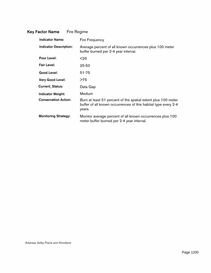
Key Factor Name Fire Regime
Indicator Name: Fire Frequency
Indicator Description: Average percent of all known occurrences plus 100 meter buffer burned per 2-4 year interval.
Poor Level: <25
Fair Level: 25-50
Good Level: 51-75
Very Good Level: >75
Current_Status: Data Gap
Indicator Weight: Medium
Conservation Action: Burn at least 51 percent of the spatial extent plus 100 meter buffer of all known occurrences of this habitat type every 2-4 years.
Monitoring Strategy: Monitor average percent of all known occurrences plus 100 meter buffer burned per 2-4 year interval.
Arkansas Valley Prairie and Woodland
Page 1200

Key Factor Name Remoteness
Key Factor Description: Mean density of roads (miles per square mile) within this community type at the landscape scale.
Key Factor Weight: Medium
Indicator Name: Road Density
Indicator Description: Average number of road miles per square mile across all known occurrences of this target.
Poor Level: >2 miles
Fair Level: 1-2 miles
Good Level: 0.5-1 mile
Very Good Level: <0.5 mile
Current_Status: Data Gap
Indicator Weight: Medium
Conservation Action: Maintain or, where necessary, restore the average number of road miles per square mile to one or less across all known occurrences of this target.
Monitoring Strategy: Monitor average number of road miles per square mile across all known occurrences of this target.
Arkansas Valley Prairie and Woodland
Page 1201
Key Factor Name Spatial Ecology
Key Factor Description: The relative spatial abundance, proximity, distribution, and arrangement of this habitat type on the landscape.
Key Factor Weight: Medium
Indicator Name: Patch Size
Indicator Description: Average patch size across all known occurrences (acres)
Poor Level: <75 acres
Fair Level: 75-149 acres
Good Level: 150-375 acres
Very Good Level: >375 acres
Current_Status: Data Gap
Indicator Weight: Medium
Conservation Action: Maintain or, where necessary, restore the average patch size of this habitat type to 150 acres or more across all known occurrences.
Monitoring Strategy: Monitor average patch size across all known occurrences (acres).
Indicator Name: Patch Proximity
Indicator Description: Median nearest distance between patches.
Poor Level: >2.5 miles
Fair Level: 1-2.5 miles
Good Level: 0.5-1 mile
Very Good Level: <0.5 mile
Current_Status: Data Gap
Indicator Weight: Medium
Conservation Action: Maintain or, where necessary, restore the median nearest distance between patches of this habitat type to one mile or less.
Monitoring Strategy: Monitor median nearest distance between patches.
Arkansas Valley Prairie and Woodland
Page 1202

Key Factor Name Spatial Ecology
Indicator Name: Average Block Size
Indicator Description: Block is defined by the minimum convex polygon bounded by known occurrences of this habitat type in which the median patch size is above the fair level for patch size, and in which each of the patches score fair or better on the patch proximity threshold.
Poor Level: <1,000 acres
Fair Level: 1,000-2,499 acres
Good Level: 2,500-5,000 acres
Very Good Level: >5,000 acres
Current_Status: Data Gap
Indicator Weight: Medium
Conservation Action: Maintain or, where necessary, restore average block size to 2,500 acres or more. (Block is defined by the minimum convex polygon bounded by known occurrences of this habitat type in which the median patch size is above the fair level for patch size, and in which each of the patches score fair or better on the patch proximity threshold.)
Monitoring Strategy: Monitor block size.
Arkansas Valley Prairie and Woodland
Page 1203

Key Factor Name Spatial Ecology
Indicator Name: Number of Blocks
Indicator Description: Total number of blocks statewide
Poor Level: 0-1
Fair Level: 2
Good Level: 3
Very Good Level: >3
Current_Status: Data Gap
Indicator Weight: Medium
Conservation Action: Maintain or, where necessary, restore number of blocks to three or more. (Block is defined by the minimum convex polygon bounded by known occurrences of this habitat type in which the median patch size is above the fair level for patch size, and in which each of the patches score fair or better on the patch proximity threshold.)
Monitoring Strategy: Monitor total number of blocks statewide.
Arkansas Valley Prairie and Woodland
Page 1204

Habitat Name Caves, Mines & Karst Habitat
Description:
Caves refer to naturally occurring underground cavities, chambers, or series of chambers, especially ones with an opening in the side of a hill or mountain. Mines refer to man-made underground cavities, chambers, or series of chambers, especially ones with an opening in the side of a hill or mountain. (Foti and others 2005)
Species associated with this habitat type (and the weight or importance of the habitat to each species) include:isopod (Caecidotea stiladactyla) Weight: Obligateisopod (Caecidotea steevesi) Weight: Obligateisopod s.d (Caecidotea ancyla) Weight: Obligate
Boston Mountains Arkansas Valley
Ouachita Mountains South Central Plains Mississippi Alluvial Plain
Mississippi Valley Loess PlainsOzark Highlands
Ecoregions where the habitat occurs:
Caves, Mines & Karst Habitat
Page 1205

amphipod (Bactrurus pseudomucronatus) Weight: ObligateOzark Cavefish (Amblyopsis rosae) Weight: Obligatecave obligate harvestman (Crosbyella distincta) Weight: Obligatecave obligate pseudoscorpion (Apochthonius diabolus) Weight: Obligatecave obligate pseudoscorpion (Apochthonius titanicus) Weight: Obligatebat cave isopod (Caecidotea macropropoda) Weight: ObligateHubricht's Long-tailed Amphipod (Allocrangonyx hubrichti) Weight: ObligateGrotto Salamander (Eurycea spelaea) Weight: ObligateSouthern Cavefish (Typhlichthys subterraneus) Weight: Obligatecave obligate harvestman (Crosbyella roeweri) Weight: ObligateFoushee Cavesnail (Amnicola cora) Weight: Obligatecave obligate springtail (Schaefferia alabamensis) Weight: Obligatespringtail (Arrhopalites clarus) Weight: ObligateIndiana Bat (Myotis sodalis) Weight: Optimalcrayfish (Cambarus aculabrum) Weight: ObligateHell Creek Crayfish (Cambarus zophonastes) Weight: ObligateEastern Small-Footed Bat (Myotis leibii) Weight: OptimalBristly Cave Crayfish (Cambarus setosus) Weight: ObligateShelled Cave Springtail (Pseudosinella testa) Weight: Obligatecave obligate planarian (Dendrocoelopsis americana) Weight: Optimalisopod (Caecidotea oculata) Weight: ObligateOzark Cave Amphipod (Stygobromus ozarkensis) Weight: ObligateCaddo Mountain Salamander (Plethodon caddoensis) Weight: Suitablespringtail (Pseudosinella dubia) Weight: Obligateisopod (Lirceus bidentatus) Weight: Obligatecave obligate isopod (Caecidotea simulator) Weight: Obligateisopod (Caecidotea salamensis) Weight: Obligatecave obligate millipede (Trigenotyla parca) Weight: Obligatepseudoscorpion (Pseudozaona occidentalis) Weight: ObligateOzark Big-eared Bat (Corynorhinus townsendii ingens) Weight: Optimalisopod (Lirceus bicuspidatus) Weight: OptimalGray Bat (Myotis grisescens) Weight: Optimalground beetle (Rhadine ozarkensis) Weight: Optimal
ANHC Mr. Tom Foti, TNC Mr. Doug Zoellner, AGFC Ms. Elizabeth Murray, Audubon Arkansas Mr. Ken Smith, Conservation Southeast Mr. Jeff Holmes, AGFC Mr. Jeff Johnston, AGFC Ms. Jane Anderson, FTN Associates Mr. Don Catenzaro
Habitat Team
Habitat Priority Score 6404
Caves, Mines & Karst Habitat
Page 1206
Key Factor Name Cave/Mine Accessibility
Key Factor Description: Percent of caves/mines housing species of greatest conservation need that are closed to disturbance.
Key Factor Weight: Medium
Indicator Name: Road Proximity
Indicator Description: Distance to nearest public road from cave entrance.
Poor Level: <.25 mile
Fair Level: .25-.5 mile
Good Level: 0.5-1 mile
Very Good Level: >1 mile
Current_Status: Data Gap
Indicator Weight: Medium
Conservation Action: Maintain or, where necessary, restore the distance from the nearest public road to cave entrance to .5 more or more.
Monitoring Strategy: Monitor distance to nearest public road from cave entrance.
Indicator Name: Percent gated or fenced caves/mines
Indicator Description: The percent of known caves and mines that have been successfuly gated.
Poor Level: <20
Fair Level: 20-40
Good Level: 40-60
Very Good Level: >60
Current_Status: Data Gap
Indicator Weight: Medium
Conservation Action: Build or maintain gates in 40 percent or more of the caves and mines known to have ecologically sensitive biota.
Monitoring Strategy: Monitor percent of known caves and mines that have been successfuly gated.
Caves, Mines & Karst Habitat
Page 1207

Key Factor Name Recharge area
Key Factor Description: The surface and sub-surface hydrologic area contributing water and the compounds (nutrients/sediments/pollutants) water carries to the cave system.
Key Factor Weight: High
Indicator Name: Point source pollution
Indicator Description: Number of Point Source Pollution permits per square mile in the recharge area.
Poor Level: 0.465-0.297
Fair Level: 0.296-0.184
Good Level: 0.183-0.036
Very Good Level: <0.036
Current_Status: Data Gap
Indicator Weight: Medium
Conservation Action: Maintain or reduce the number of Point Source Pollution permits to .183 or fewer per square mile in the recharge area.
Monitoring Strategy: Monitor number of Point Source Pollution permits per square mile in the recharge area.
Indicator Name: Percent pasture land
Indicator Description: Percent total land cover in the recharge area that is pasture land.
Poor Level: >75
Fair Level: 50-75
Good Level: 25-50
Very Good Level: <25
Current_Status: Data Gap
Indicator Weight: Medium
Conservation Action: Maintain or, where necessary, restore the total land cover in the recharge area that is pasture land to 50 percent or less.
Monitoring Strategy: Monitor percent total land cover in the recharge area that is pasture land.
Caves, Mines & Karst Habitat
Page 1208
Key Factor Name Recharge area
Indicator Name: Unpaved road density
Indicator Description: Miles of unpaved road per square mile of recharge area.
Poor Level: >2 miles
Fair Level: 1-2 miles
Good Level: 0.5-1 mile
Very Good Level: <0.5 mile
Current_Status: Data Gap
Indicator Weight: Medium
Conservation Action: Maintain or, where necessary, restore the miles of unpaved road per square mile of recharge area to one or less.
Monitoring Strategy: Monitor miles of unpaved road per square mile of recharge area.
Indicator Name: Percent Urban/impervious
Indicator Description: The percent of total land cover in the recharge area that is urban/impervious.
Poor Level: >25
Fair Level: 15-25
Good Level: 5-15
Very Good Level: <5
Current_Status: Data Gap
Indicator Weight: Medium
Conservation Action: Maintain or, where necessary, restore the total land cover in the recharge area that is urban/impervious to 15 percent or less.
Monitoring Strategy: Monitor percent total land cover in the recharge area that is urban/impervious.
Caves, Mines & Karst Habitat
Page 1209
Key Factor Name Recharge area
Indicator Name: Percent Forested
Indicator Description: Percent total land cover in the recharge area that is forested.
Poor Level: <25
Fair Level: 25-50
Good Level: 50-75
Very Good Level: >75
Current_Status: Data Gap
Indicator Weight: Medium
Conservation Action: Maintain or, where necessary, restore the total land cover in the recharge area that is forested to 50 percent or more.
Monitoring Strategy: Monitor percent total land cover in the recharge area that is forested.
Caves, Mines & Karst Habitat
Page 1210

Habitat Name Central Interior Acidic Cliff and Talus
Description:
This system is found primarily in the Interior Highlands including the Ozark Highlands, Boston Mountains, Arkansas Valley and Ouachita Mountains ecoregions. Sandstone and shale outcrops and talus ranging from moist to dry typify this system. It is typically sparsely vegetated, however, on moister sites with more soil development several fern species and sedges (Carex spp.) can establish. Wind and water erosion are the major dynamics influencing this system.EMBEDDED: These systems are usually small, isolated, and/or disjunct and are often "embedded" in a larger habitat matrix. These systems rely heavily on surrounding and/or adjacent habitats for landscape scale functions and processes such as fire. (adapted from NatureServe 2005).
Species associated with this habitat type (and the weight or importance of the habitat to each species)
Boston Mountains Arkansas Valley
Ouachita Mountains South Central Plains Mississippi Alluvial Plain
Mississippi Valley Loess PlainsOzark Highlands
Ecoregions where the habitat occurs:
Central Interior Acidic Cliff and Talus
Page 1211

include:
Diana (Speyeria diana) Weight: SuitableEastern Spotted Skunk (Spilogale putorius) Weight: SuitableRich Mountain Slitmouth (Stenotrema pilsbryi) Weight: ObligateWestern Diamondback Rattlesnake (Crotalus atrox) Weight: OptimalEastern Small-Footed Bat (Myotis leibii) Weight: OptimalCollared Lizard (Crotaphytus collaris) Weight: Obligate
ANHC Mr. Tom Foti, TNC Mr. Doug Zoellner, AGFC Ms. Elizabeth Murray, Audubon Arkansas Mr. Ken Smith, Conservation Southeast Mr. Jeff Holmes, AGFC Mr. Jeff Johnston, AGFC Ms. Jane Anderson, FTN Associates Mr. Don Catenzaro
Habitat Team
Habitat Priority Score 491
Central Interior Acidic Cliff and Talus
Page 1212

Key Factor Name Composition
Key Factor Description: The diversity, species richness, and relative abundance of vegetative elements in this habitat type.
Key Factor Weight: Medium
Indicator Name: Exotic Forbs and Grasses
Indicator Description: The percent of ground cover in non-native herbaceous species
Poor Level: >20
Fair Level: 10-20
Good Level: 5-9
Very Good Level: <5
Current_Status: Data Gap
Indicator Weight: Medium
Conservation Action: Maintain or, where necessary, restore the percent of groundcover in non-native herbaceous vegetation to nine percent or less.
Monitoring Strategy: Monitor the percent of ground cover in non-native herbaceous species.
Indicator Name: Invasive shrubs and woody vines
Indicator Description: The percent of ground cover in non-native woody species
Poor Level: >20
Fair Level: 10-20
Good Level: 5-9
Very Good Level: <5
Current_Status: Data Gap
Indicator Weight: Medium
Conservation Action: Maintain or, where necessary, restore the percent of groundcover in invasive woody species to nine percent or less.
Monitoring Strategy: Monitor the percent of ground cover in non-native woody species.
Central Interior Acidic Cliff and Talus
Page 1213

Key Factor Name Fire Regime
Key Factor Description: Fire Return Interval and Seasonality, including landscape-scale fire in surrounding/adjacent habitats to prevent woody encroachment and allow for distribution and dispersal of obligate species.
Key Factor Weight: Medium
Indicator Name: Fire Seasonality/Intensity
Indicator Description: The percent of areas burned during either March/April or Aug/Sept, or from leaf-expansion to leaf-fall, depending on project-level goals. In some but not all cases, seasonality is an accurate surrogate for intensity. Since intensity goals will vary from burn to burn it is difficult to "pre-quantify" ideal intensity objectives at a forest-wide scale. It is presumed that restoration, maintenance, fuel-reduction and other prescribed fire goals will be considered at the project level when planning burn intensity.
Poor Level: <25
Fair Level: 25-50
Good Level: 51-75
Very Good Level: >75
Current_Status: Data Gap
Indicator Weight: Medium
Conservation Action: When burning, burn during either March/April or August/September, or from leaf-expansion to leaf-fall, depending on project-level goals.
Monitoring Strategy: Monitor percent of burned areas burned during either March/April or Aug/Sept, or from leaf-expansion to leaf-fall, depending on project-level goals. In some but not all cases, seasonality is an accurate surrogate for intensity. Since intensity goals will vary from burn to burn it is difficult to "pre-quantify" ideal intensity objectives at a forest-wide scale. It is presumed that restoration, maintenance, fuel-reduction and other prescribed fire goals will be considered at the project level when planning burn intensity.
Central Interior Acidic Cliff and Talus
Page 1214

Key Factor Name Fire Regime
Indicator Name: Fire Frequency
Indicator Description: Average percent of all known occurrences plus 100 meter buffer burned per 3-7 year interval.
Poor Level: <25
Fair Level: 25-50
Good Level: 51-75
Very Good Level: >75
Current_Status: Data Gap
Indicator Weight: Medium
Conservation Action: Burn at least 51 percent of the spatial extent plus 100 meter buffer of all known occurrences of this habitat type every 3-7 years.
Monitoring Strategy: Monitor average percent of all known occurrences plus 100 meter buffer burned per 3-7 year interval.
Central Interior Acidic Cliff and Talus
Page 1215
Key Factor Name Remoteness
Key Factor Description: Mean density of roads (miles per square mile) within this community type at the landscape scale.
Key Factor Weight: Medium
Indicator Name: Road Density
Indicator Description: Average number of road miles per square mile across all known occurrences of this target.
Poor Level: >2 miles
Fair Level: 1-2 miles
Good Level: 0.5-1 mile
Very Good Level: <0.5 mile
Current_Status: Data Gap
Indicator Weight: Medium
Conservation Action: Maintain or, where necessary, restore the average number of road miles per square mile to one or less across all known occurrences of this target.
Monitoring Strategy: Monitor average number of road miles per square mile across all known occurrences of this target.
Central Interior Acidic Cliff and Talus
Page 1216
Key Factor Name Spatial Ecology
Key Factor Description: The relative spatial abundance, proximity, distribution, and arrangement of this habitat type on the landscape.
Key Factor Weight: Medium
Indicator Name: Patch Size
Indicator Description: Average patch size across all known occurrences (acres)
Poor Level: <100 acres
Fair Level: 100-200 acres
Good Level: 201-400 acres
Very Good Level: >400 acres
Current_Status: Data Gap
Indicator Weight: Medium
Conservation Action: Maintain or, where necessary, restore the average patch size of this habitat type to 201 acres or more across all known occurrences.
Monitoring Strategy: Monitor average patch size across all known occurrences (acres).
Central Interior Acidic Cliff and Talus
Page 1217
Key Factor Name Spatial Ecology
Indicator Name: Average Block Size
Indicator Description: Block is defined by the minimum convex polygon bounded by known occurrences of this habitat type in which the median patch size is above the fair level for patch size, and in which each of the patches score fair or better on the patch proximity threshold.
Poor Level: <1,000 acres
Fair Level: 1,000-5,000
Good Level: 5,001-10,000 acres
Very Good Level: >10,000 acres
Current_Status: Data Gap
Indicator Weight: Medium
Conservation Action: Maintain or, where necessary, restore average block size to 5,001 acres or more. (Block is defined by the minimum convex polygon bounded by known occurrences of this habitat type in which the median patch size is above the fair level for patch size, and in which each of the patches score fair or better on the patch proximity threshold.)
Monitoring Strategy: Monitor block size.
Indicator Name: Patch Proximity
Indicator Description: Median nearest distance between patches.
Poor Level: >2 miles
Fair Level: 1-2 miles
Good Level: 0.5-1 mile
Very Good Level: <0.5 mile
Current_Status: Data Gap
Indicator Weight: Medium
Conservation Action: Maintain or, where necessary, restore the median nearest distance between patches of this habitat type to one mile or less.
Monitoring Strategy: Monitor median nearest distance between patches.
Central Interior Acidic Cliff and Talus
Page 1218

Key Factor Name Spatial Ecology
Indicator Name: Number of Blocks
Indicator Description: Total number of blocks statewide
Poor Level: 0-1
Fair Level: 2
Good Level: 3
Very Good Level: >3
Current_Status: Data Gap
Indicator Weight: Medium
Conservation Action: Maintain or, where necessary, restore number of blocks to three or more. (Block is defined by the minimum convex polygon bounded by known occurrences of this habitat type in which the median patch size is above the fair level for patch size, and in which each of the patches score fair or better on the patch proximity threshold.)
Monitoring Strategy: Monitor total number of blocks statewide.
Central Interior Acidic Cliff and Talus
Page 1219
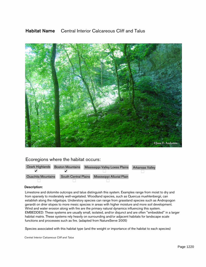
Habitat Name Central Interior Calcareous Cliff and Talus
Description:
Limestone and dolomite outcrops and talus distinguish this system. Examples range from moist to dry and from sparsely to moderately well-vegetated. Woodland species, such as Quercus muehlenbergii, can establish along the ridgetops. Understory species can range from grassland species such as Andropogon gerardii on drier slopes to more mesic species in areas with higher moisture and more soil development. Wind and water erosion along with fire are the primary natural dynamics influencing this system.EMBEDDED: These systems are usually small, isolated, and/or disjunct and are often "embedded" in a larger habitat matrix. These systems rely heavily on surrounding and/or adjacent habitats for landscape scale functions and processes such as fire. (adapted from NatureServe 2005)
Species associated with this habitat type (and the weight or importance of the habitat to each species)
Boston Mountains Arkansas Valley
Ouachita Mountains South Central Plains Mississippi Alluvial Plain
Mississippi Valley Loess PlainsOzark Highlands
Ecoregions where the habitat occurs:
Central Interior Calcareous Cliff and Talus
Page 1220

include:Collared Lizard (Crotaphytus collaris) Weight: ObligateIndiana Bat (Myotis sodalis) Weight: MarginalDesert Shrew (Notiosorex crawfordi) Weight: SuitableOzark Big-eared Bat (Corynorhinus townsendii ingens) Weight: Suitable
ANHC Mr. Tom Foti, TNC Mr. Doug Zoellner, AGFC Ms. Elizabeth Murray, Audubon Arkansas Mr. Ken Smith, Conservation Southeast Mr. Jeff Holmes, AGFC Mr. Jeff Johnston, AGFC Ms. Jane Anderson, FTN Associates Mr. Don Catenzaro
Habitat Team
Habitat Priority Score 328
Central Interior Calcareous Cliff and Talus
Page 1221
Key Factor Name Composition
Key Factor Description: The diversity, species richness, and relative abundance of vegetative elements in this habitat type.
Key Factor Weight: Medium
Indicator Name: Invasive shrubs and woody vines
Indicator Description: The percent of ground cover in non-native woody species
Poor Level: >20
Fair Level: 10-20
Good Level: 5-9
Very Good Level: <5
Current_Status: Data Gap
Indicator Weight: Medium
Conservation Action: Maintain or, where necessary, restore the percent of groundcover in invasive woody species to nine percent or less.
Monitoring Strategy: Monitor the percent of ground cover in non-native woody species.
Indicator Name: Exotic Forbs and Grasses
Indicator Description: The percent of ground cover in non-native herbaceous species
Poor Level: >20
Fair Level: 10-20
Good Level: 5-9
Very Good Level: <5
Current_Status: Data Gap
Indicator Weight: Medium
Conservation Action: Maintain or, where necessary, restore the percent of groundcover in non-native herbaceous vegetation to nine percent or less.
Monitoring Strategy: Monitor the percent of ground cover in non-native herbaceous species.
Central Interior Calcareous Cliff and Talus
Page 1222
Key Factor Name Fire Regime
Key Factor Description: Fire Return Interval and Seasonality, including landscape-scale fire in surrounding/adjacent habitats to prevent woody encroachment and allow for distribution and dispersal of obligate species
Key Factor Weight: Medium
Indicator Name: Fire Frequency
Indicator Description: Average percent of all known occurrences plus 100 meter buffer burned per 3-7 year interval.
Poor Level: <25
Fair Level: 25-50
Good Level: 51-75
Very Good Level: >75
Current_Status: Data Gap
Indicator Weight: Medium
Conservation Action: Burn at least 51 percent of the spatial extent plus 100 meter buffer of all known occurrences of this habitat type every 3-7 years.
Monitoring Strategy: Monitor average percent of all known occurrences plus 100 meter buffer burned per 3-7 year interval.
Central Interior Calcareous Cliff and Talus
Page 1223

Key Factor Name Fire Regime
Indicator Name: Fire Seasonality/Intensity
Indicator Description: The percent of areas burned during either March/April or Aug/Sept, or from leaf-expansion to leaf-fall, depending on project-level goals. In some but not all cases, seasonality is an accurate surrogate for intensity. Since intensity goals will vary from burn to burn it is difficult to "pre-quantify" ideal intensity objectives at a forest-wide scale. It is presumed that restoration, maintenance, fuel-reduction and other prescribed fire goals will be considered at the project level when planning burn intensity.
Poor Level: <25
Fair Level: 25-50
Good Level: 51-75
Very Good Level: >75
Current_Status: Data Gap
Indicator Weight: Medium
Conservation Action: When burning, burn during either March/April or August/September, or from leaf-expansion to leaf-fall, depending on project-level goals.
Monitoring Strategy: Monitor percent of burned areas burned during either March/April or Aug/Sept, or from leaf-expansion to leaf-fall, depending on project-level goals. In some but not all cases, seasonality is an accurate surrogate for intensity. Since intensity goals will vary from burn to burn it is difficult to "pre-quantify" ideal intensity objectives at a forest-wide scale. It is presumed that restoration, maintenance, fuel-reduction and other prescribed fire goals will be considered at the project level when planning burn intensity.
Central Interior Calcareous Cliff and Talus
Page 1224
Key Factor Name Remoteness
Key Factor Description: Mean density of roads (miles per square mile) within this community type at the landscape scale.
Key Factor Weight: Medium
Indicator Name: Road Density
Indicator Description: Average number of road miles per square mile across all known occurrences of this target.
Poor Level: >2 miles
Fair Level: 1-2 miles
Good Level: 0.5-1 mile
Very Good Level: <0.5 mile
Current_Status: Data Gap
Indicator Weight: Medium
Conservation Action: Maintain or, where necessary, restore the average number of road miles per square mile to one or less across all known occurrences of this target.
Monitoring Strategy: Monitor average number of road miles per square mile across all known occurrences of this target.
Central Interior Calcareous Cliff and Talus
Page 1225

Key Factor Name Spatial Ecology
Key Factor Description: The relative spatial abundance, proximity, distribution, and arrangement of this habitat type on the landscape.
Key Factor Weight: Medium
Indicator Name: Number of Blocks
Indicator Description: Total number of blocks statewide
Poor Level: 0-1
Fair Level: 2
Good Level: 3
Very Good Level: >3
Current_Status: Data Gap
Indicator Weight: Medium
Conservation Action: Maintain or, where necessary, restore number of blocks to three or more. (Block is defined by the minimum convex polygon bounded by known occurrences of this habitat type in which the median patch size is above the fair level for patch size, and in which each of the patches score fair or better on the patch proximity threshold.)
Monitoring Strategy: Monitor total number of blocks statewide.
Indicator Name: Patch Size
Indicator Description: Average patch size across all known occurrences (acres)
Poor Level: <10 acres
Fair Level: 10-30 acres
Good Level: 31-100 acres
Very Good Level: >100 acres
Current_Status: Data Gap
Indicator Weight: Medium
Conservation Action: Maintain or, where necessary, restore the average patch size of this habitat type to 31 acres or more across all known occurrences.
Monitoring Strategy: Monitor average patch size across all known occurrences (acres).
Central Interior Calcareous Cliff and Talus
Page 1226

Key Factor Name Spatial Ecology
Indicator Name: Patch Proximity
Indicator Description: Median nearest distance between patches.
Poor Level: >2 miles
Fair Level: 1-2 miles
Good Level: 0.5-1 mile
Very Good Level: <0.5 mile
Current_Status: Data Gap
Indicator Weight: Medium
Conservation Action: Maintain or, where necessary, restore the median nearest distance between patches of this habitat type to one mile or less.
Monitoring Strategy: Monitor median nearest distance between patches.
Indicator Name: Average Block Size
Indicator Description: Block is defined by the minimum convex polygon bounded by known occurrences of this habitat type in which the median patch size is above the fair level for patch size, and in which each of the patches score fair or better on the patch proximity threshold.
Poor Level: <1,000 acres
Fair Level: 1,000-5,000 acres
Good Level: 5,001-10,000 acres
Very Good Level: >10,000 acres
Current_Status: Data Gap
Indicator Weight: Medium
Conservation Action: Maintain or, where necessary, restore average block size to 5,001 acres or more. (Block is defined by the minimum convex polygon bounded by known occurrences of this habitat type in which the median patch size is above the fair level for patch size, and in which each of the patches score fair or better on the patch proximity threshold.)
Monitoring Strategy: Monitor block size.
Central Interior Calcareous Cliff and Talus
Page 1227
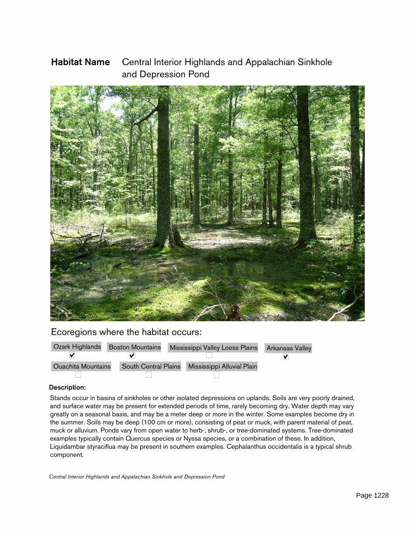
Habitat Name Central Interior Highlands and Appalachian Sinkhole and Depression Pond
Description:
Stands occur in basins of sinkholes or other isolated depressions on uplands. Soils are very poorly drained, and surface water may be present for extended periods of time, rarely becoming dry. Water depth may vary greatly on a seasonal basis, and may be a meter deep or more in the winter. Some examples become dry in the summer. Soils may be deep (100 cm or more), consisting of peat or muck, with parent material of peat, muck or alluvium. Ponds vary from open water to herb-, shrub-, or tree-dominated systems. Tree-dominated examples typically contain Quercus species or Nyssa species, or a combination of these. In addition, Liquidambar styraciflua may be present in southern examples. Cephalanthus occidentalis is a typical shrub component.
Boston Mountains Arkansas Valley
Ouachita Mountains South Central Plains Mississippi Alluvial Plain
Mississippi Valley Loess PlainsOzark Highlands
Ecoregions where the habitat occurs:
Central Interior Highlands and Appalachian Sinkhole and Depression Pond
Page 1228

Comments: Many of these ponds have their geologic origin as a more-or-less complete karst collapse feature. Some of them may display this geologic origin in a more explicit manner, with definite walls and exposed limestone or dolomite at the surface ("sinkholes"). Others are more subtle, and exist as more gentle depressions, with no exposed surface geology ("depression ponds").Vegetation: Ponds vary from open water to herb, shrub, or tree-dominated systems. Tree-dominated examples typically contain Quercus species or Nyssa species, or a combination of these. In addition, Liquidambar styraciflua may be present in southern examples. Cephalanthus occidentalis is a typical shrub component.Dynamics: Water depth may vary greatly on a seasonal basis, and may be a meter deep or more in the winter. Some examples become dry in the summer. (Adapted from NatureServe 2005)
Species associated with this habitat type (and the weight or importance of the habitat to each species) include:Ringed Salamander (Ambystoma annulatum) Weight: OptimalSoutheastern Shrew (Sorex longirostris) Weight: MarginalWood Frog (Rana sylvatica) Weight: OptimalFour-toed Salamander (Hemidactylium scutatum) Weight: Obligate
ANHC Mr. Tom Foti, TNC Mr. Doug Zoellner, AGFC Ms. Elizabeth Murray, Audubon Arkansas Mr. Ken Smith, Conservation Southeast Mr. Jeff Holmes, AGFC Mr. Jeff Johnston, AGFC Ms. Jane Anderson, FTN Associates Mr. Don Catenzaro
Habitat Team
Habitat Priority Score 183
Central Interior Highlands and Appalachian Sinkhole and Depression Pond
Page 1229
Key Factor Name Composition
Key Factor Description: The diversity, species richness, and relative abundance of vegetative elements in this habitat type.
Key Factor Weight: Medium
Indicator Name: Invasive shrubs and woody vines
Indicator Description: The percent of ground cover in non-native woody species
Poor Level: >20
Fair Level: 10-20
Good Level: 5-9
Very Good Level: <5
Current_Status: Data Gap
Indicator Weight: Medium
Conservation Action: Maintain or, where necessary, restore the percent of groundcover in invasive woody species to nine percent or less.
Monitoring Strategy: Monitor the percent of ground cover in non-native woody species.
Indicator Name: Exotic Forbs and Grasses
Indicator Description: The percent of ground cover in non-native herbaceous species
Poor Level: >20
Fair Level: 10-20
Good Level: 5-9
Very Good Level: <5
Current_Status: Data Gap
Indicator Weight: Medium
Conservation Action: Maintain or, where necessary, restore the percent of groundcover in non-native herbaceous vegetation to nine percent or less.
Monitoring Strategy: Monitor the percent of ground cover in non-native herbaceous species.
Central Interior Highlands and Appalachian Sinkhole and Depression Pond
Page 1230

Key Factor Name Fire Regime
Key Factor Description: Fire Return Interval and Seasonality, including landscape-scale fire in surrounding/adjacent habitats to prevent woody encroachment and allow for distribution and dispersal of obligate species
Key Factor Weight: Medium
Indicator Name: Fire Seasonality/Intensity
Indicator Description: The percent of areas burned during either March/April or Aug/Sept, or from leaf-expansion to leaf-fall, depending on project-level goals. In some but not all cases, seasonality is an accurate surrogate for intensity. Since intensity goals will vary from burn to burn it is difficult to "pre-quantify" ideal intensity objectives at a forest-wide scale. It is presumed that restoration, maintenance, fuel-reduction and other prescribed fire goals will be considered at the project level when planning burn intensity.
Poor Level: <25
Fair Level: 25-50
Good Level: 51-75
Very Good Level: >75
Current_Status: Data Gap
Indicator Weight: Medium
Conservation Action: When burning, burn during either March/April or August/September, or from leaf-expansion to leaf-fall, depending on project-level goals.
Monitoring Strategy: Monitor percent of burned areas burned during either March/April or Aug/Sept, or from leaf-expansion to leaf-fall, depending on project-level goals. In some but not all cases, seasonality is an accurate surrogate for intensity. Since intensity goals will vary from burn to burn it is difficult to "pre-quantify" ideal intensity objectives at a forest-wide scale. It is presumed that restoration, maintenance, fuel-reduction and other prescribed fire goals will be considered at the project level when planning burn intensity.
Central Interior Highlands and Appalachian Sinkhole and Depression Pond
Page 1231
Key Factor Name Fire Regime
Indicator Name: Fire Frequency
Indicator Description: Average percent of all known occurrences plus appropriate buffer burned per 3-7 year interval.
Poor Level: <25
Fair Level: 25-50
Good Level: 51-75
Very Good Level: >75
Current_Status: Data Gap
Indicator Weight: Medium
Conservation Action: Burn at least 51 percent of the spatial extent plus appropriate buffer of all known occurrences of this habitat type every 3-7 years.
Monitoring Strategy: Monitor average percent of all known occurrences plus appropriate buffer burned per 3-7 year interval.
Central Interior Highlands and Appalachian Sinkhole and Depression Pond
Page 1232

Key Factor Name Remoteness
Key Factor Description: Mean density of roads (miles per square mile) within this community type at the landscape scale.
Key Factor Weight: Medium
Indicator Name: Road Density
Indicator Description: Average number of road miles per square mile across all known occurrences of this target.
Poor Level: >2 miles
Fair Level: 1-2 miles
Good Level: 0.5-1 mile
Very Good Level: <0.5 mile
Current_Status: Data Gap
Indicator Weight: Medium
Conservation Action: Maintain or, where necessary, restore the average number of road miles per square mile to one or less across all known occurrences of this target.
Monitoring Strategy: Monitor average number of road miles per square mile across all known occurrences of this target.
Central Interior Highlands and Appalachian Sinkhole and Depression Pond
Page 1233

Key Factor Name Spatial Ecology
Key Factor Description: The relative spatial abundance, proximity, distribution, and arrangement of this habitat type on the landscape.
Key Factor Weight: Medium
Indicator Name: Number of Blocks
Indicator Description: Total number of blocks statewide
Poor Level: 0-1
Fair Level: 2
Good Level: 3
Very Good Level: >3
Current_Status: Data Gap
Indicator Weight: Medium
Conservation Action: Maintain or, where necessary, restore number of blocks to three or more. (Block is defined by the minimum convex polygon bounded by known occurrences of this habitat type in which the median patch size is above the fair level for patch size, and in which each of the patches score fair or better on the patch proximity threshold.)
Monitoring Strategy: Monitor total number of blocks statewide.
Central Interior Highlands and Appalachian Sinkhole and Depression Pond
Page 1234

Key Factor Name Spatial Ecology
Indicator Name: Average Block Size
Indicator Description: Block is defined by the minimum convex polygon bounded by known occurrences of this habitat type in which the median patch size is above the fair level for patch size, and in which each of the patches score fair or better on the patch proximity threshold.
Poor Level: <300 acres
Fair Level: 300-600 acres
Good Level: 601-1,000 acres
Very Good Level: >1,000 acres
Current_Status: Data Gap
Indicator Weight: Medium
Conservation Action: Maintain or, where necessary, restore average block size to 2,500 acres or more. (Block is defined by the minimum convex polygon bounded by known occurrences of this habitat type in which the median patch size is above the fair level for patch size, and in which each of the patches score fair or better on the patch proximity threshold.)
Monitoring Strategy: Monitor block size.
Indicator Name: Patch Size
Indicator Description: Width of buffer (meters)
Poor Level: <100 meters of buffer
Fair Level: 100-250 meters of buffer
Good Level: 251-400 meters of buffer
Very Good Level: >400 meters of buffer
Current_Status: Data Gap
Indicator Weight: Medium
Conservation Action: Maintain or, where necessary, buffer known occurrences of the habitat type with a minimum of 251 meters of adjacent but dissimilar habitat
Monitoring Strategy: Monitor width of buffer (meters).
Central Interior Highlands and Appalachian Sinkhole and Depression Pond
Page 1235
Key Factor Name Spatial Ecology
Indicator Name: Patch Proximity
Indicator Description: Median nearest distance between patches.
Poor Level: >1200 meters
Fair Level: 801-1200 meters
Good Level: 500-800 meters
Very Good Level: <500 meters
Current_Status: Data Gap
Indicator Weight: Medium
Conservation Action: Maintain, or where necessary, restore the average distance between patches to 800 meters or less.
Monitoring Strategy: Monitor median nearest distance between patches.
Central Interior Highlands and Appalachian Sinkhole and Depression Pond
Page 1236
Habitat Name Central Interior Highlands Calcareous Glade and Barrens
Description:
This system is found along moderate to steep slopes and steep valleys on primarily southerly to westerly facing slopes. Limestone, dolomite or shale bedrock typify this system with shallow, moderately to well-drained soils interspersed with rocks. These soils often dry out during the summer and autumn, and then become saturated during the winter and spring. Schizachyrium scoparium dominates this system and is commonly associated with Andropogon gerardii, Bouteloua curtipendula, and calcium-loving plant species. Stunted woodlands primarily dominated by Quercus muehlenbergii interspersed with Juniperus virginiana occur on variable-depth-to-bedrock soils. Fire is the primary natural dynamic, and prescribed fires help manage this system by restricting woody growth and maintaining the more open glade structure.
Boston Mountains Arkansas Valley
Ouachita Mountains South Central Plains Mississippi Alluvial Plain
Mississippi Valley Loess PlainsOzark Highlands
Ecoregions where the habitat occurs:
Central Interior Highlands Calcareous Glade and Barrens
Page 1237

EMBEDDED: These systems are usually small, isolated, and/or disjunct and are often "embedded" in a larger habitat matrix. These systems rely heavily on surrounding and/or adjacent habitats for landscape scale functions and processes such as fire. (adapted from Natureserve 2005)
Species associated with this habitat type (and the weight or importance of the habitat to each species) include:Scrubland Tiger Beetle (Cicindela obsoleta) Weight: OptimalLong-tailed Weasel (Mustela frenata) Weight: Data GapPainted Bunting (Passerina ciris) Weight: MarginalBlue-winged Warbler (Vermivora pinus) Weight: MarginalWhip-poor-will (Caprimulgus vociferus) Weight: SuitableGround Snake (Sonora semiannulata) Weight: ObligateTexas Horned Lizard (Phrynosoma cornutum) Weight: SuitableChuck-will's-widow (Caprimulgus carolinensis) Weight: SuitableCollared Lizard (Crotaphytus collaris) Weight: ObligateWestern Slender Glass Lizard (Ophisaurus attenuatus attenuatus) Weight: Suitable
ANHC Mr. Tom Foti, TNC Mr. Doug Zoellner, AGFC Ms. Elizabeth Murray, Audubon Arkansas Mr. Ken Smith, Conservation Southeast Mr. Jeff Holmes, AGFC Mr. Jeff Johnston, AGFC Ms. Jane Anderson, FTN Associates Mr. Don Catenzaro
Habitat Team
Habitat Priority Score 390
Central Interior Highlands Calcareous Glade and Barrens
Page 1238
Key Factor Name Composition
Key Factor Description: The diversity, species richness, and relative abundance of vegetative elements in this habitat type.
Key Factor Weight: Low
Indicator Name: Invasive shrubs and woody vines
Indicator Description: The percent of ground cover in non-native woody species
Poor Level: >20
Fair Level: 10-20
Good Level: 5-9
Very Good Level: <5
Current_Status: Data Gap
Indicator Weight: Medium
Conservation Action: Maintain or, where necessary, restore the percent of groundcover in invasive woody species to nine percent or less.
Monitoring Strategy: Monitor the percent of ground cover in non-native woody species.
Indicator Name: Exotic Forbs and Grasses
Indicator Description: The percent of ground cover in non-native herbaceous species
Poor Level: >20
Fair Level: 10-20
Good Level: 5-9
Very Good Level: <5
Current_Status: Data Gap
Indicator Weight: High
Conservation Action: Maintain or, where necessary, restore the percent of groundcover in non-native herbaceous vegetation to nine percent or less.
Monitoring Strategy: Monitor the percent of ground cover in non-native herbaceous species.
Central Interior Highlands Calcareous Glade and Barrens
Page 1239
Key Factor Name Fire Regime
Key Factor Description: Fire Return Interval and Seasonality, including landscape-scale fire in surrounding/adjacent habitats to prevent woody encroachment and allow for distribution and dispersal of obligate species
Key Factor Weight: Medium
Indicator Name: Fire Seasonality/Intensity
Indicator Description: The percent of areas burned during either March/April or Aug/Sept, or from leaf-expansion to leaf-fall, depending on project-level goals. In some but not all cases, seasonality is an accurate surrogate for intensity. Since intensity goals will vary from burn to burn it is difficult to "pre-quantify" ideal intensity objectives at a forest-wide scale. It is presumed that restoration, maintenance, fuel-reduction and other prescribed fire goals will be considered at the project level when planning burn intensity.
Poor Level: <25
Fair Level: 25-50
Good Level: 51-75
Very Good Level: >75
Current_Status: Data Gap
Indicator Weight: Medium
Conservation Action: When burning, burn during either March/April or August/September, or from leaf-expansion to leaf-fall, depending on project-level goals.
Monitoring Strategy: Monitor percent of burned areas burned during either March/April or Aug/Sept, or from leaf-expansion to leaf-fall, depending on project-level goals. In some but not all cases, seasonality is an accurate surrogate for intensity. Since intensity goals will vary from burn to burn it is difficult to "pre-quantify" ideal intensity objectives at a forest-wide scale. It is presumed that restoration, maintenance, fuel-reduction and other prescribed fire goals will be considered at the project level when planning burn intensity.
Central Interior Highlands Calcareous Glade and Barrens
Page 1240

Key Factor Name Fire Regime
Indicator Name: Fire Frequency
Indicator Description: Average percent of all known occurrences plus 100 meter buffer burned per 3-5 year interval.
Poor Level: <25
Fair Level: 25-50
Good Level: 51-75
Very Good Level: >75
Current_Status: Data Gap
Indicator Weight: Medium
Conservation Action: Burn at least 51 percent of the spatial extent plus 100 meter buffer of all known occurrences of this habitat type every 3-5 years.
Monitoring Strategy: Monitor average percent of all known occurrences plus 100 meter buffer burned per 3-5 year interval.
Central Interior Highlands Calcareous Glade and Barrens
Page 1241

Key Factor Name Remoteness
Key Factor Description: Mean density of roads (miles per square mile) within this community type at the landscape scale.
Key Factor Weight: Medium
Indicator Name: Road Density
Indicator Description: Average number of road miles per square mile across all known occurrences of this target.
Poor Level: >2 miles
Fair Level: 1-2 miles
Good Level: 0.5-1 mile
Very Good Level: <0.5 mile
Current_Status: Data Gap
Indicator Weight: Medium
Conservation Action: Maintain or, where necessary, restore the average number of road miles per square mile to one or less across all known occurrences of this target.
Monitoring Strategy: Monitor average number of road miles per square mile across all known occurrences of this target.
Central Interior Highlands Calcareous Glade and Barrens
Page 1242

Key Factor Name Spatial Ecology
Key Factor Description: The relative spatial abundance, proximity, distribution, and arrangement of this habitat type on the landscape.
Key Factor Weight: Medium
Indicator Name: Average Block Size
Indicator Description: Block is defined by the minimum convex polygon bounded by known occurrences of this habitat type in which the median patch size is above the fair level for patch size, and in which each of the patches score fair or better on the patch proximity threshold.
Poor Level: <500 acres
Fair Level: 500-1,000 acres
Good Level: 1,001-2,000 acres
Very Good Level: >2,000 acres
Current_Status: Data Gap
Indicator Weight: Medium
Conservation Action: Maintain or, where necessary, restore average block size to 1,001 acres or more. (Block is defined by the minimum convex polygon bounded by known occurrences of this habitat type in which the median patch size is above the fair level for patch size, and in which each of the patches score fair or better on the patch proximity threshold.)
Monitoring Strategy: Monitor block size.
Central Interior Highlands Calcareous Glade and Barrens
Page 1243

Key Factor Name Spatial Ecology
Indicator Name: Patch Proximity
Indicator Description: Median nearest distance between patches.
Poor Level: >2.5 miles
Fair Level: 1-2.5 miles
Good Level: 0.5-1 mile
Very Good Level: <0.5 mile
Current_Status: Data Gap
Indicator Weight: Medium
Conservation Action: Maintain or, where necessary, restore the median nearest distance between patches of this habitat type to one mile or less.
Monitoring Strategy: Monitor median nearest distance between patches.
Indicator Name: Number of Blocks
Indicator Description: Total number of blocks statewide
Poor Level: 0-1
Fair Level: 2
Good Level: 3
Very Good Level: >3
Current_Status: Data Gap
Indicator Weight: Medium
Conservation Action: Maintain or, where necessary, restore number of blocks to three or more. (Block is defined by the minimum convex polygon bounded by known occurrences of this habitat type in which the median patch size is above the fair level for patch size, and in which each of the patches score fair or better on the patch proximity threshold.)
Monitoring Strategy: Monitor total number of blocks statewide.
Central Interior Highlands Calcareous Glade and Barrens
Page 1244

Key Factor Name Spatial Ecology
Indicator Name: Patch Size
Indicator Description: Average patch size across all known occurrences (acres)
Poor Level: <10 acres
Fair Level: 10-30 acres
Good Level: 31-100 acres
Very Good Level: >100 acres
Current_Status: Data Gap
Indicator Weight: Medium
Conservation Action: Maintain or, where necessary, restore the average patch size of this habitat type to 31 acres or more across all known occurrences.
Monitoring Strategy: Monitor average patch size across all known occurrences (acres).
Central Interior Highlands Calcareous Glade and Barrens
Page 1245

Habitat Name Central Interior Highlands Dry Acidic Glade and Barrens
Description:
This system occurs along moderate to steep slopes or valley walls of rivers along most aspects. Parent material includes chert, shale and/or sandstone bedrock with well- to excessively well-drained, shallow soils interspersed with rock and boulders. These soils are typically dry during the summer and autumn, becoming saturated during the spring and winter. Grasses such as Schizachyrium scoparium and Sorghastrum nutans dominate this system with stunted oak species Quercus stellata, Quercus marilandica and shrub species such as Vaccinium spp. Occurring on variable depth soils. This system is influenced by drought and infrequent to occasional fires. Prescribed fires help manage this system by maintaining an open glade structure.
Boston Mountains Arkansas Valley
Ouachita Mountains South Central Plains Mississippi Alluvial Plain
Mississippi Valley Loess PlainsOzark Highlands
Ecoregions where the habitat occurs:
Central Interior Highlands Dry Acidic Glade and Barrens
Page 1246

EMBEDDED: These systems are usually small, isolated, and/or disjunct and are often "embedded" in a larger habitat matrix. These systems rely heavily on surrounding and/or adjacent habitats for landscape scale functions and processes such as fire. (adapted from NatureServe 2005)
Species associated with this habitat type (and the weight or importance of the habitat to each species) include: Long-tailed Weasel (Mustela frenata) Weight: Data GapTexas Horned Lizard (Phrynosoma cornutum) Weight: SuitableChuck-will's-widow (Caprimulgus carolinensis) Weight: SuitableGreat Plains Skink (Eumeces obsoletus) Weight: OptimalRufous-crowned Sparrow (Aimophila ruficeps) Weight: SuitablePainted Bunting (Passerina ciris) Weight: MarginalDesert Shrew (Notiosorex crawfordi) Weight: SuitableWestern Slender Glass Lizard (Ophisaurus attenuatus attenuatus) Weight: SuitableNorthern Bobwhite (Colinus virginianus) Weight: SuitableCollared Lizard (Crotaphytus collaris) Weight: ObligateDiana (Speyeria diana) Weight: SuitableBlue-winged Warbler (Vermivora pinus) Weight: MarginalWestern Diamondback Rattlesnake (Crotalus atrox) Weight: OptimalWhip-poor-will (Caprimulgus vociferus) Weight: Suitable
ANHC Mr. Tom Foti, TNC Mr. Doug Zoellner, AGFC Ms. Elizabeth Murray, Audubon Arkansas Mr. Ken Smith, Conservation Southeast Mr. Jeff Holmes, AGFC Mr. Jeff Johnston, AGFC Ms. Jane Anderson, FTN Associates Mr. Don Catenzaro
Habitat Team
Habitat Priority Score 522
Central Interior Highlands Dry Acidic Glade and Barrens
Page 1247

Key Factor Name Composition
Key Factor Description: The diversity, species richness, and relative abundance of vegetative elements in this habitat type.
Key Factor Weight: Low
Indicator Name: Invasive shrubs and woody vines
Indicator Description: The percent of ground cover in non-native woody species
Poor Level: >20
Fair Level: 10-20
Good Level: 5-9
Very Good Level: <5
Current_Status: Data Gap
Indicator Weight: Medium
Conservation Action: Maintain or, where necessary, restore the percent of groundcover in invasive woody species to nine percent or less.
Monitoring Strategy: Monitor the percent of ground cover in non-native woody species.
Indicator Name: Exotic Forbs and Grasses
Indicator Description: The percent of ground cover in non-native herbaceous species
Poor Level: >20
Fair Level: 10-20
Good Level: 5-9
Very Good Level: <5
Current_Status: Data Gap
Indicator Weight: High
Conservation Action: Maintain or, where necessary, restore the percent of groundcover in non-native herbaceous vegetation to nine percent or less.
Monitoring Strategy: Monitor the percent of ground cover in non-native herbaceous species.
Central Interior Highlands Dry Acidic Glade and Barrens
Page 1248

Key Factor Name Fire Regime
Key Factor Description: Fire Return Interval and Seasonality, including landscape-scale fire in surrounding/adjacent habitats to prevent woody encroachment and allow for distribution and dispersal of obligate species
Key Factor Weight: High
Indicator Name: Fire Frequency
Indicator Description: Average percent of all known occurrences plus 100 meter buffer burned per 3-5 year interval.
Poor Level: <25
Fair Level: 25-50
Good Level: 51-75
Very Good Level: >75
Current_Status: Data Gap
Indicator Weight: Medium
Conservation Action: Burn at least 51 percent of the spatial extent plus 100 meter buffer of all known occurrences of this habitat type every 3-5 years.
Monitoring Strategy: Monitor average percent of all known occurrences plus 100 meter buffer burned per 3-5 year interval.
Central Interior Highlands Dry Acidic Glade and Barrens
Page 1249

Key Factor Name Fire Regime
Indicator Name: Fire Seasonality/Intensity
Indicator Description: The percent of areas burned during either March/April or Aug/Sept, or from leaf-expansion to leaf-fall, depending on project-level goals. In some but not all cases, seasonality is an accurate surrogate for intensity. Since intensity goals will vary from burn to burn it is difficult to "pre-quantify" ideal intensity objectives at a forest-wide scale. It is presumed that restoration, maintenance, fuel-reduction and other prescribed fire goals will be considered at the project level when planning burn intensity.
Poor Level: <25
Fair Level: 25-50
Good Level: 51-75
Very Good Level: >75
Current_Status: Data Gap
Indicator Weight: Medium
Conservation Action: When burning, burn during either March/April or August/September, or from leaf-expansion to leaf-fall, depending on project-level goals.
Monitoring Strategy: Monitor percent of burned areas burned during either March/April or Aug/Sept, or from leaf-expansion to leaf-fall, depending on project-level goals. In some but not all cases, seasonality is an accurate surrogate for intensity. Since intensity goals will vary from burn to burn it is difficult to "pre-quantify" ideal intensity objectives at a forest-wide scale. It is presumed that restoration, maintenance, fuel-reduction and other prescribed fire goals will be considered at the project level when planning burn intensity.
Central Interior Highlands Dry Acidic Glade and Barrens
Page 1250
Key Factor Name Remoteness
Key Factor Description: Mean density of roads (miles per square mile) within this community type at the landscape scale.
Key Factor Weight: Medium
Indicator Name: Road Density
Indicator Description: Average number of road miles per square mile across all known occurrences of this target.
Poor Level: >2 miles
Fair Level: 1-2 miles
Good Level: 0.5-1 mile
Very Good Level: <0.5 mile
Current_Status: Data Gap
Indicator Weight: Medium
Conservation Action: Maintain or, where necessary, restore the average number of road miles per square mile to one or less across all known occurrences of this target.
Monitoring Strategy: Monitor average number of road miles per square mile across all known occurrences of this target.
Central Interior Highlands Dry Acidic Glade and Barrens
Page 1251
Key Factor Name Spatial Ecology
Key Factor Description: The relative spatial abundance, proximity, distribution, and arrangement of this habitat type on the landscape.The relative spatial abundance, proximity, distribution, and arrangement of this habitat type on the landscape.
Key Factor Weight: Medium
Indicator Name: Patch Proximity
Indicator Description: Median nearest distance between patches.
Poor Level: >2.5 miles
Fair Level: 1-2.5 miles
Good Level: 0.5-1 mile
Very Good Level: <0.5 mile
Current_Status: Data Gap
Indicator Weight: Medium
Conservation Action: Maintain or, where necessary, restore the median nearest distance between patches of this habitat type to one mile or less.
Monitoring Strategy: Monitor median nearest distance between patches.
Central Interior Highlands Dry Acidic Glade and Barrens
Page 1252

Key Factor Name Spatial Ecology
Indicator Name: Average Block Size
Indicator Description: Block is defined by the minimum convex polygon bounded by known occurrences of this habitat type in which the median patch size is above the fair level for patch size, and in which each of the patches score fair or better on the patch proximity threshold.
Poor Level: <250 acres
Fair Level: 250-500 acres
Good Level: 501-1,000 acres
Very Good Level: >1,000 acres
Current_Status: Data Gap
Indicator Weight: Medium
Conservation Action: Maintain or, where necessary, restore average block size to 501 acres or more. (Block is defined by the minimum convex polygon bounded by known occurrences of this habitat type in which the median patch size is above the fair level for patch size, and in which each of the patches score fair or better on the patch proximity threshold.)
Monitoring Strategy: Monitor block size.
Central Interior Highlands Dry Acidic Glade and Barrens
Page 1253

Key Factor Name Spatial Ecology
Indicator Name: Number of Blocks
Indicator Description: Total number of blocks statewide
Poor Level: 0-1
Fair Level: 2
Good Level: 3
Very Good Level: >3
Current_Status: Data Gap
Indicator Weight: Medium
Conservation Action: Maintain or, where necessary, restore number of blocks to three or more. (Block is defined by the minimum convex polygon bounded by known occurrences of this habitat type in which the median patch size is above the fair level for patch size, and in which each of the patches score fair or better on the patch proximity threshold.)
Monitoring Strategy: Monitor total number of blocks statewide.
Indicator Name: Patch Size
Indicator Description: Average patch size across all known occurrences (acres)
Poor Level: <5 acres
Fair Level: 5-10 acres
Good Level: 10-30 acres
Very Good Level: >30 acres
Current_Status: Data Gap
Indicator Weight: Medium
Conservation Action: Maintain or, where necessary, restore the average patch size of this habitat type to 10 acres or more across all known occurrences.
Monitoring Strategy: Monitor average patch size across all known occurrences (acres).
Central Interior Highlands Dry Acidic Glade and Barrens
Page 1254

Habitat Name Crop Land
Description:
This type includes cultivated fields or aquaculture ponds, often many acres in size, managed specifically for a single crop. Occasional edges around the perimeter provide some habitat diversity. (Foti and others 2005)
Species associated with this habitat type (and the weight or importance of the habitat to each species) include:Greater Prairie Chicken (Tympanuchus cupido) Weight: MarginalBlack-tailed Jackrabbit (Lepus californicus) Weight: MarginalShort-eared Owl (Asio flammeus) Weight: SuitableAmerican Black Bear (Ursus americanus americanus) Weight: MarginalLong-tailed Weasel (Mustela frenata) Weight: Data Gap
Boston Mountains Arkansas Valley
Ouachita Mountains South Central Plains Mississippi Alluvial Plain
Mississippi Valley Loess PlainsOzark Highlands
Ecoregions where the habitat occurs:
Crop Land
Page 1255

Barn Owl (Tyto alba) Weight: SuitableNorthern Harrier (Circus cyaneus) Weight: SuitableNorthern Crawfish Frog (Rana areolata circulosa) Weight: MarginalNorthern Bobwhite (Colinus virginianus) Weight: MarginalKing Rail (Rallus elegans) Weight: MarginalUpland Sandpiper (Bartramia longicauda) Weight: MarginalHudsonian Godwit (Limosa haemastica) Weight: MarginalStrecker's Chorus Frog (Pseudacris streckeri) Weight: MarginalAmerican Woodcock (Scolopax minor) Weight: MarginalBuff-breasted Sandpiper (Tryngites subruficollis) Weight: MarginalAmerican Badger (Taxidea taxus) Weight: SuitableEastern Spotted Skunk (Spilogale putorius) Weight: MarginalSmith's Longspur (Calcarius pictus) Weight: MarginalHurter's Spadefoot (Scaphiopus hurterii) Weight: MarginalAmerican Black Duck (Anas rubripes) Weight: SuitableIllinois Chorus Frog (Pseudacris illinoensis) Weight: MarginalOzark Pocket Gopher (Geomys bursarius ozarkensis) Weight: MarginalEastern Tiger Salamander (Ambystoma tigrinum tigrinum) Weight: MarginalGrasshopper Sparrow (Ammodramus savannarum) Weight: MarginalNorthern Pintail (Anas acuta) Weight: SuitableLark Sparrow (Chondestes grammacus) Weight: MarginalRusty Blackbird (Euphagus carolinus) Weight: MarginalEastern Spadefoot (Scaphiopus holbrookii) Weight: MarginalMigrant Loggerhead Shrike (Lanius ludovicianus migrans) Weight: SuitableWestern Harvest Mouse (Reithrodontomys megalotis) Weight: Marginal
ANHC Mr. Tom Foti, TNC Mr. Doug Zoellner, AGFC Ms. Elizabeth Murray, Audubon Arkansas Mr. Ken Smith, Conservation Southeast Mr. Jeff Holmes, AGFC Mr. Jeff Johnston, AGFC Ms. Jane Anderson, FTN Associates Mr. Don Catenzaro
Habitat Team
Habitat Priority Score 693
Crop Land
Page 1256
Key Factor Name Fire Regime
Key Factor Description: Fire Return Interval and Seasonality, including landscape-scale fire in surrounding/adjacent habitats to prevent woody encroachment and allow for distribution and dispersal of obligate species
Key Factor Weight: Medium
Indicator Name: Fire Seasonality/Intensity
Indicator Description: The percent of areas burned during either March/April or Aug/Sept, or from leaf-expansion to leaf-fall, depending on project-level goals. In some but not all cases, seasonality is an accurate surrogate for intensity. Since intensity goals will vary from burn to burn it is difficult to "pre-quantify" ideal intensity objectives at a forest-wide scale. It is presumed that restoration, maintenance, fuel-reduction and other prescribed fire goals will be considered at the project level when planning burn intensity.
Poor Level: <25
Fair Level: 25-50
Good Level: 51-75
Very Good Level: >75
Current_Status: Data Gap
Indicator Weight: Medium
Conservation Action: When burning, burn during either March/April or August/September, or from leaf-expansion to leaf-fall, depending on project-level goals.
Monitoring Strategy: Monitor percent of burned areas burned during either March/April or Aug/Sept, or from leaf-expansion to leaf-fall, depending on project-level goals. In some but not all cases, seasonality is an accurate surrogate for intensity. Since intensity goals will vary from burn to burn it is difficult to "pre-quantify" ideal intensity objectives at a forest-wide scale. It is presumed that restoration, maintenance, fuel-reduction and other prescribed fire goals will be considered at the project level when planning burn intensity.
Crop Land
Page 1257

Key Factor Name Remoteness
Key Factor Description: Mean density of roads (miles per square mile) within this community type at the landscape scale.
Key Factor Weight: Medium
Indicator Name: Road Density
Indicator Description: Average number of road miles per square mile across all known occurrences of this target.
Poor Level: >2 miles
Fair Level: 1-2 miles
Good Level: 0.5-1 mile
Very Good Level: <0.5 mile
Current_Status: Data Gap
Indicator Weight: Medium
Conservation Action: Maintain or, where necessary, restore the average number of road miles per square mile to one or less across all known occurrences of this target.
Monitoring Strategy: Monitor average number of road miles per square mile across all known occurrences of this target.
Crop Land
Page 1258
Habitat Name Cultivated Forest
Description:
This type includes plantations primarily composed of pine with regularly spaced trees planted for commercial production and subject to periodic silvicultural maintenance. This habitat type is extensive in Arkansas and is used by many species of conservation concern. Key factors and Indicators have often been derived in relationship to species of concern that use this habitat. In some cases, this habitat replaces native terrestrial habitats and may be of conservation concern from that standpoint.(Foti and others 2005)
Species associated with this habitat type (and the weight or importance of the habitat to each species) include:Hooded Warbler (Wilsonia citrina) Weight: MarginalNorthern Bobwhite (Colinus virginianus) Weight: Marginal
Boston Mountains Arkansas Valley
Ouachita Mountains South Central Plains Mississippi Alluvial Plain
Mississippi Valley Loess PlainsOzark Highlands
Ecoregions where the habitat occurs:
Cultivated Forest
Page 1259

EasternTowhee (Pipilo erythrophthalmus) Weight: SuitableYellow-billed Cuckoo (Coccyzus americanus) Weight: MarginalAmerican Black Bear (Ursus americanus americanus) Weight: MarginalSwainson's Warbler (Limnothlypis swainsonii) Weight: MarginalBachman's Sparrow (Aimophila aestivalis) Weight: MarginalKentucky Warbler (Oporornis formosus) Weight: MarginalLark Sparrow (Chondestes grammacus) Weight: SuitableWood Thrush (Hylocichla mustelina) Weight: MarginalLong-tailed Weasel (Mustela frenata) Weight: Data Gap
ANHC Mr. Tom Foti, TNC Mr. Doug Zoellner, AGFC Ms. Elizabeth Murray, Audubon Arkansas Mr. Ken Smith, Conservation Southeast Mr. Jeff Holmes, AGFC Mr. Jeff Johnston, AGFC Ms. Jane Anderson, FTN Associates Mr. Don Catenzaro
Habitat Team
Habitat Priority Score 193
Cultivated Forest
Page 1260
Key Factor Name Composition
Key Factor Description: The diversity, species richness, and relative abundance of vegetative elements in this habitat type.
Key Factor Weight: Medium
Indicator Name: Invasive shrubs and woody vines
Indicator Description: The percent of ground cover in non-native woody species
Poor Level: >20
Fair Level: 10-20
Good Level: 5-9
Very Good Level: <5
Current_Status: Data Gap
Indicator Weight: Medium
Conservation Action: Maintain or, where necessary, restore the percent of groundcover in invasive woody species to nine percent or less.
Monitoring Strategy: Monitor the percent of ground cover in non-native woody species.
Indicator Name: Exotic Forbs and Grasses
Indicator Description: The percent of ground cover in non-native herbaceous species
Poor Level: >20
Fair Level: 10-20
Good Level: 5-9
Very Good Level: <5
Current_Status: Data Gap
Indicator Weight: Medium
Conservation Action: Maintain or, where necessary, restore the percent of groundcover in non-native herbaceous vegetation to nine percent or less.
Monitoring Strategy: Monitor the percent of ground cover in non-native herbaceous species.
Cultivated Forest
Page 1261

Key Factor Name Composition
Indicator Name: Bedding or Hipping
Indicator Description: The percent area where raised beds are created for tree planting
Poor Level: >20
Fair Level: 10-19
Good Level: 5-9
Very Good Level: <5
Current_Status:
Indicator Weight: High
Conservation Action: Maintain or, where necessary restore, the percentage of bedded or hipped areas to nine percent or less.
Monitoring Strategy: Monitor percent of area where raised beds are created for tree planting.
Cultivated Forest
Page 1262
Key Factor Name Fire Regime
Key Factor Description: Fire Return Interval and Seasonality, including landscape-scale fire in surrounding/adjacent habitats to prevent woody encroachment and allow for distribution and dispersal of obligate species
Key Factor Weight: Medium
Indicator Name: Fire Frequency
Indicator Description: Average percent of all known occurrences burned per 3-5 year interval.
Poor Level: <25
Fair Level: 25-50
Good Level: 51-75
Very Good Level: >75
Current_Status: Data Gap
Indicator Weight: Medium
Conservation Action: Burn at least 51 percent of the spatial extent of all known occurrences of this habitat type every 3-5 years.
Monitoring Strategy: Monitor average percent of all known occurrences burned per 3-5 year interval.
Cultivated Forest
Page 1263
Key Factor Name Fire Regime
Indicator Name: Fire Seasonality/Intensity
Indicator Description: The percent of areas burned during either March/April or Aug/Sept, or from leaf-expansion to leaf-fall, depending on project-level goals. In some but not all cases, seasonality is an accurate surrogate for intensity. Since intensity goals will vary from burn to burn it is difficult to "pre-quantify" ideal intensity objectives at a forest-wide scale. It is presumed that restoration, maintenance, fuel-reduction and other prescribed fire goals will be considered at the project level when planning burn intensity.
Poor Level: <25
Fair Level: 25-50
Good Level: 51-75
Very Good Level: >75
Current_Status: Data Gap
Indicator Weight: Medium
Conservation Action: When burning, burn during either March/April or August/September, or from leaf-expansion to leaf-fall, depending on project-level goals.
Monitoring Strategy: Monitor percent of burned areas burned during either March/April or Aug/Sept, or from leaf-expansion to leaf-fall, depending on project-level goals. In some but not all cases, seasonality is an accurate surrogate for intensity. Since intensity goals will vary from burn to burn it is difficult to "pre-quantify" ideal intensity objectives at a forest-wide scale. It is presumed that restoration, maintenance, fuel-reduction and other prescribed fire goals will be considered at the project level when planning burn intensity.
Cultivated Forest
Page 1264

Key Factor Name Remoteness
Key Factor Description: Mean density of roads (miles per square mile) within this community type at the landscape scale.
Key Factor Weight: Medium
Indicator Name: Road Density
Indicator Description: Average number of road miles per square mile across all known occurrences of this target.
Poor Level: >2 miles
Fair Level: 1-2 miles
Good Level: 0.5-1 mile
Very Good Level: <0.5 mile
Current_Status: Data Gap
Indicator Weight: Medium
Conservation Action: Maintain or, where necessary, restore the average number of road miles per square mile to one or less across all known occurrences of this target.
Monitoring Strategy: Monitor average number of road miles per square mile across all known occurrences of this target.
Cultivated Forest
Page 1265

Key Factor Name Spatial Ecology
Key Factor Description: The relative spatial abundance, proximity, distribution and arrangement of this habitat type on the landscape.
Key Factor Weight: Medium
Indicator Name: Average Block Size
Indicator Description: Block is defined by the minimum convex polygon bounded by known occurrences of this habitat type in which the median patch size is above the fair level for patch size, and in which each of the patches score fair or better on the patch proximity threshold.
Poor Level: <2,499 acres
Fair Level: 2,500-5,000 acres
Good Level: 5,001-10,000 acres
Very Good Level: >10,000 acres
Current_Status: Data Gap
Indicator Weight: Medium
Conservation Action: Maintain or, where necessary, restore average block size to 5,001 acres or more. (Block is defined by the minimum convex polygon bounded by known occurrences of this habitat type in which the median patch size is above the fair level for patch size, and in which each of the patches score fair or better on the patch proximity threshold.)
Monitoring Strategy: Monitor block size.
Cultivated Forest
Page 1266

Key Factor Name Spatial Ecology
Indicator Name: Patch Size
Indicator Description: Average patch size across all known occurrences (acres)
Poor Level: <250 acres
Fair Level: 250-500 acres
Good Level: 501-1,000 acres
Very Good Level: >1,000 acres
Current_Status: Data Gap
Indicator Weight: Medium
Conservation Action: Maintain or, where necessary, restore the average patch size of this habitat type to 501 acres or more across all known occurrences.
Monitoring Strategy: Monitor average patch size across all known occurrences (acres).
Indicator Name: Number of Blocks
Indicator Description: Total number of blocks statewide
Poor Level: 0-1
Fair Level: 2
Good Level: 3
Very Good Level: >3
Current_Status: Data Gap
Indicator Weight: Medium
Conservation Action: Maintain or, where necessary, restore number of blocks to three or more. (Block is defined by the minimum convex polygon bounded by known occurrences of this habitat type in which the median patch size is above the fair level for patch size, and in which each of the patches score fair or better on the patch proximity threshold.)
Monitoring Strategy: Monitor total number of blocks statewide.
Cultivated Forest
Page 1267
Key Factor Name Spatial Ecology
Indicator Name: Patch Proximity
Indicator Description: Median nearest distance between patches.
Poor Level: >4 miles
Fair Level: 2-4 miles
Good Level: 1-2 miles
Very Good Level: <1 mile
Current_Status: Data Gap
Indicator Weight: Medium
Conservation Action: Maintain or, where necessary, restore the median nearest distance between patches of this habitat type to two miles or less.
Monitoring Strategy: Monitor median nearest distance between patches.
Cultivated Forest
Page 1268

Habitat Name Lower Mississippi Alluvial Plain Grand Prairie
Description:
This system of prairies and woodlands occurs on the oldest substantial land surfaces in the Mississippi River Alluvial Valley and the highest land surface in the river-deposited portions of the Mississippi Alluvial Plain ecoregion. It occupies a very flat region up to 20 miles wide and 60 miles long bounded by present day rivers, especially the Arkansas and White, which are much lower in elevation than the Grand Prairie terrace. This terrace is covered with thin soils underlain by deep layers of impervious clay. The surface soils have been considered to be loess by some sources but are more likely silts and silty clays (T. Foti pers. comm.). Although productive, these soils are droughty due to the impervious clay subsoils. The combination of droughty soils, very flat topography, and the lack of major stream corridors in the region create conditions suitable to the ignition and spread of fires. Almost annual fires would have been necessary to maintain these prairies, and anthropogenic influences have been critical for probably 5,000 years. The vegetation includes
Boston Mountains Arkansas Valley
Ouachita Mountains South Central Plains Mississippi Alluvial Plain
Mississippi Valley Loess PlainsOzark Highlands
Ecoregions where the habitat occurs:
Lower Mississippi Alluvial Plain Grand Prairie
Page 1269

both wet and dry prairies as well as "slashes" dominated by Fraxinus pennsylvanica and Crataegus spp. (adapted from NatureServe 2005)
Species associated with this habitat type (and the weight or importance of the habitat to each species) include:Red-headed Woodpecker (Melanerpes erythrocephalus) Weight: MarginalSnowy Egret (Egretta thula) Weight: SuitableAmerican Bittern (Botaurus lentiginosus) Weight: MarginalYellow-billed Cuckoo (Coccyzus americanus) Weight: MarginalSedge Wren (Cistothorus platensis) Weight: Optimalred milkweed beetle (Tetraopes quinquemaculatus) Weight: OptimalBell's Vireo (Vireo bellii) Weight: SuitableWillow Flycatcher (Empidonax traillii) Weight: OptimalWestern Slender Glass Lizard (Ophisaurus attenuatus attenuatus) Weight: OptimalBarn Owl (Tyto alba) Weight: OptimalLong-tailed Weasel (Mustela frenata) Weight: Data GapShort-eared Owl (Asio flammeus) Weight: OptimalPrairie Mole Cricket (Gryllotalpa major) Weight: ObligateWestern Chicken Turtle (Deirochelys reticularia miaria) Weight: SuitableBuff-breasted Sandpiper (Tryngites subruficollis) Weight: MarginalMigrant Loggerhead Shrike (Lanius ludovicianus migrans) Weight: OptimalPainted Bunting (Passerina ciris) Weight: SuitableNorthern Harrier (Circus cyaneus) Weight: OptimalGreater Prairie Chicken (Tympanuchus cupido) Weight: ObligateKing Rail (Rallus elegans) Weight: OptimalGrasshopper Sparrow (Ammodramus savannarum) Weight: SuitableNorthern Crawfish Frog (Rana areolata circulosa) Weight: OptimalUpland Sandpiper (Bartramia longicauda) Weight: MarginalNorthern Pintail (Anas acuta) Weight: OptimalAmerican Woodcock (Scolopax minor) Weight: SuitableChuck-will's-widow (Caprimulgus carolinensis) Weight: SuitableMississippi Kite (Ictinia mississippiensis) Weight: SuitableAmerican Black Duck (Anas rubripes) Weight: SuitableHenslow's Sparrow (Ammodramus henslowii) Weight: SuitableYellow-crowned Night-heron (Nyctanassa violacea) Weight: SuitableLe Conte's Sparrow (Ammodramus leconteii) Weight: Optimalcrayfish (Procambarus ferrugineus) Weight: ObligateBlack-crowned Night-heron (Nycticorax nycticorax) Weight: SuitableNorthern Bobwhite (Colinus virginianus) Weight: OptimalSmith's Longspur (Calcarius pictus) Weight: MarginalLittle Blue Heron (Egretta caerulea) Weight: SuitableOrnate Box Turtle (Terrapene ornata ornata) Weight: OptimalGraham's Crayfish Snake (Regina grahamii) Weight: Suitable
ANHC Mr. Tom Foti, TNC Mr. Doug Zoellner, AGFC Ms. Elizabeth Murray, Audubon Arkansas Mr. Ken Smith, Conservation Southeast Mr. Jeff Holmes, AGFC Mr. Jeff Johnston, AGFC Ms. Jane Anderson, FTN Associates Mr. Don Catenzaro
Habitat Team
Habitat Priority Score 2148
Lower Mississippi Alluvial Plain Grand Prairie
Page 1270

Key Factor Name Composition
Key Factor Description: The diversity, species richness, and relative abundance of vegetative elements in this habitat type.
Key Factor Weight: Medium
Indicator Name: Invasive shrubs and woody vines
Indicator Description: The percent of ground cover in non-native woody species
Poor Level: >20
Fair Level: 10-20
Good Level: 5-9
Very Good Level: <5
Current_Status: Data Gap
Indicator Weight: Medium
Conservation Action: Maintain or, where necessary, restore the percent of groundcover in invasive woody species to nine percent or less.
Monitoring Strategy: Monitor the percent of ground cover in non-native woody species.
Indicator Name: Exotic Forbs and Grasses
Indicator Description: The percent of ground cover in non-native herbaceous species
Poor Level: >20
Fair Level: 10-20
Good Level: 5-9
Very Good Level: <5
Current_Status: Data Gap
Indicator Weight: High
Conservation Action: Maintain or, where necessary, restore the percent of groundcover in non-native herbaceous vegetation to nine percent or less.
Monitoring Strategy: Monitor the percent of ground cover in non-native herbaceous species.
Lower Mississippi Alluvial Plain Grand Prairie
Page 1271

Key Factor Name Composition
Indicator Name: Broomsedge imbalance
Indicator Description: The percent broomsedge coverage among ground vegetation
Poor Level: >20
Fair Level: 10-20
Good Level: 5-9
Very Good Level: <5
Current_Status: Data Gap
Indicator Weight: Medium
Conservation Action: Maintain or, where necessary, restore the percent broomsedge coverage among ground vegetation to nine percent or less.
Monitoring Strategy: Monitor percent of broomsedge coverage among ground vegetation.
Lower Mississippi Alluvial Plain Grand Prairie
Page 1272

Key Factor Name Fire Regime
Key Factor Description: Fire Return Interval and Seasonality, including landscape-scale fire in surrounding/adjacent habitats to prevent woody encroachment and allow for distribution and dispersal of obligate species
Key Factor Weight: Medium
Indicator Name: Fire Frequency
Indicator Description: Average percent of all known occurrences plus 100 meter buffer burned per 2-4 year interval.
Poor Level: <25
Fair Level: 25-50
Good Level: 51-75
Very Good Level: >75
Current_Status: Data Gap
Indicator Weight: Medium
Conservation Action: Burn at least 51 percent of the spatial extent plus 100 meter buffer of all known occurrences of this habitat type every 2-4 years.
Monitoring Strategy: Monitor average percent of all known occurrences plus 100 meter buffer burned per 2-4 year interval.
Lower Mississippi Alluvial Plain Grand Prairie
Page 1273
Key Factor Name Fire Regime
Indicator Name: Fire Seasonality/Intensity
Indicator Description: The percent of areas burned during either March/April or Aug/Sept, or from leaf-expansion to leaf-fall, depending on project-level goals. In some but not all cases, seasonality is an accurate surrogate for intensity. Since intensity goals will vary from burn to burn it is difficult to "pre-quantify" ideal intensity objectives at a forest-wide scale. It is presumed that restoration, maintenance, fuel-reduction and other prescribed fire goals will be considered at the project level when planning burn intensity.
Poor Level: <25
Fair Level: 25-50
Good Level: 51-75
Very Good Level: >75
Current_Status: Data Gap
Indicator Weight: Medium
Conservation Action: When burning, burn during either March/April or August/September, or from leaf-expansion to leaf-fall, depending on project-level goals.
Monitoring Strategy: Monitor percent of burned areas burned during either March/April or Aug/Sept, or from leaf-expansion to leaf-fall, depending on project-level goals. In some but not all cases, seasonality is an accurate surrogate for intensity. Since intensity goals will vary from burn to burn it is difficult to "pre-quantify" ideal intensity objectives at a forest-wide scale. It is presumed that restoration, maintenance, fuel-reduction and other prescribed fire goals will be considered at the project level when planning burn intensity.
Lower Mississippi Alluvial Plain Grand Prairie
Page 1274

Key Factor Name Remoteness
Key Factor Description: Mean density of roads (miles per square mile) within this community type at the landscape scale.
Key Factor Weight: Medium
Indicator Name: Road Density
Indicator Description: Average number of road miles per square mile across all known occurrences of this target.
Poor Level: >2 miles
Fair Level: 1-2 miles
Good Level: 0.5-1 mile
Very Good Level: <0.5 mile
Current_Status: Data Gap
Indicator Weight: Medium
Conservation Action: Maintain or, where necessary, restore the average number of road miles per square mile to one or less across all known occurrences of this target.
Monitoring Strategy: Monitor average number of road miles per square mile across all known occurrences of this target.
Lower Mississippi Alluvial Plain Grand Prairie
Page 1275
Key Factor Name Spatial Ecology
Key Factor Description: The relative spatial abundance, proximity, distribution, and arrangement of this habitat type on the landscape.
Key Factor Weight: Medium
Indicator Name: Average Block Size
Indicator Description: Block is defined by the minimum convex polygon bounded by known occurrences of this habitat type in which the median patch size is above the fair level for patch size, and in which each of the patches score fair or better on the patch proximity threshold.
Poor Level: <1,000 acres
Fair Level: 1,000-2,499 acres
Good Level: 2,500-5,000 acres
Very Good Level: >5,000 acres
Current_Status: Data Gap
Indicator Weight: Medium
Conservation Action: Maintain or, where necessary, restore average block size to 2,500 acres or more. (Block is defined by the minimum convex polygon bounded by known occurrences of this habitat type in which the median patch size is above the fair level for patch size, and in which each of the patches score fair or better on the patch proximity threshold.)
Monitoring Strategy: Monitor block size.
Lower Mississippi Alluvial Plain Grand Prairie
Page 1276

Key Factor Name Spatial Ecology
Indicator Name: Patch Size
Indicator Description: Average patch size across all known occurrences (acres)
Poor Level: <100 acres
Fair Level: 100-249 acres
Good Level: 250-500 acres
Very Good Level: >500 acres
Current_Status: Data Gap
Indicator Weight: Medium
Conservation Action: Maintain or, where necessary, restore the average patch size of this habitat type to 250 acres or more across all known occurrences.
Monitoring Strategy: Monitor average patch size across all known occurrences (acres).
Indicator Name: Number of Blocks
Indicator Description: Total number of blocks statewide
Poor Level: 0-1
Fair Level: 2
Good Level: 3
Very Good Level: >3
Current_Status: Data Gap
Indicator Weight: Medium
Conservation Action: Maintain or, where necessary, restore number of blocks to three or more. (Block is defined by the minimum convex polygon bounded by known occurrences of this habitat type in which the median patch size is above the fair level for patch size, and in which each of the patches score fair or better on the patch proximity threshold.)
Monitoring Strategy: Monitor total number of blocks statewide.
Lower Mississippi Alluvial Plain Grand Prairie
Page 1277

Key Factor Name Spatial Ecology
Indicator Name: Patch Proximity
Indicator Description: Median nearest distance between patches.
Poor Level: >2.5 miles
Fair Level: 1-2.5 miles
Good Level: 0.5-1 mile
Very Good Level: <0.5 mile
Current_Status: Data Gap
Indicator Weight: Medium
Conservation Action: Maintain or, where necessary, restore the median nearest distance between patches of this habitat type to one mile or less.
Monitoring Strategy: Monitor median nearest distance between patches.
Lower Mississippi Alluvial Plain Grand Prairie
Page 1278

Habitat Name Lower Mississippi Flatwoods Woodland and Forest
Description:
This system is composed of forests, prairies and woodlands on Pleistocene terraces in the Mississippi Alluvial Plain ecoregion. It occurs primarily west of Crowley’s Ridge on Pleistocene glacial outwash deposits in Arkansas and Missouri, and on Macon Ridge in Louisiana and Arkansas. The sites are above modern floodplains, but have poor internal drainage and are flat with poor runoff, leading to very wet conditions in winter and spring. They also often have a claypan that restricts both internal drainage and, later in the year, water availability. Therefore they are very wet in the winter/spring and very dry in the summer, a moisture regime termed hydroxeric. Because of this moisture regime, the communities are variable, ranging from willow oak flats to post oak flats to prairies. In the 1940s, the Arkansas Game and Fish Commission produced a wildlife habitat map of Arkansas in which these sites were classified as "terrace hardwood forests". These communities have a large variety of upland and lowland tree species, ranging from post oak to overcup oak in
Boston Mountains Arkansas Valley
Ouachita Mountains South Central Plains Mississippi Alluvial Plain
Mississippi Valley Loess PlainsOzark Highlands
Ecoregions where the habitat occurs:
Lower Mississippi Flatwoods Woodland and Forest
Page 1279

a small area. Such species diversity may be explained by regeneration of species with dramatically different moisture tolerances on the same site in dry and wet years on these hydroxeric sites. Because the sites are above current floodplains and susceptible to being drained, they have been cleared at an even greater rate than nearby floodplain forests. (adapted from NatureServe 2005)
Species associated with this habitat type (and the weight or importance of the habitat to each species) include:Southern Bog Lemming (Synaptomys cooperi) Weight: MarginalRusty Blackbird (Euphagus carolinus) Weight: SuitableYellow-crowned Night-heron (Nyctanassa violacea) Weight: MarginalSwainson's Warbler (Limnothlypis swainsonii) Weight: MarginalKentucky Warbler (Oporornis formosus) Weight: MarginalHooded Warbler (Wilsonia citrina) Weight: MarginalCerulean Warbler (Dendroica cerulea) Weight: SuitableSoutheastern Bat (Myotis austroriparius) Weight: MarginalPrairie Warbler (Dendroica discolor) Weight: SuitableWood Thrush (Hylocichla mustelina) Weight: MarginalLong-tailed Weasel (Mustela frenata) Weight: Data GapLittle Blue Heron (Egretta caerulea) Weight: MarginalRed-headed Woodpecker (Melanerpes erythrocephalus) Weight: SuitableProthonotary Warbler (Protonotaria citrea) Weight: MarginalChimney Swift (Chaetura pelagica) Weight: SuitableSnowy Egret (Egretta thula) Weight: MarginalAmerican Black Duck (Anas rubripes) Weight: SuitableNorthern Pintail (Anas acuta) Weight: SuitableSwallow-tailed Kite (Elanoides forficatus forficatus) Weight: SuitableNorthern Bobwhite (Colinus virginianus) Weight: MarginalIvory-billed Woodpecker (Campephilus principalis) Weight: MarginalMississippi Kite (Ictinia mississippiensis) Weight: OptimalAmerican Woodcock (Scolopax minor) Weight: SuitableWestern Chicken Turtle (Deirochelys reticularia miaria) Weight: SuitableAmerican Black Bear (Ursus americanus americanus) Weight: OptimalYellow-billed Cuckoo (Coccyzus americanus) Weight: OptimalBlack-crowned Night-heron (Nycticorax nycticorax) Weight: Marginal
ANHC Mr. Tom Foti, TNC Mr. Doug Zoellner, AGFC Ms. Elizabeth Murray, Audubon Arkansas Mr. Ken Smith, Conservation Southeast Mr. Jeff Holmes, AGFC Mr. Jeff Johnston, AGFC Ms. Jane Anderson, FTN Associates Mr. Don Catenzaro
Habitat Team
Habitat Priority Score 733
Lower Mississippi Flatwoods Woodland and Forest
Page 1280

Key Factor Name Composition
Key Factor Description: The diversity, species richness, and relative abundance of vegetative elements in this habitat type.
Key Factor Weight: Medium
Indicator Name: Invasive shrubs and woody vines
Indicator Description: The percent of ground cover in non-native woody species
Poor Level: >20
Fair Level: 10-20
Good Level: 5-9
Very Good Level: <5
Current_Status: Data Gap
Indicator Weight: Medium
Conservation Action: Maintain or, where necessary, restore the percent of groundcover in invasive woody species to nine percent or less.
Monitoring Strategy: Monitor the percent of ground cover in non-native woody species.
Indicator Name: Loblolly pine presence
Indicator Description: The percent of loblolly crown cover among dominant canopy trees
Poor Level: >20
Fair Level: 10-20%
Good Level: 5-9%
Very Good Level: <5
Current_Status: Data Gap
Indicator Weight: High
Conservation Action: Maintain or, where necessary, restore the total percentage of loblolly crown cover among dominant canopy trees to nine percent or less.
Monitoring Strategy: Monitor percent of loblolly crown cover among dominant canopy trees.
Lower Mississippi Flatwoods Woodland and Forest
Page 1281

Key Factor Name Composition
Indicator Name: Exotic Forbs and Grasses
Indicator Description: The percent of ground cover in non-native herbaceous species
Poor Level: >20
Fair Level: 10-20
Good Level: 5-9
Very Good Level: <5
Current_Status: Data Gap
Indicator Weight: Medium
Conservation Action: Maintain or, where necessary, restore the percent of groundcover in non-native herbaceous vegetation to nine percent or less.
Monitoring Strategy: Monitor the percent of ground cover in non-native herbaceous species.
Lower Mississippi Flatwoods Woodland and Forest
Page 1282

Key Factor Name Fire Regime
Key Factor Description: Fire Return Interval and Seasonality, including landscape-scale fire in surrounding/adjacent habitats to prevent woody encroachment and allow for distribution and dispersal of obligate species
Key Factor Weight: Medium
Indicator Name: Fire Seasonality/Intensity
Indicator Description: The percent of areas burned during either March/April or Aug/Sept, or from leaf-expansion to leaf-fall, depending on project-level goals. In some but not all cases, seasonality is an accurate surrogate for intensity. Since intensity goals will vary from burn to burn it is difficult to "pre-quantify" ideal intensity objectives at a forest-wide scale. It is presumed that restoration, maintenance, fuel-reduction and other prescribed fire goals will be considered at the project level when planning burn intensity.
Poor Level: <25
Fair Level: 25-50
Good Level: 51-75
Very Good Level: >75
Current_Status: Data Gap
Indicator Weight: Medium
Conservation Action: When burning, burn during either March/April or August/September, or from leaf-expansion to leaf-fall, depending on project-level goals.
Monitoring Strategy: Monitor percent of burned areas burned during either March/April or Aug/Sept, or from leaf-expansion to leaf-fall, depending on project-level goals. In some but not all cases, seasonality is an accurate surrogate for intensity. Since intensity goals will vary from burn to burn it is difficult to "pre-quantify" ideal intensity objectives at a forest-wide scale. It is presumed that restoration, maintenance, fuel-reduction and other prescribed fire goals will be considered at the project level when planning burn intensity.
Lower Mississippi Flatwoods Woodland and Forest
Page 1283

Key Factor Name Fire Regime
Indicator Name: Fire Frequency
Indicator Description: Average percent of all known occurrences burned per 3-7 year interval.
Poor Level: <25
Fair Level: 25-50
Good Level: 51-75
Very Good Level: >75
Current_Status: Data Gap
Indicator Weight: Medium
Conservation Action: Burn at least 51 percent of the spatial extent of all known occurrences of this habitat type every 3-7 years.
Monitoring Strategy: Monitor average percent of all known occurrences burned per 3-7 year interval.
Lower Mississippi Flatwoods Woodland and Forest
Page 1284

Key Factor Name Remoteness
Key Factor Description: Mean density of roads (miles per square mile) within this community type at the landscape scale.
Key Factor Weight: Medium
Indicator Name: Road Density
Indicator Description: Average number of road miles per square mile across all known occurrences of this target.
Poor Level: >2 miles
Fair Level: 1-2 miles
Good Level: 0.5-1 mile
Very Good Level: <0.5 mile
Current_Status: Data Gap
Indicator Weight: Medium
Conservation Action: Maintain or, where necessary, restore the average number of road miles per square mile to one or less across all known occurrences of this target.
Monitoring Strategy: Monitor average number of road miles per square mile across all known occurrences of this target.
Lower Mississippi Flatwoods Woodland and Forest
Page 1285

Key Factor Name Spatial Ecology
Key Factor Description: The relative spatial abundance, proximity, distribution, and arrangement of this habitat type on the landscape.
Key Factor Weight: Medium
Indicator Name: Number of Blocks
Indicator Description: Total number of blocks statewide
Poor Level: 0-1
Fair Level: 2
Good Level: 3
Very Good Level: >3
Current_Status: Data Gap
Indicator Weight: Medium
Conservation Action: Maintain or, where necessary, restore number of blocks to three or more. (Block is defined by the minimum convex polygon bounded by known occurrences of this habitat type in which the median patch size is above the fair level for patch size, and in which each of the patches score fair or better on the patch proximity threshold.)
Monitoring Strategy: Monitor total number of blocks statewide.
Lower Mississippi Flatwoods Woodland and Forest
Page 1286
Key Factor Name Spatial Ecology
Indicator Name: Average Block Size
Indicator Description: Block is defined by the minimum convex polygon bounded by known occurrences of this habitat type in which the median patch size is above the fair level for patch size, and in which each of the patches score fair or better on the patch proximity threshold.
Poor Level: <2,499 acres
Fair Level: 2,500-5,000 acres
Good Level: 5,001-10000 acres
Very Good Level: >10000 acres
Current_Status: Data Gap
Indicator Weight: Medium
Conservation Action: Maintain or, where necessary, restore average block size to 5,001 acres or more. (Block is defined by the minimum convex polygon bounded by known occurrences of this habitat type in which the median patch size is above the fair level for patch size, and in which each of the patches score fair or better on the patch proximity threshold.)
Monitoring Strategy: Monitor block size.
Indicator Name: Patch Size
Indicator Description: Average patch size across all known occurrences (acres)
Poor Level: <250 acres
Fair Level: 250-500 acres
Good Level: 501-1,000 acres
Very Good Level: >1,000 acres
Current_Status: Data Gap
Indicator Weight: Medium
Conservation Action: Maintain or, where necessary, restore the average patch size of this habitat type to 501 acres or more across all known occurrences.
Monitoring Strategy: Monitor average patch size across all known occurrences (acres).
Lower Mississippi Flatwoods Woodland and Forest
Page 1287

Key Factor Name Spatial Ecology
Indicator Name: Patch Proximity
Indicator Description: Median nearest distance between patches.
Poor Level: >4 miles
Fair Level: 2-4 miles
Good Level: 1-2 miles
Very Good Level: <1 mile
Current_Status: Data Gap
Indicator Weight: Medium
Conservation Action: Maintain or, where necessary, restore the median nearest distance between patches of this habitat type to two miles or less.
Monitoring Strategy: Monitor median nearest distance between patches.
Lower Mississippi Flatwoods Woodland and Forest
Page 1288
Related Documents