Tectonostratigraphic Terranes and Tectonic Evolution of Mexico Richard L. Sedlock, Fernando Ortega-Gutierrez, \ and Robert C. Speed ‘ '1888' SPECIAL PA PER 2 78

Welcome message from author
This document is posted to help you gain knowledge. Please leave a comment to let me know what you think about it! Share it to your friends and learn new things together.
Transcript

Tectonostratigraphic
Terranes and
Tectonic Evolution
of Mexico
Richard L. Sedlock, Fernando Ortega-Gutierrez,
\ and Robert C. Speed
‘ '1888'
SPECIAL PAPER
278
G.S.A. ARCHIVES
Tectonostratigraphic Terranes and
Tectonic Evolution ofMexico
Richard L. Sedlock
Department of Geology
San Jose State University
San Jose, California 95192-0102
Fernando Ortega-Gutierrez
Instituto de Geologia
Universidad Nacional Autonoma de México, Apartado 70-296
México 20, DR
and
Robert C. Speed
Department of Geological Sciences
Northwestern University
Evanston, Illinois 60208
—- 7' “<
k —\I '
x ' a
SPECIAL PAPER
278
1993
© 1993 The Geological Society of America, Inc.
All rights reserved.
All materials subject to this copyright and included
in this volume may be photocopied for the noncommercial
purpose of scientific or educational advancement.
Copyright is not claimed on any material prepared
wholly by government employees within the scope
of their employment.
Published by The Geological Society of America, Inc.
3300 Penrose Plaoe, PO. Box 9140, Boulder, Colorado 80301
Printed in USA.
GSA Books Science Editor Richard A. Hoppin
Library of Congress Cataloging-in-Publication Data
Sedlock, Richard L., 1958—
Tectonostratigraphic terranes and tectonic evolution of Mexico /
Richard L. Sedlock, Fernando Ortega-Gutierrez, Robert C. Speed.
p. cm. — (Special paper ; 278)
Includes bibliographical references and index.
ISBN 0-8137-2278-0
1. Geology, Structural—Mexico. 2. Geology, Stratigraphic.
I. Ortega-Gutierrez, Fernando. II. Speed, Robert C. III. Title.
IV. Series: Special papers (Geological Society of America) ; 278.
QE629.S43 1993
551.8’0972—d020 93-3196
CIP
Cover photo: View to the southwest of Isla Santa Margarita,
Baja California Sur, México; Isla Magdalena in foreground. Both
islands are underlain by ophiolitic, arc, and blueschist terranes
whose history of amalgamation and displacement may be repre
sentative of the tectonic evolution of most of México.
10 9 8 7 6 5 4 3 2 1

Contents
Acknowledgments . . . . . . . . . . . . . . . . . . . . . . . . . . . . . . . . . . . . . . . . . . . . . . . . . . . . . . v
Abstract . . . . . . . . . . . . . . . . . . . . . . . . . . . . . . . . . . . . . . . . . . . . . . . . . . . . . . . . . . . . . . 1
Goals and Overview . . . . . . . . . . . . . . . . . . . . . . . . . . . . . . . . . . . . . . . . . . . . . . . . . . . . 2
Part 1: Tectonostratigraphic Terranes of México . . . . . . . . . . . . . . . . . . . . . . . . . . . . . . . 2
Morphotectonic Provinces . . . . . . . . . . . . . . . . . . . . . . . . . . . . . . . . . . . . . . . . . . . . . . 2
Modern Plate Tectonic Framework . . . . . . . . . . . . . . . . . . . . . . . . . . . . . . . . . . . . . . . 4
Caribbean—North America Plate Boundary . . . . . . . . . . . . . . . . . . . . . . . . . . . . . . . 4
Pacific—North America Plate Boundary . . . . . . . . . . . . . . . . . . . . . . . . . . . . . . . . . . 4
Cocos—North America and Cocos-Caribbean Plate Boundaries . . . . . . . . . . . . . . . . 5
Rivera—North America Plate Boundary . . . . . . . . . . . . . . . . . . . . . . . . . . . . . . . . . . 7
Trans-Mexican Volcanic Belt (TMVB) . . . . . . . . . . . . . . . . . . . . . . . . . . . . . . . . . . 7
North American Intraplate Deformation . . . . . . . . . . . . . . . . . . . . . . . . . . . . . . . . . 7
Significance of Regional Geophysical Studies . . . . . . . . . . . . . . . . . . . . . . . . . . . . . 8
Terrane Descriptions . . . . . . . . . . . . . . . . . . . . . . . . . . . . . . . . . . . . . . . . . . . . . . . . . . 8
Chatino Terrane . . . . . . . . . . . . . . . . . . . . . . . . . . . . . . . . . . . . . . . . . . . . . . . . . . . 10
Chortis Terrane . . . . . . . . . . . . . . . . . . . . . . . . . . . . . . . . . . . . . . . . . . . . . . . . . . . ll
Coahuiltecano Terrane . . . . . . . . . . . . . . . . . . . . . . . . . . . . . . . . . . . . . . . . . . . . . . 15
Cochimi Terrane . . . . . . . . . . . . . . . . . . . . . . . . . . . . . . . . . . . . . . . . . . . . . . . . . . 17
Cuicateco Terrane . . . . . . . . . . . . . . . . . . . . . . . . . . . . . . . . . . . . . . . . . . . . . . . . . 23
Guachichil Terrane . . . . . . . . . . . . . . . . . . . . . . . . . . . . . . . . . . . . . . . . . . . . . . . . . 25
Maya Terrane . . . . . . . . . . . . . . . . . . . . . . . . . . . . . . . . . . . . . . . . . . . . . . . . . . . . . 28
Mixteco Terrane . . . . . . . . . . . . . . . . . . . . . . . . . . . . . . . . . . . . . . . . . . . . . . . . . . . 34
Nahuatl Terrane . . . . . . . . . . . . . . . . . . . . . . . . . . . . . . . . . . . . . . . . . . . . . . . . . . . 37
North America Terrane . . . . . . . . . . . . . . . . . . . . . . . . . . . . . . . . . . . . . . . . . . . . . 42
Period Terrane . . . . . . . . . . . . . . . . . . . . . . . . . . . . . . . . . . . . . . . . . . . . . . . . . . . . 47
Seri Terrane . . . . . . . . . . . . . . . . . . . . . . . . . . . . . . . . . . . . . . . . . . . . . . . . . . . . . . 49
Tahué Terrane . . . . . . . . . . . . . . . . . . . . . . . . . . . . . . . . . . . . . . . . . . . . . . . . . . . . 54
Tarahumara Terrane . . . . . . . . . . . . . . . . . . . . . . . . . . . . . . . . . . . . . . . . . . . . . . . 55
Tepehuano Terrane . . . . . . . . . . . . . . . . . . . . . . . . . . . . . . . . . . . . . . . . . . . . . . . . 58
Yuma Composite Terrane . . . . . . . . . . . . . . . . . . . . . . . . . . . . . . . . . . . . . . . . . . . 63
Zapoteco Terrane . . . . . . . . . . . . . . . . . . . . . . . . . . . . . . . . . . . . . . . . . . . . . . . . . . 67
Terrane Boundaries . . . . . . . . . . . . . . . . . . . . . . . . . . . . . . . . . . . . . . . . . . . . . . . . . . 68
Boundaries of Tarahumara Terrane . . . . . . . . . . . . . . . . . . . . . . . . . . . . . . . . . . . . 68
Southern Boundary of North America, Tarahumara, and Coahuiltecano
Terranes (Mojave-Sonora Megashear) . . . . . . . . . . . . . . . . . . . . . . . . . . . . . . . . 69
iii
Contents
Eastern and Southern Boundaries of Seri Terrane . . . . . . . . . . . . . . . . . . . . . . . . . 70
Cochimi-Yuma Boundary . . . . . . . . . . . . . . . . . . . . . . . . . . . . . . . . . . . . . . . . . . . 70
Yuma-Tahué Boundary (Pre—Gulf of California) . . . . . . . . . . . . . . . . . . . . . . . . . . 70
Boundaries of Pericu Terrane . . . . . . . . . . . . . . . . . . . . . . . . . . . . . . . . . . . . . . . . . 70
Tahué-Tepehuano Boundary . . . . . . . . . . . . . . . . . . . . . . . . . . . . . . . . . . . . . . . . . 71
Tepehuano-Guachichil Boundary . . . . . . . . . . . . . . . . . . . . . . . . . . . . . . . . . . . . . . 71
Guachichil-Maya Boundary . . . . . . . . . . . . . . . . . . . . . . . . . . . . . . . . . . . . . . . . . . 71
Trans-Mexican Volcanic Belt . . . . . . . . . . . . . . . . . . . . . . . . . . . . . . . . . . . . . . . . . 71
Eastern Boundary of Nahuatl Terrane . . . . . . . . . . . . . . . . . . . . . . . . . . . . . . . . . . 72
Zapoteco-Mixteco Boundary . . . . . . . . . . . . . . . . . . . . . . . . . . . . . . . . . . . . . . . . . 72
Northern Boundary of Chatino Terrane . . . . . . . . . . . . . . . . . . . . . . . . . . . . . . . . . 72
Boundaries of Cuicateco Terrane . . . . . . . . . . . . . . . . . . . . . . . . . . . . . . . . . . . . . . 73
Maya-Chortis Boundary . . . . . . . . . . . . . . . . . . . . . . . . . . . . . . . . . . . . . . . . . . . . . 73
Part 2: Tectonic Evolution of México . . . . . . . . . . . . . . . . . . . . . . . . . . . . . . . . . . . . . . 74
Introduction . . . . . . . . . . . . . . . . . . . . . . . . . . . . . . . . . . . . . . . . . . . . . . . . . . . . . . . . 74
Premises and Other Constraints . . . . . . . . . . . . . . . . . . . . . . . . . . . . . . . . . . . . . . . . . 74
Reference Frame and Time Scale . . . . . . . . . . . . . . . . . . . . . . . . . . . . . . . . . . . . . 74
Southern Margin of Proterozoic North America . . . . . . . . . . . . . . . . . . . . . . . . . . 74
Paleogeography of Pangea in the Vicinity of Méxioo . . . . . . . . . . . . . . . . . . . . . . . 76
Origin of Grenville Basement in México . . . . . . . . . . . . . . . . . . . . . . . . . . . . . . . . 76
Permian-Triassic Arc in Eastern México . . . . . . . . . . . . . . . . . . . . . . . . . . . . . . . . 77
Late Paleozoic-Cenozoic Strike-Slip Faulting . . . . . . . . . . . . . . . . . . . . . . . . . . . . 78
Opening of the Proto-Caribbean and Gulf of México . . . . . . . . . . . . . . . . . . . . . . 82
Mesozoic and Cenozoic Evolution of Oceanic Plates Bordering México . . . . . . . . . . 82
Western México . . . . . . . . . . . . . . . . . . . . . . . . . . . . . . . . . . . . . . . . . . . . . . . . . . . 82
Caribbean Region . . . . . . . . . . . . . . . . . . . . . . . . . . . . . . . . . . . . . . . . . . . . . . . . . 84
Reconstruction of the Tectonic Evolution of Mexico . . . . . . . . . . . . . . . . . . . . . . . . . 85
Precambrian to Devonian . . . . . . . . . . . . . . . . . . . . . . . . . . . . . . . . . . . . . . . . . . . 85
Devonian and Carboniferous . . . . . . . . . . . . . . . . . . . . . . . . . . . . . . . . . . . . . . . . . 88
Carboniferous and Early Permian . . . . . . . . . . . . . . . . . . . . . . . . . . . . . . . . . . . . . 91
Late Permian to Present: Overview . . . . . . . . . . . . . . . . . . . . . . . . . . . . . . . . . . . . 93
Late Permian to Middle Triassic . . . . . . . . . . . . . . . . . . . . . . . . . . . . . . . . . . . . . . 94
Late Triassic to Late Jurassic . . . . . . . . . . . . . . . . . . . . . . . . . . . . . . . . . . . . . . . . . 96
Cretaceous to Paleogene . . . . . . . . . . . . . . . . . . . . . . . . . . . . . . . . . . . . . . . . . . . . 105
Cenozoic . . . . . . . . . . . . . . . . . . . . . . . . . . . . . . . . . . . . . . . . . . . . , . . . . . . . . . . 114
Summary . . . . . . . . . . . . . . . . . . . . . . . . . . . . . . . . . . . . . . . . . . . . . . . . . . . . . . . . . 119
References Cited . . . . . . . . . . . . . . . . . . . . . . . . . . . . . . . . . . . . . . . . . . . . . . . . . . . . . 119

Acknowledgments
This work benefited from discussions with or comments by Carlos Aiken, Emilio
Almazan-Vazquez, Thomas Anderson, Suzanne Baldwin, David Bottjer, Richard Buffler,
Thierry Calrnus, Alejandro Carrillo-Chévez, Zoltan de Csema, Ray Ethington, Gordon Gastil,
Roger Griffith, James Handschy, Jonathan Hagstrum, Uwe Herrmann, Norris Jones, Keith
Ketner, David Kimbrough, Jeff Lee, James McKee, John Minch, Pete Palmer, Barney Poole,
Kevin Robinson, Jaime Roldan-Quintana, Jack Stewart, James Stitt, and George Viele.
Preprints and reprints were provided by Luis Delgado-Argote, Nick Donnelly, Hans
Jurgen Gursky, Christopher Henry, Gregory Home, Hugh McLean, James McKee, Mark
McMenamin, Dieter Michalzik, Douglas Smith, and James Wilson.
Unpublished data were provided by Alejandro Carrillo-Chavez, Luis Delgado-Argote,
Nick Donnelly, Gregory Horne, Uwe Herrrnann, Kevin Robinson, and Douglas Smith.
Thorough, helpful reviews were supplied by Christopher Henry, Jack Stewart, and an
anonymous reviewer, who are not to blame for whatever speculations and mistakes persist in
this version.
Kinematic studies in Part 2 were partly supported by National Aeronautics and Space
Administration Grant NAG 5-1008. Sedlock thanks the faculty, students, and staff of the
Department of Geological Sciences at Northwestern University and the Department of Geo
logical Sciences at the University of Missouri—Columbia for computer and technical support.
Geological Society of America
Special Paper 278
1993
Tectonostratigraphic Terranes
and Tectonic Evolution ofMexico
ABSTRACT
Part 1 of this work (Sedlock, Ortega-Gutierrez, and Speed) is a synthesis of geo
scientific data pertaining to Mexico and northern Central America using the framework
of a new division of these regions into tectonostratigraphic terranes. First, we review
the morphotectonic provinces and the modern plate tectonic framework of the region.
Next, we present data for 17 terranes that, except for North America, are named
after indigenous cultures. Terrane descriptions are based on published and unpublished
geophysical and geologic data of all types, utilizing a much more extensive data base
than that used in previous terrane divisions. Each terrane description includes, if
possible, an interpretive geologic and tectonic history focusing on distinctive features; a
description of constituent rock units, with extended descriptions of especially significant
or controversial units; a schematic tectonostratigraphic column, which in many cases
shows geographic variation in the form of a structure section; and a compilation of
radiometric data, including dates, system used, errors, and sources. Finally, we discuss
the rationale for distinguishing individual terranes and summarize data concerning the
orientation, nature, and kinematic history of terrane boundaries. An extended reference
list is included.
Part 2 of this work (Sedlock, Speed, and Ortega-Gutierrez) is a speculative model
of the Late Precambrian to Cenozoic tectonic evolution of the terranes that comprise
México and northern Central America. First, we discuss numerous formal premises on
which the model is predicated, including Late Jurassic sinistral slip on the Mojave
Sonora Megashear and Late Cretaceous-Paleogene northward displacement of Baja
California. Next, we review constraints imposed by plate motion models on the tectonic
evolution of the region. Finally, we present a reconstruction of the tectonic evolution of
the region that, while certainly not a unique solution, is an internally consistent solution
that is testable in many respects.
The following are a few of the salient features of the reconstruction. (1) Grenville
basement in eastern and southern México is regarded to be far-traveled with respect to
the southern termination of the Grenville belt in North America. (2) The late Paleozoic
Ouachitan suture that marks the collision of North America and Gondwana does not
and did not extend into central Mexico. (3) The Permo-Triassic continental are on the
western margin of Pangea affected only the far eastern edge and far northwestern
comer of Mexico; most of what is now México was a complex assemblage of arcs,
continental blocks, and basins in the oceanic region west and south of the Pangean
continental are. (4) Continental México grew most markedly toward its present form
during the Late Triassic and Jurassic as terranes were episodically accreted to its
southern and western flanks. (5) Mesozoic southward and westward continental growth
was accompanied by a southward and westward shift of the locus of arc magmatism.
(6) The tectonically active southern and western margins of Mexico were sites of large
margin-parallel translations of terranes that accommodated the tangential component of
oblique convergence of México with oceanic lithosphere to the west. Convergence and
terrane translation were sinistral from the Triassic(?) until the Early Cretaceous, and
Sedlock, R. L., Ortega-Gutierrez, F., and Speed, R. C., 1993, Tectonostratigraphic Terranes and Tectonic Evolution of Mexico: Boulder, Colorado, Geological
Society of America Special Paper 278.

R. L. Sedlock and Others
dextral in the mid-Cretaceous and Paleogene. (7) Jurassic stretching and rifting in the
Gulf of Mexico was not kinematically related to sinistral faulting on the Mojave-Sonora
Megashear; instead, slip on the megashear and on other, more outboard, fault systems
was controlled by left-oblique convergence of Mexico with plates in the Pacific basin.
(8) Paleomagnetic data that indicate about 15° of northward latitudinal displacement of
Baja in the Late Cretaceous and Paleogene can be reconciled with geologic correlations
only by postulating an earlier episode of southward displacement during left-oblique
convergence. (9) The Cretaceous reconstruction is consistent with postulated origins at
Mexican latitudes of terranes in the western United States and Canada. (10) The Carib
bean plate, including the Chortis block, has been translated 1,000 to 2,000 km eastward
on strike-slip faults along the southern margin of México since about 45 Ma. (1 1) Basin
and Range extension has affected most of México north of about 20°N, an area much
larger than the Basin and Range province in the United States.
We have endeavored to ensure that Part 1 of this volume and the extended refer
ence list serve as up-to-date storehouses of accurate information for anyone interested in
the geology of México and northern Central America. We hope that Part 2—which
clearly is but a first attempt to explain the diverse aspects of this complex region in
tectonic terms—is sufficiently provocative to spur further study and subsequent modifi
cation of our ideas.
GOALS AND OVERVIEW
The subject of this two-part work is the geology and tecton
ics of México. Where appropriate, we also discuss aspects of the
geology and tectonics of the southwestern United States, northern
Central America, the Caribbean region, and northwestern South
America.
In Part 1, we present a new division of Mexico into tectono
stratigraphic terranes using a geologic and geophysical data
base that is much more extensive than that used in previous
divisions. We hope that this compilation and synthesis of pub
lished and unpublished information serves as a useful reference
for current and future workers in Mexico and adjacent areas, and
that it helps pinpoint problematic topics and areas that would
benefit from further study. Part 1 begins with a very brief outline
of the morphotectonic provinces of México, followed by a review
of the modern plate tectonic framework of the region. The bulk
of Part 1 is devoted to the 17 tectonostratigraphic terranes that we
recognize in the region, including a review and synthesis of pub
lished and unpublished data, schematic tectonostratigraphic col
umns, and tabulated radiometric data. We also offer brief
interpretations of the geologic history of each terrane and of the
displacement on terrane-bounding faults.
In Part 2, we offer a speculative kinematic model of the Late
Precambrian to Cenozoic tectonic evolution of these terranes.
Although some aspects of this model undoubtedly will be modi
fied or altered by future work, the model is useful as the first
attempt to reconstruct in detail the evolution of all of Mexico in a
regional context. Part 2 also includes discussions of the numerous
premises on which the model is predicated, and key controversial
or poorly understood aspects of the model. Finally, we hope that
the compilation of hundreds of entries in the bibliography serves
as a useful resource for future workers.
As has long been noted, investigations of the geology and
tectonics of Mexico and Central America are handicapped by
several serious drawbacks. Thick tropical vegetation obscures
bedrock in much of southeastern Mexico and Central America,
and access to the sparse outcrops is difficult. Much of northern
and central México is covered by widespread late Mesozoic ma
rine strata (Gulf of Mexico sequence) and Cenozoic volcanic
rocks (Sierra Madre Occidental and Trans-Mexican Volcanic
Belt), making it very difficult to establish the significance of iso
lated basement outcrops. Published geochronologic data from
pre-Cretaceous rocks include K-Ar, Rb-Sr, and obsolete Pb-a
determinations, but very few U-Pb and 40Ar/39Ar data have
been published in refereed journals. Much of the country has
been mapped at scales of l:250,000, and 150,000 (see de Csema,
1989), and an eight-sheet l:l,000,000 geologic map was pub
lished in 1980 by Secretaria de Programacion y Presupuesta
(SPP), now called Instituto Nacional de Estadistica Geografia e
Informacion, or INEGI (INEGI, 1980), but most work of the last
15 yr has not yet been incorporated into these maps. Much of the
available literature is published in Spanish language journals that
have fairly limited circulation, and many studies in both English
and Spanish are available only in abstract form. In light of these
problems, we caution that this volume represents our best attempt
to integrate data available at this time, and we anticipate future
modifications based on new geologic and geophysical data.
PART 1: TECTONOSTRATIGRAPHIC
TERRANES OF MEXICO
Richard L. Sedlock, Fernando Ortega-Gutierrez, and
Robert C. Speed
MORPHOTECTONIC PROVINCES
Here we very briefly delineate and describe the major morpho
tectonic provinces of México (Fig. 1), based on the excellent sum
maries presented by de Csema (1989) and Lugo-Hubp (1990).

Tectonostratigraphic Terranes and Tectonic Evolution ofMexico
% Z“? are."a a ° V\
C?“ g ///l Sigsbeemy
375 (£1 ////////\A '/
/ g ///%// M01% \ I/ / Yucatén platform
.\\\\\\)" L
\\\\\\\\\\\\\\\\\\\\\ w“ // dig/20
_ TMVB \ ,'\\\\ I s s? 1
Ac ”\ Slerra Madre del Sur C \WQW‘ %
F,I\C:IFH(: afinflbo 4 p
relic/7 ‘ '1’ $0
‘ M
Ma500 km COCOS éoQao 0/9 40’s” ‘ CARIBBEAN
Jbefl? ca \\\\\ 12—
'0“ ‘2} rencl,
100 92
NORTH AMERICA
Figure 1. Major morphotectonic features and plate tectonic setting of Mexico and vicinity. Major
tectonic features identified by bold type; plate names given in all capital letters. Line segments in Gulf of
Mexico are hinge traces of folds. Plate boundaries denoted by heavy lines; lighter lines bound labeled
morphotectonic provinces. Lined region in southwestern México: Zacoalco (west), Colima (south), and
Chapala (east) grabens. Abbreviations: CM, Chiapas Massif; CT, Cayman Trough; J-C, Jocotén
Chamelecén fault; M, Motagua fault; P, Polochic fault; SC, Salina Cruz fault; TMVB, Trans-Mexican
Volcanic Belt.
The arid, rugged Baja California peninsula is separated from
mainland México by the Gulf of California, in which most or all
displacement on the Pacific—North America plate boundary cur
rently is accommodated. The gulf is surrounded by an extensional
province that includes the eastern margin of Baja California, the
Laguna Salada—Salton Trough, coastal, northwestern, and central
Sonora, and coastal Sinoloa and Nayarit. This extended province
is bounded to the east by the Sierra Madre Occidental, a linear,
north-northwest—elongate plateau of thick Tertiary volcanic
rocks that, with few exceptions, completely obscure older rocks.
East of the Sierra Madre Occidental is the Mexican Basin and
Range province (Sierras y Valles or Sierras y Cuencas), another
extended province characterized by north-northwest—trending
basins and ranges that reaches from central México north into the
southwestern United States. The margins of the Sierra Madre
Occidental are affected by extension, but the plateau clearly has
undergone less net extension than provinces to the east and west.
The extended provinces are the southern continuation of the
Basin and Range province of the southwestern United States; we
suggest that they be called the western and eastern Mexican Basin
and Range provinces.
The eastern Mexican Basin and Range province partly over
laps, and is transitional with, the Sierra Madre Oriental to the
east. The Sierra Madre Oriental consists of Mesozoic carbonates
and elastic rocks that obscure underlying rocks and that were
thrusted eastward and folded during Laramide orogenesis. The
Sierra Madre Oriental extends as far south as the Trans-Mexican
Volcanic Belt near 20°N; on the cast it abuts the Gulf coastal
plain, a low-lying region known mainly from exploratory drilling
for hydrocarbons. The structural grain of the Sierra Madre Orien
tal generally is slightly west of north, but near 25°N the province
includes a west-trending prong called the Monterrey-Torreon

4 R. L. Sedlock and Others
transverse system or Sierras Transversales. This transverse system
separates the eastern Mexican Basin and Range province to the
north from an elevated plateau to the south known as the Mesa
Central, Meseta Central, or Altiplano. Irregular relief within the
Mesa Central has been interpreted by some workers as due to
block faulting related to the emplacement of Tertiary volcanic
rocks in the Sierra Madre Occidental (Pasquaré and others,
1987) or, more probably, to late Cenozoic Basin and Range
extension (Stewart, 1978).
The provinces of northern Mexico outlined above are
bounded on the south by the Trans-Mexican Volcanic Belt, a
roughly east-west—trending belt of Miocene to Holocene volcanic
rocks, stratovolcanoes, and active faults. South of this belt is the
Sierra Madre del Sur, a rugged, geologically complex region that
contains exposed basement rocks as old as Precambrian. The
Chiapas Massif, or Sierra de Chiapas, intersects the Sierra Madre
del Sur province in the vicinity of the narrow Isthmus of Tehuan
tepec and has geologic similarities with rocks in central Guate
mala. The Yucatén platform is a broad, low-lying plateau
underlain by subhorizontal Mesozoic strata and crystalline base
ment known only from wells.
MODERN PLATE TECTONIC FRAMEWORK
México is in the southwestern North American plate, with
the exception of most of the Baja California peninsula, which is
attached to the Pacific plate, and a small tract near Guatemala
that probably moves partly or wholly with the Caribbean plate
(Fig. 1). On its southern margin México abuts the Caribbean
plate at a probable major sinistral strike-slip fault system. On its
northwestern margin its contact with the Pacific plate is a system
of transform faults and short segments of the East Pacific Rise.
On its southwestern margin it is being underthrust by oceanic
lithosphere of the Cocos and Rivera plates. Offshore to the
southwest are the complex plate boundaries of the Cocos, Pacific,
and Rivera oceanic plates.
Caribbean-North America plate boundary
In the Caribbean basin east of Central America, the Carib
bean-North America plate boundary is the Cayman Trough
(Fig. 1). In Central America, the plate boundary is widely inter
preted as a sinistral fault zone consisting of the Motagua fault (site
of a Ms = 7.5 left-slip earthquake in 1976), the Polochic (some
times called Cuilco-Chixoy-Polochic) fault, and the Jocotan
Chamelecon fault (Malfait and Dinkelman, 1972; Muehlberger
and Ritchie, 1975; Bowin, 1976; Plafker, 1976; Burkart, 1978,
1983; Schwartz and others, 1979; Sykes and others, 1982). All
three faults have strong topographic expression and the Motagua
and Polochic faults are interpreted to be active, but rates of
displacement are unknown and demonstrable Quaternary sinis
tral offsets are minimal (Plaflter, 1976; Schwartz and others,
1979; Burkart and others, 1987). The lack of surface expression
of the Motagua fault in western Guatemala, the westward bifur
cation and apparent termination of the Polochic fault (Case and
Holcombe, 1980; Burkart and others, 1987), neotectonic field
studies in southeastern Mexico and northern Guatemala, and
stability analysis of the boundary zone of the Caribbean, North
American, and Cocos plates indicate that deformation in the
diffuse Caribbean-North America-Cocos triple junction proba
bly is accommodated by most or all of the following: sinistral slip
on the Polochic and Motagua faults; sinistral slip on faults be
tween Puerto Angel, Oaxaca and Macuspana, Tabasco; east-west
extension in the vicinity of the Isthmus of Tehuantepec; and
clockwise rotation of crust between the Puerto Angel—Macus
pana and Polochic fault systems (Guzman-Speziale and others,
1989; Delgado-Argote and Carballido-Sanchez, 1990).
Relative motion of the Caribbean plate with respect to the
North American plate in the vicinity of Guatemala and the west
ern Cayman Trough, as determined from the Euler vector of the
NUVEL-l global plate motion model (DeMets and others,
1990), is 12 i 3 mm/yr, S75-80E. The magnitude previously had
been estimated at 37 (Sykes and others, 1982), 20 (Macdonald
and Holcombe, 1978), and 15 mm/yr (Stein and others, 1988).
The Cayman Trough spreading rate, based on magnetic anoma
lies and subsidence, has been estimated to be about 15 mm/yr
(Rosencrantz and others, 1988), but cumulative Caribbean—
North America motion may be 20 mm/yr or more, based on
tectonic interpretation of new SeaMARC mapping (Rosencrantz
and Mann, 1991).
Pacific—North America plate boundary
In the Gulf of California, the Pacific—North America plate
boundary consists of short segments of the northernmost East
Pacific Rise spreading ridge separated by northwest-striking
transform faults (Fig. 1). Normal oceanic crust, as defined by
linear magnetic anomalies parallel to ridge segments, is present
only between the Pescadero and Tamayo fracture zones at the
mouth of the gulf. A thick blanket of sediment smooths basement
topography in much of the gulf (van Andel, 1964; Curray,
Moore, and others, 1982; Aguayo-C., 1984), but transform faults
and as many as 16 ridge segments can be determined on the basis
of bathymetry, sediment distribution, negative gravity anomalies,
heat flow, and active seismicity (Dauphin and Ness, 1991; Couch
and others, 1991; Ness and Lyle, 1991). Background heat flow
values are about 200 mW/m2 (von Herzen, 1963; Henyey and
Bischoff, 1973), and maximum values are as high as 6,250
mW/m2 in the vicinity of vigorous hydrothermal vents in the
Guaymas basin near 27°N (Lonsdale and Becker, 1985; Becker
and Fisher, 1991). Crustal thickness decreases from about 20 km
in the Laguna Salada—Salton Trough north of the gulf to 13 km
in the northern gulf to 8 km in the southernmost gulf, whereas
low-density (3.1 to 3.15 g/cc) upper mantle is 90 km wide and 4
km thick beneath the northern gulf but about 230 km wide and
10 km thick beneath the southernmost gulf (Couch and oth
ers, 1991). The velocity structure of the mantle beneath the Gulf
of California includes unusually low velocities to a depth of about
350 km (Walck, 1984).

Tectonostratigraphic Terranes and Tectonic Evolution ofMexico 5
Modern seismicity on the Pacific—North America plate
boundary in México coincides fairly well with ridge segments and
transform faults in the gulf but is more dispersed in the diffuse
plate boundary zone in northern Baja California. Earthquakes in
the gulf region are shallower and smaller than in the subduction
regime of southern Mexico; only two Ms 27.5 earthquakes have
occurred since 1900. On land, most earthquakes occur in swarms
corresponding to mapped dextral strike-slip faults such as the
Cerro Prieto, Imperial, Agua Blanca, and San Miguel—Vallecitos;
normal faults that comprise the main gulf escarpment in northern
Baja show little or no seismicity but may still be active (Brune
and others, 1979; Frez and Gonzalez-Garcia, 1991a, b; Ness and
Lyle, 1991; Suarez-Vidal and others, 1991).
The direction and magnitude of relative motion of the Pa
cific and North American plates can be measured only between
the Pescadero and Tamayo transforms at the mouth of the Gulf of
California. Marine magnetic anomalies on profiles normal to the
Pescadero rift segment between these transforms are consistent
with spreading rates of 49 (DeMets and others, 1987) or 66
mm/yr (Lyle and Ness, 1981). There is no statistical basis for
preferring one rate over the other (Ness and others, 1991), but we
favor the slow rate because it is predicted by the NUVEL-l global
plate motion model (DeMets and others, 1990) and because the
fast rate requires about 11 mm/yr dextral slip in a zone in south
ern México that generally is interpreted to accommodate a small
amount of sinistral slip (see below). Using the NUVEL-l Euler
pole, relative motion of the Pacific plate with respect to the North
American plate ranges from 50 j: 1 mm/yr, N55W at latitude
23°N to 46.5 :1: 1 mm/yr, N43W at latitude 31°N. Geologic and
geodetic studies indicate only 35 mm/yr of dextral slip on the
San Andreas fault system at the north end of the Gulf (Thatcher,
1979; Savage, 1983; Sieh and Jahns, 1984). Thus, Pacific-North
America motion is not confined to the northern and central Gulf
of California, and 11-15 mm/yr dextral slip must be taken
up by faults within or west of Baja California and perhaps in
mainland Mexico (Sedlock and Hamilton, 1991). A laser trilater
ation geodetic study across the central Gulf of California (latitude
29°) found northwest-southeast relative motion of about 80 i 30
mm/yr (Ortlieb and others, 1989). Preliminary determinations of
relative motion determined by a Global Positioning System geo
detic experiment across the southern Gulf of California are 44 :1:
8, N53 :t 10°W and 47 i 7, N57 i 6°W, similar to the NUVEL
1 value within 10 error (Dixon and others, 1991). However, this
experiment, and any experiment of similar design, cannot meas
ure displacement that may be occurring west of the southern Baja
peninsula because no sites exist sufficiently close to the plate
boundary on indisputible Pacific plate.
Pacific—North America relative motion includes a compo
nent of extension normal to the boundary, based on the orienta
tion of the boundary and the NUVEL-l Euler pole (DeMets and
others, 1990). Extension currently is accommodated by rifting
within the Gulf of California and by detachment faulting, high
angle normal faulting, and block tilting of continental crust along
the east coast of the Baja California peninsula and, to a lesser
degree, western and central Sonora and western Sinaloa and
Nayarit (e.g., Moore, 1973; Roldan-Quintana and Gonzalez
Leon, 1979; Gastil and Fenby, 1991). Miocene extension and
continental rifting that formed a proto-gulf probably were mani
festations of Basin and Range extension (p. 117).
Cocos-North America and Cocos-Caribbean
plate boundaries
The Cocos plate is being subducted beneath the North
American and Caribbean plates at the Acapulco and Middle
America trenches (Fig. 1). The NUVEL-l plate motion model
(DeMets and others, 1990) predicts that motion of the Cocos
plate relative to North America is to the north-northeast, slightly
counterclockwise from the normal to the trench, at rates of about
55 mm/yr near Colima, 60 near Acapulco, and 75 near the
Chiapas-Guatemala border (see Fig. 2 for locations). Remote
sensing, field, and plate motion studies support the inference that
continental Mexico east of the Colima graben and south of the
Trans-Mexican Volcanic Belt is moving southeastward, parallel
to the trench, along left-lateral faults at about 5 i 5 mm/yr
(Pasquaré and others, 1987, 1988; Johnson and Harrison, 1989;
DeMets and Stein, 1990). Neotectonic studies recognize uplift of
the Michoacan-Guerrero coast at rates as fast as 14 mm/yr
(Corona-Esquivel and others, 1988).
Most large (Ms >7.5) historical earthquakes recorded in
southern Mexico, including the 1985 Michoacan event (8.1) and
aftershocks (J. Anderson and others, 1986), the 1907 (7.8) and
1957 (7.5) events near Acapulco (Gonzalez-Ruiz and McNally,
1988), and the 1978 (7.7) Oaxaca event (Stewart and others,
1981), were associated with subduction of the Cocos plate be
neath North America. Focal mechanisms indicate predominant
shallow thrust events ascribed to underthrusting during subduc
tion, and less common, deeper normal events that may represent
tensional deformation of the subducted plate (Nixon, 1982;
Burbach and others, 1984). In northern Central America and
adjacent southeastern Mexico west of 94°W, a well-defined
Wadati-Benioff zone dips 15° to 20° to about 60 km and about
60° to maximum depths of 200 to 240 km (Burbach and others,
1984; LeFevre and McNally, 1985). In southern México east of
96°W, a less well-defined Wadati-Benioff zone dips 10° to 20° to
a maximum depth of about 100 km (Havskov and others, 1982;
Bevis and Isacks, 1984; Burbach and others, 1984; LeFevre and
McNally, 1985; Valdes and others, 1986; Castrejon and others,
1988; Nava and others, 1988).
The continental arcs above the subduction zones also exhibit
pronounced changes in the vicinity of 96—94°W (p. 7).
One possible explanation for the different seismic and volcanic
characteristics is the different buoyancy of lithosphere in the sub
ducting plate on either side of the Tehuantepec Ridge, which
intersects the trench at about 95°W (Fig. 1) (Bevis and Isacks,
1984). Another likely cause is differential plate motions: the tran
sition at 96—94°W coincides with the diffuse Cocos—North Amer
ica—Caribbean triple junction. The Cocos plate is more strongly
coupled to the North American plate than to the Caribbean plate,
Pacific Ocean
90
Gulf of Mexico
Gulf of
Tehuantepec
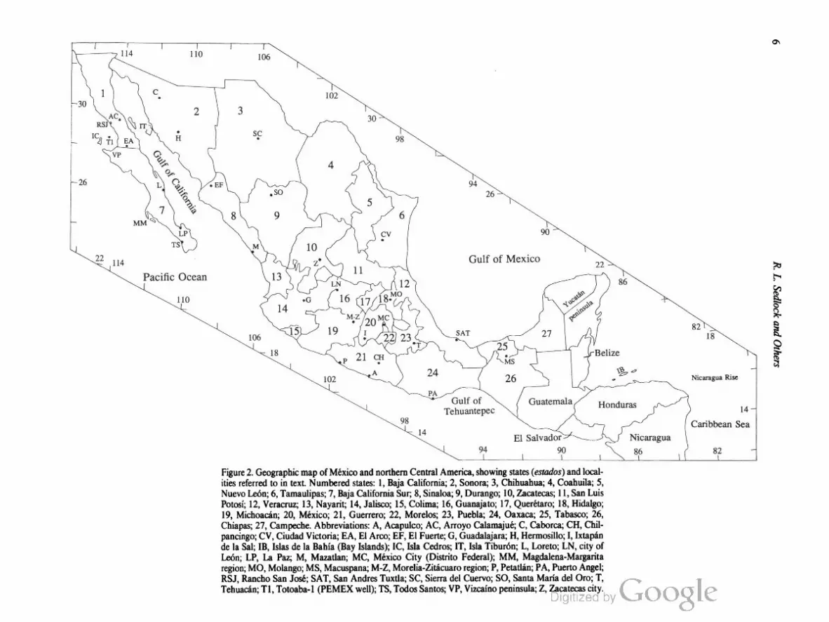
Figure 2. Geographic map of Mexico and northern Central America, showing states (estados) and local
ities referred to in text. Numbered states: 1, Baja California; 2, Sonora; 3, Chihuahua; 4, Coahuila; 5,
Nuevo Leon; 6, Tamaulipas; 7, Baja California Sur; 8, Sinaloa; 9, Durango; 10, Zacatecas; 11, San Luis
Potosi; 12, Veracruz; l3, Nayarit; l4, Jalisco; 15, Colima; l6, Guanajato; l7, Querétaro; 18, Hidalgo;
19, Michoacan; 20, México; 21, Guerrero; 22, Morelos; 23, Puebla; 24, Oaxaca; 25, Tabasco; 26,
Chiapas; 27, Campeche. Abbreviations: A, Acapulco; AC, Arroyo Calamajué; C, Caborca; CH, Chil
pancingo; CV, Ciudad Victoria; EA, El Aroo; EF, El Fuerte; G, Guadalajara; H, Hermosillo; I, Ixtapan
de la Sal; IB, Islas de la Bahia (Bay Islands); IC, Isla Cedros; IT, Isla Tiburén; L, Loreto; LN, city of
Leon; LP, La Paz; M, Mazatlan; MC, Mexico City (Distrito Federal); MM, Magdalena-Margarita
region; MO, Molango; MS, Macuspana; M-Z, Morelia-Zitacuaro region; P, Petatlan; PA, Puerto Angel;
RSJ, Rancho San José; SAT, San Andres Tuxtla; SC, Sierra del Cuervo; SO, Santa Maria del Oro; T,
Tehuacan; Tl, Totoaba-l (PEMEX well); TS, Todos Santos; VP, Vizcaino peninsula; Z, Zacatecas city.
Nicaragua
86
1
Nicaragua Rise
14
Caribbean Sea
wmopuvwaves'7a
Tectonostratigraphic Terranes and Tectonic Evolution ofMexico 7
as indicated by backarc extension in Central America and back
arc contraction in southern Méxieo (Buffler and others, 1979;
Weyl, 1980; McNally and Minster, 1981; de Csema, 1989). The
Caribbean plate appears to be motionless with respect to the
subducted slab, resulting in a well—developed Wadati-Benioff
zone and narrow arc, whereas motion of North America toward
the slab has produced a broader, less continuous arc and in
creased the arc-trench distance (Burbaeh and others, 1984).
The alignment of terrestrial volcanic centers has been used
to infer a segmented subdueted slab beneath Mexico and Central
America (Stoiber and Carr, 1973; Carr and others, 1974; Nixon,
1982). Seismologic data have been interpreted to indicate that the
subducted Cocos plate lithosphere is either smoothly curving and
laterally continuous (Burbaeh and others, 1984) or segmented
near 99°W where the O’Gorman Fracture Zone intersects the
Middle America Trench (Singh and Mortera, 1991).
Rivera-North America plate boundary
The Rivera—North America plate boundary is the Acapulco
Trench south of 20°N and probably the Tamayo Fracture Zone
and Tres Marias escarpment north of 20°30’N (Fig. l). Larson
(1972) and Menard (1978) inferred that the Acapulco Trench
was inactive and that the Rivera plate currently is part of the
North American plate, but the lithosphere above the trench is
seismically active, although to a lesser extent than the Middle
America Trench along the Cocos—North America boundary
(Ness and Lyle, 1991). The 1932 (8.1) Jalisco event clearly indi
cates shallow thrusting to the northeast, as would be expected if
the Rivera plate underthrusts México (Nixon, 1982; Eissler and
McNally, 1984). When compared with the NUVEL-l plate
motion model, spreading rates and slip vectors deduced from the
boundaries of the Rivera plate indicate that the Rivera plate is
kinematically distinct from both the North American and Cocos
plates, and that the Rivera plate moves roughly orthogonally to
the Rivera—North America plate boundary at rates that increase
from about 6 mm/yr at the Tamayo transform fault to about 20
or even 30 at the Acapulco Trench (DeMets and others, 1990; ‘
DeMets and Stein, 1990). These results contrast sharply with
earlier interpretations of a large dextral component of Rivera—
North America relative motion (Minster and Jordan, 1979;
Eissler and McNally, 1984). The nature of the Rivera—North
America plate boundary north of 20°N is poorly understood, but
the precipitous gravity gradient there may reflect a steeply dipping
(transform?) fault boundary between continental and oceanic
crust (Couch and others, 1991).
The Colima, Zacoaloo (also called Tepic-Chapala), and
Chapala grabens in southwestern Mexico (Fig. l) are charac
terized by active alkalic volcanism and about 1 mm/yr exten
sion. Net extension across the rifts has been estimated at 4 to
8% (Barrier and others, 1990). It has been suggested that the
Rivera triple junction (Pacific—North America—Rivera) is in the
initial stages ofjumping from the mouth of the Gulf of California
to the junction of these grabens, and that the “Jalisco block,” a
fragment of North American continental crust in western Jalisco,
is being transferred to the Pacific plate (Luhr and others, 1985;
Allan, 1986; Barrier and others, 1990; Allan and others, 1991).
Offshore seismicity and bathymetric data are consistent with an
incipient spreading ridge offshore southern Colima in a structur
ally complex zone of diffuse seismicity that probably encloses the
indistinct Rivera—Coeos—North America and Pacific-Rivera
Cocos triple junctions (Bourgois and others, 1988; Dauphin and
Ness, 1991; Ness and Lyle, 1991). However, plate motion kine
matics imply that the Colima graben is a passive pull-apart basin
and that the Chapala graben is the locus of transtensional dis
placement at the northwestern and northeastern boundaries, re
spectively, of a coastal sliver undergoing southeastward transport
during oblique convergence (DeMets and Stein, 1990). Also, heat
flow values offshore Colima are not elevated compared to other
parts of the southern continental slope of Mexico, suggesting that
active rifting is not occurring (M. Khutorskoy and others, unpub
lished manuscript).
Truns-Mexican Volcanic Belt (TMVB)
The Trans-Mexican Volcanic Belt (TMVB) consists of late
Miocene (11 Ma), chiefly andesitic to dacitic volcanic rocks and
active volcanoes that extend across Mexico from Nayarit to
southern Veracruz (Figs. 1, 2). The volcanic rocks generally are
linked to subduction of oceanic lithosphere of the Cocos and
Rivera plates (Nixon, 1982; Nixon and others, 1987), but in
several respects the TMVB is atypical of continental arcs. Com
pared to the Central American are, for instance, the TMVB is
broader, less continuous, and farther from the trench (Robin,
1982). Few intermediate-depth earthquakes that may be attrib
uted to a subducted slab have been recorded beneath the TMVB,
but an inclined band of earthquake foci that dips shallowly be
neath southern Mexico to a maximum depth of about 100 km
probably marks the Wadati-Benioff zone (Bevis and Isacks, 1984;
Burbach and others, 1984; LeFevre and McNally, 1985). The
TMVB may also mark a nascent plate or crustal block boundary
along which southern Mexico is moving eastward (Shurbet and
Cebull, 1984) or, more probably, westward (Johnson, 1987;
Urrutia-Fucugauchi and Bohnel, 1988; DeMets and Stein, 1990)
with respect to northern Mexico. The TMVB is marked by very
high heat flow (Ziagos and others, 1985) and very low shear
velocities in the lower lithosphere (Gomberg and Masters, 1988).
Recent studies of the neotectonics of the belt include those by
Campos-Enriques and others (1990), Martinez-Reyes and Nieto
Samaniego (1990), Suter (1991), and Suter and others (1992),
and papers in a special volume of Geofisica Internacional
(e.g., Verma, 1987). Recent work on the age, geology, petrology,
and geochemistry of specific volcanoes within the belt includes
that of Dobson and Mahood (1985), Nixon (1989), Luhr and
Carmichael (1990), Nelson (1990), Ferrari and others (1991),
and Pasquaré and others (1991).
North American intraplate deformation
Although the Gulf of Mexico and eastern México generally
are considered to be part of North America, active tectonism and
8 R. L. Sedlock and Others
volcanism imply relative motion between the two regions. North
trending fold hinges and east-vergent thrusts in Cretaceous and
Cenozoic strata off the coast of Tamaulipas and northern Vera
cruz (“Mexican Ridges Foldbelt” of Buffler and others, 1979;
“Cordillera Ordofiez” of de Csema, 1981) probably record latest
Cenozoic east-west shortening between eastern Mexico and the
Gulf of Mexico basin (Fig. 1). A younger, probably modern,
phase of northeast-southwest shortening is indicated by the
northeastward overthrusting of this offshore fold belt by the
continental shelf (de Csema, 1981, 1989). Late Cenozoic
northeast-southwest shortening in southern México also is indi
cated by a southwest-verging fold and thrust belt on the northeast
side of the Chiapas Massif and by active northwwt-southeast
trending folds offshore northern Tabasco and Campeche (Fig. 1)
(de Csema, 1989).
Miocene to Quaternary, calc-alkalic to alkalic, siliceous to
basaltic volcanic rocks that crop out along the Gulf of Mexico
coast from Tamaulipas to San Andres Tuxtla (Fig. 2) have been
attributed to intraplate rifting, but new geochemical studies imply
eruption in a backarc setting during subduction of the Cocos plate
(Lopez-Infanzon and Nelson, 1990; Nelson and others, 1991).
Significance of regional geophysical studies
Few regional studies of geophysical characteristics of Méx
ico have been published. On the basis of a short, unreversed
refraction profile between northern Guanajuato and eastern Du
rango, Meyer and others (1961) inferred a crustal thickness of 37
to 47 km beneath the southeastern Sierra Madre Occidental. Fix
(1975) inferred an average crustal thickness of about 30 km for
central Mexico based on arrival times of waves from earthquakes
in Chiapas at receivers in the southwestern United States. Based
on measurements of surface wave phase velocity and travel times
at three newly installed long-period seismic stations in northern
México, Gomberg and others (1988) inferred an average crustal
thickness of about 40 km, corroborating the results of Meyer and
others ( 1963), and an average thickness of a high-velocity mantle
lid of about 30 to 40 km. The indicated lithospheric thickness of
70 to 80 km is significantly thicker than in the Basin and Range
province of the western United States, implying less thinning and
thus less extension in northern México, but is significantly thinner
than in cratonal areas of the United States, implying that northern
Mexico may not be underlain by thick Precambrian continental
lithosphere. The crustal and lithospheric thickness estimates are
consistent with gravity models of Bouguer gravity anomalies in
northern México (Aiken and others, 1988; Schellhom and others,
1991). Gomberg and others (1988) also noted the presence of a
low-velocity zone for shear waves (SN as low as 4.0 km/sec)
above 250 km in central México.
Gravity data from the vicinity of the Baja California penin
sula are interpreted to indicate a southward decrease in crustal
thickness from about 28 km at the border to about 20 km near
the tip, a lithospheric thickness of 50 to 55 km, and thinning of
the lithosphere on both sides of the Gulf of California (Aiken and
others, 1988; Couch and others, 1991). Positive low-pass filtered
gravity anomalies trend north-northwest on the Pacific continen
tal shelf of Baja California between 30° and 23°N and in main
land Baja from north of the international border at least as far
south as 26°N and perhaps to the tip of the peninsula at 23°N
(Couch and others, 1991). In detail, the continental shelf anom
aly appears to consist of at least three en echelon domains that
may indicate dextral offset on northwest-striking strike-slip faults.
Few of the linear magnetic anomalies on the Pacific continental
shelf correspond to bathymetric and gravity lineaments (Ness and
others, 1991). A well-defmed paleotrench at the foot of the con
tinental slope is indicated by a gravity low between 29° and
22°30'N, and a remnant of oceanic crust subducted at this trench
probably extends eastward 100 to 150 km beneath the continen
tal slope (Couch and others, 1991).
The compressional velocity structure of parts of Sonora and
Chihuahua is interpreted to indicate crustal thickness of 36 km
and total lithosphere thickness of 70 to 76 km (Gomberg and
others, 1989), estimates consistent with gravity models of anom
alies in Sonora (Aiken and others, 1988; Schellhom and others,
1991). The crust beneath the Sierra Madre del Sur in southern
México has been interpreted to be about 45 i 4 km thick (Valdes
and others, 1986).
Heat flow measurements have been reported from México
by Smith (1974), Smith and others (1979), Ziagos and others
(1985), and Prol-Ledesma and Juarez (1986). Although coverage
is not complete, it seems clear that most of northern and central
Mexico, including Sonora, eastern Chihuahua, Sinaloa, Durango,
Zacatecas, Guanajuato, and San Luis Potosi, is characterized by
high heat flow values (38 to 190 mW/mz, with most values 75 to
125 mW/mz). Lower values were obtained east of the Sierra
Madre Oriental (most values 25 to 75 mW/mz), in the Sierra
Madre del Sur (13 to 45 mW/mz), and in the Baja California
peninsula (most values 35 to 50 mW/mz). The region of higher
heat flow values roughly corresponds to the region affected by
late Cenozoic extension in the Basin and Range province and
along the eastern margin of the Gulf of California. The apparent
southward increase in crustal and lithospheric thickness and
southward decrease in heat flow from the Basin and Range prov
ince to southern México may indicate a southward decrease in
the net thinning and extension of the lithosphere (Gomberg and
others, 1989). Alternatively, these differences may reflect differ
ent starting thicknesses, crustal rheology, or both.
Other gravity, magnetic, and seismic data, particularly those
interpreted in terms of problems of a more local, rather than a
regional, scale, and all paleomagnetic data are presented in dis
cussions of specific terranes.
TERRANE DESCRIPTIONS
We have identified and characterized 17 tectonostratigraph
ic terranes (hereafter called terranes) in Mexico and northern
Central America (Fig. 3). Our usage of the term terrane is from
Howell and others (1985, p. 4): “a fault-bounded package of

Figure 3. Terrane map of Mexico and northern Central America. State boundaries as in Figure 2.
Terrane boundaries (heavy lines) dashed where inferred. Terrane abbreviations: CUI, Cuicateco;
M, Mixteco; T, Tarahumara; Z, Zapoteco. Other abbreviations: AB, Agua Blanca fault (Baja California);
SM, San Marcos fault (Coahuila); TMVB, Trans-Mexican Volcanic Belt.
oogxaWf0uogznloagaruoroalpuvsaurwalorydwr‘iuwzsouozoal

10 R. L. Sedlock and Others
rocks of regional extent characterized by a geologic history which
differs from that of neighboring terranes.” Figure 3 is modified
from a similar division that was developed at the Institute of
Geology (Instituto de Geologia) at the University of Mexico
(Universidad Nacional Autonoma de Mexico) in Mexico City
and that was used in Continent-Ocean Transects H-1 and H-3
(Ortega-Gutierrez and others, 1990; Mitre-Salazar and others,
1991). With the exception of North America, terrane names were
selected on the basis of indigenous pre-Columbian cultures.
The distinctive characteristics of most Mexican terranes are
to be found in their pre-Cretaceous geologic record. In Part 2, we
develop the hypothesis that most of México, excepting its western
and southern margins, behaved as a structurally intact, little
deformed mass throughout the Cretaceous and Cenozoic. Expo
sures of Jurassic and older rocks are sparse in some terranes due
to widespread, overlapping Cretaceous sedimentary rocks and
Cenozoic volcanic and sedimentary rocks. In these cases, we
delimited terranes based on the scattered exposures of older rocks
and on geophysical and isotopic data that help constrain the
nature of the subsurface. However, we expect that future work
will lead to the recognition that some of these terranes are com
posite, as we have formally proposed for other Mexican terranes.
Some earth scientists have expressed reservations about the
term terrane, which they deem less precise than terms such as
block, sliver, fragment, and nappe, and about the concept of ter
rane analysis, which they view as a merely descriptive routine that
avoids interpretation of the genetic significance of lithotectonic
assemblages (Sengor and Dewey, 1990). These complaints are
unfounded, however, provided that the ultimate goal of terrane
analysis is not the splitting of orogenic belts into myriad terranes
but rather the evaluation of the genetic significance of assemblages
within individual terranes and the genetic relations between and
among terranes. When properly performed, terrane analysis can
stimulate breakthroughs in understanding the evolution of com
plex regions, e.g., the North American Cordillera, and we believe
that the Mexican region would be well served by such a strategy.
To this end, this volume includes not only chiefly factual terrane
descriptions (bulk of Part 1), but also a detailed interpretive
model of the genetic relations among the terranes (Part 2).
Our terrane division is in some respects similar to an earlier
division developed by Campa-Uranga and Coney (1983) and
Coney and Campa-Uranga (1987). However, many aspects of
their terrane division, such as terrane boundaries, descriptions of
constituent rocks, and interpretations of constituent rocks and
terrane-bounding faults, have been changed, clarified, or invali
dated by the hundreds of scientific contributions that have been
published in the last decade. Presentation of the data in Part 1 of
this work would be rendered disruptingly opaque if we were to
express all of these advances in terms of revised terrane bound
aries and definitions (e.g., “that part of the Guerrero terrane north
of the Trans-Mexican Volcanic Belt and east of the Gulf of Cali
fornia” instead of our Tahué terrane). On this basis we have
implemented the new terrane names used in the DNAG Tran
sects. We do not expect that our division of Mexican terranes will
go unchallenged and unchanged in the future, and we realize that
a new set of terrane names may cause consternation in some
quarters, but we have concluded that the potential for confusion
is minimized by avoiding a scheme that splices two sets of terrane
names. In the few cases that the descriptions and boundaries of
the terranes in our division are very similar to those of the
Campa-Uranga and Coney division (e.g., Yuma-Santa Ana,
Cochimi-Vizcaino), we anticipate future reference to the older
names, which have precedence. In the course of our terrane de
scriptions, we note the geographic and geologic relation of each
terrane to earlier terrane nomenclature.
Below, we describe the terranes shown in Figure 3 in alpha
betical order. Where possible, each terrane description includes
the following elements: (1) a brief interpretive geologic or
tectonic history of the major rock units, focusing on those features
that distinguish a given terrane from other terranes; (2) a review
and synthesis of published and unpublished data for all major
rock units, including basement rocks, stratigraphic units from
oldest to youngest, and plutonic rocks; (3) a review of available
geophysical data; (4) a schematic tectonostratigraphic column
that, in some cases, also shows geographic variation in the form of
a structure section; and (5) a table of radiometric data including
dates, system used, errors, and sources. In some instances we cite
synthesis articles rather than unpublished theses and reports or
particularly hard-to-find original sources. The interested reader is
directed to the syntheses for reference to such works.
The natural resources of petroleum and economic mineral
deposits are keystones of the Mexican economy. Mexico ranks
seventh in worldwide crude oil reserves and third in production
(Beck and Thrush, 1991). México is the world’s leading producer
of silver and bismuth; is among the top five producers of barite,
fluorospar, graphite, lead, lime, and molybdenum; and ranks
among the top 10 producers of antimony, cadmium, copper,
manganese, gypsum, mercury, mica, ammonia, salt, sulfur, zinc,
and asbestos (Minerals Yearbook, 1990). Summarizing the
wealth of available information on these topics is beyond the
scope of this work, but recent summary volumes of possible
interest include a recent DNAG volume entitled Economic Geol
ogy ofMéxico (Salas, 1991) and a special volume of the journal
Economic Geology (1988, v. 83).
The DNAG time scale (Palmer, 1983) is used throughout
this work. Where necessary, K-Ar ages have been recalculated
using the revised constants of Steiger and Jager (1977). In order
to simplify the reference section, we have taken the following
liberties with the potentially confusing variety of ways in which
the Latin American double surname is referenced: where known,
both surnames are spelled out and hyphenated, even where the
original citation abbreviated or omitted the maternal surname or
omitted the hyphen. Symbols used in Figures 5 through 21 are
those used in the DNAG Continent/Ocean Transects (Fig. 4).
Chatino terrane
The Chatino terrane consists mainly of orthogneiss and meta
sedimentary rocks derived from protoliths of unknown age that
Tectonostratigraphic Terranes and Tectonic Evolution ofMexico 1 l
SEDIMENTARY ROCKS
mainly conglomerate & hreccia @ carbonate
7"!
chert
% evaporite
I] mainly sandstone
E] mainly mudstone
VOLCANIC ROCKS
silicic mafic
intermediate unspecified composition
PLUTONIC ROCKS
{N silicic to intermediate ultramaflc
(includes serpentinite)
[5] intermediate to mafic
METAMORPHIC ROCKS
greenschist blueschist
E arnphibolite eclogite
granulite
DEFORMED ROCKS
schist& gneiss g mylonitic rocks
CONTACTS
W W unconformity
depositional & intrusive
fault
— [fiffafle boundary
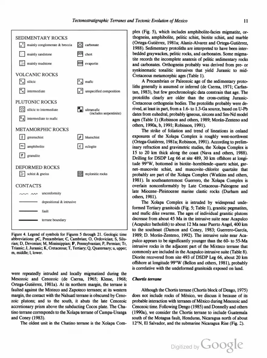
Figure 4. Legend of symbols for Figures 5 through 21. Geologic time
abbreviations: pC, Precambrian; C, Cambrian; O, Ordovician; S, Silu
rian; D, Devonian; M, Mississippian; P, Pennsylvanian; P, Permian; Tr,
Triassic; J, Jurassic; K, Cretaceous; T, Tertiary; Q, Quaternary; u, upper;
at, middle; 1, lower.
were repeatedly intruded and locally migmatized during the
Mesozoic and Cenozoic (de Cserna, 1965; Klesse, 1968;
Ortega-Gutierrez, 1981a). At its northern margin, the terrane is
faulted against the Mixteco and Zapoteco terranes; at its western
margin, the contact with the Nahuatl terrane is obscured by Ceno
zoic plutons; and to the south, it abuts the late Cenozoic
accretionary prism above the subducting Cocos plate. The Cha
tino terrane corresponds to the Xolapa terrane of Campa-Uranga
and Coney (1983).
The oldest unit in the Chatino terrane is the Xolapa Com
plex (Fig. 5), which includes amphibolite-facies migmatite, or
thogneiss, amphibolite, pelitic schist, biotite schist, and marble
(Ortega-Gutierrez, 1981a; Alaniz-Alvarez and Ortega-Gutierrez,
1988). Sedimentary protoliths are interpreted to have been inter
bedded graywackes, pelitic rocks, and carbonates. Some migma
tite records the incomplete anatexis of pelitic sedimentary rocks
and carbonates. Orthogneiss probably was derived from pre- or
synkinematic tonalitic intrusives that yield Jurassic to mid
Cretaceous metamorphic ages (Table l).
A Precambrian or Paleozoic age of the sedimentary proto
liths generally is assumed or inferred (de Csema, 1971; Carfan
tan, 1983), but few geochronologic data constrain that age. The
protoliths clearly are older than the cross-cutting Jurassic
Cretaceous orthogneiss bodies. The protoliths probably were de
rived, at least in part, from a 1.6- to 1.3-Ga source, based on U-Pb
dates from euhedral, probably igneous, zircons and Sm-Nd model
ages (Table 1) (Robinson and others, 1989; Moran-Zenteno and
others, 1990a, b, 1991; Robinson, 1991).
The strike of foliation and trend of lineations in onland
exposures of the Xolapa Complex is roughly west-northwest
(Ortega-Gutierrez, 1981a; Robinson, 1991). According to prelim
inary refraction and gravirnetric studies, the Xolapa Complex is
15 to 20 km thick along the coast (Nava and others, 1988).
Drilling for DSDP Leg 66 at site 489, 30 km offshore at longi
tude 99°W, bottomed in biotite—hornblende—quartz schist, gar
net—muscovite schist, and muscovite—ehlorite quartzite that
probably are part of the Xolapa Complex (Watkins and others,
1981). In southeastemmost Guerrero, the Xolapa Complex is
overlain nonconformably by Late Cretaceous—Paleogene and
late Miocene—Pleistocene marine elastic rocks (Durham and
others, 1981).
The Xolapa Complex is intruded by widespread unde
formed Tertiary granitoids (Fig. 5; Table 1), granitic pegmatites,
and mafic dike swarms. The ages of individual granitic plutons
decrease from about 45 Ma in the intrusive suite near Acapulco
(Acapulco batholith) to about 12 Ma near Puerto Angel, 400 km
to the southeast (Damon and Coney, 1983; Guerrero-Garcia,
1989; D. Moran-Zenteno, 1992). The intrusive suite near Aca
pulco appears to be significantly younger than the 60- to 55-Ma
intrusive rocks in the adjacent part of the Mixteco terrane that
commonly are included in the Acapulco intrusive suite (Table 8).
Diorite recovered from site 493 of DSDP Leg 66, about 20 km
offshore at longitude 99°W (Bellon and others, 1981), probably
is correlative with the undeformed granitoids exposed on land.
Chortis terrane
Although the Chortis terrane (Chortis block of Dengo, 1975)
does not include rocks of Mexico, we discuss it because of its
probable interaction with terranes of México during Mesozoic and
Cenozoic time. Following Dengo (1985) and Donnelly and others
(1990a), we consider the Chortis terrane to include Guatemala
south of the Motagua fault, Honduras, Nicaragua north of about
12°N, El Salvador, and the submarine Nicaragua Rise (Fig. 2).

12 R. L. Sedlock and Others
CHATINO
S site 489 N
accretionary
prism
/
CMIXTECO
& ZAPOTECO
COCOS PLATE Xolapa Complex
q
Juchatengo fault zone
Figure 5. Schematic north-south structure section of Chatino terrane. Ages of Tertiary plutons decrease
from west to east.
TABLE 1. CHATINO TERRANE RADIOMETRIC DATA
Sample System Mineral" Date Fleference't Comments
(Ma)
Xolapa Complex
Paragneiss U-Pb zr 1,525 i 170 1 Discordia intercepts
78 i 35
Metasedimentary rocks Flb-Sr 308 t 5 2 lsochron age
Paragneiss Rb-Sr b 240 i 50 3
Gneissic granitoid Rb-Sr wr 185 i 84 4 a7Sr/‘M’Sr; 0.7056
Gneissic granitoid U-Pb zr 160 1 3 4 Concordant age
Gneissic tonalite near Acapulco Rb-Sr wr 144 :t 7 2 isochron age; aTSr/“Sn 0.7030
Rb-Sr b 30-28 5
Gneissic tonalite near Acapulco Flb-Sr wr 138 :1: 12 2 lsochron age; a7Sr/“Sr'. 0.7048
Rb-Sr b 25 :t 1 5
Gneissic tonalite near Acapulco Rb-Sr wr 128 i 7 2 lsochron age; 87Sr/““‘Sr'. 0.7049
Flb-Sr b 32—31 5
Undeformed diorite near Acapulco Rb-Sr wr 136 i 11 2 lsoehron age; B7Sr/‘M‘Sr. 0.7038
Biotite gneiss K-Ar b 44 i 7 6
Biotite schist K-Ar b 38 i 2 6
Paragneiss Rb-Sr b 32 3
Undeformed intrusive rocks
Acapulco granitoids Rb-Sr k1 80 7 Maximum age
Acapulco granitoids Rb-Sr b 48 i 1 8
Acapulco granitoids Flb-Sr wr 43 i 7 8 Apparent isochron
Felsic-mafic plutons, Acapulco Batholith Hb-Sr b 43—26 5
Acapulco granitoids K-Ar 43 :t 1 9
Acapulco paragneiss K-Ar 43 8
Puerto Angel tonalite U-Pb zr 40 10 Concordant age
Diorite. DSDP Leg 66 K~Ar wr 36 i 2 11
Diorite, DSDP Leg 66 K-Ar wr 35 :t 2 11
Diorite, DSDP Leg 66 K-Ar wr 34 i 2 11
Acapulco paragneiss Rb-Sr b 32 :t 1 8
Granitoid K-Ar 30 i 1 9
Granodiorite Rb-Sr b 24 i 1 8
Puerto Angel gneiss Flb-Sr 24 i 1 8
Diorite Flb-Sr b 18.5 i 5 8
Puerto Angel gneiss Flb-Sr 15 i 1 8
Puerto Angel gneiss Flb-Sr 11 i 1 8
“Mineral abbreviations: b = biotite; kt = potassium feldspar, wr = whole rock; zr = zircon.
I1 = Robinson and others, 1990; 2 = Mora'n-Zenteno and others, 1990b; 3 = Halpern and others, 1974; 4 = Guerrero-Garcia and others,
1978; Morén-Zenteno, 1992; 6: de Csema and others, 1962; 7 = Fries and Flincon-Orta, 1965; 8 = Guerrero-Garcia, 1975; 9 = Bohnel and
others, 1989; 10 = Robinson and others, 1989; 11 = Bellon and others, 1981.

Tectonostratigraphic Terranes and Tectonic Evolution ofMexico 13
The Chortis terrane consists of deformed Paleozoic
Precambrian(?) metamorphic basement unconformably overlain
by a variety of Mesozoic and Cenozoic sedimentary and volcanic
rocks. Basement once may have been part of Pangean continental
crust (South America), or it may represent an exotic crustal frag
ment or fragments that accreted to western Pangea in the late
Paleozoic or early Mesozoic. Mesozoic and Cenozoic cover strata
indicate Triassic(?) to Jurassic clastic sedimentation in nonma
rine, coastal, and shelf environments, deposition of Cretaceous
carbonates in shallow epeirogenic seas, mid-Cretaceous uplift,
Late Cretaceous—Paleogene orogenesis, and Cenozoic volcanism.
Volcanic rocks and volcaniclastic detritus are present throughout
the Mesozoic and Cenozoic section, implying proximity to a
volcanic arc. The Chortis terrane probably was part of continen
tal Mexico during the Mesozoic, based on the similarity of its
Mesozoic history to that of the Maya and Mixteco terranes, but
its location at any particular time and the nature of its interaction
with any particular part of México are not well understood. The
current location of the Chortis terrane probably is due to
hundreds of kilometers of Cenozoic eastward displacement with
respect to southern Mexico.
Basement rocks. The northern margin of the Chortis block
consists of metamorphic and plutonic basement rocks that crop
out between the Motagua fault zone and Cayman Trough to the
north and the Jocotan-Chamelecon and Aguan faults in Guate
mala and northern Honduras to the south. Basement rocks of the
Chortis terrane include older, higher grade metamorphic rocks
generally termed the Las Ovejas Complex, and younger, lower
grade metamorphic rocks generally called the San Diego Phyllite
(Fig. 6) (Horne and others, 1976a; Horne and others, in Donnelly
and others, 1990a). The Las Ovejas Complex includes amphib
olite-facies quartzofeldspathic gneiss, two-mica schist, subordi
nate amphibolite and marble, and foliated cross-cutting plutonic
rocks that are pervasively mylonitized and isoclinally folded. Pro
toliths of the Las Ovejas Complex may be as old as Precambrian
or early Paleozoic, and metamorphism may have accompanied
late Paleozoic plutonism (Table 2).
The San Diego Phyllite consists of greenschist-facies phyl
lite, schist, and slate with thin interbeds of quartzite that are
overlain unconformably by Early Cretaceous limestone and cut
by plutons of uncertain but probable Cretaceous and Tertiary
age. The single generation of penetrative structures in the San
Diego Phyllite is similar in style and geometry to the youngest
fabric in the Las Ovejas Complex; thus, the phyllite may have
been deposited unconformably on Las Ovejas basement prior to
deformation.
South of the Jocotan-Chamelecon and Aguan faults, base
ment rocks in the Chortis terrane include scattered outcrops of
greenschist- and lower amphibolite—facies phyllite, mica schist,
graphitic schist, quartzite, metaconglomerate, marble, and meta
basite. This unit includes isolated outcrops that locally are known
as the Petén Formation, the Cacaguapa Schist, the Palacaguina
Formation, and unnamed units (Fig. 6); these rocks are similar to,
but neither clearly correlative with nor differentiable from, the
San Diego Phyllite north of the Jocotan-Chamelecon and Aguan
faults (Carpenter, 1954; Fakundiny, 1970; Mills and Hugh, 1974;
Simonson, 1977; Home and others, in Donnelly and others,
1990a). In east-central Honduras, deformed adamellite plutons
that crop out near the schists yielded early Mesozoic Rb-Sr ages,
suggesting that deformation of the schists and plutons may have
been Early Triassic or older (Table 2). In most areas, exposures of
phyllite or schist are overlain unconformably by unmetamor
phosed Jurassic strata and intruded by undeformed plutons at
least as old as 140 i 15 Ma (Table 2). These isolated outcrops
have been correlated among themselves, with the San Diego
Phyllite north of the Jocotan-Chamelecon fault, and with the
Santa Rosa Group of the Maya terrane (Burkart and others,
1973), but such correlations are conjectural at best (Dengo, 1985;
Home and others, in Donnelly and others, 1990a).
Basement rocks reported in wells drilled along the coast of
CHORTIS
N s
1.101.; 946$ ‘9'4'. . .l.;T1-.,'_< 9.; ,4], , gag _',-,<:~1 < V < V < V T_Q< V < V
~ ~ ~ 2r ~ ~
<1 6’ ~ San Diego Phyllite N
> "fix/V1 N N K-Q rocks
E N N of southern
N T N Central
N Las Ovejas Complex X ~ Amcnca
N °‘ ” W N pre-Jm metamorphic rocks N
T A °< °< "' " gr I
N N N °< °< ~ <>< ~ N
l MOtagua fault Jocotan-Chamelecon fault
Figure 6. Schematic north-south structure section of Chortis terrane. Unknown nature and orientation of
contact with pre-Quaternary rocks of southern Central America (the latter not covered in this volume).

14 R. L. Sedlock and Others
TABLE 2. CHORTIS TERRANE RADIOMETHIC DATA
Sample System Mineral' Date Referencest Comments
(M8)
Basement rocks
Metaigneous rocks in Las Ovejas Complex Rb-Sr 720 i 260 1 3-pt isochron; samples may not be
cogenetic
Metaigneous rocks, intrude Las Ovejas Rb-Sr 305 i 12 1 4-pt isochron
Adamellite gneiss Flb-Sr wr 230—203 2 Minimum ages assuming a7Sr/‘SGSrI
150-125 2 = 0.704; uncertain relation to
basement rocks
Intrusive rocks
Granodiorite Rb-Sr 150 1 13 1 4-pt isochron; intruoes Las Ovejas
Dipilto batholith Rb-Sr wr 140 i 15 2 4-pt isochron; intrusion age;
67Sir/"‘Bstri; 0.7031
San Ignacio adamellite, central Honduras K-Ar h 123 :t 2 3 Source: F. McDowell
K-Ar b 117 i 2 3 Source: F. McDowell
K-Ar b 114 :1: 2 3 Minimum age
Tonalite pluton, northern Honduras K-Ar h 95 i 2 4
b 76 :t 2 4
Tonalite plutons, northern Honduras K-Ar b 83 i 2 4
b 76 i 2 4
Tonalite pluton, northern Honduras wm 59 i 1 4
K-Ar h 74 i 2 4
b 58 i 1 4
Minas de Oro granodiorite, central Honduras K-Ar b 62 :t 1 3
K-Ar b 59 i 2 3 Source: F. McDowell
K-Ar h 55 i 2 3 Source: F. McDowell
Adamellite Rb—Sr wr 60 1 lntrudes 720 Ma complex;
assumed “Sr/“Sr, = 0.703
Dacite stock K_Ar b 60 :t 1 3 Cogenetic w/volc rocks?
Granodiorite K-Ar b 37 i 1 4 Radiogenic Ar loss?
Igneous rocks in Motagua fault Zone
Diorite K~Ar h 104 1 6 5 Xenolith in granite
Granite K-Ar b 95 i 3 5
Chiquimula batholith, granite Rb-Sr b, wr 95 i 1 6 lsochron age
K-Al' b 84 i 2 6
Chiquimula batholith, mafic-intennediate Rb-Sr 50 i 5 6 lsochron age; 67Sr/“Sri: 0.706
Granitoids ‘°ArP°Ar 35 7 Source: J. Sutton 3 samples
lgnimbn'te K-Ar p 17 i 1 5
'Mineral abbreviations: b = biotite; h = hornblende; p = plagioclase; wr= whole rock.
T1 = Home and others, 1976a; 2 = G. Horne and Clark, unpublished; 3 = Gose, 1985; 4 = Home and others, 19760; 5 = Ritchie and McDow
ell, 1979; 6 = Clemons and Long, 1971; 7 = Donnelly and others, 1990a.
Nicaragua and on the Nicaragua Rise include “metamorphic
rocks” that may be correlative with the San Diego Phyllite, an
desite of possible Cretaceous to Paleogene age, and Eocene grano
diorite (Table 2) (Arden, 1975). The eastward extent of
pre-Mesozoic basement rocks beneath the Nicaragua Rise is
unknown.
Mesozoic and Cenozoic rocks. Metamorphic basement is
overlain nonconformably by Mesozoic sedimentary and less
common volcanic rocks south of the Jocotan-Chamelecon fault
(Fig. 6) (Home and others, in Donnelly and others, 1990a).
Shallow marine clastic rocks of uncertain but possible early
Mesozoic age crop out locally but have uncertain regional extent
and correlation. The oldest widespread Mesozoic unit is the Hon
duras Group, which consists of siliciclastic marine strata and
sparse interbedded volcanic rocks ranging in age from at least as
old as Bajocian (early Middle Jurassic) to Early Cretaceous
(Delevoryas and Srivastava, 1981; Ritchie and Finch, 1985;
Gordon, 1989; Donnelly and others, 1990a). Previous correla
tions of part of the Honduras Group with the Todos Santos
Formation of the southern Maya terrane should be abandoned
(Horne and others, in Donnelly and others, 1990a). Successively
younger units include Barremian to Late Albian limestone and
shaly limestone, sparsely distributed andesitic volcanic and v01
caniclastic rocks in central Honduras of inferred mid-Cretaceous
age, coarse-grained mid-Cretaceous(?) red beds, Cenomanian
limestone, and fine-grained Late Cretaceous to Paleogene(?)
red beds. These Mesozoic strata were faulted, folded, and eroded
prior to the deposition of unconformably overlying mid-Tertiary

Tectonostratigraphic Terranes and Tectonic Evolution ofMexico 15
volcanic rocks (Carpenter, 1954; Simonson, 1977; Finch, 1981;
Home and others, in Donnelly and others, 1990a).
Basement rocks and cover strata as young as early Late
Cretaceous are intruded by widespread, undeformed, silicic to
mafic, calc-alkalic plutons. Plutonism appears to have begun at
least as early as the Late Jurassic and to have continued until
earliest Tertiary time (Table 2).
Paleogene red beds, tuff, and minor andesite (Subinal For
mation) that crop out in southeastern Guatemala and northern El
Salvador are similar to coeval rocks in the Maya terrane, but
possible correlations are complicated by rapid lateral faeies and
thickness changes (Deaton and Burkart, 1984a; Donnelly, 1989;
Donnelly and others, 1990a). The Cenozoic stratigraphy of the
Chortis block is dominated by volcanic rocks (Reynolds, 1980;
Weyl, 1980; Donnelly and others, 1990a, b). Andesitic lavas,
tuff, and breccia of the Matagalpa and Morazan Formations are
probably Oligocene and Eocene(?) in age. Early Miocene to
middle Miocene siliceous ignimbrites as thick as 2 km are locally
overlain by late Miocene to Pliocene basalts and andesites.
Other Cenozoic rocks include local late Miocene to Pleistocene
red beds and Quaternary stratovolcanoes near the Pacific margin.
Structural and geophysical data. The modern volcanic
are lies within the Nicaraguan Depression and Median Trough, a
pronounced margin-parallel graben cut by transverse strike-slip
faults (Carr, 1976; Weyl, 1980). In the northwestern part of the
terrane, volcanic vents and normal faults that are aligned approx
imately north-south, i.e., at an angle of about 50° to the trench
and are (Carr, 1976), indicate either east-west extension due to
internal deformation of the Caribbean plate or the existence of a
separate microplate wedged among the Caribbean, North Amer
ica, and Cocos plates (Burkart and Self, 1985; Guzman-Speziale
and others, 1989).
Seismic refraction and gravity studies indicate that continen
tal crust of the Chortis terrane is 35 to 40 km thick beneath
northwestern Central America, thinning to about 20 km beneath
the Honduras Rise (Couch and Woodcock, 1981; Kim and oth
ers, 1982; Case and others, 1990). Seismic reflection data from
offshore southwestern Guatemala (Ladd and others, 1982) and a
+100-mgal gravity anomaly in the same region (Couch and others,
1985) indicate the presence of oceanic crustal rocks that may be
roughly correlative with the Nicoya Complex of Costa Rica (Au
bouin and others, 1982) or with the El Tambor Group in the
Maya-Chortis boundary zone (Donnelly and others, 1990b).
Paleomagnetic studies of Jurassic and Cretaceous red beds
and limestone and Early Cretaceous and Paleogene magmatic
rocks indicate that the Chortis terrane apparently rotated more
than 100° clockwise during the Jurassic and Early Cretaceous,
and then rotated more than 100° counterclockwise during the
Late Cretaceous and Paleogene (Gose, 1985).
Coahuiltecano terrane
The Coahuiltecano terrane contains Paleozoic low-grade
metamorphic rocks and Paleozoic arc-derived flyseh and related
arc volcanic rocks. These units may correspond to the forearc and
are, respectively, of the Gondwana supercontinent that collided
with southern North America in the late Paleozoic during the
Ouachita orogeny. Alternatively, the arc-related assemblage may
be an arc fragment that is exotic with respect to Gondwana. The
Paleozoic rocks were intruded by Triassic calc-alkalic plutons
and overlapped by Late Jurassic and Cretaceous platformal
rocks that cover most of the terrane. The Coahuiltecano terrane is
equivalent to the Coahuila terrane of Coney and Campa-Uranga
(1987). It is also correlative, at least to the extent that it is a
remnant of Gondwanan continental crust, with the submarine
Sabine terrane in the northern Gulf of Mexico (U.S. Geodynam
ics Committee, 1989) and the composite Maya terrane as defined
in this work.
Pre-Jurassic rocks. Paleozoic or Paleozoic(?) metamor
phic rocks are known from wells in the northern and central parts
of the terrane. Granitic gneiss in the PEMEX #1 La Perla well in
easternmost Coahuila yielded a mid-Paleozoic Rb-Sr whole-rock
date (Table 3), and fine-grained, strongly deformed, low-grade
metamorphic rocks of unknown but inferred Paleozoic age have
been reported from five PEMEX wells in eastern Coahuila and
northern Nuevo Leon (Flawn and others, 1961). Cretaceous con
glomerate in southern Coahuila contains clasts of mid-Paleozoic
schist (Table 3). Similar rocks may underlie most of the northern
and central Coahuiltecano terrane and, with the Sabine terrane to
the east, are inferred to be part of the Gondwanan forearc that
was stranded during Mesozoic rifting and drifting. Basement of
this forearc may be Gondwanan continental crust (Fig. 7), but
such a relation is purely conjectural.
Paleozoic volcaniclastic flysch and Triassic granitoids crop
out south of the San Marcos fault in the southern part of the
terrane (Fig. 3). Late Pennsylvanian to Permian strata of the
Las Delicias basin (Fig. 7) consist chiefly of mass-gravity marine
deposits that contain sand- to boulder-sized fragments of volcanic
rocks, siliciclastic rocks, and limestone (King and others, 1944;
Wardlaw and others, 1979; McKee and others, 1988, 1990).
Volcanic and carbonate bank and reef detritus indicate that the
Las Delicias basin was adjacent to an active calc-alkalic mag
matic arc fringed by carbonate banks from mid(?)-Pennsylvanian
to Late Permian time (Jones and others, 1986; McKee and oth
ers, 1988, 1990). The are probably was constructed on continen
tal crust (Fig. 7), based on the occurrence of clasts of Devonian
schist and Triassic gneiss and granite in Cretaceous conglomerate
(Table 3). Volcanic rocks originally mapped as intrusive rocks
(King and others, 1944) may be the north edge of the arc and
may form the depositional basement of the Las Delicias basin
(Fig. 7) (McKee and others, 1988). Late Paleozoic strata of the
Las Delicias basin are intruded by Triassic granodiorite (Fig. 7)
(Table 3). The Las Delicias basin underwent east-west to
southeast-northwest shortening prior to the deposition of overly
ing Late Jurassic strata (King and others, 1944; McKee and
others, 1988).
Triassic granodiorite also crops out north of the San Marcos
fault near Potrero de la Mula (Table 3). PEMEX wells in east
central Coahuila and northern Nuevo Leon bottomed in igneous

16 R. L. Sedlock and Others
TABLE 3. COAHUILTECANO TERRANE RADIOMETRIC DATA
Sample System Mineral’ Date Reterencesl Comments
(Ma)
Paleozoic-Triassic rocks
Schist cobbles in Cretaceous conglomerate Rb-Sr wr 370 :t 5 1 Model ages, assumed a7SrI°°Srlt
387 i 4 1 0.705
Granitic gneiss, PEMEX No. 1 La Perla well Rb-Sr wr 358 i 70 2 Assumed a7Sr/“f‘Srp 0.706
Flb-Sr wr 277 i; 60 2 Assumed 87Sr/‘l"Sr,: 0.713
Granodiorite in Acatia-Delicias region K-Ar b 266 i 21 3 Source: M. Mugica
K-Ar h 256 i 20 3 Source: M. Mugica
Cataclastic granodiorite Delicias basin Flb-Sr Wm 240 i 2 1 Model age; crops out along San
Marcos fault
Plutonic basement in well near Parras K-Ar? 236 4
Gneiss cobble in Cretaceous conglomerate Rb-Sr wr, b, wrn 230 i 3 1 3-pt isochron “Sr/“Sq: 0.7082
Granite clasts in Jur(?)-K(?) conglomerate Rb-Sr wr 225 i 4 1 67Sr1°“Sr,: 0.7063
Granodiorite, Potrero de la Mula Flb-Sr wr 213 :t 14 5 9-pt isochron
Granodiorite, Potrero de la Mula K-Ar h 212 i 4 2
Granodiorite, Delicias basin K-Ar b 210 :t 4 2 lntrudes upper Pz section
K-Ar b 206 i 4 2
Cenozoic magmatic rocks
Andesite, northern Nuevo Leon K-Ar h 44 i 1 6, 7
Homblende diorite, eastern Coahuila K-Ar wr 44 i 1 6, 7
Andesite, eastern Coahuila K-Ar wr 40 i 1 6, 7
K-Ar wr 36 i 1 6, 7
Diorite, eastern Coahuila K-Ar wr 40 i 1 6, 7
K-Ar b 38 i 1 6, 7
Granodiorite, eastem Coahuila K-Ar b 38 :1; 1 6, 7
Syenite, Coahuila K-Ar b 35 i 1 8
Alkalic intrusives, San Caries, Tamaulipas K-Ar h, wm 30 i 1 9 3 samples
'Mineral abbreviations: b = biotite; h = hornblende; wm = white mica; wr = whole rock.
11 = McKee and others, 1990; 2 = Denison and others, 1969; 3 = Lopez-Infanzon, 1986; 4 = Wilson, 1990; 5 = Jones and other, 1984; 6 = C.
R. Sewell and Ft. E. Denison, unpublished data; 7 = Also see Sewell, 1968; 8 = C. Henry, unpublished data; 9 = Bloomfield and Cepeda,
1973.
rocks similar to those near Potrero de la Mula (Flawn and others,
1961; Wilson, 1990), implying that much of the terrane is under
lain by Permian(?) and Triassic granitoids.
Jurassic-Tertiary sedimentary rocks. Pre-Cretaceous
clastic rocks near Monterrey were mapped as Triassic and corre
lated with the Upper Triassic—Lower Jurassic Huizachal Forma
tion in the Guachichil terrane by Lopez-Ramos (1985,
p. 274—275), but are mapped as Jurassic and Cretaceous rocks on
the l:l,000,000 geologic map of México (INEGI, 1980). Rhy
olitic tuff and breccia that have yielded an unpublished Early
Jurassic age crop out in the Sierra de Mojada, Chihuahua, in the
southeastern corner of the Coahuiltecano terrane (McKee and
others, 1990).
Basement rocks in the Coahuiltecano are overlain noncon
formably by Oxfordian limestone and shale (Zuloaga Group of
Gotte and Michalzik, 1991) that also overlap the Guachichil and
Tepehuano terranes. Emergent topographic highs, possibly pro
duced by transtension during the Jurassic opening of the Gulf of
Mexico, included the Burro-Picachos platform in northern Coa
huila; the Tamaulipas platform in Nuevo Leon and Tamaulipas,
which was submerged by the beginning of Cretaceous time; and
the Coahuila peninsula (uplifted Las Delicias basin) in south
central Coahuila, which was isolated as Coahuila Island in
Barremian time and submerged by Albian time (Smith, 1981;
Salvador, 1987; Mitre-Salazar and others, 1991; pp. 105, 113).
Late Jurassic strata are overlain by Cretaceous platform carbon
ates, interplatforrn basinal limestone, fine-grained clastic rocks,
and evaporites; local coal seams of Maastrichtian age; a local
tektite-and shocked quartz-bearing, 3-m-thick elastic unit at the
K-T boundary that may have been deposited by a tsunami caused
by an impact in the Yucatan region (Smit and others, 1992); and
Paleogene marl and nonmarine elastic rocks. The late Mesozoic
paleogeographic evolution of this region is discussed by Enos
(1983), Young (1983), Lopez-Ramos (1985, p. 198-233), and de
Csema (1989).
A thick sequence of Albian to Maastrichtian carbonates,
shales, and coarser elastic rocks crops out in the Parras basin
(lmlay, 1936; Murray and others, 1962), which is elongate east to
west along the south side of the Coahuila platform (Part 2).
Cenomanian-Maastrichtian flysch in the Parras basin was de
rived, at least in part, from a calc-alkalic volcanic arc to the west
(Tardy and Maury, 1973). The trace of the Mojave-Sonora Meg
ashear is inferred to cut diagonally beneath the Cretaceous
sedimentary rocks of the Parras basin from northwest to south

Tectonostratigraphic Terranes and Tectonic Evolution ofMexico 17
COAHUILTECANO
Delicias basin/Coahuila Island
Potrero
de la Mula
continental crust?
TEPEHUANO
_| A
LMojave-Sonora Megashear C
mid-Pz continental crust
of Gondwana?
San Marcos fault
Figure 7. Schematic north-south structure section of Coahuiltecano terrane. Steepness of nonconformity
between Triassic pluton and younger Mesozoic sedimentary rocks due to large vertical exaggeration.
Nature and age of crystalline basement unknown. Effects of Laramide deformation have been omitted.
east (p. 78). Displacement on the San Marcos fault (Fig. 7), a
possible splay or strand of the megashear, produced syntectonic
Jurassic and Neocomian conglomerate that contains clasts of
Paleozoic schist and Paleozoic-Triassic granite and granitic gneiss
(Table 3) (McKee and others, 1990).
Cretaceous and older rocks in the Coahuiltecano terrane are
intruded by numerous silicic to intermediate plutons, laccoliths,
dikes, and sills of inferred Tertiary age (Kellum and others, 1932;
INEGI, 1980). Although these plutons commonly are interpreted
to be coeval with Laramide deformation (e.g., Kellum and others,
1932; Lopez-Ramos, 1985), many and perhaps most cut Lara
mide structures (C. Henry, unpublished data), and similar rocks in
the adjacent Tepehuano terrane are post-Laramide.
Thick Paleocene to Miocene nonmarine and marine clastic
rocks that have been mapped and drilled in the Burgos basin in
northern Tamaulipas and the La Popa basin in Nuevo Leon
(McBride and others, 1974; Lopez-Ramos, 1985, p. 248—256;
Vega-Vera and others, 1989) are correlative with strata in south
ern Texas (e.g., Wilcox and Frio: Frio Formations). Cenozoic
volcanic rocks include siliceous mid-Tertiary rocks in northern
Coahuila near the Rio Grande, Oligocene alkalic volcanic rocks in
Tamaulipas, and sparsely distributed Quaternary basalts (Table 3)
(INEGI, 1980; Hubberten and Nick, 1986; Nick, 1988).
Structural andgeophysical data. The southern boundary
of the Coahuiltecano terrane is obscured by thrust sheets of Juras
sic to Late Cretaceous strata that underwent as much as 45 km
of northward to northeastward transport during latest Cretaceous
to middle Eocene Laramide orogenesis (dc Cserna, 1956; Tardy,
1975; Padilla y Sénchez, 1985, 1986; Quintero-Legorreta and
Aranda-Garcia, 1985; Gotte, 1988, 1990). The east-west struc
tural grain and marked curvature of the fold and thrust belt in this
region probably was caused by divergence of thrust sheets around
the margins of Coahuila Island, which apparently served as a
rigid backstop during thrusting. South-dipping thrusts sole into a
basal décollement at depth.
North- to northwest-striking high-angle normal faults in
northwestern Coahuila formed during mid- to late Tertiary
extension.
Paleomagnetic data from Triassic and Jurassic strata have
been interpreted to indicate about 130° of counterclockwise rota
tion of parts of the southern Coahuiltecano terrane and adjacent
Guachichil terrane in Early and Middle Jurassic time (Gose and
others, 1982). Early Cretaceous strata in southernmost Coahuila
may have been rotated about 35° counterclockwise during Lara
mide orogenesis (Kleist and others, 1984) or 10° to 15° counter
clockwise in post-Eocene time (Nowicki and others, 1990).
Cochimi terrane
Oceanic rocks of Mesozoic ophiolite, island arc, mélange,
and blueschist terranes probably underlie the continental shelf of
North America from the southern California Transverse Ranges
to the tip of Baja California. North of about 30°N, the distribu
tion of these rocks has been disrupted by late Cenozoic transten
sion in the California Continental Borderland province (Crouch,
1979; Norrnark and others, 1987; Leg and others, 1991; Sedlock

18 R. L. Sedlock and Others
and Hamilton, 1991). In this Special Paper we define the Co
chimi terrane as a composite terrane that includes outcrops and
subcrops of oceanic rocks south of 30°N, approximately the same
as the Vizcaino terrane of Campa-Uranga and Coney (1983) and
Coney and Campa-Uranga (1987).
Exposures of the Cochimi terrane are discontinuous but
spectacular. On Isla Cedros, Islas San Benito, and the Vizcaino
Peninsula (Fig. 2), rocks of the Cochimi terrane are assigned to
the Choyal, Vizcaino Sur, Vizcaino Norte, and Western Baja
subterranes (called terranes by earlier workers); on Isla Magda
lena and Isla Santa Margarita (Fig. 2), they are provisionally
assigned to are, ophiolite, and subduction complex terranes (Sed
lock, 1993). In this section we describe the subterranes of the
Cochimi terrane and then summarize geophysical data that indi
cate disruption and translation in a Late Cretaceous and Paleo
gene forearc.
Cedros-Benitos- Vizcaino region. In the Cedros-Benitos
Vizcaino region, the Cochimi terrane consists of three structural
units (Fig. 8): an upper plate consisting of arc and ophiolite rocks
of the Choyal, Vizcaino Norte, and Vizcaino Sur subterranes; a
lower plate consisting of regionally metamorphosed blueschists of
the Western Baja subterrane; and an unnamed intervening
serpentinite-matrix mélange (Sedlock, 1988b).
The Choyal subterrane includes a well-preserved Middle
Jurassic arc/ophiolite complex consisting of mafic to silicic vol
canic rocks intruded by granitoids, ophiolite that probably
formed during intraarc extension, and concordantly overlying
volcanic rocks and clastic rocks derived solely from volcanic
sources (Fig. 8; Table 4) (Kilmer, 1984; Kirnbrough, 1984, 1985;
Busby-Spera, 1988). The arc/ophiolite complex is overlain by
Middle and Late Jurassic clastic rocks derived mainly from
terrigenous sources including Paleozoic (probably Pennsylva
nian) limestone, metasedimentary rocks including quartzite, and
quartzose sandstone. The abrupt change in provenance has been
interpreted to indicate that the Choyal subterrane was juxtaposed
with or accreted to a continental mass, presumably North Amer
ica, in early Late Jurassic time (Boles and Landis, 1984).
The Vizcaino Norte subterrane includes Late Triassic
ophiolite, conformably overlying tuffaceous Late Triassic sedi
mentary rocks that contain radiolarians and the megafossil Mono
tis, and Late Jurassic—Upper Cretaceous coarse volcanogenic
rocks containing granitoid clasts that have Middle Proterozoic
and Late Jurassic U-Pb discordia intercepts (Fig. 8; Table 4)
(Hickey, 1984; Moore, 1985; Kimbrough and others, 1987). The
Vizcaino Sur subterrane includes Late Triassic ophiolite; con
formably overlying Late Triassic chert, limestone, breccia, and
sandstone that contain radiolarians and the megafossils Monotis
and Halobia; pre-Late Jurassic volcanic and volcaniclastic
rocks; and Middle Jurassic to Early Cretaceous tonalite (Fig. 8,
Table 4) (Pessagno and others, 1979; Moore, 1985). The Viz
caino Norte and Sur subterranes are fragments of island arcs that
probably formed on Late Triassic oceanic crust and were ac
creted to North America by latest Jurassic or earliest Cretaceous
time, based on a provenance change from purely volcanogenic to
partly or mainly siliciclastic (Moore, 1985). In Early Creta
ceous(?) time, the Vizcaino Norte and Sur subterranes were juxta
posed with one another along a fault zone that contains the Sierra
Placeres mélange (Fig. 8, Table 4) (Moore, 1985).
All three arc/ophiolite subterranes are overlapped by the
Valle Formation, which consists of Albian-Campanian siliciclas
tic turbidites that probably accumulated in a forearc basin setting
(Kilmer, 1979; Patterson, 1984; Boles, 1986). Much of the Cre
taceous section was deposited syntectonically, based on the pres
ence of large basement blocks within olistostromes, asymmetric
subsidence of the basin, and slide blocks as long as 100 m (Busby
Spera and others, 1988; Smith and Busby-Spera, 1992). Miocene
and Pliocene shallow marine strata unconformably overlie arc/
ophiolite rocks and Cretaceous siliciclastic turbidites on Isla
Cedros and the Vizcaino Peninsula (Fig. 8) (Kilmer, 1979; Smith,
1984). Latest Miocene fossil marine vertebrates on Cedros form
one of the most diverse assemblages in the North Pacific realm
(Barnes, 1992).
All upper plate units are cut by shallowly to moderately
dipping normal faults and vein systems of Late Cretaceous and
possibly Cenozoic age, and contractional structures are very rare
(Sedlock, 1988c). Preliminary studies of fault plane striations
imply changing stress directions during the Late Cretaceous and
Cenozoic (R. Sedlock and D. Larue, unpublished data), but more
work is needed to ascertain this trend. Upper plate normal faults
and vein systems sole into major faults that separate the upper
and lower plates.
Lower plate blueschists of the Western Baja subterrane (Fig.
8) are exposed on Isla Cedros and Islas San Benito, where they
structurally underlie Jurassic, Cretaceous, and Cenozoic upper
plate rocks (Sedlock, 1988b). Protoliths include ocean-floor ba
salt, siliciclastic metasedimentary rocks, ribbon radiolarian chert
ranging in age from Late Triassic to mid-Cretaceous, and rare
limestone (Sedlock and Isozaki, 1990). Contractional structures
such as cleavage, folds, and thrust faults developed during peak
blueschist metamorphic conditions of 5 to 8+ kbar and 170° to
300°C in a subduction zone beneath western North America in
the late Early Cretaceous (about 115 to 105 Ma). Contractional
structures are cut by younger normal faults and carbonate-quartz
vein systems that probably developed during slow uplift in the
Late Cretaceous and Tertiary (Table 4) (Sedlock, 1988a, c, 1992,
1993; Baldwin and Harrison, 1989).
Serpentinite-matrix mélange occupies major fault zones be
tween the upper and lower plates (Fig. 8). The mélange consists
of diverse tectonic blocks up to 1 km long in a strongly foliated
chrysotile-lizardite matrix. Petrologic and radiometric studies in
dicate that blocks were derived from several source terranes,
including Middle Jurassic high-pressure amphibolite with a local
mid-Cretaceous blueschist overprint, eclogite of uncertain age
with a mid-Cretaceous blueschist overprint, coarse-grained mid
Cretaceous blueschists distinct from the lower plate Western Baja
terrane, greenschists of latest Jurassic or earliest Cretaceous age,
orthogneiss of uncertain age, and serpentinized ultramafic rocks
of uncertain age (Moore, 1986; Sedlock, 1988c; Table 4). The

Tectonostratigraphic Terranes and Tectonic Evolution ofMexico 19
Cedros-Benitos-Vizcafno region
COCHIMI SE
Isla Magdalena &
Isla Santa Margarita
CHOYAL VIZCAINO NORTE VIZCAINO SUR
SUBTERRANE SUBTERRANE SUBTERRANE
To),
-1_-'- (org-1;.
< < Jarc A < A
WESTERNBAJASUBTERRANE
X. X, X X
N x x Mz ophrolrte
N
k
I
. 8mm
/\ p A
m
*9 A
/\ fl . A
Mz subduction complex
Sierra Placeres mélange
Figure 8. Schematic northwest-southeast structure section of Cochinri composite terrane. Relations
between Cedros-Benitos-Vizcaino region and lsla Magdalena—Isla Santa Margarita region unknown. In
each region, serpentinite-matrix mélange separates footwall blueschist-facies subduction complex from
hanging-wall ophiolitic, are, and forearc basin rocks. Normal faults in upper plate and all deformation in
lower plate not depicted.
fault zones between upper and lower plates were interpreted as
thrust faults or strike-slip faults by earlier workers, but are rein
terpreted as normal faults for several reasons (Sedlock, 1988c,
1992, 1993). (1) The plate-bounding faults dip 0° to 55°.
(2) Upper plate normal faults and vein systems merge with
plate-bounding faults, indicating a synkinematic origin. (3) Strains
in the upper plate and the youngest strains in the lower plate are
extensional. (4) Geobarometric estimates of wall rocks indicate
“pressure gaps” of 1 to 6 kbar across these faults, with lower
pressure rocks always in the upper plate; this relation requires
tectonic thinning of 3 to 20 km of the crust and net normal
displacements of 5 to 40 km. Mid-Cretaceous to Paleogene uplift
of the lower plate blueschists probably was accommodated by
major normal displacement on these shallowly dipping faults
during synsubduction extension in the forearc (Sedlock, 1987,
1988, 1992, 1993).
Magdalena-Margarita region. Isla Santa Margarita and
southern Isla Magdalena, islands west of mainland Baja between
25° and 24°N, consist chiefly of metamorphosed and deformed
Mesozoic(?) rocks of oceanic origin, with subordinate Tertiary
volcanic rocks and dikes. The islands are separated from unmeta
morphosed Tertiary sedimentary rocks of the Yuma terrane on
mainland Baja by a buried northwest-striking fault. Reconnais
sance geologic studies were undertaken on southern Isla Mag
dalena by Blake and others (1984) and on Isla Santa Margarita
by Forman and others (1971), Rangin and Carrillo (1978), and
Rangin (1978). The identity and nature of geologic map units and
contacts have been modified on both islands, particularly on Isla
Santa Margarita, on the basis of detailed mapping and structural,
petrologic, and geochemical work (Sedlock, 1993).
As in the Cedros-Benitos-Vizcaino region, Mesozoic rocks
in the Magdalena-Margarita region are divided into three struc
tural units: an upper plate consisting of ophiolite, arc, and forearc
basin rocks and locally gametiferous amphibolite; a lower plate
subduction complex; and serpentinite-matrix mélange that crops
out along intervening, shallowly dipping faults (Fig. 8) (Sedlock,
1993). The subduction complex and serpentinite-matrix mé
lange crop out only on Isla Santa Margarita. Ophiolitic, arc, and
forearc basin rocks and amphibolite crop out on both islands, and
possible consanguinity of each geographic pair (e.g., Magdalena
arc rocks, Santa Margarita arc rocks) is indicated by mesoscopic
igneous, sedimentary, and tectonic structures, metamorphic as
semblages, and inferred P-T conditions. Ongoing biostratigraphic,
geochemical, and geochronologic studies will test the correlation
of units between islands. Rocks of both islands are grouped to
gether in the discussion below.
Upper plate ophiolitic rocks include metamorphosed ultra
mafic rocks, gabbro, diabase, mafic volcanic rocks, chert, and
elastic sedimentary rocks that crop out on southern Isla Magdal
ena and central Isla Santa Margarita. All rocks underwent ductile
contraction as indicated by penetrative foliation and local linea
tion, open to isoclinal folding, and thrust faulting. Primary miner

20 R. L. Sedlock and Others
TABLE 4. COCHIMI TERRANE RADIOMETRIC DATA
Sample System Mineral“ Date Referencest Comments
(Ma)
Choyal terrane
Plagiogranite U-Pb zr 173 1 Concordant age; minimum age of
ophiolite
Granitoids U-Pb zr 166—160 1 Several samples
Plag-homblende tuff U-Pb zr 166 1 Concordant age
Granitoids “Ar/“Ar kt 162, 161 2 2 samples; isochron ages
Homblende tuff 40Ar/“Ar p ~160 2
Andesitic tuft K-Ar h 159 i 5 3
Plutonic clast in mid-K conglomerate 4°Ar/-“’Ar kf 158 i 1 2 lsochron age
Quartz diorite (float) K-Ar 148 i 6 4
Vizcafno Norte terrane
Plagiogranite U-Pb zr ~220 1
Albitite in ophiolite U-Pb kf, sph 220 :t 2 5 Concordant age
Granitoid clasts in Upper Jurassic strata U-Pb zr 1,340 i 3; 6 Discordia intercepts
150 i 3 6
K-Ar b 155 :1: 5 6
Andesite dikes K-Ar p 128 i 2 7 lntrude Upper Jurassic strata
116 i 5 7
Andesite dike K-Ar wr 125 8 lntrudes Upper Jurassic strata
Vizcai'no Sur terrane
Tonalite, granodiorite U-Pb zr 154, 151, 9,1 Several samples; minimum ages
140, 127 9,1 of emplacement
Tonalite K—Ar b 154 i 3 7
Tonalite K-Ar h 143 i 3 10
Tuff in mid-Cretaceous flysch K-Ar b 103 i 2 3
Blocks in Sierra Placeres mélange
Homblende tonalite 2°7Pbfz°6Pb zr 161 1 Lower intercept
U-Pb zr 149 1
Amphibolite K-Ar h 140 i 21 11 Source: D. Krummenacher
Homblende porphyry K-Ar h 126 i 11 Source: D. Krummenacher
Western Baja terrane
Homblende quartz diorite 40Ar/JQAr h 153 i 11 12 Protolith age
Conglomerate clast “Ar/“Ar wm 100 i 14 12 Age of blueschist metam
Metasandstone, San Benitos “Ar/"Ar wm 113 i 1 12 lsochron age
Metasandstone, Cedros 4°Ar/39Ar wm 109 i 1 11 Plateau age
Metasandstone, Cedros 4C’Ar/39Ar kt ~75 2 Cooling age
Plutonic clast in conglomerate “’ArPQAr kf 20 12 Cooling age
Blocks in serpentinite-matrix me'lange, Cedros-Vizcaino region
Garnet amphibolite, Cedros “Ar/“Ar h 167 i 6 13 Plateau age;
FTA ap 55 14 Cooling age
Garnet amphibolite, Cedros 40Ar/rlgAr h 166 :t 2 13 lsochron age
Epidote amphibolite 40Ar/~“’Ar h 170 i 1 14 lsochron age
Epidote amphibolites 40Ar/“Ar h 175—150; 14 2 samples; complex release
~165 14 spectra
Epidote-amphibolite facies “Ar/“Ar wm 172-150 14 Convex-up pattern;
metasedimentary rocks FTA ap 99 14 cooling age
“Ar/“Ar wm ~170 14 Plateau age;
FTA ap 125 14 cooling age
‘°ArP9Ar wrn 168—152 14 Cooling gradient;
FTA ap 164 14 concordant cooling age
Amphibolites, Cedros Rb-Sr p, wm 151 i 18 2 2 samples; 4-pt isochron;
a7Sr/“°Sri: 0.7048
Amphibolites, San Benitos K-Ar h, wm 148 _+_ 5 15 2 samples

Tectonostratigraphic Terranes and Tectonic Evolution ofMexico 21
TABLE 4. COCHIMI TERRANE RADIOMETRIC DATA (continued)
Sample System Mineral“ Date Referencesi Comments
(Ma)
Blocks in serpentinite-matrix mélange, Cedros-Vizcatno region (continued)
Epidote amphibolite-tacies blocks “Ar/“Ar amph 170—1 15 14 Apparent ages; M, ~170; M2 ~115
overprinted by blueschist assemblage, “Ar/“Ar amph 161—96 14 Apparent ages; M, ~161; M2 ~96
Cedros and San Benitos ‘°Ar/”Ar amph 161 112; 14 Isochron ages from two degassing
64 i 5 phases?
“Ar/“Ar wm 173—119 14 Apparent ages; M, ~173; M2 ~119
4oArf-‘i‘Ar wm 171—142 14 Apparent ages; M, ~171; M2 ~142
“Ar/“Ar wm 169—89 14 Apparent ages; M, ~169; M2 ~89
“Ar/“Ar wm 168—59 14 Apparent ages; M, ~168; M2 ~59
4oArFQAr wm 167—76 14 Apparent ages; M, ~76; M2 ~16?
Blueschist, Vizcar'no K-Ar na 173 i 69 11 Source: D. Krummenacher
Greenschist, Vizcal'no “Ar/“Ar h ~140 2 Apparent age
Eclogite, blueschist overprint, Cedros 4°Ar/~‘9Ar wm 115—105 12 Slow cooling gradient;
FTA ap 32 i 4 12 cooling age
Blueschists, Cedros “Ar/“Ar wm 115-95 12 Four samples; Ar loss profiles:
slow cooling
FTA ap 22 i 3 12 Cooling age
Blueschists, Cedros K-Ar wm 110 :1: 2 15 2 samples
Blueschist, San Benitos K-Ar na 104 i 2 15
Blueschist, Cedros 4°Ar/“Ar na 103 i 4 14 Isochron age; degassing ofwm
intergrowths
Blueschists, Cedros 4°ArP°Ar na 95 i 1 14 Isochron age; degassing
94 i 1 12 of wm intergrowths
Blueschist, Cedros Rb-Sr wr, wm, 99 i 13 12 Isochron age;
p, na "Sr/“Sr; 0.7050
Blueschist, Cedros K-Ar na 94 i 4 15
Magdalena and Santa Margarita Islands
Amphibolite, southem Magdalena K-Ar h 138 i 3 16 Base of ophiolite?
Amphibolite, southem Magdalena K-Ar h 133 i 6 16 Block in melange
Gamer-amphibolite, central Santa Margarita K-Ar h 134 i 6 16 Blockin mélange
Lamprophyre dike, central Santa Margarita K-Ar b 29 i 1 16 lntrudes ophiolite
“Mineral abbreviations: amph = amphibole; b = biotite; h = hornblende; kt = potassium feldspar, na = sodic amphibole; p = plagioclase; sph =
sphene; wm = white mica; wr = whole rock; zr = zircon.
T1 = Kimbrough, 1982; 2 = Baldwin, 1988; 3 = Gastil and others, 1978; 4 = Suppe and Armstrong, 1972; 5 = Barnes and Mattinson, 1981; 6 =
Kimbrough and others, 1987; 7 = Minch and others, 1976; 8 = Robinson, 1975; 9 = Bames, 1982; 10 = Troughton, 1974; 11 = Moore, 1985;
12 = Baldwin and Harrison, 1989; 13 = Baldwin and others, 1990; 14 = Baldwin and Harrison, 1992; 15 = Suppe and Armstrong, 1972; 16 =
Forman and others, 1971.
alogy and textures were obliterated by greenschist-facies metamor
phism, including 98 to 100% serpentinization of ultramafic
phases, that outlasted contractional deformation. Contractional
structures in all rock types are cut by later normal faults and vein
systems, which in turn are cut by Oligocene lamprophyre dikes
(Table 4). The ages of protoliths, contractional deformation, and
metamorphism are not known.
Upper plate are rocks that crop out on southern Isla Mag
dalena and southern Isla Santa Margarita include layered and
massive gabbro; a mafic to intermediate dike and sill complex;
mafic to intermediate pillow lavas, massive flows, and breccia;
and tuffaceous volcaniclastic sedimentary rocks. Arc rocks lack a
penetrative fabric and were statically metamorphosed at low to
moderate temperature and low pressure. The sedimentary rocks
contain Jurassic fauna (Blake and others, 1984), but ages of the
magmatic rocks are unknown. All rock types are cut by normal
faults and vein systems that are inferred to be older than the
Oligocene dikes that cut similar structures in the ophiolite. The
ages of igneous protoliths and metamorphism are not known.
Upper plate forearc basin rocks consist of small, isolated,
fault-bounded sequences of unmetamorphosed deep-water con
glomerate and rhythmically interbedded terrigeneous turbid
ites that crop out on southern Isla Magdalena and in several
places on Isla Santa Margarita. These rocks strongly resemble the
mid-Cretaceous Valle Formation in the Cedros-Benitos-Vizcaino
region and thus are assigned a provisional Cretaceous age and
interpreted as submarine fan deposits in a forearc basin. Contrac
tional structures are absent, but all outcrops are cut by normal
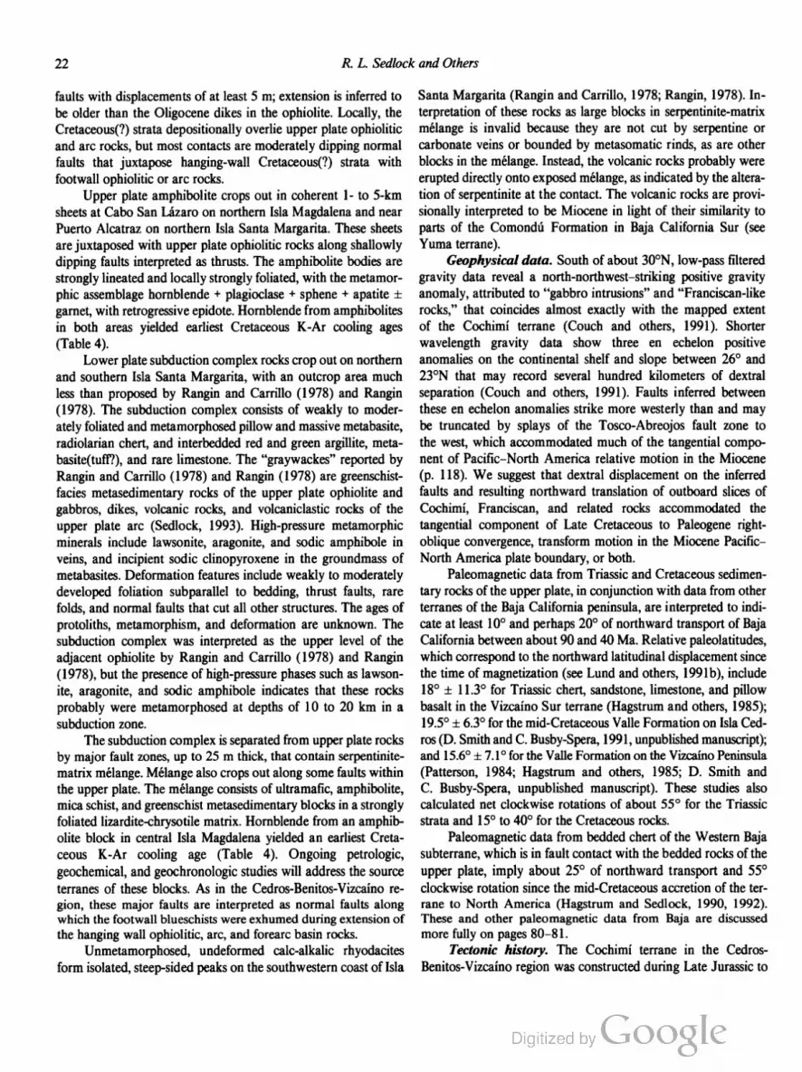
22 R. L. Sedlock and Others
faults with displacements of at least 5 m; extension is inferred to
be older than the Oligocene dikes in the ophiolite. Locally, the
Cretaceous(?) strata depositionally overlie upper plate ophiolitic
and are rocks, but most contacts are moderately dipping normal
faults that juxtapose hanging-wall Cretaceous(?) strata with
footwall ophiolitic or arc rocks.
Upper plate amphibolite crops out in coherent 1- to 5-km
sheets at Cabo San Lazaro on northern Isla Magdalena and near
Puerto Alcatraz on northern Isla Santa Margarita. These sheets
are juxtaposed with upper plate ophiolitic rocks along shallowly
dipping faults interpreted as thrusts. The amphibolite bodies are
strongly lineated and locally strongly foliated, with the metamor
phic assemblage hornblende + plagioclase + sphene + apatite i
garnet, with retrogressive epidote. Hornblende from amphibolites
in both areas yielded earliest Cretaceous K-Ar cooling ages
(Table 4).
Lower plate subduction complex rocks crop out on northern
and southern Isla Santa Margarita, with an outcrop area much
less than proposed by Rangin and Carrillo (1978) and Rangin
(1978). The subduction complex consists of weakly to moder
ately foliated and metamorphosed pillow and massive metabasite,
radiolarian chert, and interbedded red and green argillite, meta
basite(tuft?), and rare limestone. The “graywackes” reported by
Rangin and Carrillo (1978) and Rangin (1978) are greenschist
facies metasedimentary rocks of the upper plate ophiolite and
gabbros, dikes, volcanic rocks, and volcaniclastic rocks of the
upper plate are (Sedlock, 1993). High-pressure metamorphic
minerals include lawsonite, aragonite, and sodic amphibole in
veins, and incipient sodic clinopyroxene in the groundmass of
metabasites. Deformation features include weakly to moderately
developed foliation subparallel to bedding, thrust faults, rare
folds, and normal faults that cut all other structures. The ages of
protoliths, metamorphism, and deformation are unknown. The
subduction complex was interpreted as the upper level of the
adjacent ophiolite by Rangin and Carrillo (1978) and Rangin
(1978), but the presence of high-pressure phases such as lawson
ite, aragonite, and sodic amphibole indicates that these rocks
probably were metamorphosed at depths of 10 to 20 km in a
subduction zone.
The subduction complex is separated from upper plate rocks
by major fault zones, up to 25 m thick, that contain serpentinite
matrix mélange. Mélange also crops out along some faults within
the upper plate. The mélange consists of ultramafic, amphibolite,
mica schist, and greenschist metasedimentary blocks in a strongly
foliated lizardite-chrysotile matrix. Hornblende from an amphib
olite block in central Isla Magdalena yielded an earliest Creta
ceous K-Ar cooling age (Table 4). Ongoing petrologic,
geochemical, and geochronologic studies will address the source
terranes of these blocks. As in the Cedros-Benitos-Vizcaino re
gion, these major faults are interpreted as normal faults along
which the footwall blueschists were exhumed during extension of
the hanging wall ophiolitic, arc, and forearc basin rocks.
Unmetamorphosed, undeformed calc-alkalic rhyodacites
form isolated, steep-sided peaks on the southwestern coast of Isla
Santa Margarita (Rangin and Carrillo, 1978; Rangin, 1978). In
terpretation of these rocks as large blocks in serpentinite-matrix
mélange is invalid because they are not cut by serpentine or
carbonate veins or bounded by metasomatic rinds, as are other
blocks in the mélange. Instead, the volcanic rocks probably were
erupted directly onto exposed mélange, as indicated by the altera
tion of serpentinite at the contact. The volcanic rocks are provi
sionally interpreted to be Miocene in light of their similarity to
parts of the Comondu Formation in Baja California Sur (see
Yuma terrane).
Geophysical data. South of about 30°N, low-pass filtered
gravity data reveal a north-northwest—striking positive gravity
anomaly, attributed to “gabbro intrusions” and “Franciscan-like
rocks,” that coincides almost exactly with the mapped extent
of the Cochimi terrane (Couch and others, 1991). Shorter
wavelength gravity data show three en echelon positive
anomalies on the continental shelf and slope between 26° and
23°N that may record several hundred kilometers of dextral
separation (Couch and others, 1991). Faults inferred between
these en echelon anomalies strike more westerly than and may
be truncated by splays of the Tosco-Abreojos fault zone to
the west, which accommodated much of the tangential compo
nent of Pacific-North America relative motion in the Miocene
(p. 118). We suggest that dextral displacement on the inferred
faults and resulting northward translation of outboard slices of
Cochimi, Franciscan, and related rocks accommodated the
tangential component of Late Cretaceous to Paleogene right
oblique convergence, transform motion in the Miocene Pacific—
North America plate boundary, or both.
Paleomagnetic data from Triassic and Cretaceous sedimen
tary rocks of the upper plate, in conjunction with data from other
terranes of the Baja California peninsula, are interpreted to indi
cate at least 100 and perhaps 20° of northward transport of Baja
California between about 90 and 40 Ma. Relative paleolatitudes,
which correspond to the northward latitudinal displacement since
the time of magnetization (see Lund and others, 1991b), include
18° 1 113° for Triassic chert, sandstone, limestone, and pillow
basalt in the Vizcaino Sur terrane (Hagstrum and others, 1985);
195° :1: 63° for the mid-Cretaceous Valle Formation on Isla Ced
ros (D. Smith and C. Busby-Spera, 1991, unpublished manuscript);
and 15.60 :1: 7.1° for the Valle Formation on the Vizcaino Peninsula
(Patterson, 1984; Hagstrum and others, 1985; D. Smith and
C. Busby-Spera, unpublished manuscript). These studies also
calculated net clockwise rotations of about 55° for the Triassic
strata and 15° to 40° for the Cretaceous rocks.
Paleomagnetic data from bedded chert of the Western Baja
subterrane, which is in fault contact with the bedded rocks of the
upper plate, imply about 25° of northward transport and 55°
clockwise rotation since the mid-Cretaceous accretion of the ter
rane to North America (Hagstrum and Sedlock, 1990, 1992).
These and other paleomagnetic data from Baja are discussed
more fully on pages 80-81.
Tectonic history. The Cochimi terrane in the Cedros
Benitos-Vizcaino region was constructed during Late Jurassic to

Tectonostratigraphic Terranes and Tectonic Evolution ofMexico 23
Cenozoic time. The Choyal, Vizcaino Norte, and Vizcaino Sur
subterranes are fossil are and ophiolite complexes that were deac
tivated and attached to the continent and to one another during
Late Jurassic and Early Cretaceous time, and overlapped by tur
bidites in the mid-Cretaceous. The major fault zones between
upper and lower plates are interpreted as normal faults at which
lower plate blueschists have been uplifted, atop which upper plate
rocks have been brittely extended, and within which serpentinite
matrix mélange has been formed or emplaced (Sedlock, 1988b,
0). Uplift and normal faulting probably began in the mid
Cretaceous, as indicated by facies analysis of the mid-Cretaceous
overlap sequence in the upper plate (Busby-Spera and Boles,
1986; Smith, 1987; Busby-Spera and others, 1988), and con
tinued in Late Cretaceous and Tertiary time (Table 4) (Baldwin
and Harrison, 1989). Paleomagnetic data indicate that the upper
and lower plates underwent significant, but different, amounts of
northward translation in mid-Cretaceous to Paleogene time.
Available data cannot distinguish between two end-member sce
narios: (1) Lower plate blueschists were translated up to 1,500
km northward in mid-Cretaceous time, juxtaposed with upper
plate rocks of the Cochimi terrane (e.g., Choyal subterrane), and
translated about 1,000 km northward with the upper plate rocks
in the Late Cretaceous to Paleogene. (2) Upper plate rocks of the
Cochimi terrane were translated 1,000 to 2,000 km northward in
the Late Cretaceous to Paleogene; lower plate blueschists were
translated up to 2,500 km northward between late Early Cre
taceous and Paleogene time, perhaps in a position more outboard
than that of the upper plate rocks; upper and lower plates were
juxtaposed more or less in their current position during Late
Cretaceous or Paleogene normal faulting.
The tectonic history of the Cochimi terrane in the
Magdalena-Margarita region remains uncertain pending the out
come of ongoing geochronologic, biostratigraphic, and paleo
magnetic studies. However, the gross similarity of its regional
structure, deformation history, and metamorphic history to the
Cedros-Benitos-Vizcaino region strongly suggests a similar
evolution.
Cuicateco terrane
The Cuicateco terrane is a west-dipping fault-bounded
prism of strongly deformed Jurassic and Cretaceous oceanic and
are rocks that structurally overlies the Maya terrane and underlies
the Zapoteco terrane. We provisionally infer that the volcanic
and sedimentary protoliths of the Cuicateco terrane were depos
ited in a southward-opening Jurassic—Early Cretaceous basin of
enigmatic origin, and that these protoliths were pervasively de
formed and metamorphosed to greenschist facies during Late
Cretaceous to Paleogene closure of the basin between the con
verging Zapoteco and Maya continental massifs.
Many aspects of the geology of the Cuicateco terrane are
unresolved. Few radiometric data are available, and the distribu
tion of and relations among major map units still have not been
satisfactorily determined. We emphasize that our structure sec
tions of the Cuicateco terrane (Fig. 9) are very simple, schematic
representations of the distribution of the major rock units. The
rock units of the Cuicateco terrane broadly correspond to those of
the Juarez terrane of Campa-Uranga and Coney (1983) and
Coney and Campa-Uranga (1987), but the placement of terrane
boundaries differ. Specifically, rocks in the long, narrow, western
arm of the Juarez terrane have been reassigned to the Zapoteco
and Chatino terranes and the fault zone between them, as shown
on Transect H-3 (Ortega-Gutierrez and others, 1990).
Along Transect H-3, the Cuicateco terrane is divided into
three shallowly dipping structural units (Ortega-Gutierrez and
others, 1990). In the structurally lowest unit, greenstone, lenses of
gabbro and serpentinite, metatuff, and graywacke in the southern
part of the terrane are interpreted as a disrupted ophiolite (Car
fantan, 1983) and sedimentary cover that have been faulted onto
the Maya terrane (Fig. 9, section A-B). Similar rocks have not
been recognized in the northern part of the terrane.
The intermediate and most voluminous unit is an assem
blage of strongly deformed but weakly metamorphosed flysch,
tuff, black slate, and limestone that contains Berriasian
Valanginian microfossils and the Valanginian ammonite Olcoste
phanus (Carfantan, 1981; Ortega-Gutierrez and Gonzalez
Arreola, 1985). Calcareous conglomerate contains small pebbles
of granulitie gneiss and phyllite that may have been derived from
the Oaxaca Complex (Zapoteco terrane) and Acatlan Complex
(Mixteco terrane). A single K-Ar date of 82.5 Ma obtained from
a phyllite may indicate early Late Cretaceous metamorphism
(Carfantan, 1983). Along Transect H-3 (Ortega-Gutierrez and
others, 1990) the intermediate unit locally is overthrust by
sheared serpentinite associated with low-grade phyllite-quartzite
and greenstone (Fig. 9, sections A-B, C-D). Protoliths of this unit
accumulated in a Jurassic to earliest Cretaceous basin, called the
Cuicateco basin in Part 2 of this volume. Basement of the basin
does not crop out but is inferred to be oceanic, at least in the
southern part of the terrane (Ortega-Gutierrez and others, 1990).
The structurally highest unit of the terrane includes mylo
nitic mafie to silicic orthogneiss that crops out at the western
boundary of the Cuicateco terrane within the Juarez suture, at
which the Zapoteco terrane overthrust the Cuicateco terrane in
the Late Cretaceous (Ortega-Gutierrez and others, 1990). Unpub
lished K-Ar dates and new 40Ar/ 39Ar laser probe results (Table
5) have been interpreted to indicate Middle Jurassic intrusion and
Early Cretaceous metamorphism and cataclasis (R. Mugica, per
sonal communication, 1981; C. Pacheco, unpublished data, in
Delgado-Argote, 1989) and earliest Cretaceous cooling past the
hornblende blocking temperature (Delgado-Argote and others,
1992b). The plutonic protoliths may have formed in a short-lived
continental arc (Delgado-Argote and others, 1992b). The Juarez
suture also contains mylonitic rocks derived from anorthosite of
the adjacent Zapoteco terrane (Delgado-Argote, 1989; Ortega
Gutiérrez and others, 1990).
In the southern Cuicateco terrane (Fig. 9, section E-F),
Early Cretaceous flysch and tufl' of the intermediate unit are
juxtaposed at an inferred fault with the “Chontal are” (Carfantan,
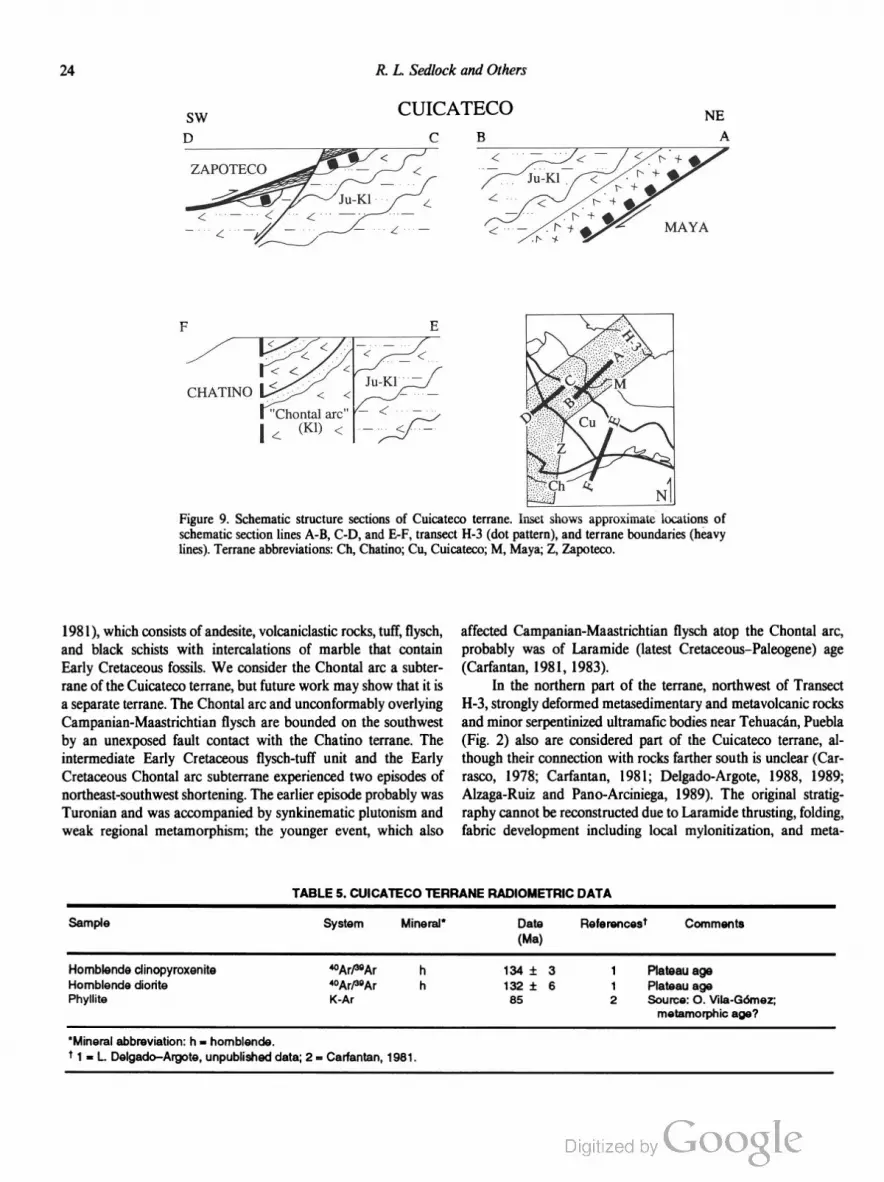
24 R. L. Sedlock and Others
SW
D
ZAPOTECO
CHATINO
CUICATECO
Figure 9. Schematic structure sections of Cuicateco terrane. Inset shows approximate locations of
schematic section lines A-B, OD, and E-F, transect 1-1-3 (dot pattern), and terrane boundaries (heavy
lines). Terrane abbreviations: Ch, Chatino; Cu, Cuicateco; M, Maya; Z, Zapoteco.
1981), which consists of andesite, volcaniclastic rocks, tuff, flysch,
and black schists with intercalations of marble that contain
Early Cretaceous fossils. We consider the Chontal are a subter
rane of the Cuicateco terrane, but future work may show that it is
a separate terrane. The Chontal arc and unconformably overlying
Campanian-Maastrichtian flysch are bounded on the southwest
by an unexposed fault contact with the Chatino terrane. The
intermediate Early Cretaceous flysch-tuff unit and the Early
Cretaceous Chontal arc subterrane experienced two episodes of
northeast-southwest shortening. The earlier episode probably was
Turonian and was accompanied by synkinematic plutonism and
weak regional metamorphism; the younger event, which also
affected Campanian-Maastrichtian flysch atop the Chontal are,
probably was of Laramide (latest Cretaceous—Paleogene) age
(Carfantan, 1981, 1983).
In the northern part of the terrane, northwest of Transect
H-3, strongly deformed metasedimentary and metavolcanic rocks
and minor serpentinized ultramafic bodies near Tehuacan, Puebla
(Fig. 2) also are considered part of the Cuicateco terrane, al
though their connection with rocks farther south is unclear (Car
rasco, 1978; Carfantan, 1981; Delgado-Argote, 1988, 1989;
Alzaga-Ruiz and Pano-Arciniega, 1989). The original stratig
raphy cannot be reconstructed due to Laramide thrusting, folding,
fabric development including local mylonitization, and meta
TABLE 5. CUICATECO TERRANE RADIOMETRIC DATA
Sample System Mineral' Date Referencest Comments
(Ma)
Homblende clinopyroxenite “Ar/“Ar h 134 i 3 1 Plateau age
Homblende diorite 4°Ar/JQAr h 132 i 6 1 Plateau age
Phyllite K-Ar 85 2 Source: 0. Vila-Gomez;
metamorphic age?
'Mineral abbreviation: h = hornblende.
l 1 = L. Delgado—Argote, unpublished data; 2 = Carfantan, 1981.
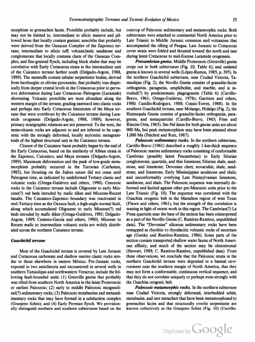
Tectonostratigraphic Terranes and Tectonic Evolution ofMexico 25
morphism to greenschist facies. Protoliths probably include, but
may not be limited to, intermediate to silicic massive and pil
lowed lavas that locally contain gneissic xenoliths that probably
were derived from the Oaxacan Complex of the Zapoteco ter
rane; intermediate to silicic tuff; volcaniclastic sandstone and
conglomerate that locally contains clasts of the Oaxacan Com
plex; and fine-grained flysch, including black shales that may be
correlative with Early Cretaceous strata in the intermediate unit
of the Cuicateco terrane farther south (Delgado-Argote, 1988,
1989). The metatuffs contain tabular serpentinite bodies, derived
from harzburgite or olivine pyroxenite, that probably rose diapir
ically from deeper crustal levels in the Cretaceous prior to perva
sive deformation during Late Cretaceous—Paleogene (Laramide)
shortening. Volcanic protoliths are most abundant along the
western margin of the terrane, grading eastward into clastic rocks
and perhaps into Early Cretaceous limestones of the Maya ter
rane that were overthrust by the Cuicateco terrane during Lara
mide orogenesis (Delgado-Argote, 1988, 1989); however,
primary stratigraphic relations are not preserved. To the west, the
metavolcanic rocks are adjacent to and are inferred to be coge
netic with the strongly deformed, locally mylonitic metagrani
toids of the highest structural unit in the Cuicateco terrane.
Closure of the Cuicateco basin probably began by the end of
the Early Cretaceous, based on the similarity of Albian strata in
the Zapoteco, Cuicateco, and Maya terranes (Delgado-Argote,
1989). Maximum deformation and the peak of low-grade meta
morphism probably occurred in the Turonian (Carfantan,
1983), but thrusting on the Juarez suture did not cease until
Paleogene time, as indicated by undeformed Tertiary elastic and
volcanic rocks (Ortega-Gutierrez and others, 1990). Cenozoic
rocks in the Cuicateco terrane include Oligocene to early Mio
cene(?) red beds intruded by mafic dikes and Miocene-Recent
basalts. The Cuicateco-Zapoteco boundary was reactivated in
mid-Tertiary time as the Oaxaca fault, a high-angle normal fault,
along which accumulated Oligocene to early Miocene(?) red
beds intruded by mafic dikes (Ortega-Gutierrez, 1981; Delgado
Argote, 1989; Centeno-Garcia and others, 1990). Miocene to
Recent mafic to intermediate volcanic rocks are widely distrib
uted across the northern Cuicateco terrane.
Guachichil terrane
Most of the Guachichil terrane is covered by Late Jurassic
and Cretaceous carbonate and shallow marine clastic rocks sim
ilar to those elsewhere in eastern México. Pre-Jurassic rocks,
exposed in two anticlinoria and encountered in several wells in
southern Tamaulipas and northwestern Veracruz, include the fol
lowing fault-bounded units: (1) Grenville gneiss that probably
was rifted from southern North America in the latest Proterozoic
or earliest Paleozoic; (2) early to middle Paleozoic miogeocli
na1(?) sedimentary rocks; (3) Paleozoic metabasites and metased
imentary rocks that may have formed in a subduction complex
(Granjeno Schist); and (4) Early Permian flysch. We provision
ally distinguish northern and southern subterranes based on the
outcrop of Paleozoic sedimentary and metamorphic rocks. Both
subterranes were attached to continental North America prior to
Late Triassic to Middle Jurassic extension and volcanism that
accompanied the rifting of Pangea. Late Jurassic to Cretaceous
cover strata were folded and thrusted toward the north and east
during latest Cretaceous to mid-Eocene Laramide orogenesis.
Precambrian gneiss. Middle Proterozoic (Grenville) gneiss
crops out in both subterranes (Fig. 10, Table 6), and undated
gneiss is known in several wells (Lopez-Ramos, 1985, p. 395). In
the northern Guachichil subterrane, near Ciudad Victoria, Ta
maulipas (Fig. 2), the Novillo Gneiss consists of granulite-facies
orthogneiss, paragneiss, amphibolite, and marble, and is in
truded(?) by postkinematic plagiogranite (Table 6) (Carrillo
Bravo, 1961; Ortega-Gutierrez, 1978c; Garrison and others,
1980; Castillo-Rodriguez, 1988; Cossio-Torres, 1988). In the
southern Guachichil terrane, near Molango, Hidalgo (Fig. 2), the
Huiznopala Gneiss consists of granulite-facies orthogneiss, para
gneiss, and metaquartzite (Carrillo-Bravo, 1965; Fries and
Rincon-Orta, 1965). Sm-Nd dates for both gneiss units are about
900 Ma, but peak metamorphism may have been attained about
1,000 Ma (Patchett and Ruiz, 1987).
Paleozoic sedimentary rocks. In the northern subterrane,
Carrillo-Bravo (1961) described a roughly l-km-thick sequence
of Paleozoic marine sedimentary rocks consisting of conformable
Cambrian (possibly latest Precambrian) to Early Silurian
conglomerate, quartzite, and thin limestone; Silurian shale, sand
stone, and limestone; Devonian chert, novaculite, shale, sand
stone, and limestone; Early Mississippian sandstone and shale;
and unconformably overlying Late Pennsylvanian limestone,
sandstone, and shale. The Paleozoic sequence was internally de
formed and faulted against other pre-Mesozoic units prior to the
Late Triassic (Fig. 10). The sequence was correlated with the
Ouachita orogenic belt in the Marathon region of west Texas
(Flawn and others, 1961), but the strength of this correlation is
waning in light of recent work in this region. The Cambrian(?) La
Presa quartzite near the base of the section has been reinterpreted
as a part of the Novillo Gneiss (C. Ramirez-Ramirez, unpublished
data). The “Devonian” siliceous sedimentary rocks have been
remapped as rhyolitic to rhyodacitic volcanic rocks of uncertain
age (Gursky and Ramirez-Ramirez, 1986). Some parts of the
section contain transported shallow water fauna of North Ameri
can affinity, and much of the section may be olistostromal
(Stewart, 1988; C. Ramirez-Ramirez, unpublished data). From
these observations, we conclude that the Paleozoic strata in the
northern Guachichil terrane were deposited in a basinal envi
ronment near the southern margin of North America, that they
may not form a conformable, continuous vertical sequence, and
that they do not correlate uniquely or perhaps even strongly with
the Ouachita orogenic belt.
Paleozoic metamorphic rocks. In the northern subterrane
near Ciudad Victoria, strongly deformed, interbedded schist,
metabasite, and rare metachert that have been metamorphosed to
greenschist facies and that structurally overlie serpentinite are
known collectively as the Granjeno Schist (Fig. 10) (Carrillo

26 R. L. Sedlock and Others
N GUACHICHIL S
gL)
g 1
g |a l ‘.O , . | . v . H 1 -' . Huiznopala I
U (11112? a I 'So & pré-Sa I I ~ \ \7 5 I Gnelss (pe)
CMojave-Sonora 9
Mcgashear NORTHERN SOUTHERN
<W~im GUACHICHIL ——> <—GUACHICHIL ——>
SUBTERRANE SUBTERRANE
Figure 10. Composite tectonostratigraphic section and schematic north-south structure section of Gua
chichil composite terrane. Northern and southern Guachichil terranes defined by differences in pre
Permian rocks. Effects of Laramide deformation have been omitted.
TABLE 6. GUACHICHIL TERRANE RADIOMETRIC DATA
Sample System Mineral' Date Fteferencesf Comments
(Ma)
Novillo Gneiss and plagiogranite
Micaceous marble K-Ar ph 928 i 18 1
Granitic gneiss K-Ar h 919 t 18 1
Granitic gneiss K-Ar h 880 i 17 1
Gneiss Ftb-Sr wr 1,140 i 80 2 6-pt isochron; 87Sr/“"Sr,: 0.7061
Gneiss Rb-Sr wr 860 i 77 2 5-pt isochron; a7Sr/MSri: 0.7070
Gneiss K-Ar b 744 i 25 3
Plagiogranite Hb-Sr wr 774 1256 2 5~ptisochron; e7Sr/‘168r,: 0.7037
Plagiogranite Rb-Sr wr 570 i181 2 4-pt isochron; 67Sr/‘K’Srir 0.7040
Granieno Schist
Schist Rb-Sr wr 452 :1: 45 4 Corrections to de Csema and
Schist Ftb-Sr wr 373 i 37 4 others, 1977
Pelitic schist Rb-Sr wr + wrn 330 i 35 2 Composite isochron
Pelitic schist Rb-Sr wr + wm 327 i 31 2 Data of Denison and others, 1971
Pelitic schist Rb-Sr wr + wm 320 1- 12 2
Schist K-Ar m 318 i 10 3
Pegmatite K-Ar m 313 i 10 5
Graphitic schist K-Ar m 311 i 6 1
Graphitic schist K-Ar m 300 i 6 1
Graphitic schist K-Ar m 299 i 6 1
Pelitic schist Ftb-Sr wr 286 i 66 2
Graphitic schist K-Ar m 278 i 5 1
Schist K-Ar m 270 :l: 8 6
Schist K-Ar m 257 i 8 6
“Mineral abbreviations: b = biotite; h = homblende; m = mica; ph = phlogopite; wm = white mica; wr = whole rock.
f1 = Denison and others, 1971; 2 = Garrison and others, 1980; 3 = Fries and others, 1962; 4 = de Csema and Ortega-Gutierrez, 1978; 5 =
Fries and Flincon-Orta, 1965; 6 = de Csema and others, 1977.

Tectonostratigraphic Terranes and Tectonic Evolution ofMexico 27
Bravo, 1961; de Cserna and others, 1977; Ortega-Gutierrez,
1978c; Garrison and others, 1980; Castillo-Rodriguez, 1988).
Schist that probably is correlative with the Granjeno Schist crops
out beneath Triassic strata near Aramberri, Nuevo Leon (Deni
son and others, 1971; Lopez-Ramos, 1985, p. 275) and has been
encountered in several wells in southern Tamaulipas and north
western Veracruz (Lopez-Ramos, 1985, p. 395). Protoliths of the
schist include pelites, volcaniclastic rocks, metabasites, and chert
of unknown age; rare carbonates and coarse-grained siliciclastic
rocks imply deep water accumulation at a distance from terrigen
ous sources (Castillo-Rodriguez, 1988).
These protoliths were subjected to at least three phases of
deformation and metamorphism (Castillo-Rodriguez, 1988).
During Dl/M1, the rocks were penetratively foliated under
greenschist(?)-facies conditions. D2/M2 caused north-northwest—
trending isoclinal folds of D1 and nearly complete recrystalliza
tion to a biotite-rich greenschist-facies assemblage. D3/M3 re
sulted in north- to northwest-trending folds, widespread crenula
tion of D2 structures, and retrograde metamorphism (chlorite
zone). K-Ar and Rb-Sr dates, chiefly from micas, imply a late
Paleozoic age for M2 metamorphism (Table 6). However, de
Cserna and others (1977) and de Cserna and Ortega-Gutierrez
( 1978) correlated schist clasts in the Silurian strata described
above with the Granjeno Schist, requiring an early Paleozoic
metamorphic age for the schist.
The contact of the Granjeno Schist with the Novillo Gneiss
is a subvertical shear zone containing mylonite and ultramylonite
produced from granulitie gneiss (Ortega-Gutierrez, l978e; Mitre
Salazar and others, 1991). Mineral dates in the Novillo Gneiss
were not reset by the late Paleozoic metamorphic event that
affected the Granjeno Schist, suggesting postmetamorphic juxta
position of the two units.
Permian rocks. In both subterranes, the Lower Permian
Guacamaya Formation consists of strongly folded but unmeta
morphosed flysch, mudstone, and conglomerate containing a rich
Wolfeampian-Leonardian faunal assemblage (Carrillo-Bravo,
1961, 1965; Perez-Ramos, 1978). Deformation and fault juxta
position with other pre-Mesozoic units are older than Late Trias
sic (Fig. 10). The formation generally coarsens upward, and the
proportion of volcanic and skeletal carbonate rock fragments
increases upward (Gursky and Michalzik, 1989). Single brachio
pod and trilobite fossils of reported Mississippian age were col
lected from the base of the Guaeamaya Formation in the
southern subterrane (Carrillo-Bravo, 1965).
Mesozoic and Cenozoic strata. Pre-Mesozoic rocks of the
Guachichil terrane are overlain unconformably by Triassic to
Jurassie sedimentary and minor volcanic rocks (Fig. 10) that crop
out locally and have been penetrated by many wells (Mixon and
others, 1959; Carrillo-Bravo, 1961, 1965; Imlay, 1965; 1980;
Lopez-Ramos, 1972, 1983, 1985; Schmidt-Effing, 1980; Scott,
1984; Salvador, 1987). The oldest of these strata are unmetamor
phosed, weakly deformed red beds of the Upper Triassic—Lower
Jurassic Huizachal Formation and marine elastic rocks of the
Sinemurian-Pliensbaehian (Lower Jurassic) Huayacocotla For
mation; in the northern part of the terrane, the two formations are
combined in the La Boca Formation. The red beds were derived
from a sedimentary-metamorphic source similar to the rocks de
scribed above, were deposited in fluvial and alluvial environ
ments in an arid climate, and display southward to westward
paleocurrent indicators (Michalzik, 1991). In the northern part of
the terrane, the red beds contain rhyolite interbeds and are in
truded by silicic to mafic dikes and sills that do not affect younger
Jurassic strata in the region (Michalzik, 1991).
The Triassic—Early Jurassic red beds were locally folded
and eroded prior to deposition of unconformably overlying Bajo
cian-Callovian (Middle Jurassie) red beds and evaporites that are
named the Cahuasas Formation in the southern part of the terrane
and the La Joya Formation of the Huizachal Group to the north.
The La Joya Formation consists of a thick, coarse basal lag depos
it overlain by a fining-upward sequence that records a change to
quiet marine conditions by the early Late Jurassic (Michalzik,
1991). Primary volcanic and volcaniclastic rocks are absent.
Late Triassic to Middle Jurassic strata apparently were
deposited in roughly north-south—trending extensional grabens
(Sehmidt-Effing, 1980; Salvador, 1987) that probably formed
during the incipient breakup of Pangea (pp. 96—98). Early
Jurassic fauna imply a marine connection with the Tethyan realm
to the east or west, perhaps via a seaway between North America
and South America (Scott, 1984; Taylor and others, 1984).
Callovian (late Middle Jurassic) calcarenites and marine
shales of the Tepexic Formation in east-central México indicate
marine connection between the Pacific basin and the Gulf of
Mexico region (Imlay, 1980; Salvador, 1987). Wells have
penetrated Middle Jurassic rhyolitic lavas and tuff near Tezuitlan,
Puebla; they have also penetrated volcanic and plutonie rocks
that yielded reported Early to Late Jurassic K-Ar ages in central
Puebla and northern San Luis Potosi (Lopez-Ramos, 1972;
Lopez-Infanzon, 1986).
The Guachichil, Tepehuano, and Coahuiltecano terranes are
overlapped by widespread Oxfordian carbonate and shale of the
Zuloaga Formation (or Zuloaga Group of Gotte and Michalzik,
1991) and by a thick sequence of Late Jurassic—Late Cre
taceous carbonate and fine-grained elastic rocks deposited in plat
formal and basinal environments (Salvador, 1987; Mitre-Salazar
and others, 1991). Tuff is interbedded with Tithonian limestone
and elastic rocks in the southern part of the Guachichil terrane
(Longoria, 1984), but volcanogenic strata are absent from the
Cretaceous section. These strata were folded and thrusted during
Laramide orogenesis (see section below) and, particularly in the
northern part of the terrane, intruded by scattered silicic to inter
mediate plutons, stocks, and dikes of probable Paleogene, post
Laramide age (INEGI, 1980). Cenozoic nonmarine elastic rocks
occupy basins between antiformal crests.
Structural and geophysical data. Late Jurassie and
Cretaceous strata throughout the Guachichil terrane were af
fected by east-vergent folding and thrusting of probable Laramide
origin, producing north-south structural trends such as the anti
clinoria that expose Precambrian and Paleozoic rocks (Lopez

28 R. L. Sedlock and Others
Ramos, p. 324—343). At the eastern margin of the terrane, i.e., the
frontal zone of the Sierra Madre Oriental fold and thrust belt,
deformation probably is older than middle Eocene, and east
vergent thrust faults do not break to the surface but are inferred
beneath the folded strata (Mossman and Viniegra-Osorio, 1976;
Hose, 1982). In the southern part of the terrane, along the
Querétaro-Hidalgo border and in San Luis Potosi, detailed struc
tural studies indicate thin-skinned deformation, displacement
along low-angle thrusts, and at least 40 km of eastward tectonic
transport during late Maastrichtian to Paleocene time (Suter,
1984, 1987; Carrillo-Martinez, 1990). Thrust faults and de
formed strata are intruded by granitoids that have yielded Paleo
gene K-Ar dates (Table 6).
Paleomagnetic data from Late Triassic(?) to Early Cre
taceous rocks are interpreted to indicate that parts of the northern
Guachichil terrane and the adjoining Coahuiltecano terrane un
derwent about 130° of counterclockwise rotation during Early
and Middle Jurassic time and none thereafter (Gose and others,
1982). A small circle fit to the Late Triassic poles indicates that
net counterclockwise rotation was less than about 100° (Urrutia
Fucugauchi and others, 1987).
Maya terrane
We informally divide the Maya terrane into three geograph
ic provinces: the northern province, which includes southern
Tamaulipas, Veracruz as far southeast as the Isthmus of Tehuan
tepec, and thin transitional crust along the western margin of the
Gulf of Mexico; the Yucatrin platform, which includes the Mexi
can states of Tabasco, Campeche, Quintana R00, and Yucatan,
northern Belize, northern Guatemala, and thinned transitional
crust in the adjacent Gulf of Mexico and Yucatan basins; and the
southern province, which includes central Guatemala, Chiapas,
and northeastern Oaxaca. Basement rocks include disjunct out
crops and subcrops of Paleozoic and Precambrian(?) metamor
phic rocks that are widely interpreted as Gondwanan continental
crust stranded during the rifting of Pangea. This basement and
overlying Pennsylvanian-Permian flysch were strongly deformed
in the Permian, perhaps during Ouachitan orogenesis. A Permo
Triassic continental magmatic are that formed in the northern
and southern provinces of the Maya terrane probably was pro
duced by eastward subduction of oceanic lithosphere of the Pa
cific basin. During late Middle to Late Jurassic opening of the
Gulf of Mexico, the Yucatan platform and the southern province
were displaced to the south-southeast with respect to the northern
province along an enigmatic north-northwest—striking fault.
Rocks on both sides of the fault apparently underwent differential
rotation concomitant with this displacement. Post-Jurassic rota
tion and displacement of the Maya terrane is below the detection
limit of paleomagnetic studies. Late Jurassic to Cenozoic strata
were deposited on carbonate platforms and in shelf basins around
the margins of the Gulf of Mexico. A Jurassic-Cretaceous ophio
lite was accreted to the southern margin of the Maya terrane in
the Maastrichtian.
The Maya terrane as defined in this volume broadly corre
sponds to the Maya terrane of Coney and Campa-Uranga (1987);
it includes the Yucatan terrane (United States Geodynamics
Committee, 1989) and the Maya block (Dengo, 1975). Ophio
litic and associated rocks that were accreted to the southern mar
gin of the Maya terrane in the latest Cretaceous are considered a
subterrane of the Maya terrane (El Tambor subterrane; see
below). The Coahuiltecano terrane in northeastern Mexico may
be correlative or in fact continuous with the Maya terrane across
a postulated eastward extension of the Mojave-Sonora
Megashear.
Pre-Mesozoic basement rocks, general statement. Pre
Mesozoic basement rocks crop out only in the southern province
of the Maya terrane (central Guatemala, Maya Mountains of
Belize, northeastern Oaxaca, Chiapas). The nature, history, and
age of basement rocks penetrated by wells in the Yucatan plat
form (Yucatan peninsula, northern Guatemala, Belize) and the
northern province (Veracruz, southern Tamaulipas) are too
poorly known to evaluate possible correlations among basement
outcrops and subcrops throughout the terrane. Much more work
is needed to determine whether the Maya is a composite terrane
consisting of two or more pre-Mesozoic basement terranes over
lapped by Mesozoic and Cenozoic strata.
Pre-Mesozoic basement rocks, southern province.
Basement rocks crop out only in the southern part of the Maya
terrane. Constituent units include, roughly from east to west, the
Chuacus Group, the Santa Rosa Group and Chochal Formation,
the Chiapas Massif, and unnamed metamorphic rocks in north
eastern Oaxaca.
Chuaci'is Group (or Series) crops out only along the north
ern side of the Motagua fault in central Guatemala (Fig. 11);
metasedimentary rocks in wells in the Yucatan peninsula may be
correlative (see below). In central Guatemala, the Chuaci'is Group
consists of quartz-mica schist, marble, mylonitized metagrani
toids, and minor greenstone and quartzite derived from elastic
sedimentary rocks, carbonates, granitoids, and minor volcanic
rocks of uncertain but inferred Paleozoic or Proterozoic age
(McBirney, 1963; Kesler and others, 1970; Anderson and others,
1973; Roper, 1978; Burkart and others, 1987; Donnelly and
others, 1990a). A deformed Carboniferous granitoid in the Chua
ci'is Group contains zircons that are probably Precambrian (Table
7). Garnet-biotite and staurolite-sillimanite assemblages indicate
peak metamorphism at conditions of high greenschist to low
garnet-amphibolite facies (Anderson and others, 1973; Clemons
and others, 1974). The Chuaci'is Group was overprinted by retro
grade greenschist-facies metamorphism and pervasively deformed
during Maastrichtian north-south shortening (Sutter, 1979; Don
nelly and others, 1990a).
An unmetamorphosed but strongly deformed sequence of
late Paleozoic sedimentary and minor volcanic rocks crops out
in the Maya Mountains in Belize and along the Polochic fault
between eastern Guatemala and Chiapas, and was recognized in
wells in northern Guatemala; metasedimentary rocks in wells in
the northern Yucatan peninsula also may be correlative (see
below) (Bateson and Hall, 1971, 1977; Viniegra-Osorio, 1971;
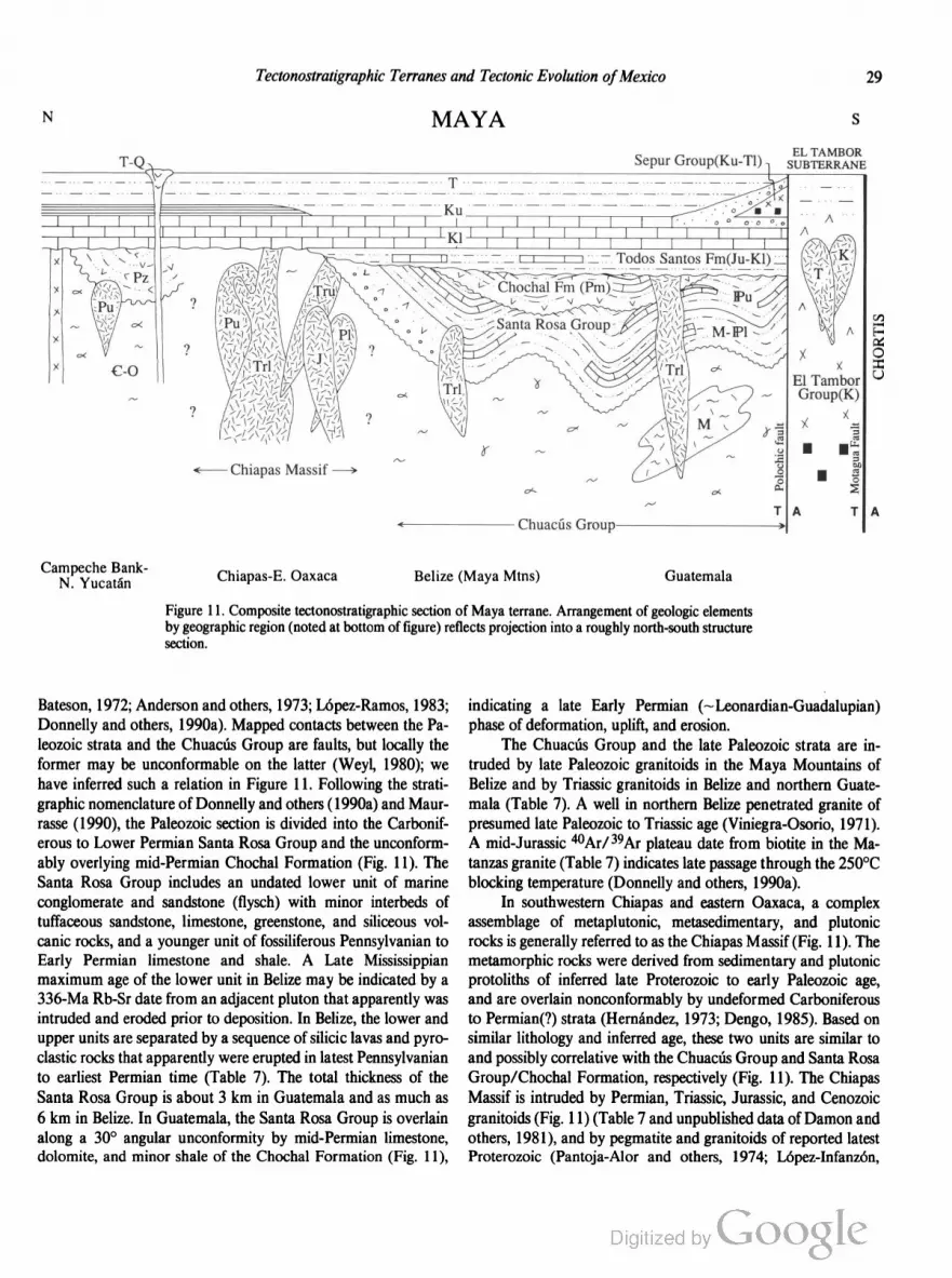
Tectonostratigraphic Terranes and Tectonic Evolution ofMexico 29
N MAYA S
~\a6
\\
\
\-—\/\
\:l\
\\
.
\I/
\
7l>/\/>
'—'>\/
\\
\\V.
\/_f
Q~I
’/>
L1
\
\J
r \\ T \
<—Chiapas Massif ——>
Campeche BankN_ Yucatan Chiapas-E. Oaxaca
Belize (Maya Mtns)
EL TAMBORSepur Group(Ku-Tl)1 SUBTERRANE
E’.
[—
{Z
O
I
ElTambor Q
~ Group(K)
X
1% X “5
- z - r;4:
2E I 50o 0
9k 0‘ n. 2
N T A T A
ChuacusGroup*_>
Guatemala
Figure 11. Composite tectonostratigraphic section of Maya terrane. Arrangement of geologic elements
by geographic region (noted at bottom of figure) reflects projection into a roughly north-south structure
section.
Bateson, 1972; Anderson and others, 1973; Lopez-Ramos, 1983;
Donnelly and others, 1990a). Mapped contacts between the Pa
leozoic strata and the Chuacus Group are faults, but locally the
former may be unconformable on the latter (Weyl, 1980); we
have inferred such a relation in Figure 11. Following the strati
graphic nomenclature of Donnelly and others (1990a) and Maur
rasse (1990), the Paleozoic section is divided into the Carbonif
erous to Lower Permian Santa Rosa Group and the unconform
ably overlying mid-Permian Chochal Formation (Fig. 11). The
Santa Rosa Group includes an undated lower unit of marine
conglomerate and sandstone (flysch) with minor interbeds of
tuffaceous sandstone, limestone, greenstone, and siliceous vol
canic rocks, and a younger unit of fossiliferous Pennsylvanian to
Early Permian limestone and shale. A Late Mississippian
maximum age of the lower unit in Belize may be indicated by a
336-Ma Rb-Sr date from an adjacent pluton that apparently was
intruded and eroded prior to deposition. In Belize, the lower and
upper units are separated by a sequence of silicic lavas and pyro
clastic rocks that apparently were erupted in latest Pennsylvanian
to earliest Permian time (Table 7). The total thickness of the
Santa Rosa Group is about 3 km in Guatemala and as much as
6 km in Belize. In Guatemala, the Santa Rosa Group is overlain
along a 30° angular unconformity by mid-Permian limestone,
dolomite, and minor shale of the Chochal Formation (Fig. 11),
indicating a late Early Permian (~ Leonardian-Guadalupian)
phase of deformation, uplift, and erosion.
The Chuacus Group and the late Paleozoic strata are in
truded by late Paleozoic granitoids in the Maya Mountains of
Belize and by Triassic granitoids in Belize and northern Guate
mala (Table 7). A well in northern Belize penetrated granite of
presumed late Paleozoic to Triassic age (Viniegra-Osorio, 1971).
A mid-Jurassic 40Ar/ 39Ar plateau date from biotite in the Ma
tanzas granite (Table 7) indicates late passage through the 250°C
blocking temperature (Donnelly and others, 1990a).
In southwestern Chiapas and eastern Oaxaca, a complex
assemblage of metaplutonic, metasedimentary, and plutonic
rocks is generally referred to as the Chiapas Massif (Fig. 11). The
metamorphic rocks were derived from sedimentary and plutonic
protoliths of inferred late Proterozoic to early Paleozoic age,
and are overlain nonconforrnably by undeformed Carboniferous
to Permian(?) strata (Hernandez, 1973; Dengo, 1985). Based on
similar lithology and inferred age, these two units are similar to
and possibly correlative with the Chuacus Group and Santa Rosa
Group/Chochal Formation, respectively (Fig. 11). The Chiapas
Massif is intruded by Permian, Triassic, Jurassic, and Cenozoic
granitoids (Fig. l 1) (Table 7 and unpublished data of Damon and
others, 1981), and by pegmatite and granitoids of reported latest
Proterozoic (Pantoja-Alor and others, 1974; Lopez-Infanzén,
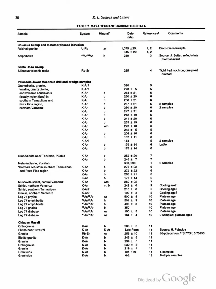
30 R. L. Sedlock and Others
TABLE 7. MAYA TERRANE RADlOMETFlIC DATA
Sample System Mineral" Date ReferencesT Comments
(Ma)
Chuacus Group and metamorphosed intrusion
Rabinal granite U-Pb zr 1,075 :25; 1, 2 Discordia intercepts
345 j: 20 1, 2
Amphibolite ‘°ArP°Ar h 238 3 Source: J. Sutter; reflects late
thermal event
Santa Rosa Group
Siliceous volcanic rocks Rb-Sr 285 4 Tight 4-pt isochron, one point
omitted
Paleozoic—lower Mesozoic drill and dredge samples
Granodiorite, granite, K-Al’? 320 5
tonalite, quartz diorite, K-Ar’? 273 i 5 5
and volcanic equivalents K-Ar b 264 i 21 6
(locally mylonitized) in K-Ar b 260 t 20 6
southern Tamaulipas and K~Ar b 258 i 21 6
Poza Rica region, K-Ar b 257 i 21 6 2 samples
northern Veracruz K-Ar b 250 i 20 6 2 samples
K-Ar b 247 i 21 6
K-Ar b 243 i 19 6
K-Ar b 241 i 20 6
K-Ar b 233 i 19 6
KM wm 223 i 16 6
K-Al' 212 :t 5 5
K-Ar b 208 :t: 16 6
K-Ar h 187 :t: 11 6
K-Ar? 183 5 2 samples
K-Ar b 179 :l: 14 6 Latite
K-Ar b 173 :t 14 6
Granodiorite near Tezuitlan, Puebla K-Ar b 252 i 20 7
K-Ar b 246 i 7 7
Meta-andesite, Yucatan 330, 290 1 2 samples
“Homfels schist’I in southem Tamaulipas K-Ar b 276 i 22 6
and Poza Rica region K-Ar b 272 :l: 22 6
K-Ar b 263 i 21 6
K-Ar b 177 i 14 6
Muscovite schist, central Veracruz K-Ar wm 269 i 22 7
Schist, northern Veracruz K-Ar m, b 242 :1; 6 9 Cooling are?
Schist, southem Tamaulipas K-Ar’? 210 i 6 5 Cooling age?
Gneiss, northern Veracruz K-Ai’? 192 i 3 5 Cooling age?
Leg 77 phylite “Ar/“Ar wr 500 i 8 1O Plateau age
Leg 77 amphibolite “Ar/“Ar h 501 i 9 1O Plateau age
Leg 77 amphibolite “Ar/“Ar h 496 i 8 10 Plateau age
Leg 77 gneiss “Ar/“Ar b 350 10 Plateau age
Leg 77 diabase 40Ar/tgAr wr 190 i 3 10 Plateau age
Leg 77 diabase 4°Arf-‘°Ar wr 164 i 4 10 2 samples; plateau ages
Chiapas Massif
Orthogneiss K-Ar b 288 i 6 11
Pluton near 19°40'N K-Ar K-Ar Late Penn 11 Source: H. Palacios
Granite Rb-Sr wr 256 i 10 11 10-ptisochron; a7Sr/‘u’Sriz 0.70453
Biotite granite K-Ar b 246 i 5 11
Granite K-Ar b 239 i 5 11
Orthogneiss K-Ar h 232 i 5 11
Granite K-Ar b 219 _+_ 4 11
Granitoids K-Ar b 191—170 11 5 samples
Granitoids K-Ar b 6-2 12 Multiple samples

Tectonostratigraphic Terranes and Tectonic Evolution ofMexico 31
TABLE 7. MAYA TERRANE RADIOMETRIC DATA (continued)
Sample System Mineral' Date ReferencesT Comments
(Ma)
Cenozoic magmatic rocks north of TMVB
Alkalie volcanic rocks, southem K-Ar wr 28, 24, 13 4 samples
Tamaulipas 21, 7
Olivine basalt, northern Veracruz K~Ar wr 20 i 1 13 Alkalie
Diorite, central Veracruz K-Ar wr 17 i 1 13 Cale-alkalic
Alkalie basalt, central Veracruz K-Ar Wt 14, 3 13 2 samples; transitional
Andesite and basalt andesite, Puebla K-Ar wr 9—1 13 7 samples; cale-alkalie
Basalt and ignimbrite, Hidalgo and C Veracruz K-Ar wr 8-2 13 12 samples; alkalic and transitional
Dacite, central Veracruz K-Ar wr 7 13 Cale-alkalic
Intrusive rocks in Belize and Guatemala
Mountain Pine Ridge granite, Maya Mountains Rb-Sr wr, kt 320 i 10 4 9-pt isoehron; uncertain relation
with Santa Rosa Group; yielded
'Triassic' K-Ar date
Hummingbird and Sapote granites, Maya K-Ar b 237—227 4 4 samples; intrudes Santa Rosa
Mountains Group
Undefermed Matanzas granite; intrudes Hb-Sr wr, kt, p 227 3 Source: P. Pushkar
Chuacris Group 4°Ar/39Ar m 213—212 3 Source: J. Sutter, 2 samples
“Ar/“Ar b 161 3 Source: J. Sutter
Granitoids in Polochic Valley, Guatemala A-Ar 65—58 14 Source: MMA, Japan; 5 samples
K-Ar k1 68 :t 3 14
Other rocks in Guatemala
Amphibolite and diabase, El Tambor Group K-Ar 59 1t 4 15 11-pt isochron; metamorphic age?
Andesite boulder in Eocene Subinal Formation K-Ar p 42 :t 2 16
Welded tuff clasts in Miocene Colotenango beds K-Ar b, 9 12-7 16 3 samples
'Mineral abbreviations: b = biotite; g = glass; h = hornblende; kf= potassium feldspar; m = mica; p = plagioclase; wrn - white mica; wr - whole rock; zr
= zircon.
*1 = Gombort and others, 1968; 2 = Me Birney and Bass, 1969; 3 = Donnelly and others, 1990a; 4 = Bateson and Hall, 1977; 5 = Lopez Ramos,
1972; 6 = Jacobo—Albanan, 1986; 7 = Lopez-Intanzon, 1985; 8 = Marshall, 1984; 9 = Denison and others, 1969; 10 = Schlager and others, 1984; 11
= Damon and others, 1981; 12 = Damon and Montesinos, 1978; 13 = Cantagrel and Robin, 1979; 14 = Burkart and others, 1987; 15 = Bertrand and
others, 1978; 16 = Deaton and Burkart, 1964b.
1986; Pacheco-G. and Barba, 1986) and Late Cretaceous (Bur
kart, 1990) age.
In the eastern Sierra Juarez of northeastern Oaxaca, an area
crossed by Transect H-3, the Maya terrane includes an unnamed
subterrane of poorly understood metamorphic rocks that crops
out east of the fault boundary with the Cuicateco terrane (not
shown in Fig. 11) (Ortega-Gutierrez and others, 1990). The unit
consists of polydeformed, greenschist-facies metasedimentary and
metaigneous rocks including phyllite, schist, gabbro, and rare meta
gabbro and serpentinite. Biotite and muscovite schists have
yielded late Paleozoic K-Ar dates (S. Charleston, personal com
munication, 1981). These metamorphic rocks are not present
along the Maya/Cuicateco boundary to the southeast of Transect
H-3; in this region, the Maya terrane consists of weakly metamor
phosed Albian-Cenomanian elastic rocks and marble that were
strongly deformed in Late Cretaceous time (Carfantan, 1981).
Pre-Mesozoic basement rocks, Yucatdn platform
Wells in the northern Yucatan peninsula bottomed in Paleozoic
or Paleozoie(‘l) metavoleanic rocks, quartzite, and schist (Lopez
Ramos, 1983). Metamorphic rocks yielded radiometric dates of
420 to 410 Ma with an inferred metamorphic event at 330 Ma
(Dengo, 1969), and 290 i 30 Ma (Viniegra-Osorio, 1971). These
ages are consistent with the suggestion that the Yucatan platform
is underlain by the Chuacus Group, the Santa Rosa Group, or
both units (Fig. 11).
At the Catoche Knolls in the Gulf of Mexico, about 300 km
northeast of the Yucatan peninsula, DSDP Leg 77 encountered
gneiss that yielded early Paleozoic metamorphic or cooling ages,
as well as Jurassie diabase (Table 7) (Dallrneyer, 1982; Schlager
and others, 1984). These rocks may be remnants of rifted, thinned
basement of the Maya terrane.
Pre-Mesozoic basement rocks, northern province. The
only information about pre-Mesozoie basement in the northern
province (Veracruz, southern Tamaulipas, and adjacent offshore
regions) comes from the numerous wells that have been drilled
through overlying Cenozoic and Mesozoic strata (Lopez-Ramos,
1972, 1985). Many wells throughout the northern province bot
tomed in granitic basement and metamorphic rocks that, where
dated, yielded ages ranging from Carboniferous to Jurassic (Table
7). The abundance of Perrno-Triassic granitoids generally is taken

32 R. L. Sedlock and Others
as evidence of intrusion of a batholith of this age in eastern
México (also see Coahuiltecano terrane); younger Triassic and
Jurassic dates are probably cooling ages. Permian to Jurassic
dates from some metamorphic rocks probably indicate thermal
metamorphism of country rocks due to intrusion of the batholith
(Table 7). However, some K-Ar dates indicate Carboniferous to
Early Permian plutonism and thermal or regional metamorphism
that probably predate intrusion of the Permo-Triassic batholith.
We suggest that these older dates reflect magmatism and meta
morphism accompanying late Paleozoic Ouachitan orogenesis.
Volcanic and plutonic rocks that yielded unpublished Early
to Late Jurassic K-Ar dates are reported from wells throughout
the state of Veracruz (Lopez-Infanzon, 1986), but it is uncertain
whether these are crystallization ages or cooling ages due to
Permo-Triassic magmatism.
Mesozoic and Cenozoic rocks, northern province. Al
though Triassic through Middle Jurassic strata do not crop out in
the Maya terrane, a few wells in northern Veracruz have pene
trated nonmarine and shallow marine elastic rocks that are in
ferred to be correlative with the Upper Triassic—Lower Jurassic
Huizachal Formation in the adjacent Guachichil terrane (Imlay
and others, 1948; Lopez-Ramos, 1972; Wilson, 1990). Callovian
(late Middle Jurassic) shallow marine strata are known from a
few wells near Tampico (Veracruz-Tamaulipas border), but most
of the northern province was emergent until the Late Jurassic.
Late Jurassic and Cretaceous platform carbonates, basinal car
bonates, evaporites, and minor clastic rocks indicate deposition
on topographic highs (e.g., southern Tamaulipas arch, Tuxpan
platform) and in intervening deeper water basins. The complex
distribution of facies along this eastern margin of the Gulf of
Mexico basin is markedly different from the Atlantic-type pas
sive margin sequences that accumulated along the other margins
of the basin (Winker and Buffler, 1988). The Cretaceous strata
are overlain by Paleocene to Eocene marl, shale, and sandstone
(Barker and Blow, 1976). The cumulative thickness of Late Ju
rassic to Paleogene strata beneath the Veracruz-Tamaulipas
coastal plain ranges up to 10 km (Mossman and Viniegra
Osorio, 1976).
A single well (San Antonio 101) near Cucharas, Veracruz,
encountered Early Jurassic strata that apparently were thermally
metamorphosed by underlying granite, implying an Early Cre
taceous or younger intrusion age (Lopez-Ramos, 1972).
Late Jurassic to middle Eocene strata in the northern prov
ince of the Maya terrane underwent east-vergent folding and
thrusting of probable Laramide origin and were intruded by
poorly dated silicic to intermediate granitoids prior to the deposi
tion of unconformably overlying late Eocene to Miocene marl
and fine-grained marine elastic rocks (Barker and Blow, 1976;
Mossman and Viniegra-Osorio, 1976). The belt of Laramide
shortening may terminate to the south near the Isthmus of
Tehuantepec (Viniegra-Osorio, 1971, 1981).
Miocene to Quaternary calcalkalic to alkalic, siliceous to
basaltic volcanic rocks crop out in the northern province from
southern Tamaulipas to San Andrés Tuxtla in southeastern Vera
cruz (Table 7). Geochemical data from a middle Miocene calc
alkalic basaltic suite and a more alkalic, nepheline-normative late
Miocene—Recent basaltic Suite imply derivation of both suites
from subduction-related magmas (Lopez-Infanzon and Nelson,
1990; Nelson and others, 1991). A large positive gravity anomaly
beneath San Andres Tuxtla may indicate that the area is underlain
by ultramafic rocks (Woollard and Monges-Caldera, 1956) or a
gabbroic complex (Ortega-Gutierrez and others, 1990).
Mesozoic and Cenozoic rocks, Yucatan platform and
western part of southern province. In this section we consider
Mesozoic and Cenozoic rocks of the Yucatén platform together
with rocks of the western part of the southern province (Chiapas
and northeastern Oaxaca). The entire region was emergent until
the Callovian, when widespread evaporites (chiefly halite), com
monly known as the Isthmian Salt, were deposited in Chiapas
and in what is now Bahia de Campeche in the Gulf of Mexico
(Fig. 1) (Martin, 1980). The original thickness and lateral extent
of these evaporites is poorly understood, but it is widely believed
that the Isthmian Salt was once contiguous with the Louann Salt
in the US. Gulf Coast (e.g., Salvador, 1987). The evaporites
probably were deposited in a low-lying, gently subsiding region
that periodically was flooded by marine water from the west
(Pacific Ocean) through a gap near Tampico, Veracruz (Sal
vador, 1987), and subsequently separated into two bodies by
southward displacement of the Yucatan region during Late Juras
sic opening of the Gulf of Mexico.
Salt accumulation was followed abruptly by transgression,
subsidence, and deposition of Late Jurassic shallow marine
carbonates and elastic rocks along the eastern margin of
the Yucatan platform, in the Tabasco-Chiapas region, and in the
northern province of the Maya terrane (see above). South of this
subsiding basin in Chiapas and western Guatemala, eroded Pa
leozoic granitoids and metamorphic rocks are nonconformably
overlain by the Oxfordian (Upper Jurassic) to Lower Cretaceous
Todos Santos and San Ricardo Formations, which consist of
discontinuous basal andesite overlain by a thick sequence of lo
cally derived elastic rocks deposited in alluvial, fluvial, and laws
trine environments, carbonates, and minor evaporites (Lopez
Ramos, 1973, 1975, 1983; Castro-Mora and others, 1975; Blair,
1987, 1988; Michaud, 1988). A Late Jurassic K-Ar date from
andesite (Table 7) indicates a minimum age for the base of the
sequence, which may be as old as Middle Jurassic (Michaud,
1988). A gross southward coarsening of average grain size in the
Todos Santos Formation may indicate that the southern margin
of the Yucatan platform was tectonically active in Late Jurassic
to earliest Cretaceous time (Donnelly and others, 1990a), perhaps
along the rifting, subsiding continental margin northwest of an
actively opening proto-Caribbean ocean basin (p. 4).
Early Cretaceous massive dolomite and evaporites indicate
that the Yucatan region was a reef-bounded platform extending
as far east as the Isthmus of Tehuantepec and at least as far south
as northern Guatemala (Viniegra-Osorio, 1981). The southern
edge of this Early Cretaceous platform apparently was destroyed
during latest Cretaceous collision along the southern margin of

Tectonostratigraphic Terranes and Tectonic Evolution ofMexico 33
the Maya terrane, as indicated by the deposition of synorogenic
flysch (see below) (Anderson and others, 1973, 1985; Clemons
and others, 1974; Donnelly and others, 1990a).
Thin-bedded limestones accumulated on the Yucatan plat
form in the Late Cretaceous, indicating protracted flushing by
open marine waters. Limestone deposition was interrupted by
volcanism in eastern Chiapas and Guatemala, where Late Cre
taceous volcanic rocks are reported from a backarc basin se
quence (Burkart, 1990), and near Mérida in northwestern
Yucatan, where wells penetrated a 400-m-thick sequence of
submarine Late Cretaceous andesite and glass (Paine and
Meyerhoff, 1970; Lopez-Ramos, 1973, 1983). The andesitic vol
canic rocks near Mérida occur within a multi-ring pattern recog
nized in proprietary aeromagnetic and gravity data, the
Chixculub structure, that may be a buried K-T impact structure
about 180 km in diameter (Penfield and Camargo, 1981). Glass
and shocked quartz identified in some core samples are inter
preted to indicate an ejecta blanket (Hildebrand and others,
1991), but examination of other cores from the proposed ejecta
blanket revealed no shocked quartz, suggesting that either an
impact breccia is not present at Chixculub or that the crater is
much smaller than generally thought (Sharpton and others,
1991). Much more geophysical and geologic work is needed to
understand the true significance of the Chixculub structure.
Tertiary strata in the southern province include Eocene
nonmarine conglomerate, sandstone, and mudstone; mid-Tertiary
ignimbrites; scattered Miocene-Quatemary nonmarine clastic
rocks with interbedded ignimbrite (Table 7) and basalt; and
Quatemary-Tertiary calc-alkalic volcanic rocks (Donnelly and
others, 1990a). The Yucatan platform and Chiapas region did not
undergo latest Cretaceous-Paleogene Laramide shortening. Late
Cenozoic and probably active tectonism in eastern Chiapas and
Oaxaca and western Tabasco includes northwest-trending folding
and thrust faulting and left-lateral displacement on strike-slip
faults that strike northeast-southwest, east-west, and southeast
northwest (Viniegra-Osorio, 1971, 1981; de Cserna, 1989;
Delgado-Argote and Carballido-Sanchez, 1990). Modern defor
mation in this region may be due to instability of the diffuse
Caribbean—North America—Cocos triple junction (p. 96). Ac
tive northeast-southwest shortening offshore the northern coast of
Tabasco and Campeche is indicated by northwest-trending folds
(de Cserna, 1989). The Isthmus of Tehuantepec purportedly is
transected by the Salina Cruz fault, a high-angle structure of
presumed Cenozoic age that was recognized in marine seismic
reflection work in the Gulf of Mexico (Viniegra-Osorio, 1971),
bu the fault has not been documented by gravity or geologic
studies on land (see discussion in Salvador, 1988; Delgado
Argote and Carballido-Sanchez, 1990).
Mesozoic and Cenozoic rocks, eastern part ofsouthern
province. Along the southern margin of the Maya terrane, within
and a few tens of kilometers north and south of the Motagua
Valley in central Guatemala, disrupted, strongly deformed ultra
mafic, mafic, and pelagic and volcaniclastic sedimentary rocks
are provisionally assigned to the El Tambor subterrane of the
Maya terrane (Fig. 11). Known as the E1 Tambor Group (old El
Tambor Formation), these rocks are widely interpreted as a dis
membered Cretaceous ophiolite and forearc assemblage (McBir
ney, 1963; Williams and others, 1964; McBimey and Bass, 1969;
Lawrence, 1975, 1976; Muller, 1979; Rosenfeld, 1981; Donnelly
and others, 1990a). Tenuous correlations have been proposed
with ophiolitic rocks to the east (Islas de la Bahia) and south
(Sierra de Omoa) and mafic rocks off the west coast of Guate
mala (DSDP Legs 67 and 84) (McBimey and Bass, 1969; Home
and others, 1976a; Bourgois and others, 1984; Donnelly and
others, 1990a).
Constituent rock types of the El Tambor Group are perido
tite, gabbro, plagiogranite, diabase dikes, pillow basalt, chert and
limestone, clastic sedimentary rocks, and serpentinite-matrix mé
lange. Abundant ultramafic rocks include serpentinite-matrix
mélange with blocks of jadeitite, omphacite-bearing metabasite,
and amphibolite, and slabs of partly to completely serpentinized
peridotite up to 80 km long (McBimey, 1963; McBimey and
others, 1967; Lawrence, 1975, 1976; Donnelly and others,
1990a). Gabbro is strongly deformed and metamorphosed to
amphibolite facies. Basalts are midocean-n'dge basalt (MORB)
—like normative tholeiites, contain interbedded Valanginian to
Cenomanian pelagic rocks, and grade upward into Early Cre
taceous chert and mudstone and volcaniclastic wackes that con
tain fragments of andesite, dacite, and Aptian-Albian chert
(Lawrence, 1975, 1976; Muller, 1979; Rosenfeld, 1981).
North-directed thrusting of latest Cretaceous age caused tec
tonic intercalation of the El Tambor Group with the Chuacus
Group and with synorogenic late Campanian-Paleogene flysch
(see below) (Wilson, 1974; Johnson and Muller, 1986; Donnelly
and others, 1990a). Early Paleogene K-Ar dates (Table 7) from
ophiolitic rocks may be metamorphic cooling ages related to this
deformation. Gravity modeling suggests that the north-vergent
thrusts root into a north-dipping amphibolite body that may be a
remnant of subducted oceanic lithosphere (T. Donnelly, unpub
lished data). The El Tambor Group is widely interpreted as a
fault-bounded, strongly deformed, dismembered Cretaceous
ophiolite and forearc assemblage that was obducted onto the
southern Maya terrane during Maastrichtian collision of Chortis
or an island arc of uncertain identity (p. 109). The El Tambor
Group probably does not represent obducted Caribbean crust,
based on its many dissirnilarities to widespread Cretaceous basalts
that crop out around the margins of and probably underlie the
Caribbean plate (Donnelly and others, 1973; Donnelly, 1989).
Several other Mesozoic to Paleogene units crop out near the
Motagua and Polochic fault zones and are tentatively included in
the El Tambor subterrane. Coarse terrigenous elastic detritus,
ophiolitic debris, and arc-derived cobbles and pebbles in the
Upper Campanian—Paleogene Sepur Group were derived from
southern sources and locally are overthrust by ophiolitic El Tam
bor rocks (Rosenfeld, 1981; Donnelly and others, 1990a). Granit
oids within and between the Polochic and Motagua fault zones
have yielded Late Cretaceous to mid-Tertiary radiometric dates
(Table 7). Within the Motagua Valley, fault-bounded units of
34 R. L. Sedlock and Others
uncertain origin and significance include (1) unmetamorphosed
Campanian-Maastrichtian limestone and pelagic marl with
blocks of limestone, arc rocks(?), and ophiolitic rocks up to 2 km
across; (2) highly deformed, marmorized limestone of probable
Late Cretaceous age; and (3) nonmarine clastic rocks with thin
limestone interbeds (Donnelly and others, 1990a). The Eocene
Subinal Formation consists of limestone and elastic rocks con
taining an Eocene andesite boulder (Table 7), and is similar to
and possibly correlative with coeval rocks in the Chortis terrane
(Deaton and Burkart, 1984a; Donnelly, 1989; Donnelly and oth
ers, 1990a). Miocene fluvial clastic rocks and volcanic rocks
referred to as the Colotenango beds include clasts of middle to
late Miocene ignimbrite (Table 7) (Deaton and Burkart, 1984a,
b; Donnelly, 1989; Donnelly and others, 1990a).
Geophysical data. Models of total tectonic subsidence,
seismic refraction data, and gravity data indicate that continen
tal crust of the Maya terrane is 35 to 40 km thick along the
Veracruz coast, and that transitional crust under the Yucatan
platform is about 30 km thick (Dillon and others, 1973; Sawyer
and others, 1991). The boundaries between these regions and the
oceanic crust in the Gulf of Mexico are narrow zones of thin (10
to 30 km thick) transitional crust (Sawyer and others, 1991).
A gravity model for a profile that crosses the Chortis-Maya
boundary indicates that continental crust is about 38 km thick
beneath both terranes but about 15 km thicker in a 30-km-wide
zone straddling the Motagua fault (T. Donnelly, unpublished
data). At shallower depths the observed gravity profile is best fit
by north-dipping slabs of ophiolitic rocks.
Marine geophysical studies have recognized late Cenozoic
east-west folding and thrusting of Cretaceous and Cenozoic strata
in the 600-km-long, north-south—trending Mexican Ridges fold
belt off the coast of Tamaulipas and northern Veracruz (Bufiler
and others, 1979). This belt was named the Cordillera Ordéfiez
by de Csema (1981).
Paleomagnetic studies of rocks in the southern Maya terrane
indicate late Paleozoic and early Mesozoic southward displace
ment, mid-Jurassic counterclockwise rotation, and post-Oxford
ian tectonic stability. Permo-Triassic granitoids in the Chiapas
Massif are interpreted to have undergone about 1,200 i 900 km
of southward latitudinal displacement and ~75° counterclock
wise rotation (Molina-Garza and others, 1992). Paleomagnetism
of Early Permian(?) strata in the Chiapas Massif originally was
interpreted to indicate considerable southward displacement with
respect to North America (Gose and Stinchez-Barreda, 1981), but
Molina-Garza and others (1992) have reinterpreted the magnet
ism as a Jurassic overprint indicative of little displacement.
Paleomagnetic studies of Middle Jurassic to earliest Creta
ceous sedimentary rocks (Todos Santos and San Ricardo Forma
tions) and intrusives have interpreted negligible latitudinal dis
placement and 63° i 110 of counterclockwise rotation during the
Middle Jurassic, and negligible rotation and latitudinal displace
ment with respect to stable North America since the Oxfordian
(Guerrero and others, 1990; Molina-Garza and others, 1992).
Mixteco terrane
Basement rocks of the Mixteco terrane record early Paleo
zoic subduction, early Paleozoic obduction of an ophiolite onto a
subduction complex, early to middle Paleozoic collision of the
oceanic rocks of the Mixteco terrane with continental crust of the
Zapoteco terrane, middle to late Paleozoic deformation and meta
morphism, and deposition of late Paleozoic synorogenic and
postorogenic marine strata. Mesozoic epicontinental strata in
clude Jurassic marine and nonmarine clastic rocks and Creta
ceous carbonates. Paleogene and early Neogene volcanic rocks
indicate proximity to an arc. Sparse paleomagnetic data may
indicate large Jurassic displacements, but such an interpretation
has not yet been supported by other geologic or geophysical data.
Acatldn Complex. The oldest unit in the Mixteco terrane is
the Acatlan Complex, which is divided into the structurally lower
most Petlalcingo Subgroup, the structurally overlying Acateco Sub
group, and the Upper Devonian(?) Tecomate Formation, which
overlaps the thrust contact between the other two units (Fig. 12)
(Ortega-Gutierrez, 1978a, 1981a, b). The Petlalcingo Subgroup
consists of schist, amphibolite, quartzite, and phyllite that proba
bly were derived from marine sedimentary rocks and intercalated
mafic igneous rocks. The lower, partly migmatitic part of the sub
group (Magdalena migmatite) is more calcic and presumably de
rived from strata that is more carbonate-rich than the mid
dle and upper parts of the subgroup (Chazumba and Cosoltepec
Formations, respectively), which are dominantly metagraywackes
intercalated with metapelite and metagabbro. Protoliths of all
three units probably were derived from a Grenville source such as
the Oaxacan Complex of the Zapoteco terrane (Table 8) (Ruiz
and others, 1990; Yafiez and others, 1991).
The Acateco Subgroup consists of the basal Xayacatlan
Formation and the mylonitic Esperanza granitoids (Fig. 12)
(Ortega-Gutierrez, 1978a, 1981a, b). The Xayacatlan Formation
contains serpentinized peridotites, eclogitized and amphibolitized
metabasites, pelitic schist, and quartzite, and is interpreted as a
dismembered ophiolite. The Esperanza granitoids consist of poly
metamorphic mylonitic gneisses derived from tonalitic to granitic
protoliths. Cataclastic granitoids correlated with the Esperanza
also intrude the Oaxacan Complex of the Zapoteco terrane
(F. Ortega-Gutierrez, unpublished data). The Esperanza grani
toids are interpreted to be products of partial crustal anatexis
caused by the Early-Middle Devonian collision of the Mixteco
and Zapoteco terranes on the basis of U-Pb, Rb-Sr, and Sm-Nd
data (Table 8), the locally intrusive contact between the
granitoids and ophiolitic rocks of the Xayacatlan Formation, and
apparent syntectonic intrusion of both the Acatlan Complex and
the Oaxacan Complex (Robinson and others, 1989; Yafiez and
others, 1991; F. Ortega-Gutierrez, unpublished data).
The Tecomate Formation consists of arkosic metaclastic
rocks, calcareous metapelites, and limestone, and contains clasts
of the Esperanza granitoids. The depositional age is probably
Late Devonian based on sparse fossils of possible post

Tectonostratigraphic Terranes and Tectonic Evolution ofMexico 35
MIXTECO
< < 4 < < < < < < Tu < < < < < < < < < < <
_ _ <._ <._ <._.<.._.<.__(._<._<Tl<._<._.<.__<.__<.__ <.._.<._ <.__<._.<.___I I I I IK I I I I I I l I I I I I ITI LI F I J L I
I I I 11I I I I I I I l I I l I I I I I l I
_ — "_'—;i; K] 7': _7.;:_-;i._'7._‘f;1;;I;'.T_-_— ;i;~;.— ;.—
lllrlzlm'lilI'llilllllllwlllrlllllilf
-- SIZE-iv— -—- -— --- > — — — - —--
_.. Jl.r._..._..._..._..._.. _ ._..,_..._. _. _ _ ._ _ .._
> Tr? > > > > > > > >
'_;T ;___—. ;T ;_. LT. "_‘P I. Li;i ;TI;T “_T "_‘T';i_i;i
i. Em.(_11?¢1’),-_I€—AcatlanComplex-51
Petlalcingo Subgroup (Pzl)
Figure 12. Schematic tectonostratigraphic section of Mixteco terrane. Unknown direction of motion on
old thrust between lower plate Petlalcingo Subgroup and upper plate Xayacatlan Formation. Upper
Devonian(?) Tecomate Formation overlaps this thrust. Pennsylvanian-Permian Matzitzi Formation is
the oldest unit to physically overlap the Zapoteco-Mixteco contact.
Cambrian to pre-Mississippian age and the presence of clasts of
the Esperanza granitoids (Ortega-Gutierrez, 1978a, 1981a, b;
Yafiez and others, 1991). The Teoomate Formation depositionally
overlaps the suture between the two structurally lower units of the
Acatlan Complex, but was folded and metamorphosed prior to
the deposition of Early Mississippian cover strata (Fig. 12). All
three units of the Acatlan Complex have Nd crustal residence ages
of about 1,700 to l,400 Ma (Yafiez and others, 1991).
The Acatlan Complex has undergone several phases of
metamorphism and deformation (Ortega-Gutierrez, 1974, 1979,
1981a, b; Yafiez and others, 1991). The upper plate is inferred to
have overthrust the lower plate in an early Paleozoic(?) subduc
tion zone, causing high-pressure metamorphism (M1: 8-12 kbar,
500° to 550°C) and isoclinal folding (D 1) of the upper plate in
response to northwest-southeast shortening; minimum thrust dis
placement was 200 km. No record of this event has been identi
fied radiometrically. The Early to Middle Devonian, probably
syntectonic, intrusion of the Esperanza granitoids was concomit
ant with strong deformation of both plates of the Acatlan
Complex that caused retrograde metamorphism (M2) and isocli
nal folding (D2); the deformation records east-west shortening
and westward vergence (Table 8). This event has been related to
Acadian orogenesis in eastern North America (Ortega-Gutierrez,
1981a, b; Ruiz and others, 1988b; Yafiez and others, 1991). In
the early(?) Carboniferous, after latest Devonian deposition of the
Tecomate Formation but prior to intrusion by the 287-Ma Totol
tepec stock, the entire Acatlan Complex was folded, foliated, and
domed during east-west shortening (D3) and underwent coeval
high-temperature metamorphism (M3: 5-6 kbar, 700° to 750°C)
and a later retrogression (M4) to greenschist-facies assemblages.
Incomplete resetting of K-Ar and Rb-Sr systems by the Carbonif
erous event may explain 350- to 320-Ma whole-rock and white
mica dates obtained from the Acatlan Complex (Table 8). Car
boniferous metamorphism and intrusion of the Totoltepec stock
(Table 8) are attributed to collision of Gondwana and North
America (Yafiez and others, 1991).
Other Paleozoic rocks. In the northern part of the Mixteco
terrane, the Acatlan Complex is overlain unconformably by
Early Mississippian marine strata of the Patlanoaya Formation
and presumably by unmetamorphosed continental sandstone, silt
stone, and conglomerate of the Matzitizi Formation of Pennsyl
vanian and probable Permian age; however, the contact between
the Acatlan Complex and the Matzitzi Formation is not clearly
exposed (Silva-Pineda, 1970; Carrillo and Martinez, 1981; Vil
lasefior and others, 1987; Weber and others, 1987). The Matzitizi
Formation is the oldest unmetamorphosed stratigraphic unit that
physically overlaps the fault contact between the Mixteco and
Zapoteco terranes. Permian marine sedimentary rocks that non
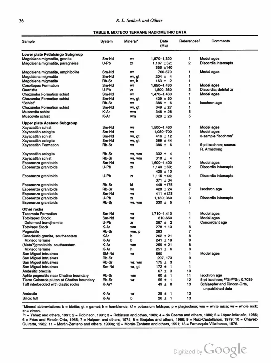
36 R. L. Sedlock and Others
TABLE 8. MIXTECO TERRANE RADIOMETRIC DATA
Sample System Mineral’ Date Fleferencesl Comments
(Ma)
Lower plate Petlalcingo Subgroup
Magdalena migmatite, granite Sm-Nd wr 1,870—1,320 1 Model ages
Magdalena migmatite, paragneiss U-Pb zr 1,187 :52; 2 Discordia intercepts
356 i140
Magdalena migmatite, amphibolite Sm-Nd wr 760-670 1 Model ages
Magdalena migmatite Sm-Nd wr, gt 204 i 4 1
Magdalena migmatite Rb-Sr wr, b 163 i 2 1
Cosoltepec Formation Sm-Nd wr 1,650—1,430 1 Model ages
Quartzite U-Pb zr 1,800, 360 3 Discordia; detrital zr
Chazumba Formation schist Sm-Nd wr 1,470—1,430 1 Model ages
Chazumba Formation schist Sm-Nd wr, gt 429 i 50 1
“Schist” Rb~Sr wr 386 i 6 4 lsochron age
Chazumba Formation schist Sm-Nd wr, gt 349 i 27 1
Muscovite schist K-Ar wrn 346 i 28 5
Muscovite schist K-Ar wrn 328 i 26 5
Upper plate Acateco Subgroup
Xayacatlan schist Sm-Nd wr 1,500—1,460 1 Model ages
Xayacatla'n eclogite Sm-Nd wr 1,080—700 1 Model ages
Xayacatla'n schist Sm-Nd wr, gt 416 i 12 1 3-sample “isochron”
Xayacatlan eclogite Sm-Nd Wr, gt 388 i 44 1
Xayacatla'n Formation Ftb-Sr wr 386 i 6 1 5-ptisochron; source:
R. Armstrong
Xayacatlén eclogite Flb-Sr wr, Win 332 i 4 1
Xayacatlan schist Rb-Sr wr, wm 318 i 4 1
Esperanza granitoids Sm-Nd wr 1 ,600—1,400 1 Model ages
Esperanza granitoids U-Pb zr 1,140 169; 2 Discordia intercepts
425 i 13
Esperanza granitoids U-Pb zr 1,116 11:44; 1 Discordia intercepts
371 i 34
Esperanza granitoids Rb-Sr k1 448 i175 6
Esperanza granitoids Rb-Sr wr 428 i 24 7 lsochron age
Esperanza granitoids Sm-Nd wr 411 1123 1
Esperanza granitoids U-Pb zr 1,180; 360 3 Discordia intercepts
Esperanza granitoids Flb-Sr Wr, wm 330 i 5 1
Other rocks
Tecomate Formation Sm-Nd wr 1,710—1,410 1 Model ages
Totoltepec Stock: Sm-Nd wr 810-660 1 Model ages
Deformed trondjhemite U-Pb zr 287 i 2 1 Concordant age
Totoltepc Stock K-Ar wm 278 :t 13 8
Pegmatite Flb-Sr wm, p 283 7
Cataclastic granite, southeastem KAr b 262 i 21 8
Mixtecoterrane K-Ar b 241 :t 19 8
(Meta?)granitoids, southeastem K-Ar Win 259 i 21 8
Mixteco terrane K—Ar h 251 i 6 8
San Miguel intrusives SM-Nd wr 660 1 Model ages
San Miguel intrusives Rb-Sr 207, 173 9
San Miguel intrusives Rb-Sr wr, wm 175 i 3 1
San Miguel intrusives Sm-Nd wr, gt 172 i 1 1
Andesitic breccia 67 i 3 10
Aplite pegmatite near Chatino boundary Flb-Sr wrn 60 :t: 1 11 lsochron age
Tierra Colorada pluton at Chatino boundary Rb-Sr wr 55 :1; 1 12 8-pt isochron; 87Sr/mSrI: 0.7039
Tufi interbedded with elastic rocks K-Ar? 49 i 8 13 Schlaepfer and Flincon-Orta,
unpublished data
Andesite K-Ar wr 29 i 1 13
Silicic tuff K-Ar b 26 i 1 13
'Mineral abbreviations: b = biotite; gt = garnet; h = hornblende; kf = potassium feldspar; p = plagioclase; wm = white mica; wr = whole rock;
zr = zircon.
t1 = Yar'iez and others, 1991; 2 = Robinson, 1991; 3 = Robinson and othes, 1989; 4 = de Cserna and others, 1980; 5 = Lopez-Infanzdn, 1986;
6 = Fries and Rincén-Orta, 1965; 7 = Halpem and others, 1974; 8 = Grajales and others, 1986; 9 = Ruiz-Castellanos, 1979; 10 = Chavez
Quirarte, 1982; 11 = Moran-Zenteno and others, 1990a; 12 = Moran-Zenteno and others, 1991; 13 = Ferrusqufa-Wllafranca, 1976.

Tectonostratigraphic Terranes and Tectonic Evolution ofMexico 37
conforrnably overlie the Acatlan Complex near Olinala contain
fauna that are provisionally correlated with Permian rocks in the
Seri terrane near El Antimonio, Sonora (Corona-Esquivel, 1981;
Enciso de la Vega, 1988).
At the southeastern edge of the Mixteco terrane, deformed
and metamorphosed late Paleozoic marine elastic rocks, pe
lagic rocks(?), mafic volcanic roeks(?), and granitoids (mapped as
Acatlan Complex on the H-3 Transect) are wedged between the
Zapoteco terrane and the Chatino terrane (Grajales-Nishirnura,
1988). These rocks may be a late Paleozoic forearc and are
assemblage that accumulated Outboard of the Totoltepec stock
and other Permian magmatic rocks in southeastern México, or a
distinct terrane that was accreted to the Mixteco terrane prior to
the accretion of the Chatino terrane. We provisionally call these
oceanic rocks the Juchatengo subterrane of the Mixteco terrane.
Mesozoic and Cenozoic rocks. Granite in the Magdalena
migmatite and silicic dikes of the San Miguel intrusive suite have
yielded latest Triassic to Middle Jurassic ages (Table 8). The
Aeatlan Complex and overlying Paleozoic strata are overlain by
Mesozoic epicontinental strata that are very similar to those in the
adjacent Zapoteco terrane. Near Olinala, Triassic(?) ignimbrite
unconformably overlies Upper Permian strata and the Acatlan
Complex (Fig. 12) (Corona-Esquivel, 1981). Jurassic strata in
clude T0arcian(‘l) nonmarine sandstone, carbonaceous shale, and
coal (Salvador, 1987); Aalenian-Bajocian quartz-cobble con
glomerate that contains fragments of the Triassic(?) ignimbrite
(Corona-Esquivel, 1981); and Bajocian-Callovian marine and
nonmarine elastic rocks, coal, and carbonates whose fauna tie the
Mixteco terrane to the Pacific margin near the Central Andes and
to the western end of a seaway between North America and
South America (Imlay, 1980; Westermann and others, 1984).
Other Mesozoic strata include Callovian-Oxfordian carbonates
and shale, Kimmeridgian-Tithonian marine elastic rocks, Neo
comian carbonates and marine elastic rocks that contain reptilian
fossils with affinities to Tethyan forms in Europe and South
America, Neocomian-Aptian red beds, and Albian-Maastrichtian
basinal carbonates that are partly coeval with the Morelos
Guerrero platform in the adjacent Nahuatl terrane (Ferrusquia
Villafranca, 1976; Salvador, 1987; Ferrusquia-Villafranca and
Comas-Rodriguez, 1988). Campanian-Maastrichtian conglomer
ate and sandstone derived from the Juehatengo subterrane were
deposited on that subterrane as well as on the Zapoteco terrane
(Carfantan, 1986; F. Ortega-Gutierrez, unpublished data).
latest Cretaceous to Eocene Laramide orogenesis caused
north-south-trending folds in Cretaceous and older rocks, serpen
tinization and plastic deformation of deep-level harzburgite, and
the diapiric emplacement of the serpentinite into the upper part of
the Acatlan Complex along reverse faults (Carballido-Sanehez
and Delgado-Argote, 1989). Cretaceous and older rocks subse
quently were overlain unconformably by Paleogene(?) conglom
erate, sandstone, and shale that were derived from the Oaxacan
Complex (Zapoteco terrane) and an unidentified subordinate
volcanic source, and minor interbedded tuff (Table 8) (Ferrus
quia-Villafranca, 1976). Along the southern margin of the ter
rane, the 60- to 55-Ma Tierra Colorada pluton (Table 8) intrudes
not only Cretaceous limestones of the Nahuatl terrane, but also my
lonites along the fault boundary with the Chatino terrane (p. 73).
Other Cenozoic rocks include Oligocene(?) silicic ignimbrite, vol
caniclastic rocks, andesitic lavas, and andesitic hypabyssal rocks
(Table 8), and Miocene-Pliocene(?) lake deposits (Ferrusquia
Villafranca, 1976; Ortega-Gutierrez and others, 1990).
Geophysical data. Paleomagnetic studies indicate that Al
bian and younger rocks have undergone little or no displacement
of the Mixteco terrane with respect to stable North America
(Moran-Zenteno and others, 1988). However, anomalous direc
tions from Bathonian to Oxfordian rocks and from the Permian
strata near Olinala imply counterclockwise rotation and 15° i 8°
of southward translation of the Mixteco terrane with respect to
stable North America between Oxfordian to Albian time, about
160 to 110 Ma (Urrutia-Fucugauchi and others, 1987; Ortega
Guerrero and Urrutia-Fucugauehi, 1989). These results supersede
an earlier estimate of 25° to 30° of southward translation
(Moran-Zenteno and others, 1988).
Nahuatl terrane
The Nahuatl terrane consists of weakly to strongly deformed
and metamorphosed sedimentary and magmatic rocks of Jurassic
to Cretaceous age, as well as structurally lower and probably
older strongly deformed metamorphic rocks in the eastern part of
the terrane (Fig. 13). These rocks are intruded by numerous
mid-Cretaceous and Tertiary plutons and overlain unconform
ably by Tertiary volcanic rocks. The Nahuatl terrane corresponds
to the southern part of the Guerrero terrane of Campa-Uranga
and Coney (1983) and Coney and Campa-Uranga (1987), and
encompasses terrane and subterrane names proposed by other
workers, as outlined below.
Many rock unit and terrane names have been published or
proposed for rocks within the confines of the Nahuatl terrane, but
data and observations are sparse and partly contradictory. In
order to clarify matters for those who are familiar with these
earlier works, the following paragraphs specify the components of
the Nahuatl terrane in terms of the previously published nomen
clature. The internal structure of the Nahuatl terrane is greatly
simplified in Figure 13; many features and structures discussed
below are not depicted because their regional geologic and tec
tonic relations are enigmatic.
Tierra Caliente Complex (TCC). The lower structural
level of the Nahuatl terrane crops out in several regions in the
eastern part of the terrane (Guerrero and Mexico states).
Prehnite-pumpellyite—, greenschist-, and lower amphibolite—facies
metasedimentary and metavolcanic rocks that are known by
many local names were informally named the Tierra Caliente
Complex (TCC) by Ortega-Gutierrez (1981a), who tentatively
interpreted them as a magmatic arc/marginal basin assemblage.
The TCC includes the Taxco Schist, Ayotusco Formation, and
Taxco Viejo Greenstone in northern Guerrero, southern Méxieo
state, and perhaps northeastern Miehoaca'm; the Ixcuinatoyac and

38 R. L. Sedlock and Others
NAHUA 1 L
w eggiiiéli» E
< v < /\ < V < /\ < \/ < A < Tu-Q < A < v < A < A < A
GulfofCalifomia
unknown basement
l_\Q/My? UMA(Ju-Kl)
| . . . _ . .. __
u’\/
>/\/\/< —“
/
<
MIXTECO
Figure 13. Schematic east-west structure section of Nahuatl terrane. Effects of mid-Cretaceous thrusting
and Laramide deformation in Upper Mesozoic Assemblage (UMA) have been omitted. Deformation in
Tierra Caliente Complex (TCC) is simplified; see text for discussion.
Chapolapa Formations in southern Guerrero; and metavolcanic
and metasedimentary rocks in southwestern Guerrero. These
rocks are not known in the western part of the terrane (Fig. 13).
The Taxco Schist, Ayotusco Formation, and Taxco Viejo
Greenstone crop out over a large area near Arcelia and Taxco,
northernmost Guerrero and Ixtapan de la Sal (Fig. 2) and Teju
pilco, southern Mexico state; isolated exposures of similar rocks
in the late Cenozoic Trans-Mexican Volcanic Belt in northeastern
Michoacan may be correlative. The Taxco Schist (Esquisto
Taxco) consists of strongly foliated, greenschist-fades metapelite,
quartzite and slate, and metavolcanic rocks of silicic to mafic
composition (Fries, 1960; Diaz-Garcia, 1980; de Csema and
Fries, 1981; de Cserna, 1982; Elias-Herrera, 1987, 1989). Near
Tejupilco, about 50 km west of Ixtapan de la Sal, Taxco Schist
includes phyllite and schist derived from mafic to silicic volcanic
and pyroclastic rocks, carbonaceous pelite, flysch, and limestone
(Elias-Herrera, 1987, 1989; Tolson, 1990). The metasedimentary
and metavolcanic rocks have a structural thickness of about 2
km, and have been subjected to at least four phases of metamor
phism (M1 to M4) and two episodes of penetrative deformation
(D1, D2). M1 and M2 were coeval with D1 and D2, respectively,
and attained greenschist-facies conditions (Elias-Herrera, 1987,
1989). M3 was characterized by low-pressure, high-temperature
lower amphibolite-facies metamorphism with geothermal gra
dients of 700 to 90°C/km, suggesting magmatic are conditions
(Elias-Herrera, 1989). M4 was a very low grade retrogressive
overprint coeval with kilometer-scale open folding. Structural
basement does not crop out beneath the schist and phyllite but
may be represented by nearby mylonitic, amphibolite-facies,
adamellitic orthogneiss of continental or perhaps transitional
crustal affinity (two-mica granites, pelitic xenoliths) (Elias
Herrera, 1989). Dating of protoliths and metamorphic events has
been frustrated by the complex thermal history; although dates as
old as late Precambrian have been reported (Table 9), unpub
lished Rb-Sr studies imply that the orthogneiss protolith is late
Paleozoic (R. L. Armstrong, in de Csema, 1982) or Permo
Triassic (P. E. Damon, in Elias-Herrera, 1989). The structural
and metamorphic history of the orthogneiss is similar to that of
the schist and phyllite, and supports the interpretation that the
sedimentary and volcanic protoliths were deposited in a continen
tal arc environment (Elias-Herrera, 1989). However, contact
relations are equivocal; a possible alternate interpretation is that
the orthogneiss was faulted against the schist-phyllite unit after
the two units had developed similar structural and metamorphic
histories. According to the latter alternative, the schist-phyllite
sequence may have been deposited within an island arc, rather
than a continental arc.
The Taxco Schist is discordantly overlain along an unexposed
contact by the Ayotusco Formation, which consists of strongly foli
ated, greenschist-facies carbonaceous slate, quartzite, and marble
(Diaz-Garcia, 1980). Protolith and metamorphic ages are
unknown. The Ayotusco Formation probably has been mapped
as Taxco Schist in many areas (de Csema and Fries, 1981).
The Taxco Schist and Ayotusco Formation are discordantly
overlain along unexposed contacts by the Taxco Viejo Green
stone (Roca Verde Taxco Viejo), which consists of weakly fo
liated, greenschist-facies lava, tuff, and lahar of andesitic to
basaltic-andesitic composition (Fries, 1960; Diaz-Garcia, 1980).
Metamorphic minerals such as pumpellyite, phengite, piedmon
tite, and stilpnomelane(?) may indicate moderately high P/T
conditions (Diaz-Garcia, 1980; Ortega-Gutierrez, 1981a). Direct
fossil and radiometric age control are lacking, but based on its

Tectonostratigraphic Terranes and Tectonic Evolution ofMexico 39
TABLE 9. NAHUATL TERRANE RADIOMETRIC DATA
Sample System Mineral' Date Fleierencesl Comments
(Ma)
Tierra Caliente Complex
Metamyolite Pb-u zr 1,020 i100 1
Gabbro, monzonite Rb-Sr wr 311 i 30 2 Minimum age: a7Sr/aI’SrI: 0.7037
Andesite, schist from Taxco Viejo Green~ K-Ar wr 125 :t 5 3 Age of hydrothermal alteration?
stone, southern Mexico state K-Ar wr 108 t 5 3
“Upper Mesozoic Assemblage"
Low-grade fuchsite schist Rb-Sr wrn 149 :1: 64 4
southwestern Méxioo state K-Ar wrn 61 i 5 4
Quartz porphyry, southwestern Jalisco K-Ar p 114 i 2 5
Mafic dike, south-central Guerrero “Ar/“Ar h 112 i 3 6 Plateau age
Welded tuff, southwestem Jalisco K-Ar k1, b 92 i 2 5
Welded tuff, southwestern Jalisco K-Ar kf, b 88 i 2 5
Welded tuft, southwestern Jalisco K-Ar kf, b 81 :l: 4 5
Welded tuft, southwestern Jalisco K-Ar kt, b 71 :t 1 5
Siliclc to intermediate volcanic rocks, W Guerrero Rb-Sr w 69 i 7 7 6-pt. isochron
Rhyolite, Nayarit K-Ar p 54 i 2 5
Intrusive rocks
Matic and ultramafic rocks, 40Ar/39Ar h 114 :t 3 6 Plateau age
San Pedro Limon, “Ar/“Ar h 105 :1: 1 6 Plateau age
southwestern Méxioo state; 4°Ar/~‘°Ar h 102 i 7 6 Plateau age
intrusive into Upper Mesozoic Assemblage ‘°ArP°Ar h 100 i 3 6 Integrated age
Puerto Vallarta Batholith Rb-Sr wr 105 8 Emplacement age
Puerto Vallarta Batholith K-Ar h 91 i 2 5 Cooling age
Puerto Vallarta Batholith Rb—Sr h 66 i 2 6 Cooling age
Puerto Vallarta Batholith Rb-Sr b 83 :t 3 8 Cooling age
Puerto Vallarta Batholith K-Ar h, b 82—80 5 Cooling ages, 6 samples
Gabbro pegmatite, Nayarit K-Ar h 98 i 3 5
Granitoids, Nayarit and southwestern Jalisco K-Ar h, b, p 71-45 5 8 samples
Granite, southem Jalisco Rb-Sr wr 69 i 1 6
Quartz monzonite, western Guerrero K-Ar wm 63 :t 1 9 e7Sr/wSrl: 0.7041
Granitoids, south-central Michoaca'n K-Ar b 57—44 10 5 samples
Tonalite, southcentral Michoacan Rb-Sr wr 56 i 5 11
Granite, south-central Michoaca'n K-Ar b 55 i 4 1O
43 :t 5 10
Quartz monzonite, central Jalisco K-Ar wr 54 i 5 12
Gabbro, southeastem Jalisco 53 :t 1 11
Mineralized (Cu) breccia pipes, central K-Ar h, p, wm, b 36—31 9 6 samples; "Sr/“Sq: 07039-07055
Michoacan (tour samples)
Granitoids near Petatlan, Guerrero Rb~Sr wr 33 1 3 13 3-pt isochron
Diorite, Nayarit K-Ar h 27 i 3 5
Post-Laramide volcanic rocks
Basalt, Balsas Group K-Ar 42 :I; 1 14
Rhyolite near Taxco K-Ar wr, kt 36 i 2 14
lgnimbrite near Morelia K-Ar k1 33 i 2 15
Fthyolite near Morelia K-Ar kf 23 i 1 15
lgnimbrite near Morelia K-Ar kf 22, 21 15
p 16 i 1 15
Basalt near Morelia K-Ar wr 20 i 1 15
Rhyolite conglomerate K-Ar p 18 i 1 16
Andesite near Morelia K-Ar wr, p, b 18—6 15 6 samples
Gabbro K-Ar p 13 i 2 16
Basalt dike K-Ar p 13 i 1 16
Welded tuft K-Ar k1 11 i 1 16
Basalts K-Ar p 10—8 16 3 samples
'Mineral abbreviations: b = biotite; h = hornblende; k1 = potassium feldspar, p = plagioclase; wm = white mica; wr = whole rock; zr = zircon.
T1 = de Cserna and others, 1974b; 2 = de Cserna and others, 1978; 3 = Urrutia-Fucugauchi and Linares, 1981; 4 = Fries and Flincon-Orta,
1965; 5 = Gastil and others, 1978; 6 = Delgada-Argote and others, 1992b; 7 = Gonzalez and others, 1989; 8 = Kohler and others, 1992; 9 =
Damon and others, 1983; 10 = Grajales-Nishimura and Lopez-Intanzén, 1983; 11 = Pantoja-Alor, 1988; 12 = Gonzalez and Martinez, 1989;
13 = Gonzélez-Partida and others, 1969; 14 = de Cserna and Fries, 1981; 15 = Pasquaré and others, 1991; 16 = Gastil and others, 1979.
40 R. L. Sedlock and Others
presumed youth with respect to the underlying Taxco Schist and
Ayotusco Formation and the unconformable overlap by Titho
nian and younger strata of the Upper Mesozoic Assemblage (see
section below), the Taxco Viejo Greenstone has been assigned a
provisional Late Triassic to Early Jurassic age (Dial-Garcia,
1980; de Csema and Fries, 1981; de Csema, 1982). The Taxco
Viejo Greenstone differs from the underlying Taxco Schist and
Ayotusco Formation by its weaker deformation and its marked
hydrothermal alteration, implying that it may have evolved inde
pendently of the latter units until its juxtaposition with them (i.e.,
Taxco Viejo Greenstone as an allochthonous thrust sheet) prior to
Tithonian overlap (de Cserna and Fries, 1981; de Csema, 1982).
Early Cretaceous dates from the Taxco Viejo Greenstone (Table
9) are inferred to correspond to the age of hydrothermal altera
tion (Campa-Uranga and others, 1974; Urrutia-Fucugauchi and
Linares, 1981), but the presence of Taxco Viejo Greenstone clasts
in overlying Tithonian-Neocomian strata (see below) implies an
earlier age for the alteration.
We note here that an alternate interpretation of the stratig
raphy of the Taxco-Tejupilco region has been proposed (Campa
Uranga and others, 1974; Campa-Uranga, 1978). In this interpre
tation, the protoliths of TCC as described above are not Paleozoic
but rather are correlative or at least coeval with Late Jurassic to
Early Cretaceous rocks that we assign to the Upper Mesozoic As
semblage (see below). These rocks were assigned to the Teloloa
pan-Ixtapan subterrane of the Guerrero terrane (Campa-Uranga
and Coney, 1983; Coney and Campa-Uranga, 1987).
About 20 km southwest of Chilpancingo, southern Guerrero
(Fig. 2), the TCC probably includes two greenschist-facies se
quences of metavolcanic and metasedimentary rocks that may be
separated by an unconformity (de Cserna, 1965; Klesse, 1968).
The Ixcuinatoyac Formation consists of deformed quartzite, phyl
lite, metabasite, sedimentary sulfides, conglomerate, and serpen
tinite of unknown age that were deformed prior to intrusion of
granitoids of unknown age. The unconformably overlying Cha
polapa Formation consists of silicic to intermediate metavolcanic
rocks and metaclastic rocks including conglomerate, sandstone,
and phyllite of unknown age.
In the vicinity of Petatlan (Fig. 2), Zihuatanejo, and Puerto
Escondido in southwestern Guerrero, near the western boundary
of the Chatino terrane, the TCC consists of greenschist-facies
metavolcanic and metasedimentary rocks that were derived from
marine volcanic and volcaniclastic rocks, carbonaceous shale,
and intercalated volcanic and sedimentary rocks and were de
formed by northeast-vergent folds and thrusts prior to intrusion
by gabbro and monzonite of possible late Paleozoic age (Table 9)
(de Csema and others, 1978; Delgado-Argote and others, 1986).
These metamorphic rocks are overlain unconformably by
younger rocks of the Nahuatl terrane (see below) along a contact
locally marked by serpentinite.
In northeastern Michoacan in the Morelia-Zitacuaro area,
the TCC may include a 1,500-m-thick sequence of rhythmically
interbedded sandstone, siltstone, and shale affected by low-grade
metamorphism (Pasquaré and others, 1991). Fossil plants indi
cate a Middle Jurassic age for part of the sequence (A. Islas and
others, unpublished data, 1989; Pasquaré and others, 1991).
In summary, the name Tierra Caliente Complex refers to
metabasites, metaandesites, and metasedimentary rocks in the
structurally lower part of the eastern Nahuatl terrane. Protoliths of
at least some of these rocks probably are of Paleozoic age. The na
ture of protoliths and metamorphism in the TCC may indicate the
juxtaposition of arc (andesites; high-temperature metamorphism)
and basinal (metabasites, flysch; low-grade metamorphism) as
semblages, although other interpretations certainly are possible
given the limited data base (Ortega-Gutierrez, 1981). Many as
pects of the complex structural and metamorphic history still are
unresolved, but shallowly dipping to subhorizontal foliation, axial
surfaces, and thrust faults probably record tectonic transport to the
northeast (Ortega-Gutierrez, 1981a; Robinson, 1990).
UpperMesozoic Assemblage. The structurally higher unit
of the Nahuatl terrane consists of generally strongly deformed but
weakly metamorphosed Jurassic(?) to Cretaceous(?) sedimentary
and volcanic strata, and overlying weakly deformed and meta
morphosed late Early and Late Cretaceous carbonates and
elastic strata. These rocks crop out throughout both the eastern
and western parts of the Nahuatl terrane. First, we discuss out
crops of the Upper Mesozoic Assemblage in the eastern part of
the terrane.
In western Morelos, northernmost Guerrero, and southern
Mexico state, the Upper Mesozoic Assemblage overlies the Taxco
Schist and other rocks of the TCC along a contact that has been
interpreted as a regionally extensive unconformity (Diaz-Garcia,
1980) and, at least locally, as a fault (Tolson, 1990). The Titho
nian (latest Jurassic) to Neocomian(?) Acuitlapan Formation con
sists of slightly to strongly deformed, low-grade metamorphic
rocks derived from siliciclastic sedimentary rocks, limestone, and
andesitic flows, tuff, and agglomerate (Fries, 1960; Campa
Uranga and others, 1974; de Csema and Fries, 1981; de Csema,
1982). Conglomerate contains hydrothermally altered clasts de
rived from the underlying Taxco Viejo Greenstone. In western
Morelos and northern Guerrero, the Acuitlapan Formation is
overlain with possible unconformity by Albian-Cenomanian plat
form carbonates and Turonian-Coniacian limestone grading to
flysch (the Morelos-Guerrero platform and cover, including the
Morelos Formation). In southern México state, the Acuitlapan
Formation is overlain by Albian-Cenomanian basinal carbonates
and Cenomanian-Coniacian andesitic to basaltic-andesitic lavas
and pyroclastic rocks, associated mafic to ultramafic intrusives,
flysch, and minor limestone (Fries, 1960; de Csema and Fries,
l98l; de Csema, 1982; Delgado-Argote and others, 1992a). The
post-Acuitlapan strata have been correlated with coeval platform
and basinal carbonates throughout central and eastern México and
with similar strata in the western Nahuatl terrane (see below).
Calcite c-axis fabrics in marbles of the Acuitlapan Forma
tion indicate top-to-the-east tectonic transport; less deformed
Albian-Turonian limestones lack crystallographic preferred orien
tation (Tolson, 1990). These observations imply a mid
Cretaceous episode of east-vergent thrusting. Both units under
Tectonostratigraphic Terranes and Tectonic Evolution ofMexico 41
went younger east-west to northeast-southwest shortening gener
ally associated with the Laramide orogeny (Fries, 1960;
Campa-Uranga, 1978; de Csema and Fries, 1981; de Cserna,
1982). The age of Laramide deformation is bracketed by de
formed Coniacian strata and postkinematic nonmarine volcanic
and elastic rocks (Balsas Group) that are as young as late
Eocene and as old as Maastrichtian (Table 9) (de Cserna, 1982).
Some thrusts locally cut basement rocks of the TCC, but most are
inferred to merge into a décollement near the base of the Upper
Mesozoic Assemblage (de Cserna, 1982).
Near Petatlan, southern Guerrero (Fig. 2), the Upper Meso
zoic Assemblage includes very weakly metamorphosed and
deformed marine shale, sandstone, and limestone of possible
Mesozoic age (de Cserna and others, 1978) and mid-Cretaceous
volcanic and volcaniclastic rocks that may be cogenetie with
adjacent plutonic rocks (Delgado-Argote and others, 1986). The
volcanogenic rocks are weakly deformed, implying either that
they were erupted after Laramide orogenesis, or that they are part
of an arc terrane that collided with the southern Nahuatl terrane
during Laramide orogenesis (Urrutia-Fucugauchi and Valencio,
1986). The volcanogenic rocks and associated mafic and ultra
mafic rocks were termed the Papanoa terrane by Coney and
Campa-Uranga (1987), but recent remapping and geochrono
logic work by Delgado-Argote and others (1986, 1990, 1992b)
indicate that the magmatic rocks are of Cretaceous age. It seems
advisable to discontinue use of the term Papanoa terrane.
In the western part of the Nahuatl terrane (states of Michoa
can, Colima, Jalisco, Nayarit), the Upper Mesozoic Assemblage
includes Mesozoic volcanic and sedimentary rocks that have been
assigned to a bewildering array of terranes and subterranes by
different workers. (1) The Huetamo subterrane of the Guerrero
terrane in Michoaean (Campa-Uranga and Coney, 1983; Coney
and Campa-Uranga, 1987) consists of Late Jurassic marine
volcaniclastic rocks overlain by Neocomian siliciclastie strata and
tuff and Albian and Late Cretaceous siliciclastie strata and plat
form carbonates (Campa-Uranga, 1978). (2) Deformed but
weakly metamorphosed andesitic flows, breccias and tuffs, and
interbedded Albian limestone and siliciclastie strata in Michoacan
and Colima have been called the Zihuatanejo subterrane of the
Guerrero terrane (Campa-Uranga and Coney, 1983; Coney and
Campa-Uranga, 1987) and the Colima terrane (Campa-Uranga,
1985a). (3) The Arteaga terrane in southeastern Michoacan
(Coney and Campa-Uranga, 1987) reportedly consists of
metamorphosed Middle to Late Triassic volcaniclastic rocks
structurally juxtaposed with Paleozoic schists. Detrital zircons
were derived from Grenville and early Paleozoic sources
(K. Robinson, personal communication, 1991). (4) The Tumbis
catio terrane in southeastern Michoaean (Campa-Uranga, 1985a)
geographically coincides with the Arteaga terrane but is said to
consist of chert and metabasite that is at least partly Triassic.
Gastil and others (1978) recognized (5) an unnamed sequence of
interbedded graywacke and andesite of uncertain but possible
Late Jurassic age in southern Nayarit and western Jalisco, and
(6) an unnamed sequence of interbedded andesite, marble, and
metasandstone of uncertain but possible Early Cretaceous age in
southern Nayarit, Jalisco, and Colima. (7) In southern Colima,
weakly deformed late Aptian—Albian deep-water to platformal
limestone (Miehaud and others, 1989) may be correlative with
more deformed rocks in (1), (2), and (3) and with the Morelos
Formation in the eastern part of the Nahuatl terrane. (8) In
southeastern Jalisco, late Aptian andesitic conglomerate, lime
stone, and sandstone and early Albian rhyolitic to dacitic
volcanogenic rocks, limestone, and sandstone (Pantoja-Alor,
1983; Pantoja-Alor and Estrada-Barraza, 1986) probably corre
spond to (6). (9) In Colima, Smith and others (1989) recognized
Neocomian to Turonian(?) deposition, Turonian(?) uplift, and
later strike-slip disruption of rocks that also probably correspond
to (6). (10) In northeastern Michoaean in the Morelia-Zitacuaro
region, Upper Mesozoic Assemblage rocks include Late Juras
sic to Neocomian low-grade schist, pillow lavas, and metatuff
overlain transitionally by unmetamorphosed Hauterivian to Al
bian volcaniclastic and terrigenous sedimentary rocks with inter
calated bioclastic limestone (I. Israde and L. Martinez, unpub
lished data, 1986).
Based on the broad similarity of lithotype and, where
known, depositional age, we provisionally assign the above rocks
to a Late Jurassic—Early Cretaceous volcanic and sedimen
tary assemblage that we correlate with the Upper Mesozoic As
semblage in the eastern part of the Nahuatl terrane (Fig. 13).
Weakly to moderately deformed Cretaceous limestone observed
throughout the Nahuatl terrane probably was laterally continuous
with the platform succession in eastern Mexico. Triassic(?) rocks
of the so-called Tumbiscatio terrane (4) may represent older,
deeper parts of the terrane, a megablock within the terrane, or a
distinct terrane of enigmatic origin. The definition of the Arteaga
terrane (3) apparently is obsolete and we suggest that the name be
abandoned.
Post-Laramide strata. The oldest post-Laramide rocks in
the Nahuatl terrane are Maastrichtian to Eocene nonmarine
coarse elastic rocks and intercalated rhyolite, andesite, and rarer
basalt in the eastern part of the terrane known as the Balsas
Group. Widespread Eocene to Oligocene rhyolitic to dacitic py
roclastic rocks (Table 9) may be correlative with Tertiary vol
canic rocks of the Sierra Madre Occidental. Late Oligocene to
late Miocene flows, marine volcaniclastic rocks, and less
abundant intrusives of andesitic and subordinate mafic and silicic
composition (Table 9) probably formed in an are above the
subducting Farallon (Cocos) plate (Edwards, 1955; Fries, 1960;
Gastil and others, 1979; de Csema and Fries, 1981; de Cserna,
1982). In Late Neogene to Quaternary time, voluminous calc
alkalie volcanic rocks were erupted in the Trans-Mexican Vol
canic Belt on the northern margin of the terrane (Nixon, 1982;
Nelson and Livieres, 1986; Nixon and others, 1987; Pasquaré and
others, 1991). Starting about 4.5 to 4.0 Ma, alkalic and calc
alkalic volcanic rocks were erupted in the Colima and Zacoalco
grabens in the western part of the terrane (Allan, 1986). Calc
alkalic rocks were derived from partial melting of heterogeneous
mantle above the subducting Cocos and Rivera plates. Source

42 R. L. Sedlock and Others
magmas of alkalic rocks in the Colima graben included a large
component of incompatible element-rich lherzolite dikes and
metasomatic veins (Luhr and others, 1989), whereas alkalic and
peralkalic magmas in the Zacoalco graben were derived from a
source typical of an oceanic island (Verma and Nelson, 1989).
Intrusive rocks. Granitoids crop out in about one-third of
the terrane, with a rough west to east decrease in crystallization
age from mainly mid-Cretaceous in southern Nayarit, Jalisco,
Colima, and western Michoacan to mainly Tertiary in eastern
Michoacan and Guerrero (Fig. 13, Table 9) (Damon and Coney,
1983; Bohnel and others, 1989; Guerrero-Garcia, 1989). Pub
lished geochronologic data are not available for many plutonic
rocks in eastern Jalisco, Colima, Michoacan, and western Guer
rero, but country rocks of these intrusions are mainly of Creta
ceous and Paleogene age. Preliminary Nd isotopic data from
plutons in the northwestern part of the terrane imply partial
derivation from a Proterozoic(?) source and variable degrees of
crustal contamination, whereas plutons in the eastern part of the
terrane yield middle to late Paleozoic Nd model ages and show
no evidence for crustal contamination (Schaaf and others, 1991).
Regional structural and geophysical data. The lateral
continuity of late Early and Late Cretaceous clastic and
carbonate strata indicate that the Nahuatl terrane was amalga
mated and accreted to Mexico prior to Late Cretaceous—Paleo
gene Laramide orogenesis that produced northeast-vergent folds
and basement-involved thrusts (Johnson and others, 1990). Out
liers of Jurassic-Cretaceous arc rocks within the Cretaceous car
bonate platform of the Upper Mesozoic Assemblage are probably
klippe stranded by northeast-vergent Laramide thrusting
(Campa-Uranga, 1978). Early Miocene shortening is indicated by
a large, open, asymmetric anticline in northeastern Michoacan
that dips steeply west (Pasquaré and others, 1991).
Paleomagnetic data from volcanic rocks, sedimentary rocks,
and granitoids imply negligible latitudinal displacement and
minor local clockwise or counterclockwise rotation of the Na
huatl terrane since Early Cretaceous time (Bohnel and others,
1989). In the northwestern part of the terrane, post-Oligocene
normal faults that strike northwest, east-west, and northeast are
interpreted as products of north-south tension related to subduc
tion of the Cocos plate to the south (de Csema and Fries, 1981;
de Csema, 1982). In the same area, left-slip and rarer right-slip
faults that strike north-south to north-northwest—south-southeast
are inferred to be a result of Neogene transpression (Delgado
Argote and others, 1992a).
North America terrane
Proterozoic crystalline rocks of North American continental
crust crop out locally in northern Sonora and Chihuahua and
probably underlie the entire region. Paleozoic carbonate and si
liciclastic rocks were deposited in shallow water on a south-facing
shelf until the late Paleozoic, when foundering of the southern
shelf edge resulted in the deposition of basinal fiysch and pelagic
rocks. Precambrian basement and late Paleozoic flysch were de
formed and interleaved in the Permian(?), coeval with but per
haps unrelated to Ouachitan orogenesis. This region apparently
was emergent during the Triassic and part of the Jurassic. The
western part of the terrane hosted a Jurassic volcanic arc that
continued n0rthwest into southern Arizona and California, and
also was the site of Early Cretaceous magmatism. The eastern
part of the terrane accumulated Late Jurassic to Cretaceous
carbonate, siliciclastic rocks, and evaporites in the Chihuahua
Trough and fault-bounded Bisbee basin.
Precambrian basement rocks. In northern Sonora, North
American continental basement consists of 1,700- to 1,660-Ma
“eugeosynclinal” rocks that were deformed and metamorphosed
to greenschist facies about 1,650 Ma (Fig. 14; Table 10); these
rocks probably are correlative with the Pinal Schist in southern
Arizona (Anderson and Silver, 1977b, 1981). These metamor
phic rocks are intruded by undeformed, volumetrically abundant
1,460- to 1,410-Ma anorogenic granitoids that probably are part
of a suite of similar rocks in the western and midcontinental
United States (Anderson, 1983), and by much rarer 1,100-Ma
anorogenic granites (Anderson and Silver, 1977a, b, 1981;
Rodriguez-Castafieda, 1988).
In Chihuahua, known Precambrian basement includes gran
ite gneiss encountered at depths of 4 to 5 km in two PEMEX
wells; two small outcrops of fault-bounded metaplutonic rocks
intruded by amphibolite dikes and pegmatites within Permian
flysch in the Sierra del Cuervo, about 15 km north-northwest of
Aldama; and small fault-bounded outcrops of undated amphibo
lite gneiss near Rancho El Carrizalillo, about 80 km east of Sierra
del Cuervo (Thompson and others, 1978; Mauger and others,
1983; Quintero-Legorreta and Guerrero, 1985; Handschy and
Dyer, 1987; Blount and others, 1988). Radiometric dates (Table
10) are similar to those of Grenville rocks in western and central
Texas (Copeland and Bowring, 1988; Walker, 1992). Late Pa
leozoic and Triassic cooling ages probably indicate a regional
low-grade thermal event in late Paleozoic time, perhaps asso
ciated with Ouachitan orogenesis (Denison and others, 1971;
Mauger and others, 1983). Grenville rocks probably underlie
much of northern and eastern Chihuahua (Fig. 14), as indicated
by Sm-Nd and U-Pb studies of xenoliths (Table 10) (Ruiz and
others, 1988b; Rudnick and Cameron, 1991). Thus, the Protero
zoic southern margin of cratonal North America probably extend
ed southwest from Texas into northern Chihuahua. The location
and nature of the contact between the Grenville rocks of Chihua
hua and the older crust of Sonora are not known (Fig. 14).
Paleozoic rocks. Scattered outcrops of Paleozoic strata in
Chihuahua and northeastern Sonora are correlative with strata in
adjacent Arizona and New Mexico, and record deposition along
the southern margin of North America (Fig. 14). Similar rocks
have been penetrated by numerous wells in northern Chihuahua
(Thompson and others, 1978; Lopez-Ramos, 1985, p. 156—159).
Ordovician to Permian carbonate, shale, and sandstone in
north-central Chihuahua and northeastern Sonora were deposited
in shallow-water shelf and platform environments in and on the

Tectonostratigraphic Terranes and Tectonic Evolution ofMexico 43
NORTH AMERICA
SERI
<74 North American crust
T A (l,700-1,650 Ma)
t, Mojave-Sonora
Megashear
N Sonora
(IO North American crust
(Grenville, 1,300- l ,000 Ma)
NW Chihuahua
q, <r
NE Chihuahua
Figure 14. Composite tectonostratigraphic section and schematic east-west structure section of North
American continental crust in northern México. Uncertain location and orientation of Grenville front,
i.e., contact between Grenville and older basement rocks. SMO(T), Tertiary volcanic rocks of Sierra
Madre Occidental. CT-BB, Upper Jurassic to Upper Cretaceous rocks of Chihuahua Trough and Bisbee
basin. Effects of Cretaceous to Paleogene shortening have been omitted.
margins of the Pedregosa basin, which probably trended north
west from central Chihuahua into southern New Mexico and
southeastern Arizona (Taliaferro, 1933; Imlay, 1939; Ramirez
M. and Acevedo-C, 1957; Bridges, 1964a; Diaz and Navarro-G,
1964; Navarro-G. and Tovar-R., 1974; King, 1975; Greenwood
and others, 1977; Dyer, 1986; Gonzalez-Leon, 1986; Armin,
1987; Pubellier and Rangin, 1987). During latest Pennsylva
nian(?) and Early Permian time, the southern part of the
Pedregosa basin in central Chihuahua subsided rapidly, as indi
cated by the deposition of thick basinal flysch and pelagic rocks;
minor tuff and conglomerate composed exclusively of rhyolite
clasts may indicate proximity to a cryptic Early Permian volcanic
arc (de Cserna and others, 1968; Mellor and Breyer, 1981;
Torres-Roldan and Wilson, 1986; Handschy and Dyer, 1987;
Handschy and others, 1987). In the Sierra del Cuervo in central
Chihuahua, late Paleozoic flysch was overridden in mid-Permian
to Jurassic time by crystalline rocks of Grenville age along east
verging thrust faults (Fig. 14) (Handschy and Dyer, 1987;
Handschy and others, 1987). A significant unconformity is in
ferred above the Precambrian and Paleozoic rocks because Trias
sic to Middle Jurassic strata are absent (Fig. 14). Latest Paleozoic
K-Ar cooling ages reported from Precambrian granite and peg
matite in the Sierra del Cuervo region (Table 10) may reflect
tectonism of this age.
Zircons collected from an orthogneiss xenolith in eastern
Chihuahua indicate crystallization at 350 to 320 Ma followed by
granulite metamorphism either shortly thereafter or at 190 Ma
(Rudnick and Cameron, 1991). Carboniferous and Permian zir
cons are absent from five xenoliths in this region, indicating that
Ouachitan orogenesis had no effect on the lower crust in eastern
Chihuahua, presumably because the thermal high was in the
Ouachita interior zone to the east.
Mesozoic and Cenozoic rocks. In northern Sonora, crys
talline Precambrian basement is overlain by Jurassic intermediate
to silicic volcanic and hypabyssal rocks and sedimentary rocks
(e.g., Fresnal Canyon sequence, Artesa sequence of Tosdal and
others, 1990a; unnamed Jurassic volcanic rocks of Rodriguez
Castafieda, 1988) and intruded by Jurassic granitoids (K0 Vaya
superunit of Tosdal and others, 1990a) (Table 10). In the
Cucurpe-Tuape region in northeastern Sonora, Oxfordian (early
Late Jurassic) volcaniclastic rocks, tuff, andesite, and shale
grade upward into clastic rocks and limestone of uncertain
but presumed Late Jurassic age (Rangin, 1978; Rodriguez
Castafieda, 1988). These Jurassic volcanic, plutonic, and volcani
clastic rocks are interpreted to have formed in a northwest
trending arc in southwestern North America that, in northwestern
México, was the locus of Late Jurassic sinistral displacement on
the Mojave-Sonora Megashear (Anderson and Silver, 1979; Tos
dal and others, 1990a).
Tithonian to Albian basal conglomerate, limestone, fine
grained marine siliciclastic rocks, evaporites, and coal accumu
lated in the Chihuahua Trough and the fault-bounded Bisbee
basin in Chihuahua and Sonora (Greenwood and others, 1977;
Dickinson and others, 1986; Brown and Dyer, 1987; Araujo
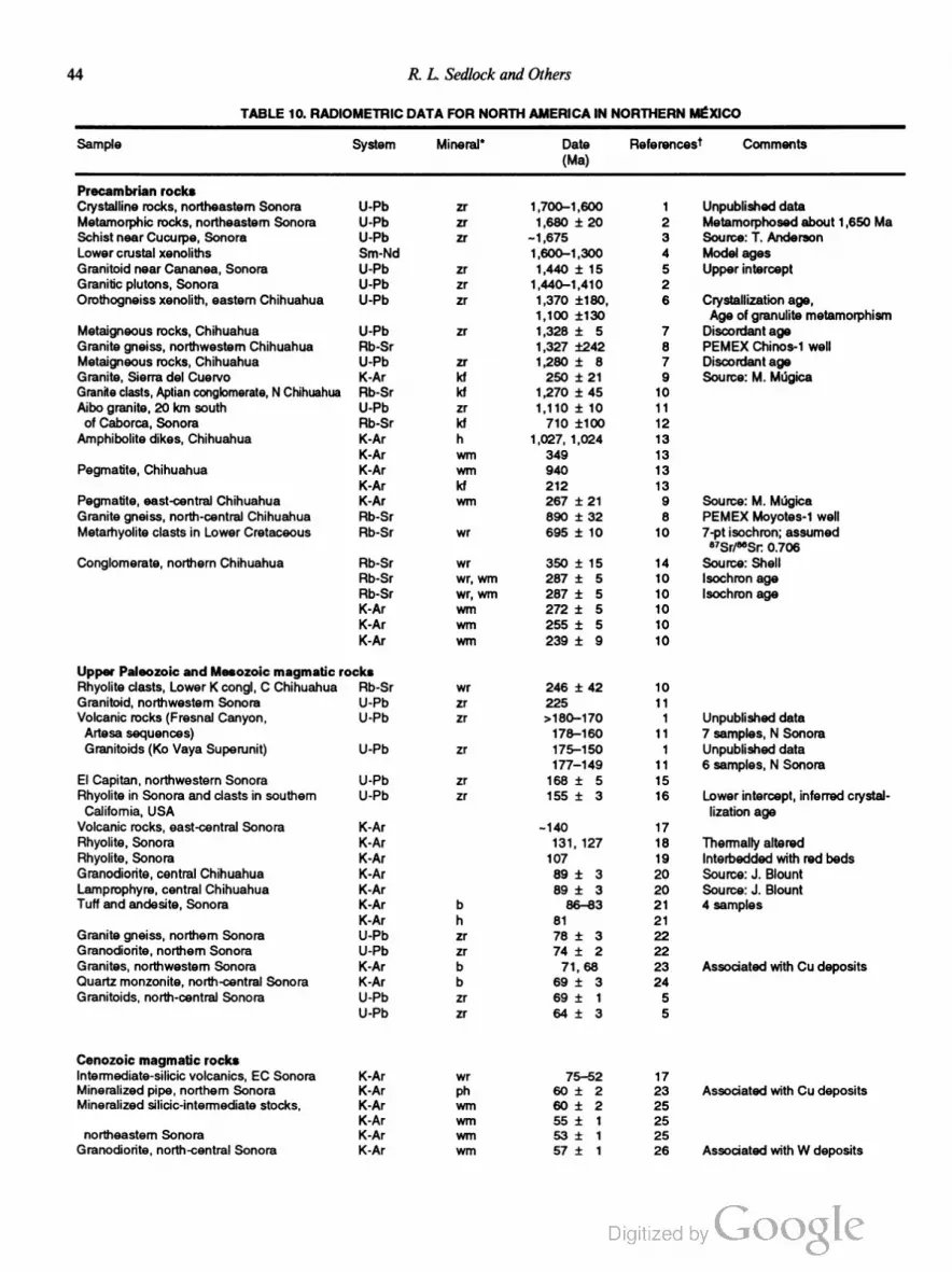
44 R. L. Sedlock and Others
TABLE 10. RADIOMETRIC DATA FOR NORTH AMERICA IN NORTHERN MEXICO
Sample System Mineral’ Date Reterences'r Comments
(Ma)
Precambrian rocks
Crystalline rocks, northeastern Sonora U-Pb zr 1,700-1,600 1 Unpublished data
Metamorphic rocks, northeastern Sonora U-Pb zr 1,680 i 20 2 Metamorphosed about 1,650 Me
Schist near Cucurpe, Sonora U-Pb zr ~1,675 3 Source: T. Anderson
Lower crustal xenoliths Sm-Nd 1 ,600-1,300 4 Model ages
Granitoid near Cananea, Sonora U-Pb zr 1,440 i 15 5 Upper intercept
Granitic plutons, Sonora U-Pb zr 1,440-1,410 2
Orothogneiss xenolith, eastern Chihuahua U-Pb zr 1,370 $180, 6 Crystallization age,
1,100 1:130 Age of granulite metamorphism
Metaigneous rocks, Chihuahua U-Pb zr 1,328 i 5 7 Discordant age
Granite gneiss, northwestern Chihuahua Rb-Sr 1,327 1242 8 PEMEX Chinos-1 well
Metaigneous rocks, Chihuahua U-Pb zr 1,280 :t 8 7 Disoordant age
Granite, Sierra del Cuervo K-Ar kt 250 i 21 9 Source: M. MiIIgica
Granite clasts, Aptian conglomerate, N Chihuahua Rb-Sr kt 1,270 i 45 10
Aibo granite, 20 km south U-Pb zr 1,110 i 10 11
of Caborca, Sonora Rb-Sr kt 710 1100 12
Amphibolite dikes, Chihuahua K-Ar h 1,027, 1,024 13
K-Ar wm 349 13
Pegmatite, Chihuahua K-Ar wrn 940 13
K-Ar kt 212 13
Pegmatite, east-central Chihuahua K-Ar Win 267 i 21 9 Source: M. MOQica
Granite gneiss, north~central Chihuahua Rb-Sr 890 i 32 8 PEMEX Moyotes-1 well
Metarhyolite clasts in Lower Cretaceous Rb-Sr wr 695 i 10 10 7-pt isochron; assumed
a7Sr/“t‘Sr. 0.706
Conglomerate, northern Chihuahua Rb-Sr wr 350 i 15 14 Source: Shell
Rb-Sr wr, wm 287 i 5 10 lsochron age
Rb-Sr wr, wrn 287 i 5 10 lsochron age
K-Ar wm 272 i 5 10
K-Ar wm 255 i 5 10
K-Ar wm 239 i 9 10
Upper Paleozoic and Mesozoic magmatic rocks
Rhyolite clasts, Lower K congl, C Chihuahua Rb-Sr wr 246 i 42 10
Granitoid, northwestem Sonora U-Pb zr 225 11
Volcanic rocks (Fresnal Canyon, U-Pb zr >180—170 1 Unpublished data
Artesa sequences) 178—160 11 7 samples, N Sonora
Granitoids (K0 Vaya Superunit) U-Pb zr 175—150 1 Unpublished data
177—149 11 6 samples, N Sonora
El Capitan, northwestern Sonora U-Pb zr 168 i 5 15
Rhyolite in Sonora and clasts in southern U-Pb zr 155 i 3 16 Lower intercept, inferred crystal
California, USA lization age
Volcanic rocks, east-central Sonora K-Ar ~140 17
Rhyolite, Sonora K-Ar 131, 127 18 Thermally altered
Rhyolite, Sonora K-Ar 107 19 lnterbedded with red beds
Granodiorite, central Chihuahua K-Ar 89 i 3 20 Source: J. Blount
Lamprophyre, central Chihuahua K-Ar 89 :i: 3 20 Source: J. Blount
Tutt and andesite, Sonora K-Ar b 86—83 21 4 samples
K-Ar h 81 21
Granite gneiss, northern Sonora U-Pb zr 78 ;t 3 22
Granodiorite, northern Sonora U-Pb zr 74 i 2 22
Granites, northwestern Sonora K-Ar b 71, 68 23 Associated with Cu deposits
Quartz monzonite, north-central Sonora K-Ar b 69 1- 3 24
Granitoids, north-central Sonora U-Pb zr 69 i 1 5
U-Pb zr 64 i 3 5
Cenozoic magmatic rocks
Intermediate-silicic volcanics, EC Sonora K—Ar wr 75—52 17
Mineralized pipe, northern Sonora K-Ar ph 60 i 2 23 Associated with Cu deposits
Mineralized silicic-intermediate stocks, K-Ar wm 60 i 2 25
K-Ar wm 55 i 1 25
northeastern Sonora K-Ar wm 53 :1: 1 25
Granodiorite, north-central Sonora K-Ar wrn 57 i 1 26 Associated with W deposits

Tectonostratigraphic Terranes and Tectonic Evolution ofMexico 45
TABLE 10. RADIOMETRIC DATA FOR NORTH AMERICA IN NORTHERN MEXICO (continued)
Sample System Mineral' Date Reteroncesl Comments
(Ma)
Conozoic magmatic rocks (continued)
Granodiorites, north-central Sonora “ArmAr h 57 :l; 2 26 3 samples
Intrusive breccia, northern Sonora K-Ar b 57 i 1 23 Associated with Cu deposits
Granitoids, northem Sonora K-Ar b 56 i 2 23 3 samples; "Sr/“Sq:
O.7062-0.7070
Granitoids, northem Sonora K-Ar wm 56—50 23 5 samples; hydrothermal
altered Cu deposits
Pegmatite, northern Sonora K-Ar b 55 i 2 23 Associated with Cu deposits
Granite, northwestem Sonora K-Ar wm 53 i: 2 24
Silicic plutonic and volcanic rocks, N Sonora K-Ar 52—43 27 Source: P. Damon and others
Rhyolite stock, northern Sonora K-Ar kl 51 i 1 23 Associated with Cu deposits;
“Sr/“Sq: 0.7103
Granodiorite, north-central Sonora Rb-Sr 50 i 1 26 4-pt isochron; a7Sr/“Srlz 0.7091
4°ArP9Ar h 48 i 2 26 Associated with W deposits
K-Ar b 40 i 1 26
‘°ArP°Ar b 37 i 1 26
lgnimbrites K-Ar 50—40 28 Unpublished data
Rhyo(dacite), northern Chihuahua K-Ar h, b 46 i 2 29 2 samples
Granodiorite, north-central Sonora “Ar/“Ar h 47 i 1 26 Associated with W deposits
“Ar/“Ar b 37 1 1 26
Mineralized pipe, northern Sonora K-Ar wm 46 i 1 23 Associated with Cu deposits
Silicic tutt and rhyolite, NC Chihuahua K-Ar >45—36 27 Sources: Alba and Chavez,
Mauger, Capps
Silicic tutt, northem Chihuahua K-Ar kt + p 45 :l: 1 30
Andesite, northeastern Sonora K-Ar 44 i 1 31 Source: P. Damon
Rhyolite, central Chihuahua K-Ar 44-37 32 Several samples
Pegmatite, north-central Sonora K-Ar wm 42 i 1 26 Associated with W deposits
Silicic tuft and andesite, central Chihuahua U-Pb 42—38 27 Source: F. McDowell
Granodiorite, northern Sonora K-Ar b 40 i 1 23 Biotite associated with Cu
mineralization
Volcanic rock, eastern Chihuahua K-Ar kt 40 i 1 33
Andesites from K-Ar p 40 i- 2 34
lower volcanic sequence, 38 i 7 34
Chihuahua 32 i 2 34
Silicic tutt, northem Chihuahua K-Ar kt + p 39 :t 1 30
Rhyolite, northern Chihuahua K-Ar kt + p 39-35 30 6 samples
Rhyolitic ignimbrite, Chihuahua K-Ar b 38 :t 2 34
p 38—35 34 3 samples
Pegmatite, north-central Sonora K-Ar b 38 i 1 26 Associated with W deposits
Granite, Chihuahua K-Ar wm 37 i 1 23
Diabase, Chihuahua K-Ar wr 37 i 1 35 2 samples
Skam, southeastern Chihuahua K-Ar wm 37 i 1 23 Associated with Cu deposits
Andesites from U-Pb zr ~37 34 F. McDowell, unpublished data
lower volcanic sequence K-Ar ~35
Skams, north-central Sonora K-Ar b 36 ;l: 1 26 Associated with W deposits
“Ar/“Ar b 35 ;l: 2 26 2 samples
Skam, central Sonora K-Ar wm 35 i 1 26 Associated with W deposits
Quartz monzonite, Chihuahua K-Ar b 35 i 1 35
kt, b, p 35—27 29 samples
Basaltie andesite, Chihuahua K-kAr 33—25 36 F. McDowell, unpublished data
Basaltie andesite, E Sonora—W Chihuahua K-Ar p, wr 31—25 37 5 samples
Silicic stock, eastern Chihuahua K-Ar kt 31 i 1 33
Silicic tutt, eastern Chihuahua K-Ar kt 30 i 1 33 2 samples
Volcanic rocks, eastern Chihuahua K-Ar kt 29 1t 1 33 4 samples
Basalt, northern Chihuahua K-Ar Wt 29 i 1 30
Silicic tutt, northern Chihuahua K-Ar kt 29 i 1 30
Volcanic rocks K-Ar wr, wm, kt 29—26 35 4 samples
Silicic tutt, eastem Chihuahua K-Ar kt 28 i 1 33 4 samples
Gabbro, eastem Sonora K-Ar p 27 i 1 37
Basaltie andesites, Chihuahua K-Ar 26—24 36 Cameron and others, 1980;
unpublished data
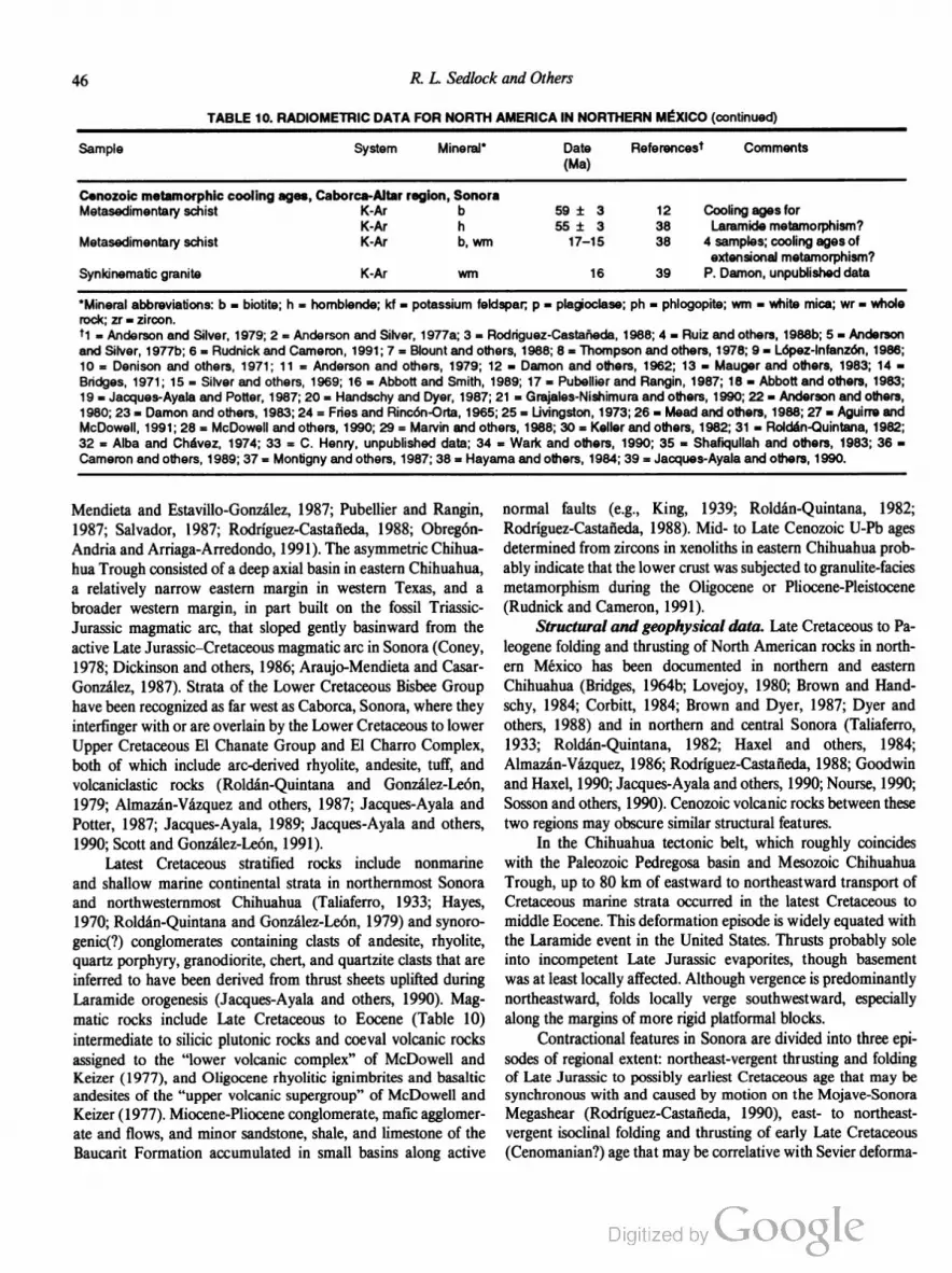
46 R. L. Sedlock and Others
TABLE 10. RADIOMETRIC DATA FOR NORTH AMERICA IN NORTHERN MEXICO (continued)
Sample System Mineral' Date References? Comments
(Ma)
Cenozoic metamorphic cooling ages, Caborca-Altar region, Sonora
Metasedimentary schist K-Ar b 59 i 3 12 Cooling agestor
K-Ar h 55 :i; 3 38 Laramide metamorphism?
Metasedimentary schist K-Ar b, wm 17—15 38 4 samples; cooling ages of
extensional metamorphism?
Synkinematic granite K-Ar wm 16 39 P. Damon, unpublished data
'Mineral abbreviations: b = biotite; h = hornblende; kt = potassium feldspar; p = plagioclase; ph = phlogopite; wm = white mica; wr - whole
rock; zr = zircon.
t1 = Anderson and Silver, 1979; 2 = Anderson and Silver, 1977a; 3 = Rodriguez-Castafieda, 1988; 4 = Ruiz and others, 1988b; 5 I Anderson
and Silver, 1977b; 6 = Rudnick and Cameron, 1991; 7 = Blount and others, 1988; 8 = Thompson and others, 1978; 9 = Lopez-Intanzon, 1986;
10 = Denison and others, 1971; 11 = Anderson and others, 1979; 12 = Damon and others, 1962; 13 = Mauger and others, 1983; 14 -
Bridges, 1971; 15 = Silver and others, 1969; 16 = Abbott and Smith, 1989; 17 = Pubellier and Rangin, 1987; 18 = Abbott and others, 1983;
19 = Jacques-Ayala and Potter, 1987; 20 = Handschy and Dyer, 1987; 21 = Grajales-Nishimura and others, 1990; 22 = Anderson and others,
1980; 23 = Damon and others, 1983; 24 = Fries and Rincén-Orta, 1965; 25 = Livingston, 1973; 26 = Mead and others, 1988; 27 = Aguirre and
McDowell, 1991; 28 = McDowell and others, 1990; 29 = Marvin and others, 1988; 30 = Keller and others, 1982; 31 = Roldan-Quintana, 1982;
32 = Alba and Chavez, 1974; 33 = C. Henry, unpublished data; 34 = Wark and others, 1990; 35 = Shatiqullah and others, 1983; 36 =
Cameron and others, 1989; 37 = Montigny and others, 1987; 38 = Hayama and others, 1984; 39 = Jacques-Ayala and others, 1990.
Mendieta and Estavillo-Gonzalez, 1987; Pubellier and Rangin,
1987; Salvador, 1987; Rodriguez-Castafieda, 1988; Obregon
Andria and Arriaga-Arredondo, 1991). The asymmetric Chihua
hua Trough consisted of a deep axial basin in eastern Chihuahua,
a relatively narrow eastern margin in western Texas, and a
broader western margin, in part built on the fossil Triassic
Jurassic magmatic arc, that sloped gently basinward from the
active Late Jurassic—Cretaceous magmatic arc in Sonora (Coney,
1978; Dickinson and others, 1986; Araujo-Mendieta and Casar
Gonzalez, 1987). Strata of the Lower Cretaceous Bisbee Group
have been recognized as far west as Caborca, Sonora, where they
interfinger with or are overlain by the Lower Cretaceous to lower
Upper Cretaceous El Chanate Group and E1 Charro Complex,
both of which include arc-derived rhyolite, andesite, tuff, and
volcaniclastic rocks (Roldan-Quintana and Gonzalez-Leon,
1979; Almazan-Vazquez and others, 1987; Jacques-Ayala and
Potter, 1987; Jacques-Ayala, 1989; Jacques-Ayala and others,
1990; Scott and Gonzalez-Leon, 1991).
Latest Cretaceous stratified rocks include nonmarine
and shallow marine continental strata in northernmost Sonora
and northwestemmost Chihuahua (Taliaferro, 1933; Hayes,
1970; Roldan-Quintana and Gonzalez-Leon, 1979) and synoro
genic(?) conglomerates containing clasts of andesite, rhyolite,
quartz porphyry, granodiorite, chert, and quartzite clasts that are
inferred to have been derived from thrust sheets uplifted during
Laramide orogenesis (Jacques-Ayala and others, 1990). Mag
matic rocks include Late Cretaceous to Eocene (Table 10)
intermediate to silicic plutonic rocks and coeval volcanic rocks
assigned to the “lower volcanic complex” of McDowell and
Keizer (1977), and Oligocene rhyolitic ignimbrites and basaltic
andesites of the “upper volcanic supergroup” of McDowell and
Keizer (1977). Miocene-Pliocene conglomerate, mafic agglomer
ate and flows, and minor sandstone, shale, and limestone of the
Baucarit Formation accumulated in small basins along active
normal faults (e.g., King, 1939; Roldan-Quintana, 1982;
Rodriguez-Castaneda, 1988). Mid- to Late Cenozoic U-Pb ages
determined from zircons in xenoliths in eastern Chihuahua prob
ably indicate that the lower crust was subjected to granulite-facies
metamorphism during the Oligocene or Pliocene-Pleistocene
(Rudnick and Cameron, 1991).
Structural and geophysical data. Late Cretaceous to Pa
leogene folding and thrusting of North American rocks in north
ern Mexico has been documented in northern and eastern
Chihuahua (Bridges, 1964b; Lovejoy, 1980; Brown and Hand
schy, 1984; Corbitt, 1984; Brown and Dyer, 1987; Dyer and
others, 1988) and in northern and central Sonora (Taliaferro,
1933; Roldan-Quintana, 1982; Haxel and others, 1984;
Almazan-Vazquez, 1986; Rodriguez-Castafieda, 1988; Goodwin
and Haxel, 1990; Jacques-Ayala and others, 1990; Nourse, 1990;
Sosson and others, 1990). Cenozoic volcanic rocks between these
two regions may obscure similar structural features.
In the Chihuahua tectonic belt, which roughly coincides
with the Paleozoic Pedregosa basin and Mesozoic Chihuahua
Trough, up to 80 km of eastward to northeastward transport of
Cretaceous marine strata occurred in the latest Cretaceous to
middle Eocene. This deformation episode is widely equated with
the Laramide event in the United States. Thrusts probably sole
into incompetent Late Jurassic evaporites, though basement
was at least locally affected. Although vergence is predominantly
northeastward, folds locally verge southwestward, especially
along the margins of more rigid platformal blocks.
Contractional features in Sonora are divided into three epi
sodes of regional extent: northeast-vergent thrusting and folding
of Late Jurassic to possibly earliest Cretaceous age that may be
synchronous with and caused by motion on the Mojave-Sonora
Megashear (Rodriguez-Castaneda, 1990), east- to northeast
vergent isoclinal folding and thrusting of early Late Cretaceous
(Cenomanian?) age that may be correlative with Sevier deforma

Tectonostratigraphic Terranes and Tectonic Evolution ofMexico 47
tion, and late Late Cretaceous to Paleogene southwest-vergent
folding and thrusting, as well as coeval plutonism, equated with
Laramide deformation and magmatism (Roldan-Quintana,
1982; Pubellier and Rangin, 1987; Jacques-Ayala and others,
1990; Sosson and others, 1990). Many thrusts emplace
Precambrian basement rocks over Mesozoic rocks (Rodriguez
Castafieda, 1988, I990). The second and third episodes of
shortening must be younger than deformed Early Cretaceous
strata and older than mid- to late Tertiary extensional features. It
is unclear whether these two deformation episodes are phases of
a single protracted mid-Cretaceous to Paleogene (100 to 50 Ma?)
compressional event. Near Altar, a major thrust of the older
episode is inferred to be older than a “cross-cutting” intrusion
that yielded K-Ar cooling ages of about 80 Ma (Table 10), but
the contact is not exposed, and map relations permit the alternate
interpretation that the intrusion is within the upper plate of, and
thus older than, the thrust. According to this interpretation, all
shortening occurred during late Late Cretaceous to Paleogene
(Laramide) time.
Mid- to late Tertiary extensional deformation in northern
México is temporally and kinematically similar to deformation in
southern Arizona and California (e.g., Reynolds and others,
1988). Late Oligocene and early Miocene metamorphic core
complexes in parts of north-central Sonora are characterized by
top-to-the-southwest detachment faulting, displacement on shal
lowly dipping ductile shear zones, synextensional magmatism,
and regional tilting of fault blocks (Davis and others, 1981;
Goodwin and Haxel, 1990; Nourse, 1990). During middle Mio
cene to Quaternary time, high-angle normal faults associated with
Basin and Range extension overprinted all older fabrics and
formed north-northwest—trending ridges and valleys not only
throughout northern Sonora and Chihuahua, but also in most of
northern and central Mexico (Roldan-Quintana and Gonzalez
Leon, 1979).
A paleomagnetic study of Kimmeridgian red beds near
Placer de Guadalupe concluded that the primary magnetization is
masked by a strong Quaternary (Brunhes chron) overprint
(Herrero-Bervera and others, 1990).
Pericu' terrane
The Perict'r terrane consists chiefly of a suite of prebatholith
ic metasedimentary and minor metaigneous rocks that was in
truded by mafic to intermediate plutons in the late Early
Cretaceous, strongly deformed with those plutonic rocks in the
mid-Cretaceous, and intruded by undeformed granitoids in the
Late Cretaceous. Late Cretaceous granitoids probably formed
in the magmatic are along the western margin of Mexico, as did
similar rocks in the Seri, Tahué, and Nahuatl terranes. The origin
and early history of the prebatholithic rocks is poorly understood.
The Period terrane probably was detached from western Mexico
and attached to the southern tip of Baja California prior to late
Cenozoic opening of the Gulf of California.
To the east and south, thinned continental crust of the ter
rane is bounded by Miocene to Holocene oceanic crust (Fig. 15).
On the west, the terrane boundary generally is called the La Paz
fault, an enigmatic, partly buried feature that probably records at
least two episodes of displacement (Aranda-Gémez and Pérez
Venzor, 1989). Recent work suggests that rocks of the Pericri
terrane may underlie downdropped late Cenozoic strata west of
the fault (Fig. 15), so the westward and northward extent of
Period rocks is uncertain (A. Carrillo-Chavez, unpublished data).
The oldest rocks in the Period terrane are prebatholithic
metasedimentary and minor metaigneous rocks that crop out
chiefly in a narrow band between La Paz and Todos Santos (Fig.
2) along the western edge of the terrane (Fig. 15) (Ortega
Gutiérrez, 1982; Gastil, 1983; Aranda-Gomez and Pérez-Venzor,
1989; Murillo-Mufieton, 1991) Constituent rock types include
schist, gneiss, phyllite, marble, amphibolite, slate, homfcls, mig
matite, and skam, and likely protoliths were shale, sandstone,
marl, impure limestone, and mafic igneous rocks. Protolith ages
and depositional environments are unknown. In the southern part
of the belt, a typical assemblage in strongly foliated and lineated
gneiss is quartz + plagioclase i garnet i hornblende i potassium
feldspar :1: diopside d: epidote or zoisite, with accessory sphene,
tourmaline, and zircon; a typical assemblage in strongly foliated
phyllite is biotite + quartz + plagioclase i andalusite i sillimanite
:1: muscovite i cordierite, with coexisting andalusite and silliman
ite in several samples (Aranda-Gomez and Pérez-Venzor, 1989).
Hornblende-sillimanite schist and diopside-homblende-biotite
quartzofeldspathic gneiss have been reported from the central
part of the belt (Murillo-Mufietén, 1991). These assemblages
indicate amphibolite-facies metamorphism of most of the meta
sedimentary suite, probably during intrusion of late Early Cre
taceous mafic plutons and low-potassium granitoids (Table 11).
During the late Early Cretaceous and early Late Cretaceous,
the metasedimentary suite and late Early Cretaceous plutonic
rocks were penetratively deformed by roughly east-west com
pression. Evidence includes well-developed foliation, gneissic
layering, mineral lineations, folds, strained early porphyro
blasts of garnet and andalusite, boudinage, and widespread
development of mylonite zones several meters to 2.5 km thick
(Aranda-Gémez and Pérez-Venzor, 1989; Murillo-Mufieton,
1991). Mylonitic foliation dips east to southeast (Fig. 15), linea
tions in the foliation surface plunge shallowly south, and
microstructures indicate left-oblique displacement (Aranda
Gomez and Pérez-Venzor, 1989). Strongly mylonitized gametif
erous gneiss near Todos Santos may be a pre—Late Cretaceous
metamorphic core complex: mylonitic foliation dips very gently
to the northwest, a strong mineral lineation plunges shallowly
northwest, and pressure shadows of garnets indicate top-to-the
northwest transport. Enigmatic late Paleozoic and Triassic K-Ar
dates obtained from the deformed plutonic rocks (Table 11) may
indicate that the mid-Cretaceous deformation and metamorphism
overprinted older fabrics and assemblages, but these dates are
considered invalid by some workers (G. Gastil, personal com
munication, 1991).
Prebatholithic metasedimentary rocks of the Period terrane

48 R. L. Sedlock and Others
PERICU SE
San Jose del Cabo
Trough (Tu-Q)
La Paz fault
Figure 15. Schematic northwest-southeast structure section of Period terrane. Distribution of metasedi
mentary rocks (Pz?) at deep level is uncertain. Southeastern boundary of the terrane is transitional to
oceanic lithosphere near East Pacific Rise. Feature labeled La Paz fault includes older subvertical(?)
surface and younger, down-to-the-west normal fault.
are grossly similar to and may be displaced fragments of Paleo
zoic rocks in the Tahué terrane. On the other hand, they also
resemble the Mesozoic prebatholithic rocks in the eastern subter
rane of the Yuma terrane in Baja California and southern
California, and may be continuous with buried basement rocks of
the Yuma terrane west and north of the La Paz fault. Evaluation
of possible correlations awaits U-Pb dating of zircon-rich meta
sedimentary and deformed plutonic rocks in the Period terrane.
The metasedimentary rocks and deformed plutonic rocks
are cut by undeformed Late Cretaceous high-potassium grani
toids that constitute the most abundant rock type in the terrane
(Fig. 15; Table 11). Disseminated gold deposits occur in cataclas
tic tonalite and diorite in narrow fault zones (Carillo-Chavez,
1991). The granitoids are similar in age and lithology to grani
toids in the Tahué, Yuma, and Seri terranes and probably formed
East Pacific Rise
in the magmatic are along the western margin of México. K-Ar
mineral ages from the metamorphic suite reflect thermal meta
morphism due to Late Cretaceous intrusion (Table 11).
The metamorphic complex and granitoids are cut by mid
Tertiary(?) andesitic dikes and stocks and are nonconformably
overlain by late Cenozoic nonmarine and marine elastic rocks.
Miocene-Pliocene nonmarine to shallow marine strata that ac
cumulated in the San José del Cabo trough (Fig. 15) indicate
subsidence during middle to late Miocene time and shoaling dur
ing Pliocene and Quaternary time (McCloy, 1984).
The Perici'i terrane is cut by numerous steeply dipping nor
mal faults of uncertain but probable Cenozoic age (omitted from
Fig. 15). The predominant strike directions in successively
younger sets of faults are north to north-northwest, northeast, and
northwest to west-northwest. The paucity of northwest to north
TABLE 11. PERICU TERRANE RADIOMETRIC DATA
Sample System Mineral“ Date Fleferences’r Comments
(Ma)
Homblende gneiss K-Ar h 225 t 5 1
Tonalite K-Ar h 335 i 4 1
Amphibolite K-Ar h 116 i 6 2 Cooling age
Homblende diorite K-Ar h 115 :t: 2 3
Undetonned granitoids K-Ar 109—70 3 V. Frizzell and others
Undetonned granitoid U-Pb zr 93 3 unpublished data
Cataclastic granite K-Ar wm 100 i 5 2
b 93 i 5
Undetonned granitoids K-Ar wm, b, h 91-64 2 6 samples
Mica schist K-Ar wrn 87 i 1 2 Cooling ages
b 62 :i: 3
Augen gneiss K-Ar b 50 :t 4 2 Cooling age
'Mineral abbreviations: b = biotite; h = hornblende; wm = white mica; zr = zircon.
T1 = Altamirano-R., 1972; 2 = Murillo-Mufieton, 1991; 3 = Hausback, 1984.
Tectonostratigraphic Terranes and Tectonic Evolution ofMexico 49
northwest-striking normal faults typical of late Cenozoic Basin
and Range faulting may be due to control by preexisting, chiefly
north- to northeast-striking structures (Aranda-Gomez and Pérez
Venzor, 1988).
Serl' terrane
The Seri terrane is distinguished by latest Proterozoic
and Paleozoic shelfal and basinal rocks that were deposited on
and outboard of Proterozoic North American continental crust.
Basinal rocks, first deformed during Mississippian time, were
deformed a second time during northward thrusting onto shelfal
rocks in the Perrno-Triassic. Paleomagnetic studies suggest that
the western part of the Seri terrane may have been stripped from
the eastern part in late Paleozoic or early Mesozoic time, only to
return to, or nearly to, its departure point in the late Cretaceous
and Paleogene. The Seri terrane hosted a continental magmatic
arc during the Cretaceous and early Cenozoic. By 5, and perhaps
as early as 12 Ma, the terrane was disrupted by extension and
right-lateral faulting in the Gulf of California.
The Serr' terrane is bounded by the Mojave-Sonora Mega
shear on the northeast, by a west-verging reverse fault at its bound
ary with the Yuma terrane to the west, and by an inferred fault
contact with the Tahué terrane to the south (Figs. 3, 16). Parts of
the Seri terrane have been included in the Caborca (Coney and
Campa-Uranga, 1987), Ballenas (Gastil, 1985), and Cortes
terranes (Champion and others, 1986; Howell and others, 1987).
Crystalline basement. Proterozoic crystalline basement
rocks of the North American craton crop out in northwestern
Sonora and are inferred to underlie the entire Seri terrane (Fig.
16; Table 12). Deformed quartz-rich schist and gneiss, quartzite,
metarhyodacite, and amphibolite are cut by calc-alkalic plutons
ranging in age from 1,750 to 1,710 Ma, and younger layered
quartzofeldspathic and amphibolitic gneiss were deformed, meta
morphosed, and cut by pegmatites about 1,685 to 1,645 Ma
(Anderson and Silver, 1977a, 1981). These older rocks are in
truded by volumetrically abundant anorogenic granitoids dated at
about 1,450 Ma and the much rarer Aibo granites dated at about
1,110 Ma (Table 12) (Anderson and others, 1979; Anderson and
Silver, 1981). Precambrian basement rocks of the Seri terrane
probably were displaced southeastward on the Mojave-Sonora
Megashear from a southwest-trending belt of similar rocks in the
southwestern United States (Silver and Anderson, 1974, 1983;
Anderson and Silver, 1979).
Crystalline Precambrian rocks are overlain nonconformably
by latest Proterozoic and Paleozoic rocks that are assigned
to two roughly defined units: (1) shallow-water shelfal (“mio
geoclinal”) strata that overlie Proterozoic basement nonconform
ably, and (2) deep-water basinal (“eugeoclina ”) strata, south
and west of the shelfal rocks, that were thmst above the shelfal
rocks in the Permo-Triassic (Radelli and others, 1987; Stewart,
1988; Stewart and others, 1990). The shelfal strata bear a strong
resemblance to coeval shelfal rocks in eastern and southern Cali
fornia and probably are part of a displaced fragment of south
western North America. The basinal strata are grossly similar to
Paleozoic basinal strata in southern Nevada, eastern California,
and the Ouachita orogenic belt, but their stratigraphic and tec
tonic relation to these rocks is unknown (Poole and others, 1983;
Stewart and others, 1984; 1990; Ketner, 1986, 1990; Poole and
Madrid, 1986, 1988; Murchey, 1990). As more data become
available, it may be useful to delineate these fault-bounded ba
sinal strata as a distinct terrane.
Shelfal rocks. Latest Proterozoic to Middle Cambrian
shelfal (“miogeoclina”) rocks near Caborca, Sonora include
dolomite, quartzite, limestone, and rarer mafic volcanogenic
rocks that are similar to rocks in the Death Valley region and in
the San Bernardino Mountains of southern California (Stewart
and others, 1984; McMenamin and others, 1992). Late Proter
ozoic strata, known as the Gamuza beds, lie nonconformably on
the 1,110-Ma Aibo granite south of Caborca and are transitional
upward to the Paleozoic section (Cooper and Arellano, 1946;
Arellano, 1956; Anderson and Silver, 1981). East of Hermosillo,
the Cambrian strata are overlain by Late Cambrian, Early
Ordovician, Late Devonian, Mississippian, and Early Penn
sylvanian strata, mainly carbonates (Fig. 16) (Stewart and others,
1984, 1990; Radelli and others, 1987). Cambrian to Permian
shelfal strata also crop out in several other ranges in central
Sonora (Ketner, 1986; AlmazAn-Vazquez, 1989; Stewart and
others, 1990). Pennsylvanian-Permian depositional patterns indi
cate Early Permian foundering of the continental shelf (Stewart
and others, 1990), as is recognized in the Pedregosa basin in New
Mexico and Chihuahua (North America). Shelfal rocks that may
be correlative with Paleozoic shelfal rocks in central and north
west Sonora crop out on the west coast of Sonora and perhaps on
northern Isla Tiburon in the Gulf of California (Stewart and
others, 1990), and in eastern Baja California (Miller and Dockum,
1983; Anderson, 1984; Gastil, 1985; Gastil and others, 1991).
Basinal rocks. Basinal (“eugeoclinal”) strata are exposed
in an east-west—trending belt in central Sonora and in isolated
outcrops in western Sonora and Baja California. In central
Sonora, these include Early and Middle Ordovician graptolitic
shale, Late Ordovician and Silurian chert, shale, and dolostone,
Late Devonian chert, clastic rocks, and bedded barite, Early
Mississippian limestone turbidites, argillite, and chert, and un
conformably overlying Late Mississippian elastic rocks and
Pennsylvanian-Permian clastic rocks, limestone, chert, argillite,
and bedded barite (Fig. 16) (Poole and others, 1983, 1990;
(Ketner, 1986; Poole and Madrid, 1986, 1988; Radelli and oth
ers, 1987; Stewart and others, 1990). Detrital zircons collected
from Late Devonian elastic rocks yielded a 1,675-Ma date,
implying derivation from crystalline Precambrian basement
(F. G. Poole, personal communication, 1990). Basinal rocks that
may be correlative with Paleozoic basinal strata in central Sonora
crop out in eastern Baja California and on islands in the Gulf of
California (Gastil and Krummenacher, 1977a, b; Lothringer,
1984; Gastil, 1985; Griffith, 1987; Gastil and others, 1991). The
contact between basinal rocks and shelfal rocks in eastern Baja
California has not been recognized.
50 R. L Sedlock and Others
Figure 16 (on this and facing page). Schematic sections of Seri terrane. Location map shows
approximate section lines; B is near Caborca, Sonora. Key to patterns on location map (modified after
Stewart and others, 1990): ruled lines, cratonal upper Proterozoic—lower Paleozoic facies; brick, coeval
shelfal (miogeoclinal) facies; dots, coeval basinal (eugeoclinal) facies. Abbreviations on location map: G,
Gila Mountains—El Capitén area; H, Hermosillo; IT, Isla Tiburon.
Other pre-Middle Triassic rocks. Mid-Permian (Guada
lupian) siltstone and limestone of the Monos Formation crop
out near El Antimonio, about 40 km west of Caborca; the lower
contact is not exposed (Brunner, 1979; Gonzalez-Leon, 1979,
1980). These strata contain large fusulinids (Parafusulina
antimonioensis) that are similar to fusulinids from accreted
terranes in northern California and Washington state and unlike
fusulinids in shelfal rocks of the Cordillera (Stewart and others,
1990). These strata probably were deposited outboard of the
continental margin, but they are not correlative with basinal
rocks elsewhere in the Seri terrane. In Baja California near 30°N,
Early Permian to Early Triassic rocks record a transition from
deep-water basinal rocks to shallow-water shelfal strata similar
to shelfal strata in the southern Great Basin (Buch, 1984; Dellatre,
1984; Gastil, 1990).
Juxtaposition of basinal and shelfal strata. In early
Late Mississippian time, Ordovician—Early Mississippian basinal
rocks in central Sonora underwent northwest-southeast shorten
ing. After deposition of Late Mississippian to Early Permian
strata, basinal rocks of Ordovician to Early Permian age under
went north-northwest~south-southeast shortening in Late Per
mian to Middle Triassic time. During or immediately after the
second phase of shortening, the basinal rocks were thrust over the
shelf sequence (Poole and others, 1990; Stewart and others,
1990). The basinal allochthon is repeated by north-dipping thrust
faults in at least one range (Bartolini and Stewart, 1990) and has
been interpreted as a stack of thrust nappes (Radelli and others,
1987), but structural relations in most parts of the basinal and
shelfal sequences are not yet understood. Most mapped contacts
between the two sequences are high-angle faults of probable Ce
nozoic age, but the outcrop pattern indicates that the basinal
sequence was transported over the shelfal sequence a minimum of
50 km northward, roughly normal to the inferred east-west trend
of the latest Paleozoic continental margin in central Sonora (Fig.
16, location map) (Stewart, 1988; Poole and others, 1990;
Stewart and others, 1990).
Westward from central Sonora, the boundary between the
basinal and shelfal sequences probably continues across Isla
Tiburon in the Gulf of California and into formerly adjacent
eastern Baja California, from where it curves northward or
northeastward back into Sonora between E1 Antimonio and Ca
borca (Fig. 16, location map) (Stewart, 1990; Stewart and others,
1990). North of Caborca, the boundary may be truncated and
displaced northwestward by a left-lateral fault or faults such as
the Mojave-Sonora Megashear, or it may have been originally
continuous to the north-northwest, wrapping around a promon
tory of North America with little or no modification by later
strike-slip displacement (Stewart and others, 1984, 1990;
Stewart, 1990).
Mesozoic and Cenozoic rocks. Scattered outcrops of
Early Jurassic and Triassic clastic rocks in northwestern and
central Sonora once were considered part of a single formation
(King, 1939), but the rocks subsequently have been divided into
several discrete units. Near and southwest of El Antimonio,
Tectonostratigraphic Terranes and Tectonic Evolution ofMexico 51
W SERI E
A Gulf of California B
~
<:a 2
04
~ IL]
2
°< <1
. I
North American crust F
a (l,800-1,725 Ma) g
North American crust? ' Z
” ~ N T A
Mojave-Sonora/4
Megashear
S N
C _ Barranca Group I B
a <
2
a ~ a5 a <
H “’ I
P
a n:
ON N A- /\J /\./ N N 'v M N N z
a °< a a a North American crust (l,800-1,725 Ma)
\’ N M ~ ~ N N ~ ~ ~ ~ ~
\ x T A\ \ r>< °< °< °< <>< °< or °< at
northwestern Sonora, the mid-Permian Monos Formation is
overlain unconformably by marine elastic rocks and limestone of
the Upper Triassic to Lower Jurassic El Antimonio Formation
(White and Guiza, 1949;Gonza1ez-Le6n, 1979, 1980). Camian
Norian (Late Triassic) ammonites are broadly similar to fauna
of the Hallstatt facies of Tethyan strata in Europe and Asia, and
are dissimilar to Triassic fauna elsewhere in México, including
accreted Triassic oceanic rocks on the Vizcaino Peninsula (Co
chimi terrane) (Tozer, 1982). Ichthyosaur remains from the
Carnian-Norian strata belong to the same family (Shastasaurus)
as fossils from Nevada, Oregon, Canada, Europe, Russia, China,
New Caledonia, and possibly New Zealand (Callaway and Mas
sare, 1989). Strong stratigraphic and faunal similarities have been
recognized between the El Antimonio Formation and the Upper
Triassic Luning Formation in southwestern Nevada (Stanley and
others, 1991). The Upper Triassic lower member of the El Anti
monio Formation is overlain with slight unconformity by an
upper member of coarse clastic rocks and shale of Hettangian
Sinemurian (Early Jurassic) and possibly late Early or even
Middle Jurassic age (Gonzalez-Leon, 1979, 1980). The Late
Triassic strata and the underlying Permian Monos Formation
probably were deposited outboard of the continental margin and
52 R. L. Sedlock and Others
have undergone significant displacement with respect to North
America (Stewart and others, 1990).
Late Triassic marginal marine and nonmarine clastic rocks
of the Barranca Group unconformably overlie Paleozoic strata in
an east-west belt across central Sonora (Fig. 16) (King, 1939;
Wilson and Rocha, 1949; Alencaster, 1961; Gonzalez-Leon,
1979; Almazan-Vazaquez and others, 1987; Stewart and Roldan
Quintana, 1991). The Barranca Group includes fluvial and del
taic quartzose and feldspathic clastic rocks (red beds), Carnian
(early Late Triassic) coal measures that contain Tethyan bi
valves and ammonoids (Alencaster, 1961; Obregon-Andria and
Arriaga-Arredondo, 1991), and Late Triassic(?) conglomerates
that contain locally derived clasts of crystalline Precambrian,
miogeoclinal, and eugeoclinal rocks (Cojan and Potter, 1991;
Stewart and Roldén-Quintana, 1991). Volcanic rocks and
detritus apparently are absent. Deformation is significantly less
intense than in underlying Paleozoic strata. The Barranca Group
crops out over a sizable region of east-central Sonora, but out
crops are chiefly confined to an east-west belt that is interpreted
as an elongate rift basin that developed after the Late Permian—
Middle Triassic juxtaposition of the eugeoclinal and miogeoclinal
sequences (Stewart, 1988; Stewart and Roldan-Quintana, 1991).
In the Sierra Lopez, 40 km northwest of Hermosillo, Sine
murian (Early Jurassic) clastic rocks interbedded with andesitic
flows and tuffs unconformably overlie Paleozoic limestone
(Avila-Angulo, 1990). In the Sierra de Santa Rosa, about 120 km
north-northwest of Hermosillo, Early Jurassic(—Triassic?) elastic
rocks, derived in part from a volcanic source, and minor lime
stone are conformably overlain by a thick sequence of andesitic
flows and tuffs and volcaniclastic rocks that probably is Early to
Middle Jurassic at its base and perhaps as young as Cretaceous at
its top (Hardy, 1981). Jurassic volcanic rocks at both localities
are compositionally and lithologically similar to, and may be
correlative with, undated intermediate volcanic and volcaniclastic
rocks that unconformably overlie the Barranca Group east of
Hermosillo (Stewart and others, 1990). Early Jurassic elastic
rocks and limestone that crop out about 120 km north of Hermo
sillo contain fauna similar to those in the Sierra de Santa Rosa
(Flores, 1929). At Cerro Pozo Cerna, about 40 km west of Sierra
de Santa Rosa, late Oxfordian—early Kimmeridgian corals and
molluscs were identified in the upper part of a 2-km-thick se
quence of elastic rocks (Beauvais and Stump, 1976).
Rare Middle Jurassic plutonic rocks have been reported
from the Seri terrane (Anderson and Silver, 1979). These are
interpreted as cogenetic and coeval with Middle to Late Juras
sic granitoids in northern Sonora (North America) and thus part
of the Jurassic arc of southwestern North America that probably
hosted sinistral displacement on the Mojave-Sonora Megashear
(Anderson and Silver, 1979; Tosdal and others, 1990a).
Diverse post-Jurassic magmatic rocks crop out in the Serf
terrane (Fig. 16; Table 12). Early Cretaceous intermediate vol
canic rocks are present in westernmost Sonora, and Late Cre
taceous to Paleogene granitoids crop out in central Sonora and
northeastern Baja California (e.g., Roldan-Quintana, 1991). Pre
batholithic andesitic to rhyolitic lavas and tuffs in central Sonora
probably were erupted in the Late Cretaceous to Paleogene
(Roldan-Quintana, 1989). Oligocene silicic ignimbrites and ba
saltic andesites (e.g., Cocheme and Demant, 1991) are part of the
“upper volcanic supergroup” of McDowell and Keizer (1977).
Neogene calc-alkalic volcanic rocks along the west coast of
Sonora, the east coast of northern Baja California, and on islands
in the Gulf of California are remnants of a Neogene magmatic
are that also is preserved in Baja California Sur and Nayarit
(Gastil and others, 1979). Neogene bimodal volcanic rocks in
southern Sonora are inferred to be related to Basin and Range
extension (Morales and others, 1990).
Nonmarine conglomerate and sandstone and mafic agglom
erate and lavas of the Neogene Baucarit Formation accumulated
in small basins along active normal faults throughout central
Sonora (King, 1939; Hardy, 1981; Roldan-Quintana, 1982,
1989). K-Ar dating of volcanic rocks indicates that coarse clastic
debris of the Baucarit Formation was deposited from late Oligo
cene to middle Miocene time (about 27 to 10 Ma), coincident
with Basin and Range faulting in the region (McDowell and
Roldan-Quintana, 1991; Bartolini and others, 1992) (Table 12).
late Cenozoic marine clastic strata that record marine deposi
tion in the subsiding Gulf of California rift basin were deposited
as far north as Isla Tiburon by 13 Ma (Smith and others, 1985;
Neuhaus and others, 1988).
Other structural and geophysical data. Much or all of
the Seri terrane apparently underwent east-west shortening in
Late Cretaceous time, though in many regions this deformation is
masked by Tertiary volcanic rocks and extensional features.
North-south—striking folds and thrust faults of probable Late Cre
taceous age were mapped throughout central Sonora by King
(1939). In several ranges south of Caborca, east-vergent thrusting
of Jurassic strata and Precambrian basement occurred prior to the
intrusion of dikes in the Late Cretaceous 0r Paleogene (Hardy,
1981). In northeastern Baja California, isoclinal overturned and
recumbent folds indicate roughly north-south Late Cretaceous—
Paleogene(?) shortening (Siem and Gastil, 1990).
Mid- to late Tertiary extensional deformation in the Seri
terrane is temporally and kinematically similar to deformation in
the southwestern United States (e.g., Reynolds and others, 1988)
and in the North America terrane in Mexico. Mid-Tertiary to
active metamorphic core complexes have been recognized in the
Sierra Mazatan, about 80 km east of Hermosillo, where ductilely
deformed lower plate orthogneiss of Paleogene age (Table 12) is
separated from upper plate Mississippian strata by mylonite
(Davis and others, 1981), in the Sierra El Mayor at 32°N in
northeastern Baja California, where shallowly dipping detach
ment faults that separate ductilely deformed footwall gneisses
from brittlely extended Upper Miocene—Pleistocene rocks indi
cate west-northwest—east-southeast to northwest-southeast ex
tension (Siem and Gastil, 1990, 1991), and at several points along
the main Gulf of California escarpment between 31° and 29°N
(Bryant and others, 1985; Gastil and Fenby, 1991). Tilting and
high-angle normal faulting indicating east-northeast—west-south

Tectonostratigraphic Terranes and Tectonic Evolution ofMexico 53
TABLE 12. SERl TERRANE RADIOMETRIC DATA
Sample System Mineral“ Date References1 Comments
(Ma)
Precambrian rocks
Crystalline rocks, northwestern Sonora U-Pb zr 1,800—1,725 1 Unpublished data
Cale-alkalic plutons, northwestern Sonora U-Pb zr 1,750—1,710 2
Layered gneiss, northwestern Sonora U-Pb zr 1,660 1 15 2 Metamorphic ages
Anorogenic granitoids, southwestern Sonora U-Pb zr ~1,450 3 Unpublished data
Precambrian rocks in Caborca-Bamori area, northwestern Sonora
Rhyodacite U-Pb zr 1,755 i 20 3 Crystallization age
Granite gneiss U-Pb zr 1,745 i 20 3 Intrusion age
Pegmatites K-Ar wrn 1,703 i 50 4 Accompanied regional intrusion
K-Ar wrn 1,684 i 50 4 and metamorphism about 1,675
U-Pb zr 1,680 1 2O 3 Ma
U-Pb Zr 1,635 i 20 3
Schist intruded by pegmatite K-Ar wrn 1,684 i 50 4
Flb-Sr wm 1,570 5
Amphibolite K-Ar wm 1,654 5
Aibo granite U-Pb zr 1,110 i 10 6
Rb-Sr k1 710 i100 4
Mesozoic and Cenozoic magmatic rocks
El Capitan orthogneiss at San Luis, NW Sonora U-Pb zr 170 i 3 7
Andesite, western Sonora K-Ar p 143 i 3 8 Source: G. Salas
Rhyolite, western Sonora U-Pb zr 142 i 2 7
Metarhyolite, western Sonora U-Pb zr 128 i 2 7
Granitoids, western Sonora U-Pb zr 100—82 7 Several plutons
Granitoids, northeastern Baja U-Pb zr 100-75 9 Many samples
Quartz monzonite, Caborca K-Ar b 87 i 6 4
Andesite, western Sonora K-Ar h 87 :t 2 8 Source: G. Salas
Granodiorite, Caborca K-Ar h 81 i 2 10 inferred to postdate thrusting
K-Ar b 79 :i: 2 10
Quartz monzonite, Caborca K-Ar b 72 i 3 11
Granite, central Sonora K-Ar b 70 i 2 12 Source: G. Gastil
Granodiorite, west-central Sonora K-Ar b 65 :t 1 13 Associated with W deposits
Granodiorite, southeastern Sonora K-Ar h 63 :t 1 13 Associated with W deposits
4oAr/39Ar b 54 i 1 13
K-Ar b 53 :t: 1 13
Granite, Barita de Sonora U-Pb zr 62 i 1 14 Source: Fl. E. Zartrnan
Mafic volcanic rocks, central Sonora K-Ar wr 62 :t 1 15 Lower volcanic complex
Granitoids, south-central Sonora K-Ar b, wrn, 59—54 16 7 samples; associated with
h, wr Cu deposits; a7Sr/BGSrI:
07064-07079 (4 samples)
Granitoids, southeastern Sonora Rb-Sr wr 59 i 5 13 5-pt. isochron; °7SrPGSrlt 0.7058
Granitoids, central Sonora U-Pb zr 58 :t 3 17
U-Pb 2r 57 i 3 17
Granites, central Sonora K-Ar h 57, 52 12 Source: D. Mead
Quartz vein, northwestern Sonora K-Ar b 54 i 1 13 Associated with W deposits
Granite, northwestem Sonora K-Ar wm 53 i 2 11
Granodiorite, east-central Sonora K-Ar 50 18 Source: Damon and others
Granodiorite, west-central Sonora 1°Ar/39Ar b 48 :1: 1 13 Associated with W deposits
Rb-Sr 47 i 2 13 4pt. isochron; a7Sr/‘u‘Sric 0.7068
K-Ar b 42 i 1 13
Pegmatite, central Sonora K-Ar 42 18 Source: Damon and others
Andesite, central Sonora K-Ar 33 19 Below Baucan't Formation
Silicic volcanic rocks, eastern Sonora K-Ar p, b 30-27 20 4 samples
lgnimbrite, central Sonora K-Ar p 27 t 1 15 At base of Baucan't Formation
Mafic volcanic rocks, eastern Sonora K-Ar p 23 :l: 1 20
Volcanic rocks, Sonora and Baja K-Ar p, wr, b, h, kf 23—4 21 33 samples
Mafic volcanic rocks, central Sonora K-Ar wr 22 i 1 22 At base of Baucarit Formation
Basalt, central Sonora K-Ar wr 14 15 \Mthin Baucarit Formation
Calcic latite, central Sonora K-Ar 16, 14 19
Flhyolite, central Sonora K-Ar kt 14 15 Overties Baucarit Formation
lgnimbrite, central Sonora K-Ar 13, 12 19 2 samples
Latite, southern Sonora K-Ar p ~10 23 Part of bimodal suite
“Mineral abbreviations: b = biotite; h = hornblende; kf= potassium feldspar; p = plagioclase; wm = white mica; wr = whole rock; zr = zircon.
11 = Anderson and Silver, 1979; 2 = Anderson and Silver, 1977a; 3 = Anderson and Silver, 1981; 4 = Damon and others, 1962; 5 = Livingston and
Damon, 1968; 6 = Anderson and others, 1979; 7 = Anderson and others, 1969; 8 = Roldan-Quintana, 1986; 9 = Silver and others, 1979; 10 =
DeJong and others, 1988; 11 = Fries and Rincon-Orta, 1965; 12 = Roldan-Quintana, 1989; 13 = Mead and others, 1988; 14 = Stewsart and others,
1990; 15 = F. McDowell, 1991; 16 = Damon and others, 1983; 17 = Anderson and others, 1980; 18 = Aguirre and McDoweell, 1991; 19 = Bartolini
and others, 1992; 20 = Montigny and others, 1987; 21 = Gastil and others, 1979; 22 = Roldan-Quintana, 1979; 23 = Morales and others 1990.

54 R. L. Sedlock and Others
west extension began by 17 Ma in parts of coastal Sonora (Gastil
and Krummenacher, 1977), 12 Ma in coastal northeastern Baja
California (Dokka and Merriam, 1982; Stock and Hodges, 1989,
1990; Stock, 1991), and 15 to 13 Ma on Isla Tiburon (Neuhaus
and others, 1988). Late Cenozoic block faulting in central Sonora
is geometrically similar to late Miocene to Recent Basin and
Range extension in the southwestern United States (Roldan
Quintana and Gonzalez-Leon, 1979).
The least principal stress and extension direction around the
periphery of the gulf changed from east-northeast—west-south
west to roughly northwest-southeast about 6 Ma, roughly coeval
with the initiation or acceleration of transtensional opening of the
modern gulf (Gastil and Krummenacher, 1977; Angelier and
others, 1981; Henry, 1989). Since about 5 Ma, the surface of the
eastern edge of the Baja continental block has been uplifted about
1 to 3 km, resulting in detachment and eastward translation of
elevated continental crustal walls of the Gulf of California (Fenby
and Gastil, 1991; Gastil and Fenby, 1991; Siem and Gastil, 1990,
1991). Pliocene to Holocene faulting appears to more active on
the west side of the gulf, where it includes normal, dextral, and
right-oblique faults with complex geometry and interaction
(Stock, 1991; Mueller and Rockwell, 1991).
A paleomagnetic pole determined from the El Antimonio
Formation in western Sonora overlaps two poles from coeval
rocks of southwestern North America, including the correlative
Luning Formation, at the 95% confidence level (Cohen and oth
ers, 1986). The clustering of the poles is significantly improved at
the 95% confidence level by restoring 800 km of Late Jurassic
sinistral displacement on the Mojave-Sonora Megashear, which
separates the Seri terrane from North America (p. 79).
Paleomagnetic data suggest that the entire Baja California
peninsula, including part of the Seri terrane and the Yuma and
Cochimi terranes, was translated 10° 1 5° northward and rotated
about 25° clockwise between mid-Cretaceous and early Miocene
time (see Yuma terrane). However, no paleomagnetic data are
available for metamorphosed rocks of the Seri' terrane in
northeastern Baja.
Tahué terrane
The Tahué terrane in western Mexico is bounded on all sides
by inferred contacts (Fig. 3). Its main components are mid-Paleo
zoic metasedimentary rocks of unknown origin that were accreted
to North America by Late Jurassic time, and Jurassic to Cenozoic
volcanic and plutonic rocks that formed within the magmatic are
along the western margin of North America. The Tahué terrane
includes part of the Guerrero terrane of Campa-Uranga and
Coney (1983) and Coney and Campa-Uranga (1987).
The oldest known rocks in the Tahué terrane are late
Paleozoic chert, shale, micrite, quartzite, and overlying flysch in
northern Sinaloa that have probable or possible correlatives
throughout Sinaloa and southern Sonora (Fig. 17) (Carrillo
Martinez, 1971; Malpica, 1972). Fossils include Early Missis
sippian to Late Pennsylvanian fusulinids and mid-Pennsylvanian
to Early Permian conodonts (Carrillo-Martinez, 1971; Gastil
and others, 1991). Probable correlatives include greenschist-facies
metamorphic rocks in northern Sinaloa near E1 Fuerte derived
from argillite, siliceous and andesitic flows and pyroclastic rocks,
and rare limestone and chert (Mullan, 1978). Possible correla
tives include greenschist- to amphibolite-facies metamorphic rocks
in southern Sinaloa near Mazatlan, which were derived from
flysch, conglomerate, thin limestone, and minor volcanic rocks
(Henry and Frederikson, 1987) and which contain plant remains
indicative of a maximum age of Carboniferous (R. Rodriguez, in
Mullan, 1978).
The age and nature of basement to the Carboniferous rocks
are problematic. Amphibolite-facies gneiss of probable Triassic
age (Table 13) crops out near but not in contact with the proba
ble Carboniferous rocks near El Fuerte (Fig. 17) (Mullan, 1978).
The metasedimentary rocks near Mazatlan overlie and may have
been deposited nonconformably on pre-Cretaceous quartz dio
ritic gneiss (Henry and Fredrikson, 1987). The tectonic signifi
cance and relation between the two gneiss outcrops are unknown.
Low initial 87Sr/868r ratios in Cretaceous and Tertiary plutons
(Table 13) imply that the Tahué terrane is not underlain by thick,
old continental crust but instead by transitional crust, perhaps
including gneissic rocks such as those near El Fuerte and Maza
tlan (Fig. 17), or even by oceanic crust.
Sparsely distributed Late Jurassic to Early Cretaceous(?)
magmatic arc rocks in northern and central Sinaloa probably
were emplaced within an are that developed on the western edge
of North America. The carapace of the arc (Borahui Complex)
consists of a thick (up to 8 km) sequence of metabasites derived
from andesitic to basaltic flows, tuffs, and volcaniclastic rocks
that locally unconformably overlie Carboniferous strata and meta
morphosed correlatives (Mullan, 1978; Servais and others, 1982,
1986). Sparse outcrops of mafic and ultramafic plutonic rocks
may represent the roots of the arc (Servais and others, 1982).
Greenschist-facies metamorphism probably occurred in the Late
Cretaceous (see below). The magmatic arc rocks are conformably
overlain by and locally overthmst to the northeast or east
northeast by the Bacurato Formation, which consists of isocli
nally folded greenschists derived from calcareous and tuffaceous
sandstone, tuff, chert, and pelagic limestone grading upward to
reefal limestones containing poorly preserved Aptian to Ceno
manian fossils (Bonneau, 1969; Holguin-Q., 1978; Mullan, 1978;
Servais and others, 1982, 1986).
The arc and its sedimentary cover are structurally overlain
by thrust sheets consisting of weakly metamorphosed to unmeta
morphosed dunite, serpentinite, pyroxenite, massive and layered
gabbro, diabase dikes, pillow basalt, limestone, chert, and tuff
that are interpreted as an ophiolitic assemblage (Ortega-Gutierrez
and others, 1979; Servais and others, 1982, 1986). The tectonic
setting of the ophiolite may have been a backarc basin east of the
Early Cretaceous magmatic arc (Fig. 17), as suggested by Ortega
Gutiérrez and others (1979), or a forearc basin west of the arc, as
suggested by Servais and others (1982, 1986). The latter interpre
tation may be supported by limited structural data that imply

Tectonostratigraphic Terranes and Tectonic Evolution ofMexico 55
TAHUE
NW SE
Gulf of California
A V4 < /\\/ <<v I; V << TIr/r-Q<<V < A l<4~--~~-Tu-Qé-~V-m
< v v < < v < V <Sierra Madre Occidental volc rx (T) V <
I I
|
|
~ Igneiss (Tr?) I
N I
l
l
l
D( O(
I‘V
N N
TEPEHUANO
A/ IN gneiss (age unknown)
Figure 17. Schematic tectonostratigraphic section of Tahué terrane. Mesozoic and Cenozoic rocks are
oriented west to east rather than northwest to southeast.
eastward tectonic transport (Servais and others, 1982). Contrac
tional deformation and greenschist metamorphism of the
Jurassic-Cretaceous(?) arc, thrusting of the partly conformable
Bacurato Formation and the ophiolite assemblage eastward to
northeastward onto the arc, and mylonitization along some
thrusts are inferred to have occurred during Late Cretaceous to
Eocene time (Servais and others, 1982, 1986).
Two classes of Late Cretaceous to Tertiary intrusive rocks
have been identified in the Tahué terrane (Henry, 1975; Henry
and Fredrikson, 1987). Weakly foliated and lineated tonalites
and granodiorites older than about 85 Ma that crop out within 50
km of the coast in Sinaloa are interpreted as syntectonic rocks
intruded during regional compression. Undeforrned, more felsic
granitoids younger than about 85 Ma that crop out throughout
the terrane are interpreted as posttectonic intrusives. The ages of
the granitoids decrease eastward (Henry, 1975). A similar range
of Late Cretaceous to mid-Tertiary ages was reported from grani
toids in southwestern Chihuahua near the Sinaloa border by
Bagby (1979).
In southern Sinaloa and perhaps throughout the Tahué ter
rane, intrusion of Late Cretaceous—Paleogene granitic rocks
was broadly synchronous with the accumulation of andesitic
to rhyolitic tuffs, flows, volcaniclastic sedimentary rocks, and
hypabyssal intrusives of the “lower volcanic complex” of
McDowell and Keizer (1977) (Table 13) (Henry, 1975; Henry
and Fredrikson, 1987). The Cretaceous to Eocene volcanic rocks
of the lower volcanic complex, granitoids, and prebatholithic
rocks are overlain unconformably by more than 1 km of mid
Tertiary silicic volcanic rocks of the “upper volcanic supergroup”
of McDowell and Keizer (1977) and by mid-Tertiary basaltic
andesites (Henry, 1975; McDowell and Clabaugh, 1979; Cam
eron and others, 1989). Younger rocks include Miocene to
Pliocene silicic to mafic dikes, domes, and volcanic rocks, Mio
cene to Quaternary alluvial and fluvial sedimentary rocks, and
Quaternary basalt (Table 13).
On the west side of the Sierra Madre Occidental, fault
geometry and stress orientation determined from fault-striae rela
tions indicate that north-northwest—striking normal faults formed
in response to east-northeast—west-southwest least principal stress
by about 32 Ma (Henry, 1989; Henry and others, 1991). How
ever, most faulting and tilting of Cenozoic strata in this region
probably began after about 17 Ma. Total extension in southern
Sinaloa is 20 to 50%, depending on the deep geometry of major
normal faults. Many northwest-striking faults near the eastern
margin of the Gulf of California are recently or currently active
and probably accommodate transtensional Pacific—North Amer
ica relative plate motion (Bryant and others, 1985; Henry, 1989;
Stock and Hodges, 1989).
Paleomagnetic studies indicate that the upper volcanic se
quence of the Sierra Madre Occidental probably has undergone
negligible translation and rotation (Naim and others, 1975; Hag
strum and others, 1987). Another study interpreted 10° 1 10° of
northward translation and 25° :1: 15° clockwise rotation of the
lower volcanic sequence during the Late Cretaceous and Paleo
gene (Bobier and Robin, 1983), but this interpretation probably is
invalid because the authors did not apply a structural correction
to rocks that dip as much as 55° (C. Henry, personal communica
tion, 1991).
Tarahumara terrane
The only outcrops of pre-Mesozoic rocks in the Tarahumara
terrane are low-grade metasedimentary rocks near Boquillas,

56 R. L. Sedlock and Others
TABLE 13. TAHUE TERRANE RADIOMETRIC DATA
Sample System Mineral' Date Reterences" Comments
(Ma)
Pre-batholithic rocks
Gneiss, El Fuerte U-Pb zr Triassic 1 Upper intercept; unpublished data
Gabbros, Mazatlan K-Ar h 139 i 3, 2 lntrude Miss(?) or Jurassic(?)
134 i 3 metasedimentary rocks
Amphibolite, southem Sinaloa K-Ar h 94 :l: 1 3 Late reheating?
Cretaceous and Cenozoic magmatic rocks
Quartz diorite (Recodo), southem Sinaloa U-Pb zr 102 11: 2 3 Syntectonic intnrsion
Other quartz diorite, southern Sinaloa K-Ar h 98-87 6 samples; syntectonic
K-Ar b 99—61 3 7 samples
Granitoids, northem Sinaloa K-Ar h 93—90 3 3 samples; syntectonic
Granitic dike, northern Sinaloa K-Ar b 88 i 2 4 Associated with Cu-W deposits;
K-Ar kt 77 :t 1 4 a7Sr/““Sr,: 0.7039
Quartz diorite, southern Sinaloa K-Ar h 83 i 2 3 Posttectonic
K-Ar b 82 i 1 3
Granitic dike, northem Sinaloa K-Ar kt 78 i 2 4 Associated with Cu-W deposits
Granodiorites, southern Sinaloa K-Ar h 75-73 3 3 samples;
K-Ar b 75-63 3 posttectonic
Granodiorite and quartz diorite, S Sinaloa K-Ar h 71—62 3 4 samples
K-Ar b 70—52 3 8 samples
Quartz monzonite, northern Sinaloa K-Ar h 68 i 2 3 Post-tectonic
K-Ar b 66 :l: 1 3
Granodiorite, southem Sinaloa U-Pb zr 67 :t 1 3
(San Ignacio) K-Ar h 65-63 3 6 samples
K-Ar b 65-52 3 8 samples
Rhyolite, southwestem Chihuahua K-Ar b 65 t 1 5
Mineralized breccia, N Sinaloa-NW Durango K-Ar wm 63 i 1 4 Associated with Cu deposits;
a7Sr/“Sri: 0.7050
Granitoids, NC Sinaloa and SW Chihuahua K-Ar b 60—59 4 4 samples; associated with
Cu; B7Sr/wSri: 07047-07050
(2 samples)
Granodiorite, southern Sinaloa K-Ar b 60 i 1 4 Associated with Cu deposits;
K-Ar kt 53 i 1 4 a7Sr/“Sri: 0.7042
Granodiorite, central Sinaloa K-Ar b 59 i 1 4 Associated with Cu deposits;
K-Ar h 58 i 1 4 87Sr/“ltiSriz 0.7052
Granitoids, northern Sinaloa K-Ar b 58-51 6 3 samples
Granodiorite, northern Sinaloa K~Ar h 57 i 1 4 Associated with Cu deposits;
K-Ar b 55 i 1 4 a7Sr/Bt‘Sri: 0.7063
Granitoids, northern Sinaloa K-Ar b 56—54 4 4 samples; associated with
Cu; B7Sr/‘aesn: 0.7063-0.7048
(3 samples)
Granitoids, southern Sinaloa K‘Ar h 56—50 3 5 samples
K-Ar b 55-47 3 9 samples
Quartz monzodiorite, southern Sonora “Ar/“Ar h 56 i 1 7 Associated with W deposits
K-Ar h 53 :l; 1 7
Rb'Sr 48 i 1 7 6-pt isochron; B7Srl‘5‘-“Sr,: 0.7057
K-Ar b 48 i 1 7
“Ar/“Ar b 47 i 1 7
Granodiorite, southern Sonora K-Ar b 54 i 1 7 Associated with W deposits
Dacite, southwestern Chihuahua K-Ar b 52 i 1 5
Granodiorites, northern Sinaloa K-Ar wrn 52 i 1 4 Hydrothermal Cu;
and southwestem Chihuahua K-Ar wm 49 i 1 4 a7Sr/a“Sr,: 0.7036
Granodiorite, central Sinaloa K-Ar 49 8 Source: Clark and others
Granodiorite, southwestern Chihuahua K-Ar b 48 i 1 4 B7Sr/‘mSri: 0.7048
Granpdiorite, southern Sinaloa U-Pb zr 48 i 1 3
(Caridelero) K-Ar h 47—45 3 3 samples
K-Ar b 46—31 3 6 samples
Granitoids, southern Sinaloa K-Ar h 46, 44 3
K-Ar b 48-34 3 6 samples
Granodiorite, western Durango K-Ar b 46 i 1 9
Mineralized breccia K-Ar wrn 46 i 1 4 Associated with Cu deposits
Andesite, western Durango K-Ar a, c, wr 44 i 1 9 3 samples
Quartz diorite dike, southern Sinaloa K-Ar b 32 i 1 3

Tectonostratigraphic Terranes and Tectonic Evolution ofMexico 57
TABLE 13. TAHUE TERRANE RADIOMETRIC DATA (continued)
Sample System Mineral“ Date Fteferences'r Comments
(Ma)
Andesite dike, southern Sinaloa K-Ar h 30 i 1 3
Silicic tufts and K-Ar b, kt, p 29—22 10 12 samples
flows, southem Sinaloa K-Ar b, p 28—17 3 5 samples
Andesite, northem Jalisco K-Ar p 24 i 1 11
Silicic tuft, northern Jalisco K-Ar b 21 :t 1 11
Quartz diorite, southem Sinaloa U-Pb zr 20 i 1 3
(Colegio) K-Ar h ~19.5 3
K-Ar b ~19 3
Basalt, southem Sinaloa K-Ar wr 2 i 1 12
Basalt, northern Sinaloa K-Ar 0.7 13
‘Mineral abbreviations: a = adularia; b = biotite; c = celadonite; h = hornblende; kt = potassium feldspar, p = plagioclase; wrn = white mica;
wr = whole rock; zr = zircon.
T1 = T. H. Anderson, personal communication; 2 = Henry and Fredrikson, 1987; 3 = Henry, 1975; 4 = Damon and others, 1983; 5 = Shafiqui
Iah and others, 1983; 6 = Henry, 1974; 7 = Mead and others, 1988; 8 = Aguirre and McDowell, 1991; 9 = Loucks and others, 1988; 10 =
McDowell and Keizer, 1977; 11 = Scheubel and others, 1988; 12 = Henry and Fredrikson, 1987; 13 = Clark, 1976.
northern Coahuila, that probably were metamorphosed in the
late Paleozoic (Table 14) (Flawn and others, 1961). These rocks
strongly resemble the Ouachita orogenic belt in the Marathon
region of west Texas in terms of lithology, deformation style and
intensity, and age (Flawn and Maxwell, 1958), and probably are
the southern continuation of that belt. We interpret the Tara
humara terrane as deformed basinal sedimentary rocks that were
obducted onto the North American shelf during the Pennsylva
nian-Permian collision of North America and Gondwana; the
Coahuiltecano terrane is inferred to be a remnant of Gondwana
(Fig. 18).
Gravity studies indicate that a negative anomaly associated
with the frontal zone of the Ouachita orogenic belt in west Texas
continues about 200 km southward to south-southwestward into
northeastern México (Handschy and others, 1987), and we have
tentatively drawn the boundaries of the Tarahumara terrane near
the boundaries of this anomaly. The Tarahumara—North America
boundary corresponds very closely with the southeastern edge of
buried Grenville lithosphere of North America as mapped using
initial lead isotopic ratios of Tertiary igneous rocks in northern
Chihuahua and western Texas (James and Henry, 1993). In
terms of the findings of James and Henry, the Tarahumara ter
rane includes their central province and that part of the
southeastern province not underlain by Phanerozoic continental
crust accreted during the Ouachita orogeny. The isotopic data
can be interpreted to indicate a minimum of 40 km of thrust
displacement of the Tarahumara terrane northwestward onto the
North America shelf.
Late Permian, Triassic, and Early Jurassic sedimentary
rocks are absent from the Tarahumara terrane. Late Jurassic
and Cretaceous siliciclastie sedimentary rocks, carbonates, and
evaporites accumulated in the roughly north-south-trending Chi
huahua Trough, overlapping the Tarahumara and Coahuiltecano
terranes and North America (Navarro-G. and Tovar-R., 1974;
Padilla y Sénchez, 1986). All Cretaceous and older rocks in the
Tarahumara terrane were affected by the Laramide orogeny in
the latest Cretaceous and Paleogene (Fig. 18) (Navarro-G. and
Tovar-R., 1974; Padilla y Sz'tnchez, 1986). Subduction-related
calc-alkalic Cenozoic volcanic rocks in eastern Chihuahua,
though not physically contiguous with the mid-Tertiary Sierra
Madre Occidental province, probably are part of the province
based on age and composition data (McDowell and Clabaugh,
1979). On average, they are more alkalic than rocks farther west
in the province (Barker, 1979).
TABLE 14. TARAHUMARA TERRANE RADIOMETFIIC DATA
Sample System Mineral“ Date Referencesl Comments
(Ma)
Greenschist, Sierra del Cannon, K-Ar wm 268 i 5 1
northem Coahuila K-Ar wm 271 i 5 1
Rb-Sr wr, wm 275 i 20 1 Isochron age
“Mineral abbreviations: wm = white mica; wr = whole rock.
'1 = Denison and others, 1969

58 R. L. Sedlock and Others
TARAHUMARA
Figure 18. Schematic east-west structure section of Tarahumara terrane
and adjacent terranes. SMO(T) indicates Tertiary volcanic rocks of
Sierra Madre Occidental. Laramide deformation in Mesozoic rocks is
schematic and simplified.
Tepehuano terrane
The pre—Late Jurassic geology of the Tepehuano terrane is
poorly understood due to widespread Late Jurassic, Creta
ceous, and Cenozoic cover. Isotopic data from xenoliths in
Quaternary volcanic rocks imply that the terrane is partly under
lain by Proterozoic continental crust. Sparse, widely separated
outcrops beneath younger cover strata are deformed, poorly
dated metaigneous and metasedimentary rocks that appear to
reflect the development of part of the Jurassic Cordilleran mag
matic are, one or more subduction complexes(?) that include
fragments of Paleozoic rocks, and one or more backarc basins,
including matic crust and siliciclastic fill. The internal structure of
the Tepehuano terrane is simplified in Figure 19 because geologic
and tectonic relations among many rock units still are not under
stood, but large Jurassic and Early Cretaceous horizontal contrac
tions in all units probably are related to attachment of the terrane
to the continent. The Tepehuano terrane includes the Parral and
Sombrerete terranes and parts of the Cortes, Guerrero, and Sierra
Madre terranes of Coney and Campa-Uranga (1987). The terrane
roughly corresponds to the Mesa Central or Altiplano geomor
phologic province.
Proterozoic xenoliths. Sm-Nd studies of granulite gneiss
xenoliths from Quaternary volcanic rocks indicate that the Tepe
huano terrane is underlain by Proterozoic continental crust (Fig.
19; Table 15). Samples with 1,720- to 1,520-Ma model ages prob
ably represent mixing of roughly 10 to 30% recycled older crust
and 70 to 90% newly derived mantle material of Grenville age
(~ 1,000 Ma); samples with 1,050- to 660-Ma model ages proba
bly represent mixing during Phanerozoic orogenesis of uncertain
age (Ruiz and others, 1988b). Preliminary 207Pb/206Pb dates
(Table 15), Pb isotopic ratios, and the geographic provinciality of
fundamental differences in elemental abundances, particularly of
Sr and Nd, suggest that the lower crust comprises a heterogeneous
assemblage of Proterozoic, Paleozoic, and perhaps Mesozoic
rocks (J. Luhr, personal communication, 1992).
Pre-Oxfordian outcrops. Several sparsely distributed
pre-Late Jurassic units crop out in northernmost Zacatacas
(Cordoba, 1965; Anderson and others, 1991), southernmost
Coahuila (Ledezma-Guerrero, 1967; Mayer-Perez Rul, 1967),
and eastern Durango (Pantoja-Alor, 1963). Structurally lowest
(Fig. 19) is the Taray Formation, a strongly deformed assemblage
of weakly metamorphosed deep-water flysch and olistostromal
mélange containing blocks of chert, volcanic rocks, limestone
with Paleozoic fossils, silicified serpentinite, and enigmatic
dolomite-magnetite rock, which has been interpreted as a subduc
tion complex (Ortega-Gutierrez, 1984b; Anderson and others,
1990; Klein and others, 1990). Axial surfaces and bedding hom
oclines strike northeast-southwest, and matrix foliation dips south
east (Anderson and others, 1990). The depositional age of the
Taray Formation must be younger than the Paleozoic age of
some enclosed blocks, but the ages of most enclosed blocks and
the age and cause of penetrative deformation are unknown (T. H.
Anderson, personal communication, 1990).
The Taray Formation is overlain structurally or locally un
conformably(?) by as much as 3 km of weakly metamorphosed,
strongly deformed calc-alkalic volcanic and volcaniclastic rocks
of the Rodeo Formation and Nazas Formation. Earlier workers
interpreted partly nonmarine air-fall tuff, tuffaceous siltstone, and
pyroclastic-flow tuff of the Nazas Formation to be younger than
underlying feldspar porphyry and volcaniclastic rocks of the
Rodeo Formation (e.g., Pantoja-Alor, 1963; Cordoba, 1965), but
new data imply that the two may interfinger laterally as contem
poraneous distal and proximal components of a Mesozoic
volcanic arc (Jones and others, 1990). Deformed quartz por
phyry of the Caopas Schist, which abuts and may be gradational
with volcanic rocks of the Rodeo Formation, may have been a
cogenetic, subvolcanic pluton in that arc (Jones and others, 1990;
Anderson and others, 1991). The Nazas Formation probably
includes volcanic and volcaniclastic rocks in northern San Luis
Potosi that contain palmate fern fronds of probable Early or
Middle Jurassic age (Maher and others, 1991). The Caopas
Schist and Rodeo Formation have yielded Late Triassic and Ju
rassic radiometric dates, whereas the Nazas Formation yielded a
single Middle Triassic date (Table 15). Most workers reconciled
the inferred younger stratigraphic position of the Nazas Forma
tion with available radiometric dates by rejecting dates from the
Caopas Schist and Rodeo Formation, and by correlating the Nazas
Formation with nonmarine strata of the Upper Triassic Huizachal
Formation in the Guachichil terrane (Pantoja-Alor, 1963; Lopez
Ramos, 1985; Salvador, 1987; Mitre-Salazar and others, 1991; Z.
de Csema, personal communication, 1990). However, in view of
the obvious dissimilarities between the calc-alkalic volcanogenic
rocks of the Nazas Formation and the dominantly nonmarine to
shallow marine clastic rocks of the Huizachal Formation, it seems
appropriate to discontinue the proposed correlation of the two
units. We consider it more likely that the single radiometric date

Tectonostratigraphic Terranes and Tectonic Evolution ofMexico 59
TEPEHUANO
g x\§.’.'.//\\‘
a (“fie .E... Jacatecas Fm_.- 7
? a
X .
_ 1 ,_ _ _ ._ ._ _ _
o (I, Grenville?
COAHUILTECANO
". -.
? Mojave-Sonora}
Megashear
Figure 19. Composite tectonostratigraphic section and northeast-southwest structure section of Tepe
huano terrane. Laramide deformation in Mesozoic rocks is depicted schematically. Relation of
Zacatecas and Taray Formations is uncertain.
from the Nazas Formation is suspect, and that the Caopas,
Rodeo, and Nazas Formations are parts of a Late Triassic to
Jurassic volcanic arc (Anderson and others, 1991), hereafter
termed the CRN arc, that was built on continental crust (Fig. 19).
Jurassic plutonic rocks also crop out 400 km to the west
northwest in southern Chihuahua (Table 15).
The CRN arc was penetratively deformed (northwest
striking foliation and axial surfaces) and juxtaposed with the
underlying Taray Formation prior to intrusion of a 160-Ma
quartz porphyry (Table 15) (Anderson and others, 1990). The
final stage of deformation may have been coeval with the deposi
tion of Oxfordian limestone (Anderson and others, 1991). Lara
mide deformation of this region rooted into a detachment within
the Oxfordian strata and did not affect the Taray Formation and
CRN arc (Fig. 19) (Anderson and others, 1990, 1991).
In central and southeastern Zacatecas and western San Luis
Potosi, the lower Camian (Upper Triassic) Zacatecas Formation
consists of isolated outcrops of strongly foliated, isoclinally
folded marine sandstone, shale, conglomerate, and limestone that
were metamorphosed under greenschist-facies conditions; inter
calated greenstones are interpreted to derive from either inter
bedded volcanic rocks or younger intrusives (de Cserna, 1976;
Mejia-Dautt and others, 1980; Ranson and others, 1982;
Cuevas-Pérez, 1983; Lopez-Ramos, 1985, p. 412—415; Servais
and others, 1986). Adjacent outcrops of less-deformed pillow
lavas, graywacke and shale, chert, tuff, and limestone previously
were grouped with the Triassic Zacatecas Formation and inter
preted as accreted oceanic crust (de Cserna, 1976). Later workers
discovered Late Jurassic ammonites in the elastic rocks and
pre-Valanginian radiolarians in the chert, and now these rocks
generally are termed the Chilitos Formation or subdivided into
the Valdecafias, Plateros, and Chilitos Formations, and are in
ferred to overlie the Zacatecas Formation along an obscure con
tact (Cuevas-Pérez, 1983, 1985; Macdonald and others, 1986;
Servais and others, 1986). The marine Zacatecas Formation may
have been deposited on continental basement and graded east
ward into, or been coeval with, nonmarine strata of the Huizachal
Formation in the Guachichil terrane, but there is no field evi
dence for such an inference. Apparently, the Zacatecas Forma
tion underwent an episode of penetrative deformation and
metamorphism in the Early to Middle Jurassic, probably in a
tectonically active environment that was dissimilar to the tectonic
setting of both the coeval Huizachal Formation and the younger
Chilitos Formation. We tentatively interpret the Zacatecas For
mation as the upper levels of oceanic crust and overlying sedi
mentary cover that were deformed and metamorphosed during
Jurassic accretion to North America, and suggest that they may
be grossly correlative, in terms of depositional setting and tectonic
environment, with the Taray Formation in northern Zacatecas
(Fig. 19). The overlying Late Jurassic rocks probably were depos
ited in a Late Jurassie to Early Cretaceous backarc basin that may
have continued south into Guanajuato.
Controversial, structurally complex metamorphic rocks of
probable late Paleozoic to Jurassic age crop out in the vicinity
of Santa Maria del Oro, northern Durango (Fig. 2; not shown in
Fig. 19). Some workers recognize three units that they consider
part of the upper Paleozoic Gran Tesoro Formation (Zaldivar
Ruiz and Gardufio-M., 1984; Cordoba and Silva-Mora, 1989),
whereas other workers recognize at least two fault-bounded units
of pre-Late Jurassic age (Pacheco-G. and others, 1984;
Aranda-Garcia and others, 1988). The structurally lowest unit is
muscovite-rich schist that contains greenschist- and amphibolite
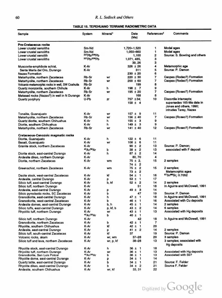
60 R. L. Sedlock and Others
TABLE 15. TEPEHUANO TERRANE RADIOMETRIC DATA
Sample System Mineral“ Date Referencest Comments
(Ma)
Pre-Cretaceous rocks
Lower crustal xenoliths Sm-Nd 1,720—1,520 1 Model ages
Lower crustal xenoliths Sm-Nd 1,050—660 1 Model ages
Lower crustal xenolith 207Pb/ZWPb 1,100 2 Source: 8. Bowring and others
Lower cmstal xenoliths 2°7PbF°6Pb 1,071, 485, 3
39, 26 3
Muscovite-amphibole schist, K-Ar 326 i 26 4 Metamorphic age
Santa Maria del Oro, Durango K-Ar 311 5 Source: P. Damon
Nazas Formation 230 :t 20 6
Metarhyolite, northern Zacatecas Rb-Sr wr 220 i 30 7 Caopas (Rodeo?) Formation
Metarhyolite, northern Zacatecas Rb-Sr wr 200 i 60 7 Caopas (Rodeo?) Formation
Volcanic-metamorphic rocks in well, SW Coahuila Rb-Sr 199 8
Quartz monzonite, southern Chihula K-Ar h 198 i 7 9
Metamyolite, northem Zacatecas Rb-Sr wr 195 i 20 7 Caopas (Roseo?) Formation
Metased rocks (Nazas?) in well in N Durango K~Ar 168 8
Quartz porphyry U-Pb zr 757 134; 10 Discordia intercepts;
158 :I: 4 supersedes 165-Ma date in
Jones and others, 1990;
intrudes Taray, Nazas
Tonalite, Guanajuato K-Ar wr 157 :t 9 11
Metarhyolite, northem Zacatecas Rb-Sr wr 156 i 40 7 Caopas (Rosco?) Formation
Quartz diorite, southern Chihuahua K-Ar h 155 i 3 9
Diorite, southern Chihuahua K-Ar h 149 i 3 9
Metarhyolite, northem Zacatecas Rb-Sr wr 141 i 40 12 Caopas (Roseo?) Formation
Cretaceous-Cenozoic magmatic rocks
Diorite, Guanajuato K-Ar h 122 i 6 11
Basalt, Guanajuato K-Ar wr 108 i 6 11
Granite stock, northern Zacatecas K-Ar 90 i 2 13 Source: P. Damon;
4°Arf39Ar b 38 i 2 13 associated with F deposit
Diorite stock, east~central Durango K-Ar h 87 i 2 14
Andesite dikes, northem Durango K-Ar 80, 70 4
Diorite, northern Zacatecas K-Ar wrn 75 i 2, 15 2 samples
74 i 2
Greenschist, northern Zacatecas K-Ar wm 75 :t 2 15 2 samples;
73 i 2 Metamorphic ages
Dacite stock, west-central Zacatecas K-Ar kt 54 i 1 16 l"Srfi’t‘Sriz 0.7052
Andesite, central Durango K-Ar p 53 i 1 17
Silicic tutt, east-central Durango K-Ar b, kt 52 i 2 14 2 samples
Silicic tutt, northern Durango K-Ar 51 18 In Aguirre and McDowell, 1991
Andesite, east-central Durango K-Ar p 49 i 3 14
Silicic pyroclastic rocks, SC Zacatecas K-Ar b 47 19 Source: P. Damon
Granodiorite, east-central Durango K-Ar h 47 i 1 18 In Aguirre and McDowell, 1991
Granodiorite, west-central Zacatecas K-Ar b 46 i 1 16 Associated with Cu deposits
Andesite domes, east-central Durango K-Ar b, h 45 i 1 14 2 samples
Silicic tufts, east-central Durango K-Ar p, kt, b 43 i 2 14 6 samples
Rhyolitic tuft, northern Durango K-Ar wr 43 i 1 13 Associated with Hg deposits
40Ar/39Ar b 40 i 1
Silicic tutt, northem Durango K-Ar 42 18 In Aguirre and McDowell, 1991
Granodiorite, northern Zacatecas K-Ar b 42 i 1 7
Rhyolite, southern Chihuahua K-Ar kt 42 i 1 20
Andesite, east‘central Durango K-Ar p 41 i 2 14 2 samples
Silicic tutt, south-central Zacatecas K-Ar kt 37 19 Source: P. Damon
Volcanic rocks, skarn K-Ar wr, wrn 37—28 20 3 samples
Silicic tutt and lava, northern Zacatecas K-Ar wr, p, kt 38—28 13 3 samples; associated with
Hg deposits
Rhyolite stock, east-central Durango K-Ar h 36 i 1 18
Rhyolitic tutt, northern Durango K-Ar wr 36 i 1 13 Associated with Hg deposits
Granodiorite, San Luis Potosr' ‘°ArP9Ar b 36 i 1 13 Associated with Sb?
Rhyolite dome, east-central Durango K-Ar p 34 i 1 14
Quartz Iatite, east-central Durango K-Ar b 34 i 1 21 Source: F. FeIder
Rhyolite dikes, east-central Durango K-Ar b 34 i 2 21 Source F. Folder
Andesite, southern Chihuahua K-Ar wr, kt 33, 31 22
Tectonostratigraphic Terranes and Tectonic Evolution ofMexico 61
TABLE 15. TEPEHUANO TERRANE RADIOMETRIC DATA (continued)
Sample System Mineral“ Date Referencesf Comments
(Ma)
Silicic tufts and lavas, central Durango K-Ar b, kt, p, wr 33—30 17 23 samples
Rhyolitic tuft, eastern Durango K-Ar wr, kt 31—30 13 2 samples; associated with Sn
Rhyolite, San Luis Potosf K-Ar wr, kt 31—27 13 4 samples; associated with F
Rhyolite, central Durango K-Ar wr 31 i 1 13
Granite stock, east-central Durango K-Ar b 30 i 1 18
Silicic dome/tuft, east-central Durango K-Ar p, kf 30 i 2 14 8 samples
Silicic tuft, northern Zacatecas K-Ar wr, p, kt 30—24 13 3 samples; associated with Sn
“Ar/“Ar b 32 i 1
Silicic tutf and lava, central Zacatecas K-Ar wr, p, kf 30—21 13 4 samples; associated with Hg
“Ar/“Ar wr 26 13 deposits
Granite stock, northern San Luis Potosf “Ar/“Ar b, wm 29—28 13 3 samples; associated with Sn
Rhyolite, southern Chihuahua K—Ar wr 25 22
Alkalic basalts, southwestern Chihuahua K-Ar 24, 21 23 Contemporaneous with Basin and
Range faulting
Alkalic mafic lavas, east-central Durango K-Ar 22 i 2 14 4 samples
Alkalic basalts, San Luis Potosi—Zacatecas K-Ar 14—11 24 3 samples
Mafic volcanic rocks and dikes, C Durango K-Ar p, h 13—12 17
“Mineral abbreviations: b = biotite; h = hornblende; kt = potassium feldspar, p = plagioclase; wrn = white mica; wr= whole rock; zr = zircon.
t1 = Ruiz and others, 1988b; 2 = Ruiz and others, 1990; 3 = J. Luhr and others, unpublished data; 4 = Araujo and Arenas, 1986; 5 = Pacheco
and others, 1984; 6 = Blickwede, 1981; 7 = Fries and Flincon-Orta, 1965; 8 = Wilson, 1990; 9 = Damon and others, 1981; 10 = T. H. Ander
son, unpublished data, personal communication, 1990; 11 = Monod and others, 1990; 12 = Denison and others, 1969; 13 = Tuta and others,
1988; 14 = Aguirre and McDowell, 1991; 15 = Fianson and others, 1982; 16 = Damon and others, 1983; 17 = McDowell and Keizer, 1977;
18 = Clark and others, 1980; 19 = Ponce and Clark, 1988; 20 = Shafiquallah and others, 1983; 21 = Gilmer and others, 1988; 22 = Grant and
Ruiz, 1988; 23 = Cameron and others, 1980; 24 = Luhr and others, 1991.
facies assemblages (chlorite, garnet, cordierite), displays a
penetrative northwest-striking foliation, is locally blastomylonitic,
and has yielded late Paleozoic K-Ar dates (Table 15). A struc
turally intermediate unit consists, according to conflicting reports,
of either crenulated phyllite or metaandesite. The structurally
highest unit consists of strongly deformed black slate containing
early Mesozoic, probably Early Jurassic, palynomorphs and
blocks of quartzite, Carboniferous limestone, tuff, and other sed
imentary rocks. Isolated outcrops of basaltic to andesitic pillow
lavas may be interbeds in the slate, olistoliths within the slate, or
fault-bounded units unrelated to the Gran Tesoro Formation.
Zaldivar-Ruiz and Gardufio-M. (1984) and Cordoba and Silva
Mora (1989) considered all these rocks to be part of the Gran
Tesoro Formation, which they inferred to be upper Paleozoic
despite the presence of early Mesozoic fossils in the slate.
Pacheco-G. and others (1984) and Aranda-Garcia and others
(1988) restricted use of the term Gran Tesoro Formation to the
upper and perhaps middle units, which they considered a tecton
ized olistostrome, and recognized a fault between these units and
the more strongly deformed and metamorphosed late Paleozoic
schist. All units are intruded by quartz diorites that yielded Late
Jurassic K-Ar dates in southern Chihuahua (Table 15), are over
lain with uncertain relation by the Nazas Formation, and are
overlain unconformably by Late Jurassic to Early Cretaceous
marine strata correlative with rocks in eastern Mexico (Aranda
Garcia and others, 1987; Contreras y Montero and others, 1988).
A variety of Mesozoic rocks crop out near the cities of
Guanajuato and Leon, Guanajuato (Fig. 2). The structurally
lowest rocks are strongly deformed greenschists of the Arperos
Formation (also known in part or whole as Esperanza Formation
or E1 Maguey Formation), which were derived from volcaniclas
tic flysch, tuff, chert, and limestone and shale that have been
assigned probable Triassic or Jurassic ages and tentatively corre
lated with the Triassic Zacatecas Formation in the northern part
of the terrane (e.g., Servais and others, 1982; de Cserna, 1989).
However, recently reported radiolarians of probable Early Creta
ceous age (Davila-Alcocer and Martinez-Reyes, 1987) indicate
that the entire assemblage probably is post-Jurassic. In adjacent
Jalisco, 25 km north of Leon, the Arperos Formation is overlain
unconformably by Albian carbonates including oolitic grain
stone, reefstone, marly limestone, calcareous sandstone, and marl
(Chiodi and others, 1988) interpreted as the western continuation
of platform carbonates of the Gulf of Mexico sequence in eastern
Mexico (see below).
South and east of Leon, the Arperos Formation is struc
turally overlain by faulted slabs of mafic and ultramafic igneous
rocks interpreted by Servais and others (1982) as an ophiolitic
complex and by Monod and others (1990) as the disrupted re
mains of a once-complete oceanic island are. Constituent rock
types include massive and pillow basalts, at least partly of Early
Cretaceous age; a diabase dike complex; distinct sheets of Early
Cretaceous diorite and Jurassic(?) tonalite, each intruded by
mafic dikes; partly serpentinized massive and layered gabbro; and
serpentinized harzburgite, wehrlite, and pyroxenite (Table 15).
The mafic and ultramafic rocks and the underlying Arperos For
mation are strongly foliated and locally lineated, and contain kine

62 R L Sedlock and Others
matic indicators that record tectonic transport to the north to
north-northeast. These rocks are inferred to be oceanic island arc
tholeiites on the basis of trace element data (Ortiz and others,
1991; Lapierre and others, 1992), but we consider the island arc
interpretation unlikely because the trace element data also show
affinities with N-MORB (e.g., Sun, 1980) and because, in terms
of lithology and structure, the igneous assemblage closely resem
bles Mesozoic ophiolites scattered throughout western Mexico.
We follow Servais and others (1982) in interpreting the mafic
and ultramafic rocks as Late Jurassic(?)—Early Cretaceous
oceanic crust of a backarc basin, presumably the same basin
inferred to the north in Zacatecas (see above), that was shortened
and thrusted north-northeastward onto volcaniclastic backarc
basin fill (Arperos Formation) prior to deposition of Albian plat
form limestone. The thrust sheet of Jurassic(?) tonalite presuma
bly was derived from the Jurassic magmatic arc in southwestern
Mexico, the original extent and present disposition of which are
not well known.
In west-central Querétaro, strongly deformed, low-grade
metasedimentary rocks of the Chilar Formation are lithologically
and structurally similar to the Zacatecas Formation 300 km to
the northwest. At least one episode of strong pre-Laramide de
formation is documented. These rocks were provisionally inferred
to be Paleozoic(?) or Triassic(?) by Lopez-Ramos (1985,
p. 443446) and Late Jurassic(?) by Coney and Campa
Uranga (1987), who assigned them to the Toliman terrane. No
direct radiometric or paleontologic data are available concerning
the ages of protolith and metamorphism.
Late Jurassic to Recent rocks. Oxfordian to early
Kirnmeridgian carbonate and fine-grained elastic rocks that crop
out throughout the northern Tepehuano terrane contain megafos
sils of both Tethyan and Boreal affinity (Buitron, 1984; Aranda
Garcia and others, 1987; Salvador, 1987; Contreras y Montero
and others, 1988). These strata are laterally continuous with coe
val strata in the Guachichil and Coahuiltecano terranes; local
formation names include Zuloaga, Novillo, Santiago, and La
Gloria (Imlay, 1936; 1938; Heim, 1940; Cantu-Chapa, 1979).
Coeval, correlative strata in the US. Gulf Coast region include
the Smackover Formation (e.g., Imlay, 1943). Overlap by these
strata indicates that the Tepehuano, Guachichil, and Coahuilte
cano terranes were amalgamated within the continental platform
of Mexico by Late Jurassic time (Mitre-Salazar and others,
1991). Later fault displacements (Longoria, 1988) have been of
insufficient magnitude to obscure regional facies patterns.
Late Jurassic to Late Cretaceous platform strata in the
Tepehuano terrane are dominated by carbonates and local evap
orites, but also include interbedded shale and flysch derived
chiefly from the magmatic arc to the west (Fig. 19), with a
marked increase in the abundance of elastic rocks in the late
Cenomanian (Tardy and Maury, 1973; de Cserna, 1976; Cuevas
Pérez, 1983; Mitre-Salazar and others, 1991). Cretaceous plat
form limestone and shale crop out in the western part of the
terrane (Chiodi and others, 1988).
Cretaceous and older rocks are intruded by widely distrib
uted Paleogene granitoids (Table 15) and intermediate hypabys
sal rocks (INEGI, 1980; Damon and others, 1983; Lopez-Ramos,
1985, p. 426—427).
Rocks deformed during Laramide shortening are unconform
ably overlain by sparse outcrops of Paleogene nonmarine
conglomerate and sandstone that probably were deposited in al
luvial fans at the feet of fault blocks elevated during regional
extension (Aranda-Garcia and others, 1989). In northwestern
Guanajuato, vertebrate fossils are late Eocene to early Oligo
cene, subordinate interbeds of basalt and andesite are present, and
clasts were derived chiefly from silicic to intermediate volcanic
rocks as well as from granitoids (increasing upsection) and Early
Cretaceous limestone (Edwards, 1955). On the outskirts of
Zacatecas city, conglomerate derived from mixed igneous and
sedimentary sources unconformably overlies the Zacatecas For
mation and Chilitos Formation (Edwards, 1955) and is overlain
conformably by ignimbrite from an Oligocene caldera (Ponce
and Clark, 1988). Near Durango city, conglomerate is derived
chiefly from carbonates and elastic rocks, and is overlain by
andesite that yielded a K-Ar date of ~52 Ma (Table 15), imply
ing a Paleocene—early Eocene age for the conglomerate (Cor
doba, 1988).
Tertiary magmatic rocks (Table 15) include Paleogene gran
itoids, Paleogene andesitic lava, tuff, and hypabyssal intrusives of
the “lower volcanic complex” of McDowell and Keizer (1977),
and mid-Tertiary silicic ignimbrites and basaltic andesites of the
“upper volcanic supergroup” of McDowell and Keizer (1977)
(Swanson and others, 1978; Cordoba, 1988; Cameron and oth
ers, 1989; McDowell and others, 1990; Wark and others, 1990).
Late Cenozoic rocks include Miocene-Pliocene alkali basalts
and basanites that were erupted during Basin and Range exten
sion (Table 15), Neogene and Quaternary fluvial sedimentary
rocks, and Quaternary basalts containing crustal and mantle xe
noliths (Luhr and others, 1990; Heinrich and Besch, 1992).
Structural andgeophysical data. The Tepehuano terrane
underwent an unresolved amount of north- to northeast-vergent
Laramide shortening in the latest Cretaceous and Paleogene
(Pantoja-Alor, 1963; Ledezma-Guerrero, 1967, 1981; Enciso de
la Vega, 1968; INEGI, 1980). Laramide deformation affected
rocks at least as far south as 24°N (Ledezma-Guerrero, 1981) and
at least as far west as 104°30'W, where pre-Tertiary rocks are
covered by Tertiary volcanics of the Sierra Madre Occidental
(Pantoja-Alor, 1963).
Regional stresses changed from east-northeast—west-south
west compression to east-northeast—west-southwest tension about
30 Ma, initiating block tilting, diking, and veining. High-angle
normal faulting generally ascribed to Basin and Range deforma
tion and associated basaltic volcanism were underway by 24 Ma
and continue at present (Table 15) (Aguirre-Diaz and McDowell,
1988; Grant and Ruiz, 1988; Cordoba and Silva-Mora, 1989;
Henry and others, 1991; Henry and Aranda-Gomez, 1992). On
the basis of structural analysis of faults, fractures, and lineaments,
Aranda-Gémez and others (1989) concluded that the southern
part of the Mesa Central of México (i.e., southern Tepehuano

Tectonostratigraphic Terranes and Tectonic Evolution ofMexico 63
terrane) experienced distinct episodes of northeast-southwest and
northwest-southeast tension during the Cenozoic. The relative
ages of these episodes are not yet understood.
A paleomagnetic pole determined from the Nazas Forma
tion south of Torreo'n, Coahuila overlaps two poles from coeval
rocks of southwestern North America at the 95% confidence level
(Nairn, 1976; Cohen and others, 1986). The clustering of the
poles is significantly improved at the 95% confidence level by
restoring 800 km of Late Jurassic sinistral displacement on the
Mojave-Sonora Megashear, which separates the Tepehuano ter
rane from North America (p. 79).
Yuma composite terrane
The Yuma composite terrane of Baja California (and south
ern California) consists of a Jurassie-Cretaceous volcanic arc sub
terrane to the west and a Triassic-Jurassic basinal subterrane to
the east (Fig. 20). The subterranes were amalgamated during the
Early Cretaceous and intruded by the Peninsular Ranges batho
lith during the Early and Late Cretaceous. The Yuma composite
terrane corresponds to the Alisitos terrane of Campa-Uranga and
Coney (1983) and to the Santa Ana terrane of southern Califor
nia (Howell and others, 1985; Coney and Campa-Uranga, 1987).
The western (arc) subterrane. The western (arc) subter
rane is known by different names on opposite sides of the east
west Agua Blanca fault near latitude 31°N (Fig. 3). To the north,
volcanic rocks between the Agua Blanca fault and southern Cali
fornia generally have been correlated with the Upper Jurassic—
Lower Cretaceous Santiago Peak Formation of southern
California (Larsen, 1948; Hawkins, 1970). To the south, the
western subterrane is known as the Alisitos Formation, which is
at least partly of Early Cretaceous age. Recent studies seem to
show that a perceived age difference between the Santiago Peak
and Alisitos Formations is imaginary, that the Agua Blanca fault
does not mark a major division of the arc subterrane, and that the
two formations are correlative parts of the same Late Jurassic
to chiefly Early Cretaceous volcanic are that was the extrusive
equivalent of the older part of the Peninsular Ranges batholith
(see below). In the following paragraphs, we summarize charac
teristics of the Santiago Peak and Alisitos Formations and de
scribe other volcanic rocks from the western (arc) subterrane that
are not clearly part of the Santiago Peak—Alisitos association.
The Santiago Peak Formation consists predominantly of
calc-alkalic and tholeiitic, andesitic to rhyolitic massive flows,
tuff, agglomerate, and breccia, with minor amounts of basalt and
volcaniclastic rocks (Larsen, 1948; Adams, 1979; Balch and oth
ers, 1984; Buesch, 1984). On the basis of Tithonian bivalves,
belemnites, radiolarians, and trace fossils in the volcaniclastic
rocks (Fife and others, 1967; Jones and others, 1983), the Santi
ago Peak Formation is widely inferred to be Upper Jurassic.
However, recent U-Pb zircon studies of massive flows and brec
cias have yielded Early Cretaceous dates (Table 16), implying
that the more abundant volcanic rocks in the Santiago Peak
Formation are Early Cretaceous and thus coeval with the older
part of the Peninsular Ranges batholith (Kimbrough and others,
1990; Herzig and Kimbrough, 1991). A 122-Ma date from sev
eral granite clasts is a maximum age for part of the volcanic
breccia in the Santiago Peak Formation (D. Kimbrough, personal
communication, 1990).
The Alisitos Formation is a thick (>6 km) sequence of
calc-alkalic rhyolitic to andesitic flows, pyroclastic rocks, and
breccias with thin interbeds of volcaniclastic sandstone and shale
YUMA
W ‘Alisitos Fm-Santiago Peak Fm (Ju'z-Ki)w E
<
COCHIMI
>
lt_|
WESTERN (ARC) SUBTERRANE
<
2. < /\<'///' . <, <1“
/\ ._\ unknown basement I
< I
w r“
EASTERN (BASINAL
SUBTERRANE
V
Figure 20. Schematic structure section of Yuma composite terrane. Plutons of Peninsular Ranges
batholith locally intrude boundary between Yuma and Seri terranes and reverse fault boundary between
eastern (basinal) and western (arc) subterranes. Plutons are younger to east and display eastward
increases in 87Sr/8°Sri, 6180, and REE fractionation.

64 R. L. Sedlock and Others
TABLE 16. YUMA TERRANE RADIOMETRIC DATA
Sample System Mineral“ Date References1 Comments
(Ma)
Volcanic arc (western) subterrane
Andesite beneath Alisitos Formation at U-Pb zr 155 1 Unpublished data
Arroyo Calamajue'
Santiago Peak Formation 2°7Pbfz°6Pb zr 130 t 5 2
Santiago Peak Formation U-Pb zr 120 2
Santiago Peak Formation U-Pb zr 114 2
Santiago Peak Formation U-Pb zr 107 2
Siliceous volcanic rocks (Alisitos Formation?) Rb-Sr wr 103 :t 4 3, 1
at Arroyo Calamajue' U-Pb zr ~122
Greenschist-facies andesite near Loreto K-Ar h 92 i 2 1 Minimum age
Peninsular Ranges Batholith
S-type granitoids in eastern subterrane U-Pb zr 1,600; 4 Discordia intercepts
156 :t 12
Rb-Sr wr 168 i 12 4 5 samples
Tonalite near Loreto K-Ar h 144 i 9 5
Western part of batholith U—Pb zr 140—105 6, 7 Unpublished data
Eastern part of batholith U-Pb zr 105-80 6
Gabbro K-Ar h 126 :t 4 5
Hypabyssal volcanic rock U-Pb zr 127 i 5 5 Source: L. Silver
Granodiorite near El Arco K-Ar b 117 i 4 8
K-Ar h 110 i 3 8
Granodiorite near El Arco K-Ar h 115 i 3 8
K-Ar b 1 11 t 3 8
Copper porphyry K-Ar kf 107 i 3 8
Granitoidsnear El Arco K-Ar wr 107—99 9 3 samples
Quartz monzonite near 27°30'N K-Ar 93 i 2 10
Granodiorite near Loreto K-Ar b 87 i 2 11
Upper Cenozoic volcanic rocks
Rhyolite tutt, Baja California Sur K-Ar b, kt, wr 28—23 12, 13 7 samples
Basalt near 25°N K-Ar p 28 d: 1 12
Volcanic rocks, Baja California K-Ar p, wr, h, kt, b 25-10 14, 12 78 samples; mainly calc-alkalic
13, 15
Volcanic rocks, Baja California K-Ar wr, p, kf 12—1 12, 13, 15 30 samples; alkaline and tholeiitic
“Mineral abbreviations: b = biotite; h = hornblende; kt = potassium feldspar, p = plagioclase; wr = whole rock; zr= zircon.
i1 = Gastil and others, 1991; 2 = Kimbrough and others, 1990; 3 = Griffith, 1987; 4 = Todd and others, 1991; 5 = Gastil and others, 1978; 6 =
Silver and others, 1979; 7 = Silver and Chappell, 1988; 8 = Barthelmy, 1979; 9 = Damon and others, 1983; 10 = Schmidt, 1975; 11 = McLean,
1988; 12 = Gastil and others, 1979; 13 = Hausback, 1984; 14 = Gastil and Krummenacher, 1977; 15 = Sawlan and Smith, 1984.
and reef limestone (Santillan and Barrera, 1930; Allison, 1955;
Gastil and others, 1975, 1981; Almazan-Vazquez, 1988a, b).
Some limestones contain Aptian-Albian fauna, but much of the
formation is unfossiliferous and of unknown age. The Alisitos
Formation crops out as far south as latitude 28°N (Rangin, 1978;
Barthelmy, 1979) and is known from the subsurface beneath the
eastern margin of the Vizcaino desert (~27°50'N); similar rocks
of unknown age crop out near Loreto (McLean, 1988). The
Alisitos Formation probably is correlative with the Early Cre
taceous part of the Santiago Peak Formation (Kimbrough and
others, 1990).
Other Mesozoic igneous rocks reported from the western
(arc) subterrane of the Yuma terrane have uncertain origins and
relation to the Santiago Peak and Alisitos Formations. The Alisi
tos Formation overlies Late Jurassic andesite and basalt (Table
16) at Arroyo Calamajué (Fig. 2). Initial reports of Late Trias
sic or Early Jurassic elastic and volcanic rocks beneath the
Alisitos Formation near Rancho San José (Fig. 2) (Minch, 1969)
were based on incorrect fossil identification; the rocks are Cre
taceous and probably part of the Alisitos (J. Minch, personal
communication, 1991; Strand and others, 1991). Weakly meta
morphosed Late Cretaceous andesite and volcaniclastic rocks
northwest of Loreto (Fig. 2) probably are a younger part of the
Alisitos Formation, although they also resemble Late Creta
ceous rocks in the Tahué terrane (Gastil and others, 1981). North
of El Arco (Fig. 2), gabbro, diorite, serpentinite, pyroxenite, and
pillow basalt of unknown age are faulted against metavolcanic
and metasedimentary rocks of possible Cretaceous age (Rangin,
1978; Barthelmy, 1979). It has been speculated that these rocks
represent a disrupted ophiolite and adjacent or overlying sedi
mentary rocks that were intercalated within numerous thrust
sheets during mid-Cretaceous contraction (see below) (Rangin,
1978; Radelli, 1989), but few data are available concerning their
age, origin, and structural evolution.

Tectonostratigraphic Terranes and Tectonic Evolution ofMexico 65
The eastern (basinal) subterrane. The eastern (basinal)
subterrane is considered by many workers to be divisible into an
older unit north of the Agua Blanca fault and a younger unit
south of the fault. To the north, undated siliciclastie flysch be
tween the Agua Blanca fault and southern California generally
has been correlated with the Triassic(?)-Jurassic Bedford Canyon
Formation, the Late Triassic(?) Frenchman Valley Formation,
and the Triassic(?) Julian Schist of southern California (Gastil
and others, 1975, 1981; Criscione and others, 1978; Todd and
others, 1988; Reed, 1989). The Triassic-Jurassic age of the silici
clastie Bedford Canyon Formation is based on olistostromal
Middle to Late Jurassic limestone clasts (Moran, 1976) and
Rb-Sr studies of sedimentary rocks that yield isochron ages of
about 230 and 175 Ma (Criscione and others, 1978). The Juras
sic fauna include several ammonite species that have affinities
southward rather than northward (Imlay, 1963, 1964). On the
basis of lithologic similarity to part of the Franciscan Complex,
the protoliths of the Bedford Canyon Formation and, by analogy,
of the Frenchman Valley Formation and the Julian Schist, have
been interpreted as trench or trench-slope deposits (Moran, 1976;
Criscione and others, 1978); forearc basin and even backarc ba
sin environments also are possible (Todd and others, 1988).
Recent work has shown that the eastern subterrane is intruded by
strongly deformed S-type granitoids as old as Middle Jurassic
(Fig. 20), but the regional extent of these plutons is not yet certain
(Todd and others, 1991). The following geologic history can be
deduced for the Julian Schist at its type locality near Julian:
deposition of a fine- to coarse-grained siliciclastie protolith in
uncertain tectonic setting; intrusion by thin pegmatite veins, per
haps in association with intrusion of Jurassic S-type granitoids;
Early Cretaceous penetrative deformation and metamorphism;
and Early Cretaceous intrusion by the Peninsular Ranges
batholith.
To the south, the eastern (basinal) subterrane includes un
named fiysch units at several isolated localities. Near 30°00'N, a
6-km-thick greenschist- and amphibolite-facies flysch unit that in
cludes rare quartzite conglomerate and andesite contains proba
ble Aptian-Albian fauna (Gastil and others, 1981; Phillips, 1984)
and has been interpreted as a backarc sequence (Gastil and oth
ers, 1986b). Near 30°30'N, flysch of unknown age contains rare
interbeds of rhyolite and andesite (Gastil and Miller, 1984). At
Arroyo Calamajué, broken formation derived from metamor
phosed flysch of unknown age may be correlative with the Cre
taceous flysch farther north (Gastil and Miller, 1983; Griffith,
1987). North of El Arco, prebatholithic metamorphosed elastic
rocks crop out to the northeast of probable Alisitos rocks (Bar
thelmy, 1979; Radelli, 1989).
Relation of subterranes. Contact relations between the
eastern and western subterranes are complex. Locally, volcanic
rocks of the Santiago Peak Formation (western subterrane) un
conformably overlie deformed, metamorphosed, and uplifted
flysch of the eastern subterrane. However, field relations and
geochemical and geophysical studies indicate that in most areas
the eastern (basinal) subterrane overlies the western (arc) subter
rane along a steeply east-dipping suture that probably formed
during late Early Cretaceous collision of the arc subterrane with
the marginal basin subterrane and continental rocks of the Seri
terrane farther east. In southern California and much of northern
Baja California, this suture is obscured by the younger (Late
Cretaceous) part of the Peninsular Ranges batholith (Fig. 20), as
well as by Late Cretaceous and Cenozoic cover. North of the
Agua Blanca fault, the position of the suture is inferred from
geochemical and geophysical studies, and U-Pb dating of tectonic
and posttectonic plutons indicates collision during the Early Cre
taceous (Todd and others, 1988). South of the Agua Blanca fault,
the suture crops out in several locations; locally, the western
subterrane is juxtaposed directly with the Seri terrane, i.e., the
eastern Yuma subterrane is absent. Steeply plunging lineations,
asymmetric kinematic indicators, and the inferred depth of crustal
exposure indicate thrust or reverse displacement; U-Pb dating
of syntectonic and posttectonic plutons indicates that collision,
southwest-northeast contraction, and upper greenschist— to lower
amphibolite—facies metamorphism occurred between about 105
and 95 Ma (Griffith, 1987; Griffith and Goetz, 1987; Goetz and
others, 1988; Radelli, 1989; Windh and others, 1989). Younger
episodes of west-vergent thrusting and mylonitization (~80 Ma)
and uplift along normal faults (~62 Ma) that affected the eastern
(marginal basin) subterrane and adjacent Serf terrane have been
recognized along the East Peninsular Ranges fault zone in Alta
California (Dokka, 1984; Todd and others, 1988; Goodwin and
Renne, 1991), but similar deformation in Baja California has not
been recognized.
Peninsular Ranges batholith. Plutons of the Peninsular
Ranges batholith intruded the Yuma terrane during Cretaceous
time. This batholith is a composite of a 140- to 105-Ma (U-Pb)
western part and a 105- to 80-Ma (U-Pb) eastern part that
youngs to the east (Fig. 20; Table 16). The older part of the
batholith is cogenetie with, and intrudes, Santiago Peak-Alisitos
volcanic rocks of the western subterrane. The younger part of the
batholith intrudes both subterranes of the Yuma terrane, the su
ture between them, and the older part of the batholith. Near the
U.S.—México border, the older part of the batholith is more petro
logically diverse and has lower initial 37Sr/86Sr ratios, lower
6180 values, and less fractionated rare earth element (REE) pat
terns than the younger part (Silver and others, 1979; Hill and
others, 1986; Gromet and Silver, 1987). Sr, Nd, and Pb isotopic
systems have mantle values in the west but are progressively more
evolved to the east (Silver and Chappell, 1988). The western part
of the batholith is typical of primitive island arcs built on oceanic
lithosphere; the entire batholith appears to be an example of the
formation of continental crust in an area previously devoid of
continental lithosphere (Silver and Chappell, 1988).
The boundary between the older and younger parts of the
batholith is nearly coincident with regional features including a
magnetite-ilmenite line, a boundary between I-type and S-type
granitoids, a sharp gravity gradient, a linear magnetic anomaly
(Todd and Shaw, 1985; Gastil and others, 1986a; Jachens and
others, 1986, 1991), and the suture between the eastern and

66 R. L. Sedlock and Others
western subterranes (Fig. 20). Petrographic and structural obser
vations in penetratively deformed plutons as young as 100 Ma are
interpreted to indicate syntectonic intrusion of the older part of
the batholith (Todd and others, 1988). Continuous exposures of
the Peninsular Ranges batholith are found as far south as El Arco
(28°N), but isolated outcrops have been discovered on the east
coast of Baja California Sur as far south as 26°N (Table 16), and
diorite and gneissic xenoliths have been collected in Tertiary
basalt at latitude 26°20’N (Demant, 1981; Hausback, 1984;
Lopez-Ramos, 1985, p. 28; McLean and others, 1987; McLean,
1988). Positive gravity anomalies associated with the batholith
continue at least as far south as 26°N (see below).
Postbatholithic rocks. Along the west coast of northern
Baja California, Late Cretaceous to Eocene postbatholithic ma
rine clastic strata rest nonconformably on, and probably were
derived from, the Alisitos Formation and Peninsular Ranges bath
olith (Gastil and others, 1975; Bottjer and Link, 1984). Cre
taceous strata contain abundant Coralliochama Orcutti, a warm
water rudist absent from Cretaceous rocks of the Great Valley
Group in California (D. Bottjer, personal communication, 1992).
Some postbatholithic rocks in northern Baja California were de
posited in tectonically active basins of uncertain tectonic setting
(Boehlke and Abbott, 1986; Cunningham and Abbott, 1986).
Eocene sedimentary rocks in the northern Yuma terrane indicate
bypassing of the eroded Peninsular Ranges batholith and volcanic
arc and tapping of source terranes in Sonora (Bartling and Abbott,
1983). Middle Miocene basalts, tuffs, and fluvial and shallow
marine clastic rocks along the coast between Ensenada and San
Diego were derived from western volcanic and Franciscan sources
that subsequently were submerged or displaced (Ashby, 1989).
Postbatholithic Late Cretaceous and Paleogene clastic
rocks in Baja California Sur probably were derived from the
southward continuation of the Peninsular Ranges batholith,
which crops out locally on the eastern coast. Latest Creta
ceous and Paleogene marine clastic rocks containing benthic and
planktonic forams and minor tuff (e.g., Bateque and Tepetate
Formations) crop out in the eastern Vizcaino Peninsula and along
the Pacific coast east of Isla Magdalena (Heim, 1922; Mina,
1957; Fulwider, 1976; Hausback, 1984; Lopez-Ramos, 1985;
McLean and others, 1987; Squires and Demetrion, 1989, 1990a,
b). Wells in these regions and in the northern Bahia Sebastian
Vizcaino have penetrated Late Cretaceous to Eocene marine
clastic rocks and minor tuff (Mina, 1957; Lopez-Ramos, 1985,
p. 30—32, 50—52). The Late Cretaceous strata are similar to the
Valle Formation in the western part of the Vizcaino Peninsula
(Cochimi terrane), implying Late Cretaceous overlap of a buried
northwest-trending Yuma-Cochimi fault boundary (p. xx). E0
cene nonmarine rocks near Loreto probably are more proximal
lateral equivalents of the shallow marine strata (McLean, 1988).
Late Cenozoic volcanism, sedimentation, andfaulting.
Late Oligocene to early Miocene(?) (Table 16) shallow marine
clastic rocks and subordinate tuffs and flows of the San Gregorio
Formation (also called El Cien Formation or Monterrey Forma
tion) in central Baja California Sur contain commercially viable
phosphorite deposits (Hausback, 1984; Alatorre, 1988; Grimm
and others, 1991 ). The Middle to upper Miocene Salada Forma
tion, which crops out in the Magdalena plain in southwestern
Baja California Sur, is a thin (< 100 m) sequence of richly fossilif
erous marine sandstone, conglomerate, siltstone, and mudstone
deposited in a shallow embayment (Smith, 1992). Miocene calc
alkalic andesites and volcaniclastic rocks (Comondi'i Formation)
in Baja California Sur and southern Baja California, and correla
tive rocks in the Serf terrane in northeastern Baja California, are
remnants of a chain of coalescing stratovolcanoes that was active
24 to 11 Ma (Gastil and others, 1979; Sawlan and Smith, 1984;
Sawlan, 1991). Vent-facies rocks of the axial core of this calc
alkalic arc are exposed on the eastern margin of Baja from 29° to
25°N (Hausback, 1984). The waning stage of orogenic magma
tism was contemporaneous with alkalic and tholeiitic volcanism
that started by about 13 Ma in eastern Baja California and within
the developing Gulf of California rift (Hausback, 1984; Sawlan
and Smith, 1984; Sawlan, 1991). The geologic-tectonic map of
Baja California compiled by Fenby and Gastil (1991) depicts all
sedimentary and volcanic rocks of Oligocene and younger age.
The eastern Baja California peninsula, including the eastern
Yuma, western Seri, and eastern Pericl'l terranes, has undergone
extension with or without dextral slip since at least the Middle
Miocene (Angelier and others, 1981; Dokka and Merriam, 1982;
Hausback, 1984; Stock and Hodges, 1989, 1990). The least prin
cipal stress and extension directions changed from east
northeast—west-southwest to northwest-southeast about 6 Ma,
roughly coeval with the initiation or acceleration of transtensional
opening of the modern Gulf of California. Since about 5 Ma, the
surface of the eastern edge of the Baja continental block has been
uplifted about 1 to 3 km, resulting in detachment and eastward
translation of elevated continental crustal walls of the Gulf of
California (Fenby and Gastil, 1991; Gastil and Fenby, 1991).
Pliocene to Holocene faulting in eastern Baja California includes
dextral slip on northwest-striking strike-slip faults, down-to-the
gulf normal faulting, and oblique-slip faulting (e.g., Umhoefer
and others, 1991). The geologic-tectonic map of Baja California
compiled by Fenby and Gastil (1991) depicts all faults on which
displacement is interpreted to be Oligocene and younger.
Geophysical data. A positive low-pass filtered gravity
anomaly trends south-southeast from the peninsular ranges in
Baja California to at least 26°N in Baja California Sur (Couch
and others, 1991). Gravity models interpret this anomaly to indi
cate southeastward continuation of the Cretaceous batholith in
the subsurface.
Paleomagnetic investigations of rocks of different age, li
thology, and magnetic character in the Yuma terrane have yielded
Cretaceous and Paleogene paleolatitudes that are significantly
shallower than expected for stable North America. Calculated
relative paleolatitudes, i.e., the implied northward latitudinal dis
placement of specific localities relative to North America since
rocks at those localities were magnetized, include 12.3° :t 7.4°,
132° 1: 6.8°, and 46° :l; 6.00 for Cretaceous plutons (Teissere
and Beck, 1973; Hagstrum and others, 1985); 150° 1 3.8° and

Tectonostratigraphic Terranes and Tectonic Evolution ofMexico 67
18.2° i 67° for Late Cretaceous sedimentary rocks (Fry and
others, 1985; Filmer and Kirschvink, 1989); and about 5° i 5°
for Paleogene sedimentary rocks (Flynn and others, 1989). These
and other results from correlative rocks in southern California
(summarized in Lund and Bottjer, 1991 and Lund and others,
1991) imply at least 10° and perhaps as much as 20° of north
ward translation and 25° to 45° of clockwise rotation of Baja
with respect to stable North America between about 90 and 40
Ma. These data are discussed more fully on pages 80—81.
Zapoteco terrane
The Zapoteco terrane is a fragment of Proterozoic continen
tal crust consisting mainly of crystalline basement rocks of Gren
ville age overlain nonconforrnably by rare cratonal Paleozoic
strata. On the basis of petrologic, geochronologic, and paleomag
netic data we infer that the Precambrian and early Paleozoic
rocks of the Zapoteco terrane formed part of the Grenville prov
ince of southeastern Canada; however, other interpretations are
permissible. The Zapoteco terrane probably was displaced to the
south of the southern margin of North America during the Pa
leozoic, and by the latest Paleozoic it hosted a magmatic arc
within or west of the western margin of Pangea. The Zapoteco
terrane corresponds to the Oaxaca terrane of Campa-Uranga and
Coney (1983) and Coney and Campa-Uranga (1987).
Oaxacan Complex. The oldest unit in the Zapoteco ter
rane is the Oaxacan Complex (Fig. 21), an assemblage of meta
anorthosite, quartzofeldspathic orthogneiss, paragneiss, calcsili
cate metasedimentary rocks, and chamockite that was formed by
Grenvillian metamorphism of miogeoclinal or continental rift
deposits and plutonic rocks (Ortega-Gutiérez, 1981a, b, 1984a).
The protoliths experienced peak granulite-facies metamorphic
temperatures of 710° i 50°C and pressures of approximately 7
kbar (Mora and others, 1986). Metamorphism probably occurred
between 1,100 and 1,000 Ma, and slightly younger Sm-Nd cool
ing ages (Table 17) probably postdate peak metamorphism (Pat
chett and Ruiz, 1987). There are no radiometric data to support
speculative Archean to Middle Proterozoic ages (e.g., Bazan,
1987). Fold axes and lineations in the Oaxacan Complex plunge
gently to the north-northwest, and mesoscopic folds record east
west shortening (Ortega-Gutiérez, 1981b).
Paleozoic to Cenozoic rocks. The Oaxacan Complex is
overlain nonconformably by thin-bedded shale, sandstone, lime
stone, and conglomerate of the Tifiu Formation, which contains
early Tremadocian (earliest Ordovician) trilobite taxa that
resemble those in Early Ordovician rocks in South America,
southeastern Canada, and northwestern Europe, and that are dis
similar to those of southwestern North America (Pantoja-Alor
and Robison, 1967). Younger Paleozoic strata include Carbonif
erous marine sandstone and shale of the Santiago and Ixtaltepec
Formations, and continental sandstone, siltstone, and conglomer
ate of the Matzitzi Formation of Pennsylvanian and probable
Permian age; depositional environments of these rocks are not yet
certain (Pantoja-Alor and Robison, 1967; Robison and Pantoja
Alor, 1968). The Matzitzi Formation is the oldest unmetamor
phosed stratigraphic unit that physically overlaps the fault contact
between Zapoteco and Mixteco terranes.
Near Caltepec, Puebla, the Oaxacan Complex is intruded by
cataclastic granitoids that are correlated with the Devonian Es
peranza granitoids in the Mixteco terrane (F. Ortega-Gutierrez,
unpublished data). The granitoids become more strongly mylo
nitic closer to the contact of the Zapoteco terrane with the Mix
teco terrane, implying syntectonic intrusion of the two terranes
during the Early to Middle Devonian. The Oaxacan Complex also
ZAPOTECO
W E
A\l< /\\/</\v< ATl-Tu</\\/</\v</\
_.>._ >._.>._.>._.>._..)._ >._.>._.>._T]_.>._ >._ >._.>.__.>._.>._>_
I l
.._..._..M_|P_..._..._..._..._.._.._
T \\l\\_-_H__'__I__L01_'_i__‘__L_L_J__
o //
X A,E I Oaxacan Complex (pC) //v
| 62%;“, ~ q> N e N CUICATECO
\Juarez suture
Figure 21. Schematic tectonostratigraphic section of Zapoteco terrane. Upper Devonian rocks at
western margin overlap Mixteco and Zapoteco terranes.

68 R. L. Sedlock and Others
TABLE 17. ZAPOTECO TERRANE RADIOMETRIC DATA
Sample System Mineral“ Date Referencesi Comments
(Ma)
Oaxacan Complex
Paragneiss U-Pb zr 1,168 1180; 1 Discordia intercepts
747 i330
Gneiss and syntectonic pegmatite U-Pb zr 1,080 i 10 2
Gneiss U-Pb zr 1,050 i 20 3
Paragneiss U-Pb zr 1,020 4 Slightly discordant
Posttectonic pegmatites U-Pb zr 975 i 10 2
U-Pb zr 960 i 15 3 Concordant age
Gneiss Sm-Nd g 960, 940 5 Cooling ages
Pegmatite K-Ar b 950 i 30 6
K-Ar b 930 i 30 6
K-Ar b 906 i 30 7
Rb-Sr b 870 :t 35 7
Rb-Sr kt 770 i 35 7
Rb-Sr b 770 i 20 7
K-Ar b 680 i 20 7
Other rocks
Granite Rb-Sr 272 i B 8 6"Sr/“Sq: 0.7047
Ignimbrite K-Ar b 17 :t 1 9
“Mineral abbreviations: b = biotite; g = garnet; kt = potassium feldspar, zr = zircon.
i1 = Robinson, 1991; 2 = Anderson and Silver, 1971; 3 = Ortega-Gutierrez and others, 1977; 4 = Robinson and others, 1989; 5 — Patchelt
and Ruiz, 1987; 6 = Fries and others, 1962a; 7 = Fries and Rincén-Orta, 1965; 8 = Ruiz-Castellanos, 1979; 9 - Ferrusquia-Wlafranca, 1976.
is intruded by a small, undeformed Early Permian granitoid
(Table 17).
Much of the Zapoteco terrane is overlain by Mesozoic and
Cenozoic rocks that are very similar to those in the Mixteco
terrane. These rocks include Late Jurassic to Early Cretaceous
shallow-water and nonmarine elastic rocks with minor limestone
and coal, mid-Cretaceous carbonates, Campanian-Maastrichtian
conglomerate and sandstone derived from the Juchatengo subter
rane of the Mixteco terrane, Paleogene red beds and volcanic
rocks, mid-Tertiary andesite, and Neogene calc-alkalic volcano
genic rocks (Fig. 21, Table 17) (Carfantan, 1986; Ortega
Gutiérrez and others, 1990). Neogene nonmarine strata and
volcanic rocks were deposited in elongate north-north
west—striking grabens that formed from about 19 to 12 Ma along
the Oaxaca fault at the eastern margin of the Zapoteco terrane
(Ferrusquia-Villafranca and McDowell, 1988; Centeno-Garcia
and others, 1990). The geometry and timing of extension may indi
cate that the Basin and Range province continued south of the
TMVB in the Middle Miocene (Henry and Aranda-Gomez, 1992).
Geophysical data. The paleopole of primary magnetiza
tion in the Oaxacan Complex is >40° from the Grenville Loop of
the North America polar wander path; this has been intepreted to
indicate a position near Quebec during Grenvillian time (Ballard
and others, 1989). Paleozoic cover of the Zapoteco terrane was
remagnetized between Late Permian and Jurassic time, possibly
by Permo-Triassic intrusions, and may have rotated counter
clockwise as much as 28° with respect to the adjacent Mixteco
terrane (McCabe and others, 1988). Paleomagnetic arguments for
Jurassic to Early Cretaceous southward displacement of the Mix
teco terrane with respect to cratonal North America (Urrutia
Fucugauchi and others, 1987; Ortega-Guerrero and Urrutia
Fucugauchi, 1989) also must apply to the attached Zapoteco
terrane.
TERRANE BOUNDARIES
In this section, we discuss the rationale for distinction of
terranes and for the delineation of terrane boundaries shown in
Figure 3, and we summarize available data concerning the orien
tation, nature, and kinematic history of terrane boundaries. Be
cause much of México is covered by Cretaceous and Cenozoic
rocks, and because major displacement on most terrane-bounding
faults is Jurassic or older, few terrane-bounding faults crop out at
the surface, particularly in northern and central México. Never
theless, the surface trace of most faults can be determined to
within 10 to 200 km based on scattered exposures of basement
rocks and geophysical and isotopic data. The straight dashed lines
shown in Figure 3 are not meant to imply vertical faults; as
discussed in this section, the subsurface orientation of most faults
is unknown. As noted elsewhere, many of these terranes probably
are composite, and future work may lead to partitioning into
smaller terranes or subterranes.
Boundaries of Tarahumara terrane
The eastern and western boundaries of the Tarahumara ter
rane are not exposed. The western boundary is inferred to be a
major southeast-dipping suture, probably of Pennsylvanian
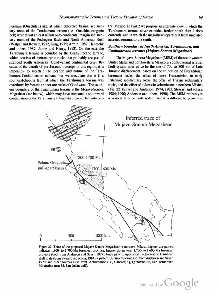
Tectonostratigraphic Terranes and Tectonic Evolution ofMexico 69
Permian (Ouachitan) age, at which deformed basinal sedimen
tary rocks of the Tarahumara terrane (i.e., Ouachita orogenic
belt) were thrust at least 40 km onto continental margin sedimen
tary rocks of the Pedregosa Basin and North American shelf
(Walper and Rowett, 1972; King, 1975; Armin, 1987; Handschy
and others, 1987; James and Henry, 1993). On the east, the
Tarahumara terrane is bounded by the Coahuiltecano terrane,
which consists of metamorphic rocks that probably are part of
stranded South American (Gondwanan) continental crust. Be
cause of the dearth of pre-Jurassic outcrops in this region, it is
impossible to ascertain the location and nature of the Tara
humara-Coahuiltecano contact, but we speculate that it is a
southeast-dipping fault at which the Tarahumara terrane was
overthrust by forearc and/or are rocks of Gondwana. The south
ern boundary of the Tarahumara terrane is the Mojave-Sonora
Megashear (see below), which may have truncated a southward
continuation of the Tarahumara/Ouachita orogenic belt into cen
Pelona-Orocopia ’
pull-apart basin
I 1 l
tral México. In Part 2 we propose an alternate view in which the
Tarahumara terrane never extended farther south than it does
currently, and in which the megashear separates it from unrelated
accreted terranes to the south.
Southern boundary ofNorth America, Tarahumara, and
Coahuiltecano terranes (Mojave-Sonora Megashear)
The Mojave-Sonora Megashear (MSM) of the southwestern
United States and northwestern Mexico is a controversial sinistral
fault system inferred to be the site of 700 to 800 km of Late
Jurassic displacement, based on the truncation of Precambrian
basement rocks, the offset of latest Precambrian to early
Paleozoic sedimentary rocks, the offset of Triassic sedimentary
rocks, and the offset of a Jurassic volcanic arc in northern Mexico
(Fig. 22) (Silver and Anderson, 1974, 1983; Stewart and others,
1984; 1990; Anderson and others, 1990). The MSM probably is
a vertical fault or fault system, but it is difficult to prove this
Inferred trace of
Mojave-Sonora Megashear
lOOOkm
l
Figure 22. Trace of the proposed Mojave-Sonora Megashear in northern México. Lighter dot pattern
indicates 1,800- to 1,700-Ma basement province; heavier dot pattern, 1,700- to 1,600-Ma basement
province (both from Anderson and Silver, 1979); brick pattern, uppermost Proterozoic to Cambrian
shelf strata (from Stewart and others, 1984); v pattern, Jurassic volcanic are (from Anderson and Silver,
1979, and other sources as in text). Abbreviations: C, Caborca; Q, Quitovac; SB, San Bernardino
Mountains area; SJ, San Julian uplift.

70 R. L. Sedlock and Others
because along most of its length it is obscured by younger sedi
mentary rocks and modified by younger structural features. In
Part 2, we discuss at length the case against and, in our opinion,
the stronger case for large displacement on the MSM (p. 78).
Eastern and southern boundaries ofSeri terrane
The boundary between the Seri and Tahué terranes at lati
tude 28°N separates outcrops and inferred subcrops of Precam
brian basement in the Seri terrane to the north from Mississippian
and inferred late Paleozoic basement rocks of the Tahué terrane
to the south. Initial 87Sr/86Sr values of late Cretaceous—Paleo
gene volcanic rocks are 0.7064 to 0.7080 north of the boundary
but only 0.7036 to 0.7063 south of the boundary (Tables 10, 11),
suggesting that sialic Precambrian crust underlies the Serf terrane
but not the Tahué terrane (Damon and others, 1983). The
inferred boundary also marks the southern edge of the outcrop
area of the Upper Triassic-Lower Jurassic Barranca Group in the
Seri terrane. The orientation of and history of displacement on
the inferred fault boundary are unknown, but displacement appar
ently has been negligible since the emplacement of overlapping
Early Cretaceous volcanic rocks.
In southern Baja California, the Seri terrane is tectonically
interleaved with the western (arc) subterrane of the Yuma terrane
(eastern Yuma subterrane is absent) within a 5-km-wide, steeply
east-dipping suture zone (Griffith, 1987; Griffith and Goetz,
1987; Goetz and others, 1988). Juxtaposition was latest Early
Cretaceous (106 to 97 Ma), based on U-Pb ages of deformed and
undeformed plutons in and near the suture.
The nature of the Serf-Yuma contact in southern Cali
fornia and northern Baja California, where Mesozoic basinal
rocks of the eastern Yuma subterrane intervene between the
Seri terrane and the western (arc) Yuma subterrane, is enigmatic.
The Seri-eastem Yuma boundary is intruded by numerous
plutons and has not been studied in detail, although some screens
between plutons appear to be transitional in lithology and
age between the Paleozoic miogeoclinal strata of the Seri
terrane and the Mesozoic basinal strata of the eastern Yuma
subterrane (Todd and others, 1988). We provisionally infer a
prebatholithic fault boundary between the two rock units, but
if further work demonstrates that the contact is depositional, then
the Mesozoic basinal strata should be considered a subterrane of
the Seri terrane rather than of the Yuma terrane. The bound
ary between the eastern and western Yuma subterranes is in
ferred to be a steeply east-dipping suture zone of Early Creta
ceous age on the basis of geologic, geophysical, and geochemical
discontinuities (Todd and Shaw, 1985; Todd and others, 1988)
and thus is geometrically similar to and may be related to the
Serf-Yuma suture in southern Baja California.
Cochimi-Yuma boundary
The boundary between Cretaceous arc and forearc basin
rocks of the Yuma terrane and are rocks and blueschists of the
Cochimi terrane is not exposed, but its position in the subsurface
is known within a few tens of kilometers from the distribution of
outcrops and subcrops and from distinctive gravity anomalies.
The boundary probably lies west of PEMEX well Totoaba-l in
Bahia Sebastian Vizcaino (Fig. 2), which penetrated mid-Creta
ceous flysch of the Valle Formation and bottomed in andesite that
may be correlative with the Alisitos Formation of the Yuma ter
rane (Lopez-Ramos, 1985, p. 52). The boundary must be cast of
exposures of the Cochimi terrane on the Vizcaino Peninsula at
28° to 27°N and on Isla Santa Margarita and Isla Magdalena at
25° to 24°N (Fig. 2). The terrane boundary probably strikes
north-northwest between these two outcrop areas but is buried
beneath late Cenozoic sedimentary rocks of the Pacific continental
shelf. Gravity studies have measured a north-northwest—trending,
low-pass filtered, positive gravity anomaly above the Pacific shelf
south of about 30°N, indicating that submerged areas of the
terrane probably are underlain by comparatively dense rocks simi
lar to the ophiolitic, arc, and blueschist rocks known from
outcrops of the terrane (Couch and others, 1991).
The current proximity of basement rocks of marked differ
ences in lithology and metamorphic and structural history implies
that the boundary between the Yuma and Cochimi terranes must
be a major fault zone. The nature and the orientation of the fault
or faults are unknown, but possibilities include east- or west
vergent thrust faults related to accretion, and younger strike-slip
faults. The age ofjuxtaposition of the two terranes is post-Jurassic
and pre—latest Cretaceous. By the earliest Cretaceous, arc subter
ranes of the Cochimi terrane had collided with continental North
America, but it is not certain that they were originally juxtaposed
with the central Yuma terrane because paleomagnetic studies
infer that both the Yuma and Cochimi terranes were south of
their present latitude prior to the Eocene (p. 80). Available data
are too meager to assess possible postcollisional strike-slip dis
placement between the two terranes. Major displacement may
have ceased by the Late Cretaceous because the boundary appar
ently is overlapped by widespread Late Cretaceous to Eocene
marine strata that have been mapped and drilled in the eastern
Vizcaino region and the [ray-Magdalena basin (Lopez-Ramos,
1985, p. 50—52). Alternatively, the boundary may have under
gone significant Cenozoic displacement that juxtaposed strata
deposited in similar, although distant, depositional environments.
Yuma-Tahué boundary (pre-Gulf of California)
Prior to the opening of the Gulf of California, the Yuma
terrane in southern Baja California was adjacent to the Tahué
terrane. Relations between the Yuma terrane and Tahué terrane
were obliterated by late Cenozoic magmatism and the opening of
the Gulf of California. We infer that the pre-gulf boundary con
sists of or included the fault or faults at which Baja California,
including the Yuma terrane and the western part of the Seri
terrane, was translated northward with respect to North America
in the Late Cretaceous and Cenozoic.
Boundaries ofPericu terrane
The “La Paz fault” at the western margin of the Period
terrane probably includes structures related to several episodes of

Tectonostratigraphic Terranes and Tectonic Evolution ofMexico 71
displacement. Over the past several million years, this fault has
been characterized by down-to-the-west normal displacement,
probably associated with the opening of the Gulf of California
(Curray and Moore, 1984). Holocene displacement is indicated
by visible scarps along the fault trace (A. Carrillo-Chavez, unpub
lished data). Normal slip during the Miocene may have been
accompanied by a sinistral (Hausback, 1984) or dextral (Sedlock
and Hamilton, 1991) component of strike-slip displacement.
Basement rocks of the Period terrane have uncertain relation to
buried basement rocks west of the fault that provisionally are
assigned to the Yuma terrane, but early Tertiary strike-slip dis
placement inferred between the two terranes implies that the
buried boundary between them is subvertical.
Prior to the opening of the Gulf of California, the Period,
western Nahuatl, and southern Tahué terranes were mutually
adjacent. The original boundaries among these terranes have been
obscured by late Cenozoic strike-slip faulting, opening of the Gulf
of California, and volcanism in the Trans-Mexican Volcanic Belt.
Nevertheless, the protoliths of prebatholithic rocks in the three
terranes are quite similar and may indicate common parentage
(Henry, 1986). Metamorphic rocks of the Period terrane were
derived from elastic rocks and carbonates at least as old as
Triassic, and probably Paleozoic. The lithology and age of these
rocks are very similar to those of the Paleozoic rocks of the Tahué
terrane. The host rocks for granitoids in the western Nahuatl
terrane are interbedded andesite, metagraywacke, and marble of
possible Jurassic and Cretaceous age. These rocks are similar to
the Cretaceous marble and volcanic rocks of the Tahué terrane
and were correlated with these rocks by Henry and Fredrikson
(1987). These relations may indicate that the Perict'r and Tahué
terranes were part of the same parent Paleozoic terrane, and that
the western Nahuatl, Tahué, and (presumably) Perict'r terranes
were part of the same composite terrane by the late Mesozoic.
Tahué-Tepehuano boundary
Thick volcanic rocks of the Sierra Madre Occidental
completely obscure the location, nature, and orientation of the
contact between the Tahué and Tepehuano terranes. Mitre
Salazar and others (1991) inferred that the two terranes were
juxtaposed in the Late Cretaceous, based on differences between
arc-derived Cretaceous rocks in the Tahué terrane and basinal
(carbonates and marine elastic) rocks in the Tepehuano terrane.
An alternate explanation is that Jurassic closure of an intervening
ocean basin resulted in collision of the two terranes and the
cessation of magmatism in the Tepehuano terrane. In other
words, the stratigraphic differences between the Tahué and Tepe
huano terranes in Cretaceons time may simply reflect differences
between adjacent arc and backarc environments.
Tepehuano-Guachichil boundary
The Tepehuano-Guachichil terrane boundary is an inferred
fault, called the San Tiburcio lineament by Mitre-Salazar (1989)
and Mitre-Salazar and others (1991), that is overlapped by late
Mesozoic strata. The boundary is defined by the eastern outcrop
limit of Triassic(?)-Jurassic magmatic arc rocks (Caopas Schist,
Rodeo and Nazas Formations) and Late Triassic marine strata
(Zacatecas Formation), and by the western outcrop and subcrop
limit of nonmarine strata of the Upper Triassic to Lower Jurassic
Huizachal Formation (Lopez-Ramos, 1985). We do not accept
proposed correlations of the Huizachal Formation with either the
Nazas Formation or Zacatecas Formation. We suggest that the
San Tiburcio lineament is a southeastward splay of the Mojave
Sonora Megashear (p. 79) with Late Jurassic dextral slip of un
known magnitude. The San Tiburcio lineament may have been
reactivated during Laramide orogenesis (Mitre-Salazar, 1989).
Guachichil-Maya boundary
Basement rocks along this boundary are obscured by late
Mesozoic-Cenozoic sedimentation, Laramide folding and thrust
ing, and Cenozoic volcanism, but abundant well logs and samples
indicate that a subvertical boundary separates widespread Permo
Triassic plutonic rocks to the east (Maya terrane) from Precam
brian gneiss and Paleozoic schist and sedimentary rocks to the
west (Guachichil terrane) (Lopez-Ramos, 1972). This steeply
dipping boundary is a fault or fault zone that strikes about N20W
and appears to be offset by east-northeast—striking high-angle(?)
faults east of Tuxpan, Veracruz. Schist and gneiss in some wells in
the Maya terrane probably represent country rocks metamor
phosed by the Perrno-Triassic intrusions, as indicated by cooling
ages from some samples (Table 7). The boundary is placed at the
western limit of Permo-Triassic plutonic rocks, which do not crop
out in the Guachichil terrane. We propose that reported tonalite
or diorite in a few wells in the Guachichil terrane instead may be
gneissic basement; the ambiguity inherent in identifying basement
on the basis of small samples of drill core was discussed by
Lopez-Ramos (1972).
Several interpretations of the nature, timing, and kinematics
of displacement on the buried fault boundary between the Gua
chichil and Maya terranes have been proposed. First, the bound
ary may be a high-angle dextral fault system that accommodated
southward displacement of the Yucatan block of the Maya ter
rane during the Jurassie opening of the Gulf of Mexico (Padilla y
Sénchez, 1986). Second, it may consist of thrust and reverse faults
that were produced during Triassic collision events, with Yucatan
displacement accommodated on the offshore (intra-Maya ter
rane) Golden Lane-Tamaulipas fault zone (e.g., Pindell, 1985).
Third, as discussed in Part 2, it may have been a high-angle
sinistral fault system that was a strand of the Jurassic Mojave
Sonora Megashear (p. 79).
Truns-Mexican Volcanic Belt
Late Cenozoic volcanic rocks mask the identity of and
relations among older rocks in the Trans-Mexican Volcanic Belt
(TMVB) in southern México (Figs. 1, 3). Boreholes in the México
basin (“la cuenca de México”) between Cuemavaca and Pachuca

72 R. L. Sedlock and Others
have penetrated Tertiary volcanic and continental elastic rocks,
Late Cretaceous limestone, shale, and sandstone, Early Cre
taceous marine limestone, and underlying anhydrite (Mooser and
others, 1974; de Csema and others, 1987). Spectral analysis of
regional aeromagnetic data in the western part of the TMVB has
been used to infer that the Cenozoic volcanic rocks are underlain
by Cretaceous-Tertiary granitic basement west of Guadalajara
and by older('?) crystalline basement east of Guadalajara
(Campos-Enriques and others, 1990). Although insufficient data
are available to map terrane boundaries through the volcanic
cover, it is likely that the TMVB coincides with a major fault or
fault zone that forms the southern boundary of the Tahué, Tepe
huano, and Guachichil terranes, and the northern boundary of the
Nahuatl, Mixteco, Zapoteco, and Cuicateco terranes (Fig. 3).
Anderson and Schmidt (1983) invoked several hundred kilome
ters of Jurassic sinistral slip on this inferred fault, whereas Gastil
and Jensky (1973) inferred several hundred kilometers of dextral
slip of latest Cretaceous and earliest Tertiary age. We are unable
to document geologic evidence for the older, sinistral event, but
restoration of the postulated younger, dextral event aligns the
Cretaceous batholiths of the Tahué, Period, and Nahuatl terranes
and various mineralization belts in central and southern Mexico
(Gastil and Jensky, 1973; Clark and others, 1982).
Eastern boundary ofNahuatl terrane
The location of the fault boundary between the Nahuatl
terrane and the Mixteco terrane is controversial. At its westem
most exposure, the Acatlan Complex of the Mixteco terrane is
faulted westward above Cretaceous carbonates along the Papa
lutla reverse fault. The basement and parent terrane of these car
bonates are unknown. If the carbonates are underlain by Acatlan
Complex, they are part of the Mixteco terrane and the Mixteco
Nahuatl terrane boundary is west of the carbonates. However,
suitable major faults are not exposed in this area. Alternatively,
the carbonates may mark an eastward facies change from the
Cretaceous marine siliciclastic and volcanic rocks that comprise
most of the Nahuatl terrane, in which case the carbonates are part
of the Nahuatl terrane and the Papalutla fault is the Mixteco
Nahuatl terrane boundary. A third possibility is that the Creta
ceous carbonates overlap and completely obscure the original
Mixteco-Nahuatl terrane boundary. Currently, we cannot deter
mine which of these possibilities is the most likely.
The fault boundary between the Nahuatl terrane and the
Chatino terrane has been completely obliterated by intrusion of
Tertiary granitoids east of Zihuatanejo and Petatlan, Guerrero.
The granitoids have yielded a 33 i 8-Ma three-point Rb-Sr
isochron (Gonzalez-Partida and others, 1989), and U-Pb studies
of the plutons are in progress (K. Robinson, personal communi
cation, 1991).
Zapoteco-Mixteco boundary
Basement rocks of the Zapoteco and Mixteco terranes
(Oaxacan Complex and Acatlan Complex, respectively) are di
rectly juxtaposed at the subvertical to northeast-dipping Caltepec
fault zone 140 km north of the city of Oaxaca (Ortega-Gutierrez,
1980). The 300- to 400-m-wide fault zone contains cataclastic
and mylonitic rocks derived from Precambrian granulitic gneiss
of the Oaxacan Complex and gneissic granitoids of the Acatlan
Complex and is overlain unconformably by the Pennsylvanian
Perrnian Matzitzi Formation (Fig. 12). Basement rocks of the two
terranes probably were sutured by the Middle Devonian, based
on the syntectonic(?) intrusion of both terranes by the Early to
Middle Devonian Esperanza granitoids, the Early to Middle
Devonian age of penetrative deformation and high-temperature
metamorphism of the Acatlan Complex, and the presence of
clasts derived from basement rocks of both terranes in the Upper
Devonian Tecomate Formation of the Mixteco terrane (Ortega~
Gutierrez, 1978b, 1981a, b; Ortega-Gutierrez and others, 1990;
Yafiez and others, 1991).
Northern boundary of Chatino terrane
From west to east along its northern boundary, the Chatino
terrane is in fault contact with the Nahuatl, Mixteco, Zapoteco,
and Cuicateco terranes. This contrasts with the relations shown
by Campa-Uranga and Coney (1983) and Coney and Campa
Uranga (1987), who placed a narrow western arm of the Cui
cateco (their Juarez) terrane between the Chatino and Zapoteco
(their Xolapa and Oaxaca) terranes. The Chatino-Nahuatl con
tact and many reaches of the Chatino-Mixteco and Chatino
Zapoteco contacts are obliterated by Cenozoic plutons. Where
the contact has escaped later intrusion, it crops out as a major
mylonitic fault zone known by different fault names on opposite
sides of a cross-cutting Cenozoic high-angle fault that causes the
sharp bend in the boundary (Fig. 3). The contact with the Cui
cateco terrane and the eastern part of the Zapoteco terrane is
called the Chacalapa fault zone, and the contact with the Mixteco
terrane and the western part of the Zapoteco terrane is called the
Juchatengo fault zone (Ortega-Gutierrez and others, 1990).
The south-dipping, 2- to 5-km-thick Chacalapa fault zone
consists of mylonite and ultramylonite derived from both the
Zapoteco and Chatino terranes, and metamorphosed mid
Cretaceous Iirnestone from the Zapoteco terrane (Ortega
Gutiérrez, 1978b; Ortega-Gutierrez and others, 1990; F. Ortega
Gutiérrez and R. Corona-Esquivel, unpublished data). Blasto
mylonitic granite with a shallowly east-southeast—plunging
lineation yielded a poorly constrained Rb-Sr whole-rock isochron
age of about 110 Ma (Ortega-Gutierrez and others, 1990).
Within several hundred meters of the Chacalapa fault zone, Pre
cambrian granulites of the Zapoteco terrane contain retrograde
amphibolite-facies assemblages similar to prograde amphibolite
facies assemblages in the Chatino terrane, implying synkinematic
metamorphism. The Chacalapa fault zone is interpreted as the site
of Late Cretaceous thrusting of the Chatino terrane over the
Zapoteco terrane, based on structural analysis, the presence near
the fault zone of fault-bounded synorogenic strata of Campanian
Santonian age, and the Tertiary age of nearby posttectonic strata
(Carfantan, 1981; Grajales-Nishimura, 1988; Ortega-Gutierrez
and others, 1990).

Tectonostratigraphic Terranes and Tectonic Evolution ofMexico 73
Near Juchatengo (97°W), the Juchatengo fault zone is
about 100 to 200 m thick and consists of north- to northeast
dipping mylonite, ultramylonite, and cataclasite (Ratschbacher
and others, 1991) probably derived from the Chatino terrane and
the Juchatengo subterrane of the Mixteco terrane. Shear criteria
and quartz c-axes indicate top-to-the-north motion during low
grade metamorphism; the interior of the mylonite zone is hy
drotherrnally altered. Footwall gneiss and migmatite of the
Chatino terrane display evidence for coaxial north-south stretch
ing. Hanging-wall Cretaceous(?) sedimentary and volcanic rocks,
assigned to the Juarez terrane by Ratschbacher and others (1991)
but here interpreted to overlie the Juchatengo subterrane of the
Mixteco terrane, display evidence for brittle north-south
extension.
At Tierra Colorada, 50 km northeast of Acapulco, the Ju
chatengo fault zone is about 1 km thick and consists of mylonite,
ultramylonite, and cataclasite derived from migmatite of the Cha
tino terrane and mid-Cretaceous carbonates of the Mixteco ter
rane (Ratschbacher and others, 1991). Shear criteria and
fault-striae solutions indicate top-to-the-northwest ductile flow in
response to northwest-southeast extension. Mylonitic fabrics and
faults in the hanging wall display a component of left-lateral
strike-slip motion, indicating that displacement probably was left
normal. Hanging-wall rocks are intruded by the Tierra Colorada
pluton, which yielded a 60-Ma Rb-Sr date (Table 8). According
to Ratschbacher and others (1991), a contact aureole indicates
that this pluton also intrudes the mylonites and thus constrains
ductile deformation to prior to 60 Ma. However, these workers
also noted (p. 1235) that the contact aureole is faulted “with a
deformation geometry consistent with that of the mylonite zone,”
indicating “continued uplift in the Tertiary.” An alternate inter
pretation of this area, based on unpublished mapping, kinematic
analysis of structures in the fault zone, and a synthesis of regional
radiometric data, is that the Tierra Colorada pluton intruded the
hanging wall about 60 Ma and was juxtaposed with mylonites of
the Juchatengo fault zone during early Tertiary tectonic exhuma
tion, extension, and mylonitization of the Chatino terrane from
beneath the Mixteco and Zapoteco terranes (Robinson and
others, 1989, 1990; Robinson, 1991; G. Gastil and K. Robinson,
personal communication, 1991).
Clearly, the kinematics and age of the Juchatengo and Cha
calapa fault zones are unresolved problems in need of additional
study. There is disagreement on the dip of the mylonite zone (S or
N), the type of faulting (thrusting or left-oblique extension), and
the timing of deformation (Cretaceous or early Tertiary).
Perhaps all observations can be reconciled by a two-stage
history involving Mesozoic thrusting and Paleogene left-oblique
extension. During stage one, northward thrusting of the Chatino
terrane on a south-dipping fault or faults (shown in Fig. 5) caused
amphibolite-facies metamorphism of both hanging wall and
footwall and produced a thick south-dipping zone of cataclastic
rocks. Thrusting may have started during the Jurassic(?) and
Early Cretaceous, as indicated by Rb-Sr and U-Pb dates from
gneissic granitoids of the Xolapa Complex in the Chatino terrane
(Table l), and may have continued into the Late Cretaceous, as
indicated by the Campanian-Santonian age of synorogenic strata
(Ortega-Gutierrez and others, 1990). During stage two (not
shown in Fig. 5), left-oblique transtension produced north
dipping mylonites with normal fault geometry, tectonic thinning
of the hanging-wall section, exhumation of the Xolapa Complex
footwall, and an undetermined amount of left-lateral displace
ment along the northern boundary of the Chatino terrane (Robin
son and others, 1989; 1990; Ratschbacher and others, 1991;
Robinson, 1991). Left-oblique transtension probably occurred
during the Paleogene or possibly the late Late Cretaceous. It
began later than about 80 Ma, the youngest metamorphic age
from deformed orthogneiss and migmatite, and may have been
active until about 30 Ma, the oldest intrusion age of undeformed
granitoids that cut mylonites east of Zihuatanejo and Petatlan,
Guerrero (Table 9). Complex relations like those at Tierra Color
ada may indicate protracted, possibly episodic, extension, mylo
nitization, and tectonic exhumation of the Chatino terrane.
Boundaries of Cuicateco terrane
The Mesozoic oceanic rocks of the Cuicateco terrane are
easily distinguished from Precambrian and Paleozoic continental
rocks of the bounding Maya and Zapoteco terranes. Along its
western margin, the Cuicateco terrane is overthrust by the Za
poteco terrane along the shallowly southwest-dipping Juarez su
ture, which contains mylonitic rocks derived from the Zapoteco
terrane and from granitoids inferred to be a subterrane of the
Cuicateco terrane (Ortega-Gutierrez and others, 1990). The
Cuicateco-Zapoteco boundary has been modified by Cenozoic
normal and right-lateral displacement on several strands of the
high-angle Oaxaca fault (Centeno-Garcia and others, 1990).
Along its eastern margin, the Cuicateco terrane is thrust eastward
over Paleozoic(?) metamorphic rocks and Jurassic red beds of the
Maya terrane along the Vista Hermosa fault. Thrusting on these
bounding faults, internal deformation of the Cuicateco terrane,
and internal deformation of the adjacent Maya terrane probably
occurred more or less synchronously during Late Cretaceous time
and terminated prior to the deposition of a Cenozoic overlap
assemblage, although structural and stratigraphic relations near
the city of Oaxaca indicate pre-Early Cretaceous displacement
on the Cuicateco-Zapoteco boundary (F. Ortega-Gutierrez and
others, unpublished data).
Maya-Chortis boundary
We have placed the boundary between the southern Maya
terrane and Chortis terrane along the Motagua fault in central
Guatemala, one of three east-west—striking faults that probably
form the boundary between the North America and Caribbean
plates (Molnar and Sykes, 1969; Dengo, 1972; Malfait and
Dinkelman, 1972; Muehlberger and Ritchie, 1975; Schwartz and
others, 1979). As discussed in Part 2, the southern boundary of
the Maya terrane was the site of latest Cretaceous arc collision,

74 R. L. Sedlock and Others
northward obduction of Early Cretaceous oceanic crust, and
hundreds to thousands of kilometers of postcollisional sinistral
displacement. Cumulative displacement on the Polochic fault is
controversial (Deaton and Burkart, 1984a; T. Anderson and oth
ers, 1985, 1986; Dengo, 1986; Burkart and others, 1987), but
carefully documented offset of major anticlinoria, belts of Pb-Zn
mineralization, conglomerate clasts and their source, the Miocene
volcanic belt, stratigraphic contacts, and granitoids indicates
about 130 km of Cenozoic sinistral slip (Deaton and Burkart,
1984a; Burkart and others, 1987). Cumulative sinistral displace
ment on the Motagua fault is unknown, but interpretations of
geophysical data from the Cayman Trough and Yucatan basin
and plate tectonic reconstructions imply a minimum of 1,100 km
and perhaps more than 2,500 km of latest Cretaceous and Ce
nozoic slip (Macdonald and Holcombe, 1978; Pindell and
Dewey, 1982; Burke and others, 1984; Rosencrantz and Sclater,
1986; Pindell and others, 1988; Rosencrantz and others, 1988;
Pindell and Barrett, 1990; Rosencrantz, 1990).
PART 2: TECTONIC EVOLUTION
OF MEXICO
Richard L. Sedlock, Robert C. Speed, and
Fernando Ortega-Gutierrez
INTRODUCTION
In Part 2 of this volume, we develop a comprehensive
model of the tectonic evolution of Mexico since the mid
Proterozoic. In Part 1, we delineated and described the terranes
that comprise México and northern Central America; here, we
propose a plausible tectonic evolution of Mexico that accounts
for the geologic history of each terrane and for the displacement,
attachment, and redistribution of the terranes. Our fundamen
tal premise is that most of México is a conglomeration of terranes
accreted to the southern margin of North America during Phan
erozoic time. Some aspects of our model of the paleogeographic
reconstruction of Mexico are modified after ideas in the H-1 and
H-3 Ocean-Continent Transects completed for the DNAG
program (Ortega-Gutierrez and others, 1990; Mitre-Salazar and
others, 1991).
Previous models divided the country into a few simplified
continental blocks and focused chiefly on Mesozoic displace
ments during the breakup of Pangea and on the evolution of the
Gulf of Mexico and Caribbean plate (Walper, 1980; Pindell and
Dewey, 1982; Anderson and Schmidt, 1983; Coney, 1983; Pin
dell and others, 1988). Papers of regional scope by Moran
Zenteno (INEGI, 1985) and de Csema (1989) summarized
the geology of Mexico in the context of geographic and morpho
tectonic provinces but eschewed terrane analysis. Campa-Uranga
and Coney (1983) and Coney and Campa-Uranga (1987) di
vided Mexico into tectonostratigraphic terranes but did not ad
dress their tectonic evolution. The concept of terranes is absent
from the schematic syntheses of the Jurassic to Tertiary tectonic
evolution of México by Tardy and others (1986) and Servais and
others (1986), which instead infer large-scale continuity of arcs,
backarc basins, and forearc basins beneath Cenozoic and late
Mesozoic cover.
PREMISES AND OTHER CONSTRAINTS
Investigations of the geology of México are handicapped by
sparse basement outcrop, limited availability of many studies, and
insufficient radiometric dating. Kinematic analysis of terranes
also is complicated by the gaping hole in our knowledge of
Proterozoic, Paleozoic, and early Mesozoic plate motions and
plate boundaries in the region, and by poorly constrained late
Mesozoic motions of all plate pairs except North America—South
America. These obstacles inhibit the testing of the many, to some
extent irreconcilable, hypotheses that have been proposed for
different aspects of the tectonic evolution of México. To maintain
internal consistency in our tectonic model, we base our recon
struction on numerous formal premises and less formal con
straints as discussed below. Many premises and constraints are
straightforward and conventional, but others address pivotal but
poorly understood aspects of the geology of Mexico.
Referenceframe and time scale
In this study, we adopt the North American continent as the
kinematic reference frame to which we will relate motions within
Mexico. Because the position and orientation of North America
are not completely established for the Phanerozoic, we have
omitted north arrows and latitude references on our paleogeo
graphic reconstruction. The term Proterozoic North America
denotes contiguous Proterozoic and older crystalline continental
crust at the onset of the Phanerozoic. We use the DNAG time
scale (Palmer, 1983).
Southern margin ofProterozoic North America
Premise 1: The southern margin of Proterozoic North America, which is
well established in the southern Appalachians and Great Basin, extends
no more than a few hundred kilometers south of the frontal trace of the
Ouachita orogenic belt.
The gross shape of Proterozoic North America was created
in the latest Proterozoic and early Paleozoic by rifting and drifting
of an originally larger continent (Fig. 23), producing well-docu
mented passive continental margins at the eastern margin north of
Georgia (Rankin, 1975; Thomas, 1977, 1991) and at the western
margin of the continent north of southern California (Stewart,
1972; Stewart and Poole, 1974; Bond and Kominz, 1984).
It is difficult to pinpoint the location and nature of the
southern margin of Proterozoic North America between the
southern Appalachians and southern California due to virtually
continuous sedimentary and volcanic cover strata of Mesozoic
and Cenozoic age. Indirect evidence is recognized in the Ouachita
orogenic belt (Fig. 24), where allochthonous off-shelf early Pa
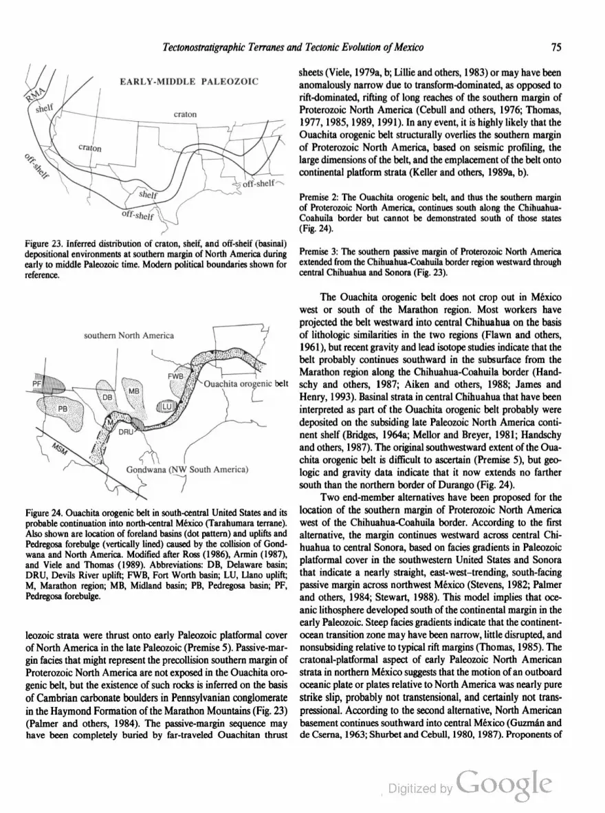
Tectonostratigraphic Terranes and Tectonic Evolution ofMexico 75
EARLY-MIDDLE PALEOZOIC
Figure 23. Inferred distribution of craton, shelf, and off-shelf (basinal)
depositional environments at southern margin of North America during
early to middle Paleozoic time. Modern political boundaries shown for
reference.
southern North America
Figure 24. Ouachita orogenic belt in south-central United States and its
probable continuation into north-central México (Tarahumara terrane).
Also shown are location of foreland basins (dot pattern) and uplifts and
Pedregosa forebulge (vertically lined) caused by the collision of Gond
wana and North America. Modified after Ross (1986), Armin (1987),
and Viele and Thomas (1989). Abbreviations: DB, Delaware basin;
DRU, Devils River uplift; FWB, Fort Worth basin; LU, Llano uplift;
M, Marathon region; MB, Midland basin; PB, Pedregosa basin; PF,
Pedregosa forebulge.
leozoic strata were thrust onto early Paleozoic platformal cover
of North America in the late Paleozoic (Premise 5). Passive-mar
gin facies that might represent the precollision southern margin of
Proterozoic North America are not exposed in the Ouachita oro
genic belt, but the existence of such rocks is inferred on the basis
of Cambrian carbonate boulders in Pennsylvanian conglomerate
in the Haymond Formation of the Marathon Mountains (Fig. 23)
(Palmer and others, 1984). The passive-margin sequence may
have been completely buried by far-traveled Ouachitan thrust
sheets (Viele, 1979a, b; Lillie and others, 1983) or may have been
anomalously narrow due to transform-dominated, as opposed to
rift-dominated, rifting of long reaches of the southern margin of
Proterozoic North America (Cebull and others, 1976; Thomas,
1977, 1985, 1989, 1991). In any event, it is highly likely that the
Ouachita orogenic belt structurally overlies the southern margin
of Proterozoic North America, based on seismic profiling, the
large dimensions of the belt, and the emplacement of the belt onto
continental platform strata (Keller and others, 1989a, b).
Premise 2: The Ouachita orogenic belt, and thus the southern margin
of Proterozoic North America, continues south along the Chihuahua
Coahuila border but cannot be demonstrated south of those states
(Fig. 24).
Premise 3: The southern passive margin of Proterozoic North America
extended from the Chihuahua-Coahuila border region westward through
central Chihuahua and Sonora (Fig. 23).
The Ouachita orogenic belt does not crop out in México
west or south of the Marathon region. Most workers have
projected the belt westward into central Chihuahua on the basis
of lithologic similarities in the two regions (Flawn and others,
1961), but recent gravity and lead isotope studies indicate that the
belt probably continues southward in the subsurface from the
Marathon region along the Chihuahua-Coahuila border (Hand
schy and others, 1987; Aiken and others, 1988; James and
Henry, 1993). Basinal strata in central Chihuahua that have been
interpreted as part of the Ouachita orogenic belt probably were
deposited on the subsiding late Paleozoic North America conti
nent shelf (Bridges, 1964a; Mellor and Breyer, 1981; Handschy
and others, 1987). The original southwestward extent of the Oua
chita orogenic belt is difficult to ascertain (Premise 5), but geo
logic and gravity data indicate that it now extends no farther
south than the northern border of Durango (Fig. 24).
Two end-member alternatives have been proposed for the
location of the southern margin of Proterozoic North America
west of the Chihuahua-Coahuila border. According to the first
alternative, the margin continues westward across central Chi
huahua to central Sonora, based on facies gradients in Paleozoic
platformal cover in the southwestern United States and Sonora
that indicate a nearly straight, east-west—trending, south-facing
passive margin across northwest Mexico (Stevens, 1982; Palmer
and others, 1984; Stewart, 1988). This model implies that oce
anic lithosphere developed south of the continental margin in the
early Paleozoic. Steep facies gradients indicate that the continent
ocean transition zone may have been narrow, little disrupted, and
nonsubsiding relative to typical rift margins (Thomas, 1985). The
cratonal-platformal aspect of early Paleozoic North American
strata in northern México suggests that the motion of an outboard
oceanic plate or plates relative to North America was nearly pure
strike slip, probably not transtensional, and certainly not trans
pressional. According to the second alternative, North American
basement continues southward into central Mexico (Guzman and
de Cserna, 1963; Shurbet and Cebull, 1980, 1987). Proponents of

76 R. L. Sedlock and Others
this alternative also infer late Precambrian to early Paleozoic
northwest-striking transform offset of the continental margin
(Cebull and others, 1976), as has been inferred in the Ouachitan
and Appalachian orogens (Thomas, 1977, 1991). The second
alternative is unattractive because the 70- to 80-km thickness of
the lithosphere in central México is less than in cratonal areas of
North America, and because, in the late Paleozoic and early
Mesozoic, part and perhaps most of what is now central México
was an oceanic realm that lay west of the western margin of
Pangea, with a clear history of arc magmatism and accretionary
tectonics.
Premise 4: In the latest Proterozoic, the passive margin of southwestern
North America stretched northward from Sonora into southeastern Cali
fornia and south-central Nevada (Fig. 23).
The late Proterozoic southern margin of North America
between central Chihuahua and Sonora (Premise 3) and east
central California and south-central Nevada (Stewart and Poole,
1974) is difficult to determine because of superposed sinistral and
dextral strike-slip faulting of late Proterozoic(?), late Paleozoic,
Mesozoic, and Cenozoic age (Premises 11 through 13). North
American basement may have formed a southwest-trending
promontory between Chihuahua and central California in the late
Proterozoic (Dickinson, 1981). Following the reasoning in Prem
ise 3, such a promontory must have been disrupted prior to the
late Paleozoic, producing (1) displaced terranes correlative with
southwestern North America or (2) a large continental mass
with a paleomagnetic pole path that indicates past proximity to
southwestern North America. We find no evidence for either
product, although it is conceivable that the disrupted terranes or
continental mass may have been attached to northern South
America in the late Paleozoic or Mesozoic, given the existence
there of basement rocks of Grenville age (Rowley and Pindell,
1989)
Facies distribution indicates that the trend of the western
margin of North America at the latitude of central and southern
California changed from north-south or northeast-southwest to
northwest-southeast by the Pennsylvanian and perhaps earlier
(Stevens and Stone, 1988; Stone and Stevens, 1988). Late Pa
leozoic to possible early Mesozoic southeastward translation of a
narrow tract of latest Proterozoic to Cambrian platformal
rocks from southeastern California to northern Sonora (Premise
10) does not require pronounced southwestward bulging of the
continental margin and is consistent with the roughly linear
northwest trend shown in Figure 23.
Paleogeography ofPangea in the vicinity ofMéxico
Premise 5: The supercontinent Pangea was formed by diachronous Penn
sylvanian—Early Permian collision of Gondwana (Africa and South
America) with North America during the Alleghany orogeny in the
Appalachian region and the Ouachita orogeny in the southern United
States.
Late Paleozoic deformation, metamorphism, and synoro
genic sedimentation in the Appalachian and Ouachitan orogens
are widely ascribed to diachronous collision between Gondwana
and North America (Hatcher, 1972; King, 1975; Walper, 1980).
Reconstructions based on paleomagnetic, biostratigraphic, and
other geologic and geophysical evidence show that North Amer
ica and South America were in close proximity as part of the
Pangea supercontinent during the Pennsylvanian, Permian, and
Triassic (Ross, 1979; Van der Voo and others, 1984; Scotese and
McKerrow, 1990).
Premise 6: Diachronous collision, or “zippering,” of North America and
Scuth America terminated in the Permian near the Chihuahua-Coahuila
border due to the unfavorable orientation of the margins of the colliding
plates and perhaps to the cessation of convergence.
The termination of the Ouachita orogenic belt (Tarahu
mara terrane) near the Chihuahua-Coahuila border can be ex
plained in several ways. First, the original southwestern contin
uation of the belt may have been offset southeastward to Ciudad
Victoria, Tamaulipas (northern Guachichil terrane) by sinistral
slip on the Mojave-Sonora Megashear or other faults (Flawn and
others, 1961). This possibility is unlikely in light of recently
documented differences between Ouachitan rocks in west Texas
and contemporaneous rocks near Ciudad Victoria (Stewart,
1988). Second, the Ouachita orogenic belt may have continued
westward from the Chihuahua-Coahuila border region to
southern California, subparallel to the inferred southern margin
of Proterozoic North America (Premise 3), but later was
disrupted or obscured by tectonism and magmatism. This
alternative is awkward because it places Gondwanan crystalline
basement rocks directly west of a Permo-Triassic arc in eastern
Mexico that probably records eastward subduction of oceanic
lithosphere beneath the western margin of Pangea. A third
possibility, which we adopt here, is that collision did not occur
south or west of the Chihuahua-Coahuila border, for either or
both of two reasons: (1) the orientation of the two continental
margins may have been unsuitable for collision, e.g., a
north-south western boundary of South America; and (2) the
convergence rate between North America and South America
may have slowed dramatically during the ongoing collision
between the two continents.
Low-grade metasedimentary rocks underlying the Coahuil
tecano terrane, metamorphic country rocks of the Permo-Triassic
batholith in the Coahuiltecano and northern Maya terranes, and
metamorphic basement rocks underlying the Yucatan platform
are interpreted here as remnants of Gondwanan continental crust.
Origin of Grenville basement in México
Premise 7: Precambrian rocks of Grenville age in México and central
Cuba were derived from and are allochthonous with respect to the North
American Grenville province.

Tectonostratigraphic Terranes and Tectonic Evolution ofMexico 77
High-grade metasedirnentary and metaigneous rocks of the
Grenville province rim eastern and southern Proterozoic North
America, probably underlie the Ouachita orogenic belt, and are
inferred to extend southwestward into northern Mexico (Fig. 25).
Ages of intrusion and metamorphism of rocks in the Llano uplift
of central Texas range from 1,305 to 1,091 Ma (Walker, 1992),
and rocks in this age range crop out or have been penetrated by
wells in central and northern Chihuahua. Outcrops and xenoliths
of basement rocks that have been correlated with the Grenville
province are known from several disjunct terranes in central and
southern Mexico and from central Cuba (Renne and others,
1989)
Basement rocks with lithology, history, and age similar to the
Grenville province have been recognized in northern South
America (Kroonenberg, 1982; Priem and others, 1989), but to
date there are no strong arguments in favor of their possible
original contiguity with and subsequent separation from the
Grenville province in North America. We adopt Premise 7 be
cause evidence is lacking for pre-late Paleozoic contiguity of
North America and South America, and thus for original conti
guity and perhaps continuity of the Grenville province and
Grenville-like rocks in South America.
The outcrops of Grenville rocks in eastern and southern
México are commonly interpreted as culminations of continuous
Grenvillian basement in eastern and central Mexico (de Cserna,
1971; Lopez-Infanzon, 1986; Ruiz and others, 1988b). We sug
gest that such continuity of basement is very unlikely because the
western edge of the Maya terrane probably was a major kine
matic boundary in late Paleozoic to mid-Jurassic time, separating
relatively rigid continental crust of the Maya terrane to the east
from tectonically active, kinematically distinct terranes to the
west (pp. 94—103). Our preferred alternate interpretation is that
exposures of Grenville rocks are discrete, fault-bounded frag
ments of basement derived from the North American Grenville
province, that much or most of México is underlain by basement
blocks of not only Grenville but also younger (early and middle
Paleozoic) age, and that the basement blocks are allochthonous
with respect to North America and to one another. The
interpretation of the basement of central Mexico as a heterogene
ous assemblage of rocks of diverse age and composition is sup
ported by recent Pb, Sr, and Nd isotopic studies.
Permian-Triassic arc in eastern México
Premise 8: In the Late Permian and Triassic, a continental magmatic are
developed at the western margin of central Pangea near what
is now eastern México.
Late Permian and Triassic magmatic arc rocks are present
in a roughly linear swath that extends from Coahuila (Coahuilte
cano terrane) to Chiapas (Maya terrane) in eastern Mexico; these
rocks probably were emplaced into continental crust (Lopez
Ramos, 1972, 1985; Damon and others, 1981; Lopez-Infanzon,
Archean
Cordilleran
terranes
Figure 25. Precambrian domains in southern North America, modified
after Anderson and Silver (1979), Bickford and others (1986), and
Hoffman (1989). Horizontal lines indicate 2,000- to 1,800-Ma provinces;
circle pattern, 1,300- to 1,000-Ma Grenville province; irregular dot pat
tern, 1,100-Ma rift.
1986; Wilson, 1990). Remnants of the arc crop out near Valle
San Marcos (242 i 2 Ma granodiorite, Rb-Sr), Potrero de
la Mula (213 i 14 Ma I-type granite, Rb-Sr), and Las Delicias
(210 i 4 Ma granodiorite, K-Ar) in the Coahuiltecano terrane;
they crop out in the Chiapas Massif (~260 to 220 Ma, K-Ar),
Maya Mountains of Belize (237 to 226 Ma, K-Ar), and Guate
mala (227 Ma, Rb-Sr, and 238, 213, and 212 Ma, 40Ar/39Ar
cooling ages) in the southern part of the Maya terrane; and they
have been penetrated by numerous petroleum wells in the states of
Veracruz, Nuevo Leon, and Tamaulipas in the Gulf coastal plain
(~275 to 210 Ma, K-Ar).
Global and regional reconstructions indicate that this arc
probably formed on the western margin of Pangea above an
east-dipping subduction zone that consumed oceanic lithosphere
of a plate or plates west of Pangea, and that the Mexican reach of
the arc was roughly coeval with adjacent reaches of continental
magmatic arc in the southwestern United States and northwestern
South America (Dickinson, 1981; Scotese and McKerrow,
1990). In the southwestern United States, Permo-Triassic arc
rocks include Permian volcanic rocks as old as 283 Ma (U-Pb),
Late Permian to Early Triassic granitoids, and Early Triassic
volcaniclastic rocks that contain clasts of the granitoids in the
northwestern Mojave Desert and Death Valley (Carr and others,
1984; Walker, 1988; Snow and others, 1991; Barth and others,
1992). In northwestern South America, Permo-Triassic mag
matic rocks crop out in the Cordillera de Mérida in northwestern
Venezuela, the Sierra Nevada de Santa Marta in northern Co
lombia, and the Cordillera Central and Cordillera Oriental in
central Colombia (Shagam and others, 1984; Restrepo and Tous
saint, 1988; Case and others, 1990); in the eastern Cordillera of
Peru (Cobbing and Pitcher, 1983); and in Chile north of about
28°S (Farrar and others, 1970; McBride and others, 1976; Hal
pem, 1978; Aguirre, 1983).

78 R. L. Sedlock and Others
The Mexican reach of the Permo-Triassic continental arc
may have been partially disrupted by later tectonism but is pre
sumed to initially have been laterally continuous with the reach in
northwestern South America (p. 99). The discontinuity between
the northern end of the Mexican reach of the arc and the southern
end of the US. reach in the Mojave—Death Valley region proba
bly reflects the initial geometry of the plate boundary rather than
tectonic offset (p. 95).
Late Paleozoic-Cenozoic strike-slipfaulting
Premise 9: Since late Paleozoic time, the western margin of North Amer
ica has been cut by sinistral and dextral strike-slip fault systems that
accommodated the margin-parallel transport of tectonostratigraphic ter
ranes. These fault systems probably extended south into Mexico and
perhaps into northwestern South America.
Paleomagnetic, biostratigraphic, and geologic data support
the widely held view that the western margin of North America,
at least at the latitude of the United States and Canada, was the
site of margin-parallel transport of tectonostratigraphic terranes
during much of Cenozoic, Mesozoic, and perhaps Paleozoic time
(e.g., Coney and others, 1980; Howell and others, 1985). Below,
we outline evidence for episodes of sinistral and dextral displace
ment within and along the western margin of México at different
times since the late Paleozoic.
Late Paleozoic—Early Triassic truncation of
southwestern United States
Premise 10: A fragment of southwestern North America was tectonically
removed from the continental margin in eastern California and translated
to the southeast during Pennsylvanian to Early Triassic time.
The distribution of cratonal, shelfal, and basinal rocks in
southeastern and east-central California and western Nevada is
interpreted by many workers to indicate Pennsylvanian to Early
Triassic truncation of the southwestern margin of Proterozoic
North America at an enigmatic northwest-striking structure or
structures (Fig. 26). Displaced fragments include part of the
Roberts Mountain allochthon, which was accreted to western
North America during the Antler orogeny, and latest Prot
erozoic to early Paleozoic passive margin strata of North
America (Stevens and others, 1992). Proposed ages of displace
ment are Late Permian to earliest Triassic (Hamilton, 1969;
Burchfiel and Davis, 1981), Pennsylvanian to Early Permian
(Stevens and Stone, 1988; Stone and Stevens, 1988; Stevens and
others, 1992), and both late Paleozoic and Early Triassic
(Walker, 1988). We propose that the displaced fragment of the
Roberts Mountain allochthon was translated southeastward
about 400 km to the Mojave region during the Pennsylvanian to
Early Permian at a left-lateral fault or faults (Walker, 1988;
Stevens and others, 1992). To the southeast, this left-lateral fault
Mississippian mid-Permian
off-shelf
0
Figure 26. Diagrams showing proposed late Paleozoic truncation of
southwestern margin of North America. Brick pattern indicates passive
margin facies; irregular dot pattern, accreted Roberts Mountain Alloch
thon. Modified from Walker (1988).
or faults may be the Mojave-Sonora Megashear, in which case
about half of the inferred postulated displacement on the mega
shear is Paleozoic (Stevens and others, 1992). Alternatively, the
fault or faults may have been outboard of the future trace of a
Jurassic megashear (see discussion of Premise 11).
Late Jurassic Mojave-Sonora Megashear
Premise 11: The Mojave-Sonora Megashear in the southwestern United
States and northwestern Mexico accommodated about 700 to 800 km of
sinistral slip from 160 to 145 Ma, and was roughly coincident with the
Jurassic magmatic are.
In Part 1 we identified the southern boundary of the North
America, Tarahumara, and Coahuiltecano terranes as the
Mojave-Sonora Megashear (MSM), a major left-lateral fault pos
tulated to have been active in the Late Jurassic (Silver and And
erson, 1974, 1983; Anderson and Silver, 1979). The MSM was
first recognized in Sonora on the basis of the truncation of the
northeast-southwest trend of 1,700- to 1,600-Ma basement rocks
by 1,800- to 1,700-Ma basement rocks, the juxtaposition of dis
similar Mesozoic volcanic and sedimentary rocks as young as
Oxfordian, and penetrative deformation features in Proterozoic
and Mesozoic rocks near the proposed fault trace (Fig. 22). Oth
er evidence for displacement along the MSM (Fig. 22) in
cludes: (1) strong similarity between latest Proterozoic and
Cambrian shelfal rocks southwest of the fault near Caborca,
Sonora (Serf terrane) and rocks northeast of the fault in southern
California and Nevada (Stewart and others, 1984); (2) strong
stratigraphic and sedimentologic similarity between Middle Or
dovician quartzite in central Sonora (Serf terrane) and the Eureka
quartzite in southeastern California (Ketner, 1986); (3) about 800
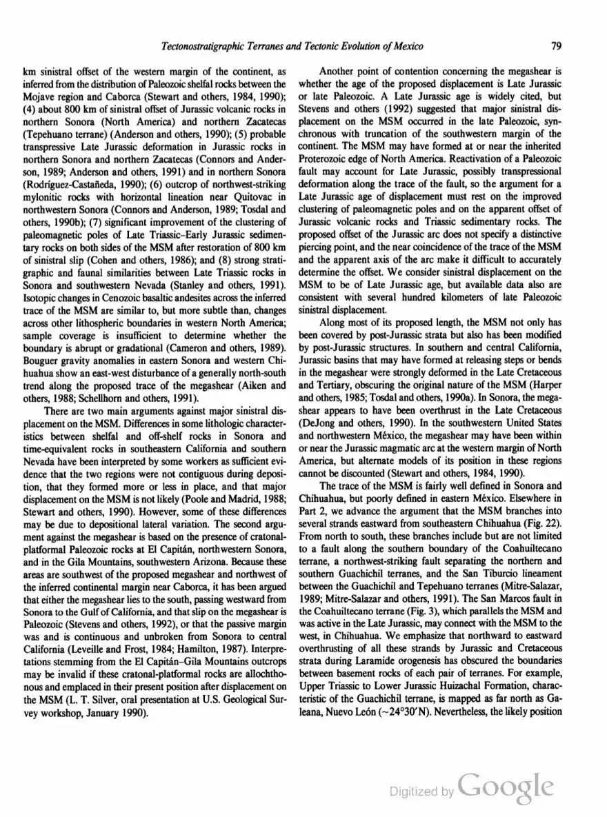
Tectonostratigraphic Terranes and Tectonic Evolution ofMexico 79
km sinistral offset of the western margin of the continent, as
inferred from the distribution of Paleozoic shelfal rocks between the
Mojave region and Caborca (Stewart and others, 1984, 1990);
(4) about 800 km of sinistral offset of Jurassic volcanic rocks in
northern Sonora (North America) and northern Zacatecas
(Tepehuano terrane) (Anderson and others, 1990); (5) probable
transpressive Late Jurassic deformation in Jurassic rocks in
northern Sonora and northern Zacatecas (Connors and Ander
son, 1989; Anderson and others, 1991) and in northern Sonora
(Rodriguez-Castaneda, 1990); (6) outcrop of northwest-striking
mylonitic rocks with horizontal lineation near Quitovac in
northwestern Sonora (Connors and Anderson, 1989; Tosdal and
others, 1990b); (7) significant improvement of the clustering of
paleomagnetic poles of Late Triassic-Early Jurassic sedimen
tary rocks on both sides of the MSM after restoration of 800 km
of sinistral slip (Cohen and others, 1986); and (8) strong strati
graphic and faunal similarities between Late Triassic rocks in
Sonora and southwestern Nevada (Stanley and others, 1991).
Isotopic changes in Cenozoic basaltic andesites across the inferred
trace of the MSM are similar to, but more subtle than, changes
across other lithospheric boundaries in western North America;
sample coverage is insufficient to determine whether the
boundary is abrupt or gradational (Cameron and others, 1989).
Bouguer gravity anomalies in eastern Sonora and western Chi
huahua show an east-west disturbance of a generally north-south
trend along the proposed trace of the megashear (Aiken and
others, 1988; Schellhom and others, 1991).
There are two main arguments against major sinistral dis
placement on the MSM. Differences in some lithologic character
istics between shelfal and off-shelf rocks in Sonora and
time-equivalent rocks in southeastern California and southern
Nevada have been interpreted by some workers as sufficient evi
dence that the two regions were not contiguous during deposi
tion, that they formed more or less in place, and that major
displacement on the MSM is not likely (Poole and Madrid, 1988;
Stewart and others, 1990). However, some of these differences
may be due to depositional lateral variation. The second argu
ment against the megashear is based on the presence of cratonal
platformal Paleozoic rocks at El Capitan, northwestern Sonora,
and in the Gila Mountains, southwestern Arizona. Because these
areas are southwest of the proposed megashear and northwest of
the inferred continental margin near Caborca, it has been argued
that either the megashear lies to the south, passing westward from
Sonora to the Gulf of California, and that slip on the megashear is
Paleozoic (Stevens and others, 1992), or that the passive margin
was and is continuous and unbroken from Sonora to central
California (Leveille and Frost, 1984; Hamilton, 1987). Interpre
tations stemming from the El Capitan—Gila Mountains outcrops
may be invalid if these cratonal-platformal rocks are allochtho
nous and emplaced in their present position after displacement on
the MSM (L. T. Silver, oral presentation at US. Geological Sur
vey workshop, January 1990).
Another point of contention concerning the megashear is
whether the age of the proposed displacement is Late Jurassic
or late Paleozoic. A Late Jurassic age is widely cited, but
Stevens and others (1992) suggested that major sinistral dis
placement on the MSM occurred in the late Paleozoic, syn
chronous with truncation of the southwestern margin of the
continent. The MSM may have formed at or near the inherited
Proterozoic edge of North America. Reactivation of a Paleozoic
fault may account for Late Jurassic, possibly transpressional
deformation along the trace of the fault, so the argument for a
Late Jurassic age of displacement must rest on the improved
clustering of paleomagnetic poles and on the apparent offset of
Jurassic volcanic rocks and Triassic sedimentary rocks. The
proposed offset of the Jurassic arc does not specify a distinctive
piercing point, and the near coincidence of the trace of the MSM
and the apparent axis of the arc make it difficult to accurately
determine the offset. We consider sinistral displacement on the
MSM to be of Late Jurassic age, but available data also are
consistent with several hundred kilometers of late Paleozoic
sinistral displacement.
Along most of its proposed length, the MSM not only has
been covered by post-Jurassic strata but also has been modified
by post-Jurassic structures. In southern and central California,
Jurassic basins that may have formed at releasing steps or bends
in the megashear were strongly deformed in the Late Cretaceous
and Tertiary, obscuring the original nature of the MSM (Harper
and others, 1985; Tosdal and others, 1990a). In Sonora, the mega
shear appears to have been overthrust in the Late Cretaceous
(DeJong and others, 1990). In the southwestern United States
and northwestern México, the megashear may have been within
or near the Jurassic magmatic are at the western margin of North
America, but alternate models of its position in these regions
cannot be discounted (Stewart and others, 1984, 1990).
The trace of the MSM is fairly well defined in Sonora and
Chihuahua, but poorly defined in eastern México. Elsewhere in
Part 2, we advance the argument that the MSM branches into
several strands eastward from southeastern Chihuahua (Fig. 22).
From north to south, these branches include but are not limited
to a fault along the southern boundary of the Coahuiltecano
terrane, a northwest-striking fault separating the northern and
southern Guachichil terranes, and the San Tiburcio lineament
between the Guachichil and Tepehuano terranes (Mitre-Salazar,
1989; Mitre-Salazar and others, 1991). The San Marcos fault in
the Coahuiltecano terrane (Fig. 3), which parallels the MSM and
was active in the Late Jurassic, may connect with the MSM to the
west, in Chihuahua. We emphasize that northward to eastward
overthrusting of all these strands by Jurassic and Cretaceous
strata during Laramide orogenesis has obscured the boundaries
between basement rocks of each pair of terranes. For example,
Upper Triassic to Lower Jurassic Huizachal Formation, charac
teristic of the Guachichil terrane, is mapped as far north as Ga
leana, Nuevo Leon (~24°30’N). Nevertheless, the likely position

80 R. L. Sedlock and Others
of the Guachichil-Coahuiltecano boundary, i.e., the megashear, is
several tens of kilometers south of Galeana, beneath nappes that
have transported the Huizachal Formation and other rocks of the
Guachichil terrane to the north and east.
Cretaceous translation ofBaja California
Premise 12: A crustal fragment comprising most of the present Baja
California peninsula has been translated about 15° northward since
about 90 Ma.
One of the most controversial aspects of the tectonic evolu
tion of Mexico is whether rocks in Baja California underwent
large amounts of margin-parallel transport during Mesozoic and
Tertiary oblique convergence. Paleomagnetic studies of rocks of
different age, lithology, and magnetic character have been inter
preted to indicate that much or all of Baja California and adjacent
southern California has been translated northward a minimum of
10° and perhaps as much as 20° since about 90 Ma (Hagstrum
and others, 1985, 1987; Lund and Bottjer, 1991; Lund and oth
ers, 1991b). Most studies also have recognized 25° to 45° of
concomitant clockwise rotation. The rocks that are affected in
clude the Yuma terrane, that part of the Seri terrane in Baja
California, the Cochimi terrane excepting blueschist-facies sub
duction complex rocks, and rocks in southern California south of
the Transverse Ranges that appear to correlate with the Yuma
and Seri terranes. In the following discussion we refer to this
region as Baja or the Baja block; it is similar to the Peninsular
Ranges composite terrane of Bottjer and Link (1984) but does
not include the Period terrane at the southern tip of the peninsula,
for which no paleomagnetic data are available. Although anom
alously low paleolatitudes were reported in a study of volcanic
rocks on the eastern margin of the gulf (Bobier and Robin, 1983),
we do not consider this region part of the Baja block because
these workers did not correct for structural tilt.
Paleomagnetic investigations of rocks of different age, 1i
thology, and magnetic character throughout the Baja block have
yielded Cretaceous and Paleogene paleolatitudes that are signifi
cantly shallower than would be expected if they had been part of
stable North America. Below we list some typical relative paleo
latitudes, i.e., the northward latitudinal displacement of specific
localities relative to North America since rocks at those localities
were magnetized (Lund and Bottjer, 1991). Cretaceous plutons:
123° 1 7.4° (Teissere and Beck, 1973), 132° 1 6.8°, and 4.6° i
6.0° (Hagstrum and others, 1985); Triassic chert, limestone, pil
low basalt, and sandstone: 180" i 11.3° (Hagstrum and others,
1985); Jurassic clastic sedimentary rocks: 151° 1: 6.7° (Morris
and others, 1986); Late Cretaceous sedimentary rocks: 18.20 i
6.7°, 175° 1 6.7°, and 141° i 9.6° (Fry and others, 1985;
Morris and others, 1986), 15.0° i 3.8° (Filmer and Kirschvink,
1989), and 17.7° i 6.9° (Smith and Busby-Spera, 1991); and
Paleogene sedimentary rocks: 15.0° 1: 98° (Morris and others,
1986). Studies of Tertiary sedimentary and volcanic rocks indi
cate no resolvable motion with respect to North America since
about 40 Ma (Hagstrum and others, 1987; Lund and others,
1991a, b). Included within the values listed above is the widely
accepted 2° to 3° of northward displacement of Baja California
during Late Cenozoic opening of the Gulf of California.
Paleomagnetic data from Baja, including studies listed above
and others summarized by Lund and Bottjer (1991) and Lund
and others (1991b), display an average range of relative paleo
latitude values of about 12° to 15°. The dispersion of values is
not peculiar to Baja, and thus does not undermine the viability of
the paleomagnetic data base. For example, such dispersion is
characteristic of the paleomagnetic data base for cratonal North
America, where an individual site may yield a relative paleolati
tude as much as 12° different from the average of many sites on
the craton (Lund and Bottjer, 1991). The importance of the Baja
data base is that the average Cretaceous and Paleogene relative
paleolatitudes of Baja are consistently lower than those of coeval
North America (Lund and Bottjer, 1991; Lund and others,
1991b), and it is on this basis that we premise 15° of northward
displacement of Baja since about 90 Ma.
The interpretation of Cretaceous and Paleogene northward
displacement of Baja has been countered by numerous paleo
magnetic and geologic arguments (Beck, 1991; Butler and others,
1991; Gastil, 1991; Lund and others, 1991b): (1) relative paleo
latitudes from Baja are not statistically different from those of
North America; (2) results may be due to experimental error;
(3) results from the Peninsular Ranges batholith are due to tilting
of the batholith about a subhorizontal axis; (4) in sedimentary
rocks, the inclination may be flattened by compaction of incom
pletely lithified sediment or by very strong anisotropy in strongly
magnetized rocks; (5) results are due to an irregularity in the
geomagnetic field during the Cretaceous and early Paleogene;
(6) results may reflect remagnetization; (7) no fault or faults have
been identified along which Baja may have been displaced; and
(8) correlations of geologic units between Baja and Sonora, such
as Paleozoic sedimentary rocks and Cretaceous plutonic rocks,
allow little net displacement. Below, we sequentially address each
argument.
1. Recent studies of Late Cretaceous and early Paleogene
strata on North America and in the Baja block offer very strong
evidence that there are significant differences between data sets
from the two areas (Lund and others, 1991b).
2. In modern paleomagnetic studies, experimental error
ought to be random and less than about 20°, yet no Cretaceous
paleomagnetic poles from Baja fall within a circle of radius 20°
centered on the Cretaceous reference pole (Beck, 1991). Also,
modern magnetic cleaning methods ensure that large amounts of
present-day overprint are not present.
3. En masse tilting of the Peninsular Ranges batholith as a
means of deriving anomalously low paleolatitudes is not sup
ported by regional geologic relations or recent geobarometric
studies of the batholith itself. The western part of the batholith
apparently has not been tilted since at least the Turonian, based
on the ages of flat-lying overlying strata (Gastil, 1991). Using
amphibole barometry, Ague and Brandon (1992) defined pa

Tectonostratigraphic Terranes and Tectonic Evolution ofMexico 81
leohorizontal in the northern part of the batholith that differed
from a rather conjectural one used by Butler and others (1991).
On the basis of the newly determined orientation of this surface,
Ague and Brandon calculated about 1,000 i 450 km of north
ward displacement of Baja since the emplacement of the
batholith.
3. and 4. In order to explain all anomalous poles from Baja
by batholith tilting and sediment compaction, the direction and
amount of tilting must have produced paleomagnetic poles that
converged with those produced by flattening and perhaps rota
tion in the sediments. Such a coincidence is possible but the
probability is very small (Beck, 1991).
4. Inclination flattening of as much as 20° does not account
for the distribution of Cretaceous poles from Baja (Beck, 1991).
Likewise, studies of grain size versus magnetization in Cretaceous
siltstones and sandstones indicate that compaction is not the cause
of anomalously low inclinations (Smith and Busby-Spera, 1991).
5. It is very unlikely that the anomalous paleomagnetic
poles from Baja are due to an irregularity of the Late Cretaceous
paleomagnetic field (Beck, 1991). No irregularities are apparent
in the Cretaceous paleomagnetic field over cratonal North Amer
ica or over the world as a whole. Any irregularity somehow must
have been focused on the western edge of North America, main
taining itself for at least 30 my. and tracking the leading edge of
the continent as it moved westward over hotspots.
6. Almost all paleomagnetic poles from Baja are interpreted
as carrying a primary magnetization. Only a few of these poles
fall near the post-Cretaceous apparent polar wander path for
North America, indicating that undetected remagnetization of all
Baja poles has not occurred (Beck, 1991).
7. Possible locations of faults that may have accommodated
displacement of Baja are discussed by Gastil (1991). In this
volume, we adopt Gastil’s Oaxaca-Baja Megashear II, a
hypothetical fault or fault system that roughly coincides with the
Gulf of California. The trace of this fault system apparently has
been obliterated by late Cenozoic stretching, extension, subsid
ence, and sedimentation in the Gulf of California.
8. Large displacement of Baja along a fault system in the
Gulf of California has been challenged on the basis of several
geologic correlations across the gulf. However, regional geologic
relations and correlations, such as reefal limestones in Cretaceous
arc rocks, high-grade metamorphism associated with are magma
tism (Gastil, 1991), and compositional and isotopic trends within
the Cretaceous batholith (Silver and others, 1979; Silver, 1986),
have proven to be inconclusive tests of the proposed displace
ments. For example, we cannot dismiss the possibility that Cre
taceous arc rocks in Baja correlate equally well with coeval arc
rocks farther south in México, for which few comparable geo
chemical data are available.
A stronger correlation across the Gulf of California is the
boundary between Paleozoic shelfal and Paleozoic basinal strata
(Stewart and others, 1990; Gastil and others, 1991). This correla
tion may be reconciled with Cretaceous-Paleogene northward
displacement of Baja only if the Paleozoic rocks in Baja earlier
had been displaced southward from correlative rocks in Sonora.
In our reconstruction, we postulate a two-stage displacement his
tory of Baja California involving Permian-Jurassic southward
displacement and Cretaceous-Paleogene northward displace
ment. Some critics may charge that such a scenario relies too
much on coincidence, but we counter that the perceived
coincidence is a function of the timing of evolution relative to
plate tectonics: if humans as earth scientists had evolved 10 my.
in the future (assuming constant Pacific—North America relative
motion), the coincidence would not be an issue inasmuch as the
Paleozoic rocks in Baja and Sonora would not be adjacent. In
fact, much of western North America appears to have been af
fected by southward displacement of terranes in the Triassic to
the mid-Cretaceous, followed by northward displacement in the
Late Cretaceous and Tertiary (Beck, 1989).
Other geologic evidence is consistent with Baja at the lati
tude of southern México in the mid-Mesozoic. Late Jurassic
granite clasts in Late Jurassic conglomerate of the Cochimi ter
rane that contain mid-Proterozoic inherited or xenocrystic zircon
may have been derived from either mid-Proterozoic to Mesozoic
continental crust in southern Mexico or early Proterozoic crust
intruded by abundant mid-Proterozoic granitoids in northwestern
México (Anderson and Silver, 1977a, b; Kimbrough and others,
1987). A southern source is tentatively inferred because most
granitoids in northwestern México are slightly older and more
alkalic than the conglomerate clasts in the Cochimi terrane
(Kimbrough and others, 1987). Limestone blocks in flysch of the
eastern subterrane of the Yuma terrane contain Jurassic ammo
nites that have stronger affinities to the south than to the north
(Imlay, 1963, 1964). Late Cretaceous sedimentary rocks in
northern Baja contain abundant Coralliochama Orcutti rudists
that are absent from cooler water assemblages in the Great Valley
of California (D. Bottjer, personal communication, 1992) and are
consistent with, although not indicative of, a more southerly
position.
The view that the Baja block and other Cordilleran blocks
or terranes were subjected to large displacements requires that
convergence between North America and subducting oceanic
lithosphere to the west was oblique, at times highly oblique, for
tens of millions of years (Beck, 1991). Plate motion calculations,
although rather speculative for times as old as the Mesozoic, seem
to support this conclusion. Another implication of the large dis
placements is that terrane dispersion was not obstructed by a
continental buttress (Beck, 1991).
Cretaceous slip in the TMVB
Premise 13: A fault zone in central México now concealed by thick
volcanic rocks of the Trans-Mexican Volcanic Belt accommodated about
435 km of dextral slip since the mid-Cretaceous.
The late Cenozoic Trans-Mexican Volcanic Belt (TMVB) in
central México may conceal a preexisting fault zone of uncertain
displacement history (Demant, 1978; Nixon, 1982). Gastil and

82 R. L. Sedlock and Others
Jensky (1973) inferred about 435 km of post—mid-Cretaceous
slip on a dextral fault system in order to realign batholithic and
mineralization belts. Anderson and Schmidt (1983) proposed
about 300 km of Jurassic slip on a sinistral fault system as a
geometric requirement of their kinematic model. We are unable
to assess the speculative sinistral offset in the Jurassic, but we
accept the proposed post-mid-Cretaceous dextral slip.
Cenozoic translation of the Chortis block/terrane
Premise 14: The Chortis block was translated at least 1,000 km eastward
on a sinistral fault system near the southern margin of Mexico since the
Eocene.
Proterozoic and Phanerozoic metamorphic basement rocks
with a predominant north-south structural grain appear to have
been truncated near the roughly east-west—trending Middle
America trench in southern México (Figs. 3, 27) (de Csema,
1967, 1971). Karig and others (1978) noted that this truncation
may have occurred during Tertiary sinistral displacement of the
Chortis block (Chortis terrane). Estimates of the amount and
timing of sinistral displacement of Chortis range from 1,000 to
2,000 km since the middle Eocene to 150 km during the late
Miocene (Burkart and others, 1987; Rosencrantz and others,
1988). The alternative of greater magnitude displacement is sup
ported by the length of the truncated margin, based on length-slip
magnitudes of modern faults, and the presence of a wide belt of
highly deformed, locally mylonitic rocks in the Motagua fault
zone (Erikson, 1990). West-northwest—trending structures in the
Chatino terrane may have been produced by Paleogene transten
sion during eastward displacement of the Chortis block (Robin
son and others, 1989, 1990; Robinson, 1991). The Cenozoic
evolution of the southern margin of Mexico is discussed further
on pages 109-112.
Truncation of structural trends in southern Mexico
Trans-Mexican Volcanic Belt
Figure 27. Apparent truncation of structural trends in metamorphic
basement in southern México. Data from many sources, including
INEGI (1980) and de Csema (1989). Abbreviations for terranes: C,
Cuicateco; Ch, Chatino; M, Mixteco; N, Nahuatl; Z, Zapoteco.
Opening of the proto-Caribbean and Gulf of Mexico
Premise 15: The Gulf of Mexico formed when the Yucatan block was
rifted from southern North America in the late Middle Jurassic to Late
Jurassic.
Premise 16: An ocean basin formed near what is now the Caribbean Sea
when South America was rifted from southern North America during
Early Cretaceous time.
Western Pangea underwent intracontinental extension and
rifting beginning in the Late Triassic. Late Triassic to Early
Jurassic red beds and volcanic rocks at the western and northern
margins of the Gulf of Mexico probably were deposited in
grabens produced during an early phase of brittle extension. In
Middle Jurassic time, extension was accommodated by ductile
stretching of continental lithosphere in the US. Gulf Coast region
and the northern margin of the Yucatan block. Continued rifting
of Pangea caused latest Middle to Late Jurassic southward drift
ing of Yucatan from the US. Gulf Coast, with contemporaneous
formation of oceanic lithosphere in the Gulf of Mexico, and Early
Cretaceous opening of a “proto-Caribbean” ocean basin between
the drifting North American and South American continents
(Schlager and others, 1984; Buffler and Sawyer, 1985; Pindell,
1985; Dunbar and Sawyer, 1987; Klitgord and Schouten, 1987;
Salvador, 1987; Pindell and others, 1988; Pindell and Barrett,
1990). Rifting and drifting of western Pangea is discussed further
on pages 96—98.
MESOZOIC AND CENOZOIC EVOLUTION OF
OCEANIC PLATES BORDERING MEXICO
In this section we summarize the constraints imposed on the
tectonic evolution of the Mexican region by studies of the oceanic
plates that once lay to the west and south.
Western Mexico
Using linear velocities predicted by plate motion studies
based on global plate—hotspot circuits (Engebretson and others,
1985; DeMets and others, 1990) and on marine magnetic anom
alies (Stock and Molnar, 1988; Stock and Hodges, 1989), we
have calculated the normal and tangential components of relative
motion between the North American plate and oceanic plates to
the west over the last 180 Ma (Table 18). Normal and tangential
components of relative velocity are shown for five sites on the
North American plate. On the basis of global reconstructions of
the orientation of the North American plate (e.g., Scotese and
others, 1988), we base our calculations on a north-south trend of
the plate boundary at the latitude of México and southern Cali
fornia prior to 161 Ma, a N20W trend between 161 and 85 Ma
(roughly parallel to the Sierra Nevada batholith), and a N40W
trend since 85 Ma (parallel to the modern San Andreas fault
system in California). Geographic coordinates refer to a plate
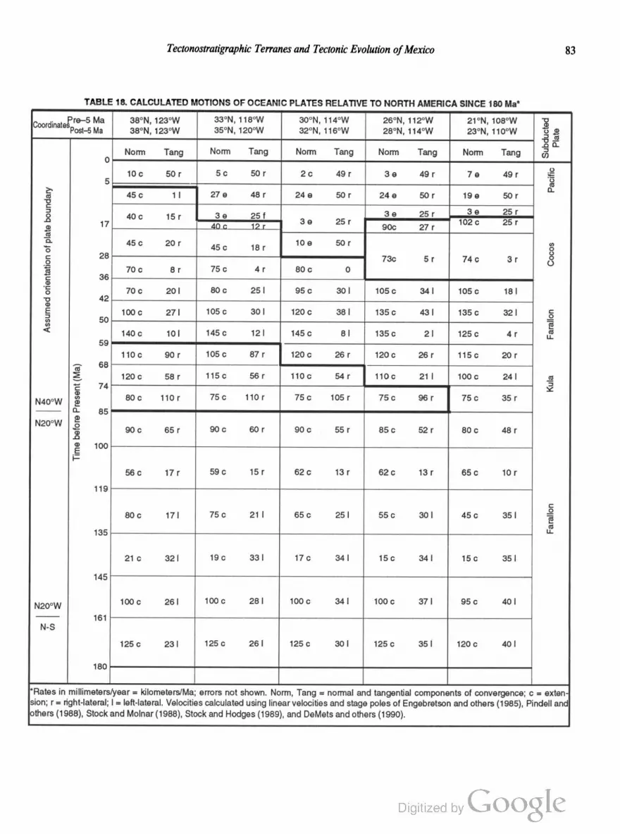
Tectonostratigraphic Terranes and Tectonic Evolution ofMexico 83
TABLE 18. CALCULATED MOTIONS OF OCEANIC PLATES RELATIVE TO NORTH AMERICA SINCE 180 Ma'
Coordinatefre—S Ma 38°N, 123°W 33°N, 118°W 30°N, 114°W 26°N, 112°W 21 °N, 108°W "8
Post—5 Ma 38°N, 123=w 35°N. 120°W 32°N. 116°W 28°N, 114°w 23°N, 110°w ‘g .3
1, _.o 0.
Norm Tang Norm Tang Norm Tang Norm Tang Norm Tang (3
0
10¢ 50r 5c 50r 2c 49r 39 49r 7e 49r 5%
5 i5 45¢ 1| 279 48r 24o 50r 24a 50r 199 50r
C
= 3 e 25 r° 40 c 15 r 3 e 25 r 3 e 25 r _.Q ‘—l2 17 dog 12r Se 25r 90c 27r 102c 25r
2D.B 45c 20r 45¢ 18r 109 50r g
g 28 73¢ s r 14 c s r 3
70 c a r 75 c 4 r 60 c 0
g 36
'5 70c 20| 80c 25l 95¢ 30| 105c s4| 105c ml
'8 42
E 100C 27| 1050 30l 120c 38l 135c 43l 135C 32I 5
§ 50 g
< 1ao¢ 1o| 145c 12| 145c 8| 1350 2| 1250 4r ,1“
59
110a 90r 105C 871 120C 26r 1200 26r 115c 20r
"E 68
g 120C 55r 1150 56r 11°C 54r 110c 21| 1006 24| g
'5 74 g0
N40,,w 3 60¢ 110r 750 110r 75¢ 105r 75c 96r 750 35r
0- 85
N20°W 95 90¢ 65f 900 60r 90¢ 55r 85c 52r 80c 48r
0
g 100
j—
564; 17r 59¢ 15r 626 131' 626 13f 65¢ 10r
119
580¢ WI 750 21! 65c 25l 55c 30l 450 35l E
(U
135 “
21C 32| 190 33| 170 34l 15c 34l 15¢ 35|
145
Nzoow 100C 26] 1000 28| 1000 34] 100c 37| 95¢ 40|
161
N-S
1250 23I 1250 26l 1256 30I 125C 35] 12°C 40l
180
'Rates in millimeters/year = kilometers/Ma; errors not shown. Norm, Tang = normal and tangential components of convergence; c = exten
lsion; r = right-lateral; l = left-lateral. Velocities calculated using linear velocities and stage poles of Engebretson and others (1985), Pindell and
others (1988), Stock and Molnar (1988), Stock and Hodges (1989), and DeMets and others (1990).

84 R. L. Sedlock and Others
margin for which 300 km of post-5.5-Ma displacement has been
restored in the Gulf of California (Stock and Hodges, 1989; Sed
lock and Hamilton, 1991). We premise that the Kula plate was
subducted beneath western Mexico with a large component of
right obliquity in the Late Cretaceous, following the “southern
option” of Engebretson and others (1985). Alternatively, a differ
ent, unnamed plate moving with a large component of dextral
tangential motion relative to North America may have lain adja
cent to México in the Late Cretaceous (T. Atwater, D. Engebret
son, presentations at US. Geological Survey, January 1990).
Uncertainties associated with the calculated rates in Table 18 are
large, particularly for the Mesozoic, so we do not premise veloci
ties for specific times or sites in our reconstruction. Rather, we
regard the rates as a guide to the expected sense of obliquity and
the times of changes in relative motion, as has proven valuable in
geologic studies of the western United States, Canada, and Alaska
(e.g., Page and Engebretson, 1984). It should be noted that the
amount of tangential relative motion that was accommodated
in the forearc and are of a particular subduction zone prob
ably was significantly less than the values shown in Table 18;
in modern obliquely convergent margins the ratio is less than 0.5
(Jarrard, 1986).
The following general history at Mexican latitudes (south of
32°N) may be inferred from Table 18. From 180 until 145 Ma,
rapid convergence of the Farallon and North America plates
included a normal component of $100 mm/yr and a sinistral
component of about 30 to 40 mm/yr. The component of sinistral
slip may have increased more markedly than shown during the
Late Jurassic (161 to 145 Ma) due to an increase in the north
ward absolute motion of the North America plate (May and
Butler, 1986). Convergence slowed dramatically about 145 Ma,
although the sinistral component remained at about 35 mm/yr.
From 135 until 100 Ma, moderate convergence included a nor
mal component of 60 mm/yr and a tangential component that
changed from sinistral to dextral about 119 Ma. From 100 to 74
Ma at latitudes south of about 23°N and until 85 Ma at latitudes
north of 23°N, the Farallon plate was subducted moderately
rapidly with a dextral component of 35 to 55 mm/yr. About 85
Ma, spreading was initiated between the Farallon plate and the
newly formed Kula plate (and perhaps another, unidentified plate)
at the latitude of western Mexico (Kula plate labeled in right
column and outlined by heavy lines in Table 18). The Kula plate
was subducted beneath North America rapidly and with a large
dextral component until about 59 Ma (Woods and Davies, 1982;
Engebretson and others, 1985). Throughout the Late Cretaceous
and Paleogene, the Farallon plate was subducted nearly 0r
thogonally beneath México, with a minor component (0 to
40 mm/yr) of either dextral or sinistral motion. Ward (1991) sug
gested that Farallon-North America motion 36 to 20 Ma at the
latitude of northern Mexico (32° to 26°N) slowed greatly or ceased
due to the unsubductibility of very young Farallon lithosphere.
Subduction beneath western North America has been super
seded by dextral shear along the lengthening Pacific-North
America transform plate boundary since the intersection of the
Pacific-Farallon spreading ridge with the trench about 25 Ma
(Atwater, 1970, 1989). Neogene and Quaternary Pacific—North
America motion at Mexican latitudes has been transtensional,
with large components of boundary—normal extension in early
Miocene and late Miocene time (Pacific plate labeled in right
column and outlined in heavy lines in Table 18). The dextral
tangential component of relative motion at Mexican latitudes was
markedly slower in the interval 20 to 11 Ma than at other times.
South of the transform margin, subduction of the southern part of
the old Farallon plate (now called the Cocos plate, labeled in
right column and outlined in heavy lines in Table 18) continues.
Models of the tectonic evolution of parts of the transform margin
are presented by Atwater (1970, 1989), Dickinson and Snyder
(1979), Lonsdale (1989, 1991), Lyle and Ness (1991), and Sed
lock and Hamilton (1991).
Caribbean region
The Caribbean basin and the Gulf of Mexico formed in the
larger context of southeastward drift of South America relative to
North America. Relative motion of South America was to the
southeast at about 30 mm/yr between the early Middle Jurassic
(about 180 to 175 Ma) and early Late Cretaceous (100 to 84 Ma)
and has been small and nonuniform since that time (Klitgord and
Schouten, 1987; Pindell and others, 1988; Pindell and Barrett,
1990). Although Mesozoic growth of the gap between the conti
nents is well established, the processes of gap-filling by horizontal
stretching, sea-floor spreading, and terrane migration are not fully
understood. The Yucatan platform withdrew to the southeast as
part of South America until the Late Jurassic. The kinematics of
Yucatan displacement and, thus, of the evolution of the Gulf of
Mexico are uncertain, but the following sequence of events is
likely (Buftler and Sawyer, 1985; Dunbar and Sawyer, 1987;
Salvador, 1987; Winker and Buffler, 1988; R. Buffler, personal
communication, 1988): (1) Late Triassic(?) to Early Jurassic brit
tle extension and graben formation, with unknown but probably
negligible cumulative displacement; (2) Middle Jurassic ductile
horizontal stretching of continental lithosphere in the gulf region,
with perhaps 600 km cumulative stretching in the direction of
North America—South America drifting; and (3) Late Jurassic
sea-floor spreading, with about 450 km of cumulative displace
ment in the direction of North America—South America drifting.
As a result of this deformation, the continental crust at the north
ern margin of the southern Maya terrane (Yucatan platform) was
strongly stretched and intruded by dikes. When Yucatan-North
America relative motion ceased near the end of the Jurassic, relict
South American crust of the Maya terrane became part of the
North American plate. South America began to drift away from
the southern margin of North America (Maya terrane) in the
earliest Cretaceous, creating an intervening Caribbean ocean
basin. The Caribbean basin attained its current (maximum) di
mensions by early Late Cretaceous time. A Jurassic seaway
between North America and South America, inferred on the basis
of faunal distributions, probably covered submerged pre-drift
Pangean continental crust.

Tectonostratigraphic Terranes and Tectonic Evolution ofMexico 85
At least three hypotheses have been advanced to explain the
origin of the oceanic lithosphere that currently occupies the gap
between North America and South America. First, Caribbean
lithosphere may have formed in place during the Cretaceous drift
ing of South America away from North America (Freeland and
Dietz, 1972; Salvador and Green, 1980; Klitgord and Schouten,
1986). Second, the Caribbean lithosphere may be Jurassic Faral
lon plate that was inserted eastward into the growing gap between
the continents during the Early and early Late Cretaceous and
displaced progressively eastward during the Cenozoic (Malfait
and Dinkelman, 1972). Third, in-place Caribbean lithosphere
that formed during Cretaceous drifting was consumed beneath an
eastward-migrating salient of the Farallon plate that became
independent of the Farallon (Cocos) plate in the Tertiary (Pindell
and Dewey, 1982; Sykes and others, 1982; Burke and others,
1984; Pindell and others, 1988; Pindell and Barrett, 1990).
We employ the third hypothesis because it is most consistent
with up to 1,100 km of late Eocene(?) and younger sinistral
displacement on the Caribbean-North America plate boundary
in the Cayman Trough (Macdonald and Holcombe, 1978;
Rosencrantz and Sclater, 1986; Rosencrantz and others, 1988)
and with early Paleogene opening of the Yucatan Basin (Rosen
crantz, 1990). In most versions of the third hypothesis, an island
arc terrane, speculatively identified as Cuba, Jamaica, or the
Nicaragua Rise, collided with the southern Maya terrane in the
latest Cretaceous and subsequently was translated eastward to
northeastward into the Caribbean basin (Pindell and Dewey,
1982; Burke and others, 1984; Pindell and others, 1988; Pindell
and Barrett, 1990). In an alternate model, the southern Maya
terrane collided with the northern, continental arc, margin of the
Chortis terrane, which subsequently underwent no more than a
few hundred kilometers of sinistral displacement in Guatemala
and several hundred kilometers of net east-west extension during
the Cenozoic (Donnelly, 1989). Many important aspects of these
models may prove to be untestable because it is so difficult to
determine the location of plate boundaries and the timing and
kinematics of displacement during the Jurassic to early Tertiary,
particularly in and near the western margin of the proto
Caribbean basin—that is, south of Mexico.
RECONSTRUCTION'OF THE TECTONIC
EVOLUTION OF MEXICO
Precambrian to Devonian
Early to middle Proterozoic basement. The oldest rocks
in Mexico crop out in northwestern Sonora, south of the inferred
trace of the Mojave-Sonora Megashear, and are inferred to under
lie the entire Seri terrane. Metasedimentary and metavolcanic
rocks were intruded by calc-alkalic plutons about 1,750 to 1,710
Ma, and younger layered gneisses were deformed and metamor
phosed about 1,685 to 1,645 Ma (Anderson and Silver, 1977b,
1981). These rocks were probably displaced southeastward by
the megashear from a northeast-trending belt of similar rocks in
the southwestern United States (Figs. 22, 25) (Anderson and Sil
ver, 1979). Slightly younger (1,650-Ma metamorphic age) Proter
ozoic rocks crop out in northern Sonora north of the megashear
and are probably correlative with a northeast-trending belt of sim
ilar rocks that includes the Pinal Schist in southern Arizona (And
erson and Silver, 1977b, 1979, 1981). Both suites of metamorphic
rocks were intruded by plutons that probably are part of a belt of
anorogenic granitoids extending from southern California to the
midcontinent (e.g., Anderson, 1983) and by much less abundant
1,100-Ma granites (Anderson and Silver, 1977a, b, 1981).
Grenville basement. The early to middle Proterozoic meta
morphic rocks described above are bounded to the southeast by a
northeast-trending belt of rocks that have yielded Grenville
(1,300 to 1,000 Ma) radiometric dates (Fig. 24) (Bickford, 1988).
The Grenville belt apparently continues southwestward from cen
tral Texas to northern and central Chihuahua, where ~1,000-Ma
amphibolite dikes cut ~1,300-Ma granite. Although some out
crops are fault-bounded, we infer that the Grenville rocks in
Chihuahua are autochthonous or little displaced with respect to
the main Grenville belt. The original southwestward extent of
Grenville and older Proterozoic rocks is uncertain, but the appar
ent termination of contiguous Precambrian basement at the lati
tude of central or southern Chihuahua implies truncation of the
southern margin of North America in this area by rifting or
strike-slip faulting (Stewart, 1988). The timing of truncation is
bracketed by the youngest ages of Grenville rocks (about 1,000
Ma) and by the nonconformable deposition of latest Precam
brian to Cambrian passive-margin facies on eroded crystalline
basement in the Seri terrane and southern North America (about
600 Ma). We infer that these truncated margins evolved into the
latest Precambrian to early Paleozoic west-trending (present
coordinates) passive margin in Chihuahua and Coahuila and the
northwest-trending passive margin between Sonora and eastern
California (Premises 3, 4; Fig. 23).
Basement rocks elsewhere in México and in central Cuba
that have yielded Grenville radiometric dates include gneiss in the
northern and southern Guachichil terrane, at least part of the
Acatlan Complex in the Mixteco terrane, the Oaxacan Complex
in the Zapoteco terrane, at least part of the Chuacus Group in the
southern Maya terrane, and allochthonous metasedirnentary
rocks in central Cuba that have yielded K-Ar and 40Ar/39Ar
cooling ages on phlogopite of 950 to 900 Ma (Renne and others,
1989). Also, lower crustal xenoliths in the central Tepehuano
terrane contain some zircons of Grenville age and have yielded
207Pb/ 206Pb ages of Grenville and younger age. Unambiguous
correlations between these rocks and those of the autochthonous
North American Grenville province have not been demonstrated,
but, like Stewart (1988), we infer that the former are allochtho
nous fragments that were separated from the latter in the latest
Proterozoic (1,000 to 600 Ma). Some allochthons may have been
tectonically removed from the southwestern end of the North
American Grenville belt during latest Proterozoic truncation of
unknown sense and displacement. Other allochthons may be
parts of the Grenville belt in eastern North America that were

86 R. L. Sedlock and Others
displaced into the Iapetus ocean basin during latest Pre
cambrian to Cambrian rifting and then southwestward during
Paleozoic (Acadian) strike-slip faulting. Few distinctive fea
tures tie the orphaned Grenville blocks to specific parts of
the Grenville province. We provisionally infer that most of
the allochthonous Grenville rocks, which are lithologically
similar to Grenville basement in Chihuahua and Texas,
were derived from the southern North American Grenville
province.
Paleontologic and paleomagnetic data indicate that the
Oaxacan Complex of the Zapoteco terrane, although grossly sim
ilar to coeval rocks in Chihuahua and western Texas, did not
originate in the southern North American Grenville province.
Early Ordovician strata that unconformably overlie the Oaxa
can Complex contain trilobites that are dissimilar to those of the
southwestern United States but have strong affinities with fauna
in Argentina, southeastern Canada, Scandinavia, and Great Bri
tain (Robison and Pantoja-Alor, 1968; Whittington and Hughes,
1972). The paleopole to primary magnetization in the Oaxacan
Complex is >40° from the Grenville loop of the North American
polar wander path, which can be interpreted to show that these
rocks were adjacent to Grenville rocks near southeastern Canada
about 1,000 Ma (Ballard and others, 1989). According to the
PALEOMAP global plate reconstruction, southeastern Canada
was contiguous with Scandinavia until the latest Proterozoic to
Cambrian opening of the Iapetus Ocean (Scotese and McKerrow,
1990; C. Scotese and others, unpublished data). The paleonto
logic and paleomagnetic data are consistent with the following
tectonic history. The Oaxacan Complex formed adjacent to
Grenville rocks in southeastern Canada and southern Scandina
via about 1,300 to 1,000 Ma (Fig. 28A). In the latest Proterozoic
to Cambrian, the Oaxacan Complex was rifted away from south
eastern Canada and either remained attached to Scandinavia or
was stranded as a microcontinent within the growing proto
Tethys Ocean (Fig. 28B). Faunal similarities imply that the Oa
xacan Complex was not far from either Scandinavia or
southeastern Canada in the earliest Ordovician.
Alternatively, the evolution of the Zapoteco terrane can be
modeled by emphasizing the similarity of Early Ordovician
fauna above the Oaxacan Complex to coeval fauna in Argentina.
The global plate reconstruction proposed in the SWEAT hy
pothesis (Dalziel, 1991) places the North American Grenville
province adjacent to southern South America at the end of the
Proterozoic. The exact location of the Oaxacan Complex in this
reconstruction is impossible to determine, but the dissimilarity of
the Early Ordovician trilobite fauna of the Zapoteco terrane to
coeval fauna in the southwestern United States suggests that by
the early Paleozoic the Zapoteco terrane lay east of the Patagonia
assemblage, i.e., in a position relative to North America similar to
that predicted by the southeastern Canada—Scandinavia link (Fig.
28; cf. Fig. 3 of Dalziel, 1991). Thus, according to either model,
the Zapoteco terrane probably lay east of the North American
Grenville belt in the early Paleozoic.
We propose that during Ordovician-Silurian diachronous
closure of the proto-Tethys Ocean, the Zapoteco microcontinent
was translated westward and southward through proto-Tethys by
margin-parallel right-slip during late Taconian and/or Acadian
orogenesis. Platformal sedimentation probably occurred in the
open ocean southeast and perhaps well outboard of eastern North
America. In the Early to Middle Devonian, the Zapoteco terrane
collided with the Acatlan Complex (basement of the Mixteco ter
rane), which consists of an ophiolite of unknown age that was ob
ducted in the early or middle Paleozoic onto a subduction com
plex containing sedimentary rocks derived from a Grenville-aged
source (Ortega-Gutierrez, 1981a, b; Robinson and others, 1989;
Yafiez and others, 1991). An Early to Middle Devonian age of
collision is indicated by the ages of metamorphism and deforma
tion of the Acatlan Complex, the ages of granitic intrusion of base
ment in both terranes, and the presence of clasts of both basement
terranes in Late Devonian marine strata in the Acatlan Complex
(Ortega-Gutierrez, 1978b, 1981a, b; Ortega-Gutierrez and others,
1990; Yafiez and others, 1991). The collision probably occurred
at a boundary with a convergent component within the oceanic
realm south of eastern North America (Fig. 28C), but Paleozoic
plate configurations, boundaries, and relative motions are insuffi
ciently known to specify the location, nature, and orientation of
that boundary. The collision has been interpreted to be a result of
Acadian orogenesis (Yafiez and others, 1991). Late Paleozoic
translation of the amalgamated terranes to a position west of
southwestern North America (Fig. 28D) is discussed below.
As postulated in Premise 7, we consider the exposures of
Grenville rocks in Chihuahua, eastern Mexico, and Oaxaca to be
discrete, fault-bounded fragments derived from the North
American Grenville province, rather than cuhninations of con
tinuous Grenvillian basement in eastern and central México.
Continuity of Grenville basement into central Mexico is consid
ered unlikely because the western edge of the Maya terrane
probably was a major kinematic boundary in the late Paleozoic
to mid-Jurassic (pp. 94—103). Our hypothesis is that much or
most of Mexico is underlain by Grenville and Paleozoic basement
blocks of diverse origin, including those described above, and that
the basement blocks have been displaced with respect to North
America and to one another during the complex younger tectonic
history of the region.
Latest Proterozoic to early Paleozoic basement.
Outcrops or subcrops of igneous and metamorphic continental
basement in several parts of southern and eastern México are
inferred to be of latest Proterozoic to early or middle Pa
leozoic age (Fig. 29). The Las Ovejas Complex in the Chortis
terrane contains amphibolite, gneiss, and migmatite that yielded a
poor Rb-Sr isochron of 720 :1: 260 Ma (Horne and others, 1976).
Metasedimentary and metaplutonic rocks in the Chiapas Massif
in the southern Maya terrane were derived from protoliths of
probable Late Proterozoic to early Paleozoic age, and are over
lain nonconformably by undeformed late Paleozoic strata. Deep
Sea Drilling Project cores obtained from the Catoche Knolls in
the Gulf of México (Fig. 29) contain gneiss, amphibolite, and
phyllite that yielded early Paleozoic (~500 Ma) ages (Schlager

Tectonostratigraphic Terranes and Tectonic Evolution ofMexico 87
W/ latest/Proterozoic (600 \Ma) \
m
Tremadocian (Early Ordovician) (490 Ma)
/
i
Figure 28A-E. Interpreted evolution of the Oaxacan Complex of the Zapoteco terrane (bold x symbol),
in framework of reconstruction of Scotese and McKerrow (1990). Abbreviations: AF, Africa; BA,
Baltica; FL, Florida; NA, North America; SA, South America; SIB, Siberia. Amalgamation with
Acatlan Complex of the Mixteco terrane probably occurred in the Early to Middle Devonian. Location
and orientation of strike-slip faults (not shown) responsible for translation of Zapoteco terrane are
uncertain.
and others, 1984). Scant radiometric dates from schist, granite,
gneiss, quartzite, and rhyolite in wells in the Coahuiltecano ter
rane and the Yucatan Peninsula (Maya terrane) imply middle
Paleozoic magmatism and metamorphism. We infer that all of
these rocks are relics of South American continental crust that
were stranded by Cretaceous drifting of South America away
from North America. We discuss the poorly constrained kinemat
ics of these rocks in a section below.
Unmetamorphosed Silurian strata in the northern Guachi
chil terrane contain schist clasts similar to the nearby Granjeno
Schist, implying a pre-Silurian age for the schist. However, radi
ometric dates from the Granjeno Schist imply late Paleozoic (330
to 260 Ma) metamorphism, suggesting to us that the schist clasts
were derived from a different source and that the Granjeno Schist
may be no older than Mississippian (p. 27).
Early Paleozoic sedimentary rocks. The passive margin
at the southern and southwestern edges of North America per
sisted from latest Proterozoic to middle or late Paleozoic time and
probably was the site of deposition of cratonal and shelfal (“mio
geoclinal”) strata. Basinal (“eugeoclina ”) rocks probably were
deposited in deeper water farther offshore to the south and west.
Cratonal strata were deposited on Proterozoic North Amer
ican basement in northern Chihuahua and Sonora and the
southwestern United States from at least the Ordovician until the

88 R. L. Sedlock and Others
Precambrian to mid-Paleozoic
crystalline basement rocks
Figure 29. Outcrops and subcrops of upper Proterozoic to middle Paleozoic crystalline basement rocks
in Mexico and northern Central America. Irregular pattern indicates mid-Proterozoic rocks in Sonora;
filled diamonds, outcrops of Grenville rocks at Sierra del Cuervo (SdC), Ciudad Victoria (CV), Mo
lango (M), and in Oaxacan Complex (OC); open diamonds, subcrops of Grenville rocks inferred from
wells (W) and xenoliths (X); dot pattern, outcrop of uppermost Proterozoic(?) to lower Paleozoic
basement rocks, including Acatlan Complex (AC) and Chiapas Massif (CM); filled triangle, lower
Paleozoic rocks at Catoche Knoll, DSDP Leg 77, Hole 538A; filled stars, outcrops of crystalline
basement rocks of probable mid-Paleozoic age at Ciudad Victoria (CV) and in Taxco region (TX);
open stars, subcrops from wells (W) of crystalline basement of possible but unproven mid-Paleozoic age.
Mississippian (lmlay, 1939; Greenwood and others, 1977). These
strata were mantled to the south and west by latest Proterozoic
Devonian shallow—water shelfal strata in Sonora and Baja Cali
fornia (Seri terrane) that strongly resemble coeval rocks in the
Death Valley and San Bernardino—westem Mojave regions of
California. The shelfal rocks thicken away from the craton and
are overthrust by allochthonous siliceous and detrital basinal
rocks of Ordovician-Mississippian age (Seri terrane) that proba
bly were deposited on Paleozoic proto-Pacific ocean floor an
unknown distance south or west of the edge of North America.
These early and middle Paleozoic deep-water rocks are similar in
some respects to those in the Roberts Mountain allochthon in
Nevada and, to a lesser degree, rocks in the Ouachita orogenic
belt (Stewart, 1988; Stewart and others, 1990), but there are
significant differences in the timing of deformation and emplace
ment over shelfal rocks (see below).
Early and middle Paleozoic shelfal rocks in the northern
Guachichil terrane are now faulted against Grenville gneiss in a
structural position analogous to that of the Talladega slate in the
southern Appalachians (Tull and others, 1988), but initially they
may have been deposited on the gneiss in or outboard of an
unidentified sector of the passive southern margin of North
America.
Devonian and Carboniferous
Deposition and deformation of shelfal and basinal
strata. Shelfal and basinal rocks were deposited in shelf, slope,
and ocean-floor environments south and west of the passive mar
gin of southwestern North America during the Devonian and
Carboniferous (Fig. 23). We infer that late Paleozoic basinal
strata in the northern Tahué terrane, eastern Nahuatl terrane, and
possibly the Period terrane were deposited on oceanic or transi
tional crust at an indeterminate distance from North America.

Tectonostratigraphic Terranes and Tectonic Evolution ofMexico 89
The Tahué terrane contains Carboniferous to Early Permian
clastic rocks, siliceous to intermediate volcanic rocks, chert, and
thin carbonates that are grossly similar to Paleozoic rocks in
northeastern Baja California (Lopez-Ramos, 1985, p. 9). Base
ment beneath these strata is not exposed, but isotopic ratios of
younger plutons imply a lack of thick sialic continental crust
(Damon and others, 1983). In the Tierra Caliente Complex of the
eastern Nahuatl terrane, protoliths of metasedimentary and meta
igneous rocks appear to be Paleozoic, at least in part, and may
have been deposited on transitional crust (Elias-Herrera, 1989).
In the Period terrane, strongly deformed and metamorphosed
sedimentary protoliths deposited on unknown basement have
yielded late Paleozoic metamorphic dates. Because these terranes
probably arrived at the active margin of western México later
than most terranes, we infer that they were in the northern proto
Pacific basin in the Paleozoic (pp. 99—100).
The evolution of early to middle Paleozoic basinal strata dif
fered with position around the southern and western margins of
North America. In the Great Basin, basinal strata were deformed
prior to and during the Devonian and thrust eastward onto shelfal
strata during two distinct events: the Late Devonian—Early Missis
sippian Antler orogeny (Roberts Mountain allochthon) and the
Late Permian or Early Triassic Sonoma orogeny (Golconda alloch
thon) (Roberts and others, 1958). In the western Ouachitan oro
gen, basinal strata were deformed and incorporated into a growing
subduction complex at the southern margin of North America
during the Mississippian and thrust northward onto the North
American shelf during Pennsylvanian and earliest Permian time
(Viele and Thomas, 1989). In Sonora, they were internally de
formed at an unknown location during the early Late Mississip
pian and thrust northward(?) onto shelfal strata in Late Permian
to Middle Triassic time (Poole and Madrid, 1988; Stewart and
others, 1990). Because deformation in Sonora was west of the
Permo-Triassic are at the western margin of Pangea, we infer that
it was not caused by collision of Gondwana but rather by accre
tion of an unidentified island are or microcontinent.
Magmatism, metamorphism, and tectonism. Several
fragments that contain continental basement of Grenville or
early to middle Paleozoic age experienced magmatism and re
gional metamorphism during the Devonian and Carboniferous.
The Granjeno Schist probably was metamorphosed to greenschist
facies in Mississippian time, prior to its faulting against Grenville
gneiss of the northern Guachichil terrane. Early Paleozoic gneiss
at Catoche Knolls in the Gulf of Mexico yielded a 40Ar/39Ar
plateau age (biotite) of 350 Ma that probably reflects a Mississip
pian thermal overprint (Schlager and others, 1984). Wells in the
Coahuiltecano terrane and Maya terrane penetrated Carbonifer
ous granitic gneiss and metaandesite, respectively (Denison and
others, 1969; Marshall, 1984). Gneiss, schist, and low-grade
metamorphic rocks that are inferred to underlie the Coahuilte
cano terrane probably were metamorphosed in the Devonian to
Carboniferous. Late Proterozoic(?) to mid-Paleozoic basement
rocks of the Maya terrane in Guatemala and Belize were intruded
by granitoids in the Mississippian and were locally overlain by
silicic lavas and pyroclastic rocks in the Late Pennsylvanian
and Early Permian. The Acatlan Complex in the Mixteco
terrane was intruded by the Esperanza granitoids, penetratively
deformed and metamorphosed in the Late Silurian to Middle
Devonian, and deformed and metamorphosed during the latest
Devonian to Carboniferous (Ortega-Gutierrez, 1978a, b; Yafiez
and others, 1991). Late Proterozoic to mid-Paleozoic basement
rocks in the Chortis terrane were intruded by granitoids in
the Pennsylvanian.
We infer that Paleozoic magmatism and metamorphism in
Mexican terranes probably were related to consumption of oce
anic lithosphere at one or more subduction zones between
Gondwana and the passive southern margin of North America
(Fig. 30). Throughout early and middle Paleozoic time, Gond
wana was an indeterminate distance south and east of North
America. Plate reconstructions indicate that northward motion of
Gondwana with respect to North America and the consumption
of intervening oceanic lithosphere was underway at least as early
as Devonian time (Scotese and McKerrow, 1990). Deep-water
strata deposited in the ocean basin between Gondwana and
southern North America were incorporated into a subduction
complex by Mississippian time, implying southward subduction
of oceanic lithosphere at a trench at the northern edge of Gond
wana (Fig. 30) (Viele and Thomas, 1989).
The positions and displacements of Mexican basement
blocks with respect to Gondwana and North America cannot be
pinpointed with available data. Below we outline some schematic
tectonic histories that pertain only to those basement blocks that
were affected by middle to late Paleozoic magmatism or meta
morphism and thus, presumably, were not part of the passive
southern margin of North America. The few Mexican basement
blocks unaffected by Devonian-Carboniferous magmatism or
metamorphism, e.g., southern Guachichil terrane and northern
Guachichil terrane, may have been attached to North America.
1. Basement blocks were part of the forearc or arc along the
northern edge of Gondwana (label B in Fig. 30), where they were
intruded and metamorphosed during southward subduction of
oceanic lithosphere beneath Gondwana. As integral parts of the
northern edge of Gondwana, the blocks were penetratively de
formed and accumulated thick synorogenic sediments during
late Paleozoic collision with southern North America.
2. Basement blocks were intruded and metamorphosed in
the Gondwana forearc or arc, as above, but were stripped from
northern Gondwana prior to late Paleozoic Ouachitan collision
and translated westward or southwestward (present coordinates)
to an ocean basin south of the southwestern United States (west
of label A in Fig. 30), presumably due to diachronous oblique
convergence between Gondwana and North America.
3. Basement blocks were intruded or metamorphosed at
one or more cryptic subduction zones or collision zones north
of the major subduction zone on the northern margin of Gond
wana (label C in Fig. 30). In the middle Paleozoic, the blocks
were isolated continental fragments embedded in oceanic or
transitional crust an unknown distance from each other and from

90 R. L. Sedlock and Others
Silurian
Figure 30. Schematic paleogeography of west-central Pangea in the Silurian, modified after Bally and
others (1989). Blocks A, B, and C are schematic and not directly representative of existing blocks (see
text). Stipple pattern indicates deposition of passive margin facies; v pattern, magmatic arcs at northern
margin of South America, in Avalon-Carolina (AV-C) terrane, and in block C; BA, Baltica; NA, North
America. Collision of Avalonia-Carolina terrane may have been completed by Silurian time.
North America and Gondwana (labels A, C, AV-C in Fig. 30).
Trapped between the converging North America and Gondwana
plates, the blocks were deformed during accretion to Gondwana
or late Paleozoic Gondwana—North America collision. The
tectonic evolution of these blocks may resemble that of the Sa
bine block (terrane) in the south-central United States (Viele and
Thomas, 1989; Mickus and Keller, 1992).
4. Basement blocks were intruded or metamorphosed at
one or more cryptic subduction zones or collision zones, as above,
but they escaped Ouachitan collision by southwestward transla
tion to the ocean basin south of the southwestern United States,
perhaps due to diachronous oblique convergence between North
America and Gondwana.
Interpreting the tectonic history of Mexican basement
blocks in terms of the above alternatives is frustrated by limited
outcrop, incomplete radiometric dating and structural analysis,
and complex Mesozoic tectonic overprints. Paleozoic plate kine
matics cannot be determined because Paleozoic oceanic litho
sphere, which must have bounded the basement blocks, has been
completely subducted or is masked by Mesozoic and Cenozoic
cover. Here, we speculate briefly on the Paleozoic tectonic history
of individual basement blocks.
The events leading to the Devonian amalgamation of the
Zapoteco and Mixteco terranes were discussed above. After de
position of Late Devonian marine strata in the Mixteco terrane,
the amalgamated terranes were folded, weakly foliated, and
metamorphosed at high temperatures during the (Early?)
Carboniferous, probably during collision with a continental mass,
and unconformably overlain by little-deformed Carboniferous to
Permian(?) marine and continental strata. We interpret early(?)

Tectonostratigraphic Terranes and Tectonic Evolution ofMexico 91
Carboniferous deformation and metamorphism of the amalga
mated Zapoteoo and Mixteco terranes as a result of collision with
and incorporation into the Gondwanan forearc. The Zapoteco
Mixteco composite terrane lacks deformation associated with late
Paleozoic Ouachitan continental collision, so we infer that it was
within the westernmost, west-facing part of the Gondwanan fore
arc and was swept westward or northwestward into the proto
Pacific ocean basin past the southern termination of the Tarahu
mara-Ouachita orogenic belt. By the Permian, the composite ter
rane lay west and perhaps north of modern México (Fig. 28D).
Late Proterozoic rocks in the northern Guachichil ter
rane, southern Guachichil terrane, and central Cuba may have
been rifted from the southern end of the Grenville belt in the
latest Proterozoic (p. 85). We propose that during Paleozoic time
these basement blocks occupied the ocean basin south of south
western North America, an indeterminate distance south of the
continent, where Paleozoic shelfal strata in the northern
Guachichil terrane may have been deposited on Grenville gneiss.
Available data permit at least three interpretations of
the evolution of the Granjeno Schist of the northern Guachichil
terrane. First, the schist may be a metamorphosed subduction
complex that formed at a trench, either at the northern margin
of Gondwana or within the ocean basin between Gondwana
and North America. Serpentinite that structurally underlies
the schist may have been derived from either upper plate astheno
sphere or subducted oceanic lithosphere. Second, protoliths of
the schist may have been deposited on the flank of a micro
continental block in the ocean basin between Gondwana and
North America (label A in Fig. 30) and metamorphosed and
deformed during accretion of the block to the Gondwanan
forearc. The Granjeno Schist is now outboard (west) of the
Permo-Triassic are that developed at the western margin of
Pangea; in either case, it was translated westward during the
late Paleozoic. A third interpretation is that metamorphism
and deformation of the protoliths, whether in a subduction
complex or during collision, occurred in the ocean basin south of
southwestern North America.
In the discussion of Premise 6 we proposed that basement
rocks of probable or possible Late Proterozoic to early Paleo
zoic age in the Maya and Coahuiltecano terranes are remnants of
Gondwana. We infer that middle to late Paleozoic metamor
phism and plutonism that have been demonstrated or inferred in
these terranes occurred in the arc or forearc of northern Gond
wana (label B in Fig. 30). Mississippian plutonism and metamor
phism and Pennsylvanian volcanism in Guatemala and Belize
imply that much or most of the Maya terrane was part of the
continental magmatic arc of northern Gondwanan. The Coahuilte
cano terrane, which has yielded a few mid(?)-Paleozoic radiomet
ric dates, bounds the Ouachita orogenic belt on the south and
probably is a salient of the Gondwanan forearc.
On the strength of a single Rb-Sr isochron indicating Penn
sylvanian plutonism, we speculate that the Chortis terrane also
was part of the magmatic arc of northern Gondwana. However,
given the incomplete understanding of the deformational, mag
matic, and metamorphic history of the Chortis terrane, it certainly
is possible that plutonism occurred in a tectonic setting unrelated
to Ouachitan orogenesis.
Carboniferous and Early Permian
Formation of Pangea. Convergence between North
America and Gondwana resulted in complete consumption of
intervening oceanic lithosphere, diachronous Mississippian to
mid-Permian collision between the two continents, and the for
mation of Pangea (Premise 5). During convergence but prior to
continental collision, early Paleozoic basinal or “off-shelf” strata
were stripped from the southern, oceanic, part of the North
America plate and accreted to the forearc of Gondwana; such
rocks form the cores of the Benton and Marathon uplifts in the
Ouachitan orogen. Mississippian and Pennsylvanian flysch depos
ited on the outer shelf, slope, and proximal ocean floor of the
North American passive margin also were accreted to the Gond
wanan forearc and then driven northward onto the North Ameri
can shelf; such rocks form the external zones of the Ouachitan
orogen (King, 1975; Ross and Ross, 1985; Ross, 1986; Viele and
Thomas, 1989). The North America—Gondwana collision is
marked by the Alleghany orogen in eastern North America, the
Ouachita-Marathon orogen in the southern United States, and
the Tarahumara terrane in northern Mexico. The Ouachitan
orogeny in eastern México has been referred to as the Coahuilan
orogeny (Guzman and de Csema, 1963).
Following Premises 2, 3, and 6, we postulate that the west
ern margin of Pangea featured a nearly right-angle bend that
framed an oceanic corner near what was to become Mexico.
This corner was bounded by the roughly north-south—trending
(present coordinates) western margin of South America and by
the east-southeast/west-northwest-trending passive margin of
southwestern North America in Chihuahua and Sonora (Fig. 31).
The Tarahumara-Ouachitan orogenic belt, which marks the colli
sion between North America and Gondwana, terminated near
this bend and never extended farther to the southwest because the
north-south-trending western margin of South America pre
vented contact of the continental masses there. Because Ouachi
tan orogenesis probably did not affect rocks oceanward of this
corner, we infer that terranes with Precambrian and Paleozoic
basement that lack evidence of Pennsylvanian to Early Permian
deformation, magmatism, and metamorphism ascribable to the
Ouachitan orogeny were in this region.
Loading of the southern edge of North America by north
ward thrusting of the Ouachita orogenic belt produced a series of
discontinuous foreland basins and forebulges on the buckling,
foundering continental shelf from New England to Chihuahua,
and perhaps as far west as central Sonora (Ross and Ross, 1985; Ross,
1986; Armin, 1987). The southern part of the Pedregosa basin in
México (Fig. 24) displays an abrupt transition from cratonal
strata to deeper water rocks at the beginning of the Permian,
implying the onset of foreland loading (Armin, 1987; Handschy
and others, 1987). Wolfcampian flysch was late tectonic to post

92 R. L. Sedlock and Others
Roberts Mountain Allochthon
domain of oceanic crust,
island arcs, trenches, flysch basins,
& continental fragments
Late Permian
250 hda
orogenic belt
NORTH AMERICA
Ouachita
a.{tag
,‘ AF
4 p‘ 4
Figure 31. Late Permian (about 250 Ma) paleogeographic reconstruction, approximately synchronous
with cessation of Ouachitan orogenesis. V pattern indicates active magmatic arc; irregular pattern,
obducted deformed rocks of Roberts Mountain Allochthon and Ouachita orogenic belt; ChM, Chiapas
Massif. Faults l, 2, and 3 are discussed in text.
tectonic in the Marathon region and syntectonic in Chihuahua,
suggesting diachroneity of the collision and termination of
Ouachitan tectonism by late Early Permian (Leonardian) time
(Ross and Ross, 1985; Ross, 1986; Thomas, 1985, 1989). Oua
chitan orogenesis probably subjected Precambrian and Paleozoic
rocks of North America to regional low-grade thermal metamor
phism, producing late Paleozoic cooling ages (Denison and oth
ers, 1971; Mauger and others, 1983).
Marine siliciclastic strata of Carboniferous and Permian
age that crop out in several Mexican terranes help determine
whether the terranes were involved in the Ouachitan orogeny. In
the Maya terrane, Late Mississippian(?) to Pennsylvanian flysch
and volcanogenic rocks and Pennsylvanian—Early Permian shale
and limestone are cut by an Early Permian angular unconformity,
indicating late Early Permian deformation, uplift, and erosion.
These relations support our earlier inference that the Maya ter
rane was part of the Gondwanan forearc.
The northern and southern Guachichil terranes contain
fault-bounded, thick, provisionally correlative Early Permian
flysch that was derived from siliciclastic, volcanic, and carbonate
sources. Unequivocal identification of a depositional environment
will be difficult because the flysch units are rootless, having been
faulted against Grenville basement and other pre-Mesozoic rocks
in Permo-Triassic time. Possible depositional sites include the

Tectonostratigraphic Terranes and Tectonic Evolution ofMexico 93
continental rise west of Pangea, continental foreland basins (e.g.,
Pedregosa basin) near the corner in the Pangean continental mar
gin (Fig. 31), intracontinental successor basins above the cooled,
subsided magmatic arc in Gondwana, and continental backarc
basins in Gondwana.
In the southern Coahuiltecano terrane, coarse Late Penn
sylvanian to Permian marine strata of the Las Delicias basin were
derived from and deposited adjacent to and north of a continental
calc-alkalic arc fringed by carbonate banks (McKee and others,
1988, 1990). These strata once may have been contiguous with
the partly volcanogenic Permian flysch in the northern and
southern Guachichil terranes (J. McKee, personal communica
tion, 1990).
The Oaxacan Complex of the Zapoteco terrane and the
Acatlan Complex of the Mixteco terrane are overlapped by ma
rine, possibly shelfal, and continental Carboniferous-Permian si
liciclastie rocks, but these strata do not constrain the late Paleozoic
position of the Zapoteco-Mixteco block with respect to other
blocks or to Pangea. The terranes are intruded by Permian grani
toids, implying proximity to a magmatic arc.
Cordilleran tectonics and sedimentation. Deformation,
magmatism, and metamorphism associated with the formation of
Pangea had little effect on southwestern North America west and
northwest of the Pedregosa basin. In the Great Basin and Mojave
regions, late Paleozoic shallow- to deep-water sediments were
deposited in shelf and off-shelf environments. In the Seri terrane,
Late Mississippian to Permian shelfal rocks were deposited con
formably on older Paleozoic shelfal rocks, and deformed Ordovi
cian—Early Mississippian basinal rocks were overlain unconform
ably by Late Mississippian to Early Permian deep-water flysch
(Ketner, 1986; Poole and Madrid, 1986, 1988).
In Pennsylvanian to Permian time, the western edge of the
southern Cordillera was truncated at an inferred sinistral fault
system of approximately northwest strike (Premise 10). The most
inboard fault or faults in this system displaced part of the Roberts
Mountain allochthon (RMA) roughly 400 km southeastward
(present coordinates) from the northern Great Basin to what is
now the western Mojave region (Fig. 31, fault l), and may be the
Mojave-Sonora Megashear (Walker, 1988; Stevens and others,
1992). Activity on this fault also displaced Paleozoic shelfal rocks
south of the RMA that were to become the Seri terrane.
We speculate that concomitant sinistral slip occurred on at
least two other, more outboard faults in the system (Fig. 31). We
propose a hypothetical fault system, here named fault 3, at which
basinal strata of the Seri terrane were displaced to a position
adjacent to and outboard of shelfal strata of the Seri terrane in
what is new central Sonora (Figs. 31, 32). Net displacement of
the basinal strata was minimal if they were deposited near
Sonora but correspondingly larger if the depocenters were more
distant. The age of displacement on fault 3 probably was Permian
to Early Triassic, based on the youngest basinal rocks and on the
timing of thrusting of the basinal rocks onto shelfal rocks in
central Sonora.
We propose another fault system, here named fault 2, that
separates Paleozoic shelfal rocks of the Sen' terrane in what is
now Baja California, denoted as “Baja” in the figures, from ap
parently correlative rocks of the Seri terrane in what is now
Sonora. To be consistent with our interpretation that the Paleo
zoic shelfal Baja rocks were displaced 1,500 to 2,500 km north
westward during the Late Cretaceous and Paleogene (p. 80),
Paleozoic shelfal rocks in Baja must have been displaced south
eastward l,500 to 2,500 km on a sinistral fault system such as
fault 2 prior to the mid-Mesozoic. Sinistral displacement on fault
2 may have begun in the Pennsylvanian, but we suspect that most
displacement occurred in the Triassic and Jurassic, after major
displacement on hypothetical fault 3 to the west.
Late Paleozoic continental truncation of the southern Cor
dillera indicates margin-parallel shearing between North America
and an oceanic plate or plates to the west, possibly due to a change
of relative plate motions accompanying collision of Gondwana
with southern North America. Margin-parallel sinistral shearing
apparently started prior to calc-alkalic magmatism along the west
ern margin of Pangea, but may have been coeval with magma
tism for much of the Permian. Relative motion with a large
component of sinistral displacement continued into the early
Mesozoic, implying thousands of kilometers of southward or
southeastward displacement relative to North America of rocks in
the ocean basin west of the continent. The long-term southward
or southeastward sweep of the oceanic plates suggests that those
Mexican terranes that arrived relatively late at the active margin of
western Mexico, such as the northern Tahué, eastern Nahuatl, and
Pericu, lay far to the north and west of North America in the
Paleozoic and subsequently were displaced southeastward relative
to North America while embedded in oceanic lithosphere that
converged with the continent, or on margin-parallel faults along
the plate boundary such as fault 3 in Figure 31. The basinal proto
liths of these terranes may have been similar to accretionary fore
arcs of the proto-Pacific basin such as the Sonomia and Golconda
allochthons in the western United States.
Late Permian to Present: Overview
Oceanic lithosphere probably has been subducted with a
large eastward component beneath the western margin of Mexico
since the Permian. There is no evidence of post-Ouachitan con
vergence in the Gulf of Mexico region, so the magmatic and
tectonic effects of plate convergence and subduction must have
been accommodated to the east, in what is now mainland Méx
ico. In the reconstruction that follows, we infer that the
continuous subduction of oceanic lithosphere beneath México
resulted in southward and westward continental growth due to
the accretion of continental fragments, island arcs, and interven
ing basins, and in southward and westward migration of the locus
of subduction-related arc magmatism. Paleomagnetic and geo
logic data and plate motion models indicate that margin-parallel
displacement of outboard terranes due to oblique convergence
was sinistral (southward) during the Permian, Triassic, Jurassic,
and earliest Cretaceous, and dextral (northward) during most of
the Cretaceous and the Paleogene.
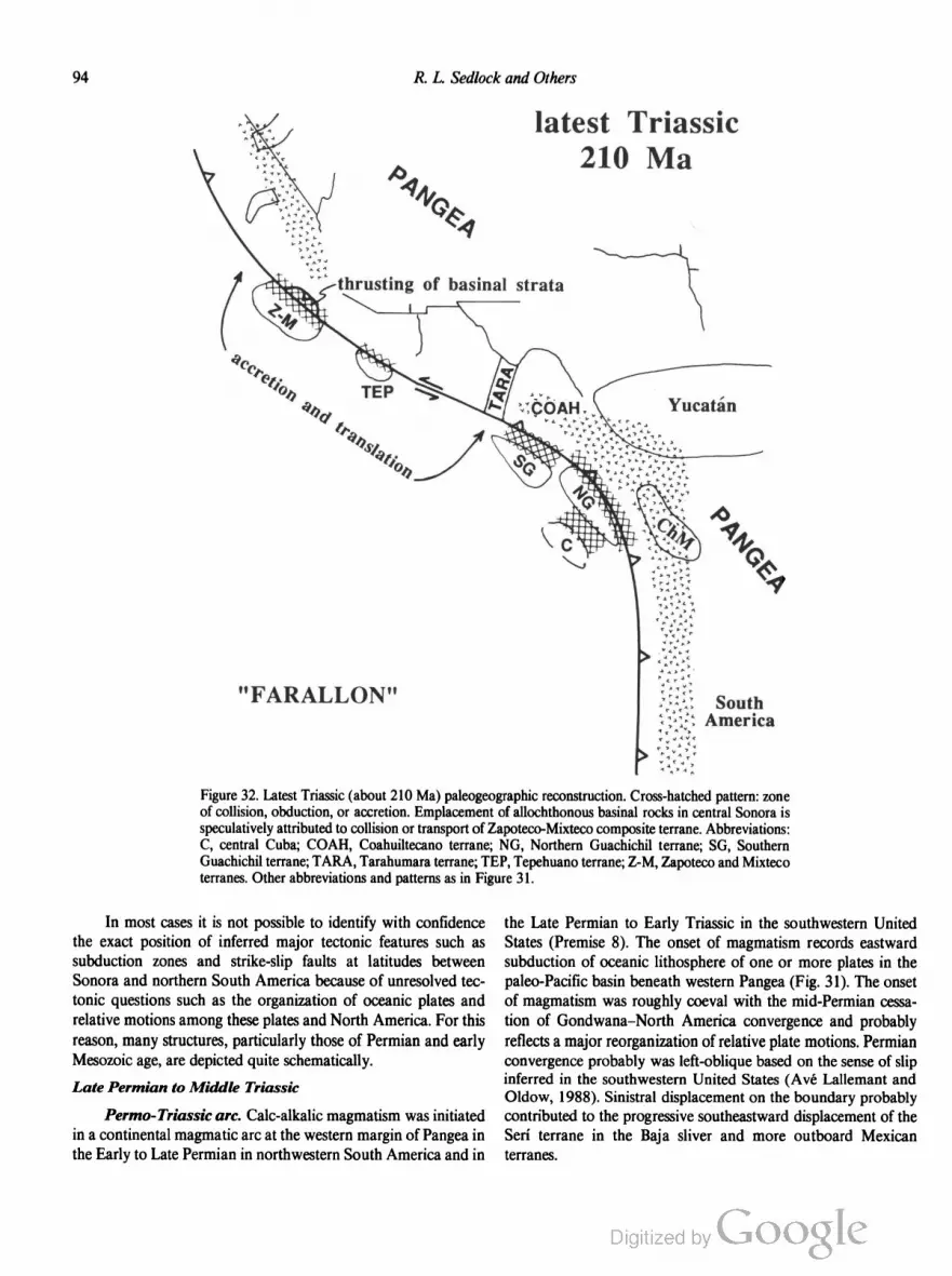
94 R. L. Sedlock and Others
"FARALLON"
latest Triassic
46
’4’0
e,
South
America
Figure 32. Latest Triassic (about 210 Ma) paleogeographic reconstruction. Cross-hatched pattern: zone
of collision, obduction, or accretion. Emplacement of allochthonous basinal rocks in central Sonora is
speculatively attributed to collision or transport of Zapoteco-Mixteco composite terrane. Abbreviations:
C, central Cuba; COAH, Coahuiltecano terrane; NG, Northern Guachichil terrane; SG, Southern
Guachichil terrane; TARA, Tarahumara terrane; TEP, Tepehuano terrane; Z-M, Zapoteco and Mixteco
terranes. Other abbreviations and patterns as in Figure 31.
In most cases it is not possible to identify with confidence
the exact position of inferred major tectonic features such as
subduction zones and strike-slip faults at latitudes between
Sonora and northern South America because of unresolved tec
tonic questions such as the organization of oceanic plates and
relative motions among these plates and North America. For this
reason, many structures, particularly those of Permian and early
Mesozoic age, are depicted quite schematically.
Late Permian to Middle Triassic
Permo-Triassic arc. Calc-alkalic magmatism was initiated
in a continental magmatic are at the western margin of Pangea in
the Early to Late Permian in northwestern South America and in
the Late Permian to Early Triassic in the southwestern United
States (Premise 8). The onset of magmatism records eastward
subduction of oceanic lithosphere of one or more plates in the
paleo-Pacific basin beneath western Pangea (Fig. 31). The onset
of magmatism was roughly coeval with the mid-Permian cessa
tion of Gondwana—North America convergence and probably
reflects a major reorganization of relative plate motions. Permian
convergence probably was left-oblique based on the sense of slip
inferred in the southwestern United States (Avé Lallemant and
Oldow, 1988). Sinistral displacement on the boundary probably
contributed to the progressive southeastward displacement of the
Serf terrane in the Baja sliver and more outboard Mexican
terranes.

Tectonostratigraphic Terranes and Tectonic Evolution ofMexico 95
The Permo-Triassic arc is preserved intact in the southwest
ern United States and northern South America and is known
from subcrops and rarer outcrops in the Coahuiltecano and Maya
terranes of eastern México (see discussion of Premise 8). This are
was emplaced into continental crust on the western edge of Pangea
starting in the Early Permian (Figs. 31, 32). The apparent conti
nuity and linearity of the arc in eastern México implies eastward
subduction of oceanic lithosphere beneath the western margin of
Pangea during most of the Permian and Triassic. Subsequent
displacement transverse to the Mexican reach of the arc may have
occurred at the boundary between the Coahuiltecano and Maya
terranes, where minor Late Jurassic sinistral slip probably oc
curred on the Mojave-Sonora Megashear, and between the Chia
pas Massif and Veracruz region, which probably were separated
during opening of the Gulf of Mexico (pp. 96—98). Because
the arc is known chiefly in the subsurface, the magnitude and age
of these and other transverse and longitudinal displacements of
the arc cannot be ascertained.
We attribute the apparent discontinuity in the Permo
Triassic are between the northern end of the Mexican reach in
Coahuila and the southern end of the United States reach in the
Mojave region to the original plate geometry, rather than to
post-Triassic truncation and displacement of the arc. The bound
ary between North America and an oceanic plate or plates in the
paleo-Pacific basin was a subduction zone in the western United
States and eastern México, where the boundary trended roughly
north-south, but was a transform fault in northern Mexico, where
the boundary trended east or east-southeast (present coordinates;
Figs. 31, 32). A similar idea was discussed by J. H. Stewart in an
oral presentation at the 1990 meeting of the Geological Society of
America Cordilleran Section. We infer that relative plate motion
was roughly parallel to this transform, but conceivably there may
have been a margin-normal component of shortening or exten
sion. The reconstruction depicts left-oblique convergence at the
trench in the southwestern United States in order to account for
inferred southeastward displacement of Mexican terranes such as
the sliver of Seri terrane in Baja (Figs. 31, 32). We surmise that
convergence south of the transform margin in eastern México was
either roughly orthogonal or left-oblique.
Permo-Triassic arc rocks also crop out in the amalgamated
Zapoteco and Mixteco terranes. They include Permian granitoids
in both terranes, post-Early Permian, pre—Middle Jurassic ig
nimbrite in the Mixteco terrane, and Triassic(?) to Middle Juras
sic dikes and sills in both terranes. Paleomagnetic data are
interpreted to indicate that the terranes were at the latitude of
Sonora at the end of the Triassic. Three interpretations of the
origin of the Zapoteco-Mixteco arc rocks are permissible based
on available data. First, the Zapoteco-Mixteco composite terrane
underwent arc magmatism within the Mexican reach of arc in the
Permo-Triassic, after which it was excised from the arc and trans
lated to the latitude of Sonora in the early Mesozoic. Second, the
Zapoteco-Mixteco composite terrane underwent arc magmatism
in an arc unrelated to subduction beneath western Pangea, at an
unspecified latitude some distance west of the Pangean margin,
perhaps requiring translation to the latitude of Sonora by the Late
Triassic. Third, the Zapoteco-Mixteco composite terrane under
went arc magmatism within the southern end of the United
States reach of the Perrno-Triassic continental arc of western
Pangea. The first option requires northwestward transport of the
terranes relative to North America, which we consider unlikely
because of evidence for southward margin-parallel displacements
in the early Mesozoic (Avé Lallemant and Oldow, 1988). We
cannot distinguish between the second and third options with
available data, so we have omitted the terranes from the Late
Permian reconstruction (Fig. 31) but shown them at the latitude
of Sonora by the Late Triassic (Fig. 32).
Cordilleran deformation. The Permo-Triassic are at the
western margin of Pangea probably was paired with an east
dipping subduction zone that consumed one or more oceanic
plates of the paleo-Pacific basin. Although the paleogeography of
this basin is not known, its subsequent history suggests that it con
tained fragments of Grenville and Paleozoic continental base
ment, magmatic arcs, and flysch basins (Fig. 31). Some of these
may have been separated from Pangea by substantial tracts of
oceanic lithosphere, whereas others may have been nearby, per
haps enmeshed in a complex system of trenches similar to the
modern southeastern Pacific.
Contractional deformation of Permo-Triassic age, reported
from several parts of southwestern North America, probably re
sulted from convergence between North America and one or
more oceanic plates to the west or south. In the Great Basin,
Perrno-Triassic collision of the Sonomia terrane with North
America emplaced the forearc of Sonomia as the Golconda al
lochthon onto previously accreted Paleozoic rocks of the Roberts
Mountain allochthon and its Paleozoic cover (Speed, 1979). The
Mojave and Death Valley regions were affected by Late Permian
deformation, including development of large thrust systems (Carr
and others, 1984; Snow and others, 1991). Deformation in these
regions probably was caused by margin-normal shortening
caused by high-angle convergence to the west. In central Chihua
hua, along the inferred transform fault boundary at the truncated
southwestern margin of North America, east-vergent thrusting of
Precambrian basement and Early Permian flysch occurred be
tween the mid-Permian and Middle Jurassic (Handschy and
Dyer, 1987). Thrusting may record either margin-parallel short
ening at the transform boundary or margin-normal shortening
east of a hypothetical north-south trench that offset the transform
(Fig. 31). In the Seri terrane, Paleozoic basinal rocks may have
been juxtaposed with Paleozoic shelfal rocks by late Paleozoic
sinistral strike-slip faulting (Fig. 31); penetrative deformation of
both units accompanied Late Permian to Middle Triassic over
thrusting of the shelfal rocks by the basinal rocks (Poole and
Madrid, 1986, 1988). The cause of this overthrusting is unknown.
We have speculated that it is related to displacement of the
Zapoteco-Mixteco composite terrane along the continental mar
gin (Fig. 31), but the supposed northward vergence of thrusting is
difficult to reconcile with generally eastward to southeastward
displacement of oceanic plates relative to North America.
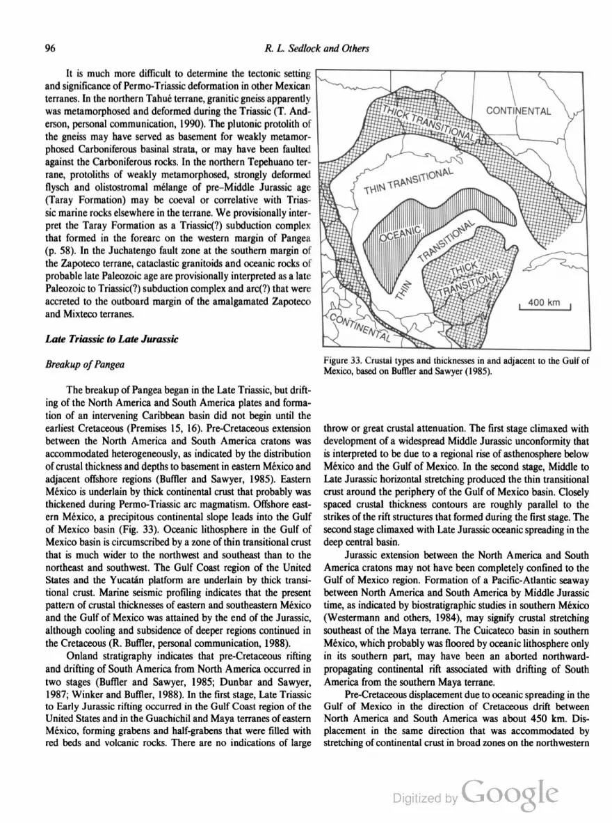
96 R. L. Sedlock and Others
It is much more difficult to determine the tectonic setting
and significance of Permo-Triassic deformation in other Mexican
terranes. In the northern Tahué terrane, granitic gneiss apparently
was metamorphosed and deformed during the Triassic (T. And
erson, personal communication, 1990). The plutonic protolith of
the gneiss may have served as basement for weakly metamor
phosed Carboniferous basinal strata, or may have been faulted
against the Carboniferous rocks. In the northern Tepehuano ter
rane, protoliths of weakly metamorphosed, strongly deformed
flysch and olistostromal mélange of pre—Middle Jurassic age
(Taray Formation) may be coeval or correlative with Trias
sic marine rocks elsewhere in the terrane. We provisionally inter
pret the Taray Formation as a Triassic(?) subduction complex
that formed in the forearc on the western margin of Pangea
(p. 58). In the Juchatengo fault zone at the southern margin of
the Zapoteco terrane, cataclastic granitoids and oceanic rocks of
probable late Paleozoic age are provisionally interpreted as a late
Paleozoic to Triassic(?) subduction complex and arc(?) that were
accreted to the outboard margin of the amalgamated Zapoteco
and Mixteco terranes.
Late Triassic to Late Jurassic
Breakup ofPangea
The breakup of Pangea began in the Late Triassic, but drift
ing of the North America and South America plates and forma
tion of an intervening Caribbean basin did not begin until the
earliest Cretaceous (Premises 15, 16). Pre-Cretaceous extension
between the North America and South America cratons was
accommodated heterogeneously, as indicated by the distribution
of crustal thickness and depths to basement in eastern México and
adjacent offshore regions (Buftler and Sawyer, 1985). Eastern
México is underlain by thick continental crust that probably was
thickened during Perrno-Triassic arc magmatism. Offshore east
ern México, a precipitous continental slope leads into the Gulf
of Mexico basin (Fig. 33). Oceanic lithosphere in the Gulf of
Mexico basin is circumscribed by a zone of thin transitional crust
that is much wider to the northwest and southeast than to the
northeast and southwest. The Gulf Coast region of the United
States and the Yucatan platform are underlain by thick transi
tional crust. Marine seismic profiling indicates that the present
pattern of crustal thicknesses of eastern and southeastern Mexico
and the Gulf of Mexico was attained by the end of the Jurassic,
although cooling and subsidence of deeper regions continued in
the Cretaceous (R. Buffler, personal communication, 1988).
Onland stratigraphy indicates that pre-Cretaceous rifting
and drifting of South America from North America occurred in
two stages (Bufiler and Sawyer, 1985; Dunbar and Sawyer,
1987; Winker and Buffler, 1988). In the first stage, Late Triassic
to Early Jurassic rifting occurred in the Gulf Coast region of the
United States and in the Guachichil and Maya terranes of eastern
México, forming grabens and half-grabens that were filled with
red beds and volcanic rocks. There are no indications of large
CONTINENTAL
Figure 33. Crustal types and thicknesses in and adjacent to the Gulf of
Mexico, based on Bufiler and Sawyer (1985).
throw or great crustal attenuation. The first stage climaxed with
development of a widespread Middle Jurassic unconformity that
is interpreted to be due to a regional rise of asthenosphere below
México and the Gulf of Mexico. In the second stage, Middle to
Late Jurassic horizontal stretching produced the thin transitional
crust around the periphery of the Gulf of Mexico basin. Closely
spaced crustal thickness contours are roughly parallel to the
strikes of the rift structures that formed during the first stage. The
second stage climaxed with Late Jurassic oceanic spreading in the
deep central basin.
Jurassic extension between the North America and South
America cratons may not have been completely confined to the
Gulf of Mexico region. Formation of a Pacific-Atlantic seaway
between North America and South America by Middle Jurassic
time, as indicated by biostratigraphic studies in southern México
(Westermann and others, 1984), may signify crustal stretching
southeast of the Maya terrane. The Cuicateco basin in southern
México, which probably was floored by oceanic lithosphere only
in its southern part, may have been an aborted northward
propagating continental rift associated with drifting of South
America from the southern Maya terrane.
Pre-Cretaceous displacement due to oceanic spreading in the
Gulf of Mexico in the direction of Cretaceous drift between
North America and South America was about 450 km. Dis
placement in the same direction that was accommodated by
stretching of continental crust in broad zones on the northwestern

Tectonostratigraphic Terranes and Tectonic Evolution ofMexico 97
and southeastern sides of the basin exceeds that due to spreading,
assuming validity of the stretching values calculated by Dunbar
and Sawyer (1987). Thus, at least 1,000 km, or at least one-third
of the ~3,000 km of northwest-southeast displacement between
the two cratons, was accommodated prior to Cretaceous opening
of the Caribbean basin. Displacements of individual blocks in the
Gulf of Mexico region apparently were complex and did not
follow small circle paths about the North America-South Amer
ica Euler pole, given the evidence for local counterclockwise
rotations of Jurassic age in northeastern Mexico (Gose and oth
ers, 1982) and in the Yucatan block (Molina-Garza and others,
1992).
There is no consensus about the configuration of the spread
ing system in and adjacent to the Gulf of Mexico. In our recon- -
\ future Baja
A“, ,' future SERI
u“:1"
"FARALLON"
struction, the Jurassic extensional displacement field in the Gulf
of Mexico region was bounded to the west by a fault beneath the
continental slope of eastern Mexico (Fig. 34), similar to the
Tamaulipas—Golden Lane fault of Pindell (1985). We view this
fault as a roughly northwest-striking transform that connected a
Jurassic spreading center in the Gulf of Mexico with a spreading
center or trench south of Mexico. The transform probably ac
commodated relative displacement between large, heterogeneous
extension in the Gulf of Mexico basin and Yucatan platform to
the east and little Jurassic extension in continental crust of eastern
México to the west.
Displacement on the transform boundary probably was
transtensional. Finite, but minor, horizontal extension must have
occurred in order to produce the zone of thin transitional crust at
Middle Jurassic
180 Ma
early
NORTH AMERICA
diffuse TJ :1':'~'-‘:1
Figure 34. Early Middle Jurassic (about 180 Ma) paleogeographic reconstruction. Abbreviations and
patterns as in Figure 32.

98 R. L. Sedlock and Others
the western margin of the Gulf of Mexico basin. Transtension
also may have been taken up by Late Triassic—Early Jurassic
graben formation in the eastern Guachichil and northern Maya
terranes, and by Middle to Late Jurassic formation of roughly
margin-parallel basins and platforms throughout eastern México
(Fig. 35). We place the transform fault beneath the continental
slope off the coast of Veracruz, as did Pindell (1985), but we
project the fault to the southeast along the western, rather than
the eastern, side of the Chiapas Massif in view of the similarity of
Paleozoic strata there and in northern Guatemala. This allows
Jurassic southeastward displacement of both the Yucatan plat
form and the southern province of the Maya terrane relative to
both the northern province of the Maya terrane and the
amalgamated Zapoteco and Mixteco terranes. Displacement on
the proposed north-striking Salina Cruz fault on the Isthmus of
Tehuantepec, if any, is probably Tertiary and thus unrelated to
the opening of the Gulf of Mexico (Salvador, 1987, 1988).
Conspicuous by its absence from our analysis of displace
ments during the opening of the Gulf of Mexico is the Mojave
Sonora Megashear (MSM). Many workers have inferred that the
left-lateral MSM connected a spreading system in the Gulf of Mexi
co with the trench at the western margin of North America (Pindell
and Dewey, 1982; Anderson and Schmidt, 1983; Klitgord and
Schouten, 1987). We offer an alternate interpretation in which slip
on the megashear is driven by transpression in the Cordillera, inde
pendent of extension in the Gulf of Mexico region (p. 103).
Activity in the Cordillera
Throughout the Mesozoic, oceanic lithosphere of one or
more plates in the Pacific basin converged with and was sub
ducted eastward beneath the western margin of Pangea. Pro
tracted left-oblique convergence resulted in subduction, arc
magmatism, accretion, east-west shortening, and southward trans
lation of continental blocks, island arcs, and basinal strata during
westward growth of continental Mexico.
Arc magmatism. Late Triassic to Late J urassic eastward
subduction of oceanic lithosphere generated continental magmatic
Basement highs and lows
in the Jurassic
Figure 35. Jurassic basins (irregular stipple) and horsts (circle pattern) in northern and eastern México,
modified after Winker and Buffler (1988). Abbreviations: A, Aldama; B-P, Burro-Picacho; C, Chicon
tepec; C-B, Chihuahua-Bisbee; CH, Chiapas; CO, Coahuila; G, Guaxcama; I, Isthmian; M, Magicatzin;
MQ, Miquihuana; S, Sabinas; T, Tuxpan; TM, Tamaulipas.

Tectonostratigraphic Terranes and Tectonic Evolution ofMexico 99
arcs in southwestern North America and northwestern South
America. In the western Great Basin and Mojave region, Late
Triassic to Late Jurassic magmatism continued near the older
Permo-Triassic magmatic arc (Kistler, 1974; Dilles and Wright,
1988). In southern Arizona, continental arc magmatism began
in the Early Jurassic or possibly the latest Triassic, indicating
a change from a transform to a convergent plate margin (Figs.
32, 34) (Coney, 1978; Damon and others, 1981; Asmeron and
others, 1990; Tosdal and others, 1990a). In northwestern South
America, Late Triassic(?) and Jurassic magmatic rocks crop out
in the Cordillera de Mérida and Sierra dc Perija in west
ern Venezuela, the Guajira Peninsula and Sierra Nevada de
Santa Marta in northern Colombia, the Cordillera Central and
Cordillera Oriental in central Colombia (Goldsmith, 1971;
Tschanz and others, 1974; Shagam and others, 1984; Case and
others, 1990), in southern Ecuador (Feininger, 1987), in the
southern part of the Eastern Cordillera of Peru (Cobbing and
Pitcher, 1983), and in Chile north of about 28°S (Farrar and
others, 1970; Aguirre, 1983).
Arc magmatism in the Mexican region occurred progres
sively farther westward during Permian to Jurassic time. A
continental arc was constructed on continental crust in the Maya
and eastern Coahuiltecano terranes in easternmost México in
Permian and Triassic time (p. 95). We provisionally divide Late
Triassic to Early Jurassic and more abundant Middle to Late
Jurassic magmatic rocks of the Mexican region into two groups.
Group 1 rocks formed in a Jurassic continental are that was
approximately coincident with the Permo-Triassic arc in the
southern Maya terrane (e.g., Chiapas Massif) but was southwest
of the Permo-Triassic arc in the northern Maya terrane and Coa
huiltecano terrane (Fig. 34). Group 2 rocks formed in a
continental magmatic arc west of the Group l are or in one or
more island arcs west of the continental margin. We interpret the
Permian to Jurassic westward shift of the locus of magmatism to
indicate that terranes comprising continental blocks and island
arcs were accreted to the western margin of Pangea in the Mexi
can region after consumption of intervening ocean basins of un
known width and age at trenches along and west of the
continental margin.
Group 1 rocks formed in a continental magmatic are that
connected the segments of the Late Triassic-Jurassic continental
magmatic arc in the southwestern United States and northwest
ern South America (Figs. 34, 36) (Damon and others, 1984). The
are was cut by the Mojave-Sonora Megashear in the Late Juras
sic, but there may have been little transverse offset because dis
placement probably was roughly parallel to the trend of the are.
We infer that, although margin-parallel displacement of the arc is
not yet understood, the are originally was continuous on conti
nental crust between northern Sonora and Chiapas (Figs. 34, 36).
In northern Sonora (North America), continental volcanic rocks
(>180 to 170 Ma) intruded by 175- to ISO-Ma plutons (Ander
son and Silver, 1979) are correlated with coeval rocks in southern
Arizona and were emplaced in the gap in the older Permo
Triassic arc, implying a change in relative plate motions. Trias
sic(?) ignimbrite and Triassic to Middle Jurassic dikes in the
Mixteco terrane probably were emplaced when the composite
Zapoteco-Mixteco terrane was at the latitude of Sonora (Figs. 32,
34). Orthogneiss in the Chatino terrane has yielded Middle Juras
sic to Early Cretaceous Rb-Sr isochron ages that have been inter
preted as crystallization ages of synkinematic plutons intruded
along the southern margin of the Zapoteco-Mixteco composite
terrane (Moran-Zenteno and others, 1991). Middle and Late
Jurassic S-type granites intruded the eastern subterrane of the
Yuma terrane (Todd and others, 1991) prior to and perhaps
during the early stages of its translation from northern to southern
México (Fig. 37). Jurassic plutonic rocks in the northwestern
corner of the Tepehuano terrane, Jurassic(?) arc volcanic rocks
older than 160 Ma in the northeastern Tepehuano terrane, and
rare Middle Jurassic granitoids in the Seri terrane probably are
parts of the Jurassie are that were displaced southeastward from
the Mojave region or northwestern Sonora during Late Jurassic
displacement on the Mojave-Sonora Megashear. In the southern
Tepehuano terrane, volcanic rocks of the Upper Jurassic Chilitos
Formation may have been derived from a continental are. In the
northern and southern parts of the Guachichil terrane, volcanic
and plutonic rocks that yielded Jurassic K-Ar ages were pene
trated by wells (Lopez-Infanzon, 1986). In the southern Guachi
chil terrane and adjacent areas, tuff interbedded with Late
Jurassic flysch and pelagic rocks (Longoria, 1984; Salvador,
1987; Longoria, 1988) was deposited as far southeast as Mexico
City (Suter, 1987), but the source are has not been identified. The
Chiapas Massif in the southern Maya terrane contains Early to
Middle Jurassic granitoids and Late Jurassic or older andesite.
Group 2 includes all other Late Triassic to Late Jurassic
magmatic rocks in México and northern Central America. Sev
eral subterranes of the Cochimi terrane contain Middle Jurassic
to early Early Cretaceous plutonic, volcanic, and volcaniclastic
rocks that probably represent fragments of oceanic island arcs
accreted to North America by the earliest Cretaceous. Granite
pebbles from Tithonian-Aptian strata in one of the subterranes
yielded K-Ar dates and a lower U-Pb discordia intercept of about
150 Ma, indicating derivation from Jurassic plutons. Both the
eastern and western subterranes of the Yuma terrane contain
minor volcanic rocks of inferred Late Triassic or Early Juras
sic age interbedded with elastic rocks, and the western subterrane
consists chiefly of Late Jurassic and more abundant Early
Cretaceous volcanic arc rocks. In the Period terrane, protoliths of
metasedimentary and minor metavolcanic rocks are probably
Jurassic or older. Intermediate volcanic rocks of demonstrated
and inferred Late Jurassic age are widespread throughout the
Nahuatl terrane. The Chortis terrane is intruded by a Late
Jurassie granodiorite and many other undated granitoids that also
may be Jurassic. Precambrian rocks in central Cuba were in
truded by potassic granite about 172 Ma (U-Pb, zircon) (Renne
and others, 1989).
Group 2 magmatic rocks formed in a variety of tectonic
environments that in many cases still are incompletely under
stood. The apparent absence of continental crust in the Cochimi,

100 R. L. Sedlock and Others
FARALLON
late Middle Jurassic
165 Ala
NORTH AMERICA
Yucatan
diffuse TJ
soura
r
Figure 36. Late Middle Jurassic (about 165 Ma) paleogeographic reconstruction. Future Seri terrane
and future Baja California block shown in northwestern corner. Abbreviations: NAH, Nahuatl terrane;
P, Pericu terrane; TAH, Tahué terrane; TCC, Tierra Caliente Complex. Other abbreviations and
patterns as in Figure 32.
Yuma, Perict'l, and Nahuatl terranes suggests that Jurassic mag
matic rocks in these terranes formed in one or more island arcs
outboard of the continental are at the western margin of North
America. We have inferred that the latter three terranes origi
nated in the northern proto-Pacific basin in the Paleozoic, but so
little data pertain to the Jurassic positions of these arcs relative to
one another and to the continent that we refrain from depicting
them in the reconstruction (Figs. 34, 36). The Jurassic locations
of the Chortis terrane and central Cuba are unknown, but be
cause both have continental basement we speculate that they
were parts of the North American continental are that later were
detached and displaced (Fig. 34).
Westward growth of Mexican continental crust. East
ward subduction of oceanic lithosphere during Permian to Juras
sic time was accompanied by east-west shortening in a
compressional or transpressional displacement field. Here we out
line the tectonic history insofar as can be determined for each
terrane that may have been accreted to western Mexico during
this time span.
Northern Guachichil terrane. The Precambrian Novillo

Tectonostratigraphic Terranes and Tectonic Evolution ofMexico 101
Mojave-Sonora Megashear
SERI Sliver \ ' -‘
YUMA E (basin) K
YUMA W (pre-Alisitos) ~,
COCHIMI
NORTH AMERICA
end Jurassic
145 Ma
Late J
NA-Yuc spreading
Early K
SA-Yuc spreading
SOUTH
Cuicateco pull-apart basin
AIFV‘ITERICA>
v a
v
1
r.
FARALLON
Figure 37. Latest Jurassic (about 145 Ma) paleogeographic reconstruction, shortly after displacement on
Mojave-Sonora Megashear and shortly prior tojump of spreading center from North America—Yucatan
to Yucatan—South America. Feature termed “Baja” composite terrane consists of Seri, Yuma, and
Cochimi terranes. Block pattern, lower Paleozoic shelfal rocks in Seri terrane; stipple, oceanic crust in
Gulf of Mexico region. Other patterns and abbreviations as in Figure 36.
Gneiss apparently was not affected by Ouachitan orogenesis, so
we infer a late Paleozoic position in the ocean basin south of
southwestern North America. We infer that Paleozoic miogeocli
nal strata currently faulted against the gneiss are parautochtho
nous with respect to it. The Granjeno Schist was deformed and
metamorphosed in an uncertain location in the Carboniferous
and probably was attached to the gneiss and Paleozoic strata in
Pennsylvania, Permian, or possibly earliest Triassic time. Early
Permian flysch must have been attached during the Late Permian
to Middle Triassic. Fault juxtaposition of all these rocks was
completed prior to deposition of overlapping redbeds of the
Upper Triassic—Lower Jurassic Huizachal Formation, which also
may be present in the subsurface in the northern Maya terrane.
Permian to Jurassic magmatic rocks are absent from the northern
Guachichil terrane but are present in terranes to the east (Maya)
and west (Tepehuano). Based on these relations, we infer (1) a
late Paleozoic position in the ocean basin south of southwestern
North America for some or all of the pre-Triassic rock units,
(2) Permo-Triassic eastward subduction of the intervening ocean
basin beneath western Pangea and are magmatism in the Coa
huiltecano and Maya terranes, (3) Middle to Late Triassic accre
tion of the pre-Triassic rock units to the western margin of
Pangea, (4) a Late Triassic to Jurassic westward shift of magma
tism from the western margin of Pangea to an unidentified arc
west of the accreted northern Guachichil terrane, and (5) deposi
tion of overlapping Late Triassic to Early Jurassic strata during
the breakup of Pangea (Figs. 31, 32, 34). It is unclear whether the
pre-Triassic rocks were amalgamated in the ocean basin west of
central Pangea or were successively accreted directly to the west
ern margin of Pangea.
Southern Guachichil terrane. The Precambrian Huiznopala
Gneiss apparently was not affected by Ouachitan orogenesis, so

102 R. L. Sedlock and Others
we infer a late Paleozoic position in the ocean basin south of
southwestern North America. Early Permian flysch was faulted
against the gneiss prior to deposition of overlapping Late Trias
sic to Early Jurassic red beds. Permian-Jurassic magmatic rocks
are absent. These relations imply a tectonic history very similar to
that of the northern Guachichil terrane. We propose that the
northern and southern Guachichil terranes were accreted to ad
joining parts of the western Pangean margin, and we speculate
that Late Jurassic sinistral displacement on a splay of the Mojave
Sonora Megashear displaced them to their present locations
(Figs. 32, 37).
Las Delicias basin. The Las Delicias basin in the southern
Coahuiltecano terrane contains Pennsylvanian and Permian vol
canogenic strata derived from and deposited on the fringes of a
continental magmatic arc (McKee and others, 1988, 1990). The
identity and present location of the arc and the time of its separa
tion from the basin are unknown. Strata in the Las Delicias basin
are anomalous with respect to Paleozoic rocks in adjacent ter
ranes, but Triassic granitoids intrude both the basin and the
northern Coahuitelcano terrane, implying little relative displace
ment since the Triassic. We speculate that the Las Delicias basin
and its source are formed in northwestern Gondwana in the late
Paleozoic, and that the basin was translated an unknown distance
northward or northwestward along the western margin of Pangea
in the Permo-Triassic (Fig. 31).
Zapoteco and Mixteco terranes. Basement rocks of these
terranes were amalgamated in the Paleozoic, prior to their over
lap by Carboniferous and Permian strata, and are inferred to have
been displaced west from Pangea by the beginning of the Permian
(p. 91). Other postamalgamation rocks in the terranes include a
few Permian granitoids, Triassic(?) ignimbrite, Triassic to Middle
Jurassic dikes, Early Jurassic nonmarine rocks and coal, and
Early Jurassic—Cretaceous epicontinental strata. Remagnetiza
tion caused by Permian intrusions occurred while the terrane was
at its present latitude with respect to North America, but anoma
lous directions from Permian to Oxfordian rocks in the Mixteco
terrane imply about 15° :1: 8° of southward translation in Ox
fordian to Albian time, about 160 to 1 10 Ma. We infer that in the
late Paleozoic the amalgamated terranes were on the periphery of
a Permo-Triassic magmatic arc in the ocean basin west of Pangea,
at or near their present latitude with respect to North America.
Strongly deformed late Paleozoic oceanic rocks that crop out in
the fault zone at the southern boundary of the terranes (Jucha
tengo subterrane of Mixteco terrane) may be a subduction com
plex that formed at the trench associated with this are. We
speculate that the amalgamated terranes were displaced north
ward during Permo-Triassic subduction of oceanic lithosphere
beneath western Pangea and were attached to western Pangea at
the latitude of northern Mexico by the end of Triassic time,
possibly causing emplacement of Paleozoic basinal rocks on Pa
leozoic shelfal rocks in central Sonora (Fig. 32). The locus of
continental arc magmatism probably shifted west of the Mixteco
terrane after collision, although sparse Triassic to Middle Jurassic
magmatic rocks imply that the terranes were on the periphery of
an active arc (Figs. 32, 34, 36). Across most of the Zapoteco and
Mixteco terranes, Jurassic strata were deposited in continental
and epicontinental environments distant from magmatic arcs. The
amalgamated Zapoteco and Mixteco terranes probably were
translated at least 1,000 km southeastward during the Late Jwas
sic on sinistral faults that accommodated oblique convergence
(Figs. 36, 37).
Tepehuano terrane. Protoliths of strongly deformed flysch
and mélange of the Taray Formation in the northern part of the
terrane may be coeval and correlative with Triassic flysch and
metabasite in the southern part of the terrane. We provisionally
interpret the Taray Formation as a subduction complex that
formed during the Triassic to Early Jurassic in the forearc of
western Pangea, which by this time included the accreted Gua
chichil terranes (Figs. 32, 34). The Taray Formation apparently
was overthrust by Late Triassic(?) to Late Jurassic(?) calc
alkalic volcanic arc rocks prior to intrusion of a quartz porphyry
pluton in the early Late Jurassic. The basement of the Jurassic arc
is unknown. We speculate that the are developed on the western
edge of Pangean/North American crust of unknown thickness
after the westward shift of magmatism from the Permo-Triassic
arc in eastern Mexico, and was thrust eastward over the Taray
subduction complex in the Early to Middle Jurassic (Figs. 34,
36). Magmatism continued into the Late Jurassic.
Yuma terrane. The eastern subterrane of the Yuma terrane
consists of Triassic to Jurassic flysch and sparse interbedded vol
canic rocks that were strongly deformed and uplifted prior to
mid-Cretaceous overthrusting by Late Jurassic to Early Cre
taceous volcanic rocks of the western subterrane of the Yuma
terrane. On its eastern margin, flysch of the eastern subterrane is
juxtaposed with Paleozoic rocks of the Serf terrane at an enig
matic contact that we provisionally identify as a reverse or thrust
fault or fault system. We infer that flysch of the eastern subterrane
was deposited in a trench or forearc basin during the Triassic to
Middle Jurassic and was deformed and uplifted during Jurassic
accretion to allochthonous Paleozoic rocks of the Sen' terrane in
central Mexico (Figs. 36, 37). The western subterrane developed
as an outboard island arc in the Late Jurassic and was accreted to
the Serf terrane and eastern Yuma subterrane in the late Early
Cretaceous (p. 107).
Central Cuba. Rocks in central Cuba include Grenville(?)
marble, schist, and quartzite metamorphosed about 950 to 900
Ma, potassic granite dated at 172 Ma, and unconformably overly
ing Late Jurassic conglomerate and limestone and Early Cre
taceous chert and shale (Renne and others, 1989; Lewis and
Draper, 1990). We speculate that the Proterozoic rocks were
south of southwestern North America during the Paleozoic;
were accreted to western Pangea in the Triassic; were underthrust
by oceanic lithosphere and hosted arc magmatism during the
Middle Jurassic; and were deformed, uplifted, and eroded by
collision of outboard terranes or closure of a backarc basin in the
Late Jurassic (Figs. 32, 34, 36). During the Late Jurassic and
Tectonostratigraphic Terranes and Tectonic Evolution ofMexico 103
Early Cretaceous, central Cuba was a stable shelf or platform that
may have been contiguous with southern México (Fig. 37).
Tahue' terrane. The late Paleozoic to Jurassic kinematic his
tory of the Tahué terrane is enigmatic. The substrate of
Mississippian to Permian clastic rocks, siliceous to intermediate
volcanic rocks, chert, and thin carbonates was probably oceanic
or transitional crust, based on initial 87Sr/86Sr ratios in Creta
ceous and Tertiary plutons. Amphibolite-facies gneiss, which prob
ably was metamorphosed and deformed in the Triassic, and
undated quartz diorite gneiss have uncertain relation to one
another and to the Paleozoic rocks. The gneiss may be transi
tional crustal basement of the Paleozoic strata, or may have
evolved separately from the Paleozoic rocks and been juxtaposed
with them after Triassic metamorphism and before Cretaceous
magmatism. Volcanic and plutonic rocks were emplaced in the
Tahué terrane from at least the Early Cretaceous until the Mio
cene. We infer that the Tahué terrane was accreted to mainland
Mexico in the Middle to Late Jurassic by closure of a now
obscure intervening basin (Fig. 36). We speculate that the paucity
of Late Jurassic magmatic rocks in the Tahué terrane can be
attributed to the passage of the Baja block as it migrated south
eastward along the continental margin above a steeply dipping
subduction zone (Fig. 37). Arc magmatism affected the Tahué
terrane by the middle of the Early Cretaceous, indicating passage
of the Baja block, westward migration of the are due to shallow
ing of the subduction zone, or both.
Cochimi terrane. The structurally highest level of the north
ern part of this composite terrane consists of three distinct subter
ranes, each a fragment of an oceanic island are, that were accreted
to the western margin of North America in the latest Jurassic or
earliest Cretaceous (Fig. 37). The Choyal subterrane is a Middle
Jurassic island are that was accreted to North America in the Late
Jurassic; its short lifespan may reflect relative proximity to the
continental margin as a fringing arc. The Vizcaino Norte and
Vizcaino Sur subterranes are Late Triassic to Late Jurassic
island arcs that were accreted to North America in the latest
Jurassic or earliest Cretaceous; the long duration of arc magma
tism and the lack of terrigenous detritus indicate formation in a
large ocean basin and protracted subduction of oceanic litho
sphere of that basin prior to accretion. Paleomagnetic studies infer
that the terranes were accreted to Mexico about 1,500-2,000 km
south of their present position (p. 22).
Sinistral displacement. Relative motions between North
America and oceanic plates to the west are poorly constrained
for the Jurassic and Early Cretaceous, but it is likely that the Late
Jurassic incraese in the rate of northward absolute motion of
North America (May and Butler, 1986) initiated or accelerated
sinistral displacement at the western margin of the continent.
Geologic and paleomagnetic studies suggest that convergence in
cluded a significant left-oblique component that was resolved on
sinistral strike-slip faults in the arc and forearc (Ave Lallemant
and Oldow, 1988; Beck, 1989; Wolf and Saleeby, 1991). Most
Mesozoic paleomagnetic poles from Mexican terranes are dis
placed to the left of the reference apparent polar wander path for
North America, implying sinistral displacements and counter
clockwise rotations relative to the craton (Urrutia-Fucugauchi
and others, 1987). We discuss evidence for sinistral displacement
on the Mojave-Sonora Megashear, the most inboard of the sinis
tral fault systems, and for southeastward displacement of the
amalgamated Mixteco and Zapoteco terranes and the Seri terrane
in Baja California.
Mojave-Sonora Megashear. The existence and position of,
and evidence of displacement on, the Mojave-Sonora Megashear
are best documented in northern Sonora (Premise 11). To the
northwest, in California, the record of the megashear has been
erased nearly completely by superposed episodes of thrusting,
extension, and strike-slip displacement. Southeastward from
Sonora, we speculate that displacement on the megashear was
partitioned among several southeast-striking splays (Figs. 22, 37)
that we informally term the megashear fault zone. Constituent
faults of the megashear fault zone in northeastern México include
but are not limited to the inferred Coahuiltecano-Maya terrane
boundary, the Guachichil-Tepehuano terrane boundary, a buried
fault separating the northern Guachilchil terrane from the south
ern Guachichil terrane, and perhaps the San Marcos fault in the
southern Coahuiltecano terrane.
Late Jurassic contraction and extension near the trace of the
megashear and megashear fault zone may record displacement at
right (restraining) and left (releasing) steps or bends, respectively.
Late Jurassic transpression has been inferred in Zacatecas (And
erson and others, 1991) and northern Sonora (Connors and And
erson, 1989; Tosdal and others, 1990b). Late Jurassic trans
tension near the trace of the megashear in southeastern California
has been inferred to explain the formation of ensimatic pull-apart
or rift basins in which elastic and basaltic protoliths of the Pelona
Orocopia schist were deposited (Tosdal and others, 1990a).
Late Jurassic ophiolites of the Klamath Mountains and Sierran
foothills may have formed in similar rift basins along the north
westward projection of the megashear in central and northern
California (Harper and others, 1985). Local transtension along
the northwestward projection of the megashear may also be indi
cated by intrusion ages of 165 to 147 Ma of dikes from southeast
ern California to the Sierran foothills (James, 1989; Wolf and
Saleeby, 1991). Transtension in the southern part of the mega
shear fault zone may have created the Cuicateco basin in southern
México (Figs. 36, 37), which probably formed in the Middle to
Late Jurassic as a rift basin within continental crust (Ortega
Gutiérrez and others, 1990). Late Jurassic to Early Cretaceous
rocks of the Cuicateco terrane may be analogous to rocks of the
Josephine or Smartville ophiolites of California, or to the proto
liths of the Pelona-Orocopia schist.
Although displacement on the megashear is widely cited as
Late Jurassic, available data are consistent with several hundred
kilometers of late Paleozoic sinistral slip (Stevens and others,
1992), with reactivation and several hundred kilometers of dis
placement in the Late Jurassic. Our reconstruction portrays all

104 R. L. Sedlock and Others
left-lateral displacement on the megashear as Late Jurassic, but it
can be easily modified to accommodate partitioning of displace
ment into late Paleozoic and Late Jurassic episodes.
Displacement of amalgamated Mixteco and Zapoteco ter
ranes. Paleomagnetic data from Permian, Bathonian to Oxford
ian, and Albian rocks in the Mixteco terrane are interpreted to
indicate that the amalgamated Mixteco and Zapoteco terranes
were translated 15° 1 8° southward to their present latitude
during Oxfordian to Albian time, about 160 to 110 Ma (Urrutia
Fucugauchi and others, 1987; Ortega-Guerrero and Urrutia
Fucugauchi, 1989). This interpretation supersedes a previous
estimate of 20° to 30° of southward translation. Based on the
revised estimate, we have inferred accretion of the terranes to
western Pangea at the latitude of northern Mexico. We speculate
that southeastward translation of the amalgamated Zapoteco and
Mixteco terranes was accommodated by Late Jurassic slip on
an outboard strand of the megashear fault zone and earliest
Cretaceous slip on a fault outboard of the megashear (Fig. 36,
Xolapa Complex
deformed, metamorphosed
closure of Cuicateco basin begins
37). Temporal partitioning and rates of displacement are un
known. By Albian time, and perhaps earlier in the Early Creta
ceous, the Zapoteco-Mixteco composite terrane was in its current
position with respect to the Cuicateco terrane and southern Maya
terrane (Fig. 38).
Displacement of Serr' terrane in Baja Califomia. Paleozoic
miogeoclinal rocks of the Seri terrane in northeastern Baja Cali
fornia probably were deposited in contiguity with correlative
rocks of the Seri terrane in northern Sonora (Gastil and others,
1978; Gastil and Miller, 1984). This relation apparently conflicts
with numerous paleomagnetic studies that have inferred about
1,500 km of Late Cretaceous and Cenozoic northward displace
ment of Baja California and a mid-Cretaceous position in central
or southern México (p. 80). The geologic correlations can be
reconciled with the paleomagnetic data only if the sliver of Seri
terrane in northeastern Baja California was translated southward
from an initial position adjacent to Sonora to central México on
sinistral strike-slip faults prior to the mid-Cretaceous.
mid-Cretaceous
115-90 Ma
NORTH AMERICA
passive
margin
r
a
>I~lc1u
VPrv<*<
r1~4>r'-v""
’CHOF‘II‘I<
Figure 38. Mid-Cretaceous (about 115-90 Ma) paleogeographic reconstruction. Southeastward
displacement of Baja composite terrane and Chortis ceases by about 100 Ma. Xolapa Complex (part of
Chatino terrane) is deformed and metamorphosed at southern margin of Zapoteco-Mixteco composite
terrane. Shortening is coeval with are magmatism in Pericr'r terrane, Xolapa Complex, and Baja compos
ite terrane; shortening also occurs in Cuicateco basin and in Seri, North America, Tahué, western
Tepehuano, and Nahuatl terranes. G, Guachichil terrane. Other abbreviations and patterns as
in Figure 37.
Tectonostratigraphic Terranes and Tectonic Evolution ofMexico 105
The Seri terrane in Baja California probably was trimmed
from the continent by a sinistral strike-slip fault and translated
southward to central Mexico beginning in late Paleozoic time,
coeval with similar displacement in the Mojave region. On the far
western edge of North America, the western part of the Seri
terrane was especially susceptible to translations accompanying
oblique convergence, which probably was sinistral in the late
Paleozoic to Jurassic. Earlier, we proposed a few hundred kilo
meters of southward displacement of the Seri terrane in Baja
during the late Paleozoic (Fig. 31). We infer an additional 1,000
to 1,500 km southward displacement during the Middle Jurassic
to Early Cretaceous (Figs. 36—38), at least partly coeval with the
southward displacement of the amalgamated Zapoteco and Mix
teco terranes and displacement on the megashear fault zone.
Jurassic deposition in and near the GulfofMexico
Prior to Late Jurassic oceanic spreading in the Gulf of Mex
ico, the Yucatan platform probably was about 500 km north
northwest of its current position, adjacent to stretched cmst of the
US. Gulf Coast (Fig. 36). In the Callovian (late Middle Juras
sic), these areas forrned a flat-lying, gently subsiding region that
periodically was flushed by marine water, leading to the accumu
lation of the thick Louann-Isthmian salts. The presence of Callo
vian shallow-marine strata in northern Veracruz supports a
Pacific (western) origin for these waters; Tethyan (eastern) waters
may not have reached the Gulf of Mexico until late Kimmerid
gian to Tithonian time (Salvador, 1987).
In the Oxfordian (early Late Jurassic), concomitant with
oceanic spreading in the Gulf of Mexico and southeastward
displacement of the Yucatan platform and southern province of
the Maya terrane, transgression and subsidence resulted in the
deposition of shallow-marine strata in the Maya terrane on the
margins of the Gulf of Mexico and in the Coahuiltecano, Guachi
chil, and Tepehuano terranes in eastern continental Mexico
(Lopez-Ramos, 1981; Enos, 1983; Young, 1983; Salvador, 1987;
de Cserna, 1989). Platform carbonates accumulated on a series of
topographic highs at the western margin of the growing Gulf of
Mexico (Fig. 35), which probably was the site of a transform
boundary (Figs. 34, 36). In Oxfordian time, fine-grained pelagic
carbonates, shale, and local evaporites known as the Santiago
Formation and the Zuloaga Formation (or Zuloaga Group; Gotte
and Michalzik, 1991) in central and northeastern México, respec
tively, were deposited in intraplatforrn shelf basins. These strata
are approximately correlative with the Norphlet, Smackover, and
Haynesville Formations in the US. Gulf Coast (Imlay, 1943).
Continued transgression caused marine deposition in the Chihua
hua Trough starting in the late Kimmeridgian to Tithonian
(Tovar-R., 1981; Dickinson and others, 1986; Araujo-Mendieta
and Casar-Gonzalez, 1987; Salvador, 1987) and greater marine
influence around emergent islands and peninsulas in eastern Méx
ico (Fig. 35). Clastic sediments accumulated near the margins of
emergent areas such as the Coahuila platform and Tamaulipas
platform, and red beds were deposited across the Yucatan Penin
sula (Viniegra-Osorio, 1981). Late Jurassic nonmarine strata
were deposited south of the marine environments in the Chiapas
Guatemala region.
Cretaceous to Paleogene
With the cessation of extension in the Gulf of Mexico region
and sinistral displacement on the Mojave-Sonora Megashear by
the beginning of the Early Cretaceous, the Seri (in Sonora), Tara
humara, Coahuiltecano, Maya, Guachichil, Tepehuano, and
Tahué terranes had attained their approximate current positions
with respect to North America and thus were part of the North
America plate (Fig. 38). Sinistral displacement of more outboard
terranes such as the amalgamated Zapoteco and Mixteco terranes
may have continued until the Albian. All terranes were inboard
of a major trench at which oceanic lithosphere of the Farallon
and perhaps other plates was subducted beneath North America
during Cretaceous and Paleogene time (Fig. 38). Subduction was
accompanied by are magmatism, late Early to early Late Cre
taceous collision and accretion, Early Cretaceous sinistral and
Late Cretaceous dextral translation of outboard terranes, and
Late Cretaceous-Paleogene Laramide orogenesis.
Cretaceous magmatic arc
During the Early Cretaceous, a continental magmatic arc
was active near the southwestern margin of Mexico (Fig. 38). In
the Seri terrane in Sonora, Early Cretaceous silicic and interme
diate volcanic rocks are intruded by Late Cretaceous granitoids
that are younger to the east (Anderson and Silver, 1969). In
northern Sonora, volcanogenic Early Cretaceous strata were
deposited on North American basement in a backarc basin
(Almazan-Vazquez and others, 1987). In the Tahué terrane, ba
salts and andesites interbedded with Aptian-Cenomanian car
bonates are intruded by syntectonic early Late Cretaceous
granitoids and post-tectonic late Late Cretaceous and Paleo
gene granitoids (Henry and Fredrikson, 1987). In the Pericu ter
rane, metamorphic country rocks were intruded by late Early
Cretaceous matic to intermediate plutonic rocks during strong
regional compression; undeformed high-K granitoids intruded
these rocks in the Late Cretaceous (Ortega-Gutierrez, 1982;
Aranda-Gomez and Perez-Venzor, 1989). In the Nahuatl terrane,
intermediate to siliceous volcanic and volcaniclastic rocks and
interbedded Early Cretaceous siliciclastie rocks and carbonates
are intruded by mid-Cretaceous to Paleogene granitoids and over
lain by Late Cretaceous rhyolites and red beds. Geophysical
data imply that the western part of the Trans-Mexican Volcanic
Belt between the Tahué and Nahuatl terranes is underlain by
Cretaceous-Tertiary(?) granitic rocks (Campos-Enriques and oth
ers, 1990). In the Yuma terrane, for which we infer a position
adjacent to southern México by the end of the Early Cretaceous
(Fig. 38), intermediate to siliceous volcanic rocks of the Alisitos
and Santiago Peak Formations were erupted in the western sub
terrane during the Late Jurassic and Early Cretaceous (Gastil and

106 R L. Sedlock and Others
others, 1975). The Yuma terrane is intruded by syntectonic plu
tons of the western, Early Cretaceous part of the Peninsular
Ranges batholith, whereas Paleozoic miogeoclinal rocks of the
Serf terrane are intruded by late to posttectonic plutons of the
eastern, Late Cretaceous part of batholith (Silver and others,
1975; Silver, 1979; Todd and others, 1988). In the Chatino ter
rane, orthogneisses have yielded U-Pb and Rb-Sr dates of 160 to
128 Ma that may be interpreted to indicate Late Jurassic and
Early Cretaceous intrusion of granitoids prior to deformation and
metamorphism. Magmatic rocks were not emplaced in the Cha
tino and adjacent Zapoteco-Mixteco composite terrane from the
late Early Cretaceous until the earliest Tertiary, about 110 to 60
Ma. The Chortis terrane, for which we infer a position south of
Guerrero in the Late Cretaceous (p. 109) (Fig. 39), is intruded by
abundant mid-Cretaceous to Paleogene granitoids (Home and
others, 1976; Gose, 1985, and references therein).
During the Late Cretaceous and Paleogene the conti
nental arc in northern Mexico progressively broadened from a
narrow zone in western Sonora and Sinaloa to a wider zone
extending eastward into Chihuahua, Durango, and Zacatecas
(Anderson and Silver, 1969; Clark and others, 1980, 1982; '
Damon and others, 1981). This broadening or migration of arc
magmatism probably was caused by progressive shallowing of
the Benioff zone beneath western North America (Coney and
Reynolds, 1977).
The magmatic history of southwestern Mexico is consistent
with a more southerly Early Cretaceous position of terranes of the
Baja California peninsula (terranes in Baja hereafter are referred
to as Baja composite terrane or simply Baja; analogous to Penin
sular Ranges terrane of Bottjer and Link, 1984; Lund and Bottjer,
1991). Cretaceous intrusive rocks older than about 115 Ma are
absent from the southern Tahué, Pericu, and Nahuatl terranes. We
suggest that these three terranes were inboard (northeast) of the
magmatic are that intruded the Yuma and Serf terranes in the
Baja composite terrane (Fig. 37). Mid-Cretaceous intrusion of the
Tahué, Period, and Nahuatl terranes may have been delayed until
the Baja California block was transported sufficiently far to the
southeast (Fig. 38), and also may indicate shallowing of the sub
duction zone and eastward migration of arc magmatism. A cen
tral Mexican position of the Baja California block until the Late
Cretaceous obviates the need for parallel volcanic arcs in
northwestern Mexico, which would be required if Baja were in its
Late Cretaceous
75 Ma
NORTH AMERICA
FARALLON
Figure 39. Late Cretaceous (about 75 Ma) paleogeographic reconstruction. Speculative plate boundaries
southwest and southeast of continent. Stipple pattern indicates oceanic lithosphere created by rifting of
South America from Yucatt'in platform; CUI, Cuicateco terrane. Other abbreviations and patterns as in
Figure 38.

Tectonostratigraphic Terranes and Tectonic Evolution ofMexico 107
current position in the Early Cretaceous because a Jurassic—
Early Cretaceous magmatic arc crops out in Sonora (cf. Rangin,
1978; Gastil, 1983).
Collision and accretion
The continental magmatic arc in western México indicates
that oceanic lithosphere of the Farallon and perhaps other plates
was subducted beneath North America throughout Cretaceous
time. The orthogonal component of convergence caused shorten
ing and accretion of several terranes at the western margin of
México.
Cochimicomposite terrane. Triassic to Jurassic island arc
subterranes of the Cochimi composite terrane probably were ac
creted to the western margin of the Yuma terrane in the Late
Jurassic and Early Cretaceous (Fig. 37). Accretion terminated arc
magmatism in each terrane. The accreted arc terranes and the
Yuma terrane were overlapped by forearc-basin flysch in the
Albian. Paleomagnetic studies infer as much as 1,500 km of Late
Cretaceous and early Cenozoic northward translation with re
spect to North America.
The Cochimi composite terrane also contains Late Triassic
to mid-Cretaceous ocean-floor basalt and overlying pelagic and
clastic sedimentary rocks that were subducted, metamorphosed to
blueschist facies, and underplated to North America near the
equator during mid-Cretaceous time (Sedlock, 1988a, 0; Baldwin
and Harrison, 1989; Hagstrum and Sedlock, 1990, 1991, 1992).
After about 1,000 km of late Early Cretaceous and Late Creta
ceous northward transport, the blueschists were juxtaposed with
the previously accreted arc subterranes of the Cochimi terrane in
the Late Cretaceous. During later Cretaceous and Paleogene
time, the entire Cochimi composite terrane and the Yuma terrane
were translated about 1,500 km northward with the rest of Baja
California (Figs. 39, 40) (Hagstrum and others, 1985; Sedlock,
1988b, c; D. Smith and Busby-Spera, 1989, and unpublished
manuscript; Hagstrum and Sedlock, 1990, 1991, 1992).
Yuma terrane. We have speculated that Mesozoic basinal
strata of the eastern Yuma subterrane were accreted to allochtho
nous Paleozoic rocks of the Seri terrane in the central Mexican
forearc in the Middle or Late Jurassic. In the Late Jurassic, arc
magmatism at this latitude jumped westward from the Mexican
continental arc, east of the amalgamated eastern Yuma subterrane
and the allochthonous part of the Seri terrane, to an island arc in
the western subterrane of the Yuma terrane (Figs. 36, 37). In
other words, the arc jump transferred the eastern Yuma subter
rane and the allochthonous part of the Seri terrane from the
forearc to the backarc.
In Early to early Late Cretaceous time, the Late Jurassic to
Early Cretaceous island arc in the western Yuma subterrane
closed with and then was thrust eastward beneath the amalgam
ated eastern Yuma subterrane and allochthonous Seri terrane,
which were now part of North America (Fig. 38) (Griffith and
Goetz, 1987; Goetz and others, 1988; Todd and others, 1988). In
southern California and Baja California north of the Agua Blanca
fault, the island arc in the western Yuma subterrane was thrust
eastward beneath the deformed, uplifted, and eroded eastern sub
terrane of the Yuma terrane in the Early Cretaceous. South of the
Agua Blanca fault, the island arc in the western Yuma subterrane
underthrust Paleozoic miogeoclinal rocks of the Seri terrane and
the eastern subterrane of the Yuma terrane about 105 to 100 Ma,
based on U-Pb ages of deformed and undeformed plutons that
stitch the suture. Vergence and sense of displacement of the suture
are deduced from steeply plunging lineations, asymmetric micro
structural kinematic indicators, and the inferred level of crustal
exposure. Plutonism in the Peninsular Ranges batholith migrated
eastward across the suture during the mid-Cretaceous.
Pericti terrane. In the Pericr'i terrane, prebatholithic meta
sedimentary rocks were intruded by mafic plutons and low-K
granitoids beginning about 115 Ma. Penetrative, roughly east
west shortening of the metasedimentary and plutonic rocks ap
parently began shortly after intrusion of the plutonic rocks and
ceased by about 95 Ma (Fig. 38). Syntectonic emplacement is
supported by concordant foliation in the metasedimentary and
deformed plutonic rocks. S-C fabrics in thick mylonites indicate
left-reverse displacement on north- to northeast-striking, east
dipping shear zones (Aranda-Gomez and Pérez-Venzor, 1989).
Compression ceased by about 95 Ma, as indicated by intrusion of
undeformed high-K granitoids that crosscut the older rocks and
structures.
Cuicateco terrane. The Cuicateco terrane contains earliest
Cretaceous or older sedimentary rocks that were deposited in a
basin of enigmatic origin, here named the Cuicateco basin. In the
southern part of the terrane, the sedimentary rocks are faulted
against the Early Cretaceous Chontal island(?) are, a subterrane
of the Cuicateco terrane (Carfantan, 1981). Along most of its
western margin, the Cuicateco terrane contains deformed and
metamorphosed granitoids and volcanic rocks of uncertain origin.
Opening of the Cuicateco basin began prior to earliest Cre
taceous deposition of sediments, probably in the Late Jurassic
and perhaps as early as the Middle Jurassic. Carfantan (1983)
proposed that the basin formed by aborted intracontinental rifting
during drifting of North America from South America, but this
seems unlikely because the northwest-southeast trend of the basin
was parallel to the probable drifting direction. We propose two
other, possibly interdependent, origins of the basin. First, the
basin may have formed by Middle to Late Jurassic transtension
on the southern reach of the transform fault at the western margin
of the extending Gulf of Mexico region (Figs. 36, 37). We have
inferred that this fault is buried near the western margin of the
Chiapas Massif, i.e., the eastern margin of the Cuicateco terrane.
Second, the basin may have formed by Late Jurassic wrenching
at a releasing step in the megashear fault zone.
There are at least two interpretations of the original tectonic
setting of the strongly deformed metaigneous rocks at the western
margin of the Cuicateco terrane; both are consistent with the two
proposed interpretations of the origin of the Cuicateco basin. The
rocks may be products of anorogenic magmatism associated with
continental rifting. Alternatively, the rocks may have formed in

108 R. L. Sedlock and Others
1 rr4>>v ‘4 in
L 7,“J, van
FARALLON
Early Eocene
55 Ma
mbor ohducted
n latest K
CARIBBEAN
Figure 40. Early Eocene (about 55 Ma) paleogeographic reconstruction. CHAT indicates Chatino
terrane; Nic Rise, Nicarague Rise. Other abbreviations and patterns as in Figure 39.
the continental are on the western margin of México. The latter
option implies that a strand or strands of the megashear coincided
with the Jurassic arc in southern México, as has been postulated
for the megashear in northern Mexico.
Extension in the Gulf of Mexico region and southward dis
placement of the Chiapas Massif in the southern Maya terrane
with respect to the Cuicateco basin terminated by the end of the
Jurassic, when the locus of Pangean rifting shifted from the
northwestern to the southeastern margin of the Yucatan block
(Figs. 36, 37). Southeastward displacement of the amalgamated
Zapoteco and Mixteco terranes with respect to the Cuicateco
basin probably ceased by Albian or earlier Cretaceous time. In
the Albian, these two continental blocks began to converge, clos
ing the intervening Cuicateco basin (Delgado-Argote, 1989).
Pervasive northeast-southwest shortening, intrusion by synkine
matic plutons, and weak metamorphism of the basin peaked in
the Turonian (Carfantan, 1983). Deformation of synorogenic
Campanian to Maastrichtian flysch indicates that closure con
tinued throughout the Cretaceous. By earliest Paleogene time, the
Zapoteco terrane was thrust eastward over the Cuicateco terrane
on the Juarez suture, and the Cuicateco terrane was thrust east
ward over the adjacent Maya terrane, causing internal deforma
tion of the Maya terrane. An alternate model calls for earlier
(pre-Cretaceous) thrusting of the Zapoteco terrane eastward over
basment rocks of the Maya terrane, prior to opening of the Cui
cateco basin.
Other Cordilleran terranes. Mid-Cretaceous (pre-Lara
mide) thrusting, folding, and metamorphism have been noted
in other terranes near the southwestern margin of Mexico.
Cretaceous shortening in the Seri and North America ter
ranes includes not only a latest Cretaceous-Paleogene Laramide
event but also unrelated(?), early Late Cretaceous, east
to northeast-vergent thrusting (Roldan-Quintana, 1982; Pubel
lier and Rangin, 1987; Rodriguez-Castaneda, 1988; Nourse,
1990; Siem and Gastil, 1990). Large elongational strains in
northern Sonora and northeastern Baja California may in
dicate a genetic link with coeval, generally south-vergent
shortening in the Maria fold and thrust belt of southeast
ern California and southwestern Arizona (Reynolds and oth
ers, 1986).
Tectonostratigraphic Terranes and Tectonic Evolution ofMexico 109
In the Tahué terrane, the Jurassic—Early Cretaceous mag
matic arc was deformed and metamorphosed during east-vergent
overthrusting by a partly conformable ophiolite sequence. The
ophiolite probably formed in a forearc basin (Servais and others,
1982, 1986) or possibly a backarc basin (Ortega-Gutierrez and
others, 1979). Mylonites developed along some thrusts. Deforma
tion was inferred to be of Laramide age by Servais and others
(1982, 1986), but we infer a mid-Cretaceous age because Late
Cretaceous plutons older than 85 Ma are syntectonic (Fig. 38).
In the Tepehuano terrane, disrupted mafic and ultramafic
magmatic rocks of probable Late Jurassic to Early Cretaceous
age were shortened and thrusted to the north-northeast over vol
caniclastic rocks of the backarc basin. The lithology, structure,
and geochemistry of the magmatic rocks are more consistent with
an ophiolitic origin (Servais and others, 1982) than an oceanic
island arc origin (Monod and others, 1990). Thrusting probably
occurred during Early Cretaceous, pre-Albian closure of a back
arc basin east of the Early Cretaceous arc in the Tahué terrane
(Fig. 38).
In the Nahuatl terrane, Paleozoic(?) to early Mesozoic meta
morphic rocks of the Tierra Caliente Complex (TCC) exhibit
subhorizontal foliation, axial surfaces, and thrust faults that indi
cate eastward to northeastward tectonic transport of uncertain
age. The TCC is overlain by low-grade metamorphic rocks in the
lower part of the Upper Mesozoic Assemblage (UMA) that were
strongly deformed during east-vergent thrusting of mid-Creta
ceous age. We speculate that the TCC was accreted to the Mexi
can continental margin by the end of the Jurassic (Fig. 37), and
that the TCC and the lower part of the UMA together underwent
east-vergent to northeast-vergent folding and thrusting in the late
Early Cretaceous (Fig. 39). After deposition of Albian-Coniacian
platform carbonates of the upper part of the UMA, the entire
UMA underwent Laramide thrusting.
In the Chatino terrane, metasedimentary rocks of the X01
apa Complex have a complex history of deformation, intrusion,
and metamorphism. The pre—Late Jurassic history of the terrane
is completely unknown. The metasedimentary rocks may have
been intruded in the Late Jurassic and Early Cretaceous by tona
litic plutons derived at least partly from Proterozoic sources such
as those in the Mixteco and Zapoteco terranes. These plutons
may have been strongly deformed and metamorphosed during
thrusting of the Chatino terrane over the Mixteco and Zapoteco
terranes during the late Early to Late Cretaceous (Fig. 38).
In our reconstruction, rocks- deformed during the mid
Cretaceous as described above form a quasi-continuous belt that
roughly coincided with the arc and forearc at the southwestern
margin of Mexico (Fig. 38). The cause or causes of this deforma
tion have not been demonstrated but may include collision and
accretion of outboard terranes and changes in relative plate mo
tions. The collision hypothesis is awkward because the continuity
of the deformed belt requires later excision of unidentified and
unaccounted for terranes from the entire length of the western
margin of México. The plate motion hypothesis may be sup
ported by the apparent increase in Farallon—North America con
vergence throughout the Early Cretaceous at the latitude of
central Mexico (Table 18), which may have disrupted the west
ern margin of the overriding North America plate.
Southern Maya terrane. Late Cretaceous collision at the
southern edge of the Maya terrane resulted in the Campanian
Maastrichtian northward obduction of the El Tambor Group, a
Cretaceous ophiolite and forearc assemblage (Donnelly and oth
ers, 1990a). The tectonic setting and kinematics of the collision
are controversial. One popular model infers Cretaceous subduc
tion of oceanic lithosphere southwest of the passive southern
margin of the Maya terrane beneath a northeastward-migrating
arc terrane that probably included much of modern Cuba; latest
Cretaceous collision of this are with the Maya terrane; and latest
Cretaceous and Cenozoic northeastward to eastward translation
of this are into the Caribbean region (Pindell and Dewey, 1982;
Burke and others, 1984; Pindell and others, 1988; Pindell and
Barrett, 1990). A necessary element of this model is that the
Chortis terrane was adjacent to the southwestern margin of
Mexico west of the collision zone and has undergone 1,000 to
2,000 km of postcollision sinistral slip on the southern boundary
of the Maya terrane (Figs. 39—42). This model is supported by
interpretations of 1,100 to 1,400 km of post-late Eocene left slip
on the Cayman Trough (Macdonald and Holcombe, 1978; Burke
and others, 1984; Rosencrantz and Sclater, 1986); by the pres
ence of Grenville basement in central Cuba, which has no corre
lative within or on the periphery of the Caribbean; and by the
absence of late Early Cretaceous to earliest Tertiary magmatic
rocks in the Chatino and Zapoteco-Mixteco terranes. The latter
terranes may have been shielded from arc magmatism by an
outboard terrane such as Chortis.
An alternate interpretation of the collision is that the Chortis
terrane collided with the southern margin of the Maya terrane,
presumably after closure of a small ocean basin (Donnelly,
1989). According to this model, postcollision sinistral displace
ment of the Chortis terrane would be no more than a few
hundred kilometers, in agreement with onland investigations of
the major faults in central Guatemala (Deaton and Burkart,
1984a; Burkart and others, 1987). A thickened crustal root be
neath the Motagua fault (T. Donnelly, unpublished gravity study)
seems to be more consistent with the Chortis collision model than
with a model involving collision and subsequent removal of an
island arc. The gravity data also indicate that slabs of the El
Tambor Group dip to the north, implying northward subduction
of oceanic lithosphere beneath the Maya terrane prior to collision
and southward as well as northward vergence during collision.
This interpretation counters arguments for the westward transfer
of 2 1,100 km of sinistral displacement in the Cayman Trough by
arguing for less cumulative displacement in the trough or
large-scale east-west crustal extension of the Chortis terrane, par
ticularly of the submerged Nicaragua Rise (Donnelly, 1989). We
provisionally accept the island arc alternative and the implied
mobility of the Chortis terrane, but we do not discount the possi
bility or likelihood of the alternate interpretation and discuss it
further on pages 116—117.

110 R. L. Sedlock and Others
FARALLON
a
l v. .
AL} flint.
..Ant|lles.,..... .tr.~‘~|,4 <1>c1
*n' ('a‘vi. ~Pv'»
Middle Eocene
50 Ma
NORTH AMERICA
., 0 Cuba &
Greater Antilles
2 CARIBBEAN
Figure 41. Middle Eocene (about 50 Ma) paleogeographic reconstruction. Abbreviations and patterns as
in Figure 39.
According to either interpretation, north-south shortening of
the El Tambor Group may have accommodated only the or
thogonal component of possibly oblique collision. During
collision, Paleozoic basement rocks in the southern Maya terrane
were pervasively deformed and metamorphosed to greenschist
facies, and some fragments may have been metasomatized and
metamorphosed under blueschist- or eclogite-facies conditions
prior to incorporation in serpentinite (Harlow, 1990). Detritus
derived from the El Tambor Group has been found in Campa
nian (Sepur Group), Maastrichtian, and Paleocene flysch that over
lie Paleozoic basement rocks and older Mesozoic strata in the
southern Maya terrane. These strata also contain volcanic clasts
that must have been derived from an island are or continental arc
(Chortis?) to the south.
Dextral displacement
Many terranes in the western United States and Canada
may have been derived from sources at the latitude of Mexico
and translated hundreds to thousands of kilometers northward
along the western continental margin during the Late Cretaceous
and early Cenozoic, probably in response to right-oblique con
vergence between North America and subducting oceanic plates
in the Pacific (McWilliams and Howell, 1982; Champion and
others, 1984; Page and Engebretson, 1984; Engebretson and oth
ers, 1985; Tarduno and others, 1985, 1986; Stock and Hodges,
1989; Umhoefer and others, 1989). In this section, we summarize
evidence for Late Cretaceous and Paleogene dextral displacement
along the western margin of Mexico.
Baja California. Paleomagnetic studies of rocks of diverse
age and lithology in the Yuma and Cochimi terranes have con
cluded that Baja California was translated 10° to 25° northward
between mid-Cretaceous and Miocene time (Patterson, 1984;
Hagstrum and others, 1985, 1987; Filmer and Kirschvink, 1989;
Flynn and others, 1989; D. Smith and Busby-Spera, 1989, and
unpublished manuscript). In Premise 12, we postulate that about
15° of northward translation of Baja (including displacement
due to the opening of the Gulf of California) has occurred since
about 90 Ma. Although paleomagnetic data have not yet been
collected from the Serf terrane in northeastern Baja California or the
southern Yuma terrane, we infer that these areas have undergone
similar displacement because plutons of the Peninsular Ranges
batholith stitch the Serf sliver to the Yuma terrane by about 95
Ma and probably intrude the entire Yuma terrane. Paleomagnetic
studies of the Magdalena subterrane of the Cochimi terrane are in
progress. The blueschist-facies subduction complex of the Co
chimi terrane appears to have undergone more dextral displace
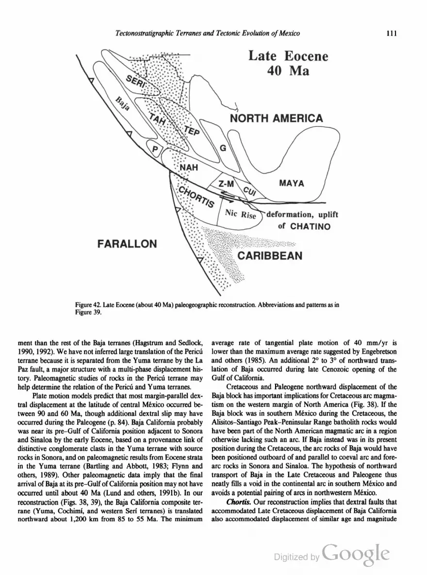
Tectonostratigraphic Terranes and Tectonic Evolution ofMexico lll
FARALLON
Late Eocene
deformation, uplift
of CHATINO
Figure 42. Late Eocene (about 40 Ma) paleogeographic reconstruction. Abbreviations and patterns as in
Figure 39.
ment than the rest of the Baja terranes (Hagstrum and Sedlock,
1990, 1992). We have not inferred large translation of the Period
terrane because it is separated from the Yuma terrane by the La
Paz fault, a major structure with a multi-phase displacement his
tory. Paleomagnetic studies of rocks in the Pericr'r terrane may
help determine the relation of the Period and Yuma terranes.
Plate motion models predict that most margin-parallel dex
tral displacement at the latitude of central Mexico occurred be
tween 90 and 60 Ma, though additional dextral slip may have
occurred during the Paleogene (p. 84). Baja California probably
was near its pre—Gulf of California position adjacent to Sonora
and Sinaloa by the early Eocene, based on a provenance link of
distinctive conglomerate clasts in the Yuma terrane with source
rocks in Sonora, and on paleomagnetic results from Eocene strata
in the Yuma terrane (Bartling and Abbott, 1983; Flynn and
others, 1989). Other paleomagnetic data imply that the final
arrival of Baja at its pre-Gulf of California position may not have
occurred until about 40 Ma (Lund and others, 1991b). In our
reconstruction (Figs. 38, 39), the Baja California composite ter
rane (Yuma, Cochimi, and western Serr' terranes) is translated
northward about 1,200 km from 85 to 55 Ma. The minimum
average rate of tangential plate motion of 40 mm/yr is
lower than the maximum average rate suggested by Engebretson
and others (1985). An additional 2° to 3° of northward trans
lation of Baja occurred during late Cenozoic opening of the
Gulf of California.
Cretaceous and Paleogene northward displacement of the
Baja block has important implications for Cretaceous arc magma
tism on the western margin of North America (Fig. 38). If the
Baja block was in southern Mexico during the Cretaceous, the
Alisitos—Santiago Peak—Peninsular Range batholith rocks would
have been part of the North American magmatic arc in a region
otherwise lacking such an arc. If Baja instead was in its present
position during the Cretaceous, the arc rocks of Baja would have
been positioned outboard of and parallel to coeval arc and fore
arc rocks in Sonora and Sinaloa. The hypothesis of northward
transport of Baja in the Late Cretaceous and Paleogene thus
neatly fills a void in the continental arc in southern Mexico and
avoids a potential pairing of arcs in northwestern México.
Chortis. Our reconstruction implies that dextral faults that
accommodated Late Cretaceous displacement of Baja California
also accommodated displacement of similar age and magnitude

112 R. L. Sedlock and Others
of the Chortis terrane (Figs. 38-40). Our reconstruction predicts
that translation of Chortis at the southern margin of México was to
the west or west-northwest and thus unlikely to be resolved by pa
leolatitude calculations. Paleomagnetic data indicate a complex his
tory of rotation but little latitudinal displacement of Chortis during
the Cretaceous (Gose, 1985). The Cretaceous dextral slip and Ceno
zoic sinistral slip of Chortis shown in our reconstruction roughly
(but not exactly) correspond to times of clockwise and counter
clockwise rotations of Chortis as determined by Gose (1985).
Trans-Mexican Volcanic Belt. In order to remove a kink
in various mineralization belts and to better align the Cretaceous
granitoids of the Tahué, Pericu, and Nahuatl terranes, we postu
late early Cenozoic dextral slip on a fault system that is now
concealed by the late Cenozoic Trans-Mexican Volcanic Belt
(TMVB). In our reconstruction, about 400 km of dextral dis
placement occurred on the TMVB fault system from 55 to 40
Ma, implying an average rate of 25 mm/yr (Figs. 40, 41). Gastil
and Jensky (1973) inferred 175 km of latest Cretaceous and early
Cenozoic dextral slip and 260 km of Neogene dextral slip on the
TMVB, but Neogene dextral displacement seems unlikely in view
of reconstructed plate motions (Stock and Hodges, 1989) and
evidence for Neogene sinistral slip along the southern margin of
México (Burkart and others, 1987). Our reconstruction assumes
that dextral slip on the TMVB occurred during and after north
ward translation of Baja California.
Mexican origin of terranes in the United States and
Canada. In this section, we compare displaced terranes north
of México with coastal terranes of México to which they may
have been adjacent in mid-Cretaceous time. Displacement of
some terranes is disputed on the basis of geologic arguments that
are beyond the scope of this volume.
The following tectonic history accounts for paleomagnetic,
biostratigraphic, and geologic data from terranes of southwestern
Canada and southeastern Alaska. (Monger and others, 1982;
Hillhouse and Gromme, 1984; Irving and others, 1985; Gehrels
and Saleeby, 1987; Umhoefer and others, 1989). The Stikine,
Cache Creek, and Quesnel terranes were amalgamated to form
Superterrane I in the eastern Pacific at the latitude of the north
western United States in the Early or Middle Jurassic time.
Superterrane I was translated southward to the latitude of
northwestern Mexico by the mid-Cretaceous. The Wrangellia
and Alexander terranes were in the eastern Pacific basin near but
not necessarily adjacent to southern Mexico and northwestern
South America by the Late Triassic, and were amalgamated to
form Superterrane II at the latitude of Mexico in the Late Jurassic
to Early Cretaceous. After mid-Cretaceous accretion of Superter
rane II to Superterrane I at the latitude of northwestern México,
both superterranes were translated 2,500 to 4,000 km northward
along western North America in the Late Cretaceous and Paleo
gene. The Wrangellia terrane contains late Paleozoic to Juras
sic volcanic rocks that may have formed at an arc in or near the
oceanic corner west of central Pangea (Fig. 31). The Alexander
terrane probably was exotic with respect to North America until
the Triassic (Gehrels and Saleeby, 1987), but Middle(?) Jurassic
granitoids formed at the latitude of southern México in either the
continental Jurassic arc or an outboard arc (Group 1 and Group
2 Jurassic arc rocks, respectively). The amalgamated superter
ranes were intruded by Cretaceous granitoids of the Coast Plu
tonic Complex while at the latitude of northwestern México
(references in Irving and others, 1985), perhaps adjacent to the
Seri and Tahué terranes (Figs. 37, 38).
The Salinia block in the central California Coast Ranges
consists of Cretaceous granitic basement and overlying Late
Cretaceous sedimentary rocks that have yielded anomalous mag
netic inclinations suggesting about 2,500 km of latest Cretaceous
to Paleogene northward translation (Champion and others,
1984). Restoration of this displacement places Salinia adjacent to
the mid-Cretaceous continental arc in the Nahuatl and Mixteco
terranes. However, petrologic, isotopic, and paleontologic data
(e.g., James and Mattinson, 1988) seem to indicate that the
granitic basement of Salinia formed south of the Sierra Nevada
and north of the Peninsular Ranges batholith.
In the Coast Ranges of California, paleomagnetic data have
been interpreted to indicate more than 2,000 km of Late Creta
ceous to Eocene northward displacement of oceanic rocks
including Jurassic ophiolite, Late Cretaceous sedimentary
rocks, and mid-Cretaceous limestone blocks of the Franciscan
Complex (Alvarez and others, 1980; McWilliams and Howell,
1982; Courtillot and others, 1985; Tarduno and others, 1985,
1986; M. Fones and others, unpublished manuscript). We specu
late that in the mid-Cretaceous the ophiolitic rocks and flysch,
and perhaps other parts of the Franciscan Complex, were part of
the forearc of the continental are at the latitude of central Mexico
(e.g., Fig. 39). Limestone blocks probably were derived from
seamounts in the Pacific basin that accreted to North America in
the latest Cretaceous or Paleogene.
Late Cretaceous—Paleogene shortening: Laramide
(Hidalgoan) orogeny
During latest Cretaceous to about middle Eocene time, east
northeast—west-southwest to northeast-southwest shortening pro
duced a roughly north-northwest—trending foreland fold and
thrust belt in most of eastern and central México (Fig. 43) during
the Hidalgoan orogeny (Guzman and de Cserna, 1963). Defor
mation was synchronous and kinematically and spatially akin to
Laramide foreland deformation in the Cordillera north of the
border (e.g., Davis, 1979), so we substitute the term Laramide for
Hidalgoan in this work. Laramide deformation in Mexico and
coeval eastward migration of the locus of arc magmatism may
have been caused by progressive shallowing of subducted oceanic
lithosphere, as has been postulated for the southwestern United
States (Coney and Reynolds, 1977).
The age and kinematics of Laramide deformation in México
are well understood in and near the Sierra Madre Oriental prov
ince, where post-Laramide volcanism and tectonism were
minimal. Parallel fold ridges and valleys trend roughly north
south in east-central Mexico and beneath the Gulf coastal plain

Tectonostratigraphic Terranes and Tectonic Evolution ofMexico 113
Laramide (Hidalgoan)
thrust belt in México
Figure 43. Map of Laramide (Hidalgoan) thrust belt, after Campa
Uranga (1985b). Barbed lines indicate major deformation fronts; short
line segments, structural trends. Western margin of continent has not
been paleogeographically restored.
(Mossman and Viniegra-Osorio, 1976; Suter, 1984, 1987) and in
the Chihuahua tectonic belt in northern Chihuahua (Lovejoy,
1980; Corbitt, 1984; Dyer and others, 1988); they trend east-west
in the intervening Monterrey-Torreén transverse system (de
Cserna, 1956; Tardy, 1975; Padilla y Sénchez, 1985, 1986;
Quintero-Legorreta and Aranda-Garcia, 1985). Tectonic trans
port normal to these trends—Le, to the north, northeast, and
east—locally was controlled by preexisting basement highs such
as the Coahuila platform. Deformation was thin-skinned, with
only local involvement of crystalline basement rocks. Detached
sheets locally rotated about vertical axes during foreland thrusting
(Kleist and others, 1984). Cumulative transverse displacement
was 40 to 200 km, with up to 30% shortening, but spatial and
temporal partitioning of displacement are poorly understood. In
our pre-Cenozoic reconstruction, we arbitrarily restored about
150 km of margin-normal Laramide shortening, all at the eastern
edge of the fold and thrust belt.
Late Cretaceous to Paleogene deformation is less well un
derstood in southern and western Mexico, in large part due to the
overprint of subsequent tectonism and magmatism. Northeast- to
east-vergent folding and thrusting of probable latest Cretaceous to
Paleogene age in the Cuicateco, Mixteco, and Nahuatl terranes
were synchronous with and may have been continuous with Lara
mide deformation in the Sierra Madra Oriental (Ferrusquia-Villa
franca, 1976; Carfantan, 1981, 1983; Johnson and others, 1990).
In the Tahué terrane, roughly east-west compression caused
eastward thrusting and mylonitization of ophiolitic and forearc
basin strata and greenschist metamorphism of underlying
Jurassic-Cretaceous arc rocks (Servais and others, 1982, 1986).
In the Seri and North America terranes, Late Cretaceous to Pa
leogene Laramide shortening was superposed on early Late Cre
taceous contractional structures (p. 108); tectonic transport
directions are reported to both the north and south (Roldan
Quintana, 1982; Pubellier and Rangin, 1987; Rodriguez
Castafieda, 1988; Nourse, 1990; Siem and Gastil, 1990).
Although the age of Laramide deformation still is not well
constrained in many parts of México, available data are consist
ent with a progressive decrease in age to the northeast, as in the
western United States (de Cserna, 1989). For example, shorten
ing probably occurred in the Late Cretaceous in Sonora and
Sinaloa but in the late Paleocene to middle Eocene near Monter
rey and in the Veracruz subsurface (Mossman and Viniegra
Osorio, 1976; Padilla y Sénchez, 1985, 1986).
Laramide deformation corresponded in time and space with
Late Cretaceous-Paleogene magmatism, which occurred west of
the thrust front (Lopez-Infanzon, 1986). Paleogene nonmarine
conglomerate and finer-grained elastic rocks, often referred to as
molasse, that locally crop out in the Tepehuano and Nahuatl
terranes probably were deposited atop unconformity surfaces dur
ing or immediately after Laramide orogenesis (Edwards, 1955;
Cordoba, 1988).
Depositional patterns
The following summary of the Cretaceous depositional his
tory of eastern Mexico is distilled from Viniegra-Osorio (1971,
1981), Enos (1983), Young (1983), Cantu-Chapa and others
(1987), Winker and Buffler (1988), and de Csema (1989), to
whom the reader is referred for more detailed accounts. The Late
Jurassic arrangement of isolated ephemeral islands, shallow-water
platforms, and intraplatform deeper water basins at the western
and southern margins of the Gulf of Mexico persisted into the
Early Cretaceous. Neocomian transgression transformed Jurassic
peninsulas (Coahuila, Tamaulipas) to islands and reduced the
area of smaller islands. The Tethyan affinity of reptilian fossils in
Neocomian strata in the northern Mixteco terrane indicates ex
change of oceanic waters between the Gulf of Mexico basin and
the Tethyan realm to the south and east (Ferrusquia-Villafranca
and Comas-Rodriguez, 1988). A likely paleogeography includes
a nearly closed basin, bounded on the north by the US. Gulf
Coast, on the west by the Cretaceous arc in western México, and
on the south by the southern Maya terrane and Zapoteco
Mixteco terranes, with a single oceanic outlet in the eastern Gulf
of Mexico (see Winker and Buffler, 1988, Fig. 17).
After an influx of terrigenous material during late Aptian
transgression, mid-Cretaceous (Albian-Cenomanian) carbonates
were deposited over a larger part of Mexico than in Neocomian
time. Steep-sided, high-relief carbonate-evaporite platforms
bounded by reef complexes shed very coarse carbonate detritus,
notable also as prolific hydrocarbon reservoirs, into adjacent deep
water basins. The decline in the number and size of carbonate
banks around the Gulf of Mexico in Comanchean time (90 to 85
Ma) may have been caused by thermal contraction of stretched
crust (Winker and Buffler, 1988). Late Cretaceous (post
Turonian) deposition in eastern México was characterized by an
114 R. L. Sedlock and Others
increasing terrigenous component, shallowing of basins, and
eastward migration of the shoreline. Throughout the Cretaceous,
evaporites and carbonates accumulated on the stable Yucatan
platform. We interpret the similarity of Cretaceous carbonates
and clastic rocks in the Chortis terrane and coeval deposits of the
open marine shelf in eastern Mexico to indicate that the regions
were contiguous (Figs. 38, 39).
In western Mexico, Cretaceous sediments probably were
deposited in a backarc basin or basins on the eastern flank of the
continental arc in the Serf and Tahué terranes. Servais and others
(1982) inferred an active backarc basin environment for Creta
ceous terrigenous marine strata in Durango, Zacatecas, and
Guanajuato (Tepehuano terrane) that apparently interfingered
eastward with carbonate and shale of the open marine shelf in
eastern México. A backarc setting has been proposed for Neoco
mian to Turonian terrigenous and carbonate strata in northeastern
Durango and southeastern Chihuahua (Araujo-Mendieta and
Arenas-Partida, 1986). In Chihuahua and northern Sonora (North
America terrane), Kimmeridgian (Late Jurassic) to Cretaceous
strata of the Chihuahua Group and Bisbee Group accumulated in
the Chihuahua Trough, a north- to northwest-trending basin on
the eastern flank of the continental arc (Fig. 35) (Cantu-Chapa
and others, 1985; Dickinson and others, 1986; Araujo-Mendieta
and Estavillo-GonzAlez, 1987; Salvador, 1987; Scott and
Gonzalez-Leon, 1991). The oldest volcanogenic debris observed
in these strata is Early Cretaceous in the Serf and North America
terranes in Sonora (Araujo-Mendieta and Gonzalez, 1987;
Jacques-Ayala, 1989), Turonian in the Tepehuano terrane (Tardy
and Maury, 1973), and Campanian-Maastrichtian in the Parras
basin of the Coahuiltecano terrane (McBride and others, 1974).
Late Cretaceous flysch in the Yuma terrane and Chatino terrane
probably accumulated in intraarc depositional settings.
Cenozoic
The distribution of Cenozoic magmatic rocks indicates that
oceanic lithosphere was subducted beneath southern and western
México during much or all of Cenozoic time. Dextral slip on the
TMVB and on the fault system east of Baja California and Chor
tis ceased during the Eocene or perhaps Oligocene. Major Ce
nozoic tectonism included shortening during the Laramide
orogeny, sinistral displacement of the Chortis block along the
southern margin of México, Basin and Range extension, and
extensional deformation and dextral faulting associated with the
opening of the Gulf of California.
Magmatism
Northern México. Magmatism affected most of northern
México during the Paleogene, but the composition and style of
emplacement of magmatic rocks are quite variable. The areal
distribution of Cenozoic magmatic rocks generally is interpreted
to reflect the slow eastward migration of magmatism and the
progressive widening of the continental arc during the early Ce
nozoic, followed by the comparatively rapid return of the arc to
the western margin of the continent by the end of Oligocene time.
Below, we briefly summarize several temporally and petrologi
cally distinct suites of magmatic rocks in the region.
Continental arc magmatism associated with eastward sub
duction of oceanic lithosphere beneath North America was well
established in northwestern México by the Late Cretaceous.
Latest Cretaceous to mid-Tertiary continental magmatic rocks in
Mexico are traditionally divided into an andesitic lower volcanic
sequence and a rhyolitic upper volcanic sequence with abundant
ignimbrites (McDowell and Keizer, 1977). However, this divi
sion appears to be meaningful only in northwestern Mexico,
where a major unconforrnity has been mapped between the two
units. A major unconforrnity has not been recognized in north
eastern México and adjacent Trans-Pecos Texas, where mag
matism began in the earliest Tertiary and continued into the
Oligocene and locally the early Miocene.
The composition and distribution of magmatism in northern
México changed after the Oligocene ignimbrite flare-up in the
Sierra Madre Occidental. Continental arc magmatism was con
fined to a narrow are at the western margin of the continent that
became inactive by the end of the middle Miocene. Late Oligo
cene to Miocene basaltic andesites in the Sierra Madre Occiden
tal may have been emplaced in an extensional backarc basin.
Miocene and younger alkalic basalts in and east of the Sierra
Madre Occidental probably were emplaced during Basin and
Range extension.
The “lower volcanic complex” of the Sierra Madre Occi
dental (McDowell and Keizer, 1977) consists of Late Cre
taceous and Paleogene calc-alkalic volcanic rocks and asso
ciated granitoids in the North America, Serf, Tahué, and Tepe
huano terranes (Tables 10, 12, 13, 15). These rocks are widely
presumed to have formed in a continental magmatic are above
the subducting Farallon plate, and the general eastward decrease
in crystallization age may indicate progressive shallowing of the
Benioff zone (Coney and Reynolds, 1977; Clark and others,
1980, 1982; Damon and others, 1981). A paucity of crystalliza
tion ages between 50 and 40 Ma led to the postulation of a
“magma gap” in western Mexico at this time, but studies in the
last decade have identified widespread Eocene magmatic rocks in
northwestern México (Aguirre-Dfaz and McDowell, 1991) and
in Trans-Pecos Texas (Henry and McDowell, 1986). Eocene vol
canic rocks exhibit a broad spectrum of compositions and vol
canic styles typical of arc magmatism, including intermediate
flows and felsic ash-flow tuffs. Eocene rocks probably are more
abundant in the Sierra Madre Occidental than currently realized;
Eocene silicic tuffs, flows, and calderas may have been mistak
enly grouped with the overlying Oligocene ignimbrite unit
(McDowell and others, 1990; Aguirre-Dfaz and McDowell,
1991). By 50 Ma, a broad, roughly north-south calc-alkalic
magmatic are stretched from the western Sierra Madre Occiden
tal east to Coahuila, San Luis Potosi, and Guanajato and south to
Chortis, which we infer was adjacent to southwestern Mexico
(Fig. 41). Magmatism in this region abated by about 40 Ma but
Tectonostratigraphic Terranes and Tectonic Evolution ofMexico 115
continued locally until 36 to 34 Ma (Wark and others, 1990, and
references therein). In some parts of western Mexico (e.g., Tepe
huano terrane), the lower volcanic complex was uplifted, tilted,
and eroded prior to late Eocene(?) deposition of nonmarine sand
stone and conglomerate.
In Trans-Pecos Texas, subduction-related magmatism began
about 48 Ma and continued until about 31 Ma. Magmatic rocks
were emplaced a great distance from the trench and are more
alkalic than rocks from arcs near trenches, but trace element
analyses and age relations strongly suggest that the rocks are
subduction-related (James and Henry, 1991). An arc environ
ment is also supported by paleostress measurements that indicate
emplacement in a compressional regime (see below). Rocks
dated at 48 to 31 Ma are divided into western alkalic-calcic and
eastern alkalic belts; several calderas have been mapped in each
belt (Henry and Price, 1984). Magma chemistry is consistent with
a history of derivation from a deep, partly dehydrated subducted
slab, a small degree of partial melting relative to typical arcs, and
interaction of rising melts with a thick mantle wedge and thick
continental crust (James and Henry, 1991).
Cretaceous to Eocene magmatic rocks in western México
are overlain unconformably by a kilometer-thick sequence of
Oligocene calc-alkalic rhyolite ignimbrite and subordinate ande
site, dacite, and basalt of the “upper volcanic supergroup”
(McDowell and Keizer, 1977; McDowell and Clabaugh, 1979;
Cameron and others, 1980). These rocks were erupted through
out the Sierra Madre Occidental and perhaps as far west as
east-central Baja California (Hausback, 1984). At least a dozen
calderas have been mapped, but several hundred may be present
based on comparisons with other ignimbrite provinces (Swanson
and McDowell, 1984). Rhyolitic and alkalic basaltic rocks were
emplaced in Trans-Pecos Texas starting about 31 Ma, apparently
in response to a change from compression to east-northeast—west
southwest tension (James and Henry, 1991). Most petrologic and
isotopic studies imply that mid-Tertiary rhyolitic magmas are
differentiates of mantle-derived basalts mixed with a small crustal
component (Cameron and Hanson, 1982; Gunderson and
others, 1986). The transition from andesitic to rhyolitic volcanism
may have been a consequence of the slowing or cessation of
Farallon—North America plate convergence: the resulting de
crease in the flux of mantle melts into the lower crust may have
caused ascending intermediate magmas to stall, accumulate, and
differentiate to produce rhyolite (Wark and others, 1990; Wark,
1991). Nd and Sr isotope ratios in silicic tuffs and lower crustal
xenoliths can be interpreted to indicate that the rhyolitic magmas
were derived from crustal anatexis (Ruiz and others, 1988a), but
others have argued for small or negligible crustal components
(Cameron and Cameron, 1985; Cameron and others, 1991;
Wark, 1991).
During and after the final stages of explosive rhyolitic vol
canism, basaltic andesites referred to as SCORBA (Southern
Cordilleran Basaltic Andesites) were erupted throughout the
northern Sierra Madre Occidental and southwestern United
States (Cameron and others, 1989). SCORBA lavas are included
in the upper volcanic supergroup of McDowell and Keizer
(1977). K-Ar ages from SCORBA samples range from 32 to 17
Ma, with a westward decrease from >24 Ma in the Basin and
Range province to 24 to 17 Ma in the Sierra Madre Occidental.
Most of the SCORBA suite is older than a Miocene continental
are at the western margin of northern Mexico and thus, probably
was erupted in an are rather than backarc setting (Cameron and
others, 1989). The mid-Tertiary transition from silicic volcanism
(andesite, rhyolite) to mafic volcanism (basaltic andesite) coin
cided with the onset of regional east-northeast-west-southwest
tension across northern México (p. 117). The sheetlike form of 36
to 30-Ma ignimbrites in northern Mexico and southwestern
United States apparently attests to weak regional stresses and the
absence of fault-generated topography, but younger SCORBA
lavas clearly were erupted in an extensional regime, probably
during Basin and Range extension (Cameron and others, 1989,
and references therein).
By about 24 Ma, arc magmatism in northern México had
shifted westward to a narrow chain of coalescing stratovolcanoes
composed chiefly of calc-alkalic andesite with minor basalt and
dacite (Damon and others, 1981; Clark and others, 1982; Hans
back, 1984; Sawlan and Smith, 1984; Sawlan, 1991). The axial
core of the arc crops out in coastal Baja California between
latitude 29° and 25°N, as indicated by vent-facies rocks as much
as 2 km thick. North and south of this strip, the axial core may be
submerged within the Gulf of California, or a broader, more
diffuse are complex may have developed instead of an axial core
(Hausback, 1984; Sawlan, 1991). Are magmatism persisted until
about 16 Ma north of about 28°N and until about 11 Ma in Baja
California Sur. Waning orogenic magmatism persisted until
about 10 Ma, overlapping in time and space with the onset of
alkalic volcanism related to initial rifting in the Gulf of California
starting about 13 Ma (Sawlan, 1991). The alkalic magmatic
rocks (“bajaites”) have unusual trace element characteristics that
may be attributed to the presence of recently-subducted very
young oceanic lithosphere, and that appear to have derived at
least partly from MORB (Saunders and others, 1987; Sawlan,
1991). Late Cenozoic tholeiitic rocks in central Baja and within
the Gulf of California record a transition from older intraplate
tholeiite to current MORB that mirrors the transition from ensial
ic to oceanic rifting (Moore and Carmichael, 1991; Sawlan,
1991). Scattered late Miocene to Quaternary calc-alkalic vol
canic rocks may have been produced by remelting of the
subduction-modified source of the Miocene calc-alkalic magmas.
The salient aspects of the late Cretaceous and Cenozoic
magmatic evolution of northern Mexico appear to be related to
changes in plate boundaries and relative plate motions. The
Late Cretaceous to Eocene lower volcanic sequence and a
probably coeval intrusive suite record arc magmatism related to
eastward subduction of oceanic lithosphere of the Farallon and
Kula(?) plates beneath the continent. The eastward decrease
in the age of the onset of arc magmatism and the widening of the
region affected by are magmatism in northern México probably
were caused by progressive shallowing of the Benioff zone beneath

116 R. L. Sedlock and Others
western North America (Damon and others, 1981; Clark and
others, 1982). The progressive decrease in age and increase in
buoyancy of subducted Farallon lithosphere probably resulted in
regional uplift and the development of one or more unconformi
ties during the Eocene in the Sierra Madre Occidental. Some or
most of this uplift was concomitant with part of Laramide oro
genesis, which also is attributed to the progressively shallower
angle of subduction of Farallon lithosphere. The decline at about
40 Ma in the emplacement of andesitic and rhyolitic magmatic
arc rocks in the Sierra Madre Occidental may reflect a decrease in
or possibly the cessation of Farallon—North America convergence
(Ward, 1991). Such a change may have caused transtensional
stretching of the hanging wall of this subduction zone, providing
space in the upper and middle crust for the accumulation of
magmas that ultimately were erupted as rhyolite ignimbrite in the
Oligocene (Ward, 1991). Oligocene to early Miocene alkalic
magmatic rocks in eastern México and Trans-Pecos Texas and
SCORBA magmas in the Mexican Basin and Range province
also were emplaced into stretched crust. By the early Miocene,
Cocos (ex-Farallon) lithosphere was being subducted at a rela
tively steep angle beneath western Mexico (Severinghaus and
Atwater, 1990), producing a narrow magmatic arc in eastern
Baja California. This are was extinguished in the late Miocene by
the growth of the Pacific-North America transform plate bound
ary (p. 118).
Southern Mexico. Crystallization ages of Cenozoic mag
matic arc rocks in southern Mexico are progressively younger to
the east. The Nahuatl terrane contains Late Cretaceous, Paleo
cene, Eocene, and Oligocene plutonic and rarer volcanic rocks.
The age of Cenozoic plutons in the Chatino terrane ranges from
about 45 Ma (Eocene) in the western part of the terrane to about
12 Ma (Miocene) in the east. Cale-alkalic volcanic rocks in the
Mixteco, Zapoteco, and Cuicateco terranes were erupted in the
Oligocene and Miocene (Ortega-Gutierrez and others, 1990). In
Chiapas (southern Maya terrane), plutons in the northern part of
the magmatic arc of Central America are as old as about 6 Ma
(Damon and Montesinos, 1978). These data have been inter
preted to indicate progressive eastward lengthening of the subduc
tion zone along the southern México continental margin,
probably due to eastward displacement of the Chortis terrane in
Eocene and later time (p. 117). Late Cretaceous and Paleogene
granitoids and volcanic rocks in the Chortis terrane probably
were contiguous with coeval arc rocks in west-central and
northwestern México.
Eastern México. Isolated Tertiary alkalic magmatic rocks
crop out in eastern México (Coahuiltecano and Maya terranes),
with crystallization ages decreasing southward from Oligocene in
Tamaulipas to Quaternary at San Andres Tuxtla (Bloomfield and
Cepeda-Davila, 1973; Barker, 1977, 1979; Cantagrel and Robin,
1979). These rocks and post—31-Ma alkalic rocks in Trans-Pecos
Texas have been ascribed to a roughly north-south belt related to
continental rifting, but recent geochemical and geochronologic
results support a different interpretation. Late Oligocene and
early Miocene alkalic intrusive rocks in Tamaulipas and
post—31-Ma alkalic magmatic rocks in Trans-Pecos Texas proba
bly formed during intraplate extension (James and Henry, 1991).
Miocene and younger magmatic rocks in Veracruz, Hidalgo, and
Puebla probably were produced in arc and backarc settings (Can
tagrel and Robin, 1979; Lopez-Infanzon and Nelson, 1990; Nel
son and others, 1991). Mid-Miocene rocks are calc-alkalic and
may be related to subduction of the Cocos plate, whereas late
Miocene to Recent rocks are alkalic and calc-alkalic and proba
bly were erupted in an extensional backarc setting.
Truns-Mexican Volcanic Belt. The late Cenozoic Trans
Mexican Volcanic Belt (TMVB) cuts across the northwest
southeast structural grain of Mexico (Fig. 3). Intermediate
volcanic rocks range in age from late Miocene to Quaternary
and are younger southward across the axis of the belt (Cantagrel
and Robin, 1979; Nixon and others, 1987). Despite anomalous
arc-trench distance and the discontinuous distribution of volcanic
rocks in the TMVB, the calc-alkalic composition of most volcanic
rocks probably indicates a genetic link with subduction of the
Cocos and Rivera plates (Nixon, 1982; Nixon and others, 1987).
The modern TMVB may be the site of sinistral or transtensional
displacement (Shurbet and Cebull, 1984; Cebull and Shurbet,
1987; Urrutia-Fucugauchi and Bohnel, 1987; Johnson and Harri
son, 1989; DeMets and Stein, 1990).
Alkalic volcanic rocks have been erupted in the Colima,
Chapala, and Zacoalco grabens in the western TMVB (Fig. 1)
since the mid-Pliocene. Suggested causes of continental extension
and alkalic volcanism in this region include (1) interaction of the
transform boundary between the subducting Cocos and Rivera
plates with overriding continental lithosphere (Nixon, 1982;
Nixon and others, 1987), (2) continental rifting during the pro
tracted eastward shifting of the Pacific-Cocos—North America
(Rivera) triple junction (Gastil and others, 1979; Luhr and others,
1985; Allan, 1986; Allan and others, 1991), (3) and passive exten
sion caused by southeastward displacement of coastal southern
México during oblique convergence (DeMets and Stein, 1990).
Displacement of the Chortis block
As part of the Caribbean plate, the Chortis terrane has
moved eastward with respect to Mexico along a major sinistral
plate boundary since 10 Ma or earlier (Burkart and others, 1987).
According to our reconstruction, the Chortis terrane was
translated westward to northwestward during the Cretaceous to
Paleocene, so it was transferred from the North America plate to
the Caribbean plate after ~60 and prior to 10 Ma.
An Eocene age of the transfer of the Chortis terrane is
supported by the age of truncation of southern Mexico, by the age
of sinistral transtension inferred to accompany the uplift of the
Chatino terrane, and by reconstructions of Cenozoic displace
ments on the northern margin of the Caribbean plate east of
Central America. The progressive eastward decrease in the age of
Tertiary magmatism in southern Mexico probably resulted from
northward subduction beneath progressively eastward sectors of
southern México and progressive sinistral displacement of a buf

Tectonostratigraphic Terranes and Tectonic Evolution ofMexico 117
fering land mass on the southern side of the Maya terrane (Fig.
42) (Malfait and Dinkehnan, 1972; Damon and others, 1983;
Wadge and Burke, 1983; Pindell and others, 1988; Pindell and
Barrett, 1990). Structural and geochronologic data from the X01
apa Complex in the Chatino terrane at the southern edge of
Mexico have been interpreted to indicate uplift of the complex on
shallowly north-dipping normal faults in response to sinistral
transtension on a major boundary to the south (Robinson and
others, 1989; Ratschbacher and others, 1991; Robinson, 1991).
Geophysical and geologic studies of the Cayman Trough and the
northern margin of the Caribbean plate in the eastern Caribbean
have concluded that at least 1,100 km of post-Eocene sinistral slip
was transferred westward on the southern margin of México
(Macdonald and Holcombe, 1978; Rosencrantz and Sclater,
1986; Pindell and others, 1988; Rosencrantz and others, 1988;
Pindell and Barrett, 1990). In central Guatemala, this sinistral
displacement presumably was accommodated within the Mota
gua fault zone, where highly deformed, locally mylonitic rocks in
a shear zone 10 to 25 km wide are inferred to record post
Cretaceous sinistral displacement of large but undetermined
magnitude (Erikson, 1990). Minor left-lateral strike-slip faulting
of late Eocene to Miocene age has been documented in southern
Guerrero and southern Oaxaca (Johnson and others, 1988;
Robinson, 1991), but almost all eastward displacement of the Chor
tis terrane south of Mexico probably was accommodated on
offshore faults.
In an alternate model of the evolution of the Caribbean
region, Chortis was accreted to the southern Maya terrane in
the latest Cretaceous and subsequently underwent negligible
pre—late Miocene displacement with respect to México
(Donnelly, 1989). The strongest support for this model is
the similarity of Cretaceous and Paleogene rock units, including
undeformed Eocene clastic rocks, across the Motagua fault zone.
According to this model, mylonitic fabrics in the Motagua fault
zone were formed during latest Cretaceous oblique collision of
the Chortis terrane with the southern Maya terrane. Mid-Tertiary
sinistral displacement in Guerrero and Oaxaca may be reconciled
with this model by invoking eastward displacement of coastal
slivers during highly oblique subduction, but the model does not
satisfactorily explain the age pattern of Tertiary magmatism in
southern México.
Extension
Cenozoic extension in the Basin and Range province of the
United States has been divided into (1) east-northeast-west
southwest extension from 30 to 10 Ma, the so-called pre-Basin
and Range, and (2) northwest-southeast extension since 10 Ma,
the so-called true Basin and Range (Zoback and others, 1981).
Basin and Range extension in the United States is physically
continuous with extension that affected most of northern and
central Mexico, and the timing and geometry of Mexican exten
sion appear to be similar to, although not as well understood as,
the history of extension in the US.
The belt of mid-Tertiary metamorphic core complexes in
the southwestern United States probably continues south into
México, as indicated by late Cenozoic detachment faulting,
subhorizontal penetrative ductile deformation, synkinematic
magmatism, and brittle extension of upper plate rocks in meta
morphic core complexes in the northern Seri terrane and adjacent
North America in Sonora (Anderson and others, 1980; Davis and
others, 1981; Nourse, 1990; Siem and Gastil, 1990, 1991).
Possible causes of mid-Tertiary extension include a reduction in
compressional stress on the Farallon—North America plate bound
ary to the west due to changes in relative plate motions, collapse
of a crustal welt thickened during Late Cretaceous—Paleogene
Laramide orogenesis, and lowering of the viscosity of the crust by
the strong mid-Tertiary magmatic pulse (Coney and Reynolds,
1977; Spencer and Reynolds, 1986; Coney, 1987).
Much of northern and central Mexico was affected by high
angle normal faulting typical of the Miocene-Recent Basin and
Range extension in the Great Basin (Fig. l), but extension ap
pears to have started 10 to 15 my. earlier in Mexico. Late Ce
nozoic net extension is minimal in the Sierra Madre Occidental
but significant in extended provinces to its east and west. In the
following discussion we refer to these areas as the eastern and
western Mexican Basin and Range provinces; the western prov
ince also has been called the Gulf of California extensional
province (Stock and Hodges, 1989, 1990).
The timing and kinematics of extension have been docu
mented in only a few parts of the eastern Mexican Basin and
Range. In north-central Mexico and Trans-Pecos Texas, roughly
east-northeast—west-southwest compression was supplanted by
east-northeast—west-southwest Basin and Range extension by 28
and probably by 31 Ma, based on the geometry of dikes and
veins; major normal faulting did not begin until about 24 Ma
(Seager and Morgan, 1979; Dreier, 1984; Henry and Price, 1986;
Aguirre-Diaz and McDowell, 1988; Henry and others, 1990,
1991). This mid-Oligocene stress reorientation was coeval with
and probably caused the change to alkalic magmatism (p. 115).
North-northwest-trending horsts and grabens formed in Sonora
and Chihuahua in the Miocene (Roldan-Quintana and Gonzalez
Ledn, 1979). North-northwest—trending horsts and grabens in
central México may indicate that late Cenozoic Basin and Range
extension affected crust as far south as and possibly south of the
TMVB (Henry and Aranda-Gomez, 1992). Cenozoic normal
displacement on faults north of the TMVB has been episodic,
with Quaternary reactivation of many older faults; faulting
caused moderate tilt of fault blocks and in many areas was asso
ciated with eruption of alkalic basalts (Henry and Aranda
Gomez, 1992).
In the western Mexican Basin and Range province, Miocene
extension has been documented on the periphery of and on is
lands within the Gulf of California. In western Sinaloa between
the Gulf of California and the Sierra Madre Occidental, east
northeast-west-southwest extension began as early as 32 Ma,
major tilting and faulting began after about 17 Ma, and net
extension is estimated to be 20 to 50%, depending on the deep

118 R. L. Sedlock and Others
geometry of normal faults (Henry, 1989). Geometrically similar
tilting and faulting indicating east-northeast—west-southwest ex
tension began by 17 Ma and terminated by 9 Ma in parts of
coastal Sonora (Gastil and Krummenacher, 1977), began by 12
Ma in coastal northeastern Baja California (Dokka and Merriam,
1982; Stock and Hodges, 1989, 1990), began by 15 to 13 Ma on
Isla Tiburon (Neuhaus and others, 1988), and probably began
after about 12 Ma in the La Paz region (Hausback, 1984).
Miocene faulting around the periphery of the Gulf of Califor
nia was physically continuous with Basin and Range extension in
the southwestern United States and probably occurred in a similar
tectonic setting, namely, adjacent to the evolving Pacific—North
America transform margin (Henry, 1989; Stock and Hodges,
1989). An uncertain, but probably small, component of slightly
transtensional Pacific—North America relative motion (Table 18)
was accommodated in the gulf region during the Miocene, result
ing in continental stretching, rifting, and thinning, subsidence, and
the development by a marine proto-gulf embayment, the so-called
“proto—Gulf of California.” The distribution and fauna of Mio
cene marine strata indicate that a narrow seaway had formed by
about 14 Ma over the eastern half of the modern gulf and parts of
coastal Sonora and Sinaloa, and that this seaway opened to the
south near the mouth of the modern Gulf of California where it
may have fed the 14.5- to 13-Ma Magdalena fan at the base of the
slope (Moore, 1973; Lozano-Romen, 1975; Yeats and Haq, 1981;
Aguayo-C., 1984; Smith and others, 1985; Gastil and Fenby,
1991; Smith, 1991). It is unlikely that crust in the western
Mexican Basin and Range province was thickened by Laramide
orogenesis or are magmatism, implying that extension was not
caused by collapse of a thick crustal welt (Henry, 1989). Miocene
dextral slip has not been documented in or adjacent to the proto
gulf, but a reconstruction of kinematics of the evolving Pacific—
North America plate boundary zone predicts about 60 km of dex
tral displacement on faults that were linked to the San Andreas
fault to the north (Sedlock and Hamilton, 1991).
The least principal stress and extension directions changed
from east-northeast—west-southwest to roughly northwest-south
east in the latest Miocene, coeval with the initiation of rifting
along the axis of the modern Gulf of California (Gastil and
Krummenacher, 1977; Angelier and others, 1981; Henry, 1989).
Subsidence of the gulf has spurred gulfward displacement of con
tinental blocks from the topographic rims of the gulf along late
Cenozoic and possibly active detachment faults (Fenby and Gas
til, 1991; Gastil and Fenby, 1991). Post-Miocene faulting in the
Gulf of California region includes dextral displacement on
northwest-striking strike-slip faults and normal displacement on
down-to-the-gulf normal faults (Gastil and Krummenacher,
1977; Angelier and others, 1981). Locally, the geometry of fault
ing is complex, probably reflecting the reactivation of older faults
and the interaction of translational and extensional components
of the plate boundary zone (e.g., Umhoefer and others, 1991).
Recent geochronologic and geomorphologic studies contra
dict the long-held notions that Baja has been uplifted rapidly and
tilted westward in the late Cenozoic (e.g., Beal, 1948). Apatite
fission-track studies of batholithic rocks in northern Baja indicate
less than 2 km of uplift and erosion since the mid-Tertiary (Cer
veny and others, 1991). Studies of emerged Pleistocene marine
terraces indicate uniform uplift of Baja, with no westward tilting,
at about 100 i 50 mm/1,000 yr since 1 Ma and perhaps since
about 5 Ma (Ortlieb, 1991). This rate is about an order of magni
tude lower than in parts of coastal California in the U.S., suggest
ing that Baja and Alta California may be independent structural
blocks, perhaps decoupled along the Agua Blanca and other
faults in northern Baja California.
Late Cenozoic tectonic history of northwestern México
Latest Oligocene to middle Miocene calc-alkalic magma
tism in the continental arc in eastern Baja was related to
subduction of the Farallon (Cocos) plate beneath Baja California.
As the Pacific—Cocos—North America triple junction migrated
southward along the western edge of the continent, convergence
was supplanted by dextral transform motion by 16 Ma west of
northern Baja California and by 12 Ma west of southern Baja
California (Lonsdale, 1989, 1991). From 12 to about 5 Ma, the
triple junction was south of Cabo San Lucas and was connected
to the Mendocino triple junction via a transform boundary in
which most slip occurred on offshore faults such as the Tosco
Abreojos fault zone (Spencer and Norrnark, 1979; Lonsdale,
1989, 1991; Sedlock and Hamilton, 1991). Late Miocene dextral
displacement also may have occurred on strike-slip faults in the
proto—Gulf of California (see above) and on proposed but un
identified faults that cut the Baja peninsula (see below). Late
Miocene (8 to 5.5 Ma) extension near the tip of Baja produced an
embayment in the continental margin, accounting for the greater
width of the gulf near its mouth (about 450 km) than at its north
end (about 300 km). About 5.5 Ma, the Pacific—Cocos—North
America triple junction jumped eastward to this embayment,
initiating the opening of the modern Gulf of California (Curray
and Moore, 1984). As rifting and spreading in the gulf pro
gressed, most dextral transform displacement was transferred
from the Tosco-Abreojos fault zone to faults within the modern
gulf that connected northward with the San Andreas fault.
Alternate models for the opening of the southern Gulf of
California have been summarized by Lyle and Ness (1991). Each
of these models proposes that creation of oceanic crust and drift
ing within the gulf began by 9 to 8.3 Ma, thereby accounting for
the different northern and southern widths of the gulf but also
requiring the accommodation of about 150 km of late Miocene
dextral slip on a fault or faults that cut the Baja California penin
sula along or north of the northwestward projection of the Pes
cadero transform fault (cf. Humphreys and Weldon, 1991). The
simplest test of these models is whether 150 km of Miocene
dextral slip can be demonstrated on transpeninsular faults. Al
though the entire peninsula has not yet been mapped in detail, the
age and distribution of units certainly are known well enough to
dismiss the possibility that a single fault accommodated all 150
km of hypothesized displacement. Displacement may have been
distributed on several or dozens of faults, but as the number of

Tectonostratigraphic Terranes and Tectonic Evolution ofMexico 119
faults increases so does the likelihood that one or more faults
would have been recognized. Not only are these models incom
patible with the geology of Baja as currently understood, but also
they imply that the change to northwest-southeast extension in
the gulf region occurred 3 to 4 my. earlier than indicated by field
studies (p. 118). The models of Lyle and Ness (1991) are incon
sistent with available observations, but more stringent testing re
quires further mapping and structural analysis.
Late Cenozoic shortening in southern México
Offshore geophysical studies have documented late Ceno
zoic folding and thrusting of Cretaceous and Cenozoic strata
around the southern margin of the Gulf of Mexico. East-west
shortening in the 600-km-long, north-south—trending Mexican
Ridges foldbelt off the coast of Tamaulipas and northern Vera
cruz has been ascribed to either gravity sliding and growth fault
ing or east-west crustal shortening (Buffler and others, 1979). The
southern end of this offshore foldbelt, which also is known as
Cordillera Ordofiez, currently may be overthrust to the northeast
by the continental shelf of southern Veracruz (De Cserna, 1981).
Other evidence for late Cenozoic northeast-southwest shortening
in southern México includes a southwest-verging fold and thrust
belt on the northeast side of the Chiapas Massif that was active
from middle Miocene to Pliocene time, and active northwest
trending folds off the north coast of Tabasco and Campeche (de
Cserna, 1989). We speculate that the locus of shortening is above
a proto-subduction zone where much of southern Mexico over
rides the lithosphere of the Gulf of Mexico basin.
SUMMARY
In Part 2 of this volume, we have presented a speculative
model of the Late Precambrian to Cenozoic tectonic evolution of
Mexico that is based on the geologic and tectonic history of
constituent tectonostratigraphic terranes described in Part 1, geo
physical and plate motion constraints, and formal premises. Some
of the salient features of the model are summarized below.
1. Grenville basement in eastern and southern México is
considered to be far-traveled with respect to the southern termi
nation of the Grenville belt in North America.
2. The late Paleozoic Ouachitan suture that marks the colli
sion of North America and Gondwana does not and did not
extend into central México.
3. The Perrno-Triassic continental are on the western mar
gin of Pangea affected only the far eastern edge and far north
western corner of Mexico; most of what is now Mexico was a
complex assemblage of arcs, continental blocks, and basins in the
oceanic region west and south of the Pangean continental arc.
4. Continental Mexico grew most markedly toward its
present form during the Late Triassic and Jurassic as terranes
were episodically accreted to its southern and western flanks.
5. Mesozoic southward and westward continental growth
was accompanied by a southward and westward shift of the locus
of arc magmatism.
6. The tectonically active southern and western margins of
México were sites of large margin-parallel translations of terranes
resulting from oblique convergence of Mexico with oceanic litho
sphere to the west. Convergence and terrane translation were
sinistral from the Triassic(?) until the Early Cretaceous, and dex
tral from the mid-Cretaceous to the Paleogene.
7. Jurassic stretching and rifting in the Gulf of Mexico was
not kinematically related to sinistral faulting on the Mojave
Sonora Megashear; instead, slip on the megashear and on other,
more outboard, fault systems was controlled by left-oblique con
vergence of Mexico with plates in the Pacific basin.
8. Paleomagnetic data that indicate about 15° of northward
latitudinal displacement of Baja in the Late Cretaceous and Pa
leogene can be reconciled with geologic correlations only by
postulating an earlier episode of southward displacement during
left-oblique convergence.
9. The Cretaceous reconstruction is consistent with postu
lated origins at Mexican latitudes of terranes in the western
United States and Canada.
10. The Caribbean plate, including the Chortis block, has
been translated 1,000 to 2,000 km eastward on strike-slip faults
along the southern margin of México since about 45 Ma.
11. Basin and Range extension has affected most of México
north of about 20°N.
Our reconstruction is not a unique explanation of the geo
logic and tectonic history of Mexico, but it does provide an
internally consistent framework for interpreting geoscientific data
from the region. Many aspects of the model are testable; we look
forward to the acquisition of new data and the formulation of
new interpretations and hypotheses that will almost certainly re
sult in modifications to the model.
REFERENCES CITED
Abbott, P. L., and Smith, T. E., 1989, Sonora, Mexico, source for the Eocene
Poway Conglomerate of southern California: Geology, v. 17, p. 329-332.
Abbott, P. L., Kies, R. P., Krummenacher, D., and Martin, D., 1983, Potassium
argon ages of rhyolite bedrock and conglomerate clasts in Eocene strata,
northwestern Mexico and southern California, in Anderson, D. W., and
Rymer, M. J., eds, Tectonics and sedimentation along faults of the San
Andreas system: Pacific Section, Society of Economic Mineralogists and
Paleontologists, p. 59—66.
Adams, M. A., 1979, Stratigraphy and petrography of the Santiago Peak Volcan
ics east of Rancho Santa Fe, California [M.S. thesis]: San Diego, California,
San Diego State University, 123 p.
Aguayo-C., J. E., 1984, Estudio de los sedimentos terrigenos de la Cuenca de
Guaymas, Golfo de Califomia, norocste de Mexico: Revista del Instituto
Mexicano del Petroleo, v. 16(4), p. 5—19.
Ague, J. J., and Brandon, M. T., 1992, Tectonic tilting and large-scale northwards
translation of the Peninsular Ranges batholith: Geological Society of Amer
ica Abstracts with Programs, v. 24, p. 2.
Aguirre, L., 1983, Granitoids in Chile: Geological Society of America Memoir
159, p. 293-316.
Aguirre-Diaz, G., and McDowell, F. W., 1988, Nature and timing of faulting in
the southern Basin and Range, central-eastern Durango, Mexico: EOS Tran
sactions of the American Geophysical Union, v. 69, p. 1412—1413.
Aiken, C.L.V., Schellhorn, R. W., and de la Fuente, M. F., 1988, Gravity of
northern Mexico, in Stratigraphy, tectonics, and resources of parts of Sierra
Madre Occidental province, Mexico, Clark, K. F., Goodell, P. C., and
Hoffer, J. M., eds., El Paso Geological Society, Field Conference

120 R. L. Sedlock and Others
Guidebook, p. 119—133.
Alaniz-Alvarez, S., and Ortega-Gutierrez, F., 1988, Constituye el Complejo Xol
apa realmente las raices de un arco?: Union Geofisica Mexicana, Colima,
GEOS, Numero extraordinario, Epoca 2, FQIT 15/57.
Alatorre, A. E., 1988, Stratigraphy and depositional environments of the
phosphorite-bearing Monterrey Formation in Baja California Sur, Mexico:
Economic Geology, v. 83, p. 1918—1930.
Alba, C. M., and Chavez, R., 1974, K-Ar ages of volcanic rocks from central
Sierra Peiia Blanca, Chihuahua, México: Isochron/West, v. 10, p. 2.
Alencaster, G., 1961, Paleontologia del Triésico Superior de Sonora: Instituto de
Geologia, Universidad Nacional Autonoma de Mexico, Paleontologia Mexi
cana nt'rmero 11, 38 p.
Allan, J. F., 1986, Geology of the Colima and Zacoalco grabens, SW Mexico:
Late Cenozoic rifting in the Mexican volcanic belt: Geological Society of
America Bulletin, v. 97, p. 473485.
Allan, J. R, Nelson, S. A., Luhr, J. F., Carmichael, I.S.E., Wopat, M., and
Wallace, P. J ., 1991, Pliocene-Holocene rifting and associated volcanism in
southwest Mexico: An exotic terrane in the making, in Dauphin, J. P., and
Simoneit, B.R.T., eds, The Gulf and Peninsular Province of the Californias:
American Association of Petroleum Geologists, Memoir 47, p. 425—445.
Allison, E. C., 1955, Middle Cretaceous gastropoda from Punta China, Baja
California, México: Journal of Paleontology, v. 29, p. 400—432.
Almazan-Vazquez, E., 1988a, Geoquimica de las rocas volcanicas de la Forma
cion Alisitos del Arroyo 1a Bocana en el Estado de Baja California Norte:
Revista del Instituto de Geologia, Universidad Nacional Autonoma de Mex
ico, v. 7, p. 78-88.
—— , 1988b, Marco paleosedimentario y geodinamico de la Forrnacion Alisitos
en la Peninsula de Baja California: Revista del Instituto de Geologia, Univer
sidad Nacional Autdnoma de Mexico, v. 7, p. 41—51.
Almazan-Vazquez, E., and 6 others, 1987, Stratigraphic framework of Mesozoic
strata in northern Sonora, Mexico: Geological Society of America Abstracts
with Programs, v. 19, p. 570.
Altamirano-R., F. J., 1972, Tectonica de la porcion meridional de Baja California
Sur: Sociedad Geologica Mexicana, II Convencion Nacional, Libro de Resu
menes, p. 113—114.
Alvarez, W., Kent, D. V., Premoli-Silva, 1., Schweickert, R. A., and Larson, R.,
1980, Franciscan Complex limestone deposited at 17° south paleolatitude:
Geological Society of America Bulletin, v. 91, p. 476—484.
Alzaga-Ruiz, H., and Pano-Arciniega, A., 1989, Origen de la Formacion Chivillas
y presencia del jurasico tardio en la region de Tehuacan, Puebla, Mexico:
Revista del Instituto Mexicano del Petroleo, v. 21(1), p. 5—15.
Anderson, J. G., and 6 others, 1986, Strong ground motion from the Michoacan,
Mexico, earthquake: Science, v. 233, p. 1043—1049.
Anderson, J. L., 1983, Proterozoic anorogenic granite plutonism of North Amer
ica, in Medaris, L. G., Jr., Byers, C. W., Mickelson, D. M., and Shanks,
W. C., eds, Proterozoic geology; Selected Papers from an International
Proterozoic Symposium: Geological Society of America Memoir 161,
p. 133—154.
Anderson, P. V., 1984, Prebatholithic strata of San Felipe: The recognition of
Cordilleran miogeosynclinal deposits in northeastern Baja California, Méx
ico: Pacific Section, Society of Economic Mineralogists and Paleontologists,
San Diego meeting, p. 29—30.
Anderson, T. H., and Schmidt, V. A., 1983, The evolution of Middle America and
the Gulf of Mexico—Caribbean Sea region during Mesozoic time: Geological
Society of America Bulletin, v. 94, p. 941~966.
Anderson, T. H., and Silver, L. T., 1969, Mesozoic magmatic events of the
northern Sonora coastal region, Mexico: Geological Society of America
Abstracts with Programs, v. 1, p. 3—4.
—— , 1971, Age of granulite metamorphism during the Oaxacan orogeny, Méx
ico: Geological Society of America Abstracts with Programs, v. 3, p. 492.
— , 1977a, Geochronometric and stratigraphic outlines of the Precambrian
rocks of northwestern Mexico: Geological Society of America Abstracts
with Programs, v. 9, p. 880.
— , 1977b, U-Pb isotope ages of granitic plutons near Cananea, Sonora: Eco
nornic Geology, v. 72, p. 827—836.
— , 1979, The role of the Mojave-Sonora Megashear in the tectonic evolution
of northern Sonora, in Anderson, T. H., and Roldan-Quintana, J., eds,
Geology of Northern Sonora: Geological Society of America, Field Trip
Guidebook, p. 59-68.
— , 1981, An overview of Precambrian rocks in Sonora, Mexico: Revista del
Instituto de Geologia, Universidad Nacional Autonoma de Mexico, v. 5,
p. 131—139.
Anderson, T. H., Burkart, B., Clemons, R. E., Bohnenburger, O. H., and Blount,
D. N., 1973, Geology of the western Altos Cuchumantes, northwestern
Guatemala: Geological Society of America Bulletin, v. 84, p. 805—826.
Anderson, T. H., Eells, J. L., and Silver, L. T., 1979, Precambrian and Paleozoic
rocks of the Caborca region, Sonora, Mexico, in Anderson, T. H., and
Roldan-Quintana, J., eds, Geology of Northern Sonora: Geological Society
of America, Field Trip Guidebook, p. 1—22.
Anderson, T. H., Silver, L. T., and Salas, G. A., 1980, Distribution and U-Pb
isotope ages of some lineated plutons, northwestern Mexico: Geological
Society of America Memoir 153, p. 269—283.
Anderson, T. H., Erdlac, R. J., Jr., and Sandstrom, M. A., 1985, Late-CretaceOus
allochthons and post-Cretaceous strike-slip displacement along the Cuilco
Polochic fault, Guatemala: Tectonics, v. 4, p. 453-475.
— , 1986, Reply to comment on “Late Cretaceous allochthons and post
Cretaceous strike-slip displacement along the Cuilco-Chixoy-Polochic fault,
Guatemala“ by Anderson, T. H., Erdlac, R. J ., Jr., and Sandstrom, M. A.:
Tectonics, v. 5, p. 473—475.
Anderson, T. H., McKee, J. W., and Jones, N. W., 1990, Jurassic(7) mélange in
north-central Mexico: Geological Society of America Abstracts with Pro
grams, v. 22, p. 3.
—— , 1991, A northwest trending, Jurassic fold nappe, northernmost Zacatecas,
Mexico: Tectonics, v. 10, p. 383—401.
Angelier, J., Colletta, B., Chorowicz, J ., Ortlieb, L., and Rangin, C., 1981, Fault
tectonics of the Baja California peninsula and the opening of the Sea of
Cortez, México: Journal of Structural Geology, v. 3, p. 347—357.
Aranda-Garcia, M., Gomez-Luna, M. E., and Contreras y Montero, B., 1987, El
Jurasico Superior (Kimeridgiano-Titoniano) en al area Santa Maria del Oro,
Durango, Mexico: Revista del Sociedad Mexicana Paleontolégica, v. 1,
p. 75—87.
Aranda-Garcia, M., Quintero-Legorreta, 0., and Martinez-Hernandez, E., 1988,
Palinomorfos del Jurasico de la Formacion Gran Tesoro, Santa Maria del
Oro, Durango: Revista del Instituto de Geologia, Universidad Nacional
Auténoma de México, v. 7, p. 112—115.
Aranda-Gémez, J. J ., and Pérez-Venzor, J. A., 1988, Estudio geoloogico de Punta
Coyotes, Baja California Sur: Revista del Instituto de Geologia, Universidad
Nacional Autonoma de Mexico, v. 7, p. l~21.
— , 1989, Estratigrafia del complejo cristalino de la region de Todos Santos,
Estado de Baja California Sur: Revista del Instituto de Geologia, Univer
sidad Nacional Autonoma de México, v. 8, p. 149*170.
Aranda-Gomez, J. J ., Aranda-Gomez, J. M., and Nieto-Samaniego, A. F., 1989,
Consideraciones acerca de la evolucion tectonica durante el Cenozoico de la
Sierra de Guanajuato y la parte meridional de la Mesa Central: Revista del
Instituto de Geologia, Universidad Nacional Autonoma de Mexico, v. 8,
_p. 33—46.
Araujo-Mendieta, J., and Arenas-Partida, R., 1986, Estudio tectonico-sedimen
tario en el Mar Mexicano, estados de Chihuahua y Durango: Sociedad
Geologica Mexicana Boletin, v. 47(2), p. 43—87.
Araujo-Mendieta, J., and Cesar-Gonzalez, R., 1987, Estratigrafia y sedimentol
ogia del jurasico superior en la Cuenca de Chihuahua, norte de Mexico:
Revista del Instituto Mexicano del Petroleo, v. 19(1), p. 6—29.
Araujo-Mendieta, J., and Estavillo-Gonzz'rlez, C. F., 1987, Evolucion tectonica
sedimentaria del jurasico superior y cretacico inferior en el NE de Sonora,
Mexico: Revista del Instituto Mexicano del Petroleo, v. 19(3), p. 4~67.
Arden, D. D., Jr., 1975, Geology of Jamaica and Nicaragua Rise, in Nairn,
A.E.M., and Stehli, F. G., eds, The ocean basins and margins: Volume 3:
The Gulf of Mexico and the Caribbean: New York, Plenum Press,

Tectonostratigraphic Terranes and Tectonic Evolution ofMexico 121
p. 617—661.
Arellano, A.R.V., 1956, Relaciones del Cambrico de Caborca, especialmente con
la base del Paleozoico, in Rodgers, J ., ed., El Sistema Cambrico, su paleo
geografia y el problema de su base; pt II: Australia, America: Mexico, D. F.,
XX Congreso Geolégico Internacional, p. 509—527.
Armin, R. A., 1987, Sedimentology and tectonic significance of Wolfcampian
(Lower Permian) conglomerates in the Pedregosa basin: Southeastern Ari
zona, southwestern New Mexico, and northern Mexico: Geological Society
of America Bulletin, v. 99, p. 42—65.
Ashby, J. R., 1989, A resume of the Miocene stratigraphic history of the Rosarito
Beach basin, northwestern Baja California, Mexico, in Abbott, P. L., ed.,
Geologic Studies in Baja California, Volume 63: Pacific Section, Society of
Economic Paleontologists and Mineralogists, p. 27—36.
Asmerom, Y., Zartman, R. E., Damon, P. E., and Shafiqullah, M., 1990, Zircon
U-Th-Pb and whole-rock Rb-Sr age patterns of lower Mesozoic igneous
rocks in the Santa Rita Mountains, southeast Arizona: Implications for Meso
zoic magmatism and tectonics in the southern Cordillera: Geological Society
of America Bulletin, v. 102, p. 961—968.
Atwater, T., 1970, Implications of plate tectonics for the tectonic evolution of
western North America: Geological Society of America Bulletin, v. 81,
p. 3513—3536.
— , 1989, Plate tectonic history of the northeast Pacific and western North
America, in Winterer, E. L., Hussong, D. M., and Decker, R. W., eds,
Decade of North American Geology, Volume N: The Eastern Pacific region:
Geological Society of America, p. 21—72.
Aubouin, J., and 6 others, 1982, The Middle America trench in the geological
framework of Central America, in Initial Reports of the Deep Sea Drilling
Project, Volume 67: Washington, D.C., US. Government Printing Office,
p. 747—755.
Avé Lallemant, H. G., and Oldow, J. S., 1988, Early Mesozoic southward migra
tion of Cordilleran transpressional terranes: Tectonics, v. 7, p. 1057—1075.
Avila-Angulo, R., 1990, Lower Jurassic volcanic and sedimentary rocks of the
Sierra Lopez, west-central Sonora, Mexico: Geological Society of America
Abstracts with Programs, v. 22, p. 4.
Bagby, W. C., 1979, Geology, geochemistry and geochronology of the Batopilas
quadrangle, Sierra Madre Occidental, Chihuahua, México [Ph.D. disserta
tion]: Santa Cruz, University of California, 271 p.
Balch, D. C., Bartling, S. H., and Abbott, P. L., 1984, Volcaniclastic strata of the
Upper Jurassic Santiago Peak Volcanics, San Diego, California, in Crouch,
J. K., and Bachman, S. B., eds, Tectonics and sedimentation along the
California margin, Volume 38: Pacific Section, Society of Economic Paleon
tologists and Mineralogists, p. 157—170.
Baldwin, S. L., and Harrison, T. M., 1989, Geochronology of blueschists from
west-central Baja California and the timing of uplift of subduction com
plexes: Journal of Geology, v. 97, p. 149—163.
— , 1992, The P-T-t history of blocks in serpentinite-matrix mélange, west
central Baja California: Geological Society of America Bulletin, v. 104,
p. 18—31.
Baldwin, S. L., Harrison, T. M., and Fitz Gerald, J. D., 1990, Diffusion of 40Ar in
metamorphic hornblende, Contributions to Mineralogy and Petrology,
v. 105, p. 691-703.
Baldwin, S. L., Harrison, T. M., and Sedlock, R. L., 1987, 40Ar/39Ar geochronol
ogy of high-pressure blocks in mélange, Cedros Island, Baja California:
Geological Society of America Abstracts with Programs, v. 19, p. 356.
Ballard, M. M., van der Voo, R., and Urrutia-Fucugauchi, J., 1989, Paleomag
netic results from the Grenvillian-aged rocks from Oaxaca, Mexico: Evi
dence for a displaced terrane: Precambrian Research, v. 42, p. 343—352.
Bally, A. W., Scotese, C. R., and Ross, M. 1., 1989, North America: Plate tectonic
setting and tectonic elements, in Bally, A. W., and Palmer, A. R., eds.,
Decade of North American Geology, Volume A: The geology of North
America; An overview: Geological Society of America, p. 1-15.
Barker, D. S., 1977, Northern Trans-Pecos magmatic province: Introduction and
comparison with the Kenya rift: Geological Society of America Bulletin,
v. 88, p. 1421—1427.
— , 1979, Genozoic magmatism in the Trans-Pecos province: Relation to Rio
Grande rift, in Riecker, R. E., ed., Rio Grande rift: Tectonics and magma
tism: Washington, D.C., American Geophysical Union, p. 382—392.
Barker, R. W., and Blow, W. H., 1976, Biostratigraphy of some Tertiary forma
tions in the Tampico-Misantla embayment, Mexico: Journal of Foraminif
eral Research, v. 6, p. 39—58.
Barnes, D. A., 1982, Basin analysis of volcanic are derived, Jura-Cretaceous
sedimentary rocks, Vizcaino Peninsula, Baja California Sur, Mexico [Ph.D.
dissertation]: Santa Barbara, University of California, 240 p.
Barnes, D. A., and Mattinson, J. M., 1981, Late Triassic—Early Cretaceous age of
eugcoclinal terranes, western Vizcaino Peninsula, Baja California Sur, Méx
ico: Geological Society of America Abstracts with Programs, v. 13, p. 43.
Barnes, L. G., 1992, The fossil marine vertebrate fauna of the latest Miocene
Almejas Formation, Isla Cedros, Baja California, Mexico: First International
Meeting on Geology of the Baja California Peninsula, Memoir Universidad
Autonoma de Baja California Sur, La Paz, B.C.S., p. 147-166.
Barrier, E., Bourgois, J., and Michaud, F., 1990, Le systéme de rifts actifs du point
triple de Jalisco: vers un proto-golfe de Jalisco: Comptes Rendus l’Académie
de Sciences, Paris, v. 310, p. 1513-1520.
Barth, A. P., Tosdal, R. M., and Wooden, J. L., 1992, Initiation of the Mesozoic
Cordilleran arc in southern California: Geological Society of America Ab
stracts with Programs, v. 24, p. 6.
Barthelmy, D. A., 1979, Regional geology of the El Arco porphyry copper
deposit, Baja California, in Baja California geology: Abbott, P. L., and Gastil,
R. G., eds., San Diego, Department of Geological Sciences, San Diego State
University, p. 127—138.
Bartling, W. A., and Abbott, P. L., 1983, Upper Cretaceous sedimentation and
tectonics with reference to the Eocene, San Miguel Island and San Diego
area, California, in Iarue, D. K., and Steel, R. J., eds., Cenozoic marine
sedimentation, Pacific margin, USA: Pacific Section, Society of Economic
Mineralogists and Paleontologists, p. 133—150.
Bartolini, C., and Stewart, J. H., 1990, Stratigraphy and structure of Paleozoic
oceanic strata in Sierra E1 Aliso, central Sonora, Mexico: Geological Society
of America Abstracts with Programs, v. 22, p. 6.
Bartolini, C., Morales, M., Damon, P., and Shafiqullah, M., 1992, K-Ar ages of
tilted Tertiary volcanic rocks associated with continental conglomerates,
Sonoran Basin and Range province, México: Geological Society of America
Abstracts with Programs, v. 24, p. 6.
Bateson, J. H., 1972, New interpretation of the geology of the Maya Mountains,
British Honduras: American Association of Petroleum Geologists Bulletin,
v. 56, p. 956—963.
Bateson, J. H., and Hall, I.H.S., 1971, Revised geologic nomenclature for pre
Cretaceous rocks of British Honduras: American Association of Petroleum
Geologists Bulletin, v. 55, p. 529—530.
— , 1977, Geology of the Maya Mountains, Belize: Great Britain, Institute of
Geological Sciences, Overseas Memoir 3, 42 p.
Bazan-B., S., 1987, Genesis de las pegmatitas del arco insular de Telixtlahuaca:
Geomimet, v. 149, p. 5L67.
Beal, C. H., 1948, Reconnaissance of the geology and oil possibilities of Baja
California, Mexico: Geological Society of America Memoir 31, 138 p.
Beauvais, L., and Stump, T. E., 1976, Corals, molluscs, and paleogeography of
Late Jurassic strata of the Cerro Pozo Sema, Sonora, México: Palaeogeo
graphy, Palaeoclimatology, Palaeoecology, v. 19, p. 275—301.
Beck, M. E., Jr., 1989, Paleomagnetism of continental North America: Implica
tions for displacement of crustal blocks with the western Cordillera, Baja
California to British Columbia, in Pakiser, L. C., and Mooney, W. D., eds,
Geophysical framework of the continental United States: Geological Society
of America, Memoir 172, p. 471—492.
— , 1991, Case for northward transport of Baja and coastal southern Califor
nia: Paleomagnetic data, analysis, and alternatives: Geology, v. 19,
p. 506—509.
Beck, R. J., and Thrash, L. T., 1991, State companies dominate non-US.
OGJ100: Oil and Gas Journal, v. 89, n. 39, p. 72—77.
Becker, K., and Fisher, A. T., 1991, A brief review of heat-flow studies in the

122 R. L. Sedlock and Others
Guaymas basin, Gulf of California, in Dauphin, J. P., and Simoneit, B.R.T.,
eds, The Gulf and Peninsular Province of the Californias: American Associ
ation of Petroleum Geologists Memoir 47, p. 709—720.
Bellon, H., Maury, R. C., and Stephan, J.-F., 1981, Dioritic basement, site 493:
Petrology, geochemistry, and geodynamics, in Initial Reports of the Deep
Sea Drilling Project, Volume 66: Washington, D.C., US. Government Print
ing Office, p. 723—730.
Bertrand, J., Delaloye, M., Fontignie, D., and Vuagnat, M., 1978, Ages (K-Ar)
sur diverse ophiolitiques et roches associees de la Cordillere Centrale du
Guatemala: Schweizerische Mineralogische und Petrographische Mitteilun
gen, v. 58, p. 405—413.
Bevis, M., and Isacks, B. L., 1984, Hypocentral trend surface analysis: Probing the
geometry of the Benioff zones: Journal of Geophysical Research, v. 89,
p. 6153—6170.
Bickford, M. E., 1988, The formation of continental crust: Part 1. A review of
some principles; Part 2. An application to the Proterozoic evolution of
southern North America: Geological Society of America Bulletin, v. 100,
p. 1375—1391.
Bickford, M. E., Van Schmus, W. R., and Zietz, I., 1986, Proterozoic history of
the midcontinent region of North America: Geology, v. 14, p. 492—496.
Blair, T. C., 1987, Tectonic and hydrologic controls on cyclic alluvial fan, fluvial,
and lacustrine rift-basin sedimentation, Jurassic-lowermost Cretaceous
Todos Santos Formation, Chiapas, Mexico: Journal of Sedimentary Petrol
ogy, v. 57, p. 845—862.
— , 1988, Mixed siliciclastic-carbonate marine and continental syn-rift sedi
mentation, Upper Jurassic—lowermost Cretaceous Todos Santos and San
Ricardo Formations, western Chiapas, Mexico: Journal of Sedimentary Pe
trology, v. 58, p. 623-636.
Blake, M. C., Jr., Jayko, A. S., Moore, T. E., Chavez, V., Saleeby, J. B., and Seel,
K., 1984, Tectonostratigraphic terranes of Magdalena Island, Baja California
Sur, in Frizzell, V. A., Jr., ed., Geology of the Baja California Peninsula,
Volume 39: Pacific Section, Society of Economic Paleontologists and Min
eralogists, p. 183—191.
Blickwede, J. F., 1981, Petrology and stratigraphy of Triassic(?) “Nazas Forma
tion,” Sierra de San Julian, Zacatecas, Mexico: American Association of
Petroleum Geologists Bulletin, v. 65, p. 1012.
Bloomfield, K., and Cepeda-Davila, L., 1973, Oligocene alkaline igneous activity
in NE Mexico: Geological Magazine, v. 110, p. 551—555.
Blount, J. G., Walker, N. W., and Carlson, W. D., 1988, Geochemistry and U-Pb
zircon ages of mid-Proterozoic metaigneous rocks from Chihuahua, México:
Geological Society of America Abstracts with Programs, v. 20, p. A205.
Bobier, C., and Robin, C., 1983, Palemagnetisme de la Sierra Madre Occidentale
dans les etats de Durango et Sinaloa (Mexique): Variations du champ ou
rotations de blocs au Paleocene et au Neogene'l: Geofisica Intemacional,
v. 22, p. 57—86.
Boehlke, J. E., and Abbott, P. L., 1986, Punta Baja Formation, a Campanian
submarine canyon fill, Baja California, Mexico, in Abbott, P. L, ed, Cre
taceous stratigraphy western North America: Pacific Section, Society of
Economic Paleontologists and Mineralogists, p. 91—101.
Bohnel, H., Alva-Valdivia, L., Gonzalez-Huesca, S., Urrutia-Fucugauchi, J.,
Moran-Zenteno, D., and Schaaf, P., 1989, Paleomagnetic data and the accre
tion of the Guerrero terrane, southern Mexico continental margin, in
Hillhouse, J. W., ed., Deep structure and past kinematics of accreted ter
ranes: American Geophysical Union Geophysical Monograph 50, p. 73—92.
Boles, J. R., 1986, Mesozoic sedimentary rocks in the Vizcaino Peninsula—Isla de
Cedros area, Baja California, México, in Abbott, P. L., ed., Cretaceous
stratigraphy western North America: Pacific Section, Society of Economic
Paleontologists and Mineralogists, p. 63—77.
Boles, J. R., and Landis, C. A., 1984, Jurassic sedimentary mélange and asso
ciated facies, Baja California, Mexico: Geological Society of America Bul
letin, v. 95, p. 513—521.
Bond, G. C., and Kominz, M. A., 1984, Construction of tectonic subsidence
curves for the early Paleozoic miogeocline, southern Canadian Rocky
Mountains: Implications for subsidence mechanisms, age of breakup, and
crustal thinning: Geological Society of America Bulletin, v. 95, p. 155—173.
Bonneau, M., 1969 (1970), Una nueva area cretacica fosilifera en el Estado de
Sinaloa: Sociedad Geologica Mexicana Boletfn, v. 32, p. 159—167.
Bottjer, D. J., and Link, M. H., 1984, A synthesis of Late Cretaceous southern
California and northern Baja California paleogeography, in Crouch, J. K.,
and Bachman, S. B., eds, Tectonics and sedimentation along the California
margin, Volume 38: Pacific Section, Society of Economic Paleontologists
and Mineralogists, p. 171—188.
Bourgois, J., Azéma, J., Baumgartner, P. O., Toumon, J., Desmet, A., and Au
bouin, J., 1984, The geologic history of the Caribbean—Cocos Plate bound
ary with special reference to the Nicoya ophiolite complex (Costa Rica) and
DSDP results (Legs 67 and 84 off Guatemala): Tectonophysics, v. 108,
p. 1-32.
Bourgois, J., and others, 1988, Fragmentation en cours du bord Ouest du Con
tinent Nord Américain: Les frontieres sous-marines du Bloc Jalisco
(Mexique) de fracture de Rivera au large du Mexique: Comptes Rendus,
l’Académie des Sciences, Paris, v. 307, p. 1121—1130.
Bowin, C. 0., 1976, Caribbean gravity field and plate tectonics: Geological So
ciety of America Special Paper 169, 79 p.
Bridges, L. W., 1964a, Stratigraphy of Mina Plomosas—Placer de Guadalupe area,
Geology of Mina Plomosas—Placer de Guadalupe area, Chihuahua, México:
West Texas Geological Society, Field Trip Guidebook, Publication 64-50,
p. 50—59.
— , 1964b, Structure of Mina Plomosas—Placer de Guadalupe area, Geology of
Mina Plomosas—Placer de Guadalupe area, Chihuahua, Mexico: West Texas
Geological Society, Field Trip Guidebook, Publication 64-50, p. 60—61.
Brown, M. L., and Dyer, R., 1987, Mesozoic geology of northwestern Chihuahua,
México, in Dickinson, W. R., and Klute, M. A., eds, Mesozoic rocks of
southern Arizona and adjacent areas, Volume 18: Arizona Geological So
ciety Digest, p. 381-394.
Brown, M. L., and Handschy, J. W., 1984, The tectonic framework of Chihua
hua, in Geology and petroleum potential of Chihuahua, Méxieo, Volume
84-80: West Texas Geological Society, Field Trip Guidebook, p. 161-173.
Brune, J. N., Simons, R. S., Rebollar, C., and Reyes, A., 1979, Seismicity and
faulting in northern Baja California, in Abbott, P. L., and Elliott, J. W., eds,
Earthquakes and other perils of the San Diego region: Geological Society of
America, Field Trip Guide, San Diego State University, San Diego, Califor
nia, p. 83—100.
Brunner, P., 1979, Microfacies y microfosiles permo-triasicos en el area El
Antimonio, Sonora, Mexico: Revista del Instituto Mexicano del Petroleo,
v. 11(1), p. 6—41.
Bryant, 8., Gastil, G., and Roldan-Quintana, J., 1985, Detachment faulting on
opposite sides of the Gulf of California: Geological Society of America
Abstracts with Programs, v. 17, p. 345.
Buch, l. P., 1984, Upper Permian(?) and Lower Triassic metasedimentary rocks,
northeastern Baja California, México, in Frizzell, V. A., Jr., ed., Geology of
the Baja California Peninsula, Volume 39: Pacific Section, Society of Eco
nomic Paleontologists and Mineralogists, p. 31—36.
Buesch, D. C., 1984, The depositional environment and subsequent metamor
phism of the Santiago Peak volcanic rocks, Camp Pendleton, California
[M.S. thesis]: Los Angeles, California State University, 113 p.
Bufiler, R. T., and Sawyer, D. S., 1985, Distribution of crust and early history,
Gulf of Mexico basin: Transactions of the Gulf Coast Geological Society,
v. 35, p. 333—344.
Buffler, R. T., Schaub, F. J ., Watkins, J. S., and Worzel, J. L., 1979, Anatomy of
the Mexican Ridges, southwestern Gulf of Mexico, in Watkins, J. 8., Mon
tadert, L., and Dickerson, P. W., eds., Geological and geophysical investiga
tions of continental margins: American Association of Petroleum Geologists
Memoir 29, p. 319—327.
Buitron, B. E., 1984, Late Jurassic bivalves and gastropods from northern Zacate
cas, Mexico, and their biogeographic significance, in Westermann, G.E.G.,
ed., Jurassic-Cretaceous biochronology and paleogeography of North Amer
ica: Geological Association of Canada Special Paper 27, p. 89—98.
Burbach, G. V., Frohlich, C., Pennington, W. D., and Matumoto, T., 1984,

Tectonostratigraphic Terranes and Tectonic Evolution ofMexico 123
Seismicity and tectonics of the subducted Cocos plate: Journal of Geophysi
cal Research, v. 89, p. 7719—7735.
Burchfiel, B. C., and Davis, G. A., 1981, Mojave Desert and environs, in Ernst,
W. 6., ed., The geotectonic development of California, Rubey Volume I:
Englewood Cliffs, New Jersey, Prentice-Hall, p. 217—252.
Burkart, 13., 1978, Offset across the Polochic fault of Guatemala and Chiapas,
Mexico: Geology, v. 6, p. 328-332.
— , 1983, Neogene North America—Caribbean plate b0undary across northern
Central America: Offset along the Polochic fault: Tectonophysics, v. 99,
p. 251—270.
—— , 1990, Contrast in effects of late Cretaceous convergence between Chia
pas, México, and Guatemala: Geological Society of America Abstracts with
Programs, v. 22, A338.
Burkart, B., and Self, S., 1985, Extension and rotation of crustal blocks in north
ern Central America and effect on the volcanic arc: Geology, v. 13, p. 22—26.
Burkart, 13., Clemons, R. E., and Crane, D. C., 1973, Mesozoic and Cenozoic
stratigraphy of southeastern Guatemala: American Association of Petroleum
Geologists Bulletin, v. 57, p. 63—73.
Burkart, B., Deaton, B. C., Dengo, C., and Moreno, G., 1987, Tectonic wedges
and offset laramide structures along the Polochic fault of Guatemala and
Chiapas, Mexico: Reaffirmation of large Neogene displacement: Tectonics,
v. 6, p. 411—422.
Burke, K., Cooper, C., Dewey, J. F., Mann, P., and Pindell, J. L., 1984, Carib
bean tectonics and relative plate motion, in Bonini, W. E., Hargraves, R. B.,
and Shagam, R., eds, The Caribbean—South American plate boundary and
regional tectonics: Geological Society of America Memoir 162, p. 31—63.
Busby-Spera, C. J., 1988, Evolution of a Middle Jurassic back-arc basin, Cedros
Island, Baja California: Evidence from a marine volcaniclastic apron: Geo
logical Society of America Bulletin, v. 100, p. 218~233.
Busby-Spera, C. J ., and Boles, J. R., 1986, Sedimentation and subsidence styles in
a Cretaceous forearc basin, southern Vizcaino Peninsula, Baja California
(Mexico), in Abbott, P. L., ed., Cretaceous stratigraphy western North
America: Pacific Section, Society of Economic Paleontologists and Mineral
ogists, p. 71—90.
Busby-Spera, C. J., Morris, W. R., and Smith, D., 1988, Syndepositional normal
faults across the width of the Cretaceous forearc region of Baja California
(Mexico): Geological Society of America Abstracts with Programs, v. 20,
p. 147.
Butler, R. F., Dickinson, W. R., and Gehrels, G. E., 1991, Paleomagnetism of
coastal California and Baja California: Alternatives to large-scale northward
transport: Tectonics, v. 10, p. 561—576.
Callaway, J. M., and Massare, J. A., 1989, Shastasauras altispinus (Ichthyosau
ria, Shastasauridae) from the Upper Triassic of the El Antimonio district,
northwestern Sonora, México: Journal of Paleontology, v. 63, p. 930—939.
Cameron, K. L., and Cameron, M., 1985, Rare earth element, 87Sr/“Sr, and
143Nd/1‘14Nd compositions of Cenozoic orogenic dacites from Baja Califor
nia, northwestern Mexico, and adjacent west Texas: Evidence for the pre
dominance of a subcrustal component: Contributions to Mineralogy and
Petrology, v. 91, p. 1—1 1.
Cameron, K. L., and Hanson, G. N., 1982, Rare earth element evidence concem
ing the origin of voluminous mid-Tertiary rhyolitic ignimbrites and related
volcanic rocks, SMO, Chihuahua, México: Geochimica et Cosmochimica
Acta, v. 46, p. 1489—1503.
Cameron, K. L., Cameron, M., Bagby, W. C., Moll, E. J., and Drake, R. E., 1980,
Petrologic characteristics of mid-Tertiary volcanic suites, Chihuahua,
Mexico: Geology, v. 8, p. 87-91.
Cameron, K. L., Cameron, M., Harmon, R. S., and Barreiro, B., 1991, Role of
crustal interaction in the genesis of ignimbrites from Batopilas, northcentral
Sierra Madre Occidental (SMO), México: Geological Society of America
Abstracts with Programs, v. 23, A332.
Cameron, K. L., Nimz, G. J., Kuentz, D., Niemeyer, S., and Gunn, S., 1989,
Southern Cordilleran Basaltic Andesite suite, southern Chihuahua, Mexico:
A link between Tertiary continental arc and flood basalt magmatism in
North America: Journal of Geophysical Research, v. 94, p. 7817—7840.
Campa-Uranga, M. F., 1978, La evolucion tectonica de Tierra Caliente, Guerrero:
Sociedad Geologica Mexicana Boletin, v. 39, p. 52—64.
— , 1985a, Metalogenecis y tectonica de placas: Ciencias, v. 1, p. 22—29.
— , 1985b, The Mexican thrust belt, in Howell, D. G., ed., Tectonostratigraph
ic terranes of the Circum-Pacific region: Circum-Pacific Council for Energy
and Mineral Resources, Earth Science Series, no. 1, p. 299-313.
Campa-Uranga, M. F., and Coney, P. J., 1983, Tectono-stratigraphic terranes and
mineral resource distributions of México: Canadian Journal of Earth Sci
ences, v. 20, p. 1040—1051.
Campa-Uranga, M. F., Campos, M., Flores, R., and Oviedo, R., 1974, La secuen
cia mesozoica volcanica sedimentaria metamorfizada de Ixtapan dc la Sal,
México-Teloloapan: Sociedad Geolégica Mexicana Boletin, v. 35, p. 7—28.
Campos-Enriques, J. 0., Arroyo-Esquivel, M. A., and Urrutia-Fucugauchi, J.,
1990, Basement Curie isotherm and shallow-crustal structure of the Trans
Mexican Volcanic Belt from aeromagnetic data: Tectonophysics, v. 172,
p. 77790.
Cantagrel, J. M., and Robin, C., 1979, K-Ar dating on eastern Mexican volcanic
rocks—Relations between the andesitic and alkaline provinces: Journal of
Volcanology and Geothermal Research, v. 5, p. 99—114.
Cantr'r-Chapa, A., 1979, Biostratigrafia de la Serie Huasteca (Jurasico Medio) en
el subsuelo de Poza Rica, Veracruz: Revista del Instituto Mexicano del
Petroleo, v. 11, p. 14—24.
Cantri-Chapa, C. M., Sandoval-Silva, R., and Arenas-Partida, R., 1985, Evolu
cion sedimentario del cretacico inferior en el norte de México: Revista del
Instituto Mexicano del Petroleo, v. 17(2), p. 14—37.
Carballido-Sanchez, E. A., and Delgado-Argote, L. A., 1989, Geologia del cuerpo
serpentinitico de Tehuitzingo, Estado de Puebla—Interpretacion preliminar
de su emplazamiento: Revista del Instituto de Geologia, Universidad Na
cional Autonoma de México, v. 8, p. 134—148.
Carfantan, J.-C., 1981 (1984), Evolucion estructural del sureste de Mexico: Pa
leogeografia e historia tecténica de las zonas intemas mesozoicas: Revista del
Instituto de Geologia, Universidad Nacional Autonoma de México, v. 5,
p. 207—216.
—— , 1983, Les ensembles géologiques du Mexique meridional. Evolution geo
dynamique durante 1e Mésozoique et le Cénozoique: Geofisica Intemacional,
v. 22, p. 9—37.
— , 1986, Du systeme Cordillerain nord-americain au domaine Caraibe—
Etude geologique du Mexique meridional [Ph.D.thesis]: Chambery, France,
Universite de Savoie, 556 p.
Carpenter, R. H., 1954, Geology and ore deposits of the Rosario mining district
and the San Juancito mountains, Honduras, Central America: Geological
Society of America Bulletin, v. 65, p. 23-38.
Carr, M. D., Christiansen, R. L., and Poole, F. G., 1984, Pre-Cenozoic geology of
the El Paso Mountains, southwestern Great Basin, California: A summary, in
Lintz, J ., Jr., ed., Western geological excursions, Volume 4: Reno, Nevada,
Department of Geological Sciences, Mackey School of Mines, p. 84—93.
Carr, M. J., Stoiber, R. E., and Drake, C. L., 1974, The segmented nature of some
continental margins, in Burk, C. A., and Drake, C. L., eds, The geology of
continental margins: New York, Springer-Verlag, p. 105—114.
Carrasco, V. B., 1978, Estratigrafia de unas lavas almohadilladas y rocas sedimen
tarias del Cretacico Inferior en Tehuacan, Puebla: Sociedad Geologica Mex
icana Boletin, v. 39, p. 13.
Carrillo, M., and Martinez E., 1981 (1983), Evidencias de facies continentales en
la Formacion Matzitzi, Estado de Puebla: Revista del Instituto de Geologia,
Universidad Nacional Autonoma de México, v. 5, p. 117—118.
Canillo-Bravo, J ., 1961, Geologia del Anticlinorio Huizachal-Peregrina a] N-W
de Ciudad Victoria, Tamaulipas: Asociacion Mexicana de Geologos
Petroleros Boletin, v. 13, p. 1—98.
— , 1965, Estudio geolégico de una parte del Anticlinorio de Huayacocotla:
Asociacion Mexicana de Geologos Petroleros Boletin, v. 17, p. 73—96.
Carrillo-Chavez, A., 1991, Las alteraciones como guias mineralogicas en yaci
mientos de oro tipo dike falla: Los Uvares, B.C.S., ejemplo caracteristico:
First International Meeting on Geology of the Baja California Peninsula,
Universidad Autonoma de Baja California Sur, La Paz, B.C.S., p. 14.

124 R. L. Sedlock and Others
Carrillo-Martinez, M., 1971, Geologia de la Hoja San José de Gracia Sinaloa
(Tésis Profesional): Mexico City, Universidad Nacional Autonoma de Méx
ico Faculty Ingenieria, 154 p.
— , 1990, Geometria estructural de la Sierra Madre Oriental, entre Peframiller
y Jalpan, Estado de Querétaro: Revista del Instituto de Geologia, Univer
sidad Nacional Autonoma de Mexico, v. 9, p. 62—70.
Case, J. E., and Holcombe, T. L., 1980, Geologic-tectonic map of the Caribbean
region: US. Geological Survey Miscellaneous Investigations Series, Map
1-1100, scale 12,500,000.
Case, J. E., Shagam, R., and Giegegack, R. F., 1990, Geology of the northern
Andes; An overview, in Dengo, G., and Case, J. E., eds, Decade of North
American Geology, Volume H: The Caribbean region: Geological Society of
America, p. 177—200.
Castillo-Rodriguez, H., 1988, Zur Geologic des kristallinen Grundgebirges der
Sierra Madre Oriental—insbesondere des Granjeno-Schiefer-Komplexes—im
Sudteil des Huizachal-Peregrina-Antildinoriums (Raum Ciudad Victoria,
Bundesstaat Tamaulipas, Mexiko) [Ph.D. thesis]: Miinster, Germany, Uni
versitat Munster, 138 p.
Castrejon, F., Porres, A., and Nava, F., 1988, A velocity model perpendicular to
the Acapulco trench region based on RESMAC data: Geofisica lntema
cional, v. 27(1), p. 131—147.
Castro-Mora, J., Schlaepfer, C. J., and Rodriquez, E. M., 1975, Estratigrafia y
microfacies del mesozoico de la Sierra Madre del sur, Chiapas: Asociacion
Mexicano Geologicos Petroleros Boletin, v. 27, p. 1-95.
Cebull, S. E., and Shurbet, D. H., 1987, Mexican volcanic belt: An intraplate
transform?: Geofisica Intemacional, v. 26, p. 1—13.
Cebull, S. E., Shurbet, D. H., Keller, G. R., and Russell, L. R., 1976, Possible role
of transform faults in the development of apparent ofisets in the Ouachita—
southem Appalachian tectonic belt: Journal of Geology, v. 84, p. 107—114.
Centeno-Garcia, E., Ortega-Gutierrez, F., and Corona-Esquivel, R., 1990, Oax
aca fault: Cenozoic reactivation of the suture between the Zapoteco and
Cuicateco terranes, southern Mexico: Geological Society of America Ab
stracts with Programs, v. 22, p. 13.
Cerveny, P. F., Dorsey, R. J., and Burns, B. A., 1991, Apatite and zircon fission
track ages from the Sierra San Pedro Martir, eastern Peninsular Ranges, Baja
California, México: Geological Society of America Abstracts with Programs,
v. 23, p. 12.
Champion, D. E., Howell, D. G., and Gromme, C. S., 1984, Paleomagnetic and
geologic data indicating 2500 km of northward displacement for the Sali
nian and related terranes, California: Journal of Geophysical Research, v. 89,
p. 7736—7752.
Champion, D. E., Howell, D. G., and Marshall, M., 1986, Paleomagnetism of
Cretaceous and Eocene strata, San Miguel Island, California, borderland and
the northward translation of Baja California: Journal of Geophysical Re
search, v. 91, p. 11557—11570.
Chavez-Quirarte, R., 1982, El Cretacico superior en el area del proyecto hidroe
léctrico de San Juan Tetelcingo, Guerrero: Libro guia de la excursion geolog
ica a la cunca del alto Rio Balsas: Sociedad Geolégica Mexicana, p. 55—58.
Chiodi, M., Monod, 0., Busnardo, R., Gaspard, D., Sénchez, A., and Yta, M.,
1988, Une discordance ante albienne datee par une faune d’Ammonites et de
Brachiopades de type tethysien au Mexique central: Geobios, v. 21,
p. 125*135.
Clark, K. F., 1976, Geologic section across Sierra Madre Occidental, Chihuahua
to Topolobampo, Mexico: New Mexico Geological Society Special Publica
tion 6, p. 26—38.
Clark, K. F., Damon, P. E., Schutter, S. R., and Shafiqullah, M., 1980, Magma
tismo en el norte de Mexico en relacion a 10s yacimientos metaliferos:
Geomimet, v. 106, p. 51—71.
Clark, K. F., Foster, C. T., and Damon, P. E., 1982, Cenozoic mineral deposits
and subduction-related magmatic arcs in Mexico: Geological Society of
America Bulletin, v. 93, p. 533—544.
Cobbing, E. J., and Pitcher, W. S., 1983, Andean plutonism in Peru and its
relationship to volcanism and metallogenesis at a segmented plate edge:
Geological Society of America Memoir 159, p. 277—291.
Cocheme, J.-J., and Demant, A., 1991, Geology of the Yécora area, northern
Sierra Madre Occidental, Mexico, in Pérez-Segura, E., and Jacqnes-Ayala,
C., eds, Studies of Sonoran geology: Geological Society of America Special
Paper 254, p. 81-94.
Cohen, K. K., Anderson, T. H., and Schmidt, V. A., 1986, A paleomagnetic test of
the proposed Mojave-Sonora megashear in northwestern Mexico: Tectono
physics, v. 131, p. 23—51.
Cojan, 1., and Potter, P., 1991, Depositional environment, petrology, and prove
nance of the Santa Clara Formation, Upper Triassic Barranca Group, eastern
Sonora, Mexico, in Pérez-Segura, E., and Jacques-Ayala, C., eds, Studies of
Sonoran geology: Geological Society of America Special Paper 254,
p. 37-50.
Coney, P. J., 1978, The plate tectonic setting of southeastern Arizona, Land of
Cochise: New Mexico Geological Society, 29th Field Conference,
p. 285490.
— , 1983, Un modelo tectonico de Mexico y sus relaciones con America del
Norte, America del Sur y el Caribe: Revista del Instituto Mexicano del
Petroleo, v. 15(1), p. 6—15.
— , 1987, The regional tectonic setting and possible causes of Cenozoic exten
sion in the North American Cordillera, in Coward, M. P., Dewey, J. F., and
Hancock, P. L., eds, Continental extensional tectonits: Geological Society of
London Special Publication 28, p. 177-186.
Coney, P. J., and Campa-Uranga, M. F., 1987, Lithotectonic terrane map of
Mexico (west of the 9151 meridian): US. Geological Survey, Miscellaneous
Field Studies Map MF-1874-D, scale 1:2,500,000.
Coney, P. J., and Reynolds, S. J., 1977, Cordilleran Benioif zones: Nature,
v. 270, p. 403—406.
Coney, P. J., Jones, D. L., and Monger, J.W.H., 1980, Cordilleran suspect
terranes: Nature, v. 299, p. 329—333.
Connors, C. D., and Anderson, T. H., 1989, Expression and structural analysis of
the Mojave-Sonora Megashear in northwestern Sonora, México: Geological
Society of America Abstracts with Programs, v. 21, A91.
Contreras y Montero, B., Martinez, C. A., and Gomez-Luna, M. E., 1988, Bioes
tratigrafia y sedimentologia del Jurasico Superior en San Pedro del Gallo,
Durango, Mexico: Revista del Instituto Mexicano del Petroleo, v. 20(3),
p. 5—49.
Cooper, G. A., and Arellano, A.R.V., 1946, Stratigraphy near Caborca, northwest
Sonora, Mexico: American Association of Petroleum Geologists Bulletin,
v. 30, p. 606—611.
Copeland, P., and Bowring, S. A., 1988, U-Pb zircon and 40Ar/39Ar ages for
Proterozoic rocks, west Texas: Geological Society of America Abstracts with
Programs, v. 20, p. 95—96.
Corbitt, L. L., 1984, Tectonics of fold and thrust belt of northwestern Chihuahua,
in Geology and petroleum potential of Chihuahua, Mexico, Volume 84-80:
West Texas Geological Society, Field Trip Guidebook, p. 174—180.
Cordoba, D. A., 1965, Hoja Viesca 13R-1(9), con resumen de la geologia de la
Hoja Apizolaya, Estados de Zacatecas y Durango: Carta Geolégica de Mex
ico, serie de l:100,000.
— , 1988, Estratigrafia de las rocas volcanicas de la region entre Sierra de
Gamon y Laguna de Santaiguillo, Estado de Durango: Revista del Instituto
de Geologia, Universidad Nacional Autonoma de Mexico, v. 7, p. 136—147.
Cordoba, D. A., and Silva-Mora, L., 1989, Marco geologico del area de
Revolucion-Puerta de Cabrera, Estado de Durango: Revista del Instituto de
Geologia, Universidad Nacional Autonoma de México, v. 8, p. 111—122.
Corona-Esquivel, R. J., 1981 (1984), Estratigrafia de la region de Olinahi
Tecocoyunca, noreste del Estado de Guerrero: Revista del Instituto de Geo
logia, Universidad Nacional Autonoma de Mexico, v. 5, p. 1-16.
Corona-Esquivel, R., Ortega-Gutierrez, F., Martinez-Reyes, J., and Centeno
Garcia, E., 1988, Evidencias de Ievantamiento tectonico asociado con el
sismo del 19 de septiembre de 1985, en la regio de Caleta de Campos,
Estado de Michoacan: Revista del Instituto de Geologia, Universidad Na
cional Autonoma de Mexico, v. 7, p. 106*111.
Cossio-Torres, T., 1988, Zur Geologic des kristallinen Grundgebirges der Sierra
Madre Oriental—insbesondere des Novillo-Gneis-Komplexes~im Sudteil des

Tectonostratigraphic Terranes and Tectonic Evolution ofMexico 125
Huizachal-Peregrina-Antiklinoriums (Raum Ciudad Victoria, Bundesstaat
Tamaulipas, Mexiko) [Ph.D. thesis]: Miinster, Universitat Munster, 99 p.
Couch, R., and Woodcock, S., 1981, Gravity and structure of continental margins
of southwestern Mexico and northwestern Guatemala: Journal of Geophysi
cal Research, v. 86, p. 1829—1840.
Couch, R. W., Ness, G. E., Victor, L., Shanahan, S., and Troseth, S. C., compilers,
1985, Free-air gravity anomalies, southern México to Costa Rica margin, in
Ladd, J. W., and Buffler, R. T., eds., Middle America Trench off western
Central America: Woods Hole, Massachusetts, Marine Science Intema
tional, Ocean Basins and Margins Drilling Program Atlas Series, Atlas 7,
sheet 2.
Couch, R. W., and others, 1991, Graw'ty anomalies and crustal structure of the
Gulf and Peninsular Province of the Californias, in Dauphin, J. P., and
Simoneit, B.R.T., eds., The Gulf and Peninsular Province of the Californias:
American Association of Petroleum Geologists Memoir 47, p. 25—45.
Courtillot, V., Feinberg, l-l., Ragaru, J. P., Kerguelen, R., McWilliams, M., and
Cox, A., 1985, Franciscan Complex limestone deposited at 24°N: Geology,
v. 13, p. 107—110.
Criscione, J. J., Davis, T. E., and Ehlig, P., 1978, The age of sedimentation/dia
genesis for the Bedford Canyon Formation and the Santa Monica Formation
in southern California: A Rb/Sr evaluation, in Howell, D. G., and McDou
gall, K., eds., Mesozoic paleogeography of the western United States, Pacific
Coast Paleogeography Symposium 2: Pacific Section, Society of Economic
Mineralogists and Paleontologists, p. 385—396.
Crouch, J. K., 1979, Neogene tectonic evolution of the western Transverse
Ranges and the California Continental Borderland: Geological Society of
America Bulletin, v. 90, p. 338—345.
Cuevas-Pérez, E., 1983, Evolucion geologica mesozoica del Estado de Zaca
tecas, México: Zentralblatt fiir Geologic und Paleontologie Teil 1 (3/4),
p. 190~201.
— , 1985, Geologic des Alteran mesozoikums in Zacatecas und San Lusi
Potosi, Mexiko [Ph.D. dissertation]: Marburg, Germany, Universita't Mar
burg, 189 p.
Cunningham, A. B., and Abbott, P. L., 1986, Sedimentology and provenance of
the Upper Cretaceous Rosario Formation south of Ensenada, Baja Califor
nia, Méxioo, in Abbott, P. L., ed., Cretaceous stratigraphy western North
America: Pacific Section, Society of Economic Paleontologists and Mineral
ogists, p. 103—118.
Curray, J. R., and Moore, D. G., 1984, Geologic history of the Gulf of California,
in Crouch, J. K., and Bachman, S. B., eds., Tectonics and sedimentation
along the California margin, Volume 38: Pacific Section, Society of Eco
nomic Paleontologists and Mineralogists, p. 17—35.
Curray, J. R., Moore, D. G., and others, 1982, Initial Reports of the Deep Sea
Drilling Project: Washington, D.C., US. Government Printing Office, v. 64,
507 p. (Part 1) and 1313 p. (Part 2).
Dallmeyer, R. D., 1982, Pre-Mesozoic basement of the southeastern Gulf of
Mexico: Geological Society of America Abstracts with Programs, v. 14,
p. 471.
Dalziel, I.W.D., 1991, Pacific margins of Laurentia and East AntarcticayAustralia
as a conjugate rift pair: Evidence and implications for an Eocambrian super
continent: Geology, v. 19, p. 598—601.
Damon, P. E., and Coney, P. J., 1983, Rate of movement of nuclear Central
America along the coast of Méxioo during the last 90 Ma: Geological Society
of America Abstracts with Programs, v. 15, p. 553.
Damon, P. E., and Montesinos, E., 1978, Late Cenozoic volcanism and metallo
genesis over an active Benioff zone in Chiapas, Mexico: Arizona Geological
Society Digest, v. 11, p. 155—168.
Damon, P. E., Livingston, D. E., Mauger, R. L., Giletti, B. J., and Pantoja-Alor,
J., 1962, Edad del Precambrico “Anterior” y de otras rocas del Zocalo de la
region de Caborca—Altar de la parte noroccidental de Estado de Sonora:
Boletin del Instituto de Geologia, Universidad Nacional Auténoma de Méx
ico, v. 64, p. 11—44.
Damon, P. E., Shariqullah, M., and Clark, K. F., 1981, Age trends of igneous
activity in relation to metallogenesis in the southern Cordillera, in Dickinson,
W. R., and Payne, W. D., eds., Relations of tectonics to ore deposits in the
southern Cordillera, Volume 14: Arizona Geological Society Digest,
p. 137—154.
— , 1983, Geochronology of the porphyry copper deposits and related miner
alization of Mexico: Canadian Journal of Earth Sciences, v. 20,
p. 1052—1071.
Damon, P. E., Shafiqullah, M., and Roldan-Quintana, J., 1984, The Cordilleran
Jurassic arc from Chiapas (southern Mexico) to Arizona: Geological Society
of America Abstracts with Programs, v. 16, p. 482.
Dauphin, J. P., and Ness, G. E., 1991, Bathymetry of the Gulf and Peninsular
Province of the Californias, in Dauphin, J. P., and Simoneit, B.R.T., eds.,
The Gulf and Peninsular Province of the Califomias: American Association
of Petroleum Geologists, Memoir 47, p. 21—23.
Davila-Alcocer, V., and Martinez-Reyes, J ., 1987, Una edad cretécica para las
rocas basales de la Sierra Guanajuato, Simposio sobre la geologia de la
region de la Sierra de Guanajuato (Resumenes), April 1987, p. l9—20.
Davis, G. H., 1979, Laramide faulting and folding in southeastern Arizona: Amer
ican Journal of Science, v. 279, p. 543—569.
Davis, G. H., Gardulski, A. P., and Anderson, T. H., 1981, Structural and
structural-petrologic characteristics of some metamorphic core complex ter
ranes in southern Arizona and northern Sonora, in Ortlieb, L, and Roldan
Quintana, J., eds., Geology of northwestern México and southern Arizona:
Revista del Instituto dc Geologia, Universidad Nacional Autonoma de Méx
ico, Estacién Regional del Noreste, p. 323-365.
de Cserna, Z., 1965, Reconocimiento geologioo de la Sierra Madre del Sur de
Mexico, entre Chilpancingo y Acapulco, Estado de Guerrero: Boletin del
Instituto de Geologia, Universidad Nacional Autonoma de México, v. 62,
p. 1—77.
—— , 1971, Precambrian sedimentation, tectonics, and magmatism in Mexico:
Geologische Rundschau, v. 60, p. 1488—1513.
— , 1976, Geology of the Fresnillo area, Zacatecas, México: Geological So
ciety of America Bulletin, v. 87, p. 1191—1199.
— , 1981 (1984), Margen continental de oolision activo en la parte surocciden
tal del Golfo de México: Revista del Instituto de Geologia, Universidad
Nacional Autonoma de México, v. 5, p. 255—261.
— , 1982 (1983), Hoja Viesca l4Q-g(9), con resumen de la geologia de la
Hoja Tejupilco, Estados de Guerrero, México y Michoacan: Carta Geologica
de Méxioo, serie de 1:100,000.
— , 1989, An outline of the geology of Mexico, in Bally, A. W., and Palmer,
A. R., eds., Decade of North American Geology, Volume A: The geology of
North America—An overview: Geological Society of America, p. 233—264.
de Cserna, Z., and Fries, C., Jr., 1981, Hoja Viesca l4Q-h(7), con resumen de la
geologia de la Hoja Taxco, Estados de Guerrero, Mexico y Morelos: Carta
Geolégica de Mexico, serie de 1:100,000.
de Cserna, Z., and Ortega-Gutierrez, F., 1978, Reinterpretation of isotopic age
data from the Granjeno Schist, Ciudad Victoria, Tamaulipas; y reinterpreta
cion tecténica del Esquisto Granjeno, Ciudad Victoria, Tamaulipas; Contes
tacién: Revista del Instituto de Geologia, Universidad Nacional Autonoma
de México, v. 2, p. 212—215.
tie Cserna, Z., Schmitter, E., Damon, P. E., Livingston, D. E., and Kulp, J. L.,
1962, Edades isotopicas de rocas metamorficas del centro y sur de Guerrero
y una monzonita cuarcifera del norte de Sinaloa: Boletin del Instituto de
Geologia, Universidad Nacional Autonoma de Mexico, v. 64, p. 71—84.
de Cserna, Z., Rinoon-Orta, C., Solorio-Munguia, J., and Schmitter-Villada, E.,
1968, Una edad radiométrica Pérmica temprana de la region de Placer de
Guadelupe, noreste de Chihuahua: Sociedad Geologico Mexicana Boletin,
v. 31, p. 158—159.
de Cserna, Z., Fries, C., Jr., Rincon-Orta, C., Westley, A., Solorio-Munguia, J.,
and Schmitter-Villada, E., 1974, Edad Precambrica tardia del Esquisto
Taxco, Estado de Guerrero: Asociacion Mexicanos Geologicos Petroleros
Boletin, v.26, p. 183—193.
de Cserna, 2., Graf, J. L., Jr., and Ortega-Gutierrez, P., 1977, Aloctono Paleo
zoico Inferior en la region de Ciudad Victoria, Estado de Tamaulipas: Re
vista del Instituto de Geologia, Universidad Nacional Auténoma de México,

126 R. L. Sedlock and Others
v. 1, p. 33—43.
de Cserna, Z., Ortega-Gutierrez, F., and Palacios-Nieto, M., 1980, Reconoci
miento geologico de la parte central de la cuenca del alto Rio Balsas, Estados
de Guerrero y Puebla: Libro guia de la excursion geologica a la parte central
de la euenca del alto Rio Balsas, Estados de Guerrero y Puebla: Sociedad
Geologica Mexicana, p. 1—33.
de Csema, Z., de la Fuente-Duch, M., Palacios-Nieto, M., Triay, L., Mitre
Salazar, L.-M., and Mota-Palomino, R., 1987 (1988), Estnrctura geologica,
gravimetria, sismicidad y relaciones neotectonicas regionales de la cuenca de
Mexico: Boletin del Instituto de Geologia, Universidad Nacional Autonoma
de México, v. 104, 71 p.
Deaton, B. C., and Burkart, B., 1984a, Time of sinistral slip along the Polochic
fault of Guatemala: Tectonophysics, v. 102, p. 297—313.
— , 1984b, K-Ar ages of samples from the Subinal Formation and the Colote
nango beds, Guatemala: lsochron/West, v. 39, p. 19-20.
DeJong, K. A., Escarcega-Escarcega, J. A., and Damon, P. E., 1988, Eastward
thrusting, southwestward folding, and westward backsliding in the Sierra La
Vibora, Sonora, Mexico: Geology, v. 16, p. 904—907.
DeJong, K. A., Garcia y Barragan, J. C., Damon, P. E., Miranda, M., Jacques
Ayala, C., and Almazan-Vazquez, E., 1990, Untangling the tectonic knot of
Mesozoic Cordilleran orogeny in northern Sonora, NW Mexico: Geological
Society of America Abstracts with Programs, v. 22, A327.
Delevoryas, T., and Srivastava, S. C., 1981, Jurassic plants from the Department
of Francisco Morazan, central Honduras: Review of Palaeobotany and Paly
nology, v. 34, p. 345357.
Delgado-Argote, L. A., 1988, Geologia preliminar de la secuencia volcanosedi
mentaria y serpentinitas asociadas del jurasico(?) del area de Cuicatlan
Concepcién Papalo, Oaxaca: Revista del Instituto de Geologia, Universidad
Nacional Autonoma de Mexico, v. 7, p. 127—135.
— , 1989, Regional implications of the Jurassic~Cretaceous volcanosedimcn
tary Cuicateco terrane, Oaxaca, Mexico: Geofisica Internacional, v. 28, p.
939—973.
Delgado-Argote, L. A., and Carballido-Sénchez, E. A., 1990, Analisis tectonico
del sistema traspresivo neogénico entre Macuspana, Tabasco, y Puerto
Angel, Oaxaca: Revista del Instituto de Geologia, Universidad Nacional
Autonoma de Mexico, v. 9, p. 21—32.
Delgado-Argote, L. A., Rubinovich-Cogan, R., and Gasca-Duran, A., 1986, Des
cripcion preliminar de la geologia y mecanica dc emplazamiento del oom
plejo ultrabasico del cretacio de Loma Baya, Guerrero, México: Geofisica
lntemacional, v. 25, p. 537—558.
Delgado—Argote, L. A., Lopez-Martinez, M., York, D., and Hall, C. M., 1990,
Geology and geochronology of ultramafic localities in the Cuicateco and
Tierra Caliente Complexes, southern Mexico: Geological Society of America
Abstracts with Programs, v. 22, A326.
Delgado-Argote, L. A., Casar-Aldrete, 1., Gonzzilez-Caver, E., Morales-Puente,
P., and Giron-Garcia, P., 1992a, Geologic controls on the variation of hy
drogen isotope ratios of structural water of serpentinites from San Pedro
Limon-Palmar Chico, Tierra Caliente terrane, México: Geofisica Interna
cional, in press.
Delgado-Argote, L. A., Lopez-Martinez, M., York, D., and Hall, C. M., 1992b,
Geologic framework and geochronology of ultramafic complexes of south
ern México, Canadian Journal of Earth Sciences, v. 29, p. 1590—1604.
Dellatre, M. P., 1984, Permian miogeoclinal strata at El Volcan, Baja California,
Mexico, in Frizzell, V. A., Jr., ed., Geology of the Baja California Peninsula,
Volume 39: Pacific Section, Society of Economic Paleontologists and Min
eralogists, p. 23—29.
Demant, A., 1978, Caracteristicas del Eje Neovolcanico Transmexicano y sus
problemas de interpretacion: Revista del Instituto de Geologia, Universidad
Nacional Autonoma de Mexico, v. 2, p. 172—181.
— , 1981, Plio-Quaternary volcanism of the Santa Rosalia area, Baja Califor
nia, Mexico, in Ortlieb, L., and Roldan-Quintana, J., eds., Geology of
northwestern Mexico and southern Arizona: Instituto de Geologia, Univer
sidad Nacional Autonoma de Mexico, Estacion Regional del Noreste,
p. 295-307.
DeMets, C., and Stein, 8., 1990, Present-day kinematics of the Rivera plate and
implications for tectonics in southwestern Mexico: Journal of Geophysical
Research, v. 95, p. 21931—21948.
DeMets, G, Gordon, R. G., Argus, D. F., and Stein, 8., 1990, Current plate
motions: Geophysical Journal International, v. 101, p. 425—478.
Dengo, C. A., 1986, Comment on “Late Cretaceous allochthons and post
Cretaceous strike-slip displacement along the Cuilco-Chixoy-Polochic fault,
Guatemala” by Anderson, T. 11., Erdlac, R. J., Jr., and Sandstrom, M. A.,
Tectonics, v. 5, p. 469-472.
Dengo, G., 1972, Review of Caribbean serpentinites and their tectonic implica
tions: Geological Society of America Memoir 132, p. 303 —312.
— , 1975, Paleozoic and Mesozoic tectonic belts in Mexico and Central Amer
ica, in Nairn, A.E.M., and Stehli, F. G., eds., The ocean basins and margins:
Volume 3: The Gulf of Mexico and the Caribbean: New York, Plenum
Press, p. 283—323.
— , 1985, Mid-America: tectonic setting for the Pacific margin from southern
México to northwestern Colombia, in Nairn, A.E.M., and Stehli, F. G., eds.,
The ocean basins and margins: Volume 7A: The Pacific Ocean, New York,
Plenum Press, p. 123—180.
Denison, R. E., Kenny, G. S., Burke, W. H., Jr., and Hetherington, E. A., Jr.,
1969, lsotopic ages of igneous and metamorphic boulders from the Hay4
mond Formation (Pennsylvanian), Marathon basin, Texas, and their signifi
cance: Geological Society of America Bulletin, v. 80, p. 245—256.
Denison, R. E., Burke, W. 11., Jr., 11ethen'ngton, E. A., Jr., and Otto, J. B., 1971,
Basement rock framework of parts of Texas, southern New Mexico, and
northern México, in The geologic framework of the Chihuahua Tectonic
Belt, Midland, Texas: West Texas Geological Society, p. 1—14.
Diaz, T., and Navarro-G, A., 1964, Lithology and stratigraphic correlation of the
upper Paleozoic in the region of Palomas, Chihuahua, Geology of Mina
Plomosa—Placer de Guadalupe area, Chihuahua, México: West Texas Geo
logical Society, Field Trip Guidebook, Publication 64-50, p. 6584.
Dial-Garcia, V., 1980, Las rocas metamorficas de la region de Zucualpan, Estado
de México: Revista del Instituto de Geologia, Universidad Nacional
Autonoma de Mexico, v. 4, p. 1—12.
Dickinson, W. R., 1981, Plate tectonic evolution of the southern Cordillera, in
Dickinson, W. R., and Payne, W. D., eds., Relation of tectonics to ore
deposits in the southern Cordillera, Volume 14: Arizona Geological Society
Digest, p. 113—135.
Dickinson, W. R., and Snyder, W. S., 1979, Geometry of triple junctions related
to San Andreas transform: Journal of Geophysical Research, v. 84,
p. 561—572.
Dickinson, W. R., Klute, M. A., and Swift, P. N., 1986, The Bisbee Basin and its
bearing on late Mesozoic paleogeographic and paleotectonic relations be
tween the Cordilleran and Caribbean regions, in Abbott, P. L., ed, Creta
ceous stratigraphy western North America: Pacific Section, Society of
Economic Paleontologists and Mineralogists, p. 51—62.
Dilles, J. 11., and Wright, J. E., 1988, The chronology of early Mesozoic arc
magmatism in the Yerington district of western Nevada and its regional
implications: Geological Society of America Bulletin, v. 100, p. 644—652.
Dillon, W. P., Vedder, J. G., and Graf, R. J., 1972, Structural profile of the
northwestern Caribbean: Earth and Planetary Science Letters, v. 17,
p. 175—180.
Dixon, T. H., Gonzélez, G., Lichten, S. M., Ness, G. E., Dauphin, J. P., and Tralli,
D. M., 1991, Preliminary determination of Pacific—North America relative
motion in the southern Gulf of California using the Global Positioning
System: Geophysical Research Letters, v. 18, p. 861-864.
Dobson, P. F., and Mahood, G. A., 1985, Volcanic stratigraphy of the Los
Azufres geothermal area, Mexico: Journal of Volcanology and Geothermal
Research, v. 25, p. 273*287.
Dokka, R. K., 1984, Fission-track geochronologic evidence for Late Cretaceous
mylonitization and early Paleocene uplift of the northeastern Peninsular
Ranges, California: Geophysical Research Letters, v. 1 l, p. 46—49.
Dokka, R. K., and Merriam, R. 11., 1982, Late Cenozoic extension of northeast
ern Baja California: Geological Society of America Bulletin, v. 93,

Tectonostratigraphic Terranes and Tectonic Evolution ofMexico 127
p. 371—378.
Donnelly, T. W., 1989, Geologic history of the Caribbean and Central America,
in Bally, A. W., and Palmer, A. R., eds., Decade of North American Geol
ogy, Volume A: The geology of North America: An overview: Geological
Society of America, p. 299—321.
Donnelly, T. W., Melson, W., Kay, R., and Rogers, J.J.W., 1973, Basalts and
dolerites of Late Cretaceous age from the central Caribbean, in 1nitial Re
ports of the Deep Sea Drilling Project, Volume 15: Washington, DC, US.
Government Printing Office, p. 989—1012.
Donnelly, T. W., Home, G. S., Finch, R. C., and Lopez-Ramos, E., 1990a,
Northern Central America; The Maya and Chortis blocks, in Dengo, G., and
Case, J. E., eds., Decade of North American Geology, Volume H: The
Caribbean region: Geological Society of America, p. 37—76.
Donnelly, T. W., and 10 others, 1990b, History and tectonic setting of Caribbean
magmatism, in Dengo, G., and Case, J. E., eds., Decade of North American
Geology, Volume H: The Caribbean region: Geological Society of America,
p. 339—374.
Dreier, J., 1984, Regional tectonic control of epithermal veins in the western
United States and Mexico: Arizona Geological Society Digest, v. 15,
p. 28—50.
Dunbar, J. A., and Sawyer, D. S., 1987, Implications of continental crust exten
sion for plate reconstruction: An example from the Gulf of Mexico: Tecton
ics, v. 6, p. 739-755.
Durham, J. W., Applegate, S. P., and Espinosa-Arrubarrena, L., 1981, Onshore
marine Cenozoic along the southwest Pacific Coast of Mexico: Geological
Society of America Bulletin, v. 92, p. 384-394.
Dyer, R., 1986, Precambrian and Paleozoic rocks of Sierra el Carrizalillo, Chi
huahua, Mexico—A preliminary report: Geological Society of America Ab
stracts with Programs, v. 18, p. 353.
Dyer, R., Chavez-Quirarte, R., and Guthrie, R. S., 1988, Cordilleran orogenic
belt of northern Chihuahua, Mexico: American Association of Petroleum
Geologists Bulletin, v. 72, p. 99.
Edwards, J. D., 1955, Studies of some early Tertiary red conglomerates of central
Mexico: US. Geological Survey Professional Paper 264-H, p. 153—185.
Eissler, H., and McNally, K., 1984, Seismicity and tectonics of the Rivera plate
and implications for the 1932 Jalisco, Mexico, earthquake: Journal of Geo
physical Research, v. 89, p. 4520—4530.
Elias-Herrera, M., 1987, Metamorphic geology of the Tierra Caliente Complex,
Tejupilco region, State of Mexico: Geological Society of America Abstracts
with Programs, v. 19, p. 654.
— , 1989, Geologia metamorfica del area de San Lucas de Maiz, Estado de
Mexico: Boletin del Instituto de Geologia, Universidad Nacional Auténoma
de Mexico, v. 105, 79 p.
Enciso de la Vega, 8., 1968, Hoja Viesca 13R-l(7), con resumen de la geologia de
la Hoja Cuencame, Estado de Durango: Carta Geolégica de Mexico, serie de
1:100,000.
— , 1988, Una nueva localidad pérmica eon fusilinidos en Puebla: Revista del
Instituto de Geologia, Universidad Nacional Autonoma de Mexico, v. 7,
p. 28—34.
Engebretson, D. C., Cox, A., and Gordon, R. 6., 1985, Relative motions between
oceanic and continental plates in the Pacific Basin: Geological Society of
America Special Paper, v. 206, 64 p.
Enos, P., 1983, Late Mesozoic paleogeography of Mexico, in Reynolds, M. W.,
and Dolly, E. D., eds, Mesozoic paleogeography of the west-central United
States, Rocky Mountain Paleogeography Symposium 2: Rocky Mountain
Section, Society of Economic Paleontologists and Mineralogists, p. 133—157.
Erikson, J. P., 1990, The Motagua fault zone of Guatemala and Cenozoic dis—
placement on the Caribbean—North America plate boundary: Geological
Society of America Abstracts with Programs, v. 22, A229.
Fakundiny, R. H., 1970, Geology of the El Rosario quadrangle, Honduras, Cen
tral America [Ph.D. dissertation]: Austin, University of Texas, 234 p.
Farrar, A., and others, 1970, K-Ar evidence for the post-Paleozoic migration of
granitic intrusion foci in the Andes of northern Chile: Earth and Planetary
Science Letters, v. 10, p. 60—66.
Feininger, T., 1987, Allochthonous terranes in the Andes of Ecuador and north
western Peru: Canadian Journal of Earth Sciences, v. 24, p. 266—278.
Fenby, S. S., and Gastil, R. G., 1991, Geologic-tectonic map of the Gulf of
California and surrounding areas, in Dauphin, J. P., and Simoneit, B.R.T.,
eds., The Gulf and Peninsular Province of the Californias, American Associ
ation of Petroleum Geologists Memoir 47, p. 79—83.
Ferrari, L., Gardufio, V. 11., Pasquaré, G., and Tibaldi, A., 1991, Geology of Los
Azufres Caldera, Mexico, and its relationships with regional tectonics: Jour
nal of Volcanology and Geothermal Research, v. 47, p. 129—147.
Ferrusquia-Villafranca, 1., 1976, Estudios geolégicos-paleontologicos en la region
mixteca, Part 1: Geologia del area Tamazulapan-Teposcolula-Yanhuitlan,
Mixteca Alta, Estado de Oaxaca, Mexico: Boletin de Instituto de Geologia,
Universidad Nacional Auténoma de Mexico, v. 97, 160 p.
Ferrusquia-Villafranca, 1., and Comas-Rodriguez, O., 1988, Reptiles marinos
mesozoicos en el sureste de Mexico y su significacién geologico
paleontologica Revista del Instituto de Geologia, Universidad Nacional
Autonoma de Mexico, v. 7, p. 136—147.
Ferrusquia-Villafranca, 1., and McDowell, F. W., 1988, Time constraints on
formation of continental Tertiary basins in the state of Oaxaca: Geological
Society of America Abstracts with Programs, v. 20, A59.
Fife, D. L., Minch, J. A., and Crampton, P. J., 1967, Late Jurassic age of the
Santiago Peak Volcanics, California: Geological Society of America Bulletin,
v. 78, p. 299—302.
Filmer, P. E., and Kirschvink, J. L., 1989, A paleomagnetic constraint on the Late
Cretaceous paleoposition of northwestern Baja California, Mexico: Journal
of Geophysical Research, v. 94, p. 7332—7342.
Finch, R. C., 1981, Mesozoic stratigraphy of central Honduras: American Associ
ation of Petroleum Geologists Bulletin, v. 65, p. 1320—1333.
Fix, J. E., 1975, The crust and upper mantle of central Mexico: Geophysical
Journal of the Royal Astronomical Society, v. 43, p. 453—499.
Flawn, P. T., and Maxwell, R. A., 1958, Metamorphic rocks in the Sierra del
Carmen, Coahuila, México: American Association of Petroleum Geologists
Bulletin, v. 42, p. 2245—2249.
Flawn, P. T., Goldstein, A., Jr., King, P. B., and Weaver, C. E., 1961, The
Ouachitan System: University of Texas Publication 6120, 401 p.
Flores, T., 1929, Reconocimientos geolégicos en la region central del Estado de
Sonora: Instituto Geologia Mexicano Boletin, v. 49, 267 p.
Flynn, J. J., Cipolletti, R. M., and Novacek, M. J., 1989, Chronology of early
Eocene marine and terrestrial strata, Baja California, Mexico: Geological
Society of America Bulletin, v. 101, p. 1182—1196.
Forman, J. A., Burke, W. H., Jr., Minch, J. A., and Yeats, R. S., 1971, Age of the
basement rocks at Magdalena Bay, Baja California, Mexico: Geological
Society of America Abstracts with Programs, v. 3, p. 120.
Freeland, G. L., and Dietz, R. S., 1972, Plate tectonic evolution of the Caribbean—
Gulf of Mexico region: Nature, v. 232, p. 20—23.
Frez, J., and Gonzalez-Garcia, J. J ., 1991, Seismotectonics of the border region
between southern and northern Baja California: Geological Society of Amer
ica Abstracts with Programs, v. 23, p. A24.
— , 1991a, Crustal structure and seismotectonics of northern Baja California,
in Dauphin, J. P., and Simoneit, B.R.T., eds., The Gulf and Peninsular
Province of the Californias: American Association of Petroleum Geologists
Memoir 48, p. 261—283.
Fries, C., Jr., 1960, Geologia del Estado de Morelos y de panes adyacentes de
Mexico y Guerrero, region central-meridional de Mexico: Boletin del Insti
tuto de Geologia, Universidad Nacional Autonoma de Mexico, v. 60, 236 p.
Fries, C., Jr., and Rincon-Orta, C., 1965, Nuevas aportaciones geocronologicas
y tecnicas empleadas en el Laboratorio de Geocronologia: Boletin del Insti
tuto de Geologia, Universidad Nacional Autonoma de Mexico, v. 73,
p. 57-133.
Fries, C., Jr., Schmitter, E., Damon, P. E., Livingston, D. E., and Erikson, R.,
1962, Edad de las rocas metamorficas en los Cafiones de La Peregrina y de
Caballeros, parte centro-occidental de Tamaulipas: Boletin del Instituto de
Geologia, Universidad Nacional Autonoma de Mexico, v. 64, p. 55—59.
Fries, C., Jr., Schmitter, E., Damon, P. E., and Livingston, D. E., 1962a, Rocas

128 R. L. Sedlock and Others
precambricas de edad grenvilliana de la parte central de Oaxaca en el sur de
Mexico: Boletin del Instituto de Geologia, Universidad Nacional Autonoma
de México, v. 64, p. 45—53.
Fry, J. G., Bottjer, D. J ., and Lund, S. P., 1985, Magnetostratigraphy of displaced
Upper Cretaceous strata in southern California: Geology, v. 13, p. 648—65 1.
Fulwider, R. W., 1976, Biostratigraphy of the Tepetate Formation, Baja Califor
nia del Sur [M.S. thesis]: Los Angeles, University of Southern California,
111 p.
Garrison, J. R., Jr., Ramirez-Ramirez, C., and Long, L. E., 1980, Rb—Sr isotopic
study of the ages and provenance of Precambrian granulite and Paleozoic
greenschist near Ciudad Victoria, Mexico, in Pilger, R. H., Jr., ed., The origin
of the Gulf of Mexico and the early opening of the central north Atlantic
Ocean: Baton Rouge, Louisiana State University, p. 37—49.
Gastil, R. G., 1983, Mesozoic and Cenozoic granitic rocks of southern California
and western Mexico: Geological Society of America Memoir 159,
p. 265-275.
— , 1985, Terranes of peninsular California and adjacent Sonora, in Howell,
D. 6., ed., Tectonostratigraphic terranes of the Circum-Pacific region:
Circum-Pacific Council for Energy and Mineral Resources, Earth Science
Series, no. 1, p. 273-283.
—— , 1990, The Cordilleran geocline in peninsular California, USA, and Mex
ico: Geological Society of America Abstracts with Programs, v. 22, p. 24.
— , 1991, Is there a Oaxaca-California megashear? Conflict between
paleomagnetic data and other elements of geology: Geology, v. 19,
p. 502-505.
Gastil, R. G., and Jensky, W. A., II, 1973, Evidence for strike-slip displacement
beneath the Trans-Mexican Volcanic Belt, in Kovach, R. L., and Nur, A.,
eds, Proceedings of Conference on Tectonic Problems of San Andreas Fault
System, Volume 13: Stanford University Publications in Geological Sci
ences, p. 171—180.
Gastil, R. G., and Krummenacher, D., 1977a, Reconnaissance geological map of
coastal Sonora between Puerto Lobos and Bahia Kino: Geological Society of
America Map and Chart Series, MC-16, scale 1:150,000.
— , 1977b, Reconnaissance geology of coastal Sonora between Puerto Lobos
and Bahia Kino: Geological Society of America Bulletin, v. 88, p. 189—198.
Gastil, R. G., and Fenby, S. S., 1991, Detachment faulting as a mechanism for
tectonically filling the Gulf of California during dilation, in Dauphin, J. P.,
and Simoneit, B.R.T., eds, The Gulf and Peninsular Province of the Califor
nias: American Association of Petroleum Geologists Memoir 47,
p. 371—375.
Gastil, R. G., and Miller, R. H., 1983, Pre-batholithic terranes of southern and
Peninsular California, USA. and México: Status report, in Stevens, C. H.,
ed., Pre-Jurassic rocks in western North American suspect terranes: Pacific
Section, Society of Economic Paleontologists and Mineralogists, p. 49—61.
— , 1984, Prebatholithic paleogeography of Peninsular California and adjacent
Mexico, in Frizzell, V. A., Jr., ed., Geology of the Baja California Peninsula,
Volume 39: Pacific Section, Society of Economic Paleontologists and Min
eralogists, p. 9—16.
Gastil, R. G., Phillips, R. P., and Allison, E. C., 1975, Reconnaissance geology of
the state of Baja California: Geological Society of America Memoir 140,
170 p.
Gastil, R. G., Krummenacher, D., and Jensky, W. A., II, 1978, Reconnaissance
geology of west-central Nayarit, Mexico: Geological Society of America
Map and Chan Series, MC-24, scale 1:200,000, 8 p.
Gastil, R. G., Morgan, G. J., and Krummenacher, D., 1978, Mesozoic history of
peninsular California and related areas east of the Gulf of California, in
Howell, D. G., and McDougall, K. A., eds, Mesozoic paleogeography of the
western United States: Pacific Section, Society of Economic Paleontologists
and Mineralogists, p. 107-115.
— , 1981, The tectonic history of peninsular California and adjacent Mexico,
in Ernst, W. G., ed., The geotectonic development of California, Rubey
Volume I: Englewood Cliffs, New Jersey, Prentice-Hall, p. 284—306.
Gastil, R. G., Krummenacher, D., and Minch, J ., 1979, The record of Cenozoic
volcanism around the Gulf of California: Geological Society of America
Bulletin, v. 90, p. 839—857.
Gastil, R. 6., Diamond, J., and Knaack, C., 1986a, The magnetite-ilmenite line in
peninsular California: Geological Society of America Abstracts with Pro
grams, v. 18, p. 109.
Gastil, R. G., Miller, R. H., and Campa-Uranga, M., 1986b, The Cretaceous
paleogeography of peninsular California and adjacent Mexico, in Abbott,
P. L., ed., Cretaceous stratigraphy western North America: Pacific Section,
Society of Economic Paleontologists and Mineralogists, p. 41—50.
Gastil, R. G., and 10 others, 1991, The relation between the Paleozoic strata on
opposite sides of the Gulf of California, in Pérez-Segura, E., and Jacques
Ayala, C., eds, Studies of Sonoran geology: Geological Society of America
Special Paper 254, p. 7-18.
Gehrels, G. E., and Saleeby, J. B., 1987, Geologic framework, tectonic evolution,
and displacement history of the Alexander terrane: Tectonics, v. 8,
p. 151—173.
Gilmer, A. L., Clark, K. F., Conde-C., J ., Hernandez-C, 1., Figueroa-5., J. 1., and
Porter, E. W., 1988, Sierra de Santa Maria, Velardefia mining district, Du
rango, México: Economic Geology, v. 83, p. 1802—1829.
Goetz, C. W., Girty, G. H., and Gastil, R. G., 1988, East over west ductile
thrusting along a terrane boundary in the Peninsular Ranges: Rancho El
Rosarito, Baja California, México: Geological Society of America Abstracts
with Programs, v. 20, p. 165.
Goldsmith, R., Marvin, R. F., and Mehnert, H. H., 1971, Radiometric ages in the
Santander Massif, Eastem cordillera, Colombia Andes: US. Geological Sur
vey Professional Paper 750-D, p. 44—49.
Gomberg, D. N., Banks, P. D., and McBirney, A. R., 1968, Preliminary zircon
ages from the Central Cordillera: Science, v. 162, p. 121—122.
Gomberg, J., and Masters, T. G., 1988, Waveform modeling using locked-mode
synthetic and differential seismograms: Application to determination of the
structure of Mexico: Geophysical Journal of the Royal Astronomical So
ciety, v. 94, p. 193—218.
Gomberg, J., Priestley;K. F., Masters, T. G., and Brune, J. N., 1988, The structure
of the crust and upper mantle of northern Mexico: Geophysical Journal of
the Royal Astronomical Society, v.94, p. 1—20.
Gomberg, J., Priestly, K., and Brune, J ., 1989, The compressional velocity struc
ture of the crust and upper mantle of northern Méxieo and the border region:
Bulletin of the Seismological Society of America, v. 79, p. 1496—1519.
Gonzélez-Leon, C., 1979, Geology of the Sierra del Alamo, in Anderson, T. H.,
and Roldan-Quintana, J., eds, Geology of northern Sonora, Geological
Society of America, Field Trip Guidebook, p. 23—31.
— , 1980, La Formacion Antimonio (Triésico Superior-Jurasico Inferior) en la
Sierra del Alamo, Estado de Sonora: Revista del Instituto de Geologia,
Universidad Nacional Auténoma de Mexico, v. 4, p. 13—18.
—— , 1986, Estratigrafia del Paleozoic de la Sierra del Tule, noreste de Sonora:
Revista del Instituto de Geologia, Universidad Nacional Autonoma de
Mexico, v. 6, p. 117—135.
Gonzalez-Partida, E., and Martinez-Serrano, R., 1989, Geochronologia, termomi
crometria e istopoia de azufre y carbono de la brecha cuprifera La Sorpresa,
Estado de Jalisco: Revista del Instituto de Geologia, Universidad Nacional
Auténoma de Mexico, v. 8, p. 202—210.
Gonzalez-Partida, E., Casar-Aldrete, 1., Morales-Puente, P., and Nieto-Obregon,
J., 1989, Fechas de Rb-Sr (Maastrichtiano y Oligoceno) de rocas volcanicas
e intrusivas de la region de Zihuatanejo, Sierra Madre del Sur de Mexico:
Revista del Instituto de Geologia, Universidad Nacional Auténoma de Mex
ico, v. 8, p. 248—249.
Gonzalez-Ruiz, J. R., and McNally, K. C., 1988, Stress accumulation and release
since 1882 in Ometepec, Guerrero, México: Implications for failure mecha
nisms and risk assessments of a seismic gap: Journal of Geophysical Re
search, v. 93, p. 6297-6317.
Goodwin, L. B., and Haxel, G. B., 1990, Structural evolution of the southern
Baboquivari Mountains, south-central Arizona and north-central Sonora:
Tectonics, v. 9, p. 1077—1095.
Goodwin, L. B., and Renne, P. R., 1991, Effects of progressive mylonitization on
Ar retention of biotites in the Santa Rosa Mylonite Zone, California, and

Tectonostratigraphic Terranes and Tectonic Evolution ofMexico 129
thermochronologic implications: Contributions to Mineralogy and Petrol
ogy, v. 108, p. 283*297.
Gordon, M. E., 1989, Mesozoic igneous rocks on the Chortis block: Implications
for Caribbean reconstructions: EOS Transactions of the American
Geophysical Union, v. 70, p. 1342.
Gose, W. A., 1985, Paleomagnetic results from Honduras and their bearing on
Caribbean tectonics: Tectonics, v. 4, p. 565—585.
Gose, W. A., and Sanchez-Barreda, L. A., 1981, Paleomagnetic results from
southern México: Geofisica Internacional, v. 20, p. 163—175.
Gose, W. A., Belcher, R. C., and Scott, G. R., 1982, Paleomagnetic results from
northeastern México: Evidence for large Mesozoic rotations: Geology, v. 10,
p. 50-54.
Go'tte, M., 1988, Estudio geologico-estructural de Galeana/N.L. (Mexico) y sus
alrededores: Actas de la Facultad de Ciencias de la Tierra, Universidad
Auténoma de Nuevo Leon, Linares, v. 2, p. 61—87.
—— , 1990, Halotektonische Deformationsprozesse in Sulfatgesteinen der Minas
Viejas-Formation (ober-Jura) in der Sierra Madre Oriental, nordost-Mexiko
[Ph.D. dissertation]: Darmstadt, Germany, Technischen Hochschule Dann
stadt, 270 p.
Gotte, M., and Michalzik, D., 1991, Stratigraphic relations and facies sequence of
an Upper Jurassic evaporitic ramp in the Sierra Madre Oriental (Mexico):
Zentralblatt fiir Geologie und Palaeontologie, Teil 1, H. 6, p. 1445—1466.
Grajales-Nishimura, J. M., 1988, Geology, geochronology, geochemistry, and
tectonic implications of the Juchatengo green rock sequence, state of Oax
aca, southern Mexico [M.S. thesis]: Tucson, University of Arizona.
Grajales-Nishimura, J. M., and Lépez-Infanzon, M., 1983, Estudio petrogenético
de las rocas igneas y metamérficas en el prospecto Tomatlan-Guerrero
Jalisco: Mexico City, Instituto Mexicana del Petroleo, Internal Report,
Proyecto C-1160, 69 p.
Grajales-Nishimura, J . M., Torres, R., and Murillo, G., 1986, Dates isotopicos potas
io-argon para rocas igneas y metamérficas en el Estado de Oaxaca: Sociedad
Geologica Mexicana, VIII Convencion Nacional, Libro de Resumenes.
Grajales-Nishimura, J. M., Terrell, D., and Torres-Vargas, R., 1990, late Cre
taceous synorogenic volcanic/sedimentary sequences in eastern Sonora,
Mexico: Geological Society of America Abstracts with Programs, v. 22,
p. 26.
Grant, G. J., and Ruiz, J., 1988, The Pb-Zb-Cu-Ag deposits of the Granadefia
mine, San Francisco del Oro-Santa Barbara district, Chihuahua, Mexico:
Economic Geology, v. 83, p. 1683—1702.
Greenwood, E., Kottlowski, F. E., and Thompson, S., III, 1977, Petroleum poten
tial and stratigraphy of Pedregosa Basin: Comparison with Permian and
Orogrande basins: American Association of Petroleum Geologists Bulletin,
v. 61, p. 1448—1469.
Griffith, R. C., 1987, Geology of the southern Sierra Calamjué area; Structural
and stratigraphic evidence for latest Albian compression along a terrane
boundary, Baja California, México [M.S. thesis]: San Diego, California, San
Diego State University, 115 p.
Griffith, R. C., and Goetz, C. W., 1987, Structural and geochronological evidence
for mid-Cretaceous compressional tectonics along a terrane boundary in the
Peninsular Ranges: Geological Society of America Abstracts with Programs,
v. 19, p. 384.
Grimm, K. A., Ledesma, M., Garrison, R. E., and Fonseca, C., 1991, The Oligo
Miocene San Gregorio Formation of Baja California Sur, Mexico: An early
record of coastal upwelling along the eastern Pacific margin: First Intema
tional Meeting on Geology of the Baja California Peninsula, Universidad
Auténoma de Baja California Sur La Paz, B.C.S., p. 35.
Gromet, L. P., and Silver, L. T., 1987, REE variations across the Peninsular
Ranges batholith: Implications for batholithic petrogenesis and crustal
growth in magmatic arcs: Journal of Petrology, v. 28, p. 75-125.
Guerrero-Garcia, J. C., 1989, Vertical tectonics in southern Mexico and its rela
tion to trench migration: EOS Transactions of the American Geophysical
Union, v. 70, p. 1319.
Guerrero-Garcia, J. C., Silver, L. .T., and Anderson, T. H., 1978, Estudios geo
chronologicos en el complejo Xolapa: Sociedad Geolégica Mexicana
Boletin, v. 39, p. 22—23.
Guerrero-Garcia, J. C., Herrero-Bervera, E., and Helsley, C. E., 1990, Paleomag
netic evidence for post-Jurassic stability of southeastern Méxioo: Maya ter
rane: Journal of Geophysical Research, v. 95, p. 7091—7100.
Gunderson, R., Cameron, K., and Cameron, M., 1986, Mid-Cenozoic high-K
calc-alkalic and alkalic volcanism in eastern Chihuahua, Mexico: Geology
and geochemistry of the Benavides-Pozos area: Geological Society of Amer
ica Bulletin, v. 97, p. 737—753.
Gursky, H.-J., and Michalzik, D., 1989, Lower Permian turbidites in the northern
Sierra Madre Oriental, México: Zentralblatt fiir Geologie und Palaeontolo
gie, Teil 1, p. 821—838.
Gursky, H.-J., and Ramirez-Ramirez, C., 1986, Notas preliminares sobre el dis
cubrimiento de volcanicas acidas en el Cafion de Caballeros (Nucleo del
Anticlinorio Huizachal-Peregrina, Tamaulipas, Mexico): Actas de la Facul
tad de Ciencias de la Tierra, Universidad Autonoma de Nuevo Leon, Li
nares, v. 1, p. 11—22.
Guzman-Speziale, M., Pennington, W., and Matumoto, T., 1989, The triple junc
tion of the North America, Cocos, and Caribbean plates: Seismicity and
tectonics: Tectonics, v. 8, p. 981—997.
Hagstrum, J. T., and Sedlock, R. L., 1990, Remagnetization and northward
translation of Mesozoic red chert from Cedros Island and the San Benito
Islands, Baja California, México: Geological Society of America Bulletin,
v. 102, p. 983-991.
— , 1992, Paleomagnetism of Mesozoic red chert from Cedros Island and the
San Benito Islands, Baja California, Mexico, revisited: Geophysical Research
Letters, v. 19, p. 329—332.
Hagstrum, J. T., McWilliams, M., Howell, D. G., and Gromme, C. S., 1985,
Mesozoic paleomagnetism and northward translation of the Baja California
peninsula: Geological Society of America Bulletin, v. 96, p. 221—225.
Hagstrum, J. T., Sawlan, M. G., Hausback, B. P., Smith, J. G., and Gromme,
C. S., 1987, Miocene paleomagnetism and tectonic setting of the Baja
California peninsula, Mexico: Journal of Geophysical Research, v. 92,
p. 2627A2640.
Halpem, M., 1978, Geological significance of Rb-Sr isotopic data of northern
Chile crystalline rocks of the Andean orogen between latitudes 23° and 27°
south: Geological Society of America Bulletin, v. 89, p. 522—532.
Halpem, M., Guerrero-Garcia, J. C., and Ruiz-Castellanos, M,, 1974, Rb-Sr dates
of igneous and metamorphic rocks from southeastern and central México; A
progress report: Union Geofisica Mexicana, Reunion Annual, Resumenes,
p. 30—31.
Hamilton, W., 1969, Mesozoic California and the underflow of Pacific mantle:
Geological Society of America Bulletin, v. 80, p. 2409—2430.
—— , 1987, Mesozoic geology and tectonics of the Big Maria Mountains region,
southeastern Arizona, in Dickinson, W. R., and Klute, M. A., eds., Mesozoic
rocks of southern Arizona and adjacent areas, Volume 18: Arizona Geologi
cal Society Digest, p. 33-47.
Handschy, J. W., and Dyer, R., 1987, Polyphase deformation in Sierra del
Cuervo, Chihuahua, Mexico: Evidence for ancestral Rocky Mountain tec
tonics in the Ouachita foreland of northern Méxieo: Geological Society of
America Bulletin, v. 99, p. 618-632.
Handschy, J. W., Keller, G. R., and Smith, K. J., 1987, The Ouachita system in
northern México: Tectonics, v. 6, p. 323—330.
Hardy, L. R., 1981, Geology of the central Sierra de Santa Rosa, Sonora Mexico,
in Ortlieb, L., and RoldAn-Quintana, J., eds., Geology of northwestern Méx
ice and southern Arizona: Instituto de Geologia, Universidad Nacional
Autonoma de Méxieo, Estacion Regional del Noreste, p. 73—98.
Harlow, G. E., 1990, Constraints on the geochemical and P-T evolution of
Guatemalan jadeitite and related inclusions in serpentinite: Geological So
ciety of America Abstracts with Programs, v. 22, A349.
Harper, G. D., Saleeby, J. B., and Norman, E.A.S., 1985, Geometry and tectonic
setting of sea-floor spreading for the Josephine Ophiolite, and implications
for Jurassic accretionary events along the California margin, in Howell,
D. G., ed, Tectonostratigraphic terranes of the Circum-Pacific region,
Volume 1: Circum-Pacific Council for Energy and Mineral Resources,
130 R. L. Sedlock and Others
p. 239—257.
Hatcher, R. D., Jr., 1972, Developmental model for the southern Appalachians:
Geological Society of America Bulletin, v. 83, p. 2735-2760.
Hausback, B. P., 1984, Cenozoic volcanic and tectonic evolution of Baja Califor
nia Sur, Mexico, in Frizzell, V. A., Jr., ed., Geology of the Baja California
peninsula, Volume 39: Pacific Section, Society of Economic Paleontologists
and Mineralogists, p. 219—236.
Havskov, J., Singh, S., and Novelo, D., 1982, Geometry of the Benioff zone in the
Tehuantepec area in southern Mexico: Geofisica Internacional, v. 21,
p. 325—330.
Hawkins, J. W., 1970, Metamorphosed Late Jurassic andesites and dacites of the
Tijuana-Tecate area, California, Pacific slope geology of northern Baja Cali
fornia and adjacent Alta California: Pacific Section, American Asociation
of Petroleum Geologists—Society of Economic Paleontologists and Minera
logists—Society of Exploration Geophysicists Guidebook, p. 25—29.
Haxel, G. B., Tosdal, R. M., May, D. J., and Wright, J. E., 1984, Latest Creta
ceous and early Tertiary orogenesis in south-central Arizona: Thrust faulting,
regional metamorphism, and granitic plutonism: Geological Society of
America Bulletin, v. 95, p. 631—653.
Hayama, Y., Shibata, K., and Takeda, H., 1984, K-Ar ages of the low-grade
metamorphic rocks in the Altar massif, northwest Sonora, Mexico: Journal
of the Geological Society of Japan, v. 90, p. 589—596.
Hayes, P. T., 1970, Cretaceous paleogeography of southeastern Arizona and
adjacent areas: US. Geological Survey Professional Paper 658-8, 42 p.
Heim, A., 1922, Notes on the Tertiary of southern Lower California: Geological
Magazine, v. 59, p. 529—547.
— , 1940, The front ranges of the Sierra Madre Oriental, Mexico, from Ciudad
Victoria to Tamazunchale: Eclogae Geologicae Helvetiae, v. 33, p. 313—352.
Heinrich, W., and Besch, T., 1992, Thermal history of the upper mantle beneath a
young back-arc extensional zone: Ultramafic xenoliths from San Luis Potosi,
central Mexico: Contributions to Mineralogy and Petrology, v. 111,
p. 126—142.
Henry, C. D., 1986, East-northeast—trending structures in western México: Evi
dence for oblique convergence in the late Mesozoic: Geology, v. 14,
p. 314-317.
— , 1989, Late Cenozoic Basin and Range structure in western Mexico adja
cent to the Gulf of California: Geological Society of America Bulletin,
v. 101, p. 1147-1156.
Henry, C. D., and Aranda-Gomez, J. J., 1992, The real southern Basin and
Range: Mid- to late Cenozoic extension in Mexico: Geology, v. 20,
p. 701—704.
Henry, C. D., and Fredrikson, G., 1987, Geology of part of southern Sinaloa,
Mexico adjacent to the Gulf of California: Geological Society of America
Map and Chan Series, MCH063, scale 1:250,000, 14 p.
Henry, C. D., and McDowell, F. W., 1986, Geochronology of magmatism in the
Tertiary volcanic field, Trans-Pecos Texas: University of Texas at Austin
Bureau of Economic Geology Guidebook, v. 23, p. 91—122.
Henry, C. D., and Price, J. G., 1986, Early Basin and Range development in
Trans-Pecos Texas and adjacent Chihuahua: Magmatism and orientation,
timing, and style of extension: Journal of Geophysical Research, v. 91,
p. 6213—6224.
Henry, C. D., Price, J. G., and James, E. W., 1991, Mid-Cenozoic stress evolution
and magmatism in the southern Cordillera, Texas and Mexico: Transition
from continental arc to intraplate extension: Journal of Geophysical Re
search, v. 96, p. 13545—13560.
Henyey, T. L., and Bischoff, J. L., 1973, Tectonic elements of the northern part of
the Gulf of California: Geological Society of America Bulletin, v. 84,
p. 315—330.
Herrero-Bervera, E., Urrutia-Fucugauchi, J., and Khan, M. A., 1990, A paleo
magnetic study of remagnetized Upper Jurassic red beds from Chihuahua,
northern Mexico: Physics of Earth and Planetary interiors, v. 62,
p. 307-322.
Herzig, C. T., and Kimbrough, D. L., 1991, Early Cretaceous zircon ages prove a
non-accretionary origin for the Santiago Peak volcanics, orthern Santa Ana
Mtns., California: Geological Society of America Abstracts with Programs,
v. 23, p. 35.
Hickey, J. J ., 1984, Stratigraphy and composition of a Jura-Cretaceous volcanic
arc apron, Punta Eugenia, B.C. Sur, Mexico, in Frizzell, V. A., Jr., ed.,
Geology of the Baja California Peninsula, Volume 39, Pacific Section, So
ciety of Economic Paleontologists and Mineralogists, p. 149—160.
Hill, R. 1., Silver, L. T., and Taylor, H. P., Jr., 1986, Coupled Sr~O isotope
variations as an indicator of source heterogeneity for the northern Peninsular
Ranges batholith: Contributions to Mineralogy and Petrology, v. 92,
p. 351—361.
Hillhouse, J. W., and Gromme, C. S., 1984, Northward displacement and accre
tion of Wrangellia: New paleomagnetic evidence from Alaska: Journal of
Geophysical Research, v. 89, p. 4461—4477.
Hoffman, P. F., 1989, Precambrian geology and tectonic history of North Amer
ica, in Bally, A. W., and Palmer, A. R., eds., Decade of North American
Geology, Volume A: The geology of North America—An overview: Geo
logical Society of America, p. 447-512.
Holguin-Q., N., 1978, Estudio estratigrafico del cretacico inferior en el norte de
Sinaloa, Mexico: Revista del Instituto Mexicano del Petroleo, v. 10(1),
p. 6—13.
Home, G. S., Clark, G. S., and Pushkar, P., 1976a, Pre-Cretaceous rocks of
northwestern Honduras: Basement terrane in Sierra de Omoa: American
Association of Petroleum Geologists Bulletin, v. 60, p. 566—583.
Home, G. S., Pushkar, P., and Shafiqullah, M., 1976b, Preliminary K-Ar age data
from the Laramide Sierras of central Honduras, lnforme de la 1V Reunion de
Geélogos de America Central, Volume 5: Publicaciones Geologicas del
ICAITI, Guatemala, p. 92-98.
— , 1976c, Laramide plutons on the landward continuation of Bonacca Ridge,
northern Honduras: Transactions, Caribbean Geological Conference, V11,
p. 583—588.
Hose, L. D., 1982, The effects of Laramide stress on Cretaceous carbonate sedi
ments in the northwest flanks of the Huizachal-Peregrina anticlinorium,
northeastern Mexico, in Powers, R. B., ed., Geologic studies of the Cordil
leran thrust belt: Denver, Colorado, Rocky Mountain Association of
Geologists, p. 869—874.
Howell, D. G., Jones, D. L., and Schermer, E. R., 1985, Tectonostratigraphic
terranes of the Circum-Pacific region, in Howell, D. 6., ed., Tectonostrati
graphic terranes of the Circum-Pacific region: Circum-Pacific Council for
Energy and Mineral Resources, Earth Science Series, no. 1, p. 3—30.
Howell, D. 6., Champion, D. E., and Vedder, J. G., 1987, Terrane accretion,
crustal kinematics, and basin evolution, southern California, in Ingersoll,
R. V., and Ernst, W. G., eds., Cenozoic basin development of coastal
California, Rubey Volume V1: Englewood Cliffs, New Jersey, Prentice-Hall,
p. 242-258.
Hubberten, 11.-W., and Nick, K., 1986, La Sierra de San Carlos, Tamaulipas—Uh
complejo igneo de la Provincia Alcalina Mexicana Oriental: Actas de la
Facultad de Ciencias de la Tierra, Universidad Autonoma de Nuevo Leon,
Linares, v. 1, p. 68-77.
Humphreys, E., and Weldon, R., 1991, Kinematic constraints on the rifting of
Baja California, in Dauphin, J. P., and Simoneit, B.R.T., eds., The Gulf and
Peninsular Province of the Califomias, American Association of Petroleum
Geologists Memoir 47, p. 217—229.
Imlay, R. W., 1936, Evolution of the Coahuila Peninsula, Part IV, Geology of the
western part of the Sierra de Parras: Geological Society of America Bulletin,
v.47, p. 1091—1152.
— , 1938, Studies of the Mexican Geosyncline: Geological Society of America
Bulletin, v. 49, p. 1651-1694.
— , 1939, Upper Jurassic ammonites from Mexico: Geological Society of
America Bulletin, v. 50, p. 1—77.
— , 1943, Jurassic formations of Gulf region: American Association of Petro
leum Geologists Bulletin, v. 27, p. l407»1533.
— , 1963, Jurassic fossils from southern California: Journal of Paleontology,
v. 37, p. 97—107.
— , 1964, Middle and Upper Jurassic fossils from southern California: Journal

Tectonostratigraphic Terranes and Tectonic Evolution ofMexico 131
of Paleontology, v. 33, p. 505—509.
— , 1965, Jurassic marine faunal differentiation in North America: Journal of
Paleontology, v. 39, p. 1023—1038.
— , 1980, Jurassic paleobiogeography of the conterminous United States in its
continental setting: US. Geological Survey Professional Paper 1062, 134 p.
Imlay, R. W., Cepeda, E., Alvarez, M., Jr., and Diaz, T., 1948, Stratigraphic
relations of certain Jurassic formations in eastern Mexico: American Associ
ation of Petroleum Geologists Bulletin, v. 32, p. 1750—1761.
INEGI, 1980, Carta geologica de México: Instituto Nacional de Estadistica Geo
grafia e Informatica, scale 1:1,000,000, 8 sheets.
— , 1985, Geologia de la Republica Mexicana: Instituto Nacional de Estadi
stica Geografia e Informatica, 2nd ed, 88 p.
Irving, E., Woodsworth, G. J., Wynne, P. J., and Morrison, A., 1985, Paleomag
netic evidence for displacement from the south of the Coast Plutonic Com
plex, British Columbia: Canadian Journal of Earth Sciences, v. 22,
p. 584—598.
Jachens, R. C., Simpson, R. W., Griscom, A., and Mariano, J., 1986, Plutonic
belts in southern California defined by gravity and magnetic anomalies:
Geological Society of America Abstracts with Programs, v. 18, p. 120.
Jachens, R. C., Todd, V. R., Morton, D. M., and Griscom, A., 1991, Constraints
on the structural evolution of the Peninsular Ranges batholith, California,
from a new aeromagnetic map: Geological Society of America Abstracts
with Programs, v. 23, p. 38.
Jacobo-Anaban, J., 1986, E1 basamento del distrito Poza Rica y su implicacion
en la generacion de hidrocarburos: Revista del Instituto Mexicano del Petro
leo, v. 18.
Jacques-Ayala, C., 1989, Arroyo Sésabe Formation (Aptian-Albian), northwest
ern Sonora, Mexico—Marginal marine sedimentation in the Sonora back
arc basin: Revista del Instituto de Geologia, Universidad Nacional
Autonoma de Mexico, v. 8, p. 171—178.
Jacques-Ayala, C., and Potter, P. E., 1987, Stratigraphy and paleogeography of
Lower Cretaceous rocks, Sierra El Chanate, northwest Sonora, Mexico, in
Dickinson, W. R., and Klute, M. A., eds, Mesozoic rocks of southern
Arizona and adjacent areas, Volume 18: Arizona Geological Society Digest,
p. 203-214.
Jacques-Ayala, C., Garcia y Barragan, J. C., and DeJong, K. A., 1990, Caborca
Altar geology: Cretaceous sedimentation and compression, Tertiary uplift
and extension, in Gehrels, G. E., and Spencer, J. E., eds., Geologic excur
sions through the Sonoran Desert region, Arizona and Sonora: Tucson,
Arizona Geological Survey Special Paper 7, p. 165—182.
James, E. W., 1989, Southern extension of the Independence dike swarm of
eastern California: Geology, v. 17, p. 587—590.
James, E. W., and Henry, C. D., 1991, Compositional changes in Trans-Pecos
Texas magmatism coincident with Cenozoic stress realignment: Journal of
Geophysical Research, v. 96, p. 13561—13575.
— , 1993, Southeastern extent of the North American craton in Texas and
northern Chihuahua as revealed by Pb isotopes: Geological Society of Amer
ica Bulletin, v. 105, p. 116—126.
James, E. W., and Mattinson, J. M., 1988, Metamorphic history of the Salinian
block: An isotopic reconnaissance, in Ernst, W. G., ed, Metamorphism and
crustal evolution of the western United States, Rubey Volume VII: Engle
wood Cliffs, New Jersey, Prentice Hall, p. 938—952.
Jarrard, R. D., 1986, Terrane motion by strike-slip faulting of forearc slivers:
Geology, v. 14, p. 780—783.
Johnson, C. A., 1987, Regional tectonics in central Mexico: Active rifting and
transtension within the Mexican volcanic belt: EOS Transactions of the
American Geophysical Union, v.68, p. 423.
Johnson, C. A., and Harrison, C.G.A., 1989, Tectonics and volcanism in central
México: A Landsat Thematic Mapper perspective: Remote Sensing of the
Environment, v. 28, p. 273—286.
Johnson, C. A., Barros, J. A., and Harrison, C.G.A., 1988, The Chapala-Oaxaca
fault zone: A major trench-parallel fault in southwestern Mexico: EOS
Transactions of the American Geophysical Union, v. 69, p. 1451.
Johnson, C. A., Lang, H., Cabral-Cano, E., Harrison, C., and Barros, J. A., 1990,
A new Cordilleran fold-thmst model for Laramide deformation in Tierra
Caliente, Michoacan and Guerrero states, Mexico: Geological Society of
America Abstracts with Programs, v. 22, A186-187.
Johnson, K. R., and Muller, P. D., 1986, Late Cretaceous collisional tectonics in
the southern Yucatén (Maya) block of Guatemala: Geological Society of
America Abstracts with Programs, v. 18, p. 647.
Jones, D. A., and Miller, R. H., 1982, Jurassic fossils from the Santiago Peak
Volcanics, San Diego County, California, in Abbott, P. L., ed., Geologic
studies in San Diego: San Diego, California, San Diego Association of
Geologists, p. 93—103.
Jones, N. W., Dula, R., Long, L. E., and McKee, J. W., 1982, An exposure of a
fundamental fault in Permian basement granitoids, Valle San Marcos, Coa
huila, Mexico: Geological Society of America Abstracts with Programs,
v. 14, p. 523—524.
Jones, N. W., McKee, J. W., Marquez-D, B., Tovar, J., Long, L. E., and Laudon,
T. E., 1984, The Mesozoic La Mula island, Coahuila, Mexico: Geological
Society of America Bulletin, v. 95, p. 1226—1241.
Jones, N. W., McKee, J. W., and Anderson, T. H., 1986, Pre-Cretaceous igneous
rocks in north central Mexico: Geological Society of America Abstracts with
Programs, v. 18, p. 649.
Jones, N. W., McKee, J. W., Anderson, T. H., and Silver, L. T., 1990, Nazas
Formation: A remnant of the Jurassic arc of western North America in
north-central Mexico: Geological Society of America Abstracts with Pro
grams, v. 22, A327.
Karig, D. E., Cardwell, R. K., Moore, G. F., and Moore, D. G., 1978, Late
Cenozoic subduction and continental margin truncation along the northern
Middle America trench: Geological Society of America Bulletin, v. 89,
p. 265-276.
Keller, G. R., Braile, L. W., McMechan, G. A., Thomas, W. A., Harder, S. H.,
Chang, W.-F., and Jardine, W. G., 1989a, Paleozoic continent-ocean transi
tion in the Ouachita Mountains imaged from PASSCAL wide-angle seismic
reflection-refraction data: Geology, v. 17, p. 119-122.
Keller, G. R., Kruger, J. M., Smith, K. J., and Voight, W. M., 1989b, The
Ouachita system; A geophysical overview, in Hatcher, R. D., Jr., Thomas,
W. A., and Viele, G. W., eds., Decade of North American Geology, Volume
F-2: The Appalachian and Ouachita orogen in the United States: Geological
Society of America, p. 689-694.
Keller, P. C., Bockoven, N. T., and McDowell, F. W., 1982, Tertiary volcanic
history of the Sierra del Gallego area, Chihuahua, Mexico: Geological So
ciety of America Bulletin, v. 93, p. 303—314.
Kellum, L. B., Imlay, R. W., and Kane, W. G., 1932, Evolution of the Coahuila
Peninsula, Mexico: Geological Society of America Bulletin, v. 47,
p. 969—1008.
Kesler, S. E., Josey, W. L., and Collins, E. M., 1970, Basement rocks of western
nuclear Central America: The Western Chuact'is Group: Geological Society
of America Bulletin, v. 81, p. 3307—3322.
Ketner, K. B., 1986, Eureka Quartzite in Méxic07— Tectonic implications: Geol
ogy, v. 14, p. 1027-1030.
— , 1990, Stratigraphy, structure, and regional correlatives of tectonically jux
taposed Paleozoic miogeoclinal and eugeoclinal assemblages, Cerro Coba
chi, Sonora, Mexico: Geological Society of America Abstracts with
Programs, v. 22, p. 34.
Kilmer, F. H., 1979, A geological sketch of Cedros Island, Baja California,
Mexico, in Abbott, P. L., and Gastil, R. G., eds., Baja California geology: San
Diego, Department of Geological Sciences, San Diego State University,
p. 11—28.
— , 1984, Geology of Cedros Island, Baja California, Mexico: Arcata, Califor
nia, Humboldt State University, 69 p.
Kim, J. J., Matumoto, T., and Latham, G. V., 1982, A crustal section of northern
Central America as inferred from wide-angle reflections from shallow earth
quakes: Bulletin of the Seismological Society of America, v. 72, p. 925—940.
Kimbrough, D. L., 1982, Structure, petrology, and geochronology of Mesozoic
paleooceanic terranes on Cedros Island and the Vizcaino Peninsula, Baja

132 R. L. Sedlock and Others
California Sur, Mexico [Ph.D. dissertation]: Santa Barbara, University of
California, 395 p.
— , 1984, Paleogeographic significance of the Middle Jurassic Gran Cafion
Formation, Cedros Island, Baja California Sur, in Frizzell, V. A., Jr., ed.,
Geology of the Baja California Peninsula, Volume 39: Pacific Section, So
ciety of Economic Paleontologists and Mineralogists, p. 107—117.
— , 1985, Tectonostratigraphic terranes of the Vizcaino Peninsula and Cedros
and San Benito Islands, Baja California, México, in Howell, D. 6., ed.,
Tectonostratigraphic terranes of the Circum-Pacific region: Circum-Pacific
Council for Energy and Mineral Resources, Earth Science Series, no. 1,
p. 285—298.
Kimbrough, D. L., Hickey, J. J ., and Tosdal, R. M., 1987, U-Pb ages of granitoid
clasts in upper Mesozoic arc-derived strata of the Vizcaino Peninsula, Baja
California, Mexico: Geology, v. 15, p. 26—29.
Kimbrough, D. L., Anderson, C. L., Glass, S. M., Kenney, M. D., Thomas, A. P.,
and Vitello, T., 1990, Early Cretaceous zircon U-Pb ages from the Santiago
Peak volcanics, western Peninsular Ranges batholith, San Diego County,
California: Geological Society of America Abstracts with Programs, v. 22,
p. 35.
King, P. B., 1975, The Ouachita and Appalachian orogenic belts, in Nairn,
A.E.M., and Stehli, F. G., eds., The ocean basins and margins: Volume 3:
The Gulf of Mexico and the Caribbean: New York, Plenum Press,
p. 20l—24l.
King, R. E., 1939, Geological reconnaissance in northern Sierra Madre Occiden
tal of Mexico: Geological Society of America Bulletin, v. 50, p. 1625—1722.
King, R. E., Dunbar, C. 0., Cloud, P. E., and Miller, A. K., 1944, Geology and
paleontology of the Permian area northwest of Las Delicias, southwestern
Coahuila, Mexico: Geological Society of America Special Paper 52, 170 p.
Kistler, R. W., 1974, Phanerozoic batholiths in western North America: Annual
Review of Earth and Planetary Sciences, v. 2, p. 403—418.
Klein, R. T., Hannula, S. R., Jones, N. W., McKee, J. W., and Anderson, T. H.,
1990, Cerro E1 Pedemal: Block-in-mélange features in northern Zacatecas,
Mexico: Geological Society of America Abstracts with Programs, v. 22,
p. 35.
Kleist, R., Hall, S. A., and Evans, 1., 1984, A paleomagnetic study of the Lower
Cretaceous Cupido Formation, northeast Mexico: Evidence for local rota
tion within the Sierra Madre Oriental: Geological Society of America Bul
letin, v. 95, p. 55—60.
Klesse, E., 1968 (1970), Geology of the E1 Ocotito—Ixcuinatoyac region and of La
Dicha stratiform sulfide deposit, State of Guerrero: Sociedad Geolégica
Mexicana Boletin, v. 31, p. 107—140.
Klitgord, K. D., and Schouten, H., 1987, Plate kinematics of the Central Atlantic,
in Tucholke, B. E., and Vogt, P. R., eds, Decade of North American Geol
ogy, Volume M: The Western Atlantic Region: Geological Society of Amer
ica, p. 351-378.
Kohler, H., Schaaf, P., Muller-Sohnius, D., Emmermann, R., Negendank, J.F.W.,
and Tobschall, H. J., 1993, Geochronological and geochemical investiga
tions on plutonic rocks from the complex of Puerto Vallarta, Sierra Madre
del Sur (Mexico): Geofisica Internacional (in press).
Kroonenberg, S. B., 1982, A Grenvillian granulite belt in the Colombian Andes
and its relation to the Guiana Shield: Geologic en Mijnbouw, v. 61,
p. 325—333.
Ladd, J. W., Ibrahim, A. K., McMillen, K. J., Latham, G. V., and von Huene,
R. E., 1982, Interpretation of seismic-reflection data of the Middle America
trench offshore Guatemala, in Initial Reports of the Deep Sea Drilling
Project, Volume 67: Washington, DC, US. Government Printing Office,
p. 675—689.
Lapierre, H., Ortiz, L. E., Abouchami, W., Monod, 0., Coulon, C., and Zimmer
man, J.-L., 1992, A crustal section of an intra-oceanic island arc: The Late
Jurassic~Early Cretaceous Guanajuato magmatic sequence, central México:
Earth and Planetary Science Letters, v. 108, p. 61*77.
Larsen, E. 8., Jr., 1948, Batholith and associated rocks of Corona, Elsinore, and
San Luis Rey quadrangles, southern California: Geological Society of Amer
ica Memoir 29, 182 p.
Larson, R. L., 1972, Bathymetry, magnetic anomalies, and plate tectonic history
of the mouth of the Gulf of California: Geological Society of America
Bulletin, v. 83, p. 3345—3360.
Lawrence, D. P., 1975, Petrology and structural geology of the Sanarate—El
Progreso area, Guatemala [Ph.D. dissertation]: Binghamton, State University
of New York, 255 p.
— , 1976, Tectonic implications of the geochemistry and petrology of the El
Tambor formation: Probable oceanic crust in central Guatemala: Geological
Society of America Abstracts with Programs, v. 8, p. 973—974.
Ledezma-Guerrero, O., 1967, Hoja Viesca 13R-1(6), con resumen de la geologia
de la Hoja Parras, Estados de Coahuila, Durango y Zacatecas: Carta Geolog
ica de México, serie de 1:100,000.
—— , I981, Hoja Viesca l3R-l(12), con resumen de la geologia de la Hoja
Camacho, Estados de Durango y Zacatecas: Carta Geologica de Mexico,
serie de l:100,000.
LeFevre, L. V., and McNally, K. C., 1985, Strm distribution and subduction of
aseismic ridges in the Middle America subduction zone: Journal of Geophys
ical Research, v. 90, p. 4495—4510.
Legg, M. R., Wong, 0., V., and Suarez Vidal, F., 1991, Geologic structure and
tectonics of the inner continental borderland of northern Baja California, in
Dauphin, J. P., and Simoneit, B.R.T., eds, The Gulf and Peninsular Prov
ince of the Californias: American Association of Petroleum Geologists
Memoir 47, p. 145—177.
Leveille, G., and Frost, E. G., 1984, Deformed upper Paleozoic—lower Mesozoic
cratonic strata, El Capitan, Sonora, México: Geological Society of America
Abstracts with Programs, v. 16, p. 575.
Lewis, J. F., and Draper, G., 1990, Geology and tectonic evolution of the north
ern Caribbean margin, in Dengo, G., and Case, J. E., eds, Decade of North
American Geology, Volume H: The Caribbean region: Geological Society of
America, p. 77—140.
Lillie, R. J., and 7 others, 1983, Crustal structure of Ouachita Mountains, Arkan
sas; A model based on integration of COCORP reflection profiles and
regional geophysical data: American Association of Petroleum Geologists
Bulletin, v. 67, p. 907-931.
Livingston, D. E., 1973, A plate tectonic hypothesis for the genesis of porphyry
copper deposits of the southern Basin and Range province: Earth and Plane
tary Science Letters, v. 2, p. 171—179.
Livingston, D. E., and Damon, P. E., 1968, The ages of stratified Precambrian
rock sequences in central Arizona and northern Sonora: Canadian Journal of
Earth Sciences, v. 5, p. 763—772.
Longoria, J. F., 1984, Mesozoic tectonostratigraphic domains in east-central Mex
ico, in Westermann, G.E.G., ed., Jurassic-Cretaceous biochronology and
paleogeography of North America: Geological Association of Canada
Special Paper 27, p. 65—76.
— , 1988, Late Triassic—Jurassic paleogeography and origin of Gulf of Mexico
basin: Discussion: American Association of Petroleum Geologists Bulletin,
v. 72, p. 1411—1418.
Lonsdale, P., 1989, Geology and tectonic history of the Gulf of California, in
Winterer, E. L., Hussong, D. M., and Decker, R. W., eds, Decade of North
American Geology, Volume N: The Eastern Pacific region: Geological So
ciety of America, p. 499-521.
— , 1991, Structural patterns of the Pacific floor offshore of peninsular Cali
fornia, in Dauphin, J. P., and Simoneit, B.R.T., eds, The Gulf and Peninsu
lar Province of the Californias: American Association of Petroleum
Geologists Memoir 47, p. 87—125.
Lonsdale, P., and Becker, K., 1985, Hydrothermal plumes, hot springs, and con
ductive heat flow in the southern trough of Guaymas Basin: Earth and
Planetary Science Letters, v. 73, p. 211—225.
Lopez-Infanzon, M., 1986 (1989), Petrologia y radiometria de rocas igneas y
metamorficas de Mexico: Asociacién Mexicanos Geologicos Petroleros Bo
letin, v. 38, p. 59—98.
Lopez-Infanzon, M., and Nelson, S. A., 1990, Geology and K-Ar dating of the
Sierra de Chiconquiaco—Palma Sola volcanics, central Veracruz, Mexico:
Geological Society of America Abstracts with Programs, v. 22, A165.
Tectonostratigraphic Terranes and Tectonic Evolution ofMexico 133
Lopez-Ramos, E., 1972, Bosquejo geolégico del basamento igneo y metamorfico
de la zonas norte y Poza Rica: Asociacion Mexicanos Geoldgicos Petroleros
Boletin, v. 13.
— , 1973, Estudio geolégico de la Peninsula de Yucatan: Asociacién Mexica
nos Geologicos Petroleros Boletin, v. 25, p. 23—76.
— , 1975, Geological summary of the Yucatan peninsula, in Nairn, A.E.M.,
and Stehli, F. G., eds., The ocean basins and margins: Volume 3: The Gulf of
Mexico and the Caribbean: New York, Plenum Press, p. 257—282.
— , 1981 (1984), Paleogeografia y tectonica del Mesozoico en Mexico: Revista
del Instituto de Geologia, Universidad Nacional Autonoma de Mexico, v. 5,
p. 158—177.
— , 1983, Geologia de México, Tomo III, edicion 3a: Mexico, D.F., 454 p.
— , 1985, Geologia de México, Tomo II, edicion 3a, primera reimpresion:
Mexico, DE, 453 p.
Lothringer, C. J ., 1984, Geology of a Lower Ordovician allochthon, Rancho San
Marcos, Baja California, México, in Frizzell, V. A., Jr., ed., Geology of the
Baja California Peninsula, Volume 39: Pacific Section, Society of Economic
Paleontologists and Mineralogiss, p. 17-22.
Lozéno-Romen, R. F., 1975, Evaluacion petrolifera de la Peninsula de Baja
California: Asociacion Mexicana de Geologos Petroleros Boletin, v. 27,
329 p.
Luhr, J. F., and Carmichael, I.S.E., 1990, Geology of Volcan de Colima: Boletin
del Instituto de Geologia, Universidad Nacional Autonoma de Mexico,
v. 107, 101 p.
Luhr, J. F., Nelson, S. A., Allan, J. P., and Carmichael, I.S.E., 1985, Active rifting
in southwestern Mexico: Manifestations of an incipient eastward spreading
ridge jump: Geology, v. 13, p. 54—57.
Luhr, J. F., Aranda-Gomez, J. J ., and Pier, J. G., 1989, Spinel-lherzolite-bearing
Quaternary volcanic centers in San Luis Potosi, Mexico: 1. Geology, miner
alogy, and petrology: Journal of Geophysical Research, v. 94, p. 7916—7940.
—— , 1991, Crustal contamination in early Basin and Range alkalic basalts:
Petrology of the Los Encinos volcanic field, Mexico: EOS Transactions of
the American Geophysical Union, v. 72, no. 44, p. 560.
Luhr, J. F., Pier, J. G., and Aranda-Gomez, J. J ., 1990, Geology and petrology of
the late Neogene Los Encinos volcanic field of north-central México: Geo
logical Society of America Abstracts with Programs, v. 22, A165.
Lund, S. P., and Bottjer, D. J., 1991, Paleomagnetic evidence for microplate
tectonic development of southern and Baja California, in Dauphin, J. P., and
Simoneit, B.R.T., eds., The Gulf and Peninsular Province of the Californias:
American Association of Petroleum Geologists Memoir 47, p. 231—248.
Lund, S. P., Bottjer, D. J., Whidden, K. J., and Powers, J. E., 1991a, Paleomag
netic evidence for the timing of accretion of the Peninsular Ranges terrane in
southern California: Geological Society of America Abstracts with Pro
grams, v. 23, p. 74.
Lund, S. P., Bottjer, D. J., Whidden, K. J., Powers, J. E., and Steele, M. C.,
1991b, Paleomagnetic evidence for Paleogene terrane displacements and
accretion in southern California, in Abbott, P. L., and May, J. A., eds.,
Eocene geologic history, San Diego region, Volume 68: Pacific Section,
Society of Economic Paleontologists and Mineralogists, p. 99—106.
Lyle, M., and Nes, G. E., 1991, The opening of the southern Gulf of California, in
Dauphin, J. P., and Simoneit, B.R.T., eds., The Gulf and Peninsular Prov
ince of the Californias: American Association of Petroleum Geologists
Memoir 47, p. 403423.
Macdonald, A. J., Kreczmer, M. J., and Kesler, S. E., 1986, Vein, manto, and
chimney mineralization at the Fresnillo silver-lead-zinc mine, Mexico: Can
adian Journal of Earth Sciences, v. 23, p. 1603—1614.
Macdonald, K. C., and Holcombe, T. L., 1978, Inversion of magnetic anomalies
and seafloor spreading in the Cayman Trough: Earth and Planetary Science
Letters, v. 40, p. 407-414.
Maher, D. J., Jones, N. W., McKee, J. W., and Anderson, T. H., 1991, Volcanic
rocks at Sierra de Catorce, San Luis Potosi, México: A new piece for the
Jurassic arc puzzle: Geological Society of America Abstracts with Programs,
v. 23, A133.
Malfait, B. T., and Dinkelman, M. G., 1972, Circum-Caribbean tectonic and
igneous activity and the evolution of the Caribbean plate: Geological Society
of America Bulletin, v. 83, p. 251—272.
Malpica, C. R., 1972, Rocas marinas del Paleozoico tardio en el area de San José
de Gracia, Sinaloa: Sociedad Geolégica Mexicana, II Convencién Nacional,
Libro de Resumenes, p. 174—175.
Marshall, R. H., 1984, Petrology of the subsurface Mesozoic rocks of the Yucatan
Platform [M.S. thesis]: New Orleans, Louisiana, University of New Orleans,
96 p.
Martin, R. G., 1980, Distribution of salt structures in the Gulf of Mexico: Map
and descriptive text: US. Geological Survey Miscellaneous Field Studies,
Map MF—1213.
Martinez-Reyes, J ., and Nieto-Samaniego, A. F., 1990, Efectos geologicos de la
tectonica reciente en la parte central de México: Revista del Instituto de
Geologia, Universidad Nacional Autonoma de Mexico, v. 9, p. 33—50.
Marvin, R. F., Mehnert, H. H., and Zartman, R. E., 1988, US. Geological Survey
radiometric ages—compilation “C.” Part 1, Mexico, and Wisconsin, Michi
gan, and North and South Carolina: Isochron/West, v. 51, p. 3-4.
Mauger, R. L., McDowell, F. W., and Blount, J. G., 1983, Grenville-age Precam
brian rocks of Los Filtros area, near Aldama, Chihuahua, Mexico, in Clark,
K. F., and Goodell, P. C., eds., Geology and mineral resources of north
central Chihuahua: El Paso Geological Society Guidebook, p. 165—168.
Maurrasse, F.J.-M.R., 1990, Stratigraphic correlation for the circum-Caribbean
region, in Dengo, G., and Case, J. E., eds., Decade of North American
Geology, Volume H: The Caribbean region: Geological Society of America,
Plates 4, 5A, B.
May, S. R., and Butler, R. F., 1986, North American Jurassic apparent polar
wander: Implications for plate motion, paleogeography, and Cordilleran
tectonics: Journal of Geophysical Research, v. 91, p. 11519—11544.
Mayer-Perez Rul, F. A., 1967, Hoja Viesca 13R-1(5), con resumen de la geologia
de la Hoja Viesca, Estados de Coahuila y Durango: Carta Geolégica de
Mexico, serie de 1:100,000.
McBirney, A. R., 1963, Geology of a part of the central Guatemalan Cordillera:
University of California Publications in the Geological Sciences, v. 38(4),
p. 177—242.
McBimey, A. R., and Bass, M. N., 1969, Structural relations of pre-Mesozoic
rocks of northern Central America: American Association of Petroleum
Geologists Memoir 11, p. 269—280.
McBirney, A. R., Aoki, K. 1., and Bass, M., 1967, Eclogite and jadeite from the
Motagua fault zone, Guatemala: American Mineralogist, v. 52, p. 908—918.
McBride, E. F., Weidie, A. E., Jr., Wolleben, J. A., and Laudon, P. C., 1974,
Stratigraphy and structure of the Parras and La Popa basins, northeastern
Mexico: Geological Society of America Bulletin, v. 85, p. 1603—1622.
McBride, S. L., Caelles, J. C., Clark, A. H., and Farrar, E., 1976, Paleozoic
radiometric age provinces in the Andean basement, latitudes 25°-30°S: Earth
and Planetary Science Letters, v. 29, p. 373—383.
McCabe, C., Van der Voo, R., and Urrutia-Fucugauchi, J., 1988, Late Paleozoic
or early Mesozoic magnetizations in remagnetized Paleozoic rocks, State of
Oaxaca, Mexico: Earth and Planetary Science Letters, v. 91, p. 205—213.
McCloy, C., 1984, Stratigraphy and depositional history of the San Jose del Cabo
Trough, Baja California Sur, Mexico, in Frizzell, V. A., Jr., ed., Geology of
the Baja California Peninsula, Volume 39: Pacific Section, Society of Eco
nomic Paleontologists and Mineralogists, p. 267-273.
McDowell, F. W., and Clabaugh, S., 1979, Ignimbrites of the Sierra Madre
Occidental and their relation to the tectonic history of western Mexico:
Geological Society of America Special Paper 180, p. 113—124.
McDowell, F. W., and Keizer, R. P., 1977, Timing of mid-Tertiary volcanism in
the Sierra Madre Occidental between Durango City and Mazatlan, México:
Geological Society of America Bulletin, v. 88, p. 1479—1487.
McDowell, F. W., Wark, D. A., and Aguirre-Diaz, 1990, The Tertiary ignimbrite
flare-up in western Mexico: Geological Society of America Abstracts with
Programs, v. 22, p. 66.
McKee, J. W., Jones, N. W., and Anderson, T. H., 1988, Las Delicias basin: A
record of late Paleozoic arc volcanism in northeastern Mexico: Geology,
v. 16, p. 37—40.

134 R. L Sedlock and Others
McKee, J. W., Jones, N. W., and Long, L. E., 1990, Stratigraphy and provenance
of strata along the San Marcos fault, central Coahuila, Mexico: Geological
Society of America Bulletin, v. 102, p. 593—614.
McLean, H., 1988, Reconnaissance geologic map of the Loreto and part of the
San Javier quadrangles, Baja California Sur, México: US. Geological
Survey, Geologic Map MF-2000, scale 1:50,000.
McLean, H., Hausback, B. P., and Knapp, J. H., 1987, The geology of west
central Baja California Sur, Mexico: US. Geological Survey Bulletin 1579,
p. 1—16.
McMenamin, M.A.S., Pittenger, S. L., Carson, M. R., and Larrabee, E. M., 1993,
Upper Precambrian—Cambrian faunal sequence, Sonora, México and
Lower Cambrian fossils from New Jersey, United States, in Landing, E., ed.,
Festschrift, Studies in stratigraphy and paleontology in honor of Donald W.
Fisher, New York State Museum Bulletin 481 (in press).
McWilliams, M. 0., and Howell, D. G., 1982, Exotic terranes of western Califor
nia: Nature, v. 297, p. 215—217.
Mead, R. D., Kesler, S. E., Foland, K. A., and Jones, L. M., 1988, Relationship of
Sonoran tungsten mineralization to the metallogenic evolution of México:
Economic Geology, v. 83, p. 1943—1965.
Meiburg, P., and 6 others, 1987, El basamento precretacico de Aramberri—
estructura clava para comprender et decollement de la cubierta jurasica
cretacica de la Sierra Madre Oriental, México?: Actas de la Facultad de
Ciencias de la Tierra, Universidad Autonoma de Nuevo Leon, Linares, v. 2,
p. 15—22.
Mejia-Dautt, 0., and many others, 1980, Evaluacion geologica petrolera, plata
forma Valles—San Luis Potosi: X1 Excursion geologica, Petroleros Mexica
nos, Superintendencia General de Distritos de Exploracion Petrolera, Zona
None, 123 p.
Mellor, E. 1., and Breyer, J. A., 1981, Petrology of late Paleozoic basin-fill
sandstones, north-central Mexico: Geological Society of America Bulletin,
v. 92, p. 367—373.
Menard, H. W., 1978, Fragmentation of the Farallon plate by pivoting subduc
tion: Journal of Geology, v. 86, p. 99—110.
Meyer, R. P., Steinhart, S. S., and Woollard, G. P., 1961, Central plateau, Mex
ico, Explosion studies of continental structure: Washington, DC, Carnegie
Institution of Washington Publication 622, p. 199—225.
Michalzik, D., 1991, Facies sequence of Triassic-Jurassic red beds in the Sierra
Madre Oriental (NE Mexico) and its relation to the early opening of the Gulf
of Mexico: Sedimentary Geology, v. 71, p. 243—259.
Michaud, F., 1988, Apports de la micropaleontologie a la connaissance strati
graphique de la Formation San Ricardo (Callovien-Neocomien) état du
Chiapas: Revista del Instituto de Geologia, Universidad Nacional Autonoma
de Mexico, v. 7, p. 35-40.
Michaud, F., Bourgois, J ., Barrier, E., and Fourcade, E., 1989, La série cretacée de
Tecoman (Etat de Colima): Consequences sur les rapports sturcturaux entre
zones internes et zones de l’édifice montagneux mexicain: Comptes Rendus
l’Academie de Sciences, v. 309, p. 587—593.
Mickus, K. L., and Keller, G. R., 1992, Lithosphen'c structure of the south-central
United States: Geology, v. 20, p. 335—338.
Miller, R. 11., and Dockum, M. S., 1983, Ordovician conodonts from metamor
phosed carbonates of the Salton Trough, California: Geology, v. 11,
p. 410—412.
Mills, R. A., and Hugh, K. E., 1974, Reconnaissance geologic map of Mosquitia
region, Honduras, and Nicaragua Caribbean coasts: American Association of
Petroleum Geologists Bulletin, v. 80, p. 189—207.
Mina, F., 1957, Bosquejo geolégico del Territorio Sur de la Baja California:
Asociacion Mexicana de Geologos Petroleros Boletfn, v. 9, p. 139—270.
Minch, J. A., 1969, A depositional contact between the pre-batholithic Jurassic
and Cretaceous rocks in Baja California, Mexico: Geological Society of
America Abstracts with Programs, v. 42—43.
Minch, J. C., Gastil, R. G., Finch, W., Robinson, J., and James, A. H., 1976,
Geology of the Vizcaino Peninsula, in Howell, D. G., ed., Aspects of the
geologic history of the California continental borderland: Pacific Section,
Society of Economic Paleontologists and Mineralogists Miscellaneous Publi
cation 24, p. 136—195.
Mitre-Salazar, L.-M., 1989, La megafalla laramidica de San Tiburcio, Estado de
Zacatecas: Revista del Instituto de Geologia, Universidad Nacional Auto
noma de Mexico, v. 8, p. 47—51.
Mitre-Salazar, L.-M., and 8 others, 1991, H-l: Southern Baja California
to Coahuila: Geological Society of America, Centennial Continent/Ocean
Transect #13.
Mixon, R. B., Murray, G. E., and Diaz, G., 1959, Age and correlation of Huiz
achal Group (Mesozoic), state of Tamaulipas, Mexico: American Associa
tion of Petroleum Geologists Bulletin, v. 43, p. 757—771.
Molina-Garza, R. S., Van der Voo, R., and Urrutia-Fucugauchi, J., 1992,
Paleomagnetism of the Chiapas Massif, southern Mexico: Evidence for
rotation of the Maya Block and implications for the opening of the Gulf of
Mexico: Geological Society of America Bulletin, v. 104, p. 1156-1168.
Molnar, P., and Sykes, L. R., 1969, Tectonics of the Caribbean and Middle
America regions from focal mechanisms and seismicity: Geological Society
of America Bulletin, v. 80, p. 1639—1684.
Monger, J.W.H., Price, R. A., and Tempelman-Kluit, D. J., 1982, Tectonic
accretion and origin of the two major metamorphic and pl utonic welts in the
Canadian Cordillera: Geology, v. 10, p. 70—75.
Monod, O., Lapierre, H., Chiodi, M., Martinez, J., Calvet, P., Ortiz, E., and
Zimmermann, J.-L., 1990, Reconstitution d‘un arc insulaire intra-océanique
au Mexique central: La sequence volcano-plutonique de Guanajuato (Cre
tacé inférieur): Comptes Rendus l’Académie des Sciences, v. 310, p. 45—51.
Montigny, R., Demant, A., Delpretti, P., Piguet, P., and Cocheme, J. J., 1987,
Chronologie K/A des sequences volcaniques du Nord de la Sierra Madre
Occidental (Mexique): Comptes Rendus l’Academie des Sciences, v. 304,
p. 987—992.
Moore, D. G., 1973, Plate-edge deformation and crustal growth, Gulf of Califor
nia structural province: Geological Society of America Bulletin, v. 84,
p. 1883-1906.
Moore, G. M., and Carmichael, I.S.E., 1991, Late Miocene basaltic volcanism in
the Guadalajara area, Jalisco, Mexico, and its relationship to the opening of
the Gulf of California: Geological Society of America Abstracts with Pro
grams, v. 23, A332.
Moore, T. E., 1985, Stratigraphy and tectonic significance of the Mesozoic tec
tonostratigraphic terranes of the Vizcaino Peninsula, Baja California Sur,
Mexico, in Howell, D. 6., ed., Tectonostratigraphic terranes of the Circum
Pacific region: Circum-Pacific Council for Energy and Mineral Resources,
Earth Science Series, no. 1, p. 315—329.
— , 1986, Petrology and tectonic implications of the blueschist-bearing Puerto
Nuevo mélange complex, Vizcaino Peninsula, Baja California Sur, Mexico,
in Evans, B. W., and Brown, E. H., eds., Blueschists and Eclogites: Geologi
cal Society of America Memoir 164, p. 43—58.
Mooser, F., Nairn, A.E.M., and Negendank, J.F.W., 1974, Palaeomagnetic inves
tigations of the Tertiary and Quaternary rocks; 8, A palaeomagnetic and
petrologic study of volcanics of the Valley of México: Geologische Rund
schau, v. 63, p. 451—483.
Moran-Zenteno, D. J., 1992, Investigaciones isotopicas de Rb-Sr y Sm-Nd en
rocas cristalinas de la region de Tierra Colorada—Acapulco—Cruz Grande,
Estado de Guerrero [Ph.D. dissertation]: México City, Universidad Nacional
Autonoma de México, 186 p.
Moran-Zenteno, D. J., Urrutia-Fucugauchi, J ., Bohnel, H., and Gonzélez-Torres,
E., 1988, Paleomagnetismo de rocas jurasicas del norte de Oaxaca y sus
implicaciones tecténicas: Geofisica lntemacional, v.27, p. 485-518.
Moran-Zenteno, D. J., Kohler, 11., Von Drach, V., and Schaaf, P., 1990a, The
geological evolution of Xolapa terrane, southern Mexico, as inferred from
Rb-Sr and Sm-Nd isotopic data: Munich, Ludwig-Maximilians-Universitat,
Miinchen Geowissenschaftliches Lateinamerika-Kolloquium, 21.11.90—
23.11.90.
Moran-Zenteno, D. J., Urrutia-Fucugauchi, J., and Kohler, H., 1990b, Nuevos
fechamientos cle Rb-Sr en rocas cristalinas del Complejo Xolapa en el estado
de Guerrero: Sociedad Geologica Mexicana, X Convencion Nacional, Libro
de Resumenes, p. 92—93.

Tectonostratigraphic Terranes and Tectonic Evolution ofMexico 135
Moran-Zenteno, D. J., Urrutia-Fucugauchi, J., and Kohler, H., 1991, Rb-Sr
geochronology and Sr-Nd systematics of crystalline rocks from the Xolapa
terrane, southern Mexico: Geological Society of America Abstracts with
Programs, v. 23, A136.
Mora, C. 1., Valley, J. W., and Ortega-Gutierrez, F., 1986, The temperature and
pressure conditions of Grenville-age granulite-facies metamorphism of the
Oaxacan complex, southern Mexico: Revista del Instituto de Geologia, Uni
versidad Nacional Auténoma de Mexico, v. 6, p. 222—242.
Morales, M., Bartolini, C., Damon, P., and Shafiqullah, M., 1990, K-Ar age
dating, stratigraphy and extensional deformation of Sierra Lista Blanca, cen
tral Sonora, Mexico: Geological Society of America Abstracts with Pro
grams, v. 22, A364.
Moran, A. 1., 1976, Allochthonous carbonate debris in Mesozoic flysch deposits
in Santa Ana Mountains, California: American Association of Petroleum
Geologists Bulletin, v. 60, p. 2038—2043.
Morris, L. K., Lund, S. P., and Bottjer, D. J., 1986, Paleolatitude drift history of
displaced terranes in southern and Baja California: Nature, v. 321,
p. 844—847.
Mossman, R. W., and Viniegra-Osorio, F., 1976, Complex fault structures in
Veracruz province of Mexico: American Association of Petroleum Geolo
gists Bulletin, v. 60, p. 379—388.
Muehlberger, W. R., and Ritchie, A. W., 1975, Caribbean-American plate bound
ary in Guatemala and southern México as seen on Skylab IV orbital
photography: Geology, v. 3, p. 232—235.
Mueller, K. J., and Rockwell, T. K., 1991, Late Quaternary structural evolution
of the western margin of the Sierra Cucapa, northern Baja California, in
Dauphin, J. P., and Simoneit, B.R.T., eds., The Gulf and Peninsular Prov
ince of the Califomias: American Association of Petroleum Geologists
Memoir 47, p. 249—260.
Mullan, H. S., 1978, Evolution of the Nevadan orogen in northwestern Mexico:
Geological Society of America Bulletin, v. 89, p. 1175—1188.
Muller, P. D., 1980, Geology of the Los Amates quadrangle and vicinity, Gua
temala [Ph.D. dissertation]: Binghamton, State University of New York,
326 p.
Murchey, B. L., 1990, Radiolarian biostratigraphy of Paleozoic siliceous sedimen
tary rocks in central Sonora, Mexico: Geological Society of America Ab
stracts with Programs, v. 22, p. 71.
Murillo-Muileton, G., 1991, Analisis petrologico y edades K-Ar de las rocas
metamorficas e igneas precenozoicas de la region de La Paz-Los Cabos,
B.C.S., Mexico: First International Meeting on Geology of the Baja Califor
nia Peninsula, p. 55—56.
Murray, G. E., Weidie, A. E., Jr., Boyd, D. R., Forde, R. H., and Lewis, P. D., Jr.,
1962, Formational division of Difunta Group, Parras basin, Coahuila and
Nuevo Leon, Mexico: American Association of Petroleum Geologists Bul
letin, v. 46, p. 374—383.
Nairn, A.E.M., 1976, A paleomagnetic study of certain Mesozoic formations in
northern México: Physics of the Earth and Planetary Interiors, v. 13,
p. 47—56.
Nairn, A.E.M., Negendank, J.F.W., Noltimier, H. C., and Schmitt, T. J., 1975,
Paleomagnetic investigations of the Tertiary and Quaternary igneous rocks,
X: The ignimbrites and lava units west of Durango, Mexico: Jahrbuch fiir
Geologie und Mineralogie, Monatshefte, v. 11, p. 664—678.
Nava, F., and others, 1988, Structure of the Middle America trench in Oaxaca,
Mexico: Tectonophysics, v. 154, p. 241—25 1.
Navarro-G, A., and Tovar-R., J ., 1974, Stratigraphy and tectonics of the state of
Chihuahua, Geologic field trip guidebook through the state of Chihuahua
and Sonora, West Texas Geological Society Publication 74—63, p. 87—91.
Nelson, S. A., 1990, Volcanic hazards in Mexico: A summary: Revista del Insti
tuto de Geologia, Universidad Nacional Auténoma de Mexico, v. 9,
p. 71-81.
Nelson, S. A., and Livieres, R. A., 1986, Contemporaneous calc-alkaline and
alkaline volcanism at Sanganguey Volcano, Nayarit, Mexico: Geological
Society of America Bulletin, v. 97, p. 798—808.
Nelson, S. A., Gonzalez-Caver, E., and Kyser, T. K., 1991, Constraints on the
origin of Late Miocene to Recent alkaline and calc-alkaline magmas from
the Tuxtla volcanic field, Veracruz, Mexico: Geological Society of America
Abstracts with Programs, v. 23, A332.
Ness, G. E., and Lyle, M. W., 1991, A seismo-tectonic map of the Gulf and
Peninsular Province of the Californias, in Dauphin, J. P., and Simoneit,
B.R.T., eds., The Gulf and Peninsular Province of the Californias: American
Association of Petroleum Geologists Memoir 47, p. 71-77.
Ness, G. E., Lyle, M. W., and Couch, R. W., 1991, Marine magnetic anomalies
and oceanic crustal isochrons of the Gulf and Peninsular Province of the
Californias, in Dauphin, J. P., and Simoneit, B.R.T., eds., The Gulf and
Peninsular Province of the Californias: American Association of Petroleum
Geologists Memoir 47, p. 47—69.
Neuhaus, J. R., Cassidy, M., Krummenacher, D., and Gastil, R. G., 1988, Timing
of protogulf extension and transtensional rifting through volcanic/sedimen
tary stratigraphy of SW Isla Tiburon, Gulf of California, Sonora, Mexico:
Geological Society of America Abstracs with Programs, v. 20, p. 218.
Nick, K., 1988, Mineralogische, geochemische und petrographische Uritersu
chungen in der Sierra de San Carlos (Mexiko) [Ph.D. dissertation]: Karls
ruhe, Germany, Universitat Karlsruhe, 167 p.
Nixon, G. T., 1982, The relationship between Quaternary volcanism in central
Mexico and the seismicity and structure of subducted coeanic lithosphere:
Geological Society of America Bulletin, v. 93, p. 514-523.
———- , 1989, The geology of Iztaccihuatl volcano and adjacent areas of the Sierra
Nevada and Valley of México: Geological Society of America Special Paper
219, 58 p.
Nixon, G. T., Demant, A., Armstrong, R. L., and Harakal, J. E., 1987, K-Ar and
geologic data bearing on the age and evolution of the Trans-Mexican Vol
canic Belt: Geofisica Internacional, v. 26, p. 109—158.
Normark, W. R., Spencer, J. E., and Ingle, J. C., Jr., 1987, Geology and Neogene
history of the Pacific continental margin of Baja California Sur, Mexico, in
Scholl, D. W., Grautz, A., and Vedder, J. G., eds., Geology and resource
potential of the continental margin of western North America and adjacent
ocean basins—Beaufort Sea to Baja California, Volume 6: Circum-Pacific
Council for Energy and Mineral Resources, Earth Science Series,
p. 449—472.
Nourse, J. A., 1990, Tectonostratigraphic development and strain history of the
Magdalena metamorphic core complex, northern Sonora, Mexico, in Geh
rels, G. E., and Spencer, J. E., eds., Geologic excursions through the Sonoran
Desert region, Arizona and Sonora: Arizona Geological Survey Special
Paper 7, p. 155—164.
Nowicki, M. J., Hall, S. A., and Evans, 1., 1990, Paleomagnetic evidence for local
and regional post-Eocene rotations in northern Mexico: EOS Transactions of
the American Geophysical Union, v. 71, p. 491.
Obregén-Andria, L., and Arriaga-Arredondo, F., 1991, Coal in Sonora, in Pérez
Segura, E., and Jacques-Ayala, C., eds., Studies of Sonoran geology: Geolog
ical Society of America Special Paper 254, p. 121—130.
Ortega-Guerrero, B., and Urrutia-Fucugauchi, J., 1989, Paleogeography and tec
tonics of the Mixteca terrane, southern Mexico, during the interval of drifting
between North and South America and Gulf of Mexico rifting: EOS Trans
actions of the American Geophysical Union, v. 70, p. 1314.
Ortega-Gutierrez, F., 1974 (1975), Nota preliminar sobre las eclogitas de Acatlan,
Puebla: Sociedad Geologica Mexicana Boletin, v. 35, p. 1—6.
— , l978a, Estratigrafia del Complejo Acatlan en la Mixteca Baja, Estados (1e
Puebla y Oaxaca: Revista del Instituto de Geologia, Universidad Nacional
Autonoma de Mexico, v. 2, p. 112—131.
— , l978b, Geologia del contacto entre la Formacién Acatlan Paleozoico y el
Complejo Oaxaqueno Precambrico, al oriente de Acatlan, Estado de Puebla:
Sociedad Geologica Mexicana Boletin, v. 39, p. 27—28.
— , 1978c, El Gneis Novillo y rocas metamorficas asociadas en los cafiones del
Novillo y de La Peregrina, area de Ciudad Victoria, Tamaulipas: Revista del
Instituto de Geologia, Universidad Nacional Autonoma de Mexico, v. 2,
p. 19—30.
— , 1979, The tectonothermic evolution of the Paleozoic Acatlan Complex of
southern Mexico: Geological Society of America Abstracts with Programs,
136 R. L. Sedlock and Others
v. 11, p. 490.
— , 1980, Algunas rocas miloniticas de Mexico y su significado tectonico:
Sociedad Geologica Mexicana, V Convencion Nacional, Libro de Resu
menes, p. 99—100.
— , 1981a, Metamorphic belts of southern Mexico and their tectonic signifi
cance: Geofisica Intemacional, v. 20, p. 177-202.
— , 1981b (1984), La evolucion tectonica premisisipica del sur de México:
Revista del Instituto de Geologia, Universidad Nacional Autonoma de Mex
ico, v. 5, p. 140—157.
— , 1982, Evolucion magmatica y metamorfica del complejo cristalino de La
Paz, Baja California Sur: Sociedad Geologica Mexicana, VI Convencion
Nacional, Libro de Resr'rmenes, p. 90.
— , 1984a, Evidence of Precambrian evaporites in the Oaxacan granulite
complex of southern Mexico: Precambrian Research, v. 23, p. 377—393.
—— , 1984b, Relaciones estratigraficas del basamento pre-oxfordiano de la re
gion de Caopas-Rodeo, Zacatecas, y su significado tecténico: Sociedad Geo
logica Mexicana, VII Convencion Nacional, Libro de Resumenes, p. 56—57.
Ortega-Gutierrez, F., and Gonzalez-Arreola, C., 1985, Una edad cretacica de las
rocas sedimentarias deformadas de la Sierra de Juarez, Oaxaca: Revista del
Instituto de Geologia, Universidad Nacional Autonoma de Mexico, v. 6,
p. 100—101.
Ortega-Gutierrez, F., Anderson, T. H., and Silver, L. T., 1977, Lithologies and
geochronology of the Precambrian craton of southern Mexico: Geological
Society of America Abstracts with Programs, v. 9, p. 1121—1122.
Ortega-Gutierrez, F., Prieto-Vélez, R., Zt'ifiiga, Y., and Flores, S., 1979, Una
secuencia volcano-plutoniwsedimentana cretacica en el norte de Sinaloa:
un complejo ofiolitico?: Revista del Instituto de Geolégica, Universidad
Nacional Autonoma de Mexico, v. 3, p. 1’8.
Ortega-Gutierrez, F., Mitre-Salazar, L.-M., Roldan-Quintana, J ., Sandrez-Rubio,
G., and de la Fuente, M., 1990, H-3: Middle America Trench-Oaxaca—Gulf
of Mexico: Geological Society of America, Centennial Continent/Ocean
Transect #14.
Ortiz, E., Yta, M., Talavera, 0., Lapierre, H., Monod, 0., and Tardy, M., 1991,
Origine intra-oceanique des formations volcano-plutoniques d’arc du Juras
sique superieur-Cretace inferieur du Mexique centro-meridional: Paris,
Comptes Rendus I’Académie des Sciences, Serie II, v. 312, p. 399—406.
Ortlieb, L., 1991, Quaternary vertical movements along the coasts of Baja Cali
fornia and Sonora, in Dauphin, J. P., and Simoneit, B.R.T., eds, The Gulf
and Peninsular Province of the Californias: American Association of Petro
leum Geologists Memoir 47, p. 447—480.
Ortlieb, L., Ruegg, J. C., Angelier, J., Colletta, 13., Kasser, M., and Lesage, P.,
1989, Geodetic and tectonic analyses along an active plate boundary: The
central Gulf of California: Tectonics, v. 8, p. 429—442.
Pacheco-G, C., and Barba, M., 1986, El precambrico de Chiapas, un terrano
estratotectonico: Sociedad Geologica Mexicana, VIII Convencién Nacional,
Libro de Resumenes.
Pacheco-G, C., Castro-M., R., and A.-G6mez, M., 1984, Confluencia de terrenos
estratotectonicos en Santa Maria del Oro, Durango, Mexico: Revista del
Instituto Mexicano del Petréleo, v. 16(1), p. 7—20.
Padilla y Sanchez, R. J., 1985, Las estructuras de la Curvature de Monterrey,
Estados de Coahuila, Nuevo Leon, Zacatecas y San Luis Potosi: Instituto de
Geologia, Universidad Nacional Auto'noma de Mexico, Revista, v. 6,
p. 1—20.
— , 1986, Post-Paleozoic tectonics of northeast Mexico and its role in the
evolution of the Gulf of Mexico: Geofisica Intemacional, v. 25, p. 157—206.
Page, B. M., and Engebretson, D. C., 1984, Correlation between the geologic
record and computed plate motions for central California: Tectonics, v. 3,
p. 133—155.
Paine, W. R., and Meyerhoff, A. A., 1970, Gulf of Mexico basin: Interactions
among tectonics, sedimentation, and hydrocarbon accumulation: Transac
tions of the Gulf Coast Geological Society, v. 20, p. 5—44.
Palmer, A. R., 1983, compiler, The Decade of North American Geology 1983
geologic time scale: Geology, v. 11, p. 503504.
Palmer, A. R., DeMis, W. D., Muehlberger, W. R., and Robison, R. A., 1984,
Geologic implications of Middle Cambrian boulders from the Haymond
Formation (Pennsylvanian) in the Marathon basin, west Texas: Geology,
v. 12, p. 91—94.
Pantoja-Alor, J., 1963, Hoja Viesca l3R-k(3), con resumen de la geologia de la
Hoja San Pedro del Gallo, Estado de Durango: Carta Geolégica de Mexico,
serie de 1:100,000.
— , 1983, Geocronometria de magmatismo cretacico-terciario de la Sierra
Madre del Sur: Sociedad Geologica Mexicana, XIV Convencion Nacional,
Libro de Resumenes, p. 29.
— , 1988, Petrologia e implicaciones tectonicas del evento magmatico Balsas
(Paleogene) de la Sierra Madre del Sur: Union Geofisica Mexicana, Reunion
Anual, Resumenes.
Pantoja-Alor, J ., and Estrada-Barraza, S., 1986, Estratigrafia de los alrededores de
la mima de fierro de El Encino, Jalisco: Sociedad Geolégica Mexicana
Boletin, v. 47, p. 1—16.
Pantoja-Alor, J ., and Robison, R., 1967, Paleozoic sedimentary rocks in Oaxaca,
Mexico: Science, v. 157, p. 1033—1035.
Pantoja-Alor, J., Rincon-Orta, C., Fries, C., Jr., Silver, L. T., and Solorio
Munguia, J., 1974, Contribuciones a la geocronologia de Chiapas: Asocia
cion Mexicanos Geologicos Petroleros Boletin, v. 26, p. 207—223.
Pasquaré, 6., Ferrari, L., Perazzoli, V., Tiberi, M., and Turchetti, F., 1987, Mor
phological and structural analysis of the central sector of the Transmexican
volcanic belt: Geofisica Intemacional, v. 26, p. 177—193.
Pasquaré, G., Gardufio, V. H., Tibaldi, A., and Ferrari, M., 1988, Stress pattern
evolution in the central sector of the Mexican Volcanic Belt: Tectonophysics,
v. 146, p. 353—364.
Pasquaré, G., Ferrari, L., Gardufio, V. H., Tibaldi, A., and Vezzoli, L., 1991,
Geologic map of the central sector of the Mexican Volcanic Belt, states of
Guanajuato and Michoacan, Mexico: Geological Society of America Map
and Chart Series MCH072.
Patchett, P. J., and Ruiz, J., 1987, Nd isotopic ages of crust formation and
metamorphism in the Precambrian of eastern and southern Mexico: Contri
butions to Mineralogy and Petrology, v. 96, p. 523-528.
Patterson, D. L., 1984, Paleomagnetism of the Valle Formation and the Late
Cretaceous paleogeography of the Vizcaino Basin, Baja California, México,
in Frizzell, V. A., Jr., ed., Geology of the Baja California Peninsula, Volume
39: Pacific Section, Society of Economic Paleontologists and Mineralogists,
p. 173-182.
Penfield, G. T., and Carmargo-Z., A., 1981, Definition of a major igneous zone in
the central Yucatan platform with aeromagnetics and gravity (abs): 51st
annual meeting, Los Angeles, Society of Exploration Geophysicists,
p. 448—449.
Perez-Ramos, 0., 1978, Estudio biostratigrafico del paleozoico superior del An
ticlinorio de Huayacocotla en la Sierra Madre Oriental: Sociedad Geologica
Mexicana Boletin, v. 39, p. 126—135.
Pessagno, E. A., Jr., Finch, J. W., and Abbott, P. L., 1979, Upper Triassic
Radiolaria from the San Hipolito Formation, Baja California: Micropaleon
tology, v. 25, p. 160—197.
Phillips, J. R., 1984, “Middle” Cretaceous metasedimentary rocks of La Olvid
ada, northeastern Baja California, Mexico, in Frizzell, V. A., Jr., ed., Geol
ogy of the Baja California Peninsula, Pacific Section, Society of Economic
Paleontologists and Mineralogists, p. 37—41.
Pindell, J., 1985, Alleghenian reconstruction and subsequent evolution of the Gulf
of Mexico, Bahamas, and proto-Caribbean: Tectonics, v. 4, p. 1—39.
Pindell, J., and Dewey, J. F., 1982, Permo-Triassic reconstruction of western
Pangaea and the evolution of the Gulf of Mexico/Caribbean region: Tecton
ics, v. 1, p. 179-212.
Pindell, J. L., and Barrett, S. F., 1990, Geological evolution of the Caribbean
region; A plate-tectonic perspective, in Dengo, G., and Case, J. E., eds,
Decade of North American Geology, Volume H: The Caribbean region:
Geological Society of America, p. 405—432.
Pindell, J. L., and 6 others, 1988, A plate-kinematic framework for models of
Caribbean evolution: Tectonophysics, v. 155, p. 121438.
Plafker, G., 1976, Tectonic aspects of the 4 February 1976 Guatemala
Tectonostratigraphic Terranes and Tectonic Evolution ofMexico 137
earthquake—A preliminary evaluation: Science, v. 193, p. 1201—1208.
Ponce, B. F., and Clark, K. F., 1988, The Zacatecas mining district: A Tertiary
caldera complex associated with precious and base metal mineralization:
Economic Geology, v. 83, p. 1668—1682.
Poole, F. G., and Madrid, R. J., 1986, Paleozoic rocks in Sonora (Mexico) and
their relation to the southwestern continental margin of North America:
Geological Society of America Abstracts with Programs, v. 18, p. 720—721.
— , 1988, Comparison of allochthonous Paleozoic eugeoclinal rocks in the
Sonoran, Marathon, and Antler orogens: Geological Society of America
Abstracts with Programs, v. 20, p. A267.
Poole, F. G., Murchey, B. L., and Jones, D. L., 1983, Bedded barite deposits of
Middle and Late Paleozoic age in central Sonora, México: Geological So
ciety of America Abstracts with Programs, v. 15, p. 299.
Poole, F. 6., Madrid, R. J., and Morales-Ramirez, J. M., 1990, Sonoran orogen
in the Barita de Sonora mine area, central Sonora, Mexico: Geological
Society of America Abstracts with Programs, v. 22, p. 76.
Priem, H.N.A., Boelrijk, N.A.I.M., Hebeda, E. H., and Kroonenberg, S. B., 1989,
Rb-Sr and K-Ar evidence for the presence of a 1.6 Ga basement underlying
the 1.2 Ga Garzon-Santa Marta granulite belt in the Colombian Andes:
Precambrian Research, v. 42, p. 315—324.
Prol-Ledesma, R. M., and Juarez, M. G., 1986, Geothermal map of Mexico:
Journal of Volcanology and Geothermal Research, v. 28, p. 351—361.
Pubellier, M., and Rangin, C., 1987, Mise en evidence d’une phase cénomano
turonienne en Sonora central (Mexique). Consequences sur les relations
structurales entre domaine cordillérain et domaine téthysien: Comptes Ren
dus l’Académie des Sciences, Serie 11, v. 305, p. 1093—1098.
Quintero-Legorreta, 0., and Aranda-Garcia, M., 1985, Relaciones estructurales
entre el Anticlinorio de Parras y el Anticlinorio de Arteaga (Sierra Madre
Oriental), en la region de Agua Nueva, Coahuila: Instituto de Geologia,
Universidad Nacional Autonoma de Mexico, Revista, v. 6, p. 21—36.
Quintero-Legorreta, 0., and Guerrero, J. C., 1985, Una nueva localidad del
basamento precambrico de Chihuahua en el area de Carrizalillo: Revista del
Instituto de Geolégica, Universidad Nacional Auténoma de Mexico, v. 6,
p. 98-99.
Radelli, L., 1989, The ophiolites of Calmalli and the Olvidada nappe of northern
Baja California and wast-central Sonora, Mexico, in Abbott, P. L., ed.,
Geologic studies in Baja California, Volume 63: Pacific Section, Society of
Economic Paleontologists and Mineralogists, p. 79—85.
Radelli, L., and many others, 1987, Allochthonous Paleozoic bodies of central
Sonora: Departmento de Geologia—UNISON (Universidad de Sonora) Bo
letin, v. 4(1 & 2), p. 1-15.
Ramirez-M., J. C., and Acevedo-C., F., 1957, Notas sobre la geologia de Chihua
hua: Asociacién Mexicanos Geologicos Petroleros Boletin, v. 9, p. 583—770.
Rangin, C., 1978, Speculative model of Mesozoic geodynamics, central Baja
California to northeastern Sonora (Mexico), in Howell, D. G., and
McDougall, K. A., eds., Mesozoic Paleogeography of the western United
States: Pacific Section, Society of Economic Paleontologists and Mineralo
gists, p. 85—106.
Rangin, C., and Carrillo, M., 1978, Le complexe ophiolitique a affinité de iles
Margarita-Magdalena (Baja California méridionale): Une croute paleo
océanique obductée: Compte Rendus Sommaire de la Société Geologique de
France, fasc. 2, p. 55—58.
Rankin, D. W., 1975, The continental margin of eastern North America in the
southern Appalachians: The opening and closing of the Proto-Atlantic
Ocean: American Journal of Science, v. 275-A, p. 298—336.
Ranson, W. A., Fernandez, L. A., Simmons, W. B., Jr., and Enciso de la Vega, S.,
1982, Petrology of the metamorphic rocks of Zacatecas, Zac., Mexico: So
ciedad Geologica Mexicana Boletin, v. 43(1), p. 37—60.
Ratschbacher, L., Riller, U., Meschede, M., Herrmann, U., and Frisch, W., 1991,
Second look at suspect terranes in southern Mexico: Geology, v. 19,
p. 1233—1236.
Reed, J. B., 1989, Lower Triassic(?) strata in the Vallecitos—San Marcos area,
Baja California, in Abbott, P. L., ed., Geologic studies in Baja California,
Volume 63: Pacific Section, Society of Economic Paleontologists and Min
eralogists, p. 87—102.
Renne, P. R., and 6 others, 1989, 4°Ar/39Ar and U-Pb evidence for Late Pro
terozoic (Grenville-age) continental crust in north-central Cuba and regional
tectonic implications: Precambrian Research, v. 42, p. 325—341.
Restrepo, J. J., and Toussaint, J. F., 1988, Terranes and continental accretion in
the Colombian Andes: Episodes, v. 11, p. 189-193.
Reynolds, J. H., 1980, Late Tertiary volcanic stratigraphy of northern Central
America: Bulletin Volcanologique, v. 45, p. 601—608.
Reynolds, S. J., Spencer, J. E., Richard, S. M., and Laubach, S. E., 1986, Meso
zoic structures in west-central Arizona: Arizona Geological Society Digest,
v. 16, p. 35—51.
Ritchie, A. W., and Finch, R. C., 1985, Widespread Jurassic strata on the Chortis
block of the Caribbean plate: Geological Society of America Abstracts with
Programs, v. 17, p. 700—701.
Ritchie, A. W., and McDowell, F. W., 1979, K-Ar ages of plutonic and volcanic
rocks from the volcanic highlands of Guatemala northwest of Guatemala
City: Isochron/West, v. 25, p. 3—4.
Roberts, R. J ., Hotz, P. E., Gilluly, J ., and Ferguson, H. G., 1958, Paleozoic rocks
of north-central Nevada: American Association of Petroleum Geologists
Bulletin, v. 42, p. 2813-2857.
Robin, C., 1982, Mexico, in Thorpe, R. S., ed., Andesites, orogenic andesites, and
related rocks: New York, Wiley, p. 137447.
Robinson, J. W., 1975, Reconnaissance geology of the northern Vizcaino Penin
sula, Baja California Sur, México [M.S. thesis]: San Diego, California, San
Diego State University, 114 p.
Robinson, K. L., 1991, U-Pb zircon geochronology of basement terranes and the
tectonic evolution of southwestern mainland México [M.S. thesis]: San
Diego, California, San Diego State University, 190 p.
Robinson, K. L., Gastil, R. G., Campa-Uranga, M. F., and Ramirez, J., 1989,
Geochronology of basement and metasedimentary rocks in southern Mexico
and their relation to metasedimentary rocks in peninsular California: Geolog
ical Society of America Abstracts with Programs, v. 21, p. 135.
Robinson, K. L., Gastil, R. G., and Girty, M. S., 1990, Eocene intra-arc
transtension: The detachment of the Chortis block from southwestern Mex
ico: Geological Society of America Abstracts with Programs, v. 22, p. 78.
Robison, R., and Pantoja-Alor, J., 1968, Tremadocian trilobites from the Nochix
tlan region, Oaxaca, Mexico: Journal of Paleontology, v. 42, p. 767—800.
Rodriguez-Castaneda, J. L., 1988, Estatigrafia de la region de Tuape, Sonora:
Revista del Instituto de Geologia, Universidad Nacional Auténoma de Méx
ico, v. 7, p. 52—66. >
-— , 1990, Relaciones estructurales en la parte centroseptentrional del Fstado
de Sonora: Revista del Instituto de Geologia, Universidad Nacional Auto
noma de México, v. 9, p. 51—61.
Roldan-Quintana, J., 1982, Evolucion tectonica del Estado de Sonora: Revista
del Instituto de Geologia, Universidad Nacional Autonoma de Mexico, v. 5,
p. 178—185.
— , 1989, Geologia de la Hoja Baviacora, Sonora: Revista del Instituto de
Geologia, Universidad Nacional Autonoma de Mexico, v. 8, p. 1—14.
— , 1991, Geology and chemical composition of the Jaralito and Aconchi
batholiths in east-central Sonora, Mexico, in Pérez-Segura, E., and Jacques
Ayala, C., eds., Studies of Sonoran geology: Geological Society of America
Special Paper 254, p. 69—80.
Roldén-Quintana, J., and GonzAlez-Leon, C., 1979, Brief summary of the geology
of the Cretaceous and Tertiary in the State of Sonora, México, in Anderson,
T. H., and Roldan-Quintana, J ., eds., Geology of northern Sonora: Geologi
cal Society of America, Field Trip Guidebook, p. 49—58.
Roper, P. J ., 1978, Stratigraphy of the Chuacus Group on the south side of the
Sierra de las Minas range, Guatemala: Geologie en Mijnbouw, v. 57,
p. 309—313.
Rosencrantz, E., 1990, Structure and tectonics of the Yucatan basin, Caribbean
Sea, as determined from seismic reflection studies: Tectonics, v. 9,
p. 1037—1059.
Rosencrantz, E., and Mann, P., 1991, SeaMarc II mapping of transform faults in
the Cayman Trough, Caribbean Sea: Geology, v. 19, p. 690—693.
138 R. L. Sedlock and Others
Rosencrantz, E., and Sclater, J. G., 1986, Depth and age in the Cayman Trough:
Earth and Planetary Science Letters, v. 79, p. 133—144.
Rosencrantz, E., Ross, M. 1., and Sclater, J. G., 1988, Age and spreading history
of the Cayman Trough as determined from depth, heat flow, and magnetic
anomalies: Journal of Geophysical Research, v. 93, p. 2141-2157.
Rosenfeld, J. H., 1981, Geology of the western Sierra de Santa Cruz, Guatemala,
Central America; An ophiolite sequence [Ph.D. dissertation]: Binghamton,
State University of New York, 315 p.
Ross, C. A., 1979, Late Paleozoic collision of North and South America: Geology,
v. 7, p. 41—44.
—— , 1986, Paleozoic evolution of southern margin of Permian basin: Geologi
cal Society of America Bulletin, v. 97, p. 536—554.
Ross, C. A., and Ross, J.R.P., 1985, Paleozoic tectonics and sedimentation in west
Texas, southern New Mexico, and southern Arizona, in Dickerson, P. W.,
and Muehlberger, W. R., eds., Structure and tectonics of Trans-Pecos Texas:
West Texas Geological Society Publication 85-81, p. 221—230.
Rowley, D. B., and Pindell, J. L., 1989, End Paleozoic—Early Mesozoic western
Pangean reconstruction and its implications for the distribution of Precam
brian and Paleozoic rocks around Meso-America: Precambrian Research,
v. 42, p. 411—444.
Rudnick, R. L., and Cameron, K. L., 1991, Age diversity of the deep crust in
northern Mexico: Geology, v. 19, p. 1197—1200.
Ruiz, J ., Patchett, P. J., and Arculus, R. J., 1988a, Reply to “Comments on Nd-Sr
isotopic composition of lower crustal xenoliths—Evidence for the origin of
mid-Tertiary felsic volcanics in México; by Cameron, K. L., and Robinson,
J. V.: Contributions to Mineralogy and Petrology, v. 104, p. 615-618.
Ruiz, J., Patchett, P. J ., and Ortega-Gutierrez, F., 1988b, Proterozoic and
Phanerozoic basement terranes of Mexico from Nd isotopic studies: Geo
logical Society of America Bulletin, v. 100, p. 274-281.
— , 1990, Proterozoic and Phanerozoic terranes of Mexico based on Nd, Sr
and Pb isotopes: Geological Society of America Abstracts with Programs,
v.22, A113—ll4.
Ruiz-Castellanos, M., 1979, Rubidium-strontium geochronology of the Oaxaca
and Acatlan metamorphic areas of southern Mexico [Ph.D. dissertation]:
Dallas, University of Texas, 188 p.
Salas, G. P., ed., 1991, Economic geology of Mexico, in Bally, A. W., and Palmer,
A. R., eds., Decade of North American Geology, Volume P-3: Economic
geology of Mexico: Geological Society of America, 448 p.
Salvador, A., 1987, Late TriassicfJurassic paleogeography and origin of Gulf of
Mexico basin: American Association of Petroleum Geologists Bulletin, v. 71,
p. 419—451.
Salvador, A., and Green, A. G., 1980, Opening of the Caribbean Tethys, in
Auboin, J., ed., Geology of the Alpine chains born of Tethys, Bureau de
Recherches Geologiques et Minieres Memoire 115, p. 224—229.
Santillan, M., and Barrera, T., 1930, Las posibilidades petroliferas en la costa
occidental de la Baja California, entre los parallelos 30 y 32 de latitud norte:
Anales del Instituto de Geologia, v. 5, p. 1—37.
Savage, J. C., 1983, Strain accumulation in western United States: Annual Re
views of Earth and Planetary Sciences, v. 11, p. 11—43.
Sawlan, M. G., 1991, Magmatic evolution of the Gulf of California rift, in
Dauphin, J. P., and Simoneit, B.R.T., eds., The Gulf and Peninsular Province
of the Californias: American Association of Petroleum Geologists Memoir
47, p. 301—369.
Sawlan, M. G., and Smith, J. G., 1984, Petrologic characteristics, age and tectonic
setting of Neogene volcanic rocks in northern Baja California Sur, Mexico,
in Frizzell, V. A., Jr., ed., Geology of the Baja California Peninsula, Volume
39: Pacific Section, Society of Economic Paleontologist and Mineralogists,
p. 237—251.
Sawyer, D. S., Buffler, R. T., and Pilger, R. H., Jr., 1991, The crust under the Gulf
of Mexico basin, in Salvador, A., ed., Decade of North American Geology,
Volume J: The Gulf of Mexico Basin: Geological Society of America,
p. 53~72.
Schaaf, P., Kohler, H., Muller-Sohnius, D., von Drach, V., and Frank, M. M.,
1991, Nd and Sr isotopic data on W-Mexican granitoids: Evidence for
different magma sources and implications for tectogenesis: EOS Transac
tions of the American Geophysical Union, v. 72, no. 44, p. 560.
Schellhom, R. W., Aiken, C.L.V., and de la Fuente, M. F., 1991, Bouguer gravity
anomalies and crustal structure in northwestern Mexico, in Dauphin, J. P.,
and Simoneit, B.R.T., eds., The Gulf and Peninsular Province of the Califor
nias: American Association of Petroleum Geologists Memoir 47,
p. 197—215.
Scheubel, F. R., Clark, K. F., and Porter, E. W., 1988, Geology, tectonic en
vironment, and structural controls in the San Martin de Bolailos district,
Jalisco, Mexico: Economic Geology, v. 1988, p. 1703—1720.
Schlager, W., and others, 1984, Deep Sea Drilling Project, Leg 77, southeastern
Gulf of Mexico: Geological Society of America Bulletin, v. 95, p. 226—236.
Schmidt, E. K., 1975, Plate tectonics, volcanic petrology, and ore formations in
the Santa Rosalia area, Baja California, Mexico [M.S. thesis]: Tucson, Uni
versity of Arizona, 197 p.
Schmidt-Effing, R., 1980, The Huayacocotla aulacogen in Mexico (Lower Juras
sic) and the origin of the Gulf of Mexico, in Pilger, R. H., Jr., ed., The origin
of the Gulf of Mexico and the early opening of the central north Atlantic
Ocean: Baton Rouge, Louisiana State University, p. 78—86.
Schwartz, D. P., Cluff, L. S., and Donnelly, T. W., 1979, Quaternary faulting
along the Caribbean~North American plate boundary in Central America:
Tectonophysics, v. 52, p. 431—445.
Scotese, C. R., and McKerrow, W. S., 1990, Revised world maps and introduc
tion, in McKerrow, W. S., and Scotese, C. R., eds., Palaeozoic palaeo
geography and biogeography: Geological Society of London Memoir 12,
p. 1-21.
Scotese, C. R., Gahagan, L. M., and Larson, R. L., 1988, Plate tectonic recon
struction of the Cretaceous and Cenozoic ocean basins: Tectonophysics,
v. 155, p. 27—48.
Scott, R. W., 1984, Mesozoic biota and depositional systems of the Gulf of
Mexico—Caribbean region, in Westermann, G.E.G., ed., J urassic-Cretaceous
biochronology and paleogeography of North America: Geological Associa
tion of Canada Special Paper 27, p. 49-64.
Scott, R. W., and Gonzalez-Leon, C., 1991, Paleontology and biostratigraphy of
Cretaceous rocks, Lampazos area, Sonora, Mexico, in Pérez-Segura, E., and
Jacques-Ayala, C., eds., Studies of Sonoran geology, Geological Society of
America Special Paper 254, p. 51—67.
Seager, W. R., and Morgan, P., 1979, Rio Grande Rift in southern New Mexico,
west Texas, and northern Chihuahua, in Riecker, R. E., ed., Rio Grande rift:
Tectonics and magmatism: Washington, DC, American Geophysical
Union, p. 87—106.
Sedlock, R. L., 1988a, Metamorphic petrology of a high-pressure, low
temperature subduction complex in west-central Baja California, Mexico:
Journal of Metamorphic Geology, v. 5, p. 205—233.
— , 1988b, Tectonic setting of blueschist and island-arc terranes of west-central
Baja California, Mexico: Geology, v. 16, p. 623—626.
— , 1988c, Lithology, petrology, structure, and tectonics of blueschists and
associated rocks in west-central Baja California, Mexico [Ph.D. dissertation]:
Stanford, California, Stanford University, 223 p.
— , 1992, Mesozoic geology and tectonics of the Cedros—Vizcaino—San Benito
and Magdalena-Margarita regions, Baja California, Mexico: First Inter
national Meeting on Geology of the Baja California Peninsular, Memoir,
Universidad Autonoma de Baja California Sur, La Paz, B.C.S., p. 55—62.
— , 1993, Mesozoic geology and tectonics of oceanic terranes in the Cedros—
Vizcaino—San Benito and Magdalena-Margarita regions, Baja California,
Mexico, in Dunne, G. C., and McDougall, K. A., eds., Mesozoic
paleogeography of the western United States: Pacific Section, Society of
Economic Paleontologists and Mineralogists (in press).
Sedlock, R. L., and Hamilton, D. H., 1991, Late Cenozoic tectonic evolution of
southwestern California: Journal of Geophysical Research, v. 96,
p. 2325-2352.
Sedlock, R. L., and Isozaki, Y., 1990, Lithology and biostratigraphy of
Franciscan-like chert and associated rocks, west-central Baja California,
Mexico: Geological Society of America Bulletin, v. 102, p. 852-864.

Tectonostratigraphic Terranes and Tectonic Evolution ofMexico 139
Sengor, A.M.C., and Dewey, J. F., 1990, Terranology: Vice or virtue7: Philosoph
ical Transactions of the Royal Society of London, Series A, v. 331,
p. 457-477.
Servais, M., Rojo-Yaiz, R., and Colorado-Liévano, D., 1982, Estudio de las rocas
basicas y ultrabasicas de Sinaloa y Guanajuato: Postulacién de un paleogulfo
de Baja California y de una digitacién Tethysiana en Mexico central:
Geomimet, v. 115, p. 53—71.
Servais, M., Cuevas-Pérez, E., and Monod, 0., 1986, Une section de Sinaloa a
San Luis Potosi: nouvelle approche de l’évolution du Mexique nord
occidental: Bulletin de la Société Geologique de France, Serie 8, v. 2,
p. 1033—1047.
Severinghaus, J., and Atwater, T. M., 1990, Cenozoic geometry and thermal
condition of the subducting slabs beneath western North America: Geologi
cal Society of America Memoir 176, p. 1—22.
Shafiqullah, M., Damon, P. E., and Clark, K. F., 1983, K-Ar chronology of
Mesozoic-Cenozoic continental magmatic arcs and related mineralization in
Chihuahua, in Clark, K. F., and Goodell, P. C., eds., Geology and mineral
resources of north-central Chichuhua: El Paso Geological Society Guide
book, p. 303—315.
Shagam, R., and 6 others, 1984, Tectonic implications of Cretaceous-Pliocene
fission-track ages from rocks of the circum-Maracaibo Basin region of west
ern Venezuela and eastern Colombia: Geological Society of America
Memoir 162, p. 385—414.
Sharpton, V. L., Schuraytz, B. C., Ming, D. W., Jones, J. H., Rosencrantz, E.,
and Weidie, A. E., 1991, Is the Chicxulub structure in N. Yucatan a 200 km
diameter impact crater at the K/T boundary? Analysis of drill core samples
geophysics, and regional geology: Houston, Texas, 22nd Annual Lunar and
Planetary Science Conference, Abstracts.
Shurbet, D. H., and Cebull, S. E., 1984, Tectonic interpetation of the Trans
Mexican volcanic belt: Tectonophysics, v. 101, p. [59—165.
— , 1987, Tectonic interpretation of the westernmost pan of the Ouachita
Marathon (Hercynian) orogenic belt, west Texas-Mexico: Geology, v. 15,
p. 458—461.
Sieh, K. E., and Jahns, R., 1984, Holocene activity of the San Andreas fault at
Wallace Creek, California: Geological Society of America Bulletin, v. 95,
p. 883-896.
Siem, M. E., and Gastil, R. G., 1990, Active development of the Sierra Mayor
metamorphic core complex, northeastern Baja California: Geological So
ciety of America Abstracts with Programs, v. 22, A228.
— , 1991, WNW to NW mid-Miocene to Recent extension associated with the
Sierra Mayor metamorphic core complex, NE Baja California, Mexico:
Geological Society of America Abstracts with Programs, v. 23, p. A247.
Silva-Pineda, A., 1970, Plantas del Pensilvanico de la region Tehuacan, Puebla:
Instituto de Geologia, Universidad Nacional Auténoma de México, Paleon
tologia Mexicana, v. 29, 109 p.
Silver, L. T., 1979, Peninsular Ranges batholith: A case study in continental
margin magmatic are setting, characteristics, and evolution: Geological So
ciety of America Abstracts with Programs, v. 11, p. 517.
—-— , 1986, Observations on the Peninsular Ranges batholith, southern Califor—
nia and Mexico, in space and time: Geological Society of America Abstracts
with Programs, v. 18, p. 184.
Silver, L. T., and Anderson, T. H., 1974, Possible left-lateral early to middle
Mesozoic disruption of the southwestern North American craton margin:
Geological Society of America Abstracts with Programs, v. 6, p. 956.
-— , 1983, Further evidence and analysis of the role of the Mojave-Sonora
Megashear(s) in Mesozoic Cordilleran tectonics: Geological Society of
America Abstracts with Programs, v. 15, p. 273.
Silver, L. T., and Chappell, B. W., 1988, The Peninsular Ranges Batholith: An
insight into the evolution of the Cordilleran batholiths of southwestern North
America: Transactions of the Royal Society of Edinburgh: Earth Sciences,
v. 79, p. 105—121.
Silver, L. T., Early, T. 0., and Anderson, T. H., 1975, Petrological, geochemical,
and geochronological asymmetries of the Peninsular Ranges batholith: Geo
logical Society of America Abstracts with Programs, v. 7, p. 376.
Silver, L. T., Taylor, H. P., Jr., and Chappell, E., 1979, Peninsular Ranges
Batholith, San Diego and Imperial Counties, in Mesozoic Crystalline Rocks,
Guidebook for Geological Society of America meeting, San Diego: San
Diego, California, Department of Geological Sciences, San Diego State
University, p. 83-110.
Simonson, B. M., 1977, Geology of the El Porvenir quadrangle, Honduras, Oen
tral America: Tegucigalpa, Departmento de Geologia e Hidrografia, Instituto
Geografico Nacional de Honduras, Open-File Report, 84 p.
Singh, S. K., and Mortera, F., 1991, Source time functions of large Mexican
subduction earthquakes, morphology of the Benioff zone, age of the plate,
and their tectonic implications: Journal of Geophysical Research, v. 96,
p. 21487-21502.
Smit, J., and many others, 1992, Tektite-bearing, deep-water elastic unit at the
Cretaceous-Tertiary boundary in northeastern Mexico: Geology, v. 20,
p. 99-103.
Smith, C. 1., 1981, Review of the geologic setting, stratigraphy, and facies distribu
tion of the Lower Cretaceous in northern Mexico: West Texas Geological
Society Field Trip Guidebook, Publication 81-74, p. l—27.
Smith, D. L., 1974, Heat flow, radioactive heat generation, and theoretical tecton
ics for northwestern Mexico: Earth and Planetary Science Letters, v. 23,
p. 43—52.
Smith, D. L., Nuckels, C. E., Jones, R. L., and Cook, G. A., 1979, Distribution of
heat flow and radioactive heat generation in northern Mexico: Journal of
Geophysical Research, v. 84, p. 2371—2379.
Smith, D. P., 1987, Fault-controlled sedimentation in a mid-Cretaceous forearc
basin: Valle Formation, Cedros Island, Baja California, Mexico: Geological
Society of America Abstracts with Programs, v. 19, p. 452.
Smith, D. P., and Busby-Spera, C. J., 1989, Evidence for the early remagnetiza
tion of Cretaceous strata on Cedros Island, Baja California Norte (Méxioo):
EOS Transactions of the American Geophysical Union, v. 70, p. 1067—1068.
— , 1991, Shallow magnetic inclinations in Cretaceous Valle Fm, Baja Cali
fornia: remagnetization, compaction, or 18 degrees northward drift com
pared to North America?: Geological Society of America Abstracts with
Programs, v. 23, p. 99.
_ , 1992, Sedimentological evidence for syndepositional faulting in Cretaceous
strata of Cedros Island, Baja California: First International Meeting on
Geology of the Baja California Peninsula, Memoir, Universidad Autonoma
de Baja California Sur, La Paz, B.C.S., p. 33-41.
Smith, J. T., 1984, Miocene and Pliocene marine mollusks and preliminary
correlations, Vizcaino Peninsula to Arroyo La Purisima, northwestern Baja
California Sur, Mexico, in Frizzell, V. A., Jr., ed., Geology of the Baja
California Peninsula, Volume 39: Pacific Section, Society of Economic Pa
leontologists and Mineralogists, p. 197—217.
— , 1991, Cenozoic marine mollusks and paleogeography of the Gulf of Cali
fornia, in Dauphin, J. P., and Simoneit, B.R.T., eds., The Gulf and Penin
sular Province of the Califomias: American Association of Petroleum
Geologists Memoir 47, p. 637—666.
—— , 1992, The Salada Formation of Baja California Sur, México: First Intema
tional Meeting on Geology of the Baja California Peninsula, Memoir, Uni
versidad Autonoma de Baja California Sur, La Paz, B.C.S., p. 23—32.
Smith, J. T., and 6 others, 1985, Fossil and K-Ar age constraints on upper middle
Miocene conglomerate, southwestern Isla Tiburon, Gulf of California: Geo
logical Society of America Abstracts with Programs, v. 17, p. 409.
Smith, S. A., Sloan, R. F., Pavlis, T. L., and Serpa, L. F., 1989, Reconnaissance
study of Cretaceous rocks in the state of Colima, México: A volcanic arc
deformed by right-lateral transpression: EOS Transactions of the American
Geophysical Union, v. 70, p. 1313.
Snow, J. K., Asmerom, Y., and Lux, D. R., 1991, Permian-Triassic plutonism and
tectonics, Death Valley region, California and Nevada: Geology, v. 19,
p. 629—632.
Sosson, M., Calmus, T., Tardy, M., and Blanchet, R., 1990, Nouvelles données sur
le front tectonique cénomano-turonien dans le nord de l’Etat de Sonora
(Mexique): Comptes Rendus l’Académie des Sciences, v. 310, p. 417423.
Speed, R. C., 1979, Collided Paleozoic platelet in the western United States:
140 R. L. Sedlock and Others
Journal of Geology, v. 87, p. 279—292.
Spencer, J. E., and Normark, W. R., 1979, Tosco-Abreojos fault zone: A Neo
gene transforrn plate boundary within the Pacific margin of southern Baja
California, Mexico: Geology, v. 7, p. 554—557.
Spencer, J. E., and Reynolds, S. J., 1986, Some aspects of the Middle Tertiary
tectonics of Arizona and southeastern California: Arizona Geological Society
Digest, v. 16, p. 102—107.
Squires, R. L., and Demetrion, R., 1989, An early Eocene pharetronid sponge
from the Bateque Formation, Baja California Sur, Mexico: Journal of Pa
leontology, v. 63, p. 440—442.
— , 1990a, New early Eocene marine gastropods from Baja California Sur,
Mexico: Journal of Paleontology, v. 64, p. 99—103.
— , 1990b, New Eocene marine bivalves from Baja California Sur, Mexico:
Journal of Paleontology, v. 64, p. 382—391.
Stanley, G. D., Jr., Sandy, M. R., and Gonzélez-Leon, C., 1991, Upper Triassic
fossils from the Antimonio Formation, northern Sonora, support the
Mojave-Sonora Megashear: Geological Society of America Abstracts with
Programs, v. 23, A127.
Steiger, R. H., and Jager, E., 1977, Subcommission of geochronology: Conven
tion on the use of decay constants in geo- and cosmochronology: Earth and
Planetary Science Letters, v. 36, p. 359—362.
Stein, 8., and 9 others, 1988, A test of alternative Caribbean plate relative motion
models: Journal of Geophysical Research, v. 93, p. 3041—3050.
Stevens, C. H., 1982, The Early Permian Thysanophyllum coral belt: Another clue
to Permian plate-tectonic reconstructions: Geological Society of America
Bulletin, v. 93, p. 798—803.
Stevens, C. H., and Stone, P., 1988, Early Permian thrust faults in east-central
California: Geological Society of America Bulletin, v. 100, p. 552—562.
Stevens, C. H., Stone, P., and Kistler, R. W., 1992, A speculative reconstruction
of the Middle Paleozoic continental margin of southwestern North America:
Tectonics, v. 11, p. 405—419.
Stewart, 6., Chael, E., and McNally, K., 1981, The November 29, 1978, Oaxaca,
Mexico, earthquake: A large, simple event: Journal of Geophysical Re
search, v. 85, p. 5053—5060.
Stewart, J. H., 1972, Initial deposits in the Cordilleran geosyncline: Evidence of a
late Precambrian (<850 m.y.) continental separation: Geological Society of
America Bulletin, v. 83, p. 1345—1360.
— , 1978, Basin-Range structure in western North America—A review: Geo
logical Society of America Special Paper 152, p. 1—31.
— , 1988, Latest Proterozoic and Paleozoic southern margin of North America
and the accretion of Mexico: Geology, v. 16, p. 186—189.
— , 1990, Position of Paleozoic continental margin in northwestern Mexico:
Present knowledge and speculations: Geological Society of America Ab
stracts with Programs, v. 22, p. 86—87.
Stewart, J. H., and Poole, F. G., 1974, Lower Paleozoic and uppermost Pre
cambrian miogeocline, Great Basin, western United States, in Dickinson, W.
R., ed., Tectonics and sedimentation: Society of Economic Paleontologists
and Mineralogists Special Publication 22, p. 28—57.
Stewart, J. H., and Roldan-Quintana, J ., 1991, Upper Triassic Barranca Group:
Nonmarine and shallow-marine rift-basin deposits of northwestern Mexico,
in Jacques, C., and Perez, E., eds, Studies in Sonoran geology: Geological
Society of America Special Paper 254, p. 19—36.
Stewart, J. H., McMenamin, M.A.S., and Morales-Ramirez, J. M., 1984, Upper
Proterozoic and Cambrian rocks in the Caborca region, Sonora, Mexico—
Physical stratigraphy, biostratigraphy, paleocurrent studies, and regional re
lations: US. Geological Survey Professional Paper 109, 36 p.
Stewart, J. H., Anderson, T. H., Haxcl, G. 8., Silver, L. T., and Wright, J. E.,
1986, Late Triassic paleogeography of the southern Cordillera: The problem
of a source for voluminous volcanic detritus in the Chinle Formation of the
Colorado Plateau region: Geology, v. 14, p. 567—570.
Stewart, J. H., Poole, F. G., Ketner, K. 8., Madrid, R. J., Roldan-Quintana, J.,
and Amaya-Martinez, R., 1990, Tectonics and stratigraphy of the Paleozoic
and Triassic southern margin of North America, Sonora, Mexico, in Gehrels,
G. E., and Spencer, J. E., eds, Geologic excursions through the Sonoran
Desert region, Arizona and Sonora: Arizona Geological Survey Special
Paper 7, p. 183—202.
Stock, J. M., 1991, Volcanism and extension at the northern margin of the
Puertecitos Volcanic Province, NE Baja California, Mexico: Geological So
ciety of America Abstracts with Programs, v. 23, A194.
Stock, J. M., and Hodges, K. V., 1989, Pre-Pliocene extension around the Gulf of
California, and the transfer of Baja California to the Pacific plate: Tectonics,
v. 8, p. 99-116.
— , 1990, Miocene to Recent structural development of an extensional ac
commodation zone, northeastern Baja Califomia, Mexico: Journal of Struc
tural Geology, v. 12, p. 315—328.
Stock, J., and Molnar, P., 1988, Uncertainties and implications of the Late Cre
taceous and Tertiary position of North America relative to the Farallon,
Kula, and Pacific plates: Tectonics, v. 7, p. 1339-1384.
Stoiber, R. E., and Carr, M. J., 1973, Quaternary volcanic and tectonic segmenta
tion of Central America: Bulletin Volcanologique, v. 37, p. 304—325.
Stone, P., and Stevens, C. H., 1988, Pennsylvanian and Early Permian paleo
geography of east-central California: Implications for the shape of the con
tinental margin and the timing of continental truncation: Geology, v. 16,
p. 330—333.
Strand, G. H., Wack, J. F., Gastil, R. G., and Elder, W. P., 1991, New age
determination for the volcanic-volcaniclastic section at Arroyo San José,
Baja California: Geological Society of America Abstracts with Programs,
v. 23, A194.
Suftrez-Vidal, F., Arrnijo, R., Morgan, G., Bodin, P., and Gastil, R. G., 1991,
Framework of recent and active faulting in northern Baja California, in
Dauphin, J. P., and Simoneit, B.R.T., eds, The Gulf and Peninsular Province
of the Californias: American Association of Petroleum Geologists Memoir
47, p. 285-301.
Sun, S.-S., 1980, Lead isotopic study of young volcanic rocks from mid-ocean
ridges, ocean islands and island arcs: Philosophical Transactions of the Royal
Society of London, v. A297, p. 409—445.
Suppe, J., and Armstrong, R. L., 1972, Potassium-argon dating of Franciscan
metamorphic rocks: American Journal of Science, v. 272, p. 217—233.
Suter, M., 1984, Cordilleran deformation along the eastern edge of the Valles—
San Luis Potosi carbonate platform, Sierra Madre Oriental fold-thrust belt,
cast-central Mexico: Geological Society of America Bulletin, v. 95,
p. 1387—1397.
-— , 1987, Structural traverse across the Sierra Madre Oriental fold-thrust belt
in east-central México: Geological Society of America Bulletin, v. 98,
p. 249-264.
—— , 1991, State of stress and active deformation in Mexico and western Central
America, in Slemmons, D. B., Engdahl, E. R., Zoback, M. D., and Black
well, D. D., eds, Neotectonics of North America, Decade Map Volume:
Geological Society of America, Boulder, Colorado, p. 401—421.
Suter, M., Quintero-Legorreta, 0., and Johnson, C. A., 1992, Active faults and
state of stress in the central part of the Trans-Mexican Volcanic Belt, Mexico:
1. The Venta de Bravo fault: Journal of Geophysical Research, v. 97,
p. 11983—11993.
Sutter, J. F., 1979, Late Cretaceous collisional tectonics along the Motagua fault
zone, Guatemala: Geological Society of America Abstracts with Programs,
v. 11, p. 525.
Swanson, E. R., and McDowell, F. W., 1984, Calderas of the Sierra Madre
Occidental volcanic field, western Mexico: Journal of Geophysical Re
search, v. 9, p. 8787—8799.
Swanson, E. R., Keizer, R. P., Lyons, J. I., and Clabaugh, S. E., 1978, Tertiary
volcanism and caldera development in the Durango city area, Sierra Madre
Occidental, Mexico: Geological Society of America Bulletin, v. 89,
p. 1000—1012.
Sykes, L. R., McCann, W. R., and Kafka, A. L., 1982, Motion of the Caribbean
plate during the last 7 million years and implications for earlier Cenozoic
movements: Journal of Geophysical Research, v. 87, p. 10656—10676.
Taliaferro, N. L., 1933, An occurrence of Upper Cretaceous sediments in northern
Sonora, Mexico: Journal of Geology, v. 41, p. 12—37.

Tectonostratigraphic Terranes and Tectonic Evolution ofMexico 141
Tarduno, J. A., McWilliams, M., Debiche, M. G., Sliter, W. V., and Blake, M. C.,
Jr., 1985, Franciscan Complex Calera limestones: Accreted remnants of
Farallon Plate oceanic plateaus: Nature, v. 317, p. 345—347.
Tarduno, J. A., McWilliams, M., Sliter, W. V., Cook, H. E., Blake, M. C., Jr., and
Premoli-Silva, 1., 1986, Southern hemisphere origin of the Cretaceous Lay
tonville limestone of California: Science, v. 321, p. 1425—1428.
Tardy, M., 1975, La nappe de Parras: Un trait essential de la structure laramienne
du secteur transverse de la Sierra Madre Oreintale Mexique: Bulletin de la
Société Géologique de France, Ser. 7, v. 17, p. 77—87.
Tardy, M., and Maury, R., 1973, Sobre la presencia de elementos de origen
volcanico en las areniscas de los flyschs de edad cretacica superior de los
Estados de Coahuila y de Zacatecas—Mexico: Sociedad Geolégica Mexi
cana Boletin, v. 34, p. 5-12.
Tardy, M., Carfantan, J.-C., and Rangin, C., 1986, Essai de synthése sur la
structure du Mexique: Bulletin de la Société Géologique de France, v. 6,
p. 1025—1031.
Taylor, D. G., Callomon, J. H., Hall, R., Smith, P. L., Tipper, H. W., and
Westermann, G.E.G., 1984, Jurassic ammonite biogeography of western
North America: The tectonic implications in Westermann, G.E.G., ed.,
Jurassic-Cretaceous biochronology and paleogeography of North America:
Geological Association of Canada Special Paper 27, p. 121—141.
Teissere, R. F., and Beck, M. E., Jr., 1973, Divergent Cretaceous paleomagnetic
pole position for the southern California batholith, U.S.A.: Earth and Plane
tary Science Letters, v. 18, p. 296-300.
Thatcher, W., 1979, Horizontal crustal deformation from historic geodetic
measurements in southern California: Journal of Geophysical Research,
v. 84, p. 2351-2370.
Thomas, W. A., 1977, Evolution of the Appalachian-Ouachita salients and re
cesses from reentrants and promontories in the continental margin: Ameri
can Journal of Science, v. 277, p. 1233—1278.
— , 1985, The Appalachian-Ouachitan connection; Paleozoic orogenic belt at
the southern margin of North America: Annual Reviews of Earth and Plane
tary Sciences, v. 13, p. 175—199.
—— , 1989, The Appalachian-Ouachitan belt beneath the Gulf Coastal Plain
between the outcrops in the Appalachian and Ouachita Mountains, in
Hatcher, R. B., Jr., Thomas, W. A., and Viele, G. W., eds., Decade of North
American Geology, Volume F-2: The Appalachian and Ouachita orogen in
the United States, Geological Society of America, p. 537—553.
—— , 1991, The Appalachian-Ouachita rifted margin of southeastern North
America: Geological Society of America Bulletin, v. 103, p. 415—431.
Thompson, S., III, Tovar-R., J. C., and Conley, J. N., 1978, Oil and gas explora
tion wells in the Pedregosa basin, in Land of Cochise: 29th Field Conference,
New Mexico Geological Society, p. 331—342.
Todd, V. R., and Shaw, S. E., 1985, S-type granitoids and an I-S line in the
Peninsular Ranges batholith, southern California: Geology, v. 13,
p. 231-233.
Todd, V. R., Erskine, B. G., and Morton, D. M., 1988, Metamorphic and tectonic
evolution of the northern Peninsular Ranges batholith, southern California,
in Ernst, W. 0., ed., Metamorphism and crustal evolution of the western
United States, Rubey Volume VII, Englewood Cliffs, New Jersey, Prentice
Hall, p. 894—937.
Todd, V. R., Shaw, S. E., Girty, G. H., and Jachens, R. C., 1991, A probable
Jurassic plutonic arc of continental affinity in the Peninsular Ranges batho
lith, southern California: Tectonic implications: Geological Society of Amer
ica Abstracts with Programs, v. 23, p. 104.
Tolson, G., 1990, Structural development and tectonic evolution of the Santa
Rosa area, SW state of México, Mexico: Geological Society of America
Abstracts with Programs, v. 22, p. A328.
Torres-Roldan, V., and Wilson, J. L., 1986, Tectonics and facies in the late
Paleozoic Plomosas Formation of the Pedregosa basin of Chihuahua: Geo
logical Society of America Abstracts with Programs, v. 18, p. 774.
Torres-Vargas, R., Murillo, G., and Grajales, M., 1986, Estudio petrografico y
radiométrico de la porcién norte del limite entre los Complejos Acaflén y
Oaxaca: Sociedad Geologica Mexicana, VIII Convencion Nacional, Libro
de Resumenes.
Tosdal, R. M., Haxel, G. B., and Wright, J. E., 1990a, Jurassic geology of the
Sonoran Desert region, southern Arizona, southeastern California, and north
ermost Sonora, in Jenny, J. P., and Reynolds, S. J ., eds., Geologic evolution
of Arizona, Volume 17: Arizona Geological Society Digest, p. 397—434.
Tosdal, R. M., Haxel, G. B., Anderson, T. H., Connors, C. D., May, D. J., and
Wright, J. E., l990b, Highlights of Jurassic, Cretaceous to early Tertiary,
and mid-Tertiary tectonics, south-central Arizona and north-central Sonora,
in Gehrels, G. E., and Spencer, J. E., eds., Geologic excursions through the
Sonoran Desert region, Arizona and Sonora: Arizona Geological Survey
Special Paper 7, p. 76—89.
Tovar-R., J. C., 1981, Provincias con possibilidades petroleras en el distrito de
Chihuahua: Asociacion Mexicanos Geolégicos Petroleros Boletin, v. 33,
p. 25—51.
Tozer, E. T., 1982, Marine Triassic faunas of North America: Their significance
for assessing plate and terrane movements: Geologische Rundschau, v. 71,
p. 1077—1104.
Troughton, G. H., 1974, Stratigraphy of the Vizcaino Peninsula near Asuncion
Bay, Territorio de Baja California, México [M.S. thesis]: San Diego, Califor
nia, San Diego State University, 83 p.
Tschanz, C. M., Marvin, R. F., Curuz, B., Mehnert, H. H., and Cebula, G. T.,
1974, Geologic evolution of the Sierra Nevada de Santa Marta, northwest
ern Colombia: Geological Society of America Bulletin, v. 85, p. 273—284.
Tull, J. F., Harris, A. G., Repetski, J. E., McKinney, F. R., Garrett, C. B., and
Bearce, D. N., 1988, New paleontologic evidence constraining the age and
paleotectonic setting of the Talladega slate belt, southern Appalachians:
Geological Society of America Bulletin, v. 100, p. 1291-1299.
Umhoefer, P. J., Dragovich, J., Cary, J., and Engrebretson, D. C., 1989, Refine
ments of the “Baja British Columbia” plate-tectonic model for northward
translation along the margin of western North America; American Geophys
ical Union Geophysical Monograph 50, p. 101—1 11.
Umhoefer, P. J., Teyssier, C., and Dorsey, R. J., 1991, Plio-Quaternary
dextral-normal faulting, Gulf Extensional Province, Tres Virgenes to Loreto
basin, Baja California Sur: Geological Society of America Abstracts with
Programs, v. 23, p. A232.
United States Geodynamics Committee, 1989, North American Continent-Ocean
Transects Program: Washington, D.C., National Academy Press, 87 p.
Urrutia-Fucugauchi, J., and Bohnel, H. N., 1987, Tectonic interpretation of
the Trans-Mexican volcanic belt—Discussion: Tectonophysics, v. 138,
p. 319—323.
— , 1988, Tectonics along the Trans-Mexican volcanic belt according to pa
laeomagnetic data: Physics of Earth and Planetary Interiors, v. 52,
p. 320-329.
Urrutia-Fucugauchi, J., and Linares, E., 1981, Dating of hydrothermal alteration,
Ixtapan de la Sal, México State, Méxioo: Isochron/West, v. 131, p. 15.
Urrutia-Fucugauchi, J., and Valencio, D. A., 1986, Paleomagnetic study of
Mesozoic rocks from Ixtapan de la Sal, Mexico: Geofisica Internacional,
v. 25, p. 485-502.
Urrutia-Fucugauchi, J., Moran-Zenteno, D. J., and Cabral-Cane, E., 1987,
Palaeomagnetism and tectonics of México: Geofisica Internacional, v. 26,
p. 429—458.
Valdes, C. M., and others, 1986, Crustal structure of Oaxaca, México, from
seismic refraction measurements: Bulletin of the Seismological Society of
America, v. 76, p. 547—563.
van Andel, T., 1964, Recent marine sediments of Gulf of California: American
Association of Petroleum Geologists Memoir 3, p. 216—230.
Van der R00, R., Peinado, J., and Scotese, C. R., 1984, A paleomagnetic reeva
luation of Pangea reconstructions, in Van der Voo, R., Scotese, C. R., and
Bonhommet, N., eds., Plate reconstructions from Paleozoic paleomagnetism,
Volume 12: American Geophysical Union Geodynamics Series, p. 11—26.
Vega-Vera, F. J., Mitre-Salazar, L.-M., and Martinez-Heméndez, E., 1989, Con
tribucion a1 conicimiento del estratigrafia del Grupo Difunta (cretacico
superior-terciario) en le noreste de Mexico: Revista del Instituto de Geo
logia, Universidad Nacional Auténoma de Méxioo, v. 8, p. 179-187.
142 R. L. Sedlock and Others
Verma, S. P., 1987, Mexican Volcanic Belt: Present state of knowledge and
unsolved problems: Geofisica lntemacional, v. 26, p. 309—340.
Verma, S. P., and Nelson, S. A., 1989, Isotopic and trace element constraints on
the origin and evolution of alkaline and calc-alkaline magmas in the north
western Mexican Volcanic Belt: Journal of Geophysical Research, v. 94,
p. 4531—4544.
Viele, G. W., 1979a, Geological map and cross section, eastern Ouachita Moun
tains, Arkansas: Geological Society of America Map and Chart Series,
MC-28F.
—— , 1979b, Geological map and cross section, eastern Ouachita Mountains,
Arkansas: Map summary: Geological Society of America Bulletin, v. 90,
p. 1096—1099.
Viele, G. W., and Thomas, W. A., 1989, Tectonic synthesis of the Ouachita
orogenic belt, in Hatcher, R. D., Jr., Thomas, W. A., and Viele, G. W., eds.,
Decade of North American Geology, Volume F-2: The Appalachian and
Ouachita orogen of the United States: Geological Society of America,
p. 695-728.
Villasefior-Martinez, A. H., Martinez-Cortes, A., and Contreras y Montero, B.,
1987, Bioestratigrafia del paleozoico superior del Salvador Patlanoaya,
Puebla, Mexico: Revista del Sociedad Mexicana Paleontologica Bulletin,
v. 1, p. 396-417.
Viniegra-Osorio, F., 1971, Age and evolution of salt basins of southeastern Mex
ico: American Association of Petroleum Geologists, v. 55, p. 478—494.
— , 1981, Great carbonate bank of Yucatan, southern Mexico: Journal of
Petroleum Geology, v. 3, p. 247—278.
von Herzen, R. P., 1963, Geothermal heat flow in the gulfs of California and
Aden: Science, v. 140, p. 1207—1208.
Wadge, G., and Burke, K., 1983, Neogene Caribbean plate rotation and asso
ciated Central American tectonic evolution: Tectonics, v. 2, p. 633—643.
Walck, M. C., 1984, The P-wave upper mantle structure beneath an active
spreading centre: The Gulf of California: Geophysical Journal of the Royal
Astronomical Society, v. 76, p. 697—723.
Walker, J. D., 1988, Permian and Triassic rocks of the Mojave Desert and their
implications for timing and mechanisms of continental truncation: Tectonics,
v. 7, p. 685—709.
Walker, N. W., 1992, Middle Proterozoic geologic evolution of Llano uplift,
Texas: Evidence from U-Pb zircon geochronometry crust in the Llano: Geo
logical Society of America Bulletin, v. 104, p. 494—504.
Wallace, P., Carmichael, l.S.E., Righter, K., and Becker, T. A., 1992, Volcanism
and tectonism in western Mexico: A contrast of style and substance: Geol
ogy, v. 20, p. 625—628.
Walper, J. L., 1980, Tectonic evolution of the Gulf of Mexico, in Pilger, R. H., Jr.,
ed., The origin of the Gulf of Mexico and the early opening of the central
north Atlantic Ocean: Baton Rouge, Louisiana State University, p. 87—98.
Walper, J. L., and Rowett, C. L., 1972, Plate tectonics and the origin of the
Caribbean and the Gulf of Mexico: Transactions of the Gulf Coast Geologi
cal Society, v. 22, p. 105—116.
Ward, P. L., 1991, On plate tectonics and the geologic evolution of southwestern
North America: Journal of Geophysical Research, v. 96, p. 12479—12496.
Wardlaw, B., Furnish, W. M., and Nesiell, M. K., 1979, Geology and paleontol
ogy of the Permian beds near Las Delicias, Coahuila, Mexico: Geological
Society of America Bulletin, v. 90, part I, p. 111—1 16.
Wark, D. A., 1991, Oliogocene ash flow volcanism, northern Sierra Madre
Occidental: Role of mafic and intermediate-composition magmas in rhyolite
genesis: Journal of Geophysical Research, v. 96, p. 13389—13411.
Wark, D. A., Kempter, K. A., and McDowell, F. W., 1990, Evolution of waning,
subduction-related magmatism, northern Sierra Madre Occidental, Mexico:
Geological Society of America Bulletin, v. 102, p. 1555—1564.
Watkins, J. S., McMillen, K. J., Bachman, S. B., Shipley, T. H., Moore, J. C., and
Angevine, C., 1981, Tectonic synthesis, Leg 66: Transect and vicinity and
geodynamics, in Initial Reports of the Deep Sea Drilling Project, Volume 66:
Washington, D.C., US. Government Printing Office, p. 837—849.
Weber, R., Centeno-Garcia, E., and Magallon-Puebla, S., 1987, La formacion
Matzitzi (Estado de Puebla) tiene edad PermoCarbonifera: Segundo Simpo
sio de Geologia Regional de Mexico, p. 57—58.
Weidie, A. E., Jr., Ward, W. C., and Marshall, R. H., 1979, Geology of Yucatan
platform, Geology of Cancun, Quintana Roo, Mexico, volume 79-72: West
Texas Geological Society Field Trip Guidebook, p. 50—68.
Westermann, G.E.G., Corona, R., and Carrasco, R., 1984, The Andean Mid
Jurassic Neuqueniceras ammonite assemblage of Cualac, Mexico, in West
ermann, G.E.G., ed., Jurassic-Cretaceous biochronology and paleogeography
of North America: Geological Association of Canada Special Paper 27,
p. 99—112.
Weyl, R., 1980, Geology of Central America: Berlin, Gebruder Bomtraeger,
371 p.
White, E. H., and Guim, R., 1949, Antimony deposits of E1 Antimonio district,
Sonora, Mexico: US. Geological Survey Bulletin 962-B, p. 81—116.
Whittington, H. H., and Hughes, C. P., 1972, Ordovician geography and faunal
provinces deduced from trilobite distribution: Philosophical Transactions of
the Royal Society of London, Series B, v. 263, p. 235—278.
Williams, H., McBimey, A. R., and Dengo, G., 1964, Geologic reconnaissance of
southeastern Guatemala: University of California Publications in Geological
Sciences, v. 50, p. 1—56.
Wilson, H. H., 1974, Cretaceous sedimentation and orogeny in nuclear Central
America: American Association of Petroleum Geologists Bulletin, v. 58,
p. 1348—1396.
Wilson, I. F., and Rocha, V. S., 1949, Coal deposits of the Santa Clara district
near Tonichi, Sonora, Mexico: US. Geological Survey Bulletin 962-A,
p. 1-80.
Wilson, J. L., 1990, Basement structural controls on Mesozoic carbonate facies in
northeastern Mexico—A review: Special Publications of the International
Association of Sedimentologists, v. 9, p. 235—255.
Windh, J., Griffith, R. C., and Girty, G. H., 1989, Tectonic significance of kink
bands in Arroyo Calamajué, Baja California, México, in Abbott, P. L., ed.,
Geologic studies in Baja California, Volume 63: Pacific Section, Society of
Economic Paleontologists and Mineralogists, p. 75—78.
Winker, C. D., and Bufiler, R. T., 1988, Paleogeographic evolution of early
deep-water Gulf of Mexico and margins, Jurassic to Middle Cretaceous
(Comanchean): American Association of Petroleum Geologists Bulletin,
v. 72, p. 318—346.
Wolf, M. B., and Saleeby, J. B., 1992, Jurassic Cordilleran dike swarm-shear
zones: Implications for the Nevadan orogeny and North American plate
motion: Geology, v. 20, p. 745—748.
Woods, M. T., and Davies, G. F., 1982, Late Cretaceous genesis of the Kula plate:
Earth and Planetary Science Letters, v. 58, p. 161—166.
Wollard, G. P., and Monges-Caldera, J., 1956, Gravedad, geologia regional y
estructura cortical en Mexico: Anales del Instituto de Geofisica, Universidad
Nacional Autonoma de Mexico, v. 2, p. 60-112.
Yar'iez, P., Ruiz, J., Patchett, P. J., Ortega-Gutierrez, F., and Gehrels, G., 1991,
Isotopic studies of the Acatlfin Complex, southern Mexico: Implications for
Paleozoic North American tectonics: Geological Society of America Bul
letin, v. 103, p. 817—828.
Young, K., 1983, Mexico, in the Phanerozoic geology of the world, 11: The Meso
zoic, 8: Amsterdam, Elsevier, p. 61—88.
Zaldivar-Ruiz, J ., and Garduflo-M., V. H., 1984, Estudio estratigrafico y estruc
tural de las rocas del paleozoico superior de Santa Maria del Oro, Durango
y sus implicaciones tectonicas: Sociedad Geologica Mexicana, VII Con
vencion Nacional, Memoria, p. 28—39.
Ziagos, J. P., Blackwell, D. D., and Mooser, F., 1985, Heat flow in southern
México and the thermal effects of subduction: Journal of Geophysical Re
search, v. 90, p. 5410—5420.
Zoback, M. L., Anderson, R. E., and Thompson, G. A., 1981, Cenozoic evolution
of the state of stress and style of tectonism in the western United States:
Philosophical Transactions of the Royal Society of London, Series A, v. 300.
p. 407-434.
Manuscnrvr ACCEPTED BY THE Socnzrv AUGUST 4, 1992
Printed in USA.

A
Acadian orogenesis, 35, 86
Acapulco, 11, 73
Acapulco Batholith, 11
Acapulco earthquake (1907), 5
Acapulco earthquake (1957), 5
Acapulco intrusive suite, 11
Acapulco Trench, 5, 7
Acateco Subgroup, 34
Acatlan Complex, 23, 34, 35, 37, 72,
85, 86, 89, 93
accretion, 107
Acuitlapan Formation, 40
adamellite, 13
aeromagnetic data, Maya terrane, 33
agglomerate, Yuma composite terrane,
Agua Blanca fault, 5, 63, 65, 107,
1 18
Aguan fault, 13
Aibo granite, 49
Alaska, southeastern, 112
Aldama, 42
Alexander terrane, 112
Alisitos Formation, 63, 64, 66, 70,
105
Alisitos—Santiago Peak—Peninsular
Range batholith, 111
Alisitos terrane, 63
alkali basalts, Tepehuano terrane, 62
alkalic magma, Nahuatl terrane, 42
alkalic rocks, Nahuatl terrane, 41
alkalic volcanic rocks, 8
Alleghany orogen, 91
alluvial fans, Tepehuano terrane, 62
Altar, 47
Altiplano. See Mesa Central
Altiplano geomorphic province, 58
ammonia, 10
ammonites
Cuicateco terrane, 23
Seri' terrane, 51
Tepehuano terrane, 59
Yuma composite terrane, 65, 81
ammonoids, Serf terrane, 52
amphibole, Cochimi terrane, 22
amphibolite
Chatino terrane, 11, 13
Cochimi terrane, 18, 22
gametiferous, l9
Guachichil terrane, 25
Maya terrane, 28, 33
Mixteco terrane, 34
Nahuatl terrane, 37, 38
Period terrane, 47
Serf terrane, 49
Tahué terrane. 54
Tepehuano terrane, 59
Yuma composite terrane, 65
amphibolite dikes, North America
terrane, 42
Index
[Italic page numbers indicate major references]
amphibolite gneiss, North America
terrane, 42
andalusite, Pericfi terrane, 47
andesite
Alisitos Formation, 70
Chatino terrane, 14
Chortis Formation, 15
Chortis terrane, 15
Cuicateco terrane, 24
Maya terrane, 32, 33, 34
Nahuatl terrane, 40, 41, 71
North America terrane, 43, 46
Seri terrane, 52
Tahué terrane, 55
Tepehuano terrane, 62
Yuma composite terrane, 64, 65, 66
Zapoteco terrane, 68
andesitic conglomerate, Nahuatl
terrane, 41
andesitic dikes, Perici'i terrane, 47
andesitic flows
Nahuatl terrane, 41
Tahué terrane, 54, 55
Yuma composite terrane, 63
andesitic hypabyssal rocks, Mixteco
terrane, 37
andesitic lavas
Mixteco terrane, 37
Nahuatl terrane, 4O
Seri' terrane, 52
Tepehuano terrane, 62
andesitic tuffs, Tahué terrane, 55
andesitic volcanic rocks, 7
anhydrite, 72
anomaly, gravity, 15, 57
anorogenic granites, North America
terrane, 42
anorogenic granitoids, North America
terrane, 42
anticlinoria, Guachichil terrane, 25, 27
antimony, 10
Antler orogeny, 78, 89
apatite, Cochimi terrane, 22
Appalachian orogen, 76
aragonite, Cochimi terrane, 22
Aramberri, Nuevo Leon, 27
are assemblages, Nahuatl terrane, 40
are magmatism, 1, 98
are rocks
Cochimi terrane, l9
Cuicateco terrane, 23
Maya terrane, 34
Nahuatl terrane, 42
Arcelia, 38
arcs, 1
continental, 5, 7
Argentina, 86
argillite
Cochimi terrane, 22
Seri’ terrane, 49
Tahué terrane, 54
143
Arizona, 42
southeastern, 43
southern, 42, 47, 85, 99
southwestern, 79, 108
Arperos Formation, 61, 62
Arroyo Calamajué, 64, 65
Arteaga terrane, 41
Artesa sequence, 43
asbestos, 10
Ayotusco Formation, 37, 38, 40
B
Bacurato Formation, 54, 55
Bahia de Campeche, 32
Bahia Sebastian Vizcaino, 66, 70
Baja block, 103, 111
defined, 80
Baja California, 3
northeastern, 52, 54
northern, 52
Baja California Norte, 49, 50, 65
Baja California Sur, 52, 66, 115
Balsas Group, 41
barite, 10
Sen' terrane, 49
Barranca Group, 52, 70
basalt
Chortis Formation, 15
Coahuiltecano terrane, 17
Cuicateco terrane, 25
Maya terrane, 33
Nahuatl terrane, 41
ocean-floor, 18
Tahué terrane, 55
Tepehuano terrane, 62
Yuma composite terrane, 63, 64, 66
basaltic andesites, North America
terrane, 46
basaltic flows, Tahué terrane, 54
basaltic volcanic rocks, 8
basanites, Tepehuano terrane, 62
basement rocks
Chortis terrane, 13
Serf terrane, 49
Basin and Range extension, 2, 4, 5,
47, 52, 54, 62, 114, 115, 117,
118, 119
Basin and Range faulting, 52
Basin and Range province, 2, 3, 4, 8,
68, 117, 118
basin subsidence, Cochimi terrane, 18
basinal allochthon, Serf terrane, 50
basinal assemblages, Nahuatl terrane,
4O
basinal rocks, Sen' terrane, 49
bathymetry, 4
Baucarit Formation, 46, 52
Bedford Canyon Formation, 65
belemnites, Yuma composite terrane,
63

144 Index
Belize, 28, 29, 89, 91
northern, 28
Benioff zone, 114, 115
benthic forams, Yuma composite
terrane, 66
Benton uplift, Ouachita orogen, 91
biotite
Maya terrane, 28, 31
Pericfi terrane, 47
biotite-hornblende-quartz schist, 11
biotite schist, 11
Bisbee Basin, 42, 43
Bisbee Group, 46, 114
bismuth, 10
bivalves, Yuma composite terrane, 63
black schists, Cuicateco terrane, 24
black slate
Cuicateco terrane, 23
Tepehuano terrane, 61
block faulting, Serf terrane, 54
blueschist, 7O
Cochimi terrane, 17, 18, 22, 23
Boquillas, Coahuila, 57
Boreal fossils, Tepehuano terrane, 62
boudinage, Pericti terrane, 47
Bouguer gravity anomalies, 8, 79
brachiopod, Guachichil terrane, 27
breccia
Coahuiltecano terrane, 16
Cochimi terrane, 18, 21
Nahuatl terrane, 41
Yuma composite terrane, 63
Burgos basin, 17
Burro-Picachos platform, 16
C
Cabo San Lazaro, 22
Cabo San Lucas, 118
Caborca, Sonora, 46, 49, 50, 52, 78,
79
Caborca terrane, 49
Cacaguapa Schist, 13
Cache Creek, 112
cadmium, 10
Cahuasas Formation, 27
calc-alkalic plutons, Serf terrane, 49
calc-alkalic volcanic arc,
Coahuiltecano terrane, 16
calc-alkalic volcanic rocks, 8
calcarenites, Guachichil terrane, 27
calcareous metapelites, Mixteco
terrane, 34
calcareous sandstone, Tepehuano
terrane, 61
California, 108
central, 76
eastern, 49, 85
northern, 50, 103
southeastern, 78, 103
southern, 48, 49
California Continental Borderland
province, l7
Caltepec, Puebla, 67
Caltepec fault zone, 72
Campanian, 18
Campeche, 8, 28, 33, 119
Canada
southeastern, 67, 86
southwestern, 112
Caopas Formation, 59
Caopas Schist, 58, 71
carbonaceous pelite, Nahuatl terrane,
38
carbonaceous shale
Mixteco terrane, 37
Nahuatl terrane, 40
carbonate, 11
Chortis terrane, 13
Coahuiltecano terrane, 16
Guachichil terrane, 25, 27
Maya terrane, 28, 32, 32
Mesozoic, 3
Mixteco terrane, 34, 37
Nahuatl terrane, 40
North America terrane, 42
Seri terrane, 49
Tarahumara terrane, 57
Tepehuano terrane, 62
Zapoteco terrane, 68
carbonate platform, Nahuatl terrane, 42
Caribbean basin, 4, 96
opening, 97
Caribbean plate, 2, 4, 5, 15, 33, 73,
85, 116, 119
Caribbean region, 84
Caribbean-North America plate
boundary, 4
Caribbean—North American—Cocos
triple junction, 33
cataclasite, 73
Catoche Knolls, Gulf of Mexico, 31,
86, 89
Cayman Trough, 4, 13, 74, 85, 109,
117
spreading rate, 4
Cedros-Benitos-Vizcaino region, 18,
19, 21, 22, 23
Central Andes, 37
Cerro Pozo Cerna, 50
Cerro Prieto fault, 5
Chacalapa fault zones, 73
Chamelecon fault, 13
Chapala graben, 7, 116
Chapolapa Formation, 38, 40
charnockite, Zapoteco terrane, 67
Chatino terrane, 10, ll, 23, 37, 40,
72, 82,99, 106, 109, 114, 116
radiometric data, 12
Chazumba Formation, 34
chert
Cochimi terrane, 18, 19, 22
Guachichil terrane, 25, 27
Maya terrane, 33
Nahuatl terrane, 41
North America terrane, 46
radiolarian, 22
Serf terrane, 49
Tahué terrane, 54
Tepehuano terrane, 58, 59, 61
Chiapas, 28, 32, 77, 99
eastern, 32, 33
earthquakes, 8
southwestern, 29
Chiapas-Guatemala border, 5
Chiapas-Guatemala region, 105
Chiapas Massif, 4, 8, 19, 28, 29, 34,
77, 86, 95, 98, 99, 108
Chiapas terrane, 116
Chihuahua, 8, 42, 43, 49, 76, 85, 86,
91, 117
central, 43, 75, 76, 77, 85, 95
eastern, 8, 42, 46, 57
north-central, 42
northern, 42, 46, 57, 77, 87
northwestern, 46
southeastern, 79, 114
southern, 59, 61
southwestern, 55
western, 79
Chihuahua Group, 114
Chihuahua tectonic belt, 46, 113
Chihuahua Trough, 42, 43, 46, S7,
105, 114
Chilar Formation, 62
Chile, 77
Chilitos Formation, 59, 62, 99
Chilpancingo, Guerrero, 40
Chixculub structure, 33
chlorite, Tepehuano terrane, 61
Chochal Formation, 28, 29
Chohuila, eastern, 15
Chontal island arc, 23, 107
Chortis, 114
Chortis block, 2, 11, 13, 15 82
displacement, 116
Chortis terrane, I], 34, 73, 82, 85,
86,100,106,109, 111,116
radiometric data, 14
Choyal subterrane, 18, 23, 103
chrysotile, Cochimi terrane, 18, 22
Chuactis Group, 28, 29, 31, 33, 85
Ciudad Victoria, Tamaulipas, 25, 76
clastic detritus, Maya terrane, 33
elastic rocks, 72
Coahuiltecano terrane, 16, 17
Cochimi terrane, l8
Guachichil terrane, 27
Maya terrane, 32, 33, 34
Mixteco terrane, 34
Nahuatl terrane, 41
North America terrane, 43
Serf terrane, 49, 50, 51, 52
Tepehuano terrane, 62
Yuma composite terrane, 66
clastic sedimentary rocks, Maya
terrane, 33
clasts, granitoid, 18
clinopyroxenc, Cochimi terrane, 22
Coahiultecano terrane, 69
Coahuila, 85, 114
east-central, 15
northern, 16, 17
northwestern, 17
south-central, 16
southern, 58
Coahuila Island, 16, 17
Coahuila peninsula, l6
Coahuila platform, 16, 105. 113
Coahuila terrane, 15, 77
Coahuilan orogeny, 91
Coahuiltecano terrane, 15, 27, 28, 57,
62, 76, 77, 78, 79, 87, 89, 91,
95,99, 10], 102, 103, 105
Index 145
coal
Coahuiltecano terrane, 16
Mixteco terrane, 37
North America terrane, 43
Serf terrane, 52
Coalhuiltecano terrane, 114, 116
Coast Ranges, California, 112
Cochimf terrane, 17, 54, 70, 80, 81,
99,103, 107, 110, 111
geophysical data, 22
radiometric data, 20
tectonic history, 22
uplift, 23
Cochimi-Vizcafno, 10
Cocos plate, 4, 5, 7, ll, 15, 41, 42,
84, 85, 116
Cocos-Caribbean plate boundary, 5
Cocos-North America plate boundary,
5, 7
Cocos—North America—Caribbean
triple junction, 5
Colima, 5, 41, 42
southern, 7
Colima graben, 5, 7, 41, 116
Colima terrane, 41
collision, 107
Colombia
central, 77, 99
northern, 77, 99
Colotenango beds, 34
Comondt'i Formation, Baja California
Sur, 22
conglomerate
Guachichil terrane, 25, 27
Mixteco terrane, 35, 37
Nahuatl terrane, 4O
Tepehuano terrane, 59, 62
Yuma composite terrane, 66
Zapoteco terrane, 67, 68
conodonts, Tahué terrane, 54
continental arcs, 5, 7
Cuicateco terrane, 23
Nahuatl terrane, 38
continental blocks, 1
continental crust, 7, 28
Tepehuano terrane, 58
continental rifting, Miocene, 5
copper, 10
Coralliochama Orcutti, 66, 81
corals, Serf terrane, 52
cordierite
Pericu terrane, 47
Tepehuano terrane, 61
Cordillera, 50, 98
Cordillera Central, Colombia, 77, 99
Cordillera de Mérida, Venezuela, 77, 99
Cordillera Ordofiez, 8, 34, 119
Cordillera Oriental, Colombia, 77, 99
Peru, 77
Cortes terrane, 49, 58
Cosoltepec Formation, 34
Costa Rica, 15
Cretaceous-Tertiary boundary, 33
CRN arc, defined, 59
crustal thickness, 8
crystalline basement, Serf terrane, 49
crystalline rocks
North America terrane, 42, 43
Serf terrane, 52
crystallization
Nahuatl terrane, 42
North America terrane, 43
Cuba, 85, 91
central, 77, 85, 100, 102, 109
Cucharas, Veracruz, 32
Cucurpe-Tuape region, Sonora, 43
Cuernavaca, 71
Cuicateco basin, 96, 103, 107, 108
closing, 25
opening, 107
Cuicateco terrane, 23, 31, 72, 73, 103,
107, 113, 116
Cuilco-Chixoy-Polochic fault. See
Polochic fault, 4
D
dacite, Maya terrane, 33
dacitic volcanic rocks, 7
Death Valley, California, 49, 77, 78,
88, 95
décollement, l7
Nahuatl terrane, 41
deformation
Mixteco terrane, 35
Nahuatl terrane, 38
North America terrane, 47
Delicias basin, 93, 102
depositional patterns, 113
diabase, Cochimi terrane, 19
diabase dikes
Maya terrane, 33
Tahué terrane, 54
dikes
Coahuiltecano terrane, 17
Cochimf terrane, 19, 22
Guachichil terrane, 27
diopside, Pericti terrane, 47
diorite, 11
Pericfi terrane, 47
Tepehuano terrane, 61
Yuma composite terrane, 64
displacement, terranes, 81
dolomite
Maya terrane, 29, 32
Serf terrane, 49
Tepehuano terrane, 58
dolostone, Serf terrane, 49
domes, Tahué terrane, 55
dunite, Tahué terrane, 54
Durango, 8, 62, 114
eastern, 8, 58
northeastern, 114
northern, 59
E
earthquakes, 5, 7
Acapulco (1907), 5
Acapulco (1957), 5
Chiapas, 8
foci, 7
Jalisco (1932), 7
Michoacan (1985), 5
Motogua fault (1976), 4
Oaxaca (1978), 5
East Pacific Rise, 4
East Peninsular Ranges fault zone, 65
Eastern Cordillera, Peru, 99
eclogite, Cochimf terrane, 18
economic mineral deposits, 10
E1 Antimonio, Sonora, 37, 50
El Antimonio Formation, SO, 51, 54
El Arco, 64, 65, 66
El Capitan, Sonora, 79
El Chanate Group, 46
El Charro Complex, 46
El Cien Formation. See San Gregorio
Formation
E1 Fuerte, 54
E1 Maguey Formation. See Arperos
Formation
El Salvador, 11
northern, 15
E1 Tambor Formation. See E1 Tambor
Group
E1 Tambor Group, 15, 33, 109, 110
El Tambor subterrane, 28, 33
en echelon anomalies, Cochimf
terrane, 22
en echelon domains, 8
Ensefiada, 66
epidote, Pericu terrane, 47
Esperanza Formation. See Arperos
Formation
Esperanza granitoids, 34, 35, 67, 72,
89
Eureka quartzite, 78
evaporites
Coahuiltecano terrane, 16
Maya terrane, 32
North America terrane, 42, 43, 46
Tarahumara terrane, 57
extension, I 1 7
Chatino terrane, 73
Miocene, 5
Serf terrane, 52, 54
Tahué terrane, 55
F
Farallon lithosphere, 116
Farallon plate, 41, 84, 85, 107, 109,
114, 115. See also Cocos plate
Farallon-North America convergence,
116
Farallon—North America plate bundary,
117
fault zones, Cochimi terrane, 22, 23
faulting
Serf terrane, 54
Yuma composite terrane, 66
faults, 4
Guachichil terrane, 28
Maya terrane, 28, 29
Nahuatl terrane, 40
Serf terrane, 50
Tahué terrane, 55
fauna, 84
Argentina, 86
Cochimf terrane, 21
Guachichil terrane, 25, 27
Mixteco terrane, 37
Serf terrane, 51

146 Index
Yuma composite terrane, 63, 65
faunal assemblage, Guachichil terrane,
27
flows, Cochimi terrane, 21
fluorospar, 10
flysch
Coahuiltecano terrane, 15
Cuicateco terrane, 23, 24, 25
Guachichil terrane, 25, 27
Maya terrane, 28, 33
Nahuatl terrane, 38, 40
North America terrane, 42, 43
Tahué terrane, 54
Tepehuano terrane, 58, 61
Valle Formation, 70
volcaniclastic, 15
Yuma composite terrane, 65, 81
folding
Guachichil terrane, 27
Maya terrane. 33, 34
Mixteco terrane, 35
Nahuatl terrane, 38
North America terrane, 47
folds, 8
Cochimi terrane, 22
Mixteco terrane, 37
Nahuatl terrane, 42
Pericfi terrane, 47
Serf terrane, 52
foliation, Cochimi terrane, 22
forearc basin, Cochimi terrane, 21
forearc rocks, Cochimi terrane, 19
fossil marine vertebrates, Isla Cedros,
l8
fossil plants, Nahuatl terrane, 40
fossils
Cuicateco terrane, 24
Mixteco terrane, 34
reptilian, 37
Serf terrane, 51
Tahué terrane, 54
Tepehuano terrane, 58, 61, 62
Yuma composite terrane, 63
Franciscan Complex, 65, 112
Frenchman Valley Formation, 65
Fresnal Canyon sequence, 43
fusulinids
Serf terrane, 50
Tahué terrane, 54
G
gabbro
Cochimi terrane, 19, 21, 22
Cuicateco terrane, 23
Maya terrane, 31, 33
Tahué terrane, 54
Tepehuano terrane, 61
Yuma composite terrane, 64
gabbroic complex, Maya terrane, 32
Galeana, 80
Gamuza beds, 49
garnet
Cochimi terrane, 22
Maya terrane, 28
Period terrane, 47
Tepehuano terrane, 61
gamet-muscovite schist, 11
garnetiferous amphibolite, Cochimi
terrane, 19
Gila Mountains, Arizona, 79
glass, Maya terrane, 33
Global Positioning System, 5
gneiss, 71
Coahuiltecano terrane, 15
Cuicateco terrane, 23
Guachichil terrane, 25
Perici'r terrane, 47
Seri terrane, 49, 52
Tahué terrane, 54
gneissic xenoliths, Cuicateco terrane,
25
Golconda allochthon, 93
gold deposits, Pericii terrane, 47
Golden Lane—Tamaulipas fault zone, 71
Gondwana plate, 90
Gondwana, 1, 15, 28, 35, 57, 69, 89,
90, 91, 93, 94
Gondwanan continental cnrst, 69
Gondwanan forearc, 91
grabens, Guachichil terrane, 27
Gran Tesoro Formation, 59, 61
granite gneiss, North America terrane,
42
granite, 72
Coahuiltecano terrane, 15, 17
Maya terrane, 32
North America terrane, 42
granitic pegmatites, 11
granitoid clasts, Cochimi terrane, 18
granitoids
Chatino terrane, 73
Cochimi terrane, 18
Guachichil terrane, 28
Maya terrane, 28, 29
Mixteco terrane, 37
Nahuatl terrane, 40, 42
North America terrane, 42, 43
Period terrane, 47
Seri terrane, 49, 52
Tahué terrane, 55
Tepehuano terrane, 62
Yuma composite terrane, 65
Granjeno Schist, 25, 27, 87, 89, 91,
101
granodiorite, 14
Coahuiltecano terrane, 15
North America terrane, 46
Tahué terrane, 55
granulite metamorphism, North
America terrane, 43
graphite, 10
gravity anomaly, 4, 8, 57
Chortis terrane, 15
Maya terrane, 32
Yuma composite terrane, 66
gravity data, Maya terrane, 33
gravity models, 8
graywacke, 11
Cuicateco terrane, 23
Nahuatl terrane, 41
Tepehuano terrane, 59
Great Basin, 93, 95, 117
southern, 50
Great Britain, 86
Great Valley, California, 81
Great Valley Sequence, 66
greenschist, 13
Cochimi terrane, 18, 21, 22
Cuicateco terrane, 23, 25
Guachichil terrane, 25, 27
Maya terrane, 28, 31
Mixteco terrane, 35
Nahuatl terrane, 37, 38, 40
North America terrane, 42
Tahué terrane, 54. 55
Tepehuano terrane, 59, 61
Yuma composite terrane, 65
greenstone
Cuicateco terrane, 23
Maya terrane, 28, 29
Grenville basement, 1, 67, 76, 85, 89,
92
Grenville belt, 1
Grenville gneiss, 89, 91
Grenville lithosphere, 57
Grenville province, 77
Grenville rocks, 42
Guacamaya Formation, 27
Guachichil subterrane, 25
Guachichil terrane, 16, 17, 25, 32, 58,
59, 62, 71, 72, 76, 79, 85, 87.
88, 89, 91, 92, 93, 96, 98, 99,
100, 101, 103, 105
radiometric data, 26
Guajira Peninsula, Colombia, 99
Guanajuato, 8, 59, 61, 114
northern, 8
northwestern, 62
Guatemala, 4, 11, 13, 29, 32, 89, 91
central, 28, 33, 73, 109, 117
eastern, 28
northern, 28, 29, 98
southeastern, 15
southwestern, 15
western, 32
Guaymas basin, 4
Guerrero, 42, 106
northern, 37, 38, 40
southeastern, ll
southern, 38, 40, 41
southwestern, 38, 40
western, 42
Guerrero terrane, 10, 37, 40, 41, 54,
58
Gulf coastal plain, 3, 112
Gulf of California, 3, 4, 5, 49, 50,
117, 118
faulting, 49
opening, 47, 66, 70, 71, 80, 111,
118
Gulf of California rift, 66
Gulf of Mexico
displacement, 84
oceanic spreading, 105
opening, 16, 32, 71, 82, 95
Gulf of Mexico basin, 28, 96, 97
Gulf of Mexico sequence, 2
gypsum, 10
H
halite, Maya terrane, 32
Halobia, 18

Index 147
hanging wall rocks, Chatino terrane,
73
harzburgite
Cuicateco terrane, 25
Mixteco terrane, 37
Tepehuano terrane, 61
Haymond Formation, 75
Haynesville Formation, 105
heat flow, 4, 7, 8
Hermosillo, 49, 52
Hidalgo, 25, 116
Hidalgoan orogeny, 112
Honduras, 11
central, 14
east-central, 13
northern, 13
Honduras Group, 14
Honduras Rise, 15
hornblende
Cochimi terrane, 22
Period terrane, 47
hornfels, Pericu terrane, 47
Huayacocotla Formation, 27
Huetano subterrane, 41
Huizachal Formation, 16, 27, 32, 58,
59, 71, 79, 80, 101
Huizachal Group, 27
Huiznopala Gneiss, 25, 101
hydrocarbon drilling, 3
hydrothermal alteration, Nahuatl
terrane, 4O
hydrothermal vents, 4
hypabyssal rocks, North America
terrane, 43
lapetus Ocean, 86
Iapetus Ocean basin, 86
Ichthyosaur remains, Serf terrane, 51
igneous rocks
Coahuiltecano terrane, 15
Cochimi terrane, 19
ignimbrite
Maya terrane, 33, 34
Mixteco terrane, 37
North America terrane, 46
Serr' terrane, 52
Tepehuano terrane, 62
Imperial fault, 5
[ray-Magdalena basin, 70
Isla Cedros, 18, 22
Isla Magdalena, 18, 19, 22, 66, 70
northern, 22
Isla San Benito, 18
Isla Santa Margarita, 18, I 9, 70
northern, 22
southern, 22
Isla Tiburén, 50, 52, 118
northern, 49
island arc
Cochimi terrane, 17, 18
Yuma composite terrane, 65
Islas de la Bahia, 33
Islas San Benito, 18
isoclinal folding, Cochimi terrane,
19
Isthmian Salt, 32
Isthmus of Tehuantepec, 4, 28, 32, 33,
98
lxaltepec Formation, 67
lxcuinatoyac Formation, 37, 40
lxtapan de la Sal, 38
J
jadeitite, Maya terrane, 33
Jalisco, 41, 42
eastern, 42
southeastern, 41
western, 7, 41
Jalisco block, 7
Jalisco earthquake (1932), 7
Jamaica, 85
Jocotan-Chamelecén fault, 4, 14
Jocotan fault, l3
Josephine ophiolite, 103
Juarez suture, 23, 25
Juarez terrane, 23
Juchatengo fault zone, 72, 73
Juchatengo subterrane, 37, 102
Julain Schist, 65
K
Klamath Mountains, 103
klippe, Nahuatl terrane, 42
K0 Vaya superunit, 43
Kula plate, 84, 115
L
La Boca Formation, 27
La Gloria Formation, 62
La Joya Formation, Huizachal Group,
27
La Paz, 47, 118
La Paz fault, 47, 48, 70, 111
La Popa basin, Nuevo Le6n, 17
La Presa quartzite, 25
laccoliths, Coahuiltecano terrane, 17
Laguna Salada-Salton Trough, 3, 4
lahar, Nahuatl terrane, 38
lamprophyre dikes, Cochimi terrane,
21
Laramide deformation, 47, 59, 62,
112, 113
Coahuiltecano terrane, 17
Laramide event, 46
Laramide origin, 32
Laramide orogenesis, 3, 17, 25, 27,
37,41, 42, 46, 71, 79, 113, 117,
1 18
Laramide orogeny, 41, 57
Laramide shortening, 62
Maya terrane, 32
Las Delicias basin, 15
Las Delicias, 77
Las Ovejas Complex, 13, 86
lavas, Nahuatl terrane, 38, 40
lawsonite, Cochimi terrane, 22
lead, 10
Leon, Guanajuato, 61
lherzolite dikes, Nahuatl terrane, 42
lime, 10
limestone, 13, 72
Chortis terrane, 14, 15
Coahuiltecano terrane, 16
Cochimi terrane, 18, 22
Cuicateco terrane, 23, 25
Guachichil terrane, 25, 27
Maya terrane, 29, 33, 34
Mixteco terrane, 34, 37
Nahuatl terrane, 38, 40, 41
North America terrane, 43, 46
Pericri terrane, 47
Serf terrane, 49, 50, 51, 52
Tahué terrane, 54
Tepehuano terrane, 58, 59, 61, 62
Yuma composite terrane, 65
Yuma terrane, 81
Zapoteco terrane, 67
lithosphere, lower, 7
lithospheric thickness, 8
lizardite, Cochimi terrane, 18, 22
Llano Uplift, Texas, 77
Loreto, 64, 66
Louann Salt, 32
Louann-Isthmian salts, 105
Luning Formation, 51, 54
M
Macuspana, 4
mafic dike swarms, 1 1
mafic dikes
Cuicateco terrane, 25
Tahué terrane, 55
matic flows, North America terrane, 46
mafic igneous rocks, Pericu terrane, 47
mafic orthogneiss, Cuicateco terrane,
23
mafic plutons, Pericr'r terrane, 47
mafic rocks, 33
Nahuatl terrane, 41
mafic volcanic rocks, Mixteco terrane,
37
Magdalena-Margarita region, 23
Magdalena migmatite, 34, 37
Magdalena subterrane, 109
magmatic arc rocks, 71
Tahué terrane, 54
magmatic arc, 77
Maya terrane, 28
Nahuatl terrane, 38
North America terrane, 46
Tepehuano terrane, 58
magmatic rocks, Tepehuano terrane, 62
magmatism, 114
North America terrane, 42, 47
magnetic anomalies, 8
Yuma composite terrane, 65
magnetite, Tepehuano terrane, 58
magnetization, North America, 47
manganese, 10
mantle thickness, 8
Marathon Mountains, 75
Marathon region, Texas, 25, 57, 92
Marathon uplift, Ouachita orogen, 91
marble, 11, 13
Cuicateco terrane, 24
Guachichil terrane, 25
Maya terrane, 28
Nahuatl terrane, 38, 40, 41, 71

148 Index
Pericu terrane, 47
Maria fold and thrust belt
Arizona, 108
California, 108
marine elastic rocks, 11
Maya terrane, 32
Mixteco terrane, 37
Serf terrane, 51
Yuma composite terrane, 66
marine conglomerate, Maya terrane, 29
marine sandstone, Zapoteco terrane, 67
marine sedimentary rocks, Mixteco
terrane, 35
marine shales, Guachichil terrane, 27
marine strata, 2
Mixteco terrane, 34
marine volcanic rocks, Nahuatl terrane,
40
marl
Coahuiltecano terrane, 16
Maya terrane, 32
Perict'l terrane, 47
Tepehuano terrane, 61
marly limestone, Tepehuano terrane,
61
Matagalpa Formation, 15
Matanzas granite, 29
Matzitzi Formation, 35, 67, 72
Maya block, 28
Maya continental massif, 23
Maya Mountains, Belize, 28, 29, 77
Maya terrane, 13, 15, 23, 25, 28, 71,
73, 76, 77, 84, 85, 86, 87, 89,
91, 92, 95, 96, 98, 99, 101, 105,
108,109,113,116
geophysical data, 34
radiometric data, 30
southern, l4
Mazatlan, 54
Median Trough, 15
megafossils, Tepehuano terrane, 62
mélange
Cochimf terrane, 17, 18, 19, 22
Maya terrane, 33
Tepehuano terrane, 58
Mendocino triple junction, 118
mercury, 10
Mérida, Yucatan, 33
Mesa Central geomorphologic
province, 4, 58, 62
Meseta Central. See Mesa Central
geomorphological province
metaandesite
Nahuatl terrane, 40
Tepehuano terrane, 61
metaanorthosite, Zapoteco terrane, 67
metabasite, 13
Cochimf terrane, 22
Guachichil terrane, 25, 27
Maya terrane, 33
Nahuatl terrane, 40, 41
metachert, Guachichil terrane, 25
metaclastic rocks
Mixteco terrane, 34
Nahuatl terrane, 40
metaconglomerate, 13
metagabbro
Maya terrane, 31
Mixteco terrane, 34
metagranitoids, Maya terrane, 28
metagraywacke
Mixteco terrane, 34
Nahuatl terrane, 71
metaigneous rocks
Maya terrane, 31
Pericfi terrane, 47
Tepehuano terrane, 58
metamorphic rocks
Guachichil terrane, 25
Maya terrane, 28, 31
Tahué terrane, 54
metamorphism
Mixteco terrane, 35
Nahuatl terrane, 38
metapelite
Mixteco terrane, 34
Nahuatl terrane, 38
metaplutonic rocks
Maya terrane, 29
North America terrane, 42
metaquartzite, Guachichil terrane, 25
metarhyodacite, Serf terrane, 49
metasandstone, Nahuatl terrane, 41
metasedimentary rocks, 10
Cuicateco terrane, 24
Maya terrane, 29, 31
Nahuatl terrane, 37, 38, 40
Pericu terrane, 47
Tepehuano terrane, 58
Zapoteco terrane, 67
metasomatic veins, Nahuatl terrane, 42
metatuff
Cuicateco terrane, 23
Nahuatl terrane, 41
metavolcanic rocks
Cuicateco terrane, 24
Maya terrane, 31
Nahuatl terrane, 37, 38, 40
Mexican Ridges Foldbelt, 8, 34
mica, 10
Guachichil terrane, 27
mica schist, Cochimf terrane, 22
Michoacan, 41
eastern, 42
earthquake (1985), 5
northeastern, 37, 38, 40, 41, 42
southeastern, 41
western, 42
Michoacan-Guerrero coast, 5
micrite, Tahué terrane, 54
microfossils, Cuicateco terrane, 23
Middle America Trench, 5, 7
midocean-ridge basalt (MORB), Maya
terrane, 33
migmatite, ll
Mixteco terrane, 34, 37
Pericti terrane, 47
miogeoclinal rocks, Serf terrane, 52
Mixteco terrane, 11, 13, 23, 34, 67,
68, 72, 73, 85, 86, 90, 91, 95,
96,98, 99, 102, 103, 104, 105,
108, 109, 112, 113, 116
radiometric data, 36
Mojave Desert, California, 78, 79, 88,
95
northwestern, 77
Mojave region, 93, 105
Mojave-Sonora Megashear (MSM), 2,
16, 28, 43, 46, 49, 50, 54, 63,
69, 71, 76, 78, 85, 95, 102, 103,
104, 105, 119
Molango, Hidalgo, 25
molluscs, Serf terrane, 52
molybdenum, 10
Monos Formation, 50, 51
Monotis, 18
Monterrey, 16, 113
Monterrey Formation. See San
Gregorio Formation
Monterrey-Terreon transverse system,
3
monzonite, Nahuatl terrane, 4O
Morazan Formation, 15
MORE. See midocean-ridge basalt
Morelia-Zitacuaro area, 40, 41
Morelos Formation, 40, 41
Morelos, Guerrero, 40
Morelos-Guerrero platform, 37
morphotectonic provinces, México,
Motagua fault, Guatemala, 4, 11, 28,
73
earthquake (1976), 4
Motagua fault zone, 13, 33, 34, 82
Motagua Valley, Guatemala, 33
mudstone
Guachichil terrane, 27
Maya terrane, 33
Yuma composite terrane, 66
muscovite
Pericu terrane, 47
Tepehuano terrane, 59
muscovite-chlorite quartzite, 11
muscovite schist, Maya terrane, 31
mylonite, 73
Chatino terrane, 73
Guachichil terrane, 27
Mixteco terrane, 37
Serf terrane, 52
mylonitic foliation, Pericu terrane, 47
mylonitization
Cuicateco terrane, 24
Tahué terrane, 55
N
Nahuatl terrane, ll, 37, 47, 71, 72,
88, 89, 93, 100, 105, 106, 109,
112, 113
radiometric data, 39
Nayarit, 3, 7, 41
southern, 41, 42
Nazas Formation, 58, 59, 61, 63, 71
Neogene transpression, 42
neotectonics, 7
Nevada, 88
south-central, 76
southern, 49
New Mexico, 42
southern, 43
Nicaragua Rise, ll, 14, 85, 109
Nicaragua, 11, 14
Nicaraguan Depression, 15
Nicoya Complex, Costa Rica, 15
Index 149
nonmarine conglomerate, Maya
terrane, 33
normal faulting, Serf terrane, 52
normal faults, 5
Cochimf terrane, 18, 19, 21, 22, 23
Cuicateco terrane, 25
Nahuatl terrane, 42
North America terrane, 46
Pericu terrane, 47
Norphlet Formation, 105
North America plate, 3, 4, 5, 15, 55,
73, 82, 84, 85, 90, 91, 105, 109,
1 15
North America shelf, 57
North America terrane, 52, 69, 78,
108, 114, 117
radiometric data, 44
North American intraplate
deformation, 7
North American shelf, 69
novaculaite, Guachichil terrane, 25
Novillo Formation, 62
Novillo Gneiss, 25, 27, 100
Nuevo Leon, 16, 17, 77
northern, 15
NUVEL-l plate motion model, 5, 7
O
Oaxaca, Chiapas, 4, 28, 33, 72
eastern, 29
earthquake (1978), 5
northeastern, 28, 31, 32
Oaxaca-Baja Megashear, 81
Oaxaca fault, 25, 73
Oaxaca terrace, 67
Oaxacan Complex, 23, 25, 34, 37, 67,
68, 72, 85, 86, 93
obduction, Mixteco terrane, 34
ocean-floor basalt, Cochimf terrane,
18
oceanic basement, Cuicateco terrane,
23
oceanic crust, 4, 7
Period terrane, 47
Tahué terrane, 54
oceanic crustal rocks, Chortis terrane,
15
oceanic island arcs, 99
Tepehuano terrane, 62
oceanic lithosphere, 4, 84
Maya terrane, 28, 33
subduction, 7
oceanic plates, 82, 83
oceanic rocks
Cuicateco terrane, 23, 73
Mixteco terrane, 34
oceanic spreading, 96
O’Gorman Fracture Zone, 7
Olcostephanus, 23
Olinala, 37
olistoliths, Tepehuano terrane, 61
olistrostromes, Cochimf terrane, 18
olivine pyroxenite, Cuicateco terrane,
25
oolitic grainstone, Tepehuano terrane,
61
ophiolite
Cochimf terrane, 17, 18, 19, 21, 22
Cuicateco terrane, 23
Maya terrane, 28, 33
Mixteco terrane, 34
Tahué terrane, 54, 55
Yuma composite terrane, 64
ophiolitic debris, Maya terrane, 33
ophiolitic rocks, Maya terrane, 33
orogenesis, Chortis terrane, l3
orthogneiss, 10, 11
Cochimf terrane, 18
Cuicateco terrane, 23
Guachichil terrane, 25
Nahuatl terrane, 38
orthogneiss xenolith, North America
terrane, 43
Ouachita orogenic belt, 25, 49, 57, 74,
75, 77, 88, 91
Ouachita orogeny, 15, 76, 91, 92
Ouachita-Marathon orogen, 91
Ouachitan collision, 90, 91
Ouachitan orogenesis, 28, 32, 42, 43,
101
Ouachitan suture, 1
Ouachitan tectonism, 92
P
Pachuca, 71
Pacific plate, 3, 4, 5, 7, 55, 84
Pacific-Cocos-North America triple
junction, 116, 118
Pacific-Rivera-Cocos triple junction, 7
Pacific—North America plate boundary,
3, 4, 22
Pacific-North America—Rivera triple
junction. See Rivera triple
junction
Palacaguina Formation, 13
paleolatitudes, 80
Yuma composite terrane, 66
paleomagnetic data, Baja California,
80
paleomagnetic poles, 80, 81
palmate fern fronds, Tepehuano
terrane, 58
Pangea, 1, 13, 25, 27, 28, 67, 76, 82,
91, 93, 94, 95, 99, 101, 102
breakup, 96
continental crust, 13
rifting, 108
Papalutla fault, 72
Papanoa terrane, 41
paragneiss
Guachichil terrane, 25
Zapoteco terrane, 67
Parral terrane, 58
Parras basin, 16, 114
Patlanoaya Formation, 35
Pedregosa basin, 43, 46, 49, 69, 91,
93
pegmatites
Maya terrane, 29
North America terrane, 42
Serf terrane, 49
pelagic marl, Maya terrane, 34
pelagic rocks, 33
Maya terrane, 33
Mixteco terrane, 37
North America terrane, 42, 43
pelites
Guachichil terrane, 27
Nahuatl terrane, 38
pelitic rocks, 11
pelitic schist, 11
pelitic xenoliths, Nahuatl terrane, 38
Pelona-Orocopia schist, 103
PEMEX well, 15, O
Peninsular Ranges, 80
Peninsular Ranges batholith, 63, 65,
66, 80, 106, 107, 110, 112
Peninsular Ranges terrane, 106
peralkalic magma, Nahuatl terrane, 42
Period terrane, 47, 66, 70, 72, 80, 88,
89,93, 100, 105, 106, 107, 111,
112
radiometric data, 48
peridotite, Maya terrane, 33
Peru, 77, 99
Pescadero fracture zone, 4
Pescadero transform, 5
Pescadora transform fault, 118
Petatlan, Guerrero, 40, 41, 72, 73
Petén Formation, 13
Petlalcingo Subgroup, 34
Petrero de la Mula, 15, 16
petroleum deposits, 10
phengite, Nahuatl terrane, 38
phosphorite, Yuma composite terrane,
66
phyllite, 13
Cuicateco terrane, 23
Maya terrane, 31
Mixteco terrane, 34
Nahuatl terrane, 38, 40
Pericfi terrane, 47
Tepehuano terrane, 61
piedmontite, Nahuatl terrane, 38
pillow basalt
Cochimf terrane, 22
Maya terrane, 33
Tahué terrane, 54
Yuma composite terrane, 64
pillow lavas
Cochimf terrane, 21
Cuicateco terrane, 25
Nahuatl terrane, 41
Tepehuano terrane, 59, 61
Pinal Schist, 42, 85
Placer de Guadalupe, 47
plagioclase
Cochimf terrane, 22
Period terrane, 47
plagiogranite
Guachichil terrane, 25
Maya terrane, 33
planktonic forams, Yuma composite
terrane, 66
plant remains, Tahué terrane, 54
Plateros Formation, 59
platform carbonate, Nahuatl terrane, 41
plutonic rocks, 13
Guachichil terrane, 27
Maya terrane, 29, 32
North America terrane, 46
Period terrane, 47

150 Index
Tahué terrane, 54
plutonism
Chortis terrane, 15
Cuicateco terrane, 24
Maya terrane, 32
North America terrane, 47
plutons
Coahuiltecano terrane, l7
Guachichil terrane, 27
Nahuatl terrane, 37
Polochic fault, 4, 28, 33
potassium feldspar, Pericu terrane,
47
potassium granitoids, Pericli terrane,
47, 48
Potrero de la Mula, 77
prehnite, Nahuatl terrane, 37
proto-Caribbean ocean basin, 32
opening, 82
proto-Pacific basin, 93, 100
proto-Tethys Ocean, 86
Puebla, 116
central, 27
Puerto Alcatraz, 22
Puerto Angel, 4, 11
Puerto Angel—Macuspana fault system,
4
Puerto Escondido, Guerrero, 40
pull-apart basin, 7
pumpellyite, Nahuatl terrane, 37, 38
pyroclastic rocks
Nahuatl terrane, 38, 40, 41
Tahué terrane, 54
Yuma composite terrane, 63
pyroxenite
Cuicateco terrane, 25
Tahué terrane, 54
Tepehuano terrane, 61
Yuma composite terrane, 64
Q
quartz diorites, Tepehuano terrane,
61
quartz mica schist, Maya terrane, 28
quartz porphyry, 59
North America terrane, 46
Tepehuano terrane, 58
quartz
Perict'i terrane, 47
Serf terrane, 49
Tahué terrane, 54
quartzite, l3
Cochimf terrane, 18
Cuicateco terrane, 23
Guachichil terrane, 25
Maya terrane, 28, 31
Mixteco terrane, 34
Nahuatl terrane, 38, 40
North America terrane, 46
Serf terrane, 49
Tahué terrane, 54
Tepehuano terrane, 61
Yuma composite terrane, 65
quartzofeldspathic gneiss, l3
quartzofeldspathic orthogneiss,
Zapoteco terrane, 67
quartzose, Serf terrane, 52
quartzose sandstone, Cochimf terrane,
l8
Querétaro, west-central, 62
Querétaro-Hidalgo border, 28
Quesnel terrane, 112
Quintana R00, 28
Quitovac, Sonora, 79
R
radiolarians
Cochimi terrane, l8
Tepehuano terrane, 59, 61
Yuma composite terrane, 63
Rancho E1 Carrizalillo, 42
Rancho San José, 64
rare earth elements (REE), Yuma
composite terrane, 65
red beds
Chortis terrane, 14, 15
Cuicateco terrane, 25
Guachichil terrane, 27
Mixteco terrane, 37
North America, 47
Serf terrane, 52
Zapoteco terrane, 68
reef limestone, Yuma composite
terrane, 63
reefstone, Tepehuano terrane, 61
remote sensing, 5
reptilian fossils, Mixteco terrane,
37
reverse faults, Mixteco terrane, 37
rhyolite
Guachichil terrane, 27
Nahuatl terrane, 41
North America terrane, 43, 46
Yuma composite terrane, 65
rhyolitic flows, Yuma composite
terrane, 63
rhyolitic ignimbrites, North America
terrane, 46
rhyolitic lavas
Guachichil terrane, 27
Serf terrane, 52
rhyolitic tuffs, Tahué terrane, 55
rifting, 2
Rio Grande, 17
Rivera plate, 4, 7, 41, 116
Rivera triple junction, 7
Rivera-Cocos—North America triple
junction, 7
Rivera—North America plate boundary,
7
Roberts Mountain allochthon, Nevada,
78, 88, 93, 95
Roca Verde Taxco Viejo, 38
Rodeo Formation, 58, 59, 71
rudists, 81
Yuma composite terrane, 66
S
Sabine terrane, 15
Salada Formation, 66
Salina Cruz fault, Isthmus of
Tehuantepec, 33, 98
Salinia block, 112
salt, 10
Maya terrane, 32
San Andreas fault system, 5, 82, 118
San Andres Tuxtla, Veracruz, 8, 32,
116
San Bernardino, California, 88
San Bernardino Mountains, California,
49
San Diego, 66
San Diego Phyllite, 13, 14
San Gregorio Formation, 66
San José del Cabo trough, 48
San Luis Potosi, 8, 27, 28, 114
northern, 58
western, 59
San Marcos fault, 15, 17, 103
San Miguel intrusive suite, 37
San Miguel-Vallecitos fault, 5
San Ricardo Formation, 32, 34
San Tiburcio lineament, 71, 79
sandstone, 72
Cochimi terrane, 18, 22
Cuicateco terrane, 25
Guachichil terrane, 25
Maya terrane, 29, 32, 33
Mixteco terrane, 35, 37
Nahuatl terrane, 40, 41
North America terrane, 42, 46
Pericti terrane, 47
Tahué terrane, 54
Tepehuano terrane, 59, 62
Yuma composite terrane, 63, 66
Zapoteco terrane, 67, 68
Santa Ana terrane, 63
Santa Maria del Oro, 59
Santa Rosa Group, 13, 28, 29, 31
Santiago Formation, 62, 67, 105
Santiago Peak-Alisitos volcanic rocks,
65
Santiago Peak Formation, 63, 64, 65,
105
Scandinavia, 86
schist, 13, 71
Coahuiltecano terrane, 15, 17
Guachichil terrane, 25, 27
Maya terrane, 28, 31
Mixteco terrane, 34
Nahuatl terrane, 38, 41
Pericu terrane, 47
Serf terrane, 49
Tepehuano terrane, 59, 61
SCORBA. See Southern Cordilleran
Basaltic Andesites
sediment distribution, 4
sedimentary rocks, 10, 71
Chortis terrane, 13, 14
Cochimi terrane, l9
Guachichil terrane, 25
Maya terrane, 28, 34
Nahuatl terrane, 40, 41, 42
North America terrane, 43
Tahué terrane, 55
Tarahumara terrane, 57
Yuma composite terrane, 64
sedimentation, 71
Yuma composite terrane, 66
seismicity, 4, 5. See also earthquakes
Sepur Group, 110

Index 151
Serf terrane, 37, 47, 48, 49, 65, 66,
70, 78, 85, 94, 95, 102, 103,
104, 105, 106, 107, 108, 111,
112, 114, 117
radiometric data, 53
serpentinite
Cochimf terrane, 18, 19, 22, 23
Cuicateco terrane, 23, 25
Maya terrane, 31
Mixteco terrane, 37
Nahuatl terrane, 40
Tahué terrane, 54
Tepehuano terrane, 58
Yuma composite terrane, 64
serpentinite-matrix mélange
Cochimf terrane, 22, 23
Maya terrane, 33
serpentinization
Cochimf terrane, 21
Mixteco terrane, 37
Sevier deformation, North America
terrane, 46
shale, 72
Coahuiltecano terrane, 16
Guachichil terrane, 25, 27
Maya terrane, 29, 32
Mixteco terrane, 37
Nahuatl terrane, 40, 41
North America terrane, 42, 43, 46
Pericri terrane, 47
Serf terrane, 49, 51
Tahué terrane, 54
Tepehuano terrane, 59, 61, 62
Yuma composite terrane, 63
Zapoteco terrane, 67
Shastasaurus, 51
shelfal rocks, Serf terrane, 49, 50
shocked quartz
Coahuiltecano terrane, 16
Maya terrane, 33
shortening, 8, 119
Cuicateco terrane, 24, 25
Maya terrane, 28, 33
Mixteco terrane, 35
Nahuatl terrane, 41, 42
North America terrane, 47
Serf terrane, 50, 52
Sierra de Chiapas. See Chiapas
Massif
Sierra de Mojada, Chihuahua, 16
Sierra de Omoa, 33
Sierra de Perija, Venezuela, 99
Sierra de Santa Rosa, 52
Sierra del Cuervo, 42, 43
Sierra El Mayor, 52
Sierra Juarez, Oaxaca, 31
Sierra Lopez, 52
Sierra Madre del Sur province, 4, 8
Sierra Madre Oriental, 3, 8, 113
Sierra Madre Oriental fold and thurst
belt, 28
Sierra Madre terrane, 58
Sierra Mazatan, 52
Sierra Nevada, 112
Sierra Nevada de Santa Maria,
Colombia, 77, 99
Sierra Placers mélange, 18
Sierran foothills, 103
Sierras Transversales. See Monterrey
Terre6n transverse system
Sierras y Cuencas. See Basin and Range
province, Mexico
Sierras y Valles. See Basin and Range
province, México
siliceous flows, Tahué terrane, 54, 55
siliceous volcanic rocks, 8
silicic dikes, Tahué terrane, 55
silicic orthogneiss, Cuicateco terrane,
23
siliciclastic rocks
Guachichil terrane, 27
Nahuatl terrane, 72
siliclastic rocks, North America
terrane, 42, 43
siliclastic strata, Nahuatl terrane, 41
siliclastic turbidites, Cochimf terrane,
18
sillimanite
Maya terrane, 28
Pericfi terrane, 47
sills
Coahuiltecano terrane, 17
Guachichil terrane, 27
siltstone
Mixteco terrane, 35
Nahuatl terrane, 40
Serf terrane, 50
Yuma composite terrane, 66
Zapoteco terrane, 67
silver, 10
Sinaloa, 3, 8, 54, 55, 111, 113, 118
central, 54
northern, 54
southern, 55
western, 5, 117
skarn, Pericu terrane, 47
slate, l3
Nahuatl terrane, 38
Pericu terrane, 47
Tepehuano terrane, 61
Smackover Formation, 62, 105
Smartville ophiolite, 103
Sombrete terrane, 58
Sonoma orogeny, 89
Sonomia allochthon, 93
Sonora Megashear, 98
Sonora, 3, 8, 37, 43, 46, 50, 66, 81,
1, 95,105,111,113,117,118
central, 5, 36, 49, 52, 75, 76, 78,
93
coastal, 54
east-central, 52
eastern, 79
north-central, 47
northeastern, 42, 43
northern, 36, 42, 43, 46, 47, 54,
79, 85, 87, 99, 103, 104, 114
northwestern, 49, 79, 85
western, 5, 49, 52
Southern Cordilleran Basaltic
Andesites (SCORBA), 115, 116
sphene
Cochimf terrane, 22
Period terrane, 47
spreading rates, 7
staurolite, Maya terrane, 28
Stikine terrane, 112
stilpnomelane, Nahuatl terrane, 38
stocks
Guachichil terrane, 27
Pericfi terrane, 47
stratovolcanoes, 4
Chortis Formation, 15
Yuma composite terrane, 66
stress, Tahué terrane, 55
stretching, 2
strike-slip faulting, 78
strike-slip faults, 4, 5, 8
Cochimf terrane, 19
Maya terrane, 33
subduction, Mixteco terrane, 34
Subinal Formation, 34
sulfides, Nahuatl terrane, 40
sulfur, 10
Superterrane I, defined, 112
Superterrane 11, defined, 112
T
Tabasco, 4, 28, 32, 119
northern, 8
western, 33
Tahahumara terrane, 105
Tahué terrane, 10, 47, 48, 49, 54, 64,
70, 71, 72, 89, 93, 103, 105,
106, 109, 112, 114
radiometric data, 56
Tamaulipas, 8, 16, 17, 25, 32, 34, 76,
77, 116, 119
northern, 17
southern, 25, 27, 28
Tamaulipas arch, southern, 32
Tamaulipas—Golden Lane fault, 97
Tamaulipas platform, 16, 105
Tamaulipas terrane, 113
Tamayo Fracture Zone, 4, 7
Tamayo transform, 5
Tamayo transform fault, 7
Tampico, Veracruz, 32
Tarahumara terrane, 55, 68, 69, 78, 91
Tarahumara-Ouachitan orogenic belt,
91
Taray Formation, 58, 59, 96
Taxco, 38
Taxco Schist, 37, 38, 40
Taxco Viejo Greenstone, 37, 38, 40
Tecomate Formation, 34, 35, 72
tectonic evolution, 74
tectonic history, 118
tectonic structures, Cochimf terrane,
19
tectonism, 7
North America terrane, 43
Tehuacan, Puebla, 24
Tehuantepec Ridge, 5
Tejupilco, Mexico state, 38
tektite, Coahuiltecano terrane, l6
Teloloapan-Ixtapan subterrane, Guerro
terrane, 40
Tepehuano terrane, 16, 17, 27, 58, 71 ,
72, 79, 85, 99, 101, 102, 103,
105, 109, 113, 114, 115
radiometric data, 60
Tepexic Formation, 27

152 Index
Tepic-Chapala graben. See Zacoalco
graben
terrane
boundaries, 68
defined, 8
naming, 10
Tethyan bivalves, Serf terrane, 52
Tethyan fossils
Mixteco terrane, 37
Tepehuano terrane, 62
Tethyan waters, 105
Texas
central, 42, 77, 85
southern, 17
western, 25, 46, 57
Tezuitlan, Puebla, 27
tholeiites, Tepehuano terrane, 62
thrust faulting, Maya terrane, 33
thrust faults
Cochimf terrane, 19, 22
Nahuatl terrane, 40
Sen' terrane, 52
thrust sheets, Tahué terrane, 54
thrusting
Chatino terrane, 73
Guachichil terrane, 27
Maya terrane, 34
North America terrane, 47
Tierra Caliente Complex (TCC), 37,
89, 109
Tierra Colorada pluton, 37, 73
Tifiu Formation, 67
TMVB. See Trans-Mexican Volcanic
Belt
Todos Santos, 47
Todos Santos Formation, 14, 32, 34
Toliman terrane, 62
tonalite
Cochimf terrane, 18
Pericu terrane, 47
Tahué terrane, 55
Tepehuano terrane, 62
Torreén Coahuila, 63
Tosco-Abreojos fault zone, 22, 118
Totoltepec stock, 35, 37
tourmaline, Pericti terrane, 47
trace fossils, Yuma composite terrane,
63
Trans-Mexican Volcanic Belt (TMVB),
2, 3, 4, 5,7, 10, 38,71, 81, 105,
112, 114, 116
Trans-Pecos Texas, 114, 115, 116
translation, Baja California, 80
Transverse Ranges, 8O
Tres Marias escarpment, 7
trilobite fossils, Guachichil terrane, 27
trilobite taxa, Zapoteco terrane, 67
trilobites, 86
tsunami, Coahuiltecano terrane, l6
tuff
Chortis terrane, 15
Cuicateco terrane, 23, 24, 25
Guachichil terrane, 27
Nahuatl terrane, 38, 41
North America terrane, 43, 46
Serf terrane, 52
Tahué terrane, 54
Tepehuano terrane, 59, 61, 62
Yuma composite terrane, 63, 66
tuffaceous sandstone, Maya terrane, 29
Tumbiscatio terrane, 41
turbidites
Cochimf terrane, 21, 23
Serf terrane, 49
Tuxpan platform, 32
Tuxpan, Veracruz, 71
two-mica granite, Nahuatl terrane, 38
U
ultramafic rocks, 33
Cochimf terrane, 18, 19
Maya terrane, 32
Nahuatl terrane, 41
ultramylonite, 73
Guachichil terrane, 27
Upper Mesozoic Assemblage (UMA),
40, 109
V
Valdecafias Formation, 59
Valle Formation, 18, 21, 22, 66, 70
Valle San Marcos, 77
vegetation, tropical, 2
vein systems, Cochimf terrane, 21
Venezuela
northwestern, 77
western, 99
Veracruz, 28, 32, 77, 95, 98, 105,
113, 116
coast, 34
northern, 8, 32, 34, 119
northwestern, 25
southeastern, 32
southern, 7, 119
western, 27
vertebrate fossils, Tepehuano terrane,
62
vertebrates, marine, 18
Vista Hermosa fault, 73
Vizcafno desert, 64
Vizcafno Norte subterrane, 18, 23, 103
Vizcafno Peninsula, 18, 22, 51 66, 70
Vizcafno Sur subterrane, 18, 23, 103
Vizcafno Sur terrane, 22
Vizcafno terrane, 18
volcanic arc
North America terrane, 42, 43
Tepehuano terrane, 59
Yuma composite terrane, 63
volcanic centers, 7
volcanic rocks, 2, 4, 7, 8, 10, 72
Chortis terrane, l3, 14, 15
Coahuiltecano terrane, 15
Cochimf terrane, 18, 19
Guachichil terrane, 25, 27
Maya terrane, 28, 29, 32, 33, 34
Mixteco terrane, 34
Nahuatl terrane, 37, 40, 41, 42, 72
North America terrane, 43, 46
Serf terrane, 52, 70
Tahué terrane, 54, 55
Tarahumara terrane, 57
Tepehuano terrane, 58, 59
Yuma composite terrane, 63, 64
Zapoteco terrane, 68
volcanic vents, 15
volcaniclastic detritus, Chortis terrane,
13
volcaniclastic rocks, 14
Cochimf terrane, 22
Cuicateco terrane, 24
Guachichil terrane, 27
Mixteco terrane, 37
Nahuatl terrane, 40, 41
North America terrane, 43, 46
Serf terrane, 52
Tahué terrane, 54, 55
Tepehuano terrane, 58
Yuma composite terrane, 63, 64, 66
volcaniclastic sedimentary rocks, 33
Cochimf terrane, 21
volcaniclastic wackes, Maya terrane,
33
volcanism, 7, 8, 71
Chortis terrane, 13
Guachichil terrane, 25
Maya terrane, 33
Trans-Mexican Volcanic Belt
(TMVB), 71
Yuma composite terrane, 66
volcanoes, 7
volcanogenic rocks
Cochimf terrane, 18
Nahuatl terrane, 41
Serf terrane, 49
Zapoteco terrane, 68
W
Wadati-Benioff zone, 5, 7
wall rocks, Cochimf terrane, 19
Washington, 50
wehrlite, Tepehuano terrane, 61
wells, Maya terrane, 28, 29, 31, 32
Western Baja subterrane, 18, 22
Wrangellia terrane, 112
X
xenoliths
Cuicateco terrane, 25
Nahuatl terrane, 38
North America terrane, 43, 46
Tepehuano terrane, 58
Yuma composite terrane, 66
Xolapa Complex, 11, 109
Xolapa Complex footwall, 73
Xolapa terrane, 11
Y
Yucatan basin, 28, 74
Yucatan block, 71, 97
Yucatan Peninsula, 28, 31, 87, 105
northwestern, 33
tsunami, 16
Yucatan platform, 28, 31, 32, 34, 76,
84, 96, 97, 105
Yucatan terrane, 28
Yuma-Cochimf fault boundary, 66
Yuma composite terrane, 63
Yuma—Santa Ana, 10
Index 153
Yuma subterrane, 65, 70, 102, 107
Yuma terrane, 48, 49, 54, 70, 80, 99,
100, 102, 105, 106, 107, 110,
111, 114
radiometric data, 64
Z
Zacatecas, 8, 62, 103, 114
central, 59
northern, 58, 59, 79
southeastern, 59
Zacatecas Formation, 59, 61, 62, 71
Zacoalco graben, 7, 41, 42, 116
Zapoteco continental massif, 23
Zapoteco terrane, ll, 23, 25, 34, 35,
37, 67,72, 73, 85, 86, 90, 91,
93, 95, 96, 98, 99, 102, 103,
104, 105, 108, 109, 113, 116
radiometric data, 68
Zapoteco-Mixteco block, 93
Zapoteco-Mixteco composite terrane,
106
zenoliths, 42
Zihuatanejo, Guerrero, 40, 72, 73
Zihuatanejo subterrane, Guerrero
terrane, 41
zinc, 10
zircon, ll
Maya terrane, 28
Nahuatl terrane, 41
North America terrane, 43, 46
Period terrane, 47
zoisite, Pericfi terrane, 47
Zuloaga Formation, 27, 62, 105
Zuloaga Group. See Zuloaga Formation

Typeset by WESType Publishing Services, Inc., Boulder, Colorado
Printed in U.S.A. by Malloy Lithographing, Inc., Ann Arbor, Michigan

The Geological/Society 0fc/4merz'm
4 3300 Penrose Place ' R0. Box 9740 ' Boulder, Colorado 80301
Tectonostratigraphic Terranes and
Tectonic Evolution
of Mexico
Richard L. Sedlock, Fernando Ortega-Gutierrez,
and Robert C. Speed
Contents
Acknowledgments ............................................................................................... ..v
Abstract ............................................................................................................... ..1
Goals and Overview ............................................................................................ ..2
Part 1: Tectonostratigraphic Terranes of Mexico ................................................. ..2
Morphotectonic Provinces .............................................................................. ..2
Modern Plate Tectonic Framework ................................................................ ..4
Terrane Descriptions ...................................................................................... ..8
Terrane Boundaries ...................................................................................... ..68
Part 2: Tectonic Evolution of Mexico ................................................................. ..74
Introduction .................................................................................................. ..74
Premises and Other Constraints .................................................................. ..74
Mesozoic and Cenozoic Evolution of Oceanic Plates Bordering Mexico ..... ..82
Reconstruction of the Tectonic Evolution of México ..................................... ..85
Summary .................................................................................................... ..119
References Cited ............................................................................................. ..119
Index ................................................................................................................ ..143
ISBN 0-8137-2278—0
Related Documents