1 3 Int J Earth Sci (Geol Rundsch) (2014) 103:1597–1620 DOI 10.1007/s00531-014-1026-5 ORIGINAL PAPER Tectono‑stratigraphic evolution of an inverted extensional basin: the Cameros Basin (north of Spain) Silvia Omodeo Salè · Joan Guimerà · Ramón Mas · José Arribas Received: 3 May 2013 / Accepted: 5 April 2014 / Published online: 3 May 2014 © Springer-Verlag Berlin Heidelberg 2014 the interpretation of the Cameros Basin as an extensional- ramp synclinal basin formed on a blind south-dipping extensional ramp. The gradual hanging-wall displacement to the south shifted the depocentres to the north over time, thus increasing the basin in size northwards, with onlap geometry on the pre-rift substratum. The basin was inverted by means of a main thrust located in a detachment located in the Upper Triassic beds (Keuper), which branched in depth with the Mesozoic extensional fault flat. The recon- struction of the tectono-stratigraphic evolution of the Cam- eros Basin proposed herein represents a synthesis and an integration of previous studies of the structure and geom- etry of the basin. This study can be used as the basis for future basin-scale research and for modelling the ancient petroleum system of the basin. Keywords Extensional synclinal basin · Syn-rift geometry and architecture · Tectono-stratigraphic evolution · Iberian rift · Inverted basin Introduction Extensional basins are generally characterised by high to medium subsidence rates, which allow constant formation of accommodation space and the accumulation of thick sedimentary successions (i.e. Busby and Ingersoll 1995). By studying these successions, an understanding of the mecha- nisms that govern the extensional tectonic processes and their relationship with sedimentation trends can be gained (Gawthorpe et al. 1994). Unfortunately, in the case of exten- sional basins that have experienced a high degree of inver- sion, the original structures and geometry can be modified and/or eroded (Schlische and Olsen 1990), and consequently, the evolution of the basin can barely be interpreted. Thus, Abstract The Cameros Basin is a part of the Mesozoic Iberian Rift. It is an extensional basin formed during the late Jurassic and early Cretaceous, in the Mesozoic Iberian Rift context, and it was inverted in the Cenozoic as a result of the Alpine contraction. This work aims to reconstruct the tectono-stratigraphic evolution of the basin during the Mes- ozoic, using new and revised field, geophysical and subsur- face data. The construction of a basin-wide balanced sec- tion with partial restorations herein offers new insights into the geometry of the syn-rift deposits. Field data, seismic lines and oil well data were used to identify the main struc- tures of the basin and the basin-forming mechanisms. Map- ping and cross-sectional data indicate the marked thickness variation of the depositional sequences across the basin, suggesting that the extension of the depositional area varied during the syn-rift stage and that the depocentres migrated towards the north. From field observation and seismic line interpretation, an onlap of the depositional sequences to the north, over the marine Jurassic substratum, can be deduced. In the last few decades, the structure and geometry of the basin have been strongly debated. The structure and geom- etry of the basin infill reconstructed herein strongly support S. Omodeo Salè (*) · J. Arribas Dpto. Petrología y Geoquímica, Facultad de Ciencias Geológicas, UCM-IGEO (CSIC), José Antonio Novais, 12, 28040 Madrid, Spain e-mail: [email protected] J. Guimerà Dpt. Geodinàmica i Geofísica, Universitat de Barcelona, Martí i Franqués s/n, 08028 Barcelona, Spain R. Mas Dpto. Estratigrafía, Facultad de Ciencias Geológicas, UCM-IGEO (CSIC), José Antonio Novais, 12, 28040 Madrid, Spain

Welcome message from author
This document is posted to help you gain knowledge. Please leave a comment to let me know what you think about it! Share it to your friends and learn new things together.
Transcript
1 3
Int J Earth Sci (Geol Rundsch) (2014) 103:1597–1620DOI 10.1007/s00531-014-1026-5
ORIGInal PaPER
Tectono‑stratigraphic evolution of an inverted extensional basin: the Cameros Basin (north of Spain)
Silvia Omodeo Salè · Joan Guimerà · Ramón Mas · José Arribas
Received: 3 May 2013 / accepted: 5 april 2014 / Published online: 3 May 2014 © Springer-Verlag Berlin Heidelberg 2014
the interpretation of the Cameros Basin as an extensional-ramp synclinal basin formed on a blind south-dipping extensional ramp. The gradual hanging-wall displacement to the south shifted the depocentres to the north over time, thus increasing the basin in size northwards, with onlap geometry on the pre-rift substratum. The basin was inverted by means of a main thrust located in a detachment located in the Upper Triassic beds (Keuper), which branched in depth with the Mesozoic extensional fault flat. The recon-struction of the tectono-stratigraphic evolution of the Cam-eros Basin proposed herein represents a synthesis and an integration of previous studies of the structure and geom-etry of the basin. This study can be used as the basis for future basin-scale research and for modelling the ancient petroleum system of the basin.
Keywords Extensional synclinal basin · Syn-rift geometry and architecture · Tectono-stratigraphic evolution · Iberian rift · Inverted basin
Introduction
Extensional basins are generally characterised by high to medium subsidence rates, which allow constant formation of accommodation space and the accumulation of thick sedimentary successions (i.e. Busby and Ingersoll 1995). By studying these successions, an understanding of the mecha-nisms that govern the extensional tectonic processes and their relationship with sedimentation trends can be gained (Gawthorpe et al. 1994). Unfortunately, in the case of exten-sional basins that have experienced a high degree of inver-sion, the original structures and geometry can be modified and/or eroded (Schlische and Olsen 1990), and consequently, the evolution of the basin can barely be interpreted. Thus,
Abstract The Cameros Basin is a part of the Mesozoic Iberian Rift. It is an extensional basin formed during the late Jurassic and early Cretaceous, in the Mesozoic Iberian Rift context, and it was inverted in the Cenozoic as a result of the alpine contraction. This work aims to reconstruct the tectono-stratigraphic evolution of the basin during the Mes-ozoic, using new and revised field, geophysical and subsur-face data. The construction of a basin-wide balanced sec-tion with partial restorations herein offers new insights into the geometry of the syn-rift deposits. Field data, seismic lines and oil well data were used to identify the main struc-tures of the basin and the basin-forming mechanisms. Map-ping and cross-sectional data indicate the marked thickness variation of the depositional sequences across the basin, suggesting that the extension of the depositional area varied during the syn-rift stage and that the depocentres migrated towards the north. From field observation and seismic line interpretation, an onlap of the depositional sequences to the north, over the marine Jurassic substratum, can be deduced. In the last few decades, the structure and geometry of the basin have been strongly debated. The structure and geom-etry of the basin infill reconstructed herein strongly support
S. Omodeo Salè (*) · J. arribas Dpto. Petrología y Geoquímica, Facultad de Ciencias Geológicas, UCM-IGEO (CSIC), José antonio novais, 12, 28040 Madrid, Spaine-mail: [email protected]
J. Guimerà Dpt. Geodinàmica i Geofísica, Universitat de Barcelona, Martí i Franqués s/n, 08028 Barcelona, Spain
R. Mas Dpto. Estratigrafía, Facultad de Ciencias Geológicas, UCM-IGEO (CSIC), José antonio novais, 12, 28040 Madrid, Spain
1598 Int J Earth Sci (Geol Rundsch) (2014) 103:1597–1620
1 3
in these cases, a reliable reconstruction of the geometry of the basin before the inversion is fundamental in determin-ing its tectono-stratigraphic evolution. The reconstruction of the original structure and geometry of the basin repre-sents an essential base for basin-scale studies, e.g. subsid-ence analysis, thermal modelling and petroleum system play reconstruction (allen and allen 2009). The amount of ero-sion must be determined to calculate the maximum burial of the basin as consequence of the sediment load, which is a fundamental key for determining the thermal maturity of the source rocks. Furthermore, the reconstruction for the differ-ent steps of the basin evolution (from the beginning of the infill process to the inversion and erosion processes) of the geometry of the basin infill can be useful for determining the main migration paths of the hydrocarbons and their possible accumulations (allen and allen 2009).
The present Cameros Basin is an inverted extensional basin that formed as part of the Mesozoic Iberian Rift Sys-tem (during the late Jurassic–Early Cretaceous) with a regional n–S to nnE–SSW extensional direction. It was inverted during the alpine Orogeny with a transport direc-tion roughly similar to that recorded during the extensional phase (Guimerà et al. 1995). The basin records the strong-est subsidence of all Mesozoic Iberian Rift System basins, with the deposition in the basin depocentre of a maximum vertical thickness of 6,500 m, mainly continental in origin (Mas et al. 2011).
The geometry of the basin infill, as well as the exten-sional mechanisms that formed the basin, have been the subject of debates over the last few decades (Mas et al. 1993; Casas-Sainz and Gil-Imaz 1994; Guimerà et al. 1995; Mata et al. 2001; Casas et al. 2012; González-acebrón et al. 2012). The most controversial issues concern the esti-mation of the maximum burial depth, the geometry of the syn-rift units and the nature of the normal fault that formed the accommodation space during the extensional phase. In fact, the peculiar geometry and structures of the Cam-eros Basin clearly suggest a different extensional model than a typical half-graben rift model (Gibbs 1984; McClay 1990; Schlische 1991; Gawthorpe and leeder 2000), where accommodation space is formed by a basin border-bound-ing normal fault transecting the sedimentary cover that is simply reactivated during the compressive phase.
The main aim of this work is to provide an accurate reconstruction of the geometry and architecture of the basin infill. Secondarily, a model that could better explain the structure and geometry of the basin is proposed.
To determine the geometry and structure of the Cam-eros Basin, a basin-wide balanced cross section and its partial restorations were reconstructed, based mainly on field data, geophysical and subsurface data, such as seismic lines and well-logs. For a complete comprehension of the sedimentary evolution of the basin, a revision and synthesis
of previous structural, sedimentological and chronostrati-graphical data are included.
The tectono-stratigraphic synthesis proposed in this paper for the Cameros Basin can improve the knowledge of the relationships in a rift setting between the basin infill architecture and the facies distribution with the tectonic/subsidence processes, (e.g. Schlische 1991; Gawthorpe and leeder 2000). Furthermore, this work provides a singular example of an inverted extensional basin whose geometry and architecture cannot be explained by a typical half-gra-ben rift model (Gibbs 1984; McClay 1990; Schlische 1991; Gawthorpe and leeder 2000). The data presented could be usefully integrated in a larger-scale tectonic work that aims to determine the extensional mechanisms that governed, during the Mesozoic, in the whole Iberian plate.
Geological setting
The Cameros Basin is located in the north-western Ibe-rian Chain, an intraplate contractional chain, extending over the east, centre and north areas of the Iberian Penin-sula (Fig. 1a). The basin, as part of the Mesozoic Iberian Rift System, was subsequently inverted during the alpine compression (Casas and Salas 1992; Salas and Casas 1993; Salas et al. 2001).
During the Mesozoic, the Iberian plate was repeatedly affected by extensional tectonics as a consequence of the opening of the Western Tethys, the north atlantic domain and the Bay of Biscay. a nW–SE-oriented intraplate rift (Mesozoic Iberian Rift System) developed (Álvaro et al. 1979; Mas et al. 1982; arche and lópez-Gómez 1996; Salas et al. 2001; Vera 2001; Verges and Garcia-Senz 2001; Mas et al. 2003). Different basins were formed, accumu-lating thick sequences of continental and shallow marine siliciclastics, carbonates and minor evaporites (Mas et al. 1993; Guimerà et al. 1995; Salas et al. 2001). Mesozoic sediments lie unconformably on the Variscan basement.
The Cameros Basin is the northwesternmost Iberian Rift System basin, and it was formed under a regional n–S to nnE–SSW extension direction. The basin records the greatest subsidence of the Mesozoic Iberian System, with a deposition of a maximum vertical thickness at the basin depocentre of nearly 6,500 m (Mas et al. 2011). The basin infill was deposited in approximately 46 Ma, from the late Jurassic (Tithonian) to the early Cretaceous (early albian) (Mas et al. 1993; Salas et al. 2001).
During the Eocene to early Miocene, the whole Meso-zoic Iberian Rift System was inverted under a regional nnE–SSW contraction, building the Iberian Ranges and Catalan Coastal Chains (Guimerà and Álvaro 1990; Casas and Salas 1992; Salas and Casas 1993; Salas et al. 2001) (Fig. 1a). The contractional intraplate deformation is the
1599Int J Earth Sci (Geol Rundsch) (2014) 103:1597–1620
1 3
result of the interaction of deformations located in the two borders of the Iberian plate during the alpine collisional event: the Pyrenean Orogeny (Guimerà 1984; Guimerà and Álvaro 1990; Verges and Garcia-Senz 2001) and the con-temporaneous early phase of the Betic Orogeny (Guimerà and Álvaro 1990; Vera 2001). Within the Iberian Chain, two detachment levels have been recognised during the inversion (Guimerà 1984; Viallard 1989; Guimerà and Álvaro 1990; Guimerà et al. 1995), one within the Trias-sic evaporitic levels and a deeper one in the basement. The Ebro and Duero Basins are the northern foreland basins of the Iberian Chain, whereas the Tajo basin is the foreland in the south (Salas et al. 2001) (Fig. 1a). The almazán basin is a piggy-back basin within the Iberian Chain (Guimerà et al. 1995).
Basin structure
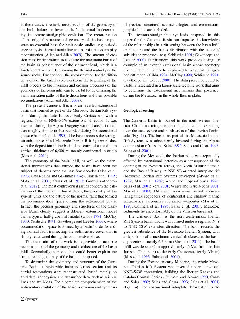
The Cameros Basin is contained in the Cameros thrust sheet (Guimerà et al. 1995), which includes the rift and post-rift
sedimentary infill of the Cameros Basin and also its Juras-sic and Triassic substratum and the Hercynian Basement (cropping out mainly in the Sierra de la Demanda, in the northwest sector of the basin) (Fig. 1a).
The Cameros thrust sheet thrusts northward onto the Ebro Basin foreland, with nearly 28 km of horizontal dis-placement, and southwards, with a back-thrust system, onto the local almazán Basin with a smaller displacement of nearly 5 km (Guimerà et al. 1995). These features define the Cameros tectonic unit as a pop-up structure (Guimerà et al. 1995) (Fig. 1b).
The northern main thrust (the Cameros Thrust) is ori-ented E–W along the Sierra de la Demanda and the central part of the basin, where it is almost continuously exposed for 120 km (Fig. 1a). To the SE, it continues for more than 150 km under a cover of post-tectonic Tertiary rocks (as observed in several oil wells), forming the boundary between the Iberan Chain and the Ebro Basin (Guimerà et al. 2004). The southern border of the basin is defined by a nearly 150 km-long conjugate south-verging thrust
Fig. 1 a Geological setting of the Cameros Basin (after Guimerà et al. 2004). a–a’ indicates the trace of the sec-tion shown in Fig. 1b, whereas a–a’’ indicates the trace of the balanced geological cross sec-tion reconstructed in this work (Figs. 3, 12). b The Cameros tectonic unit shows a “pop-up” structure, characterised by a main thrust in the northern basin border and a secondary back-thrust in the southern one (after Guimerà et al. 1995)
1600 Int J Earth Sci (Geol Rundsch) (2014) 103:1597–1620
1 3
system with imbricate thrusts and thrust propagation folds (Platt 1990; Casas-Sainz and Simón-Gómez 1992; Miege-bielle et al. 1993; Guimerà et al. 1995) (Fig. 1a, b).
In the northern Cameros area, the main thrust is located within the evaporitic Upper Triassic beds (Keuper facies), whereas, in the southern area, and to the west, north of the Sierra de la Demanda, it is located deeper in the Hercyn-ian basement (Guimerà et al. 1995). These two detachment levels are joined by means of an oblique to frontal ramp (Fig. 1b). The shortening direction during the basin inver-sion has been estimated to be between n–S and nnE–SSW (Guimerà et al. 1995). at the regional scale, the Cameros Basin has a gently folded synclinal geometry (Fig. 1b).
Basin infill and stratigraphy
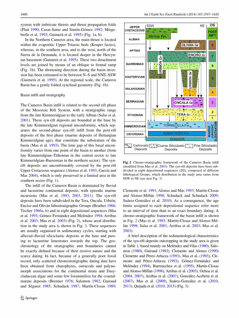
The Cameros Basin infill is related to the second rift phase of the Mesozoic Rift System, with a stratigraphic range from the late Kimmeridgian to the early albian (Salas et al. 2001). These syn-rift deposits are bounded at the base by the late Kimmeridgian regional unconformity, which sep-arates the second-phase syn-rift infill from the post-rift deposits of the first phase (marine deposits of Hettangian Kimmeridgian age), that constitute the substratum of the basin (Mas et al. 1993). The time gap of this basal uncon-formity varies from one point of the basin to another (from late Kimmeridgian–Tithonian in the central sector to late Kimmeridgian–Barremian in the northern sector). The syn-rift deposits are unconformably covered by the post-rift Upper Cretaceous sequence (alonso et al. 1993; García and Mas 2004), which is only preserved in a limited area in the southern sector (Fig. 1).
The infill of the Cameros Basin is dominated by fluvial and lacustrine continental deposits, with episodic marine incursions (Mas et al. 1993, 2003, 2011). The syn-rift deposits have been subdivided in the Tera, Oncala, Urbión, Enciso and Oliván lithostratigraphic Groups (Beuther 1966; Tischer 1966a, b) and in eight depositional sequences (Mas et al. 1993; Gómez-Fernández and Meléndez 1994; arribas et al. 2003; Mas et al. 2003) (Fig. 2), whose areal distribu-tion in the study area is shown in Fig. 3. These sequences are usually organised in sedimentary cycles, starting with alluvial–fluvial siliciclastic deposits at the base and pass-ing to lacustrine limestones towards the top. The geo-chronology of the stratigraphic unit boundaries cannot be exactly defined because of their erosive nature and the scarce dating. In fact, because of a generally poor fossil record, only scattered chronostratigraphic dating data have been obtained from charophytes, ostracods and palyno-morph associations for the continental strata and Dasy-cladacean algae and some few foraminifera for the coastal-marine deposits (Brenner 1976; Salomon 1982; Guiraud and Séguret 1985; Schudack 1987; Martín-Closas 1989;
Clemente et al. 1991; alonso and Mas 1993; Martín-Closas and alonso-Millán 1998; Schudack and Schudack 2009; Suárez-González et al. 2010). as a consequence, the age limits assigned to each depositional sequence refer more to an interval of time than to an exact boundary dating. a chrono-stratigraphic framework of the basin infill is shown in Fig. 2 (Mas et al. 1993; Martín-Closas and alonso-Mil-lán 1998; Salas et al. 2001; arribas et al. 2003; Mas et al. 2003).
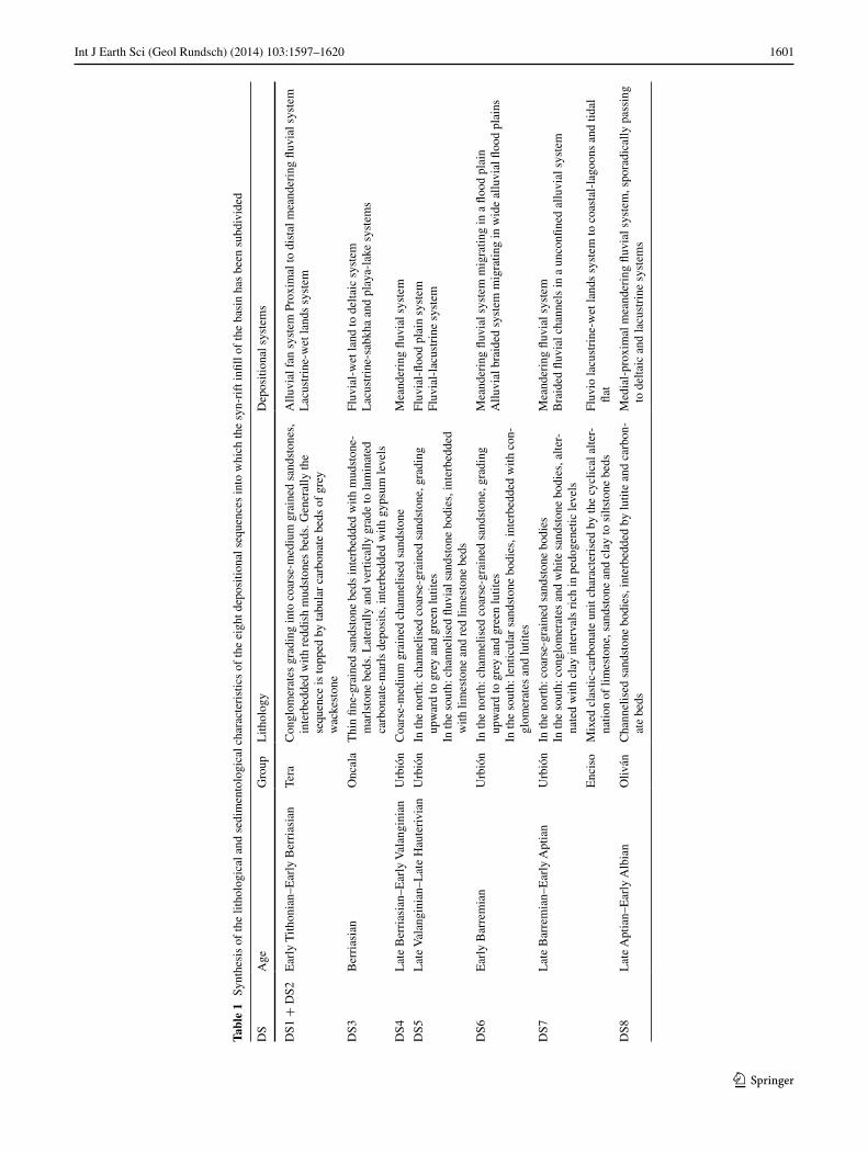
a brief description of the sedimentological characteristics of the syn-rift deposits outcropping in the study area is given in Table 1, based mainly on Meléndez and Vilas (1980), Salo-mon (1980), Guiraud (1983), Clemente and alonso (1990) Clemente and Pérez-arlucea (1993), Mas et al. (1993), Cle-mente and Pérez-arlucea (1993), Gómez-Fernández and Meléndez (1994), Barrenechea et al. (1995), Martín-Closas and alonso-Millán (1998), arribas et al. (2003), Ochoa et al. (2004, 2007), arribas et al. (2007), González-acebrón et al. (2007), Mas et al. (2009), Suárez-González et al. (2010, 2013), Quijada et al. (2010, 2013) (Fig. 3).
Fig. 2 Chrono-stratigraphic framework of the Cameros Basin infill (modified from Mas et al. 2003). The syn-rift deposits have been sub-divided in eight depositional sequences (DS), composed of different lithological Groups, which distribution in the study area varies from SSW to nE (see next Fig. 3)
1601Int J Earth Sci (Geol Rundsch) (2014) 103:1597–1620
1 3
Tabl
e 1
Syn
thes
is o
f th
e lit
holo
gica
l and
sed
imen
tolo
gica
l cha
ract
eris
tics
of th
e ei
ght d
epos
ition
al s
eque
nces
into
whi
ch th
e sy
n-ri
ft in
fill o
f th
e ba
sin
has
been
sub
divi
ded
DS
age
Gro
upl
ithol
ogy
Dep
ositi
onal
sys
tem
s
DS1
+ D
S2E
arly
Tith
onia
n–E
arly
Ber
rias
ian
Tera
Con
glom
erat
es g
radi
ng in
to c
oars
e-m
ediu
m g
rain
ed s
ands
tone
s,
inte
rbed
ded
with
red
dish
mud
ston
es b
eds.
Gen
eral
ly th
e se
quen
ce is
topp
ed b
y ta
bula
r ca
rbon
ate
beds
of
grey
w
acke
ston
e
allu
vial
fan
sys
tem
Pro
xim
al to
dis
tal m
eand
erin
g flu
vial
sys
tem
lac
ustr
ine-
wet
land
s sy
stem
DS3
Ber
rias
ian
Onc
ala
Thi
n fin
e-gr
aine
d sa
ndst
one
beds
inte
rbed
ded
with
mud
ston
e-m
arls
tone
bed
s. l
ater
ally
and
ver
tical
ly g
rade
to la
min
ated
ca
rbon
ate-
mar
ls d
epos
its, i
nter
bedd
ed w
ith g
ypsu
m le
vels
Fluv
ial-
wet
land
to d
elta
ic s
yste
ml
acus
trin
e-sa
bkha
and
pla
ya-l
ake
syst
ems
DS4
lat
e B
erri
asia
n–E
arly
Val
angi
nian
Urb
ión
Coa
rse-
med
ium
gra
ined
cha
nnel
ised
san
dsto
neM
eand
erin
g flu
vial
sys
tem
DS5
lat
e V
alan
gini
an–l
ate
Hau
teri
vian
Urb
ión
In th
e no
rth:
cha
nnel
ised
coa
rse-
grai
ned
sand
ston
e, g
radi
ng
upw
ard
to g
rey
and
gree
n lu
tites
In th
e so
uth:
cha
nnel
ised
fluv
ial s
ands
tone
bod
ies,
inte
rbed
ded
with
lim
esto
ne a
nd r
ed li
mes
tone
bed
s
Fluv
ial-
flood
pla
in s
yste
mFl
uvia
l-la
cust
rine
sys
tem
DS6
Ear
ly B
arre
mia
nU
rbió
nIn
the
nort
h: c
hann
elis
ed c
oars
e-gr
aine
d sa
ndst
one,
gra
ding
up
war
d to
gre
y an
d gr
een
lutit
esIn
the
sout
h: le
ntic
ular
san
dsto
ne b
odie
s, in
terb
edde
d w
ith c
on-
glom
erat
es a
nd lu
tites
Mea
nder
ing
fluvi
al s
yste
m m
igra
ting
in a
floo
d pl
ain
allu
vial
bra
ided
sys
tem
mig
ratin
g in
wid
e al
luvi
al fl
ood
plai
ns
DS7
lat
e B
arre
mia
n–E
arly
apt
ian
Urb
ión
In th
e no
rth:
coa
rse-
grai
ned
sand
ston
e bo
dies
In th
e so
uth:
con
glom
erat
es a
nd w
hite
san
dsto
ne b
odie
s, a
lter-
nate
d w
ith c
lay
inte
rval
s ri
ch in
ped
ogen
etic
leve
ls
Mea
nder
ing
fluvi
al s
yste
mB
raid
ed fl
uvia
l cha
nnel
s in
a u
ncon
fined
allu
vial
sys
tem
Enc
iso
Mix
ed c
last
ic-c
arbo
nate
uni
t cha
ract
eris
ed b
y th
e cy
clic
al a
lter-
natio
n of
lim
esto
ne, s
ands
tone
and
cla
y to
silt
ston
e be
dsFl
uvio
lacu
stri
ne-w
et la
nds
syst
em to
coa
stal
-lag
oons
and
tida
l fla
t
DS8
lat
e a
ptia
n–E
arly
alb
ian
Oliv
ánC
hann
elis
ed s
ands
tone
bod
ies,
inte
rbed
ded
by lu
tite
and
carb
on-
ate
beds
Med
ial-
prox
imal
mea
nder
ing
fluvi
al s
yste
m, s
pora
dica
lly p
assi
ng
to d
elta
ic a
nd la
cust
rine
sys
tem
s
1602 Int J Earth Sci (Geol Rundsch) (2014) 103:1597–1620
1 3
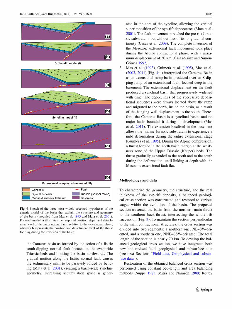
Proposed genetic models
although the geometry and structure of the Cameros Basin have been debated, no agreement has been reached yet. Three main genetic models have been proposed:
1. Guiraud and Séguret (1985) (Fig. 4i) interpreted the Cameros Basin as a releasing solitary overstep of two nE–SW strike-slip faults. In this context, nW–SE extensional faults would develop inside the step area, allowing the formation of the basin, whereas nW–SE compressional structures formed outside it, producing uplifted areas. associated with the forward migration of each tip of the major strike-slip faults, the normal
faults would be successively initiated SW and nE of the overstep. Consequently, the basin lengthened, and the depocentres migrated to the nE. Moreover, these authors assume that the extensional faults involve only the Variscan basement, with the Mesozoic cover detached at the Keuper (Upper Triassic) level and stretched only by smaller-scale faults (see Guiraud and Séguret 1985, Figs 8, 9). according to these authors, the main normal fault in the north was slightly inverted during the Tertiary contraction, creating the present-day Cameros Basin structure.
2. Casas and Salas (1992), Casas-Sainz (1993), Casas-Sainz and Gil-Imaz (1998), Casas et al. (2000), Mata et al. (2001) and Casas et al. (2009) (Fig. 4ii) explain
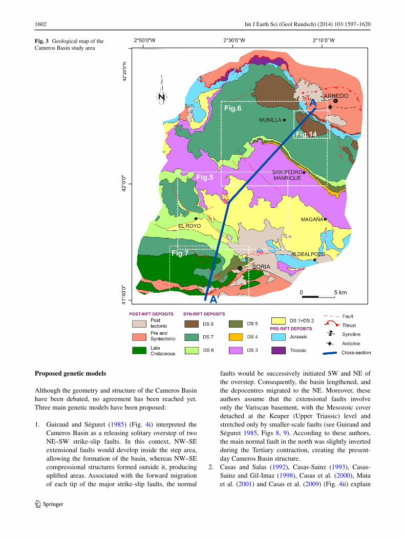
Fig. 3 Geological map of the Cameros Basin study area
1603Int J Earth Sci (Geol Rundsch) (2014) 103:1597–1620
1 3
the Cameros basin as formed by the action of a listric south-dipping normal fault located in the evaporitic Triassic beds and limiting the basin northwards. The gradual motion along the listric normal fault causes the sedimentary infill to be passively folded by bend-ing (Mata et al. 2001), creating a basin-scale syncline geometry. Increasing accumulation space is gener-
ated in the core of the syncline, allowing the vertical superimposition of the syn-rift depocentres (Mata et al. 2001). The fault movement stretched the pre-rift Juras-sic substratum, but without loss of its longitudinal con-tinuity (Casas et al. 2009). The complete inversion of the Mesozoic extensional fault movement took place during the alpine contractional phase, with a maxi-mum displacement of 30 km (Casas-Sainz and Simón-Gómez 1992).
3. Mas et al. (1993), Guimerà et al. (1995), Mas et al. (2003, 2011) (Fig. 4iii) interpreted the Cameros Basin as an extensional-ramp basin produced over an S-dip-ping ramp of an extensional fault, located deep in the basement. The extensional displacement on the fault produced a synclinal basin that progressively widened with time. The depocentres of the successive deposi-tional sequences were always located above the ramp and migrated to the north, inside the basin, as a result of the hanging-wall displacement to the south. There-fore, the Cameros Basin is a synclinal basin, and no major faults bounded it during its development (Mas et al. 2011). The extension localised in the basement allows the marine Jurassic substratum to experience a mild deformation during the entire extensional stage (Guimerà et al. 1995). During the alpine compression, a thrust formed in the north basin margin at the weak-ness zone of the Upper Triassic (Keuper) beds. The thrust gradually expanded to the north and to the south during the deformation, until linking at depth with the Mesozoic extensional fault flat.
Methodology and data
To characterise the geometry, the structure, and the real thickness of the syn-rift deposits, a balanced geologi-cal cross section was constructed and restored to various stages within the evolution of the basin. The proposed section traverses the basin from the northern main thrust to the southern back-thrust, intersecting the whole rift succession (Fig. 3). To maintain the section perpendicular to the main contractional structures, the cross section was divided into two segments: a northern one, nE–SW-ori-ented, and a southern one, nnE–SSW-oriented. The total length of the section is nearly 70 km. To develop the bal-anced geological cross section, we have integrated both new and revised field, geophysical and subsurface data (see next Sections “Field data, Geophysical and subsur-face data”).
Restoration of the obtained balanced cross section was performed using constant bed-length and area balancing methods (Suppe 1983; Mitra and namson 1989; Rouby
Fig. 4 Sketch of the three most widely accepted hypotheses of the genetic model of the basin that explain the structure and geometry of the basin (modified from Mas et al. 1993 and Mata et al. 2001). For each model, a illustrates the proposed position, depth and detach-ment level of the main normal fault, relative to the extensional phase, whereas b represents the position and detachment level of the thrust forming during the inversion of the basin
1604 Int J Earth Sci (Geol Rundsch) (2014) 103:1597–1620
1 3
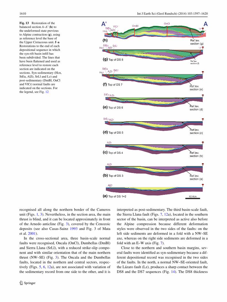
et al. 1996) via a CaD program (Microstation). The first step was to restore the section to its undeformed state pre-vious to alpine contraction. To that end, the base of the post-rift unit (Upper Cretaceous) was flattened and taken as reference level. Subsequently, the geometry of the lower units was reconstructed, maintaining for every unit the bed-length and the section area. In a second step, addi-tional restored sections, corresponding to the geometry of the basin at the end of the deposition of each depositional sequence, were drawn. Each restored section was achieved by flattening the top of the correspondent DS and taking it as reference level; the geometry of the lower section was reconstructed with maintenance for every unit of the bed-length and the section area of the previous restored section.
Finally, to calculate the amount of displacement that occurred during the basin inversion process, as well as the geometry of the associated inversion structures, the younger restored section was forward modelled with Move software, considering the base of the Upper Creta-ceous as reference level. The restored section was intro-duced as input of the model, whereas the geometry of the fault planes along which the section was displaced and the amount of displacement was considered as variables. These variables were changed until the restored section introduced achieved a deformation style similar to the post-inversion structure, represented in the balanced sec-tion reconstruct in this work. a coaxial deformation in a 2D plane was assumed. To simplify, erosion was not consid-ered in this process.
Field data
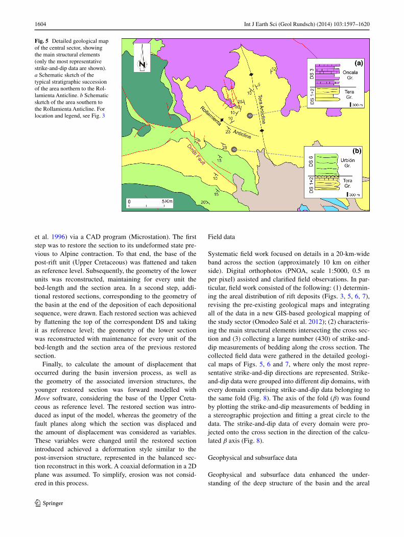
Systematic field work focused on details in a 20-km-wide band across the section (approximately 10 km on either side). Digital orthophotos (PnOa, scale 1:5000, 0.5 m per pixel) assisted and clarified field observations. In par-ticular, field work consisted of the following: (1) determin-ing the areal distribution of rift deposits (Figs. 3, 5, 6, 7), revising the pre-existing geological maps and integrating all of the data in a new GIS-based geological mapping of the study sector (Omodeo Salé et al. 2012); (2) characteris-ing the main structural elements intersecting the cross sec-tion and (3) collecting a large number (430) of strike-and-dip measurements of bedding along the cross section. The collected field data were gathered in the detailed geologi-cal maps of Figs. 5, 6 and 7, where only the most repre-sentative strike-and-dip directions are represented. Strike-and-dip data were grouped into different dip domains, with every domain comprising strike-and-dip data belonging to the same fold (Fig. 8). The axis of the fold (β) was found by plotting the strike-and-dip measurements of bedding in a stereographic projection and fitting a great circle to the data. The strike-and-dip data of every domain were pro-jected onto the cross section in the direction of the calcu-lated β axis (Fig. 8).
Geophysical and subsurface data
Geophysical and subsurface data enhanced the under-standing of the deep structure of the basin and the areal
Fig. 5 Detailed geological map of the central sector, showing the main structural elements (only the most representative strike-and-dip data are shown). a Schematic sketch of the typical stratigraphic succession of the area northern to the Rol-lamienta anticline. b Schematic sketch of the area southern to the Rollamienta anticline. For location and legend, see Fig. 3
1605Int J Earth Sci (Geol Rundsch) (2014) 103:1597–1620
1 3
distribution of rift deposits in depth. Geophysical data refer to the interpretation of two seismic lines (TOR84-05 and TOR84-06) (Figs. 9, 10, 11), acquired by EnIEPSa in 1984. a shot was performed with a 15-kg explosive, and 36 geophones were arranged. Coverage was 12-fold and the record length 6,000 ms, with a sampling of 2 ms, filters used range between 8 and 125 Hz. Static and dynamic cor-rection were applied. Second, subsurface data, represented
by logs of oil wells, were used. The wells analysed (Fig. 9) were drilled by “Hispanoil” in 1964 for oil exploration.
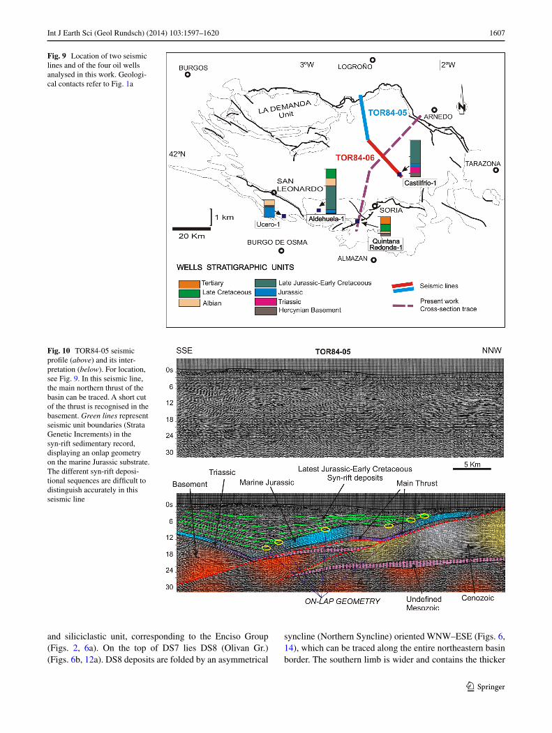
TOR84-05 is perpendicular to the main structures of the northern basin border, crossing the main basin thrust (Fig. 9). although TOR84-05 does not intersect the cross-sectional trace, interpretation of this seismic line was use-ful in determining the relationship between the Jurassic substratum and the syn-rift deposits at the northern border
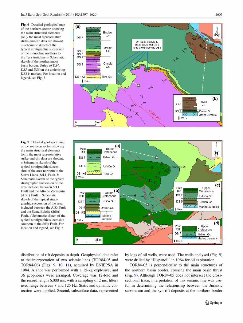
Fig. 6 Detailed geological map of the northern sector, showing the main structural elements (only the most representative strike-and-dip data are shown). a Schematic sketch of the typical stratigraphic succession of the monocline northern to the Tera anticline. b Schematic sketch of the northernmost basin border. Onlap of DS4, DS5 and DS6 on the underlying DS3 is marked. For location and legend, see Fig. 3
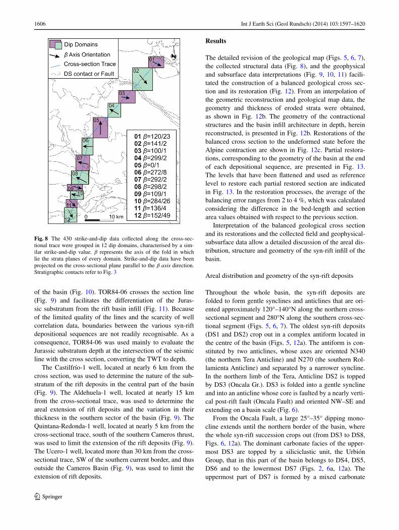
Fig. 7 Detailed geological map of the southern sector, showing the main structural elements (only the most representative strike-and-dip data are shown). a Schematic sketch of the typical stratigraphic succes-sion of the area northern to the Sierra llana (Srll) Fault. b Schematic sketch of the typical stratigraphic succession of the area included between Srll Fault and the alto de Zorraquín (alZr) Fault. c Schematic sketch of the typical strati-graphic succession of the area included between the alZr Fault and the Santa Eulelia (StEu) Fault. d Schematic sketch of the typical stratigraphic succession southern to the StEu Fault. For location and legend, see Fig. 3
1606 Int J Earth Sci (Geol Rundsch) (2014) 103:1597–1620
1 3
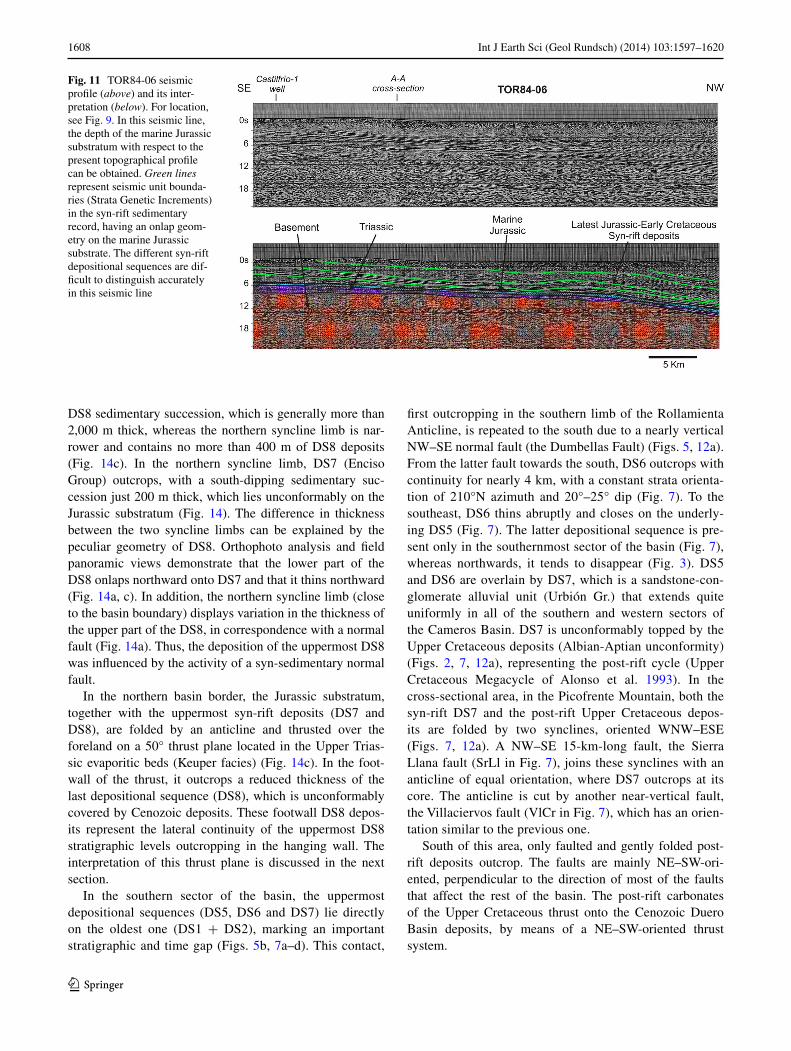
of the basin (Fig. 10). TOR84-06 crosses the section line (Fig. 9) and facilitates the differentiation of the Juras-sic substratum from the rift basin infill (Fig. 11). Because of the limited quality of the lines and the scarcity of well correlation data, boundaries between the various syn-rift depositional sequences are not readily recognisable. as a consequence, TOR84-06 was used mainly to evaluate the Jurassic substratum depth at the intersection of the seismic line with the cross section, converting the TWT to depth.
The Castilfrío-1 well, located at nearly 6 km from the cross section, was used to determine the nature of the sub-stratum of the rift deposits in the central part of the basin (Fig. 9). The aldehuela-1 well, located at nearly 15 km from the cross-sectional trace, was used to determine the areal extension of rift deposits and the variation in their thickness in the southern sector of the basin (Fig. 9). The Quintana-Redonda-1 well, located at nearly 5 km from the cross-sectional trace, south of the southern Cameros thrust, was used to limit the extension of the rift deposits (Fig. 9). The Ucero-1 well, located more than 30 km from the cross-sectional trace, SW of the southern current border, and thus outside the Cameros Basin (Fig. 9), was used to limit the extension of rift deposits.
Results
The detailed revision of the geological map (Figs. 5, 6, 7), the collected structural data (Fig. 8), and the geophysical and subsurface data interpretations (Fig. 9, 10, 11) facili-tated the construction of a balanced geological cross sec-tion and its restoration (Fig. 12). From an interpolation of the geometric reconstruction and geological map data, the geometry and thickness of eroded strata were obtained, as shown in Fig. 12b. The geometry of the contractional structures and the basin infill architecture in depth, herein reconstructed, is presented in Fig. 12b. Restorations of the balanced cross section to the undeformed state before the alpine contraction are shown in Fig. 12c. Partial restora-tions, corresponding to the geometry of the basin at the end of each depositional sequence, are presented in Fig. 13. The levels that have been flattened and used as reference level to restore each partial restored section are indicated in Fig. 13. In the restoration processes, the average of the balancing error ranges from 2 to 4 %, which was calculated considering the difference in the bed-length and section area values obtained with respect to the previous section.
Interpretation of the balanced geological cross section and its restorations and the collected field and geophysical-subsurface data allow a detailed discussion of the areal dis-tribution, structure and geometry of the syn-rift infill of the basin.
areal distribution and geometry of the syn-rift deposits
Throughout the whole basin, the syn-rift deposits are folded to form gentle synclines and anticlines that are ori-ented approximately 120°–140°n along the northern cross-sectional segment and 280°n along the southern cross-sec-tional segment (Figs. 5, 6, 7). The oldest syn-rift deposits (DS1 and DS2) crop out in a complex antiform located in the centre of the basin (Figs. 5, 12a). The antiform is con-stituted by two anticlines, whose axes are oriented n340 (the northern Tera anticline) and n270 (the southern Rol-lamienta anticline) and separated by a narrower syncline. In the northern limb of the Tera, anticline DS2 is topped by DS3 (Oncala Gr.). DS3 is folded into a gentle syncline and into an anticline whose core is faulted by a nearly verti-cal post-rift fault (Oncala Fault) and oriented nW–SE and extending on a basin scale (Fig. 6).
From the Oncala Fault, a large 25°–35° dipping mono-cline extends until the northern border of the basin, where the whole syn-rift succession crops out (from DS3 to DS8, Figs. 6, 12a). The dominant carbonate facies of the upper-most DS3 are topped by a siliciclastic unit, the Urbión Group, that in this part of the basin belongs to DS4, DS5, DS6 and to the lowermost DS7 (Figs. 2, 6a, 12a). The uppermost part of DS7 is formed by a mixed carbonate
Fig. 8 The 430 strike-and-dip data collected along the cross-sec-tional trace were grouped in 12 dip domains, characterised by a sim-ilar strike-and-dip value. β represents the axis of the fold in which lie the strata planes of every domain. Strike-and-dip data have been projected on the cross-sectional plane parallel to the β axis direction. Stratigraphic contacts refer to Fig. 3
1607Int J Earth Sci (Geol Rundsch) (2014) 103:1597–1620
1 3
and siliciclastic unit, corresponding to the Enciso Group (Figs. 2, 6a). On the top of DS7 lies DS8 (Olivan Gr.) (Figs. 6b, 12a). DS8 deposits are folded by an asymmetrical
syncline (northern Syncline) oriented WnW–ESE (Figs. 6, 14), which can be traced along the entire northeastern basin border. The southern limb is wider and contains the thicker
Fig. 9 location of two seismic lines and of the four oil wells analysed in this work. Geologi-cal contacts refer to Fig. 1a
Fig. 10 TOR84-05 seismic profile (above) and its inter-pretation (below). For location, see Fig. 9. In this seismic line, the main northern thrust of the basin can be traced. a short cut of the thrust is recognised in the basement. Green lines represent seismic unit boundaries (Strata Genetic Increments) in the syn-rift sedimentary record, displaying an onlap geometry on the marine Jurassic substrate. The different syn-rift deposi-tional sequences are difficult to distinguish accurately in this seismic line
1608 Int J Earth Sci (Geol Rundsch) (2014) 103:1597–1620
1 3
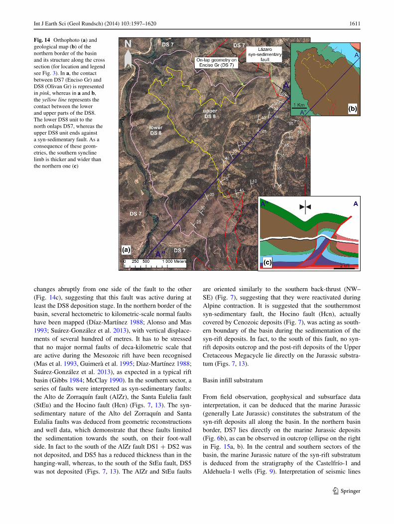
DS8 sedimentary succession, which is generally more than 2,000 m thick, whereas the northern syncline limb is nar-rower and contains no more than 400 m of DS8 deposits (Fig. 14c). In the northern syncline limb, DS7 (Enciso Group) outcrops, with a south-dipping sedimentary suc-cession just 200 m thick, which lies unconformably on the Jurassic substratum (Fig. 14). The difference in thickness between the two syncline limbs can be explained by the peculiar geometry of DS8. Orthophoto analysis and field panoramic views demonstrate that the lower part of the DS8 onlaps northward onto DS7 and that it thins northward (Fig. 14a, c). In addition, the northern syncline limb (close to the basin boundary) displays variation in the thickness of the upper part of the DS8, in correspondence with a normal fault (Fig. 14a). Thus, the deposition of the uppermost DS8 was influenced by the activity of a syn-sedimentary normal fault.
In the northern basin border, the Jurassic substratum, together with the uppermost syn-rift deposits (DS7 and DS8), are folded by an anticline and thrusted over the foreland on a 50° thrust plane located in the Upper Trias-sic evaporitic beds (Keuper facies) (Fig. 14c). In the foot-wall of the thrust, it outcrops a reduced thickness of the last depositional sequence (DS8), which is unconformably covered by Cenozoic deposits. These footwall DS8 depos-its represent the lateral continuity of the uppermost DS8 stratigraphic levels outcropping in the hanging wall. The interpretation of this thrust plane is discussed in the next section.
In the southern sector of the basin, the uppermost depositional sequences (DS5, DS6 and DS7) lie directly on the oldest one (DS1 + DS2), marking an important stratigraphic and time gap (Figs. 5b, 7a–d). This contact,
first outcropping in the southern limb of the Rollamienta anticline, is repeated to the south due to a nearly vertical nW–SE normal fault (the Dumbellas Fault) (Figs. 5, 12a). From the latter fault towards the south, DS6 outcrops with continuity for nearly 4 km, with a constant strata orienta-tion of 210°n azimuth and 20°–25° dip (Fig. 7). To the southeast, DS6 thins abruptly and closes on the underly-ing DS5 (Fig. 7). The latter depositional sequence is pre-sent only in the southernmost sector of the basin (Fig. 7), whereas northwards, it tends to disappear (Fig. 3). DS5 and DS6 are overlain by DS7, which is a sandstone-con-glomerate alluvial unit (Urbión Gr.) that extends quite uniformly in all of the southern and western sectors of the Cameros Basin. DS7 is unconformably topped by the Upper Cretaceous deposits (albian-aptian unconformity) (Figs. 2, 7, 12a), representing the post-rift cycle (Upper Cretaceous Megacycle of alonso et al. 1993). In the cross-sectional area, in the Picofrente Mountain, both the syn-rift DS7 and the post-rift Upper Cretaceous depos-its are folded by two synclines, oriented WnW–ESE (Figs. 7, 12a). a nW–SE 15-km-long fault, the Sierra llana fault (Srll in Fig. 7), joins these synclines with an anticline of equal orientation, where DS7 outcrops at its core. The anticline is cut by another near-vertical fault, the Villaciervos fault (VlCr in Fig. 7), which has an orien-tation similar to the previous one.
South of this area, only faulted and gently folded post-rift deposits outcrop. The faults are mainly nE–SW-ori-ented, perpendicular to the direction of most of the faults that affect the rest of the basin. The post-rift carbonates of the Upper Cretaceous thrust onto the Cenozoic Duero Basin deposits, by means of a nE–SW-oriented thrust system.
Fig. 11 TOR84-06 seismic profile (above) and its inter-pretation (below). For location, see Fig. 9. In this seismic line, the depth of the marine Jurassic substratum with respect to the present topographical profile can be obtained. Green lines represent seismic unit bounda-ries (Strata Genetic Increments) in the syn-rift sedimentary record, having an onlap geom-etry on the marine Jurassic substrate. The different syn-rift depositional sequences are dif-ficult to distinguish accurately in this seismic line
1609Int J Earth Sci (Geol Rundsch) (2014) 103:1597–1620
1 3
Structural elements
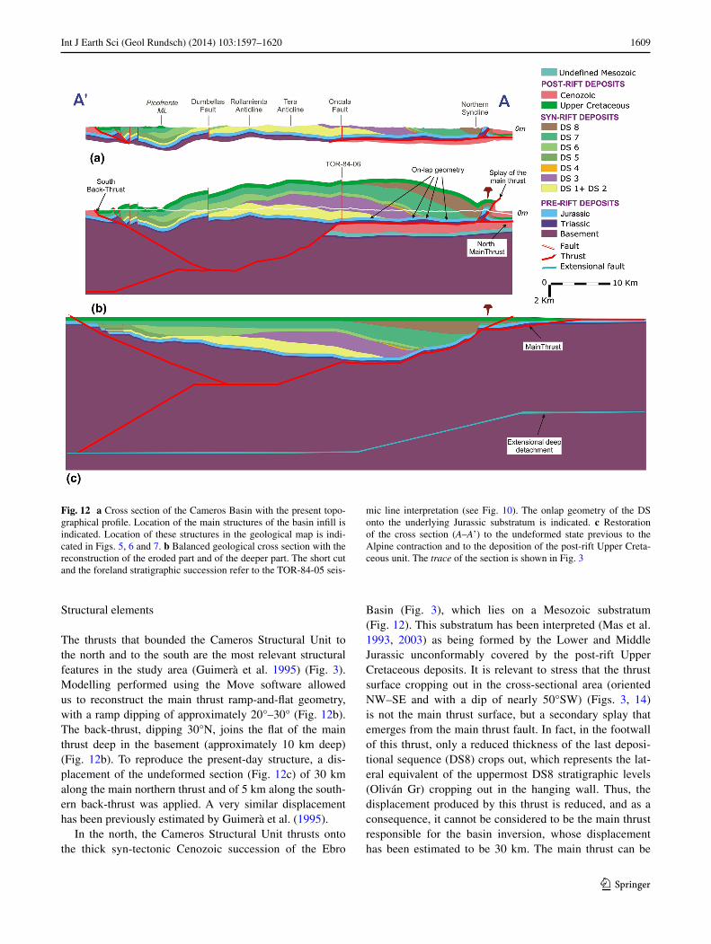
The thrusts that bounded the Cameros Structural Unit to the north and to the south are the most relevant structural features in the study area (Guimerà et al. 1995) (Fig. 3). Modelling performed using the Move software allowed us to reconstruct the main thrust ramp-and-flat geometry, with a ramp dipping of approximately 20°–30° (Fig. 12b). The back-thrust, dipping 30°n, joins the flat of the main thrust deep in the basement (approximately 10 km deep) (Fig. 12b). To reproduce the present-day structure, a dis-placement of the undeformed section (Fig. 12c) of 30 km along the main northern thrust and of 5 km along the south-ern back-thrust was applied. a very similar displacement has been previously estimated by Guimerà et al. (1995).
In the north, the Cameros Structural Unit thrusts onto the thick syn-tectonic Cenozoic succession of the Ebro
Basin (Fig. 3), which lies on a Mesozoic substratum (Fig. 12). This substratum has been interpreted (Mas et al. 1993, 2003) as being formed by the lower and Middle Jurassic unconformably covered by the post-rift Upper Cretaceous deposits. It is relevant to stress that the thrust surface cropping out in the cross-sectional area (oriented nW–SE and with a dip of nearly 50°SW) (Figs. 3, 14) is not the main thrust surface, but a secondary splay that emerges from the main thrust fault. In fact, in the footwall of this thrust, only a reduced thickness of the last deposi-tional sequence (DS8) crops out, which represents the lat-eral equivalent of the uppermost DS8 stratigraphic levels (Oliván Gr) cropping out in the hanging wall. Thus, the displacement produced by this thrust is reduced, and as a consequence, it cannot be considered to be the main thrust responsible for the basin inversion, whose displacement has been estimated to be 30 km. The main thrust can be
Fig. 12 a Cross section of the Cameros Basin with the present topo-graphical profile. location of the main structures of the basin infill is indicated. location of these structures in the geological map is indi-cated in Figs. 5, 6 and 7. b Balanced geological cross section with the reconstruction of the eroded part and of the deeper part. The short cut and the foreland stratigraphic succession refer to the TOR-84-05 seis-
mic line interpretation (see Fig. 10). The onlap geometry of the DS onto the underlying Jurassic substratum is indicated. c Restoration of the cross section (A–A’) to the undeformed state previous to the alpine contraction and to the deposition of the post-rift Upper Creta-ceous unit. The trace of the section is shown in Fig. 3
1610 Int J Earth Sci (Geol Rundsch) (2014) 103:1597–1620
1 3
recognised all along the northern border of the Cameros unit (Figs. 1, 3). nevertheless, in the section area, the main thrust is blind, and it can be located approximately in front of the arnedo anticline (Fig. 3), covered by the Cenozoic deposits (see also Casas-Sainz 1993 and Fig. 3 of Mata et al. 2001).
In the cross-sectional area, three basin-scale normal faults were recognised, Oncala (OnCl), Dumbellas (DmBl) and Sierra llana (Srll), with a reduced strike-slip compo-nent and with similar orientation that of the main northern thrust (nW–SE) (Fig. 3). The Oncala and the Dumbellas faults, located in the northern and central sectors, respec-tively (Figs. 5, 6, 12a), are not associated with variation of the sedimentary record from one side to the other, and it is
interpreted as post-sedimentary. The third basin-scale fault, the Sierra llana fault (Figs. 7, 12a), located in the southern sector of the basin, can be interpreted as active also before the alpine compression because different deformation styles were observed in the two sides of the faults: on the left side sediments are deformed in a fold with a nW–SE axe, whereas on the right side sediments are deformed in a fold with an E–W axis (Fig. 7).
Close to the northern and southern basin margins, sev-eral faults were identified as syn-sedimentary because a dif-ferent depositional record was recognised in the two sides of the faults. In the north, a normal nW–SE-oriented fault, the lázaro fault (lz), produces a sharp contact between the DS8 and the DS7 sequences (Fig. 14). The DS8 thickness
Fig. 13 Restoration of the balanced section A–A’ (h) to the undeformed state previous to alpine contraction (g), using as reference level the base of the Upper Cretaceous unit. f–a Restorations to the end of each depositional sequence in which the syn-rift basin infill has been subdivided. The lines that have been flattened and used as reference level to restore each section are indicated on the sections. Syn-sedimentary (Hcn, StEu, alZr, Srll and lz) and post-sedimentary (DmBl, OnCl and VlCr) normal faults are indicated on the sections. For the legend, see Fig. 12
1611Int J Earth Sci (Geol Rundsch) (2014) 103:1597–1620
1 3
changes abruptly from one side of the fault to the other (Fig. 14c), suggesting that this fault was active during at least the DS8 deposition stage. In the northern border of the basin, several hectometric to kilometric-scale normal faults have been mapped (Díaz-Martínez 1988; alonso and Mas 1993; Suárez-González et al. 2013), with vertical displace-ments of several hundred of metres. It has to be stressed that no major normal faults of deca-kilometric scale that are active during the Mesozoic rift have been recognised (Mas et al. 1993, Guimerà et al. 1995; Díaz-Martínez 1988; Suárez-González et al. 2013), as expected in a typical rift basin (Gibbs 1984; McClay 1990). In the southern sector, a series of faults were interpreted as syn-sedimentary faults: the alto de Zorraquín fault (alZr), the Santa Eulelia fault (StEu) and the Hocino fault (Hcn) (Figs. 7, 13). The syn-sedimentary nature of the alto del Zorraquín and Santa Eulalia faults was deduced from geometric reconstructions and well data, which demonstrate that these faults limited the sedimentation towards the south, on their foot-wall side. In fact to the south of the alZr fault DS1 + DS2 was not deposited, and DS5 has a reduced thickness than in the hanging-wall, whereas, to the south of the StEu fault, DS5 was not deposited (Figs. 7, 13). The alZr and StEu faults
are oriented similarly to the southern back-thrust (nW–SE) (Fig. 7), suggesting that they were reactivated during alpine contraction. It is suggested that the southernmost syn-sedimentary fault, the Hocino fault (Hcn), actually covered by Cenozoic deposits (Fig. 7), was acting as south-ern boundary of the basin during the sedimentation of the syn-rift deposits. In fact, to the south of this fault, no syn-rift deposits outcrop and the post-rift deposits of the Upper Cretaceous Megacycle lie directly on the Jurassic substra-tum (Figs. 7, 13).
Basin infill substratum
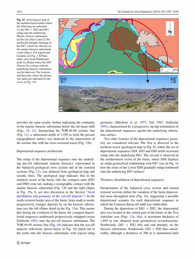
From field observation, geophysical and subsurface data interpretation, it can be deduced that the marine Jurassic (generally late Jurassic) constitutes the substratum of the syn-rift deposits all along the basin. In the northern basin border, DS7 lies directly on the marine Jurassic deposits (Fig. 6b), as can be observed in outcrop (ellipse on the right in Fig. 15a, b). In the central and southern sectors of the basin, the marine Jurassic nature of the syn-rift substratum is deduced from the stratigraphy of the Castelfrío-1 and aldehuela-1 wells (Fig. 9). Interpretation of seismic lines
Fig. 14 Orthophoto (a) and geological map (b) of the northern border of the basin and its structure along the cross section (for location and legend see Fig. 3). In a, the contact between DS7 (Enciso Gr) and DS8 (Olivan Gr) is represented in pink, whereas in a and b, the yellow line represents the contact between the lower and upper parts of the DS8. The lower DS8 unit to the north onlaps DS7, whereas the upper DS8 unit ends against a syn-sedimentary fault. as a consequence of these geom-etries, the southern syncline limb is thicker and wider than the northern one (c)
1612 Int J Earth Sci (Geol Rundsch) (2014) 103:1597–1620
1 3
provides the same results, further indicating the continuity of the marine Jurassic substratum below the rift basin infill (Figs. 10, 11). Interpreting the TOR-84-06 seismic line (Fig. 11), a substratum depth of 1,550 m from the present topographical surface was deduced in the intersection of the seismic line with the cross-sectional traces (Fig. 12b).
Depositional sequence architecture
The onlap of the depositional sequence onto the underly-ing pre-rift substratum (marine Jurassic), represented in the balanced geological cross section and in the restored sections (Fig. 12), was deduced from geological map and seismic lines. The geological map indicates that in the northern sector of the basin, only the youngest units (DS7 and DS8) crop out, making a stratigraphic contact with the marine Jurassic substratum (Fig. 12b and the right ellipse in Fig. 15a, b; see also discussion in the Section “areal distribution and geometry of the syn-rift deposits”). In the north-western border area of the basin, from south to north, progressively younger deposits lie on the Jurassic substra-tum (see the left ellipse detail in the Fig. 15a). This means that during the evolution of the basin, the youngest deposi-tional sequences northwards progressively onlapped (sensu Schlische 1991) onto the pre-rift Jurassic substratum. The TOR-84-05 seismic line (Fig. 10) indicates that the syn-rift deposits reflections (green layers in Fig. 10) pinch out to the north onto the Jurassic substratum, with typical onlap
geometry (Mitchum et al. 1977; Vail 1987; Schlische 1991), characterised by a progressive up-dip termination of the depositional sequences against the underlying substra-tum surface.
Two other features of the depositional sequences geom-etry are considered relevant. The first is observed in the northern sector (geological map in Fig. 6), where the set of depositional sequences DS4, DS5 and DS6 north-westward onlap onto the underlying DS3. The second is observed in the northernmost sector of the basin, where DS8 displays an onlap geometrical relationship with DS7 (see in Fig. 14 how the strata of the lower DS8 gradually onlap northward onto the underlying DS7 surface).
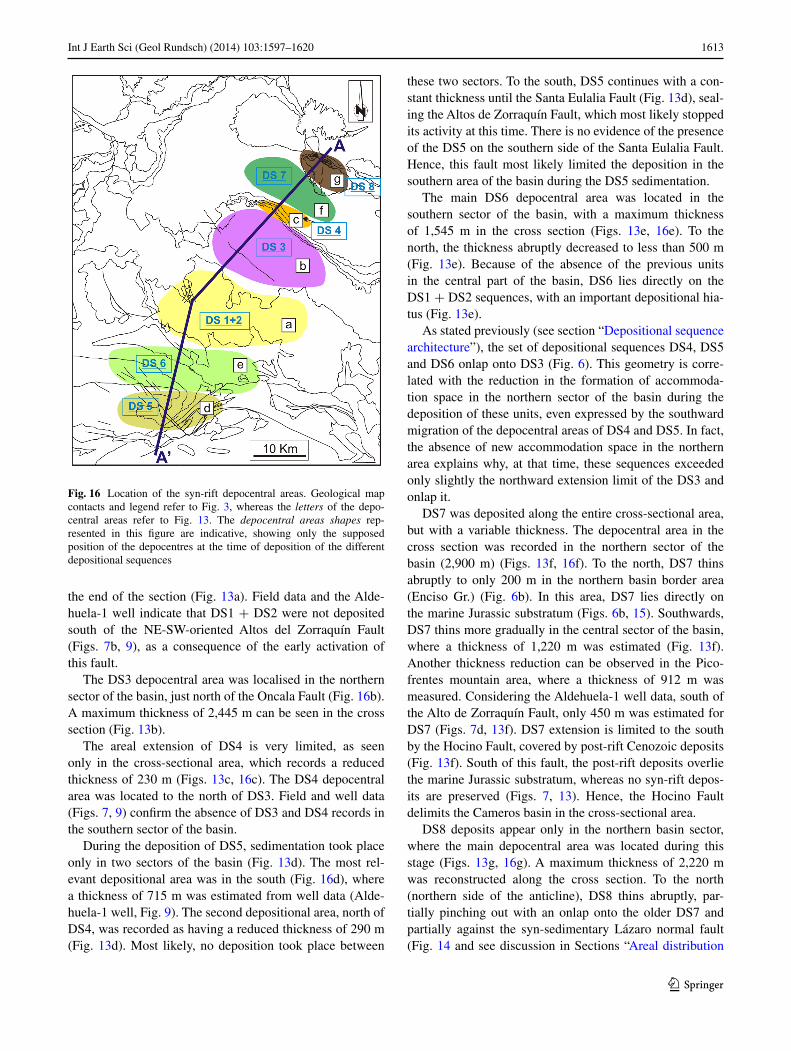
Thickness distribution of depositional sequences
Interpretation of the balanced cross section and related restored sections define the variation of the basin depocen-tral areas throughout time (Fig. 16), suggesting a possible depositional scenario for each depositional sequence in which the Cameros Basin rift infill was subdivided.
During the deposition of DS1 + DS2, the depocentral area was located in the central part of the basin, in the Tera anticline core (Figs. 13a, 16a). a maximum thickness of 1,895 m was obtained from geometrical reconstructions. northwards, DS1 + DS2 thin and end abruptly on the Jurassic substratum. Southwards, DS1 + DS2 thin consid-erably, although a thickness of 300 m is maintained until
Fig. 15 a Geological map of the northern basin border where the following are indicated: (1) the DS1 + DS2 and DS3 onlap onto the underlying Marine Jurassic substratum (in the left ellipse) and (2) the northward abruptly thinning of the DS7, which lies directly on the marine Jurassic substratum (right ellipse). For legend and location, see Fig. 3. b Pano-ramic view from Peñalmonte peak (la Rioja) where the DS7 (Enciso Gr) contact with the underlying Jurassic substratum can be observed. The location and direction where the picture was taken are indicated by the arrow in Fig. 15a
1613Int J Earth Sci (Geol Rundsch) (2014) 103:1597–1620
1 3
the end of the section (Fig. 13a). Field data and the alde-huela-1 well indicate that DS1 + DS2 were not deposited south of the nE-SW-oriented altos del Zorraquín Fault (Figs. 7b, 9), as a consequence of the early activation of this fault.
The DS3 depocentral area was localised in the northern sector of the basin, just north of the Oncala Fault (Fig. 16b). a maximum thickness of 2,445 m can be seen in the cross section (Fig. 13b).
The areal extension of DS4 is very limited, as seen only in the cross-sectional area, which records a reduced thickness of 230 m (Figs. 13c, 16c). The DS4 depocentral area was located to the north of DS3. Field and well data (Figs. 7, 9) confirm the absence of DS3 and DS4 records in the southern sector of the basin.
During the deposition of DS5, sedimentation took place only in two sectors of the basin (Fig. 13d). The most rel-evant depositional area was in the south (Fig. 16d), where a thickness of 715 m was estimated from well data (alde-huela-1 well, Fig. 9). The second depositional area, north of DS4, was recorded as having a reduced thickness of 290 m (Fig. 13d). Most likely, no deposition took place between
these two sectors. To the south, DS5 continues with a con-stant thickness until the Santa Eulalia Fault (Fig. 13d), seal-ing the altos de Zorraquín Fault, which most likely stopped its activity at this time. There is no evidence of the presence of the DS5 on the southern side of the Santa Eulalia Fault. Hence, this fault most likely limited the deposition in the southern area of the basin during the DS5 sedimentation.
The main DS6 depocentral area was located in the southern sector of the basin, with a maximum thickness of 1,545 m in the cross section (Figs. 13e, 16e). To the north, the thickness abruptly decreased to less than 500 m (Fig. 13e). Because of the absence of the previous units in the central part of the basin, DS6 lies directly on the DS1 + DS2 sequences, with an important depositional hia-tus (Fig. 13e).
as stated previously (see section “Depositional sequence architecture”), the set of depositional sequences DS4, DS5 and DS6 onlap onto DS3 (Fig. 6). This geometry is corre-lated with the reduction in the formation of accommoda-tion space in the northern sector of the basin during the deposition of these units, even expressed by the southward migration of the depocentral areas of DS4 and DS5. In fact, the absence of new accommodation space in the northern area explains why, at that time, these sequences exceeded only slightly the northward extension limit of the DS3 and onlap it.
DS7 was deposited along the entire cross-sectional area, but with a variable thickness. The depocentral area in the cross section was recorded in the northern sector of the basin (2,900 m) (Figs. 13f, 16f). To the north, DS7 thins abruptly to only 200 m in the northern basin border area (Enciso Gr.) (Fig. 6b). In this area, DS7 lies directly on the marine Jurassic substratum (Figs. 6b, 15). Southwards, DS7 thins more gradually in the central sector of the basin, where a thickness of 1,220 m was estimated (Fig. 13f). another thickness reduction can be observed in the Pico-frentes mountain area, where a thickness of 912 m was measured. Considering the aldehuela-1 well data, south of the alto de Zorraquín Fault, only 450 m was estimated for DS7 (Figs. 7d, 13f). DS7 extension is limited to the south by the Hocino Fault, covered by post-rift Cenozoic deposits (Fig. 13f). South of this fault, the post-rift deposits overlie the marine Jurassic substratum, whereas no syn-rift depos-its are preserved (Figs. 7, 13). Hence, the Hocino Fault delimits the Cameros basin in the cross-sectional area.
DS8 deposits appear only in the northern basin sector, where the main depocentral area was located during this stage (Figs. 13g, 16g). a maximum thickness of 2,220 m was reconstructed along the cross section. To the north (northern side of the anticline), DS8 thins abruptly, par-tially pinching out with an onlap onto the older DS7 and partially against the syn-sedimentary lázaro normal fault (Fig. 14 and see discussion in Sections “areal distribution
Fig. 16 location of the syn-rift depocentral areas. Geological map contacts and legend refer to Fig. 3, whereas the letters of the depo-central areas refer to Fig. 13. The depocentral areas shapes rep-resented in this figure are indicative, showing only the supposed position of the depocentres at the time of deposition of the different depositional sequences
1614 Int J Earth Sci (Geol Rundsch) (2014) 103:1597–1620
1 3
and geometry of the syn-rift deposits, Structural ele-ments”). The DS8 thickness above the DS7 in the north-ern side of the anticline was estimated to be at least 450 m. South of the Cameros northern Thrust, the contact between DS8 and the Upper Cretaceous top unit is not preserved. Therefore, the thickness of DS8 could not be completely estimated.
The syn-rift infill of the Cameros Basin was overlain by the post-rift Upper Cretaceous Megacycle deposits, with a thickness of 530 m (Picofrentes Mountain area) (Fig. 12a). Taking into account data from other Iberian coeval basins, a maximum thickness of 650 m was estimated for the Upper Cretaceous Megacycle (siliciclastic Utrillas Fm plus marine carbonate late Cretaceous units) (García and Mas 2004) (Fig. 12b).
The amount of erosion estimated along the section is variable: a maximum of 5,500 m in the northern-central part of the section, 1,400 m in the northern extreme and from 150 to 1,000 m in the southern extreme of the section.
Discussion
The reconstruction of a balanced geological cross section and its restorations, as well as the revision of the geological map and of the geophysical and subsurface data, represents the most relevant advance in this work on the knowledge of the Cameros Basin tectono-stratigraphic evolution. In fact, as extensively presented in Section “Results”, these results provide a detailed and precise reconstruction of the follow-ing features: (1) the areal distribution of the infill deposits, (2) the present-day structure and thickness of the infill of the basin, (3) the amount of erosion, (4) the architecture of the syn-rift units, (5) the geometry of the basin in the dif-ferent evolution stages and (6) the main structural elements that have influenced the present geometry and architecture of the basin infill. Interpretation and discussion of these new data allow the proposal of a synthesis of the sedimen-tary architectural model of the basin infill during the exten-sional stage and the identification of a genetic model more coherent with the structure and geometry of the basin. The synthesis herein proposed can integrate data and interpre-tations presented by previous studies on the structure and geometry of the basin (Guiraud and Séguret 1985; Mas et al. 1993; Guimerà et al. 1995; Mata et al. 2001; Casas et al. 2009). In addition, it can be an useful basis for future basin- and plate-scale research.
Sedimentary architectural model of the syn-rift deposits
The variation of the geometry, thickness and areal distribu-tion of the depocentres (Figs. 13, 16), together with sedi-mentological information (Table 1), allow us to present a
synthesis of the sedimentary architectural evolution of the basin during the syn-rift phase (late Jurassic to Early Cretaceous).
at the beginning of the rift, during the Tithonian–early Berriasian (deposition of the DS1 and DS2), the basin depocentre was located in the central sector. a reduced thickness was deposited in the southern sector of the basin, whereas no sedimentation is recorded in the northern sec-tor. Proximal–distal fluvial systems predominated, with alternating fine- and coarse-grained siliciclastic deposits. Tabular limestone, deposited in a lacustrine depositional system, tops this first interval of the rift. During the Ber-riasian (deposition of the DS3), the basin was characterised by a rapid subsidence, with the accumulation in the basin of a thick depocentre. The depocentre was located north of the depocentre of the previous stage, during which fluvial–deltaic and lacustrine playa-lake depositional systems were predominant. In the next stage, the late Berriasian–Early Valanginian (DS4), reduced accommodation space was formed in the basin. a small depocentre formed north of DS3 depocentral area, with deposition of dominantly silici-clastic deposits. From the late Valanginian to the Early Barremian (DS5 and DS6), the depositional area of the basin migrated southward. The formation of depocentres in this area could be a consequence of the tectonic activity of normal faults, which increased the subsidence rate. Fluvial to alluvial depositional systems developed with the forma-tion of very thick sandstone bodies alternated with lutitic intervals. From the late Barremian to the Early aptian (deposition of the DS7), the subsidence became again very rapid. In fact, during this stage, the depositional area extended over most of the basin. In the southern sector, flu-vial braided depositional systems developed, evolving to meandering fluvial systems towards the central sector and to lacustrine-wet land environments towards the northern one. Tidal flats developed in the northernmost area. The depocentral area was again located in the northern sector, to the north of the DS3 depocentral area. From the late aptian to the Early albian (deposition of the DS8), which is the last syn-rift stage, an accommodation space formed only in the northernmost sector of the basin, where a thick areally limited depocentre formed. at that time, large amounts of terrigenous sediments were produced, with the reactivation of fluvial depositional systems that deposited thick sandstone bodies, alternating with fine facies.
The sedimentary architectural evolution reconstructed herein reflects, during the basin infill, a cyclical transition from a dominant fluvial to a dominant lacustrine deposi-tional setting, as a consequence of the combination of tec-tonic and sedimentological factors (Schlische and Olsen 1990; Schlische 1991). In the Cameros Basin, lacustrine depositional settings developed mostly during DS3 and DS7 (Gr Oncala and Gr Enciso, respectively), which can
1615Int J Earth Sci (Geol Rundsch) (2014) 103:1597–1620
1 3
be related to an increase in the capacity of the basin and of the subsidence rate, as a consequence of the extension, together with a decrease in the available volume of sedi-ment (Schlische 1991). a future accurate subsidence analy-sis study of the basin infill would be necessary to determine a more precise relationship between subsidence/tectonic processes and sedimentological and architectural features.
The accurate reconstruction of the basin infill geometry performed in this work determines a maximum vertical thickness at the basin depocentre of 6,500 m, similar to the thickness estimated by Mas et al. (2011). The maximum erosion is estimated in the central and northern sector of the basin, whereas it decreases abruptly towards the south. The detailed reconstruction of the basin infill thickness obtained in this work would allow future precise subsid-ence and thermal maturity analyses.
Concerning the extensional mechanisms, which cre-ated the stratigraphic architecture observed, it is relevant to stress that no evidence of major normal faults of the deca-kilometric scale, which may be responsible of the forma-tion of accommodation space during the extensional stage, was found in the border of the basin. This makes difficult to explain the syn-rift architecture observed in the Cameros Basin with a typical rift model (Ziegler 1978; Gibbs 1984; McClay 1990), where accommodation space is formed by a series of listric normal faults bounding the basin during the extension. In the latter case, because of the extensional fault movement, the rift deposits would lie onto progres-sively older units until they reached the basin basement (leeder and Gawthorpe 1987; Gibson et al. 1989; Schlis-che and Olsen 1990). In contrast, in the Cameros Basin, the stratigraphic evolution reconstructed herein shows that dur-ing the extensional stage, all of the depositional sequences onlap to the north directly onto the marine Jurassic substra-tum, which, as indicated by field and seismic lines observa-tions, does not display relevant stretching. Thus, the Cam-eros Basin cannot be considered a typical half-graben rift basin (Schlische 1991; Gawthorpe and leeder 2000), and a different model is needed to explain its tectono-strati-graphic evolution.
Basin formation genetic model
Despite the extensive research on the structure of the Cam-eros Basin (see section “Proposed genetic models”), an agreement on the formation mechanisms that could explain the peculiarity of the basin has not yet been achieved. The data and results presented in this work can help to define the main critical points of the models proposed up to now.
The main drawbacks of the strike-slip basin model of Guiraud and Séguret (1985) (see section “Proposed genetic models” and Fig. 4i) can be summarised as follows: (1) the compressional structures outside the proposed releasing
areas developed during the Cenozoic, that is when the Cameros basin was already fully formed; (2) the extension needed in the basement is larger than that deduced from the normal faults involving the Mesozoic cover; (3) the Cam-eros Basin extends further west (south of la Demanda massif) and east (Moncayo area) of the supposed location of the releasing strike-slip faults; (4) no evidence of the two nE-SW strike-slip faults suggested by this model has been found in the Cameros Basin area.
The syncline basin model, proposed by Casas-Sainz and Simón-Gómez (1992), Casas-Sainz (1993), Casas-Sainz and Gil-Imaz (1998); Casas et al. (2000); Mata et al. (2001) and Casas et al. (2009) (see section “Pro-posed genetic models” and Fig. 4ii) does not explain some of the data presented in this work and in several previous studies (Mas et al. 1993, 2003, 2011; Guimerà et al. 1995; Suárez-González et al. 2010, 2013). The most significant drawbacks can be summarised as follows. (1) Field obser-vation and seismic line interpretations indicate that all of the depositional sequences in the north lie directly on the marine Jurassic substratum, displaying an onlap geom-etry. as a result, in the northern basin border area, only the younger syn-rift deposits can be found (Figs. 12, 15). This onlap geometry was not accepted by the “syncline model” authors, who assumed that the older syn-rift units are present in the northern border area of the basin. (2) The northward lateral migration of the depocentres during the extensional stage was not accepted either by Casas-Sainz and Simón-Gómez (1992), Casas-Sainz (1993), Casas-Sainz and Gil-Imaz (1998), Casas et al. (2000), Mata et al. (2001) and Casas et al. (2009), who assumed that the depocentres of every stratigraphic unit were superimposed vertically instead of laterally. (3) The continuity of the rift substratum and its integrity along the basin was acknowl-edged by Casas-Sainz and Simón-Gómez (1992), Casas-Sainz (1993), Casas-Sainz and Gil-Imaz (1998), Casas et al. (2000), Mata et al. (2001) and Casas et al. (2009), who stated that the fault movement stretched the pre-rift Jurassic substratum by means of small-scale normal faults (Casas et al. 2009) but maintaining a more or less longi-tudinal continuity in the direction of the extension (Casas et al. 2009) (Fig. 4ii). In fact, these authors (i.e. Fig 3B in Mata et al. 2001) drew isolated blocks separated by a set of normal faults of hectometric displacement (171–1,334 m) and one major fault (with a displacement of 4,385 m) bounding the basin to the north. Most of these faults should have been apparent in the seismic profile analysed previ-ously (Figs. 10, 11), where it is clear that the pre-rift sub-stratum maintains its integrity and continuity all along the profile. (4) The absence in the northern border area of the older depositional sequences is a very important key to understanding the geometry and evolution of the Cam-eros Basin. In the geological maps presented in Mata et al.
1616 Int J Earth Sci (Geol Rundsch) (2014) 103:1597–1620
1 3
(2001), Villalaín et al. (2003) and Casas et al. (2009), the lower depositional sequences (DS1, DS2 and DS3) appear in the northern border area of the basin. This would be the evidence of a vertical depocentre superposition, a crucial element of the syncline basin model. The present work, together with several previous works (Mas et al. 2003, 2004; Suárez-González et al. 2010, 2013), demonstrates that this assumption is based on misinterpretation of these outcrops and of the basin stratigraphy. In fact, Casas et al. (2009) and references therein consider that the Oncala Gr. (DS3) appears in the northern border area, with both car-bonate and conglomeratic facies. These carbonate and the conglomeratic units correspond to various facies of the Urbión and Enciso Groups (DS7) (alonso and Mas 1993; Suárez-González et al. 2010, 2013) (Fig. 6). Panoramic views (Suárez-González et al. 2013) clearly indicate that the carbonate unit outcropping in the northern border area is a facies lateral change of the Enciso Gr. (DS7) and con-sequently cannot be considered to belong to the DS3. The dating of this carbonate unit as Barremian-aptian (Suárez-González et al. 2010, 2013) reinforced this attribution. The drawbacks of the “Syncline basin model” were recently exhaustively discussed in detail by González-acebrón et al. (2012), where implications for the metamorphism recorded in the Cameros Basin of the different genetic models are also considered.
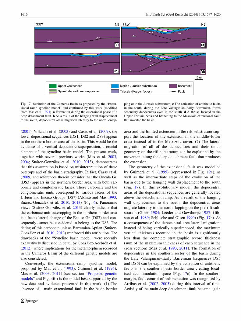
Conversely, the extensional-ramp syncline model, proposed by Mas et al. (1993), Guimerà et al. (1995), Mas et al. (2003, 2011) (see section “Proposed genetic models” and Fig. 4iii) is the model best supported by the new data and evidence presented in this work. (1) The absence of a main extensional fault in the basin border
area and the limited extension in the rift substratum sup-port the location of the extension in the middle–lower crust instead of in the Mesozoic cover. (2) The lateral migration of all of the depocentres and their onlap geometry on the rift substratum can be explained by the movement along the deep detachment fault that produces the extension.
The geometry of the extensional fault was modelled by Guimerà et al. (1995) (represented in Fig. 12c), as well as the intermediate steps of the evolution of the basin due to the hanging wall displacement to the south (Fig. 17). In this evolutionary model, the depocentral areas of the depositional sequences are generally located above the detachment ramp. as a result of the hanging wall displacement to the south, the depocentral areas migrate laterally to the north, lapping on the pre-rift sub-stratum (Gibbs 1984; leeder and Gawthorpe 1987; Gib-son et al. 1989; Schlische and Olsen 1990) (Fig. 17b). as a consequence of the depocentral area lateral migration, instead of being vertically superimposed, the maximum vertical thickness recorded in the basin is significantly less than the complete stratigraphic record thickness (sum of the maximum thickness of each sequence in the cross section) (Mas et al. 1993, 2011). The formation of depocentres in the southern sector of the basin during the late Valanginian–Early Barremian (sequences DS5 and DS6) can be explained by the activation of antithetic faults in the southern basin border area creating local-ised accommodation space (Fig. 17c). In the southern margin, fault control of sedimentation was recognised by arribas et al. (2002, 2003) during this interval of time. activity of the main deep detachment fault became again
Fig. 17 Evolution of the Cameros Basin as proposed by the “Exten-sional ramp syncline model” and confirmed by this work (modified from Mas et al. 1993). a Formation during the extensional phase of a deep detachment fault. b as a result of the hanging wall displacement to the south, depocentral areas migrated laterally to the north, onlap-
ping onto the Jurassic substratum. c The activation of antithetic faults in the south, during the late Valanginian–Early Barremian, forms secondary depocentres even in the south. d a thrust, located in the Upper Triassic beds and branching to the Mesozoic extensional fault flat, inverted the basin
1617Int J Earth Sci (Geol Rundsch) (2014) 103:1597–1620
1 3
dominant during the last stages, and a renewed north-ward migration of the depocentres (DS7 and DS8) was produced (Fig. 17c). The basin was inverted by a main thrust generated and located in the weakness zone of the Upper Triassic (Keuper) beds that branched in depth with the Mesozoic extensional fault flat (Figs. 12c, 17d). The geometry and architecture of the syn-rift deposits reconstructed by the computer simulation of Guimerà et al. (1995) (Fig. 17) are very similar to the geometries obtained in the restorations sections performed in the present work (Fig. 13).
Summing up the previous discussion, the genetic model proposed by Mas et al. (1993), Guimerà et al. (1995), and Mas et al. (2003, 2011) appears to be the most coherent with the basin infill geometry and evolu-tion reconstructed in this work and with the structural elements known today. Thus, the Cameros Basin can be considered a singular example of inverted extensional basin, where the inversion processes did not occur by reactivation of the extensional fault during the contrac-tive phase (as in Jackson and larsen 2008; Mora et al. 2009) but instead via a newly formed thrust. The accom-modation space was formed by an extensional deep detachment instead of by a basin-bounding normal fault, which did not affect the sedimentary cover, which typi-cally occurs in the most common rift basins (Ziegler 1978; Gibbs 1984; McClay 1990).
an unresolved issue with the “extensional ramp syn-cline model” is the correlation of the proposed exten-sional mechanism with the Iberian structural context. In fact, the formation of an extensional flat-ramp basin has to be linked to the north with a rift half-graben basin, where the ramp-flat deep detachment crops out (Gibbs 1984; McClay 1990). a plausible hypothesis is corre-lating the ramp and flat deep detachment with the listric normal faults that bounded the rift basins of the Basco-Cantabrian Chain (García-Garmilla y Pujalte 1988; Rat 1988; García-Mondéjar et al. 1996; García-Mondéjar et al. 2004; Pujalte et al. 2004), a western prolongation of the Pyrenees. These basins were formed during the early Cretaceous rifting, affecting this area and all of the Pyr-eneean domains (Rat 1988; García-Mondéjar et al. 1996; Rosales et al. 2002). as a consequence of this hypothesis, the formation of the Cameros Basin could be correlated on a larger scale with the Pyreneean extensional geody-namic context. Thus, far, the deep structural relation-ships that could explain this geodynamic link have not yet been well defined. To address these critical points and to define a more accurate genetic model for the Cameros Basin, the structural features of the basin in the context of the geodynamic mechanisms that govern the Mesozoic Iberian rift at plate scale should be taken into account in an exhaustive work.
Conclusions
a combination of field, geophysical and subsurface data with sedimentological information (facies changes and depositional environments) allowed the establishment of the evolution of the basin during the rift stage and the origi-nal thickness of the syn-rift units. The first phase of the rift is Tithonian–Early Berriasian (deposition of the DS1, DS2 and DS3), which is characterised by a rapid subsidence rate, with the formation of thick depocentres in the central-northern sector of the basin (1,895 m for the DS1 + DS2 and 2,445 m for DS3, in the basin cross-sectional a–a’). The deposition at the beginning of this first rift phase was prevalently siliciclastic (DS1 and DS2) in a fluvial system environment. Towards the top, carbonate deposits (DS3) sedimented in lacustrine environments became dominant. The late Berriasian–Early Barremian stage (deposition of the DS4, DS5 and DS6) is characterised by a decelerating subsidence rate. The thickest deposits of this phase were located in the southern sector of the basin (715 m for the DS5 and 1,545 m for the DS6, in the basin cross-sectional a–a’). The deposits are dominantly siliciclastic and were generated by fluvial systems. From the late Barremian to the Early aptian (deposition of the DS7), the whole basin was characterised by an increased subsidence rate. The depocentre was located in the northern sector (2,900 m), where the maximum thickness of the entire Cameros basin rift stage was recorded. During this phase, fluvial sys-tem siliciclastic deposits were dominant in the southern and central sector while mixed siliciclastic and carbonate deposits, which are related to palustrine–lacustrine depo-sitional environments, dominated in the northern one. The last phase of rifting is late aptian–Early albian in age (deposition of the DS8), recording another high-subsidence stage. Deposition was confined to the northernmost sec-tor of the basin where a thick depocentre (2,220 m) was located. In this last phase of the rift, siliciclastic deposits sedimented by a fluvial system were strongly dominant. The maximum vertical thickness measured at the basin depocentre is 6,500 m. The maximum amount of erosion, which occurred as consequence of the inversion of the basin during the Cenozoic, is 5,500 m.
During the rifting, a northward lateral migration of the depocentres occurred. This trend was inverted during the late Valanginian–Early Barremian stages (DS5 and DS6) when the depocentres were located in the southern sector of the basin. as a general result, the overall stratigraphic architecture of the eight depositional sequences (DS) dis-plays an onlap geometry towards the north onto the under-lying marine Jurassic substratum.
In the basin boundaries, there is no evidence of major normal faults that could have been active during the rift stage. The rift substratum (marine Jurassic deposits)
1618 Int J Earth Sci (Geol Rundsch) (2014) 103:1597–1620
1 3
appears to be continuous throughout the whole basin and consequently was not affected by any major stretching.
The extensional-ramp model proposed by Mas et al. (1993), Guimerà et al. (1995), and Mas et al. (2003, 2011) better explains the basin infill geometry and evolu-tion reconstructed in this work. Thus, the Cameros Basin formed over a south-dipping ramp joining two flats of a blind extensional fault located deep in the basement. The inversion of the basin was produced by a main thrust gener-ated and located in the weakness zone of the Upper Triassic (Keuper) beds, which branched in depth with the Mesozoic extensional fault flat.
The results presented in this work represent a geological basis for any type of future basin-scale study, such as sub-sidence analysis, thermal and petroleum system modelling, sediment and transport mass-balancing modelling, as well as plate-scale study, that wants to consider the extensional geodynamic mechanisms that governed the Iberian plate evolution during the Mesozoic.
Acknowledgments Funding for this research was provided by Spanish Projects CGl2008-01648/BTE, CGl2008-04916/BTE and CGl2011-22709 and by the UCM-CM (Universidad Complutense Madrid Com-munity). Bentley Systems, Inc. is acknowledged for providing Microsta-tion, which was used for cross-sectional drawing and restoration. We also acknowledge Midland Valley for providing Move, which was used for part of the cross-sectional restoration. The article benefited from reviews and comments by IJES reviewers Prof. Ramón Salas (Universitat de Bar-celona), Oliver B. Duffy (Imperial College of london) and an anony-mous IJES reviewer, who greatly improved the quality of the manuscript. The authors would like to thank Prof. Maria Isabel Benito Moreno and Prof Rosa Tejero (UCM) for their useful comments and suggestions.
References
allen Pa, allen JR (2009) Basin analysis: principles and applications. Wiley, Hoboken
alonso a, Mas JR (1993) Control tectónico e influencia del eus-tatismo en la sedimentación del Cretácico inferior de la Cuenca de los Cameros. Cuad Geol Ibérica 17:285–310
alonso Á, Floquet M, Mas R, Meléndez a (1993) late Cretaceous carbonate platforms: origin and evolution, Iberian Range, Spain. In: Scott RW, Simo JaT, Masse JP (eds) Cretaceous carbonate platforms, vol 56. american association of Petroleum Geolo-gists, Memoir, Oklahoma, pp 297–313
Álvaro M, Capote R, Vegas R (1979) Un modelo de evolución geo-tectònica para la cadena Celtibérica. acta Geologica Hispanica 14:172–181
arche a, lópez-Gómez J (1996) Origin of the Permian–Triassic Ibe-rian Basin, central-eastern Spain. Tectonophysics 266:443–464
arribas J, Mas R, Ochoa M, alonso Á (2002) Composición y diagé-nesis del registro detrítico en el borde suroccidental de la Cuenca de Cameros. Zubía Monográfico 14:99–119
arribas J, alonso Á, Mas R, Tortosa a, Rodas M, Barrenechea JF, alonso-azcárate J, artigas R (2003) Sandstone petrogra-phy of continental depositional sequences of an intraplate rift basin: Western Cameros Basin (north Spain). J Sediment Res 73(2):309–327. doi:10.1306/082602730309
arribas J, Mas R, arribas ME, González-acebrón l, Ochoa M (2007) Sandstone petrofacies in the northwestern sector of the Iberian Basin. J Iber Geol 33(2):191–206
Barrenechea JF, Rodas M, Mas JR (1995) Clay mineral variations associated with diagenesis and low-grade metamorphism of Early Cretaceous sediments in the Cameros Basin, Spain. Clay Miner 30(2):119–133
Beuther a (1966) Geologische Untersuchungen in Wealden und Utril-las-Schichten im Westteil der Sierra de los Cameros (nordwestli-che Iberische Ketten). Beitr Geol Jb 44(2):103–121
Brenner P (1976) Ostracoden und Charophyten des spanischen Weal-den (Systematik, Ökologie, Stratigraphie, Paläogeographie). Palaeontographica abteilung a: Palaeozoologie-Stratigraphie 152(4–6):113–201
Busby CJ, Ingersoll RV (1995) Tectonics of sedimentary basins. Blackwell Science, Oxford, p 579
Casas a, Salas R (1992) Historia de la subsistencia, anomalías gravimétricas y evolución mesozoica de las Cuencas del mar-gen oriental de Iberia. In: actas de las sesiones científicas: III Congreso Geológico de España. Facultad de Ciencias 1992: 112–116
Casas aM, Cortés al, Maestro a (2000) Intra-plate deformation and basin formation during the Tertiary at the northern Iberian Plate: origin and evolution of the almazán Basin. Tectonics 19:762–786
Casas aM, Villalaín JJ, Soto R, Gil-Imaz a, del Río P, Fernández G (2009) Multidisciplinary approach to an extensional syncline model for the Mesozoic Cameros Basin (n Spain). Tectonophys-ics 470(1–2):3–20. doi:10.1016/j.tecto.2008.04.020
Casas a, Río P, Mata P, Villalaìn J, Barbero l (2012) Comment on González-acebrón et al. Criteria for the recognition of localiza-tion and timing of multiple events of hydrothermal alteration in sandstones illustrated by petrographic, fluid inclusion, and iso-topic analysis of the Tera Group, northern Spain Int J Earth Sci-ences (2011) 100:1811–1826. Int J Earth Sci 101(7):2043–2048. doi:10.1007/s00531-012-0768-1
Casas-Sainz aM (1993) Oblique tectonic inversion and basement thrusting in the Cameros Massif (northern Spain). Geodinámica acta 6(3):202–216
Casas-Sainz aM, Gil-Imaz a (1994) Evolución tectonosedimenta-ria de una cuenca extensional intraplaca: la cuenca finijurásica-eocretácica de los Cameros (la Rioja-Soria): Discusión y Réplica. Rev Soc Geol España 7(3–4):337–345
Casas-Sainz aM, Gil-Imaz a (1998) Extensional subsidence, contrac-tional folding and thrust inversion of the eastern Cameros basin, northern Spain. Geol Rundsch 86(4):802–818
Casas-Sainz aM, Simón-Gómez Jl (1992) Stress field and thrust kin-ematics: a model for the tectonic inversion of the Cameros massif (Spain). J Struct Geol 14(5):521–530
Clemente P, alonso a (1990) Estratigrafía y sedimentología de las facies continentales del Cretácico Inferior en el borde meridional de la Cuenca de los Cameros. Estud Geol 46(3–4):257–276
Clemente P, Pérez-arlucea M (1993) Depositional architecture of the Cuerda del Pozo Formation, lower Cretaceous of the exten-sional Cameros Basin, north-central Spain. J Sediment Petrol 63(3):437–452
Clemente P, alonso a, Pérez-arlucea M (1991) Secuencias de depósito en la parte occidental de la cuenca de los Cameros. Jurásico terminal-Cretácico inferior. Paper presented at the III Coloquio del Cretácico de España, Morella (España)
Díaz-Martínez E (1988) El Cretácico Inferior del sector de Jubera (norte de la sierra de los Cameros, la Rioja): relación entre tectónica y sedimentación. Paper presented at the II Congreso Geológico de España, Granada
García GarmilIa FP, V. (1988) los sistemas fluvio-Iacustres “weal-denses” en el sector central de la región Vasco-Cantábrica:
1619Int J Earth Sci (Geol Rundsch) (2014) 103:1597–1620
1 3
evolución paleogeográfica y tectosedimentaria. Paper presented at the II Congreso Geológico de España, Granada
García a, Mas, R (2004) Segunda fase de post-rifting:Cretácico Supe-rior. In Geología de España. In: eds. Vera Ja (ed) Geología de España. Prasl. - Madrid: Sociedad Geológica de España; Instituto Geológico y Minero de España, pp 510–522
García-Mondéjar J, agirrezabala lM, aranburu a, Fernández-Men-diola Pa, Gómez-Pérez I, lópez-Horgue M, Rosales I (1996) aptian–albian tectonic pattern of the Basque–Cantabrian Basin (northern Spain). Geol J 31(1):13–45
García-Mondéjar J, Fernàndez-Mendiola Pa, agirrezabala lM, aran-buru a, lópez-Horgue Ma, Iriarte E, Martinez de Rituerto S (2004) Extensón del aptiense-albiense en la Cuenca Vasco-Can-tábrica. SGEIGME, Madrid. First published
Gawthorpe R, leeder M (2000) Tectono-sedimentary evolution of active extensional basins. Basin Res 12(3–4):195–218
Gawthorpe Rl, Fraser aJ, Collier REl (1994) Sequence stratig-raphy in active extensional basins: implications for the inter-pretation of ancient basin-fills. Mar Pet Geol 11(6):642–658. doi:10.1016/0264-8172(94)90021-3
Gibbs aD (1984) Structural evolution of extensional basin margins. J Geol Soc 141(4):609–620. doi:10.1144/gsjgs.141.4.0609
Gibson JR, Walsh JJ, Watterson J (1989) Modelling of bed contours and cross-sections adjacent to planar normal faults. J Struct Geol 11:317–328
Gómez-Fernández JC, Meléndez n (1994) Climatic control on lower Cretaceous sedimentation in a playa-lake system of a tectonically active basin (Huérteles alloformation, Eastern Cameros Basin, north-Central Spain). J Paleolimnol 11(1):91–107
González-acebrón l, arribas J, Mas R (2007) Provenance of fluvial sandstones at the start of late Jurassic–Early Cretaceous rifting in the Cameros Basin (n. Spain). Sediment Geol 202(1–2):138–157. doi:10.1016/j.sedgeo.2007.05.008
González-acebrón l, Goldstein RH, Mas R, arribas J (2012) answer to the comment of Casas et al. about González acebrón et al. (2011) paper. Int J Earth Sci 101(7):2049–2053. doi:10.1007/s00531-012-0769-0
Guimerà J (1984) Paleogene evolution of deformation in the north-eastern Iberian Peninsula. Geol Mag 121(5):413–420
Guimerà J, Álvaro M (1990) Structure et Evolution de la compres-sion alpine dans la Chaîne Ibérique et la chaîne côtière cata-lane (Espagne). Bulletin de la Société géologique de France 6(2):339–348
Guimerà J, alonso Á, Mas JR (1995) Inversion of an extensional-ramp basin by a newly formed thrust: the Cameros Basin (n. Spain). In: Buchanan JG, Buchanan PG (eds) Basin inversion, vol 88. Geological Society, london, Special Publications. pp 433–453
Guimerà J, Mas R, alonso Á (2004) Intraplate deformation in the nW Iberian Chain: Mesozoic Extension and Tertiary contractional inversion. J Geol Soc lond 161(2):291–303
Guiraud M (1983) Evolution tectono-sédimentaire du bassin wealdien (Crétacé inferieur) en relais de décrochements de logroño-Soria (n-W Espagne). These Université des Sciences et Techniques du languedoc, Montpellier
Guiraud M, Séguret M (1985) a releasing solitary overstep model for the late Jurassic–early Cretaceous (Wealdian) Soria strike-slip basin (northern Spain). In: Biddle KT, Christie-Blick n (eds) Strike slip deformation, basin formation and sedimentation, vol 37., SEPM Special PublicationSociety of Economic Paleontolo-gists and Mineralogists, Tulsa, pp 159–175
Jackson C, larsen E (2008) Temporal constraints on basin inversion provided by 3D seismic and well data: a case study from the South Viking Graben, offshore norway. Basin Res 20(3):397–417
leeder MR, Gawthorpe Rl (1987) Sedimentary models for exten-sional tilt-block/half-graben basins. In: Coward MP, Dewey JF,
Hancock Pl (ed) Continental Extensional Tectonic. Spec Publ Geolog Soc london 28: 139–152
Martín-Closas C (1989) Els caròfits del Cretaci inferior de les con-ques perifèriques del bloc de l’Ebre. Tesis, Universitat de Barce-lona, Barcelona
Martín-Closas C, alonso-Millán Á (1998) Estratigrafía y bioes-tratigrafía (Charophyta) del Cretácico inferior en el sector occi-dental de la cuenca de Cameros (Cordillera Ibérica). Revista de la Sociedad Geológica de España 11(3–4):253–269
Mas JR, alonso a, García a, arias C, Vilas l, Meléndez n, Rincón R (1982) les grandes étapes dans l’evolution du Crétacé de la zone sudoccidental de la Chaine Ibérique (Espagne). 9º Reunion annuelle des Sciences de la Terre, Soc. Géol. De France, Paris: 417
Mas JR, alonso Á, Guimerà J (1993) Evolución tectonosedimenta-ria de una cuenca extensional intraplaca: la cuenca finijurásica-eocretácica de los Cameros (la Rioja-Soria). Revista de la Sociedad Geológica de España 6(3–4):129–144
Mas R, Benito MI, arribas J, Serrano a, Guimerà J, alonso a, alonso-azcárate J (2003) The Cameros Basin: from late Juras-sic–Early Cretaceous Extension to Tertiary contractional inver-sion-implications of hydrocarbon exploration. northwest Iberian Chain, north Spain. In: aaPG international conference and exhi-bition, Barcelona. Barcelona (ed) Centr. Recherches. Elf-Total-Fina p 56
Mas R, arribas J, Miranda J, najarro M, Benito MI, arribas ME, le Pera E (2009) Fluvial architecture and provenance evolution at the ending sedimentary record of a rift basin (Early Cretaceous, Cameros Basin, n Spain). In: 27th IaS Meeting alghero (Italy), 2009, p 598
Mas R, Benito MI, arribas J, alonso a, arribas ME, González-ace-brón l, Hernán J, Quijada E, Suárez-González P, Omodeo Salè S (2011) Evolution of an intra-plate rift basin: the latest Juras-sic-Early Cretaceous Cameros Basin (northwest Iberian Ranges, north Spain). In: Post-Meeting field trips 28th IaS Meeting, vol Geoguías 8. Zaragoza (Spain)
Mata MP, Casas aM, Canals a, Gil a, Pocoví a (2001) Thermal his-tory during Mesozoic extension and Tertiary uplift in the Cam-eros Basin, northern Spain. Basin Res 13(1):91–111
McClay K (1990) Extensional fault systems in sedimentary basins: a review of analogue model studies. Mar Pet Geol 7(3):206–233
Meléndez n, Vilas l (1980) las facies detríticas de la región de Pico-frentes (Soria). Boletín de la Real Sociedad Española de Historia natural (Sección Geológica) 78:157–174
Miegebielle V, Hervouet Y, Xavier JP (1993) analyse structurale de la partie méridionale du bassin de Soria (Espagne). Bulletin des Centres de Recherches Exploration-Production Elf-aquitaine 17(1):19–37
Mitchum R Jr, Vail P, Sangree J (1977) Seismic stratigraphy and global changes of sea level, part 7: seismic stratigraphic inter-pretation procedure. Seismic Stratigr: appl Hydrocarb Explor aaPG Mem 26:135–143
Mitra S, namson JS (1989) Equal-area balancing. am J Sci 289(5):563–599
Mora a, Gaona T, Kley J, Montoya D, Parra M, Quiroz lI, Reyes G, Strecker MR (2009) The role of inherited extensional fault seg-mentation and linkage in contractional orogenesis: a reconstruc-tion of lower Cretaceous inverted rift basins in the Eastern Cor-dillera of Colombia. Basin Res 21(1):111–137
Ochoa M, arribas J, Mas R (2004) Changes in sandstone composition during lower Cretaceous syn-rift fluvial sedimentation (Cameros Basin, Spain). Paper presented at the 32nd international geologi-cal congress, Florence (Italia)
Ochoa M, arribas ME, arribas J, Mas R (2007) Significance of geo-chemical signatures on provenance in intracratonic rift basins: examples from the Iberian plate. In: arribas J, Johnsson MJ,
1620 Int J Earth Sci (Geol Rundsch) (2014) 103:1597–1620
1 3
Critelli S (eds) Sedimentary provenance and petrogenesis: per-spectives from petrography and geochemistry, vol 420. Geologi-cal Society of america Special Papers, pp 199–219
Omodeo Salé S, lopez V, arribas J, Mas R (2012) a petroleum sys-tem research supported by GIS (Cameros basin north of Spain). 7th Euregeo–European Congress on Regional GEOscientific Car-tography and Information System, Bologna, Italy, June 2012
Platt nH (1990) Basin evolution and fault reactivation in the western Cameros Basin, northern Spain. J Geol Soc lond 147(1):165–175
Pujalte V, Robles S, García-Ramos J, Hernández J (2004) El Malm-Barremiense no marinos de la Cordillera Cantábrica. Vera, Ja (Ed Ppal) Geología de España: Instituto Geológico y Minero de España Sociedad Geológica de España Madrid 288–291
Quijada IE, Suárez González P, Moreno Benito MI, Mas JR (2010) Un ejemplo de llanura fluvio-deltaica influenciada por las mareas: el yacimiento de icnitas de Serrantes (Grupo Oncala, Berriasiense, Cuenca de Cameros, n. De España). Geogaceta 49:15–18
Quijada IE, Suárez González P, Moreno B, Isabel M, Mas J (2013) new insights on stratigraphy and sedimentology of the Oncala Group (eastern Cameros Basin): implications for the paleogeo-graphic reconstruction of nE Iberia at Berriasian times. J Iber Geol 39(2):313–334
Rat P (1988) The Basque–Cantabrian basin between the Iberian and European plates: some facts but still many problems. Rev Soc Geol Esp 1(3–4):327–348
Rosales I, Gräfe K, Robles S, Quesada S, Floquet M (2002) The Basque–Cantabrian Basin. Gibbons W, Mo-In: Gibbons W, Moreno T (eds) The Geology of Spain. The Geological Society, london, pp 272–284
Rouby D, Fossen H, Cobbold PR (1996) Extension, displace-ment, and block rotation in the larger Gullfaks area, northern north Sea: determined from map view restoration. aaPG Bull 80(6):875–889
Salas R, Casas a (1993) Mesozoic extensional tectonics, stratigraphy and crustal evolution during the alpine cycle of the eastern Ibe-rian basin. Tectonophysics 228(1–2):33–55
Salas R, Guimerà J, Mas R, Martín-Closas C, Meléndez a, alonso Á (2001) Evolution of the Mesozoic Central Iberian Rift Sys-tem and its Cainozoic inversion (Iberian chain). In: Ziegler Pa, Cavazza W, Robertson aHF, Crasquin-Soleau S (eds) Peri-Tethys Memoir 6: Peri-Tethyan Rift/Wrench Basins and Passive Margins, vol 186. Mémoires du Museum national d’Histoire naturelle, Paris, pp 145–186
Salomon J (1980) les formations continentales du Jurassique Supé-rieur et du Crétacé Inferieur en Espagne du nord (Chaînes Canta-brique et Iberique). Résumé These de Doctorat es Sciences. Uni-versité de Dijon
Salomon J (1982) les formations continentales du bassin de Soria (nW Chaînes ibériques) au Jurassique Supérier-Crétacé Inferieur. Relations entre tectonique et sedimentation. Cuad Geol Ibérica 8:167–185
Schlische RW (1991) Half-graben basin filling models: new con-straints on continental extensional basin development. Basin Res 3(3):123–141
Schlische RW, Olsen PE (1990) Quantitative filling model for conti-nental extensional basins with applications to the early Mesozoic rifts of eastern north america. J Geol 98:135–155
Schudack M (1987) Charophytenflora und fazielle Entwicklung der Grenzschichten mariner Jura/Wealden in den nordwestlichen Iberischen Ketten (mit Vergleichen zu asturien und Kantabrien) (Charophyten Flora and Facies Development of the Marine Jurassic-Wealden Boundary layers in the northwestern Iberian Ranges with a Comparison to asturia and Cantabria). Palaeon-tographica Beiträde zur naturgeschichte der Vorzeit abteilung B 204(1–6):1–180
Schudack U, Schudack M (2009) Ostracod biostratigraphy in the lower Cretaceous of the Iberian chain (eastern Spain). J Iber Geol 35(2):141–168
Suárez-González P, Quijada IE, Mas J, Benito MI (2010) nuevas aportaciones sobre la influencia marina y la edad de los carbona-tos de la Fm leza en el sector de Préjano (SE de la Rioja). Cre-tácico Inferior, Cuenca de Cameros. Geogaceta 49:7–10
Suárez-Gonzalez P, Quijada IE, Benito MI, Mas R (2013) Eustatic versus tectonic control in an intraplate rift basin (leza Fm, Cam-eros Basin). Chronostratigraphic and paleogeographic implica-tions for the aptian of Iberia. J Iber Geol 39(2):285–312
Suppe J (1983) Geometry and kinematics of fault-bend folding. am J Sci 283(7):684–721
Tischer G (1966a) El delta weáldico de las Montañas Ibéricas Occi-dentales y sus enlaces tectónicos. notas y Comunicaciones del Instituto Geológico y Minero de España 81:53–78
Tischer G (1966b) Über die Wealden-ablagerung und die Tektonik der östlichen Sierra de los Cameros in den nordwestlichen Iber-ischen Ketten (Spanien). Beihefte zum Geologischen Jahrbuch 44:123–164
Vail PR (1987) Seismic stratigraphy interpretation using sequence stratigraphy: Part 1: Seismic stratigraphy interpretation proce-dure. In: Bally aW (ed) aaPG Studies in Geology 27, vol atlas of Seismic Stratigraphy, pp 1–10
Vera J-a (2001) Evolution of the South Iberian continental margin. Mémoires du Muséum national d’histoire naturelle 186:109–143
Verges J, Garcia-Senz J (2001) Mesozoic evolution and Cainozoic inversion of the Pyrenean rift. Mémoires du Muséum national d’histoire naturelle 186:187–212
Viallard P (1989) Decollement de couverture et decollement medio-crustal dans une chaine intraplaque; variations verticales du style tectonique des Iberides (Espagne). Bull Soc Geol Fr 5:913–918
Villalaín JJ, Fernández-González G, Casas aM, Gil-Imaz a (2003) Evidence of a Cretaceous remagnetization in the Cameros Basin (north Spain): implications for basin geometry. Tectonophysics 377(1–2):101–117. doi:10.1016/j.tecto.2003.08.024
Ziegler Pa (1978) north Sea rift and basin development”. Tectonics and geophysics of continental rifts. Springer, netherlands, pp 249–277
Related Documents


