Tectono-climatic signatures during Late Quaternary in the Yunam basin, Baralacha Pass (upper Lahaul valley, India), derived from multi-proxy records Archna Bohra a, * , Bahadur Singh Kotlia b a Centre for Glaciology, Wadia Institute of Himalayan Geology, Dehradun, 248001, India b Centre of Advanced Study in Geology, Kumaun University, Nainital, 263002, India article info Article history: Available online xxx Keywords: Kilang Sarai Palaeolake Multi-proxy study PleistoceneeHolocene abstract This study provides evidence of the monsoon record over the past 25 ka from the Kilang Sarai palaeolake which is located in NW Himalaya in the rain shadow zone of the Indian Summer Monsoon (ISM). The multi-proxy study by using geomorphology, carbon isotopes, mineral magnetism, clay mineralogy and elemental chemistry of a 8 m thick laminated lacustrine sediments indicates that the area experienced fluctuating precipitation conditions during the last 25 ka. The time period between 12 and 5 ka BP can be regarded as a very wet interval of the Last Glacial to mid Holocene due to a combined effect of ISM and Westerlies, followed by aridity after 5 ka BP. Tectonic triggers may have caused the development of terraces and closure of lake. At the millennial time scale, a correlation of precipitation and vegetational changes between our data and other records from similar geographical settings suggests that Kilang Sarai basin responded to periods of strengthening in precipitation during the Last Glacial to early Holocene. © 2014 Elsevier Ltd and INQUA. All rights reserved. 1. Introduction The landscape evolution in the Indian Himalaya is highly influenced by both the tectonics and climate (Kotlia et al., 2000, 2010; Barnard et al., 2001; Prasad and Enzel, 2006). In this re- gion, the nature of climate depends on the pressure gradient be- tween ocean and land and seasonal migration of the Intertropical Convergence Zone (ITCZ) (Colin et al., 1998; McGregor and Nieuwolt, 1998). The eastewest alignment of the Himalayan mountain chain forms a formidable physical barrier between the tropical and polar air masses and thus controls the northward extension of the ISM. During summer, the high mountains do not allow the equatorial maritime air masses from the Indian Ocean to cross Himalaya and thus force them to curve round to north-west. During winters, the mountains obstruct the penetration of cold polar air masses from Siberia into the Indian subcontinent. How- ever, until now, it remains unclear to what extent monsoonal moisture has affected the interior of the Himalaya during the Last Glacial and Holocene intervals (e.g., Prell and Kutzbach, 1992). The Himalaya has experienced three major tectonic activities at ca. 35, 21 and 10 ka BP resulting in blockage of rivers and formation of lakes (Kotlia et al., 2008, 2010) or intensified river discharges with huge sediment load (Bookhagen et al., 2005). These ancient lakes contain important information of past climatic change on centennial to millennial timescales. Several studies have been car- ried out to reconstruct the past climatic and environmental changes using palaeo-lacustrine deposits from the Indian Himalaya (e.g., Bagati et al., 1996; Kotlia et al., 1997a,b, 1998a, 2000, 2008, 2010; Phadtare, 2000; Shukla et al., 2002; Phartiyal et al., 2003, 2005; Rühland et al., 2006; Sangode and Mazari, 2007). However, only a few records cover the Late Glacial and Holocene intervals, representing the palaeoclimatic history of areas adjacent to Ladakh (Fort et al., 1989; Gasse et al., 1991; Kotlia et al., 1998b; Chakraborty et al., 2006; Wünnemann et al., 2008, 2010; Demske et al., 2009; Leipe et al., 2014a,b) and the western part of Tibetan Plateau (Van Campo and Gasse, 1993, 1996; Fontes et al., 1996 and therein). The Late Quaternary tectonic activity has also played a considerable role in formation of palaeo-lacustrine deposits in the Lahaul and Spiti and surrounding areas (Bhargava, 1990; Bagati and Thakur, 1993; Phartiyal et al., 2005, 2009a,b; Singh and Jain, 2007; Anoop et al., 2013; Bohra et al., 2014). In this study, we present a 25 ka record from the lake sequence, exposed at Kilang Sarai along the Yunam River (32 49 0 N: 77 27 0 E, altitude 4,573 m asl), north of Baralacha Pass (Fig. 1). The laminated sequence was studied with respect to precipitation variability by * Corresponding author. E-mail address: [email protected] (A. Bohra). Contents lists available at ScienceDirect Quaternary International journal homepage: www.elsevier.com/locate/quaint http://dx.doi.org/10.1016/j.quaint.2014.10.023 1040-6182/© 2014 Elsevier Ltd and INQUA. All rights reserved. Quaternary International xxx (2014) 1e11 Please cite this article in press as: Bohra, A., Kotlia, B.S., Tectono-climatic signatures during Late Quaternary in the Yunam basin, Baralacha Pass (upper Lahaul valley, India), derived from multi-proxy records, Quaternary International (2014), http://dx.doi.org/10.1016/j.quaint.2014.10.023

Welcome message from author
This document is posted to help you gain knowledge. Please leave a comment to let me know what you think about it! Share it to your friends and learn new things together.
Transcript
lable at ScienceDirect
Quaternary International xxx (2014) 1e11
Contents lists avai
Quaternary International
journal homepage: www.elsevier .com/locate/quaint
Tectono-climatic signatures during Late Quaternary in the Yunambasin, Baralacha Pass (upper Lahaul valley, India), derived frommulti-proxy records
Archna Bohra a, *, Bahadur Singh Kotlia b
a Centre for Glaciology, Wadia Institute of Himalayan Geology, Dehradun, 248001, Indiab Centre of Advanced Study in Geology, Kumaun University, Nainital, 263002, India
a r t i c l e i n f o
Article history:Available online xxx
Keywords:Kilang SaraiPalaeolakeMulti-proxy studyPleistoceneeHolocene
* Corresponding author.E-mail address: [email protected] (A. Bohr
http://dx.doi.org/10.1016/j.quaint.2014.10.0231040-6182/© 2014 Elsevier Ltd and INQUA. All rights
Please cite this article in press as: Bohra, A.,(upper Lahaul valley, India), derived from m
a b s t r a c t
This study provides evidence of the monsoon record over the past 25 ka from the Kilang Sarai palaeolakewhich is located in NW Himalaya in the rain shadow zone of the Indian Summer Monsoon (ISM). Themulti-proxy study by using geomorphology, carbon isotopes, mineral magnetism, clay mineralogy andelemental chemistry of a 8 m thick laminated lacustrine sediments indicates that the area experiencedfluctuating precipitation conditions during the last 25 ka. The time period between 12 and 5 ka BP can beregarded as a very wet interval of the Last Glacial to mid Holocene due to a combined effect of ISM andWesterlies, followed by aridity after 5 ka BP. Tectonic triggers may have caused the development ofterraces and closure of lake. At the millennial time scale, a correlation of precipitation and vegetationalchanges between our data and other records from similar geographical settings suggests that Kilang Saraibasin responded to periods of strengthening in precipitation during the Last Glacial to early Holocene.
© 2014 Elsevier Ltd and INQUA. All rights reserved.
1. Introduction
The landscape evolution in the Indian Himalaya is highlyinfluenced by both the tectonics and climate (Kotlia et al., 2000,2010; Barnard et al., 2001; Prasad and Enzel, 2006). In this re-gion, the nature of climate depends on the pressure gradient be-tween ocean and land and seasonal migration of the IntertropicalConvergence Zone (ITCZ) (Colin et al., 1998; McGregor andNieuwolt, 1998). The eastewest alignment of the Himalayanmountain chain forms a formidable physical barrier between thetropical and polar air masses and thus controls the northwardextension of the ISM. During summer, the high mountains do notallow the equatorial maritime air masses from the Indian Ocean tocross Himalaya and thus force them to curve round to north-west.During winters, the mountains obstruct the penetration of coldpolar air masses from Siberia into the Indian subcontinent. How-ever, until now, it remains unclear to what extent monsoonalmoisture has affected the interior of the Himalaya during the LastGlacial and Holocene intervals (e.g., Prell and Kutzbach, 1992).
The Himalaya has experienced three major tectonic activities atca. 35, 21 and 10 ka BP resulting in blockage of rivers and formation
a).
reserved.
Kotlia, B.S., Tectono-climatic sulti-proxy records, Quaternar
of lakes (Kotlia et al., 2008, 2010) or intensified river dischargeswith huge sediment load (Bookhagen et al., 2005). These ancientlakes contain important information of past climatic change oncentennial to millennial timescales. Several studies have been car-ried out to reconstruct the past climatic and environmentalchanges using palaeo-lacustrine deposits from the Indian Himalaya(e.g., Bagati et al., 1996; Kotlia et al., 1997a,b, 1998a, 2000, 2008,2010; Phadtare, 2000; Shukla et al., 2002; Phartiyal et al., 2003,2005; Rühland et al., 2006; Sangode and Mazari, 2007). However,only a few records cover the Late Glacial and Holocene intervals,representing the palaeoclimatic history of areas adjacent to Ladakh(Fort et al., 1989; Gasse et al., 1991; Kotlia et al., 1998b; Chakrabortyet al., 2006; Wünnemann et al., 2008, 2010; Demske et al., 2009;Leipe et al., 2014a,b) and the western part of Tibetan Plateau (VanCampo and Gasse, 1993, 1996; Fontes et al., 1996 and therein).The Late Quaternary tectonic activity has also played a considerablerole in formation of palaeo-lacustrine deposits in the Lahaul andSpiti and surrounding areas (Bhargava, 1990; Bagati and Thakur,1993; Phartiyal et al., 2005, 2009a,b; Singh and Jain, 2007; Anoopet al., 2013; Bohra et al., 2014).
In this study, we present a 25 ka record from the lake sequence,exposed at Kilang Sarai along the Yunam River (32� 490N: 77� 270E,altitude 4,573 m asl), north of Baralacha Pass (Fig. 1). The laminatedsequence was studied with respect to precipitation variability by
ignatures during Late Quaternary in the Yunam basin, Baralacha Passy International (2014), http://dx.doi.org/10.1016/j.quaint.2014.10.023

Fig. 1. SRTM image showing the location of study site (in red box) with adjacent rivers, lakes and glaciers. (For interpretation of the references to colour in this figure legend, thereader is referred to the web version of this article.)
A. Bohra, B.S. Kotlia / Quaternary International xxx (2014) 1e112
using multi-proxy analyses such as mineral magnetism, claymineralogy, geochemistry and carbon isotopes. The study area isclimatically important because of its proximity to the glaciatedmountain ranges and/or rain shadow zone, and is influenced by thewesterly airflow (Bohra et al., 2014). The presentwork is thus aimedto evaluate various environmental proxies and to compare the re-sults with other regional climatic data during the Late Quaternary.
2. Geological background
The study site is located above the tree line, comprising of twoSEeNW trending mountain ranges, the Pir Panjal and the GreatHimalaya, which are separated by the major valley of the ChandraRiver (Fig. 1). A number of geomorphological features such asdevelopment of gorges (Fig. 2a) and canyons, sinuosity of YunamRiver (Fig. 2b), formation of river terraces, triangular fault facets,lineaments and entrenched meanders indicate that the terrain istectonically active. The Yunam River, which originates from theBaralacha Pass, flows through a number of parallel diminutivefaults (Fig. 3). Activity along these faults is also manifested by thedisplacement of country rocks. Considering that the terrain lies inthe rain shadow zone due to the orographic barrier of the HigherHimalaya, the geomorphic processes are dominated by frost action,glacial deposits, and debris fans emanating from the relict cirqueglaciers. The major lithology in the area includes quartzite, shale,sandstone, limestone and meta-sedimentary rocks of Palaeozoicand Mesozoic age (Bhargava and Bassi, 1998). The relict lake sedi-ments at Kilang Sarai (Fig. 4) extend for ~11 km and are dominatedby greyish clayey-silt and sandy horizons, capped by river gravel.
3. Materials and methods
The 8 m thick laminated lacustrine sequence (Fig. 4AeC) wassampled at an interval of 10 cm and sub-divided for various
Please cite this article in press as: Bohra, A., Kotlia, B.S., Tectono-climatic s(upper Lahaul valley, India), derived from multi-proxy records, Quaternar
analyses. A total of 72 samples were subjected to mineral magne-tism, carbon isotopes (d13C), clay mineralogy and major elementalstudies. Three levels of soft sediment structures have earlier beenreported from the succession (Bohra et al., 2014).
Three organic-rich layers were subjected to radiocarbon dating(see Bohra et al., 2014). The ages were calibrated using INTCAL09 ofCalib 6.1.0 (Reimer et al., 2009). For measuring d13C, ~4 mg ofpowdered bulk sample in Ag capsule was treated twice with 20%HCl for 24 h (60 �C) to remove the carbonate. Subsequently, 1e2mgof the residue was analyzed via combustion in a CNS elementalanalyzer (Carlo Erba CN 2500), connected to an Isotope Ratio MassSpectrometer (IRMS-Optima/Micromass). Analyses of d13C and TOCwere conducted at the GeoForschungs Zentrum Potsdam, Germany.The TOC, an indirect indicator of vegetation cover and biomass, canbe related tomonsoonal intensity (Mazari et al., 1995; Selvaraj et al.,2010, 2012) and is also controlled by primary production in thelake, and preservation or degradation processes of organic matter(Rhodes et al., 1996).
Major clay minerals were measured by a Philips PW 3071 X-Raydiffractometer, Cu Ka radiation at 45 kV, 40mA atWadia Institute ofHimalayan Geology, Dehradun. Powdered bulk sample were scan-ned from 2� to 40�. Identified reflected intensities were convertedinto percentage from summation of all identified main reflexes inorder to better compare minerals with each other (Brindley andBrown, 1980). The concentrations of illite, chlorite and muscovitewere obtained in percent of the total clay assemblage.
The mineral magnetic measurements including low field massspecific susceptibility (c) and S-ratio to saturation isothermalremnant magnetisation (SIRM), [(IRM_300mT)/(SIRM1.5T)] were per-formed at Indian Institute of Geomagnetism, Mumbai. The c wasmeasured on frequencies 0.47 and 4.7 khz using the BartingtonMS2B sensor. The IRM was measured on a forward fields of100e2500 mT and backward fields of 10e300 mT using an impulsemagnetizer, and the magnetic moment was measured on Molspin
ignatures during Late Quaternary in the Yunam basin, Baralacha Passy International (2014), http://dx.doi.org/10.1016/j.quaint.2014.10.023
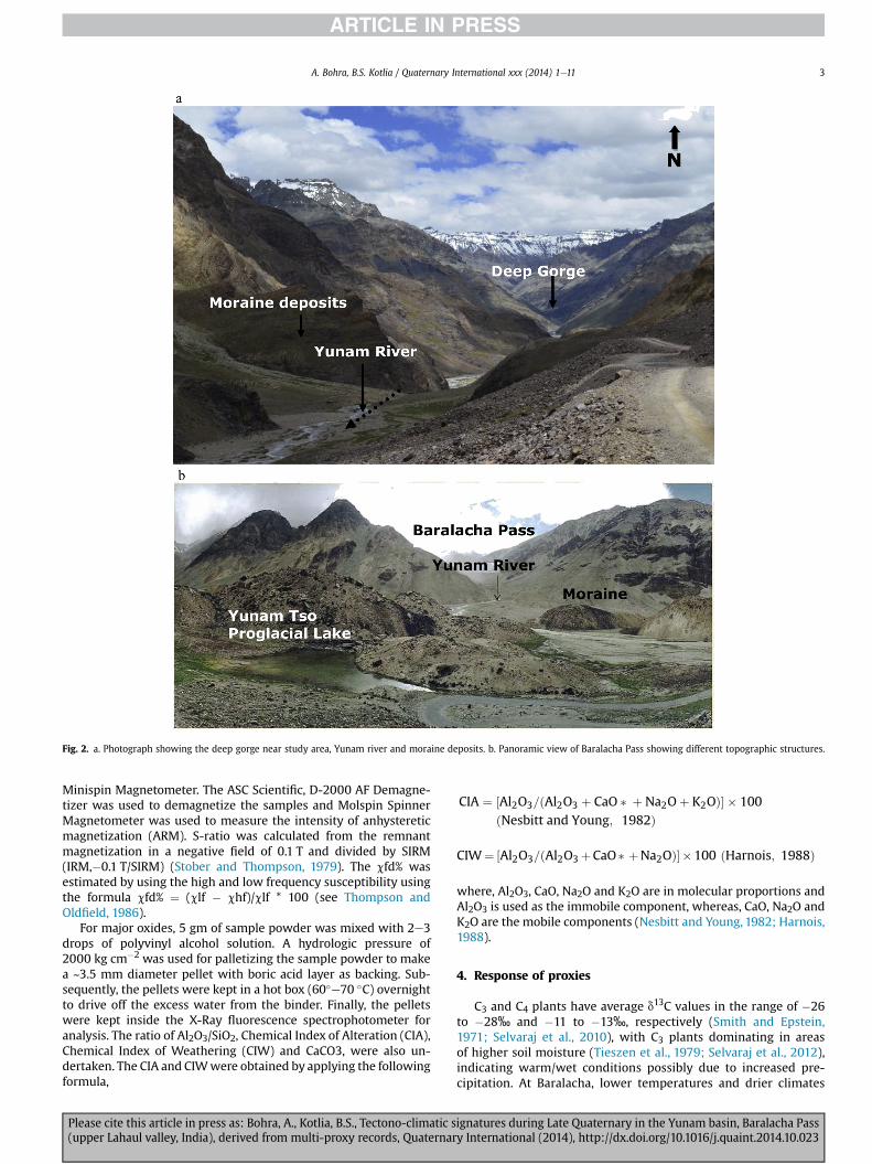
Fig. 2. a. Photograph showing the deep gorge near study area, Yunam river and moraine deposits. b. Panoramic view of Baralacha Pass showing different topographic structures.
A. Bohra, B.S. Kotlia / Quaternary International xxx (2014) 1e11 3
Minispin Magnetometer. The ASC Scientific, D-2000 AF Demagne-tizer was used to demagnetize the samples and Molspin SpinnerMagnetometer was used to measure the intensity of anhystereticmagnetization (ARM). S-ratio was calculated from the remnantmagnetization in a negative field of 0.1 T and divided by SIRM(IRM,�0.1 T/SIRM) (Stober and Thompson, 1979). The cfd% wasestimated by using the high and low frequency susceptibility usingthe formula cfd% ¼ (clf � chf)/clf * 100 (see Thompson andOldfield, 1986).
For major oxides, 5 gm of sample powder was mixed with 2e3drops of polyvinyl alcohol solution. A hydrologic pressure of2000 kg cm�2 was used for palletizing the sample powder to makea ~3.5 mm diameter pellet with boric acid layer as backing. Sub-sequently, the pellets were kept in a hot box (60�e70 �C) overnightto drive off the excess water from the binder. Finally, the pelletswere kept inside the X-Ray fluorescence spectrophotometer foranalysis. The ratio of Al2O3/SiO2, Chemical Index of Alteration (CIA),Chemical Index of Weathering (CIW) and CaCO3, were also un-dertaken. The CIA and CIWwere obtained by applying the followingformula,
Please cite this article in press as: Bohra, A., Kotlia, B.S., Tectono-climatic s(upper Lahaul valley, India), derived from multi-proxy records, Quaternar
CIA ¼ ½Al2O3=ðAl2O3 þ CaO � þ Na2Oþ K2OÞ� � 100ðNesbitt and Young; 1982Þ
CIW¼ ½Al2O3=ðAl2O3þCaO � þNa2OÞ��100 ðHarnois; 1988Þ
where, Al2O3, CaO, Na2O and K2O are in molecular proportions andAl2O3 is used as the immobile component, whereas, CaO, Na2O andK2O are the mobile components (Nesbitt and Young, 1982; Harnois,1988).
4. Response of proxies
C3 and C4 plants have average d13C values in the range of �26to �28‰ and �11 to �13‰, respectively (Smith and Epstein,1971; Selvaraj et al., 2010), with C3 plants dominating in areasof higher soil moisture (Tieszen et al., 1979; Selvaraj et al., 2012),indicating warm/wet conditions possibly due to increased pre-cipitation. At Baralacha, lower temperatures and drier climates
ignatures during Late Quaternary in the Yunam basin, Baralacha Passy International (2014), http://dx.doi.org/10.1016/j.quaint.2014.10.023

Fig. 3. Geological formations and tectonics around Yunam river (after Bagati and Suresh, 1991).
A. Bohra, B.S. Kotlia / Quaternary International xxx (2014) 1e114
facilitate occurrence of C4 vegetation. An increased TOC indicateswetter conditions (Talbot and Livingstone, 1989; Beuning et al.,1997) and is a sign of ongoing eutrophication (Schelske andHodell, 1995; Matzinger et al., 2007). The d13C and TOC of thestudied profile range from �22.3 to �25.1‰ and 0.06e0.16%,respectively.
Clay minerals are generally used for interpreting weatheringconditions in the source area (Hallam, 1994; Chamley, 1989, 1997;Ruffell et al., 2002; Ahlberg et al., 2003; Deconinck et al., 2003;Fürsich et al., 2005). Higher concentrations of chlorite andmuscovite mark lesser precipitation and arid conditions (Chamley,1989). Illite is produced in humid climates in higher altitudes
Please cite this article in press as: Bohra, A., Kotlia, B.S., Tectono-climatic s(upper Lahaul valley, India), derived from multi-proxy records, Quaternar
(Berner, 1971; Chamley, 1989; Weaver, 1989). Low illite also sug-gests uplift (Jonathan, 1988).
The mineral magnetic properties provide information theoccurrence of iron oxides, their sensitivity to climate, depositionalsetting and transporting media (Thompson and Oldfield, 1986;Verosub and Roberts, 1995; Dekkers, 1997; Maher and Thompson,1999; Evans and Heller, 2003). Magnetic susceptibility (c) and S-ratio are affected by dilution caused by the precipitation ofdiamagnetic carbonate or aquatic growth of organic matter. Thehigher cfd indicates finer grain size under warm/humid environ-mental setting (Walden et al., 1999). The S-ratio provides a measureof relative proportions of high coercivity/hard (Haematite,
ignatures during Late Quaternary in the Yunam basin, Baralacha Passy International (2014), http://dx.doi.org/10.1016/j.quaint.2014.10.023

Fig. 4. A. Detailed succession of Kilang Sarai deposits with identified lithologies and radiocarbon dates (modeled ages are shown in italics). B. Exposed section fromwhere sedimentsamples were collected. C. Close view of the laminated sediments (after Bohra et al., 2014).
A. Bohra, B.S. Kotlia / Quaternary International xxx (2014) 1e11 5
Goethite) to low coercivity and magnetically soft (Magnetite,Greigite) magnetic minerals (Robinson, 1986; Thompson andOldfield, 1986; King and Channell, 1991; Verosub and Roberts,1995). Higher c and S-ratio indicate close relationship betweenthe erosional processes and increasing detrital titanomagneticconcentration (Williamson et al., 1998). During the drier periods,supply of detritus to the lakes is reduced and more deeply weath-ered iron oxides derived from soil material are deposited and re-flected in the form of low S-ratio.
Higher concentrations of Na, K, Fe and Ca represent arid climate(Pennington et al., 1972; Engstrom and Wright, 1984). Aluminiummay be leached from sediments as a result of low pH of lake waterand can be used as a proxy of weathering and erosion in thecatchment (Juyal et al., 2009). Low Al2O3 indicates oligotrophiccondition due to a reduced melt water discharge under arid con-ditions (Kotlia et al., 2008) and high SiO2 shows humid/wetterclimate (Newman, 1987). Higher values of Al2O3/SiO2 imply in-crease in weathering under warm climatic conditions (Newman,1987; Wehausen et al., 2003). Similarly, Al2O3/SiO2, CIA and CIW
Please cite this article in press as: Bohra, A., Kotlia, B.S., Tectono-climatic s(upper Lahaul valley, India), derived from multi-proxy records, Quaternar
can be used to identify changes in weathering intensity. The highCIA suggests relatively more intense weathering from the sourcearea (Mahjoor et al., 2009).
5. Results and interpretation
5.1. Chronology
The chronology of the Kilang Sarai profile was established using14C dates on bulk sediment samples. The age depth model (adoptedfrom Bohra et al., 2014) suggests a mean sedimentation rate of31 cm/1000 y and each 10 cm sample gives an age of ~350 years.The lowermost part of the profile has an age of 25.3 ka BP (Fig. 4A).
5.2. Lithology
The Yunam River is fed by the Baralacha glacier, and is the mainsource of sediment discharge, especially during the rainy season.The study site receives its sediment input only from this river as
ignatures during Late Quaternary in the Yunam basin, Baralacha Passy International (2014), http://dx.doi.org/10.1016/j.quaint.2014.10.023
A. Bohra, B.S. Kotlia / Quaternary International xxx (2014) 1e116
there is no other stream that contributes sediment to the lake. Onlylocal/regional climate is recorded by its sediments. The palaeo-lacustrine section lies ~25 m above the present level of theYunam River bed. Based on the sediment texture, the successioncan be divided into three broad zones: a lowermost 0.4 m thickglacial outwash with highly angular to sub-rounded litho-clasts,(not shown in Fig. 4A), followed by parallel laminated lacustrinesequence from 0.4 m to 7.5 m, and terminating with deposition ofwell-sorted, rounded to sub-rounded river gravel from 7.5 to 8.0 m(Fig. 4A and B). The laminated sequence begins with the depositionof dark brown carbonaceous clay, followed by medium to fine sandand is invariably capped by fine grained sand. The laminated de-posits are mm scale thick (Fig. 4C).
The presence of lowermost angular to sub-rounded outwashgravel indicates deposition during flash-flood conditions. Consid-ering that the terrain had undergone significant glacial activityduring the Late Quaternary (Pant et al., 2005), we suggest thatoutwash material was deposited when debris-laden water trans-ported the moraine sediments from the upper reaches. The lami-nated sediments show fining upward sediment texture indicatingepisodic flooding inwhich the coarse fractionwas deposited duringthe flood peak, whereas the overlying fine sediments represent thewinnowing phase of the flood (e.g., Campbell and Evan, 1990). Theuppermost rounded to sub-rounded river gravel may indicateabrupt increase in the discharge causing the breaching of the lake.
5.3. Variation in carbon isotopes, TOC, mineral magnetism, clayminerals and major elements
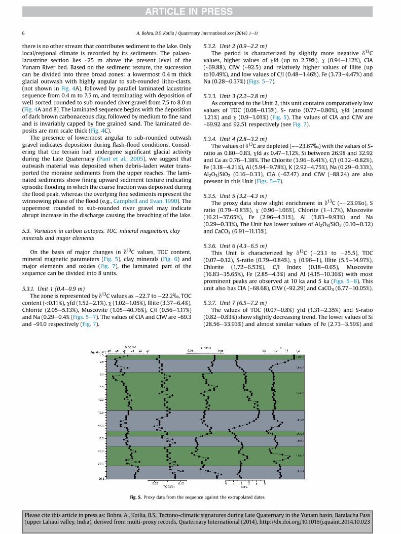
On the basis of major changes in d13C values, TOC content,mineral magnetic parameters (Fig. 5), clay minerals (Fig. 6) andmajor elements and oxides (Fig. 7), the laminated part of thesequence can be divided into 8 units.
5.3.1. Unit 1 (0.4e0.9 m)The zone is represented by d13C values as �22.7 to�22.2‰, TOC
content (<0.11%), cfd (1.52e2.1%), c (1.02e1.05%), Illite (3.37e6.4%),Chlorite (2.05e5.13%), Muscovite (1.05e40.76%), C/I (0.56e1.17%)and Na (0.29e0.4% (Figs. 5e7). The values of CIA and CIW are ~69.3and ~91.0 respectively (Fig. 7).
Fig. 5. Proxy data from the sequence
Please cite this article in press as: Bohra, A., Kotlia, B.S., Tectono-climatic s(upper Lahaul valley, India), derived from multi-proxy records, Quaternar
5.3.2. Unit 2 (0.9e2.2 m)The period is characterized by slightly more negative d13C
values, higher values of cfd (up to 2.79%), c (0.94e1.12%), CIA(~69.88), CIW (~92.5) and relatively higher values of Illite (upto10.49%), and low values of C/I (0.48e1.46%), Fe (3.73e4.47%) andNa (0.28e0.37%) (Figs. 5e7).
5.3.3. Unit 3 (2.2e2.8 m)As compared to the Unit 2, this unit contains comparatively low
values of TOC (0.08e0.13%), S- ratio (0.77e0.80%), cfd (around1.21%) and c (0.9e1.01%) (Fig. 5). The values of CIA and CIW are~69.92 and 92.51 respectively (see Fig. 7).
5.3.4. Unit 4 (2.8e3.2 m)The values of d13C are depleted (~�23.67‰) with the values of S-
ratio as 0.80e0.83, cfd as 0.47e1.12%, Si between 26.98 and 32.92and Ca as 0.76e1.38%. The Chlorite (3.96e6.41%), C/I (0.32e0.82%),Fe (3.18e4.21%), Al (5.94e9.78%), K (2.92e4.75%), Na (0.29e0.33%),Al2O3/SiO2 (0.16e0.33), CIA (~67.47) and CIW (~88.24) are alsopresent in this Unit (Figs. 5e7).
5.3.5. Unit 5 (3.2e4.3 m)The proxy data show slight enrichment in d13C (~�23.9%o), S
ratio (0.79e0.83%), c (0.96e1.06%), Chlorite (1e1.7%), Muscovite(16.21e37.65%), Fe (2.96e4.31%), Al (3.83e9.93%) and Na(0.29e0.33%), The Unit has lower values of Al2O3/SiO2 (0.10e0.32)and CaCO3 (6.91e11.13%).
5.3.6. Unit 6 (4.3e6.5 m)This Unit is characterized by d13C (�23.1 to �25.5), TOC
(0.07e0.12), S-ratio (0.79e0.84%), c (0.96e1), Illite (5.5e14.97%),Chlorite (1.72e6.53%), C/I Index (0.18e0.65), Muscovite(16.83e35.65%), Fe (2.85e4.3%) and Al (4.15e10.36%) with mostprominent peaks are observed at 10 ka and 5 ka (Figs. 5e8). Thisunit also has CIA (~68.68), CIW (~92.29) and CaCO3 (6.77e10.05%).
5.3.7. Unit 7 (6.5e7.2 m)The values of TOC (0.07e0.8%) cfd (1.31e2.35%) and S-ratio
(0.82e0.83%) show slightly decreasing trend. The lower values of Si(28.56e33.93%) and almost similar values of Fe (2.73e3.59%) and
against the extrapolated dates.
ignatures during Late Quaternary in the Yunam basin, Baralacha Passy International (2014), http://dx.doi.org/10.1016/j.quaint.2014.10.023

Fig. 6. Concentration of various clay minerals and their ratios plotted against lithology.
A. Bohra, B.S. Kotlia / Quaternary International xxx (2014) 1e11 7
Na (0.26e0.35%) (Fig. 7) are also observed. The CIA (~67.03), CIW(~87.64) and CaCO3 (9.69e11.8%) also show relatively low values ascompared to Unit 6 (see Fig. 7).
5.3.8. Unit 8 (7.2e7.5 m)The data show increasing trend in c, S-ratio, Illite, K, CaCO3, CIA
and decreasing values of Chlorite and C/I index.
6. Discussion
During the time span of 25 ka, the study area experiencedfluctuations of warming and cooling phases. It is interesting thatthe area has also preserved geomorphological features, such as,river terraces, deep gorge, fault facets, and river sinuosity, which
Fig. 7. Concentration of various elements, Ca
Please cite this article in press as: Bohra, A., Kotlia, B.S., Tectono-climatic s(upper Lahaul valley, India), derived from multi-proxy records, Quaternar
generally occur in substantially humid climates. The precipitationrecords are in good agreement with other regions from Ladakh,Lahaul and Trans Himalayan region and present day arid Tibet (Fortet al., 1989; Bagati and Thakur, 1993; Gasse and Van Campo, 1994;Phartiyal et al., 2005, 2009b; Wünnemann et al., 2010; Leipe et al.,2014b). The increase in precipitation can be associated with rise intemperature in the study region. The general history of the climaticphases can be summarized as below.
6.1. ca. 25e23 ka BP
During this time span, the low values of c and cfd indicate lessrainfall with low concentration of magnetic grains. The low TOCcontent (see Fig. 5) may indicate less input of organic matter under
CO3, CIA and CIW, plotted against dates.
ignatures during Late Quaternary in the Yunam basin, Baralacha Passy International (2014), http://dx.doi.org/10.1016/j.quaint.2014.10.023
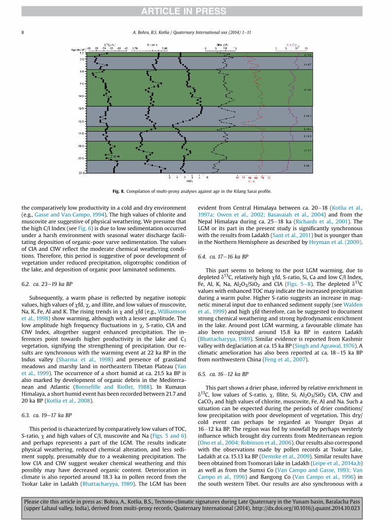
Fig. 8. Compilation of multi-proxy analyses against age in the Kilang Sarai profile.
A. Bohra, B.S. Kotlia / Quaternary International xxx (2014) 1e118
the comparatively low productivity in a cold and dry environment(e.g., Gasse and Van Campo, 1994). The high values of chlorite andmuscovite are suggestive of physical weathering. We presume thatthe high C/I Index (see Fig. 6) is due to low sedimentation occurredunder a harsh environment with seasonal water discharge facili-tating deposition of organic-poor varve sedimentation. The valuesof CIA and CIW reflect the moderate chemical weathering condi-tions. Therefore, this period is suggestive of poor development ofvegetation under reduced precipitation, oligotrophic condition ofthe lake, and deposition of organic poor laminated sediments.
6.2. ca. 23e19 ka BP
Subsequently, a warm phase is reflected by negative isotopicvalues, high values of cfd, c, and illite, and low values of muscovite,Na, K, Fe, Al and K. The rising trends in c and cfd (e.g., Williamsonet al., 1998) show warming, although with a lesser amplitude. Thelow amplitude high frequency fluctuations in c, S-ratio, CIA andCIW Index, altogether suggest enhanced precipitation. The in-ferences point towards higher productivity in the lake and C3vegetation, signifying the strengthening of precipitation. Our re-sults are synchronous with the warming event at 22 ka BP in theIndus valley (Sharma et al., 1998) and presence of grasslandmeadows and marshy land in northeastern Tibetan Plateau (Yanet al., 1999). The occurrence of a short humid at ca. 21.5 ka BP isalso marked by development of organic debris in the Mediterra-nean and Atlantic (Bonnefille and Riollet, 1988). In KumaunHimalaya, a short humid event has been recorded between 21.7 and20 ka BP (Kotlia et al., 2008).
6.3. ca. 19e17 ka BP
This period is characterized by comparatively low values of TOC,S-ratio, c and high values of C/I, muscovite and Na (Figs. 5 and 6)and perhaps represents a part of the LGM. The results indicatephysical weathering, reduced chemical alteration, and less sedi-ment supply, presumably due to a weakening precipitation. Thelow CIA and CIW suggest weaker chemical weathering and thispossibly may have decreased organic content. Deterioration inclimate is also reported around 18.3 ka in pollen record from theTsokar Lake in Ladakh (Bhattacharyya, 1989). The LGM has been
Please cite this article in press as: Bohra, A., Kotlia, B.S., Tectono-climatic s(upper Lahaul valley, India), derived from multi-proxy records, Quaternar
evident from Central Himalaya between ca. 20�18 (Kotlia et al.,1997a; Owen et al., 2002; Basavaiah et al., 2004) and from theNepal Himalaya during ca. 25�18 ka (Richards et al., 2001). TheLGM or its part in the present study is significantly synchronouswith the results from Ladakh (Sant et al., 2011) but is younger thanin the Northern Hemisphere as described by Heyman et al. (2009).
6.4. ca. 17e16 ka BP
This part seems to belong to the post LGM warming, due todepleted d13C, relatively high cfd, S-ratio, Si, Ca and low C/I Index,Fe, Al, K, Na, Al2O3/SiO2 and CIA (Figs. 5e8). The depleted d13Cvalues with enhanced TOCmay indicate the increased precipitationduring a warm pulse. Higher S-ratio suggests an increase in mag-netic mineral input due to enhanced sediment supply (see Waldenet al., 1999) and high cfd therefore, can be suggested to documentstrong chemical weathering and strong hydrodynamic enrichmentin the lake. Around post LGM warming, a favourable climate hasalso been recognized around 15.8 ka BP in eastern Ladakh(Bhattacharyya, 1989). Similar evidence is reported from Kashmirvalley with deglaciation at ca. 15 ka BP (Singh and Agrawal, 1976). Aclimatic amelioration has also been reported at ca. 18�15 ka BPfrom northwestern China (Feng et al., 2007).
6.5. ca. 16�12 ka BP
This part shows a drier phase, inferred by relative enrichment ind13C, low values of S-ratio, c, Illite, Si, Al2O3/SiO2 CIA, CIW andCaCO3 and high values of chlorite, muscovite, Fe, Al and Na. Such asituation can be expected during the periods of drier conditions/low precipitation with poor development of vegetation. This dry/cold event can perhaps be regarded as Younger Dryas at16�12 ka BP. The region was fed by snowfall by perhaps westerlyinfluence which brought dry currents from Mediterranean region(Ono et al., 2004; Robinson et al., 2006). Our results also correspondwith the observations made by pollen records at Tsokar Lake,Ladakh at ca. 15.13 ka BP (Demske et al., 2009). Similar results havebeen obtained from Tsomorari lake in Ladakh (Leipe et al., 2014a,b)as well as from the Sumxi Co (Van Campo and Gasse, 1993; VanCampo et al., 1996) and Bangong Co (Van Campo et al., 1996) inthe south western Tibet. Our results are also synchronous with a
ignatures during Late Quaternary in the Yunam basin, Baralacha Passy International (2014), http://dx.doi.org/10.1016/j.quaint.2014.10.023
A. Bohra, B.S. Kotlia / Quaternary International xxx (2014) 1e11 9
glacial advance at 15.1�12 ka BP in Lahaul (Owen et al., 1997) and at16�12 ka BP in the Zanskar (Taylor and Mitchell, 2000).
6.6. ca. 12�4.5 ka BP
This longer phase shows an increase in precipitation as depictedby depleted d13C, higher TOC, S-ratio, cfd, Si, Illite and relatively lowvalues of chlorite, C/I Index, muscovite, Fe, Al and K. The prominentpeaks can bewell visible at ca.10 and 5 ka BP (see Figs. 6 and 8). Thedata indicate a gradual increase inweathering with more alterationof primary minerals and strong hydrodynamics due to enhancedprecipitation, possibly representing intensification in precipitation.The results are in agreement with a warm and humid phase fromwestern Tibet and Karakoram around ca. 11.5 ka BP (Brown et al.,2003). Our results are also in agreement with those obtainedfrom Tsokar and Tsomorari Lakes in Ladakh (Demske et al., 2009;Wünnemann et al., 2010; Leipe et al., 2014a,b) as well as fromSumxi Co, Bangong Co and Qaidam Basin in Tibet (Van Campo andGasse, 1993; Van Campo et al., 1996; Zhao et al., 2007).
6.7. ca. 4.5�2 ka BP
During this time, our data indicate reduced melt waterdischarge under cold and arid conditions, as is also evidenced bycomparatively lower values of TOC, S-ratio, cfd, Si, CIA and CIW. Thevalues of Fe, Al and Na further support our results. The dry condi-tions due to weakened precipitation at Kilang Sarai correspondswith records from Tsokar (Kramer et al., 2014), Tso Moriri (Leipeet al., 2014a) and Pangong Tso in Ladakh (Gasse et al., 1996). Theintensification of an arid phase at 4.0e3.5 ka BP is also recordedfrom the Indian Himalaya (Chauhan and Sharma, 1996; Kotlia et al.,1997a; Phadtare, 2000). Similar results have also been reportedfrom the Kinnaur Himalaya (Himachal Pradesh) where reducedmonsoonal precipitation prevailed around 2 ka BP (Chakrabortyet al., 2006).
6.8. ca. 2 ka BP onwards
This sector represents frequent oscillations of autochthonouslacustrine organic matter within the lake, somewhat oligotrophicconditions and suggestive of wet climate as reflected by relativelyincreasing trends of CIA, CIWand CaCO3. Around 1.6 ka BP, presenceof river gravel at Kilang Sarai indicates breaching of the Kilang Sarailake.
7. Conclusions
A 8 m thick palaeolake sequence from Kilang Sarai (LahaulHimalaya), has been studied for multi-proxy analyses, viz., d13C,TOC, LOI, mineral magnetism, clay minerals and major elements.Based on the lithological texture and a number of analyses, weconclude:
1. The ancient lake was tectonically formed around 25 ka BP byactivity along the fault that dammed the Yunam River. Thegeomorphologic characters such as tilted terraces, fluvio-lacustrine sediments, fault facets, deep gorge and abruptchanges in the course of Yunam River indicate that the region isinfluenced by tectonic activity. The uninterrupted sedimentswere deposited in a closed lake which was breached about1.6 ka BP due to revival of tectonic upheaval.
2. According to our results using multi-proxy investigations, it isinferred that the study area experienced eight climatic episodesas a cold/dry period from ca. 25�23 ka BP, a warm-humid phasefrom ca. 23e19 ka BP, an arid phase of the LGM at ca.
Please cite this article in press as: Bohra, A., Kotlia, B.S., Tectono-climatic s(upper Lahaul valley, India), derived from multi-proxy records, Quaternar
19e17 ka BP, a warm humid pulse of post glacial warmingaround ca. 17�16 ka BP, a cooling phase of the Younger Dryasfrom ca. 16�12 ka BP, a warmest phase at ca. 12�4.5 ka BP, fol-lowed by an arid phase between ca. 4.5�2 ka BP and a warmhumid phase from 2 ka BP onwards.
Acknowledgements
The authors are thankful to the Director, Wadia Institute of Hi-malayan Geology, Dehradun and Dr. N.K. Saini for the supportduring clay mineralogy and geochemical analysis and to Dr N.Basaviah, Institute of Geomagnetism, Mumbai for providing facilityfor measuring magnetic susceptibility. Drs. Sushma Prasad andBrigit Pleesen, from GFZ, Potsdam, Germany are acknowledged forcarbon isotopic data. AB is grateful to Drs. D.P. Dobhal, R. Islam, P.Srivastava, R. Bhambri, M. Mehta, N.K. Meena from WIHG and K.Selvaraj from Xiamen University, China for discussion and valuablesuggestions. BSK is thankful to the University Grants Commission,New Delhi (F.8-10/SA/90/SA-II) for financial assistance.
References
Ahlberg, A., Olsson, I., �Simkevi�cius, P., 2003. TriassiceJurassic weathering and claymineral dispersal in basement areas and sedimentary basins of southernSweden. Sedimentary Geology 161, 15e29.
Anoop, A., Prasad, S., Krishnan, R., Naumann, R., Dulski, P., 2013. Intensifiedmonsoon and spatiotemporal changes in precipitation patterns in the NWHimalaya during the early-mid Holocene. Quaternary International 313e314,74e84.
Bagati, T.N., Mazari, R.K., Rajagopalan, G., 1996. Palaeotectonic amplification ofLamayuru lake (Ladakh). Current Science 71 (6), 479e482.
Bagati, T.N., Suresh, N., 1991. Sedimentology of the Lingti lacustrine sequence, Spitivalley, Himachal Pradesh. Himalayan Geology 2 (2), 124e132.
Bagati, T.N., Thakur, V.C., 1993. Quaternary basins of Ladakh and Lahaul-Spiti innorthwestern Himalaya. Current Science 64, 898e903.
Barnard, P.L., Owen, L.A., Sharma, M.C., Finkel, R.C., 2001. Natural and human-induced landsliding in the Garhwal Himalaya of northern India. Geo-morphology 40, 21e35.
Basavaiah, N., Juyal, N., Pant, R.K., Yadava, M.G., Singhvi, A.K., Appel, E., 2004. LateQuaternary climatic changes reconstructed from mineral magnetic studies fromproglacial lake deposits of Higher Central Himalaya. Journal of IndianGeophysical Union 8 (1), 27e37.
Berner, R.A., 1971. Principles of Chemical Sedimentation. McGraw-Hill, New York,p. 270.
Beuning, K.R.M., Talbot, M.R., Kelts, K., 1997. A revised 30,000 year paleoclimatic andpaleohydrologic history of Lake Albert, east Africa. Palaeogeography, Palae-oclimatology, Palaeoecology 136, 259e279.
Bhargava, O.N., 1990. Holocene tectonics south of Indus suture, Lahaul LadakhHimalaya, India: a consequence of Indian plate motion. Tectonophysics 174,314e320.
Bhargava, O.N., Bassi, U.K., 1998. Geology of Spiti-Kinnaur, Himachal Himalaya.Geological Survey of India Memoirs 124, 1e210.
Bhattacharyya, A., 1989. Vegetation and climate during the last 30,000 years inLadakh. Palaeogeography, Palaeoclimatology, Palaeoecology 73, 25e38.
Bohra, A., Kotlia, B.S., Laskar, A.H., Yadava, M.G., 2014. Evidence of late Quaternaryseismicity from Yunam Tso, Lahaul and Spiti, NW Himalaya India. Journal ofEarth System Science 123 (3), 603e616.
Bookhagen, B., Thiede, R., Strecker, M.R., 2005. Late Quaternary intensified monsoonphases control landscape evolution in the northwest Himalaya. Geology 33,149e152.
Bonnefille, R., Riollet, G., 1988. The Kashiru pollen sequence (Burundi). Palae-oclimatic implications for the last 40,000 yr B.P. in tropical Africa. QuaternaryResearch 30, 19e35.
Brindley, G.W., Brown, G., 1980. Crystal Structures of Clay Minerals and TheirIdentification. Mineral Society, London, p. 495.
Brown, E.T., Bendick, R., Bourles, D.L., Gaur, V., Molnar, P., Raisbeck, G.M., Yiou, F.,2003. Early Holocene climatic record in geomorphological features in westernTibet. Palaeogeography, Palaeoclimatology, Palaeoecology 199, 141e151.
Campbell, J.A., Evan, D.J.A., 1990. Glaciotectonics and landsliding in little sand hillcreek Alberta. Geomorphology 30, 19e36.
Chakraborty, S., Bhattacharya, S.K., Ranhotra, P.S., Bhattacharyya, A., Bhushan, R.,2006. Palaeoclimatic scenario during Holocene around Sangla valley, Kinnaur,northwest Himalaya based on multiproxy records. Current Science 10,777e782.
Chamley, H., 1989. Clay Sedimentology. Springer-Verlag, New York, p. 623.Chamley, H., 1997. Clay mineral sedimentation in the ocean. In: Paquet, H., Clauer, N.
(Eds.), Soils and Sediments. Mineralogy and Geochemistry. Springer-Verlag,Berlin, New York, pp. 269e302.
ignatures during Late Quaternary in the Yunam basin, Baralacha Passy International (2014), http://dx.doi.org/10.1016/j.quaint.2014.10.023

A. Bohra, B.S. Kotlia / Quaternary International xxx (2014) 1e1110
Chauhan, M.S., Sharma, C., 1996. Pollen Analysis of Mid-Holocene Sediments fromKumaun Himalaya. In: Geological Survey of India Special Publication 21,pp. 257e269.
Colin, C., Kissel, C., Blamart, D., Turpin, L., 1998. Magnetic properties of sediments inthe Bay of Bengal and the Andaman Sea: impact of rapid North Atlantic Oceanclimatic events on the strength of the Indian monsoon. Earth and PlanetaryScience Letters 160, 623e635.
Deconinck, J.F., Hesselbo, S.P., Debuisser, N., Averbuch, O., Baudin, F., Bessa, J., 2003.Environmental controls on clay mineralogy of an Early Jurassic mudrock (BlueLias Formation, Southern England). International Journal of Earth Science 92,255e266.
Dekkers, M.J., 1997. Environmental magnetism: an introduction. Geologie enMijnbouw 76, 163e182.
Demske, D., Tarasov, P.E., Wünnemann, B., Riedel, F., 2009. Late glacial and Holocenevegetation, Indian monsoon and westerly circulation dynamics in the Trans-Himalaya recorded in the pollen profile from high-altitude Tso Kar Lake,Ladakh, NW India. Palaeogeography, Palaeoclimatology, Palaeoecology 279(3e4), 172e185.
Engstrom, D.R., Wright, H.E., 1984. Chemical statigraphy of lake sediments as recordof environmental change. In: Haworth, E.Y., Lund, J.W.G. (Eds.), Lind: LakeSediments and Environmental History. Leicester University Press, pp. 11e67.
Evans, E.E., Heller, F., 2003. Environmental Magnetism: Principles and Applicationsof Enviromagnetics. In: International Geophysics Series, New York. AcademicPress, San Francisco, p. 293.
Feng, D.Z., Zhai, X.W., Ma, Y.Z., Huang, C.Q., Wang, W.G., Zhang, H.C., Khosbayar, P.,Narantsetseg, T., Liu, K.B., Rutter, N.W., 2007. Eolian environmental change inthe northern Mongolian plateau during the past ~35,000 yr. Palaeogeography,Palaeoclimatology, Palaeoecology 245, 505e517.
Fontes, J.C., Gasse, F., Gibert, E., 1996. Holocene environmental changes in lakeBangong basin (western Tibet). Part 1: chronology and stable isotopes of car-bonates of a Holocene lacustrine core. Palaeogeography, Palaeoclimatology,Palaeoecology 120, 25e47.
Fort, M., Burbank, D.W., Freytet, P., 1989. Lacustrine sedimentation in a semi alpinesetting: an example from Ladakh, northwestern Himalaya. Quaternary Research31, 332e352.
Fürsich, F.T., Singh, I.B., Joachimski, M., Krumm, S., Schlirf, M., Schlirf, S., 2005.Palaeoclimate reconstructions of the Middle Jurassic of Kachchh (western In-dia): an integrated approach based on palaeoecological, oxygen isotopic andclay mineralogical data. Palaeogeography, Palaeoclimatology, Palaeoecology217, 289e309.
Gasse, F., Arnold, Fontes, J.C., Fort, M., Gibert, E., Huc, A., Bingyan, L., Yuanfang, L.,Qing, L., Melieres, F., Van Campo, E., Fubao, Q.Z., 1991. A 13,000 year climaterecord from western Tibet. Nature 353, 742e745.
Gasse, F., Fontes, J.C., Van Campo, E., Wei, K., 1996. Holocene environmental changesin Bangong Co basin (Western Tibet). Part 4: discussion and conclusions.Palaeogeography, Palaeoclimatology, Palaeoecology 120 (1e2), 79e92.
Gasse, F., Van Campo, E., 1994. Abrupt post-glacial climate events in West Asia andNorth Africa monsoon domains. Earth and Planetary Science Letters 126,435e456.
Hallam, A., 1994. Jurassic climates as inferred from the sedimentary and fossil re-cord. In: Allen, J.R.L., Hoskins, B.J., Sellwood, B.W., Spicer, R.A., Valdes, P.J. (Eds.),Palaeoclimates and Their Modelling, with Special Reference to the MesozoicEra. Chap- man & Hall, London, pp. 79e88.
Harnois, L., 1988. The CIW index: a new chemical index of weathering. SedimentaryGeology 55, 31e32.
Heyman, J., Stroeven, A.P., Alexanderson, H., H€attestrand, C., Harbor, J., Li, Y.K.,Caffee, M.W., Zhou, L.P., Veres, D., Liu, F., Machiedo, M., 2009. Palaeoglaciation ofBayan Har Shan, northeastern Tibetan Plateau: glacial geology indicatesmaximum extents limited to ice cap and ice field scales. Journal of QuaternaryScience 24, 710e727. http://dx.doi.org/10.1002/jqs.1305.
Jonathan, A.H., 1988. Pliocene and Quaternary Environmental Changes in Kashmir,Northwest Himalaya (Unpublished Ph.D. thesis). Hertford College and School ofGeography, University of Oxford, p. 527.
Juyal, N., Pant, R.K., Basavaiah, N., Bhushan, R., Jain, M., Saini, N.K., Yadava, M.G.,Singhvi, A.K., 2009. Reconstruction of Late Glacial to early Holocene monsoonvariability from relict lake sediments of the Higher Central Himalaya, Uttarak-hand, India. Journal of Asian Earth Sciences. http://dx.doi.org/10.1016/j.jseaes2008.07.007.
King, J.W., Channell, J.E.T., 1991. Sedimentary magnetism, environmental magne-tism and magnetostratigraphy. Review Geophysics 358e370.
Kotlia, B.S., Bhalla, M.S., Shah, N., Rajagopalan, G., 1998a. Palaeomagnetic resultsfrom the Pleistocene-Holocene lake deposits of Bhimtal and Bhowali (KumaunHimalaya) and Lamayuru (Ladakh Himalaya) with reference to the reversalevents. Journal of Geological Society of India 51, 7e20.
Kotlia, B.S., Bhalla, M.S., Sharma, C., Ramesh, R., Rajagopalan, G., Mathur, P.D.,Bhandari, S., Chacko, S.T., 1997a. Palaeoclimatic conditions in the Upper Pleis-tocene and Holocene Bhimtal-Naukuchiatal lake basin in the south-centralKumaun, North India. Palaeogeography, Palaeoclimatology, Palaeoecology 130,307e322.
Kotlia, B.S., Sanwal, J., Bhattacharya, S.K., 2008. Climatic record between ca. 31 and22 ka BP in east-Central Uttarakhand Himalaya, India. Himalayan Geology 29(1), 59e67.
Kotlia, B.S., Sanwal, J., Phartiyal, B., Joshi, L.M., Trivedi, A., Sharma, C., 2010. LateQuaternary climatic changes in the eastern Kumaun Himalaya, India, asdeduced from multi-proxy studies. Quaternary International 213, 44e55.
Please cite this article in press as: Bohra, A., Kotlia, B.S., Tectono-climatic s(upper Lahaul valley, India), derived from multi-proxy records, Quaternar
Kotlia, B.S., Schallreuter, I.H., Schallreuter, R., Schwarz, J., 1998b. Evolution ofLamayuru palaeolake in the Trans Himalaya: palaeoecological implications.Eiszeitalter und Gegenwart 48, 177e191.
Kotlia, B.S., Sharma, C., Bhalla, M.S., Rajagopalan, G., Subrahmanyam, K.,Bhattacharyya, A., Valdiya, K.S., 2000. Palaeoclimatic conditions in the LatePleistocene Wadda Lake, eastern Kumaun Himalaya, India. Palaeogeography,Palaeoclimatology, Palaeoecology 162, 105e118.
Kotlia, B.S., Shukla, U.K., Bhalla, M.S., Mathur, P.D., Pant, C.C., 1997b. Quaternaryfluvio-lacustrine deposits of Lamayuru basin, Ladakh Himalaya: preliminarymultidisciplinary investigations. Geological Magazine 134 (6), 807e812.
Kramer, M., Kotlia, B.S., Wünnemann, B., 2014. A late Quaternary ostracod recordfrom the Tso Kar basin (North India) with a note on the distribution of recentspecies. Journal of Paleolimnology 51 (4), 549e565.
Leipe, C., Demske, D., Tarasov, P.E., 2014a. A Holocene pollen record from thenorthwestern Himalayan lake Tso Moriri: implications for palaeoclimatic andarchaeological research. Quaternary International 348, 93e112.
Leipe, C., Demske, D., Tarasov, P.E., Wünnemann, B., Riedel, F., 2014b. Potential ofpollen and non-pollen palynomorph records from Tso Moriri (Trans-Himalaya,NW India) for reconstructing Holocene limnology and human-environmentalinteractions. Quaternary International 348, 113e129.
Maher, B.A., Thompson, R., 1999. Quaternary Climates, Environments and Magne-tism. Cambridge University Press, Cambridge, pp. 81e125.
Mahjoor, A.J., Karimi, M.K., Rastegariari, A., 2009. Mineralogical and geochemicalcharacteristics of clay deposits from south Abarkouh district of clay deposits(Central Iran) and their application. Journal of Applied Science 9, 601e614.
Matzinger, A., Schmid, M., Sarafiloska, E.V., Patceva, S., Guseska, D., Wagner, B.,Muller, B., Sturm, M., Wuest, A., 2007. Eutrophication of ancient Lake Ohrid:global warming amplifies detrimental effects of increased nutrient inputs.American Society of Limnology and Oceanography 52 (1), 338e353.
Mazari, R.K., Bagati, T.N., Chauhan, M.S., Rajagopalan, G., 1995. Palaeoclimatic re-cords of last 2000 years in Trans-Himalaya Lahaul-Spiti region. In: ProceedingsNagoya IGBP-Pages/REP-II Symposium, pp. 262e268.
McGregor, G.R., Nieuwolt, S., 1998. A Book: Tropical Climatology: an Introduction tothe Climates of the Low Latitudes. xi þ 339. ISBN: 0-471-96611-8.
Nesbitt, H.W., Young, G.M., 1982. Early Proterozoic climates and plate motionsinferred from major element chemistry of Lutites. Nature 299, 715e717.
Newman, A.C.D., 1987. Chemistry of Clay and Clay minerals. In: Mineralogical So-ciety Monograph, vol. 6, p. 480.
Ono, Y., Shulmeister, J., Lehmkuhl, F., Asahia, K., Aoki, T., 2004. Timings and causes ofglacial advances across the PEP-II transect (East-Asia to Antarctica) during thelast glaciation cycle. Quaternary International 118e119, 55e68.
Owen, L.A., Bailey, R.M., Rhodes, E.J., Mitchell, W.A., Coxon, P., 1997. Style and timingof glaciation in the Lahul Himalaya, northern India: a framework for recon-structing late Quaternary palaeoclimatic change in the western Himalayas.Journal of Quaternary Science 12, 83e109.
Owen, L.A., Finkel, R.C., Caffee, M.W., Gualtieri, L., 2002. Timing of multiple lateQuaternary glaciations in the Hunza Valley, Karakoram Mountains, northernPakistan: defined by cosmogenic radionuclide dating of moraines. GeologicalSociety of America Bulletin 114 (5), 593e604.
Pant, R.K., Basavaiah, N., Juyal, N., Saini, N.K., Yadava, M.G., Singhvi, A.K., 2005. A 20-Ka climate record from Central Himalayan loess deposits. Quaternary Science20, 48e492.
Pennington, W., Haworth, E.Y., Bonny, A.P., Lishman, J.P., 1972. Lake sediments innorthern Scotland. Philosophical Transactions of Royal Society 264, 191e294.
Phadtare, N.R., 2000. Sharp decrease in summer monsoon strength 4000e3500 calyr B.P. in the Central Higher Himalaya of India based on pollen evidence fromAlpine Peat. Quaternary Research 53, 122e129.
Phartiyal, B., Appel, E., Blaha, U., Hoffmann, V., Kotlia, B.S., 2003. Palaeoclimaticsignificance of magnetic properties from Late Quaternary lacustrine sedimentsat Pithoragarh, Kumaun Lesser Himalaya, India. Quaternary International 108,51e62.
Phartiyal, B., Sharma, A., Srivastava, P., Ray, Y., 2009a. Chronology of relict lakedeposits in the Spiti River, NW Trans Himalaya: implications to Late Pleisto-ceneeHolocene climate-tectonic perturbations. Geomorphology 105 (3e4),264e272.
Phartiyal, B., Sharma, A., Upadhyay, R., Awatar, R., Sinha, A., 2005. Quaternary Ge-ology, tectonics and distribution of palaeo and present fluvio/glacio lacustrinedeposits in Ladakh, NW Indian Himalayan- a study based on field observations.Geomorphology 65, 241e256.
Phartiyal, B., Srivastava, P., Sharma, A., 2009b. Tectono-climatic signatures duringlate Quaternary period from Spiti valley, NW Himalaya, India. Himalayan Ge-ology 30 (2), 164e174.
Prasad, S., Enzel, Y., 2006. Holocene paleoclimates of India. Quaternary Research 66,442e453.
Prell, W.L., Kutzbach, J.E., 1992. Sensitivity of the Indian Monsoon to forcing pa-rameters and implications for its evolution. Nature 360, 647e652.
Reimer, P.J., Baillie, M.G.L., Bard, E., Bayliss, A., Beck, J.W., Blackwell, P.G., BronkRamsey, C., Buck, C.E., Burr, G.S., Edwards, R.L., Friedrich, M., Grootes, P.M.,Guilderson, T.P., Hajdas, I., Heaton, T.J., Hogg, A.G., Hughen, K.A., Kaiser, K.F.,Kromer, B., McCormac, F.G., Manning, S.W., Reimer, R.W., Richards, D.A.,Southon, J.R., Talamo, S., Turney, C.S.M., van der Plicht, J., Weyhenmeyer, C.E.,2009. IntCal09 and Marine09 radiocarbon age calibration curves, 0e50,000years cal BP. Radiocarbon 51 (4), 1111e1150.
Rhodes, T.E., Gasse, F., Ruifen, L., Fontes, J.C., Keqin, W., Bertrand, P., Gilbert, E.,Melieres, F., Tucholka, P., Zhixiang, W., Zhi-Yuan, C., 1996. A late Pleistocene-
ignatures during Late Quaternary in the Yunam basin, Baralacha Passy International (2014), http://dx.doi.org/10.1016/j.quaint.2014.10.023

A. Bohra, B.S. Kotlia / Quaternary International xxx (2014) 1e11 11
Holocene lacustrine record from Lake Manas, Zunggar, northern Xinjiang,western China. Palaeogeography, Palaeoclimatology, Palaeoecology 120,105e121.
Richards, B.W.M., Benn, D.I., Owen, L.A., Rhodes, E.J., Spencer, J.Q., 2001. Timing oflate Quaternary glaciations south of Mount Everest in the Khumbu Himal,Nepal. Geological Society of America Bulletin 112, 1621e1632.
Robinson, S.G., 1986. The Late Pleistocene paleoclimatic record of North Atlanticdeep-sea sediments revealed by mineral magnetic measurements. Physics ofEarth and Planetary Interiors 42, 22e47.
Robinson, S.A., Black, S., Sellwood, B.W., Valdes, P.J., 2006. A review of palae-oclimates and palaeoenvironments in the Levant and Eastern Mediterra-nean from 25,000 to 5000 years BP: setting the environmental backgroundfor the evolution of human civilisation. Quaternary Science Reviews 25,1517e1541.
Rühland, K., Phadtare, N.R., Pant, R.K., Sangode, S.J., Smol, J.P., 2006. Acceleratedmelting of Himalayan snow and ice triggers pronounced changes in a valleypeat-land from northern India. Geophysical Research Letters 33. http://dx.doi.org/10.1029/2006GL026704.
Ruffell, A., McKinley, J.M., Worden, R.H., 2002. Comparison of clay mineral stratig-raphy to other proxy palaeoclimate indicators in the Mesozoic of NW Europe.Philosophical Transactions of Royal Society London 360, 675e693.
Sant, D.A., Wadhawan, S.K., Ganjoo, R.K., Basavaiah, N., Sukumaran, P.,Bhattacharya, S., 2011. Morphostratigraphy and Palaeoclimate appraisal of theLeh Valley, Ladakh Himalayas, India. Journal of Geological Society of India 77,499e510.
Sangode, S.J., Mazari, R.K., 2007. Mineral magnetic response to climate variability inthe high altitude Kioto palaeolake, Spiti valley, northwestern Himalaya. Hima-layan Geology 28, 1e9.
Schelske, C.L., Hodell, D.A., 1995. Using carbon isotopes of bulk sedimentary organicmatter to reconstruct the history of nutrient loading and eutrophication in LakeErie. Limnology and Oceanography 40, 918e929.
Selvaraj, K., Parthiban, G., Chen, C.A., Lou, J., 2010. Anthropogenic effects on sedi-ment quality offshore southwestern Taiwan: assessing the sediment coregeochemical record. Continental Shelf Research 30, 1200e1210.
Selvaraj, K., Wei, K.Y., Liu, K.K., Kao, S.J., 2012. Late Holocene monsoon climate ofnortheastern Taiwan inferred from elemental (C, N) and isotopic (d13C, d15N)data in lake sediments. Quaternary Science Reviews 37, 48e60.
Sharma, K.K., Gu, Z.Y., Lal, D., Caffee, M.W., Southon, J., 1998. Late Quaternarymorphotectonic evolution of Upper Spiti Valley: a cosmogenic radionuclidestudy of river polished surfaces. Current Science 75 (4), 366e372.
Shukla, U.K., Kotlia, B.S., Mathur, P.D., 2002. Sedimentation pattern in a trans-Himalayan Quaternary lake at Lamayuru (Ladakh), India. Sedimentary Geol-ogy 148, 405e424.
Singh, G., Agrawal, D.P., 1976. Radiocarbon evidence for deglaciation in north-western Himalaya, India. Nature 260, 233.
Singh, S., Jain, A.K., 2007. Liquifaction and fluidization of lacustrine deposits fromLahaul-Spiti and Ladakh Himalaya: geological evidences of Palaeoseismicityalong active fault zone. Sedimentary Geology 196, 47e57.
Smith, B.N., Epstein, S., 1971. Two categories 13C/12C ratios for higher plants. PlantPhysiology 47, 380e384.
Please cite this article in press as: Bohra, A., Kotlia, B.S., Tectono-climatic s(upper Lahaul valley, India), derived from multi-proxy records, Quaternar
Stober, J.C., Thompson, R., 1979. Magnetic remanence acquisition in Finnish lakesediments. Geophysical Journal Royal Astronomical Society 57, 127e739.
Talbot, M.R., Livingstone, D.A., 1989. Hydrogen index and carbon isotopes oflacustrine organic matter as lake level indicators. Palaeogeography, Palae-oclimatology, Palaeoecology 70, 121e137.
Taylor, P.J., Mitchell, A.W., 2000. The Quaternary glacial history of the Zanskar range,north-west Indian Himalaya. Quaternary International 65, 81e99.
Thompson, R., Oldfield, F., 1986. Environmental Magnetism. Allen and UnwinPublishers Ltd., UK, p. 227.
Tieszen, L.L., Senyimba, M.M., Imbamba, S.K., Troughton, J.M., 1979. The distributionof C3 and C4 grasses and carbon isotope discrimination along an altitudinal andmoisture gradient in Kenya. Oecologia 37, 337e350.
Van Campo, E., Gasse, F., 1993. Pollen and diatom-inferred climatic and hydrologicalchanges in Sumxi Co Basin (Western Tibet) since 13,000 yr B.P. QuaternaryResearch 39, 300e313.
Van Campo, E., Cour, P., Sixuan, Hang, 1996. Holocene environmental changes inBangong Co basin (Western Tibet), Part 2: the pollen record. Palaeogeography,Palaeoclimatology, Palaeoecology 120, 49e63.
Verosub, K., Roberts, A.P., 1995. Environmental magnetism: past, present and future.Journal of Geophysical Research 100, 2175e2192.
Walden, J.F., Oldfield, F., Smith, J., 1999. Environmental Magnetism: a PracticalGuide. No. 6. Quaternary Research Association, London, p. 243.
Weaver, C.V., 1989. Clay, Muds and Shales. Elsevier, Amsterdam, p. 819.Wehausen, R., Tian, J., Brumsack, H.J., Cheng, X.R., Wang, P.X., 2003. Geochemistry of
Pliocence sediments from ODP site 1143 (Southern South China Sea). In:Wang, P., Prell, W.L., et al. (Eds.), Proceedings of the Ocean Drilling Program,Science Results, vol .184, pp. 1e25.
Williamson, D., Jelinowska, A., Kissel, C., Tucholka, P., Gibert, E., Gasse, F.,Massault, M., Taied, M., Van Campo, E., Wieckowski, 1998. Mineral magneticproxies of erosion/oxidation cycles in tropical marr-lake sediments (Lake Tri-trivakely, Medagascar): paleoenvironmental implications. Earth and PlanetaryScience Letters 155, 205e219.
Wünnemann, B., Demske, D., Tarasov, P., Kotlia, B.S., Reinhardt, C., Bloemendal, J.,Diekmann, B., Hartmann, K., Krois, J., Riedel, F., Arya, N., 2010. Hydrologicalevolution during the last 15 kyr in the Tso Kar lake basin (Ladakh, India),derived from geomorphological, sedimentological and palynological records.Quaternary Science Reviews 29 (9), 1138e1155.
Wünnemann, B., Reinhardt, C., Kotlia, B.S., Riedel, F., 2008. Observations on therelationship between Lake formation, Permafrost activity and Lithalsa devel-opment during the last 20,000 years in the Tso Kar Basin, Ladakh, India.Permafrost and Periglacial Processes 19, 341e358.
Yan, G., Wang, F.B., Shi, G.R., Li, S.F., 1999. Palynological and stable isotopic studyof palaeoenvironmental changes on the northeastern Tibetan plateau in thelast 30,000 years. Palaeogeography, Palaeoclimatology, Palaeoecology 153,147e159.
Zhao, Y., Yu, Z., Chen, F., Ito, E., Zhao, C., 2007. Holocene vegetation and climatehistory at Hurleg Lake in the Qaidam Basin, northwest China. Review ofPalaeobotany and Palynology 145 (3e4), 275e288.
ignatures during Late Quaternary in the Yunam basin, Baralacha Passy International (2014), http://dx.doi.org/10.1016/j.quaint.2014.10.023
Related Documents


