Tectonics and history of the Andaman Sea region Joseph R. Curray * Scripps Institution of Oceanography, La Jolla, CA 92093-0220, USA Received 20 May 2004; revised 25 August 2004; accepted 1 September 2004 Abstract The Andaman Sea is an active backarc basin lying above and behind the Sunda subduction zone where convergence between the overriding Southeast Asian plate and the subducting Australian plate is highly oblique. The effect of the oblique convergence has been formation of a sliver plate between the subduction zone and a complex right-lateral fault system. The late Paleocene collision of Greater India and Asia with approximately normal convergence started clockwise rotation and bending of the northern and western Sunda Arc. The initial sliver fault, which probably started in the Eocene, extended through the outer arc ridge offshore from Sumatra, through the present region of the Andaman Sea into the Sagaing Fault. With more oblique convergence due to the rotation, the rate of strike-slip motion increased and a series of extensional basins opened obliquely by the combination of backarc extension and the strike-slip motion. These basins in sequence are the Mergui Basin starting at w32 Ma, the conjoined Alcock and Sewell Rises starting at w23 Ma, East Basin separating the rises from the foot of the continental slope starting at w15 Ma; and finally at w4 Ma, the present plate edge was formed, Alcock and Sewell Rises were separated by formation of the Central Andaman Basin, and the faulting moved onshore from the Mentawai Fault to the Sumatra Fault System bisecting Sumatra. q 2005 Elsevier Ltd. All rights reserved. Keywords: Andaman Sea; Backarc Basin; Oblique Convergence; Subduction; Myanmar; Sumatra 1. Introduction The Andaman Sea (Figs. 1 and 2) is a complex backarc extensional basin that differs from most other such basins in that it is west facing and that it was formed by transtension. The Andaman Sea lies along a highly oblique convergent margin between the northeastern moving Australian and/or Indian plate and the nearly stationary Eurasian or Southeast Asian plate. As the Greater Indian continental mass converged on the southeastern Asian margin, it caused clockwise rotation of the subduction zone and increase in the obliquity to the point that transtension along a sliver fault has resulted in oblique rhombochasm-like opening of the Andaman Sea during the Neogene. The tectonics and geological history of the Andaman Sea cannot be separated from the tectonics and geological histories of Myanmar (Burma) on the north, the Andaman and Nicobar Islands part of the accretionary prism on the western side of the Andaman Sea, and Sumatra on the south. The descriptions and discussion to follow will, therefore, include consideration of Sumatra and western and central Myanmar. The continental crust and pre-Neogene rocks of the Malay Peninsula and the Shan Plateau of Myanmar are directly involved in the tectonics where they have been rifted and thinned to form the Mergui Basin in the southeastern part of the Andaman Sea. 1.1. Previous exploration and investigation An early sighting of the Andaman and Nicobar Islands by a western explorer is attributed to Marco Polo in 1298, allegedly on his return to Europe by sea. He wrote ‘Angamanain is a very long island.’, and then went on to describe the unsavory nature of the aboriginal inhabitants of both the Andaman Islands (Angamanain) and Nicobar Islands (Necuveran), descriptions that were subsequently shown to be untrue or greatly exaggerated (Mukerjee, 2003). 1367-9120/$ - see front matter q 2005 Elsevier Ltd. All rights reserved. doi:10.1016/j.jseaes.2004.09.001 Journal of Asian Earth Sciences 25 (2005) 187–232 www.elsevier.com/locate/jaes * Tel.: C1 858 534 3299; fax: C1 858 534 0784. E-mail address: [email protected].

Welcome message from author
This document is posted to help you gain knowledge. Please leave a comment to let me know what you think about it! Share it to your friends and learn new things together.
Transcript
Tectonics and history of the Andaman Sea region
Joseph R. Curray*
Scripps Institution of Oceanography, La Jolla, CA 92093-0220, USA
Received 20 May 2004; revised 25 August 2004; accepted 1 September 2004
Abstract
The Andaman Sea is an active backarc basin lying above and behind the Sunda subduction zone where convergence between the
overriding Southeast Asian plate and the subducting Australian plate is highly oblique. The effect of the oblique convergence has been
formation of a sliver plate between the subduction zone and a complex right-lateral fault system. The late Paleocene collision of Greater India
and Asia with approximately normal convergence started clockwise rotation and bending of the northern and western Sunda Arc. The initial
sliver fault, which probably started in the Eocene, extended through the outer arc ridge offshore from Sumatra, through the present region of
the Andaman Sea into the Sagaing Fault. With more oblique convergence due to the rotation, the rate of strike-slip motion increased and a
series of extensional basins opened obliquely by the combination of backarc extension and the strike-slip motion. These basins in sequence
are the Mergui Basin starting at w32 Ma, the conjoined Alcock and Sewell Rises starting at w23 Ma, East Basin separating the rises from
the foot of the continental slope starting at w15 Ma; and finally at w4 Ma, the present plate edge was formed, Alcock and Sewell Rises were
separated by formation of the Central Andaman Basin, and the faulting moved onshore from the Mentawai Fault to the Sumatra Fault System
bisecting Sumatra.
q 2005 Elsevier Ltd. All rights reserved.
Keywords: Andaman Sea; Backarc Basin; Oblique Convergence; Subduction; Myanmar; Sumatra
1. Introduction
The Andaman Sea (Figs. 1 and 2) is a complex backarc
extensional basin that differs from most other such basins in
that it is west facing and that it was formed by transtension.
The Andaman Sea lies along a highly oblique convergent
margin between the northeastern moving Australian and/or
Indian plate and the nearly stationary Eurasian or Southeast
Asian plate. As the Greater Indian continental mass
converged on the southeastern Asian margin, it caused
clockwise rotation of the subduction zone and increase in
the obliquity to the point that transtension along a sliver
fault has resulted in oblique rhombochasm-like opening of
the Andaman Sea during the Neogene.
The tectonics and geological history of the Andaman Sea
cannot be separated from the tectonics and geological
histories of Myanmar (Burma) on the north, the Andaman
1367-9120/$ - see front matter q 2005 Elsevier Ltd. All rights reserved.
doi:10.1016/j.jseaes.2004.09.001
* Tel.: C1 858 534 3299; fax: C1 858 534 0784.
E-mail address: [email protected].
and Nicobar Islands part of the accretionary prism on the
western side of the Andaman Sea, and Sumatra on the south.
The descriptions and discussion to follow will, therefore,
include consideration of Sumatra and western and central
Myanmar. The continental crust and pre-Neogene rocks of
the Malay Peninsula and the Shan Plateau of Myanmar are
directly involved in the tectonics where they have been
rifted and thinned to form the Mergui Basin in the
southeastern part of the Andaman Sea.
1.1. Previous exploration and investigation
An early sighting of the Andaman and Nicobar Islands by
a western explorer is attributed to Marco Polo in 1298,
allegedly on his return to Europe by sea. He wrote
‘Angamanain is a very long island.’, and then went on to
describe the unsavory nature of the aboriginal inhabitants of
both the Andaman Islands (Angamanain) and Nicobar
Islands (Necuveran), descriptions that were subsequently
shown to be untrue or greatly exaggerated (Mukerjee, 2003).
Journal of Asian Earth Sciences 25 (2005) 187–232
www.elsevier.com/locate/jaes
hp
高亮
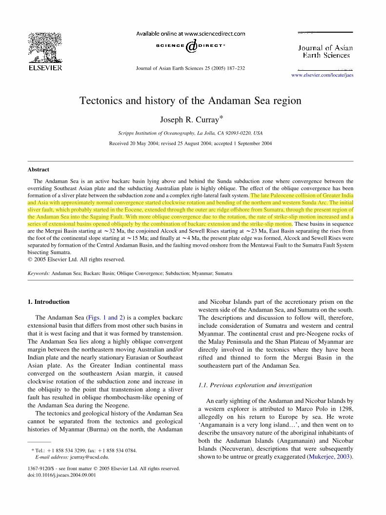
Fig. 1. Tectonic map of part of the northeastern Indian Ocean. Modified from Curray (1991).
J.R. Curray / Journal of Asian Earth Sciences 25 (2005) 187–232188
Whether these comments were from his personal obser-
vations or taken from earlier Persian accounts, Marco Polo
brought them to Europe.
The first organized oceanographic and marine biological
investigations of the Andaman Sea were by Alcock (1902).
Sewell (1925), Director of the Zoological Survey of India,
did further oceanographic and geographic surveys. Rodolfo
(1969a,b) named Alcock and Sewell Seamounts, later
designated rises, after these two pioneers. Earlier workers
had, however, made observations of Barren Island (about
128N, Figs. 1, 2 and 4), the only active subaerial volcano and
on the adjacent Andaman and Nicobar Islands and the
Malay Peninsula. The first recorded observation of Barren
Island by a western explorer was by Van Linschoten (1595).
Mallet (1895) reviewed the history of observations of
eruption of Barren Island, and reported that the first known
landing on the island by a westerner was by Captain
Archibald Blair in 1789, after whom Port Blair on South

Fig. 2. Bathymetry of the Andaman Sea and part of the adjacent Indian Ocean, in corrected meters.
J.R. Curray / Journal of Asian Earth Sciences 25 (2005) 187–232 189
J.R. Curray / Journal of Asian Earth Sciences 25 (2005) 187–232190
Andaman Island was named. The other subaerial volcano,
Narcondam Island, is inactive or dormant.
The earliest known geological mention in the western
literature of Myanmar (Burma) was by Fitch (1599) who
traveled from Syria to Burma. Cox (1799a,b) described the
hand-dug oil wells on the Yenangyaung anticline in the
Central Burma basin, although there are reports of a Chinese
traveler who reported oil workings at Yenangyaung in the
13th century. Suess (1904) divided Myanmar into three
zones (Fig. 1): (1) The Western Indoburman Ranges;
(2) The Central Tertiary Burma Basin; (3) The Eastern
Zone Shan Plateau. Classic descriptions of the geology of
Burma were published by Pascoe (1912), Chhibber (1934)
and many other publications of the Geological Survey of
India (GSI), as summarized by Goosens (1978).
Consideration of the geology and origin of the Anda-
man–Nicobar Ridge started with Rink (1847), who
suggested that this ridge had been formed of sediments
uplifted from the deep ocean floor, and consisted ‘partly of
those stratified deposits which occupied the level bottom of
the sea’, an early statement of the modern hypothesis
of uplift and incorporation of sea floor deposits into an
accretionary prism. Hochstetter (1869) pointed out that the
same ridge extended southward as the outer arc ridge off
Sumatra and Java. Sewell (1925) suggested that ‘the
Andaman–Nicobar Ridge has drifted toward the west
away from the mainland, and has thus formed a pronounced
curve with its apex in the region of Little Andaman Island’.
Wegener was probably the first author to postulate a rift
origin of the Andaman Sea in one of the early editions of his
book ‘Die Entstehung der Kontinente und Ozeane’, starting
in 1915. In the 1966 edition of the translation of his 1929
edition (Wegener, 1966), he compared Lawson’s (1921)
analysis of the San Andreas Fault of California and the
opening of the Gulf of California with opening of the
Andaman Sea. He says (p. 201) of the Andaman Sea ‘We
may perhaps assume here that the vast compression of the
Himalaya put the Indochina chains in tension along their
length, that under this stress the Sumatra chain was torn at
the northern end of that island and that the northern part of
the chain (Arakan) was, and still is, being pulled northwards
like a rope’s end into the great compression’.
Post-World War II work in the Andaman Sea, Burma and
Sumatra which contributes to understanding the Andaman
Sea includes important papers by Brunnschweiler (1966,
1974), Peter et al. (1966), Weeks et al. (1967), Aung Khin
and Kyaw Win (1968, 1969), Rodolfo (1969a,b), Frerichs
(1971), Mitchell and McKerrow (1975), Paul and Lian
(1975), Mitchell (1976, 1981, 1985), Curray et al. (1979,
1982), Bender (1983), Chatterjee (1984), Roy and Chopra
(1987), Mukhopadyay (1984, 1992), Polachan and Racey
(1994), Acharyya (1994, 1997, 1998), Sieh and Natawidjaja
(2000), Genrich et al. (2000) and many others. However, not
all Indian syntheses agree with the plate tectonic interpret-
ations presented in this paper. Rodolfo (1969a) was the first
modern worker to fully understand the rifting and exten-
sional opening of the Andaman Sea.
Newer information is gradually coming into public
availability with excellent work in progress by Indian and
French scientists and oil and gas exploration studies. Many
of the irresolvable problems encountered in the present
paper with the limited data available will eventually be
resolved with these new sources of information, but many
conclusions and interpretations in the present paper must for
now remain speculation based on limited data.
My colleagues and I started publishing on the tectonics
and history of the Andaman Sea in 1979 (Curray et al.
1979), including analysis of sea floor spreading magnetic
anomalies for most of the Andaman Sea, which we had
interpreted back to 11 Ma. Later, we extended that to 13 Ma.
Several years ago, however, I carefully reviewed our
anomaly interpretations and at first concluded that none
prior to about 3 Ma were correct. More recently, we
(S. Cande, personal communication, 2003) concluded that
even those last 3 my anomaly identifications were not valid.
We then concluded that anomalies could be identified back
to 4 Ma for the Central Andaman Basin (Fig. 4).
While in the final stages of preparation of this manu-
script, a long-awaited analysis of excellent closely spaced
swath mapping and magnetic surveys of the Central
Andaman Basin (Fig. 4) was published by Raju et al.
(2004). I have now revised my discussion of our limited
magnetic data in the Central Andaman Basin and have
accepted their interpretation of the magnetic anomalies.
Raju et al. (2004) agreed with our conclusion that the
Central Andaman Basin has opened 118 km in about the last
4 my. Unfortunately, those authors misread our earlier
publications that stated that the entire Andaman Sea had
opened up to 460 km in the last 11 my. Instead they
attributed our 11 my time to just the central most recent
118 km of opening. This opening history will be reviewed in
Sections 6 and 7 in this paper.
1.2. Sources of data
Most of the ship tracks (Fig. 3) on which this study is
based are from ships of the Scripps Institution of
Oceanography, run between 1968 and 1979. In addition,
some useful information has come from the cruises of R/V
Pioneer and R/V Oceanographer from the US Coast and
Geodetic Survey in 1964 and 1967, a few lines of the
Lamont-Doherty Geological Observatory and several lines
to which I was given access by oil companies. The
data utilized include magnetics, gravity, 3.5 kHz bottom-
penetrating (w100 m maximum) echo sounder and airgun
seismic reflection profiling, mainly analog, but with some
multichannel digital seismic reflection data. For most of our
analog seismic reflection surveys, data were collected with
two different sweep times and filter settings: a slower sweep,
generally five seconds, filtered to 20–60 Hz; and a faster
sweep, generally 2 s, filtered to 50–150 Hz for higher
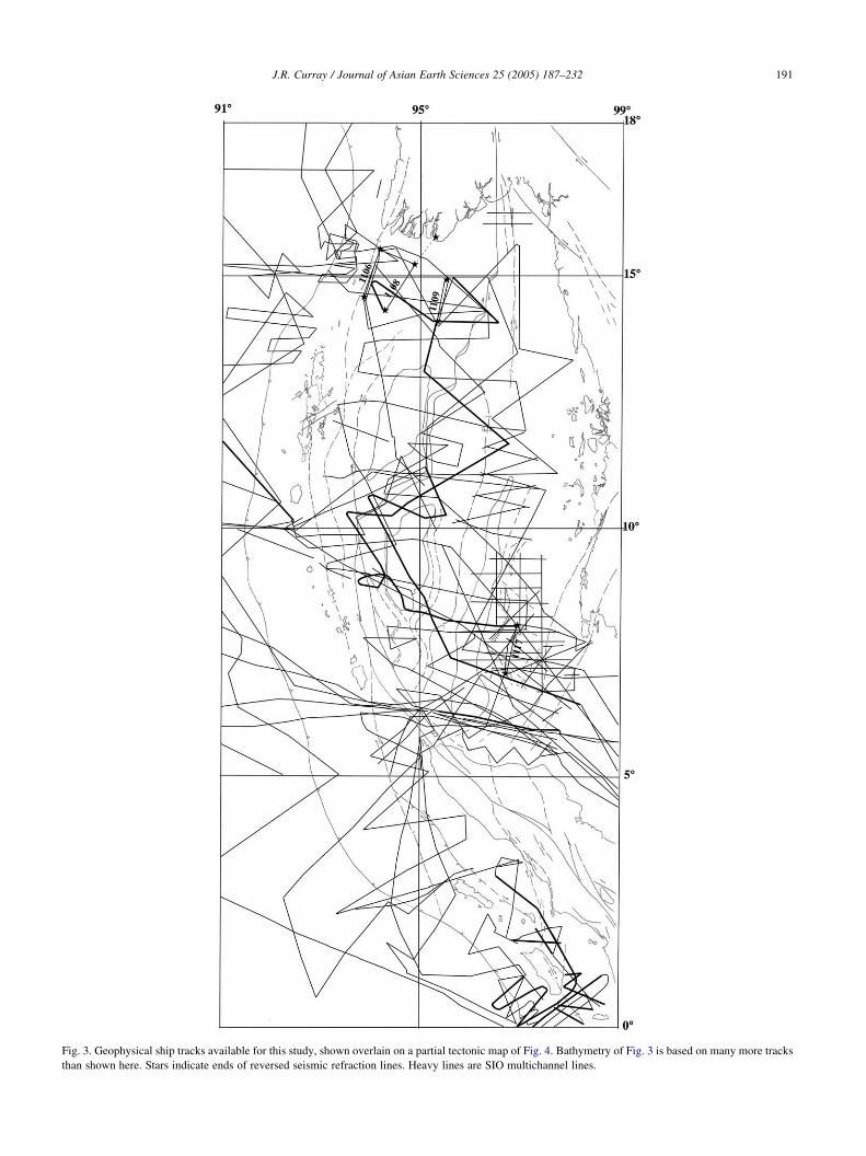
Fig. 3. Geophysical ship tracks available for this study, shown overlain on a partial tectonic map of Fig. 4. Bathymetry of Fig. 3 is based on many more tracks
than shown here. Stars indicate ends of reversed seismic refraction lines. Heavy lines are SIO multichannel lines.
J.R. Curray / Journal of Asian Earth Sciences 25 (2005) 187–232 191
J.R. Curray / Journal of Asian Earth Sciences 25 (2005) 187–232192
resolution. Swath-mapping bathymetry equipment was not
available to us at the time of our surveys.
Some of the 134 seismic refraction and wide-angle
seismic reflection stations involved single expendable
sonobuoys; some were run with successive sonobuoys at
intervals. All utilized air guns as a source, and about a third
of the stations also utilized explosives as a source. Four of
the refraction stations (Fig. 3) utilized moored telemetering
hydrophones at each end of a reversed line as well as
successively launched sonobuoys in between. The three
lines on the Myanmar continental shelf were run in
collaboration with geophysicists from the Myanma Oil
Corporation, the Myanmar national petroleum company. A
24 channel analog receiving array was set up on the
landward end. One of our technicians worked on shore with
the oil company crew placing the geophones and synchro-
nizing the shot timing by radio with our ship. A geophysicist
from Myanma worked aboard our ship, which acted as both
a shooting ship and receiving ship, while the time-
synchronized signals were also received at the shore station.
A geophysicist and a geologist from Myanma listed in the
Acknowledgements at the end of this paper came to Scripps
following the cruise to participate in analyzing the results.
Our bathymetric chart (Fig. 2) is based on many
additional ship tracks, positions of which were adjusted to
agree with the satellite-positioned lines of our own surveys.
Our bathymetric and reflection profiles commonly exhibit a
vertical exaggeration averaging about 10!. I have
compared the bathymetry of Fig. 2 with bathymetry
calculated from satellite altimetry (Smith and Sandwell,
1997) and conclude that while bathymetry from satellite
measurements is useful for general trends, it is not
satisfactory for understanding complex tectonic features.
2. Morphological and tectonic featuresof the Andaman Sea region
The major tectonic elements of the northeastern Bay of
Bengal and the adjacent parts of Southeast Asia are shown in
Fig. 1. The Indian and Australian plates are converging on the
Eurasian or Southeast Asian plate in a northeasterly direction
along the Himalayan front at the north and the Sunda Trench.
The margin along the western Sunda Trench is an oblique
convergence continental and arc margin. The sedimentary
cover on the subducting plate is very thick because of the
Bengal Fan (Curray et al., 2003), and sediments and ocean
crust have been accreted and uplifted into the Indoburman
Ranges, the Andaman–Nicobar Ridge and the outer arc ridge
off Sumatra and Java. The sediments thin over the Ninetyeast
Ridge, which is commonly interpreted as a hotspot trace (see,
for example, Curray et al. (1982)), with NE–SW en echelon
ridges on top. The bathymetric trench extends continuously
from east of Java westward and northward to where it is
overwhelmed by sediment of the Bengal Fan, and the surface
trace of the subduction zone rises out of the depths onto land
as the thrust faults of eastern Bangladesh, eastern India,
western Myanmar and the southeastern edge of the Assam
Valley (Fig. 1). The accretionary prism forms an entire
mountain range, the Indoburman Ranges.
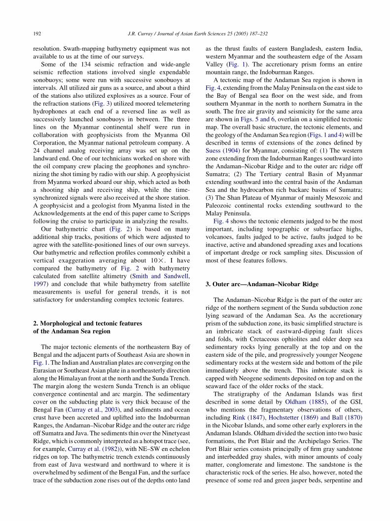
A tectonic map of the Andaman Sea region is shown in
Fig. 4, extending from the Malay Peninsula on the east side to
the Bay of Bengal sea floor on the west side, and from
southern Myanmar in the north to northern Sumatra in the
south. The free air gravity and seismicity for the same area
are shown in Figs. 5 and 6, overlain on a simplified tectonic
map. The overall basic structure, the tectonic elements, and
the geology of the Andaman Sea region (Figs. 1 and 4) will be
described in terms of extensions of the zones defined by
Suess (1904) for Myanmar, consisting of: (1) The western
zone extending from the Indoburman Ranges southward into
the Andaman–Nicobar Ridge and to the outer arc ridge off
Sumatra; (2) The Tertiary central Basin of Myanmar
extending southward into the central basin of the Andaman
Sea and the hydrocarbon rich backarc basins of Sumatra;
(3) The Shan Plateau of Myanmar of mainly Mesozoic and
Paleozoic continental rocks extending southward to the
Malay Peninsula.
Fig. 4 shows the tectonic elements judged to be the most
important, including topographic or subsurface highs,
volcanoes, faults judged to be active, faults judged to be
inactive, active and abandoned spreading axes and locations
of important dredge or rock sampling sites. Discussion of
most of these features follows.
3. Outer arc—Andaman–Nicobar Ridge
The Andaman–Nicobar Ridge is the part of the outer arc
ridge of the northern segment of the Sunda subduction zone
lying seaward of the Andaman Sea. As the accretionary
prism of the subduction zone, its basic simplified structure is
an imbricate stack of eastward-dipping fault slices
and folds, with Cretaceous ophiolites and older deep sea
sedimentary rocks lying generally at the top and on the
eastern side of the pile, and progressively younger Neogene
sedimentary rocks at the western side and bottom of the pile
immediately above the trench. This imbricate stack is
capped with Neogene sediments deposited on top and on the
seaward face of the older rocks of the stack.
The stratigraphy of the Andaman Islands was first
described in some detail by Oldham (1885), of the GSI,
who mentions the fragmentary observations of others,
including Rink (1847), Hochstetter (1869) and Ball (1870)
in the Nicobar Islands, and some other early explorers in the
Andaman Islands. Oldham divided the section into two basic
formations, the Port Blair and the Archipelago Series. The
Port Blair series consists principally of firm gray sandstone
and interbedded gray shales, with minor amounts of coaly
matter, conglomerate and limestone. The sandstone is the
characteristic rock of the series. He also, however, noted the
presence of some red and green jasper beds, serpentine and
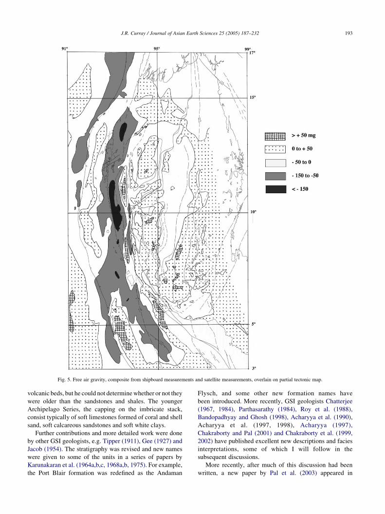
Fig. 5. Free air gravity, composite from shipboard measurements and satellite measurements, overlain on partial tectonic map.
J.R. Curray / Journal of Asian Earth Sciences 25 (2005) 187–232 193
volcanic beds, but he could not determine whether or not they
were older than the sandstones and shales. The younger
Archipelago Series, the capping on the imbricate stack,
consist typically of soft limestones formed of coral and shell
sand, soft calcareous sandstones and soft white clays.
Further contributions and more detailed work were done
by other GSI geologists, e.g. Tipper (1911), Gee (1927) and
Jacob (1954). The stratigraphy was revised and new names
were given to some of the units in a series of papers by
Karunakaran et al. (1964a,b,c, 1968a,b, 1975). For example,
the Port Blair formation was redefined as the Andaman
Flysch, and some other new formation names have
been introduced. More recently, GSI geologists Chatterjee
(1967, 1984), Parthasarathy (1984), Roy et al. (1988),
Bandopadhyay and Ghosh (1998), Acharyya et al. (1990),
Acharyya et al. (1997, 1998), Acharyya (1997),
Chakraborty and Pal (2001) and Chakraborty et al. (1999,
2002) have published excellent new descriptions and facies
interpretations, some of which I will follow in the
subsequent discussions.
More recently, after much of this discussion had been
written, a new paper by Pal et al. (2003) appeared in
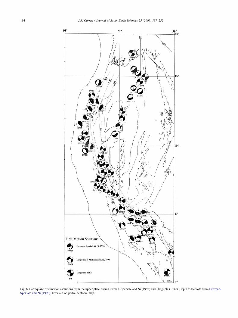
Fig. 6. Earthquake first motions solutions from the upper plate, from Guzman–Speziale and Ni (1996) and Dasgupta (1992). Depth to Benioff, from Guzman-
Speziale and Ni (1996). Overlain on partial tectonic map.
J.R. Curray / Journal of Asian Earth Sciences 25 (2005) 187–232194
J.R. Curray / Journal of Asian Earth Sciences 25 (2005) 187–232 195
the literature with excellent descriptions, analyses and
interpretations. The following discussion is based in part on
that newer paper.
Geologists from the Oil and Natural Gas Commission
(ONGC) continued using the older GSI system of strati-
graphy for their drilling and seismic work, with approxi-
mately the same units, with some of the original Oldham
names for the formations. See, for example, Chatterjee
(1967), Roy (1983, 1986), Misra and Roy (1984) and others.
Ananthanarayanan et al. (1981) correlated the seismic,
drilling and outcrop stratigraphy, by designating Seismic
Sequences correlating with the formations. Subdivision of
the Archipelago Group has been proposed by a series of
papers by Srinivasan (see, for example, Srinivasan and Azmi
(1979) and Srinivasan (1979, 1986)).
The generalized stratigraphy of the Andaman–Nicobar
Ridge is shown in Table 1, with both the newer and older
(in italics) formation and group names. The notations ‘M
Seismic Horizon?’ and ‘P Seismic Horizon?’ in the right hand
Table 1
Stratigraphy of the Andaman–Nicobar Ridge
column refer to seismic horizons identified in the Bengal Fan
sedimentary section, described in Curray et al. (2003).
In evaluating this stratigraphic column, it should be kept
in mind that all observations have been made on either drill
cores or cuttings or on outcrops of an accretionary complex,
described by many of the authors as melange. The outcrops
are furthermore only on the exposed island sections, much of
which is described as humid jungle. Thus, the sections may
be incompletely represented, and some of the rocks sampled
in drilling do not crop out anywhere on land. And certainly,
the facies shown in seismic reflection records from low on the
western slope of the ridge do not crop out on land.
The final difficulty in attempting a general description of
the stratigraphy and environments of deposition, the most
difficult to reconcile, is very different interpretations of the
environments of deposition. For example, the sedimentary
rocks of the Archipelago Series have been interpreted by
many to have been deposited mainly in shallow marine
conditions, while others, including M.S. Srinivasan, of
J.R. Curray / Journal of Asian Earth Sciences 25 (2005) 187–232196
Banaras Hindu University, interpret some of the same rocks
as products of deposition in deep water (see Table 1).
It would not be unreasonable, in view of the nature of
the sampling, to conclude that both are present. For
example, geologists who sampled the subaerially exposed
sections of Archipelago rocks would have seen mainly the
shallow water facies. These different facies should perhaps
have been given different formation names, but they were
not.
All of the rocks are the products of a subduction zone
region. Possible environments of accumulation include the
open ocean floor, the trench, slope basins on the landward
slope of the trench and the top of an outer arc ridge. In
addition, some of the older deposits could have originated
on a pre-subduction passive continental margin, and
olistostromes are common because the slopes above
subduction zones are frequently steep and are disturbed by
earthquakes. The consensus opinions of the environments
and ages of the units are listed in Table 1.
Composites of line drawings of seismic reflection lines of
portions of the outer arc ridge distributed southward down
the Andaman–Nicobar Ridge from offshore Myanmar to
northern Sumatra are illustrated in Figs. 8a–d. Tracks of
seismic reflection records in the line drawings are shown in
Fig. 7. Most of these sections do not cross the entire ridge of
the Andaman and Nicobar Islands; they mainly show the
landward trench slope from the floor of the Bay of Bengal to
the top of the slope offshore from the islands. The principle
passes through the ridge between the islands (Figs. 2, 4 and
7) are the ‘Great Channel’ north of Sumatra at about 6–78N,
the ‘Ten Degree Channel’ and ‘Preparis Channels North and
South’, which lie south of the southwest tip of Myanmar.
Several sections have been adapted from Roy (1983, 1992)
and Roy and Chopra (1987).
Many of the sections clearly show folding of the sea floor
Bengal Fan sediments, increasing from north to south,
caused by convergence of the Australian (or Indian) Plate
with the accretionary prism, especially in Fig. 8a, b and d in
the central and southern parts of the area. The direction of
plate convergence is much more oblique in the northern
sector, Fig. 8a, and in fact is almost entirely transverse or
strike slip. Where the direction of convergence is less
oblique, sediments of the fan are wrinkled up into folds as
they approach the base of the accretionary prism. These
folds are then uplifted and progressively underthrust by new
folds forming at the base of the slope. The folds form slope
basins, some of which appear to be tilted landward (e.g. T
24–25. Fig. 8a; and T 55–56 and T 57–58, Fig. 8b).
Eastward tilting of Car Nicobar has also been reported
(Tipper, 1911).
Sections T 22–23 and T 24–25 (Fig. 8a) are adjacent to the
location of a dredge sample, C-29, collected on our first
cruise to the area on Circe Expedition in 1968. Frances Parker
(personal communication, 1968) determined by micropa-
leontology that the shales in the sample are Miocene in age
and of deep-water origin. This, stratigraphically, would be in
the Archipelago Series. Younger rocks are being thrust into
the slope below the level of this sample.
Several of the sections and parts of the area have
mid-level plateaus, especially in the northern sector (Figs.
8a and b). The significance is not clear, but could possibly
represent a change in rate or direction of convergence at
some time in the Neogene.
The sections that cross over the top of the ridge are T
36–37,C–F–G in Fig. 8a, and all of the sections in Fig. 8c
and d. Section T 36–37, C–F–G shows only a suggestion of
folds over the ridge and eastward dips into the forearc basin.
Sections Roy, S.K., Roy, T.K.-9, Roy and Chopra in Fig. 8c
and Roy, T.K.-16 in Fig. 8d were interpreted to show
eastward-dipping reverse or thrust faults all across the ridge
and into the forearc basin lying to the east. In addition, they
show the Neogene section, the Archipelago Series, both on
the top of the ridge and starting westward down the
landward slope of the trench. These sedimentary rocks were
apparently deposited both in a shallow environment on top
of the ridge and as deeper facies of the slope and slope
basins, explaining the variation in interpretations of
environment already mentioned.
Section Roy and Chopra in Fig. 8c and Sections M 8–9
and E 42–43 in Fig. 8d show the West Andaman Fault
(WAF), which has also been called the Invisible Bank Fault.
Sections AND-1 and Roy and Chopra in Fig. 8c and T 5–7 in
Fig. 8d show the Eastern Margin Fault (EMF).
The ‘Older Sediments’, Table 1, are perhaps fragments
derived from rocks of the continental margin that existed
prior to the initiation of subduction in this sector of southern
Asia. Offshore, ophiolites, i.e. ocean floor basalts and the
associated pelagic sediments, formed as the floor of the
Tethys Sea that lay between India and Asia. I believe that
subduction along this margin started in the Cretaceous with
the separation of India from its former Gondwana
neighbors. The Lipa formation of shallow water to paralic
sediments may have been deposited on the pre-subduction
continental margin. The Namunagarh sediments appear to
have been deposited in a range of environments that range
from paralic to deeper trench slope basins.
Most authors agree that the Andaman Flysch or Port
Blair Formation sandstones and shales are turbidities. We
have interpreted them as sediments of the Bengal Fan
(Curray et al., 1979; and subsequent papers). Newer work
by Pal et al. (2003), however, attributes the Andaman Flysch
mainly to a forearc basin environment, barred from
deposition of turbidities from the Bengal Fan by the outer
arc ridge. They suggest the possibility of the Irrawaddy
(Ayeyarwady) Delta as a source of these sediments. They
have described outcrops of Andaman Flysch on both sides
of the top of the Andaman Islands in approximately the
locations of some of the sections of Fig. 8c and d. To be
forearc sediments from Myanmar, long distance transport
down the axis of a forearc basin would be required. Also, if
they are forearc deposits, the source of this thick (3000 m?)
section could hardly have been from islands on the outer arc
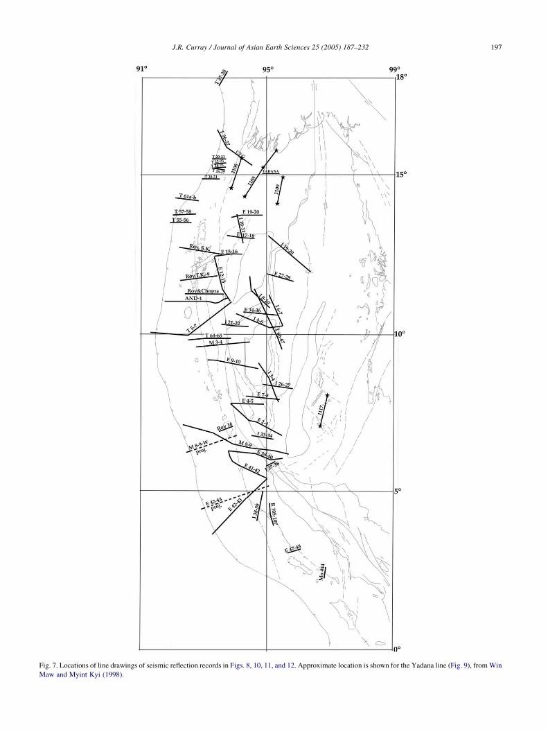
Fig. 7. Locations of line drawings of seismic reflection records in Figs. 8, 10, 11, and 12. Approximate location is shown for the Yadana line (Fig. 9), from Win
Maw and Myint Kyi (1998).
J.R. Curray / Journal of Asian Earth Sciences 25 (2005) 187–232 197

Fig. 8. (a–d) Line drawings of seismic reflection records of the Andaman–Nicobar Ridge and the Bay of Bengal continental slope. The base of the slope is
within the Sunda Trench from T 30–31 southward. North of this point, about 158N, the trench is filled with sediments of the Bengal Fan and from Myanmar. See
Fig. 7 for locations. Sections M 8–9W and E 42–43 are compressed as if projected to lines normal to the structural trends, shown in Fig. 7 as dashed lines, to
illustrate changes in width of the outer arc ridge.
J.R. Curray / Journal of Asian Earth Sciences 25 (2005) 187–232198
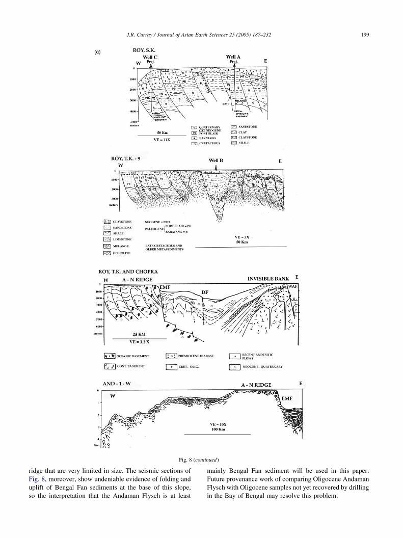
Fig. 8 (continued)
J.R. Curray / Journal of Asian Earth Sciences 25 (2005) 187–232 199
ridge that are very limited in size. The seismic sections of
Fig. 8, moreover, show undeniable evidence of folding and
uplift of Bengal Fan sediments at the base of this slope,
so the interpretation that the Andaman Flysch is at least
mainly Bengal Fan sediment will be used in this paper.
Future provenance work of comparing Oligocene Andaman
Flysch with Oligocene samples not yet recovered by drilling
in the Bay of Bengal may resolve this problem.

Fig. 8 (continued)
J.R. Curray / Journal of Asian Earth Sciences 25 (2005) 187–232200
The Archipelago Series was interpreted as shallow
marine, with water depths from 0 to 25 m by Roy (1983),
and as deep water to neritic or outer neritic by Srinivasan
(1986). In Table 1, the environmental interpretations of
Srinivasan (1986) are shown first, followed by the
alternative option. I conclude that the major part of the
sedimentary rock is probably the facies as interpreted by
Srinivasan, but suggest that shallow facies are also present,
J.R. Curray / Journal of Asian Earth Sciences 25 (2005) 187–232 201
considering the sampling problems discussed previously
and the complexities of simultaneous deposition of
sediments both on top of a accretionary prism and farther
on down the slope and in slope basins.
The outer arc ridge is characterized by a strong negative
free air gravity anomaly (Fig. 5), indicating an excess of
relatively low-density sediment in the accretionary com-
plex. Invisible Bank (w118N, 938E), part of the forearc
basin, on the other hand, is a rather high positive anomaly
(Fig. 5) because, as has been shown by Roy and Chopra
(1987) (Fig. 8c), it is underlain by uplifted volcanics and/or
intrusives. This may also explain the high positive anomaly
at about 88N, 938E, east of Camorta Island (Fig. 4).
The first motion solutions for earthquakes on the upper
Southeast Asia or Burma Plate within the Andaman–
Nicobar Ridge (Fig. 6) are generally easily explained.
Some, for example, suggest normal or reverse faults with a
strike of about SE–ESE, as one might expect in this
environment. A few suggest right-lateral strike-slip faulting
approximately parallel to the arc and parallel to the similar
solutions along the trend of the West Andaman Fault which
lies within the central part of the Andaman Sea. Some of
these may indicate continued strike-slip activity along the
Eastern Margin or Diligent Faults, the boundary between
the outer arc ridge and the central basin. A few others show
‘nodal planes oriented NNW–SSE characterizing the
deformation in the forearc region. The depths of these
events suggest that they were located within the upper
plate.and suggests that the sedimentary forearc is being
deformed by the convergence [between the Indian and
Southeast Asian plates]’ (Guzman-Speziale and Ni, 1996,
p. 72). Normal faulting is occurring in the Central Andaman
Basin and in the area of short spreading axes at about 148N;
and right-lateral strike-slip faulting is occurring along the
transform segments east of Alcock Rise.
What is the nature of the crust underlying the outer arc
ridge? Kieckhefer et al. (1981) concluded that the outer arc
ridge off Sumatra is probably underlain by melange,
including ultramafic rocks, or by continental crust. In
Myanmar, in contrast, Mitchell (1989), Acharyya (1994,
1998) and Hutchison (1989) all conclude that the Indobur-
man Ranges are underlain by continental crust.
I have one reversed seismic refraction line over the
Andaman–Nicobar Ridge, Line 1106, offshore from the
Indoburman Ranges (Figs. 3, 7 and 9a). The section for Line
1106 had records from six buoy receivers. The thin water
layer is ignored in these sections. A thick sedimentary rock
section showed a range of velocities between about 2.8 and
3.3 km/s, but most of the solutions were not very good
because of rather steep southerly dips, as shown in the
reflection records. Some of this sedimentary section may be
deltaic sediment from Ayeyarwady (Irrawaddy) River and
other rivers, and some may be melange of uplifted
sedimentary rocks. The variation in velocities in this thick
layer shows somewhat more of the higher velocities of
3.5 km/s in the north, with the section of lower velocity
2.8 km/s thickening toward the continental slope to the
south. The basement velocities of 6.3–6.9 km/s are
suggestive of oceanic crust.
4. The central basin
This is the part of the Andaman Sea region where the
action has occurred during the Neogene, where the strike-slip
sliver faulting and transtensional extension have occurred.
The major tectonic parts of this province are the forearc
basin, the magmatic arc and the backarc basin. The forearc
Basin in this discussion includes West Basin, Invisible Bank,
and the other banks farther to the south. The magmatic arc
discussion will be limited to the few known or suspected
volcanic features in the Andaman Sea, the known volcanic
line in Myanmar and the shelf lying in between. The backarc
region will include Alcock and Sewell Rises, East Basin, the
shelf and basins to the north and east and the small basin
between the rises, the Central Andaman Basin (Fig. 4).
4.1. The forearc basin: West Basin, Invisible Bank
and West Sewell Ridge
The dividing line between the outer arc ridge and the
forearc basin is the Diligent Fault (DF) in the central and
northern parts of the area (Fig. 4). It is shown in some of
the sections in Fig. 8c and d, as are the Eastern Margin
Fault (EMF; Roy, 1983) and the West Andaman Fault
(WAF; Curray et al., 1979). The Eastern Margin and
Diligent Faults are apparently normal faults, although
there may both at times in the past and today possibly
have been some dextral strike-slip motion (Fig. 6). No
seismicity north of about 98 can convincingly be
associated with these faults, but at about 78N earthquake
DM 18 (Dasgupta and Mukhopadhyay, 1993) and earth-
quakes 8/4/82 and 20/1/82 (Guzman-Speziale and Ni,
1996) could possibly lie along these faults (Fig. 6). South
of there the right-lateral strike-slip motions are probably
associated with the West Andaman Fault. North of the
Andaman Islands the Diligent Fault is shown questionably
connected with the Kabaw Fault of Myanmar (Hla Maung,
1987) to form the eastern margin of the Indoburman
Ranges. A splay may be the Cocos Fault (Fig. 4 and
sections E 19–20 and I 10–11, Fig. 8a). To the south, the
Diligent Fault can be traced questionably to the Nicobar
Islands (Chatterjee, 1984). Off Northern Sumatra, the back
of the outer arc ridge lies along the trace of the West
Andaman Fault, behind Tuba Ridge, and in line with what
has been called the Mentawei Fault (Diament et al., 1992)
behind the islands off Sumatra. In this paper, the name
West Andaman Fault will be applied to this fault to as far
south as the apparent offset by the Battee Fault at 28N,
following the earlier definition (Curray et al., 1979;
Curray, 1989, 1991). The name Mentawei Fault will be
restricted to southeast of the Battee Fault.
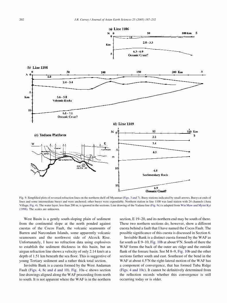
Fig. 9. Simplified plots of reversed refraction lines on the northern shelf off Myanmar (Figs. 3 and 7). Buoy stations indicated by small arrows. Buoys at ends of
lines and some intermediate buoys and were anchored; other buoys were expendable. Northern station in line 1108 was land station with 24 channels (Ama
Village, Fig. 4). The water layer, less than 200 m, is ignored in the sections. Line drawing of the Yadana line (Fig. 9c) is adapted from Win Maw and Myint Kyi
(1998). The scales are unknown.
J.R. Curray / Journal of Asian Earth Sciences 25 (2005) 187–232202
West Basin is a gently south-sloping plain of sediment
from the continental slope at the north ponded against
cuestas of the Cocos Fault, the volcanic seamounts of
Barren and Narcondam Islands, some apparently volcanic
seamounts and the northwest side of Alcock Rise.
Unfortunately, I have no refraction data using explosives
to establish the sediment thickness in this basin, but an
airgun refraction line shows a velocity of only 2.14 km/s at a
depth of 1.51 km beneath the sea floor. This is suggestive of
young Tertiary sediment and a rather thick total section.
Invisible Bank is a cuesta formed by the West Andaman
Fault (Figs. 4, 8c and d and 10). Fig. 10a–c shows section
line drawings aligned along the WAF proceeding from north
to south. It is not apparent where the WAF is in the northern
section, E 19–20, and its northern end may be south of there.
These two northern sections do, however, show a different
cuesta behind a fault that I have named the Cocos Fault. The
possible significance of this cuesta is discussed in Section 6.
Invisible Bank is a distinct cuesta formed by the WAF as
far south as E 9–10, Fig. 10b at about 98N. South of there the
WAF forms the back of the outer arc ridge and the outside
flank of the forearc basin. See M 8–9, Fig. 10b and the other
sections farther south and east. Southeast of the bend in the
WAF at about 4.58N the right-lateral motion of the WAF has
a component of convergence, that has formed Tuba Ridge
(Figs. 4 and 10c). It cannot be definitively determined from
the reflection records whether this convergence is still
occurring today or is older.
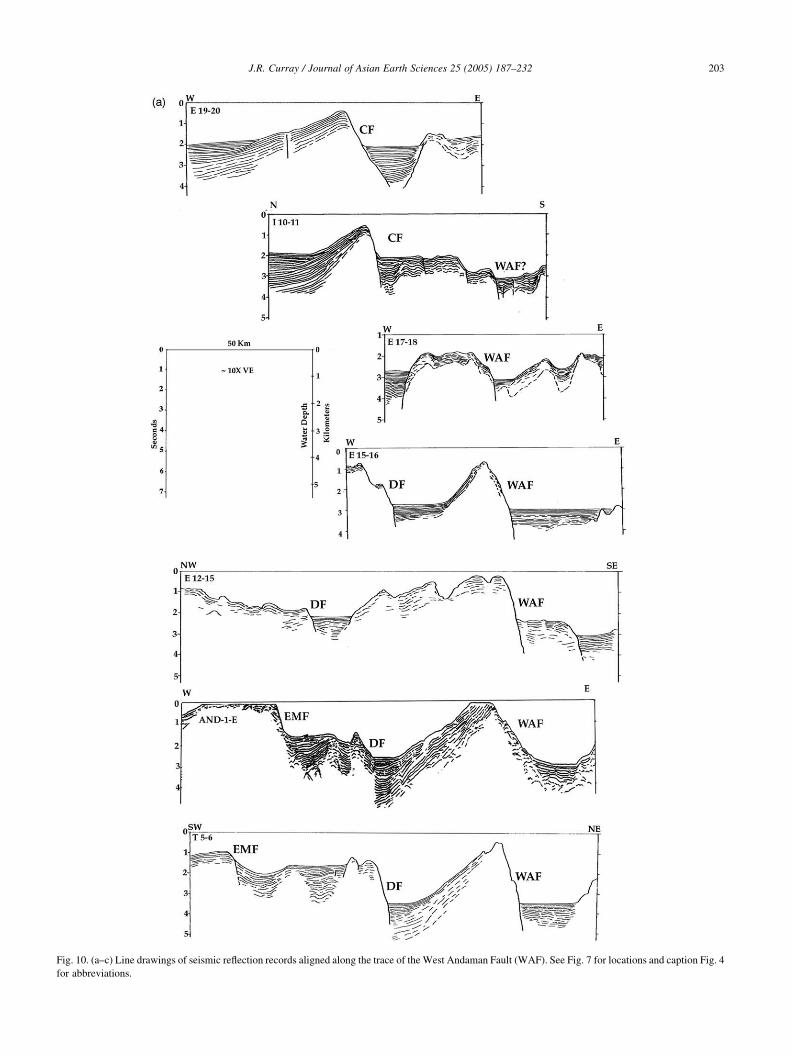
Fig. 10. (a–c) Line drawings of seismic reflection records aligned along the trace of the West Andaman Fault (WAF). See Fig. 7 for locations and caption Fig. 4
for abbreviations.
J.R. Curray / Journal of Asian Earth Sciences 25 (2005) 187–232 203

Fig. 10 (continued)
J.R. Curray / Journal of Asian Earth Sciences 25 (2005) 187–232204
Roy and Chopra (1987) report that drilling near the crest
of Invisible Ridge encountered thick lava flows below
1100 m of middle Miocene sedimentary rocks. Frerichs
(1971) reports that dredge sample 8 (w98N, Fig. 4)
contained radiolarian shale of post-early late Miocene age,
w10 my, which was uplifted about 2000 m since depo-
sition. Dredge sample 12 (w11.58N) was late lower
Miocene calcarenite and calcilutite, w17 my, uplifted
about 400 m since deposition; and dredge sample 13
(w128N) was late upper Miocene, w6 my, uplifted more
than 500 m. These sediments are probably forearc basin
sediments, and the West Andaman Fault probably formed
the cuesta within the past 6 my.
The nature and rocks of the somewhat discontinuous
West Sewell Ridge (WSR, Fig. 4) are not known. The North
Sumatra Ridge (NSR, Fig. 4) is probably underlain by the
continental crust of Sumatra.
4.2. The volcanic arc
The volcanic arc of the Andaman Sea lies between the
active volcanic arc on Java and Sumatra and the extinct or
dormant arc in Myanmar. The last volcanic activity of
Mount Popa, Myanmar, w218N, is believed to have been
sub-Recent (Chhibber, 1934; Bender, 1983; Stephenson and
Marshall, 1984). Chhibber reported local legend of an
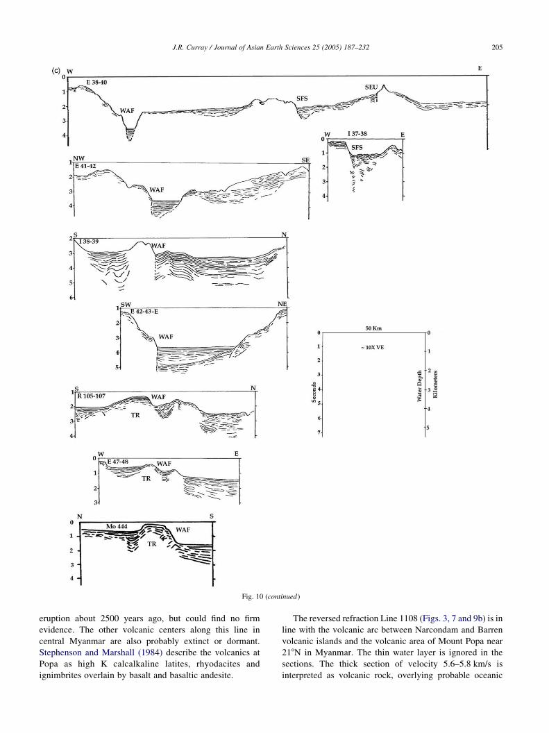
Fig. 10 (continued)
J.R. Curray / Journal of Asian Earth Sciences 25 (2005) 187–232 205
eruption about 2500 years ago, but could find no firm
evidence. The other volcanic centers along this line in
central Myanmar are also probably extinct or dormant.
Stephenson and Marshall (1984) describe the volcanics at
Popa as high K calcalkaline latites, rhyodacites and
ignimbrites overlain by basalt and basaltic andesite.
The reversed refraction Line 1108 (Figs. 3, 7 and 9b) is in
line with the volcanic arc between Narcondam and Barren
volcanic islands and the volcanic area of Mount Popa near
218N in Myanmar. The thin water layer is ignored in the
sections. The thick section of velocity 5.6–5.8 km/s is
interpreted as volcanic rock, overlying probable oceanic
J.R. Curray / Journal of Asian Earth Sciences 25 (2005) 187–232206
crust of 6.1–7.1 km/s. Note that the northern end of the line
lies at Ama Village on the Myanmar coastline.
Two volcanic islands (Bhattacharya et al., 1993) lie in
the northern Andaman Sea (Fig. 4), Barren Island, which is
still active, and Narcondam Island, which may be dormant.
Barren showed some activity as recently as 1994. Andesite,
dacite and basalt have been reported. Other sea floor
features that may be volcanic in origin are shown in Fig. 4.
The next definitely volcanic features are Wey and Brueh
Islands off the north tip of Sumatra, approximately 400 km
farther south, approximately the total amount of opening
suggested for the entire Andaman Sea in Sections 6 and 7.
4.3. Backarc basin: Alcock and Sewell Rises, Central
Andaman Basin and East Basin
The backarc region of the Andaman Sea (Fig. 4), a part of
the central basin of the Andaman Basin, includes Alcock
and Sewell Rises, the Central Andaman Basin between the
two rises, East Basin and some other smaller topographic
features of unknown character. It also includes part of the
present plate edge between the Burma platelet and the
Eurasian or Southeast Asian plate (Figs. 10a–c) and it
includes a segment of what I interpret as an abandoned plate
edge (Fig. 11).
Alcock and Sewell Rises were named Alcock and Sewell
Seamounts by Rodolfo (1969a). They were renamed Alcock
and Sewell Rises in the GEBCO Gazetteer of Undersea
Features Names in November 2003, and will be referred to
by those names in this paper. Neither feature is well
surveyed bathymetrically, and they are shown with some-
what generalized contours in Fig. 2. The margins adjoining
the Central Andaman Basin and spreading axis, Fig. 4, are
however well enough known to suggest their reassembly
(Section 6 of this paper) into a single rise prior to opening of
this small basin. Both rises show a suggestion of northeast–
southwest trending top surface features, approximately
parallel to the trend of the spreading axis in the basin. The
western margins of both rises appear to be faults, which
align with each other in a reassembly.
The northern end of Alcock Rise is uncertain, as indicated
in Fig. 4. Line drawing of a multichannel reflection line is
shown in Fig. 9c, adapted from Win Maw and Myint Kyi
(1998). Unfortunately, neither the scales nor the exact
location were indicated in the original paper, so the location
indicated in Fig. 7 is only approximate. The line does,
however, show a ridge that might represent the northern end
of Alcock Rise, or the connection with the Bago Yoma, as
discussed later in Section 6.3.
Rodolfo (1969a) describes rocks from dredge sample 14in the northern part of Alcock Rise (w138N, Fig. 4) as ‘large
tabular slabs of massive unaltered intergranular augite
basalt’. Unfortunately, the samples from this dredge haul
collected from R/V Pioneer in 1964 are lost, and cannot be
located for further analysis and dating. In 1977, my
colleagues and I sampled rocks in dredge haul 17 from an
escarpment at 900–1250 m from the southern part of Alcock
(w11.58N, Fig. 4). J.W. Hawkins (personal communication,
1982) described the rocks as ‘moderately fractionated
tholeitic basalts’. In 1993, two samples were dated by
K–Ar as 19.8G0.7 and 20.5G1.0 my by Geochron
Laboratories, Cambridge, MA.
Refraction/reflection Line 1109 (Figs. 3, 7 and 9d) lies
north of the axis of thickest sediment accumulation in the
Andaman Sea, and has a sedimentary rock section of
high velocity between 14 and over 16 km thick. The high
velocities are similar to deeply buried high sediment
velocities beneath the Bengal Fan (Curray et al., 2003).
Another possibility is that this section is mixed well-lithified
sediments and volcanics. The basement velocity of 6.9 km/s
is probably oceanic crust. The section could possibly be
even thicker farther to the east in the center of the Gulf of
Mottama (formerly the Gulf of Martaban) (Fig. 4).
East Basin has a section of flat ponded sediment at least
4.6 km thick. I have one especially good refraction line
where the ‘Oc’ symbol is shown at about 9810 0N in Fig. 4.
Basement is definitely oceanic, with a velocity of 6.7 km/s.
The layers beneath the sea floor in this side solution,
weighted least squares fit layer solution are: a sediment
layer of 1.8 km/s, 1.0 km thick; a sediment layer of
3.4 km/s, 3.6 km thick; a layer of probable volcanic rock
of 5.8 km/s and 2.7 km thick; all overlying oceanic base-
ment of 6.7 km/s velocity.
The edge of continental crust is shown in Fig. 4 as
interpreted from all available lines of evidence: gravity,
magnetics, seismic reflection and refraction data and
bathymetry. It is at best an approximation. The lower
continental slope above this line is marked with listric block
faulting down to the west or NW, as suggested in Fig. 11,
Section I 19–20 and Fig. 12, sections I 3–4, I 26–27, E 7–8,
E 2–4 and I 33–34.
The sliver plate between the Sunda subduction zone on the
west and the Sagaing Fault in Myanmar, a plate edge in the
Andaman Sea and the Sumatra Fault System (SFS) on
the east was named the Burma Plate by Curray et al. (1979),
but has been given various other names by later workers. The
present plate edge (Fig. 4) is the Sagaing Fault in Myanmar,
passing into the system of short spreading axes and transform
faults down to the longer spreading axis at about 118N, then
southward on the WAF, SEU and SFS into the SFS which
runs the length of Sumatra to the Sunda Strait.
Locations of major earthquakes in Myanmar were plotted
by Chhibber (1934) along the now-known trend of the
Sagaing Fault. The fault (Fig. 13) was recognized as
separate from the Shan Scarp Fault which forms the edge of
the Shan Plateau by Dey (1968). Win Swe (1972, 1981)
recognized right-lateral offsets at Sagaing, near Mandalay.
Mitchell (1977) referred to this fault as the Hninzee–
Sagaing Fault and attributed in excess of 300 km of offset to
it. Curray et al. (1982) suggested that the total offset might
be as much as 460 km. Ba Than Haq (personal communi-
cation, 1986) observed offset of a Permo-Triassic limestone
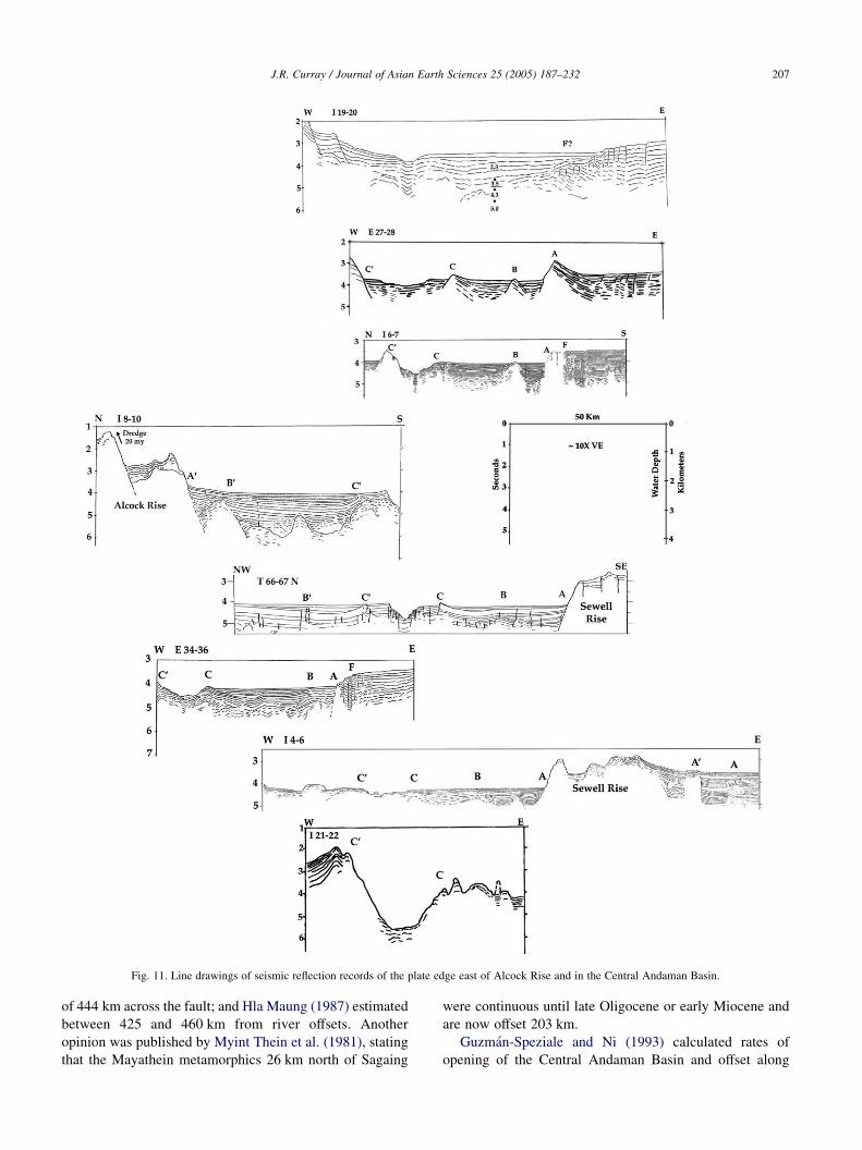
Fig. 11. Line drawings of seismic reflection records of the plate edge east of Alcock Rise and in the Central Andaman Basin.
J.R. Curray / Journal of Asian Earth Sciences 25 (2005) 187–232 207
of 444 km across the fault; and Hla Maung (1987) estimated
between 425 and 460 km from river offsets. Another
opinion was published by Myint Thein et al. (1981), stating
that the Mayathein metamorphics 26 km north of Sagaing
were continuous until late Oligocene or early Miocene and
are now offset 203 km.
Guzman-Speziale and Ni (1993) calculated rates of
opening of the Central Andaman Basin and offset along
Fig. 12. Line drawings of seismic reflection records of the abandoned plate edge spreading axes and short segments of transform fault in the southern Andaman
Sea east of Sewell Rise.
J.R. Curray / Journal of Asian Earth Sciences 25 (2005) 187–232208
the Sagaing Fault from earthquake seismic moments.
Using earthquakes from 1964 to 1986, they obtained
rates of only 0.5 and 5 mm/yr, respectively. Using
earthquakes back to 1908, they obtained a rate of
57 mm/yr for the Sagaing Fault. They suggested that
opening of the Central Andaman Basin might be partly
aseismic. Vigny et al. (2003) conducted field work in
Myanmar and GPS surveys across the Sagaing Fault and
Shan Scarp Fault zones and concluded that the Sagaing
Fault motion today is !20 mm/yr of the total of 35 mm/
yr of the India/Sundaland (Eurasia or Southeast Asia)
strike-slip motion. The remainder of the motion is
accommodated by distribution of deformation over a
wide zone.
The Sagaing Fault appears to splay southward into two or
three faults at about the point of intersection with the Three
Pagodas Fault (TPF) at 178N (Fig. 4). One of these trends
may be the Shan Scarp Fault (SSF).
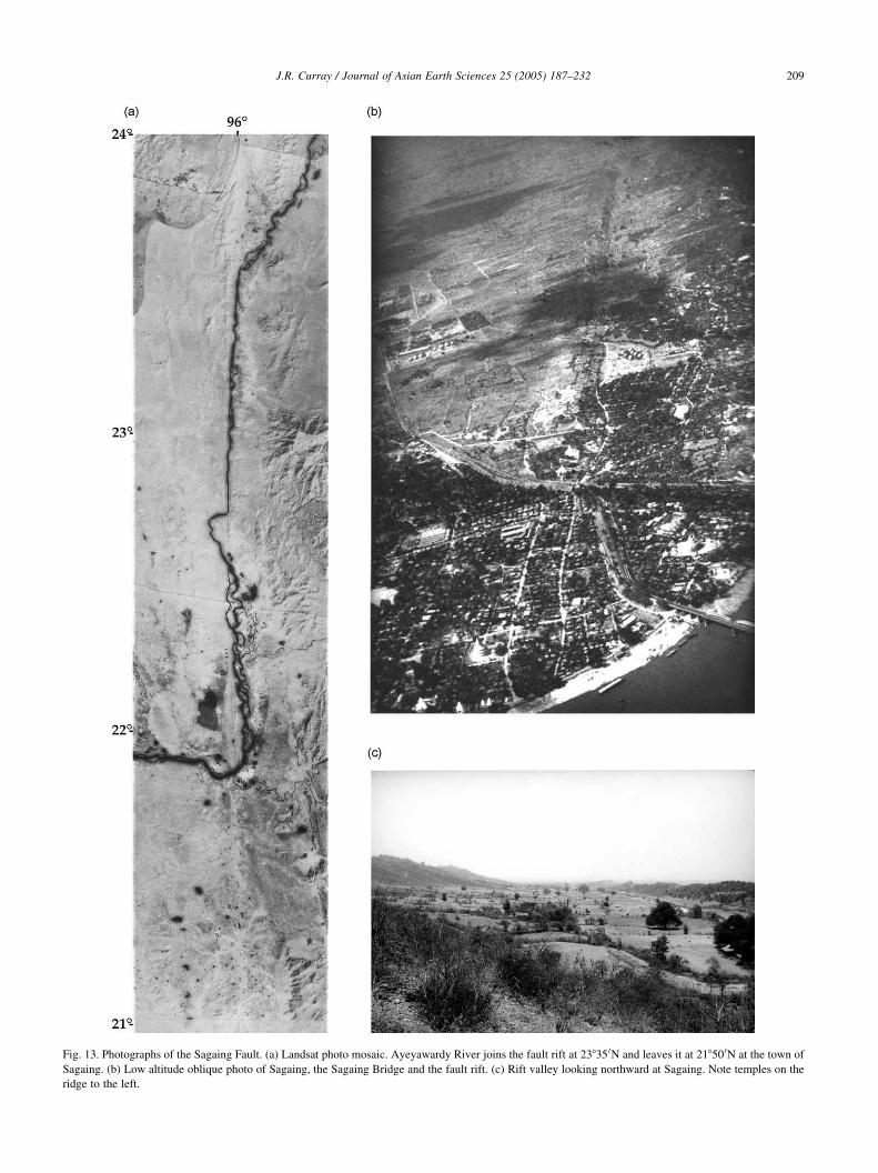
Fig. 13. Photographs of the Sagaing Fault. (a) Landsat photo mosaic. Ayeyawardy River joins the fault rift at 23835 0N and leaves it at 21850 0N at the town of
Sagaing. (b) Low altitude oblique photo of Sagaing, the Sagaing Bridge and the fault rift. (c) Rift valley looking northward at Sagaing. Note temples on the
ridge to the left.
J.R. Curray / Journal of Asian Earth Sciences 25 (2005) 187–232 209
J.R. Curray / Journal of Asian Earth Sciences 25 (2005) 187–232210
A complex extensional fault system is seen in reflection
surveys on the shelf. Fig. 4 shows an overly simplified
pattern of short spreading axes and transform faults running
off the continental slope into the Andaman Sea basin. This is
based on seismicity (Fig. 6) as well as reflection evidence.
The bathymetric and reflection record evidence is very good
off the slope at the northernmost longer segment of
spreading axis at about 138N. Section I 19–20 (Fig. 11)
shows a crossing of this spreading axis. This line shows the
faulted eastern margin of Alcock Rise, it shows the present
spreading axis, and it shows higher sediment velocities
down to at least 2 km below the sea floor.
Section E 27–28 (Fig. 11) shows four upturned margins
of the plate edge: C 0, C, B and A. Edges C and C 0 are
arranged symmetrically outside of the present or youngest
axis, as they are in other sections farther south and west. The
older ridges, A and B are proportionately farther away from
the present rift valley. These edges can be traced and
correlated in the bathymetry and reflection records (Fig. 4)
southward to the major NE–SW trending spreading axis in
the Central Andaman Basin at 10.2–118N (Fig. 11); and
correlations of A and A 0 are interpreted southward along the
abandoned plate edge to as far as 78N (Fig. 12).
These upturned edges were earlier interpreted as time
lines in the opening of the central basin (Curray et al., 1979),
and considered as indicating either episodic spreading or
episodic deposition. We favored the latter explanation and
suggested that a correlation should exist with fluctuations of
sea level. See Section 6.
The plate edge delineated in Fig. 4, where it is a valley
south of the continental slope, slopes continuously to the
south and west to about 10830 0N and 94825 0E, indicating
that during the last period of lowered sea level, turbidity
currents flowed through this rift valley as a turbidity current
channel until the river mouth supply had retreated too far
across the shelf for much sediment to reach the canyon.
Several other probable turbidity current channels are also
indicated in Fig. 4 running down the slope to join this major
channel. Thus, this valley is at the same time a rift valley of
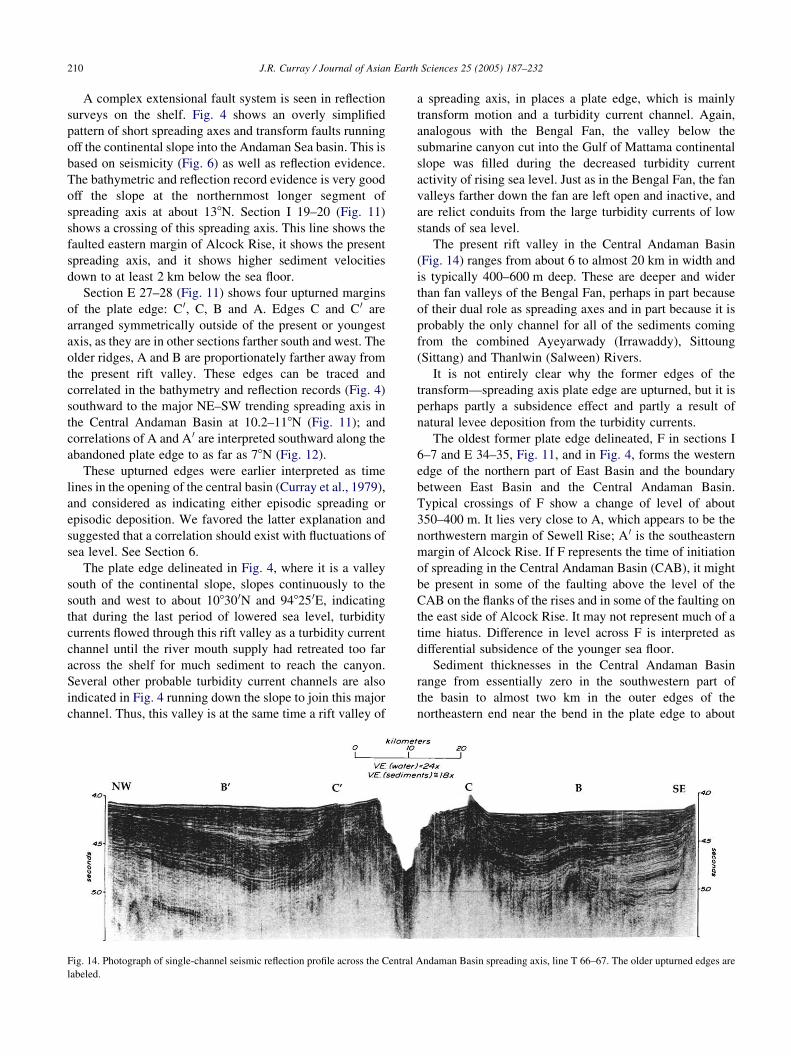
Fig. 14. Photograph of single-channel seismic reflection profile across the Central
labeled.
a spreading axis, in places a plate edge, which is mainly
transform motion and a turbidity current channel. Again,
analogous with the Bengal Fan, the valley below the
submarine canyon cut into the Gulf of Mattama continental
slope was filled during the decreased turbidity current
activity of rising sea level. Just as in the Bengal Fan, the fan
valleys farther down the fan are left open and inactive, and
are relict conduits from the large turbidity currents of low
stands of sea level.
The present rift valley in the Central Andaman Basin
(Fig. 14) ranges from about 6 to almost 20 km in width and
is typically 400–600 m deep. These are deeper and wider
than fan valleys of the Bengal Fan, perhaps in part because
of their dual role as spreading axes and in part because it is
probably the only channel for all of the sediments coming
from the combined Ayeyarwady (Irrawaddy), Sittoung
(Sittang) and Thanlwin (Salween) Rivers.
It is not entirely clear why the former edges of the
transform—spreading axis plate edge are upturned, but it is
perhaps partly a subsidence effect and partly a result of
natural levee deposition from the turbidity currents.
The oldest former plate edge delineated, F in sections I
6–7 and E 34–35, Fig. 11, and in Fig. 4, forms the western
edge of the northern part of East Basin and the boundary
between East Basin and the Central Andaman Basin.
Typical crossings of F show a change of level of about
350–400 m. It lies very close to A, which appears to be the
northwestern margin of Sewell Rise; A 0 is the southeastern
margin of Alcock Rise. If F represents the time of initiation
of spreading in the Central Andaman Basin (CAB), it might
be present in some of the faulting above the level of the
CAB on the flanks of the rises and in some of the faulting on
the east side of Alcock Rise. It may not represent much of a
time hiatus. Difference in level across F is interpreted as
differential subsidence of the younger sea floor.
Sediment thicknesses in the Central Andaman Basin
range from essentially zero in the southwestern part of
the basin to almost two km in the outer edges of the
northeastern end near the bend in the plate edge to about
Andaman Basin spreading axis, line T 66–67. The older upturned edges are
J.R. Curray / Journal of Asian Earth Sciences 25 (2005) 187–232 211
north–south, as based on refraction data using both
explosive and airgun sources and airgun wide-angle
reflection data. Unfortunately, our data are insufficient to
isopach the sediments.
Oceanic magnetic anomalies have been recognized in the
southwestern part of the Central Andaman Basin where the
sediment section is thin. These are discussed in Section 6.
Study of seismic reflection sections and seismicity
suggests that the West Andaman Fault is inactive from its
northern termination to where it intersects with the spreading
axis at about 10.28N (Fig. 4), south of line T 5–7 (Fig. 10a).
From that point of intersection, it is active and constitutes the
sliver plate edge to where the Seulimeum (SEU) Fault and/or
the SFS then form the plate edge in Sumatra. The more active
strand of the SFS in Aceh Province at the northwestern corner
of Sumatra is what Sieh and Natawidjaja (2000) call the
Seulimeum segment, abandoning the former name of Lam
Teuba Baro (Bennett et al., 1981).
A possible abandoned plate edge is shown in Figs. 4 and
12 along the eastern margin of Sewell Rise. The margins of
this spreading axis—transform system are correlated with
plate margins A—A 0 bordering the active plate edge farther
north. This plate edge was presumably abandoned some
millions of years ago, and the rift valley depression is filled.
These are discussed in Section 6 of opening history, as are
possible correlations of the old rift valley margins A–A 0,
B–B 0, C–C 0 with the chronology of sea level fluctuations.
5. Eastern zone of continental crust
Following the Suess (1904) subdivision, the eastern zone
is the continental crust of the Shan Plateau in Myanmar and
the Malay Peninsula and continental margin in the eastern
Andaman Sea. This is basically the SIBUMASU Block of
Metcalfe (1984) and Acharyya (1994). It includes Siam,
Burma, Malaysia and Sumatra, and consists mainly of
Paleozoic and Mesozoic rocks overlying continental crust.
The western margin of the Shan Plateau is generally
interpreted to be an old suture, and is assumed to be along a
fault known as the Shan Scarp Fault (Aung Khin et al.,
1970; Mitchell, 1989) or the Central Burma Suture
(Acharyya, 1998). The origin of the margin in the Andaman
Sea is presumed to be an extensional margin formed by
opening of the Andaman Sea along a back arc fault line, as
outlined in Section 6 of this paper. Several of our reflection
lines suggest down-to-basin listric faulting beneath this
continental slope, as mentioned previously. Faulting on the
shelf is also important in some of the areas of commercial
wells drilled on this continental shelf, such as the Yetagun
Field at about 138N, 978E and also in some of the seismic
lines illustrated by Win Maw and Myint Kyi (1998).
The Mergui Basin (Fig. 4) is an offshore extension of the
North Sumatra Basin. It is a backarc basin formed by rifting,
transtension and thinning of continental crust, starting in
Early Oligocene. The very simplified rifting structure is
shown in Fig. 4. It is discussed and illustrated in much more
detail in papers by Harding (1985), Polachan and Racey
(1994) and Andreason et al. (1997). The basic simplified
structure is a sag basin formed by graben and half-graben
extensional faulting. The structural components (Fig. 4) are
the Mergui Ridge, the West Mergui sub-basin, the Central
Horst, the East Mergui sub-basin, the Ranong Ridge and the
Ranong Trough. Extension was in an E–W to ESE–WNW
direction, but dextral sliver faulting turns this extension
direction to NW–SE, as explained in Section 7.
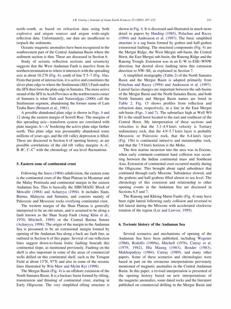
A simplified stratigraphy (Table 2) of the North Sumatra
Basin and the Mergui Basin is adapted primarily from
Polachan and Racey (1994) and Andreason et al. (1997).
Lateral facies changes are important between the sub-basins
of the Mergui Basin and the North Sumatra Basin, and both
North Sumatra and Mergui Basin names are listed in
Table 2. Fig. 15 shows profiles from reflection and
refraction data, respectively, in a line in the East Mergui
sub-basin (Figs. 3 and 7). The subsurface high at Well W9
B1 is the small horst located to the east and southeast of the
Central Horst. My interpretation of these sections and
velocities is that the 3.1–4.9 km/s velocity is Tertiary
sedimentary rock, that the 4.9–5.7 km/s layer is probably
Mesozoic or Paleozoic rock, that the 6.4 km/s layer
(Fig. 15b) is continental intrusive and metamorphic rock,
and that the 7.9 km/s horizon is the Moho.
The first marine incursion into the area was in Eocene,
when early continent–continent hard collision was occur-
ring between the Indian continental mass and Southeast
Asia. Extension of continental crust occurred mainly during
the Oligocene. This brought about rapid subsidence that
continued through early Miocene. Subsidence slowed, and
the grabens and half-grabens filled almost to sea level. The
chronology of this extension and relationship to other
opening events in the Andaman Sea are discussed in
Sections 6.5 and 7.
The Ranong and Khlong Marui Faults (Fig. 4) may have
been right lateral following early collision and reversed to
left lateral during the Miocene with accelerated clockwise
rotation of the region (Lee and Lawver, 1995).
6. Tectonic history of the Andaman Sea
Several scenarios and mechanisms of opening of the
Andaman Sea have been published, including Wegener
(1966), Rodolfo (1969a), Mitchell (1976), Curray et al.
(1979, 1982), Hla Maung (1983), Bender (1983),
Mukhopadyay (1984), Curray (1989), and many other
papers. Some of these scenarios and chronologies were
based in part on the erroneous interpretations previously
mentioned of magnetic anomalies in the Central Andaman
Basin. In this paper, a revised interpretation is presented of
the opening history based on new interpretations of
the magnetic anomalies, some dated rocks and the literature
published on commercial drilling in the Mergui Basin and
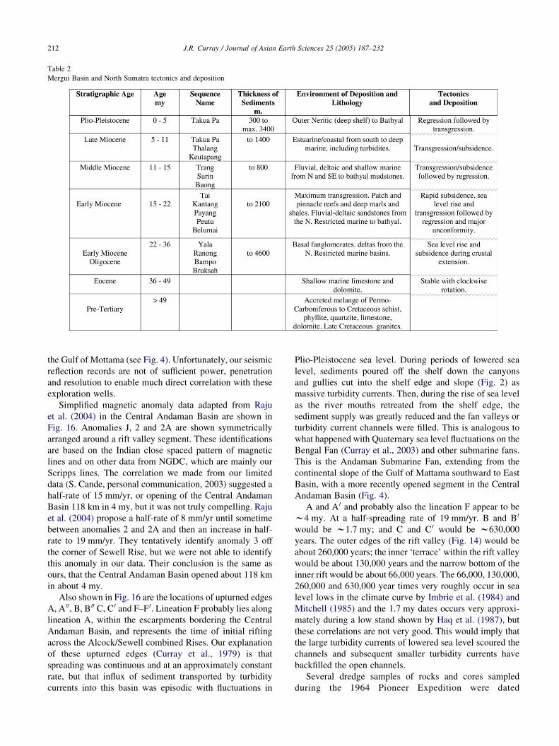
Table 2
Mergui Basin and North Sumatra tectonics and deposition
J.R. Curray / Journal of Asian Earth Sciences 25 (2005) 187–232212
the Gulf of Mottama (see Fig. 4). Unfortunately, our seismic
reflection records are not of sufficient power, penetration
and resolution to enable much direct correlation with these
exploration wells.
Simplified magnetic anomaly data adapted from Raju
et al. (2004) in the Central Andaman Basin are shown in
Fig. 16. Anomalies J, 2 and 2A are shown symmetrically
arranged around a rift valley segment. These identifications
are based on the Indian close spaced pattern of magnetic
lines and on other data from NGDC, which are mainly our
Scripps lines. The correlation we made from our limited
data (S. Cande, personal communication, 2003) suggested a
half-rate of 15 mm/yr, or opening of the Central Andaman
Basin 118 km in 4 my, but it was not truly compelling. Raju
et al. (2004) propose a half-rate of 8 mm/yr until sometime
between anomalies 2 and 2A and then an increase in half-
rate to 19 mm/yr. They tentatively identify anomaly 3 off
the corner of Sewell Rise, but we were not able to identify
this anomaly in our data. Their conclusion is the same as
ours, that the Central Andaman Basin opened about 118 km
in about 4 my.
Also shown in Fig. 16 are the locations of upturned edges
A, A 00, B, B 00 C, C 0 and F–F 0. Lineation F probably lies along
lineation A, within the escarpments bordering the Central
Andaman Basin, and represents the time of initial rifting
across the Alcock/Sewell combined Rises. Our explanation
of these upturned edges (Curray et al., 1979) is that
spreading was continuous and at an approximately constant
rate, but that influx of sediment transported by turbidity
currents into this basin was episodic with fluctuations in
Plio-Pleistocene sea level. During periods of lowered sea
level, sediments poured off the shelf down the canyons
and gullies cut into the shelf edge and slope (Fig. 2) as
massive turbidity currents. Then, during the rise of sea level
as the river mouths retreated from the shelf edge, the
sediment supply was greatly reduced and the fan valleys or
turbidity current channels were filled. This is analogous to
what happened with Quaternary sea level fluctuations on the
Bengal Fan (Curray et al., 2003) and other submarine fans.
This is the Andaman Submarine Fan, extending from the
continental slope of the Gulf of Mattama southward to East
Basin, with a more recently opened segment in the Central
Andaman Basin (Fig. 4).
A and A 0 and probably also the lineation F appear to be
w4 my. At a half-spreading rate of 19 mm/yr. B and B 0
would be w1.7 my; and C and C 0 would be w630,000
years. The outer edges of the rift valley (Fig. 14) would be
about 260,000 years; the inner ‘terrace’ within the rift valley
would be about 130,000 years and the narrow bottom of the
inner rift would be about 66,000 years. The 66,000, 130,000,
260,000 and 630,000 year times very roughly occur in sea
level lows in the climate curve by Imbrie et al. (1984) and
Mitchell (1985) and the 1.7 my dates occurs very approxi-
mately during a low stand shown by Haq et al. (1987), but
these correlations are not very good. This would imply that
the large turbidity currents of lowered sea level scoured the
channels and subsequent smaller turbidity currents have
backfilled the open channels.
Several dredge samples of rocks and cores sampled
during the 1964 Pioneer Expedition were dated
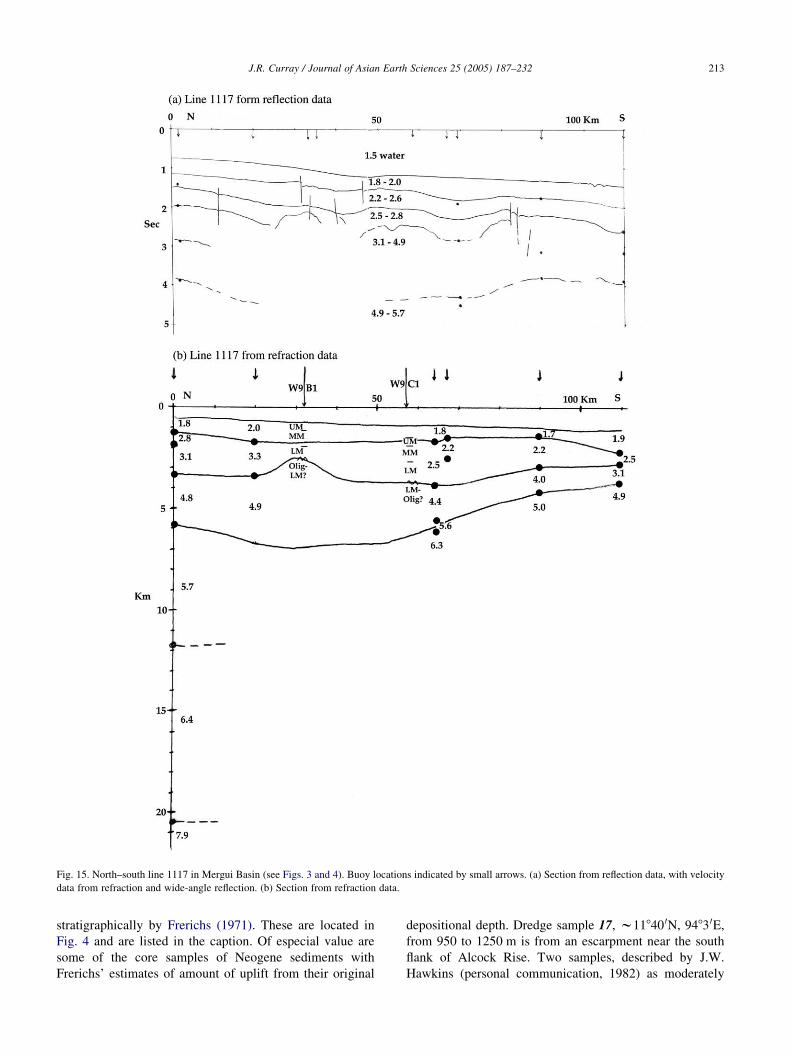
Fig. 15. North–south line 1117 in Mergui Basin (see Figs. 3 and 4). Buoy locations indicated by small arrows. (a) Section from reflection data, with velocity
data from refraction and wide-angle reflection. (b) Section from refraction data.
J.R. Curray / Journal of Asian Earth Sciences 25 (2005) 187–232 213
stratigraphically by Frerichs (1971). These are located in
Fig. 4 and are listed in the caption. Of especial value are
some of the core samples of Neogene sediments with
Frerichs’ estimates of amount of uplift from their original
depositional depth. Dredge sample 17, w11840 0N, 9483 0E,
from 950 to 1250 m is from an escarpment near the south
flank of Alcock Rise. Two samples, described by J.W.
Hawkins (personal communication, 1982) as moderately
Fig. 16. Mergui Basin magnetic anomalies, simplified from Raju et al.
(2004). Anomalies J, 2 and 2A are labeled. Rift margins B 0, C 0, C and B are
shown, as are Alcock and Sewell Rises, Invisible Cuesta and the West
Andaman Fault. Double lines indicate the three segments of spreading rift
identified by Raju et al. (2004).
J.R. Curray / Journal of Asian Earth Sciences 25 (2005) 187–232214
fractionated tholeitic basalts, dated by at 19.8G0.7 and
20.5G1.0 my.
Not all of the tectonic elements shown in Fig. 4 are active
today, and an effort was made to distinguish between active
and inactive elements. The elements judged to be active
today are shown separately in Fig. 17. They include the two
strands of the SFS, the main strand coming out of northwest
Sumatra and the more active Seulimeum Fault (SEU)
(Bennett et al., 1981; Sieh and Natawidjaja, 2000), the WAF
from its intersection with the SFS to the western end of the
Central Andaman Basin, the spreading axis in the Central
Andaman Basin and the complex spreading axis-transform
system extending northward from the eastern end of the
Central Andaman Basin to where the Sagaing Fault comes
offshore from Myanmar. The Eastern Margin and Diligent
Faults (Fig. 4) are probably inactive, but this cannot be
determined for sure.
As shown by the magnetic anomalies, the present full
rate of spreading in the Central Andaman Basin (Raju et al.,
2004) is about 38 mm/yr. This rate compares with the
estimate of about 25 mm/yr for the SFS and SEU in
northwestern Sumatra (Sieh and Natawidjaja, 2000; Genrich
et al., 2000; Prawwirodirdjo et al., 2000). Sieh and
Natawidjaja (2000) suggest that only the SEU at the
northwest tip of Sumatra has been active for the last
100,000 years. The consensus of opinion of these workers in
Sumatra is that the rate decreases to 10–20 mm/yr toward
the southeast by either stretching of the sliver on the
southwest side of the fault or by take-up of motion by other
faults. These estimates of slip rate also compare with
estimates for the Sagaing Fault. As mentioned previously,
Vigny et al. (2003) have shown that less than 20 mm/yr of
the total plate motion of 35 mm/yr occurs along the Sagaing
Fault. They suggest that the remainder is accommodated by
distribution of deformation over a wide zone. A wide zone
of deformation must also exist along the SFS. These rates
will be further compared in Sections 6.1 and 7.
The subduction zone of the Sunda Trench is active.
Reflection records from the slope above the filled trench in
Fig. 8a and b, sections T 24–25 and southward, show
deformation of young sediments of the Bengal Fan low on
the slope. North of T 24–25 the slope is depositional,
probably from the large input of sediment from the
Myanmar rivers and coastline, but a component of
convergence probably still exists all the way up the
Myanmar part of the arc, although this is controversial
(see, for example, Satabala (1998) and Guzman-Speziale
and Ni (2000)).
Vectors are shown at several points along the trench axis
(Fig. 17). The rate of convergence between the Indian and
Eurasian (or Southeast Asian) plates is in dispute today.
Estimates from GPS observations (Holt et al., 2000) differ
from the earlier IN-EU-NUVEL-1A of DeMets et al.
(1994). The vectors in Fig. 17 are therefore only
approximate, and are shown only to illustrate that
convergence appears to occur all along this segment of the
trench because of the spreading in the Andaman Sea.
Vectors AE represent the Australian plate with respect to the
Eurasian or Southeast Asian plate; vectors AB represent
Australia with respect to the Burma sliver plate; vectors AT
represent the component of convergence normal to the trend
of the trench, and vectors BE represent Burma with respect
to Eurasia. Vectors are shown for the spreading across the
Central Andaman Basin.
The vectors at 28N are adapted from McCaffrey et al.
(2000) who calculated vector AB as the slip vector from
earthquakes. They found that vector BE is about 1/3 less
than the total trench-parallel vector and interpreted this to
mean that the additional strike-slip motion occurs between
the SFS and the trench. This is analogous to Vigny et al.
(2003) conclusion that some of the total plate motion occurs
in a wide zone between the Sagaing Fault and the plate edge.
This implies that there are many unmapped faults active
within the Andaman and Nicobar accretionary complex.
I do not have access to slip vectors for the 7.5 and 15.58N
locations, so some assumptions have been made in
attempting to show AB and BE. The rationalization behind
these assumptions will be explained in Section 6.1, and at
that time we will return to consideration of Fig. 17.
Opening of the Andaman Sea has occurred during the
convergence of India and Asia since Paleogene time. The
history of convergence and collision have been thoroughly
discussed in the literature. This discussion will follow the
chronology by Lee and Lawver (1995); an adaptation of
their convergence curves is shown in Fig. 18. Some events
in the Andaman Sea history appear to correlate with events
in these convergence curves, while others do not. The stages
of the opening of the Andaman Sea to be discussed below
are summarized in Table 3.
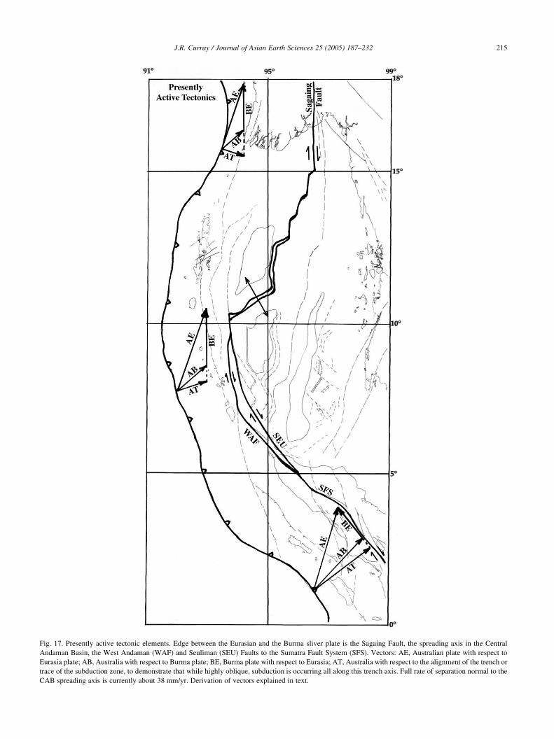
Fig. 17. Presently active tectonic elements. Edge between the Eurasian and the Burma sliver plate is the Sagaing Fault, the spreading axis in the Central
Andaman Basin, the West Andaman (WAF) and Seuliman (SEU) Faults to the Sumatra Fault System (SFS). Vectors: AE, Australian plate with respect to
Eurasia plate; AB, Australia with respect to Burma plate; BE, Burma plate with respect to Eurasia; AT, Australia with respect to the alignment of the trench or
trace of the subduction zone, to demonstrate that while highly oblique, subduction is occurring all along this trench axis. Full rate of separation normal to the
CAB spreading axis is currently about 38 mm/yr. Derivation of vectors explained in text.
J.R. Curray / Journal of Asian Earth Sciences 25 (2005) 187–232 215
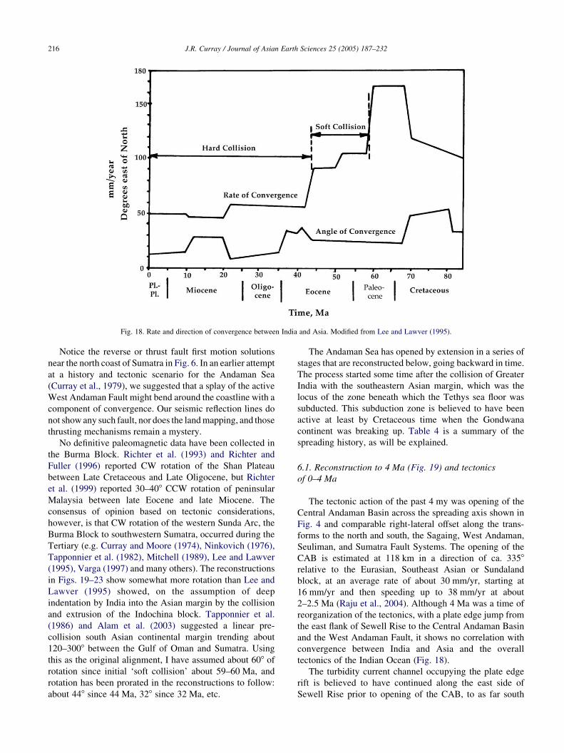
Fig. 18. Rate and direction of convergence between India and Asia. Modified from Lee and Lawver (1995).
J.R. Curray / Journal of Asian Earth Sciences 25 (2005) 187–232216
Notice the reverse or thrust fault first motion solutions
near the north coast of Sumatra in Fig. 6. In an earlier attempt
at a history and tectonic scenario for the Andaman Sea
(Curray et al., 1979), we suggested that a splay of the active
West Andaman Fault might bend around the coastline with a
component of convergence. Our seismic reflection lines do
not show any such fault, nor does the land mapping, and those
thrusting mechanisms remain a mystery.
No definitive paleomagnetic data have been collected in
the Burma Block. Richter et al. (1993) and Richter and
Fuller (1996) reported CW rotation of the Shan Plateau
between Late Cretaceous and Late Oligocene, but Richter
et al. (1999) reported 30–408 CCW rotation of peninsular
Malaysia between late Eocene and late Miocene. The
consensus of opinion based on tectonic considerations,
however, is that CW rotation of the western Sunda Arc, the
Burma Block to southwestern Sumatra, occurred during the
Tertiary (e.g. Curray and Moore (1974), Ninkovich (1976),
Tapponnier et al. (1982), Mitchell (1989), Lee and Lawver
(1995), Varga (1997) and many others). The reconstructions
in Figs. 19–23 show somewhat more rotation than Lee and
Lawver (1995) showed, on the assumption of deep
indentation by India into the Asian margin by the collision
and extrusion of the Indochina block. Tapponnier et al.
(1986) and Alam et al. (2003) suggested a linear pre-
collision south Asian continental margin trending about
120–3008 between the Gulf of Oman and Sumatra. Using
this as the original alignment, I have assumed about 608 of
rotation since initial ‘soft collision’ about 59–60 Ma, and
rotation has been prorated in the reconstructions to follow:
about 448 since 44 Ma, 328 since 32 Ma, etc.
The Andaman Sea has opened by extension in a series of
stages that are reconstructed below, going backward in time.
The process started some time after the collision of Greater
India with the southeastern Asian margin, which was the
locus of the zone beneath which the Tethys sea floor was
subducted. This subduction zone is believed to have been
active at least by Cretaceous time when the Gondwana
continent was breaking up. Table 4 is a summary of the
spreading history, as will be explained.
6.1. Reconstruction to 4 Ma (Fig. 19) and tectonics
of 0–4 Ma
The tectonic action of the past 4 my was opening of the
Central Andaman Basin across the spreading axis shown in
Fig. 4 and comparable right-lateral offset along the trans-
forms to the north and south, the Sagaing, West Andaman,
Seuliman, and Sumatra Fault Systems. The opening of the
CAB is estimated at 118 km in a direction of ca. 3358
relative to the Eurasian, Southeast Asian or Sundaland
block, at an average rate of about 30 mm/yr, starting at
16 mm/yr and then speeding up to 38 mm/yr at about
2–2.5 Ma (Raju et al., 2004). Although 4 Ma was a time of
reorganization of the tectonics, with a plate edge jump from
the east flank of Sewell Rise to the Central Andaman Basin
and the West Andaman Fault, it shows no correlation with
convergence between India and Asia and the overall
tectonics of the Indian Ocean (Fig. 18).
The turbidity current channel occupying the plate edge
rift is believed to have continued along the east side of
Sewell Rise prior to opening of the CAB, to as far south

Table 3
Andaman Sea spreading history
a Directions relative to present north.
J.R.
Cu
rray
/Jo
urn
al
of
Asia
nE
arth
Scien
ces2
5(2
00
5)
18
7–
23
22
17
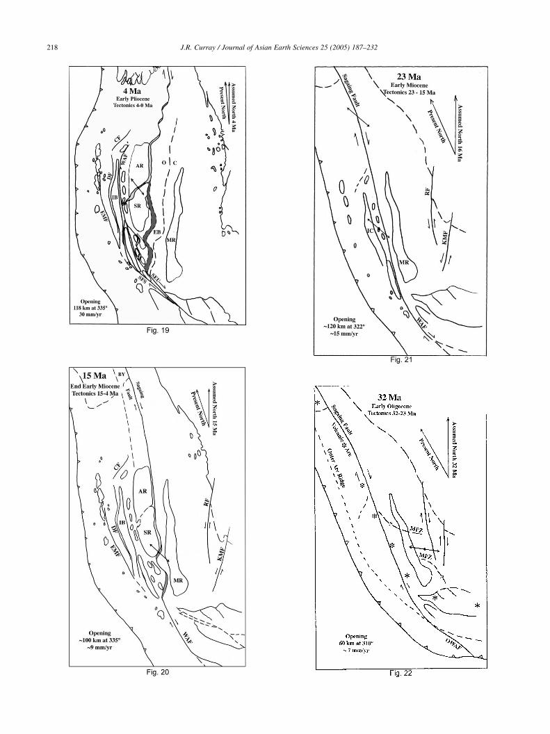
J.R. Curray / Journal of Asian Earth Sciences 25 (2005) 187–232218
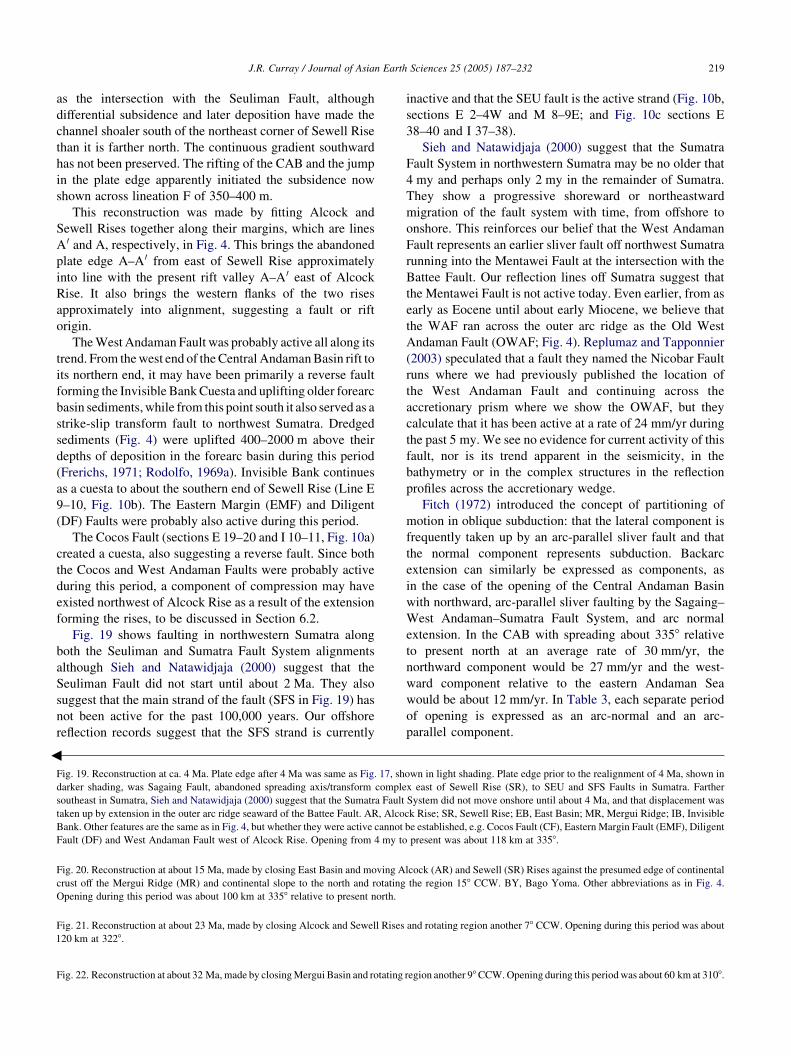
3
J.R. Curray / Journal of Asian Earth Sciences 25 (2005) 187–232 219
as the intersection with the Seuliman Fault, although
differential subsidence and later deposition have made the
channel shoaler south of the northeast corner of Sewell Rise
than it is farther north. The continuous gradient southward
has not been preserved. The rifting of the CAB and the jump
in the plate edge apparently initiated the subsidence now
shown across lineation F of 350–400 m.
This reconstruction was made by fitting Alcock and
Sewell Rises together along their margins, which are lines
A 0 and A, respectively, in Fig. 4. This brings the abandoned
plate edge A–A 0 from east of Sewell Rise approximately
into line with the present rift valley A–A 0 east of Alcock
Rise. It also brings the western flanks of the two rises
approximately into alignment, suggesting a fault or rift
origin.
The West Andaman Fault was probably active all along its
trend. From the west end of the Central Andaman Basin rift to
its northern end, it may have been primarily a reverse fault
forming the Invisible Bank Cuesta and uplifting older forearc
basin sediments, while from this point south it also served as a
strike-slip transform fault to northwest Sumatra. Dredged
sediments (Fig. 4) were uplifted 400–2000 m above their
depths of deposition in the forearc basin during this period
(Frerichs, 1971; Rodolfo, 1969a). Invisible Bank continues
as a cuesta to about the southern end of Sewell Rise (Line E
9–10, Fig. 10b). The Eastern Margin (EMF) and Diligent
(DF) Faults were probably also active during this period.
The Cocos Fault (sections E 19–20 and I 10–11, Fig. 10a)
created a cuesta, also suggesting a reverse fault. Since both
the Cocos and West Andaman Faults were probably active
during this period, a component of compression may have
existed northwest of Alcock Rise as a result of the extension
forming the rises, to be discussed in Section 6.2.
Fig. 19 shows faulting in northwestern Sumatra along
both the Seuliman and Sumatra Fault System alignments
although Sieh and Natawidjaja (2000) suggest that the
Seuliman Fault did not start until about 2 Ma. They also
suggest that the main strand of the fault (SFS in Fig. 19) has
not been active for the past 100,000 years. Our offshore
reflection records suggest that the SFS strand is currently
Fig. 19. Reconstruction at ca. 4 Ma. Plate edge after 4 Ma was same as Fig. 17, sh
darker shading, was Sagaing Fault, abandoned spreading axis/transform comple
southeast in Sumatra, Sieh and Natawidjaja (2000) suggest that the Sumatra Fault
taken up by extension in the outer arc ridge seaward of the Battee Fault. AR, Alco
Bank. Other features are the same as in Fig. 4, but whether they were active cannot
Fault (DF) and West Andaman Fault west of Alcock Rise. Opening from 4 my to
Fig. 20. Reconstruction at about 15 Ma, made by closing East Basin and moving A
crust off the Mergui Ridge (MR) and continental slope to the north and rotating
Opening during this period was about 100 km at 3358 relative to present north.
Fig. 22. Reconstruction at about 32 Ma, made by closing Mergui Basin and rotating
Fig. 21. Reconstruction at about 23 Ma, made by closing Alcock and Sewell Rises
120 km at 3228.
inactive and that the SEU fault is the active strand (Fig. 10b,
sections E 2–4W and M 8–9E; and Fig. 10c sections E
38–40 and I 37–38).
Sieh and Natawidjaja (2000) suggest that the Sumatra
Fault System in northwestern Sumatra may be no older that
4 my and perhaps only 2 my in the remainder of Sumatra.
They show a progressive shoreward or northeastward
migration of the fault system with time, from offshore to
onshore. This reinforces our belief that the West Andaman
Fault represents an earlier sliver fault off northwest Sumatra
running into the Mentawei Fault at the intersection with the
Battee Fault. Our reflection lines off Sumatra suggest that
the Mentawei Fault is not active today. Even earlier, from as
early as Eocene until about early Miocene, we believe that
the WAF ran across the outer arc ridge as the Old West
Andaman Fault (OWAF; Fig. 4). Replumaz and Tapponnier
(2003) speculated that a fault they named the Nicobar Fault
runs where we had previously published the location of
the West Andaman Fault and continuing across the
accretionary prism where we show the OWAF, but they
calculate that it has been active at a rate of 24 mm/yr during
the past 5 my. We see no evidence for current activity of this
fault, nor is its trend apparent in the seismicity, in the
bathymetry or in the complex structures in the reflection
profiles across the accretionary wedge.
Fitch (1972) introduced the concept of partitioning of
motion in oblique subduction: that the lateral component is
frequently taken up by an arc-parallel sliver fault and that
the normal component represents subduction. Backarc
extension can similarly be expressed as components, as
in the case of the opening of the Central Andaman Basin
with northward, arc-parallel sliver faulting by the Sagaing–
West Andaman–Sumatra Fault System, and arc normal
extension. In the CAB with spreading about 3358 relative
to present north at an average rate of 30 mm/yr, the
northward component would be 27 mm/yr and the west-
ward component relative to the eastern Andaman Sea
would be about 12 mm/yr. In Table 3, each separate period
of opening is expressed as an arc-normal and an arc-
parallel component.
own in light shading. Plate edge prior to the realignment of 4 Ma, shown in
x east of Sewell Rise (SR), to SEU and SFS Faults in Sumatra. Farther
System did not move onshore until about 4 Ma, and that displacement was
ck Rise; SR, Sewell Rise; EB, East Basin; MR, Mergui Ridge; IB, Invisible
be established, e.g. Cocos Fault (CF), Eastern Margin Fault (EMF), Diligent
present was about 118 km at 3358.
lcock (AR) and Sewell (SR) Rises against the presumed edge of continental
the region 158 CCW. BY, Bago Yoma. Other abbreviations as in Fig. 4.
region another 98CCW. Opening during this period was about 60 km at 3108.
and rotating region another 78 CCW. Opening during this period was about
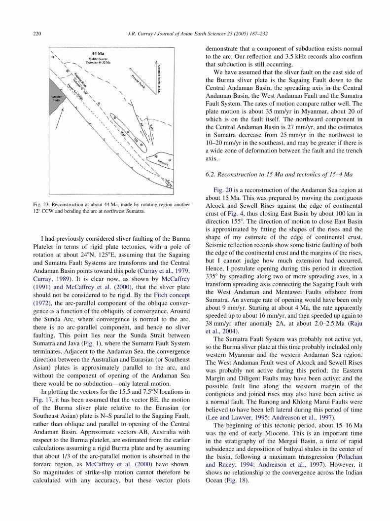
Fig. 23. Reconstruction at about 44 Ma, made by rotating region another
128 CCW and bending the arc at northwest Sumatra.
J.R. Curray / Journal of Asian Earth Sciences 25 (2005) 187–232220
I had previously considered sliver faulting of the Burma
Platelet in terms of rigid plate tectonics, with a pole of
rotation at about 248N, 1258E, assuming that the Sagaing
and Sumatra Fault Systems are transforms and the Central
Andaman Basin points toward this pole (Curray et al., 1979;
Curray, 1989). It is clear now, as shown by McCaffrey
(1991) and McCaffrey et al. (2000), that the sliver plate
should not be considered to be rigid. By the Fitch concept
(1972), the arc-parallel component of the oblique conver-
gence is a function of the obliquity of convergence. Around
the Sunda Arc, where convergence is normal to the arc,
there is no arc-parallel component, and hence no sliver
faulting. This point lies near the Sunda Strait between
Sumatra and Java (Fig. 1), where the Sumatra Fault System
terminates. Adjacent to the Andaman Sea, the convergence
direction between the Australian and Eurasian (or Southeast
Asian) plates is approximately parallel to the arc, and
without the component of opening of the Andaman Sea
there would be no subduction—only lateral motion.
In plotting the vectors for the 15.5 and 7.58N locations in
Fig. 17, it has been assumed that the vector BE, the motion
of the Burma sliver plate relative to the Eurasian (or
Southeast Asian) plate is N–S parallel to the Sagaing Fault,
rather than oblique and parallel to opening of the Central
Andaman Basin. Approximate vectors AB, Australia with
respect to the Burma platelet, are estimated from the earlier
calculations assuming a rigid Burma plate and by assuming
that about 1/3 of the arc-parallel motion is absorbed in the
forearc region, as McCaffrey et al. (2000) have shown.
So magnitudes of strike-slip motion cannot therefore be
calculated with any accuracy, but these vector plots
demonstrate that a component of subduction exists normal
to the arc. Our reflection and 3.5 kHz records also confirm
that subduction is still occurring.
We have assumed that the sliver fault on the east side of
the Burma sliver plate is the Sagaing Fault down to the
Central Andaman Basin, the spreading axis in the Central
Andaman Basin, the West Andaman Fault and the Sumatra
Fault System. The rates of motion compare rather well. The
plate motion is about 35 mm/yr in Myanmar, about 20 of
which is on the fault itself. The northward component in
the Central Andaman Basin is 27 mm/yr, and the estimates
in Sumatra decrease from 25 mm/yr in the northwest to
10–20 mm/yr in the southeast, and may be greater if there is
a wide zone of deformation between the fault and the trench
axis.
6.2. Reconstruction to 15 Ma and tectonics of 15–4 Ma
Fig. 20 is a reconstruction of the Andaman Sea region at
about 15 Ma. This was prepared by moving the contiguous
Alcock and Sewell Rises against the edge of continental
crust of Fig. 4, thus closing East Basin by about 100 km in
direction 1558. The direction of motion to close East Basin
is approximated by fitting the shapes of the rises and the
shape of my estimate of the edge of continental crust.
Seismic reflection records show some listric faulting of both
the edge of the continental crust and the margins of the rises,
but I cannot judge how much extension had occurred.
Hence, I postulate opening during this period in direction
3358 by spreading along two or more spreading axes, in a
transform spreading axis connecting the Sagaing Fault with
the West Andaman and Mentawei Faults offshore from
Sumatra. An average rate of opening would have been only
about 9 mm/yr. Starting at about 4 Ma, the rate apparently
speeded up to about 16 mm/yr, and then speeded up again to
38 mm/yr after anomaly 2A, at about 2.0–2.5 Ma (Raju
et al., 2004).
The Sumatra Fault System was probably not active yet,
so the Burma sliver plate at this time probably included only
western Myanmar and the western Andaman Sea region.
The West Andaman Fault west of Alcock and Sewell Rises
was probably not active during this period; the Eastern
Margin and Diligent Faults may have been active; and the
possible fault line along the western margin of the
contiguous and joined rises may also have been active as
a normal fault. The Ranong and Khlong Marui Faults were
believed to have been left lateral during this period of time
(Lee and Lawver, 1995; Andreason et al., 1997).
The beginning of this tectonic period, about 15–16 Ma
was the end of early Miocene. This is an important time
in the stratigraphy of the Mergui Basin, a time of rapid
subsidence and deposition of bathyal shales in the center of
the basin, following a maximum transgression (Polachan
and Racey, 1994; Andreason et al., 1997). However, it
shows no relationship to the convergence across the Indian
Ocean (Fig. 18).

J.R. Curray / Journal of Asian Earth Sciences 25 (2005) 187–232 221
The Bago Yoma (formerly named Pegu Yoma) low
mountains are shown in this figure, and are discussed in
Section 6.3.
6.3. Reconstruction to 23 Ma and tectonics of 23–15 Ma
Fig. 21 is a reconstruction of the region at about 23 Ma. It
was made by removing the contiguous Alcock and Sewell
Rises and displacing the western sliver plate about 120 km
toward 1428, relative to present north. The direction of
motion to close up the space of the rises is judged by the
structural grain of the tops of the rises. Hence, spread-
ing during the formation of these volcanic piles was in
a direction 3228 relative to present north at an average rate
of about 15 mm/yr.
Two rock dredge hauls have yielded information on the
petrology of Alcock Rise. Pioneer dredge 14 at 138N
(Rodolfo, 1969a) is a ‘tabular, massive unaltered inter-
granular augite basalt’. No dating has been done because the
samples are lost. Dredge 17 is a moderately fractionated
tholeitic basalt (J. W. Hawkins, personal communication,
1982). Two dates are 19.8G0.7 and 20.5G1.0 my. Thus,
this part of Alcock Rise was formed about 20 Ma. Hawkins’
analyses furthermore show that it is rather typical backarc
basin basalt. This was the time of the earliest backarc basin
sea floor spreading the Andaman Sea.
The northern limit of Alcock Rise is unknown; our
seismic data are not adequate to resolve this, as is indicated
in Fig. 4. Thus, the question is how far did the extension to
form the rises continue to the north? The suggested solution
shown in Figs. 20 and 21 is that it extended north about as
far as the bulge in the Sunda subduction zone extends, or to
at least 178N, north of the present Myanmar shoreline. This
assumes that the Sunda subduction zone and trench were
approximately linear or a smooth curve between northern
Sumatra and central Myanmar, rather than showing
a pronounced bulge as it does today. A possibility is that
this Alcock–Sewell extension continued into the Bago
Yoma low mountain region in the southeastern part of the
central basin of Myanmar (see Fig. 20) immediately west of
the Sagaing Fault, to perhaps 19–208N. The ridge in the
Yadana section (Fig. 9c) might represent the connection
between Alcock Rise and the Bago Yoma.
Rocks cropping out in the Bago Yoma are early to late
Miocene. This region started subsiding in early Miocene
and deposition in the Bago Yomas was in a long narrow
north–south trough (Aung Khin and Kyaw Win, 1968,
p. 246), compatible with the suggestion that this basin
opened by rifting during this period. Pivnik et al. (1998)
report that this area was subject to Miocene NNW-directed
extension, followed by ENE-directed compression. This
compression could be related to the suggested compression
NW of Alcock Rise from 4 to 0 Ma, although the direction is
wrong.
Seismic refraction line 1109 (Fig. 9d) shows a great
thickness of sediment and high velocity sedimentary rock,
over 16 km at its northern end, overlying apparent oceanic
crust. These high velocity sediments are analogous with the
deeply buried high velocity older sediments beneath the
northern Bengal Fan, which have been interpreted by
consideration of temperature and pressure conditions to be
low grade greenschist facies metasediments (Curray, 1991).
This is also compatible with the interpretation that extension
occurred in this area while Alcock and Sewell Rises were
forming. Volcanic filling of the extended backarc
region occurred in the Alcock–Sewell region and the flood
of sediment from the large rivers of Myanmar buried and
filled the northern continuation in the Bago Yoma and shelf
area.
Prior to 23 Ma, the Sagaing Fault apparently connected
directly in line with the West Andaman Fault passing
offshore west of the tip of Sumatra and perhaps connected
southeastward with the Mentawei Fault. The Battee Fault,
a splay of the Sumatra Fault System, was probably not
active yet because the Sumatra Fault had not yet formed
in Sumatra. The Samalanga Sipokok Fault in northern
Sumatra (Fig. 4) became active in the Oligocene
(Cameron et al., 1983; Keats et al., 1981) and might
have continued as the Batee Fault, but the time of first
activity of the Batee Fault is not known. The Ranong and
Khlong Marui Faults were probably actively cutting the
Malay Peninsula and are believed to have reversed from
right lateral to left lateral at about this time (Lee and
Lawver, 1995).
More rotation, 238, is suggested than in the previous
period. This time of 23 Ma was a time of change in
convergence direction and rate between India and Asia
(Fig. 18). The rate of convergence decreased from about
60 mm/yr to less than 50 mm/yr, and the direction of
convergence turned more eastward, from about 010 to 0258.
This was also perhaps the time of first emergence of the top
of the Andaman–Nicobar Ridge above sea level, as
documented by the shallow water facies of the Archipelago
Series.
6.4. Reconstruction to 32 Ma and tectonics
from 32 to 23 Ma
Fig. 22 is a reconstruction to early Oligocene, about
32 Ma. It was made by closing the extended continental
crust in the Mergui Basin and the North Sumatra Basin.
The direction of closing is determined by the trends of the
normal faults in the basin. The pole of rotation for
opening these basins is generally assumed to lie close to
the north because the basin terminates in a point
somewhere on the Myanmar shelf between about 12 and
148N.
Fig. 15 shows the refraction line and a line drawing of the
reflection line in the Mergui Basin with average velocities
for each unit. The stratigraphy of two exploration wells is
projected into the refraction line. At the north end of the line
an arrival with 7.9 km/s velocity is interpreted as mantle at

Table 4
Correlation of chronology of events
J.R. Curray / Journal of Asian Earth Sciences 25 (2005) 187–232222
about 20 km depth. On the assumption that the original
thickness of sedimentary rock plus continental crust was
about 30 km, this suggests extension and bZ1.5, i.e.
thinning from 30 to 20 km by extension and increasing the
width of the basin to 1.5 times its original width (McKenzie,
1978).
Extension, and rapid subsidence in the Mergui Basin
are postulated to have occurred in the Oligocene and early
Miocene (Polachan and Racey, 1994; Andreason et al.,
1997; Table 2). This was the first period of opening of the
Andaman Sea, for approximately 60 km in a direction
3108, at a rate of about 7 mm/yr. The plate edge is
believed to have been the Sagaing Fault, extending the
length of the Andaman Sea at that time and connecting
with the West Andaman Fault and what is called here the
OWAF which crosses the outer arc ridge/accretionary
prism to the Sunda Trench off Sumatra (Figs. 4 and 21).
6.5. Reconstruction to 44 Ma and tectonics
from 44 to 32 Ma
Fig. 23 is a reconstruction to the end of middle Eocene,
about 44 Ma. This was the time of hard continent–continent
collision between India and continental Asia (Fig. 18). Initial
collision occurred earlier, probably early Eocene, about
59 Ma, but convergence continued at about 100 mm/yr for
about 15 my before the rate of convergence reduced to about
60 mm/yr (Fig. 18; Lee and Lawver, 1995). During all of this
time clockwise rotation of this region continued, and perhaps
some bending of the SIBUMASU block (Siam, Burma,
Malay Peninsula, and Sumatra) between Sumatra and the
southern Andaman Sea. Fig. 23 was drawn on this
assumption, so the bend in the trend of the magmatic arc
was decreased, and the Andaman Sea and Myanmar are
shown more nearly in line with the trend of Sumatra.

J.R. Curray / Journal of Asian Earth Sciences 25 (2005) 187–232 223
The Greater Indian subcontinent had collided with the
subduction zone and had started the clockwise bending of
this northern part of the Sunda Arc. The sliver fault, the
combined Sagaing and West Andaman Faults, perhaps
started in middle to late Eocene, as suggested by Tankard
et al. (1998) after some rotation had already occurred and the
convergence direction was more oblique.
As shown in Table 3, the vector sum of the different
periods of opening of the Andaman Sea is about 389 km in a
direction 3278 relative to present north.
7. Discussion of geological history and tectonics
Reconstructions of the several stages in the opening
history of the Andaman Sea have been presented going
backwards in time because that is the way the reconstruc-
tions were made. Let us now summarize that history moving
forward in time (Table 4).
India separated from Australia and Antarctica in eastern
Gondwanaland in the Cretaceous and started its spectacular
flight northward. The precise time of this separation is
irrelevant, but subduction along the eastern Asian margin
had started by at least that time. Before the departure of
India from Australia and Antarctica, the South Tibet, Burma
and SIBUMASU Blocks had already spun off northward and
had docked against Asia. Prior to initiation of the subduction
system, this could have been a passive continental margin,
the source of some of the older sediments found in Myanmar
and the Andaman–Nicobar Ridge.
The northeastern corner of ‘Greater India’ hit this
subduction zone at about 59 Ma (Klootwijk et al., 1992;
Table 4), the so-called ‘soft collision’, and India underwent
some counter clockwise rotation from about 59 to 55 Ma, at
which time the suture was completely closed. During this
time and until about 44 Ma, India was indenting the Asian
margin and rotating the subduction zone in a clockwise
direction. With this rotation the direction of convergence
became increasingly more oblique. Finally, probably in
the middle to late Eocene, about 44 Ma, a sliver fault
formed, the forerunner of the Old West Andaman, West
Andaman and Sagaing Fault systems (Fig. 23). Right-lateral
motion started on the Khlong Marui and Ranong Faults at
about this same time (Lee and Lawver, 1995) prior to the
opening of the Mergui Basin during the Oligocene. Also
active from the Late Oligocene were the Lhokseumawe-
Lopok Kutacane Fault (Cameron et al., 1983) and the
Samalanga Sipokok Fault (Keats et al., 1981; Cameron et
al., 1983; Fig. 4). They could have been the southern ends of
the Ranong and Khlong Marui Faults, respectively. With
extension of the Mergui Basin starting in late Oligocene, the
Mergui Faults, north and south (Fig. 4 and 22), could have
terminated these connections. The northern strand of the
Mergui Fault may have crossed the Mergui Ridge as a splay
of the Sagaing Fault (Fig. 22). The Mergui Ridge was
probably part of the original volcanic arc (Fig. 23).
By early Miocene, about 23 Ma (Fig. 21), the plate
convergence was oblique enough that extension and backarc
sea floor spreading moved westward to the sliver fault
running approximately along the magmatic arc, which had
by that time migrated westward. This sea floor spreading
and creation of oceanic crust formed the rock masses
comprising Alcock and Sewell Rises and possibly opened
the southern Bago Yoma Basin. The dates on rocks from
Alcock are early Miocene. With abandonment of extension
in the Mergui Basin area, rapid subsidence occurred and the
shallow water deposits of the late Oligocene were buried by
deeper water facies.
With continuing rotation of the arc, the direction of
extension relative to present north (Table 3 and Figs. 21 and
22) became more northerly, from 310 to 3358, between 32
and 15 Ma and stabilized thereafter at 3358.
At the end of early Miocene, about 15–16 Ma, a major
change occurred in the Mergui Basin with an unconformity
and deposition of dark gray to black shales of the Baong,
Trang and Surin Formations over the carbonate sediments of
the Peutu, Tai, Katang and Payang formations. At this time
the conjoined Alcock and Sewell Rises started rifting away
from the edge of continental crust forming East Basin
(Fig. 4). And finally at about 4 Ma, the plate edge migrated
again to cut Alcock and Sewell apart, and the present plate
edge between the Southeast Asian and the Burma Sliver
Blocks was formed.
The interpreted timing of tectonic events of the different
parts of the system is compared in Table 4. We cannot
determine whether these times of change were gradual and
the tectonic events described overlapped, or whether these
times were sharp events. Although some of the events
appear to correlate from region to region within the
Andaman Sea, we must bear in mind that the times in the
spreading history, Table 3, and the middle column in
Table 4, were estimated in part from the better-dated
tectonic events in the Mergui Basin. Nevertheless, there are
some apparent correlations. Major stratigraphic changes
occurred on the Andaman–Nicobar Ridge and in the Mergui
Basin at about 4–5 Ma, the time rifting began separating
Alcock and Sewell Rises and the time the Sumatra Fault
System moved onto land (Sieh and Natawidjaja, 2000).
Compression and uplift of the older forearc basin had
commenced approximately 6 Ma. Stratigraphic changes
occurred at about 20–23 my in the Irrawaddy Delta, the
Mergui Basin and in the sediments accreted on the
Andaman–Nicobar Ridge. This is the time of a major
unconformity in the Indoburman Ranges and on the
Andaman–Nicobar Ridge (Acharyya et al., 1990). The
time of ‘hard’ India–Asia collision, about 44 my, is about
the age of the oldest Andaman Flysch on the A–N Ridge.
During this history of extension, northward motion of the
sliver plate occurred as a result of the oblique convergence,
and westward extension occurred, a result of the component
of normal convergence like other backarc extensional
basins. The relative northwest motion of the block west of
J.R. Curray / Journal of Asian Earth Sciences 25 (2005) 187–232224
the sliver fault was oblique, a resultant vector of the normal
extension and the north–south sliver faulting. Total offset of
the Sagaing Fault during this spreading history should be
just the northward component, 332 km, rather than the
vector sum of the sliver block of 389 km toward 3278. These
reconstructions, therefore, predict total offset of the Sagaing
Fault as somewhere between the extremes previously
published of 203 and 460 km.
The direction and magnitude of opening of each of these
stages depends on an estimate of the direction of tectonic
trends or opening lines within the basin or ridge. Each was
explained during the descriptions of these stages. An error
of a few degrees of direction in each could amount to tens of
kilometers in amount of opening because of the shapes of
the features. Thus, the possible error, although indetermi-
nate, could amount to tens of kilometers.
The strike-slip fault rate, vector BE in Fig. 17, varies
with the obliquity of plate convergence, from more oblique
in the north to less oblique off Sumatra. Estimates of the
rates of the Sagaing Fault and Sumatra Fault System appear
to confirm this. Vigny et al. (2003) estimate total strike-slip
plate motion in Myanmar as 35 mm/yr, with !20 mm/yr
along the Sagaing Fault itself. Our estimate of N–S motion
in the Central Andaman Basin is 27 mm/yr (Table 3). Sieh
and Natawidjaja (2000) and Genrich et al. (2000) estimate
25 mm/yr at northwest Sumatra, decreasing to 10–20 mm/yr
in southeast Sumatra.
The E–W component of opening of the Central Andaman
Basin (Table 3) at the present time is 12 mm/yr. This
compares with the rate of convergence between the
Andaman Islands and mainland eastern India of 15 mm/yr
reported by Paul et al. (2001) from GPS surveys.
The rates of spreading or opening in the Andaman Sea
appear to range widely (Table 3) from Oligocene to the
present from about 7 to 38 mm/yr. Fluctuations occur, and
the apparent increase is not uniform. With increasing
rotation of the trend of the arc from about 120–3008 to N–S,
the obliquity of the convergence increased, so the rate of
sliver faulting should also increase. The reversals in
spreading rate are undoubtedly misinterpretations in direc-
tions and amounts of opening during each stage and
misinterpretations in the times.
The outer arc ridge, the combined Andaman–Nicobar
and Mentawei Ridges, varies in width, as measured by the
distance from the subduction zone to the islands or crest of
the ridge. It ranges from 80 km at Preparis Island at 158N, to
95 km off the Andaman Islands, to a maximum of 150 km at
Great Nicobar, to 85 km at Similue and Nias (Figs. 1, 2 and
4). It thins rapidly southeast of where the OWAF crosses the
ridge. If the OWAF has always been right lateral, one would
expect the ridge to be a more constant width and one would
not expect the sharp bend in the trench axis and subduction
zone at 28N. This bend suggests the interesting possibility
that the OWAF was initially left lateral. Pivnik et al. (1998)
have considered the possibility of initial left-lateral motion
on the Sagaing Fault in Myanmar because of possible
movement of the Burma Block during the collision process.
At about 42 Ma, the direction of convergence between
India and Asia was about 388 (Fig. 18), and the
perpendicular to the alignment of a straight linear arc
would have been about 0388 by the rate of rotation we have
assumed. This would have been normal convergence.
Furthermore, if the arc were bending, as we speculated in
discussion of the period 44–32 Ma, east of that point the
lateral component would have been left lateral; west and
NW of that point would have been right lateral. Thus, the
ancestral OWAF could possibly have been left lateral for a
period of time.
As stated earlier, many of the interpretations and
conclusions of this paper are speculative based on limited
data. Much remains to be done within the Andaman Sea and
in the adjacent land areas to resolve some of this
speculation. We need more rock sampling, analysis, dating
and stratigraphic analysis. Further definitive magnetic
surveys are needed. More seismic refraction and/or deeper
penetration multichannel seismic reflection are needed.
Correlation of exploration seismic reflection data with
hydrocarbon exploration wells is already possible, but needs
to be expanded into the deeper water areas where such
exploration drilling has not and will not be extended. The
bathymetry is exceedingly complex, and detailed swath
mapping and detailed high resolution seismic reflection
surveys will be required to understand it and the tectonics.
Finally, a recent paper by Clark et al. (2004) considers
river capture and changes in drainage patterns in eastern
Asia as a result mainly of Miocene (?) uplift in eastern
Tibet. They raise the possibility that the Salween (Thanl-
win) River had captured drainage that previously had run
into the South China Sea through the Red River.
Subsequently, the Irrawaddy (Ayeyarwady) River captured
drainage of the Tsangpo River, and even later the
Brahmaputra River captured the Tsangpo drainage and
the Irrawaddy (Ayeyarwady) drainage was limited to
northern Myanmar. These drainage changes would be
reflected in amount and provenance of sediment coming
into the Andaman Sea in this late to post-Miocene time. It
also raises the possibility that studies of provenance of the
sedimentary record in cores from the Andaman Sea could
help to establish the timing of these changes, if the source
areas show differences in mineralogy.
8. Conclusions
1.
The Andaman Sea is an active backarc extensional basinlying above and behind the Sunda subduction zone where
convergence is highly oblique.
2.
The Andaman Sea opened during the Cenozoic by asuccession of extensional episodes.
3.
During each extensional episode backarc extensionnormal to the trend of the subduction zone combined
hp
高亮
J.R. Curray / Journal of Asian Earth Sciences 25 (2005) 187–232 225
with strike-slip faulting of a sliver plate, first formed
probably in the Eocene, to result in oblique opening.
4.
During the Cenozoic collision of India with Asia, thealignment of the Sunda subduction zone gradually
rotated in a clockwise direction.
5.
With this rotation, obliquity increased and the openingscenario shows an apparent increase in the rate of strike-
slip motion.
Acknowledgements
I have many colleagues to thank for sharing in the
collection, analysis and interpretation of the information in
this paper. Dave Moore and Frans Emmel were my close
colleagues who contributed especially significantly through
the early years of this study, as did Larry Lawver
(magnetics), Bob Kieckhefer, Russ Raitt and Marilee
Henry (seismic refraction work), Perry Crampton, Paul
ONeil, Aung Tin U, Hla Tin, Aung Min and our other
colleagues who worked with us at sea. More recently, I have
been especially assisted by Bob Kieckhefer, Steve Cande,
Hla Maung and Kerry Sieh. Funding for the work at sea and
early years of analysis was provided by the Office of Naval
Research and the National Science Foundation. Dave
Moore, Dick Murphy and Kelvin Rodolfo made careful,
thoughtful reviews of an early version of this paper and
made many excellent suggestions for improvement.
Responsibility for all interpretations and opinions is mine.
References
Acharyya, S.K., 1994. Accretion of Indo-Australian Gondwanic blocks
along Peri-Indian collision margins. Ninth International Gondwana
Symposium, Hyderabad, India 1994, pp. 1029–1049.
Acharyya, S.K., 1997. Stratigraphy and tectonic history reconstruction of
the India–Burma–Andaman mobile belt. Indian Journal of Geology 69,
211–234.
Acharyya, S.K., 1998. Break-up of the greater Indo-Australian continent
and accretion of blocks framing south and east Asia. Journal of
Geodynamics 26, 149–170.
Acharyya, S.K., Ray, K.K., Sengupta, S., 1990. Tectonics of the ophiolite
belt from Naga Hills and Andaman Islands, India. Proceedings Indian
Academy Science (Earth Planetary Science) 99, 187–199.
Alam, M., Alam, M.M., Curray, J.R., Chowdhury, M.L.R., Gani, M.R.,
2003. An overview of the sedimentary geology of the Bengal Basin in
relation to the regional tectonic framework and basin-fill history.
Sedimentary Geology 155, 179–208.
Alcock, A.W., 1902. A Naturalist in Indian Seas. John Murray Publishing
Company, London, p. 328.
Ananthanarayanan, P.V., Ramdev, C.M., Murti, K.V.S., 1981. Andaman
Island Arc. Workshop on Geological Interpretation of Geophysical
Data. Institute of Petroleum Exploration, Oil and Natural Gas
Commission, Dehra Dun, India, p. 8
Andreason, M.W., Mudfor, B., St Onge, J.E., 1997. Geologic evolution and
petroleum system of the Thailand Andaman Sea basins. Indonesian
Petroleum Association. Proceedings of the Petroleum Systems of SE
Asia and Australasia, May 1997, IPA97-OR-44 1997.
Aung Khin, Kyaw Win, 1968. Preliminary studies of the paleogeography of
Burma during the Cenozoic. Union of Burma Journal of Science and
Technology 1, 241–251.
Aung Khin, Kyaw Win, 1969. Geology and hydrocarbon prospects of the
Burma Tertiary geosyncline. Union of Burma Journal of Science and
Technology 2, 53–81.
Aung Khin, Aung Tin U., Aung Soe, Khin Han, 1970. A study on the
gravity indication of the Shan Scarp fault. Union of Burma Journal of
Science and Technology 3, 91–113.
Ball, V., 1870. Notes on the geology of the vicinity of Port Blair, Andaman
Islands. Journal Asiatic Society of Bengal 39, 231–239.
Bandopadhyay, P.C., Ghosh, M., 1998. Facies, petrology and
depositional environment of the Tertiary sedimentary rocks,
around Port Blair, South Andaman. Journal Geological Society of
India 52, 53–66.
Bhattacharya, A., Reddy, C.S.S., Srivastav, S.K., 1993. Remote sensing for
active volcano monitoring in barren Island, India. Ninth Thematic
Conference on Geologic Remote sensing, Pasadena, California,
pp 993–1003.
Bender, F., 1983. Geology of Burma. Borntraeger, Berlin, p. 260.
Bennett, J.D., Bridge, D.McC., Cameron, N.R., Djunudden, A.,
Ghazali, S.A., Jeffery, D.H., Keats, W., Rock, N.M.S.,
Thompson, S.J., Whandoyo, R., 1981. Geologic Map of the Banda
Aceh Quadrangle, North Sumatra. Geologic Map. Geological Research
and Development Centre, Bandung, Indonesia, p. 19.
Brunnschweiler, R.O., 1966. On the geology of the Indoburman Ranges.
Geological Society Australia Journal 13, 127–194.
Brunnschweiler, R.O., 1974. Indoburman Ranges. In: Spencer, A.M. (Ed.),
Mesozoic–Cenozoic Orogenic Belts Geological Society London,
Special Publication 4, pp. 279–299.
Cameron, N.R., Bennett, J.D., Bridge, D.McC., Clarke, M.C.G.,
Djunuddin, A., Ghazali, S.A., Harahap, H., Jeffery, D.H., Keats, W.,
Ngabito, H., Rocks, N.M.S., Thompson, S.J., 1983. The Geology of the
Takengon Quadrangle, Sumatra. Geological Map. Geological Research
and Development Centre, Bandung, Indonesia, p. 26.
Chakraborty, P.P., Pal, T., 2001. Anatomy of a forearc submarine fan:
Upper Eocene–Oligocene Andaman Flysch Group, Andaman Islands,
India. Gondwana Research 4, 477–486.
Chakraborty, P.P., Pal, T., Gupta, T.D., Gupta, K.S., 1999. Facies pattern
and depositional motif in an immature trench-slope basin, Eocene
Mithakhari Group, Middle Andaman Island, India. Journal Geological
Society India 53, 271–284.
Chakraborty, P.P., Mukhopadhyay, B., Pal, T., Gupta, T.D., 2002.
Statistical appraisal of bed thickness patterns in turbidite successions,
Andaman Flysch Group, Andaman Islands, India. Journal of Asian
Earth Sciences 21, 189–196.
Chatterjee, P.K., 1967. Geology of the main islands of the Andaman Sea.
Proceedings Symposium on Upper Mantle Project, Geophysical
Research Board, National Geophysical Research Institute, Hyderabad,
India, pp. 348–360.
Chatterjee, P.K., 1984. The Invisible Bank fault and geotectonics of the
Andaman Nicobar Islands. Quarterly Journal Geological Mineral
Metallurgical Society India 56, 28–40.
Chhibber, H.L., 1934. The Geology of Burma. McMillan and Co, London,
p. 530.
Clark, M.K., Schoenbohm, L.M., Royden, L.H., Whipple, K.X.,
Whipple, K.X., Burchfiel, B.C., Tang, W., Wang, E., Chen, L., 2004.
Surface uplift, tectonics, and erosion of eastern Tibet from large-scale
drainage patterns. Tectonics 23 (TC1006), 1–20.
Cox, H., 1799a. An account of the petroleum wells in the Burmha
Dominions, extracted from a journal of a voyage from Ranghong up in
the river Erai-wuddey to Amarapoorah to the present capital of the
Burmha empire. Philosophical Magazine 9, 226–234.
Cox, H., 1799b. An account of the petroleum wells in the Burmha
Dominions, extracted from a journal of a voyage from Ranghong up in
the river Erai-wuddey to Amarapoorah to the present capital of the
Burmha empire. Asiatic Research 6, 127–136.
hp
高亮

J.R. Curray / Journal of Asian Earth Sciences 25 (2005) 187–232226
Curray, J.R., 1989. The Sunda Arc: a model for oblique plate convergence,
Netherlands. Journal of Sea Research 24, 131–140.
Curray, J.R., 1991. Possible greenschist metamorphism at the base of a
22 km sediment section, Bay of Bengal. Geology 19, 1097–1100.
Curray, J.R., Moore, D.G., 1974. Sedimentary and tectonic processes in
Bengal deep-sea fan and geosyncline. In: Burk, C.A., Drake, C.L.
(Eds.), The Geology of Continental Margins. Springer, New York,
pp. 617–628.
Curray, J.R., Moore, D.G., Lawver, L.A., Emmel, F.J., Raitt, R.W.,
Henry, M., Kieckhefer, R., 1979. Tectonics of the Andaman Sea and
Burma. In: Watkins, J., Montadert, L., Dickerson, P.W. (Eds.),
Geological and Geophysical Investigations of Continental Margins
American Association Petroleum Geologists, Memoir 29, pp. 189–198.
Curray, J.R., Emmel, F.J., Moore, D.G., Raitt, R.W., 1982. Structure,
tectonics and geological history of the northeastern Indian Ocean. In:
Nairn, A.E.M., Stehli, F.G. (Eds.), The Ocean Basins and Margins. The
Indian Ocean, vol. 6. Plenum Press, New York, pp. 399–450.
Curray, J.R., Emmel, F.J., Moore, D.G., 2003. The Bengal Fan:
morphology, geometry, stratigraphy, history and processes. Marine
and Petroleum Geology 19, 1191–1223.
Dasgupta, S., 1992. Seismotectonics and stress distribution in the Andaman
plate. Memoir Geological Society of India 23, 319–334.
Dasgupta, S., Mukhopadhyay, M., 1993. Seismicity and plate deformation
below the Andaman arc, northeastern Indian Ocean. Tectonophysics
225, 529–542.
DeMets, C., Gordon, R.G., Argus, D.F., Stein, S., 1994. Effect of recent
revisions to the geomagnetic reversal time scale on estimates of current
plate motions. Geophysical Research Letters 21, 2191–2194.
Dey, B.P., 1968. Aerial photo interpretation of a major lineament in the
Yamethin–Pyawbwe quadrangle. Union of Burma Journal Science and
Technology 1, 431–443.
Diament, M., Harjono, H., Karta, K., Deplus, C., Dahrin, M., Zen Jr.., M.T.,
Gerard, M., Lassai, O., Martin, A., Malod, J., 1992. Mentawei fault
zone off Sumatra: a new key to the geodynamics of western Indonesia.
Geology 20, 259–262.
Fitch, R., 1599. The voyage of M. Ralph Fitch, marchant of London..
Hakluyt’s Principal Navigation 2, 250–268.
Fitch, T.J., 1972. Plate convergence, transcurrent faults and internal
deformation adjacent to Southeast Asia and the western Pacific. Journal
Geophysical Research 77, 4432–4462.
Frerichs, W.E., 1971. Paleobathymetric trends of Neogene foraminiferal
assemblages and sea floor tectonism in the Andaman Sea area. Marine
Geology 11, 159–173.
Gee, F.R., 1927. The Geology of the Andaman and Nicobar Islands, with
special reference to Middle Andaman Island. Records of the Geological
Survey of India LIX, 208–232.
Genrich, J.F., Bock, Y., McCaffrey, R., Prawirodirjo, L., Stevens, C.W.,
Puntodewo, S.S.O., Subarya, C., Wdowinski, S., 2000. Distribution of
slip at the northern Sumatran fault system. Journal of Geophysical
Research 105, 28,327–28,341.
Goosens, P.J., 1978. Earth sciences bibliography of Burma, Yunan and
Andaman Islands, Third Regional Conference on Geology and Mineral
Resources of Southeast Asia, Bangkok, Thailand.
Guzman-Speziale, M., Ni, J., 1993. The opening of the Andaman Sea.
Geophysical Research Letters 20, 2949–2952.
Guzman-Speziale, M., Ni, J., 1996. Seismicity and active tectonics of the
western Sunda Arc. In: An Yin, Harrison, M.T. (Eds.), The Tectonic
Evolution of Asia. Cambridge University Press, Cambridge, pp. 63–84.
Guzman-Speziale, M., Ni, J., 2000. Comment on ‘Subduction in the Indo-
Burman region: is it still active?’ by S.P. Satyabala. Geophysical
Research Letters 27, 1065–1066.
Haq, B.U., Hardenbol, J., Vail, P.R., 1987. Chronology of fluctuating sea
levels since the Triassic. Science 235, 1156–1167.
Harding, T.P., 1985. Seismic characteristics and identification of negative
flower structures, positive flower structures, and positive structural
inversion. American Association of Petroleum Geologists, Bulletin 69,
582–600.
Hla Maung, 1983. A new reconstruction of Southeast Asia and Gondwana-
land: its relation to mantle plumes or hotspots. SEAPEX Proceedings
VI, 66–70.
Hla Maung, 1987. Transcurrent movements in the Burma–Andaman Sea
region. Geology 15, 911–912.
Hochstetter, F. von, 1869. Geology and physical geography of Nicobar
Islands. Records Geological Survey of India 2 (Pt 3).
Holt, W.E., Chamot-Rooke, N., Le Pichon, X., Haines, A.J., Shen-Tu, B.,
Ren, J., 1918. Velocity field in Asia inferred from Quaternary fault slip
rates and global positioning system observations. Journal of Geophy-
sical Research 105, 19,185–19,209.
Hutchison, C.S., 1989. Geological Evolution of South-East Asia. Clarendon
Press, London, p. 368.
Imbrie, J., Hays, J.D., Martinson, D.G., McIntyre, A., Mix, A.C.,
Morley, J.J., Pisias, N.G., Prell, W.L., Shackleton, N.J., 1984. The
orbital theory of Pleistocene climate: support from a revised chronology
of the marine d18O record. In: Berger, A., Imbrie, J., Hays, J., Kukla, G.,
Saltzman (Eds.), Milankovitch and Climate. D. Riedel, Boston,
pp. 269–305.
Jacob, K., 1954. The occurrence of radiolarian cherts in association
with ultrabasic intrusives in the Andaman Islands, and its
significance in sedimentary tectonics. Records Geological Survey
India 83 (Pt 2).
Karunakaran, C., Ray, K.K., Saha, S.S., 1964a. A new probe into the
tectonic history of the Andaman and Nicobar Islands. Reports of the
22nd International Geologic Congress, New Delhi, India IV, 507–
515.
Karunakaran, C., Pawde, M.B., Raina, V.K., Ray, K.K., Saha, S., 1964b.
Geology of South Andaman Island, India. Reports of the 22nd
International Geologic Congress, New Delhi, India. XI, 79–100.
Karunakaran, C., Ray, K.K., Saha, S.S., 1964c. Sedimentary environment
of the formation of Andaman Flysch, Andaman Islands, India. Reports
of the 22nd International Geologic Congress, New Delhi, India XV,
226–232.
Karunakaran, C., Ray, K.K., Saha, S.S., 1968a. A revision of the
stratigraphy of Andaman and Nicobar Islands, India. Bulletin of the
National Institute of Sciences of India 38, 436–441.
Karunakaran, C., Ray, K.K., Saha, S.S., 1968b. Tertiary sedimentation in
the Andaman–Nicobar geosyncline. Journal Geological Society of India
9, 32–39.
Karunakaran, C., Ray, K.K., Sen, C.R., Saha, S.S., Sakar, S.K., 1975.
Geology of Great Nicobar Island. Geological Society of India Journal
16, 135–142.
Keats, W., Cameron, N.R., Djunuddin, A., Ghazali, S.A., Harahap, H.,
Kartawa, W., Ngabito, H., Rock, N.M.S., Thompson, S.J.,
Whandoyo, R., 1981. The Geology of the Lhokseumawe Quadrangle,
Sumatra, Geological Research and Development Centre, Bandung,
Indonesia. Geological Map, p. 13.
Kieckhefer, R.M., Moore, G.F., Emmel, F.J., 1981. Crustal structure of the
Sunda forearc region west of central Sumatra from gravity data. Journal
of Geophysical Research 86, 7003–7012.
Klootwijk, C.T., Gec, J.S., Peirce, J.W., Smith, G.M., McFadden, P.L.,
1992. An early India–Asia contact: Paleomagnetic constraints from
Ninetyeast Ridge, ODP Leg 121. Geology 20, 395–398.
Lawson, A.C., 1921. The mobility of the Coast Ranges of California.
University of California Publications in Geology 12, 431–473.
Lee, T.T., Lawver, L.A., 1995. Cenozoic plate reconstruction of Southeast
Asia. Tectonophysics 251, 85–138.
Mallet, F.R., 1895. Some early allusions to Barren Island, with a few
remarks thereon. Records Geologic Survey India 28, 22–34.
McCaffrey, R., 1991. Slip vectors and stretching of the Sumatran fore arc.
Geology 19, 881–884.
McCaffrey, R., Zwick, P.C., Bock, Y., Prawirdirdjo, L., Genrich, J.F.,
Stevens, C.W., Puntodewo, S.S.O., Subarya, C., 2000. Journal of
Geophysical Research 105, 28,363–28,376.
McKenzie, D., 1978. Some remarks on the development of basins. Earth
and Planetary Science 40, 25–32.
J.R. Curray / Journal of Asian Earth Sciences 25 (2005) 187–232 227
Metcalfe, I., 1984. Late Paleozoic paleogeography of SE Asia: some
stratigraphic paleontological and paleomagnetic constraints, Fifth
Regional Congress Geology Mineral Resources. SE Asia, Kuala
Lumpur Abstr. 20.
Misra, P.C., Roy, T.K., 1984. Exploration in Andaman forearc basin its
evaluation, facies trend and prospects—a review. Fifth Offshore
Southeast Asia, Singapore, 4.66–4.83.
Mitchell, A.H.G., 1977. Tectonic settings for emplacement of southeast
Asian tin granites. Geological Society of Malaysia, Bulletin 6, 123–140.
Mitchell, A.H.G., 1981. Phanerozoic plate boundaries in mainland SE Asia,
theHimalayasandTibet.JournalGeologicSocietyLondon138,109–122.
Mitchell, A.H.G., 1985. Collision-related fore-arc and back-arc evolution
of the northern Sunda Arc. Tectonophysics 116, 323–334.
Mitchell, A.H.G., 1989. The Shan Plateau and western Burma: Mesozoic–
Cenozoic plate boundaries and correlations with Tibet. In:
Sengor, A.M.C. (Ed.), Tectonic Evolution of the Tethyan Region.
Kluwer Academic Publishers, Dordrecht, pp. 567–583.
Mitchell, A.H.G., McKerrow, W.S., 1975. Analogous evolution of the
Burma orogen and the Scottish Caledonides. Geological Society of
America Bulletin 86, 305–315.
Mukerjee, M., 2003. The Land of Naked People. Houghton Mifflin
Company, Boston, New York, p. 268.
Mukhopadyay, M., 1984. Seismotectonics of subduction and back-arc
rifting under the Andaman Sea. Tectonophysics 108, 229–239.
Mukhopadyay, M., 1992. On earthquake focal mechanism studies for the
Burmese arc. Current Science 62, 72–85.
Myint Thein, Kyaw Tint, Aye Ko Aung, 1981. On the lateral
displacement of the Sagaing Fault. Georeports 1, 1. University of
Mandalay, Burma.
Ninkovich, D., 1976. Late Cenozoic clockwise rotation of Sumatra. Earth
Planetary Science Letters 29, 269–275.
Oldham, R.D., 1885. Notes on the geology of the Andaman Islands.
Records Geological Survey India 18 (Pt 3).
Pal, T., Chakraborty, P.P., Gupta, T.D., Singh, C.D., 2003. Geodynamic
evolution of the outer-arc–forearc belt in the Andaman Islands, the
central part of the Burma–Java subduction complex. Geological
Magazine 140, 289–307.
Parthasarathy, T.N., 1984. The conglomerates of Middle Andaman and
their geologic significance. Journal Geological Society India 25, 94–
101.
Pascoe, E.H., 1912. The oil-fields of Burma. Memoirs of the Geological
Survey of India, XL, 1, 1–269.
Paul, D.D., Lian, H.M., 1975. Offshore basins of southwest Asia—Bay of
Bengal to South Sea. In: Proceedings of the Ninth World Petroleum
Congress, Tokyo, vol. 3, pp. 1107–121.
Paul, J., Burgemann, R., Gaur, V.K., Bilham, R., Larson, K.M.,
Ananda, M.B., Jade, S., Mukal, M., Anupama, T.S., Satyal, G.,
Kumar, D., 2001. The motion and active deformation of India.
Geophysical Research Letters 28, 647–650.
Peter, G., Weeks, L.A., Burns, R.E., 1966. A reconnaissance geophysical
survey in the Andaman Sea and across the Andaman–Nicobar Island
arc. Journal of Geophysical Research 71, 495–509.
Pivnik, D.A., Nahm, J., Tucker, R.S., Smith, G.O., Nyein, K., Nyunt, N.,
Maung, P.H., 1998. Polyphase deformation in a fore-arc/back-arc basin,
Salin subbasin, Myanmar (Burma). American Association of Petroleum
Geologists Bulletin 82, 1837–1856.
Polachan, S., Racey, A., 1994. Stratigraphy of the Mergui Basin, Andaman
Sea: implications for petroleum exploration. Journal of Petroleum
Geology 17, 373–406.
Prawirodirdjo, L., Bock, Y., Genrich, J.F., 2000. One century of tectonic
deformation along the Sumatran fault from triangulation and global
positioning system surveys. Journal of Geophysical Research 105,
28,343–28,361.
Raju, K.A.K., Ramprasad, T., Rao, P.S., Rao, B.R., Varghese, J., 2004.
New insights into the tectonic evolution of the Andaman basin,
northeast Indian Ocean. Earth and Planetary Science Letters 221,
145–162.
Replumaz, A., Tapponnier, P., 2003. Reconstruction of the deformed
collision zone between India and Asia by backward motion of
lithospheric blocks. Journal of Geophysical Research 108, ETG 1-1-24.
Richter, B., Fuller, M., 1996. Paleomagnetism of the Sibumasu and
Indochina blocks: implications for the extrusion tectonic model. In:
Hall, R., Blundell, E. (Eds.), Tectonic Evolution for Southeast Asia
Geological Society Special Publication No. 106, pp. 203–224.
Richter, B., Fuller, M., Schmidtke, E., Tin Myint, U., Tin Ngwe, U., Mya
Win, U., Bunapas, S., 1993. Paleomagnetic results from Thailand
and Myanmar: implications for the interpretation of tectonic rotations
in Southeast Asia. Journal of Southeast Asian Earth Sciences 8,
247–255.
Richter, B., Schmidtke, E., Fuller, M., Harbury, N., Samsudin, A.R., 1999.
Paleomagnetism of peninsular Malaysia. Journal of Asian Earth
Sciences 17, 477–519.
Rink, P.H., 1847. Die Nikobar Inseln. Eine Geographische Skizze, mit
speciieller Beruksichtigung der Geognosie, Kopenhagen. Translated
Selections, Records Government India LXXVII, 540.
Rodolfo, K.S., 1969a. Bathymetry and marine geology of the Andaman
basin, and tectonic implications for Southeast Asia. Geological Society
of America Bulletin 80, 1203–1230.
Rodolfo, K.S., 1969b. Sediments of the Andaman basin, northeastern
Indian Ocean. Marine Geology 7, 371–402.
Roy, T.K., 1983. Geology and hydrocarbon prospects of Andaman–Nicobar
basin. In: Bhandari, L.L. (Ed.), Petroliferous Basins of India Petroleum
Asia Journal, pp. 37–50.
Roy, T.K., 1986. Petroleum prospects of the frontal fold belt and subduction
complex associated with the Indian plate boundary in the northeast.
Proceedings of the Southeast Petroleum Exploration Society VII, 192–
212.
Roy, S.K., 1992. Accretionary prism in Andaman forearc. Geological
Survey India Special Publication 29, 273–278.
Roy, T.K., Chopra, N.N., 1987. Wrench faulting in Andaman forearc basin,
India. Proceedings Offshore Technology Conference 19, 393–404.
Roy, D.K., Acharyya, S.K., Ray, K.K., Lahri, T.C., Sen, M.K., 1988. Nature
of occurrence, age, and depositional environment of the oceanic pelagic
sediments associated with the ophiolite assemblage, South Andaman
Islands, India. Indian Minerals 42, 31–56.
Satabala, S.P., 1998. Subduction in the Indo-Burman region: is it still
active?. Geophysical Research Letters 25, 3189–3192.
Sewell, R.B.S., 1925. The geography of the Andaman Sea basin. Asiatic
Society of Bengal 9, 1–26.
Sieh, K., Natawidjaja, D., 2000. Neotectonics of the Sumatran fault,
Indonesia. Journal of Geophysical Research 105, 28,295–28,326.
Smith, W.H.F., Sandwell, D.T., 1997. Global seafloor topography from
satellite altimetry and ship depth soundings. Science 277, 1956–1962.
Srinivasan, M.S., 1979. Geology and mineral resources of the Andaman and
Nicobar Islands, Andaman Nicobar Information 1978–1979. Govern-
ment Printing Office, Port Blair.
Srinivasan, M.S., 1986. Neogene reference sections of Andaman–Nicobar:
their bearing on volcanism, sea-floor tectonism and global sea-level
changes. In: Ghose, N.C., Varadarajan, S. (Eds.), Ophiolites and Indian
Plate Margin, pp. 295–308.
Srinivasan, M.S., Azmi, R.J., 1979. Correlation of late Cenozoic marine
sections in Andaman–Nicobar, northern Indian Ocean and the
equatorial Pacific. Journal of Paleontology 53, 1401–1415.
Stephenson, D., Marshall, T.R., 1984. The petrology and mineralogy of Mt.
Popa and the nature of the late-Cenozoic Burma volcanic arc. Journal
Geological Society of London 141, 747–762.
Suess, E., 1904. The Face of the Earth, vol. 5. Clarendon Press, Oxford.
Tankard, A.J., Balkwill, H.R., Mehra, A., Aung Din, 1998. Tertiary wrench
fault tectonics and sedimentation in the central basin of Burma.
American Association of Petroleum Geologists Bulletin 78, 1165,
(Abstr.).
Tapponnier, P., Peltzer, G., Le Dain, A.Y., Armijo, R., Cobbold, P., 1982.
Propagating extrusion tectonics in Asia: new insights from simple
experiments with plasticine. Geology 10, 611–616.
J.R. Curray / Journal of Asian Earth Sciences 25 (2005) 187–232228
Tapponnier, P., Peltzer, G., Armijo, R., 1986. On the mechanics of the
collision between India and Asia, In: Coward, M., and Ries, A.C. (Eds),
Collision Tectonics, Geological Special Publication No. 19, pp. 115–157
Tipper, G.H., 1911. The geology of the Andaman Islands. Memoir
Geological Survey India 35, 195–216.
Van Linschoten, V.J.H., 1595. Itinerario Voyage ofte Schipvaert, Van Jan
Huygen Van Lindschoten naer ooste ofte Portugaels Indien, Amstelredam.
Varga, R.J., 1997. Burma. In: Moores, E.M., Fairbridge, R.W. (Eds.),
Encyclopedia of European and Asian Regional Geology. Chapman and
Hall, London, pp. 109–121.
Vigny, C., Socquet, A., Rangin, C., Chamot-Rooke, N., Pubellier, M.,
Bouin, M.-N., Bertrand, G., Becker, M., 2003. Present-day crustal
deformation around Sagaing Fault, Myanmar. Journal of Geophysical
Research 108, ETG 6-1-10.
Weeks, L.A., Harbison, R.N., Peter, G., 1967. Island arc system in the
Andaman Sea. American Association of Petroleum Geologists Bulletin
51, 1803–1815.
Wegener, A., 1966. The Origin of Continents and Oceans. Dover
Publications, New York, p. 246.
Win Maw, Myint Kyi, 1998. Prospecting the Moattama/Tanintharyi Shelf
of Myanmar, Proceedings, Gas Habitats of SE Asia and Australian
Conference. Indonesian Petroleum Association.
Win Swe, 1972. Strike-slip faulting in central belt of Burma (abs).
In: Haile, N.S. (Ed.), Regional Conference on the Geology of
Southeast Asia, Kuala Lumpur, Malaysia Annex to Newsletter No.
34, p. 59.
Win Swe, 1981. A major strike-slip fault in Burma. Contributions to
Burmese Geology 1, 63–72.

Fig. 4. Tectonic map of the Andaman Sea and adjacent southern Myanmar and northern Sumatra. Abbreviations for this and subsequent figures: A is Ama Village, AN is Arun High, B is Brueh Island, Ba is Barren
Island, BF is Battee Fault, BI is Banyak Islands, C is Camorta Island, CF is Cocos Fault, CH is Central Horst, CN is Car Nicobar Island, Co is continental crust refraction determination, DF is Diligent Fault, EMF is
Eastern Margin Fault, EP is Elephant Point, GC is Great Cocos Island, GN is Great Nicobar Island, K is Katchall Island, KF is Kabaw Fault, KMF is Khlong Marui Fault, LA is Little Andaman Island, LC is Little
Cocos Island, LF is Lhokseumawe-Lopok Kutacane Fault, LN is Little Nicobar Island, LT is Lake Toba, M is Mawlamyine (Moulmein), MA is Middle Andaman Island, MF is Mentawei Fault, MFZ is Mergui Fault,
MPF is Mae Ping Fault, N is Narcondam Island, NA is North Andaman Island, NS is North Sentinal Island, NSR is North Sumatra Ridge, Oc is oceanic crust refraction determination, OWAF is Old West Andaman
Fault, P is Phuket Island, PH is Peusangan High, PI is Pini Island, Pr is Preparis Island, R is Rutland Island, RF is Ranong Fault, RR is Ranong Ridge, SA is South Andaman Island, SEU is Seulimeum strand of SFS,
SF is Samalanga Sipokok Fault, SFS is Sumatra Fault System, SIM is Simeuleu Island, SSF is Shan Scarp Fault, T is Terressa Island, TPF is Three Pagodas Fault, TR is Tuba Ridge, W is Weh Island, WAF is West
Andaman Fault, WSR is West Sewell Ridge, Y is Yangon (Rangoon). Dredge and dated core samples: 17, dredge I-17, moderately fractionated tholeitic basalt (J.W. Hawkins, personal communication w11.58N,
deepth w900–1250 m, dates 19.8G0.7, 20.5G1.0 my; 29, dredge C-29, Miocene deep-water shale (F.L. Parker, personal communication, 1968), depth w1350–2100 m; The following from Frerichs (1967) and
Rodolfo (1969a,b): 3, altered hypersthene augite basalt, w118N; 8, radiolarite shale, post-early late Miocene, w10 my, uplifted O2000 m, plus altered extrusive rock w98N; 11, unaltered vesicular basalt from a
120 m pinnacle on the shelf, w1.5–2 my, w108N; 12, late lower Miocene calcarenite and calcilutite, w17 my, uplifted w400 m, w11.58N; 13, late upper Miocene calcarenite and calcilutite, w6 my, uplifted O500 m, w128N; 14, tabular, massive unaltered intergranular augite basalt, undated; 220, core of early Pliocene shale, w5 my, subsided O100 m, w138N.
Related Documents