Tectonically induced change in lake evolution recorded by seismites in the Eocene Green River Formation, Wyoming Bal azs T€ or} o, Brian R. Pratt and Robin W. Renaut Department of Geological Sciences, University of Saskatchewan, 114 Science Place, Saskatoon SK S7N 5E2, Canada ABSTRACT Seismogenic sedimentary structures – seismites – provide an opportunity to understand the effects of syndepositional tec- tonics on lacustrine sedimentation. The lowermost Wilkins Peak Member (Eocene Green River Formation, Wyoming, USA) contains laterally extensive intervals displaying folds, load structures, mixed brittle–ductile deformation, microfaults, breccias and sedimentary dykes, which formed intrastratally in a low-energy, sublittoral lacustrine environment. They developed in situ by liquefaction and plastic or brittle behav- iour of semi-lithified sediment, or by remobilization and injec- tion of granular material. Their morphological attributes and lateral extent, zonation in deformation intensity and the depositional setting all imply deformation triggered by earth- quake-induced stresses in shallow-buried sediment. Their stratigraphic distribution coincides with a shift in hydrological conditions from a balanced-filled to an underfilled lake type, independent of climate change. This study is the first to ascribe seismites to a pulse of tectonic activity that caused a synchronous change in lacustrine evolution. Terra Nova, 00, 1–7, 2015 Introduction Although lakes are relatively short- lived sedimentary basins, their isola- tion and dominantly low-energy setting mean they can be high-resolu- tion archives of palaeoenvironmental changes, such as climate, geomor- phology, hydrology and their tec- tonic milieu (Cohen, 2003; Renaut and Gierlowski-Kordesch, 2010). The conceptual subdivision, whereby vari- ations in facies and their stacking patterns define three major categories – overfilled, balanced-filled and un- derfilled – reflects primarily the rela- tive contributions of climate and accommodation in lake evolution (Carroll and Bohacs, 1999; Bohacs et al., 2000, 2003). Lacustrine deposits may have sus- ceptible rheologies ideal for record- ing large-magnitude seismic events (e.g. Sims, 1975; Ricci Lucchi, 1995). Earthquake-induced sedimentary structures (‘seismites’) may provide a powerful tool to better understand the contribution and significance of tectonic events in the evolution of lacustrine systems, especially those in tectonically active regions. Although seismites have been reported exten- sively (e.g. Moretti and Sabato, 2007; Beck, 2011), direct linkage with syn- tectonic changes of lake-basin type has not yet been attempted. The Green River Formation (Eocene) is one of the best-studied ancient lacustrine deposits (e.g. Smith et al., 2008). It accumulated in a tectonically active region where synchronous faulting has been inferred (e.g. Pietras et al., 2003). However, in situ sedimentary defor- mation features have not been recorded and integrated with the regional-scale evolution of the lacus- trine system. Using seismites pre- served in the Green River Formation of south-western Wyoming, this study documents for the first time the sedimentary record of syndeposi- tional tectonic activity that also induced changes in the hydrological balance of a lake basin. Geological setting The Greater Green River Basin is flanked by the Sevier Fold and Thrust Belt to the west and by Precambrian- cored uplifts on its northern, eastern and southern margins, and is subdi- vided by intrabasinal arches, all of which were periodically active during the waning stages of the Laramide Orogeny (e.g. Dickinson et al., 1988; DeCelles, 1994) (Fig. 1A). Their movements modified the regional drainage, geomorphology, gradients around the palaeolakes and locations of depocentres (Roehler, 1992, 1993; Pietras et al., 2003; Carroll et al., 2006, 2008). Lake Gosiute occupied the Greater Green River Basin and passed through hydrologically open to closed and back to open conditions during its history (Roehler, 1993). These stages are recorded by distinct facies associations: the fluvial-lacus- trine (overfilled) and fluctuating pro- fundal (balanced-filled) Tipton and Laney members, and the evaporitic (underfilled) Wilkins Peak Member (Carroll and Bohacs, 1999) (Fig. 1B). These changes reflect the longer term interplay between climatic and tec- tonic controls under an overall warm climate, which led to variable sedi- ment supply, accommodation and water influx (e.g. Smith et al., 2008). This study focuses on the transi- tion between the Rife Bed of the Tip- ton Member and the overlying Wilkins Peak Member in south-east- ern Bridger Basin (Fig. 1A,B). It is recorded by a rapid facies change over 2–3 m, from organic-rich oil shale to organic-poor calcareous mudstone and siltstone, marking a shift to more saline and alkaline lake chemistry (e.g. Pietras and Carroll, 2006). Sedimentary facies At five outcrops near the contempo- rary depocentre (Fig. 1A) the lower- most Wilkins Peak Member is Correspondence: Bal azs T€ or} o, Depart- ment of Geological Sciences, University of Saskatchewan, 114 Science Place, Saskatoon, SK S7N 5E2, Canada. Tel.: +1 306 241 5424; e-mail: balazs.toro@ usask.ca © 2015 John Wiley & Sons Ltd 1 doi: 10.1111/ter.12150

Welcome message from author
This document is posted to help you gain knowledge. Please leave a comment to let me know what you think about it! Share it to your friends and learn new things together.
Transcript

Tectonically induced change in lake evolution recorded byseismites in the Eocene Green River Formation, Wyoming
Bal�azs T€or}o, Brian R. Pratt and Robin W. RenautDepartment of Geological Sciences, University of Saskatchewan, 114 Science Place, Saskatoon SK S7N 5E2, Canada
ABSTRACT
Seismogenic sedimentary structures – seismites – provide an
opportunity to understand the effects of syndepositional tec-
tonics on lacustrine sedimentation. The lowermost Wilkins
Peak Member (Eocene Green River Formation, Wyoming, USA)
contains laterally extensive intervals displaying folds, load
structures, mixed brittle–ductile deformation, microfaults,
breccias and sedimentary dykes, which formed intrastratally
in a low-energy, sublittoral lacustrine environment. They
developed in situ by liquefaction and plastic or brittle behav-
iour of semi-lithified sediment, or by remobilization and injec-
tion of granular material. Their morphological attributes and
lateral extent, zonation in deformation intensity and the
depositional setting all imply deformation triggered by earth-
quake-induced stresses in shallow-buried sediment. Their
stratigraphic distribution coincides with a shift in hydrological
conditions from a balanced-filled to an underfilled lake type,
independent of climate change. This study is the first to
ascribe seismites to a pulse of tectonic activity that caused a
synchronous change in lacustrine evolution.
Terra Nova, 00, 1–7, 2015
Introduction
Although lakes are relatively short-lived sedimentary basins, their isola-tion and dominantly low-energysetting mean they can be high-resolu-tion archives of palaeoenvironmentalchanges, such as climate, geomor-phology, hydrology and their tec-tonic milieu (Cohen, 2003; Renautand Gierlowski-Kordesch, 2010). Theconceptual subdivision, whereby vari-ations in facies and their stackingpatterns define three major categories– overfilled, balanced-filled and un-derfilled – reflects primarily the rela-tive contributions of climate andaccommodation in lake evolution(Carroll and Bohacs, 1999; Bohacset al., 2000, 2003).Lacustrine deposits may have sus-
ceptible rheologies ideal for record-ing large-magnitude seismic events(e.g. Sims, 1975; Ricci Lucchi, 1995).Earthquake-induced sedimentarystructures (‘seismites’) may provide apowerful tool to better understandthe contribution and significance oftectonic events in the evolution oflacustrine systems, especially those intectonically active regions. Althoughseismites have been reported exten-
sively (e.g. Moretti and Sabato, 2007;Beck, 2011), direct linkage with syn-tectonic changes of lake-basin typehas not yet been attempted.The Green River Formation
(Eocene) is one of the best-studiedancient lacustrine deposits (e.g.Smith et al., 2008). It accumulated ina tectonically active region wheresynchronous faulting has beeninferred (e.g. Pietras et al., 2003).However, in situ sedimentary defor-mation features have not beenrecorded and integrated with theregional-scale evolution of the lacus-trine system. Using seismites pre-served in the Green River Formationof south-western Wyoming, thisstudy documents for the first timethe sedimentary record of syndeposi-tional tectonic activity that alsoinduced changes in the hydrologicalbalance of a lake basin.
Geological setting
The Greater Green River Basin isflanked by the Sevier Fold and ThrustBelt to the west and by Precambrian-cored uplifts on its northern, easternand southern margins, and is subdi-vided by intrabasinal arches, all ofwhich were periodically active duringthe waning stages of the LaramideOrogeny (e.g. Dickinson et al., 1988;DeCelles, 1994) (Fig. 1A). Theirmovements modified the regionaldrainage, geomorphology, gradientsaround the palaeolakes and locations
of depocentres (Roehler, 1992, 1993;Pietras et al., 2003; Carroll et al.,2006, 2008).Lake Gosiute occupied the Greater
Green River Basin and passedthrough hydrologically open toclosed and back to open conditionsduring its history (Roehler, 1993).These stages are recorded by distinctfacies associations: the fluvial-lacus-trine (overfilled) and fluctuating pro-fundal (balanced-filled) Tipton andLaney members, and the evaporitic(underfilled) Wilkins Peak Member(Carroll and Bohacs, 1999) (Fig. 1B).These changes reflect the longer terminterplay between climatic and tec-tonic controls under an overall warmclimate, which led to variable sedi-ment supply, accommodation andwater influx (e.g. Smith et al., 2008).This study focuses on the transi-
tion between the Rife Bed of the Tip-ton Member and the overlyingWilkins Peak Member in south-east-ern Bridger Basin (Fig. 1A,B). It isrecorded by a rapid facies changeover 2–3 m, from organic-rich oilshale to organic-poor calcareousmudstone and siltstone, marking ashift to more saline and alkaline lakechemistry (e.g. Pietras and Carroll,2006).
Sedimentary facies
At five outcrops near the contempo-rary depocentre (Fig. 1A) the lower-most Wilkins Peak Member is
Correspondence: Bal�azs T€or}o, Depart-
ment of Geological Sciences, University
of Saskatchewan, 114 Science Place,
Saskatoon, SK S7N 5E2, Canada. Tel.:
+1 306 241 5424; e-mail: balazs.toro@
usask.ca
© 2015 John Wiley & Sons Ltd 1
doi: 10.1111/ter.12150
organized into repetitive 3–5-m-thickpackages (‘cycles’ of Pietras andCarroll, 2006). These are dominatedby parallel-laminated carbonatemudstone, with upward-increasingintercalation of wavy- or lenticular-laminated calcareous siltstone; oilshale is present at the base andcalcareous sandstone at the top.Sandstones display wave-ripple cross-lamination and, less commonly, com-bined-flow ripple cross-lamination.There is a southward-coarseningtrend, marked by increased intercala-tion of very fine- to medium-grainedsandstone.These sediments were deposited in
the shallow profundal to sublittoralzones of Lake Gosiute, below stormwave base (parallel-laminated car-bonate mud with variable organic
content) or between fair-weatherwave base and storm wave base (car-bonate mud, silt and sand) (Roehler,1990; Fig. 2). Sedimentary deforma-tion features are abundant only inthe lowest two cycles (Fig. 3A). Thestudied interval lacks indicators of aplaya-lake setting, such as evaporitemineral casts, polygonal desiccationcracks or pedogenic modifications,all of which are common higher inthe Wilkins Peak Member (e.g.Pietras and Carroll, 2006).
Deformation features
Deformation is present in five or sixhorizons, separated from each otherby undeformed strata with eithersharp or gradual boundaries. Thestyle of deformation is fairly uniform
in the northern area, consisting ofmillimetre- to centimetre-scale com-posite brittle and ductile features thatform crumpled horizons in interca-lated siltstone and mudstone(Fig. 3B). Individual deformed inter-vals up to 80-cm thick can be tracedlaterally for >20 km and includefolds, load structures, microfaults,breccias and sedimentary dykes. Ingeneral, breccias and dykes are morecommon in the southern locations.Folds are irregularly spaced <25 cm
apart, up to 15-cm high and 10-cmwide and exhibit variable geometry,with open to tight and recumbentshapes (Fig. 3B,D). Successive bedswithin a single deformed interval com-monly show different fold geometries,orientation and wavelength.Mudstone interbeds have irregular
thickness and are typically highlycontorted or disrupted and churned.Millimetre- to centimetre-scale loadstructures are common at their bases,penetrating the underlying foldedand faulted siltstone (Figs 3C,D and4A). These structures are up to 5 cmin diameter, filled by fragmentedmaterial in a mud-rich matrix, andirregularly spaced 1–10 cm apart.Sets of laminated siltstone and
sandstone are commonly offset bymicrofaults with high-angle normal,reverse and thrust geometries. Differ-ent types of faults, with variably dip-ping fault planes and various lengthsand throws, may co-exist in a singlebed (Figs 3D,E and 4B). Displace-ment ranges from a few millimetresto 5 cm, and microfaults die outboth upwards and downwards. Theyoccur in intervals 1–40-cm thick,which are overlain by contortedmudstone beds (Fig. 3B,D).Breccias in siltstone and sandstone,
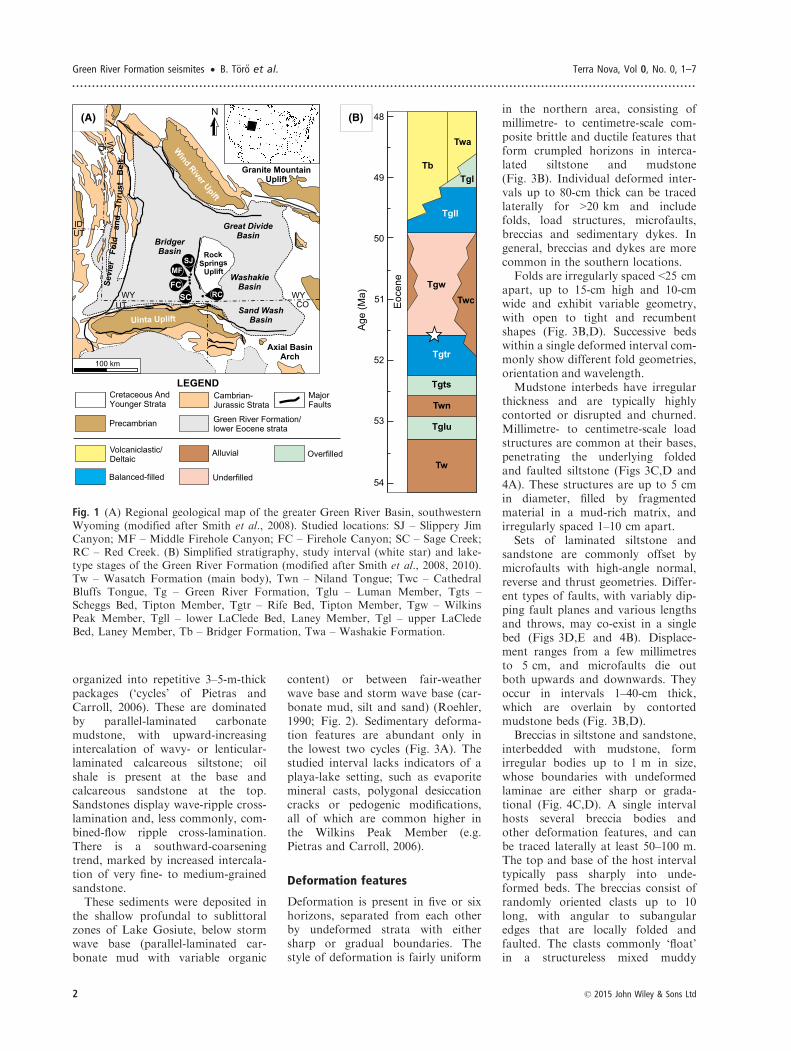
interbedded with mudstone, formirregular bodies up to 1 m in size,whose boundaries with undeformedlaminae are either sharp or grada-tional (Fig. 4C,D). A single intervalhosts several breccia bodies andother deformation features, and canbe traced laterally at least 50–100 m.The top and base of the host intervaltypically pass sharply into unde-formed beds. The breccias consist ofrandomly oriented clasts up to 10long, with angular to subangularedges that are locally folded andfaulted. The clasts commonly ‘float’in a structureless mixed muddy
(A) (B)
Fig. 1 (A) Regional geological map of the greater Green River Basin, southwesternWyoming (modified after Smith et al., 2008). Studied locations: SJ – Slippery JimCanyon; MF – Middle Firehole Canyon; FC – Firehole Canyon; SC – Sage Creek;RC – Red Creek. (B) Simplified stratigraphy, study interval (white star) and lake-type stages of the Green River Formation (modified after Smith et al., 2008, 2010).Tw – Wasatch Formation (main body), Twn – Niland Tongue; Twc – CathedralBluffs Tongue, Tg – Green River Formation, Tglu – Luman Member, Tgts –Scheggs Bed, Tipton Member, Tgtr – Rife Bed, Tipton Member, Tgw – WilkinsPeak Member, Tgll – lower LaClede Bed, Laney Member, Tgl – upper LaCledeBed, Laney Member, Tb – Bridger Formation, Twa – Washakie Formation.
2 © 2015 John Wiley & Sons Ltd
Green River Formation seismites • B. T€or}o et al. Terra Nova, Vol 0, No. 0, 1–7
.............................................................................................................................................................

matrix. In places, breccia bodies havean obliquely oriented, crudely curvi-linear shape, resembling sedimentarydykes (Fig. 4C,D).Sedimentary dykes are abundant as
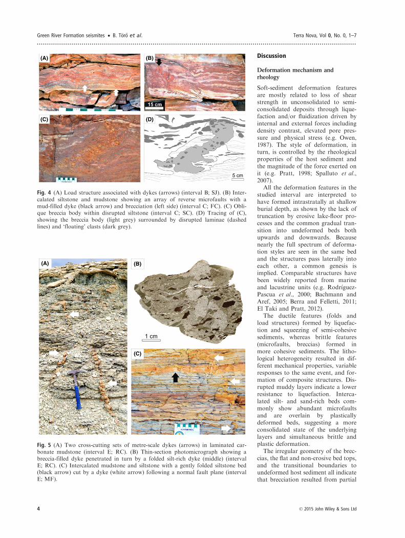
intrusions up to 3-m long and 5-cmwide (Fig. 5A) filled with homoge-nized lime mud, silt or a mixture withsand- and pebble-sized mudstoneclasts (Fig. 5B). Dykes display rag-
ged, folded and bifurcating linearpaths with sharp boundaries in bothcross-section and plan view. At dis-tinct lithological boundaries theycommonly show step-like offsets. AtRed Creek, they have two prominentorientations (~005° and ~120°). AtMiddle Firehole Canyon, many ofthem follow normal microfault planesand penetrate downwards through
several, locally folded, siltstoneinterbeds (Fig. 5C). The upper termi-nation of most dykes is against paral-lel- or wavy-laminated siltstone orsandstone, or, in some places, mud-stone. The overlying bed locallyshows folding, irregular thickness orbrecciation. Where visible, dykestaper downwards, indicating that theywere sourced from above.
Fig. 2 Schematic depositional model for the southern Greater Green River Basin (modified after Roehler, 1993; Renaut andGierlowski-Kordesch, 2010) (not to scale). The seismites described here occur in sublittoral calcareous siltstone deposits (star).Slope gradient was of the order of 0.02–0.5° (Surdam and Wolfbauer, 1975; Roehler, 1990). The diagram is vertically exagger-ated to show facies relationships.
(A) (B) (C)
(D) (E)
Fig. 3 (A) Stratigraphic section at FC with five deformed intervals (A–E). (B) Composite deformation feature with irregularfolding and brecciation, sandwiched between less deformed and microfaulted intervals (interval C; MF). (C) Thin-sectionphotomicrograph showing load structure filled with brecciated laminated mudstone (interval A; SJ). (D) Load structure com-posed of disrupted and churned mudstone, with folds, microfaults and millimetre-scale dykes below (arrow) (interval B; SJ).(E) Thin-section photomicrograph showing normal microfault in intercalated siltstone and sandstone with isolated andupward-protruding dykes (arrows) (interval E; MF).
© 2015 John Wiley & Sons Ltd 3
Terra Nova, Vol 0, No. 0, 1–7 B. T€or}o et al. • Green River Formation seismites
............................................................................................................................................................
Discussion
Deformation mechanism andrheology
Soft-sediment deformation featuresare mostly related to loss of shearstrength in unconsolidated to semi-consolidated deposits through lique-faction and/or fluidization driven byinternal and external forces includingdensity contrast, elevated pore pres-sure and physical stress (e.g. Owen,1987). The style of deformation, inturn, is controlled by the rheologicalproperties of the host sediment andthe magnitude of the force exerted onit (e.g. Pratt, 1998; Spalluto et al.,2007).All the deformation features in the
studied interval are interpreted tohave formed intrastratally at shallowburial depth, as shown by the lack oftruncation by erosive lake-floor pro-cesses and the common gradual tran-sition into undeformed beds bothupwards and downwards. Becausenearly the full spectrum of deforma-tion styles are seen in the same bedand the structures pass laterally intoeach other, a common genesis isimplied. Comparable structures havebeen widely reported from marineand lacustrine units (e.g. Rodr�ıguez-Pascua et al., 2000; Bachmann andAref, 2005; Berra and Felletti, 2011;El Taki and Pratt, 2012).The ductile features (folds and
load structures) formed by liquefac-tion and squeezing of semi-cohesivesediments, whereas brittle features(microfaults, breccias) formed inmore cohesive sediments. The litho-logical heterogeneity resulted in dif-ferent mechanical properties, variableresponses to the same event, and for-mation of composite structures. Dis-rupted muddy layers indicate a lowerresistance to liquefaction. Interca-lated silt- and sand-rich beds com-monly show abundant microfaultsand are overlain by plasticallydeformed beds, suggesting a moreconsolidated state of the underlyinglayers and simultaneous brittle andplastic deformation.The irregular geometry of the brec-
cias, the flat and non-erosive bed tops,and the transitional boundaries toundeformed host sediment all indicatethat brecciation resulted from partial
(A) (B)
(C) (D)
Fig. 4 (A) Load structure associated with dykes (arrows) (interval B; SJ). (B) Inter-calated siltstone and mudstone showing an array of reverse microfaults with amud-filled dyke (black arrow) and brecciation (left side) (interval C; FC). (C) Obli-que breccia body within disrupted siltstone (interval C; SC). (D) Tracing of (C),showing the breccia body (light grey) surrounded by disrupted laminae (dashedlines) and ‘floating’ clasts (dark grey).
(A) (B)
(C)
Fig. 5 (A) Two cross-cutting sets of metre-scale dykes (arrows) in laminated car-bonate mudstone (interval E; RC). (B) Thin-section photomicrograph showing abreccia-filled dyke penetrated in turn by a folded silt-rich dyke (middle) (intervalE; RC). (C) Intercalated mudstone and siltstone with a gently folded siltstone bed(black arrow) cut by a dyke (white arrow) following a normal fault plane (intervalE; MF).
4 © 2015 John Wiley & Sons Ltd
Green River Formation seismites • B. T€or}o et al. Terra Nova, Vol 0, No. 0, 1–7
.............................................................................................................................................................

liquidization of the carbonate mud in-terbeds and brittle failure of the cohe-sive, coarser grained layers withoutsignificant transportation (Kahle,2002; El Taki and Pratt, 2012). Wherebreccias fill sedimentary dykes, agenetic sequence of temporally closelyspaced events can be inferred, includ-ing (1) liquefaction, (2) brecciationand homogenization and (3) remobili-zation through injection.The intrastratal formation of
sharp-walled sedimentary dykes indi-cates shrinkage and brittle failure ofsemi-lithified sediments with concom-itant injection of granular material indirections defined by the stress field(Pratt, 1998; Jolly and Lonergan,2002). Thus, these dykes are not nep-tunian dykes formed by the passiveinfilling of pre-existing fissures.Although downward emplacementis dominant, lateral or upward injec-tion may have occurred in someinstances (e.g. Rodr�ıguez-Pascuaet al., 2000).
Trigger mechanism
A number of natural trigger mecha-nisms have been invoked to generatecomparable deformation structures,including wave action, sedimentloading, drag by currents, ice-induced stresses and earthquakes.Consequently, positive identificationof the most likely origin is often per-ceived to be elusive (Owen et al.,2011a).The mid-latitude palaeogeographi-
cal location and the warm palaeocli-mate (e.g. Roehler, 1993; Wilf, 2000)exclude glaciotectonics. The tranquildepositional setting and lack of mass-transport or channel deposits rule outoverloading and drag by bottom cur-rents. Shear stresses associated withtidal currents (e.g. Greb and Archer,2007) are unlikely in lakes. The faciesevidence and the inferred low slopegradient (~0.02–0.5°; Surdam andWolfbauer, 1975; Roehler, 1990) pre-clude deformation from breaking orpounding waves (Dalrymple, 1979;Nataraja and Gill, 1983; Alfaro et al.,2002) or gravitational instability.Moreover, most such triggers wouldgenerate only localized features andcannot explain a lateral extent insome cases of >20 km.A desiccation origin for the sedi-
mentary dykes is rejected based on
the depositional context, the overallsheet-like geometry and oriented nat-ure of the dykes, the lack of evidenceof subaerial exposure, and theabsence of fabrics that would beexpected if the cracks were open andfilled passively from above by sub-aerial or fluvial processes (e.g. Nealet al., 1968; Eugster and Hardie,1975; Harris, 2004).The observed associations and
morphologies of the deformationstructures are best explained as theresult of liquefaction, fluidizationand shear stresses induced by shak-ing during syndepositional earth-quakes. The cyclic and chaoticstresses related to the repeated pas-sage of seismic waves during spo-radic events explain the: (1)unoriented and contorted nature ofthe folded and faulted structures; (2)recurrence of deformed intervalsbound stratally by undeformed beds;(3) superposition of brittle and duc-tile structures in rheologically hetero-geneous sediment; and (4) largelateral extent. The southwardincrease in the relative proportion ofbreccias and sedimentary dykesmight be related to changes in faciesand rheology, or to higher deforma-tion intensity and, in turn, proximityto the source of the earthquakes.
Implications
Three nearby fault zones were activeduring deposition of the lowermostWilkins Peak Member at ~51.5 Ma:the Sevier Fold and Thrust Belt,110–140 km to the west (Coogan,1992); the Laramide Wind RiverThrust system, 95–130 km to thenorth (Pietras et al., 2003); and theUinta Thrust system, 15–50 km tothe south (Roehler, 1993; Bradley,1995; Fig. 1A). Considering modernand ancient analogues, and empiricalrelationships between magnitude andepicentral distance for liquefaction(e.g. Galli, 2000; Monecke et al.,2004; Castilla and Audemard, 2007;Berra and Felletti, 2011), the seis-mites identified here were most likelytriggered by earthquakes with a mag-nitude ≥5 and epicentral intensity≥VI, sourced at the northern front ofthe Uinta Uplift (Figs 1A and 2).The lateral zonation of deformedbeds further supports this interpreta-tion.
The shift from a balanced-filled toan underfilled state that occurred atthe boundary of the Tipton and theWilkins Peak members has beenascribed to increasing aridity (e.g.Bradley and Eugster, 1969; Roehler,1993) or tectonic isolation of the lakebasin (Pietras et al., 2003). The sedi-mentary deformation features, as astratigraphic archive of syndeposi-tional earthquakes, imply that, ratherthan being climatically forced, thechange in palaeohydrological condi-tions of Lake Gosiute was indeedtectonically induced through thediversion of the regional drainagesystem.
Conclusions
Lacustrine deposits of the EoceneGreen River Formation of south-wes-tern Wyoming exhibit laterally exten-sive sedimentary deformationstructures in the boundary intervalbetween the Tipton and Wilkins Peakmembers. These are interpreted asseismites formed in situ by selectiveliquefaction processes and elevatedshear stresses in rheologically hetero-geneous, sublittoral deposits undershallow burial. Their morphologicalcharacteristics, the depositional set-ting, and the zonation of deformationintensity imply that deformation wastriggered by earthquakes with a mag-nitude of ≥5, related to the activity ofbasin-bounding faults of the UintaUplift to the south. For the first time,such seismites have been linkeddirectly to a syntectonic change inlake-basin type, in this case from bal-anced-filled to underfilled.Syndepositional tectonism poten-
tially influences the hydrology,hydrogeology, watershed geology,spring activity and local climate.Thus, it ultimately affects lake chem-istry and sedimentation, especially inregions of active tectonics, such asrift systems or orogenic belts (e.g.Owen et al., 2011b; Lee et al., 2013;Cohen et al., 2015). This study dem-onstrates that seismites should bemore widely utilized to assess thecontribution of tectonics in lake evo-lution, not only in other sub-basinsof the Green River Formation, butalso in other modern or ancient lakedeposits where lacustrine conditionschanged in a tectonically activesetting.
© 2015 John Wiley & Sons Ltd 5
Terra Nova, Vol 0, No. 0, 1–7 B. T€or}o et al. • Green River Formation seismites
............................................................................................................................................................
Acknowledgements
This research was supported by NSERCDiscovery Grants (to B.R. Pratt, R.W.Renaut) and student research grants fromAAPG, IAS, SEPM and GSA (to B.T€or}o). We thank both referees plus theeditor and associate editor for comment-ing on the manuscript, and S. Dasgupta,E. Wiens and J.J. Scott for discussion andhelp in the field.
References
Alfaro, P., Delgado, J., Est�evez, A.,Molina, J.M., Moretti, M. and Soria,J.M., 2002. Liquefaction andfluidization structures in Messinianstorm deposits (Bajo Segura Basin,Betic Cordillera, southern Spain). Int.J. Earth Sci., 91, 505–513.
Bachmann, G.H. and Aref, M.A.M.,2005. A seismite in Triassic gypsumdeposits (Grabfeld Formation,Ladinian), southwestern Germany. Sed.Geol., 180, 75–89.
Beck, C., 2011. Lake sediments as lateQuaternary paleoseismic archives:examples in the northwestern Alps andclues for earthquake-origin assessmentof sedimentary disturbances. In:Geological Criteria for EvaluatingPaleoseismicity Revisited: Forty Yearsof Paleoseismic Investigations and theNatural Record of Past Earthquakes(F.A. Audemard, A.M. Michetti andJ.P. McCalpin, eds). Geol. Soc. Am.Spec. Pap., 479, 159–179.
Berra, F. and Felletti, F., 2011.Syndepositional tectonics recorded bysoft-sediment deformation andliquefaction structures (continentalLower Permian sediments, SouthernAlps, Northern Italy): stratigraphicsignificance. Sed. Geol., 235, 249–263.
Bohacs, K.M., Carroll, A.R., Neal, J.E.and Mankiewicz, P.J., 2000. Lake-basintype, source potential, and hydrocarboncharacter: an integrated sequence-stratigraphic–geochemical framework.In: Lake Basins Through Space andTime (E.H. Gierlowski-Kordesch andK.R. Kelts, eds). Am. Assoc. Pet. Geol.Stud. Geol., 46, 3–34.
Bohacs, K.M., Carroll, A.R. and Neal,J.E., 2003. Lessons from large lakesystems—thresholds, nonlinearity, andstrange attractors. In: ExtremeDepositional Environments: Mega EndMembers in Geologic Time (M.A. Chanand A.W. Archer, eds). Geol. Soc. Am.Spec. Pap., 370, 75–90.
Bradley, M.D., 1995. Timing of theLaramide rise of the Uinta Mountains,Utah and Colorado. In: Resources ofSouthwestern Wyoming (R.W. Jones,ed.). Wyo. Geol. Assoc. 1995 FieldConf. Guidebook, 46, 31–44.
Bradley, W.H. and Eugster, H.P., 1969.Geochemistry and paleolimnology ofthe trona deposits and associatedauthigenic minerals of the Green RiverFormation of Wyoming. U.S. Geol.Surv. Prof. Pap., 496B, 71 pp.
Carroll, A.R. and Bohacs, K.M., 1999.Stratigraphic classification of ancientlakes: balancing tectonic and climaticcontrols. Geology, 27, 99–102.
Carroll, A.R., Chetel, L.M. and Smith,M.E., 2006. Feast to famine: sedimentsupply control on Laramide basin fill.Geology, 34, 197–200.
Carroll, A.R., Doebbert, A., Booth, A.L.,Chamberlain, C.P., Rhodes-Carson,M., Smith, M.E., Johnson, C.M. andBeard, B.L., 2008. Capture of high-altitude precipitation by a low-altitudeEocene lake, western U.S. Geology, 36,791–794.
Castilla, R.A. and Audemard, F.A., 2007.Sand blows as a potential tool formagnitude estimation of pre-instrumental earthquakes. J. Seismol.,11, 483–487.
Cohen, A.S., 2003. Paleolimnology.Oxford University Press, New York.
Cohen, A., McGlue, M.M., Ellis, G.S.,Zani, H., Swarzenski, P.W., Assine,M.L. and Silva, A., 2015. Lakeformation, characteristics, andevolution in retroarc deposystems: asynthesis of the modern Andean orogenand its associated basins. In:Geodynamics of a Cordilleran OrogenicSystem: The Central Andes of Argentinaand Northern Chile (P.G. DeCelles,M.N. Ducea, B. Carrapa and P.A.Kapp, eds). Geol. Soc. Am. Mem., 212,309–335.
Coogan, J.C., 1992. Structural evolutionof piggyback basins in the Wyoming-Idaho-Utah thrust belt. In: RegionalGeology of Eastern Idaho and WesternWyoming (P.K. Link, M.A. Kentz andL.B. Platt, eds). Geol. Soc. Am. Mem.,179, 55–81.
Dalrymple, R.W., 1979. Wave-inducedliquefaction—a modern example fromthe Bay of Fundy. Sedimentology, 26,835–844.
DeCelles, P.G., 1994. Late Cretaceous-Paleocene synorogenic sedimentationand kinematic history of the Sevierthrust belt, northeast Utah andsouthwest Wyoming. Geol. Soc. Am.Bull., 106, 32–56.
Dickinson, W.R., Klute, M.A., Hayes,M.J., Janecke, S.U., Lundin, E.R.,McKittrick, M.A. and Olivares, M.D.,1988. Paleogeographic andpaleotectonic setting of Laramidesedimentary basins in the central RockyMountain region. Geol. Soc. Am. Bull.,100, 1023–1039.
El Taki, H. and Pratt, B.R., 2012.Syndepositional tectonic activity in an
epicontinental basin revealed bydeformation of subaqueous carbonatelaminites and evaporites: seismites inRed River strata (Upper Ordovician) ofsouthern Saskatchewan, Canada. Bull.Can. Petrol. Geol., 60, 37–58.
Eugster, H.P. and Hardie, L.A., 1975.Sedimentation in an ancient playa-lakecomplex: the Wilkins Peak member ofthe Green River formation ofWyoming. Geol. Soc. Am. Bull., 86,319–334.
Galli, P., 2000. New empiricalrelationships between magnitude anddistance for liquefaction.Tectonophysics, 324, 169–187.
Greb, S.F. and Archer, A.W., 2007. Soft-sediment deformation produced bytides in a meizoseismic area, TurnagainArm, Alaska. Geology, 35, 435–438.
Harris, R.C., 2004. Giant desiccationcracks in Arizona. Ariz. Geol. Surv.Open-File Rep., 04-01, 93 pp.
Jolly, R.J.H. and Lonergan, L., 2002.Mechanisms and controls on theformation of sand intrusions. J. Geol.Soc. London, 159, 605–617.
Kahle, C.F., 2002. Seismogenicdeformation structures in microbialitesand mudstones, Silurian LockportDolomite, northwestern Ohio, USA.J. Sed. Res., 72, 201–216.
Lee, R.K.L., Owen, R.B., Renaut, R.W.,Behrensmeyer, A.K., Potts, R. andSharp, W., 2013. Facies, geochemistryand diatoms of late PleistoceneOlorgesailie tufas, southern Kenya Rift.Palaeogeogr. Palaeoclimatol.Palaeoecol., 374, 197–217.
Monecke, K., Anselmetti, F.S., Becker,A., Sturm, M. and Giardini, D., 2004.The record of historic earthquakes inlake sediments of Central Switzerland.Tectonophysics, 394, 21–40.
Moretti, M. and Sabato, L., 2007.Recognition of trigger mechanisms forsoft-sediment deformation in thePleistocene lacustrine deposits of theSant’ Arcangelo Basin (Southern Italy):seismic shocks vs. overloading. Sed.Geol., 196, 31–45.
Nataraja, M.S. and Gill, H.S., 1983.Ocean wave-induced liquefactionanalysis. J. Geotech. Eng., 109,573–590.
Neal, J.T., Langer, A.M. and Kerr, P.F.,1968. Giant desiccation polygons ofGreat Basin playas. Geol. Soc. Am.Bull., 79, 69–90.
Owen, G., 1987. Deformation processesin unconsolidated sands. In:Deformation of Sediments andSedimentary Rocks (M.E. Jones andR.M.F. Preston, eds). Geol. Soc.London. Spec. Publ., 29, 11–24.
Owen, G., Moretti, M. and Alfaro, P.,2011a. Recognising triggers for soft-sediment deformation: current
6 © 2015 John Wiley & Sons Ltd
Green River Formation seismites • B. T€or}o et al. Terra Nova, Vol 0, No. 0, 1–7
.............................................................................................................................................................

understanding and future directions.Sed. Geol., 235, 133–140.
Owen, R.B., Renaut, R.W. andStamatakis, M.G., 2011b. LateMiocene lacustrine sedimentation in theMytilinii Basin, Samos Island, Greece.J. Paleolimnol., 46, 151–166.
Pietras, J.T. and Carroll, A.R., 2006.High-resolution stratigraphy of anunderfilled lake basin: wilkins PeakMember, Eocene Green RiverFormation, Wyoming, U.S.A. J. Sed.Res., 76, 1197–1214.
Pietras, J.T., Carroll, A.R. and Rhodes,M.K., 2003. Lake basin response totectonic drainage diversion: eoceneGreen River Formation, Wyoming.J. Paleolimnol., 30, 115–125.
Pratt, B.R., 1998. Syneresis cracks:subaqueous shrinkage inargillaceous sediments caused byearthquake-induced dewatering. Sed.Geol., 117, 1–10.
Renaut, R.W. and Gierlowski-Kordesch,E.H., 2010. Lakes. In: Facies Models,4th edn (N.P. James and R.W.Dalrymple, eds). Geol. Assoc. Can.GEOtext, 6, 541–575.
Ricci Lucchi, F., 1995. Sedimentologicalindicators of paleoseismicity. In:Perspectives in Paleoseismology
(L. Serva and D.B. Slemmons, eds).Assoc. Eng. Geol. Spec. Publ., 6, 7–17.
Rodr�ıguez-Pascua, M.A., Calvo, J.P., DeVicente, G. and G�omez-Gras, D., 2000.Soft-sediment deformation structuresinterpreted as seismites in lacustrinesediments of the Prebetic Zone, SESpain, and their potential use asindicators of earthquake magnitudesduring the Late Miocene. Sed. Geol.,135, 117–135.
Roehler, H.W., 1990. Sedimentology offreshwater lacustrine shorelines in theEocene Scheggs Bed of the TiptonTongue of the Green River Formation,Sand Wash Basin, NorthwestColorado. U.S. Geol. Surv. Bull., 1911,12 pp.
Roehler, H.W., 1992. Correlation,composition, areal distribution, andthickness of Eocene stratigraphic units,Greater Green River basin, Wyoming,Utah, and Colorado. U.S. Geol. Surv.Prof. Pap., 1506-E, 49 pp.
Roehler, H. W., 1993. Eocene climates,depositional environments, andgeography, Greater Green River basin,Wyoming, Utah, and Colorado. U.S.Geol. Surv. Prof. Pap., 1506-F, 74 pp.
Sims, J.D., 1975. Determining earthquakerecurrence intervals from deformational
structures in young lacustrinesediments. Tectonophysics, 29, 141–152.
Smith, M.E., Carroll, A.R. and Singer,B.S., 2008. Synoptic reconstruction of amajor ancient lake system: EoceneGreen River Formation, westernUnited States. Geol. Soc. Am. Bull.,120, 54–84.
Smith, M.E., Chamberlain, K.R., Singer,B.S. and Carroll, A.R., 2010. Eoceneclocks agree: coeval 40Ar/39Ar, U-Pb,and astronomical ages from theGreen River Formation. Geology, 38,527–530.
Spalluto, L., Moretti, M., Festa, V. andTropeano, M., 2007. Seismically-induced slumps in Lower-Maastrichtianperitidal carbonates of the ApulianPlatform (southern Italy). Sed. Geol.,196, 81–98.
Surdam, R.C. and Wolfbauer, C.A., 1975.Green River Formation, Wyoming: aplaya-lake complex. Geol. Soc. Am.Bull., 86, 335–345.
Wilf, P., 2000. Late Paleocene–earlyEocene climate changes in southwesternWyoming: paleobotanical analysis.Geol. Soc. Am. Bull., 112, 292–307.
Received 26 November 2014; revised
version accepted 10 March 2015
© 2015 John Wiley & Sons Ltd 7
Terra Nova, Vol 0, No. 0, 1–7 B. T€or}o et al. • Green River Formation seismites
............................................................................................................................................................
Related Documents