Tectonic event / location: The Caribbean - between the Caribbean Sea and the North Atlantic Ocean, west of the Dominican Republic. Key information and statistics (deaths, magnitude, injured etc) Socio-economic profile (indicators that might relate to their ability to manage the hazard) The tremor hit at 16:53 local time on Tuesday 12th January 2010. Reached 7.0 on the Richter Scale. Depth 13 Km. 2300’000 deaths, 300’000 injured and 1million left homeless. It is estimated that as many as 3 million people had been affected by the quake. Population below poverty line: 80% Population growth rate: 1.84% per year Urban Population: 47% of total population Population: 9,203,083 Age Structure: 0-14 years: 37.5% 15-64 years: 59.1% 65 years and over: 3.4% Climate: Tropical; semiarid where mountains in east cut off trade winds Terrain: mostly rough and mountainous, pretty dry Level of development (developing, developed) Associated hazards (e.g. landslides, tsunami) LDC – one of the 50 least developed countries in the world. GDP (per capita): $1,300 Lies in the middle of the hurricane belt and subject to severe storms from June to October; occasional flooding and earthquakes; periodic droughts. Haitian Earthquake

Tectonic event / location: The Caribbean - between the Caribbean Sea and the North Atlantic Ocean, west of the Dominican Republic. Key information and.
Jan 01, 2016
Welcome message from author
This document is posted to help you gain knowledge. Please leave a comment to let me know what you think about it! Share it to your friends and learn new things together.
Transcript
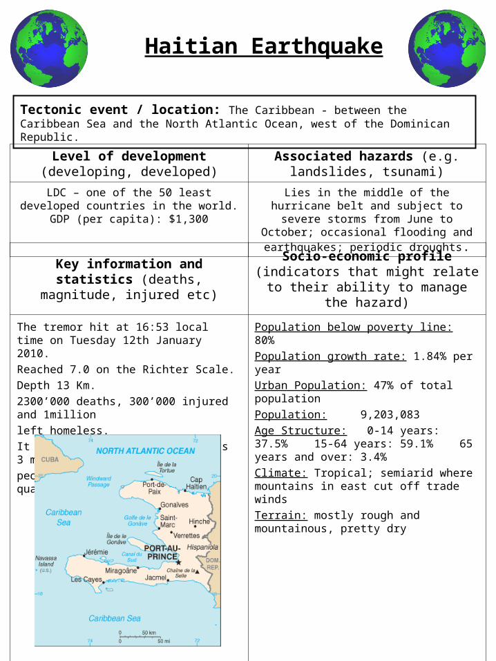
Tectonic event / location: The Caribbean - between the Caribbean Sea and the North Atlantic Ocean, west of the Dominican Republic.
Key information and statistics (deaths, magnitude, injured etc)
Socio-economic profile (indicators that might relate to their ability to manage the
hazard)
The tremor hit at 16:53 local time on Tuesday 12th January 2010.
Reached 7.0 on the Richter Scale.
Depth 13 Km.
2300’000 deaths, 300’000 injured and 1million
left homeless.
It is estimated that as many as 3 million
people had been affected by the quake.
Population below poverty line: 80%Population growth rate: 1.84% per yearUrban Population: 47% of total populationPopulation: 9,203,083Age Structure: 0-14 years: 37.5% 15-64 years: 59.1% 65 years and over: 3.4% Climate: Tropical; semiarid where mountains in east cut off trade windsTerrain: mostly rough and mountainous, pretty dry
Level of development (developing, developed)
Associated hazards (e.g. landslides, tsunami)
LDC – one of the 50 least developed countries in the world.
GDP (per capita): $1,300
Lies in the middle of the hurricane belt and subject to severe storms from June to
October; occasional flooding and earthquakes; periodic droughts.
Haitian Earthquake
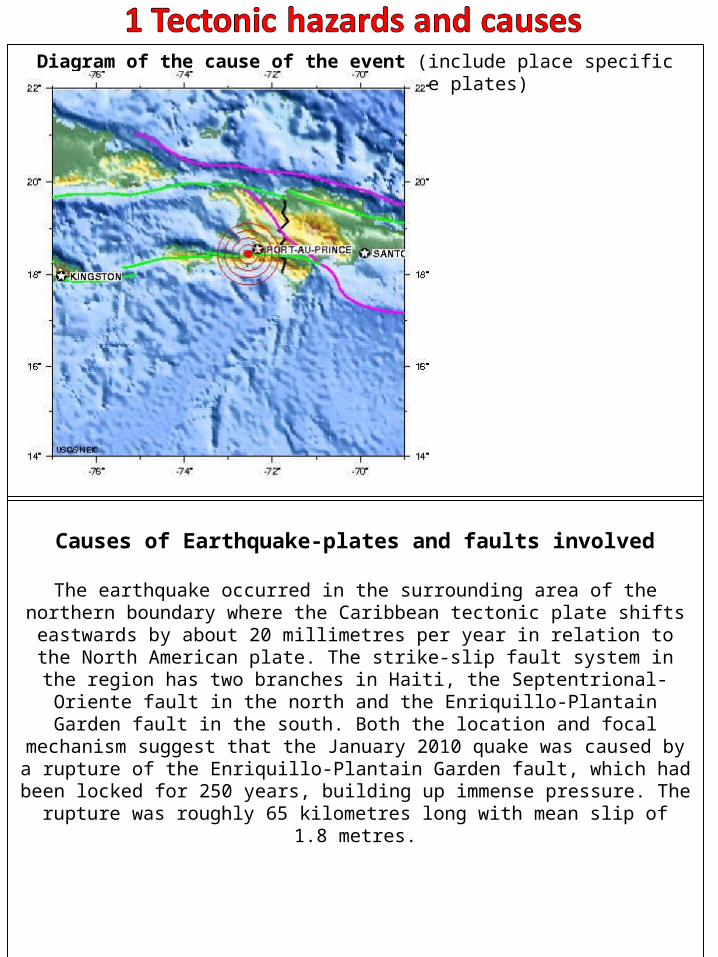
Diagram of the cause of the event (include place specific detail e.g. name of the plates)
Causes of Earthquake-plates and faults involved
The earthquake occurred in the surrounding area of the northern boundary where the Caribbean tectonic plate shifts eastwards by about 20 millimetres per year in relation to the North American plate. The strike-slip fault system in the region has
two branches in Haiti, the Septentrional-Oriente fault in the north and the Enriquillo-Plantain Garden fault in the south. Both the location and focal
mechanism suggest that the January 2010 quake was caused by a rupture of the Enriquillo-Plantain Garden fault, which had been locked for 250 years, building up immense pressure. The rupture was roughly 65 kilometres long with mean slip of
1.8 metres.
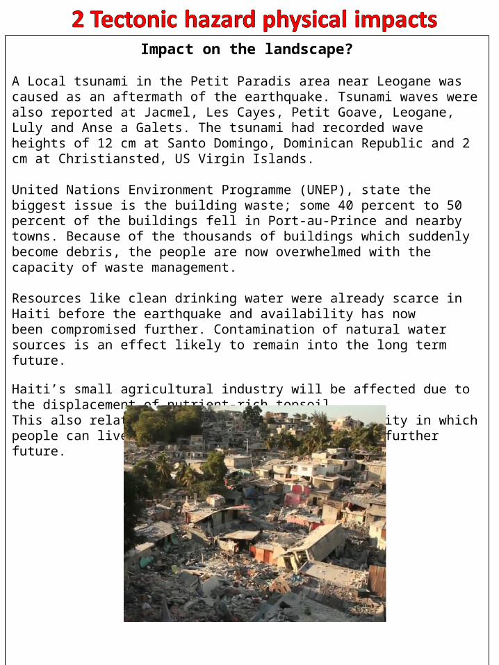
Impact on the landscape?
A Local tsunami in the Petit Paradis area near Leogane was caused as an aftermath of the earthquake. Tsunami waves were also reported at Jacmel, Les Cayes, Petit Goave, Leogane, Luly and Anse a Galets. The tsunami had recorded wave heights of 12 cm at Santo Domingo, Dominican Republic and 2 cm at Christiansted, US Virgin Islands.
United Nations Environment Programme (UNEP), state the biggest issue is the building waste; some 40 percent to 50 percent of the buildings fell in Port-au-Prince and nearby towns. Because of the thousands of buildings which suddenly become debris, the people are now overwhelmed with the capacity of waste management.
Resources like clean drinking water were already scarce in Haiti before the earthquake and availability has now been compromised further. Contamination of natural water sources is an effect likely to remain into the long term future.
Haiti’s small agricultural industry will be affected due to the displacement of nutrient-rich topsoil.This also relates to the issue of land availability in which people can live and build new structures in the further future.
The social-economic impacts of the event.
In the nights following the earthquake, many people in Haiti slept in the streets, on pavements, in their cars, or in makeshift shanty towns either because their houses had been destroyed, or they feared standing structures would not withstand aftershocks.Structures are often raised wherever they can fit; some buildings were built on slopes with insufficient foundations or steel works. A representative of Catholic Relief Services has estimated that about two million Haitians lived as squatters on land they did not own. The country also suffered from shortages of fuel and potable water even before the disaster. By 14 January, a thousand bodies had been placed on the streets and pavements. Government crews manned trucks to collect thousands more, burying them in mass graves.The country was sent into a mass panic, in whih completely shut down. It took 12 hours for emergencry responses to hit the scenes and even days after the event people were still being pulled out from under debris and being searched for by loved ones. All health centres which were either in make shift buildings or buildings which still had the basic structure, were overwelmed with casualties. With very few staff to help all of the people who desperately needed it. Many countries responded to the appeals for help and launched fund-raising efforts, as well as sending search and rescue teams. The neighbouring Dominican Republic was the first country to give aid to Haiti, sending water, food and heavy-lifting machinery. The hospitals in Dominican Republic were made available, and the airport opened to receive aid that would be distributed to Haiti. The Dominican emergency team assisted more than 2,000 injured people. The Dominican Red Cross coordinated early medical relief in conjunction with the International Red Cross. The government sent eight mobile medical units along with 36 doctors including orthopedic specialists, traumatologists, anaesthetists, and surgeons. In addition, 39 trucks carrying canned food were dispatched, along with 10 mobile kitchens and 110 cooks capable of producing 100,000 meals per day.
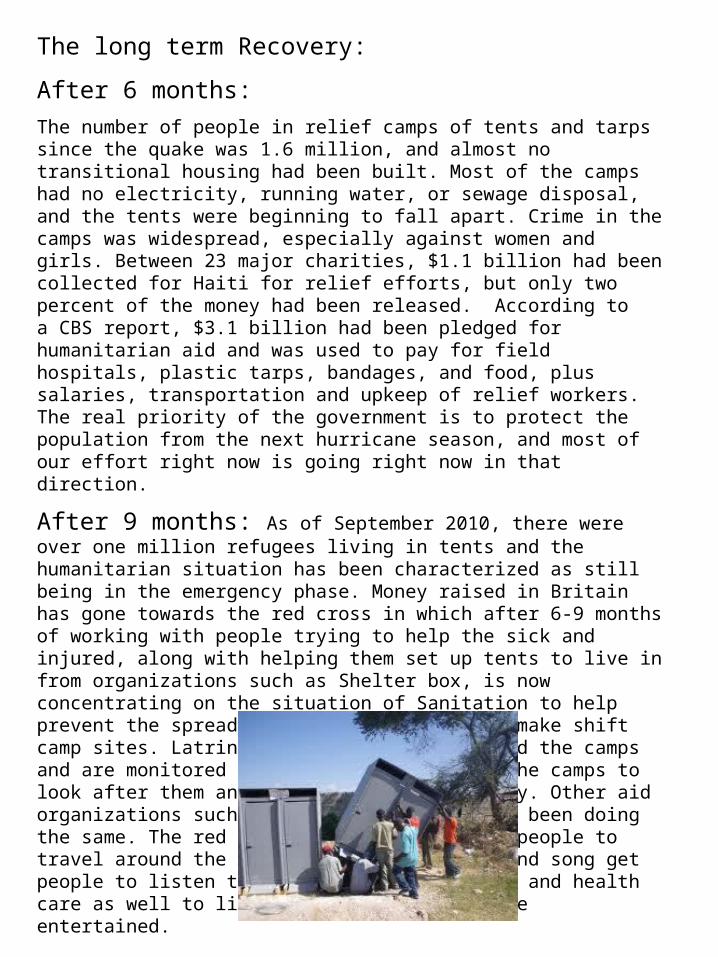
The long term Recovery:
After 6 months:
The number of people in relief camps of tents and tarps since the quake was 1.6 million, and almost no transitional housing had been built. Most of the camps had no electricity, running water, or sewage disposal, and the tents were beginning to fall apart. Crime in the camps was widespread, especially against women and girls. Between 23 major charities, $1.1 billion had been collected for Haiti for relief efforts, but only two percent of the money had been released. According to a CBS report, $3.1 billion had been pledged for humanitarian aid and was used to pay for field hospitals, plastic tarps, bandages, and food, plus salaries, transportation and upkeep of relief workers. The real priority of the government is to protect the population from the next hurricane season, and most of our effort right now is going right now in that direction.
After 9 months: As of September 2010, there were over one million refugees living in tents and the humanitarian situation has been characterized as still being in the emergency phase. Money raised in Britain has gone towards the red cross in which after 6-9 months of working with people trying to help the sick and injured, along with helping them set up tents to live in from organizations such as Shelter box, is now concentrating on the situation of Sanitation to help prevent the spread of disease on the large make shift camp sites. Latrines have been set up around the camps and are monitored by the people living on the camps to look after them and keep them running safely. Other aid organizations such as Unicef and Oxfam have been doing the same. The red cross are also providing people to travel around the camps and through music and song get people to listen to advice about sanitation and health care as well to lift spirits and keep people entertained.
How human actions help or hinder
Before the event
Earthquake hazard study in 2007 by different geologist’s show that the Enriquillo-Plantain Garden fault zone could have be at the end of its seismic
cycle and an article published in Haiti's Le Matin newspaper in September 2008 showed comments by geologist Patrick Charles that there was a high risk of major seismic activity in Port-au-Prince. Even though this was said no action
was taken by the Haitian government.
Intensive logging beginning in the 1950s reduced Haiti’s forest cover from 60 percent to less than 2 percent today. This lack of trees causes huge soil erosion problems, threatening both food and clean water sources. If there is forest cover,
when heavy rain takes place it doesn’t erode the land and It doesn’t result in flash floods. This lack of forest cover results in Haiti being badly effected by
hurricanes.
Due to a rapidly rising population millions of Haitians have been pushed out into marginal areas like floodplains while the most fertile land areas are often used
for slums and hillsides and steep landscapes used for agriculture.
Construction standards were low in Haiti; the country had no building codes. Engineers had stated after the earthquake that 'it was unlikely many buildings
would have stood through any kind of disaster let alone this one.’
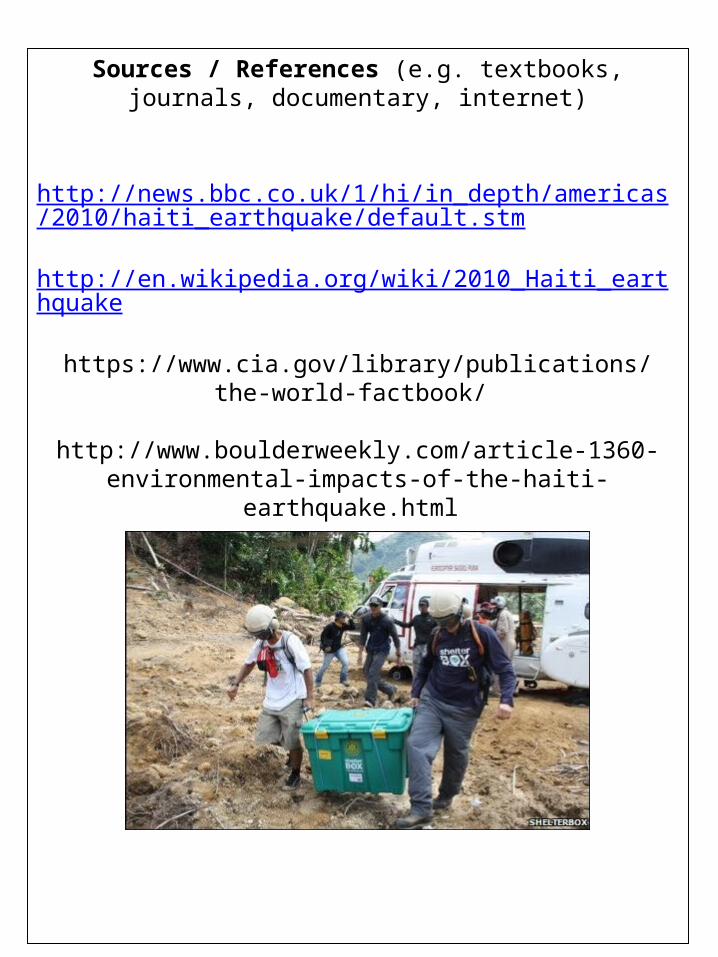
Sources / References (e.g. textbooks, journals, documentary, internet)
http://news.bbc.co.uk/1/hi/in_depth/americas/2010/haiti_earthquake/default.stm
http://en.wikipedia.org/wiki/2010_Haiti_earthquake
https://www.cia.gov/library/publications/the-world-factbook/
http://www.boulderweekly.com/article-1360-environmental-impacts-of-the-haiti-earthquake.html
http://www.shelterbox.org/deployment_details.php?id=122
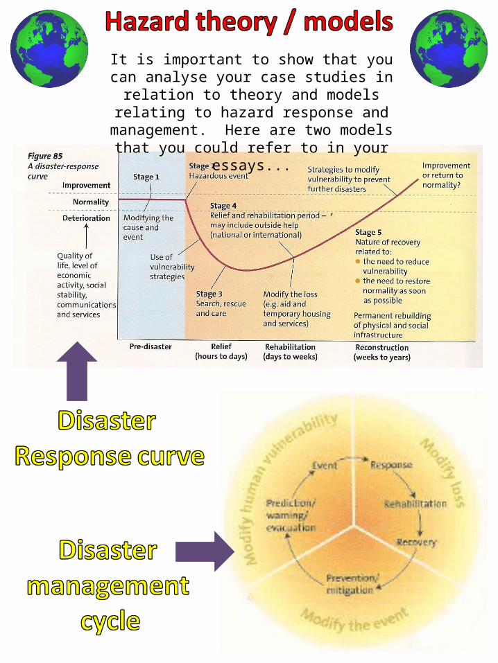
It is important to show that you can analyse your case studies in relation to theory and models
relating to hazard response and management. Here are two models that you could refer to in
your essays...
Related Documents