Tectonic controls on the hydrocarbon habitats of the Barito, Kutei, and Tarakan Basins, Eastern Kalimantan, Indonesia: major dissimilarities in adjoining basins Awang Harun Satyana *, Djoko Nugroho, Imanhardjo Surantoko JOB PERTAMINA—Santa Fe Salawati, Menara Mutia, 10th Floor, Jalan Gatot Subroto 9-11, Jakarta 12930, Indonesia Received 10 December 1997; accepted 22 October 1998 Abstract The Barito, Kutei, and Tarakan Basins are located in the eastern half of Kalimantan (Borneo) Island, Indonesia. The basins are distinguished by their dierent tectonic styles during Tertiary and Pleistocene times. In the Barito Basin, the deformation is a consequence of two distinct, separate, regimes. Firstly, an initial transtensional regime during which sinistral shear resulted in the formation of a series of wrench-related rifts, and secondly, a subsequent transpressional regime involving convergent uplift, reactivating old structures and resulting in wrenching, reverse faulting and folding within the basin. Presently, NNE–SSW and E–W trending structures are concentrated in the northeastern and northern parts of the basin, respectively. In the northeastern part, the structures become increasingly imbricated towards the Meratus Mountains and involve the basement. The western and southern parts of the Barito Basin are only weakly deformed. In the Kutei Basin, the present day dominant structural trend is a series of tightly folded, NNE–SSW trending anticlines and synclines forming the Samarinda Anticlinorium which is dominant in the eastern part of the basin. Deformation is less intense oshore. Middle Miocene to Recent structural growth is suggested by depositional thinning over the structures. The western basin area is uplifted, large structures are evident in several places. The origin of the Kutei structures is still in question and proposed mechanisms include vertical diapirism, gravitational gliding, inversion through regional wrenching, detachment folds over inverted structures, and inverted delta growth-fault system. In the Tarakan Basin, the present structural grain is typified by NNE–SSW normal faults which are mostly developed in the marginal and oshore areas. These structures formed on older NW–SE trending folds and are normal to the direction of the basin sedimentary thickening suggesting that they developed contemporaneously with deposition, as growth-faults, and may be the direct result of sedimentary loading by successive deltaic deposits. Older structures were formed in the onshore basin, characterized by the N–S trending folds resulting from the collision of the Central Range terranes to the west of the basin. Hydrocarbon accumulations in the three basins are strongly controlled by their tectonic styles. In the Barito Basin, all fields are located in west-verging faulted anticlines. The history of tectonic inversion and convergent uplift of the Meratus Mountains, isostatically, have caused the generation, migration, and trapping of hydrocarbons. In the Kutei Basin, the onshore Samarinda Anticlinorium and the oshore Mahakam Foldbelt are prolific petroleum provinces, within which most Indonesian giant fields are located. In the oshore, very gentle folds also play a role as hydrocarbon traps, in association with stratigraphic entrapment. These structures have recently become primary targets for exploratory drilling. In the Tarakan Basin, the prominent NW–SE anticlines, fragmented by NE–SW growth-faults, have proved to be petroleum traps. The main producing pools are located in the downthrown blocks of the faults. Diverse tectonic styles within the producing basins of Kalimantan compel separate exploration approaches to each basin. To discover new opportunities in exploration, it is important to understand the structural evolution of neighbouring basins. # 1999 Elsevier Science Ltd. All rights reserved. 1. Introduction Kalimantan is the Indonesian portion of the island of Borneo. It occupies more than two thirds of the island. Kalimantan is separated from Sarawak and Sabah (Malaysian portions of Borneo) and Brunei Darussalam by the ridges of the Central Ranges com- prising from WSW–ENE the Kelingkang, Upper Kapuas, Iran and Semporna Highs (Figs. 1 and 2). In Kalimantan, hydrocarbons are produced from three sedimentary basins located in the eastern half of Journal of Asian Earth Sciences 17 (1999) 99–122 1367-9120/99 $ - see front matter # 1999 Elsevier Science Ltd. All rights reserved. PII: S0743-9547(98)00059-2 PERGAMON * Corresponding author.

Welcome message from author
This document is posted to help you gain knowledge. Please leave a comment to let me know what you think about it! Share it to your friends and learn new things together.
Transcript
Tectonic controls on the hydrocarbon habitats of the Barito,Kutei, and Tarakan Basins, Eastern Kalimantan, Indonesia:
major dissimilarities in adjoining basins
Awang Harun Satyana *, Djoko Nugroho, Imanhardjo Surantoko
JOB PERTAMINAÐSanta Fe Salawati, Menara Mutia, 10th Floor, Jalan Gatot Subroto 9-11, Jakarta 12930, Indonesia
Received 10 December 1997; accepted 22 October 1998
Abstract
The Barito, Kutei, and Tarakan Basins are located in the eastern half of Kalimantan (Borneo) Island, Indonesia. The basinsare distinguished by their di�erent tectonic styles during Tertiary and Pleistocene times. In the Barito Basin, the deformation is a
consequence of two distinct, separate, regimes. Firstly, an initial transtensional regime during which sinistral shear resulted inthe formation of a series of wrench-related rifts, and secondly, a subsequent transpressional regime involving convergent uplift,reactivating old structures and resulting in wrenching, reverse faulting and folding within the basin. Presently, NNE±SSW andE±W trending structures are concentrated in the northeastern and northern parts of the basin, respectively. In the northeastern
part, the structures become increasingly imbricated towards the Meratus Mountains and involve the basement. The western andsouthern parts of the Barito Basin are only weakly deformed. In the Kutei Basin, the present day dominant structural trend is aseries of tightly folded, NNE±SSW trending anticlines and synclines forming the Samarinda Anticlinorium which is dominant in
the eastern part of the basin. Deformation is less intense o�shore. Middle Miocene to Recent structural growth is suggested bydepositional thinning over the structures. The western basin area is uplifted, large structures are evident in several places. Theorigin of the Kutei structures is still in question and proposed mechanisms include vertical diapirism, gravitational gliding,
inversion through regional wrenching, detachment folds over inverted structures, and inverted delta growth-fault system. In theTarakan Basin, the present structural grain is typi®ed by NNE±SSW normal faults which are mostly developed in the marginaland o�shore areas. These structures formed on older NW±SE trending folds and are normal to the direction of the basin
sedimentary thickening suggesting that they developed contemporaneously with deposition, as growth-faults, and may be thedirect result of sedimentary loading by successive deltaic deposits. Older structures were formed in the onshore basin,characterized by the N±S trending folds resulting from the collision of the Central Range terranes to the west of the basin.Hydrocarbon accumulations in the three basins are strongly controlled by their tectonic styles. In the Barito Basin, all ®elds are
located in west-verging faulted anticlines. The history of tectonic inversion and convergent uplift of the Meratus Mountains,isostatically, have caused the generation, migration, and trapping of hydrocarbons. In the Kutei Basin, the onshore SamarindaAnticlinorium and the o�shore Mahakam Foldbelt are proli®c petroleum provinces, within which most Indonesian giant ®elds
are located. In the o�shore, very gentle folds also play a role as hydrocarbon traps, in association with stratigraphic entrapment.These structures have recently become primary targets for exploratory drilling. In the Tarakan Basin, the prominent NW±SEanticlines, fragmented by NE±SW growth-faults, have proved to be petroleum traps. The main producing pools are located in
the downthrown blocks of the faults. Diverse tectonic styles within the producing basins of Kalimantan compel separateexploration approaches to each basin. To discover new opportunities in exploration, it is important to understand the structuralevolution of neighbouring basins. # 1999 Elsevier Science Ltd. All rights reserved.
1. Introduction
Kalimantan is the Indonesian portion of the island
of Borneo. It occupies more than two thirds of the
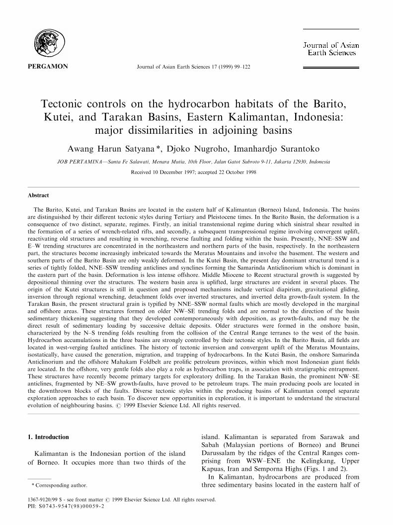
island. Kalimantan is separated from Sarawak andSabah (Malaysian portions of Borneo) and BruneiDarussalam by the ridges of the Central Ranges com-prising from WSW±ENE the Kelingkang, UpperKapuas, Iran and Semporna Highs (Figs. 1 and 2).
In Kalimantan, hydrocarbons are produced fromthree sedimentary basins located in the eastern half of
Journal of Asian Earth Sciences 17 (1999) 99±122
1367-9120/99 $ - see front matter # 1999 Elsevier Science Ltd. All rights reserved.
PII: S0743-9547(98 )00059 -2
PERGAMON
* Corresponding author.
the island : Barito (since 1938), Kutei (since 1897) andTarakan (since 1905) (Weeda, 1958) (Fig. 3). The his-tory of oil exploration and production dates back to1865 when Greve reported numerous oil seeps locatedin the Balikpapan±Samarinda area of the Kutei Basin.However, the oil and gas industry in Kalimantanbegan properly in 1891, when two petroleum conces-sions (Mathilde and LouiseÐboth in the South KuteiBasin) were awarded to a private oil company by theDutch Government. Nowadays, Kalimantan accountsfor 18% of Indonesia's oil and condensate productionand 32% of its gas production (Courteney andWiman, 1991). One ®eld in the Barito Basin and sev-
eral ®elds in the Kutei Basin are classi®ed as giant®elds.
Almost all the oil ®elds in these three producingbasins are due to the deformation undergone by thebasins during the Tertiary and Pleistocene. In theBarito Basin, all ®elds are located in faulted anticli-nes. In the Kutei Basin, the SamarindaAnticlinorium is a proli®c petroleum province. In theTarakan Basin, anticlines fragmented by normal andgrowth-faults, prove to be the main petroleum traps.However, the tectonic style and origin within eachbasin is di�erent, despite their neighbouring pos-itions.
Fig. 1. The tectonic setting of the study area in eastern Kalimantan in Southeast Asia.
A.Harun Satyana et al. / Journal of Asian Earth Sciences 17 (1999) 99±122100
This paper ®rst discusses the geologic setting of
each basin and their tectonic implications for hydro-
carbon habitats. Secondly, a comparative examin-
ation of the basins is given. Evaluation of the
possibility of applying the understanding of the tec-
tonic style of one basin to the other basins, in the
search for new play opportunities, is also addressed
in this paper.
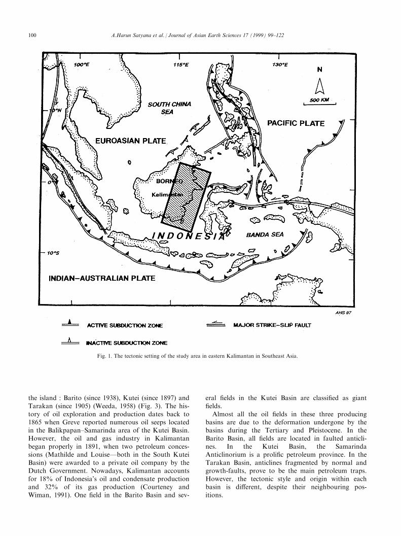
Fig. 2. Borneo±Kalimantan showing national and administrative boundaries, important cities and the mountainous areas constituting the Central
Kalimantan Ranges.
A.Harun Satyana et al. / Journal of Asian Earth Sciences 17 (1999) 99±122 101
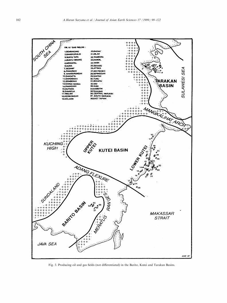
Fig. 3. Producing oil and gas ®elds (not di�erentiated) in the Barito, Kutei and Tarakan Basins.
A.Harun Satyana et al. / Journal of Asian Earth Sciences 17 (1999) 99±122102
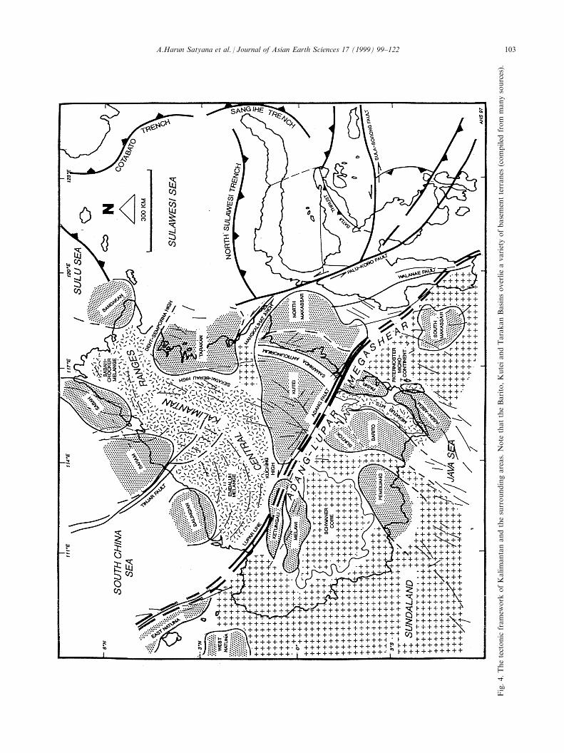
Fig.4.Thetectonic
framew
ork
ofKalimantanandthesurroundingareas.Note
thattheBarito,KuteiandTarakanBasinsoverlieavarietyofbasementterranes
(compiled
from
manysources).
A.Harun Satyana et al. / Journal of Asian Earth Sciences 17 (1999) 99±122 103
2. Regional framework
2.1. Tectonics
Regionally, the island of Borneo is cored by a tri-angular-shaped nucleus (Latreille et al., 1971) pointingto the north, consisting of the Western Kalimantan±Schwaner continental shield at its base in the south,and of accreted crust, comprising the Central(Kalimantan) Ranges, to the north (Fig. 4). This tri-angular core forms the backbone of the island andplays a role as a dividing element separating two mainbasinal areas, to the NW and SE of the nucleus. TheBalingian, Baram and Sabah basinal areas have devel-oped to the NW of the nucleus, while the Barito,Kutei and Tarakan Basins have developed to the SE.The Melawi, Ketungau and Pembuang Basins occurwithin the area of the nucleus.
In the light of modern terrane concepts, the islandof Borneo is made up by a variety of amalgamatedbasements : continental, oceanic and transitional(Fig. 4). The Barito Basin is situated between theSchwaner continental basement to the west and theaccreted crust of the Meratus Mountains to the east.The Kutei Basin is terminated to the west and northby the accreted crust of the Kuching High (portion ofthe Central Ranges) and the continental basement ofMangkalihat, respectively. Onshore the Tarakan Basinis half encircled in a clockwise direction by theaccreted crusts of Dent±Semporna, the Sekatak±BerauHigh (a portion of the Central Ranges) and theMangkalihat continental basement. Relationshipsbetween these basement terranes are not fully under-stood. Some may represent suture lines, indicating col-lision zones, mobile belts or major fault zones (van deWeerd and Armin, 1992; Metcalfe, 1996; Satyana,1996).
The Barito, Kutei and Tarakan Basins were part ofa large and interconnected area of subsidence and sedi-mentation in the Early Tertiary. Miocene uplift seg-mented the area into separate basins (Weeda, 1958;van de Weerd and Armin, 1992). The Barito Basin isseparated from the Kutei Basin by the Adang Flexure/Fault, a hinge line representing a major fault. The ori-gin, evolution and economic signi®cance of the AdangFault has been discussed by Satyana (1996). The KuteiBasin is separated from the Tarakan Basin by theMangkalihat Arch (Figs. 4 and 15).
Both the Tarakan and the Kutei Basins formembayments opening to the east towards the deepMakassar Strait (Fig. 14). Whereas, the Barito Basin isrestricted towards the east by the Meratus Mountains.The rifting of the Makassar Strait in the EarlyTertiary is considered to have controlled the inceptionof both the Tarakan and Kutei Basins (Biantoro et al.,1992; Lentini and Darman, 1996). Uplifted western
borders cause the sedimentary ®lls of these basins todeepen and thicken asymmetrically towards the east.
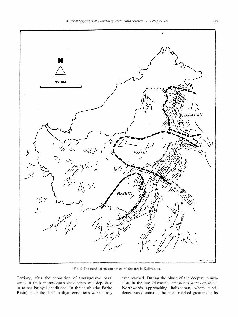
The present structural con®guration within the threebasins is characterized by fold- and fault-belts trendingparallel to the shoreline of Eastern Kalimantan(Fig. 5). The belts trend dominantly in a SSW±NNEdirection, except in the Adang Flexure, theMangkalihat Arch and the Semporna High areas,where they trend in a more E±W direction The originof structures in each basin is completely di�erent. Inthe Barito Basin, the structures are associated with theuplift of the Meratus Mountains to the east (Satyanaand Silitonga, 1993; 1994; Satyana, 1994). In the KuteiBasin, the formation of the structures has been con-sidered to have resulted from many causes: verticaldiapirism (Biantoro et al., 1992), gravitational glidingdue to the Kuching Uplift (Rose and Hartono, 1978;Ott, 1987), inversion through regional wrenching(Biantoro et al., 1992), detachment folds over invertedstructures (Chambers and Daley, 1995) and inverteddelta growth-fault system (Ferguson and McClay,1997). In the Tarakan Basin, the origin of structures isclosely related to sedimentary loading of successivedeltaic deposits (Biantoro et al., 1996; Lentini andDarman, 1996). In the Tarakan Basin terranes fromthe Sulu Sea to NNE of Borneo, converging with theSemporna High are responsible for the formation ofthe structures.
The three basins show similar tectonic historiesduring the Tertiary, until the Pleistocene (Fig. 6).Extensional tectonics, resulting in rifts and commen-cing in latest Paleocene±Middle Eocene time, charac-terized structural styles during the Paleogene.Compressional tectonics dominated during Neogeneand Pleistocene times, when older structures wereinverted and uplifted, resulting in regressive sedimen-tation. Neogene and Pleistocene extensional faults,both in the Kutei and Tarakan Basins, were triggeredby convergent uplift along the western margins of bothbasins.
2.2. Stratigraphy
The Paleozoic and Mesozoic deposits of Borneo,preserved in cratonic areas, were metamorphosedand folded during pre-Tertiary orogenies. Tertiaryand Pleistocene sediments were deposited in thebasinal areas ¯anking the Borneo nucleus. Tertiarysedimentation took place under continental, transi-tional and open marine conditions (Latreille et al.,1971).
The depositional history of the eastern Kalimantanbasins during the Tertiary is broadly one of subsi-dence, with the establishment of deep marine con-ditions, followed by ®lling up of the basins undershallower marine conditions (Figs. 6 and 7). In the
A.Harun Satyana et al. / Journal of Asian Earth Sciences 17 (1999) 99±122104
Tertiary, after the deposition of transgressive basal
sands, a thick monotonous shale series was deposited
in rather bathyal conditions. In the south (the Barito
Basin), near the shelf, bathyal conditions were hardly
ever reached. During the phase of the deepest immer-
sion, in the late Oligocene, limestones were deposited.
Northwards approaching Balikpapan, where subsi-
dence was dominant, the basin reached greater depths
Fig. 5. The trends of present structural features in Kalimantan.
A.Harun Satyana et al. / Journal of Asian Earth Sciences 17 (1999) 99±122 105
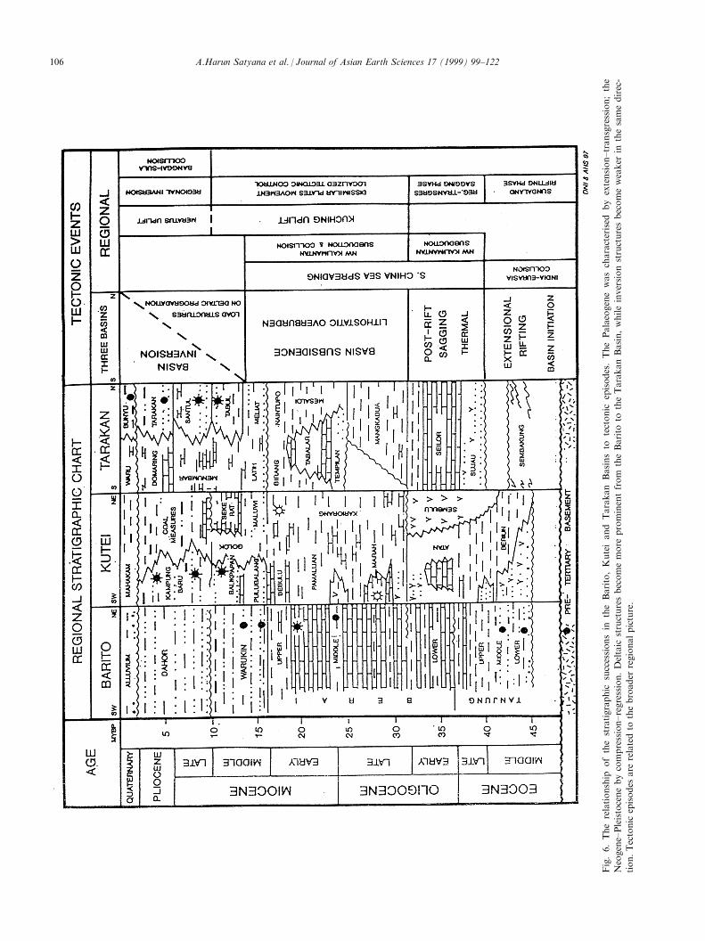
Fig.6.Therelationship
ofthestratigraphic
successionsin
theBarito,Kuteiand
Tarakan
Basinsto
tectonic
episodes.ThePalaeogenewascharacterised
by
extension±transgression;the
Neogene±Pleistocenebycompression±regression.Deltaic
structuresbecomemore
prominentfrom
theBarito
totheTarakanBasin,whileinversionstructuresbecomeweaker
inthesamedirec-
tion.Tectonic
episodes
are
relatedto
thebroader
regionalpicture.
A.Harun Satyana et al. / Journal of Asian Earth Sciences 17 (1999) 99±122106
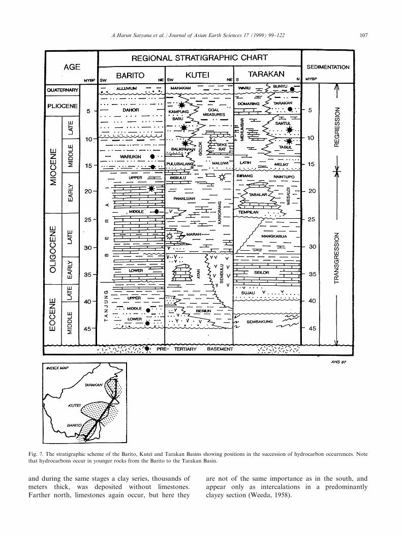
and during the same stages a clay series, thousands of
meters thick, was deposited without limestones.
Farther north, limestones again occur, but here they
are not of the same importance as in the south, and
appear only as intercalations in a predominantly
clayey section (Weeda, 1958).
Fig. 7. The stratigraphic scheme of the Barito, Kutei and Tarakan Basins showing positions in the succession of hydrocarbon occurrences. Note
that hydrocarbons occur in younger rocks from the Barito to the Tarakan Basin.
A.Harun Satyana et al. / Journal of Asian Earth Sciences 17 (1999) 99±122 107
In early Middle Miocene time, a phase of regressioncommenced, during which sands were deposited. In theBarito Basin, very soon after the deposition of theearly Miocene carbonates, paralic conditions prevailed,with the deposition of limestones and coals, togetherwith sands, late in the Early Miocene. NearBalikpapan, early Middle Miocene deposits consist ofclays with limestone intercalations, and it was only inthe middle of Middle Miocene times that coarse sandswere deposited. Farther north, near the MangkalihatArch, only the latest Middle Miocene is paralic, buton the Arch itself a fairly important carbonate of thisage has been developed and coals are absent. Finallyin the extreme north, in the Tarakan Basin, no coalsor well-developed sands occur until after MiddleMiocene time, although at Bunyu this stage does con-tains some coals and sands. After Middle Miocenetime, the deposits became coarser over wide areas. Inthe extreme north and south of East Kalimantan, inthe Tarakan and Barito Basins, younger deposits restunconformably upon older deposits. In the KuteiBasin in the central part of eastern Kalimantan, thisunconformity fades out. The thickness of the Tertiarydeposits is considerable. Rough estimates are: in theBarito BasinÐ4000 m; in the Kutei Basin 12,000±14,000 meters; and in the Tarakan Basin 9000 m(Fig. 15).
3. Barito basin
3.1. Geologic setting
The Barito Basin is situated along the southeasternmargin of the Schwaner Shield in South Kalimantan(Fig. 8). The basin is de®ned by the MeratusMountains to the east and separated from the KuteiBasin to the north by a ¯exure related to the AdangFault. The basin has a narrow opening to the southtowards the Java Sea. The Barito Basin is an asym-metric basin, forming a foredeep in the eastern partand a platform approaching the Schwaner Shieldtowards the west (Fig. 9 and Fig. 14).
The Barito Basin commenced its development in theLate Cretaceous, following a micro-continental col-lision between the Paternoster and SW Borneo micro-continents (Metcalfe, 1996; Satyana, 1996). EarlyTertiary extensional deformation occurred as a tec-tonic consequence of that oblique convergence. Thisproduced a series of NW±SE trending rifts. These riftsbecame accommodation space for alluvial fan andlacustrine sediments of the Lower Tanjung Formation,derived from horst areas. In the earliest MiddleEocene, as the result of a marine transgression, the riftsediments becoming more ¯uviodeltaic and eventuallymarine, as transgression proceeded during the depo-
sition of the Middle Tanjung Formation. The marinetransgression subsequently submerged the rifts in lateEocene±earliest Oligocene time, resulting in the depo-sition of widespread marine shales of the UpperTanjung Formation.
After a short-lived marine regression in the MiddleOligocene the development of a sag basin causedrenewed marine transgression. The Late Oligocene ischaracterized by the deposition of platform carbonatesof the Berai Formation (Figs. 6 and 7). Carbonate de-position continued into the Early Miocene, when itwas terminated by increasing clastic input from thewest. During the Miocene the sea regressed, due to theuplift of the Schwaner Core and the MeratusMountains. Clastic input resulted in the deposition ofthe eastwards-prograding deltaic sediments of theWarukin Formation. In the late Miocene the MeratusMountains re-emerged, followed by the isostatic subsi-dence of the basin which was situated in a forelandposition in relation to the rising mountains. Sedimentsshed from this uplift were deposited in the subsidingbasin, resulting in the deposition of thousands ofmeters of the Warukin Formation. The uplift of theMeratus Mountains continued into the Pleistocene andresulted in the deposition of the molassic-deltaic sedi-ments of the Pliocene Dahor Formation. This struc-tural and depositional regime still exists today.
The structural development of the Barito Basin is aconsequence of two distinctly separate, regimes (Fig. 6).First, an initial transtensional regime, during whichsinistral shear resulted in the formation of a series ofNW±SE trending wrench-related rifts, and second, atranspressional regime involving convergent uplift,which reactivated and inverted old tensile structuresand resulted in wrenching, faulting and folding. Thekinematics and type of Barito tectonic inversion havebeen discussed by Satyana and Silitonga (1994).
Presently, the structural grain of the basin is charac-terized by the concentration of structures in the NNEpart of the basin, typi®ed by tight, parallel SSW±NNEtrending folds, bounded towards the MeratusMountains by high-angle easterly-dipping imbricatereverse faults, which involve the basement (Figs. 5 and9). The presence of major wrench faults is indicated bydrag or fault-bend folds and reverse fault traces. Theunique concentration of structures in the NE part ofthe basin was interpreted by Satyana (1994) as the tec-tonic consequence of half-encirclement of the area bythe two pre-Tertiary massifs: the northern MeratusRange and the North Meratus Massifs (Fig. 8). Thewestern and southern parts of the Barito Basin wasmildly tectonized and show almost no deformationstructures. Thin-skinned tectonic manifestations, rep-resented by decollement and ramp anticlines are onlyvaguely identi®able in this portion of the basin(Satyana and Silitonga, 1993). Along the northern
A.Harun Satyana et al. / Journal of Asian Earth Sciences 17 (1999) 99±122108
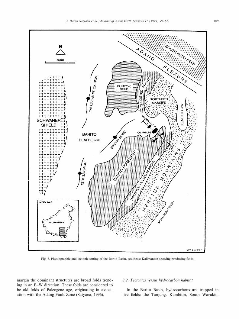
margin the dominant structures are broad folds trend-ing in an E±W direction. These folds are considered tobe old folds of Paleogene age, originating in associ-ation with the Adang Fault Zone (Satyana, 1996).
3.2. Tectonics versus hydrocarbon habitat
In the Barito Basin, hydrocarbons are trapped in®ve ®elds: the Tanjung, Kambitin, South Warukin,
Fig. 8. Physiographic and tectonic setting of the Barito Basin, southeast Kalimantan showing producing ®elds.
A.Harun Satyana et al. / Journal of Asian Earth Sciences 17 (1999) 99±122 109
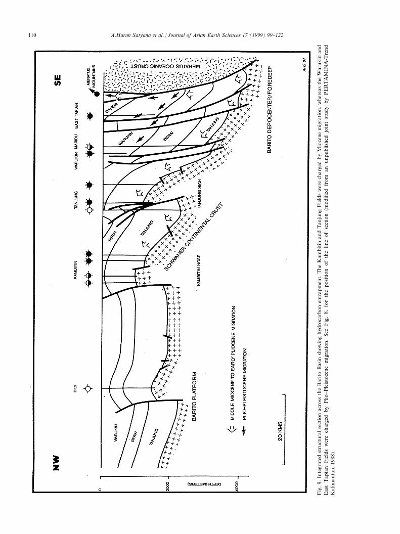
Fig.9.Integratedstructuralsectionacross
theBarito
Basinshowinghydrocarbonentrapment.TheKambitin
andTanjungFieldswerecharged
byMiocenemigration,whereastheWarukin
and
East
Tapian
Fieldswerecharged
by
Plio±Pleistocenemigration.See
Fig.8.fortheposition
ofthelineofsection
(modi®ed
from
an
unpublished
jointstudy
by
PERTAMIN
A-Trend
Kalimantan,1988).
A.Harun Satyana et al. / Journal of Asian Earth Sciences 17 (1999) 99±122110
Central Warukin and East Tapian Fields (Fig. 3). Allof the ®elds occur in faulted anticlines dipping to theeast. The Tanjung and Kambitin Fields are associatedwith basement-involved structures. The Warukin andEast Tapian Fields occurred in structures developed bythin-skinned tectonics within the Warukin Formation(Fig. 9).
Hydrocarbons are reservoired in the Lower andMiddle Tanjung Sands (Middle Eocene) and in theLower and Middle Warukin sands (Middle Miocene)(Figs. 7, 14 and 15). Pre-Tertiary basement rocks andthe Berai carbonates (late Oligocene±early Miocene),where they are fractured, have also proved to be goodreservoirs, and may trap hydrocarbons if they are wellpositioned. The hydrocarbons were generated in, andmigrated from, Lower and Middle Tanjung coals andcarbonaceous shales, and Lower Warukin carbon-aceous shales. The main kitchen is located in the pre-sent basin depocentre. The sealing rocks are mainlyprovided by the intra-formational shales. Generation,migration and entrapment of hydrocarbons has takenplace since the middle Early Miocene (20 Ma).
The Barito Basin provides the best example of thee�ects of tectonic interaction on hydrocarbon habitat(Fig. 9). In this basin, tectonics controlled each com-ponent of the hydrocarbon habitat (petroleum system).Extensional tectonics in the Early Tertiary formed arifted basin within which the lacustrine Tanjung shalesand coals were deposited in graben areas. This lacus-trine environment was responsible for the depositionof the Tanjung source rocks. As subsidence continuedand the rifted structures were submerged, widespreadshales were deposited, which became an important sealfor the underlying reservoir rocks. This condition wasalso responsible for the deposition of the widely-dis-tributed Middle Tanjung reservoir rocks. Extensionalfaults became conduits for the migration of hydrocar-bons generated in the deeper graben areas.
The role of tectonics in hydrocarbon accumulationin the basin during Neogene and Pleistocene time isindisputable. The implications of basin reversal in thedevelopment of the petroleum system in the BaritoBasin is discussed in Satyana and Silitonga (1994).During the Late Miocene the basin was inverted, in as-sociation with the Meratus Uplift, to produce anasymmetric basin; the Barito Basin, dipping gently inthe NW, towards the Barito Platform, and steeply inthe SE against the Meratus Uplift. Consequently thecentral part of the basin subsided rapidly, due to iso-stasy, causing the Tanjung source rocks to be deeplyburied, so that they attained the depth at which hydro-carbons were generated.
Restored modelling for the Barito tectonics and pet-roleum generation (Satyana and Silitonga, 1994;Satyana, 1995; Satyana and Idris, 1996) has shownthat inversion of the basin resulted from compressional
tectonism (Fig. 9). Graben-®ll sequences were activelyinverted and asymmetric anticlines were generatedalong the reverse faults. Hydrocarbons generated fromthe basin depocentre were expelled to ®ll these struc-tural traps. Structures such as the Tanjung Field werethus favorably positioned for the entrapment of earlymigrating hydrocarbons. Uplift of the MeratusMountains was continuous during the Late Miocene,through the Pliocene, and peaked in the Plio±Pleistocene. Tanjung source rocks in the depocentrewere already mature by the Late Miocene. Proto-inverted structural traps formed in the early Miocenetime were continuously inverted as basin compressiondeveloped, resulting in strongly positive features.Hydrocarbons ®lled these traps through the faults andalong permeable sands. It is considered that in theearly Pliocene the Tanjung source rocks in this areahad exhausted their liquid hydrocarbon generatingcapability. At this stage gas was generated andmigrated to ®ll the existing traps.
Plio±Pleistocene tectonism caused the whole BaritoBasin to be strongly inverted (Fig. 9). This tectonicevent caused both the formation of new traps and thedestruction of existing traps. Entrapped hydrocarbonsprobably remigrated to the newly-formed structures asold traps were tilted or breached by the Plio±Pleistocene inversion. At this stage the Tanjung sourcerocks had ceased to generate oil and gas in the depo-centre, since the section was ®rmly within the dry gaswindow. The Lower Warukin Shales in the basin depo-centre reached the depth of the oil window in the peakepisode of tectonism during Plio±Pleistocene times. Oilwas generated and migrated to accumulate in struc-tural traps within the Warukin sands. The Warukinand East Tapian Fields were charged in this period.
The foregoing discussion depicts how critical tec-tonics are to the deposition of reservoir and sourcerocks, the maturation of source rocks, the formationof structural traps and oil ®eld distribution. However,tectonics may also destroy pre-existing traps.
4. Kutei Basin
4.1. Geologic setting
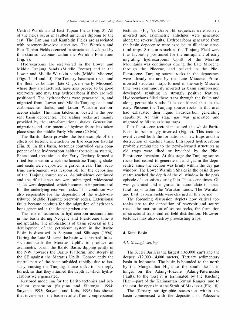
The Kutei Basin is the largest (165,000 km2) and thedeepest (12,000±14,000 meters) Tertiary sedimentarybasin in Indonesia. The basin is bounded to the northby the Mangkalihat High; to the south the basinhinges on the Adang±Flexure (Adang-PaternosterFault); to the west it is terminated by the KuchingHighÐpart of the Kalimantan Central Ranges; and tothe east the opens into the Strait of Makassar (Fig. 10).
The Tertiary stratigraphic succession within thebasin commenced with the deposition of Paleocene
A.Harun Satyana et al. / Journal of Asian Earth Sciences 17 (1999) 99±122 111
alluvial sediments of the Kiham Haloq Formation inthe inner basin, close to the western border (Figs. 6, 7and 14). The basin subsided during the late Paleocene±Middle Eocene to Oligocene, due to basement rifting,and became the site of deposition of the MangkupaShale in a marginal to open marine environment.Some coarser siliciclastics, the Beriun Sands, arelocally associated with the shale sequence, indicating
an interruption of basin subsidence by uplift. Thebasin subsided rapidly after the deposition of theBeriun Sands, mostly through the mechanism of basinsagging, resulting in the deposition of marine shales ofthe Atan Formation and carbonates of the KedangoFormation (Satyana and Biantoro, 1996).
Subsequent tectonic events uplifted parts of thebasin margin by the late Oligocene (Figs. 6 and 7).
Fig. 10. Physiographic and tectonic setting of the Kutei Basin, East Kalimantan showing producing ®elds.
A.Harun Satyana et al. / Journal of Asian Earth Sciences 17 (1999) 99±122112
This uplift was associated with the deposition of theSembulu Volcanics in the eastern part of the basin.The second stratigraphic phase was contemporaneouswith basin uplift and inversion, which started in EarlyMiocene time. During that time, a vast series of allu-vial and deltaic deposits were deposited in the basin.They comprise deltaic sediments of the Pamaluan,Pulubalang, Balikpapan and Kampung Baru for-mations, prograding eastwards, which range in agefrom the Early Miocene to Pleistocene times. Deltaicdeposition continues to the present day, and extendseastwards into o�shore Kutei Basin.
At present, the structural style of the Kutei Basin isdominated by a series of tight NNE±SSW trending folds(and subsidiary faults) that parallel the arcuate coastalline, and are known as the Samarinda AnticlinoriumÐMahakam Foldbelt (Figs. 5, 10 and 11). These fold beltsare characterized by tight, asymmetric anticlines, separ-ated by broad synclines, containing Miocene siliciclas-tics. These features dominate the eastern part of thebasin and are also identi®able o�shore. The defor-mation is increasingly more complex in the onshoredirection. The western basin area has been uplifted. Aminimum of 1500 m to over 3500 m of sediments havebeen removed by a mechanism of inversion (Wain andBerod, 1989; Courteney and Wiman, 1991). Not much isknown about the structure of the western basin areaand, although large structures are evident, a similarityin structural trend and style is not apparent from theavailable data (Ott, 1987). In this region, the tectonicsmay involve the basement (thick-skinned tectonics).Tectonic reversal, in terms of origin and its strain re-sponse, is not as obvious as in the Barito Basin.Prograding deltaic sediments may have contributed tothe mechanism of structural inversion, by a mechanismof diapirism or growth-faulting, these mechanisms arevery di�erent from those which a�ected the BaritoBasin.
The origin of folds and faults in the Kutei Basinremains unresolved and concepts as diverse as verticaldiapirism, gravitational gliding ( Rose and Hartono,1978; Ott, 1987), inversion through regional wrenching(Biantoro et al., 1992), micro-continental collision,detachment folding above overpressured sediments(Chambers and Daley, 1995), di�erential loading ondeltaic sediments and an inverted delta growth faultsystem (Ferguson and McClay, 1997) have beeninvoked.
4.2. Tectonics versus hydrocarbon habitat
The Kutei Basin is the most proli®c petroleum pro-vince in Kalimantan. No new commercial ®eld hasbeen discovered in the Barito and Tarakan Basinsduring the last few decades of exploration, but several
new ®elds, some giants, have been discovered in the
Kutei Basin during the last decade.
Producing oil and gas ®elds in the Kutei Basin are
all concentrated in the outer (Lower) Kutei Basin(Figs. 3 and 10). Not one ®eld is located in the inner
(Upper) Kutei Basin. The non-producing Kerendan
gas and condensate ®eld is located in the transitionalarea between the Barito and Kutei basins, in the SW
Kutei Basin, and cannot be related to the trend of the
upper Kutei Basin. All the oil®elds in the Kutei Basinoccur in the Samarinda Anticlinorium±Mahakam
Foldbelt. Some recently-discovered ®elds are strati-graphic traps, which are connected in some way with
the tectonics. The 24 producing ®elds of the Kutei
Basin are: Sangatta, Sangkimah, Semberah,Pamaguan, Sanga-Sanga, Mutiara, Samboja, Wailawi,
Kerindingan, Melahin, Badak, Nilam, Handil, Yakin,
Serang, Attaka, Tambora, Tunu, NW Peciko, Santan,Bekapai, Sisi, Nubi and Sepinggan. Giant ®elds are
located along the present Mahakam River. The ®elds
occur in parallel belts constituting four trends (Trend Ito IV) across the onshore and o�shore parts of the
Mahakam Delta (Fig. 10).
Hydrocarbons are trapped in reservoir deltaic sands
of the Balikpapan (Middle Miocene) and Kampung
Baru (late Miocene±Pliocene) formations (Figs. 7, 11,14 and 15). Pliocene carbonates form subsidiary reser-
voirs in the o�shore area. The source rocks are the
coals and carbonaceous shales of these two for-mations. Sealing is provided entirely by intra-for-
mational shales. Each ®eld is sourced by a proximal
kitchen located in its down-dip synclinal area. Thehydrocarbons generated in these areas migrated later-
ally updip to a maximum distance of 10 km (Paterson
et al., 1997) to accumulate in anticlinal traps. The gen-eration and migration of hydrocarbons started in the
Late Miocene and peak oil accumulation has occurredsince the late Pliocene. Trap formation took place
from the middle Miocene to Plio±Pleistocene time.
Tectonics are responsible for the richness of theKutei Basin. Convergent tectonics, which began in the
late Oligocene, have uplifted/inverted the Kuching
High and the Upper Kutei Basin (Ott, 1987) (Fig. 11).This uplifted area has become a major provenance for
the deltaic sediments deposited in the Lower KuteiBasin since that time. These sediments provide reser-
voir, source and sealing rocks in the Kutei Basin. The
presence of repeated synclinal kitchens and anticlinaltraps within the Samarinda Anticlinorium/Mahakam
Fold Belt demonstrates the role of tectonics in hydro-
carbon accumulation. Recent papers by Paterson et al.(1997) and Ferguson and McClay (1997) stress the
control of tectonics on early hydrocarbon expulsion of
oil by fracturing of the source rocks, while in the gen-erative stage.
A.Harun Satyana et al. / Journal of Asian Earth Sciences 17 (1999) 99±122 113

Fig.11.Integratedstructuralsectionacross
theKuteiBasinshowinghydrocarbonentrapment.Note:kitchensare
locatedin
each
synclineoftheSamarindaAnticlinorium.Thelocationofthelineof
sectionisshownonFig.10.
A.Harun Satyana et al. / Journal of Asian Earth Sciences 17 (1999) 99±122114
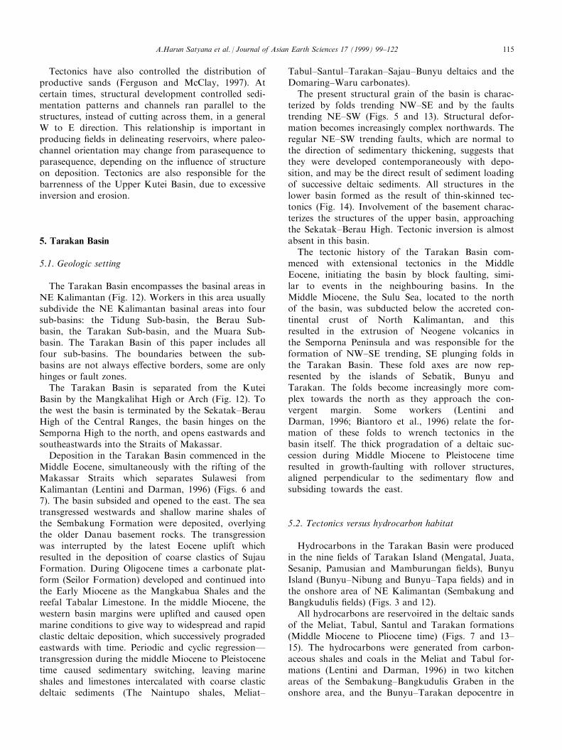
Tectonics have also controlled the distribution ofproductive sands (Ferguson and McClay, 1997). Atcertain times, structural development controlled sedi-mentation patterns and channels ran parallel to thestructures, instead of cutting across them, in a generalW to E direction. This relationship is important inproducing ®elds in delineating reservoirs, where paleo-channel orientation may change from parasequence toparasequence, depending on the in¯uence of structureon deposition. Tectonics are also responsible for thebarrenness of the Upper Kutei Basin, due to excessiveinversion and erosion.
5. Tarakan Basin
5.1. Geologic setting
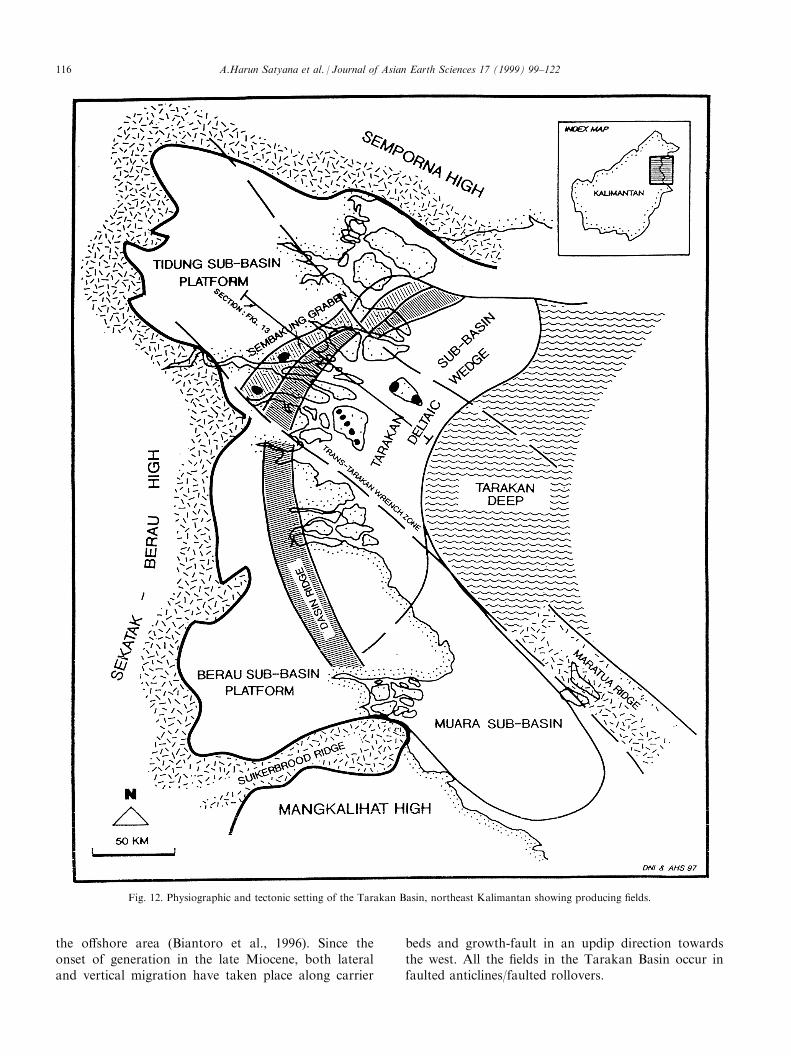
The Tarakan Basin encompasses the basinal areas inNE Kalimantan (Fig. 12). Workers in this area usuallysubdivide the NE Kalimantan basinal areas into foursub-basins: the Tidung Sub-basin, the Berau Sub-basin, the Tarakan Sub-basin, and the Muara Sub-basin. The Tarakan Basin of this paper includes allfour sub-basins. The boundaries between the sub-basins are not always e�ective borders, some are onlyhinges or fault zones.
The Tarakan Basin is separated from the KuteiBasin by the Mangkalihat High or Arch (Fig. 12). Tothe west the basin is terminated by the Sekatak±BerauHigh of the Central Ranges, the basin hinges on theSemporna High to the north, and opens eastwards andsoutheastwards into the Straits of Makassar.
Deposition in the Tarakan Basin commenced in theMiddle Eocene, simultaneously with the rifting of theMakassar Straits which separates Sulawesi fromKalimantan (Lentini and Darman, 1996) (Figs. 6 and7). The basin subsided and opened to the east. The seatransgressed westwards and shallow marine shales ofthe Sembakung Formation were deposited, overlyingthe older Danau basement rocks. The transgressionwas interrupted by the latest Eocene uplift whichresulted in the deposition of coarse clastics of SujauFormation. During Oligocene times a carbonate plat-form (Seilor Formation) developed and continued intothe Early Miocene as the Mangkabua Shales and thereefal Tabalar Limestone. In the middle Miocene, thewestern basin margins were uplifted and caused openmarine conditions to give way to widespread and rapidclastic deltaic deposition, which successively progradedeastwards with time. Periodic and cyclic regressionÐtransgression during the middle Miocene to Pleistocenetime caused sedimentary switching, leaving marineshales and limestones intercalated with coarse clasticdeltaic sediments (The Naintupo shales, Meliat±
Tabul±Santul±Tarakan±Sajau±Bunyu deltaics and theDomaring±Waru carbonates).
The present structural grain of the basin is charac-terized by folds trending NW±SE and by the faultstrending NE±SW (Figs. 5 and 13). Structural defor-mation becomes increasingly complex northwards. Theregular NE±SW trending faults, which are normal tothe direction of sedimentary thickening, suggests thatthey were developed contemporaneously with depo-sition, and may be the direct result of sediment loadingof successive deltaic sediments. All structures in thelower basin formed as the result of thin-skinned tec-tonics (Fig. 14). Involvement of the basement charac-terizes the structures of the upper basin, approachingthe Sekatak±Berau High. Tectonic inversion is almostabsent in this basin.
The tectonic history of the Tarakan Basin com-menced with extensional tectonics in the MiddleEocene, initiating the basin by block faulting, simi-lar to events in the neighbouring basins. In theMiddle Miocene, the Sulu Sea, located to the northof the basin, was subducted below the accreted con-tinental crust of North Kalimantan, and thisresulted in the extrusion of Neogene volcanics inthe Semporna Peninsula and was responsible for theformation of NW±SE trending, SE plunging folds inthe Tarakan Basin. These fold axes are now rep-resented by the islands of Sebatik, Bunyu andTarakan. The folds become increasingly more com-plex towards the north as they approach the con-vergent margin. Some workers (Lentini andDarman, 1996; Biantoro et al., 1996) relate the for-mation of these folds to wrench tectonics in thebasin itself. The thick progradation of a deltaic suc-cession during Middle Miocene to Pleistocene timeresulted in growth-faulting with rollover structures,aligned perpendicular to the sedimentary ¯ow andsubsiding towards the east.
5.2. Tectonics versus hydrocarbon habitat
Hydrocarbons in the Tarakan Basin were producedin the nine ®elds of Tarakan Island (Mengatal, Juata,Sesanip, Pamusian and Mamburungan ®elds), BunyuIsland (Bunyu±Nibung and Bunyu±Tapa ®elds) and inthe onshore area of NE Kalimantan (Sembakung andBangkudulis ®elds) (Figs. 3 and 12).
All hydrocarbons are reservoired in the deltaic sandsof the Meliat, Tabul, Santul and Tarakan formations(Middle Miocene to Pliocene time) (Figs. 7 and 13±15). The hydrocarbons were generated from carbon-aceous shales and coals in the Meliat and Tabul for-mations (Lentini and Darman, 1996) in two kitchenareas of the Sembakung±Bangkudulis Graben in theonshore area, and the Bunyu±Tarakan depocentre in
A.Harun Satyana et al. / Journal of Asian Earth Sciences 17 (1999) 99±122 115
the o�shore area (Biantoro et al., 1996). Since theonset of generation in the late Miocene, both lateraland vertical migration have taken place along carrier
beds and growth-fault in an updip direction towardsthe west. All the ®elds in the Tarakan Basin occur infaulted anticlines/faulted rollovers.
Fig. 12. Physiographic and tectonic setting of the Tarakan Basin, northeast Kalimantan showing producing ®elds.
A.Harun Satyana et al. / Journal of Asian Earth Sciences 17 (1999) 99±122116
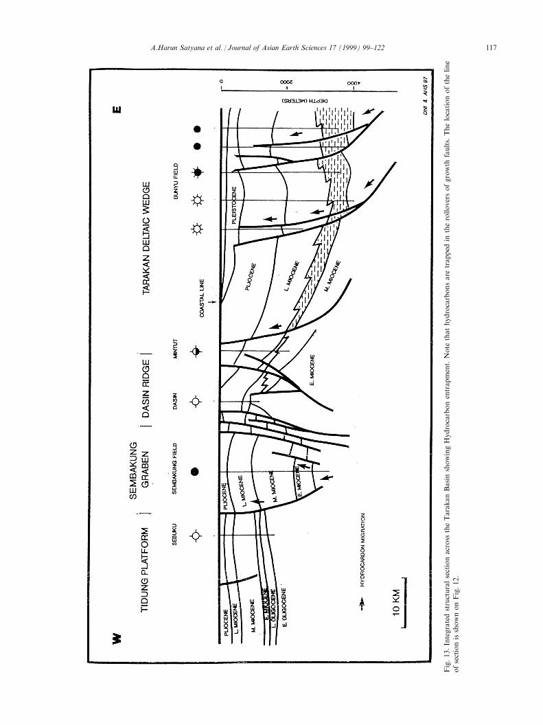
Fig.13.Integratedstructuralsectionacross
theTarakanBasinshowingHydrocarbonentrapment.Note
thathydrocarbonsare
trapped
intherolloversofgrowth
faults.
Thelocationoftheline
ofsectionisshownonFig.12.
A.Harun Satyana et al. / Journal of Asian Earth Sciences 17 (1999) 99±122 117
Syn-depositional faults play a major role in hydro-carbon accumulation in the Tarakan Basin. Biantoroet al. (1996) concluded that existing ®elds in the basinare very much dependent on the presence of growth-faults. The types of entrapment can be classi®ed underthe models of : four-way dip closure (SembakungField); rollover against fault (all Tarakan and Bunyu±Tapa ®elds); locally-upthrown block against fault(Bunyu Nibung Field); and unconformity-truncationagainst fault (Bangkudulis Field). Generally, hydrocar-bons are trapped in the downthrown blocks of growth-faults. If hydrocarbons are found in the upthrownblocks, the reserves are generally not commercial.Faults may play a role either as conduits or as mi-gration barriers. The maturation of source rocks wasalso a direct result of tectonics through subsidenceuntil the rocks attained the depth of the oil window.
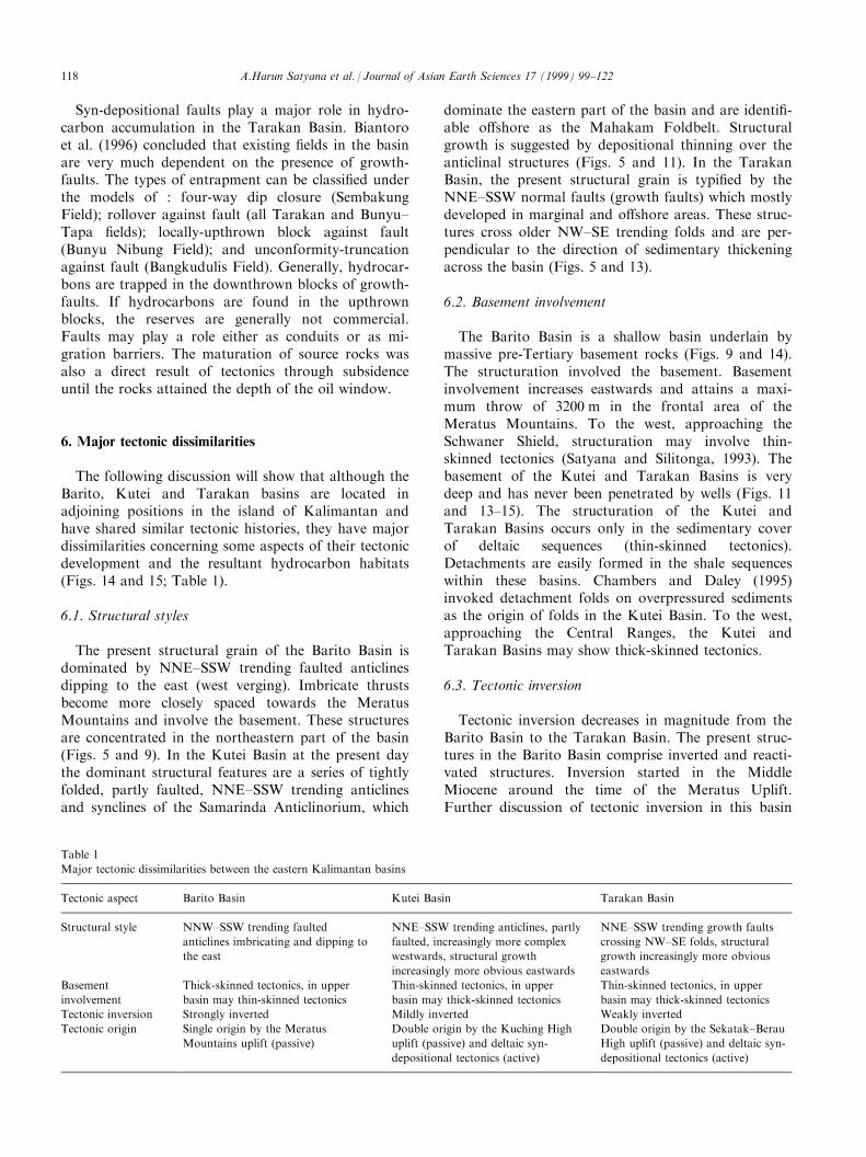
6. Major tectonic dissimilarities
The following discussion will show that although theBarito, Kutei and Tarakan basins are located inadjoining positions in the island of Kalimantan andhave shared similar tectonic histories, they have majordissimilarities concerning some aspects of their tectonicdevelopment and the resultant hydrocarbon habitats(Figs. 14 and 15; Table 1).
6.1. Structural styles
The present structural grain of the Barito Basin isdominated by NNE±SSW trending faulted anticlinesdipping to the east (west verging). Imbricate thrustsbecome more closely spaced towards the MeratusMountains and involve the basement. These structuresare concentrated in the northeastern part of the basin(Figs. 5 and 9). In the Kutei Basin at the present daythe dominant structural features are a series of tightlyfolded, partly faulted, NNE±SSW trending anticlinesand synclines of the Samarinda Anticlinorium, which
dominate the eastern part of the basin and are identi®-able o�shore as the Mahakam Foldbelt. Structuralgrowth is suggested by depositional thinning over theanticlinal structures (Figs. 5 and 11). In the TarakanBasin, the present structural grain is typi®ed by theNNE±SSW normal faults (growth faults) which mostlydeveloped in marginal and o�shore areas. These struc-tures cross older NW±SE trending folds and are per-pendicular to the direction of sedimentary thickeningacross the basin (Figs. 5 and 13).
6.2. Basement involvement
The Barito Basin is a shallow basin underlain bymassive pre-Tertiary basement rocks (Figs. 9 and 14).The structuration involved the basement. Basementinvolvement increases eastwards and attains a maxi-mum throw of 3200 m in the frontal area of theMeratus Mountains. To the west, approaching theSchwaner Shield, structuration may involve thin-skinned tectonics (Satyana and Silitonga, 1993). Thebasement of the Kutei and Tarakan Basins is verydeep and has never been penetrated by wells (Figs. 11and 13±15). The structuration of the Kutei andTarakan Basins occurs only in the sedimentary coverof deltaic sequences (thin-skinned tectonics).Detachments are easily formed in the shale sequenceswithin these basins. Chambers and Daley (1995)invoked detachment folds on overpressured sedimentsas the origin of folds in the Kutei Basin. To the west,approaching the Central Ranges, the Kutei andTarakan Basins may show thick-skinned tectonics.
6.3. Tectonic inversion
Tectonic inversion decreases in magnitude from theBarito Basin to the Tarakan Basin. The present struc-tures in the Barito Basin comprise inverted and reacti-vated structures. Inversion started in the MiddleMiocene around the time of the Meratus Uplift.Further discussion of tectonic inversion in this basin
Table 1
Major tectonic dissimilarities between the eastern Kalimantan basins
Tectonic aspect Barito Basin Kutei Basin Tarakan Basin
Structural style NNW±SSW trending faulted
anticlines imbricating and dipping to
the east
NNE±SSW trending anticlines, partly
faulted, increasingly more complex
westwards, structural growth
increasingly more obvious eastwards
NNE±SSW trending growth faults
crossing NW±SE folds, structural
growth increasingly more obvious
eastwards
Basement
involvement
Thick-skinned tectonics, in upper
basin may thin-skinned tectonics
Thin-skinned tectonics, in upper
basin may thick-skinned tectonics
Thin-skinned tectonics, in upper
basin may thick-skinned tectonics
Tectonic inversion Strongly inverted Mildly inverted Weakly inverted
Tectonic origin Single origin by the Meratus
Mountains uplift (passive)
Double origin by the Kuching High
uplift (passive) and deltaic syn-
depositional tectonics (active)
Double origin by the Sekatak±Berau
High uplift (passive) and deltaic syn-
depositional tectonics (active)
A.Harun Satyana et al. / Journal of Asian Earth Sciences 17 (1999) 99±122118
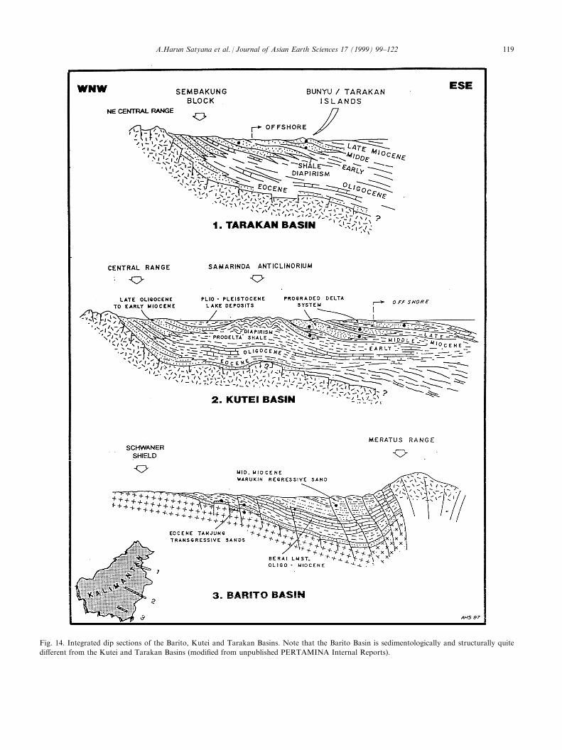
Fig. 14. Integrated dip sections of the Barito, Kutei and Tarakan Basins. Note that the Barito Basin is sedimentologically and structurally quite
di�erent from the Kutei and Tarakan Basins (modi®ed from unpublished PERTAMINA Internal Reports).
A.Harun Satyana et al. / Journal of Asian Earth Sciences 17 (1999) 99±122 119
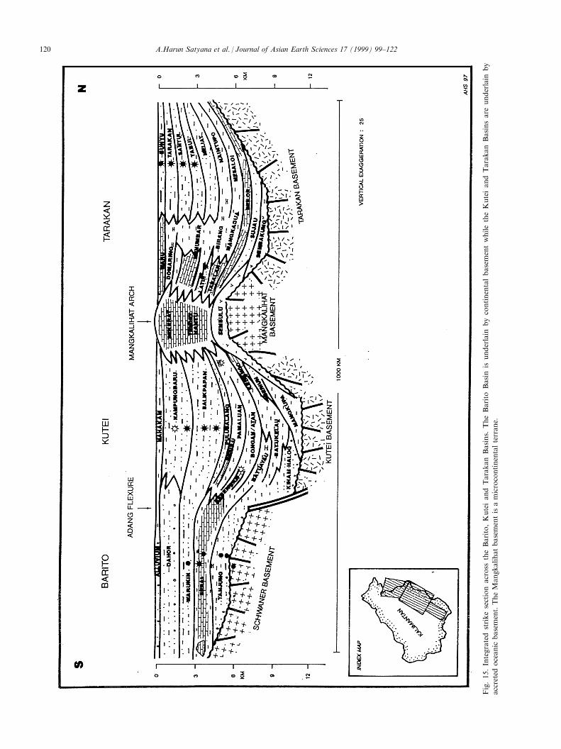
Fig.15.Integratedstrikesectionacross
theBarito,KuteiandTarakanBasins.
TheBarito
Basinis
underlain
bycontinentalbasementwhiletheKuteiandTarakanBasinsare
underlain
by
accretedoceanic
basement.TheMangkalihatbasementisamicrocontinentalterrane.
A.Harun Satyana et al. / Journal of Asian Earth Sciences 17 (1999) 99±122120
can be found in Satyana and Silitonga (1994). Mostworkers agree that inversion also took place in theKutei Basin (Biantoro et al., 1992; Ferguson andMcClay, 1997). However, extensional structures stillimprint the tectonism strongly in some parts of thebasin. Inverted structures in the Kutei Basin are di�er-ent from those in the Barito Basin and were activelyinverted as the deltaic sediments prograded. In theTarakan Basin, the predominate structures are exten-sional growth-faults which show almost no overprintdue to tectonic inversion.
6.4. Tectonic origin
Structures in the Barito Basin were caused by con-vergent uplift of the Meratus Mountains. This upliftcompressed the basin obliquely towards the northwest.This is expressed by the westward vergence of all thestructures and the imbricate system approaching theMeratus Mountains (Figs. 9 and 14). Structures ofthe Kutei Basin should be attributed ®rst to the con-vergent uplift of the Kuching High, which sub-sequently contributed to very thick deltaic sequences inthe lower basin, within which the present day struc-tures developed actively through a number of mechan-isms. The vergence of structures is various, anddepends on the origin of the structures. Structures inthe Tarakan Basin shared a similar origin to those ofthe Kutei Basin, where the Sekatak±Berau High to thewest of the basin controlled the tectonism. However,further development of the structures was di�erent, asthe convergence of terranes located to the north of thebasin controlled the development of their development.The last tectonic events in the Tarakan Basin are as-sociated with the deposition of the deltaic sequence,the development of growth-faults and associated rollovers, as the deltaic sediments prograded eastwardsacross the basin.
7. Lessons from adjoining basins
Among the three producing basins in Kalimantan,the Barito Basin occupies a unique geologic settingand is tectonically isolated (Figs. 14 and 15; Table 1).The basin is terminated to the east, it has no thicksequence of deltaic sediments, it was deformed bythick-skinned tectonics, it has only a single tectonicgenerator, it produces oil from the basement and fromthe Paleogene section. The Kutei and Tarakan Basinsshow these aspects conversely: the basins open to theeast, they have very thick sequences of deltaic sedi-ments, they were structured in an environment of thin-skinned tectonics, they have double tectonic generatorsand they produce oil and gas only from the Neogenesection.
These di�erences and similarities provide importantlessons in the endeavor to improve exploration success.The Kutei Basin has Eocene sands, which in age andfacies are equivalent to the productive Tanjung sandsin the Barito Basin (Satyana and Biantoro, 1996). Oneshould learn from the success of Paleogene explorationin the Barito Basin to look for a similar situation inthe Kutei Basin. The Tarakan and Kutei basins aresimilar in several aspects of their tectonics and hydro-carbon habitat. However, exploration e�ort in theKutei Basin, mainly in o�shore Lower Kutei Basin,has had much greater success, by far, than in theTarakan Basin.
Explorationists searching for hydrocarbons in theo�shore Tarakan Basin will bene®t from the experi-ence of exploration success in the o�shore KuteiBasin. Unfortunately, the lessons of Neogene successin the Kutei Basin cannot be applied directly to theBarito Basin, since these two adjoining basins werequite di�erent in Neogene time. New exploration con-cepts should be developed for the Barito Basin, suchas relict structures (Mason et al., 1993), Paleogeneunconformities and structures (Satyana, 1995; Satyanaand Idris, 1996) or stratigraphic traps within TanjungFormation (Imanhardjo et al., 1993; Bon et al., 1996).
8. Summary
The Barito, Kutei and Tarakan basins shared a simi-lar tectonic history during the Tertiary, characterizedby an extensional regime in the Paleogene and a com-pressional regime in Neogene and Pleistocene time.However, their tectonic origins and styles are dissimi-lar. The e�ect of inversionÐcompressional stressdecreases from the Barito Basin to the Tarakan Basin.The Barito Basin is tectonically isolated from theKutei and Tarakan Basins.
Almost all existing producing ®elds in theKalimantan basins occur as structural traps. Recentlydiscovered ®elds in the o�shore Kutei Basin are strati-graphic traps in which a structural component has,more or less, enhanced the traps.
Tectonics has played a major role in developing thehabitats in the Kalimantan hydrocarbon-producingbasins. In the Barito Basin it caused the subsidence ofsource rocks to depths for hydrocarbon generation,tectonics formed structural traps, it is responsible forthe anomalous distribution of ®elds, it controlled thedirection of migration and processes of entrapment.But also tectonics has destroyed old traps. In theKutei Basin, tectonics is responsible for the richness ofthe basin, it expelled oil from source rocks, it causedthe deposition of repeated sections of rich source andreservoir rocks, it controlled the distribution of pro-ductive sands, but it has also inverted the upper basin
A.Harun Satyana et al. / Journal of Asian Earth Sciences 17 (1999) 99±122 121
and rendered it barren. In the Tarakan Basin, tectonicsformed growth-faults that solely controlled all hydro-carbon accumulations in the basin.
To lessen risk and increase success within eachbasin, it is necessary to learn from failures and suc-cesses in neighbouring basins.
Acknowledgements
The authors gratefully acknowledge the granting ofpermission for publication by the management ofPERTAMINA and JOB PERTAMINAÐSanta FeSalawati and for sponsorship of this paper. The paperhas bene®ted from discussions with Mr Luki Samuel,PERTAMINA and from several colleagues (especiallyMr Elan Biantoro, Mr Sopandi Tossin and Mr EddyPurnomo) from Kalimantan RegionÐExplorationDivision PERTAMINA E & P. Dr Chris Morley fromUniversity of Brunei Darussalam reviewed the paper.Mrs Lanny Satyana, the ®rst author's wife, assisted inresolving some di�culties in the English language.
References
Biantoro, E., Kusuma, M.I., Rotinsulu, L.F., 1996. Tarakan Sub-basin
growth faults, N.E. Kalimantan: their roles in hydrocarbon entrap-
ment. Proceedings of the Indonesian Petroleum Association, 25th
Annual Convention, pp. 175±189.
Biantoro, E., Muritno, B.P., Mamuaya, J.M.B., 1992. Inversion faults
as the major structural control in the northern part of the Kutei
Basin, East Kalimantan. Proceedings of the Indonesian Petroleum
Association, 21st Annual Convention, pp. 45±68.
Bon, J., Fraser, T.H., Amris, W., Stewart, D.N., Abubakar, Z.,
Sosromihardjo, S., 1996. A review of the exploration potential of
the Paleocene Lower Tanjung Formation in the South Barito
Basin. Proceedings of the Indonesian Petroleum Association, 25th
Annual Convention, pp. 69±79.
Chambers, J.L.C., Daley, T.E., 1995. A tectonic model for the onshore
Kutai Basin, East Kalimantan, based on an integrated geological
and geophysical interpretation. Proceedings of the Indonesian
Petroleum Association, 24th Annual Convention, pp. 111±130.
Courteney, S., Wiman, S.K., 1991. Indonesian Oil and Gas Fields
Atlas (Vol. 5, Kalimantan). Indonesian Petroleum Association,
Jakarta.
Ferguson, A., McClay, K., 1997. Structural modeling within the
Sanga-Sanga PSC, Kutei Basin, Kalimantan: its application to
paleochannel orientation studies and timing of hydrocarbon entrap-
ment. Petroleum Systems of SE Asia and Australasia Conference,
May 1997, Indonesian Petroleum Association, Jakarta, pp. 727±743.
Imanhardjo, D.N., Silalahi, L.P.T., Hartanto, K., 1993. Studi strati-
gra® Formasi Tanjung. Unpublished Internal Report,
PERTAMINA Kalimantan Exploration.
Latreille, M., Sjahbuddin, A., Perrier, R., Goenarto, Pekar L.,
Baumann, P., Koesdarsono, L., Hartojo, P., 1971. Kalimantan
Basins. PERTAMINA-LEMIGAS-BEICIP, Jakarta.
Lentini, M.R., Darman, H., 1996. Aspects of the Neogene tectonic his-
tory and hydrocarbon geology of the Tarakan Basin. Proceedings of
the Indonesian Petroleum Association, 25th Annual Convention,
Jakarta, pp. 241±251.
Mason, A.D.M., Haebig, J.C., McAdoo, R.L., 1993. A fresh look at
the North Barito Basin, Kalimantan. Proceedings of the
Indonesian Petroleum Association, 22nd Annual Convention,
Jakarta, pp. 589±606.
Metcalfe, I., 1996. Pre-Cretaceous evolution of S.E. Asian terranes. In:
Hall, R., Blundell, D. (Eds.). Tectonic evolution of Southeast Asia.
Geological Society of London Special Publication 106, pp. 97±122.
Ott, H.L., 1987. The Kutei BasinÐa unique structural history.
Proceedings of the Indonesian Petroleum Association, 16th
Annual Convention, Jakarta, pp. 307±316.
Paterson, D.W., Bachtiar, A., Bates, J.A., Moon, J.A., Surdam, R.C.,
1997. Petroleum system of the Kutei Basin, Kalimantan, Indonesia.
Petroleum Systems of SE Asia and Australasia Conference, Jakarta,
May 1997. Indonesian Petroleum Association, pp. 709±726.
Rose, R., Hartono, P., 1978. Geological evolution of the Tertiary
Kutei-Melawi Basin, Kalimantan, Indonesia. Proceedings of the
Indonesian Petroleum Association, 7th Annual Convention,
Jakarta, pp. 225±252.
Satyana, A.H., 1994. The northern massifs of the Meratus Mountains,
South Kalimantan: nature, evolution and tectonic implications to
the Barito structures. Proceedings of the Indonesian Association
of Geologists, 23rd Annual Convention, Jakarta, pp. 457±470.
Satyana, A.H., 1995. Paleogene unconformities in the Barito Basin,
S.E. Kalimantan: a concept for the solution of the ``Barito
Dilemma'' and a key to the search for Paleogene structures.
Proceedings of the Indonesian Petroleum Association, 24th
Annual Convention, Jakarta, pp. 263±276.
Satyana, A.H., 1996. Adang-Lupar Fault, Kalimantan: controversies
and new observations on the trans-Kalimantan megashear.
Proceedings Indonesian Association of Geologists, 25th Annual
Convention, Jakarta, pp. 124±143.
Satyana, A.H., Biantoro, E. 1996. Seismic stratigraphy of Eocene
Beriun sands of West Bungalun, East Kalimantan, Indonesia: a con-
tribution to the Paleogene stratigraphical knowledge of the Kutei
Basin. International Symposium on Sequence Stratigraphy in S.E.
Asia, May 1995. Indonesian Petroleum Association, Jakarta.
pp. 383±394.
Satyana, A.H., Idris, R., 1996. Chronology and intensity of the Barito
uplifts, S.E. Kalimantan: a geochemical constraint and windows of
opportunity (poster). Proceedings of the Indonesian Petroleum
Association, 25th Annual Convention, Jakarta, p. 207.
Satyana, A.H., Silitonga, P.D., 1993. Thin-skinned tectonics and fault-
propagation folds: new insights to the tectonic origin of Barito folds,
South Kalimantan. Proceedings of the Indonesian Association of
Geologists, 22nd Annual Convention, Jakarta, pp. 282±291.
Satyana, A.H., Silitonga, P.D., 1994. Tectonic reversal in East Barito
Basin, South Kalimantan: consideration of the types of inversion
structures and petroleum system signi®cance. Proceedings of the
Indonesian Petroleum Association, 23rd Annual Convention,
Jakarta, pp. 57±74.
van de Weerd, A.A., Armin, R.A., 1992. Origin and evolution of the
Tertiary hydrocarbon bearing basins in Kalimantan (Borneo),
Indonesia. American Association of Petroleum Geologists Bulletin
76 (11), 1778±1803.
Wain, T., Berod, B., 1989. The tectonic framework and paleogeo-
graphic evolution of the Upper Kutei Basin. Proceedings of the
Indonesian Petroleum Association, 18th Annual Convention,
Jakarta, pp. 55±78.
Weeda, J., 1958. Oil basins of East Borneo. In Weeks, L.G. (Ed.).
Habitat of Oil. American Association of Petroleum Geologists,
Tulsa, pp. 1337±1346.
A.Harun Satyana et al. / Journal of Asian Earth Sciences 17 (1999) 99±122122
Related Documents