California Trails and Greenways - 2011 • We want to present our process for improving the trail experience through efficient planning. • This is not about any particular user group. It’s about a vision for better non‐motorized multi‐use trails for all users and how to streamline the process of planning for them. 1 Technology for Fun Susatinable Trails

Welcome message from author
This document is posted to help you gain knowledge. Please leave a comment to let me know what you think about it! Share it to your friends and learn new things together.
Transcript

California Trails and Greenways - 2011
• We want to present our process for improving the trail experience through efficient planning.
• This is not about any particular user group. It’s about a vision for better non‐motorized multi‐use trails for all users and how to streamline the process of planning for them.
1Technology for Fun Susatinable Trails
California Trails and Greenways - 2011
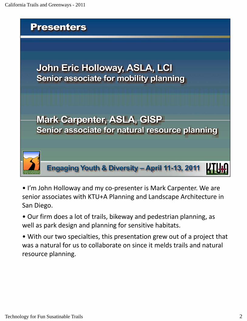
• I’m John Holloway and my co‐presenter is Mark Carpenter. We are senior associates with KTU+A Planning and Landscape Architecture in San Diego.
• Our firm does a lot of trails, bikeway and pedestrian planning, as well as park design and planning for sensitive habitats.
• With our two specialties, this presentation grew out of a project that was a natural for us to collaborate on since it melds trails and natural resource planning.
2Technology for Fun Susatinable Trails
California Trails and Greenways - 2011
• This slide is only here for the benefit of the conference proceedings. You won’t see this size text on any other slide. We promise.
3Technology for Fun Susatinable Trails
California Trails and Greenways - 2011
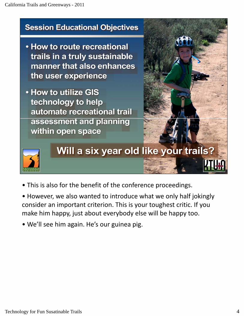
• This is also for the benefit of the conference proceedings.
• However we also wanted to introduce what we only half jokingly However, we also wanted to introduce what we only half jokingly consider an important criterion. This is your toughest critic. If you make him happy, just about everybody else will be happy too.
• We’ll see him again. He’s our guinea pig.
4Technology for Fun Susatinable Trails
California Trails and Greenways - 2011
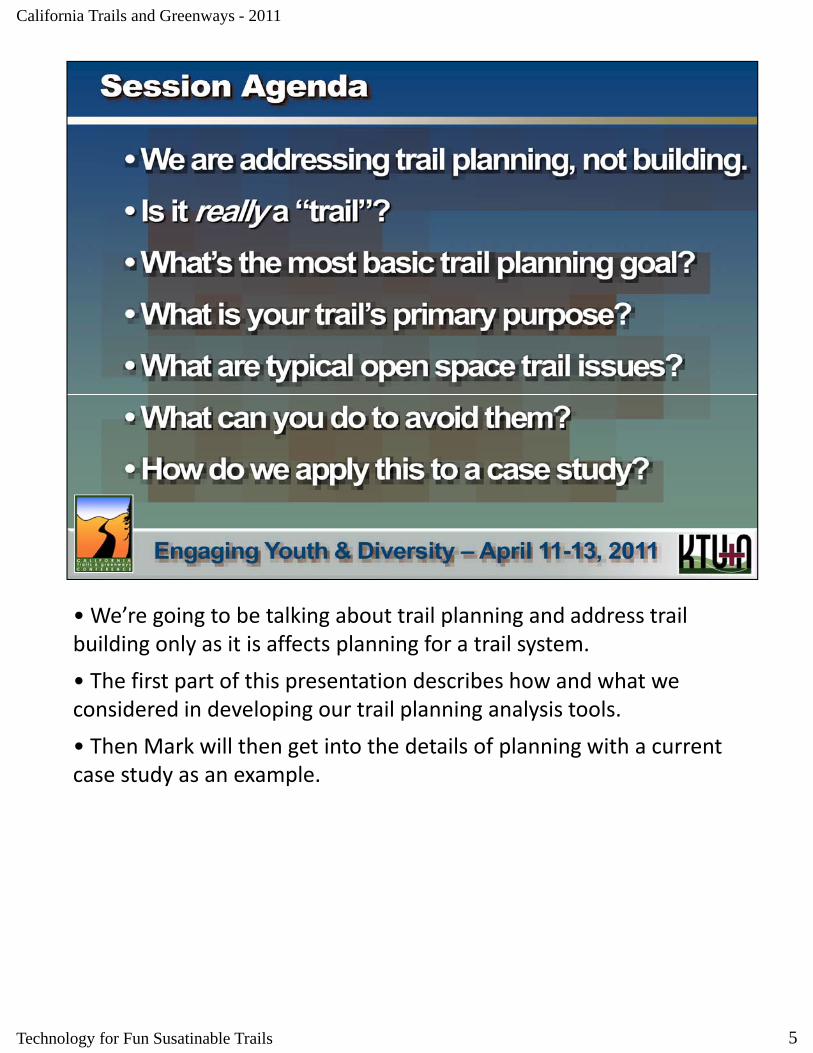
• We’re going to be talking about trail planning and address trail building only as it is affects planning for a trail system.
• The first part of this presentation describes how and what we considered in developing our trail planning analysis tools.
• Then Mark will then get into the details of planning with a current case study as an example.
5Technology for Fun Susatinable Trails
California Trails and Greenways - 2011
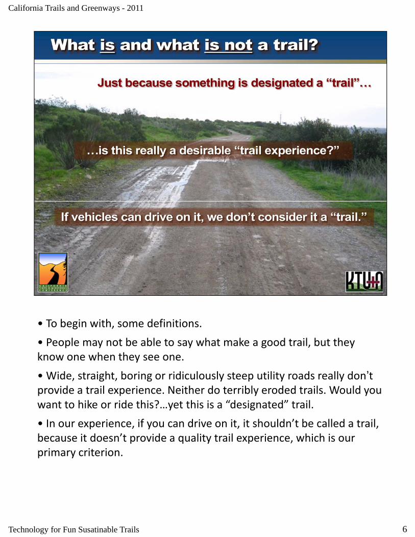
• To begin with, some definitions.
• People may not be able to say what make a good trail, but they know one when they see one.
• Wide, straight, boring or ridiculously steep utility roads really don’t provide a trail experience. Neither do terribly eroded trails. Would you want to hike or ride this? yet this is a “designated” trailwant to hike or ride this?…yet this is a “designated” trail.
• In our experience, if you can drive on it, it shouldn’t be called a trail, because it doesn’t provide a quality trail experience, which is our primary criterion.
6Technology for Fun Susatinable Trails
California Trails and Greenways - 2011
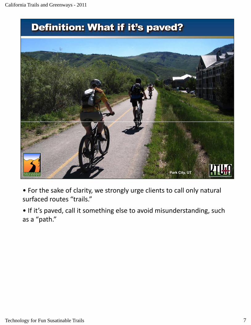
• For the sake of clarity, we strongly urge clients to call only natural surfaced routes “trails.”
• If it’s paved, call it something else to avoid misunderstanding, such as a “path.”
7Technology for Fun Susatinable Trails

California Trails and Greenways - 2011
• This may be one of the best paths we know of, and in this case, it’s called a parkway, which is pretty descriptive.
• What we’re addressing is natural surfaced trails.
8Technology for Fun Susatinable Trails

California Trails and Greenways - 2011
• This is a great path connecting two cities in southern Utah. Interstate 15 is just over the rise to the right.
• I found it because it accesses some really nice trails.
9Technology for Fun Susatinable Trails
California Trails and Greenways - 2011
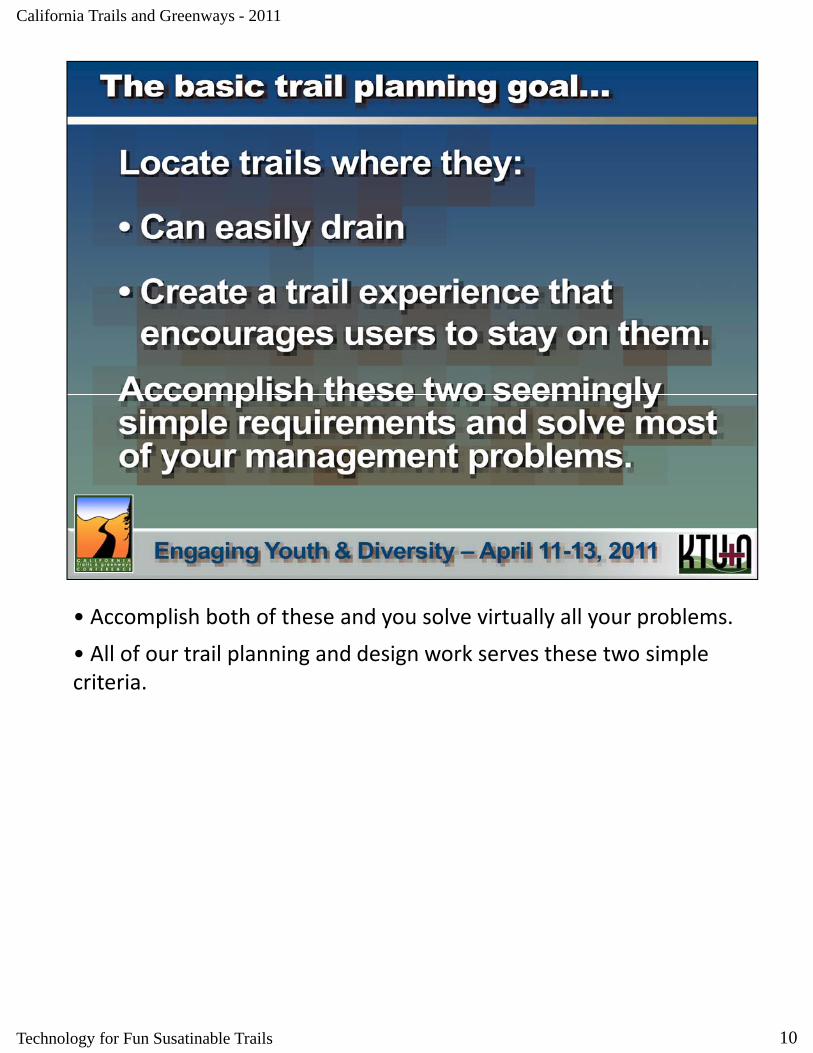
• Accomplish both of these and you solve virtually all your problems.
• All of our trail planning and design work serves these two simple All of our trail planning and design work serves these two simple criteria.
10Technology for Fun Susatinable Trails

California Trails and Greenways - 2011
• Trails serve a lot of purposes.
• Knowing what those purposes are help define how to plan them Knowing what those purposes are help define how to plan them.
11Technology for Fun Susatinable Trails
California Trails and Greenways - 2011
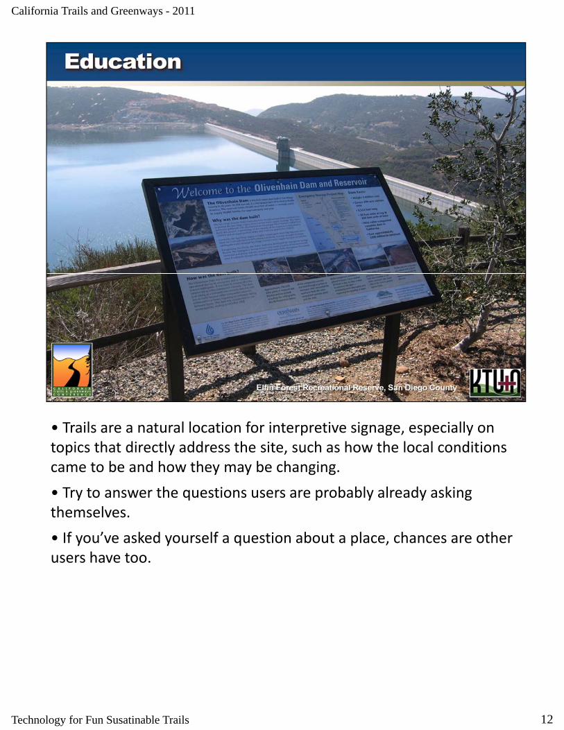
• Trails are a natural location for interpretive signage, especially on topics that directly address the site, such as how the local conditions came to be and how they may be changing.
• Try to answer the questions users are probably already asking themselves.
• If you’ve asked yourself a question about a place, chances are other users have too.
12Technology for Fun Susatinable Trails
California Trails and Greenways - 2011
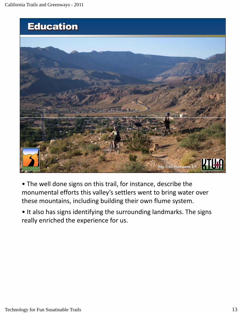
• The well done signs on this trail, for instance, describe the monumental efforts this valley’s settlers went to bring water over these mountains, including building their own flume system.
• It also has signs identifying the surrounding landmarks. The signs really enriched the experience for us.
13Technology for Fun Susatinable Trails

California Trails and Greenways - 2011
• Just being out on trails, especially with a knowledgeable guide, is an invaluable experience.
• We’ve seen that once children experience interesting trails, they clamor to go out there again.
14Technology for Fun Susatinable Trails
California Trails and Greenways - 2011
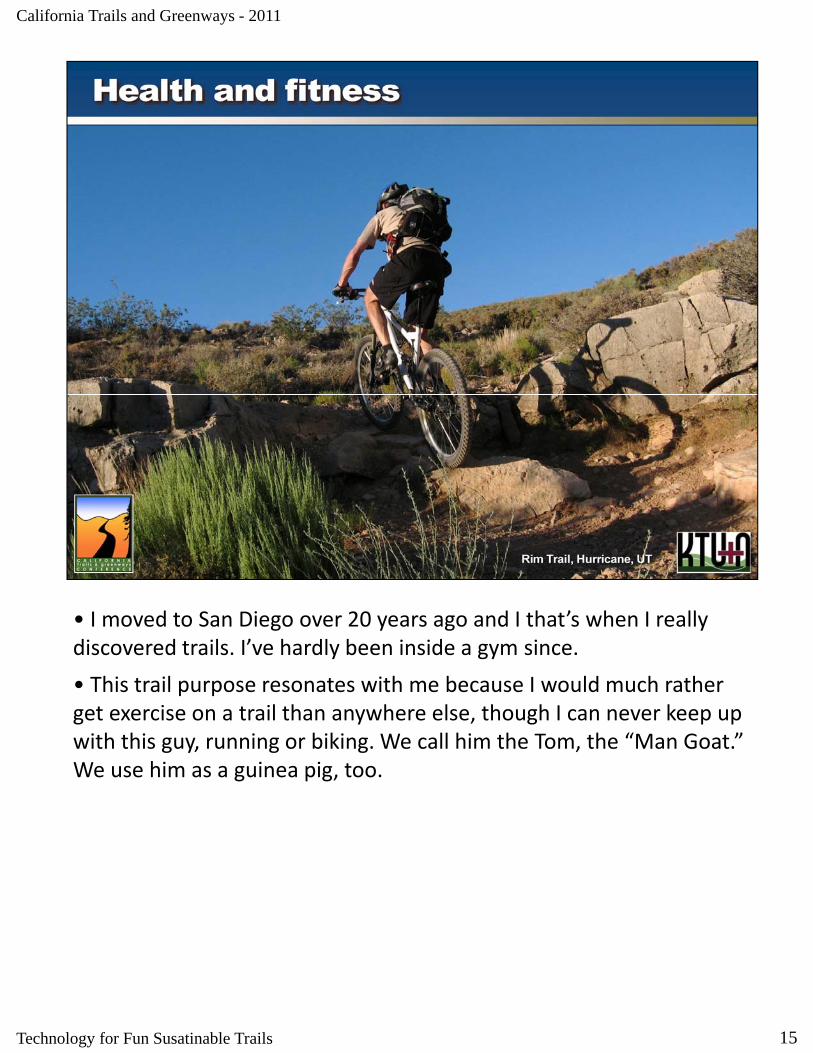
• I moved to San Diego over 20 years ago and I that’s when I really discovered trails. I’ve hardly been inside a gym since.y gy
• This trail purpose resonates with me because I would much rather get exercise on a trail than anywhere else, though I can never keep up with this guy, running or biking. We call him the Tom, the “Man Goat.” We use him as a guinea pig, too.
15Technology for Fun Susatinable Trails
California Trails and Greenways - 2011
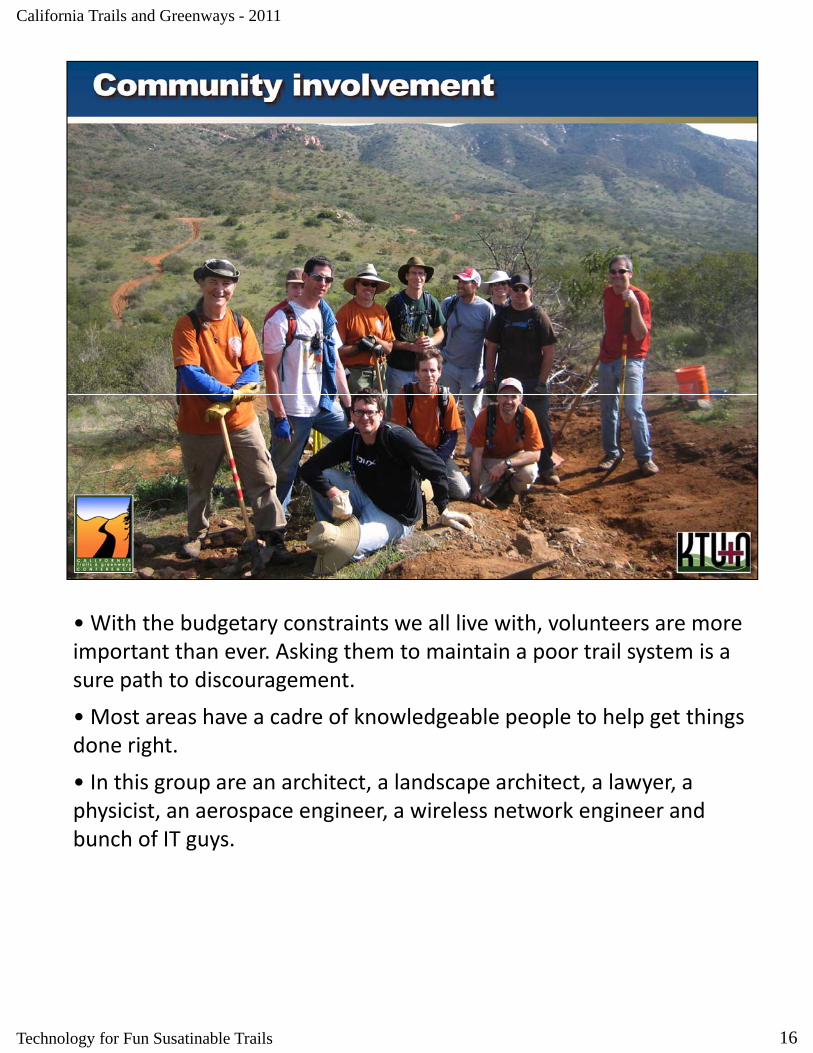
• With the budgetary constraints we all live with, volunteers are more important than ever. Asking them to maintain a poor trail system is aimportant than ever. Asking them to maintain a poor trail system is a sure path to discouragement.
• Most areas have a cadre of knowledgeable people to help get things done right.
• In this group are an architect, a landscape architect, a lawyer, a g p , p , y ,physicist, an aerospace engineer, a wireless network engineer and bunch of IT guys.
16Technology for Fun Susatinable Trails

California Trails and Greenways - 2011
• These trail signs are in downtown Park City, Utah, in the middle of the shopping and entertainment district.
• The trails mentioned range from paved paths to singletrack.
• Obviously, the city places a high quality‐of‐life value on trails.
17Technology for Fun Susatinable Trails
California Trails and Greenways - 2011
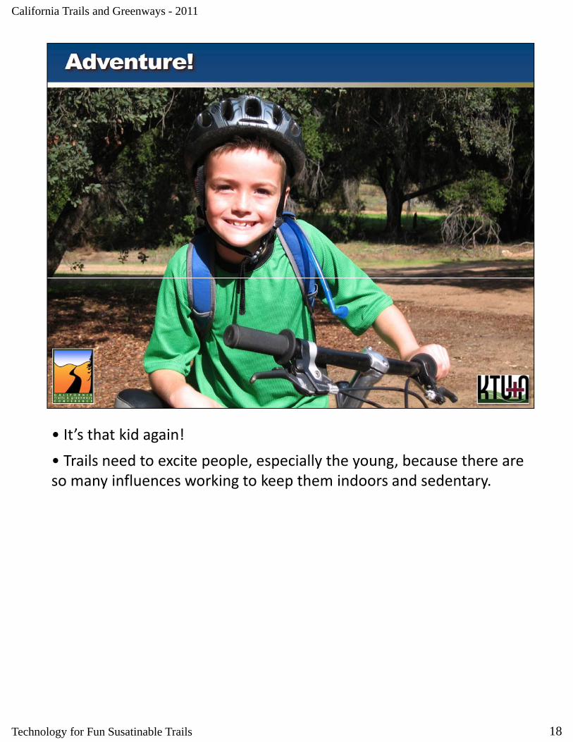
• It’s that kid again!
• Trails need to excite people especially the young because there are Trails need to excite people, especially the young, because there are so many influences working to keep them indoors and sedentary.
18Technology for Fun Susatinable Trails
California Trails and Greenways - 2011
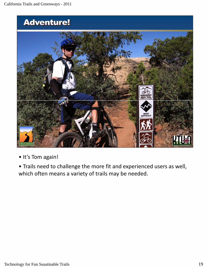
• It’s Tom again!
• Trails need to challenge the more fit and experienced users as well Trails need to challenge the more fit and experienced users as well, which often means a variety of trails may be needed.
19Technology for Fun Susatinable Trails
California Trails and Greenways - 2011
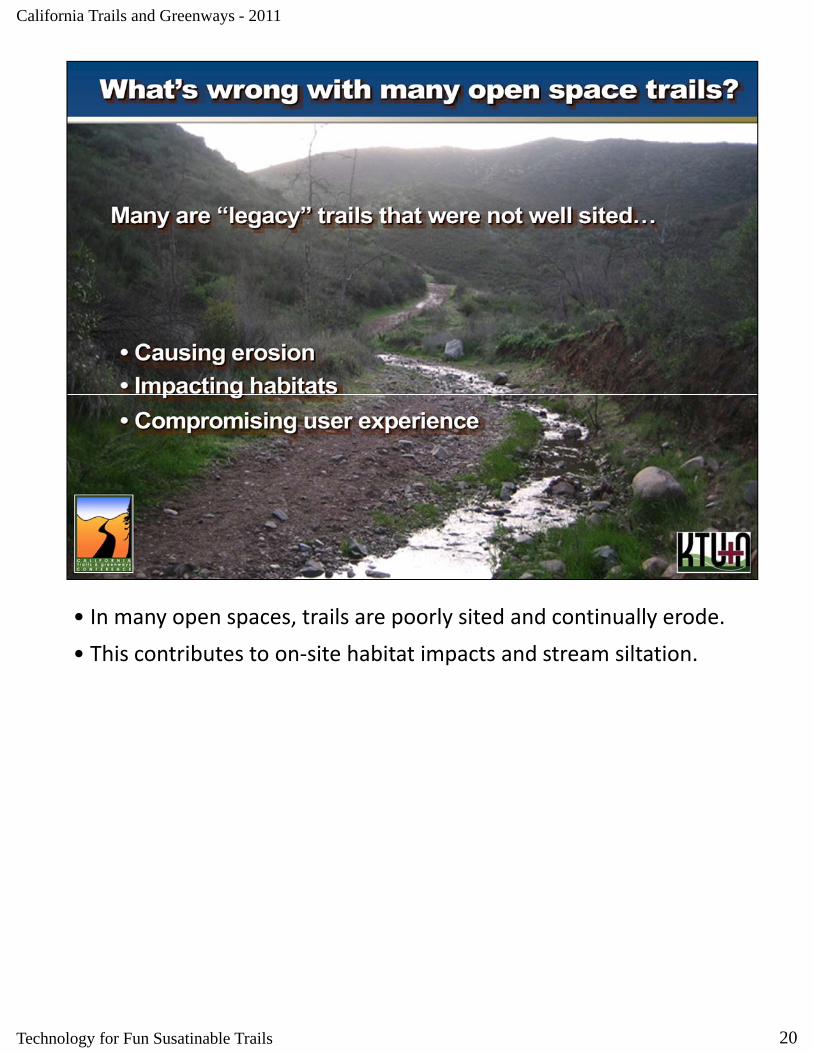
• In many open spaces, trails are poorly sited and continually erode.
• This contributes to on‐site habitat impacts and stream siltationThis contributes to on site habitat impacts and stream siltation.
20Technology for Fun Susatinable Trails
California Trails and Greenways - 2011
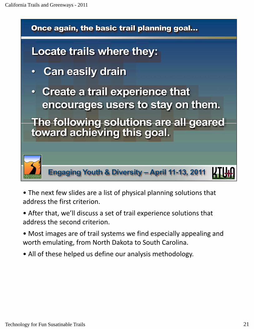
• The next few slides are a list of physical planning solutions that address the first criterion.
• After that, we’ll discuss a set of trail experience solutions that address the second criterion.
• Most images are of trail systems we find especially appealing and worth emulating, from North Dakota to South Carolina.
• All of these helped us define our analysis methodology.
21Technology for Fun Susatinable Trails

California Trails and Greenways - 2011
• Follow these principles and little, if any maintenance will be needed.
22Technology for Fun Susatinable Trails
California Trails and Greenways - 2011
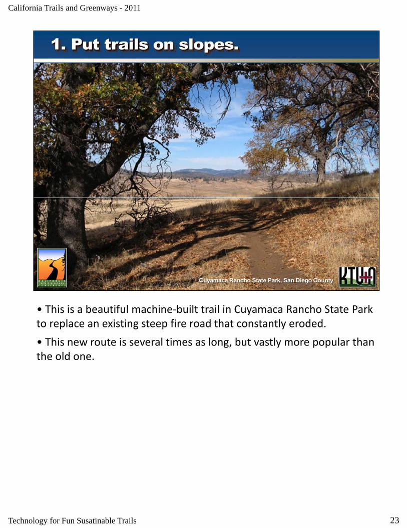
• This is a beautiful machine‐built trail in Cuyamaca Rancho State Park to replace an existing steep fire road that constantly eroded.
• This new route is several times as long, but vastly more popular than the old one.
23Technology for Fun Susatinable Trails

California Trails and Greenways - 2011
• What can I say about this trail?
• It breaks all the rules and is a constant maintenance issue It was It breaks all the rules and is a constant maintenance issue. It was planned to fail.
• As we’ll see in the second half of this presentation, being able to quickly model whether a routes will infringe on the fall line is invaluable.
24Technology for Fun Susatinable Trails
California Trails and Greenways - 2011
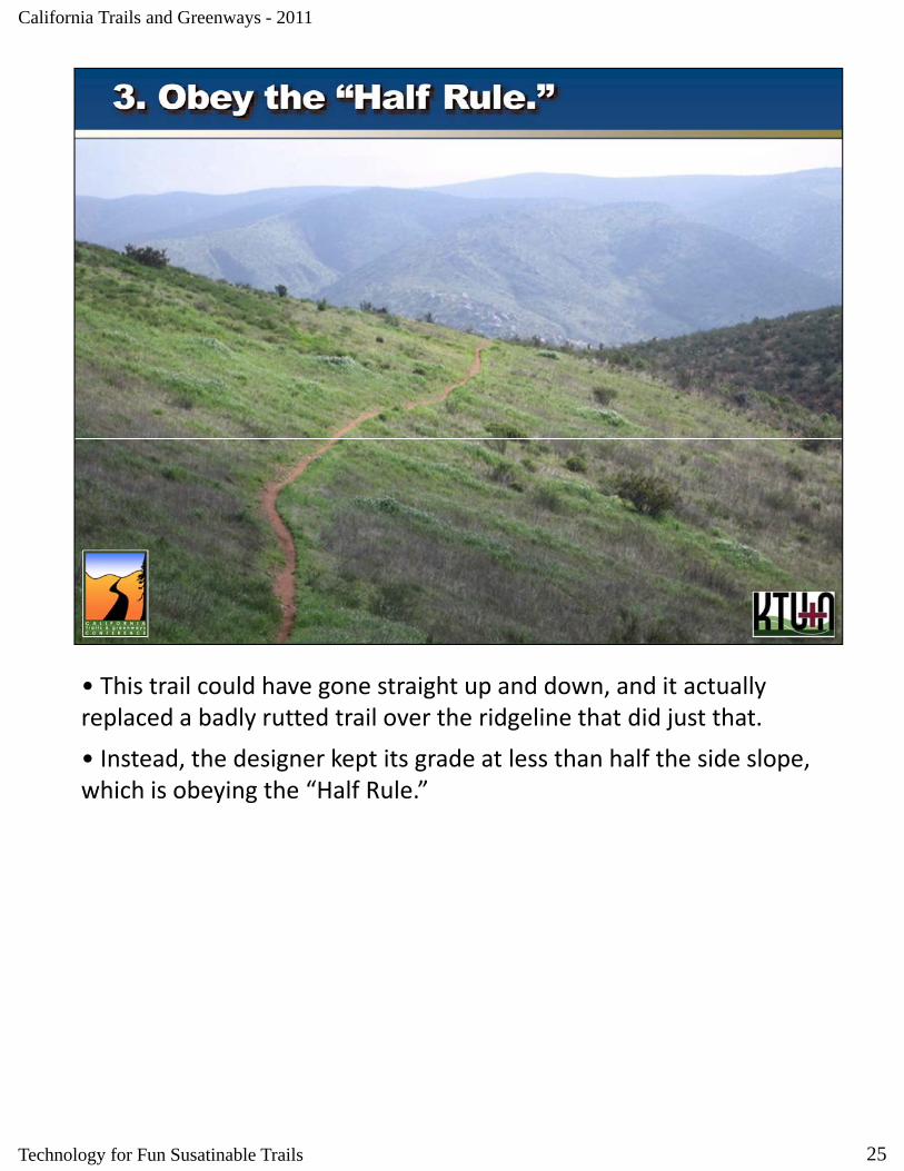
• This trail could have gone straight up and down, and it actually replaced a badly rutted trail over the ridgeline that did just that.
• Instead, the designer kept its grade at less than half the side slope, which is obeying the “Half Rule.”
25Technology for Fun Susatinable Trails
California Trails and Greenways - 2011
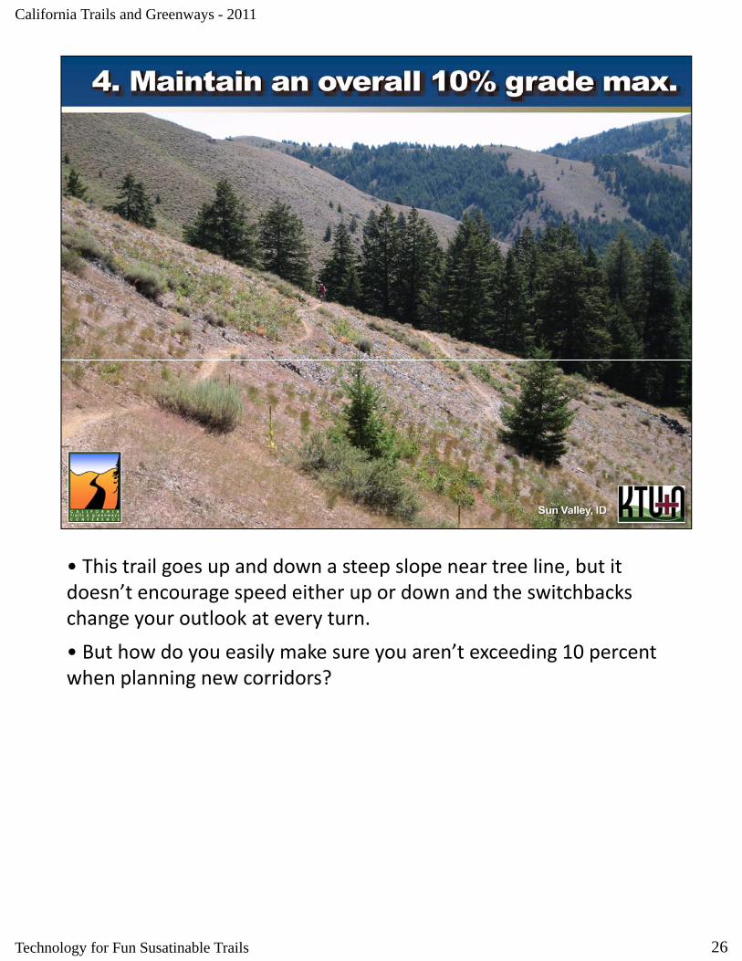
• This trail goes up and down a steep slope near tree line, but it doesn’t encourage speed either up or down and the switchbacks g p pchange your outlook at every turn.
• But how do you easily make sure you aren’t exceeding 10 percent when planning new corridors?
26Technology for Fun Susatinable Trails

California Trails and Greenways - 2011
• One way to do that is what we jokingly refer to as “string theory.”
k d d h d f l l d h h• Mark devised a method of laying out trail corridors that ensures that even a novice will not exceed a 10 percent grade.
27Technology for Fun Susatinable Trails

California Trails and Greenways - 2011
• It simply uses a string regularly marked with dots that coincide with the map scale and contour interval.
• You pin the string down so that each of its dots rests on a contour line. The distance between the dots is the maximum distance you can go between contour lines to ensure no more than a 10 percent grade.
• Skipping a contour line so that you cross two lines at once means you now have a 20 percent grade.
28Technology for Fun Susatinable Trails

California Trails and Greenways - 2011
• Remember that the 10 percent rule is a general guideline.
• Depending on local conditions you may be able to exceed that or Depending on local conditions, you may be able to exceed that, or have to keep your grades less than that.
• But if you don’t have to maintain a 10 percent grade and can work with less, there are some advantages.
29Technology for Fun Susatinable Trails

California Trails and Greenways - 2011
• And of course, local conditions will trump all other criteria.
• In this case the hard ground gets limited use and doesn’t erode In this case, the hard ground gets limited use and doesn t erode easily. These ridgeline routes are shared with cattle, but hold up well.
30Technology for Fun Susatinable Trails
California Trails and Greenways - 2011
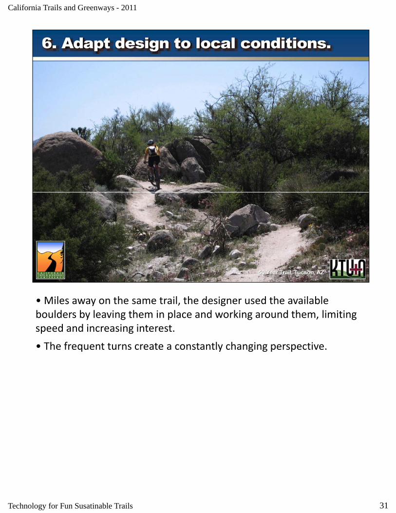
• Miles away on the same trail, the designer used the available boulders by leaving them in place and working around them, limiting speed and increasing interest.
• The frequent turns create a constantly changing perspective.
31Technology for Fun Susatinable Trails
California Trails and Greenways - 2011
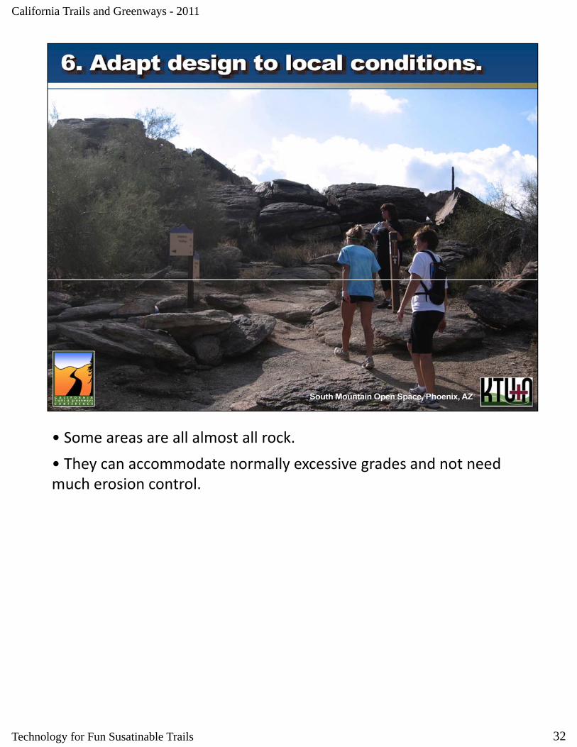
• Some areas are all almost all rock.
• They can accommodate normally excessive grades and not need They can accommodate normally excessive grades and not need much erosion control.
32Technology for Fun Susatinable Trails
California Trails and Greenways - 2011
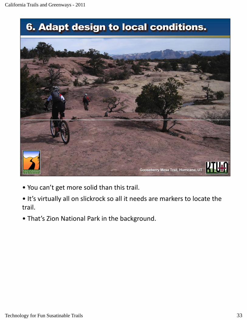
• You can’t get more solid than this trail.
• It’s virtually all on slickrock so all it needs are markers to locate the It s virtually all on slickrock so all it needs are markers to locate the trail.
• That’s Zion National Park in the background.
33Technology for Fun Susatinable Trails
California Trails and Greenways - 2011
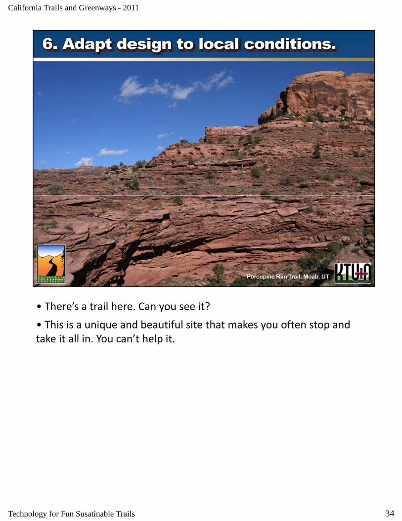
• There’s a trail here. Can you see it?
• This is a unique and beautiful site that makes you often stop and• This is a unique and beautiful site that makes you often stop and take it all in. You can’t help it.
34Technology for Fun Susatinable Trails

California Trails and Greenways - 2011
• Besides the physical design criteria, the following are what we employ to ensure a quality trail experience, our number one criterion.
• They can’t really be modeled, but they come from own experience and profoundly influence our planning process.
35Technology for Fun Susatinable Trails
California Trails and Greenways - 2011
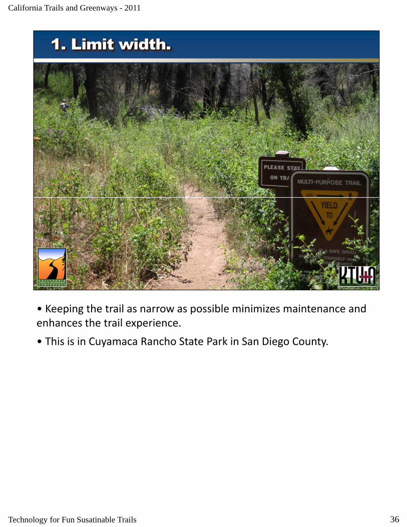
• Keeping the trail as narrow as possible minimizes maintenance and enhances the trail experience.
• This is in Cuyamaca Rancho State Park in San Diego County.
36Technology for Fun Susatinable Trails
California Trails and Greenways - 2011
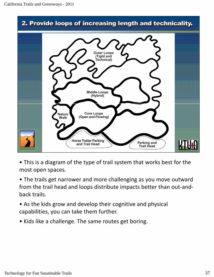
• This is a diagram of the type of trail system that works best for the most open spaces.
• The trails get narrower and more challenging as you move outward from the trail head and loops distribute impacts better than out‐and‐back trails.
• As the kids grow and develop their cognitive and physical capabilities, you can take them further.
• Kids like a challenge. The same routes get boring.
37Technology for Fun Susatinable Trails
The image cannot be displayed. Your computer may not have enough memory to open the image, or the image may have been corrupted. Restart your computer, and then open the file again. If the red x still appears, you may have to delete the image and then insert it again.
California Trails and Greenways - 2011
• The designer could have gone straight here, but in this well done trail system, straight lines are virtually non‐existent. One of my favorites.
38Technology for Fun Susatinable Trails
The image cannot be displayed. Your computer may not have enough memory to open the image, or the image may have been corrupted. Restart your computer, and then open the file again. If the red x still appears, you may have to delete the image and then insert it again.
California Trails and Greenways - 2011
• This routing makes the trail much more inviting than going straight across this valley, as well as helps avoid excessive grades.
39Technology for Fun Susatinable Trails

California Trails and Greenways - 2011
• On this trail outside Bryce National Park, your viewpoint changes constantly through these turns as a result of working hard to maintain a reasonable grade.
40Technology for Fun Susatinable Trails
The image cannot be displayed. Your computer may not have enough memory to open the image, or the image may have been corrupted. Restart your computer, and then open the file again. If the red x still appears, you may have to delete the image and then insert it again.
California Trails and Greenways - 2011
• This trail illustrates the previous “no straight lines” criterion, but it is also an example of using what is there to help enhance the experience.
• No rocks were harmed in the making of this trail.
41Technology for Fun Susatinable Trails
California Trails and Greenways - 2011
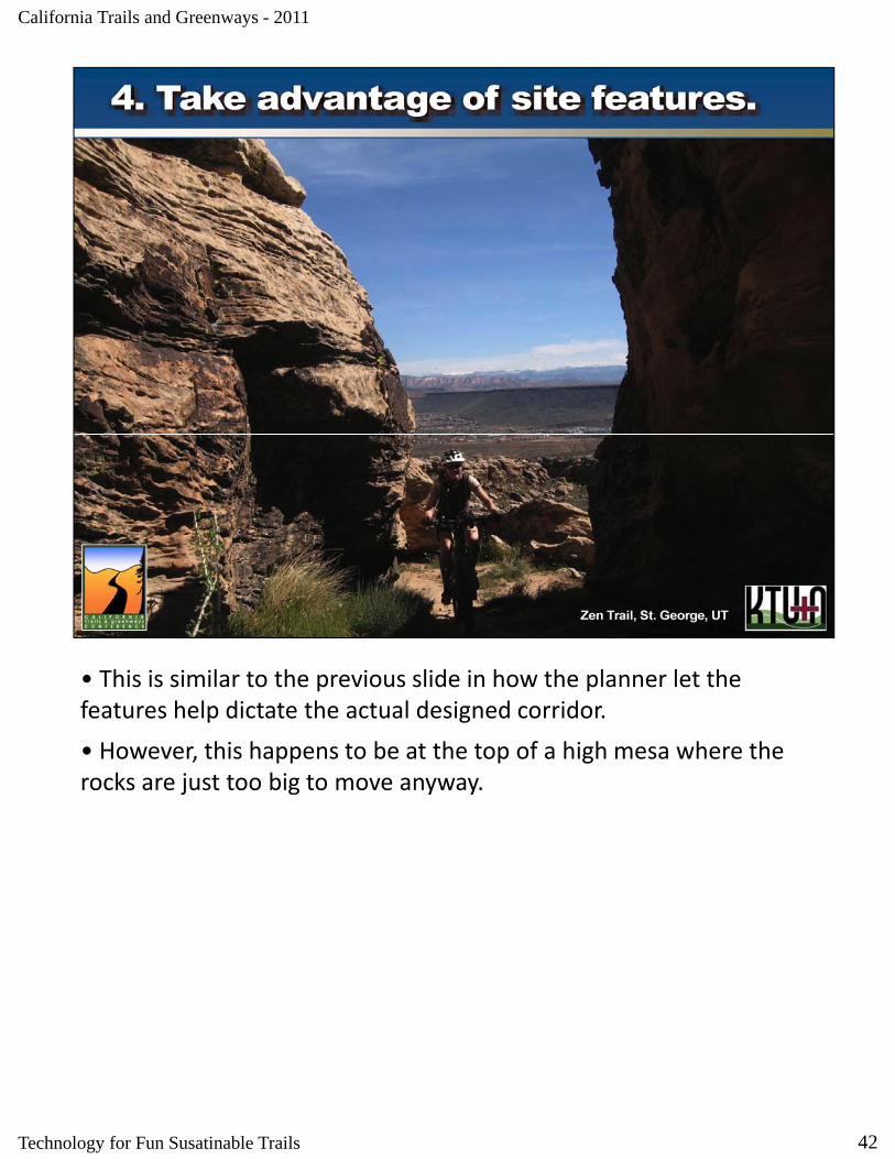
• This is similar to the previous slide in how the planner let the features help dictate the actual designed corridor.
• However, this happens to be at the top of a high mesa where the rocks are just too big to move anyway.
42Technology for Fun Susatinable Trails
The image cannot be displayed. Your computer may not have enough memory to open the image, or the image may have been corrupted. Restart your computer, and then open the file again. If the red x still appears, you may have to delete the image and then insert it again.
California Trails and Greenways - 2011
• Anyone who doesn’t stop to take this in is not really appreciating the experience.
43Technology for Fun Susatinable Trails
The image cannot be displayed. Your computer may not have enough memory to open the image, or the image may have been corrupted. Restart your computer, and then open the file again. If the red x still appears, you may have to delete the image and then insert it again.
California Trails and Greenways - 2011
• Some people crave a challenge and are up to it. Yes, it’s the Tom again.
• He’s actually a very mild mannered, polite aerospace engineer my wife is always trying to fix up with her single friends.
44Technology for Fun Susatinable Trails
The image cannot be displayed. Your computer may not have enough memory to open the image, or the image may have been corrupted. Restart your computer, and then open the file again. If the red x still appears, you may have to delete the image and then insert it again.
California Trails and Greenways - 2011
• Some people want to take it to extremes.
• This is part of the route to a mountain top in San Diego County This is part of the route to a mountain top in San Diego County.
45Technology for Fun Susatinable Trails
The image cannot be displayed. Your computer may not have enough memory to open the image, or the image may have been corrupted. Restart your computer, and then open the file again. If the red x still appears, you may have to delete the image and then insert it again.
California Trails and Greenways - 2011
• Other users may want a more sedate experience.
Th b tt li i th t ti i t d t ff t l i• The bottom line is that anticipated user types affect planning.
46Technology for Fun Susatinable Trails
The image cannot be displayed. Your computer may not have enough memory to open the image, or the image may have been corrupted. Restart your computer, and then open the file again. If the red x still appears, you may have to delete the image and then insert it again.
California Trails and Greenways - 2011
• And some users just wish they could get up the hill.
• If this is happening near your trailhead as in this case there’s• If this is happening near your trailhead, as in this case, there’s something wrong.
• Fortunately, a replacement singletrack to this legacy road is the works.
47Technology for Fun Susatinable Trails
The image cannot be displayed. Your computer may not have enough memory to open the image, or the image may have been corrupted. Restart your computer, and then open the file again. If the red x still appears, you may have to delete the image and then insert it again.
California Trails and Greenways - 2011
GIS models are often thought of as Black Boxes – put a bunch of data in, apply weightings and algorithms, and presto – a solution is produced. Successful trail planning and design that is both sustainable and enjoyable takes human insight and decision making that is nearly impossible to adequately model. Any one that tells you they can create a trail system by using a MODEL alone doesn’t fully understand trail planning Sure models can be used to identify potential trailtrail planning. Sure, models can be used to identify potential trail corridors that avoid constraints or include key locations, but translating that corridor into a preliminary trail route requires not just human insight, but local knowledge of the site.
48Technology for Fun Susatinable Trails
The image cannot be displayed. Your computer may not have enough memory to open the image, or the image may have been corrupted. Restart your computer, and then open the file again. If the red x still appears, you may have to delete the image and then insert it again.
California Trails and Greenways - 2011
Even a well planned trail route developed by a knowledgeable personnel still requires substantial time in the field to physically lay it out and make adjustments for localized site characteristics.
49Technology for Fun Susatinable Trails
The image cannot be displayed. Your computer may not have enough memory to open the image, or the image may have been corrupted. Restart your computer, and then open the file again. If the red x still appears, you may have to delete the image and then insert it again.
California Trails and Greenways - 2011
Even though GIS models cannot produce truly enjoyable sustainable trails by themselves, they can be used by skilled hands to help assess existing trails, as well as evaluate potential trail routes to ensure they are viable for further assessment.
50Technology for Fun Susatinable Trails
The image cannot be displayed. Your computer may not have enough memory to open the image, or the image may have been corrupted. Restart your computer, and then open the file again. If the red x still appears, you may have to delete the image and then insert it again.
California Trails and Greenways - 2011
At nearly 6,000 acres, MTRP is a tremendous asset to San Diegans due to its proximity and varied landform and habitats. The park has a colorful history with Native American habitation, water works for the San Diego Mission, military tank training (Gen. Patton), mineral extraction along the river, infrastructure development (water & power) and most recently inclusion is the San Diego Multi‐Species Management Program These characteristics provide bothManagement Program. These characteristics provide both opportunity and constraint to trail planning efforts.
51Technology for Fun Susatinable Trails

California Trails and Greenways - 2011
MTRP has been evolving since 1976, but not necessarily in a well thought out planned fashion. This effort was brought into full focus in 1985 by the approval of its Master Plan. The last 25 years have been punctuated with a variety of successful projects, but has been hampered by the lack of a planned trail system and an inability of park management to undertake any meaningful trail development without an environmental process or inclusion in the Master Plan The Masteran environmental process or inclusion in the Master Plan. The Master Plan Update is the opportunity to address both issues and set a vision for trail planning and design within MTRP for the next 25 years.
52Technology for Fun Susatinable Trails
The image cannot be displayed. Your computer may not have enough memory to open the image, or the image may have been corrupted. Restart your computer, and then open the file again. If the red x still appears, you may have to delete the image and then insert it again.
California Trails and Greenways - 2011
Most people are used to using GIS for inventory and basic mapping purposes. We started in the same manner.
53Technology for Fun Susatinable Trails
The image cannot be displayed. Your computer may not have enough memory to open the image, or the image may have been corrupted. Restart your computer, and then open the file again. If the red x still appears, you may have to delete the image and then insert it again.
California Trails and Greenways - 2011
With all the existing ‘trails’ mapped, we began assessing how much of a Trail network really existed. Fifty‐six miles within 6,000 acres seems like a reasonable amount of trails, but…
54Technology for Fun Susatinable Trails
The image cannot be displayed. Your computer may not have enough memory to open the image, or the image may have been corrupted. Restart your computer, and then open the file again. If the red x still appears, you may have to delete the image and then insert it again.
California Trails and Greenways - 2011
When you eliminate utility access roads, the network is reduced to 36 miles. Still not too bad, but connectivity begins to be compromised.
55Technology for Fun Susatinable Trails
The image cannot be displayed. Your computer may not have enough memory to open the image, or the image may have been corrupted. Restart your computer, and then open the file again. If the red x still appears, you may have to delete the image and then insert it again.
California Trails and Greenways - 2011
When you eliminate the park access roads, the network is reduced to 28 miles – or only 50% of the original network and connectivity is severely diminished. This was our starting point!
56Technology for Fun Susatinable Trails

The image cannot be displayed. Your computer may not have enough memory to open the image, or the image may have been corrupted. Restart your computer, and then open the file again. If the red x still appears, you may have to delete the image and then insert it again.
California Trails and Greenways - 2011
Many of the utility and access roads conflict with resource management goals and create conditions that are awkward for users.
57Technology for Fun Susatinable Trails
The image cannot be displayed. Your computer may not have enough memory to open the image, or the image may have been corrupted. Restart your computer, and then open the file again. If the red x still appears, you may have to delete the image and then insert it again.
California Trails and Greenways - 2011
With multiple utilities types crossing the Park, their access roads often converge and diverge in tangled intersections that leave users confused and resources degraded.
58Technology for Fun Susatinable Trails
The image cannot be displayed. Your computer may not have enough memory to open the image, or the image may have been corrupted. Restart your computer, and then open the file again. If the red x still appears, you may have to delete the image and then insert it again.
California Trails and Greenways - 2011
Many of these ‘trails’ are excessively steep. This one, at 34%, is steep enough to cause many cyclist to walk and many hikers to avoid the ‘trail’ all together.
59Technology for Fun Susatinable Trails

The image cannot be displayed. Your computer may not have enough memory to open the image, or the image may have been corrupted. Restart your computer, and then open the file again. If the red x still appears, you may have to delete the image and then insert it again.
California Trails and Greenways - 2011
Some are not only steep, but completely disregard landforms and often go straight up mountain sides that become highly eroded and very difficult to navigate.
60Technology for Fun Susatinable Trails
The image cannot be displayed. Your computer may not have enough memory to open the image, or the image may have been corrupted. Restart your computer, and then open the file again. If the red x still appears, you may have to delete the image and then insert it again.
California Trails and Greenways - 2011
Even many of MTRP’s older planned trails didn’t follow sustainable trail guidelines and have become severely eroded.
61Technology for Fun Susatinable Trails
California Trails and Greenways - 2011
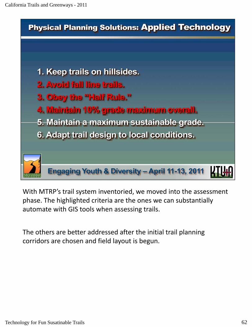
With MTRP’s trail system inventoried, we moved into the assessment phase. The highlighted criteria are the ones we can substantially automate with GIS tools when assessing trails.
The others are better addressed after the initial trail planning corridors are chosen and field layout is begun.
62Technology for Fun Susatinable Trails
The image cannot be displayed. Your computer may not have enough memory to open the image, or the image may have been corrupted. Restart your computer, and then open the file again. If the red x still appears, you may have to delete the image and then insert it again.
California Trails and Greenways - 2011
Fall line – when the slope of the trail tread exceeds half the value of the slope it is traversing. E.g. if a trail is traversing a 20% slope and the tread of the trail is at 10% or steeper, then it is a fall line trail and will likely act as a creek during rainfall events that generate runoff. 43% of the 56 miles of ‘trails’ within MTRP fit this description.
63Technology for Fun Susatinable Trails
The image cannot be displayed. Your computer may not have enough memory to open the image, or the image may have been corrupted. Restart your computer, and then open the file again. If the red x still appears, you may have to delete the image and then insert it again.
California Trails and Greenways - 2011
The 10% average trail grade guidance is intended to help create sustainable trails, not preclude trails from being any steeper, assuming local conditions will sustain steeper routes. To help assess this, we calculated the Line Slope of the trail segments and then classified them into 5 categories. You would hope to see most of the trail length in blue (0‐10%), with some shorter sections going into green (10‐15%) or yellow (15‐25%) If a section exceeds 25% you really have toor yellow (15 25%). If a section exceeds 25%, you really have to understand why, as this is steep enough to deter most users and may result in numerous user created trails that try and find an alternate route. Almost two‐thirds of the trails within MTRP are within 0‐10% add another third are 10‐25%. Only 4% of so of the trails exceed 25%, h h i i i l l i h f h k
64
however these occur in critical locations that fragment the park.
Technology for Fun Susatinable Trails
The image cannot be displayed. Your computer may not have enough memory to open the image, or the image may have been corrupted. Restart your computer, and then open the file again. If the red x still appears, you may have to delete the image and then insert it again.
California Trails and Greenways - 2011
Here is an example of a utility access road that cuts almost straight up the mountain side. It is almost completely fall line as shown in the lower graphic and is consistently 15‐25% (yellow) and 25‐50% (red). This is the main connection between the east and west sections of the park and precludes many users from using both sides of the park at the same time. Most will decide to either use one side or other only.
65Technology for Fun Susatinable Trails
The image cannot be displayed. Your computer may not have enough memory to open the image, or the image may have been corrupted. Restart your computer, and then open the file again. If the red x still appears, you may have to delete the image and then insert it again.
California Trails and Greenways - 2011
Here is an example of a major hiking trail (easily 1,000 users on a nice Saturday) that doesn’t go quite as straight up the mountain side as the utility road, but is still almost completely fall line as shown in the lower graphic. It also has extensive sections of 15‐25% (yellow) and 25‐50% (red). The photograph shows as area that continues to gully due to the fall line condition and users continue to widen the trail to avoid the gullies until new gullies form and they move the trail againavoid the gullies, until new gullies form and they move the trail again. Park management is trying to control the erosion by adding rock into the gullies and defining the edges of the trail as well, but even with these fixes, the trail is still fall line and will continue to erode.
66Technology for Fun Susatinable Trails

The image cannot be displayed. Your computer may not have enough memory to open the image, or the image may have been corrupted. Restart your computer, and then open the file again. If the red x still appears, you may have to delete the image and then insert it again.
California Trails and Greenways - 2011
Here is an example of a minor hiking trail (maybe 100 users on a nice Saturday) that goes essentially straight up the mountain side and is almost completely fall line as shown in the lower graphic. It also has extensive sections of 15‐25% (yellow) and 25‐50% (red). The photograph shows as area of that approaches 50% where water bars, timbers, rock vanes, and other treatments have been added to create micro switchbacks and hopefully divert water However thesemicro switchbacks and hopefully divert water. However, these continue to fail and the trail continues to erode.
67Technology for Fun Susatinable Trails
The image cannot be displayed. Your computer may not have enough memory to open the image, or the image may have been corrupted. Restart your computer, and then open the file again. If the red x still appears, you may have to delete the image and then insert it again.
California Trails and Greenways - 2011
As we began our trail planning phase, we began by identifying missing connections and opportunities for additional loops. We also looked at the worst sections of existing trails (fall line and % slope) and considered those for re‐routing. We identified almost 23 miles of new trails and 16 miles of re‐routes.
68Technology for Fun Susatinable Trails
The image cannot be displayed. Your computer may not have enough memory to open the image, or the image may have been corrupted. Restart your computer, and then open the file again. If the red x still appears, you may have to delete the image and then insert it again.
California Trails and Greenways - 2011
Some of the constraints we considered along the way included overall percent slope of the landforms within MTRP. Areas in green are 0‐10%, yellow 10‐20%, red 20‐50%, magenta 50‐75%, and purple >75%. Most of MTRP has slopes greater than 20%.
69Technology for Fun Susatinable Trails
The image cannot be displayed. Your computer may not have enough memory to open the image, or the image may have been corrupted. Restart your computer, and then open the file again. If the red x still appears, you may have to delete the image and then insert it again.
California Trails and Greenways - 2011
We also considered soil erosion potential combined with slope to assess Erosion Hazard. Areas in green are slightly erodible, yellow –moderately erodible, orange – highly erodible, and red ‐ very highly erodible.
70Technology for Fun Susatinable Trails
The image cannot be displayed. Your computer may not have enough memory to open the image, or the image may have been corrupted. Restart your computer, and then open the file again. If the red x still appears, you may have to delete the image and then insert it again.
California Trails and Greenways - 2011
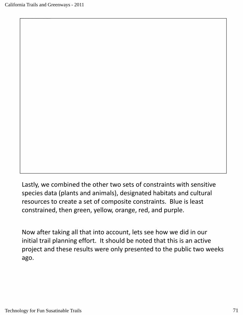
Lastly, we combined the other two sets of constraints with sensitive species data (plants and animals), designated habitats and cultural resources to create a set of composite constraints. Blue is least constrained, then green, yellow, orange, red, and purple.
Now after taking all that into account, lets see how we did in our initial trail planning effort. It should be noted that this is an active project and these results were only presented to the public two weeks ago.
71Technology for Fun Susatinable Trails

The image cannot be displayed. Your computer may not have enough memory to open the image, or the image may have been corrupted. Restart your computer, and then open the file again. If the red x still appears, you may have to delete the image and then insert it again.
California Trails and Greenways - 2011
Overall, out of our 39 miles of new or re‐routed trails we still had a little over a quarter of them that are considered fall line. We will likely adjust some of our routes to get this value down to 10% or so, since climbing turns always have a section of fall line that cannot be avoided.
72Technology for Fun Susatinable Trails
The image cannot be displayed. Your computer may not have enough memory to open the image, or the image may have been corrupted. Restart your computer, and then open the file again. If the red x still appears, you may have to delete the image and then insert it again.
California Trails and Greenways - 2011
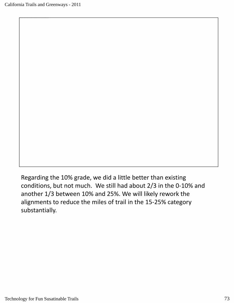
Regarding the 10% grade, we did a little better than existing conditions, but not much. We still had about 2/3 in the 0‐10% and another 1/3 between 10% and 25%. We will likely rework the alignments to reduce the miles of trail in the 15‐25% category substantially.
73Technology for Fun Susatinable Trails
The image cannot be displayed. Your computer may not have enough memory to open the image, or the image may have been corrupted. Restart your computer, and then open the file again. If the red x still appears, you may have to delete the image and then insert it again.
California Trails and Greenways - 2011
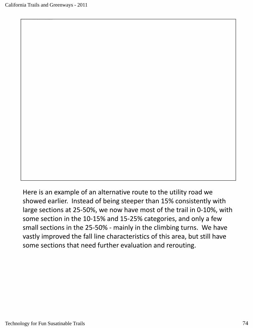
Here is an example of an alternative route to the utility road we showed earlier. Instead of being steeper than 15% consistently with large sections at 25‐50%, we now have most of the trail in 0‐10%, with some section in the 10‐15% and 15‐25% categories, and only a few small sections in the 25‐50% ‐mainly in the climbing turns. We have vastly improved the fall line characteristics of this area, but still have some sections that need further evaluation and reroutingsome sections that need further evaluation and rerouting.
74Technology for Fun Susatinable Trails
The image cannot be displayed. Your computer may not have enough memory to open the image, or the image may have been corrupted. Restart your computer, and then open the file again. If the red x still appears, you may have to delete the image and then insert it again.
California Trails and Greenways - 2011
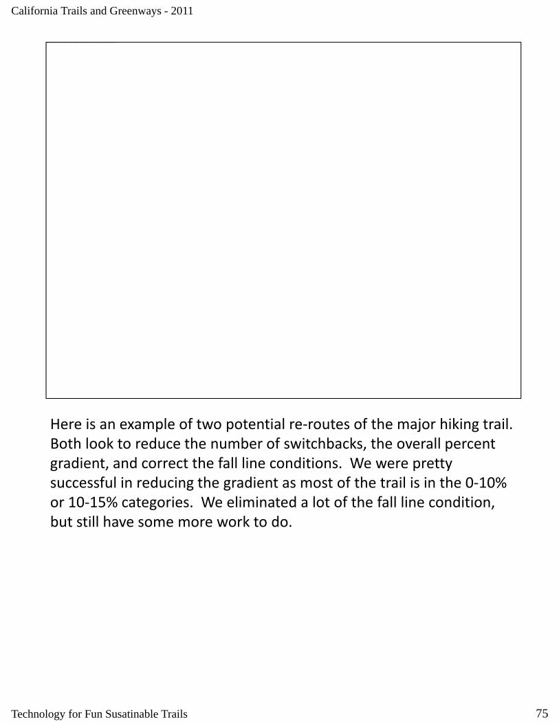
Here is an example of two potential re‐routes of the major hiking trail. Both look to reduce the number of switchbacks, the overall percent gradient, and correct the fall line conditions. We were pretty successful in reducing the gradient as most of the trail is in the 0‐10% or 10‐15% categories. We eliminated a lot of the fall line condition, but still have some more work to do.
75Technology for Fun Susatinable Trails

The image cannot be displayed. Your computer may not have enough memory to open the image, or the image may have been corrupted. Restart your computer, and then open the file again. If the red x still appears, you may have to delete the image and then insert it again.
California Trails and Greenways - 2011
Here is an example of a re‐route of the minor hiking trail. We added a number of switchbacks, reduced the overall percent gradient, and corrected a lot of fall line condition, but still have some more work to do as we still have sections too steep and too much contiguous fall line.
76Technology for Fun Susatinable Trails

The image cannot be displayed. Your computer may not have enough memory to open the image, or the image may have been corrupted. Restart your computer, and then open the file again. If the red x still appears, you may have to delete the image and then insert it again.
California Trails and Greenways - 2011
Lastly, here is an example of two alternatives for a new trail route. You can see that they have very different characteristics – one more flowing, the other full of climbing turns. Both have sections that are too steep for too long, and both have some issues with fall line conditions.
So even though we have more work to do, these analyses were very effective in communicating to the public and various stakeholder groups that we understood sustainable trail planning techniques and were well on our way to recommending improvements to the existing trail network that would benefit all They are now more concerned
77
trail network that would benefit all. They are now more concerned about how to prioritize potential projects then about the skill and understanding of the planning team.
Technology for Fun Susatinable Trails
California Trails and Greenways - 2011
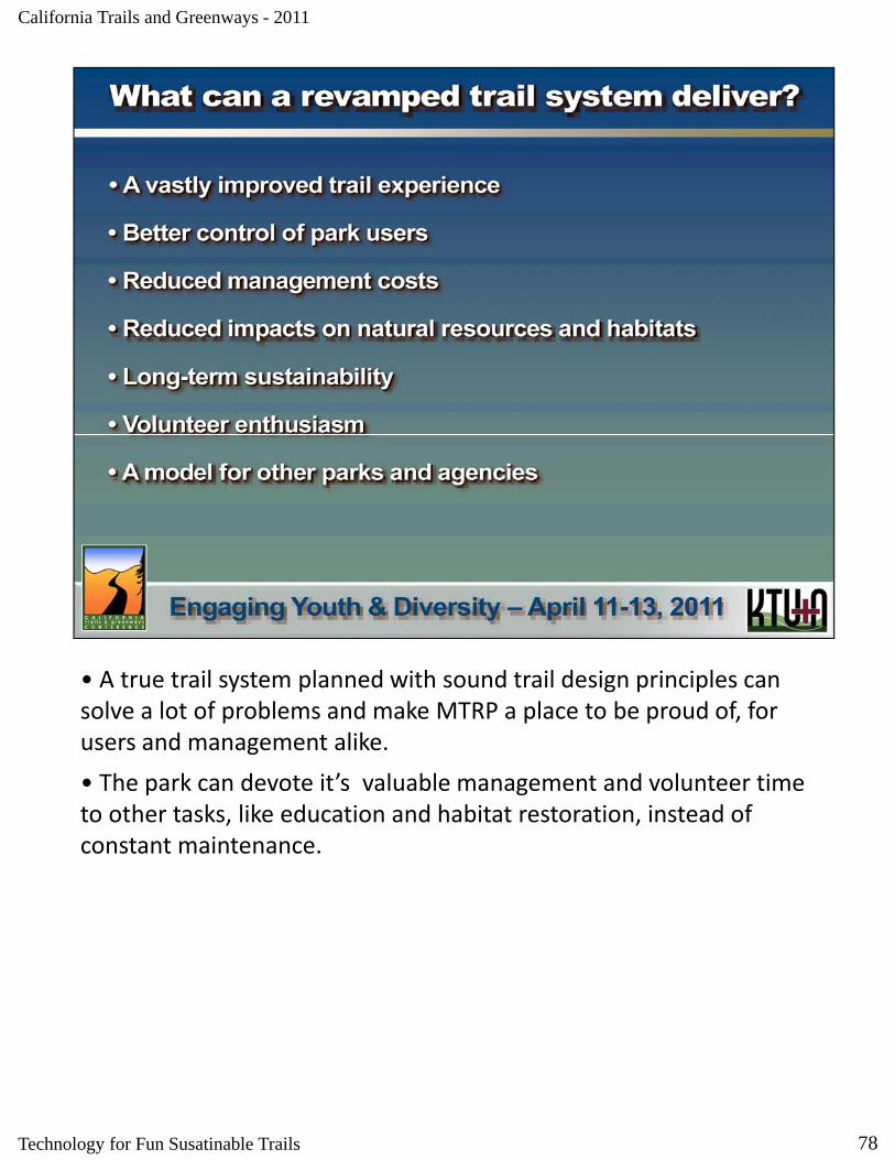
• A true trail system planned with sound trail design principles can solve a lot of problems and make MTRP a place to be proud of, for users and management alike.
• The park can devote it’s valuable management and volunteer time to other tasks, like education and habitat restoration, instead of constant maintenance.
78Technology for Fun Susatinable Trails
California Trails and Greenways - 2011
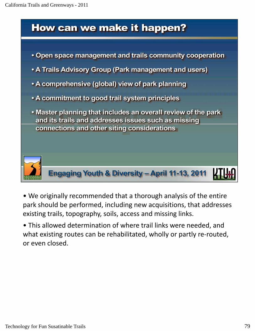
• We originally recommended that a thorough analysis of the entire park should be performed, including new acquisitions, that addressespark should be performed, including new acquisitions, that addresses existing trails, topography, soils, access and missing links.
• This allowed determination of where trail links were needed, and what existing routes can be rehabilitated, wholly or partly re‐routed, or even closed.
79Technology for Fun Susatinable Trails

California Trails and Greenways - 2011
• It’s easier to find information on trail design than on planning, but these books are helpful.
• Note that the IMBA books have mountain biking in their titles, but their principles of sound design apply to all trail types.
80Technology for Fun Susatinable Trails

The image cannot be displayed. Your computer may not have enough memory to open the image, or the image may have been corrupted. Restart your computer, and then open the file again. If the red x still appears, you may have to delete the image and then insert it again.
California Trails and Greenways - 2011
• We realize it will take time to implement what we’ve recommended, so our work is really for the next generation.
• They’ll need all the encouragement we can give them to resist “screen time” and get outside. Fun Sustainable Trails can help.
81Technology for Fun Susatinable Trails
The image cannot be displayed. Your computer may not have enough memory to open the image, or the image may have been corrupted. Restart your computer, and then open the file again. If the red x still appears, you may have to delete the image and then insert it again.
California Trails and Greenways - 2011
Questions?
82Technology for Fun Susatinable Trails
Related Documents