2045 Long Range Transportation Plan Auburn-Opelika Metropolitan Planning Organization Plan Development Draft February 2020 Prepared by: 5 TECHNICAL REPORT

Welcome message from author
This document is posted to help you gain knowledge. Please leave a comment to let me know what you think about it! Share it to your friends and learn new things together.
Transcript

2045 Long Range Transportation Plan Auburn-Opelika Metropolitan Planning Organization
Plan Development
Draft February 2020
Prepared by:
5 TECHNICAL REPORT

Table of Contents
2045 Long Range Transportation Plan Auburn-Opelika Metropolitan Planning Organization
i
Table of Contents
Table of Contents
1.0 Introduction ................................................................................................................................................ 1
2.0 Public and Stakeholder Involvement Phase 1 .................................................................................... 2
2.1 How We Engaged .................................................................................................................................................................... 2
2.2 Stakeholder Input ..................................................................................................................................................................... 3
2.3 Public Input ...............................................................................................................................................................................10
3.0 Public and Stakeholder Involvement Phase 2 .................................................................................. 21
3.1 How We Engaged ..................................................................................................................................................................21
3.2 Stakeholder Input ...................................................................................................................................................................21
3.3 Public Input ...............................................................................................................................................................................21
4.0 Review of Existing Plans ....................................................................................................................... 22
5.0 Visioning and Strategies ....................................................................................................................... 40
5.1 Vision and Strategic Framework ......................................................................................................................................40
5.2 Goals and Objectives ............................................................................................................................................................41
5.3 National Goals and Performance Measures ................................................................................................................43
5.4 Strategies ...................................................................................................................................................................................47
6.0 Project Development ............................................................................................................................. 49
6.1 Project Identification .............................................................................................................................................................49
6.2 Estimating Project Costs ......................................................................................................................................................50
7.0 Environmental Analysis and Mitigation ........................................................................................... 52
7.1 Environmental Regulations ................................................................................................................................................53
7.2 The Natural Environment ....................................................................................................................................................54
7.3 The Human Environment ....................................................................................................................................................61
7.4 Project Screening ...................................................................................................................................................................72
8.0 Project Prioritization ...............................................................................................................................76
8.1 Roadway Capacity Project Prioritization .......................................................................................................................76
8.2 Bicycle and Pedestrian Corridor Prioritization ............................................................................................................82

Table of Contents
2045 Long Range Transportation Plan Auburn-Opelika Metropolitan Planning Organization
ii
Table of Contents
9.0 Financial Plan ........................................................................................................................................... 86
9.1 Roadway Funding ..................................................................................................................................................................86
9.2 Bicycle and Pedestrian Funding .......................................................................................................................................90
9.3 Public Transit Funding ..........................................................................................................................................................92
10.0 Implementation Plan ....................................................................................................................... 95
10.1 Fiscally Constrained Plan ..................................................................................................................................................95
10.2 Visionary (Unfunded) Projects ..................................................................................................................................... 107
Appendix: Public/Stakeholder Outreach Record ................................................................................. 118

Table of Contents
2045 Long Range Transportation Plan Auburn-Opelika Metropolitan Planning Organization
iii
Table of Contents
List of Tables
Table 2.1: Phase 1 Public and Stakeholder Activity.................................................................................................... 2
Table 2.2: Most Congested Corridors .............................................................................................................................. 5
Table 2.3: Most Congested Intersections ....................................................................................................................... 5
Table 2.4: Corridors Most in Need of Safety Improvements .................................................................................. 6
Table 2.5: Intersections Most in Need of Safety Improvements ........................................................................... 6
Table 2.6: Top Public Survey Respondent Zip Codes ............................................................................................. 10
Table 2.7: Votes per Transportation Priority .............................................................................................................. 11
Table 2.8: Budget Allocation Responses ..................................................................................................................... 12
Table 2.9: Corridor Most in Need of Safety Improvements ................................................................................. 13
Table 2.10: Intersection Most in Need of Safety Improvements ....................................................................... 13
Table 2.11: Most Congested Corridor During Rush Hour .................................................................................... 14
Table 2.12: Most Congested Intersection During Rush Hour ............................................................................. 14
Table 2.13: Roadway Big Ideas ........................................................................................................................................ 15
Table 2.14: Transit Big Ideas ............................................................................................................................................. 16
Table 2.15: General Bicycle and Pedestrian Ideas .................................................................................................... 17
Table 2.16: Specific Bicycle and Pedestrian Ideas .................................................................................................... 18
Table 2.17: Downtown Auburn Streetscape Ideas ................................................................................................... 19
Table 4.1: Plans Reviewed ................................................................................................................................................. 22
Table 5.1: Relationship between Goals, Objectives, Performance Measures, and Federal Planning
Factors .............................................................................................................................................................. 45
Table 6.1: Typical Roadway Costs by Improvement Type .................................................................................... 50
Table 6.2: Typical Transit Capital Costs by Improvement Type .......................................................................... 51
Table 7.1: Typical Environmental Resources Evaluated ......................................................................................... 52
Table 7.2 Species Identified under Endangered Species Act in Lee County, AL ......................................... 57
Table 8.1: Project Prioritization Methodology for Roadway Capacity Projects ........................................... 77
Table 8.2: Project Prioritization Results for Roadway Capacity Projects ......................................................... 78
Table 8.3: Project Prioritization Methodology for Bicycle and Pedestrian Projects ................................... 83
Table 8.4: High-Priority Bicycle and Pedestrian Project Corridors .................................................................... 84

Table of Contents
2045 Long Range Transportation Plan Auburn-Opelika Metropolitan Planning Organization
iv
Table of Contents
Table 10.1: Travel Impacts of Fiscally Constrained Roadway Capacity Projects .......................................... 96
Table 10.2: Fiscally Constrained Roadway Capacity Projects .............................................................................. 98
Table 10.3: Fiscally Constrained Roadway Non-Capacity Projects ................................................................. 100
Table 10.4: Fiscally Constrained Bicycle and Pedestrian Projects .................................................................... 103
Table 10.5: Fiscally Constrained List of Transit Projects ...................................................................................... 105
Table 10.6: Visionary Roadway Capacity Projects .................................................................................................. 108
Table 10.7: Visionary Roadway Non-Capacity Projects ....................................................................................... 112
Table 10.8: Visionary Bicycle and Pedestrian Project Corridors ....................................................................... 116

Table of Contents
2045 Long Range Transportation Plan Auburn-Opelika Metropolitan Planning Organization
v
Table of Contents
List of Figures
Figure 1.1: Long Range Transportation Planning Process....................................................................................... 1
Figure 2.1: Transportation Priorities Ranked in Order of Importance ................................................................ 4
Figure 2.2: Biggest Challenges to Implementing Projects ...................................................................................... 4
Figure 2.3: Biggest Causes of Congestion in the Region ......................................................................................... 4
Figure 2.4: Stakeholder Anticipated Growth Areas .................................................................................................... 7
Figure 2.5: Stakeholder Ideas for Roadway Improvements .................................................................................... 8
Figure 2.6: Stakeholder Ideas for Other Improvements ........................................................................................... 9
Figure 2.7: Average Priority Ranking............................................................................................................................. 11
Figure 2.8: Budget Allocation Results ........................................................................................................................... 12
Figure 2.9: Big Ideas from Public Meeting Map ....................................................................................................... 20
Figure 5.1: Vision and Strategic Framework .............................................................................................................. 40
Figure 5.2: Current Transportation Performance Overview ................................................................................. 44
Figure 7.1: Wetlands and Waterways ........................................................................................................................... 58
Figure 7.2: Flood Zones ...................................................................................................................................................... 59
Figure 7.3: Critical Habitats ............................................................................................................................................... 60
Figure 7.4: Historic and Recreational Resources ...................................................................................................... 66
Figure 7.5: Prime Farmland ............................................................................................................................................... 67
Figure 7.6: Potentially Hazardous Sites ........................................................................................................................ 68
Figure 7.7: Block Group Demographics: People in Poverty ................................................................................. 69
Figure 7.8: Block Group Demographics: People of Color ..................................................................................... 70
Figure 7.9: Other Community Resources .................................................................................................................... 71
Figure 7.10: Candidate Projects with High Concern for Environmental and Community Impacts ...... 74
Figure 7.11: Candidate Projects with High Concern for Environmental Justice Impacts ......................... 75
Figure 8.1: Project Prioritization Results for Roadway Capacity Projects ....................................................... 81
Figure 8.2: High-Priority Bicycle and Pedestrian Project Corridors .................................................................. 85
Figure 10.1: Fiscally Constrained Roadway Projects (Federal Funding Only) ............................................... 95
Figure 10.2: Fiscally Constrained Bicycle/Pedestrian Projects (Federal Funding Only) ............................. 96
Figure 10.3: Fiscally Constrained Transit Projects (Federal Funding Only) .................................................... 97

Table of Contents
2045 Long Range Transportation Plan Auburn-Opelika Metropolitan Planning Organization
vi
Table of Contents
Figure 10.4: Fiscally Constrained Roadway Capacity Projects ............................................................................ 99
Figure 10.5: Fiscally Constrained Roadway Non-Capacity Projects ................................................................ 102
Figure 10.6: Fiscally Constrained Bicycle and Pedestrian Projects .................................................................. 104
Figure 10.7: Fiscally Constrained Transit Projects .................................................................................................. 106
Figure 10.8: Visionary Roadway Capacity Projects ................................................................................................ 111
Figure 10.9: Visionary Roadway Non-Capacity Projects ..................................................................................... 115
Figure 10.10: High-Priority Bicycle and Pedestrian Project Corridors ........................................................... 117

2045 Long Range Transportation Plan Auburn-Opelika Metropolitan Planning Organization
1
Introduction
1.0 Introduction This report describes how the Long Range Transportation Plan was developed and details the
associated information and planning process that was used. It builds on other technical reports
and addresses the following topics:
• Public and Stakeholder Involvement
• Existing Plans
• Visioning and Strategies
• Project Development
• Environmental Analysis and Mitigation
• Project Prioritization
• Financial Plan
• Implementation Plan
Figure 1.1: Long Range Transportation Planning Process

Table of Contents
2045 Long Range Transportation Plan Auburn-Opelika Metropolitan Planning Organization
2
Public and Stakeholder Involvement Phase 1
2.0 Public and Stakeholder Involvement Phase 1 The first phase of the planning process – Listening and Learning – was set up to hear about
transportation priorities and ideas for improvement in the region. It was also an opportunity to
meet with key stakeholders and learn about needs and upcoming plans.
Input in this phase was used to develop the vision, goals, and objectives and to identify
potential projects to be included in the plan. Input on growth areas was also used in forecasting
future socioeconomic data for the regional travel demand model.
2.1 How We Engaged
LRTP Stakeholder Advisory Committee
On May 1, 2019, an LRTP Stakeholder Advisory Committee meeting was held at the Lee-Russell
Council of Governments from 1 P.M. to 3 P.M. Twenty-six people attended, with a variety of
government officials, university officials, and economic development officials. The purpose of
this meeting was to learn about priorities, brainstorm ideas for improving transportation, and
identify major growth areas.
Public Meeting and Online Survey
On May 1, 2019, twenty-six people attended a public meeting held at the Lee-Russell Council of
Governments from 4 P.M. to 6 P.M. After signing in, they were walked through multiple station
areas that introduced the plan, asked about priorities, and asked about big ideas.
From May 1st through June 30th, members of the public who could not attend the meeting were
able to provide their input through an online survey. 163 people participated in this online
survey.
Table 2.1: Phase 1 Public and Stakeholder Activity
Activity People Engaged Surveys Completed
LRTP Advisory Committee Meeting 26 22
Public Meeting 26 9
Online Survey 163 163
Total 215 194

Table of Contents
2045 Long Range Transportation Plan Auburn-Opelika Metropolitan Planning Organization
3
Public and Stakeholder Involvement Phase 1
2.2 Stakeholder Input
The attendees of the LRTP Stakeholder Advisory Committee participated in three exercises.
The first exercise was an interactive polling exercise that asked about transportation priorities,
challenges, and concerns. Results from the poll are shown in on the following pages and key
takeaways include:
• Improving safety was voted the top transportation priority. Improving connectivity
between places was voted second, followed by reducing traffic congestion and
maintaining roads and infrastructure in good condition.
• Funding was voted as the biggest challenge to implementing projects, followed by
community and environmental impacts and acquiring land or right-of-way.
• “Too much traffic for the road to handle” was voted as the number one cause of
congestion. “Waiting at intersections,” “Freight truck traffic,” and “Crashes” were voted as
the next leading causes of congestion.
• Almost half of respondents named Gateway Drive as the most congested corridor,
especially at its intersection with Frederick Road and Tiger Town Shopping Center.
College Street, Downtown Auburn, and I-85 Exit 62 were almost named by a few
respondents.
• The I-85 interchanges in Opelika were voted as most in need of safety improvements,
especially Exit 60 at Marvyn Parkway (AL-51). A handful of respondents named Opelika
Road (Al-14) and the Auburn University area as needing safety improvements.
In a second exercise stakeholders were asked to mark areas where they expected future
development and to indicate what kind of development this would be (residential, commercial,
industrial, recreational, or educational/medical). Figure 2.4 shows these areas of anticipated
development.
The third exercise asked stakeholders to mark areas in the MPO that they thought needed
transportation improvements or where they knew of planned projects. These could include
projects for roadways, bicycle and pedestrian infrastructure, transit, freight, or any other
transportation need. Figures 2.5 and 2.6 map this input.

Table of Contents
2045 Long Range Transportation Plan Auburn-Opelika Metropolitan Planning Organization
4
Public and Stakeholder Involvement Phase 1
Figure 2.1: Transportation Priorities Ranked in Order of Importance
Figure 2.2: Biggest Challenges to Implementing Projects
Figure 2.3: Biggest Causes of Congestion in the Region
6th
5th
4th
3rd
2nd
1st
Supporting Movement of Goods/Freight
Making Transit, Biking, and Walking More Convenient
Maintaining Roads and Infrastructure in Good Condition
Reducing Traffic Congestion
Improving Connectivity Between Places
Improving Safety
5th
4th
3rd
2nd
1st
Shifting Priorities in the Region
Public Opposition
Acquiring Land and Right-of-Way
Environmental and Community Impacts
Funding
7th
6th
5th
4th
3rd
2nd
1st
Poor pavement conditions
Railroad crossings or drawbridges/moveable bridges
Unattractive alternatives to driving (transit, walking,
biking)
Crashes
Freight truck traffic
Waiting at intersections
Too much traffic for the road to handle

Table of Contents
2045 Long Range Transportation Plan Auburn-Opelika Metropolitan Planning Organization
5
Public and Stakeholder Involvement Phase 1
Table 2.2: Most Congested Corridors
Corridor Times Mentioned
Gateway Dr (US-280) 7
Downtown Auburn 2
College St 2
I-85 1
Columbus Pkwy (US-280) 1
Pepperell Pkwy (AL-15) 1
2nd Avenue (AL-15) 1
Table 2.3: Most Congested Intersections
Intersection Times Mentioned
Gateway Dr (US-280) and Frederick Rd 4
Columbus Pkwy (US-280) and I-85 Exit 62 2
S College St and E University Dr 1
Columbus Pkwy (US-280) and 2nd Avenue (AL-15) 1
S College Ave and Samford Rd (AL-15) 1

Table of Contents
2045 Long Range Transportation Plan Auburn-Opelika Metropolitan Planning Organization
6
Public and Stakeholder Involvement Phase 1
Table 2.4: Corridors Most in Need of Safety Improvements
Corridor Times Mentioned
Opelika Rd (AL-15) 2
I-85 2
Around Auburn Campus 2
College Street 1
6th St 1
Table 2.5: Intersections Most in Need of Safety Improvements
Intersection Times Mentioned
I-85 at Exit 60 (AL-51 & AL-169) 5
I-85 at Exit 64 (US 29) 2
Marvyn Pkwy (AL-51) and Crawford Rd (AL-169) 1
Gateway Dr (US-280) and Frederick Rd 1
Opelika Ave (AL-14) and 10th St 1
Opelika Ave (Al-14) and 2nd Ave 1
I-85 at Exit 62 (US 280 E & US 431) 1
N Gay St and Shelton Mill Rd 1
Gateway Dr (US-280) at Marvyn Pkwy (AL-51) 1
I-85 at Exit 58 (US 280 W & Gateway Dr) 1

2045 Long Range Transportation Plan Auburn-Opelika Metropolitan Planning Organization
7
Crash Locations Public and Stakeholder Involvement Phase 1
Figure 2.4: Stakeholder Anticipated Growth Areas

2045 Long Range Transportation Plan Auburn-Opelika Metropolitan Planning Organization
8
Crash Locations Public and Stakeholder Involvement Phase 1
Figure 2.5: Stakeholder Ideas for Roadway Improvements

2045 Long Range Transportation Plan Auburn-Opelika Metropolitan Planning Organization
9
Crash Locations Public and Stakeholder Involvement Phase 1
Figure 2.6: Stakeholder Ideas for Other Improvements

Table of Contents
2045 Long Range Transportation Plan Auburn-Opelika Metropolitan Planning Organization
10
Public and Stakeholder Involvement Phase 1
2.3 Public Input
The public meeting and online survey asked people to weigh-in on five topics that would help
planners better understand priorities and needs in the region.
• The first topic asked about general transportation priorities
• The second topic asked about budget allocation priorities
• The third topic asked about areas with perceived safety issues
• The fourth topic asked about areas with perceived high levels of congestion
• The final topic asked about their ideas for improving transportation in the region.
The exercises at the public meeting and in the online survey were identical. There was a total of
172 surveys completed from the public meeting and online survey. Survey participants were not
required to answer all questions.
The table below shows how participation varied by zip code.
Table 2.6: Top Public Survey Respondent Zip Codes
Zip Code Area Count
36830 Auburn (East) 81
36832 Auburn (West) 26
36801 Opelika (North of I-85) 26
36879 Waverly/Gold Hill 16
36804 Opelika (South of I-85) 13
Other All Other Areas 10
Total 172

Table of Contents
2045 Long Range Transportation Plan Auburn-Opelika Metropolitan Planning Organization
11
Public and Stakeholder Involvement Phase 1
Public Priorities Exercise
Participants were asked to independently rank six transportation priorities from 0 to 4, with 0
being least important and 4 being most important.
Figure 2.7: Average Priority Ranking
Table 2.7: Votes per Transportation Priority
Priority 0 – Not
Important 1 2 3
4 – Very
Important
Improving connectivity between places 5 8 38 39 72
Reducing traffic congestion 5 7 18 34 100
Improving safety 4 6 17 39 97
Maintaining roads and infrastructure in good condition 2 1 20 63 78
Making public transit, biking, and walking more convenient 7 10 24 38 85
Improving movement of goods/freight 12 27 62 34 31
2.3
3.0
3.1
3.3
3.3
3.3
Improving movement of goods/freight
Improving connectivity between places
Making public transit, biking, and walking more
convenient
Maintaining roads and infrastructure in good condition
Reducing traffic congestion
Improving safety
Less Important More Important

Table of Contents
2045 Long Range Transportation Plan Auburn-Opelika Metropolitan Planning Organization
12
Public and Stakeholder Involvement Phase 1
Public Budget Allocation Exercise
Participants were asked to imagine they had $100 to spend on transportation projects and to
allocate their money in increments of $10 among nine different categories.
Figure 2.8: Budget Allocation Results
Table 2.8: Budget Allocation Responses
Priority $ Allocated % Allocated
Use technology & new road designs to reduce traffic
(smart traffic signals, intersection improvements, left turn lanes in medians) 2,514 16%
Improve safety for all users
(redesign dangerous areas, biking/walking protections) 2,422 16%
Improve public transit
(bus service, vans, new options) 2,374 15%
Maintain existing roadways
(pavement, bridges, signage, striping) 1,899 12%
Improve pedestrian infrastructure
(sidewalks, crosswalks, walking paths) 1,778 11%
Add new roads or widen/extend roads
(expand roadway network) 1,725 11%
Improve bicycling infrastructure
(bike lanes and paths) 1,703 11%
Improve streetscape appearance
(trees/plants, decorative lighting/pavement) 665 4%
Move freight more efficiently
(heavy trucks, ports, railroads, air, waterways) 473 3%
16%
16%
15%12%
12%
11%
11%
4% 3%Use technology & new road designs to reduce traffic
Improve safety for all users
Improve public transit
Maintain existing roadways
Improve pedestrian infrastructure
Expand Roadway Network
Improve bicycling infrastructure
Improve streetscape appearance
Move freight more efficiently

Table of Contents
2045 Long Range Transportation Plan Auburn-Opelika Metropolitan Planning Organization
13
Public and Stakeholder Involvement Phase 1
Roadway Safety Concerns Exercise
Respondents were asked which intersection or corridor is most in need of safety improvements.
Table 2.9: Corridor Most in Need of Safety Improvements
Corridor Times Mentioned
Shug Jordan Parkway 8
Glenn Avenue 4
Opelika Road 3
E University Drive 3
All Others 11
Total Responses 29
The following responses only received 1-2 mentions: Gay Street; Farmville Road; Samford Avenue; Wire Road; Columbus
Parkway; Society Hill Road; Gateway Drive; Waverly Parkway; and US-280 W.
Table 2.10: Intersection Most in Need of Safety Improvements
Intersection Times Mentioned
N College Street and Farmville Road 14
Gateway Drive and Frederick Road 6
Pepperell Parkway (AL-14) and U.S. Highway 280 4
Farmville Road and Donahue Drive 4
N College Street and U.S. Highway 280 4
Interstate 85 and Marvyn Parkway 4
S College Street and Sand Hill Road 3
All Others 32
Total Responses 71
The following responses only received 1-2 mentions: Wire Road and Cox Road; Glenn Avenue and College Street; S
College Street and Shell Toomer Parkway; S Gay Street and E Samford Avenue; S Gay Street and E Magnolia Avenue;
Alabama Street and Shug Jordan Parkway; S College Street and U.S. Highway 29; Moore's Mill Road and Rock Fence
Road; Interstate 85 and S College Street; Wire Road and W Samford Avenue; SportsPlex Parkway and West Point
Parkway; Airport Road and Pepperell Parkway; Pumphrey Avenue and Alabama Street; Wire Road and Shug Jordan
Parkway; Farmville Road and U.S. Highway 280; W Magnolia Avenue and N Donahue Drive; Shell Toomer Parkway and
Mill Creek Road; E Samford Avenue and E Glenn Avenue; E Drake Avenue and N Gay Street; Gay Street and Mitcham
Avenue; E University Drive and E Glenn Avenue; Annalue Drive and Dean Road; Richland Road and E University Drive;
Saugahatchee Rd and E University Drive; Pinnacle Drive and N College Street; N Dean Road and Opelika Road; Shug
Jordan Parkway and N Donahue Drive; E University Drive and Opelika Road; and Lake Condy Rd and Lafayette Pkwy.

Table of Contents
2045 Long Range Transportation Plan Auburn-Opelika Metropolitan Planning Organization
14
Public and Stakeholder Involvement Phase 1
Roadway Congestion Concerns Exercise
Respondents were asked which intersection or corridor is most congested during rush hour.
Table 2.11: Most Congested Corridor During Rush Hour
Corridor Times Mentioned
College Street 10
Gateway Drive 7
Opelika Road 6
Tiger Town (Gateway Drive + Frederick Road Corridors) 4
U.S. Highway 280 W 3
Gay Street 3
All Others 16
Total Responses 49
The following responses only received 1-2 mentions: Moore’s Mill Road; Interstate 85; E University Drive; Samford
Avenue; Glenn Avenue; Shug Jordan Parkway; Magnolia Avenue; Donahue Drive; Dean Road; and 2nd Avenue.
Table 2.12: Most Congested Intersection During Rush Hour
Intersection Times Mentioned
Gateway Drive and Frederick Road 11
W Magnolia Avenue and College Street 10
Glenn Avenue and S College Street 7
E University Avenue and Opelika Rd 5
Opelika Road and Dean Road 5
N Gay Street and E Glenn Avenue 4
Samford Avenue and College Street 4
All Others 37
Total Responses 83
The following responses only received 1-2 mentions: Interstate 85 and Gateway Drive; Gateway Drive and Pepperell Parkway; N College
Street and Gay Street; N Donahue Drive and W Glenn Avenue; Society Hill Road and Gateway Drive; Shug Jordan Parkway and E
University Drive; E Glenn Avenue and N Ross Street; N Donahue Drive and Shug Jordan Parkway; Shug Jordan Parkway and Wire Road;
Gateway Drive and Hamilton Road; Dean Road and Samford Avenue; E Glenn Avenue and Airport Road; E University Drive and Moore’s
Mill Road; E Samford Avenue and S Gay Street; E University Drive and College Street; W Samford Avenue and Mell Street; Columbus
Parkway and Fox Run Parkway; Opelika Road and Gateway Drive; N College Street and Farmville Road; E University Drive and Richland
Road; E Thach Avenue and S Gay Street; S College Street and Donahue Drive; E University Drive and E Glenn Avenue; Moore’s Mill Road
and Ogletree Road; Donahue Drive and W Magnolia Avenue; Pepperell Parkway and Opelika Road; Donahue Drive and E University
Drive; Shug Jordan Parkway and Richland Road; and N Dean Road and E Glenn Avenue.

Table of Contents
2045 Long Range Transportation Plan Auburn-Opelika Metropolitan Planning Organization
15
Public and Stakeholder Involvement Phase 1
Big Ideas Exercise
Respondents were also asked an open-ended question, “What BIG IDEAS do you have for
improving transportation in the region? Think about getting around by all modes- driving, riding
transit, walking, biking, etc.” Almost all participants answered this question. Their answers are
organized below into roadway, transit, bike/ped, and Downtown Auburn improvements.
Roadway Ideas
About 30 respondents discussed ways to decrease congestion and improve intersections.
Several of the most common responses mentioned:
• Construct an outer loop or bypass between US-280 and I-85 to decrease congestion and
allow freight to avoid downtown Auburn
• Implement smart traffic lights
• Ensure that speed limits are appropriate for roads and legibly labelled
• Replace yield signs at right turns with green lights
Additionally, several respondents voiced opposing opinions. For example, people disagreed on
whether to build or dismantle roundabouts, to add or remove traffic lights, and whether to
widen or narrow roads.
Table 2.13: Roadway Big Ideas
Idea Times Mentioned
Build outer loop or bypass between 280 and I-85 + add freight bypass 6
Create smart/synchronized traffic lights 5
Create more roundabouts 3
Widen congested roads; no road diets 3
Ensure speeds are appropriate for the roads and have legible signs 2
Construct more turning lanes 2
Deconstruct roundabouts 2
Make Interstate left lane for passing only 1
Install more traffic lights 1
Remove traffic lights 1
Replace yield signs with right turn arrows 1
Reduce congestion 1
Total Responses 28

Table of Contents
2045 Long Range Transportation Plan Auburn-Opelika Metropolitan Planning Organization
16
Public and Stakeholder Involvement Phase 1
Transit Ideas
About 50 respondents asked for increased public transit options in the region. Respondents
want transit that provides fixed-route services for the public, not just the university. People want
access to popular destinations, especially for low-income and disabled residents. Some
commonly requested routes for transit include:
• Between subdivisions and downtown Auburn
• Between Auburn University and downtown Opelika
• To Tiger Town Shopping Center
• To East Alabama Medical Center
• To major job centers
Table 2.14: Transit Big Ideas
Idea Times Mentioned
Create reliable public transit in the Auburn area beyond campus and demand-
service vans 28
Provide transit between campus, downtown Opelika, hospitals, and Tiger Town
Shopping Center 5
Provide transit that provides access for low-income and disabled users to jobs,
drugstores, malls, and medical centers 4
Construct a Park and Ride with transit to downtown 2
Provide transit between downtown Auburn and subdivisions 2
Create a monorail on Auburn University campus 2
Provide rail service between Auburn and Opelika 2
Encourage cooperation between cities of Auburn and Opelika in transportation
projects 2
Use school buses for transit 1
Improve customer service at Lee County Transit 1
Ensure clean transit 1
Charge developer fees to fund transit 1
Provide transit to Duck Samford and Felton Little baseball fields 1
Total Responses 52

Table of Contents
2045 Long Range Transportation Plan Auburn-Opelika Metropolitan Planning Organization
17
Public and Stakeholder Involvement Phase 1
Bicycle and Pedestrian Ideas
Over 75 respondents discussed improving bicycle and pedestrian infrastructure. The various
responses are summarized below:
• Construct more bike lanes, sidewalks, and off-street paths that provide some separation
from vehicles and are accessible to a variety of users
• Expand bike-ped infrastructure beyond the university so families and younger students
in the outer neighborhoods can walk or bike to schools, parks, and downtown Auburn
• Create a safe bicycle route connecting downtown Auburn and downtown Opelika
• Improve safety at crossings for pedestrians and bicyclists
• Increase downtown lighting after dark for pedestrians, runners, and bicyclists
• Provide education for all users of the road to increase safe bicycling and walking
Table 2.15: General Bicycle and Pedestrian Ideas
Idea Times Mentioned
Create more bike lanes and off-street paths 17
Construct a bike route connecting downtown Opelika and downtown Auburn 8
Build more sidewalks, specifically in Opelika 8
Improve safety at crossings (at intersections; when there are no lights; when parked
cars block views; outside schools) 7
Enhance pedestrian infrastructure in downtown Auburn 7
Create paths that extend beyond campus and can connect to neighborhood
developments 6
Improve safety for on-road cyclists 5
Increase nighttime lighting for pedestrians and cyclists 5
Ensure cyclists follow rules of the road 4
Increase bike/ped connections into downtowns 4
Construct pedestrian bridges over busy roads 2
Provide bike/ped maps and wayfinding tools 1
Provide bike storage 1
Total Responses 75
Table of Contents
2045 Long Range Transportation Plan Auburn-Opelika Metropolitan Planning Organization
18
Public and Stakeholder Involvement Phase 1
Table 2.16: Specific Bicycle and Pedestrian Ideas
Idea Times Mentioned
Build bike lane and sidewalk on Donahue 3
Build path to Chewacla Park 1
Close traffic on College and Magnolia streets in downtown Auburn 1
Build bike lane or sidewalks to Yarborough Elementary 1
Build bike lane along Society Hill Road 1
Build sidewalk along Ogletree Rd 1
Add speed humps and sidewalks along 30th St 1
Build bike land and sidewalks by Hickory Dickory Park 1
Total Responses 10

Table of Contents
2045 Long Range Transportation Plan Auburn-Opelika Metropolitan Planning Organization
19
Public and Stakeholder Involvement Phase 1
Downtown Auburn Streetscape Ideas
About 20 respondents mentioned discontent with the streetscape and construction in
downtown Auburn. These responses showed that residents see a connection between attractive
and accessible streetscapes and increased biking and walking, as well as the negative relation
between construction and parking or congestion. Below are some more common suggestions
from respondents:
• Increase green space downtown, perhaps by increasing building setbacks for
greenspaces on sidewalks and maintaining street trees despite construction
• Bury power lines underground
• Control construction and new development downtown and perhaps consider infill
alternatives
• Create parking structures or Park and Rides to supplement or replace on-street parking
Table 2.17: Downtown Auburn Streetscape Ideas
Idea Times
Mentioned
Improve downtown streetscape (move power lines underground, increase green space,
leave street trees despite construction; larger setback for more greenspace in front of
new development)
11
Curb downtown construction 6
Improve downtown parking: create parking structures or park and ride for downtown
and AU employees
4
Implement a Complete Streets Policy 1
Redirect freight from downtown Auburn 1
Total Responses 23

2045 Long Range Transportation Plan Auburn-Opelika Metropolitan Planning Organization
20
Crash Locations Public and Stakeholder Involvement Phase 1
Figure 2.9: Big Ideas from Public Meeting Map
Table of Contents
2045 Long Range Transportation Plan Auburn-Opelika Metropolitan Planning Organization
21
Public and Stakeholder Involvement Phase 2
3.0 Public and Stakeholder Involvement Phase 2 During this phase, the public and stakeholders reviewed the draft plan and provided input to
refine and finalize the plan.
3.1 How We Engaged
LRTP Stakeholder Advisory Committee
On November 5, 2019, an LRTP Stakeholder Advisory Committee meeting was held at the Lee-
Russell Council of Governments from XX P.M. to XX P.M. XX people attended, with a variety of
government officials, university officials, and economic development officials present. The
purpose of this meeting was to review the draft plan and list of projects and recommend any
changes before releasing the plan for public review.
This section will be updated once outreach phase 2 is complete.
Public Meeting
On Month XX, 2019, XX people attended a public meeting held at the Lee-Russell Council of
Governments from 4 P.M. to 6 P.M. After signing in, they were walked through multiple station
areas that introduced the plan, summarized the plan recommendations, and asked about their
opinions and ideas for improving the plan.
This section will be updated once outreach phase 2 is complete.
3.2 Stakeholder Input
Stakeholder input for this phase of the planning process is being summarized and this section
will be updated once complete.
This section will be updated once outreach phase 2 is complete.
3.3 Public Input
Public input has not yet been received for this phase of the planning process. This section will
be updated once public input has been received and summarized.
This section will be updated once outreach phase 2 is complete.

2045 Long Range Transportation Plan Auburn-Opelika Metropolitan Planning Organization
22
Review of Existing Plans
4.0 Review of Existing Plans In preparing this document, relevant plans from the state, MPO, county, and municipal level
were reviewed. Key takeaways regarding transportation are summarized on the following pages.
A consistent theme of planning for growth emerged across the various plans, as well as an
increased interest in bicycle and pedestrian transportation and expanding transit.
Table 4.1: Plans Reviewed
Plan Agency
Alabama Statewide Transportation Plan (2017) ALDOT
Alabama Statewide Bicycle and Pedestrian Plan (2017) ALDOT
Alabama Statewide Freight Plan (2017) ALDOT
2040 Long Range Transportation Plan (2015) AOMPO
Auburn-Opelika Bicycle Pedestrian Plan (2015) AOMPO
Human Services Coordinated Transportation Plan (2017) Lee-Russell Council of Governments
Lee County Master Plan (2010) Lee County
Auburn University Comprehensive Campus Plan (2013) Auburn University
CompPlan 2030: The Comprehensive Plan for the City of Auburn
(2018) City of Auburn
Auburn Downtown Master Plan (2014) City of Auburn
Renew Opelika Road (2013) City of Auburn
Downtown Auburn Parking Plan (2017) City of Auburn
Northwest Auburn Neighborhood Plan (2018) City of Auburn
City of Auburn Parks, Recreation, and Cultural Master Plan (2018) City of Auburn
City of Auburn Citywide Comprehensive Traffic Study (ongoing) City of Auburn
City of Opelika Master Plan 2030 (2016) City of Opelika
Carver-Jeter Revitalization Plan (2014) City of Opelika

2045 Long Range Transportation Plan Auburn-Opelika Metropolitan Planning Organization
23
Review of Existing Plans
Alabama Statewide Transportation Plan (2017)
This statewide plan considers the mobility for people and
freight across all modes in the state and identifies statewide
trends and needs in order to select and prioritize projects. It
identifies five key issues: supporting growth of the overall
network and its implications for a multimodal network;
understanding how the roadway network will function as a
result of the current work program; focusing on maintenance;
accommodating emerging technologies; and understanding
trends in mode shift.
A key concern of the plan is the physical condition and
congestion of the Interstate system, U.S. highways, and state highways. Most congestion occurs
along the Interstate, especially by larger metropolitan areas. Auburn-Opelika currently
experiences heavy congestion along I-85 and U.S. Highway 280 and this is expected to worsen
by 2040. Between 2010 and 2040 the overall population is predicted to increase more than ten
percent and shift from rural to urban areas. Auburn-Opelika, along with Baldwin County, has the
highest growth rate and is thus expected to see an increase in congestion, even with the
addition of capacity projects.
In order to mitigate current and expected congestion, ALDOT has several resurfacing and
widening projects planned. One project would widen I-85 from four lanes to six in Opelika from
Exit 58 at Gateway Drive to Exit 64 at U.S. Highway 29. ALDOT also plans to continue its work
with ITS to monitor traffic and prioritize maintenance and operations rather than capacity
projects.
Their freight analysis shows that trucks are the most frequently utilized mode to transport
freight and is predicted to grow, leading to some bottlenecks where the Volume-to-Capacity
Ratio is greater than 1.5. After trucks, freight is most frequently carried by pipeline. Freight
carried by air or water is negligible.
ALDOT acknowledges the importance of multimodal transportation while recognizing its limited
role in these modes. With some exceptions in the larger cities, public transit consists of demand
service buses. ALDOT names a frequent desire from the public for expanded service, saying “the
greatest public transportation deficiency within Alabama is the lack of service.”
Regarding bicycle and pedestrian transportation, ALDOT encourages Complete Street policies
that create safe and accessible roads for all users. Their focus for bicycles is to increase
connectivity. The 2017 Statewide Bicycle and Pedestrian Plan outline further actions.

2045 Long Range Transportation Plan Auburn-Opelika Metropolitan Planning Organization
24
Review of Existing Plans
Alabama Statewide Bicycle and Pedestrian Plan (2017)
This statewide plan looks at trends in bicycle and pedestrian
interest, usage, and funding and calculates bike/ped demand
in order to develop some projects, strategies, and
implementation tools. The plan considers how to improve
bicycle and pedestrian safety and connectivity and how to
support economic development and the natural environment.
There has been a general increase in bike/ped demand, as
well as supply of federal funding, but this has also been
accompanied by an increase in crashes and fatalities. While
traffic injuries and fatalities decreased overall from 2003-2013,
pedestrian injuries have been increasing since 2008 and since 2011 for bicyclists. Alabama has
the lowest fatality rate in the Southeastern U.S., but also has one of the lowest commute modes
by biking or walking. Bike/ped consists of a small mode share of Alabama residents, but is
quickly growing. Despite vehicles constituting most of the mode share, many Alabama residents
lack access to vehicles. Forty percent of residents are not of a driving age, thirty-nine percent of
households have one or less vehicles, and transportation costs are second only to housing.
Besides the benefit to the individual or household, research from other states show that
increased bike/ped usage supports local economic development.
A demand analysis for bike/ped was conducted for the state. Downtown Auburn scored the
highest level of demand, with the outskirts of the city and Opelika scoring medium demand.
Based upon this analysis, the plan recommends three strategies to improve bike/ped programs:
• Prioritize bike/ped safety programs + improvements
• Increase access to bike/ped in traditionally underserved communities
• Improve connections between bike/ped facilities on state highways, local greenways, and
share use paths, as well as access to natural and scenic areas
The plan also identified priority and vision corridors for a bicycle route. Three priority corridors
intersect in Auburn-Opelika that would connect to Montgomery, Phoenix City, and Wadley. To
implement these projects and strategies the plan identifies performance measures and provides
a project prioritization criteria and design guidance.

2045 Long Range Transportation Plan Auburn-Opelika Metropolitan Planning Organization
25
Review of Existing Plans
2017 Alabama Statewide Freight Plan (2017)
This statewide plan identifies key issues in the state freight
system, highlights its main commodities and modes,
describes characteristics of Existing + Capacity network and
National Freight Network Designations, and provides a
freight investment plan with goals and monitoring tools.
The seven key issues facing the freight system are
congestion reduction; intermodal connectivity; infrastructure
condition; economic competitiveness; safety; innovative
operational improvements; and intergovernmental
coordination. Tackling these issues works toward promoting
the mission statement to “promote efficient and safe movement of goods in a manner that
increases economic competitiveness and promote environmental responsibility throughout the
State of Alabama.”
Currently trucks are by far the most common mode of freight transportation, followed by
pipelines which carry about twenty percent of commodities. Alabama imports slightly more than
it exports. These trends are expected to remain consistent through 2040, although there is
uncertainty about future demand for coal as federal policies change. Gravel and logs are the
largest commodity by truck, followed by coal and natural sand. Pipeline freight transports coal
and is controlled by the private sector. Air and water freight are negligible. Rail freight traffic is
expected to increase by over twenty percent; by 2040 chemical exports are expected to double
and become the state’s leading export.
Given that truck transport is the most common mode and is expected to grow, there is concern
about congestion along the Interstate and highway system and maintenance of roads. The
report mentions that there is a high volume of vehicles along I-85 through the Auburn-Opelika
area that is expected to worsen significantly by 2040 and existing bottlenecks like are expected
to worsen.
The report then details the parameters for National Freight Network Designation funds and how
these funds are currently allocated. For Lee County, there is money allocated to improve the
bridges along I-85 by 2021.
The report concludes discussing goals and performance monitoring, specifically for reliability
and congestion for trucks. It describes the Truck Travel Time Reliability Index with two- and four-
year targets. MPOs can follow these targets or establish their own.

2045 Long Range Transportation Plan Auburn-Opelika Metropolitan Planning Organization
26
Review of Existing Plans
2040 AOMPO Long Range Transportation Plan (2015)
The Long Range Transportation plan is developed by the MPO
every five years in coordination with regional partners, in this
case, the City of Auburn, the City of Opelika, Lee County,
stakeholders, and the general public. Their input and an analysis
of existing conditions, current demand, and future demands
helps the MPO to identify and prioritize transportation
improvements.
The plan aims to improve mobility and accessibility of people
and for freight throughout the region while protecting the
environment and ensuring safety, quality of life, and economic
development. The report used previous plans, public input,
census data, GIS mapping, and a travel demand model. It considered existing conditions of
transportation such as existing infrastructure and Level of Service.
A key component of the plan is providing constrained and visionary transportation projects.
Given limited resources, the project list was carefully scrutinized to determine priorities and
strategies. Key takeaways for each mode are:
• Many roads currently experience congestion and this is expected to worsen. The 2040
LRTP lists forty-eight maintenance and operations projects and fifteen capacity projects,
sponsored by various entities like ALDOT, Auburn, Opelika, or Lee County. The capacity
projects will produce modest improvements in congestion but are hoped to positively
impact the region when paired with the maintenance and operations projects.
• Bicycle and pedestrian modes are to be considered as equally important as vehicular.
This plan inventories existing facilities but leaves naming specific projects to the AOMPO
Bicycle and Pedestrian Plan (2015). Improvements or new roadway projects must
consider bike/ped improvements that could be made, in keeping with FHWA policy.
• AOMPO plans to identify funding sources to expand transit, especially into rural areas
and continue to market, integrate, and maintain the existing Tiger Transit and LRPT
operations. Lack of funding limits network expansion.
• The AOMPO does not have a port or passenger rail. The AOMPO focus for freight rail is
on safety for trains and vehicles and maintaining access to industrial and technology
parks.
• The Auburn University Regional Airport, owned and operated by Auburn University,
continues to grow and has a new and operational terminal building.

2045 Long Range Transportation Plan Auburn-Opelika Metropolitan Planning Organization
27
Review of Existing Plans
Auburn-Opelika Bicycle and Pedestrian Plan
(2016)
This comprehensive plan facilitated by the Auburn-
Opelika Metropolitan Planning Organization and the
Lee-Russell Council of Governments identifies and
prioritizes improvements for cyclists and pedestrians.
The plan considers mainly arterial and collector
roadways within the AOMPO boundaries.
A Level of Service (LOS) analysis showed that Auburn-
Opelika’s roadways provide relatively good bicycling
conditions with an average Level C (on a scale of A-F, A being the best). Sixty-six percent of the
study network contains bicycle facilities, defined as bicycle lanes or at least four-foot-wide,
paved shoulders. Pedestrian conditions fared worse on the LOS analysis with sixty-eight percent
of the network scoring a D or worse and only nine percent of the study network providing full
coverage for pedestrians with full sidewalks on both sides of the road.
A list of six possible interventions were made for bicycling ranging from no intervention to
restriping, bike lane construction, or shared use path. Many roads were judged as having
sufficient LOS even without any bicycle infrastructure because of low traffic volumes. Other
roads that lacked infrastructure and had demand were prioritized for restriping, road diets, or
detailed corridor studies. LOS, demand, and public input were then analyzed to decide which
roadways needed either minor or major regrading for sidewalks and which roadways needed
detailed corridor studies.
Estimated costs to address these improvements were $535 million dollars, well above available
funding. The plan prioritized projects to aid in selection and provided a comprehensive toolbox
with design tools and strategies to encourage and educate the community about active
transportation.

2045 Long Range Transportation Plan Auburn-Opelika Metropolitan Planning Organization
28
Review of Existing Plans
Human Services Coordinated Transportation Plan for
Region 10 Lee and Russell Counties (2017)
This plan, created by the Lee-Russell Council of Governments in
coordination with ALDOT and the Alabama Department of
Senior Services, identifies transit gaps and opportunities for
coordination among the publicly funded transportation human
service programs in Lee and Russell Counties.
There is a very high demand for existing services from seniors
and people with disabilities or below the poverty level, but not
enough service, especially in rural areas. Lack of funding is the
most urgent issue. Alabama state law prevents fuel taxes to be
used for anything except road maintenance or construction and most general state funds are
already earmarked for other functions.
Other issues include increasing operating costs, limited service hours, and lack of coordination
among existing buses and routes. Additionally, many demand response passengers cancel the
day of service or have trouble scheduling rides.
While finding reliable and robust funding is critical to meet the current high demand, better
coordination among the various providers and organization and technology to improve rider
scheduling and communication can also improve service. The report also recommends that
providers collaborate to provide a deviated fixed route system that serves retail and business
corridors in metro areas.

2045 Long Range Transportation Plan Auburn-Opelika Metropolitan Planning Organization
29
Review of Existing Plans
Lee County Master Plan (2010)
This document is not a plan but a guide that utilizes public
input to envision long-term county development. The primary
focus is on unincorporated areas rather than incorporated
municipalities. The area is anchored by Auburn University and is
also close to Fort Benning, Georgia, an active military post. The
county has experienced steady growth and expects to continue
growing. The county acknowledges both its growth and its
attractive rural areas as strengths, but these two strengths can
be at odds if low-density development spreads across the rural
areas. Therefore, this guide adopts a “Conservation and
Development Framework” that focuses on maintaining Lee
County’s rural character with a clear distinction from the suburbs.
To support this framework the guide identifies land uses by characteristics that range from
Urban Core to Preservation. The goal is to maintain natural beauty at the Preservation end of the
spectrum and to promote density at the Urban Core end of the spectrum. This density should
have a variety of uses clustered together, such as pharmacies, groceries, and child-care, to
support a hierarchical transportation system characterized by low congestion and multimodal
options. The three main transportation goals are to create and maintain an all-weather local
road network; to create a major street system linking to East Alabama; and to expand alternative
transportation facilities such as pedestrian, bicycle, or public transit.
Some highlighted recommendations of the guide are to functionally classify roads and
implement context-sensitive designs consistent with the Conservation and Development
Framework; create a checklist for new developments or subdivisions for transportation needs,
such as bike/ped infrastructure; consider developer fees for anticipated impacts on traffic and
bike/ped; and to work with the MPO and other partners to expand urban and rural transit.
Some general projects to support these recommendations include expanding public and private
greenway multi-purpose paths that connect to other facilities like schools; constructing
infrastructure that supports denser in-fill development; and using access management strategies
along key corridors like U.S. Highway 280, U.S. Highway 29, and U.S. Highway 431. Gateway
Drive, N Donahue Drive above Shug Jordan Parkway, and Shelton Mill Road above U.S. Highway
280 stood out as county roads most needing access management or congestion intervention.
Other projects include studying roadways with ADT greater than 4,000; analyzing truck traffic by
the Kia plant; prioritizing maintaining existing paved roads rather than paving dirt roads; and
monitoring the need for transit or carpool/vanpool opportunities.

2045 Long Range Transportation Plan Auburn-Opelika Metropolitan Planning Organization
30
Review of Existing Plans
Auburn University Comprehensive Campus Master Plan
(2013)
This comprehensive plan by Auburn University considers
improvements to be made across many elements such as
transportation, student housing, and athletics. The plan is
regularly revised to consider changing conditions and input
from diverse stakeholders, advisory committees, and students,
faculty, and staff.
Regarding transportation, the plan considers the existing
conditions and demand for multimodal transportation, vehicle
parking, and service/emergency vehicle access. The university
has seen a demonstrable shift to multimodal transportation with a large number of bicyclists, a
pedestrian friendly core, and increased transit use. Tiger Transit, the transit service funded by
student tuition and university funds, grew its ridership from about 2,000 in 2001 to 11,000 in
2011. Projects to create bicycle lanes and multi-use paths, sidewalks, and expand transit routes
have been successful and the university plans to continue developing these types of projects.
Regarding parking, the university has experienced a decrease in demand from students as
alternative modes became more popular, but an increased demand from staff and faculty. The
plan studied the existing parking supply and demand and considered many different alternatives
before recommending additional parking supply to support growth in the northeast quadrant of
campus. The University has recently completed a new 600-space parking structure located near
South College Street adjacent to the AU Hotel and Dixon Conference Center. This new parking
facility is shared between the University and the hotel.

2045 Long Range Transportation Plan Auburn-Opelika Metropolitan Planning Organization
31
Review of Existing Plans
CompPlan 2030: The Comprehensive Plan for the
City of Auburn (2018)
This comprehensive city plan analyzes existing and future
conditions of demographics, land use, transportation, built
environment, civics, infrastructure, and parks and
recreation. The scope is the existing city limits plus thirty-
seven square miles that the City plans to add to the
corporate boundary over the next two years.
Auburn has experienced significant growth and expects to continue growing. Part of this plan
includes a Future Land Use Plan that aims to expand the downtown core and encourages infill
development rather than sprawl. This plan should guide transportation investments.
The plan summarizes AOMPO recommendations and projects and lists its most congested
roadways. It classifies roads based on volumes and considers access management, widening,
resurfacing, or restriping for several streets.
The plan focuses on connectivity and expanding transportation choices within the city’s
jurisdiction. It acknowledges the increased popularity and facilities for bicycling in the city since
adopting The Auburn Bicycle Plan in 1998 and Auburn’s prestigious designation as a Bicycle
Friendly Community. They plan to increase their current 49 miles of bicycle paths to 150 miles.
At the time of this report, four resurfacing or restriping projects were in progress and the SR-
Hwy 14 Multi-Use Path was programmed.
For pedestrian infrastructure the city has constructed over one mile of sidewalks over the past
few years. They have several more sidewalk construction projects in place and wish to continue
creating wayfinding and upgrading pedestrian signals and streetlights. Some funds for these
projects would come from developer fees, which the Future Land Use Plan hopes to adjust so
that fees are spread evenly across all users. The Public Works Department also recommends a
policy for sidewalk construction in new and established neighborhoods.
The city is continuing to construct the five proposed greenways from the 2007 Greenway Master
Plan. Two have been completed, a third is starting construction, and two more lack timetables.
The plan also recommends exploring the possibility of a fixed-route mass transit system.

2045 Long Range Transportation Plan Auburn-Opelika Metropolitan Planning Organization
32
Review of Existing Plans
Auburn Downtown Master Plan (2014)
This plan by the City of Auburn builds off its citywide
CompPlan 2030 to create a detailed downtown specific plan
based off a realistic and community-grounded understanding
of the downtown’s current identity and future growth. The
study area runs between S College Street and Armstrong
Street above Reese Avenue with several blocks between W
Magnolia Avenue and W Glenn Avenue to S Donahue Dr and
several blocks to the north and east that encompass Felton
Little Park, the Douglas J. Watson Municipal Complex, and the
Auburn Police Department.
The city recognizes that Downtown is thriving with “high levels of occupancy and vibrant street
life.” Auburn University anchors the Downtown, but families, young professionals, and seniors
also live Downtown.
Three main areas of focus in the report are to encourage mixed-uses and diversified housing
options Downtown; improving the safety and aesthetics of roadways and streetscapes to
promote alternative modes of transportation; and to improve ease of public parking Downtown
and foster a “park once and walk” culture.
The plan provides design guidance for minimal front setbacks, rear parking lots, street
furnishings, pedestrian amenities, and bicycle facilities. It also identifies infill opportunities and
discusses implementation paths.
This plan identifies several bicycle, pedestrian and roadway safety crashes for Downtown. The list
of bicycle projects includes right of way extensions, access management projects to reduce
access points or shift parking lots, roadway realignments, bike lanes, and bike parking.
Pedestrian projects include landscaped medians, raised intersections, mid-block crossings, and
paving across driveways. There are also several projects to enhance public spaces and
streetscape aesthetics like lowering street walls for outdoor dining and furnishings, burying
utilities, streetlights, banners, and street trees.
The plan also discusses congestion, roadway safety, and parking. A key issue with parking Is the
perception of lacking spaces despite a sufficient supply. Many private spaces are underutilized
during dinner times, so the plan recommends creating a shared parking system. Other
recommendations include traffic calming and vehicle traffic studies, considering traffic
responsive signals, and opening Tiger Transit to the public for a small fee.

2045 Long Range Transportation Plan Auburn-Opelika Metropolitan Planning Organization
33
Review of Existing Plans
City of Auburn Renew Opelika Road Corridor Plan (2013)
This plan by the City of Auburn considers how to make the
Opelika Road Corridor a destination rather than a vehicular
thoroughfare by increasing activity and enhancing aesthetics.
Significant traffic volumes drive here, but the corridor “suffers
from high rates of vacancy, a generally unattractive visual
environment, outdated buildings and lot configurations, and
unsafe pedestrian environment, and underutilized buildings
and parcels.”
The character of the road changes along each segment, but
the recommended general street design is a complete street
that accommodates all users and whose design is sensitive to the segment’s land use. The plan
performed a comprehensive traffic study and included significant public input to craft
community-supported recommendations and candidate projects.
The traffic study revealed a wide range of LOS from A to F depending on the street segment and
time of day. Most traffic is not heading to destinations on the road but to residential side streets
or some strip malls. There is also a high amount of crashes along Opelika Road. The intersection
with East University Drive sustained 2.34 crashes per million vehicles entering (MVE), which is
considered a range requiring attention. Opelika Road and North Dean St had a very high rate of
3.52 crashes per MVE in 2003-2004 but this decreased to 1.68 crashes per MVE in 2009-2011.
Pedestrians surveyed ranked the different segments for safety and gave an F to several sections.
Currently there are no bicycle infrastructure although the LRTP lists future improvements. There
is no fixed route public transit, although Lee-Russell demand route transit and the Auburn
University Tiger Transit pass along the corridor.
The large amount of curb cuts, driveways, and left turns make driving more dangerous and
congested and discourage biking or pedestrian use. Public input showed that drivers were most
concerned by left turns and the number of driveways, and that very few people walk along this
corridor. The plan recommends access management like reducing curb cuts, consolidating
access points, sharing parking lots, and creating a network of new side and backstreets. Other
action items to support pedestrian use are to create smaller blocks, continuous sidewalks, and
crosswalks. Bike sharrows, multi-use paths, and a lowered speed limit are also recommended.
The Auburn CompPlan 2030 designated Opelika Road as a Corridor Redevelopment, which
entails incentives for redevelopment, reduced setbacks, shared parking, and streetscaping. These
characteristics can support denser, robust mixed-uses that would support multi-modal
transportation.

2045 Long Range Transportation Plan Auburn-Opelika Metropolitan Planning Organization
34
Review of Existing Plans
City of Auburn Downtown Auburn Parking Plan (2017)
This plan by the City of Auburn analyzes the supply, demand,
and operations of public and private parking in Downtown. As
part of this plan the city completed a Downtown parking
inventory which counted a total of 607 public parking spaces,
400 of which are metered. These public spaces are on-street, in
two surface lots, and in a three-story municipal parking deck
with metered and leased parking. Businesses are not required to
provide on-site parking.
Previous plans were reviewed. Most recommendations from a
2006 parking study regarding options and management had
been implemented. Plans to expand supply via a new parking deck were revised in 2009 to
instead improve the existing but underutilized parking deck and lots. 2016 improvements like
resurfacing Tichenor Park and upgrading the parking kiosks to uniform Ventek kiosks appeared
successful. Parking revenue in 2016 was up to $130,692 and parking fine revenue had decreased.
Despite a public perception that parking is deficient, the study found an adequate supply in
most parts of downtown. Some specific areas lacked sufficient nearby parking. Thus, the plan
recommends increasing the spaces in some areas in and around Downtown, especially in
conversation with Auburn University, but to also efficiently and maintain existing spaces. The
plan also recommends increasing parking meter rates and hours of operation and tracking
revenues and expenditures. Finally, beyond increasing supply of parking the plan recommends
reducing the number of vehicles downtown.

2045 Long Range Transportation Plan Auburn-Opelika Metropolitan Planning Organization
35
Review of Existing Plans
Northwest Auburn Neighborhood Plan (2018)
This plan by the City of Auburn provides a guide to augment
the livability of northwest Auburn by expanding quality housing
options, supporting safe and attractive roads for pedestrians
and bicyclists, and increasing access to parks and recreation.
The neighborhood is 1.4 square miles bordered by Shug Jordan
Parkway, North Donahue Drive, North College St, Martin Luther
King Drive, and Bragg Avenue. About fifty percent of the area is
residential with the remainder being largely vacant or public
parks. The neighborhood contains mostly aging single-family
homes and many vacant lots or dilapidated structures.
Historically the neighborhood supported a mix of commercial, industrial, and residential uses.
This plan proposes zoning changes that would increase density and mixed uses and support
commercial uses through minimum setbacks along certain corridors and adaptive reuse of older
structures. The plan also hopes to improve the quality of publicly assisted housing options and
to encourage “missing middle housing,” that provides options between traditional detached
single-family residences and multi-family housing.
Projects to improve bicycle and pedestrian facilities include repairing damaged sidewalk
sections, improving key crossing points like at the railroad, improving roadway surfaces, and
adding new bicycle infrastructure.

2045 Long Range Transportation Plan Auburn-Opelika Metropolitan Planning Organization
36
Review of Existing Plans
City of Auburn Parks, Recreation, and Cultural Master
Plan (2018)
This plan by the City of Auburn analyzes the quality and supply
of parks, recreation centers, and public libraries to determine
where to focus financial resources for upgrades. The plan found
that the current supply of parks meets city needs, but over the
next ten years as the population grows it will need four more
parks.
Most pertinent to transportation is the plan’s recommendations
to increase and connect bicycle and walking trails and facilities,
expand the bike-share system, and create more wayfinding and
signage. These recommendations come from public input and needs assessments. Surveys
found that forty-five percent of respondents voted walking and biking trails as the most
important outdoor spaces and that the existing system has some gaps and lacks protection in
spots. The plan proposes some trail connections and discusses a cooperative agreement with
Auburn University to expand the War Eagle Bike Share program to increase public usage. It also
recommends that the city watches for opportunities to acquire right-of-way and easements for
future trails, sidewalks, and greenways.
The plan also repeats the consistent public interest in a transit system, especially one that stops
at the library and APRD programs and services. Fifty-two percent of respondents said that transit
was somewhat or extremely important. The plan recommends that the city considers a city-wide
transit master plan.

2045 Long Range Transportation Plan Auburn-Opelika Metropolitan Planning Organization
37
Review of Existing Plans
City of Auburn Comprehensive City-Wide Traffic
Study (ongoing)
This study by the City of Auburn analyzed congestion
and crashes throughout the city for vehicles, bicyclists,
and pedestrians. Within the city the study focused on
corridors and intersections of College Street, Donahue
Drive, Gay Street, Dean Road, Moores Mill Road, Glenn
Avenue, Samford Avenue, Bent Creek Road, Opelika
Road, East University Drive, and Shug Jordan Parkway.
The crash analysis showed an increase in vehicle crashes between 1998-2015. 2015 data shows
thirty-one crashes per one thousand people, which is on the lower end compared to cities of
comparable sizes. 22 percent came from following too close, 21.5 percent from failing to yield,
and 16 percent from distracted driving which was the largest increase in primary cause of
crashes. They identified thirteen high-priority crash locations. South College St at East University
Drive/Shug Jordan Pkwy has the most observed crashes, which cost of over nine million dollars,
more than three times most of the other intersections. To reduce these crashes the plan
proposes signal systems and intersection improvements here and along eight other corridors.
Pedestrian and bicyclist crashes have increased between 2012-2016. Recommendations to
improve pedestrian safety are to create more sidewalks, especially in network gaps or along
roadways with high activity. They prioritized nine areas to receive sidewalks or multi-use paths.
Bicycle recommendations are tailored to the activity and use of the corridor, so projects for
seven different corridors include bike lanes, buffered bike lanes, multi-use paths, traffic calming,
and shared lane markings.

2045 Long Range Transportation Plan Auburn-Opelika Metropolitan Planning Organization
38
Review of Existing Plans
City of Opelika Master Plan 2030 (2016)
This plan by the City of Opelika looks at how to balance
maintenance and expansion in the areas of transportation,
land use, infrastructure, recreation, community resources, and
economic development. The city is expecting growth,
especially in its residential subdivisions, but also faces
deterioration of old and historic infrastructure.
Regarding transportation and infrastructure, the city
considered projects most impactful for safety and efficiency.
Their approach is to make comprehensive improvements,
meaning that if one element is being improved then the
project scope should also consider how traffic flow, bike/ped modes, or drainage could be
simultaneously improved. The city partnered with AOMPO and ALDOT to develop their
candidate project list and have six roadway capacity projects, several which have been
completed.
Besides capacity projects, the city would like to replace existing intersection signals with
mast/arm signals with underground wires; consider roundabouts for four-way stops; construct
more bicycle lanes via road diets or bike lanes; construct or upgrade sidewalks to be ADA
accessible with proper crossing features; and improve streetscapes through lighting and
landscaping.

2045 Long Range Transportation Plan Auburn-Opelika Metropolitan Planning Organization
39
Review of Existing Plans
Carver-Jeter Revitalization Plan (2014)
The City of Opelika collaborated with the Carter and
Jeter communities through a twenty-week process to
create this comprehensive vision and plans for their
area. These neighborhoods are roughly bounded by I-
85, 2nd Avenue, Gateway Drive, and Fox Run Parkway.
The goal is to better connect these neighborhoods to
Opelika while maintaining the history of the
neighborhoods and providing high quality of life for all
residents. This plan aims to build off the pre-existing
neighborhood plans and stretch existing funds to accomplish its goals.
The plan includes numerous and diverse projects. Some larger-scale projects include
constructing a diverse mixture of homes through the housing authority anchored by a grocery
store, attracting affordable developers, and revising the zoning code to support infill
development and mixed-uses. Some projects are node-specific, like creating a community
center or business incubator. These increased residential, community, and commercial functions
could support the bicycle, pedestrian, and streetscape improvements that the plan envisions.
These improvements include street plantings, light fixtures, signage, and street art to create
“community gateway streets” at Auburn Street, Darden Street, Toomer Street, S Railroad Avenue,
and Martin Luther King Boulevard and to enhance the pedestrian experience. The plan also calls
for traffic circles to both calm speed and enhance aesthetics and for historic signage. They
recommend a Tax Increment Financing district to fund some of these improvements.
A key element to this plan is a new multi-use path from Pepperell Village to Fox Run Parkway
that would connect Pepperell Village, the Carter and Jeter neighborhoods, downtown, and
Opelika High School/Southern Union. Some segments would lose their middle turning lane to
allow space for the path. Supporting the path would be a non-profit bike shop providing
donated equipment, classes, and engagement opportunities for neighborhood children.

2045 Long Range Transportation Plan Auburn-Opelika Metropolitan Planning Organization
40
Visioning and Strategies
5.0 Visioning and Strategies Using public and stakeholder input from the Listening and Learning phase of the project, a long-
term vision was developed followed by supporting goals and objectives. These goals and
objectives are consistent with national goals set forth in federal transportation legislation.
5.1 Vision and Strategic Framework
The graphic below shows the long-term vision, goals, and objectives for the Metropolitan
Planning Area. These reflect local priorities as well as national transportation goals.
The graphic also illustrates the overall strategic framework and how the goals and objectives
support the vision. Strategies and the implementation plan address the goals and objectives
and are discussed later.
Figure 5.1: Vision and Strategic Framework

2045 Long Range Transportation Plan Auburn-Opelika Metropolitan Planning Organization
41
Visioning and Strategies
5.2 Goals and Objectives
For each goal, objectives were identified that clarify and expand upon the goal statement. These
activity-based objectives are used later to identify specific strategies that help the MPO achieve
its stated goals.
TO.1 Reduce roadway congestion and delay
TO.2 Make more areas in the region walkable and bikeable
TO.3 Expand and improve transit to meet the needs of the region
TO.4 Support convenient and affordable access to surrounding airports and regions
SS.1 Redesign corridors and areas with existing safety and security needs
SS.2 Coordinate with local and state stakeholders to improve enforcement of traffic regulations,
transportation safety education, and emergency response
SS.3 Encourage the use of Intelligent Transportation Systems and other technology during disruptive
incidents, including evacuation events
MM.1 Maintain transportation infrastructure and assets in a good state of repair
MM.2 Reduce demand for roadway expansion by using technology to efficiently and dynamically
manage roadway capacity
SP.1 Pursue transportation improvements that are consistent with local plans for growth and economic
development
SP.2 Support local businesses and industry by ensuring efficient movement of freight by truck, rail, and
other modes
SP.3 Address the unique needs of visitors to the region and the impacts of tourism
SP.4 Promote context-sensitive transportation solutions that integrate land use and transportation
planning and reflect community values
EC.1 Minimize or avoid adverse impacts from transportation improvements to the natural environment
and the human environment (historic sites, recreational areas, environmental justice populations)
EC.2 Encourage proven Green Infrastructure and other design approaches that effectively manage and
mitigate stormwater runoff
EC.3 Work with local and state stakeholders to meet the growing needs of electric and alternative fuel
vehicles
EC.4 Increase the percentage of workers commuting by carpooling, transit, walking, and biking
Goal: Provide Reliable Transportation Options
Goal: Improve Safety and Security
Goal: Maintain and Maximize Our System
Goal: Support Prosperity
Goal: Protect Our Environment and Communities

2045 Long Range Transportation Plan Auburn-Opelika Metropolitan Planning Organization
42
Visioning and Strategies
Relationship with Planning Factors
Federal legislation requires the Long Range Transportation Plan to consider the following ten
planning factors:
1) Support the economic vitality of the metropolitan area, especially by enabling global
competitiveness, productivity, and efficiency;
2) Increase the safety of the transportation system for motorized and non-motorized users
3) Increase the security of the transportation system for motorized and non-motorized
users;
4) Increase accessibility and mobility of people and freight;
5) Protect and enhance the environment, promote energy conservation, improve the quality
of life, and promote consistency between transportation improvements and State and
local planned growth and economic development patterns;
6) Enhance the integration and connectivity of the transportation system, across and
between modes, for people and freight;
7) Promote efficient system management and operation;
8) Emphasize the preservation of the existing transportation system;
9) Improve the resiliency and reliability of the transportation system and reduce or mitigate
stormwater impacts of surface transportation; and
10) Enhance travel and tourism.
Table 5.1 shows how these planning factors are addressed by each goal area.

2045 Long Range Transportation Plan Auburn-Opelika Metropolitan Planning Organization
43
Visioning and Strategies
5.3 National Goals and Performance Measures
Following federal legislation and rulemaking, the Federal Highway Administration and Federal
Transit Administration have moved to performance-based planning and have established
national goals and performance measures. These national goals and performance measures are
summarized below.
The LRTP goals and objectives are consistent with these national goals and federal performance
measures, as indicated in Table 5.1.
• Safety - To achieve a significant reduction in traffic fatalities and serious injuries on all
public roads.
o Number of fatalities
o Rate of fatalities
o Number of serious injuries
o Rate of serious injuries
o Number of non-motorized fatalities and serious injuries
• Infrastructure Condition - To maintain the highway infrastructure asset system in a
state of good repair
o Percentage of Interstate pavements in Good condition
o Percentage of Interstate pavements in Poor condition
o Percentage of non-Interstate NHS pavements in Good condition
o Percentage of non-Interstate NHS pavements in Poor condition
o Percentage of NHS bridges by deck area in Good condition
o Percentage of NHS bridges by deck area in Poor condition
• Congestion Reduction - To achieve a significant reduction in congestion on the
National Highway System
o Annual hours of peak-hour excessive delay per capita*
o Percent of non-single-occupant vehicle travel
• System Reliability - To improve the efficiency of the surface transportation system
o Percent of the person-miles traveled on the Interstate that are reliable
o Percent of the person-miles traveled on the non-Interstate NHS that are reliable

2045 Long Range Transportation Plan Auburn-Opelika Metropolitan Planning Organization
44
Visioning and Strategies
• Freight Movement and Economic Vitality - To improve the national freight network,
strengthen the ability of rural communities to access national and international trade
markets, and support regional economic development.
o Truck Travel Time Reliability (TTTR) Index
• Environmental Sustainability - To enhance the performance of the transportation
system while protecting and enhancing the natural environment.
o Total emissions reduction*
• Transit Asset Management - To maintain transit assets in a state of good repair.
o Percentage of track segments that have performance restrictions
o Percentage of revenue vehicles that exceed useful life benchmark
o Percentage of non-revenue vehicles that exceed useful life benchmark
o Percentage of facilities rated less than 3.0 on TERM Scale
*only required for areas designated as nonattainment or maintenance for certain pollutants
Current Performance
The MPO adopted performance targets for the required federal performance measures and is
monitoring performance for these measures over time. The graphic below summarizes how the
MPO and region are performing today for these performance measures.
For more detailed information, see the Transportation Performance Management technical
report.
Figure 5.2: Current Transportation Performance Overview

2045 Long Range Transportation Plan Auburn-Opelika Metropolitan Planning Organization
45
Crash Locations Visioning and Strategies
Table 5.1: Relationship between Goals, Objectives, Performance Measures, and Federal Planning Factors
Goals Objectives Performance Measures Federal Planning Factors
Goal 1:
Provide Reliable
Transportation Options
TO.1 Reduce roadway congestion and delay
TO.2 Make more areas in the region walkable and bikeable
TO.3 Expand and improve transit to meet the needs of the region
TO.4 Support convenient and affordable access to surrounding
airports and regions
NHS Travel Time Reliability
> Percent of the person-miles traveled on the Interstate that are
reliable
> Percent of the person-miles traveled on the non-Interstate NHS
that are reliable
Freight Reliability
> Truck Travel Time Reliability (TTTR) Index
(1) Support the economic vitality of the metropolitan area, especially by enabling
global competitiveness, productivity, and efficiency
(4) Increase accessibility and mobility of people and freight
(6) Enhance the integration and connectivity of the transportation system,
across and between modes, for people and freight
(9) Improve the resiliency and reliability of the transportation system and reduce
or mitigate stormwater impacts of surface transportation
Goal 2:
Improve Safety and
Security
SS.1 Redesign corridors and areas with existing safety and security
needs for all modes
SS.2 Coordinate with local and state stakeholders to improve
enforcement of traffic regulations, transportation safety education
for all users, and emergency response times and incident
management
SS.3 Encourage the use of Intelligent Transportation Systems and
other technology during disruptive incidents, including
evacuation events
Safety
> Number of fatalities
> Rate of fatalities
> Number of serious injuries
> Rate of serious injuries
> Number of non-motorized fatalities and serious injuries
(2) Increase the safety of the transportation system for motorized and non-
motorized users
(3) Increase the security of the transportation system for motorized and non-
motorized users
Goal 3:
Maintain and Maximize
Our System
MM.1 Maintain transportation infrastructure and assets in a good
state of repair
MM.2 Reduce demand for roadway expansion by using
technology to efficiently and dynamically manage roadway
capacity
Bridge Conditions
> Percentage of NHS bridges by deck area in Good condition
> Percentage of NHS bridges by deck area in Poor condition
Pavement Conditions
> Percentage of Interstate pavements in Good condition
> Percentage of Interstate pavements in Poor condition
> Percentage of non-Interstate NHS pavements in Good condition
> Percentage of non-Interstate NHS pavements in Poor condition
Transit Asset Management
> Percentage of revenue vehicles that exceed useful life benchmark
> Percentage of non-revenue vehicles that exceed useful life
benchmark
> Percentage of facilities rated less than 3.0 on TERM Scale
(7) Promote efficient system management and operation
(8) Emphasize the preservation of the existing transportation system

2045 Long Range Transportation Plan Auburn-Opelika Metropolitan Planning Organization
46
Crash Locations Visioning and Strategies
Goals Objectives Performance Measures Federal Planning Factors
Goal 4:
Support Prosperity
SP.1 Pursue transportation improvements that are consistent with
local plans for growth and economic development
SP.2 Support local businesses and industry by ensuring efficient
movement of freight by truck, rail, and other modes
SP.3 Address the unique needs of visitors to the region and the
impacts of tourism
SP.4 Promote context-sensitive transportation solutions that
integrate land use and transportation planning and reflect
community values
These are process-related objectives and do not have any associated
federal performance measures.
(1) Support the economic vitality of the metropolitan area, especially by enabling
global competitiveness, productivity, and efficiency
(4) Increase accessibility and mobility of people and freight
(5) Protect and enhance the environment, promote energy conservation,
improve the quality of life, and promote consistency between transportation
improvements and State and local planned growth and economic development
patterns
(6) Enhance the integration and connectivity of the transportation system,
across and between modes, for people and freight
(10) Enhance travel and tourism
Goal 5:
Protect Our Environment
and Communities
EC.1 Minimize or avoid adverse impacts from transportation
improvements to the natural environment and the human
environment (historic sites, recreational areas, environmental
justice populations)
EC.2 Encourage proven Green Infrastructure and other design
approaches that effectively manage and mitigate stormwater
runoff
EC.3 Work with local and state stakeholders to meet the growing
needs of electric and alternative fuel vehicles
EC.4 Increase the percentage of workers commuting by
carpooling, transit, walking, and biking
These are process-related objectives and do not have any associated
federal performance measures.
(5) Protect and enhance the environment, promote energy conservation,
improve the quality of life, and promote consistency between transportation
improvements and State and local planned growth and economic development
patterns
(9) Improve the resiliency and reliability of the transportation system and reduce
or mitigate stormwater impacts of surface transportation

2045 Long Range Transportation Plan Auburn-Opelika Metropolitan Planning Organization
47
Crash Locations Visioning and Strategies
5.4 Strategies
These strategies, identified from a technical needs assessment and stakeholder and public input,
will help the region achieve the transportation goals previously stated.
Responsibly Improve Roadway System
Funding for new roads and widening roads is limited. The MPO
will prioritize roadway expansion projects that have a high
benefit/cost ratio.
Redesign Key Corridors and Intersections
This plan has identified major corridors that should be
redesigned to be safer, more efficient, and more accessible to
bicyclists and pedestrians. These corridors can be found in the
list of non-capacity roadway projects.
Improve and Expand Public Transportation
Improve existing dial-a-ride services to meet high demand and
consider introducing fixed-route service in the cities of Auburn
and Opelika. Explore additional funding options and consider
partnering with Auburn University for fixed route service.
Rapidly Expand Biking and Walking Infrastructure
The most frequent comments from public input were for better
walking and biking conditions. The MPO should encourage more
bicycle and pedestrian projects and encourage bicycle and
pedestrian improvements as part of planned roadway projects.
2045 Long Range Transportation Plan Auburn-Opelika Metropolitan Planning Organization
48
Crash Locations Visioning and Strategies
Address Freight Bottlenecks and Needs
The MPO should prioritize projects that reduce delay for freight
vehicles to support local businesses and industry. The MPO
should advocate for the widening of I-85, a freight bottleneck of
statewide significance.
Prioritize Maintenance
The MPO should proactively address pavement conditions,
bridge conditions, and transit asset management. Additional
studies may be worthwhile to collect maintenance data on
roadways outside of the National Highway System.
Establish a Safety Management System
The typical traffic safety program includes a crash record system,
identification of hazardous locations, engineering studies,
selection of countermeasures, prioritization of projects, planning
and implementation, and evaluation.
Monitor Emerging Technology Options
Transportation technology is changing rapidly but much is still
uncertain. The MPO should continue to monitor trends in
emerging mobility options and consider partnerships with
mobility companies and pilot programs as appropriate.
CAV

2045 Long Range Transportation Plan Auburn-Opelika Metropolitan Planning Organization
49
Crash Locations Project Development
6.0 Project Development This chapter summarizes how committed and potential transportation projects were identified
and how cost estimates were developed for these projects.
6.1 Project Identification
Roadway Projects
A preliminary list of roadway projects was developed for both capacity and non-capacity
roadway projects. Each list included the following:
• All projects included in the current Transportation Improvement Program (TIP)
• All projects from the 2040 LRTP
• Projects addressing needs frequently cited in public input
• Projects identified in stakeholder consultation and in existing plans
• Projects that addressed any remaining needs identified in the Needs Assessment
The list of projects was refined with stakeholders and some projects were removed or modified
in scale/scope based on feasibility assessments.
Bicycle and Pedestrian Projects
Bicycle and pedestrian projects included in the current TIP were incorporated into the LRTP.
Outside of these projects, no other stand-alone bicycle and pedestrian projects were identified.
Instead, the MPO will continue to work with its local agencies to identify and prioritize bicycle
and pedestrian projects along high priority bicycle and pedestrian corridors. These corridors
were identified based on existing plans and the Needs Assessment.
Furthermore, bicycle and pedestrian improvements must be part of the overall design phase of
all projects and included unless restrictions apply, consistent with FHWA guidance.
Transit Projects
At a minimum, the LRTP assumes that existing transit services will continue to operate at current
levels and that vehicles will be kept in a good state of repair.
The Needs Assessment also revealed demand for a fixed route transit system in the urbanized
area. To address this need, the LRTP recommends a Fixed Route Transit Feasibility Study. This
study should be conducted before the next LRTP update and if a fixed route system is
recommended, this will be incorporated into the 2050 LRTP Update.

2045 Long Range Transportation Plan Auburn-Opelika Metropolitan Planning Organization
50
Crash Locations Project Development
6.2 Estimating Project Costs
Roadway Project Cost Estimates
Cost estimates for some projects were available from existing studies or preliminary engineering
work from local governments or ALDOT. For the remaining projects, order-of-magnitude cost
estimates were developed using ALDOT’s Chart for Preliminary Cost Estimates. These typical
construction cost estimates for various types of improvements are shown in Table 6.1.
Cost estimates for studies were based on similar projects. No cost estimates were made for
maintenance projects such as bridge and pavement projects.
Table 6.1: Typical Roadway Costs by Improvement Type
Improvement Type Average Cost (2019 dollars) Unit
New 2 Lane Roadway Rural $4,883,977 Mile
New 2 Lane Roadway Urban $7,123,784 Mile
Interstate Widening (Add 2 lanes) $8,004,820 Mile
Arterial Widening (Add 2 lanes) $9,332,865 Mile
Arterial Widening (Add 2 lanes) ALDOT $9,891,234 Mile
Turn Lane $3,042,985 Mile
Source: ALDOT Chart for Preliminary Cost Estimates (October 2013)
Note: Assumes 1% inflation per year from 2013 costs.
Bicycle and Pedestrian Project Cost Estimates
Bicycle and pedestrian projects included in the TIP were incorporated into the LRTP. Outside of
these projects, no other stand-alone bicycle and pedestrian projects were identified. Instead,
the MPO will continue to work with its local agencies to identify bicycle and pedestrian projects.
High priority bicycle and pedestrian corridors are identified later and the MPO should
encourage local agencies to implement projects along these corridors. Furthermore, Incidental
bicycle and pedestrian improvements may be implemented alongside planned roadway projects
Transit Project Cost Estimates
The annual cost of operating public transit in the MPO was taken from the current levels of
expenditures shown in the TIP. These costs were in 2019 dollars and an inflation factor of two
percent was used for future years.

2045 Long Range Transportation Plan Auburn-Opelika Metropolitan Planning Organization
51
Crash Locations Project Development
Capital transit projects for FY 2019 were provided in the TIP and these were used as provided.
Future capital costs were estimated by assuming that all vehicles will be replaced by 2022 and
that after that, they will be replaced on a regular cycle based on FTA useful life benchmarks.
Vehicle replacement costs were based on ALDOT’s Group-Sponsored Transit Asset Management
Plan and are shown below. Again, an inflation factor of two percent was used for future years.
Table 6.2: Typical Transit Capital Costs by Improvement Type
Asset Class Replacement Cost
(2019 dollars)
FTA Useful Life Benchmark
Van $55,994 4 years
Small Buses (17-21 passengers) $58,546 5 years
Small Buses (24-27 passengers) $61,833 7 years
Full Size Bus (28+ passengers) $90,088 10 years
Source: ALDOT Group-Sponsored Transit Asset Management Plan (October 2018)
Note: Assumes 2% inflation per year from 2019 costs.

2045 Long Range Transportation Plan Auburn-Opelika Metropolitan Planning Organization
52
Crash Locations Environmental Analysis and Mitigation
7.0 Environmental Analysis and Mitigation The Long Range Transportation Plan must consider the impacts of transportation on both the
natural and human environment. By providing appropriate consideration of environmental
impacts early in the planning process, the plan increases opportunities for inter-agency
coordination, enables expedited project delivery, and promotes outcomes that are more
environmentally sustainable.
Table 7.1 shows resources typically considered in environmental impact evaluations. This
chapter will focus on these resources and their implications in the Auburn-Opelika Metropolitan
Planning Area.
Table 7.1: Typical Environmental Resources Evaluated
Resource Importance
HAZMAT Sites Health hazards, costs, delays, liability for both state and federal projects on
either existing or acquired right-of-way
Air Quality Public health, welfare, productivity, and the environment are degraded by air
pollution
Noise Noise can irritate, interrupt, and disrupt, as well as generally diminish the quality
of life
Wetlands Flood control, wildlife habitat, water purification; applies to both state and
federally funded projects
Threatened and
Endangered Species
Loss of species can damage or destroy ecosystems, to include the human food
chain
Floodplains Encroaching on or changing the natural floodplain of a water course can result
in catastrophic flooding of developed areas
Farmlands Insure conversion compatibility with state and local farmland programs and
policies
Recreation Areas Quality of life; neighborhood cohesion
Historic Structures Quality of life; preservation of the national heritage
Archaeological Sites Quality of life; preservation of national and Native American heritage
Environmental Justice To avoid, minimize, or mitigate disproportionately high impacts on minorities
and low-income populations; basic American fairness
Source: ALDOT

2045 Long Range Transportation Plan Auburn-Opelika Metropolitan Planning Organization
53
Crash Locations Environmental Analysis and Mitigation
7.1 Environmental Regulations
Planning Requirements
Federal regulations (23 C.F.R. §450) require the Long Range Transportation Plan to address
environmental concerns by consulting with relevant stakeholder agencies and discussing
potential environmental mitigation activities.
The plan should involve consultation with state and local agencies responsible for land use
management, natural resources, environmental protection, conservation, and historic
preservation. This should include a comparison of the plan with State conservation plans or
maps and inventories of natural or historic resources, if this information is available.
The plan must discuss types of potential environmental mitigation activities relating to the
implementation of the plan, including potential areas for these activities to occur and activities
which may have the greatest potential to mitigate the effects of the plan projects and strategies.
Mitigation activities do not have to be project-specific and can instead focus on broader
policies, programs, and strategies. The discussion must involve consultation with federal, state,
and tribal land management, wildlife, and regulatory agencies.
Defining Mitigation
The National Environmental Policy Act (1969), or NEPA, established the basic framework for
integrating environmental considerations into federal decision-making. Federal regulations
relating to NEPA (40 C.F.R. 1508) define mitigation as:
• Avoiding the impact altogether by not taking a certain action or parts of an action.
• Minimizing impacts by limiting the degree or magnitude of the action and its
implementation.
• Rectifying the impact by repairing, rehabilitating, or restoring the affected environment.
• Reducing or eliminating the impact over time by preservation and maintenance
operations during the life of the action.
• Compensating for the impact by replacing or providing substitute resources or
environments.

2045 Long Range Transportation Plan Auburn-Opelika Metropolitan Planning Organization
54
Crash Locations Environmental Analysis and Mitigation
7.2 The Natural Environment
Wetlands, Waterways, and Flooding
Transportation projects were evaluated for proximity to wetlands, impaired waters, flood zones,
and navigable waters. While transportation projects should be sensitive to all bodies of water,
these water bodies merit special attention for the following reasons:
• Wetlands have many environmental benefits, most notably water purification, flood
protection, shoreline stabilization, groundwater recharge and streamflow maintenance,
and fish and wildlife habitat. Wetlands are protected by the Clean Water Act.
• Impaired waters are already too polluted or otherwise degraded to meet the state water
quality standards. Impaired waters are protected by the Clean Water Act.
• Encroaching on or changing the natural floodplain of a water course can result in
catastrophic flooding of developed areas.
• Structures built across navigable waterways must be designed in consultation with the
Coast Guard, as required by the Coast Guard Authorization Act of 1982.
Figure 7.1 displays the proposed LRTP transportation projects along with the location of
wetlands and impaired waters. Figure 7.2 displays the proposed LRTP transportation projects
and flood zones.
There are no navigable waterways within the Metropolitan Planning Area. However, the
Chattahoochee River that forms the Alabama/Georgia Border is part of the inland waterways
system from Columbus to its confluence with the Apalachicola River. No project is proposed
that would cross this waterway.
Mitigation
This early in the planning stage, there are not enough resources available to assess project level
impacts to specific wetlands. As individual projects proceed through the ALDOT project delivery
process and NEPA process, it is anticipated that project sponsors will:
• Ensure that transportation facilities constructed in floodways will not increase flood
heights
• Take steps to avoid wetland and flood zone impacts where practicable
• Consider strategies which minimize potential impacts to wetlands and flood zones
• Provide compensation for any remaining unavoidable impacts through activities to
restore or create wetlands
• Projects near impaired waters should consider measures to improve the quality of these
waters.

2045 Long Range Transportation Plan Auburn-Opelika Metropolitan Planning Organization
55
Crash Locations Environmental Analysis and Mitigation
Spotlight: Stormwater Mitigation
In urban areas, unmanaged stormwater often leads to excessive flooding. This flooding can
damage property and create environmental and public health hazards by introducing
contaminants into new areas. Without proper drainage and stormwater mitigation efforts,
new transportation projects have the potential to exacerbate existing stormwater issues.
Transportation Related Strategies
• During project design, minimize impervious surfaces and alterations to natural
landscapes.
• Promote the use of “green infrastructure” and other low-impact development
practices. Examples include the use of rain barrels, rain gardens, buffer strips,
bioswales, and replacement of impervious surfaces on property with pervious
materials such as gravel or permeable pavers.
• Adopt ordinances that include stormwater mitigation practices, including landscaping
standards, tree preservation, and “green streets”.
• Develop a Standard Urban Stormwater Mitigation Plan at multiple levels; including
state, region, and municipality. Efforts should be made to coordinate these plans,
even though multiple agencies would have them in place.

2045 Long Range Transportation Plan Auburn-Opelika Metropolitan Planning Organization
56
Crash Locations Environmental Analysis and Mitigation
Wildlife
Transportation projects were evaluated for proximity to identified critical habitat areas for
threatened and endangered species and wildlife refuges. The Endangered Species Act of 1973,
as amended, was enacted to provide a program for the preservation of endangered and
threatened species, and to provide protection for the ecosystems upon which these species
depend for their survival. All federal agencies or projects utilizing federal funding are required
to implement protection programs for designated species and to use their survival.
Furthermore, Section 4(f) of the Department of Transportation (DOT) Act of 1966 affords
protection to wildlife or waterfowl refuges when USDOT funds are invested in a project.
An endangered species is a species in danger of extinction throughout all or a significant
portion of its range. A threatened species is a species likely to become endangered within the
foreseeable future throughout all or a significant portion of its range. Proposed species are
those which have been formally submitted to Congress for official listing as threatened or
endangered.
Species may be considered endangered or threatened when any of the five following criteria
occurs:
• The current/imminent destruction, modification, or curtailment of their habitat or range
• Overuse of the species for commercial, recreational, scientific, or educational purposes
• Disease or predation
• The inadequacy of existing regulatory mechanisms
• Other natural or human-induced factors affect continued existence.
Table 7.2 lists species classified as endangered or threatened within the Metropolitan Planning
Area. Figure 7.3 displays the proposed LRTP transportation projects along with the location of
identified critical habitat areas. There are no wildlife or waterfowl refuges in the Metropolitan
Planning Area.
Mitigation
Preliminary planning undertaken within the context of development of the LRTP does not
include resources sufficient to assess project specific impacts to species habitats. As projects
are carried forward through the ALDOT project delivery process, the NEPA process, design, and
construction, projects will be developed in consultation with U.S. Fish and Wildlife Service and
Alabama Department of Conservation and Natural Resources, and to the extent practicable,
actions which impact critical habitats will be avoided.

2045 Long Range Transportation Plan Auburn-Opelika Metropolitan Planning Organization
57
Crash Locations Environmental Analysis and Mitigation
Table 7.2 Species Identified under Endangered Species Act in Lee County, AL
Group Common Name Scientific Name Status
Birds Wood stork Mycteria americana Threatened
Clams
Purple bankclimber (mussel) Elliptoideus sloatianus Threatened
Oval pigtoe Pleurobema pyriforme Endangered
Finelined pocketbook Lampsilis altilis Threatened
Shinyrayed pocketbook Lampsilis subangulata Endangered
Ovate clubshell Pleurobema perovatum Endangered
Southern clubshell Pleurobema decisum Endangered
Rayed creekshell Anodontoides radiatus Under Review
Flowering Plants
Georgia rockcress Arabis georgiana Threatened
Little amphianthus Amphianthus pusillus Threatened
Relict trillium Trillium reliquum Endangered
Reptiles Gopher tortoise Gopherus polyphemus Candidate
Source: U.S. Fish and Wildlife Service, Environmental Conservation Online System; National Marine Fisheries Service
(NOAA Fisheries)

2045 Long Range Transportation Plan Auburn-Opelika Metropolitan Planning Organization
58
Crash Locations Environmental Analysis and Mitigation
Figure 7.1: Wetlands and Waterways

2045 Long Range Transportation Plan Auburn-Opelika Metropolitan Planning Organization
59
Crash Locations Environmental Analysis and Mitigation
Figure 7.2: Flood Zones
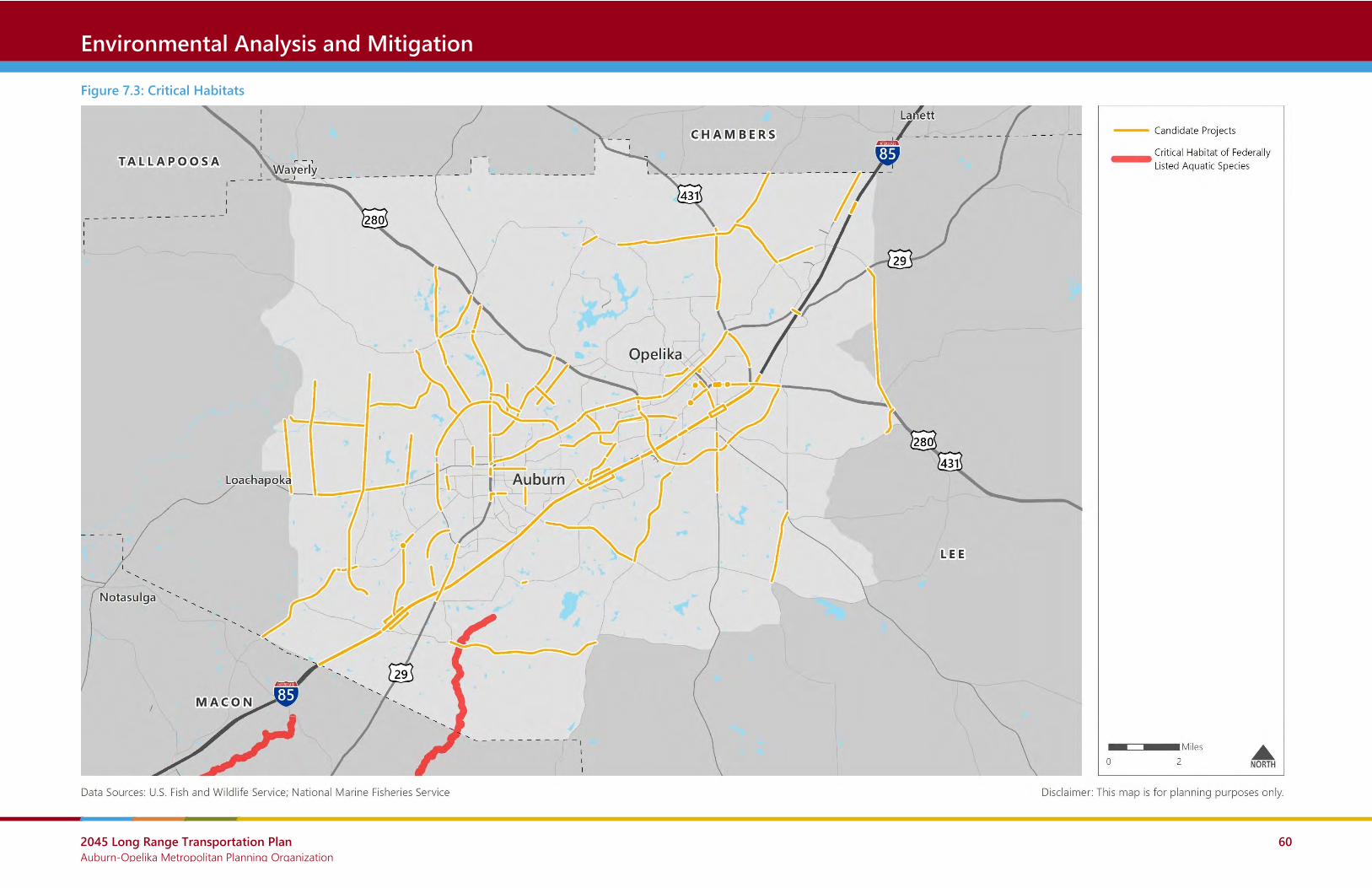
2045 Long Range Transportation Plan Auburn-Opelika Metropolitan Planning Organization
60
Crash Locations Environmental Analysis and Mitigation
Figure 7.3: Critical Habitats

2045 Long Range Transportation Plan Auburn-Opelika Metropolitan Planning Organization
61
Crash Locations Environmental Analysis and Mitigation
7.3 The Human Environment
Historic and Recreational Resources
Transportation Projects were evaluated for proximity to historic sites and publicly-owned
recreational facilities. Section 4(f) of the Department of Transportation (DOT) Act of 1966
affords protection to publicly-owned parks and recreation areas and all historic sites listed or
eligible for listing on the National Register of Historic Places when USDOT funds are invested in
a project.
In order to be eligible for the National Register of Historic Places (NRHP), a district, site, building,
structure, or object must possess integrity of location, design, setting, materials, workmanship,
feeling, and association and generally must be at least 50 years old. It will also be evaluated by
the following criteria:
• association with events that have made a significant contribution to the broad patterns
of our history; or
• association with the lives of significant persons in or past; or
• embodiment of the distinctive characteristics of a type, period, or method of
construction, or representative of the work of a master, or possession of high artistic
values, or representative of a significant and distinguishable entity whose components
may lack individual distinction; or
• provision or likelihood to provide information important in history or prehistory.
Figure 7.4 shows all historic sites listed on the National Register and State Register. It is
important to note the State Register properties are not necessarily protected by 4(f) regulations
unless they meet NRHP eligibility. Furthermore, there may be additional properties not listed on
either register which are eligible for the NRHP. Figure 7.4 excludes all historic features deemed
'restricted' or 'sensitive', such as sensitive archaeological sites.
Figure 7.4 also shows all publicly-owned parks and recreation areas deemed significant by a
review of public agency websites.
Mitigation
Projects will be developed in consultation with the State Historic Preservation Office (SHPO) and
to the extent practicable, actions which adversely impact NRHP properties and publicly-owned
recreation areas will be avoided. When historic properties are adversely affected, mitigation will
include data recovery as appropriate to document the essential qualities of the historic
resources. When publicly-owned recreation areas are adversely affected, appropriate
compensation will be provided.

2045 Long Range Transportation Plan Auburn-Opelika Metropolitan Planning Organization
62
Crash Locations Environmental Analysis and Mitigation
Farmland
Farmland is a vital local and national resource but many communities have witnessed significant
loss of this finite resource over the last century.
The Farmland Protection Policy Act (FPPA), enacted in 1981, is intended to minimize the impact
Federal programs have on the unnecessary and irreversible conversion of farmland to
nonagricultural uses. It assures that to the extent possible federal programs are administered to
be compatible with state, local government, and private programs and policies to protect
farmland.
For the purpose of FPPA, farmland includes prime farmland, unique farmland, and land of
statewide or local importance. Farmland subject to FPPA requirements does not have to be
currently used for cropland. It can be forest land, pastureland, cropland, or other land, but not
water or urban built-up land.
Figure 7.5 shows prime farmland in the Metropolitan Planning Area. There is no farmland of
local, statewide, or unique importance as defined by the Natural Resources Conservation
Service.1
Mitigation
Before farmland can be used for a federally-funded project, an assessment must be completed
to determine if prime, unique, or statewide or locally important farmlands would be converted
to non-agricultural uses.
If the assessment determines that the use of farmland is in excess of the parameters defined by
the Natural Resources Conservation Service, then measures must be taken to minimize impacts
to these farmlands.
1 Soil Data Access (SDA) Prime and other Important Farmlands
2045 Long Range Transportation Plan Auburn-Opelika Metropolitan Planning Organization
63
Crash Locations Environmental Analysis and Mitigation
Potentially Hazardous Materials
Accidents, spills, leaks, and past improper disposal and handling of hazardous materials and
wastes have resulted in contamination of many sites across the country.
The Comprehensive Environmental Response, Compensations, and Liability Act (CERCLA),
commonly known as Superfund, was enacted in 1980 and established prohibitions and
requirements concerning closed and abandoned hazardous waste sites, provided for liability of
persons responsible for releases of hazardous waste at these sites; and established a trust fund
to provide for cleanup when no responsible party could be identified. CERCLA also enabled the
revision of the National Contingency Plan, which established the National Priorities List.
The National Priorities List (NPL) is the list of national priorities among the known releases or
threatened releases of hazardous substances, pollutants, or contaminants throughout the United
States and its territories. The NPL is intended primarily to guide the EPA in determining which
sites warrant further investigation.
While there are no sites listed on the National Priorities List in the MPA, there are a few cleanup
sites identified by the EPA, as illustrated in Figure 7.6.
These cleanup sites were identified using the EPA’s Cleanups in My Community database. This
database includes cleanup sites, facilities and properties for which EPA collects information by
law, or voluntarily via grants.
Mitigation
At this stage in project development, not enough information is available to determine impacts
and mitigation. However, transportation projects affected by or affecting potentially hazardous
properties will be evaluated during the ALDOT project delivery process, the NEPA process,
design, and construction.

2045 Long Range Transportation Plan Auburn-Opelika Metropolitan Planning Organization
64
Crash Locations Environmental Analysis and Mitigation
Environmental Justice Populations
Executive Order 12898: Federal Actions to Address Environmental Justice in Minority Populations
and Low Income Populations, was signed by President Clinton in 1994. It seeks to reaffirm the
intent of Title VI of the Civil Rights Act of 1964, NEPA, and other federal laws, regulations, and
policies by establishing the following Environmental Justice (EJ) principles for all federal agencies
and agencies receiving federal funds, such as MPOs:
• To avoid, minimize, or mitigate disproportionately high and adverse human health and
environmental effects, including social and economic effects, on minority populations
and low-income populations.
• To ensure the full and fair participation by all potentially affected communities in the
transportation decision-making process.
• To prevent the denial of, reduction in, or significant delay in the receipt of benefits by
minority and low-income populations.
Figure 7.7 shows areas in the Metropolitan Planning Area where low-income households make
up a greater share of the overall population.
Similarly, Figure 7.8 shows areas in the Metropolitan Planning Area where people of color, or
minority populations, make up a greater share of the overall population.
Mitigation
In an attempt to prevent disproportionately high and adverse effects on minority or low-income
populations early in the planning process, the MPO should encourage high community and
stakeholder engagement in the design phase of projects. This is especially important for
projects that are located in areas with a disproportionately high minority and/or low-income
population. These projects are flagged later in this chapter.

2045 Long Range Transportation Plan Auburn-Opelika Metropolitan Planning Organization
65
Crash Locations Environmental Analysis and Mitigation
Other Community Impacts
In addition to the community impacts already discussed, a transportation project may produce
various impacts to public spaces, residences, and businesses. These impacts may relate to
property, air quality, noise, or other issues and many will not be well understood until a project
is substantially advanced.
Figure 7.9 shows the location of some other community resources that should be considered
early in the planning process. Proximity to schools and colleges/universities should be carefully
considered for many reasons, including the high volume of pedestrians and presence of
recreational facilities. Projects should also be careful to avoid or mitigate impacts to cemeteries.
Mitigation
Impacts associated with specific projects will be assessed in conformance with local, state, and
federal regulations, NEPA guidance, and the ALDOT project delivery process.
Certain impacts, such as those associated with an increase in traffic related noise, can potentially
be mitigated. Also, to the extent practicable, projects should be developed using Context
Sensitive Solutions.

2045 Long Range Transportation Plan Auburn-Opelika Metropolitan Planning Organization
66
Crash Locations Environmental Analysis and Mitigation
Figure 7.4: Historic and Recreational Resources

2045 Long Range Transportation Plan Auburn-Opelika Metropolitan Planning Organization
67
Crash Locations Environmental Analysis and Mitigation
Figure 7.5: Prime Farmland

2045 Long Range Transportation Plan Auburn-Opelika Metropolitan Planning Organization
68
Crash Locations Environmental Analysis and Mitigation
Figure 7.6: Potentially Hazardous Sites

2045 Long Range Transportation Plan Auburn-Opelika Metropolitan Planning Organization
69
Crash Locations Environmental Analysis and Mitigation
Figure 7.7: Block Group Demographics: People in Poverty

2045 Long Range Transportation Plan Auburn-Opelika Metropolitan Planning Organization
70
Crash Locations Environmental Analysis and Mitigation
Figure 7.8: Block Group Demographics: People of Color

2045 Long Range Transportation Plan Auburn-Opelika Metropolitan Planning Organization
71
Crash Locations Environmental Analysis and Mitigation
Figure 7.9: Other Community Resources

2045 Long Range Transportation Plan Auburn-Opelika Metropolitan Planning Organization
72
Crash Locations Environmental Analysis and Mitigation
7.4 Project Screening
The Long Range Transportation Plan uses an environmental screening process to evaluate the
likelihood of significant environmental impacts for all considered transportation projects. More
detailed environmental analyses are conducted for each project if it is selected for
implementation.
Potential for Natural and Community Impacts
All transportation projects considered in the Long Range Transportation Plan were evaluated for
proximity to the following natural and community resources:
• Natural Resources
o Wildlife refuges or preserves
o Wetlands
• Community Resources
o Historic sites
o Parks and recreation centers
o Schools and college/university campuses
o Cemeteries
Projects with “High Concern for Environmental and Community Impacts” were defined as
projects that potentially impact 4 or more resources total or 2 resources per project corridor
mile. The potential for impacts was determined by proximity. For point-level resource data, a
buffer of ¼ mile was applied and for polygon-based resource data, a buffer of 250 feet was
applied.
Figure 7.10 shows the projects with “High Concern for Environmental and Community Impacts.”
Potential for Environmental Justice Impacts
All transportation projects considered in the Long Range Transportation Plan were evaluated for
disproportionately high concentrations of the following environmental justice populations:
• People living in poverty (low-income)
• People of color (minorities)
Projects with “High Concern for Environmental Justice Impacts” were defined as projects where
people nearby are at least 1.5 times more likely than the Metropolitan Planning Area average to
be a person living in poverty or a person of color. For people living in poverty, the Metropolitan
Planning Area average was 26.6% and for people of color, the average was 36.2%.

2045 Long Range Transportation Plan Auburn-Opelika Metropolitan Planning Organization
73
Crash Locations Environmental Analysis and Mitigation
To estimate the socioeconomic composition of project areas, projects were buffered by a half
mile and block-level data was compiled. This block-level data used 2010 Census data
supplemented with known developments since 2010. All blocks were assumed to have the
socioeconomic characteristics of their block group, per the 2017 American Community Survey.
Figure 7.11 shows the projects with “High Concern for Environmental Justice Impacts.”
Mitigating Potential Impacts
Projects with high concern for environmental impacts warrant unique design considerations. For
these projects, project sponsors should carefully coordinate with stakeholders and communities
impacted, especially during preliminary engineering/design. Doing so will promote outcomes
that are more environmentally sustainable and equitable.

2045 Long Range Transportation Plan Auburn-Opelika Metropolitan Planning Organization
74
Crash Locations Environmental Analysis and Mitigation
Figure 7.10: Candidate Projects with High Concern for Environmental and Community Impacts

2045 Long Range Transportation Plan Auburn-Opelika Metropolitan Planning Organization
75
Crash Locations Environmental Analysis and Mitigation
Figure 7.11: Candidate Projects with High Concern for Environmental Justice Impacts

2045 Long Range Transportation Plan Auburn-Opelika Metropolitan Planning Organization
76
Crash Locations Project Prioritization
8.0 Project Prioritization Roadway capacity projects and bicycle and pedestrian corridors were prioritized based on the
goals and objectives stated earlier in this LRTP. Non-capacity roadway projects, such as safety
and maintenance projects, were not prioritized. Instead, the MPO will continue to identify and
prioritize these projects on a regular basis with local governments.
8.1 Roadway Capacity Project Prioritization
To maximize the amount of limited funding available within the MPA, roadway capacity projects
were prioritized. Table 8.1 shows the criteria and weights that were utilized to prioritize the
identified roadway capacity projects. This methodology is intended to support the previously
stated goals and objectives.
The results of this prioritization exercise are shown in Table 8.2 and illustrated in Figure 8.1.

2045 Long Range Transportation Plan Auburn-Opelika Metropolitan Planning Organization
77
Crash Locations Project Prioritization
Table 8.1: Project Prioritization Methodology for Roadway Capacity Projects
Criterion Rationale Measure Scoring Scale (Points Possible)
0 5 10 15 20
Congestion Reduction
Prioritize projects that reduce
congestion.
Reduction in Vehicle Hours of Delay from baseline
conditions (Existing + Committed Network) Points awarded in increments of 5 based upon to be determined breaks in the data
Benefit Cost Ratio
Prioritize projects with congestion
reduction benefits exceeding
construction costs and maximize
limited federal funds.
Benefit/Cost Ratio: annual dollars saved from delay
reduction divided by project cost. Points awarded in increments of 5 based upon to be determined breaks in the data
Safety Benefits Prioritize projects that will improve
safety conditions.
Qualitative assessment based on crash data, bridge
conditions, and engineering analysis. Minimal safety
benefits Some safety benefits
Moderate safety
benefits
Significant safety
benefits
Very significant safety
benefits
Bicycle and Pedestrian
Benefits
Prioritize projects that will allow for
incidental bike/ped improvements.
Existing Roadway: identified bike/ped need in MPO
Bike/Ped Plan or in local bike/ped plans.
New Roadway: proximity to urbanized area (only
roadways that do not restrict bike/ped activity)
No existing need
identified
Identified bike/ped
need (Tiers 4-5 in
MPO plan or in
comprehensive plan)
or within 1 mile of
urbanized area (new
roadway)
Identified bike/ped
need (Tiers 1-3 in
MPO plan or in stand-
alone bike/ped plan)
or within urbanized
area (new roadway)
Freight Benefits
Prioritize projects that benefit the
movement of goods.
Reduction in Truck Hours of Delay from baseline
conditions (Existing + Committed Network).
Designation as part of the statewide freight
network.
Points awarded in increments of 5 based upon to be determined breaks in the data
(projects that are part of statewide freight network automatically receive maximum points)
Supports Existing Plans
Prioritize projects that have been
vetted in locally-adopted plans or
existing studies and plans.
In locally-adopted plan, previous LRTP, or existing
study/plan. Not in previous plan
or study
In previous LRTP OR
existing study/plan
(not in comprehensive
plan)
In previous LRTP AND
existing study/plan
(not in comprehensive
plan)
In local
comprehensive plan
20%
20%
20%
10%
15%
15% Project Scoring Breakdown
Congestion Reduction
Benefit Cost Ratio
Safety Benefits
Bicycle and Pedestrian Benefits
Freight Benefits
Supports Existing Plans

2045 Long Range Transportation Plan Auburn-Opelika Metropolitan Planning Organization
78
Crash Locations Project Prioritization
Table 8.2: Project Prioritization Results for Roadway Capacity Projects
Project ID Sponsor/
Jurisdiction Location Limits
Length
(miles) Improvement
Project Scoring (Points Awarded) Total
Score Congestion
Reduction
Benefit
Cost Ratio
Safety
Benefits
Bike/Ped
Benefits
Freight
Benefits
Supports
Existing Plans
RC-3 City of Auburn Watercrest Blvd
Extension
E University Dr (CR-706) to 0.73
miles north of E University Dr
0.73 New 2 Lane Roadway 20 20 0 5 15 15 75
RC-4 City of Auburn Dean Rd Extension E University Dr to Birmingham
Hwy (US-280)
1.89 New 2 Lane Roadway 20 15 0 5 15 15 70
RC-7 City of Auburn Academy Dr Extension Gatewood Dr to Shelton Mill Rd
(CR-97)
0.80 New 2 Lane Roadway 20 20 0 0 15 15 70
RC-21 City of Auburn Richland Rd Extension Outer Loop to Richland Rd (CR-
188)
2.20 New 2 Lane Roadway 15 10 5 5 10 15 60
RC-10 ALDOT I-85 Exits 58-62: Gateway Dr (US-280
W) to Columbus Pkwy (US-280 E)
2.94 Widen From 4 to 6 Lanes;
Bridge Replacement
15 0 10 0 15 15 55
RC-11 ALDOT N College St (SR-147) Shug Jordan Pkwy/E University
Dr (SR-147) to US-280
2.86 Widen From 2 to 4 Lanes 15 0 15 5 15 5 55
RC-26 City of Auburn N Donahue Ave (CR-86) Shug Jordan Parkway (SR-147) to
E Farmville Rd (CR-72)
2.32 Widen From 2 to 4 Lanes 15 0 10 10 10 5 50
RC-51 City of Auburn Shug Jordan
Pkwy/University Dr
Richland Rd to Opelika Rd 4.68 Center Turn Lane and Turn
Lanes
5 0 15 10 5 15 50
RC-19 City of Auburn Outer Loop – Segment
2/3
Mrs. James Rd (CR-81) to Martin
Luther King Drive (SR-14)
3.34 New 2 Lane Roadway 15 0 0 5 10 15 45
RC-22 City of Auburn Wills Turk Rd (CR-57)
Connector
SR-14 to Mr. James Rd (CR-81) 3.23 New 2 Lane Roadway 10 0 5 5 10 15 45
RC-23 City of Auburn CR-188 Connector CR-188 to SR-14 (Stage Rd) 2.04 New 2 Lane Roadway 10 0 5 5 10 15 45
RC-24 City of Auburn Shelton Mill Rd (CR-97) E University Dr to Birmingham
Hwy (US-280)
2.09 Widen From 2 to 4 Lanes 15 0 5 5 15 5 45
RC-49 ALDOT I-85 Exit 50 (Cox Rd) to Exit 58
(Gateway Dr)
8.65 Widen From 4 to 6 Lanes;
Bridge Replacement
20 0 10 0 15 0 45
RC-50 City of Auburn Full Outer Loop (All 3
segments)
Corporate Pkwy to US 280
(multiple segments)
6.57 New 2 Lane Roadway 15 0 5 0 10 15 45
RC-53 City of Auburn Miracle Rd Extension CR-677 to Shug Jordan Pkwy
(SR-147)
1.48 New 2 Lane Roadway 15 15 0 5 10 0 45
RC-171 City of Auburn Piedmont Dr Extension Donahue Dr (CR-82) to Outer
Loop
2.39 New 2 Lane Roadway 15 5 0 5 10 5 40
RC-48 City of Opelika King Ave/Century Blvd
Extension
Park St to Frederick Rd 2.33 New 2 Lane Roadway 10 0 10 10 10 0 40

2045 Long Range Transportation Plan Auburn-Opelika Metropolitan Planning Organization
79
Crash Locations Project Prioritization
Project ID Sponsor/
Jurisdiction Location Limits
Length
(miles) Improvement
Project Scoring (Points Awarded) Total
Score Congestion
Reduction
Benefit
Cost Ratio
Safety
Benefits
Bike/Ped
Benefits
Freight
Benefits
Supports
Existing Plans
RC-9 Auburn University Lem Morrison Dr
Extension
W Samford Ave to W Magnolia
Ave
0.40 New 2 Lane Roadway 5 0 10 10 5 5 35
RC-29 City of Opelika Gateway Drive (US-280)
Extension
Marvyn Parkway (SR-51) to
Crawford Rd (SR-169)
0.38 New 2 Lane Roadway 0 0 10 10 0 15 35
RC-31 City of Opelika Fox Run Pkwy (US-431) Fox Trail to Samford Ave 0.86 Widen From 2 to 4 Lanes 0 0 5 10 15 5 35
RC-35 City of Opelika Lafayette Pkwy (US-431) Freeman Ave to Opelika City
Limits
2.20 Widen From 2 to 4 Lanes 0 0 10 5 15 5 35
RC-14 City of Auburn Downs Way Extension Shug Jordan Pkwy (SR-267) to
Veterans Blvd
1.97 New 2 Lane Roadway 0 0 5 10 0 15 30
RC-16 City of Auburn N College St Shelton Mill Rd (CR-97) to Shug
Jordan Pkwy/E University Dr (SR-
147)
0.91 Widen From 2 to 4 Lanes 0 0 15 10 0 5 30
RC-27 City of Auburn Shelton Mill Rd (CR-97) N College St to E University Dr 0.92 Widen From 2 to 4 Lanes 0 0 10 5 0 15 30
RC-28 City of Auburn N College St Bragg Ave (SR-14) to Shelton Mill
Rd (CR-97)
0.83 Widen From 2 to 4 Lanes 0 0 15 10 0 5 30
RC-34 City of Opelika Gateway Drive East (US-
280) Extension
Crawford Rd (SR-169) to N
Uniroyal Rd
2.27 New 2 Lane Roadway 5 0 5 5 0 15 30
RC-36 City of Opelika Northern By-Pass
Connector
Oak Bowery Rd @ National
Village Pkwy to Lafayette Pkwy
(US-431)
2.56 New 2 Lane Roadway 10 0 0 0 5 15 30
RC-43 City of Auburn Moore's Mill Rd Grove Hill Rd to Society Hill Rd
(CR-54)
2.89 Widen From 2 to 4 Lanes 5 0 15 0 5 5 30
RC-12 ALDOT SR-14 Willis Turk Rd to Webster Rd 2.58 Widen From 2 to 4 Lanes 0 0 15 5 0 5 25
RC-13 City of Auburn Cox Rd Beehive Interchange to Wire Rd 2.24 Widen From 2 to 4 Lanes 5 0 5 5 5 5 25
RC-30 City of Opelika Pepperell Pkwy (SR-14)
Connector
Pepperell Pkwy (SR-14) to Airport
Rd
0.39 New 2 Lane Roadway 0 0 0 10 0 15 25
RC-33 City of Opelika Marvyn Parkway (SR-51) Crawford Rd (SR-169) to the
southern city limits
1.50 Add Center Turn Lane 0 0 15 5 0 5 25
RC-38 City of Opelika Eastern By-Pass
Roadway Corridor
US-280 to W Point Pkwy (US-29) 3.95 New 2 Lane Roadway 5 0 5 0 0 15 25
RC-41 City of Opelika Fitzpatrick Ave Pleasant Ave to North 10th Street 0.68 Widen From 2 to 4 Lanes 0 0 10 10 0 5 25
RC-42 City of Opelika Columbus Pkwy (SR-38) McCoy St to Fox Run Parkway 1.00 Widen From 2 to 4 Lanes 0 0 15 5 0 5 25
RC-45 City of Auburn Webster Rd Extension Richland Rd to Martin Luther
King Dr (SR-14)
1.47 New 2 Lane Roadway 0 0 0 10 0 15 25
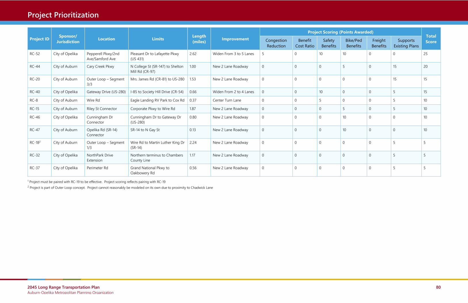
2045 Long Range Transportation Plan Auburn-Opelika Metropolitan Planning Organization
80
Crash Locations Project Prioritization
Project ID Sponsor/
Jurisdiction Location Limits
Length
(miles) Improvement
Project Scoring (Points Awarded) Total
Score Congestion
Reduction
Benefit
Cost Ratio
Safety
Benefits
Bike/Ped
Benefits
Freight
Benefits
Supports
Existing Plans
RC-52 City of Opelika Pepperell Pkwy/2nd
Ave/Samford Ave
Pleasant Dr to Lafayette Pkwy
(US 431)
2.62 Widen From 3 to 5 Lanes 5 0 10 10 0 0 25
RC-44 City of Auburn Cary Creek Pkwy N College St (SR-147) to Shelton
Mill Rd (CR-97)
1.00 New 2 Lane Roadway 0 0 0 5 0 15 20
RC-20 City of Auburn Outer Loop – Segment
3/3
Mrs. James Rd (CR-81) to US-280 1.53 New 2 Lane Roadway 0 0 0 0 0 15 15
RC-40 City of Opelika Gateway Drive (US-280) I-85 to Society Hill Drive (CR-54) 0.66 Widen From 2 to 4 Lanes 0 0 10 0 0 5 15
RC-8 City of Auburn Wire Rd Eagle Landing RV Park to Cox Rd 0.37 Center Turn Lane 0 0 5 0 0 5 10
RC-15 City of Auburn Riley St Connector Corporate Pkwy to Wire Rd 1.87 New 2 Lane Roadway 0 0 0 5 0 5 10
RC-46 City of Opelika Cunningham Dr
Connector
Cunningham Dr to Gateway Dr
(US-280)
0.80 New 2 Lane Roadway 0 0 0 10 0 0 10
RC-47 City of Auburn Opelika Rd (SR-14)
Connector
SR-14 to N Gay St 0.13 New 2 Lane Roadway 0 0 0 10 0 0 10
RC-182 City of Auburn Outer Loop – Segment
1/3
Wire Rd to Martin Luther King Dr
(SR-14)
2.24 New 2 Lane Roadway 0 0 0 0 0 5 5
RC-32 City of Opelika NorthPark Drive
Extension
Northern terminus to Chambers
County Line
1.17 New 2 Lane Roadway 0 0 0 0 0 5 5
RC-37 City of Opelika Perimeter Rd Grand National Pkwy to
Oakbowery Rd
0.56 New 2 Lane Roadway 0 0 0 0 0 5 5
1 Project must be paired with RC-19 to be effective. Project scoring reflects pairing with RC-19
2 Project is part of Outer Loop concept. Project cannot reasonably be modeled on its own due to proximity to Chadwick Lane

2045 Long Range Transportation Plan Auburn-Opelika Metropolitan Planning Organization
81
Crash Locations Project Prioritization
Figure 8.1: Project Prioritization Results for Roadway Capacity Projects

2045 Long Range Transportation Plan Auburn-Opelika Metropolitan Planning Organization
82
Crash Locations Project Prioritization
8.2 Bicycle and Pedestrian Corridor Prioritization
All previously identified bicycle and pedestrian projects and new projects identified in the Needs
Assessment were prioritized based on the criteria and weights shown in Table 8.3. This
methodology is intended to support the previously stated goals and objectives.
However, given the large number of overlapping bicycle and pedestrian projects from existing
plans and the Needs Assessment, the LRTP does not recommend specific bicycle and pedestrian
projects beyond those already funded in the TIP. Instead, high-priority corridors were identified
based on the location of the highest scoring individual projects.
These high-priority bicycle and pedestrian corridors are shown in Table 8.4 and illustrated in
Figure 8.2.

2045 Long Range Transportation Plan Auburn-Opelika Metropolitan Planning Organization
83
Crash Locations Project Prioritization
Table 8.3: Project Prioritization Methodology for Bicycle and Pedestrian Projects
Criterion Measure Scoring Scale (Points Possible)
0 5 10 15 20
Land Use
Population Density Persons per acre 0 to 1 persons per
acre
1 to 2.5 persons per
acre
2.5 to 5 persons per
acre
5 to 10 persons per
acre
10 or more persons
per acre
Employment Density Jobs per acre 0 to 0.5 jobs per acre 0.5 to 4 jobs per acre
4 or more jobs per
acre
Popular Destinations Nearby Number of Popular Destinations per mile1 0 to 0.01 destinations
per mile
0.01 to 0.05
destinations per mile
0.05 to 0.10
destinations per mile
0.10 or more
destinations per mile
Demographic
Low-Income and Carless
Households
Households receiving food stamps or lacking at least one vehicle
per acre 0 to 0.17 households
per acre
0.17 to 0.33
households per acre
0.33 to 0.67
households per acre
0.67 or more
households per acre
Limited Mobility Age Groups Population aged 15 or under and 65 or older per acre 0 to 0.45 persons per
acre
0.45 to 0.90 persons
per acre
0.90 or more persons
per acre
Travel Environment
System Connectivity Connectivity to existing sidewalks, bike facilities, and bicycle and
pedestrian-friendly streets. For pedestrian projects, ratio of
sidewalk to roadway. For bike projects, bike facility connections
per mile. For bike/ped project, combined score, maxing out at 10.
Sidewalk ratio of 0 to
0.10. 0 to 1 bike
connection per mile
Sidewalk ratio of 0.1 to
1.00. 1 to 2 bike
connection per mile
Sidewalk ratio of 1 or
more. 2 or more bike
connection per mile
Street Connectivity Percentage of intersections that are four-way or more 0% to 15% 15% to 30% 30% or more
Safety Ratio of unsafe roadway miles to project miles (unsafe roadway =
posted speed above 25 MPH or either a multi-lane roadway or a
Volume to Capacity ratio above 0.75) 0 to 0.50 0.50 to 1.00 1.00 or more
1 Popular destinations are parks, major recreation centers, schools, libraries, hospitals, grocery stores, pharmacies, convenience stores, and eating and drinking places. Universities were weighted 10x, other schools and hospitals were weighted 5x and grocery stores, pharmacies, and convenience stores and parks/rec centers were weighted 2x.
20%
10%
15%
15%
10%
10%
10%
10% Project Scoring Breakdown
Population Density
Employment Density
Popular Destinations Nearby
Low-Income and Carless Households
Limited Mobility Age Groups
System Connectivity
Street Connectivity
Safety

2045 Long Range Transportation Plan Auburn-Opelika Metropolitan Planning Organization
84
Crash Locations Project Prioritization
Table 8.4: High-Priority Bicycle and Pedestrian Project Corridors
LRTP ID Location Limits Length
(Miles) Type Location
BP-2 E University Dr S College St to S Donahue Dr 0.63 Bicycle and Pedestrian City of Auburn
BP-3 S College St E University Dr to E Samford Ave 1.81 Bicycle and Pedestrian City of Auburn
BP-4 E Samford Ave Well St to S Dean Rd 1.27 Bicycle and Pedestrian City of Auburn
BP-5 Magnolia Ave Roosevelt Dt to N Ross St 1.13 Bicycle and Pedestrian City of Auburn
BP-6 W Glenn Ave N Donahue Dr to Wright St 0.42 Bicycle and Pedestrian City of Auburn
BP-7 Martin Luther King Dr/Bragg Ave/Mitcham Ave Jordan St to N Gay St 1.49 Bicycle and Pedestrian City of Auburn
BP-8 N Donahue Dr W Thatch Ave to Cary Dr 0.96 Bicycle and Pedestrian City of Auburn
BP-9 S Gay St E Samford Ave to E Drake Ave 1.06 Bicycle City of Auburn
BP-10 College St E Samford Ave to E Drake Ave 1.08 Bicycle City of Auburn
BP-11 E Glenn Ave Wright St to Alice St 1.87 Bicycle City of Auburn
BP-12 Harper Ave N Ross St to N Dean St 0.60 Bicycle and Pedestrian City of Auburn
BP-13 N Dean St E Glenn Ave to Opelika Rd 0.54 Bicycle and Pedestrian City of Auburn
BP-14 N Dean Rd Opelika Rd to E University Dr 0.91 Bicycle and Pedestrian City of Auburn
BP-15 E University Dr Dekalb St to Bailey-Harris Dr 1.39 Bicycle and Pedestrian City of Auburn
BP-16 Mall Blvd/Commerce Dr Mall Pkwy to Commerce Dr; entire street 0.76 Pedestrian City of Auburn
BP-17 Veterans Pkwy Pepperell Pkwy to Academy Dr 0.48 Pedestrian City of Opelika
BP-18 Pleasant Dr Pepperell Pkwy to Waverly Pkwy 0.63 Bicycle and Pedestrian City of Opelika
BP-19 1st Ave Thomason Dr to N 11th St 1.55 Bicycle and Pedestrian City of Opelika
BP-20 10th St 2nd Ave to Martin Luther King Blvd 0.64 Bicycle City of Opelika
BP-21 6th St 2nd Ave to Columbus Pkwy 0.74 Bicycle City of Opelika
BP-22 Jeter Ave S Railroad Ave to Fair St 0.50 Pedestrian City of Opelika
BP-23 S Dean Rd E Glenn Ave to Moores Mill Rd 1.20 Bicycle City of Auburn
BP-24 Opelika Rd/Pepperell Pkwy/2nd Ave/Samford Ave N Gay St to Lafayette Pkwy 7.87 Bicycle and Pedestrian Cities of Auburn and Opelika
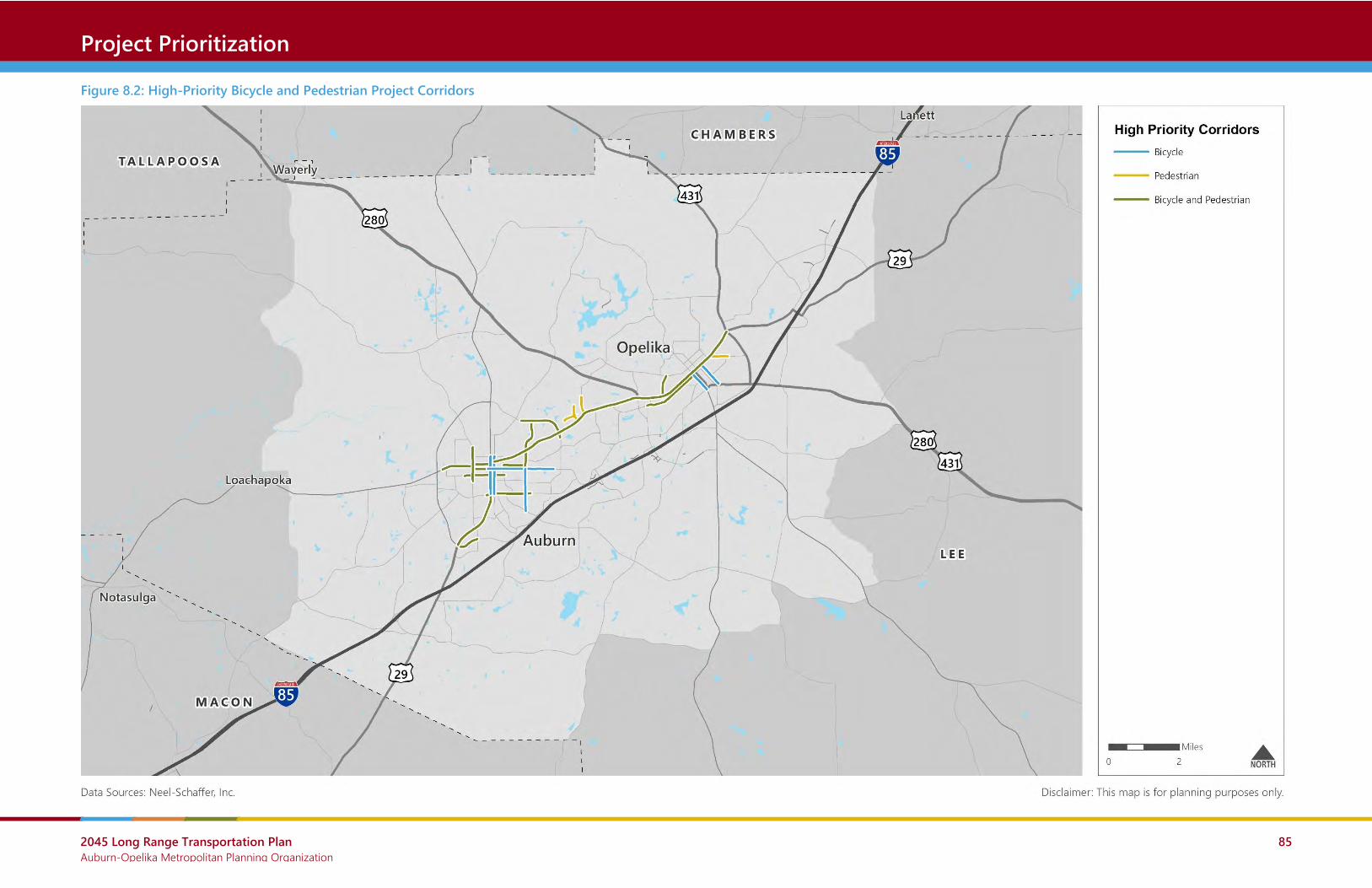
2045 Long Range Transportation Plan Auburn-Opelika Metropolitan Planning Organization
85
Crash Locations Project Prioritization
Figure 8.2: High-Priority Bicycle and Pedestrian Project Corridors

2045 Long Range Transportation Plan Auburn-Opelika Metropolitan Planning Organization
86
Crash Locations Financial Plan
9.0 Financial Plan Long range transportation plans are required by federal legislation to be fiscally constrained. In
order to demonstrate fiscal constraint, the costs of programmed projects must not exceed the
amount of funding that is reasonably expected to be available.
This chapter reviews available funding sources and forecasts the amount of funding that can
reasonably be anticipated to be available for transportation projects and programs in the MPA
through 2045. Forecasts used in this chapter are for planning purposes only and do not commit
any jurisdiction or agency to provide a specific level of funding.
9.1 Roadway Funding
Federal Funding Sources
Federal funding for transportation is authorized through the current transportation bill (FAST
Act) and includes several major “formula” programs and discretionary programs. While
“formula” programs may change somewhat in future transportation bills, they have been
relatively stable over time.
National Highway Performance Program (NHPP)
Overview: The NHPP provides support for the condition and performance of the National
Highway System (NHS), for the construction of new facilities on the NHS, and to ensure that
investments of Federal-aid funds in highway construction are directed to support progress
toward the achievement of performance targets established in a State's asset management plan.
Eligible Activities: Projects or programs supporting progress toward the achievement of national
performance goals for improving infrastructure condition, safety, congestion reduction, system
reliability, or freight movement on the NHS.
Federal Share: 90 percent for most projects on the Interstate System and 80 percent elsewhere.
Surface Transportation Block Grant Program (STBG)
Overview: The Surface Transportation Block Grant (STBG) provides flexible funding that may be
used for just about any type of transportation-related project. FAST Act continues the regulation
that 50 percent of a state’s STBG apportionment is sub-allocated to areas based on their relative
share of the total state population, with the other 50 percent available for use in any area of the
state. These sub-allocations to the urban areas are called attributable funds.

2045 Long Range Transportation Plan Auburn-Opelika Metropolitan Planning Organization
87
Crash Locations Financial Plan
Eligible Activities: Most transportation projects are eligible for STBG funding. See 23 U.S.C.
133(b)(15) for details.
Federal Share: 90 percent for most projects on the Interstate System and 80 percent elsewhere.
Highway Safety Improvement Program (HSIP)
Overview: The HSIP seeks to achieve a significant reduction in traffic fatalities and serious injuries
on all public roads, including non-State-owned public roads and roads on tribal lands. The HSIP
requires a data-driven, strategic approach to improving highway safety on all public roads that
focuses on performance.
Eligible Activities: Safety projects that are consistent with the State’s strategic highway safety
plan (SHSP) and that correct or improve a hazardous road location or feature or address a
highway safety problem.
Federal Share: 90 percent except as provided in 23 U.S.C. 120 and 130.
Congestion Mitigation and Air Quality Improvement Program (CMAQ)
Overview: The CMAQ program provides a flexible funding source to State and local
governments for transportation projects and programs to help meet the requirements of the
Clean Air Act. Funding is available to reduce congestion and improve air quality for areas that do
not meet the National Ambient Air Quality Standards for ozone, carbon monoxide, or particulate
matter (nonattainment areas) and for former nonattainment areas that are now in compliance
(maintenance areas).
Note: The Auburn-Opelika MPO currently does not qualify for CMAQ funds because it is in
attainment of air quality standards. However, should that change in the future, the MPO would
become eligible for CMAQ funding.
Eligible Activities: Projects or programs that are likely to contribute to the attainment or
maintenance of a national ambient air quality standard, with a high level of effectiveness in
reducing air pollution.
Federal Share: 90 percent for most projects on the Interstate System and 80 percent elsewhere.
National Highway Freight Program (NHFP)
Overview: The NHFP seeks to improve the efficient movement of freight on the National
Highway Freight Network (NHFN) and support national freight related goals.

2045 Long Range Transportation Plan Auburn-Opelika Metropolitan Planning Organization
88
Crash Locations Financial Plan
Eligible Activities: Generally, NHFP funds must contribute to the efficient movement of freight on
the NHFN and be identified in a freight investment plan included in the State’s freight plan.
Federal Share: 90 percent for most projects on the Interstate System and 80 percent elsewhere.
State and Local Funding Sources
State Funding
State transportation revenues come from motor fuel taxes and fees and vehicles taxes and fees.
The gasoline excise tax in particular is the state’s largest funding source for roadway projects.
Property, Sales, and Income Taxes
Taxation contributes the most revenue to local governments in the United States. Property
taxes, sales taxes, and income taxes are the most common and biggest sources of local
government tax revenue. Taxes may be levied by states, counties, municipalities, or other
authorities.
User Fees
User fees are fees collected from those who utilize a service or facility. The fees are collected to
pay for the cost of a facility, finance the cost of operations, and/or generate revenue for other
uses. User fees are commonly charged for public parks, water and sewer services, transit
systems, and solid waste facilities. The theory behind the user fee is that those who directly
benefit from these public services pay for the costs.
Special Assessments
Special assessment is a method of generating funds for public improvements, whereby the cost
of a public improvement is collected from those who directly benefit from the improvement. In
some instances, new streets are financed by special assessment. The owners of property located
adjacent to the new streets are assessed a portion of the cost of the new streets, based on the
amount of frontage they own along the new streets.
Special assessments have also been used to generate funds for general improvements within
special districts, such as central business districts. These assessments may be paid over a period
of time rather than as a lump sum payment.
Impact Fees

2045 Long Range Transportation Plan Auburn-Opelika Metropolitan Planning Organization
89
Crash Locations Financial Plan
New developments create increased traffic volumes on the streets around them. Development
impact fees are a way of attempting to place a portion of the burden of funding improvements
on developers who are creating or adding to the need for improvements.
Bond Issues
Property tax and sales tax funds can be used on a pay-as-you-go basis, or the revenues from
them can be used to pay off general obligation or revenue bonds. These bonds are issued by
local governments upon approval of the voting public.
Forecasting Available Funds
ALDOT forecasted the amount of federal funding that the MPO can reasonably expect to be
available for roadway projects over the next 25 years. These forecasts account for inflation and
were provided for three categories: capacity projects, operations and maintenance projects, and
MPO dedicated funding. MPO dedicated funding is assumed to be split into 25 percent capacity
and 75 percent operations and maintenance.
Using the assumptions above, the amount of federal funding reasonably expected to available
for roadway projects in the MPO through 2045 is as follows:
• Capacity Projects
o Stage 1 (2020-2023) - $6,576,271 (committed projects in TIP)
o Stage 2 (2024-2045) - $50,613,086
• Operations and Maintenance Projects
o Stage 1 (2020-2023) - $34,032,513 (committed projects in TIP)
o Stage 2 (2024-2045) - $103,284,052
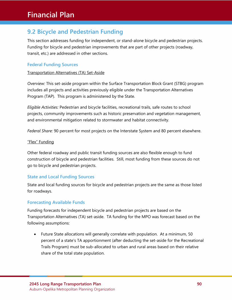
2045 Long Range Transportation Plan Auburn-Opelika Metropolitan Planning Organization
90
Crash Locations Financial Plan
9.2 Bicycle and Pedestrian Funding
This section addresses funding for independent, or stand-alone bicycle and pedestrian projects.
Funding for bicycle and pedestrian improvements that are part of other projects (roadway,
transit, etc.) are addressed in other sections.
Federal Funding Sources
Transportation Alternatives (TA) Set-Aside
Overview: This set-aside program within the Surface Transportation Block Grant (STBG) program
includes all projects and activities previously eligible under the Transportation Alternatives
Program (TAP). This program is administered by the State.
Eligible Activities: Pedestrian and bicycle facilities, recreational trails, safe routes to school
projects, community improvements such as historic preservation and vegetation management,
and environmental mitigation related to stormwater and habitat connectivity.
Federal Share: 90 percent for most projects on the Interstate System and 80 percent elsewhere.
“Flex” Funding
Other federal roadway and public transit funding sources are also flexible enough to fund
construction of bicycle and pedestrian facilities. Still, most funding from these sources do not
go to bicycle and pedestrian projects.
State and Local Funding Sources
State and local funding sources for bicycle and pedestrian projects are the same as those listed
for roadways.
Forecasting Available Funds
Funding forecasts for independent bicycle and pedestrian projects are based on the
Transportation Alternatives (TA) set-aside. TA funding for the MPO was forecast based on the
following assumptions:
• Future State allocations will generally correlate with population. At a minimum, 50
percent of a state's TA apportionment (after deducting the set-aside for the Recreational
Trails Program) must be sub-allocated to urban and rural areas based on their relative
share of the total state population.

2045 Long Range Transportation Plan Auburn-Opelika Metropolitan Planning Organization
91
Crash Locations Financial Plan
• The MPO will receive an amount of funding from the State that is proportionate to its
Metropolitan Planning Area’s share of the state population (2.0 percent). In 2020, that
will amount to $317,217.
• TAP revenue will increase 0.5 percent annually.
Using the assumptions above, the amount of federal TA funding reasonably expected to
available for bicycle and pedestrian projects in the MPO through 2045 is as follows:
• Stage 1 (2020-2023) - $1,278,415
• Stage 2 (2024-2045) - $7,505,924

2045 Long Range Transportation Plan Auburn-Opelika Metropolitan Planning Organization
92
Crash Locations Financial Plan
9.3 Public Transit Funding
Federal Funding Sources
There are many federal funding sources for public transit. Most of these sources are programs
funded by the Federal Transit Administration (FTA) and administered by the State.
Urbanized Area Formula Grants (Section 5307)
Overview: This formula-based funding program provides funds for capital and operating
assistance for transit service in urbanized areas with populations greater than 50,000 and for
transportation-related planning.
Eligible Activities: Funds can be used for planning, engineering, design and evaluation of transit
projects and other technical transportation-related studies; capital investments in bus and bus-
related activities such as replacement of buses, overhaul of buses, rebuilding of buses, crime
prevention and security equipment and construction of maintenance and passenger facilities;
computer hardware/software; and operating assistance in urbanized areas under 200,000 in
population or with 100 or fewer fixed-route buses operating in peak hours. Activities eligible
under the former Job Access and Reverse Commute (JARC) program, which provided services to
low-income individuals to access jobs, are now eligible under the Urbanized Area Formula
program.
Federal Share: 80 percent for capital projects, 50 percent for operating assistance, and 80
percent for ADA non-fixed route paratransit service.
Enhanced Mobility of Seniors and Individuals with Disabilities (Section 5310)
Overview: Grants are made by the State to private non-profit organizations (and certain public
bodies) to increase the mobility of seniors and persons with disabilities. The former New
Freedom program (Section 5317) is folded into this program.
Eligible Activities: Projects must be included in a coordinated human service transportation plan.
Funds can be used for buses and vans; wheelchair lifts, ramps, and securement devices; transit-
related information technology systems; mobility management programs; acquisition of
transportation services under a contract, lease, or other arrangement; travel training; volunteer
driver programs; building an accessible path to a bus stop; and incremental cost of providing
same day service or door-to-door service.
Federal Share: 80 percent for capital projects, 50 percent for operating assistance.

2045 Long Range Transportation Plan Auburn-Opelika Metropolitan Planning Organization
93
Crash Locations Financial Plan
Rural Area Formula Grants (Section 5311)
Overview: This formula-based funding program provides administration, capital, planning, and
operating assistance to support public transportation in rural areas, defined as areas with fewer
than 50,000 residents.
Eligible Activities: Planning, capital, operating, job access and reverse commute projects, and the
acquisition of public transportation services. Activities eligible under the former JARC program,
which provided services to low-income individuals to access jobs, are now eligible under the
Rural Area Formula program.
Federal Share: 80 percent for capital projects, 50 percent for operating assistance, and 80
percent for ADA non-fixed route paratransit service.
Bus and Bus Facilities Formula Grants (Section 5339a)
Overview: This program provides funds to replace, rehabilitate, and purchase buses and related
equipment and to construct bus-related facilities.
Eligible Activities: Capital projects to replace, rehabilitate and purchase buses, vans, and related
equipment, and to construct bus-related facilities, including technological changes or
innovations to modify low or no emission vehicles or facilities.
Federal Share: 80 percent for capital projects.
Other FTA Grant Programs
The FTA has several other funding sources that each address specific issues. Most of these are
more limited in funding and are competitive programs, meaning that applicants must compete
for funding based on the merits of their project.
More details can be found at https://www.transit.dot.gov/grants
Flexible, Non-FTA Funds
Surface Transportation Block Grant Program (STBG): Provides funding that may be used by states
and localities for a wide range of projects to preserve and improve the conditions and
performance of surface transportation, including highway, transit, intercity bus, bicycle and
pedestrian projects.
National Highway Performance Program (NHPP): Funds may only be used for the construction of
a public transportation project that supports progress toward the achievement of national

2045 Long Range Transportation Plan Auburn-Opelika Metropolitan Planning Organization
94
Crash Locations Financial Plan
performance goals for improving infrastructure condition, safety, mobility, or freight movement
on the NHS and which is eligible for assistance under chapter 53 of title 49, if: the project is in
the same corridor as, and in proximity to, a fully access-controlled NHS route; the construction is
more cost-effective (as determined by a benefit-cost analysis) than a NHS improvement; and the
project will reduce delays or produce travel time savings on the NHS, as well as improve
regional traffic flow. Local match requirement varies.
Congestion Mitigation and Air Quality Program (CMAQ): Provides funding to areas in
nonattainment or maintenance for ozone, carbon monoxide, and/or particulate matter. States
that have no nonattainment or maintenance areas still receive a minimum apportionment of
CMAQ funding for either air quality projects or other elements of flexible spending. Funds may
be used for any transit capital expenditures otherwise eligible for FTA funding as long as they
have an air quality benefit.
State and Local Funding Sources
State and local funding sources include the same potential sources as those outlined for
roadways. Fare revenue and advertising revenue are also important local funding sources but
are relatively small.
Forecasting Available Funds
Forecasts were developed for the four major federal transit programs that are utilized by transit
providers in the region (Section 5307, Section 5310, Section 5311, and Section 5339).
The following assumptions are utilized:
• The region will receive 100 percent of annual Section 5307 funding allocated to the
Auburn, AL Urbanized Area
• The region will receive 3.5 percent of annual Section 5310, Section 5311, and Section
5339 funding allocated to the State based on the region’s share of Vehicle Revenue
Miles.
• Federal funding for these programs is inflated 2 percent annually. This is consistent with
long-term annual increases in FTA program funding.
Based on these assumptions, the following levels of federal funding for public transit in the MPO
can be expected through 2045:
• Stage 1 (2020-2023) - $7,517,875 for operating and capital projects
• Stage 2 (2024-2045) - $53,898,365 for operating and capital projects

2045 Long Range Transportation Plan Auburn-Opelika Metropolitan Planning Organization
95
Crash Locations Implementation Plan
10.0 Implementation Plan Based on the amount of funding anticipated in the financial plan, this section presents the
recommended Implementation Plan. This plan advances the strategies previously outlined and
incorporates the results of the project prioritization process.
10.1 Fiscally Constrained Plan
The fiscally constrained plan is the list of transportation projects that best address the needs of
the region with the limited funding available. All other projects are “unfunded” and are listed
later as visionary projects.
Roadways
Over the next 25 years, the MPO plans to implement a variety of roadway capacity projects
(adding lanes or new roadways) and roadway non-capacity projects.
The MPO receives funding from many federal sources and provides local funding in addition to
federal funding. Based on projections by ALDOT, approximately $195 million in federal funds will
be available to the MPO for roadway projects from 2020 to 2045.
Table 10.2 list all roadway capacity projects in the fiscally constrained plan and Table 10.3 lists all
roadway non-capacity projects in the fiscally constrained plan. These projects are mapped in
Figure 10.4 and Figure 10.5 respectively.
As shown in Table 10.1, the fiscally constrained capacity projects will reduce vehicle hours of
delay by nearly 15% when compared to only implementing projects that are currently funded.
Figure 10.1: Fiscally Constrained Roadway Projects (Federal Funding Only)
$57,189,357
$137,316,565
$56,294,495
$137,316,565
Capacity Projects
(2020-2045)
Non-Capacity Projects
(2020-2045)
Anticipated Fiscally Constrained Projects

2045 Long Range Transportation Plan Auburn-Opelika Metropolitan Planning Organization
96
Crash Locations Implementation Plan
Table 10.1: Travel Impacts of Fiscally Constrained Roadway Capacity Projects
2045
Existing and
Committed
2045
Fiscally Constrained
Roadway Capacity Projects
Difference Percent
Difference
Vehicle Miles Traveled 4,588,931 5,119,821 530,890 11.6%
Vehicle Hours Traveled 135,572 164,323 28,751 21.2%
Vehicle Hours of Delay 40,748 34,775 -5,973 -14.7%
Source: Auburn-Opelika Regional Travel Demand Model; NSI
Bicycle and Pedestrian
In addition to bicycle and pedestrian improvements included with planned roadway projects, the
region will continue to fund stand-alone bicycle and pedestrian projects.
The major federal source for bicycle and pedestrian projects is the Transportation Alternatives
(TA) Set-Aside program, administered by ALDOT. Based on historical funding levels and the
region’s share of the state population, this plan assumes that approximately $8.8 million in
federal TA funds will be available to the MPO from 2020 to 2045. The MPO currently only has
one TA-funded project and local governments should continue to apply for these projects.
While the LRTP does not identify specific bicycle and pedestrian projects outside of those
already funded in the TIP, the MPO will encourage local agencies to make improvements along
the high-priority bicycle and pedestrian corridors listed in Table 10.4 and Figure 10.10.
Figure 10.2: Fiscally Constrained Bicycle/Pedestrian Projects (Federal Funding Only)
$8.78 million$331,000
Transportation Alternatives
Funding
(2020-2045)
Anticipated Fiscally-Constrained Projects

2045 Long Range Transportation Plan Auburn-Opelika Metropolitan Planning Organization
97
Crash Locations Implementation Plan
Public Transit
Over the next 25 years, the region will continue to provide the dial-a-ride service operated by
Lee-Russell Council of Governments. At the same time, it will also consider introducing fixed-
route service around the cities of Auburn and Opelika.
If recent funding levels continue, the region will have enough federal funding to continue
operating its dial-a-ride service at current levels. The main limitation to expanding service will
be local funding to match and exceed federal funding.
There is demand for regularly scheduled, fixed route transit in the region. A feasibility study
should be conducted that addresses the following questions:
• Who would operate this transit service and how would it include Auburn University?
• What funds are available and what new funding sources are viable options?
• What types of service should be provided and where?
• What are the steps for implementation?
Figure 10.3: Fiscally Constrained Transit Projects (Federal Funding Only)
$61.42 million$47.21 millionFederal Transit Funding
(2020-2045)
Anticipated Fiscally-Constrained Projects

2045 Long Range Transportation Plan Auburn-Opelika Metropolitan Planning Organization
98
Crash Locations Implementation Plan
Table 10.2: Fiscally Constrained Roadway Capacity Projects
LRTP ID TIP
ID Roadway Limits
Length
(Miles) Type Description Phase Sponsor
Fiscal
Year
Total Cost
(2019$)
Federal Cost
(2019$)
Total Cost
(YOE)
Federal Cost
(YOE)
Design
Considerations
RC-1 1972 N Donahue Dr Bragg Ave to Cary Dr 0.48 ⚫ Center Turn Lane ALL City of
Auburn
2021-
2022
n/a n/a $3,466,447 $2,877,641 EJ | EC
RC-2 41002 S College (SR-147) South College St: Garden Dr to
Samford Ave; Samford Ave and
Gay St
.17; .09 ⚫ New lane; Drainage;
Add Turn Lane
UT City of
Auburn
2020 n/a n/a $4,596,318 $3,698,630 EJ | EC
RC-3 n/a Watercrest Blvd Extension E University Dr (CR-706) to 0.73
miles north of E University Dr
0.73 ⚫ New 2 Lane
Roadway
ALL City of
Auburn
2034 $3,565,303 2,852,242 $4,798,429 $3,838,743
RC-4 n/a Dean Rd Extension E University Dr to Birmingham
Hwy (US-280)
1.89 ⚫ New 2 Lane
Roadway
ALL City of
Auburn
2034 $9,230,716 7,384,573 $12,423,329 $9,938,663 EJ
RC-7 n/a Academy Dr Extension Gatewood Dr to Shelton Mill Rd
(CR-97)
0.80 ⚫ New 2 Lane
Roadway
ALL City of
Auburn
2034 $3,907,181 3,125,745 $5,258,551 $4,206,841 EJ
RC-19 n/a Outer Loop - Segment 2/3 Mrs. James Rd (CR-81) to
Martin Luther King Drive (SR-
14)
3.34 ⚫ New 2 Lane
Roadway
ALL City of
Auburn
2034 $16,312,482 13,049,986 21,954,453 17,563,562 EJ
RC-29 n/a Gateway Dr Extension Marvyn Pkwy (SR-51) to
Crawford Rd (SR-169)
0.38 ⚫ New 2 Lane
Roadway
ALL City of
Opelika
2034 1,417,111 1,133,689 1,907,245 1,525,796 EC
RC-33 n/a Marvyn Pkwy (SR-51) Crawford Rd (SR-169) to the
southern city limits
1.50 ⚫ Add Center Turn
Lane
ALL City of
Opelika
2034 4,564,477 3,651,582 6,143,185 4,914,548
RC-45 n/a Webster Rd Extension Richland Rd to Martin Luther
King Dr (SR-14)
1.47 ⚫ New 2 Lane
Roadway
ALL City of
Auburn
2034 7,179,446 5,743,557 9,662,589 7,730,071 EJ | EC
Note 1: YOE (Year of Expenditure) costs assume a 2% annual inflation rate.
Note 2: Bicycle and pedestrian improvements must be part of the overall design phase of all projects and included unless restrictions apply consistent with FHWA guidance.
Improvement Type: ⚫ New Roadway ⚫ Widening ⚫ Turning Lane ⚫ Other/Multiple
Design Considerations: EJ – High Concern for Environmental Justice Impacts EC – High Concern for Environmental and Community Impacts

2045 Long Range Transportation Plan Auburn-Opelika Metropolitan Planning Organization
99
Crash Locations Implementation Plan
Figure 10.4: Fiscally Constrained Roadway Capacity Projects

2045 Long Range Transportation Plan Auburn-Opelika Metropolitan Planning Organization
100
Crash Locations Implementation Plan
Table 10.3: Fiscally Constrained Roadway Non-Capacity Projects
LRTP ID TIP ID Roadway Limits Length
(Miles)
Type Description Phase Sponsor Fiscal
Year
Total
Cost
(2019$)
Federal
Cost
(2019$)
Total Cost
(YOE)
Federal
Cost (YOE)
Design
Considerations
RN-1 42914 Pepperell Pkwy Lowndes St to Westend
Court
0.00 ⚫ Resurfacing/Milling/Pedestrian
Sidewalks and Signals
ALL City of
Opelika
2020-
2021
n/a n/a $3,206,175 $2,585,341 EJ
RN-2 44154 Pepperell Pkwy Lowndes St to Auburn City
Limits
0.00 ⚫ Resurfacing Sidewalks and Signals ALL City of
Opelika
2022-
2023
n/a n/a $2,004,939 $1,603,951 EC
RN-3 44157 I-85 At Exit 50 (Cox Rd) 0.00 ⚫ Interchange Lighting and
Landscaping
ALL ALDOT 2020 n/a n/a $1,200,000 $960,000 EC
RN-4 44178 I-85 At Exit 57 (Bent Creek Rd) 0.00 ⚫ Interchange Lighting and
Landscaping
ALL ALDOT 2020-
2021
n/a n/a $1,211,000 $968,800 EC
RN-5 11397 CR-137 Macon County Line to
Chadwick Ln
3.56 ⚫ Resurfacing and Widening ALL Lee
County
2023 n/a n/a $1,045,755 $836,604 EJ | EC
RN-6 29639 I-85 Bridges (4) Over Choctafaula Creek and
Over Halawakee Creek
0.00 ⚫ Bridge Widening ALL ALDOT 2022 n/a n/a $3,615,482 $3,253,934 EC
RN-7 42005 I-85 Bridges (6) Over Long St, NS Railroad,
and Marvyn Pkwy
1.80 ⚫ I-85 Bridge Replacement w/
Access/Decel Extensions NB Off
Ramp and SB On Ramp
ALL ALDOT 2020-
2021
n/a n/a $18,429,825 $16,586,843 EJ
RN-8 43344 I-85 Macon County Line to .42
Mile West of SR-15
3.71 ⚫ Pavement Preservation ALL ALDOT 2020-
2021
n/a n/a $3,032,525 $2,729,273 EC
RN-9 42669 N College St (SR-147) At Farmville Rd 0.00 ⚫ Construct Roundabout ALL ALDOT 2020 n/a n/a $1,571,248 $1,414,123 EC
RN-10 43548 Wire Rd At Cox Rd 0.00 ⚫ Construct Roundabout ALL City of
Auburn
2020 n/a n/a $1,604,232 $1,443,809 EJ | EC
RN-11 43552 Columbus Pkwy At 4th, 6th, and 7th Streets 0.00 ⚫ Intersection Improvements ALL City of
Opelika
2020 n/a n/a $1,833,150 $1,649,835 EJ | EC
RN-42 n/a Multiple All At-Grade Rail Crossings
within Metropolitan
Planning Area
0.00 ⚫ Railroad Crossings Safety Study ALL LRCOG 2025 $300,00
0
$240,000 $337,849 $270,279
RN-43 n/a Gateway Drive Marvyn Parkway (SR-51) 0.00 ⚫ Construct Roundabout ALL City of
Opelika
2025 $3,729,
500
$2,983,60
0
4,200,023 3,360,018
RN-44 n/a Gateway Drive (US-280) At Frederick Rd 0.00 ⚫ Innovative Intersection Study and
Conceptual Plans
ALL City of
Opelika
2025 $500,00
0
$400,000 563,081 450,465
RN-30 n/a Opelika Rd (SR-14) E University Dr to
Commerce Dr
0.65 ⚫ Access Management Study and
Implementation
ALL City of
Auburn
2034 $2,000,
000
$1,600,00
0
2,691,737 2,153,389
RN-31 n/a Pepperell Pkwy (SR-14) Commerce Dr to Pleasant
Dr
2.56 ⚫ Access Management Study and
Implementation
ALL City of
Opelika
2034 $8,000,
000
$6,400,00
0
10,766,947 8,613,557 EJ

2045 Long Range Transportation Plan Auburn-Opelika Metropolitan Planning Organization
101
Crash Locations Implementation Plan
LRTP ID TIP ID Roadway Limits Length
(Miles)
Type Description Phase Sponsor Fiscal
Year
Total
Cost
(2019$)
Federal
Cost
(2019$)
Total Cost
(YOE)
Federal
Cost (YOE)
Design
Considerations
RN-45 24518 SR-147 I-85 at Beehive Rd to US
280 at MP 101.37
11.41 ⚫ Feasibility Study for Relocating SR-
147 along new and existing roads
ALL City of
Auburn
2020 n/a n/a $287,676 $230,141
TBD n/a Projects TBD in
coordination with
stakeholders (see Visionary
Projects)
TBD TBD ⚫ Line-item for remaining non-
capacity budget
ALL TBD 2034 TBD TBD $110,257,751 $88,206,203
Note 1: YOE (Year of Expenditure) costs assume a 2% annual inflation rate.
Note 2: Bicycle and pedestrian improvements must be part of the overall design phase of all projects and included unless restrictions apply consistent with FHWA guidance.
Improvement Type: ⚫ Bridge ⚫ Pavement ⚫ Intersection/Interchange ⚫ Corridor Redesign ⚫ Other/Multiple
Design Considerations: EJ – High Concern for Environmental Justice Impacts EC – High Concern for Environmental and Community Impacts

2045 Long Range Transportation Plan Auburn-Opelika Metropolitan Planning Organization
102
Crash Locations Implementation Plan
Figure 10.5: Fiscally Constrained Roadway Non-Capacity Projects

2045 Long Range Transportation Plan Auburn-Opelika Metropolitan Planning Organization
103
Crash Locations Implementation Plan
Table 10.4: Fiscally Constrained Bicycle and Pedestrian Projects
LRTP ID TIP ID Roadway Limits Length
(Miles)
Type Phase Sponsor Fiscal
Year
Total Cost
(2019$)
Federal Cost
(2019$)
Total Cost
(YOE)
Federal Cost
(YOE)
BP-1 100069022 N 8th Street; 1st Avenue N Railroad Avenue to 1st Ave; N 8th Street to N 7th
Street
n/a ⚫ CN TBD 2020 $410,125 $328,100 $414,226 $331,381
Note: YOE (Year of Expenditure) costs assume a 2% annual inflation rate.
Improvement Type: ⚫ Streetscape ⚫ Bicycle ⚫ Pedestrian ⚫ Bicycle and Pedestrian

2045 Long Range Transportation Plan Auburn-Opelika Metropolitan Planning Organization
104
Crash Locations Implementation Plan
Figure 10.6: Fiscally Constrained Bicycle and Pedestrian Projects

2045 Long Range Transportation Plan Auburn-Opelika Metropolitan Planning Organization
105
Crash Locations Implementation Plan
Table 10.5: Fiscally Constrained List of Transit Projects
LRTP ID TIP ID Description Type Sponsor Fiscal
Year
Total Cost
(2019$)
Federal Cost
(2019$)
Total Cost
(YOE)
Federal Cost
(YOE)
PT-1 100069148 SECTION 5307 TRANSIT LEE-RUSSELL COG (AUBURN/OPELIKA - URBAN) OPERATING ⚫ LRCOG 2019 n/a n/a $741,438 $370,719
PT-2 100069149 SECTION 5307 TRANSIT LEE-RUSSELL COG (AUB/OPELIKA - URBAN) CAPITAL ROLLING STOCK (2 CC BUS) ⚫ LRCOG 2019 n/a n/a $120,000 $96,000
PT-3 100069151 SECTION 5307 TRANSIT JARC (LOCAL) LEERUSSELL COG OPERATING ⚫ LRCOG 2019 n/a n/a $100,000 $50,000
PT-4 100069153 SECTION 5307 TRANSIT JARC (DHR) LEERUSSELL COG OPERATING ⚫ LRCOG 2019 n/a n/a $403,829 $201,915
PT-5 100069154 SECTION 5316 TRANSIT JARC LEE-RUSSELL COG (URBAN) CAPITAL MOBILITY MGMT ⚫ LRCOG 2019 n/a n/a $22,770 $18,216
PT-6 100069163 SECTION 5311 TRANSIT LEE-RUSSELL COG OPERATING ⚫ LRCOG 2019 n/a n/a $443,249 $221,625
PT-7 100069165 SECTION 5311 TRANSIT LEE-RUSSELL COG ADMINISTRATION ⚫ LRCOG 2019 n/a n/a $166,381 $83,191
PT-8 100069168 SECTION 5339 TRANSIT LEE-RUSSELL COG CAPITAL ROLLING STOCK (2 CC BUS) ⚫ LRCOG 2019 n/a n/a $131,835 $105,468
PT-9 100069169 SECTION 5311 TRANSIT LEE-RUSSELL COG CAPITAL SUPPORT EQUIPMENT ⚫ LRCOG 2019 n/a n/a $46,286 $37,029
PT-10 100069172 SECTION 5311 TRANSIT JARC (LOCAL) LEERUSSELL COG OPERATING ⚫ LRCOG 2019 n/a n/a $20,000 $10,000
PT-11 100069174 SECTION 5311 TRANSIT JARC (DHR) LEERUSSELL COG OPERATING ⚫ LRCOG 2019 n/a n/a $170,733 $85,367
PT-12 100069175 SECTION 5311 TRANSIT JARC (LOCAL) LEERUSSELL COG CAPITAL MOBILITY MANAGEMENT ⚫ LRCOG 2019 n/a n/a $37,055 $29,644
PT-13 100069237 SECTION 5307 TRANSIT (AUBURN / OPELIKA) LEE-RUSSELL COG CAPITAL ROLLING STOCK (3 CCB) GRANT AL90X198 ⚫ LRCOG 2019 n/a n/a $189,198 $151,358
PT-14 100069651 SECTION 5310 TRANSIT (URBAN) LEERUSSELL COG CAPITAL PURCHASED TRANS ⚫ LRCOG 2019 n/a n/a $150,000 $120,000
PT-15 100069864 SECTION 5307 TRANSIT JARC LEE-RUSSELL COG (URBAN) CAPITAL MOBILITY MGMT ⚫ LRCOG 2019 n/a n/a $45,970 $36,776
PT-16 100070091 SECTION 5310 TRANSIT (URBAN) ACHIEVEMENT CNTR - EASTER SEALS CAPITAL ROLLING STOCK (1 CCB) ⚫ LRCOG 2019 n/a n/a $62,483 $49,986
PT-19 n/a FIXED ROUTE FEASIBILITY STUDY ⚫ LRCOG 2021 n/a n/a $100,000 $80,000
PT-17 n/a LEE-RUSSELL COG OPERATING ⚫ LRCOG 2020-2045 n/a n/a $70,255,779 $35,127,890
PT-18 n/a LEE-RUSSELL COG CAPITAL ⚫ LRCOG 2020-2045 n/a n/a $15,006,390 $12,005,112
Note: YOE (Year of Expenditure) costs assume a 2% annual inflation rate for transit projects.
Improvement Type: ⚫ Operating ⚫ Capital ⚫ Study

2045 Long Range Transportation Plan Auburn-Opelika Metropolitan Planning Organization
106
Crash Locations Implementation Plan
Figure 10.7: Fiscally Constrained Transit Projects

2045 Long Range Transportation Plan Auburn-Opelika Metropolitan Planning Organization
107
Crash Locations Implementation Plan
10.2 Visionary (Unfunded) Projects
Visionary projects are identified projects that are unfunded or unprogrammed in the fiscally
constrained list of projects.
Visionary Roadway Capacity Projects
Unfunded roadway capacity projects are not necessarily less important or effective; they just
cannot be accommodated within the fiscally constrained budget. This may be due to project
costs or overall feasibility.
Table 10.6 shows the list of visionary roadway capacity projects and Figure 10.8 maps these
projects.
Visionary Roadway Non-Capacity Projects
The fiscally constrained plan has a line-item for non-capacity type roadway projects. Local
agencies should consider these projects as high priorities and should seek federal and state
funding for these projects on a regular basis through coordination with the MPO and ALDOT.
Table 10.7 shows the list of visionary roadway non-capacity projects and Figure 10.9 maps these
projects.
Visionary Bicycle and Pedestrian Corridors
The fiscally constrained plan has a line-item for Transportation Alternatives (TA) projects. Local
agencies should consider the visionary bicycle and pedestrian corridors when ALDOT releases a
call for TA project grant applications.
Table 10.8 shows the list of visionary bicycle and pedestrian corridors and Figure 10.10 maps
these projects.
Unfunded projects that that could become funded with additional funding or if the
fiscally constrained plan is changed.
Projects that can be programmed within the line-item budget for non-capacity
projects.
Projects that can be programmed within the line-item budget for Transportation
Alternatives projects.

2045 Long Range Transportation Plan Auburn-Opelika Metropolitan Planning Organization
108
Crash Locations Implementation Plan
Table 10.6: Visionary Roadway Capacity Projects
LRTP ID TIP
ID
Roadway Limits Length
(Miles)
Type Description Phase Sponsor Fiscal
Year
Total Cost
(2019$)
Federal Cost
(2019$)
Total
Cost
(YOE)
Federal
Cost
(YOE)
Design
Considerations
RC-8 n/a Wire Rd Eagle Landing RV Park to Cox Rd 0.37 ⚫ Center Turn Lane ALL City of
Auburn
n/a $1,125,904 $900,723 n/a n/a EJ
RC-9 n/a Lem Morrison Dr Extension W Samford Ave to W Magnolia Ave 0.40 ⚫ New 2 Lane Roadway ALL Auburn
University
n/a $2,849,514 $2,279,611 n/a n/a EJ | EC
RC-10 n/a I-85 Exits 58-62: Gateway Dr (US-280 W) to
Columbus Pkwy (US-280 E)
2.94 ⚫ Widen From 4 to 6
Lanes; Bridge
Replacement
ALL ALDOT n/a $42,162,436 $33,729,949 n/a n/a EJ | EC
RC-11 n/a N College St (SR-147) Shug Jordan Pkwy/E University Dr (SR-
147) to US-280
2.86 ⚫ Widen From 2 to 4
Lanes
ALL ALDOT n/a $28,288,929 $22,631,143 n/a n/a EC
RC-12 n/a SR-14 Willis Turk Rd to Webster Rd 2.58 ⚫ Widen From 2 to 4
Lanes
ALL ALDOT n/a $25,519,383 $20,415,507 n/a n/a EJ | EC
RC-13 n/a Cox Rd Beehive Interchange to Wire Rd 2.24 ⚫ Widen From 2 to 4
Lanes
ALL City of
Auburn
n/a $20,905,617 $16,724,494 n/a n/a EJ
RC-14 n/a Downs Way Extension Shug Jordan Pkwy (SR-267) to
Veterans Blvd
1.97 ⚫ New 2 Lane Roadway ALL City of
Auburn
n/a $14,033,855 $11,227,084 n/a n/a EJ | EC
RC-15 n/a Riley St Connector Corporate Pkwy to Wire Rd 1.87 ⚫ New 2 Lane Roadway ALL City of
Auburn
n/a $9,133,036 $7,306,429 n/a n/a
RC-16 n/a N College St Shelton Mill Rd (CR-97) to Shug Jordan
Pkwy/E University Dr (SR-147)
0.91 ⚫ Widen From 2 to 4
Lanes
ALL City of
Auburn
n/a $8,492,907 $6,794,326 n/a n/a EC
RC-17 n/a Piedmont Dr Extension Donahue Dr (CR-82) to Outer Loop 2.39 ⚫ New 2 Lane Roadway ALL City of
Auburn
n/a $11,672,704 $9,338,163 n/a n/a EC
RC-18 n/a Outer Loop – Segment 1/3 Wire Rd to Martin Luther King Dr (SR-
14)
2.24 ⚫ New 2 Lane Roadway ALL City of
Auburn
n/a $10,940,108 $8,752,086 n/a n/a EC
RC-20 n/a Outer Loop – Segment 3/3 Mrs. James Rd (CR-81) to US-280 1.53 ⚫ New 2 Lane Roadway ALL City of
Auburn
n/a $7,472,484 $5,977,988 n/a n/a
RC-21 n/a Richland Rd Extension Outer Loop to Richland Rd (CR-188) 2.20 ⚫ New 2 Lane Roadway ALL City of
Auburn
n/a $10,744,749 $8,595,799 n/a n/a EC
RC-22 n/a Wills Turk Rd (CR-57)
Connector
SR-14 to Mr. James Rd (CR-81) 3.23 ⚫ New 2 Lane Roadway ALL City of
Auburn
n/a $15,775,245 $12,620,196 n/a n/a EC
RC-23 n/a CR-188 Connector CR-188 to SR-14 (Stage Rd) 2.04 ⚫ New 2 Lane Roadway ALL City of
Auburn
n/a $9,963,313 $7,970,650 n/a n/a EC

2045 Long Range Transportation Plan Auburn-Opelika Metropolitan Planning Organization
109
Crash Locations Implementation Plan
LRTP ID TIP
ID
Roadway Limits Length
(Miles)
Type Description Phase Sponsor Fiscal
Year
Total Cost
(2019$)
Federal Cost
(2019$)
Total
Cost
(YOE)
Federal
Cost (YOE)
Design
Considerations
RC-24 n/a Shelton Mill Rd (CR-97) E University Dr to Birmingham Hwy
(US-280)
2.09 ⚫ Widen From 2 to
4 Lanes
ALL City of
Auburn
n/a $19,505,687 $15,604,550 n/a n/a EC
RC-26 n/a N Donahue Ave (CR-86) Shug Jordan Parkway (SR-147) to E
Farmville Rd (CR-72)
2.32 ⚫ Widen From 2 to
4 Lanes
ALL City of
Auburn
n/a $21,652,246 $17,321,797 n/a n/a
RC-27 n/a Shelton Mill Rd (CR-97) N College St to E University Dr 0.92 ⚫ Widen From 2 to
4 Lanes
ALL City of
Auburn
n/a $8,586,236 $6,868,988 n/a n/a EC
RC-28 n/a N College St Bragg Ave (SR-14) to Shelton Mill Rd
(CR-97)
0.83 ⚫ Widen From 2 to
4 Lanes
ALL City of
Auburn
n/a $7,746,278 $6,197,022 n/a n/a EJ | EC
RC-30 n/a Pepperell Pkwy (SR-14)
Connector
Pepperell Pkwy (SR-14) to Airport Rd 0.39 ⚫ New 2 Lane
Roadway
ALL City of
Opelika
n/a $2,778,276 $2,222,621 n/a n/a EJ
RC-31 n/a Fox Run Pkwy (US-431) Fox Trail to Samford Ave 0.86 ⚫ Widen From 2 to
4 Lanes
ALL City of
Opelika
n/a $8,026,264 $6,421,011 n/a n/a EJ | EC
RC-32 n/a Northpark Drive Extension Northern terminus to Chambers
County Line
1.17 ⚫ New 2 Lane
Roadway
ALL City of
Opelika
n/a $5,714,253 $4,571,402 n/a n/a
RC-34 n/a Gateway Drive East (US-280)
Extension
Crawford Rd (SR-169) to N Uniroyal Rd 2.27 ⚫ New 2 Lane
Roadway
ALL City of
Opelika
n/a $11,086,627 $8,869,302 n/a n/a EC
RC-35 n/a Lafayette Pkwy (US-431) Freeman Ave to Opelika City Limits 2.20 ⚫ Widen From 2 to
4 Lanes
ALL City of
Opelika
n/a $20,532,303 $16,425,842 n/a n/a
RC-36 n/a Northern By-Pass Connector Oak Bowery Rd @ National Village
Pkwy to Lafayette Pkwy (US-431)
2.56 ⚫ New 2 Lane
Roadway
ALL City of
Opelika
n/a $12,502,980 $10,002,384 n/a n/a EC
RC-37 n/a Perimeter Rd Grand National Pkwy to Oakbowery Rd 0.56 ⚫ New 2 Lane
Roadway
ALL City of
Opelika
n/a $2,735,027 $2,188,022 n/a n/a EC
RC-38 n/a Eastern By-Pass Roadway
Corridor
US-280 to W Point Pkwy (US-29) 3.95 ⚫ New 2 Lane
Roadway
ALL City of
Opelika
n/a $19,291,708 $15,433,366 n/a n/a
RC-40 n/a Gateway Drive (US-280) I-85 to Society Hill Drive (CR-54) 0.66 ⚫ Widen From 2 to
4 Lanes
ALL City of
Opelika
n/a $6,159,691 $4,927,753 n/a n/a EJ | EC

2045 Long Range Transportation Plan Auburn-Opelika Metropolitan Planning Organization
110
Crash Locations Implementation Plan
LRTP ID TIP
ID
Roadway Limits Length
(Miles)
Type Description Phase Sponsor Fiscal
Year
Total Cost
(2019$)
Federal Cost
(2019$)
Total
Cost
(YOE)
Federal
Cost
(YOE)
Design
Considerations
RC-41 n/a Fitzpatrick Ave Pleasant Ave to North 10th Street 0.68 ⚫ Widen From 2 to 4
Lanes
ALL City of
Opelika
n/a $6,346,348 $5,077,078 n/a n/a EC
RC-42 n/a Columbus Pkwy (SR-38) McCoy St to Fox Run Parkway 1.00 ⚫ Widen From 2 to 4
Lanes
ALL City of
Opelika
n/a $9,332,865 $7,466,292 n/a n/a EJ | EC
RC-43 n/a Moore's Mill Rd Grove Hill Rd to Society Hill Rd (CR-54) 2.89 ⚫ Widen From 2 to 4
Lanes
ALL City of
Auburn
n/a $26,971,979 $21,577,583 n/a n/a EC
RC-44 n/a Cary Creek Pkwy N College St (SR-147) to Shelton Mill
Rd (CR-97)
1.00 ⚫ New 2 Lane Roadway ALL City of
Auburn
n/a $4,883,977 $3,907,181 n/a n/a
RC-46 n/a Cunningham Dr Connector Cunningham Dr to Gateway Dr (US-
280)
0.80 ⚫ New 2 Lane Roadway ALL City of
Opelika
n/a $5,699,027 $4,559,222 n/a n/a
RC-47 n/a Opelika Rd (SR-14)
Connector
SR-14 to N Gay St 0.13 ⚫ New 2 Lane Roadway ALL City of
Auburn
n/a $926,092 $740,874 n/a n/a EJ | EC
RC-48 n/a King Ave/Century Blvd
Extension
Park St to Frederick Rd 2.33 ⚫ New 2 Lane Roadway ALL City of
Opelika
n/a $16,598,417 $13,278,734 n/a n/a EJ | EC
RC-49 n/a I-85 Exit 50 (Cox Rd) to Exit 58 (Gateway Dr) 8.65 ⚫ Widen From 4 to 6
Lanes; Bridge
Replacement
ALL ALDOT n/a $69,241,695 $55,393,356 n/a n/a EC
RC-50 n/a Full Outer Loop (A-V1, A-V2,
A-V3, and AC-9)
Corporate Pkwy to US 280 (multiple
segments)
6.57 ⚫ New 2 Lane Roadway ALL City of
Auburn
n/a $32,087,727 $25,670,182 n/a n/a EC
RC-51 n/a Shug Jordan Pkwy/University
Dr
Richland Rd to Opelika Rd 4.68 ⚫ Center Turn Lane and
Turn Lanes
ALL City of
Auburn
n/a $22,761,525 $18,209,220 n/a n/a EC
RC-52 n/a Pepperell Pkwy/2nd
Ave/Samford Ave
Pleasant Dr to Lafayette Pkwy (US 431) 2.62 ⚫ Widen From 3 to 5
Lanes
ALL City of
Opelika
n/a $24,452,106 $19,561,685 n/a n/a EJ | EC
RC-53 n/a Miracle Rd Extension CR-677 to Shug Jordan Pkwy (SR-147) 1.48 ⚫ New 2 Lane Roadway ALL City of
Auburn
n/a $7,228,286 $5,782,628 n/a n/a
RC-54 n/a Duncan Rd Extension Lem Morrison Dr to Woodfield Dr 0.30 ⚫ New 2 Lane Roadway ALL Auburn
University
n/a $2,137,135 $1,709,708 n/a n/a
Note: Bicycle and pedestrian improvements must be part of the overall design phase of all projects and included unless restrictions apply consistent with FHWA guidance.
Note 2: RC-54 was added after the project prioritization process as a result of a recommendation from Auburn University.
Improvement Type: ⚫ New Roadway ⚫ Widening ⚫ Turning Lane ⚫ Other/Multiple
Design Considerations: EJ – High Concern for Environmental Justice Impacts EC – High Concern for Environmental and Community Impacts

2045 Long Range Transportation Plan Auburn-Opelika Metropolitan Planning Organization
111
Crash Locations Implementation Plan
Figure 10.8: Visionary Roadway Capacity Projects

2045 Long Range Transportation Plan Auburn-Opelika Metropolitan Planning Organization
112
Crash Locations Implementation Plan
Table 10.7: Visionary Roadway Non-Capacity Projects
LRTP ID TIP
ID
Roadway Limits Length
(Miles)
Type Description Phase Sponsor Fiscal
Year
Total
Cost
(2019$)
Federal
Cost
(2019$)
Total
Cost
(YOE)
Federal
Cost
(YOE)
Design
Considerations
RN-12 n/a Opelika Road East University Drive to Dean Road 1.05 ⚫ Improve Turning Movement,
Safety, and Traffic Flow
ALL City of
Auburn
n/a TBD TBD n/a n/a
RN-13 n/a Dean Rd Dean Elementary School to South of
Auburn High School
0.24 ⚫ Improve Turning Movement,
Safety, and Traffic Flow
ALL City of
Auburn
n/a TBD TBD n/a n/a EC
RN-14 n/a Samford Ave College Street to Moore's Mill Road 0.43 ⚫ Improve Turning Movement,
Safety, and Traffic Flow
ALL City of
Auburn
n/a TBD TBD n/a n/a EJ | EC
RN-15 n/a Shug Jordan Pkwy Wire Road to Opelika Road 1.01 ⚫ Improve Turning Movement,
Safety, and Traffic Flow
ALL City of
Auburn
n/a TBD TBD n/a n/a EC
RN-16 n/a Glenn Ave Gay Street to Dean Road 0.87 ⚫ Improve Turning Movement,
Safety, and Traffic Flow
ALL City of
Auburn
n/a TBD TBD n/a n/a EJ | EC
RN-17 n/a 2nd Ave Replace Traffic Signal System Along 2nd
Avenue with Demand- Response Traffic
Signal System
n/a ⚫ Replace Traffic Signal System
with Demand- Response
Traffic Signal System /
Improve Traffic Flow and
Reduce Delay
ALL City of
Opelika
n/a TBD TBD n/a n/a EJ
RN-18 n/a S. 10th St and Geneva St Between Avenue B and McCoy Street 0.82 ⚫ Improve Turning Movement,
Safety, and Traffic Flow
ALL City of
Opelika
n/a TBD TBD n/a n/a EJ | EC
RN-19 n/a Martin Luther King Ave Between Hurst Street and Clanton Street
& Construct Left Turn Lane on Avenue B
Westbound and South 10th Street
0.69 ⚫ Improve Turning Movement,
Safety, and Traffic Flow
ALL City of
Opelika
n/a TBD TBD n/a n/a EJ | EC
RN-20 n/a Auburn St Hurst Street and Magazine Avenue 0.52 ⚫ Improve Turning Movement,
Safety, and Traffic Flow
ALL City of
Opelika
n/a TBD TBD n/a n/a EJ | EC
RN-21 n/a Old Columbus Rd Relocate Old Columbus Road Northward
between Norfolk-Southern Railroad and
US-280 to Align with CR-155 (2 New
Lanes)
0.24 ⚫ Relocate/Realign and Improve
Safety and Traffic Flow
ALL City of
Opelika
n/a TBD TBD n/a n/a

2045 Long Range Transportation Plan Auburn-Opelika Metropolitan Planning Organization
113
Crash Locations Implementation Plan
LRTP ID TIP
ID
Roadway Limits Length
(Miles)
Type Description Phase Sponsor Fiscal
Year
Total
Cost
(2019$)
Federal
Cost
(2019$)
Total
Cost
(YOE)
Federal
Cost
(YOE)
Design
Considerations
RN-22 n/a CR-54 Opelika City Limits to Moore's Mill Road 2.85 ⚫ Widen and Resurface and
Improve Safety and Traffic
Flow
ALL Lee
County
n/a TBD TBD n/a n/a
RN-23 n/a CR-10 CR-22 to CR-54 4.41 ⚫ Widen and Resurface and
Improve Safety and Traffic
Flow
ALL Lee
County
n/a TBD TBD n/a n/a EC
RN-24 n/a CR-137 Over Choclafaula Creek n/a ⚫ Bridge Replacement and
Improve Safety
ALL Lee
County
n/a TBD TBD n/a n/a EJ | EC
RN-25 n/a CR-46 CR-72 to US-280 2.07 ⚫ Widen and Resurface and
Improve Safety and Traffic
Flow
ALL Lee
County
n/a TBD TBD n/a n/a EC
RN-26 n/a CR-166 SR-169 to CR-146 2.01 ⚫ Widen and Resurface and
Improve Safety and Traffic
Flow
ALL Lee
County
n/a TBD TBD n/a n/a
RN-27 n/a CR-389 US-431 to Chambers County Line 2.42 ⚫ Widen and Resurface and
Improve Safety and Traffic
Flow
ALL Lee
County
n/a TBD TBD n/a n/a EC
RN-28 n/a Northern By-Pass Connector Lafayette Pkwy to Andrews Rd 4.08 ⚫ Resurface ALL TBD n/a TBD TBD n/a n/a
RN-29 n/a Eastern By-Pass Roadway Corridor West Point Pkwy to I-85 0.27 ⚫ Resurface ALL TBD n/a TBD TBD n/a n/a
RN-32 n/a Gateway Dr Pepperell Pkwy to Marvyn Parkway 3.66 ⚫ Corridor Study for signals,
intersection improvements,
safety improvements, and
access management
ALL City of
Opelika
n/a TBD TBD n/a n/a EC

2045 Long Range Transportation Plan Auburn-Opelika Metropolitan Planning Organization
114
Crash Locations Implementation Plan
LRTP ID TIP
ID
Roadway Limits Length (Miles) Type Description Phase Sponsor Fiscal
Year
Total
Cost
(2019$)
Federal
Cost
(2019$)
Total
Cost
(YOE)
Federal
Cost
(YOE)
Design
Considerations
RN-33 n/a Bridge on Ogletree Rd Over Moores Mill Creek N/A ⚫ Bridge Replacement ALL City of
Auburn
n/a TBD TBD n/a n/a EC
RN-34 n/a US 280 (Columbus Pkwy) Fox Run Pkwy to S
Uniroyal Rd
0.84 ⚫ Corridor Study for signals, intersection
improvements, safety improvements,
and access management
ALL City of
Opelika
n/a TBD TBD n/a n/a EJ | EC
RN-35 n/a Bridge on US 280
(Gateway Dr)
Over 1st Ave N/A ⚫ Bridge Replacement ALL City of
Opelika
n/a TBD TBD n/a n/a EC
RN-36 n/a S. College St Shell Toomer Pkwy to E
University Ave
1.68 ⚫ Intersection, turn lane, access
management, and signalization
improvements as called for in City of
Auburn Traffic Study
ALL City of
Auburn
n/a TBD TBD n/a n/a EJ
RN-37 n/a S. College St Magnolia Ave to Glenn
Ave
0.18 ⚫ Intersection, turn lane, access
management, and signalization
improvements as called for in City of
Auburn Traffic Study
ALL City of
Auburn
n/a TBD TBD n/a n/a EJ | EC
RN-38 n/a Shug Jordan Parkway Richland Rd to E University
Ave
2.35 ⚫ Intersection, turn lane, access
management, and signalization
improvements as called for in City of
Auburn Traffic Study
ALL City of
Auburn
n/a TBD TBD n/a n/a EC
RN-39 n/a I-85 Exit 60 (Marvyn Pkwy
Interchange)
n/a ⚫ Redesign interchange for safety
improvements and traffic flow
ALL ALDOT n/a TBD TBD n/a n/a EJ | EC
RN-40 n/a City of Auburn Traffic
Study Recommendations
All n/a ⚫ Line item for potential addition of
recommendations from traffic study not
already covered in above projects
ALL City of
Auburn
n/a TBD TBD n/a n/a
RN-41 n/a Miracle Rd Farmville Rd to CR-677 0.60 ⚫ Resurface ALL City of
Auburn
n/a TBD TBD n/a n/a
Note: Bicycle and pedestrian improvements must be part of the overall design phase of all projects and included unless restrictions apply consistent with FHWA guidance.
Improvement Type: ⚫ Bridge ⚫ Pavement ⚫ Intersection/Interchange ⚫ Corridor Redesign ⚫ Other/Multiple
Design Considerations: EJ – High Concern for Environmental Justice Impacts EC – High Concern for Environmental and Community Impacts

2045 Long Range Transportation Plan Auburn-Opelika Metropolitan Planning Organization
115
Crash Locations Implementation Plan
Figure 10.9: Visionary Roadway Non-Capacity Projects

2045 Long Range Transportation Plan Auburn-Opelika Metropolitan Planning Organization
116
Crash Locations Implementation Plan
Table 10.8: Visionary Bicycle and Pedestrian Project Corridors
LRTP ID TIP ID Location Limits Length
(Miles) Type Phase Sponsor
Fiscal
Year
Total Cost
(2019$)
Federal Cost
(2019$)
Total Cost
(YOE)
Federal Cost
(YOE)
BP-2 n/a E University Dr S College St to S Donahue Dr 0.63 ⚫ ALL City of Auburn n/a TBD TBD n/a n/a
BP-3 n/a S College St E University Dr to E Samford Ave 1.81 ⚫ ALL City of Auburn n/a TBD TBD n/a n/a
BP-4 n/a E Samford Ave Well St to S Dean Rd 1.27 ⚫ ALL City of Auburn n/a TBD TBD n/a n/a
BP-5 n/a Magnolia Ave Roosevelt Dt to N Ross St 1.13 ⚫ ALL City of Auburn n/a TBD TBD n/a n/a
BP-6 n/a W Glenn Ave N Donahue Dr to Wright St 0.42 ⚫ ALL City of Auburn n/a TBD TBD n/a n/a
BP-7 n/a Martin Luther King Dr/Bragg Ave/Mitcham Ave Jordan St to N Gay St 1.49 ⚫ ALL City of Auburn n/a TBD TBD n/a n/a
BP-8 n/a N Donahue Dr W Thatch Ave to Cary Dr 0.96 ⚫ ALL City of Auburn n/a TBD TBD n/a n/a
BP-9 n/a S Gay St E Samford Ave to E Drake Ave 1.06 ⚫ ALL City of Auburn n/a TBD TBD n/a n/a
BP-10 n/a College St E Samford Ave to E Drake Ave 1.08 ⚫ ALL City of Auburn n/a TBD TBD n/a n/a
BP-11 n/a E Glenn Ave Wright St to Alice St 1.87 ⚫ ALL City of Auburn n/a TBD TBD n/a n/a
BP-12 n/a Harper Ave N Ross St to N Dean St 0.60 ⚫ ALL City of Auburn n/a TBD TBD n/a n/a
BP-13 n/a N Dean St E Glenn Ave to Opelika Rd 0.54 ⚫ ALL City of Auburn n/a TBD TBD n/a n/a
BP-14 n/a N Dean Rd Opelika Rd to E University Dr 0.91 ⚫ ALL City of Auburn n/a TBD TBD n/a n/a
BP-15 n/a E University Dr Dekalb St to Bailey-Harris Dr 1.39 ⚫ ALL City of Auburn n/a TBD TBD n/a n/a
BP-16 n/a Mall Blvd/Commerce Dr Mall Pkwy to Commerce Dr; entire street 0.76 ⚫ ALL City of Auburn n/a TBD TBD n/a n/a
BP-17 n/a Veterans Pkwy Pepperell Pkwy to Academy Dr 0.48 ⚫ ALL City of Opelika n/a TBD TBD n/a n/a
BP-18 n/a Pleasant Dr Pepperell Pkwy to Waverly Pkwy 0.63 ⚫ ALL City of Opelika n/a TBD TBD n/a n/a
BP-19 n/a 1st Ave Thomason Dr to N 11th St 1.55 ⚫ ALL City of Opelika n/a TBD TBD n/a n/a
BP-20 n/a 10th St 2nd Ave to Martin Luther King Blvd 0.64 ⚫ ALL City of Opelika n/a TBD TBD n/a n/a
BP-21 n/a 6th St 2nd Ave to Columbus Pkwy 0.74 ⚫ ALL City of Opelika n/a TBD TBD n/a n/a
BP-22 n/a Jeter Ave S Railroad Ave to Fair St 0.50 ⚫ ALL City of Opelika n/a TBD TBD n/a n/a
BP-23 n/a S Dean Rd E Glenn Ave to Moores Mill Rd 1.20 ⚫ ALL City of Auburn n/a TBD TBD n/a n/a
BP-24 n/a Opelika Rd/Pepperell Pkwy/2nd Ave/Samford Ave N Gay St to Lafayette Pkwy 7.87 ⚫ ALL Cities of Auburn
and Opelika
n/a TBD TBD n/a n/a
Improvement Type: ⚫ Streetscape ⚫ Bicycle ⚫ Pedestrian ⚫ Bicycle and Pedestrian

2045 Long Range Transportation Plan Auburn-Opelika Metropolitan Planning Organization
117
Crash Locations Implementation Plan
Figure 10.10: High-Priority Bicycle and Pedestrian Project Corridors

2045 Long Range Transportation Plan Auburn-Opelika Metropolitan Planning Organization
118
Crash Locations Public/Stakeholder Outreach Record
Appendix: Public/Stakeholder Outreach Record
Public Meeting Advertisement – Round 1

2045 Long Range Transportation Plan Auburn-Opelika Metropolitan Planning Organization
119
Crash Locations Public/Stakeholder Outreach Record
Public Meeting Sign-in Sheet – Round 1

2045 Long Range Transportation Plan Auburn-Opelika Metropolitan Planning Organization
120
Crash Locations Public/Stakeholder Outreach Record
Public Meeting Sign-in Sheet – Round 1 (continued)

2045 Long Range Transportation Plan Auburn-Opelika Metropolitan Planning Organization
121
Crash Locations Public/Stakeholder Outreach Record
Stakeholder Meeting Sign-in Sheet – Round 1

2045 Long Range Transportation Plan Auburn-Opelika Metropolitan Planning Organization
122
Crash Locations Public/Stakeholder Outreach Record
Stakeholder Meeting Sign-in Sheet – Round 1 (continued)

2045 Long Range Transportation Plan Auburn-Opelika Metropolitan Planning Organization
123
Crash Locations Public/Stakeholder Outreach Record
Public Meeting Advertisement – Round 2
Placeholder – will update after Round 2 is complete.

2045 Long Range Transportation Plan Auburn-Opelika Metropolitan Planning Organization
124
Crash Locations Public/Stakeholder Outreach Record
Public Meeting Sign-in Sheet – Round 2
Placeholder – will update after Round 2 is complete.

2045 Long Range Transportation Plan Auburn-Opelika Metropolitan Planning Organization
125
Crash Locations Public/Stakeholder Outreach Record
Stakeholder Meeting Sign-in Sheet – Round 2
Placeholder – will update after Round 2 is complete.
Related Documents