Technical Assistance Consultant’s Report This consultant’s report does not necessarily reflect the views of ADB or the Government concerned, and ADB and the Government cannot be held liable for its contents. (For project preparatory technical assistance: All the views expressed herein may not be incorporated into the proposed project’s design. Project Number: 39590-01 December 2007 Pakistan: Additional Works for the Preparation of Hill Torrent Management Plan (Financed by TASF) Prepared by Engr. Muhammad Yunus Javed, Dr. Muhammad Nadeem, Engr. Faisal Javed Islamabad, Pakistan For: Irrigation and Power Dept., Punjab

Welcome message from author
This document is posted to help you gain knowledge. Please leave a comment to let me know what you think about it! Share it to your friends and learn new things together.
Transcript

Technical Assistance Consultant’s Report
This consultant’s report does not necessarily reflect the views of ADB or the Government concerned, and ADB and the Government cannot be held liable for its contents. (For project preparatory technical assistance: All the views expressed herein may not be incorporated into the proposed project’s design.
Project Number: 39590-01 December 2007
Pakistan: Additional Works for the Preparation of Hill Torrent Management Plan (Financed by TASF)
Prepared by Engr. Muhammad Yunus Javed, Dr. Muhammad Nadeem, Engr. Faisal Javed
Islamabad, Pakistan
For: Irrigation and Power Dept., Punjab
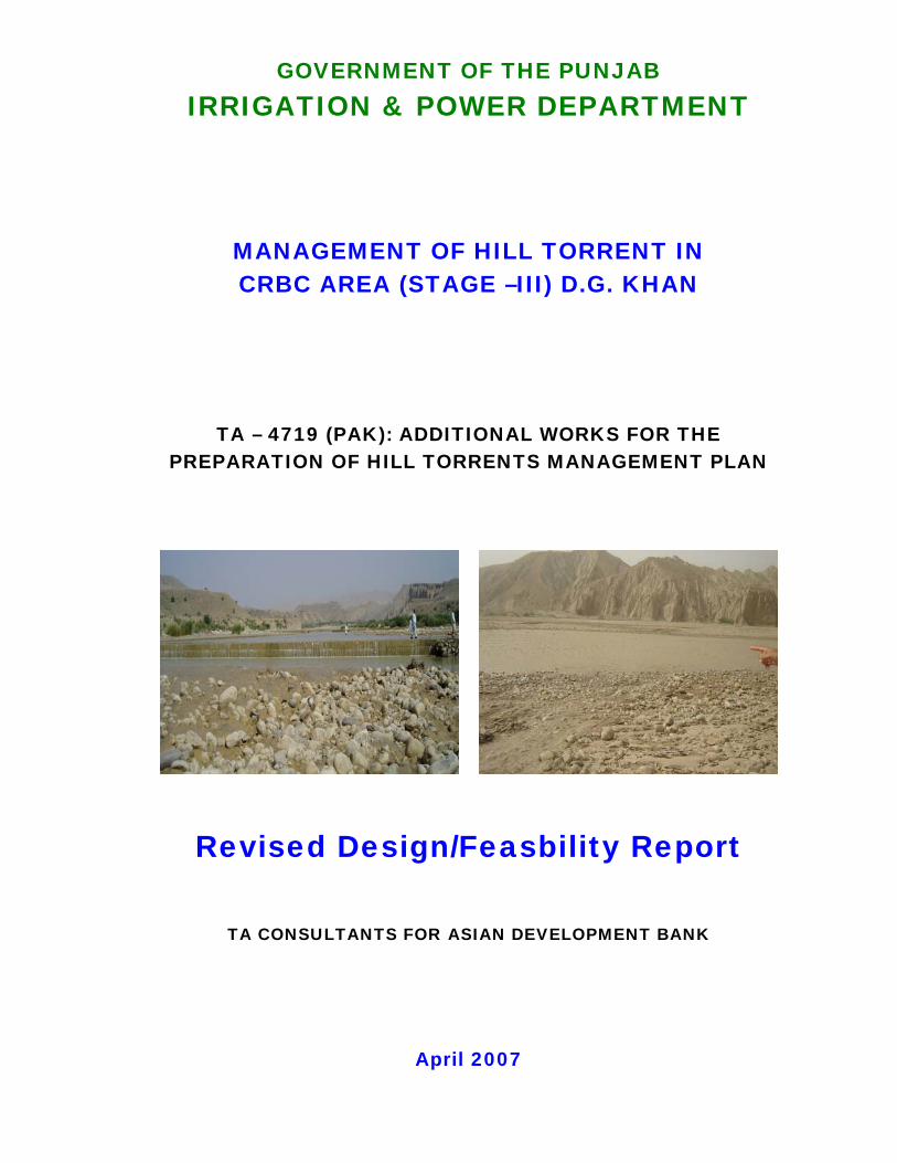
GOVERNMENT OF THE PUNJAB IRRIGATION & POWER DEPARTMENT
MANAGEMENT OF HILL TORRENT IN CRBC AREA (STAGE –III) D.G. KHAN
TA – 4719 (PAK): ADDITIONAL WORKS FOR THE PREPARATION OF HILL TORRENTS MANAGEMENT PLAN
Revised Design/Feasbility Report
TA CONSULTANTS FOR ASIAN DEVELOPMENT BANK
April 2007
i
TA-4719 (PAK) ADDITIONAL WORKS FOR THE PREPARATION
OF HILL TORRENTS MANAGEMENT PLAN
CONTENTS FOREWORD Chapter-1 – BACKGROUND AND OBJECTIVES Chapter-2 – PROJECT AREA AND THE PROJECT Chapter-3 – REVIEW OF PREVIOUS REPORTS Chapter-4 – HYDROLOGICAL ASSESSMENT REPORT Chapter-5 – MANAGEMENT OF HILL TORRENTS Chapter-6 – SOCIAL IMPACT ASSESSMENT AND PARTICIPATORY PLANNING
STUDIES Chapter-7 – AGRICULTURAL STUDIES Chapter-8 – COST ESTIMATES AND IMPLEMENTATION SCHEDULE Chapter-9 – ECONOMIC ANALYSIS

ii
LIST OF ANNEXES Annex-1 Review of Kaha Hill Torrents Report Annex-2 Design Calculations of Major Structures
iii
LIST OF ABBREVIATION ADS Asian Development Bank Ac-ft Acre feet AO Agricultural Officer AZRI Arid Zone Research Institute CCA Cultivable/Culturable Commanded Area CE/PD CFs Chief Engineer/Project Director CFs Cubic feet per second - (Cusec) Cft Cubic Feet CM Cubic meter per second - Cumic CN CurVe Number' CRBC Chashma Right Bank Canal CRBIP Chashma Right Bank Irrigation Project DA Director of Agriculture DAP Di-ammonium Phosphate DCC Derajat Canal Circle D.G. Khan Dera Ghazi Khan D.I. Khan Dera Ismail Khan DLR Directorate of Land Reclamation DTA Dehi Taraqiati Anjuman DTC Dehi Taraqiati Council EIA Environmental Impact Assessment EMU Environment Management Unit EPA Environmental Protection Agency EPD Environmental Protection Department FAO Food and Agricultural Organization FCC Flood Carrying Channel, FFC Federal Flood Commission FP Bund Flood Protection Bund FPSP-1 Flood Protection Sector Project Phase -1 Gabion Stone/Rock bound in wire crates GCA Gross Commanded Area GDP Gross Domestic Product GOP Government of Pakistan GPV Gross Production Value H.T. Hill Torrent HTFP Bund Hill Torrent Flood Protection Bund HYU High Yielding Variety IBRD International Bank for Reconstruction and Development Initial
Environmental Examination IEE International Environmental Examination IRR Internal Rate of Return ISO International Standards Organization Kg Kilogram LAA Land Acquisition Act LSEU Landscape Ecological Units MAF Million Acre Feet NDC National Development Consultant NDP National Drainage Program NESPAK National Engineering Services of Pakistan (Pvt) Ltd.

iv
NGO Non Government Organization NPK Nitrogen Phosphorous Potash (Fertilizer) Net Production Value NPV Nitrogen Phosphorous Potash (Fertilizer) NRSP National Rural Support Program NWFP North Western Frontier Province O&M Operation and maintenance OGDC Oil and Gas Development Corporation Participatory Associations PAs Participatory Associations PIDA Punjab Irrigation Development Authority Pakistan Meteorological
Department PNGO Project Non Government Organization Pakistan Panel Code PRA Participatory Rapid Appraisal Q Quantity RAP Resettlement Action Plan RCC Reinforcement Cement Concrete RD Reduced Distance in 1000 Feet Rs Rupees SCF Standard Conversion Factor SCSUH Soil Conservation Services Unit Hydrograph Square Sq Square SSOP Soil Survey of Pakistan TOR Terms of Reference USDI United States Department of the Interior US-SCS United Status Soil Conversion Services VR Bridge Village Road Bridge WAPDA Water and Power Development Authority WUA Water Users Associations
v
GLOSSARY Bajra Millet Bund Embankments encircling an agricultural field for storage of flood water
as irrigation input Bundat The plural of a bund Banna Approximately one foot high and one food wide earthen wallet serving
as the boundary of a field Chur A very small rain generated hill torrent Darrah The gorge through which a hill torrents emerge out of the hills/maintains
onto the plain Ganda Earthen structure across the entire width of a stream bed - high enough
to divert the water into the wahs (channels) used for conveying flows into the fields that have to be irrigated.
Ghair/non-haqooq Without (water) rights - customary or legal. Haqooq Rights (of water) Haqooq-i-Abpashi The Rights of Irrigation (Name ofa legal book) Jowar Sorghum Jigra The tribal forum competent of resolving all local issues, as a court
Perennial Kala Pani Flow of water - water without sediment Kamara Common structure at all levels of the system, constructed collectively,
which are necessary to convey the water upto the individual field that is to be irrigated.
Krah A blade type implement used for moving earth Katcha Construction work using earth Kharif Summer Season (April to September) Lath Embankment with one end tied to high ground or a bund with other end
free Markaz Center/Capital Mauza Village Md maund Mouza A revenue circle or estate Mt Metric Tons Nallah Hill torrent channel Non-Haqooq Without rights (water) Pacca Construction work using fabricated materials such as bricks, cement,
iron and steel, stone etc. Paina Tail towards feet Pacha Area Area lying on the Western side of CRBC up to the toe of hill Patwari Village level employee of the Revenue or Irrigation Department Pora Sowing in rows by dropping seed through pouring instrument Rabi Winter Season (October to March) Rivej-e-Abpashi Rules for diverting water in natural channels (Name of a book) Rod Kohi Hill torrent Sad A small diversion bund/dam/wall Sailaba Moisture retained in a field by flood water/rain Saropa Piana Head to Tail - Name of a local/traditional irrigation System. The upper
fields on a hill torrent is called Saropa and have prior rights while the lower fields are called Piana and have secondary right over flood flows. This is a relative term and is used for all the fields on a hill torrent with

vi
respect to their location. Sardar President/Head/Chief Saropa Head Salai A small spur like structure used for guiding water Shakh Branch of a hill torrent used as water channel Tehsil Secondary unit of a district Union Council Primary administrative political unit Wah A large natural channel maintained by farmers Wahi A relatively small distribution channel usually man made
TA-4719 (PAK) Additional Works for the Preparation of Hill Torrents Management Plan
FOREWORD
1
FOREWORD AUTHORIZATION The Project has been financed by the Asian Development Bank (ADB) and Government of the Punjab. Under the arrangements, TA Consultants is to review, update the design, planning and Management of the hill torrents of CRBC Area in Taunsa Teshil of DG Khan District. This indeed, was a task of initiating the survey, and design, hydrological assessments ab-initio for the evolution of a comprehensive plan which has also to encompass various other review reports and the previous plan proposed for the area by NESPAK in 2005. SCEOPE OF CONTRACT SERVICES Principal output of the studies under the Contract is the review revision and updating of the feasibility study 2005. Hill Torrents Management Plan in Taunsa Tehsil of Dera Ghazi Khan District while keeping in view of the consideration of physical interventions of CRBC across the flood plains of the hill torrents. Objective/Purpose of the Assignment To prepare a revised design report for the Hill Torrent Management Project as well as a revised cost estimate and implementation plan. Scope of Work Review earlier reports prepared for the Hill Torrent Management Project; conduct field trips to proposed project sites; review proposed design in the Feasibility Report (FR) as well as the implementation plan; review and revise design criteria that was provided in the FR; review the consultants TORs; prepare a draft revised design report including a revised cost estimate and implementation plan. Detailed Tasks:
i. Review the Final Feasibility Report (FR) prepared by National Engineering Services Pakistan (NESPAK) in March 2005, particularly Chapter 4: Hydrological Evaluation and Chapter 5: Management of Hill Torrents, a report on Performance Evaluation of Kaha Hill Torrent, April 2004 also prepared by NESPAK, a desk review report made by Mr. Terry Heiler on these documents in July 2005, Social and Poverty Assessment by Mr. Jamshed Tirmizi in June 2005, and a report produced by Mr. Yoichi Kishi in August 2005;
ii. Conduct field trips to the proposed project sites to assess the geographic conditions of the proposed locations of structures in FR;
iii. Visit the existing structures in Kaha and Vidore hill torrents to assess the behavior of the existing structures;
iv. Review the proposed design in FR considering (a) site specific condition, (b) characteristics of hill torrent flood flow and debris flow, (c) experiences in construction and operation and maintenance, (d) selection of type of the structures; flexible or rigid, (e) width of weirs and share of flood distribution, (f) relative elevation of top of weirs of distributor, top of weirs of off-takes, and intake level of fields in the upper reaches of each wah, (g) structural details of bank protection, (h) cutoff wall material and its depth and penetration length, (i) structure of energy dissipater, etc., and (j) flow capacity of each wah and design discharge at the offtake;
TA-4719 (PAK) Additional Works for the Preparation of Hill Torrents Management Plan
FOREWORD
2
v. Review the proposed implementation plan, taking into consideration the recommendation of Mr. Yoichi Kishi to construct structures one after another starting from the most upper reaches to avoid flood damage during construction, based on the experience of the Kaha project;
vi. Review and revise the design criteria that are provided in FR, and determine the new criteria in consultation with the Irrigation and Power Department (IPD) and the panel of experts, based on which review of the design will be carried out;
vii. Design engineers to re-design the structures, as needed, following the revised design criteria;
viii. Review the terms of reference for the consultants for detailed design and construction supervision. Actual schedule to be confirmed with User Unit. the Hill Torrent Management Project (the Project). The terms of reference was prepared by IPD in June 2005 and comments on them were provided by Mr. Yoichi Kishi;
ix. Based on the revised design of structures and the terms of reference for consulting services, reestimate the project cost in consultation with IPD;
x. Prepare a draft revised design report for the Project including a revised cost estimate and implementation plan, and submit a copy (hard copy and soft copy) to IPD and the Asian Development Bank (ADB);
xi. Finalize the revised design report for the Project, incorporating the comments received from IPD, the panel of experts, and ADB; and
xii. Prepare a revised draft PC-1 for the Hill Torrent Management Project and submit a copy (hard copy and soft copy) to IPD and ADB.
Output/Reporting Requirements
i. A draft revised design report for the Project including a revised cost estimate and implementation plan (hard copy and soft copy) for submission to IPD and ADB;
ii. A revised draft PC-1 for the Hill Torrent Management Project (hard copy and soft copy) for submission to IPD and ADB; and
iii. Ad hoc reports to ADB staff through e-mail or telephonic communication. REPORT LAYOUT The layout of report is given below: Volume-I 1. Introduction 2. Project Area and the Project 3. Review of Previous Reports 4. Hydrological Assessment Report 5. Management of Hill Torrents 6. Social Impact Assessment and Participatory Planning Studies 7. Agricultural Study 8. Cost Estimate and Implementation Schedule 9. Economic Analysis Volume-II Design Criteria Volume-III Album of Survey Volume-IV Album of Drawings & Design Calculations Volume-V Technical Specifications
Chapter 1, Volume-I of the report presents a brief description of the Background and Objectives of the Project. This Chapter enlightens prominent salient features of the hill torrents of CRBC area and the local irrigation system, a review of the previous studies, the project objectives and Terms of Reference

TA-4719 (PAK) Additional Works for the Preparation of Hill Torrents Management Plan
FOREWORD
3
Chapter 2, Volume-I of the reports details regarding the Project area and the Project. This includes a brief description of the major and minor hill torrents, Kamara Irrigation System, the natural resources and the physiographic features of the Project area. Chapter 3, Volume-I of the report includes a comprehensive evaluation of the different review reports on the feasibility report of NESPAK (2005) for the management of Hill Torrent. This chapter also provides the guidelines for future planning and designing of similar projects on the basis of lessons learnt on Hill Torrent. The guidelines enunciated by the experts in their reports have been kept in view and broadly form the basis for preparation of this plan. Chapter 4, Volume-I presents hydrological evaluations/re-assessments based upon data and information and comments of the Dr. Terry Heiler. This study, inter-alia, presents estimation and distribution of runoff against various return periods. These results have been utilized for project planning and designing. Chapter 5, Volume-I presents the core of the entire plan. This Chapter highlights the problems, their technical solutions, analyses of various planning schemes, all possible alternatives of solutions to the problems and future plans, a comparative illustration of each alternatives and finally the recommended plan. For the recommended package, design parameters have been derived and, cost effective and appropriate structures have been designed Chapter 6, Volume-I presents the social impact assessment and participatory planning studies of the Project and has been adopted from NESPAK reports. This Chapter comprehends social analysis of the Project area, ideas and suggestions of the local residents and intellectuals of the area, assessment of the level of participation of the beneficiaries, the possible role of women and youth; and the a rational participatory plan regarding the Project. Chapter 7, Volume-I presents the Project Agricultural Studies. This Chapter has undertaken a rational comparison of pre and post project improvements in agricultural outputs of the Project area and has outlined specific recommendations and taken from NESPAK Feasibility Report. Chapter 8, Volume-I presents the cost estimates and the Project Implementation Schedule. This Chapter also includes the schedule items, their unit rates and the guidelines regarding the use of these rates. Chapter 9, Volume-I comprises the Project Economic Evaluation. This study evaluates the economic indicators necessarily required to establish the Public investment This study also includes a sensitivity analyses of the project costs and benefits and has provided confidence regarding the anticipated project outcome. Volume-II contains the design criteria. Volume-III contains the survey album. Volume-IV contains the drawings album and design calculations. Volume-IV contains the technical specifications for the work to be taken under this Hill Torrent Management Project.

TA-4719 (PAK) Additional Works for the Preparation of Hill Torrents Management Plan
FOREWORD
4
PRINICPAL STAFF Entire work has been carried out under the general supervision and guidance of Mr. SMA Zaidi, Advisor and Mr Yoichi Kishi, International Advisor, Members of the TA Consultants who participated in various studies are listed below: Member of TA Consultants Team 1. Engr Muhammad Yunus Javed Team Leader/River Structure Engineer 2. Dr Muhammad Nadeem Hydrologist 3. Engr Faisal Javed Design Engineer
TA-4719 (PAK) Additional Works for the Preparation of Hill Torrents Management Plan
BACKGROUND AND OBJECTIVES
Table of Contents
1. BACKGROUND AND OBJECTIVES............................................................................1-1 1.1 CHASHMA RIGHT BANK CANAL PROJECT (STAGE-III) ..................................1-1 1.2 HILL TORRENTS DRAINAGE .............................................................................1-1 1.3 KAMARA IRRIGATION SYSTEM.........................................................................1-2 1.4 SOCIO-ECONOMIC CONDITIONS .....................................................................1-2 1.5 ROLE OF NGOS ..................................................................................................1-2 1.6 PREVIOUS STUDIES/PLANS..............................................................................1-2
TA-4719 (PAK) Additional Works for the Preparation of Hill Torrents Management Plan
BACKGROUND AND OBJECTIVES
1-1
1. BACKGROUND AND OBJECTIVES 1.1 CHASHMA RIGHT BANK CANAL PROJECT (STAGE-III) Chashma Right Bank Canal (CRBC) Stage-III, constructed in 2001, has emerged as a major physical intervention in the flood plains of the hill torrents crossing the Pachad (piedmont) area in Taunsa Tehsil of Dera Ghazi Khan District. The newly emerged canal system has taken a large part of Pachad area in its command which had previously been receiving flows of hill torrents during precipitation periods intermittently for sporadic agriculture. However, the system has affected:
• The natural drainage of the hill torrents towards Indus River; • The flow of surface runoff in its natural direction; • The traditional hill torrents' Kamara" system of irrigation comprising 'haqooq' and
‘'non-haqooq' areas under 'saropa paina' - the local rules of using hill torrents flows; • The projects planned for the flood management of hill torrents of the area; • Social, cultural and economic scenarios of the local population; • Settlements/dwellings of the locals alongwith associated problems of resettlement/
compensation; • Activities of non-governmental organizations (NGOs).
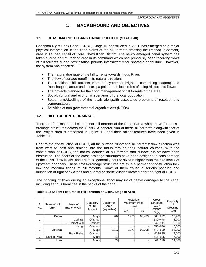
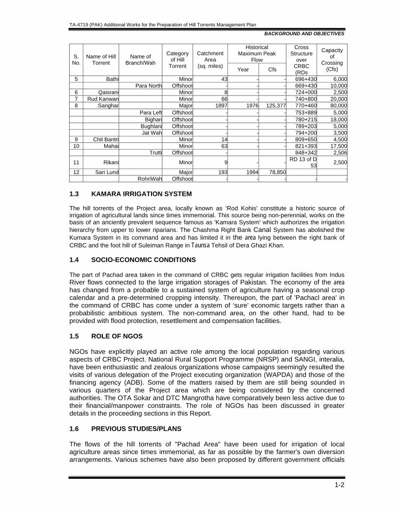
1.2 HILL TORRENTS DRAINAGE There are four major and eight minor hill torrents of the Project area which have 21 cross -drainage structures across the CRBC. A general plan of these hill torrents alongwith that of the Project area is presented in Figure 1.1 and their salient features have been given in Table 1.1. Prior to the construction of CRBC, all the surface runoff and hill torrents' flow direction was from west to east and drained into the Indus through their natural courses. With the construction of CRBC, the natural courses of hill torrents and surface run-off have been obstructed. The floors of the cross-drainage structures have been designed in consideration of the CRBC flow levels, and are thus, generally, four to six feet higher than the bed levels of upstream channels. These cross-drainage structures are thus a permanent obstruction for / low and medium floods of hill torrents. Some of them cause a serious ponding and inundation of right bank areas and submerge some villages located near the right of CRBC. The ponding of flows during an exceptional flood may inflict heavy damages to the canal including serious breaches in the banks of the canal. Table 1-1: Salient Features of Hill Torrents of CRBC Stage-III Area
Historical Maximum Peak
Flow S. No.
Name of Hill Torrent
Name of Branch/Wah
Category of Hill
Torrent
Catchment Area
(sq. miles) Year Cfs
Cross Structure
over CRBC (RDs
Capacity of
Crossing (Cfs)
Kaura Major 202 1975 63,423 568+222 15,700Lodhran Offshoot - - - 530+448 3,000
J. Haibat Wali Offshoot - - - 542+111 3,0001
Jhangri Offshoot - - - 555+686 6,5002 Vehowa Major 1017 1977 90,098 579+500 83,000 Para Raibat Offshoot - - - 603-835 7,000
3 Sheikh Para Minor 13 - - 616+835 7,0004 Litra Minor 29 - - 641+190 14,500
TA-4719 (PAK) Additional Works for the Preparation of Hill Torrents Management Plan
BACKGROUND AND OBJECTIVES
1-2
Historical Maximum Peak
Flow S. No.
Name of Hill Torrent
Name of Branch/Wah
Category of Hill
Torrent
Catchment Area
(sq. miles) Year Cfs
Cross Structure
over CRBC (RDs
Capacity of
Crossing (Cfs)
5 Bathi Minor 43 - - 696+430 6,000 Para North Offshoot - - - 669+430 10,000
6 Qaisrani Minor 8 - - 724+000 2,5007 Rud Kanwan Minor 66 - - 740+800 20,0008 .Sanghar Major 1897 1976 125,377 770+460 80,000 Para Left Offshoot - - - 753+889 5,000 Bighari Offshoot - - - 780+215 18,000 Bughlani Offshoot - - - 789+203 5,000 Jat Wah Offshoot - - - 794+200 3,500
9 Chit Bantri Minor 14 - - 809+650 4,50010 Mahai Minor 63 - - 821+393 17,500 Trutti Offshoot - 848+342 2,506
11 Rikani Minor 9 - - RD 13 of D 53 2,500
12 Sari Lund Major 193 1994 78,850 RohriWah Offshoot - - - - -
1.3 KAMARA IRRIGATION SYSTEM The hill torrents of the Project area, locally known as ‘Rod Kohis' constitute a historic source of irrigation of agricultural lands since times immemorial. This source being non-perennial, works on the basis of an anciently prevalent sequence famous as 'Kamara System' which authorizes the irrigation hierarchy from upper to lower riparians. The Chashma Right Bank Canal System has abolished the Kumara System in its command area and has limited it in the area lying between the right bank of CRBC and the foot hill of Suleiman Range in Taunsa Tehsil of Dera Ghazi Khan. 1.4 SOCIO-ECONOMIC CONDITIONS The part of Pachad area taken in the command of CRBC gets regular irrigation facilities from Indus River flows connected to the large irrigation storages of Pakistan. The economy of the area has changed from a probable to a sustained system of agriculture having a seasonal crop calendar and a pre-determined cropping intensity. Thereupon, the part of 'Pachacl area' in the command of CRBC has come under a system of ‘sure' economic targets rather than a probabilistic ambitious system. The non-command area, on the other hand, had to be provided with flood protection, resettlement and compensation facilities. 1.5 ROLE OF NGOS NGOs have explicitly played an active role among the local population regarding various aspects of CRBC Project. National Rural Support Programme (NRSP) and SANGI, interalia, have been enthusiastic and zealous organizations whose campaigns seemingly resulted the visits of various delegation of the Project executing organization (WAPDA) and those of the financing agency (ADB). Some of the matters raised by them are still being sounded in various quarters of the Project area which are being considered by the concerned authorities. The OTA Sokar and DTC Mangrotha have comparatively been less active due to their financial/manpower constraints. The role of NGOs has been discussed in greater details in the proceeding sections in this Report. 1.6 PREVIOUS STUDIES/PLANS The flows of the hill torrents of "Pachad Area" have been used for irrigation of local agriculture areas since times immemorial, as far as possible by the farmer's own diversion arrangements. Various schemes have also been proposed by different government officials
TA-4719 (PAK) Additional Works for the Preparation of Hill Torrents Management Plan
BACKGROUND AND OBJECTIVES
1-3
and agencies from time to time but could not be implemented due to one reason or the other. The first serious attempt to control the hill torrents of Pachad area vvas made after the 1929 flood. The then government of Punjab directed Mr. P. Claxton (Executive Engineer), to study and submit plan for flood control of hill torrents in 0 G Khan Division area. He proposed two dams at Haran Bore and Gulki on San ghar Hill Torrent, one dam at Pishi on Vidore and a dam at Harrand on Kaha Hill Torrent. These proposals were not approved by the Government, being unfeasible and uneconomical. Again during 1944-45 Mr. Kanwar Sain, Superintending Engineer, Irrigation Department presented proposals for flood control of different hill torrents which included a distributor at Darrah on Sanghar Hill Torrent. These proposals could not be implemented for lack of economic justification and because of turmoil at the time of independence. In 1951, Mr. M. I. Ahmad, Geologist of Survey of Pakistan, after carrying out investigations of 1 Sanghar Hill Torrent reported that as it brings large amount of silt every year, storage reservoir is liable to be silted up very soon. In 1952, Malik Ramiz Ahmad, the then Executive Engineer, proposed bifurcations and trifurcations at the head of off-takes of various nullahs for better spreading of flood flows in the fields. During 1958, Mr. G. E. Meads, an FAO expert visited the area and suggested storage dams, check dams and retarding dams on various hill torrents, but these proposals were not executed due to poor geological conditions and likely low financial returns. A pick up weir was constructed during 1970-71 at a cost of Rs. 3.71 million on Vehowa Hill Torrent by Small Dams Organization. It has been damaged many times and a large amount of money have been spent for its restoration since its construction. Even these repairs were inadequate and proved ineffective for finding out comprehensive solution for the problem. After the 1976 high flood, Punjab Government appointed an Expert Committee of Irrigation Engineers headed by late Mr. Ahmad Tariq, Chief Engineer for study of problems of flood. This committee studied the flood problems caused by hill torrents of D G Khan Division and, Inter-alia, recommended creation of a "Hill Torrent and Pachad Development Authority" for flood management of hill torrents and development of basin irrigation in Pachad area. In September, 1976 Mr. Muhammad Ismail Shaheed, the then Superintending Engineer, Derajcn Circle, suggested that hill torrents flows after their dispersion over Pachad area by means of distributors and improved irrigation channels (Wah), be allowed to enter the canal command areas by providing additional crossings at existing canal systems and then led into the Indus River through a network of drains comprising hundreds of miles long; main drain and sub-drains throughout the canal irrigated area with numerous crossings on channel as, roads and railway. Also in 1976, Mr. M. A. H. Rahmani, Superintending Engineer, Derajat Circle, suggested the following schemes to the Specialist Committee:
a) Distributors with undersluice-cum-weir alongwith their training works tied to the high banks of Darrah, should be constructed for proper feeding of the irrigation channels (Wahs).
b) Ultimately, the residual flow, if any, should be retained along the canal channels by converting their right bank into a proper high flood embankment.
c) In order to break the fury of flood, ogee type speed-breakers and check dams be considered.
TA-4719 (PAK) Additional Works for the Preparation of Hill Torrents Management Plan
BACKGROUND AND OBJECTIVES
1-4
In view of complex nature of flood problem, in depth hydrologic and economic evaluation is an essential pre-requisite for drawing up an effective management plan of hill torrents. All the reports prepared so far lacked comprehensive approach to the flood problem and flood events have not been related to the theoretical return period. Flood damage potential of each hill torrent and risk analysis studies were never carried out nor any exercise was conducted for economic evaluation of various alternatives and their cost estimates. During 1980's, the Government of Punjab requested Federal Flood Commission of Pakistan (FFC) to take a comprehensive view of the flood problems of 0 G Khan Hill Torrents. The FFC engaged NESPAK to carryout the studies and propose a multipurpose plan for the management of flood flows of hill torrents of Pachad area. Accordingly, NESPAK carried out a comprehensive study of 13 major hill torrents of the area and presented a complete management plan for each major torrent separately. The plan mainly comprised the diversion arrangements and flood protection facilities at the cost of public investment on a technically sound and economically feasible basis. The report was widely hailed and accepted. During 1990's, the report was updated as part of the "Master Feasibility Studies for Flood Management of Hill Torrents of Pakistan". A complete feasibility study was carried out for the area "Core-Project" including economic analysis of the proposed plan. Consequently, a Pilot Project was formulated and executed on Kaha Hill Torrent under Flood Protection Sector Project Phase-I (FPSP-1) and those for Mithawan Hill Torrent are under construction. The inception of CRBC is most recent intervention across the flood plains of Kaura, Sanghar, Vehowa and Sori Lund. In addition, a number of flood carrier channels (twenty one) have also been constructed for the disposal of flood flows of the hill torrents. A large part of the flood plains of these torrents has come under the command of CRBC. This significant physical development has affected the entire scenario of the Project area, and has necessitated the revision and updating the Feasibility Studies for this part of the Project area. Thereupon, the Government of Punjab asked NESPAK to submit the updated feasibility which they prepared and submitted in 2005. Feasibility reports was circulated for examination and comments to experts who accordingly commented. ADB engaged TA Consultants who were asked to review all previous proceedings and give their revised design/feasibility report and hence this report.
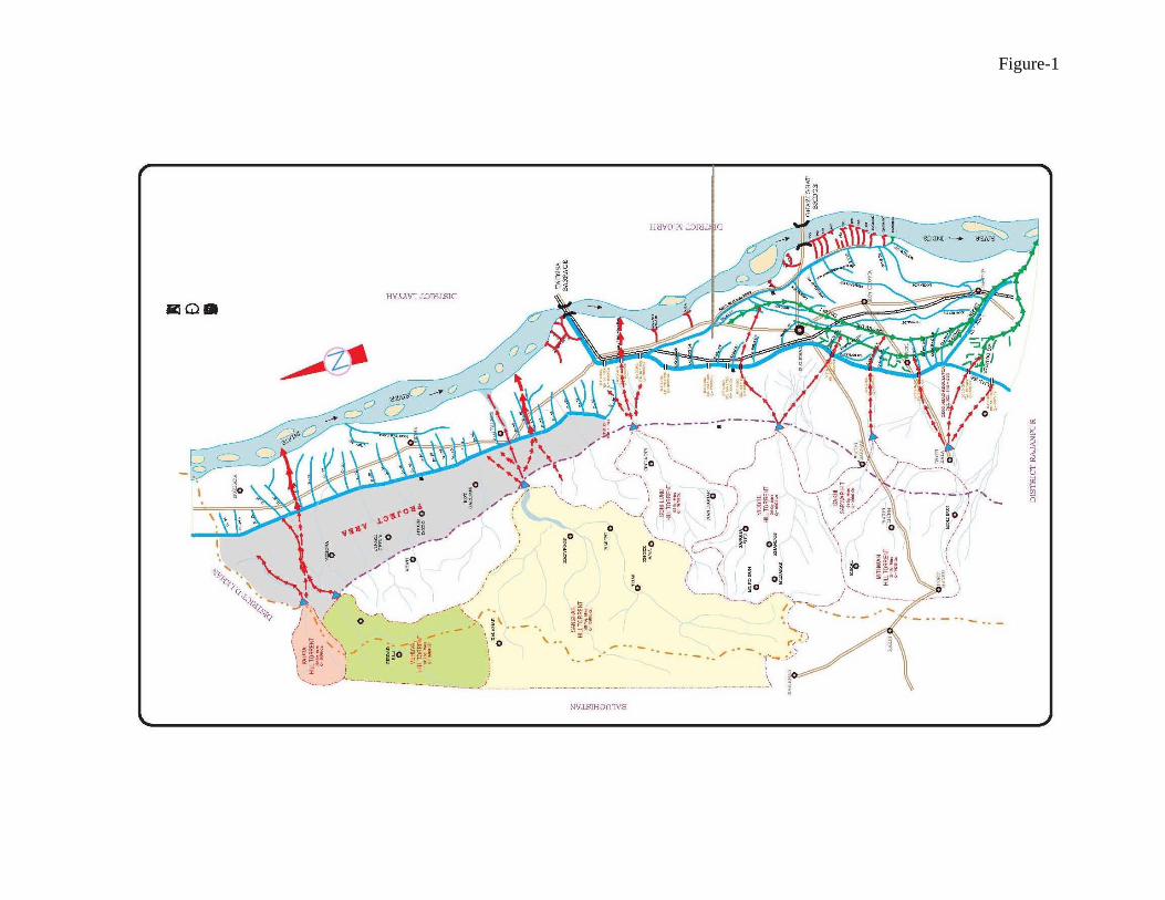
Figure-1
TA-4719 (PAK) Additional Works for the Preparation of Hill Torrents Management Plan
PROJECT AREA AND THE PROJECT
Table of Contents
2. PROJECT AREA AND THE PROJECT........................................................................2-1 2.1 PROJECT LIMITS AND LOCATION ....................................................................2-1 2.2 HILL TORRENTS OF THE AREA ........................................................................2-1
2.2.1 Major Hill Torrent of the Area............................................................................2-1 2.2.1.1 Kaura ........................................................................................................2-1 2.2.1.2 Vehowa.....................................................................................................2-2 2.2.1.3 Sanghar ....................................................................................................2-3
2.2.2 Minor Hill Torrent ..............................................................................................2-3 2.3 KAMARA IRRIGATION AND FLOOD PROBLEMS..............................................2-3
2.3.1 Kamara Irrigation ..............................................................................................2-3 2.3.2 Water Rights and Water Users Groups ............................................................2-4 2.3.3 Flood Problems.................................................................................................2-4
2.3.3.1 Cross Drainage Structure .........................................................................2-5 2.3.3.2 Flood Carrier Channels.............................................................................2-5 2.3.3.3 Flood Year 2003 .......................................................................................2-5 2.3.3.4 Flood Year 2004 .......................................................................................2-5
2.4 THE PROJECT.....................................................................................................2-6 2.5 natural resources and physical features...............................................................2-6
2.5.1 Climate .............................................................................................................2-6 2.5.2 Soils ..................................................................................................................2-7 2.5.3 Geology ............................................................................................................2-8 2.5.4 Landforms.........................................................................................................2-8 2.5.5 Hydrology .........................................................................................................2-8 2.5.6 Ecological Resources .......................................................................................2-9 2.5.7 Land Use ........................................................................................................2-10
2.5.7.1 Torrent Watered Cultivation....................................................................2-10 2.5.7.2 Poor Grazinq and Fuel Wood Production ...............................................2-10
2.6 ECONOMY .........................................................................................................2-10 2.7 AGRICULTURE..................................................................................................2-10 2.8 LIVESTOCK .......................................................................................................2-11 2.9 SOCIO-ECONOMIC POSITION.........................................................................2-11
2.9.1 Population.......................................................................................................2-11 2.9.2 Physical Infrastructures ..................................................................................2-11 2.9.3 Social System.................................................................................................2-12 2.9.4 Health and Education Facilities ......................................................................2-12 2.9.5 Education Facilities (Men) ..............................................................................2-12

TA-4719 (PAK) Additional Works for the Preparation of Hill Torrents Management Plan
PROJECT AREA AND THE PROJECT
2-1
2. PROJECT AREA AND THE PROJECT 2.1 PROJECT LIMITS AND LOCATION The Project Area is located between 30°15' N - 31°15' N longitudes and 70°15' E - 70°45' E latitudes. It is a part of Dera Ghazi Khan District adjacent to Dera Ismail Khan of NWFP. The Project area extends from Ramak to Shadin Lund in its north south direction. The D I Khan 0 G Khan section of the Indus Super Highway runs almost perpendicular to the direction of flows of hill torrents descending from Suleiman Range in the Project area. On its east, flows Indus River in its reach upstream and past Taunsa Barrage. The northern extremity is determined by the NWFP boundary over Suleiman Range. On the west of the Project area is the Balochistan Province, and on the south lies the catchment areas of Sori Lund and Vidore Hill Torrent as already shown in Fig. 1.1. 2.2 HILL TORRENTS OF THE AREA The hill torrents of Chashma Right Bank Canal area in Dera Ghazi Khan District are a part of the series of mountainous streams debouching onto the "Pachad area" from Suleiman Range. These streams are locally known as "Rod Kohis"; few of them have perennial discharge (kala pani) while the others flow only during precipitation periods. These torrents have signified their recurrence as the potential stochastic sources having dry and wet cyclic rotations. These mountainous streams are usually categorized as small, medium and major hill torrents in consideration of their average annual peak flows as indicated below:
Limit of Flow cfs Category of Hill Torrent 1. Upto 5,000 Small or Minor 2. 5,000 – 15,000 Medium 3. Over 15,000 Major 2.2.1 Major Hill Torrent of the Area Four major hill torrents and some minor ones debouch onto the "Pachad1" area and run through the CRBC Command Area towards Indus River. These major hill torrents and their salient features are already enlisted in Table 1.1 of Section 1 of this report. A brief description of these torrents is given as: 2.2.1.1 Kaura Kaura Hill Torrent Basin is situated at the northern extremity of the Project area. It is the only basin of the Project which shares area from the three provinces of the country - Balochistan, NWFP and Punjab. However, the sub-mountainous and plain area of the basin lies in Punjab Province where it debouches from its "Darrah" and fans out to disperse its flows. Kaura Hill Torrent originates from an elevation of 2,860 m (9,385 ft) in the form of a small stream in Balochistan Province. The stream flows southward and after covering a small distance takes an eastward turn. Hereafter, the flow direction remains almost same upto its confluence with a neighboring torrent on its right.
1 The area between the foot hill of Suleiman Range and the canal command or the Indus River in DG Khan Division of Punjab Province of Pakistan
TA-4719 (PAK) Additional Works for the Preparation of Hill Torrents Management Plan
PROJECT AREA AND THE PROJECT
2-2
The torrent retains the name of "Guzai River" upto its crossing of the Provincial boundary of Balochistan, where it receives the flows of Mashkha Khwar from the left. After the union, it enters NWFP and assumes its name as "Kaura" which continues to receive flows of a number of small streamlets from both the sides, and enters Punjab Province a little above the Darrah. After passing through the Darrah, it bifurcates into two branches. The right branch delivers major part of its flow into Vehowa Hill Torrent and aggravates flood problems' in the downstream areas. The flows of the left branch drain into Indus River after crossing the CRBC and the Indus Super Highway. Its main problem at present, is to prevent its flows from going into the Vehowa Torrent and to utilize these flows for agriculture development in Pachad area by construction of dispersion structures which will reduce the flood damage potential and thus will also provide safety to the CRBC. 2.2.1.2 Vehowa Vehowa Hill Torrent rises at an elevation of about 2,360 m (7,743 ft) near Atal Kach in Balochistan Province. It flows northwards for a small distance. After flowing past Atal Kach it takes a right direction and crosses D I Khan - Musa Khel Road near Toi Sar. Upfo this point, it receives flows of Nigande Lahar and Zam Khawara from the left; and Tsapparai Mastai, Razanni River and Khezai Lahar from the right. Just below the road crossing, the torrent receives the flows of Loa Lahar from the right, which collects flows from the following small tributaries:
• Zindai/Tang Lahar; • Wangarah; • Sherani; • Darwazai Lahar; • Tor Haranch; • Haranch Lahar; and • Sewe Khwara
Hereafter, the torrent flows eastward near Khundai Kili and assumes a wavy path, upto Punjab - Balochistan provincial boundary. Just above the boundary, flows from Badri Nallah Shavan Khwar and Pasta Nallah join the main torrent. Below the confluence, the main stream takes almost northward turn and flows down to receive Kaura flows, where after it again turns eastward and fans out after crossing the Darrah. On its way to the Indus River, it crosses CRBC and the D I Khan - D G Khan Highway. Total catchment area of Vehowa is nearly 2,634 sq.km (1,017 sq. miles). From the point of view of catchment, it ranks second in the hill torrents of Project Area. The flood flows of this torrent cause the following flood problems:
• Out flanking and damaging the Vehowa Pick up weir; • Flooding of "non Haqooq area; • Depriving the Haqooq, area from water rights; • Damaging the CRBC command area.
Below the weir, flood flows usually damage the earthen bund put across "non haqooq", channel for diversion of flood flows to "haqooq" channel which consequently deprive the area of basin irrigation. Therefore its main problem is to train the torrent by providing proper flood management measures which would also improve the basin irrigation.
TA-4719 (PAK) Additional Works for the Preparation of Hill Torrents Management Plan
PROJECT AREA AND THE PROJECT
2-3
2.2.1.3 Sanghar Sanghar is the largest hill torrent of the area with a catchment of 4,913 sq.km (1,897 sq. miles). The torrent springs from a mountain of Suleiman Range at an elevation of 1,915 m (6,285 ft). The stream flows in a north-eastern direction for some distance and then takes a "U" turn towards south-east. About 15 km down, it again turns after receiving flows from the following torrents from the right.
• Tirkh/Artangiwar; • Tirkhan Lahar; and • Bud Rod
The following major tributaries join it from both sides upto the Darrah.
• Khajuri Rud • Lori Tangi; • Zer Tangai; • Kingri River; • Rud Lahar; • Machihin Sarin Lahar; • Kannokai; • Indarpur / Luni Lahar; • Naval Chur; • Binar Chai; • Sanghar Lahar; and • Drug Lahr.
Main satellites of the area are Khan Muhammad Kot, Haran Bore, Mangrotha and Taunsa. The hill torrent is divided into three parts below Darrah. The torrent crosses CRBC and Indus Super Highway; and outfalls into the Indus near Taunsa Town. The improper distribution at various sites is the major problem of the hill torrent. 2.2.2 Minor Hill Torrent Apart from three major hill torrents and an off-shoot of Sori Lund, which is called "Rohri Wah", eight (8) minor hill torrents/churs cross the CRBC. Most of them have separate catchments in the hilly area and thus debouch onto the Pachad area through their own ‘Darrahs'. All of the major and minor torrents/churs have 21 separate cross-drainage structures over Chashma Right Bank Canal which have been connected to the flood carrier channels across the CRBC. Some of these channels have been excavated upto the Indus River while some others still need to be connected to the river. These streams alongwith their salient features have already been enlisted in Table 1.1. 2.3 KAMARA IRRIGATION AND FLOOD PROBLEMS 2.3.1 Kamara Irrigation The intermittent and erratic patterns of precipitation events, being the unique source of stream flow irrigation, have become the sole basis for the evolution of Kamara Irrigation System' since centuries. This system enforces the sequential water rights and dictates the
TA-4719 (PAK) Additional Works for the Preparation of Hill Torrents Management Plan
PROJECT AREA AND THE PROJECT
2-4
Irrigation pattern from upper to lower riparians, without consideration of the duration and magnitude of the storm generated flow. Under the system sometimes, the far flung lower riparians remain deprived of irrigation facilities during a low flow year. Non-the-Iess, the system is hardly capable of managing the low flows, whereupon the medium and high flows destruct the farmer's earthen diversion arrangements; the flows rush down assuming the shape of floods which usually cause unprecedented damages to the local economy. The wastage of irrigable flows and the resultant loss of edible, potable and encashable agricultural production, coupled with the flood losses being inflicted since centures together, is well presented by the current socio-economic parameter and the existing standard of livelihood of the locals of the area. The gross command area, comprising all the major and minor hill torrents is about 281,000 acres which includes the culturable area of about 235,500 acres. Still the cropping intensity remains 8-12 percent under the existing Kamara system, the actual yearly cultivated area varies hardly from 20-30 thousand acres. This area utilizes only a friction of the hill torrents annual runoff which approximates to about one and a half million acre-foot when assessed against a 25-year recurrence. 2.3.2 Water Rights and Water Users Groups The term .water rights' refers to as the priority of using the manageable, flows of hills torrents in accordance with the prevalent Kamara Irrigation System, following the 'Saropa Paina' rules. The Saropa Raina (head to tail) rules strictly dictate the irrigation sequence starting from upper (head) farms/fields to the lower (tail) agricultural areas. The term is sometimes associated with the irrigation off-takes/wahs when these are categorized in accordance with the water rights. These are:
• Haqooq wahs • Non-haqooq wahs
Haqooq wahs are those off-taking channels which have the priority rights to use hill torrents i flows. Non-haqooq wahs can only draw the flood flows which are in excess of the needs/ capacity of the ‘haqooq wahs'. The data regarding 'water rights' was collected from the offices of hill torrent officers of Taunsa and Dera Ghazi Khan during the inception stage of the Project. List of mauzas/villages commanded by four major and eight minor hill torrents on the basis of water rights in Project area is presented in Table 2.1. Land potential of the Project area was determined for each structure/wah on the basis of haqooq/non-haqooq data/information. The entire plan presented in the proceeding sections has been undertaken accordingly. 2.3.3 Flood Problems The damages inflicted by hill torrents flooding in the Project area can generally be categorized as:
• Loss of land due to erosion; • Loss of standing crops due to inundation; • Damages to public and private properties due to submergence; • Damages to infrastructure; and • Breaches of canals systems and suspension of irrigation supplies.
As already mentioned, the construction of CRBC has, interalia, affected the flood scenario of the Project area, mainly due to the cross drainage structures over CRBC and the conversion of hill torrent flow paths into flood carrier channels (FCC) in the command area.
TA-4719 (PAK) Additional Works for the Preparation of Hill Torrents Management Plan
PROJECT AREA AND THE PROJECT
2-5
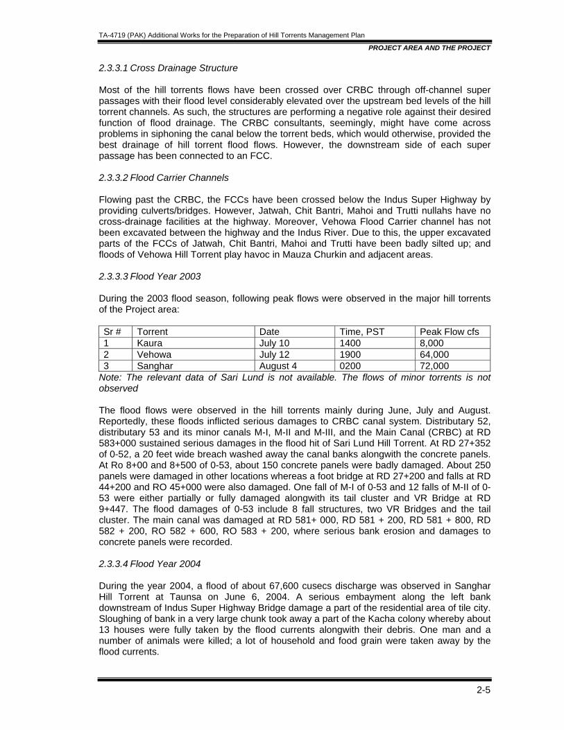
2.3.3.1 Cross Drainage Structure Most of the hill torrents flows have been crossed over CRBC through off-channel super passages with their flood level considerably elevated over the upstream bed levels of the hill torrent channels. As such, the structures are performing a negative role against their desired function of flood drainage. The CRBC consultants, seemingly, might have come across problems in siphoning the canal below the torrent beds, which would otherwise, provided the best drainage of hill torrent flood flows. However, the downstream side of each super passage has been connected to an FCC. 2.3.3.2 Flood Carrier Channels Flowing past the CRBC, the FCCs have been crossed below the Indus Super Highway by providing culverts/bridges. However, Jatwah, Chit Bantri, Mahoi and Trutti nullahs have no cross-drainage facilities at the highway. Moreover, Vehowa Flood Carrier channel has not been excavated between the highway and the Indus River. Due to this, the upper excavated parts of the FCCs of Jatwah, Chit Bantri, Mahoi and Trutti have been badly silted up; and floods of Vehowa Hill Torrent play havoc in Mauza Churkin and adjacent areas. 2.3.3.3 Flood Year 2003 During the 2003 flood season, following peak flows were observed in the major hill torrents of the Project area: Sr # Torrent Date Time, PST Peak Flow cfs 1 Kaura July 10 1400 8,000 2 Vehowa July 12 1900 64,000 3 Sanghar August 4 0200 72,000
Note: The relevant data of Sari Lund is not available. The flows of minor torrents is not observed The flood flows were observed in the hill torrents mainly during June, July and August. Reportedly, these floods inflicted serious damages to CRBC canal system. Distributary 52, distributary 53 and its minor canals M-I, M-II and M-III, and the Main Canal (CRBC) at RD 583+000 sustained serious damages in the flood hit of Sari Lund Hill Torrent. At RD 27+352 of 0-52, a 20 feet wide breach washed away the canal banks alongwith the concrete panels. At Ro 8+00 and 8+500 of 0-53, about 150 concrete panels were badly damaged. About 250 panels were damaged in other locations whereas a foot bridge at RD 27+200 and falls at RD 44+200 and RO 45+000 were also damaged. One fall of M-I of 0-53 and 12 falls of M-II of 0-53 were either partially or fully damaged alongwith its tail cluster and VR Bridge at RD 9+447. The flood damages of 0-53 include 8 fall structures, two VR Bridges and the tail cluster. The main canal was damaged at RD 581+ 000, RD 581 + 200, RD 581 + 800, RD 582 + 200, RO 582 + 600, RO 583 + 200, where serious bank erosion and damages to concrete panels were recorded. 2.3.3.4 Flood Year 2004 During the year 2004, a flood of about 67,600 cusecs discharge was observed in Sanghar Hill Torrent at Taunsa on June 6, 2004. A serious embayment along the left bank downstream of Indus Super Highway Bridge damage a part of the residential area of tile city. Sloughing of bank in a very large chunk took away a part of the Kacha colony whereby about 13 houses were fully taken by the flood currents alongwith their debris. One man and a number of animals were killed; a lot of household and food grain were taken away by the flood currents.
TA-4719 (PAK) Additional Works for the Preparation of Hill Torrents Management Plan
PROJECT AREA AND THE PROJECT
2-6
The local civil authorities, the officers of Irrigation and Power Department D G Khan, Nazim and Naib Nazim of Tehsil Taunsa and the Consultants rushed to the site for rescue and relief operation. However, a second peak did not appear whereby the rescue and relief campaigns were not needed. Floods were also observed in other major hill torrents of the area. The peak discharge as observed on Kaura, was of the order of about 7,100 cusec. The season's maximum flow of Vehowa hill torrent was recorded as about 35,100 cusecs on July 30, 2004. Facts and events of these flood are being collected by the Irrigation and Power Department, D G Khan. 2.4 THE PROJECT Section 1.6 of this report presents an account of the cognizance of this study, under the objectives laid down in Section 1.7. Although continual efforts through various types of schemes have been carried out since 1929, but not implemented except the one put forward by NESPAK during the decades of 1980s and 1990s, a part of which has been executed on ol1'e 'of the most damaging and enormously potential hill torrents - Kaha Sultan (commonly known as Kaha). The achievement of success by and large to the desired targets, has set forth the landmark encouragement for the planner, engineers and the government to make the public investment on another torrent - the Mathawan. This is the second largest physical intervention in the Pachad area for the flood utilization of the hill torrents for irrigation and flood alleviation. The previous plans prepared by NESPAK, as discussed above, comprise 13 major hill torrents of Dera Ghazi Khan Division. However, the emergence Of various canal systems (CRSC, Kachhi Canal), has a profound effect on the physical as well as agro-environmental scenarios of the area. This has rationally necessitated the revision of the latest plan in consideration of the latest physical interventions. This project comprises the updating of the 1998 feasibility studies already carried out by NESPAK on flood management of .hill torrents in Chashma Right Bank Canal Area. As already explained, four major and eight minor hill torrents cris-cross the Chashma Right Bank Canal area. All the four major hill torrents have a well developed traditional cultivation system based on the spate irrigation. Offtakes/wahs originating from the main torrents serve as the irrigation channels/inundation canals for the farmer's fields. Diversion/distribution structures are required to regulate the required deliveries of discharges into the existing wahs in accordance with prevalent rules and regulations. However, none of the eight minor torrents has any offtaking system/wahs. Their existing flows are easily manageable and are being handled by the local farmers quite efficiently. As such, they do not require any structural measures. The beneficiaries, however, demand the diversion of excess flows of major torrents to these minor torrents. This alternative has been considered In the proceeding Sections of this report. Pertinent statistics of the area have already been presented in Table 2.1. 2.5 NATURAL RESOURCES AND PHYSICAL FEATURES 2.5.1 Climate There are a few rainfall measuring stations in the Project area which record precipitation with an interval of 24 hours. None of these stations records any other meteorologic data. However some synoptic stations exist around the Project area which possesses markedly prominent hydromet similarities with those of the Project area.
TA-4719 (PAK) Additional Works for the Preparation of Hill Torrents Management Plan
PROJECT AREA AND THE PROJECT
2-7
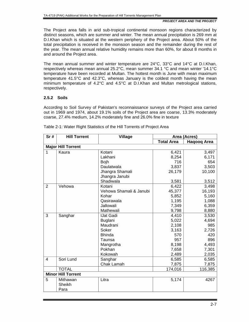
The Project area falls in arid sub-tropical continental monsoon regions characterized by distinct seasons, which are summer and winter. The mean annual precipitation is 269 mm at D.l.Khan which is situated at the western periphery of the Project area. About 50% of the total precipitation is received in the monsoon season and the remainder during the rest of the year. The mean annual relative humidity remains more than 60%, for about 8 months in and around the Project area. The mean annual summer and winter temperature are 24°C, 33°C and 14°C at D.I.Khan, respectively whereas mean annual 25.2°C, mean summer 34.1 °C and mean winter '14.1°C temperature have been recorded at Multan. The hottest month is June with mean maximum temperature 41.5°C and 42.3°C, whereas January is the coldest month having the mean minimum temperature of 4.2°C and 4.5°C at D.I.Khan and Multan metrological stations, respectively. 2.5.2 Soils According to Soil Survey of Pakistan's reconnaissance surveys of the Project area carried out in 1969 and 1974, about 19.1% soils of the Project area are coarse, 13.3% moderately coarse, 27.4% medium, 14.2% moderately fine and 26.0% fine in texture Table 2-1: Water Right Statistics of the Hill Torrents of Project Area
Area (Acres) Sr # Hill Torrent Village Total Area Haqooq Area
Major Hill Torrent 1 Kaura Kotani
Lakhani Bojh Daulatwala Jhangra Shamali Jhangra Janubi Shadiwala
6,421 8,254
716 3,837
26,179
3,581
3,4976,171
6543,503
10,100
3,5122 Vehowa Kotani
Vehowa Shamali & Janubi Kohar Qasirawala Jallowali Mathewali
6,422 45,377
5,852 1,195 7,349 9,798
3,49816,1935,1601,0886,3598,880
3 Sanghar IJat Gadi Buglani Maudrani Soker Bhinda Taunsa Mangrotha Pokhan Kokowah
4,410 5,022 2,108 3,163
570 957
8,198 7,658 2,489
3,5304,694
9852,726
420896
4,4937,3012,035
4 Sori Lund Sanghar Chak Lamah
6,585 7,875
6,5857,875
TOTAL 174,016 116,385Minor Hill Torrent 5 Mithawan
Sheikh Para
Litra 5,174 4267
TA-4719 (PAK) Additional Works for the Preparation of Hill Torrents Management Plan
PROJECT AREA AND THE PROJECT
2-8
Area (Acres) Sr # Hill Torrent Village Total Area Haqooq Area
6 Litra Litra Chatri Choraki
15523 10976
4874
12801104844476
7 Bathi/Para North Chatta Maih Ghatt Roar Hali Jhok Bodo Kathranwala Bayrund
2041 6429 9528 2593 1642
14626147824624821557
8 Qaisirani Jhok Bodo Hamal Wali
2382 624
2061459
9 Kawan Kot Qaisrani Baroth Mandwani
19768 1315
122831315
10 Chit Bantri/Chitpani Chitpani 8626 732411 Mahoi/Trutti Jhok Rohal
Kot Mahoi Jhok Mausso Gona Kalari (non-haqooq)
3507 2211 1427 4042 2475
28651794125737511612
12 Rakyani Rakyani 1589 596 TOTAL 106746 87239 GRRAND TOTAL 280762 203624
2.5.3 Geology2 The geologic formations in the Project area generally comprise Quaternary deposits and Tertiary deposits. Quaternary deposits are relatively younger, unconsolidated deposits consisting of river and piedmont alluvial sediments with unknown thickness. However, the gravelly deposits are thick and occur close to the mountains. The alluvial plains substrata are predominantly sandy, that of the floodplains are homogenous and the one of the piedmont plains are heterogeneous comprising alternating layers of sand and clay. The silt and gravel are presented in thin layers. The tertiary deposits are consolidated sedimentary rocks, light green/grey to green shale, interbedded with sandstone and gypsum; alternate beds of greenish/grey clays and soft friable sandstone, with intermittent deposits of conglomerates. 2.5.4 Landforms Based on surface configuration, relief, age and degree of soil development, the piedmont plains have been segmented into four major landforms. 2.5.5 Hydrology The surface hydrology of the Project area is predominantly controlled by four main hill torrents, a detailed accordance of which is presented in the following sections of this Report. The general direction of the streams is west to east with a slight inclination to the south. Most of the tributaries that debouch from the hills onto the plains are gradually dissipated by distributary channels on the gravelly terraces/fans or piedmont slopes and do not join the trunk streams of the piedmont as large channels. Virtually, all the streams are smaller at their ultimate .destination than further upstream of the various hill torrents, which have 2 Soil Survey of Pakistan
TA-4719 (PAK) Additional Works for the Preparation of Hill Torrents Management Plan
PROJECT AREA AND THE PROJECT
2-9
managed to cut out their way through the piedmont plains to the Indus River. Among them Vehowa and the Sanghar are the most important. For most of the time the torrents are dry, and are only filled with water, following heavy rains in the catchment area. These torrents are active only for a few days or even hours and generally do not persist over long period. However, the heavy rains generate uncontrollable floods which causes formidable erosion and destruction. The groundwater sources of the Project area generally comprise the unconsolidated alluvial deposits lying between the Indus river and the Suleiman Range. The sub-surface aquifer is mainly recharged by precipitation, and surface runoff of hill torrents. The water table depth the distance from the hill torrent channels and is found upto 350 feet depth. About 32% of the available groundwater is fit for irrigation and another 9% is marginally fit; nearby 59% is front unfit for irrigation. 2.5.6 Ecological Resources The existing ecological resources of the Project area are identified on the basis of geographical, pedological and biological environmental parameters and conditions. These conditions are the resultant of the combined and integrated effect of altitude, climatic, different land systems including the soil conditions occurring in the Project area. The climate IS mainly arid sub-tropical continental characterized by low rainfall, hot summer and mild winters. The soils are generally moderately fine to medium and coarse in texture having low to high infiltration rates and inherently low nutrient content. Based on these parameters alongwith altitude, landforms and plant species the following landscape ecological units (LSEU) are identified in the Project area.
• Haloxylon salicornicum-Salvadora oleoides lower altitudinal mountainous zone. • Lasurus sindicus- Cymbopogon jawarancusa middle altitudinal mountainous zone. .
Acacia modesta higher altitudinal mountainous zone. • Rhazya stricta- Haloxylon sallicornicum gravelly terraces/fans zone. • Tamarix articulata- Prosopis glandulosa channel margins and valley fioor zone. • Tamarix articulata-Zizyphus mauritiana Recent piedmont plains zone. • Prosopis cineraria-Acacia nilotica Subrecent piedmont plain zone. • Prosopis cinraria-Capparis decidua Pleistocene piedmont plain zone. • Acacia jacquemontii- Zizyphus mauritiana Pleistocene channel remants zone. • Typha angustata- Phragmites communis wetlands zone.
These LSEUs comprise characteristic flora and fauna. The flora (natural vegetation) generally include mesophytic to xerophytic genera of trees, shrubs, grasses, and shrub grasses. The land use such as torrent watered restricted cropping and poor grazing/fuel wood production associated with nominal forest reserves are found in the Project area. A detailed account of ecological resources of the Project area is presented in the proceeding sections of this report. The wild animals contribute towards productive ecosystem providing food, water, fertilizer and recreation. The wildlife resources are scarce even in the catchment areas of the hill torrents. The present scarce covers with human disturbance provide few habitat vegetation taken in terms of feed, shelter and protection. The endangered status arises from extreme aridity including indiscriminate cut and carry land use, livestock grazing, which alter the nature of the vegetation. livestock also compete for feed resources with native fauna. The Project area includes 13 major species of sedentary/resident birds and 6 species of migratory birds (from Siberia etc.). In addition, eleven major species of mammals (animals) are found in the catchment/wild zones of Pachad area. No considerable aquatic life is present.
TA-4719 (PAK) Additional Works for the Preparation of Hill Torrents Management Plan
PROJECT AREA AND THE PROJECT
2-10
2.5.7 Land Use Land uses reported in the project area are: 2.5.7.1 Torrent Watered Cultivation This land use is encountered along the main hill torrents of the area such as the Kaura, Vehowa, Sanghar and Sori Lund. These hill torrents have larger catchment areas and provide more or less assured seasonal discharges during summer. Tubewell irrigation has also been reported, at places. Over the past decade or so torrent watered cultivation has been steadily deteriorating due to unchecked floods causing formidable erosion. The soils are laminated to weakly structured with medium to fine textures. Farming methods are traditional and water diversion methods are unreliable. Wheat, millets and oil seeds are the main crops especially, along the hill torrent routes. 2.5.7.2 Poor Grazinq and Fuel Wood Production This land use has been encountered as scattered patches throughout the Project area. Predominantly, the Project area constitutes the piedmont plains. Some of the major plant species encountered in the area are: Prosopis spicegera (Jand) Capparis decidua (Karir), Acacia nilotica (Kiker), Salvadora o/ed oides (wan), Tamarix articulata (Fragh), Elionurus hirsutus (Gorkha), Eleusine flagel/ifera (Chhimber) and Cynodon dactylon (Khibbal). 2.6 ECONOMY Economy of the Project area is almost entirely based on agriculture and livestock. It is thus affected by the cropping pattern largely controlled by availability of water and mode of irrigation. Lack of communication facilities, illiteracy and other infrastructure are the cause of low standard of living for the greater part of the population and the main constraints in the development of the area. Majority of the population lives in the rural areas and depends upon agricultural production through regulated supplies from CRBC and Hill Torrent irrigation in Pachad area. The canal water supports almost a regular cropping pattern in the canal irrigated area, while rainfall generally sustain a varying cropping pattern depending upon the season and its duration in Project area. The main products in canal irrigated area are cotton, rice, wheat and oilseed whereas sorghum, wheat, pulses, oilseeds and livestock (meat and wool) are of Pachad area. Mode of communication and transport charges affect the economy considerably. The market value of produce in the villages is about 10 to 25 percent lower than the trading centres depending on the mode of transport. 2.7 AGRICULTURE Agriculture in the Project area is predominantly rainfed. Only 12% of the total cultivable area is. presently irrigated. Agriculture in the area is below subsistence level. Major crops are millet (jawar/bajra) covering about 40% of the cropped area followed by wheat representing 23%, gram 22% and 15% other crops. Crop yields in the Project area are very low, mainly due to uncertain and erratic amount of water at critical stages of crop growth, non availability of improved seed, inadequate use of fertilizers and pesticides, insufficient cultural practices,
TA-4719 (PAK) Additional Works for the Preparation of Hill Torrents Management Plan
PROJECT AREA AND THE PROJECT
2-11
lack of credit facilities for the purchase of farm inputs, lack of modern technology for land crop-water management. At numerous places, farmers have been diverting flood flows into small channels for irrigation purposes since decades, but many have become defunctional due to physical, technical, financial and social constraints. Most of the water is wasted by run off through hill torrent streams which during floods often cause damage to land and life and end up in Indus River. Because of this the lands of Project area are not being utilized according to their potential. Without proper management of water resources, subsistence level of farming would perpetuate causing thereby more deterioration in the socio-economic condition of the farming community. 2.8 LIVESTOCK In the absence of organized and developed agriculture in Pachad area, livestock raising is an important supporting occupation for farm families, because this is a major source of income for the farmers and its contribution to agricultural development is substantial. Livestock also contribute to security against crop failures in years of exceptionally high floods or drought. The livestock in the area include cattle, buffalo, goat and sheep. Livestock in fact playa primary role in the economy, for agriculture depends largely on cattle which are used as draught animals for the construction of bunds, ploughing and carting. On the other hand the livestock depend on agriculture for the greater part of their requirements. The cows & buffaloes are generally kept for breeding purposes but milk production is very low due to a shortage of feed, particularly protein. The project area produces surplus sheep and goats, which are the main source of me.at and wool for other parts of the province. Local breeds of all species are well adopted. Major part of livestock is reared by nomadic and transmuting families, deriving 60 to 70 percent of their feed from the ranges and the balance from the cropped areas. 2.9 SOCIO-ECONOMIC POSITION 2.9.1 Population According to 1998 Population Census of Pakistan, the total population in the Project area was 77546 with 39621 males and 37925 females. The average growth rate of population of Pachad area and the mountainous Catchment were 2.87 % and 2.55% respectively. The average annual growth rate of the Project area was slightly higher than the national average rate of 2.1 % prevailing in the country. Most of the people of the Project area speak Siraiki, while Balochi, Sindhi, Punjabi and Pushto are also spoken. Urdu having the status of national language is understood in all parts of the Project area. 2.9.2 Physical Infrastructures Out of total number of 24 villages of the Project area, 18 have electricity, 14 have been supplied with potable drinking water while only 4 basic health units exist in the area. Six (6), villages are connected with metalled rural access roads, requiring extensive repairing and maintenance. Only a few villages have been supplied with telephone facilities.

TA-4719 (PAK) Additional Works for the Preparation of Hill Torrents Management Plan
PROJECT AREA AND THE PROJECT
2-12
2.9.3 Social System The 'Jirga' System is the most common social phenomenon irf the Project social setup. This is essentially needed to resolved the social disputes and acts as the amicably. The supreme local court and governing council, Law and order is also maintained by the local police. Other prominent social organization emerging at the village level in the Project area are I. Zakat Committee ii. Mosque Committee iii. Water users Committee IV. Punchyat (Village Council) v. Union Council (Formal) However, Sardar, the tribe Chief, commands absolute authority and power over his tribe in all matters. Sardar's position is a hereditary status ascribed through ancestors. He is a symbol of power in his area and it is always important to take him into confidence while initiating any development activity. 2.9.4 Health and Education Facilities Three of the villages of the Project area have Rural Health Centers, while four other villages have Basic Health Centers. Hospital facilities are only available at tehsil headquarters at Taunsa. 2.9.5 Education Facilities (Men) The data extracted from the District Census Report, D.G. Khan 1998 shows that the facility of 329 Primary Schools is existing in Taunsa Tehsil whereas 21 schools of the same Cadre are available in the Tribal Area, which is deprived of other educational institution. The Project area does not have any intermediate/degree college. However there are 15 primary, 8 middle and three high schools. The tribal area has also been provided with primary school facilities at 21 (boys) and 50 (girls) different places.
TA-4719 (PAK) Additional Works for the Preparation of Hill Torrents Management Plan
REVIEW OF PREVIOUS REPORTS
Table of Contents
3. REVIEW OF PREVIOUS REPORTS............................................................................3-1 3.1 BACKGROUND....................................................................................................3-1 3.2 OBJECTIVES .......................................................................................................3-1 3.3 REVIEW OF THE REPORT ON HILL TORRENT MANAGEMENT BY MR YOICHI
KISHI ....................................................................................................................3-1 3.3.1 NESPAK Report on Updating Feasibility Study on Hill Torrents Management
Plan ..................................................................................................................3-2 3.3.1.1 Review of Chapter 5: Management of Hill Torrent....................................3-2 3.3.1.2 Appropriateness of recommended plan....................................................3-3 3.3.1.3 Appropriateness of the criteria and design ...............................................3-4
3.4 REVIEW REPORT OF DR TERRY HEILER (2005).............................................3-5 3.4.1 Management of Hill Torrents ............................................................................3-6
3.4.1.1 Options Considered ..................................................................................3-6 3.4.1.2 Diversion /Distribution Options .................................................................3-6 3.4.1.3 Proposed Closure and Flood Protection Embankments ...........................3-8 3.4.1.4 Proposed Diversion and Distribution Structures .......................................3-8 3.4.1.5 Other and Concluding Comments on NESPAK (2005) ............................3-9 3.4.1.6 Summary of Findings................................................................................3-9 3.4.1.7 Conclusions and Recommendations ........................................................3-9
3.5 REVIEW OF KACHI CANAL CONSULTANTS...................................................3-10 3.6 FLOOD MITIGATION BENEFITS.......................................................................3-10 3.7 PERFORMANCE OF STRUCTURES ................................................................3-10 3.8 COMMENTS BY TA CONSULTANTS ...............................................................3-11 3.9 REVIEW REPORT OF MR JAMSHED TIRMIZI.................................................3-12
3.9.1 Introduction.....................................................................................................3-12 3.9.2 Social and Poverty Assessment .....................................................................3-13 3.9.3 Participation....................................................................................................3-14 3.9.4 Land Acquisition and Resettlement ................................................................3-14 3.9.5 Stakeholder Consultations..............................................................................3-15
3.9.5.1 Methodology ...........................................................................................3-15 3.9.5.2 Operation of Rodh Kohi ..........................................................................3-16 3.9.5.3 Summary of Consultation Sangar Hill Torrent ........................................3-16
3.9.6 Approach for Participation During Implementation and Operation .................3-22 3.9.7 Historical Flood Irrigation Community.............................................................3-22 3.9.8 Nature and Quality of Cooperation .................................................................3-23 3.9.9 Hill Torrent Officer- Collector rodh kohi ..........................................................3-23 3.9.10 Maintenance of Gabion Structures Instead of Kamara...............................3-24 3.9.11 Continuing Community Organization ..........................................................3-24 3.9.12 Willingness and Ability to Pay.....................................................................3-24 3.9.13 Inclusion of Tail End Communities .............................................................3-24 3.9.14 Inclusion of Women ....................................................................................3-25 3.9.15 Participation during Implementation ...........................................................3-25 3.9.16 Comments and Suggestion on the Draft Tor ..............................................3-26
3.10 HYDROLOGICAL ANALYSIS ............................................................................3-27
TA-4719 (PAK) Additional Works for the Preparation of Hill Torrents Management Plan
REVIEW OF PREVIOUS REPORTS
3-1
3. REVIEW OF PREVIOUS REPORTS 3.1 BACKGROUND The Chashma Right Bank Irrigation Project (CRBIP) is spread over two provinces of Pakistan. The main canal is 170 miles in length, out of which 64 miles irrigating 240000 acres in Punjab. Prior to construction of the CRBC, the area between foothills of Suleiman Mountain Rang and Indus River was being irrigated by flood flows. After the project, the inhabitants of the area are not happy because they has been left behind continuing traditional farming by diverting unpredictable flood flows of hill torrents. The hill torrent brings flashy flood of shorter duration but very high magnitude. The banks and bed of the channels are eroded due to steep gradients. The floodwater brings huge amount of sediment to the plain areas. The silting and scouring phenomenon are largely responsible for frequent changes in the flow regime and shifting of flow paths of hill torrents. As the floods in hill torrent areas are unpredictable and are of erratic nature, these pose challenges to the designers arid flood planners for their economical management. The farmers in hill torrents areas utilize low flows of hill torrents by constructing small earthen bunds called "Gandas". High flows breach earthen diversion bunds and deprive the cultivators from the use of this water. The flood water thus rushes downstream and damages crops, houses and other infrastructures. The main objectives of the Hill Torrent Management Project are to reduce the flood damage to the CRBC and increase the availability of manageable irrigation water flows for lands in the Pachad area to the west of the CRBC to farm enhance produce. 3.2 OBJECTIVES The Asian Development Bank (ADB) has contracted TA Consultants for review of the hydrological technical aspects of the Feasibility Report plan for the management of major hill torrents that cross the Chashma Right Bank Canal (CRBC) in the Dera Ghazi Khan District prepared by M/s NESPAK (2005) and report on performance evaluation of Kaha hill torrents (2004). Comments offered thereof on these reports by Dr Heiler, Engr. Yoichi Kishi and Syed Jamshed Tirmizi, were required to the examined, analyzed for incorporation where ever feasibly useable and adoptable in the improved design and plan of the scheme. TA Consultants have perused / examined all the reports. Relevant extracts alongwith appropriate comments are available infra. 3.3 REVIEW OF THE REPORT ON HILL TORRENT MANAGEMENT BY MR YOICHI
KISHI TA Consultants after their visits to the site consultations with field staff, Chief Engineer DG Khan, SE Project Circle and with National and International Consultants have finalized their report. We are in agreement with Yoichi Kishi except some reservations which have been discussed and taken in the design of structures.
TA-4719 (PAK) Additional Works for the Preparation of Hill Torrents Management Plan
REVIEW OF PREVIOUS REPORTS
3-2
3.3.1 NESPAK Report on Updating Feasibility Study on Hill Torrents Management Plan1
3.3.1.1 Review of Chapter 5: Management of Hill Torrent Appropriateness of Alternatives NESPAK report suggests six alternatives for managing hill torrent flood flows as below: .
• Construction of Storage Dams • Construction of Delay Action Dams • Diversion of Excess Flows to Adjacent Hill Torrents • Diversion of Excess Flows to Non-Haqooq Channels • Dispersion of Excess Flows to Evaporation Ponds • Dispersion of Flows through Diversion/Distribution Structures
These alternatives are categorized into three groups; (1) store/delay flood flows in hill torrent channels, (2) diverting flood flows out of haqooq areas, and (3) spread flood flows over haqooq areas or to evaporate. (1) Store/delay flood flows in hill torrent channels. The alternatives are (1) construction of storage dams and (2) construction of delay action dams Storage dam is not feasible with present scenario due to brazen catchment area. Due to the flood flows with heavy sediment concentration, reservoir must be silted up in a short period. Dams are possible as a follow up action to watershed management. The Report does not give clearly define delay action dams. If the idea is same to the delay action dams in Balochistan constructed by Balochistan Irrigation and Power Department, then delay action dams are not recommendable since they are same as semi-storage dams. However, it is worth to research on the delay action dams designed to regulate flood flows by reducing peak floods and extending the duration of flood flows. (2) Diverting flood flows out of haqooq areas Considering the reduced water requirement on Pachad after CRBC operation, a study is necessary on the alternatives of diversion of excess flows to adjacent hill torrents and diversion of excess flows to non-haqooq channels. Before construction of CRBC, entire area had been relying on hill torrent runoff. However, the situation has changed with operation of CRBC. Remained area that needs flood flows in future was estimated on the map; roughly 60 percent areas remain in Kaura, 1/3 in Vehowa and 1/4 in Sanghar. This exercise would be useful after people reap the benefits of this project. Considering above change of requirement of flood flows, rearrangement of water rights may creates difficult social problems in the population, yet it is good timing to discuss with irrigators to improve efficiency of floodwater use which will other wise go waste so far as Pachad area is concerned.
1 NESPAK, March 2005, Chashma Right Bank Irrigation Project (Stage III), Updating Feasibility Study on Hill Torrents Management Plan in CRBC Area in Dera Ghazi Khan District
TA-4719 (PAK) Additional Works for the Preparation of Hill Torrents Management Plan
REVIEW OF PREVIOUS REPORTS
3-3
(3) Spread flood flows over haqooq areas or to evaporate. The alternatives are dispersion of excess flows to evaporation ponds and dispersion of flows through diversion/distribution structures. Judging from the total runoff of high flood events, floodwater storage in evaporation pond on Pachd is impossible due to physical and social constraints. Distributing flood flows on Pachad is a traditional practice of spate irrigation. Local people have controlled flood flows for spate irrigation. However, the traditional flow management method is applicable only for low flood events. High flood events have been beyond the capacity of such practices. Distribution plan of flood flows should consider this fact; capacity of off-take channels be below manageable discharge, but would have to be expandable gradually. Flows beyond the capacity would be disturbing the present system. 3.3.1.2 Appropriateness of recommended plan (1) Kaura Presently proposed plan for complete closure dike of Sad Loharan is not suitable to manage high flood flows. Flood control structure (utilization of existing escape structure with improvement) should be provided between darrah and the first distributor. Water requirement for irrigation is equivalent to 5-year flood and excess inflow creates inundation problem downstream. Escape is necessary to release excess flood flows to Vehowa hill torrent and are to be accordingly modified and enforced. The proposed closure dike might be seriously damaged by high flood events and the first distributor would not distribute flood flows properly. Since the proposed plan is not topographically site specific and would be relocated, revised and reinforced. (2) Vehowa Proposed plan is acceptable. Flood discharge in Vehowa hill torrent is lower than that of Sanghar, however there would be considerable excess flows in medium and high flood events. The major distributors are located in the main hill torrent channel of sandy bed material. The distributors need to be resilient and bearable during high flood events. The proposed design of the distributor is not appropriate to manage high flood events; scouring might develop resulting the distributor into critical condition during floods. Further check measures like addition of bed fixers are recommended. The structure should be readjusted in upstream reach and lowered as much as possible to minimize downstream scouring. Measures against sediment deposition are to be kept in view to make the distributor active even after the fore-bay is silted up. (3) Sanghar Hill torrent Proposed plan for Sanghar hill torrent is inappropriate for the following reasons. Main Distributor Sanghar hill torrent has a distinct flood channel upto Indus River. Peak flood flows of Sanghar hill torrent are very high, on the other hand, the area of Pachad is less compared with other hill torrents. Therefore, considerable part of flood flows should be released downstream as an excess flow of 2-year flood is more than double the requirements and 75 percent of year flood is excess and should go to Indus River. Excess inflow into the wahs

TA-4719 (PAK) Additional Works for the Preparation of Hill Torrents Management Plan
REVIEW OF PREVIOUS REPORTS
3-4
damages channels and fields and inundates downstream villages. The main distributor of San ghar hill torrent should be designed placing first priority on releasing flood flows safely without damaging the distributor. Proposed main distributor is a flexible structure. However, experience in Kaha project shows most flexible structures in the higher part of Pachad, where the flow velocity is estimated 7-10 m/second and where 0.7 m diameter boulders move with flow, cannot stand the high flood events. The proposed main distributor could be washed away at once in any high flood event. Local people are afraid about the proposed design, .because huge excess discharge would go into wahs during high flood events, as the top elevation of the proposed design of main weir is two feet (2') higher than off-take weir elevation. In monsoon months, Sanghar hill torrent flows regularly with manageable discharge. Local irrigators are managing low flows to fulfill the requirement by constructing earthen dike, Salai to draw low flood flows. The earthen dikes are washed away by high flood flows and as a result, excess inflow to the wahs are avoided. After high flood events, local population remake Salai using machinery with subsidy from local government. Proposed main distributor is large and costly, and vulnerable to high flood events. The structure cannot control high flood flows nor distribute properly flood flows. The main distributor is recommended to construct downwards where Bughlani and Begwari Wahs off- take. Accordingly as per site situations individual sallais / diversion structures for Jatwah, Jamwah, are proposed and main structure in conjunction with Shumali, Bughlani and Begwari Shakhs have been adopted alongwith bed fixers for checking the flow velocity. Presently on the southern bank, proposed Baghwari wah distributor was not proposed which appears as omission. Now distributor/bifurcation of Baghwari and Bughlani wahs in conjunction with main x-structure is recommended to distribute flood flows in due shares of 1/2 for each wah. 3.3.1.3 Appropriateness of the criteria and design Sketchy and one line design criteria and standards in the feasibility report are guide the general design of the canal design engineering, which is lacking a sense towards hill torrent flood flows and ignore the specific facts of the field. Hill torrent management require special treatise. Prior to designing a structure, the purpose of the structure should be clarified; for flood control in major hill torrent channel or for water management. Technical evaluation of existing structures and field experiences in construction and operation and maintenance by local people and engineers should be respected. Proposed design criteria in FR (2005) is inconformity to hill torrent management now it has been prepared afresh and circulated to all agencies for information & comments, if any and would be adopted in design of the structures, however in overall context there was increase in agriculture production, uplift of the area, fresh ground water recharge, improvement in communication, health, education due to permanent but induced settlements in the area. Flood control structures Hill torrents have very steep bed slopes compared to that of canals and major rivers in plain areas. Bed slope is usually steeper than 1/150 at darrah sites, and between 1/250 to 1/1000 in Pachad. The flood flows have extremely high velocities and very high sediment
TA-4719 (PAK) Additional Works for the Preparation of Hill Torrents Management Plan
REVIEW OF PREVIOUS REPORTS
3-5
concentration during high flood events, which cause damages to the structures seriously. Criteria for planning and designing the flood control structures should consider such extreme condition. The Report showed criteria and design details, in which "All structures are flexible, comprising gabions”. Unfortunately, most gabion cross structures, which are placed perpendicular to the flows, have failed not only in Kaha hill torrent, but also considerably in Vidore hill torrent and Choti nullah. Use of flexible structures is not always suitable in hill torrent, Semi-rigid structures are appropriate at critical points. These structures are costly in construction, but they are reliable to face extreme high flood flows, which also will reduce O&M cost. Engineering experience in hill torrent control is still limited to prepare general criteria and standards for the structures to be built in difficult and wide variant conditions. Each structure should be designed based on careful research of site-specific conditions and field experiences in construction, operation and maintenance. Criteria applied to the design in the Report do not give attention on the characteristics of hill torrent flood flows or performance of existing structures. The flood control structures have to work during high floods and thus are to be durable against extreme conditions. Management structures Prior to planning, each structure should be evaluated carefully whether it is located at appropriate positions or not, and whether local people can construct and maintain it by themselves or not. Management structures should be constructed only when the structures are located at critical places and their construction is beyond the capacity of local people. The design of the management structures in the Feasibility Report lacks appropriate stress on site condition(s) and is not learned from the failure cases of Kaha project, such as section shape of off-take weir, relative elevation of off-take for commands of the fields, width of off-take weirs and share of each wah, protection measures of overflow section of the weir and guide banks, height of structures extent of scouring, dimensions of energy dissipater, etc. Revised Design Criteria Keeping in view the above stated short comings, design criteria has been revised and circulated to all. Finalized version of this criteria stand added to this report as volume-IV. 3.4 REVIEW REPORT OF DR TERRY HEILER (2005) Report of Dr Terry Heiler Dr. Tery Heiler reviewed four reports on hill torrents development; Feasibility Report -Updating Feasibility Study on Hill Torrents Management in CRBC Area in Dera Ghazi Khan District, March 2005 by NESPAK, Performance Evaluation of Kaha Hill Torrent, April 2004 by Kachi Canal Consultants, Master Feasibility Studies for Floods Management of Hill Torrents in Pakistan, February 1996 by NESPAK, and Feasibility Study of Irrigation Based on Flood Flows of D G Khan Hill Torrents, October 1992 by JICA. He concluded as below. The review of the current NESPAK proposals for hill torrent management in the four hill torrents of interest has found a number of methodological shortcomings in the hydrologic analyses and in the estimation of irrigation benefits. The structural proposals are generally
TA-4719 (PAK) Additional Works for the Preparation of Hill Torrents Management Plan
REVIEW OF PREVIOUS REPORTS
3-6
sound but more attention is needed address the problems found in the ex-post evaluation of the Kaha hill torrent interventions. The Report neglects the need for additional investments in managing flood water diversions below wah off takes. The Report as it stands is an inadequate basis for loan financing. The Kaha evaluation is short on detail but illustrates the potential for improvements with diversion/distribution works. It also indicates the likely problems that could be encountered with similar interventions proposed under the Project. A key requirement will clearly be to ensure adequate provisions for maintenance and repairs if the investments are to be sustainable. The JICA watershed management proposals are innovative and worthy of a closer look-, but the quantitative assessments of benefits in physical and economic terms are theoretical and cannot be relied upon. It is recommended that the proposals in NESPAK (2005) be modified to reflect the findings of this review, and extended to include a component on physical improvements below the diversion structures, the requirements for repairs and maintenance to make the investments sustainable, and the social issues related to ensuring the necessary level of farmers acceptance and operational support. Extracts and conclusion of the report is at infra. 3.4.1 Management of Hill Torrents 3.4.1.1 Options Considered The list of six options for management of hill torrents presented in the report involve two storage options ( Storage Dams and Delay Action Dams); two diversion options (Diversion of Excess Flows to Adjacent Hill Torrents or to Non-Haqooq Channels), and two dispersion options (Dispersion of Excess Flows to Evaporation Basins and Dispersion of Flows through Diversion/Distribution Structures). Throughout Chapter 5 - Management of Hill Torrents - a common reason raised to preclude further consideration of options identified, was the social difficulties in any proposal that would alter the historical entitlements of the traditional irrigation system users - Saropa Paina. This position is also taken in the chapter on social impact and participatory planning (Chapter 6 in the Report). It is clear that the basic premise of the study is that no interventions will be included in the Project if the traditional water right system is compromised, which may be a valid position to take if the social problems associated with any change are insurmountable. 3.4.1.2 Diversion /Distribution Options This is the recommended approach of the Report for achieving flood mitigation and irrigation objectives in the Pachad. There are several reasons given for examining the proposals in detail:
• The proposals go some way to regularizing haqooq and non-haqooq entitlements, and reduce the likelihood of serious social discord.
• The Kaha experiences are claimed to demonstrate the efficacy and technical sustainability of the proposals.
• Greater control of flood pathways should be possible, thereby reducing problems with CRBC cross drainage.

TA-4719 (PAK) Additional Works for the Preparation of Hill Torrents Management Plan
REVIEW OF PREVIOUS REPORTS
3-7
• The reduction in Darrah flood flows at the CRBC alignment are substantial. It is noted that the proposals are only made for the three main hill torrents, the assumption being that minor hill torrents can be managed by the farming community without interventions. It is an important point to note that the proposed interventions will not achieve their purpose unless there is a parallel investment in the operation of wahs and lower level distribution works - as it stands, the Project does not provide for this investment. Estimated Increase in Irrigated Area. It is estimated that the use of diversion/distribution structures will allow large increases in irrigated area. The reliability of estimated increases depend directly on the estimates of monthly runoff volumes. The main concern is whether the study has correctly estimated runoff volumes. The concern is based on three issues: a) whether the methodology SCS curve number is the most appropriate for the purpose; b) the way in which the conversion of the Barkhan daily runoff estimates to probabilistic estimates has been done; and c) the relatively high equivalent average daily discharges required to explain the monthly runoff estimates. Flood Peak Reductions; One of the main objectives of the study is to devise hill torrent management schemes that reduce the frequency and magnitude of flood flows reaching the CRBC alignment. The basic approach is to split incoming flows into diverted flows at wah confluences in a downstream direction - which is not strictly a flood routing procedure, in which the attenuation effects of storage would be accommodated. As such, the approach is conservative.
• For Kaura (1 in 25 year event), incoming flood flow of 45,160 cfs is reduced to 22,050 cfs at the Shakh Chaharam wah diversion. The closure to Vehowa is allowed for. No flow estimates are given at the I CRBC alignment.
• For Vehowa, incoming flood flow of 85,520 cfs is reduced to 58,430 cfs at the CRBC alignment. Although unclear, it appears that the Kaura spill has been excluded.
• For Sanghar, incoming flood flow of 122,730 cfs is reduced to 55,220 cfs at the CRBC alignment.
The basic assumptions in this partitioning are that: a) the diversion distribution structures operate as designed; b) the diverted water is absorbed by the irrigation operations and no excess flows escape and join downstream flows; and c) that the farming community can manage the diverted flows safely. If these assumptions are violated, diverted flood flows lost from the wah may create new pathways, and water stored in embankments may be lost by bank failure and exacerbate downstream flooding2. The reductions in flood peak and runoff volumes estimated for the proposed diversion distribution interventions are considerable and probably achievable so long as the structural components operate as intended and are structurally sustainable, and the farmer management of the system in high floods is feasible.
2 The point is well made in the master feasibility study that diversion/distribution schemes are dependent on connecting the wahs to lower level irrigation channels, and on the efforts of the farming community to manage the diverted flows
TA-4719 (PAK) Additional Works for the Preparation of Hill Torrents Management Plan
REVIEW OF PREVIOUS REPORTS
3-8
3.4.1.3 Proposed Closure and Flood Protection Embankments The technical risk issues for the closure and flood protection embankments as proposed are: overtopping; scour along the bottom of waterside slope of the embankment induced by gabion position; and piping failure3 of the earthen embankment under prolonged period of high adjacent water levels. The first two risks can be mitigated by proper design and construction; the last is dependent on availability of suitable embankment construction material, correct placement and control of seepage flows. Given local circumstances, the earthen embankment may also be subject to damage by burrowing animals, creating voids and associated piping risks. PIPD has raised concerns about the use of gabion structures to protect earthen closure and flood protection embankments because of tier joint weaknesses in stacked gabion structures and possibility of removal of wires from the basket structure. The purpose of the spurs is to protect the earthen embankment at points of attack and encourage sediment deposition - which should reduce flood loadings on the gabions over time, and make the structural integrity of the gabions less of an issue. The question of vandalism and removal of wire from the baskets is potentially more serious, in that early failure of the gabions may put the embankment at risk. The alternative would be to construct head, protected earthen spurs or add vegetative protection using vetiver grass or similar. 3.4.1.4 Proposed Diversion and Distribution Structures The eight distribution structures proposed are all of similar design. They comprise: a cross weir of gabion construction strengthened by a vertical reinforced concrete cutoff wall under and at the upstream portion of the gabion weir; masonry wall abutments; protected upstream and downstream containing earthen embankments of similar design to the Kaura closure embankment; a stilling basin downstream of the weir and gabion erosion protection works. Depending on the site, one or more off take structures split the incoming flow' into adjacent wahs over a small gabion weir into the natural wah channel. Assuming that the structure remains stable, main flows are contained within the structure and excessive siltation (20 cs not occur, the design is suitable for flow distribution, so long as the hydraulic dimensions of the main weir and wah weirs are properly proportioned. Structural design is based on the use of gabion baskets, justified that flexibility is required to reduce the risk of major structural failure. The alternative is to use reinforced or masonry concrete at considerably more cost for the main structural elements, with the risk that any unplanned settlement or scour could cause complete failure and loss of function, and require costly repairs. As a general comment, and based on the Kaha experiences, the sustainability of the diversion/distribution structures is not assured. If adequate provision is not available for repairs and maintenance, then the structures as proposed will gradually lose function, and may fail completely. 3 Piping failure can occur because of high seepage velocities through the embankment, or under the embankment. It is noted that most earthen embankments designed to have water ponded on one side would incorporate a cut-off trench under the embankment, or a drainage collector in the toe region of the downstream face, to control drainage water flows
TA-4719 (PAK) Additional Works for the Preparation of Hill Torrents Management Plan
REVIEW OF PREVIOUS REPORTS
3-9
3.4.1.5 Other and Concluding Comments on NESPAK (2005) As a general comment, this report is a regurgitation of the 0 G Khan area contained in the NESPAK (1996) report. Tables and schematics have been copied almost exactly, and little new is offered. If anything, this report is less well presented and unclear - in some cases because the copying of tables has not been as complete. The economic analysis in this report is very detailed, and correctly handles the probabilistic issues involved in determining benefits at various return periods. What is unrecognized, however, is the impact of risk of not achieving claimed benefits. This risk is a combination of possible errors in hydrologic evaluations, especially in assessment of area irrigated; and the technical uncertainty of the long term performance of the proposed structures. For example, the occurrence of a more extreme flood event in the early period after implementation could seriously damage flexible structures. One of the main limitations is the lack of account of the accompanying investment needed downstream of the structures on the wah distribution system and into the irrigation area, and the absolute reliance on the assumption that the farmers have sufficient resources access to inputs and will be willing and are able to manage this system. There does not appear to be any objective account taken of the necessary level and costs of the O&M requirements of the investment, although the. Kaha review identifies the role of deferred maintenance in causing structure failure and poor function. As it stands, the report is an inadequate basis for preparing an investment project, and the issues raised in this review need to be satisfactorily addressed. 3.4.1.6 Summary of Findings
• The JICA report correctly identifies the need to control upper catchment sediment production if a long term and sustainable solution to hill torrent management problems is to be found.
• The report correctly identifies that Pachad flood diversion/distribution structures are short term measures that will need continuing maintenance to maintain function and are dependent on other works along the wahs, and a high level of farmer cooperation, if they are to be effective.
• The JICA watershed management interventions are well thought and are developed from a logical consideration of catchment-specific features. The suggested use of vetiver grass or similar has been based on 1992 knowledge and other opportunities may now be available.
• Implementation of watershed management works above the Darrah will be difficult given the traditional attitudes to common grazing land, water rights and other social issues.
• The claimed benefits in terms of increased livestock numbers, sediment reduction lower Darrah flood peaks are in the right direction, but the quantitative estimates are speculative and cannot be authenticated with any certainty.
3.4.1.7 Conclusions and Recommendations 1. The review of the current NESPAK proposals for hill torrent management in the three hill
torrents of interest has found a number of methodological shortcomings in the hydrologic analyses and in the estimation of irrigation benefits. The structural proposals are generally sound but more attention is needed address the problems found in the ex-post evaluation of the Kaha hill torrent interventions. The report neglects the need for
TA-4719 (PAK) Additional Works for the Preparation of Hill Torrents Management Plan
REVIEW OF PREVIOUS REPORTS
3-10
additional investments in managing flood water diversions below wah of takes. The report as it stands is an inadequate basis for loan financing.
2. The Kaha evaluation in short on detail but illustrates the potential for improvements with
diversion/distribution works. It also indicates the likely problems that could be encountered with similar interventions proposed under, the Project. A key requirement will clearly be to ensure adequate provisions for maintenance and repairs if the investments are to be sustainable.
3. The JICA watershed management proposals are innovative and worthy of a closer look,
but the quantitative assessments of benefits in physical and economic terms are theoretical and cannot be relied upon.
4. It is recommended that the proposals in NESPAK (2005) be modified to reflect the
findings of this review, and extended to include a component on physical improvements below the diversion structures, the requirements for repairs and maintenance to make the investments sustainable, and the social issues related to ensuring the necessary level of farmer acceptance and operational support.
3.5 REVIEW OF KACHI CANAL CONSULTANTS The TOR require a review of the report on the performance Evaluation of The Kaha Hill Torrent. The performance evaluation comprised an assessment of the post-project performance of structures, agricultural and social impact and a post project economic evaluation. The basis of the evaluation was a technical review of performance in terms of flood mitigation affects, impact of groundwater availability and structural issues; a substantial data collection program on changes in agricultural production; and a survey of social attitudes to the investments. 3.6 FLOOD MITIGATION BENEFITS The report uses post-project (1997-2003) estimates of the reduction of Darrah flood flows at the Dajal Branch Canal crossings to identify the flood mitigation benefits attributable to the construction of 13 diversion/ distribution structures in the Punjab area of the kaha Hill Torrent. No information is given as to the source and reliability of the flood estimates, but given that they are reliable, the conclusion reached that the works in Punjab resulted in significant flood mitigation benefits seems reasonable. There is no information of the routing that actually took place during the flood events for example, along the main channel and wah flows at each structure which would have added considerably to the arguments made. 3.7 PERFORMANCE OF STRUCTURES The technical evaluation of the structural performance of the management structures was based on field observations of structures and an associated report on condition; an analysis of theoretical scour depth at each structure and a comparison with as- built foundation depth; and survey of perceptions of local water users. Despite the claimed efficacy of the structures, most are in a damaged condition, the reason given being poor and inadequate maintenance. This will also be a problem in the proposed Project not addressed. The problems are threefold; scour, siltation and settlement of rigid components causing structural damage. Scour and settlement issues can be addressed by proper design,

TA-4719 (PAK) Additional Works for the Preparation of Hill Torrents Management Plan
REVIEW OF PREVIOUS REPORTS
3-11
construction and maintenance, but siltation is a natural and unavoidable phenomenon that can only be handled by periodic de-silting. The lessons learned from the kaha evaluation were:
• The need to include a reinforced concrete cut- of wall under the upstream gabion crest of cross regulators deep enough to support the gabion weir and prevent under piping.
• Structures should be flexible- gabions preferred to solid construction. • Symmetry of flow conditions- upstream and downstream. • Semi-circular mole head configuration of the upstream end of Salai and confining
embankments. • Locating off take structures upstream of the cross regulator weir (10 times H {depth
of flow over crest} • For H> 2m, utilize falls with glacis rather thatn drop falls. • Collection of operating performance data during floods at key structures.
Apart from the location of offtake weirs, these improvements have been incorporated in the project proposals. Additional measures also need to be considered to address scour and settlement problems:
• Pre-wetting of foundations to reduce post-project consolidation. • Use of geotextile filters cloth under sections of structures where removal of fines is
possible. Unresolved problems are siltation and loss of function, and damage to gabions by local communities, the latter being more important in the proposed Project than was the case in Kaha, because of the almost total commitment to gabion construction. 3.8 COMMENTS BY TA CONSULTANTS The consultants, by and large agrees with Dr, Heiler's conclusions. Social mobilization has been made a part at the planning and construction stage. As regards components of physical improvement in downstream diversion for distributary and minor level structures; this itself is project and can be launched in the follow-up phases. Short coming in hydrological studies have been looked into and improved and added at Chapter-4 of this report. Since project is based on run of the torrent and thus crop production on a 5 year return flow is quite fair and these does not appear any shortcomings. Though Dr. Heiler evaluated structural proposal as sound, NESPAK's proposal on the structures needs more attention on hill torrent flood characteristics and sediment deposition. High sediment concentration of the hill torrent flood is the key factor of designing the structures in hill torrents and on Pachad areas. Though Dr. Heiler mentioned "The Kaha evaluation is short on detail but illustrates the potential for improvements with diversion/distribution works," the structures constructed in the upper reaches especially are completely damaged by innocent design to high flood flows. It is not because of lack of O&M but the problem originated from the design. Design criteria have been enlarged embracing all the proposals which were worthing of consideration and implementation. Since Hill Torrent management technology is till in infancy. Topographic and material wise, Suleman range has its own peculiar parameters and hence very few inferences from Japan, Italy, Switzerland, USA can be followed due to
TA-4719 (PAK) Additional Works for the Preparation of Hill Torrents Management Plan
REVIEW OF PREVIOUS REPORTS
3-12
limitations in available resources and very painstaking after longer intervals due to areas socio-political environment. Dr Terry Heiler has misinterpreted about the diverted flows. Generally the off-taking Wahs follow their developed routs and also cross CRBC in different arms in addition to the main hill torrents viz Kaura, Vehowa & Sanghar and excessive discharge over and above the ones utilized by irrigators will find its way through already constructed structures under CRBC to river Indus. For that matter some escapes in the wah for transferring back the extra discharges into the main channels wherever essentials and feasible has been also provided. As regards failures of structure in Kaha Hill Torrent area, this was primarily done to non construction of one of the structures in the upper reach and in the absence of this structures, effected downstream constructed structures which have to face the full blooded brunt of high floods and thus gave way and damaged considerably. Their conditions further deteriorated in the following years due to successive floods and none recoupment/repairs and warranted improvements of the structures. To overcome local vandalism viz theft of gabions rates and thus rendering it to vulnerable to damages semi-rigid structures with panels of CC over packed stone and coping with concrete of the other gabion walls have been adopted in the revised design. 3.9 REVIEW REPORT OF MR JAMSHED TIRMIZI TA Consultant have examined the report prepared by Mr Jamshed Tirmizi on the Social and Poverty assessment for proposed engineering interventions and endorse for implementation. Technical aspects about sharing and sitting of structure have been examined and incorporated as there were considered views of the locals and worthy of consideration and inclusion. The social mobilization for launching finalization of the sitting of management structures during the phase of detail design and other phases. At present with the implementation of this part management of flows through appropriate structures would be regulated. Utilization of the irrigation flows would remain, under the purview of Punjab Minor Canal Act 1903 thus existing system would remain functional and further strengthened through Social Mobilization and creation of NGO for better management and enforcement of Kamara System through collector Rod Kohi. 3.9.1 Introduction The purpose of the assignment in May 2005 was to assist the Punjab Irrigation Department in carrying out participatory consultations and a poverty and social assessment analysis for the Hill Torrent Management Project proposed as a complementary project to the Chashma Right Bank Irrigation Project (Stage III). The project will cover Sangarh, Vehowa and Kaura hill torrents, all located in Western part of Taunsa Sharif Tehsil in Dera Ghazi Khan District.4 This report supplements the participatory consultation carried out by the feasibility consultants5.Systematic consultations were conducted with stakeholder communities on the design concept and functions of the structures being proposed. These communities have an
4 The feasibility study originally included a proposed diversion on one wah on the left bank of Sori Lund which was dropped because the beneficiary community feels it will breach convention and would be disallowed by the user community of the off take directly in front of them on the opposite bank, unless both are included for the improvement. 5 NESPAK, Updating Feasibility Study on Hill Torrents Management Plan in CRBC Area in Dera Ghazi Khan District, March 2005
TA-4719 (PAK) Additional Works for the Preparation of Hill Torrents Management Plan
REVIEW OF PREVIOUS REPORTS
3-13
intimate familiarity with their respective hill torrents and system of irrigation which they have managed. over generations. A social and poverty analysis including self estimates of communities regarding poverty levels and characteristics of poor groups and potential impacts of the proposed plan on the poor and women was also conducted during reconnaissance and participatory assessments. The essentially participative nature of rodh kohi irrigation management, the changes that have come over time are described. An approach for participation of the rodh kohi communities during implementation of the project are outlined to ensure appropriate detailed design, fair and transparent compensation for adverse impacts such as land acquisition and agreement on structure of wah organizations, and rules of business. In view of the land that will be required for the structures being proposed by the project a draft resettlement framework is developed based on the nature of structures proposed, ADBs policy and Pakistan's law. The stakeholder communities were generally keen to see the interventions take place and drew attention to three issues that appeared important for them.
• Provision for reconstruction: On structures that seemed precarious in comparison to the fury of the torrent they suggested that a provision for reconstruction be included in the project if structure failure occurs.
• Provision of escape structures: With the construction of the Project structures all flood events will be diverted into the wah. While this is excellent some provision needs to be made to divert the water away from the wah, when necessary. This is currently possible with earthen diversions by breaching them. In order for them to be able to do so once the gabion and concrete structures are in place they suggest some form of an escape (taal) at the head of the wah, which when operated can drain the water back into the main torrent. The necessity to be able to do so, according to the rodh kohi communities, stems from two perspectives. First, it serves a function of safety, preventing flood when the flows are excessive, are difficult to manage and threaten to breach embankments of fields and enter into villages. Second, it allows the water users of downstream wahs who monitor irrigation on the upstream systems, particularly in low and medium floods, to re-divert the water back into the torrent once the upstream farmers have completed their irrigation6
• Improvement of critical points on wahs: They propose construction of distribution structures at points where water in a wah is split according to established rights into two channels (muqasma), especially where one bed has become lower than the other and does not draw any water without gigantic effort.
3.9.2 Social and Poverty Assessment In a self assessment by communities during a PRA, the communities in the Sangar area classified 25 percent households amongst themselves as very poor, 15 percent as poor, 30 percent as middle income and 30 percent as well off. In Vehowa and Kaura, the averages of the self assessments worked out as 30 percent very poor, 30 percent poor, 20 percent middle, income and 20 percent as well off. Women of cultivating households in Daman are actively involved in agricultural work. An important factor that separates women of landless non cultivating households from those of 6 Channels that have clear drainage routes such as Bughlani, Begwari and Jat wah on the southern bank of the Sangarh and where no other channels off take from the main torrent upstream from them did not raise this as an issue
TA-4719 (PAK) Additional Works for the Preparation of Hill Torrents Management Plan
REVIEW OF PREVIOUS REPORTS
3-14
cultivating households is the dearth of productive work opportunity for the women of the former. A significant aspect that characterizes landless and non- artisan poor households is the fact that women do not have an opportunity to contribute to the income of the household. As abandoned embanked fields once again become available for cultivation because of reliable diversion of water into the distribution system and landless households are sought as share croppers, their women will be able to tend to the fields and to raising milk animals; made possible because of the access to land, while the men continue with off farm daily wage .labor in the period between sowing and harvesting. In view of this, there is a good possibility of those categorized as 'very poor' to move up into the category 'poor' or for the 'poor' to move into the 'middle income' group as a consequence of the project. 4. The poor propose lining and a protection wall around existing rod kohi ponds for domestic use as an appropriate pro poor and pro-women investment for the Project to consider. It will be appropriate to organize the management of water tanks for domestic use, proposed as an additional project component, under the leadership and participation of women. 3.9.3 Participation The approach to realize participation during implementation and post project operations will be to organize the existing community of interest at each diversion (ganda, sad, silali into a committee representing all the sub groups that have a stake at that level. The construction of pucca structures in the place of the khaki kamara will erode community initiative even further, especially if the responsibility of maintenance will pass on to the Punjab Irrigation Department. It is neither desirable nor appropriate that this happens. The rodh kohi systems have historically been farmer operated and maintained systems.. Passing on the responsibility of maintaining structures on these systems to the Irrigation Department would be ironical and counter productive institutionally and from the perspective of government policy During stakeholder consultations most communities were confident about being able to institute maintenance. funds, and did not protest when it was suggested that the proposed project structures should only be made after communities provide an undertaking that they will take on maintenance responsibility. However, communities that presently manage to get public funds for their kamara through political influence, though not reluctant did not seem confident about instituting a regular maintenance contribution without further advocacy and mobilization. Social mobilization on the project will precede detailed design, land acquisition to be determined during detail design, and construction. Negative impacts will be minimized as much as possible and compensation for lost land win be paid in full prior to land acquisition. ADS's Indigenous Peoples Policy does not apply to the Hill Torrent Management Project. 3.9.4 Land Acquisition and Resettlement The Project does not generally need to acquire land because it is based on improvement of existing closure embankments and locations from which water is to be diverted. However, on a few cross structures land for guide structures on both banks, mostly upstream of these cross structures, which belongs to individual farmers will be needed. The impact of losing land will be low since the holdings are relatively large. Land acquisition will be compensated at replacement value plus 15% Compulsory Acquisition Surcharge as provided in the Land Acquisition Act of 1894 (LAA). Involuntary borrowing of land will not be necessary for this Project. However wherever land is damaged, the Project shall assist in restoring it. No land will be severed since guide structures will be along the banks of the torrent or wah. There are no orchards, commercial structures or dwellings at these locations that can be impacted
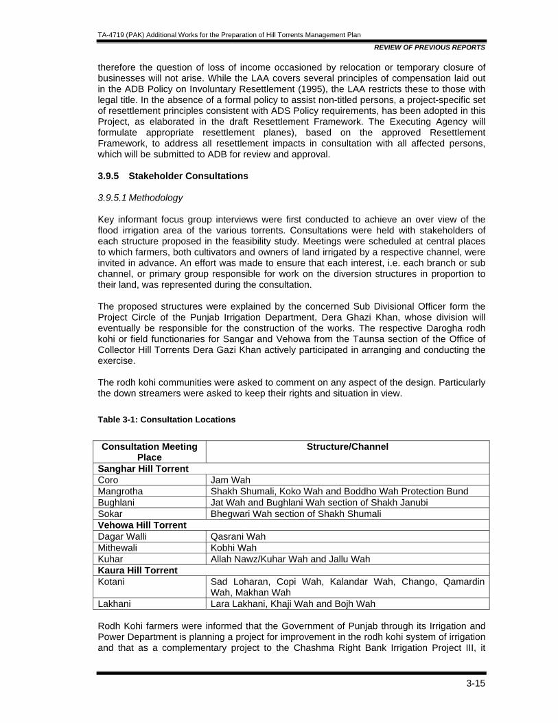
TA-4719 (PAK) Additional Works for the Preparation of Hill Torrents Management Plan
REVIEW OF PREVIOUS REPORTS
3-15
therefore the question of loss of income occasioned by relocation or temporary closure of businesses will not arise. While the LAA covers several principles of compensation laid out in the ADB Policy on Involuntary Resettlement (1995), the LAA restricts these to those with legal title. In the absence of a formal policy to assist non-titled persons, a project-specific set of resettlement principles consistent with ADS Policy requirements, has been adopted in this Project, as elaborated in the draft Resettlement Framework. The Executing Agency will formulate appropriate resettlement planes), based on the approved Resettlement Framework, to address all resettlement impacts in consultation with all affected persons, which will be submitted to ADB for review and approval. 3.9.5 Stakeholder Consultations 3.9.5.1 Methodology Key informant focus group interviews were first conducted to achieve an over view of the flood irrigation area of the various torrents. Consultations were held with stakeholders of each structure proposed in the feasibility study. Meetings were scheduled at central places to which farmers, both cultivators and owners of land irrigated by a respective channel, were invited in advance. An effort was made to ensure that each interest, i.e. each branch or sub channel, or primary group responsible for work on the diversion structures in proportion to their land, was represented during the consultation. The proposed structures were explained by the concerned Sub Divisional Officer form the Project Circle of the Punjab Irrigation Department, Dera Ghazi Khan, whose division will eventually be responsible for the construction of the works. The respective Darogha rodh kohi or field functionaries for Sangar and Vehowa from the Taunsa section of the Office of Collector Hill Torrents Dera Gazi Khan actively participated in arranging and conducting the exercise. The rodh kohi communities were asked to comment on any aspect of the design. Particularly the down streamers were asked to keep their rights and situation in view. Table 3-1: Consultation Locations
Consultation Meeting
Place Structure/Channel
Sanghar Hill Torrent Coro Jam Wah Mangrotha Shakh Shumali, Koko Wah and Boddho Wah Protection Bund Bughlani Jat Wah and Bughlani Wah section of Shakh Janubi Sokar Bhegwari Wah section of Shakh Shumali Vehowa Hill Torrent Dagar Walli Qasrani Wah Mithewali Kobhi Wah Kuhar Allah Nawz/Kuhar Wah and Jallu Wah Kaura Hill Torrent Kotani Sad Loharan, Copi Wah, Kalandar Wah, Chango, Qamardin
Wah, Makhan Wah Lakhani Lara Lakhani, Khaji Wah and Bojh Wah Rodh Kohi farmers were informed that the Government of Punjab through its Irrigation and Power Department is planning a project for improvement in the rodh kohi system of irrigation and that as a complementary project to the Chashma Right Bank Irrigation Project III, it
TA-4719 (PAK) Additional Works for the Preparation of Hill Torrents Management Plan
REVIEW OF PREVIOUS REPORTS
3-16
intends to request ADB to approve use of the proceeds of that loan to finance the improvement. National Engineering Services of Pakistan (NESPAK) has prepared a feasibility report and in close consultation with farmers has proposed several structures on Sori Lund, Sangar, Vehowa and Kaura hill torrents. These hill torrents flow west to east from the Suliman range to River Indus carrying significant quantities of silt. Channels off-taking from .the northern and southern banks provide irrigation to and deposit this fertile silt on the agricultural fields of communities that live along them in a semi-arid climate, with scarce ground water resources. The farmers were told that the purpose of the consultations was to explain to them the nature of the .proposed structures and get their feed back. Particularly because of the potentially cataclysmic nature of the hill torrents and of flood irrigation it was a major concern of both the Government of Punjab and ADB that the beneficiaries of the project understand clearly what was being finally proposed. Rodh kohi systems were the farmers own systems and from experience of the past several hundred years they knew best the behavior of their respective hill torrent flows, their own irrigation requirements, their established water rights, the methods of diversion and use of varying flows, and the rules of distribution. The farmers were facilitated to focus on the proposed improvement by reiterating the working of the system and the changes it has under gone over time. 3.9.5.2 Operation of Rodh Kohi They were asked to focus on how they have continued to gather according to their rights in water at a particular location in the bed of the hill torrent to build earthen diversions (salai ganda) to divert water into their channels (wah) for which they provide labor and other resources calculated in units of pair of oxen Uora) historically determined in proportion to the land they irrigate; how they further put up earthen diversions (yanda) in their channel to divert water into sub channels (wahl) and how in. the sub channels they again pile up earthen diversions (wakra) to raise water into their fields encircled by embankments (lath) (Figure 1); how only after embanked fields irrigated by a particular diversion are filled up, the diversion is cut to allow water to flow down to the next stoppage for the process to repeat itself until all the fields dependent on the channel are irrigated and the diversion in the channel feeding the sub channel, or the one in the hill torrent bed feeding the main channel, is breached by those downstream (Figure 2) to let the water flow up to the obstruction that they in turn have collectively raised to divert water; how these collective earthen works (kamara) often get washed away in a severe flood event and the water just gushes down to the river without entering into the channels or irrigating the fields (Figure 3); how they then have to again gather at the main channel to reconstruct the diversion in the hope of capturing "the next flood event. 3.9.5.3 Summary of Consultation Sangar Hill Torrent Structures at the Head the Torrent The rights of usage of the waters of Sangar, once it emerges from its gorge (darah) in the Sulaiman Range, are equally divided, one half each, between the communities living on its Northern and Southern banks. The first distribution -channel on the torrent, Jat wah, off takes from the southern or right bank, immediately below the edge of the gorge. The proposal is to have a diversion gabion wall running in the hill torrent bed parallel to the northern edge of the gorge at a distance of 50 feet from it. In principle the proposed diversion is a reinforced and improved version of the structure used to divert the water into Jat wah at present.
TA-4719 (PAK) Additional Works for the Preparation of Hill Torrents Management Plan
REVIEW OF PREVIOUS REPORTS
3-17
The consultants have proposed a combined distribution structure, about 500 meters down stream of Jat Wah and the gorge. This is for Shakh Janubi on the south and Jam wah and Shakh Shumali or Bodho wah, as it is mostly called, in the north. The fact that Jamwah is not off taking directly opposite Jat wah does not diminish its status as an upper riparian viz. a viz. the latter. Both these channels will continue to equally share whatever perennial flow (kalapam) is available at the gorge. They will as in the past go up into the gorge and divide available follows and guide these through light earth work up to the mouths of their new diversion. Anyhow, these perennial flows are reportedly almost non existent now because water is being pumped upstream in the gorge and beyond for irrigation by the highland communities that did not previously have access to pumping technology to lift water up to their cultivated fields. Tied at both ends to the two torrent banks of Sangar, the distribution structure will have a 300 feet wide diversion weir for the southern channel (Shakh Junub/), a 300 feet wide diversion weir for the northern channel (Shakh Shumali) and a 50 feet wide diversion weir for Jam wah, corresponding to bed widths of the respective channels. In between the southern and northern branch in-let weirs, there will be a 1500 feet long main cross weir straddling the remaining width of the torrent bed for surplus water to flow down stream. With 350 feet of total in-let space for the northern bank of Sangar (300 feet Shakh Shumali and 50 Jam wah) and 350 feet for the southern bank (300 feet in the combined distributor structure for Shakh Jaunbi, and 50 feet in Jat wah upstream) the waters of Sangar are being divided equally at this point. In all consultation meetings with farmers on different channels on both the banks, this point was thoroughly explained and confirmation sought that it was clearly understood and that there were no objections regarding this distribution or division. Northern Bank • Jam Wah The stakeholders of Jam wah agree that Jat wah off-taking independently on the opposite bank, as opposed to themselves being incorporated into the combined distribution structure a little further downstream, will not adversely impact their upper riparian status or water share. Fifty feet proposed for their in-let is adequate. They do not fear being flooded and have the capacity to absorb the increased flows. Their kamara will not cease because this distribution channel requires plenty of collective work particularly when crossing small torrents that come in its way. On one torrent crossing they maintain the provision for an escape (taal: literally, avoid) which they use to drain off any excess flows their channel cannot manage. They hope that construction of the distributor structure in the bed of the main torrent will take place at a time .and in a manner that will not disrupt their irrigation and sowing. They also hope that some mechanism will be devised through which they can monitor the quality. of the works. Provision should also be made to give preference to locals when hiring unskilled labor. • Shakh Shumali The stakeholders of Shakh Shumali commonly known as Bodho Wah include the irrigators of all the fourteen distributaries that off-take from it7. Koko Wah is the only one of these several for which a distribution structure has been proposed. The rationale for including this structure and not other diversions is not clear while reading the feasibility report. Apparently at this point the waters of flood events are difficult to divert and the outlet being just opposite the
7 These are Lakhi , Raj, Koko, Kacha, Matwal, Rohri, Mithuwali, Lari, Ghumal, Kachwala, Pat Wah, Diwanwali, Zookra and Rati
TA-4719 (PAK) Additional Works for the Preparation of Hill Torrents Management Plan
REVIEW OF PREVIOUS REPORTS
3-18
village a structured diversion will prevent any overflows in the direction of the habitation. None of the other wahs including those downstream expressed any opposition to this structure apparently because they can divert water into their distributaries relatively easily. A few remarked that it would not matter in any way if the Koko diversion was left out, but since it is included they had no objection. It seems that a large number of farmers who have land on the other distributaries also have land on Koko wah. However, one participant wanted to make sure that the exact height of the diversion weir in the final design stage should be fixed in the presence of the down streamers. A few also anticipated that with the diversion silt will accumulate raising the bed of the channel upstream. It would be important, they stressed, to extend the guide bank upstream on the right of the channel as much as possible in order to protect the land on the southern side from erosion and flood. • Budho Wah Closure Embankment Immediately downstream of the Koko Wah off-take, Bodho Wah enters into a widening that resembles a pond, before assuming the shape of a channel at the eastern end, which then feeds the remaining ten distributaries. The southern side of this widening has eroded and the water from the Wah escapes from a height into a stream bed below, rapidly disposing the water from Bodho back into the Sanghar. The farmers invest a considerable amount of labor and resources to keep this spill plugged but do not always succeed, which leaves a major portion of the fields on the system without water. They are most pleased with this proposal and hope that the embankment is sufficiently high to achieve its purpose. • Necessity of an Escape Structure on Shakh Shumali Bodho Wah A heated discussion ensued amongst the stakeholders of Bodho wah when attention was diverted to the adequc;3cy and or appropriateness of the size of the in-let (300 -feet) at the proposed distributor structure on the main torrent. Considering that all levels of flood flows, low (Iajhi),medium (lug) and high (lor) will always be diverted once the proposal is implemented, when presently high floods wash aw'ay all diversions and flow down straight to the river, it was worth reflecting whether they would be in a position to handle high flows. They. talked about it amongst themselves visualizing what three hundred feet was but did not suggest a reduction in the in-let size. They felt confident that the designers must have factored in the flood flow data and also seemed sure in their own capacity to handle these. A general consensus emerged that the' in-let size was adequate especially when the southern channel was also going to be 300 feet. However, after this discussion they all stressed that it was absolutely necessary for an escape structure to be included into their system. Such a provision would prevent a breach or overflow in their channel, without which there could be occasion for the embankments around their fields to be washed away and water to enter the houses in Mangrotha town. Southern Bank They were concerned about newspaper reports of statements made by a member of the provincial legislature that water will be stored and schemes developed upstream of where Sangar emerges from the gorge in the Sulaiman Range. They were told that the Punjab Irrigation Department, which is the concerned department, is not aware of any such plan. • Jat Wah The one concern expressed by farmers who were consulted regarding the proposed design is the strength of the Jat Wah diversion structure and its ability to withstand the fury of Sangar's high floods. Without suggesting an alternative design .they propose for the project to incorporate a contingency in its funding for modification, redesign and construction in case
TA-4719 (PAK) Additional Works for the Preparation of Hill Torrents Management Plan
REVIEW OF PREVIOUS REPORTS
3-19
this structure fails during the first two seasons. They feel that the planned 50 feet bed width of the channel is not excessive keeping the channel size and irrigation requirements downstream in view. However, they fear that their diversion might lose water in low floods to the northern bank, as the stream has a tendency of flowing on the northern edge when it is low. One farmer did not think that this was much of a. problem and suggested that in such situations they could always revert back to their old practices and direct the water into the new diversion. The main advantage of the new structure will be that it will sustain strong flood events. • Shakh Junubi The stakeholders, mostly living in Basti Bughlani and Sokar, are of the opinion that the 300 feet bed width of the inlet at the distribution structure in the main torrent is sufficient and also not excessive. Unlike the farrmers on the northern branch they did not feel that it was necessary to have the provision of an escape on their channel. They are keenly awaiting the increased water supplies that will become available due to the improvement and are confident that these will not cause any damage. The size of the inlet is appropriate and any excessive water will safely drain out to the river through the Bughlani and Begwari super-passage across the Chashma Canal. However, the intervention will lose its purpose unless the distribution or division structure (muqasamma) between the Bughlani "and Begwari sections of the Shakh Junubi upstream of Mundrani village, which divides the water equally between them in keeping with established rights, is not included for construction in the project. The land between the two channels, where the two sections segment, has eroded and the' water flows disproportionately into the Begwari stream. Besides being a technical problem it creates ill will between the two communities. With the erosion of the efficacy of the Rodh Kohi Collectors department at the operational level, the absence of a mediating referee can result in violent disagreement. • Begwari Distributor The Begwari Diversion will ease the diversion of flood flows into a channel (Begwari wah) off-taking on the left bank of the Begwari section of ShakhJanubi which irrigates considerable land of the Malghani inhabitants of Sokkar village. The stream bed at this point is fairly low and the farmers have to put in a disproportionately large effort several times every year to raise water into this channel. They have no reservations regarding the design and height of the weir and were hoping that the channel off take would include a guide banks along the head of the channel. Other irrigators of the Begwari section of Shakh Janubi, down stream of this structure, did not express any fears because of it. Summary of Consultations -- Vehowa Hill Torrent Three structures are being proposed on the rodh kohi irrigation system of Vehowa. All three structures - Qasrani Wah, Kobi Wah and a combined structure for Jallu Wah and Allah Nawaz Kohar Wah - are diversion structures of distributaries that off-take below the middle of the system or at its end. Farmers of Qasrani Wah, some of whom also have lands' in the upper rea(;hes of Vehowa, felt that there were other channels upstream with as much land, if not more, that also qualified for improvement. Qualifying diversion points (gund) and related channels according to them were Ambra Gund, Sarkari Gund and Miramshah Gund. A retired senior government 'official whbis a stakeholder farmer expressed his disappointment that the project was primarily improving the present operations of .the system. His expectations Were for the consultants to have come up with proposals for the utilization in water scarce west of, according to him, 4/5 of the water that does not now get utilized for rodh kohi downstream of the CRBC.
TA-4719 (PAK) Additional Works for the Preparation of Hill Torrents Management Plan
REVIEW OF PREVIOUS REPORTS
3-20
• Qasrani Wah In key informant focus group interviews conducted to get insight and an over view of the Vehowa Hill Torrent irrigation systems and communities it became clear that the location where the diversion structure for Qasrani Wah is being proposed is actually the point from which in the relatively recent past the tail enders of Qasrani Wah have diverted water from the main torrent to feed the tail portion of the Wah. A major part of the area commanded by Qasrani Wah, the head and middle, will remain excluded from the facility of an improved and reliable diversion and increased flows if the structure is constructed where it is being proposed. If the actual and historical off-take of Qasrani wah, which is further upstream, is improved instead it would also feed the tail portion. Several farmers in the tail also have land in the two third upper part of the wah, which would be excluded if the structure is built where proposed by the consultants. The original diversion point is called Koba/Qasrani because after the distribution channel off takes for the main torrent and travels a little while, 1n of the entire flow feeds into a small channel called Koba Qas and an flows down Qasrani wah. This diversion point is located opposite the old mound Ohera, under which purportedly lie the ruins of what was once the settlement of Vehowa, which is now inhabited further downstream. The community insists that the structure' be build at this established point called Dheray wali, Gund, and feels that the consultant appears to have been misguided by a few people who are absentees. In their opinion with the Improvement they will all .get water including those at the tail. However, if the tail-enders still want more they can continue to erect a diversion where they have been doing in the recent past. This diversion should not be constructed by the project at the cost of the one upstream, which takes care of the larger portion of the community and will at the same time not exclude the tall enders. They understand the concept of the diversion structures that have been designed. However they suggest that while designing their structure it would be important to put in a gate at the inlet to manage flows and that the channel should also have the provision for an escape. • Kobi Wah A debate ensued amongst the farmers on the appropriateness of the size of the inlet designed for their channel -- a bed width of 40 feet. Some felt that this will be too much, since their channel runs too closely parallel to the torrent. and the chances of its right bank eroding into the torrent bed are real, unless reinforced. The farmers from the tail were quick to react and felt that reducing the size will deprive them of water and would even like to see the size of the inlet increased to 50 feet. After much talk they agreed to the designed 40 feet amongst themselves. . However, they pointed out that an escape at the very beginning of the channel leading back into the hill torrent was crucial for safe and controlled operations. In addition they felt that it was essential to build one more structure for Kobi Wah on the channel itself at Khober upstream of Mithaywali where there is a muqassama (division of flow) 1/3 goes north into Mehmoodwali and 2/3 south into Laskani wala. Presently the southern channel does not draw its share at Khober because its bed has been raised over time. • Allah Nawaz Wah and Jallo Wah For Jallo Wah on the left or northern bank of Vehowa and Allah Nawaz Wah on the right or southern bank, the consultants propose a combined structure, the last one on the system. The stakeholders of both the off takes have no problems with this proposal. They want to ensure, however, that after the off take their respective channels should not lie within the bed of the hill torrent and have the provision of appropriate guide structures leading to firm
TA-4719 (PAK) Additional Works for the Preparation of Hill Torrents Management Plan
REVIEW OF PREVIOUS REPORTS
3-21
ground beyond the torrent banks. They insist that escapes be provided in both the channels that preferably have paths that lead back to the torrent. In addition they stress the importance of escapes on all structures that will be improved up stream from them which should also drain back into the torrent when operated. This is necessary because once the upstream channels have utilized the water and have irrigated all their fields, the escape can be operated so that water may flow downstream to the lower riparian channel. . This will be particularly important in medium and small torrent flow events. On a minor point, some farmers drew attention to the fact that what is being referred to Allah Nawaz Wah are actually two wahs using one diversion, Allah Nawaz which has relatively little land and Kuhar Wah which irrigates the entire revenue estate of Kuhar. They would want this diversion referred to as Kuhar Wah, and not as the smaller one named after an individual. This would also be in keeping with the corresponding channel on the opposite bank, Jallu wah which is named after the revenue estate Jalluwali. Summary of Consultations -- Kaura Hill Torrent A substantial amount of water from Kaura,. right at the beginning after emerging from its gorge in Sulaiman Range spills into a stream bed, Sukh Lar on its southern bank that leads to Vehowa and is lost. The entire irrigation community of Kaura, farmers with water rights on all distributaries have traditionally provided labor at this point to plug these flows. In this sense Kaura is unique amongst all three torrents. since there is no kamara on the other two torrents which is the responsibility of all the irrigators from head to tail. • Sad Loharan The proposal to plug the entire spill into Sukh Lar is in keeping with the wishes of all the stake holders. They want to make sure that the structure and materials being proposed will withstand the pressure and rage of the waters at this point. They have been struggling here for several decades and have repeatedly constructed structures and reinforcements which have not worked. • Kalander Wah Complex & Cuppi Wah This is a cluster of six channels, three on the left bank (Khaji, Lara Lakhani and Makhan), and .three on the right (Qamardin, Kalander and Chango off-taking close to each other on Kaura. The consultants have proposed a common structure for all six of them. The farmers of each have no problems with this. There was a suggestion. .that the off take sizes or channel bed width proposed should not be a uniform 25 feet for each of the six channels but proportionate to the land on these respective channels and the existing size of these channels. However, they were willing to go ahead with the proposed design if proportionate distribution was not possible because of the design constraints. Gated structures would be important and necessary for safe operations and ways to provide these should be sought, alternatively escapes should be provided for each channel. Cuppi wah, downstream of the Kalandar Wah complex will have its own distributor structure with a channel bed with at the off -take also kept at 25 feet. Cuppi wah farmers also own land on the proposed. Kalandar wah complex. They felt comfortable with the design in keeping with their concerns on Kalandar wah, pointed to the necessity of some form of gates or an escape. • Boih This point is called Chaharum and divides the follows of Kaura according to traditional rights into a southern channel and a northern channel. The water users beyond this point have no issues with the structure being proposed here. However, they are most concerned about not receiving flows down stream of the Kalandar wah complex once the proposed structures
TA-4719 (PAK) Additional Works for the Preparation of Hill Torrents Management Plan
REVIEW OF PREVIOUS REPORTS
3-22
there are built. They think it is crucial for their existence for channels upstream to have a provision for escape back into Kaura. This will enable them to go upstream and monitor the irrigation process of the upper riparian farmers during each flood event, as they have been doing in the past, and operate the escape once the upper riparian have irrigated their fields, for the water to flow down stream to them. Currently for water to flow down to them they break the earthen diversion of up stream channels once upstream irrigation is complete. Based on their own experience and knowledge they are not confident that the main. weirs on the torrent bed of the upstream structures will spill over downstream in low and medium flood events. 3.9.6 Approach for Participation During Implementation and Operation Rodh Kohi irrigation systems are community operated and managed systems with a long history. The Project is intervening with concrete and gabion structures that will eliminate the need for construction (raising and re raising) of the earthen diversion structures several times in a year. The community will continue to manage and operate the system but the nature of this kamara i.e. participation in collective work will change from participation in construction to participation in maintenance. This section will describe the essentially participative nature of rodh kohi irrigation management, the changes that have come over time, and highlight the potential of the project's proposed interventions to further erode participation unless an adequate 'provision is made. An approach for participation of the rodh kohi communities during implementation of the project will also be outlined to ensure appropriate detailed design, fair and transparent compensation for adverse impacts such as land acquisition and agreement on structure of Wah organizations, and rules of business. 3.9.7 Historical Flood Irrigation Community Clearly there is a community of irrigators at various levels of the system. On Kaura for example the beneficiaries of the entire system have an interest and obligation to keep the water from spilling into Vehowa just a little downstream from the gorge or darah. The plugging here is a major Qperation requiring a large amount of labor, stones and earth and the embankment that is raised here is called Sad Loharan. This community df common interests of all the irrigators on Kaura hill torrent has gathered at Sad Loham over several decades to contribute labo~. Similarly' irrigators of individual Wah or distribution channels have to provide labor to collectively raise the diversion in the bed of the hill torrent. Traditionally kamara or collective work is an obligation of the users in proportion to the benefit that each group derives-- in proportion to the land they historically irrigate on their respective channels. This obligation even after mechanization is still expressed in terms of number of pairs of oxen joray that members of respective groups were supposed to arrive with at a particular diversion for collective labor. Today the number of oxen each has to bring signifies the proportion in the total work that a group is responsible for. The group is identified differently depending on the level in the system that is the point of reference. If the works are undertaken at a location upstream before any off-take, which if not maintained would disrupt flows to every stakeholder irrespective of their location on the system, such as at the Sad Loharan in the case of Kaura, then the groups are pronounced on the basis of the revenue estate or mauza. If it is a diversion from the main torrent to a wah then the obligation is expressed in terms of either the individual sub wahs or the different b cultivating the land on these. Patti is both the segment of land belonging to an agnatic family and the agnatic family itself, when referred to in the context of matters of land.
TA-4719 (PAK) Additional Works for the Preparation of Hill Torrents Management Plan
REVIEW OF PREVIOUS REPORTS
3-23
3.9.8 Nature and Quality of Cooperation These communities do not gather any longer at the diversion to provide labor with their oxen but make annual contributions for bulldozer or tractor hours. , The diligence with which they do so varies between communities. Systems which have perennial flows are more participatory and organized. The Jam wah community on Sangarh, for example is divided into two sections the Nutkani in the upper reaches of the wah and the Buzdarin the tail reaches. They have divided the total water distribution system' into 32 units of time. The water flows to the tail reaches half of the time. According to both communities they contribute 60,000 Rs each for the raising of the diversion weir before and during the flood season. The small perennial flow during the rest of the year is relatively easy to divert. Some communities make very little or no contribution at all. They sit back while the more influential amongst them arrange local government funds for the annual bulldozer or tractor work necessary on the main diversions in the bed of the torrent eroding the collectivity characteristic of the past even further. The tenacity with Which they repeatedly struggled with the kamara, often under the pressure of the Hill Torrent Officer also called Collector Rodh Kohi and his staff, does not exist any more. This also encourages the head enders not to be mindful of the tail enders any more, which results in the latter withdrawing from all obligations considering they are not receiving any water. Even though upper riparian have the right to divert all the flood events, in the past when large quantities of labor and draft animals were needed for work on major embankments, such as for example Sad Loharan at the head of Kaura, upper riparian farmers would show concern for the tail end farmers, and forgo some flood events to the downstream in the fear that repeated irrigation failures, despite weeks of labor would lead those at the tail to withdraw from the collective effort. 3.9.9 Hill Torrent Officer- Collector rodh kohi All matters pertaining to hill torrent irrigation fall under the purview of the Punjab Minor Canal Act of 1905 (the Act). Sori Lund, Sangarh, Vehowa and Kaura, the project hill torrents are all specified in Schedule I of the Act. Under the Act the Collector of the revenue district, or an official to whom the Collector delegates powers (the Hill Torrent Officer), is authorized to resolve rodh kohi disputes/issues brought to the Collector's notice through one party by summing the other parties related to that dispute/issues. In 1923 a record 'of rights or haqooq i-abpashi in flood water irrigation was complied for the various torrents which have continued to be amended on the basis of the Act by the Collector in keeping with the changes in the flow of the torrents. These essentially state the location from which a particular group can divert its water and also the number of joray or oxen pairs that each group is obligated to bring for labor to that point. Under Section 43 of the Act the Collector has the powers to get the work conducted on payment and recover as arrears of land revenue, (punishable by imprisonment and confiscation of property when not forth coming,) the total cost of the work from those obligated to provide the collective labor. The presence of the Collector rodh kohi and his staff in the field during the time of the irrigation season, directing the kamara and managing irrigation has decreased over time8. This decrease seems to have also coincided with the mechanization and the availability of public funds for raising diversions. The communities attribute this absence to a small staff, no motivation to undertake collective issues and a preoccupation of this staff with disputes mostly between individuals related to field inlets and embankments around flood irrigation fields. 8 The Hill Torrent Officer Dera Ghazi Khan is assisted by a Deputy Hill Torrent Officer in Taunsa Sharif, who is supported in his function by two Darogha's or field assistants, one for the southern torrents in the Tehsil, designated as Darogha rodh kohi Taunsa and other for the northern torrents called Darogha rodh kohi Vehowa
TA-4719 (PAK) Additional Works for the Preparation of Hill Torrents Management Plan
REVIEW OF PREVIOUS REPORTS
3-24
3.9.10 Maintenance of Gabion Structures Instead of Kamara The construction of pucca structures in the place of the khaki kamara will erode community initiative even further, especially if the responsibility of maintenance will pass on to the Punjab Irrigation Department. It is neither desirable nor appropriate that this happens. The rodh kohi systems have historically been farmer operated and maintained systems. Passing on the responsibility of maintaining structures on these systems to the Irrigation Department would be ironical and counter productive institutionally and from the perspective of government policy9. 3.9.11 Continuing Community Organization The approach to realize participation during implementation and post project operations will be to organize the existing community of interest at each diversion (ganda, sad, silal) into a committee representing all the sub groups that have a stake at that level. In the past they had an obligation to raise and re-raise these diversions every year for successive flood events. This has eroded due to factors explained above. The obligation in the future, after permanent structures are constructed by the Project, will need to focus on the maintenance of these structures. 3.9.12 Willingness and Ability to Pay The present cash collections contributing towards tractors for raising earthen diversions; which earlier replaced physical labor aided by oxen power, will continue in the shape of collection for maintenance. The principles for mobilizing oxen or labor in the past and realizing the collection of money are the same.
• Collective contribution is an obligation of the users in proportion to the benefit that each group derives-- in proportion to the land they historically irrigate on their respective channels.
• Sub groups have a liability to the overall community and individual farmers- the source of money or labor - to their sub group.
During stakeholder consultations most communities were confident about being able to institute maintenance funds, and did not protest when it was suggested that the proposed project structures should only be made when communities provide an undertaking that they will take on maintenance responsibility. However, communities that presently manage to get public funds for their kamara through political influence, though not reluctant did not seem confident about instituting a regular maintenance contribution without further advocacy and mobilization. 3.9.13 Inclusion of Tail End Communities The social mobilization effort will need to go beyond organizing committees around the infrastructure being improved by the project and an exclusive focus on the maintenance of these structures. On systems like Kaura, that presently do not generate sufficient water to reach the tail end because of structural difficulties upstream, such as the spill at Sad Loharan, the social mobilization effort will need to reorganize and remobilize communities at the tail of the tail. There is a whole row of villages with substantial embanked land that do not 9 The Government of Pakistan and the provincial governments are committed to reform in the irrigation sector based on the principles of decentralization, participation and arrangement transfer. Under this governance framework, the Irrigation Departments will phase out of the role of service delivery (operation and maintenance, water distribution, and abiana collection) retaining only policy and regulator functions for. the autonomous entities created

TA-4719 (PAK) Additional Works for the Preparation of Hill Torrents Management Plan
REVIEW OF PREVIOUS REPORTS
3-25
receive water with any reliability and who have migrated. to more reliable sources of water in the past decades10. While flows are expected to increase to these tails after the improvements by the project, there are spots from which irrigation may no longer be possible without a substantial mobilization for the kamara, which has eroded due to unreliable flows. Even though. the project may not construct all structures, the social organizational effort must aim at mobilizing these communities through the Hill Torrent 1evel organization to collectively and cooperatively strive at improving the operations of their rodh kohi agriculture. They can be organized as Citizen Community Boards that are eligible for a large proportion of development funds under the government's devolution program. 3.9.14 Inclusion of Women Women are as familiar with their natural environment and the behavior of hill torrents as are men and participate during flood irrigation 'events in the immediate neighborhood of their embanked fields, physically applying water while men concern themselves with the diversion weirs. Although women work in agriculture and livestock, contributing to household income and quality of life, there is segregation between men and women in the public domain. Nonetheless, it will be appropriate to organize the management of water tanks for domestic use, proposed above as an additional project component, under the leadership and participation of women. 3.9.15 Participation during Implementation Social mobilization on the project will precede detailed design, land acquisition and construction. Building on the extensive participation that has characterized the planning process, social mobilization during the implementation of the Project will facilitate each community through consultations to: 1. Form committees for each wah and the collective structures such as closure
embankments, 2. Ensure meaningful participation of communities in the detailed design of their respective
structures. 3. Form Project Liaison Committees on each wah and collective structure to include
representation from wah committees, field staff of the Punjab Irrigation Department and the contractor responsible for the construction. These committees will oversea quality, timeliness and mitigation measures of adverse impact including land acquisition. .
4. Impart maintenance training to wah committee members while th~ structures are being built on materials and on the functions and specification of the various elements of the diversion and other structures.
5. Determine for each wah the annual contribution towards maintenance, preferably not less than what they are currently collecting towards the cost of the kamara.
6. Frame rules of business on how they would want to structure their organization and manage their maintenance fund11, assist in operating accounts help work out detailed mechanisms for collection, deposit, transparency and approvals.
10 The two main revenue estates on the tail down stream of Bojh on Kaura, are Jahnagra Janubi on the southern channel and Jhangra Shumali on the northern channel. Several villages on the west bank of the Chashma canal are irrigated by these, before they cross the canal. 11 During consultations on Shakh Junubi of Sangar, for example, the communities suggested that the two branches of this wah the Bughlani and Begwari branches should preferably have their own organizations and own accounts for maintenance. The Bughlani and Begwari group will together form a committee that will manage the maintenance of the off take in the main Sangarh torrent bed. The money needed will come from the
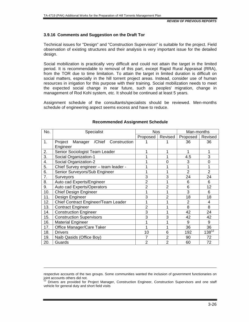
TA-4719 (PAK) Additional Works for the Preparation of Hill Torrents Management Plan
REVIEW OF PREVIOUS REPORTS
3-26
3.9.16 Comments and Suggestion on the Draft Tor Technical issues for "Design" and "Construction Supervision" is suitable for the project. Field observation of existing structures and their analysis is very important issue for the detailed design. Social mobilization is practically very difficult and could not attain the target in the limited period. It is recommendable to removal of this part, except Rapid Rural Appraisal (RRA), from the TOR due to time limitation. To attain the target in limited duration is difficult on social matters, especially in the hill torrent project areas. Instead, consider use of human resources in irrigation for this purpose with their training. Social mobilization needs to meet the expected social change in near future, such as peoples' migration, change in management of Rod Kohi system, etc. It should be continued at least 5 years. Assignment schedule of the consultants/specialists should be reviewed. Men-months schedule of engineering aspect seems excess and have to reduce.
Recommended Assignment Schedule
Nos Man-months No. Specialist Proposed Revised Proposed Revised
1. Project Manager /Chief Construction Engineer
1 1 36 36
2. Senior Sociologist Team Leader 1 1 1 1 3. Social Organization-1 1 1 4.5 3 4. Social Organization-2 1 0 3 0 5. Chief Survey engineer – team leader - 1 1 1 1 6. Senior Surveyors/Sub Engineer 1 1 2 2 7. Surveyors 3 3 24 24 8. Auto cad Experts/Engineer 2 1 6 6 9. Auto cad Experts/Operators 2 2 6 12 10. Chief Design Engineer 1 1 3 6 11. Design Engineer 3 2 18 18 12. Chief Contract Engineer/Team Leader 1 1 2 4 13. Contract Engineer 2 1 8 8 14. Construction Engineer 3 1 42 24 15. Construction Supervisors 3 3 42 42 16. Material Engineer 1 1 9 9 17. Office Manager/Care Taker 1 1 36 36 18. Drivers 10 6 192 13812 19. Naib Qasids (Office Boy) 7 2 90 72 20. Guards 2 2 60 72 respective accounts of the two groups. Some communities wanted the inclusion of government functionaries on joint accounts others did not. 12 Drivers are provided for Project Manager, Construction Engineer, Construction Supervisors and one staff vehicle for general duty and short field visits

TA-4719 (PAK) Additional Works for the Preparation of Hill Torrents Management Plan
REVIEW OF PREVIOUS REPORTS
3-27
3.10 HYDROLOGICAL ANALYSIS Comments on the view points raised by reviewing consultants on hydrology has been finalized by Dr Nadeem, a team member of TA Consultants and added in this report in Section-4.
TA-4719 (PAK) Additional Works for the Preparation of Hill Torrents Management Plan
HYDROLOGICAL ASSESSMENT REPORT
Table of Contents
4. HYDROLOGICAL ASSESSMENT REPORT................................................................4-1 4.1 INTRODUCTION ..................................................................................................4-1
4.1.1 Background ......................................................................................................4-1 4.1.2 The Project Area...............................................................................................4-3
4.2 OBJECTIVES .......................................................................................................4-3 4.3 REVIEW OF THE FEASIBILITY STUDY..............................................................4-3
4.3.1 Review Findings of Dr. Terry Heiler..................................................................4-5 4.3.2 Review Findings of Mr. Yoichi Kishi..................................................................4-5 4.3.3 Comments on Previous Reviews......................................................................4-6
4.4 DATA AVAILABILITY ...........................................................................................4-6 4.4.1 Rainfall Data .....................................................................................................4-7 4.4.2 Stream Flow Data .............................................................................................4-8
4.5 CATCHMENT CHARACTERISTICS ....................................................................4-9 4.5.1 2.5.1 Soil Cover Data .......................................................................................4-9 4.5.2 Land Use Data................................................................................................4-10
4.6 REVIEW OF METHODOLOGY ..........................................................................4-10 4.6.1 Peak Runoff Estimates from Stream Flow Data .............................................4-10 4.6.2 Peak Runoffs and Volume from SCS method ................................................4-11 4.6.3 Frequency Analyses of Rainfall Data..............................................................4-11 4.6.4 Catchment Characteristics and Land use.......................................................4-12 4.6.5 Moisture Conditions ........................................................................................4-13 4.6.6 Time of Concentration ....................................................................................4-13 4.6.7 Peak Runoff ....................................................................................................4-13
4.7 RELIABILITY OF ESTIMATES...........................................................................4-15 4.7.1 Peak Flows .....................................................................................................4-15 4.7.2 Direct Runoff Volume......................................................................................4-16
4.8 REVIEW OF DESIGN OF DIVERSION STRUCTURES ....................................4-17 4.8.1 Design Criteria ................................................................................................4-17 4.8.2 Construction Materials ....................................................................................4-17
4.9 REVIEW OF FLOW DISTRIBUTION AND CHANNEL ROUTING .....................4-18 4.10 CONCLUSIONS .................................................................................................4-18 4.11 PHOTOGRAPHS................................................................................................4-19
TA-4719 (PAK) Additional Works for the Preparation of Hill Torrents Management Plan
HYDROLOGICAL ASSESSMENT REPORT
4-1
4. HYDROLOGICAL ASSESSMENT REPORT 4.1 INTRODUCTION About 200 hill torrents of which 13 are major originate from Suleman Range and flow through DG Khan and Rajanpur district towards River Indus. Major hill torrents affecting the CRBC route in DG Khan area are:
• Kaura • Vehowa • Sanghar • Sori lund
Torrent means fast flowing water; the term is primarily used for a steep mountainous stream generating quick runoff. A large number of hill torrents join River Indus on its right bank causing major disruption to the infrastructure projects in the area like roads, highways, canals, etc. The catchment size of these torrents vary from small to medium and can generate peak flows of the magnitude ranging from a few thousand cusecs to a few hundred thousand cusecs. The basic characteristics of hill torrents are;
• large variation in peak flows • high sediment load • flow in the fan area is not stable due to moving channel beds.
These characteristics make the Management of Hill Torrents more challenging. The options available to tame a torrent are limited. Different structural and non structural measures are proposed in the different studies to control and to improve the use of water from torrents and its economic viability. Primary The main objective of the present Hill Torrents Management Project is to reduce the flood damages to CRBC from the hill torrent flows. Beside improving the flow conditions in the torrents across the fan areas in order to minimize damage to infrastructure due to flooding and to utilize the flood water for enhancing irrigated agriculture. Asian Development Bank has contracted Dr. Muhammad Nadeem to review a set of reports and previous studies available on the subject of Hill Torrent Management, in general, and more specifically related to DG Khan District (For detailed TOR, refer Annex 1). The review is a part of the detailed design of the Project in the area of CRBC (Stage III) to minimize losses due to flood damages caused by these Hill Torrents and to enhance the utilization of water for irrigated agriculture. This chapter covers/reviews the recommendations of the previous reports and identifies possible improvements in the hydrological analyses, accordingly. 4.1.1 Background About 13 major and minor hill torrents cross the CRBC alignment in the DG Khan area (Table 1). In the feasibility study it was established that runoff from most of these torrents is being managed by the farmers and the water is being utilized by locals for irrigation therefore no intervention is required in these torrents. Surface water hydrology of the project area is controlled by the four major hill torrents mentioned above, flowing mainly from west to south east directions. Flow in these torrents is not perennial except a small flow in Sanghar nullah.
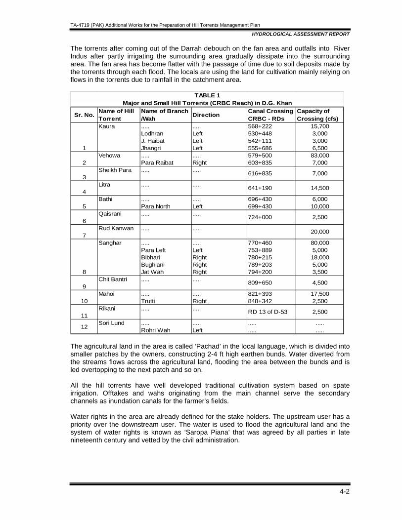
TA-4719 (PAK) Additional Works for the Preparation of Hill Torrents Management Plan
HYDROLOGICAL ASSESSMENT REPORT
4-2
The torrents after coming out of the Darrah debouch on the fan area and outfalls into River Indus after partly irrigating the surrounding area gradually dissipate into the surrounding area. The fan area has become flatter with the passage of time due to soil deposits made by the torrents through each flood. The locals are using the land for cultivation mainly relying on flows in the torrents due to rainfall in the catchment area.
Sr. No. Name of Hill Torrent
Name of Branch/Wah Direction Canal Crossing
CRBC - RDsCapacity ofCrossing (cfs)
1
Kaura .....LodhranJ. HaibatJhangri
.....LeftLeftLeft
568+222530+448542+111555+686
15,7003,0003,0006,500
2Vehowa .....
Para Raibat .....Right
579+500603+835
83,0007,000
3Sheikh Para ..... ..... 616+835 7,000
4Litra ..... ..... 641+190 14,500
5Bathi .....
Para North .....Left
696+430699+430
6,00010,000
6Qaisrani ..... ..... 724+000 2,500
7Rud Kanwan ..... ..... 20,000
8
Sanghar .....Para LeftBibhariBughlaniJat Wah
.....LeftRightRight Right
770+460753+889780+215789+203794+200
80,0005,00018,0005,0003,500
9Chit Bantri ..... ..... 809+650 4,500
10Mahoi .....
Trutti.....Right
821+393848+342
17,5002,500
11Rikani ..... ..... RD 13 of D-53 2,500
12 Sori Lund .....Rohri Wah
.....Left
.....
...............
TABLE 1Major and Small Hill Torrents (CRBC Reach) in D.G. Khan
The agricultural land in the area is called ‘Pachad’ in the local language, which is divided into smaller patches by the owners, constructing 2-4 ft high earthen bunds. Water diverted from the streams flows across the agricultural land, flooding the area between the bunds and is led overtopping to the next patch and so on. All the hill torrents have well developed traditional cultivation system based on spate irrigation. Offtakes and wahs originating from the main channel serve the secondary channels as inundation canals for the farmer’s fields. Water rights in the area are already defined for the stake holders. The upstream user has a priority over the downstream user. The water is used to flood the agricultural land and the system of water rights is known as ‘Saropa Piana’ that was agreed by all parties in late nineteenth century and vetted by the civil administration.
TA-4719 (PAK) Additional Works for the Preparation of Hill Torrents Management Plan
HYDROLOGICAL ASSESSMENT REPORT
4-3
4.1.2 The Project Area The project area is located in semi arid subtropical continental monsoon regions characterized by two distinct seasons ie summer and winter. Mean annual precipitation in the area is around 350 mm (13.8 inches). Most of the rainfall takes place during the months of June to September under the influence of the monsoon rains. Mean annual summer day time temperature in the project area is 34 C. The hottest month is June and the mean of maximum day time temperature is 41.5 C whereas the minimum temperature in observed in January is 4.2 C. 4.2 OBJECTIVES This report is primarily aimed at:
• Reviewing the Hydrological Analyses carried out in the feasibility study for suitability of the approach and possible improvements which can be incorporated in the analyses to make it more reliable.
• Review of similar work carried out on other projects like Kaha Hill Torrent, etc. • Review of the design aspects of the structures proposed for the management of
runoffs from hill torrents before joining River Indus. • Producing a chapter on Hydrological analyses for the Final design report on Hill
Torrents Management Plan in CRBC Area. 4.3 REVIEW OF THE FEASIBILITY STUDY The following studies and reports have been reviewed on the subject:
• Hill Torrents Master Feasibility Study by Nespak, 1996 • Performance Evaluation of Kaha Hill Torrent Report, Kachhi Canal Consultants, 2004 • Feasibility Report on Hill Torrents Management Plan in CRBC Area in DG Khan
District by Nespak, 2005 • Expert review of the above reports by Dr. Terry Heiler, July 2005 • Expert review of the above reports by Mr. Yoichi Kishi, Aug 2005
The Hydrological analyses for the above mentioned studies are primarily influenced by the master feasibility report of 1996 on Management of Hill torrents produced by M/s Nespak that enumerated all the hill torrents of Pakistan and their basic characteristics. The report gives a comprehensive account of possible interventions to tame the torrential behavior of the streams. As the stream flow measurement data on most of these torrents is missing, synthetic method of SCS unit hydrograph was used to convert rainfall data to peak runoffs and subsequent frequency analysis was carried out on the peak runoff data to estimate design discharges of know return periods. Nespak (2005) carried out the feasibility study to establish water potential of the streams crossing the CRBC alignment in DG Khan area and to identify possible structural interventions to divert the flows to the agricultural lands for irrigation purposes thus reducing the magnitude of flow reaching the structures crossing CRBC. These interventions are planned to cut down flood magnitude and resulting losses along the CRBC alignment and improve agricultural production from the area as well. The feasibility report contains detailed economic analyses carried out to establish economic viability of the management schemes. The following different management options were considered to select the best of the lot. These were:

TA-4719 (PAK) Additional Works for the Preparation of Hill Torrents Management Plan
HYDROLOGICAL ASSESSMENT REPORT
4-4
• construction of storage dams • construction of delay action dams • diversion of excess flows to adjacent smaller hill torrents • diversion of excess flows to Non Haqooq channels • diversion of excess flows to evaporation ponds • dispersion of flows through diversion/distribution structures
The last option ‘dispersion of flows through diversion/distribution structures’ was considered as the most suitable due to its flexibility in supporting the old system of water rights of Saropa Paina and also its reliability which has been established through an executed project and a subsequent a pilot study of Kaha Hill Torrent Management Project; leading a basis for the proposal. The methodology and findings of the Performance Evaluation Report on Kaha Hill Torrent Project are also reviewed as a part of this report and compiled separately as Annex-1 of this report. The hydrological analyses were carried out in the following steps;
• frequency analyses of peak annual stream flow data (if available) to determine the magnitude of runoff in relation to a known return period,
• frequency analyses of maximum 24 hr rainfall data of the catchment, if actual stream flow records are not available, to determine the magnitudes of 24 hr rainfall of known frequencies / return periods,
• generation of missing peak runoff values of the catchments for the corresponding return periods through SCS unit hydrograph techniques using the catchment characteristics.
The frequency analyses of annual observed peak flows and maximum 24-hr rainfall on the available data for the catchments have been carried out. The data sets were sorted in descending order and subsequently plotted on Gumbel probability paper to generate a curve of extreme value distribution (EV1). The approach is commonly used in such situations where stream flow data is either missing or unreliable. The SCS unit hydrograph method is relatively more reliable than most of the other methods of generating synthetic runoff from rainfall data. It also provides computation of volumetric runoff from the catchments to assess the total potential runoff from the catchment. A lot of effort has already been made by different experts/reviewers to analyze and suggest improvements on the approach and methodology of the feasibility report. To sum up their findings and suggestions the following section recollects the main findings of these reviews related to hydrological analysis and proposed methodology of Hill Torrent management only and readers are referred to consult the main reports for further details, if required on the subject. Work of two main reviewers has been included in this report;
• review by Dr. Terry Heiler, July 2005 • review by Yoichi Kishi, August 2005
Both the experts have produced detailed reviews on nearly every aspect of the feasibility report and contributed positively, however, the present report will primarily concentrate on their comments related to Chapter 4 on Hydrological Evaluation and Chapter 5 on the Management Options of the Hill Torrents.
TA-4719 (PAK) Additional Works for the Preparation of Hill Torrents Management Plan
HYDROLOGICAL ASSESSMENT REPORT
4-5
4.3.1 Review Findings of Dr. Terry Heiler
• He highlighted the limitations of data availability and reliability issues and agrees with the hydrological analyses report as reasonable, however the uncertainties need to be recognized in the report.
• The flood frequency estimates are considered to be reasonable. • The peak flow estimates by SCSUH method and flood frequency analyses approach
for 25 year return period compare well with the observed values however; he feels that the comparison is not meaningful.
• The estimates of monthly runoff volumes appear to be too high therefore in his opinion the SCS method used may not be suitable for this purpose. This has implications on the reliability of economic evaluation of the project. He recommends using water balance approach for each catchment using daily rainfall and evaporation loss data, appropriate soil moisture conditions, etc. to determine the magnitude of runoff.
• The storage dam option was recognized as not workable due to high sediment loads inflow in the streams that would impinge upon the local water distribution system of Saropa Piana which will affect the interest of the community for the project. The option should be revisited once watershed degradation has been stopped through special watershed management interventions to reduce the sediment load.
• The water from storage due to its reduced sediment load may have adverse effect on the Pachad area creating a new management problem.
• Highlighted weaknesses of the feasibility report in terms of insufficient information regarding redistribution of flows in the project area to check the computations.
• Reviewed all the management options considered in the report for all the individual hill torrents and agreed with the recommendations of the report in most cases.
4.3.2 Review Findings of Mr. Yoichi Kishi Mr. Kishi recommends the use of some alternate simpler and reliable approach for estimation of peak flows in place of SCS method, improvements in design of structures to take into account the previous experience, a comprehensive survey of local problems, flood protection bunds around the villages, etc. He also recommended the development of a comprehensive strategy for the Management of Hill torrents through
• a panel of experts on the subject, • proper maintenance strategy for the management structures by the irrigation
department, • adoption of watershed management techniques to minimize erosion and
sedimentation, • problem solving in consultation with the stake holders, • adequate provision of funds for hill torrent management directly from the Federal
Government as well as from the donor agencies. The major comments related to hydrological studies are as follows:
• concern on reliability of runoff observations and estimates • appropriateness of using the SCS method for larger catchments • look for some simplified method other than SCS based on water balance of the
rainfall over a catchment.

TA-4719 (PAK) Additional Works for the Preparation of Hill Torrents Management Plan
HYDROLOGICAL ASSESSMENT REPORT
4-6
His review is critical to nearly everything and suggests general overall improvement. He has long experience working in the area and has excellent exposure to local conditions. Therefore, his suggestions have a lot of weight. He has reviewed all the structures, their location and designs giving useful suggestions. 4.3.3 Comments on Previous Reviews The SCS method, although developed on small catchments, has built into it all the factors contributing to magnitude and volume of runoff and it does take into account water balance of inflows and outflows into/from a catchment as suggested by the previous reviewers. The use of required parameters is slightly tedious however it does not give totally ridiculous results even with its simplified approach. Therefore, the methodology based on the SCS method can be applied to catchment areas where reliable runoff data is not available. As far as the overall hydrological analyses is concerned, both reviewers are rather restricted to over estimation of available runoff and recommends to consult the local people in order to check the reliability of flow estimates. In my opinion, the individual observations are only useful in understanding the river behavior or checking the depth of flow in the channel. As in the present case, the magnitudes of runoff being calculated are in the range of 50-100,000 cs, therefore, it will be very difficult to judge it by visual observation to the level of accuracy say +- 10,000 cs. 4.4 DATA AVAILABILITY A list of 15 rainfall gauging stations and 4 stream flow gauging stations are provided in the report by Nespak in Table 4.2 which is reproduced here. Out of 15, six are located in the project area and the remaining are outside. Most of the stations are maintained by the IPD Punjab. Barkhan station which is being maintained by Pakistan Met Department is located southwest of the project area and has a record for around 100 years. Most of the remaining stations have a short length of record of less than15 years. Isohytal map of the annual rainfall is shown in Figure 4.2 of the feasibility report.
deg min deg min Monthly Daily
1 Kaura at Darrah - 31 15 70 25 IRR (P) 1958-64,2 Vehowa at Darrah - 31 10 70 25 IRR (P) 1958-64,3 Sanghar at Darrah - 30 43 70 33 IRR (P) 1958-64,4 Sori Lund at Dharrh - 30 27 70 34 IRR (P) 1959-64,
1 Bagu Bun** Vidore 31 2 70 14 IRR (P) 1980 - 90 1977 - 90
2 Bandukh** Vidore 30 9 70 13 IRR (P) 1976 - 90 1976 - 90
3 Beria** Vidore 30 8 70 10 IRR (P) 1975 - 90 1975 - 90
4 Barkhan** Kaha 29 53 69 43 PMD - 1975 - 82
5 Fort Munro(Khar)** - 29 56 69 58 WAPDA - 1966 - 70 & 1975 - 90
6 Kala Mar Sanghar 30 46 70 17 IRR (P) 1975 - 90 1975 - 90
7 Kohlu** - 29 55 69 15 WAPDA - -
8 Mard Bun Vidore 30 18 70 7 IRR (P) 1975 - 90 1975 - 90
9 Musakhel Sanghar 30 42 69 50 IRR (B) - -
10 Nelo Har Vehowa 31 8 70 21 IRR (P) 1976 - 90 1976 - 90
11 Nandi Ghar Sori Lund 30 19 70 21 IRR (P) 1975 - 90 1975 - 90
12 Nohkandi Ghar Sanghar 30 28 70 18 IRR (P) 1975 - 90 1975 - 9013 Sangha Sluf** Vidore 30 16 70 15 IRR (P) 1975 - 90 1975 - 90
14 Taunsa - 30 42 70 38 WAPDA - -15 Zinda Pir Sori Lund 30 25 70 30 IRR (P) - 1975 - 89
Table 2Inventory of Hydro - Meteorological Stations
Available Date
A- INVENTORY OF STREAM GUAGE STATIONS
B- INVENTORY OF RAIN GUAGE STATIONS
1975 - 901975 - 90
-1975 - 89
1975 - 90
1911 - 50
1976 - 90
1975 - 90
1911 - 881966 - 70 & 1975 - 90
1975 - 901921 - 50 & 1962 - 74
1977 - 90
1976 - 90
1975 - 90
1975-89, 94,01, 02 & 031975-87, 94,01, 02 & 031975-89, 94,01, 02 & 031975-89, 94,01, 02 & 03
LongitudesAgency One Day
Max.
Sr.No.
Torrent BasinName of Station
Latitudes
Table 4.2 of feasibility report
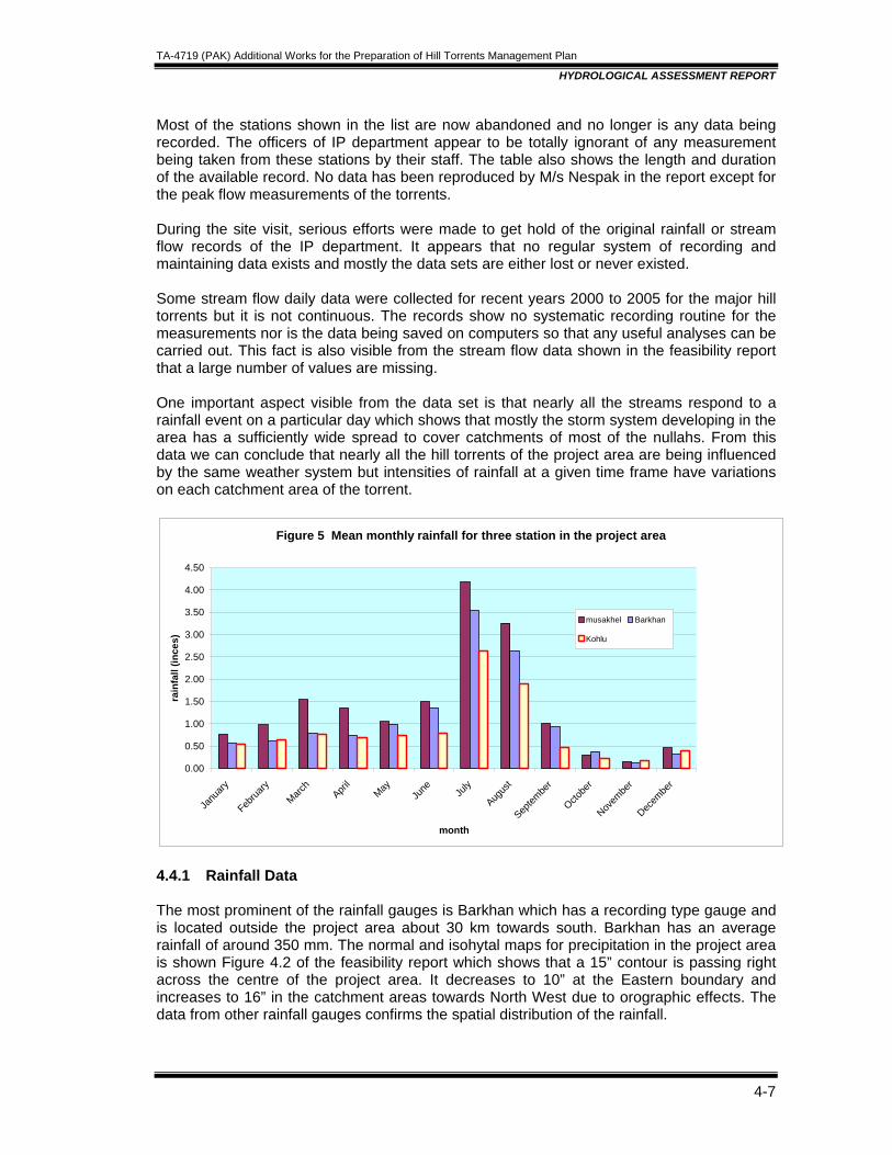
TA-4719 (PAK) Additional Works for the Preparation of Hill Torrents Management Plan
HYDROLOGICAL ASSESSMENT REPORT
4-7
Most of the stations shown in the list are now abandoned and no longer is any data being recorded. The officers of IP department appear to be totally ignorant of any measurement being taken from these stations by their staff. The table also shows the length and duration of the available record. No data has been reproduced by M/s Nespak in the report except for the peak flow measurements of the torrents. During the site visit, serious efforts were made to get hold of the original rainfall or stream flow records of the IP department. It appears that no regular system of recording and maintaining data exists and mostly the data sets are either lost or never existed. Some stream flow daily data were collected for recent years 2000 to 2005 for the major hill torrents but it is not continuous. The records show no systematic recording routine for the measurements nor is the data being saved on computers so that any useful analyses can be carried out. This fact is also visible from the stream flow data shown in the feasibility report that a large number of values are missing. One important aspect visible from the data set is that nearly all the streams respond to a rainfall event on a particular day which shows that mostly the storm system developing in the area has a sufficiently wide spread to cover catchments of most of the nullahs. From this data we can conclude that nearly all the hill torrents of the project area are being influenced by the same weather system but intensities of rainfall at a given time frame have variations on each catchment area of the torrent.
Figure 5 Mean monthly rainfall for three station in the project area
0.00
0.50
1.00
1.50
2.00
2.50
3.00
3.50
4.00
4.50
Janu
ary
Februa
ryMarc
hApri
lMay
June Ju
ly
Augus
t
Septem
ber
Octobe
r
Novem
ber
Decem
ber
month
rain
fall
(ince
s)
musakhel Barkhan
Kohlu
4.4.1 Rainfall Data The most prominent of the rainfall gauges is Barkhan which has a recording type gauge and is located outside the project area about 30 km towards south. Barkhan has an average rainfall of around 350 mm. The normal and isohytal maps for precipitation in the project area is shown Figure 4.2 of the feasibility report which shows that a 15” contour is passing right across the centre of the project area. It decreases to 10” at the Eastern boundary and increases to 16” in the catchment areas towards North West due to orographic effects. The data from other rainfall gauges confirms the spatial distribution of the rainfall.

TA-4719 (PAK) Additional Works for the Preparation of Hill Torrents Management Plan
HYDROLOGICAL ASSESSMENT REPORT
4-8
As long-term data for the other stations are not available, therefore in order to estimate the volume of runoff, rainfall events of known return periods, only Barkhan dataset is used. Time distribution of rainfall within 24 hr is not discussed in the report as most of the data is observed from non-recording gauges. In the absence of such data, rainfall intensity distribution pattern within a 24 hr storm can be assumed as SCS Type II distribution pattern. 4.4.2 Stream Flow Data Stream flow data for limited durations is available for the four nullahs ie Kaura, Vehowa, Sanghar and Sori lund, as recorded by IPD. However, reliability of the data is a major limitation as no methodology of measurement is discussed in the report. These data sets are used to carryout frequency analyses to determine the magnitude of peak flows of known return periods to select suitable design discharges for the diversion structures. The data availability is in packets like for Kaura it is available from 1958 to 64, 1975 to 89, 1994 to 2003. A detailed account of this availability is given in Table 4.2 of the feasibility report. The quality of flood measurement data obtained from Darras is also not so good as no quality assurance procedures are adopted; however, it does give a feel of the magnitude of flows coming out of Darrahs for the four streams. Where the stream flow data is not available, rainfall data was used to synthesize peak discharges corresponding to rainfalls of known probability.
Figure 6 Peak Annual Discharges at Darra for Sanghar Nullah
0.0
20000.0
40000.0
60000.0
80000.0
100000.0
120000.0
140000.0
1958
1960
1962
1964
1966
1968
1970
1972
1974
1976
1978
1980
1982
1984
1986
1988
1990
1992
1994
1996
1998
2000
2002
Year
Dis
char
ge, c
usec
s Generated Peaks
Generated Peaks
As the stream flow data available for the catchments has a large number of values missing, these were synthesized from the rainfall data to complete the data set. Subsequently, frequency analysis was used on the combined dataset by plotting on Gumbel probability paper to estimate the peak floods of know probability/return period. The peak values of the combined data set for Sanghar nullah are plotted in Fig 6. It shows that the generated values using the rainfall data for both the periods ie 1964 to 1975 and 1990 to 2000 remains very low as compared to the actual flood data observed for the period of 1975 to 1989. This is indicative of the limitations of the generated values that are used to carryout frequency analyses. The average values of the peak discharges can be divided into
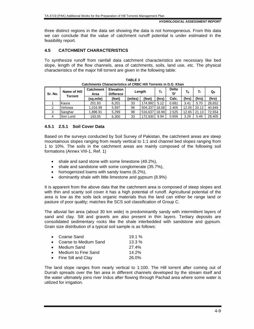
TA-4719 (PAK) Additional Works for the Preparation of Hill Torrents Management Plan
HYDROLOGICAL ASSESSMENT REPORT
4-9
three distinct regions in the data set showing the data is not homogeneous. From this data we can conclude that the value of catchment runoff potential is under estimated in the feasibility report. 4.5 CATCHMENT CHARACTERISTICS To synthesize runoff from rainfall data catchment characteristics are necessary like bed slope, length of the flow channels, area of catchments, soils, land use, etc. The physical characteristics of the major hill torrent are given in the following table:
CatchmentArea
Elevation Differece Tc
Delta'D' Tp Tr Qp
(sq.mile) (feet) (miles) (feet) (hrs) Calc. (hrs) (hrs) (hrs)1 Kaura 201.93 6,201 33 174,992 5.12 0.681 3.41 5.70 28,6522 Vehowa 1,016.99 5,597 96 504,337 18.08 2.405 12.05 20.12 40,8493 Sanghar 1,896.91 5,299 98 516,637 18.99 2.525 12.65 21.13 72,5544 Sori Lund 193.05 6,300 33 172,930 9.94 0.656 3.29 5.49 28,405
TABLE 3
Sr. No. Name of Hill Torrent
Length
Catchments Characteristics of CRBC Hill Torrents in D.G. Khan
4.5.1 2.5.1 Soil Cover Data Based on the surveys conducted by Soil Survey of Pakistan, the catchment areas are steep mountainous slopes ranging from nearly vertical to 1:1 and channel bed slopes ranging from 1 to 10%. The soils in the catchment areas are mainly composed of the following soil formations (Annex VIII-1, Ref. 1)
• shale and sand stone with some limestone (49.2%), • shale and sandstone with some conglomerate (35.7%), • homogenized loams with sandy loams (6.2%), • dominantly shale with little limestone and gypsum (8.9%)
It is apparent from the above data that the catchment area is composed of steep slopes and with thin and scanty soil cover it has a high potential of runoff. Agricultural potential of the area is low as the soils lack organic materials thus the land can either be range land or pasture of poor quality; matches the SCS soil classification of Group C. The alluvial fan area (about 30 km wide) is predominantly sandy with intermittent layers of sand and clay. Silt and gravels are also present in thin layers. Tertiary deposits are consolidated sedimentary rocks like the shale interbedded with sandstone and gypsum. Grain size distribution of a typical soil sample is as follows:
• Coarse Sand 19.1 % • Coarse to Medium Sand 13.3 % • Medium Sand 27.4% • Medium to Fine Sand 14.2% • Fine Silt and Clay 26.0%
The land slope ranges from nearly vertical to 1:100. The Hill torrent after coming out of Durrah spreads over the fan area in different channels developed by the stream itself and the water ultimately joins river Indus after flowing through Pachad area where some water is utilized for irrigation.
TA-4719 (PAK) Additional Works for the Preparation of Hill Torrents Management Plan
HYDROLOGICAL ASSESSMENT REPORT
4-10
4.5.2 Land Use Data The upper catchment area is mainly rangeland and land use to agriculture is less than 3% which has a nominal effect on the runoff magnitudes and therefore agricultural development in catchment areas has a low potential and indicative of the poor results in that area in response to the project interventions as visible in Kaha Torrent Management Project. In the Pachad area, 12% of the total cultivable area is irrigated which is below subsistence level. Most of the water waste by running off through hill torrent streams besides causing damage to the infrastructure. Land potential is highly under utilized. The soils are laminated and weakly structured, farming methods are traditional and water diversion methods are generally tedious and somewhat vulnerable unreliable. Economy of the area depends on agriculture and livestock. Cropping pattern largely depends on the availability of water and mode of irrigation. Wheat, millets and oilseeds are the main crops. Livestock is the major source of income, includes cattle, buffalo, goat and sheep. During the field visits, it was observed that the soil of the Pachad area varies from coarse silt to fine sand. Due to presence of a thick soil layer, thickness varying from 150 to 200 ft, the area has a medium runoff potential below Darra. Group B has been selected as the representative soil cover. The bed slopes in the Pachad area ranges from 1:100 to 1:250. Initial abstraction through the area is high due to presence of edge bunds constructed to irrigate the land. 4.6 REVIEW OF METHODOLOGY Standard procedure has been adopted to estimate the magnitude of design flood 5, 10, 25 and 50 year return periods. In order to ascertain the safety of structures against damage from floods, frequency analysis of annual maximum daily flows were carried out. To estimate the runoff of known return periods, the available stream flow data has been used which is the most reliable method for estimating design discharge for structure of a known probability of occurrence. However, the SCS synthetic hydrograph analysis is sensitive to a number of parameters; Catchment characteristics, soil types, land use, vegetative cover, hydrologic conditions, layout of the drainage channels, slope, etc. Storm characteristics, intensity, duration, time variation, sequence of the events, etc. Therefore, these parameters are reviewed in the following section to build confidence in the estimates 4.6.1 Peak Runoff Estimates from Stream Flow Data On the available stream flow data of the streams at Darrah, Gumbel Distribution for extreme events was used to determine the design discharge of each nullah. The annual maximum daily observed flows recorded for the streams are arranged in descending order as shown in Table 4.3 to 4.6 of the feasibility report. In Gumbel’s Extreme Value Distribution (EV-1)1, the frequency/return period (T) of any event (x) is given as: 1/T = 1 - F(x) = 1 - exp {- exp [- α (x - u)]}
1 Introduction to Hydrology (2nd ed.) by Viessman, W., J.W. Knapp, G.L. Lewis, and T.E. Harbaugh. Harper and Row Publishers, New York, pp:178-184.
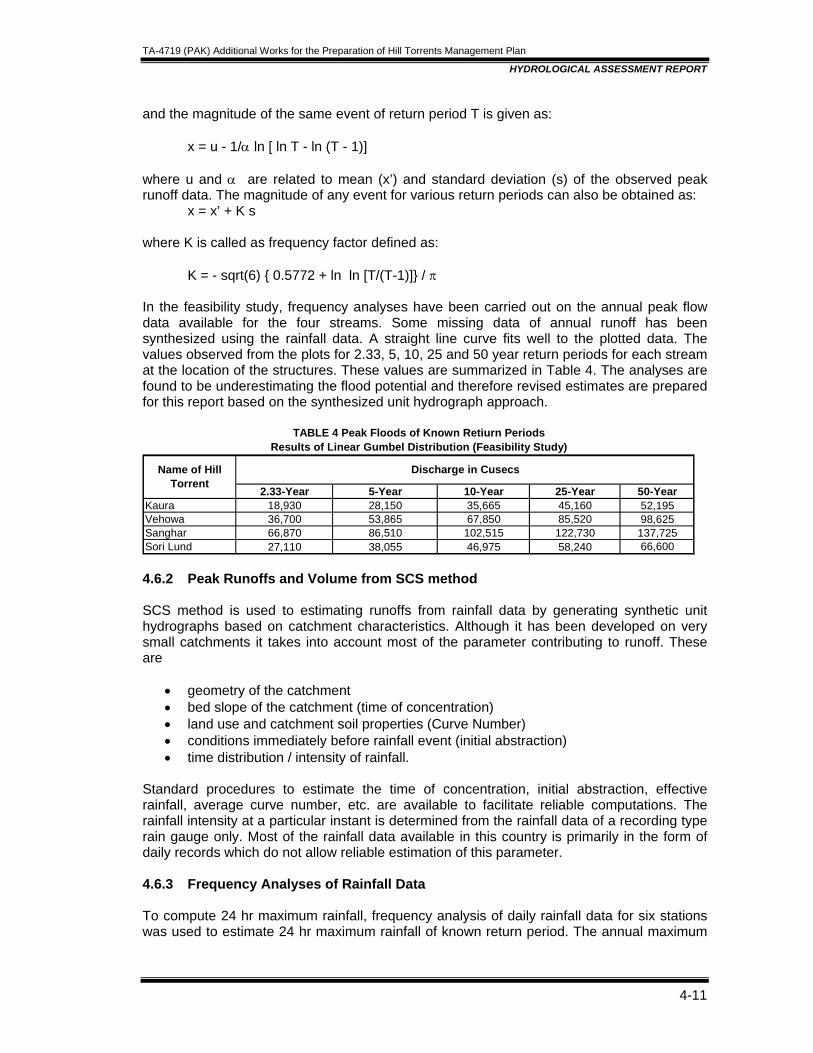
TA-4719 (PAK) Additional Works for the Preparation of Hill Torrents Management Plan
HYDROLOGICAL ASSESSMENT REPORT
4-11
and the magnitude of the same event of return period T is given as: x = u - 1/α ln [ ln T - ln (T - 1)] where u and α are related to mean (x’) and standard deviation (s) of the observed peak runoff data. The magnitude of any event for various return periods can also be obtained as: x = x’ + K s where K is called as frequency factor defined as: K = - sqrt(6) { 0.5772 + ln ln [T/(T-1)]} / π In the feasibility study, frequency analyses have been carried out on the annual peak flow data available for the four streams. Some missing data of annual runoff has been synthesized using the rainfall data. A straight line curve fits well to the plotted data. The values observed from the plots for 2.33, 5, 10, 25 and 50 year return periods for each stream at the location of the structures. These values are summarized in Table 4. The analyses are found to be underestimating the flood potential and therefore revised estimates are prepared for this report based on the synthesized unit hydrograph approach.
2.33-Year 5-Year 10-Year 25-Year 50-YearKaura 18,930 28,150 35,665 45,160 52,195Vehowa 36,700 53,865 67,850 85,520 98,625Sanghar 66,870 86,510 102,515 122,730 137,725Sori Lund 27,110 38,055 46,975 58,240 66,600
Name of Hill Torrent
Discharge in Cusecs
Results of Linear Gumbel Distribution (Feasibility Study)TABLE 4 Peak Floods of Known Retiurn Periods
4.6.2 Peak Runoffs and Volume from SCS method SCS method is used to estimating runoffs from rainfall data by generating synthetic unit hydrographs based on catchment characteristics. Although it has been developed on very small catchments it takes into account most of the parameter contributing to runoff. These are
• geometry of the catchment • bed slope of the catchment (time of concentration) • land use and catchment soil properties (Curve Number) • conditions immediately before rainfall event (initial abstraction) • time distribution / intensity of rainfall.
Standard procedures to estimate the time of concentration, initial abstraction, effective rainfall, average curve number, etc. are available to facilitate reliable computations. The rainfall intensity at a particular instant is determined from the rainfall data of a recording type rain gauge only. Most of the rainfall data available in this country is primarily in the form of daily records which do not allow reliable estimation of this parameter. 4.6.3 Frequency Analyses of Rainfall Data To compute 24 hr maximum rainfall, frequency analysis of daily rainfall data for six stations was used to estimate 24 hr maximum rainfall of known return period. The annual maximum
TA-4719 (PAK) Additional Works for the Preparation of Hill Torrents Management Plan
HYDROLOGICAL ASSESSMENT REPORT
4-12
24 hr rainfall values of 6 stations were plotted on Gumbel’s probability paper and an average line was drawn to get 2.33, 5, 10 and 25 year values of rainfall (refer Table on 4-10 of Ref 1). Most of the rainfall stations data sets are for 15 years only, therefore 15 values of each data set are available, however the plot shows 9 values and the return period of beyond 100 years is shown to be plotted with the data sets indicating that a dataset of 100 years or more has been used. There appears to be some discrepancy on the data set or plotting position calculated for this case. The data collected at the mithavan hill torrent met station was reviewed and found to be unreliable and not very useful for the analyses especially the rainfall data. The approach is very approximate and has limitations. The averaging means that each station represents a uniform area in the catchment. A more accurate approach would be to use weighted average of each station. The following paragraphs describe the SCS method briefly and suitable choice of parameters is also discussed under the same heading. 4.6.4 Catchment Characteristics and Land use According to rate of infiltration, soils are classified as follows; Group A having characteristics of high infiltration rate even when thoroughly wetted.
Sandy or coarser soil lies in this class. Group B having moderate infiltration rates. The soils will be having moderate to fine
texture. Group C having low infiltration rate. This group consist of soil with layers impede
downward movement of water. Group D having very less infiltration rate. Clayey soils lie in this group. Types of land use and treatment are classified on a flood runoff-producing basis. Different land use / treatments tend to increase retention capacity of soils; thus reducing the flood runoff production scale. These classes help in the estimating the representative Curve Number (CN), which in turn is used in estimating direct runoff. The two classes identified in the previous section for the project areas are: - Catchment area Group C - Pachad area Group B The feasibility report does not specify the curve number used in the analyses. By trial and error it is estimated that a Curve number of 75 has been used in the analyses. From the land use characteristic, soil type and prevailing moisture conditions of the area, SCS method has introduced a parameter known as curve number. The parameter represents prevailing soil conditions in the catchment areas and other parameter affecting the runoff like the soil conditions, land use, initial moisture conditions, etc. The soil data of the catchment areas show that these are mainly composed of shale along with layers of sand stone and limes stone etc. With steep slope and minimal soil cover, the rock will generate large volumes of runoffs. The agricultural activity on the steep slopes is also minimal thus direct runoff potential is high. Based on this data, the curve number selection in the feasibility study appears to be on the conservative side ie the catchments have a greater runoff potential.
TA-4719 (PAK) Additional Works for the Preparation of Hill Torrents Management Plan
HYDROLOGICAL ASSESSMENT REPORT
4-13
The catchment area can be classified as ‘rangeland’ with limited grass cover. The corresponding curve number is estimated as 86 and for the Pachad areas is 74. 4.6.5 Moisture Conditions Initial moisture conditions of the soils can affect the magnitude of runoff from the catchment. This effect is incorporated by changing the CN in the analyses. In general, the greater the moisture present in soil the greater will be the runoff potential. Three soil moisture conditions AMC I, II and III conditions are classified according to low, moderate and high moisture present in soil prior to rainfall, respectively. In this connection, moderate moisture condition (AMCII) was assumed to estimate the runoff. The corresponding curve number for AMC I and AMC III conditions are
AMC II AMC I AMC III Pachad 74 57 91 Catchment 86 70 97 From the above values it is apparent that the runoff potential of the catchments is higher than anticipated in the feasibility report. 4.6.6 Time of Concentration Time of concentration signifies the time taken by the flow to reach the channel crossing from the farthest point of the catchment, and is a function of topographic features of the catchment like slope, geometry of the channel, etc. Time of concentration was calculated by using Kirpich Formula given by Tc = 0.95 L1.15 / (H)0.385 Where,
Tc = Flow concentration time in hours. L = Main stream length in km H = Difference of height at highest and exit in m Using effective rainfall against known return periods, peak runoff discharges were calculated for each structure. The average velocity resulting from the Kirpich formula time of concentration is in the range of 7-9 ft/s which appears to be realistic due to the fact that big boulders transported by the streams are present in large quantities at the downstream of Darras. Therefore, the application of Kirpich formula is applicable 4.6.7 Peak Runoff Peak runoffs from the catchments are calculated using the concept of unit hydrograph of the catchments of the hill torrents, the following formula is used to determine the magnitude of peak flow, Qp = Cd Q* A/ Tp Where Cd = Constant representing catchment shape and slope varies for 300 to 600 for flat areas to steep catchments, for normal conditions a value of 484 is recommended.
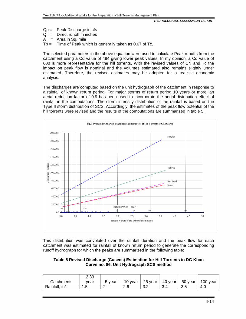
TA-4719 (PAK) Additional Works for the Preparation of Hill Torrents Management Plan
HYDROLOGICAL ASSESSMENT REPORT
4-14
Qp = Peak Discharge in cfs Q = Direct runoff in inches A = Area in Sq. mile Tp = Time of Peak which is generally taken as 0.67 of Tc. The selected parameters in the above equation were used to calculate Peak runoffs from the catchment using a Cd value of 484 giving lower peak values. In my opinion, a Cd value of 600 is more representative for the hill torrents. With the revised values of CN and Tc the impact on peak flow is nominal and the volumes estimated also remains slightly under estimated. Therefore, the revised estimates may be adopted for a realistic economic analysis. The discharges are computed based on the unit hydrograph of the catchment in response to a rainfall of known return period. For major storms of return period 10 years or more, an aerial reduction factor of 0.9 has been used to incorporate the aerial distribution effect of rainfall in the computations. The storm intensity distribution of the rainfall is based on the Type II storm distribution of SCS. Accordingly, the estimates of the peak flow potential of the hill torrents were revised and the results of the computations are summarized in table 5.
Fig.7 Probability Analysis of Annual Maximum Flow of Hill Torrents of CRBC area
0.0
20000.0
40000.0
60000.0
80000.0
100000.0
120000.0
140000.0
160000.0
180000.0
200000.0
0.0 0.5 1.0 1.5 2.0 2.5 3.0 3.5 4.0 4.5 5.0
Reduce Variate of the Extreme Distribution
Dis
char
ges (
cum
ces)
Return Period ( Year)5.75
100 50050252.33
Vehowa
Sanghar
Sori LundKaura
This distribution was convoluted over the rainfall duration and the peak flow for each catchment was estimated for rainfall of known return period to generate the corresponding runoff hydrograph for which the peaks are summarized in the following table:
Table 5 Revised Discharge (Cusecs) Estimation for Hill Torrents in DG Khan Curve no. 86, Unit Hydrograph SCS method
Catchments
2.33 year 5 year 10 year 25 year 40 year 50 year 100 year
Rainfall, in* 1.5 2 2.6 3.2 3.4 3.5 4.0
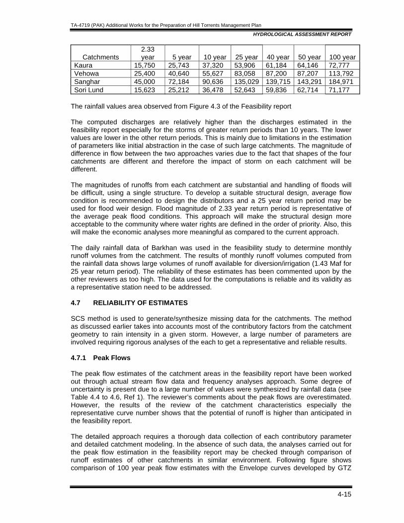
TA-4719 (PAK) Additional Works for the Preparation of Hill Torrents Management Plan
HYDROLOGICAL ASSESSMENT REPORT
4-15
Catchments
2.33 year 5 year 10 year 25 year 40 year 50 year 100 year
Kaura 15,750 25,743 37,320 53,906 61,184 64,146 72,777 Vehowa 25,400 40,640 55,627 83,058 87,200 87,207 113,792 Sanghar 45,000 72,184 90,636 135,029 139,715 143,291 184,971 Sori Lund 15,623 25,212 36,478 52,643 59,836 62,714 71,177
The rainfall values area observed from Figure 4.3 of the Feasibility report The computed discharges are relatively higher than the discharges estimated in the feasibility report especially for the storms of greater return periods than 10 years. The lower values are lower in the other return periods. This is mainly due to limitations in the estimation of parameters like initial abstraction in the case of such large catchments. The magnitude of difference in flow between the two approaches varies due to the fact that shapes of the four catchments are different and therefore the impact of storm on each catchment will be different. The magnitudes of runoffs from each catchment are substantial and handling of floods will be difficult, using a single structure. To develop a suitable structural design, average flow condition is recommended to design the distributors and a 25 year return period may be used for flood weir design. Flood magnitude of 2.33 year return period is representative of the average peak flood conditions. This approach will make the structural design more acceptable to the community where water rights are defined in the order of priority. Also, this will make the economic analyses more meaningful as compared to the current approach. The daily rainfall data of Barkhan was used in the feasibility study to determine monthly runoff volumes from the catchment. The results of monthly runoff volumes computed from the rainfall data shows large volumes of runoff available for diversion/irrigation (1.43 Maf for 25 year return period). The reliability of these estimates has been commented upon by the other reviewers as too high. The data used for the computations is reliable and its validity as a representative station need to be addressed. 4.7 RELIABILITY OF ESTIMATES SCS method is used to generate/synthesize missing data for the catchments. The method as discussed earlier takes into accounts most of the contributory factors from the catchment geometry to rain intensity in a given storm. However, a large number of parameters are involved requiring rigorous analyses of the each to get a representative and reliable results. 4.7.1 Peak Flows The peak flow estimates of the catchment areas in the feasibility report have been worked out through actual stream flow data and frequency analyses approach. Some degree of uncertainty is present due to a large number of values were synthesized by rainfall data (see Table 4.4 to 4.6, Ref 1). The reviewer’s comments about the peak flows are overestimated. However, the results of the review of the catchment characteristics especially the representative curve number shows that the potential of runoff is higher than anticipated in the feasibility report. The detailed approach requires a thorough data collection of each contributory parameter and detailed catchment modeling. In the absence of such data, the analyses carried out for the peak flow estimation in the feasibility report may be checked through comparison of runoff estimates of other catchments in similar environment. Following figure shows comparison of 100 year peak flow estimates with the Envelope curves developed by GTZ
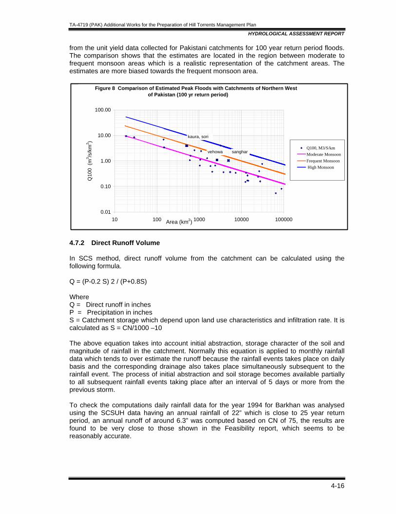
TA-4719 (PAK) Additional Works for the Preparation of Hill Torrents Management Plan
HYDROLOGICAL ASSESSMENT REPORT
4-16
from the unit yield data collected for Pakistani catchments for 100 year return period floods. The comparison shows that the estimates are located in the region between moderate to frequent monsoon areas which is a realistic representation of the catchment areas. The estimates are more biased towards the frequent monsoon area.
Figure 8 Comparison of Estimated Peak Floods with Catchments of Northern West of Pakistan (100 yr return period)
0.01
0.10
1.00
10.00
100.00
10 100 1000 10000 100000Area (km2)
Q10
0 (m
3 /s/k
m2 )
Q100, M3/S/kmModerate MonsoonFrequent Monsoon High Monsoon
sanghar
kaura, sori
vehowa
4.7.2 Direct Runoff Volume In SCS method, direct runoff volume from the catchment can be calculated using the following formula. Q = (P-0.2 S) 2 / (P+0.8S) Where Q = Direct runoff in inches P = Precipitation in inches S = Catchment storage which depend upon land use characteristics and infiltration rate. It is calculated as S = CN/1000 –10 The above equation takes into account initial abstraction, storage character of the soil and magnitude of rainfall in the catchment. Normally this equation is applied to monthly rainfall data which tends to over estimate the runoff because the rainfall events takes place on daily basis and the corresponding drainage also takes place simultaneously subsequent to the rainfall event. The process of initial abstraction and soil storage becomes available partially to all subsequent rainfall events taking place after an interval of 5 days or more from the previous storm. To check the computations daily rainfall data for the year 1994 for Barkhan was analysed using the SCSUH data having an annual rainfall of 22” which is close to 25 year return period, an annual runoff of around 6.3” was computed based on CN of 75, the results are found to be very close to those shown in the Feasibility report, which seems to be reasonably accurate.
TA-4719 (PAK) Additional Works for the Preparation of Hill Torrents Management Plan
HYDROLOGICAL ASSESSMENT REPORT
4-17
The computations performed in the feasibility report are based on daily rainfall data of Barkhan, accordingly the correct approach has been followed and the estimates are reliable. Therefore, volumes generated in the feasibility can be used for the economic analyses. 4.8 REVIEW OF DESIGN OF DIVERSION STRUCTURES A peak flow of 25 years return period is proposed for the design of diversion structures which appears to be reasonable. However, care should be taken in design of major structures where loss of life may be at stake due to failure, it is recommended to design the structure for a bigger flood event like 40, 50 or 100 year return period but recommended imperative for 40 years return period as adopted for CRBC structures. It is stated in the report that channel routing has been carried out considering the channel losses and offtake capacities of different channels based on their command areas requirement. Some of the figures indicated on the plots showing distribution of flow in Pachad areas of the major hill torrents are incorrect. However, the report does not contain sufficient data to check that if that is true. Two main types of structures are to be provided for the managements of hill torrents. Main distributor structures are proposed for distributing the water immediately downstream of Darra according to historic water rights. Smaller offtake structures at the mouth of the major channels for diverting flow from the main stream into these channels to apply water to the agricultural lands. A combination of the two at most places is envisaged. The other structures are bed fixers, spurs, stone pitching, aprons, etc. where strengthening and safety of the banks is required. 4.8.1 Design Criteria The design criteria of these structures as outlined in the feasibility are:
• use of local materials, • minimum or no land acquisitions, • use of local un skilled labour, • use gabions or wire crates, • designed for 25 years return period, working checked for 50 year return period, • factor of safety of 1.5 time the computed scour depth • 100 ft length of the channels at the intake to be protected by stone pitching • manning roughness coefficient of .035 for main channel
4.8.2 Construction Materials The above criteria seem reasonable except for a couple of them need further thinking. Use of gabion wire for the structures seems to be vandalized by the locals and thus the stone being filled becomes loose and can be lifted by the flow. Stone blocks in cement mortar might be a better option with larger modules of say 3 ft by 4ft sizes or similar to gabion size can be more economical in the longer run. A composite and flexible structure may be more useful than to provide the same materials for all components of the structure. A good example of such a composite structure is that of Mithavan hill torrent which its limitations now visible and overall improvements in design can be made (Ref Annex 3 of this report, Report on Mithavan Hill Torrent) A cost comparison of permanent and temporary structures is needed to provide the right type of structure which can result in reliable return on the investment made on the structure.
TA-4719 (PAK) Additional Works for the Preparation of Hill Torrents Management Plan
HYDROLOGICAL ASSESSMENT REPORT
4-18
4.9 REVIEW OF FLOW DISTRIBUTION AND CHANNEL ROUTING The flow is expected to be redistributed through a series of channels in the Pachad area through construction of a series of management structures (ref Fig 5.1 to 5.6, Ref 1). The redistribution described in the report appears to be preliminary and requires detailed analyses of the large volumes of flood flows to be managed or distributed to a manageable level. The range of flows shown on the flow charts ranges from 500 to 2000 cfs for secondary channels and the flows reaching the field levels are not defined very well. The management to be effective needs further management of flows to manageable levels ie less than 500 cfs. The flows which are shown on the figures have errors that are to be rectified to make the flow diagrams more meaningful. 4.10 CONCLUSIONS The feasibility report for Hill Torrent Management reports has been reviewed with an aim to improve the methodology of Hydrological Analyses and Options proposed for the Management of the Hill Torrents in DG Khan area. The methodology of hydrological analyses adopted by Nespak in the feasibility report is appropriate and the results are reliable. However, the peaks estimated are lower than the potential due to a lower curve number selection. However, the rainfall analyses for 24 hr rainfall of a known return period has some limitations and need to be further looked at critically. Other supporting information like the estimated curve number shows that the values are not over estimated, rather underestimated. A curve number of 86 is more representative for the catchment as compared to 74 estimated in the feasibility report. Due to the above reason, the discharge estimates for the peak floods were revised with SCSUH method based on the rainfall data of known return periods using a curve number of 86. The resulting discharges are found to be higher than the previous estimates by about 10%, especially for the bigger catchments. The computed peak flow discharges are compared with 100 year envelope curves for other catchments estimates and found to be well within the envelope. The regional data of rainfall has also been used from other reports to compare it with the available data and found to be sufficiently in agreement with the results produced in the report. The recommendations made for the structural design criteria are acceptable except for using gabions as the preferred material for construction. The problem of wire theft and limited life of the wire due to rusting are major limitations of such structures. These need to be looked at more carefully. A composite type of structure may be more economical in the long run. The community may be involved in watch and ward of the structures which might help in reducing the damage of the structures due to wire theft. Further improvements in the structural design may be suggested are used of filter materials under the flexible structures, and stone pitching to avoid loss of material due to flow of water. The distributors may be designed for average flow conditions to safeguard the Pachad areas from unprecedented flood which can affect the locals in terms of loss of materials and equipment.
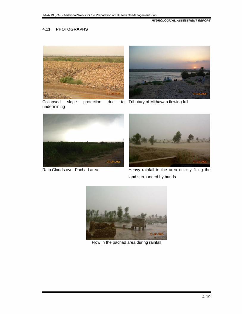
TA-4719 (PAK) Additional Works for the Preparation of Hill Torrents Management Plan
HYDROLOGICAL ASSESSMENT REPORT
4-19
4.11 PHOTOGRAPHS
Collapsed slope protection due to undermining
Tributary of Mithawan flowing full
Rain Clouds over Pachad area
Heavy rainfall in the area quickly filling the
land surrounded by bunds
Flow in the pachad area during rainfall
TA-4719 (PAK) Additional Works for the Preparation of Hill Torrents Management Plan
MANAGEMENT OF HILL TORRENTS
Table of Contents
5. MANAGEMENT OF HILL TORRENTS.........................................................................5-1 5.1 GENERAL ............................................................................................................5-1
5.1.1 Dispersion of Flows through Diversion/Distribution Structures.........................5-1 5.1.1.1 Management of Flood Flows in Pachad Area...........................................5-2
5.2 RECOMMENDED PLAN ......................................................................................5-4 5.3 PROPOSALS FOR STRUCTURES SITING ........................................................5-4
5.3.1 Sanghar Hill Torrent .........................................................................................5-5 5.3.1.1 Jat Wah.....................................................................................................5-5 5.3.1.2 Jam Wah...................................................................................................5-5 5.3.1.3 Shakh Shumali and Shakh Janubi............................................................5-5 5.3.1.4 Koko Wah .................................................................................................5-6 5.3.1.5 Budhu Wah protection Bund.....................................................................5-7 5.3.1.6 Begwari Wah ...........................................................................................5-7
5.3.2 Vehova Hill Torrent ...........................................................................................5-7 5.3.2.1 Kobhi Wah ................................................................................................5-8 5.3.2.2 Qaisrani Wah ............................................................................................5-8 5.3.2.3 Allahnawaz Wah and Jallu Wah ...............................................................5-8 5.3.2.4 Jallowali, Gatt and Khad Buzdar / Churkin Villages Flood Protection
Bunds........................................................................................................5-8 5.3.3 Kaura Hill Torrent .............................................................................................5-9
5.3.3.1 Sad Loharan .............................................................................................5-9 5.3.3.2 Qalandar Wah Complex .........................................................................5-10 5.3.3.3 Copi wah.................................................................................................5-10 5.3.3.4 Bojh wah and Shakh Chaharam .............................................................5-10
5.4 DESIGN CRITERIA ............................................................................................5-10 5.5 DESIGN OF STRUCTURES/WORKS................................................................5-11
TA-4719 (PAK) Additional Works for the Preparation of Hill Torrents Management Plan
MANAGEMENT OF HILL TORRENTS
5-1
5. MANAGEMENT OF HILL TORRENTS 5.1 GENERAL The physical scarcity and erratic pattern of rainfall and the qualitative constraints of groundwater have added to the dearth of water in the Project area. Surface water is generated by the rainfall storms which possess characteristically high peaks of short durations. Too wide variations from low to high discharges in limited time frame has rendered the management of flows a complex process. Due to the sparse vegetal cover, nominal land use, non existence of watershed management, and soft rock formations in the catchment areas, enormous quantities of suspended sediments including bed loads, brought down by the critical and super critical flows have posed a challenge to the ingenuity of engineers and planners. The failures of the past planning efforts have been attributed to a large range of values of the fundamental parameters affecting the state of the art of water resources management for the area. Thereupon, the evaluation of a technically effective plan conducted with the socio-economic and environmental considerations inevitably needs a fully coordinated and integrated sound engineering skill comprising various allied professional disciplines. This essentially required in-depth and expert analyses and evaluation of all possible alternate solutions to the complex problem. The hill torrents runoff can also be utilized in watershed management for affore-station and pasture development in upper catchments. But these aspects lie out of the scope of present study which mainly emphasizes the planning and designing of such ways and means which provide for the economic utilization of hill torrents flows for the development of agriculture in Pachad area. The construction of storage reservoirs in the area is neither technically viable nor economically justified. However, the current Project must remain at top priority as it has its specific significance regarding the utilization of hill torrents flows for the existing command areas under Saropa Paina. 5.1.1 Dispersion of Flows through Diversion/Distribution Structures As discussed in the preceding sections, various planning strategies have been considered for the evolution of a technically feasible, most cost effective and economically viable solution, fulfilling the objectives of the study and in line with the national goals and dives. The basic principle in the selection of the strategy has been to utilize maximum possible quantities of hill torrents flood flows in Pachad area for the development of agriculture. This would not only facilitate the economic development through increase in irrigation but also mitigate flood damages. A comprehensive and long term plan necessarily warrants a coordinated approach recognizing the inter-relationship with other planning aspects. Broadening perspective for management of hill torrents flows calls for formulation of a sound plan to ensure that account taken today of the problems to be faced tomorrow. The recommended plan for the management of hill torrents would provide framework comprehending the main aspect of engineering along with its various perspectives comprising hydrology, environment, sociology, resettlement, agriculture and economics etc. Hill torrents management plan provides reappraisal of problems and solutions to avoid the risk of being looked into as a program that no longer responds to its needs. Feedback of the plan provides information about the effectiveness of executed plan (Kaha Hill Torrent) and thus serves as guideline for in time revision to take into account the exact problems and priorities.

TA-4719 (PAK) Additional Works for the Preparation of Hill Torrents Management Plan
MANAGEMENT OF HILL TORRENTS
5-2
Effective management of hill torrents primarily aims at two major benedictions; utilization of flood flows to boost agro-based economy of the area and flood protection of flood prone areas damaged by hill torrents. The foregoing discussion has considered a number of alternatives, which have been carefully, explained both from technical and economic perspectives to arrive at the optimal solution to be presented as a recommended plan. Thereby, the most promising solution appears to be the provision of diversion/dispersion or distribution structures, weirs, and distributors and off takes which are most suitable to aerial configurations and traditional socio-economic practices. The same approach has been recommended and presented in the previous plan which is to be updated under the studies of this Project. The proposed system is expected to work well if properly maintained and due participation of beneficiaries continues. An overall account of this alternative is presented hereunder. 5.1.1.1 Management of Flood Flows in Pachad Area Field studies carried out for the Project area indicate the normal flows of hill torrents are manageable and utilized for basin irrigation in the Pachad area. This is done by the local farmers by diverting these floods into their fields through the construction of bunds. In case of high flows, these earthen bunds are damaged and major part of flood flows moves down causing heavy damages to CRBC especially in the downstream reaches, crops, infra structure and houses. The worst affected areas are those of village Jallowah (upstream CRBC) and village Gatt and Mauza Chirkin, in the vicinity of Khad Buzdar. The problems of effective management include the impossibility of storage due to silt contents, erratic nature of rainfall, limited management potential in case of small hill torrents and high elevation of cross drainage structures of CRBC. Field investigations and studies carried out indicate that a reasonable potential is available for management Utilization of major hill torrents flows in Pachad area through structural means. This approach provides for utilization of 426 thousand acre feet of flood flows for agriculture development out of the total available runoff of 1243 thousand acre feet against design flow. This would enhance the existing cropping area from 13,520 acres to 84,140 acres; whereby the cropping intensity will be enhanced from 11.62 percent to 72.30 percent. Flood protection shall be provided to about 25,500 acres inundated area of Mauza Churkin, Jalowali and Gat villages in canal command area against flood flows of Vehowa. A review of Table 5.1 indicates the discharge and runoff for various return periods. The technical as well as economic considerations indicated that the optimum event for the designing of structures and flood protection works is a 40 year return period. The discharge capacities of the 'wahs' and the available cultivable areas (in consideration of the water rights) have concluded that all of the available runoff against the design flood cannot be utilized. Table 5.2 presents a comparison of the available and exploitable quantities of runoff the total CCA, and the existing cultivated acreage.
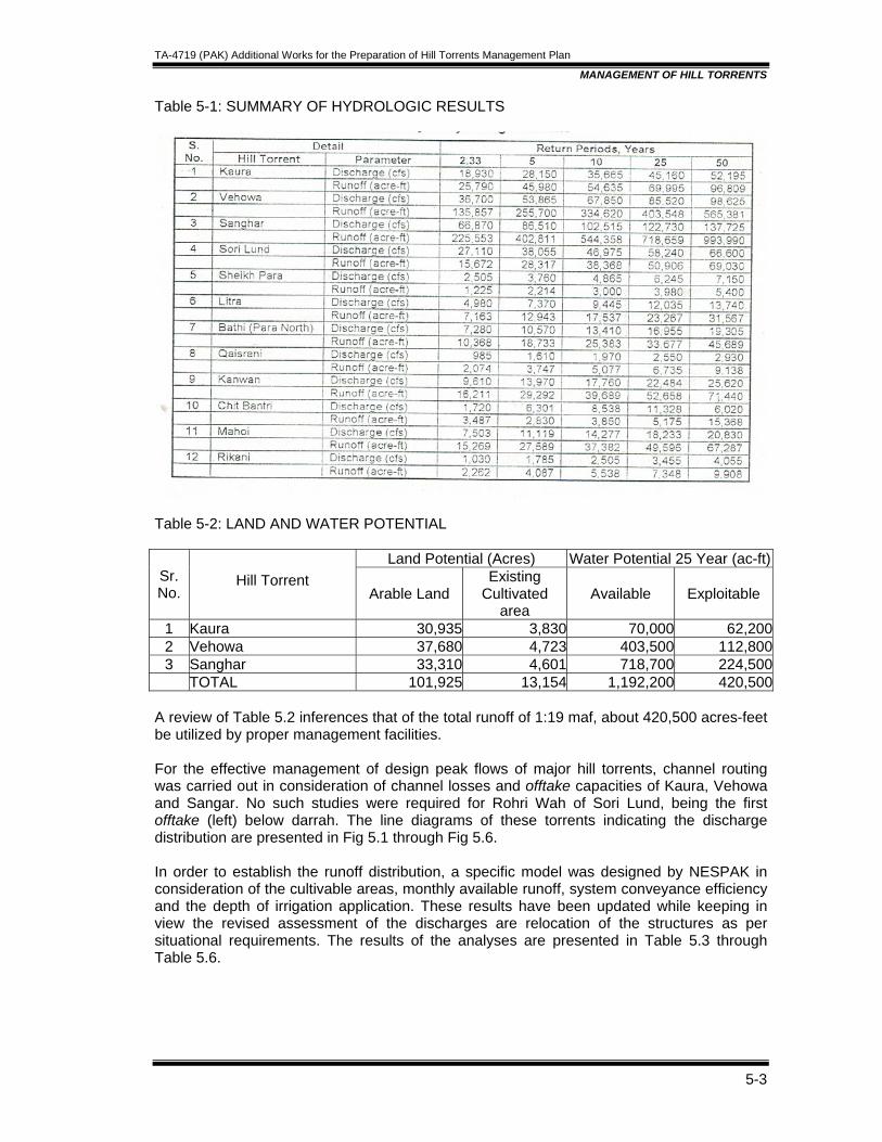
TA-4719 (PAK) Additional Works for the Preparation of Hill Torrents Management Plan
MANAGEMENT OF HILL TORRENTS
5-3
Table 5-1: SUMMARY OF HYDROLOGIC RESULTS
Table 5-2: LAND AND WATER POTENTIAL
Land Potential (Acres) Water Potential 25 Year (ac-ft)Sr. No.
Hill Torrent Arable Land
Existing Cultivated
area Available Exploitable
1 Kaura 30,935 3,830 70,000 62,2002 Vehowa 37,680 4,723 403,500 112,8003 Sanghar 33,310 4,601 718,700 224,500
TOTAL 101,925 13,154 1,192,200 420,500 A review of Table 5.2 inferences that of the total runoff of 1:19 maf, about 420,500 acres-feet be utilized by proper management facilities. For the effective management of design peak flows of major hill torrents, channel routing was carried out in consideration of channel losses and offtake capacities of Kaura, Vehowa and Sangar. No such studies were required for Rohri Wah of Sori Lund, being the first offtake (left) below darrah. The line diagrams of these torrents indicating the discharge distribution are presented in Fig 5.1 through Fig 5.6. In order to establish the runoff distribution, a specific model was designed by NESPAK in consideration of the cultivable areas, monthly available runoff, system conveyance efficiency and the depth of irrigation application. These results have been updated while keeping in view the revised assessment of the discharges are relocation of the structures as per situational requirements. The results of the analyses are presented in Table 5.3 through Table 5.6.
TA-4719 (PAK) Additional Works for the Preparation of Hill Torrents Management Plan
MANAGEMENT OF HILL TORRENTS
5-4
5.2 RECOMMENDED PLAN As discussed in the preceding sections of this report, different planning strategies have been considered for evaluation of their technical feasibility and economic viability. The basic principle in the selection of the strategy has been to utilize maximum quantities of hill torrents flows in Pachad area for the development of agriculture. This would not only facilities economic development through increased flood irrigation but also alleviate the flood volumes, thus mitigating the flood damages. The achievement of this objective resulted in i.e selection of the option of constructing diversion/distribution structures on the feasible sites of the hill torrents of Project area. In order to ensure the delivery of flood flows in the Wahs' of 'haqooq area' in accordance with their due shares and sequential rights. Fig. 1.1 presented in Section-1 of this report shows the locations of various components of the recommended plan. Based upon the design flood studies (Section 4), the Consultants have selected a 40-Year event as a design discharge but higher discharges may be encountered with a less frequency In such cases, excess quantities of runoff would essentially be generated, which would need safe passage to Indus River. Disposal of excess flows to Indus by channelization through the CRBC command area is a part and parcel of the project and undertaken by WAPDA. It is anticipated that the utilization of a considerable part of hill torrents flood for agriculture would automatically alleviate the flood peaks thereby reducing the downstream flood problems. However, flood protection measures at some vulnerable points are inevitably required. One of such points is to stop the Kaura spillage to Vehowa, the others being the flood protection of Jallowali, Gatt and Churkin area, prevention of spillage of Shakh Shumali (Buddo Wah) to main channel of Sanghar Hill Torrent. Hence the recommended plan comprises the following three major aspects:
• Utilization of flood flows for agriculture through diversion/distribution structures in Pachad Area;
• Disposal of excess flows to Indus by channelization through CRB command area; and
• Flood protection measures of vulnerable areas. As already mentioned, some of the cross-drainage structures of CRBC have off site locations. M/s NESPAK have proposed the construction of link channels between the existing channels of the torrents to their respective cross-drainage structures. These are however, a part of CRBC Project. Hence this plan does not include the cost of construction of these channels. However, the construction of these link channels must be implemented prior to or concurrent with the project works to make it functional. In order to establish the structural requirements, the Consultants considered each hill torrent at length, the details of which are given in the proceeding sections. 5.3 PROPOSALS FOR STRUCTURES SITING The hill torrents of the Chashma Right Bank Canal area in Dera Ghazi Khan District are a part of the series of mountain streams debouching onto the “Pachad area” from Sulieman Range. These streams are locally known as “Rod Kohis”; few of them have perennial flows (kala pani) while the others flow only during precipitation periods. Four major hill torrents and some minor ones run through the CRBC Command area towards Indus River. These major hill torrents are Sanghar, Vehowa, Kaura and Sori Lund. Sori Lund hill torrent is not included in the assignment of TA Consultants.

TA-4719 (PAK) Additional Works for the Preparation of Hill Torrents Management Plan
MANAGEMENT OF HILL TORRENTS
5-5
5.3.1 Sanghar Hill Torrent Sanghar is the largest hill torrent of the project area with the catchment of 4913 sq. km. The hill torrent is divided into three parts below darrah, namely Sanghar main channel, Southern Branch or Shakh Janubi (locally known as Begwari) and Northern Branch or Shakh Shumali (locally known as Bodho Wah). Once it emerges from darrah, the rights of water usage are divided equally, one half each, between the communities on either sides of torrent . Sanghar traverses in 37000 ft from darrah to CRBC with an average bed slope of 1 in 200. Keeping the might of Sanghar in view, TA Consultants have proposed to design all structures in Sanghar main channel on the bases of forty (40) years return period peak flow. Where as the off takes will be designed on peak flow of twenty five (25) years return period. Schematic flow diagram for Sanghar is appended as Figure 5.1 for 5 years and 40 years periods. 5.3.1.1 Jat Wah Jat Wah is the first distribution channel on the torrent off taking from the southern or right bank, immediately below the edge of the darrah. A separation dyke / Salai was constructed to divert the perennial flows into Jat Wah, which is damaged at various locations specially in the leading portion which is completely washed. The TA Consultants endorse the existing (original) off taking position and propose a separation dyke / salai on the torrent side, starting from the source along the right edge of hill. The inlet will be provided with a mole head with a bed width of 50 feet followed by a gabion wall in a length of about 700 feet protected with stone apron on both sides. The wall will be aligned with the gentle upstream curve guiding the flow into jat wah. The remaining portion of salai will be earthen embankment with slope and bed protection. The existing embankment of Jat Wah salai will be remodeled / readjusted and damaged portion in the lower reach will be reconstructed. A bed fixer in Sanghar main channel with the crest level 1.5 feet higher the inlet level of Jat wah Salai will also be provided about 100 feet of downstream the inlet to conduct flow. 5.3.1.2 Jam Wah Jam Wah, the second distribution channel on the torrent off taking from the northern or left bank is about 4300 feet downstream darrah. Both Jam wah and Jat wah have equal rights of kala pani. Jam wah separates from sanghar little below the source and runs on high contours leaving the torrent for farther irrigation area. The TA Consultants propose a separation dyke / salai with inlet width of 50 feet, same as jat wah. The salai will be an earthen embankment with slope and bed protection using stone gabions and mattresses. The right bank of inlet will be provided with mole head and a gentle upstream curve guiding the flow into jam wah. The left bank of the jam wah will also be protected from inside. A bed fixer in Sanghar main channel with the crest level 1.5 feet higher the inlet level of Jam wah Salai will also be provided about 100 feet downstream of the inlet to conduct flow. 5.3.1.3 Shakh Shumali and Shakh Janubi These are the major offtakes and command large cultivable areas. Shakh Janubi further subdivides into two branches, namely Bughlani and Begwari. Both Bughlani and Begwari have equal rights of water usage. The TA Consultants have proposed a combined distribution structure in the Sanghar main channel at RD + 6+300 for diverting flows into Shakh Shumali and Skakh Janubi (Begwari and Bughlani wah). The main weir in Sanghar bed will be approximately 1800 feet long with the crest level of RL 687.00, where as the
TA-4719 (PAK) Additional Works for the Preparation of Hill Torrents Management Plan
MANAGEMENT OF HILL TORRENTS
5-6
crest level of off taking channels will be at RL. 685.00. The upstream floor level will be at RL. 683.50. The combined water way for Bughlani and Begwari off taking structures will be kept same as for Shakh Shumali off taking structure. The downstream left guide bank of main weir will be connected with the right bank of Budhu Wah inlet at Sanghar RD. 8+650. The downstream right guide bank will extend upto and tied with Khaji wala Ganda. The weirs for Sanghar, Shakh Shmali, Begwari and Bughlani Wah will be constructed with stone fillings and boulder concrete abutments. There will be three vertical cutoffs (one at either end of floors as toe walls and one at the upstream end of weir crest) in the weir profile at appropriate locations. The top layer of weir profile will be made of 2.0 ft. thick PCC in order to overcome the pilferage of gabion wires, a common present prevalent problems in the previous Hill torrent management structures. The guide banks will be earthen with stone pitching protection in appropriate lengths. A bed fixer about 2.0 feet higher than average bed level will be provided about 300 feet from the crest axis within the upstream guide banks to ensure uniform flow and distribution. 5.3.1.4 Koko Wah Shakh Shumali (locally known as Budhu Wah) flows down to Mangrotha village in a north-eastern direction. Near Mangrotha village koko Wah oftakes from left and commands a quite an area. The present topographical conditions warrant construction of a high rise rigid distributor for the Koko wah. Budhu Wah has scoured badly at this location with an average bed level of RL 605.00, whereas the first field of Koko wah is at RL 621.00. The TA Consultants have two proposals to deal with this problem: Shift the weir about 2000 feet upstream where the levels permit the construction of a low height weir combined with an escape to attenuate the flood peak in the right bank upstream of weir. A link channel of about 2000 feet long will have to be provided passing through left bank fields up to the existing inlet structure of Koko wah. This proposal would involve significant land acquisition for link channel and escape. Improvisation of budhu wah section – Strengthening the banks of budhu wah with stone pitching and apron in a length of about 2500 feet. The stone pitching of right bank will be extended downstream to the point where flows of 2004 developed a creek. This creek is now closed by the stake holders but demand the strengthening of this section. Three bed fixers of minimum 3.0 feet height will be provided at appropriate distances within the protected section to reduce the existing bed slope of 1 in 150 and to stabilize the bed. Until that time when bed is stabilized and levels permit the construction of low height weir at koko wah off take in future (second stage improvement), Koko wah will be irrigated through the presently practiced kamara system by the stake holders. A side channel escape structure will also be provided in the right bank of budhu wah with the crest level 2.0 feet below highest flood level. The TA Consultants support second proposal because it would not involve too much land acquisition creating social problems. Both the proposals are open to discussion and the comments/ suggestions from the reviewer of this document would be appreciated. PID has appreciated and agreed with TA Consultants proposal about check for further retrogression but has asked for arrangements for Irrigation supplies througha high rise weir downstream of Koko Wah off-take. Provision of escape would also be made at this site for passing down the excessive flows back into Sanghar.
TA-4719 (PAK) Additional Works for the Preparation of Hill Torrents Management Plan
MANAGEMENT OF HILL TORRENTS
5-7
5.3.1.5 Budhu Wah protection Bund Little downstream of Mangrotha village, Budhu wah developed a creek during flows of 2004 thus short circuiting its route to Sanghar main channel. This breach is now closed by the stake holders but demand its strengthening. The proposal in the feasibility report of NESPAK is endorsed by the TA Consultants and has been incorporated in their proposal (b) of Koko Wah in the preceding paragraphs. 5.3.1.6 Begwari Wah Begwari wah off takes at RD 28+700 of Shakh Janubi / Begwari on the left side which irrigates considerable land of the Malghani inhabitants of Sokkar village. The stream bed at this point has scoured up to thirteen (13) feet and the farmers have to put in a lot of effort to raise water for his channel. According to existing topographic conditions the average bed level of the channel is RL 583.00 and the field level at RL 596.46. The TA Consultants have two proposals to deal with this problem: Shift the weir about 6500 feet upstream where the levels permit the construction of a low height weir with a link channel of about same length passing through left bank fields up to feed begwari wah. This proposal would involve significant land acquisition for link channel and weir. Like budhu wah, improvisation of begwari channel in the close proximity of begwari wah off take by strengthening the section with stone pitching and stone apron. Two bed fixers of minimum 3.0 feet height will be provided at appropriate distances within the protected section to to stabilize the bed by reducing the existing slope. Until that time when bed is stabilized and levels permit the construction of low height weir at begwari wah off take in future (second stage improvement), begwari wah will be irrigated through kamara system by the stake holders. The construction of upstream regulating structures will also in bed stabilization. Provide a high crested weir for diverting water to Begwari wah as per the concept proposed in the feasibility report of M/s NESPAK. The TA Consultants support second proposal because it would not involve too much land acquisition creating social problems. Both the proposals are open to discussion and the comments/ suggestions from the reviewer of this document would be appreciated. PID has asked for high rise structure for feeding Begwari Wah which has been now accordingly provided in the project. 5.3.2 Vehova Hill Torrent Vehova is the second largest hill torrent of the project area with the catchment of 2,634 sq. km. The torrent possesses a characteristic fanout area downstream of Gang Canal Regulator flowing in northward. Below this regulator, the torrent bifurcates into a “haqooq” and “non haqooq” channel. Due to retrogression of non haqooq channel, an embankment has been constructed with varying crest levels to ensure spillage of only excess flows to the non haqooq channel. It receives kaura spills at the other end of its fanout area, flowing. Vehova traverses through 74000 feet length from darrah to CRBC with an average bed slope of 1 in 250. TA Consultants have proposed to design all structures in Vehova main channel on the bases of forty (40) years return period flow. Where as the off takes will be designed on flow of
TA-4719 (PAK) Additional Works for the Preparation of Hill Torrents Management Plan
MANAGEMENT OF HILL TORRENTS
5-8
twenty five (25) years return period. Schematic flow diagram for Vehova is appended as figure 2. 5.3.2.1 Kobhi Wah Kobhi wah off takes at RD. 21+800 from the left side of Vehova hill torrent. About 350 feet upstream of kobhi wah a small escape channel joins Vehova. This escape carries the spillage/excess flows of Sukh Lar and Qalandar Wah (Kaura hill torrent channel). The original proposal in feasibility report was to construct a 6 feet high and 850 feet wide cross weir about 400 feet downstream kobhi wah inlet (40 feet wide) with a crest level of RL 708.00. At this proposed location the bed of vehowa has scoured badly and would result in a higher weir, may be upto 10-12 feet, which is not feasible. Also, presently, the average bed level of kobhi wah inlet is at RL 713.00 which is about 5 feet above the proposed crest level RL 708.00 which would cause feeding problems to Kobhi wah in low flows. The TA Consultants have proposed to shift the main weir 1100 feet upstream of the source of kobhi wah which is broadly the original source of kobhi wah. The crest level of main weir will be fixed at RL. 715.50 and the crest level of kobhi wah regulator will be at RL. 714.00. The upstream floor will be placed at RL. 712.00. Water will be carried from the regulator to the existing kobhi inlet through a leading channel made with earthen embankments protected with stone pitching and apron on both sides. The right guide bank of the main weir / distributor will be tied with high edge to check the danger of outflanking. A boulder concrete vertical drop structure with the crest level above the highest flood level of kobhi wah will be provided in the portion where above mentioned escape channel joins kobhi wah. The structure will be properly protected. The TA Consultants also propose a boulder concrete side channel escape structure will be provided in the right bank of kobhi wah at least about 1000 feet downstream existing inlet of kobhi wah to control any excess flow by draining it into Vehova main channel. The crest level of this escape will be kept about 0.5 feet higher than the full supply level of kobhi wah. 5.3.2.2 Qaisrani Wah Regulators for withdrawls for Qaisrani Wah and three small wahs around Nolkani village would also be provided in the Kobi Wah complex and original source of Non Haqooq limb of Vehowa would be plugged. 5.3.2.3 Allahnawaz Wah and Jallu Wah The TA Consultants propose a distribution structure in Vehova hill torrent. From this structure Jallu wah will be regulated towards Jallu wah channel where as the regulator of Allahnawaz wah will be connected by a leading channel up to its off take point i.e. at the off taking point of Allahnawaz wah on right side. 5.3.2.4 Jallowali, Gatt and Khad Buzdar / Churkin Villages Flood Protection Bunds The TA Consultants endorse the work in respect of Churkin village given in the feasibility report with the recommendation that the design of the scheme to be checked according to the Design Criteria of the TA Study and present prevalent situation. Two addition flood protection works for Jallowali & Gatt villages have also been included on the recommendations of the Irrigation Department.
TA-4719 (PAK) Additional Works for the Preparation of Hill Torrents Management Plan
MANAGEMENT OF HILL TORRENTS
5-9
5.3.3 Kaura Hill Torrent Kaura is the third largest hill torrent of the project area. Its basin is situated at the extremity of the Project area. It is the only basin of the project which shares area from the three provinces of the country – Balochistan, NWFP and Punjab. There is no off take immediately below darrah of kaura hill torrent, however a little below darrah, an undesired offshoot has been developed from where a considerable part of the flows of kaura overspills towards right, short circuiting its route towards vehova hill torrent. The overspills of kaura on joining vehova flows, aggravate the flood situation in downstream areas and inflict lot of damages. On the other hand , kaura areas remain dry for want of flood irrigation. Kaura traverses 69300 ft from darrah to CRBC with an average bed slope of 1 in 250. TA Consultants have proposed to design all structures in Kaura main channel on the bases of forty (40) years return period peak flow. Where as the off takes will be designed on peak flow of twenty five (25) years return period. Schematic flow diagram for Kaura is appended as figure 3. 5.3.3.1 Sad Loharan There is no off take immediately below' darrah' of Kaura Hill Torrent. However, a little below darrah, an undesired offshoot has been developed wherefrom a considerable part of the flows of Kaura overspills towards right, short-circuiting its route to Vehowa Hill Torrent. The overspills of Kaura on joining Vehowa flows aggravate the flood situation in downstream areas and inflict lot of damages. On the other hand, Kaura areas remain dry for want of flood irrigation. Presently, a pair of parallel stone masonry walls, filled with stone/boulders has been constructed in a length 560 feet to check this erosion. In continuation and downstream of the wall, a stone filled earthen embankment comprising local coarse material has been constructed in a length of 3,600 feet. The total top width of the wall and that of the bund is 15 feet. This system of bunds is locally known as 'Sad Lohoran'. These arrangements have not been successful to check the Kaura spills completely. The existing embankment usually gets breached in the event of a high flood. In case of a low flood, water seeps out due to pore pressure and the problem remains as such. In order to check the escapages of Kaura flows towards Vehowa, the Consultants have proposed a 7,760 feet long earthen embankment, starting from upstream of the existing masonry wall, utpo the Kalandar Wah Complex. The embankment is proposed to be stone pitched on waterside with 2 feet gabion matress laid over a 9" thick layer of spawl. In order to combat the direct attack of the flows on the embankment, three short stone spurs have been proposed, each having a length of 75 feet. These spurs would protect the embankment, help in sedimentation along the bund and streamline the flow along the channel. The TA Consultants propose the raising and strengthening of Sad Loharan embankment upto Qalander Wah Complex as proposed in the feasibility report. The only difference with the original proposal is to keep the 735 feet long escape structure starting at RD 1+867 as it is and strengthen its stone protection, rather than burying it into the raised embankment. The remodeled earthen embankment with slope and bed stone protection will run on the existing right edge of Kaura hill torrent reinforced with small stone studs at appropriate locations. This embankment will close “Sukh Lar” the undesired over spillage channel on the right side completely.
TA-4719 (PAK) Additional Works for the Preparation of Hill Torrents Management Plan
MANAGEMENT OF HILL TORRENTS
5-10
5.3.3.2 Qalandar Wah Complex This is the cluster of six channels three on the left bank (Khaji, Lakhani and Makhan) and three on the right (Qamardin, Qalandar and Chango) off taking close to each other on Kaura. The sources of all wahs are at varying distance from each other ranging from 150 feet to 1500 feet. In feasibility report a 850 feet wide and 9.0 feet high weir is proposed with crest level of RL. 801. According to existing site conditions, Chango, Qalandar and Makhan wahs are off taking about 150 feet upstream the proposed weir. Similarly Lakhani and Qamardin wahs are off taking 1000 feet upstream where as Khaji wah is off taking about 1600 feet upstream the proposed weir. The TA Consultants have proposed to shift the weir upstream at RD + 5+600 (about 270 feet upstream the nose of right side bund) in order to reduce its height and better command. From this location, sources of Khaji wah and Lakhani wah are about 1000 feet and 350 feet upstream respectively, where as sources of Makhan, Qamardin, Qalander and Chango wahs are on the downstream. The proposal is to provide a 800 feet long cross weir with the crest level of RL 816.00 and upstream floor level of RL 811.00. Lakhani wah and Makhan wah will off take from left side with a leading channel for Makhan wah. All five regulators will be of same width and crest level RL 615.00. Khaji wah being a high level channel with its bed about 10 feet higher than torrent’s bed at the proposed new location will be provided with a small separation dyke / Salai at source and its common embankment with Lakhani wah will be properly protected. The width of Khaji wah inlet will be same as for individual regulator of off taking channel. Two bed fixers will be provided in Kaura bed upstream the source of Khaji wah to ensure uniform flow and even distribution. 5.3.3.3 Copi wah The TA Consultants support the proposal of NESPAK in principle with the recommendation that the crest level of a low height weir be fixed according to existing topographic condition and the design be improved in light of Design Criteria of TA Study and revised design discharges and additional cpacity for catering excessive flow so as to reduce abnormal quality of culverts in the already constructed road immediately upstream of bifurcation structure of Bojh & Shakh Chaharam. A cross drainage strcture under CRBC exists which have enough capacity for this escapage. 5.3.3.4 Bojh wah and Shakh Chaharam The TA Consultants proposed a bifurcating structure about 500 feet upstream of existing road culvert for Bojh wah on the right side and shakh chaharam and on left. The leading channel of chaharam wah from bifurcating structure will pass through an additional road culvert which will be designed on revised discharges, where as bojh wah which receives the major share of torrent flow will cross the existing road which will be remodeled according to revised design discharges. But PID has not agreed and recommend siting of the structures as per FR (2005). Now to avoid excessive barrels of culverts part of the flood flows would be passed in Copi Wah. Road project near shakh chaharam has been recently constructed. Concerned agency may be asked for provision of adequate capacity in the culverts. Alternatively since at present there is limited grant and its provision can be met in any next phase of construction. 5.4 DESIGN CRITERIA The design of all the structures has been based upon the following main principles:

TA-4719 (PAK) Additional Works for the Preparation of Hill Torrents Management Plan
MANAGEMENT OF HILL TORRENTS
5-11
• Use of local materials, • Minimum or no land acquisition, • Use of Local unskilled labour might • Environment friendly design, • Maximum possible output with minimum (optimal) cost, • Improvements as suggested by the Impact Evaluation Study of Kaha Hill Torrent.
Within the framework of above mentioned principles, the following main criteria have been adopted while designing the structures:
• All the structures are flexible or semi rigid, comprising gabions in wire crates and topping of aprons & glacis with concrete alongwith release wells.
• Hydraulic designing of weirs have been carried out using the' Manual for Design of Flexible Gabion Structures in Rivers and Stream Training Works' prepared by Maccaferri.
• All the weirs are glacis type with upstream slope 1V:2.5H and downstream slope 1V:3H.
• The concrete slab panels with temperature steel has been provided on upstream and downstream glacis of all the diversion structures.
• The stilling basins have been sized to cover all ranges of discharge. • The bottom of the stilling basins of all the diversion weirs has been provided with 6”
thick transition rock spawl layer and 6 “ thick filter of coarse material. • For all the structures, upstream and downstream guide bunds have been provided
with stone pitching and stone apron. • Top of the crest of the weirs has been fixed at a 5-year discharge. • Stilling basins of main weirs have been provided with filter material. Top of
embanks/walls are designed at a water level of 40-year discharge with a free board of 4 feet. .
• RCC cut-off wall has been provided to all the main (cross) weirs at upstream side of crest.
• Depth of cut-off is provided using safety factor of 1.25 D for upstream and 2.5 D for downstream, D being the scour depth from top of apron. Lacey's silt factor for scour depth calculation is taken based on the river bed material.
• Depth of gabion wall has been kept in-coincidence to the bottom level of stilling • Stability of gabion walls has been checked for overturning. Factor of safety for
overturning is greater than 1.5. • Stone protection has been provided to the off takes of the channels in a length of 100
feet each. Longer length of protection becomes uneconomical. • Manning's Roughness Coefficient (n) used for earthen channels is 0.025. • Manning ‘n' used for channels with stone pitching is 0.030. • Existing bed slopes of the channels have been used for designing the designation
the channel off takes. • Detailed design criteria was circulated to PID, Advisors and ADB in September 2006
and is also added with this report as Volume-II. 5.5 DESIGN OF STRUCTURES/WORKS The structure meant for distribution of flows for cultivation, comprise distributors and off take diversions. The flood works consist of closure embankments and bank protection/stabilizing provisions. The structures are semi-rigid, proposed to be constructed with the help of locally available stone, to be used in gabions and other works. The closure embankments are meant to prevent loss of flows/runoff due to the development of spill/seepage channels. The

TA-4719 (PAK) Additional Works for the Preparation of Hill Torrents Management Plan
MANAGEMENT OF HILL TORRENTS
5-12
bank protection/stabilizing have been recommended to check flood damages against sloughing and erosion. Design calculations alongwith drawings for all structures have been placed in Volume IV. However calculations for three major structures are also annexed with this volume at Annexure-2.
TA-4719 (PAK) Additional Works for the Preparation of Hill Torrents Management Plan
SOCIAL IMPACT ASSESSMENT AND PARTICIPATORY PLANNING STUDIES
Table of Contents
6. SOCIAL IMPACT ASSESSMENT AND PARTICIPATORY PLANNING STUDIES ......6-1 6.1 PLANNING STUDIES...........................................................................................6-1 6.2 SOCIAL IMPACT ASSESSMENT ........................................................................6-1
6.2.1 Objective of Study ............................................................................................6-1 6.2.2 Study Area........................................................................................................6-1 6.2.3 Methodological Approach .................................................................................6-2
6.2.3.1 Sampling Design.......................................................................................6-3 6.2.3.2 Data Collection .........................................................................................6-3
6.2.4 Identification of Potential Beneficiaries .............................................................6-3 6.2.4.1 Basic Amenities Available.........................................................................6-4 6.2.4.2 Distribution of Poor/Non Poor ...................................................................6-4 6.2.4.3 Social Organization...................................................................................6-4 6.2.4.4 Village NGO..............................................................................................6-5 6.2.4.5 Conclusions as drawn by M/s NESPAK ...................................................6-5 6.2.4.6 Quantification of the Benefit......................................................................6-5 6.2.4.7 Impact on Ethnic and Vulnerable Groups .................................................6-6 6.2.4.8 Gender and Development.........................................................................6-6 6.2.4.9 Institutional Capacity Building...................................................................6-7 6.2.4.10 Project status and Poverty Reduction...................................................6-7 6.2.4.11 Anticipated Project Adverse Affects......................................................6-8 6.2.4.12 Demands of the Affectees/beneficiaries ...............................................6-8
6.3 PARTICIPATORY DEVELOPMENT PLAN ..........................................................6-9 6.3.1 Social Mobilization ..........................................................................................6-10 6.3.2 Prevailing Hill Torrent Management Practices................................................6-10 6.3.3 Constraints in Hill Torrent Management .........................................................6-11 6.3.4 Farmers Prescription on Flood Mitigation Project...........................................6-11 6.3.5 Project Participation Level ..............................................................................6-11 6.3.6 Women Participation ......................................................................................6-12 6.3.7 Suggestion for Project Sustainability ..............................................................6-12 6.3.8 Conclusion......................................................................................................6-13

TA-4719 (PAK) Additional Works for the Preparation of Hill Torrents Management Plan
SOCIAL IMPACT ASSESSMENT AND PARTICIPATORY PLANNING STUDIES
6-1
6. SOCIAL IMPACT ASSESSMENT AND PARTICIPATORY PLANNING STUDIES
6.1 PLANNING STUDIES Social impact assessment is an in evitable pre-exquisite for the evolution of a participating plan for a particular Project. This section deals with the social and participatory planning in separate parts. The first parts consists Social Impact Assessment and the second parts the participatory Planning Studies. 6.2 SOCIAL IMPACT ASSESSMENT 6.2.1 Objective of Study The principal objective of the study is to identify the potential beneficiaries/affectees (primary stakeholders) and communities affected by the project activities by assessing their needs, demands and major problems faced by them with respect to the hill torrents of CRBC Area. The major aims and objectives of the study are:-
• Identification of potential beneficiaries/affectees with reference to their basic sociological characteristics;
• Incorporation of interest of ethnic groups and vulnerable population, • Gender sensitivity analysis and poverty reduction strategy for potential beneficiaries
by poor and non-poor. • Identification of Project potential adverse affects and their remedial measures; • Institutional capacity building; • Quantification of social benefits; • Identification of need for land acquisition and re-Location of houses and other
properties for project successful implementation (Resettlement Action Plan) • Review the traditional water right; • Public consultation regarding current hill torrent management practices constraint
and possible option for improvement of the system; and • Assessment of potential for participatory development planning process in the flood
mitigation 6.2.2 Study Area Project Plan mainly comprises 12 proposed structures on four major hill torrents namely, 3, Vehowa, Sanghar and Sori Lund. The culturable command area comprises 116,385 belonging to 24 main villages. These villages fall in the jurisdiction of six union councils of Tehsil Taunsa and one union council of Tehsil D.G Khan. The detail of the res regarding types, location, villages and area, are given in Table 6.1.
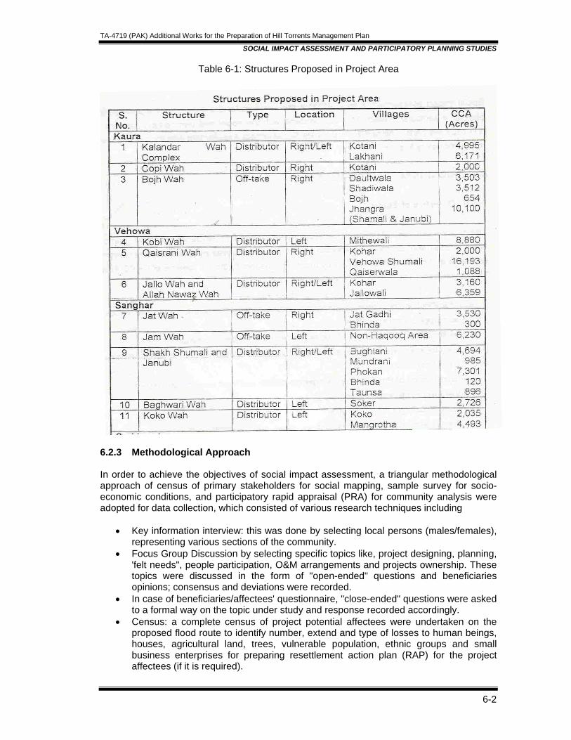
TA-4719 (PAK) Additional Works for the Preparation of Hill Torrents Management Plan
SOCIAL IMPACT ASSESSMENT AND PARTICIPATORY PLANNING STUDIES
6-2
Table 6-1: Structures Proposed in Project Area
6.2.3 Methodological Approach In order to achieve the objectives of social impact assessment, a triangular methodological approach of census of primary stakeholders for social mapping, sample survey for socio-economic conditions, and participatory rapid appraisal (PRA) for community analysis were adopted for data collection, which consisted of various research techniques including
• Key information interview: this was done by selecting local persons (males/females), representing various sections of the community.
• Focus Group Discussion by selecting specific topics like, project designing, planning, 'felt needs", people participation, O&M arrangements and projects ownership. These topics were discussed in the form of "open-ended" questions and beneficiaries opinions; consensus and deviations were recorded.
• In case of beneficiaries/affectees' questionnaire, "close-ended" questions were asked to a formal way on the topic under study and response recorded accordingly.
• Census: a complete census of project potential affectees were undertaken on the proposed flood route to identify number, extend and type of losses to human beings, houses, agricultural land, trees, vulnerable population, ethnic groups and small business enterprises for preparing resettlement action plan (RAP) for the project affectees (if it is required).
TA-4719 (PAK) Additional Works for the Preparation of Hill Torrents Management Plan
SOCIAL IMPACT ASSESSMENT AND PARTICIPATORY PLANNING STUDIES
6-3
6.2.3.1 Sampling Design A multi-stage stratified proportionate random sampling technique was applied to select adequate and representative sample so as to generalize survey findings at the project level with the highest level of statistical confidence and meaningful sociological fact findings on the subject under review. Stage-1: Selection of Study Area: All above mentioned four main hill torrents selected as study area falling within the Project boundaries. The universe was classified into above four project areas for the purpose of social analysis. In all proposed 12 structures falling lin above four study areas were chosen for in depth study at the first stage of universe stratification. Stage 2: Selection of Villages: Since, the total number of main villages falling within the project area did not exceed 24, therefore all the main villages were selected for the purpose 1e participatory planning study and 3 villages at each hill torrent (head, middle and tail) chosen for socio-economic sample survey at the 2nd stage of universe stratification. Stage 3: Farmer Selection: At the 3rd stage of universe stratification, the attendance for participatory Planning Study ranged between 08-48 in the villagers under study. Whereas farmers per village were chosen for socio-economic survey by applying simple random sampling techniques. In this way total of 36 farmers constituted sample for socio-economic study. 6.2.3.2 Data Collection Primary Data: Questionnaires, Interviewing guide/schedules were prepared for socio-economic participatory planning and resettlement studies in English and translated into local language. The instruments were administered by experienced interviewers. The draft interviewing schedules were pre-tested in non-sample area of Kaha Hill Torrent structure and small hill torrent. A number of questions were deleted, added, changed and altered in order to make the instruments reliable and valid in the actual field. These amendments, deletion and addition in the field instruments were made in the light of discussion carried out in the non-sampled area. Secondary Data: In addition to above primary data collected technique, secondary data were collected from various sources. All available literature / material were studied thoroughly to:
• Visualize the nature and scope of the proposed interventions; • To gain insight into the Project • Drafting of interviewing schedule / guide. • Besides, having conceptual clarity on the basic themes of the project.
6.2.4 Identification of Potential Beneficiaries The meaningful understanding and identification of potential beneficiaries of hill torrent project calls for scientific sociological analysis of primary stakeholders in terms of their number. Who are they? Where are they? And how they are placed with respect to their daily interactional pattern, group dynamics and institutional make-up. Additionally, what are their ways of thinking and orientation sociological characteristics of the potential project beneficiaries/affectees with respect to their numbers, distribution by sex, ethnicity, religious affiliation, occupational classification, local status, income level, family size, educational attainments, indigenous/vulnerable groups and residential status are positively correlated
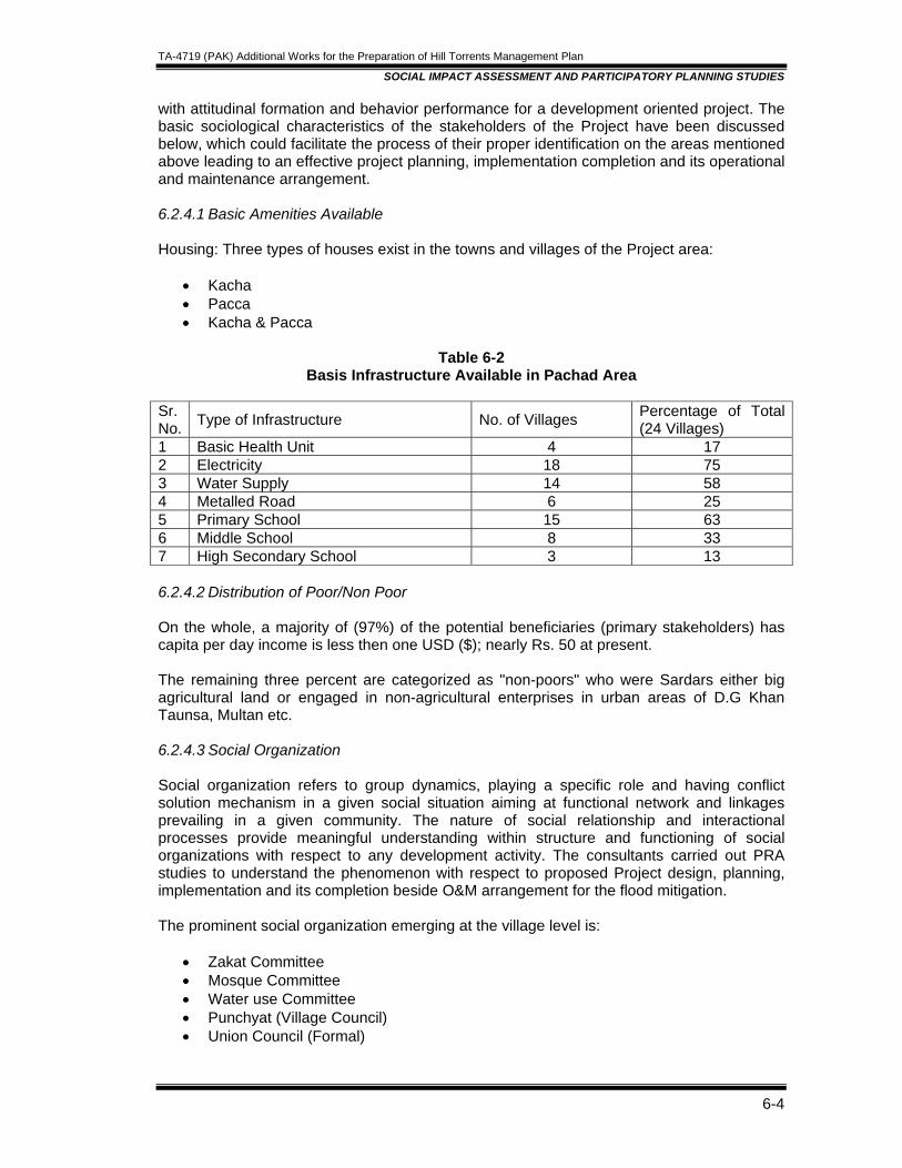
TA-4719 (PAK) Additional Works for the Preparation of Hill Torrents Management Plan
SOCIAL IMPACT ASSESSMENT AND PARTICIPATORY PLANNING STUDIES
6-4
with attitudinal formation and behavior performance for a development oriented project. The basic sociological characteristics of the stakeholders of the Project have been discussed below, which could facilitate the process of their proper identification on the areas mentioned above leading to an effective project planning, implementation completion and its operational and maintenance arrangement. 6.2.4.1 Basic Amenities Available Housing: Three types of houses exist in the towns and villages of the Project area:
• Kacha • Pacca • Kacha & Pacca
Table 6-2
Basis Infrastructure Available in Pachad Area Sr. No. Type of Infrastructure No. of Villages Percentage of Total
(24 Villages) 1 Basic Health Unit 4 17 2 Electricity 18 75 3 Water Supply 14 58 4 Metalled Road 6 25 5 Primary School 15 63 6 Middle School 8 33 7 High Secondary School 3 13 6.2.4.2 Distribution of Poor/Non Poor On the whole, a majority of (97%) of the potential beneficiaries (primary stakeholders) has capita per day income is less then one USD ($); nearly Rs. 50 at present. The remaining three percent are categorized as "non-poors" who were Sardars either big agricultural land or engaged in non-agricultural enterprises in urban areas of D.G Khan Taunsa, Multan etc. 6.2.4.3 Social Organization Social organization refers to group dynamics, playing a specific role and having conflict solution mechanism in a given social situation aiming at functional network and linkages prevailing in a given community. The nature of social relationship and interactional processes provide meaningful understanding within structure and functioning of social organizations with respect to any development activity. The consultants carried out PRA studies to understand the phenomenon with respect to proposed Project design, planning, implementation and its completion beside O&M arrangement for the flood mitigation. The prominent social organization emerging at the village level is:
• Zakat Committee • Mosque Committee • Water use Committee • Punchyat (Village Council) • Union Council (Formal)
TA-4719 (PAK) Additional Works for the Preparation of Hill Torrents Management Plan
SOCIAL IMPACT ASSESSMENT AND PARTICIPATORY PLANNING STUDIES
6-5
Power Structure: Tribal Chief (Sardar) and caste (Brotheri) head commanded absolute authority and power over his tribes/ caste fellows on all matters of daily life. Sardar's opinion and decision is considered final and absolute in day to day community life. The Sardar is usually big landlord and his position is further strengthened by his higher economic status in e community. Sardar's position is a hereditary status ascribed through ancestors. Sardar is symbol of wisdom and social capital at community level, which is an important variable for 3king into confidence in initiating any development activity. Relationship among the People: In terms of interactional processes, cooperation dominates over-all day to day life of the average person. The inhabitants of the Project area ate with one another in socio-economic activities e.g. games, recreational events and political proceedings such as elections whether local or general. Coal disputes are natural, which occur off and on among the communities. The community were asked as to ho these disputes were being resolved. Field surveys, Ked that the percentage of disputes, generally handled by local jirgas elder person and court is 75%, 18% and 6% respectively. 6.2.4.4 Village NGO For any development activity, village leadership and genuine village level organization considered is an informal NGO for successful completion of a given Project. Nevertheless following formal NGOs were identified in the Project area, which are likely to provide a resource for the implementation of on-going Project.
• National Rural Support Programme (NRSP) • Sungi • Dehi Taraqiati Anjuman (OTA), Sokar • Dehi Taraqiati Council (OTC), Mangrotha
With the exception of the 1st and 2nd NGOs listed above, the remaining local NGOs were 'e or less inactive and required fresh blood to make their functional identities for the purpose of the Project under review. 6.2.4.5 Conclusions as drawn by M/s NESPAK Summarizing the findings on basic sociological characteristics, nature of social organization, prevailing power structure, nature of social capital including village NGO’s and composition of vulnerable groups; it could be concluded that the Project under planning has favourable socio-cultural environment with respect to its planning, implementation, completion and operation and maintenance in a socially acceptable manner. 6.2.4.6 Quantification of the Benefit The PRA findings suggest that the project would have significant positive impact on the areas listed below;
• Increase in irrigated area; • Improvement in reliability, adequacy and equity in water distribution; • Minimizing the irrigation expenditures; • Decline in water related dispute; • Increase in crop productivity; • Enhancing livestock breeding/production; • Reduction in outward migration;

TA-4719 (PAK) Additional Works for the Preparation of Hill Torrents Management Plan
SOCIAL IMPACT ASSESSMENT AND PARTICIPATORY PLANNING STUDIES
6-6
• Extension in communication system; • Literacy status and; • Health facilities.
6.2.4.7 Impact on Ethnic and Vulnerable Groups The field survey PRA finding reveals the following Project benefits for the subject population; Impact on Tenant: The tenants livelihood will be improved by getting enough employment opportunity in lieu of getting abundant land for cultivation. Presently less land is brought under cultivation due to scarcity of water and is insufficient to meet the needs of the land owners. Tenants livelihood will also be improved by livestock breeding. Presently lack of grazing land imposes serious limitations on rearing livestock population. Additionally the tenants facilities will be more secure and safe. As now they are moving towards irrigated areas for livelihood ignoring their families. Impact on Handicapped: Improvement in the agricultural productivity would create better lances for the handicapped and disabled persons to have access to modern physical and medical facility enabling them to make this sector of population and assets rather than a liability. Impact on Farm Labourer: The surplus farm labourer currently under employed or un-employed might get better employment opportunities locally due to higher cropping, intensities and other agricultural operations because of increased availability of irrigation water. 6.2.4.8 Gender and Development Gender sensitivity analysis is the systematic study to assess the difference in social role to be played by females and males in the project conception, planning, implementation and operation and maintenance. The PRA case study, sample survey findings and direct interviews with female of various categories in the Project area suggested the following facts with respect to the Project:
• Women have lower literacy status, occupational engagement, social image, household prestige, access to resources and management skills as compared to men-folk.
• The easy access to water for domestic purpose will save their time and energy, which would be utilized for productive activity.
• The women-folk strongly believed that working as labourer in the Project area would improve their economic status rather than sitting idle.
• Surface irrigation water available in adequate quantity at the right time would enhance agricultural productivity leading to substantial increase in farm income, which would be used for improving social indicators, particularly relating to women and children.
• The elderly women interviewed were of the opinion that Project would be beneficial in generating economic activities resultantly the parents of marriageable girl would be in a position to get their daughter married at right time.

TA-4719 (PAK) Additional Works for the Preparation of Hill Torrents Management Plan
SOCIAL IMPACT ASSESSMENT AND PARTICIPATORY PLANNING STUDIES
6-7
6.2.4.9 Institutional Capacity Building The organization of local population at the community level by forming non-government organizations/committees for the Project would facilitate the process of social development as conceived by various sections of population including women folk. Water Users Association, Women Organization and Village Organizations including men and women as embers could facilitate the development process at the community and 'wah' levels. Similarly community needs based organization would find potential for their progress and uplift Project area. Institutional Building: Institution building refers to the planning, structuring and guidance of reconstructed organizations which:
• Incorporate, foster, encourage and protect normative (shared expectations) relationship and action patterns.
• Perform functions and services, which are valued in the environment (physical, biological, social and cultural)
• Facilitate the accommodation of new physical and social technologies. Tests for Degree of Institutional Maturity: By definition, the process of institution building is complete when it demonstrates:-
• Organizational ability to survive: Institution has its own goals and coordinating mechanism to demonstrate its separate existence.
• Organization intrinsic value: Refers to the relationship of the organization with environment and action taken by the environment towards the organization.
• Autonomy: A high degree of autonomy exists which is express as: o On the basis of its acknowledged intrinsic value, the institution can acquire
source without being detailed questioning of specific operational items, and o It can count on its intrinsic values and can defend itself against any attack on
its elements. • Influence on the environment:
o The extent to which it can influence decisions made by its functional areas, o The extent to which it can enlarge its sphere of action inside and outside the
organization. • Stability and continuity: There are definite elements of stability and continuity in its
normative order, action process and value orientation. • Adaptability, goal attainment, integration and pattern maintenance: The institution,
when matures, has a high degree of adaptability to its resources and other institutions in the community, a priority in its goal attainment, an integration of its various structural-functional components, resources and its pattern maintenance mechanism.
6.2.4.10 Project status and Poverty Reduction Economic Opportunity: The civil works particularly unskilled labour input is expected to re significant employment opportunities and incomes for the potential beneficiaries in considerable period. This would enhance income level of both "very poor" and poor population and influence positively on improving health status, educational level and skill element for local population. Thus, leading to improve standard of living and minimizing poverty level in the Project area. Provision of Security: The Project would contribute to long-term protection against socio -cultural violence for vulnerable groups by enhancing livelihood/incomes to bear economic 5,
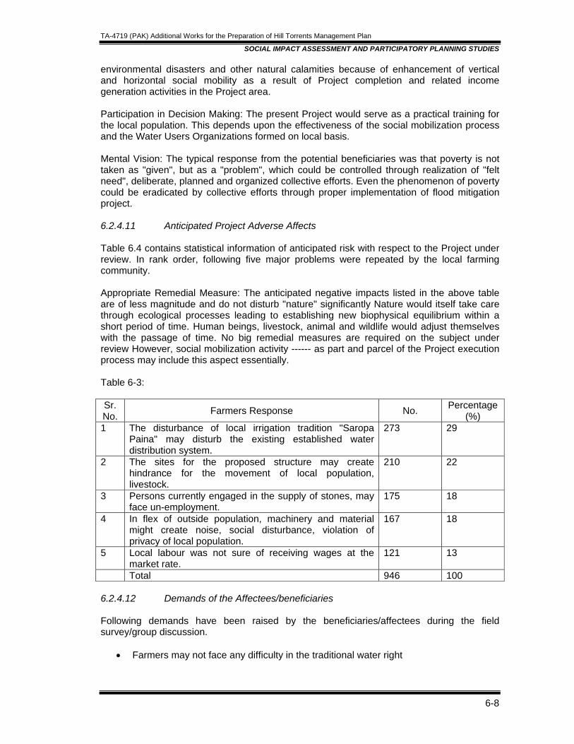
TA-4719 (PAK) Additional Works for the Preparation of Hill Torrents Management Plan
SOCIAL IMPACT ASSESSMENT AND PARTICIPATORY PLANNING STUDIES
6-8
environmental disasters and other natural calamities because of enhancement of vertical and horizontal social mobility as a result of Project completion and related income generation activities in the Project area. Participation in Decision Making: The present Project would serve as a practical training for the local population. This depends upon the effectiveness of the social mobilization process and the Water Users Organizations formed on local basis. Mental Vision: The typical response from the potential beneficiaries was that poverty is not taken as "given", but as a "problem", which could be controlled through realization of "felt need", deliberate, planned and organized collective efforts. Even the phenomenon of poverty could be eradicated by collective efforts through proper implementation of flood mitigation project. 6.2.4.11 Anticipated Project Adverse Affects Table 6.4 contains statistical information of anticipated risk with respect to the Project under review. In rank order, following five major problems were repeated by the local farming community. Appropriate Remedial Measure: The anticipated negative impacts listed in the above table are of less magnitude and do not disturb "nature" significantly Nature would itself take care through ecological processes leading to establishing new biophysical equilibrium within a short period of time. Human beings, livestock, animal and wildlife would adjust themselves with the passage of time. No big remedial measures are required on the subject under review However, social mobilization activity ------ as part and parcel of the Project execution process may include this aspect essentially. Table 6-3: Sr. No. Farmers Response No. Percentage
(%) 1 The disturbance of local irrigation tradition "Saropa
Paina" may disturb the existing established water distribution system.
273 29
2 The sites for the proposed structure may create hindrance for the movement of local population, livestock.
210 22
3 Persons currently engaged in the supply of stones, may face un-employment.
175 18
4 In flex of outside population, machinery and material might create noise, social disturbance, violation of privacy of local population.
167 18
5 Local labour was not sure of receiving wages at the market rate.
121 13
Total 946 100 6.2.4.12 Demands of the Affectees/beneficiaries Following demands have been raised by the beneficiaries/affectees during the field survey/group discussion.
• Farmers may not face any difficulty in the traditional water right

TA-4719 (PAK) Additional Works for the Preparation of Hill Torrents Management Plan
SOCIAL IMPACT ASSESSMENT AND PARTICIPATORY PLANNING STUDIES
6-9
• Local population must be given preference in hiring labor and technicians for the construction of dispersion structures.
• The land of the poor people may be avoided for acquisition to build the dispersion structure
• The dispersion structure may be provided at wah and sub-wah level depending upon development potential for the economic benefit of the users
• Launch the social mobilization process before the execution of the Project to ensure the community participation.
• Community development Project may launch poverty reduction campaign in the area with the help of Project NGO.
• Built the capacity of the Project beneficiaries including the promotion of literacy level. Enhancing of credit access to local population, particularly for agricultural inputs and development of the human resource.
Training/skill Development and Job Opportunities: The Project proponents are expected to provision for improving skills and training of affectees/beneficiaries in the following because the current Project might be considered as development opportunity;
• Operation and maintenance of dispersion structure • Technical persons for controlled grazing, nursery raising and social forestry; • Livestock/dairy extension workers, vaccinators and prevention of livestock/dairy/
poultry birds diseases; • Agricultural extension/rural development agents; • Motor/tractor drivers and mechanics; and • Health workers/aids, lady health visitors, nursing and paramedical staff;
The above-suggested areas of human resource development (women including), training would certainly improve technical capabilities of local population. This would be an essential component for attaining long term project sustainability indirectly. The attained skills would automatically, in most of the cases, lead to employment opportunities and hunt for relevant jobs within or outside the Project area. Any investment in Ian resource development is justifiable socially, financially and ethically at the local and regional level. It would be rational to select a number of local skills required for the nearest markets, where newly trained persons might get employment opportunities. The Project authorities are lased to make special budgetary provisions and enhance credit access to Project beneficiaries/affectees for training/skill improvement and creating job opportunities. 6.3 PARTICIPATORY DEVELOPMENT PLAN The basic philosophy and instrument of any development Project is to work "with people" and not "for people" in order to achieve sustainable development mechanism. The local population may identify their "felt-needs", and find their solutions in cooperation with the Project officials. The PRA findings' suggested that all sections of potential beneficiaries and affectees were willing to participate actively in various Project activities rather playing passive role and remain salient consumers of Project benefits. The details are presented in proceeding paragraphs:
TA-4719 (PAK) Additional Works for the Preparation of Hill Torrents Management Plan
SOCIAL IMPACT ASSESSMENT AND PARTICIPATORY PLANNING STUDIES
6-10
6.3.1 Social Mobilization Social mobilization is an essential component of community participation process. This is the vital principle of any community development process, particularly the project regarding management of hill torrents of CRBC area in Taunsa Tehsil of D.G Khan. Social mobilization methodology is divided into the following five aspects:
• Need: Social preparation is a pre-investment phase designed to strengthen the absorption capacity of vulnerable groups and ethnic populations, who may be marginal to main stream development activities.
• Aim: To provide vulnerable and ethnic groups with the confidence, motivation, and opportunity to address community and development issues.
• Focus: Vulnerable and ethnic groups, and/or indigenous population outside the main stream of information or development process are to be focused at.
• Responsibility: Experienced NGOs and/or community based organizations (CBOs) are usually engaged to take responsibility for the social preparation process.
• Method: Social mobilization usually has four phases: o Identification of vulnerable group and ethnic people affected/benefited by the
Project and targeting of particular sub-groups (for examples a very poor, women or indigenous groups).
o Social preparation: community organizers work with the groups to create awareness, engage their interest. "Consciousness of kind" realization of "felt needs" and pooling of human, economic and political resources to achieve the project objectives in a democratic way with justice and equity effectively.
o Social organization: Community organizers generally help to build skills, leadership and sense of common purpose. The group may work through a process of problem identification, review of constraints and identification of opportunities and risks in the context of the proposed Project. The group may identify preferred options for re-Iocation and income restoration activities.
o Institutionalization: The small community groups are linked to broader entities, for example, to District Government- local agencies and the line departments. At this stage the group makes a formal input into the preparation.
6.3.2 Prevailing Hill Torrent Management Practices The diverting of hill torrents' flows and runoff into the lands falling within its command is called the "Rod Kohi" irrigation system. According to this system, the field, around which earthen dykes about three feet high, locally called the "Sadds" are constructed and water is collected in the field, down to a depth of about 2-5 feet, which gradually seeps into the soil. The crop so sown generally matures even with one watering. The flood water is diverted into fields by constructing a "ganda" (an earthen diversion bund) across the nallah. When the particular area is irrigated, the ganda has to be breached for 3110wing water to pass downstream for diversion at the next ganda and so on. This practice of irrigation is called "Saropa Paina" The word "Saropa" stand for head and "Paina" used for tall of nullah. The construction of these gandas involves huge community labour and earth machinery. Machinery is usually arranged by the farmers on self help basis from the al Government at subsidized rate. Occasionally, they get fund from the local men! as well, depending upon local population influence on district administration. The Water User Association 0NUA), comprises progressive and large farmers take the initiative of ganda formation. The WUA collected the funds from the respective farmers in of donating 1/64 share of last year total crop produce, or Rs. 100/acre. In case of last year crop
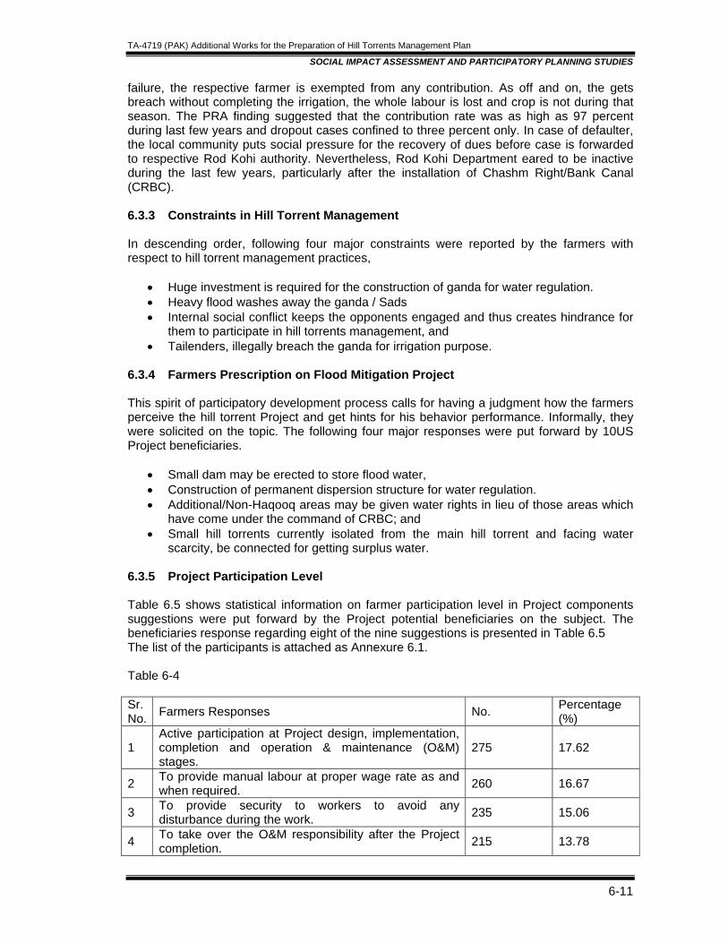
TA-4719 (PAK) Additional Works for the Preparation of Hill Torrents Management Plan
SOCIAL IMPACT ASSESSMENT AND PARTICIPATORY PLANNING STUDIES
6-11
failure, the respective farmer is exempted from any contribution. As off and on, the gets breach without completing the irrigation, the whole labour is lost and crop is not during that season. The PRA finding suggested that the contribution rate was as high as 97 percent during last few years and dropout cases confined to three percent only. In case of defaulter, the local community puts social pressure for the recovery of dues before case is forwarded to respective Rod Kohi authority. Nevertheless, Rod Kohi Department eared to be inactive during the last few years, particularly after the installation of Chashm Right/Bank Canal (CRBC). 6.3.3 Constraints in Hill Torrent Management In descending order, following four major constraints were reported by the farmers with respect to hill torrent management practices,
• Huge investment is required for the construction of ganda for water regulation. • Heavy flood washes away the ganda / Sads • Internal social conflict keeps the opponents engaged and thus creates hindrance for
them to participate in hill torrents management, and • Tailenders, illegally breach the ganda for irrigation purpose.
6.3.4 Farmers Prescription on Flood Mitigation Project This spirit of participatory development process calls for having a judgment how the farmers perceive the hill torrent Project and get hints for his behavior performance. Informally, they were solicited on the topic. The following four major responses were put forward by 10US Project beneficiaries.
• Small dam may be erected to store flood water, • Construction of permanent dispersion structure for water regulation. • Additional/Non-Haqooq areas may be given water rights in lieu of those areas which
have come under the command of CRBC; and • Small hill torrents currently isolated from the main hill torrent and facing water
scarcity, be connected for getting surplus water. 6.3.5 Project Participation Level Table 6.5 shows statistical information on farmer participation level in Project components suggestions were put forward by the Project potential beneficiaries on the subject. The beneficiaries response regarding eight of the nine suggestions is presented in Table 6.5 The list of the participants is attached as Annexure 6.1. Table 6-4 Sr. No. Farmers Responses No. Percentage
(%)
1 Active participation at Project design, implementation, completion and operation & maintenance (O&M) stages.
275 17.62
2 To provide manual labour at proper wage rate as and when required. 260 16.67
3 To provide security to workers to avoid any disturbance during the work. 235 15.06
4 To take over the O&M responsibility after the Project completion. 215 13.78
TA-4719 (PAK) Additional Works for the Preparation of Hill Torrents Management Plan
SOCIAL IMPACT ASSESSMENT AND PARTICIPATORY PLANNING STUDIES
6-12
5 To provide land/earth for civil works free of cost as per requirement. 180 11.54
6 To provide required piece of land free of cost for logistic arrangement during construction work. 165 10.58
7 To supply stones free of cost for picking purpose. 120 7.69 8 To contribute one percent of Project cost. 110 7.06 Total 1560 100 The ninth issue related to the voluntary donation of land by the beneficiaries whose land is likely fall in the vicinity of the planned structures. Efforts were directed to contact all such stakeholders whose part of land might be needed for the structures. A special survey was carried out for this task, past the submission of Draft Feasibility Report in order to update the pre-planning survey statistics. All the expected land donors contacted during this endeavor earnestly assured that they would donate the required pieces of land (if required) totally free of cost No orchards, sheeps houses or any property except agricultural land falls in these The number of affectees at all the sites ranges between four to eight; the aggregates number being much less than 200. This task was extensively carried out in the areas of Kaura, Vehowa and SanghaI hill torrents whereas Sori Lund (Rohir Wah) area did not "rant such field studies. In addition to above mentioned factors of participation, the stakeholders were willing to form association (committee) at each sub-project (wah & wahi) level, which can playa vital role at various stages of the Project. The list of association (structure-wise) is given in Annexure-6.2. It has already been mentioned that one of the most important and fundamental principals followed during the planning process is to accommodate the required structures on the government lands as far as possible The extent of the private land, if required for the structures would not render any farmer landless. Rather, the construction of some of the structures would constrict existing channel and thus would make some of the land available for cultivation. However, it is suggested that the offers of the land donor's may be confirmed through legal agreements during the social mobilization period, well In advance of the start of work on physical components of the Project. The Project executing agency may execute such agreements with the landlords through the concerned government formations and the consultants (if necessary). 6.3.6 Women Participation Usually a male head of the family informally discusses all matters and problems regarding profession with his counterparts, specially his wife and family members. This constitutes most important institution of sharing the information and consultations. The conclusion rived during such a discussion necessarily affect duly on the matters discussed in the family forum, This was confirmed by the women interviewed during the field studies, It was also conceived that women, particularly aged ones, could be quite effective for conflict resolution on various Project activities. The women of different working group offered to the manual labour at proper wage rates on need basis. The list of female participants is presented in Annexure-6.3. 6.3.7 Suggestion for Project Sustainability Table 6.6 indicates that following seven major suggestions were put forward by the local unities for the successful completion of the Project.
TA-4719 (PAK) Additional Works for the Preparation of Hill Torrents Management Plan
SOCIAL IMPACT ASSESSMENT AND PARTICIPATORY PLANNING STUDIES
6-13
Table 6-5: Farmers Views for the Sustainability of the Project Sr. No. Farmers Responses No. Percentage
(%)
i) Formation of committee is a legal identity for the O&M of the Project. 278 17.2
ii) Construction of dispersion structure at the original site, as shown in Rod Kohi record (on state land). 273 16.9
iii) To maintain and reserve the existing water right of farming community 270 16.8
iv)
A three tier social structure of "Wah” (primary level), "Sub-wah" (secondary level) & "Wahi" (Tartiary level) may be established for having an effective participatory approach of water management.
270 16.8
V) Dispersion structure may be constructed during winter to avoid the crop failure during summer season. 210 13.1
vi) Flow may be regulated in such a away that there could not remain any risk of it re-mixing into the flow of parent channel or other hill torrent.
190 11.8
vii) Provision of super-passages at CRBC for minimizing the flood risks and danger. 118 7.4
Total 1609 100 6.3.8 Conclusion On the basis of above discussion, it could be safely concluded that the potential for participatory development process is quite rich in term of ultimate beneficiaries towing the proposed flood mitigation project, realization of felt need and formation of local village level later user association for the proper implementation of water distribution system. Further provision in this regard for activating the aspect of social mobilization through social mobilizers have been made in the PC-1.
TA-4719 (PAK) Additional Works for the Preparation of Hill Torrents Management Plan
AGRICULTURAL STUDIES
Table of Contents
7. AGRICULTURAL STUDIES..........................................................................................7-1 7.1 PRESENT AGRICULTURE..................................................................................7-1
7.1.1 General .............................................................................................................7-1 7.1.2 Existing Cropping Pattern and Intensities.........................................................7-1 7.1.3 Existing Crop Yields and Production ................................................................7-3 7.1.4 Crop Production................................................................................................7-3 7.1.5 Crop Sharing Arrangements.............................................................................7-5 7.1.6 Farm Cultural Practices ....................................................................................7-6 7.1.7 Integration with live stock..................................................................................7-6
7.2 FUTURE AGRICULTURE DEVELOPMENT ........................................................7-7 7.2.1 Potential for Development ................................................................................7-7 7.2.2 Cropping Pattern and Intensities ......................................................................7-8
7.2.2.1 'Without’ Project ........................................................................................7-8 7.2.2.2 'With' Project ...........................................................................................7-11
7.2.3 Crop Yields and Production............................................................................7-11 7.2.4 Cultural Practices ...........................................................................................7-11 7.2.5 Input Utilization ...............................................................................................7-12 7.2.6 Agriculture Extension Services.......................................................................7-12
TA-4719 (PAK) Additional Works for the Preparation of Hill Torrents Management Plan
AGRICULTURAL STUDIES
7-1
7. AGRICULTURAL STUDIES 7.1 PRESENT AGRICULTURE 7.1.1 General The Project area is lying "in D. G. Khan and Taunsa Tehsils of Dera Ghazi Khan District having cultivable command area (CCA) of about 116.4 thousand acres. Flood water is mainly utilized for agricultural purposes. Perennial water of springs available in catchment area of Vehowa and Sanghar is utilized for drinking and agriculture purposes. The Pachad area has arid climate. Farming and crop production mainly depend upon flood water or rainfall moistures. Only a small part of the rainfall in the catchment area is utilized for agriculture, while major portion of its flow causes damages to earthen bunds in Pachad area and the CRBC irrigation system and agricultural command area by flooding. Cropping intensity in Pachad area varies greatly according to the extent and frequency of flooding, Sorghum and Bajra are mainly sown on most of the area on flood moisture and oil seeds are later grown on where sorghum fails to germinate. In case flood season start late, or optimum soil moisture is retained in the soil from earlier flooding, Wheat is planted in the month of November. Cultivation by traditional wooden plough is practiced without the use of fertilizers and pest' control. Because of the importance' of straw and stover for livestock feeding, local high yielding straw varieties are selected for sowing. Yields are low, averging about 298 kgs acre for Sorghum, 204 kgs acre for Oilseeds and 367 kgs per Oilseeds and 367 kgs per acre for Wheat. Lack of optimal use of water; poor management practices, inefficient flood management and improper use of other essential inputs are main causes for low agricultural outputs in Pachad Area. Without flood protection and proper management of water resources, subsistence level of farming would perpetuate causing thereby more deterioration in the socio-economic condition of the farming community. 7.1.2 Existing Cropping Pattern and Intensities Existing cropping pattern and intensities have been developed on the basis of five years average (1999-2000 to 2003-04) cropped data obtained from Revenue Department by collecting village wise cropped area for each hill torrent as given in Table 9.1. It indicates that annual cropping intensity comes to about 12.4, 12.5, 13.8 and 2.5 percent for Kaura, Vehowa, Sanghar and Sori Lund, respectively. The reason for using five years data to determine the existing cropping pattern and intensities is to smooth out all the seasonal as well as rainfall fluctuation to achieve rationality in the project evaluation. The overall cropping intensity of the project is determined as 12.3 percent. The cropping pattern in the area is practiced on the basis of availability of limited and unpredictable flood water supply. Sorghum and Bajra (Millet), Guara and Pulses are sown during kharif season with the use of flood flows from April to the end of July in the area. From August to September/October Rabi crops namely Wheat and Gram are cultivated on flood moisture or (Rape seed and Mustered (oil-seeds) on occurrence of rain in the Project area. Maximum .intensity of 7.6 percent is achieved for Sorghum during Kharif in Sanghar Hill Torrent -and Wheat covers 4.6 percent in Kaura hill torrent during Rabi Season. Kharif crops are usually harvested during October December whereas Rabi crops like Wheat and Gram in March-April and Oil-seeds during February-March.
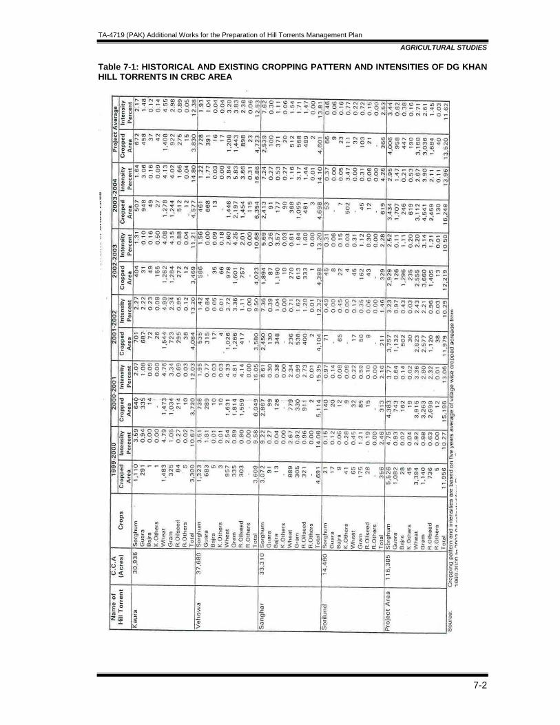
TA-4719 (PAK) Additional Works for the Preparation of Hill Torrents Management Plan
AGRICULTURAL STUDIES
7-2
Table 7-1: HISTORICAL AND EXISTING CROPPING PATTERN AND INTENSITIES OF DG KHAN HILL TORRENTS IN CRBC AREA
TA-4719 (PAK) Additional Works for the Preparation of Hill Torrents Management Plan
AGRICULTURAL STUDIES
7-3
7.1.3 Existing Crop Yields and Production Hill Torrent wise existing crop yields are given in Table 9.2. The existing yields are based on field surveys and discussions with agriculture officials working in the project area. Before opting the existing yields level comparison with published sources i.'e. Agricultural Statistics of Punjab for D. G. Khan district and previous studies conducted for the Project area were also consulted and compared. The yields calculated for Sorghum, Guara, Bajra, and Wheat Gram and Oil-Seeds are 298, 192,247,367,285 and 204 kg/acre respectively. The existing yields of Sorghum, Bajra, Wheat and Gram are higher by 63,55,2 and 48 percent than the un-irrigated yields of D. G. Khan District. Hill torrent wise comparison indicates that maximum yields of Sorghum and Guara are 315 & 205 kgs/acre in Sanghar, and Bajra, Wheat, Gram, Oilseed yields are 275,- 445, 335 and 225 kg/acre in Sori Lund; respectively. 7.1.4 Crop Production Pachad area is very fertile because flood deposits loamy/silty soils which greatly adds fertility to 'the land. Table 9.2 also indicates the areas and total production of the crops grown in the Project area. The total production for Sorghum, Guara, Bajra, Wheat, Gram and Oilseed comes to 1195, 184, 157, 1160, 866 and 352 tones, respectively. T/1e brief history and general description of -the crops are as follows: a. Kharif Crops: Millet and Guara are sown from April to July and Harvested during
November and December Millet: Sorghum & Bajra are the most important kharif food grain crops grown in the Project area. The cultivation depends upon the availability of moisture of the diverted flood water which flow down into the plains from the mountains or catchment area with fertile virgin soil. This flood flow is primarily available in summer season with variable in quantity and timing. The area under these crops, thus, varies considerably according to the duration and number of floods occurs every year. The Sorghum and Bajra crops varieties planted in the area are low yielding with long stemmed indigenous varieties. The straw of the crops are considered as important as grain production because this is used as feed for livestock throughout the year. This is' the main reason that farmers generally prefer to sow Sorghum/Bajra even in the late season if the rainfall occurs late. The main local varieties of Sorghum Le. SS-11 and D. G. Pearl-1947 are mostly sown in the area after the first flood during summer season.

TA-4719 (PAK) Additional Works for the Preparation of Hill Torrents Management Plan
AGRICULTURAL STUDIES
7-4
Table 7-2: EXISTING CROP YIELDS & PRODUCTION LEVEL IN DIFFERENT HILL TORRENTS OF PROJECT AREA
Name of Hill Torrent CCA (ha) Crops Area* Yield** (kg/ha) Production (Tons)
Sorghum 648.00 770.00 499.00
Bajra 255.00 690.00 176.00
Wheat 667.00 830.00 554.00
Pulses - 530.00 -
Oilseeds 337.00 550.00 185.00
Sorghum 74.00 900.00 67.00
Bajra 635.00 665.00 422.00
Wheat 1,401.00 1,330.00 1,863.00
Pulses 1,377.00 550.00 758.00
Oilseeds 22.00 695.00 15.00
Sorghum 2,436.00 880.00 2,144.00
Bajra 212.00 800.00 170.00
Wheat 3,009.00 1,095.00 3,294.00
Pulses 598.00 575.00 344.00
Oilseeds 364.00 650.00 237.00
Sorghum 3,158.00 2,550.00 2,637.00
Bajra 1,102.00 2,155.00 792.00
Wheat 5,077.00 3,255.00 5,737.00
Pulses 1,975.00 1,655.00 1,102.00
Oilseeds 723.00 1,895.00 442.00
12,035.00 11,510.00 10,710.00
Source: * Revenue Offices DG Khan & Rajanpur Districts** Agriculture Department and Field Investigations
Adopted from: NESPAK February 1996, Flood Management of DG Khan Hill TorrentsNESPAK March 1990, Flood Management of Kaha Hill Torrent
SANGHAR
TOTAL
Total
17310
26730
25770
69810
KAURA
VEHOVA
For using the flood water, bunds are made with the help of tractor. The flood water is allowed to stand inside the bunds up to 2-3 feet deep. After few day on 'wattar1' condition Sorghum/Bajra is sown through Nalil Pora method. Farmers are usually using 5-9 kgs seed rate per acre. Field preparation is done by applying one to two ploughing according to the
TA-4719 (PAK) Additional Works for the Preparation of Hill Torrents Management Plan
AGRICULTURAL STUDIES
7-5
available resources or financial status. Bajra is generally sown on small scale due to low forage quality. Considerable quantities of grain as well as straw are crushed and fed to livestock because farmers in Sorghum growing areas are passing no mads style of life with traditional livestock rearing background. Yields of grains are estimated as 298 'and 247 kgs and straw 1193 and 986 kgs/acre for Sorghum and Bajra respectively. Fertilizer is not used for growing the crops, plant diseases like smut and insect attack of stem borer are the major problems of the area. Therefore, farmers are using high seed rate in case of Bajra. Guara: Crop is mostly sown on sandy loam soil having low water holding capacity. The sowing of Guara as late season mixed crop is general practice in the project area. Farmers are mainly sowing local varieties (cluster 2/1) which are drought resistance and tolerate shortage of water. About 10 kgs seed. is used per acre in the project area. On ripening the crop'-grain'-are'soldin1he'market and'usediri' teXtile,Hniedicine' aridbtherbY'prooud'of human use. Straw is crushed and used as dry fodder by the animals. Usually farmers broadcast the seed in the field on watar: condition and apply one ploughing for field preparation as well as to bury the seed in the soil for better germination. Average yield is estimated about 192 kgs per acre in the Pachad area. b. Rabi Crops: Wheat, Pulses and Oilseeds are sown on Flood Water Moisture from
September to November and harvested in February to April Wheat: It is the second important rabi food crop sown in Pachad area. In case floods occur late in the season, considerable area is planted under Wheat. Farmers fill the field with water just-like Millet. In case the fields have abundant grasses, then farmers prefer to plough once or twice before filling the water in the field. Otherwise on 'wattar' condition most of the farmer apply one to two ploughing for uprooting the grown grasses as well as preparation of field for sowing Wheat crop through Nali/Pora method. About 40-50 kgs seed per acre is used in the area. Approximately 90 percent of the Wheat area is grown with local varieties, because of its high straw yielding ability and to withstand under drought condition. Wheat crop generally receives no additional moisture than the stored in the soil of bunde9 fields. This results in low crop yield, (about 367 kgs per acre). Pulses: Cultivation practices used for Gram cultivation are similar to Wheat crop. About 20 kgs per acre seed rate is commonly used by the farmers. Area under kharif pulses is not large and generally intercropped with Sorghum in summer. In Rabi season, Gram is cultivated in sandy soil due to its relatively high drought tolerant characteristics. The local varieties like C;42, CM-72 and C-727, are sown in October and harvested in April. Average yield of pulses is estimated about 285 kgs per acre in Pachad area. Oilseeds: The common oilseed crops grown are Rape-seed and Mustard, planted in the rabi season. The rabi oilseed crop is grown in the low alluvial patches of Pachad area using the residual moisture. The crop is planted in pockets inside the Sorghum crop where poor establishment has left gaps. In view of lack of moisture in the soil and likely poor financial return, littl_e efforts are made for the cultivation of oilseed crops. They are taken as a bonus, because of low yields. Sometimes, it is fed green to livestock. The seed rate is 2 to 2.5 kgs per acre and broadcasting method is used for planting the crop. 7.1.5 Crop Sharing Arrangements There are two types of crop sharing system practiced in the Project area:
• In Type-I system all expenditure like cost of seed,. fertilizer, tillage operations, plant protection measures and other labour charges required from -sowing to harvesting are the responsibility of tenant. Crop produce is shared in the ratio of 50:50 among tenant and owner. This system is popular and commonly practiced in the area.
TA-4719 (PAK) Additional Works for the Preparation of Hill Torrents Management Plan
AGRICULTURAL STUDIES
7-6
• In Type-II system all expenditure like tillage operations, farm inputs and labour requirement except cost of seed is provided by tenant. The cost of seed is shared half and half (50:50) among owner and tenant. Similarly crop produce is also shared in the ratio 50:50 between owner and tenants.
In crop sharing arrangements, landowners play the major role for settling the terms with reference and conditions of crop sharing. In addition, location of farm and successful cropping to flood water availability has major impact for deciding the expenditure incurred on farming. Due to above reasons type one is commonly practiced and acceptable to both parties. 7.1.6 Farm Cultural Practices Bullocks provide power for land preparation in the Project area but tractor is also widely available and "used by the farmers on rental basis in recent years. Most of the Farmers have one or two pair of bullocks for cultivation purpose, depending upon the size of land holding. Ploughing is usually done after first soaking of fields because most of the piedmont soils of. the Project area have low permeability, continued ponding or successive flooding is required to achieve saturation levels. The number of ploughing carried out with the help of wooden bullocks drawn implements/tractor are .between 2-3 which is less than that of carried out in canal irrigated area. The seed is sown by' pora' method, direct into the soil at the time of first ploughing. Despite, this, good germination usually occurs because in the sailaba agriculture, silt is deposited with the first watering thus producing a fertile and porus seedbed. The farming operations are not labour extensive. Average family size is about 7-8 persons and they can easily manage to cultivate about 12-15 acres of land with the help of a pair of bullocks. 7.1.7 Integration with live stock Most of the people of the Project area are nomadic and livestock rearing is their traditional activity as source of income. They maintain farm of sheep and goat flocks as well as cattle for draught and milk purpose. These animals are commonly reared through stubble grazing and stalk of Sorghum and Bajra as green fodder. Block and Bunches of sorghum straw are also sold as fodder. This integration of the livestock and cropping system serve the dual purpose of supplying manure to the cropped area as well as keeping the nomadic sheep and goat, flocks in reasonable condition over the winter period. In the absence of organized and developed agriculture, livestock rearing is an important supporting occupation for the farm families. Livestock is a major source of income for the people of the area and its contribution to agricultural development is substantial. The population and composition of livestock for DG Khan district have been obtained from Livestock Census Repot.-2000. Total livestock population of Taunsa tehsil was divided by total area of the tehsil to find the numbers of different categories of livestock per square mile. The same figures were adopted for the project area, to estimate the livestock population as given in Table 7-3.

TA-4719 (PAK) Additional Works for the Preparation of Hill Torrents Management Plan
AGRICULTURAL STUDIES
7-7
Table 7-3: LIVESTOCK POPULATION AND COMPOSITION
District Area Project Area'" Composition
Number Percent Number Percent Cattle 300,962 18.13 29,184 31.26Buffalo 144,581 8.71 9,519 10.20Other Animals 56,655 3.41 3,359 3.60Sheep 530,510 31.96 22,692 24.31Goat 626,955 37.78 28,596 30.63TOTAL 1,659,663 100 93,350 100 Source: Livestock Census Report District D.G. Khan- 2000 * Estimated from Taunsa Tehsil Census Data The table indicates that surplus sheep and goats are produced in the project area which are sold in other towns of the Province. As it is clear that flood irrigation is not a regular feature and mostly depends upon rainfall in the catchment area, therefore, rearing of more livestock without proper management of hill torrents is not possible. Thus, values of increased fodder stalk 'with' project conditions has been considered as an additional benefit instead of calculating benefits through rearing more livestock. 7.2 FUTURE AGRICULTURE DEVELOPMENT 7.2.1 Potential for Development The management of flood flows for agriculture development requires comparative study of pre and post-project level of production. The development potential for future level of cropping where rainfall is the only source of irrigation, mainly depends on the availability of flood water in the form of monthly runoff and culturable area. The annual run-off and total cultivable area of the four hill torrents against various return periods indicate that only 11.6 percent of the Project area is irrigated during average flood year. The historical cropping level of the hill torrents indicates that only a small percentage of flood flows during high floods are utilized for agriculture and remaining flood flows damage canals and canal command area. The Project has been designed against a peak flood of 25-year return period. Flood flows are planned to be managed for the development of Pachad area and to avoid losses. Month-wise runoffs against floods of various return period, at the 'Darrah' for four hill torrents have been estimated using various synthetic techniques. The culturable and water rights of areas have been taken into account to determine flood spreading potential in the Pachad area of each hill torrent. . There are two major seasons of sowing crops Le. Kharif (April-July) and Rabi (September-November). Therefore, month-wise calculated runoff of each hill torrent has been computed for Kharif and Rabi season against 2.33, 5, .10 and 25-year flood. During field investigations, it was observed that the area proposed for agriculture development is already well bunded and suitable for cultivation. The main problem is the diversion of flood flows against high flood. Once the temporary structures are washed away, 'even the low flow water cannot be utilized through the traditional irrigation networks. By the construction of proposed structures, the manageable flows upto design flood can be utilized in the area where economy totally depends upon agricultural production and livestock rearing. The flood flows diverted during the months of April to July are utilized for raising kharif crops. Whereas
TA-4719 (PAK) Additional Works for the Preparation of Hill Torrents Management Plan
AGRICULTURAL STUDIES
7-8
the available diverted flows during the months of August and September are preserved in the fields for sowing Rabi crops from September to November. The assumption of 3 feet bunded irrigation and about 60 percent conveyance efficiency" and have been taken in the light of performance evafuation of Kaha Hill TorrE?nt, in keeping with soil characteristics of the area and recommendations as given in FAO Technical Paper No. 24. The ultimate achievable cropping intensities for each hill torrent against floods of various' return periods have been worked out on the basis of manageable annual runoff during Kharif and Rabi seasons and cultura61e area of respective hill torrents as shown in Table 9.4. This indicates that' ultimate attainable level of cropping intensities increases with the increase of return period of peak flood of each hill torrent depending upon the manageable flood plans. In this way future production and development potential 'with' and ‘without' Project have been' studied to establish incremental production because of project management. For agriculture 'with' and 'without' project, the cropping pattern, crop yield and production have been evaluated. 7.2.2 Cropping Pattern and Intensities 7.2.2.1 'Without’ Project The historical cropping pattern and intensities based on revenue records of DG Khan and Taunusa tehsils indicate that there is vast variation in the - cropped area which is due to vagaries of weather, drought and intensity of floods. The cropping pattern and intensities 'without' Project have been estimated using peak floods for various return periods. After knowing the return period of each flood, area under crops during corresponding years has been estimated from the. revenue records of DG Khan and Taunsa tehsils, which show quantum of flood flows used in the year. Thus cropped area against 2.33, 5, 10 and 25-year floods comes 13,520, 10,284,7,594 and 4,340 acres respectively 'without' flood management conditions as shown in Table 9.5. According to field studies and judgement, increase in cropping pattern and intensities is not anticipated without proper management of hill torrents.
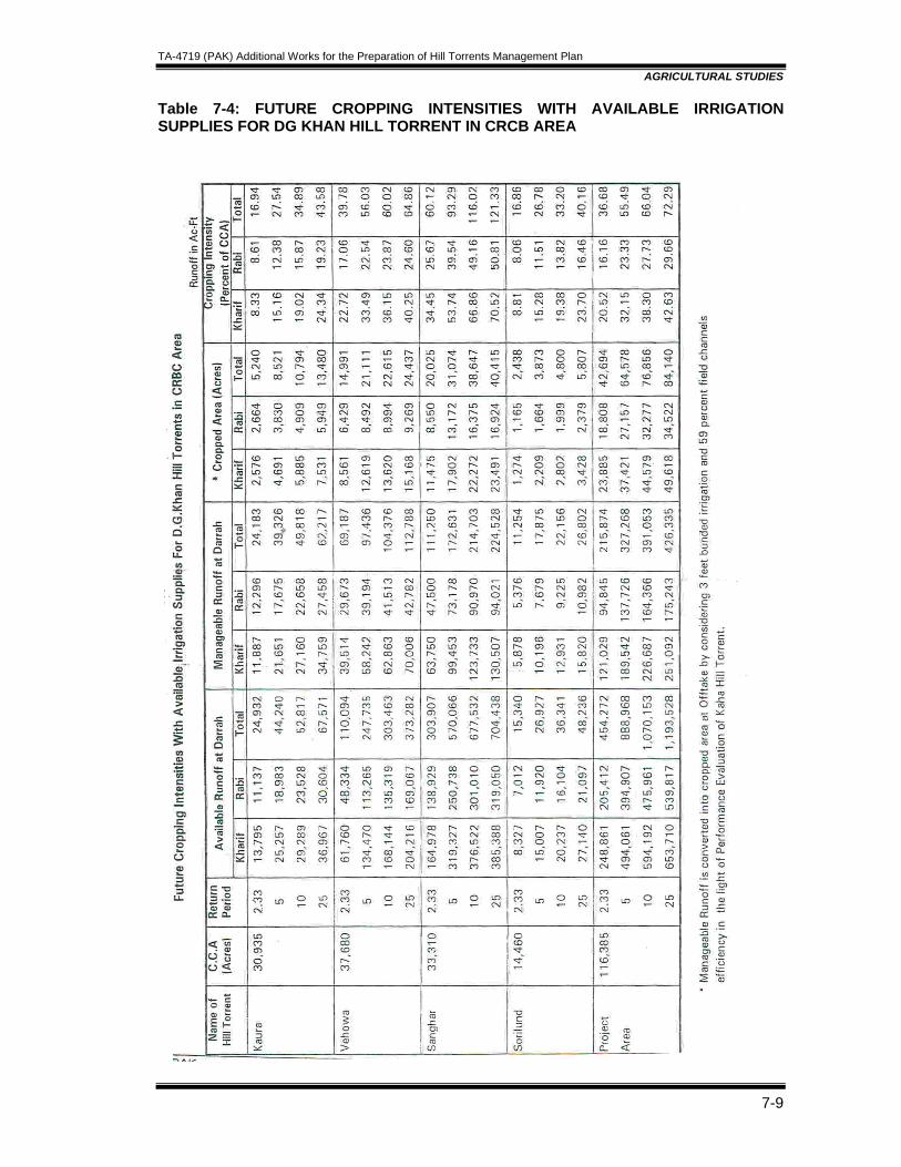
TA-4719 (PAK) Additional Works for the Preparation of Hill Torrents Management Plan
AGRICULTURAL STUDIES
7-9
Table 7-4: FUTURE CROPPING INTENSITIES WITH AVAILABLE IRRIGATION SUPPLIES FOR DG KHAN HILL TORRENT IN CRCB AREA

TA-4719 (PAK) Additional Works for the Preparation of Hill Torrents Management Plan
AGRICULTURAL STUDIES
7-10
Table 7-5: FUTURE CROPPING PATTERN “WITH” AND “WITHOUT” PROJECT FOR DG KHAN HILL TORRENT IN CRCB AREA
TA-4719 (PAK) Additional Works for the Preparation of Hill Torrents Management Plan
AGRICULTURAL STUDIES
7-11
7.2.2.2 'With' Project The ultimate achievable cropping pattern and intensities for Kaura, Vehowa, Sanghar and Sori Lund Hill Torrents against 2.33, 5, 10, 25 and 40 years have been worked out by spreading manageable annual runoff of respective year flood with the assumption of 3 feet bunded irrigation and about 60 percent field channel efficiency as shown in Table 9.5. It indicates that the ultimate attainable level of cropping intensities varies in each hill torrent area depending upon the availability of runoff and quantity of water. The growth of intensity to achieve its ultimate level is considered to be influenced by many other factors such as existing infrastructure, distance from the market, level of cropping and socio-economic conditions and pattern of irrigation supplies. Therefore, all the factors mentioned above have also been taken into account for establishing future cropping intensities for each hill torrent against 2.33, 5, 10, 25 and 40 years floods. Future cropping pattern under 'with' project conditions have been proposed for each hill torrent after taking into consideration the major factors such as soil texture, crop suitability; root system, water requirement, drought tolerance and present crop distribution. The piedmont soils of Pachad area are well suited to Millet (Jawar and Bajra), oilseed (Taramira and usu) pulses and Wheat crops. Jawar and Bajra, the important food grain crops, covering 48.4 percent of cropped area have been included in the cropping pattern, in view of its deep root system, low water requirements and better drought tolerance. Rabi oilseeds in winter season are suited for drier parts of the Project area which cover 10.3 percent of cropped area. On the basis of previous experience, with the availability of a more dependable water supplies and a prolonged flood season, it is reasonably to assume that .Wheat and pulses would subsequently occupy about 25,863 acres of Project area. 7.2.3 Crop Yields and Production Traditional and subsistence agriculture conditions would perpetuate due to undependable irrigation supply under 'without' proper management of Project hill torrents. The historical yield growth rates would not be sustained by the local farmers, who do not have technical know-how and financial resources. It is anticipated that most of the Project benefits would accrue from increase in the cropping intensities. However, manageable water supply would also bring improvement in cultural practices and input utilization, resulting in some increase in crop yields. Projection of crop yields against peak floods of various return' periods without detailed hydrologic studies and field investigations are not possible. The projected cropping pattern and intensities 'with' and 'without' Project have been used for the assessment of incremental production against various return periods generated by the Project development. The future crop production for 'without' and 'with' Project, has been estimated for each hill torrent according to the type of soil and water availability in these hill torrents. The future production has been assessed for 2.33, 5, 10, 25 and 40 years floods in Table 9.6 for 'without' and 'with' project conditions. It indicates that Millet grain would increase to about 11,873 tons, Wheat by 4,838 tons, Oilseed by 1,855 tons and Pulses by 3,908 tons under ultimate development conditions against designed peak flood. 7.2.4 Cultural Practices The cultural practices proposed for the Project area are: .
• Improved Cultivation: Permeability of most of the soil could be significantly improved and the flooding time required for saturation reduced by annual cultivation with a chisel plough and metal implements prior to the commencement of the flood season. This would also help to improve soil texture, structure, aeration and root penetration.
TA-4719 (PAK) Additional Works for the Preparation of Hill Torrents Management Plan
AGRICULTURAL STUDIES
7-12
• Land Leveling and Bund formation: Present bund enclosed areas usually range from 8-10 to 25-30 acres. .As a consequence, the lower section of each area is more thoroughly watered and top section is often not sufficiently soaked. Land leveling will substantially increase the cropped area and improve the efficiency of water use.
• Improved Sowing Method: The crop yield can be increased by sowing crops with improved methods and by using clean & the recommended seed rate. Presently in the area, local varieties of Sorghum and Wheat are preferred because of their drought resistance quality and high yields of straw
7.2.5 Input Utilization The following 'input application level has been recommended for the Project area:
• Improved Seed: Improved seed of high yielding drought resistant varieties should be introduced under with Project condition on reliable water supply. The technical discussion held with District Officers, and other specialists revealed that new improved varieties of crops are under experimental stage and would be released for. general adoption for the farmers in flood irrigated areas,
Existing improved varieties of various crops recommeC}ded for the Project area are:
o Wheat: Pak 81, Barani 83, Rawal 88, Chakwal 86 and Faisalabad 83. o Sorghum: DG Pearl Bhaqdir, ~,S-75 and PK SS-11. o Mung (Pulses): 6601, 2002 and Niyab 28. o Oilseeds, Porbi Raya, Raya L.L.84 and Pila Raya
• Adaptation of new crops: Initially, it is, expected that farmers would grow the crops
like; Sorghum, Bajra, Oilseeds, Wheat and Gram crops. If Sorghum prices remain, attractive and the feeding of Sorghum grain for livestock creates an adequate demand, it is postulated that the traditional cropping pattem will continue, If Sorghum becomes less profitable than other crops, change in cropping pattem will occur due to reliable water supply and better distribution under with project condition. There would probably be opportunities for introduction of other new kharif crops. For dissemination of proposed new crops, trials and demonstration plots need to be established to determine the feasibility of their introduction in the area.
• Fertilizer: Farmers have awareness regarding use of chemical fertilizer (NPK) but it is not used in proper proportion or according to the recommendation of Agriculture Department. There is need to arrange training in this regards though agriculture extension technical staff.
• Plant Protection: Farmers are lacking from the knowledge and use of pesticide or plant protection measures, should be introduced on a wider scale to reduce losses from stem borer and insect pest attacks in the Project area:
7.2.6 Agriculture Extension Services In order to achive the planned development and production targets, adoption of improved cultural practices and modern farm technologies by the project farmers is necessary. To accomplish this, strong and efficient agricultural advisory services are necessary to be made available to the farmers by the Department of Agriculture through implementation of proper advisory services in the Project area.
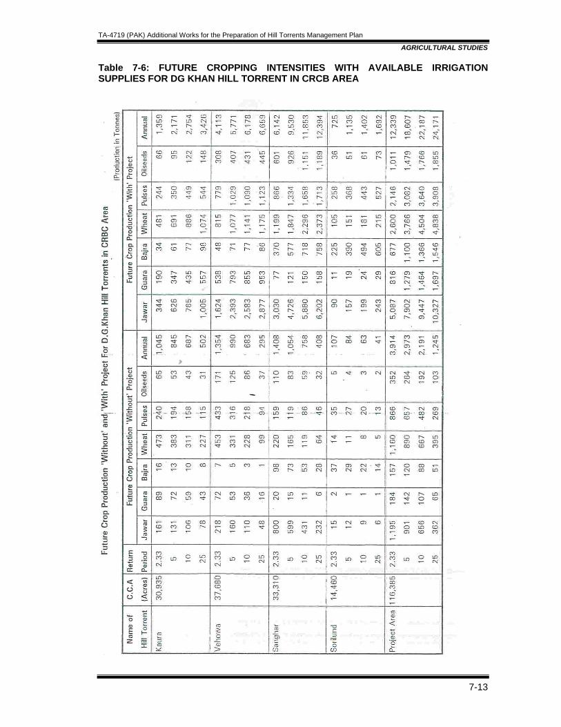
TA-4719 (PAK) Additional Works for the Preparation of Hill Torrents Management Plan
AGRICULTURAL STUDIES
7-13
Table 7-6: FUTURE CROPPING INTENSITIES WITH AVAILABLE IRRIGATION SUPPLIES FOR DG KHAN HILL TORRENT IN CRCB AREA

TA-4719 (PAK) Additional Works for the Preparation of Hill Torrents Management Plan
AGRICULTURAL STUDIES
7-14
Discussion held with District Officer (Agriculture) at D. G. Khan and Deputy District Officers at tehsil level and Agriculture Officers working in the project are reveals that lack of transportation and inadequate budgetary provisions restrict the mobility of the technical staff for performing field activities and creation of effective linkage among the Agriculture Department staff and farming community. The organization set up of the existing agriculture extension services in the District and Project area is shown in Fig. 9.1. Following measures are recommended in order to improve the existing agriculture extension services:
• Agriculture officers and Field Assistant may be convinced to stationed at place of posting and also relieved from non-extension duties.
• Farmers may be provided agriculture machinery on subsidized rates for small to medium size farm in order to make them self-sufficient and self-reliant.
• Development of linkage and coordination between Agriculture Extension and Agriculture Research of the District for transfer of. improved technology to the farming community.
• Other departments related to the Agriculture Development of Project area are: a) Water Management b) Soil Conservation c) Livestock and Diary Development and d) Forest and Wildlife
These departments should be made functional in the Project area through existing City District Government set up.
TA-4719 (PAK) Additional Works for the Preparation of Hill Torrents Management Plan
COST ESTIMATES AND IMPLEMENTATION SCHEDULE
Table of Contents
8. COST ESTIMATES AND IMPLEMENTATION SCHEDULE.........................................8-1
8.1 UNIT RATES ........................................................................................................8-1 8.1.1 Guidelines Regarding Rates.............................................................................8-1
8.1.1.1 Earthwork (Excavation and Embankments)..............................................8-1 8.1.1.2 Stone Masonry..........................................................................................8-2 8.1.1.3 Concrete ...................................................................................................8-2 8.1.1.4 Protection and Diversion Works ...............................................................8-2
8.2 BASIS AND ITEMS OF COST ESTIMATES PROJECT COSTS.........................8-3 8.2.1 Rates ................................................................................................................8-3 8.2.2 Project Cost ......................................................................................................8-3
8.2.2.1 Land Acquisition .......................................................................................8-3 8.2.2.2 Civil Works................................................................................................8-3 8.2.2.3 Work charge and contingencies ...............................................................8-3
8.2.3 Implementation Schedule .................................................................................8-3 8.2.3.1 Background...............................................................................................8-3 8.2.3.2 Prioritization of the Project Scheme..........................................................8-3

TA-4719 (PAK) Additional Works for the Preparation of Hill Torrents Management Plan
AGRICULTURAL STUDIES
7-1
7. COST ESTIMATES AND IMPLEMENTATION SCHEDULE
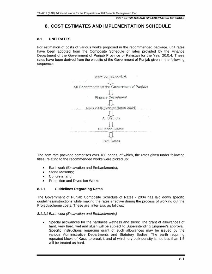
TA-4719 (PAK) Additional Works for the Preparation of Hill Torrents Management Plan
COST ESTIMATES AND IMPLEMENTATION SCHEDULE
8-1
8. COST ESTIMATES AND IMPLEMENTATION SCHEDULE 8.1 UNIT RATES For estimation of costs of various works proposed in the recommended package, unit rates have been adopted from the Composite Schedule of rates provided by the Finance Department of the Government of Punjab Province of Pakistan for the Year 20.0.4. These rates have been derived from the website of the Government of Punjab given in the following sequence:
The item rate package comprises over 180 pages, of which, the rates given under following titles, relating to the recommended works were picked up:
• Earthwork (Excavation and Embankments); • Stone Masonry; • Concrete; and • Protection and Diversion Works
8.1.1 Guidelines Regarding Rates The Government of Punjab Composite Schedule of Rates - 2004 has laid down specific guidelines/instructions while making the rates effective during the process of working out the Project/scheme costs. These are, inter-alia, as follows: 8.1.1.1 Earthwork (Excavation and Embankments)
• Special allowances for the hardness wetness and slush: The grant of allowances of hard, very hard, wet and slush will be subject to Superintending Engineer's approval. Specific instructions regarding grant of such allowances may be issued by the various Administrative Departments and Statutory Bodies. The earth requiring repeated blows of Kassi to break it and of which dry bulk density is not less than 1.5 will be treated as hard.

TA-4719 (PAK) Additional Works for the Preparation of Hill Torrents Management Plan
COST ESTIMATES AND IMPLEMENTATION SCHEDULE
8-2
• Deduction for shrinkage from bank measurements: The following allowances should be provided for material which is not rammed, or equally consolidated:
Deduction for shrinkage from the bank measurements when the earthwork is done by manual labour
10%
Deduction for settlement from the bank measurement when the earthwork is done by machines
3 to 6%
• Before the work is to let out to be done by tractors, scrapers, etc. deduction ranging
between 3% to 6% should be agreed to with the contractors. 8.1.1.2 Stone Masonry
• The composite rates do not include the carriage of stone or spawl which will be paid separately by raod and/or rail which ever means of transport is adopted. The supply and carriage to site of work of all other materials is included in the composite rates.
• The payment of carriage of stone or spawl will be made on the basis of the actual stack measurement (without any reduction factor) of the stone or spawl carried.
• Where the stone or spawl is issued from stock and the contractor is paid for its carriage and/or labour only; or where the stone or spawl is supplied, carried or handled by the contractor in which no laying is required, the actual stack measurement (without any reduction factory) shall from the basis of the payment of supply or carriage of stone or spawl. The quantity of finished and completed item of work shall form the basis of laying.
• Rates for all finished work include the removal of surplus, debris, unused material and byproducts.
8.1.1.3 Concrete
• Rates for all finished works include the removal of surplus debris, unused material and by products.
• If concrete mixer or high frequency vibrator, etc. is supplied by the Government, all charges including depreciation will be recovered from the contractor,
8.1.1.4 Protection and Diversion Works
• Rates for all finished works include the removal of surplus debris, unused material and by product.
• The composite rates of the items in which stone, boulders, shingle spawl are used do not contain the carriage of these stone materials, which will be paid separately by road, and/or rail, whichever means of transport is adopted. The supply and carriage to site of work of all other material required in the item is included in the composite rates.
• The carriage of stone or spawl will be paid on the basis of actual stack measurement (without any reduction factor) of the stone, boulders, shingle or spawl carried. Where stone, boulder or spawl is issued from stock and contractor is paid its carriage and/or labour only; or where such stone product is supplied, .carried or handled by the contractor in which no laying is required, the actual stack measurement (without any reduction factor) shall from the basis of payment of supply or carriage of the stone, boulder or spawl, etc. The quantity of finished and completed item of work shall form the basis of laying.
• In case of the items in which the rates include carriage of stakes, bushing, Pilchi, sarkanda or farash, etc. within one mile (1.6 Km).
TA-4719 (PAK) Additional Works for the Preparation of Hill Torrents Management Plan
COST ESTIMATES AND IMPLEMENTATION SCHEDULE
8-3
1. The cost of the carriage within one mile (one km) shall not be deducted from the carriage charges to follow thereafter from the point of supply.
2. If the site of work happens to be within one mile (one km) of the source of supply, the materials will be collected and measured at site of work and no extra carriage would be admissible in such cases.
3. Where the site of the work is situated at more than one mile (one km) distance from the source of supply, the point of supply will be fixed carefully by the Engineer-in-incharge in such a way that the carriage charges would be arrived at, most economically. Extra carriage will be admissible from the place of supply of the material which will be considered its starting point. The demarcation of the place of supply will be pre-determined before calling the tender.
8.2 BASIS AND ITEMS OF COST ESTIMATES PROJECT COSTS 8.2.1 Rates The estimates have been prepared on the basis of amended, updated MRS 1ST quarter 2007. 8.2.2 Project Cost The total cost of the project is Rs 1622.24 and it comprises various components such as land acquisition, civil works and work charge and contingencies referred in Table 8.1. 8.2.2.1 Land Acquisition 170.79 Acres land is required for project. The land would have to be purchased from the private landowners. Estimated costs based on the current market price have therefore been included under this head. 8.2.2.2 Civil Works The cost of civil works on Kaura, Vehova & Sanghar has been worked out as Rs.1545.089 Million referred in Table 8.2. 8.2.2.3 Work charge and contingencies A provision of 3% work charge and contingencies have been made to cover the probable costs the petty expenses on stationery items and work charged supervisory staff. 8.2.3 Implementation Schedule 8.2.3.1 Background A number of roads and infrastructure have been constructed in the area to provide basic facilities to the people. The conservation of flood flows of the hill torrents would be helpful for the development of irrigated agriculture. Management of flood flows would also provide protection to the area from the damages caused by the hill torrent. The implementation of the project has been now planned to be completed within a period of 2 years. Investment schedule is given in Table 8.3. 8.2.3.2 Prioritization of the Project Scheme The order of the priority for the execution of proposed measures for the hill torrents has been based on the flood flows, the available agriculture land and damage potential is as under:
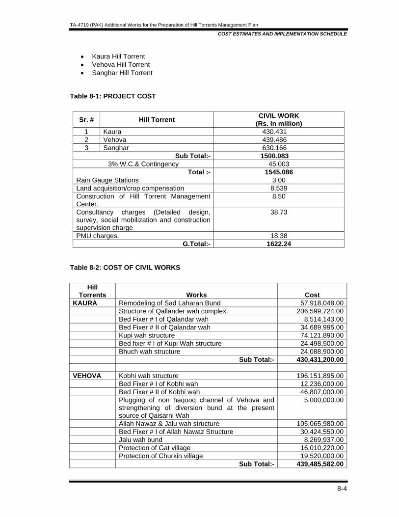
TA-4719 (PAK) Additional Works for the Preparation of Hill Torrents Management Plan
COST ESTIMATES AND IMPLEMENTATION SCHEDULE
8-4
• Kaura Hill Torrent • Vehova Hill Torrent • Sanghar Hill Torrent
Table 8-1: PROJECT COST
Sr. # Hill Torrent CIVIL WORK (Rs. In million)
1 Kaura 430.431 2 Vehova 439.486 3 Sanghar 630.166
Sub Total:- 1500.083 3% W.C.& Contingency 45.003
Total :- 1545.086 Rain Gauge Stations 3.00 Land acquisition/crop compensation 8.539 Construction of Hill Torrent Management Center.
8.50
Consultancy charges (Detailed design, survey, social mobilization and construction supervision charge
38.73
PMU charges. 18.38 G.Total:- 1622.24
Table 8-2: COST OF CIVIL WORKS
Hill Torrents Works Cost
KAURA Remodeling of Sad Laharan Bund 57,918,048.00 Structure of Qallander wah complex. 206,599,724.00 Bed Fixer # I of Qalandar wah 8,514,143.00 Bed Fixer # II of Qalandar wah 34,689,995.00 Kupi wah structure 74,121,890.00 Bed fixer # I of Kupi Wah structure 24,498,500.00 Bhuch wah structure 24,088,900.00 Sub Total:- 430,431,200.00 VEHOVA Kobhi wah structure 196,151,895.00 Bed Fixer # I of Kobhi wah 12,236,000.00 Bed Fixer # II of Kobhi wah 46,807,000.00 Plugging of non haqooq channel of Vehova and
strengthening of diversion bund at the present source of Qaisarni Wah
5,000,000.00
Allah Nawaz & Jalu wah structure 105,065,980.00 Bed Fixer # I of Allah Nawaz Structure 30,424,550.00 Jalu wah bund 8,269,937.00 Protection of Gat village 16,010,220.00 Protection of Churkin village 19,520,000.00 Sub Total:- 439,485,582.00
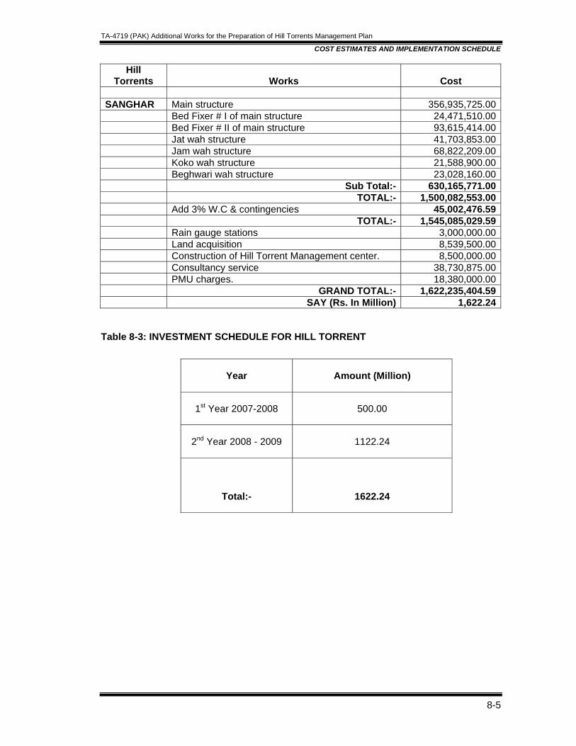
TA-4719 (PAK) Additional Works for the Preparation of Hill Torrents Management Plan
COST ESTIMATES AND IMPLEMENTATION SCHEDULE
8-5
Hill Torrents Works Cost
SANGHAR Main structure 356,935,725.00 Bed Fixer # I of main structure 24,471,510.00 Bed Fixer # II of main structure 93,615,414.00 Jat wah structure 41,703,853.00 Jam wah structure 68,822,209.00 Koko wah structure 21,588,900.00 Beghwari wah structure 23,028,160.00 Sub Total:- 630,165,771.00 TOTAL:- 1,500,082,553.00 Add 3% W.C & contingencies 45,002,476.59 TOTAL:- 1,545,085,029.59 Rain gauge stations 3,000,000.00 Land acquisition 8,539,500.00 Construction of Hill Torrent Management center. 8,500,000.00 Consultancy service 38,730,875.00 PMU charges. 18,380,000.00 GRAND TOTAL:- 1,622,235,404.59 SAY (Rs. In Million) 1,622.24
Table 8-3: INVESTMENT SCHEDULE FOR HILL TORRENT
Year Amount (Million)
1st Year 2007-2008 500.00
2nd Year 2008 - 2009 1122.24
Total:-
1622.24
TA-4719 (PAK) Additional Works for the Preparation of Hill Torrents Management Plan
ECONOMIC ANALYSIS
Table of Contents
9. ECONOMIC ANALYSIS ...............................................................................................9-1
9.1 GENERAL ............................................................................................................9-1
9.2 METHODOLOGY .................................................................................................9-1
9.2.1 Price Datum..................................................................................................9-1
9.2.2 Exchange Rate .............................................................................................9-2
9.2.3 Rate of Discount ...........................................................................................9-2
9.2.4 Standard Conversion Factor.........................................................................9-2
9.2.5 Border Prices ................................................................................................9-2
9.2.6 Domestic Prices............................................................................................9-2
9.2.7 Project Life for Analytical Period...................................................................9-2
9.2.8 Project Benefits.............................................................................................9-2
9.3 PROJECT COSTS ...............................................................................................9-4
9.4 RESULTS OF ECONOMIC ANALYSIS................................................................9-4
9.5 SENSITIVITY ANALYSIS .....................................................................................9-4
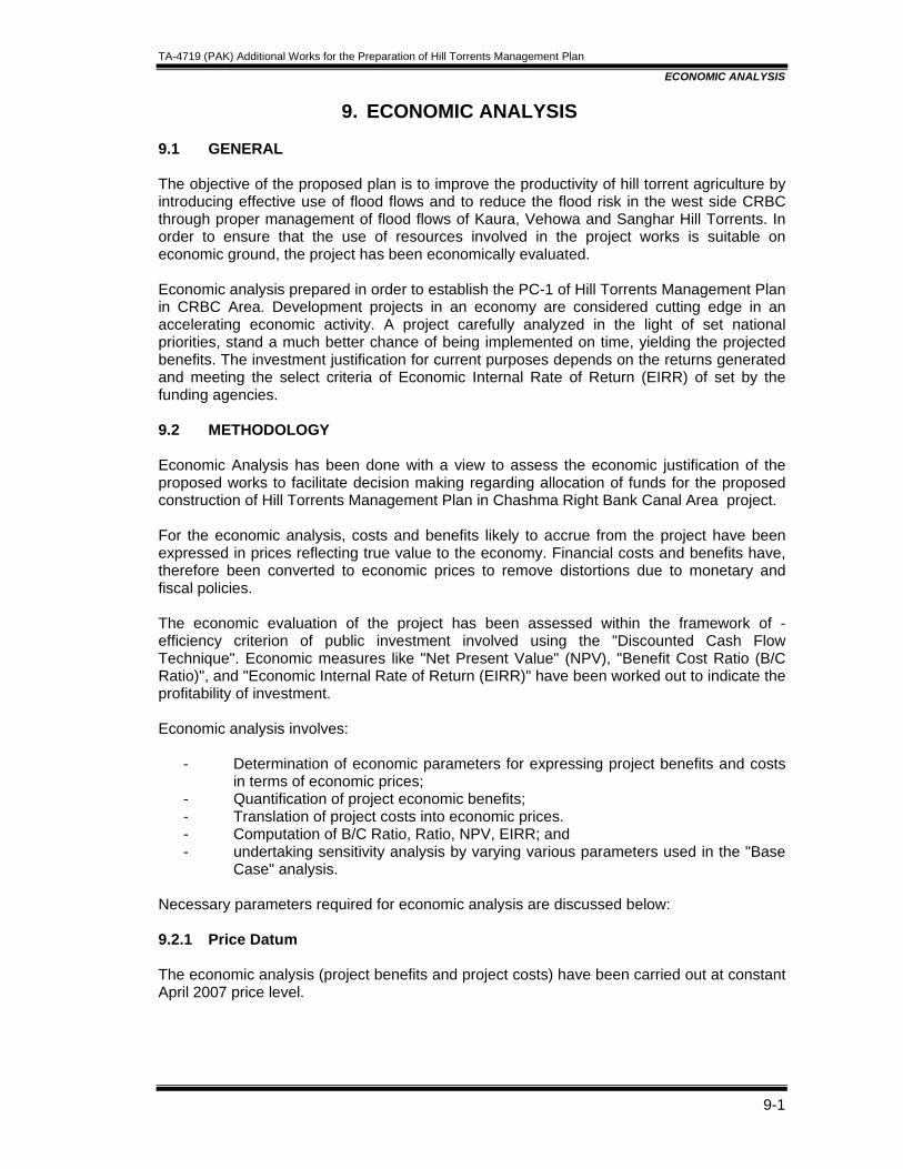
TA-4719 (PAK) Additional Works for the Preparation of Hill Torrents Management Plan
ECONOMIC ANALYSIS
9-1
9. ECONOMIC ANALYSIS 9.1 GENERAL The objective of the proposed plan is to improve the productivity of hill torrent agriculture by introducing effective use of flood flows and to reduce the flood risk in the west side CRBC through proper management of flood flows of Kaura, Vehowa and Sanghar Hill Torrents. In order to ensure that the use of resources involved in the project works is suitable on economic ground, the project has been economically evaluated. Economic analysis prepared in order to establish the PC-1 of Hill Torrents Management Plan in CRBC Area. Development projects in an economy are considered cutting edge in an accelerating economic activity. A project carefully analyzed in the light of set national priorities, stand a much better chance of being implemented on time, yielding the projected benefits. The investment justification for current purposes depends on the returns generated and meeting the select criteria of Economic Internal Rate of Return (EIRR) of set by the funding agencies. 9.2 METHODOLOGY Economic Analysis has been done with a view to assess the economic justification of the proposed works to facilitate decision making regarding allocation of funds for the proposed construction of Hill Torrents Management Plan in Chashma Right Bank Canal Area project. For the economic analysis, costs and benefits likely to accrue from the project have been expressed in prices reflecting true value to the economy. Financial costs and benefits have, therefore been converted to economic prices to remove distortions due to monetary and fiscal policies. The economic evaluation of the project has been assessed within the framework of -efficiency criterion of public investment involved using the "Discounted Cash Flow Technique". Economic measures like "Net Present Value" (NPV), "Benefit Cost Ratio (B/C Ratio)", and "Economic Internal Rate of Return (EIRR)" have been worked out to indicate the profitability of investment. Economic analysis involves:
- Determination of economic parameters for expressing project benefits and costs in terms of economic prices;
- Quantification of project economic benefits; - Translation of project costs into economic prices. - Computation of B/C Ratio, Ratio, NPV, EIRR; and - undertaking sensitivity analysis by varying various parameters used in the "Base
Case" analysis. Necessary parameters required for economic analysis are discussed below: 9.2.1 Price Datum The economic analysis (project benefits and project costs) have been carried out at constant April 2007 price level.
TA-4719 (PAK) Additional Works for the Preparation of Hill Torrents Management Plan
ECONOMIC ANALYSIS
9-2
9.2.2 Exchange Rate Exchange rate for working out export parity prices is taken as Rs. 60 to a US Dollar as prevailing in April 2007 and would be adopted throughout the analysis. 9.2.3 Rate of Discount The marginal productivity of capital in Pakistan is believed to be somewhere between 10 and 12 percent. A discount rate of 10 percent would be adopted for the appraisal of the project. 9.2.4 Standard Conversion Factor The Standard Conversion Factor (SCF), which represents the ratio of prices of all goods within the economy of their international prices. The SCF is mainly influenced by the trade policies of the Government. It is approximated by the weighted average of import and export tariffs, with subsides excluded. The weights used are based on the magnitude of imports and exports in the total trade during the recent years. The Table 9–1 gives the yearly data used to calculate the Standard Conversion Factor for the fiscal years 2001-02 to 2005-06. An average of five years is taken to allow for annual fluctuations in trade, taxes and subsides excluded. The value of SCF has been worked out as 0.90.This however, only takes into account distortions to domestic prices of traded goods caused by tariffs. It may be noted that such factors as trade margins and labor input, particularly in non- tradable goods or services also tend to distort the ratio. 9.2.5 Border Prices Border prices of tradable commodities like Wheat have been computed on the basis of latest available World Bank Commodity Forecasts for April 2007. Necessary adjustments were made to account for transport and handling check between part and market as well as from the market to the farm gate. The border prices of tradable commodity like Wheat have been given in Table 9-2. 9.2.6 Domestic Prices For those commodities for which Pakistan does not enter into international trade, wholesale prices prevailing in Dera Ghazi Khan market of Punjab during respective harvesting periods were collected and adjusted to the farmgate by deducting marketing costs between the farm and the market. Marketing costs include packing, transportation, loading/unloading, commission charges etc. These prices are further adjusted by applying SCF and are shown in Table 9-3. 9.2.7 Project Life for Analytical Period Project life or service life of the Project is dependent upon the useful life of its diverse components. Civil works will entail a different service life compared with earthwork and others items such as machinery. A project utilization period of 30 years has been assumed, which is in line with the common practice for such a canal rehabilitation projects. 9.2.8 Project Benefits 9.2.8.1 Indirect Benefits The indirect benefits include creation of job opportunities during and post construction period; increase in trade and commerce due to marketing of incremental crop production; increase in farm income. Such benefits are difficult to quantify in monetary terms and do not
TA-4719 (PAK) Additional Works for the Preparation of Hill Torrents Management Plan
ECONOMIC ANALYSIS
9-3
form part of the economic appraisal. In addition, the project would contribute toward social developments inhabitants of the project areas in long run. Furthermore, public investment on the proposed work is to increase economic welfare of the people of the Project Area. 9.2.8.2 Direct/Quantifiable Benefits To evaluate monetary benefits related to crops on account of agriculture development of flood plain area and avoidance of area inundation through the implementation of proposed project works, the incremental crop production and flood losses have been estimated. 9.2.8.3 Agricultural Benefits With proper management of hill torrents in CRCB area, major part of flood flows would be utilised for flood irrigation in Pachad area. The benefits of additional flood irrigation can be measured in terms of increased agricultural production under the ‘with’ project conditions compared to the output under the ‘without’ project conditions. Total crop production under the ‘with’ and without’ project conditions was obtained by multiplying the cropped area with the yield of respective crops against 2.33,5,10,25 & 40 years floods and is given in the Table 9-4. The Gross Production Value (GPV) was computed by multiplying the total production of each crop with the prices adjusted to the farm gate and shown in the Table 9-5. The production cost for crops include the money spent on seed, bund maintenance, cultivation, hired labour and an additional small amount to cover the miscellaneous charges have been estimated at 35 percent of the GPV and given in the Table 9-6. The total crop gross margins were worked out by deducting the respective farm production expenses from the GPV of crops grown in the area under both conditions and given in Table 9-7. In the Table 9-8, the difference between crop gross margins under assumed ‘with’ and the same under ‘without’ project conditions has been taken as measure of agriculture benefits. The incremental benefits accruing through proper flood water distribution and improvement in flood management of Hill Torrents are, therefore, estimated as Rs 90, Rs 187, Rs 275,355 and 4446 million against 2.33,5,10, 25 and 40 years floods respectively. 9.2.8.4 Average Annual Agricultural Benefits: The estimated incremental benefits against floods of various return periods have been plotted on normal probability paper to compute average annual agricultural benefits based on the standard procedure as given in Table 9-9. It indicates that annual benefits amounting to Rs 84.53 million would be forthcoming. 9.2.8.5 Total Losses against Design Flood The total potential losses of crops, private houses, roads and other direct and indirect damages have been estimated in Feasibility Study on Hill Torrents Management Plan in CRBC Area in the year 1996 prepared by M/S NESPAK. These losses are updated with multiplying the factor of 2.01 and are shown in the Table 9-10. In addition Vehowa Hill Torrent flood flow have endangered the villages of Jallowali, Gatt & Churkin and for their protection from onslaught of floods requisite additional works have been included in the scheme. The benefits accruing due to the protection of these villages equivalent to 10% of the total losses against design flood have been taken and shown in the above table.

TA-4719 (PAK) Additional Works for the Preparation of Hill Torrents Management Plan
ECONOMIC ANALYSIS
9-4
9.2.8.6 Average Annual Damage: It has been assumed that there will be no flood damage up to 2.33 year returns period under ‘without’ project conditions. The damage corresponding to design flood are plotted on normal Probability Paper. The proposed works would provide full protection against flood of magnitude up to a return period of 40 year. The average annual reduction in damage has been estimated as Rs. 60.55 million as detailed in Table 9-11. 9.2.8.7 Total Project Benefits The average annual agricultural benefits due to flood irrigation and benefits due to savings in flood damages have been estimated as Rs. 84.53 million and Rs. 60.55 million respectively. These benefits are assumed to increase at 6% per annum upto 10th year beyond which it will remain constant. Summary of total annual benefits is shown in Table 9-12. 9.3 PROJECT COSTS Total financial costs are as Rs. 1610 million, which reflect all the associated costs of project implementation through out the economic life of the Project. The project financial cost estimates were converted to economic costs by applying the standard conversion factor (SCF) of 0.90. After the adjustment the total economic capital cost of the project at April 2007 price level comes to Rs. 1449 million. The project proposed to be implemented in two years. The annual operation and maintenance cost is estimated to be Rs. 32.2 million which is 2% of the base cost. The economic value of operation and maintenance costs is calculated on economic prices as Rs. 28.99 million annually. 9.4 RESULTS OF ECONOMIC ANALYSIS To judge the economic viability of the project economic indicators namely, the Net Present Value (NPV), Benefit Cost Ratio (B/C Ratio) and Economic Internal Rate of Return (EIRR) have been calculated. The streams of project benefits and project costs are detailed in Table 9-13 and the results are summarized below:
Economic Indicators At 10% Discount Rate Net Present Value ( Rs. Million) 356.95 B/ C Ratio 1.24 : 1 EIRR (Percent) 12.99
The results indicate that the project is economically viable. 9.5 SENSITIVITY ANALYSIS The results of analysis given above have been computed on the basis of a set of assumptions as given in Table 9-13. Alternate analysis has therefore been undertaken by varying the following assumptions.
- 10 percent increase in project costs - 10 percent decrease in project benefits. - Benefit reduction and cost over run (each by 10 percent) - Occurring simultaneously.
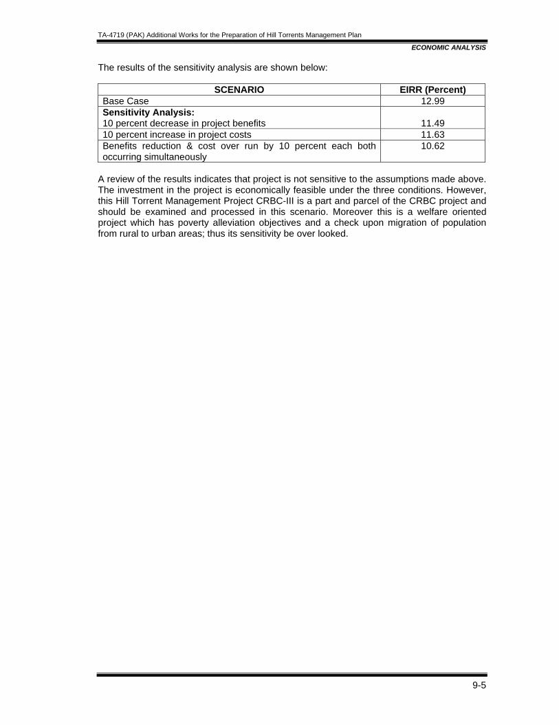
TA-4719 (PAK) Additional Works for the Preparation of Hill Torrents Management Plan
ECONOMIC ANALYSIS
9-5
The results of the sensitivity analysis are shown below:
SCENARIO EIRR (Percent) Base Case 12.99 Sensitivity Analysis: 10 percent decrease in project benefits
11.49
10 percent increase in project costs 11.63 Benefits reduction & cost over run by 10 percent each both occurring simultaneously
10.62
A review of the results indicates that project is not sensitive to the assumptions made above. The investment in the project is economically feasible under the three conditions. However, this Hill Torrent Management Project CRBC-III is a part and parcel of the CRBC project and should be examined and processed in this scenario. Moreover this is a welfare oriented project which has poverty alleviation objectives and a check upon migration of population from rural to urban areas; thus its sensitivity be over looked.
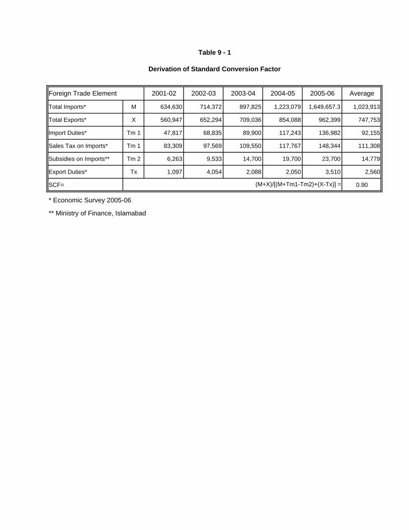
2001-02 2002-03 2003-04 2004-05 2005-06 Average
Total Imports* M 634,630 714,372 897,825 1,223,079 1,649,657.3 1,023,913
Total Exports* X 560,947 652,294 709,036 854,088 962,399 747,753
Import Duties* Tm 1 47,817 68,835 89,900 117,243 136,982 92,155
Sales Tax on Imports* Tm 1 83,309 97,569 109,550 117,767 148,344 111,308
Subsidies on Imports** Tm 2 6,263 9,533 14,700 19,700 23,700 14,779
Export Duties* Tx 1,097 4,054 2,088 2,050 3,510 2,560
SCF= 0.90
* Economic Survey 2005-06
** Ministry of Finance, Islamabad
Derivation of Standard Conversion Factor
Table 9 - 1
Foreign Trade Element
(M+X)/[(M+Tm1-Tm2)+(X-Tx)] =

WHOLE SALE PACKING TRANSPORT OTHER/ COMMISSION FARMGATE PRICESCROPS MARKET PRICE CHARGES CHARGES MARKET CHARGES FINANCIAL ECONOMIC FINANCIAL ECONOMIC
CHARGES Rs. Per M.Ton Rs. Per KgKHARIF
Jowar 14875 65 288 119 223 14180 12762 14.18 12.76Millets 14250 65 288 114 214 13570 12213 13.57 12.21
RABI
Wheat 10917 65 144 0 0 10708 * 10.71 *Oilseeds (R & M) 25250 65 288 202 379 24317 21885 24.32 21.89Pulses 32178 65 288 257 483 31085 27976 31.08 27.98
* ===> Used the Border
Table 9- 2FARMGATE FINANCIAL AND ECONOMIC PRICES
Average Whole Sale Market Prices of D.G.Khan Market
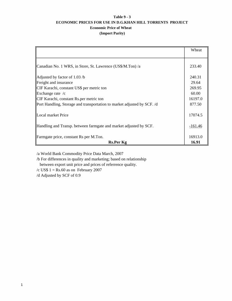
ECONOMIC PRICES FOR USE IN D.G.KHAN HILL TORRENTS PROJECT Economic Price of Wheat
(Import Parity)
Wheat
Canadian No. 1 WRS, in Store, St. Lawrence (US$/M.Ton) /a 233.40
Adjusted by factor of 1.03 /b 240.31Freight and insurance 29.64CIF Karachi, constant US$ per metric ton 269.95Exchange rate /c 60.00CIF Karachi, constant Rs.per metric ton 16197.0Port Handling, Storage and transportation to market adjusted by SCF. /d 877.50
Local market Price 17074.5 Handling and Transp. between farmgate and market adjusted by SCF. -161.46 Farmgate price, constant Rs per M.Ton. 16913.0
Rs.Per Kg 16.91
/a World Bank Commodity Price Data March, 2007/b For differences in quality and marketing; based on relationship between export unit price and prices of referrence quality./c US$ 1 = Rs.60 as on February 2007/d Adjusted by SCF of 0.9
Table 9 - 3
1
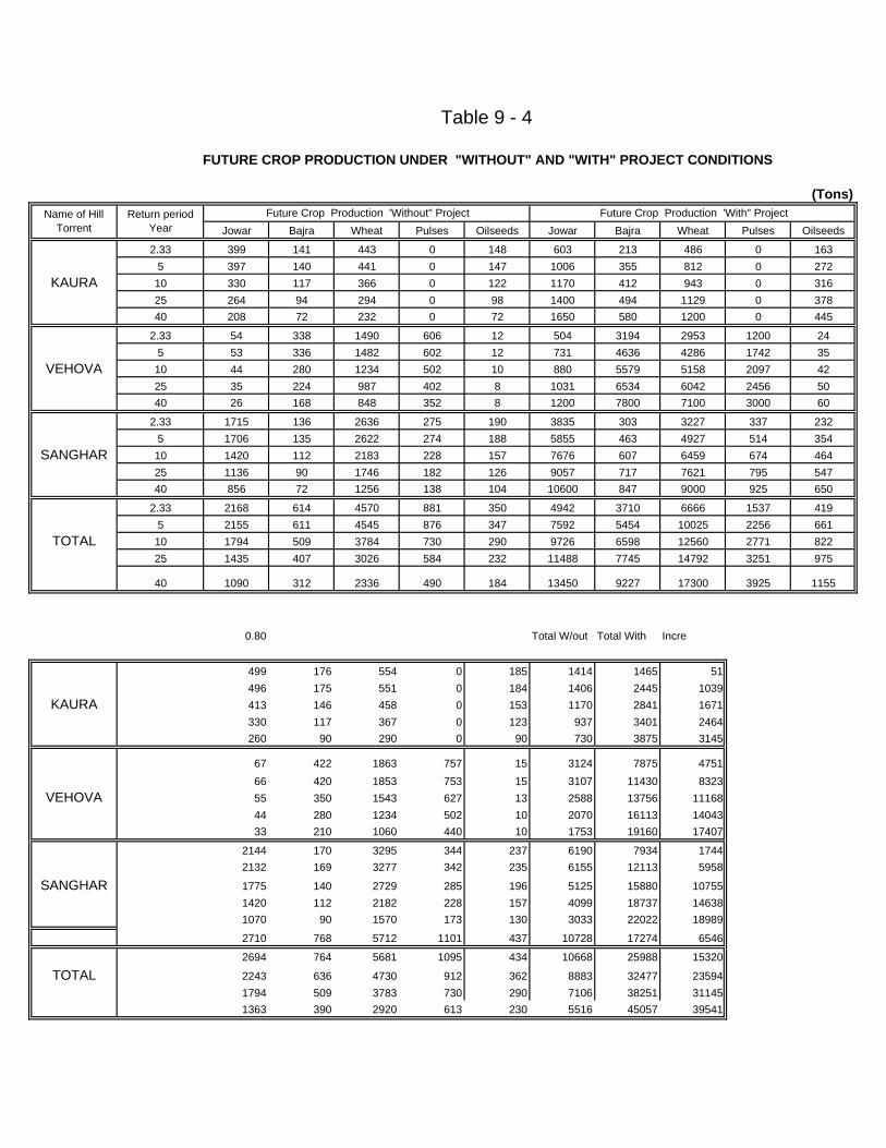
Jowar Bajra Wheat Pulses Oilseeds Jowar Bajra Wheat Pulses Oilseeds
2.33 399 141 443 0 148 603 213 486 0 1635 397 140 441 0 147 1006 355 812 0 272
KAURA 10 330 117 366 0 122 1170 412 943 0 31625 264 94 294 0 98 1400 494 1129 0 37840 208 72 232 0 72 1650 580 1200 0 445
2.33 54 338 1490 606 12 504 3194 2953 1200 245 53 336 1482 602 12 731 4636 4286 1742 35
VEHOVA 10 44 280 1234 502 10 880 5579 5158 2097 4225 35 224 987 402 8 1031 6534 6042 2456 5040 26 168 848 352 8 1200 7800 7100 3000 60
2.33 1715 136 2636 275 190 3835 303 3227 337 2325 1706 135 2622 274 188 5855 463 4927 514 354
SANGHAR 10 1420 112 2183 228 157 7676 607 6459 674 46425 1136 90 1746 182 126 9057 717 7621 795 54740 856 72 1256 138 104 10600 847 9000 925 650
2.33 2168 614 4570 881 350 4942 3710 6666 1537 4195 2155 611 4545 876 347 7592 5454 10025 2256 661
TOTAL 10 1794 509 3784 730 290 9726 6598 12560 2771 82225 1435 407 3026 584 232 11488 7745 14792 3251 975
40 1090 312 2336 490 184 13450 9227 17300 3925 1155
0.80 Total W/out Total With Incre
499 176 554 0 185 1414 1465 51496 175 551 0 184 1406 2445 1039
KAURA 413 146 458 0 153 1170 2841 1671330 117 367 0 123 937 3401 2464260 90 290 0 90 730 3875 3145
67 422 1863 757 15 3124 7875 475166 420 1853 753 15 3107 11430 8323
VEHOVA 55 350 1543 627 13 2588 13756 1116844 280 1234 502 10 2070 16113 1404333 210 1060 440 10 1753 19160 17407
2144 170 3295 344 237 6190 7934 17442132 169 3277 342 235 6155 12113 5958
SANGHAR 1775 140 2729 285 196 5125 15880 107551420 112 2182 228 157 4099 18737 146381070 90 1570 173 130 3033 22022 18989
2710 768 5712 1101 437 10728 17274 6546
2694 764 5681 1095 434 10668 25988 15320
TOTAL 2243 636 4730 912 362 8883 32477 235941794 509 3783 730 290 7106 38251 311451363 390 2920 613 230 5516 45057 39541
Name of Hill Torrent
Return period Year
Future Crop Production 'With" Project Future Crop Production 'Without" Project(Tons)
Table 9 - 4
FUTURE CROP PRODUCTION UNDER "WITHOUT" AND "WITH" PROJECT CONDITIONS
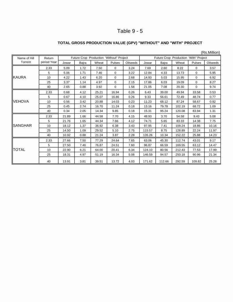
Jowar Bajra Wheat Pulses Oilseeds Jowar Bajra Wheat Pulses Oilseeds
2.33 5.09 1.72 7.50 0 3.24 7.69 2.60 8.22 0 3.575 5.06 1.71 7.46 0 3.22 12.84 4.33 13.73 0 5.95
KAURA 10 4.22 1.43 6.20 0 2.68 14.93 5.03 15.95 0 6.9225 3.37 1.14 4.97 0 2.15 17.86 6.03 19.09 0 8.2740 2.65 0.88 3.92 0 1.58 21.05 7.08 20.30 0 9.74
2.33 0.68 4.12 25.21 16.94 0.26 6.43 39.00 49.94 33.58 0.535 0.67 4.10 25.07 16.86 0.26 9.33 56.61 72.49 48.74 0.77
VEHOVA 10 0.56 3.42 20.88 14.03 0.23 11.23 68.12 87.24 58.67 0.9225 0.45 2.74 16.70 11.24 0.18 13.16 79.78 102.19 68.72 1.0940 0.34 2.05 14.34 9.85 0.18 15.31 95.24 120.08 83.94 1.31
2.33 21.89 1.66 44.58 7.70 4.15 48.93 3.70 54.58 9.43 5.085 21.76 1.65 44.34 7.66 4.12 74.71 5.65 83.33 14.38 7.75
SANGHAR 10 18.12 1.37 36.92 6.38 3.43 97.95 7.41 109.24 18.86 10.1625 14.50 1.09 29.52 5.10 2.75 115.57 8.75 128.89 22.24 11.9740 10.92 0.88 21.24 3.87 2.28 135.26 10.34 152.22 25.88 14.23
2.33 27.66 7.50 77.29 24.64 7.65 63.06 45.30 112.74 43.01 9.175 27.50 7.46 76.87 24.51 7.60 96.87 66.59 169.55 63.12 14.47
TOTAL 10 22.90 6.21 64.00 20.41 6.34 124.10 80.56 212.43 77.53 17.9925 18.31 4.97 51.19 16.34 5.08 146.59 94.57 250.18 90.96 21.34
40 13.91 3.81 39.51 13.72 4.03 171.62 112.66 292.59 109.82 25.28
Name of Hill Torrent
Future Crop Production 'With" Project
Table 9 - 5
TOTAL GROSS PRODUCTION VALUE (GPV) "WITHOUT" AND "WITH" PROJECT
(Rs.Million)Return
period Year Future Crop Production 'Without" Project

Jowar Bajra Wheat Pulses Oilseeds Jowar Bajra Wheat Pulses Oilseeds
2.33 1.53 0.52 2.25 0.00 0.97 2.31 0.78 2.47 0.00 1.075 1.52 0.51 2.24 0.00 0.97 3.85 1.30 4.12 0.00 1.79
KAURA 10 1.26 0.43 1.86 0.00 0.80 4.48 1.51 4.78 0.00 2.08
25 1.01 0.34 1.49 0.00 0.65 5.36 1.81 5.73 0.00 2.48
40 0.80 0.26 1.18 0.00 0.47 6.32 2.12 6.09 0.00 2.92
2.33 0.21 1.24 7.56 5.08 0.08 1.93 11.70 14.98 10.07 0.165 0.20 1.23 7.52 5.06 0.08 2.80 16.98 21.75 14.62 0.23
VEHOVA 10 0.17 1.03 6.26 4.21 0.07 3.37 20.44 26.17 17.60 0.28
25 0.13 0.82 5.01 3.37 0.05 3.95 23.93 30.66 20.62 0.3340 0.10 0.62 4.30 2.95 0.05 4.59 28.57 36.02 25.18 0.39
2.33 6.57 0.50 13.37 2.31 1.25 14.68 1.11 16.37 2.83 1.525 6.53 0.50 13.30 2.30 1.23 22.41 1.70 25.00 4.31 2.32
SANGHAR 10 5.44 0.41 11.08 1.91 1.03 29.38 2.22 32.77 5.66 3.0525 4.35 0.33 8.86 1.53 0.82 34.67 2.63 38.67 6.67 3.5940 3.28 0.26 6.37 1.16 0.68 40.58 3.10 45.67 7.76 4.27
2.33 8.30 2.25 23.19 7.39 2.30 18.92 13.59 33.82 12.90 2.755 8.25 2.24 23.06 7.35 2.28 29.06 19.98 50.87 18.94 4.34
TOTAL 10 6.87 1.86 19.20 6.12 1.90 37.23 24.17 63.73 23.26 5.4025 5.49 1.49 15.36 4.90 1.52 43.98 28.37 75.05 27.29 6.4040 4.17 1.14 11.85 4.12 1.21 51.49 33.80 87.78 32.95 7.58
Return period Year
Future Crop Production 'Without" Project Future Crop Production 'With" Project
(Rs.Million)
Name of Hill Torrent
TOTAL CROP PRODUCTION EXPENSES (COP) "WITHOUT" AND "WITH" PROJECT
Table 9 - 6
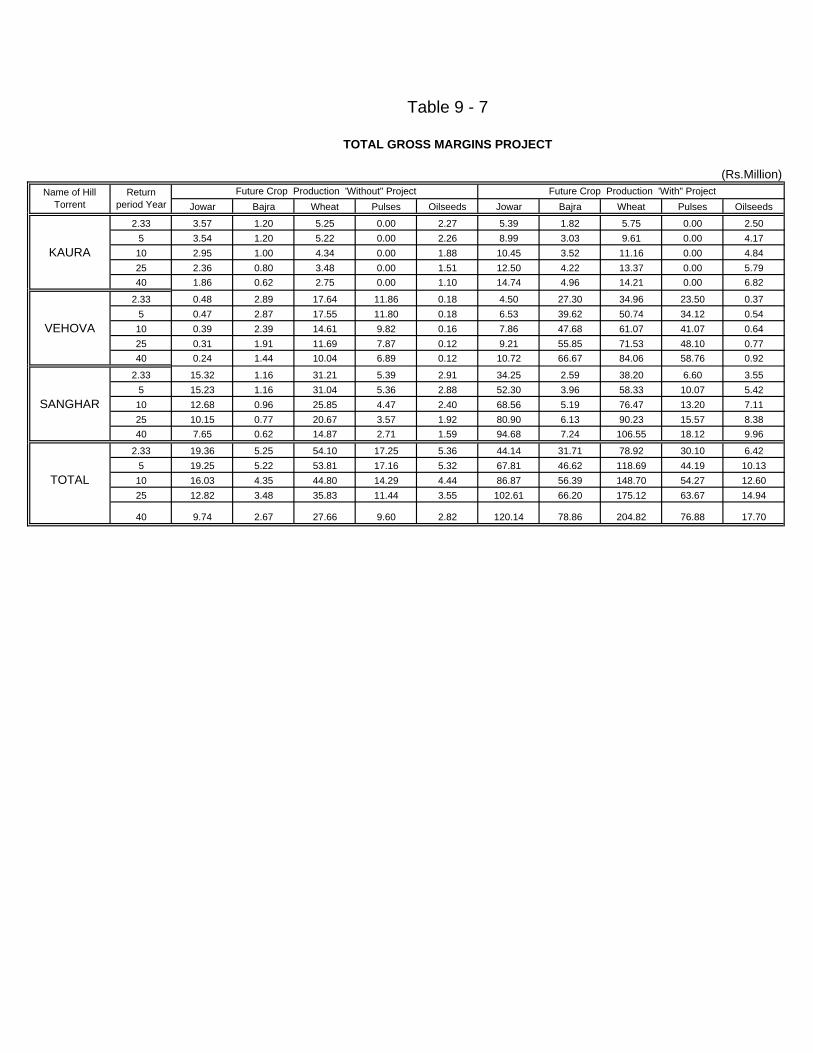
Jowar Bajra Wheat Pulses Oilseeds Jowar Bajra Wheat Pulses Oilseeds
2.33 3.57 1.20 5.25 0.00 2.27 5.39 1.82 5.75 0.00 2.505 3.54 1.20 5.22 0.00 2.26 8.99 3.03 9.61 0.00 4.17
KAURA 10 2.95 1.00 4.34 0.00 1.88 10.45 3.52 11.16 0.00 4.8425 2.36 0.80 3.48 0.00 1.51 12.50 4.22 13.37 0.00 5.7940 1.86 0.62 2.75 0.00 1.10 14.74 4.96 14.21 0.00 6.82
2.33 0.48 2.89 17.64 11.86 0.18 4.50 27.30 34.96 23.50 0.375 0.47 2.87 17.55 11.80 0.18 6.53 39.62 50.74 34.12 0.54
VEHOVA 10 0.39 2.39 14.61 9.82 0.16 7.86 47.68 61.07 41.07 0.6425 0.31 1.91 11.69 7.87 0.12 9.21 55.85 71.53 48.10 0.7740 0.24 1.44 10.04 6.89 0.12 10.72 66.67 84.06 58.76 0.92
2.33 15.32 1.16 31.21 5.39 2.91 34.25 2.59 38.20 6.60 3.555 15.23 1.16 31.04 5.36 2.88 52.30 3.96 58.33 10.07 5.42
SANGHAR 10 12.68 0.96 25.85 4.47 2.40 68.56 5.19 76.47 13.20 7.1125 10.15 0.77 20.67 3.57 1.92 80.90 6.13 90.23 15.57 8.3840 7.65 0.62 14.87 2.71 1.59 94.68 7.24 106.55 18.12 9.96
2.33 19.36 5.25 54.10 17.25 5.36 44.14 31.71 78.92 30.10 6.425 19.25 5.22 53.81 17.16 5.32 67.81 46.62 118.69 44.19 10.13
TOTAL 10 16.03 4.35 44.80 14.29 4.44 86.87 56.39 148.70 54.27 12.6025 12.82 3.48 35.83 11.44 3.55 102.61 66.20 175.12 63.67 14.94
40 9.74 2.67 27.66 9.60 2.82 120.14 78.86 204.82 76.88 17.70
Future Crop Production 'With" ProjectName of Hill Torrent
(Rs.Million)Return
period Year Future Crop Production 'Without" Project
Table 9 - 7
TOTAL GROSS MARGINS PROJECT
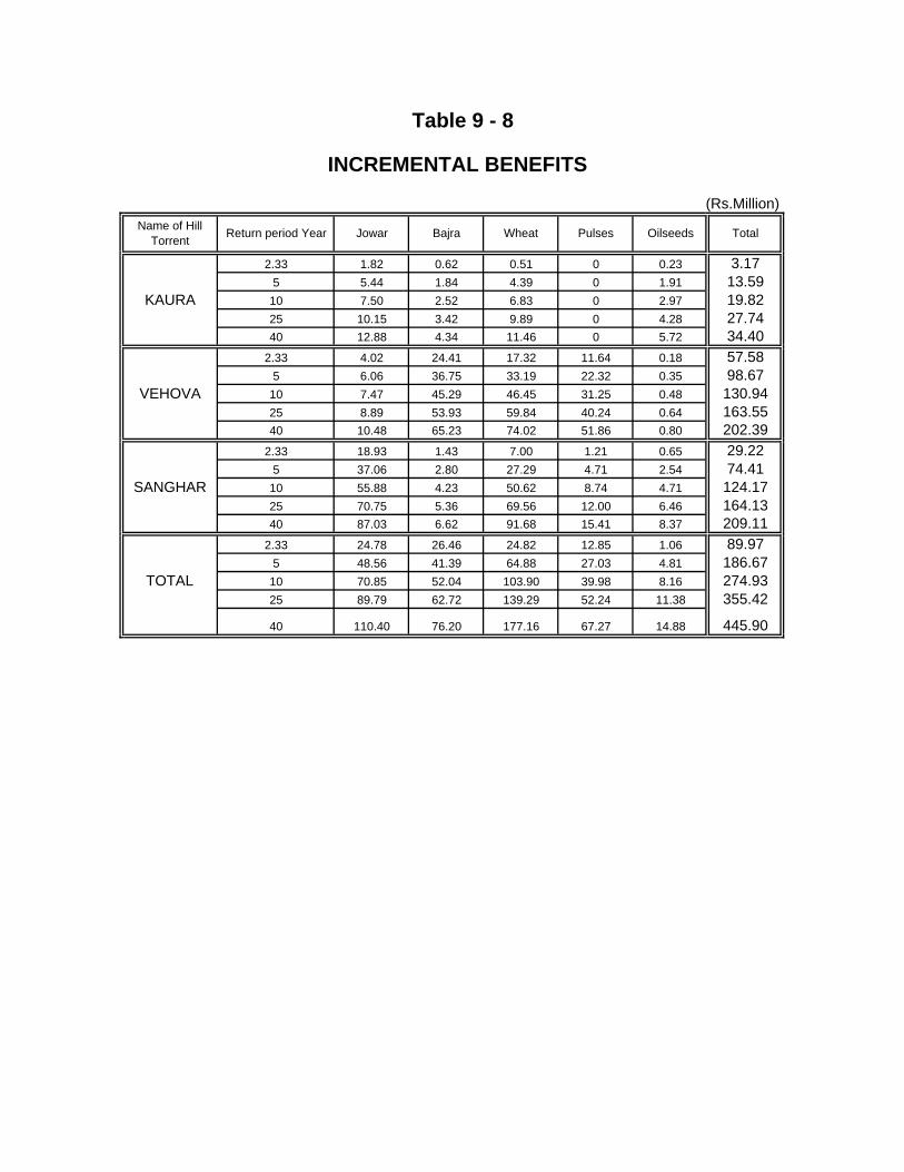
2.33 1.82 0.62 0.51 0 0.23 3.175 5.44 1.84 4.39 0 1.91 13.59
KAURA 10 7.50 2.52 6.83 0 2.97 19.8225 10.15 3.42 9.89 0 4.28 27.7440 12.88 4.34 11.46 0 5.72 34.40
2.33 4.02 24.41 17.32 11.64 0.18 57.585 6.06 36.75 33.19 22.32 0.35 98.67
VEHOVA 10 7.47 45.29 46.45 31.25 0.48 130.9425 8.89 53.93 59.84 40.24 0.64 163.5540 10.48 65.23 74.02 51.86 0.80 202.39
2.33 18.93 1.43 7.00 1.21 0.65 29.225 37.06 2.80 27.29 4.71 2.54 74.41
SANGHAR 10 55.88 4.23 50.62 8.74 4.71 124.1725 70.75 5.36 69.56 12.00 6.46 164.1340 87.03 6.62 91.68 15.41 8.37 209.11
2.33 24.78 26.46 24.82 12.85 1.06 89.975 48.56 41.39 64.88 27.03 4.81 186.67
TOTAL 10 70.85 52.04 103.90 39.98 8.16 274.9325 89.79 62.72 139.29 52.24 11.38 355.42
40 110.40 76.20 177.16 67.27 14.88 445.90
PulsesName of Hill Torrent Jowar Bajra Total
(Rs.Million)
OilseedsReturn period Year Wheat
Table 9 - 8
INCREMENTAL BENEFITS
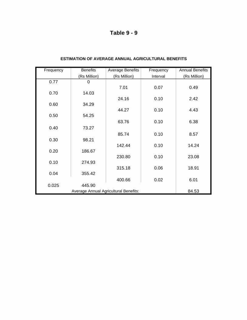
Frequency Benefits Average Benefits Frequency Annual Benefits(Rs Million) (Rs Million) Interval (Rs Million)
0.77 07.01 0.07 0.49
0.70 14.0324.16 0.10 2.42
0.60 34.2944.27 0.10 4.43
0.50 54.2563.76 0.10 6.38
0.40 73.2785.74 0.10 8.57
0.30 98.21142.44 0.10 14.24
0.20 186.67230.80 0.10 23.08
0.10 274.93315.18 0.06 18.91
0.04 355.42400.66 0.02 6.01
0.025 445.90Average Annual Agricultural Benefits: 84.53
Table 9 - 9
ESTIMATION OF AVERAGE ANNUAL AGRICULTURAL BENEFITS
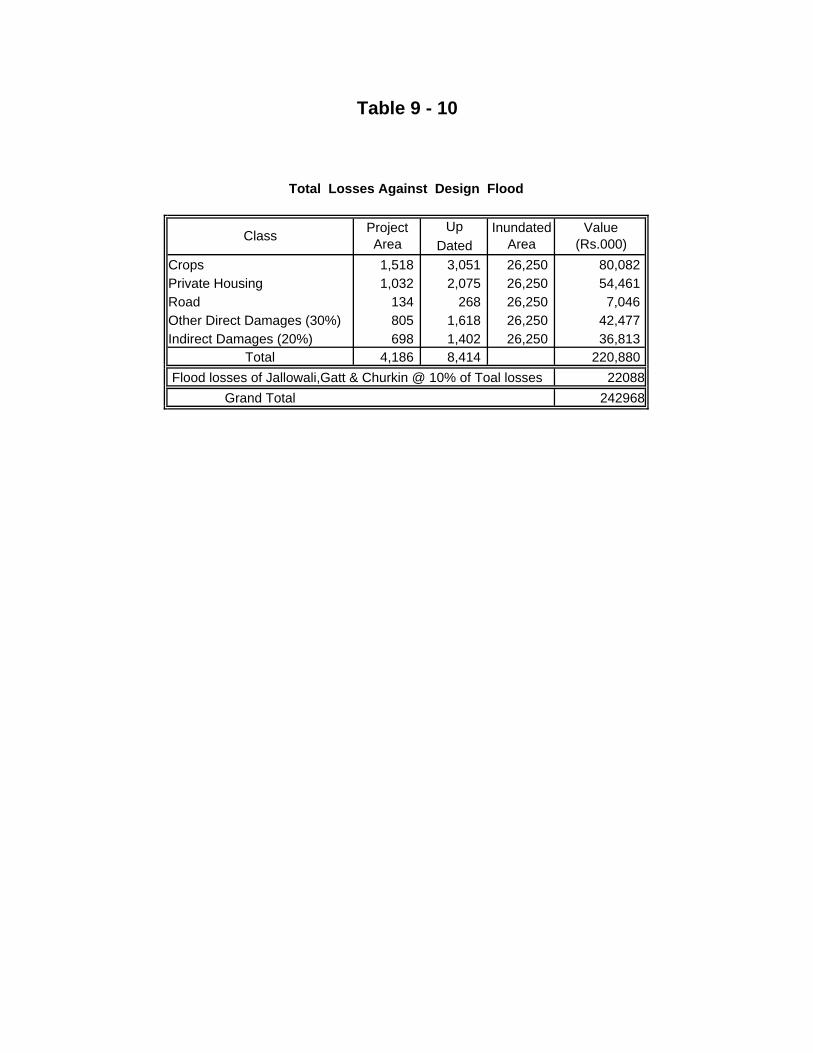
UpDated
Crops 1,518 3,051 26,250 80,082 Private Housing 1,032 2,075 26,250 54,461 Road 134 268 26,250 7,046 Other Direct Damages (30%) 805 1,618 26,250 42,477 Indirect Damages (20%) 698 1,402 26,250 36,813
Total 4,186 8,414 220,880 22088
Grand Total 242968 Flood losses of Jallowali,Gatt & Churkin @ 10% of Toal losses
Total Losses Against Design Flood
Table 9 - 10
Class Project Area
Inundated Area
Value (Rs.000)

Frequency Damages Average Damages Frequency Annual Damages(Rs Million) (Rs Million) Interval (Rs Million)
0.77 0.007.74 0.07 0.54
0.70 15.4824.50 0.10 2.45
0.60 33.5342.56 0.10 4.26
0.50 51.5960.61 0.10 6.06
0.40 69.6485.12 0.10 8.51
0.30 100.59112.20 0.10 11.22
0.20 123.81149.60 0.10 14.96
0.10 175.39209.18 0.06 12.55
0.04 242.97Average Annual Damage: 60.55
Table 9 - 11
COMPUTATION OF AVERAGE ANNUAL DAMAGES
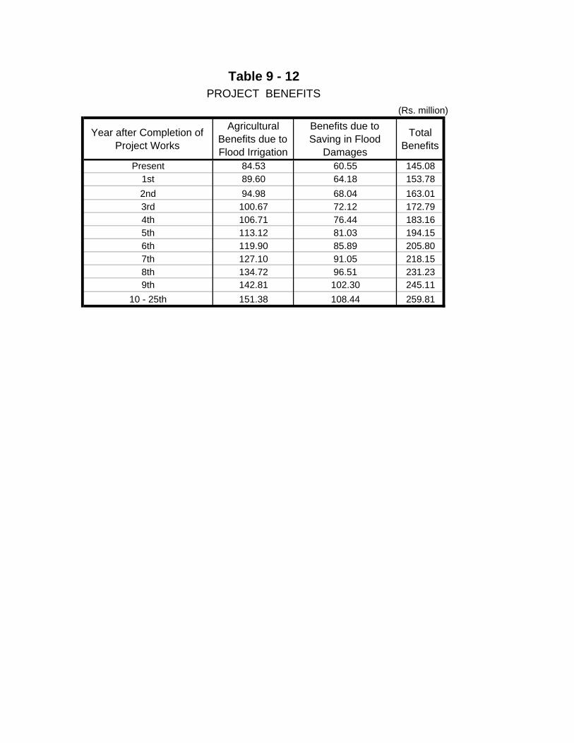
(Rs. million)
Year after Completion of Project Works
Agricultural Benefits due to Flood Irrigation
Benefits due to Saving in Flood
Damages
Total Benefits
Present 84.53 60.55 145.081st 89.60 64.18 153.782nd 94.98 68.04 163.013rd 100.67 72.12 172.794th 106.71 76.44 183.165th 113.12 81.03 194.156th 119.90 85.89 205.807th 127.10 91.05 218.158th 134.72 96.51 231.239th 142.81 102.30 245.11
10 - 25th 151.38 108.44 259.81
Table 9 - 12PROJECT BENEFITS
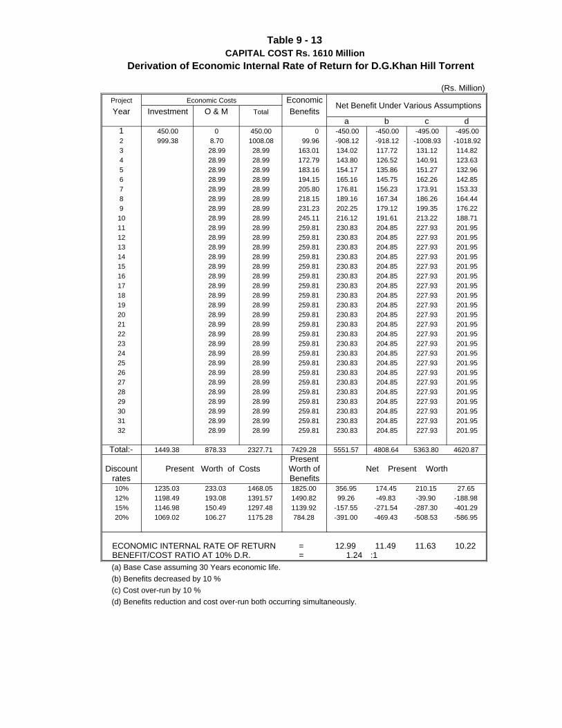
Project EconomicYear Investment O & M Total Benefits
a b c d1 450.00 0 450.00 0 -450.00 -450.00 -495.00 -495.002 999.38 8.70 1008.08 99.96 -908.12 -918.12 -1008.93 -1018.923 28.99 28.99 163.01 134.02 117.72 131.12 114.824 28.99 28.99 172.79 143.80 126.52 140.91 123.635 28.99 28.99 183.16 154.17 135.86 151.27 132.966 28.99 28.99 194.15 165.16 145.75 162.26 142.857 28.99 28.99 205.80 176.81 156.23 173.91 153.338 28.99 28.99 218.15 189.16 167.34 186.26 164.449 28.99 28.99 231.23 202.25 179.12 199.35 176.2210 28.99 28.99 245.11 216.12 191.61 213.22 188.7111 28.99 28.99 259.81 230.83 204.85 227.93 201.9512 28.99 28.99 259.81 230.83 204.85 227.93 201.9513 28.99 28.99 259.81 230.83 204.85 227.93 201.9514 28.99 28.99 259.81 230.83 204.85 227.93 201.9515 28.99 28.99 259.81 230.83 204.85 227.93 201.9516 28.99 28.99 259.81 230.83 204.85 227.93 201.9517 28.99 28.99 259.81 230.83 204.85 227.93 201.9518 28.99 28.99 259.81 230.83 204.85 227.93 201.9519 28.99 28.99 259.81 230.83 204.85 227.93 201.9520 28.99 28.99 259.81 230.83 204.85 227.93 201.9521 28.99 28.99 259.81 230.83 204.85 227.93 201.9522 28.99 28.99 259.81 230.83 204.85 227.93 201.9523 28.99 28.99 259.81 230.83 204.85 227.93 201.9524 28.99 28.99 259.81 230.83 204.85 227.93 201.9525 28.99 28.99 259.81 230.83 204.85 227.93 201.9526 28.99 28.99 259.81 230.83 204.85 227.93 201.9527 28.99 28.99 259.81 230.83 204.85 227.93 201.9528 28.99 28.99 259.81 230.83 204.85 227.93 201.9529 28.99 28.99 259.81 230.83 204.85 227.93 201.9530 28.99 28.99 259.81 230.83 204.85 227.93 201.9531 28.99 28.99 259.81 230.83 204.85 227.93 201.9532 28.99 28.99 259.81 230.83 204.85 227.93 201.95
Total:- 1449.38 878.33 2327.71 7429.28 5551.57 4808.64 5363.80 4620.87Present
Discount Worth ofrates Benefits10% 1235.03 233.03 1468.05 1825.00 356.95 174.45 210.15 27.6512% 1198.49 193.08 1391.57 1490.82 99.26 -49.83 -39.90 -188.9815% 1146.98 150.49 1297.48 1139.92 -157.55 -271.54 -287.30 -401.2920% 1069.02 106.27 1175.28 784.28 -391.00 -469.43 -508.53 -586.95
ECONOMIC INTERNAL RATE OF RETURN = 12.99 11.49 11.63 10.22 BENEFIT/COST RATIO AT 10% D.R. = 1.24 :1 (a) Base Case assuming 30 Years economic life. (b) Benefits decreased by 10 % (c) Cost over-run by 10 % (d) Benefits reduction and cost over-run both occurring simultaneously.
Table 9 - 13
(Rs. Million)
Derivation of Economic Internal Rate of Return for D.G.Khan Hill Torrent
Net Present Worth
CAPITAL COST Rs. 1610 Million
Present Worth of Costs
Net Benefit Under Various AssumptionsEconomic Costs
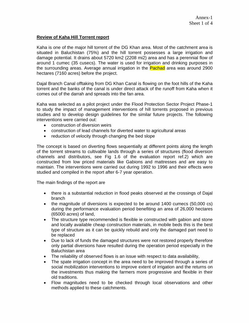
Annex-1 Sheet 1 of 4
Review of Kaha Hill Torrent report Kaha is one of the major hill torrent of the DG Khan area. Most of the catchment area is situated in Baluchistan (75%) and the hill torrent possesses a large irrigation and damage potential. It drains about 5720 km2 (2208 mi2) area and has a perennial flow of around 1 cumec (35 cusecs). The water is used for irrigation and drinking purposes in the surrounding areas. Average annual irrigation in the Pachad area was around 2900 hectares (7160 acres) before the project. Dajal Branch Canal offtaking from DG Khan Canal is flowing on the foot hills of the Kaha torrent and the banks of the canal is under direct attack of the runoff from Kaha when it comes out of the darrah and spreads into the fan area. Kaha was selected as a pilot project under the Flood Protection Sector Project Phase-1 to study the impact of management interventions of hill torrents proposed in previous studies and to develop design guidelines for the similar future projects. The following interventions were carried out:
• construction of diversion weirs • construction of lead channels for diverted water to agricultural areas • reduction of velocity through changing the bed slope
The concept is based on diverting flows sequentially at different points along the length of the torrent streams to cultivable lands through a series of structures (flood diversion channels and distributors, see Fig 1.6 of the evaluation report ref.2) which are constructed from low priced materials like Gabions and mattresses and are easy to maintain. The interventions were carried out during 1992 to 1996 and their effects were studied and compiled in the report after 6-7 year operation. The main findings of the report are
• there is a substantial reduction in flood peaks observed at the crossings of Dajal branch
• the magnitude of diversions is expected to be around 1400 cumecs (50,000 cs) during the performance evaluation period benefiting an area of 26,000 hectares (65000 acres) of land,
• The structure type recommended is flexible ie constructed with gabion and stone and locally available cheap construction materials, in mobile beds this is the best type of structure as it can be quickly rebuild and only the damaged part need to be replaced
• Due to lack of funds the damaged structures were not restored properly therefore only partial diversions have resulted during the operation period especially in the Baluchistan area
• The reliability of observed flows is an issue with respect to data availability, • The spate irrigation concept in the area need to be improved through a series of
social mobilization interventions to improve extent of irrigation and the returns on the investments thus making the farmers more progressive and flexible in their old traditions.
• Flow magnitudes need to be checked through local observations and other methods applied to these catchments.
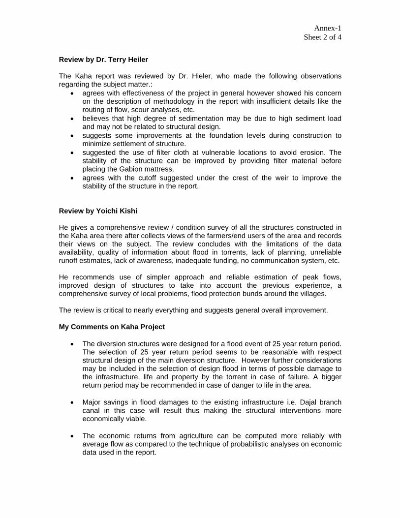
Annex-1 Sheet 2 of 4
Review by Dr. Terry Heiler The Kaha report was reviewed by Dr. Hieler, who made the following observations regarding the subject matter.:
• agrees with effectiveness of the project in general however showed his concern on the description of methodology in the report with insufficient details like the routing of flow, scour analyses, etc.
• believes that high degree of sedimentation may be due to high sediment load and may not be related to structural design.
• suggests some improvements at the foundation levels during construction to minimize settlement of structure.
• suggested the use of filter cloth at vulnerable locations to avoid erosion. The stability of the structure can be improved by providing filter material before placing the Gabion mattress.
• agrees with the cutoff suggested under the crest of the weir to improve the stability of the structure in the report.
Review by Yoichi Kishi He gives a comprehensive review / condition survey of all the structures constructed in the Kaha area there after collects views of the farmers/end users of the area and records their views on the subject. The review concludes with the limitations of the data availability, quality of information about flood in torrents, lack of planning, unreliable runoff estimates, lack of awareness, inadequate funding, no communication system, etc. He recommends use of simpler approach and reliable estimation of peak flows, improved design of structures to take into account the previous experience, a comprehensive survey of local problems, flood protection bunds around the villages. The review is critical to nearly everything and suggests general overall improvement. My Comments on Kaha Project
• The diversion structures were designed for a flood event of 25 year return period. The selection of 25 year return period seems to be reasonable with respect structural design of the main diversion structure. However further considerations may be included in the selection of design flood in terms of possible damage to the infrastructure, life and property by the torrent in case of failure. A bigger return period may be recommended in case of danger to life in the area.
• Major savings in flood damages to the existing infrastructure i.e. Dajal branch
canal in this case will result thus making the structural interventions more economically viable.
• The economic returns from agriculture can be computed more reliably with
average flow as compared to the technique of probabilistic analyses on economic data used in the report.

Annex-1 Sheet 3 of 4
• The structural designs were reviewed for the above suggestions and it appears that the quality of design may be improved in general and specifically the problem of sedimentation on the upstream side may be surmounted through designing the diversion weirs as submerged weirs or low height weirs thus reducing the capability of scour of the stream flowing over the weir.
• The structural damage can also be reduced if the obstruction caused by the
structure in the form of a weir is designed as submerged weirs instead of modular flow will also reduce the cost of the structure, deposition upstream of the structure and reduced scour on the downstream of the structure.
• The use of filter cloth or providing a properly designed filter under the mattresses
will definitely help in reducing the chances of settlements and failures due to removal of fines underneath the structure.
• The cutoff configuration as proposed in the evaluation report may not be very
helpful as it will provide rigidity to the crest and the surrounding structure is designed as flexible mattresses. This will create a distinct hump in the crest at the point of cutoff and flow crossing the point will form a roller action which will remove fines through the downstream mattress thus instigating a failure.
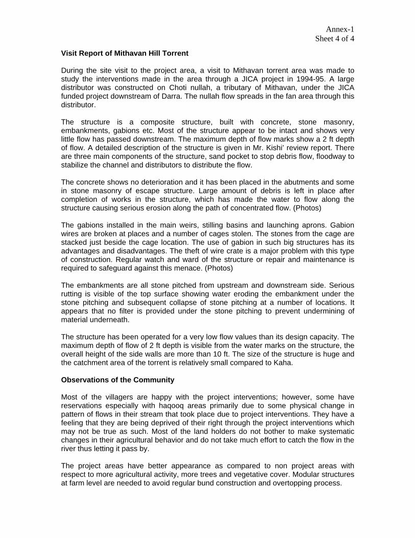
Annex-1 Sheet 4 of 4
Visit Report of Mithavan Hill Torrent During the site visit to the project area, a visit to Mithavan torrent area was made to study the interventions made in the area through a JICA project in 1994-95. A large distributor was constructed on Choti nullah, a tributary of Mithavan, under the JICA funded project downstream of Darra. The nullah flow spreads in the fan area through this distributor. The structure is a composite structure, built with concrete, stone masonry, embankments, gabions etc. Most of the structure appear to be intact and shows very little flow has passed downstream. The maximum depth of flow marks show a 2 ft depth of flow. A detailed description of the structure is given in Mr. Kishi’ review report. There are three main components of the structure, sand pocket to stop debris flow, floodway to stabilize the channel and distributors to distribute the flow. The concrete shows no deterioration and it has been placed in the abutments and some in stone masonry of escape structure. Large amount of debris is left in place after completion of works in the structure, which has made the water to flow along the structure causing serious erosion along the path of concentrated flow. (Photos) The gabions installed in the main weirs, stilling basins and launching aprons. Gabion wires are broken at places and a number of cages stolen. The stones from the cage are stacked just beside the cage location. The use of gabion in such big structures has its advantages and disadvantages. The theft of wire crate is a major problem with this type of construction. Regular watch and ward of the structure or repair and maintenance is required to safeguard against this menace. (Photos) The embankments are all stone pitched from upstream and downstream side. Serious rutting is visible of the top surface showing water eroding the embankment under the stone pitching and subsequent collapse of stone pitching at a number of locations. It appears that no filter is provided under the stone pitching to prevent undermining of material underneath. The structure has been operated for a very low flow values than its design capacity. The maximum depth of flow of 2 ft depth is visible from the water marks on the structure, the overall height of the side walls are more than 10 ft. The size of the structure is huge and the catchment area of the torrent is relatively small compared to Kaha. Observations of the Community Most of the villagers are happy with the project interventions; however, some have reservations especially with haqooq areas primarily due to some physical change in pattern of flows in their stream that took place due to project interventions. They have a feeling that they are being deprived of their right through the project interventions which may not be true as such. Most of the land holders do not bother to make systematic changes in their agricultural behavior and do not take much effort to catch the flow in the river thus letting it pass by. The project areas have better appearance as compared to non project areas with respect to more agricultural activity, more trees and vegetative cover. Modular structures at farm level are needed to avoid regular bund construction and overtopping process.
Related Documents