PLEASE SCROLL DOWN FOR ARTICLE This article was downloaded by: [University of Southern California] On: 5 November 2009 Access details: Access Details: [subscription number 906872643] Publisher Routledge Informa Ltd Registered in England and Wales Registered Number: 1072954 Registered office: Mortimer House, 37-41 Mortimer Street, London W1T 3JH, UK The Professional Geographer Publication details, including instructions for authors and subscription information: http://www.informaworld.com/smpp/title~content=t788352615 Teaching GIS in Geography Karen K. Kemp a ; Michael F. Goodchild b ; Rustin F. Dodson c a KAREN K. KEMP is Department of Geography at the University of California, Santa Barbara, CA 93106- 4060, and Coordinator of Education Programs for NCGIA. Her research interests center on the use of GIS for environmental modeling.. b MICHAEL F. GOODCHILD is Director of NCGIA and Professor of Geography, University of California, Santa Barbara, CA 93106-4060, with research intersts in GIS, spatial analysis, and geographic data modeling.. c RUSTIN F. DODSON is Department of Geography, University of California, Santa Barbara, CA 93106-4060. He is currently investigating the role of spatial data models in the integration of spatial statistics and geographic information systems.. Online Publication Date: 01 May 1992 To cite this Article Kemp, Karen K., Goodchild, Michael F. and Dodson, Rustin F.(1992)'Teaching GIS in Geography',The Professional Geographer,44:2,181 — 191 To link to this Article: DOI: 10.1111/j.0033-0124.1992.00181.x URL: http://dx.doi.org/10.1111/j.0033-0124.1992.00181.x Full terms and conditions of use: http://www.informaworld.com/terms-and-conditions-of-access.pdf This article may be used for research, teaching and private study purposes. Any substantial or systematic reproduction, re-distribution, re-selling, loan or sub-licensing, systematic supply or distribution in any form to anyone is expressly forbidden. The publisher does not give any warranty express or implied or make any representation that the contents will be complete or accurate or up to date. The accuracy of any instructions, formulae and drug doses should be independently verified with primary sources. The publisher shall not be liable for any loss, actions, claims, proceedings, demand or costs or damages whatsoever or howsoever caused arising directly or indirectly in connection with or arising out of the use of this material.

Welcome message from author
This document is posted to help you gain knowledge. Please leave a comment to let me know what you think about it! Share it to your friends and learn new things together.
Transcript

PLEASE SCROLL DOWN FOR ARTICLE
This article was downloaded by: [University of Southern California]On: 5 November 2009Access details: Access Details: [subscription number 906872643]Publisher RoutledgeInforma Ltd Registered in England and Wales Registered Number: 1072954 Registered office: Mortimer House,37-41 Mortimer Street, London W1T 3JH, UK
The Professional GeographerPublication details, including instructions for authors and subscription information:http://www.informaworld.com/smpp/title~content=t788352615
Teaching GIS in GeographyKaren K. Kemp a; Michael F. Goodchild b; Rustin F. Dodson c
a KAREN K. KEMP is Department of Geography at the University of California, Santa Barbara, CA 93106-4060, and Coordinator of Education Programs for NCGIA. Her research interests center on the use of GIS forenvironmental modeling.. b MICHAEL F. GOODCHILD is Director of NCGIA and Professor of Geography,University of California, Santa Barbara, CA 93106-4060, with research intersts in GIS, spatial analysis, andgeographic data modeling.. c RUSTIN F. DODSON is Department of Geography, University of California,Santa Barbara, CA 93106-4060. He is currently investigating the role of spatial data models in the integrationof spatial statistics and geographic information systems..
Online Publication Date: 01 May 1992
To cite this Article Kemp, Karen K., Goodchild, Michael F. and Dodson, Rustin F.(1992)'Teaching GIS in Geography',The ProfessionalGeographer,44:2,181 — 191
To link to this Article: DOI: 10.1111/j.0033-0124.1992.00181.x
URL: http://dx.doi.org/10.1111/j.0033-0124.1992.00181.x
Full terms and conditions of use: http://www.informaworld.com/terms-and-conditions-of-access.pdf
This article may be used for research, teaching and private study purposes. Any substantial orsystematic reproduction, re-distribution, re-selling, loan or sub-licensing, systematic supply ordistribution in any form to anyone is expressly forbidden.
The publisher does not give any warranty express or implied or make any representation that the contentswill be complete or accurate or up to date. The accuracy of any instructions, formulae and drug dosesshould be independently verified with primary sources. The publisher shall not be liable for any loss,actions, claims, proceedings, demand or costs or damages whatsoever or howsoever caused arising directlyor indirectly in connection with or arising out of the use of this material.
METHODS AND TECHNIQUES ~ ~
Teaching GIS in Geography*
Karen K. Kemp, Michael F. Goodchild and Rustin F. Dodson University of California, Santa Barbara Although numerous courses in geographic information systems (GIs) have been introduced into the geography curriculum over the past few years, there has been remarkably little debate over the issues involved. This paper first discusses the arguments for geography as an appropriate disciplinary setting for GIS teaching at the under- graduate level. This is followed by a discussion of the nature of GIS courses and their appropriate place in the undergraduate geography curriculum. The final section of the paper describes the NCGIA Core Curriculum project and examines its significance in this broader context. Key Words: GIs, geographic education.
Introduction
While there has been some debate over the value of geographic information systems (GIS) to geography in general (Abler 1988; Dobson 1983, and subsequent commentaries in 7he Professional Geographer; Jordan 1988, and subse- quent correspondence in the AAG Newsletter), there has been somewhat less debate over the place of GIS in the geography curriculum. One notable exception is a series of presen- tations at a special session of the Canadian Association of Geographers in 1985, subse- quently published in The Operational Geogra- pher. However, only a subset of these (Goodchild 1985; Muller 1985; Poiker 1985) specifically addressed the needs of geography, the remainder being more concerned with the general issue of GIS education. The same is true of the series of meetings on GIS and Higher Education held at Ohio State Univer- sity in 1988, 1989, and 1990 and at the Uni- versity of South Florida in 1991, and of the handful of additional articles on GIS education that have appeared in the literature (Nyerges and Chrisman 1989; Unwin and Dale 1990).
The purpose of this paper is to explore ar- guments for the teaching of GIS within geog- raphy at the undergraduate level, the im- plications of these arguments for the objectives, structure, and content of GIS courses, and their positioning within the course sequence of an undergraduate geogra- phy curriculum. Many of these issues were debated during the development and evalua-
tion of the NCGIA Core Curriculum in GIS re- cently completed by the National Center for Geographic Information and Analysis (Goodchild and Kemp 1990), and the paper concludes with a review of the curriculum and the processes used in its development.
GIS and Geography
The case for teaching GIS within the geogra- phy higher education curriculum rests on sev- eral propositions regarding the general significance of GIS to geography, some widely accepted and some controversial. They are presented in this section as four separate argu- ments: geography as the home discipline for GIs; GIS as a collection of marketable skills; GIS as enabling technology for science; and geographic information as an intellectual theme within geography.
Geography as the Home Discipline Of the four arguments, this is perhaps the weakest from the discipline’s viewpoint. GIS has developed as a multidisciplinary field with no single home, as a consortium of photogram- metry, cartography, spatial statistics, spatial analysis, computer science, engineering, re- mote sensing, etc. None of these fields has any particular claim to ownership, although all make useful contributions. But multidiscipli- nary fields inevitably fall through the academic cracks; cooperation through conferences, jour- nals, and organizations is comparatively easy in research activities but much more difficult in education. If higher education is to supply
* The National Center for Geographic Information and Analysis is supported by the National Science Foundation, grant SES 88-10917. Ad- ditional funding for the Core Curriculum project was provided by the Office of Instructional Development, University of California, Santa Barbara.
Professional Geographer, 44(2) 1992, pages 181-191 0 Co yright 1992 by Association of .4merican Geographers Initial submission, July 1991; h a y acceptance, December 1991.
Downloaded By: [University of Southern California] At: 03:24 5 November 2009
182 Volume 44, Number 2, May 1992
the growing employment market with well- trained graduates equipped with an appropri- ate range of skills, GIS needs a “home disci- pline” in order that the necessary specialized curricula and instructional methods can be de- veloped and nurtured.
Morrison (1991) argues that geography, with its traditional view of itself as an integrating discipline and its focus on spatial phenomena, is uniquely suited as the home discipline of GIS. But while there may be some agreement with this sentiment within the GIS commu- nity in general, the weakness of this argument stems from questions about geography’s own willingness and ability to play the role. Jordan’s comments (Jordan 1988) clearly demonstrate this reluctance on the part of some geographers to embrace GIS as a contri- bution to the intellectual core of the discipline, and several recent editorials (Openshaw 1991; Taylor and Overton 1991; Taylor 1990; Goodchild 1991) have added to the debate.
Marketable Skills There is a rapidly growing market for both new and traditional geographical skills in the GIS industry. GIS software vendors, public and private agencies with GIS installations, and GIS consulting companies have all hired significant numbers of geography graduates in the past few years, and demand is growing as employers recognize the particular value of the geographer’s perspective and mix of skills. A great many geography departments have re- sponded to this demand by quickly introduc- ing GIS courses. Thus, GIS has emerged alongside statistics, cartography, surveying, photogrammetry, and remote sensing as a skill area that competes for a place in the geography undergraduate curriculum.
GIS as Enabling Technology for Science The largest markets for GIS technology cur- rently lie in resource management, the utili- ties, and local government (for a comprehen- sive view of the GIS industry see GIS World Inc. 1991), where the primary focus is on geo- graphic information management rather than geographic analysis. There appears, in fact, to be a growing tension in the industry between the large market in information management and the comparatively small but crucial role of GIS in supporting scientific analysis and mod-
eling. Abler (1988) has described the potential of GIS as a tool to support scientific inquiry in geography, and, more generally, in all dis- ciplines that work with geographically refer- enced information. On the other hand, the value of any such scientific tool is extremely difficult to document, particularly as measured by specific insights gained through the use of the tool that would not have been obtained otherwise. It would be as difficult, for exam- ple, to identify GIs’s contribution to theory in this sense as i t would be to find instances of theory that owes its origins to the use of re- gression.
From a teaching perspective, the enabling technology argument suggests that GIS should be an integral part of the geography curricu- lum because of its role as a tool for geograph- ical research. This puts it in competition with all such tools, and begs the question of how we judge the importance of one tool against an- other. It may be more appropriate for us to teach GIS than word processing, since one is unique to geography and the other generic, but what about statistical packages, for exam- ple? Should the competition be judged on fre- quency of use, or some notion of necessity or uniqueness? Despite its attractions and the es- sentially geographical nature of GIs, the en- abling technology argument seems a weak basis for curriculum design precisely because of the difficulty of making an objective choice between an enormous variety of tools useful for geography.
Geographic Information as an Intellectual Theme Despite the growing strength of the industry and widespread interest, GIS remains difficult to define. Is it a technology, a set of applica- tions, an approach to analysis and decision- making, or a database? What constitutes “GIS research” (Craig 1989; Maguire IYYO; Masser 1990; NCGIA 1989)? Goodchild (1990) has argued that what should hold the GIS commu- nity together, particularly at the research level, is a common interest in the generic issues that surround the technology and impede and af- fect its use. Geographic information has unique characteristics, and its collection, com- pilation, and analysis present unique prob- lems. The reality represented by geographic information is frequently continuous and al-
Downloaded By: [University of Southern California] At: 03:24 5 November 2009

Teaching GIs in Geography 183
ways infinitely complex and, therefore, must be discretized, abstracted, generalized, or in- terpreted for subsequent management and analysis. A variety of alternative data models can be used as bases for discretization. More- over, geographic information is multidimen- sional: items of data can be accessed through a two- or three-dimensional spatial key, or through the attributes of objects.
To pursue the argument a little further, the various disciplines and fields that deal with geographical information share a common in- terest in a set of generic issues that together constitute a science of geographic information. Mark (1990) has argued that GIS has relevance to each of Pattison’s four traditional paradigms of geography (Pattison 1964): Man-Land, Earth Science, Area Studies, and Spatial. But the emergence of GIS has suggested an addi- tional theme underlying and contributing to each of these, and composed of the generic issues of geographical information: its capture, compilation, accuracy, display, analysis, etc.
In our view, these issues of geographic in- formation that surround the effective use of GIS technology provide the strongest of the four arguments presented here and the one that should guide the incorporation of GIS into the undergraduate geography curriculum. Issues that have always been implicit in work- ing with geographic information, such as accu- racy or display, become explicit within the structure imposed by a digital data handling system. The designer of a GIS database must have an understanding of geography to choose between alternative data models or dis- cretizations, to determine appropriate levels of accuracy, to assess uncertainty, and to display the results effectively. Since a GIS database provides the user with a structured and inter- preted view of geographical reality, the uncer- tainty in data must be modeled and described; the structure of data must be represented in the database by implementing theories of space and spatial cognition (Frank and Mark 1991; Gatrell 1983); and principles of cartographic design must be made explicit in display pro- cesses. In a university geography program, these generic issues of geographical informa- tion science seem much more important to us than the specifics of a given geographic infor- mation system. Together they provide a useful distinction between training in the technology,
and education about its concepts, applications and significance.
Teaching GIs
In view of the continuing demand for GIS graduates and the level of sophistication and complexity of many GIS applications, it is inevitable that CIS will be taught somewhere in many universities’ programs. At the mo- ment, a majority of the academic departments teaching GIS are departments of geography (Morgan 1990). This section examines the dif- ferent objectives that can be established for GIS courses, considers where these courses can be placed in an undergraduate geography curriculum, and ends with a discussion of ap- propriate prerequisites.
GIS Course Objectives There are at least two dimensions to consider when setting objectives for GIS courses. Per- haps the most basic is that represented by the fundamentally different objectives of educa- tion and training (Green and McEwen 1990; Kuennecke 1988; Nyerges 1989; Unwin et al. 1990). Education focuses on the principles and conceptual issues which surround GIs, while training emphasizes the technical skills neces- sary to operate specific GIS packages. While we have already argued in favor of an educa- tion in the key concepts of GIs , few would disagree that a well-rounded GIS graduate needs both education and training (Green and McEwen 1990). An understanding of general concepts allows the student to place GIS specifics in a broader framework, but this un- derstanding is greatly enhanced by working on authentic applications. Training might be sufficient for students looking only for an entry-level position in the workplace, but an emphasis on education is more compatible with the objectives of a university and would be more appropriate for students planning to concentrate on applications and research.
A second dimension to consider is the bal- ance between technical issues and applications. On the one hand it is important to learn about GIS technology, and the hardware, data struc- tures, and algorithms that underlie it. On the other hand it may be more important to learn about working with GIS technology, and the issues that arise in implementing GIS within
Downloaded By: [University of Southern California] At: 03:24 5 November 2009
184 Volume 44, Number 2 , May 1992
an organization, or in developing GIS analysis procedures in support of research.
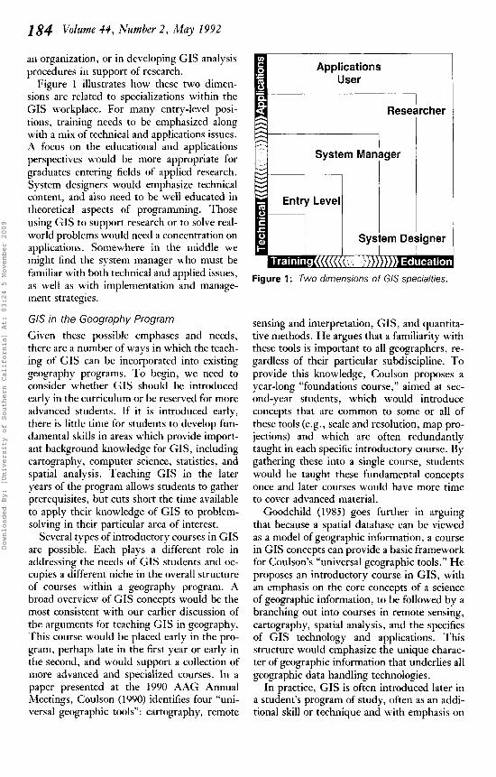
Figure 1 illustrates how these two dimen- sions are related to specializations within the GIS workplace. For many entry-level posi- tions, training needs to be emphasized along with a mix of technical and applications issues. A focus on the educational and applications perspectives would be more appropriate for graduates entering fields of applied research. System designers would emphasize technical content, and also need to be well educated in theoretical aspects of programming. Those using GIS to support research or to solve real- world problems would need a concentration on applications. Somewhere in the middle we might find the system manager who must he familiar with both technical and applied issues, as well as with implementation and manage- ment strategies.
GIS in the Geography Program Given these possible emphases and needs, there are a number of ways in which the teach- ing of GIS can be incorporated into existing geography programs. To begin, we need to consider whether GIS should be introduced early in the curriculum or be reserved for more advanced students. If i t is introduced early, there is little time for students to develop fun- damental skills in areas which provide import- ant background knowledge for GIS, including cartography, computer science, statistics, and spatial analysis. Teaching GIS in the later years of the program allows students to gather prerequisites, but cuts short the time available to apply their knowledge of GIS to problem- solving in their particular area of interest.
Several types of introductory courses in GIS are possible. Each plays a different role in addressing the needs of GIS students and oc- cupies a different niche in the overall structure of courses within a geography program. A broad overview of GIS concepts would he the most consistent with our earlier discussion of the arguments for teaching GIS in geography. This course would be placed early in the pro- gram, perhaps late in the first year or early in the second, and would support a collection of more advanced and specialized courses. In a paper presented at the 1990 AAG Annual Meetings, Coulson (1990) identifies four “uni- versal geographic tools”: cartography, remote
Figure 1 : Two dimensions of GlS specialties.
sensing and interpretation, GIS, and quantita- tive methods. He argues that a familiarity with these tools is important to all geographers, re- gardless of their particular subdiscipline. To provide this knowledge, Coulson proposes a year-long “foundations course,” aimed at sec- ond-year students, which would introduce concepts that are common to some or all of these tools (e.g., scale and resolution, map pro- jections) and which are often redundantly taught in each specific introductory course. By gathering these into a single course, students would he taught these fundamental concepts once and later courses would have more time to cover advanced material.
Goodchild (1985) goes further in arguing that because a spatial database can be viewed as a model of geographic information, a course in GIS concepts can provide a basic framework for Coulson’s “universal geographic tools.” He proposes an introductory course in GIS, with an emphasis on the core concepts of a science of geographic information, to be followed by a branching out into courses in remote sensing, cartography, spatial analysis, and the specifics of GIS technology and applications. This structure would emphasize the unique charac- ter of geographic information that underlies all geographic data handling technologies.
In practice, GIS is often introduced later in a student’s program of study, often as an addi- tional skill or technique and with emphasis on
Downloaded By: [University of Southern California] At: 03:24 5 November 2009

Teaching GIs in Geography 185
the technical and analytical issues involved in the storage, manipulation, and display of geo- graphic information. Goodchild (1985) has called this the “leaf on the tree” model, empha- sizing the way GIS has often been tacked onto existing offerings. All too often this approach has led to the dropping of other skill courses, notably spatial analysis and quantitative meth- ods, to make room in a crowded curriculum, as a deciduous discipline tries to keep up with changing fashion. Heywood (1990) comments on the parallels between GIS and the earlier introduction of spatial analysis courses in the 1960s. Too often, quantitative methods were seen as isolated skills to be acquired by geog- raphy students, rather than as tools to be inte- grated into all aspects of geographical investi- gation. GIS may well fall into the same trap if it is institutionalized as a specialty and fails to find a role for itself in supporting the tradi- tional, substantive subfields of geography (for an example of the integration of GIS into teaching in economic geography see Dodson 1991a). Such essential skills must surely be located in the core of the curriculum, not on the periphery.
If there is indeed a “zero sum game” in technical courses offering marketable skills, such that new techniques can be introduced only if old ones are eliminated, then the im- plications for GIS are profound. O n the one hand, most definitions of GIS emphasize the importance of analysis and support for deci- sion-making as the primary objectives of the technology, while on the other hand, many authors have commented on the relatively sim- plistic nature of many current GIS applica- tions (Burrough 1986; Cowen 1988; Openshaw 1987; Star and Estes 1990). It would be tragic if the introduction of GIS into the curriculum were accompanied by a simultaneous loss of courses in spatial analysis or cartography.
Structuring GIS Courses
Lectures or labs? In the university environment, there are two primary means for presenting computer-re- lated subject matter: lectures and laboratory exercises. T h e lecture approach is suitable for presenting theoretical issues in a linear, struc- tured format, while the laboratory environ- ment is less rigorously structured and is also
suitable for providing training. Most GIS courses take advantage of both approaches: lec- tures convey the general concepts and labs re- inforce these concepts with hands-on applica- tions. However, it is possible to base a course entirely on exercises or real-world applications in the GIS laboratory. Here, theoretical as- pects are presented only when the issues emerge within the context of the laboratory work. Lecture-only approaches are also used, particularly in more advanced courses or where suitable laboratory equipment is simply unavailable.
Synchronization of lecture and lab compo- nents is a difficult issue. Should the structure of the lecture outline determine the content and sequence of individual lab exercises, or should the theory needed to learn and intelli- gently use the laboratory software determine the order in which lectures are presented? O r can the two be fully independent? To make this question more complex, while a lecture can easily be confined to a single topic, a lab exercise, especially one demonstrating an ap- plication, will usually encompass several top- ics. In addition, in order to function in the lab, students must learn the purely mechanical as- pects of operating the system hardware and software. This in itself can be a formidable task given the complexity of some commercial GIS packages and can absorb much of the available laboratory time. In statistics courses, it is often argued that manual processing of data is preferable to computer processing, at least initially, because it leads to a greater ap- preciation for the principles involved, and avoids the distracting influences of computer technology, and a similar argument can be made against lab exercises in GIS. In our view, based on the arguments presented earlier in this paper, the role of labs in an undergraduate GIS course in geography should be to support and illustrate the concepts presented in the lectures as effectively as possible.
Determining Course Content Although GIS is a comparatively new area, there have already been several attempts to identify the contents of GIS curricula. Some of the results are more complete and im- mediately useful than others. In this section, we consider several of the ways in which the
Downloaded By: [University of Southern California] At: 03:24 5 November 2009

184 Volume 44, Number 2 , May I992
content and structure of G I S courses have been defined.
In reviewing these different approaches it is important to recognize that they vary consid- erably according to the intended scope of the curriculum. At one extreme are approaches to defining macrocurricula, or general plans for en- tire programs. The other extreme addresses microcurricula, or detailed plans for individual instructional units directed at specific groups of students (Armstrong 1989). T h e order in which topics are identified provides another variation. In a top-down approach, known in ed- ucation circles as the “behavioral” approach (Armstrong 1989), the knowledge and skills needed by a student for entry into the work force or for advanced courses are identified. These terminal conditions are then translated into the specific topics to be taught. The bot- tom-up approach begins by identifying the component parts of the entire subject area. Curriculum development then focuses on building connections between these topics so that the student completes his or her education with a set of related skills, and with knowledge that is readily adaptable to a wide range of situations.
While each of the following projects or ac- tivities has provided input to the development of GIS curricula at various levels of detail, they are not, of course, mutually exclusive. Therefore, while we recognize that many of these activities are complementary, we feel that it is useful to examine each individually as a technique for curriculum development.
Marketplace Needs Surveys. Using a truly behavioral approach to the macro- curriculum, content definition begins with a survey of the marketplace to determine the knowledge and skills required by successful GIS practitioners. A panel discussion a t the AAG Annual Meeting in Toronto in 1990 con- sidered the qualities desired in the ideal GIS professional, and the need for graduates with strong problem solving skills was a recurring theme. Willis and Nutter (1990) and GIs World Inc. (1990) describe two formal surveys of the GIS job marketplace that have been conducted to provide input to the design of GIS education programs. An intelligent merg-
ing of such expert opinions with the objectives of a university education would provide valu- able input to anyone planning a GIS program.
University Curricula. Nyerges and Chris- man (1989) provide a useful bottom-up per- spective on GIS macrocurriculum develop- ment by considering the range of cartography and GIS skills that should be taught to stu- dents in a four-year geography program. Using a conceptual framework relating topics to depth of coverage, they develop a com- prehensive design for the introduction and de- velopment of an integrated cartography and GIS curriculum. In terms of our earlier discus- sion, the curriculum is notable in not similarly integrating GIS with geographic analysis and systematic courses, although Nyerges and Chrisman recognize this as desirable.
Tutorials and Demonstrators. GISTutor (Raper and Green 1989) represents an entirely different bottom-up approach to course con- tent. Developed initially in the Macintosh Hypercard environment, GISTutor allows a student to explore a broad range of topics from line intersection algorithms to database query. Students can select their own route through the “cards” (screens) of information, and clev- erly designed animated segments are included to show the computational steps in GIS pro- cesses.
While there is little comparison between the model curriculum of Nyerges and Chrisman and the GISTutor, both projects have resulted in the identification of topics that are seen to be important in GIS education. Aside from the very different scopes (micro versus macro), the projects are substantially different in structure. While the model curriculum focuses much at- tention on the topic sequence and the depth to which each must be covered, the GISTutor allows students substantial freedom in the se- lection, sequencing and depth of the topics chosen for review, within constraints set by the designer.
Software Training Programs. From an en- tirely different perspective, very rigid micro- curriculum projects designed along behavioral
Downloaded By: [University of Southern California] At: 03:24 5 November 2009
Teaching GIs in Geography 187
lines can be seen in the software training pro- grams developed by various commercial GIS vendors. The specific terminal skills and knowledge required by students who will be operating the given software and hardware de- termine the limited range of topics that must be covered, and as a result these programs are often weak in theoretical and conceptual con- tent. However, vendors are increasingly recog- nizing the importance of more general con- cepts and have begun incorporating them into their training sessions. The ARC/INFO tutorial workbook Understanding GIs, The ARCIfNFO Method is a good example of this trend (ESRI 1990).
Textbooks. Instructors often look to text- books for authoritative guidance on course content in a bottom-up approach to both micro- and macrocurriculum development. This has been difficult in GIS to date because of the lack of appropriate texts, particularly in geography, although the situation is improving rapidly. While textbooks necessarily force a degree of logical sequencing of topics, it is often easy to vary the sequence and selection of chapters to fit specific course objectives.
Projects. GIS teaching can be based en- tirely on hands-on projects. This technique has not been widely used in geography, but is common in landscape architecture and envi- ronmental design programs (Tomlin 1990). Project-oriented instruction does not begin with a clearly defined list of topics, but instead the list evolves as the project progresses. In- struction under these conditions can be very demanding for the student and for the instruc- tor, and requires a clear recognition of the range of theoretical and conceptual knowledge that students should acquire during the project and some insight into the sequence in which these principles are best acquired. This ap- proach is perhaps neither top-down nor bot- tom-up but serendipitous, since the process of defining content must be intuitive and contin- uously evolving. Sequencing will be defined both by the mechanics of the project and by more conceptual course objectives.
Lecture Outlines. Finally, course content can be designed as a sequence of semi-indepen- dent units more or less equivalent to individual lectures of standard duration. This is the ap- proach chosen by the NCGIA for its Core Curriculum project. It has a number of advan- tages, not the least of which is its familiarity to all academics. It is readily understood and easy to implement. In fact, we chose this ap- proach for the Core Curriculum because of our desire to develop materials that would be mod- ular, and thus readily adaptable by a wide range of GIS instructors. A textbook would not have provided this immediate applicabil- ity. Definition of curriculum content through a set of lecture notes is a bottom-up approach to microcurriculum development
Sequencing Once the objectives, content, and educational approach of the course have been defined, im- plementation by whatever means requires at- tention to the sequencing of topics. Some top- ics might be identified as more fundamental than others, but we have already pointed out that it is not easy to identify the fundamental topics of GIS. Moreover it is not clear that fundamental topics should necessarily be pre- sented first. Sequencing can follow a t least two opposing strategies, in a manner similar to the top-dowdbottom-up dichotomy presented above. One strategy holds that fundamental principles must be presented first so that the more complex ones can build upon this knowl- edge, while the alternative begins with a superficial introduction to the complex whole in order to motivate interest in the various component parts. Another strategy follows the natural sequence of tasks in an applied GIS project, beginning with database creation and moving to processing, analysis, and presenta- tion of results. This sequence is commonly followed in GIS training programs (ESRI 1990). The arguments presented earlier in this paper suggest that for undergraduate GIS courses the most appropriate sequence is a short superficial introduction, followed by a progression from simple to complex funda- mental principles.
Downloaded By: [University of Southern California] At: 03:24 5 November 2009
188 Volume 44, Number 2 , May 1992
The NCGIA Core Curriculum
In its solicitation for a National Center for Geographic Information and Analysis (NSF 1987), the National Science Foundation recog- nized that one of the major impediments to the adoption of GIS technology was a shortage of trained professionals. In its proposal to NSF, the Santa Barbara/Buffalo/Maine consortium (University of California, Santa Barbara; State University of New York at Buffalo; University of Maine) argued that a readily adaptable set of teaching materials could have a rapid and significant impact on GIS education. The Core Curriculum in GIS was developed over a two- year period following the announcement of the NCGIA award in August 1988. An initial out- line for a one-year course sequence was devel- oped in a series of discussions with the GIS community, and some 35 CIS educators in the United States, Canada and the United King- dom eventually contributed material. A draft version was evaluated and tested at over 100 sites in the 1989-90 academic year, and a re- vised version was released for general distribu- tion in July 1990. For a detailed description of the development and evaluation of the Core Curriculum, see Kemp and Goodchild (1991a and b). By late 1991, over 750 copies of the three volume, 1000 + page document had been distributed to universities, government agen- cies, and GIS vendors and consultants around the world.
Design of the Core Curriculum Given the objective stated above, we chose the lecture format for the Core Curriculum in order to provide (1) a means for rapid dissem- ination and adoption, ( 2 ) a common format for organizing a broad range of diverse topics rel- evant to the study of GIS, and (3) a structured outline that could be easily modified according to local conditions and preferences. The result- ing product consists of detailed outlines and support materials (handouts, readings, slides, and review questions) for 75 lectures organized into three “courses.” Supporting laboratory materials are described in a separate series of publications (Dodson 199lb; Dodson, et. al. 1991; Vcregin 1991).
The Core Curriculum in Geography
Preparation of the Core Curriculum focused on providing a generic set of materials for teaching (;IS in any discipline. Although the editors of the document and many of its orig- inal contributors are geographers, we ex- pended considerable effort to ensure that we included a broad range of materials that would be of interest to educators outside of our dis- cipline. Now that the project has been com- pleted and its results acquired by educators in disciplines as diverse as marine science, land- scape architecture and civil engineering, we have been able to re-examine our efforts from a geographical perspective. This has been aided by discussions at several Core Curricu- lum User Group meetings and GIS education workshops, and by comments received on the materials themselves.
The project has produced a number of im- portant impacts on the GIS community in ge- ography. By beginning with an assumption that GIS education is both valuable and neces- sary, it has presented a “strawman” and al- lowed discussions to focus on questions of con- tent rather than on the abstract value of an ill-defined subject. With the potential scope and content of GIS courses more clearly artic- ulated, the geography community is now bet- ter equipped to debate the broader issues. Is GIS an academic subject, and does it indeed constitute part of a “new” geography? What parts of a general GIS curriculum are import- ant to geography, and where does each topic fit into a geography program? Whatever its faults, the widespread distribution of the Core Curriculum should be a useful basis for debate on some of these issues within the discipline.
This progression of issues can be seen within a framework of innovation adoption. In the first stage, the geographic community rec- ognized the rapid growth of GIS in the user community and began to examine the role of the subject within the discipline. Having rec- ognized its importance, academics then needed to learn about GIS and to examine questions of content and implementation of courses. Now we have reached the early part of the stage of maturity when we begin to think more deeply about pedagogic questions. Discussion of these important questions can only serve to
Downloaded By: [University of Southern California] At: 03:24 5 November 2009

Teaching (;IS in Geography 189
increase the quality of GIS instruction and to improve our degree of satisfaction with our students’ education.
Conclusion
The basic premise of this paper is that GIS instruction has been introduced into geog- raphy programs in response to a rapidly ex- panding demand, but without any clear con- sensus on its place in the geography curriculum, its content, or the appropriate pedagogic approach. Many of the more de- tailed issues of content, sequence, and ap- proach can be resolved through a clarification of course objectives, particularly in choosing an appropriate balance between education and training, and between technology (learning about GIs) and application (learning to work with GIS). But the more fundamental issues that drive course objectives can only be re- solved through the development of a consen- sus, particularly on the relationship between geography and the diverse set of topics that fall more or less under the GIS umbrella.
Some of the dimensions of the relationship between geography as a discipline and GIS have been discussed in this paper, and we have argued strongly in favor of one-that geogra- phy should emphasize the generic issues that arise in working with geographic information and its unique ability as a discipline to focus on them. This may be a controversial position, as it is not obviously compatible with any of the four traditional paradigms of geography. This argument leads to certain conclusions: that GIS courses in undergraduate geography should emphasize education in concepts over training in hardware and software; that these concepts are better taught early in the pro- gram; that the conceptual content of lectures should drive the practical content of laboratory exercises; and that course content should pro- gress from simpler to more complex concepts. The final section of the paper described the NCGIA Core Curriculum project, and dis- cussed its potential as a common basis for de- bate on these issues within the discipline, not only on the desirable content of a GIS course in geography, but also on the relationship be- tween that course and the wider aims of an undergraduate geography program. We see the
strength of the GIS industry and its im- plications for employment of geography grad- uates as a unique opportunity for rejuvenation of the geography curriculum. We have argued that many of the issues of geographic informa- tion that surround GIS applications, and that are so essential to GIS education, are old and familiar issues to geographers, although they occur more starkly and objectively in the dig- ital context. This argument seems to us to be the one that should guide the implementa- tion of GIS courses in geography above all others. H
Literature Cited Abler, R. F. 1988. Awards, rewards, and excellence:
Keeping geography alive and well. The Professional Geographer 40(2):135-40.
Armstrong, D. G. 1989. Developing and Documenting the Curriculum. Boston: Allyn and Bacon.
Burrough, P. A. 1986. Principles ofGeographica1 lnfor- mation Systems for Land Resources Assessment. Oxford: Clarendon.
Coulson, M. R. C. 1990. Cartographic instruction and the smorgasbord curriculum: The case for a foundations course in geographic techniques. Paper presented at the Annual Meeting of the Association of American Geographers, Toronto, Canada.
Cowen, D. J. 1988. GIS versus CAD versus DBMS: What are the differences? Photogrammetric Engineering and Remote Sensing 54: 155 1-55,
Craig, W. J. 1989. URISA’s research agenda and the NCGIA. Journal ofthe Urban and Regional Infirma- taon Systems Association 1( 1):7-16.
Dobson, J. E. 1983. Automated geography. The Pro- feaional Geographer 35(2):135-43.
Dodson, R. F. 1991a. VT/GIS: The Von Thiinen GIs’ Package. Technical Paper 91-27. Santa Barbara, CA: National Center for Geographic Information and Analysis.
Dodson, R. F., ed. 1991b. GIs Labwatoty Exercises: Volume 1 . Technical Paper 91-12. Santa Barbara, CA: National Center for Geographic Information and Analysis.
Dodson, R. F., K. K. Kemp, and S. D. Palladino, eds. 1991. The NCGIA Guide t a Laboratoty Maieri- als-1991. Technical Paper 91-20. Santa Barbara, CA: National Center for Geographic Information and Analysis.
ESRI. 1990. Understanding GIs, The ARCIINFO Method. Redlands, CA: Environmental Systems Research Institute.
Frank, A. U . , and D. M. Mark. 1991. Language issues for GIS. In Geographical Information Systems:
Downloaded By: [University of Southern California] At: 03:24 5 November 2009
190 Volume 44, Number 2 , May 1992
Principles and Applications (2 vols), ed. D. J. Mag- uire, M. F. Goodchild, and D. W. Rhind, 1:147- 63. London: Longman Scientific and Technical.
Gatrell, A. C. 1983. Distance and Space: A Geographi- cal Perspectiwe. Oxford: Clarendon Press.
GIS World Inc. 1990. The 1990 GISSourcebook. Fort Collins, CO: GIS World Inc.
GIS World Inc. 1991. 1991-92 International GIs Sourcehok. Fort Collins, CO: CIS World Inc.
Goodchild, M. F. 1985. Geographic information systems in undergraduate geography: A contem- porary dilemma. The Operational Geographer 8 : 3 4 38.
Goodchild, M. F. 1990. Keynote address: Spatial information science. Proceedings, Fourth Interna- tional Symposium on Spatial Data Handling l : 3-1 2. Zurich: University of Zurich.
Goodchild, M. F. 1991. Just the facts. Political Geog- raphy Quarterly 10(4):335-37.
Goodchild, M. F., and K. K. Kemp, eds. 1990. NCGIA Corr Curriculum in GIs (3 vols.). Santa Barbara, CA: National Center for Geographic In- formation and Analysis.
Green, D. R., and L. J. McEwen. 1990. CIS as a component of information technology options in higher education geography courses. In The AGI Yearbook 1990, ed. M. J. Foster and P. J . Shand, 287-94. London: Taylor and Francis.
Heywood, I. 1990. Commentary: Geographic infor- mation systems in the social sciences. Environment and Planning A 22:849-52.
Jordan, T . 1988. A A G Newsletter 23(5):1. Kemp, K. K., and M. F. Goodchild. 1991a. Devel-
oping a curriculum in GIS: The NCGIA Core Curriculum project. Journal of Geography in Higher Education 1 S(2): 12 1-32.
Kemp, K. K . , and M. F. Goodchild. 1991b. Evalu- ation of the NCGIA Core Curriculum. Journal of Geography in Higher Education (in press).
Kuennecke, B. H. 1988. Experiments with teaching a GIS course within an undergraduate geography curriculum. Proceedings, GISILIS '88, Sun Antonio, TX, 302-07. Falls Church, VA: ASPRSIACSM.
Maguire, D. J. 1990. A research plan for GIS in the 1990s. In The AGI Yearbook 1990, ed. M. J. Foster and P. J. Shand, 267-77. London: Taylor and Francis.
Mark, D. M. 1990. GIS and the four traditions of geography. Paper presented at the Annual Meet- ing of the Association of American Geographers, Toronto, Canada.
Masser, I. 1990. The Regional Research Laboratory initiative: An update. In The AGI Yearbook 1990, ed. M. J. Foster and P. J. Shand, 259-63. Lon- don: Taylor and Francis.
Morgan, J . M. 111. 1990. Education and training: Meeting the rising demand for GIS personnel. Geo Info Systems, November/Decemher:22.
Morrison, J. L. 1991. The organizational home for CIS in the scientific professional community. In Geographical Information Systems: Principles and Ap- plications (2 vols), ed. D. J. Maguire, M. F. Goodchild, and D. W. Rhind, 1:91-100. London: Longman Scientific and Technical.
Muller, J . C. 1985. Geographic information sys- tems: A unifying force for geography. The Opera- tional Geographer 8 4 - 4 3 ,
NCGIA. 1989. The research plan of the National Center for Geographic Information and Analysis. International Journal of Geographical Information Sys- tems 3:117-36.
NSF. 1987. Solicitation for a National Center for Geo- graphic Information and Analysis. Washington, DC: National Science Foundation.
Nyerges, T. L. 1989. Components of model curric- ula development for CIS in university education. Proceedings, AutoCarto 9 , Baltimore, MD, 199-204. Bethesda, MD: ASPRSIACSM.
Nyerges, T. L., and N. R. Chrisman. 1989. .4 framework for model curricula development in cartography and geographic information systems. The Professional Geographer 4 1(3):283-93.
Openshaw, S. 1987. Guest editorial: An automated geographical analysis system. Enwironment and Planning A 19:43 1-36.
Openshaw, S. 1991. Commentary: A view on the CIS crisis in geography, or, using GIS to put Hunipty-Dumpty back together again. Enwiron- ment and Planning A 2 3(5)62 1-29.
Pattison, W. D. 1964. The four traditions of geog- raphy. Journal of Geography 63:211-16.
Poiker, T . K. 1985. Geographical information sys- tems in the geography curriculum. The Operational Grographer 8: 38-41.
Raper, J. F., and N . P. A. Green. 1989. GIST: An object-orientated approach to a geographical in- formation system tutor. Proceedings, AutoCarto 9, Baltimore, MD, 610-19. Bethesda, MD: AS PRSIAC SM .
Star, J. L., and J. E. Estes. 1990. Geographic Infir- mation Systems: A n Introduction. Englewood Cliffs, NJ: Prentice-Hall.
Taylor, P. J. 1990. GKS. Political Geography Quar- terly 9:211-12.
Taylor, P. J., and M. Overton. 1991. Further thoughts on geography and GIS. Enwironment and Planning A 23: 1087-90.
Tomlin, C. D. 1990. Geographic Information Systems and Cartographic Modeling. Englewood Cliffs, NJ: Prentice-Hall.
Unwin, D. J., and P. F. Dale. 1990. An educationalist's view of GIS. In The AGI Yearbook 1990, ed. M. J . Foster and P. J . Shand, 30412. London: Taylor and Francis.
Unwin, D. J . and eight others. 1990. A syllabus for teaching geographical information systems. Intei-
Downloaded By: [University of Southern California] At: 03:24 5 November 2009
Fast Nearest Neighbor Classification Methods for Multispectral Imagery 191 national Journal of Geographical Information System.!
Veregin, H. 1991. GIs Laboratory Exercises: Volume 2, Technical Issues. Technical Paper 91-14. Santa Bar- bara, CA: National Center for Geographic Infor- mation and Analysis.
Willis, j., and R. D. Nutter. 1990. A survey of skills needs for GIs. In The AGI Yearbook 1990, ed. M. j. Foster and P. J . Shand, 295-303. London: Taylor and Francis.
4(4)457-65.
KAREN K. KEMP is a doctoral candidate in the Department of Geography at the University of Cal-
ifornia, Santa Barbara, CA 93106-4060, and Co- ordinator of Education Programs for NCGIA. Her research interests center on the use of GIS for environmental modeling. MICHAEL F. GOODCHILD (Ph.D., McMaster) is Director of NCGIA and Professor of Geography, University of California, Santa Barbara, CA 93 106-4060, with re- search interests in GIS, spatial analysis, and geo- graphic data modeling. RUSTIN F. DODSON is a graduate student in the Department of Geography, University of California, Santa Barbara, CA 93 106- 4060. He is currently investigating the role of spatial data models in the integration of spatial statistics and geographic information systems.
Fast Nearest Neighbor Classification Methods for Multispectral Imagery
Perry J. Hardin Brigham Young University
Curtis N. Thomson University o f Idaho
Nearest neighbor classifiers have not been widely used by remote sensing practitioners. The lack of acceptance of these classifiers may be partially due to their notoriously slow speed of execution which makes them impractical for the classification of mega-pixel images. However, training data reduction, distance measure optimization, and neighbor searching algorithms based on the modified k-d tree can speed nearest neighbor classification substantially. Key Words: nearest neighbor classifier, distance measure optimization, hierarchical structures.
Introduction
Since 1972, when the first Landsat was launched, considerable effort has been devoted to producing land cover maps from digital im- ages. While some effort has focused on extract- ing and classifying spectrally homogeneous image polygons, most land cover classification has been routinely performed on a per-pixel basis-that is, each unknown image pixel is classified individually according to its own brightness values (BVs).
It seems that nonparametric per-pixel classifiers predicated on spectral neighbor- hoods have been largely ignored by remote sensing practitioners, despite evidence that these too can be considered Bayesian classifiers without the normality constraints required for efficient use of the common maximum-likeli- hood (ML) classifier (James 1985). One of these nonparametric per-pixel classifiers, the first nearest neighbor (1-nn) rule, has met with mixed success in remote sensing. Ince (1987) found the 1-nn rule superior to the MI,
classifier for assigning pixels in an agricultural scene of central Anatolia. In contrast, Skidmore (1989) found the 1-nn classifier to be a failure in classifying eucalypt forest in Aus- tralia.
While opinions regarding the relative advan- tages of nearest neighbor class assignment over alternatives is divided, few acquainted with the technique would disagree that 1-nn classification has one fundamental implementa- tion problem. Unlike ML classification where training data are condensed into covariance matrices and mean vectors, the 1-nn classifier requires that the actual training vectors be stored in memory. For each image pixel to be classified, this large volume of training data must be searched in order to identify the near- est neighboring pixel in the training set. The slow speed of nearest neighbor identification can make nearest neighbor classification im- practical for many pixel assignment tasks.
The purpose of this paper is to present a nearest neighbor searching methodology, based on the modified k-d tree, which ad-
Professional Geographer. 44(2) 1992, pages 191-201 0 Copyright 1992 by Association of American Geographers Initial submission, April 1991; revised submission, September 1991; final acceptance, November 1991.
Downloaded By: [University of Southern California] At: 03:24 5 November 2009
Related Documents


