Page 1 FINAL Version Rosebery WWTP and Discharge DPEMP Ph: +61 3 62 378 325 www.taswater.com.au TasWater Rosebery Wastewater Treatment Plant and Discharge Development Proposal & Environmental Management Plan (DPEMP) 12 th June 2014 TRIM Ref: RY101-SE01-J03-042 C14/12640 TasWater

Welcome message from author
This document is posted to help you gain knowledge. Please leave a comment to let me know what you think about it! Share it to your friends and learn new things together.
Transcript

Page 1 FINAL Version
Rosebery WWTP and Discharge DPEMP Ph: +61 3 62 378 325
www.taswater.com.au
TasWater
Rosebery Wastewater Treatment Plant and Discharge
Development Proposal &
Environmental Management Plan
(DPEMP)
12th June 2014
TRIM Ref: RY101-SE01-J03-042
C14/12640
TasWater
TasWater
Page 2 FINAL Version
Rosebery WWTP and Discharge DPEMP Ph: +61 3 62 378 325
www.taswater.com.au
TasWater
Contents Contents ....................................................................................................................................................... 2
Table Index ................................................................................................................................................... 6
Figure Index .................................................................................................................................................. 7
Abbreviations ............................................................................................................................................... 8
Executive Summary .................................................................................................................................... 11
1. Introduction ........................................................................................................................................ 12
1.1. Proposal Outline ............................................................................................................................. 12
1.2. Proponent ....................................................................................................................................... 13
1.3. Consultation and Public Display ..................................................................................................... 13
1.4. Legislative Context ......................................................................................................................... 14
2. Proposal Description .......................................................................................................................... 16
2.1. Site Plan .......................................................................................................................................... 16
2.1.1. Services to Site ........................................................................................................................... 18
2.1.2. Offsite Infrastructure .................................................................................................................. 18
2.2. Influent Characterisation ................................................................................................................ 19
2.2.1. Flow Rates .................................................................................................................................. 19
2.2.2. Influent Quality ........................................................................................................................... 20
2.2.3. Temperature ............................................................................................................................... 22
2.3. Proposed Effluent Quality .............................................................................................................. 22
2.4. Proposed Treatment Process ......................................................................................................... 23
2.5. Construction ................................................................................................................................... 27
2.6. Operation ....................................................................................................................................... 28
2.7. Technical and Management Alternatives ....................................................................................... 29
2.7.1. Effluent Reuse Scheme ............................................................................................................... 29
2.7.2. Small WWTPs at Existing Sewage Pump Stations....................................................................... 29
3. The Existing Environment ................................................................................................................... 30
3.1. Planning Aspects ............................................................................................................................ 30
3.2. Environmental Aspects ................................................................................................................... 50
3.2.1. Topography ................................................................................................................................ 50
3.2.2. Geology, Geomorphology and Soils including Land Stability ..................................................... 51
Page 3 FINAL Version
Rosebery WWTP and Discharge DPEMP Ph: +61 3 62 378 325
www.taswater.com.au
TasWater
3.2.3. Flora & Fauna ............................................................................................................................. 54
3.2.3.1. Terrestrial Flora and Fauna Assessment ................................................................................ 54
3.2.3.2. Tasmanian Devil Impacts ........................................................................................................ 55
3.2.3.3. Aquatic Flora and Fauna ......................................................................................................... 55
3.2.4. Groundwater .............................................................................................................................. 57
3.2.5. Surface Water ............................................................................................................................. 57
3.2.5.1. Stitt River ................................................................................................................................ 58
3.2.5.2. Lake Pieman ........................................................................................................................... 58
3.2.6. Conservation Reserves and Wilderness Areas ........................................................................... 59
3.3. Socio-Economic Aspects ................................................................................................................. 59
4. Potential Environmental Effects and their Management .................................................................. 60
4.1. Receiving Waters ............................................................................................................................ 60
4.1.1. WQO and Emission Limits .......................................................................................................... 60
4.1.2. Ambient Monitoring Program .................................................................................................... 60
4.1.3. Rosebery Rainfall Data ............................................................................................................... 62
4.1.4. Stitt River Flow Data ................................................................................................................... 62
4.1.5. Mixing Zones .............................................................................................................................. 63
4.1.6. Mixing Zone Risk Assessment ..................................................................................................... 66
4.1.7. Design & Construction of the Outfall ......................................................................................... 67
4.2. Atmospheric Dispersion Monitoring .............................................................................................. 70
4.3. Groundwater .................................................................................................................................. 72
4.4. Noise Emissions .............................................................................................................................. 72
4.4.1. During Construction ................................................................................................................... 72
4.4.2. Operations and Maintenance ..................................................................................................... 73
4.5. Solid & Controlled Waste Management......................................................................................... 75
4.5.1. Boisolids Management ............................................................................................................... 75
4.6. Dangerous Goods and Environmentally Hazardous Materials....................................................... 76
4.7. Biodiversity and Nature Conservation Values ................................................................................ 76
4.7.1. Weed Management .................................................................................................................... 77
4.7.2. Machinery washdown procedures ............................................................................................. 78
4.7.3. Rubbish management ................................................................................................................ 79
4.7.4. Ongoing management and assessment of weed and disease ................................................... 79
4.7.5. Forests Practices Plan ................................................................................................................. 80
4.8. Design and Construction of Stitt River Outfall ............................................................................... 80

Page 4 FINAL Version
Rosebery WWTP and Discharge DPEMP Ph: +61 3 62 378 325
www.taswater.com.au
TasWater
4.8.1. Potential Water Quality Impacts associated with Discharge ..................................................... 81
4.8.2. Impacts associated with Construction of Outfall ....................................................................... 81
4.9. Overflow Management .................................................................................................................. 81
4.9.1. I/I Reduction Program ................................................................................................................ 82
4.9.2. Alternative Power Supply ........................................................................................................... 82
4.9.3. Existing SPS Operations .............................................................................................................. 83
4.9.4. At WWTP .................................................................................................................................... 83
4.10. Greenhouse Gasses and Ozone Depletion ................................................................................. 84
4.11. Heritage ...................................................................................................................................... 84
4.11.1. Aboriginal Cultural Heritage ....................................................................................................... 84
4.11.2. European Built Heritage ............................................................................................................. 85
4.12. Land Use & Development ........................................................................................................... 85
4.13. Visual Effects .............................................................................................................................. 85
4.14. Socio-economic Issues ................................................................................................................ 86
4.15. Health and Safety Issues............................................................................................................. 86
4.15.1. HAZOP......................................................................................................................................... 86
4.15.2. Safety Data Sheets (SDS) ............................................................................................................ 86
4.15.3. Safety, Environmental and Quality Audits and Surveillance ...................................................... 87
4.15.4. Risk Assessment or Job Safety and Environment Analysis (JSEA) .............................................. 88
4.15.5. Workplace Safety and Regulations ............................................................................................. 88
4.16. Fire Risk ...................................................................................................................................... 89
4.16.1. Hazardous Waste Management ................................................................................................. 92
4.16.2. Switchboard Fire Detection Assessment .................................................................................... 93
4.16.3. Bushfire Management Plan ........................................................................................................ 93
4.17. Infrastructure and Offsite Ancillary Facilities ............................................................................. 94
4.18. Environmental Management Systems ....................................................................................... 94
4.19. Traffic Impacts ............................................................................................................................ 95
4.19.1. Access Road Requirements ........................................................................................................ 95
4.20. Cumulative and Interactive Effects ............................................................................................ 96
4.21. Hazard Analysis & Risk Assessment ............................................................................................ 97
5. Monitoring & Review ....................................................................................................................... 101
5.1. Ambient Water Quality Characterisation of receiving Environment ........................................... 101
5.2. Sampling Procedures and Controls .............................................................................................. 101
5.3. Influent Quality and Quantity....................................................................................................... 101

Page 5 FINAL Version
Rosebery WWTP and Discharge DPEMP Ph: +61 3 62 378 325
www.taswater.com.au
TasWater
5.4. Receiving Surface Waters ............................................................................................................. 101
5.5. Groundwater ................................................................................................................................ 101
5.6. Terrestrial Environment ............................................................................................................... 101
5.7. Atmospheric Dispersion Impacts .................................................................................................. 102
5.8. Complaints & Incident Notification .............................................................................................. 102
5.9. Decommissioning & Rehabilitation .............................................................................................. 102
5.10. Post Commissioning Review ..................................................................................................... 103
6. Commitments ................................................................................................................................... 104
Appendices ............................................................................................................................................... 112
Appendix A - Site Plans ......................................................................................................................... 113
Appendix B - Rosebery RFP Influent Data Analysis and Design Parameters ........................................ 114
Appendix C - Forest Practices Planning ................................................................................................ 115
Appendix D - Natural Values Atlas and Geo-conservation ................................................................... 116
Appendix E - Influent Water Quality .................................................................................................... 117
Appendix F - Reuse Study ..................................................................................................................... 118
Appendix G - Aboriginal Heritage Study ............................................................................................... 119
Appendix H – Approval to Access Land ................................................................................................ 120
Appendix I - Agreements ...................................................................................................................... 121
Appendix J - Community Consultation & Communications ................................................................. 122
Appendix K - Ambient Monitoring of Receiving Waters ...................................................................... 123
Appendix L - Aquatic Biological Surveys ............................................................................................... 124
Appendix M - Proposed Water Quality Objectives and Emission Limits .............................................. 125
Appendix N - Atmospheric Odour Modelling ....................................................................................... 126
Appendix O - Hydrodynamic Surveys and Outfall Mixing Zone ........................................................... 127
Appendix P - Detailed Flora & Fauna Survey ........................................................................................ 128
Appendix Q - Geotechnical Investigation ............................................................................................. 129
Appendix R - Heritage Assessment ....................................................................................................... 130
Appendix S - Hazardous Products ........................................................................................................ 131
Appendix T - Fire Risk ........................................................................................................................... 132
Appendix U – WWTP Plans ................................................................................................................... 133
Page 6 FINAL Version
Rosebery WWTP and Discharge DPEMP Ph: +61 3 62 378 325
www.taswater.com.au
TasWater
Table Index
Table 1 – Existing Rosebery SPS Data ......................................................................................................... 18
Table 2 – Existing Rosebery Influent Flow Data ......................................................................................... 20
Table 3 – Rosebery Influent Data 2010 to 2012 (AMT Analytes only) ....................................................... 21
Table 4 – Rosebery Influent Data 2010 to 2012 (Additional Analytes) ...................................................... 21
Table 5 – AMT Tasmania WWTP Effluent Quality Limits into Fresh Water ............................................... 23
Table 6 – Factor UTB WWTP process summary ......................................................................................... 24
Table 7 – WCC Relevant Planning Scheme Issues ...................................................................................... 31
Table 8 – Surrounding Geology .................................................................................................................. 51
Table 9 – Comparison of AMP data to ANZECC Trigger Values .................................................................. 61
Table 10 – Rosebery BOM Monthly Rainfall Data (BOM Station 87089 – 1997 to Current) ..................... 62
Table 11 – Stitt River Flow Data m3/s (kL/s) (Hydro Tasmania – 1991 to 2012) ....................................... 63
Table 12 – March 2013 Flow Monitoring in Stitt River at WWTP Outfall Site ........................................... 64
Table 13 – Expected Dilution in Stitt River at WWTP Outfall Site .............................................................. 64
Table 14 – Likely Construction Equipment Noise ....................................................................................... 72
Table 15 – Likely Noise Sources Due to WWTP Operations (from Contractor) ......................................... 73
Table 16 – Expected Waste Sources and Management ............................................................................. 75
Table 17 – Chemicals on Site ...................................................................................................................... 76
Table 18 – Generator Sites ......................................................................................................................... 82
Table 19 – Council and Tasmania Fire Service Bushfire Requirements ..................................................... 90
Table 20 – Proposed Bushfire Mitigation and Management ..................................................................... 93
Table 21 – Offsite Facilities......................................................................................................................... 94
Table 22 – Expected Additional Traffic Movements .................................................................................. 95
Table 23 – Risk Assessment (in no priority order) ...................................................................................... 99
Page 7 FINAL Version
Rosebery WWTP and Discharge DPEMP Ph: +61 3 62 378 325
www.taswater.com.au
TasWater
Figure Index
Figure 1 – Site Plan ..................................................................................................................................... 16
Figure 2 - General WWTP Arrangements ................................................................................................... 25
Figure 3 – Proposed WWTP Plan ................................................................................................................ 26
Figure 4– LIDAR Contour Plan of Site ......................................................................................................... 50
Figure 5 – GeoTon Site Plan - Proposed WWTP and Outfall Pipeline (Re: Fig 2 in GeoTon report) .......... 53
Figure 6 –Waterways Downstream of WWTP and Outfall Pipeline .......................................................... 57
Figure 7 – AMP Monitoring Sites ................................................................................................................ 60
Figure 8 – Rosebery WWTP Outfall and Diffuser ....................................................................................... 69
Figure 9 – Odour Model Mitigation Footprint (Ref: Fig 5.2 in MWH report) ............................................ 71
Figure 10 – Noise Sources at WWTP .......................................................................................................... 74
Figure 11 – Proposed BPZ and FMBZ around WWTP ................................................................................. 92
Figure 12 – Risk Assessment Matrix ........................................................................................................... 98
Page 8 FINAL Version
Rosebery WWTP and Discharge DPEMP Ph: +61 3 62 378 325
www.taswater.com.au
TasWater
Abbreviations
7Q10 Lowest 7 day flow rate which can be expected to occur in a 10 year period
ADF Average Daily Flow
ADWF Average Dry Weather Flow
AHD Australian Height Datum
AHT Aboriginal Heritage Tasmania
AMG Australian Mapping Grid
AMP Ambient Monitoring Program
ANZECC Australian and New Zealand Environment and Conservation Council
AMT Acceptable Modern Technology
AS Australian Standard
BCA Building Code of Australia
BNR Biological Nutrient Removal
BOD Biological Oxygen Demand
BOM Bureau of Meteorology
BPZ Building Protection Zone
CAR Corrective Action Request
CCTV Closed circuit television
cfu Colony forming units
CHAIR Construction Hazard and Implementation Review
CEMP Construction Environmental Management Plan
CMP Construction Management Plan
CMW Cradle Mountain
COD Chemical Oxygen Demand
d Day
D&C Design and construction contract
DPEMP Development Proposal and Environmental Management Plan
DPIPWE Department of Primary Industries, Parks, Water and Environment (Tasmania)
DO Dissolved Oxygen
DRP Decommissioning and Rehabilitation Plan
ELG Emission Limit Guidelines
EMPCA Environmental Management & Protection Control Act 1994 (Tasmania)
EOI Expression of Interest
EPA Environmental Protection Authority (Tasmania)
EPBC Environment Protection and Biodiversity Conservation Act 1999 (Commonwealth)
EPN Environmental Protection Notice
EPP Environmental Protection Policy
ET Equivalent Tenement
FAT Factory Acceptance Testing
FMBZ Fuel Modified Buffer Zone
FTE Full time equivalent
GDA Geocentric Datum of Australia
GHD Company name of consulting company – GHD

Page 9 FINAL Version
Rosebery WWTP and Discharge DPEMP Ph: +61 3 62 378 325
www.taswater.com.au
TasWater
GHG Greenhouse gases
GLC Ground Level Concentrations
GPS Global Positioning System
ha Hectares
HAZOP Hazard and Operability Study
HBNR Hybrid Biological Nutrient Removal
IDEA Intermittently Decanted Extended Aeration
I/I Inflow and Infiltration
kL Kilo-litre (1,000 litres)
JSEA Job Safety and Environment Analysis
L Litre
l/s Litres per second
LUPAA Land Use Planning and Approvals Act 1993 (Tasmania)
LIDAR Light Detecting and Ranging (survey data collection method)
MBR Membrane Bio-reactor
MGA Map Grid of Australia
ML Mega-litres (1,000,000 litres)
MM Multi Media
MMG Minerals and Metal Group – Mining company
MRT Mineral Resources Tasmania
MSDS Material Safety Data Sheet
MWH Company name of consulting company - MWH
N / TN Nitrogen / Total Nitrogen
NEPM National Environmental Protection Measure
NGER National Greenhouse and Energy Report
NH3 Ammonia
NFR Non Filterable Residue (same as TSS)
NTU Nephelometric turbidity units
Ou odour units
OHS Occupational Health and Safety
P Phosphorus
PC Personal computer
PCAB Policy and Conservation Assessment Branch (part of DPIPWE)
P&ID Process and Instrumentation Diagram
PDWF Peak Dry Weather Flow
PEV Protected Environmental Values
PLC Programmable Logic Controller
PWWF Peak Wet Weather Flow
RO Reverse Osmosis
RFP Request for Proposal
RTK Real Time Kinematic (satellite navigation technique)
SBR Sequencing Batch Reactor
SCADA Supervisory control and data acquisition
SDS Safety Data Sheets
SKM Sinclair Knight Merz

Page 10 FINAL Version
Rosebery WWTP and Discharge DPEMP Ph: +61 3 62 378 325
www.taswater.com.au
TasWater
SMEC Company name of consulting company – SMEC
SPS Sewage Pumping Station
SPWQM State Policy on Water Quality Management 1997
SRADS Standard relevant attenuation distances
WWTP Wastewater Treatment Plant
STEDS Septic Tank Effluent Drainage Scheme
STP Sewage Treatment Plant
TAN Total ammonia nitrogen
TDS Total Dissolved Solids
TN Total Nitrogen
TP Total Phosphorus
TPx Test Pit No. x
TSS Total Suspended Solids (same as NFR)
TFA Tasmanian Forestry Agreement
TFS Tasmanian Fire Service
UV Ultra violet
VESDA Very Early Smoke Detection Apparatus
VSD Variable Speed Drive
VSS Volatile Suspended Solids
WAS Waste activated sludge
WCC West Coast Council
WIST Water Information System of Tasmania
WQO Water quality objectives WWTP Wastewater treatment plant

Page 11 FINAL Version
Rosebery WWTP and Discharge DPEMP Ph: +61 3 62 378 325
www.taswater.com.au
TasWater
Executive Summary
This Development Proposal and Environmental Management Plan (DPEMP) details the proposed works
associated with constructing the new Wastewater Treatment Plant (WWTP) at Rosebery and discharge
into the Stitt River.
Since 1st July 2013 TasWater manages, operates and maintains water and sewerage services across
Tasmania. Prior to this date, Cradle Mountain Water (CMW) managed this infrastructure for the north
west region of Tasmania. It should be noted that any reference or agreement with CMW in this DPEMP
also refers to TasWater as per the transitional arrangements from CMW to TasWater under the Water
and Sewerage Corporation Act 2012.
Rosebery has a population of 1,032 with an existing sewerage reticulation network that is currently
connected to MMG’s tailings dams. TasWater plans to construct a new Wastewater Treatment Plant at
Rosebery, which is to be fully constructed and commissioned to provide delivery of sewage treatment
services to the township by June 2015.
Since 2011, CMW and now TasWater has undertaken a number of detailed studies to finalise the
proposed Rosebery WWTP and determine an appropriate discharge location of the treated effluent.
Copies of all these reports are included in the DPEMP Appendices, and the main issues and risks
identified in these reports discussed in detail in this document. One of the key issues to be determined
is the condition of the inland receiving waters for the WWTP outfall pipeline, and this DPEMP
summarises the first 8 months of a 2 year comprehensive Ambient Monitoring Program that clearly
shows the current condition of these receiving waters. This has resulted in TasWater, with agreement
of the EPA adopting AMT guidelines for the Rosebery WWTP effluent. An environmental risk
assessment has also been done to define the mixing zone during low flow summer conditions in the Stitt
River.
Because the average daily flow through the plant is greater than 500 kL/day, the proposed Rosebery
WWTP is classified as a Level 2 activity under the Environmental Management & Protection Control Act
1994 (EMPCA). In addition to these requirements, in February 2013, the Tasmanian Environment
Protection Authority (EPA) issued Project Specific Guidelines for the DPEMP for this project. Specific
issues discussed in this document as identified by the EPA, and the section they are discussed, are:
Water quality impacts due to discharge of effluent into the Stitt River – Section 4.1
Ambient water quality and characterisation of the receiving environment – Section 4.1.2
Air emissions from the WWTP under normal operating conditions – Section 4.2
Impacts associated with construction of the Stitt River outfall pipeline – Section 4.8
This DPEMP will be submitted for approval by the EPA, and used to gain planning approval via a permit
application under the Land Use Planning and Approvals Act 1993 (LUPAA) from West Coast Council.
Page 12 FINAL Version
Rosebery WWTP and Discharge DPEMP Ph: +61 3 62 378 325
www.taswater.com.au
TasWater
1. Introduction
This DPEMP details the proposed works associated with constructing the new WWTP at Rosebery and
outfall to the Stitt River.
TasWater manages, operates and maintains water and sewerage services across Tasmania. Prior to the
1st July 2013, CMW managed this infrastructure for the north west region of Tasmania. TasWater plans
to construct a WWTP at Rosebery, which is to be fully constructed and commissioned to provide
delivery of sewage treatment services to the township by June 2015.
Because the average daily flow through the plant is greater than 500 kL/day, the proposed Rosebery
WWTP is classified as a Level 2 activity under the Environmental Management & Protection Control Act
1994 (EMPCA). In addition to these requirements, in February 2013, the Tasmanian Environment
Protection Authority (EPA) issued Project Specific Guidelines for the DPEMP for this project. Key issues
discussed in this document as identified by the EPA include:
Ambient water quality and characterisation of the receiving environment,
Water quality impacts due to discharge of effluent into the Stitt River,
Impacts associated with construction of the Stitt River outfall pipeline,
Air emissions from the WWTP under normal operating conditions.
This DPEMP will be submitted for approval by the EPA, and used to gain planning approval via a permit
application under the Land Use Planning and Approvals Act 1993 (LUPAA) from West Coast Council.
1.1. Proposal Outline
The town of Rosebery has a population of approximately 1,032 with 704 rateable properties connected
to the sewer network. No growth is expected across the catchment for the life of the new WWTP.
The Rosebery sewerage catchments are subject to extreme infiltration into the sewage network due to
the high regional rainfall, and condition of the sewer infrastructure. Because of this, the new WWTP
will accommodate flows in excess of the specified design flow through appropriate detention and
bypass structures. The average daily flow to be treated by the new plant is 0.41 ML/day, with an
expected flow of 1.6 ML/day during wet weather. The expected range of flows during dry and wet
weather as discussed in more detail in Section 2.2.1.
In 2002 the West Coast Council and the former owners of Rosebery Mine, Pasminco Australia, formed a
joint venture to operate the disused tailings dams #2 and #5 as sewerage lagoons to treat the town’s
sewerage. This arrangement required the installation of rising mains and upgrade of three sewage
pumping stations (SPS’s) to re-direct flow to the #5 Tailings Dam. The treated effluent is pumped from
the #2 tailings dam to Minerals and Metal Group’s (MMG) Effluent Treatment Plant and then via its
Bobadil Tailings Dam before final discharge (under MMG’s permit) to Lake Pieman. The 3 plants have
since been decommissioned, however the Sterling Valley, Park Road and Dalmeny Estate sites still have
outfalls which may be employed in the event of severe storm event or equipment breakdown.
Page 13 FINAL Version
Rosebery WWTP and Discharge DPEMP Ph: +61 3 62 378 325
www.taswater.com.au
TasWater
The aims of the development are to:
Maintain a reticulated sewerage system for the township of Rosebery
Provide a single point of collection, treatment and disposal of sewage for Rosebery
Redirect all sewage from existing tailings dams
Minimise environmental impacts due to the construction and operation of a new WWTP
Improve effluent quality and provide a single discharge location for a high level of treatment
based on the quality of the receiving waters.
The new WWTP and outfall to the Stitt River is classified as a Level 2(b) plant under EMPCA. The
purpose of this DPEMP is to progress to approval performing the following activities:
Assessment by the EPA to ascertain environmental requirements under EMPCA for the new
WWTP and outfall
The outcome of the assessment will be considered in the planning approval via a permit
application under the LUPAA from West Coast Council.
1.2. Proponent
TasWater is the proponent for this project. TasWater commenced as an entity on 1st July 2013 and is
the new statewide authority responsible for the provision of water, wastewater and recycled water
services to the 29 Councils across Tasmania.
Because part of the works to establish the WWTP will be on Crown Land, the Department of Primary
Industries, Parks, Water and Environment (DPIPWE) Crown Land Services has to provide consent on
behalf of the Crown to conduct a WWTP activity on the nominated land. Consent was granted to
TasWater in August 2013, and a copy of their letter is included in Appendix I. Because construction
activities shall also be on existing Crown Land, Crown Land Services on behalf of the Crown as also
authorised TasWater to conduct these works as per its requirements detailed in a letter dated 2nd
September 2013 included in Appendix H.
This project is being managed by TasWater’s north west offices based in Forth.
The proponent contact for this Rosebery WWTP project are:
Department Manager: Stuart McFadzean
Address: Tasmanian Water & Sewerage Corporation Pty Ltd
Postal Address: GPO Box 1393, Hobart 7001
Phone: 62 378 325
Mobile: 0417 131 768
Email: [email protected]
1.3. Consultation and Public Display
Under Section 74(6) of EMPCA, the EPA is required to provide an opportunity for public consultation
during assessment of the proposal. Therefore this DPEMP is to be used to provide the public and
stakeholders with relevant information on this project so they can make an informed submission during
the public consultation phase of the proposal.
Page 14 FINAL Version
Rosebery WWTP and Discharge DPEMP Ph: +61 3 62 378 325
www.taswater.com.au
TasWater
This project is well supported by the community, West Coast Council and MMG. A consultation and
community plan was prepared by TasWater as part of this project. TasWater’s Rosebery Wastewater
Treatment Plant Community Consultation Plan Overview dated 2 July 2013 is included as Appendix J.
Public consultation and a survey completed in early 2013 indicated the following:
65% indicated that a sewerage system friendly to health is perceived to be the most important
consideration for sewerage treatment practices.
61% indicated that an environmentally friendly sewerage system and effluent treated to a high
standard and best practice technology is necessary,
Visual impact was the least important consideration, with 40% rating this as very important/high
value and 30% indicating that it is not an important consideration,
There was in principal support from key stakeholders for the project to proceed to the design
stage,
There was general support for the Direen’s Corner site (which has been selected), and no
support for the Recreation Ground site due to tourism implications,
The most effective form of communicating with the community was via direct mail and through
the Rosebery Rambler and Western Herald, and no responses were submitted on the project
specific email address,
TasWater should establish a website project page to keep people informed during the project.
TasWater will display this DPEMP on its Rosebery WWTP project website (with a link to this site on the
TasWater website), at its Forth offices, and at its West Coast Council’s chambers during all public
consultation processes.
1.4. Legislative Context
This DPEMP will be used to gain planning approval via a permit application under the LUPAA from West
Coast Council.
The proposed Rosebery WWTP is classified as a Level 2 activity under EMPCA. Under EMPCA, this
DPEMP will form the basis of EPA’s assessment of this proposal, with the EPA’s environmental operating
conditions included in WCC’s permit.
In addition to these requirements, in February 2013, the Tasmanian Environment Protection Authority
(EPA) issued Project Specific Guidelines for the DPEMP for this project.
Water quality impacts due to discharge of effluent into the Stitt River – Section 4.1
Ambient water quality and characterisation of the receiving environment – Section 4.1.2
Air emissions from the WWTP under normal operating conditions – Section 4.2
Impacts associated with construction of the Stitt River outfall pipeline – Section 4.8
Key legislative acts and policies relevant to this application include:
Environmental Management and Pollution Control Act 1994 (EMPCA)
Environmental Protection & Biodiversity Conservation Act 1999 (EPBCA)
Tasmanian Threatened Species Protection Act 1995
Aboriginal Relics Act 1975

Page 15 FINAL Version
Rosebery WWTP and Discharge DPEMP Ph: +61 3 62 378 325
www.taswater.com.au
TasWater
Forest Practices Act 1985
Weed Management Act 1999
Nature Conservation Act 2002
Management and Pollution Control (Waste Management) Regulations 2010
State Policy on Water Quality Management 1997
Environmental Protection Policy (Air Quality) 2004
Environmental Protection Policy (Noise) 2009

Page 16 FINAL Version
Rosebery WWTP and Discharge DPEMP Ph: +61 3 62 378 325
www.taswater.com.au
TasWater
2. Proposal Description
The sections below detail what work is proposed as part of this project which is known as the Rosebery
WWTP, at Direen’s Corner, Rosebery.
Rosebery has 3 discrete sewerage catchment zones (Sterling Valley, Park Road and Dalmeny Estate) that
prior to 2002 were treated by 3 stand alone WWTP’s with separate discharges to the Stitt River and/or
Lake Pieman. Refer to Appendix A1 – Rosebery Catchment map for more details.
2.1. Site Plan
A site for the WWTP has been selected at Direens Corner with a gravity outfall to the Stitt River. Refer to
Appendix A2 - Rosebery WWTP Site Location Map, showing the proposed WWTP site and outfall location
relative to the Rosebery township and Fig 1 below.
The site is located off the end of Chester Avenue, on the western side of town on existing Crown Land.
The site is 1 km west of the centre of Rosebery. The proposed site is centred around a 125 metre by 145
metre area Easting 377816 Northing 5373711. The site currently includes an existing disused tank that
is owned by TasWater.
A plan of the proposed survey site is included in Appendix A6.
Figure 1 – Site Plan
The site is on Crown Land with a mining lease (Tender Id 11184, Reference 28M/1993) until 2024
granted to MMG Australia Ltd for Category 1 - Metallic Minerals, Atomic Substances and Category 3 -
Construction Minerals. The area immediately to the west between the WWTP site and Pieman Lake is
part of the Mt Read Strategic Prospectivity Zone.
N
Page 17 FINAL Version
Rosebery WWTP and Discharge DPEMP Ph: +61 3 62 378 325
www.taswater.com.au
TasWater
The proposed WWTP site was identified as the preferred location based on social, engineering and
environmental criteria which determined that the site:
1. Is set back from existing Rosebery residential areas, and downstream of the section of Stitt River
that flows through the township,
2. Has good vehicular access off existing road networks, and an existing access track (which will be
upgraded),
3. Already has an existing TasWater sewage treatment asset which defined existing sewage
treatment processing had already been undertaken at the site(an 18 metre diameter, 1.4 metre
high 0.3 ML open steel tank) with scope to expand the site to the west to accommodate the new
plant,
4. Can accommodate the proposed plant area of 2.103 hectares (125 metres by 145 metres site
footprint),
5. Is gently sloping across the proposed WWTP footprint area,
6. Has existing power to the access road (which will require extending into the WWTP site),
7. Has nearby reticulated water supply which will be extended into the site,
8. Allows for a gravity outfall discharge to the Stitt River, and
9. Has limited visibility from Rosebery and Chester Avenue since it is surrounded by trees.
In addition to the WWTP components (switchboard, inlet works, treatment process, disinfection and
balance tank), the site will also include a 15 metre by 13.2 metre TasWater amenities building. This will
be constructed immediately adjacent to the WWTP switchboard, and include 5 car parking spaces. Plans
of the proposed works are included in Appendix A5.
The proposed outfall is located to the north of the WWTP site with the 200 metre long pipeline passing
through a steep section of Crown Land and into the Stitt River (Easting 377875 Northing 5373831) 300
metres downstream of the Rosebery township’s Stitt Falls. A further 1.2 kilometres downstream, the
Stitt River enters Lake Pieman.
An outfall discharge point downstream of the Rosebery township means that the water quality of the
Stitt River through Rosebery is not affected.
Several options were investigated as the where to locate the effluent discharge point. The two main
options were either to discharge into Pieman Lake or the Stitt River. The Stitt River was selected since
the discharge will be into flowing water rather than still water in Pieman Lake. This significantly reduces
the requirements for the mixing zone at the end of the outfall. Discharge into the Stitt River and Lake
Pieman when combined together are considered to offer the best outcome for both mixing and dilution
of the effluent. The location of the outfall on the Stitt River has been surveyed, and there is adequate
fall across the site which confirms that the outfall will be entering flowing water. A copy of the survey
plan with cross sections is included in Appendix O1.
CMW prepared a detailed Ambient Monitoring Plan (AMP) for the receiving waters at Rosebery in 2011,
which has a requirement to record 2 years of data. The first 8 months of data is included in this DPEMP.
The EPA will then be provided with quarterly reports for the remaining period of the AMP of the current
Rosebery sewerage system. Refer to Section 4.1.2 for more details relating to the AMP.
The existing access track will be upgraded as follows:
Page 18 FINAL Version
Rosebery WWTP and Discharge DPEMP Ph: +61 3 62 378 325
www.taswater.com.au
TasWater
Widened from 5 to 6 metres to accommodate two vehicles passing,
Improve gravel pavement and resheet, and
Clean out and improve existing open drains, and install several new culverts under the track at
the WWTP end of the road.
2.1.1. Services to Site
The following services will need to be extended into the site off Chester Avenue to service the proposed
development:
Underground water supply pipeline,
Overhead power supply.
Both services will be installed parallel and adjacent to the access road into the site. Excavation and
reinstatement is required to install the underground water supply pipe (trench width 600mm
maximum), with excavation for 3 or 4 private power poles.
2.1.2. Offsite Infrastructure
A preferred network upgrade strategy has been identified which incorporates the construction of new
gravity and rising mains that connect 3 existing sewer pumping stations (SPS) to the proposed new
WWTP site. Refer to Appendix A3 –Rosebery preferred reticulation upgrade strategy, for a plan showing
the proposed new sewerage pipeline infrastructure to be constructed in conjunction with the new
WWTP. Each of these SPS locations are shown in Fig 1.
The current capacity at the existing SPS’s is summarised in
Table 1 below:
Table 1 – Existing Rosebery SPS Data
SPS Name Current SPS
maximum
discharge
capacity (l/s)
Maximum
daily flow
(ML) @
pump
discharge
capacity
Current
estimate used
for
calculation of
ADF (ML/day)
Current
maximum SPS
pumping capacity
against current
estimate of ADF
Proposed
upgraded SPS
maximum
discharge to
receiving pump
station (l/s)
Proposed
upgraded SPS
maximum
discharge capacity
to receiving WWTP
(l/s)
Sterling Valley 12.0 1.03 0.12 x 8.6 15.0
Dalmeny
Estate
13.0 1.12 0.16 x 7.0 16.0
Park Road 12.0 1.03 0.13 x 8.6 47.0
Total 37.0 l/s 3.18 ML/d 0.41 ML/d x 7.7 47.0
Notes:
1 – Current SPS flows are delivery discharge flows into the rising mains only
2 – These current pumped flows DO NOT include SPS overtopping flows that occur during rainfall events
In May 2013 TasWater installed flow meters in all 3 SPS rising mains, and ultrasonic levels sensors and V-
notch weirs in the emergency storage holding tanks. These were installed to confirm the extent of

Page 19 FINAL Version
Rosebery WWTP and Discharge DPEMP Ph: +61 3 62 378 325
www.taswater.com.au
TasWater
inflow and infiltration (I/I) across the catchment as well as determine the capacity of the existing
infrastructure. These are all connected to TasWater’s SCADA network for monitoring and analysis to
confirm current and future overflow volumes during specific rainfall events. Remodelling of the existing
delivery network and pump stations has been undertaken by Taswater based on this flow meter and
overflow tank information to determine the following:
Confirm average and peak dry weather flows (ADWF and PDWF) for treatment at the new
WWTP,
Expected peak wet weather flows (PWWF) to be treated at the new WWTP, and what overflows
are likely to the environment,
Design a future I/I reduction program within the existing sewerage network.
Analysis of the SCADA data between 26th March and 6th August 2013 has highlighted the following
information relating to sewage flows across the network at the SPS level:
Park Road SPS overflowed 13 times,
Sterling Valley SPS overflowed 12 times,
Dalmeny Estate SPS overflowed 3 times,
Overflows only occurred when rainfall at Rosebery (Gepp St Station 97089) exceeded 32mm of
rain within the previous 7 days, or when more than 24mm occurred within the previous 24
hours.
A majority of overflow volumes were extremely small and for a short duration only.
This data will be used by TasWater to develop a targeted I/I program across the Rosebery sewerage
reticulation network. As part of the WWTP project, all 3 SPS will be upgraded to minimise the potential
for overflows, with a major upgrade proposed at the Park Road SPS which will pump 100% of Rosebery’s
sewage to the new WWTP.
2.2. Influent Characterisation
Sampling for the purposes of influent characterisation for the new WWTP has been conducted as
detailed in TasWater’s document titled Rosebery RFP Influent Data Analysis and Design Parameters. A
copy of this is included in Appendix B.
Specific influent characteristics relating to flow rates and influent water quality are discussed separately
below.
2.2.1. Flow Rates
The ADWF and PWWF design parameters have been interpreted from analysis of flow meter and
infiltration data to date. The new WWTP peak hydraulic design capacity will accommodate a majority
of extreme I/I experienced within the existing sewage reticulation since an I/I program has been
adopted across the catchment in conjunction with the WWTP project. The following design parameters
have been adopted to date in Table 2 – Existing Rosebery Influent Flow Data below:
Page 20 FINAL Version
Rosebery WWTP and Discharge DPEMP Ph: +61 3 62 378 325
www.taswater.com.au
TasWater
Table 2 – Existing Rosebery Influent Flow Data
Description Rate How Determined Comments
ADWF 2.8 l/s Calculated Tenement based excluding
infiltration into the network
Wet Weather Flow
from SPS
1.6 ML/d
Estimated This equated to 18.5 l/s over
24 hours
ADF 0.41 ML/day Estimated This equated to 4.7 l/s over
24 hours
Minimum ADF 1.5 l/s Observed Measured once on site during
summer dry weather.
Current maximum
pump deliverable
capacity
3.2 ML/day Estimated This equated to 37.0 l/s over
24 hours
Proposed maximum
pump deliverable
capacity to WWTP
47.0 l/s Design – Park Road SPS
upgrade
This equates 4.06 ML/day
over 24 hours
There is some additional one off testing that has been completed that suggests that sewage flows
generated in dry weather at Park Road SPS are as low as 0.5 l/s. The ongoing SCADA monitoring at the
SPS will confirm if this is the case, and provide more substantial information of dry weather flows
generated by the catchment in the 2013/14 summer period. This data can then be used to further
confirm mixing zone requirements at the outfall during dry weather, since this will be the worst case
scenario for discharge into the Stitt River during a dry summer.
2.2.2. Influent Quality
In general terms there are no major variances in the range of the quality of the influent between long
and short term sampling programs, which is mainly attributed to the influent being domestic sewage
with no industrial or major trade waste customers.
A summary of a specific TasWater effluent quality sampling program at Sterling Valley, Park Road, and
Baillieu Street in Rosebery between October 2010 and June 2012 ( 396 samples) is provided below and
detailed in Appendix E:
Page 21 FINAL Version
Rosebery WWTP and Discharge DPEMP Ph: +61 3 62 378 325
www.taswater.com.au
TasWater
Table 3 – Rosebery Influent Data 2010 to 2012 (AMT Analytes only)
Analyte Units Median (50%ile) Minimum 90%ile Maximum
BOD mg/L 36 2 89.5 499
Non-Filterable Residue
/TSS
mg/L 51 5 113.8 690
Thermotolerant Coliforms cfu/ 100mL Not measured
Oil and Grease mg/L 8 5 20.8 95
Total Nitrogen mg N/ L 14.1 0.9 28.8 67
Ammonia mg N/L 7.6 0.3 17.7 37.1
Total Phosphorus mgP/L 2.2 0 4.4 17.3
pH 6.5 3.4 7.0 7.7
Other parameters in addition to AMT analytes are summarised below that were provided by TasWater
to assist contractors in finalising their WWTP process design:
Table 4 – Rosebery Influent Data 2010 to 2012 (Additional Analytes)
Analyte Units Median
(50%ile)
Minimum 90%ile Maximum
COD mg/L
128 6 250 1180
TDS mg/L 25.3 0 129 226
VSS mg/L 43.5 5 102 594
Hydroxide Alkalinity as
CaCO3
mg/L <1 <1 <1 <1
Carbonate Alkalinity as
CaCO3
mg/L <1 <1 19 19
Bicarbonate Alkalinity as
CaCO3
mg/L 61 1 120 340
Total Alkalinity as CaCO3 mg/L 61 1 120 340
Nitrite NO2 mg/L 0.13 0.01 0.38 1.86
Nitrate NO3 mg/L 0.45 0.01 1.90 3.98
1 Dissolved Sulphide as S2 mg/L 24 < 0.1 77 106
1 Sulphide as S2 mg/L 34 < 0.1 67 91
Note 1 – Sulphide testing completed at 16 sites only
Page 22 FINAL Version
Rosebery WWTP and Discharge DPEMP Ph: +61 3 62 378 325
www.taswater.com.au
TasWater
There are currently no trade waste agreements within Rosebery, and no major industries are connected
to the sewerage system. There are several local fast food shops, mechanical workshops, and the
Rosebery Hotel which may require trade waste agreements in future. TasWater has a program to
improving its trade waste management arrangements, and has appointed a State Manager for Trade
Waste based in the Forth office. However, due to extensive influent water quality testing as detailed
above, no significant trade waste issues have been identified or are expected within the Rosebery
catchment.
2.2.3. Temperature
TasWater SCADA has collected the raw sewage temperatures at Park Road SPS since May 2013 with the
following results recorded up to August 2013:
1. Median (50%ile) temperature 11.2 oC
2. Minimum 8.6 oC
3. Maximum 16.5 oC
These temperatures are within the expected range for sewage and are not expected to cause issues in
relation to sewage treatment. It should also be noted that the sewage temperature will be lower when
it reaches the WWTP inlet works since the sewage must be stored in the Park Street SPS for a time, and
then the 1,200 metre long rising main that will pump directly into the WWTP.
2.3. Proposed Effluent Quality
The outfall from the WWTP is proposed to discharge to the Stitt River. The receiving waters currently do
not have set site specific emission limits and only interim limits have been set for the purposes of
allowing WWTP design. Monitoring of the receiving waters is currently being undertaken by Taswater
based on an agreed Ambient Monitoring Plan (AMP) with monitoring results discussed in more detail in
Section 4.1.2 The EPA have set draft water quality objectives (WQOs) for the Stitt River and Lake
Pieman (refer Appendix M). The initial 8 months of AMP data has been reviewed against the draft WQOs
and the EPA hase agreed to TasWater adopting the Accepted Modern Technology (AMT) emission limits
on this basis.
Pending the outcome of the ongoing AMP, final effluent quality standards for design of the WWTP will
be to achieve AMT limits. AMT effluent quality limits are detailed in Table 5 below:
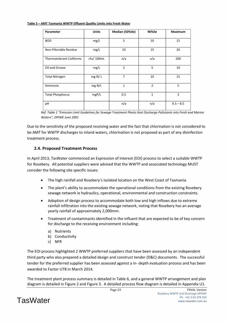
Page 23 FINAL Version
Rosebery WWTP and Discharge DPEMP Ph: +61 3 62 378 325
www.taswater.com.au
TasWater
Table 5 – AMT Tasmania WWTP Effluent Quality Limits into Fresh Water
Parameter Units Median (50%ile) 90%ile Maximum
BOD mg/L 5 10 15
Non-Filterable Residue mg/L 10 15 20
Thermotolerant Coliforms cfu/ 100mL n/a n/a 200
Oil and Grease mg/L 2 5 10
Total Nitrogen mg N/ L 7 10 15
Ammonia mg N/L 1 2 5
Total Phosphorus mgP/L 0.5 1 3
pH n/a n/a 6.5 – 8.5
Ref: Table 1 “Emission Limit Guidelines for Sewage Treatment Plants that Discharge Pollutants into Fresh and Marine
Waters”, DPIWE June 2001
Due to the sensitivity of the proposed receiving water and the fact that chlorination is not considered to
be AMT for WWTP discharges to inland waters, chlorination is not proposed as part of any disinfection
treatment process.
2.4. Proposed Treatment Process
In April 2013, TasWater commenced an Expression of Interest (EOI) process to select a suitable WWTP
for Rosebery. All potential suppliers were advised that the WWTP and associated technology MUST
consider the following site specific issues:
The high rainfall and Rosebery’s isolated location on the West Coast of Tasmania.
The plant’s ability to accommodate the operational conditions from the existing Rosebery sewage network ie hydraulics, operational, environmental and construction constraints.
Adoption of design process to accommodate both low and high inflows due to extreme rainfall infiltration into the existing sewage network, noting that Rosebery has an average yearly rainfall of approximately 2,000mm.
Treatment of contaminants identified in the influent that are expected to be of key concern for discharge to the receiving environment including:
a) Nutrients b) Conductivity c) NFR
The EOI process highlighted 2 WWTP preferred suppliers that have been assessed by an independent
third party who also prepared a detailed design and construct tender (D&C) documents. The successful
tender for the preferred supplier has been assessed against a in- depth evaluation process and has been
awarded to Factor UTB in March 2014.
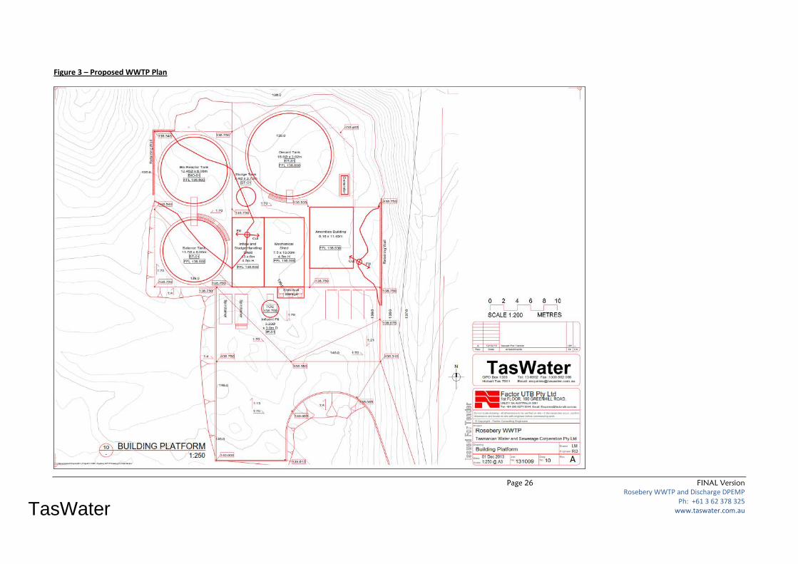
The treatment plant process summary is detailed in Table 6, and a general WWTP arrangement and plan diagram is detailed in Figure 2 and Figure 3. A detailed process flow diagram is detailed in Appendix U1.

Page 24 FINAL Version
Rosebery WWTP and Discharge DPEMP Ph: +61 3 62 378 325
www.taswater.com.au
TasWater
Table 6 – Factor UTB WWTP process summary
WWTP Component Process functionality / deliverables
Treatment Process SBR (intermittent aeration, intermittent decanter)
Proposed Effluent Quality BOD: < 5 mg/L
Turbidity: <15 NTU
NFR / SS: < 10 mg/L
Ecoli: < 10 cfu
Disinfect: Validated 1 log virus removal
P: Dosing with poly-alum or similar
N: Biological removal (note temperature dependent)
Conductivity: No change
Headworks Inlet screening and grit removal. 2
Biological Treatment Controlled SBR:
2 tanks - SBR 1 and SBR 2 1
2 aerator/mixers – 15 kW each
Nutrient Treatment P: Dosing with poly-alum or similar
N: Biological removal in SBR
Tertiary Treatment Screen filter and multi-media (MM) filters
Disinfection UV
pH
Sludge handling V-belt sludge unit into a Spirotainer 2
Plant Footprint Compact – dimensions not provided
Treatment Flow Range Can handle proposed range – Transferred influent maximum
flow capacity from main pump station 50 l/sec with 32 l/sec full
treatment and 15 l/sec primary treated then bypassed.
Control system Complete SCADA and PLC control with remote Telstra 3G
access.
Notes:
1 – Tanks are proposed to be steel based on asset life (50 years) and whole of life costing consideration.
2 – TasWater have detailed these as required for operational needs.

Page 25 FINAL Version
Rosebery WWTP and Discharge DPEMP Ph: +61 3 62 378 325
www.taswater.com.au
TasWater
Figure 2 - General WWTP Arrangements
Page 26 FINAL Version
Rosebery WWTP and Discharge DPEMP Ph: +61 3 62 378 325
www.taswater.com.au
TasWater
Figure 3 – Proposed WWTP Plan

Page 27 FINAL Version
Rosebery WWTP and Discharge DPEMP Ph: +61 3 62 378 325
www.taswater.com.au
TasWater
Effluent discharge flow rates are to be minimised when possible so that effective disinfection can occur,
and to meet receiving water mixing zone requirements. Because the process requires discharge in
batches, an effluent balance tank will be incorporated into the WWTP design as part of the final plant.
This tank will be beneficially utilised to minimise the flow discharged into the Stitt River during extreme
dry weather when low flow conditions occur. Modelling and design and an environmental risk analysis
(refer Appendix O3) confirms that a 1.0 ML balance / storage tank will ensure outfall discharge will not
exceed the required 1:80 dilution ratio on the 7Q10 flow regime (the lowest 7 day flow rate than can be
expected in 10 years). This is based upon lowest flow record over 23 years of historical flow recording in
the Stitt River. It is estimated the 1.0 ML capacity tank should mitigate between 6 to 7 days holding
capacity against the 7Q10 flow condition (using a low extreme average receiving waters flow rate of 69
l/s) before normal discharge must then occur.
The transfer of large influent flows into the WWTP is controlled at a maximum flow rate of 47 L/s (as
detailed in Table 2) from Park Road SPS. During these peak inflows 32 L/s of this flow will be fully
treated by the plant, with the remaining 15 L/s being primary treated then bypassed around the
remaining plant.
The tender evaluation process undertaken by TasWater and subsequent 3rd party review SMEC have
confirmed that the technology and plant capacity will treat effluent to meet the required AMT emission
limits as listed in Table 5.
A Environmental Risk Assessment for the high inflow bypass scenario at the plant has been prepared by
Jacobs (SKM) and is detailed in Appendix O4. This assessment confirms that even during this scenario,
because there is also a corresponding high flow along the Stitt River, there is still only a low risk to
ecological values, nuisance plant growth and algal blooms in the receiving waters. There is also only a
low to moderate risk to recreational users during bypass events because there is very limited
recreational activity downstream of the outfall since the location of the outfall is remote and difficult to
access.
2.5. Construction
The current program for the Rosebery WWTP project is summarised below:
1. Expression of Interest for WWTP April 2013 - Complete
2. Select preferred D&C tenders May 2013 – Complete
3. Prepare D&C Tender documentation June to September 2013 – Complete
4. Tender closes December 2013 – Complete
5. Award Tender July 2014
6. DPEMP / Development approval October 2014
7. Construction commence November 2014
8. Construction complete March 2015
9. Commissioning of WWTP By 30th June 2015

Page 28 FINAL Version
Rosebery WWTP and Discharge DPEMP Ph: +61 3 62 378 325
www.taswater.com.au
TasWater
The beginning of the DPEMP assessment process including any public consultation will be need to be
undertaken in parallel with TasWater awarding the tender for the WWTP D&C contract, and the
construction of the outfall pipeline, both of which will occur throughout July / November 2014.
For the middle of 2014, detailed design and supply of plant and equipment will occur. WWTP
construction is scheduled to occur over the dryer summer months in 2014/15 to minimise construction
interruptions due to poor weather.
Construction activities include:
Access track upgrade - Completed
Vegetation removal at WWTP site – Completed
Site construction pad - Completed
Vegetation removal along outfall pipeline - Completed
Construction of outfall pipeline and discharge into Stitt River
Earthworks
Installation of WWTP plant components and TasWater site office
Installation of water supply and electricity to site
Plant commissioning
All environmental controls required during construction have been detailed in the tender documents.
Factor UTB as the successful contractor will be required to prepare a Construction Management Plan
(CMP) prior to commencing work on site which details all specific environmental impacts and mitigation
measures. A specific Construction Environmental Management Plan (CEMP) will form a major part of
the CMP which will also details OHS, and other general construction risks associated with construction
and commissioning of the works (eg contractor and TasWater contact details, hours of work, sources of
materials, and construction plant on site).
2.6. Operation
Once commissioned, the Rosebery WWTP will be operated by TasWater in accordance with a planning
permit issued by the West Coast Council, which include all relevant environmental requirements
specified by the EPA Board for the new plant and outfall.
As part of the WWTP commissioning, the contractor will be required to provide the following to
TasWater:
Training for relevant TasWater staff on all plant operations,
Operations and Maintenance manuals( 2 copies), and
Proposed inspection and maintenance requirements for all plant components based on
manufacturers requirements and technical specifications.
Page 29 FINAL Version
Rosebery WWTP and Discharge DPEMP Ph: +61 3 62 378 325
www.taswater.com.au
TasWater
2.7. Technical and Management Alternatives
Prior to finalising the need for a new WWTP at the Direen’s Corner site and an outfall into the Stitt River
downstream of the Rosebery township, TasWater undertook a range of investigations to determine an
appropriate solution to collect, treat and dispose of wastewater from Rosebery. Assessments included:
a) Implementing an effluent reuse scheme with no discharge to tailings dams or waterways.
b) Constructing multiple small WWTPs at existing sewer pump station sites.
c) Looking at a range of sites for a new WWTP and outfall.
Option 3 was selected, and the sections below summarise why the other 2 options were not pursued.
2.7.1. Effluent Reuse Scheme
Prior to proceeding with a WWTP EOI, TasWater engaged GHD to assess whether a 100% effluent reuse
scheme could be implemented at Rosebery, plus 4 other towns within the region. An extract of their
report “Report for Effluent Reuse Investigations” relating to Rosebery only is included in Appendix F.
A summary of key findings from this July 2010 report were:
Rainfall data for a 1 in 10 year wet year was used to calculate required effluent generation and it
was assumed that all effluent would be irrigated with no storage dam constructed.
A cropping factor for lucerne was used to calculate water demand, since native vegetation does
not need the water or nutrients available from the effluent.
109.5 ML/year is a manageable volume which could be considered for reuse but due to high
monthly and annual rainfall, there are no months available in the wet Rosebery area where
conditions allow suitable for irrigation to occur.
Recommendation: The Rosebery site is not suitable for reuse for land application due to the high
rainfall in the area compared to evaporation.
Because of the above findings, an effluent reuse scheme was not progressed further.
2.7.2. Small WWTPs at Existing Sewage Pump Stations
An alternative option to constructing a single WWTP was to construct 3 separate small package type
WWTP’s at each existing SPS site across Rosebery, with each discharging their effluent into the
waterways adjacent to the stations. After some initial investigations this options was not considered an
appropriate long term solution for the following reasons:
1. Due to the significant annual rainfall in the area and large fluctuations in sewage inflow due to
inflow and infiltration cross the catchment, the individual small WWTP’s would not be able to
effectively treat the required flow fluctuations.
2. All proposed effluent discharge points are within the Rosebery township.
3. There is limited space available adjacent to each SPS to install a WWTP.
4. Each plant would be highly visible, and close to a number of sensitive receptors including
houses.
5. The outcome would be multiple effluent discharge points in the region, which would require
permits, management and monitoring.
Page 30 FINAL Version
Rosebery WWTP and Discharge DPEMP Ph: +61 3 62 378 325
www.taswater.com.au
TasWater
3. The Existing Environment
Detailed below are a number of site specific issues that will be impacted by this development. These all
relate to Commonwealth, State and Local requirements that must be met to satisfy all parties that this
project can proceed.
3.1. Planning Aspects
Rosebery is located within the West Coast Council (WCC) municipal area. Therefore the West Coast
Planning Scheme 1999 applies to this project. This DPEMP is intended to help gain approval to construct
all works proposed on site including the WWTP, TasWater amenities building, discharge pipeline and
access road.
The proposed site area is located off Chester Avenue and is zoned “Rural Resource”. The intent of the
Rural Resources Zone in the scheme is to:
26.1.1.1 To provide for the sustainable use or development of resources for agriculture, aquaculture, forestry, mining and other primary industries, including opportunities for resource processing. 26.1.1.2 To provide for other use or development that does not constrain or conflict with resource development uses.
Sub-section 4.1 Planning Terms and Definitions of the WCC Planning Scheme classes a “Utilities” use a “Permitted” use in the zone if it is minor. The development proposal is not considered to be minor and therefore does not comply with this part of the Planning Scheme provision. Sub-section 8.2 of the Scheme, Table 8.2 Use Classes defines the use of “Utilities” as land for utilities and infrastructure including, amongst other matters, the collecting treating, or disposing of storm or floodwater, sewage, or sullage. However, being as the “Utilities” use is the subject of the DPEMP, the Scheme provides for the use to be treated as a “Discretionary “use class. Within the scheme, Sections 26.3 to 26.4 sets out the planning scheme standards applicable to use of development in the Rural Resource zone. The following Scheme Codes are also relevant to the proposed development:
E1 - Bush Fire Prone Areas – Hazardous Uses, E3 - Clearing and Conversion of Vegetation, E6 - Hazard Management, E9 - Traffic Generating Use and Parking Code, E10 - Water and Waterways.
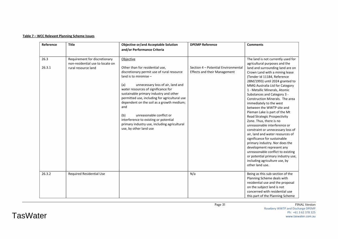
Specific relevant issues that are applicable and relevant to this project are summarised in the table below and include the location within the DPEMP where each issue is addressed in detail:
Page 31 FINAL Version
Rosebery WWTP and Discharge DPEMP Ph: +61 3 62 378 325
www.taswater.com.au
TasWater
Table 7 – WCC Relevant Planning Scheme Issues
Reference Title Objective or/and Acceptable Solution
and/or Performance Criteria
DPEMP Reference Comments
26.3
26.3.1
Requirement for discretionary non-residential use to locate on rural resource land
Objective
Other than for residential use, discretionary permit use of rural resource land is to minimise –
(a) unnecessary loss of air, land and water resources of significance for sustainable primary industry and other permitted use, including for agricultural use dependent on the soil as a growth medium; and
(b) unreasonable conflict or interference to existing or potential primary industry use, including agricultural use, by other land use
Section 4 – Potential Environmental Effects and their Management
The land is not currently used for agricultural purposes and the land and surrounding land are on Crown Land with a mining lease (Tender Id 11184, Reference 28M/1993) until 2024 granted to MMG Australia Ltd for Category 1 - Metallic Minerals, Atomic Substances and Category 3 - Construction Minerals. The area immediately to the west between the WWTP site and Pieman Lake is part of the Mt Read Strategic Prospectivity Zone. Thus, there is no unreasonable interference or constraint or unnecessary loss of air, land and water resources of significance for sustainable primary industry. Nor does the development represent any unreasonable conflict to existing or potential primary industry use, including agriculture use, by other land use.
26.3.2 Required Residential Use N/a Being as this sub-section of the Planning Scheme deals with residential use and the proposal on the subject land is not concerned with residential use this part of the Planning Scheme

Page 32 FINAL Version
Rosebery WWTP and Discharge DPEMP Ph: +61 3 62 378 325
www.taswater.com.au
TasWater
is not applicable.
26.3.3 Residential Use N/a Being as this sub-section of the Planning Scheme deals with residential use and the proposal on the subject land is not concerned with residential use this part of the Planning Scheme is not applicable.
26.4
26.4.1
Development Standards
Suitability of a site or lot a plan of subdivision for use or development
Objective
The minimum properties of a site and of each lot on a plan of subdivision are to –
(a) provide a suitable development area for the intended use;
(b) provide access from a road; and
(c) make adequate provision for a water supply for the drainage disposal of sewerage and stormwater
Table 9.1 Road access and setback
Figure 1 – Site Plan and Figure 8 – Proposed BPZ and FMBZ around WWTP
The proposed WWTP site was identified as the preferred location based on social, engineering and environmental criteria which determined that the site:
• Is set back from existing Rosebery residential areas, and downstream of the section of Stitt River that flows through the township,
• Has good vehicular access off existing road networks, and an existing access track (which will be upgraded),
• Already has an existing TasWater sewage treatment asset which defined existing sewage treatment processing had already been undertaken at the site(an 18 metre diameter, 1.4 metre high 0.3 ML open steel tank) with scope to expand the site to the west to accommodate

Page 33 FINAL Version
Rosebery WWTP and Discharge DPEMP Ph: +61 3 62 378 325
www.taswater.com.au
TasWater
Acceptable Solution 1
A site or each lot on a plan of subdivision must –
(a) unless for agricultural use dependent on the soli as a growth medium, have an area of not less than 1 hectare; and
(b) if intended for a building, contain a building area –
(i) of not more than 2000m2 or 20% of the area of the site, whichever is the
Figure 1 – Site Plan
Appendix A – Site Plans
the new plant,
• Can accommodate the proposed plant area of 2.103 hectares (125 metres by 145 metres site footprint),
• Is gently sloping across the proposed WWTP footprint area,
• Has existing power to the access road (which will require extending into the WWTP site),
• Has nearby reticulated water supply which will be extended into the site,
• Allows for a gravity outfall discharge to the Stitt River, and
• Has limited visibility from Rosebery and Chester Avenue since it is surrounded by trees.
The location of the land and site plan indicate; land area of 2.013has in size, which is greater than the minimum requirement of 1ha.
TasWater sewage treatment
asset which defined existing
sewage treatment processing
had already been undertaken at
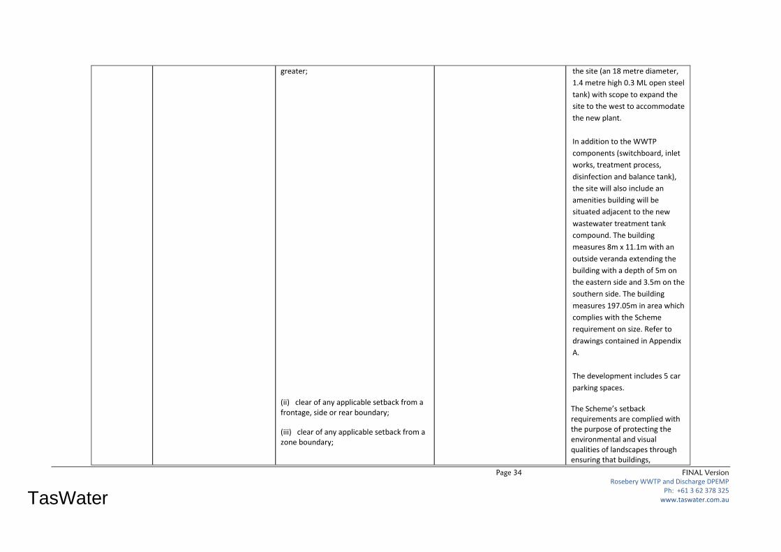
Page 34 FINAL Version
Rosebery WWTP and Discharge DPEMP Ph: +61 3 62 378 325
www.taswater.com.au
TasWater
greater;
(ii) clear of any applicable setback from a frontage, side or rear boundary;
(iii) clear of any applicable setback from a zone boundary;
the site (an 18 metre diameter,
1.4 metre high 0.3 ML open steel
tank) with scope to expand the
site to the west to accommodate
the new plant.
In addition to the WWTP
components (switchboard, inlet
works, treatment process,
disinfection and balance tank),
the site will also include an
amenities building will be
situated adjacent to the new
wastewater treatment tank
compound. The building
measures 8m x 11.1m with an
outside veranda extending the
building with a depth of 5m on
the eastern side and 3.5m on the
southern side. The building
measures 197.05m in area which
complies with the Scheme
requirement on size. Refer to
drawings contained in Appendix
A.
The development includes 5 car
parking spaces.
The Scheme’s setback requirements are complied with the purpose of protecting the environmental and visual qualities of landscapes through ensuring that buildings,

Page 35 FINAL Version
Rosebery WWTP and Discharge DPEMP Ph: +61 3 62 378 325
www.taswater.com.au
TasWater
(iv) clear of any registered easement;
(v) clear of any registered right of way benefiting other land;
(vi) clear of any restriction imposed by a utility; water supply and for the drainage and disposal of sewage and stormwater;
(vii) not including an access strip;
(viii) accessible from a frontage or access strip
structures and other works on steep slopes are located and constructed so as to minimise impact.
The 20m setback requirement to the frontage of the lot is exceeded by 127.38m.
The 10m side setback requirement is exceeded by 100m on the eastern side and 94.68 on the western side.
The 10m rear setback requirement is exceeded by 55.3m.
There are no easements to be clear of.
There are no right of ways to be clear of.
The treatment of wastewater treatment plant is clear of any restriction imposed by a utility.
N/a
The site is accessible by a hard standing gravel access track which will be widened from 5 to 6m to accommodate two vehicles passing along an access strip from Chester Avenue to the WWTP. The road frontage measures 29.22m.

Page 36 FINAL Version
Rosebery WWTP and Discharge DPEMP Ph: +61 3 62 378 325
www.taswater.com.au
TasWater
Performance Criteria 1
A site or each lot on a plan of subdivision must be of sufficient area for the intended use or development without likely constraint or interference for –
(a) erection of a building if required by the intended use;
(b) access to the site;
(c) use or development of adjacent land;
(d) a utility; and
(e) any easement or lawful entitlement for access to other land
Being as the proposal complies with the Acceptable Solution 1 the Performance Criteria 1 becomes redundant.
Acceptable Solution 2
A site or each lot on a plan of subdivision must have –
(a) a frontage upon a road of not less than 6.0m;
(b) access provided by a rightof-way to a road over land not required as the sole or principle means of access to any other land of a width not less than 6.0m; or
(c) an access strip to a road not required as the sole or principle means of access to any other land of a width not less than 6.0m; and
(d) vehicular access between the carriageway of a road and the frontage or
Figure 1 – Site Plan
Appendix A – Site Plans
The road frontage measures 29.22m, thus complying with proscribed Scheme provision.
A right-of –way is not required for access purposes.
The access strip from Chester Avenue stretches a distance of 147.38m to the WWTP footprint, bordering on both sides by Crown Land.
Vehicular access between the
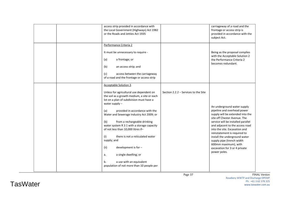
Page 37 FINAL Version
Rosebery WWTP and Discharge DPEMP Ph: +61 3 62 378 325
www.taswater.com.au
TasWater
access strip provided in accordance with the Local Government (Highways) Act 1982 or the Roads and Jetties Act 1935
carriageway of a road and the frontage or access strip is provided in accordance with the subject Act.
Performance Criteria 2
It must be unnecessary to require
(a) a frontage; or
(b) an access strip; and
(c) access between the carriageway of a road and the frontage or access strip
Being as the proposal complies with the Acceptable Solution 2 the Performance Criteria 2 becomes redundant.
Acceptable Solution 3
Unless for agricultural use dependent on the soil as a growth medium, a site or each lot on a plan of subdivision must have a water supply –
(a) provided in accordance with the Water and Sewerage Industry Act 2009; or
(b) from a rechargeable drinking water system R 3 1 with a storage capacity of not less than 10,000 litres if–
(i) there is not a reticulated water supply; and
(ii) development is for –
a. a single dwelling; or
b. a use with an equivalent population of not more than 10 people per
Section 2.2.2 – Services to the Site
An underground water supply pipeline and overhead power supply will be extended into the site off Chester Avenue. The service will be installed parallel and adjacent to the access road into the site. Excavation and reinstatement is required to install the underground water supply pipe (trench width 600mm maximum), with excavation for 3 or 4 private power poles.
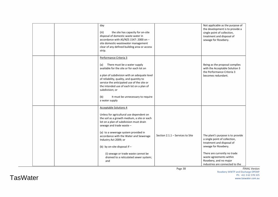
Page 38 FINAL Version
Rosebery WWTP and Discharge DPEMP Ph: +61 3 62 378 325
www.taswater.com.au
TasWater
day
(iii) the site has capacity for on-site disposal of domestic waste water in accordance with AS/NZS 1547: 2000 on –site domestic-wastewater management clear of any defined building area or access strip.
Not applicable as the purpose of the development is to provide a single point of collection, treatment and disposal of sewage for Rosebery.
Performance Criteria 3
(a) There must be a water supply available for the site or for each lot on
a plan of subdivision with an adequate level of reliability, quality, and quantity to service the anticipated use of the site or the intended use of each lot on a plan of subdivision; or
(b) It must be unnecessary to require a water supply
Being as the proposal complies with the Acceptable Solution 3 the Performance Criteria 3 becomes redundant.
Acceptable Solutions 4
Unless for agricultural use dependent on the soil as a growth medium, a site or each lot on a plan of subdivision must drain sewage and trade waste –
(a) to a sewerage system provided in accordance with the Water and Sewerage Industry Act 2009; or
(b) by onsite disposal if –
(i) sewage or trade waste cannot be drained to a reticulated sewer system; and
Section 2.1.1 – Services to Site
The plant’s purpose is to provide a single point of collection, treatment and disposal of sewage for Rosebery.
There are currently no trade waste agreements within Rosebery, and no major industries are connected to the

Page 39 FINAL Version
Rosebery WWTP and Discharge DPEMP Ph: +61 3 62 378 325
www.taswater.com.au
TasWater
(ii) the development
a. is for a single dwelling; or
b. provides for an equivalent population of not more than 10 people per day; or
(iii) the site has capacity for onsite disposal of domestic waste water in accordance with AS/NZS 1547:2000 onsite domesticwastewater management clear of any defined building area or access strip
sewerage system. Extensive influent water quality testing as detailed in the report, no significant trade waste issues have been identified or are expected within the Rosebery catchment.
n/a
Performance Criteria 4
a) A site or each lot on a plan of subdivision must drain and dispose of sewage and trade waste –
(i) in accordance with any prescribed emission limits for discharge of waste waters
(ii) in accordance with any limit advised by the Tasmanian Environmental Protection Agency;
(iii) without likely adverse impact for the health or amenity of the land and adjacent land;
(iv) without compromise to water quality objectives for surface or ground water established under the State Policy on Water Quality Management 1997; and
(v) with appropriate safeguards to minimise contamination if the use or
Being as the proposal complies with the Acceptable Solution 4 the Performance Criteria 4 becomes redundant.

Page 40 FINAL Version
Rosebery WWTP and Discharge DPEMP Ph: +61 3 62 378 325
www.taswater.com.au
TasWater
development has potential to –
a. indirectly cause the contamination of surface or ground water; or
b. involve an activity or process which requires the use, production, conveyance or storage of significant quantities of sewage or trade waste that may cause harm to surface or ground water if released through accident, malfunction, or spillage; or
(b) It must be unnecessary to require the drainage and disposal of sewage or trade waste
Acceptable Solutions 5
Unless for agricultural use dependent on the soil as a growth medium, a site or each lot on a plan of subdivision must drain stormwater –
(a) to a stormwater system provided in accordance with the Drains Act 1954 ; or
(b) if storm water cannot be drained to a stormwater system –
(i) for discharge to a natural drainage line, water body, or watercourse; or
(ii) for disposal within the site if –
a. the site has an area of not less than 5000m2;
Appendix A – Site Plans
Stormwater is to be drained by a direct pipe directed to existing open drain besides roadway. Ultimately the gravitational drain has an outfall into the Stitt River some 250m distance. This method complies with the acceptable solution.
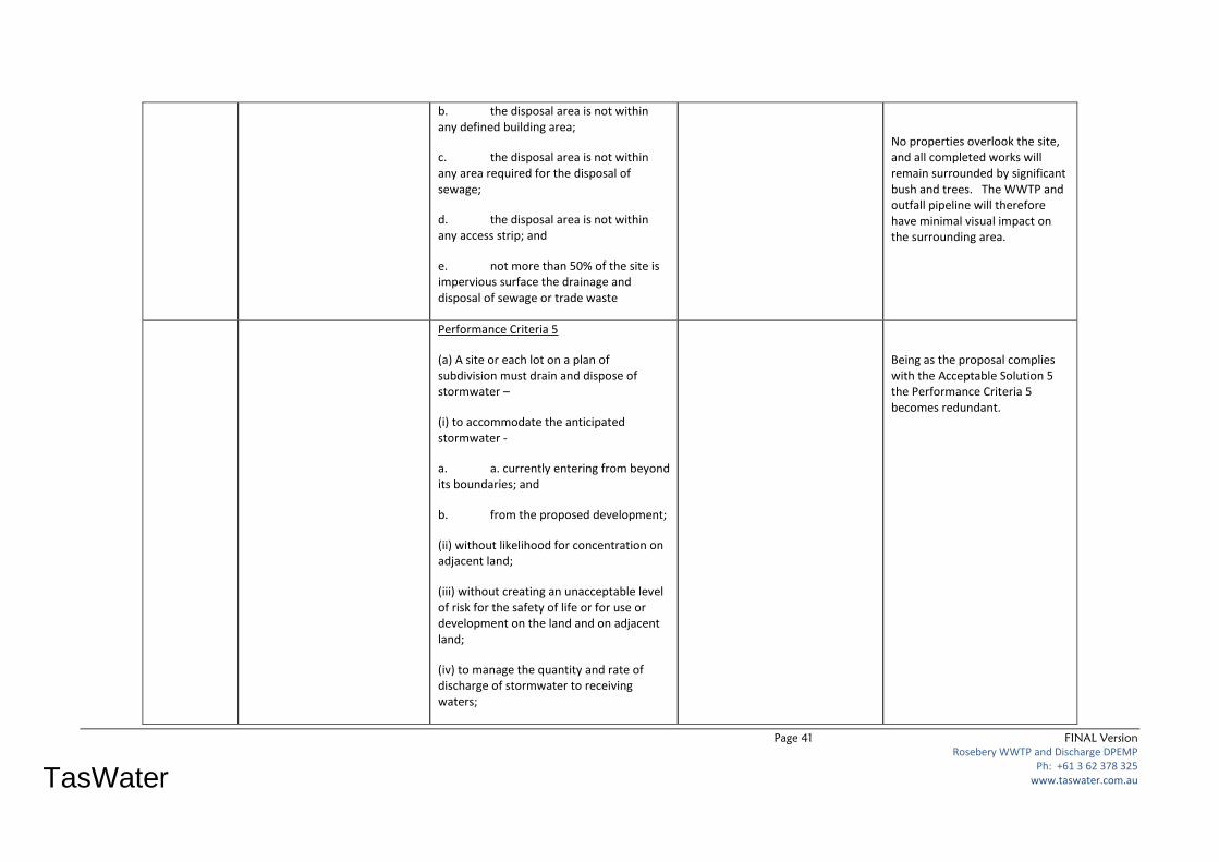
Page 41 FINAL Version
Rosebery WWTP and Discharge DPEMP Ph: +61 3 62 378 325
www.taswater.com.au
TasWater
b. the disposal area is not within any defined building area;
c. the disposal area is not within any area required for the disposal of sewage;
d. the disposal area is not within any access strip; and
e. not more than 50% of the site is impervious surface the drainage and disposal of sewage or trade waste
No properties overlook the site, and all completed works will remain surrounded by significant bush and trees. The WWTP and outfall pipeline will therefore have minimal visual impact on the surrounding area.
Performance Criteria 5
(a) A site or each lot on a plan of subdivision must drain and dispose of stormwater –
(i) to accommodate the anticipated stormwater
a. a. currently entering from beyond its boundaries; and
b. from the proposed development;
(ii) without likelihood for concentration on adjacent land;
(iii) without creating an unacceptable level of risk for the safety of life or for use or development on the land and on adjacent land;
(iv) to manage the quantity and rate of discharge of stormwater to receiving waters;
Being as the proposal complies with the Acceptable Solution 5 the Performance Criteria 5 becomes redundant.
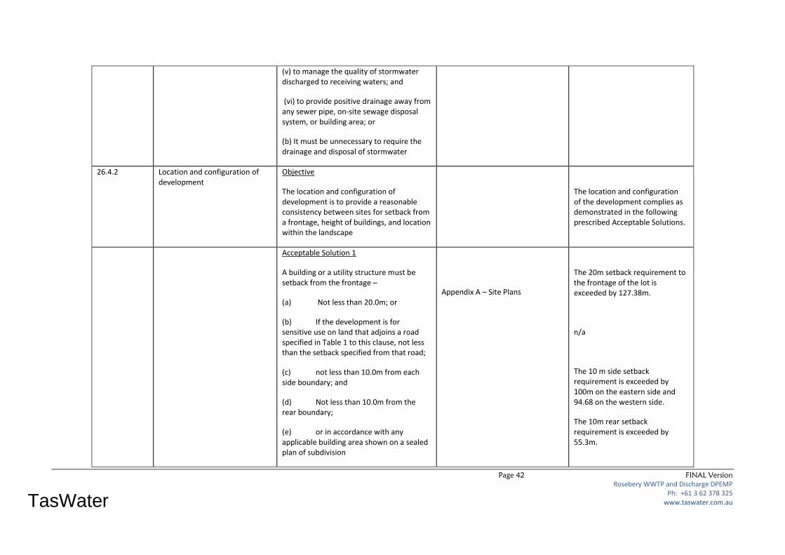
Page 42 FINAL Version
Rosebery WWTP and Discharge DPEMP Ph: +61 3 62 378 325
www.taswater.com.au
TasWater
(v) to manage the quality of stormwater discharged to receiving waters; and
(vi) to provide positive drainage away from any sewer pipe, onsite sewage disposal system, or building area; or
(b) It must be unnecessary to require the drainage and disposal of stormwater
26.4.2 Location and configuration of development
Objective
The location and configuration of development is to provide a reasonable consistency between sites for setback from a frontage, height of buildings, and location within the landscape
The location and configuration of the development complies as demonstrated in the following prescribed Acceptable Solutions.
Acceptable Solution 1
A building or a utility structure must be setback from the frontage –
(a) Not less than 20.0m; or
(b) If the development is for sensitive use on land that adjoins a road specified in Table 1 to this clause, not less than the setback specified from that road;
(c) not less than 10.0m from each side boundary; and
(d) Not less than 10.0m from the rear boundary;
(e) or in accordance with any applicable building area shown on a sealed plan of subdivision
Appendix A – Site Plans
The 20m setback requirement to the frontage of the lot is exceeded by 127.38m.
n/a
The 10 m side setback requirement is exceeded by 100m on the eastern side and 94.68 on the western side.
The 10m rear setback requirement is exceeded by 55.3m.
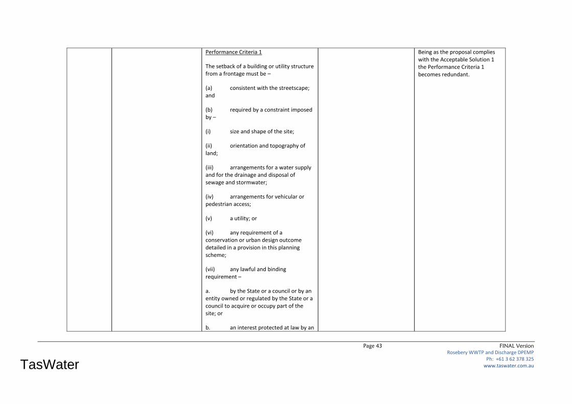
Page 43 FINAL Version
Rosebery WWTP and Discharge DPEMP Ph: +61 3 62 378 325
www.taswater.com.au
TasWater
Performance Criteria 1
The setback of a building or utility structure from a frontage must be –
(a) consistent with the streetscape; and
(b) required by a constraint imposed by –
(i) size and shape of the site;
(ii) orientation and topography of land;
(iii) arrangements for a water supply and for the drainage and disposal of sewage and stormwater;
(iv) arrangements for vehicular or pedestrian access;
(v) a utility; or
(vi) any requirement of a conservation or urban design outcome detailed in a provision in this planning scheme;
(vii) any lawful and binding requirement –
a. by the State or a council or by an entity owned or regulated by the State or a council to acquire or occupy part of the site; or
b. an interest protected at law by an
Being as the proposal complies with the Acceptable Solution 1 the Performance Criteria 1 becomes redundant.
Page 44 FINAL Version
Rosebery WWTP and Discharge DPEMP Ph: +61 3 62 378 325
www.taswater.com.au
TasWater
easement or other regulation
c. regulation
Acceptable Solutions 2
Building height must be not be more than 8.5m
Appendix A – Site Plans
The building height measures 4.13m to the apex, and thus complies with the Scheme requirement.
Performance Criteria 2
Building height must
(a) minimise likelihood for overshadowing of a habitable room or a required minimum area of private open space in any adjacent dwelling;
(b) minimise apparent scale, bulk, massing and proportion in relation to any adjacent building;
(c) be consistent with the streetscape and rural landscape;
(d) respond to the effect of the slope and orientation of the site; and
(e) take into account the effect and durability of screening other than vegetation to attenuate impact
Being as the proposal complies with the Acceptable Solution 2 the Performance Criteria 2 becomes redundant.
Acceptable Solutions 3
A building or utility structure must be –
(a) not less than 15m below the level of any adjoining ridgeline;
Appendix A – Site Plans
There are no nearby ridgelines for the building to be measured against.
Page 45 FINAL Version
Rosebery WWTP and Discharge DPEMP Ph: +61 3 62 378 325
www.taswater.com.au
TasWater
(b) not less than 30m from any shoreline to a marine or aquatic water body, water course, or wetland;
(c) below the canopy level of any adjacent forest or woodland vegetation; and
(d) clad and roofed in nonreflective materials
The outfall into the Stitt River is located some 250m distance.
No properties overlook the site, and all completed works will remain surrounded by significant bush and trees.
The amenities building, walls and roof will be clad with Colorbond Custom Orb which is non-reflective.
Performance Criteria 3
Location of a building or utility structure must –
(a) not be visually apparent on a skyline;
(b) not be visually apparent above the vegetation canopy;
(c) not be visually apparent on the shoreline of a marine or aquatic water
body, water course, or wetland; and
(d) not be visually apparent as a result of the reflection of light from an external surface; or
(e) the location of a building or structure must –
(i) provide an overriding community
Being as the proposal complies with the Acceptable Solution 3 the Performance Criteria 3 becomes redundant.

Page 46 FINAL Version
Rosebery WWTP and Discharge DPEMP Ph: +61 3 62 378 325
www.taswater.com.au
TasWater
benefit; or
(ii) be required by an exceptional circumstance
2.6.4.3 Location of new sensitive use development
Objective:
The location of sensitive use development on rural land does not unreasonably interfere with or otherwise constrain –
1) agricultural land for existing and potential sustainable agricultural use dependent on the soil as a growth medium;
(b) agricultural use of land in a proclaimed irrigation district under Part 9 Water Management Act 1999 or land that may benefit from the application of broadscale irrigation development;
(c) use of land for agricultural production that is not dependent on the soil as a growth medium, including aquaculture, controlled environment agriculture, and intensive animal husbandry;
(d) conservation management;
(e) extractive industry;
(f) forestry; and
(g) transport and utility infrastructure
This section of the Planning Scheme is not applicable, as the intended use is not a sensitive use, as defined by sub-section 4.1.
PART E CODES
Page 47 FINAL Version
Rosebery WWTP and Discharge DPEMP Ph: +61 3 62 378 325
www.taswater.com.au
TasWater
E1 Bush Fire –
Prone Areas
Code
Building in Bushfire Prone Areas
- Hazardous Uses.
To ensure hazardous uses should only be
located in bushfire-prone areas in
exceptional circumstances. Where a
hazardous use is to be located in a
bushfire-prone area, bushfire protection
measures must reflect the risk arising from
the bushfire-prone vegetation and take
into consideration the characteristics,
nature and scale of the use. The
development is to ensure that use and
development is appropriately designed,
located, serviced and constructed o reduce
the risk to human life and property, and
the cost to the community, caused be
bushfires.
Section 4.16 – Fire Risk
Table 19 – Council and Tasmania
Fire Service Bushfire Requirements
Figure 8 – Proposed BPZ and FMBZ
around WWTP
Adequate buffer zones will be
provided around the proposed
WWTP site to meet current TFS
requirements.
Figure 8 and Appendix T3 shows
the proposed buffer zones
around the WWTP.
E3 Clearing
and
Conversion of
Vegetation
Code
Clearing and conversion of
vegetation.
The Code seeks to assist with protection
and conservation of threatened native
vegetation, habitat of threatened species,
(as per relevant legislation), identified
scenic or landscape value, vegetation
within 30m of a water body or
watercourse.
Section 3.2.3 Flora and Fauna
Section 4.7 Biodiversity and Nature
Conservation Values
Weed Management
Section 4.7.2 Machinery
Washdown Procedures
Section 4.7.4 Ongoing
Management and Assessment of
Weed and Disease
Section 4.7.5 Forest Practice Plan
Vegetation removal – at WWTP
site, along outfall pipeline and
within fire protection zones
The proposed development will
result in some 2 ha of native
vegetation within the context of
a modified and managed
landscape.
E6 Hazard
Management
Hazard Management The Code requires the minimisation of
exposure of use or development to an
unacceptable level of community risk from
Section 4 – Potential Environmental
Effects and their Management.
WWTP treatment and output as
outfall into the receiving waters
ensures that there is a tolerable

Page 48 FINAL Version
Rosebery WWTP and Discharge DPEMP Ph: +61 3 62 378 325
www.taswater.com.au
TasWater
Code a natural or environmental hazard. Also,
requires the minimisation of the likelihood
for use or development to trigger, spread,
or intensify a natural or environmental
hazard.
Section 4.8 – Design and
Construction of Stitt River Outfall.
Section 4.1 – Receiving Waters
Section 3.2.5.3 – Wetlands and
Waterways Code
risk to the health of people,
property and the environment
for the potential for
contamination as a consequence
of the use.
E9 Traffic
Generating
Use and
Parking Code
Traffic generating use and
parking code
The Code requires that development assists
in protecting the operational efficiency and
safety of roads, as well as publics
investment in road assets. The Code also
requires appropriate on-site arrangements
for circulation and passage of vehicles,
loading and unloading of fright and people
appropriate levels of parking, to a standard.
E9.6 Development Standards The development proposal
ensures the road safety and
amenity of the road
infrastructure is protected and
maintained by controlling access
arrangements and requiring set
backs for new buildings.
Overall the development will
minimise the detrimental
impacts on the amenity of the
use or development, streetscape
and the neighbourhood.
The development design
demonstrates that adequate
parking is provided, and ensures
that parked vehicles do not
obstruct the passage of others.
Development meets the standard
for design of vehicle parking and
loading area as stipulated in Sub-
section (E9.6.2) and Table E94.
E10 Water and
Waterways
Protection of Riparian Developments are to ensure the natural
drainage functions and botanical,
Section 4.8 – Design and Provides for the protection of the quality of receiving waters from
Page 49 FINAL Version
Rosebery WWTP and Discharge DPEMP Ph: +61 3 62 378 325
www.taswater.com.au
TasWater
Code Vegetation zoological and landscape values of rivers
and streams is protected by the retention
of riparian vegetation.
Construction of Stitt River Outfall.
Section 3.2.5.3 – Wetlands and
Waterways Code
Section 3.2.4 – Groundwater
Section 3.2.5 – Surface Water
Section 4.1 – Receiving Waters
point sources of pollution.
The development demonstrates its compliance with Siting of Developments Code and Wetlands and Waterways Code.
To achieve sustainable management or surface and groundwater resources through a focus on achieving water quality objectives.

Page 50 FINAL Version
Rosebery WWTP and Discharge DPEMP Ph: +61 3 62 378 325
www.taswater.com.au
TasWater
3.2. Environmental Aspects
Below is a detailed outline of the proposed site.
3.2.1. Topography
The site is located between RL130 and 140 along a ridge off the end of Chester Avenue on the
western side of Rosebery. The plant site is relatively flat with an average grade of only 3%. The area
to the north and east drop away significantly from 22% up to 56% where it falls down to the Stitt
River. The area to the south and west, slope uphill at between 5% and 16%. The steep slopes and
the site can be clearly seen in Figure 4 below:
Figure 4– LIDAR Contour Plan of Site
Ref: PDA Plan 15519-1 dated Jan 2013
LIDAR data from MMG at 1 metre contour spacing with 10 metre indexing
The entire site is hidden due to surrounding bush on Crown Land.
N
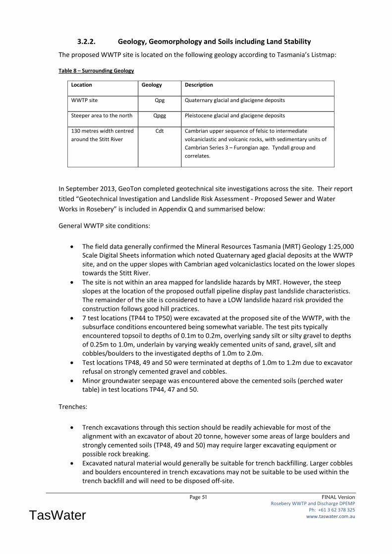
Page 51 FINAL Version
Rosebery WWTP and Discharge DPEMP Ph: +61 3 62 378 325
www.taswater.com.au
TasWater
3.2.2. Geology, Geomorphology and Soils including Land Stability
The proposed WWTP site is located on the following geology according to Tasmania’s Listmap:
Table 8 – Surrounding Geology
Location Geology Description
WWTP site Qpg Quaternary glacial and glacigene deposits
Steeper area to the north Qpgg Pleistocene glacial and glacigene deposits
130 metres width centred
around the Stitt River
Cdt Cambrian upper sequence of felsic to intermediate
volcaniclastic and volcanic rocks, with sedimentary units of
Cambrian Series 3 – Furongian age. Tyndall group and
correlates.
In September 2013, GeoTon completed geotechnical site investigations across the site. Their report
titled “Geotechnical Investigation and Landslide Risk Assessment - Proposed Sewer and Water
Works in Rosebery” is included in Appendix Q and summarised below:
General WWTP site conditions:
The field data generally confirmed the Mineral Resources Tasmania (MRT) Geology 1:25,000 Scale Digital Sheets information which noted Quaternary aged glacial deposits at the WWTP site, and on the upper slopes with Cambrian aged volcaniclastics located on the lower slopes towards the Stitt River.
The site is not within an area mapped for landslide hazards by MRT. However, the steep slopes at the location of the proposed outfall pipeline display past landslide characteristics. The remainder of the site is considered to have a LOW landslide hazard risk provided the construction follows good hill practices.
7 test locations (TP44 to TP50) were excavated at the proposed site of the WWTP, with the subsurface conditions encountered being somewhat variable. The test pits typically encountered topsoil to depths of 0.1m to 0.2m, overlying sandy silt or silty gravel to depths of 0.25m to 1.0m, underlain by varying weakly cemented units of sand, gravel, silt and cobbles/boulders to the investigated depths of 1.0m to 2.0m.
Test locations TP48, 49 and 50 were terminated at depths of 1.0m to 1.2m due to excavator refusal on strongly cemented gravel and cobbles.
Minor groundwater seepage was encountered above the cemented soils (perched water table) in test locations TP44, 47 and 50.
Trenches:
Trench excavations through this section should be readily achievable for most of the alignment with an excavator of about 20 tonne, however some areas of large boulders and strongly cemented soils (TP48, 49 and 50) may require larger excavating equipment or possible rock breaking.
Excavated natural material would generally be suitable for trench backfilling. Larger cobbles and boulders encountered in trench excavations may not be suitable to be used within the trench backfill and will need to be disposed off-site.
Page 52 FINAL Version
Rosebery WWTP and Discharge DPEMP Ph: +61 3 62 378 325
www.taswater.com.au
TasWater
We consider the slopes for the proposed WWTP possess a LOW slope stability risk.
WWTP Foundations:
The WWTP site has been classified as CLASS A (AS 2870 - 2011– Residential Slabs and Footings) based on the ground conditions encountered at the time of the site investigations.
Conditions at this site dictate that the founding medium for all footings should extend through the loose topsoil and sandy silt soils onto the weakly cemented soils or better.
Pad or bored pier footings founded within the weakly cemented soils at depths below 0.3m to 1.0m may be proportioned to an allowable bearing pressure of 250kPa.
Preliminary site pad earthworks and foundation preparation has been undertaken including excavation, stripping of topsoil and importing and compaction of 300mm depth of gravel.
Outfall Pipeline:
The hill slope is densely vegetated with native forest and a track has been cleared along the proposed alignment.
The hill slope typically has slope angles between 25 and 38 degrees and is undulating in the steeper sections with evidence of several shallow landslide features. In addition, the proposed alignment crosses two minor drainage depressions that show evidence of land instability with shallow landslide features.
The test locations on the upper slopes (BH39 and BH42) encountered topsoil and sand to depths of 0.2m and 0.3m, overlying sandy silt to auger refusal on inferred cemented soils at depths of 0.6m and 1.1m.
The test locations on the lower slopes (BH40 and BH41) encountered topsoil to a depth of 0.2m, overlying clayey silt to depths of 0.5m and 0.6m, underlain by gravelly clayey silt to auger refusal on inferred weathered rock at depths of 0.7m and 0.75m.
No groundwater seepage was encountered over the investigated depths. However, groundwater seepage is expected in the drainage depressions along the proposed alignment, and subsoil drains will be required through the drainage depressions to discharge water downslope of the pipeline.

Page 53 FINAL Version
Rosebery WWTP and Discharge DPEMP Ph: +61 3 62 378 325
www.taswater.com.au
TasWater
Figure 5 below summarises the geotechnical information relating to the WWTP site and proposed outfall pipeline: (Note - All boreholes have been purpose drilled for geotechnical assessment for the Rosebery WWTP development)
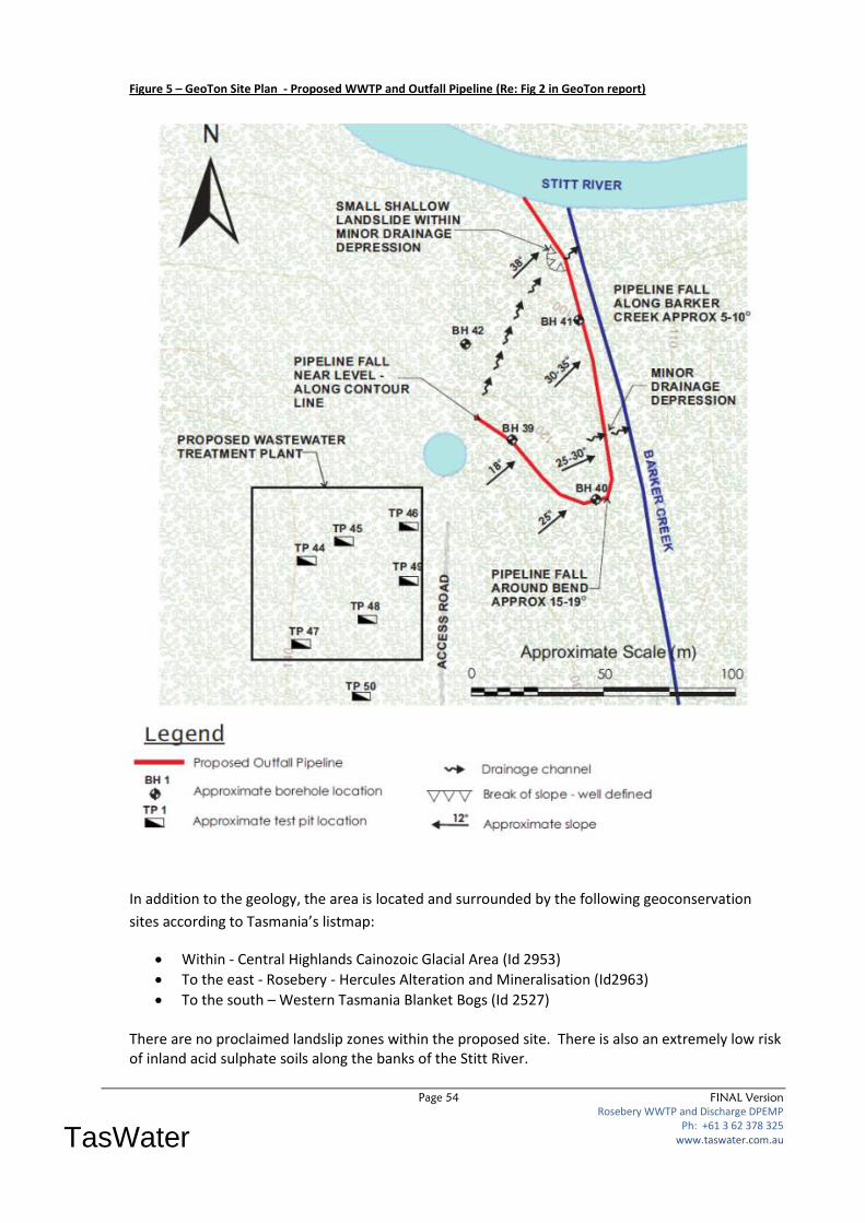
Page 54 FINAL Version
Rosebery WWTP and Discharge DPEMP Ph: +61 3 62 378 325
www.taswater.com.au
TasWater
Figure 5 – GeoTon Site Plan - Proposed WWTP and Outfall Pipeline (Re: Fig 2 in GeoTon report)
In addition to the geology, the area is located and surrounded by the following geoconservation
sites according to Tasmania’s listmap:
Within - Central Highlands Cainozoic Glacial Area (Id 2953)
To the east - Rosebery - Hercules Alteration and Mineralisation (Id2963)
To the south – Western Tasmania Blanket Bogs (Id 2527) There are no proclaimed landslip zones within the proposed site. There is also an extremely low risk of inland acid sulphate soils along the banks of the Stitt River.

Page 55 FINAL Version
Rosebery WWTP and Discharge DPEMP Ph: +61 3 62 378 325
www.taswater.com.au
TasWater
3.2.3. Flora & Fauna
Two separate assessments relating to flora and fauna have been considered as part of this project as
follows:
1. Terrestrial – at the WWTP site, access road and outfall pipeline alignment
2. Aquatic – in the vicinity of the proposed outfall pipe along the Stitt River
3.2.3.1. Terrestrial Flora and Fauna Assessment
In May and June 2013, CMW engaged ECOTas to prepare an “Ecological Assessment for the
Proposed Rosebery Wastewater Treatment Facility, Stitt River, Rosebery, Tasmania”. A copy of this
report is included in Appendix P.
The proposed development will result in the clearing of probably less than 2 ha of native vegetation
within the context of a modified and managed landscape. The assessment of the proposed
development area and immediate surrounds that may be affected by the installation and operation
of the wastewater facility were assessed in accordance with recognised guidelines.
No ecological values of high conservation significance requiring specific management under local,
State and Commonwealth government legislation and other policy instruments were identified.
No formal referral to the relevant State or Commonwealth government agency under the provisions of the Tasmanian Threatened Species Protection Act 1995 or the Commonwealth Environment Protection and Biodiversity Conservation Act 1999, respectively, are considered necessary. A summary of key findings from the desktop and field investigations are: Non-priority flora and fauna (e.g. species of biogeographic significance):
No species of high conservation significance were detected, and no special management actions are required.
Threatened fauna:
Potential habitat is present for the Tasmanian devil, spotted-tailed quoll, grey goshawk, and masked owl, however field survey did not indicate actual presence of these species
The presence of potential habitat of these species should not constrain the proposed development.
NOTE: More specific discussion on the Tasmanian devil is included in Section 3.2.3.2 below. Threatened flora:
No plant species, listed as threatened on the Commonwealth Environment Protection and Biodiversity Conservation Act 1999 were detected within the study area, and no special management actions are required.
No plant species, listed as threatened on the Tasmanian Threatened Species Protection Act 1995, were detected within the study area, and no special management actions are required.
Vegetation types: The study area supports four native TASVEG mapping units:
“Nothofagus-Atherosperma rainforest” (TASVEG code: RMT);
Page 56 FINAL Version
Rosebery WWTP and Discharge DPEMP Ph: +61 3 62 378 325
www.taswater.com.au
TasWater
“Leptospermum lanigerum-Melaleuca squarrosa swamp forest” (TASVEG code: NLM);
“Eucalyptus obliqua forest over rainforest” (TASVEG code: WOR); and
“Eucalyptus nitida forest over Leptospermum” (TASVEG code: WNL);
The study area supports one exotic non-forest TASVEG mapping unit:
“extra-urban miscellaneous” (TASVEG code: FUM).
None of these mapping units are classified as threatened under Schedule 3A of the Tasmanian Nature Conservation Act 2002, or on schedules of the Commonwealth Environment Protection and Biodiversity Conservation Act 1999, and no special management actions are required.
The clearance of the estimated extent of these vegetation types will not compromise the provisions of the Tasmanian Permanent Native Forest Estate policy, and no special management actions are required.
Weeds and disease:
Four species, classified as a “declared weeds” within the meaning of the Tasmanian Weed Management Act 1999, were detected from the study area. Two other “environmental weeds” within the meaning of Schedule 1 of the West Coast Planning Scheme 1999 are present. Two additional exotic species of potential concern but not formally classified under the Act or Scheme are also present.
No evidence of plant disease (Phytophthora cinnamomi, rootrot fungus; myrtle wilt) was detected: the former is unlikely to be a significant management issue but consideration of minimising the risk of introducing myrtle wilt is recommended.
The study area is within a “data hole” with respect to records of frog chytrid disease. It is recommended to assume that the disease is absent and to manage construction and operation of the facility to minimise the risk of introducing the pathogen.
Detailed recommendations are provided in relation to the management of the identified ecological values including weed and disease issues. These are included in Appendix H of the ECOTas report, and also detailed in Section 4.7 of the DPEMP.
3.2.3.2. Tasmanian Devil Impacts
During desktop assessments and on advice from the EPA, the need to assess potential Tasmania
Devil habitat was highlighted. Due to the Tasmania Devils facial tumour disease, numbers have
decreased to such an extent that they have been listed as an endangered species under the
Commonwealth Environment Protection and Biodiversity Conservation Act 1999 (EPBC).
The ECOTas report specifically assessed the potential impact of the WWTP on the Tasmanian Devil. The field survey concluded that:
Evidence of Tasmanian Devil was not found,
There is no need for a more formal site survey ie. camera-trapping at this site, and
The presence of potential habitat for the Tasmanian devil should not constrain the proposed development.
3.2.3.3. Aquatic Flora and Fauna
In June 2011, MMG completed a report titled “Biological Condition of the Ring and Stitt Rivers:
Survey of Aquatic Biota spring 2010 and autumn 2011”as part of their environmental obligations
given its upstream mining operations. A copy of this report is included in Appendix L1. This report
has been used as background information to help set ambient stream condition along the Stitt River.
Page 57 FINAL Version
Rosebery WWTP and Discharge DPEMP Ph: +61 3 62 378 325
www.taswater.com.au
TasWater
The MMG report indicated:
1. MMG study site S5 is just upstream of Stitt Falls, and is the site closest to the proposed
outfall being approximately 400 metres upstream of the discharge point.
2. In 2010/11 Site S5 had slightly raised conductivity when compared to past years, and low
levels in overlaying silt materials, and low to moderate algal growth.
3. Brown trout and shortfin eel elvers were noted at Site S5, although at lower number to
further upstream in the catchment. This site seems to have lower macroinvertibrate
assemblage composition than upstream areas due to reduced diversity and abundance.
4. The lower reaches of the Stitt are severely degraded with very low macroinvertibrate
densities and diversity, however there is a slight improvement in benthic biota in autumn
2011. The presence of fish, although probably transient, indicate slightly improved water
quality.
5. In conclusion, the Stitt River remains in an impaired condition.
In May 2013, TasWater engaged Peter Davies to prepare an aquatic flora and fauna report along the
Stitt River in the vicinity of the proposed outfall pipeline and down to Pieman Lake. A copy of this
report, completed in August 2013 is included in Appendix L2 and reference to the location of
sampling sites is detailed in Figure 7- AMP monitoring sites. This report indicated the following:
In relation to the Stitt River specifically:
1. The lower Stitt is in poor to moderate ecological condition. Biological condition is poor at
the downstream end of the river with sites S4, S5 and S6 being in a severely degraded state
with low to very low macroinvertebrate densities and reduced diversity.
2. Site S6, downstream of the proposed TasWater WWTP, is in an overall poorer state than
sites S5 and S4 upstream, with reduced taxon richness and total abundance, a substantially
reduced number of water quality sensitive macroinvertebrate taxa (caddis, Leptophlebiid
mayflies, beetle larvae) and greater densities of organic-tolerant worms.
3. It is apparent that site S6 is also suffering from the effects of mine-water related pollution.
The impact of sewage discharge from 2#5 Tailings Dam, observable at site S3, is not a major
contributor to biological decline in the lower reaches of the Stitt where biological condition
appears to be largely dictated by historical mining-related declines in water quality.
4. Of most importance is despite these effects, there is still just sufficient fauna at both sites S5
and S6 to act as a basis for future monitoring and detection of any potential impact from the
proposed WWTP discharge.
In relation to Lake Pieman specifically:
1. Overall, it appears that the shoreline of Lake Pieman showed no substantive algal response
to the existing inflow of the Stitt River discharge in autumn 2013, with algal levels falling
well below the upper limit derived from reference site values.
2. By contrast, the benthic macroinvertebrate response was marked, with substantially higher
total abundance and taxon richness at all three TasWater monitoring sites (peaking at site
17). This response, combined with the relatively high abundances of Chironomids and
freshwater worms, suggests a minor positive supplementation effect of the Stitt river inflow
on the Lake Pieman shoreline fauna. This suggests a stimulatory effect of enhanced
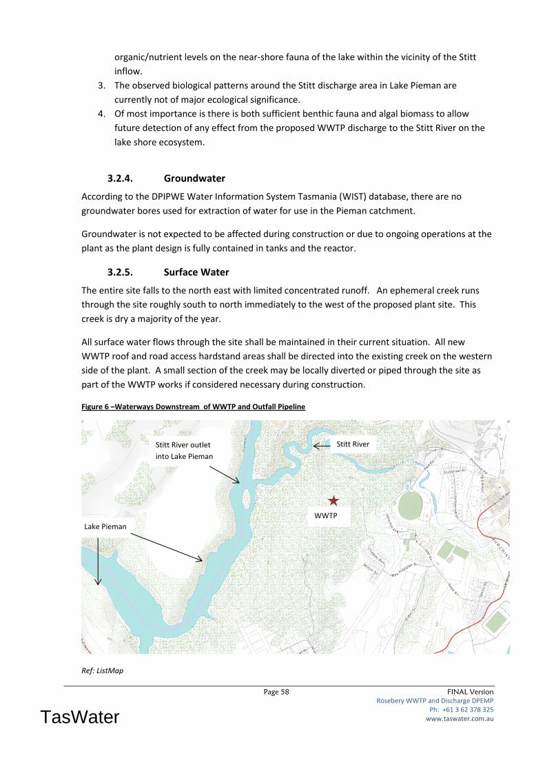
Page 58 FINAL Version
Rosebery WWTP and Discharge DPEMP Ph: +61 3 62 378 325
www.taswater.com.au
TasWater
organic/nutrient levels on the near-shore fauna of the lake within the vicinity of the Stitt
inflow.
3. The observed biological patterns around the Stitt discharge area in Lake Pieman are
currently not of major ecological significance.
4. Of most importance is there is both sufficient benthic fauna and algal biomass to allow
future detection of any effect from the proposed WWTP discharge to the Stitt River on the
lake shore ecosystem.
3.2.4. Groundwater
According to the DPIPWE Water Information System Tasmania (WIST) database, there are no
groundwater bores used for extraction of water for use in the Pieman catchment.
Groundwater is not expected to be affected during construction or due to ongoing operations at the
plant as the plant design is fully contained in tanks and the reactor.
3.2.5. Surface Water
The entire site falls to the north east with limited concentrated runoff. An ephemeral creek runs
through the site roughly south to north immediately to the west of the proposed plant site. This
creek is dry a majority of the year.
All surface water flows through the site shall be maintained in their current situation. All new
WWTP roof and road access hardstand areas shall be directed into the existing creek on the western
side of the plant. A small section of the creek may be locally diverted or piped through the site as
part of the WWTP works if considered necessary during construction.
Figure 6 –Waterways Downstream of WWTP and Outfall Pipeline
Ref: ListMap
Lake Pieman
Stitt River outlet
into Lake Pieman
WWTP
site
Stitt River
Page 59 FINAL Version
Rosebery WWTP and Discharge DPEMP Ph: +61 3 62 378 325
www.taswater.com.au
TasWater
3.2.5.1. Stitt River
The Stitt River is the major water course in the region, and is located approx. 250 metres to the
north of the proposed WWTP site. The Stitt River flows into Lake Pieman.
3.2.5.2. Lake Pieman
Lake Pieman is the major lake in the region and its western arm downstream of Lake Rosebery is
located approx. 1.2 km to the west of the proposed WWTP outfall site. Lake Pieman is a Hydro
Tasmania dam used as water storage as part of the Pieman hydro power scheme on the north west
coast.
The section of Lake Pieman that the Stitt River discharges into is known as the Yawning Gully East
Arm.
Page 60 FINAL Version
Rosebery WWTP and Discharge DPEMP Ph: +61 3 62 378 325
www.taswater.com.au
TasWater
3.2.6. Conservation Reserves and Wilderness Areas
Based on current List-map information all proposed works are on Crown Land and are:
a) outside World Heritage Areas.
b) not in State Forest,
c) not part of the Tasmanian Reserve Estate,
d) not within Tasmanian Forestry Agreement (TFA) future reserve land.
A report summarising the natural values atlas and geo-conservation values of the area based on
ListMap information is included in Appendix D.
3.3. Socio-Economic Aspects
Sewage collection and treatment is an essential aspect of any town. Rosebery currently has a
reticulated sewerage system, and with the requirement to remove the current discharge into a
nearby tailings dam, a new wastewater solution is required. Because of this, the proposed new
WWTP and outfall into the Stitt River downstream of the town is seen as the best solution to
maintain the sewerage infrastructure in Rosebery.

Page 61 FINAL Version
Rosebery WWTP and Discharge DPEMP Ph: +61 3 62 378 325
www.taswater.com.au
TasWater
4. Potential Environmental Effects and their Management
There are a number of key areas that could have potential environmental effects due to the
construction and operation of a new WWTP and outfall pipeline at this proposed site in Rosebery.
The most significant being:
The location of the outfall and impact on its receiving waters
Maintaining biodiversity and natural conservation values
Hazard analysis and risk assessment
These issues and a range of other potential impacts are discussed in detail in the sections below.
4.1. Receiving Waters
As discussed in Section 2.3.2, the new outfall is proposed to discharge into the Stitt River 1.2km
upstream of where it enters Pieman Lake.
4.1.1. WQO and Emission Limits
The adopted Draft Water Quality Objectives and agreed Emission Limits are proposed to be AMT
based on discussions with the EPA after assessment of the first 6 months of the data from
TasWater’s Ambient Monitoring Program (AMP) for the proposed Rosebery WWTP project. This is
discussed in more detail in Section 4.1.2 below.
4.1.2. Ambient Monitoring Program
In 2012 CMW developed an extensive Ambient Monitoring Program (AMP) for the proposed
Rosebery WWTP project. This program is ongoing and was ratified by the EPA in January 2013. A
copy of this agreed plan is included in Appendix K1.
A plan showing the location of the monitoring sites is shown below in Figure 7 (Note: SSP = Stitt
River sites, and PSP = Lake Pieman sites):
Figure 7 – AMP Monitoring Sites
PSP1
PSP2
SSP3
SSP4
1
SSSP
1
SSP2

Page 62 FINAL Version
Rosebery WWTP and Discharge DPEMP Ph: +61 3 62 378 325
www.taswater.com.au
TasWater
The first 8 months of data is detailed in Appendix K2 and summarised below in Table 9 and
compared with relevant ANZECC guidelines:
Table 9 – Comparison of AMP data to ANZECC Trigger Values
Parameter ANZECC default trigger values for physical and chemical stressors for SE Australia (Lowland River)
Comments
Ph
ysic
al/C
he
mic
al S
tre
sso
rs
pH 6.5 - 8 No issues at any sites, all within stressor limits.
Turbidity 6 -50 NTU No issues with a maximum of 4 NTU at all sites
Conductivity A. Stitt River (highly modified waterway) = 90 µS/cm-1
B. Lake Pieman (stressor level) = 30 µS/cm-1
Fine in the Stitt River with a maximum 80%ile of 83 µS/cm-1, which is below the stressor level, however in Lake Pieman there is a maximum 80%ile of µS/cm-1, which is above the stressor level in this waterway.
Nitrogen 500 µg/l
80%ile readings similar to stressor levels at all sites.
NOx (Oxides of N)
10 µg/l
80%ile readings more than double stressor levels at some sites.
Phosphorus 50 µg/l
80%ile readings similar to stressor levels at all sites.
Dissolved reactive P
20 µg/l
80%ile readings just below stressor levels at all sites.
95
% S
pe
cie
s P
rote
ctio
n T
oxi
can
t Tr
igge
r Le
vel
Aluminium 55 µg/l (toxicant level)
At least 316 µg/l(toxicant level) in the Stitt River which is significantly higher than the toxicant level and slightly less in Lake Pieman.
Cadmium 0.2 µg/l (toxicant level)
At least 0.7 µg/l(toxicant level) in the Stitt River which is significantly higher than the toxicant level, and slightly less in Lake Pieman.
Copper 1.4 µg/l (toxicant level)
At least 6.8 µg/l(toxicant level) in the Stitt River which is significantly higher than the toxicant level, and slightly less in Lake Pieman.
Ammonia 10 µg/l (toxicant level)
Well below toxicant levels at all sites.
Lead 3.4 µg/l (toxicant level)
At least 20.7 µg/l(toxicant level) in the Stitt River which is significantly higher than the toxicant level, and slightly less in Lake Pieman.
Zinc 8 µg/l (toxicant level)
At least 825 µg/l(toxicant level) in the Stitt River which is significantly higher than the toxicant level of 8, and slightly less in Lake Pieman.
NH
MR
C
Re
cre
atio
nal
Lim
it
Entrococci 140 CFU/100ml 80%ile of 10 CFU /100mL at all sites, well below a guideline
Some forms of nitrogen and phosphorus, and all heavy metals are at or higher than ANZECC stressor
or toxicant levels. The high heavy metals in the Stitt River were not unexpected due to ongoing
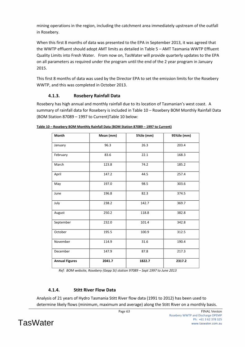
Page 63 FINAL Version
Rosebery WWTP and Discharge DPEMP Ph: +61 3 62 378 325
www.taswater.com.au
TasWater
mining operations in the region, including the catchment area immediately upstream of the outfall
in Rosebery.
When this first 8 months of data was presented to the EPA in September 2013, it was agreed that
the WWTP effluent should adopt AMT limits as detailed in Table 5 – AMT Tasmania WWTP Effluent
Quality Limits into Fresh Water. From now on, TasWater will provide quarterly updates to the EPA
on all parameters as required under the program until the end of the 2 year program in January
2015.
This first 8 months of data was used by the Director EPA to set the emission limits for the Rosebery
WWTP, and this was completed in October 2013.
4.1.3. Rosebery Rainfall Data
Rosebery has high annual and monthly rainfall due to its location of Tasmanian’s west coast. A
summary of rainfall data for Rosebery is included in Table 10 – Rosebery BOM Monthly Rainfall Data
(BOM Station 87089 – 1997 to Current)Table 10 below:
Table 10 – Rosebery BOM Monthly Rainfall Data (BOM Station 87089 – 1997 to Current)
Month Mean (mm) 5%ile (mm) 95%ile (mm)
January 96.3 26.3 203.4
February 83.6 22.1 168.3
March 123.8 74.2 185.2
April 147.2 44.5 257.4
May 197.0 98.5 303.6
June 196.8 82.3 374.5
July 238.2 142.7 369.7
August 250.2 118.8 382.8
September 232.0 101.4 342.8
October 195.5 100.9 312.5
November 114.9 31.6 190.4
December 147.9 87.8 217.3
Annual Figures 2041.7 1822.7 2317.2
Ref: BOM website, Rosebery (Gepp St) station 97089 – Sept 1997 to June 2013
4.1.4. Stitt River Flow Data
Analysis of 21 years of Hydro Tasmania Stitt River flow data (1991 to 2012) has been used to
determine likely flows (minimum, maximum and average) along the Stitt River on a monthly basis.
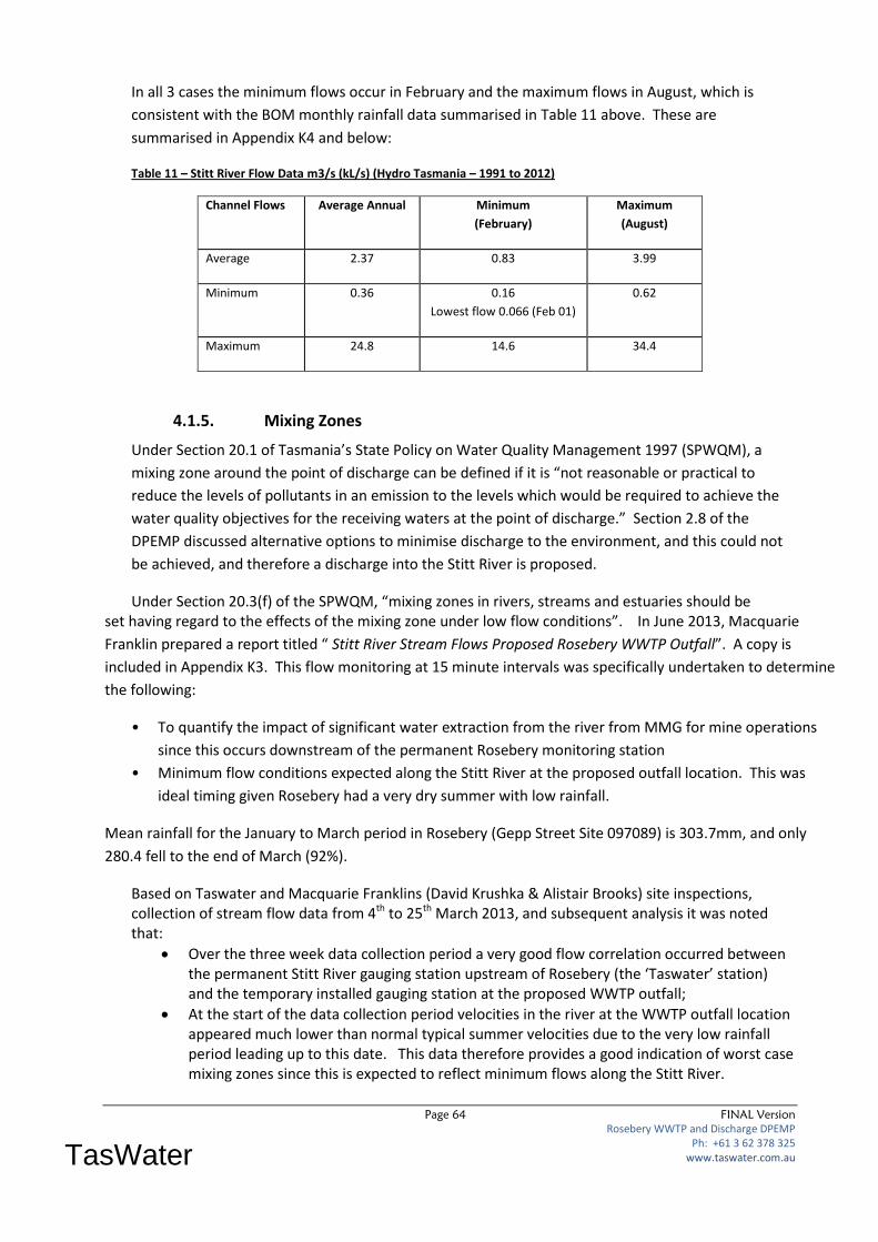
Page 64 FINAL Version
Rosebery WWTP and Discharge DPEMP Ph: +61 3 62 378 325
www.taswater.com.au
TasWater
In all 3 cases the minimum flows occur in February and the maximum flows in August, which is
consistent with the BOM monthly rainfall data summarised in Table 11 above. These are
summarised in Appendix K4 and below:
Table 11 – Stitt River Flow Data m3/s (kL/s) (Hydro Tasmania – 1991 to 2012)
Channel Flows Average Annual Minimum
(February)
Maximum
(August)
Average 2.37 0.83 3.99
Minimum 0.36 0.16
Lowest flow 0.066 (Feb 01)
0.62
Maximum 24.8 14.6 34.4
4.1.5. Mixing Zones
Under Section 20.1 of Tasmania’s State Policy on Water Quality Management 1997 (SPWQM), a
mixing zone around the point of discharge can be defined if it is “not reasonable or practical to
reduce the levels of pollutants in an emission to the levels which would be required to achieve the
water quality objectives for the receiving waters at the point of discharge.” Section 2.8 of the
DPEMP discussed alternative options to minimise discharge to the environment, and this could not
be achieved, and therefore a discharge into the Stitt River is proposed.
Under Section 20.3(f) of the SPWQM, “mixing zones in rivers, streams and estuaries should be set having regard to the effects of the mixing zone under low flow conditions”. In June 2013, Macquarie
Franklin prepared a report titled “ Stitt River Stream Flows Proposed Rosebery WWTP Outfall”. A copy is
included in Appendix K3. This flow monitoring at 15 minute intervals was specifically undertaken to determine
the following:
• To quantify the impact of significant water extraction from the river from MMG for mine operations
since this occurs downstream of the permanent Rosebery monitoring station
• Minimum flow conditions expected along the Stitt River at the proposed outfall location. This was
ideal timing given Rosebery had a very dry summer with low rainfall.
Mean rainfall for the January to March period in Rosebery (Gepp Street Site 097089) is 303.7mm, and only
280.4 fell to the end of March (92%).
Based on Taswater and Macquarie Franklins (David Krushka & Alistair Brooks) site inspections, collection of stream flow data from 4th to 25th March 2013, and subsequent analysis it was noted that:
Over the three week data collection period a very good flow correlation occurred between the permanent Stitt River gauging station upstream of Rosebery (the ‘Taswater’ station) and the temporary installed gauging station at the proposed WWTP outfall;
At the start of the data collection period velocities in the river at the WWTP outfall location appeared much lower than normal typical summer velocities due to the very low rainfall period leading up to this date. This data therefore provides a good indication of worst case mixing zones since this is expected to reflect minimum flows along the Stitt River.
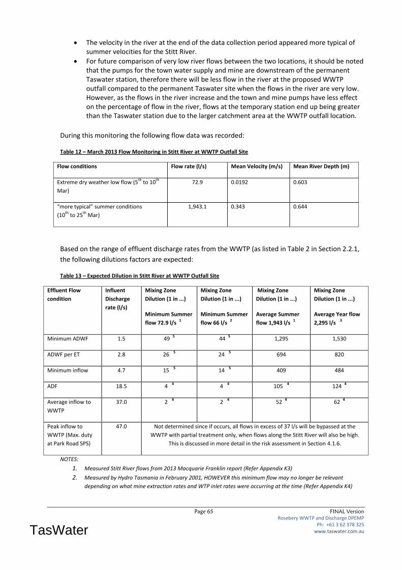
Page 65 FINAL Version
Rosebery WWTP and Discharge DPEMP Ph: +61 3 62 378 325
www.taswater.com.au
TasWater
The velocity in the river at the end of the data collection period appeared more typical of summer velocities for the Stitt River.
For future comparison of very low river flows between the two locations, it should be noted that the pumps for the town water supply and mine are downstream of the permanent Taswater station, therefore there will be less flow in the river at the proposed WWTP outfall compared to the permanent Taswater site when the flows in the river are very low. However, as the flows in the river increase and the town and mine pumps have less effect on the percentage of flow in the river, flows at the temporary station end up being greater than the Taswater station due to the larger catchment area at the WWTP outfall location.
During this monitoring the following flow data was recorded:
Table 12 – March 2013 Flow Monitoring in Stitt River at WWTP Outfall Site
Flow conditions Flow rate (l/s) Mean Velocity (m/s) Mean River Depth (m)
Extreme dry weather low flow (5th
to 10th
Mar)
72.9 0.0192 0.603
“more typical” summer conditions
(10th
to 25th
Mar)
1,943.1 0.343 0.644
Based on the range of effluent discharge rates from the WWTP (as listed in Table 2 in Section 2.2.1,
the following dilutions factors are expected:
Table 13 – Expected Dilution in Stitt River at WWTP Outfall Site
Effluent Flow
condition
Influent
Discharge
rate (l/s)
Mixing Zone
Dilution (1 in ...)
Minimum Summer
flow 72.9 l/s 1
Mixing Zone
Dilution (1 in ...)
Minimum Summer
flow 66 l/s 2
Mixing Zone
Dilution (1 in ...)
Average Summer
flow 1,943 l/s 1
Mixing Zone
Dilution (1 in ...)
Average Year flow
2,295 l/s 3
Minimum ADWF 1.5 49 5 44
5 1,295 1,530
ADWF per ET 2.8 26 5 24
5 694 820
Minimum inflow 4.7 15 5 14
5 409 484
ADF 18.5 4 4 4
4 105
4 124
4
Average inflow to
WWTP
37.0 2 4 2
4 52
4 62
4
Peak inflow to
WWTP (Max. duty
at Park Road SPS)
47.0 Not determined since if occurs, all flows in excess of 37 l/s will be bypassed at the
WWTP with partial treatment only, when flows along the Stitt River will also be high.
This is discussed in more detail in the risk assessment in Section 4.1.6.
NOTES:
1. Measured Stitt River flows from 2013 Macquarie Franklin report (Refer Appendix K3)
2. Measured by Hydro Tasmania in February 2001, HOWEVER this minimum flow may no longer be relevant
depending on what mine extraction rates and WTP inlet rates were occurring at the time (Refer Appendix K4)
Page 66 FINAL Version
Rosebery WWTP and Discharge DPEMP Ph: +61 3 62 378 325
www.taswater.com.au
TasWater
3. 2,295 l/s is Hydro Tasmania measured flow at Stitt River station upstream of MMG takeoff minus 60.8 l/s for
MMG licensed allocation and minus 10 l/s for Rosebery WTP intake.
4. This mixing zone is bot likely to occur since if effluent flows are high (due to I/I), then flows along the river will
also be high due to rainfall in the catchment.
5. This situation with low mixing is not expected to occur often since significant annual rainfall is experienced at
Rosebery.
It can be clearly seen from Table 13 above that for a majority of the time, a dilution of 1 in 80 can be
easily achieved. As discussed in Section 2.4 because the WWTP will discharge in batches, an effluent
balance tank will be incorporated into the WWTP design as part of the final plant. This tank will be
utilised to minimise the flow discharged into the Stitt River during extreme dry weather when low
flow conditions occur, and as Note 4 and 5 state. Low dilutions are not expected to occur very often
since if effluent flows are high (due to I/I), then corresponding flows along the river will also be high
due to rainfall in the catchment. In addition to this, with mean monthly rainfall of 83.6mm in the
driest month (February), and significantly more during the rest of the year, low flows along the Stitt
River will only ever occur at irregular intervals.
In February 2014, TasWater engaged SKM to investigate the capacity of the Stitt River to mix
effluent treated to 90th percentile AMT standard as described the by the Emission Limit Guidelines
for Sewage Treatment Plants (EPA 2001). A copy of the SKM report is included in Appendix O2 and
the outcomes of the report were identified as follows:
1. A 7Q10 flow of 90 l/s (0.09 m3/s) was determined based on analysis of Stitt River flow data
from Hydro Tasmania flow data collected between 1991 and 2013.
2. A maximum of 1 in 34 dilution ratio is achieved under 7Q10 flows in Stitt River, assuming
ADWF effluent volume of 2.8 L/s.
3. Total Ammonia, TN, TP, pH, TSS and total coliforms were assessed as the parameters
potentially affecting the mixing zone.
4. Under 7Q10 flows, concentrations of total ammonia, TN and TP can be expected to remain
above the EPA water quality objectives, ANZECC trigger levels and 80th percentile ambient
conditions in Stitt River until the discharge into Lake Pieman, where the considerably the
higher flows released from Lake Rosebery will heavily dilute the effluent. As the mixing
requirements will not be met with the river flow, the mixing zone will extend from the point
of discharge to the junction with Lake Pieman.
5. Total ammonia and TP concentrations in the discharge were identified as the contaminants
of concern and may present a risk to environmental values from nutrient enrichment.
However, the nutrient concentrations are well below chronic or acute toxicity levels.
6. The extent of the mixing zone will be from the outfall location to the confluence with Lake
Pieman.
The outcome of this report is that an additional risk assessment is required to assess any impacts to
environmental values in the Stitt River downstream of the outfall from nutrient enrichment from
the discharge. This is discussed in more detail in Section 4.1.6 below.
Related Documents


